Embed Size (px)
Citation preview
WADSWORTH BOULEVARD WIDENING TRANSITION FROM PEL TO NEPA
SUMMARY REPORT
Prepared for:
7500 W. 29th Ave.
Wheat Ridge, CO 80033
June 1, 2017 FINAL
WADSWORTH BOULEVARD WIDENING—TRANSITION FROM PEL TO NEPA SUMMARY REPORT June 1, 2017 FINAL
Table of Contents i
Contents 1.0 Background ........................................................................................................................................... 1 2.0 NEPA Initiation ...................................................................................................................................... 2
2.1 Scoping .............................................................................................................................................. 2 2.2 Purpose and Need Verification .......................................................................................................... 4 2.3 Environmental Analysis and Mitigation .............................................................................................. 5 2.4 Alternatives Verification ..................................................................................................................... 6 2.5 Screening Criteria ............................................................................................................................ 13
3.0 Results of Screening ........................................................................................................................... 14 3.1 Capacity ........................................................................................................................................... 14 3.2 Access Management ....................................................................................................................... 17 3.3 Multimodal Access and Accommodations ....................................................................................... 17 3.4 Safety ............................................................................................................................................... 17 3.5 Environmental and Right-of-Way Concerns .................................................................................... 18 3.6 Recommendation ............................................................................................................................. 18
4.0 FHWA and CDOT involvement ........................................................................................................... 18 4.1 Status of PEL Unresolved Issues .................................................................................................... 18
5.0 References .......................................................................................................................................... 20
Appendices Appendix A. Environmental Scoping Appendix B. Travel Data Appendix C. Summary of Right-of-Way Acquisition Required
Figures Figure 1. Cross Section Recommended North of 44th Avenue ................................................................. 11 Figure 2. Cross Section Recommended South of 44th Avenue ................................................................ 11
Tables Table 1. Alternatives Verification Summary: Includes 10 Alternatives from PEL Level 2 Screening and
2 New Alternatives ........................................................................................................................ 7 Table 2. Alternatives to be Screened for Evaluation ................................................................................ 12 Table 3. Intersection Option Analysis Results (source data available in Appendices) ............................. 15
WADSWORTH BOULEVARD WIDENING—TRANSITION FROM PEL TO NEPA SUMMARY REPORT June 1, 2017 FINAL
Acronyms and Abbreviations ii
Acronyms and Abbreviations AA Alternative Analysis
ACOE Army Corps of Engineers
ACP Access Control Plan
ADA Americans with Disabilities Act
CDOT Colorado Department of Transportation
CFI Continuous Flow Intersection
CDPHE Colorado Department of Public Health and Environment
CNHP Colorado Natural Heritage Program
DRCOG Denver Regional Council of Governments
EA Environmental Assessment
FHWA Federal Highway Administration
FRA Final Recommended Alternative
HAWK High-intensity Activated Crosswalk
HSIP Highway Safety Improvement Program
IGA Intergovernmental Agreement
LOS Level of Service
MPH Miles per Hour
MUTCD Manual on Uniform Traffic Control Devices
NEPA National Environmental Protection Act
NR-A Non-Rural Principal Highway
P & N Purpose and Need
PEL Planning and Environmental Linkages
ROD Record of Decision
RTD Regional Transportation District
SHAC State Highway Access Code
SHPO State Historic Preservation Office
STIP State Transportation Improvement Program
TIP Transportation Improvement Program.
WADSWORTH BOULEVARD WIDENING—TRANSITION FROM PEL TO NEPA SUMMARY REPORT June 1, 2017 FINAL
Page 1
1.0 BACKGROUND The Wadsworth Planning and Environmental Linkages (PEL) study began in February 2014, consisting of a 1.4-mile segment along Wadsworth Boulevard (Wadsworth) from 35th Avenue (Mile Marker 15.3) to the southern ramp edges of the Interstate-70 (I-70) interchange (Mile Marker 16.7). This roadway provides access to I-70, connects Wheat Ridge to Arvada and Lakewood, and provides transit service connecting to major east-west routes, including the West Corridor light-rail line. The PEL study investigated improvement opportunities to Wadsworth using a 2035 future year for development of purpose and need, and conducted a three-level screening process that screened 55 basic options (project elements) down to 6 alternatives, and then one Final Recommended Alternative (FRA).
Prior to completion of the PEL study in September 2015, Wheat Ridge secured Roadway Capacity funding through the Denver Regional Council of Governments’ (DRCOG) 2016-2021 Transportation Improvement Program (TIP). This will provide $25.28 million in federal funding to be matched by $6.32 million in local funds. In November 2016, Wheat Ridge successfully passed ballot initiative 2E which approved a $0.005 (1/2 cent) increase in Wheat Ridge’s sales tax in order to fund the $6.32 million local match required for the DRCOG TIP funding. On March 1, 2017 Wheat Ridge was awarded $2.60 million in Federal Highway Safety Improvement Program (HSIP) funds for the project. The PEL estimated the project to cost $40-$45 million in 2014 dollars. Conceptual cost estimates are being developed in the spring of 2017 to determine how much additional funding will be required to construct the project.
Wheat Ridge and the Colorado Department of Transportation (CDOT) have entered into an Intergovernmental Agreement (IGA) and begun a National Environmental Policy Act (NEPA) process. The project will need to be included in the Regional Transportation Plan and have identified funding for a next phase in the State Transportation Improvement Program (STIP). In this case, final design and right-of-way acquisition will be the next phase and funding is currently available for both of those efforts. The existing IGA between CDOT and Wheat Ridge for maintenance of the Wadsworth corridor will be amended to reflect agreements made during the EA process.
The September 2015 Planning and Environmental Linkages Report for Wadsworth Boulevard (PEL Report) contains a recommendation for one build alternative called a Final Recommended Alternative (FRA). Key elements include three lanes for vehicle travel in each direction, raised landscaped medians, wide detached sidewalks with tree lawn buffers, a two-way cycle track, revised bus stop locations, double left-turn lanes in all directions at 38th and 44th Avenues, and upgraded traffic signal systems (City of Wheat Ridge, 2015a, p. ES-3).
The intent of this Wadsworth Boulevard Widening Transition from PEL to NEPA Summary Report (transition report) is to document the process and rationale used to transition from the PEL Report to the NEPA process and to confirm the range of alternatives to be analyzed in the Environmental Assessment (EA). CDOT Traffic staff identified critical issues in the PEL Report regarding the FRA that need further consideration in the EA process. First, the State Highway Access Code (SHAC) sets minimum signal spacing for NR-A (Non-Rural Principle Highway) highways, such as Wadsworth, at one-half mile. The FRA signal spacing was closer to 1/8 mile. Second, although the FRA provided improved capacity and Level of Service (LOS), it only achieved a 2035 LOS F at the intersections of 38th and 44th, meaning the average vehicle delay at those intersections is more than 80 seconds.
WADSWORTH BOULEVARD WIDENING—TRANSITION FROM PEL TO NEPA SUMMARY REPORT June 1, 2017 FINAL
Page 2
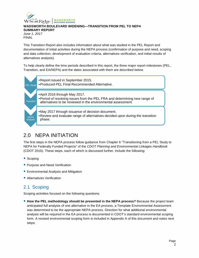
This Transition Report also includes information about what was studied in the PEL Report and documentation of initial activities during the NEPA process (confirmation of purpose and need, scoping and data collection, development of evaluation criteria, alternatives verification, and initial results of alternatives analysis).
To help clearly define the time periods described in this report, the three major report milestones (PEL, Transition, and EA/NEPA) and the dates associated with them are described below.
2.0 NEPA INITIATION The first steps in the NEPA process follow guidance from Chapter 6 "Transitioning from a PEL Study to NEPA for Federally Funded Projects" of the CDOT Planning and Environmental Linkages Handbook (CDOT 2016). These steps, each of which is discussed further, include the following:
Scoping
Purpose and Need Verification
Environmental Analysis and Mitigation
Alternatives Verification
2.1 Scoping Scoping activities focused on the following questions.
How the PEL methodology should be presented in the NEPA process? Because the project team anticipated full analysis of one alternative in the EA process, a Template Environmental Assessment was determined to be the appropriate NEPA process. Direction for what additional environmental analysis will be required in the EA process is documented in CDOT’s standard environmental scoping form. A revised environmental scoping form is included in Appendix A of this document and notes next steps.
PEL Study
•Report issued in September 2015. •Produced PEL Final Recommended Alternative.
Transition
•April 2016 through May 2017. •Period of resolving issues from the PEL FRA and determining new range of alternatives to be reviewed in the environmental assessment.
NEPA Analysis
•May 2017 through issuance of decision document. •Review and evaluate range of alternatives decided upon during the transition phase.
WADSWORTH BOULEVARD WIDENING—TRANSITION FROM PEL TO NEPA SUMMARY REPORT June 1, 2017 FINAL
Page 3
Are there any unresolved issues with the public, stakeholders or agencies? CDOT expressed critical concerns about the future performance of the PEL FRA and certain design characteristics (Sections 2.2.11.4; 2.2.18.4; and 4.1 in the PEL Report).
1. Further evaluation and justification of proposed signal locations and warrants; including the 1/8-mile spacing PEL FRA, which does not conform with the Colorado State Highway Access Code for Non-Rural Regional Highways (NR-A)
2. Evaluation of an alternative that includes only three signals at 38th Avenue, 41st Avenue and 44th Avenue.
3. Evaluation of additional pedestrian crossing designs, including High Intensity Activated Crosswalk (HAWK) signals.
4. Update of the traffic analysis (from the 2035 model to the 2040 model) to be consistent with the 2040 Statewide Transportation Plan (CDOT, March 2015).
5. Additional evaluation of refinements to improve intersection operation.
The project team seeks to identify and evaluate refined or new alternatives with different signal locations, and intersection features because the PEL FRA had LOS F at 38th and 44th, which CDOT deemed unacceptable. The PEL Report which modeled 2035 traffic data found that the No-Action, Minimal Build, Enhanced Build, and Frontage Road alternatives resulted in Levels of Service D, E and F (Traffic Analysis Technical Report, Appendix G). 2040 data will be used for the Transition Report and EA alternative(s).
6. Evaluation of potential conflict points created by the two way cycle track and review of other facility types, configurations and intersection treatments
7. Consideration of development of a complete Access Control Plan for the corridor.
What critical issues identified in the PEL Report need consideration during the NEPA process. The primary issues of concern are the unresolved items numbered 1 through 7 discussed above and expanded on in Section 4.1.
How to use the PEL Report information when coordinating with agencies and the public during the EA process. Because the PEL Report was adopted in September 2015 which is within 5 years of this EA process, the CDOT Planning and Environmental Linkages Handbook (CDOT, 2016) indicates that the PEL environmental data “can be incorporated into the NEPA study and supplemented as needed.” However, information such as traffic modeling, noise impacts, air quality analysis, wetlands, water quality, and Section 106 properties will need to be updated. Coordination with the appropriate agencies, including the Colorado Department of Health and Environment, State Historical Preservation Office, U.S. Army Corps of Engineers, Colorado Parks and Wildlife, Denver Regional Council of Governments (DRCOG), Jefferson County Open Space, Regional Transportation District (RTD), and Federal Highways Administration will continue.
WADSWORTH BOULEVARD WIDENING—TRANSITION FROM PEL TO NEPA SUMMARY REPORT June 1, 2017 FINAL
Page 4
2.2 Purpose and Need Verification Purpose and Need (P&N) activities that were undertaken during the transition included collection of the 2040 traffic data from DRCOG and a site tour to assess any changes in environmental conditions since the PEL Report (attended by Wheat Ridge, CDOT, and resource experts on May 26, 2016). Other than the need to update the traffic model to clarify capacity needs, no substantive changes in conditions require any changes to the PEL Report’s P&N and it will be carried into the EA.
The purpose statement states:
The purpose of this project is to transform Wadsworth from 35th Avenue to I-70 into a multimodal facility that enhances regional mobility, provides local accessibility, and supports the vision of a livable, walkable, mixed-use corridor.
The identified needs are:
Lack of adequate capacity. Performance measures indicate this corridor experiences high levels of congestion during peak periods that affect travel reliability and emergency vehicle response times. Buses stopping in the through lanes increase vehicular delays during peak periods. Peak hour movements at the signalized intersections of 38th Avenue and 44th Avenue currently operate over capacity, resulting in vehicle delays and poor level of service (LOS). See Appendix B Travel Data, Quantitative Comparison of Intersection LOS and Delay (Table B-1) for more information.
Lack of access management. There are more than 50 commercial and residential driveways along this 1.2-mile corridor. Many of the driveways are wider than necessary or wider than currently allowed, which increases the potential for vehicle conflict. The high number of driveways increases congestion on the corridor as vehicles accelerate and decelerate to turn in and out of the driveways, affecting overall corridor efficiency. These access points are locations of potential conflict between vehicles and pedestrians and bicyclists. Lack of sight distance at access points along the corridor has also been identified as a concern, both for vehicle visibility of other vehicles and of pedestrians and bicyclists.
Lack of multimodal access and accommodations. The existing boulevard area lacks facilities and amenities for pedestrians, bicycles, and transit patrons and is not consistent with street cross section recommendations included in the Wadsworth Corridor Subarea Plan (City of Wheat Ridge, 2007), or the standards in the City of Wheat Ridge Streetscape Design Manual (City of Wheat Ridge, 2011). Pedestrians and bicyclists are discouraged from using Wadsworth because of this lack of facilities, combined with high vehicular traffic volumes, a posted speed limit of 40 miles per hour (mph), and the large number of conflict points at driveways.
Sidewalks are intermittent and inconsistent and pedestrians have few locations to cross the corridor to access destinations on Wadsworth and nearby side streets. There are no bicycle facilities along the corridor or within the study area. In addition, there are no nearby parallel north-south continuous routes for bicyclists.
Although a number of bus stops are located along the corridor, pedestrian access to and between transit stops is unsafe and inefficient. Transit stops are not located for convenient transfers at 38th Avenue and 44th Avenue and are not associated with existing and future centers of land use activity.
WADSWORTH BOULEVARD WIDENING—TRANSITION FROM PEL TO NEPA SUMMARY REPORT June 1, 2017 FINAL
Page 5
This corridor has also been identified as an enhanced transit corridor in the DRCOG Metro Vision 2035 Plan (Denver Regional Council of Governments, 2011), so it is important to identify opportunities for near-term transit improvements in the study area with consideration for long-term, regional, high-capacity transit through the area.
Safety concerns. Safety is a concern along this corridor for all modes of travel—vehicular, pedestrian, bicycle, and transit. The 38th Avenue and 44th Avenue intersections are two of the three highest vehicular crash locations in Wheat Ridge. Crash data collected from 2011 to 2013 revealed 784 crashes in the study area (Wadsworth Planning and Environmental Linkages Study: Existing Conditions Report, City of Wheat Ridge, 2015b). Rear-end crashes accounted for 2/3 of these, and most of them entailed property damage only (not injury or death), which is indicative of congested conditions and a high number of access points. Many near-misses have also been anecdotally reported by the public and Wheat Ridge staff.
Pedestrian safety is a particular concern both along and across the corridor. Sidewalks are non-existent in some places, forcing pedestrians to walk along informal dirt paths or through parking lots. Due, in part, to the distance between signalized intersections, pedestrians unsafely jaywalk across Wadsworth, particularly between 38th Avenue and 41st Avenue.
2.3 Environmental Analysis and Mitigation Environmental analysis and mitigation activities undertaken to transition from the PEL into the early stages of the EA included answering questions that are identified in Chapter 6 "Transitioning from a PEL Study to NEPA for Federally Funded Projects" of the CDOT Planning and Environmental Linkages Handbook (CDOT, 2016).
Which resource issues need to be considered during NEPA? These were initially defined in collaboration with CDOT staff during an environmental scoping meeting held on May 16, 2016. The resource issues that need to be considered during this EA include all major resources identified in Chapter 9 of the CDOT NEPA Manual except Energy (which was determined to not be necessary for the EA). Table A-1 in Appendix A contains an updated list of environmental resources.
Which environmental resources were evaluated in the PEL Study and why? How will environmental resource data be supplemented during the NEPA process? The PEL Report recommended next steps for each environmental resource, which are included in Table 2-5 of the PEL Report. This was used as the starting point for environmental scoping discussions. These have been updated and summarized in Table A-1 (Appendix A).
Agency, environmental, and public scoping meeting(s) were held in May 2016. A field visit was also conducted (with agency representatives and consultants) on May 26, 2016, in order to clarify what and how environmental resources in the project area are to be evaluated. Any work that will be relied upon in the EA will be documented in technical reports or other technical memoranda, and will follow the CDOT NEPA Manual guidelines. All technical reports and memoranda will be included as appendices to the EA document.
WADSWORTH BOULEVARD WIDENING—TRANSITION FROM PEL TO NEPA SUMMARY REPORT June 1, 2017 FINAL
Page 6
Which environmental resources were not evaluated in the PEL Study and why? Should they be reviewed during the EA process? Environmental resources not evaluated in the PEL Report include archaeological resources, paleontological resources, and noxious weeds. These resources will be evaluated during the EA process.
What mitigation strategies should be analyzed during NEPA? These are summarized in Table 5-5 in the PEL Report. Mitigation strategies will be updated as necessary after a Preferred Alternative is identified and potential impacts to environmental resources are determined.
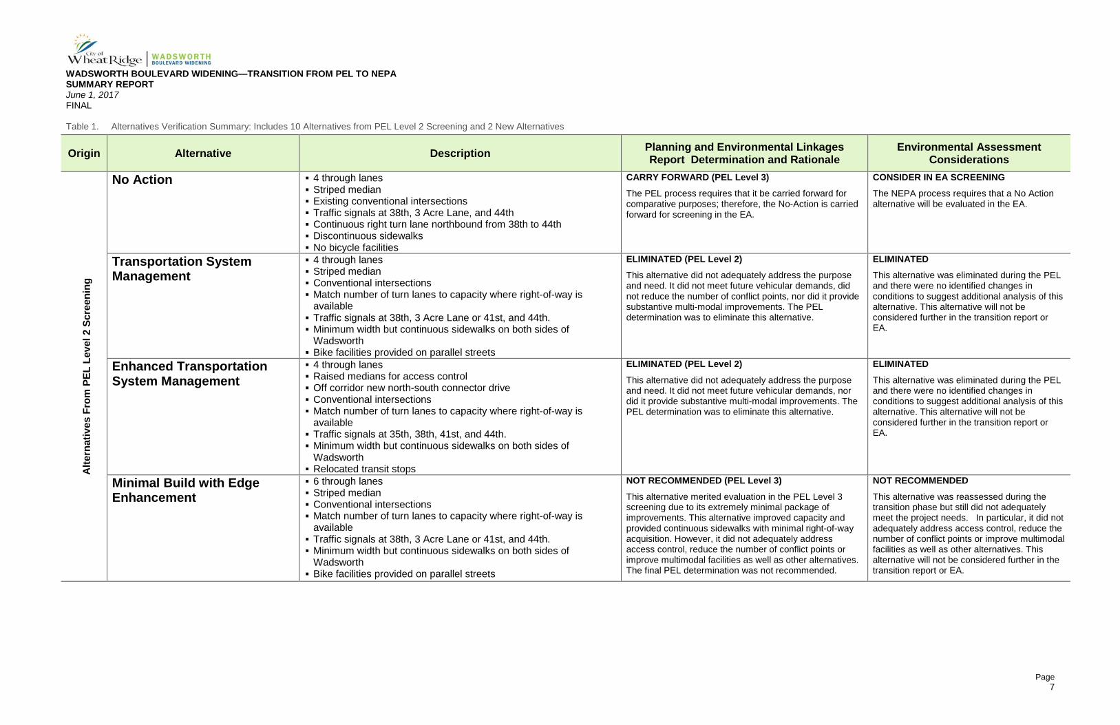
2.4 Alternatives Verification Addressing these transportation challenges on Wadsworth requires identifying reasonable solutions given the resources available. These solutions are vetted through a fact-finding process. Through that process, a Preferred Alternative may be identified. As a result of Level 1 screening during the PEL, 10 alternatives were advanced to Level 2 screening, and then 6 alternatives carried forward to level 3 for detailed evaluation.
This Transition Report documents the process and rationale by which the project team reviewed the findings of the PEL Alternatives Analysis Report (City of Wheat Ridge, 2015a, Appendix B). The team reviewed the 10 alternatives evaluated in the PEL’s Level 2 screening to determine whether any conditions had changed that would result in changing the PEL level 2 recommendations (eliminated, feasible, or recommended). These are described in detail in Table 1.
This review included an assessment of whether the 10 Level 2 alternatives adequately address the project needs upon which the PEL and EA screening criteria are based, as well as the potential for each of those alternatives to address the unresolved issues identified in the PEL Report and listed in Section 2.1 of this Transition Report. Table 1 summarizes the 10 alternatives carried forward from the PEL Level 2 screening and provides the associated rationale for further consideration and evaluating of each of those alternatives. In addition, two new alternatives have been added for consideration. A Minimal Continuous Flow Intersection (CFI) was included to investigate the possibility that a CFI may be feasible if it could function effectively within a smaller right-of-way footprint than the CFI alternative considered during the EA process. A Conventional Signalization alternative has also been added to assess the effectiveness of an alternative that adheres more strictly to the 1/2-mile signal spacing guidance provided by the Colorado State Highway Access Code for Non-Rural Regional Highways (NR-A).
WADSWORTH BOULEVARD WIDENING—TRANSITION FROM PEL TO NEPA SUMMARY REPORT June 1, 2017 FINAL
Page 7
Table 1. Alternatives Verification Summary: Includes 10 Alternatives from PEL Level 2 Screening and 2 New Alternatives
Origin Alternative Description Planning and Environmental Linkages Report Determination and Rationale
Environmental Assessment Considerations
Alte
rnat
ives
Fro
m P
EL L
evel
2 S
cree
ning
No Action 4 through lanes Striped median Existing conventional intersections Traffic signals at 38th, 3 Acre Lane, and 44th Continuous right turn lane northbound from 38th to 44th Discontinuous sidewalks No bicycle facilities
CARRY FORWARD (PEL Level 3) The PEL process requires that it be carried forward for comparative purposes; therefore, the No-Action is carried forward for screening in the EA.
CONSIDER IN EA SCREENING The NEPA process requires that a No Action alternative will be evaluated in the EA.
Transportation System Management
4 through lanes Striped median Conventional intersections Match number of turn lanes to capacity where right-of-way is
available Traffic signals at 38th, 3 Acre Lane or 41st, and 44th. Minimum width but continuous sidewalks on both sides of
Wadsworth Bike facilities provided on parallel streets
ELIMINATED (PEL Level 2) This alternative did not adequately address the purpose and need. It did not meet future vehicular demands, did not reduce the number of conflict points, nor did it provide substantive multi-modal improvements. The PEL determination was to eliminate this alternative.
ELIMINATED This alternative was eliminated during the PEL and there were no identified changes in conditions to suggest additional analysis of this alternative. This alternative will not be considered further in the transition report or EA.
Enhanced Transportation System Management
4 through lanes Raised medians for access control Off corridor new north-south connector drive Conventional intersections Match number of turn lanes to capacity where right-of-way is
available Traffic signals at 35th, 38th, 41st, and 44th. Minimum width but continuous sidewalks on both sides of
Wadsworth Relocated transit stops
ELIMINATED (PEL Level 2) This alternative did not adequately address the purpose and need. It did not meet future vehicular demands, nor did it provide substantive multi-modal improvements. The PEL determination was to eliminate this alternative.
ELIMINATED
This alternative was eliminated during the PEL and there were no identified changes in conditions to suggest additional analysis of this alternative. This alternative will not be considered further in the transition report or EA.
Minimal Build with Edge Enhancement
6 through lanes Striped median Conventional intersections Match number of turn lanes to capacity where right-of-way is
available Traffic signals at 38th, 3 Acre Lane or 41st, and 44th. Minimum width but continuous sidewalks on both sides of
Wadsworth Bike facilities provided on parallel streets
NOT RECOMMENDED (PEL Level 3) This alternative merited evaluation in the PEL Level 3 screening due to its extremely minimal package of improvements. This alternative improved capacity and provided continuous sidewalks with minimal right-of-way acquisition. However, it did not adequately address access control, reduce the number of conflict points or improve multimodal facilities as well as other alternatives. The final PEL determination was not recommended.
NOT RECOMMENDED This alternative was reassessed during the transition phase but still did not adequately meet the project needs. In particular, it did not adequately address access control, reduce the number of conflict points or improve multimodal facilities as well as other alternatives. This alternative will not be considered further in the transition report or EA.
WADSWORTH BOULEVARD WIDENING—TRANSITION FROM PEL TO NEPA SUMMARY REPORT June 1, 2017 FINAL
Page 8
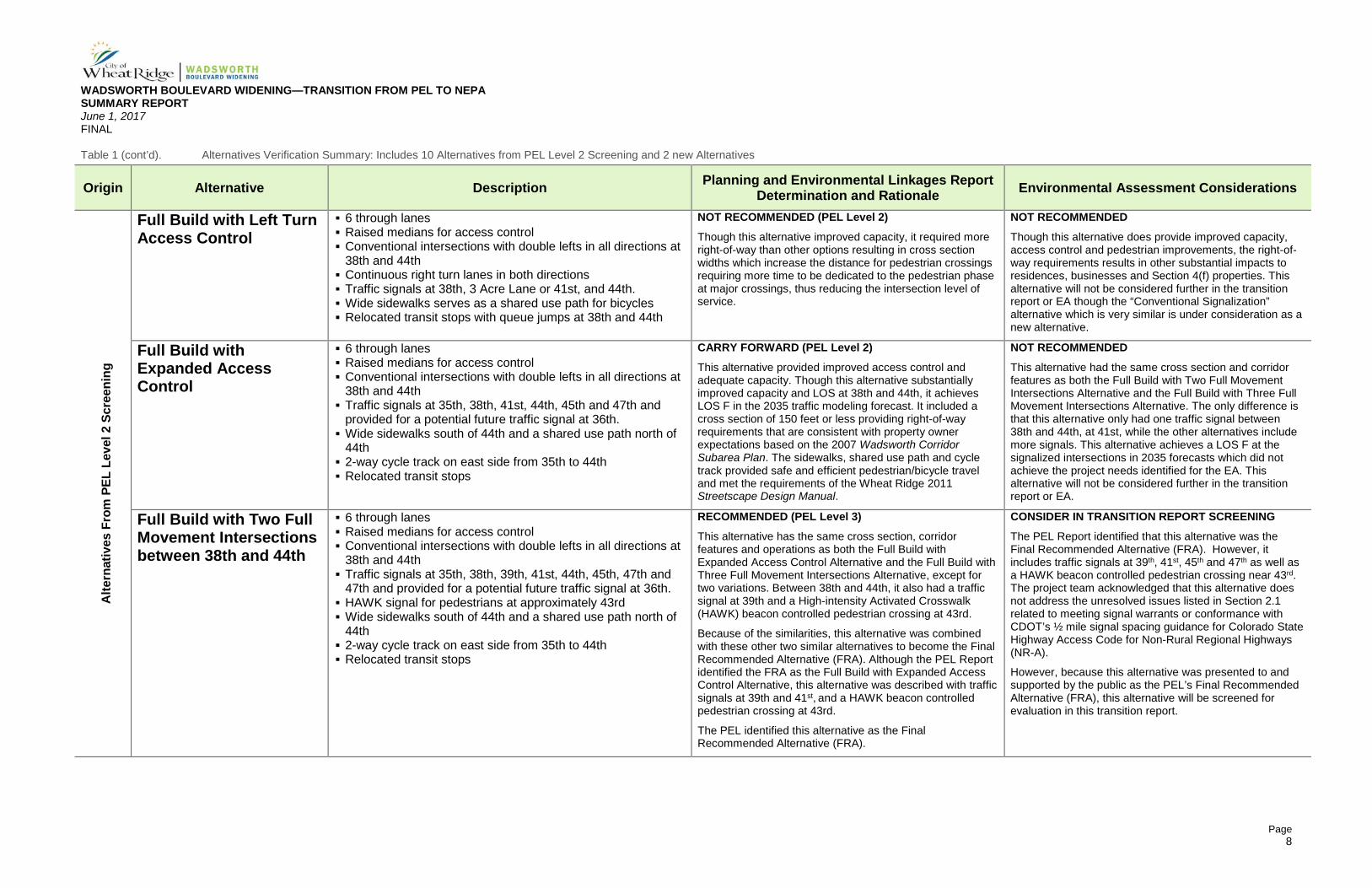
Table 1 (cont’d). Alternatives Verification Summary: Includes 10 Alternatives from PEL Level 2 Screening and 2 new Alternatives
Origin Alternative Description Planning and Environmental Linkages Report Determination and Rationale Environmental Assessment Considerations
Alte
rnat
ives
Fro
m P
EL L
evel
2 S
cree
ning
Full Build with Left Turn Access Control
6 through lanes Raised medians for access control Conventional intersections with double lefts in all directions at
38th and 44th Continuous right turn lanes in both directions Traffic signals at 38th, 3 Acre Lane or 41st, and 44th. Wide sidewalks serves as a shared use path for bicycles Relocated transit stops with queue jumps at 38th and 44th
NOT RECOMMENDED (PEL Level 2) Though this alternative improved capacity, it required more right-of-way than other options resulting in cross section widths which increase the distance for pedestrian crossings requiring more time to be dedicated to the pedestrian phase at major crossings, thus reducing the intersection level of service.
NOT RECOMMENDED
Though this alternative does provide improved capacity, access control and pedestrian improvements, the right-of-way requirements results in other substantial impacts to residences, businesses and Section 4(f) properties. This alternative will not be considered further in the transition report or EA though the “Conventional Signalization” alternative which is very similar is under consideration as a new alternative.
Full Build with Expanded Access Control
6 through lanes Raised medians for access control Conventional intersections with double lefts in all directions at
38th and 44th Traffic signals at 35th, 38th, 41st, 44th, 45th and 47th and
provided for a potential future traffic signal at 36th. Wide sidewalks south of 44th and a shared use path north of
44th 2-way cycle track on east side from 35th to 44th Relocated transit stops
CARRY FORWARD (PEL Level 2) This alternative provided improved access control and adequate capacity. Though this alternative substantially improved capacity and LOS at 38th and 44th, it achieves LOS F in the 2035 traffic modeling forecast. It included a cross section of 150 feet or less providing right-of-way requirements that are consistent with property owner expectations based on the 2007 Wadsworth Corridor Subarea Plan. The sidewalks, shared use path and cycle track provided safe and efficient pedestrian/bicycle travel and met the requirements of the Wheat Ridge 2011 Streetscape Design Manual.
NOT RECOMMENDED
This alternative had the same cross section and corridor features as both the Full Build with Two Full Movement Intersections Alternative and the Full Build with Three Full Movement Intersections Alternative. The only difference is that this alternative only had one traffic signal between 38th and 44th, at 41st, while the other alternatives include more signals. This alternative achieves a LOS F at the signalized intersections in 2035 forecasts which did not achieve the project needs identified for the EA. This alternative will not be considered further in the transition report or EA.
Full Build with Two Full Movement Intersections between 38th and 44th
6 through lanes Raised medians for access control Conventional intersections with double lefts in all directions at
38th and 44th Traffic signals at 35th, 38th, 39th, 41st, 44th, 45th, 47th and
47th and provided for a potential future traffic signal at 36th. HAWK signal for pedestrians at approximately 43rd Wide sidewalks south of 44th and a shared use path north of
44th 2-way cycle track on east side from 35th to 44th Relocated transit stops
RECOMMENDED (PEL Level 3) This alternative has the same cross section, corridor features and operations as both the Full Build with Expanded Access Control Alternative and the Full Build with Three Full Movement Intersections Alternative, except for two variations. Between 38th and 44th, it also had a traffic signal at 39th and a High-intensity Activated Crosswalk (HAWK) beacon controlled pedestrian crossing at 43rd.
Because of the similarities, this alternative was combined with these other two similar alternatives to become the Final Recommended Alternative (FRA). Although the PEL Report identified the FRA as the Full Build with Expanded Access Control Alternative, this alternative was described with traffic signals at 39th and 41st, and a HAWK beacon controlled pedestrian crossing at 43rd.
The PEL identified this alternative as the Final Recommended Alternative (FRA).
CONSIDER IN TRANSITION REPORT SCREENING The PEL Report identified that this alternative was the Final Recommended Alternative (FRA). However, it includes traffic signals at 39th, 41st, 45th and 47th as well as a HAWK beacon controlled pedestrian crossing near 43rd. The project team acknowledged that this alternative does not address the unresolved issues listed in Section 2.1 related to meeting signal warrants or conformance with CDOT’s ½ mile signal spacing guidance for Colorado State Highway Access Code for Non-Rural Regional Highways (NR-A).
However, because this alternative was presented to and supported by the public as the PEL’s Final Recommended Alternative (FRA), this alternative will be screened for evaluation in this transition report.
WADSWORTH BOULEVARD WIDENING—TRANSITION FROM PEL TO NEPA SUMMARY REPORT June 1, 2017 FINAL
Page 9
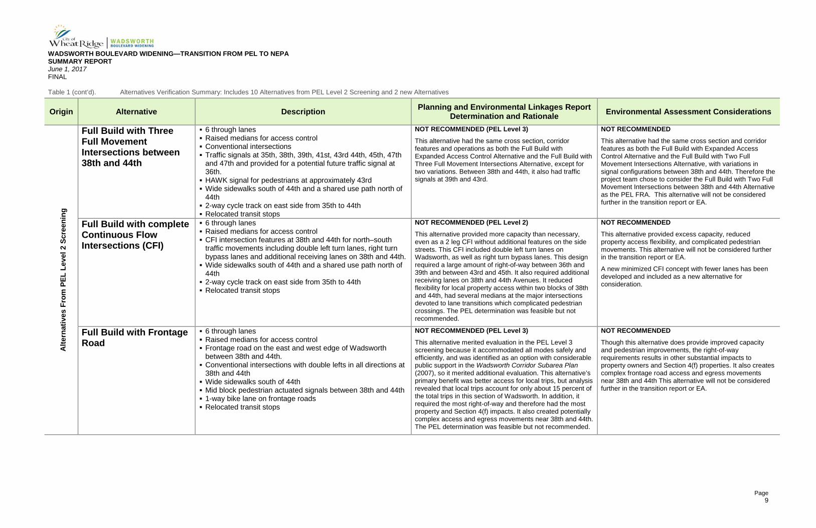
Table 1 (cont’d). Alternatives Verification Summary: Includes 10 Alternatives from PEL Level 2 Screening and 2 new Alternatives
Origin Alternative Description Planning and Environmental Linkages Report Determination and Rationale Environmental Assessment Considerations
Alte
rnat
ives
Fro
m P
EL L
evel
2 S
cree
ning
Full Build with Three Full Movement Intersections between 38th and 44th
6 through lanes Raised medians for access control Conventional intersections Traffic signals at 35th, 38th, 39th, 41st, 43rd 44th, 45th, 47th
and 47th and provided for a potential future traffic signal at 36th.
HAWK signal for pedestrians at approximately 43rd Wide sidewalks south of 44th and a shared use path north of
44th 2-way cycle track on east side from 35th to 44th Relocated transit stops
NOT RECOMMENDED (PEL Level 3) This alternative had the same cross section, corridor features and operations as both the Full Build with Expanded Access Control Alternative and the Full Build with Three Full Movement Intersections Alternative, except for two variations. Between 38th and 44th, it also had traffic signals at 39th and 43rd.
NOT RECOMMENDED
This alternative had the same cross section and corridor features as both the Full Build with Expanded Access Control Alternative and the Full Build with Two Full Movement Intersections Alternative, with variations in signal configurations between 38th and 44th. Therefore the project team chose to consider the Full Build with Two Full Movement Intersections between 38th and 44th Alternative as the PEL FRA. This alternative will not be considered further in the transition report or EA.
Full Build with complete Continuous Flow Intersections (CFI)
6 through lanes Raised medians for access control CFI intersection features at 38th and 44th for north–south
traffic movements including double left turn lanes, right turn bypass lanes and additional receiving lanes on 38th and 44th.
Wide sidewalks south of 44th and a shared use path north of 44th
2-way cycle track on east side from 35th to 44th Relocated transit stops
NOT RECOMMENDED (PEL Level 2) This alternative provided more capacity than necessary, even as a 2 leg CFI without additional features on the side streets. This CFI included double left turn lanes on Wadsworth, as well as right turn bypass lanes. This design required a large amount of right-of-way between 36th and 39th and between 43rd and 45th. It also required additional receiving lanes on 38th and 44th Avenues. It reduced flexibility for local property access within two blocks of 38th and 44th, had several medians at the major intersections devoted to lane transitions which complicated pedestrian crossings. The PEL determination was feasible but not recommended.
NOT RECOMMENDED This alternative provided excess capacity, reduced property access flexibility, and complicated pedestrian movements. This alternative will not be considered further in the transition report or EA.
A new minimized CFI concept with fewer lanes has been developed and included as a new alternative for consideration.
Full Build with Frontage Road
6 through lanes Raised medians for access control Frontage road on the east and west edge of Wadsworth
between 38th and 44th. Conventional intersections with double lefts in all directions at
38th and 44th Wide sidewalks south of 44th Mid block pedestrian actuated signals between 38th and 44th 1-way bike lane on frontage roads Relocated transit stops
NOT RECOMMENDED (PEL Level 3) This alternative merited evaluation in the PEL Level 3 screening because it accommodated all modes safely and efficiently, and was identified as an option with considerable public support in the Wadsworth Corridor Subarea Plan (2007), so it merited additional evaluation. This alternative’s primary benefit was better access for local trips, but analysis revealed that local trips account for only about 15 percent of the total trips in this section of Wadsworth. In addition, it required the most right-of-way and therefore had the most property and Section 4(f) impacts. It also created potentially complex access and egress movements near 38th and 44th. The PEL determination was feasible but not recommended.
NOT RECOMMENDED
Though this alternative does provide improved capacity and pedestrian improvements, the right-of-way requirements results in other substantial impacts to property owners and Section 4(f) properties. It also creates complex frontage road access and egress movements near 38th and 44th This alternative will not be considered further in the transition report or EA.
WADSWORTH BOULEVARD WIDENING—TRANSITION FROM PEL TO NEPA SUMMARY REPORT June 1, 2017 FINAL
Page 10
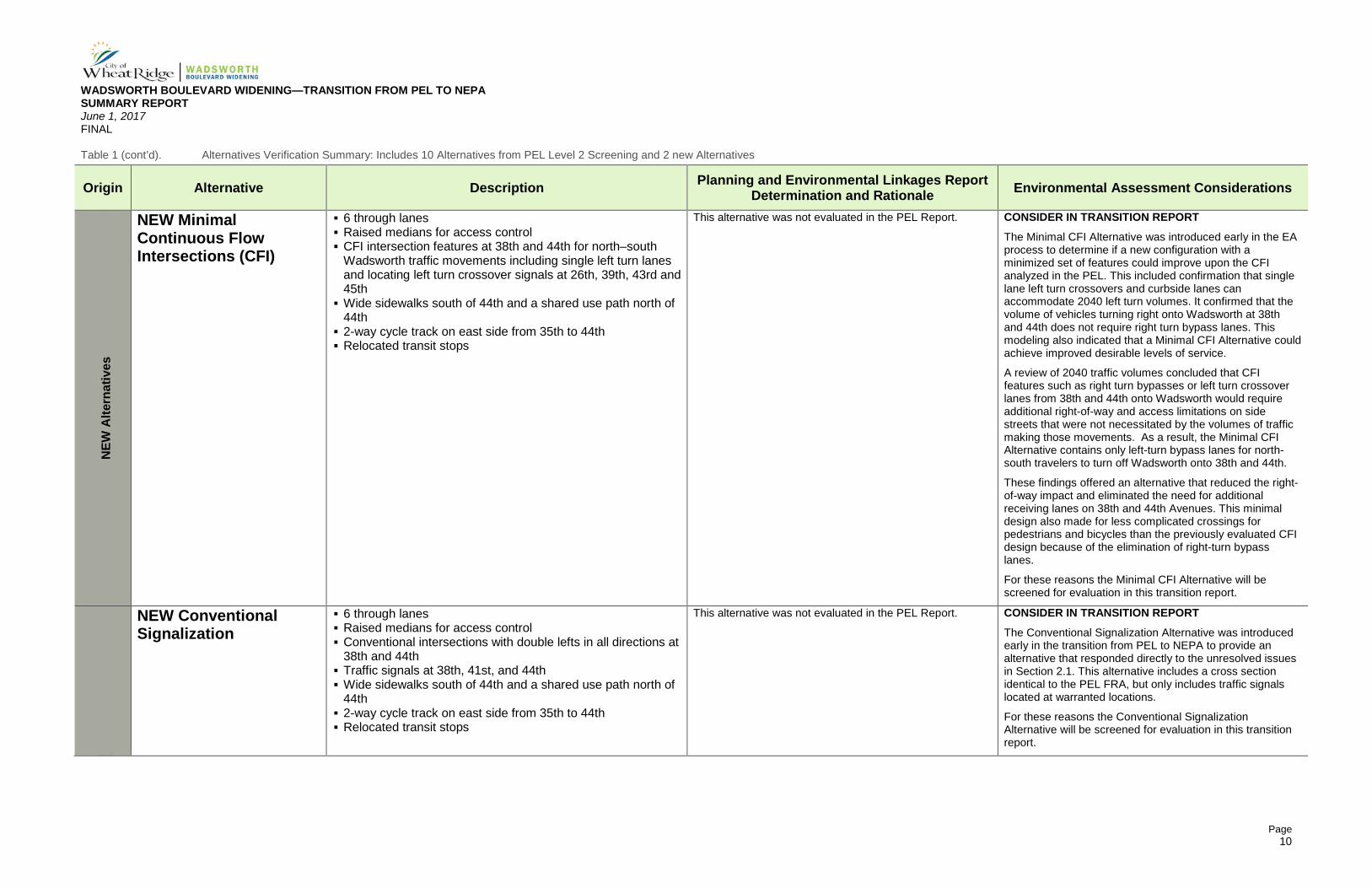
Table 1 (cont’d). Alternatives Verification Summary: Includes 10 Alternatives from PEL Level 2 Screening and 2 new Alternatives
Origin Alternative Description Planning and Environmental Linkages Report Determination and Rationale Environmental Assessment Considerations
NEW
Alte
rnat
ives
NEW Minimal Continuous Flow Intersections (CFI)
6 through lanes Raised medians for access control CFI intersection features at 38th and 44th for north–south
Wadsworth traffic movements including single left turn lanes and locating left turn crossover signals at 26th, 39th, 43rd and 45th
Wide sidewalks south of 44th and a shared use path north of 44th
2-way cycle track on east side from 35th to 44th Relocated transit stops
This alternative was not evaluated in the PEL Report. CONSIDER IN TRANSITION REPORT The Minimal CFI Alternative was introduced early in the EA process to determine if a new configuration with a minimized set of features could improve upon the CFI analyzed in the PEL. This included confirmation that single lane left turn crossovers and curbside lanes can accommodate 2040 left turn volumes. It confirmed that the volume of vehicles turning right onto Wadsworth at 38th and 44th does not require right turn bypass lanes. This modeling also indicated that a Minimal CFI Alternative could achieve improved desirable levels of service.
A review of 2040 traffic volumes concluded that CFI features such as right turn bypasses or left turn crossover lanes from 38th and 44th onto Wadsworth would require additional right-of-way and access limitations on side streets that were not necessitated by the volumes of traffic making those movements. As a result, the Minimal CFI Alternative contains only left-turn bypass lanes for north-south travelers to turn off Wadsworth onto 38th and 44th.
These findings offered an alternative that reduced the right-of-way impact and eliminated the need for additional receiving lanes on 38th and 44th Avenues. This minimal design also made for less complicated crossings for pedestrians and bicycles than the previously evaluated CFI design because of the elimination of right-turn bypass lanes.
For these reasons the Minimal CFI Alternative will be screened for evaluation in this transition report.
NEW Conventional Signalization
6 through lanes Raised medians for access control Conventional intersections with double lefts in all directions at
38th and 44th Traffic signals at 38th, 41st, and 44th Wide sidewalks south of 44th and a shared use path north of
44th 2-way cycle track on east side from 35th to 44th Relocated transit stops
This alternative was not evaluated in the PEL Report. CONSIDER IN TRANSITION REPORT The Conventional Signalization Alternative was introduced early in the transition from PEL to NEPA to provide an alternative that responded directly to the unresolved issues in Section 2.1. This alternative includes a cross section identical to the PEL FRA, but only includes traffic signals located at warranted locations.
For these reasons the Conventional Signalization Alternative will be screened for evaluation in this transition report.
WADSWORTH BOULEVARD WIDENING—TRANSITION FROM PEL TO NEPA SUMMARY REPORT June 1, 2017 FINAL
Page 11
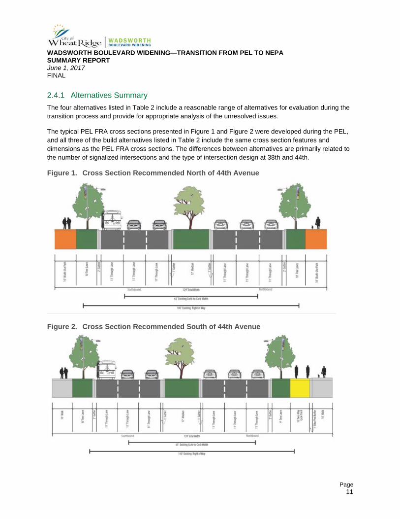
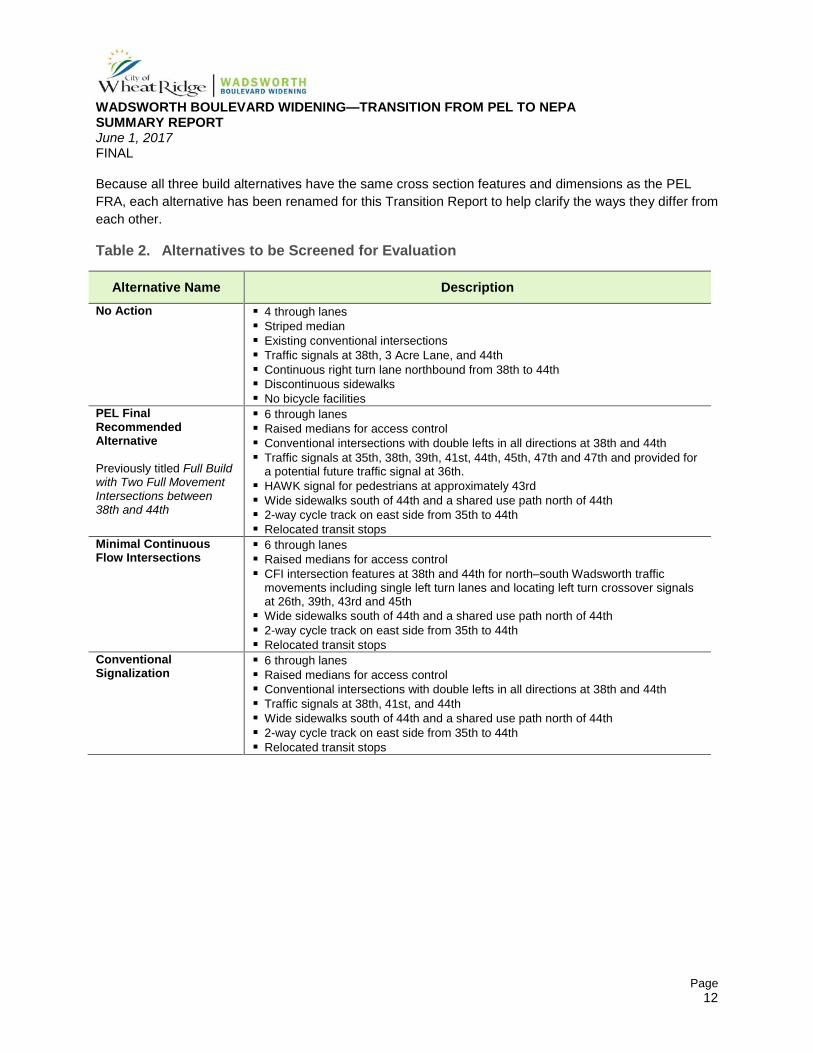
2.4.1 Alternatives Summary The four alternatives listed in Table 2 include a reasonable range of alternatives for evaluation during the transition process and provide for appropriate analysis of the unresolved issues.
The typical PEL FRA cross sections presented in Figure 1 and Figure 2 were developed during the PEL, and all three of the build alternatives listed in Table 2 include the same cross section features and dimensions as the PEL FRA cross sections. The differences between alternatives are primarily related to the number of signalized intersections and the type of intersection design at 38th and 44th.
Figure 1. Cross Section Recommended North of 44th Avenue
Figure 2. Cross Section Recommended South of 44th Avenue
WADSWORTH BOULEVARD WIDENING—TRANSITION FROM PEL TO NEPA SUMMARY REPORT June 1, 2017 FINAL
Page 12
Because all three build alternatives have the same cross section features and dimensions as the PEL FRA, each alternative has been renamed for this Transition Report to help clarify the ways they differ from each other.
Table 2. Alternatives to be Screened for Evaluation
Alternative Name Description No Action 4 through lanes
Striped median Existing conventional intersections Traffic signals at 38th, 3 Acre Lane, and 44th Continuous right turn lane northbound from 38th to 44th Discontinuous sidewalks No bicycle facilities
PEL Final Recommended Alternative Previously titled Full Build with Two Full Movement Intersections between 38th and 44th
6 through lanes Raised medians for access control Conventional intersections with double lefts in all directions at 38th and 44th Traffic signals at 35th, 38th, 39th, 41st, 44th, 45th, 47th and 47th and provided for
a potential future traffic signal at 36th. HAWK signal for pedestrians at approximately 43rd Wide sidewalks south of 44th and a shared use path north of 44th 2-way cycle track on east side from 35th to 44th Relocated transit stops
Minimal Continuous Flow Intersections
6 through lanes Raised medians for access control CFI intersection features at 38th and 44th for north–south Wadsworth traffic
movements including single left turn lanes and locating left turn crossover signals at 26th, 39th, 43rd and 45th
Wide sidewalks south of 44th and a shared use path north of 44th 2-way cycle track on east side from 35th to 44th Relocated transit stops
Conventional Signalization
6 through lanes Raised medians for access control Conventional intersections with double lefts in all directions at 38th and 44th Traffic signals at 38th, 41st, and 44th Wide sidewalks south of 44th and a shared use path north of 44th 2-way cycle track on east side from 35th to 44th Relocated transit stops
WADSWORTH BOULEVARD WIDENING—TRANSITION FROM PEL TO NEPA SUMMARY REPORT June 1, 2017 FINAL
Page 13
2.5 Screening Criteria The screening criteria were developed to identify the alternative that best meets the EA Purpose and Need, therefore, most of the criteria are categorized by the Need that each one evaluates. Descriptions of the criteria follow in this section and screening results are in Section 3.0.
2.5.1 Capacity Criteria 1: 2040 peak hour vehicle throughput. This criterion evaluates the total number of vehicles
that can be processed through the 44th Avenue intersection before it reaches LOS F. The project team chose 44th Avenue because it is the intersection that fails first in the project area as traffic volumes increase.
Criteria 2: Total average delay at 38th Avenue and 44th Avenue (2040 PM peak hour). This criterion reflects the average total delay in seconds projected at the 38th and 44th Avenue intersections.
Criteria 3: 2040 vehicular travel time in minutes through corridor. This criterion evaluates the average vehicular travel time through the entire corridor. The resulting time shows the average between northbound and southbound for each alternative.
2.5.2 Access Management Criteria 4: Number of signals that do not adhere to the 1/2-mile spacing guidance from the
CDOT Access Control Guidelines. This criterion assumes signals are necessary at 38th Avenue and 44th Avenue and indicates the number of additional proposed signals that would not meet the 1/2-mile spacing guidance, even if those signals may meet signal warrants.
Criteria 5: Number of the 16 block faces on the corners of 38th and 44th with maximum flexibility for location of access. This criterion indicates if any of the intersection design features of the alternatives under consideration restrict flexibility for current or future property owners to request and for CDOT or Wheat Ridge to grant permits for location of standard access points to the corner property.
2.5.3 Multimodal Access and Accommodations Criteria 6: Provides continuous connectivity for pedestrians and bicyclists from 35th to the Clear Creek
Trail. This criterion indicates whether a given alternative provides continuous, standard width pedestrian and bicycle facilities that include safe intersection and driveway crossings and complete north-south connectivity from 35th on the south to the Clear Creek Trail and the I-70 interchange sidewalk network on the north.
Criteria 7: Improves transit stop accessibility and amenities and allows standard stop locations. This criterion assesses whether the alternative improves access to transit stops for transit patrons and if those stops are located in RTD’s preferred station locations.
2.5.4 Safety Concerns Criteria 8: Number of unprotected vehicular left turns. This criterion is the sum of the total number
of unprotected (unsignalized, but legally allowed) left turns that could be made from Wadsworth to any
WADSWORTH BOULEVARD WIDENING—TRANSITION FROM PEL TO NEPA SUMMARY REPORT June 1, 2017 FINAL
Page 14
side street or driveway. This criteria reveals which alternative best reduces this movement (i.e. which cause the most conflict points).
Criteria 9: Number of nontraditional intersections. This criterion determines the number of intersections which have one or more nontraditional movements, which may result in an increased number of unsafe movements and a higher percent of traffic displaced from traditional travel patterns.
2.5.5 Environmental and Right-of-Way Concerns Two additional screening criteria are included in this evaluation.
Criteria 10 Regulated environmental resources impacted. This criterion lists the anticipated regulatory environmental resources that are likely to be impacted by each alternative (e.g. air quality, noise, historic resources, parks, wetlands, water quality, and others).
After review of regulated environmental resources, it was determined that air quality, noise, Section 106 historic resources, parks, wetlands, and water quality were those expected to be impacted by a build alternative. Because all three of the build alternatives have the same cross section and the only differences are the location of signals and the treatment of the intersections at 38th and 44th, most of of these resources are expected to have minimal differences between build alternatives. They are expected to show differences between the No Action and the build alternatives. The exception to this may be with regards to air quality, which could be impacted by the distance between signals.
Criteria 11: Right-of-Way acquisition required. This criterion reflects the anticipated total number of full property acquisitions anticipated, as well as the total square footage of right-of-way acquisition required for partial property acquisitions.
Concerns were raised in the screening process about other factors that may differentiate between the build alternatives, such as construction phasing, maintenance, and life cycle cost. Based on the current level of design, it is not clear how to quantify or measure these factors at this level of design. Those considerations will be taken into account when developing the Preferred Alternative and in the advancement of project design
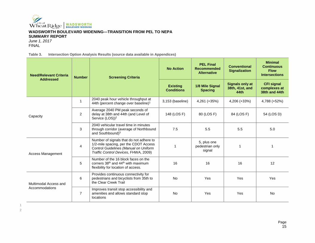
3.0 RESULTS OF SCREENING Table 3 provides the results of this screening analysis. These results are based on quantitative data and engineering judgment to determine which alternative(s) should be advanced as the Preferred Alternative for analysis in the EA.
3.1 Capacity Under 2040 traffic conditions, the Minimal CFI alternative outperforms the other alternatives by providing the largest increase in capacity (52 percent better than the No Action), the best peak hour intersection operations at LOS D, and the shortest corridor travel time of 5 minutes.
WADSWORTH BOULEVARD WIDENING—TRANSITION FROM PEL TO NEPA SUMMARY REPORT June 1, 2017 FINAL
Page 15
Table 3. Intersection Option Analysis Results (source data available in Appendices)
Need/Relevant Criteria Addressed Number Screening Criteria
No Action PEL Final
Recommended Alternative
Conventional Signalization
Minimal Continuous
Flow Intersections
Existing Conditions
1/8 Mile Signal Spacing
Signals only at 38th, 41st, and
44th
CFI signal complexes at 38th and 44th
Capacity
1 2040 peak hour vehicle throughput at 44th (percent change over baseline)1 3,153 (baseline) 4,261 (+35%) 4,206 (+33%) 4,788 (+52%)
2 Average 2040 PM peak seconds of delay at 38th and 44th (and Level of Service (LOS))2
148 (LOS F) 80 (LOS F) 84 (LOS F) 54 (LOS D)
3 2040 vehicular travel time in minutes through corridor (average of Northbound and Southbound)3
7.5 5.5 5.5 5.0
Access Management
4
Number of signals that do not adhere to 1/2-mile spacing, per the CDOT Access Control Guidelines (Manual on Uniform Traffic Control Devices, FHWA, 2009)
1 5, plus one
pedestrian only signal
1 1
5 Number of the 16 block faces on the corners 38th and 44th with maximum flexibility for location of access.
16 16 16 12
Multimodal Access and Accommodations
6 Provides continuous connectivity for pedestrians and bicyclists from 35th to the Clear Creek Trail
No Yes Yes Yes
7 Improves transit stop accessibility and amenities and allows standard stop locations
No Yes Yes No
1 2
WADSWORTH BOULEVARD WIDENING—TRANSITION FROM PEL TO NEPA SUMMARY REPORT June 1, 2017 FINAL
Page 16
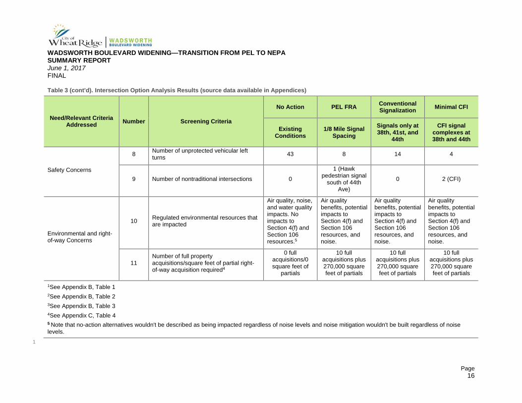
Table 3 (cont’d). Intersection Option Analysis Results (source data available in Appendices)
Need/Relevant Criteria Addressed Number Screening Criteria
No Action PEL FRA Conventional Signalization Minimal CFI
Existing Conditions
1/8 Mile Signal Spacing
Signals only at 38th, 41st, and
44th
CFI signal complexes at 38th and 44th
Safety Concerns
8 Number of unprotected vehicular left turns 43 8 14 4
9 Number of nontraditional intersections 0
1 (Hawk pedestrian signal
south of 44th Ave)
0 2 (CFI)
Environmental and right-of-way Concerns
10 Regulated environmental resources that are impacted
Air quality, noise, and water quality impacts. No impacts to Section 4(f) and Section 106 resources.5
Air quality benefits, potential impacts to Section 4(f) and Section 106 resources, and noise.
Air quality benefits, potential impacts to Section 4(f) and Section 106 resources, and noise.
Air quality benefits, potential impacts to Section 4(f) and Section 106 resources, and noise.
11 Number of full property acquisitions/square feet of partial right-of-way acquisition required4
0 full acquisitions/0 square feet of
partials
10 full acquisitions plus 270,000 square feet of partials
10 full acquisitions plus 270,000 square feet of partials
10 full acquisitions plus 270,000 square feet of partials
1See Appendix B, Table 1 2See Appendix B, Table 2 3See Appendix B, Table 3 4See Appendix C, Table 4 5 Note that no-action alternatives wouldn't be described as being impacted regardless of noise levels and noise mitigation wouldn't be built regardless of noise levels. 1
WADSWORTH BOULEVARD WIDENING—TRANSITION FROM PEL TO NEPA SUMMARY REPORT June 1, 2017 FINAL
Page 17
3.2 Access Management All three build alternatives are similar in their response to the access management. Each one provides raised medians. They also have the same cross section and therefore have the same opportunities for standardization and consolidation of private access points.
The Conventional Signalization alternative achieves all access management needs.
A disadvantage of the PEL FRA is that it proposes five signals that are not expected to meet warrants and do not adhere to CDOT’s 1/2-mile signal spacing guidance (per the Colorado State Highway Access Code for Non-Rural Regional Highways).
A disadvantage of the Minimal CFI alternative is that it reduces the flexibility for the location of conventional access points on the four block faces that have curbside left turn lanes (west side of Wadsworth from 36th to 38th and east side of Wadsworth from 38th to 39th and 44th to 45th). The project team agrees that even though these median-protected curbside lanes limit flexibility, all properties in these areas still have full access to the local street network.
An advantage of the Minimal CFI alternative is that it provides crossover signals at locations which can safely control left turn movements directly into four high volume destinations on the corridor. This provides improved safety for these larger volumes of turning traffic.
3.3 Multimodal Access and Accommodations All three build alternatives are similar in their response to Multimodal Access and Accommodations. They all provide continuous standard width pedestrian and bicycle facilities that include safe intersection and driveway crossings and complete north-south connectivity from 35th on the south to the Clear Creek Trail and the I-70 interchange sidewalk network on the north. All three build alternatives also provide potential opportunities for additional signal controlled pedestrian crossings if warrants are met.
The disadvantage of the Minimal CFI alternative is that it will require non-standard placement of 4 of the corridors’ 11 bus stops because of the median-protected curbside left turn lanes. This issue has been discussed with RTD and they have agreed that if the Minimal CFI alternative is selected, they will support far side stops in these four locations.
3.4 Safety The raised center medians common to all the build alternatives greatly reduce the safety risk associated with unprotected left turn movements when compared to the No Build Alternative.
The Minimal CFI has a safety disadvantage because it introduces two nontraditional intersections at 38th and 44th. This is noted because it does not meet standard driver expectancy. However, based on research of other existing CFI intersections (UDOT, 2013), the safety performance of CFI intersections is similar to traditional intersections.
WADSWORTH BOULEVARD WIDENING—TRANSITION FROM PEL TO NEPA SUMMARY REPORT June 1, 2017 FINAL
Page 18
3.5 Environmental and Right-of-Way Concerns All three build alternatives create similar environmental and right-of-way impacts. All three alternatives improve air quality beyond the No Action based on their ability to reduce delay. The advantage of the Minimal CFI is that it provides the least delay and, therefore, the best air quality benefits. All three build alternatives propose the same cross section so the impact to other resources (historic properties, parks, noise, visual, and others) are too similar to differentiate. The impacts to right-of-way are also essentially the same. Because the PEL FRA and Conventional Signalization alternatives include double left turn lanes at 38th and 44th, the intersection dimensions are essentially the same as the Minimal CFI which requires a single left turn lane plus an additional narrow median.
3.6 Recommendation Based on these findings, the Minimal CFI alternative provides corridor improvements that best achieve the project needs and will be advanced as the Preferred Alternative for further design and refinement in the EA process.
4.0 FHWA AND CDOT INVOLVEMENT Since the spring of 2016, CDOT and FHWA have been involved through monthly agency meetings, which are expected to continue through project completion. The purpose of these meetings is to provide input and oversight to the project processes and methodologies, as well as to approve deliverables. Additionally, the project team coordinated with DRCOG staff to confirm that revising the alternative to include Minimal CFI intersections would only require an administrative amendment to the TIP and would not change the projects eligibility to continue to receive TIP funding.
4.1 Status of PEL Unresolved Issues Based on the additional analysis and agency coordination completed, the unresolved issues listed in Section 2.1 that were identified in the PEL Report have been addressed. The primary concern and its resolution are listed below.
1. CONCERN: Further evaluation and justification of proposed signal locations and warrants, including the 1/8-mile spacing PEL FRA, which does not conform with the Colorado State Highway Access Code for Non-Rural Regional Highways.
RESOLVED: Through the traffic coordination meetings and alternatives analysis, the project team has developed a new preferred alternative that conforms to the access code and signal spacing guidance.
2. CONCERN: Evaluation of an alternative that includes only three signals at 38th Avenue, 41st Avenue and 44th Avenue.
RESOLVED: Evaluation of the Conventional Signalization alternative (which has three signals at 38th Avenue, 41st Avenue and 44th Avenue) was completed as part of the alternatives evaluation in this Transition Report. This alternative underperformed as compared to the Minimal CFI and will not be reviewed further.
WADSWORTH BOULEVARD WIDENING—TRANSITION FROM PEL TO NEPA SUMMARY REPORT June 1, 2017 FINAL
Page 19
3. CONCERN: Evaluation of additional pedestrian crossing designs, including HAWK beacon controlled pedestrian crossings.
RESOLVED: The project team continues to study different pedestrian crossing designs (protected and unprotected) and will make recommendations for both opening day and future enhancements in the EA.
4. CONCERN: Update of the traffic analysis (from the 2035 model to the 2040 model) to be consistent with the 2040 Statewide Transportation Plan (CDOT, March 2015).
RESOLVED: All transition report traffic analyses were based on the DRCOG 2040 regional traffic model. Any additional modeling in the EA process will be based on the DRCOG 2040 regional traffic model.
5. CONCERN: Additional evaluation of refinements to improve intersection operation.
RESOLVED: Additional analysis of alternatives from the PEL and two new alternatives resulted in a recommendation to advance a Minimal CFI Alternative. The modified intersection configuration improves operations and capacity. The Minimal CFI alternative will undergo additional refinement in the EA process and design phase.
6. CONCERN: Evaluation of potential conflict points created by the two way cycle track and review of other facility types, configurations and intersection treatments.
RESOLVED: The project team engaged CDOT’s bicycle specialist at the September 6, 2016 Agency Meeting and reviewed different options for the bicycle facility location and intersection treatments. The cycle track’s location on the east side of Wadsworth between 35th and 44th was evaluated for safety risks and the resolution was that it should be carried into the EA conceptual design at this location. The bicycle facility width will be considered 10 feet for the conceptual design per City of Wheat Ridge planning requirements; however its final dimensions and crossing treatments will be further detailed during the design phase.
7. CONCERN: Consideration of development of a complete Access Control Plan for the corridor.
RESOLVED: Because each build alternative included raised medians throughout the corridor, almost all of the properties with direct access onto Wadsworth would be limited to right-in/right-out. The project team also reviewed the corridor to identify access points that were unsafe or redundant. This review resulted in a design that will eliminate 38 unsignalized full-movement access points (32 private and 6 public). It will also allow the standardization of design and spacing for all of the rebuilt access points, as well as potential consolidation for shared use at three locations.
The project team considered completion of a formal Access Control Plan (ACP) as part of this Transition Report. However, two concerns suggest that completion of an ACP may not provide the benefit typically expected. First, reconstruction of the entire corridor in 2019/2020 will provide access consolidation benefits on opening day. Second, Wheat Ridge has recently rezoned most of the corridor and the new zoning impacts on redevelopment are not yet known. The opening day design resolves known access concerns and new zoning makes it difficult to determine what future land assemblages or other redevelopments may occur.
WADSWORTH BOULEVARD WIDENING—TRANSITION FROM PEL TO NEPA SUMMARY REPORT June 1, 2017 FINAL
Page 20
5.0 REFERENCES City of Wheat Ridge. 2007. Wadsworth Corridor Subarea Plan. August. Available online:
http://www.ci.wheatridge.co.us/DocumentCenter/Home/View/564
City of Wheat Ridge. 2011. City of Wheat Ridge Streetscape Design Manual.
City of Wheat Ridge. 2015a. Planning and Environmental Linkages Report for Wadsworth Boulevard. Available online: http://www.ci.wheatridge.co.us/DocumentCenter/View/23520
City of Wheat Ridge. 2015b. Wadsworth Planning and Environmental Linkages Study: Existing Conditions Report.
Colorado Department of Transportation (CDOT). 2014. NEPA Manual - Version 4. Available online: https://www.codot.gov/programs/environmental/nepa-program/nepa-manual/chapter-
9-resources/view Colorado Department of Transportation (CDOT). 2015. 2040 Statewide Transportation Plan.
Colorado Department of Transportation (CDOT). 2016. Planning and Environmental Linkages (PEL) Handbook–Version 2. January. Available online: https://www.codot.gov/programs/environmental/planning-env-link-program/pel-handbook-january-2016
Denver Regional Council of Governments (DRCOG). 2011. DRCOG Metro Vision 2035 Plan.
Federal Highway Administration (FHWA). 2009. Manual on Uniform Traffic Control Devices- Revision 1.
Utah Department of Transportation (UDOT). 2013. CFI Guidelines. Available online: https://www.udot.utah.gov/main/uconowner.gf?n=10114119157568379
WADSWORTH BOULEVARD WIDENING—TRANSITION FROM PEL TO NEPA SUMMARY REPORT June 1, 2017 FINAL
Appendix A
Appendix A. Environmental Scoping
WADSWORTH BOULEVARD WIDENING—TRANSITION FROM PEL TO NEPA SUMMARY REPORT June 1, 2017 FINAL
A-1
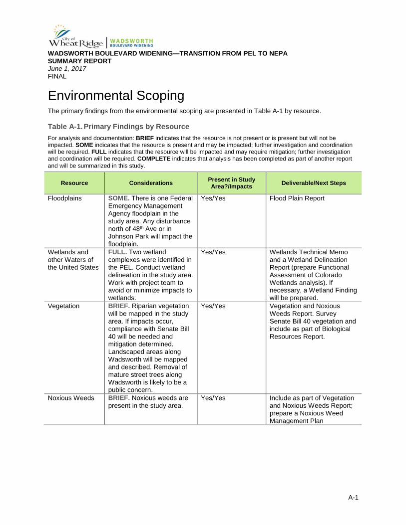
Environmental Scoping The primary findings from the environmental scoping are presented in Table A-1 by resource.
Table A-1. Primary Findings by Resource For analysis and documentation: BRIEF indicates that the resource is not present or is present but will not be impacted. SOME indicates that the resource is present and may be impacted; further investigation and coordination will be required. FULL indicates that the resource will be impacted and may require mitigation; further investigation and coordination will be required. COMPLETE indicates that analysis has been completed as part of another report and will be summarized in this study.
Resource Considerations Present in Study Area?/Impacts Deliverable/Next Steps
Floodplains SOME. There is one Federal Emergency Management Agency floodplain in the study area. Any disturbance north of 48th Ave or in Johnson Park will impact the floodplain.
Yes/Yes Flood Plain Report
Wetlands and other Waters of the United States
FULL. Two wetland complexes were identified in the PEL. Conduct wetland delineation in the study area. Work with project team to avoid or minimize impacts to wetlands.
Yes/Yes Wetlands Technical Memo and a Wetland Delineation Report (prepare Functional Assessment of Colorado Wetlands analysis). If necessary, a Wetland Finding will be prepared.
Vegetation BRIEF. Riparian vegetation will be mapped in the study area. If impacts occur, compliance with Senate Bill 40 will be needed and mitigation determined. Landscaped areas along Wadsworth will be mapped and described. Removal of mature street trees along Wadsworth is likely to be a public concern.
Yes/Yes Vegetation and Noxious Weeds Report. Survey Senate Bill 40 vegetation and include as part of Biological Resources Report.
Noxious Weeds BRIEF. Noxious weeds are present in the study area.
Yes/Yes Include as part of Vegetation and Noxious Weeds Report; prepare a Noxious Weed Management Plan
WADSWORTH BOULEVARD WIDENING—TRANSITION FROM PEL TO NEPA SUMMARY REPORT June 1, 2017 FINAL
A-2
Table A-1 (cont’d). Primary Findings by Resource For analysis and documentation: BRIEF indicates that the resource is not present or is present but will not be impacted. SOME indicates that the resource is present and may be impacted; further investigation and coordination will be required. FULL indicates that the resource will be impacted and may require mitigation; further investigation and coordination will be required. COMPLETE indicates that analysis has been completed as part of another report and will be summarized in this study.
Resource Considerations Present in Study Area?/Impacts Deliverable/Next Steps
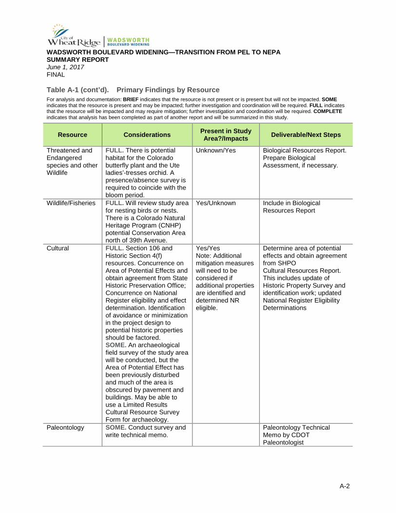
Threatened and Endangered species and other Wildlife
FULL. There is potential habitat for the Colorado butterfly plant and the Ute ladies’-tresses orchid. A presence/absence survey is required to coincide with the bloom period.
Unknown/Yes Biological Resources Report. Prepare Biological Assessment, if necessary.
Wildlife/Fisheries FULL. Will review study area for nesting birds or nests. There is a Colorado Natural Heritage Program (CNHP) potential Conservation Area north of 39th Avenue.
Yes/Unknown Include in Biological Resources Report
Cultural FULL. Section 106 and Historic Section 4(f) resources. Concurrence on Area of Potential Effects and obtain agreement from State Historic Preservation Office; Concurrence on National Register eligibility and effect determination. Identification of avoidance or minimization in the project design to potential historic properties should be factored. SOME. An archaeological field survey of the study area will be conducted, but the Area of Potential Effect has been previously disturbed and much of the area is obscured by pavement and buildings. May be able to use a Limited Results Cultural Resource Survey Form for archaeology.
Yes/Yes Note: Additional mitigation measures will need to be considered if additional properties are identified and determined NR eligible.
Determine area of potential effects and obtain agreement from SHPO Cultural Resources Report. This includes update of Historic Property Survey and identification work; updated National Register Eligibility Determinations
Paleontology SOME. Conduct survey and write technical memo.
Paleontology Technical Memo by CDOT Paleontologist
WADSWORTH BOULEVARD WIDENING—TRANSITION FROM PEL TO NEPA SUMMARY REPORT June 1, 2017 FINAL
A-3
Table A-1 (cont’d). Primary Findings by Resource For analysis and documentation: BRIEF indicates that the resource is not present or is present but will not be impacted. SOME indicates that the resource is present and may be impacted; further investigation and coordination will be required. FULL indicates that the resource will be impacted and may require mitigation; further investigation and coordination will be required. COMPLETE indicates that analysis has been completed as part of another report and will be summarized in this study.
Resource Considerations Present in Study Area?/Impacts Deliverable/Next Steps
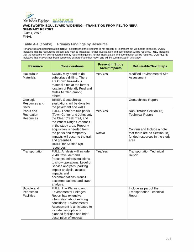
Hazardous Materials
SOME. May need to do subsurface drilling. There are known hazardous material sites at the former location of Friendly Ford and Midas Muffler, among others.
Yes/Yes Modified Environmental Site Assessment
Geologic Resources and Soils
BRIEF. Geotechnical evaluations will be done for the pavement and walls.
Geotechnical Report
Parks and Recreation Resources
FULL. There are two parks (Town Center and Johnson), the Clear Creek Trail, and the Wheat Ridge Greenbelt in the study area. Property acquisition is needed from the parks and temporary impacts will occur to the trail and greenbelt. BRIEF for Section 6(f) resources.
Yes/Yes No/No
Non-Historic Section 4(f) Technical Report Confirm and Include a note that there are no Section 6(f) funded resources in the study area
Transportation FULL. Analysis will include 2040 travel demand forecasts, microsimulations to show operations, Level of Service analyses, parking impact analysis, access impacts and accommodations, transit accommodations, and crash analysis.
Yes/Yes Transportation Technical Report
Bicycle and Pedestrian Facilities
FULL. The Planning and Environmental Linkages Report has extensive information about existing conditions. Environmental Assessment is anticipated to include description of planned facilities and brief description of impacts
Include as part of the Transportation Technical Report
WADSWORTH BOULEVARD WIDENING—TRANSITION FROM PEL TO NEPA SUMMARY REPORT June 1, 2017 FINAL
A-4
Table A-1 (cont’d). Primary Findings by Resource For analysis and documentation: BRIEF indicates that the resource is not present or is present but will not be impacted. SOME indicates that the resource is present and may be impacted; further investigation and coordination will be required. FULL indicates that the resource will be impacted and may require mitigation; further investigation and coordination will be required. COMPLETE indicates that analysis has been completed as part of another report and will be summarized in this study.
Resource Considerations Present in Study Area?/Impacts Deliverable/Next Steps
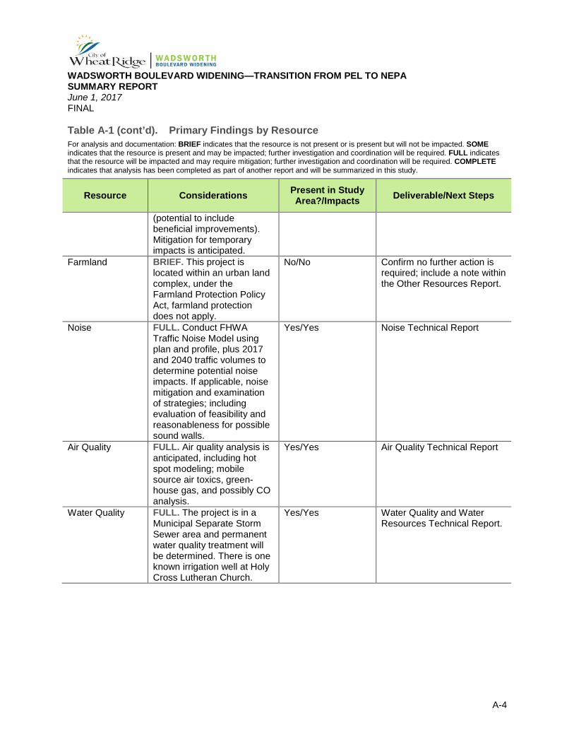
(potential to include beneficial improvements). Mitigation for temporary impacts is anticipated.
Farmland BRIEF. This project is located within an urban land complex, under the Farmland Protection Policy Act, farmland protection does not apply.
No/No Confirm no further action is required; include a note within the Other Resources Report.
Noise FULL. Conduct FHWA Traffic Noise Model using plan and profile, plus 2017 and 2040 traffic volumes to determine potential noise impacts. If applicable, noise mitigation and examination of strategies; including evaluation of feasibility and reasonableness for possible sound walls.
Yes/Yes Noise Technical Report
Air Quality FULL. Air quality analysis is anticipated, including hot spot modeling; mobile source air toxics, green-house gas, and possibly CO analysis.
Yes/Yes Air Quality Technical Report
Water Quality FULL. The project is in a Municipal Separate Storm Sewer area and permanent water quality treatment will be determined. There is one known irrigation well at Holy Cross Lutheran Church.
Yes/Yes Water Quality and Water Resources Technical Report.
WADSWORTH BOULEVARD WIDENING—TRANSITION FROM PEL TO NEPA SUMMARY REPORT June 1, 2017 FINAL
A-5
Table A-1 (cont’d). Primary Findings by Resource For analysis and documentation: BRIEF indicates that the resource is not present or is present but will not be impacted. SOME indicates that the resource is present and may be impacted; further investigation and coordination will be required. FULL indicates that the resource will be impacted and may require mitigation; further investigation and coordination will be required. COMPLETE indicates that analysis has been completed as part of another report and will be summarized in this study.
Resource Considerations Present in Study Area?/Impacts Deliverable/Next Steps
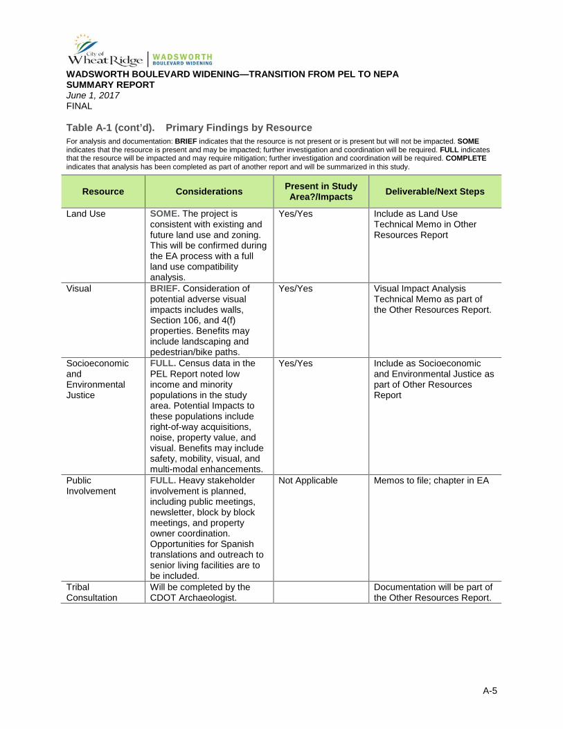
Land Use SOME. The project is consistent with existing and future land use and zoning. This will be confirmed during the EA process with a full land use compatibility analysis.
Yes/Yes Include as Land Use Technical Memo in Other Resources Report
Visual BRIEF. Consideration of potential adverse visual impacts includes walls, Section 106, and 4(f) properties. Benefits may include landscaping and pedestrian/bike paths.
Yes/Yes Visual Impact Analysis Technical Memo as part of the Other Resources Report.
Socioeconomic and Environmental Justice
FULL. Census data in the PEL Report noted low income and minority populations in the study area. Potential Impacts to these populations include right-of-way acquisitions, noise, property value, and visual. Benefits may include safety, mobility, visual, and multi-modal enhancements.
Yes/Yes Include as Socioeconomic and Environmental Justice as part of Other Resources Report
Public Involvement
FULL. Heavy stakeholder involvement is planned, including public meetings, newsletter, block by block meetings, and property owner coordination. Opportunities for Spanish translations and outreach to senior living facilities are to be included.
Not Applicable Memos to file; chapter in EA
Tribal Consultation
Will be completed by the CDOT Archaeologist.
Documentation will be part of the Other Resources Report.
WADSWORTH BOULEVARD WIDENING—TRANSITION FROM PEL TO NEPA SUMMARY REPORT June 1, 2017 FINAL
A-6
Table A-1 (cont’d). Primary Findings by Resource For analysis and documentation: BRIEF indicates that the resource is not present or is present but will not be impacted. SOME indicates that the resource is present and may be impacted; further investigation and coordination will be required. FULL indicates that the resource will be impacted and may require mitigation; further investigation and coordination will be required. COMPLETE indicates that analysis has been completed as part of another report and will be summarized in this study.
Resource Considerations Present in Study Area?/Impacts Deliverable/Next Steps
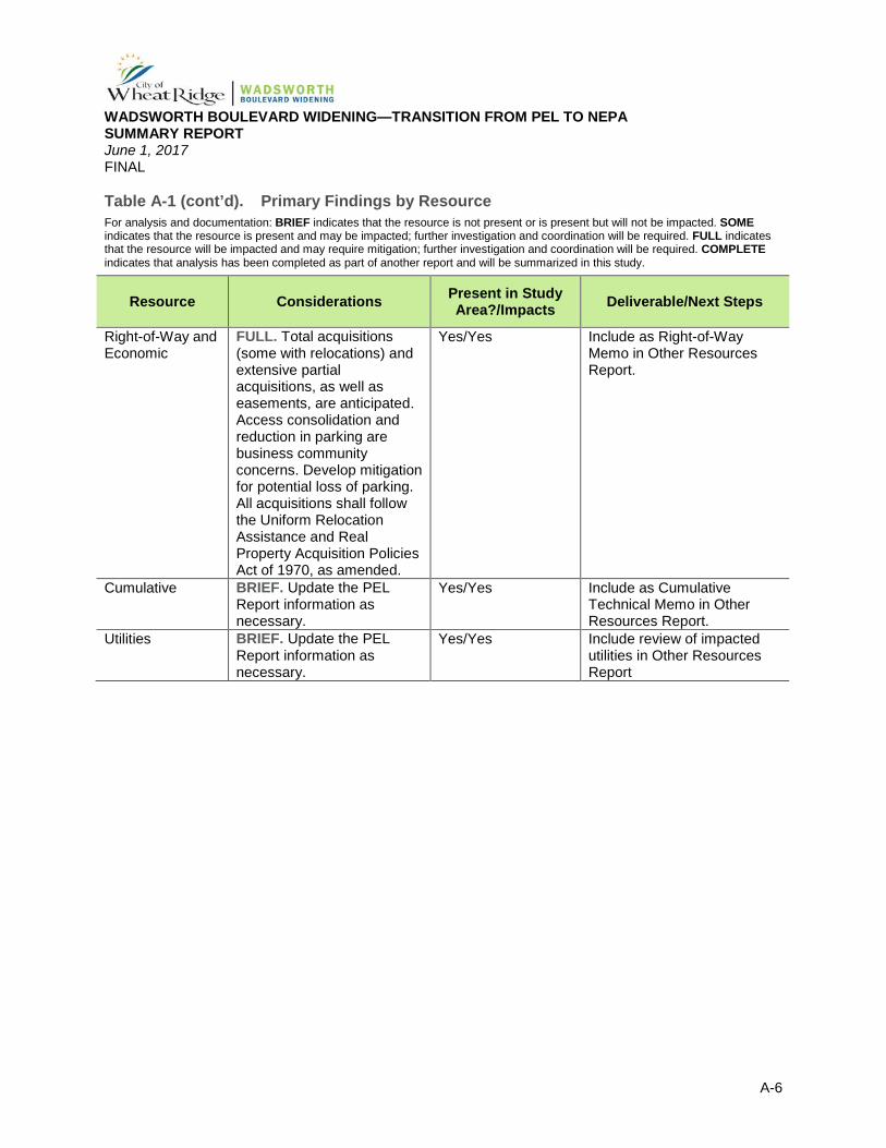
Right-of-Way and Economic
FULL. Total acquisitions (some with relocations) and extensive partial acquisitions, as well as easements, are anticipated. Access consolidation and reduction in parking are business community concerns. Develop mitigation for potential loss of parking. All acquisitions shall follow the Uniform Relocation Assistance and Real Property Acquisition Policies Act of 1970, as amended.
Yes/Yes Include as Right-of-Way Memo in Other Resources Report.
Cumulative BRIEF. Update the PEL Report information as necessary.
Yes/Yes Include as Cumulative Technical Memo in Other Resources Report.
Utilities BRIEF. Update the PEL Report information as necessary.
Yes/Yes Include review of impacted utilities in Other Resources Report
WADSWORTH BOULEVARD WIDENING—TRANSITION FROM PEL TO NEPA SUMMARY REPORT June 1, 2017 FINAL
Appendix B
Appendix B. Travel Data
WADSWORTH BOULEVARD WIDENING—TRANSITION FROM PEL TO NEPA SUMMARY REPORT June 1, 2017 FINAL
B-1
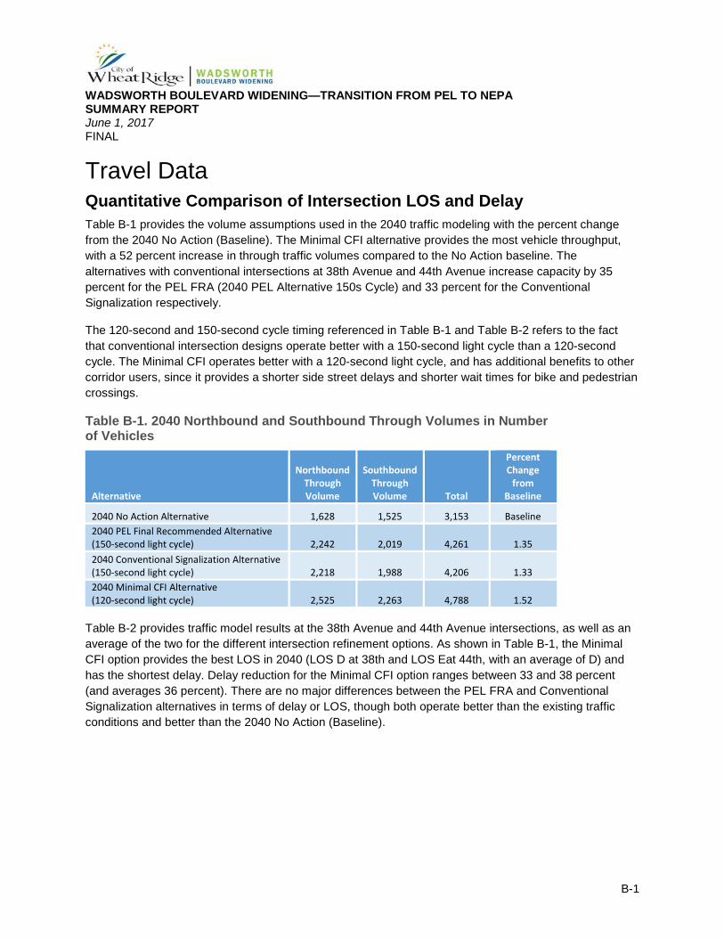
Travel Data Quantitative Comparison of Intersection LOS and Delay Table B-1 provides the volume assumptions used in the 2040 traffic modeling with the percent change from the 2040 No Action (Baseline). The Minimal CFI alternative provides the most vehicle throughput, with a 52 percent increase in through traffic volumes compared to the No Action baseline. The alternatives with conventional intersections at 38th Avenue and 44th Avenue increase capacity by 35 percent for the PEL FRA (2040 PEL Alternative 150s Cycle) and 33 percent for the Conventional Signalization respectively.
The 120-second and 150-second cycle timing referenced in Table B-1 and Table B-2 refers to the fact that conventional intersection designs operate better with a 150-second light cycle than a 120-second cycle. The Minimal CFI operates better with a 120-second light cycle, and has additional benefits to other corridor users, since it provides a shorter side street delays and shorter wait times for bike and pedestrian crossings.
Table B-1. 2040 Northbound and Southbound Through Volumes in Number of Vehicles
Alternative
Northbound Through Volume
Southbound Through Volume Total
Percent Change
from Baseline
2040 No Action Alternative 1,628 1,525 3,153 Baseline 2040 PEL Final Recommended Alternative (150-second light cycle) 2,242 2,019 4,261 1.35 2040 Conventional Signalization Alternative (150-second light cycle) 2,218 1,988 4,206 1.33 2040 Minimal CFI Alternative (120-second light cycle) 2,525 2,263 4,788 1.52
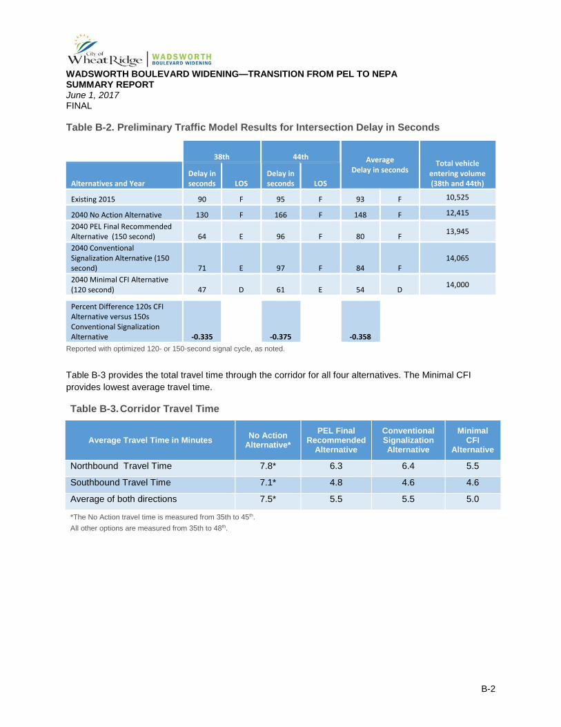
Table B-2 provides traffic model results at the 38th Avenue and 44th Avenue intersections, as well as an average of the two for the different intersection refinement options. As shown in Table B-1, the Minimal CFI option provides the best LOS in 2040 (LOS D at 38th and LOS Eat 44th, with an average of D) and has the shortest delay. Delay reduction for the Minimal CFI option ranges between 33 and 38 percent (and averages 36 percent). There are no major differences between the PEL FRA and Conventional Signalization alternatives in terms of delay or LOS, though both operate better than the existing traffic conditions and better than the 2040 No Action (Baseline).
WADSWORTH BOULEVARD WIDENING—TRANSITION FROM PEL TO NEPA SUMMARY REPORT June 1, 2017 FINAL
B-2
Table B-2. Preliminary Traffic Model Results for Intersection Delay in Seconds
38th 44th Average
Delay in seconds Total vehicle
entering volume (38th and 44th) Alternatives and Year
Delay in seconds LOS
Delay in seconds LOS
Existing 2015 90 F 95 F 93 F 10,525
2040 No Action Alternative 130 F 166 F 148 F 12,415
2040 PEL Final Recommended Alternative (150 second) 64 E 96 F 80 F 13,945
2040 Conventional Signalization Alternative (150 second) 71 E 97 F 84 F
14,065
2040 Minimal CFI Alternative (120 second) 47 D 61 E 54 D 14,000
Percent Difference 120s CFI Alternative versus 150s Conventional Signalization Alternative -0.335 -0.375
-0.358
Reported with optimized 120- or 150-second signal cycle, as noted.
Table B-3 provides the total travel time through the corridor for all four alternatives. The Minimal CFI provides lowest average travel time.
Table B-3. Corridor Travel Time
Average Travel Time in Minutes No Action Alternative*
PEL Final Recommended
Alternative
Conventional Signalization Alternative
Minimal CFI
Alternative
Northbound Travel Time 7.8* 6.3 6.4 5.5
Southbound Travel Time 7.1* 4.8 4.6 4.6
Average of both directions 7.5* 5.5 5.5 5.0
*The No Action travel time is measured from 35th to 45th. All other options are measured from 35th to 48th.
WADSWORTH BOULEVARD WIDENING—TRANSITION FROM PEL TO NEPA SUMMARY REPORT June 1, 2017 FINAL
Appendix C
Appendix C. Summary of Right-of-Way Acquisition Required
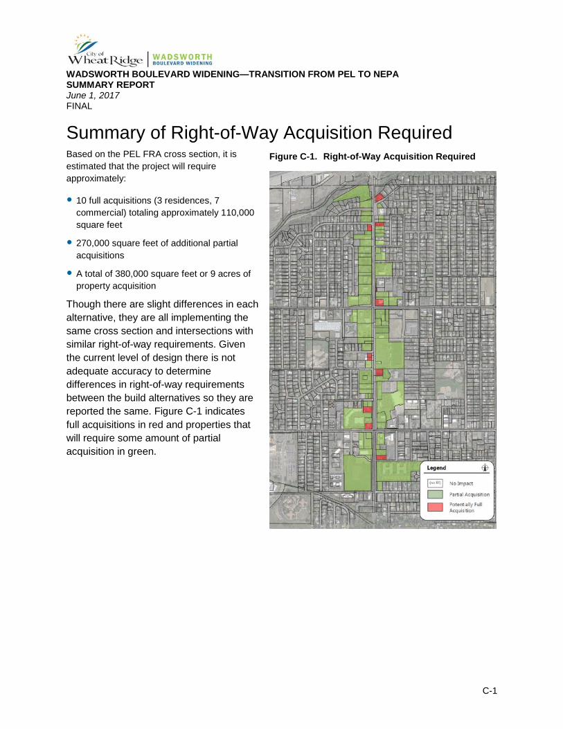
WADSWORTH BOULEVARD WIDENING—TRANSITION FROM PEL TO NEPA SUMMARY REPORT June 1, 2017 FINAL
C-1
Summary of Right-of-Way Acquisition Required Based on the PEL FRA cross section, it is estimated that the project will require approximately:
10 full acquisitions (3 residences, 7 commercial) totaling approximately 110,000 square feet
270,000 square feet of additional partial acquisitions
A total of 380,000 square feet or 9 acres of property acquisition
Though there are slight differences in each alternative, they are all implementing the same cross section and intersections with similar right-of-way requirements. Given the current level of design there is not adequate accuracy to determine differences in right-of-way requirements between the build alternatives so they are reported the same. Figure C-1 indicates full acquisitions in red and properties that will require some amount of partial acquisition in green.
Figure C-1. Right-of-Way Acquisition Required