Embed Size (px)
Citation preview

WA1488
Deep Creek
Colbert Creek
12
20
25
50
75
10
0
EXPERT EVIDENCE STATEMENT, GRANTVILLE
QUARRY PLANNING PERMIT APPLICATION 120388-1
1381-1395 BASS HIGHWAY, GRANTVILLE
HYDROGEOLOGY - JOHN LEONARD
JOHN LEONARD CONSULTING SERVICES
Groundwater and Environmental Consultants
003159

JOHN LEONARD CONSULTING SERVICES GROUNDWATER AND ENVIRONMENTAL CONSULTANTS
March 2021 Planning Permit Application 120388-1
GW-21/003 Expert Evidence - Hydrogeology – John Leonard
i
JOHN LEONARD CONSULTING SERVICES Pty Ltd ACN082316890
28 Mernda Avenue
Carnegie VIC 3163
Mobile: 0407 816 237
e-mail: [email protected]
Author: John Leonard
JLCS Ref. No.: GW-21/002.
003160

JOHN LEONARD CONSULTING SERVICES GROUNDWATER AND ENVIRONMENTAL CONSULTANTS
March 2021 Planning Permit Application 120388-1
GW-21/003 Expert Evidence - Hydrogeology – John Leonard
i
TABLE OF CONTENTS
1.0 NAME AND ADDRESS 1
2.0 QUALIFICATIONS AND EXPERIENCE 1
3.0 INSTRUCTIONS 2
4.0 REPORT RELIED UPON AND ADOPTED 3
5.0 DETAILS AND QUALIFICATIONS OF ANY PERSON WHO CARRIED OUT
ANY TESTS OR EXPERIMENTS UPON WHICH THE EXPERT HAS RELIED
IN PREPARING THE STATEMENT 3
6.0 FURTHER WORK SINCE PREPARATION OF MY REPORT 5
7.0 HA REPORT SUMMARY AND CONCLUSIONS 5
8.0 DECLARATION 6
9.0 BACKGROUND 7
10.0 CONTEXT AND GROUNDWATER CHARACTERISTICS 7
11.0 THE PROPOSED FURTHER DEVELOPMENT AND SUPPORTING
DOCUMENTATION, INCLUDING THE PROPOSALS TO INTERSECT
GROUNDWATER AND EXTRACT SAND BELOW THE GROUNDWATER
TABLE 12
12.0 WHETHER THE PROPOSED FURTHER DEVELOPMENT WILL CAUSE ANY
UNREASONABLE GROUNDWATER IMPACTS 14
13.0 ANY ISSUES RAISED IN THE OBJECTIONS TO THE AMENDMENT
APPLICATION THAT ARE WITHIN YOUR EXPERTISE. 19
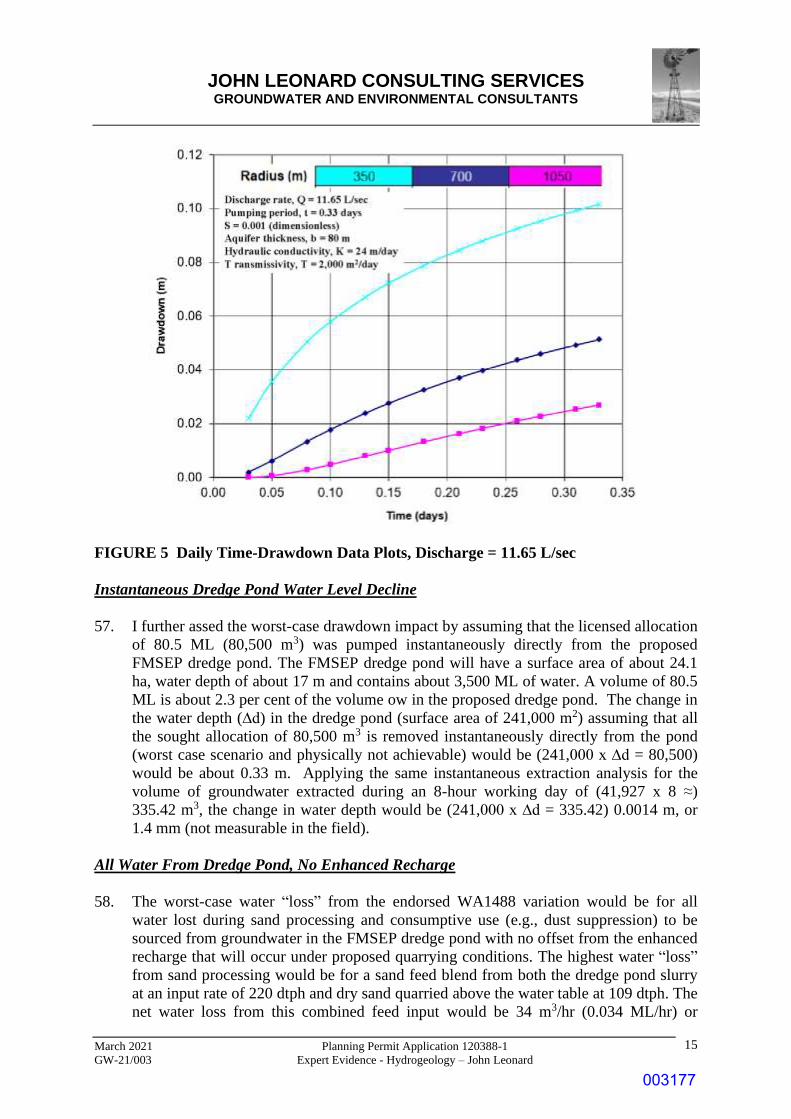
14.0 THE NEED FOR ANY ADDITIONAL WORKS OR OTHER MEASURES TO
MITIGATE ANY POTENTIAL GROUNDWATER IMPACTS. 24
15.0 THE ISSUES SET OUT IN PARAGRAPHS 6 AND 19 OF THE DIRECTIONS TO
THE EXTENT WITHIN YOUR EXPERTISE 25
003161

JOHN LEONARD CONSULTING SERVICES GROUNDWATER AND ENVIRONMENTAL CONSULTANTS
March 2021 Planning Permit Application 120388-1
GW-21/003 Expert Evidence - Hydrogeology – John Leonard
ii
16.0 ANY OTHER GROUNDWATER MATTERS YOU CONSIDER RELEVANT TO
THE ASSESSMENT OF THE PROPOSED FURTHER DEVELOPMENT 25
17.0 HA REPORT SUMMARY AND CONCLUSIONS 25
LIST OF FIGURES
FIGURE 1 WA1488 and surrounds pre-quarrying Terrain Relief Model showing the
incised Deep and Colbert creek
FIGURE 2 WA1488 and Surrounds Pre-Quarrying Filled Topographic Contours
FIGURE 3 Mapped Outcrop Geology, Grantville Area (modified after DPI, 2011)
FIGURE 4 WA1488 Terrain Relief Models, A) July 2019, and WPV Proposed Final Sand
Extraction Areas
FIGURE 5 Daily Time-Drawdown Data Plots, Discharge = 11.65 L/sec
FIGURE 6 Daily Time-Drawdown Data Plots, Deficit Rate = 12.22 L/sec
FIGURE 7 Deep Creek “True 3D” View showing incised creek and both on-stream and
off-stream pools
FIGURE 8 Deep Creek Streambed Topographic Profile and Position of the Underlying
Water Table
LIST OF TABLES
TABLE 1 Heavy Metal Concentrations in Filter Cake Leachate, Eurofins Report 742427-
L Extract
LIST OF PLATES
PLATE 1 Deep Creek Streambed: A) 60 m Upstream from Bass Highway, and B)
Upstream of Confluence with MW3840 Tributary Channel
003162

JOHN LEONARD CONSULTING SERVICES GROUNDWATER AND ENVIRONMENTAL CONSULTANTS
March 2021 Planning Permit Application 120388-1
GW-21/003 Expert Evidence - Hydrogeology – John Leonard
1
1.0 NAME AND ADDRESS
John Leonard
28 Mernda Avenue
Carnegie VIC 3163.
2.0 QUALIFICATIONS AND EXPERIENCE
1. I am a recognised hydrogeological expert. My specific skills include geology/basin
analysis, groundwater resource evaluation, production bore design, aquifer hydraulic
testing, groundwater monitoring, and impact and risk assessments. A Statement
documenting my qualifications, lecturing engagements, project experience and
publication is attached as Attachment A. and summarised in the following Sections.
2.1 Qualification
• Graduate Diploma in Computer Simulation, SIT.
• Master of Applied Science (Hydrogeology/Engineering Geology), UNSW.
• Graduate Diploma in Hydrogeology, SA Institute of Technology.
• Diploma Applied Science (Geology), Ballarat School of Mines.
2.2 Employment Positions
• Senior Principal, John Leonard Consulting Services
• Principal Hydrogeologist, CH2M Hill
• Principal Hydrogeologist, Gutteridge Haskins Davey (now GHD).
• Manager, Groundwater Policy and Planning Branch, DWR, Victoria
• Principal Hydrogeologist, Dames & Moore International
• Manager, Basin Studies (subsurface mapping), Geological Survey of Victoria
• Director, Victorian Government Drilling Unit
• Officer in Charge, Groundwater Resources Section, Geological Survey of Victoria
• Contract Geologist Exon/Esso
• Contract Hydrogeologist EPA Victoria
2.3 Project Work
2. I have worked on about 500 projects mostly in Australia, but also in Asia and the
Middle East including manager and principal researcher for three US Aid projects.
• Groundwater resource investigation, evaluation and development.
• Groundwater recharge.
• Mining and Extractive Industry.
• Civil/geotechnical engineering and Infrastructure.
003163

JOHN LEONARD CONSULTING SERVICES GROUNDWATER AND ENVIRONMENTAL CONSULTANTS
March 2021 Planning Permit Application 120388-1
GW-21/003 Expert Evidence - Hydrogeology – John Leonard
2
• Environmental impact assessment.
• Urban Hydrogeology (land development and salinity assessment) projects.
• Landfill and contaminated site projects (groundwater, surface water, gas).
• Soil contamination investigation and assessment projects.
2.4 Lecturing Engagements
3. I presented groundwater courses at a number of Australian Universities and have
lectured at Specialist Workshops and Schools. Topics included groundwater
investigations and evaluation; groundwater contamination, groundwater flow and solute
transport modelling; pumping test design and data interpretation; drilling and bore
construction; and conducting hydrogeological assessments.
2.5 Reports and Publications
4. I have prepared 32 publications including two books on Victorian hydrogeology
published by the former Department of Water Resources, chapters on “Groundwater” in
the previous two editions of the Geology of Victoria, and a chapter in Introducing
Victorian Geology. I was a co-author of the Hydrogeological Assessment (Groundwater
Quality) report prepared for the Victoria EPA. An abridged version of this report was
published by the EPA as part of their Best Practice Environment Management
Guidelines series. I was also a member of the Expert Committee working with the EPA
to prepare the (Victorian) Groundwater Sampling Guidelines. I have also prepared more
than 450 consultant reports and 38 GSV open file reports. I was the sole author of most
these publications and reports.
2.6 Committees
5. I have served on high-level government committees including the former Groundwater
Advisory Committee (Victoria), South West Victoria Water Resources Management
Task Force, Murray-Darling Basin Groundwater Modelling Committee, and Victorian
Salinity Bureau Research and Investigation Committee. I was the inaugural Secretary of
the Victorian Branch of the International Association of Hydrogeologists and am a
former Vice-President.
3.0 INSTRUCTIONS
6. Received written instructions from Equipe Lawyers acting for Dandy Premix Quarries
Pty Ltd (DPQ) on 4 February 2021. My instructions which are included in Attachment
2, were to conduct a view(s) of the Subject Land and the surrounding land and prepare
an expert witness statement addressing the following matters and questions:
1. The site context of the Subject Land, in particular the groundwater characteristics
of the Subject Land and surrounding land.
2. The Proposed Further Development and supporting documentation, including the
proposals to intersect groundwater and extract sand below the groundwater table.
3. Whether the Proposed Further Development will cause any unreasonable
003164
JOHN LEONARD CONSULTING SERVICES GROUNDWATER AND ENVIRONMENTAL CONSULTANTS
March 2021 Planning Permit Application 120388-1
GW-21/003 Expert Evidence - Hydrogeology – John Leonard
3
groundwater impacts.
4. The need for any additional works or other measures to mitigate any potential
groundwater impacts.
5. Any issues raised in the objections to the Amendment Application that are within
your expertise.
6. The issues set out in Paragraphs 6 and 19 of the Directions (which our client must
address in a Part A and a Part B submission) to the extent within your expertise.
7. Any other groundwater matters you consider relevant to the assessment of the
Proposed Further Development.
4.0 REPORT RELIED UPON AND ADOPTED
7. In in preparing my Expert Witness Statement I relied primary on my 2019 assessments
report entitled “WA1488, 1381 1395 Bass Highway, Grantville, Work Plan Variation,
Phase 2 Development, Hydrogeological Assessment” prepared by John Leonard
Consulting Services (JLCS) as presented in Hearing Book (HB) Tab 20.
8. I was the sole author of the 2019 Hydrogeological Assessment (HA) report.
9. I adopt my 2019 HA report as my evidence.
10. I summarised key components of my HA report in my Statement as background to my
responses to the specified instructions from Equipe Lawyers.
11. My responses include assessments of information on filter cake chemistry and leachate
chemistry (from column leaching tests) obtained subsequently to preparation of my
2019 HA report.
12. The additional assessments did not cause me to change my opinion that implementing
the endorsed WA1488 variations would not cause unacceptable water table drawdown,
would not reduce groundwater discharge into nearby creeks or into Western Port Bay,
or adversely impact local groundwater quality.
5.0 DETAILS AND QUALIFICATIONS OF ANY PERSON WHO CARRIED
OUT ANY TESTS OR EXPERIMENTS UPON WHICH THE EXPERT HAS
RELIED IN PREPARING THE STATEMENT
13. I used information provided by BCA Consulting (BCA), S Young and R Anderson. The
other sources of the information that I used in compiling my HA report were listed on
page 5 of my report.
BCA Consulting
14. BCA Consulting (BCA) provided the lithologic logs of the sand resource investigation
drillholes and result of grain size analyses of selected sand samples. I used the grain size
analyses to determine aquifer hydraulic conductivity values that I used for modelling
water table drawdown interference impacts (see HA report Chapter 10
003165

JOHN LEONARD CONSULTING SERVICES GROUNDWATER AND ENVIRONMENTAL CONSULTANTS
March 2021 Planning Permit Application 120388-1
GW-21/003 Expert Evidence - Hydrogeology – John Leonard
4
15. BCA Consulting is a industry leading consulting practice specialising in extractive
industry, resource assessment and planning for the quarrying and sand extraction
industries. BCA provide specialist services in Geological Assessments, Site
Investigations Resource Assessments, Quarry Planning Management Plans, Risk Based
Work Plans, and Material Testing.
Stewart Young
16. Stewart Young, Stewart Young Pty Ltd logged the holes that were drilled to map the
geological structure (Heath Hill Fault) that is located in the eastern part of WA1488. Mr
Young provided information including water budgets for a number of sand processing
water scenarios including water balance flow diagrams that I used for assessing impacts
of the proposed WA1488 variations on local groundwater as described in HA report
Chapter 9. Mr Young also “manufactured” samples of likely filter cake for laboratory
soil chemistry analysis and column leachate tests.
17. Stewart Young is a very experienced extractive industry practitioner who has worked in
a variety of technical and managerial position in the sand quarry for more than 40 years.
His employment positions include:
• Quarry Manger at “Wrights Sand”, Clayton.
• BMG Resources, wash plant and operations supervisor.
• Ready Mix Group, wash plant and operations supervisor.
• Quarry Manager, Readymix Lyndhurst
• Quarry Manager, Heatherton Sands (Readymix & Boral Joint venture)
• Technical manager for Readymix’s sand businesses in Vic.
• Stewart Young Pty Ltd Industry Consultant completed project interstate as well as
throughout Victoria.
Robert (Rob) Anderson
18. I used lithologic logs of holes drilled on the eastern side of the Heath Hill Fault
prepared by contract Engineering Geologist Robert Anderson to ascertain the
stratigraphy of the land east of the fault (HA Report Section 5.3.2).
Qualifications
• Associate Diploma, Geology, RMIT, 1970.
• Graduate Diploma, Engineering Geology Monash University, 1983.
• Post Graduate Diplomas in Engineering Geology and Environmental Science,
Monash University, 1983.
• Graduate Diploma, Environmental Science, Monash University 1993.
003166

JOHN LEONARD CONSULTING SERVICES GROUNDWATER AND ENVIRONMENTAL CONSULTANTS
March 2021 Planning Permit Application 120388-1
GW-21/003 Expert Evidence - Hydrogeology – John Leonard
5
Employment History
• 2014-present Engineering Geology Consultant
• Aug 2012 - Feb 2014 Senior engineering geologist ATC Williams P/L
• 2005- 2007 Contract engineering geologist
• Jan 1998 - Mar 2009 Engineering Geologist, Project Geoservices
• Jan 1992 – Jan 1998 Senior Engineering Geologist, Coffey Partners
International Pty Ltd.
• Jan 1973-Jan 1992 Engineering Geologist Melbourne Water, Melbourne
Metropolitan Board of Works.
• Jan 1970 – Jan 1973 Exploration Geologist, Austin-Anderson Australia Pty
Ltd.
6.0 FURTHER WORK SINCE PREPARATION OF MY REPORT
19. Since completing my HA report, I reviewed of the results of more recent groundwater
chemical analyses and filter cake soil chemistry leaching column studies to ascertain
whether placement of filter cake into the proposed dredge pond would pose
unacceptable risk to groundwater (discussed in Section 12). I also prepared additional
mapping of the water table beneath Deep Creek to aid in understanding the relationship
between the creek bed and underlying groundwater (included in Chapter 12).
7.0 HA REPORT SUMMARY AND CONCLUSIONS
20. WA1488 is in a coastal aquifer hydrogeological setting. The regional water table
beneath the majority of the site occurs within Brighton Group sediments. Groundwater
flows towards and discharges into Western Port Bay.
21. The site is bounded by two creeks, Deep Creek to the north and Colbert Creek to the
south. Flow in both creeks is ephemeral, only occurring after extended rainfall events.
22. The water table is below the creek beds only intersecting streambed at lower elevations
west of the Bass Highway.
23. DPQ will require additional water for sand washing and processing under the ERR
endorsed Work Plan Variation for WA1488. The additional water would be sourced
from groundwater either pumped directly from the dredge pond or recovered from the
sand feed (mostly from dredged slurry). DPQ have negotiated a temporary groundwater
licence transfer for 80.5 ML per annum.
24. Groundwater recharge at WA1488 has been increased by the development of the
existing FMSEP as a result of the removed of the silt/clay overburden and exposure of
the underlying more permeable sand. Recharge will be further increased (enhanced) as
the proposed footprint of the existing FMSEP increases and with development of the
proposed eastern CSEP.
003167

JOHN LEONARD CONSULTING SERVICES GROUNDWATER AND ENVIRONMENTAL CONSULTANTS
March 2021 Planning Permit Application 120388-1
GW-21/003 Expert Evidence - Hydrogeology – John Leonard
6
25. The resulting increased groundwater storage will be reduced by evaporation from the
free water surface in the proposed FMSEP dredge pond and by water deficit associated
with sand processing of about 65 ML/year as well as by the future use of groundwater
pumped from the FMSEP dredge pond for dust suppression (10 ML/yr).
26. Overall site and sand processing water budgets indicate that there will be a minimum
net gain to the groundwater system of about 136 ML per annum resulting from increase
rainfall infiltration into the exposed sands or the dredge pond. Consequently, local
drawdown interference is not expected to occur.
27. The findings of groundwater quantity and quality risk assessments were that most
potential risks are in the Low Risk category, and that Risk Mitigation measures would
result in Low Residual Risks.
28. I confirm my opinion that the proposed WA1488 variations will not adversely impact
groundwater quantity, groundwater quality, flow in Deep Creek, and/or discharge into
Western Port Bay.
8.0 DECLARATION
29. I have made all the inquiries that I believe are desirable and appropriate and no matters
of significance which I regard as relevant have to my knowledge have been withheld
from the Panel. In preparing this report I have read and had regard to the PPV Expert
Witness Practice Note dated April 2019.
John Leonard
5 March 2021
003168

JOHN LEONARD CONSULTING SERVICES GROUNDWATER AND ENVIRONMENTAL CONSULTANTS
March 2021 Planning Permit Application 120388-1
GW-21/003 Expert Evidence - Hydrogeology – John Leonard
7
9.0 BACKGROUND
30. The HA report that I prepared focused on assessing the Environmental Risk to
groundwater and the interconnected surface water systems associated with development
of the endorsed Work Authority variation for WA 1488 particularly use of groundwater
in sand processing works and for on-site dust suppression. In this context, I point out
that at the time that I prepared my HA report, DPQ were in the process for applying for
a temporary licence for 80.5 ML per year under the provisions of the Water Act 1889
and trading rules established for the local water management area, i.e., the Koo Wee
Rup Water Supply Protection Area administered by Southern Rural Water (SRW). A
temporary licence subject to annual review was subsequently granted by SRW.
31. In preparing my report, I addressed the requirement of both the “Preparation of Work
Plans and Work Plan ― Variations Guidelines for Mining Projects” prepared by the
Department of Jobs, Precincts and Regions (DJPR, V12, 2019), and the Water Act 1989
(as amended).
32. The DJPR (2019) guidelines requires that descriptions must be included in WA
variation documents of (but not limited to) 1) the nature of any new auxiliary works,
e.g., dewatering bores, and water treatment plant that could adversely impact local
groundwater systems, 2) the location of sensitive hydraulically connected receptors such
as water supply bores and Groundwater Dependent Ecosystems within two kilometres
of the licence boundary relevant to the new or changing works, and 3) an assessment of
the risk of harm arising from the proposed changed operations to local groundwater
users and hydraulically connected sensitive environmental segments such as wetlands or
Groundwater Dependent Ecosystems (GDEs).
33. The provisions of the Water Act 1989 require that potential groundwater users obtain 1)
a license to construct a bore, and 2) a separate licence to take and use groundwater for
commercial uses. [Extracting groundwater for stock watering and/or domestic use is a
statutory right under the Water Act and does not require an extraction licence.]
Licensing authorities are also required to ensure that allocation of a new groundwater
licence does not undermine environmental water reserves or surface water allocations.
In considering applications for a groundwater extraction licences the Rural Water
Authorities including SRW have to take a number of matters into consideration
including, 1) the existing and projected availability of water in the area, 2) any adverse
effect that the allocation or use of water under the entitlement is likely to have on
existing authorised uses of water, a waterway or an aquifer, 3) the need to protect the
environment, including the riverine and riparian environment, and 4) government
policies concerning the preferred allocation or use of water resources.
10.0 CONTEXT AND GROUNDWATER CHARACTERISTICS
34. Key earth system components that I considered in my HA report included climate,
topography, surface and subsurface geology, aquifer type and form, aquifer spatial
distribution, and aquifer hydraulic parameters. Climate, especially rainfall and
evaporation, control the amount of water available to recharge aquifer systems. The
003169

JOHN LEONARD CONSULTING SERVICES GROUNDWATER AND ENVIRONMENTAL CONSULTANTS
March 2021 Planning Permit Application 120388-1
GW-21/003 Expert Evidence - Hydrogeology – John Leonard
8
amount of recharge together with other stresses on groundwater systems and aquifer
hydraulic parameters in turn control the depth to groundwater. Topography is not only
one of the main controls on surface water runoff but also has a significant influence on
water table position; the water table configuration is a subdued reflection of the surface
topography. The influence of topography is more pronounced in hilly and mountainous
terrain with high relief. Direct groundwater discharge occurs where the water table
intersect the ground surface or indirectly via evapotranspiration where the water table is
close to the ground surface. The geological history of an area controls the number and
type of aquifers, their lateral and vertical extent, and configuration (depth, outcrop
pattern), hydraulic properties and degree of interconnection. Surface/outcrop geology
controls the recharge/discharge regime of aquifer systems whilst subsurface geology
controls the distribution and flow of groundwater. Subsurface geology also controls
possible development of perched water tables above the main regional water table.
Climate
35. The climate in the Grantville area is temperate and variable with moderate rainfall
received in most months. The average monthly rainfall over the 10-year period 2009 to
1018, inclusive varied between about 43.4 and 99.3 mm, and the corresponding average
annual rainfall was was about 932 mm.
Topography and Drainage
36. The Grantville area is located in on a coastal plain between Western Port Bay to the
west and the foothills of the Strzelecki Ranges to the east. The coastal plain is drained
by a number of small general east-west aligned “streams” including Deep Creek along
the northern boundary of WA1488 and Colbert Creek along its southern boundary that
discharge into Western Port Bay (Figure 1). The pre-quarrying elevation across
WA1488 ranged from less than 10 m AHD in the northwestern part of the site up to
more than 120 m AHD on the ridge in the eastern portion of the site (Figure 2).
37. The channel of both Deep Creek and Colbert Creek are incised and well defined with a
number of shallow depressions in the streambed; small, disconnected pools form in the
depression after rainfall events. Both streams were dry except for some on- and off-
stream dams and small, natural water holes, and relatively short reaches close to
Western Port Bay when inspected during field reconnaissance in 2012-3, 2017, 2018,
and 2019.
Geology
38. The geology varies across the WA1488 site with the western, larger portion (~124.0 ha)
of the site located within the Western Port Basin and smaller eastern portion (~31.6 ha)
is within the Gippsland Basin. The two basins are separated by the general northeast-
southwest aligned Heath Hill Fault. Movement on the Heath Hill Fault has
juxtapositioned younger, unconsolidated Tertiary Brighton Group against consolidated
and indurated Cretaceous Strzelecki Group Rocks that outcrop east of the Heath Hill
Fault (Figure 3) and is the predominate rock type that forms the Strzelecki Ranges.
003170

JOHN LEONARD CONSULTING SERVICES GROUNDWATER AND ENVIRONMENTAL CONSULTANTS
March 2021 Planning Permit Application 120388-1
GW-21/003 Expert Evidence - Hydrogeology – John Leonard
9
WA1488
Deep Creek
Colbert Creek
12
20
25
50
75
10
0
FIGURE 1 WA1488 and surrounds pre-quarrying Terrain Relief Model showing the
incised Deep and Colbert creek
39. The Brighton Group beneath WA1488 was not fully penetrated during sand resource
investigative drilling undertaken by BCA between 2011, 2017 and 2018. However,
based on review of bore logs in the (greater) Grantville area, the stratigraphic sequence
beneath WA1488 is considered to consist of (from oldest to youngest): 1) Strzelecki
Group, 2) possibly Childers Formation (thin brown coal was reported in a number of
bores in the Grantville area), and Brighton Group.
40. The Brighton Group east of the Heath Hill Fault consists of unconsolidated sands, silts
and clays with up to 4-10 m of silt and clay “overburden” overlaying fine-medium sand
in the western portion of WA1488, with thinner to absent overburden above the coarse
sand in the more elevated eastern portion of the site closer to the Heath Hill Fault.
41. A thin veneer of Brighton Group overlies older Cretaceous consolidated Strzelecki
Group rocks on the eastern side of the Heath Hill Fault. A volcanic plug intruding
Strzelecki Group rocks was intersected in drillholes immediately east of the Heath Hill
Fault (these drillhole were logged by R Anderson).
003171

JOHN LEONARD CONSULTING SERVICES GROUNDWATER AND ENVIRONMENTAL CONSULTANTS
March 2021 Planning Permit Application 120388-1
GW-21/003 Expert Evidence - Hydrogeology – John Leonard
10
FIGURE 2 WA1488 and Surrounds Pre-Quarrying Filled Topographic Contours
Hydrogeology
42. The hydrogeology of WA1488 and the surrounding area is described in detail in HA
report Chapter 7 and summarised in this Section.
43. The water table beneath WA1488 occurs within the Brighton Group west of the Heath
Hill Fault, and in the Strzelecki Group east of the fault. Shallow groundwater
intersected in bores immediately east of the Heath Hill Fault is consider to be perched
above the deeper regional water table.
44. The water table within the Brighton Group slopes in a general westerly direction
towards Western Port Bay. The salinity of the groundwater in the Brighton Group
beneath WA1488 was less than 500 mg/L TDS. The horizontal hydraulic conductivity
of the Brighton Group fine to medium sands determined from the grain size analyses
undertaken by BCA is in the general range 20 to 30 m/day. The hydraulic conductivity
of the coarse sand facies in the eastern portion of WA1488 would be higher possibly up
to 50 m/day. Rainfall recharge under per-quarrying conditions was variable with high
infiltration rates (25 to 30%) on the more elevated eastern portion where Brighton
Group sands outcrop or subgroup beneath a thin layer of silt and clay, and lower (less
than 15-20) in the flatter-lying western portion of the site where sand is overlaid by a
thicker layer of silt and clay. Groundwater recharge at WA1488 has been increased by
the development of the existing FMSEP as a result of the removed of the silt/clay
overburden and exposure of the underlying more permeable sands.
003172

JOHN LEONARD CONSULTING SERVICES GROUNDWATER AND ENVIRONMENTAL CONSULTANTS
March 2021 Planning Permit Application 120388-1
GW-21/003 Expert Evidence - Hydrogeology – John Leonard
11
Alluvium
(unnamed)
Quaternary
Silt, clay, gravel, sand
Coastal lagoon
deposits (unnamed)
Silt, clay; dark grey to black,
variably consolidated
Brighton Group
Mornington Volcanic
Group
Strzelecki Group
Tertiary
Cretaceous
Basalt, pyroclastics, plugs and dykes
Sandstone, siltstone, mudstone,
black coal
Sand, gravel, clayey and silty sand,
silt, clay; ferruginised in part
Hea
th
Hill F
ault
Hea
th
Hill F
ault
WA1488
A
B
AB: Figure 5.9 Cross-Section Location
Hea
th
Hill
Faul
t
Wes
tern
Por
t Bas
in
Gipps
land
Bas
in
FIGURE 3 Mapped Outcrop Geology, Grantville Area (modified after DPI, 2011)
45. Groundwater discharges mainly into the Western Port Bay over a relatively wide
discharge/transition zone, into local creeks where the base of the creeks are below the
water table, or via evapotranspiration near the bay where the water table is close to the
ground surface. The water table is below the base of both creeks that bound WA1488
(Deep Creek along the northern boundary and Colbert Creek along the southern
boundary). The water table only intersects the streambed of these creeks very close to
Western Port Bay.
003173

JOHN LEONARD CONSULTING SERVICES GROUNDWATER AND ENVIRONMENTAL CONSULTANTS
March 2021 Planning Permit Application 120388-1
GW-21/003 Expert Evidence - Hydrogeology – John Leonard
12
11.0 THE PROPOSED FURTHER DEVELOPMENT AND SUPPORTING
DOCUMENTATION, INCLUDING THE PROPOSALS TO INTERSECT
GROUNDWATER AND EXTRACT SAND BELOW THE GROUNDWATER
TABLE
46. The ERR endorsed variation includes 1) increasing the area of the western, fine-medium
extraction sand pit (FMSEP) above water table and dredging sand from the extended
central area of the pit (dredge pond) using a dredge cutter, and 2) development a new
coarse sand extraction pit (CSEP) at higher elevation and more than 40 m above the
water table in the eastern portion of the approved site in area (Figure 4). The final
dredge pond within the FMSEP will cover about 24.1 ha and contain about 3,500 ML of
water.
FIGURE 4 WA1488 Terrain Relief Models, A) July 2019, and WPV Proposed Final
Sand Extraction Areas
003174

JOHN LEONARD CONSULTING SERVICES GROUNDWATER AND ENVIRONMENTAL CONSULTANTS
March 2021 Planning Permit Application 120388-1
GW-21/003 Expert Evidence - Hydrogeology – John Leonard
13
47. The dry screening and blending sand plant will be significantly enhanced enlarged to
process both wet sand slurry from the proposed FMSEP dredge pond as well as “dry”
sand from the FMSEP areas above the water table and “dry” coarse sand from the
CSEP. The processing plant will include a sand wash plant, thickener and water
clarifier, mud buffer tank, dewatering belt press, fresh water storage tank and recycled
water storage tank (recycled water will be returned to the dredge pond).
48. Groundwater will be removed from the pond in the slurry (25% sand and 75% water)
dredged from the pond and pumped to the sand washing plant for processing.
Groundwater will also be pumped directly from the pond for sand processing make-up
water and for dust suppression.
49. The plant at WA1488 will be enlarged to process both slurry from the proposed FMSEP
dredge pond. Dry sand will continue to be extracted above the water table from an
expanded FMSEP and blended with sand from the proposed CSEP. The enhanced sand
washing, and dewatering plant will incorporate the existing raw bulk feed bin system
with the addition of constant density feed regulating sumps, cyclones, wet sizing and
dewatering screens, water clarifier and thickening tank, mud buffer tanks, process water
and make-up tanks, a dewatering belt press.).
Net Water Loss
50. For the purposes of my HA report, I analysed the highest water “losses” scenario which
was for a combination of 220 dry tonnes per hour (dtph) of “wet” sand (25% sand and
75% water slurry) from the FMSEP dredge pond and 109 dtph of “dry” sand quarried
from pit areas above the water table in both the FMSEP and the CSEP. [A sand and
water budget process flow diagram for this scenario is presented in Figure 9.1 on page
63 of my HA report].
51. The net water lost from the combined sand extraction and process system under the
highest water loss operating scenario would be 34 m3/hr. The corresponding annual
water lost for 8-hour work day, 5-days per week for 48 weeks per year would be 65,280
m3 or about 65 ML. Dust suppression would require an additional conservatively
estimated 10 ML per year.
52. The total water use would therefore be about (65 + 10 =) 75 ML/yr
Pit Storage Volume
53. I estimated the volume of water stored in the final pit to be about 3,500 ML (see
calculations on page 64 of my HA report).
Net Change in Groundwater Storage
54. I used a simple annual groundwater balance approach considering a range of infiltration
rates to estimate the change in groundwater storage from increased (enhanced) recharge
over the areas of the proposed pits between pre-quarrying and proposed ultimate pits
003175

JOHN LEONARD CONSULTING SERVICES GROUNDWATER AND ENVIRONMENTAL CONSULTANTS
March 2021 Planning Permit Application 120388-1
GW-21/003 Expert Evidence - Hydrogeology – John Leonard
14
considering both plant processing and dust suppression water losses. For the purpose of
the simplified water balance, the other water balance components (runoff, evaporation,
evapotranspiration) are lumped as non-infiltrated rainfall. The infiltration rate for the
ultimate pit conditions after the low permeability overburden is removed was
considered to be 100%, i.e., all rain that falls over these areas becomes groundwater via
infiltration in pit areas above the water table, and rain that falls on the FMSEP dredge
pond becomes groundwater storage (the exposed water in the dredge pond would be a
“window” into the water table). Annual evaporation from the exposed water table in the
dredge pond and the total water use volume (75 ML) were subtracted from the enhanced
recharge to estimate the annual change in groundwater storage. The net Annual Change
in groundwater storage for analysed infiltration rates of 15%, 20%, 25% and 30% were
about 241, 206, 171 and 136 ML, respectively. The assumptions that I used and
example calculations were presented on page 66 of my report.
12.0 WHETHER THE PROPOSED FURTHER DEVELOPMENT WILL CAUSE
ANY UNREASONABLE GROUNDWATER IMPACTS
Groundwater Resource Impacts
55. I used three different analysis methods to investigate drawdown and associated
drawdown impacts, namely:
1. Analytical modelling of drawdown induced by pumping the DPQ licensed
allocation of 80.5 ML from a single bore.
2. Instantaneous extraction of 80.5 ML from the proposed FMSEP.
3. Worst case analysis – all processing and dust suppression water sourced from the
FMSEP dredge pond but with no associated increased (enhanced) recharge.
4. Enhanced Recharge Net Groundwater Storage analysis.
Drawdown Analytical Modelling
56. The drawdown induced assuming that the calculate daily volume of 335.4 m3 (≈ 0.335
ML) was extracted from a bore located at the approximate centre of the proposed
FMSEP dredge pond pumping at a rate of 11.65 L/sec for 8 hours was determined using
the Theis nonequilibrium analytical modelling equation. This analysis assumed
conservative saturated aquifer thickness and storativity of 80 m and 0.001
(dimensionless), respectively, and an aquifer hydraulic conductivity of 25 m/day
derived from grain size analysis data. The modelled time-drawdown data and data plots
for radii of 350, 700 and 1050 m from the theoretical pumping bore are presented in
Figure 5. [The drawdown at Western Port Bay about 1,050 m from the theoretical bore
after pumping for 8-hours would be about 0.025 m.] The water level would recovery
during the intervening period before extraction commences on the next day.
003176
JOHN LEONARD CONSULTING SERVICES GROUNDWATER AND ENVIRONMENTAL CONSULTANTS
March 2021 Planning Permit Application 120388-1
GW-21/003 Expert Evidence - Hydrogeology – John Leonard
15
FIGURE 5 Daily Time-Drawdown Data Plots, Discharge = 11.65 L/sec
Instantaneous Dredge Pond Water Level Decline
57. I further assed the worst-case drawdown impact by assuming that the licensed allocation
of 80.5 ML (80,500 m3) was pumped instantaneously directly from the proposed
FMSEP dredge pond. The FMSEP dredge pond will have a surface area of about 24.1
ha, water depth of about 17 m and contains about 3,500 ML of water. A volume of 80.5
ML is about 2.3 per cent of the volume ow in the proposed dredge pond. The change in
the water depth (∆d) in the dredge pond (surface area of 241,000 m2) assuming that all
the sought allocation of 80,500 m3 is removed instantaneously directly from the pond
(worst case scenario and physically not achievable) would be (241,000 x ∆d = 80,500)
would be about 0.33 m. Applying the same instantaneous extraction analysis for the
volume of groundwater extracted during an 8-hour working day of (41,927 x 8 ≈)
335.42 m3, the change in water depth would be (241,000 x ∆d = 335.42) 0.0014 m, or
1.4 mm (not measurable in the field).
All Water From Dredge Pond, No Enhanced Recharge
58. The worst-case water “loss” from the endorsed WA1488 variation would be for all
water lost during sand processing and consumptive use (e.g., dust suppression) to be
sourced from groundwater in the FMSEP dredge pond with no offset from the enhanced
recharge that will occur under proposed quarrying conditions. The highest water “loss”
from sand processing would be for a sand feed blend from both the dredge pond slurry
at an input rate of 220 dtph and dry sand quarried above the water table at 109 dtph. The
net water loss from this combined feed input would be 34 m3/hr (0.034 ML/hr) or
003177

JOHN LEONARD CONSULTING SERVICES GROUNDWATER AND ENVIRONMENTAL CONSULTANTS
March 2021 Planning Permit Application 120388-1
GW-21/003 Expert Evidence - Hydrogeology – John Leonard
16
65.280 ML annually assuming that the quarry will operate 8-hours a day, 5-days a week
for 48 weeks per year. Dust suppress watering will require a conservatively estimated
10 ML/yr. The total annual water deficit would therefore be about 75 ML.
59. The maximum extraction over an 8-hour day would result in the greatest drawdown
interference as the water level would recover during the subsequent 16-hour non-
pumping period. The highest daily water loss associated with sand production would
therefore be (0.034 x 8 =) 0.272 ML. Assuming that dust suppression will only occur
every working day during the 6-month period September to February (120 working
days), the daily usage would be (10 ÷ 120 =) 0.08 ML. The highest total daily water
deficit would therefore be (0.272 + 0.08 =) 0.352 ML (equivalent to 12.22 L/sec).
60. The drawdown after 8-hours continuous pumping at a rate of 12.22 L/sec 350 m, 700 m
and 1,050 m from an imaginary pumping bore located at the approximated centre of the
proposed dredge pond would be about 0.14, 0.06 and 0.03 m, respectively (Figure 6).
Discharge rate, Q = 12.22 L/sec
Pumping period, t = 0.33 days
S = 0.001 (dimensionless)
Aquifer thickness, b = 80 m
Hydraulic conductivity, K = 24 m/day
T ransmissivity, T = 2,000 m2/day
FIGURE 6 Daily Time-Drawdown Data Plots, Deficit Rate = 12.22 L/sec
Net Groundwater Storage Change
61. In order to assess the realistic impact of the water deficit (processing loss plus dust
suppression water) the increased groundwater storage has to be taken into account. The
process and groundwater balances that I presented in Chapter 9 of my HA indicated that
the total change in groundwater storage [(enhanced recharge; 487 ML/yr) minus
evaporation loss (276 ML/yr) minus water use deficit (75 ML/yr)] for worst case pre-
quarrying infiltration (30% rainfall) would be a gain of 136 ML per year.
003178

JOHN LEONARD CONSULTING SERVICES GROUNDWATER AND ENVIRONMENTAL CONSULTANTS
March 2021 Planning Permit Application 120388-1
GW-21/003 Expert Evidence - Hydrogeology – John Leonard
17
62. As the change in groundwater storage is positive, the removal of groundwater in the
FMSEP dredged sand slurry and by direct pumping of water from the dredge pond will
not cause adverse drawdown interference around the pond. Consequently, the proposed
variations to WA1488 Work Plan will not adversely impact local groundwater users.
Groundwater Quality Impacts
General
63. I assessed potential impacts on groundwater quality as part of the “Groundwater
Contamination Risk Assessment” (GCRA) in my HA report using industry standard
Source-Pathway-Receptor-Consequence (SPRC) SPRC approach (refer HA Report
Section 11.4).
64. Potential contamination sources or events that I considered were, 1) leaking fuel storage
tanks and/or fuel spills, 2) leakage and/or spills of stored processing chemicals, 3)
chemicals in in water returned to the FMSEP dredge pong (discussed in more detailed
in this Statement based on data obtained subsequent to completing my HA report), and
5) dredge incident.
65. Most of the assessed risks were in the no/low or medium risk ranking. The exception
was a high risk ranking associated with potential leaking fuel tank of fuel spill.
66. I consider that adapting risk mitigation measures as listed below would reduce all risks
to no/low ranking
• All fuels and other chemicals will be stored in compliance with 1) Hydrocarbon
storage in accordance with AS 1940 (The Storage and Handling of Flammable
and Combustible Liquids) and 2) the Dangerous Goods (Storage and Handling)
Act.
• Underground fuel storage tanks will not be used.
• Vehicle refuelling will only be in bunded hardstand containment areas
• Contaminant spill kits will be kept onsite.
• All machinery and equipment including the cutter dredge will be regularly
checked and maintained to minimize the potential for equipment failure.
• Drip trays will be used on the cutter dredge to contain accidental spills when
refuelling or changing hydraulic fluids.
Specific to possible disposal of filter cake in FMSEP dredge pond
67. An option considered by DPQ after I completed my HA report involves disposing filter
cake from the sand processing operations into the water in the FMSEP dredge Pond.
The filter cake would contain heavy metals derived from the original sand feed and
possibly residual coagulants and flocculants used in processing the raw sand.
003179

JOHN LEONARD CONSULTING SERVICES GROUNDWATER AND ENVIRONMENTAL CONSULTANTS
March 2021 Planning Permit Application 120388-1
GW-21/003 Expert Evidence - Hydrogeology – John Leonard
18
68. Subsequent to preparing my 2019 HA report, DPQ had a sample of filter cake analysed
for soil chemical composition and subjected a sample to column leachate testing by two
laboratories, Eurofins Environmental Testing (Eurofins) and ALS Environmental
(ALS). The analyte suite for both the soil and leachate from the column test was
comprehensive. The leachate column tests analytical method were conducted in
accordance with AS 4439.3.
69. Most of the chemical concentrations in the leachate from the column test were less than
the Limit of Report (LOR).
70. The concentrations of heavy metals in the leachate sample analysed by Eurofins are
presented in Table 1.
TABLE 1 Heavy Metal Concentrations in Filter Cake Leachate, Eurofins Report
742427-L Extract
003180

JOHN LEONARD CONSULTING SERVICES GROUNDWATER AND ENVIRONMENTAL CONSULTANTS
March 2021 Planning Permit Application 120388-1
GW-21/003 Expert Evidence - Hydrogeology – John Leonard
19
71. The concentration of the tested heavy metals in the Leachate sample analysed by
Eurofins were mostly less than respective LOR, and were similar or less than the
concentrations in the ambient groundwater at WA1488.
72. I also read the reply to DPQ from the SFN Australian Pty Ltd dated 2 March 2021 (copy
below) regarding the use of the proposed polymers (EMA8335) and coagulants
(FL4440) at other sites in particular at potable water treatment plants to settle and
dewater solids. Victorian Water Authorities using similar chemicals include Melbourne
Water, Gippsland Water, South Gippsland Water, Western Water, Barwon Water, and
Central Highlands Water. Based on this information, I consider that the use of polymers
at WA1488 would not contaminate groundwater in the filter cake is emplaced in the
FMSEP dredge pond or have associated unacceptable risks of environmental harm.
13.0 ANY ISSUES RAISED IN THE OBJECTIONS TO THE AMENDMENT
APPLICATION THAT ARE WITHIN YOUR EXPERTISE.
73. I read all of the objections in he Hearing Book. I searched the objections using a variety
of keywords (groundwater, water table, etc.) to identify objections related to my
expertise. I grouped the objections into five general and in part overlapping categories,
namely:
1. Effects on flow in Deep Creek;
2. Reduce groundwater availability in an aquifer that is fully allocated;
3. Adverse effects on groundwater quality
4. Adverse impact on the groundwater flux into and the quality of waters of Western
Port Bay; and
5. Need for Independent review of WA1488 Hydrogeological Assessment Report.
Flow in Deep Creek
74. I presented multiple lines of evidence including field observations, topographic analysis
using high accuracy Lidar elevation data, and water table mapping to demonstrate that
Deep Creek is a losing stream that only flows intermittently after rainfall events. My
analysis indicated that the water table does not intersect the creek bed until the creek
tract downstream from Bass Highway. Reconnaissance surveys along this portion of
Deep Creek suggested that the creek would only become a gaining stream below
elevation of about 2-3 metres Australian Height Datum (m AHD).
75. Deep Creek upstream of the Bass Highway is incised and well defined with a number of
shallow depressions in the streambed; small, disconnected pools form in the depression
after rainfall events (Plate 1).
76. I prepared Figures 7, 8 and 9 for my Evidence Statement to visualise the spatial
relationship between the bed of Deep Creek and the underlying water table to further
demonstrate that the any water table drawdown at WA1488 would not impact flow in
Deep Creek.
003181

JOHN LEONARD CONSULTING SERVICES GROUNDWATER AND ENVIRONMENTAL CONSULTANTS
March 2021 Planning Permit Application 120388-1
GW-21/003 Expert Evidence - Hydrogeology – John Leonard
20
003182

JOHN LEONARD CONSULTING SERVICES GROUNDWATER AND ENVIRONMENTAL CONSULTANTS
March 2021 Planning Permit Application 120388-1
GW-21/003 Expert Evidence - Hydrogeology – John Leonard
21
PLATE 1 Deep Creek Streambed: A) 60 m Upstream from Bass Highway, and B)
Upstream of Confluence with MW3840 Tributary Channel
003183

JOHN LEONARD CONSULTING SERVICES GROUNDWATER AND ENVIRONMENTAL CONSULTANTS
March 2021 Planning Permit Application 120388-1
GW-21/003 Expert Evidence - Hydrogeology – John Leonard
22
FIGURE 7 Deep Creek “True 3D” View showing incised creek and both on-stream and
off-stream pools
Distance from Deep Creek confluence with tributary MW3840 (m)
0
10
20
30
40
50
Ele
vation
(m
AH
D)
40
0
60
0
80
0
1000
1200
1400
1600
1800
2000
2200
2400
26000
20
0
Deep creek bed
Water table
FIGURE 8 Deep Creek Streambed Topographic Profile and Position of the Underlying
Water Table
A)
B)
Water Table
Water Table
Deep Creek
incised tract
FIGURE 9 Deep Creek Terrain and Underlying Water Table 3D Visualisations
Potential impact on groundwater quality
003184

JOHN LEONARD CONSULTING SERVICES GROUNDWATER AND ENVIRONMENTAL CONSULTANTS
March 2021 Planning Permit Application 120388-1
GW-21/003 Expert Evidence - Hydrogeology – John Leonard
23
Groundwater allocation
77. One objector was concerned that DPQ were granted a groundwater extraction licence
even though groundwater is fully allocated.
78. The WA1488 is within Zone 7 Coastal Buffer of the Koo Wee Rup Water Supply
Protection Area (KWR WSPA). The amount of groundwater that can be extracted
annually from Zone 7 has been fully allocated (actual groundwater usage in Zone 7 has
historically been less than 40 per cent of the total allocated volume). DPQ have obtained
a licence to “Take and Use” 80.5 ML per year by Temporary Water Trading under the
provisions of the Water Act 1989 (as amended). The temporary licence is subject to
annual review by SWR as delegated manager for water resources across southern
Victoria.
Impacts on groundwater quality
79. See discussion in Section 11 of my Statement for response regard potential impacts on
groundwater quality
Western Port Bay
Impact on groundwater discharge flux
80. Groundwater flow tubes that pass beneath WA1488 discharge into the near off-shore
zone in Western Port Bay. The discharge zone is located at a minimum more than 600
m from the western edge of the final FMSEP. [I consider that the main discharge most
likely occurs further offshore because of the large linear extent of the advance and
retreat of seawater across the relatively extensive tidal mud flats in the bay in the
Grantville area.] The various analyses that I undertook to assess the likely drawdown
associated with future use of groundwater by DPQ showed that drawdown, if any, along
the Western Port Bay shoreline under a variety of different scenarios would very small,
less than about 3 cm (and difficult to differentiate from other process that cause water
table fluctuations). Consequently, the use of groundwater at WA1488 will not adversely
impact the groundwater flux into the bay.
Impact on Western Port Bay Water Quality
81. Based on the findings of my GCRA prepared as part of my HA report, I consider that
the risks of contamination arising from sand quarrying operations at WA1488 affecting
the quality of the water in Western Port Bay via groundwater pathways would be very
low and that the associated risks are acceptable.
Independent Review of Hydrogeological Assessment Report
82. One objector advocated that my HA report should be independently reviewed.
003185
JOHN LEONARD CONSULTING SERVICES GROUNDWATER AND ENVIRONMENTAL CONSULTANTS
March 2021 Planning Permit Application 120388-1
GW-21/003 Expert Evidence - Hydrogeology – John Leonard
24
83. My HA report was reviewed by an experienced hydrogeologist with Earth Resources
Regulation as part of their regulatory review of the WA1488 variation documents. It
was also reviewed by SRW when considering DPQ’s application for a temporary
groundwater Take and Use licence; SRW were required to be satisfied that the matters
required under the Water Act 1989 had been addressed and use of groundwater would
not have adverse impacts on other local groundwater users and/or the environment.
14.0 THE NEED FOR ANY ADDITIONAL WORKS OR OTHER MEASURES TO
MITIGATE ANY POTENTIAL GROUNDWATER IMPACTS.
General Groundwater Monitoring Bore Network
84. The current groundwater bore network is considered to be generally adequate to monitor
the impact of the endorsed WPV on groundwater. However, one of the existing bores
will be removed as the FMSEP is expanded. Consequently, I recommended that a
replacement bore should be installed. I consider that the replacement bore should be
sited down the hydraulic gradient to the west of the FMSEP dredge pond. I also
recommended that an additional monitoring bore should be installed to the south of the
FMSEP near the WA1488 site boundary with the Parks Victoria, Grantville Bushland
Reserve.
Groundwater quality monitoring
85. The suite of analytes tested in groundwater should be include all chemicals used on site.
Filter cake and leachate analysis
86. Testing of representative samples of the filter cake from the proposed sand processing
after the plant has been upgraded should be undertaken and leachate column tests
conducted to ascertain whether the filter cake produced by the proposed expanded sand
processing plant would cause water contamination if emplaced below the water table in
the FMSEP dredge pond. If the findings of the additional testing indicates that the risk
of environmental harm associated with disposal below the water table would be
unacceptable, alternative disposal methods such as above ground on-site disposal or off-
site disposal to a suitably licenced facility would be required.
Risk Mitigation Measures
87. If any potential groundwater contaminating events such as chemical spills occur, DPQ
should initiate works to either remove or control the potential contamination source,
install investigation/monitoring bores down hydraulic gradient from the source if
existing bore are not suitably located and analyses groundwater samples for Chemicals
of Concern associate with the source to determine water quality impacts. If the analyses
indicate contamination, the risk assessment should be up-dated to determine whether the
risk of harm has become unacceptable. If the risks are unacceptable DPQ should
instigate clean-up measures appropriate to the source characteristics to rehabilitate any
contaminated groundwater to the extent practicable or until the risks are acceptable.
003186

JOHN LEONARD CONSULTING SERVICES GROUNDWATER AND ENVIRONMENTAL CONSULTANTS
March 2021 Planning Permit Application 120388-1
GW-21/003 Expert Evidence - Hydrogeology – John Leonard
25
15.0 THE ISSUES SET OUT IN PARAGRAPHS 6 AND 19 OF THE DIRECTIONS
TO THE EXTENT WITHIN YOUR EXPERTISE
88. No issues that were raised in Paras 6 and 19 of the Directions that are relevant to my
area of expertise in hydrogeology.
16.0 ANY OTHER GROUNDWATER MATTERS YOU CONSIDER RELEVANT
TO THE ASSESSMENT OF THE PROPOSED FURTHER DEVELOPMENT
89. No other matters have been raised that are relevant to the WPV in my area of expertise
in groundwater management.
17.0 HA REPORT SUMMARY AND CONCLUSIONS
90. WA1488 is in a coastal aquifer hydrogeological setting. The regional water table
beneath the majority of the site occurs within Brighton Group sediments. Groundwater
flow towards and discharges into Western Port Bay.
91. The site is bounded by two creeks, Deep Creek to the north and Colbert Creek to the
south. Flow in both creeks is ephemeral, only occurring after extended rainfall events.
92. The water table is below the creek beds only intersecting streambed at lower elevations
west of the Bass Highway.
93. DPQ will require additional water for sand washing and processing under the ERR
endorsed Work Plan Variation for WA1488. The additional water would be sourced
from groundwater either pumped directly from the dredge pond or recovered from the
sand feed (mostly from dredged slurry). DPQ have negotiated a temporary groundwater
licence transfer for 80.5 ML per annum.
94. Groundwater recharge at WA1488 has been increased by the development of the
existing FMSEP as a result of the removed of the silt/clay overburden and exposure of
the underlying more permeable sand. Recharge will be further increased (enhanced) as
the proposed footprint of the existing FMSEP increases and with development of the
proposed eastern CSEP.
95. The resulting increased groundwater storage will be reduced by evaporation from the
free water surface in the proposed FMSEP dredge pond and by water deficit associated
with sand processing of about 65 ML/year as well as by the future use of groundwater
pumped from the FMSEP dredge pond for dust suppression (10 ML/yr).
96. Overall site and sand processing water budgets indicate that there will be a minimum
net gain to the groundwater system of about 136 ML per annum resulting from increase
rainfall infiltration into the exposed sands or the dredge pond. Consequently, local
drawdown interference is not expected to occur.
003187
JOHN LEONARD CONSULTING SERVICES GROUNDWATER AND ENVIRONMENTAL CONSULTANTS
March 2021 Planning Permit Application 120388-1
GW-21/003 Expert Evidence - Hydrogeology – John Leonard
26
97. The findings of groundwater quantity and quality risk assessments were that most
potential risks are in the Low Risk category, and that Risk Mitigation measures would
result in Low Residual Risks.
98. I confirm my opinion that the proposed WA1488 variations will not adversely impact
groundwater quantity, groundwater quality, flow in Deep Creek, and/or discharge into
Western Port Bay.
John Leonard
5 March 2021
003188

JOHN LEONARD CONSULTING SERVICES GROUNDWATER AND ENVIRONMENTAL CONSULTANTS
March 2021 Planning Permit Application 120388-1
GW-21/003 Expert Evidence - Hydrogeology – John Leonard
27
ATTACHMENT 1
Statement of Qualifications, Experience and Publications - John Leonard
003189

JOHN LEONARD CONSULTING SERVICES GROUNDWATER AND ENVIRONMENTAL CONSULTANTS
March 2021 Planning Permit Application 120388-1
GW-21/003 Expert Evidence - Hydrogeology – John Leonard
28
Qualifications: Graduate Diploma in Computer Simulation, SIT.
Master of Applied Science (Hydrogeology/Engineering
Geology), UNSW.
Graduate Diploma in Hydrogeology, SA Institute of Technology.
Diploma Applied Science (Geology), Ballarat School of Mines.
Additional Studies Microeconomics, University of Melbourne
Macroeconomics, University of Melbourne
Public Policy, University of Melbourne
Specialist Training Geophysical wireline log: three courses; interpretation:
introduction; intermediate and advanced.
Groundwater Modelling, San Francisco 1995; Melbourne, 1999,
2003; online 2020.
Academic achievements: Straight “A” for all Graduate Diploma in Hydrogeology subjects;
higher distinct for Master of Applied Science, Graduate Diploma in
Computer Simulation/Numerical Analysis, and economics and
public policy subjects.
Warrane Medal, Warrane College, UNSW 1977.
Countries Worked in: Australia, Sultanate of Oman, Philippines
Employment History Summary
Apr 1998 - present Managing Director and Senior Principal, John Leonard Consulting
Services
Jan 1997 - Mar 1998 Principal Hydrogeologist, CH2M HILL.
Jul 1995 - Dec1996 Principal Hydrogeologist, GHD.
Oct 1994 - Mar 1995 Mineral Resources Policy, Department of Energy and Minerals,
Victoria.
Jun 1994 - Sep 1994 Director, Geological Survey of Victoria (Acting)
Apr 1992 - Dec. 1993 Principal Hydrogeologist, Dames & Moore International.
Sep. 1990 - May 1992 Manager Basin Studies Branch, Geological Survey of Victoria.
Oct. 1989 - Aug. 1990 Manager Groundwater Policy and Planning Branch, DWR,
Victoria.
Jul 1989 - Sep. 1989 Director Victorian Government Drilling Unit.
Jan. 1987 - June 1989 Head Groundwater Resources Section, DWR, Victoria.
May 1984 - Dec. 1986 Officer-in-Charge, Groundwater Resources, Geological Survey of
Victoria.
Mar. 1981 - Apr 1984 Hydrogeologist (Team A Project Leader), Geological Survey of
Victoria.
May 1980 - Feb. 1981 Geologist (Brown Coal) Esso Australia Ltd.
Feb. 1980 - Apr 1980 Hydrogeologist (contract), Environment Protection Authority,
Victoria.
003190
JOHN LEONARD CONSULTING SERVICES GROUNDWATER AND ENVIRONMENTAL CONSULTANTS
March 2021 Planning Permit Application 120388-1
GW-21/003 Expert Evidence - Hydrogeology – John Leonard
29
COMMITTEE MEMBERSHIP
• Statutory member, (Victorian) Groundwater Advisory Committee.
• South West Victoria Water Resources Management Task Force
• Murray-Darling Basin Groundwater Modelling Committee
• Victorian Salinity Bureau Research and Investigation Committee.
• Interdepartmental Committee on State Groundwater Database, Victoria
• IAH Victorian Branch (inaugural Secretary; former Vice President).
• Ex officio member, Australia Drilling Industry Association.
INVITED EXPERT
• Expert Advisory Taskforce on Water. Workshop on Groundwater Management, State
Government White Paper Securing Our Water Future”
• Department of Sustainability and Environment Casey-Cardinia Growth Area Land
Capability Assessment - Expert Panel (Salinity).
• Estuary Environmental Flows Technical Panel, Victoria
• EPA Victoria Groundwater Sampling Guidelines Expert Panel.
• Specialist Victorian Catchment Management Salinity Workshops including:
Port Phillip and Westernport Groundwater Flow Systems Workshop.
Corangamite Groundwater Flow Systems Workshop.
Glenelg-Hopkins Groundwater Flow Systems Workshop. INVITED AUTHOR
• Groundwater, in Geology of Victoria. Geological Society of Australia, Special Publication
23, 2003.
• Water, in Introducing Victorian Geology. Geological Society of Australia (Victoria
Division), 1991
• Groundwater, in Geology of Victoria. Geological Society of Australia, Victoria Division,
1988.
• Paper in “Collected Case Studies in Engineering Geology, Hydrogeology and
Environmental Geology. Eds. MJ Knight, EJ Minty, RB Smith. Geological Society of
Australia, Sydney, 1983.
• Paper in Groundwater Recharge. Ed. ML Sharma. CSIRO Division of Water Resources,
Wembley, Australia, 1989. (Guest Speaking Conference Dinner).
• Hydrogeology of the Melbourne Area. Geomechanics Society, September 2006.
LECTURING AND ENVIRONMENTAL TRAINING ENGAGEMENTS
• Groundwater monitoring and sampling. Thiess Services hydrographic Unit, Victoria,
2008, 2009.
• Groundwater-surface water interactions. Environmental flow seminar series presented at
number of Victorian venues with HydroTasmania.
• Groundwater modelling workshop, Latrobe University Earth Science post-graduate
students, May 2004.
• Guest lecturer RMIT Land Contamination 1999-2001; three sessions – (1)
hydrogeological assessments (groundwater quality), (2) groundwater modelling, and (3)
contaminated site investigation and assessment case studies.
• Groundwater flow, particle tracking and solute transport modelling. MODFLOW
modelling course by Michael McDonald (MODFLOW author), Dan Morrissey and John
Leonard. RMIT University, Melbourne, February 1-4, 1999.
003191

JOHN LEONARD CONSULTING SERVICES GROUNDWATER AND ENVIRONMENTAL CONSULTANTS
March 2021 Planning Permit Application 120388-1
GW-21/003 Expert Evidence - Hydrogeology – John Leonard
30
• Soil and water sampling, analysis and data assessment; diploma subject in
civil/environmental engineering, Department of Infrastructure and Training, RMIT, 1998-
2002.
• Testing air and noise; diploma subject in civil/environmental engineering, Department of
Infrastructure and Training, RMIT, 1998-2002.
• Environmental assessment and impacts; undergraduate subject in civil/environmental
engineering, Department of Infrastructure and Training, RMIT, 1998-2002.
• Drilling Methods, Production and Piezometer Bore Design, CSIRO Groundwater School,
Melbourne, November 1997.
• Hydrogeology Course, RMIT, 1983-1991; Latrobe University 1987-1991; Ballarat
University College 1987, University of Melbourne, 1989.
• Aquifer testing; test design, data collection and interpretation. RMIT, 1986-1991; Latrobe
University 1988-1991; Ballarat University College 1987.
• Environmental hydrogeology. Two-week course for Environmental Officers and Mines
Inspectors. Department Industry, Technology and Resources, Victoria, 1990.
• Contaminant Transport, Prediction and Modelling, University of New South Wales
Workshop on Salinity and Pollution, Sydney 3-5 July 1989.
• Hydrogeological Principles. Workshop course on landfill disposal of wastes and effects
on groundwater and streams, University of New South Wales and Monash University,
August 1984. Topics: (1) (2) Transport of Contaminants in Groundwater, (3) Landfill Site
Investigations, Monitoring, Drilling and Aquifer Testing Programs.
• Transport of Contaminants in Groundwater. Workshop course on landfill disposal of
wastes and effects on groundwater and streams, University of New South Wales and
Monash University, August 1984.
• Landfill Site Investigations, Monitoring, Drilling and Aquifer Testing. Workshop course
on landfill disposal of wastes and effects on groundwater and streams, University of New
South Wales and Monash University, August 1984.
• Groundwater Pollution, Australian Water Resources Council, Groundwater School,
Adelaide 1981.
TECHNICAL REPORTS
Author of three thesis; three books, three book chapters; 28 technical articles; 38 Geological
Survey Victoria unpublished reports; and more than 450 consultants’ reports (sole author of
most reports).
KEY PROJECTS
GROUNDWATER INVESTIGATION, EVALUATION & DEVELOPMENT
• Design Pilot Test Pumping Pore, IPL Gibson Island, Brisbane.
• B Jennings Pumping Test Drawdown Interference Impact Assessment.
• Pumping test data interpretation and drawdown interference assessment, high yielding
irrigation bore, central Victoria.
• Pumping test data interpretation and drawdown interference assessment, new Romsey
town supply bore.
• High Level Assessment, Lancefield Groundwater Supply Investigation for Western Water
• Groundwater Supply Potential and Identification of Drilling Investigation Areas,
Lancefield.
003192

JOHN LEONARD CONSULTING SERVICES GROUNDWATER AND ENVIRONMENTAL CONSULTANTS
March 2021 Planning Permit Application 120388-1
GW-21/003 Expert Evidence - Hydrogeology – John Leonard
31
• Groundwater Investigation Lancefield-Romsey Town Water Supply.
• Groundwater Inflow Control Options, Excavations 280 Narre Warren-Cranbourne Road,
Cranbourne.
• Technical review, Barwon Downs Borefield Groundwater Extraction Impact Assessment.
• Slug test interpretation, Buffalo.
• Assessment of potential groundwater supplies, Leslie Manor Homestead, Camperdown.
• Assessment of groundwater supply options, Trevenson Park, Maldon.
• Assessment of Sherbrook Group groundwater supply potential and extraction site
selection, Penola, SA.
• Groundwater supply potential, Brompton Lodge, Cranbourne South.
• Review of DSE SAFE Project – Depth Analysis for Groundwater Management Units.
• Review of DSE SAFE Project – Estimation of Stream Depletion resulting from
groundwater Extraction in Upland Catchments.
• Review of DSE SAFE Project – Victorian Groundwater Catchment System Framework.
• Groundwater supply investigations and development, Scammell Reserve, East Oakleigh.
• Groundwater resource supply potential, Monash City Council service area.
• Groundwater resource supply potential, Yarra Valley Water service area.
• Groundwater supply potential, Manor Lakes residential development, Wyndham.
• Pumping test and data interpretation, Regional Fast Train – Ballarat Corridor, Bungaree
Deviation.
• Water supply assessment, Origin Energy power station development, Mortlake, western
Victoria.
• Regional Fast Train –Bungaree Deviation groundwater monitoring and water Quality
assessment.
• Slug test interpretation, Boral Brick Thomastown.
• Slug test interpretation, Hamilton Landfill.
• Development of conceptual hydrogeological model and assessment of seawater intrusion,
Deutgam Water Supply Protection Area.
• Tidal effects assessment, Holden site, Fishermens Bend.
• Groundwater supply feasibility assessment, Boomera, Sunbury West.
• Groundwater supply assessment and development, Aitken Hill Conference Centre,
Yuroke.
• Hydrogeological peer review, landslip investigation and remediation, the Dell, Bellarine
Peninsula.
• Assessment of impact of buried optical cable on farm springs, Springhurst, north-central
Victoria.
• Development of abandonment methodology for coal bed methane gas exploratory/test
drillholes, Otway Basin, western Victoria.
• Hydrogeology of Cretaceous-Lower Tertiary rocks, Otway Basin Western Victoria.
• Review of decommissioning methodology and development of alternative method,
Narrawaturk 2 former deep supply bore.
• Monitoring bore site selection and installation supervision, sewer inflow investigation,
Altona Meadows.
• Review of DNRE report on ‘Managed aquifer recharge as a stormwater management
option in the eastern Port Phillip Catchment”.
• Review of desktop Hydrogeological Assessment, Earth Sanctuary site by Meinhardt.
003193

JOHN LEONARD CONSULTING SERVICES GROUNDWATER AND ENVIRONMENTAL CONSULTANTS
March 2021 Planning Permit Application 120388-1
GW-21/003 Expert Evidence - Hydrogeology – John Leonard
32
• Installation and testing including assessment of induced streambed infiltration, urban
supply bores (two supply bores plus eight observation bores), Carlisle River region,
western Victoria.
• Technical specialist input for tender documents to determine aquifer parameters and
possible induced streambed infiltration, urban water supply development, southwestern
Victoria.
• Specialist hydrogeologist for US Consultants on international team developing bulk water
supply system, Cavite Province, Philippines.
• Third party review of SKM report on groundwater occurrence and irrigation potential
assessment, Bejeroop (Kerang area), northern Victoria.
• Third party review of SKM Carlisle River pumping test data analysis and interpretation,
and recommendations for resource development to augment surface water based (rural and
urban) supply system.
• Third party review of technical reports on proposed site for a wastewater treatment plant
and irrigation disposal area, Bridgewater, central Victoria.
• Geothermal groundwater resource assessment, Torquay Basin, Anglesea area Victoria.
• Groundwater development feasibility study, Cavite Province, Republic of the Philippines.
• Groundwater town supply development and costs analysis, Port Campbell, Peterborough
and Timboon.
• Hydrogeological and groundwater salinity impact assessment of the Lower Murray
Irrigation District, southwestern NSW.
• Developed approach to assess the impact of options to modify surface water diversions
and drainage schemes on the local environment, Sunraysia area, northwest Victoria.
• Land inundation study, Rosebud West
• Toolamba groundwater supply bore development and testing
• Proof engineer, hydrogeological aspects of proposed engineering works for the Southern
Link component of the Melbourne City Link Project
• Groundwater resources assessment and town supply development potential, Casterton
Casterton-Sandford-Coleraine system and Merino, western Victoria.
• Groundwater supply potential options for Cadia mine, New South Wales, review
• Groundwater resources and resource development potential, South West Water
Authority’s Water Supply Area, southwestern Victoria.
• Groundwater resources assessment and supply bore design, possible new paper mill. Mt
Gambier, SA.
• Artificial recharge study, Salalah, Sultanate of Oman.
• Groundwater resources and resource development potential, Shelim, Shuyaiymiyah,
Sharbitat and Soqrah, Southern Oman.
• Groundwater resources and resource development potential, Sudh, Hadbin and Hasik
areas, Sultanate of Oman.
• Geothermal groundwater Latrobe Group aquifer, Gippsland Basin, eastern Victoria.
• Hydrogeology and groundwater management options, Port Phillip Region, Victoria.
• Installation and testing pilot production bore, Kawarren, southwestern Victoria.
• Deep bore rehabilitation program, Otway Basin, western Victoria.
• Field experiments to develop design parameters for infiltration basins to artificially
recharge aquifers.
• Groundwater resource investigations Barwon Downs, south western Victoria.
• Groundwater resource investigations Kawarren-Gellibrand area southwestern Victoria.
003194

JOHN LEONARD CONSULTING SERVICES GROUNDWATER AND ENVIRONMENTAL CONSULTANTS
March 2021 Planning Permit Application 120388-1
GW-21/003 Expert Evidence - Hydrogeology – John Leonard
33
• Groundwater resource investigations Gellibrand-Carlisle River south-west Victoria.
• Numerical groundwater flow model of Kawarren-Gellibrand area, southwestern Victoria.
• Town water supply development potential, deep aquifers, Curdie Vale, western Victoria.
• Regional hydrogeological assessment eastern Otway Basin.
• Preliminary assessment of hydrogeology and groundwater pollution in the Port Phillip
Catchment.
• Hydrogeological assessment, regional fractured rock aquifer, Lenswood Area, South
Australia.
GROUNDWATER EXTRACTION AND DEWATERING
• Groundwater inflow control, dam site reclamation, Cranbourne.
• P Kelly irrigation bore, Panmure.
• Groundwater extracting and dewatering drawdown interference assessment, quarry
expansion, Somerville.
• Basement seepage control options, Albion.
• M Darcy irrigation bore, Camperdown.
• S Johnstone irrigation bore, Pomborniet North.
• CC Management Services, Sunbury West Groundwater Extraction License.
• Pumping test and drawdown assessment, proposed granite quarry, Garfield North.
• Bickley proposed irrigation bore interference impact modelling, Gorong.
• Warrnambool town supply bore No 1, Carlisle River, Wannon Water.
• Warrnambool town supply bore No 2, Carlisle River, Wannon Water.
• Poultry supply bore, Brewster.
• G Trewin irrigation bore, Orbost, Victoria.
• Scammell Reserve, Oakleigh South pumping test.
• B Wyndham irrigation bore, Orbost, Victoria.
• P Nixon irrigation bore, Orbost, Victoria.
• Batunga Orchards irrigation bore, Warragul South, Victoria.
• Warragul Golf Club, Warragul.
• Dilywn Formation pilot town water supply bore (800 m deep), Curdie Vale.
• Mepunga Formation investigation bore (500 m deep), Curdie Vale
• C Place irrigation bore, Koallah, western Victoria.
• Regional Fast Train – Ballarat Corridor, Bungaree Deviation pumping test.
• G Place irrigation bore, Black Rock, Western Victoria.
• C Conroy irrigation bore, Ballan, Victoria.
• C Thompson irrigation bore, Sale, Clydebank, Victoria.
• Western Plain Pork piggeries supply bore, Mt Mercer, Victoria.
• Keeble & Pratt irrigation bore, Shady Creek, Victoria.
• Slug test interpretation, Boral Brick Thomastown.
• Aitken Hill Conference Centre, Yuroke
• Slug test interpretation, Hamilton Landfill.
• Casterton town supply bores, Merino, western Victoria.
• Toolamba investigation town supply bore.
• Shuwaiymiyah 2 pumping test No1. Shuwaiymiyah, Sultanate of Oman.
• Shuwaiymiyah 2 pumping test No2. Shuwaiymiyah, Sultanate of Oman.
• Shuwaiymiyah 3 pumping test. Shuwaiymiyah, Sultanate of Oman.
• Soqrah 1 pumping test. Soqrah, Sultanate of Oman.
003195

JOHN LEONARD CONSULTING SERVICES GROUNDWATER AND ENVIRONMENTAL CONSULTANTS
March 2021 Planning Permit Application 120388-1
GW-21/003 Expert Evidence - Hydrogeology – John Leonard
34
• Hadbin bore BH-H5 pumping test. Hadbin, Sultanate of Oman.
• Garsiz Farm well GF2 pumping test. Salalah, Sultanate of Oman.
• Garsiz Farm well GF4 pumping test. Salalah, Sultanate of Oman.
• Agricultural Strip well AS1 pumping test. Salalah, Sultanate of Oman.
• Agricultural Strip well AS2 pumping test. Salalah, Sultanate of Oman.
• Agricultural Strip well AS3B pumping test. Salalah, Sultanate of Oman.
• Agricultural Strip well AS5 pumping test. Salalah, Sultanate of Oman.
• Agricultural Strip well AS6 pumping test. Salalah, Sultanate of Oman.
• North Raysut recirculation pumping test. Salalah, Sultanate of Oman.
• Barwon Water pilot town supply bore, Kawarren.
• Town supply investigation bore pumping test, Gellibrand.
• Lenswood pumping test No 1, Lenswood, Adelaide Hills, South Australia.
• Lenswood pumping test No 2, Lenswood, Adelaide Hills, South Australia.
PUMPING TEST INDEPENDENT REVIEW AND DATA REINTERPRETATION
• SKM Romsey pumping test conducted for Western Wate.r
• GHD Romsey pumping tests conducted for Western Water.
• Review and Reinterpretation of SKM pumping test, Lancefield Supply Bore 3 for Western
Water.
• Hazeldene Poultry Farm for Phil Macumber Consulting Services.
• Elmore South pumping test (19 observation bores) - Brinkley, et al. RWC 1991.
• Elmore 31 pumping test- Pratt 1986.
• Campaspe West pumping test - SKM 1997.
• Pathos 6 pumping test.
• Proposed Cattle Yards, Learmonth - URS pumping Test.
• Newlingrook 1 pumping test, Carlisle River - Blake GSV, 1974.
• Clunes urban supply Production Bore No 1 - SKM pumping test.
• Clunes urban supply Production Bore No 2 - SKM pumping test.
• Clifton Limestone, Condah - SKM Pumping test.
• Murray Valley pumping test – SKM.
• Tourello investigation bore - Douglas Partners Pumping test.
• Warrenheip investigation bore - Douglas Partners Pumping test.
• Clifton Limestone pumping Test - SKM 2005.
• Hazelwood Salinity Investigation TP01 Pumping Test - Woodward-Clyde 1996.
• Hazelwood Salinity Investigation TP02 Pumping Test - Woodward-Clyde 1996.
• Hazelwood Salinity Investigation TP03 Pumping Test - Woodward-Clyde 1996.
• Hazelwood Salinity Investigation TP04 Pumping Test - Woodward-Clyde 1996.
• Hazelwood Salinity Investigation TP05 Pumping Test - Woodward-Clyde 1996.
• Merino town supply bore - Geological Survey of Victoria pumping test.
• Tullich Borefield pumping tests, western Victoria.
• Warrigal Country Club watering bore - SKM 1999.
• Torquay Basin, Anglesea area Victoria. - Hydrotechnology pumping test.
003196

JOHN LEONARD CONSULTING SERVICES GROUNDWATER AND ENVIRONMENTAL CONSULTANTS
March 2021 Planning Permit Application 120388-1
GW-21/003 Expert Evidence - Hydrogeology – John Leonard
35
GROUNDWATER MODELLING
• Review of Batesford Quarry groundwater flow model.
• Precursory review of modelling of North East Link for Boroondara City Council.
• Review of Port Phillip and Western Port Groundwater Model.
• Phosphate Hill Groundwater Flow Modelling 2016; project scoping, data updating and
model review.
• Review of groundwater inflow modelling, Officer Activity Centre.
• Groundwater extraction interference modelling – numerous projects.
• Review of Deutgam Water Supply Protection Area groundwater model.
• Review of groundwater model, Katunga Water Supply Protection Area.
• Numerical model of groundwater control measures, groundwater remediation, One Steel,
Port Melbourne.
• Review of modelling, ADI facility, Mulwala, NSW.
• Groundwater flow modelling, Koonwarra Landfill site.
• Regional groundwater flow model Mabalacat area, Republic of the Philippines.
• Review of regional Japan International Cooperation Agency groundwater flow model
Cavite Province, Republic of the Philippines.
• Proof Hydrogeologist - Review of modelling groundwater inflow and control measures,
Domain and Burnley tunnels, Melbourne City Link Project.
• Groundwater supply potential and modelling review, Eastern Otway Basin, Victoria.
• Modelling proposed paper mill groundwater supply system, Mt Gambier.
• Salalah Coastal Plain groundwater flow model critical review, Salalah, Oman.
• Groundwater Flow Modelling, Kawarren Area, southwestern Victoria.
• Review Groundwater Modelling of Port Melbourne Gasworks Site.
• Review of Groundwater Modelling of the AUSEON industrial site, Altona, Victoria.
• Review of SKM Numerical Modelling of Declining Groundwater Levels in Gippsland
Basin.
• Groundwater flow modelling scoping and model review, Newington Olympic 2000 site.
• Groundwater Modelling Terminals Pty Ltd, Coode Island Chemical Storage Site,
Melbourne Victoria.
LAND DEVELOPMENT HYDROGEOLOGICAL ASSESSMENTS
• Nylander Road Bunyip Stages 2/3 Subdivision Hydrogeological Assessment and
Compliance Review.
• Brompton Lodge revised concept plan and update Hydrogeological Assessment.
• Nylander Road Bunyip Stage 1 Subdivision Compliance Review.
• 1160 Ballarto Road subdivision, groundwater assessment advice.
• 115 Peck Road, Officer.
• 185 Rix Road, Officer.
• 15 Bayview Road, Officer.
• 100 Botanic Drive, Junction Village.
• 114 Nepean Highway, Aspendale.
• 60-80 Botanic Drive, Junction Village.
• Brompton Lodge Estate, Cranbourne South.
• 330 Princess Highway, Officer.
• Pakenham Abbattoir site expansion.
• Rossiter Road, Koo Wee Rup.
003197

JOHN LEONARD CONSULTING SERVICES GROUNDWATER AND ENVIRONMENTAL CONSULTANTS
March 2021 Planning Permit Application 120388-1
GW-21/003 Expert Evidence - Hydrogeology – John Leonard
36
• Evergreen Waters, Jackass Flat, Bendigo.
• Mulalula Road, Pakenham.
• Mornington Freeway, Safety Beach Service Centres.
• Thewliss Road, Packenham.
• Lot 1 Henry Road, Pakenham.
• 625 Princes Highway, Officer.
• 707 Princes Highway, Pakenham.
• Lot 1 Nylander Road, Bunyip.
• Melaluka Road, Leopold Residential development.
• Sybella Avenue, Koo Wee Rup.
• Mt View Estate, Sunbury residential development.
• Marriott Property, Thompsons Road, Lyndhurst.
• Lockerbie Residential Development, Kalkallo.
• Pakenham Golf Course residential re development.
• Redevelopment of Austral Brick Scoresby quarry site.
• Cardinia Lakes residential development, Pakenham.
• Great Ocean Green residential development, Apollo Bay.
• Shell Road Point Lonsdale residential development.
• Taggerty residential development.
• Manor Lakes residential development, Wyndham Vale.
• Tarwin Cove marina/residential development complex, South Gippsland.
• Lonsdale golf course expansion, Bellarine Peninsula.
• Four Seasons hotel development, Hepburn Springs.
• Martha Cove marina/residential development complex, Safety Beach.
• Urban salinity, Sanctuary Lakes development, Point Cook.
• Mt View Estate residential development, Sunbury.
• Residential development, Salisbury Road, Upper Beaconsfield.
ENVIRONMENTAL IMPACT ASSESSMENT
• North East Link Proposal Referral Hydrogeological Review for City of Boroondara.
• Regional Rail Link Deer Park to Werribee Junction Groundwater Impact Assessment.
• Review of technical reports on establishment of a wastewater treatment plant and
irrigation disposal area, Bridgewater, Victoria.
• Waste management component, EIS for proposed marina, Mornington Peninsula.
• Environmental impact assessment of solid wastes management plan paper mill expansion
Albury, NSW.
• Groundwater and surface water leachate impact assessment, Melbourne Airport landfills.
• Developed methodology for preparing solid waste management plan and environmental
impact assessment of identified options, proposed paper mill at Mt Gambier.
• Groundwater development impact assessment, proposed paper mill at Mt Gambier, South
Australia.
• Environmental and human health impact assessment of aquifer recharge with treated
wastewater, Salalah, Sultanate of Oman.
• Expert government witness at Tribunal Hearings into Extractive Industries in Victoria and
their effects on the environment.
• Lucas Heights Regional Landfill groundwater-surface waters contamination impact
assessment.
003198

JOHN LEONARD CONSULTING SERVICES GROUNDWATER AND ENVIRONMENTAL CONSULTANTS
March 2021 Planning Permit Application 120388-1
GW-21/003 Expert Evidence - Hydrogeology – John Leonard
37
LANDFILL HYDROGEOLOGICAL ASSESSMENT PROJECTS
• Drysdale Landfill Conceptual Hydrogeological Model (current project).
• Stawell Landfill HA review and gas bore site selection and design.
• Specialist Hydrogeological advice to Environmental Auditor, Drysdale Landfill (2014,
2016, 2018).
• Grantville Landfill Hydrogeological Assessment.
• Conceptual Hydrogeological Model Foster Landfill.
• Review of Foster Landfill Hydrogeological Assessment by Meinhardt.
• Closed landfill Hydrogeological Assessment, Former Koonwarra Landfill.
• Henry Street Heatherton Landfill Hydrogeological Assessment.
• Impact of the Cleanaway Tullamarine Landfill on groundwater beneath adjoining
property.
• Hydrogeological assessment, Koorlong Landfill, northwestern Victoria.
• Hydrogeological assessment, Hamilton Landfill, western Victoria.
• Hydrogeological assessment, Mildura Landfill, northwestern Victoria.
• Hydrogeological assessment, Charlton Landfill, northwestern Victoria.
• Hydrogeological assessment, Foster Landfill, Gippsland, Victoria.
• Design review, proposed Koonwarra Landfill. EPA Works Approval application for South
Gippsland Shire.
• Landfill leachate impact assessment, proposed Koonwarra Landfill.
• Groundwater flow modelling, proposed Koonwarra Landfill site.
• Investigation and assessment of impact of decommissioned landfills, Puckpanyal Military
Area, Victoria.
• Water balance modelling, proposed Koonwarra Landfill.
• Hydrogeological assessment and landfill design, new landfill at Koonwarra.
• Groundwater flow modelling, proposed Koonwarra Landfill site.
• Review of landfill site selection assessment, abandoned coal pit, Muswellbrook, Hunter
Valley NSW (potential regional landfill for northern regions of Sydney).
• Landfill site selection, conceptual design and preliminary environmental impact,
Koonwarra sand pit, South Gippsland.
• Landfill site selection, conceptual design and preliminary environmental impact, Ruby
basalt quarry, South Gippsland.
• Groundwater contamination assessment, decommissioned landfills, Department of
Defence Swan Island.
• Environmental impact assessment of solid wastes management plan, paper mill expansion,
Albury, NSW.
• Groundwater and surface water contamination vulnerability assessment, landfill leachate
contamination investigation, and qualitative environmental risk assessment Melbourne
Airport.
• Design of a secure landfill for disposal/storage of hazardous paper mill wastes at Albury,
NSW.
• Assessment of new cell design and EPA Works Approval requirements, Mornington
Peninsula Shire Browns Road landfill, Nepean Peninsula.
• Hydrogeological assessment and groundwater monitoring program, Creswick Municipal
Tip.
• Johnsone Shire Council, Queensland, waste disposal plan and landfill requirements
review.
003199

JOHN LEONARD CONSULTING SERVICES GROUNDWATER AND ENVIRONMENTAL CONSULTANTS
March 2021 Planning Permit Application 120388-1
GW-21/003 Expert Evidence - Hydrogeology – John Leonard
38
• Review of EPA groundwater monitoring program (included review of government
groundwater monitoring at Melbourne Metropolitan landfills).
• Leachate generation and groundwater pollution from industrial waste disposal and
domestic landfills in the Melbourne area.
• Investigation and assessment of contamination of the local groundwater and surface water
systems, Lucas Heights Regional Landfill, New South Wales.
GROUNDWATER MONITORING REVIEWS AND IMPACT ASSESSMENT
• Koonwarra Landfill (new landfill), South Gippsland (2007 −).
• Koonwarra Landfill (former landfill), South Gippsland (1996 −).
• Foster Landfill, South Gippsland (2007 −).
• Martha Cove Marina (2005 −).
• Pakenham Abattoir, Groundwater Monitoring Review.
• Martha Cove Marina, Annual Groundwater Monitoring Reviews (2005-).
• Sims Metals, Brooklyn groundwater monitoring review.
• Organic worm farm, Tooradin (2009 - 2015).
• Hamilton Landfill (2006-2013)
• Koorlong Landfill, northwestern Victoria (2005-).
• Mildura Landfill, northwestern Victoria (2005-2009).
• Wests Road Landfill, Werribee (2003 −2010).
• Kangaroo Ground Landfill (2001 - 2005).
• Plenty Landfill (2001-2005).
• Braithwaite Street Landfill, Warrnambool. (2003 - 2005).
• Groundwater quality assessments (biannual monitoring and annual assessment reports)
overburden dump and landfills, Hazelwood Power.
• Twelve wastewater treatment plants, Wannon Water, western Victoria (2004 - 2006).
GROUNDWATER and SOIL CONTAMINATION
• Groundwater Contamination Risk Assessment, IPL North Shore, Geelong.
• Kooragang Island, Newcastle NSW Conceptual Hydrogeological Model.
• Gibson Island, Brisbane, Qld Conceptual Hydrogeological Model.
• Specialist Hydrogeological advice to Environmental Auditor, 97-105 Franklin Street,
Melbourne.
• Conceptual Hydrogeological Model IPL North Shore, Geelong.
• Groundwater Risk Assessment, IPL Portland, Victoria.
• Hydrogeology/Hydrochemical assessment Phosphate Hill Mine with EnviroRisk
Management.
• Groundwater contamination investigation drilling technical advice, Portland.
• Groundwater Risk Assessment, IPL, Buffalo, Victoria.
• Conceptual hydrogeological Model, IPL Portland, Victoria.
• Groundwater Contamination Risk Assessment, Phosphate Hill Mine, Queensland.
• Specialist hydrogeological advice, groundwater contamination investigation, Koornang
Island, Newcastle.
• Review of groundwater and soil contamination, Phosphate Hill, Queensland.
• Review of Hydrogeology of train derailment sulphuric acid spill, Julia Creek area
Queensland and preliminary groundwater contamination risk assessment.
003200

JOHN LEONARD CONSULTING SERVICES GROUNDWATER AND ENVIRONMENTAL CONSULTANTS
March 2021 Planning Permit Application 120388-1
GW-21/003 Expert Evidence - Hydrogeology – John Leonard
39
• Design of Gypsum Storage Facility monitoring bore network expansion, Phosphate Hill,
Queensland.
• Groundwater Contamination and Risk Assessment, Gypsum Storage Facility, Phosphate
Hill, Queensland.
• Phase 1&2 Environmental Site Assessment, Rix Road, Officer, Victoria.
• Hydrogeological Assessment Hydrocarbon Contamination, Incitec Pivot, Buffalo.
• Hydrogeological assessment and groundwater monitoring review, organic worm farm,
Tooradin.
• Groundwater contamination assessment. CSR Clayton.
• Groundwater contamination assessment, Austral Bricks, Scoresby.
• Investigation and assessment of groundwater contamination potential, soil disposal site,
Deep Creek Park, Tullamarine.
• Investigation of DNAPL groundwater contamination, industrial site East Bentleigh.
• Installation of monitoring bores and hydrogeological advice for contaminated groundwater
risk assessment, Essendon Airport.
• LNAPL plume assessment, Carter Holt Harvey site, Mount Gambier.
• DNAPL groundwater contamination data review, PBR site East Bentleigh.
• Contaminated groundwater remediation trials design.
• Contamination plume delineation, GTFP Lakeside Timber Mill, Mt Gambier.
• Hydrogeological assessment treated wastewater irrigation site, Cobden, western Victoria.
• Groundwater contamination assessment, PBR site, East Boundary Road, Bentleigh East.
• Fuel oil groundwater contamination assessment, wood panels plant, Mount Gambier.
• Detailed hydrogeological assessment and heavy metal groundwater contamination
remediation options review, timber mill site, Mt Gambier, South Australia.
• Hydrogeological and groundwater contamination impact assessment, Essendon Airport
site.
• Groundwater monitoring review timber mill site, Mt Gambier, South Australia.
• Hydrogeological and hydrochemical assessment, Hazelwood Power Station, Morwell.
• Hydrogeological site characterisation, proposed commercial composting site at Lara.
• Offsite groundwater quality monitoring bore site selection, installation supervision and
bore completion report, Hazelwood Power, Morwell.
• Hydrogeological Assessments, twelve service station sites, western Victoria.
• Groundwater quality management plan, Hazelwood Power station site.
• Contaminant hydrogeology specialist input, development of groundwater remediation
action plan ADI Mulwala facility.
• Contaminant hydrogeology specialist input, Holden Fishermans Bend plant site phase I
and II contamination investigation and assessment.
• Investigation and assessment of decommissioned landfills, Puckapunyal Military area,
central Victoria.
• Site characterisation, soil and groundwater sampling and groundwater contamination
assessment, industrial facility, Hawthorn.
• Specialist technical advice to consultations undertaking groundwater remediation at
former petrol station, eastern suburbs of Melbourne.
• Contaminant hydrogeology specialist, Dow Chemical industrial complex Altona soil and
groundwater remediation trials.
• Remediation Action Plan (RAP) Revision, Newington (Sydney 2000 Olympic) site in
conjunction with Waste Services NSW for the Olympic Coordination Authority.
003201

JOHN LEONARD CONSULTING SERVICES GROUNDWATER AND ENVIRONMENTAL CONSULTANTS
March 2021 Planning Permit Application 120388-1
GW-21/003 Expert Evidence - Hydrogeology – John Leonard
40
• Review of strategy to remediate contaminated groundwater underlying an industrial
complex in the western suburbs of Melbourne.
• Groundwater contamination assessment. Department of Defence complex, Swan Island,
Victoria.
• Third party review of soil and groundwater contamination Melbourne western suburbs
industrial complex (part of project to establish baseline environmental conditions for
establishing liability for potential rehabilitation).
• Investigation program design and technical review, potential sodium cyanide groundwater
contamination, Gladstone, Queensland.
• Soil and groundwater contaminated site investigation, tar handling and processing site,
North Geelong.
• Conceptual hydrogeological model development, Coode Island chemical tank storage farm
(input into risk assessment).
• Groundwater sampling and analytical program design, Westrail Robb Jetty site, Western
Australia.
• Groundwater monitoring bore network design and installation, Wangarrata North
wastewater treatment lagoons and woodland irrigation disposal area.
• EPA Melbourne area groundwater pollution monitoring program review.
GROUNDWATER MANAGEMENT REVIEWS
• Review of groundwater management, Katunga Water Supply Protection Area.
• Review of Permissible Annual Volume determinations and groundwater management,
Deutgam Water Supply Protection Area.
• Advice to lawyers on options for groundwater allocation dispute, Gippsland.
• Review of sustainable management of groundwater resources in the Ascot area.
• Review of Permissible Annual Volume determinations, Curlip Gravel aquifer, Orbost
• Review of Permissible Annual Volume determinations and groundwater management,
Bungaree Groundwater Area.
MINING, EXTRACTION INDUSTRY, PETROLEUM AND BROWN COAL
• Batesford Quarry Geology/hydrogeology and groundwater modelling review.
• WA1488 Grantville, Work Authority Stage II Variation Hydrogeological Assessment.
• Conceptual hydrogeological model and groundwater contamination risk assessment,
Phosphate Hill Mine, Queensland.
• Identification of source(s) of increasing groundwater salinity trends, Phosphate Hill Mine,
Queensland.
• Review of groundwater-based quarry depth constraints, Grantville sand quarry site.
• Assessment of inflow into proposed extended pit, Pottery Road Somerville Quarry.
• Hydrogeological Assessment, Pottery Road Somerville Quarry.
• Conceptual hydrogeological model and groundwater contamination risk assessment,
Gypsum Storage Facility, Phosphate Hill Mine, Queensland.
• Design of extended environmental monitoring bore network, Phosphate Hill mine site,
Queensland.
• Hydrogeology assessment, proposed sand extraction, Sharleena, 190 School House Lane,
Tallarook.
• Hydrogeological system analysis and design of extended environmental monitoring bore
network, Phosphate Hill mine site, western Queensland.
003202

JOHN LEONARD CONSULTING SERVICES GROUNDWATER AND ENVIRONMENTAL CONSULTANTS
March 2021 Planning Permit Application 120388-1
GW-21/003 Expert Evidence - Hydrogeology – John Leonard
41
• Groundwater flow system mapping, WA14488 sand extraction site, Grantville, Victoria.
• Scoresby pit dewatering options.
• Hydrogeological data gap analysis, Phosphate Hill mine and processing plant, western
Queensland.
• Hydrogeological Advice on post-closure filling of former sand pits at Langwarrin.
• Hydrogeological Assessment and Groundwater Monitoring Review, unconventional gas
investigation areas, Penola Trough, South Australia.
• Gippsland Baseline Groundwater Database compiled for DPI Coal Bed Methane Project.
• Proposed Granite Extraction Quarry, Garfield North Hydrogeological Assessment.
• Proposed Sand Extraction Quarry, 1981-1993 Bass Highway Grantville.
• Tarrone Road Proposed Basalt Quarry extension, Warrnambool.
• Proposed extension of Yarra Valley Quarries Woori Yallock hardrock quarry.
• Hardrock quarry, Bullarto Road, Cranbourne.
• Leongatha Quarry Extension - Water Resource Assessment (with Aquaterra).
• Proposed Newer Volcanics basalt quarry, Epping, Victoria.
• Impact of sand extraction on local bores, Lang Lang, Victoria.
• Brown Coal resource assessment, Moe Swamp Basin.
• Abandonment of petroleum wells, Gippsland Lakes.
• Project Manager petroleum exploration stratigraphic drilling, Otway Basin Victoria
(government-industry joint venture).
• Groundwater Area.
GROUNDWATER CONTAMINATION RISK RISK ASSESSMENTS
• IPL North Shore, Victoria.
• IPL Gippsland, Victoria.
• WA1488, Grantville, Victoria.
• IPL Phosphate Hill mine and ore processing plant.
• IPL Gibson Island, Queensland.
• IPL Koornang Island, New South Wales.
• Former Koonwarra Landfill (closed), Koonwarra, Victoria.
• Foster Landfill (closed), Foster, Victoria.
MAJOR THESIS
Leonard, J G (1977). Hydrogeology and Hydrochemistry of the Lucas Heights Waste
Disposal Site and extent of leachate transport in tributaries of Georges River, New
South Wales. M. App. Sci. Thesis (Unpublished.), University of New South Wales
368p.
Leonard, J G (1976). Hydrogeological Study of the Lenswood Area, South Australia.
Graduate Diploma in Applied Geology Thesis (Unpublished), South Australia Institute
of Technology.
MINOR THESIS
Leonard, J G (1983). Groundwater flow modelling, Kawarren area, southwestern Victoria,
Australia. Minor thesis (Unpublished), Graduate Diploma in Computer Simulation
Swinburne Institute of Technology, Victoria, Australia.
003203

JOHN LEONARD CONSULTING SERVICES GROUNDWATER AND ENVIRONMENTAL CONSULTANTS
March 2021 Planning Permit Application 120388-1
GW-21/003 Expert Evidence - Hydrogeology – John Leonard
42
PUBLICATIONS
Leonard, J.G. (2006). Hydrogeology of the Melbourne Area. Australia Geomechanics
Society. Volume 41 No.3 September 2006. p 63-74.
Leonard, J.G. and Macumber, P.G. (2006). Southern Campaspe River-Groundwater
Interaction. Murray-Darling Basin Groundwater Workshop.
Macumber, P.G. and Leonard, J.G. (2006). Groundwater-Surface Water Interaction in the
Campaspe Valley, Northern Victoria. Murray-Darling Basin Groundwater Workshop.
Leonard, J.G. (2006). Martha Cove Marina Hydrogeological Assessment. Enviro 2006
Conference, Melbourne, May 2006. 8p.
Lane, A.P., Leonard, J.G. and Weaver, T. (2006). Hydrogeological Assessment
(Groundwater Quality) Guidelines. Victorian Environment Protection Authority.
Publication 668. Melbourne Victoria.
Dahlhaus P.G., Heislers D.S., Brewin D., Leonard J., Dyson P.R. & Cherry D.P. (2004). Port
Phillip and Westernport Groundwater Flow Systems. Port Phillip and Westernport
Catchment Management Authority, Melbourne, Victoria.
Leonard, J.G. (2003) Groundwater. Chapter 17 In Birch, ED, ed. Geology of Victoria. 519-
531 Geological Society of Australia Special Publication 23. Geological Society of
Australia Victorian Division.
Leonard, J.G. (1996) Groundwater. In Colac 1:250 000 geological map report. (Edwards, J,
Leonard J G, Pettifer, G R and McDonald, P A). Geological Survey Victoria Report
No. 98.
Leonard, J.G. (1996) Groundwater. In Ballarat 1:100,000 geological map report (Taylor, D,
Whitehead, M, Olshina, A and Leonard J.) Geological Survey Victoria Report
(Report no 101).
Leonard, J G (1994). Abandonment of mineral drillholes - Guidelines for environmental
management in exploration and mining. Department of Energy and Minerals, Victoria.
Melbourne, Australia.
Leonard, J G (1992). Port Phillip Region groundwater resources - future use and management.
Department of Water Resources, Victoria. Melbourne. 296p.
Leonard, J G (1992). An overview of Victoria's groundwater resources. Background Report
S3 Short Term Planning Guidelines. Drought Management Plan for Victoria's Water
Resources. Department of Water Resources, Victoria. Melbourne. 39p.
Lane, A P, Lakey, R L, and Leonard, J G (1992). The hydrogeology of the Melbourne area. In
The Engineering Geology of the Melbourne District. Australian Geomechanics
Society, Victorian Division.
Leonard, J G and King, R L (1992). Low enthalpy geothermal resources in the Gippsland
Basin, Victoria. Gippsland Basin Symposium; Energy, Economics and the
Environment. Australian Petroleum Exploration Association. June 1992. pp279-288.
Tickell, S J, Cummings, S, Leonard J and Whithers, J (1991). Colac 1:50 000 geological map
sheet explanatory notes. Geological Survey Victoria Report No. 89.
Leonard, J G (1991). Water. In Textbook on Victorian Geology. Ed. G Cochrane. Victorian
Education Department and Victorian Division Geological Society, Australia. Ch 20,
pp 229-264.
Leonard, J G (1989). Contaminant Transport, Prediction and Modelling. University of New
South Wales Centre for Groundwater Management and Hydrogeology, Short Course
Publication 2/89. Ch 7, 56p.
003204

JOHN LEONARD CONSULTING SERVICES GROUNDWATER AND ENVIRONMENTAL CONSULTANTS
March 2021 Planning Permit Application 120388-1
GW-21/003 Expert Evidence - Hydrogeology – John Leonard
43
Leonard, J G (1989). Pumps; pump design performance and selection. University of New
South Wales Centre for Groundwater Management and Hydrogeology, Short Course
Publication 1/89. Ch 20, 26p.
Leonard, J G and Lakey R C (1989). Evaluation of natural recharge of a Tertiary aquifer
system, Barwon Downs Graben, Otway Basin, Victoria. In proceedings of the
Groundwater Recharge Symposium, Commonwealth Scientific Industry Research
Organisation, Perth, 15p.
Leonard, J G (1988). Groundwater investigation programme report July 1987-June 1988.
Groundwater Advisory Committee Annual Report to the Victorian Parliament.
Department of Water Resources, Victoria. Melbourne.
Leonard, J (1988). Groundwater. In Geology of Victoria. 2nd ed (eds J G Douglas and J A
Ferguson) Victorian Division Geological Society Australia. p547-557.
Leonard, J G (1987). Groundwater investigation programme report July 1986-June 1987.
Groundwater Advisory Committee Annual Report to the Victorian Parliament.
Department of Water Resources, Victoria. Melbourne.
Leonard, J G (1986). Groundwater investigation programme report July 1985-June 1986.
Groundwater Advisory Committee Annual Report to the Victorian Parliament.
Department of Industry Technology and Resources, Melbourne.
Leonard, J G (1985). Groundwater resources in lower Tertiary formations in the eastern
Otway Basin. In Otway 85, Earth Resources of the Otway Basin, Summary Papers and
Excursion Guide. Geological Society of Australia, South Australian and Victorian
Divisions. Mount Gambier, February.
Leonard, J G and Lakey R C (1984). Department of Minerals and Energy Submission to
Natural Resource and Environment Committee Inquiry into Water Resource
Management, Regional Water Strategy Plan for the South Western Region of Victoria,
Stage I, Augmentation of Geelong's Water Supply to the Year 1995. Victorian
Department of Minerals and Energy, Melbourne 103p.
Leonard, J G, Lakey R C and Blake W J R (1983). Hydrogeological investigation and
assessment, Barwon Down Graben, Otway Basin, Victoria. Papers of the International
Conference on Groundwater and Man, Vol. 1. The Investigation and Assessment of
Groundwater Resources. Australian Water Resources Council Conference Series No.8.
Sydney. pp 175-186.
Leonard, J G (1983). Hydrogeological principles. in Landfill Disposal of Wastes and Effects
on Groundwater and Streams. Ed. M J Knight. Graduate School of Environmental
Science, Monash University and School of Applied Geology, University of New
South Wales. Melbourne, 1983, Ch 2, 36p.
Leonard, J G (1983). Hydrogeology and hydrochemistry of an unconsolidated Tertiary aquifer
system in the southeastern suburbs of Melbourne Victoria. In Collected Case Studies
in Engineering Geology, Hydrogeology and Environmental Geology. Eds. M J Knight,
E J Minty and R B Smith. Geological Society of Australia, Special Publication No.11
pp 181-208.
Leonard, J G (1983). Landfill site investigation, monitoring, drilling programs and aquifer
testing programs. In Landfill Disposal of Wastes and Effects on Groundwater and
Streams. Ed. M J Knight. Grad. School Environmental Science, Monash University
and School of Applied Geology, University of New South Wales. Melbourne Ch 10,
39 p.
003205

JOHN LEONARD CONSULTING SERVICES GROUNDWATER AND ENVIRONMENTAL CONSULTANTS
March 2021 Planning Permit Application 120388-1
GW-21/003 Expert Evidence - Hydrogeology – John Leonard
44
Leonard, J G (1983). Transport of contaminants in groundwater. In Landfill Disposal of
Wastes and Effects on Groundwater and Streams. Ed. M J Knight. Graduate School of
Environmental Science, Monash University and School of Applied Geology,
University of New South Wales. Melbourne Ch 4, 50 p.
Leonard, J G (1981). Groundwater pollution. Australian Water Resources Council 7th
Groundwater School, Adelaide, 95 pp.
Leonard, J G (1981). Port Phillip region environment study; groundwater project - agriculture.
Ed. K Garland. Victorian Department of Agriculture, Internal Report No.18,
Melbourne
Leonard, J G, Argue J and Waterhouse J (1981). Water budget of a small catchment in the
Mount Lofty Ranges. Geological Survey of South Australia. Quarterly Geological
Notes No. 80. (1981).
Leonard, J G (1979). Preliminary assessment of the groundwater resources in the Port Phillip
Region. Geological Survey of Victoria Report No. 66. Melbourne, Australia. pp122.
Knight, M J, Leonard J G and Whitely, R (1978). Lucas Heights solid waste landfill and
downstream leachate transport - a case study in engineering geology. Bulletin of the
International Association of Engineering Geology No. 18 pp 45-64.
Knight, M J, Leonard J G and Whitely, R (1978). A hydrogeological assessment of the Lucas
Heights Landfill and significance for the selection of future landfill sites. Waste
Disposal and Water Management in Australia. Engineering Public Health-
Environmental Aspects Journal, Vol. 5, No. 2, pp. 10-24.
003206
JOHN LEONARD CONSULTING SERVICES GROUNDWATER AND ENVIRONMENTAL CONSULTANTS
March 2021 Planning Permit Application 120388-1
GW-21/003 Expert Evidence - Hydrogeology – John Leonard
45
ATTACHMENT 2
Briefing Letter from Equipe Lawyers dated 4 February 2021
003207

EQUIPE LAWYERS PTY LTD
8 GOLD STREET, COLLINGWOOD VICTORIA 3066 ABN 49 141 940 703
P/03 9853 5000, E/[email protected]
EQUIPELAWYERS.COM.AU
Our Ref: AN: EQ20000274
Contact: Andrew Natoli
Phone: 9853 5000 / 0417 101 236
Email: [email protected]
4 February 2021 John Leonard John Leonard Consulting Services Pty Ltd
28 Mernda Avenue
Carnegie VIC 3163
By email [email protected]
Dear John
Panel for the Grantville Quarry Application
Application to Amend Planning Permit No. 120388-1
1381 – 1395 Bass Highway, Grantville
We act for Dandy Premix Quarries Pty Ltd (Dandy Premix).
Dandy Premix has applied to amend Planning Permit No. 120388 (the Amendment Application). That application has been called in by the Minister and will be considered at a panel hearing which has been scheduled for 22 to 25 March 2021 (inclusive), 30 & 31 March 2021, 1 April 2021, 6 to 8 April 2021 (inclusive) (Panel Hearing).
1 We confirm that, subject to confirming your fee proposal, our client wishes to engage you
to prepare expert hydrogeology evidence and to appear as an expert witness at the Panel
Hearing.
2 The following provides brief background information in relation to the Amendment
Application.
3 An electronic copy of all relevant documents set out in the Hearing Book Index (the
Hearing Book) is also provided as part of your brief.
Background
4 Dandy Premix is the owner and operator of the Grantville Quarry (the Quarry), situated at
1381 – 1395 Bass Highway, Grantville (the Subject Land), which currently operates under
Work Authority No 1488 (WA1488) and Planning Permit 120388 (the Permit).
5 In order to meet its anticipated future demands for additional sand, Dandy Premix has
applied to Bass Coast Shire Council (Council) to amend the Permit to facilitate further
development within the existing limits of the WA1488 site boundary.
003208

2
6 WA1488 contains a State significant sand resource. In recognition of its strategic
importance to the Victorian economy, the Quarry and its proposed further development
(the Proposed Further Development) were included on the Extractive Industry Priority
Project List. A copy of the Extractive Industry Priority Project List is contained in Tab 168 of
the Hearing Book.
7 The WA1488 area contains an estimated total resource of 76,000,000 tones and is situated
within an identified Melbourne Supply Area Extractive Industry Interest Area.
8 Dandy Premix anticipates that total production in 2021 will be approximately 500,000
tonnes and this will increase to 750,000 to 800,000 tonnes per annum in 2026 if the
Permit is amended.
9 Significant increases in the demand for construction sands in recent years has meant that
sand reserves in the areas approved under the Permit have depleted at faster than
expected rates such that the approved resource is likely to be exhausted by 2023 at the
current rate of production.
10 In order to extend the life of the Quarry and to meet its anticipated future demand for
sand, Dandy Premix proposes to access additional reserves within the existing Work
Authority boundary by:
10.1 further developing the existing fine-medium sand extraction pit (FMSEP),
including extracting sands from below the water table; and
10.2 establish a new coarse extraction sand pit (CSEP) and
10.3 washing sands on site, which will require a new sand washing and dewatering
plant and associated infrastructure works within this boundary;
10.4 introducing a signalised intersection.
11 The Proposed Further Development would secure access to an approximate additional
30,000,000 tonnes of sand resource and ensure that the Quarry can continue to meet
current and forecast rates of production into the future.
12 Whilst the Proposed Further Development will necessitate some Native Vegetation
removal, it will be offset through extensive existing native vegetation offsets which will be
set aside on the Subject Land and/or on adjoining land owned by Dandy Premix. The offset
vegetation may be protected in perpetuity as First Party Offsets under an agreement made
under section 69 of the Conservation Forests and Lands Act 1987 security agreement with
the Secretary, Department of Environment, Land, Water and Planning (DELWP).
The Subject Land
13 The Subject Land is located at 1381 – 1395 Bass Highway Grantville. It is located on the eastern side of the Bass Highway approximately 1 km to the north of the Grantville township.
003209

3
Figure 1: Aerial Photo of the Subject Land (source: VicPlan)
14 The Subject Land is 156 hectares in total area and includes the following lots:
14.1 Lot 1, TP 398939V (Vol 05390 Folio 819)
14.2 Crown Allotment 176B Parish of Corinella (Vol 07824 Folio 032)
14.3 Lot 2, PS 300991J (Vol 10031 Folio 148)
14.4 Lot 4, PS 604744H (Vol 11044 Folio 475)
14.5 Lot 5, PS 604744H (Vol 11044 Folio 476)
14.6 Lot 1, TP 515206V (Vol 08869 Folio 053)
15 The Subject Land is affected by Section 173 Agreement No. AL599252 (the Section 173 Agreement). A copy of the certificates of title and the Section 173 Agreement are contained in Tabs 5 and 10 of the Hearing Book.
16 The Subject Land has a frontage to Bass Highway of approximately 285 metres. It runs eastward from the Bass Highway for some 2177 metres. Its north-south depth generally varies between 490 metres and 1137 metres. The Subject Land is 156 hectares in size.
17 The western part of the Subject Land sits within the coastal plain between Western Port Bay and the Strzelecki Ranges to the east. It is gently undulating with an ephemeral tributary, MW3840, to Deep Creek located within part of it. The eastern part of the land is more undulating and forms part of the foothills to the Strzelecki Ranges. The site’s elevation ranges from approximately 120 m AHD on the ridge in the east of the site, down to less than 10 m AHD at the western end of the Deep Creek tributary.
18 The Subject Land includes three small lots fronting the Bass Highway. Each of these have a dwelling and associated shedding located on them.
19 Prior to sand extraction commencing, the Subject Land was historically used for grazing activities. Pasture grasses were the predominant vegetation, with native vegetation located in areas of the eastern part of the land.
20 Apart from 2 dwellings located near the south west corner of the property near the Bass Highway, the proposed extraction site is well buffered from all surrounding properties not owned by the applicant.
003210

4
Bass Coast Planning Scheme
21 Under the Bass Coast Planning Scheme (the Planning Scheme), the Subject Land is located within the Farming Zone (FZ) and is affected by the Bushfire Management Overlay (BMO).
Figure 2: Zoning Map (source: VicPlan)
22 Copies of a Planning Property Report for the subject land and relevant Clauses of the
Planning Scheme are included in Part 7 of the Hearing Book.
The Permit
23 The Permit was issued by Council at the direction of the Tribunal on 7 August 2013 in VCAT Proceeding Nos. P897/2013 and 1124/2013. The Permit allows:
The use of the land for sand extraction and associated processing and associated buildings and works and create access to a road in a Road Zone category 1 generally in accordance with the endorsed plans.
24 A copy of the Permit is contained in Tab 113 of the Hearing Book.
25 The VCAT proceedings concerned an appeal by objectors against Council’s decision to issue a Notice of Decision to Grant a permit for the Quarry and an appeal by our client against condition imposed on the Notice of Decision to Grant a Permit.
26 The VCAT proceedings were settled by consent following a mediation. A copy of the Tribunal’s orders in the proceedings are included at Tabs 110, 111 and 112 of the Hearing Book.
27 A copy of all documents subsequently endorsed under the Permit are included at Tabs 112 to 124 of the Hearing Book.
The Amendment Application
28 On 29 May 2020, the Department of Jobs, Precincts and the Regions (Earth Resources
Regulation) (DJPR) endorsed a Work Plan Variation (WA1488) for the Proposed Further
Development (the Endorsed Work Plan) pursuant to section 77TD of the Mineral
Resources (Sustainable Development) Act 1990 (the MRSDA).
29 On 7 July 2020, Dandy Premix lodged the Amendment Application, seeking planning
approval for the Proposed Further Development as set out in the Endorsed Work Plan. A
complete copy of the Amendment Application and Endorsed Work Plan Variation are
003211

5
provided in Part 1 of the Hearing Book. The Amendment Application and Endorsed Work
Plan Variation are supported by the following specialist reports:
29.1 Proposed Quarry Extension Native Vegetation Removal Report, Detailed
Pathway, Dandy Premix Quarry Extension, Grantville, prepared by Paul Kelly &
Associates Ecological Services (15 December 2019) (the Native Vegetation
Report) (see Tab 19 of the Hearing Book).
29.2 WA1488, 1381-1395 Bass Highway, Grantville, Work Plan Variation, Phase 2
Development, Hydrogeological Assessment, prepared by John Leonard
Consulting Services, Groundwater and Environmental Consultants (December
2019) (the Hydrogeological Assessment) (see Tab 20 of the Hearing Book).
29.3 WA1488 Grantville – Work Plan Variation Expansion of Sand Extraction
Operations, Sand Washing & Dewatering Plant, Dandy Premix Quarries Pty Ltd,
prepared by Water Technology Pty Ltd (12 December 2019) (the Surface Water
Management Report) (see Tab 21 of the Hearing Book).
29.4 Grantville Sand Quarry – Stage 2, Landscape and Visual Impact Assessment,
Final Technical Report, prepared by Tract Consultants Australia Pty Ltd (6 July
2020) (the Landscape and Visual Impact Assessment Report) (see Tab 22 of
the Hearing Book).
29.5 Traffic Engineering, Assessment, Proposed Quarry Expansion, 1381 Bass
Highway, Grantville, prepared by Traffix Group Pty Ltd (July 2020) (the Traffic
Engineering Assessment Report) (see Tab 23 of the Hearing Book).
29.6 Grantville Commercial Sands Quarry WA 1488, 1381-1395 Bass Highway
Grantville, Proposed Work Plan Variation Noise Emission Assessment, prepared
by Watson Moss Growcott Acoustics Pty Ltd (16 December 2019) (the Noise
Emission Assessment Report) (see Tab 24 of the Hearing Book).
29.7 Proposed Further Development of Sand Extraction Operations and introduction
of Sand Washing & Dewatering, 1381-1395 Bass Highway Grantville Dust
Assessment, prepared by Environmental Science Associates (14 December
2019) (the Dust Assessment Report) (see Tab 25 of the Hearing Book).
29.8 Continued Operation and Extension of the Dandy Premix Sand Quarry at
Grantville: Economic and Social Impacts, prepared by National Institute of
Economic and Industry Research (June 2020) (the Economic and Social Impact
Assessment Report) (see Tab 26 of the Hearing Book).
29.9 Dandy Premix Quarries Pty Ltd Grantville Quarry (WA1488) Geotechnical
Assessment, prepared by GHD (December 2019) (the Geotechnical Assessment
Report) (see Tab 27 of the Hearing Book).
29.10 Dandy Premix Quarries Pty Ltd, Grantville Quarry WA 1488, Geotechnical
Assessment of Overburden Stockpile and Haul Road, prepared by GHD
(December 2019) (the Stockpile and Haul Road Geotechnical Assessment
Report) (see Tab 28 of the Hearing Book).
30 On 21 August 2020, Council requested further information in relation to environmental,
landscaping and native vegetation offset matters. This information was provided to
Council on 17 September 2020 (see Tab 32).
003212
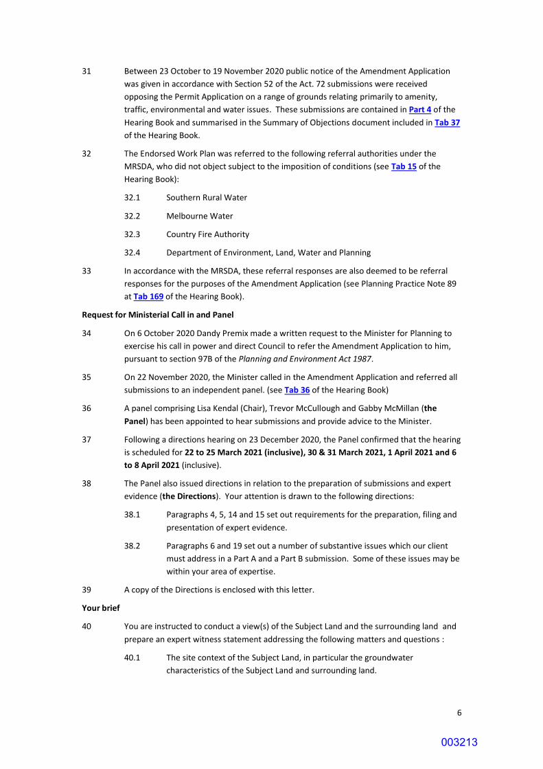
6
31 Between 23 October to 19 November 2020 public notice of the Amendment Application
was given in accordance with Section 52 of the Act. 72 submissions were received
opposing the Permit Application on a range of grounds relating primarily to amenity,
traffic, environmental and water issues. These submissions are contained in Part 4 of the
Hearing Book and summarised in the Summary of Objections document included in Tab 37
of the Hearing Book.
32 The Endorsed Work Plan was referred to the following referral authorities under the
MRSDA, who did not object subject to the imposition of conditions (see Tab 15 of the
Hearing Book):
32.1 Southern Rural Water
32.2 Melbourne Water
32.3 Country Fire Authority
32.4 Department of Environment, Land, Water and Planning
33 In accordance with the MRSDA, these referral responses are also deemed to be referral
responses for the purposes of the Amendment Application (see Planning Practice Note 89
at Tab 169 of the Hearing Book).
Request for Ministerial Call in and Panel
34 On 6 October 2020 Dandy Premix made a written request to the Minister for Planning to
exercise his call in power and direct Council to refer the Amendment Application to him,
pursuant to section 97B of the Planning and Environment Act 1987.
35 On 22 November 2020, the Minister called in the Amendment Application and referred all
submissions to an independent panel. (see Tab 36 of the Hearing Book)
36 A panel comprising Lisa Kendal (Chair), Trevor McCullough and Gabby McMillan (the
Panel) has been appointed to hear submissions and provide advice to the Minister.
37 Following a directions hearing on 23 December 2020, the Panel confirmed that the hearing
is scheduled for 22 to 25 March 2021 (inclusive), 30 & 31 March 2021, 1 April 2021 and 6
to 8 April 2021 (inclusive).
38 The Panel also issued directions in relation to the preparation of submissions and expert
evidence (the Directions). Your attention is drawn to the following directions:
38.1 Paragraphs 4, 5, 14 and 15 set out requirements for the preparation, filing and
presentation of expert evidence.
38.2 Paragraphs 6 and 19 set out a number of substantive issues which our client
must address in a Part A and a Part B submission. Some of these issues may be
within your area of expertise.
39 A copy of the Directions is enclosed with this letter.
Your brief
40 You are instructed to conduct a view(s) of the Subject Land and the surrounding land and
prepare an expert witness statement addressing the following matters and questions :
40.1 The site context of the Subject Land, in particular the groundwater
characteristics of the Subject Land and surrounding land.
003213

7
40.2 The Proposed Further Development and supporting documentation, including
the proposals to intersect groundwater and extract sand below the
groundwater table.
40.3 Whether the Proposed Further Development will cause any unreasonable
groundwater impacts.
40.4 The need for any additional works or other measures to mitigate any potential
groundwater impacts.
40.5 Any issues raised in the objections to the Amendment Application that are
within your expertise.
40.6 The issues set out in Paragraphs 6 and 19 of the Directions (which our client
must address in a Part A and a Part B submission) to the extent within your
expertise.
40.7 Any other groundwater matters you consider relevant to the assessment of the
Proposed Further Development.
41 We are retaining you personally and the opinions which you provide must be your own
opinions.
42 Please note our client will also be calling expert evidence in relation to the following
matters:
42.1 Traffic Engineering (Henry Turnbull).
42.2 Dust (Tim Pollock).
42.3 Planning (Chris De Silva).
42.4 Surface water (Neil Craigie).
42.5 Ecology (Aaron Organ).
42.6 Economic and Social Impacts (Dr Ian Manning).
42.7 Acoustic engineering (Neville Goddard).
42.8 Landscape & Visual Impact (Mark Reilly).
42.9 Quarry operations and geology (Basil Natoli).
42.10 Cultural heritage (Nicholas Clark).
43 In accordance with paragraph 4 of the Directions, your report must:
43.1 be filed and circulated by 4pm on 5 March 2021;
43.2 be prepared in accordance with the Planning Panels Victoria Guide to Expert
Evidence and Guide to witnesses provide evidence through remote
conferencing;
43.3 include a summary statement in plain English; and
43.4 not refer to any individual submitter by name. If necessary, submitters should
be referred to by submission number.
44 In your expert report, please:
44.1 refer to any relevant document in the Hearing Book, or part thereof, by
reference to that document’s Tab number; and
003214

8
44.2 refrain from including in your report another copy of any document, or part
thereof, which is already in the Hearing Book.
45 If any aspects of this retainer are unclear or if you require further information or
documents, please let us know.
Please contact me on 9853 5000 if you have any queries in relation to any aspect of this letter.
Yours faithfully
Andrew Natoli Director Equipe Lawyers Encl.
003215