Embed Size (px)
Citation preview
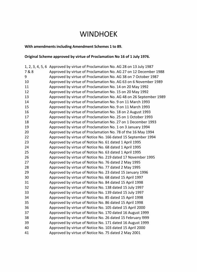
WINDHOEK With amendments including Amendment Schemes 1 to 89. Original Scheme approved by virtue of Proclamation No 16 of 1 July 1976. 1, 2, 3, 4, 5, 6 Approved by virtue of Proclamation No. AG 28 on 13 July 1987 7 & 8 Approved by virtue of Proclamation No. AG 27 on 12 December 1988 9 Approved by virtue of Proclamation No. AG 38 on 7 October 1987 10 Approved by virtue of Proclamation No. AG 63 on 6 November 1989 11 Approved by virtue of Proclamation No. 14 on 20 May 1992 12 Approved by virtue of Proclamation No. 15 on 20 May 1992 13 Approved by virtue of Proclamation No. AG 48 on 26 September 1989 14 Approved by virtue of Proclamation No. 9 on 11 March 1993 15 Approved by virtue of Proclamation No. 9 on 11 March 1993 16 Approved by virtue of Proclamation No. 18 on 2 August 1993 17 Approved by virtue of Proclamation No. 25 on 1 October 1993 18 Approved by virtue of Proclamation No. 27 on 1 December 1993 19 Approved by virtue of Proclamation No. 1 on 3 January 1994 20 Approved by virtue of Proclamation No. 78 of the 16 May 1994 22 Approved by virtue of Notice No. 166 dated 15 September 1994 23 Approved by virtue of Notice No. 61 dated 1 April 1995 24 Approved by virtue of Notice No. 68 dated 1 April 1995 25 Approved by virtue of Notice No. 63 dated 1 April 1995 26 Approved by virtue of Notice No. 219 dated 17 November 1995 27 Approved by virtue of Notice No. 76 dated 2 May 1995 28 Approved by virtue of Notice No. 77 dated 2 May 1995 29 Approved by virtue of Notice No. 23 dated 15 January 1996 30 Approved by virtue of Notice No. 68 dated 15 April 1997 31 Approved by virtue of Notice No. 84 dated 15 April 1998 32 Approved by virtue of Notice No. 138 dated 15 July 1997 33 Approved by virtue of Notice No. 139 dated 15 July 1997 34 Approved by virtue of Notice No. 85 dated 15 April 1998 35 Approved by virtue of Notice No. 86 dated 15 April 1998 36 Approved by virtue of Notice No. 105 dated 15 April 2000 37 Approved by virtue of Notice No. 170 dated 16 August 1999 38 Approved by virtue of Notice No. 26 dated 15 February l999 39 Approved by virtue of Notice No. 171 dated 16 August 1999 40 Approved by virtue of Notice No. 103 dated 15 April 2000 41 Approved by virtue of Notice No. 75 dated 2 May 2001
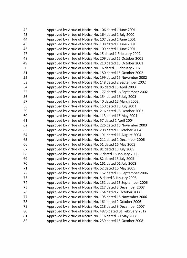
42 Approved by virtue of Notice No. 106 dated 1 June 2001 43 Approved by virtue of Notice No. 164 dated 1 July 2000 44 Approved by virtue of Notice No. 107 dated 1 June 2001 45 Approved by virtue of Notice No. 108 dated 1 June 2001 46 Approved by virtue of Notice No. 109 dated 1 June 2001 47 Approved by virtue of Notice No. 15 dated 1 February 2002 48 Approved by virtue of Notice No. 209 dated 15 October 2001 49 Approved by virtue of Notice No. 210 dated 15 October 2001 50 Approved by virtue of Notice No. 16 dated 1 February 2002 51 Approved by virtue of Notice No. 180 dated 15 October 2002 52 Approved by virtue of Notice No. 199 dated 15 November 2002 53 Approved by virtue of Notice No. 148 dated 2 September 2002 54 Approved by virtue of Notice No. 85 dated 15 April 2003 55 Approved by virtue of Notice No. 177 dated 16 September 2002 56 Approved by virtue of Notice No. 154 dated 15 July 2003 57 Approved by virtue of Notice No. 40 dated 15 March 2003. 58 Approved by virtue of Notice No. 150 dated 15 July 2003 59 Approved by virtue of Notice No. 216 dated 15 October 2003 60 Approved by virtue of Notice No. 113 dated 15 May 2004 61 Approved by virtue of Notice No. 57 dated 1 April 2004 62 Approved by virtue of Notice No. 226 dated 15 November 2003 63 Approved by virtue of Notice No. 208 dated 1 October 2004 64 Approved by virtue of Notice No. 191 dated 11 August 2004 65 Approved by virtue of Notice No. 211 dated 1 December 2006 66 Approved by virtue of Notice No. 51 dated 16 May 2005 67 Approved by virtue of Notice No. 81 dated 15 July 2005 68 Approved by virtue of Notice No. 7 dated 15 January 2005 69 Approved by virtue of Notice No. 82 dated 15 July 2005 70 Approved by virtue of Notice No. 161 dated 01 July 2008 71 Approved by virtue of Notice No. 52 dated 16 May 2005 72 Approved by virtue of Notice No. 152 dated 15 September 2006 73 Approved by virtue of Notice No. 8 dated 3 January 2006 74 Approved by virtue of Notice No. 151 dated 15 September 2006 75 Approved by virtue of Notice No. 217 dated 3 December 2007 76 Approved by virtue of Notice No. 164 dated 2 October 2006 77 Approved by virtue of Notice No. 195 dated 15 November 2006 78 Approved by virtue of Notice No. 161 dated 2 October 2006 79 Approved by virtue of Notice No. 218 dated 3 December 2007 80 Approved by virtue of Notice No. 4875 dated 01 February 2012 81 Approved by virtue of Notice No. 116 dated 30 May 2008 82 Approved by virtue of Notice No. 239 dated 15 October 2008

83 Approved by virtue of Notice No. 275 dated 1 June 2009 84 Approved by virtue of Notice No. 159 dated 14 June 2013 85 Approved by virtue of Notice No. 363 dated 03 November 2008 86 Approved by virtue of Notice No. 183 dated 16 August 2010 87 Approved by virtue of Notice No. 262 dated 01 December 2010 88 Approved by virtue of Notice No. 263 dated 01 December 2010 89 Approved by virtue of Notice No. 229 dated 13 November 2009 90 5 Yearly Amendment Scheme
i
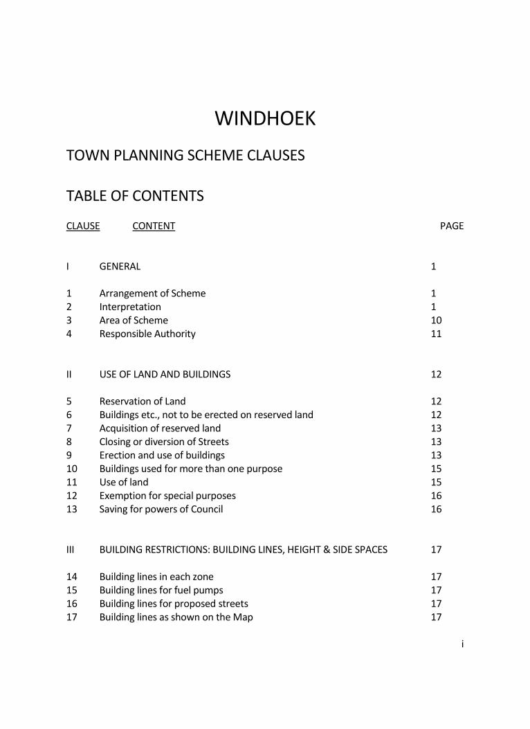
WINDHOEK
TOWN PLANNING SCHEME CLAUSES TABLE OF CONTENTS CLAUSE CONTENT PAGE I GENERAL 1 1 Arrangement of Scheme 1 2 Interpretation 1 3 Area of Scheme 10 4 Responsible Authority 11 II USE OF LAND AND BUILDINGS 12 5 Reservation of Land 12 6 Buildings etc., not to be erected on reserved land 12 7 Acquisition of reserved land 13 8 Closing or diversion of Streets 13 9 Erection and use of buildings 13 10 Buildings used for more than one purpose 15 11 Use of land 15 12 Exemption for special purposes 16 13 Saving for powers of Council 16 III BUILDING RESTRICTIONS: BUILDING LINES, HEIGHT & SIDE SPACES 17 14 Building lines in each zone 17 15 Building lines for fuel pumps 17 16 Building lines for proposed streets 17 17 Building lines as shown on the Map 17
ii
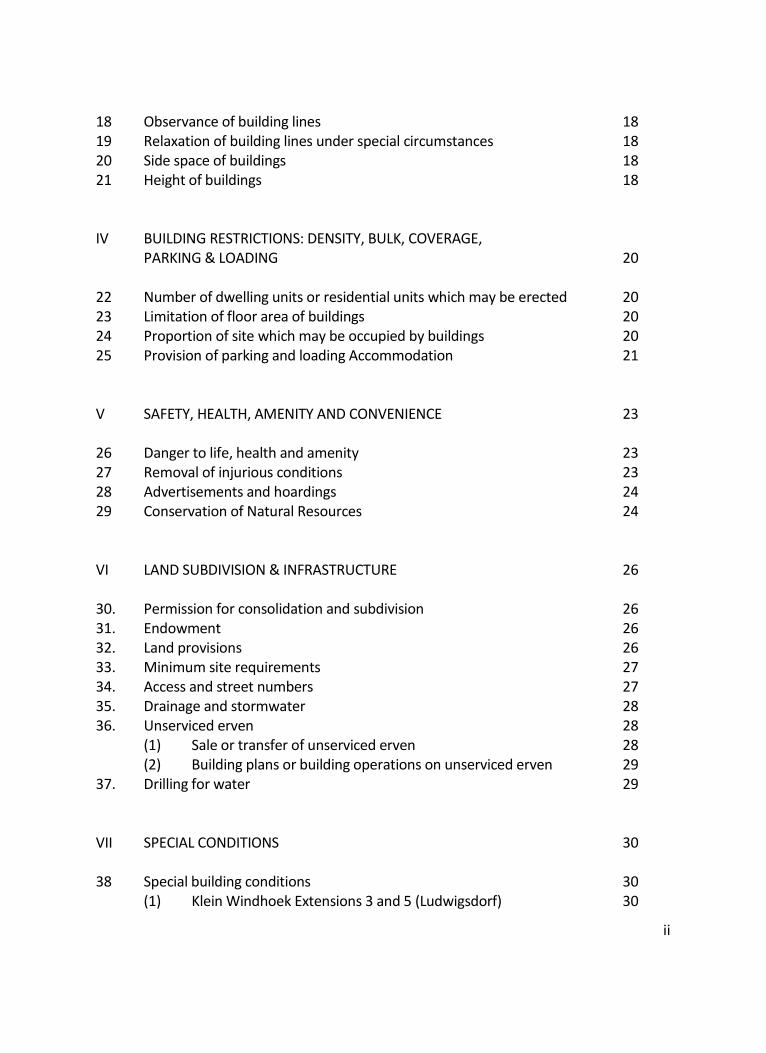
18 Observance of building lines 18 19 Relaxation of building lines under special circumstances 18 20 Side space of buildings 18 21 Height of buildings 18 IV BUILDING RESTRICTIONS: DENSITY, BULK, COVERAGE, PARKING & LOADING 20 22 Number of dwelling units or residential units which may be erected 20 23 Limitation of floor area of buildings 20 24 Proportion of site which may be occupied by buildings 20 25 Provision of parking and loading Accommodation 21 V SAFETY, HEALTH, AMENITY AND CONVENIENCE 23 26 Danger to life, health and amenity 23 27 Removal of injurious conditions 23 28 Advertisements and hoardings 24 29 Conservation of Natural Resources 24 VI LAND SUBDIVISION & INFRASTRUCTURE 26 30. Permission for consolidation and subdivision 26 31. Endowment 26 32. Land provisions 26 33. Minimum site requirements 27 34. Access and street numbers 27 35. Drainage and stormwater 28 36. Unserviced erven 28 (1) Sale or transfer of unserviced erven 28 (2) Building plans or building operations on unserviced erven 29 37. Drilling for water 29 VII SPECIAL CONDITIONS 30 38 Special building conditions 30 (1) Klein Windhoek Extensions 3 and 5 (Ludwigsdorf) 30
iii
39. Minimum Building Values 30 40. Special conditions 31 VIII PUBLIC NOTIFICATION & APPLICATIONS 32 41. Inspection of scheme 32 42. Record of permission and conditions 32 43. Advertisement and appeal in certain cases 32 44. Submission of drawings and particulars 33 45. Council may impose conditions on granting consent 34 46. Binding force of conditions imposed 35 IX CONTRAVENTIONS & APPEALS 35 47. Conflict of scheme and township conditions 35 48. Contravention of the Scheme 35 49. Entry and inspection of premises 36 50. Service of notices 37 51. Appeals 38 X ADMINISTRATION 39 52. Betterment 39
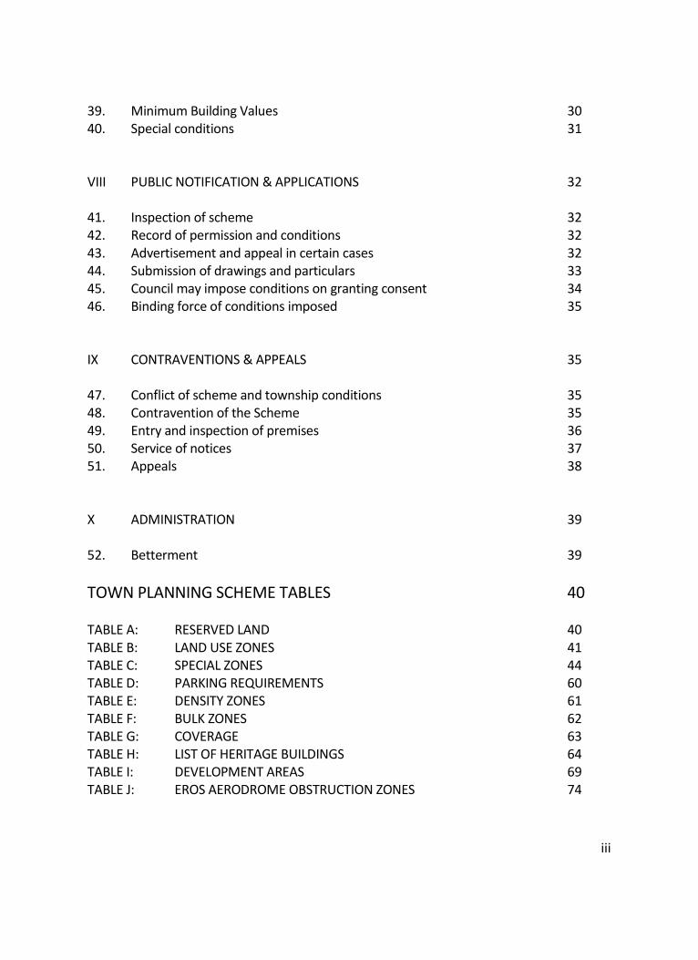
TOWN PLANNING SCHEME TABLES 40
TABLE A: RESERVED LAND 40 TABLE B: LAND USE ZONES 41 TABLE C: SPECIAL ZONES 44 TABLE D: PARKING REQUIREMENTS 60 TABLE E: DENSITY ZONES 61 TABLE F: BULK ZONES 62 TABLE G: COVERAGE 63 TABLE H: LIST OF HERITAGE BUILDINGS 64 TABLE I: DEVELOPMENT AREAS 69 TABLE J: EROS AERODROME OBSTRUCTION ZONES 74
1
WINDHOEK TOWN PLANNING SCHEME
I GENERAL
1. Arrangement of Scheme
(1) This Scheme is divided into parts relating to the following matters respectively: I GENERAL II USE OF LAND AND BUILDINGS III BUILDING RESTRICTIONS: BUILDING LINES, HEIGHT & SIDE SPACES IV BUILDING RESTRICTIONS: DENSITY, BULK, COVERAGE, PARKING & LOADING V SAFETY, HEALTH, AMENITY AND CONVENIENCE VI LAND SUBDIVISION & INFRASTRUCTURE VII SPECIAL CONDITIONS VIII PUBLIC NOTIFICATION & APPLICATIONS IX CONTRAVENTIONS & APPEALS
2. Interpretation
(1) In this Scheme, except where the context otherwise requires, or it is otherwise
expressly provided, the following words and expressions have the respective meanings hereby assigned to them:
Accommodation establishment means a building which is not a hotel or motel and includes a pension, a caravan park, a guest house, a lodge, a backpackers-lodge and all other establishments referred to in the definitions of 'accommodation establishment' in the Accommodation Establishments and Tourism Ordinance, 20 of 1973, as well as the regulations made thereunder, the Liquor Act 6 of 1998 and the Namibian Tourism Act 21 of 2000."
Advertisement means any material, fabric, article, appliance or any surface on
which characters, letters, numerals or illustrations are applied and erected, constructed or displayed in any manner whatsoever in view of any street or public place for the purpose of advertising or to give information regarding, or to attract the public to any place, public performance, article or merchandise whatsoever.
Agricultural building means a building designed and/or use in connection with, and
which would ordinarily be incidental to, or reasonably necessary in connection with
2
the use of the site as agricultural land and includes one dwelling unit. Agricultural land means arable, meadow or pasture land, market gardens, poultry
farms, pig farms, land used for beekeeping, nursery gardens, plantations and orchards, or similar uses, but does not include:
(a) Land occupied as a park together with a house thereon; or (b) Land used as a garden other than as aforesaid; or (c) Land kept or reserved for the purpose of sports, athletics or recreation or
used as a racecourse. Area means the area described in Clause 3 hereof. Building, save as provided in Section 2 of the Town Planning Ordinance, 1954, and
without limiting the ordinary meaning of the word, shall include a structure or erection in clauses 16 to 21 inclusive, but not elsewhere in the scheme and the use of a building shall be that which the zoning of the ground on which it is erected allows.
Bulk factor shall mean the ratio of the total floor area to the area of the erf
concerned. Business building means a building designed and/or used as offices, warehouses,
medical or dental consulting rooms, laboratories or other business purposes but does not include other buildings specifically defined or mentioned elsewhere in this Scheme with the exception of offices.
By-laws shall mean any of the Municipal Regulations and Council resolutions in
force in the area. Competent authority means the Minister of Regional and Local Government,
Housing and Rural Development. Council means the Municipal Council of Windhoek. Dwelling unit means a dwelling consisting of one primary unit with or without an
outbuilding or an entertainment area, where the primary unit consists of mutually adjacent rooms with a kitchen and with at least a bathroom with toilet facilities and where the said primary unit is designed for occupation by a single household, and
3
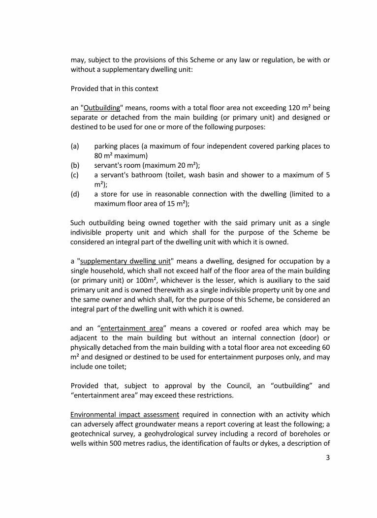
may, subject to the provisions of this Scheme or any law or regulation, be with or without a supplementary dwelling unit:
Provided that in this context an "Outbuilding" means, rooms with a total floor area not exceeding 120 m² being
separate or detached from the main building (or primary unit) and designed or destined to be used for one or more of the following purposes:
(a) parking places (a maximum of four independent covered parking places to
80 m² maximum) (b) servant's room (maximum 20 m²);
(c) a servant's bathroom (toilet, wash basin and shower to a maximum of 5 m²);
(d) a store for use in reasonable connection with the dwelling (limited to a maximum floor area of 15 m²);
Such outbuilding being owned together with the said primary unit as a single indivisible property unit and which shall for the purpose of the Scheme be considered an integral part of the dwelling unit with which it is owned.
a "supplementary dwelling unit" means a dwelling, designed for occupation by a
single household, which shall not exceed half of the floor area of the main building (or primary unit) or 100m², whichever is the lesser, which is auxiliary to the said primary unit and is owned therewith as a single indivisible property unit by one and the same owner and which shall, for the purpose of this Scheme, be considered an integral part of the dwelling unit with which it is owned.
and an “entertainment area” means a covered or roofed area which may be adjacent to the main building but without an internal connection (door) or physically detached from the main building with a total floor area not exceeding 60 m² and designed or destined to be used for entertainment purposes only, and may include one toilet;
Provided that, subject to approval by the Council, an “outbuilding” and
“entertainment area” may exceed these restrictions.
Environmental impact assessment required in connection with an activity which can adversely affect groundwater means a report covering at least the following; a geotechnical survey, a geohydrological survey including a record of boreholes or wells within 500 metres radius, the identification of faults or dykes, a description of
4
the main hydrological features of the development. Erect in relation to a building, without in any way limiting the ordinary meaning of
the word, shall include: (a) the alteration, subdivision, conversion to another use, or addition to a
building; (b) the re-erection of a building of which a part of its floor area has been
demolished or destroyed. Existing erf means any erf as defined in the Townships and Division of Lands
Ordinance, 1963 (Ordinance 11 of 1963). Existing use means in relation to any building or land the continuous lawful use of
such building or land for the purpose for which it was being lawfully used before or on the first day of October 1993 in respect of the area incorporated into the Scheme boundary in terms of Windhoek Amendment Scheme No. 23, or before or on the first day of October 1960 for the remainder of the Scheme area, or in the case of a building erected but not used on or before such date, the continuous lawful use thereof for the purpose for which it was designed and lawfully erected, including in both cases, the use of any building permitted by the Council pending the preparation and approval of this scheme and further the continuous lawful use of any building or land for any purpose which was lawful under any Town Planning Scheme in operation at the date of the approval of the plans of such building by the Council:
Provided that the interrupting of such existing use of a building or land at any time
after the approval by the competent authority of the Scheme for a period of six consecutive months, shall be deemed to be a cessation of the uninterrupted use.
Hazardous substance means any pesticide, herbicide or other biocide, radioactive substance, chemical or other substance and any micro-organism or energy form that has properties that, either by themselves, or in combination with any other thing, make it hazardous to human health or safety, or to the environment.
Heritage building means a building included in Table H and which, in the opinion of
Council, is worth preserving in whole or in part. Heritage consent means the entering into of an agreement between Council and
5
the owner of a "heritage building" in terms of which agreement the owner undertakes to preserve the building or certain specified features of the building to the satisfaction of Council as quid pro quo for the granting of permission by Council to use such building and ground for any use, provided that Council shall not enter into such an agreement where it is expected that the use will have a detrimental effect on the neighbourhood.
Household means a man or woman or both with or without a child or children of
one or the other or both of them and may with the consent of the Council include other persons. In this definition the term "child" or "children" includes stepchildren and adopted children but excludes any married children or grandchildren.
Hotel means a building designed and/or used for the business of providing
accommodation and meals for reward, as defined in, and which complies with the provisions of the Accommodation Establishments and Tourism Ordinance, 20 of 1973 (as amended) and the Liquor Act, Act No. 6 of 1998, but excludes any off-sales department.
Industrial building means a building where any person performs work in connection
with any business, undertaking or institution, whether as an employer or employee, pupil or inmate of an institution, or otherwise, in any one or more of the following activities:
(a) the making of any article or part of any article; (b) the altering, repairing, renovating, testing, ornamenting, painting, spraying,
polishing, finishing, cleaning, dyeing, washing, or breaking up of any article; (c) the adaption for sale or use of any article; (d) the sorting, assembling or packing (including washing or filling bottles or
other containers) of any articles (e) the construction, reconstruction, assembling, repairing or breaking up of
vehicles or parts thereof (but excluding premises used for the purpose of housing vehicles where only minor adjustments are carried out);
(f) printing by letterpress, lithography, photogravure or other similar process, including any activity associated with the printing industry;
(g) the production and storage of gas in a holder of more than five hundred cubic metre (500 m³) storage capacity;
(h) the generation and supply of electricity; (i) photographic work; (j) any other activity added in terms of the Labour Act (Act 23 of 1992). (k) any activity that is necessarily or ordinarily incidental to any activity
referred to in subparagraphs (i) to (x), inclusive, if the premises on which it
6
is carried on form part of or are adjacent to the premises on which the activity to which it is so incidental is carried on:
Provided that houses, residential buildings, hotels, restaurants or similar uses
where food or drink is prepared mainly for consumption on the premises and any premises used temporarily and exclusively for the carrying on of any activity connected with the construction, alteration, renovation, repair or demolition of any building, bridge, road or irrigation work or similar works shall not be included in the definition of an "industrial building". Infiltration area means the area lying within a 1 in 50 year flood area or within a strip of land measured 5 metres outwards on both sides from the outer edges of the seasonally active bed (gravel bed) or the visually identifiable banks of a watercourse which is further than 500 metre from its bounding watershed, or as may be assessed by a hydrogeological study as being an area within which surface water percolates into the groundwater in above average quantities, whichever is the larger.
Institution means a building designed and/or used as a place where persons receive medical, charitable or other care or treatment and related administrative activities, including a building designed and or used in connection with the administrative activities of a foreign organisation which operates in the Republic of Namibia without gain and is recognised by the Namibia Government to operate in the interests of the development, welfare and promotion of Namibia and its inhabitants, but does not include medical or dental consulting rooms or a building mentioned in the definition of a "special building".
Map means a scheme map as contemplated in Section 2 of the Ordinance. Minimum building value means the minimum value of buildings, structures, and
improvements which are to be erected on any erf or farm portion. Noxious industrial building means a building designed and/or used for the purpose
of carrying on any noxious or offensive trade or occupation and, without prejudice to the generality of the foregoing, includes the following:
Chemical works, paint works, breweries and distilleries, sugar mills and sugar
refineries, manure-, superphosphate- or fertilizer works; or premises used for the storing or mixing of manure, superphosphates or fertilizers or premises for the storing, drying, preserving or other treatment of bones, horns or hoofs, premises used for the storing, sorting or treatment of hides and skins, other than in a dry and inoffensive condition, abattoirs, glue or size factories, entrail scraping and tripe
7
boiling works; soap or candle works, fat and dripping works and any other similar works where meat, bones, blood, offal or other animal organic matter is handled, wool scouring or wool washing works, rock-lobster or fish processing works, fish pickling or rock-lobster and fish canning trades, whaling stations, premises or trades used for the storing or handling and processing of material originating from fish, whales and seals, paper-mills or paper factories, wattle-bark grinding or extract factories, destructors, depositing sites or other sites for the disposal or processing of domestic refuse, trade refuse, street refuse, sewage or night-soil, lead melting works, oil refineries and other trades in connection with the processing of by-products or petroleum refining, paint and varnish works, quarries, asbestos cement-, bricks- and lime-works, metallurgical works, reduction and reprocessing works or any other works or trade which the Competent Authority may declare as such by notice in the Gazette : Provided that upon production of a certificate by the Medical Officer of Health, in consultation with the Inspector of Factories, that the process to be used in the conduct of any of the said industries or factories listed above will eliminate nuisance or danger to health in neighbouring premises arising from:
(a) vapour or effluvia; (b) liquid waste matters discharged from the premises, and if land treatment of
such matters is proposed, the nature, slope and area of the land and its position in relation to buildings used for human habitation, streams or water courses;
(c) solid waste matters; the Council may consent to the erection and use of buildings for such industries in
use zone V Table B. Occupier in relation to any building, structure or land means and includes : any
person in actual occupation of, or legally entitled to occupy such building, structure or land; or any person having the charge or management thereof and includes the agent of any such person absent from the area or whose whereabouts is unknown.
Office means a building, room or suite of rooms used for administrative work and
planning and may include a place for related subordinate draughting work. Ordinance means the Town Planning Ordinance 1954 (Ordinance No.18 of 1954)
with any amendments thereof. Owner in relation to any building or land includes:
8
(a) the registered owner; (b) the lessee under a lease registered under any law; (c) the person administrating the estate of any person referred to in the
above-mentioned subsections (a) or (b) whether it is in the capacity of executor, administrator, curator guardian or any other capacity;
(d) any person receiving payment from any occupant or other person, or would have received such payment if such building or land was leased, whether for his own account or as an agent for somebody entitled to it or having an interest therein; and
(e) a duly authorised agent. Place of amusement means any building or land where persons congregate for
amusement or for social, recreational or sporting purposes and where an admission fee is generally levied and includes a night-club and restaurant where entertainment is provided.
Place of instruction means a building designed and/or used for educational and
cultural purposes, administrative activities related therewith, and board and lodging.
Place of public worship means a building, designed and/or used as a place of public
devotion and related administrative activities but excluding a funeral chapel and includes other buildings designed for social gathering or recreation which are associated with and on the same site as the place of public worship.
Private open space means any land reserved in this Scheme for use as private or
club grounds for sports, games, recreation, rest or ornamental show purposes. Public open space means any land used or reserved in this Scheme for use by the
public as an open space, park, garden, playground, recreation ground or square. Residential building means a building, other than a dwelling unit, designed or used
for human habitation, consisting of more than one residential unit together with such outbuildings and entertainment areas as are ordinarily used therewith but which does not included:
(a) a building mentioned whether by way of inclusion or exclusion in the
definition of “place of instruction” or “institution”; (b) a hotel or motel; (c) an accommodation establishment.
9
Resident occupation means an occupation carried out by a person in his or her own home and may, with the consent of Council, include the employment of other persons not resident in the home; the nature of the activities shall be such that they do not adversely interfere with the amenities of the neighbourhood nor alter the essential residential nature of the erf involved; furthermore, for the purpose of this Scheme, a resident occupation shall be excluded from the definitions of all other land uses and, except as provided for in Clause 12, shall be a consent use as indicated on Table B of this Scheme.
Residential unit means a room or suite of rooms, other than a dwelling unit, which is designed as a dwelling for a single household or for one or more single persons.
Restaurant means a place where food is prepared and served to customers at
tables against payment, excluding a "place of entertainment" and a food take away shop.
Scrap-yard means any land, together with ancillary and subordinate buildings on
the same land, used for the storage of used car parts, parts of used machinery, scrap metals, used pipes, used building materials, waste materials or other similar used goods or for the dismantling or breaking up of vehicles or machinery.
Service station means a building used for the purpose of profit or gain for one of
the following purposes, namely to maintain or repair motorbikes and motor vehicles or to supply fuel and for related purposes which also includes the parking or storage of motor vehicles, the sale of parts, accessories, fuel and lubrications for motor vehicles, but does not include panel-beating, spray painting and the dismantling of motor vehicles and motorbikes (except for minor repair works).
Shop means a building designed or used for retail trade. Site in relation to a building includes the area of any appurtenances, outbuildings,
yard, court or garden occupied or intended to be occupied in conjunction therewith.
Social hall means a building designed and/or used for social meetings, gatherings
and recreation and includes a non-residential club but does not include a "place of amusement".
Special building means any building not specifically defined in this Scheme and
includes a funeral chapel, certified reformatory, industrial school, school for mentally defectives and a place where animals receive care and treatment.
10
Street means any street, road, thoroughfare, pavement, footpath, sidewalk and
lane and includes any bridge, subway, drain, canal, culvert or the like in or under a street.
Total floor area means the gross area of all floors of a building as fixed by the
exterior measurement of each floor, excluding: (a) parking areas; (b) a caretaker's flat, including work and storage areas not exceeding 120 m². (c) fire escapes; (d) service wells including lift wells; (e) areas needed for the lift motor room, air-conditioning equipment and other
mechanical or electrical equipment which is necessary for the proper functioning and utilisation of the building, provided that no portion of such floor area may be let or used for any other purpose;
(f) areas forming part of arcades; (g) canopies; (h) open roofs: Provided that an additional floor area may be taken into account in accordance
with the Council's policy on conservation of historic buildings. Warehouse means a building used or intended to be used for the storage of goods
other than goods which will be used on or sold by retail from the premises on which they are stored.
Zone means a portion of the area shown on the Map by distinctive colouring,
hatching, edging or in some other distinctive manner for the purpose of indicating the restrictions imposed by this Scheme on the erection and use of buildings or the use of land; and the terms "density zone", "use zone" and "bulk zone" mean zones indicating restrictions as to density, use and bulk factor of buildings respectively.
3. Area of Scheme (1) The area to which this Scheme applies is the area shown within the black dotted
line on the Map.
11
4. Responsible authority
(1) The council shall be the authority responsible for enforcing and carrying into effect
the provisions of this Scheme.
12
II USE OF LAND AND BUILDINGS
5. Reservation of land
(1) General reservations The several pieces of land indicated in Table A and specified on the map are
reserved for use for the purposes indicated in Table A, and, except as hereinafter provided, shall not be used for any other purpose whatsoever, except for public utilities.
(2) Street reservations The pieces of land so specified on the map are reserved for the creation of new
streets and the widening or improvement of existing streets or comprise streets which are to be closed.
Provided that the Council, subject to the consent of the Competent Authority, may
amend any proposed street or street-widening if on the establishment of a township this is deemed necessary.
(3) Reservation transfers Where any piece of land which was previously a street or a public place vested in or
owned by the Council is closed and transferred to an abutting owner, such piece of land shall fall in the Scheme into the same use zone and sub-zone as those into which the abutting land owned by such owner falls.
6. Buildings, etc not to be erected on reserved land (1) Nobody may erect a building or execute work or excavations on land reserved
under clause 5 hereof: Provided that - (a) The Council may assent to a consent use mentioned in clause 9 which is
incidental to the land or building or for such use of the land or buildings which is necessary and desirable;
(b) The building or land may be used for the purpose for which it was lawfully used on the date on which this Scheme came into operation; and
(c) The building or land may be used or work may be executed or excavations
13
may be made which is necessary for or incidental to the purpose for which the land is reserved.
(2) Save as provided in subclause 6(1) no person shall spoil land reserved under clause
5 hereof so as to destroy or impair its use for the purpose for which it is reserved: Provided that the Council may consent to the deposit on such land of non-hazardous waste materials or refuse.
(3) Nothing in this clause shall be construed as prohibiting the reasonable fencing of
the land. (4) The new streets specified in clause 5 shall not be deemed to be public streets until
they or any portion of them fall within any township which may be established on the land traversed by such streets, or they are proclaimed as public roads, or become vested in the Council for that purpose under any law.
7. Acquisition of land
(1) Where the Council has acquired, either by agreement or expropriation, any land
(together with buildings, structures or any other erections thereon) reserved under clause 5 hereof, it may execute thereon such works as in the opinion of the Council may be required for, or be incidental to, the purpose for which the land is reserved or for public utilities.
8. Closing or diversion of streets
(1) The Council may permanently close or divert any street, provided that the Council
shall, in the exercise of such power, be subject to the provisions of the Local Authorities Act, 1992 or any amendment thereof.
9. Erection and use of buildings
(1) Table B specifies the primary, consent and prohibited uses in each zone where: "Primary uses" are those uses for which buildings may be erected and/or used. "Consent uses" are those uses for which buildings may be erected and/or used only
with the consent of the Council.
14
"Prohibited uses" are those uses for which buildings may not be erected and/or used.
Provided that: (a) An existing building or an existing work which is not in conformity with the
provisions of this Scheme relating to the erection and use of buildings and use of land, may be maintained and may be used for its existing use and that subject to the provisions of this Scheme, other than those relating to the erection and use of buildings and land, it may with the consent of the Council be altered or extended, upon the same site for the particular trade, business, industry or purpose for which it is being used : Provided that no such alteration or extension shall increase the floor space of the existing building by more than ten per cent (10%).
(b) If, in the opinion of the Council, it is essential to have a person or persons residing on the premises, the Council may consent to the use of a building or a portion of a building in use zones VII and VIII of Table B for the purpose of accommodation such person or persons and his or their households.
(c) Shops which are subordinate to an hotel may with the consent of the Council be permitted in association with an hotel which is erected with the consent of the Council in use zone II of Table B, provided that public access to such shops shall only be gained from within the hotel building,
(2) Save with the approval of the Council, in the erection of a dwelling unit, the
primary unit, which shall be a complete building, and not one partly erected and intended for completion at a later date, shall be erected simultaneously with, or before the erection of the outbuilding.
(3) No person shall use or cause or allow to be used any building or portion thereof for
a use other than that for which it has been erected unless such building has been altered for any such proposed new use and any necessary consent of the Council has been obtained therefor.
(4) (a) Should land or a building have been used or erected for a specific purpose
before or on the first of October 1993 in respect of the area incorporated into the Scheme boundary in terms of Windhoek Amendment Scheme No. 23, or before or on the date of commencement of the Scheme for the remainder of the Scheme area, and such use or building not comply to the provisions of this scheme, but is otherwise lawful, the use of land or a building may be continued for that purpose as an "existing use" and will be deemed to conform to the requirements of this scheme.
15
(b) The right to use land or a building as contemplated in subclause 9(4)(a),
expires after the lapse of a period of fifteen (15) years from the date when Windhoek Amendment Scheme Number 23 came into operation in respect of the area incorporated into the Scheme boundary in terms of Windhoek Amendment Scheme No. 23, and from the date when Windhoek Amendment Scheme Number 7 came into operation for the remainder of the Scheme area.
(5) On application by the owner, Council may consent to the changes in land use rights
for erven as shown in Table I. (6) Except with the consent of Council, no person or business selling alcoholic
beverages in containers, selling alcoholic beverages for on-site consumption, selling petroleum, noxious or explosive products, or operating a storage or warehouse business, may operate from a “residential” or “general residential” zoned erf or from an erf with a bulk factor given in Table F of 0.4 or smaller.
10. Buildings used for more than one purpose
(1) Where a building is used, or a proposed building is designed for more than one use,
it shall be treated as being used or designed partly for each of those uses. (2) Save with the consent of the Council no use which is included in the definition of a
shop or of a business building in clause 2 may be located on the same storey as a residential unit; For the purpose of this subclause the term "on the same storey" shall include any two storeys the levels of which differ by two (2) metres or less.
11. Use of land
(1) The provision of clause 9(1) shall apply mutatis mutandis in the case of the use of
land, whether buildings are erected thereon or not: Provided that, subject to the provisions of clause 43, the Council may consent to the use of land with or without temporary ancillary and subordinate buildings, for uses for which buildings are prohibited in terms of Table B.
(2) (a) Notwithstanding subclause 11(1), no commercial vehicles with a gross
vehicle mass of 9 000 kilogram and more may be parked on any erf between l9h00 and 07h00 without the approval of the Council except an erf
16
in use zone VIII of Table B; (b) Notwithstanding subclause 11(1) unless specifically reserved for such
purpose, no land within the area of this Scheme, shall be used for the purpose of refuse tipping, sewage disposal, storage yard, scrap-yard, ash dumps or a motor grave-yard.
Provided that, subject to the provisions of clause 43, the Council may grant
permission for the use of land with or without temporary and ancillary and subordinate buildings for the aforementioned purposes, and subject to such requirements as the Council deems fit in connection with advertising in cases where application is made to park motor vehicles on any land.
(3) No person shall use or cause or allow to be used any land or portion thereof for a
use other than provided for in this Scheme.
12. Saving for special purposes
(1) Without prejudice to any powers of the Council derived from any law, or to the
remainder of this Scheme, nothing in the foregoing provisions of this part of the Scheme shall be construed as prohibiting or restricting or enabling the council to prohibit or restrict:
(a) the occasional use of a place of public worship, place of instruction, or
institution, as a place of amusement or social hall; (b) the practice, subject to the compliance with the by-laws of the Council, by a
person in his own home of a hobby, sport or recreational activity which would ordinarily be associated with residential use and which does not detract from the amenities of the neighbourhood;
13. Saving for powers of Council (1) Nothing in the Scheme will operate to prevent the Council erecting, maintaining or
using any building, executing any work, or maintaining or using any land, in any part of the area for the purpose of any undertaking which it may be empowered to carry out under any law.
17
III BUILDING RESTRICTIONS: BUILDING LINES, HEIGHT & SIDE SPACES
14. Building lines in each zone (1) In use zones I, II, VI, VII, IX, XI and XII as shown on Table B, all buildings shall be at
least five (5) metres from any street boundary, except for electrical substations. (2) In use zone IV (business) as shown on Table B, only dwelling units shall be at least
five (5) metres from any street boundary, all other buildings may be erected up to any street boundary.
(3) In use zones V (restricted business) and VIII (industrial) as shown on Table B,
buildings may be erected up to any street boundary, except where a street is less than twenty five (25) metres wide, in which case any building shall be set back a distance of at least one half of the difference between the width of the street and twenty five (25) metres measured from the boundary of such street.
(4) Unless mentioned otherwise the building line in regards land reserved for any
purpose in terms of Table A, clause 5 of this Scheme, shall be five (5) metres.
15. Building line for fuel pumps
(1) In addition to any set-back of a building from a street boundary as stipulated in this
scheme, fuel pumps shall be set-back an additional four (4) metres from any street boundary.
16. Building line for proposed streets
(1) Where any land is reserved for a new street or a street widening in terms of clause
5 of this Scheme, the building line shall be determined as if such new street or street widening was in fact an existing street.
17. Building lines as shown on Map (1) Notwithstanding the foregoing, where a building line is shown on the Map, such
building line shall apply.
18
18. Observance of building lines
(1) Where a building line is fixed in terms of this Scheme, no building other than
temporary buildings erected in connection with building operations or buildings permitted in pursuance of clause 6 of this Scheme shall hereafter be erected on the land between the building line and the street boundary and no goods, merchandise, wares or other obstructions shall be placed, deposited, kept or displayed on the area between the street boundary and any such building line.
19. Relaxation of building lines under special circumstances
(1) Council may relax the provisions of clauses 14 to 18 of this Scheme where
compliance with a building line would unreasonably interfere with the development or use of a site or in any other special circumstances.
20. Side spaces of buildings
(1) Except with the consent of Council or as otherwise provided for in this Scheme, no
building or structure or any portion thereof shall be erected nearer than three (3) metres to any lateral or rear boundary common to an adjoining erf. A lateral boundary is defined as a boundary with at least one end on a street boundary, a street boundary is any boundary common to a street, and a rear boundary is any boundary other than a street or lateral boundary. In the case of a dwelling unit or residential building the three (3) metre requirements shall apply to single storey units and shall increase by two (2) metres for each additional storey. The minimum requirement shall be measured from the external walls of the building under consideration.
(2) The Council may, subject to any conditions it deems necessary, relax the provisions
of clause 20(1).
21. Height of buildings. (1) No building, structure or erection may be erected in a position which will protrude
into the obstruction zones of Eros Aerodrome as indicated on Plan P/1667/S and Table J, provided that;
19
(a) In areas where the obstruction zone is lower than the natural level ground structure heights may not exceed 8 metres above natural ground level;
(b) Any proposed structure exceeding the limitations of Table J must be
referred to the Department of Transport for approval of the structure height before the building plans will be approved.
(2) No building, structure or object may be erected in a position which will affect the
microwave system of the Department of Posts and Telecommunications; the extent to which buildings and structures are affected by the microwave system is shown on an inset to the Map (Plan number P/899/S, dated 21/06/1974, details heights, widths, angle and direction).
(3) That no dwelling unit or residential building may be erected in excess of two
storeys on land zoned "residential" without Council approval; Council shall, in considering the application, have regard to the impact, real or potential, of the additional storeys on the neighbouring property.
20
IV BUILDING RESTRICTIONS: DENSITY, BULK, COVERAGE, PARKING & LOADING
22. Number of residential units which may be erected (density)
(1) Not more than one dwelling unit or residential building may be erected on any erf
without the consent of the Council. (2) No building shall be so erected that the number of dwelling units and residential
units on an erf exceeds the number specified in Table E for the density zone in which the erf is situated;
provided that in the case of a boarding house, residential club, hostel, hotel or
similar use, Council may consent to a floor area not exceeding an area obtained by multiplying the permissible number of residential units by eighty (80) square metres in addition to a dwelling unit.
23. Limitation of floor area of buildings (bulk)
(1) No building shall be erected so that the bulk factor, as specified in Table F, is
exceeded; provided that in those areas with no prescribed residential densities or bulk factor,
appropriate densities and/or bulk factors may be imposed by the Council; provided further that in all cases where a bulk factor is specified, Council may
consent to additional floor area not exceeding the area of the erf, which must be devoted solely to residential use in the form of a dwelling unit or residential units.
24. Proportion of site which may be occupied by buildings (coverage)
(1) Save with the permission of the Council no building shall be erected so as to cover a
greater proportion of the site than is indicated in Table G for the use of such building.
Provided that the following shall not be included in the calculation of the coverage: (a) any basements situated under street level;
21
(b) external stairs and motor vehicle ramps; (c) balconies and projections of not more than 1,5 metres; (d) eaves of not more than 1,5 metre.
25. Provision of parking and loading accommodation (1) When a building is to be erected on a site the owner thereof shall construct and maintain, at his own expense and to the satisfaction of the Council, parking spaces on the site as set out in Table D. Provided that: (a) The Council may relax the provisions of this clause. (b) Notwithstanding any provision to the contrary in this Scheme, the Council
may relax the provisions of Table D and enter into a written agreement with the owner of the site concerned whereby the owner shall:
(i) pay an amount to the Council which in the opinion of the Council is
sufficient to enable it to provide and maintain the same number of parking spaces as are required in terms of Table D elsewhere; or
(ii) transfer a suitable site to the Council and pay an amount to the
Council which will in the opinion of the Council be sufficient to enable it to construct and maintain the number of parking spaces required in terms of Table D on the said site; or
iii) construct and maintain the number of parking spaces required in
terms of Table D on any other property which is considered to be suitable by the Council.
(c) Notwithstanding the provisions of this clause, the Council may in its own
discretion prohibit the provision of some or all of the parking: provided that the provisions of clause 25(1)(b)(i) shall be applicable.
(d) The leasing of parking spaces shall not be deemed to be a business for the
purpose of this Scheme. (e) The access to and the position and dimensions of a parking place shall
conform to the requirements of the Council.
22
(f) The parking requirements, subject to the specified use zoning, shall be
calculated as set out in column (3) of Table D and that the number of parking bays thus obtained, shall be rounded off to the nearest integer.
(2) Every owner who intends erecting a building which is to be wholly or partially used
for business or industrial purposes shall submit to the Council for its approval proposals for securing, so far as is reasonably practicable, the provision of suitable and sufficient accommodation on the site for loading, unloading and fuelling of vehicles which will serve the needs of the occupants of such building : Provided that no owner or occupier of a building, in respect of which the provisions of this clause have been applied, shall permit the loading, unloading or fuelling of vehicles in a manner which is not in conformity with the approved proposals.
23
V SAFETY, HEALTH, AMENITY AND CONVENIENCE 26. Danger to life, health and amenity
(1) No buildings may be erected on land which by reason of its situation or nature of
the land would be likely to involve danger to life or danger or injury to health. (2) No land shall be used and no buildings and structures be erected and/or used for
purposes likely to involve danger of life, or danger to or the possibility of harm to health or serious detriment of the neighbourhood.
(3) No shop or building or premises of any sort which supplies fuel and lubrications
directly into motor vehicles shall be permitted or erected on any erf unless the following conditions are met:
(a) The layout of facilities and design of entrances and egresses must be to the
satisfaction and have been approved by Council. (b) An effluent and waste disposal system to the satisfaction of Council has
been provided which is adequate to handle all effluent and waste collected on the erf.
(c) No sales of fuel to commercial motor vehicles with a gross vehicular mass of
9 000 kilograms or more shall be permitted from erven other than erven in the “industrial” and “restricted business” zones and “business” zoned erven abutting on Sam Nujoma Drive, Hosea Kutako Drive, Krupp Street, and Mandume Ndemufayo Avenue without the permission of Council.
(d) The premises do not fall under any prohibition mentioned in Clause 29 or at
any other place in this Scheme.
27. Removal of injurious conditions
(1) Where the amenity or groundwater or other environmental asset in any area is
adversely affected by the condition of any building, land or curtilage, garden or by any activity taking place in the area, the Council may serve notice on the responsible person requiring him, within a specified period of not less than 28 (twenty eight) days from the date on which notice was served, to take such action as is necessary to eliminate the source of annoyance and, or remove any polluting agent and cause the ground to be rehabilitated to a condition that it was at prior to
24
being polluted or to a condition acceptable to Council.
(2) Should the responsible person fail to take action as envisaged in Clause 27(1) Council may enter onto the premises or may cause its agent to enter onto the premises and may pull down, demolish and, or destroy or may cause to pull down, demolish or destroy a source leading to such effect on amenities and, or may remove pollutants or cause such to be removed and ground rehabilitated, and may recover the expense so incurred from the owner or person causing such effect to the amenities, irrespective of any criminal proceedings which may have been or may be instituted in terms of the Scheme.
(3) (a) In this clause "responsible person” is not restricted to the person
responsible for the creation of the adverse condition but also the owner of the property from which the adverse condition originates.
(b) "owner” in this clause shall include his or her heirs, assigns and successors in title.
28. Advertisements and hoarding
(1) No advertisement shall be erected or displayed without the consent of Council. (2) Council may authorise the display of any particular class of advertisement either
unconditionally or subject to conditions in respect of the nature of the advertisement, its position or manner in which the advertisement may be displayed, the period in which it may be displayed, or the environmental impact the advertisement may have.
29 Conservation of Natural Resources
(1) No trees known as Prosopis SPP shall be planted or permitted to grow on any erf. (2) No structures may be erected and no activity may take place which may entail the
direct or indirect alteration of the physical, chemical or biological properties of groundwater or pollution of groundwater in any other way so as to make it less fit for any beneficial purpose for which it may reasonably be expected to be used.
(3) No refuse, rubble or other hazardous substance that may pollute groundwater may
be dumped except at a site designated by Council as a waste disposal site. (4) Save with the approval of Council,
25
(a) No boreholes or wells may be sunk for the purposes of abstracting groundwater on any land located within the area of this Scheme;
(b) No hazardous substance shall be conveyed from an area outside of the Area
of the Scheme for purposes of dumping the hazardous substance at a site within the Area of the Scheme;
(c) No topsoil stripping activity shall take place; (d) No storage tank or drum in excess of 200 litres or other similar type facility
for a hazardous substance shall be installed, upgraded or replaced whether above or below ground;
(e) Flat drainage areas with or without discernible gradient that form the
source of rivers or groundwater recharge shall not be destroyed, damaged or polluted in any way;
(f) No stable, feedlot or concentration of livestock may occur within 200 m
of a watercourse, production borehole or private borehole. (g) No sand or gravel may be mined or removed for any purpose from any
watercourse. (h) No sewer, septic tank, pit latrine, VIP or French drain is allowed within
500 m of any private or production borehole. (i) All septic tanks, pit latrines or VIPs must be emptied as required, and the
waste removed to a municipal wastewater treatment facility. (j) All sewers, septic tanks, pit latrines or VIPs must be inspected when
empty for cracks or leaks. (k) A 100 m buffer zone must be maintained at all times around production
boreholes; No development or construction activities may occur within this buffer zone.
(l) All boreholes, whether private or production, located on private property
must be capped and locked when not in use.
(5) No hazardous substance may be conveyed in quantities exceeding 200 litres to, from, or within the Area of the Scheme except in accordance with National Regulations and SANS 0228; 2003, SANS 0229: 1996, SANS 0230: 1997 and SANS 0231:2003)
(6) No shop or building or premises of any sort which supplies fuel and lubrications
directly into motor vehicles or any storage of hazardous substances in excess of 200
26
litres save for a quantity of 1000 litres of fuel specifically and only to cater for on-site standby generator installations, shall be located on land South of the Southern edges of Academia, Windhoek, Olympia and Klein Windhoek Townships.
(7) No watercourse including an “infiltration area” shall be used for any building or
covered by an impermeable surface other than temporary buildings used in association with a park, garden or recreational area. The protection afforded by an infiltration area shall be applicable for a watercourse should it be 500 metre or more from its bounding watershed or should special topographical or flow conditions warrant earlier recognition.
(8) No area within a 1 in 50-year flood line shall be built upon or used for any
purpose other than as park, a garden or a recreational area or for municipal services.
VI LAND SUBDIVISION & INFRASTRUCTURE 30. Permission for consolidation and subdivision
(1) No consolidation of any land shall be made without the consent of the Council and
no subdivision of any land shall be made without the consent of the Council.
31. Endowment
(1) Any property owner subdividing land shall pay to the Council an endowment as
provided for in the Townships and Division of Land Ordinance No. 11 of 1963, of 7,5% of the value of the new portions being created, on or before registration of the new portions, except as may otherwise be determined by Council.
32. Land provisions
(1) Any property owner subdividing land shall make provision for and transfer, free of
all charges, such portions of land required for Municipal services related to and required by that subdivision.
(2) Any property owner subdividing land shall make provision for public services such
as schools, crèches, powerline reserves, etc. as may be reasonably required by the
27
State or the Council.
33. Minimum site requirements
(1) Where, upon the subdivision of an erf, land is given off for a street or for some
other public purpose, the area of such land may, with the consent of the Council, be calculated as part of the area of the subdivision for the purpose of Tables E, F, and G.
(2) The Council shall not, in those areas in which in terms of Table E only one dwelling
unit per existing erf is allowed, consent to any subdivision of an existing erf, provided, however, that the Council may consent to such a subdivision if no portion smaller in extent than ninety per cent (90%) of the area of the original erf is used as the site of a dwelling unit and provided further that the permissible coverage is not exceeded.
(3) Without derogating from anything else stated in the Scheme, the Council shall not,
in those areas in which, in terms of the Scheme and particularly Table E, a minimum area of site is required per dwelling unit or residential unit, consent to any subdivision of land whereby any portion which may be used for residential purposes has a size or extent which is less than the said prescribed minimum.
(4) Upon the subdivision of any land where any portion of such land is physically
separated by the execution, or proposed execution of public works and provided that such portion does no fall below 75% (seventy five per cent) of the minimum area as laid down by the Scheme, such portion may be used for residential purposes.
34. Access and street numbers
(1) If an erf has more than one street frontage, access to the erf shall be obtained from
the street(s) determined by the Council. The determination shall be made before the approval of any building plans showing how access is to be taken.
(2) Street numbers shall be regulated as follows. (a) All erven within the municipal area shall be fitted with a conspicuous
number plate, showing the erf's street address number, erected on the street boundary from which access is legally taken, within six weeks of
28
submitting a building plan for the main building on that erf, or within six weeks from the date of proclamation hereof.
(b) No service connection will be given to any erf created by private subdivision
or consolidation unless a street number has been allocated and a number plate is displayed.
(c) No service connection will be given to any unit in a sectional title scheme
unless that unit has been numbered and a number plate displayed to the satisfaction of Council.
(d) In the event of an owner failing to comply with sub-paragraphs (a), (b) and
(c), Council shall have the right to, after written notice of its intention to do so, within a specified period, which period may not be less than 21 days, fit such number plate and to recover the cost thereof from the owner as a liquid claim.
35. Drainage and stormwater
(1) No stormwater drainage pipe, canal, work or obstruction (except stormwater drain
pipes, canal or works which have been authorized in writing by the local authority or which have been or may be built, laid or erected in terms of any law) may be constructed on or over the property or located in such a way that -
(a) the flow of stormwater from higher lying property to lower lying property is
impeded or obstructed and through which any property is or may be endangered; or
(b) the flow of a natural watercourse (in which the local authority allows flood water to run off, be discharged or to be canalised) is or can be changed, canalised or impeded.
(c) the maintenance of such stormwater pipe, channel or work shall be the responsibility of the owner of the concerned property.
36. Unserviced erven
(1) Sale or transfer of unserviced erven No property owner may sell or otherwise give transfer of an erf or farm portion
which lacks any of the following:
29
(a) access to a public street constructed and surfaced in accordance with
Municipal standards; (b) a Municipal water connection or access to a communal water supply point
or supply pipeline which has been approved by the Municipality for use by that erf or farm portion;
(c) a sewer connection or access to a sewage disposal system or sewer which has been approved by the Municipality for use by that erf or farm portion;
except with the consent of Council. (2) Building plans or building operations on unserviced erven No person shall submit building plans or commence any building operations on an
erf or farm portion which lacks any of the following; (a) access to a public street constructed and surfaced in accordance with
Municipal standards; (b) a Municipal water connection or access to a Municipal communal water
supply point or supply pipeline which has been approved by the Municipality for use by that erf or farm portion;
(c) a sewer connection or access to a sewage disposal system or sewer which has been approved by the Municipality for use by that erf or farm portion;
except with the consent of Council.
37. Drilling for water
(1) Except with the consent of the council and the Water Board it shall not be
permitted to drill or excavate for water on any land.
30
VII SPECIAL CONDITIONS 38. Special building conditions
(1) The following conditions shall be applicable to Klein Windhoek Extensions 3 and 5
(Ludwigsdorf), and Auasblick Township: (a) Save with the consent of the Council no fencing material erected on any
street boundary may consist of wire mesh or any similar product. (b) Save with the consent of the Council no roof covering may consist of
galvanised iron, corrugated or other asbestos product (except for asbestos shingles), bituminous felt or any other product which is similar to the aforementioned products.
39. Minimum building values
(1) Unless otherwise determined by Council, the value of buildings, structure and
improvements erected on any property shall not be less than the minimum building value specified for that property.
(2) Minimum building values imposed in terms of this section are applicable to the
value of a main building excluding any outbuilding or a single house in the case of a "residential" zoned erf, unless otherwise determined by Council.
(3) For all new townships proclaimed from 1 January 1996, the minimum building
value of any erf zoned "institutional", "restricted business", "garage" and "industrial" shall equal the current municipal valuation of the land comprising that erf.
(4) For all new townships proclaimed from 1 January 1996, the minimum building
value of any erf zoned "office", or "business" shall equal 4 times the current municipal valuation of the land comprising that erf.
(5) For all new townships proclaimed from 1 January 1996, unless otherwise specified
in this Scheme, the minimum building value of any erf zoned "residential", or "general residential" shall equal 2 times the current municipal valuation of the land comprising that erf.
31
(6) Any erf zoned "residential" or "general residential" in the following townships shall have a minimum building value equal to 4 times 1000 times the municipal valuation of the land comprising that erf divided by the area in square metres (4000 times
municipal valuation area): (a) Auasblick (7) Any erf zoned "residential" or "general residential" in the following townships shall
have a minimum building value equal to 4 times 600 times the municipal valuation of the land comprising that erf divided by the area in square metres (2400 times
municipal valuation area): (a) Kleine Kuppe Extension 1 (8) No minimum building value shall be applicable to erven zoned "residential" or
"general residential" in the following townships: (a) Havana (Big Bend) and its extensions (b) Okuryangava Extension 6 (9) Any erf zoned "residential" or "general residential" in the following townships shall
have a minimum building value equal to 4 times the municipal valuation of the land comprising that erf:
(a) Kleine Kuppe (proper)
40. Special conditions
(1) Special conditions on land and buildings may be imposed by Council for each
township individually.
32
VIII PUBLIC NOTIFICATION & APPLICATIONS 41. Inspection of scheme
(1) The Council shall permit any person to inspect at any reasonable time the Scheme
and the Map deposited in the offices of the Council.
42. Record of permission and conditions (1) The Council shall keep, so as to be available for inspection at all reasonable times
by any person interested, a record of approvals, consents, authorities or permission granted by it, or on appeal from its decision under any provision of this Scheme, and of any conditions imposed or agreed between the Council and the applicant in connection therewith.
43. Advertisement and appeal in certain cases
(1) Unless otherwise determined by the Council, any person making application for
consent to erect or use a building or for the use of land in zones I (residential), II (general residential), VI (special) and XI (undetermined) for any purpose requiring the Council's consent, shall at his own expense:
(a) Publish once a week for two consecutive weeks a notice of his intention to
make such application in two newspapers circulating widely in the Local Authority Area, one of which shall be a newspaper in the official language. The notice shall state that any person having objections to the erection and/or use of the proposed building, or to the proposed use of land, may lodge such objections together with the grounds thereof with the Council and with the applicant, in writing, within fourteen (14) days of the date of the last advertisement and shall further state where the plans, if any, may be inspected.
(b) Post a notice, for a period of fourteen (14) days in the official language,
setting out the particulars as in (i) above, in a conspicuous position in the Municipal Offices and on the erf concerned. The notice to be posted on the erf shall be of a size not less than 600 millimetre (mm) x 450 mm and no letter thereon shall be less than 5 mm in height.
33
(2) On submitting an application in terms of this clause the applicant must lodge with the Council a copy of each of the notices as published and as posted. Such notices must be to the satisfaction of the Council.
(3) The Council shall take into consideration any objections received within the said
period of fourteen (14) days and shall notify the applicant and the persons, if any, from whom objections were received of its decision.
(4) The decision of the Council shall not take effect until the expiration of twenty eight
(28) days from the date on which the applicant and the objectors, if any, are notified thereof, or if an appeal has been made, until such appeal is disposed of.
44. Submission of drawings and particulars
(1) The provisions of this Clause are subject to the provisions of section 19 of the
Ordinance. (2) A person, in this clause referred to as the "building owner", intending to erect a
building in any use zone shall furnish the Council with drawings or other sufficient indication of the external appearance of the proposed building, including such description of the materials to be used in its construction as may be necessary for that purpose (all of which are hereafter in this clause referred to as "the particulars").
(3) Any person intending to erect a building in any use zone may be required by
Council to furnish an environmental assessment report having regard to the promotion of health, safety, order, amenity, convenience and general welfare and the impact the new buildings and the operations are likely to have on the amenity of the locality.
(4) The Council shall within ninety (90) days from the submission to it of particulars
under this clause: (a) approve the particulars; or (b) if it considers that having regard to the character of the locality or of the
buildings erected or proposed to be erected therein, the building would disfigure the locality by reason of its external appearance, disapprove the particulars;
34
and shall forthwith give notice of its decision to the building owner and if it disapproves, of the reasons for its decision.
(5) No person shall commence the erection of any building until such time as the
particulars hereinbefore referred to have been approved by the Council or by the Competent Authority on appeal.
(6) Any application for a consent use falling within the “conservation” zone, must be
accompanied by an environmental impact analysis for the proposed use to the satisfaction of the Council and the applicant may be required to submit an environmental management plan as part of the application or in order to meet Council conditions arising from a Council Resolution.
(7) In all cases where application is made for rezoning, consent use, or subdivision
for an area which includes an infiltration area for non-residential activities which could pose a threat of polluting the infiltration area, an environmental impact analysis to the satisfaction of Council, including an hydrogeological study, be submitted:
(a) To assess groundwater vulnerability to pollution relevant to the proposed land-use,
(b) To recommend conditions for the development, and (c) To fix the boundaries for any subdivision of developable erven
along watercourses and other identified areas of groundwater vulnerability and to set the building lines for future buildings.
(8) An application made for rezoning, consent use, or subdivision in the vicinity of an
infiltration area, conservation zone or other groundwater recharge area shall include full details of the proposed activities so as to enable Council to assess the groundwater vulnerability.
45. Council may impose conditions on granting consent
(1) In giving its approval, authority, permission or consent under any clause in this
Scheme, Council may impose such conditions as it deems necessary, including conditions relating to the management of the approved activity, such as an environmental management plan which outlines the processes and procedures for minimising or mitigating, or preventing the adverse effects of activities on the environment, inclusive of the possible pollution of groundwater recharge areas or
35
groundwater or both.
46. Binding force of conditions imposed
(1) Where permission to erect any building, execute any works or to use any building
or land for any particular purpose or to do any other act or thing, is granted under the Scheme, and conditions have been imposed, the conditions shall have the same force and effect as if they were part of the scheme.
IX CONTRAVENTIONS & APPEALS 47. Conflict of scheme and township conditions
(1) No consent of the Council given under the provision of this Scheme shall be
construed as conferring upon any person the right to use any land or to erect or use any building thereon in any manner or for any purpose which is prohibited in any condition registered against the title deeds of the land or imposed in respect of the land under any law relating to the establishment of the townships.
48. Contravention of the Scheme
(1) Any person who commits, or knowingly permits, a contravention of any of the
provisions of this Scheme or of the requirements of any order or notice issued or conditions imposed under the provisions of the Scheme, shall be deemed to have contravened the provisions of the Scheme and shall be guilty of an offence and liable on conviction to the penalties prescribed by Section 48 of the Ordinance.
(2) Any person who after a scheme has come into operation - (a) executes any work or does any other matter or thing contrary to any
provision of the scheme without such approval as it may be competent for the responsible authority to grant, or contrary to any condition subject to which such approval was given; or
(b) fails to comply with any provision of the scheme with which it is his duty to
comply; or (c) fails to comply with the requirements of any notice lawfully issued under
36
the scheme and duly served upon him; or (d) uses any land or building in a manner contrary to any provision of the
scheme or; shall be guilty of an offence and liable on conviction to a fine or to imprisonment as
determined in terms of the Town Planning Ordinance, Ordinance No. 18 of 1954 as amended; provided that in the case of a continuing offence an additional fine for every day upon which the contravention continued may be imposed.
(3) Any person who introduces or discharges hazardous materials into groundwater,
or onto a groundwater recharge area, whether intentionally or accidentally, shall compensate Council for the damage caused thereby, and for the cost of remedial action to rehabilitate the area in which the pollutants were introduced or discharged, to a standard acceptable to Council.
(4) (a) The owner or operator of any installation or vehicle designed to manufacture, process, store, deposit, convey or dispose of hazardous materials and which releases or discharges hazardous materials into groundwater, whether directly or indirectly or whether intentionally or accidentally, shall compensate Council for the damage caused thereby, and for the cost of remedial action to rehabilitate the area in which the pollutants were introduced or discharged, to a standard acceptable to Council.
(b) The words "owner or operator" shall include such persons heirs, assigns
and successors in title in the case of natural persons and assigns and successors in title in the case of legal personae and in the case of the latter also its shareholders, members or partners and their Heirs, assigns and successors in title.
49. Entry and inspection of premises
(1) Where an authorised officer in the investigation of any contravention or alleged
contravention [whether a notice in terms of Section 28(3) of the Ordinance has been given or not] of any provision of the Scheme reasonably suspects that a person who may furnish information with reference to any such contravention is on or in any premises or that a contravention of the Scheme is being committed on or in any premises, such officer may at any reasonable time without prior notice or warrant enter on or into such premises.
(2) No person shall in any way hinder, obstruct or interfere with any authorised officer
37
of the Council, or cause in so far as he has any authority, or permit such officer to be hindered, obstructed or interfered with in the exercise of the powers hereby granted or refuse or fail to furnish any information required or knowingly furnish false information.
50. Service of notices
(1) Any order, notice or other document required or authorised to be served under the
Scheme may be signed by the Town Clerk or other official duly authorised thereto, and may be served by delivery of a copy thereof in one or other of the following manners:
(a) to the said person personally, or to his duly authorised agent; or (b) if service cannot be effected in terms of the preceding paragraph, at his
residence or place of business or employment to some person apparently not less than sixteen (16) years of age and apparently residing at or employed there; or
(c) if there is no such person on the premises as is mentioned in the preceding paragraph, by fixing such order, notice or other document on some conspicuous part of the premises and by despatching such order, notice or other document by prepaid registered post in an envelope on which is written his last known abode, place of business or employment, or post office box number; or
(d) if such a person to be served has chosen a domicilium citandi, at the
domicile so chosen. (2) Where any service is effected in accordance with the provisions of paragraph (c) of
the preceding subclause, such service shall be deemed to have been effected at the time when the letter containing such order, notice or other document would have been delivered in the ordinary course of post and, in proving such service, it shall be sufficient to prove that the order, notice or other document was properly addressed and registered.
(3) Any order, notice or other document, by the Scheme required to be given to the
owner or occupier of any particular premises, may be addressed by the description of the "owner" or "occupier" of such premises in respect of which the order, notice or other document is given, without further name or description.
38
51. Appeals
(1) Any person who is aggrieved by a decision of the Council in terms of an application
made under this Scheme, may appeal to the Competent Authority. (2) If the decision is one which the Council is required to give upon the application of
any person or upon the submission by any person of plans or proposals, an appeal shall, in addition, lie against a refusal of the Council to give, or unreasonable delay on its part in giving a decision, as if it were an appeal against a decision of the Council.
(3) Written notice of an appeal shall be given to the Competent Authority and to the
Council. If the appeal is against a decision of the Council, the notice shall be given within twenty eight (28) days from the date of the service on the appellant of the notice of the Council's decision.
(4) The Competent Authority may, on the application of any person desiring to appeal,
extend by not more than twenty eight (28) days the time for making the appeal specified in the last preceding paragraph, whether or not the time specified for making the appeal has expired.
39
IX ADMINISTRATION
52. Betterment
(1) Whereby the coming into operation of any provision contained in a scheme, or by
the execution by a responsible authority of any work under a scheme, any property is increased in value, the responsible authority, if within twelve months after the date on which the provision came into operation, or within twenty four (24) months of approval being granted by the competent authority, or within twelve months after the completion of the work, as the case may be, it makes a claim in that behalf, may recover from the person whose property is so increased in value an amount not exceeding seventy-five per cent of the amount of that increase.
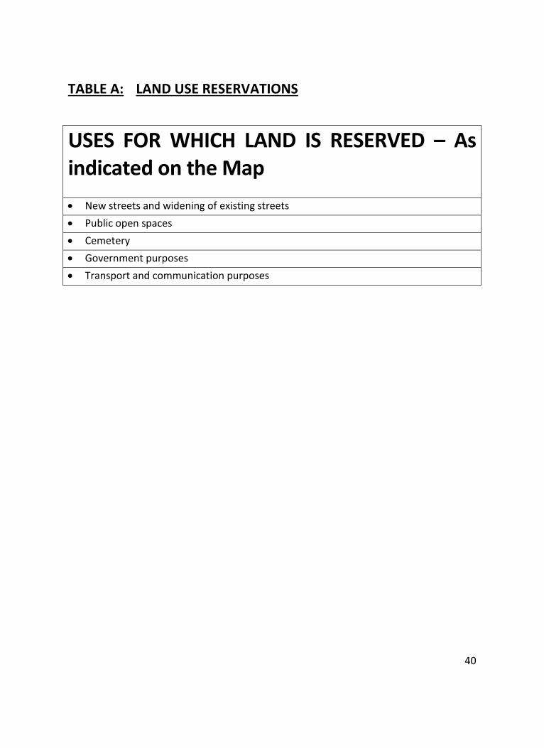
40
TABLE A: LAND USE RESERVATIONS
USES FOR WHICH LAND IS RESERVED – As indicated on the Map
New streets and widening of existing streets
Public open spaces
Cemetery
Government purposes
Transport and communication purposes
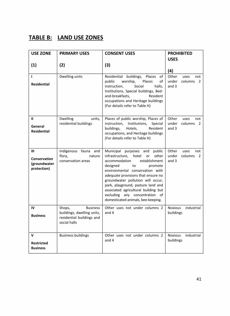
41
TABLE B: LAND USE ZONES
USE ZONE (1)
PRIMARY USES (2)
CONSENT USES (3)
PROHIBITED USES (4)
I
Residential
Dwelling units Residential buildings, Places of public worship, Places of instruction, Social halls, Institutions, Special buildings, Bed-and-breakfasts, Resident occupations and Heritage buildings (For details refer to Table H)
Other uses not under columns 2 and 3
II
General Residential
Dwelling units, residential buildings
Places of public worship, Places of instruction, Institutions, Special buildings, Hotels, Resident occupations, and Heritage buildings (For details refer to Table H)
Other uses not under columns 2 and 3
III
Conservation (groundwater protection)
Indigenous fauna and flora, nature conservation areas
Municipal purposes and public infrastructure, hotel or other accommodation establishment designed to promote environmental conservation with adequate provisions that ensure no groundwater pollution will occur, park, playground, pasture land and associated agricultural building but excluding any concentration of domesticated animals, bee-keeping.
Other uses not under columns 2 and 3
IV
Business
Shops, Business buildings, dwelling units, residential buildings and social halls
Other uses not under columns 2 and 4
Noxious industrial buildings
V
Restricted Business
Business buildings Other uses not under columns 2 and 4
Noxious industrial buildings
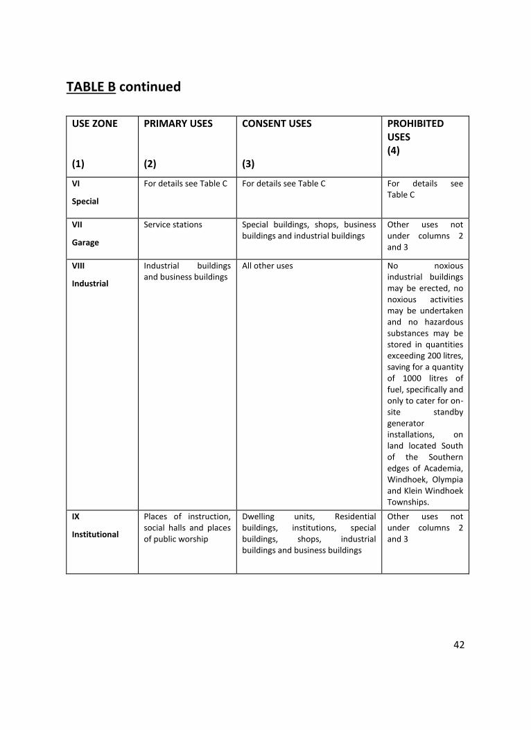
42
TABLE B continued
USE ZONE
(1)
PRIMARY USES
(2)
CONSENT USES
(3)
PROHIBITED USES (4)
VI
Special
For details see Table C For details see Table C For details see Table C
VII
Garage
Service stations Special buildings, shops, business buildings and industrial buildings
Other uses not under columns 2 and 3
VIII
Industrial
Industrial buildings and business buildings
All other uses No noxious industrial buildings may be erected, no noxious activities may be undertaken and no hazardous substances may be stored in quantities exceeding 200 litres, saving for a quantity of 1000 litres of fuel, specifically and only to cater for on-site standby generator installations, on land located South of the Southern edges of Academia, Windhoek, Olympia and Klein Windhoek Townships.
IX
Institutional
Places of instruction, social halls and places of public worship
Dwelling units, Residential buildings, institutions, special buildings, shops, industrial buildings and business buildings
Other uses not under columns 2 and 3
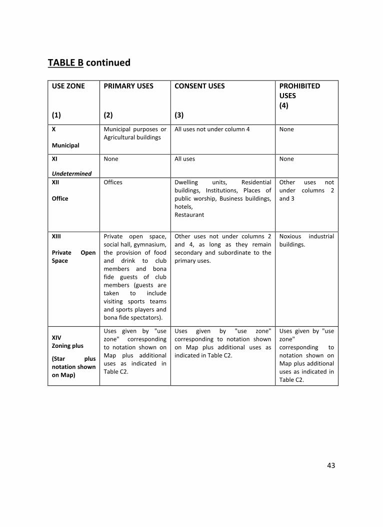
43
TABLE B continued
USE ZONE
(1)
PRIMARY USES
(2)
CONSENT USES
(3)
PROHIBITED USES (4)
X Municipal
Municipal purposes or Agricultural buildings
All uses not under column 4 None
XI
Undetermined
None All uses None
XII Office
Offices Dwelling units, Residential buildings, Institutions, Places of public worship, Business buildings, hotels, Restaurant
Other uses not under columns 2 and 3
XIII Private Open Space
Private open space, social hall, gymnasium, the provision of food and drink to club members and bona fide guests of club members (guests are taken to include visiting sports teams and sports players and bona fide spectators).
Other uses not under columns 2 and 4, as long as they remain secondary and subordinate to the primary uses.
Noxious industrial buildings.
XIV Zoning plus
(Star plus notation shown on Map)
Uses given by "use zone" corresponding to notation shown on Map plus additional uses as indicated in Table C2.
Uses given by "use zone" corresponding to notation shown on Map plus additional uses as indicated in Table C2.
Uses given by "use zone" corresponding to notation shown on Map plus additional uses as indicated in Table C2.
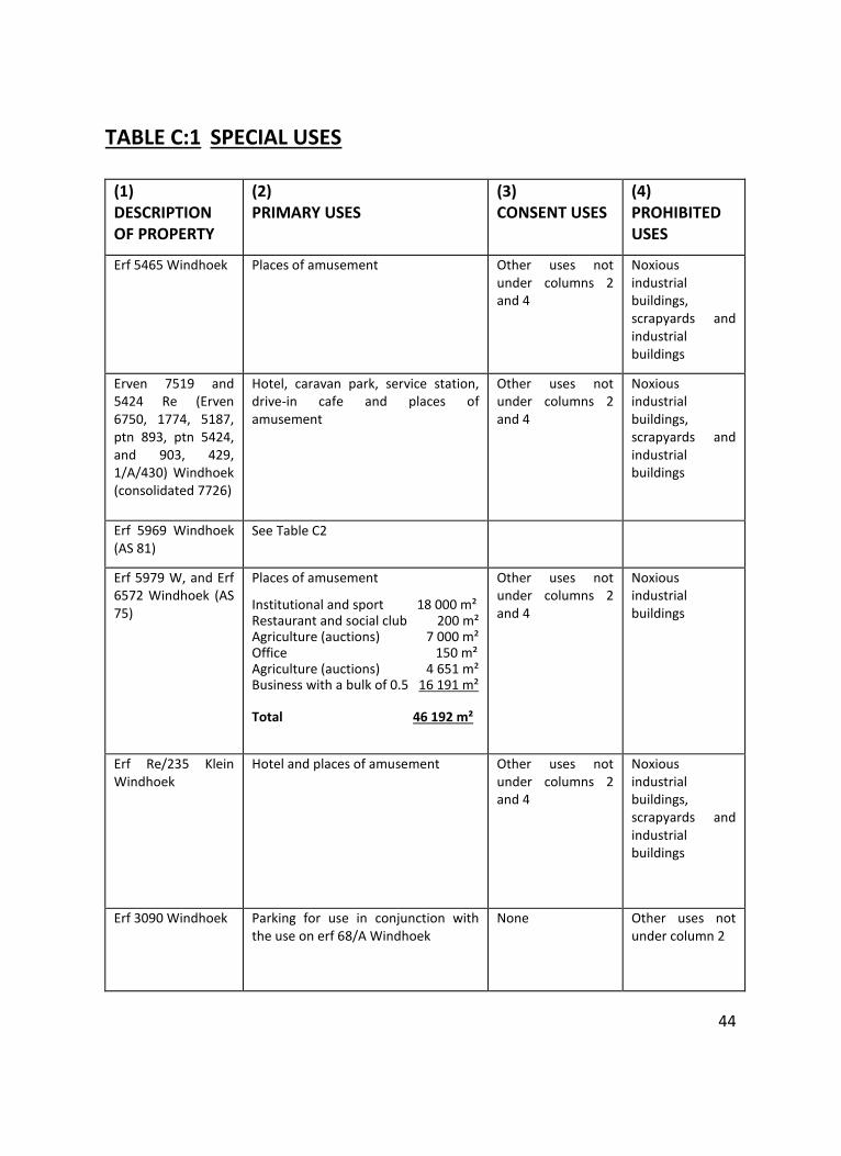
44
TABLE C:1 SPECIAL USES
(1) DESCRIPTION OF PROPERTY
(2) PRIMARY USES
(3) CONSENT USES
(4) PROHIBITED USES
Erf 5465 Windhoek Places of amusement Other uses not under columns 2 and 4
Noxious industrial buildings, scrapyards and industrial buildings
Erven 7519 and 5424 Re (Erven 6750, 1774, 5187, ptn 893, ptn 5424, and 903, 429, 1/A/430) Windhoek (consolidated 7726)
Hotel, caravan park, service station, drive-in cafe and places of amusement
Other uses not under columns 2 and 4
Noxious industrial buildings, scrapyards and industrial buildings
Erf 5969 Windhoek (AS 81)
See Table C2
Erf 5979 W, and Erf 6572 Windhoek (AS 75)
Places of amusement
Institutional and sport 18 000 m² Restaurant and social club 200 m² Agriculture (auctions) 7 000 m² Office 150 m² Agriculture (auctions) 4 651 m² Business with a bulk of 0.5 16 191 m² Total 46 192 m²
Other uses not under columns 2 and 4
Noxious industrial buildings
Erf Re/235 Klein Windhoek
Hotel and places of amusement Other uses not under columns 2 and 4
Noxious industrial buildings, scrapyards and industrial buildings
Erf 3090 Windhoek Parking for use in conjunction with the use on erf 68/A Windhoek
None Other uses not under column 2
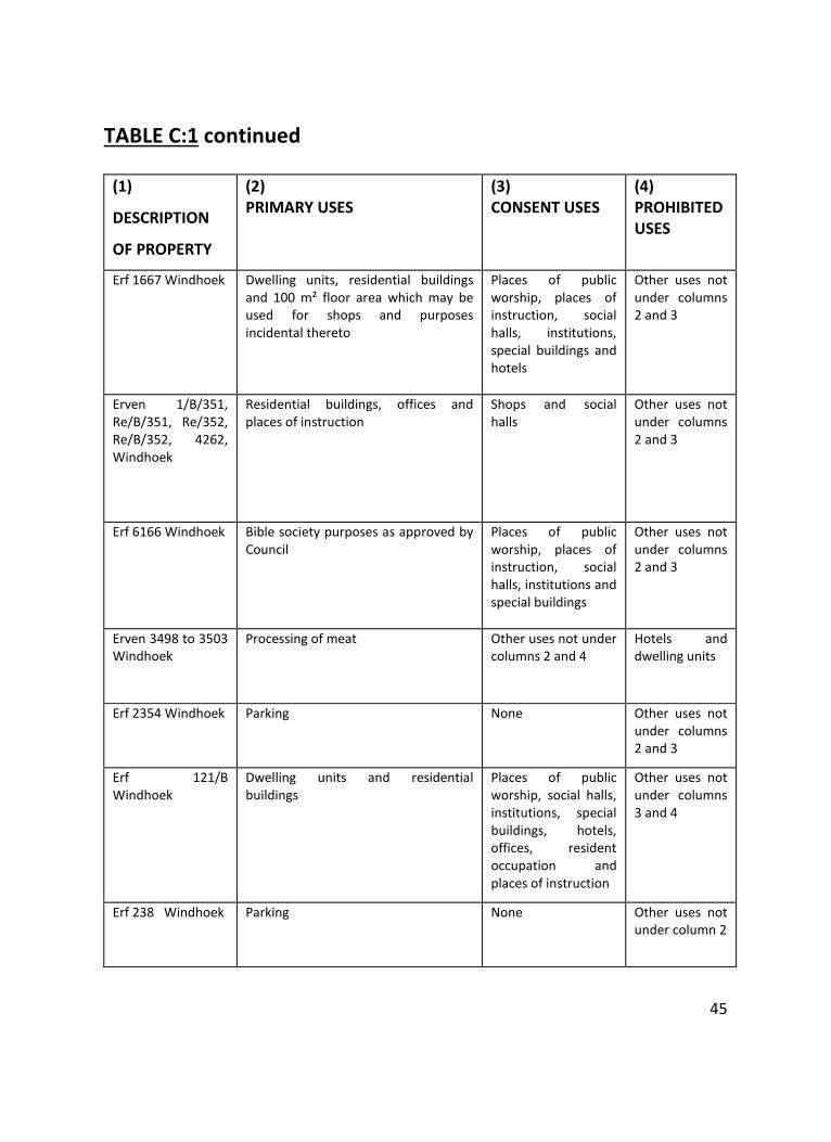
45
TABLE C:1 continued
(1)
DESCRIPTION
OF PROPERTY
(2) PRIMARY USES
(3) CONSENT USES
(4) PROHIBITED USES
Erf 1667 Windhoek Dwelling units, residential buildings and 100 m² floor area which may be used for shops and purposes incidental thereto
Places of public worship, places of instruction, social halls, institutions, special buildings and hotels
Other uses not under columns 2 and 3
Erven 1/B/351, Re/B/351, Re/352, Re/B/352, 4262, Windhoek
Residential buildings, offices and places of instruction
Shops and social halls
Other uses not under columns 2 and 3
Erf 6166 Windhoek Bible society purposes as approved by Council
Places of public worship, places of instruction, social halls, institutions and special buildings
Other uses not under columns 2 and 3
Erven 3498 to 3503 Windhoek
Processing of meat Other uses not under columns 2 and 4
Hotels and dwelling units
Erf 2354 Windhoek Parking None Other uses not under columns 2 and 3
Erf 121/B Windhoek
Dwelling units and residential buildings
Places of public worship, social halls, institutions, special buildings, hotels, offices, resident occupation and places of instruction
Other uses not under columns 3 and 4
Erf 238 Windhoek Parking None Other uses not under column 2
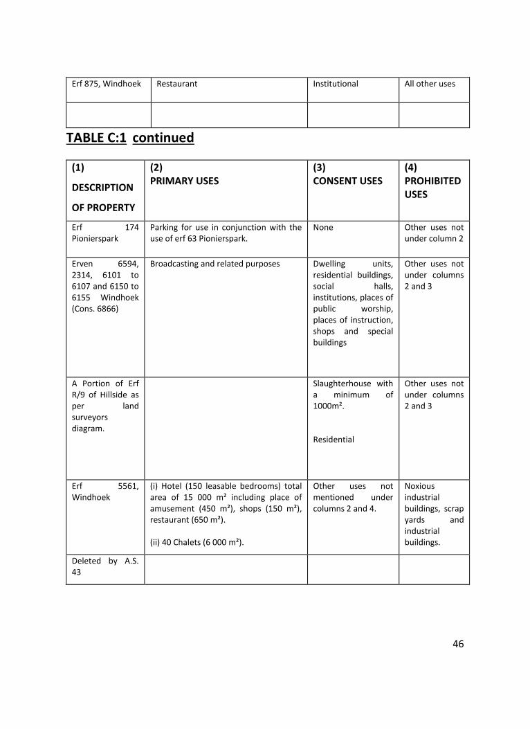
46
Erf 875, Windhoek Restaurant Institutional All other uses
TABLE C:1 continued
(1)
DESCRIPTION
OF PROPERTY
(2) PRIMARY USES
(3) CONSENT USES
(4) PROHIBITED USES
Erf 174 Pionierspark
Parking for use in conjunction with the use of erf 63 Pionierspark.
None Other uses not under column 2
Erven 6594, 2314, 6101 to 6107 and 6150 to 6155 Windhoek (Cons. 6866)
Broadcasting and related purposes Dwelling units, residential buildings, social halls, institutions, places of public worship, places of instruction, shops and special buildings
Other uses not under columns 2 and 3
A Portion of Erf R/9 of Hillside as per land surveyors diagram.
Slaughterhouse with a minimum of 1000m².
Residential
Other uses not under columns 2 and 3
Erf 5561, Windhoek
(i) Hotel (150 leasable bedrooms) total area of 15 000 m² including place of amusement (450 m²), shops (150 m²), restaurant (650 m²). (ii) 40 Chalets (6 000 m²).
Other uses not mentioned under columns 2 and 4.
Noxious industrial buildings, scrap yards and industrial buildings.
Deleted by A.S. 43
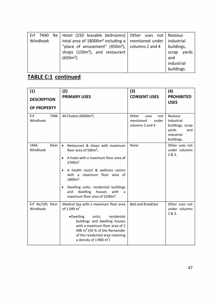
47
Erf 7440 Re Windhoek
Hotel (150 leasable bedrooms) total area of 18000m² including a “place of amusement” (450m²), shops (150m²), and restaurant (650m²).
Other uses not mentioned under columns 2 and 4
Noxious industrial buildings, scrap yards and industrial buildings.
TABLE C:1 continued
(1)
DESCRIPTION
OF PROPERTY
(2) PRIMARY USES
(3) CONSENT USES
(4) PROHIBITED USES
Erf 7496 Windhoek
40 Chalets (6000m²) Other uses not mentioned under columns 2 and 4
Noxious industrial buildings, scrap yards and industrial buildings.
1944 Klein Windhoek
Restaurant & shops with maximum floor area of 500m²;
A hotel with a maximum floor area of 2700m².
A health resort & wellness centre with a maximum floor area of 1800m².
Dwelling units, residential buildings and dwelling houses with a maximum floor area of 5200m².
None Other uses not under columns 2 & 3.
Erf Re/105 Klein Windhoek
Medical Spa with a maximum floor area of 1 049 m
2
Dwelling units, residential buildings and dwelling houses with a maximum floor area of 2 098 m
2 (50 % of the Remainder
of the residential area retaining a density of 1:900 m
2)
Bed and Breakfast Other uses not under columns 2 & 3.
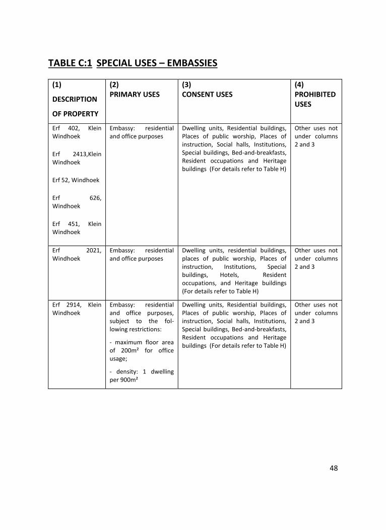
48
TABLE C:1 SPECIAL USES – EMBASSIES
(1)
DESCRIPTION
OF PROPERTY
(2) PRIMARY USES
(3) CONSENT USES
(4) PROHIBITED USES
Erf 402, Klein Windhoek
Erf 2413,Klein Windhoek
Erf 52, Windhoek
Erf 626, Windhoek
Erf 451, Klein Windhoek
Embassy: residential and office purposes
Dwelling units, Residential buildings, Places of public worship, Places of instruction, Social halls, Institutions, Special buildings, Bed-and-breakfasts, Resident occupations and Heritage buildings (For details refer to Table H)
Other uses not under columns 2 and 3
Erf 2021, Windhoek
Embassy: residential and office purposes
Dwelling units, residential buildings, places of public worship, Places of instruction, Institutions, Special buildings, Hotels, Resident occupations, and Heritage buildings (For details refer to Table H)
Other uses not under columns 2 and 3
Erf 2914, Klein Windhoek
Embassy: residential and office purposes, subject to the fol-lowing restrictions:
- maximum floor area of 200m² for office usage;
- density: 1 dwelling per 900m²
Dwelling units, Residential buildings, Places of public worship, Places of instruction, Social halls, Institutions, Special buildings, Bed-and-breakfasts, Resident occupations and Heritage buildings (For details refer to Table H)
Other uses not under columns 2 and 3
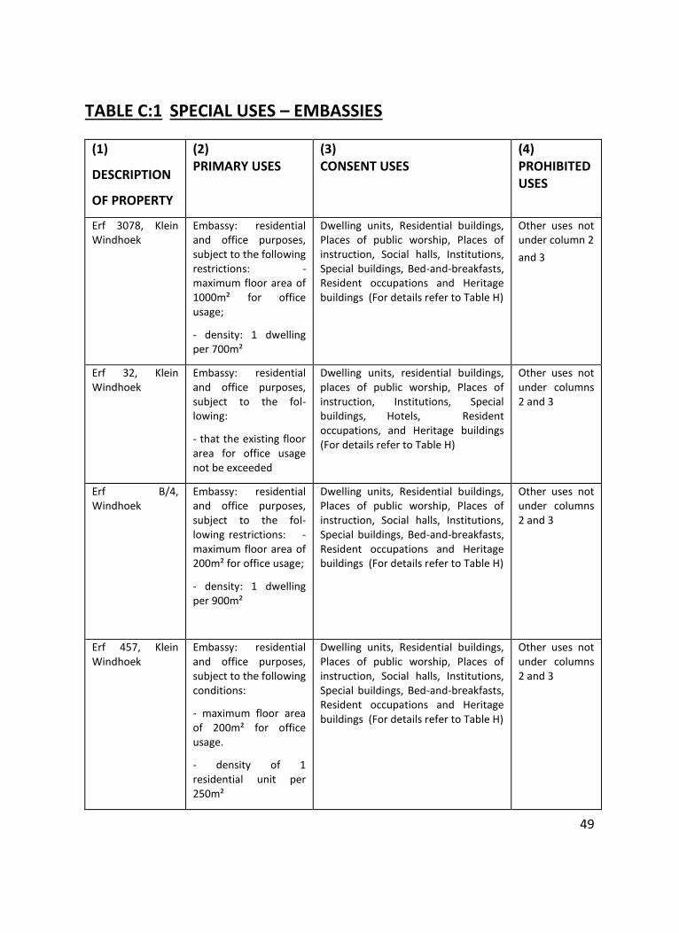
49
TABLE C:1 SPECIAL USES – EMBASSIES
(1)
DESCRIPTION
OF PROPERTY
(2) PRIMARY USES
(3) CONSENT USES
(4) PROHIBITED USES
Erf 3078, Klein Windhoek
Embassy: residential and office purposes, subject to the following restrictions: - maximum floor area of 1000m² for office usage;
- density: 1 dwelling per 700m²
Dwelling units, Residential buildings, Places of public worship, Places of instruction, Social halls, Institutions, Special buildings, Bed-and-breakfasts, Resident occupations and Heritage buildings (For details refer to Table H)
Other uses not under column 2
and 3
Erf 32, Klein Windhoek
Embassy: residential and office purposes, subject to the fol-lowing:
- that the existing floor area for office usage not be exceeded
Dwelling units, residential buildings, places of public worship, Places of instruction, Institutions, Special buildings, Hotels, Resident occupations, and Heritage buildings (For details refer to Table H)
Other uses not under columns 2 and 3
Erf B/4, Windhoek
Embassy: residential and office purposes, subject to the fol-lowing restrictions: - maximum floor area of 200m² for office usage;
- density: 1 dwelling per 900m²
Dwelling units, Residential buildings, Places of public worship, Places of instruction, Social halls, Institutions, Special buildings, Bed-and-breakfasts, Resident occupations and Heritage buildings (For details refer to Table H)
Other uses not under columns 2 and 3
Erf 457, Klein Windhoek
Embassy: residential and office purposes, subject to the following conditions:
- maximum floor area of 200m² for office usage.
- density of 1 residential unit per 250m²
Dwelling units, Residential buildings, Places of public worship, Places of instruction, Social halls, Institutions, Special buildings, Bed-and-breakfasts, Resident occupations and Heritage buildings (For details refer to Table H)
Other uses not under columns 2 and 3
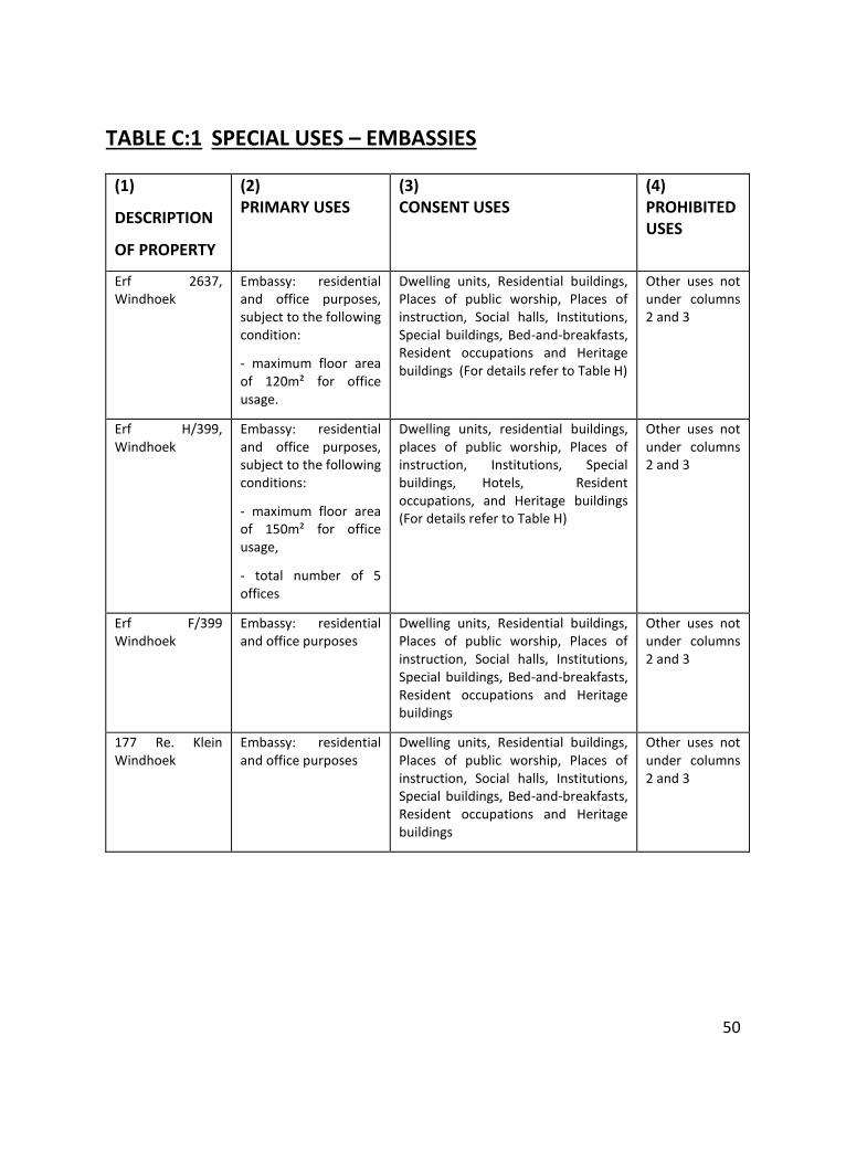
50
TABLE C:1 SPECIAL USES – EMBASSIES
(1)
DESCRIPTION
OF PROPERTY
(2) PRIMARY USES
(3) CONSENT USES
(4) PROHIBITED USES
Erf 2637, Windhoek
Embassy: residential and office purposes, subject to the following condition:
- maximum floor area of 120m² for office usage.
Dwelling units, Residential buildings, Places of public worship, Places of instruction, Social halls, Institutions, Special buildings, Bed-and-breakfasts, Resident occupations and Heritage buildings (For details refer to Table H)
Other uses not under columns 2 and 3
Erf H/399, Windhoek
Embassy: residential and office purposes, subject to the following conditions:
- maximum floor area of 150m² for office usage,
- total number of 5 offices
Dwelling units, residential buildings, places of public worship, Places of instruction, Institutions, Special buildings, Hotels, Resident occupations, and Heritage buildings (For details refer to Table H)
Other uses not under columns 2 and 3
Erf F/399 Windhoek
Embassy: residential and office purposes
Dwelling units, Residential buildings, Places of public worship, Places of instruction, Social halls, Institutions, Special buildings, Bed-and-breakfasts, Resident occupations and Heritage buildings
Other uses not under columns 2 and 3
177 Re. Klein Windhoek
Embassy: residential and office purposes
Dwelling units, Residential buildings, Places of public worship, Places of instruction, Social halls, Institutions, Special buildings, Bed-and-breakfasts, Resident occupations and Heritage buildings
Other uses not under columns 2 and 3
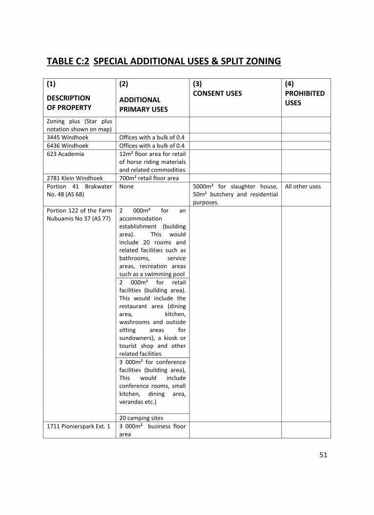
51
TABLE C:2 SPECIAL ADDITIONAL USES & SPLIT ZONING
(1)
DESCRIPTION OF PROPERTY
(2)
ADDITIONAL PRIMARY USES
(3) CONSENT USES
(4) PROHIBITED USES
Zoning plus (Star plus notation shown on map)
3445 Windhoek Offices with a bulk of 0.4
6436 Windhoek Offices with a bulk of 0.4
623 Academia 12m² floor area for retail of horse riding materials and related commodities
2781 Klein Windhoek 700m² retail floor area
Portion 41 Brakwater No. 48 (AS 68)
None 5000m² for slaughter house, 50m² butchery and residential purposes.
All other uses
Portion 122 of the Farm Nubuamis No 37 (AS 77)
2 000m² for an accommodation establishment (building area). This would include 20 rooms and related facilities such as bathrooms, service areas, recreation areas such as a swimming pool
2 000m² for retail facilities (building area). This would include the restaurant area (dining area, kitchen, washrooms and outside sitting areas for sundowners), a kiosk or tourist shop and other related facilities
3 000m² for conference facilities (building area), This would include conference rooms, small kitchen, dining area, verandas etc.)
20 camping sites
1711 Pionierspark Ext. 1
3 000m² business floor area
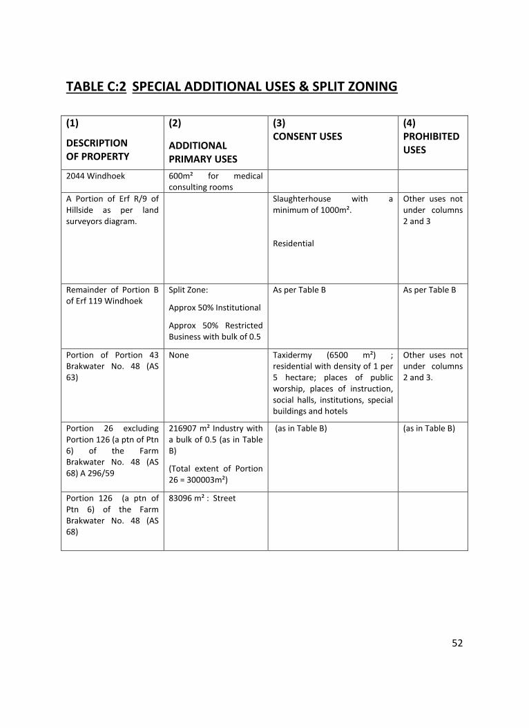
52
TABLE C:2 SPECIAL ADDITIONAL USES & SPLIT ZONING
(1)
DESCRIPTION OF PROPERTY
(2)
ADDITIONAL PRIMARY USES
(3) CONSENT USES
(4) PROHIBITED USES
2044 Windhoek
600m² for medical consulting rooms
A Portion of Erf R/9 of Hillside as per land surveyors diagram.
Slaughterhouse with a minimum of 1000m².
Residential
Other uses not under columns 2 and 3
Remainder of Portion B of Erf 119 Windhoek
Split Zone:
Approx 50% Institutional
Approx 50% Restricted Business with bulk of 0.5
As per Table B As per Table B
Portion of Portion 43 Brakwater No. 48 (AS 63)
None Taxidermy (6500 m²) ; residential with density of 1 per 5 hectare; places of public worship, places of instruction, social halls, institutions, special buildings and hotels
Other uses not under columns 2 and 3.
Portion 26 excluding Portion 126 (a ptn of Ptn 6) of the Farm Brakwater No. 48 (AS 68) A 296/59
216907 m² Industry with a bulk of 0.5 (as in Table B)
(Total extent of Portion 26 = 300003m²)
(as in Table B) (as in Table B)
Portion 126 (a ptn of Ptn 6) of the Farm Brakwater No. 48 (AS 68)
83096 m² : Street
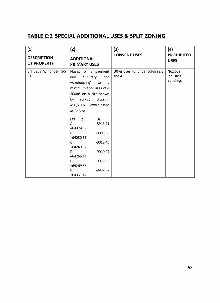
53
TABLE C:2 SPECIAL ADDITIONAL USES & SPLIT ZONING
(1)
DESCRIPTION OF PROPERTY
(2)
ADDITIONAL PRIMARY USES
(3) CONSENT USES
(4) PROHIBITED USES
Erf 5969 Windhoek (AS 81)
Places of amusement
and 'industry and
warehousing' to a
maximum floor area of 4
300m² on a site shown
by survey diagram
A90/2007 coordinated
as follows:
Pts Y X A. -8945.21 +64329.27 B. -8005.58 +64250.55 C -9019.45 +64249.17 D -9040.07 +64266.61 E. -9039.85 +64269.36 F. -8967.62 +64361.47
Other uses not under columns 2 and 4
Noxious industrial buildings
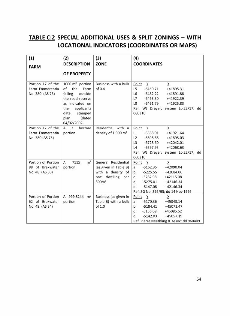
54
TABLE C:2 SPECIAL ADDITIONAL USES & SPLIT ZONINGS – WITH LOCATIONAL INDICATORS (COORDINATES OR MAPS)
(1)
FARM
(2) DESCRIPTION
OF PROPERTY
(3) ZONE
(4) COORDINATES
Portion 17 of the Farm Emmerentia No. 380. (AS 75)
1000 m² portion of the Farm falling outside the road reserve as indicated on the applicants date stamped plan (dated 04/02/2002
Business with a bulk of 0.4
Point Y X L5 -6450.71 +41895.31 L6 -6482.22 +41891.88 L7 -6493.30 +41922.39 L8 -6461.79 +41925.83 Ref. WJ Dreyer; system Lo.22/17; dd 060310
Portion 17 of the Farm Emmerentia No. 380 (AS 75)
A 2 hectare portion
Residential with a density of 1:900 m²
Point Y X L1 -6568.01 +41921.64 L2 -6698.66 +41895.03 L3 -6728.60 +42042.01 L4 -6597.95 +42068.63 Ref. WJ Dreyer; system Lo.22/17; dd 060310
Portion of Portion 88 of Brakwater No. 48. (AS 30)
A 7115 m² portion
General Residential (as given in Table B) with a density of one dwelling per 500m²
Point Y X a -5152.35 +42090.04 b -5225.55 +42084.06 c -5282.98 +42115.08 d -5275.01 +42146.34 e -5147.08 +42146.34 Ref. SG No. 395/95; dd 14 Nov 1995
Portion of Portion 62 of Brakwater No. 48. (AS 34)
A 999.8244 m² portion
Business (as given in Table B) with a bulk of 1.0
Point Y X a -5170.36 +45043.14 b -5184.41 +45071.47 c -5156.08 +45085.52 d -5142.03 +45057.19 Ref. Pierre Neethling & Assoc; dd 960409
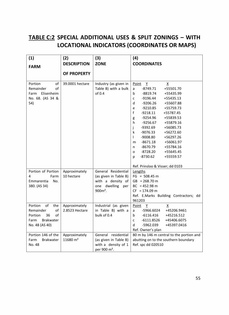
55
TABLE C:2 SPECIAL ADDITIONAL USES & SPLIT ZONINGS – WITH LOCATIONAL INDICATORS (COORDINATES OR MAPS)
(1)
FARM
(2) DESCRIPTION
OF PROPERTY
(3) ZONE
(4) COORDINATES
Portion of Remainder of Farm Elisenheim No. 68. (AS 34 & 54)
39.0001 hectare Industry (as given in Table B) with a bulk of 0.4
Point Y X a -8749.71 +55501.70 b -8819.74 +55435.99 c -9196.44 +55435.13 d -9206.26 +55607.88 e -9210.85 +55759.73 f -9218.11 +55787.45 g -9254.96 +55839.53 h -9256.67 +55879.16 j -9392.69 +56085.73 k -9076.33 +56272.60 l -9008.80 +56297.26 m -8671.18 +56061.97 n -8670.79 +55784.16 o -8728.20 +55645.45 p -8730.62 +55559.57 Ref. Prinsloo & Visser; dd 0103
Portion of Portion 4 Farm Emmarentia No. 380. (AS 34)
Approximately 10 hectare
General Residential (as given in Table B) with a density of one dwelling per 900m².
Lengths FG = 508.45 m GB = 268.70 m BC = 452.98 m CF = 174.09 m Ref. E.Marks Building Contractors; dd 961203
Portion of the Remainder of Portion 36 of Farm Brakwater No. 48 (AS 40)
Approximately 2.8523 Hectare
Industrial (as given in Table B) with a bulk of 0.4
Point Y X a -5966.6024 +45206.9461 b -6116.416 +45216.512 c -6111.8526 +45406.6075 d -5962.039 +45397.0416 Ref. Owner’s plan
Portion 146 of the Farm Brakwater No. 48
Approximately 11680 m²
General residential (as given in Table B) with a density of 1 per 900 m².
80 m by 146 m central to the portion and abutting on to the southern boundary Ref. spc dd 020510
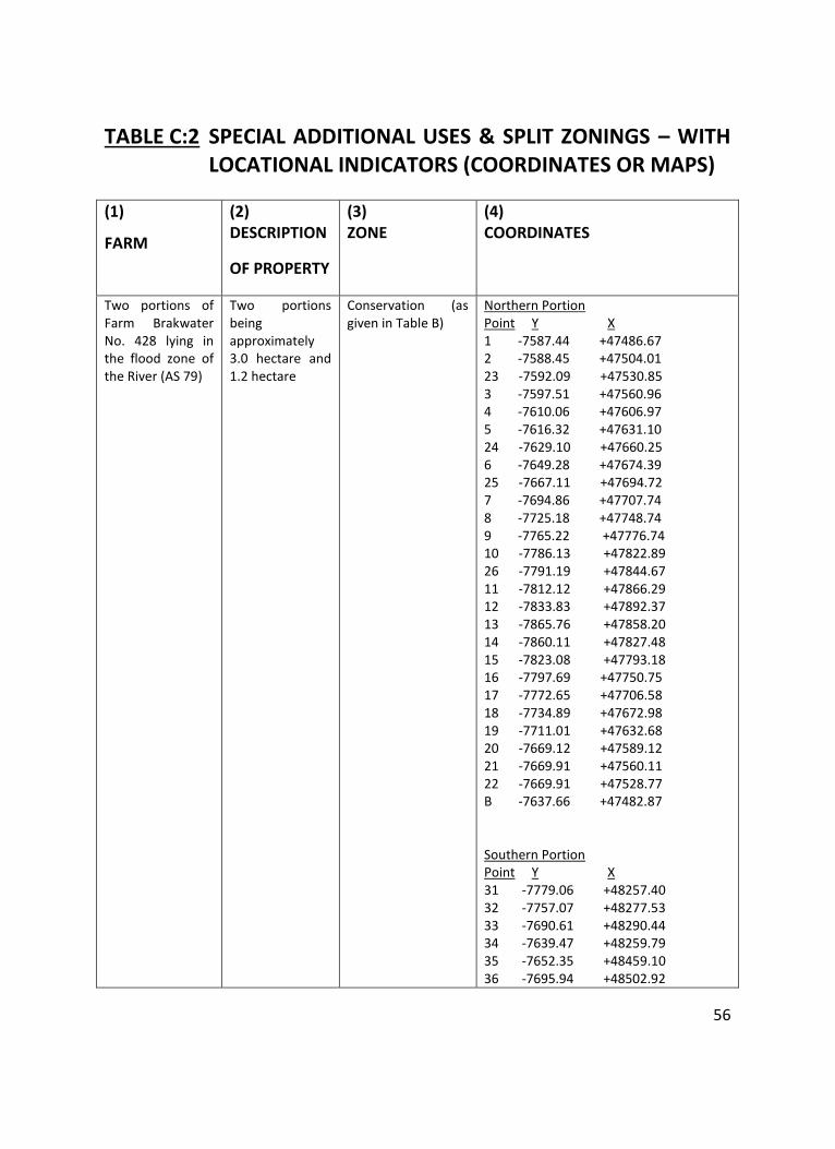
56
TABLE C:2 SPECIAL ADDITIONAL USES & SPLIT ZONINGS – WITH LOCATIONAL INDICATORS (COORDINATES OR MAPS)
(1)
FARM
(2) DESCRIPTION
OF PROPERTY
(3) ZONE
(4) COORDINATES
Two portions of Farm Brakwater No. 428 lying in the flood zone of the River (AS 79)
Two portions being approximately 3.0 hectare and 1.2 hectare
Conservation (as given in Table B)
Northern Portion Point Y X 1 -7587.44 +47486.67 2 -7588.45 +47504.01 23 -7592.09 +47530.85 3 -7597.51 +47560.96 4 -7610.06 +47606.97 5 -7616.32 +47631.10 24 -7629.10 +47660.25 6 -7649.28 +47674.39 25 -7667.11 +47694.72 7 -7694.86 +47707.74 8 -7725.18 +47748.74 9 -7765.22 +47776.74 10 -7786.13 +47822.89 26 -7791.19 +47844.67 11 -7812.12 +47866.29 12 -7833.83 +47892.37 13 -7865.76 +47858.20 14 -7860.11 +47827.48 15 -7823.08 +47793.18 16 -7797.69 +47750.75 17 -7772.65 +47706.58 18 -7734.89 +47672.98 19 -7711.01 +47632.68 20 -7669.12 +47589.12 21 -7669.91 +47560.11 22 -7669.91 +47528.77 B -7637.66 +47482.87 Southern Portion Point Y X 31 -7779.06 +48257.40 32 -7757.07 +48277.53 33 -7690.61 +48290.44 34 -7639.47 +48259.79 35 -7652.35 +48459.10 36 -7695.94 +48502.92
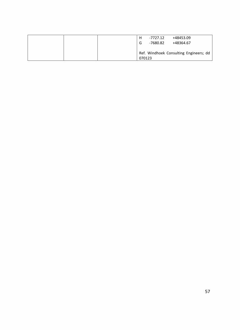
57
H -7727.12 +48453.09 G -7680.82 +48364.67 Ref. Windhoek Consulting Engineers; dd 070123
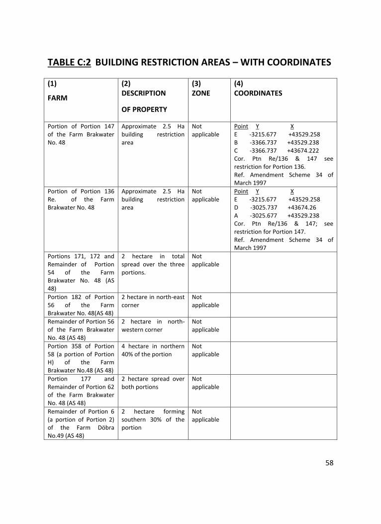
58
TABLE C:2 BUILDING RESTRICTION AREAS – WITH COORDINATES
(1)
FARM
(2) DESCRIPTION
OF PROPERTY
(3) ZONE
(4) COORDINATES
Portion of Portion 147 of the Farm Brakwater No. 48
Approximate 2.5 Ha building restriction area
Not applicable
Point Y X E -3215.677 +43529.258 B -3366.737 +43529.238 C -3366.737 +43674.222 Cor. Ptn Re/136 & 147 see restriction for Portion 136. Ref. Amendment Scheme 34 of March 1997
Portion of Portion 136 Re. of the Farm Brakwater No. 48
Approximate 2.5 Ha building restriction area
Not applicable
Point Y X E -3215.677 +43529.258 D -3025.737 +43674.26 A -3025.677 +43529.238 Cor. Ptn Re/136 & 147; see restriction for Portion 147. Ref. Amendment Scheme 34 of March 1997
Portions 171, 172 and Remainder of Portion 54 of the Farm Brakwater No. 48 (AS 48)
2 hectare in total spread over the three portions.
Not applicable
Portion 182 of Portion 56 of the Farm Brakwater No. 48(AS 48)
2 hectare in north-east corner
Not applicable
Remainder of Portion 56 of the Farm Brakwater No. 48 (AS 48)
2 hectare in north-western corner
Not applicable
Portion 358 of Portion 58 (a portion of Portion H) of the Farm Brakwater No.48 (AS 48)
4 hectare in northern 40% of the portion
Not applicable
Portion 177 and Remainder of Portion 62 of the Farm Brakwater No. 48 (AS 48)
2 hectare spread over both portions
Not applicable
Remainder of Portion 6 (a portion of Portion 2) of the Farm Döbra No.49 (AS 48)
2 hectare forming southern 30% of the portion
Not applicable
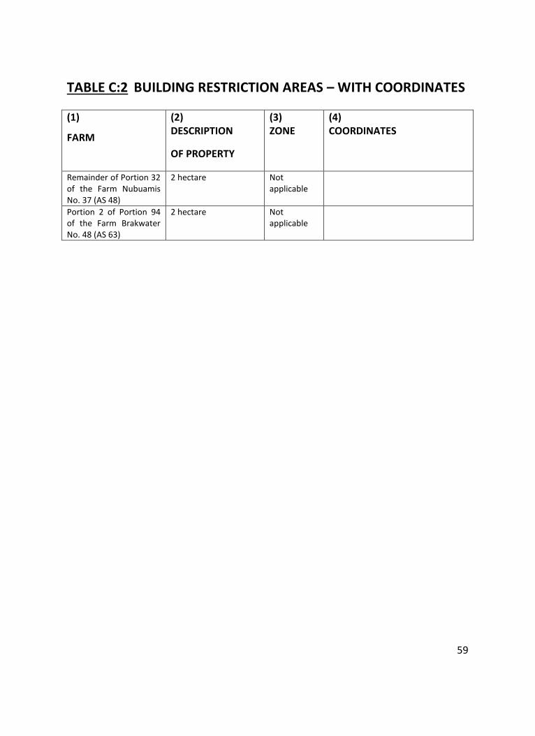
59
TABLE C:2 BUILDING RESTRICTION AREAS – WITH COORDINATES
(1)
FARM
(2) DESCRIPTION
OF PROPERTY
(3) ZONE
(4) COORDINATES
Remainder of Portion 32 of the Farm Nubuamis No. 37 (AS 48)
2 hectare Not applicable
Portion 2 of Portion 94 of the Farm Brakwater No. 48 (AS 63)
2 hectare Not applicable
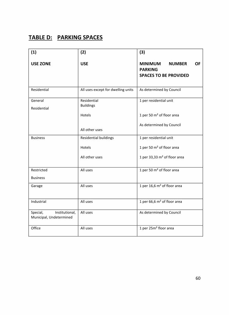
60
TABLE D: PARKING SPACES
(1) USE ZONE
(2) USE
(3) MINIMUM NUMBER OF PARKING SPACES TO BE PROVIDED
Residential All uses except for dwelling units As determined by Council
General
Residential
Residential Buildings Hotels All other uses
1 per residential unit 1 per 50 m² of floor area As determined by Council
Business Residential buildings Hotels All other uses
1 per residential unit 1 per 50 m² of floor area 1 per 33,33 m² of floor area
Restricted
Business
All uses 1 per 50 m² of floor area
Garage
All uses 1 per 16,6 m² of floor area
Industrial All uses 1 per 66,6 m² of floor area
Special, Institutional, Municipal, Undetermined
All uses As determined by Council
Office All uses 1 per 25m² floor area
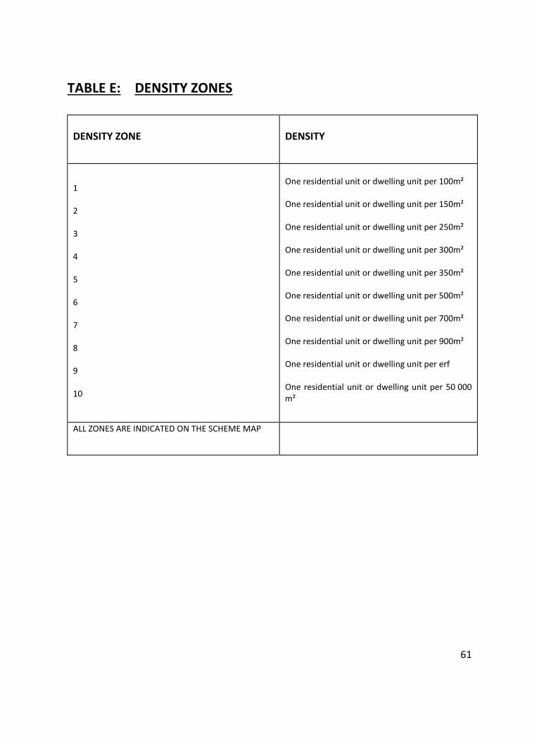
61
TABLE E: DENSITY ZONES
DENSITY ZONE
DENSITY
1 2 3 4 5 6 7 8 9 10
One residential unit or dwelling unit per 100m² One residential unit or dwelling unit per 150m² One residential unit or dwelling unit per 250m² One residential unit or dwelling unit per 300m² One residential unit or dwelling unit per 350m² One residential unit or dwelling unit per 500m² One residential unit or dwelling unit per 700m² One residential unit or dwelling unit per 900m² One residential unit or dwelling unit per erf One residential unit or dwelling unit per 50 000 m²
ALL ZONES ARE INDICATED ON THE SCHEME MAP
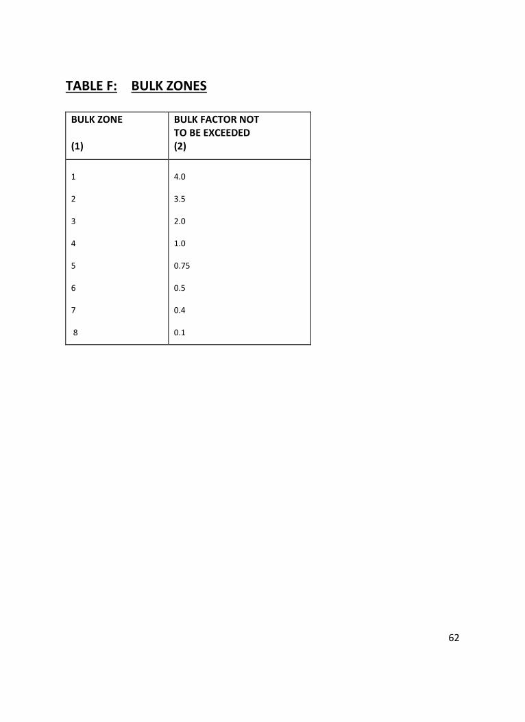
62
TABLE F: BULK ZONES
BULK ZONE (1)
BULK FACTOR NOT TO BE EXCEEDED (2)
1 2 3 4 5 6 7 8
4.0 3.5 2.0 1.0 0.75 0.5 0.4 0.1
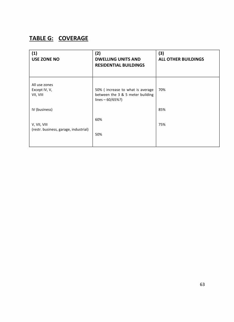
63
TABLE G: COVERAGE
(1) USE ZONE NO
(2) DWELLING UNITS AND RESIDENTIAL BUILDINGS
(3) ALL OTHER BUILDINGS
All use zones Except IV, V, VII, VIII IV (business) V, VII, VIII (restr. business, garage, industrial)
50% ( increase to what is average between the 3 & 5 meter building lines – 60/65%?) 60% 50%
70% 85% 75%
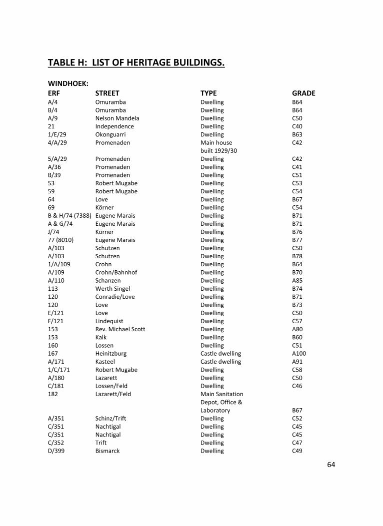
64
TABLE H: LIST OF HERITAGE BUILDINGS. WINDHOEK: ERF STREET TYPE GRADE A/4 Omuramba Dwelling B64 B/4 Omuramba Dwelling B64 A/9 Nelson Mandela Dwelling C50 21 Independence Dwelling C40 1/E/29 Okonguarri Dwelling B63 4/A/29 Promenaden Main house C42 built 1929/30 5/A/29 Promenaden Dwelling C42 A/36 Promenaden Dwelling C41 B/39 Promenaden Dwelling C51 53 Robert Mugabe Dwelling C53 59 Robert Mugabe Dwelling C54 64 Love Dwelling B67 69 Körner Dwelling C54 B & H/74 (7388) Eugene Marais Dwelling B71 A & G/74 Eugene Marais Dwelling B71 J/74 Körner Dwelling B76 77 (8010) Eugene Marais Dwelling B77 A/103 Schutzen Dwelling C50 A/103 Schutzen Dwelling B78 1/A/109 Crohn Dwelling B64 A/109 Crohn/Bahnhof Dwelling B70 A/110 Schanzen Dwelling A85 113 Werth Singel Dwelling B74 120 Conradie/Love Dwelling B71 120 Love Dwelling B73 E/121 Love Dwelling C50 F/121 Lindequist Dwelling C57 153 Rev. Michael Scott Dwelling A80 153 Kalk Dwelling B60 160 Lossen Dwelling C51 167 Heinitzburg Castle dwelling A100 A/171 Kasteel Castle dwelling A91 1/C/171 Robert Mugabe Dwelling C58 A/180 Lazarett Dwelling C50 C/181 Lossen/Feld Dwelling C46 182 Lazarett/Feld Main Sanitation Depot, Office & Laboratory B67 A/351 Schinz/Trift Dwelling C52 C/351 Nachtigal Dwelling C45 C/351 Nachtigal Dwelling C45 C/352 Trift Dwelling C47 D/399 Bismarck Dwelling C49
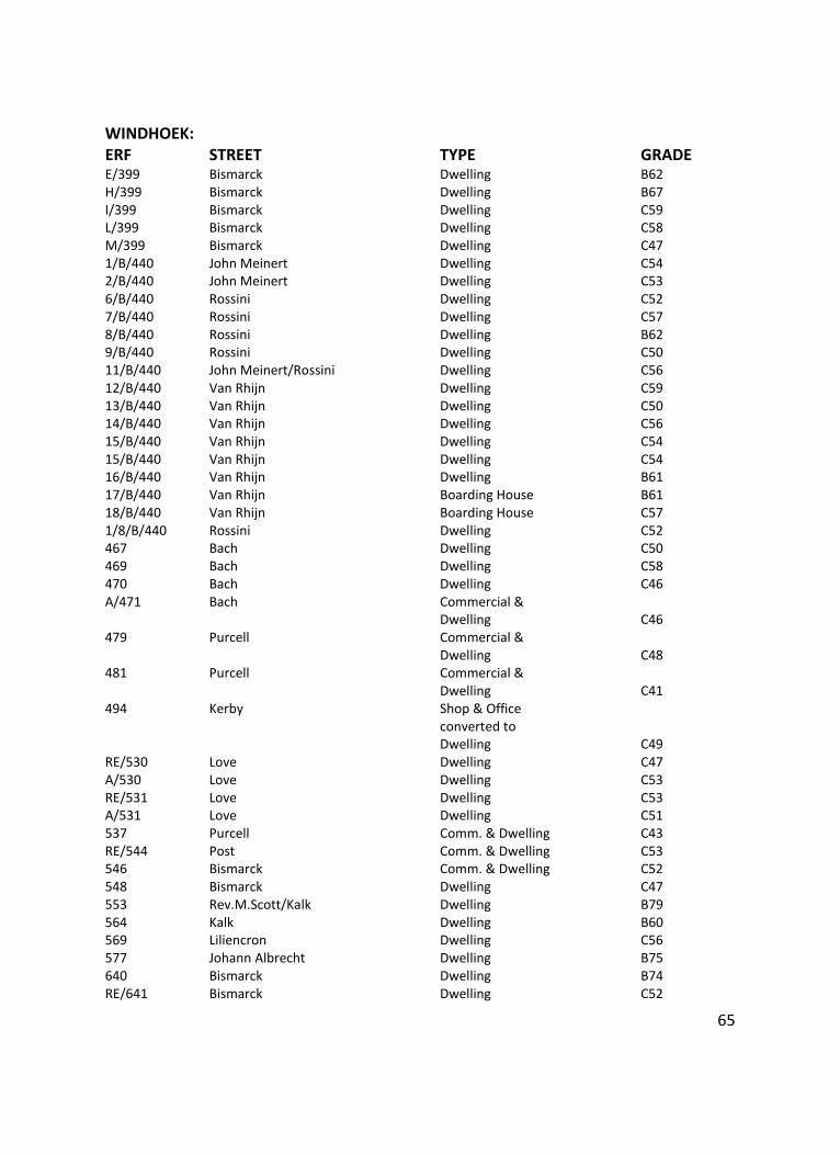
65
WINDHOEK: ERF STREET TYPE GRADE E/399 Bismarck Dwelling B62 H/399 Bismarck Dwelling B67 I/399 Bismarck Dwelling C59 L/399 Bismarck Dwelling C58 M/399 Bismarck Dwelling C47 1/B/440 John Meinert Dwelling C54 2/B/440 John Meinert Dwelling C53 6/B/440 Rossini Dwelling C52 7/B/440 Rossini Dwelling C57 8/B/440 Rossini Dwelling B62 9/B/440 Rossini Dwelling C50 11/B/440 John Meinert/Rossini Dwelling C56 12/B/440 Van Rhijn Dwelling C59 13/B/440 Van Rhijn Dwelling C50 14/B/440 Van Rhijn Dwelling C56 15/B/440 Van Rhijn Dwelling C54 15/B/440 Van Rhijn Dwelling C54 16/B/440 Van Rhijn Dwelling B61 17/B/440 Van Rhijn Boarding House B61 18/B/440 Van Rhijn Boarding House C57 1/8/B/440 Rossini Dwelling C52 467 Bach Dwelling C50 469 Bach Dwelling C58 470 Bach Dwelling C46 A/471 Bach Commercial & Dwelling C46 479 Purcell Commercial & Dwelling C48 481 Purcell Commercial & Dwelling C41 494 Kerby Shop & Office converted to Dwelling C49 RE/530 Love Dwelling C47 A/530 Love Dwelling C53 RE/531 Love Dwelling C53 A/531 Love Dwelling C51 537 Purcell Comm. & Dwelling C43 RE/544 Post Comm. & Dwelling C53 546 Bismarck Comm. & Dwelling C52 548 Bismarck Dwelling C47 553 Rev.M.Scott/Kalk Dwelling B79 564 Kalk Dwelling B60 569 Liliencron Dwelling C56 577 Johann Albrecht Dwelling B75 640 Bismarck Dwelling B74 RE/641 Bismarck Dwelling C52
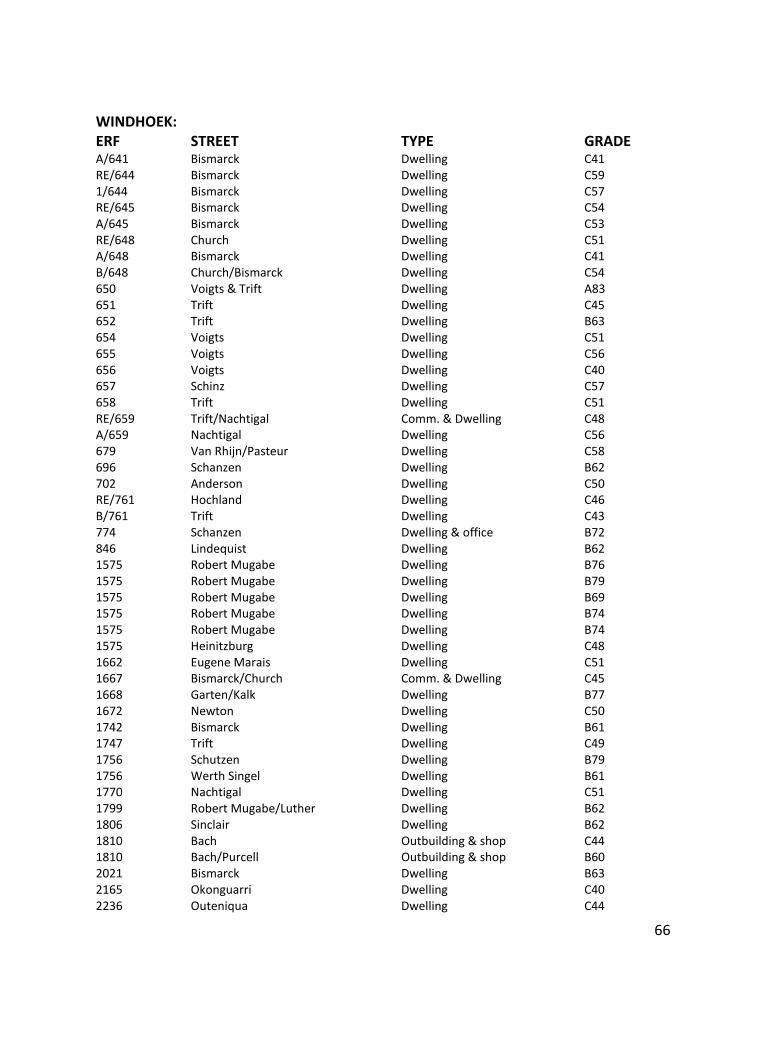
66
WINDHOEK: ERF STREET TYPE GRADE A/641 Bismarck Dwelling C41 RE/644 Bismarck Dwelling C59 1/644 Bismarck Dwelling C57 RE/645 Bismarck Dwelling C54 A/645 Bismarck Dwelling C53 RE/648 Church Dwelling C51 A/648 Bismarck Dwelling C41 B/648 Church/Bismarck Dwelling C54 650 Voigts & Trift Dwelling A83 651 Trift Dwelling C45 652 Trift Dwelling B63 654 Voigts Dwelling C51 655 Voigts Dwelling C56 656 Voigts Dwelling C40 657 Schinz Dwelling C57 658 Trift Dwelling C51 RE/659 Trift/Nachtigal Comm. & Dwelling C48 A/659 Nachtigal Dwelling C56 679 Van Rhijn/Pasteur Dwelling C58 696 Schanzen Dwelling B62 702 Anderson Dwelling C50 RE/761 Hochland Dwelling C46 B/761 Trift Dwelling C43 774 Schanzen Dwelling & office B72 846 Lindequist Dwelling B62 1575 Robert Mugabe Dwelling B76 1575 Robert Mugabe Dwelling B79 1575 Robert Mugabe Dwelling B69 1575 Robert Mugabe Dwelling B74 1575 Robert Mugabe Dwelling B74 1575 Heinitzburg Dwelling C48 1662 Eugene Marais Dwelling C51 1667 Bismarck/Church Comm. & Dwelling C45 1668 Garten/Kalk Dwelling B77 1672 Newton Dwelling C50 1742 Bismarck Dwelling B61 1747 Trift Dwelling C49 1756 Schutzen Dwelling B79 1756 Werth Singel Dwelling B61 1770 Nachtigal Dwelling C51 1799 Robert Mugabe/Luther Dwelling B62 1806 Sinclair Dwelling B62 1810 Bach Outbuilding & shop C44 1810 Bach/Purcell Outbuilding & shop B60 2021 Bismarck Dwelling B63 2165 Okonguarri Dwelling C40 2236 Outeniqua Dwelling C44
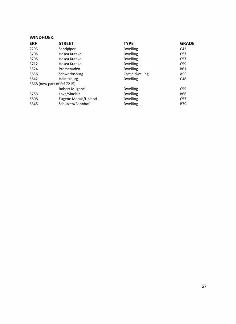
67
WINDHOEK: ERF STREET TYPE GRADE 2295 Sandpiper Dwelling C42 3705 Hosea Kutako Dwelling C57 3705 Hosea Kutako Dwelling C57 3712 Hosea Kutako Dwelling C59 5524 Promenaden Dwelling B61 5636 Schwerinsburg Castle dwelling A99 5642 Heinitzburg Dwelling C48 5668 (now part of Erf 7215) Robert Mugabe Dwelling C55 5753 Love/Sinclair Dwelling B66 6608 Eugene Marais/Uhland Dwelling C53 6645 Schutzen/Bahnhof Dwelling B79
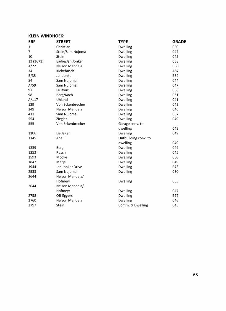
68
KLEIN WINDHOEK: ERF STREET TYPE GRADE 1 Christian Dwelling C50 7 Stein/Sam Nujoma Dwelling C47 10 Stein Dwelling C45 13 (3673) Eadie/Jan Jonker Dwelling C58 A/22 Nelson Mandela Dwelling B60 34 Kiekebusch Dwelling A87 B/35 Jan Jonker Dwelling B62 54 Sam Nujoma Dwelling C44 A/59 Sam Nujoma Dwelling C47 97 Le Roux Dwelling C58 98 Berg/Koch Dwelling C51 A/117 Uhland Dwelling C41 129 Von Eckenbrecher Dwelling C45 349 Nelson Mandela Dwelling C46 411 Sam Nujoma Dwelling C57 554 Ziegler Dwelling C49 555 Von Eckenbrecher Garage conv. to dwelling C49 1106 De Jager Dwelling C49 1145 Anz Outbuilding conv. to dwelling C49 1339 Berg Dwelling C49 1352 Rusch Dwelling C45 1593 Mocke Dwelling C50 1842 Metje Dwelling C49 1944 Jan Jonker Drive Dwelling B73 2533 Sam Nujoma Dwelling C50 2644 Nelson Mandela/ Hofmeyr Dwelling C55 2644 Nelson Mandela/ Hofmeyr Dwelling C47 2758 Off Eggers Dwelling B77 2760 Nelson Mandela Dwelling C46 2797 Stein Comm. & Dwelling C45
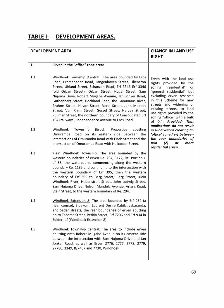
69
TABLE I: DEVELOPMENT AREAS.
DEVELOPMENT AREA CHANGE IN LAND USE RIGHT
1. Erven in the "office" zone area:
1.1 Windhoek Township (Central): The area bounded by Eros
Road, Promenaden Road, Langenhoven Street, Liliencron Street, Uhland Street, Schanzen Road, Erf 3346 Erf 3346 (old Orban Street), Orban Street, Hugel Street, Sam Nujoma Drive, Robert Mugabe Avenue, Jan Jonker Road, Guthenberg Street, Hochland Road, the Gammams River, Brahms Street, Haydn Street, Verdi Street, John Meinert Street, Van Rhijn Street, Gessel Street, Harvey Street, Pullman Street, the northern boundary of Consolidated Erf 194 (railways), Independence Avenue to Eros Road.
1.2 Windhoek Township (Eros): Properties abutting
Omuramba Road on its eastern side between the intersections of Omuramba Road with Eiseb Street and the intersection of Omuramba Road with Heliodoor Street.
1.3 Klein Windhoek Township: The area bounded by the
western boundaries of erven Re. 294, 3172, Re. Portion C of 88, the watercourse commencing along the western boundary Re. 1185 and continuing to the intersection with the western boundary of Erf 395, then the western boundary of Erf 395 to Berg Street, Berg Street, Klein Windhoek River, Hebenstreit Street, John Ludwig Street, Sam Nujoma Drive, Nelson Mandela Avenue, Arians Road, Stein Street, to the western boundary of Re. 294.
1.4 Windhoek Extension 8: The area bounded by Erf 934 (a
river course), Bloekom, Laurent Desire Kabila, Jakaranda, and Seder streets, the rear boundaries of erven abutting on to Tacoma Street, Perkin Street, Erf 7206 and Erf 934 in Suiderhof (Windhoek Extension 8).
1.5 Windhoek Township Central: The area to include erven
abutting onto Robert Mugabe Avenue on its eastern side between the intersection with Sam Nujoma Drive and Jan Jonker Road, as well as Erven 2776, 2777, 2778, 2779, 27780, 3349, R/7467 and 7730, Windhoek
Erven with the land use rights provided by the zoning "residential" or "general residential" but excluding erven reserved in this Scheme for new streets and widening of existing streets, to land use rights provided by the zoning "office" with a bulk of 0,4: Provided: That applications do not result in subdivisions creating an ‘office’ zoned erf between the rear boundaries of two (2) or more residential erven.
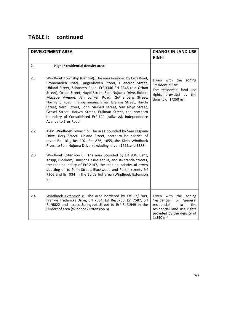
70
TABLE I: continued
DEVELOPMENT AREA CHANGE IN LAND USE RIGHT
2. Higher residential density area:
2.1 Windhoek Township (Central): The area bounded by Eros Road,
Promenaden Road, Langenhoven Street, Liliencron Street, Uhland Street, Schanzen Road, Erf 3346 Erf 3346 (old Orban Street), Orban Street, Hugel Street, Sam Nujoma Drive, Robert Mugabe Avenue, Jan Jonker Road, Guthenberg Street, Hochland Road, the Gammams River, Brahms Street, Haydn Street, Verdi Street, John Meinert Street, Van Rhijn Street, Gessel Street, Harvey Street, Pullman Street, the northern boundary of Consolidated Erf 194 (railways), Independence Avenue to Eros Road.
2.2 Klein Windhoek Township: The area bounded by Sam Nujoma
Drive, Berg Street, Uhland Street, northern boundaries of erven Re. 101, Re. 102, Re. 826, 1655, the Klein Windhoek River, to Sam Nujoma Drive. (excluding erven 1699 and 3388)
2.3 Windhoek Extension 8: The area bounded by Erf 934, Benz,
Krupp, Bloekom, Laurent Desire Kabila, and Jakaranda streets, the rear boundary of Erf 2147, the rear boundaries of erven abutting on to Palm Street, Blackwood and Perkin streets Erf 7206 and Erf 934 in the Suiderhof area (Windhoek Extension 8).
Erven with the zoning "residential" to: The residential land use rights provided by the density of 1/250 m².
2.4 Windhoek Extension 8: The area bordered by Erf Re/1949,
Frankie Fredericks Drive, Erf 7534, Erf Re/6755, Erf 7587, Erf Re/6022 and across Springbok Street to Erf Re/1949 in the Suiderhof area (Windhoek Extension 8)
Erven with the zoning ‘residential’ or ‘general residential’, to the residential land use rights provided by the density of 1/350 m².
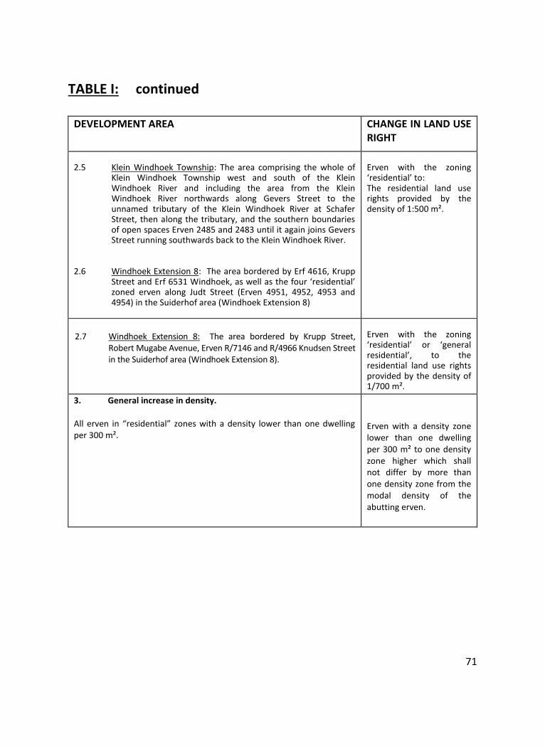
71
TABLE I: continued
DEVELOPMENT AREA CHANGE IN LAND USE RIGHT
2.5 Klein Windhoek Township: The area comprising the whole of
Klein Windhoek Township west and south of the Klein Windhoek River and including the area from the Klein Windhoek River northwards along Gevers Street to the unnamed tributary of the Klein Windhoek River at Schafer Street, then along the tributary, and the southern boundaries of open spaces Erven 2485 and 2483 until it again joins Gevers Street running southwards back to the Klein Windhoek River.
2.6 Windhoek Extension 8: The area bordered by Erf 4616, Krupp
Street and Erf 6531 Windhoek, as well as the four ‘residential’ zoned erven along Judt Street (Erven 4951, 4952, 4953 and 4954) in the Suiderhof area (Windhoek Extension 8)
Erven with the zoning ‘residential’ to: The residential land use rights provided by the density of 1:500 m².
2.7 Windhoek Extension 8: The area bordered by Krupp Street,
Robert Mugabe Avenue, Erven R/7146 and R/4966 Knudsen Street in the Suiderhof area (Windhoek Extension 8).
Erven with the zoning ‘residential’ or ‘general residential’, to the residential land use rights provided by the density of 1/700 m².
3. General increase in density. All erven in “residential” zones with a density lower than one dwelling per 300 m².
Erven with a density zone lower than one dwelling per 300 m² to one density zone higher which shall not differ by more than one density zone from the modal density of the abutting erven.
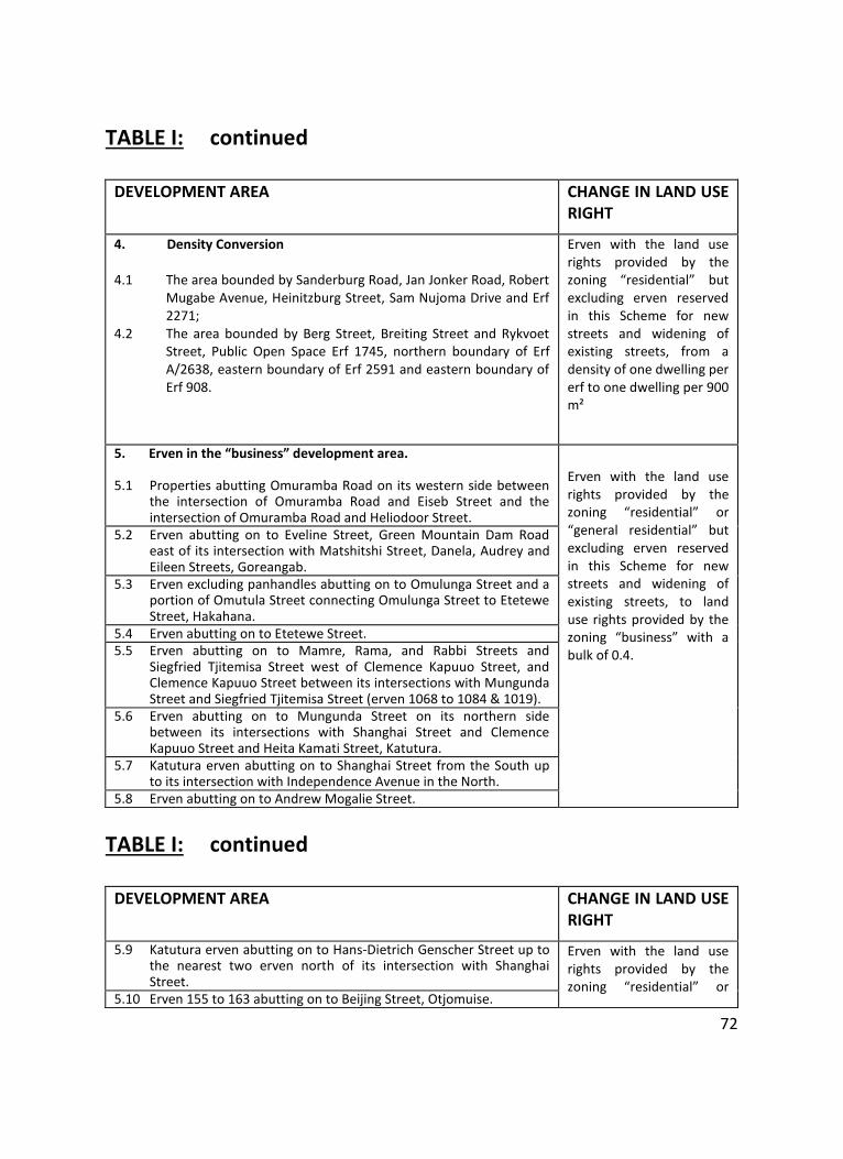
72
TABLE I: continued
DEVELOPMENT AREA CHANGE IN LAND USE RIGHT
4. Density Conversion 4.1 The area bounded by Sanderburg Road, Jan Jonker Road, Robert
Mugabe Avenue, Heinitzburg Street, Sam Nujoma Drive and Erf 2271;
4.2 The area bounded by Berg Street, Breiting Street and Rykvoet Street, Public Open Space Erf 1745, northern boundary of Erf A/2638, eastern boundary of Erf 2591 and eastern boundary of Erf 908.
Erven with the land use rights provided by the zoning “residential” but excluding erven reserved in this Scheme for new streets and widening of existing streets, from a density of one dwelling per erf to one dwelling per 900 m²
5. Erven in the “business” development area.
5.1 Properties abutting Omuramba Road on its western side between the intersection of Omuramba Road and Eiseb Street and the intersection of Omuramba Road and Heliodoor Street.
Erven with the land use rights provided by the zoning “residential” or “general residential” but excluding erven reserved in this Scheme for new streets and widening of existing streets, to land use rights provided by the zoning “business” with a bulk of 0.4.
5.2 Erven abutting on to Eveline Street, Green Mountain Dam Road east of its intersection with Matshitshi Street, Danela, Audrey and Eileen Streets, Goreangab.
5.3 Erven excluding panhandles abutting on to Omulunga Street and a portion of Omutula Street connecting Omulunga Street to Etetewe Street, Hakahana.
5.4 Erven abutting on to Etetewe Street. 5.5 Erven abutting on to Mamre, Rama, and Rabbi Streets and
Siegfried Tjitemisa Street west of Clemence Kapuuo Street, and Clemence Kapuuo Street between its intersections with Mungunda Street and Siegfried Tjitemisa Street (erven 1068 to 1084 & 1019).
5.6 Erven abutting on to Mungunda Street on its northern side between its intersections with Shanghai Street and Clemence Kapuuo Street and Heita Kamati Street, Katutura.
5.7 Katutura erven abutting on to Shanghai Street from the South up to its intersection with Independence Avenue in the North.
5.8 Erven abutting on to Andrew Mogalie Street.
TABLE I: continued
DEVELOPMENT AREA CHANGE IN LAND USE RIGHT
5.9 Katutura erven abutting on to Hans-Dietrich Genscher Street up to the nearest two erven north of its intersection with Shanghai Street.
Erven with the land use rights provided by the zoning “residential” or
5.10 Erven 155 to 163 abutting on to Beijing Street, Otjomuise.
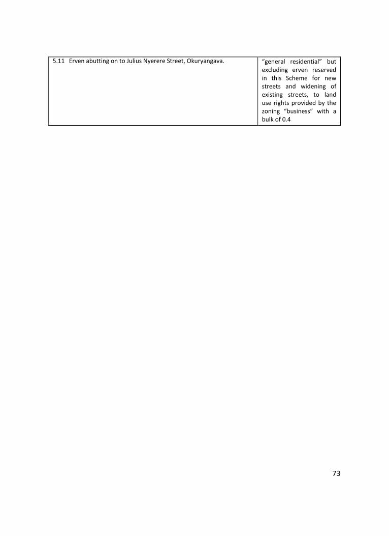
73
5.11 Erven abutting on to Julius Nyerere Street, Okuryangava. “general residential” but excluding erven reserved in this Scheme for new streets and widening of existing streets, to land use rights provided by the zoning “business” with a bulk of 0.4
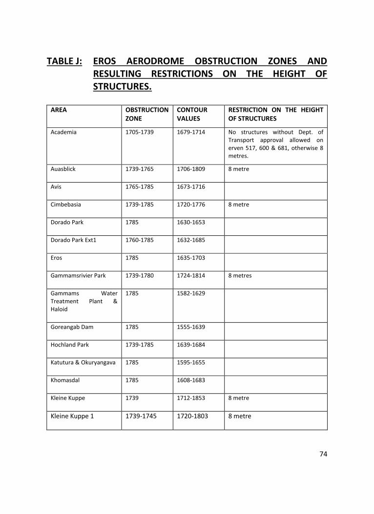
74
TABLE J: EROS AERODROME OBSTRUCTION ZONES AND RESULTING RESTRICTIONS ON THE HEIGHT OF STRUCTURES.
AREA OBSTRUCTION ZONE
CONTOUR VALUES
RESTRICTION ON THE HEIGHT OF STRUCTURES
Academia 1705-1739 1679-1714 No structures without Dept. of Transport approval allowed on erven 517, 600 & 681, otherwise 8 metres.
Auasblick 1739-1765 1706-1809 8 metre
Avis 1765-1785 1673-1716
Cimbebasia 1739-1785 1720-1776 8 metre
Dorado Park 1785 1630-1653
Dorado Park Ext1 1760-1785 1632-1685
Eros 1785 1635-1703
Gammamsrivier Park 1739-1780 1724-1814 8 metres
Gammams Water Treatment Plant & Haloid
1785 1582-1629
Goreangab Dam 1785 1555-1639
Hochland Park 1739-1785 1639-1684
Katutura & Okuryangava 1785 1595-1655
Khomasdal 1785 1608-1683
Kleine Kuppe 1739 1712-1853 8 metre
Kleine Kuppe 1 1739-1745 1720-1803 8 metre
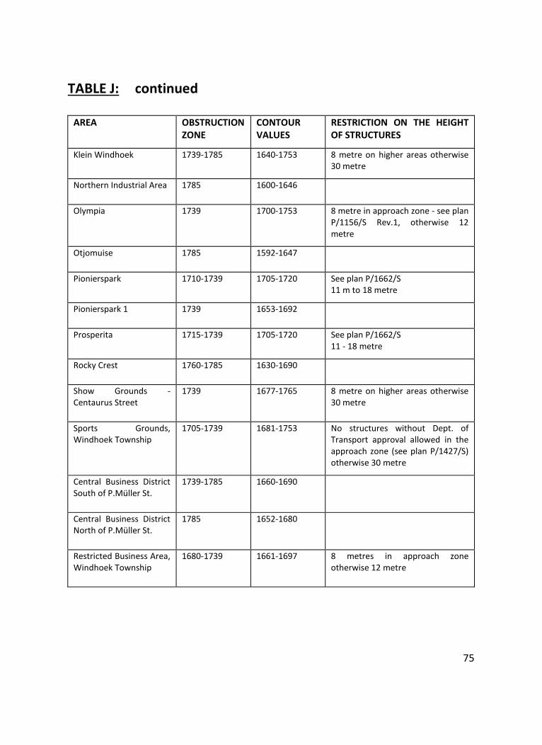
75
TABLE J: continued
AREA OBSTRUCTION ZONE
CONTOUR VALUES
RESTRICTION ON THE HEIGHT OF STRUCTURES
Klein Windhoek 1739-1785 1640-1753 8 metre on higher areas otherwise 30 metre
Northern Industrial Area 1785 1600-1646
Olympia 1739 1700-1753 8 metre in approach zone - see plan P/1156/S Rev.1, otherwise 12 metre
Otjomuise 1785 1592-1647
Pionierspark 1710-1739 1705-1720 See plan P/1662/S 11 m to 18 metre
Pionierspark 1 1739 1653-1692
Prosperita 1715-1739 1705-1720 See plan P/1662/S 11 - 18 metre
Rocky Crest 1760-1785 1630-1690
Show Grounds - Centaurus Street
1739 1677-1765 8 metre on higher areas otherwise 30 metre
Sports Grounds, Windhoek Township
1705-1739 1681-1753 No structures without Dept. of Transport approval allowed in the approach zone (see plan P/1427/S) otherwise 30 metre
Central Business District South of P.Müller St.
1739-1785 1660-1690
Central Business District North of P.Müller St.
1785 1652-1680
Restricted Business Area, Windhoek Township
1680-1739 1661-1697 8 metres in approach zone otherwise 12 metre
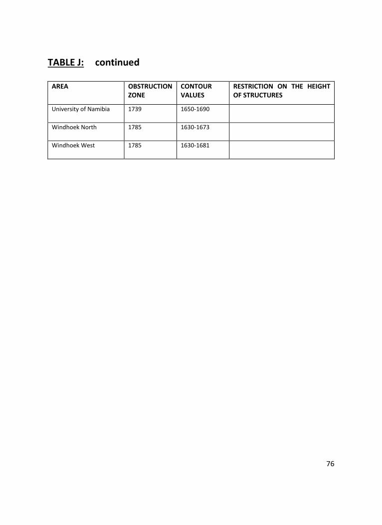
76
TABLE J: continued
AREA OBSTRUCTION ZONE
CONTOUR VALUES
RESTRICTION ON THE HEIGHT OF STRUCTURES
University of Namibia 1739 1650-1690
Windhoek North 1785 1630-1673
Windhoek West 1785 1630-1681