Embed Size (px)
Citation preview
,WTraffic Engineers and Transpprt Planners
ftaffil Croup Pty Ltcl
-, ,t , .
Addressulc\vl'tftl(
UMOVWContact
Our Reference: G164391-01 B
2 June,2014
Bayside City Council
PO Box 27SANDRINGHAM 3191
Attention: Mr Matt Kelleher
Dear Mr Kelleher,
iil
IF
f!,,,,r],,1
rr]
-Y,W ttr&g gJ l4L'
W ) /,/, 9*/slnu,tg qAk ltr (t
HAMPTON WILLIS STREET PRECINCT UDFKOOLKUNA IANE ACCESS OPTIONS
We refer to the Urban Design Framework (UDF) for the Hampton Willis Street Precinct which was prepared by
MGS Architects for Bayside City Council in 2013.
Background
The UDF contemplates the redevelopment of the triangular shaped land bounded by Hampton Strpet to the
east, Willis Sheet to the north and the Sandringham Railway Line to the south-west. The sites confemplatedfor redevelopment include:-
. The VicTrack land comprising of the existing Hampton Railway Station 78 space commuter cappark and
bus interchange,
o The Department of Human Services (DHS) land comprising public housing,
o The Council land comprising the 1st Hampton Scout Hall,
. The Council land comprising the Hampton Community Centre and Hampton Playhouse,
. The Council land comprising the 100 space at{rade public carpark to the west of Willis Lane, and
e The Council land comprising the 44 spaces atXrade public carpark to the east of Willis Lane.
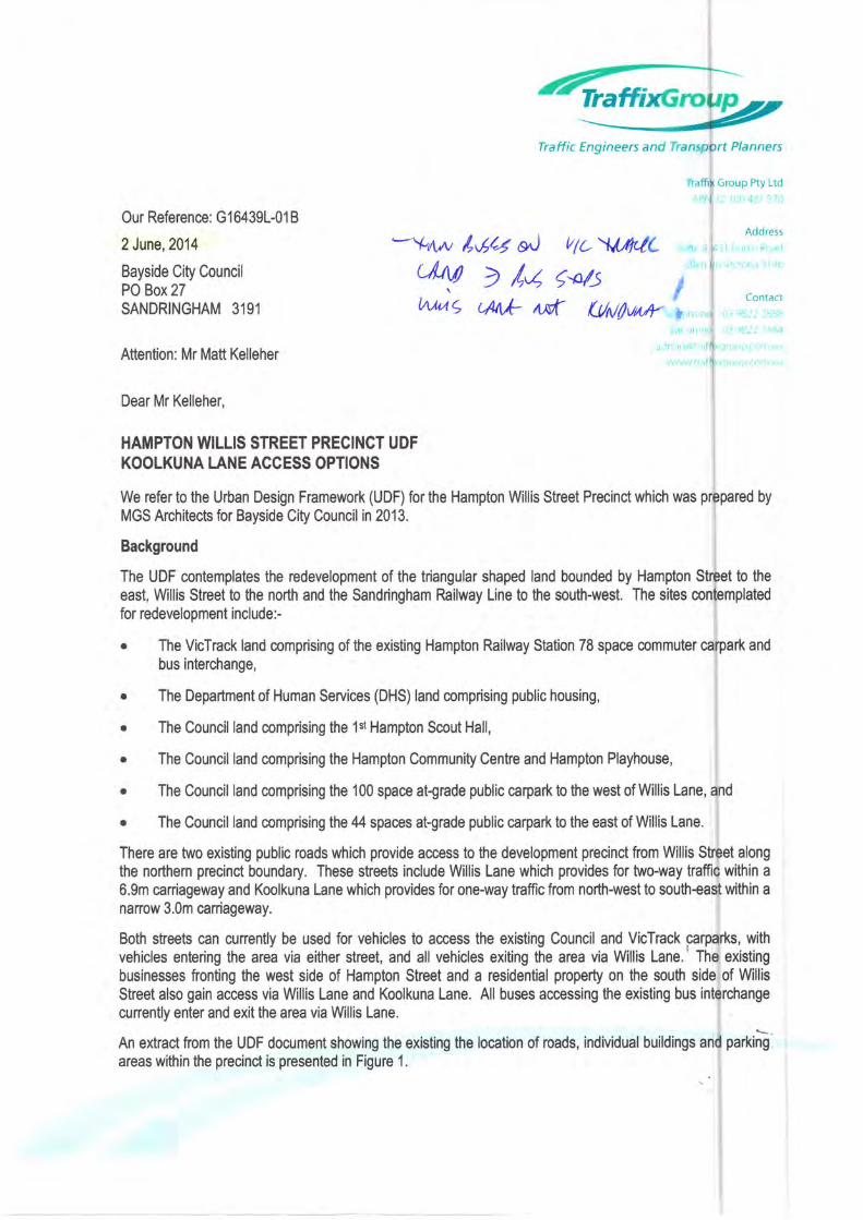
There are two existing public roads which provide access to the development precinct from Willis Sfeet alongthe northern precinct boundary. These streets include Willis Lane which provides for two-way traffic within a
6.9m caniageway and Koolkuna Lane which provides for one-way traffic from north-west to south+ast within anaffow 3.0m caniageway.
Both sheets can cunently be used for vehicles to access the existing Council and VicTrack parpa*s, with
vehicles entering the area via either street, and all vehicles exiting the area via Willis Lane.' The existing
businesses fronting the west side of Hampton Street and a residential property on the south side of Willis
Street also gain access via Wllis Lane and Koolkuna Lane. All buses accessing the existing bus interchange
cunently enter and exit the area via Willis Lane.
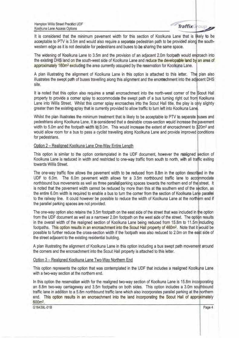
An extract from the UDF document showing the existing the location of roads, individual buildings and pa*in!areas within the precinct is presented in Figure 1.
Hampton Willis Street Precinct UDF
Koolkuna Lane Access Options
Figure 1: Existing Conditions within Precinct
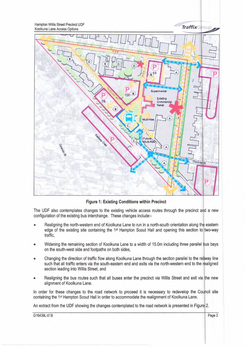
The UDF also contemplates changes to the existing vehicle access routes through the precinct and a new
configuration of the existing bus interchange. These changes includei
. Realigning the north-western end of Koolkuna Lane to run in a north-south orientation along the eastemedge of the existing site containing the 1st Hampton Scout Hall and opening this section to two-waytraffic,
o Widening the remaining section of Koolkuna Lane to a width of 15.0m including three parallel bus bays
on the south-west side and footpaths on both sides,
. Changing the direction of traffic flow along Koolkuna Lane through the section panallel to the railway line
such that all haffic enters via the south+astern end and exits via the north-western end to the realignedsection leading into Willis Street, and
. Realigning the bus routes such that all buses enter the precinct via Willis Street and exit via the newalignment of Koolkuna Lane.
ln order for these changes to the road network to proceed it is necessary to redevelop the Council sitecontaining the 1st Hampton Scout Hall in order to accommodate the realignment of Koolkuna Lane.
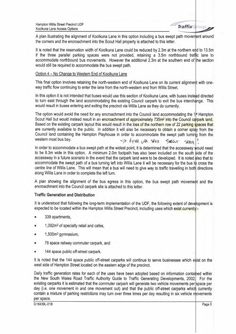
An extnact from the UDF showing the changes mntemplated to the road network is presented in Figure 2.
G164391-018 Page2
Hampton Willis Street Precinct UDFKoolkuna Lane Access Options
Street
Koolkuna Lane Access Options L
It is understood that Council is looking to explore alternative ac@ss options which allow the redevellpment ofthe VicTrack and DHS sites to proceed whilst avoiding or minimising impacts to the Council site con$ining the1't Hampton Scout Hall.
This letter discusses four alternative options to provide vehicle access through the HamptonPrecinct with concept plans provided for each option.
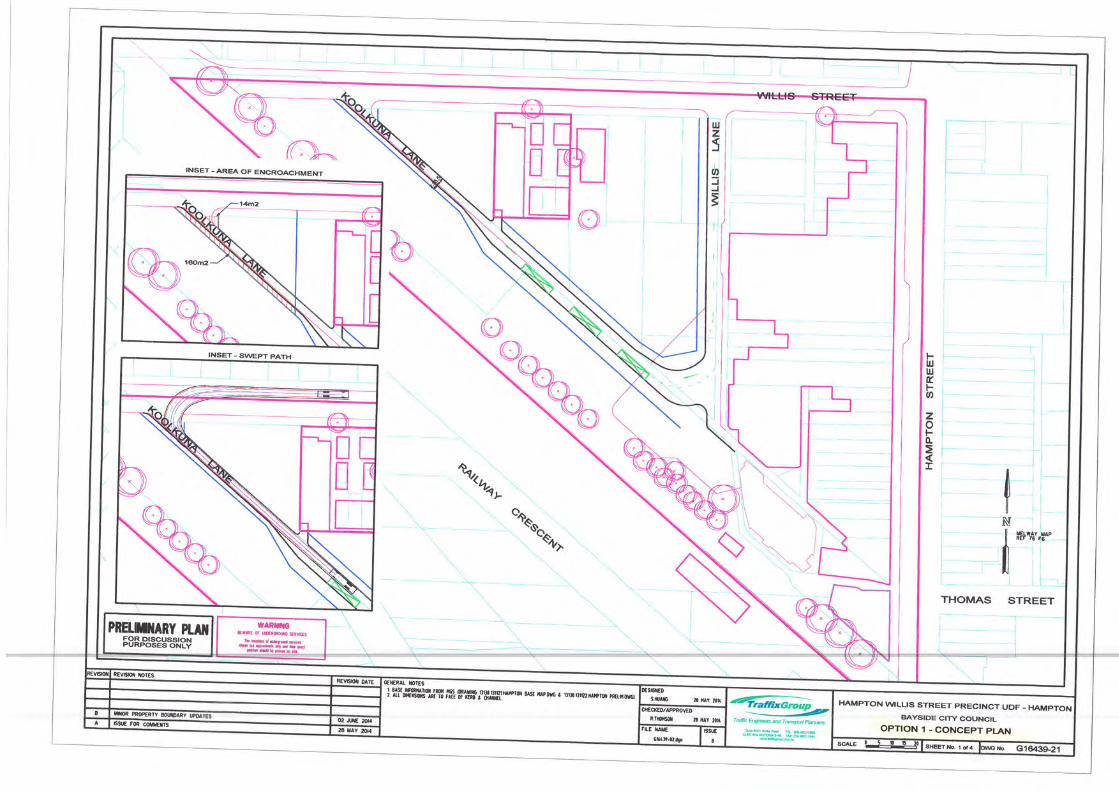
Option 1 - Retain Existinq Koolkuna Lane Aliqnment:
This option involves retaining the existing alignment of Koolkuna Lane parallel to the railway line
through to Wllis Street and abandoning the proposed realignment along the eastern edge of theproperty.
An advantage of this option is that it allows the redevelopment of the VicTrack and DHS sites towithout impacting on the existing Scout Hall.
However, the existing 3.0m Koolkuna Lane cross section is not likely to be supported by Public
connectout Hall
t@ onScout
Figure 2: Proposed Ghanges to Road Network
G164391-018 Page 3
Hampton Wllis Street PrecUlct UDFKoolkuna Lane Acress Options
It is considered that the minimum pavement width for this section of Koolkuna Lane that is to be
acocptable to PTV is 3.5m and would also require a sepailte pedestrian path to be provided
western edge as it is not desinable for pedestrians and buses to[e sharing the same space.
The widening of Koolkuna lrane to 3.5m and he provision of an adjacent 2.0m footpath wouldthe existit{ DHS land on the south-west side of Koolkuna Lane and reduce the developaHe landapproximately 160me excludi{ the area cunently mupied by the reservation for Koolkuna Lane.
A plan illustnating the alignment of Koolkuna Lane in this option is attached to this letter.illustrates the swept paft of buses travelling along this alignrlent and the enqfthment into thesite.
possible to further reduce the cross-section width if the foopath was also reduced to 2.0m on thethe street adjacent to the existing residential building.
A plan illustrating the alignment of Koolkuna Lane in this option including a bus swept path
the comens and the encroachment into the Scout Hall property is attached to this letter.
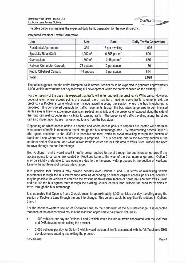
Ootion 3 - Realiqned Koolkuna Lane TweWay Northem End
This option represents the option that was contemplated in the UDF that includes a realigned
with a two-way section at the northern end.
ln this option he reservallrn width for the realigned two-way section of Koolkuna Lane is 15.8m ian 8.8m two-way caniageway and 3.5m footpaths on both sides. This option includes a 3.0m
traffic lane in adition to a 5.8m northbound traffic lane which also incorporates parallel parking at theend. This option results in an encroachment into the land incorporating the Smut Hall of600m2.
the south-
into
an area of
plan also
DHS
It io noted that this option also requires a smell encroachment into the north-west corner of the Hallpmperty to provide a comer splay to accommodak+ the swept path of a bus tuming right out KmlkunaLane into Willis Street. lrlltrilst this comer splay encroaches into the Scout Hall title, the play is slightlygreater than the existi$splay that is cunently provided to allow traffic to turn lefi into Koolkuna
Whilst the plan illustrates the minimum treatment that is likely to be acceptable ts PTV b separatepedesfians along Koolkuna Lane, it i$ considered that a desirable crosssection rmould increasewidth to 5.0m and the footpath r{dth h3.0m. This would inclease he extent of encroachment towould allow room for a bus to pass a cyclist travelling along Koolkuna Lane and provide improvedfor pedestrians.
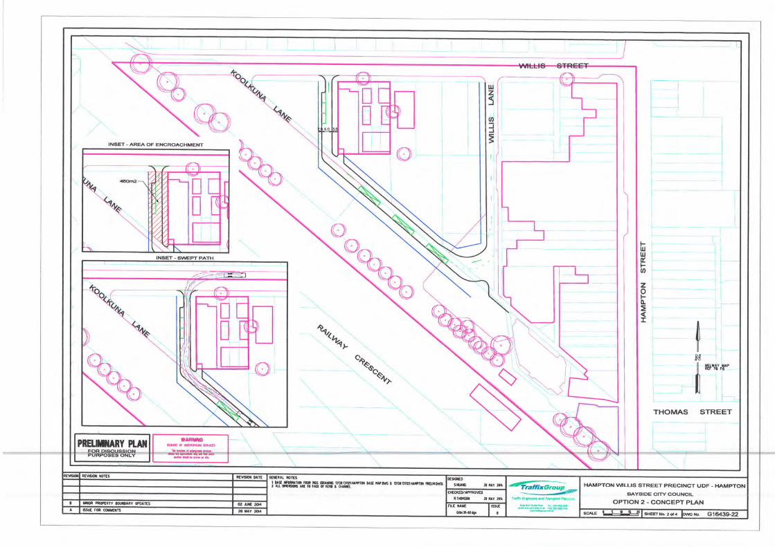
Qotion 2 - Realioned Koolkuna Lane One-Way Entire Lenoth
This option is similar to the option contemplated in the UDF document, ipwever the rdignedKoolkuna Lane is roduced in width and restricted to one-way kaffic from south to north, rrrffr alltowards Willis Sheet.
The one-way traffic flow allows the pavement width to be reduced from 8.8m in thc option in the
UDF to 6.0m. The 6.0m pavement width allows for a 3.5m northbound haffic lane tonorthbound bus movements as well as three pardl#parking spaces towards the northem end ofis noted that the pavement width cannot be reduced by more than this at tln souilrem end of thethe entire 6.0m width is required to enable a bus to tum the corfier from the section of Koolkunato he railway line. lt muld however be possible to reduce the width of Koolkuna Lane at thethe parallel parking spaces arc not provided.
The one-way option also retains the 3.5m footpath on the east side of the street frat was included infrom the UDF document as well as a narrower 2.0m footpath on the west side of the street. Thein the overallwidth of the realigned section of Koolkuna Lane being reduced from 15.8m to 11.5m
footpaths. This option results in an encrcachment into the Scout Hall property of 460m4. Note that it be
fion ofexiting
reet. lttion, aspar#lr end if
option
results
side of
arourd
G164391418
Hampton Willis Sheet Precinct UDF
Koolkuna Lane Access 0ptions
A plan illustrating the alignment of Koolkuna Lane in this option including a bus swept path
the comers and the encroachment into the Scout Hall property is attached to this letter.
It is noted that the reservation width of Koolkuna Lane could be reduced by 2.3m at the northernif the three parallel parking spaces were not pmvided, retaining a 3.5m northbound
ln order to accommodate a bus swept path at the widest point, it is determined that the accesswayto be 9.3m wide in this option. A minimum 2.0m footpath has also been included on the southaccessway in a futute scenario in the event that the carpark land were to be developed. lt is notedaccommodate the swept path of a bus turning left into Willis Lane it will be necessary for the buscentre line of Willis Lane. This will mean that a bus will need to give way to traffic travelling inalong Willis Lane in order to complete the left tum.
A plan showing the alignment of the bus egress in this option, the bus swept pathencroachment into the Council carpark site is attached to this letter.
Traffic Generation and Distribution
It is understood that following the longterm implementation of the UDF, the following extent ofexpected to be located within the Hampton Willis Street Precinct, including uses which exist
o 339 apartments,
o 1,092m2 of specialg retail and cafes,
r 1,500m2 gymnasium,
. 78 space railway commuter carpark, and
. 144 space public off-street carpark.
It is noted that the 144 space public off-street carparks will continue to serve businesses whichwest side of Hampton Street located on the eastem edge of the precinct.
Daily trafiic generation rates for each of the uses have been adopted based on informationthe New South Wales Road Traffic Authority Guide to Traffic Generating Developments,
accommodate northbound bus movements. However the additional 2.3m at the southem end ofwould still be required to accommodate the bus swept path.
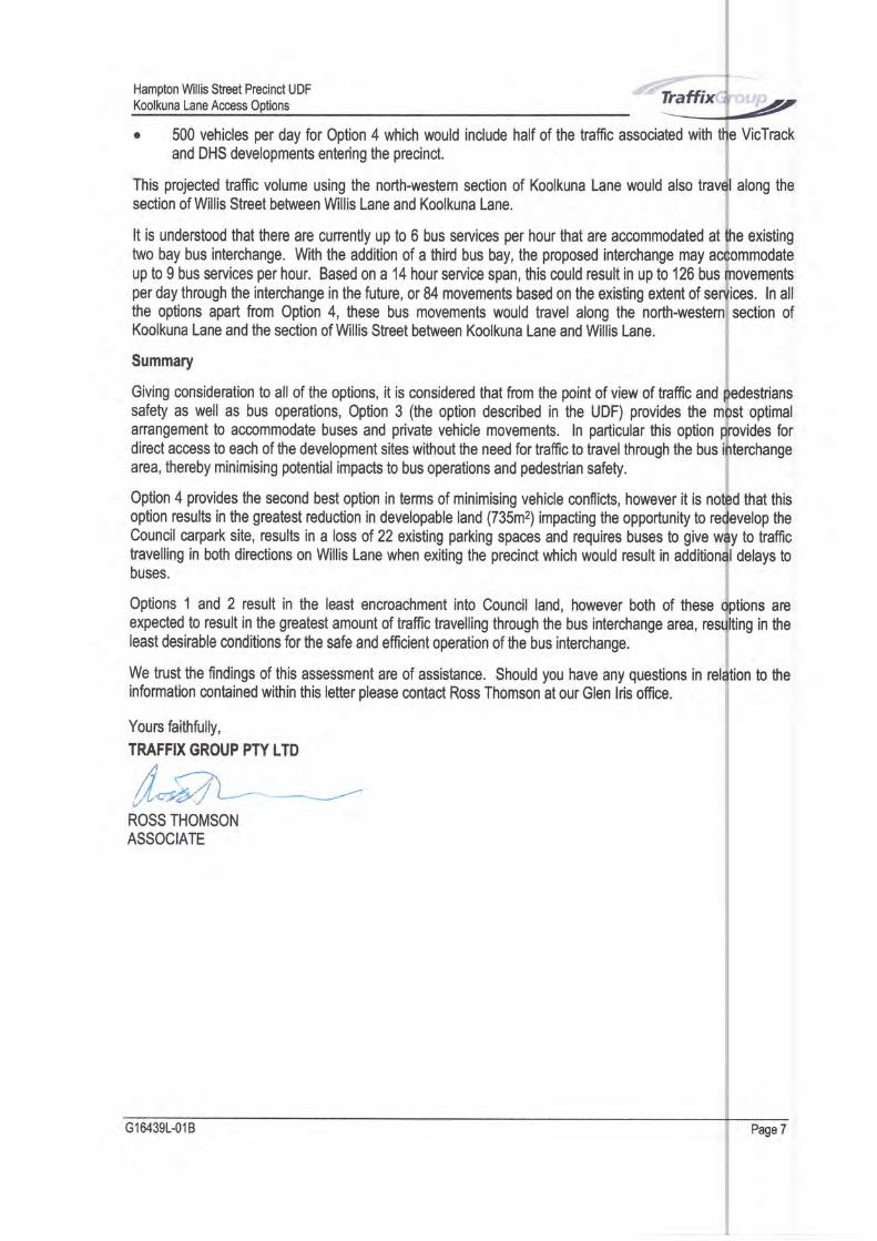
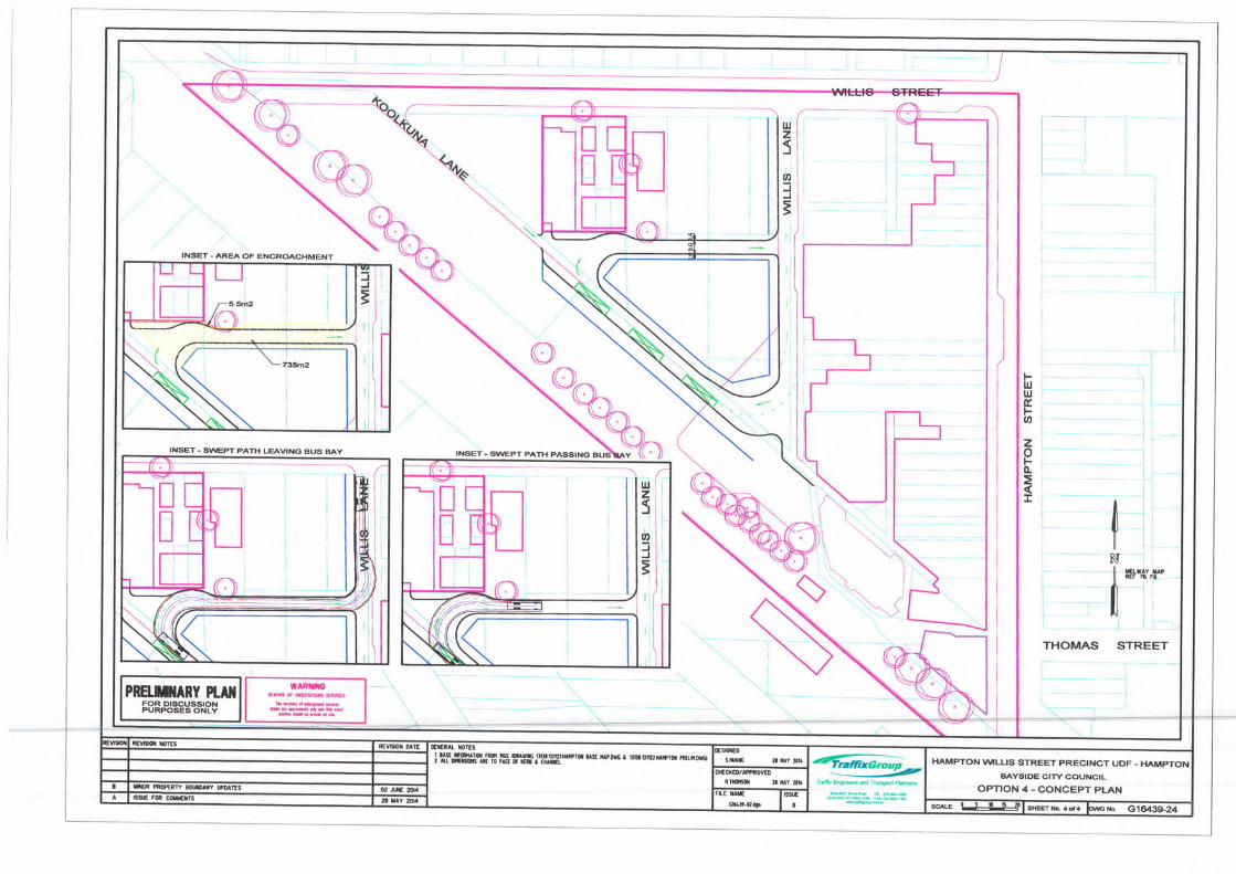
Option 4 - No Chanqe to Westem End of Koolkuna Lane
This finaloption involves retaining the north-westem end of Koolkuna Lane on its currentway traffic flow continuing to enter the lane from the north-western end from Wllis Street.
ln this option it is not intended that buses would use this section of Koolkuna Lane, with busesto turn east through the land accommodating the existing Council carpark to exit the buswould result in buses entering and exiting the precinct via Willis Lane as they do cunently.
The option would avoid the need for any encroachment into the Council land accommodating the HamptonScout Hall but would instead result in an encroachment of approximately 735r# into the Council land.Based on the existing carpa* layout this would result in the loss of the northem row of 22 parking thatare currently available to the public. ln addition it will also be necessary to obtain a cornerCouncil land containing the Hampton Playhouse in order to accommodate the swept path
western most bus bay. -1P t1*llft t,{t 9fs-.t %s"T" 4dt*
directede. This
to 13.5m
lane tosection
with one-
from the
from the
need
of the
that tocross thedirections
t and the
withinFor the
existing carpadts it is estimated that the commuter carpark will generate two vehicle movements perday (i.e. one movement in and one movement out) and that the public off-street carparkscontain a mixture of parking restrictions may turn over three times per day resulting in six vehicleper space.
G164391-018
cunently
HamptonWillisSheetPrecinctUDF ," tir"niKoolkuna Lane Acc*ss 0ptions _ _ =_The table below summarises the expected daily haffic generation for the overall precinct.
Projected Precinct Traffic Generation
Use Size Rate Daily Traffic Ge eration
Residential Apa rtments 339 5 per dwelling 1,695
Specialty RetaillCaf6 1,092m2 0.555 Per mz 606
Gymnasium 1,500m2 0.45 Per me 675
Railway Commuter Carpark 78 spaces 2 per space 156
Public Off-street Carpark 144 spaces 6 per space 864
Total 3,996
lhe table suggests that the entire Hampton Willis Street Precinct could be expected to generate ap{,000 vehicle movements per day following full development within the precinct based on the existir
:or the majority of the uses it is expected that traffic will enter and exit the precinct via Wllis Lanelepending on where access points are located, there may be a need for some traffic to enterlrecinct via Koolkuna Lane which may include travelling along the section where the bus inte
troposed. lt is considered desirable for trafflc movements through the bus interchange area to be
ls this area is likely to experience significant pedestrian activity and the presence of stopped alonghe road can restrict pedestrian visibility to passing haffic. The presence of traffic travelling alonl:an also impact upon buses manoeuvring to and from the bus stops.
)epending on which access option is adopted and where access points to carparks are located wilvhat extent of traffic is required to travel through fte bus interchange area. By implementing accerthe option described in the UDF) it is possible for most traffic to avoid travelling through the(oolkuna Lane where the bus interchange is proposed. This is possible due to the twoway ser
torthem end of Koolkuna Lane which allows traffic to enter and exit this area to Willis Street withoro travel through the bus interchange.
loth Options 1and2 would result in traffic being requhed to travelthrough the bus interchangetccess points to carparks are located on Koolkuna Lane to the west of the bus interchange areanay be slightly preferable to bus operators due to the increased width proposed in the section o
.ane to the north-west of the bus interchange.
t is possible that Option 4 may provide benefits over Options 1 and 2 in terms of minimisinovements through the bus interchange area as depending on where carpark access points annay be possible for vehicles to enter via the existing north-western section of Koolkuna Lane from V
rnd exit via the bus egress route through the existing Council carpark land, without the need foravel through the bus interchange.
I is estimated that Options 1 and 2 would result in approximately 1,000 vehicles per day travellinlection of Koolkuna Lane through the bus interchange. This volume would be significantly reducedI and 4.
ior the norftern-western section of Koolkuna Lane, to the north-west of the bus interchange, it ir
ut each of the options would result in the following approximate daily traffic volumes:-
1,000 vehicles per day for Options 1 and 2 which would include all haffic associated with thand DHS developments exiting the precinct.
2,000 vehicles per day for Option 3 which would include all tnaffic associated with the VicTracldevelopments entering and exiting the precinct.
il64391{18
I UDF.
However,
lr exit thechange is
minimised:he side ofthe sheet
;Option 3;ection ofon at thethe need
rea if anyOption 2
Koolkuna
g vehiclelocated itllis Streetlhicles to
expected
VicTrack
and DHS
PrS.6
along the
n Options
Hampton Wllis Street Precinct UDF
Koolkuna Lane Access Options*d;
It is understood that there are curently up to 6 bus services per hour fiat are accommodated at existingtwo bay bus interchange. With the addition of a third bus bay, the proposed interchange mayup to 9 bus seMces per hour. Based on a 14 hour service span, his could result in up to 126 busper day through the interchange in the future, or 84 movements based on the existing extent of . ln allthe options apart from Option 4, these bus movements would travel along the section ofKoolkuna Lane and the section of Willis Street between Koolkuna Lane and Willis Lane.
$ummary
Giving consideration to all of the options, it is considered that from the point of view of traffic andsafety as well as bus operations, Option 3 (the option described in the UDF) provides theanangement to accommodate buses and private vehicle movements. ln particular this optiondirect access to each of the development sites without the need for traffic to travel through the busarea, thereby minimising potential impacts to bus operations and pedestrian safety.
Option 4 provides the second best option in terms of minimising vehicle conflicts, however it isoption results in the greatest reduction in developable land (735m2) impacting the opportunity toCouncil carpark site, results in a loss of 22 existing parking spaces and requires buses to give to traffichavelling in both directions on Willis Lane when exiting the precinct which would result in
buses.delays to
Options 1 and 2 result in the least encroachment into Council land, however both of these arc
. 500 vehicles per day for Option 4 which would include half of the haffic associated withand DHS developments entering the precincl.
This projected haffic volume using the north-western section of Koolkuna Lane would alsosection of Willis Street between Willis Lane and Koolkuna Lane.
expected to result in the greatest amount of traffic travelling through the bus interchange area,least desirable conditions for the safe and efficient operation of the bus interchange.
We trust the findings of this assessment are of assistance. Should you have any questions ininformation contained within this letter please contact Ross Thomson at our Glen lris office.
Yours faithfully,
TRAFFIX GROUP PTY LTD
fr .----)r.1,4-.H L--
ROSS THOMSONASSOCIATE
VicTrack
along the
that thisthe
in the
optimaldes for
G1M39L-O1B
uor,
\
PnErmAnY nAltlt -,*,.q1#* I
T.'l
Iljilltu
NT
I nrriv rell fft 73 f6
ilI
THOMAS STREET
FIUultFo
2toFI:I
0Ms iEvm mErM[ nurn HAMPTONWLLISr w rmrn ru ffi dffi BtlSttuprfl w rum I Buumwrfl mrmttrtmMItotecmtoui
tllm il uY x!BAYAIDE CITY COUNCIL
OPTION2-CONCEPTPIANI nq frffiRTY lWY WEs qtr& ff l& lrs6st-rrqr I ,BSI FN ffiE ZBMY ,s G164:t922qE

-:_
__-)
\]NsET - AREA ('F ENCROACHMENT
)
I
FUJuJto
zoF0.
T
$\^
Iil
NI tfilt',t-
il
THOMAS STREET
@.. O,q)S*
ltrffi,ls lftgrff nrmwrq u$ ryff r t uaurwrc rtrilrro @--T& Eneheag and rtilW pahtuE
HAMPTON y\,ILLIS STREET PRECINCT UDF . HAMPT('NBAYSIDE CITY COUNCIL
OPTION3-CONCEPTPTAN
UJz5
of,JE
-l
I
I
)FulultFo
zoF0-
I
II
Nll i*w.t*'
il
STREETN THOMAS
PRB"MARY PI.AilFOR DTSCUSSIONPURPOSES G'NLY
stnmosfrE r ffim sRv€!
6'.rydd.qdbM'
\
L
[[
il[f--((,
@..@ 1
INSET. AREA OF ENCROACHMENT
INSET. SVI'EPT PATH LEAVINO BUS BAY
utz5
oJJ3
I
lHt*s}llrlTf ffi trrff rIlmure sc ruffi | irrar[,Md mf,mr @lhtrt EnAnt@E dnd rtuns@ tunne6
HAMPTON wlLLIS STREET PRECINCT UDF -BAYSIDE CITY COUNCIL
OPTION4-CONCEPTPI-AN


![Clement et al 141116 PP accepted - COnnecting REpositories · 2017. 2. 8. · 114 [14] and fewer viral genome copies in peripheral tissues during chronic/latent 115 infection [17]](https://img.pdfslide.us/doc/110x75/60f93956df07a122193b4dfe/clement-et-al-141116-pp-accepted-connecting-repositories-2017-2-8-114-14.jpg)