Embed Size (px)
Citation preview
1
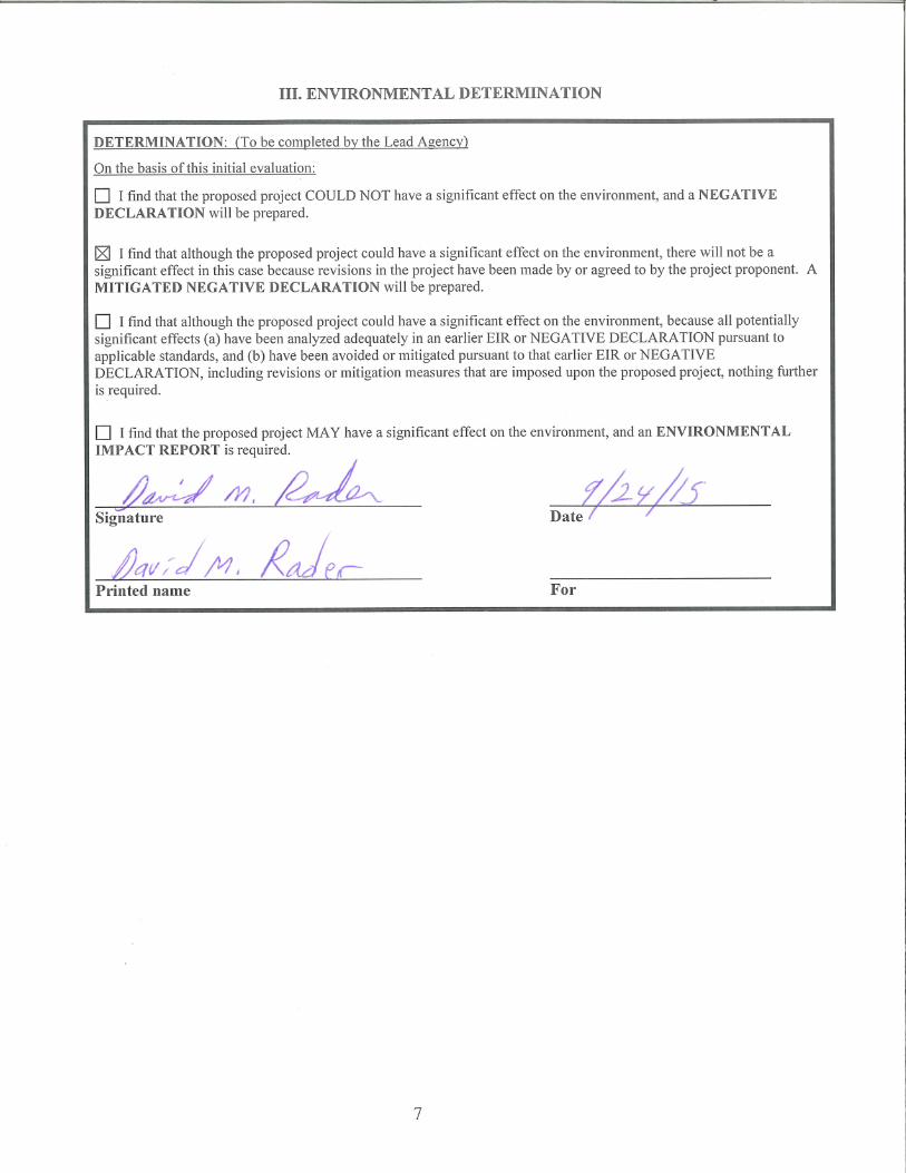
INITIAL STUDY / MITIGATED NEGATIVE DECLARATION
VVGC Hindu Temple Expansion ___________________________________________________
September 24, 2015
2
INITIAL STUDY Environmental Checklist and Evaluation for Santa Clara County
File Number: 5056-14P-14A-14G Date: September 24, 2015
Project Type: Use Permit, Architectural and Site
Approval, and Grading Approval APN(s): 779-15-006
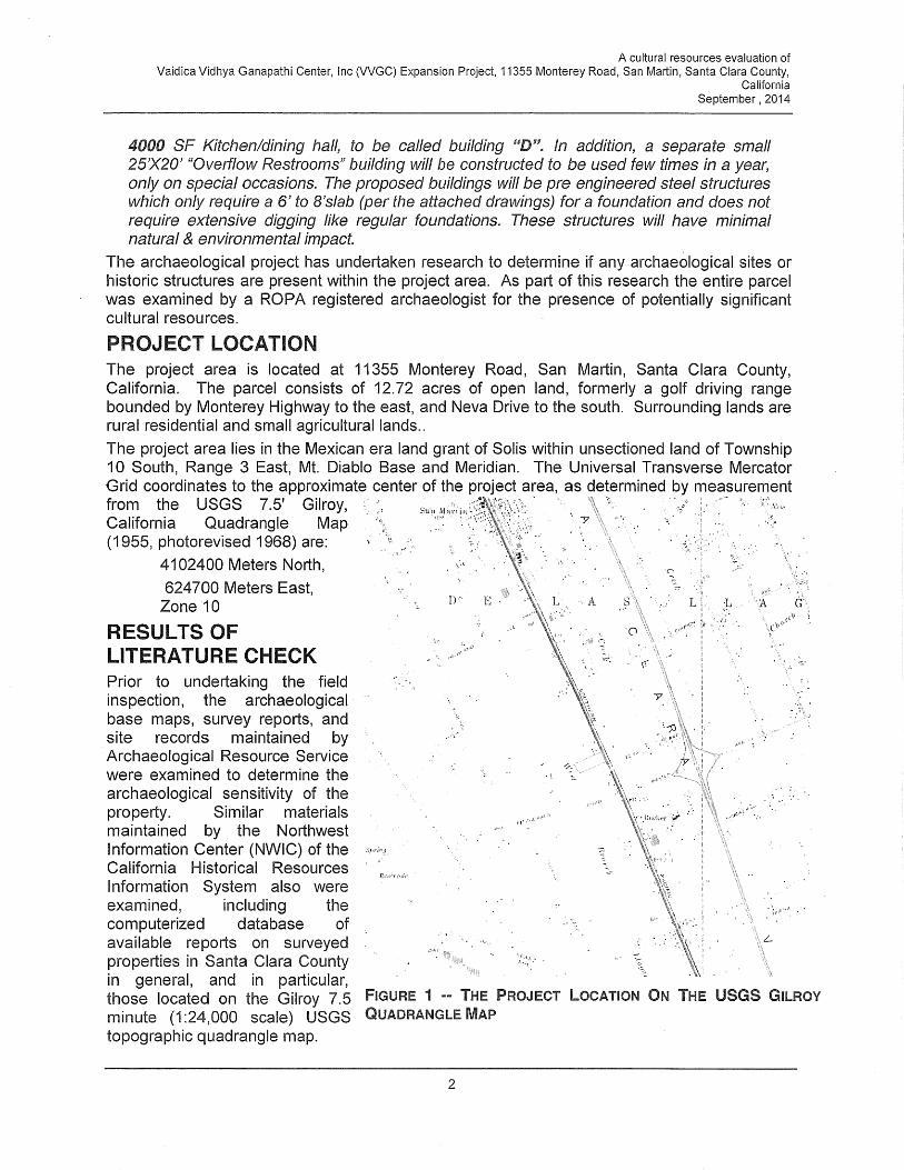
Project Location 11355 Monterey Road, San Martin General Plan Designation: Rural Residential
Owner / Applicant Vaidica Vidhya Ganapathi Center, Inc. Zoning: RR-5Ac
Project Description The proposed project is a Use Permit modification, Architectural and Site Approval (ASA), and Grading
Approval to allow expansion of a religious institution (Vaidica Vidhya Ganapathi Center, Inc.) on a 12.7-acre
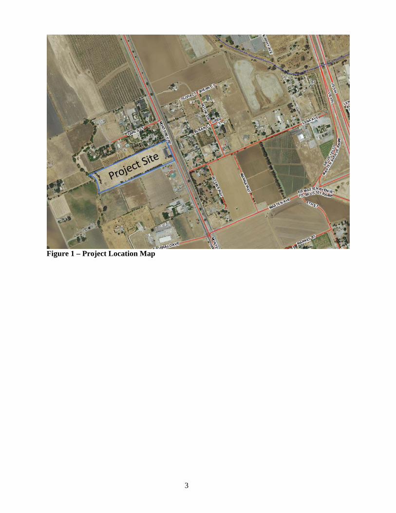
parcel located at 11355 Monterey Road, San Martin (see Figure 1 for location map). The expansion would
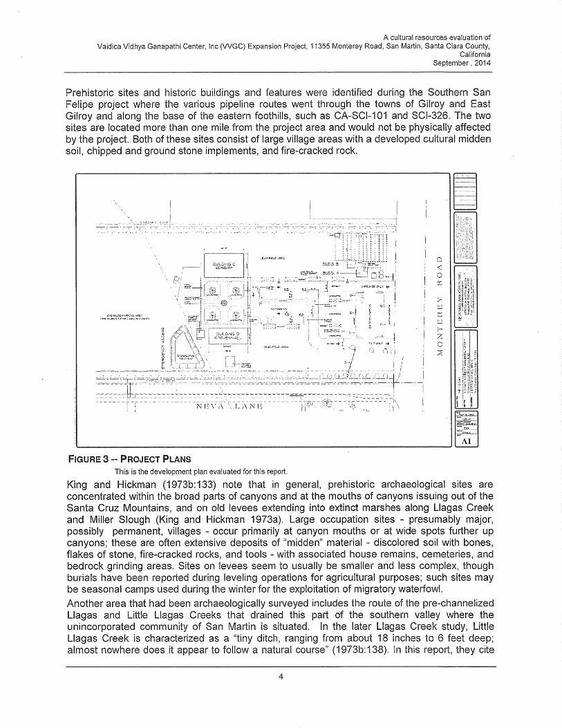
include a worship building (6,000 square feet), a kitchen hall (4,000 square feet), a barn (4,898 square feet), a
bathroom building (~400 square feet), 50 paved parking spaces, a new groundwater well, two new septic systems,
a stormwater treatment basin, a 7,500 gallon water storage tank, and an overflow parking area. Access to the
project site would be provided by one “entrance only” and one “exit only” driveway intersecting Monterey
Highway. Emergency access would be provided via Neva Lane. Figure 2 shows the site plan for these proposed
facilities. Existing on-site structures (see “Environmental Setting” below) would remain in place. Construction
would consists of site grading (1,918 cubic yards of cut, 370 cubic yards of fill), trenching for utilities, excavation
of building foundations, and building construction.
The center would be operated 7 days a week, year round between the hours of 8 a.m. to 10 p.m. The center would
be staffed by three employees. A central area for daily prayers would operate everyday with an estimated 50
attendees at a time, with a maximum of 200 persons on site at any given time on weekends. Daily hours of
worship would be from 10 a.m. to 12 p.m. and 6 p.m. to 8 p.m. The center would host 10 special events with no
more than 4 events of maximum 400 and 6 events of maximum of 200 people on weekdays. Special events may
take place over several days. Special events would not involve outdoor amplified announcements or music.
Environmental Setting and Surrounding Land Uses
The project site was previously developed as the San Martin Golf Driving Range, which operated under a Use
Permit which covered both the subject parcel as well as an adjacent parcel that continues to operate as batting
cages. In 2013, the Use Permit was modified to separate the batting cage use from operation of a religious
institution (Hindu Temple), which is now operated by Vaidica Vidhya Ganapathi Center, Inc. The existing
structures, including two buildings (746 square feet and 401 square feet in size), three storage sheds, a paved
parking area with 25 spaces, a septic system, a water storage tank, and perimeter fencing. Most of the property
consists of annual grassland. Eucalyptus trees line the north and south property lines. The surrounding area is a
mix of rural residential and some commercial uses along Monterey Highway.
Other agencies sent a copy of this document:
None
3
Figure 1 – Project Location Map

4
Figure 2 – Site Plan
5
The environmental factors checked below would be potentially affected by this project, involving at least one impact as indicated by the checklist on the following pages.
I. ENVIRONMENTAL FACTORS POTENTIALLY AFFECTED
Aesthetics Agriculture / Forest Resources
Air Quality
Biological Resources
Greenhouse Gas Emissions
Cultural Resources
Hazards & Hazardous Materials
Geology / Soils
Hydrology / Water Quality
Land Use Noise Population / Housing
Public Services Resources / Recreation Transportation / Traffic
Utilities / Service Systems Mandatory Findings of Significance
None
II. ENVIRONMENTAL FACTORS WITH NO SIGNIFICANT IMPACTS
Some proposed applications that are not exempt from CEQA review may have little or no potential for adverse environmental impact related to most of the topics in the Environmental Checklist; and/or potential impacts may involve only a few limited subject areas. These types of projects are generally minor in scope, located in a non-sensitive environment, and are easily identifiable and without public controversy. For the environmental issue areas where there is no potential for significant environmental impact (and not checked above), the following finding can be made using the project description, environmental setting, or other information as supporting evidence.
Check here if this finding is not applicable
FINDING: For the following topics, there is no potential for significant environmental impact to
occur from either construction, operation or maintenance of the proposed project, and no further discussion in the Environmental Checklist is necessary.
EVIDENCE: Agricultural and Forest Resources: The proposed project site is designated as urban
and built-up land, and the proposed project would not convert Prime Farmland, Unique Farmland or Farmland of Statewide Importance to non-agricultural uses. Construction and operation of the proposed facilities would not affect existing agricultural operations at adjacent properties. The property is not under a Williamson Act Contract. The proposed site is not designated as forest land, timberland, or zoned for timberland production, and the proposed. None project would not result in the loss or conversion of forest land to non-forest use. (Reference # 4, 17q.r.)
EVIDENCE: Biological Resources: The project site was previously developed as a golf driving
range and consists of a structure and parking area in the front and fallow golf course grass on the remainder of the site. Eucalyptus trees line the north and south property lines. No trees are proposed to be removed. The project would comply with the Santa Clara Valley Habitat Conservation Plan. (Reference # 2, 3, 4).

6
EVIDENCE: Geology and Soils: The proposed site is not located in Alquist-Priolo Earthquake Fault Zones. The site could experience strong seismic ground shaking in the event of an earthquake and could be subject to liquefaction as it has been mapped in County and State liquefaction zones. However, required geotechnical investigation would determine if additional foundation reinforcement would be required and provide design options that would be implemented as part of the project. The site is not located in a landslide hazards and is not located on unstable geologic units or soils. Best management practices used during construction would prevent substantial soil erosion or the loss of topsoil. The proposed project site is not located on expansive soils. (Project Description; Reference # 1, 3, 4, 17c.)
EVIDENCE: Hazards and Hazardous Materials: The proposed project would not involve transport
of hazardous materials or emit hazardous emissions. The project site is within two miles of San Martin Airport; however, the project would not result in a safety hazard for people residing or working in the project area. The site is flat and would conform to all requirements of the Fire Marshal’s Office for emergency vehicle access. (Project Description; Reference # 3, 6)
EVIDENCE: Land Use: Construction of the proposed project would not divide an established
community. The subject property’s general plan designated is Rural Residential and its zoning is RR-5Ac. Per the County’s Zoning Ordinance regulations, religious institutions may be established within the RR-5Ac zone with a User Permit. (Project Description; Reference # 1, 3, 4, 5)
EVIDENCE: Public Services: Because the proposed site is already developed as a religious
institution, the expansion would not require additional fire or police protection. Other public services, such as provided by or schools or parks, would not be involved. (Project Description; Reference # 3, 4, 5)
EVIDENCE: Utilities/Service Systems: Electricity and gas are already provided by PG&E. Water
supply for the proposed facility would be provided by a groundwater well, which would require a permit from the State Water Resources Control Board, Division of Drinking Water, because more than 25 persons would be served. The proposed project would include construction of a new on-site septic system for wastewater treatment, which would be permitted by the Santa Clara County Department of Health. Stormwater would be retained and treated on site prior to discharge to the existing storm drain. Construction at the proposed site would involve minimal amounts of debris that would need be removed and disposed of, and existing landfill capacity would sufficient to accommodate it. (Project Description; Reference # 1, 3, 4, 5)
EVIDENCE: Population and Housing: The proposed project is expansion of a religious institution.
Development of this project would not induce population growth or displace existing housing or people. (Project Description; Reference # 1, 3, 4, 5)
EVIDENCE: Resources/Recreation: The proposed project site is not located in an area where
mineral resources of value to the region or state have been identified. The site is also not located on locally important mineral resource recovery sites. The proposed project is expansion of a religious institution and would not involve either the use or construction of recreational facilities. (Project Description; Reference # 1, 3, 4, 5)
8
IV. ENVIRONMENTAL CHECKLIST AND DISCUSSION OF IMPACTS
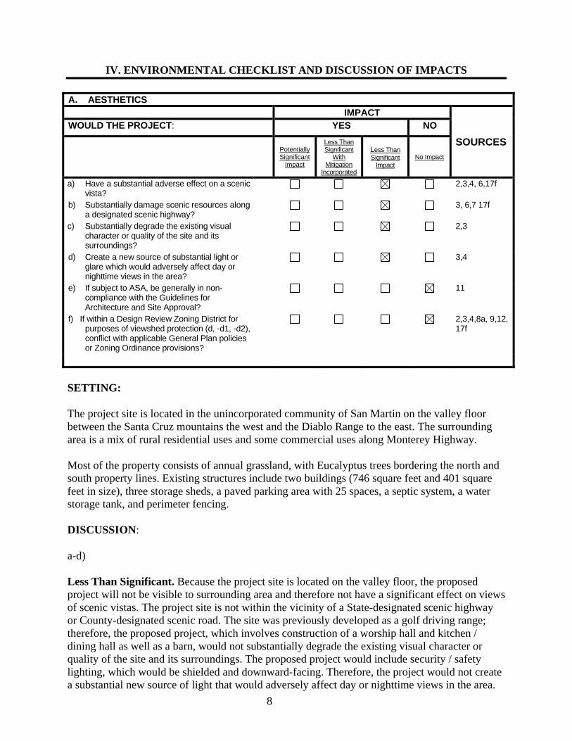
A. AESTHETICS IMPACT
SOURCES
WOULD THE PROJECT: YES NO
Potentially Significant
Impact
Less Than Significant
With Mitigation
Incorporated
Less Than Significant
Impact No Impact
a) Have a substantial adverse effect on a scenic vista?
2,3,4, 6,17f
b) Substantially damage scenic resources along a designated scenic highway?
3, 6,7 17f
c) Substantially degrade the existing visual character or quality of the site and its surroundings?
2,3
d) Create a new source of substantial light or glare which would adversely affect day or nighttime views in the area?
3,4
e) If subject to ASA, be generally in non-compliance with the Guidelines for Architecture and Site Approval?
11
f) If within a Design Review Zoning District for purposes of viewshed protection (d, -d1, -d2), conflict with applicable General Plan policies or Zoning Ordinance provisions?
2,3,4,8a, 9,12, 17f
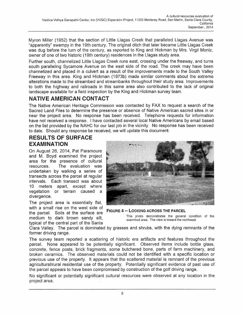
SETTING: The project site is located in the unincorporated community of San Martin on the valley floor between the Santa Cruz mountains the west and the Diablo Range to the east. The surrounding area is a mix of rural residential uses and some commercial uses along Monterey Highway. Most of the property consists of annual grassland, with Eucalyptus trees bordering the north and south property lines. Existing structures include two buildings (746 square feet and 401 square feet in size), three storage sheds, a paved parking area with 25 spaces, a septic system, a water storage tank, and perimeter fencing. DISCUSSION: a-d) Less Than Significant. Because the project site is located on the valley floor, the proposed project will not be visible to surrounding area and therefore not have a significant effect on views of scenic vistas. The project site is not within the vicinity of a State-designated scenic highway or County-designated scenic road. The site was previously developed as a golf driving range; therefore, the proposed project, which involves construction of a worship hall and kitchen / dining hall as well as a barn, would not substantially degrade the existing visual character or quality of the site and its surroundings. The proposed project would include security / safety lighting, which would be shielded and downward-facing. Therefore, the project would not create a substantial new source of light that would adversely affect day or nighttime views in the area.

9
e,f) No Impact. The project would comply with Guidelines for Architecture and Site Approval and the San Martin Design Guidelines. The project site is not located within a Design Review Zoning District. MITIGATION: None required. B. AGRICULTURE / FOREST RESOURCES
In determining whether impacts to agricultural resources are significant environmental effects, lead agencies may refer to the California Agricultural Land Evaluation and Site Assessment Model (1997) prepared by the California Dept. of Conservation as an optional model to use in assessing impacts on agriculture and farmland.
IMPACT
SOURCE
WOULD THE PROJECT: YES NO
Potentially Significant
Impact
Less Than Significant
With Mitigation
Incorporated
Less Than Significant
Impact No Impact
a) Convert 10 or more acres of farmland classified as prime in the report Soils of Santa Clara County (Class I, II) to non-agricultural use?
3,23,24,26
b) Conflict with existing zoning for agricultural use?
9,21a
c) Conflict with an existing Williamson Act Contract or the County’s Williamson Act Ordinance (Section C13 of County Ordinance Code)?
d) Conflict with existing zone for, or cause rezoning of, forest land (as defined in Public Resources Code section 12220(g)), timberland (as defined by Public Resources Code section 4526), or timberland zoned Timberland Production (as defined by Government Code section 51104(g))?
e) Result in the loss of forest land or conversion of forest land to non-forest use?
1, 28
9, 32
f) Involve other changes in the existing environment which, due to their location or nature, could result in conversion of Farmland, to non-agricultural use or conversion of forest land to non-forest use?
3,4,26
DISCUSSION: See Section II; Agriculture and Forest Resources MITIGATION: None required.
10
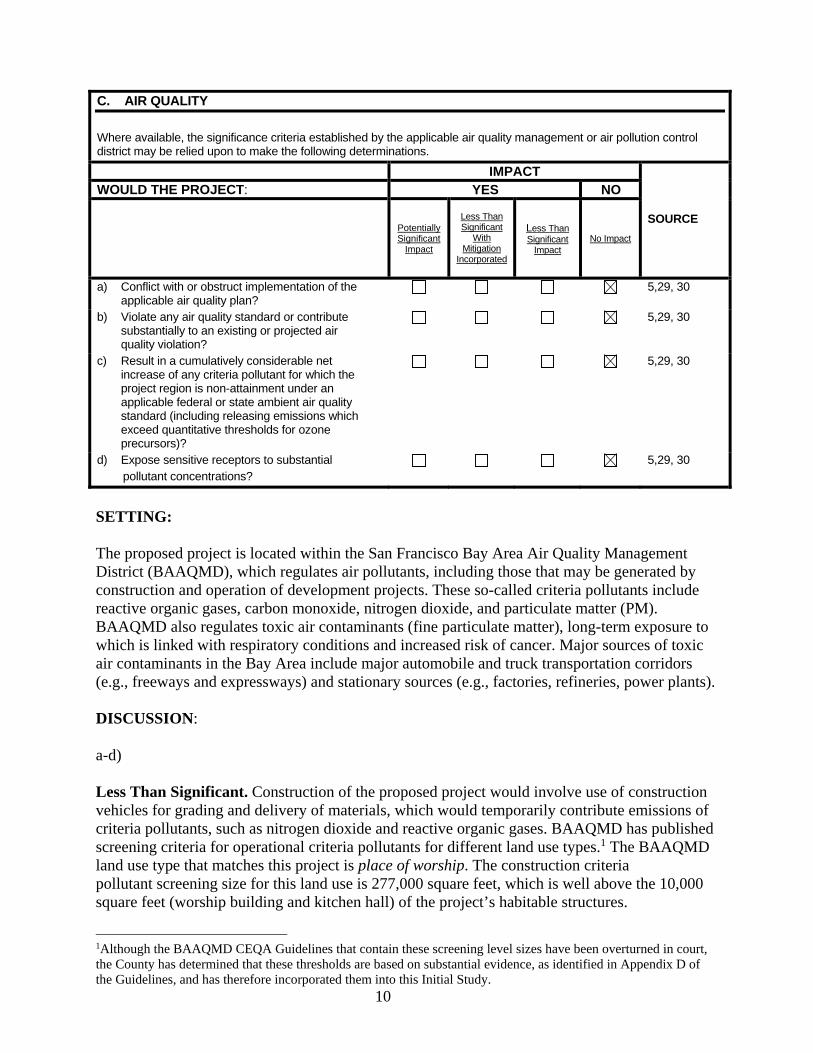
C. AIR QUALITY
Where available, the significance criteria established by the applicable air quality management or air pollution control district may be relied upon to make the following determinations.
IMPACT
SOURCE
WOULD THE PROJECT: YES NO
Potentially Significant
Impact
Less Than Significant
With Mitigation
Incorporated
Less Than Significant
Impact No Impact
a) Conflict with or obstruct implementation of the applicable air quality plan?
5,29, 30
b) Violate any air quality standard or contribute substantially to an existing or projected air quality violation?
5,29, 30
c) Result in a cumulatively considerable net increase of any criteria pollutant for which the project region is non-attainment under an applicable federal or state ambient air quality standard (including releasing emissions which exceed quantitative thresholds for ozone precursors)?
5,29, 30
d) Expose sensitive receptors to substantial pollutant concentrations?
5,29, 30
SETTING: The proposed project is located within the San Francisco Bay Area Air Quality Management District (BAAQMD), which regulates air pollutants, including those that may be generated by construction and operation of development projects. These so-called criteria pollutants include reactive organic gases, carbon monoxide, nitrogen dioxide, and particulate matter (PM). BAAQMD also regulates toxic air contaminants (fine particulate matter), long-term exposure to which is linked with respiratory conditions and increased risk of cancer. Major sources of toxic air contaminants in the Bay Area include major automobile and truck transportation corridors (e.g., freeways and expressways) and stationary sources (e.g., factories, refineries, power plants). DISCUSSION: a-d) Less Than Significant. Construction of the proposed project would involve use of construction vehicles for grading and delivery of materials, which would temporarily contribute emissions of criteria pollutants, such as nitrogen dioxide and reactive organic gases. BAAQMD has published screening criteria for operational criteria pollutants for different land use types.1 The BAAQMD land use type that matches this project is place of worship. The construction criteria pollutant screening size for this land use is 277,000 square feet, which is well above the 10,000 square feet (worship building and kitchen hall) of the project’s habitable structures.
1Although the BAAQMD CEQA Guidelines that contain these screening level sizes have been overturned in court, the County has determined that these thresholds are based on substantial evidence, as identified in Appendix D of the Guidelines, and has therefore incorporated them into this Initial Study.
11
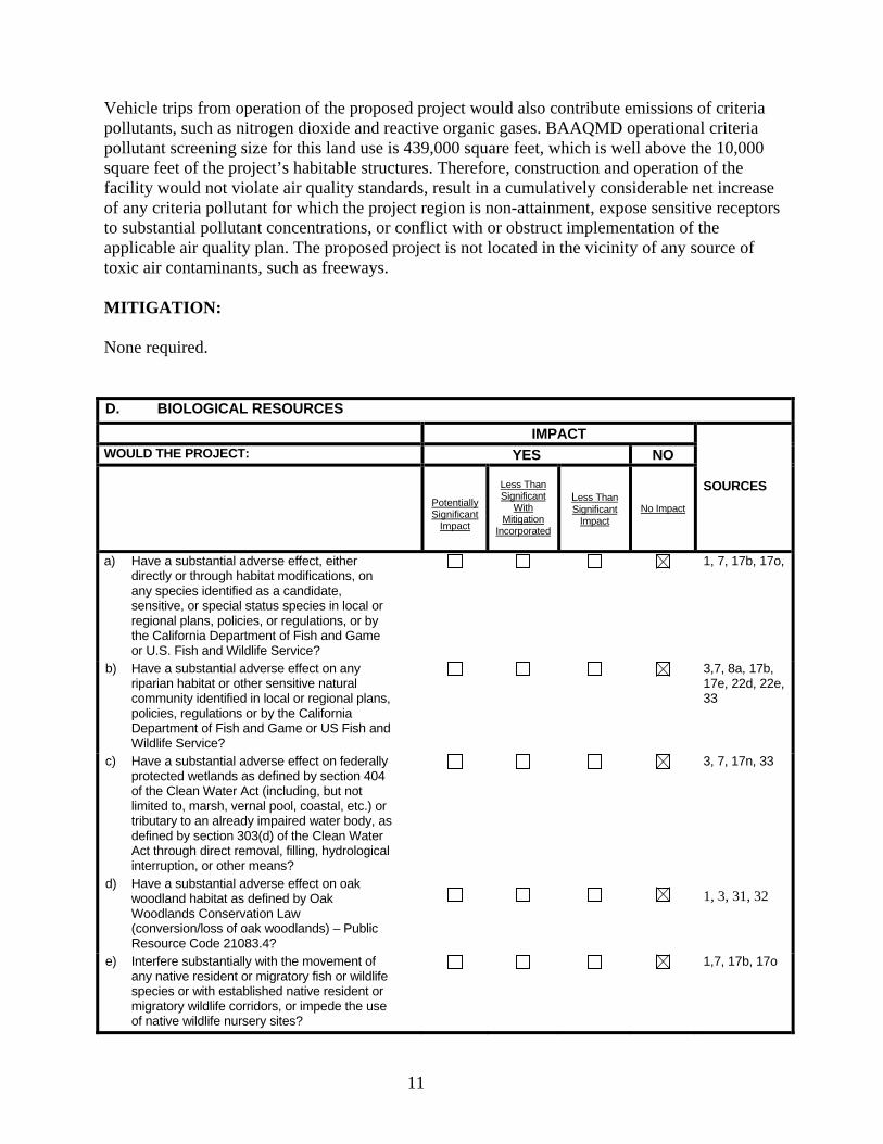
Vehicle trips from operation of the proposed project would also contribute emissions of criteria pollutants, such as nitrogen dioxide and reactive organic gases. BAAQMD operational criteria pollutant screening size for this land use is 439,000 square feet, which is well above the 10,000 square feet of the project’s habitable structures. Therefore, construction and operation of the facility would not violate air quality standards, result in a cumulatively considerable net increase of any criteria pollutant for which the project region is non-attainment, expose sensitive receptors to substantial pollutant concentrations, or conflict with or obstruct implementation of the applicable air quality plan. The proposed project is not located in the vicinity of any source of toxic air contaminants, such as freeways. MITIGATION: None required. D. BIOLOGICAL RESOURCES
IMPACT
SOURCES
WOULD THE PROJECT: YES NO
Potentially Significant
Impact
Less Than Significant
With Mitigation
Incorporated
Less Than Significant
Impact No Impact
a) Have a substantial adverse effect, either directly or through habitat modifications, on any species identified as a candidate, sensitive, or special status species in local or regional plans, policies, or regulations, or by the California Department of Fish and Game or U.S. Fish and Wildlife Service?
1, 7, 17b, 17o,
b) Have a substantial adverse effect on any riparian habitat or other sensitive natural community identified in local or regional plans, policies, regulations or by the California Department of Fish and Game or US Fish and Wildlife Service?
3,7, 8a, 17b, 17e, 22d, 22e, 33
c) Have a substantial adverse effect on federally protected wetlands as defined by section 404 of the Clean Water Act (including, but not limited to, marsh, vernal pool, coastal, etc.) or tributary to an already impaired water body, as defined by section 303(d) of the Clean Water Act through direct removal, filling, hydrological interruption, or other means?
d) Have a substantial adverse effect on oak woodland habitat as defined by Oak Woodlands Conservation Law (conversion/loss of oak woodlands) – Public Resource Code 21083.4?
3, 7, 17n, 33
1, 3, 31, 32
e) Interfere substantially with the movement of any native resident or migratory fish or wildlife species or with established native resident or migratory wildlife corridors, or impede the use of native wildlife nursery sites?
1,7, 17b, 17o
12
f) Conflict with the provisions of an adopted Habitat Conservation Plan, Natural Community Conservation Plan, or other approved local, regional or state habitat conservation plan?
3,4, 17l
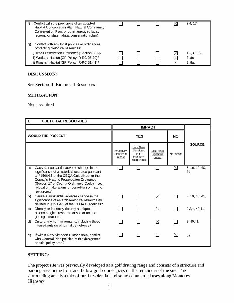
g) Conflict with any local policies or ordinances protecting biological resources:
i) Tree Preservation Ordinance [Section C16]? 1,3,31, 32 ii) Wetland Habitat [GP Policy, R-RC 25-30]? 3, 8a iii) Riparian Habitat [GP Policy, R-RC 31-41]? 3, 8a,
DISCUSSION: See Section II; Biological Resources MITIGATION: None required. E. CULTURAL RESOURCES
IMPACT
SOURCE
WOULD THE PROJECT YES NO
Potentially Significant
Impact
Less Than Significant
With Mitigation
Incorporated
Less Than Significant
Impact No Impact
a) Cause a substantial adverse change in the significance of a historical resource pursuant to §15064.5 of the CEQA Guidelines, or the County’s Historic Preservation Ordinance (Section 17 of County Ordinance Code) – i.e. relocation, alterations or demolition of historic resources?
3, 16, 19, 40, 41
b) Cause a substantial adverse change in the significance of an archaeological resource as defined in §15064.5 of the CEQA Guidelines?
3, 19, 40, 41,
c) Directly or indirectly destroy a unique paleontological resource or site or unique geologic feature?
2,3,4,,40,41
d) Disturb any human remains, including those interred outside of formal cemeteries?
2, 40,41
e) If within New Almaden Historic area, conflict
with General Plan policies of this designated special policy area?
8a
SETTING: The project site was previously developed as a golf driving range and consists of a structure and parking area in the front and fallow golf course grass on the remainder of the site. The surrounding area is a mix of rural residential and some commercial uses along Monterey Highway.
13
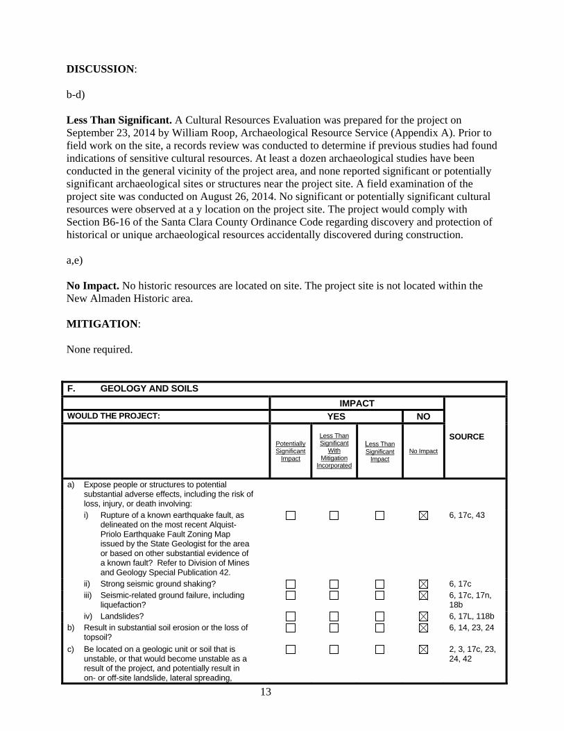
DISCUSSION: b-d) Less Than Significant. A Cultural Resources Evaluation was prepared for the project on September 23, 2014 by William Roop, Archaeological Resource Service (Appendix A). Prior to field work on the site, a records review was conducted to determine if previous studies had found indications of sensitive cultural resources. At least a dozen archaeological studies have been conducted in the general vicinity of the project area, and none reported significant or potentially significant archaeological sites or structures near the project site. A field examination of the project site was conducted on August 26, 2014. No significant or potentially significant cultural resources were observed at a y location on the project site. The project would comply with Section B6-16 of the Santa Clara County Ordinance Code regarding discovery and protection of historical or unique archaeological resources accidentally discovered during construction. a,e) No Impact. No historic resources are located on site. The project site is not located within the New Almaden Historic area. MITIGATION: None required. F. GEOLOGY AND SOILS
IMPACT
SOURCE
WOULD THE PROJECT: YES NO
Potentially Significant
Impact
Less Than Significant
With Mitigation
Incorporated
Less Than Significant
Impact No Impact
a) Expose people or structures to potential substantial adverse effects, including the risk of loss, injury, or death involving:
i) Rupture of a known earthquake fault, as delineated on the most recent Alquist-Priolo Earthquake Fault Zoning Map issued by the State Geologist for the area or based on other substantial evidence of a known fault? Refer to Division of Mines and Geology Special Publication 42.
6, 17c, 43
ii) Strong seismic ground shaking? 6, 17c iii) Seismic-related ground failure, including
liquefaction? 6, 17c, 17n,
18b iv) Landslides? 6, 17L, 118b
b) Result in substantial soil erosion or the loss of topsoil?
6, 14, 23, 24
c) Be located on a geologic unit or soil that is unstable, or that would become unstable as a result of the project, and potentially result in on- or off-site landslide, lateral spreading,
2, 3, 17c, 23, 24, 42
14
subsidence, liquefaction or collapse? d) Be located on expansive soil, as defined in the
report, Soils of Santa Clara County, creating substantial risks to life or property?
14,23, 24,
e) Have soils incapable of adequately supporting the use of septic tanks or alternative wastewater disposal systems where sewers are not available for the disposal of waste water?
3,6, 23,24,
f) Cause substantial compaction or over-covering of soil either on-site or off-site?
3, 6
g) Cause substantial change in topography or unstable soil conditions from excavation, grading, or fill?
2, 3, 6,17j, 42
DISCUSSION: See Section II; Geology and Soils MITIGATION: None required. G. GREENHOUSE GAS EMISSIONS
IMPACT
SOURCE
WOULD THE PROJECT YES NO
Potentially Significant
Impact
Less Than Significant
With Mitigation
Incorporated
Less Than Significant
Impact No Impact
a) Generate greenhouse gas emissions, either directly or indirectly, that may have a significant impact on the environment?
b) Conflict with any applicable plan, policy or regulation of an agency adopted for the purpose of reducing the emissions of greenhouse gases?
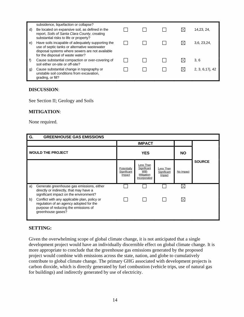
SETTING: Given the overwhelming scope of global climate change, it is not anticipated that a single development project would have an individually discernible effect on global climate change. It is more appropriate to conclude that the greenhouse gas emissions generated by the proposed project would combine with emissions across the state, nation, and globe to cumulatively contribute to global climate change. The primary GHG associated with development projects is carbon dioxide, which is directly generated by fuel combustion (vehicle trips, use of natural gas for buildings) and indirectly generated by use of electricity.
15
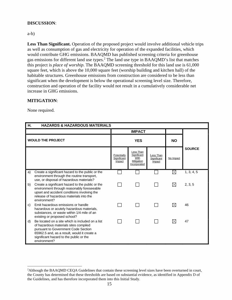
DISCUSSION: a-b) Less Than Significant. Operation of the proposed project would involve additional vehicle trips as well as consumption of gas and electricity for operation of the expanded facilities, which would contribute GHG emissions. BAAQMD has published screening criteria for greenhouse gas emissions for different land use types.2 The land use type in BAAQMD’s list that matches this project is place of worship. The BAAQMD screening threshold for this land use is 61,000 square feet, which is above the 10,000 square feet (worship building and kitchen hall) of the habitable structures. Greenhouse emissions from construction are considered to be less than significant when the development is below the operational screening level size. Therefore, construction and operation of the facility would not result in a cumulatively considerable net increase in GHG emissions. MITIGATION: None required. H. HAZARDS & HAZARDOUS MATERIALS
IMPACT
SOURCE
WOULD THE PROJECT YES NO
Potentially Significant
Impact
Less Than Significant
With Mitigation
Incorporated
Less Than Significant
Impact No Impact
a) Create a significant hazard to the public or the environment through the routine transport, use, or disposal of hazardous materials?
1, 3, 4, 5
b) Create a significant hazard to the public or the environment through reasonably foreseeable upset and accident conditions involving the release of hazardous materials into the environment?
2, 3, 5
c) Emit hazardous emissions or handle hazardous or acutely hazardous materials, substances, or waste within 1/4 mile of an existing or proposed school?
46
d) Be located on a site which is included on a list of hazardous materials sites compiled pursuant to Government Code Section 65962.5 and, as a result, would it create a significant hazard to the public or the environment?
47
2Although the BAAQMD CEQA Guidelines that contain these screening level sizes have been overturned in court, the County has determined that these thresholds are based on substantial evidence, as identified in Appendix D of the Guidelines, and has therefore incorporated them into this Initial Study.
16
e) For a project located within an airport land use plan referral area or, where such a plan has not been adopted, within two miles of a public airport or public use airport, or in the vicinity of a private airstrip, would the project result in a safety hazard for people residing or working in the project area?
3, 22a
f) Impair implementation of or physically interfere with an adopted emergency response plan or emergency evacuation plan?
5, 48
g) Expose people or structures to a significant risk of loss, injury or death involving wildland fires including where wildlands are adjacent to urbanized areas or where residences are intermixed with wildlands?
4, 17g
h) Provide breeding grounds for vectors? 1, 3, 5, 31 i) Proposed site plan result in a safety hazard
(i.e., parking layout, access, closed community, etc.)?
3
j) Involve construction of a building, road or septic system on a slope of 30% or greater?
1, 3, 17n
k) Involve construction of a roadway greater than 20% slope for a distance of 300' or more?
1, 3, 17n
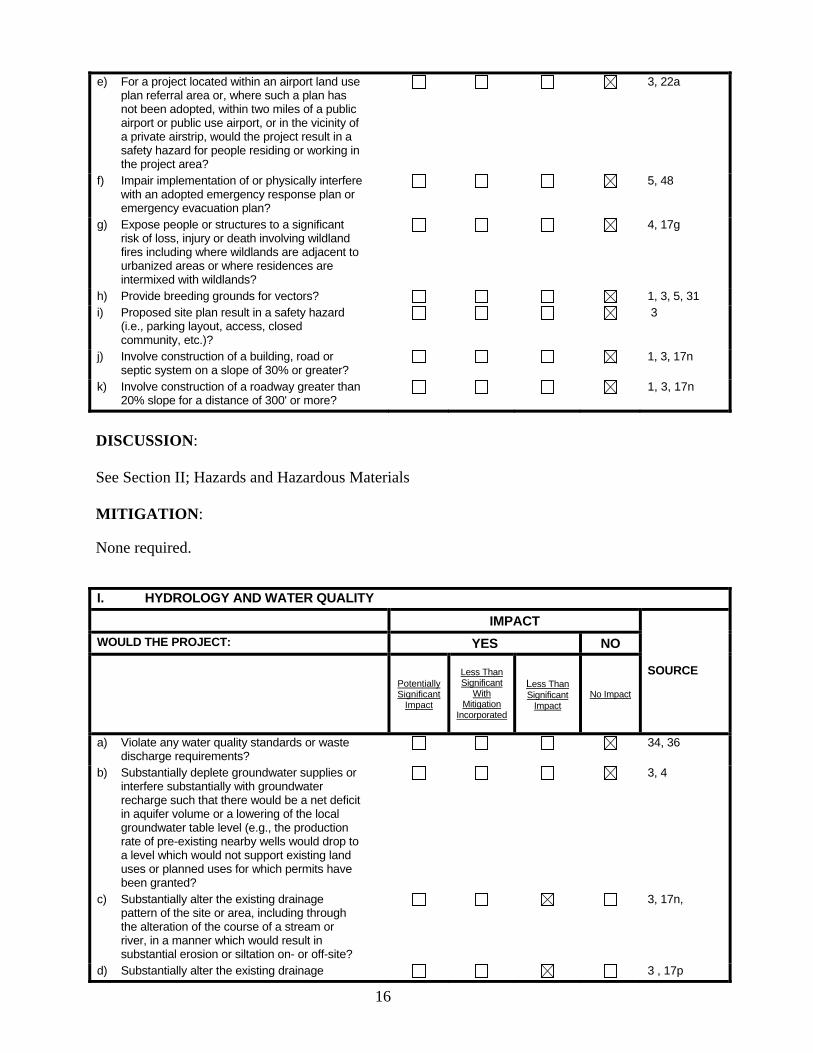
DISCUSSION: See Section II; Hazards and Hazardous Materials MITIGATION: None required. I. HYDROLOGY AND WATER QUALITY
IMPACT
SOURCE
WOULD THE PROJECT: YES NO
Potentially Significant
Impact
Less Than Significant
With Mitigation
Incorporated
Less Than Significant
Impact No Impact
a) Violate any water quality standards or waste discharge requirements?
34, 36
b) Substantially deplete groundwater supplies or interfere substantially with groundwater recharge such that there would be a net deficit in aquifer volume or a lowering of the local groundwater table level (e.g., the production rate of pre-existing nearby wells would drop to a level which would not support existing land uses or planned uses for which permits have been granted?
3, 4
c) Substantially alter the existing drainage pattern of the site or area, including through the alteration of the course of a stream or river, in a manner which would result in substantial erosion or siltation on- or off-site?
3, 17n,
d) Substantially alter the existing drainage 3 , 17p
17
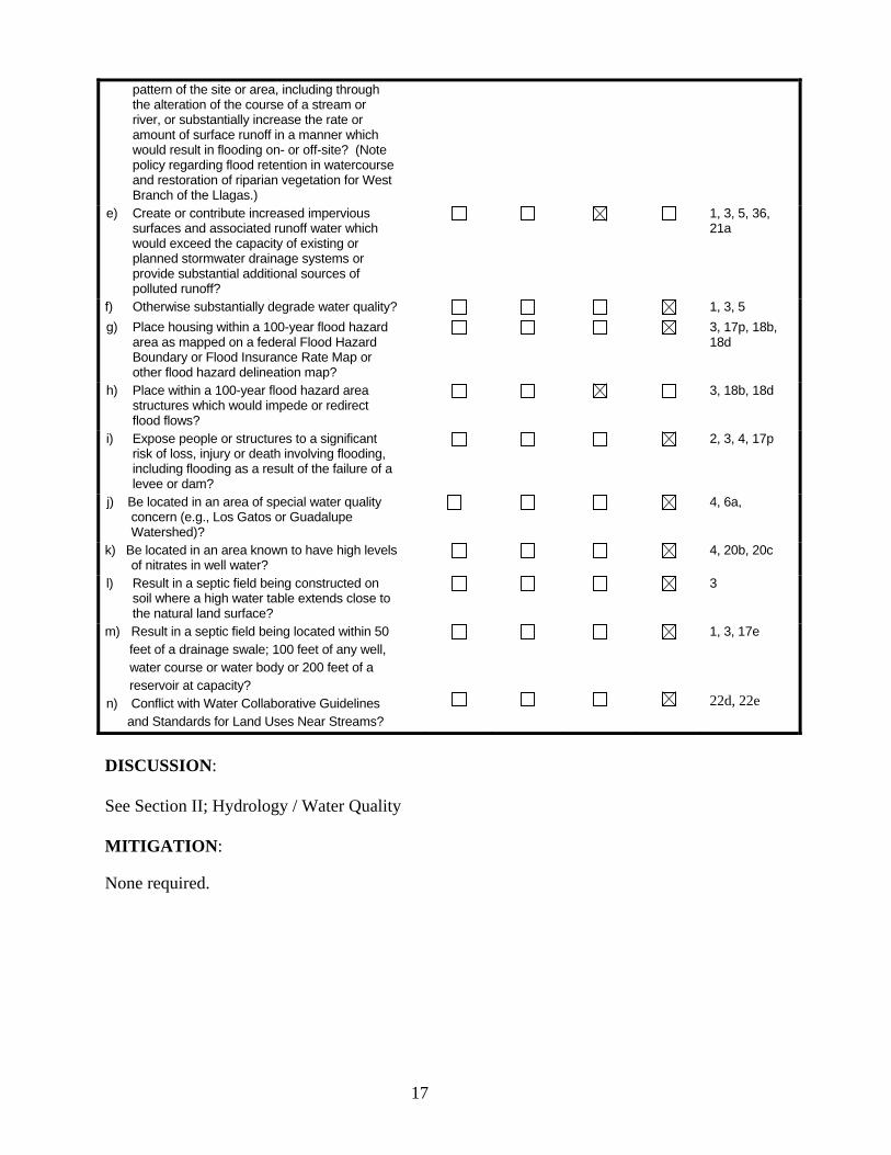
pattern of the site or area, including through the alteration of the course of a stream or river, or substantially increase the rate or amount of surface runoff in a manner which would result in flooding on- or off-site? (Note policy regarding flood retention in watercourse and restoration of riparian vegetation for West Branch of the Llagas.)
e) Create or contribute increased impervious surfaces and associated runoff water which would exceed the capacity of existing or planned stormwater drainage systems or provide substantial additional sources of polluted runoff?
1, 3, 5, 36, 21a
f) Otherwise substantially degrade water quality? 1, 3, 5
g) Place housing within a 100-year flood hazard area as mapped on a federal Flood Hazard Boundary or Flood Insurance Rate Map or other flood hazard delineation map?
3, 17p, 18b, 18d
h) Place within a 100-year flood hazard area structures which would impede or redirect flood flows?
3, 18b, 18d
i) Expose people or structures to a significant risk of loss, injury or death involving flooding, including flooding as a result of the failure of a levee or dam?
2, 3, 4, 17p
j) Be located in an area of special water quality concern (e.g., Los Gatos or Guadalupe Watershed)?
4, 6a,
k) Be located in an area known to have high levels of nitrates in well water?
4, 20b, 20c
l) Result in a septic field being constructed on soil where a high water table extends close to the natural land surface?
3
m) Result in a septic field being located within 50 feet of a drainage swale; 100 feet of any well, water course or water body or 200 feet of a reservoir at capacity? n) Conflict with Water Collaborative Guidelines and Standards for Land Uses Near Streams?
1, 3, 17e
22d, 22e
DISCUSSION: See Section II; Hydrology / Water Quality MITIGATION: None required.
18
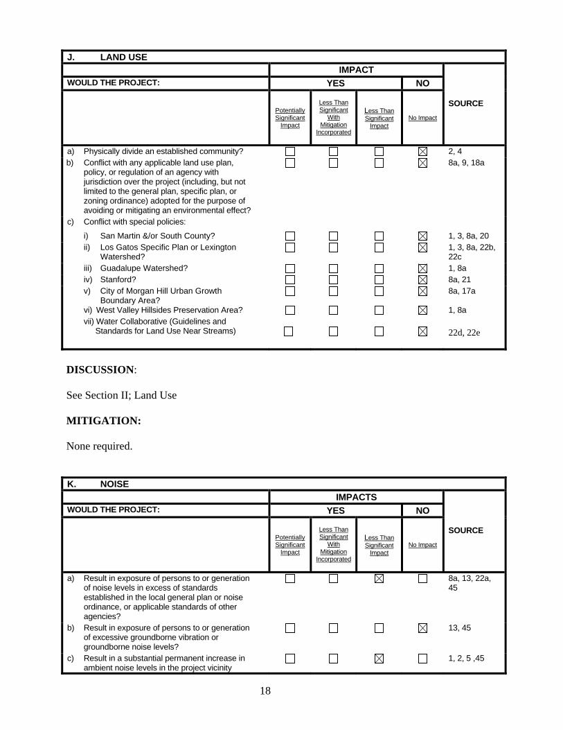
J. LAND USE IMPACT
SOURCE
WOULD THE PROJECT: YES NO
Potentially Significant
Impact
Less Than Significant
With Mitigation
Incorporated
Less Than Significant
Impact No Impact
a) Physically divide an established community? 2, 4 b) Conflict with any applicable land use plan,
policy, or regulation of an agency with jurisdiction over the project (including, but not limited to the general plan, specific plan, or zoning ordinance) adopted for the purpose of avoiding or mitigating an environmental effect?
8a, 9, 18a
c) Conflict with special policies:
i) San Martin &/or South County? 1, 3, 8a, 20 ii) Los Gatos Specific Plan or Lexington
Watershed? 1, 3, 8a, 22b,
22c iii) Guadalupe Watershed? 1, 8a iv) Stanford? 8a, 21 v) City of Morgan Hill Urban Growth
Boundary Area? 8a, 17a
vi) West Valley Hillsides Preservation Area? vii) Water Collaborative (Guidelines and
Standards for Land Use Near Streams)
1, 8a
22d, 22e
DISCUSSION: See Section II; Land Use MITIGATION: None required. K. NOISE IMPACTS
SOURCE
WOULD THE PROJECT: YES NO
Potentially Significant
Impact
Less Than Significant
With Mitigation
Incorporated
Less Than Significant
Impact No Impact
a) Result in exposure of persons to or generation of noise levels in excess of standards established in the local general plan or noise ordinance, or applicable standards of other agencies?
8a, 13, 22a, 45
b) Result in exposure of persons to or generation of excessive groundborne vibration or groundborne noise levels?
13, 45
c) Result in a substantial permanent increase in ambient noise levels in the project vicinity
1, 2, 5 ,45
19
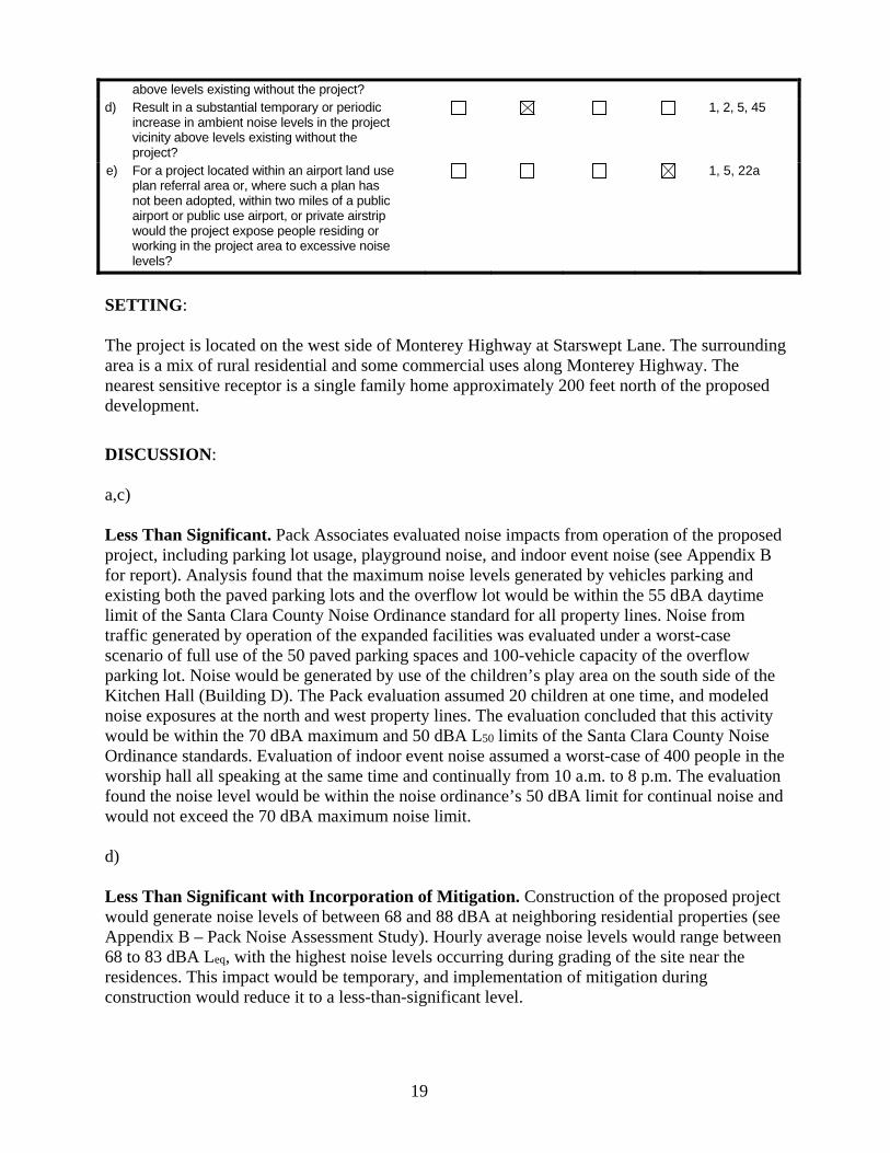
above levels existing without the project? d) Result in a substantial temporary or periodic
increase in ambient noise levels in the project vicinity above levels existing without the project?
1, 2, 5, 45
e) For a project located within an airport land use plan referral area or, where such a plan has not been adopted, within two miles of a public airport or public use airport, or private airstrip would the project expose people residing or working in the project area to excessive noise levels?
1, 5, 22a
SETTING: The project is located on the west side of Monterey Highway at Starswept Lane. The surrounding area is a mix of rural residential and some commercial uses along Monterey Highway. The nearest sensitive receptor is a single family home approximately 200 feet north of the proposed development.
DISCUSSION: a,c) Less Than Significant. Pack Associates evaluated noise impacts from operation of the proposed project, including parking lot usage, playground noise, and indoor event noise (see Appendix B for report). Analysis found that the maximum noise levels generated by vehicles parking and existing both the paved parking lots and the overflow lot would be within the 55 dBA daytime limit of the Santa Clara County Noise Ordinance standard for all property lines. Noise from traffic generated by operation of the expanded facilities was evaluated under a worst-case scenario of full use of the 50 paved parking spaces and 100-vehicle capacity of the overflow parking lot. Noise would be generated by use of the children’s play area on the south side of the Kitchen Hall (Building D). The Pack evaluation assumed 20 children at one time, and modeled noise exposures at the north and west property lines. The evaluation concluded that this activity would be within the 70 dBA maximum and 50 dBA L50 limits of the Santa Clara County Noise Ordinance standards. Evaluation of indoor event noise assumed a worst-case of 400 people in the worship hall all speaking at the same time and continually from 10 a.m. to 8 p.m. The evaluation found the noise level would be within the noise ordinance’s 50 dBA limit for continual noise and would not exceed the 70 dBA maximum noise limit. d) Less Than Significant with Incorporation of Mitigation. Construction of the proposed project would generate noise levels of between 68 and 88 dBA at neighboring residential properties (see Appendix B – Pack Noise Assessment Study). Hourly average noise levels would range between 68 to 83 dBA Leq, with the highest noise levels occurring during grading of the site near the residences. This impact would be temporary, and implementation of mitigation during construction would reduce it to a less-than-significant level.
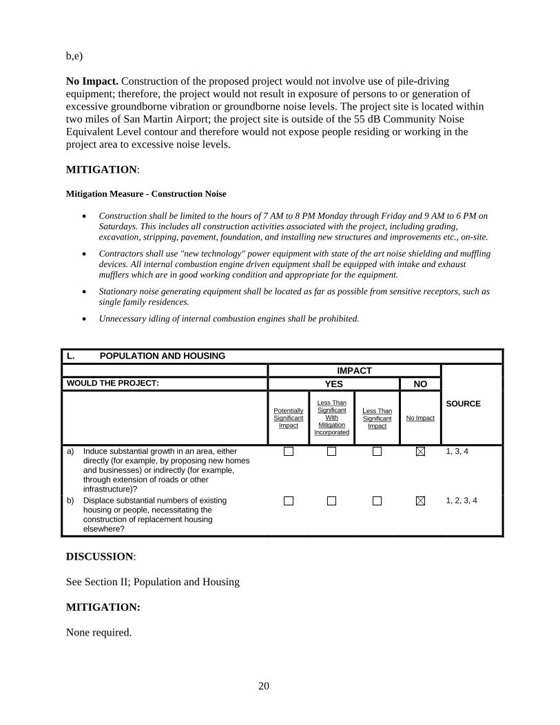
20
b,e) No Impact. Construction of the proposed project would not involve use of pile-driving equipment; therefore, the project would not result in exposure of persons to or generation of excessive groundborne vibration or groundborne noise levels. The project site is located within two miles of San Martin Airport; the project site is outside of the 55 dB Community Noise Equivalent Level contour and therefore would not expose people residing or working in the project area to excessive noise levels. MITIGATION: Mitigation Measure - Construction Noise
Construction shall be limited to the hours of 7 AM to 8 PM Monday through Friday and 9 AM to 6 PM on Saturdays. This includes all construction activities associated with the project, including grading, excavation, stripping, pavement, foundation, and installing new structures and improvements etc., on-site.
Contractors shall use "new technology" power equipment with state of the art noise shielding and muffling devices. All internal combustion engine driven equipment shall be equipped with intake and exhaust mufflers which are in good working condition and appropriate for the equipment.
Stationary noise generating equipment shall be located as far as possible from sensitive receptors, such as single family residences.
Unnecessary idling of internal combustion engines shall be prohibited. L. POPULATION AND HOUSING
IMPACT
SOURCE
WOULD THE PROJECT: YES NO
Potentially Significant
Impact
Less Than Significant
With Mitigation
Incorporated
Less Than Significant
Impact No Impact
a) Induce substantial growth in an area, either directly (for example, by proposing new homes and businesses) or indirectly (for example, through extension of roads or other infrastructure)?
1, 3, 4
b) Displace substantial numbers of existing housing or people, necessitating the construction of replacement housing elsewhere?
1, 2, 3, 4
DISCUSSION: See Section II; Population and Housing MITIGATION: None required.
21
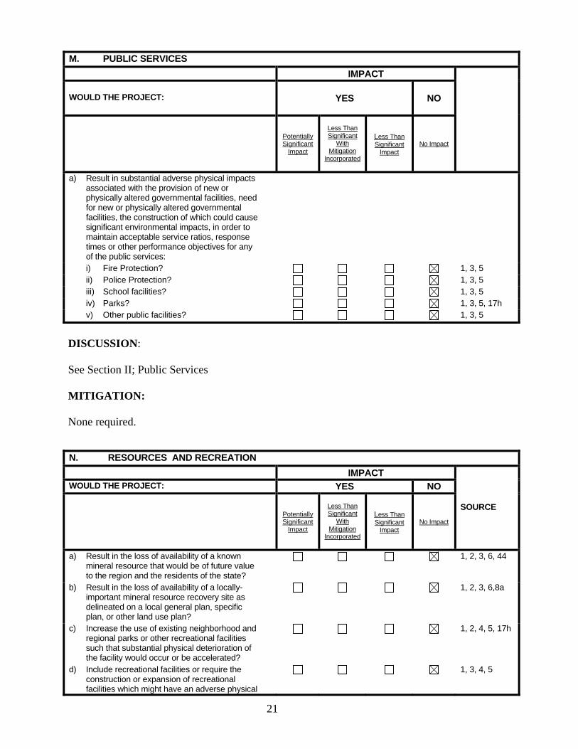
M. PUBLIC SERVICES
IMPACT
WOULD THE PROJECT: YES NO
Potentially Significant
Impact
Less Than Significant
With Mitigation
Incorporated
Less Than Significant
Impact No Impact
a) Result in substantial adverse physical impacts associated with the provision of new or physically altered governmental facilities, need for new or physically altered governmental facilities, the construction of which could cause significant environmental impacts, in order to maintain acceptable service ratios, response times or other performance objectives for any of the public services:
i) Fire Protection? 1, 3, 5 ii) Police Protection? 1, 3, 5 iii) School facilities? 1, 3, 5 iv) Parks? 1, 3, 5, 17h v) Other public facilities? 1, 3, 5
DISCUSSION: See Section II; Public Services MITIGATION: None required. N. RESOURCES AND RECREATION
IMPACT
SOURCE
WOULD THE PROJECT: YES NO
Potentially Significant
Impact
Less Than Significant
With Mitigation
Incorporated
Less Than Significant
Impact No Impact
a) Result in the loss of availability of a known mineral resource that would be of future value to the region and the residents of the state?
1, 2, 3, 6, 44
b) Result in the loss of availability of a locally-important mineral resource recovery site as delineated on a local general plan, specific plan, or other land use plan?
1, 2, 3, 6,8a
c) Increase the use of existing neighborhood and regional parks or other recreational facilities such that substantial physical deterioration of the facility would occur or be accelerated?
1, 2, 4, 5, 17h
d) Include recreational facilities or require the construction or expansion of recreational facilities which might have an adverse physical
1, 3, 4, 5
22
effect on the environment? e) Be on, within or near a public or private park,
wildlife reserve, or trail or affect existing or future recreational opportunities?
17h, 21a
f) Result in loss of open space rated as high priority for acquisition?
27
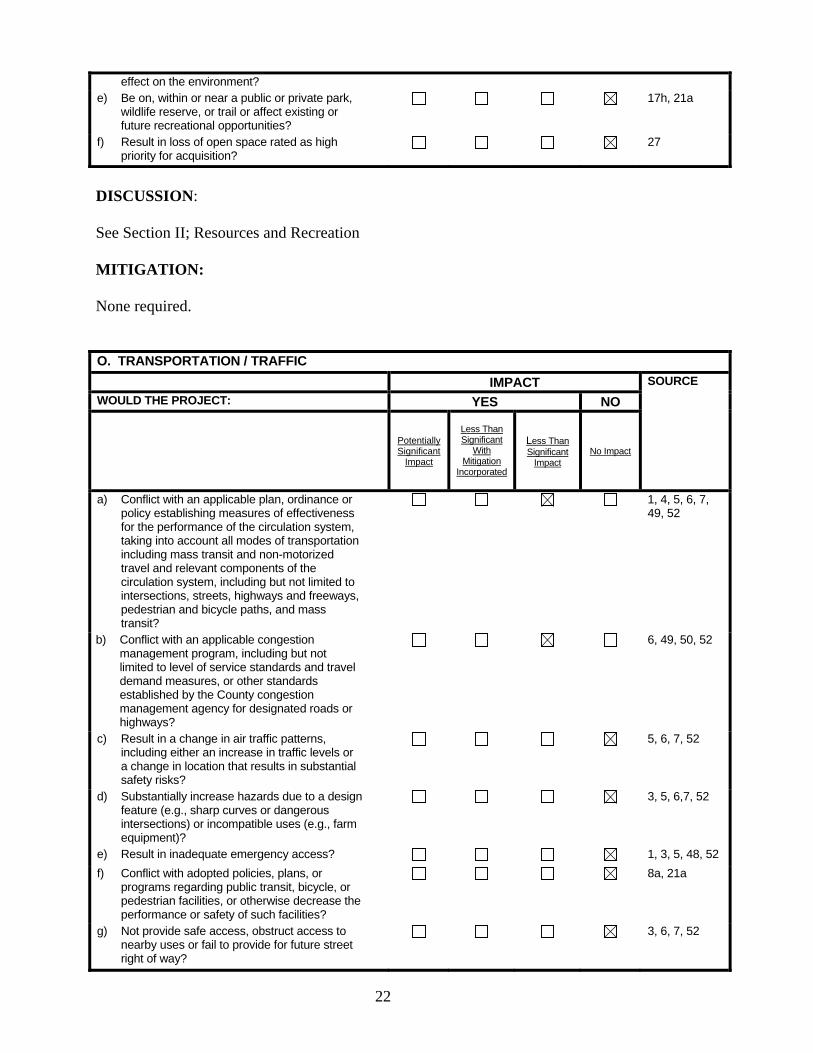
DISCUSSION: See Section II; Resources and Recreation MITIGATION: None required. O. TRANSPORTATION / TRAFFIC
IMPACT SOURCE
WOULD THE PROJECT: YES NO
Potentially Significant
Impact
Less Than Significant
With Mitigation
Incorporated
Less Than Significant
Impact No Impact
a) Conflict with an applicable plan, ordinance or policy establishing measures of effectiveness for the performance of the circulation system, taking into account all modes of transportation including mass transit and non-motorized travel and relevant components of the circulation system, including but not limited to intersections, streets, highways and freeways, pedestrian and bicycle paths, and mass transit?
1, 4, 5, 6, 7, 49, 52
b) Conflict with an applicable congestion management program, including but not limited to level of service standards and travel demand measures, or other standards established by the County congestion management agency for designated roads or highways?
6, 49, 50, 52
c) Result in a change in air traffic patterns, including either an increase in traffic levels or a change in location that results in substantial safety risks?
5, 6, 7, 52
d) Substantially increase hazards due to a design feature (e.g., sharp curves or dangerous intersections) or incompatible uses (e.g., farm equipment)?
3, 5, 6,7, 52
e) Result in inadequate emergency access? 1, 3, 5, 48, 52
f) Conflict with adopted policies, plans, or programs regarding public transit, bicycle, or pedestrian facilities, or otherwise decrease the performance or safety of such facilities?
8a, 21a
g) Not provide safe access, obstruct access to nearby uses or fail to provide for future street right of way?
3, 6, 7, 52
23
SETTING: The project is located on the west side of Monterey Highway at Starswept Lane. The local road network consists of the following:
Monterey Highway is a north-south arterial that extends between downtown San Jose and US 101 south of Gilroy. At the project site, Monterey Highway is four lanes wide with a median lane for left turns.
Neva Lane is a two-lane cul-de-sac that extends west from Monterey Highway. The lane provides access to the project site as well as undeveloped parcels to the south.
Currently, no sidewalks are provided on either Monterey Road at the project site or on Neva Lane. Bike lanes are not currently provided on Monterey Highway near the project site. However, the road as 6-8-foot shoulders that can be used by bicyclists. Valley Transit Authority operates bus routes 68, 121, and 168 on Monterey Highway.
DISCUSSION: a,b) Less Than Significant. Hatch Mott MacDonald conducted a traffic impact analysis of the proposed project (Appendix C). The analysis assessed the project’s impact (daily operations and special events) on intersection traffic operations during a typical weekday PM commute hour and a typical Sunday peak hour at the Monterey Highway / Project Driveway and Monterey Highway / Neva Lane Intersections. Although the proposed project would involve 10 special events with no more than 4 events with a maximum 400 people and 6 events with a maximum of 200 people on weekdays, Hatch Mott McDonald analyzed a worst-case scenario of 10 events with a maximum of 400 people. The results of the analysis show that the trips generated by the proposed project would not adversely affect levels of service at the study intersections, and no road improvements were recommended. c-g) No Impact. The proposed project is modification of a User Permit to allow expansion of a religious institution. It would not involve a change in air traffic patterns and would meet allow County requirements for traffic safety, emergency access, and pedestrian and bicycle access. MITIGATION: None required.
24
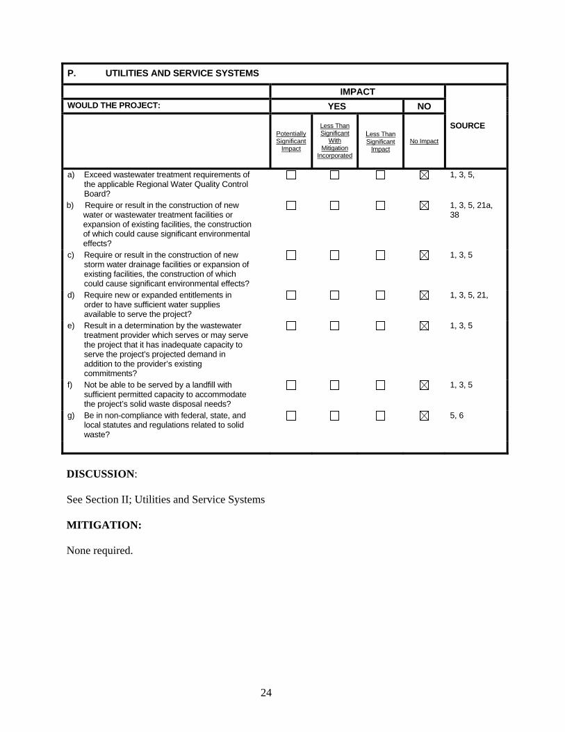
P. UTILITIES AND SERVICE SYSTEMS
IMPACT
SOURCE
WOULD THE PROJECT: YES NO
Potentially Significant
Impact
Less Than Significant
With Mitigation
Incorporated
Less Than Significant
Impact No Impact
a) Exceed wastewater treatment requirements of the applicable Regional Water Quality Control Board?
1, 3, 5,
b) Require or result in the construction of new water or wastewater treatment facilities or expansion of existing facilities, the construction of which could cause significant environmental effects?
1, 3, 5, 21a, 38
c) Require or result in the construction of new storm water drainage facilities or expansion of existing facilities, the construction of which could cause significant environmental effects?
1, 3, 5
d) Require new or expanded entitlements in order to have sufficient water supplies available to serve the project?
1, 3, 5, 21,
e) Result in a determination by the wastewater treatment provider which serves or may serve the project that it has inadequate capacity to serve the project’s projected demand in addition to the provider’s existing commitments?
1, 3, 5
f) Not be able to be served by a landfill with sufficient permitted capacity to accommodate the project’s solid waste disposal needs?
1, 3, 5
g) Be in non-compliance with federal, state, and local statutes and regulations related to solid waste?
5, 6
DISCUSSION: See Section II; Utilities and Service Systems MITIGATION: None required.
25
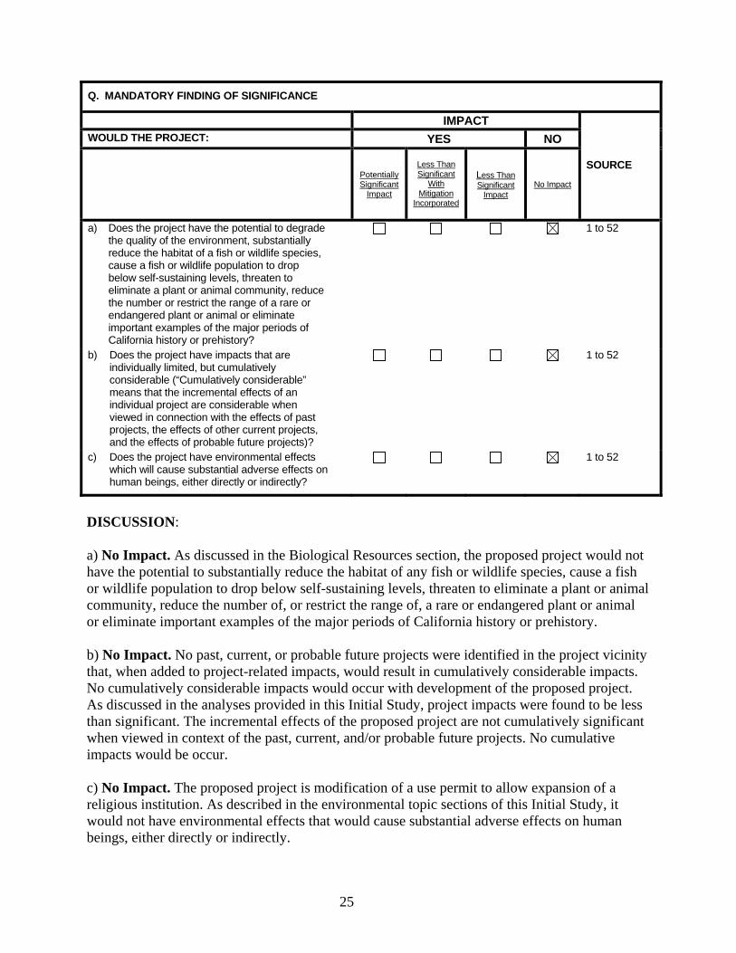
Q. MANDATORY FINDING OF SIGNIFICANCE
IMPACT
SOURCE
WOULD THE PROJECT: YES NO
Potentially Significant
Impact
Less Than Significant
With Mitigation
Incorporated
Less Than Significant
Impact No Impact
a) Does the project have the potential to degrade the quality of the environment, substantially reduce the habitat of a fish or wildlife species, cause a fish or wildlife population to drop below self-sustaining levels, threaten to eliminate a plant or animal community, reduce the number or restrict the range of a rare or endangered plant or animal or eliminate important examples of the major periods of California history or prehistory?
1 to 52
b) Does the project have impacts that are individually limited, but cumulatively considerable (“Cumulatively considerable” means that the incremental effects of an individual project are considerable when viewed in connection with the effects of past projects, the effects of other current projects, and the effects of probable future projects)?
1 to 52
c) Does the project have environmental effects which will cause substantial adverse effects on human beings, either directly or indirectly?
1 to 52
DISCUSSION: a) No Impact. As discussed in the Biological Resources section, the proposed project would not have the potential to substantially reduce the habitat of any fish or wildlife species, cause a fish or wildlife population to drop below self-sustaining levels, threaten to eliminate a plant or animal community, reduce the number of, or restrict the range of, a rare or endangered plant or animal or eliminate important examples of the major periods of California history or prehistory.
b) No Impact. No past, current, or probable future projects were identified in the project vicinity that, when added to project-related impacts, would result in cumulatively considerable impacts. No cumulatively considerable impacts would occur with development of the proposed project. As discussed in the analyses provided in this Initial Study, project impacts were found to be less than significant. The incremental effects of the proposed project are not cumulatively significant when viewed in context of the past, current, and/or probable future projects. No cumulative impacts would be occur. c) No Impact. The proposed project is modification of a use permit to allow expansion of a religious institution. As described in the environmental topic sections of this Initial Study, it would not have environmental effects that would cause substantial adverse effects on human beings, either directly or indirectly.
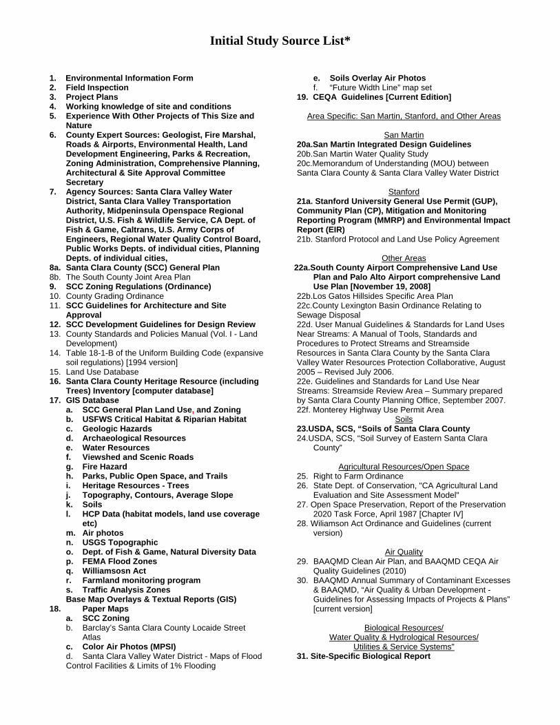
Initial Study Source List*
1. Environmental Information Form 2. Field Inspection 3. Project Plans 4. Working knowledge of site and conditions 5. Experience With Other Projects of This Size and
Nature 6. County Expert Sources: Geologist, Fire Marshal,
Roads & Airports, Environmental Health, Land Development Engineering, Parks & Recreation, Zoning Administration, Comprehensive Planning, Architectural & Site Approval Committee Secretary
7. Agency Sources: Santa Clara Valley Water District, Santa Clara Valley Transportation Authority, Midpeninsula Openspace Regional District, U.S. Fish & Wildlife Service, CA Dept. of Fish & Game, Caltrans, U.S. Army Corps of Engineers, Regional Water Quality Control Board, Public Works Depts. of individual cities, Planning Depts. of individual cities,
8a. Santa Clara County (SCC) General Plan 8b. The South County Joint Area Plan 9. SCC Zoning Regulations (Ordinance) 10. County Grading Ordinance 11. SCC Guidelines for Architecture and Site
Approval 12. SCC Development Guidelines for Design Review 13. County Standards and Policies Manual (Vol. I - Land
Development) 14. Table 18-1-B of the Uniform Building Code (expansive
soil regulations) [1994 version] 15. Land Use Database 16. Santa Clara County Heritage Resource (including
Trees) Inventory [computer database] 17. GIS Database
a. SCC General Plan Land Use, and Zoning b. USFWS Critical Habitat & Riparian Habitat c. Geologic Hazards d. Archaeological Resources e. Water Resources f. Viewshed and Scenic Roads g. Fire Hazard h. Parks, Public Open Space, and Trails i. Heritage Resources - Trees j. Topography, Contours, Average Slope k. Soils l. HCP Data (habitat models, land use coverage
etc) m. Air photos n. USGS Topographic o. Dept. of Fish & Game, Natural Diversity Data p. FEMA Flood Zones q. Williamsosn Act r. Farmland monitoring program s. Traffic Analysis Zones Base Map Overlays & Textual Reports (GIS)
18. Paper Maps a. SCC Zoning b. Barclay’s Santa Clara County Locaide Street
Atlas c. Color Air Photos (MPSI) d. Santa Clara Valley Water District - Maps of Flood Control Facilities & Limits of 1% Flooding
e. Soils Overlay Air Photos f. “Future Width Line” map set 19. CEQA Guidelines [Current Edition]
Area Specific: San Martin, Stanford, and Other Areas
San Martin
20a.San Martin Integrated Design Guidelines 20b.San Martin Water Quality Study 20c.Memorandum of Understanding (MOU) between Santa Clara County & Santa Clara Valley Water District
Stanford 21a. Stanford University General Use Permit (GUP), Community Plan (CP), Mitigation and Monitoring Reporting Program (MMRP) and Environmental Impact Report (EIR) 21b. Stanford Protocol and Land Use Policy Agreement
Other Areas 22a.South County Airport Comprehensive Land Use
Plan and Palo Alto Airport comprehensive Land Use Plan [November 19, 2008]
22b.Los Gatos Hillsides Specific Area Plan 22c.County Lexington Basin Ordinance Relating to Sewage Disposal 22d. User Manual Guidelines & Standards for Land Uses Near Streams: A Manual of Tools, Standards and Procedures to Protect Streams and Streamside Resources in Santa Clara County by the Santa Clara Valley Water Resources Protection Collaborative, August 2005 – Revised July 2006. 22e. Guidelines and Standards for Land Use Near Streams: Streamside Review Area – Summary prepared by Santa Clara County Planning Office, September 2007. 22f. Monterey Highway Use Permit Area
Soils 23.USDA, SCS, “Soils of Santa Clara County 24.USDA, SCS, “Soil Survey of Eastern Santa Clara
County”
Agricultural Resources/Open Space 25. Right to Farm Ordinance 26. State Dept. of Conservation, "CA Agricultural Land
Evaluation and Site Assessment Model" 27. Open Space Preservation, Report of the Preservation
2020 Task Force, April 1987 [Chapter IV] 28. Wiliamson Act Ordinance and Guidelines (current
version)
Air Quality 29. BAAQMD Clean Air Plan, and BAAQMD CEQA Air
Quality Guidelines (2010) 30. BAAQMD Annual Summary of Contaminant Excesses
& BAAQMD, “Air Quality & Urban Development - Guidelines for Assessing Impacts of Projects & Plans” [current version]
Biological Resources/
Water Quality & Hydrological Resources/ Utilities & Service Systems"
31. Site-Specific Biological Report

Initial Study Source List*
32. Santa Clara County Tree Preservation Ordinance Section C16, Santa Clara County Guide to Evaluating Oak Woodlands Impacts, Santa Clara County Guidelines for Tree Protection and Preservation for Land Use Applications
33. Clean Water Act, Section 404 34. Riparian Inventory of Santa Clara County, Greenbelt
Coalition, November 1988 35.CA Regional Water Quality Control Board, Water
Quality Control Plan, San Francisco Bay Region [1995]
36. Santa Clara Valley Water District, Private Well Water Testing Program [12-98]
37. SCC Nonpoint Source Pollution Control Program, Urban Runoff Management Plan [1997]
38.County Environmental Health / Septic Tank Sewage Disposal System - Bulletin “A” 39.County Environmental Health Department Tests and
Reports
Archaeological Resources 40.Northwest Information Center, Sonoma State
University 41. Site Specific Archaeological Reconnaissance
Report
Geological Resources 42. Site Specific Geologic Report
43.State Department of Mines and Geology, Special Report #42 44. State Department of Mines and Geology, Special Report #146
Noise 45. County Noise Ordinance
Hazards & Hazardous Materials 46.Section 21151.4 of California Public Resources Code 47. State Department of Toxic Substances, Hazardous
Waste and Substances Sites List 48. County Office of Emergency Services Emergency
Response Plan [1994 version]
Transportation/Traffic 49. Transportation Research Board, “Highway Capacity Manual”, Special Report 209, 1995. 50. SCC Congestion Management Agency, “Monitoring
and Conformance report” (Current Edition) 51. Official County Road Book 52. Site-specific Traffic Impact Analysis Report
*Items listed in bold are the most important sources and should be referred to during the first review of the project, when they are available. The planner should refer to the other sources for a particular environmental factor if the former indicate a potential environmental impact.
28
Appendix A
Cultural Resources Evaluation

29
Appendix B
Noise Evaluation
NOISE ASSESSMENT STUDY
FOR THE PLANNED
VAIDICA VIDHYA GANAPATHI CENTER
11355 MONTEREY ROAD, SANTA CLARA COUNTY
Prepared by
Jeffrey K. Pack
September 10, 2014
Project No. 46-060
EDWARD L. PACK ASSOCIATES, INC.
1975 HAMILTON AVENUE Acoustical Consultants TEL: 408-371-1195 SUITE 26 FAX: 408-371-1196 SAN JOSE, CA 95125 www.packassociates.com
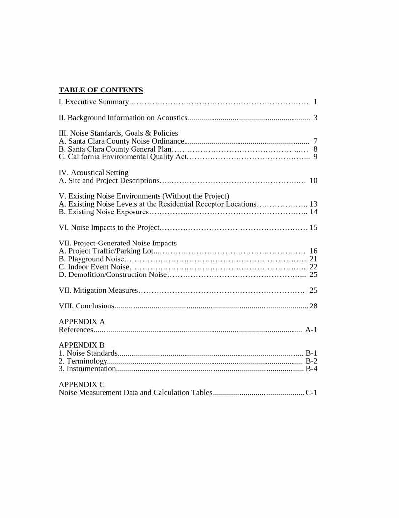
TABLE OF CONTENTS
I. Executive Summary…………………………………………………………… 1 II. Background Information on Acoustics............................................................... 3 III. Noise Standards, Goals & Policies A. Santa Clara County Noise Ordinance................................................................ 7 B. Santa Clara County General Plan…………………………………………..… 8 C. California Environmental Quality Act………………………………………... 9 IV. Acoustical Setting A. Site and Project Descriptions…..………………………………………….… 10 V. Existing Noise Environments (Without the Project) A. Existing Noise Levels at the Residential Receptor Locations……………….. 13 B. Existing Noise Exposures……………...…………………………………….. 14 VI. Noise Impacts to the Project………………………………………………… 15 VII. Project-Generated Noise Impacts A. Project Traffic/Parking Lot..………………………………………………… 16 B. Playground Noise……………………………………………………………. 21 C. Indoor Event Noise………………………………………………………….. 22 D. Demolition/Construction Noise……………………………………………... 25 VII. Mitigation Measures………………………………………………………. 25 VIII. Conclusions................................................................................................... 28 APPENDIX A References........................................................................................................... A-1 APPENDIX B 1. Noise Standards............................................................................................... B-1 2. Terminology.................................................................................................... B-2 3. Instrumentation................................................................................................ B-4 APPENDIX C Noise Measurement Data and Calculation Tables............................................... C-1
- 1 -
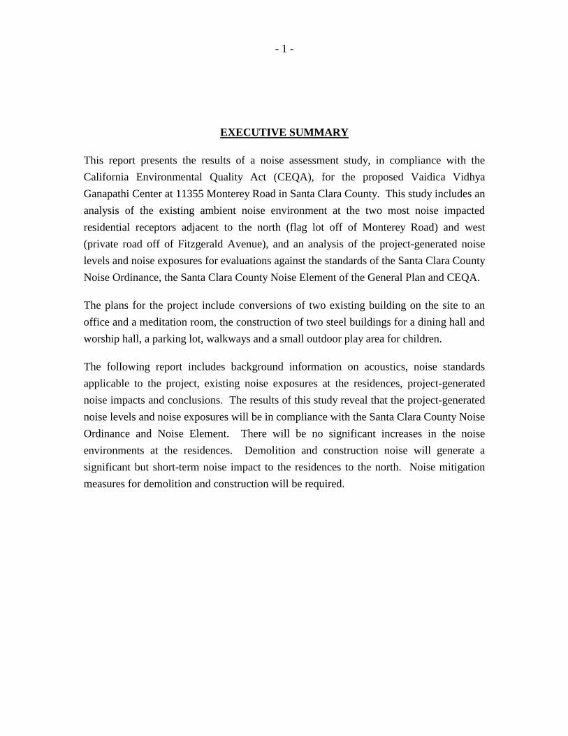
EXECUTIVE SUMMARY
This report presents the results of a noise assessment study, in compliance with the
California Environmental Quality Act (CEQA), for the proposed Vaidica Vidhya
Ganapathi Center at 11355 Monterey Road in Santa Clara County. This study includes an
analysis of the existing ambient noise environment at the two most noise impacted
residential receptors adjacent to the north (flag lot off of Monterey Road) and west
(private road off of Fitzgerald Avenue), and an analysis of the project-generated noise
levels and noise exposures for evaluations against the standards of the Santa Clara County
Noise Ordinance, the Santa Clara County Noise Element of the General Plan and CEQA.
The plans for the project include conversions of two existing building on the site to an
office and a meditation room, the construction of two steel buildings for a dining hall and
worship hall, a parking lot, walkways and a small outdoor play area for children.
The following report includes background information on acoustics, noise standards
applicable to the project, existing noise exposures at the residences, project-generated
noise impacts and conclusions. The results of this study reveal that the project-generated
noise levels and noise exposures will be in compliance with the Santa Clara County Noise
Ordinance and Noise Element. There will be no significant increases in the noise
environments at the residences. Demolition and construction noise will generate a
significant but short-term noise impact to the residences to the north. Noise mitigation
measures for demolition and construction will be required.

- 2 -
In terms of the CEQA compliance checklist, the project indicates the following:
a) Exposure of persons to or generation of noise
levels in excess of standards established in the
local general plan or noise ordinance, or applicable
standards of other agencies? Less Than Significant
b) Exposure of persons to or generation of
excessive groundborne vibration or groundborne
noise levels? No impact
c) A substantial permanent increase in ambient
noise levels in the project vicinity above levels
existing without the project? Less Than Significant
d) A substantial temporary or periodic increase
in ambient noise levels in the project vicinity above
levels existing without the project? Significant (temporary)
e) For a project located within an airport land use
plan or, where such a plan has not been adopted,
within two miles of a public airport or public use
airport, would the project expose people residing
or working in the project area to excessive noise levels? No impact
f) For a project within the vicinity of a private airstrip,
would the project expose people residing or working
in the project area to excessive noise levels? No impact
- 3 -
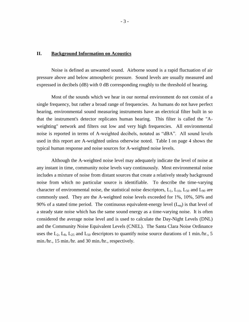
II. Background Information on Acoustics
Noise is defined as unwanted sound. Airborne sound is a rapid fluctuation of air
pressure above and below atmospheric pressure. Sound levels are usually measured and
expressed in decibels (dB) with 0 dB corresponding roughly to the threshold of hearing.
Most of the sounds which we hear in our normal environment do not consist of a
single frequency, but rather a broad range of frequencies. As humans do not have perfect
hearing, environmental sound measuring instruments have an electrical filter built in so
that the instrument's detector replicates human hearing. This filter is called the "A-
weighting" network and filters out low and very high frequencies. All environmental
noise is reported in terms of A-weighted decibels, notated as “dBA”. All sound levels
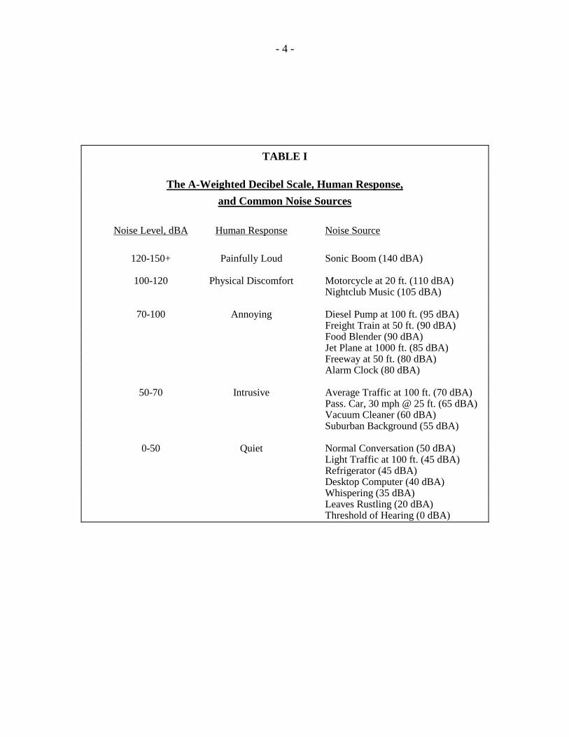
used in this report are A-weighted unless otherwise noted. Table I on page 4 shows the
typical human response and noise sources for A-weighted noise levels.
Although the A-weighted noise level may adequately indicate the level of noise at
any instant in time, community noise levels vary continuously. Most environmental noise
includes a mixture of noise from distant sources that create a relatively steady background
noise from which no particular source is identifiable. To describe the time-varying
character of environmental noise, the statistical noise descriptors, L1, L10, L50 and L90 are
commonly used. They are the A-weighted noise levels exceeded for 1%, 10%, 50% and
90% of a stated time period. The continuous equivalent-energy level (Leq) is that level of
a steady state noise which has the same sound energy as a time-varying noise. It is often
considered the average noise level and is used to calculate the Day-Night Levels (DNL)
and the Community Noise Equivalent Levels (CNEL). The Santa Clara Noise Ordinance
uses the L2, L8, L25 and L50 descriptors to quantify noise source durations of 1 min./hr., 5
min./hr., 15 min./hr. and 30 min./hr., respectively.
- 4 -
TABLE I
The A-Weighted Decibel Scale, Human Response,
and Common Noise Sources
Noise Level, dBA Human Response Noise Source
120-150+ Painfully Loud Sonic Boom (140 dBA) 100-120 Physical Discomfort Motorcycle at 20 ft. (110 dBA) Nightclub Music (105 dBA) 70-100 Annoying Diesel Pump at 100 ft. (95 dBA) Freight Train at 50 ft. (90 dBA) Food Blender (90 dBA) Jet Plane at 1000 ft. (85 dBA) Freeway at 50 ft. (80 dBA) Alarm Clock (80 dBA) 50-70 Intrusive Average Traffic at 100 ft. (70 dBA) Pass. Car, 30 mph @ 25 ft. (65 dBA) Vacuum Cleaner (60 dBA) Suburban Background (55 dBA) 0-50 Quiet Normal Conversation (50 dBA) Light Traffic at 100 ft. (45 dBA) Refrigerator (45 dBA) Desktop Computer (40 dBA) Whispering (35 dBA) Leaves Rustling (20 dBA) Threshold of Hearing (0 dBA)
- 5 -
In determining the daily level of environmental noise, it is important to account
for the difference in response of people to daytime and nighttime noises. During the
nighttime, exterior background noises are generally lower than the daytime levels.
However, most household noise also decreases at night and exterior noise becomes very
noticeable. Further, most people sleep at night and are very sensitive to noise intrusion.
To account for human sensitivity to nighttime noise levels, the Day-Night Level (DNL)
noise descriptor was developed. The DNL is also called the Ldn. Either is acceptable,
however, DNL is more popular worldwide. The DNL divides the 24-hour day into the
daytime period of 7:00 a.m. to 10:00 p.m. and the nighttime period of 10:00 p.m. to 7:00
a.m. The nighttime noise levels are penalized by 10 dB to account for the greater
sensitivity to noise at night. The Community Noise Equivalent Level (CNEL) is another
24-hour average which includes a 5 dB evening (7:00 p.m. - 10:00 p.m.) penalty and a 10
dB nighttime penalty. Both the DNL and the CNEL average the daytime, evening and
nighttime noise levels over a 24-hour period to attain a single digit noise exposure. The
proper notations for the Day-Night Level and the Community Noise Equivalent Level are
dB DNL and dB CNEL, respectively, as they can only be calculated using A-weighted
decibels. It is, therefore, considered redundant to notate dB(A) DNL or dB(A) CNEL.
The effects of noise on people can be listed in three general categories:
- subjective effects of annoyance, nuisance, dissatisfaction;
- interference with activities such as speech, sleep, learning, relaxing;
- physiological effects such as startling, hearing loss.
The levels associated with environmental noise, in almost every case, produce
effects only in the first two categories. Workers in industrial plants, airports, etc., can
experience noise in the last category. Unfortunately, there is, as yet, no completely
satisfactory way to measure the subjective effects of noise, or of the corresponding
reactions of annoyance and dissatisfaction. This is primarily due to the wide variation in
individual thresholds of annoyance and differing individual past experiences with noise.

- 6 -
An important way to determine a person's subjective reaction to a new noise is to
compare it to the existing environment to which one has adapted, i.e., the "ambient". In
general, the more a new noise exceeds the previously existing ambient noise level, the
less acceptable the new noise will be judged by the receptors.
With regard to increases in A-weighted noise levels, the Environmental Protection
Agency has determined the following relationships that will be helpful in understanding
this report.
Except in carefully controlled laboratory experiments, a change of
1 dB cannot be perceived.
Outside of the laboratory, a 3 dB change is considered a just-
perceptible difference.
A change in level of at least 5 dB is required before any noticeable
change in community response would be expected.
A 10 dB change is subjectively heard as approximately a doubling
in loudness, and would almost certainly cause an adverse change in
community response.
The adding or subtracting of sound levels is not simply arithmetic. The sound
levels, in decibels, must be converted to Bels, the anti-log’s of which are then calculated.
The manipulation is then performed (arithmetic addition or subtraction), the logarithm of
the sum or difference is calculated. The final number is then multiplied by 10 to convert
Bels to decibels. The formula for adding decibels is as follows:
Sum = 10log(10 SL/10
+ 10 SL/10
) where, SL is the Sound Level in decibels.
For example, 60 dB + 60 dB = 63 dB, and 60 dB + 50 dB = 60 dB. Two sound
sources of the same level are barely noisier than just one of the sources by itself. When
one source is 10 dB higher than the other, the less noisy source does not add to the noisier
source.
- 7 -
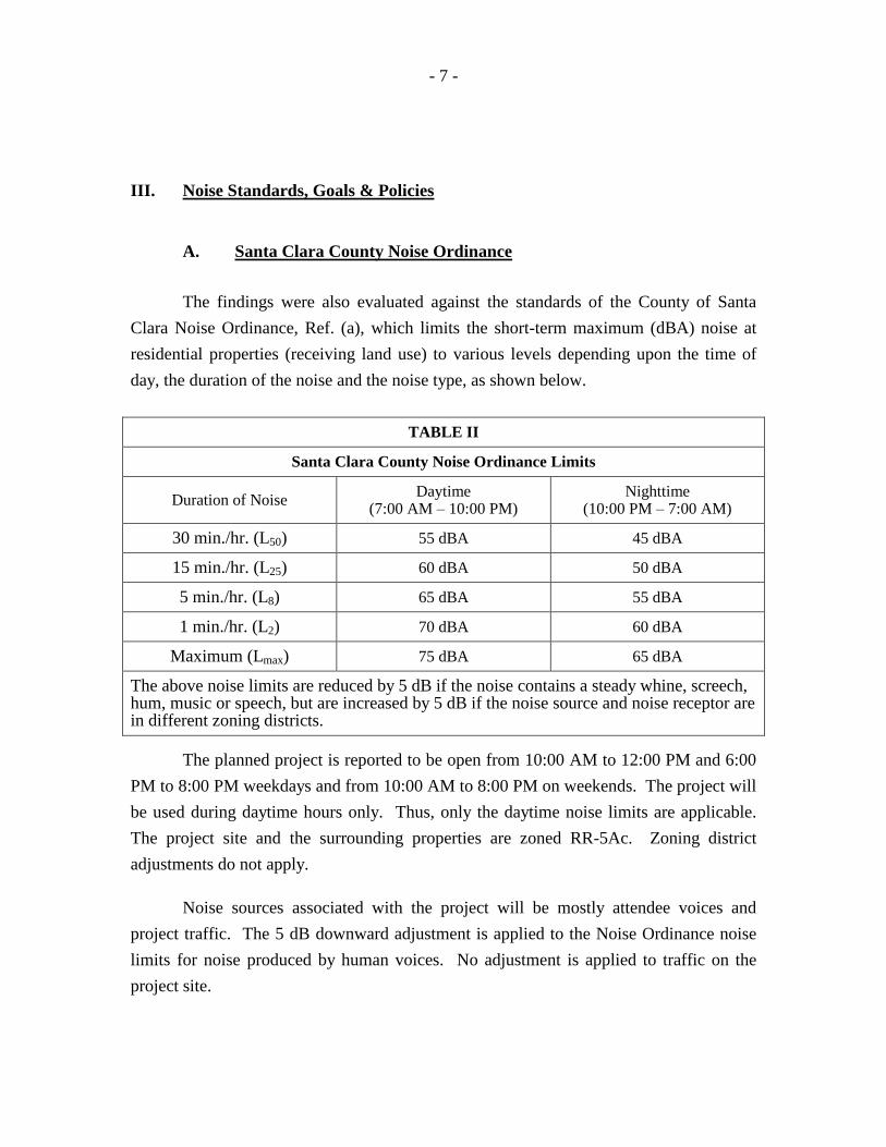
III. Noise Standards, Goals & Policies
A. Santa Clara County Noise Ordinance
The findings were also evaluated against the standards of the County of Santa
Clara Noise Ordinance, Ref. (a), which limits the short-term maximum (dBA) noise at
residential properties (receiving land use) to various levels depending upon the time of
day, the duration of the noise and the noise type, as shown below.
TABLE II
Santa Clara County Noise Ordinance Limits
Duration of Noise Daytime
(7:00 AM – 10:00 PM) Nighttime
(10:00 PM – 7:00 AM)
30 min./hr. (L50) 55 dBA 45 dBA
15 min./hr. (L25) 60 dBA 50 dBA
5 min./hr. (L8) 65 dBA 55 dBA
1 min./hr. (L2) 70 dBA 60 dBA
Maximum (Lmax) 75 dBA 65 dBA
The above noise limits are reduced by 5 dB if the noise contains a steady whine, screech, hum, music or speech, but are increased by 5 dB if the noise source and noise receptor are in different zoning districts.
The planned project is reported to be open from 10:00 AM to 12:00 PM and 6:00
PM to 8:00 PM weekdays and from 10:00 AM to 8:00 PM on weekends. The project will
be used during daytime hours only. Thus, only the daytime noise limits are applicable.
The project site and the surrounding properties are zoned RR-5Ac. Zoning district
adjustments do not apply.
Noise sources associated with the project will be mostly attendee voices and
project traffic. The 5 dB downward adjustment is applied to the Noise Ordinance noise
limits for noise produced by human voices. No adjustment is applied to traffic on the
project site.
- 8 -
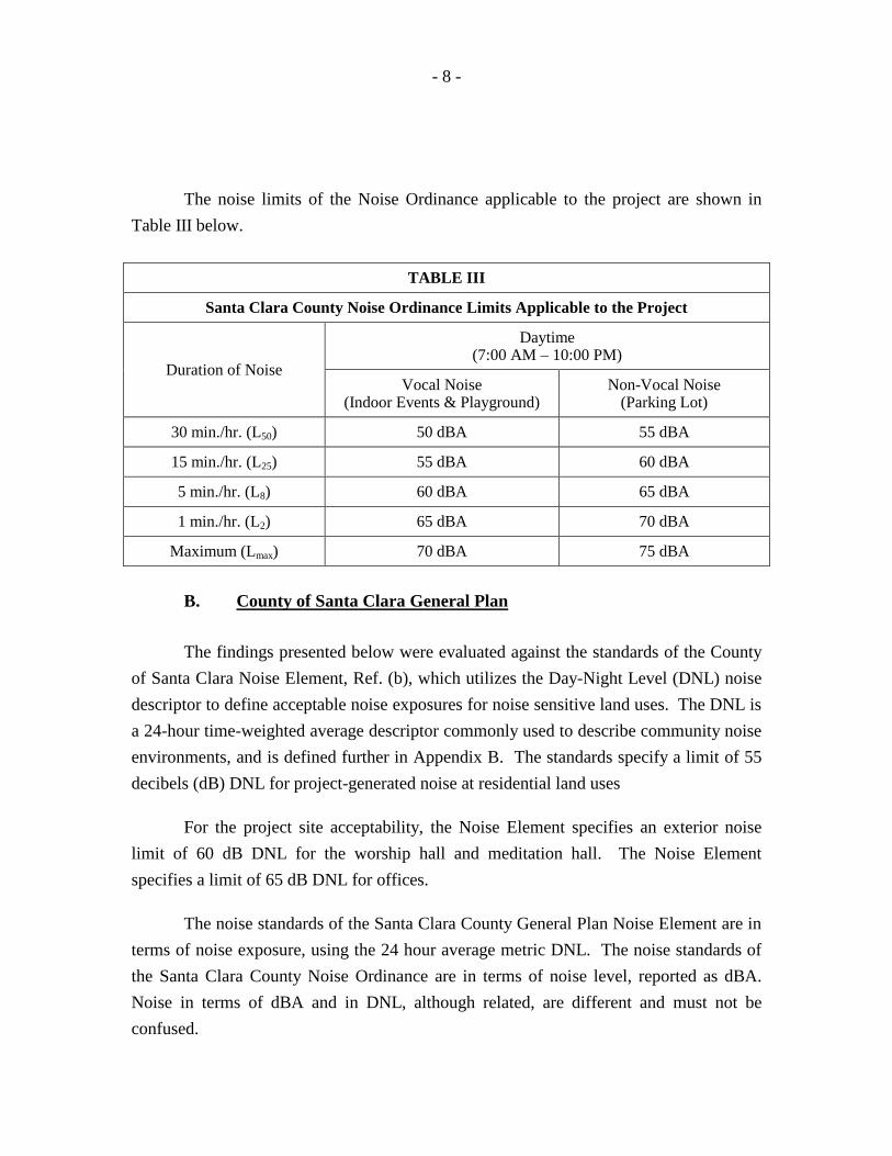
The noise limits of the Noise Ordinance applicable to the project are shown in
Table III below.
TABLE III
Santa Clara County Noise Ordinance Limits Applicable to the Project
Duration of Noise
Daytime (7:00 AM – 10:00 PM)
Vocal Noise (Indoor Events & Playground)
Non-Vocal Noise (Parking Lot)
30 min./hr. (L50) 50 dBA 55 dBA
15 min./hr. (L25) 55 dBA 60 dBA
5 min./hr. (L8) 60 dBA 65 dBA
1 min./hr. (L2) 65 dBA 70 dBA
Maximum (Lmax) 70 dBA 75 dBA
B. County of Santa Clara General Plan
The findings presented below were evaluated against the standards of the County
of Santa Clara Noise Element, Ref. (b), which utilizes the Day-Night Level (DNL) noise
descriptor to define acceptable noise exposures for noise sensitive land uses. The DNL is
a 24-hour time-weighted average descriptor commonly used to describe community noise
environments, and is defined further in Appendix B. The standards specify a limit of 55
decibels (dB) DNL for project-generated noise at residential land uses
For the project site acceptability, the Noise Element specifies an exterior noise
limit of 60 dB DNL for the worship hall and meditation hall. The Noise Element
specifies a limit of 65 dB DNL for offices.
The noise standards of the Santa Clara County General Plan Noise Element are in
terms of noise exposure, using the 24 hour average metric DNL. The noise standards of
the Santa Clara County Noise Ordinance are in terms of noise level, reported as dBA.
Noise in terms of dBA and in DNL, although related, are different and must not be
confused.
- 9 -
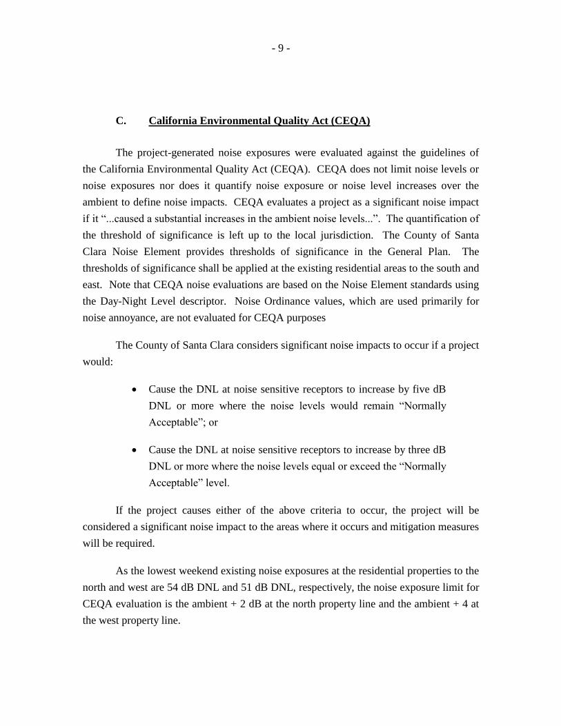
C. California Environmental Quality Act (CEQA)
The project-generated noise exposures were evaluated against the guidelines of
the California Environmental Quality Act (CEQA). CEQA does not limit noise levels or
noise exposures nor does it quantify noise exposure or noise level increases over the
ambient to define noise impacts. CEQA evaluates a project as a significant noise impact
if it “...caused a substantial increases in the ambient noise levels...”. The quantification of
the threshold of significance is left up to the local jurisdiction. The County of Santa
Clara Noise Element provides thresholds of significance in the General Plan. The
thresholds of significance shall be applied at the existing residential areas to the south and
east. Note that CEQA noise evaluations are based on the Noise Element standards using
the Day-Night Level descriptor. Noise Ordinance values, which are used primarily for
noise annoyance, are not evaluated for CEQA purposes
The County of Santa Clara considers significant noise impacts to occur if a project
would:
Cause the DNL at noise sensitive receptors to increase by five dB
DNL or more where the noise levels would remain “Normally
Acceptable”; or
Cause the DNL at noise sensitive receptors to increase by three dB
DNL or more where the noise levels equal or exceed the “Normally
Acceptable” level.
If the project causes either of the above criteria to occur, the project will be
considered a significant noise impact to the areas where it occurs and mitigation measures
will be required.
As the lowest weekend existing noise exposures at the residential properties to the
north and west are 54 dB DNL and 51 dB DNL, respectively, the noise exposure limit for
CEQA evaluation is the ambient + 2 dB at the north property line and the ambient + 4 at
the west property line.
- 10 -
The project-generated noise exposures will be limited to 53 dB DNL at the north
and west residences, respectively.
Note that 54 dB + 53 dB = 56 dB (ambient +2) and
51 dB + 53 dB = 55 dB (ambient +4).
IV. Acoustical Setting
A. Site and Project Descriptions
The planned project site is located at 11355 Monterey Road Avenue in an
unincorporated area of San Martin in Santa Clara County. The site currently contains a
vacant golf driving range with an administration building and two-story tee boxes. The
site is relatively flat and at-grade with the surrounding land uses and Monterey Road.
The surrounding land uses include single-family residential adjacent to the north, rural
residential uses adjacent to the west, a baseball batting cage facility and a vacant lot are
across Neva Lane to the south and single-family residential across Monterey Road to the
east.
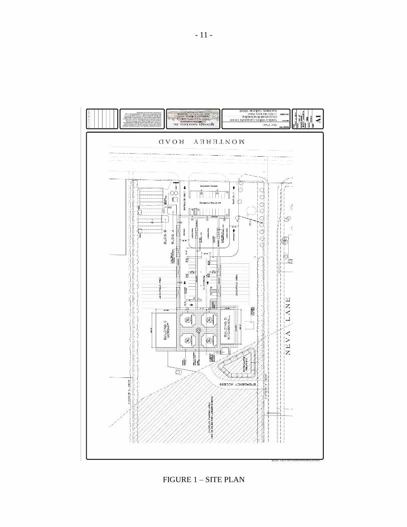
The planned project description, as provided by the project sponsor, Ref. (c),
includes a conversion of the existing driving range buildings into an office building and a
meditation hall, the construction of two steel buildings, the construction of an auxiliary
restroom facility, a new parking lot and landscaped patios/walkways. Of the two steel
buildings, the northerly building, designated as Building C, will be the worship hall. The
southerly building, designated as Building D, will be the kitchen and dining hall. A
section of the existing driving range behind the planned project buildings will be used for
up 100 cars for overflow parking.
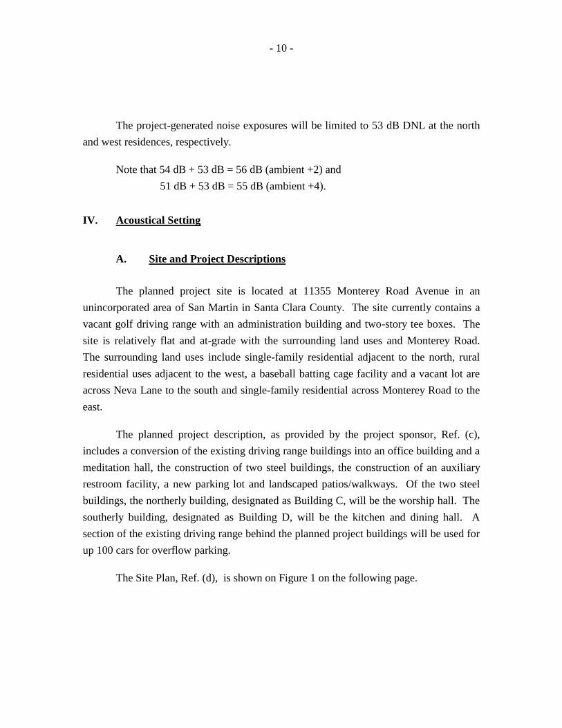
The Site Plan, Ref. (d), is shown on Figure 1 on the following page.
- 11 -
FIGURE 1 – SITE PLAN

- 12 -
The facility will operate from 10:00 AM to 12:00 PM and 6:00 PM to 8:00 PM on
weekdays and from 10:00 AM to 8:00 PM on weekends. The facility is primarily a
religious facility for prayer and worship services, meditation and religious studies.
Attendees visit the prayer/worship hall upon arrival then proceed to other areas of the
facility, which will typically be the dining hall. Usually, up to 50 people are in the
worship hall during the weekday hours with up to 200 people in the worship hall on
weekends. The maximum capacity is 400 people.
There will be no outdoor events. The only outdoor activity will be at the enclosed
children’s play area at the south side of the site along Neva Lane.
Indoor events include, but are not limited to local festivals, a pumpkin patch,
Christmas events, a farmer’s market and birthday parties. There will be no music, sound
system, public address system or any other amplified sound generating devices. Noise
from the indoor events is expected to be due primarily to people talking.
A small outdoor zoo, similar to a petting zoo, for the education of children has
been discussed. However, there are no specific plans for the zoo. Therefore, an
acoustical analysis of the zoo could not be performed. Note that the nature of a petting
zoo is somewhat benign acoustically. We do not anticipate any significant noise impacts
from the planned zoo provided that the animals and instruction area are located at least
100 ft. from a residential property line.
- 13 -
V. Existing Noise Environments (Without the Project)
A. Existing Noise Levels at the Residential Receptor Locations
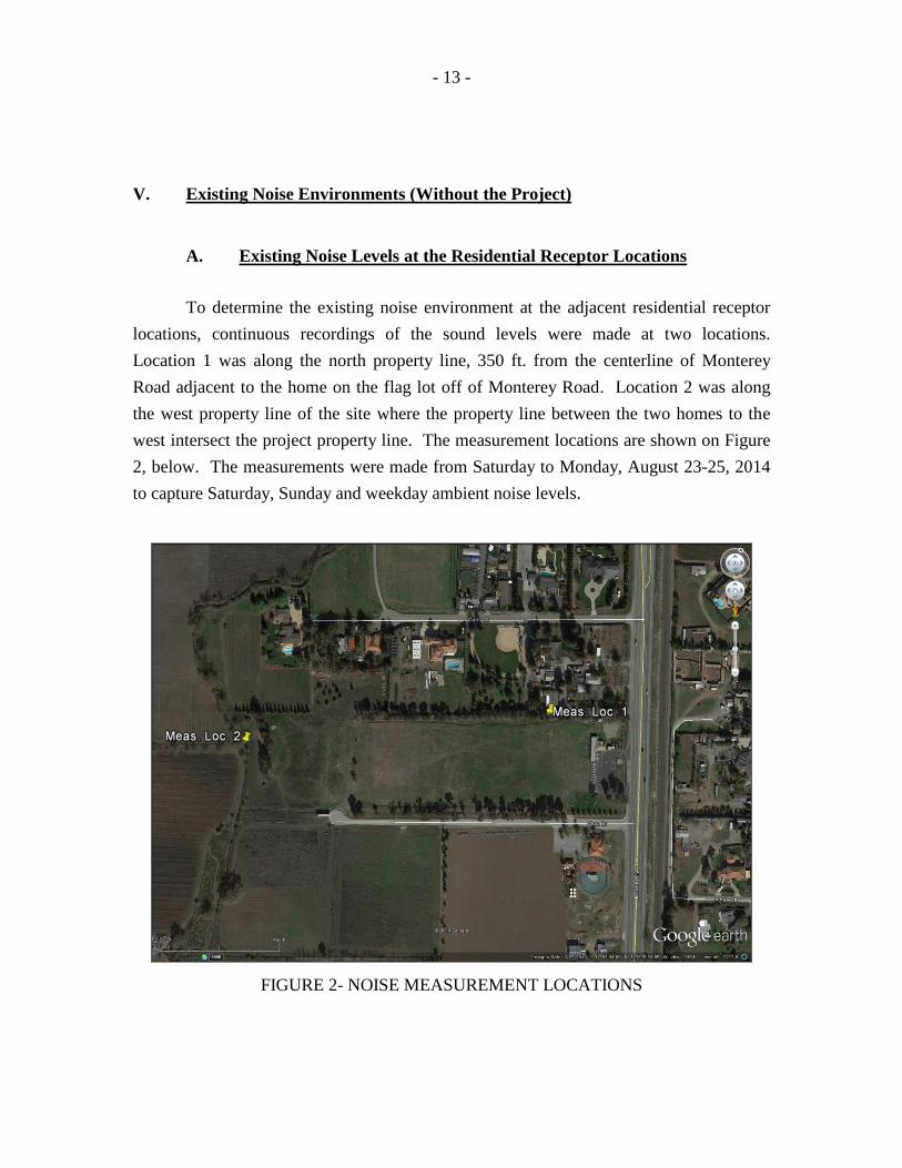
To determine the existing noise environment at the adjacent residential receptor
locations, continuous recordings of the sound levels were made at two locations.
Location 1 was along the north property line, 350 ft. from the centerline of Monterey
Road adjacent to the home on the flag lot off of Monterey Road. Location 2 was along
the west property line of the site where the property line between the two homes to the
west intersect the project property line. The measurement locations are shown on Figure
2, below. The measurements were made from Saturday to Monday, August 23-25, 2014
to capture Saturday, Sunday and weekday ambient noise levels.
FIGURE 2- NOISE MEASUREMENT LOCATIONS
- 14 -
The on-site sound levels were recorded and analyzed using Larson-Davis Model
812 Precision Integrating Sound Level Meters. The meters yield, by direct readout, a
series of descriptors of the sound levels versus time, which include the L2, L8, L25, and
L50, i.e., those levels that are exceeded 2%, 8%, 25%, and 50% of the time. The meters
also yield the maximum and minimum levels, and the continuous equivalent-energy
levels (Leq), which are used to calculate the DNL. The measured Leq’s are shown in the
data tables in Appendix C.
The Leq’s at measurement Location 1 (north property line) on Saturday ranged
from 48.1to 54.7 dBA during the daytime and from 43.7 to 50.2 dBA at night. On
Sunday, the Leq’s ranged from 46.0 to 54.5 during the daytime and from 43.8 to 51.5 dBA
at night. On Monday, the Leq’s ranged from 46.6 to 56.2 during the daytime and from
43.5 to 53.6 dBA at night.
The Leq’s at measurement Location 2 (west property line) on Saturday ranged
from 44.2 to 51.3 dBA during the daytime and from 42.2 to 49.7 dBA at night. On
Sunday, the Leq’s ranged from 38.4 to 51.3 during the daytime and from 38.9 to 46.9 dBA
at night. On Monday, the Leq’s ranged from 38.4 to 52.2 during the daytime and from
39.8 to 46.6 dBA at night.
The sound levels in the area are produced primarily by traffic sources on
Monterey Road and Fitzgerald Avenue, crickets and other wildlife and residential activity
at the homes adjacent to the north.
B. Existing Noise Exposures
To calculate the baseline noise exposures at the residential receptors for the
determination of project-related noise impacts, the DNL’s for the survey locations were
calculated by decibel averaging of the Leq’s as they apply to the various time periods of
the DNL index. A 10 decibel nighttime weighting factor was applied and the DNL was
calculated using the formula shown in Appendix B. The measured Leq’s and DNL
calculations are shown in the data tables in Appendix C.
- 15 -
The results of the calculations indicate that the existing noise exposures at
measurement Location 1 along the north property line, 350 ft. from the centerline of
Monterey Road, are 55 dB DNL on Saturday, 54 dB DNL on Sunday and 55 dB DNL on
Monday.
The existing noise exposures at measurement Location 2 along the west property
line are 53 dB DNL on Saturday, 51 dB DNL on Sunday and 51 dB DNL on Monday. As
expected, the noise exposures on Sunday are the lowest resulting in the most restrictive
noise standards for the project’s operational time periods.
The worst-case scenario would be a large event (400 people) occurring on a
Sunday. This study analyzes this worst-case scenario.
VI. Noise Impacts to the Project
The existing noise exposures at the planned office building setback, 130 ft. from
the centerline of Monterey Road were calculated to be 61, 60 and 61 dB DNL on
Saturday, Sunday and weekdays, respectively. Thus, the noise exposures are within the
65 dB DNL limit of the Santa Clara County Noise Element standards.
The existing noise exposures at the planned meditation hall, 160 ft. from the
centerline of Monterey Road were calculated to be 60, 59 and 60 dB DNL on Saturday,
Sunday and weekdays, respectively. Thus, the noise exposures are within the 60 dB DNL
limit of the Santa Clara County Noise Element standards. Areas of the site greater
distances from Monterey Road have lower noise levels.
Impact: Less Than Significant
- 16 -
VII. Project-Generated Noise Impacts
A. Project Traffic/Parking Lot
Project traffic was analyzed under a worst-case scenario of the paved parking area
with 50 spaces and the 100 vehicle overflow lot behind the project buildings being filled
in the morning bringing 400 worshippers into the facility, equivalent to 2.67 passengers
per vehicle. The 23 spaces in the existing parking lot were not included in the noise
generation analysis as these spaces are too far from any sensitive receptors to contribute
to the project-generated noise levels. The new paved area in front of the dining hall and
worship hall will contain 27 spaces and are accessed off of Monterey Road. This parking
area affects the north property line at its closest point, which is 350 ft. from the centerline
of Monterey Road, corresponding to measurement Location 1.
The 100 spaces available in the overflow lot are accessed from Neva Lane. The
closest property line is the north property line, but the most impacted point would be 660
ft. from the centerline of Monterey Road.
As the two north property line receptor locations are significantly spread apart, the
noise levels generated by the two parking areas are analyzed separately and are not added.
Each car pulling into a parking space takes approximately 8 seconds in addition to
the 2 seconds of time the vehicle is in the drive aisle just before parking. The exit
operation takes approximately 15 seconds which includes noise from the door closing,
starting the engine and pulling out.
Table IV on the following page provides the analysis of attendees entering the
paved parking lot off of Monterey Road and filling all 27 spaces in the morning and
exiting all spaces in the evening. Note that provided no more than 27 vehicles enter and
exit these spaces over the course of the daytime period between 7:00 AM and 10:00 PM,
it is inconsequential at what time the parking and exiting take place as all daytime noise is
averaged over the daytime period.

- 17 -
Table V on pages 17, 18 and 19 provide the analysis of 100 vehicles parking in
the overflow lot. This analysis assumes that attendees will park in five rows of 20 cars
each parallel to the north and south property lines, with the center row on-axis with the
center of the landscaped area between the Buildings C and D. The first row closest to the
north property line is assumed to be 100 ft. from the property line with 20 ft. of space
between the rows for pulling and backing out.
Shown in the Tables are the space indicators, (zero being the space closest to the
receptor), the parking duration, the noise level at the receptor location, the exiting
duration, the noise level at the receptor location, the hourly average (Leq(h)) noise levels
for each row (the three parallel spaces of the paved lot are included in the southerly row
as spaces 6, 7 and 8), the combined hourly average noise levels, the DNL noise exposure,
the maximum noise levels and the L50 noise levels.
Stall Parking Analysis
Space Time dBA Time dBA Dist
6 10 41 15 48 1785 10 41 15 48 1764 10 41 15 48 1743 10 41 15 48 1722 10 41 15 48 1711 10 41 15 48 1700 10 41 15 48 1701 10 41 15 48 1702 10 41 15 48 1713 10 41 15 48 1724 10 41 15 48 1745 10 41 15 48 1766 10 41 15 48 178
Sub-Total Leq(h) 26.4 35.2
8 10 40 15 47 1967 10 40 15 47 1956 10 40 15 47 1965 10 39 15 46 2394 10 39 15 46 2383 10 39 15 46 2372 10 39 15 46 2361 10 39 15 46 2350 10 39 15 46 2351 10 39 15 46 2352 10 39 15 46 2363 10 39 15 46 2374 10 39 15 46 2385 10 39 15 46 239
Sub-Total Leq(h) 25.1 33.8TOTAL Leq(h) 29 38DNL 25
Lmax 41 48L50 38 45
TABLE IV
Parking Operations - North Property Line Receptor
Parking Exiting
- 18 -
Overflow Parking Analysis
Space Time dBA Time dBA Dist
ROW 19 10 44 15 51 1298 10 44 15 51 1237 10 45 15 52 1186 10 45 15 52 1145 10 45 15 52 1104 10 45 15 52 1063 10 46 15 53 1042 10 46 15 53 1021 10 46 15 53 1000 10 46 15 53 1001 10 46 15 53 1002 10 46 15 53 1023 10 46 15 53 1044 10 45 15 52 1065 10 45 15 52 1106 10 45 15 52 1147 10 45 15 52 1188 10 44 15 51 1239 10 44 15 51 129
10 10 43 15 50 135Sub-Total Leq(h) 32.6 41.3
ROW 29 10 42 15 49 1628 10 42 15 49 1577 10 42 15 49 1546 10 42 15 49 1505 10 43 15 50 1474 10 43 15 50 1453 10 43 15 50 1432 10 43 15 50 141
1 10 43 15 50 1400 10 43 15 50 140
1 10 43 15 50 1402 10 43 15 50 1413 10 43 15 50 1434 10 43 15 50 1455 10 43 15 50 1476 10 42 15 49 1507 10 42 15 49 1548 10 42 15 49 1579 10 42 15 49 162
10 10 41 15 48 166Sub-Total Leq(h) 29.9 38.7
TABLE V
Parking Operations - North Property Line Receptor
Parking Exiting
- 19 -
Table V, cont’d
ROW 39 10 40 15 47 1978 10 40 15 47 1947 10 40 15 47 1916 10 41 15 48 1885 10 41 15 48 1864 10 41 15 48 1843 10 41 15 48 1822 10 41 15 48 1811 10 41 15 48 1800 10 41 15 48 1801 10 41 15 48 1802 10 41 15 48 1813 10 41 15 48 1824 10 41 15 48 1845 10 41 15 48 1866 10 41 15 48 1887 10 40 15 47 1918 10 40 15 47 1949 10 40 15 47 197
10 10 40 15 47 201Sub-Total Leq(h) 28.1 36.9
ROW 49 10 39 15 45 2348 10 39 15 46 2317 10 39 15 46 2296 10 39 15 46 2275 10 39 15 46 2254 10 39 15 46 2233 10 39 15 46 2222 10 39 15 46 2211 10 39 15 46 2200 10 39 15 46 2201 10 39 15 46 2202 10 39 15 46 2213 10 39 15 46 2224 10 39 15 46 2235 10 39 15 46 2256 10 39 15 46 2277 10 39 15 46 2298 10 39 15 46 2319 10 39 15 45 234
10 10 38 15 45 238Sub-Total Leq(h) 26.4 35.0
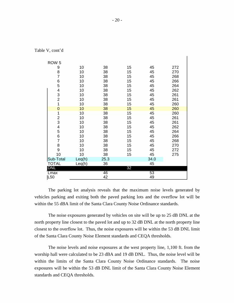
- 20 -
Table V, cont’d
ROW 59 10 38 15 45 2728 10 38 15 45 2707 10 38 15 45 2686 10 38 15 45 2665 10 38 15 45 2644 10 38 15 45 2623 10 38 15 45 2612 10 38 15 45 2611 10 38 15 45 2600 10 38 15 45 2601 10 38 15 45 2602 10 38 15 45 2613 10 38 15 45 2614 10 38 15 45 2625 10 38 15 45 2646 10 38 15 45 2667 10 38 15 45 2688 10 38 15 45 2709 10 38 15 45 272
10 10 38 15 45 275Sub-Total Leq(h) 25.3 34.0TOTAL Leq(h) 36 45DNL 32
Lmax 46 53L50 42 49
The parking lot analysis reveals that the maximum noise levels generated by
vehicles parking and exiting both the paved parking lots and the overflow lot will be
within the 55 dBA limit of the Santa Clara County Noise Ordinance standards.
The noise exposures generated by vehicles on site will be up to 25 dB DNL at the
north property line closest to the paved lot and up to 32 dB DNL at the north property line
closest to the overflow lot. Thus, the noise exposures will be within the 53 dB DNL limit
of the Santa Clara County Noise Element standards and CEQA thresholds.
The noise levels and noise exposures at the west property line, 1,100 ft. from the
worship hall were calculated to be 23 dBA and 19 dB DNL. Thus, the noise level will be
within the limits of the Santa Clara County Noise Ordinance standards. The noise
exposures will be within the 53 dB DNL limit of the Santa Clara County Noise Element
standards and CEQA thresholds.
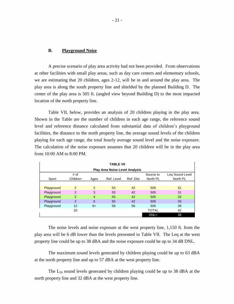
- 21 -
B. Playground Noise
A precise scenario of play area activity had not been provided. From observations
at other facilities with small play areas, such as day care centers and elementary schools,
we are estimating that 20 children, ages 2-12, will be in and around the play area. The
play area is along the south property line and shielded by the planned Building D. The
center of the play area is 505 ft. (angled view beyond Building D) to the most impacted
location of the north property line.
Table VII, below, provides an analysis of 20 children playing in the play area.
Shown in the Table are the number of children in each age range, the reference sound
level and reference distance calculated from substantial data of children’s playground
facilities, the distance to the north property line, the average sound levels of the children
playing for each age range, the total hourly average sound level and the noise exposure.
The calculation of the noise exposure assumes that 20 children will be in the play area
from 10:00 AM to 8:00 PM.
# of Source to Leq Sound Level
Sport Children Ages Ref. Level Ref. Dist North PL North PL
Playground 2 2 53 42 505 31
Playground 2 3 53 42 505 31
Playground 2 4 55 42 505 33
Playground 2 5 55 42 505 33
Playground 12 6+ 58 56 505 39
20 TOTAL 42
DNL= 38
TABLE VII
Play Area Noise Level Analysis
The noise levels and noise exposure at the west property line, 1,150 ft. from the
play area will be 6 dB lower than the levels presented in Table VII. The Leq at the west
property line could be up to 38 dBA and the noise exposure could be up to 34 dB DNL.
The maximum sound levels generated by children playing could be up to 63 dBA
at the north property line and up to 57 dBA at the west property line.
The L50 sound levels generated by children playing could be up to 38 dBA at the
north property line and 32 dBA at the west property line.
- 22 -
The noise levels at the north and west property lines from children playing at or
near the play area will be within the 70 dBA maximum and 50 dBA L50 limits of the
Santa Clara County Noise Ordinance standards.
As shown in Table VII, the noise exposure will be within the 53 dB DNL limit of
the Santa Clara County Noise Element and CEQA at the north and west residential
property lines. Playground activity will not significantly add to the existing noise
environment at the residences to the north or west.
Impact: Less Than Significant
C. Indoor Event Noise
The project description provided by the project sponsor includes several types of
activities, all of which will take place indoors. Because there will be no amplified sound
systems, music or other noise generating equipment, the primary source of noise at indoor
events will be human voices. The maximum capacity of the worship hall is 400 people.
This analysis assumes a worst-case scenario of 400 people in the worship hall all
speaking at the same time and continually from 10:00 AM to 8:00 PM.
The sound level of each person talking was assumed to be an elevated voice level
of 65 dBA at a distance of 5 ft.
Four hundred people in a 100 ft. by 60 ft. building generally places 25 people in
each of 16 rows. Typically, people in a large facility attending some type of event will
face random directions. For the purpose of this study, the 400 speaking people are
analyzed facing the north property line.
Because the interior finishes of the building has not been specified, we are also
assuming that the floor will be vinyl or tile and the walls and ceiling will be gypsum
board. The high sound reflectivity of the interior will result in sound buildup, which will
increase the interior sound levels by 15 dB.
A standard insulated steel building with a gypsum board interior will reduce noise
by at least 30 decibels.
- 23 -
Table VIII on page 24 provides the analysis of 400 people lined up facing the
north property line speaking with elevated voices inside the worship hall (Building C).
Shown in the Table are the row numbers, the distances to the property line, the sound
level (SL) at the property line (without the effect of the building), and the anti-log value
of each sound level (for the purposes of mathematical manipulation of decibels). The
right hand column provides the total sound level for each row. At the bottom of the Table
are the totals and adjustment factors.
The total sound level at the property line without the building will be 62 dBA.
The sound build up factor is +15 dB and the sound reduction provided by the building is
30 dB. The total sound level at the property line is 47 dBA. Continual speaking under
this scenario from 10:00 AM to 8:00 PM yields a noise exposure of 43 dB DNL.
The noise levels will be within the 50 dBA limit of the Santa Clara County Noise
Ordinance for continual noise. To exceed the 70 dBA maximum noise limit of the Noise
Ordinance, a noise source would need to exceed 107 dBA at 5 ft. inside the building.
There are no known sources of noise associated with the project that could generate that
level of sound.
Utilizing the same analytical scenario, with the exception of the attendees facing
west rather than north, the noise level and noise exposure at the west property line were
calculated to be 23 dBA and 19 dB DNL.
The noise exposures will be within the 53 dB DNL standard of the Santa Clara
County Noise Element. The noise exposures will not add significantly to the existing
noise environment at the residences to the north or east. The noise levels will be within
the limits of the Santa Clara County Noise Ordinance standards.
Impact: Less Than Significant
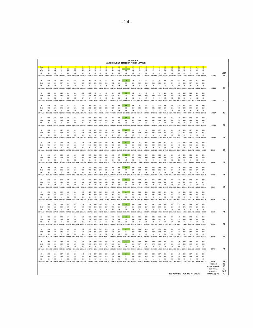
- 24 -
Row 1 2 3 4 5 6 7 8 9 10 11 12 13 14 15 16 17 18 19 20 21 22 23 24 25
1 48 44 40 36 32 28 24 20 16 12 8 4 0 4 8 12 16 20 24 28 32 36 40 44 48
Dist 87 84 82 80 79 77 76 75 74 73 72 72 72 72 72 73 74 75 76 77 79 80 82 84 87
SL 40 40 41 41 41 41 41 42 42 42 42 42 42 42 42 42 42 42 41 41 41 41 41 40 40 dBA
10^SL/10 10557.82 11104 11653.44 12200.1 12734.688 13246.81 13725.2 14158 14533 14838 15064.2 15203.3 15250.182 15203.3 15064.2 14838.01 14532.53 14158 13725.2 13246.807 12735 12200 11653.44 11104 10557.8 333285 55
2 123 119 115 111 107 103 99 95 91 87 83 79 75 79 83 87 91 95 99 103 107 111 115 119 123
Dist 144 141 137 134 131 127 124 121 118 115 112 109 75 109 112 115 118 121 124 127 131 134 137 141 144
SL 36 36 36 36 37 37 37 37 38 38 38 38 41 38 38 38 38 37 37 37 37 36 36 36 36
10^SL/10 3809.239 3995.6 4194.002 4405.27 4630.2531 4869.837 5124.92 5396 5685.1 5991.89 6317.48 6662.48 14054.567 6662.48 6317.48 5991.886 5685.096 5396 5124.92 4869.8375 4630.3 4405.3 4194.002 3995.6 3809.24 136219 51
3 126 122 118 114 110 106 102 98 94 90 86 82 78 82 86 90 94 98 102 106 110 114 118 122 126
Dist 148 145 141 138 135 132 128 125 122 119 116 113 78 113 116 119 122 125 128 132 135 138 141 145 148
SL 36 36 36 36 36 37 37 37 37 37 38 38 41 38 38 37 37 37 37 37 36 36 36 36 36
10^SL/10 3600.043 3770.4 3951.267 4143.45 4347.6101 4564.489 4794.82 5039 5298.7 5573.67 5864.76 6172.47 12994.238 6172.47 5864.76 5573.67 5298.723 5039 4794.82 4564.4885 4347.6 4143.4 3951.267 3770.4 3600.04 127236 51
4 129 125 121 117 113 109 105 101 97 93 89 85 81 85 89 93 97 101 105 109 113 117 121 125 129
Dist 152 149 146 142 139 136 133 129 126 123 120 117 81 117 120 123 126 129 133 136 139 142 146 149 152
SL 35 36 36 36 36 36 37 37 37 37 37 38 41 38 37 37 37 37 37 36 36 36 36 36 35
10^SL/10 3407.333 3563.4 3728.749 3904.05 4089.8573 4286.788 4495.45 4716 4950.3 5197.7 5458.98 5734.58 12049.526 5734.58 5458.98 5197.695 4950.341 4716 4495.45 4286.7878 4089.9 3904 3728.749 3563.4 3407.33 119117 51
5 132 128 124 120 116 112 108 104 100 96 92 88 84 88 92 96 100 104 108 112 116 120 124 128 132
Dist 156 153 150 146 143 140 137 134 131 128 125 122 84 122 125 128 131 134 137 140 143 146 150 153 156
SL 35 35 35 36 36 36 36 36 37 37 37 37 40 37 37 37 37 36 36 36 36 36 35 35 35
10^SL/10 3229.45 3372.7 3524.293 3684.61 3854.1801 4033.517 4223.13 4424 4635.1 4858.46 5093.88 5341.69 11204.215 5341.69 5093.88 4858.465 4635.14 4424 4223.13 4033.5174 3854.2 3684.6 3524.293 3372.7 3229.45 111753 50
6 135 131 127 123 119 115 111 107 103 99 95 91 87 91 95 99 103 107 111 115 119 123 127 131 135
Dist 161 157 154 151 147 144 141 138 135 132 129 126 87 126 129 132 135 138 141 144 147 151 154 157 161
SL 35 35 35 35 36 36 36 36 36 37 37 37 40 37 37 37 36 36 36 36 36 35 35 35 35
10^SL/10 3064.935 3196.8 3336.017 3482.99 3638.1473 3801.911 3974.71 4157 4349 4551.35 4764.19 4987.82 10444.833 4987.82 4764.19 4551.35 4349.045 4157 3974.71 3801.9112 3638.1 3483 3336.017 3196.8 3064.94 105055 50
7 138 134 130 126 122 118 114 110 106 102 98 94 90 94 98 102 106 110 114 118 122 126 130 134 138
Dist 165 161 158 155 152 148 145 142 139 136 133 130 90 130 133 136 139 142 145 148 152 155 158 161 165
SL 35 35 35 35 35 36 36 36 36 36 36 37 40 37 36 36 36 36 36 36 35 35 35 35 35
10^SL/10 2912.502 3034.1 3162.278 3297.34 3439.6511 3589.581 3747.48 3914 4088.6 4272.42 4465.48 4667.98 9760.1162 4667.98 4465.48 4272.424 4088.588 3914 3747.48 3589.5814 3439.7 3297.3 3162.278 3034.1 2912.5 98942 50
8 141 137 133 129 125 121 117 113 109 105 101 97 93 97 101 105 109 113 117 121 125 129 133 137 141
Dist 169 166 162 159 156 153 149 146 143 140 137 134 93 134 137 140 143 146 149 153 156 159 162 166 169
SL 34 35 35 35 35 35 35 36 36 36 36 36 40 36 36 36 36 36 35 35 35 35 35 35 34
10^SL/10 2771.011 2883.4 3001.63 3126.02 3256.8568 3394.459 3539.12 3691 3850.8 4018.35 4194 4377.95 9140.5875 4377.95 4194 4018.346 3850.801 3691 3539.12 3394.4586 3256.9 3126 3001.63 2883.4 2771.01 93350 50
9 144 140 136 132 128 124 120 116 112 108 104 100 96 100 104 108 112 116 120 124 128 132 136 140 144
Dist 173 170 166 163 160 157 154 151 148 144 142 139 96 139 142 144 148 151 154 157 160 163 166 170 173
SL 34 34 35 35 35 35 35 35 36 36 36 36 39 36 36 36 36 35 35 35 35 35 35 34 34
10^SL/10 2639.455 2743.5 2852.805 2967.6 3088.1618 3214.742 3347.6 3487 3633.1 3786.25 3946.53 4114.12 8578.2272 4114.12 3946.53 3786.252 3633.132 3487 3347.6 3214.7423 3088.2 2967.6 2852.805 2743.5 2639.45 88220 49
10 147 143 139 135 131 127 123 119 115 111 107 103 99 103 107 111 115 119 123 127 131 135 139 143 147
Dist 177 174 171 167 164 161 158 155 152 149 146 143 99 143 146 149 152 155 158 161 164 167 171 174 177
SL 34 34 34 35 35 35 35 35 35 36 36 36 39 36 36 36 35 35 35 35 35 35 34 34 34
10^SL/10 2516.935 2613.5 2714.681 2820.84 2932.1616 3048.86 3171.16 3299 3433.4 3573.68 3720.33 3873.44 8066.2118 3873.44 3720.33 3573.68 3433.377 3299 3171.16 3048.8601 2932.2 2820.8 2714.681 2613.5 2516.94 83503 49
11 150 146 142 138 134 130 126 122 118 114 110 106 102 106 110 114 118 122 126 130 134 138 142 146 150
Dist 181 178 175 172 168 165 162 159 156 153 150 147 102 147 147 147 147 147 147 147 147 147 147 147 147
SL 34 34 34 34 34 35 35 35 35 35 35 36 39 36 36 36 36 36 36 36 36 36 36 36 36
10^SL/10 2402.654 2492.3 2586.265 2684.63 2787.6214 2895.434 3008.26 3126 3249.6 3378.5 3513.02 3653.28 7598.7064 3653.28 3653.28 3653.278 3653.278 3653 3653.28 3653.2783 3653.3 3653.3 3653.278 3653.3 3653.28 87216 49
12 153 149 145 141 137 133 129 125 121 117 113 109 105 109 113 117 121 125 129 133 137 141 145 149 153
Dist 186 182 179 176 173 169 166 163 160 157 154 151 105 151 154 157 160 163 166 169 173 176 179 182 186
SL 34 34 34 34 34 34 35 35 35 35 35 35 39 35 35 35 35 35 35 34 34 34 34 34 34
10^SL/10 2295.898 2379.4 2466.675 2557.98 2653.4518 2753.254 2857.55 2966 3080.2 3198.87 3322.56 3451.36 7170.6976 3451.36 3322.56 3198.873 3080.221 2966 2857.55 2753.2542 2653.5 2558 2466.675 2379.4 2295.9 75138 49
13 156 152 148 144 140 136 132 128 124 120 116 112 108 112 116 120 124 128 132 136 140 144 148 152 156
Dist 156 152 148 144 140 136 132 128 124 120 116 156 108 156 158 161 164 167 171 174 177 180 183 186 190
SL 35 35 36 36 36 36 37 37 37 37 38 35 38 35 35 35 35 35 34 34 34 34 34 34 33
10^SL/10 3248.559 3421.8 3609.247 3812.55 4033.5174 4274.272 4537.24 4825 5141.6 5490.07 5875.22 3265.74 6777.8585 3265.74 3147.17 3033.185 2923.703 2819 2717.85 2621.2514 2528.7 2440 2355.128 2273.8 2196.03 90634 50
14 159 155 151 147 143 139 135 131 127 123 119 115 111 115 119 123 127 131 135 139 143 147 151 155 159
Dist 159 155 151 147 143 139 135 131 127 123 119 160 111 160 163 166 169 172 175 178 181 184 187 191 194
SL 35 35 35 36 36 36 36 37 37 37 37 35 38 35 35 35 34 34 34 34 34 34 34 33 33
10^SL/10 3127.129 3290.6 3467.258 3658.52 3866.0542 4091.762 4337.83 4607 4901.5 5225.52 5582.72 3094.69 6416.4387 3094.69 2985.31 2880.034 2778.803 2682 2588.13 2498.4812 2412.5 2330 2250.924 2175.1 2102.47 86445 49
15 162 158 154 150 146 142 138 134 130 126 122 118 114 118 122 126 130 134 138 142 146 150 154 158 162
Dist 198 195 192 188 185 182 179 176 173 170 167 164 114 164 167 170 173 176 179 182 185 188 192 195 198
SL 33 33 33 33 34 34 34 34 34 34 35 35 38 35 35 34 34 34 34 34 34 33 33 33 33
10^SL/10 2014.703 2082.6 2153.436 2227.21 2304.061 2384.106 2467.45 2554 2644.4 2738.19 2835.61 2936.74 6083.1749 2936.74 2835.61 2738.187 2644.399 2554 2467.45 2384.1056 2304.1 2227.2 2153.436 2082.6 2014.7 64769 48
16 165 161 157 153 149 145 141 137 133 129 125 121 117 121 125 129 133 137 141 145 149 153 157 161 165
Dist 202 199 196 193 189 186 183 180 177 174 171 168 117 168 171 174 177 180 183 186 189 193 196 199 202
SL 33 33 33 33 33 34 34 34 34 34 34 34 38 34 34 34 34 34 34 34 33 33 33 33 33
10^SL/10 1932.271 1995.9 2062.104 2131.03 2202.7568 2277.379 2354.99 2436 2519.5 2606.56 2696.9 2790.57 5775.2167 2790.57 2696.9 2606.559 2519.502 2436 2354.99 2277.3792 2202.8 2131 2062.104 1995.9 1932.27 61786 48
1762668.2 62
SOUND BUILDUP 15
SUB-TOTAL 77
BUILD. ATT 30.0
400 PEOPLE TALKING AT ONCE TOTAL @ PL 47
LARGE EVENT INTERIOR NOISE LEVELS
TABLE VIII
- 25 -
D. Demolition/Construction
Short-term construction impacts may be created during construction of the
development. Construction equipment generates noise levels in the range of 70 to 90
dBA at a 50 ft. distance from the source, and has a potential to disturb residences to the
south and west. The highest noise levels at the residential property boundaries will be up
to approximately 68 to 88 dBA at the residences closest to the project site. Hourly
average noise levels will range from 68 to 83 dBA Leq with the highest noise levels
occurring during grading of the site near the residences. The noise exposures are likely to
be up to 75 dB DNL on the noisiest days. Typical noise exposures from construction will
be 59-69 dB DNL.
Impact: Significant But Temporary
VIII. Mitigation Measures
A. Project Traffic/Parking Lot
No mitigation required.
B. Playground
No mitigation required.
C. Indoor Events
No mitigation required.
- 26 -
D. Demolition/Construction Noise
Mitigation of the construction phase noise at the site can be accomplished by
using quiet or "new technology" equipment. The greatest potential for noise abatement of
current equipment should be the quieting of exhaust noises by use of improved mufflers.
It is recommended that all internal combustion engines used at the project site be
equipped with a type of muffler recommended by the vehicle manufacturer. In addition,
all equipment should be in good mechanical condition so as to minimize noise created by
faulty or poorly maintained engine, drive-train and other components. Construction noise
can also be mitigated by the following:
Utilizing temporary berms or noise barriers, such as lumber or
other material stockpiles and construction trailers.
Stationary equipment, such as compressor and generators shall be
housed in acoustical enclosures and placed as far from sensitive
receptors as feasible.
Construction shall be scheduled in accordance with the requirements of the Santa
Clara County Code. The County Code requirements are outlined below:
Operating or causing the operation of any tools or equipment used
in construction, drilling, repair, alteration or demolition work between
weekdays and Saturday hours of 7:00 p.m. and 7:00 a.m., or at any
time on Sundays or holidays, that the sound therefrom creates a noise
disturbance across a residential or commercial real property line,
except for emergency work of public service utilities or by variance.
This section will not apply to the use of domestic power tools as
specified in Subsection 11.
Where technically and economically feasible, construction
activities will be conducted in a manner that the maximum noise levels
at affected properties will not exceed those listed in the following
schedules:

- 27 -
Mobile equipment. Maximum noise levels for nonscheduled,
intermittent, short-term operation (less than ten days) of mobile
equipment:
Single- and Two-
Family Dwelling
Residential Area
Multifamily
Dwelling
Residential Area
Commercial Area
Daily, except Sundays and legal holidays
7:00 a.m.—7:00 p.m. 75 dBA 80 dBA 85 dBA
Daily, 7:00 p.m. to 7:00 a.m. and all day
Sunday and legal holidays 50 dBA 55 dBA 60 dBA
Stationary equipment. Maximum noise levels for repetitively scheduled
and relatively long-term operation (periods of ten days or more) of stationary
equipment are as follows:
Single- and Two-
Family Dwelling
Residential Area
Multifamily
Dwelling
Residential Area
Commercial Area
Daily, except Sundays and legal holidays
7:00 a.m.—7:00 p.m. 60 dBA 65 dBA 70 dBA
Daily, 7:00 p.m. to 7:00 a.m. and all day
Sunday and legal holidays 50 dBA 55 dBA 60 dBA

- 28 -
VII. Conclusions
In conclusion, the results of this analysis indicate that the planned religious
facility will be in compliance with the standards of the Santa Clara County Noise
Ordinance and Noise Element and the project will not cause increases in the existing
ambient noise environment at the residences in the vicinity of the site. Therefore, the
project will be in compliance with the adopted CEQA thresholds for significant noise
impacts.
The exception will be standard demolition and construction noise, which will be a
temporary impact and noise mitigation measures to resolve demolition and construction
impacts are provided in Section VII of this report.
This report presents the results of a noise assessment study for the planned Vaidica
Vidhya Ganapathi Center at 11355 Monterey Road in Santa Clara County. The study
findings are based on field measurements and other data and are correct to the best of our
knowledge. However, changes in the operational scenario, operational hours, noise
regulations or other future changes beyond our control may result in long-range noise
levels different than our estimates. If you have any questions or would like an elaboration
on this report, please call me.
Sincerely, EDWARD L. PACK ASSOC., INC.
Jeffrey K. Pack President
APPENDIX A
References:
(a) Noise Ordinance of the County of Santa Clara, Chapter VII, Section B11-192, 1981
(b) Noise Element of the General Plan, County of Santa Clara, December 20, 2004
(c) Information on Vaidica Vidhya Ganapathi Center Operations and Project Descriptions Provided by Mr. Victor Singh, by email to Edward L. Pack Associates, Inc., August 11- 12, 2014
(d) Site Plan. Vaidica Vidhya Ganapathi Center, by D&Z Design Associates, Inc., May 13, 2014
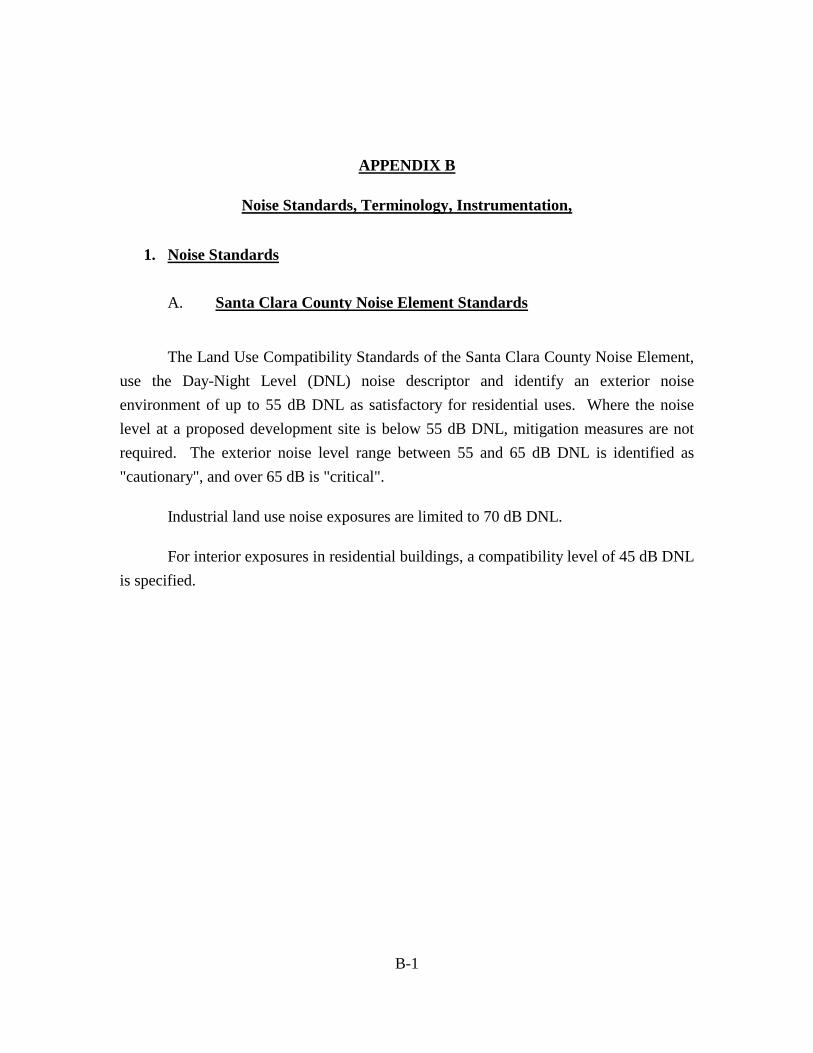
B-1
APPENDIX B
Noise Standards, Terminology, Instrumentation,
1. Noise Standards
A. Santa Clara County Noise Element Standards
The Land Use Compatibility Standards of the Santa Clara County Noise Element,
use the Day-Night Level (DNL) noise descriptor and identify an exterior noise
environment of up to 55 dB DNL as satisfactory for residential uses. Where the noise
level at a proposed development site is below 55 dB DNL, mitigation measures are not
required. The exterior noise level range between 55 and 65 dB DNL is identified as
"cautionary", and over 65 dB is "critical".
Industrial land use noise exposures are limited to 70 dB DNL.
For interior exposures in residential buildings, a compatibility level of 45 dB DNL
is specified.

B-2
2. Terminology
A. Statistical Noise Levels
Due to the fluctuating character of urban traffic noise, statistical procedures are
needed to provide an adequate description of the environment. A series of statistical
descriptors have been developed which represent the noise levels exceeded a given
percentage of the time. These descriptors are obtained by direct readout of the Sound
Level Meters and Noise Analyzers. Some of the statistical levels used to describe
community noise are defined as follows:
L1 - A noise level exceeded for 1% of the time.
L10
- A noise level exceeded for 10% of the time, considered to be an
“intrusive” level.
L50
- The noise level exceeded 50% of the time representing an
“average” sound level.
L90
- The noise level exceeded 90 % of the time, designated as a
“background” noise level.
Leq - The continuous equivalent-energy level is that level of a steady-
state noise having the same sound energy as a given time-varying
noise. The Leq represents the decibel level of the time-averaged
value of sound energy or sound pressure squared and is used to
calculate the DNL and CNEL.
B-3
B. Day-Night Level (DNL)
Noise levels utilized in the standards are described in terms of the Day-Night
Level (DNL). The DNL rating is determined by the cumulative noise exposures
occurring over a 24-hour day in terms of A-Weighted sound energy. The 24-hour day is
divided into two subperiods for the DNL index, i.e., the daytime period from 7:00 a.m. to
10:00 p.m., and the nighttime period from 10:00 p.m. to 7:00 a.m. A 10 dBA weighting
factor is applied (added) to the noise levels occurring during the nighttime period to
account for the greater sensitivity of people to noise during these hours. The DNL is
calculated from the measured Leq in accordance with the following mathematical
formula:
DNL = [(Ld+10log1015) & (Ln+10+10log109)] - 10log1024
Where:
Ld = Leq for the daytime (7:00 a.m. to 10:00 p.m.)
Ln = Leq for the nighttime (10:00 p.m. to 7:00 a.m.)
24 indicates the 24-hour period
& denotes decibel addition.
C. A-Weighted Sound Level
The decibel measure of the sound level utilizing the "A" weighted network of a
sound level meter is referred to as "dBA". The "A" weighting is the accepted standard
weighting system used when noise is measured and recorded for the purpose of
determining total noise levels and conducting statistical analyses of the environment so
that the output correlates well with the response of the human ear.

B-4
3. Instrumentation
The on-site field measurement data were acquired by the use of one or more of the
precision acoustical instruments shown below. The acoustical instrumentation provides a
direct readout of the L exceedance statistical levels including the equivalent-energy level
(Leq). Input to the meters was provided by a microphone extended to a height of 5 ft.
above the ground. The meter conforms to ANSI S1.4 for Type 1 instruments. The "A"
weighting network and the "Fast" response setting of the meter were used in conformance
with the applicable ISO and IEC standards. All instrumentation was acoustically
calibrated before and after field tests to assure accuracy.
Bruel & Kjaer 2231 Precision Integrating Sound Level Meter
Larson Davis LDL 812 Precision Integrating Sound Level Meter
Larson Davis 2900 Real Time Analyzer

APPENDIX C
Noise Measurement Data and Calculation Tables
DNL CALCULATIONS
CLIENT: VAIDICA VIDHYA GANAPATHI
FILE: 46-060
PROJECT: TEMPLE EXPANSION
DATE: 8/23-25/2014
SOURCE: EXISTING AMBIENT
LOCATION 1 North Property Line LOCATION 1 North Property Line LOCATION 1 North Property Line
SATURDAY SUNDAY MONDAY
TIME Leq 10^Leq/10 TIME Leq 10^Leq/10 TIME Leq 10^Leq/10
7:00 AM 51.1 128825.0 7:00 AM 46.0 39810.7 7:00 AM 52.5 177827.9
8:00 AM 51.5 141253.8 8:00 AM 48.7 74131.0 8:00 AM 49.5 89125.1
9:00 AM 52.4 173780.1 9:00 AM 48.5 70794.6 9:00 AM 46.6 45708.8
10:00 AM 54.7 295120.9 10:00 AM 48.6 72443.6 10:00 AM 49.4 87096.4
11:00 AM 52.2 165958.7 11:00 AM 47.5 56234.1 11:00 AM 48.4 69183.1
12:00 PM 50.8 120226.4 12:00 PM 49.4 87096.4 12:00 PM 47.2 52480.7
1:00 PM 48.1 64565.4 1:00 PM 47.5 56234.1 1:00 PM 46.8 47863.0
2:00 PM 51.4 138038.4 2:00 PM 49.7 93325.4 2:00 PM 48.6 72443.6
3:00 PM 52.6 181970.1 3:00 PM 52.1 162181.0 3:00 PM 55.2 331131.1
4:00 PM 52.4 173780.1 4:00 PM 53.1 204173.8 4:00 PM 54.3 269153.5
5:00 PM 51.1 128825.0 5:00 PM 52.1 162181.0 5:00 PM 53.4 218776.2
6:00 PM 49.7 93325.4 6:00 PM 50.2 104712.9 6:00 PM 53.7 234422.9
7:00 PM 49.3 85113.8 7:00 PM 49.2 83176.4 7:00 PM 54.9 309029.5
8:00 PM 50.2 104712.9 8:00 PM 51.6 144544.0 8:00 PM 56.2 416869.4
9:00 PM 50.7 117489.8 SUM= 2112986 9:00 PM 54.5 281838.3 SUM= 1692877 9:00 PM 53.3 213796.2 SUM= 2634907
10:00 PM 50.1 102329.3 Ld= 63.2 10:00 PM 46.8 47863.0 Ld= 62.3 10:00 PM 49.2 83176.4 Ld= 64.2
11:00 PM 48.8 75857.8 11:00 PM 45.8 38018.9 11:00 PM 47.2 52480.7
12:00 AM 50.2 104712.9 12:00 AM 48.2 66069.3 12:00 AM 45.2 33113.1
1:00 AM 44.1 25704.0 1:00 AM 51.5 141253.8 1:00 AM 43.8 23988.3
2:00 AM 44.0 25118.9 2:00 AM 43.8 23988.3 2:00 AM 43.6 22908.7
3:00 AM 43.7 23442.3 3:00 AM 44.1 25704.0 3:00 AM 43.5 22387.2
4:00 AM 45.7 37153.5 4:00 AM 45.0 31622.8 4:00 AM 45.7 37153.5
5:00 AM 48.2 66069.3 5:00 AM 44.1 25704.0 5:00 AM 46.8 47863.0
6:00 AM 50.1 102329.3 SUM= 562717 6:00 AM 45.1 32359.4 SUM= 432583 6:00 AM 53.6 229086.8 SUM= 552158
Ln= 57.5 Ln= 56.4 Ln= 57.4
Daytime Level= 63.2 Daytime Level= 62.3 Daytime Level= 64.2
Nighttime Level= 67.5 Nighttime Level= 66.4 Nighttime Level= 67.4
DNL= 55 DNL= 54 DNL= 5524-Hour Leq= 50.5 24-Hour Leq= 49.5 24-Hour Leq= 51.2
DNL CALCULATIONS
CLIENT: VAIDICA VIDHYA GANAPATHI
FILE: 46-060
PROJECT: TEMPLE EXPANSION
DATE: 8/23-25/2014
SOURCE: EXISTING AMBIENT
LOCATION 2 West Property Line LOCATION 2 West Property Line LOCATION 1 West Property Line
SATURDAY SUNDAY MONDAY
TIME Leq 10^Leq/10 TIME Leq 10^Leq/10 TIME Leq 10^Leq/10
7:00 AM 44.2 26302.7 7:00 AM 38.5 7079.5 7:00 AM 41.3 13489.6
8:00 AM 45.3 33884.4 8:00 AM 38.4 6918.3 8:00 AM 38.4 6918.3
9:00 AM 46.4 43651.6 9:00 AM 41.0 12589.3 9:00 AM 39.6 9120.1
10:00 AM 51.3 134896.3 10:00 AM 46.2 41686.9 10:00 AM 40.1 10232.9
11:00 AM 46.8 47863.0 11:00 AM 40.7 11749.0 11:00 AM 42.5 17782.8
12:00 PM 46.4 43651.6 12:00 PM 44.7 29512.1 12:00 PM 42.9 19498.4
1:00 PM 44.7 29512.1 1:00 PM 42.3 16982.4 1:00 PM 41.3 13489.6
2:00 PM 49.4 87096.4 2:00 PM 47.6 57544.0 2:00 PM 49.4 87096.4
3:00 PM 50.0 100000.0 3:00 PM 50.1 102329.3 3:00 PM 49.6 91201.1
4:00 PM 50.0 100000.0 4:00 PM 51.3 134896.3 4:00 PM 49.7 93325.4
5:00 PM 48.6 72443.6 5:00 AM 51.3 134896.3 5:00 PM 52.2 165958.7
6:00 PM 47.0 50118.7 6:00 AM 48.7 74131.0 6:00 PM 51.2 131825.7
7:00 PM 46.9 48977.9 7:00 PM 47.1 51286.1 7:00 PM 49.6 91201.1
8:00 PM 50.5 112201.8 8:00 PM 49.2 83176.4 8:00 PM 48.1 64565.4
9:00 PM 49.4 87096.4 SUM= 1017696 9:00 PM 49.5 89125.1 SUM= 853902 9:00 PM 50.6 114815.4 SUM= 930521
10:00 PM 49.7 93325.4 Ld= 60.1 10:00 PM 46.0 39810.7 Ld= 59.3 10:00 PM 46.6 45708.8 Ld= 59.7
11:00 PM 47.8 60256.0 11:00 PM 46.0 39810.7 11:00 PM 45.1 32359.4
12:00 AM 47.0 50118.7 12:00 AM 45.8 38018.9 12:00 AM 45.1 32359.4
1:00 AM 45.1 32359.4 1:00 AM 46.9 48977.9 1:00 AM 43.1 20417.4
2:00 AM 49.5 89125.1 2:00 AM 41.2 13182.6 2:00 AM 41.3 13489.6
3:00 AM 43.6 22908.7 3:00 AM 41.3 13489.6 3:00 AM 39.8 9549.9
4:00 AM 42.2 16595.9 4:00 AM 42.8 19054.6 4:00 AM 41.8 15135.6
5:00 AM 45.4 34673.7 5:00 AM 42.1 16218.1 5:00 AM 42.5 17782.8
6:00 AM 44.7 29512.1 SUM= 428875 6:00 AM 38.9 7762.5 SUM= 236326 6:00 AM 42.7 18620.9 SUM= 205424
Ln= 56.3 Ln= 53.7 Ln= 53.1
Daytime Level= 60.1 Daytime Level= 59.3 Daytime Level= 59.7
Nighttime Level= 66.3 Nighttime Level= 63.7 Nighttime Level= 63.1
DNL= 53 DNL= 51 DNL= 5124-Hour Leq= 47.8 24-Hour Leq= 46.6 24-Hour Leq= 46.8

DNL CALCULATIONS
CLIENT: VAIDICA VIDHYA GANAPATHI
FILE: 46-060
PROJECT: TEMPLE EXPANSION
DATE: 8/23-25/2014
SOURCE: PROJECT-GENERATED NOISE
North Prop Line North Prop Line North Property Line
Overflow Parking Stall Parking Play Area
100 vehicles 27 vehicles 20 children
TIME Leq 10^Leq/10 TIME Leq 10^Leq/10 TIME Leq 10^Leq/10
7:00 AM 1.0 7:00 AM 1.0 7:00 AM 1.0
8:00 AM 1.0 8:00 AM 1.0 8:00 AM 1.0
9:00 AM 1.0 9:00 AM 1.0 9:00 AM 1.0
10:00 AM 36.0 3981.1 10:00 AM 29.0 794.3 10:00 AM 42.0 15848.9
11:00 AM 1.0 11:00 AM 1.0 11:00 AM 42.0 15848.9
12:00 PM 1.0 12:00 PM 1.0 12:00 PM 42.0 15848.9
1:00 PM 1.0 1:00 PM 1.0 1:00 PM 42.0 15848.9
2:00 PM 1.0 2:00 PM 1.0 2:00 PM 42.0 15848.9
3:00 PM 1.0 3:00 PM 1.0 3:00 PM 42.0 15848.9
4:00 PM 1.0 4:00 PM 1.0 4:00 PM 42.0 15848.9
5:00 PM 1.0 5:00 PM 1.0 5:00 PM 42.0 15848.9
6:00 PM 1.0 6:00 PM 1.0 6:00 PM 42.0 15848.9
7:00 PM 1.0 7:00 PM 1.0 7:00 PM 42.0 15848.9
8:00 PM 45.0 31622.8 8:00 PM 38.0 6309.6 8:00 PM 1.0
9:00 PM 1.0 SUM= 35617 9:00 PM 1.0 SUM= 7117 9:00 PM 1.0 SUM= 158494
10:00 PM 1.0 Ld= 45.5 10:00 PM 1.0 Ld= 38.5 10:00 PM 1.0 Ld= 52.0
11:00 PM 1.0 11:00 PM 1.0 11:00 PM 1.0
12:00 AM 1.0 12:00 AM 1.0 12:00 AM 1.0
1:00 AM 1.0 1:00 AM 1.0 1:00 AM 1.0
2:00 AM 1.0 2:00 AM 1.0 2:00 AM 1.0
3:00 AM 1.0 3:00 AM 1.0 3:00 AM 1.0
4:00 AM 1.0 4:00 AM 1.0 4:00 AM 1.0
5:00 AM 1.0 5:00 AM 1.0 5:00 AM 1.0
6:00 AM 1.0 SUM= 9 6:00 AM 1.0 SUM= 9 6:00 AM 1.0 SUM= 9
Ln= 9.5 Ln= 9.5 Ln= 9.5
Daytime Level= 45.5 Daytime Level= 38.5 Daytime Level= 52.0
Nighttime Level= 19.5 Nighttime Level= 19.5 Nighttime Level= 19.5
DNL= 32 DNL= 25 DNL= 3824-Hour Leq= 31.7 24-Hour Leq= 24.7 24-Hour Leq= 38.2
30
Appendix C
Traffic Evaluation
1300-B First Street Gilroy, CA 95020 T 408-848-3122 www.hatchmott.com
\\Gil-data\fileserver\2014\Jobs\345336 - Vaidica Vidhya Ganapathi TIA\Report\345336 Vaidica Vidhya Report_rev1.doc
VAIDICA VIDHYA
GANAPATHI CENTER
SANTA CLARA COUNTY, CALIFORNIA
TRAFFIC IMPACT ANALYSIS
Prepared For
Vaidica Vidhya Ganapathi Center San Martin, California
September 8, 2014
Vaidica Vidhya Ganapathi Center TIA
\\Gil-data\fileserver\2014\Jobs\345336 - Vaidica Vidhya Ganapathi TIA\Report\345336 Vaidica Vidhya Report_rev1.doc
i
TABLE OF CONTENTS
1 INTRODUCTION ..................................................................................................................... 1
1.1 Project Description .................................................................................................. 1 1.2 Scope of Work ........................................................................................................ 1
2 EXISTING TRAFFIC CONDITIONS ...................................................................................... 3
2.1 Local Road Network ............................................................................................... 3 2.2 Bicycle and Pedestrian Facilities ............................................................................ 3 2.3 Transit Services ....................................................................................................... 3 2.4 Existing Traffic Data ............................................................................................... 4 2.5 Traffic Operation Evaluation Methodologies and Level of Service Standards ...... 4 2.6 Existing Conditions Intersection Operations .......................................................... 4
3 EXISTING PLUS PROJECT TRAFFIC CONDITIONS ......................................................... 6
3.1 Project Trip Generation ........................................................................................... 6 3.2 Project Trip Distribution and Assignment .............................................................. 6 3.3 Existing Plus Project Intersection Operations ......................................................... 6 3.4 Project Access, On-Site Circulation and Sight Distance ........................................ 7
4 BACKGROUND TRAFFIC CONDITIONS ............................................................................ 8
4.1 Background Condition Traffic Volumes ................................................................ 8 4.2 Background Conditions Intersection Operations .................................................... 8
5 BACKGROUND PLUS PROJECT TRAFFIC CONDITIONS ................................................ 9
5.1 Background Plus Project Intersection Operations .................................................. 9
6 CUMULATIVE PLUS PROJECT TRAFFIC CONDITIONS................................................ 10
6.1 Cumulative Plus Project Conditions Intersection Operations ............................... 10
7 CONCLUSIONS...................................................................................................................... 11
Vaidica Vidhya Ganapathi Center TIA
\\Gil-data\fileserver\2014\Jobs\345336 - Vaidica Vidhya Ganapathi TIA\Report\345336 Vaidica Vidhya Report_rev1.doc
ii
LIST OF EXHIBITS
1. PROJECT LOCATION 2. PROJECT SITE PLAN
3. VTA TRANSIT ROUTES
4. WEEKDAY PM AND SUNDAY PEAK HOUR VOLUMES
5. INTERSECTION LEVELS OF SERVICE
6. PROJECT TRIP GENERATION
LIST OF APPENDICES
A. TRAFFIC COUNTS B. LEVEL OF SERVICE DESCRIPTION – UNSIGNALIZED INTERSECTIONS C. INTERSECTION LEVEL OF SERVICE WORKSHEETS
D. WARRANT WORKSHEETS
Vaidica Vidhya Ganapathi Center TIA
\\Gil-data\fileserver\2014\Jobs\345336 - Vaidica Vidhya Ganapathi TIA\Report\345336 Vaidica Vidhya Report_rev1.doc
1
1 INTRODUCTION This report presents the transportation impact analysis for the development of the proposed Vaidica Vidhya Ganapathi Center (VVGC) at 11355 Monterey Highway in unincorporated San Martin, Santa Clara County, California. Exhibit 1 shows the location of the project site with respect to the local road network.
1.1 Project Description
The proposed project is located on the site of the former South County Golf Driving Range. There are currently two buildings on the project site that are 746 and 401 square feet in size. The project applicant is proposing to use the 746 square foot building as an office and the 401 square foot building as a silent meditation hall. The project also includes the construction of three new buildings; a 6,000 square foot main worship/meditation hall, a 4,000 square foot kitchen/dining hall, and a 500 square foot building for restrooms. The proposed project will be open on weekday evenings from 6:00 p.m. until 8:00 p.m. and on weekends from 10:00 a.m. until 8:00 p.m. The anticipated attendance is 50 people at a time on weekdays and 200 people at a time on weekends. Ten special events per year would occur with a maximum of 400 attendees per event. The center would have a staff of three. The project site is located on the northwest corner of the Monterey Highway/Neva Lane intersection. Access to the project site will be provided by one “entrance only” and one “exit only” driveway to Monterey Highway. Emergency access will be provided onto Neva Lane. Exhibit 2 shows the project site plan.
1.2 Scope of Work
This traffic impact analysis includes an assessment of intersection traffic operations during a typical weekday PM peak commute hour and a typical Sunday peak hour at the Monterey Highway/Project Driveway and Monterey Highway/Neva Lane intersections. The traffic conditions analyzed for this study are described below.
1. Existing Conditions
The Existing Conditions section provides a description of the existing roadway network, transit service and bikeways that serve the project site. Existing traffic volumes are presented and existing intersection operations are described.
2. Existing Plus Project Conditions
This study scenario evaluates traffic conditions with the addition of the estimated project generated trips to existing traffic volumes. Project impacts are identified in this section of the report and mitigation measures that would reduce impact

Vaidica Vidhya Ganapathi Center TIA
\\Gil-data\fileserver\2014\Jobs\345336 - Vaidica Vidhya Ganapathi TIA\Report\345336 Vaidica Vidhya Report_rev1.doc
2
significance to insignificant levels are described where significant impacts are identified.
3. Background Conditions (Existing + Approved Projects)
This study scenario evaluates background conditions that are based on the sum of existing trips and trips from approved developments in the area.
4. Background Plus Project Conditions (Existing + Approved Projects + Project)
This study scenario evaluates traffic conditions with the addition of the estimated project generated trips to the background traffic volumes. Project impacts are identified in this section of the report and mitigation measures that would reduce impact significance to insignificant levels are described where significant impacts are identified.
5. Cumulative Conditions
This study scenario evaluates the near-term cumulative analysis condition. The analysis includes expected traffic growth until the project is expected to be at full occupancy. Cumulative impacts are identified in this section of the report and mitigation measures that would reduce impact significance to insignificant levels are described where significant impacts are identified.
Vaidica Vidhya Ganapathi Center TIA
\\Gil-data\fileserver\2014\Jobs\345336 - Vaidica Vidhya Ganapathi TIA\Report\345336 Vaidica Vidhya Report_rev1.doc
3
2 EXISTING TRAFFIC CONDITIONS This section of the report evaluates existing conditions and includes a description of the project setting. 2.1 Local Road Network
The project is located on the west side of Monterey Highway at Starswept Lane. Monterey Highway is a north-south arterial that extends between downtown San Jose and US 101 south of Gilroy. At the project site, Monterey Highway is four-lanes wide and a median lane for left turn storage is provided. The posted speed limit on Monterey Highway at the project site is 50 miles per hour.
Neva Lane is two-lane local cul-de-sac street that extends west from Monterey Highway. The street provides access to one other developed parcel, the Practice Diamond Batting Cages. Other parcels served by Neva Lane are not currently developed. The Monterey Highway / Neva Lane intersection is unsignalized with the Neva Lane approach to Monterey Highway STOP controlled. Neva Lane and Monterey Highway (near the project site) are under the jurisdiction of the County of Santa Clara.
2.2 Bicycle and Pedestrian Facilities
Bike lanes are not currently provided on Monterey Highway near the project site. However, the road has 6 to 8 foot shoulders that are suitable for experienced bicyclists. There are no sidewalks provided on Monterey Highway at the project site or on Neva Lane for its entire length.
2.3 Transit Services Santa Clara Valley Transportation Authority (VTA) operates numerous transit routes and modes within Santa Clara County. VTA currently operates bus routes 68, 121 and 168 on Monterey Highway at the project site. Exhibit 3 shows VTA transit routes in the vicinity of the project. Route 68 is a “local” bus route that provides service between the Gilroy Transit Center and the Lockheed Martin Transit Center. Route 121 is an “express” bus route that provides service between the Gilroy Transit Center and the Lockheed Martin Transit Center. The route operates with 30-minute headways during the AM peak period and 30 to 55-minute headways during the PM peak period.
Vaidica Vidhya Ganapathi Center TIA
\\Gil-data\fileserver\2014\Jobs\345336 - Vaidica Vidhya Ganapathi TIA\Report\345336 Vaidica Vidhya Report_rev1.doc
4
Route 168 is an “express” bus route that provides service between the Gilroy Transit Center and the San Jose Diridon Transit Center. The route operates with 30-minute headways during the AM peak period and 30-minute headways during the PM peak period. This route only operates during the weekday commute times and only operates in the peak commute direction.
2.4 Existing Traffic Data
The evaluation of intersection operating conditions is based upon the highest one-hour traffic volumes observed during the weekday evening peak commute period and the Sunday peak hour. To establish existing traffic conditions, intersection traffic counts were collected during the weekday PM (i.e., 4:00 – 6:00 pm) and Sunday peak (i.e., 10:00 am – 12:00 pm) periods at the Monterey Highway / Neva Lane intersection. The traffic count data is provided in Appendix A. The peak one-hour intersection turning movement volumes were identified and are displayed on Exhibit 4.
2.5 Traffic Operation Evaluation Methodologies and Level of Service Standards
Intersection traffic operations were evaluated based on the Level of Service (LOS) concept. Intersection operations were evaluated using the TRAFFIX analysis software. LOS is a qualitative description of an intersection and roadway’s operation, ranging from LOS A to LOS F. Level of service A represents free flow un-congested traffic conditions. Level of service F represents highly congested traffic conditions with unacceptable delay to vehicles on the road segments and at intersections. The intermediate levels of service represent incremental levels of congestion and delay between these two extremes. Appendix B provides additional information regarding levels of service for unsignalized intersections. The County of Santa Clara has established LOS D as the minimum acceptable traffic operational standard for city streets, county roads and expressways during peak travel periods. Santa Clara County General Plan Policy C-TR 12 states that a level of service worse than LOS D (i.e., LOS E or F) may be acceptable when LOS D cannot practically be achieved. The Santa Clara County Congestion Management Program (CMP) level of service threshold for roadways and intersections if LOS E.
2.6 Existing Conditions Intersection Operations Intersection levels of service for the existing traffic conditions are summarized on Exhibit 5. The LOS calculation worksheets for the study intersection, under existing conditions, are included in Appendix C. According to current County LOS standards, the Monterey Highway/Neva Lane intersection operates at an acceptable level-of-service and no improvements are warranted. The Monterey Highway / Neva Lane intersection currently operates at an overall LOS A during the weekday PM and Sunday peak hours. The eastbound Neva Lane approach operates at LOS B during the PM peak hour and LOS A during the Sunday peak hour.
Vaidica Vidhya Ganapathi Center TIA
\\Gil-data\fileserver\2014\Jobs\345336 - Vaidica Vidhya Ganapathi TIA\Report\345336 Vaidica Vidhya Report_rev1.doc
5
The Monterey Highway / Project Driveway intersection had no traffic entering or exiting the site during the weekday PM and Sunday peak hours. The only traffic at this intersection was northbound and southbound through traffic. Therefore, this intersection operates at LOS A during both peak hours under existing conditions. The Monterey Highway / Neva Lane intersection does not meet the Caltrans peak hour signal warrant. In addition, a right turn lane is not currently warranted on the southbound Monterey Highway approaches to the study intersections. Traffic control and right turn lane warrant worksheets are provided in Appendix D. The intersections operate at acceptable operating conditions and no improvements are currently warranted at the intersections.
Vaidica Vidhya Ganapathi Center TIA
\\Gil-data\fileserver\2014\Jobs\345336 - Vaidica Vidhya Ganapathi TIA\Report\345336 Vaidica Vidhya Report_rev1.doc
6
3 EXISTING PLUS PROJECT TRAFFIC CONDITIONS
This section of the report describes the analyses of the study road network under the existing plus project traffic conditions. The section includes the analysis of project trip generation, distribution and assignment.
3.1 Project Trip Generation
Project trip generation was analyzed based on the Institute of Transportation Engineers’ (ITE) Trip Generation handbook, 9th Edition, 2012. The trip generation rates published for the Church land use were used to estimate the project’s trip generation. The project will generate an estimated 102 weekday daily trips, of which 12 will be generated during the PM peak hour (6 in, 6 out). The project will generate an estimated 408 Sunday daily trips, of which 134 will be generated during the Sunday peak hour (66 in, 68 out). The project trip generation estimate is provided in Exhibit 6.
3.2 Project Trip Distribution and Assignment
Access to the project site will be provided from Monterey Highway. Traffic will arrive from the north and south via US 101 and Monterey Highway. The project applicant indicates that approximately 80% of the congregation will come from the San Martin and Morgan Hill areas and approximately 20% will come from the Gilroy area. Therefore, the following trip distribution pattern was assumed for the project:
From the north via US 101 60% From the north via Monterey Highway 20% From the south via US 101 10% From the south via Monterey Highway 5% From the west via Fitzgerald Avenue 5% Total 100%
The trip distribution pattern presented above was used to assign the trips generated by the proposed project to the local street network. The assignment of project trips to the Monterey Highway / Neva Lane and Monterey Highway / Project Driveway intersections is shown on Exhibit 4.
3.3 Existing Plus Project Intersection Operations The project peak hour traffic assignments were combined with the existing peak hour traffic volumes to obtain Existing Plus Project peak hour traffic volumes. These volumes, both weekday PM and Sunday peak hours, are shown on Exhibit 4. The LOS calculation worksheets for the study intersections, under existing plus project conditions, are included in Appendix C. Intersection levels of service, under the Existing Plus Project conditions, are shown on Exhibit 5.
Vaidica Vidhya Ganapathi Center TIA
\\Gil-data\fileserver\2014\Jobs\345336 - Vaidica Vidhya Ganapathi TIA\Report\345336 Vaidica Vidhya Report_rev1.doc
7
Under Existing Plus Project Conditions, the weekday PM and Sunday peak hour levels of service at the study intersections would be acceptable. Overall, the Monterey Highway / Neva Lane intersection would operate at LOS A during both peak hours and the eastbound Neva Lane approach would operate at LOS B during the weekday PM peak hour and LOS A during the Sunday peak hour. Overall, the Monterey Highway / Project Driveway intersection would operate at LOS A during both peak hours and the eastbound Project Driveway approach would operate at LOS B during both peak hours. The Monterey Highway / Neva Lane intersection would not meet the Caltrans peak hour signal warrant under Existing Plus Project conditions. In addition, a right turn lane would not be warranted on the southbound Monterey Highway approaches to the study intersections. Traffic control and right turn lane warrant worksheets are provided in Appendix D. The trips added by the project to the study intersections would not significantly impact intersection traffic operations based on the Existing Plus Project Conditions analysis.
3.4 Project Access, On-Site Circulation and Sight Distance
The project will be accessed by two driveways on Monterey Highway, one entrance only and one exit only. The access and circulation plan is satisfactory for the anticipated use. The corner sight distance looking from the Project Driveway approach to Monterey Highway is adequate.
Vaidica Vidhya Ganapathi Center TIA
\\Gil-data\fileserver\2014\Jobs\345336 - Vaidica Vidhya Ganapathi TIA\Report\345336 Vaidica Vidhya Report_rev1.doc
8
4 BACKGROUND TRAFFIC CONDITIONS
This section of the report describes the analyses of the study road network under the background traffic conditions. Background Conditions models traffic conditions with traffic from approved developments added to the study intersection.
4.1 Background Condition Traffic Volumes
Weekday PM and Sunday peak hour traffic generated by projects approved for development, but not yet constructed or occupied was estimated based on the City of Gilroy City-Wide Transportation Study (Higgins Associates, 2001) which analyzed traffic conditions from 2001 through General Plan Buildout conditions. Traffic generated by approved projects was estimated to account for 25% of the growth at General Plan Buildout. The trips generated by background traffic growth were assigned to the road network and combined with the existing peak hour volumes to obtain Background Conditions traffic volumes. The Background Conditions weekday PM and Sunday peak hour volumes are shown in Exhibit 4.
4.2 Background Conditions Intersection Operations Intersection levels of service under Background traffic conditions are shown on Exhibit 5. The LOS calculation worksheets for the study intersections under background conditions are included in Appendix C. Under Background Conditions, the study intersections would operate within acceptable level of service ranges. The Monterey Highway / Neva Lane intersection will operate at an acceptable level-of-service and no improvements would be warranted. The Monterey Highway / Neva Lane intersection will operate at an overall LOS A during the weekday PM and Sunday peak hours. The eastbound Neva Lane approach will operate at LOS C during the PM peak hour and LOS A during the Sunday peak hour. The Monterey Highway / Project Driveway intersection would have no traffic entering or exiting the site during the weekday PM and Sunday peak hours under Background Conditions without the project. The only traffic at this intersection would be northbound and southbound through traffic. Therefore, this intersection would operate at LOS A during both peak hours under background conditions without the project. The Monterey Highway / Neva Lane intersection would not meet the Caltrans peak hour signal warrant. In addition, a right turn lane would not be warranted on the southbound Monterey Highway approaches to the study intersections. Traffic control and right turn lane warrant worksheets are provided in Appendix D. The intersections will operate at acceptable operating conditions and no improvements would be warranted at the intersections.
Vaidica Vidhya Ganapathi Center TIA
\\Gil-data\fileserver\2014\Jobs\345336 - Vaidica Vidhya Ganapathi TIA\Report\345336 Vaidica Vidhya Report_rev1.doc
9
5 BACKGROUND PLUS PROJECT TRAFFIC CONDITIONS
This section of the report describes the analyses of the study road network under the background plus project traffic conditions.
5.1 Background Plus Project Intersection Operations The project peak hour traffic assignments were combined with the background peak hour traffic volumes to obtain Background Plus Project peak hour traffic volumes. These volumes, both weekday PM and Sunday peak hours, are shown on Exhibit 4. The LOS calculation worksheets for the study intersections under background plus project conditions are included in Appendix C. Intersection levels of service under the Background Plus Project conditions are shown on Exhibit 5. Under Background Plus Project Conditions, the weekday PM and Sunday peak hour levels of service at the study intersections would be acceptable. Overall, the Monterey Highway / Neva Lane intersection would operate at LOS A during both peak hours and the eastbound Neva Lane approach would operate at LOS C during the weekday PM peak hour and LOS A during the Sunday peak hour. Overall, the Monterey Highway / Project Driveway intersection would operate at LOS A during both peak hours and the eastbound Project Driveway approach would operate at LOS B during both peak hours. The Monterey Highway / Neva Lane intersection would not meet the Caltrans peak hour signal warrant under Background Plus Project conditions. In addition, a right turn lane would not be warranted on the southbound Monterey Highway approaches to the study intersections. Traffic control and right turn lane warrant worksheets are provided in Appendix D. The trips added by the project to the study intersections would not significantly impact intersection traffic operations based on the Background Plus Project Conditions analysis.

Vaidica Vidhya Ganapathi Center TIA
\\Gil-data\fileserver\2014\Jobs\345336 - Vaidica Vidhya Ganapathi TIA\Report\345336 Vaidica Vidhya Report_rev1.doc
10
6 CUMULATIVE PLUS PROJECT TRAFFIC CONDITIONS
This section of the report describes the analyses of the study road network under the Cumulative Plus Project Conditions. Weekday PM and Sunday peak hour traffic under cumulative conditions are based on the City of Gilroy City-Wide Transportation Study (Higgins Associates, 2001) which analyzed traffic conditions from 2001 through General Plan Buildout conditions. The trips generated by cumulative traffic growth and the proposed project were assigned to the road network and combined with the background peak hour volumes to obtain Cumulative Plus Project Conditions traffic volumes. The Cumulative Plus Project Conditions weekday PM and Sunday peak hour volumes are shown in Exhibit 4.
6.1 Cumulative Plus Project Conditions Intersection Operations The LOS calculation worksheets for the study intersections under Cumulative Plus Project Conditions are included in Appendix C. Intersection levels of service under the cumulative plus project conditions are shown on Exhibit 5. Under Cumulative Plus Project Conditions, the study intersections will operate at acceptable conditions. With respect to overall intersection operations, the project’s cumulative impact to the study intersections is not considered significant. As with the previous “with project” analyses, the peak hour signal warrant would not be met at the Monterey Highway / Neva Lane intersection under Cumulative Plus Project Conditions. In addition, a right turn lane would not be warranted on the southbound Monterey Highway approaches to Neva Lane or the Project Driveway. Traffic control and right turn lane warrant worksheets are provided in Appendix D.
Vaidica Vidhya Ganapathi Center TIA
\\Gil-data\fileserver\2014\Jobs\345336 - Vaidica Vidhya Ganapathi TIA\Report\345336 Vaidica Vidhya Report_rev1.doc
11
7 CONCLUSIONS The results of the analysis show that the trips generated by the proposed project would not significantly impact the study intersections or the transportation system based on the Existing Plus Project, Background Plus Project or Cumulative Plus Project Conditions analysis. Based on the preceding analysis, no improvements are recommended.
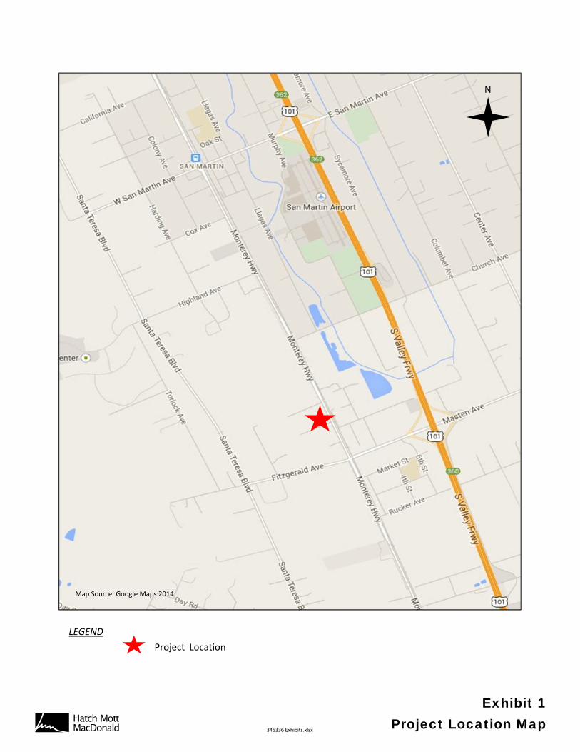
N
Map Source: Google Maps 2014
LEGEND
Project Location
AB 345336 Exhibits.xlsx
Exhibit 1Project Location Map
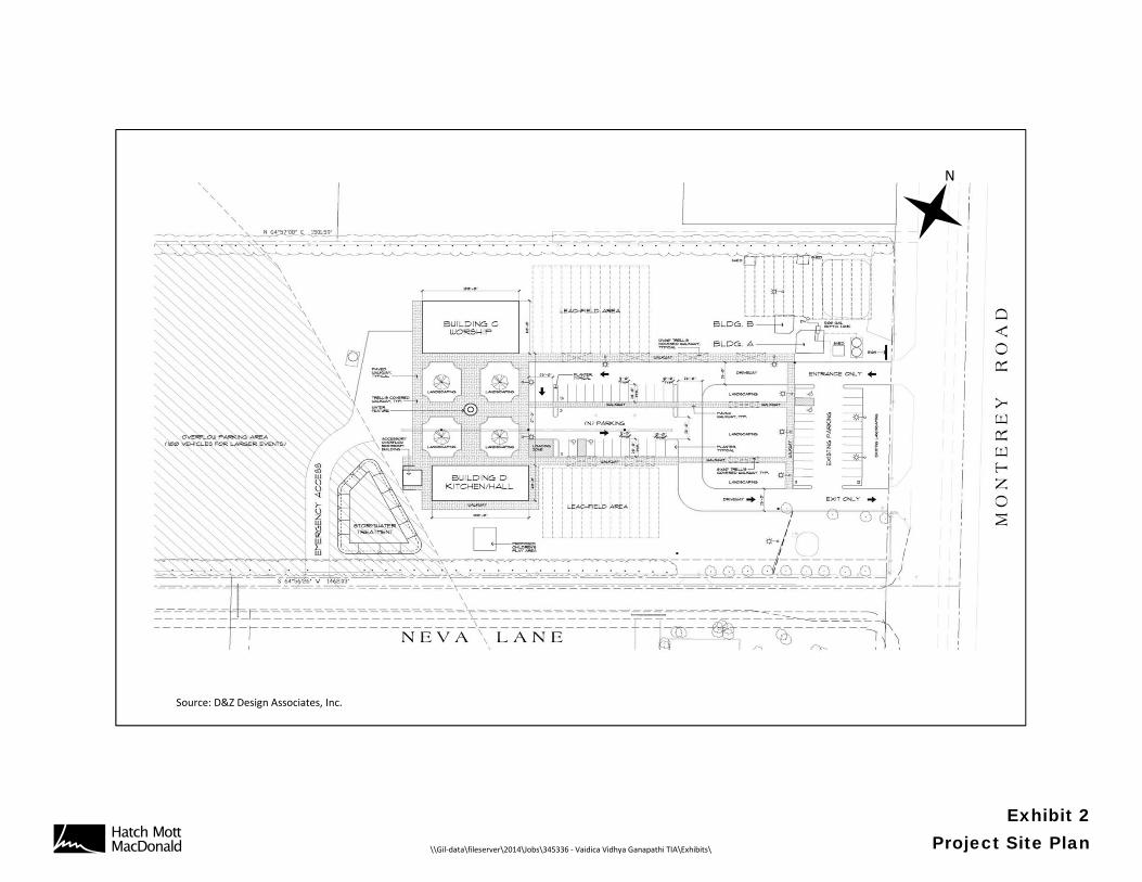
N
Source: D&Z Design Associates, Inc.
AB \\Gil‐data\fileserver\2014\Jobs\345336 ‐ Vaidica Vidhya Ganapathi TIA\Exhibits\
Exhibit 2Project Site Plan
AB 345336 Exhibits.xlsx
Exhibit 3VTA Transit Routes
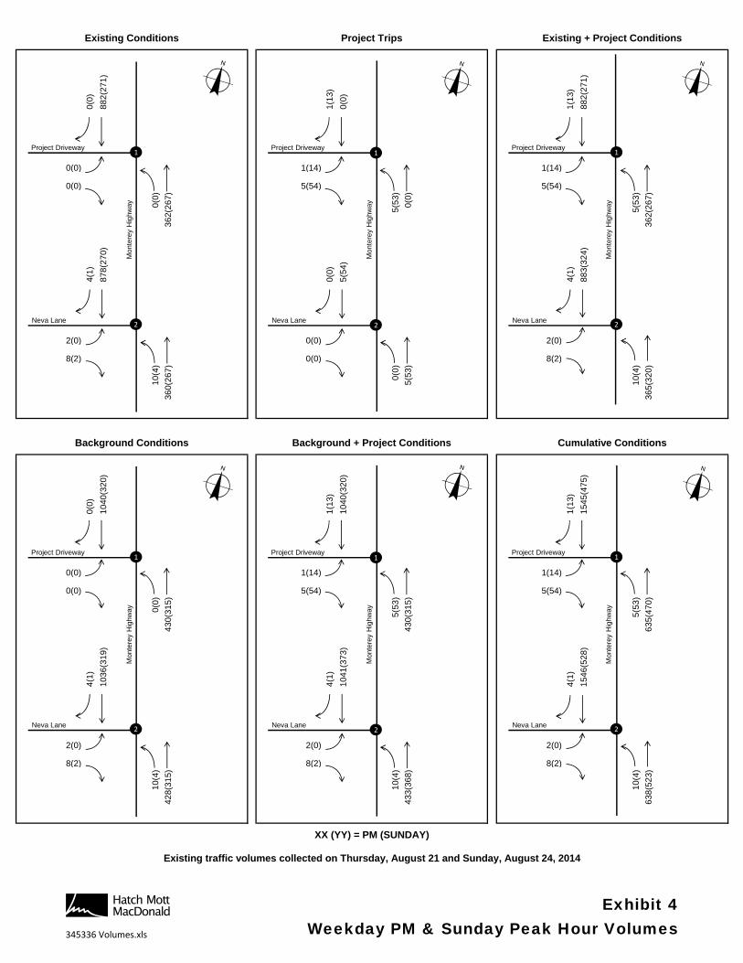
0(0
)
88
2(2
71
)
0(0
)
1(1
3)
0(0
)
0(0
)
1(1
3)
88
2(2
71
)
0(0
)
0(0) 0(0) 0(0)0(0) 0(0) 0(0)0(0) 0(0) 0(0)
0(0) 1(14) 1(14)0(0) 0(0) 0(0)0(0) 5(54) 5(54)
0(0
)
36
2(2
67
)
0(0
)
5(5
3)
0(0
)
0(0
)
5(5
3)
36
2(2
67
)
0(0
)
4(1
)
87
8(2
70
)
0(0
)
0(0
)
5(5
4)
0(0
)
4(1
)
88
3(3
24
)
0(0
)
0(0) 0(0) 0(0)0(0) 0(0) 0(0)0(0) 0(0) 0(0)
2(0) 0(0) 2(0)0(0) 0(0) 0(0)8(2) 0(0) 8(2)
10
(4)
36
0(2
67
)
0(0
)
0(0
)
5(5
3)
0(0
)
10
(4)
36
5(3
20
)
0(0
)
0(0
)
10
40
(32
0)
0(0
)
1(1
3)
10
40
(32
0)
0(0
)
1(1
3)
15
45
(47
5)
0(0
)
0(0) 0(0) 0(0)0(0) 0(0) 0(0)0(0) 0(0) 0(0)
0(0) 1(14) 1(14)0(0) 0(0) 0(0)0(0) 5(54) 5(54)
0(0
)
43
0(3
15
)
0(0
)
5(5
3)
43
0(3
15
)
0(0
)
5(5
3)
63
5(4
70
)
0(0
)
4(1
)
10
36
(31
9)
0(0
)
4(1
)
10
41
(37
3)
0(0
)
4(1
)
15
46
(52
8)
0(0
)
0(0) 0(0) 0(0)0(0) 0(0) 0(0)0(0) 0(0) 0(0)
2(0) 2(0) 2(0)0(0) 0(0) 0(0)8(2) 8(2) 8(2)
10
(4)
42
8(3
15
)
0(0
)
10
(4)
43
3(3
68
)
0(0
)
10
(4)
63
8(5
23
)
0(0
)
XX (YY) = PM (SUNDAY)
Existing + Project Conditions
Cumulative Conditions
Existing traffic volumes collected on Thursday, August 21 and Sunday, August 24, 2014
Background Conditions Background + Project Conditions
Existing Conditions Project Trips
Mon
tere
y H
ighw
ay
Project Driveway
Mon
tere
y H
ighw
ay
Neva Lane
1
2
Project Driveway
Mon
tere
y H
ighw
ay
Neva Lane
1
2
Project Driveway
Mon
tere
y H
ighw
ay
Neva Lane
1
2
Project Driveway
Mon
tere
y H
ighw
ay
Neva Lane
1
2
Project Driveway
Neva Lane
1
2
Mon
tere
y H
ighw
ay
Project Driveway
Neva Lane
1
2
AB345336 Volumes.xls
Exhibit 4Weekday PM & Sunday Peak Hour Volumes
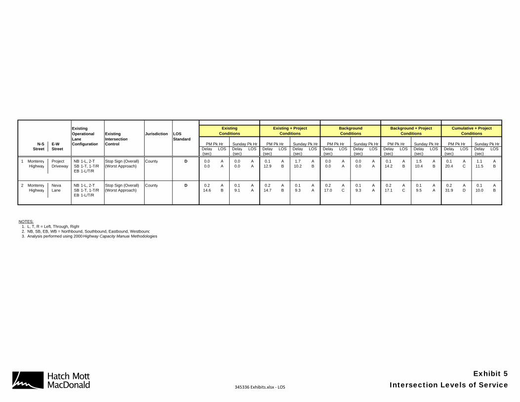
ExistingOperational Existing Jurisdiction LOSLane Intersection Standard
N-S E-W Configuration ControlStreet Street Delay LOS Delay LOS Delay LOS Delay LOS Delay LOS Delay LOS Delay LOS Delay LOS Delay LOS Delay LOS
(sec) (sec) (sec) (sec) (sec) (sec) (sec) (sec) (sec) (sec)
1 Monterey Project NB 1-L, 2-T Stop Sign (Overall) County D 0.0 A 0.0 A 0.1 A 1.7 A 0.0 A 0.0 A 0.1 A 1.5 A 0.1 A 1.1 AHighway Driveway SB 1-T, 1-T/R (Worst Approach) 0.0 A 0.0 A 12.9 B 10.2 B 0.0 A 0.0 A 14.2 B 10.4 B 20.4 C 11.5 B
EB 1-L/T/R
2 Monterey Neva NB 1-L, 2-T Stop Sign (Overall) County D 0.2 A 0.1 A 0.2 A 0.1 A 0.2 A 0.1 A 0.2 A 0.1 A 0.2 A 0.1 AHighway Lane SB 1-T, 1-T/R (Worst Approach) 14.6 B 9.1 A 14.7 B 9.3 A 17.0 C 9.3 A 17.1 C 9.5 A 31.9 D 10.0 B
EB 1-L/T/R
NOTES:1. L, T, R = Left, Through, Right2. NB, SB, EB, WB = Northbound, Southbound, Eastbound, Westbound3. Analysis performed using 2000 Highway Capacity Manual Methodologies
Background + ProjectConditions
PM Pk Hr Sunday Pk Hr
Cumulative + ProjectConditions
PM Pk Hr Sunday Pk Hr
ExistingConditions
Existing + ProjectConditions
BackgroundConditions
PM Pk Hr Sunday Pk Hr PM Pk Hr Sunday Pk Hr PM Pk Hr Sunday Pk Hr
AB 345336 Exhibits.xlsx ‐ LOS
Exhibit 5Intersection Levels of Service
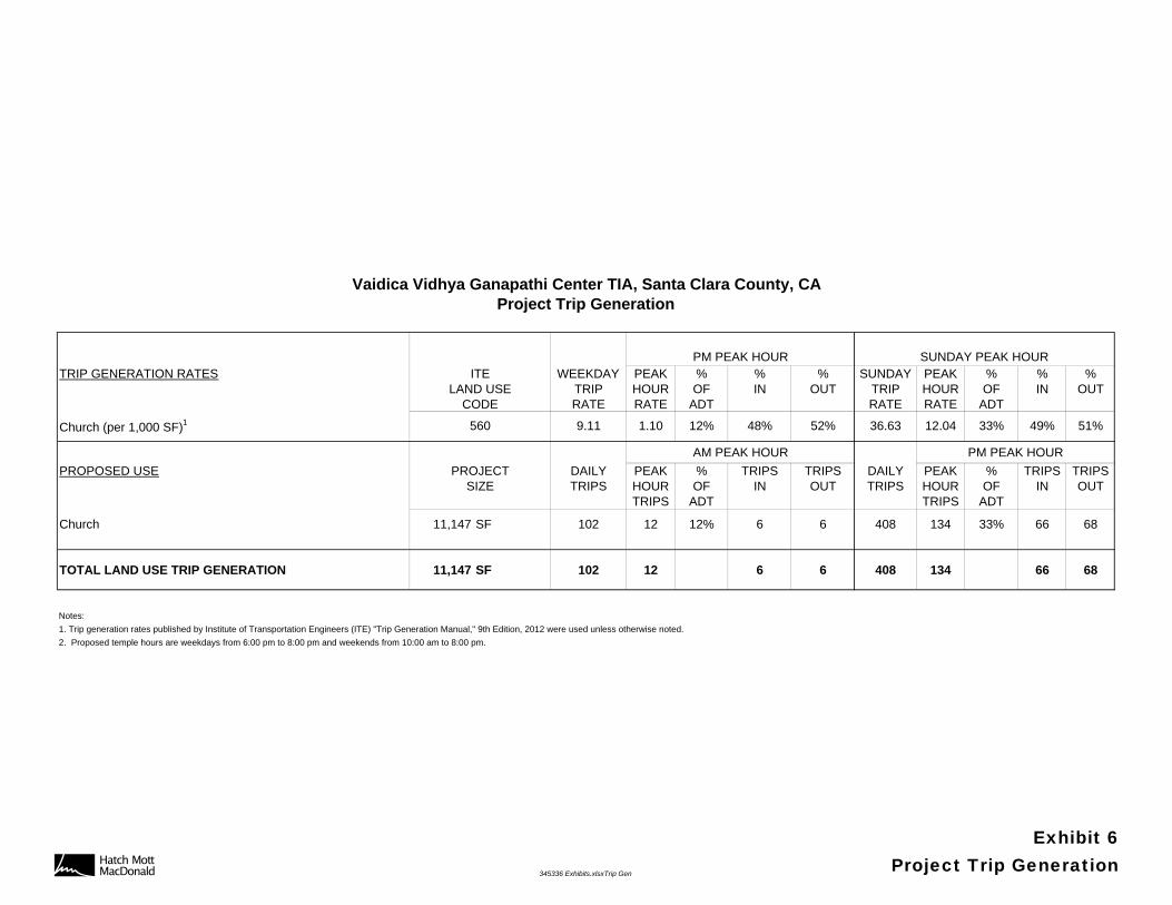
PM PEAK HOUR SUNDAY PEAK HOURTRIP GENERATION RATES ITE WEEKDAY PEAK % % % SUNDAY PEAK % % %
LAND USE TRIP HOUR OF IN OUT TRIP HOUR OF IN OUTCODE RATE RATE ADT RATE RATE ADT
Church (per 1,000 SF)1 560 9.11 1.10 12% 48% 52% 36.63 12.04 33% 49% 51%
AM PEAK HOUR PM PEAK HOUR
PROPOSED USE PROJECT DAILY PEAK % TRIPS TRIPS DAILY PEAK % TRIPS TRIPSSIZE TRIPS HOUR OF IN OUT TRIPS HOUR OF IN OUT
TRIPS ADT TRIPS ADT
Church 11,147 SF 102 12 12% 6 6 408 134 33% 66 68
TOTAL LAND USE TRIP GENERATION 11,147 SF 102 12 6 6 408 134 66 68
Notes:
1. Trip generation rates published by Institute of Transportation Engineers (ITE) "Trip Generation Manual," 9th Edition, 2012 were used unless otherwise noted.
2. Proposed temple hours are weekdays from 6:00 pm to 8:00 pm and weekends from 10:00 am to 8:00 pm.
Vaidica Vidhya Ganapathi Center TIA, Santa Clara County, CAProject Trip Generation
AB 345336 Exhibits.xlsxTrip Gen
Exhibit 6Project Trip Generation

APPENDIX A
TRAFFIC COUNTS

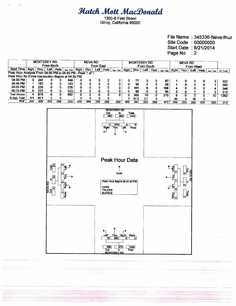

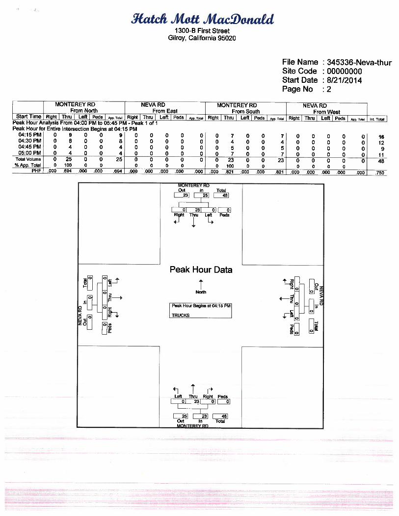
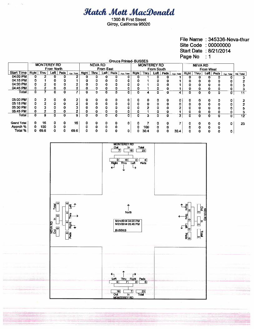
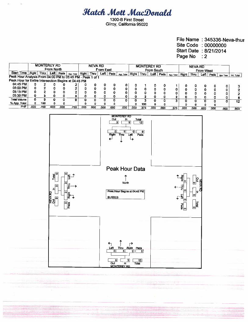
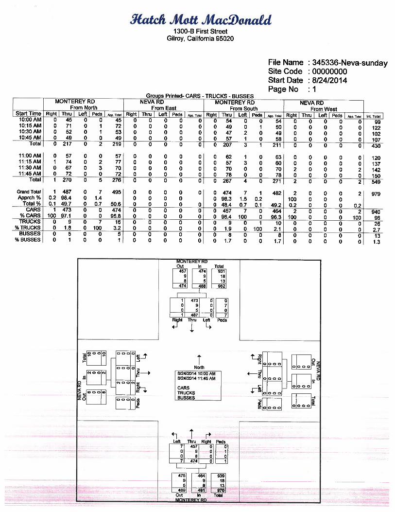

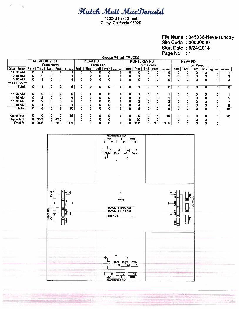
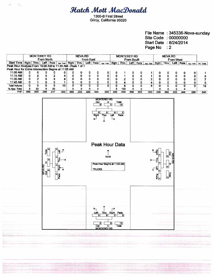
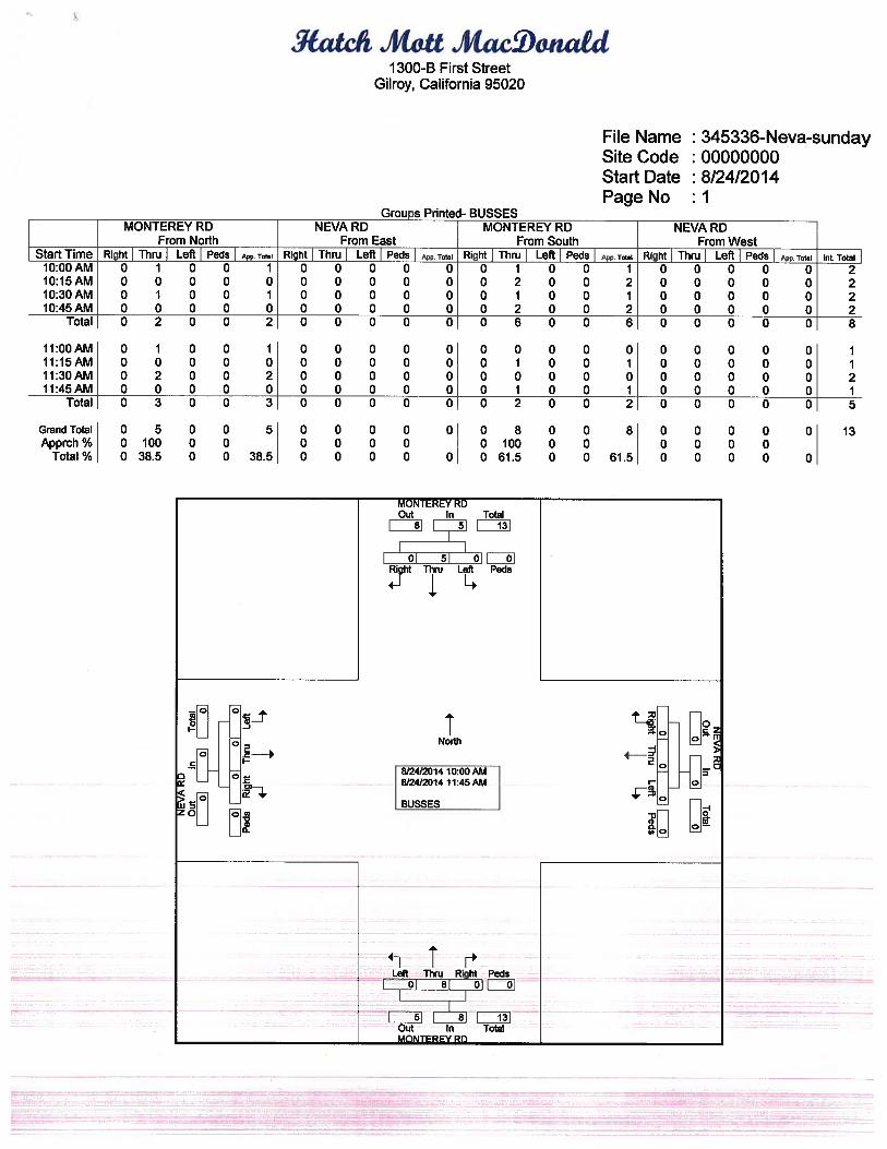
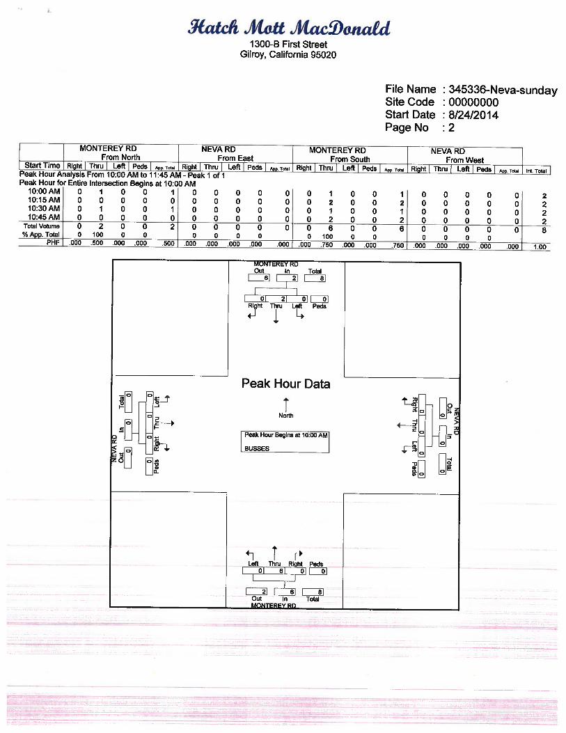
APPENDIX B
LEVEL OF SERVICE (LOS) DESCRIPTION UNSIGNALIZED INTERSECTIONS WITH TWO-WAY STOP CONTROL (TWSC)
TWSC intersections are widely used and stop signs are used to control vehicle movements at such intersections. At TWSC intersections, the stop-controlled approaches are referred to as the minor street approaches; they can be either public streets or private driveways. The intersection approaches that are not controlled by stop signs are referred to as the major street approaches. A three-leg intersection is considered to be a standard type of TWSC intersection if the single minor street approach (i.e. the stem of the T configuration) is controlled by a stop sign. Three-leg intersections where two of the three approaches are controlled by stop signs are a special form of unsignalized intersection control. At TWSC intersections, drivers on the controlled approaches are required to select gaps in the major street flow through which to execute crossing or turning maneuvers on the basis of judgement. In the presence of a queue, each driver on the controlled approach must use some time to move into the front-of-queue position and prepare to evaluate gaps in the major street flow. Capacity analysis at TWSC intersections depends on a clear description and understanding of the interaction of drivers on the minor or stop-controlled approach with drivers on the major street. Both gap acceptance and empirical models have been developed to describe this interaction. Thus, the capacity of the controlled legs is based on three factors: • the distribution of gaps in the major street traffic stream,; • driver judgement in selecting gaps through which to execute the desired maneuvers; and • the follow-up time required by each driver in a queue. The delay experienced by a motorist is made up of a number of factors that relate to control, geometrics, traffic and incidents. Total delay is the difference between the travel time actually experienced and the reference travel time that would result during base conditions, in the absence of incident, control, traffic or geometric delay. Average control delay for any particular minor movement is a function of the capacity of the approach and the degree of saturation and referred to as level of service.
LEVEL OF SERVICE (LOS) CRITERIA FOR TWSC INTERSECTIONS (Reference Highway Capacity Manual 2000)
Level of Service Control Delay (seconds / vehicle)
A 0 - 10
B >10 - 15
C >15 - 25
D >25 - 35
E >35 - 50
F >50

APPENDIX C
INTERSECTION LEVEL OF SERVICE WORKSHEETS
Existing PM Wed Sep 3, 2014 14:43:21 Page 2-1 -------------------------------------------------------------------------------- -------------------------------------------------------------------------------- Level Of Service Computation Report 2000 HCM Unsignalized Method (Base Volume Alternative) ******************************************************************************** Intersection #1 Monterey Hwy / Project Dwy ******************************************************************************** Average Delay (sec/veh): 0.0 Worst Case Level Of Service: A[ 0.0] ******************************************************************************** Street Name: Monterey Hwy Project Dwy Approach: North Bound South Bound East Bound West Bound Movement: L - T - R L - T - R L - T - R L - T - R ------------|---------------||---------------||---------------||---------------| Control: Uncontrolled Uncontrolled Stop Sign Stop Sign Rights: Include Include Include Include Lanes: 1 0 2 0 0 0 0 1 1 0 0 0 1! 0 0 0 0 0 0 0 ------------|---------------||---------------||---------------||---------------| Volume Module: >> Count Date: 21 Aug 2014 << 4:30 - 5:30 PM Base Vol: 0 362 0 0 882 0 0 0 0 0 0 0 Growth Adj: 1.00 1.00 1.00 1.00 1.00 1.00 1.00 1.00 1.00 1.00 1.00 1.00 Initial Bse: 0 362 0 0 882 0 0 0 0 0 0 0 User Adj: 1.00 1.00 1.00 1.00 1.00 1.00 1.00 1.00 1.00 1.00 1.00 1.00 PHF Adj: 0.91 0.91 0.91 0.91 0.91 0.91 0.91 0.91 0.91 0.91 0.91 0.91 PHF Volume: 0 398 0 0 969 0 0 0 0 0 0 0 Reduct Vol: 0 0 0 0 0 0 0 0 0 0 0 0 FinalVolume: 0 398 0 0 969 0 0 0 0 0 0 0 ------------|---------------||---------------||---------------||---------------| Critical Gap Module: Critical Gp:xxxxx xxxx xxxxx xxxxx xxxx xxxxx 6.8 6.5 6.9 xxxxx xxxx xxxxx FollowUpTim:xxxxx xxxx xxxxx xxxxx xxxx xxxxx 3.5 4.0 3.3 xxxxx xxxx xxxxx ------------|---------------||---------------||---------------||---------------| Capacity Module: Cnflict Vol: xxxx xxxx xxxxx xxxx xxxx xxxxx 1168 1367 485 xxxx xxxx xxxxx Potent Cap.: xxxx xxxx xxxxx xxxx xxxx xxxxx 189 148 534 xxxx xxxx xxxxx Move Cap.: xxxx xxxx xxxxx xxxx xxxx xxxxx 189 148 534 xxxx xxxx xxxxx Total Cap: xxxx xxxx xxxxx xxxx xxxx xxxxx 280 256 xxxxx 415 256 xxxxx Volume/Cap: xxxx xxxx xxxx xxxx xxxx xxxx 0.00 0.00 0.00 xxxx xxxx xxxx ------------|---------------||---------------||---------------||---------------| Level Of Service Module: 2Way95thQ: xxxx xxxx xxxxx xxxx xxxx xxxxx xxxx xxxx xxxxx xxxx xxxx xxxxx Control Del:xxxxx xxxx xxxxx xxxxx xxxx xxxxx xxxxx xxxx xxxxx xxxxx xxxx xxxxx LOS by Move: * * * * * * * * * * * * Movement: LT - LTR - RT LT - LTR - RT LT - LTR - RT LT - LTR - RT Shared Cap.: xxxx xxxx xxxxx xxxx xxxx xxxxx xxxx 0 xxxxx xxxx xxxx xxxxx SharedQueue:xxxxx xxxx xxxxx xxxxx xxxx xxxxx xxxxx xxxx xxxxx xxxxx xxxx xxxxx Shrd ConDel:xxxxx xxxx xxxxx xxxxx xxxx xxxxx xxxxx xxxx xxxxx xxxxx xxxx xxxxx Shared LOS: * * * * * * * * * * * * ApproachDel: xxxxxx xxxxxx xxxxxx xxxxxx ApproachLOS: * * * * ******************************************************************************** Note: Queue reported is the number of cars per lane. ******************************************************************************** Traffix 8.0.0715 (c) 2008 Dowling Assoc. Licensed to HIGGINS ASSOC., GILROY

Existing PM Wed Sep 3, 2014 14:43:21 Page 3-1 -------------------------------------------------------------------------------- -------------------------------------------------------------------------------- Level Of Service Computation Report 2000 HCM Unsignalized Method (Base Volume Alternative) ******************************************************************************** Intersection #2 Monterey Hwy / Neva Lane ******************************************************************************** Average Delay (sec/veh): 0.2 Worst Case Level Of Service: B[ 14.6] ******************************************************************************** Street Name: Monterey Hwy Neva Lane Approach: North Bound South Bound East Bound West Bound Movement: L - T - R L - T - R L - T - R L - T - R ------------|---------------||---------------||---------------||---------------| Control: Uncontrolled Uncontrolled Stop Sign Stop Sign Rights: Include Include Include Include Lanes: 1 0 2 0 0 0 0 1 1 0 0 0 1! 0 0 0 0 0 0 0 ------------|---------------||---------------||---------------||---------------| Volume Module: >> Count Date: 21 Aug 2014 << 4:30 - 5:30 PM Base Vol: 10 360 0 0 878 4 2 0 8 0 0 0 Growth Adj: 1.00 1.00 1.00 1.00 1.00 1.00 1.00 1.00 1.00 1.00 1.00 1.00 Initial Bse: 10 360 0 0 878 4 2 0 8 0 0 0 User Adj: 1.00 1.00 1.00 1.00 1.00 1.00 1.00 1.00 1.00 1.00 1.00 1.00 PHF Adj: 0.91 0.91 0.91 0.91 0.91 0.91 0.91 0.91 0.91 0.91 0.91 0.91 PHF Volume: 11 396 0 0 965 4 2 0 9 0 0 0 Reduct Vol: 0 0 0 0 0 0 0 0 0 0 0 0 FinalVolume: 11 396 0 0 965 4 2 0 9 0 0 0 ------------|---------------||---------------||---------------||---------------| Critical Gap Module: Critical Gp: 4.1 xxxx xxxxx xxxxx xxxx xxxxx 6.8 6.5 6.9 xxxxx xxxx xxxxx FollowUpTim: 2.2 xxxx xxxxx xxxxx xxxx xxxxx 3.5 4.0 3.3 xxxxx xxxx xxxxx ------------|---------------||---------------||---------------||---------------| Capacity Module: Cnflict Vol: 969 xxxx xxxxx xxxx xxxx xxxxx 1187 1385 485 xxxx xxxx xxxxx Potent Cap.: 719 xxxx xxxxx xxxx xxxx xxxxx 184 145 534 xxxx xxxx xxxxx Move Cap.: 719 xxxx xxxxx xxxx xxxx xxxxx 182 143 534 xxxx xxxx xxxxx Volume/Cap: 0.02 xxxx xxxx xxxx xxxx xxxx 0.01 0.00 0.02 xxxx xxxx xxxx ------------|---------------||---------------||---------------||---------------| Level Of Service Module: 2Way95thQ: 0.0 xxxx xxxxx xxxx xxxx xxxxx xxxx xxxx xxxxx xxxx xxxx xxxxx Control Del: 10.1 xxxx xxxxx xxxxx xxxx xxxxx xxxxx xxxx xxxxx xxxxx xxxx xxxxx LOS by Move: B * * * * * * * * * * * Movement: LT - LTR - RT LT - LTR - RT LT - LTR - RT LT - LTR - RT Shared Cap.: xxxx xxxx xxxxx xxxx xxxx xxxxx xxxx 385 xxxxx xxxx xxxx xxxxx SharedQueue:xxxxx xxxx xxxxx xxxxx xxxx xxxxx xxxxx 0.1 xxxxx xxxxx xxxx xxxxx Shrd ConDel:xxxxx xxxx xxxxx xxxxx xxxx xxxxx xxxxx 14.6 xxxxx xxxxx xxxx xxxxx Shared LOS: * * * * * * * B * * * * ApproachDel: xxxxxx xxxxxx 14.6 xxxxxx ApproachLOS: * * B * ******************************************************************************** Note: Queue reported is the number of cars per lane. ******************************************************************************** Traffix 8.0.0715 (c) 2008 Dowling Assoc. Licensed to HIGGINS ASSOC., GILROY
Existing Sunday Wed Sep 3, 2014 14:47:31 Page 2-1 -------------------------------------------------------------------------------- -------------------------------------------------------------------------------- Level Of Service Computation Report 2000 HCM Unsignalized Method (Base Volume Alternative) ******************************************************************************** Intersection #1 Monterey Hwy / Project Dwy ******************************************************************************** Average Delay (sec/veh): 0.0 Worst Case Level Of Service: A[ 0.0] ******************************************************************************** Street Name: Monterey Hwy Project Dwy Approach: North Bound South Bound East Bound West Bound Movement: L - T - R L - T - R L - T - R L - T - R ------------|---------------||---------------||---------------||---------------| Control: Uncontrolled Uncontrolled Stop Sign Stop Sign Rights: Include Include Include Include Lanes: 1 0 2 0 0 0 0 1 1 0 0 0 1! 0 0 0 0 0 0 0 ------------|---------------||---------------||---------------||---------------| Volume Module: >> Count Date: 24 Aug 2014 << 11:00 AM - 12:00 PM Base Vol: 0 267 0 0 271 0 0 0 0 0 0 0 Growth Adj: 1.00 1.00 1.00 1.00 1.00 1.00 1.00 1.00 1.00 1.00 1.00 1.00 Initial Bse: 0 267 0 0 271 0 0 0 0 0 0 0 User Adj: 1.00 1.00 1.00 1.00 1.00 1.00 1.00 1.00 1.00 1.00 1.00 1.00 PHF Adj: 0.92 0.92 0.92 0.92 0.92 0.92 0.92 0.92 0.92 0.92 0.92 0.92 PHF Volume: 0 290 0 0 295 0 0 0 0 0 0 0 Reduct Vol: 0 0 0 0 0 0 0 0 0 0 0 0 FinalVolume: 0 290 0 0 295 0 0 0 0 0 0 0 ------------|---------------||---------------||---------------||---------------| Critical Gap Module: Critical Gp:xxxxx xxxx xxxxx xxxxx xxxx xxxxx 6.8 6.5 6.9 xxxxx xxxx xxxxx FollowUpTim:xxxxx xxxx xxxxx xxxxx xxxx xxxxx 3.5 4.0 3.3 xxxxx xxxx xxxxx ------------|---------------||---------------||---------------||---------------| Capacity Module: Cnflict Vol: xxxx xxxx xxxxx xxxx xxxx xxxxx 440 585 147 xxxx xxxx xxxxx Potent Cap.: xxxx xxxx xxxxx xxxx xxxx xxxxx 551 426 879 xxxx xxxx xxxxx Move Cap.: xxxx xxxx xxxxx xxxx xxxx xxxxx 551 426 879 xxxx xxxx xxxxx Total Cap: xxxx xxxx xxxxx xxxx xxxx xxxxx 610 502 xxxxx 612 502 xxxxx Volume/Cap: xxxx xxxx xxxx xxxx xxxx xxxx 0.00 0.00 0.00 xxxx xxxx xxxx ------------|---------------||---------------||---------------||---------------| Level Of Service Module: 2Way95thQ: xxxx xxxx xxxxx xxxx xxxx xxxxx xxxx xxxx xxxxx xxxx xxxx xxxxx Control Del:xxxxx xxxx xxxxx xxxxx xxxx xxxxx xxxxx xxxx xxxxx xxxxx xxxx xxxxx LOS by Move: * * * * * * * * * * * * Movement: LT - LTR - RT LT - LTR - RT LT - LTR - RT LT - LTR - RT Shared Cap.: xxxx xxxx xxxxx xxxx xxxx xxxxx xxxx 0 xxxxx xxxx xxxx xxxxx SharedQueue:xxxxx xxxx xxxxx xxxxx xxxx xxxxx xxxxx xxxx xxxxx xxxxx xxxx xxxxx Shrd ConDel:xxxxx xxxx xxxxx xxxxx xxxx xxxxx xxxxx xxxx xxxxx xxxxx xxxx xxxxx Shared LOS: * * * * * * * * * * * * ApproachDel: xxxxxx xxxxxx xxxxxx xxxxxx ApproachLOS: * * * * ******************************************************************************** Note: Queue reported is the number of cars per lane. ******************************************************************************** Traffix 8.0.0715 (c) 2008 Dowling Assoc. Licensed to HIGGINS ASSOC., GILROY
Existing Sunday Wed Sep 3, 2014 14:47:31 Page 3-1 -------------------------------------------------------------------------------- -------------------------------------------------------------------------------- Level Of Service Computation Report 2000 HCM Unsignalized Method (Base Volume Alternative) ******************************************************************************** Intersection #2 Monterey Hwy / Neva Lane ******************************************************************************** Average Delay (sec/veh): 0.1 Worst Case Level Of Service: A[ 9.1] ******************************************************************************** Street Name: Monterey Hwy Neva Lane Approach: North Bound South Bound East Bound West Bound Movement: L - T - R L - T - R L - T - R L - T - R ------------|---------------||---------------||---------------||---------------| Control: Uncontrolled Uncontrolled Stop Sign Stop Sign Rights: Include Include Include Include Lanes: 1 0 2 0 0 0 0 1 1 0 0 0 0 0 1 0 0 0 0 0 ------------|---------------||---------------||---------------||---------------| Volume Module: >> Count Date: 24 Aug 2014 << 11:00 AM - 12:00 PM Base Vol: 4 267 0 0 270 1 0 0 2 0 0 0 Growth Adj: 1.00 1.00 1.00 1.00 1.00 1.00 1.00 1.00 1.00 1.00 1.00 1.00 Initial Bse: 4 267 0 0 270 1 0 0 2 0 0 0 User Adj: 1.00 1.00 1.00 1.00 1.00 1.00 1.00 1.00 1.00 1.00 1.00 1.00 PHF Adj: 0.92 0.92 0.92 0.92 0.92 0.92 0.92 0.92 0.92 0.92 0.92 0.92 PHF Volume: 4 290 0 0 293 1 0 0 2 0 0 0 Reduct Vol: 0 0 0 0 0 0 0 0 0 0 0 0 FinalVolume: 4 290 0 0 293 1 0 0 2 0 0 0 ------------|---------------||---------------||---------------||---------------| Critical Gap Module: Critical Gp: 4.1 xxxx xxxxx xxxxx xxxx xxxxx xxxxx xxxx 6.9 xxxxx xxxx xxxxx FollowUpTim: 2.2 xxxx xxxxx xxxxx xxxx xxxxx xxxxx xxxx 3.3 xxxxx xxxx xxxxx ------------|---------------||---------------||---------------||---------------| Capacity Module: Cnflict Vol: 295 xxxx xxxxx xxxx xxxx xxxxx xxxx xxxx 147 xxxx xxxx xxxxx Potent Cap.: 1278 xxxx xxxxx xxxx xxxx xxxxx xxxx xxxx 879 xxxx xxxx xxxxx Move Cap.: 1278 xxxx xxxxx xxxx xxxx xxxxx xxxx xxxx 879 xxxx xxxx xxxxx Volume/Cap: 0.00 xxxx xxxx xxxx xxxx xxxx xxxx xxxx 0.00 xxxx xxxx xxxx ------------|---------------||---------------||---------------||---------------| Level Of Service Module: 2Way95thQ: 0.0 xxxx xxxxx xxxx xxxx xxxxx xxxx xxxx 0.0 xxxx xxxx xxxxx Control Del: 7.8 xxxx xxxxx xxxxx xxxx xxxxx xxxxx xxxx 9.1 xxxxx xxxx xxxxx LOS by Move: A * * * * * * * A * * * Movement: LT - LTR - RT LT - LTR - RT LT - LTR - RT LT - LTR - RT Shared Cap.: xxxx xxxx xxxxx xxxx xxxx xxxxx xxxx xxxx xxxxx xxxx xxxx xxxxx SharedQueue:xxxxx xxxx xxxxx xxxxx xxxx xxxxx xxxxx xxxx xxxxx xxxxx xxxx xxxxx Shrd ConDel:xxxxx xxxx xxxxx xxxxx xxxx xxxxx xxxxx xxxx xxxxx xxxxx xxxx xxxxx Shared LOS: * * * * * * * * * * * * ApproachDel: xxxxxx xxxxxx 9.1 xxxxxx ApproachLOS: * * A * ******************************************************************************** Note: Queue reported is the number of cars per lane. ******************************************************************************** Traffix 8.0.0715 (c) 2008 Dowling Assoc. Licensed to HIGGINS ASSOC., GILROY

Ex + Project PM Fri Sep 5, 2014 13:38:24 Page 2-1 -------------------------------------------------------------------------------- -------------------------------------------------------------------------------- Level Of Service Computation Report 2000 HCM Unsignalized Method (Base Volume Alternative) ******************************************************************************** Intersection #1 Monterey Hwy / Project Dwy ******************************************************************************** Average Delay (sec/veh): 0.1 Worst Case Level Of Service: B[ 12.9] ******************************************************************************** Street Name: Monterey Hwy Project Dwy Approach: North Bound South Bound East Bound West Bound Movement: L - T - R L - T - R L - T - R L - T - R ------------|---------------||---------------||---------------||---------------| Control: Uncontrolled Uncontrolled Stop Sign Stop Sign Rights: Include Include Include Include Lanes: 1 0 2 0 0 0 0 1 1 0 0 0 1! 0 0 0 0 0 0 0 ------------|---------------||---------------||---------------||---------------| Volume Module: Base Vol: 5 362 0 0 882 1 1 0 5 0 0 0 Growth Adj: 1.00 1.00 1.00 1.00 1.00 1.00 1.00 1.00 1.00 1.00 1.00 1.00 Initial Bse: 5 362 0 0 882 1 1 0 5 0 0 0 User Adj: 1.00 1.00 1.00 1.00 1.00 1.00 1.00 1.00 1.00 1.00 1.00 1.00 PHF Adj: 0.91 0.91 0.91 0.91 0.91 0.91 0.91 0.91 0.91 0.91 0.91 0.91 PHF Volume: 5 398 0 0 969 1 1 0 5 0 0 0 Reduct Vol: 0 0 0 0 0 0 0 0 0 0 0 0 FinalVolume: 5 398 0 0 969 1 1 0 5 0 0 0 ------------|---------------||---------------||---------------||---------------| Critical Gap Module: Critical Gp: 4.1 xxxx xxxxx xxxxx xxxx xxxxx 6.8 6.5 6.9 xxxxx xxxx xxxxx FollowUpTim: 2.2 xxxx xxxxx xxxxx xxxx xxxxx 3.5 4.0 3.3 xxxxx xxxx xxxxx ------------|---------------||---------------||---------------||---------------| Capacity Module: Cnflict Vol: 970 xxxx xxxxx xxxx xxxx xxxxx 1180 1379 485 xxxx xxxx xxxxx Potent Cap.: 718 xxxx xxxxx xxxx xxxx xxxxx 186 146 533 xxxx xxxx xxxxx Move Cap.: 718 xxxx xxxxx xxxx xxxx xxxxx 185 145 533 xxxx xxxx xxxxx Total Cap: xxxx xxxx xxxxx xxxx xxxx xxxxx 278 254 xxxxx 361 251 xxxxx Volume/Cap: 0.01 xxxx xxxx xxxx xxxx xxxx 0.00 0.00 0.01 xxxx xxxx xxxx ------------|---------------||---------------||---------------||---------------| Level Of Service Module: 2Way95thQ: 0.0 xxxx xxxxx xxxx xxxx xxxxx xxxx xxxx xxxxx xxxx xxxx xxxxx Control Del: 10.0 xxxx xxxxx xxxxx xxxx xxxxx xxxxx xxxx xxxxx xxxxx xxxx xxxxx LOS by Move: B * * * * * * * * * * * Movement: LT - LTR - RT LT - LTR - RT LT - LTR - RT LT - LTR - RT Shared Cap.: xxxx xxxx xxxxx xxxx xxxx xxxxx xxxx 462 xxxxx xxxx xxxx xxxxx SharedQueue:xxxxx xxxx xxxxx xxxxx xxxx xxxxx xxxxx 0.0 xxxxx xxxxx xxxx xxxxx Shrd ConDel:xxxxx xxxx xxxxx xxxxx xxxx xxxxx xxxxx 12.9 xxxxx xxxxx xxxx xxxxx Shared LOS: * * * * * * * B * * * * ApproachDel: xxxxxx xxxxxx 12.9 xxxxxx ApproachLOS: * * B * ******************************************************************************** Note: Queue reported is the number of cars per lane. ******************************************************************************** Traffix 8.0.0715 (c) 2008 Dowling Assoc. Licensed to HIGGINS ASSOC., GILROY
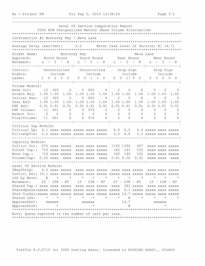
Ex + Project PM Fri Sep 5, 2014 13:38:24 Page 3-1 -------------------------------------------------------------------------------- -------------------------------------------------------------------------------- Level Of Service Computation Report 2000 HCM Unsignalized Method (Base Volume Alternative) ******************************************************************************** Intersection #2 Monterey Hwy / Neva Lane ******************************************************************************** Average Delay (sec/veh): 0.2 Worst Case Level Of Service: B[ 14.7] ******************************************************************************** Street Name: Monterey Hwy Neva Lane Approach: North Bound South Bound East Bound West Bound Movement: L - T - R L - T - R L - T - R L - T - R ------------|---------------||---------------||---------------||---------------| Control: Uncontrolled Uncontrolled Stop Sign Stop Sign Rights: Include Include Include Include Lanes: 1 0 2 0 0 0 0 1 1 0 0 0 1! 0 0 0 0 0 0 0 ------------|---------------||---------------||---------------||---------------| Volume Module: Base Vol: 10 365 0 0 883 4 2 0 8 0 0 0 Growth Adj: 1.00 1.00 1.00 1.00 1.00 1.00 1.00 1.00 1.00 1.00 1.00 1.00 Initial Bse: 10 365 0 0 883 4 2 0 8 0 0 0 User Adj: 1.00 1.00 1.00 1.00 1.00 1.00 1.00 1.00 1.00 1.00 1.00 1.00 PHF Adj: 0.91 0.91 0.91 0.91 0.91 0.91 0.91 0.91 0.91 0.91 0.91 0.91 PHF Volume: 11 401 0 0 970 4 2 0 9 0 0 0 Reduct Vol: 0 0 0 0 0 0 0 0 0 0 0 0 FinalVolume: 11 401 0 0 970 4 2 0 9 0 0 0 ------------|---------------||---------------||---------------||---------------| Critical Gap Module: Critical Gp: 4.1 xxxx xxxxx xxxxx xxxx xxxxx 6.8 6.5 6.9 xxxxx xxxx xxxxx FollowUpTim: 2.2 xxxx xxxxx xxxxx xxxx xxxxx 3.5 4.0 3.3 xxxxx xxxx xxxxx ------------|---------------||---------------||---------------||---------------| Capacity Module: Cnflict Vol: 975 xxxx xxxxx xxxx xxxx xxxxx 1195 1396 487 xxxx xxxx xxxxx Potent Cap.: 716 xxxx xxxxx xxxx xxxx xxxxx 182 143 532 xxxx xxxx xxxxx Move Cap.: 716 xxxx xxxxx xxxx xxxx xxxxx 180 140 532 xxxx xxxx xxxxx Volume/Cap: 0.02 xxxx xxxx xxxx xxxx xxxx 0.01 0.00 0.02 xxxx xxxx xxxx ------------|---------------||---------------||---------------||---------------| Level Of Service Module: 2Way95thQ: 0.0 xxxx xxxxx xxxx xxxx xxxxx xxxx xxxx xxxxx xxxx xxxx xxxxx Control Del: 10.1 xxxx xxxxx xxxxx xxxx xxxxx xxxxx xxxx xxxxx xxxxx xxxx xxxxx LOS by Move: B * * * * * * * * * * * Movement: LT - LTR - RT LT - LTR - RT LT - LTR - RT LT - LTR - RT Shared Cap.: xxxx xxxx xxxxx xxxx xxxx xxxxx xxxx 382 xxxxx xxxx xxxx xxxxx SharedQueue:xxxxx xxxx xxxxx xxxxx xxxx xxxxx xxxxx 0.1 xxxxx xxxxx xxxx xxxxx Shrd ConDel:xxxxx xxxx xxxxx xxxxx xxxx xxxxx xxxxx 14.7 xxxxx xxxxx xxxx xxxxx Shared LOS: * * * * * * * B * * * * ApproachDel: xxxxxx xxxxxx 14.7 xxxxxx ApproachLOS: * * B * ******************************************************************************** Note: Queue reported is the number of cars per lane. ******************************************************************************** Traffix 8.0.0715 (c) 2008 Dowling Assoc. Licensed to HIGGINS ASSOC., GILROY

Ex + Project Sunday Fri Sep 5, 2014 13:37:53 Page 2-1 -------------------------------------------------------------------------------- -------------------------------------------------------------------------------- Level Of Service Computation Report 2000 HCM Unsignalized Method (Base Volume Alternative) ******************************************************************************** Intersection #1 Monterey Hwy / Project Dwy ******************************************************************************** Average Delay (sec/veh): 1.7 Worst Case Level Of Service: B[ 10.2] ******************************************************************************** Street Name: Monterey Hwy Project Dwy Approach: North Bound South Bound East Bound West Bound Movement: L - T - R L - T - R L - T - R L - T - R ------------|---------------||---------------||---------------||---------------| Control: Uncontrolled Uncontrolled Stop Sign Stop Sign Rights: Include Include Include Include Lanes: 1 0 2 0 0 0 0 1 1 0 0 0 1! 0 0 0 0 0 0 0 ------------|---------------||---------------||---------------||---------------| Volume Module: Base Vol: 53 267 0 0 271 13 14 0 54 0 0 0 Growth Adj: 1.00 1.00 1.00 1.00 1.00 1.00 1.00 1.00 1.00 1.00 1.00 1.00 Initial Bse: 53 267 0 0 271 13 14 0 54 0 0 0 User Adj: 1.00 1.00 1.00 1.00 1.00 1.00 1.00 1.00 1.00 1.00 1.00 1.00 PHF Adj: 0.92 0.92 0.92 0.92 0.92 0.92 0.92 0.92 0.92 0.92 0.92 0.92 PHF Volume: 58 290 0 0 295 14 15 0 59 0 0 0 Reduct Vol: 0 0 0 0 0 0 0 0 0 0 0 0 FinalVolume: 58 290 0 0 295 14 15 0 59 0 0 0 ------------|---------------||---------------||---------------||---------------| Critical Gap Module: Critical Gp: 4.1 xxxx xxxxx xxxxx xxxx xxxxx 6.8 6.5 6.9 xxxxx xxxx xxxxx FollowUpTim: 2.2 xxxx xxxxx xxxxx xxxx xxxxx 3.5 4.0 3.3 xxxxx xxxx xxxxx ------------|---------------||---------------||---------------||---------------| Capacity Module: Cnflict Vol: 309 xxxx xxxxx xxxx xxxx xxxxx 562 707 154 xxxx xxxx xxxxx Potent Cap.: 1263 xxxx xxxxx xxxx xxxx xxxxx 462 362 870 xxxx xxxx xxxxx Move Cap.: 1263 xxxx xxxxx xxxx xxxx xxxxx 446 346 870 xxxx xxxx xxxxx Total Cap: xxxx xxxx xxxxx xxxx xxxx xxxxx 537 438 xxxxx 459 425 xxxxx Volume/Cap: 0.05 xxxx xxxx xxxx xxxx xxxx 0.03 0.00 0.07 xxxx xxxx xxxx ------------|---------------||---------------||---------------||---------------| Level Of Service Module: 2Way95thQ: 0.1 xxxx xxxxx xxxx xxxx xxxxx xxxx xxxx xxxxx xxxx xxxx xxxxx Control Del: 8.0 xxxx xxxxx xxxxx xxxx xxxxx xxxxx xxxx xxxxx xxxxx xxxx xxxxx LOS by Move: A * * * * * * * * * * * Movement: LT - LTR - RT LT - LTR - RT LT - LTR - RT LT - LTR - RT Shared Cap.: xxxx xxxx xxxxx xxxx xxxx xxxxx xxxx 772 xxxxx xxxx xxxx xxxxx SharedQueue:xxxxx xxxx xxxxx xxxxx xxxx xxxxx xxxxx 0.3 xxxxx xxxxx xxxx xxxxx Shrd ConDel:xxxxx xxxx xxxxx xxxxx xxxx xxxxx xxxxx 10.2 xxxxx xxxxx xxxx xxxxx Shared LOS: * * * * * * * B * * * * ApproachDel: xxxxxx xxxxxx 10.2 xxxxxx ApproachLOS: * * B * ******************************************************************************** Note: Queue reported is the number of cars per lane. ******************************************************************************** Traffix 8.0.0715 (c) 2008 Dowling Assoc. Licensed to HIGGINS ASSOC., GILROY

Ex + Project Sunday Fri Sep 5, 2014 13:37:53 Page 3-1 -------------------------------------------------------------------------------- -------------------------------------------------------------------------------- Level Of Service Computation Report 2000 HCM Unsignalized Method (Base Volume Alternative) ******************************************************************************** Intersection #2 Monterey Hwy / Neva Lane ******************************************************************************** Average Delay (sec/veh): 0.1 Worst Case Level Of Service: A[ 9.3] ******************************************************************************** Street Name: Monterey Hwy Neva Lane Approach: North Bound South Bound East Bound West Bound Movement: L - T - R L - T - R L - T - R L - T - R ------------|---------------||---------------||---------------||---------------| Control: Uncontrolled Uncontrolled Stop Sign Stop Sign Rights: Include Include Include Include Lanes: 1 0 2 0 0 0 0 1 1 0 0 0 0 0 1 0 0 0 0 0 ------------|---------------||---------------||---------------||---------------| Volume Module: Base Vol: 4 320 0 0 324 1 0 0 2 0 0 0 Growth Adj: 1.00 1.00 1.00 1.00 1.00 1.00 1.00 1.00 1.00 1.00 1.00 1.00 Initial Bse: 4 320 0 0 324 1 0 0 2 0 0 0 User Adj: 1.00 1.00 1.00 1.00 1.00 1.00 1.00 1.00 1.00 1.00 1.00 1.00 PHF Adj: 0.92 0.92 0.92 0.92 0.92 0.92 0.92 0.92 0.92 0.92 0.92 0.92 PHF Volume: 4 348 0 0 352 1 0 0 2 0 0 0 Reduct Vol: 0 0 0 0 0 0 0 0 0 0 0 0 FinalVolume: 4 348 0 0 352 1 0 0 2 0 0 0 ------------|---------------||---------------||---------------||---------------| Critical Gap Module: Critical Gp: 4.1 xxxx xxxxx xxxxx xxxx xxxxx xxxxx xxxx 6.9 xxxxx xxxx xxxxx FollowUpTim: 2.2 xxxx xxxxx xxxxx xxxx xxxxx xxxxx xxxx 3.3 xxxxx xxxx xxxxx ------------|---------------||---------------||---------------||---------------| Capacity Module: Cnflict Vol: 353 xxxx xxxxx xxxx xxxx xxxxx xxxx xxxx 177 xxxx xxxx xxxxx Potent Cap.: 1217 xxxx xxxxx xxxx xxxx xxxxx xxxx xxxx 842 xxxx xxxx xxxxx Move Cap.: 1217 xxxx xxxxx xxxx xxxx xxxxx xxxx xxxx 842 xxxx xxxx xxxxx Volume/Cap: 0.00 xxxx xxxx xxxx xxxx xxxx xxxx xxxx 0.00 xxxx xxxx xxxx ------------|---------------||---------------||---------------||---------------| Level Of Service Module: 2Way95thQ: 0.0 xxxx xxxxx xxxx xxxx xxxxx xxxx xxxx 0.0 xxxx xxxx xxxxx Control Del: 8.0 xxxx xxxxx xxxxx xxxx xxxxx xxxxx xxxx 9.3 xxxxx xxxx xxxxx LOS by Move: A * * * * * * * A * * * Movement: LT - LTR - RT LT - LTR - RT LT - LTR - RT LT - LTR - RT Shared Cap.: xxxx xxxx xxxxx xxxx xxxx xxxxx xxxx xxxx xxxxx xxxx xxxx xxxxx SharedQueue:xxxxx xxxx xxxxx xxxxx xxxx xxxxx xxxxx xxxx xxxxx xxxxx xxxx xxxxx Shrd ConDel:xxxxx xxxx xxxxx xxxxx xxxx xxxxx xxxxx xxxx xxxxx xxxxx xxxx xxxxx Shared LOS: * * * * * * * * * * * * ApproachDel: xxxxxx xxxxxx 9.3 xxxxxx ApproachLOS: * * A * ******************************************************************************** Note: Queue reported is the number of cars per lane. ******************************************************************************** Traffix 8.0.0715 (c) 2008 Dowling Assoc. Licensed to HIGGINS ASSOC., GILROY

Background PM Fri Sep 5, 2014 08:27:09 Page 2-1 -------------------------------------------------------------------------------- -------------------------------------------------------------------------------- Level Of Service Computation Report 2000 HCM Unsignalized Method (Base Volume Alternative) ******************************************************************************** Intersection #1 Monterey Hwy / Project Dwy ******************************************************************************** Average Delay (sec/veh): 0.0 Worst Case Level Of Service: A[ 0.0] ******************************************************************************** Street Name: Monterey Hwy Project Dwy Approach: North Bound South Bound East Bound West Bound Movement: L - T - R L - T - R L - T - R L - T - R ------------|---------------||---------------||---------------||---------------| Control: Uncontrolled Uncontrolled Stop Sign Stop Sign Rights: Include Include Include Include Lanes: 1 0 2 0 0 0 0 1 1 0 0 0 1! 0 0 0 0 0 0 0 ------------|---------------||---------------||---------------||---------------| Volume Module: Base Vol: 0 430 0 0 1040 0 0 0 0 0 0 0 Growth Adj: 1.00 1.00 1.00 1.00 1.00 1.00 1.00 1.00 1.00 1.00 1.00 1.00 Initial Bse: 0 430 0 0 1040 0 0 0 0 0 0 0 User Adj: 1.00 1.00 1.00 1.00 1.00 1.00 1.00 1.00 1.00 1.00 1.00 1.00 PHF Adj: 0.91 0.91 0.91 0.91 0.91 0.91 0.91 0.91 0.91 0.91 0.91 0.91 PHF Volume: 0 473 0 0 1143 0 0 0 0 0 0 0 Reduct Vol: 0 0 0 0 0 0 0 0 0 0 0 0 FinalVolume: 0 473 0 0 1143 0 0 0 0 0 0 0 ------------|---------------||---------------||---------------||---------------| Critical Gap Module: Critical Gp:xxxxx xxxx xxxxx xxxxx xxxx xxxxx 6.8 6.5 6.9 xxxxx xxxx xxxxx FollowUpTim:xxxxx xxxx xxxxx xxxxx xxxx xxxxx 3.5 4.0 3.3 xxxxx xxxx xxxxx ------------|---------------||---------------||---------------||---------------| Capacity Module: Cnflict Vol: xxxx xxxx xxxxx xxxx xxxx xxxxx 1379 1615 571 xxxx xxxx xxxxx Potent Cap.: xxxx xxxx xxxxx xxxx xxxx xxxxx 138 105 469 xxxx xxxx xxxxx Move Cap.: xxxx xxxx xxxxx xxxx xxxx xxxxx 138 105 469 xxxx xxxx xxxxx Total Cap: xxxx xxxx xxxxx xxxx xxxx xxxxx 226 210 xxxxx 361 210 xxxxx Volume/Cap: xxxx xxxx xxxx xxxx xxxx xxxx 0.00 0.00 0.00 xxxx xxxx xxxx ------------|---------------||---------------||---------------||---------------| Level Of Service Module: 2Way95thQ: xxxx xxxx xxxxx xxxx xxxx xxxxx xxxx xxxx xxxxx xxxx xxxx xxxxx Control Del:xxxxx xxxx xxxxx xxxxx xxxx xxxxx xxxxx xxxx xxxxx xxxxx xxxx xxxxx LOS by Move: * * * * * * * * * * * * Movement: LT - LTR - RT LT - LTR - RT LT - LTR - RT LT - LTR - RT Shared Cap.: xxxx xxxx xxxxx xxxx xxxx xxxxx xxxx 0 xxxxx xxxx xxxx xxxxx SharedQueue:xxxxx xxxx xxxxx xxxxx xxxx xxxxx xxxxx xxxx xxxxx xxxxx xxxx xxxxx Shrd ConDel:xxxxx xxxx xxxxx xxxxx xxxx xxxxx xxxxx xxxx xxxxx xxxxx xxxx xxxxx Shared LOS: * * * * * * * * * * * * ApproachDel: xxxxxx xxxxxx xxxxxx xxxxxx ApproachLOS: * * * * ******************************************************************************** Note: Queue reported is the number of cars per lane. ******************************************************************************** Traffix 8.0.0715 (c) 2008 Dowling Assoc. Licensed to HIGGINS ASSOC., GILROY

Background PM Fri Sep 5, 2014 08:27:09 Page 3-1 -------------------------------------------------------------------------------- -------------------------------------------------------------------------------- Level Of Service Computation Report 2000 HCM Unsignalized Method (Base Volume Alternative) ******************************************************************************** Intersection #2 Monterey Hwy / Neva Lane ******************************************************************************** Average Delay (sec/veh): 0.2 Worst Case Level Of Service: C[ 17.0] ******************************************************************************** Street Name: Monterey Hwy Neva Lane Approach: North Bound South Bound East Bound West Bound Movement: L - T - R L - T - R L - T - R L - T - R ------------|---------------||---------------||---------------||---------------| Control: Uncontrolled Uncontrolled Stop Sign Stop Sign Rights: Include Include Include Include Lanes: 1 0 2 0 0 0 0 1 1 0 0 0 1! 0 0 0 0 0 0 0 ------------|---------------||---------------||---------------||---------------| Volume Module: Base Vol: 10 428 0 0 1036 4 2 0 8 0 0 0 Growth Adj: 1.00 1.00 1.00 1.00 1.00 1.00 1.00 1.00 1.00 1.00 1.00 1.00 Initial Bse: 10 428 0 0 1036 4 2 0 8 0 0 0 User Adj: 1.00 1.00 1.00 1.00 1.00 1.00 1.00 1.00 1.00 1.00 1.00 1.00 PHF Adj: 0.91 0.91 0.91 0.91 0.91 0.91 0.91 0.91 0.91 0.91 0.91 0.91 PHF Volume: 11 470 0 0 1138 4 2 0 9 0 0 0 Reduct Vol: 0 0 0 0 0 0 0 0 0 0 0 0 FinalVolume: 11 470 0 0 1138 4 2 0 9 0 0 0 ------------|---------------||---------------||---------------||---------------| Critical Gap Module: Critical Gp: 4.1 xxxx xxxxx xxxxx xxxx xxxxx 6.8 6.5 6.9 xxxxx xxxx xxxxx FollowUpTim: 2.2 xxxx xxxxx xxxxx xxxx xxxxx 3.5 4.0 3.3 xxxxx xxxx xxxxx ------------|---------------||---------------||---------------||---------------| Capacity Module: Cnflict Vol: 1143 xxxx xxxxx xxxx xxxx xxxxx 1398 1633 571 xxxx xxxx xxxxx Potent Cap.: 619 xxxx xxxxx xxxx xxxx xxxxx 134 102 469 xxxx xxxx xxxxx Move Cap.: 619 xxxx xxxxx xxxx xxxx xxxxx 132 100 469 xxxx xxxx xxxxx Volume/Cap: 0.02 xxxx xxxx xxxx xxxx xxxx 0.02 0.00 0.02 xxxx xxxx xxxx ------------|---------------||---------------||---------------||---------------| Level Of Service Module: 2Way95thQ: 0.1 xxxx xxxxx xxxx xxxx xxxxx xxxx xxxx xxxxx xxxx xxxx xxxxx Control Del: 10.9 xxxx xxxxx xxxxx xxxx xxxxx xxxxx xxxx xxxxx xxxxx xxxx xxxxx LOS by Move: B * * * * * * * * * * * Movement: LT - LTR - RT LT - LTR - RT LT - LTR - RT LT - LTR - RT Shared Cap.: xxxx xxxx xxxxx xxxx xxxx xxxxx xxxx 311 xxxxx xxxx xxxx xxxxx SharedQueue:xxxxx xxxx xxxxx xxxxx xxxx xxxxx xxxxx 0.1 xxxxx xxxxx xxxx xxxxx Shrd ConDel:xxxxx xxxx xxxxx xxxxx xxxx xxxxx xxxxx 17.0 xxxxx xxxxx xxxx xxxxx Shared LOS: * * * * * * * C * * * * ApproachDel: xxxxxx xxxxxx 17.0 xxxxxx ApproachLOS: * * C * ******************************************************************************** Note: Queue reported is the number of cars per lane. ******************************************************************************** Traffix 8.0.0715 (c) 2008 Dowling Assoc. Licensed to HIGGINS ASSOC., GILROY
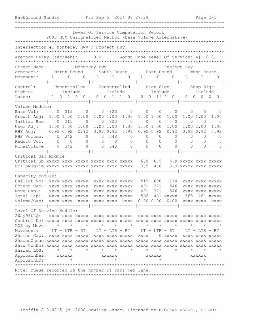
Background Sunday Fri Sep 5, 2014 08:27:28 Page 2-1 -------------------------------------------------------------------------------- -------------------------------------------------------------------------------- Level Of Service Computation Report 2000 HCM Unsignalized Method (Base Volume Alternative) ******************************************************************************** Intersection #1 Monterey Hwy / Project Dwy ******************************************************************************** Average Delay (sec/veh): 0.0 Worst Case Level Of Service: A[ 0.0] ******************************************************************************** Street Name: Monterey Hwy Project Dwy Approach: North Bound South Bound East Bound West Bound Movement: L - T - R L - T - R L - T - R L - T - R ------------|---------------||---------------||---------------||---------------| Control: Uncontrolled Uncontrolled Stop Sign Stop Sign Rights: Include Include Include Include Lanes: 1 0 2 0 0 0 0 1 1 0 0 0 1! 0 0 0 0 0 0 0 ------------|---------------||---------------||---------------||---------------| Volume Module: Base Vol: 0 315 0 0 320 0 0 0 0 0 0 0 Growth Adj: 1.00 1.00 1.00 1.00 1.00 1.00 1.00 1.00 1.00 1.00 1.00 1.00 Initial Bse: 0 315 0 0 320 0 0 0 0 0 0 0 User Adj: 1.00 1.00 1.00 1.00 1.00 1.00 1.00 1.00 1.00 1.00 1.00 1.00 PHF Adj: 0.92 0.92 0.92 0.92 0.92 0.92 0.92 0.92 0.92 0.92 0.92 0.92 PHF Volume: 0 342 0 0 348 0 0 0 0 0 0 0 Reduct Vol: 0 0 0 0 0 0 0 0 0 0 0 0 FinalVolume: 0 342 0 0 348 0 0 0 0 0 0 0 ------------|---------------||---------------||---------------||---------------| Critical Gap Module: Critical Gp:xxxxx xxxx xxxxx xxxxx xxxx xxxxx 6.8 6.5 6.9 xxxxx xxxx xxxxx FollowUpTim:xxxxx xxxx xxxxx xxxxx xxxx xxxxx 3.5 4.0 3.3 xxxxx xxxx xxxxx ------------|---------------||---------------||---------------||---------------| Capacity Module: Cnflict Vol: xxxx xxxx xxxxx xxxx xxxx xxxxx 519 690 174 xxxx xxxx xxxxx Potent Cap.: xxxx xxxx xxxxx xxxx xxxx xxxxx 491 371 846 xxxx xxxx xxxxx Move Cap.: xxxx xxxx xxxxx xxxx xxxx xxxxx 491 371 846 xxxx xxxx xxxxx Total Cap: xxxx xxxx xxxxx xxxx xxxx xxxxx 566 461 xxxxx 568 461 xxxxx Volume/Cap: xxxx xxxx xxxx xxxx xxxx xxxx 0.00 0.00 0.00 xxxx xxxx xxxx ------------|---------------||---------------||---------------||---------------| Level Of Service Module: 2Way95thQ: xxxx xxxx xxxxx xxxx xxxx xxxxx xxxx xxxx xxxxx xxxx xxxx xxxxx Control Del:xxxxx xxxx xxxxx xxxxx xxxx xxxxx xxxxx xxxx xxxxx xxxxx xxxx xxxxx LOS by Move: * * * * * * * * * * * * Movement: LT - LTR - RT LT - LTR - RT LT - LTR - RT LT - LTR - RT Shared Cap.: xxxx xxxx xxxxx xxxx xxxx xxxxx xxxx 0 xxxxx xxxx xxxx xxxxx SharedQueue:xxxxx xxxx xxxxx xxxxx xxxx xxxxx xxxxx xxxx xxxxx xxxxx xxxx xxxxx Shrd ConDel:xxxxx xxxx xxxxx xxxxx xxxx xxxxx xxxxx xxxx xxxxx xxxxx xxxx xxxxx Shared LOS: * * * * * * * * * * * * ApproachDel: xxxxxx xxxxxx xxxxxx xxxxxx ApproachLOS: * * * * ******************************************************************************** Note: Queue reported is the number of cars per lane. ******************************************************************************** Traffix 8.0.0715 (c) 2008 Dowling Assoc. Licensed to HIGGINS ASSOC., GILROY
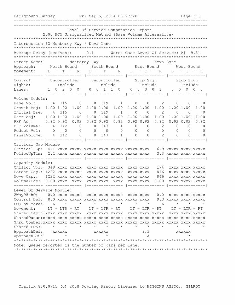
Background Sunday Fri Sep 5, 2014 08:27:28 Page 3-1 -------------------------------------------------------------------------------- -------------------------------------------------------------------------------- Level Of Service Computation Report 2000 HCM Unsignalized Method (Base Volume Alternative) ******************************************************************************** Intersection #2 Monterey Hwy / Neva Lane ******************************************************************************** Average Delay (sec/veh): 0.1 Worst Case Level Of Service: A[ 9.3] ******************************************************************************** Street Name: Monterey Hwy Neva Lane Approach: North Bound South Bound East Bound West Bound Movement: L - T - R L - T - R L - T - R L - T - R ------------|---------------||---------------||---------------||---------------| Control: Uncontrolled Uncontrolled Stop Sign Stop Sign Rights: Include Include Include Include Lanes: 1 0 2 0 0 0 0 1 1 0 0 0 0 0 1 0 0 0 0 0 ------------|---------------||---------------||---------------||---------------| Volume Module: Base Vol: 4 315 0 0 319 1 0 0 2 0 0 0 Growth Adj: 1.00 1.00 1.00 1.00 1.00 1.00 1.00 1.00 1.00 1.00 1.00 1.00 Initial Bse: 4 315 0 0 319 1 0 0 2 0 0 0 User Adj: 1.00 1.00 1.00 1.00 1.00 1.00 1.00 1.00 1.00 1.00 1.00 1.00 PHF Adj: 0.92 0.92 0.92 0.92 0.92 0.92 0.92 0.92 0.92 0.92 0.92 0.92 PHF Volume: 4 342 0 0 347 1 0 0 2 0 0 0 Reduct Vol: 0 0 0 0 0 0 0 0 0 0 0 0 FinalVolume: 4 342 0 0 347 1 0 0 2 0 0 0 ------------|---------------||---------------||---------------||---------------| Critical Gap Module: Critical Gp: 4.1 xxxx xxxxx xxxxx xxxx xxxxx xxxxx xxxx 6.9 xxxxx xxxx xxxxx FollowUpTim: 2.2 xxxx xxxxx xxxxx xxxx xxxxx xxxxx xxxx 3.3 xxxxx xxxx xxxxx ------------|---------------||---------------||---------------||---------------| Capacity Module: Cnflict Vol: 348 xxxx xxxxx xxxx xxxx xxxxx xxxx xxxx 174 xxxx xxxx xxxxx Potent Cap.: 1222 xxxx xxxxx xxxx xxxx xxxxx xxxx xxxx 846 xxxx xxxx xxxxx Move Cap.: 1222 xxxx xxxxx xxxx xxxx xxxxx xxxx xxxx 846 xxxx xxxx xxxxx Volume/Cap: 0.00 xxxx xxxx xxxx xxxx xxxx xxxx xxxx 0.00 xxxx xxxx xxxx ------------|---------------||---------------||---------------||---------------| Level Of Service Module: 2Way95thQ: 0.0 xxxx xxxxx xxxx xxxx xxxxx xxxx xxxx 0.0 xxxx xxxx xxxxx Control Del: 8.0 xxxx xxxxx xxxxx xxxx xxxxx xxxxx xxxx 9.3 xxxxx xxxx xxxxx LOS by Move: A * * * * * * * A * * * Movement: LT - LTR - RT LT - LTR - RT LT - LTR - RT LT - LTR - RT Shared Cap.: xxxx xxxx xxxxx xxxx xxxx xxxxx xxxx xxxx xxxxx xxxx xxxx xxxxx SharedQueue:xxxxx xxxx xxxxx xxxxx xxxx xxxxx xxxxx xxxx xxxxx xxxxx xxxx xxxxx Shrd ConDel:xxxxx xxxx xxxxx xxxxx xxxx xxxxx xxxxx xxxx xxxxx xxxxx xxxx xxxxx Shared LOS: * * * * * * * * * * * * ApproachDel: xxxxxx xxxxxx 9.3 xxxxxx ApproachLOS: * * A * ******************************************************************************** Note: Queue reported is the number of cars per lane. ******************************************************************************** Traffix 8.0.0715 (c) 2008 Dowling Assoc. Licensed to HIGGINS ASSOC., GILROY
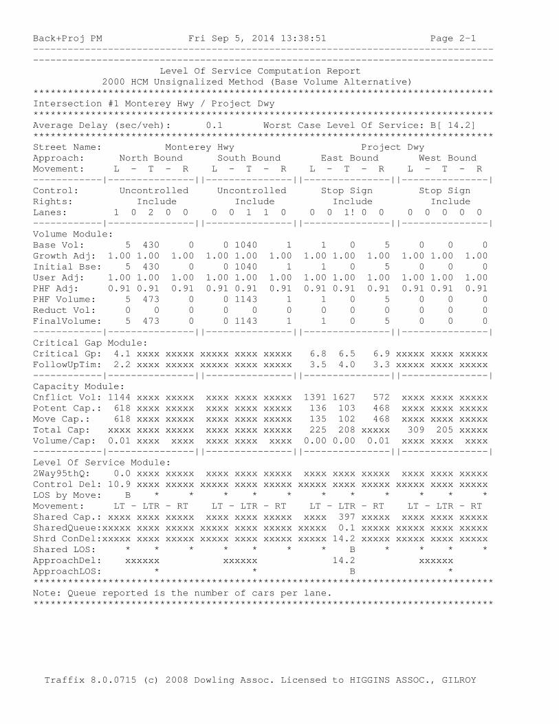
Back+Proj PM Fri Sep 5, 2014 13:38:51 Page 2-1 -------------------------------------------------------------------------------- -------------------------------------------------------------------------------- Level Of Service Computation Report 2000 HCM Unsignalized Method (Base Volume Alternative) ******************************************************************************** Intersection #1 Monterey Hwy / Project Dwy ******************************************************************************** Average Delay (sec/veh): 0.1 Worst Case Level Of Service: B[ 14.2] ******************************************************************************** Street Name: Monterey Hwy Project Dwy Approach: North Bound South Bound East Bound West Bound Movement: L - T - R L - T - R L - T - R L - T - R ------------|---------------||---------------||---------------||---------------| Control: Uncontrolled Uncontrolled Stop Sign Stop Sign Rights: Include Include Include Include Lanes: 1 0 2 0 0 0 0 1 1 0 0 0 1! 0 0 0 0 0 0 0 ------------|---------------||---------------||---------------||---------------| Volume Module: Base Vol: 5 430 0 0 1040 1 1 0 5 0 0 0 Growth Adj: 1.00 1.00 1.00 1.00 1.00 1.00 1.00 1.00 1.00 1.00 1.00 1.00 Initial Bse: 5 430 0 0 1040 1 1 0 5 0 0 0 User Adj: 1.00 1.00 1.00 1.00 1.00 1.00 1.00 1.00 1.00 1.00 1.00 1.00 PHF Adj: 0.91 0.91 0.91 0.91 0.91 0.91 0.91 0.91 0.91 0.91 0.91 0.91 PHF Volume: 5 473 0 0 1143 1 1 0 5 0 0 0 Reduct Vol: 0 0 0 0 0 0 0 0 0 0 0 0 FinalVolume: 5 473 0 0 1143 1 1 0 5 0 0 0 ------------|---------------||---------------||---------------||---------------| Critical Gap Module: Critical Gp: 4.1 xxxx xxxxx xxxxx xxxx xxxxx 6.8 6.5 6.9 xxxxx xxxx xxxxx FollowUpTim: 2.2 xxxx xxxxx xxxxx xxxx xxxxx 3.5 4.0 3.3 xxxxx xxxx xxxxx ------------|---------------||---------------||---------------||---------------| Capacity Module: Cnflict Vol: 1144 xxxx xxxxx xxxx xxxx xxxxx 1391 1627 572 xxxx xxxx xxxxx Potent Cap.: 618 xxxx xxxxx xxxx xxxx xxxxx 136 103 468 xxxx xxxx xxxxx Move Cap.: 618 xxxx xxxxx xxxx xxxx xxxxx 135 102 468 xxxx xxxx xxxxx Total Cap: xxxx xxxx xxxxx xxxx xxxx xxxxx 225 208 xxxxx 309 205 xxxxx Volume/Cap: 0.01 xxxx xxxx xxxx xxxx xxxx 0.00 0.00 0.01 xxxx xxxx xxxx ------------|---------------||---------------||---------------||---------------| Level Of Service Module: 2Way95thQ: 0.0 xxxx xxxxx xxxx xxxx xxxxx xxxx xxxx xxxxx xxxx xxxx xxxxx Control Del: 10.9 xxxx xxxxx xxxxx xxxx xxxxx xxxxx xxxx xxxxx xxxxx xxxx xxxxx LOS by Move: B * * * * * * * * * * * Movement: LT - LTR - RT LT - LTR - RT LT - LTR - RT LT - LTR - RT Shared Cap.: xxxx xxxx xxxxx xxxx xxxx xxxxx xxxx 397 xxxxx xxxx xxxx xxxxx SharedQueue:xxxxx xxxx xxxxx xxxxx xxxx xxxxx xxxxx 0.1 xxxxx xxxxx xxxx xxxxx Shrd ConDel:xxxxx xxxx xxxxx xxxxx xxxx xxxxx xxxxx 14.2 xxxxx xxxxx xxxx xxxxx Shared LOS: * * * * * * * B * * * * ApproachDel: xxxxxx xxxxxx 14.2 xxxxxx ApproachLOS: * * B * ******************************************************************************** Note: Queue reported is the number of cars per lane. ******************************************************************************** Traffix 8.0.0715 (c) 2008 Dowling Assoc. Licensed to HIGGINS ASSOC., GILROY
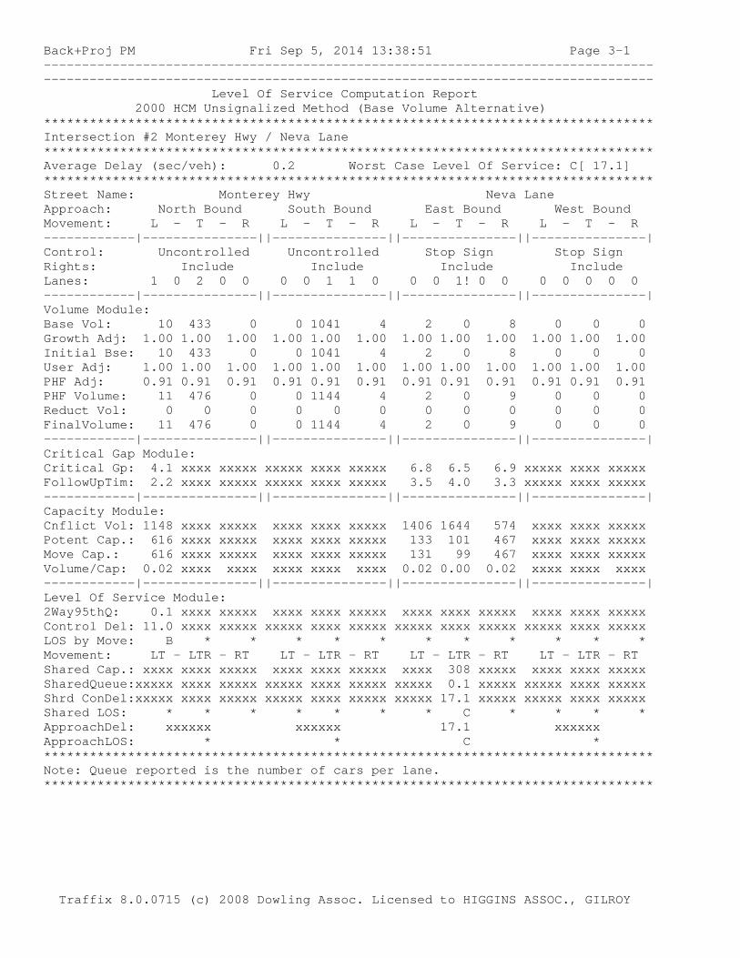
Back+Proj PM Fri Sep 5, 2014 13:38:51 Page 3-1 -------------------------------------------------------------------------------- -------------------------------------------------------------------------------- Level Of Service Computation Report 2000 HCM Unsignalized Method (Base Volume Alternative) ******************************************************************************** Intersection #2 Monterey Hwy / Neva Lane ******************************************************************************** Average Delay (sec/veh): 0.2 Worst Case Level Of Service: C[ 17.1] ******************************************************************************** Street Name: Monterey Hwy Neva Lane Approach: North Bound South Bound East Bound West Bound Movement: L - T - R L - T - R L - T - R L - T - R ------------|---------------||---------------||---------------||---------------| Control: Uncontrolled Uncontrolled Stop Sign Stop Sign Rights: Include Include Include Include Lanes: 1 0 2 0 0 0 0 1 1 0 0 0 1! 0 0 0 0 0 0 0 ------------|---------------||---------------||---------------||---------------| Volume Module: Base Vol: 10 433 0 0 1041 4 2 0 8 0 0 0 Growth Adj: 1.00 1.00 1.00 1.00 1.00 1.00 1.00 1.00 1.00 1.00 1.00 1.00 Initial Bse: 10 433 0 0 1041 4 2 0 8 0 0 0 User Adj: 1.00 1.00 1.00 1.00 1.00 1.00 1.00 1.00 1.00 1.00 1.00 1.00 PHF Adj: 0.91 0.91 0.91 0.91 0.91 0.91 0.91 0.91 0.91 0.91 0.91 0.91 PHF Volume: 11 476 0 0 1144 4 2 0 9 0 0 0 Reduct Vol: 0 0 0 0 0 0 0 0 0 0 0 0 FinalVolume: 11 476 0 0 1144 4 2 0 9 0 0 0 ------------|---------------||---------------||---------------||---------------| Critical Gap Module: Critical Gp: 4.1 xxxx xxxxx xxxxx xxxx xxxxx 6.8 6.5 6.9 xxxxx xxxx xxxxx FollowUpTim: 2.2 xxxx xxxxx xxxxx xxxx xxxxx 3.5 4.0 3.3 xxxxx xxxx xxxxx ------------|---------------||---------------||---------------||---------------| Capacity Module: Cnflict Vol: 1148 xxxx xxxxx xxxx xxxx xxxxx 1406 1644 574 xxxx xxxx xxxxx Potent Cap.: 616 xxxx xxxxx xxxx xxxx xxxxx 133 101 467 xxxx xxxx xxxxx Move Cap.: 616 xxxx xxxxx xxxx xxxx xxxxx 131 99 467 xxxx xxxx xxxxx Volume/Cap: 0.02 xxxx xxxx xxxx xxxx xxxx 0.02 0.00 0.02 xxxx xxxx xxxx ------------|---------------||---------------||---------------||---------------| Level Of Service Module: 2Way95thQ: 0.1 xxxx xxxxx xxxx xxxx xxxxx xxxx xxxx xxxxx xxxx xxxx xxxxx Control Del: 11.0 xxxx xxxxx xxxxx xxxx xxxxx xxxxx xxxx xxxxx xxxxx xxxx xxxxx LOS by Move: B * * * * * * * * * * * Movement: LT - LTR - RT LT - LTR - RT LT - LTR - RT LT - LTR - RT Shared Cap.: xxxx xxxx xxxxx xxxx xxxx xxxxx xxxx 308 xxxxx xxxx xxxx xxxxx SharedQueue:xxxxx xxxx xxxxx xxxxx xxxx xxxxx xxxxx 0.1 xxxxx xxxxx xxxx xxxxx Shrd ConDel:xxxxx xxxx xxxxx xxxxx xxxx xxxxx xxxxx 17.1 xxxxx xxxxx xxxx xxxxx Shared LOS: * * * * * * * C * * * * ApproachDel: xxxxxx xxxxxx 17.1 xxxxxx ApproachLOS: * * C * ******************************************************************************** Note: Queue reported is the number of cars per lane. ******************************************************************************** Traffix 8.0.0715 (c) 2008 Dowling Assoc. Licensed to HIGGINS ASSOC., GILROY
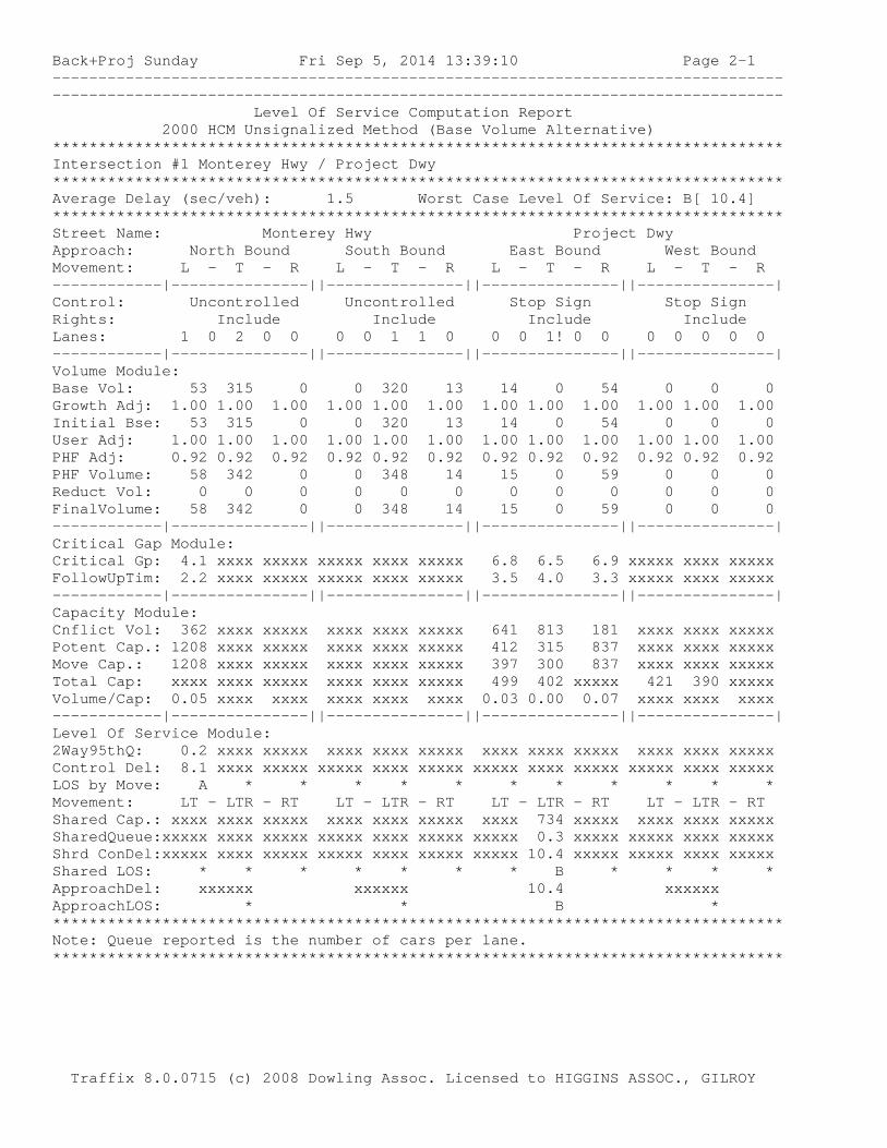
Back+Proj Sunday Fri Sep 5, 2014 13:39:10 Page 2-1 -------------------------------------------------------------------------------- -------------------------------------------------------------------------------- Level Of Service Computation Report 2000 HCM Unsignalized Method (Base Volume Alternative) ******************************************************************************** Intersection #1 Monterey Hwy / Project Dwy ******************************************************************************** Average Delay (sec/veh): 1.5 Worst Case Level Of Service: B[ 10.4] ******************************************************************************** Street Name: Monterey Hwy Project Dwy Approach: North Bound South Bound East Bound West Bound Movement: L - T - R L - T - R L - T - R L - T - R ------------|---------------||---------------||---------------||---------------| Control: Uncontrolled Uncontrolled Stop Sign Stop Sign Rights: Include Include Include Include Lanes: 1 0 2 0 0 0 0 1 1 0 0 0 1! 0 0 0 0 0 0 0 ------------|---------------||---------------||---------------||---------------| Volume Module: Base Vol: 53 315 0 0 320 13 14 0 54 0 0 0 Growth Adj: 1.00 1.00 1.00 1.00 1.00 1.00 1.00 1.00 1.00 1.00 1.00 1.00 Initial Bse: 53 315 0 0 320 13 14 0 54 0 0 0 User Adj: 1.00 1.00 1.00 1.00 1.00 1.00 1.00 1.00 1.00 1.00 1.00 1.00 PHF Adj: 0.92 0.92 0.92 0.92 0.92 0.92 0.92 0.92 0.92 0.92 0.92 0.92 PHF Volume: 58 342 0 0 348 14 15 0 59 0 0 0 Reduct Vol: 0 0 0 0 0 0 0 0 0 0 0 0 FinalVolume: 58 342 0 0 348 14 15 0 59 0 0 0 ------------|---------------||---------------||---------------||---------------| Critical Gap Module: Critical Gp: 4.1 xxxx xxxxx xxxxx xxxx xxxxx 6.8 6.5 6.9 xxxxx xxxx xxxxx FollowUpTim: 2.2 xxxx xxxxx xxxxx xxxx xxxxx 3.5 4.0 3.3 xxxxx xxxx xxxxx ------------|---------------||---------------||---------------||---------------| Capacity Module: Cnflict Vol: 362 xxxx xxxxx xxxx xxxx xxxxx 641 813 181 xxxx xxxx xxxxx Potent Cap.: 1208 xxxx xxxxx xxxx xxxx xxxxx 412 315 837 xxxx xxxx xxxxx Move Cap.: 1208 xxxx xxxxx xxxx xxxx xxxxx 397 300 837 xxxx xxxx xxxxx Total Cap: xxxx xxxx xxxxx xxxx xxxx xxxxx 499 402 xxxxx 421 390 xxxxx Volume/Cap: 0.05 xxxx xxxx xxxx xxxx xxxx 0.03 0.00 0.07 xxxx xxxx xxxx ------------|---------------||---------------||---------------||---------------| Level Of Service Module: 2Way95thQ: 0.2 xxxx xxxxx xxxx xxxx xxxxx xxxx xxxx xxxxx xxxx xxxx xxxxx Control Del: 8.1 xxxx xxxxx xxxxx xxxx xxxxx xxxxx xxxx xxxxx xxxxx xxxx xxxxx LOS by Move: A * * * * * * * * * * * Movement: LT - LTR - RT LT - LTR - RT LT - LTR - RT LT - LTR - RT Shared Cap.: xxxx xxxx xxxxx xxxx xxxx xxxxx xxxx 734 xxxxx xxxx xxxx xxxxx SharedQueue:xxxxx xxxx xxxxx xxxxx xxxx xxxxx xxxxx 0.3 xxxxx xxxxx xxxx xxxxx Shrd ConDel:xxxxx xxxx xxxxx xxxxx xxxx xxxxx xxxxx 10.4 xxxxx xxxxx xxxx xxxxx Shared LOS: * * * * * * * B * * * * ApproachDel: xxxxxx xxxxxx 10.4 xxxxxx ApproachLOS: * * B * ******************************************************************************** Note: Queue reported is the number of cars per lane. ******************************************************************************** Traffix 8.0.0715 (c) 2008 Dowling Assoc. Licensed to HIGGINS ASSOC., GILROY
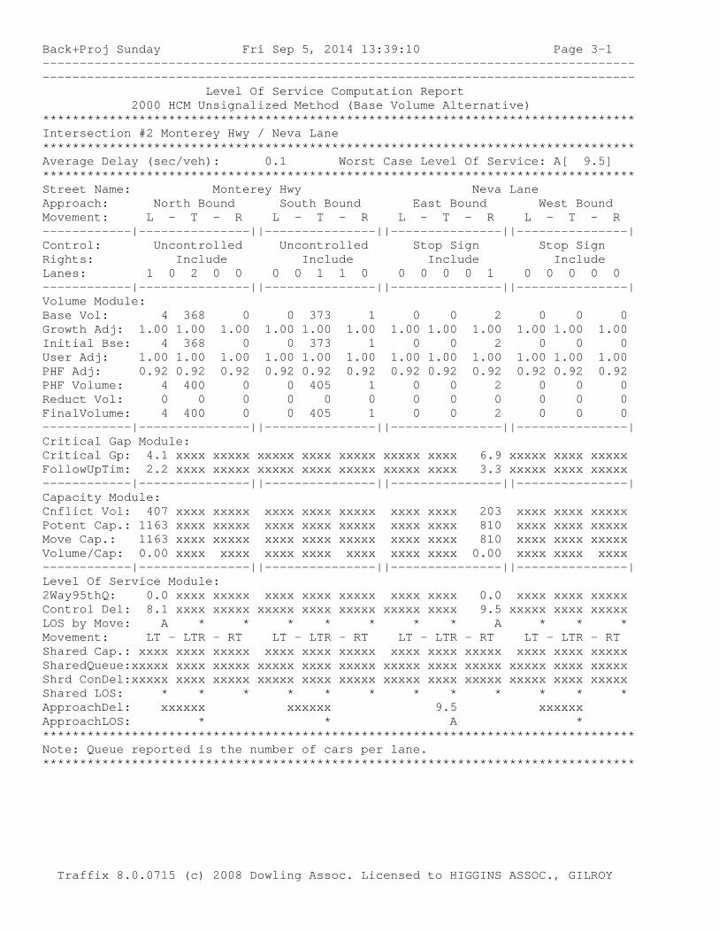
Back+Proj Sunday Fri Sep 5, 2014 13:39:10 Page 3-1 -------------------------------------------------------------------------------- -------------------------------------------------------------------------------- Level Of Service Computation Report 2000 HCM Unsignalized Method (Base Volume Alternative) ******************************************************************************** Intersection #2 Monterey Hwy / Neva Lane ******************************************************************************** Average Delay (sec/veh): 0.1 Worst Case Level Of Service: A[ 9.5] ******************************************************************************** Street Name: Monterey Hwy Neva Lane Approach: North Bound South Bound East Bound West Bound Movement: L - T - R L - T - R L - T - R L - T - R ------------|---------------||---------------||---------------||---------------| Control: Uncontrolled Uncontrolled Stop Sign Stop Sign Rights: Include Include Include Include Lanes: 1 0 2 0 0 0 0 1 1 0 0 0 0 0 1 0 0 0 0 0 ------------|---------------||---------------||---------------||---------------| Volume Module: Base Vol: 4 368 0 0 373 1 0 0 2 0 0 0 Growth Adj: 1.00 1.00 1.00 1.00 1.00 1.00 1.00 1.00 1.00 1.00 1.00 1.00 Initial Bse: 4 368 0 0 373 1 0 0 2 0 0 0 User Adj: 1.00 1.00 1.00 1.00 1.00 1.00 1.00 1.00 1.00 1.00 1.00 1.00 PHF Adj: 0.92 0.92 0.92 0.92 0.92 0.92 0.92 0.92 0.92 0.92 0.92 0.92 PHF Volume: 4 400 0 0 405 1 0 0 2 0 0 0 Reduct Vol: 0 0 0 0 0 0 0 0 0 0 0 0 FinalVolume: 4 400 0 0 405 1 0 0 2 0 0 0 ------------|---------------||---------------||---------------||---------------| Critical Gap Module: Critical Gp: 4.1 xxxx xxxxx xxxxx xxxx xxxxx xxxxx xxxx 6.9 xxxxx xxxx xxxxx FollowUpTim: 2.2 xxxx xxxxx xxxxx xxxx xxxxx xxxxx xxxx 3.3 xxxxx xxxx xxxxx ------------|---------------||---------------||---------------||---------------| Capacity Module: Cnflict Vol: 407 xxxx xxxxx xxxx xxxx xxxxx xxxx xxxx 203 xxxx xxxx xxxxx Potent Cap.: 1163 xxxx xxxxx xxxx xxxx xxxxx xxxx xxxx 810 xxxx xxxx xxxxx Move Cap.: 1163 xxxx xxxxx xxxx xxxx xxxxx xxxx xxxx 810 xxxx xxxx xxxxx Volume/Cap: 0.00 xxxx xxxx xxxx xxxx xxxx xxxx xxxx 0.00 xxxx xxxx xxxx ------------|---------------||---------------||---------------||---------------| Level Of Service Module: 2Way95thQ: 0.0 xxxx xxxxx xxxx xxxx xxxxx xxxx xxxx 0.0 xxxx xxxx xxxxx Control Del: 8.1 xxxx xxxxx xxxxx xxxx xxxxx xxxxx xxxx 9.5 xxxxx xxxx xxxxx LOS by Move: A * * * * * * * A * * * Movement: LT - LTR - RT LT - LTR - RT LT - LTR - RT LT - LTR - RT Shared Cap.: xxxx xxxx xxxxx xxxx xxxx xxxxx xxxx xxxx xxxxx xxxx xxxx xxxxx SharedQueue:xxxxx xxxx xxxxx xxxxx xxxx xxxxx xxxxx xxxx xxxxx xxxxx xxxx xxxxx Shrd ConDel:xxxxx xxxx xxxxx xxxxx xxxx xxxxx xxxxx xxxx xxxxx xxxxx xxxx xxxxx Shared LOS: * * * * * * * * * * * * ApproachDel: xxxxxx xxxxxx 9.5 xxxxxx ApproachLOS: * * A * ******************************************************************************** Note: Queue reported is the number of cars per lane. ******************************************************************************** Traffix 8.0.0715 (c) 2008 Dowling Assoc. Licensed to HIGGINS ASSOC., GILROY

Cumul W Proj PM Fri Sep 5, 2014 13:39:34 Page 2-1 -------------------------------------------------------------------------------- -------------------------------------------------------------------------------- Level Of Service Computation Report 2000 HCM Unsignalized Method (Base Volume Alternative) ******************************************************************************** Intersection #1 Monterey Hwy / Project Dwy ******************************************************************************** Average Delay (sec/veh): 0.1 Worst Case Level Of Service: C[ 20.4] ******************************************************************************** Street Name: Monterey Hwy Project Dwy Approach: North Bound South Bound East Bound West Bound Movement: L - T - R L - T - R L - T - R L - T - R ------------|---------------||---------------||---------------||---------------| Control: Uncontrolled Uncontrolled Stop Sign Stop Sign Rights: Include Include Include Include Lanes: 1 0 2 0 0 0 0 1 1 0 0 0 1! 0 0 0 0 0 0 0 ------------|---------------||---------------||---------------||---------------| Volume Module: Base Vol: 5 635 0 0 1545 1 1 0 5 0 0 0 Growth Adj: 1.00 1.00 1.00 1.00 1.00 1.00 1.00 1.00 1.00 1.00 1.00 1.00 Initial Bse: 5 635 0 0 1545 1 1 0 5 0 0 0 User Adj: 1.00 1.00 1.00 1.00 1.00 1.00 1.00 1.00 1.00 1.00 1.00 1.00 PHF Adj: 0.91 0.91 0.91 0.91 0.91 0.91 0.91 0.91 0.91 0.91 0.91 0.91 PHF Volume: 5 698 0 0 1698 1 1 0 5 0 0 0 Reduct Vol: 0 0 0 0 0 0 0 0 0 0 0 0 FinalVolume: 5 698 0 0 1698 1 1 0 5 0 0 0 ------------|---------------||---------------||---------------||---------------| Critical Gap Module: Critical Gp: 4.1 xxxx xxxxx xxxxx xxxx xxxxx 6.8 6.5 6.9 xxxxx xxxx xxxxx FollowUpTim: 2.2 xxxx xxxxx xxxxx xxxx xxxxx 3.5 4.0 3.3 xxxxx xxxx xxxxx ------------|---------------||---------------||---------------||---------------| Capacity Module: Cnflict Vol: 1699 xxxx xxxxx xxxx xxxx xxxxx 2058 2407 849 xxxx xxxx xxxxx Potent Cap.: 380 xxxx xxxxx xxxx xxxx xxxxx 49 33 308 xxxx xxxx xxxxx Move Cap.: 380 xxxx xxxxx xxxx xxxx xxxxx 48 33 308 xxxx xxxx xxxxx Total Cap: xxxx xxxx xxxxx xxxx xxxx xxxxx 114 113 xxxxx 193 109 xxxxx Volume/Cap: 0.01 xxxx xxxx xxxx xxxx xxxx 0.01 0.00 0.02 xxxx xxxx xxxx ------------|---------------||---------------||---------------||---------------| Level Of Service Module: 2Way95thQ: 0.0 xxxx xxxxx xxxx xxxx xxxxx xxxx xxxx xxxxx xxxx xxxx xxxxx Control Del: 14.6 xxxx xxxxx xxxxx xxxx xxxxx xxxxx xxxx xxxxx xxxxx xxxx xxxxx LOS by Move: B * * * * * * * * * * * Movement: LT - LTR - RT LT - LTR - RT LT - LTR - RT LT - LTR - RT Shared Cap.: xxxx xxxx xxxxx xxxx xxxx xxxxx xxxx 240 xxxxx xxxx xxxx xxxxx SharedQueue:xxxxx xxxx xxxxx xxxxx xxxx xxxxx xxxxx 0.1 xxxxx xxxxx xxxx xxxxx Shrd ConDel:xxxxx xxxx xxxxx xxxxx xxxx xxxxx xxxxx 20.4 xxxxx xxxxx xxxx xxxxx Shared LOS: * * * * * * * C * * * * ApproachDel: xxxxxx xxxxxx 20.4 xxxxxx ApproachLOS: * * C * ******************************************************************************** Note: Queue reported is the number of cars per lane. ******************************************************************************** Traffix 8.0.0715 (c) 2008 Dowling Assoc. Licensed to HIGGINS ASSOC., GILROY

Cumul W Proj PM Fri Sep 5, 2014 13:39:34 Page 3-1 -------------------------------------------------------------------------------- -------------------------------------------------------------------------------- Level Of Service Computation Report 2000 HCM Unsignalized Method (Base Volume Alternative) ******************************************************************************** Intersection #2 Monterey Hwy / Neva Lane ******************************************************************************** Average Delay (sec/veh): 0.2 Worst Case Level Of Service: D[ 31.9] ******************************************************************************** Street Name: Monterey Hwy Neva Lane Approach: North Bound South Bound East Bound West Bound Movement: L - T - R L - T - R L - T - R L - T - R ------------|---------------||---------------||---------------||---------------| Control: Uncontrolled Uncontrolled Stop Sign Stop Sign Rights: Include Include Include Include Lanes: 1 0 2 0 0 0 0 1 1 0 0 0 1! 0 0 0 0 0 0 0 ------------|---------------||---------------||---------------||---------------| Volume Module: Base Vol: 10 638 0 0 1546 4 2 0 8 0 0 0 Growth Adj: 1.00 1.00 1.00 1.00 1.00 1.00 1.00 1.00 1.00 1.00 1.00 1.00 Initial Bse: 10 638 0 0 1546 4 2 0 8 0 0 0 User Adj: 1.00 1.00 1.00 1.00 1.00 1.00 1.00 1.00 1.00 1.00 1.00 1.00 PHF Adj: 0.91 0.91 0.91 0.91 0.91 0.91 0.91 0.91 0.91 0.91 0.91 0.91 PHF Volume: 11 701 0 0 1699 4 2 0 9 0 0 0 Reduct Vol: 0 0 0 0 0 0 0 0 0 0 0 0 FinalVolume: 11 701 0 0 1699 4 2 0 9 0 0 0 ------------|---------------||---------------||---------------||---------------| Critical Gap Module: Critical Gp: 4.1 xxxx xxxxx xxxxx xxxx xxxxx 6.8 6.5 6.9 xxxxx xxxx xxxxx FollowUpTim: 2.2 xxxx xxxxx xxxxx xxxx xxxxx 3.5 4.0 3.3 xxxxx xxxx xxxxx ------------|---------------||---------------||---------------||---------------| Capacity Module: Cnflict Vol: 1703 xxxx xxxxx xxxx xxxx xxxxx 2074 2424 852 xxxx xxxx xxxxx Potent Cap.: 378 xxxx xxxxx xxxx xxxx xxxxx 48 33 307 xxxx xxxx xxxxx Move Cap.: 378 xxxx xxxxx xxxx xxxx xxxxx 47 32 307 xxxx xxxx xxxxx Volume/Cap: 0.03 xxxx xxxx xxxx xxxx xxxx 0.05 0.00 0.03 xxxx xxxx xxxx ------------|---------------||---------------||---------------||---------------| Level Of Service Module: 2Way95thQ: 0.1 xxxx xxxxx xxxx xxxx xxxxx xxxx xxxx xxxxx xxxx xxxx xxxxx Control Del: 14.8 xxxx xxxxx xxxxx xxxx xxxxx xxxxx xxxx xxxxx xxxxx xxxx xxxxx LOS by Move: B * * * * * * * * * * * Movement: LT - LTR - RT LT - LTR - RT LT - LTR - RT LT - LTR - RT Shared Cap.: xxxx xxxx xxxxx xxxx xxxx xxxxx xxxx 145 xxxxx xxxx xxxx xxxxx SharedQueue:xxxxx xxxx xxxxx xxxxx xxxx xxxxx xxxxx 0.2 xxxxx xxxxx xxxx xxxxx Shrd ConDel:xxxxx xxxx xxxxx xxxxx xxxx xxxxx xxxxx 31.9 xxxxx xxxxx xxxx xxxxx Shared LOS: * * * * * * * D * * * * ApproachDel: xxxxxx xxxxxx 31.9 xxxxxx ApproachLOS: * * D * ******************************************************************************** Note: Queue reported is the number of cars per lane. ******************************************************************************** Traffix 8.0.0715 (c) 2008 Dowling Assoc. Licensed to HIGGINS ASSOC., GILROY
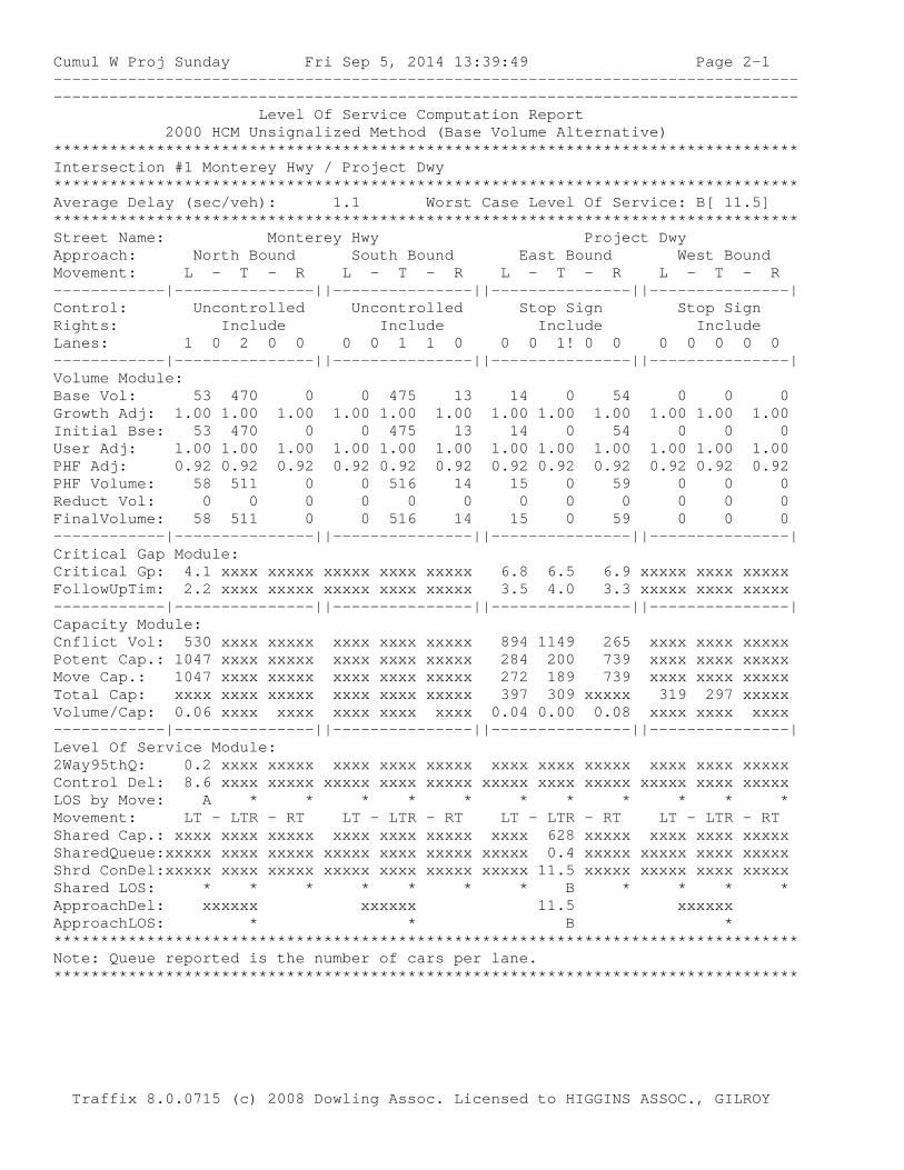
Cumul W Proj Sunday Fri Sep 5, 2014 13:39:49 Page 2-1 -------------------------------------------------------------------------------- -------------------------------------------------------------------------------- Level Of Service Computation Report 2000 HCM Unsignalized Method (Base Volume Alternative) ******************************************************************************** Intersection #1 Monterey Hwy / Project Dwy ******************************************************************************** Average Delay (sec/veh): 1.1 Worst Case Level Of Service: B[ 11.5] ******************************************************************************** Street Name: Monterey Hwy Project Dwy Approach: North Bound South Bound East Bound West Bound Movement: L - T - R L - T - R L - T - R L - T - R ------------|---------------||---------------||---------------||---------------| Control: Uncontrolled Uncontrolled Stop Sign Stop Sign Rights: Include Include Include Include Lanes: 1 0 2 0 0 0 0 1 1 0 0 0 1! 0 0 0 0 0 0 0 ------------|---------------||---------------||---------------||---------------| Volume Module: Base Vol: 53 470 0 0 475 13 14 0 54 0 0 0 Growth Adj: 1.00 1.00 1.00 1.00 1.00 1.00 1.00 1.00 1.00 1.00 1.00 1.00 Initial Bse: 53 470 0 0 475 13 14 0 54 0 0 0 User Adj: 1.00 1.00 1.00 1.00 1.00 1.00 1.00 1.00 1.00 1.00 1.00 1.00 PHF Adj: 0.92 0.92 0.92 0.92 0.92 0.92 0.92 0.92 0.92 0.92 0.92 0.92 PHF Volume: 58 511 0 0 516 14 15 0 59 0 0 0 Reduct Vol: 0 0 0 0 0 0 0 0 0 0 0 0 FinalVolume: 58 511 0 0 516 14 15 0 59 0 0 0 ------------|---------------||---------------||---------------||---------------| Critical Gap Module: Critical Gp: 4.1 xxxx xxxxx xxxxx xxxx xxxxx 6.8 6.5 6.9 xxxxx xxxx xxxxx FollowUpTim: 2.2 xxxx xxxxx xxxxx xxxx xxxxx 3.5 4.0 3.3 xxxxx xxxx xxxxx ------------|---------------||---------------||---------------||---------------| Capacity Module: Cnflict Vol: 530 xxxx xxxxx xxxx xxxx xxxxx 894 1149 265 xxxx xxxx xxxxx Potent Cap.: 1047 xxxx xxxxx xxxx xxxx xxxxx 284 200 739 xxxx xxxx xxxxx Move Cap.: 1047 xxxx xxxxx xxxx xxxx xxxxx 272 189 739 xxxx xxxx xxxxx Total Cap: xxxx xxxx xxxxx xxxx xxxx xxxxx 397 309 xxxxx 319 297 xxxxx Volume/Cap: 0.06 xxxx xxxx xxxx xxxx xxxx 0.04 0.00 0.08 xxxx xxxx xxxx ------------|---------------||---------------||---------------||---------------| Level Of Service Module: 2Way95thQ: 0.2 xxxx xxxxx xxxx xxxx xxxxx xxxx xxxx xxxxx xxxx xxxx xxxxx Control Del: 8.6 xxxx xxxxx xxxxx xxxx xxxxx xxxxx xxxx xxxxx xxxxx xxxx xxxxx LOS by Move: A * * * * * * * * * * * Movement: LT - LTR - RT LT - LTR - RT LT - LTR - RT LT - LTR - RT Shared Cap.: xxxx xxxx xxxxx xxxx xxxx xxxxx xxxx 628 xxxxx xxxx xxxx xxxxx SharedQueue:xxxxx xxxx xxxxx xxxxx xxxx xxxxx xxxxx 0.4 xxxxx xxxxx xxxx xxxxx Shrd ConDel:xxxxx xxxx xxxxx xxxxx xxxx xxxxx xxxxx 11.5 xxxxx xxxxx xxxx xxxxx Shared LOS: * * * * * * * B * * * * ApproachDel: xxxxxx xxxxxx 11.5 xxxxxx ApproachLOS: * * B * ******************************************************************************** Note: Queue reported is the number of cars per lane. ******************************************************************************** Traffix 8.0.0715 (c) 2008 Dowling Assoc. Licensed to HIGGINS ASSOC., GILROY
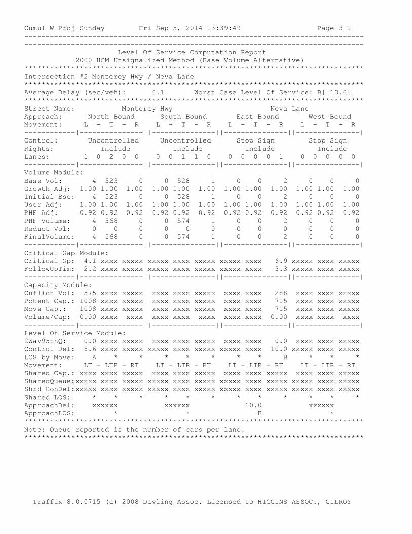
Cumul W Proj Sunday Fri Sep 5, 2014 13:39:49 Page 3-1 -------------------------------------------------------------------------------- -------------------------------------------------------------------------------- Level Of Service Computation Report 2000 HCM Unsignalized Method (Base Volume Alternative) ******************************************************************************** Intersection #2 Monterey Hwy / Neva Lane ******************************************************************************** Average Delay (sec/veh): 0.1 Worst Case Level Of Service: B[ 10.0] ******************************************************************************** Street Name: Monterey Hwy Neva Lane Approach: North Bound South Bound East Bound West Bound Movement: L - T - R L - T - R L - T - R L - T - R ------------|---------------||---------------||---------------||---------------| Control: Uncontrolled Uncontrolled Stop Sign Stop Sign Rights: Include Include Include Include Lanes: 1 0 2 0 0 0 0 1 1 0 0 0 0 0 1 0 0 0 0 0 ------------|---------------||---------------||---------------||---------------| Volume Module: Base Vol: 4 523 0 0 528 1 0 0 2 0 0 0 Growth Adj: 1.00 1.00 1.00 1.00 1.00 1.00 1.00 1.00 1.00 1.00 1.00 1.00 Initial Bse: 4 523 0 0 528 1 0 0 2 0 0 0 User Adj: 1.00 1.00 1.00 1.00 1.00 1.00 1.00 1.00 1.00 1.00 1.00 1.00 PHF Adj: 0.92 0.92 0.92 0.92 0.92 0.92 0.92 0.92 0.92 0.92 0.92 0.92 PHF Volume: 4 568 0 0 574 1 0 0 2 0 0 0 Reduct Vol: 0 0 0 0 0 0 0 0 0 0 0 0 FinalVolume: 4 568 0 0 574 1 0 0 2 0 0 0 ------------|---------------||---------------||---------------||---------------| Critical Gap Module: Critical Gp: 4.1 xxxx xxxxx xxxxx xxxx xxxxx xxxxx xxxx 6.9 xxxxx xxxx xxxxx FollowUpTim: 2.2 xxxx xxxxx xxxxx xxxx xxxxx xxxxx xxxx 3.3 xxxxx xxxx xxxxx ------------|---------------||---------------||---------------||---------------| Capacity Module: Cnflict Vol: 575 xxxx xxxxx xxxx xxxx xxxxx xxxx xxxx 288 xxxx xxxx xxxxx Potent Cap.: 1008 xxxx xxxxx xxxx xxxx xxxxx xxxx xxxx 715 xxxx xxxx xxxxx Move Cap.: 1008 xxxx xxxxx xxxx xxxx xxxxx xxxx xxxx 715 xxxx xxxx xxxxx Volume/Cap: 0.00 xxxx xxxx xxxx xxxx xxxx xxxx xxxx 0.00 xxxx xxxx xxxx ------------|---------------||---------------||---------------||---------------| Level Of Service Module: 2Way95thQ: 0.0 xxxx xxxxx xxxx xxxx xxxxx xxxx xxxx 0.0 xxxx xxxx xxxxx Control Del: 8.6 xxxx xxxxx xxxxx xxxx xxxxx xxxxx xxxx 10.0 xxxxx xxxx xxxxx LOS by Move: A * * * * * * * B * * * Movement: LT - LTR - RT LT - LTR - RT LT - LTR - RT LT - LTR - RT Shared Cap.: xxxx xxxx xxxxx xxxx xxxx xxxxx xxxx xxxx xxxxx xxxx xxxx xxxxx SharedQueue:xxxxx xxxx xxxxx xxxxx xxxx xxxxx xxxxx xxxx xxxxx xxxxx xxxx xxxxx Shrd ConDel:xxxxx xxxx xxxxx xxxxx xxxx xxxxx xxxxx xxxx xxxxx xxxxx xxxx xxxxx Shared LOS: * * * * * * * * * * * * ApproachDel: xxxxxx xxxxxx 10.0 xxxxxx ApproachLOS: * * B * ******************************************************************************** Note: Queue reported is the number of cars per lane. ******************************************************************************** Traffix 8.0.0715 (c) 2008 Dowling Assoc. Licensed to HIGGINS ASSOC., GILROY

APPENDIX D
WARRANT WORKSHEETS
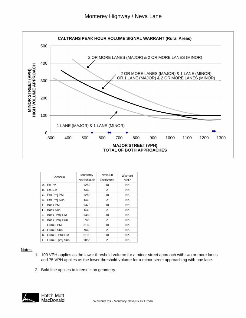
Monterey Highway / Neva Lane
Monterey Neva Ln
North/South East/West
A. Ex PM 1252 10 No
B. Ex Sun 542 2 No
C. Ex+Proj PM 1262 10 No
D. Ex+Proj Sun 649 2 No
E. Back PM 1478 10 No
F. Back Sun 639 2 No
G. Back+Proj PM 1488 10 No
H. Back+Proj Sun 746 2 No
I. Cumul PM 2188 10 No
J. Cumul Sun 949 2 No
K. Cumul+Proj PM 2198 10 No
L. Cumul+proj Sun 1056 2 No
Notes:1. 100 VPH applies as the lower threshold volume for a minor street approach with two or more lanes
and 75 VPH applies as the lower threshold volume for a minor street approaching with one lane.
2. Bold line applies to intersection geometry.
Scenario WarrantMet?
0
100
200
300
400
500
300 400 500 600 700 800 900 1000 1100 1200 1300
MIN
OR
ST
RE
ET
(VP
H)
HIG
H V
OL
UM
E A
PP
RO
AC
H
MAJOR STREET (VPH)TOTAL OF BOTH APPROACHES
CALTRANS PEAK HOUR VOLUME SIGNAL WARRANT (Rural Areas)
2 OR MORE LANES (MAJOR) & 1 LANE (MINOR)OR 1 LANE (MAJOR) & 2 OR MORE LANES (MINOR)
2 OR MORE LANES (MAJOR) & 2 OR MORE LANES (MINOR)
1 LANE (MAJOR) & 1 LANE (MINOR)
AB Warrants.xls - Monterey-Neva Pk Hr Urban
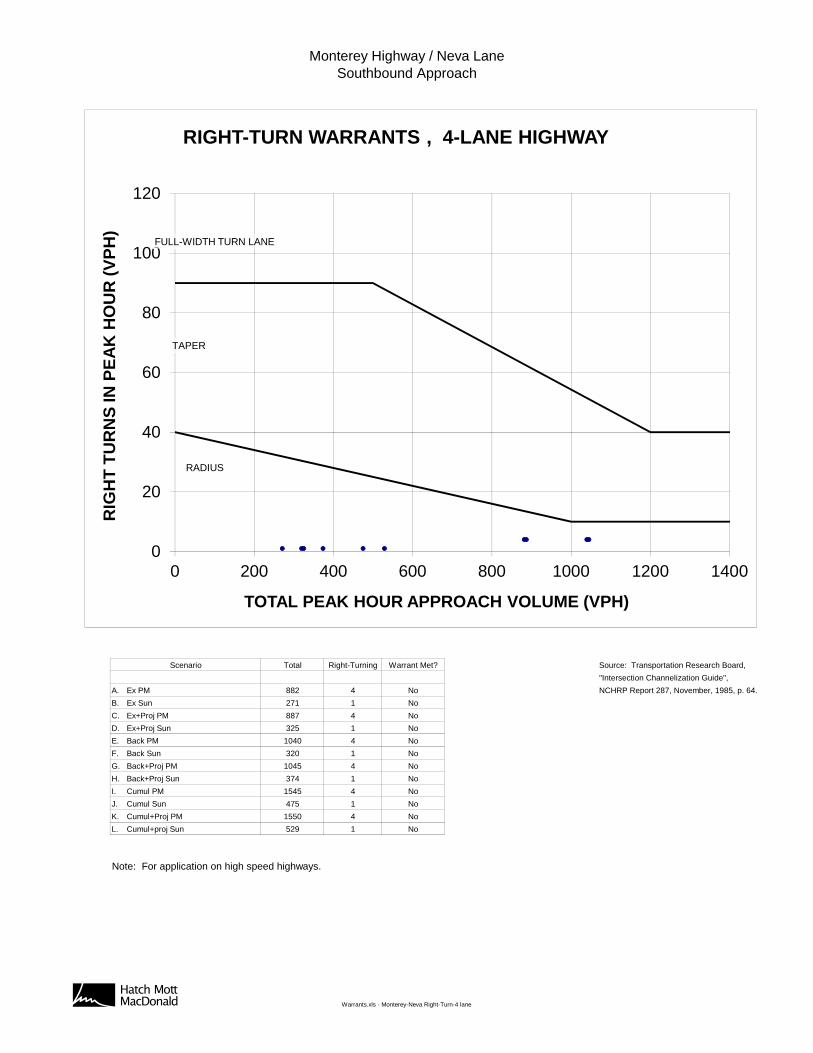
Monterey Highway / Neva LaneSouthbound Approach
Total Right-Turning Warrant Met? Source: Transportation Research Board,
"Intersection Channelization Guide",
A. Ex PM 882 4 No NCHRP Report 287, November, 1985, p. 64.
B. Ex Sun 271 1 No
C. Ex+Proj PM 887 4 No
D. Ex+Proj Sun 325 1 No
E. Back PM 1040 4 No
F. Back Sun 320 1 No
G. Back+Proj PM 1045 4 No
H. Back+Proj Sun 374 1 No
I. Cumul PM 1545 4 No
J. Cumul Sun 475 1 No
K. Cumul+Proj PM 1550 4 No
L. Cumul+proj Sun 529 1 No
Note: For application on high speed highways.
Scenario
0
20
40
60
80
100
120
0 200 400 600 800 1000 1200 1400
RIG
HT
TU
RN
S IN
PE
AK
HO
UR
(V
PH
)
TOTAL PEAK HOUR APPROACH VOLUME (VPH)
RIGHT-TURN WARRANTS , 4-LANE HIGHWAY
RADIUS
TAPER
FULL-WIDTH TURN LANE
AB Warrants.xls - Monterey-Neva Right-Turn-4 lane
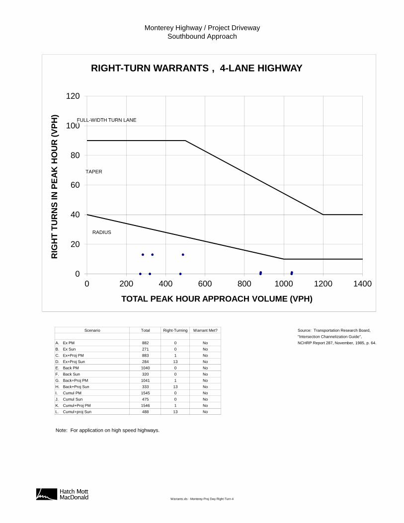
Monterey Highway / Project DrivewaySouthbound Approach
Total Right-Turning Warrant Met? Source: Transportation Research Board,
"Intersection Channelization Guide",
A. Ex PM 882 0 No NCHRP Report 287, November, 1985, p. 64.
B. Ex Sun 271 0 No
C. Ex+Proj PM 883 1 No
D. Ex+Proj Sun 284 13 No
E. Back PM 1040 0 No
F. Back Sun 320 0 No
G. Back+Proj PM 1041 1 No
H. Back+Proj Sun 333 13 No
I. Cumul PM 1545 0 No
J. Cumul Sun 475 0 No
K. Cumul+Proj PM 1546 1 No
L. Cumul+proj Sun 488 13 No
Note: For application on high speed highways.
Scenario
0
20
40
60
80
100
120
0 200 400 600 800 1000 1200 1400
RIG
HT
TU
RN
S IN
PE
AK
HO
UR
(V
PH
)
TOTAL PEAK HOUR APPROACH VOLUME (VPH)
RIGHT-TURN WARRANTS , 4-LANE HIGHWAY
RADIUS
TAPER
FULL-WIDTH TURN LANE
AB Warrants.xls - Monterey-Proj Dwy Right-Turn-4