Embed Size (px)
Citation preview
The Use of GIS in Flexible Land Tenure System (FLTS) at City of Windhoek – Namibia
MSc in GIS Thesis Lisho Mundia
Vrije Universiteit Amsterdam The Netherlands
The Use of GIS in Flexible Land Tenure System (FLTS) at City
of Windhoek – Namibia
Dissertation submitted in part fulfillment of requirements for the Degree of Master
of Science in Geographical Information Systems.
June 2007
Mr. Lisho Christoh Mundia
Vrije Universiteit - Amsterdam
The Use of GIS in Flexible Land Tenure System (FLTS) at City of Windhoek – Namibia
MSc in GIS Thesis Lisho Mundia ii
Abstract In order to uplift the economy of the low-income people in Namibia, the Government of Namibia has
started investigating alternative forms of land tenure aimed at uplifting the socioeconomic status of the
lowest income sectors of the community. The Ministry of Lands and Resettlement launched the lands
project to look for innovative solutions to this challenge. An approach referred to as "Flexible Land Tenure
System (FLTS) for Namibia" was developed, which will be debated in parliament soon, aimed at providing
simpler, more affordable and faster forms of secure tenure to low income communities in the country and
to urban informal settlement residents in particular.
This research concentrates on the pace of land administration, specifically on how the GIS can help in
handling the land administration of the FLTS projects at City of Windhoek which is responsible for such
tasks of managing and analysing the FLTS spatial and non-spatial data already in position of the City of
Windhoek. Scientific literature review, focus group interviews and field observations were used as the
methods of acquiring data. A prototype based on Microsoft Access and ArcView was developed using the
City of Windhoek’s data. This was done mainly to prove the capabilities and role of GIS in FLTS to the
implementation team of FLTS of the City of Windhoek.
The findings of this research are that, although the flexible land tenure bill is not yet gazetted (fully
enforced in operation and implemented), the City of Windhoek has already started implementing the FLTS
bill by allocating its land to the poor and the low-income people on the standards set in the flexible land
tenure bill. In the recent development this research has further revealed that the City of Windhoek has
started motivating informal settlers to form associations, referred to as saving groups (inter changeably
known as ‘schemes’) in order to acquire block erven (big plot of land) for security of tenure and
affordability of services. The current data of land information of the low-income people is managed by
paper and pen methods. The other result is that the focus group members supported the use of GIS in
administering the FLTS data, which is used to motivate the need of GIS for the AutoCAD and GIS
software vender supplying and administering Autodesk Map 3D to the City of Windhoek.
Although the flexible land tenure system is based on two new types of tenures, starter title and land hold
title. Starter title being the lowest tenure system, the City of Windhoek are currently motivating existing
saving groups (schemes) with good reputation on basic services payments to start looking at the
possibility of acquiring such block erven on this title and subsequently to land hold title as soon as the act
is gazetted. This paper also reveals that FLTS has been tested and still needs to be introduced in other
parts of the country.
The Use of GIS in Flexible Land Tenure System (FLTS) at City of Windhoek – Namibia
MSc in GIS Thesis Lisho Mundia iii
Table of Contents Pages
Abstract ..................................................................................................................................ii
Table of Contents Pages ...................................................................................................iii
List of Tables ........................................................................................................................vi
List of Figures.......................................................................................................................vi
1. Introduction and Research Outline..................................................................................1 1.1 BACKGROUND OF THE STUDY ......................................................................... 1
1.1.1 Problem Statement............................................................................... 3 1.1.2 Aim and Objectives of the Study........................................................... 5 1.1.3 Hypothesis............................................................................................ 5 1.1.4 Study Area............................................................................................ 5 1.1.5 Research Levels................................................................................... 7
2. Theory Concepts and Background ..................................................................................9 2.1 INTRODUCTION .............................................................................................. 9 2.2 CURRENT LAND RIGHTS AND POVERTY IN NAMIBIA ........................................... 9 2.3 LAND TENURE (FLTS) FOR LOW-INCOME CITIZENS ........................................ 12
2.3.1 Introduction......................................................................................... 12 2.3.2 Objectives of the FLTS ....................................................................... 13 2.3.3 Land Rights Offices And Officers........................................................ 13 2.3.4 Registers ............................................................................................ 14 2.3.5 Nature of FLTS Titles And The Establishment Of The Title Schemes 14 2.3.6 Upgrading Of The Title Schemes ....................................................... 15 2.3.7 Associations And Title Commencement ............................................. 16 2.3.8 Flexible Land Tenure State in Windhoek City..................................... 16
2.4 LAND ADMINISTRATION AT CITY OF WINDHOEK.............................................. 19 2.4.1 Introduction......................................................................................... 19 2.4.2 Land Administration Definition And Background ................................ 20 2.4.3 ICTs And Land Administration Developments .................................... 21
2.5 LAND INFORMATION SYSTEMS (LIS) .............................................................. 23 2.5.1 Introduction......................................................................................... 23 2.5.2 LIS Definition ...................................................................................... 23 2.5.3 LIS And Poor Land Management System Approach .......................... 24 2.5.4 Land Information Systems Stakeholders ............................................ 24 2.5.5 Land Information and LIS General Overview...................................... 28
2.6 PRINCIPLES OF DATABASE MANAGEMENT SYSTEMS ....................................... 29 2.6.1 Introduction......................................................................................... 29 2.6.2 Database Definition ............................................................................ 29 2.6.3 Functions Of A DBMS ........................................................................ 30 2.6.4 Why Use DBMS?................................................................................ 30
2.7 CONTEXT OF GIS IN FLTS ........................................................................... 31
The Use of GIS in Flexible Land Tenure System (FLTS) at City of Windhoek – Namibia
MSc in GIS Thesis Lisho Mundia iv
2.7.1 Introduction......................................................................................... 31 2.7.2 Definition of GIS ................................................................................. 31 2.7.3 Components of A GIS......................................................................... 32 2.7.4 FLTS GIS Linkages And Dependencies ............................................. 34 2.7.5 FLTS Project Spatial Model ................................................................ 34 2.7.6 Sources Of Spatial Data ..................................................................... 35 2.7.7 Data Input And Editing........................................................................ 36 2.7.8 Data Quality Issues ............................................................................ 37 2.7.9 The Role Of GIS At City of Windhoek................................................. 38 2.7.10 The Benefits And The Need Of GIS At City of WindhoekError! Bookmark not defined.
2.8 CITY OF WINDHOEK’S TASKS AND RESPONSIBILITY IN GIS AND FLTS .............. 40 2.8.1 Introduction......................................................................................... 40 2.8.2 City of Windhoek’s Vision and Mission ............................................... 40 2.8.3 City of Windhoek’s Tasks and Responsibility to FLTS........................ 42 2.8.4 City of Windhoek’s Tasks and Responsibility to FLTS’ GIS................ 45
3. Research Methodology ...................................................................................................47 3.1 INTRODUCTION ............................................................................................ 47 3.2 DATA ACQUISITION TECHNIQUES................................................................... 47
3.2.1 Introduction......................................................................................... 47 3.2.2 Identification of Study Area................................................................. 47 3.2.3 Research Data Sets Requirements .................................................... 47 3.2.4 Importing, Expoting and Catographic Techniques.............................. 50
3.3 INTERVIEW TECHNIQUES .............................................................................. 50 3.3.1 Introduction......................................................................................... 50 3.3.2 Focus Group Definition and Background............................................ 50 3.3.3 Focus Group Interview Technique...................................................... 51 3.3.4 Interview Contents.............................................................................. 52 3.3.5 Contributed Work................................................................................ 53
3.4 THE DEVELOPMENT OF AN LIS AND GIS APPROACH....................................... 53 3.4.1 Introduction......................................................................................... 53 3.4.2 The Aim of the LIS/GIS Prototype ...................................................... 53 3.4.3 LIS and GIS Model Technique ........................................................... 54 3.4.4 Pilot Presentation and Discussions Technique................................... 54
4. Analysis and Results ......................................................................................................56 4.1 INTRODUCTION ............................................................................................ 56 4.2 RESULTS ON FLEXIBLE LAND TENURE IN WINDHOEK....................................... 56
4.2.1 Introduction......................................................................................... 56 4.2.2 Flexible Land Tenure State in Windhoek............................................ 56 4.2.3 FLTS Set Standards at City of Windhoek ........................................... 58 4.2.4 Stakeholders’ Approach to FLTS in Windhoek and Other Region...... 61 4.2.5 Managing of Cadastral Data............................................................... 62 4.2.6 FLTS Demarcation Issues .................................................................. 64
4.3 FOCUS GROUP INTERVIEW RESULTS............................................................. 65
The Use of GIS in Flexible Land Tenure System (FLTS) at City of Windhoek – Namibia
MSc in GIS Thesis Lisho Mundia v
4.3.1 Introduction......................................................................................... 65 4.3.2 GIS and LIS for Flexible Land Tenure System ................................... 65 4.3.3 Applications Contents of GIS for FLTS............................................... 68 4.3.4 Results on OPAFIT C+ Concept......................................................... 71 4.3.5 Focus Group’s Comments and FLTS Archive .................................... 77
4.4 GIS AND LIS APPROACH RESULTS................................................................ 78 4.4.1 Introduction......................................................................................... 78 4.4.1 Achievement on GIS/LIS Pilot Approach ............................................ 78 4.4.2 GIS Maps Standard ............................................................................ 78 4.4.3 Proposed FLTS Database Solution .................................................... 79
4.5 GENERAL GIS ANALYSIS .............................................................................. 83 4.5.1 Introduction......................................................................................... 83 4.5.2 GIS SWOT Analysis ........................................................................... 83 4.5.3 Advantages and Disadvantages of GIS.............................................. 85
5. Discussion of Results .....................................................................................................87 5.1 INTRODUCTION ............................................................................................ 87 5.2 FLEXIBLE LAND TENURE AT CITY OF WINDHOEK ............................................ 87 5.3 GIS AND LIS APPROACH FOR FLTS.............................................................. 88 5.4 THE NEED, ROLE, BENEFITS AND CAPABILITIES OF GIS.................................. 88 5.5 FOCUS GROUP INTERVIEW ........................................................................... 89 5.6 GIS SWOT ANALYSIS ................................................................................. 91 5.7 GENERAL FUTURE AND PREDICTIONS OF GIS ................................................ 91
6. Conclusion .......................................................................................................................92
7. Recommendations ..........................................................................................................93
Glossary ...............................................................................................................................94
References ...........................................................................................................................96
Annexures ..........................................................................................................................100 1. FOCUS GROUP INTERVIEW DATA .................................................................. 100
Annexure A: Invitation For a Focus Group Meeting Discussion ................ 100 Annexure B: Focused Group’s Attendance List........................................ 101 Annexure C: Focused Group’s Responds To Questions.......................... 102
2. STUDY AREA MAP ....................................................................................... 103 Annexure A: Original Map of Erf 3378, Otjomuise, Windhoek .................. 103
3. WINDHOEK INFORMAL SETTLEMENTS BASE MAP2002 .................................... 104
The Use of GIS in Flexible Land Tenure System (FLTS) at City of Windhoek – Namibia
MSc in GIS Thesis Lisho Mundia vi
List of Tables Table 2.1 Representatives of the ISC of the City of Windhoek…….…………………………………... 42
Table 4.1 Standards for FLTS layout plans………………………….………………………………….... 60
Table 4.2 Focus group’s comments.………………………………….…………...……………..……….. 77
Table 4.3 GIS SWOT analysis.………………………….…………….…………...……………..……….. 84
Table 5.1 Summary of hypothesis results.………...……..………………………...……………..……….. 88
List of Figures Figure 1.1 FLTS clients for the City of Windhoek……....................................................................... 4
Figure 1.2 Study area………………………..…………………………….............................................. 6
Figure 1.3 Structure of the thesis.……………………………..…………….…………………………..... 8
Figure 2.1 Namibia population map…….………………….…………….….…………………………..... 10
Figure 2.2 Windhoek informal settlement townships…………………………………………………..... 17
Figure 2.3 Windhoek population map...…………………..…..…………….…………………………..... 18
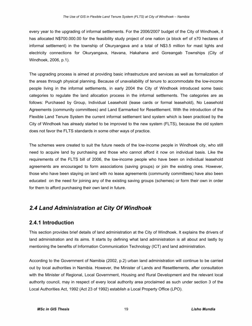
Figure 2.4a The three key attributes of land administration………………...…….……………………. 21
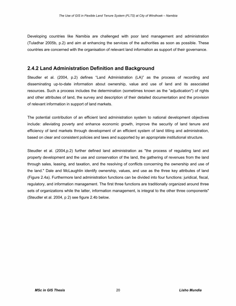
Figure 2.4b The four basic components of land administration…………….…….……………………. 21
Figure 2.5 FLTS Functional exchange between stakeholders………………………………………..... 26
Figure 2.6 FLTS Technical integration of stakeholders……….…………………..……………………. 27
Figure 2.7 Components of GIS…………………………………………………………………………..... 32
Figure 2.8 The data stream………………..…………….….…………….………….……………………. 36
Figure 2.9 Geomatics division's organization structure……………….………………………………... 41
Figure 2.10 City of Windhoek's Organogram..………………………………………………….……….. 44
Figure 3.1 The data definition process………………………………………………………………….... 49
Figure 4.1 Windhoek flexible land tenure system map….…………..………………………….………. 57
Figure 4.2 Process model for FLTS application………….…………..………………………….………. 59
Figure 4.3 FLTS land use map....……………...…………………….……………………………………. 63
Figure 4.4 Factors influencing decision to bring FLTS into GIS system….……..……………………. 66
Figure 4.5 GIS analysis map…….……………………......………………………………………...…….. 68
Figure 4.6 Other application contents of GIS for FLTS……………………..………………………….. 70
Figure 4.7 City of Windhoek technical divisional responsibilities in FLTS…........……………………. 73
Figure 4.8 The Entity-Attribute-Relationship of the proposed solution….….…………………………. 80
Figure 4.9 FLTS main register database………………………………………………………………... 81
Figure 4.10 FLTS database interface….….………………………………………………………………. 82
Figure 5.1 Existing and Proposed GIS system at City of Windhoek……………….…………………. 90
The Use of GIS in Flexible Land Tenure System (FLTS) at City of Windhoek – Namibia
MSc in GIS Thesis Lisho Mundia vii
DISCLAIMER
The results presented in this dissertation are based on my own research at the Vrije Universiteit
Amsterdam. All assistance received from other individuals and organizations has been acknowledged and
full reference is made to all published and unpublished sources used.
All assistance provided is acknowledged; any views and conclusions expressed in this study are those of
the author
This thesis has not been submitted previously for a degree at any institution.
Signed: Mr. Lisho Christoh Mundia
Date: June 2007
The Use of GIS in Flexible Land Tenure System (FLTS) at City of Windhoek – Namibia
MSc in GIS Thesis Lisho Mundia viii
ACKNOWLEDGEMENTS I acknowledge with particular thanks the advice, help and support I have received from City of Windhoek
and its staff, Claus Jendrissek of City of Windhoek’s Geomatics Division and Faniel Maanda of City of
Windhoek’s Sustainable Development Division. In the same sentiment, I further acknowledge with
particular thanks the help and support of Alexandra Tjiramanga, Tommy Bayer and Joe Lewis of the
Polytechnic of Namibia.
Many thanks to the chairman of the UNIGIS examination committee Prof. dr. Henk Scholten for allowing
me to complete my studies in an optimal time period, to my supervisors (Drs. Mathilde Molendijk and Drs.
Jasper Dekkers) for their effort and support.
Lastly, I would like to thank the following people - my mother – Brenda Lisho, my father – Jones Mundia
and my girlfriend – Elma Tholiso for their sincere support and encouraging words throughout my research.
The Use of GIS in Flexible Land Tenure System (FLTS) at City of Windhoek – Namibia
MSc in GIS Thesis Lisho Mundia 1
1. Introduction and Research Outline This chapter outlines the background of the study. It comprises of the problem statement, the aim and
objectives of the study, the hypothesis, the description of the study area and the document overview.
The theme of this study is “The use of GIS in Flexible Land Tenure1 System (FLTS) at City of Windhoek
(CoW), Namibia”. According to the Flexible Land Tenure Act of 2006 local and regional authorities are
responsible for the implementation of the FLTS in their respective areas of jurisdiction. In Windhoek the
implementation of the Act is the responsibility of the City of Windhoek as a local authority. Currently, there
are no GIS existing for handling FLTS data. This will be the first time that GIS is used to deal directly with
issues related to FLTS. The result of this study will form a basis for future research in the area related to
the use of GIS in the implementation and handling of land tenure related matters in the country.
Various organizations, private land surveyors, town planning practitioners and private individuals are
currently randomly managing both cadastral, attribute data and other geographical data of FLTS. The City
of Windhoek who has responsibility for land administration within the boundaries of the city has not been
perceptive to this effect of FLTS data management.
This thesis is divided into seven main parts. The first chapter gives a general idea about introduction and
research outline where the problem statement and the main objectives of the study are outlined. The
second chapter is about the theory concepts and their background. Chapter three explains the research
methods used for this study. The fourth chapter shows the analysis and results of this research. Chapter
five covers the discussions of the results. The sixth chapter is the conclusion drawn for this research and
lastly the recommendations in chapter seven. The section research levels in this chapter below briefly
explain what is covered in each of these chapters and how there are interlinked to each other.
1.1 Background of the Study At the beginning, the informal settlement land in Windhoek city was managed separately by pen and
paper method. This was because the land occupants were not recognized on the existing land title –
freehold which is managed by the City of Windhoek using Autodesk Map 3D supported by Munsys 9.3
Applications with Oracle database and Town Management System of Progress Systems Access Control
software, after registration in the Deeds’ Office. Other important reasons include lack of cost recovery by
the communities in terms of managing these lands and maintaining the services. Provision of services
1 Land Tenure is the condition of how and why you are occupying a certain part of land. In other words, in which rights
do you own a parcel, e.g. do you rent it, is it your property etc.
The Use of GIS in Flexible Land Tenure System (FLTS) at City of Windhoek – Namibia
MSc in GIS Thesis Lisho Mundia 2
such as water, electricity, street access, etc was very limited to this land due to un-planned (structured)
and un-surveyed land which resulted in poor health conditions for these communities.
Then the City of Windhoek realized the need for a healthy city and initiated the provision of optimal
services delivery to these communities on cost recovery bases. This was done through by registering all
the new land occupants and re-allocates them to serviced land. The initiation brought the election of
community leaders within blocks of erven for administration purpose, which saw several community
members forced to belong to a community leaders in order to save/contribute fees for drinking water and
access to community toilets. The entire procedure was then managed by pen and paper method for
statistical reasons, where the initiation resulted in less payment of water and sewerage bills for more
community groups.
Thereafter in the past few years, the City of Windhoek realized the need for a new favorable land project
in order to help the poor. The City of Windhoek then initiated the ‘Saving Group’ land project. This allowed
the communities to form groups of poor and low income people to save money daily in order to afford a
block of erf and payments of municipal services such as water, sewerage street access, etc. About forty
seven saving groups exists currently and are registered within the City of Windhoek.
Moreover, the current development is that the Government of Namibia under the Ministry of Lands and
Resettlements2 has launched the FLTS lands project as a bill which also supports the saving group
technique. Lastly, there is a need for this change because these land blocks will be properly recognized
and managed with appropriate technology such as GIS.
Geographic Information Systems (GIS) are used increasingly in variety of application areas. In all kinds of
sectors of society, applications, and research areas, GIS systems are very helpful. For Public service in
general and especially in local authorities like the City of Windhoek, GIS systems can be used as a tool for
supporting the tasks which have to be performed. There is a need for a tool to combine several data
sources. Residents and other public organizations do not only ask for more and accurate information;
there is also a need to provide in an easy and reasonably accessible manner. The possibilities to increase
the accuracy and to create combinations of all kinds of information sources are available through the GIS
technology.
In addition, there is currently no Local Property Office (LOP) yet, and the fact that each local authority has
a responsibility for managing their spatial and non-spatial data it is therefore the responsibility of the City
2 The responsibility of the Ministry of Lands and Resettlement in FLTS project is to see to it that flexible land tenure act is implemented in local authorities. This duty is performed in close consultation with other ministries, including the Ministry of Regional, Local Government, Housing and Rural Development (with reference, inter alia, to urban and regional planning, Regional Councils and local authorities)
The Use of GIS in Flexible Land Tenure System (FLTS) at City of Windhoek – Namibia
MSc in GIS Thesis Lisho Mundia 3
of Windhoek to start investigating for an innovative tool for handling its FLTS data, for which this research
is a tool of such investigation. The City of Windhoek3 is responsible for managing and monitoring all the
FLTS activities within their jurisdictions. Except for FLTS data, all other spatial data of all the erven in
Windhoek city, held on freehold rights are managed by the Geomatics Division.
From the above background, an assumption can be made that having all the FLTS data on GIS will help
with managing these data, information dissemination to the public and other relevant stakeholders, if not
today, in future all these geo data will be valuable.
1.1.1 Problem Statement
No research regarding the use of GIS for implementation of the Flexible Land Tenure bill has been
conducted in Namibia; neither do GIS existing for FLTS. This research investigates the need for GIS tools
for FLTS for the City of Windhoek.
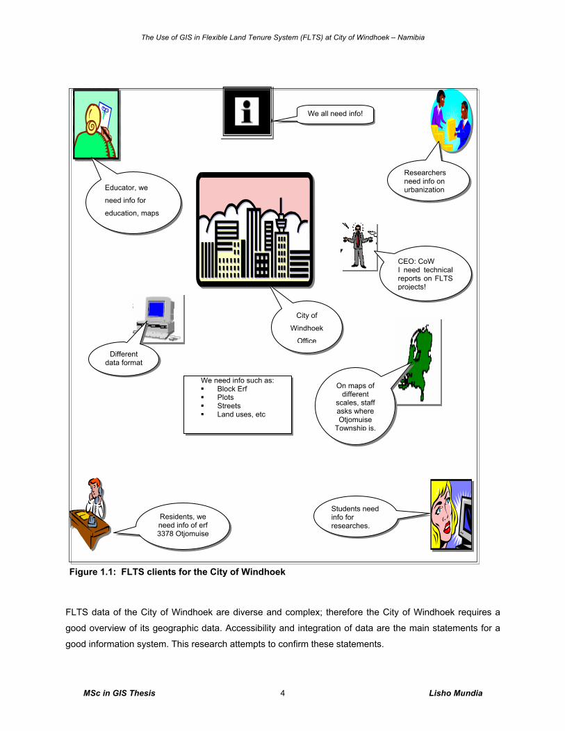
What is the potential and use of GIS in handling FLTS data at the City of Windhoek? This is one of the
main questions to be answered by this study. This includes examining the current methods and
techniques used by the City of Windhoek as well as determining the role and the need for GIS in handling
FLTS data by developing and carrying out a pilot model established by means of focus groups. The
theoretical framework for the research will be the current debate on the role of Information Technology (IT)
in land administration for poverty reduction. Figure 1.1 below shows FLTS clients for the City of Windhoek.
GIS for FLTS will replace existing paper records, maps, and attribute data. It will increase the internal
efficiency, and also the services to the public as well as to businesses and industry.
3 The Division of Geomatics, in the Department of Planning, Urbanization and Environment is responsible for surveying; mapping and GIS at the City of Windhoek. Therefore, the implementation of the Flexible Land Tenure System (FLTS) in Windhoek is to be carried out by the Division of Geomatics.
The Use of GIS in Flexible Land Tenure System (FLTS) at City of Windhoek – Namibia
MSc in GIS Thesis Lisho Mundia 4
FLTS data of the City of Windhoek are diverse and complex; therefore the City of Windhoek requires a
good overview of its geographic data. Accessibility and integration of data are the main statements for a
good information system. This research attempts to confirm these statements.
We need info such as: Block Erf Plots Streets Land uses, etc
We all need info!
City of
Windhoek
Office
CEO: CoW I need technical reports on FLTS projects!
Researchers need info on urbanization
Students need info for researches.
Residents, we need info of erf 3378 Otjomuise
Different data format
On maps of different
scales, staff asks where Otjomuise
Township is.
Educator, we
need info for
education, maps
Sustainable Development Division Figure 1.1: FLTS clients for the City of Windhoek
The Use of GIS in Flexible Land Tenure System (FLTS) at City of Windhoek – Namibia
MSc in GIS Thesis Lisho Mundia 5
1.1.2 Aim and Objectives of the Study
The research aims to examine the role of GIS in FLTS, examining the advantage and disadvantage for
using GIS in flexible land tenure, and the efficiency and benefits of GIS in handling FLTS data at the City
of Windhoek.
The main objectives of this research are to:
o Complete a scientific literature review for the Flexible Land Tenure bill of 2006, and the Flexible
Urban Land Tenure bill of 1999,
o Study the scientific literature on IT, land administration and poverty reduction,
o Examine the role of GIS in the implementation of the FLTS in Windhoek,
o Discuss the efficiency and benefits of GIS in the implementation of the Flexible Land Tenure bill to
the City of Windhoek,
o Develop an example (pilot) of a GIS/LIS (Land Information Systems) solution for handling and
managing FLTS data using Arc View GIS and Microsoft Access,
o Measure focus group’s opinions and expectations through a focused group interview technique on
the proposed use of GIS for handling and managing Flexible Land Tenure data.
1.1.3 Hypothesis
To fulfil the above objectives, the following hypothesis focusing on each of objectives need to be
answered, they are as follow:
o GIS software techniques are increasingly more user- friendly and comprehensive. The reason for
struggles in the implementation phase can be ignorance of spatial data. In addition, there is a lack
of availability of the needed budgets and consistent data.
o Early studies e.g. Bayer (2000) suggests that the initial possess of obtaining the necessary
commitment for the introduction of a system is influenced by the status and respect the promoting
department/division or group of individuals’ possess within the authority.
o GIS implementation requires professional skills.
o To increase experience and enthusiasm for GIS techniques, the (potential) users need good
training and education.
1.1.4 Study Area
The research focuses on the use of GIS in Flexible Land Tenure System (FLTS) at City of Windhoek in
the Republic of Namibia. The study will concentrates on how geographical data of the FLTS can be
analyzed and managed by a GIS.
The Use of GIS in Flexible Land Tenure System (FLTS) at City of Windhoek – Namibia
MSc in GIS Thesis Lisho Mundia 6
The City of Windhoek is situated in the central part of the Republic of Namibia. It teams with life and
dynamic cultural activities. Windhoek‘s population is about 240 000 excluding the temporary residents
amounting to approximately 7033 persons.
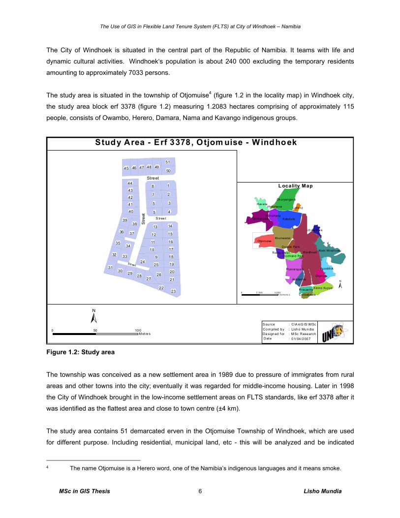
The study area is situated in the township of Otjomuise4 (figure 1.2 in the locality map) in Windhoek city,
the study area block erf 3378 (figure 1.2) measuring 1.2083 hectares comprising of approximately 115
people, consists of Owambo, Herero, Damara, Nama and Kavango indigenous groups.
Figure 1.2: Study area
The township was conceived as a new settlement area in 1989 due to pressure of immigrates from rural
areas and other towns into the city; eventually it was regarded for middle-income housing. Later in 1998
the City of Windhoek brought in the low-income settlement areas on FLTS standards, like erf 3378 after it
was identified as the flattest area and close to town centre (±4 km).
The study area contains 51 demarcated erven in the Otjomuise Township of Windhoek, which are used
for different purpose. Including residential, municipal land, etc - this will be analyzed and be indicated
4 The name Otjomuise is a Herero word, one of the Namibia’s indigenous languages and it means smoke.
0 1/ 04 /2 00 7M Sc Rese archLish o Mu n diaC\A rcG IS \M Sc
De sign ed f or :Dat e :
Co m piled b y :S ou rce :±
Str eet
Street
S tree t
Stre
et
0 5 ,0002 , 500K ilomet re s
±
Locality Map
0 10 050M et re s
9
18
3
27
5
45
10
26
11
22
39
31
23
12
45
40
13
32
2930
46 47 48
28
49
27
14
33
50
42
51
43
20
41
44
21
18
17
16
1536
35
1924
25
37
34
38
W indhoek
K atutura
Khomasdal
Goreangab
Otjomuise
Ok uryangav a
Klein Windhoek
Pionier spark Auasblick
Olympia
K leine Kuppe
Havana
Wanaheda
Hochland Park
Ac ademia
Pr os perita
Eros P ar k
Roc ky Cres t
Dorado Par k
Cimbebasia
LafrenzHakahana
Study Area - Erf 3378, Otjom uise - Windhoek
The Use of GIS in Flexible Land Tenure System (FLTS) at City of Windhoek – Namibia
MSc in GIS Thesis Lisho Mundia 7
using ArcView GIS software. The area is selected due to its suitability of FLTS standard, including suitable
street access of between 6 and 10m wide, basic services like water, sewerage and electricity. The erven
are allocated to individual clients on individual lease agreements, with the intention for the current
individual leaseholders to purchase it on new FLTS standard as a saving group in future.
1.1.5 Research Levels
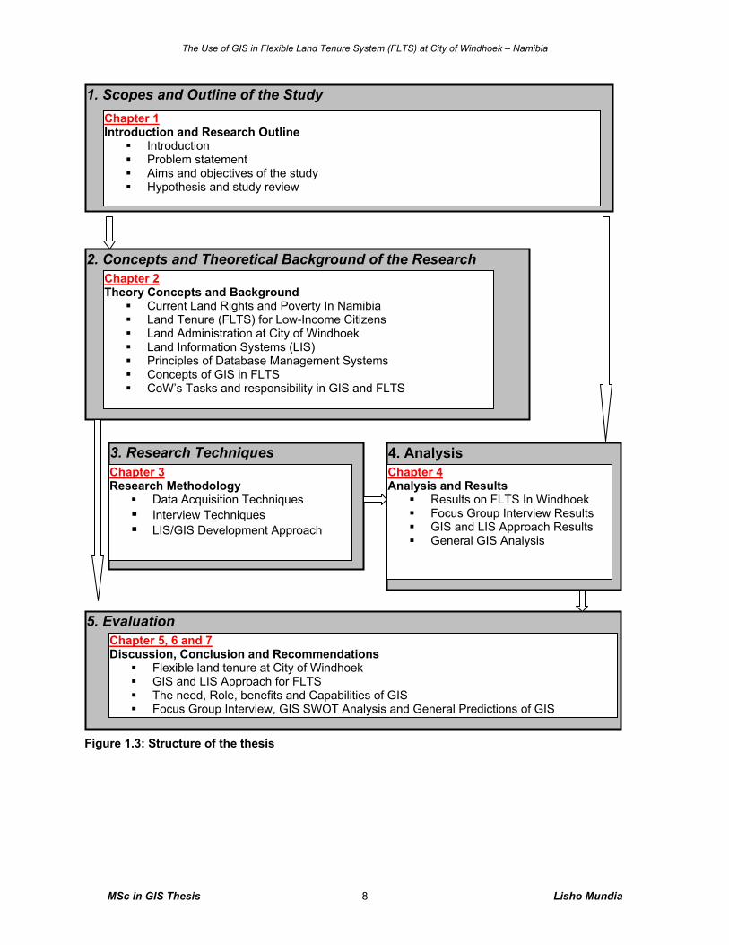
This dissertation consists of five main research levels as outlined in figure 1.3 below:
o Scope and outline of the study
o Concepts and theoretical background of framework
o Research techniques
o Analysis
o Evaluation
In Chapter 1 the problem statement and outline of this study is made. The aims of the study are described
and the objectives are pointed out. The hypothesis is stated, which will be tested in chapter five. In
Chapter 2 the theoretical background is explained mainly of how GIS can help in FLTS data analysis and
management, the theoretical concepts of land administration, land rights, IT and LIS and the services
available at the City of Windhoek are explained.
Chapter 3 is reviews the methodologies used to gather the required information of results. Two research
levels are set out. The first one is to research the way on how FLTS spatial and attribute data can be
acquired and administered with GIS, done through scientific literature review, field observations and
cartographical technical aspects with pilot data. The second level is to research the need for the
usefulness of GIS for Flexible Land Tenure System (FLTS) at the City of Windhoek, done by focus group
interview technique, interlinked with research level one.
Chapter 4 deals with the analyzed results of the scientific literature review and focus group interview
including the OPAFIT C+ concept. Results of GIS and LIS approach, General GIS SWOT analysis
including the advantages and disadvantages of GIS to determine the right usage and efficiency of a GIS
are provided in this chapter. Chapter 5 provides the discussions of results and conclusion of this study in
chapter 6, and lastly recommendations in chapter 7 (see figure 1.3 for the structure of the theses).
The Use of GIS in Flexible Land Tenure System (FLTS) at City of Windhoek – Namibia
MSc in GIS Thesis Lisho Mundia 8
Figure 1.3: Structure of the thesis
1. Scopes and Outline of the Study Chapter 1
Introduction and Research Outline Introduction Problem statement Aims and objectives of the study Hypothesis and study review
2. Concepts and Theoretical Background of the Research Chapter 2 Theory Concepts and Background
Current Land Rights and Poverty In Namibia Land Tenure (FLTS) for Low-Income Citizens Land Administration at City of Windhoek Land Information Systems (LIS) Principles of Database Management Systems Concepts of GIS in FLTS CoW’s Tasks and responsibility in GIS and FLTS
3. Research Techniques Chapter 3 Research Methodology
Data Acquisition Techniques Interview Techniques LIS/GIS Development Approach
4. Analysis Chapter 4 Analysis and Results
Results on FLTS In Windhoek Focus Group Interview Results GIS and LIS Approach Results General GIS Analysis
5. Evaluation Chapter 5, 6 and 7 Discussion, Conclusion and Recommendations
Flexible land tenure at City of Windhoek GIS and LIS Approach for FLTS The need, Role, benefits and Capabilities of GIS Focus Group Interview, GIS SWOT Analysis and General Predictions of GIS
The Use of GIS in Flexible Land Tenure System (FLTS) at City of Windhoek – Namibia
MSc in GIS Thesis Lisho Mundia 9
2. Theory Concepts and Background
2.1 Introduction This chapter is a review of literature on land rights, flexible land tenure system for low-income citizens,
land administration, GIS, Land Information Systems (LIS), Database Management Systems (DBMS) and
Information Technology (IT). This thesis deals with the implementation of the flexible land tenure system
at City of Windhoek. The research is in line with the Namibia’s vision 2030 (of the technological ideal)
thus, the following points will be examined: objectives, clarification, success factors and problems of
flexible land tenure system. Further review of the functionality of land tenure system, land rights, land
administration, LIS, database management systems, IT and GIS in Africa as an overview will be done.
2.2 Current Land Rights and Poverty in Namibia Land rights are the powers entitled to the occupant of the specific land in accordance to the conditions set
in the title deed, lease agreement or a deed of sale. Therefore, an overview of the most common land
rights is given in order to compare them to that of the FLTS. Land is a primary means of both survival and
income generation in urban-rural economies, therefore access to land and security of land rights are of
primary concern for households and the eradication of poverty (Drimie 2002, p.6). Currently, there is only
one land tenure system for urban land in Namibia which is freehold tenure. Land rights of freehold tenure
as commonly known in Namibia may include:
o Rights to occupy and to make permanent improvements;
o Rights to transact, give, mortgage, lease, rent and bequeath areas of exclusive use;
o Rights to exclude others from the above-listed rights, at community and/or individual levels; and
o Rights to enforcement of legal and administrative provisions in order to protect the rights holder
(Drimie 2002, p.6).
There is in addition, to any land tenure right recognized in terms of the common law for the time applying
in Namibia recognized land tenure rights; namely the starter title tenure and the land hold title tenure
(Government of Namibia, 1999) which are described below in section 2.3 with their detailed rights.
Namibia comprises of a population of 1, 830,330 people (see figure 2.1 for Namibia population map).
According to the 2001 Housing and Population Census report of the National Planning Commission (2003,
p.4), the majority of the population resides in the rural areas and are mainly traditional hunter-gatherers,
herders and farmers and tend to depend largely on limited livestock grazing and marginal farming.
Approximately 12% of the Namibian population lives in urban areas on land to which they have no formal

The Use of GIS in Flexible Land Tenure System (FLTS) at City of Windhoek – Namibia
MSc in GIS Thesis Lisho Mundia 10
legal rights. This issue has been one of the major focuses of the Ministry of Lands and Resettlement, working
with a Danish NGO called Ibis-Wus (Augustinus, 2003, p.2).
In many developing countries or emerging markets, property rights do exist. However, they do not have
the complementary legal framework that is present in developed countries and that allows these property
rights to become legal theirs. This legal framework provides a kind of scaffolding5, which allows property
to move to its highest valued use with a great deal of security (De Soto, 1996, p.2).
In the mid 1990s, the total population of Namibia was in the region of 1.5 million people. It rose to
approximately 1.8 million of the current population (National Planning Commission, 2003, p.4), with 71% of
this population (67% of households) living in the rural areas. The population is unevenly distributed.
Figure 2.1: Namibia population map
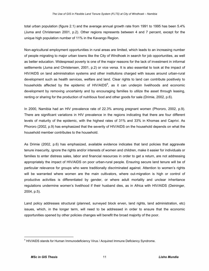
Four regions in the north of the country accommodate 43% of the total population namely Ohangwena,
Omusati, Oshana and Oshikoto. Windhoek (Khomas region), situated at the centre, has 13% of Namibia’s
5 Scaffolding means poles and boards that are used to make a frame around a building for workmen to stand on.
S o u r c e :C o m p i l e d b y :
D a t e :D e s i g n e d fo r :
C \A r c G IS \ M S cL i s h o M u n d i aM S c R e s e a r c h0 1 /0 4 /2 0 0 7
N a m i b i a P o p u la t i o n M a p B y R e g io n s
L e g e n dR e g i o n s
C a p r iv i
E r o ng o
H a r d a p
K a r as
K a v a n g o
K h o m a s
K u n en e
O h a n gw e n a
O m a h e k e
O m u s at i
O s h a n a
O s h ik ot o
O tjo z on d ju p a±0 5 0 02 5 0
K il o m e t r e s
7 %
4 %1 1 %9 %
4 %1 3 %
4 %
4 %
1 3 %
4 %1 3 % 9 %
1 2 %
The Use of GIS in Flexible Land Tenure System (FLTS) at City of Windhoek – Namibia
MSc in GIS Thesis Lisho Mundia 11
total urban population (figure 2.1) and the average annual growth rate from 1991 to 1995 has been 5.4%
(Juma and Christensen 2001, p.2). Other regions represents between 4 and 7 percent, except for the
unique high population number of 11% in the Kavango Region.
Non-agricultural employment opportunities in rural areas are limited, which leads to an increasing number
of people migrating to major urban towns like the City of Windhoek in search for job opportunities, as well
as better education. Widespread poverty is one of the major reasons for the lack of investment in informal
settlements (Juma and Christensen, 2001, p.2) or vice versa. It is also essential to look at the impact of
HIV/AIDS on land administration systems and other institutions charged with issues around urban-rural
development such as health services, welfare and land. Clear rights to land can contribute positively to
households affected by the epidemic of HIV/AIDS6, as it can underpin livelihoods and economic
development by removing uncertainty and by encouraging families to utilize the asset through leasing,
renting or sharing for the production of nutritious food and other goods for sale (Drimie, 2002, p.6).
In 2000, Namibia had an HIV prevalence rate of 22.3% among pregnant women (Phororo, 2002, p.9).
There are significant variations in HIV prevalence in the regions indicating that there are four different
levels of maturity of the epidemic, with the highest rates of 31% and 33% in Khomas and Caprivi. As
Phororo (2002, p.9) has emphasized that the severity of HIV/AIDS on the household depends on what the
household member contributes to the household.
As Drimie (2002, p.6) has emphasized, available evidence indicates that land policies that aggravate
tenure insecurity, ignore the rights and/or interests of women and children, make it easier for individuals or
families to enter distress sales, labor and financial resources in order to get a return, are not addressing
appropriately the impact of HIV/AIDS on poor urban-rural people. Ensuring secure land tenure will be of
particular relevance for groups who were traditionally discriminated against. Attention to women’s rights
will be warranted where women are the main cultivators, where out-migration is high or control of
productive activities is differentiated by gender, or where adult mortality and unclear inheritance
regulations undermine women’s livelihood if their husband dies, as in Africa with HIV/AIDS (Deininger,
2004, p.5).
Land policy addresses structural (planned, surveyed block erven, land rights, land administration, etc)
issues, which, in the longer term, will need to be addressed in order to ensure that the economic
opportunities opened by other policies changes will benefit the broad majority of the poor.
6 HIV/AIDS stands for Human Immunodeficiency Virus / Acquired Immune Deficiency Syndrome.
The Use of GIS in Flexible Land Tenure System (FLTS) at City of Windhoek – Namibia
MSc in GIS Thesis Lisho Mundia 12
To overcome compartmentalization7 that may result from such arrangements, it will be essential to have a
long-term vision and to include land issues in the framework of a broadly backed development strategy.
The extent to which goals are achieved should be monitored independently and jointly with other
government programs aimed at poverty reduction (lack of housing, poor security of land, etc) and
economic development (Deininger, 2004, p.13). Good governance8 is perhaps the single most important
factor in eradicating poverty and promoting development (Magel, 2006, p.4). This can be archived through
introducing land administration tools such as an LIS Cadastre for the entire Namibia by involving all
stakeholders in supporting and building land security issues in Namibia.
2.3 Land Tenure (FLTS) for Low-Income Citizens
2.3.1 Introduction
This section briefly explains and describes the Flexible Land Tenure System (FLTS) for low income
people in Namibia, citing the situation in Windhoek city for upgrading and formalization of informal
settlements as one of the biggest challenges facing local authorities in Namibia.
The present land registration system in operation in Namibia – Freehold system – is highly cumbersome
and costly (Vries et al. 2003, p. 0). However, due to the high cost the system is not affordable to the
majority and disadvantaged people. It has been difficult for the public sector to respond to the dramatic
demand for urban land and this has lead to a rethinking of the whole paradigm for official planning. It has
become evident that conventional planning, surveying and registration create scarcity and high costs. It is
generally agreed that the role of the government should be to perform certain planning and control
functions and protect basic rights of people, including land rights.
The Ministry of Lands and Resettlement has developed during the past years an affordable land
registration system “Flexible Land Tenure System (FLTS)” to benefit particularly poor informal urban
settlers. The FLTS aims at addressing the need for urban land for all sectors and most disadvantaged
groups of the society. It focuses on providing security of tenure rights for people living in urban informal
settlements. The new system of tenure offers two different levels of tenure i.e. starter title and land hold
title (Government of Namibia, 2006) as mentioned earlier.
Consequently, in 1998, the Cabinet has grated approval that a new parallel tenure system (Flexible land
tenure system) be adopted for Namibia, and the draft bill was prepared as a result thereof. The Ministry of
7 Compartmentalization means dividing something (land policies) into separate areas, categories, or compartments. 8 Good governance is the process whereby public institutions conduct public affairs, manage public resources and guarantee the realization of human rights.
The Use of GIS in Flexible Land Tenure System (FLTS) at City of Windhoek – Namibia
MSc in GIS Thesis Lisho Mundia 13
Lands and Resettlement will do its best to get the Bill before Parliament as a matter of urgency
(Government of Namibia, 2006).
2.3.2 Objectives of the FLTS
The objectives of the Flexible Land Tenure Act are:
o To create alternative forms of land title that is simpler and cheaper to administer than the existing
ones.
o To provide security of title for persons who live in informal settlements.
o To empower the persons concerned economically by means of these rights.
This Act is only applicable to land situated within the boundaries of a municipality, town, and village
council or within the boundaries of a settlement area but not in un-proclaimed town land i.e. like farm land,
communal land etc (Government of Namibia, 2006).
2.3.3 Land Rights Offices and Officers Land rights offices (also known as Local Property Office (LPO9) will be established near to the
beneficiaries in local authority area as well as in regional councils in respect of areas falling outside
proclaimed local authority areas. The land rights offices should be geographically located where the
pressure for land registration is greatest. Decisions on establishing land rights offices must be carried out
in cooperation with the Minister of Regional, Local Government, Housing and Rural Development
(Government of Namibia, 2006).
The Minister of Lands and Resettlement will appoint the staff of the rights office. A land rights office
comprises the following staff:
o A land rights registrar,
o A land measurer, and
o A Registration Officer.
The land rights registrar will be responsible for the operation of the office, the land measurer and
registration officer will, under the control of the land rights registrar, perform anything which may be done
under this Act (Government of Namibia, 2006).
9 A Local Property Offices are designed to be responsible for the registration of FLTS land rights including land use, land value and ownership.
The Use of GIS in Flexible Land Tenure System (FLTS) at City of Windhoek – Namibia
MSc in GIS Thesis Lisho Mundia 14
2.3.4 Registers All freeholds land tenure in Namibia is registered in the Directorate of Deeds registration system under the
Ministry of Lands and Resettlement, whilst, the geometric information (maps) are registered at the
Surveyor General’s Office (SGO) under the same ministry. In order to create one property registration
system, the new titles should be stored in the same registration system. At the full implementation, it will
be possible to access information via computer terminals situated in each land rights office. This makes it
possible to provide information about land widely accessible.
The Registrar of Deeds will establish a register for starter and land hold title, but the staff member of the
Land Rights Office (LRO) records the information from the computer access points to be accessed by the
national register of freehold tenure title. In order to ensure good governance, the Registrar of Deeds will
ensure directives and perform inspections of the information recorded in the land rights office
(Government of Namibia, 2006).
2.3.5 Nature of FLTS Titles and the Establishment of the Title Schemes The proposed starter title is a statutory form of tenure registered in respect of an erf block consisting up to
100 households. A local authority, a private sector developer, a community organization or a non-
governmental organization may own the block. The outside boundary of the erf block is surveyed
according to the existing survey regulations and the erf block is registered as freehold ownership title in
the deeds registration system. The starter title provides the holder with the right to live on a piece of land
in perpetuity, without fear of being evicted without providing them with an alternative piece of land.
Furthermore, it provides the holder the right to transfer, lease, and utilize such services as may be
provided to the scheme. It will be compulsory for the holder to be member of the saving group 10(association) of the scheme (Government of Namibia, 2006).
The land hold title provides the poor communities with almost all the rights entailed in the freehold title
under the common law but without the complications of full individual ownership, but the saving group
(associations) as registered owner. The land hold title provides the owner with the right to occupy a
defined and surveyed plot in perpetuity (Government of Namibia, 2006).
The preliminary steps before the establishments of the starter and land hold title schemes is that, the
relevant local authority may on its own or on application by the owner of a piece of land consider the
establishment of a land hold title or starter title scheme. Although people in many parts of the country
already live on the land, it might however not be suitable as a residential area (e.g. regular flooding).
10 Saving group (s) is interchangeable to mean saving scheme (s) or association (s).
The Use of GIS in Flexible Land Tenure System (FLTS) at City of Windhoek – Namibia
MSc in GIS Thesis Lisho Mundia 15
Therefore the relevant authority must conduct a feasibility study (geological, environmental, existing
planning regulations, etc.) of the area according to prescribed procedures in the regulations. Only if the
relevant authority is satisfied that the establishment of the scheme is desirable, can it continue
(Government of Namibia, 2006).
The establishments of the land hold and starter title will be based upon approval of the desirability to
establish the scheme, the procedures of establishments of schemes (currently known as saving groups)
will be investigated too. The procedures were already tested in Otjiwarongo in the Otjozondjupa Region,
Rundu in the Kavango Region and other parts of the northern regions of the country was proven to be
operating successfully, this will have to be tested in other several informal settlements also. They will have
to be proved to operate exactly towards the objective of the FLTS act (Government of Namibia, 2006).
2.3.6 Upgrading of the Title Schemes
Upgrading of starter title scheme to land hold title scheme will be possible if 75% of the holders of the
starter title rights have consented to upgrade. Thereafter the relevant authority may approve such an
application. The procedures set out above must be followed. A layout of the area needs to be approved by
the relevant authority. When the new Town Planning Act is promulgated some relevant authorities will
become “approving authorities” and others will have to liaise directly with the Ministry of Regional, Local
Government, Housing and Rural Development. However, during some years it is anticipated that most
relevant authorities will become “approving authorities” (Government of Namibia, 2006).
When a starter title scheme is upgraded to land hold title, every holder must be allocated a plot, which
corresponds as closely as possible to the piece of ground actually occupied. The regulations will describe
the minimum size of plots, the width of roads, etc. The land measurer will then survey and map the area.
As land hold title rights are substantially more individualized than starter title rights, a process of
adjudication will need to take place when upgrading from starter title rights in order to ensure that the right
parties become land hold title owners. The procedure of adjudication will be prescribed in the regulations.
When survey and regulations are completed the holder will be issued with a land hold certificate
(Government of Namibia, 2006).
Although it is envisaged that, particularly in the residential context, land hold title rights will offer sufficient
security of tenure, it will always be possible for land hold title owners to upgrade their title to full
ownership. The same applies to starter title owners, who do not want land hold title. They can go straight
for full ownership referred as freehold title.
The Use of GIS in Flexible Land Tenure System (FLTS) at City of Windhoek – Namibia
MSc in GIS Thesis Lisho Mundia 16
The procedures set out above should be followed and the cost for such upgrading must be born by the
holders themselves, these costs are optimal cost due to the poor financial status of this community
member.
2.3.7 Associations and Title Commencement The group approach is becoming much more popular as a way of protecting poor people’s property rights
while giving them access to land and security of tenure, because the associations are registered in the
Deeds Office of the Ministry of Lands and Resettlements (MLR) as legal entities. The block members must
form an association to manage and control the block. It will be compulsory to establish an association for
both starter title and land hold title schemes, also known as saving groups. To date, there are a few
success stories and majority of the communities are already registered with schemes.
The association and the elected leadership of such association will be responsible for direct liaising with
the relevant authority. The elected leadership could play a key role in solving disputes in the erf block. The
civil laws and operational rules of such association would have to be within the Namibian constitution and
would not be able to discriminate on the basis of race ethically of gender.
This act is called the Flexible Land Tenure Act, 2006 and will come in operation on the date to be
determined by the Minister by notice in the Gazette (Government of Namibia, 2006).
2.3.8 Flexible Land Tenure State in Windhoek City
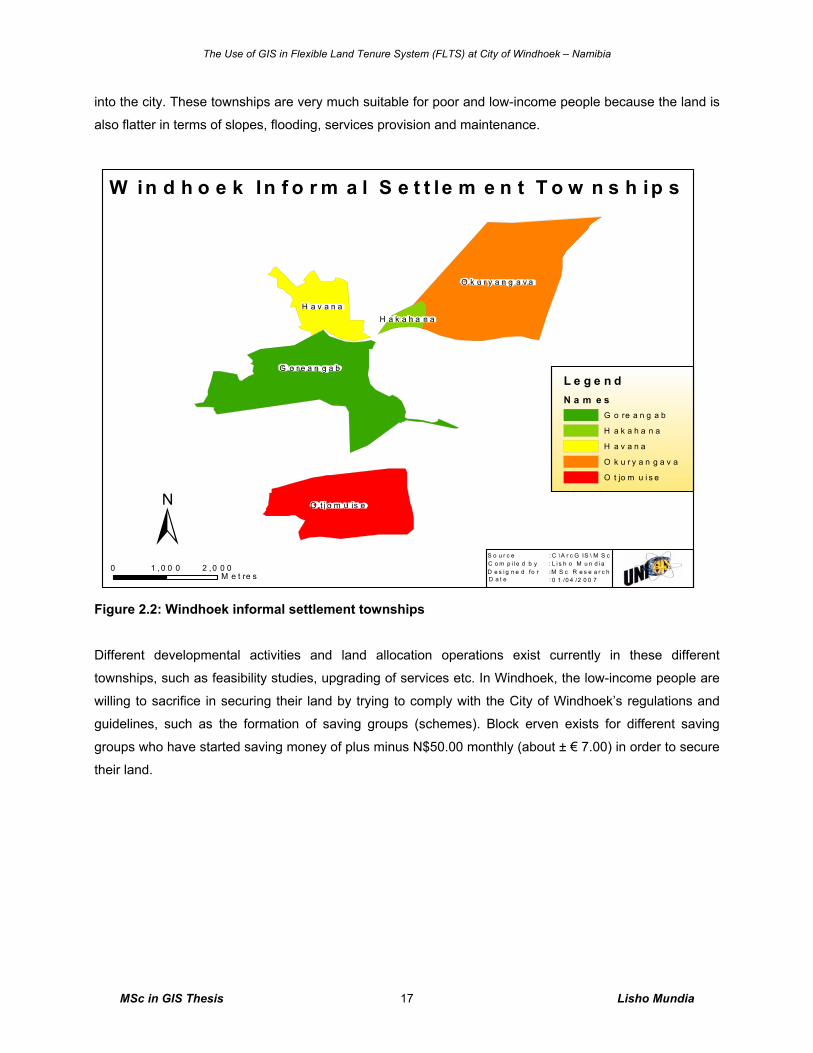
Informal settlements in Windhoek are found in the townships of Goreangab, Hakahana, Havana,
Okuryangava and Otjomuise, see figure 2.2 below. The locations of informal settlements and low-income
land in these townships are evenly distributed in order to form a uniform of related land development. It
can also be seen on figure 2.2 below that these townships are available in the northern part of the city.
According to my discretion, currently the township of Goreangab is dominantly visible with low income
houses and highly visibility of informal settlement, as of Hakahana township it is mostly dominated by the
structured low income housing, jointly to the township of Havana which is a complete informal settlement
area and is under upgrading process (see the map of informal settlement areas in figure 2.2 below). The
township of Okuryangava is highly dominated by the informal settlement and the visible mixed poor to low-
income houses in some parts.
Informal settlements land in these townships are cheap, and at reasonable prices for poor and low-income
people considering the demand of land, basic services provided and the high number of people flocking
The Use of GIS in Flexible Land Tenure System (FLTS) at City of Windhoek – Namibia
MSc in GIS Thesis Lisho Mundia 17
into the city. These townships are very much suitable for poor and low-income people because the land is
also flatter in terms of slopes, flooding, services provision and maintenance.
Figure 2.2: Windhoek informal settlement townships
Different developmental activities and land allocation operations exist currently in these different
townships, such as feasibility studies, upgrading of services etc. In Windhoek, the low-income people are
willing to sacrifice in securing their land by trying to comply with the City of Windhoek’s regulations and
guidelines, such as the formation of saving groups (schemes). Block erven exists for different saving
groups who have started saving money of plus minus N$50.00 monthly (about ± € 7.00) in order to secure
their land.
O k u r y a n g a v a
G o r e a n g a b
O t j o m u is e
H a v a n aH a k a h a n a
W in d h o e k In f o r m a l S e t t le m e n t T o w n s h ip s
L e g e n dN a m e s
G o re a n g a b
H a k a h a n a
H a v a n a
O k u r y a n g a v a
O t jo m u i s e
S o u r c e :C o m p i l e d b y :
D a t e :D e s i g n e d fo r :
C \A r c G IS \ M S cL i s h o M u n d i aM S c R e s e a r c h0 1 /0 4 /2 0 0 7
0 2 ,0 0 01 ,0 0 0M e t re s
±
The Use of GIS in Flexible Land Tenure System (FLTS) at City of Windhoek – Namibia
MSc in GIS Thesis Lisho Mundia 18
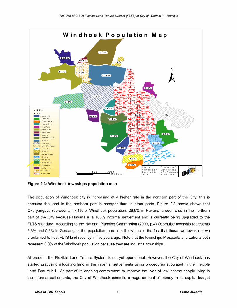
Figure 2.3: Windhoek townships population map
The population of Windhoek city is increasing at a higher rate in the northern part of the City; this is
because the land in the northern part is cheaper than in other parts. Figure 2.3 above shows that
Okuryangava represents 17.1% of Windhoek population, 26,9% in Havana is seen also in the northern
part of the City because Havana is a 100% informal settlement and is currently being upgraded to the
FLTS standard. According to the National Planning Commission (2003, p.4) Otjomuise township represents
3.8% and 5.3% in Goreangab, the population there is still low due to the fact that these two townships we
proclaimed to host FLTS land recently in five years ago. Note that the townships Prosperita and Lafrenz both
represent 0.0% of the Windhoek population because they are industrial townships.
At present, the Flexible Land Tenure System is not yet operational. However, the City of Windhoek has
started practising allocating land in the informal settlements using procedures stipulated in the Flexible
Land Tenure bill. As part of its ongoing commitment to improve the lives of low-income people living in
the informal settlements, the City of Windhoek commits a huge amount of money in its capital budget
3 . 4 % 4 %
7 .8 %
3 . 5 %
1 7 . 6 %
1 7 .1 %
5 .3 %
3 . 8 %
0 . 3 %
1 .9 %
1 6 %
7 . 2 %
5 . 2 %
2 6 .9 %
4 . 4 %
0 .0 %
7 . 5 %
5 . 6 %
6 . 9 %
1 0 .2 %
0 %4 2 . 1 %
W in d h o e k P o p u la t io n M a p
L e g e n dN a m e s
A ca de m ia
A ua sb l ick
C i m b e ba s i a
D o ra do P a rk
E ro s P a rk
G ore a ng a b
H a ka h an a
H a va n a
H o ch la n d P ark
K at u t u ra
K ho m as da l
K le in W i nd h oe k
K le in e K u pp e
L a f ren z
O ku rya ng a va
O lym p ia
O tj o m u is e
P io n ie rsp a rk
P ro sp er it a
R o cky Cr es t
W a n ah e da
W in dh o e k
S o u r c e :C o m p i l e d b y :
D a t e :D e s i g n e d fo r :
C \A r c G IS \ M S cL i s h o M u n d i aM S c R e s e a r c h0 1 /0 4 /2 0 0 7
0 3 , 0 0 01 ,5 0 0M e t re s
±
The Use of GIS in Flexible Land Tenure System (FLTS) at City of Windhoek – Namibia
MSc in GIS Thesis Lisho Mundia 19
every year to the upgrading of informal settlements. For the 2006/2007 budget of the City of Windhoek, it
has allocated N$700.000.00 for the feasibility study project of one nation (a block erf of ±70 hectares of
informal settlement) in the township of Okuryangava and a total of N$3.5 million for mast lights and
electricity connections for Okuryangava, Havana, Hakahana and Goreangab Townships (City of
Windhoek, 2006, p.1).
The upgrading process is aimed at providing basic infrastructure and services as well as formalization of
the areas through physical planning. Because of unavailability of tenure to accommodate the low-income
people living in the informal settlements, in early 2004 the City of Windhoek introduced some basic
categories to regulate the land allocation process in the informal settlements. The categories are as
follows: Purchased by Group, Individual Leasehold (lease cards or formal leasehold), No Leasehold
Agreements (community committees) and Land Earmarked for Resettlement. With the introduction of the
Flexible Land Tenure System the current informal settlement land system which is been practiced by the
City of Windhoek has already started to be improved to the new system (FLTS), because the old system
does not favor the FLTS standards in some other ways of practice.
The schemes were created to suit the future needs of the low-income people in Windhoek city, who still
need to acquire land by purchasing and those who cannot afford it now on individual basis. Like the
requirements of the FLTS bill of 2006, the low-income people who have been on individual leasehold
agreements are encouraged to form associations (saving groups) or join the existing ones. However,
those who have been staying on land with no lease agreements (community committees) have also been
educated on the need for joining any of the existing saving groups (schemes) or form their own in order
for them to afford purchasing their own land in future.
2.4 Land Administration at City Of Windhoek
2.4.1 Introduction This section provides brief details of land administration at the City of Windhoek. It explains the drivers of
land administration and its aims. It starts by defining what land administration is all about and lastly by
mentioning the benefits of Information Communication Technology (ICT) and land administration.
According to the Government of Namibia (2002, p.2) urban land administration will continue to be carried
out by local authorities in Namibia. However, the Minister of Lands and Resettlements, after consultation
with the Minister of Regional, Local Government, Housing and Rural Development and the relevant local
authority council, may in respect of every local authority area proclaimed as such under section 3 of the
Local Authorities Act, 1992 (Act 23 of 1992) establish a Local Property Office (LPO).
The Use of GIS in Flexible Land Tenure System (FLTS) at City of Windhoek – Namibia
MSc in GIS Thesis Lisho Mundia 20
Developing countries like Namibia are challenged with poor land management and administration
(Tuladhar 2005b, p.2) and aim at enhancing the services of the authorities as soon as possible. These
countries are concerned with the organisation of relevant land information as support of their governance.
2.4.2 Land Administration Definition and Background
Steudler et al. (2004, p.2) defines “Land Administration (LA)” as the process of recording and
disseminating up-to-date information about ownership, value and use of land and its associated
resources. Such a process includes the determination (sometimes known as the “adjudication") of rights
and other attributes of land, the survey and description of their detailed documentation and the provision
of relevant information in support of land markets.
The potential contribution of an efficient land administration system to national development objectives
include: alleviating poverty and enhance economic growth, improve the security of land tenure and
efficiency of land markets through development of an efficient system of land titling and administration,
based on clear and consistent policies and laws and supported by an appropriate institutional structure.
Steudler et al. (2004,p.2) further defined land administration as "the process of regulating land and
property development and the use and conservation of the land, the gathering of revenues from the land
through sales, leasing, and taxation, and the resolving of conflicts concerning the ownership and use of
the land." Dale and McLaughlin identify ownership, values, and use as the three key attributes of land
(Figure 2.4a). Furthermore land administration functions can be divided into four functions: juridical, fiscal,
regulatory, and information management. The first three functions are traditionally organized around three
sets of organizations while the latter, information management, is integral to the other three components"
(Steudler et al. 2004, p 2) see figure 2.4b below.
The Use of GIS in Flexible Land Tenure System (FLTS) at City of Windhoek – Namibia
MSc in GIS Thesis Lisho Mundia 21
Figure 2.4a: The three key attributes of land
administration (Steudler et al. 2004, p3)
Figure 2.4b: The four basic components of land administration (Steudler et al. 2004, p3).
Along with the staggering progress in information technology, the information management function has
considerably been developed over the last few decades, with many efforts to establish information
systems dealing with land information (Steudler et al. 2004, p.3). In Namibia, a feasibility study to
introduce LIS for Namibia is currently being done by the Swedesurvey AB, a Swedish agency, and the
overseas agency of the national land survey consulted by the Surveyor General’s Office (SGO) of the
Ministry of Lands and Resettlements. This feasibility study is headed by the Ministry of Lands and
Resettlement and it has already seen its first stakeholders’ meeting where the City of Windhoek was
represented by the Geomatics Division. Key attributes of land such as ownership, value and use were
extensively discussed and the FLTS tenure system is involved. This research can only reveal that the
Namibian has finally seen the potentiality in multipurpose cadastre for the entire nation. The Ministry of
Lands and Resettlement are the drivers of the project and they are commented to it. The stakeholders
involved and a brief relation for spatial information management in Namibia are explained in section 2.5.4
of this chapter.
2.4.3 ICTs and Land Administration Developments A common characteristic of land administration organizations is the great deal of effort they devote to the
determination, registration and dissemination of information pertaining to the ownership, value and use of
land. This involves a large amount of data that are subject to many changes; need to be kept up to date,
The Use of GIS in Flexible Land Tenure System (FLTS) at City of Windhoek – Namibia
MSc in GIS Thesis Lisho Mundia 22
and accessible for consultation. Consequently, these operations constitute a highly transactional
environment. The efficient and effective performance of these duties is mostly less cost efficiency with the
support of Information Technology (IT).
The very true statement about Information and Communication Technologies (ICTs) and poverty reduction
as Kenny et al. (2004, p.407) makes is that lack of access to ICTs is clearly not an element of poverty in
the way that insufficient nutrition or inadequate shelter is, but ICTs are increasingly important in the effort
to escape poverty. Kenny et al. (2004, p.407) in the world bank report for information and communication
technologies further states that ICTs provide access to information that can create earnings opportunities,
improve access to basic services, or increase the impact of education and health interventions. ICTs also
give the poor a medium through which to demand government support and reform.
Kenny et al. (2004, p. 411) claims that security wise ICTs play a major role in reducing vulnerability,
especially during times of natural disasters, and to powerlessness. One of the reasons for this is the part
that ICTs can play in amplifying the voices of the poor, for example, with the use of GIS it can be
determined which land of the informal settlements are affected by flood and identify the effect using the
GIS technology.
Flower countries which are in a further stage of development enjoyed benefit of IT-application at an earlier
stage. Many of them now face the renewal of their ICT architecture because their existing information
systems cannot cope with evolving customer demands and ICT opportunities (FIG, 2003). Currently, most
countries, information technology has improved in relation to land administration, this improvement means
that the price of processing both spatial and non-spatial data for dissemination to the clients of specific
public organizations like the City of Windhoek decreases.
With regards to data collection, positioning systems can be integrated with less time consuming,
affordable and less labor intensive. As Barodie and Barry (2004, p.2) recognize effective upgrading of
informal settlements requires accurate and up-to-date social and spatial information, this is mainly to avoid
costs in future for data collection and processing when new development comes along. As it was said by
Home & Jackson (1997, p.3) use a point position (collected with hand held GPS) to relate the property
identifier number, land cover, soil condition, and number of structures, etc.
The Use of GIS in Flexible Land Tenure System (FLTS) at City of Windhoek – Namibia
MSc in GIS Thesis Lisho Mundia 23
2.5 Land Information Systems (LIS)
2.5.1 Introduction
The review of this section is to outline the potentiality of Land Information Systems (LIS) in relation to
Land Information (LI) that the GIS for FLTS will be able to manage. It is proven that the success of GIS in
FLTS projects lies firstly on review of the cadastral and LIS in Africa at lager, strategically to build
relationship with the existing international stakeholders. Firstly a definition of LIS is given, followed by a
description of LIS issues for the poor which explain how LIS can be applied in recognizing the poor urban
settlers, then a detailed review of LIS stakeholders. Lastly, the general overview of LIS and LI will be
outlined which is important for comparison to GIS in FLTS application.
2.5.2 LIS Definition Several formal definitions of LIS are a matter of debate. The fundamental issue in all the definitions is
whether the definitions address the context in which the definition is being applied. Kaufmann and
Steudler (1998, p.2) define a Land Information System as “a tool for legal, administrative and economic
decision-making and an aide in planning and development which consists of a database with spatially
referenced land-related data for a defined area, and on the other hand, of procedures and techniques for
systematic collection, updating, processing and distribution of the data. From the above definition, LIS is
clearly understood as a uniform spatial referencing system for the data in the system, which facilitates the
linking of data within the system and other land related data.
Tuladhar et al. (2003, p.1) have said, ‘the interaction of human societies with land is becoming crucial for
the economic, social, political and environmental development’. In Namibia, the main causes for the
increased scarcity of land and destruction of natural resources (deforestation and degradation of
agricultural land) and increasing uncontrolled urbanization are mainly due to the rapid population growth
and high migration from rural to urban and terrain (Tuladhar et al. 2003, p.1). In managing and controlling
the use of land and resources, a reliable land information system (LIS) is a prerequisite (Tuladhar et al.
2003, p.1).
In brief, LIS is not some software package lying somewhere on a computer, but a tool for legal
administration in planning and development. LIS is a tool to answer a particular question or query, or to
support a particular planning process. Such questions, queries or processes can range from simple
questions such as: What is the address related to this plot? In my view, land information is any information
with regard to a piece of land. These plots or units can be parcels, erven or land use units, and are the
The Use of GIS in Flexible Land Tenure System (FLTS) at City of Windhoek – Namibia
MSc in GIS Thesis Lisho Mundia 24
information that relates to ownership, value of the land or land use. Other questions that can be answered
are those relating to geometry of a particular plot and/or thematic information.
Geometric information in a LIS is often described in form of coordinates, maps or spatial databases. The
other type of information is captured in a number of ways. The thematic information in a LIS must relate to
the geometric aspects in the same LIS. Because of the nature of geometric data, many organizations
have settled on a hybrid system of a corporate GIS and a powerful database management system.
2.5.3 LIS and Poor Land Management System Approach
In order to bring informal settlement in the cities into the formal systems, among others, one of the
possible ways in low cost and sustainable manner is to use the “poor land management system” in
upgrading process (Tuladhar, 2005b, p.3). Its main characteristics are:
a) Make the poor visible, legal citizens of the city enabling participation in the decision making;
b) Include the informal settlements in the planning;
c) Develop a procedure for tenure security and providing services that the poor can find accessible
and affordable; and
d) Allow local land information systems transparent and close to the poor and civil societies who
require the information for making decisions on their land (Tuladhar, 2005b, p.3).
The approach in poor land management system would normally include informal processes, which can be
considered as an asset for the formal system. Such informal process is community participation, which
consequently induces social obligations on the use of land. Land management responsibility is
decentralized to the local authorities, and this includes land administration activities i.e. recording,
processing, storing and disseminating land information. An example is the City of Windhoek who manages
its spatial and non-spatial data for their planning activities and makes provision to the public on cost
recovery basis.
2.5.4 Land Information Systems Stakeholders As there is no complete multipurpose national LIS for the entire Namibia, it is important to review and
outline the inter-relationship of other stakeholder to the City of Windhoek (CoW) in the implementation of
the FLTS projects in terms of data exchange and the current development. This section describes the
situation of the stakeholders involved in support of spatial information management and land
administration particular those in Windhoek, see figure 2.6 below for the technical integration model of the
LIS stakeholders in Namibia. Although there is a topographical database for the entire Namibia at the
Directorate of Survey and Mapping (DSM) and the national register at the Deeds Office (DO). There are a
The Use of GIS in Flexible Land Tenure System (FLTS) at City of Windhoek – Namibia
MSc in GIS Thesis Lisho Mundia 25
number of challenges with regard to spatial data management in Namibia, there is a lack of agreement
concerning standardization, and redundant data production adds to the complexity of spatial data
management problems.
The tasks of the stakeholders are very much interlinked to the tasks of the CoW in FLTS. Figure 2.5
shows the functional exchange between the CoW and involved stakeholders. For instance, the Deeds
Office (DO) receives a monthly report concerning farm sale. The report is sent to Directorate of Survey
and Mapping (DSM) in paper format and reentered into the Microsoft Access sales database. The DSM is
responsible for checking the farms manually from noting sheets and farm diagrams. The Ministry of
Agriculture, Water and Forestry (Min of Agric) then receives the information on a CD with farms
boundaries and detailed agriculture information such as carrying capacity, etc. However this information is
not send on a regular basis. Some farms boundaries are contrary to DSM records, the Min of Agric
manage this information using ArcView on Shape files.
On the other hand, the Directorate of Land Reform (DLR) under the Land Use Planning Division (LUP)
uses cadastral data of farms for expropriations and land use planning. They also provide subdivision plans
to Resettlements and Land Boards. Another task is to issue the exception and waiver certificate11 which
are used by the Deeds Office. The same data is required by the CoW if it contains farms within the
Windhoek boundaries.
On regional level, the Directorate of Resettlement (DRO) and other regional offices receives the
subdivision plans from Land Use Planning Advice (LUPA) Division, ownership information from the Deeds
Office (DO) or the Land Boards Tenure Advice (LBTA) Division (12 land boards maintaining manual
registry of leases and customary rights in different regions) and valuation information from the Directorate
of Valuation and Estate Management (DVEM). This is information required by the CoW for administration
of their land (figure 2.5).
The Directorate of Survey and Mapping (DSM) is the key to motivating the uses of LIS for Namibia
because of their massive spatial data currently being handled manually. The National Planning
Commission (NPC) is very much involved in this process due to the cadastral boundaries, topographical
maps, and ortho-photos they require from the Survey General (SG) for processing the population data.
The NPC currently operate a system based on Simple Query Language (SQL) Server, ArcGIS and
GeoMedia. Lastly, the City of Windhoek require updated cadastral and ownership information from the
DSM because of the responsibility they have for maintaining their cadastral erven data set, as mentioned
earlier and outlined in figure 5.1 in chapter 5 below, the CoW operates a GIS system based on Oracle,
Autodesk Map 3D and currently ArcGIS. Urban Planning Information (UPI) is maintained and 11 Waiver certificate is a legal document that gives the right of selling the farm land to members of the public by the government.
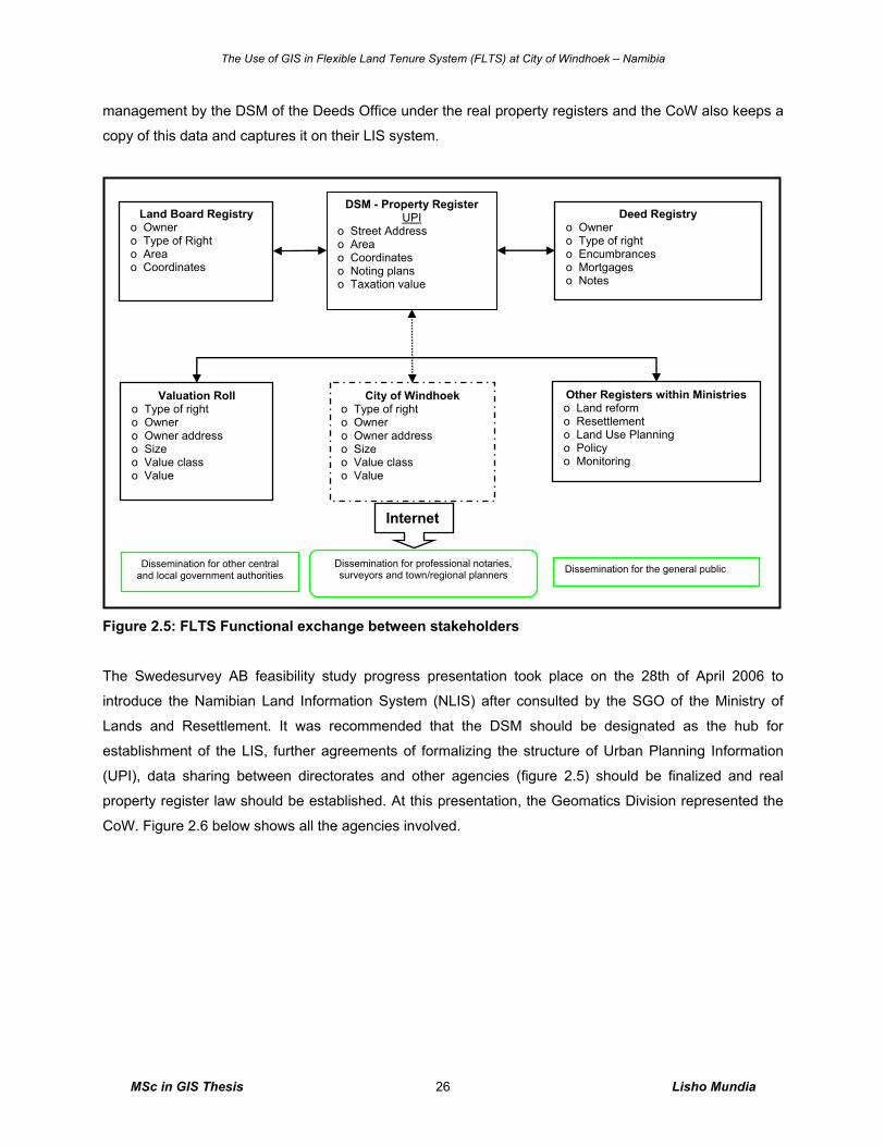
The Use of GIS in Flexible Land Tenure System (FLTS) at City of Windhoek – Namibia
MSc in GIS Thesis Lisho Mundia 26
management by the DSM of the Deeds Office under the real property registers and the CoW also keeps a
copy of this data and captures it on their LIS system.
Figure 2.5: FLTS Functional exchange between stakeholders
The Swedesurvey AB feasibility study progress presentation took place on the 28th of April 2006 to
introduce the Namibian Land Information System (NLIS) after consulted by the SGO of the Ministry of
Lands and Resettlement. It was recommended that the DSM should be designated as the hub for
establishment of the LIS, further agreements of formalizing the structure of Urban Planning Information
(UPI), data sharing between directorates and other agencies (figure 2.5) should be finalized and real
property register law should be established. At this presentation, the Geomatics Division represented the
CoW. Figure 2.6 below shows all the agencies involved.
Land Board Registry o Owner o Type of Right o Area o Coordinates
Valuation Roll o Type of right o Owner o Owner address o Size o Value class o Value
DSM - Property Register UPI
o Street Address o Area o Coordinates o Noting plans o Taxation value
City of Windhoek o Type of right o Owner o Owner address o Size o Value class o Value
Other Registers within Ministries o Land reform o Resettlement o Land Use Planning o Policy o Monitoring
Dissemination for the general public Dissemination for professional notaries, surveyors and town/regional planners
Dissemination for other central and local government authorities
Internet
Deed Registry o Owner o Type of right o Encumbrances o Mortgages o Notes
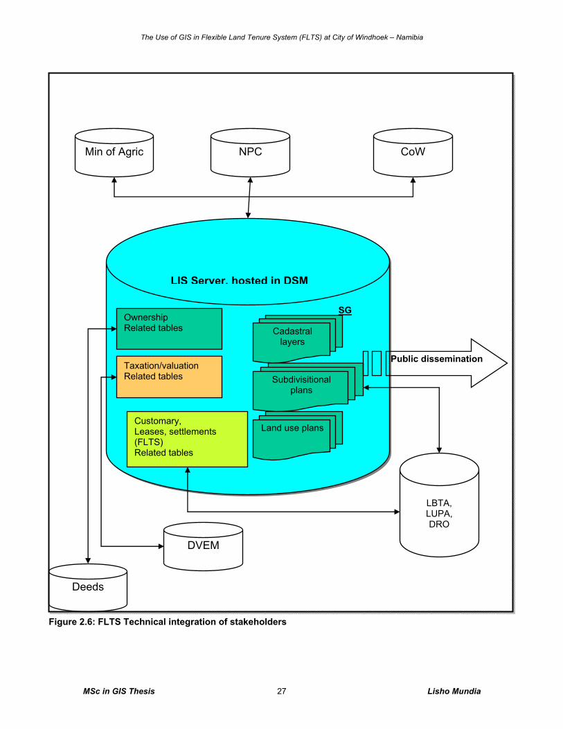
The Use of GIS in Flexible Land Tenure System (FLTS) at City of Windhoek – Namibia
MSc in GIS Thesis Lisho Mundia 27
NPC Min of Agric CoW
Deeds
DVEM
LBTA, LUPA, DRO
LIS Server, hosted in DSM
Ownership Related tables Cadastral
layers
Subdivisitional plans
Land use plans
Taxation/valuation Related tables
Customary, Leases, settlements (FLTS) Related tables
SG
Public dissemination
Figure 2.6: FLTS Technical integration of stakeholders
The Use of GIS in Flexible Land Tenure System (FLTS) at City of Windhoek – Namibia
MSc in GIS Thesis Lisho Mundia 28
Spatial data management challenges in a multi-institutional context are mainly caused by lack of policies
and infrastructure for data exchange and sharing, although the demand for this was identified and even
acknowledged by some institutions, it caused inter-organizational decision-making problems (Merson,
2004, p. 87). The problem of unclear organizational mandates makes it difficult to set up a cooperation
framework in which the responsibilities are being clearly defined based on the functional characteristics of
an organization.
The lack of organized co-operation between large group of spatial data producers and users, and lack of
requirements analysis for facilitation of information detection, sharing, exchange, creates a situation in
which avoidance of data redundancy is impossible. Merson (2004, p.88) states this very clearly ‘there are
no policies on digital data copyrights, no policies for digital exchange and data sharing’. With regards to
political issue, the FLTS project would be secured, due to the growing interest of high level ministry
officials in the land administration related to poverty alleviation and informal settlement upgrading.
2.5.5 Land Information and LIS General Overview
One of the important considerations in implementing a Land Information System (LIS) is that it must be
located in such a way that the people have access to all kinds of services and information delivery
required for land management. A local LIS normally contains local databases (or registers) in digital form
that relates to spatial and non-spatial (or descriptive) components (Tuladhar, 2005a, 2005b, p.7). In order
to find the contents of databases, the users or stakeholders are consulted and analyzed in terms of
service required and financial availability. In the starting phase, the system may be simple with minimum
services and data, and later on it is upgraded in stepwise approach.
As an example, the spatial component may contain the following information:
o Spatial units of outer boundaries – tenure units, customary areas, family parcels, individual parcel
which could be represented by geometry (either graphical polygons or points including topology);
o These spatial units must have unique identifiers in a standard form; and
o Locations of spatial units are always referred to national geodetic reference system (Tuladhar,
2005c, p.7).
Similarly non-spatial (descriptive) components may contain the following information:
o Links to spatial unit through unique identifier,
o Register of tenure rights and right holders – chief/head of the group/village, family head,
individuals, and
o Agreement/evidences on how tenure rights are brought to right holders (Tuladhar, 2005b, p.7).
The Use of GIS in Flexible Land Tenure System (FLTS) at City of Windhoek – Namibia
MSc in GIS Thesis Lisho Mundia 29
According to Robinson (2003, p.2), an information system can technically be defined as a set of
interrelated components that collect, process, store and distribute information to support decision making
and control in an organization. In addition to supporting decision-making, coordination and control,
information systems may also help managers and workers analyze problems, visualize complex subjects,
and create new products. Information systems perform three main duties:
o Data collection
o Data processing
o Information output (feedback)
Robinson (2003, p.20) states that the system boundary is one of the principles that concern itself with
system structure and behavior. It defines the components that make up the system. Anything outside the
system boundary is known as the system environment. The system boundary is dictated by the goals,
which in some cases are stipulated by legislation. As the Flexible Land Tenure Act dictates the land
tenure registration process at City of Windhoek, then these dictate the system boundary. The system
consists of people, processes and information technology. The role of computer systems is to support
people in their work by using technology to provide ways to collect and use information and to support
their work processes (Robinson 2003, p.20).
2.6 Principles of Database Management Systems
2.6.1 Introduction This section deals with the definition of a database, its functions, description a brief explanation of a file
versus Database Management Systems (DBMS) and the reasons for using DBMS.
2.6.2 Database Definition
A database is a set of related data stored in a structured manner. Note that some text use “data base” to
refer to non-computerized sets of data, reserving the word “database” to mean sets of related data held in
a computer.
A computerized database is defined as ‘a collection of interrelated data stored together with controlled
redundancy to serve one or more applications; the data are stored so that they are independent of
programs which use the data; a common controlled approach is used to add new data, modify and
retrieving existing data within the database’ (Longley et al. 2001, p. 13). On the other hand we have a
Database Management System (DBMS), which is a pool of shared facilities used to access and maintain
a database. A DBMS acts as an interface between end users, application programs and the database. It
The Use of GIS in Flexible Land Tenure System (FLTS) at City of Windhoek – Namibia
MSc in GIS Thesis Lisho Mundia 30
allocates storage, provides security and handles all the traditional demands of file processing (Longley et
al. 2001, p. 13). Application programs extract data from a database via the DBMS.
2.6.3 Functions of A DBMS
Rich (2004, p.12) considers a Multi-user Database Management System as a very large integrated
collection of data that models real world enterprise. The enterprise is entities and relations. Entities e.g.
parcel unit and parcel owner, and relationship e.g. Hangula is taking parcel unit 22. A Database
Management System (DBMS) is software packages designed to store and manage databases.
Broad functions of a DBMS adopted from Longley et al. (2001, p. 14) are as follow:
Creating, modifying and deleting data structures: Any DBMS must have a way of creating the field
definitions, record and file structures needed to receive an organization’s data.
Adding, updating, and deleting records: Having established a data-structure, the DBMS must be able
to populate the database by importing data records, either from existing external files, or via keyboard
input.
Extracting information from data: There must be mechanisms by which information can be retrieved
from the database in formats which will be appropriate to decision takers. It should be possible to query
individual records, sort records into required orders, summarize data statistically, produce report tables,
and possibly produce graphs. It should be possible to export data into other systems.
Maintaining data security and integrity through DBMS software provide means of limiting access to
particular data and of ensuring that the data held in the database is internally consistent.
Application building: In addition to maintaining the database, most DBMS software will include a
programming language, or will be compatible with an existing language such as C, Pascal, and COBOL,
which will allow applications programs to be written which can access the database through the DBMS.
Multi-user Data Sharing: Many users will need to access a database at the same time, so DBMS must
have the ability to serve data to many users.
DBMS software provides a set of tools that database designers can use to meet particular requirements.
As with any set of tools, the quality of the end product depends upon the skill of the person using the
tools. The skill of the database analyst is to use DBMS software tools to design a database that efficiently
meets client specifications (Longley et al. 2001, p. 15).
2.6.4 Why Use DBMS?
Rich (2004, p.7) argues that an application must stage large datasets between main memory and
secondary storage (e.g., buffering, page-orientated access, 32-bit addressing, etc.) it should offer special
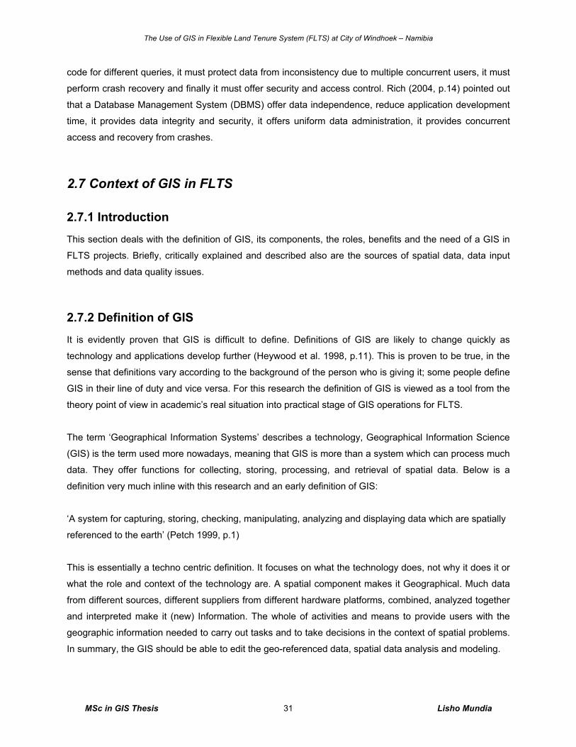
The Use of GIS in Flexible Land Tenure System (FLTS) at City of Windhoek – Namibia
MSc in GIS Thesis Lisho Mundia 31
code for different queries, it must protect data from inconsistency due to multiple concurrent users, it must
perform crash recovery and finally it must offer security and access control. Rich (2004, p.14) pointed out
that a Database Management System (DBMS) offer data independence, reduce application development
time, it provides data integrity and security, it offers uniform data administration, it provides concurrent
access and recovery from crashes.
2.7 Context of GIS in FLTS
2.7.1 Introduction
This section deals with the definition of GIS, its components, the roles, benefits and the need of a GIS in
FLTS projects. Briefly, critically explained and described also are the sources of spatial data, data input
methods and data quality issues.
2.7.2 Definition of GIS It is evidently proven that GIS is difficult to define. Definitions of GIS are likely to change quickly as
technology and applications develop further (Heywood et al. 1998, p.11). This is proven to be true, in the
sense that definitions vary according to the background of the person who is giving it; some people define
GIS in their line of duty and vice versa. For this research the definition of GIS is viewed as a tool from the
theory point of view in academic’s real situation into practical stage of GIS operations for FLTS.
The term ‘Geographical Information Systems’ describes a technology, Geographical Information Science
(GIS) is the term used more nowadays, meaning that GIS is more than a system which can process much
data. They offer functions for collecting, storing, processing, and retrieval of spatial data. Below is a
definition very much inline with this research and an early definition of GIS:
‘A system for capturing, storing, checking, manipulating, analyzing and displaying data which are spatially
referenced to the earth’ (Petch 1999, p.1)
This is essentially a techno centric definition. It focuses on what the technology does, not why it does it or
what the role and context of the technology are. A spatial component makes it Geographical. Much data
from different sources, different suppliers from different hardware platforms, combined, analyzed together
and interpreted make it (new) Information. The whole of activities and means to provide users with the
geographic information needed to carry out tasks and to take decisions in the context of spatial problems.
In summary, the GIS should be able to edit the geo-referenced data, spatial data analysis and modeling.
The Use of GIS in Flexible Land Tenure System (FLTS) at City of Windhoek – Namibia
MSc in GIS Thesis Lisho Mundia 32
2.7.3 Components of A GIS The definition of GIS provided in section 2.7.2 above is expressed as a centre of the components of GIS
(Figure 2.7) as a field of study. Looking first at the main aims of this centre we can then brainstorm this
into five components (Petch, 1999, p.4), which are:
o Technology
o Data
o Organizations
o Methods
o Body of ideas
It is known and believed that without the above, there are no GIS and GIS cannot exist without a part of it,
it operates like a human being, whereby if a human being looses almost half of his or her skin, he or she
dies. This application applies to the operation of GIS that it cannot operate or exist without people.
Figure 2.7: Components of GIS (Source: Adopted from Petch, 1999, p.1)
GIS can be viewed as a software package, the components being the various tools used to enter,
manipulate, analyze and output data. Since GIS cannot operate in isolation from an application area,
which has its own tradition ideas and procedures, attention therefore will be given at the components of
GIS in detail as outlined and illustrated above in figure 2.7 which are argued that each deserves conscious
consideration.
First among the GIS components there is the technology of GIS, which is the software and hardware.
The software part of this technology is initially a set of software process at the core of which is a set of
algorithms for accessing, presenting, analyzing and synthesizing data with reference to their spatial and
non-spatial attributes. Linked to these programs are others for data management, for extraction from
databases, for visualizing data and for undertaking other tasks such as importing and exporting
The Use of GIS in Flexible Land Tenure System (FLTS) at City of Windhoek – Namibia
MSc in GIS Thesis Lisho Mundia 33
techniques. Networks (intranets, the Internet) and distributed systems are a very important part of this
technology in GIS (Petch, 1999, p.1), this are further explained in detail in this research.
The hardware part of the technology is centered on the computer platform and has peripheral devices
related to input and output. These include conventional read devices such as floppy disks, compact discs
(CDs), etc that allow file transfer, as well as network devices, together with output devices such as
printers. In addition there are specific devices widely used in GIS applications for input and output of maps
to and from analogue formats (Petch, 1999, p.1), this are explained further in section 2.7.6 of sources of
spatial data below.
The second main element of a GIS is data. All information systems are based on data and rules for using
data in some form or other. The main components of the data part of the system (figure 2.7) are inputs,
spatial and other forms of databases, data maintenance systems and quality assurance systems (Petch,
1999, p.1). This initially means at this level, GIS is now beginning to include not only technological entities
but also human systems.
The third component of GIS is the set of methods. They are neither hardware, nor software, and certainly
not specific to people. They are independent procedures or rules for undertaking the various tasks
involved in the design, creation and operation of GIS. A method contains the logic for a procedure and the
specification for the actions. There are methods for spatial analysis, for data manipulation, for database
design, for user needs analysis, for map interpretation and the list go on and on. Each activity has a
method. And the method is what determines the meaning or quality of the outcomes of that action. Method
is the key to everything in GIS operations (Petch, 1999, p.2).
The next part of the GIS is the organization. Any information system can only work in the context of an
organization. The organization consists of many complex and subtle parts but we will consider it here to
consist of a set of business objectives, a set of business processes, management, operators and the
general overarching component, people. Particular sub-components of the management, operators and
people are those concerned with system design, implementation and monitoring since they have a
particularly important role in defining what a GIS is (Petch, 1999, p.2).
Finally, there is the body of ideas, which lie behind the use of GIS. They include areas of engineering
concerned with computing including mathematics and physics that lie behind the computer hardware
systems. Behind software systems are bodies of knowledge concerned with geomatics, data processing,
databases, spatial analysis and in any applications area bodies of theory such as from agriculture,
ecology, sociology, transportation and endlessly on. Behind organizational issues are theories of
management, systems design, business economics, sociology, psychology, psychophysics and
ergonomics. Methods stand on bodies of theory from every conceivable branch of science, sociology,
The Use of GIS in Flexible Land Tenure System (FLTS) at City of Windhoek – Namibia
MSc in GIS Thesis Lisho Mundia 34
management and commerce (Petch, 1999, p.2). In combining these components together and of course in
GIS technological way, the output should be a successful GIS with different roles, and should increase
efficiency at workplace like the City of Windhoek.
2.7.4 FLTS GIS Linkages and Dependencies FLTS is a land management tool that is making land possible to access, provide, manage and monitor.
Managing land in a local authority boundary is the response to enquiries from various stakeholders such
as the public, banks, notaries, line ministries of government, private organisation (Namibia Housing Action
Group, Shack Dwellers Federation of Namibia, etc) and private individuals, which is overseen by the local
authorities in Namibia. There is accurate information on addresses of properties (block erven) and on the
matters relating to land such as land surveying, town planning, planning consents, pollution control
ordinances, and strategic plans and so on.
The key issue in creating a GIS here is in producing an information system, which accurately reflects the
business process. The focus of interest in this situation is the analysis and design procedure. This is about
defining clearly and fully what the users of the system need and then translating these into system
requirements and system specifications. These specifications are met through a system (including
database) design process so that a computerised system truly reflects what the business and the
operators need and want, and the customers get what they want easily and quickly (Petch, 1999, p.3).
The GIS functions such as buffer operations, overlay operations, database integrations, importing and
exporting of spatial data operations, flow models, etc are the key existing functions that links FLTS to
GIS.
In each area the five components are present and each is essential. The focus of interest, activity and
investment depends, however, on the problem in hand. In other words the critical element depends on the
application. In one case it is theoretical background, in another on interpretation, in another on design.
Each application has its own focus. What is important to understand is that this focus has to be
recognised and addressed. There are no rules. Only experience and common sense can guide us to
identify the focus of our endeavor (Petch, 1999, p.3).
2.7.5 FLTS Project Spatial Model
The spatial data model component is very important for spatial data representation in a computer system as it
informs the computer on the kind of visualization it should adopt for display in GIS view window. A user
chooses whether to use raster data models or vector model as per problem area. Choosing a spatial data
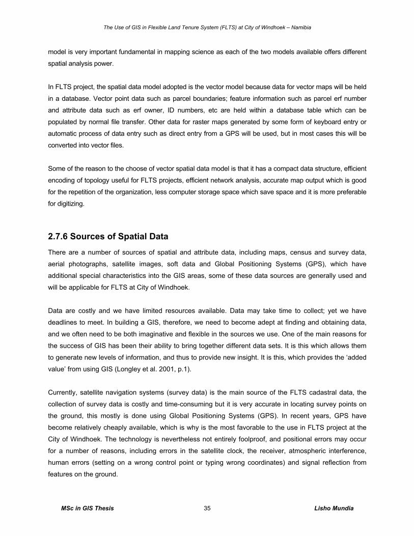
The Use of GIS in Flexible Land Tenure System (FLTS) at City of Windhoek – Namibia
MSc in GIS Thesis Lisho Mundia 35
model is very important fundamental in mapping science as each of the two models available offers different
spatial analysis power.
In FLTS project, the spatial data model adopted is the vector model because data for vector maps will be held
in a database. Vector point data such as parcel boundaries; feature information such as parcel erf number
and attribute data such as erf owner, ID numbers, etc are held within a database table which can be
populated by normal file transfer. Other data for raster maps generated by some form of keyboard entry or
automatic process of data entry such as direct entry from a GPS will be used, but in most cases this will be
converted into vector files.
Some of the reason to the choose of vector spatial data model is that it has a compact data structure, efficient
encoding of topology useful for FLTS projects, efficient network analysis, accurate map output which is good
for the repetition of the organization, less computer storage space which save space and it is more preferable
for digitizing.
2.7.6 Sources of Spatial Data
There are a number of sources of spatial and attribute data, including maps, census and survey data,
aerial photographs, satellite images, soft data and Global Positioning Systems (GPS), which have
additional special characteristics into the GIS areas, some of these data sources are generally used and
will be applicable for FLTS at City of Windhoek.
Data are costly and we have limited resources available. Data may take time to collect; yet we have
deadlines to meet. In building a GIS, therefore, we need to become adept at finding and obtaining data,
and we often need to be both imaginative and flexible in the sources we use. One of the main reasons for
the success of GIS has been their ability to bring together different data sets. It is this which allows them
to generate new levels of information, and thus to provide new insight. It is this, which provides the ‘added
value’ from using GIS (Longley et al. 2001, p.1).
Currently, satellite navigation systems (survey data) is the main source of the FLTS cadastral data, the
collection of survey data is costly and time-consuming but it is very accurate in locating survey points on
the ground, this mostly is done using Global Positioning Systems (GPS). In recent years, GPS have
become relatively cheaply available, which is why is the most favorable to the use in FLTS project at the
City of Windhoek. The technology is nevertheless not entirely foolproof, and positional errors may occur
for a number of reasons, including errors in the satellite clock, the receiver, atmospheric interference,
human errors (setting on a wrong control point or typing wrong coordinates) and signal reflection from
features on the ground.
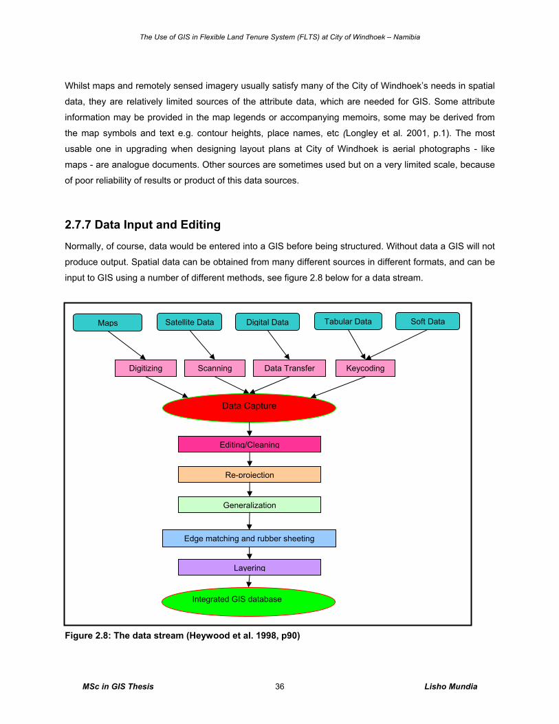
The Use of GIS in Flexible Land Tenure System (FLTS) at City of Windhoek – Namibia
MSc in GIS Thesis Lisho Mundia 36
Whilst maps and remotely sensed imagery usually satisfy many of the City of Windhoek’s needs in spatial
data, they are relatively limited sources of the attribute data, which are needed for GIS. Some attribute
information may be provided in the map legends or accompanying memoirs, some may be derived from
the map symbols and text e.g. contour heights, place names, etc (Longley et al. 2001, p.1). The most
usable one in upgrading when designing layout plans at City of Windhoek is aerial photographs - like
maps - are analogue documents. Other sources are sometimes used but on a very limited scale, because
of poor reliability of results or product of this data sources.
2.7.7 Data Input and Editing
Normally, of course, data would be entered into a GIS before being structured. Without data a GIS will not
produce output. Spatial data can be obtained from many different sources in different formats, and can be
input to GIS using a number of different methods, see figure 2.8 below for a data stream.
Figure 2.8: The data stream (Heywood et al. 1998, p90)
Maps Soft Data Satellite Data Digital Data Tabular Data
Digitizing Scanning Data Transfer Keycoding
Data Capture
Integrated GIS database
Editing/Cleaning
Re-projection
Generalization
Edge matching and rubber sheeting
Layering
The Use of GIS in Flexible Land Tenure System (FLTS) at City of Windhoek – Namibia
MSc in GIS Thesis Lisho Mundia 37
Data in analogue or digital format need to be encoded to be compatible with the GIS being used. All data
in analogue form need to be converted to digital form before they can be input into GIS. Four methods are
widely used: keyboard entry, manual digitizing, automatic digitizing and scanning.
Keyboard entry may be appropriate for tabular data, or for small numbers of co-ordinate pairs read from a
paper map source or pocket GPS. Digitizing is widely used for the encoding of paper maps and data from
interpreted air photographs. Scanning represents a faster encoding method for the data sources, although
the results, digital data may require considerable before analysis is possible. Spatial data may be
collected in digital form and transferred from the devices such as GPS receivers, total stations (electronic
distance-metering theodolites), and data loggers attached to all manner of scientific monitoring equipment.
This process is called electronic data transfer; all that is required is download cable and data
communications software for a user to download the data to a file on their computer.
During encoding a range of errors can be introduced. During keyboard encoding it is easy for an operator
to make a typing mistake; during digitizing an operator may encode the wrong lines; and folds and strains
can easily be scanned and mistaken for real geographical features, conversion of data between formats
required by different packages may lead to loss of data. Errors in attribute data are relatively easy to spot
and may be identified using manual comparison with the original data. Errors in spatial data are often
more difficult to identify and correct than errors in attribute data. These errors take many forms, depending
on the data model (vector or raster) and the method of data capture.
Data derived from maps drawn on different projections will need to be converted to a common projection
system before they can be combined or analyzed. If not re-projected (figure 2.8) data derived from a
source map drawn using one projection will not plot in the same location as data derived from another
source map using a different projection system.
When a study area extends across two or more map sheets small differences or mismatches between
adjacent map sheets may need to be resolved. Normally, each map sheet would be digitized separately
and then the adjacent sheets joined after editing, re-projection, transformation and generalization.
2.7.8 Data Quality Issues
The computing adage ‘Garbage In, Garbage Out’ (GIGO) recognizes that if you put poor quality data into
your program, you will output poor quality results. This applies to GIS since the results of analysis are only
as good as the data put into the GIS in the first place. Error can be introduced at every stage of the data
stream. Sources of error are, however, not limited to this process of data capture and integration,
The Use of GIS in Flexible Land Tenure System (FLTS) at City of Windhoek – Namibia
MSc in GIS Thesis Lisho Mundia 38
exclusive to conceptual reality stage (Heywood et al. 1998). If an error is already present in the source
data and further errors arise during manipulation, output and use of the data in a GIS will both have errors.
There are varieties of errors in GIS; the main two types of errors in FLTS projects that we need to be
aware of are positional error and attribute error. Other types of error are important but will usually be
manifested in either of the two main types. According to Redman (1996, p.1) the case for improving data
quality is pervasive, poor data quality is costly and data quality can be improved. It should therefore be
remembered that errors in the application can entirely be limited and that all geodata are subject to errors.
Errors propagate at all stages of GIS usage. We therefore need to consider carefully problems associated
with error at all stages of GIS usage if we are to maintain confidence in our output. Poor data quality
impacts on the success of the organization like the City of Windhoek.
2.7.9 The Role of GIS at City of Windhoek
The overall role of GIS in FLTS is to manage geodata and non-spatial data, to make the data available as
resource on GIS and, therefore, ensure its continued existence and make it available to a much wider
client base. To mention a few, here are the roles of this GIS, and are aiming to provide:
o A desktop GIS tool that allow exploration of the FLTS data;
o A set of maps that displays the FLTS data graphically on GIS;
o Within FLTS GIS can also be used to digitize location data; primarily the locations of health
facilities, community water points, and schools. These locations can be digitized using GIS
software from scanned images. Other spatial data, such as road networks, drainage and
topography can also be extracted from scanned images in the same way;
o To provide an integration of spatial data management of environment, land use planning for the
capture, storage, manipulation, management and mapping of relevant data;
o Developments in computerization and IT can allow GIS to cover almost all of the cadastral data
application area in Windhoek for FLTS projects;
o Standardization of parcel, block erven data, land tenure and new products of digitization are very
much relevant to success of GIS in FLTS projects.
With relevant to the roles that the GIS can offer when implemented wisely, the roles also aim to contribute
by benefiting the City of Windhoek in their intended project, which are discussed below.
2.7.10 Benefits and the Need of GIS at City of Windhoek
A well-designed GIS has the capability to provide quick and easy access to large volumes of data. It can
select information by area and by theme to merge one data set with another, to analyze spatial
The Use of GIS in Flexible Land Tenure System (FLTS) at City of Windhoek – Namibia
MSc in GIS Thesis Lisho Mundia 39
characteristics of data, to search for particular features, to update quickly, cheaply and access. According
to Aditi (2002, p.11) the general benefits that a well-designed and successful GIS would offer are mostly
very potential benefits to the organization, and this can include:
o Opportunity to reduce sets of manual maps held and associated storage costs, e.g. capturing
all the FLTS paper maps into the GIS for efficiency analysis and query services;
o Faster and more extensive access to geographical information throughout the organization,
e.g. when new developmental projects comes along, the data are easy to access in digital
format and easy analyze for such development;
o Improved of analysis e.g. of areas, distances, patterns, etc,
o Better communication of information to public officers, e.g. the public can have the information
via electronic or can view and query to meet their needs;
o Improved quality of services to the client, e.g. when fire occurs within the boundaries of
Windhoek it is easy for emergence services to query the street and parcel number for location
purpose;
o Better targeting and coordination of services within the organization and beyond, e.g. the
block erven of FLTS can be analyzed for possible community toilets at the radiuses of 50m
using GIS.
The benefits of GIS are like their roles, a variety of them exists and mostly depends on the project and
interlink with various situations. In addition to the role and the benefits of the GIS at City of Windhoek,
there is the need for a GIS tool to help in the following areas:
Improve management of organization and resources through integration are one of the needs for GIS.
A GIS can link data sets together through by common location data i.e. such as addresses, which helps
departments, divisions and agencies to share their data. By creating a shared database, like the one
existing in the City of Windhoek, one department benefits from the work of another at once and can be
used many times (Aditi, 2002, p.9).
According to Aditi (2002, p.9) GIS is not only an automated decision making system but also a tool to
query, analyze, and map data support of the decision process. Therefore, an old adage “better
information leads to better decisions” is a true say for GIS. GIS can provide powerful FLTS information not
just how things are, but how they will be in the future based on changes that are applied. GIS in FLTS is
therefore about modeling and mapping the world for better decision-making.
Making maps with GIS is much more flexible than traditional manual automated cartography approaches.
GIS creates maps from data pulled from databases. Existing paper maps can be digitized and translated
into the GIS as well. A GIS-based cartographic database can be both continuous and scale free. Map
The Use of GIS in Flexible Land Tenure System (FLTS) at City of Windhoek – Namibia
MSc in GIS Thesis Lisho Mundia 40
products can be created centered on any location, at any scale, showing selected information symbolized
effectively to highlight specific characteristics (Aditi, 2002, p.9).
2.8 City of Windhoek’s Tasks and Responsibility in GIS and FLTS
2.8.1 Introduction This section deals with the set situation of GIS in FLTS at the City of Windhoek; it reviews the vision and
mission of the City of Windhoek including the GIS objectives. It further explains and describes the
positioning of the GIS at City of Windhoek and lastly providing the tasks of the City of Windhoek in FLTS
currently.
2.8.2 City of Windhoek’s Vision and Mission The City of Windhoek (CoW) has set for the community a Vision, which states “We commit ourselves to
make Windhoek a vibrant, economic and technological centre of excellence in Africa in order to enhance
the quality of life of all our people”.
As Mission Statement, the City of Windhoek is committed to:
o Render affordable, efficient and effective services to their customers through the optimal use
of resources, technology and financial and environmental practices.
o Recruit, train, develop and retrain a highly motivated work force.
Value Statement
The City of Windhoek upholds the WINDHOEK values:
Winning Team
Innovation
Networking
Diversity and Equity
Honesty and Integrity
Open Communication
Efficient and Effective
Knowledgeable
Geomatics Division is positioned in the Department of Planning, Urbanization and Environment, the ninth
Department on figure 2.10 below on the City of Windhoek’s Organogram together with the other seven
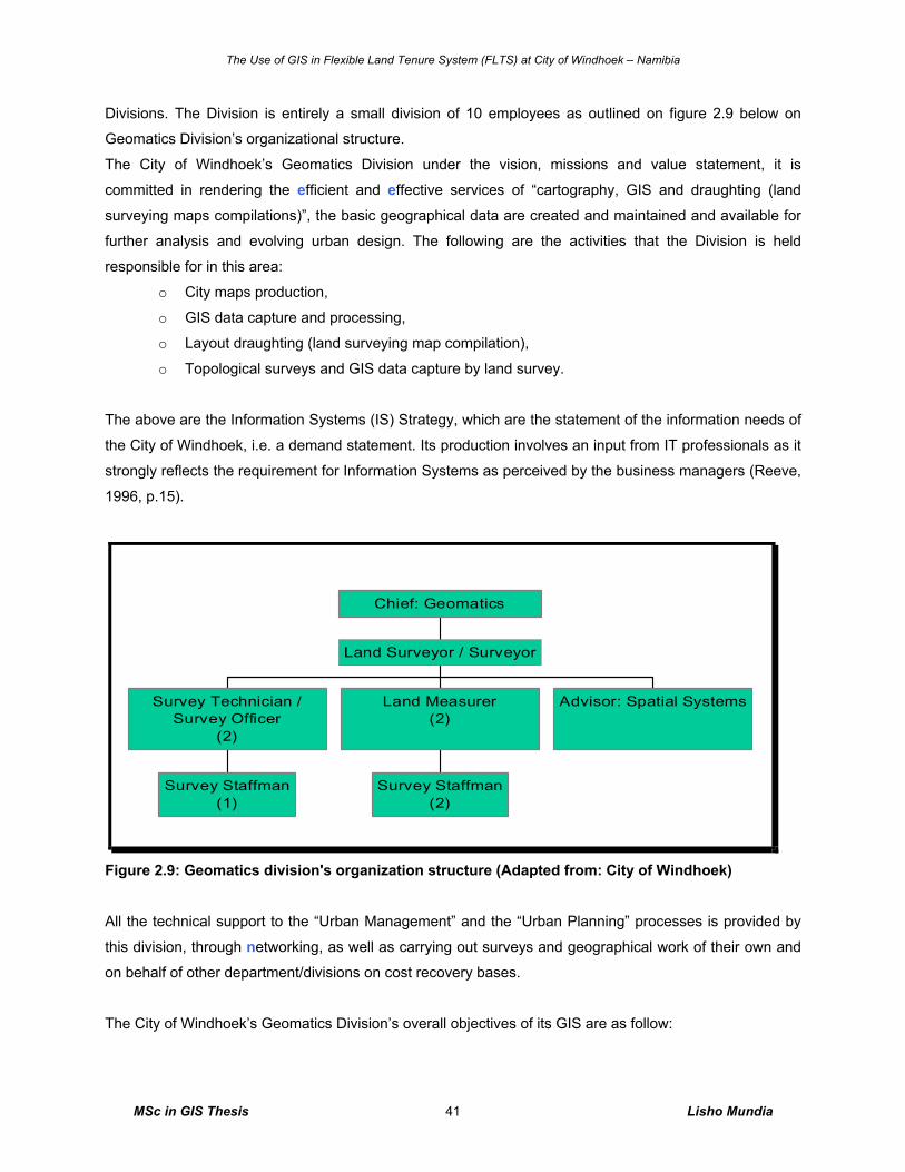
The Use of GIS in Flexible Land Tenure System (FLTS) at City of Windhoek – Namibia
MSc in GIS Thesis Lisho Mundia 41
Divisions. The Division is entirely a small division of 10 employees as outlined on figure 2.9 below on
Geomatics Division’s organizational structure.
The City of Windhoek’s Geomatics Division under the vision, missions and value statement, it is
committed in rendering the efficient and effective services of “cartography, GIS and draughting (land
surveying maps compilations)”, the basic geographical data are created and maintained and available for
further analysis and evolving urban design. The following are the activities that the Division is held
responsible for in this area:
o City maps production,
o GIS data capture and processing,
o Layout draughting (land surveying map compilation),
o Topological surveys and GIS data capture by land survey.
The above are the Information Systems (IS) Strategy, which are the statement of the information needs of
the City of Windhoek, i.e. a demand statement. Its production involves an input from IT professionals as it
strongly reflects the requirement for Information Systems as perceived by the business managers (Reeve,
1996, p.15).
Survey Staffman(1)
Survey Technician /Survey Officer
(2)
Survey Staffman(2)
Land Measurer(2)
Advisor: Spatial Systems
Land Surveyor / Surveyor
Chief: Geomatics
Figure 2.9: Geomatics division's organization structure (Adapted from: City of Windhoek)
All the technical support to the “Urban Management” and the “Urban Planning” processes is provided by
this division, through networking, as well as carrying out surveys and geographical work of their own and
on behalf of other department/divisions on cost recovery bases.
The City of Windhoek’s Geomatics Division’s overall objectives of its GIS are as follow:
The Use of GIS in Flexible Land Tenure System (FLTS) at City of Windhoek – Namibia
MSc in GIS Thesis Lisho Mundia 42
o Stimulate the development of core base of geo-referenced data and related standards that
include base map of features,
o Promote the development (standardization and sharing) of data and economic activities in ways
that can be readily geo-referenced to the base map,
o Generate clearer rules regarding the ownership and exchange of data to ensure continued
internal access to data, and
o Develop the organizational infrastructure needed to build this information, infrastructure in a way
that connects effectively to internal personnel and practices.
These are the Information Technology (IT) Strategy, which are the statement of how the City of Windhoek
intends to meet the needs expressed in its IS strategy. The IT Strategy is a supply document, detailing the
software and hardware requirement, and is primarily the province of the IT specialists (Reeve, 1996,
p.16). On top of that SWOT analysis developed as a tool for strategic thinking, which stands for Strengths,
Weaknesses, Opportunities and Threats, these being the broad headings which managers developing a
strategy or considering an investment should review. Strengths and Weaknesses relate primarily to
internal (Reeve, 1996, p.16), and current issues and it is outlined in chapter 4 below.
2.8.3 City of Windhoek’s Tasks and Responsibility to FLTS The main task of the City of Windhoek in the implementation of the Flexible Land Tenure System (FLTS)
projects is holding responsibility of the planning, allocation of land, surveying, layout designing, informal
settlement land invasion enforcement and registration processes; thereof keep the records such as maps
(both paper and digital formats) and survey records as geo information providers.
The City of Windhoek, in its effort to contribute to the upgrading of the informal settlements under the new
land tenure system aimed for poor people in maintaining, managing, processing the demarcations of land
for the informal settlers, it has employed qualified land measurers to undertake this challenge and to
provide efficient and effective land demarcation services within the City of Windhoek’s informal areas for
good quality information and help to cater for good demarcation services of the City of Windhoek’s land.
Beside the above, the City of Windhoek has also established an Informal Settlement Committee (ISC),
see in table 2.1 below) which includes members from different level of responsibilities of work and tasks
such as planning, technical, GIS, finance, top management, political and housing and urban management
area.
Table 2.1: Representative of the ISC of City of Windhoek
Divisions Title of Representatives Responsibilities
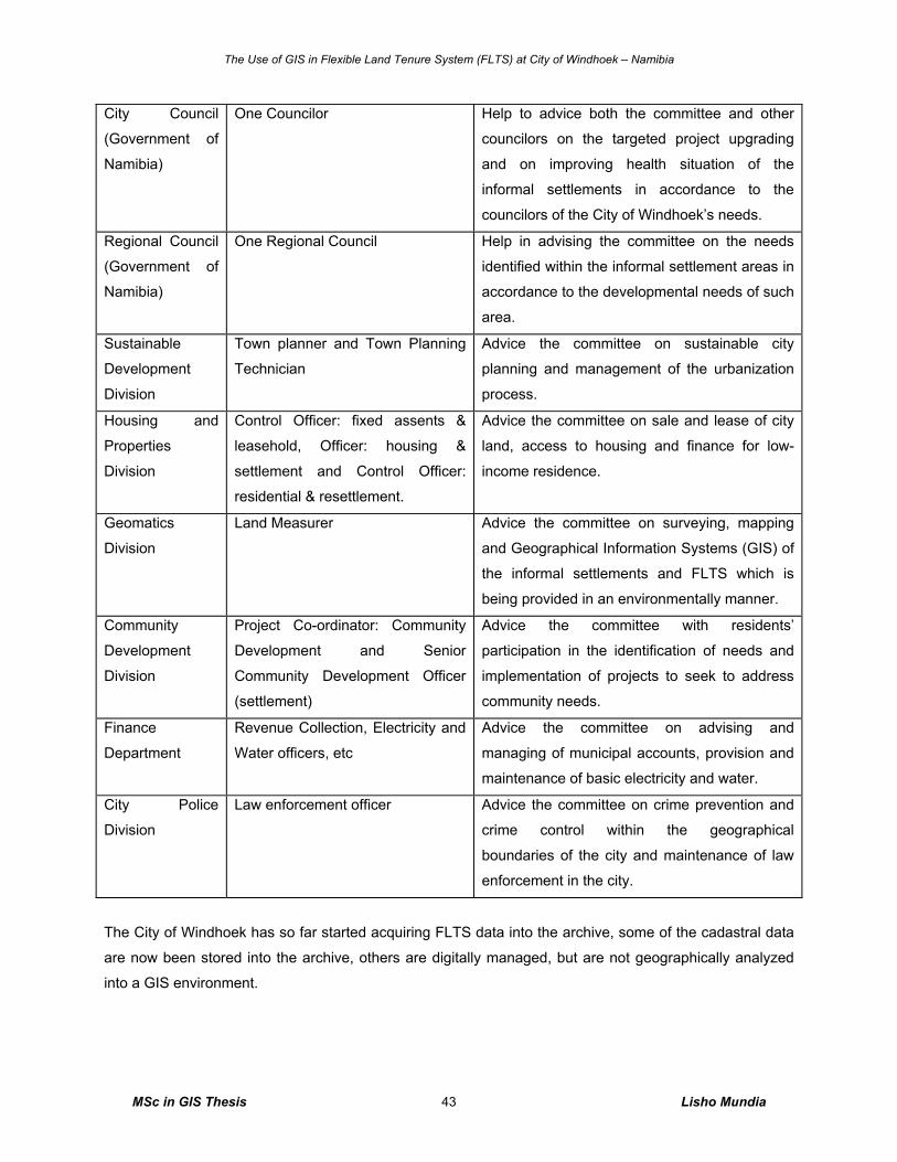
The Use of GIS in Flexible Land Tenure System (FLTS) at City of Windhoek – Namibia
MSc in GIS Thesis Lisho Mundia 43
City Council
(Government of
Namibia)
One Councilor Help to advice both the committee and other
councilors on the targeted project upgrading
and on improving health situation of the
informal settlements in accordance to the
councilors of the City of Windhoek’s needs.
Regional Council
(Government of
Namibia)
One Regional Council Help in advising the committee on the needs
identified within the informal settlement areas in
accordance to the developmental needs of such
area.
Sustainable
Development
Division
Town planner and Town Planning
Technician
Advice the committee on sustainable city
planning and management of the urbanization
process.
Housing and
Properties
Division
Control Officer: fixed assents &
leasehold, Officer: housing &
settlement and Control Officer:
residential & resettlement.
Advice the committee on sale and lease of city
land, access to housing and finance for low-
income residence.
Geomatics
Division
Land Measurer Advice the committee on surveying, mapping
and Geographical Information Systems (GIS) of
the informal settlements and FLTS which is
being provided in an environmentally manner.
Community
Development
Division
Project Co-ordinator: Community
Development and Senior
Community Development Officer
(settlement)
Advice the committee with residents’
participation in the identification of needs and
implementation of projects to seek to address
community needs.
Finance
Department
Revenue Collection, Electricity and
Water officers, etc
Advice the committee on advising and
managing of municipal accounts, provision and
maintenance of basic electricity and water.
City Police
Division
Law enforcement officer Advice the committee on crime prevention and
crime control within the geographical
boundaries of the city and maintenance of law
enforcement in the city.
The City of Windhoek has so far started acquiring FLTS data into the archive, some of the cadastral data
are now been stored into the archive, others are digitally managed, but are not geographically analyzed
into a GIS environment.
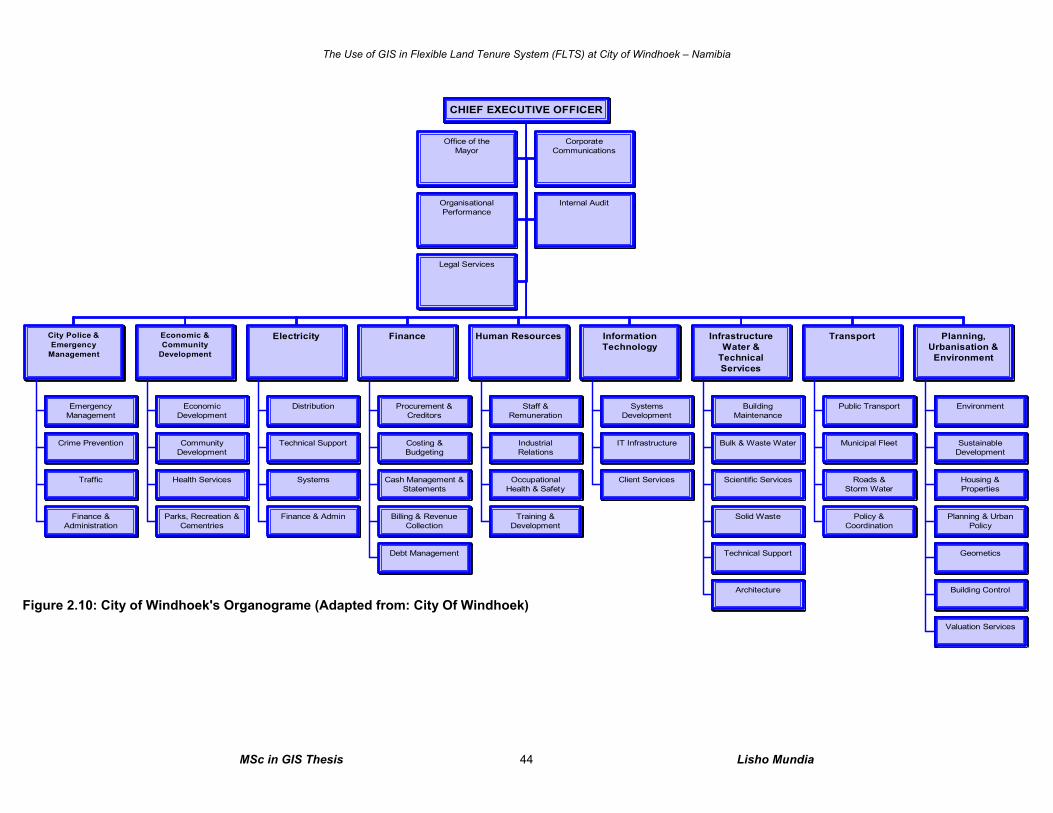
The Use of GIS in Flexible Land Tenure System (FLTS) at City of Windhoek – Namibia
MSc in GIS Thesis Lisho Mundia 44
Office of theMayor
CorporateCommunications
OrganisationalPerformance
Internal Audit
Legal Services
EmergencyManagement
Crime Prevention
Traffic
Finance &Administration
City Police &Emergency
Management
EconomicDevelopment
CommunityDevelopment
Health Services
Parks, Recreation &Cementries
Economic &Community
Development
Distribution
Technical Support
Systems
Finance & Admin
Electricity
Procurement &Creditors
Costing &Budgeting
Cash Management &Statements
Billing & RevenueCollection
Debt Management
Finance
Staff &Remuneration
IndustrialRelations
OccupationalHealth & Safety
Training &Development
Human Resources
SystemsDevelopment
IT Infrastructure
Client Services
InformationTechnology
BuildingMaintenance
Bulk & Waste Water
Scientific Services
Solid Waste
Technical Support
Architecture
InfrastructureWater &
TechnicalServices
Public Transport
Municipal Fleet
Roads &Storm Water
Policy &Coordination
Transport
Environment
SustainableDevelopment
Housing &Properties
Planning & UrbanPolicy
Geometics
Building Control
Valuation Services
Planning,Urbanisation &Environment
CHIEF EXECUTIVE OFFICER
Figure 2.10: City of Windhoek's Organograme (Adapted from: City Of Windhoek)
The Use of GIS in Flexible Land Tenure System (FLTS) at City of Windhoek – Namibia
MSc in GIS Thesis Lisho Mundia 45
Understanding of tasks and workflow is not that completed because representatives such as those from
Sustainable Development, Geomatics and Housing & Properties Divisions are from the Department of
Planning, Urbanization and Environment as seen on figure 2.10 above. Whilst Community Development
Division is under the Department of Economic & Community Development and City Police are under City
Police and Emergency Management. The Department of Information Technology is an independent one
and has a very close relationship with the Division of Geomatics due to the CAD/GIS technology
implemented by the Division of Geomatics and managed by both parties. The tasks of the ISC are mostly
set by the Department of Planning, Urbanization & Environment because they deal directly with informal
settlement communities in their daily tasks. Currently, the entire City of Windhoek and other organizations
depend to Geomatics Division for maps and other mapping projects on cost recovery bases.
The standards of handling informal settlements and low-income people’s needs are set by the Informal
Settlement Committee (ISC), and it liaisons itself with line ministries and other stakeholders. The ISC was
established in 2003 by the City of Windhoek’s management committee in terms of section 26 (1) of the
Local Authorities Act, 1992 (Act 23 of 1992) to co-ordinate the improvement of living conditions in the
informal settlements and advice Management Committee and Council accordingly.
This was also established in order to provide the transparent way of handling individual poor people’s
complaints, the ISC seats or meet once a month. The committee is also a useful implementation team in
the dealings of FLTS activities in Windhoek.
2.8.4 City of Windhoek’s Tasks and Responsibility to FLTS’ GIS
The GIS to be used in “Flexible Land Tenure Projects” will be a tool managed and implemented at City of
Windhoek’s Geomatics’ Division. Block erven and its plots and other geodata will be captured, mapped
and managed on new separate GIS software called ArcGIS. The maps will carry all the spatial and
attribute entities necessary for recognition as flexible land tenure schemes. This was agreed during the
consultation meeting and intensive presentation of the need for a GIS in FLTS applications held between
the City of Windhoek’s Geomatics Division and Geo-Business Solution, a GIS consulting company which
also presented the capabilities of Autodesk Map 3D 2007 existing in the City of Windhoek with
comparison to that of the ArcGIS proposed by the Geomatics Division. The detailed explanation to the
choice of ArcGIS is outlined in chapter 4 of section 4.3.4 of results to OPAFITS C+ concept on the
subsection agreement.
Currently in the entire Namibia there is no corporate database or register with different organizations or
ministries existing. The responsibility of land administration including the managing of cadastral data is
entirely to the local authorities themselves, like the City of Windhoek. It is for that reason that the City of
Windhoek is finding it important in upgrading its tools and system of land administration to accommodate
The Use of GIS in Flexible Land Tenure System (FLTS) at City of Windhoek – Namibia
MSc in GIS Thesis Lisho Mundia 46
FLTS potential spatial and non-spatial data. The Geomatics Division will timely monitor the way the LPO
and other private land practitioners of FLTS are carrying out the activities of spatial data compilations.
This in the end allows the data to be captured on the City of Windhoek’s GIS.
The data to be captured on GIS is of good quality, and this is made sure by the Geomatics Division’s land
surveyors who first check the quality contents and recommend for approval for the survey to be carried
out, after the survey the final layout is prepared and is brought for approval to the City of Windhoek before
it goes to the Surveyor General’s Office (SGO) for final approval.
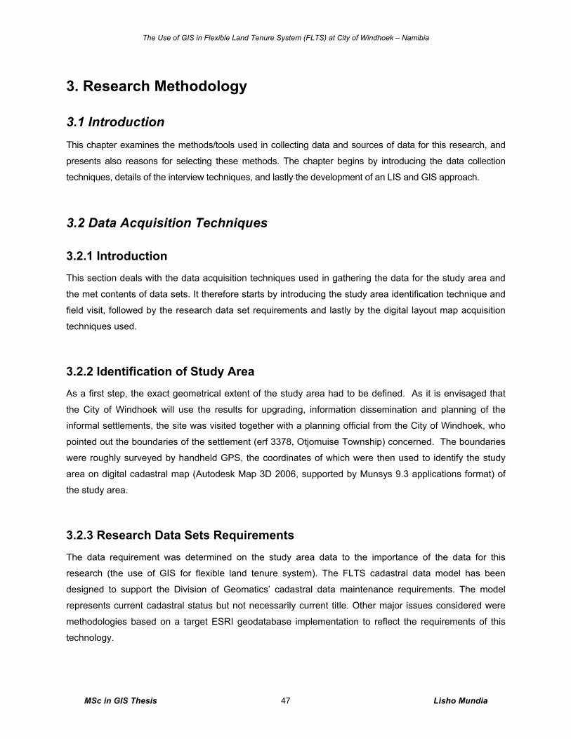
The Use of GIS in Flexible Land Tenure System (FLTS) at City of Windhoek – Namibia
MSc in GIS Thesis Lisho Mundia 47
3. Research Methodology
3.1 Introduction This chapter examines the methods/tools used in collecting data and sources of data for this research, and
presents also reasons for selecting these methods. The chapter begins by introducing the data collection
techniques, details of the interview techniques, and lastly the development of an LIS and GIS approach.
3.2 Data Acquisition Techniques
3.2.1 Introduction
This section deals with the data acquisition techniques used in gathering the data for the study area and
the met contents of data sets. It therefore starts by introducing the study area identification technique and
field visit, followed by the research data set requirements and lastly by the digital layout map acquisition
techniques used.
3.2.2 Identification of Study Area As a first step, the exact geometrical extent of the study area had to be defined. As it is envisaged that
the City of Windhoek will use the results for upgrading, information dissemination and planning of the
informal settlements, the site was visited together with a planning official from the City of Windhoek, who
pointed out the boundaries of the settlement (erf 3378, Otjomuise Township) concerned. The boundaries
were roughly surveyed by handheld GPS, the coordinates of which were then used to identify the study
area on digital cadastral map (Autodesk Map 3D 2006, supported by Munsys 9.3 applications format) of
the study area.
3.2.3 Research Data Sets Requirements
The data requirement was determined on the study area data to the importance of the data for this
research (the use of GIS for flexible land tenure system). The FLTS cadastral data model has been
designed to support the Division of Geomatics’ cadastral data maintenance requirements. The model
represents current cadastral status but not necessarily current title. Other major issues considered were
methodologies based on a target ESRI geodatabase implementation to reflect the requirements of this
technology.
The Use of GIS in Flexible Land Tenure System (FLTS) at City of Windhoek – Namibia
MSc in GIS Thesis Lisho Mundia 48
Spatial, attribute and population data for the study area with comparison to other townships (see figure 3.1
below) will be managed by the GIS and are available.
More data sets were needed to fulfill the tasks for completing the research. After site visit, collection of the
secondary data for all the FLTS in Windhoek was carried out as follows:
Acquisition of layout plans and other maps, either in digital or hard copy format, were acquired from
individuals, private companies, institutions and town planning consultants who carried out such FLTS
layout designing tasks, these always contains block erven with internal erven (plots).
Acquisition of records of all the cadastral information of the existing block erven was acquired from the
Surveyor General’s Office (SGO). Other related information were acquired from the organizations and
individuals who carried out the land survey, this include coordinates on general plans and diagrams.
Other block erven information outside the study area was also necessary for collection and storage, which
was available within the City of Windhoek. Figure 3.1 below defines the data sets requirements. Locations
of community toilets, community water points and other sewer data were collected from the field through
manually delineating them on a hard copy map, and then geo referenced into ArcView. This data are
important in the context of FLTS because at the Starter title level, the community will be sharing these
services at an earlier stage at a walking distance within the block area. It is also important for the
upgrading of the informal settlement areas to the FLTS standard.
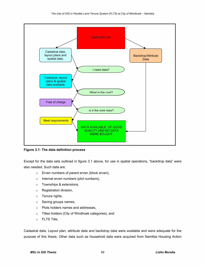
The Use of GIS in Flexible Land Tenure System (FLTS) at City of Windhoek – Namibia
MSc in GIS Thesis Lisho Mundia 49
Figure 3.1: The data definition process
Except for the data sets outlined in figure 3.1 above, for use in spatial operations, “backdrop data” were
also needed. Such data are:
o Erven numbers of parent erven (block erven),
o Internal erven numbers (plot numbers),
o Townships & extensions,
o Registration division,
o Tenure rights,
o Saving groups names,
o Plots holders names and addresses,
o Titles holders (City of Windhoek categories), and
o FLTS Title.
Cadastral data, Layout plan, attribute data and backdrop data were available and were adequate for the
purpose of this thesis. Other data such as household data were acquired from Namibia Housing Action
Cadastral data, layout plans and
spatial data.
DATA NEEDS
Backdrop/Attribute
Data
I need data?
Is it the right data?
What is the cost?
DATA AVAILABLE, OF GOOD
QUALITY AND NO DATA WERE BOUGHT.
Cadastral, layout plans & spatial data available.
Meet requirements
Free of charge
The Use of GIS in Flexible Land Tenure System (FLTS) at City of Windhoek – Namibia
MSc in GIS Thesis Lisho Mundia 50
Group (NHAG); an organization involved in a process of formalization of low-income people in the country
and Shack Dwellers Federation of Namibia (SDFN) an organization with group of saving groups
(schemes) affiliated to them.
3.2.4 Importing, Exporting and Cartographic Techniques A layout plan of the study area (erf 3378, Otjomuise Township, Windhoek) was available; it was imported
into ArcView. Saving it as DXF file format in Autodesk 3D map software and then selecting extensions that
supports DXF file in ArcView did see through the entire process of having this layout in ArcView. Other
new data entities like toilet points, water points, etc were created as new features as there appear in the
GIS mapping project. Other new operations were also done in ArcView during data analysis.
A basic understanding of map projections, coordinate systems, and map compilation was required before
the location data could be digitized. Transverse Mercator projection and Clarke 1866 Spheroid at a central
meridian of -17, and reference latitude of 22 with scale factor of 1 was used in ArcView GIS for the
mapping project. The project was fortunate in that the location data were drawn from a single map sheet.
It was therefore not necessary to combine and integrate location data from map sources of differing scales
and ages, otherwise a higher level of understanding of cartography would have been important.
Geographical Information Science (GIS) became important in geo-referencing location of new features but
basic cartographic issues such as the placement of labels, symbolization, and generalization still required
attention on a daily basis of operation.
3.3 Interview Techniques
3.3.1 Introduction
This section defines and explains the focus group techniques used to acquire the information and share
the group’s views on introducing GIS for FLTS projects at City of Windhoek. It briefly explains the purpose
of the focus group with the date it was carried out, and further explains the contents of the interview and
lastly outlining the success of the contributed work before this research.
3.3.2 Focus Group Definition and Background
The Australian Government (2004, p.1) defines a focus group as a structured discussion with an expert
group of users, they further outline the purpose of a focus group as a tool that brings together the
attitudes, beliefs, perceptions, preferences and experiences of different consumers. A focus group is an
The Use of GIS in Flexible Land Tenure System (FLTS) at City of Windhoek – Namibia
MSc in GIS Thesis Lisho Mundia 51
effective method to use group dynamics to obtain a large amount of material in a short period, and
evaluate different concepts and explore new ideas of a GIS tool in land administration.
In addition, Marczak & Sewell (1990, p.1) explains that a focus group is typically 7-10 people who are
unfamiliar with each other. These participants are selected because they have certain characteristics in
common that relate to the topic of the focus group. Marczak & Sewell further ague that the groups of over
twelve have often proven to be too big while fewer than four have shown that not enough total
experiences exist.
The base for this interview is the views of others, technical aspects and site inspections on informal
settlement block erven for the geodata verification and techniques of GIS for FLTS in order to verify the
focus group interview results. The observation done by myself through few informal settlement block
erven within the City Boundary was carried out in July 2006, whilst, cartographic maps are included in this
thesis to motivate the need, capability, benefits and efficiency of GIS in FLTS as a pilot study.
Before the focused group interview was carried out, two of the City of Windhoek staff members knew
some interview content. To get the focused group interview content structured, some colleagues of the
City of Windhoek played a role in contributing to the presentation content. Before the focused group
interview content was presented to the focused group, the content draft was first tested to few City of
Windhoek staff members in order to get an understanding of the whole interview structure.
The pilot presentation to the focused group (Appendix B to C and the accompanied digital files) told the
implementation team that GIS could be supportive in performing some major tasks for FLTS. Integrating
many data from different software and sources into a GIS, and different departments and divisions is one
of the tasks.
3.3.3 Focus Group Interview Technique
The focused group interview presentation was held on the 23rd of August 2006. The time between then
and now, June 2007, is a relatively long time. The discrepancy in time is particular important given the
rapid take up of GIS. Many respondents agreed and understand the need of involving flexible land tenure
data into the GIS world soon.
The sample for this interview includes all the implementation team from areas of IT, Geomatics, Housing
& Properties, Sustainable Development and Community Development of City of Windhoek, see attendees
list in annexure B. The team was a total of ten people, excluding one top management who was on leave;
two middle management level members from the Department of Planning, Urbanization & Environment,
The Use of GIS in Flexible Land Tenure System (FLTS) at City of Windhoek – Namibia
MSc in GIS Thesis Lisho Mundia 52
with the rest as technicians, first and middle management level members we present. The questions were
raised out to and from the group during the presentation; answers and recommendations were provided
and tackled straight away with the focus group members, including the opinions via voting on number of
GIS issues (Annexure C). The invitation notice was addressed to “GIS and FLTS Implementation teams”
(Annexure A). The invitation notice was addressed to specific staff members via e-mail. Invitations we
sent to all the FLTS, Informal Settlement Committee (ISC) members and GIS implementation team
members.
3.3.4 Interview Contents
The focused group interview technique was mainly focusing on three main parts. Several questions were
answered and discussed during the presentation aimed at answering both the objectives of this study and
the hypothesis as set out in chapter 1.
In section one of the focus group discussions, the benefits of using GIS for FLTS were outlined. This was
followed by an open discussion with the focused group members to rank and determine high benefits for
using GIS in handling FLTS data. The evaluation process was done through voting with results recorded
on flip charts (Annexure C).
Issues covering other factors that influence the use of GIS in FLTS and its outputs were covered. This
were also discussed in the interview content of ‘the use of GIS in administering FLTS data’ and ranked to
test the group’s understanding on the use of GIS through voting.
The concept OPAFIT C+ was another interview content covered in the interview. It stands for
Organization, People, Agreements, Finance, Information, Technology and Communication; in short it is
used to illustrate the tools behind the GIS, which makes the GIS successfully in intended projects. Issues
covering comments on the OPAFIT C+ and other relevant issues of FLTS were also discussed during the
focused group interview presentation. The OPAFIT C model was used in order to gain all the required
information on the implementation of a GIS/LIS database within the City of Windhoek.
A chance was given to the team to add their views and opinions on the current ‘hard copy (archive)’ of
FLTS data at Geomatics Division and on any additional comments or remarks, the results of this
discussion are presented in chapter four below.
The Use of GIS in Flexible Land Tenure System (FLTS) at City of Windhoek – Namibia
MSc in GIS Thesis Lisho Mundia 53
3.3.5 Contributed Work This research and others like Bayer 2000 and Robinson 2003 are very useful for the Namibian local
authorities and the world at large, in improving land administration activities. Nevertheless beside a focus
group interviews involving ten (10) members of technicians, first, middle and top management of the
implementation team from City of Windhoek, Bayer (2000a, 2000b) and Robinson (2003) carried out some
researches before. Bayer was the first researcher to work on Flexible Land Tenure System (FLTS) in
Namibia; he researched for “Information system design for PC based Land Information System (LIS) of
Local Property Office in Namibia within the context of the "Flexible Urban Land Tenure bill of 1999". His
research was reviewed as part of the whole initiation phase of FLTS. Whilst Robinson (2003, p.0)
emphasizes on “Development of an Operational Plan and LIS for the proposed Local Property Offices in
Namibia”, which also played a big role in drafting the Flexible Land Tenure Bill of 2006; waiting for
parliament debate soon.
3.4 The Development of an LIS and GIS Approach
3.4.1 Introduction This section describes the techniques of LIS and GIS technical approach to the development and designing
the prototype used to demonstrate the capabilities of GIS in FLTS. It starts by elaborating the aim and
background of the LIS and GIS model, followed by setting situation on the presentation of the pilot study.
3.4.2 The Aim of the LIS/GIS Prototype
A pilot project intended to demonstrate capabilities of GIS in general. A pilot project was useful because it
demonstrated to potential users and management what GIS in FLTS can do for them. Employees who are
directly involved, gain experience. The relation with the present technical infrastructure can be identified.
Basic assumptions can be tested. The usefulness of all the data can be tested. Requirements like training and
support can be identified.
The aim of the LIS/GIS pilot approach was for the team to gain experience, building technical infrastructure,
insight in own data registrations, and the use of standards and usefulness of external data; whilst, to construct
a small group of focused group employees who will be working on small feasible and pilot of GIS and LIS
products available. Only two workstations are required for managing the database and GIS for FLTS and are
available. A cadastral base map data was internally available, containing all the informal settlements layouts
and a highly useful map of cadastral data, it is useful because the background of data can be determined from
there i.e. one can easily determine the land surveyor or a private company which carried out that specific
area’s survey work. This is an ideal map to start with; it will make early deliverables possible. The results
The Use of GIS in Flexible Land Tenure System (FLTS) at City of Windhoek – Namibia
MSc in GIS Thesis Lisho Mundia 54
therefore aim at increase of knowledge of the basic understanding of GIS to the group, decision-making as to
accept or not accept the GIS for FLTS and realisation of some GIS products by the focused group members.
The results also aim to demonstrate what GIS in FLTS can do for users and managers.
3.4.3 LIS and GIS Model Technique Well-designed and maintained GIS and LIS database approach was presented to the focus group to
motivate the capabilities and benefits of the GIS in the usage for managing FLTS data.
Robinson (2003) a graduate with ITC (International Institute for Geo-Information Science and Earth
Observation) from 2001 – 2003 focused his Masters research on the Development of an Operational Plan
and Land Information System for the proposed Local Property Offices (LPO) in Namibia. His research
although more concerned with proposed Local Property Offices (LPO) for the implementation of the Draft
Flexible Land Tenure in the entire Namibia; it shares a common interest with this research on the basis of
developing of a non-expensive and effective Land Information System (LIS) to support the land information
and land registration process.
Robinson’s research proposed the use of Microsoft Access, as a standard database for the envisaged Local
Property Offices (LPO) and the reason for this is that, Microsoft Office of which Microsoft Access forms part, is
readily available and affordable. Therefore, this research also used Microsoft Access to convert the manual
FLTS tenure register to a digital format. However, the choice of whether to develop the database in MS
Access or conventional database packages will be borne by the Divisions of Geomatics and Housing and
Properties at City of Windhoek given the way forward presented in this research. ArcView GIS was used for
cadastral spatial data part of data administration and analysis.
3.4.4 Pilot Presentation and Discussions Technique
Presentation of GIS/LIS prototype and discussion with the technical and management implementation
team of FLTS projects held on the 23rd of August 2006 saw its green light. Beside the scheduled issues,
discussions included new issues of successful implementation of a database; such as:
o Adopting of the database and modify it to suit more household data,
o Communication with other relevant Divisions to be done either through the available
communication ways i.e. email, telephone, office visit, etc,
o Data exchanges and consultations within the City of Windhoek, and
o To continue researching for tangible technique of handling other spatial data like FLTS data.
The Use of GIS in Flexible Land Tenure System (FLTS) at City of Windhoek – Namibia
MSc in GIS Thesis Lisho Mundia 55
The results of all the questions during the focused group interview presentation were answered by a
‘Score Card’ technique. In case of optional questions, each member of the team was given a chance to
select his own choice, whilst, in case of open questions, all the questions were answered through different
techniques of responding and answering and finally reaching agreement as analyzed in chapter 4 below.
Three techniques of responding to questions were applicable during the focus group discussion; one was
through ranking factors that influence the use of GIS in FLTS projects, the next one was where members
has to raise their hands to NO and YES question and lastly through commentary during the discussion.
Chapter 4 below outlines in detail the entire focus group results.
The Use of GIS in Flexible Land Tenure System (FLTS) at City of Windhoek – Namibia
MSc in GIS Thesis Lisho Mundia 56
4. Analysis and Results
4.1 Introduction This chapter provides the results of the set objectives in chapter one. It also presents the discussions and
personal communication results made during the time of researching. It begins with the results on flexible
land tenure in Windhoek, followed by the focus group interview results; LIS/GIS approach results and
lastly the general GIS analysis based on a SWOT analysis with the advantages and disadvantages of
GIS.
The extent and relative importance of the geographical information varies between the projects, but taken
together they present an opportunity to investigate how maps and geographical information can be
presented on GIS in a variety of different contexts (GIS can integrate data from these different disciplines).
A key aim of this research is to achieve solutions in handling and presenting spatial data and attribute
data of FLTS at City of Windhoek. A number of FLTS issues are included in this chapter, mainly to prove
the progress of the entire FLTS projects in the City of Windhoek.
4.2 Results on Flexible Land Tenure in Windhoek
4.2.1 Introduction This section explains, elaborates and describes the results on the state and progress of the flexible land
tenure system in Windhoek. Issues such as availability of land for FLTS projects, the standards set for
acquiring the FLTS from other stakeholders and subsequently the memorandum of understanding that is
put in place between the Local Property Office (LPO) when established and the City of Windhoek as also
discussed. The results on stakeholders’ approach to FLTS currently in Windhoek is explained and
described here. Other results on how FLTS data are managed currently and FLTS land demarcation
techniques in the City of Windhoek and other local authorities in Namibia are also explained.
4.2.2 Flexible Land Tenure State in Windhoek
Currently, about 47-block erven are made available and are recognized for flexible land tenure projects
(figure 4.1) with possible upgrading. 10-block erven are purchased by saving groups, 8 are individual
leasehold, 18 are group lease agreements and lastly 11 are earmarked for resettlement on FLTS
standards.
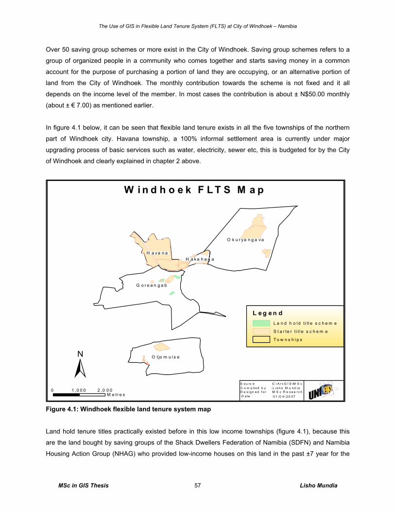
The Use of GIS in Flexible Land Tenure System (FLTS) at City of Windhoek – Namibia
MSc in GIS Thesis Lisho Mundia 57
Over 50 saving group schemes or more exist in the City of Windhoek. Saving group schemes refers to a
group of organized people in a community who comes together and starts saving money in a common
account for the purpose of purchasing a portion of land they are occupying, or an alternative portion of
land from the City of Windhoek. The monthly contribution towards the scheme is not fixed and it all
depends on the income level of the member. In most cases the contribution is about ± N$50.00 monthly
(about ± € 7.00) as mentioned earlier.
In figure 4.1 below, it can be seen that flexible land tenure exists in all the five townships of the northern
part of Windhoek city. Havana township, a 100% informal settlement area is currently under major
upgrading process of basic services such as water, electricity, sewer etc, this is budgeted for by the City
of Windhoek and clearly explained in chapter 2 above.
Figure 4.1: Windhoek flexible land tenure system map
Land hold tenure titles practically existed before in this low income townships (figure 4.1), because this
are the land bought by saving groups of the Shack Dwellers Federation of Namibia (SDFN) and Namibia
Housing Action Group (NHAG) who provided low-income houses on this land in the past ±7 year for the
±0 2 ,0 0 01 ,0 0 0
M e t r e s 0 1 /0 4 / 2 0 0 7M S c R e s e a r c hL i s h o M u n d iaC \ A r c G I S \M S c
D e s ig n e d f o r :D a te :
C o m p i l e d b y :S o u rc e :
L e g e n dL a n d h o l d t i t l e s c h e m e
S t a r te r t i t l e s c h e m e
T o w n s h i p s
W i n d h o e k F L T S M a p
O k u r y a n g a v a
G o r e a n g a b
O t jo m u i s e
H a v a n aH a k a h a n a
The Use of GIS in Flexible Land Tenure System (FLTS) at City of Windhoek – Namibia
MSc in GIS Thesis Lisho Mundia 58
poor people who saved money in order to buyer the land from the City of Windhoek. Whilst, starter title
are new development of demarcated land, well planned and continued been planned in catering for low-
income groups currently saving in order to afford the land on starter title in future. The initially stage of
starter title and land hold title is to make them legally recognized nationally.
There are ±10 block erven settled under the saving groups in Windhoek city alone. These are believed to
suit well with the FLTS requirements, and are been provided with basic services such as water, street
access, community toilets, and basic electricity. Their land is well demarcated and suits the needs of all
the FLTS under both starter title scheme and subsequently upgrading to land hold title scheme.
4.2.3 FLTS Set Standards at City of Windhoek
Flexible land tenure layout plans is acquired from individuals, organizations, private practitioners, and
institutions that are carrying out demarcations and any other task of flexible land tenure projects.
Currently, the City of Windhoek has made sure that the future acquisition of all the FLTS layouts be done
thorough by setting standards that all the flexible land tenure layout maps be approved by the City of
Windhoek before any surveying ground work begin. These standards are in line with the land survey act,
including the process model between the City of Windhoek, LPO and the clients of FLTS.
Once the Local Property Office (LPO) that deals fully with FLTS is set, it will also have to get approval
from the City of Windhoek for the final layouts to be approved and put in place before the survey starts.
This was agreed upon on the meeting of “Memorandum of Understanding between the City of Windhoek
and the Ministry of Land and Resettlement for the Local Property Office (LPO)” to be established soon see
figure 4.2 below for the process model of FLTS application. ‘All the layout plans and flexible tenure plans
also known as Land Hold (LH) plans (figure 4.2) will have to be approved by Local Authority (LA) in this
case is the City of Windhoek before any survey starts and that the Local Property Office (LPO) can at
anytime seek advice on any issues related to surveying or map composition of such FLTS’ (C P
Jendrissek 2006, pers comm., 23 May). The standards of the FLTS block erf layout that the City of
Windhoek will recognize are outlined in table 4.1 below.
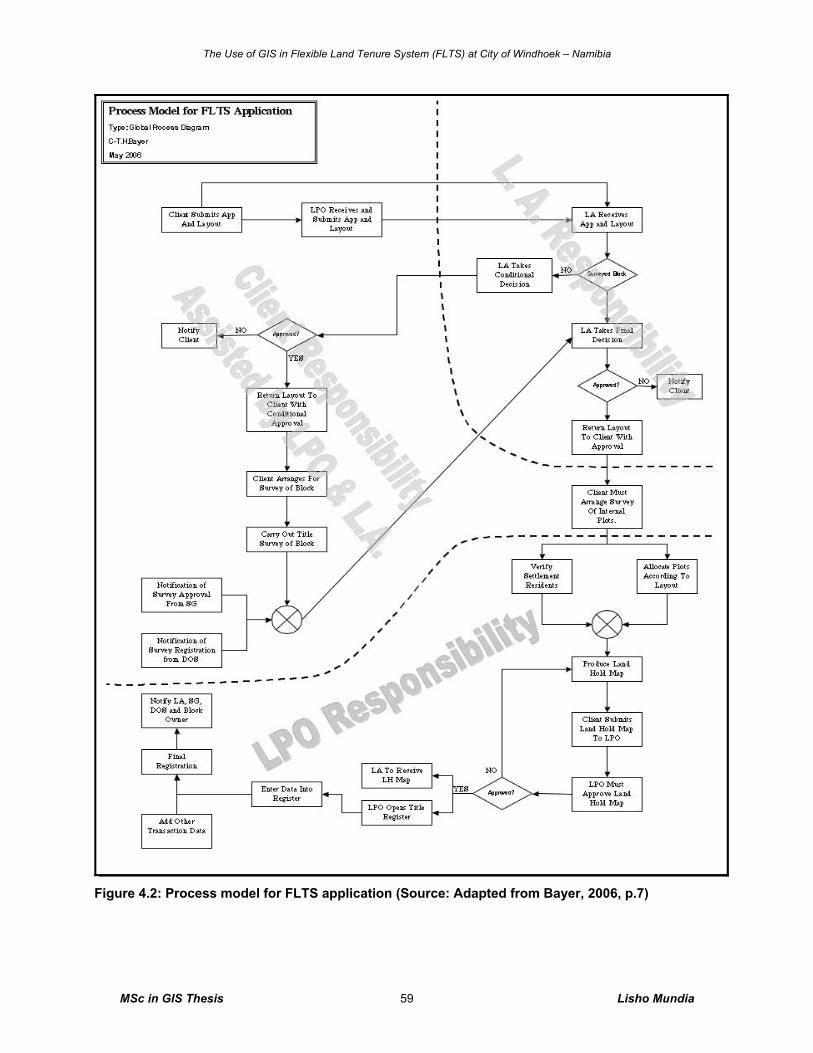
The Use of GIS in Flexible Land Tenure System (FLTS) at City of Windhoek – Namibia
MSc in GIS Thesis Lisho Mundia 59
Figure 4.2: Process model for FLTS application (Source: Adapted from Bayer, 2006, p.7)
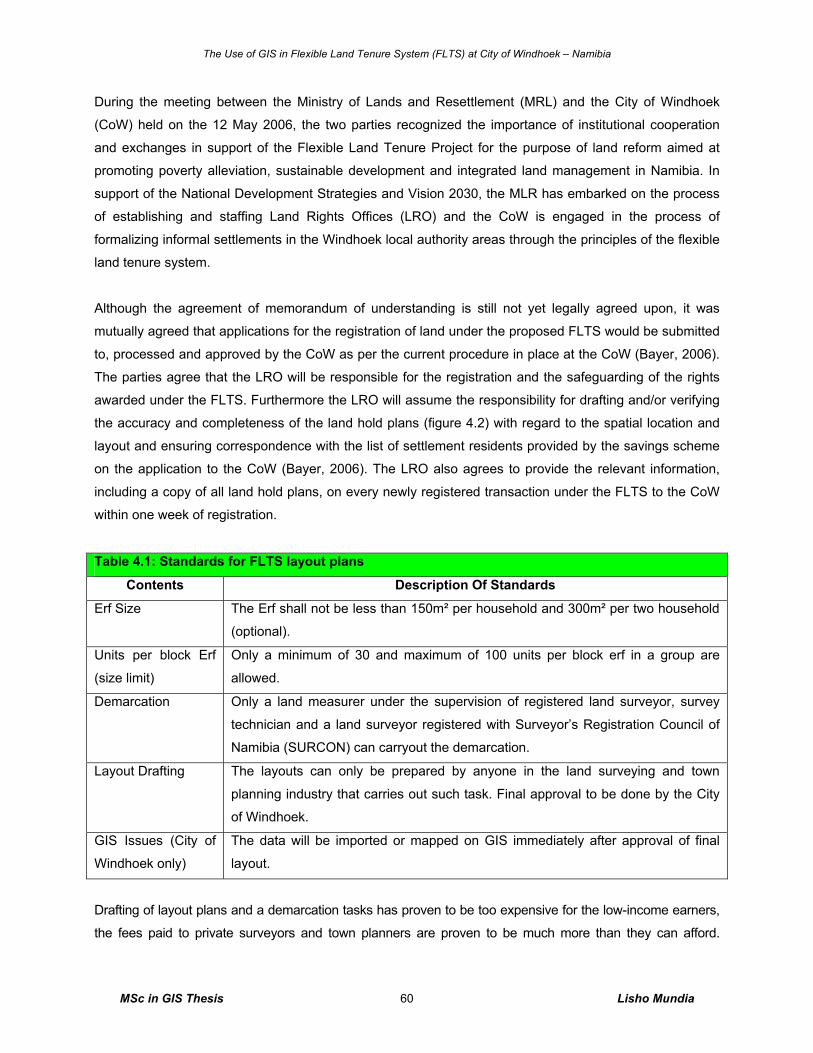
The Use of GIS in Flexible Land Tenure System (FLTS) at City of Windhoek – Namibia
MSc in GIS Thesis Lisho Mundia 60
During the meeting between the Ministry of Lands and Resettlement (MRL) and the City of Windhoek
(CoW) held on the 12 May 2006, the two parties recognized the importance of institutional cooperation
and exchanges in support of the Flexible Land Tenure Project for the purpose of land reform aimed at
promoting poverty alleviation, sustainable development and integrated land management in Namibia. In
support of the National Development Strategies and Vision 2030, the MLR has embarked on the process
of establishing and staffing Land Rights Offices (LRO) and the CoW is engaged in the process of
formalizing informal settlements in the Windhoek local authority areas through the principles of the flexible
land tenure system.
Although the agreement of memorandum of understanding is still not yet legally agreed upon, it was
mutually agreed that applications for the registration of land under the proposed FLTS would be submitted
to, processed and approved by the CoW as per the current procedure in place at the CoW (Bayer, 2006).
The parties agree that the LRO will be responsible for the registration and the safeguarding of the rights
awarded under the FLTS. Furthermore the LRO will assume the responsibility for drafting and/or verifying
the accuracy and completeness of the land hold plans (figure 4.2) with regard to the spatial location and
layout and ensuring correspondence with the list of settlement residents provided by the savings scheme
on the application to the CoW (Bayer, 2006). The LRO also agrees to provide the relevant information,
including a copy of all land hold plans, on every newly registered transaction under the FLTS to the CoW
within one week of registration.
Table 4.1: Standards for FLTS layout plans
Contents Description Of Standards
Erf Size The Erf shall not be less than 150m² per household and 300m² per two household
(optional).
Units per block Erf
(size limit)
Only a minimum of 30 and maximum of 100 units per block erf in a group are
allowed.
Demarcation Only a land measurer under the supervision of registered land surveyor, survey
technician and a land surveyor registered with Surveyor’s Registration Council of
Namibia (SURCON) can carryout the demarcation.
Layout Drafting The layouts can only be prepared by anyone in the land surveying and town
planning industry that carries out such task. Final approval to be done by the City
of Windhoek.
GIS Issues (City of
Windhoek only)
The data will be imported or mapped on GIS immediately after approval of final
layout.
Drafting of layout plans and a demarcation tasks has proven to be too expensive for the low-income earners,
the fees paid to private surveyors and town planners are proven to be much more than they can afford.
The Use of GIS in Flexible Land Tenure System (FLTS) at City of Windhoek – Namibia
MSc in GIS Thesis Lisho Mundia 61
Therefore, the City of Windhoek has resolved that the tasks of drafting of layout plans and demarcations of
block erven be done by the City of Windhoek itself, and the costs be accumulated into property costs in order
to eliminate high costs paid at once to private organization. However, saving groups, individual and group
members are still welcome to appoint their own private land survey practitioners to do their work and get it
approved by the City of Windhoek.
4.2.4 Stakeholders’ Approach to FLTS in Windhoek and Other Region The City of Windhoek has adopted the ‘Development Upgrading Strategy’ (DUS) to address the
management of urban development and informal settlement upgrading. This strategy aims at establishing
guidelines by proposing different development options based on affordability of the client and also
proposes guidelines for informal settlement upgrading and management. The stakeholders in the land
development and upgrading process are also identified.
Apart from the City of Windhoek and the Government of Namibia, there are at present only two main Non
Governmental Organizations involved in self-help housing development; the Namibia Housing Action
Group (NHAG) and Shack Dwellers Federation of Namibia (SDFN) have a number of saving schemes
affiliated to them. The two NGO’s broadly follow the same guidelines similar to those used by the City of
Windhoek and as such the City of Windhoek works closely with them in the implementation of the self-
help group’ strategy.
The strategy urges the establishment of a land bank in order to speed up the allocation of land to the self-
help housing groups. This land bank would contain information of portions of land and erven owned by
the City of Windhoek that could be developed for residential purposes by these groups. This also allows
for in-fill residential development, as vacant land within existing townships will also be listed. The City of
Windhoek will determine the feasibility of developing these erven in terms of natural conditions and
probable development costs as well as potential erf yield. The City of Windhoek’ Sustainable
Development Division have undertaken to provide planning layout designs at no costs to the groups in a
bid to demonstrate the Division’s social responsibility to the poor.
The two non-governmental organizations (Namibia Housing Action Group and Shack Dwellers Federation
of Namibia) have been doing FLTS projects in the Otjozondjupa Region in the town of Otjiwarongo and
the Kavango Region in the town of Rundu in the past with the help of the Polytechnic of Namibia’s Land
Management Department students, and are currently busy in Caprivi region in Katima Mulilo. The
Government development supporting company called Luxemburg Development is now also sponsoring
huge upgrading projects in the towns of Katima Mulilo and Rundu and they are not sure whether they will
go for FLTS approach, or for formal title (full free hold, with general plan and township establishment).
The Use of GIS in Flexible Land Tenure System (FLTS) at City of Windhoek – Namibia
MSc in GIS Thesis Lisho Mundia 62
4.2.5 Managing of Cadastral Data
The City of Windhoek, like any other local authority in the world, is faced with the challenge of supplying
timely and reliable data to its clients. These data sets are looked at as strategic resource for development
and business. The computerized multi-purpose cadastre of the City of Windhoek is a relatively new
concept. It has the potential to provide many benefits across all sections of the communities by acquiring
updated information of their parcels at quick service and to the City of Windhoek’s employees itself, such
benefits of this cadastre are:
o Ability to query data by the City of Windhoek and external parties, suburb, town name or geographic
search criteria,
o Ability to handle zonings, densities and land use separate from land parcels,
o Ability to link addresses to parcels, and
o Efficient cadastral capture tools to construct data by coordinates.
Therefore it is important that the benefits are widely promoted both to top management of the City of
Windhoek who are responsible for the allocation of resources and to the users of land and property
related information. Figure 4.3 shows the land use map of the FLTS Otjomuise of erf 3378 block. The City
of Windhoek’s top management are aware of technology growth, change and its need, the attitude of the
top management of the City of Windhoek and the people towards cadastre are quite generous and they
always require productivity of work with this new technology. Implementation of land use maps for FLTS
project is a good idea because the City of Windhoek can have a good tool for monitoring activities
happening in their land.
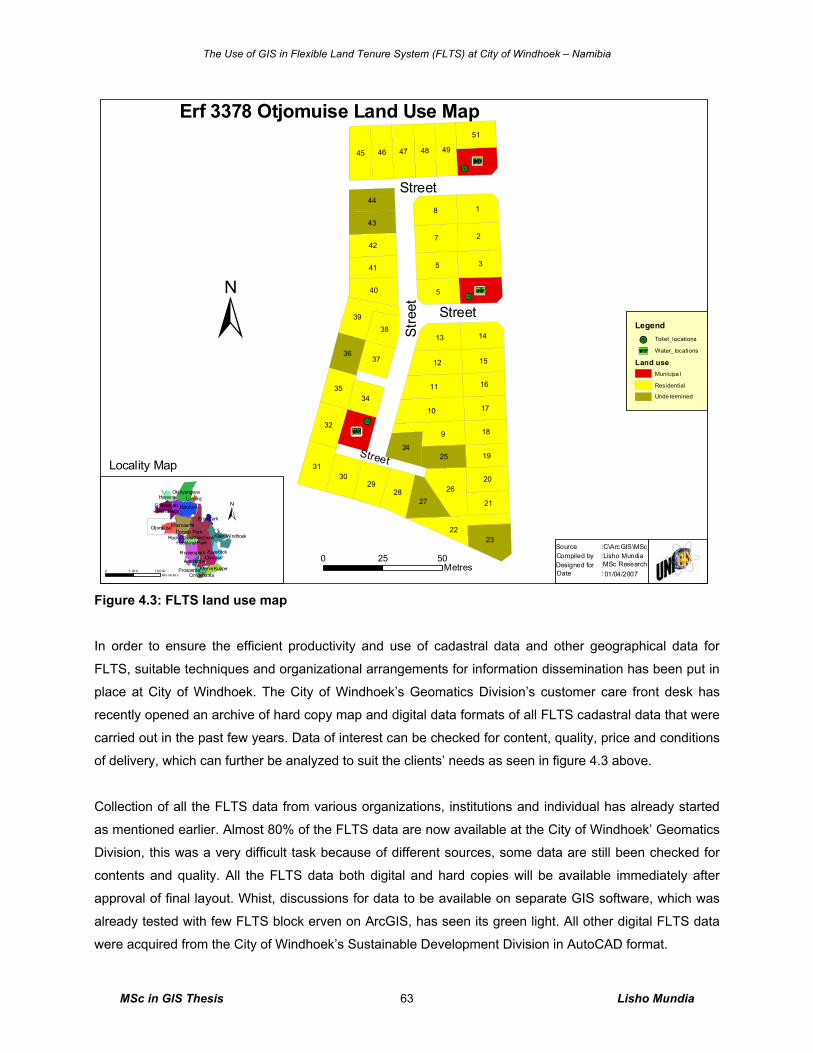
The Use of GIS in Flexible Land Tenure System (FLTS) at City of Windhoek – Namibia
MSc in GIS Thesis Lisho Mundia 63
Figure 4.3: FLTS land use map
In order to ensure the efficient productivity and use of cadastral data and other geographical data for
FLTS, suitable techniques and organizational arrangements for information dissemination has been put in
place at City of Windhoek. The City of Windhoek’s Geomatics Division’s customer care front desk has
recently opened an archive of hard copy map and digital data formats of all FLTS cadastral data that were
carried out in the past few years. Data of interest can be checked for content, quality, price and conditions
of delivery, which can further be analyzed to suit the clients’ needs as seen in figure 4.3 above.
Collection of all the FLTS data from various organizations, institutions and individual has already started
as mentioned earlier. Almost 80% of the FLTS data are now available at the City of Windhoek’ Geomatics
Division, this was a very difficult task because of different sources, some data are still been checked for
contents and quality. All the FLTS data both digital and hard copies will be available immediately after
approval of final layout. Whist, discussions for data to be available on separate GIS software, which was
already tested with few FLTS block erven on ArcGIS, has seen its green light. All other digital FLTS data
were acquired from the City of Windhoek’s Sustainable Development Division in AutoCAD format.
+C
+C
+C
!O
!O
!O
9
18
3
27
5
45
10
26
11
22
39
31
23
12
45
40
13
32
2930
46 47 48
28
49
27
14
33
50
42
51
43
20
41
44
21
18
17
16
1536
35
1924
25
37
34
38
Erf 3378 Otjomuise Land Use Map
Legend
!O Toilet_locations
+C Water_ locations
Land useMunicipa l
Residential
Unde termined
Katutura
Windhoek
Khomasdal
Okuryangava
Goreangab
Klein Windhoek
Pionierspark
Otjomuise
AuasblickOlympia
Kleine Kuppe
Havana
Wanaheda
Hochland Park
Academia
Prosperita
Eros Park
Rocky CrestDorado Park
Cimbebasia
Lafrenz
Locality Map
±
0 5025Metres
Street
Street
Stre
et
Street
Source :Compiled by :
Date :Designed for :
C\ArcGIS\MScLisho MundiaMSc Research01/04/2007
±
0 1 0,0 005 ,00 0Kilo me tre s
The Use of GIS in Flexible Land Tenure System (FLTS) at City of Windhoek – Namibia
MSc in GIS Thesis Lisho Mundia 64
The data will also be collected, stored, maintained and updated cost-effectively and efficiently through
getting a final digital and hard copy immediately after approval of such layout by the City of Windhoek.
Data will be registered only once, kept up to date in one place (Geomatics’ Archive), whilst the electronic
vision will be imported into GIS, cleaned and offered for public use. These will however, require several
separate technical, organizational, and financial measures; this then answers the questions of many GIS
experts within the Windhoek City and enthusiasts individuals who keeps asking what the City of Windhoek
is doing with the FLTS data. Questions such as ‘is there anything the City of Windhoek is doing with the
FLTS data at the moment? (T C Bayer 2006, pers comm., 20 February 2006) will be eliminated by the GIS
results in flexible land tenure projects.
4.2.6 FLTS Demarcation Issues
The demarcation of FLTS block erven will be carried out in accordance with the Namibian land survey act
(act no. 33 of 1993: land survey act) by any registered land measurer, survey technician and a land
surveyor. The Act was promulgated in 1993, to regulate the survey of land and to provide for matters
connected therewith, in the Republic of Namibia, based on the Land Survey Act No. 9 of 1927. At present,
any one who qualifies to carryout the survey and demarcation of the FLTS can do it with no objections to
his or her work (Government of Namibia, 1993).
Before one starts with the demarcation/surveying on an upgrading area of the FLTS; in situ (area where
people are already living), a meeting need to be held with the community involved to inform them of the
project and also involve them where necessary. The community needs to be educated on how to manage
beacons (pegs) and on cheap demarcation techniques, in case beacons are removed. The process of
conducting a community meeting usually is through by conducting a short meeting with the community
leader of that block erf first, the community leader then calls a meeting with their members together with
the land surveyor involved. This procedure is normal a norm in Namibia’s informal settlement upgrading
as part of adjudication process, it aims mainly to solve land dispute within the block, for example if the
land surveyor detect that the shack house is situated in the street access, he or she has to know who to
approach and be known to such community member.
In an informal settlement, under the flexible land tenure bill, demarcation using tapes for internal erven
demarcation is acceptable, because the schemes (saving group) only own a block which is registered at
the Surveyor General’s Office (SGO) and is first surveyed by a professional land surveyor. Although using
a tape measure the survey will be accepted and it is also cheaper than using professional land surveyor
with their expensive instruments, the City of Windhoek recommend the modern technological surveying
equipments like GPS and total stations for their work in order to have good quality results.
The Use of GIS in Flexible Land Tenure System (FLTS) at City of Windhoek – Namibia
MSc in GIS Thesis Lisho Mundia 65
4.3 Focus Group Interview Results
4.3.1 Introduction This section provides the results on GIS and LIS for FLTS, explaining the attribute and cadastral data
capturing results. The application contents in land administration projects of GIS for FLTS results and
proposed and ranked by the focus group is also explained here including cadastral and attributes mapping.
The results on the OPAFIT C+ concepts are explained and lastly the results on comments from the focus
group interview.
To realize the focus group’s contents, a presentation of a pilot study done with the City of Windhoek’s data
was presented to the group as an introduction to discussion and questions. This was done because the group
composed of members who could not understand much about GIS. During the discussion the group mainly
the middle and top management strongly agreed to seriously bring the FLTS data into GIS, and gave positive
recommendations on the usefulness of the FLTS data. These are outlined in this chapter below.
4.3.2 GIS and LIS for Flexible Land Tenure System
Since the main objective of the research is to evaluate the use of GIS in handling FLTS data, the focus
group interview was therefore carried out within the City of Windhoek with the implementation teams of
FLTS and GIS. This was to allow inter-divisional information sharing and determine the reason for a GIS
as to the reasons outlined in figure 4.4 below. The database will be managed by the Geomatics division,
whilst, some land information data will be entered into the database by the Division of Housing &
Properties.
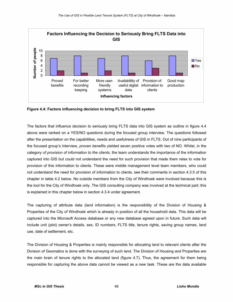
The Use of GIS in Flexible Land Tenure System (FLTS) at City of Windhoek – Namibia
MSc in GIS Thesis Lisho Mundia 66
Factors Influencing the Decision to Seriously Bring FLTS Data into GIS
02468
10
Provedbenefits
For betterrecordingkeeping
More user-friendlysystems
Availablility ofuseful digital
data
Provision ofinformation to
clients
Good mapproduction
Influencing factors
Num
ber o
f peo
ple
YesNo
Figure 4.4: Factors influencing decision to bring FLTS into GIS system
The factors that influence decision to seriously bring FLTS data into GIS system as outline in figure 4.4
above were ranked on a YES/NO questions during the focused group interview. The questions followed
after the presentation on the capabilities, needs and usefulness of GIS in FLTS. Out of nine participants of
the focused group’s interview, proven benefits yielded seven positive votes with two of NO. Whilst, in the
category of provision of information to the clients, the team understands the importance of the information
captured into GIS but could not understand the need for such provision that made them relax to vote for
provision of this information to clients. These were middle management level team members, who could
not understand the need for provision of information to clients, see their comments in section 4.3.5 of this
chapter in table 4.2 below. No outside members from the City of Windhoek were involved because this is
the tool for the City of Windhoek only. The GIS consulting company was involved at the technical part; this
is explained in this chapter below in section 4.3.4 under agreement.
The capturing of attribute data (land information) is the responsibility of the Division of Housing &
Properties of the City of Windhoek which is already in position of all the household data. This data will be
captured into the Microsoft Access database or any new database agreed upon in future. Such data will
include unit (plot) owner’s details, sex, ID numbers, FLTS title, tenure rights, saving group names, land
use, date of settlement, etc.
The Division of Housing & Properties is mainly responsible for allocating land to relevant clients after the
Division of Geomatics is done with the surveying of such land. The Division of Housing and Properties are
the main brain of tenure rights to the allocated land (figure 4.7). Thus, the agreement for them being
responsible for capturing the above data cannot be viewed as a new task. These are the data available
The Use of GIS in Flexible Land Tenure System (FLTS) at City of Windhoek – Namibia
MSc in GIS Thesis Lisho Mundia 67
within this Division, and are acquired in various ways such as through deed of sales, lease agreements
and surveys.
On the other hand, Geomatics Division of the City of Windhoek as a Division responsible for mapping,
surveying and managing all cadastral data in the boundaries of Windhoek city, will be responsible for
managing the FLTS database and the capturing of all the cadastral data into the database and on GIS.
The data includes - registration division, township, erf number, unique unit number, and plot sizes.
The relationship between these four main Divisions of the City of Windhoek namely Sustainable
Development Division, Housing and Properties, IT and Geomatics is very much essential. This is mainly
because of the integrations in work operations and Divisional needs. These parties are both in support of
the GIS in FLTS projects and their work is very much overlapping to one another see figure 4.7 below.
Having said about the relationship of the Divisions directly involved and elaborating more with figure 4.7
below, it will be understood that plot sizes will be calculated in the GIS from the layout plans prepared by
the Division of Sustainable Development and other data will all form a base for linking the Microsoft
Access Database with GIS database and subsequently joining them for data storing, managing and
further analysis. Information of GIS and Microsoft Access database can be analyzed and compiled in
forms of maps, graphs, charts, etc to make tangible and geographically readable output like the map seen
in figure 4.5 below. This can help in decision-making process, future planning of land allocation and in
progress reporting to the top management. Figure 4.5 shows a map service by a GIS. It shows a 50m
buffer of toilets points which can be used on deciding whether more toilets are needed in the area at 50m
radiuses or less.
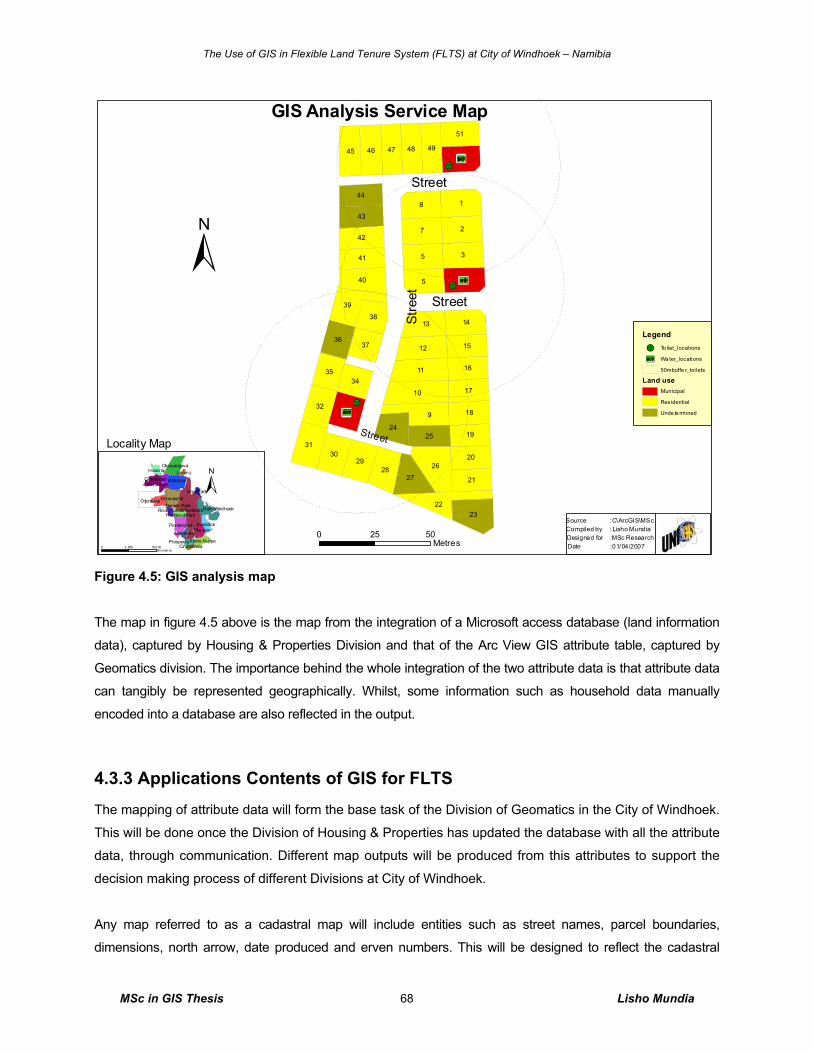
The Use of GIS in Flexible Land Tenure System (FLTS) at City of Windhoek – Namibia
MSc in GIS Thesis Lisho Mundia 68
Figure 4.5: GIS analysis map
The map in figure 4.5 above is the map from the integration of a Microsoft access database (land information
data), captured by Housing & Properties Division and that of the Arc View GIS attribute table, captured by
Geomatics division. The importance behind the whole integration of the two attribute data is that attribute data
can tangibly be represented geographically. Whilst, some information such as household data manually
encoded into a database are also reflected in the output.
4.3.3 Applications Contents of GIS for FLTS
The mapping of attribute data will form the base task of the Division of Geomatics in the City of Windhoek.
This will be done once the Division of Housing & Properties has updated the database with all the attribute
data, through communication. Different map outputs will be produced from this attributes to support the
decision making process of different Divisions at City of Windhoek.
Any map referred to as a cadastral map will include entities such as street names, parcel boundaries,
dimensions, north arrow, date produced and erven numbers. This will be designed to reflect the cadastral
+C
+C
+C
!O
!O
!O
9
18
3
27
5
45
10
26
11
22
39
31
23
12
45
40
13
32
2930
46 47 48
28
49
27
14
33
50
42
51
43
20
41
44
21
18
17
16
1536
35
1924
25
37
34
38
GIS Analysis Service Map
Legend
!O To ilet_locations
+C Wa ter_locations
50mbuffe r_toilets
Land useMunicipal
Residential
Unde te rmined
Katutu ra
Windhoek
Khomasdal
Okuryangava
Goreangab
Klein Windhoek
Pionierspark
Otjomuise
AuasblickOlympia
Kleine Kuppe
Havana
Wanaheda
Hochland Park
Academia
Prosperita
Eros Park
Rocky CrestDorado Park
Cimbebasia
Lafrenz
Locality Map
±
0 5025Metres
Street
Street
Stre
etStreet
Source :Compiled by :
Date :Designed for :
C\ArcGIS\MScLisho MundiaMSc Research01/04/2007
±
0 10,0 005 ,000Kilo metr es
The Use of GIS in Flexible Land Tenure System (FLTS) at City of Windhoek – Namibia
MSc in GIS Thesis Lisho Mundia 69
information. The Division of Geomatics will be responsible for mapping of all cadastral map of the City of
Windhoek as it is currently doing the same task. The legality work of land registration and allocation is the
responsibilities of Housing & Property Division.
All the digital attribute and cadastral information will be managed by the Division of Geomatics for different
applications of any land administration project within the City of Windhoek. Figure 4.6 below shows the factors
that influence the use of GIS in FLTS data perceived to be common and were supported by the focus group
members by means of voting after the presentation of a pilot. Whilst, all the involved Divisions have the
responsibility to see to the implementation and maintenance of the entire project tools by making use of this
GIS tool for their decision making and planning process.
The results in figure 4.6 below, clearly indicates the need of a GIS in administering the FLTS data because of
the 100% votes it has acquired from the focus group. The category of front desk and information, land parcel
and cadastral data both got votes of 100%. These results indicate also the potentiality of FLTS data as useful
for dissemination to both the public and other stakeholders like surveyors, town planners, etc.
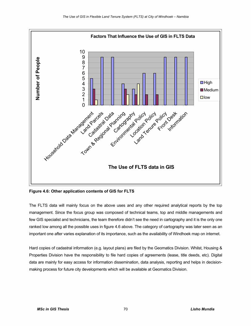
The Use of GIS in Flexible Land Tenure System (FLTS) at City of Windhoek – Namibia
MSc in GIS Thesis Lisho Mundia 70
Factors That Influence the Use of GIS in FLTS Data
0123456789
10
House
hold
Data M
anag
emen
t
Land
Parc
els
Cadas
tral D
ata
Town &
Reg
ional
Plannin
g
Cartog
raphy
Enviro
nmen
tal P
olicy
Loca
tion P
olicy
Land
Tenure
Poli
cy
Front D
esk
Inform
ation
The Use of FLTS data in GIS
Num
ber o
f Peo
ple
High
Medium
low
Figure 4.6: Other application contents of GIS for FLTS The FLTS data will mainly focus on the above uses and any other required analytical reports by the top
management. Since the focus group was composed of technical teams, top and middle managements and
few GIS specialist and technicians, the team therefore didn’t see the need in cartography and it is the only one
ranked low among all the possible uses in figure 4.6 above. The category of cartography was later seen as an
important one after varies explanation of its importance, such as the availability of Windhoek map on internet.
Hard copies of cadastral information (e.g. layout plans) are filed by the Geomatics Division. Whilst, Housing &
Properties Division have the responsibility to file hard copies of agreements (lease, title deeds, etc). Digital
data are mainly for easy access for information dissemination, data analysis, reporting and helps in decision-
making process for future city developments which will be available at Geomatics Division.
The Use of GIS in Flexible Land Tenure System (FLTS) at City of Windhoek – Namibia
MSc in GIS Thesis Lisho Mundia 71
4.3.4 Results on OPAFIT C+ Concept
Introduction A main characteristic of land tenure is that it reflects a social relationship regarding rights to land, which
means that in a certain jurisdiction the relationship between people and land is recognized as a legal valid
one either formal or non-formal (Lemmen et al. 2004, p.2). The success of GIS requires a recognized
organization, the people working in that organization with set agreements, finance available for the
project, information as a component and the technology to keep it running smoothly with good
communication.
For this research the OPAFIT C+ concept was used for discussion of the future success of FLTS GIS
project during the focused group interview, the concept with its results is summarized below on its letters
as headings.
Organization Organizations like the City of Windhoek are now increasingly confronted with rapid developments in
technology, a technology push: internet, (geo) databases, modelling standards, open systems, GIS, as well as
a growing demand for new services, a market pull: e-governance, sustainable development, electronic
conveyance, integration of public data and systems (Lemmen et al. 2004, p.2). Organisation of GIS in FLTS
project exists, which is the City of Windhoek.
As Sieber (2000, p.16) have concluded, successful implementation of a GIS in local governments
including the City of Windhoek, depends on a number of well-documented factors, such as:
o Evaluation of user needs;
o GIS as a vital component of the official organization’ strategy o Long-term upper management commitment to the project;
o Sufficient allocation of resources;
o Adequate staffing;
o Timely and sufficient training;
o Someone, called a “GIS champion (professional),” who will shepherd the project from
acquisition to use; and
o Organizational communication or diffusion to smooth the transition to full utilization.
Sieber (2000, p.16) further pointed out that “clearly, management plays a key role in achieving GIS
adoption.” “In addition to commitment to the system and the securing of resources, implementation
depends on the upper echelon’s ability to articulate organizational goals for the GIS, including
management of possibly conflicting departmental goals.” This is clearly the same procedures at City of
Windhoek because enthusiastic individual employees identify the need for a tool, and then present its role,
The Use of GIS in Flexible Land Tenure System (FLTS) at City of Windhoek – Namibia
MSc in GIS Thesis Lisho Mundia 72
capabilities and benefits of such a tool to their line managers for possible recommendations and advice on
a detailed research.
The management is divided into two levels; the primary user level and the secondary level all containing the
centralised aspect of the management, (e.g. Geomatics division). Another subdivision is the divisions into
technical, data and application management, which also include the Division of Geomatics, Information
Technology (IT) Department, Housing & Properties Division and Sustainable Development Division. Figure
2.5 and 2.6 in chapter 2 indicates the brief explanation of other outside organisations involved in the FLTS
project. On the paragraph people below, there is attention for knowledge and education.
The most important part in all the management affairs is mutual communication. The user organisation consist
of main Divisions and mostly four roles are important - (see figure 4.7 below for divisional responsibilities in
the FLTS projects) the end users, application administrator and GIS administrator. It is not possible to
combine roles into one person because of different responsibilities; roles are divided to various Divisions as
shown in figure 4.7 below.
To help elaborate more on the roles played by these Divisions, an overlap diagram of figure 4.7 illustrates the
tasks and responsibilities of each Division. Firstly, the Division of Housing and Properties under its broad
responsibilities determine the block erf (erven) for availability to the low-income people. Once the land is
available and agreed upon after necessary consultation and pre feasibility studies by the Division of Housing
and Properties, then the Division of Sustainable Development under the request from Housing and Properties
Division carries out a planning process (including detailed feasibility study, designing of technical aspects of
services, etc) and design a layout plan outlining details of parcel boundaries, street access, services such as
community toilets and water point’s locations. Thirdly, the Division of Geomatics under the request from the
either the Division of Housing and Properties, Sustainable Development or from the Informal Settlement
Committee (ISC) carries out the demarcation of this block erf by using the layout plan prepared by the
Division of Sustainable Development through cleaning it to the land surveyor’s needs. Lastly, the block erf is
imported into the City of Windhoek townships map via IT’s GIS/CAD administrator.
The process of recognizing a block of land for flexible land tenure system is the Division of Housing and
Properties’ responsibility but it gets its final approval from the Informal Settlements Committee (ISC) for such
recognition. The ISC are the driver of the low-income land within the City of Windhoek’s boundaries.
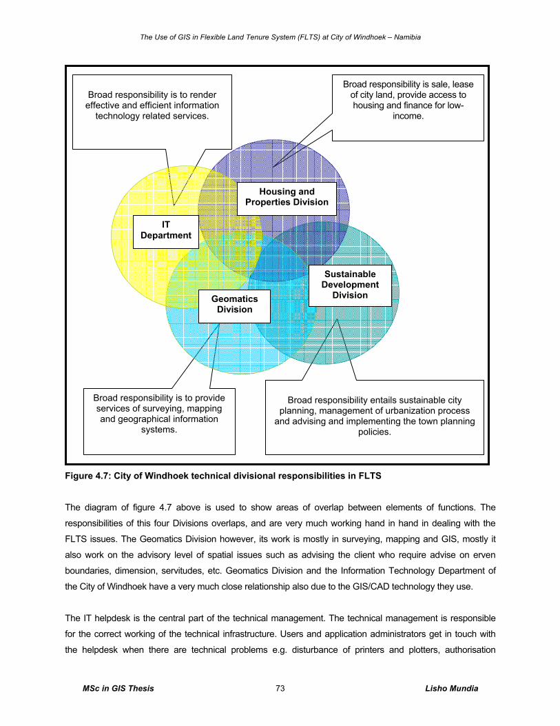
The Use of GIS in Flexible Land Tenure System (FLTS) at City of Windhoek – Namibia
MSc in GIS Thesis Lisho Mundia 73
Figure 4.7: City of Windhoek technical divisional responsibilities in FLTS
The diagram of figure 4.7 above is used to show areas of overlap between elements of functions. The
responsibilities of this four Divisions overlaps, and are very much working hand in hand in dealing with the
FLTS issues. The Geomatics Division however, its work is mostly in surveying, mapping and GIS, mostly it
also work on the advisory level of spatial issues such as advising the client who require advise on erven
boundaries, dimension, servitudes, etc. Geomatics Division and the Information Technology Department of
the City of Windhoek have a very much close relationship also due to the GIS/CAD technology they use.
The IT helpdesk is the central part of the technical management. The technical management is responsible
for the correct working of the technical infrastructure. Users and application administrators get in touch with
the helpdesk when there are technical problems e.g. disturbance of printers and plotters, authorisation
Broad responsibility is to render
effective and efficient information technology related services.
Broad responsibility entails sustainable city
planning, management of urbanization process and advising and implementing the town planning
policies.
Broad responsibility is sale, lease of city land, provide access to housing and finance for low-
income.
Broad responsibility is to provide services of surveying, mapping and geographical information
systems.
IT Department
Geomatics Division
Sustainable Development
Division
Housing and Properties Division
The Use of GIS in Flexible Land Tenure System (FLTS) at City of Windhoek – Namibia
MSc in GIS Thesis Lisho Mundia 74
problem on network directories, problems with data communication. The helpdesk brings in the technical
specialists e.g. network/system manager, automation-office expert, who are the IT department in case of this
project it is CAD/GIS administrator and are available.
People The GIS database administrator (DBA), who is agreed to be a CAD/GIS Administrator of the IT Department, is
responsible for the technical management of the database and its GIS, with important aspects like
authorisation, consistence and integrity, back up and recovery. The database administrator supports users
with complex queries. DBA will liaison himself with the Geomatics Division’s Chief Geomatics of the City of
Windhoek and he also manages metadata as well. For the data co-ordination part the DBA makes
agreements with users and data administrators. The agreements are set down in a data dictionary.
Training of the employees is an investment in the people and also an investment in the future of GIS and LIS
for FLTS projects. The introduction of GIS causes new tasks like a highly specialised and trained DBA to
manage the GIS database and IT related tasks. In practice it is possible that one person fills-in more tasks.
The relation between the tasks is that, the GIS will cut short the long time spent on the pen and paper
recording method. The following tasks need attention:
o GIS and LIS user,
o Land Information administrator,
o Database administration,
o Technical administration.
The GIS and LIS for FLTS project application management are new at the City of Windhoek. The filling in of
these tasks is necessary and forms the base for successful use and co-operation. Fortunately, all the tasks
are filled, and the new system will reduce their time frame on their everyday tasks.
Agreements The agreements are an important aspect of an information infrastructure. Because of the cooperation
between four divisions, agreements are even essential. There was already attention for some agreements on
the data infrastructure and the technical infrastructure. Agreements such as that of installation of ArcGIS,
setting up of Spatial Data Engine (SDE) which can operate as a client application on top of a wide range of
mainstream Relational Database Management Systems (RDBMS) together with oracle database were
agreed upon with the company called Geo-Business Solution. This is an external GIS Consulting Company;
chapter five of figure 5.1 below outlines the proposed setup. These choose was made based on the Division
of Geomatics’ needs considering the entire City of Windhoek’s needs too. One main reason was because the
existing Autodesk Map 3D 2006, supported by Munsys 9.3 applications was automated and cannot create
shape files for FLTS and other projects, either compatible for external clients.
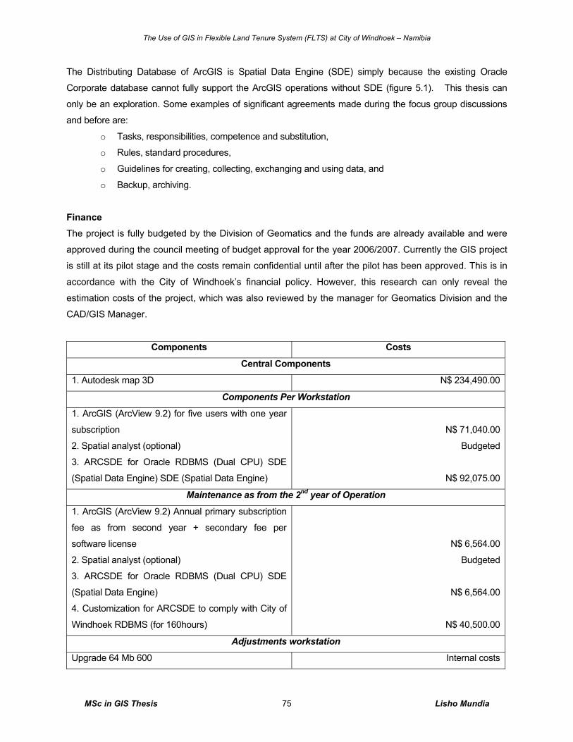
The Use of GIS in Flexible Land Tenure System (FLTS) at City of Windhoek – Namibia
MSc in GIS Thesis Lisho Mundia 75
The Distributing Database of ArcGIS is Spatial Data Engine (SDE) simply because the existing Oracle
Corporate database cannot fully support the ArcGIS operations without SDE (figure 5.1). This thesis can
only be an exploration. Some examples of significant agreements made during the focus group discussions
and before are:
o Tasks, responsibilities, competence and substitution,
o Rules, standard procedures,
o Guidelines for creating, collecting, exchanging and using data, and
o Backup, archiving.
Finance The project is fully budgeted by the Division of Geomatics and the funds are already available and were
approved during the council meeting of budget approval for the year 2006/2007. Currently the GIS project
is still at its pilot stage and the costs remain confidential until after the pilot has been approved. This is in
accordance with the City of Windhoek’s financial policy. However, this research can only reveal the
estimation costs of the project, which was also reviewed by the manager for Geomatics Division and the
CAD/GIS Manager.
Components Costs
Central Components
1. Autodesk map 3D N$ 234,490.00
Components Per Workstation
1. ArcGIS (ArcView 9.2) for five users with one year
subscription
2. Spatial analyst (optional)
3. ARCSDE for Oracle RDBMS (Dual CPU) SDE
(Spatial Data Engine) SDE (Spatial Data Engine)
N$ 71,040.00
Budgeted
N$ 92,075.00
Maintenance as from the 2nd year of Operation
1. ArcGIS (ArcView 9.2) Annual primary subscription
fee as from second year + secondary fee per
software license
2. Spatial analyst (optional)
3. ARCSDE for Oracle RDBMS (Dual CPU) SDE
(Spatial Data Engine)
4. Customization for ARCSDE to comply with City of
Windhoek RDBMS (for 160hours)
N$ 6,564.00
Budgeted
N$ 6,564.00
N$ 40,500.00
Adjustments workstation
Upgrade 64 Mb 600 Internal costs
The Use of GIS in Flexible Land Tenure System (FLTS) at City of Windhoek – Namibia
MSc in GIS Thesis Lisho Mundia 76
21 inch Monitor Internal costs
Education
GIS training (ArcGIS) N$ 3500, per group of 5 employees
The City of Windhoek is one of the local authorities that depend on the cost recovery based projects on its
service provisions and it does not receive any budgetary fund from the government. Therefore, the top
management advised that the cost budgeted for the GIS software and other items remain un-detailed to
any other outside individual and institution, until the project is officially in its operational stage. It is for this
reason that costs are estimation to indicate that the project is budgeted.
Information Information is power. In GIS, usually they are types of information such as attribute and spatial. More
attention is given to very useful information for the FLTS project which is explained below.
Cadastral maps; cadastral modelling is considered as a basic tool facilitating appropriate system development
and re-engineering and in addition it forms the basis for meaningful communication between different (parts of
the) systems (Lemmen et al. 2004, p.5). The cadastral map is very important for the entire FLTS GIS pilot and
has many possibilities for use. This will be the responsibility of the Geomatics in provision of this information
into the system and finally to both internal and external users.
Land information; the land information is very important for the entire FLTS GIS project and has many
possibilities for use too. The household data and their background are useful for future planning and
development.
Thematic maps; there are many widely used thematic maps at City of Windhoek. Examples of thematic maps
are land use, low-income saving group, informal areas, soils, subsoil’s, height maps, townships maps, etc.
Topographical data; the topographical maps are very valuable for the FLTS GIS and LIS pilot study,
especially as background. The quality of the maps of the topographical service of the City of Windhoek is
high. The core database can constitute the standard basis for the exchange of spatial data with some
adjustments (simplification).
Technology Some of the technical parts are already presented in agreements section above. The GIS specialist of
Geomatics Division disposes of professional GIS tools (ArcGIS, conversion tools, and ArcView extensions).
The database will be modified and managed. Several technical components (e.g. colour laser printer, big A0
and all size scanners, A0 colour plotter) are available.
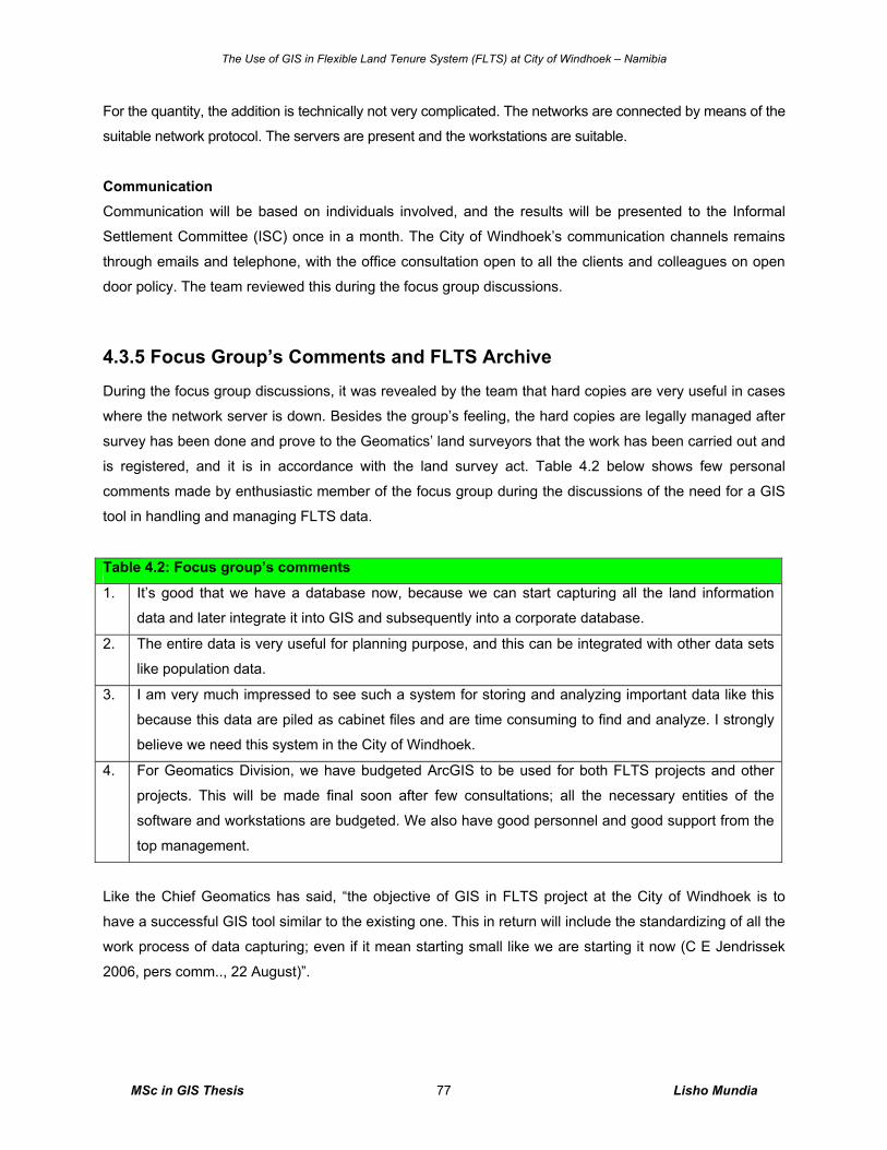
The Use of GIS in Flexible Land Tenure System (FLTS) at City of Windhoek – Namibia
MSc in GIS Thesis Lisho Mundia 77
For the quantity, the addition is technically not very complicated. The networks are connected by means of the
suitable network protocol. The servers are present and the workstations are suitable.
Communication Communication will be based on individuals involved, and the results will be presented to the Informal
Settlement Committee (ISC) once in a month. The City of Windhoek’s communication channels remains
through emails and telephone, with the office consultation open to all the clients and colleagues on open
door policy. The team reviewed this during the focus group discussions.
4.3.5 Focus Group’s Comments and FLTS Archive
During the focus group discussions, it was revealed by the team that hard copies are very useful in cases
where the network server is down. Besides the group’s feeling, the hard copies are legally managed after
survey has been done and prove to the Geomatics’ land surveyors that the work has been carried out and
is registered, and it is in accordance with the land survey act. Table 4.2 below shows few personal
comments made by enthusiastic member of the focus group during the discussions of the need for a GIS
tool in handling and managing FLTS data.
Table 4.2: Focus group’s comments
1. It’s good that we have a database now, because we can start capturing all the land information
data and later integrate it into GIS and subsequently into a corporate database.
2. The entire data is very useful for planning purpose, and this can be integrated with other data sets
like population data.
3. I am very much impressed to see such a system for storing and analyzing important data like this
because this data are piled as cabinet files and are time consuming to find and analyze. I strongly
believe we need this system in the City of Windhoek.
4. For Geomatics Division, we have budgeted ArcGIS to be used for both FLTS projects and other
projects. This will be made final soon after few consultations; all the necessary entities of the
software and workstations are budgeted. We also have good personnel and good support from the
top management.
Like the Chief Geomatics has said, “the objective of GIS in FLTS project at the City of Windhoek is to
have a successful GIS tool similar to the existing one. This in return will include the standardizing of all the
work process of data capturing; even if it mean starting small like we are starting it now (C E Jendrissek
2006, pers comm.., 22 August)”.
The Use of GIS in Flexible Land Tenure System (FLTS) at City of Windhoek – Namibia
MSc in GIS Thesis Lisho Mundia 78
The FLTS archive situated in the office of the Geomatics Division is open to the public for copies of this
geometrics information (maps). These are information keep in the separate cabinets from those of the
freehold land tenure and others. With the current development of house scheme for low-income people
most of the building designer entrepreneurs are using this archive on a daily basis.
4.4 GIS and LIS Approach Results
4.4.1 Introduction In this section the results of GIS map presentation are presented, including the Microsoft Access database
results interlinked with ArcView database.
A pilot study of FLTS was carried out on Erf 3378, located in Otjomuise Township in Windhoek. The survey
was carried out in accordance with the supplied informal layout. The calculations and draughting (land
surveying maps compilation) was done in CAD with the final layout imported into GIS (ArcGIS).
4.4.1 Achievements on GIS/LIS Pilot Approach
A pilot study on the use of GIS for handling FLTS data was presented to the focus group before discussions
commenced. The presentation helped by achieving the set objectives in the following areas:
o Helped the group in understanding the use of GIS in handling FLTS data,
o Helped to demonstrate the applicability of GIS to the managers and potential users,
o Helped in taking the first careful step towards digital data storage,
o Helped in testing data of other divisions (usability, conversion, loading),
o Helped in demonstrating the flexibility of GIS in producing cadastral maps, land use maps, etc,
o Helped on getting insight in technical and organisational consequence, and
o Helped on getting insight in tangible and intangible benefits of GIS.
These were archived successfully in a sense that the focus group appreciated the entire presentation. It
helped getting the group members into focus of the purpose of the entire interview also.
4.4.2 GIS Maps Standard
The maps of FLTS will all adopt the existing mapping standards and zoning schemes existing in the City
of Windhoek. The maps presented to the focus group mainly to prove one of the capabilities and role of
GIS in FLTS were also on this standard. The color annotation is used as fill-in to allow good visualization.
The approach was also considered for the map in figure 4.3 above. These standards are explained as
follow:
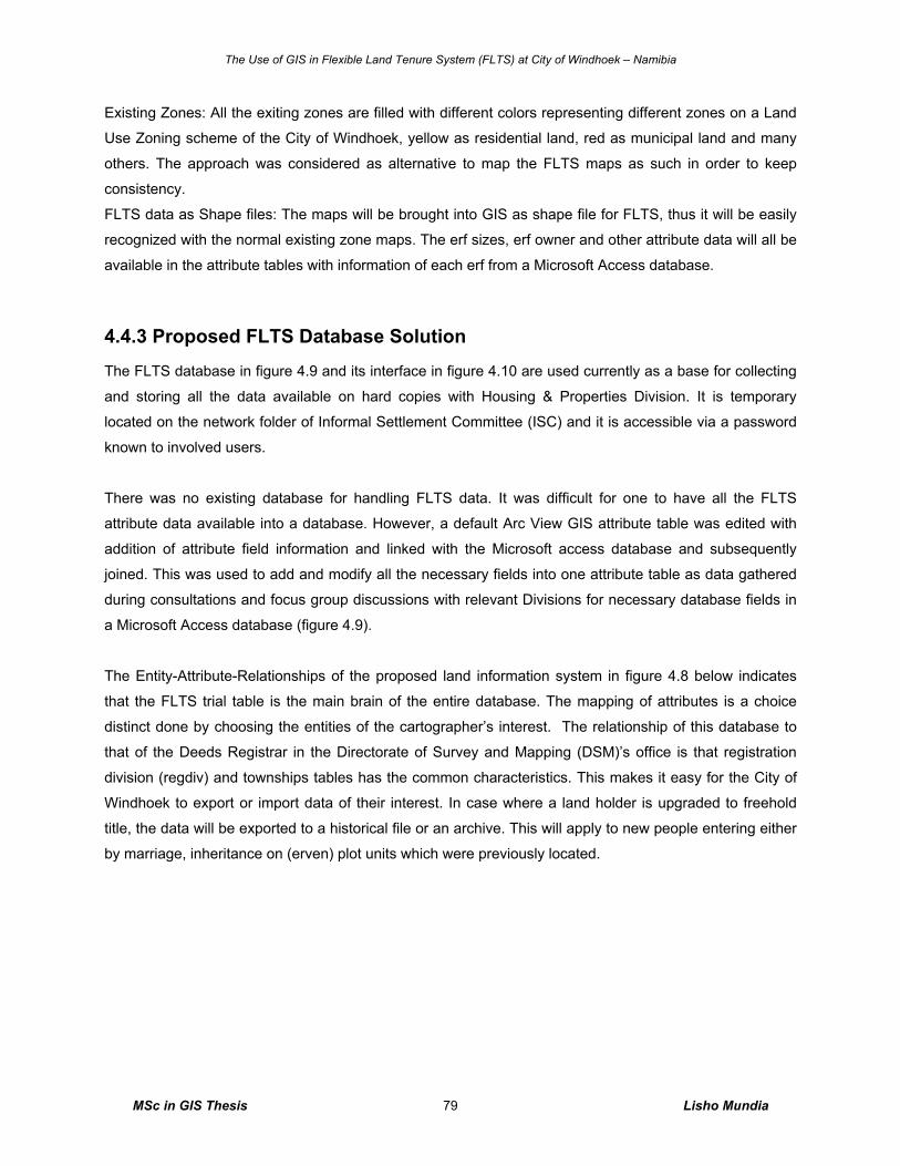
The Use of GIS in Flexible Land Tenure System (FLTS) at City of Windhoek – Namibia
MSc in GIS Thesis Lisho Mundia 79
Existing Zones: All the exiting zones are filled with different colors representing different zones on a Land
Use Zoning scheme of the City of Windhoek, yellow as residential land, red as municipal land and many
others. The approach was considered as alternative to map the FLTS maps as such in order to keep
consistency.
FLTS data as Shape files: The maps will be brought into GIS as shape file for FLTS, thus it will be easily
recognized with the normal existing zone maps. The erf sizes, erf owner and other attribute data will all be
available in the attribute tables with information of each erf from a Microsoft Access database.
4.4.3 Proposed FLTS Database Solution
The FLTS database in figure 4.9 and its interface in figure 4.10 are used currently as a base for collecting
and storing all the data available on hard copies with Housing & Properties Division. It is temporary
located on the network folder of Informal Settlement Committee (ISC) and it is accessible via a password
known to involved users.
There was no existing database for handling FLTS data. It was difficult for one to have all the FLTS
attribute data available into a database. However, a default Arc View GIS attribute table was edited with
addition of attribute field information and linked with the Microsoft access database and subsequently
joined. This was used to add and modify all the necessary fields into one attribute table as data gathered
during consultations and focus group discussions with relevant Divisions for necessary database fields in
a Microsoft Access database (figure 4.9).
The Entity-Attribute-Relationships of the proposed land information system in figure 4.8 below indicates
that the FLTS trial table is the main brain of the entire database. The mapping of attributes is a choice
distinct done by choosing the entities of the cartographer’s interest. The relationship of this database to
that of the Deeds Registrar in the Directorate of Survey and Mapping (DSM)’s office is that registration
division (regdiv) and townships tables has the common characteristics. This makes it easy for the City of
Windhoek to export or import data of their interest. In case where a land holder is upgraded to freehold
title, the data will be exported to a historical file or an archive. This will apply to new people entering either
by marriage, inheritance on (erven) plot units which were previously located.
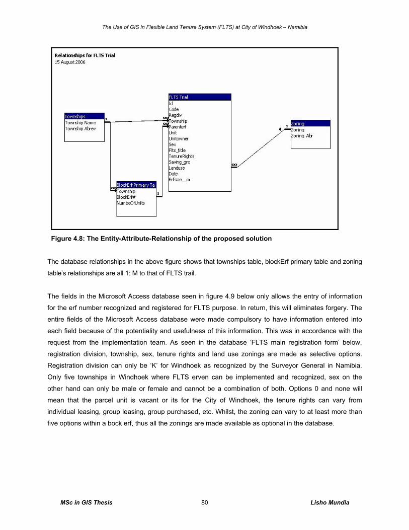
The Use of GIS in Flexible Land Tenure System (FLTS) at City of Windhoek – Namibia
MSc in GIS Thesis Lisho Mundia 80
Figure 4.8: The Entity-Attribute-Relationship of the proposed solution
The database relationships in the above figure shows that townships table, blockErf primary table and zoning
table’s relationships are all 1: M to that of FLTS trail.
The fields in the Microsoft Access database seen in figure 4.9 below only allows the entry of information
for the erf number recognized and registered for FLTS purpose. In return, this will eliminates forgery. The
entire fields of the Microsoft Access database were made compulsory to have information entered into
each field because of the potentiality and usefulness of this information. This was in accordance with the
request from the implementation team. As seen in the database ‘FLTS main registration form’ below,
registration division, township, sex, tenure rights and land use zonings are made as selective options.
Registration division can only be ‘K’ for Windhoek as recognized by the Surveyor General in Namibia.
Only five townships in Windhoek where FLTS erven can be implemented and recognized, sex on the
other hand can only be male or female and cannot be a combination of both. Options 0 and none will
mean that the parcel unit is vacant or its for the City of Windhoek, the tenure rights can vary from
individual leasing, group leasing, group purchased, etc. Whilst, the zoning can vary to at least more than
five options within a bock erf, thus all the zonings are made available as optional in the database.
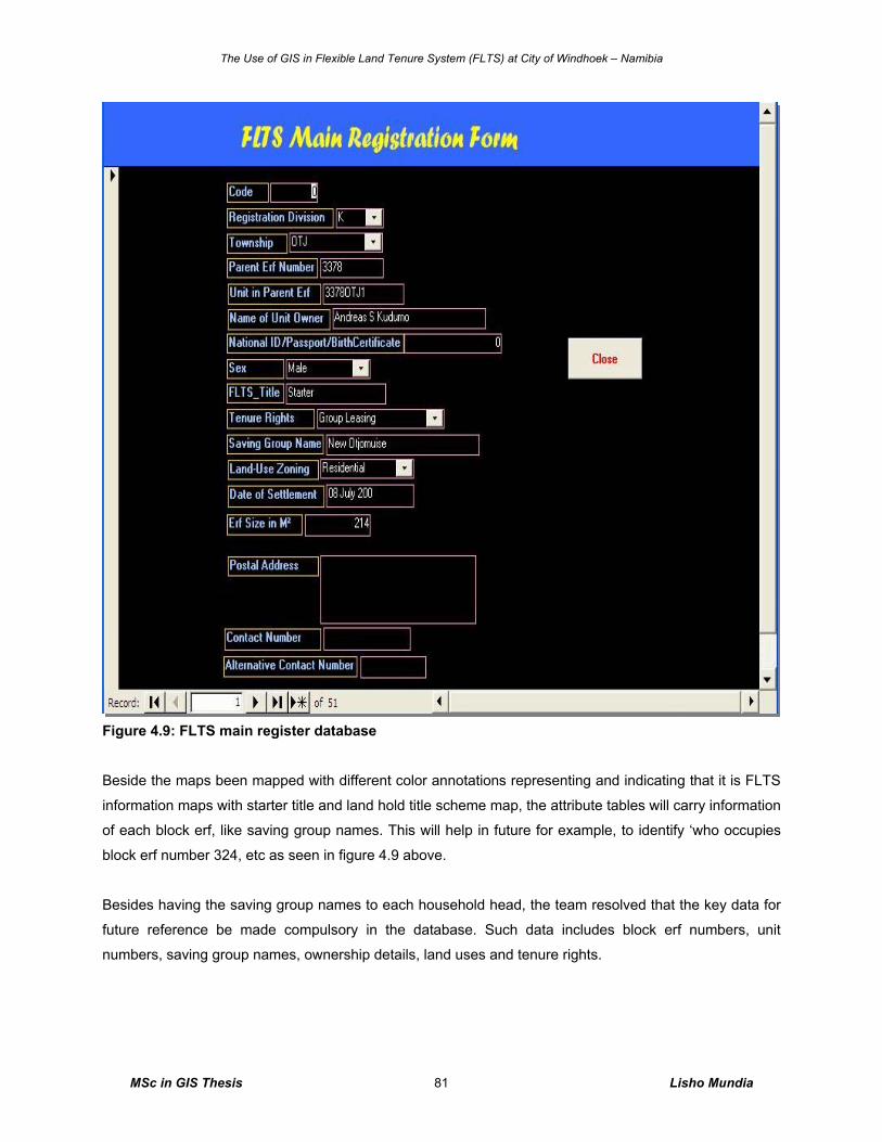
The Use of GIS in Flexible Land Tenure System (FLTS) at City of Windhoek – Namibia
MSc in GIS Thesis Lisho Mundia 81
Figure 4.9: FLTS main register database
Beside the maps been mapped with different color annotations representing and indicating that it is FLTS
information maps with starter title and land hold title scheme map, the attribute tables will carry information
of each block erf, like saving group names. This will help in future for example, to identify ‘who occupies
block erf number 324, etc as seen in figure 4.9 above.
Besides having the saving group names to each household head, the team resolved that the key data for
future reference be made compulsory in the database. Such data includes block erf numbers, unit
numbers, saving group names, ownership details, land uses and tenure rights.
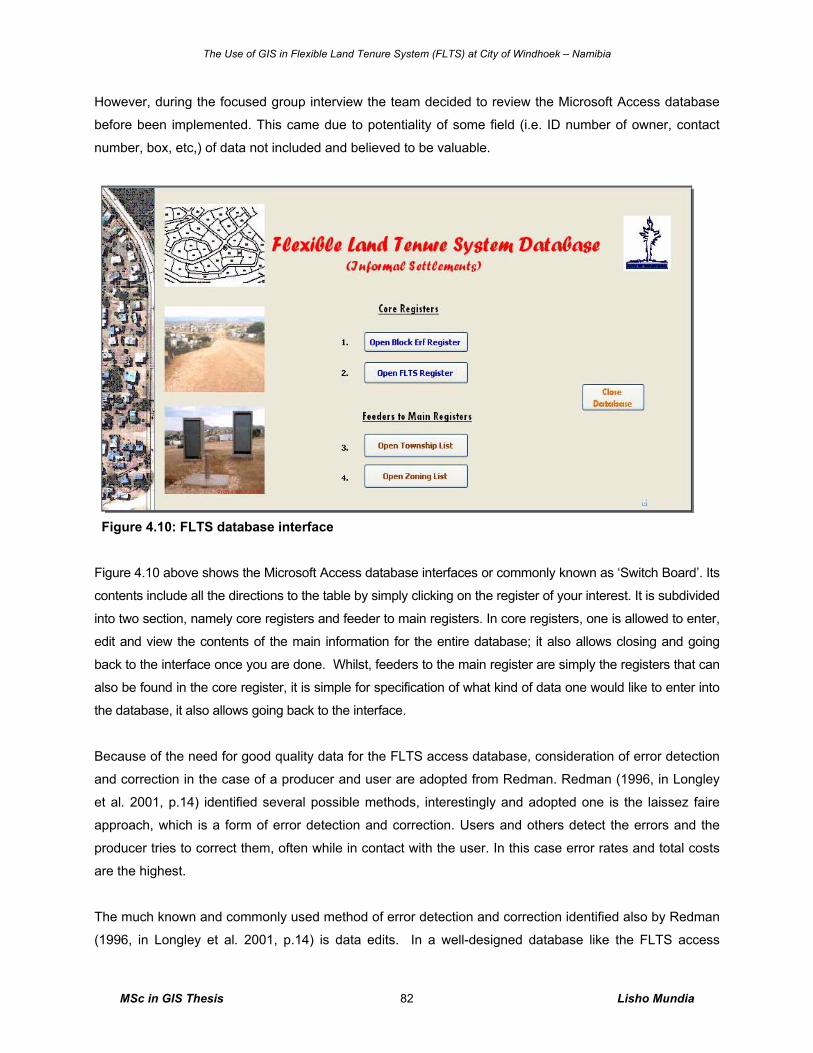
The Use of GIS in Flexible Land Tenure System (FLTS) at City of Windhoek – Namibia
MSc in GIS Thesis Lisho Mundia 82
However, during the focused group interview the team decided to review the Microsoft Access database
before been implemented. This came due to potentiality of some field (i.e. ID number of owner, contact
number, box, etc,) of data not included and believed to be valuable.
Figure 4.10: FLTS database interface
Figure 4.10 above shows the Microsoft Access database interfaces or commonly known as ‘Switch Board’. Its
contents include all the directions to the table by simply clicking on the register of your interest. It is subdivided
into two section, namely core registers and feeder to main registers. In core registers, one is allowed to enter,
edit and view the contents of the main information for the entire database; it also allows closing and going
back to the interface once you are done. Whilst, feeders to the main register are simply the registers that can
also be found in the core register, it is simple for specification of what kind of data one would like to enter into
the database, it also allows going back to the interface.
Because of the need for good quality data for the FLTS access database, consideration of error detection
and correction in the case of a producer and user are adopted from Redman. Redman (1996, in Longley
et al. 2001, p.14) identified several possible methods, interestingly and adopted one is the laissez faire approach, which is a form of error detection and correction. Users and others detect the errors and the
producer tries to correct them, often while in contact with the user. In this case error rates and total costs
are the highest.
The much known and commonly used method of error detection and correction identified also by Redman
(1996, in Longley et al. 2001, p.14) is data edits. In a well-designed database like the FLTS access
The Use of GIS in Flexible Land Tenure System (FLTS) at City of Windhoek – Namibia
MSc in GIS Thesis Lisho Mundia 83
database, it is possible and very much common to do data edits as computerized routines which verify
whether data values and their representation satisfy predetermined constraints. They can be very simple
or quite sophisticated but somehow require proper attention. Data edits may be applied to an entire
database or as a screen or filter within a process or information chain. In the latter case, they can be used
to control and improve process performance or to make a process less error prone.
It is stressed that issues of data quality and error are of paramount concern in all successful applications
of GIS technology, which is very much considered as a fact to the GIS projects at the City of Windhoek.
4.5 General GIS Analysis
4.5.1 Introduction In this section, the SWOT analysis, the advantages and disadvantages of GIS for flexible land tenure
system are outlined and explained. The SWOT analysis was determined from the observation of tasks in
different work environments within the City of Windhoek
Today many organizations are moving land information into Geographic Information Systems (GIS).
Adopting GIS techniques for FLTS data can advance broader social purposes. For example, handling the
communities’ data digitally can benefits the community at large because this information can be provided
to other community members from the City of Windhoek via the GIS technology, by making more effective
public decisions and by using natural resources in a more optimal way. Other example could be that with
GIS tool, you can determine the number of community water points required at the radius of 50m in a
block erf of two hectare by simply applying buffer to the existing toilets. GIS systems provide tools that
support many types of record keeping, analysis and decision-making. GIS has the capabilities of handling
the land information better and geo-reference them to their spatial location digitally.
4.5.2 GIS SWOT Analysis
The GIS without proper management and maintenance is easily predicted to its failure and may not be a
lasting GIS. Every tool introduced in the organization either replacing the existing one, a new tool, addition
to the existing system, etc should be analyzed by its strengths, opportunities, weaknesses and threats
(table 4.3) within and outside the organization. Failure to that may result in planning to fail.
Outlining the advantages and disadvantages of the system is also a very smart move before implementing
such a system. The idea is to know indeed the capability, the good, the bad and the need for such a
system in the organization.
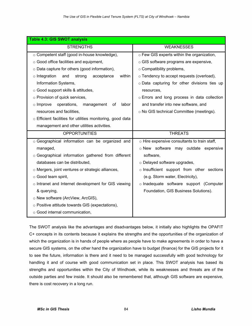
The Use of GIS in Flexible Land Tenure System (FLTS) at City of Windhoek – Namibia
MSc in GIS Thesis Lisho Mundia 84
Table 4.3: GIS SWOT analysis
STRENGTHS WEAKNESSES
o Competent staff (good in-house knowledge),
o Good office facilities and equipment,
o Data capture for others (good information),
o Integration and strong acceptance within
Information Systems,
o Good support skills & attitudes,
o Provision of quick services,
o Improve operations, management of labor
resources and facilities,
o Efficient facilities for utilities monitoring, good data
management and other utilities activities.
o Few GIS experts within the organization,
o GIS software programs are expensive,
o Compatibility problems,
o Tendency to accept requests (overload),
o Data capturing for other divisions ties up
resources,
o Errors and long process in data collection
and transfer into new software, and
o No GIS technical Committee (meetings).
OPPORTUNITIES THREATS
o Geographical information can be organized and
managed, o Geographical information gathered from different
databases can be distributed, o Mergers, joint ventures or strategic alliances,
o Good team spirit,
o Intranet and Internet development for GIS viewing
& querying,
o New software (ArcView, ArcGIS),
o Positive attitude towards GIS (expectations),
o Good internal communication,
o Hire expensive consultants to train staff,
o New software may outdate expensive
software,
o Delayed software upgrades,
o Insufficient support from other sections
(e.g. Storm water, Electricity),
o Inadequate software support (Computer
Foundation, GIS Business Solutions).
The SWOT analysis like the advantages and disadvantages below, it initially also highlights the OPAFIT
C+ concepts in its contents because it explains the strengths and the opportunities of the organization of
which the organization is in hands of people where as people have to make agreements in order to have a
secure GIS systems, on the other hand the organization have to budget (finance) for the GIS projects for it
to see the future, information is there and it need to be managed successfully with good technology for
handling it and of course with good communication set in place. This SWOT analysis has based its
strengths and opportunities within the City of Windhoek, while its weaknesses and threats are of the
outside parties and few inside. It should also be remembered that, although GIS software are expensive,
there is cost recovery in a long run.
The Use of GIS in Flexible Land Tenure System (FLTS) at City of Windhoek – Namibia
MSc in GIS Thesis Lisho Mundia 85
4.5.3 Advantages and Disadvantages of GIS Evolving GIS in the managing and mapping FLTS’ geographical entities will help in lots of ways such as
determining the need of land for other low-income people, open spaces, business land etc through GIS
analysis techniques and will benefit huge number of industries and agencies such as consulting town
planning companies to help in planning, design, engineer, build and maintain information infrastructures
through the use of digital available data. Common industry users of GIS will be on the advantage side of
getting the digital maps of FLTS projects and geo-reference their area of interest i.e. the crime prevention
will acquire this maps for mapping of high crime activities areas for efficiency operations, for new recruits
orientations etc,
Although GIS has advantages, it does also have the disadvantages; some of the advantages and
disadvantages of GIS in FLTS are outlined below and might also reflect in table 4.3 above.
The SWOT analysis aid and the OPAFIT C+ concept, they all cover issues of organization that the
advantages and disadvantages highlighted such as the employees involved, the set introductory to
agreements with consultants of GIS as expensive, finance for equipments, data etc, and they all reflect
the technology of integrating large amount of data and communication to other parties. Initially, they are
different management tools of over viewing capabilities, strengths, weaknesses, opportunities, threats,
efficiency, effectively, resources, etc.
Advantages o Can manage larger amounts of data,
o Can cover large study areas (the entire Namibia if necessary),
o Can suitably select any sub-study area,
o Can survive with infinite and recurrent edits and changes,
o More forceful and resistant to damage,
o Faster and more efficient,
o Requires less person time and money,
o Good geographical features representation and mapping,
o It improves operations in both management, resources and facilities management,
o It can be really automated on the net (www) for possible clients, educator, researchers,
communities, students etc,
o The communities, educators, students and researchers can download the data or browse the
net and that can suffice,
o It is a very useful tool for researchers and good for information dissemination to clients,
o Help in keeping track of the historical land use.
The Use of GIS in Flexible Land Tenure System (FLTS) at City of Windhoek – Namibia
MSc in GIS Thesis Lisho Mundia 86
Disadvantages
o Software are expensive,
o Long process in data capturing at the beginning,
o Expensive equipments for collecting data i.e. GPS,
o High number of geographical entities; too much work.
GIS tool, like the LIS, it also recover its cost in a long run of operations. Looking at this advantages and
disadvantages above with relation to the City of Windhoek’s Geomatics Division’s situation of only 10
employees handling large amount of work to meet the city resident’s needs; one should consider the fact
of having a GIS to alleviate high costs in recruiting other staff members on board than on acquiring tools
to improve the current situation.
It should also be remembered that all GIS processes can be undertaken manually. Before GIS, analysis
procedures would have been manually undertaken using transparent overlays or run through very slow
and cumbersome machines with far less power than the machines of today but due to the pressure in
service provision and technology demand the need for a GIS technology is required. The important
advantage of GIS here therefore is that all the functionality for working with multiple sets of geographic
information are grouped and automated within one piece of software.
The Use of GIS in Flexible Land Tenure System (FLTS) at City of Windhoek – Namibia
MSc in GIS Thesis Lisho Mundia 87
5. Discussion of Results
5.1 Introduction This chapter deals with the discussion of the achieved and unachieved results. It begins by discussing the
results of FLTS at City of Windhoek, followed by the GIS and LIS approach in FLTS results, the need,
role, benefits and capabilities of GIS, focus group interview results, GIS SWOT analysis and lastly the
general future and predictions of GIS.
The main objectives of the research itself explored the true values of the investigation, and resulted to
have a bigger yield in benefiting both the public and the organization. This is because land administration
for FLTS data will be secured and so does the public’s need for having updated information. In my view
and according to Fourie and Nino-Fluck (1999, p.3) it is proven that the success of GIS in FLTS projects
lies firstly on review of the cadastral and Land Information Systems (LIS) in Africa, that decision makers
should presently obtain sufficient information from these systems to make informed decisions. This is so
because most African countries and many other developing countries do not have an LIS as a
management tool. LIS and GIS systems either don’t exist, or have lapsed, or are seen as too expensive
(Fourie and Nino-Fluck 1999, p.3). This is proven to be partly true in the case of the City of Windhoek; it
was found that the data is there but no tools to manage these data because the managers believed that
GIS is expensive.
5.2 Flexible Land Tenure at City of Windhoek The City of Windhoek’s Geomatics Division - as a Division responsible for surveying, GIS and mapping - is
very much aware of the importance to manage and store the flexible land tenure system data. Currently,
all the land allocation of Windhoek’s informal settlements is allocated on the standard of the flexible land
tenure bill. This is done to avoid future restructuring of services, planning process and land surveying
when the flexible land tenure act is fully gazetted and implemented.
The City of Windhoek is now re-designing the data management of its informal settlement under the FLTS
bill. This research is part of such restructuring investigation tool and implementation therefore. It has
further eliminated the demarcation of its settlement land of its clients from been demarcated with
measuring tape to modern technological surveying instrument i.e. GPS and total stations.
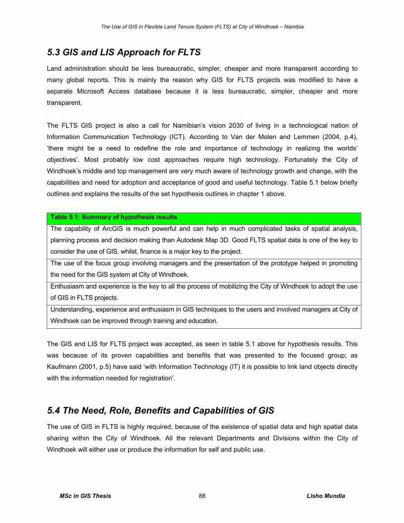
The Use of GIS in Flexible Land Tenure System (FLTS) at City of Windhoek – Namibia
MSc in GIS Thesis Lisho Mundia 88
5.3 GIS and LIS Approach for FLTS Land administration should be less bureaucratic, simpler, cheaper and more transparent according to
many global reports. This is mainly the reason why GIS for FLTS projects was modified to have a
separate Microsoft Access database because it is less bureaucratic, simpler, cheaper and more
transparent.
The FLTS GIS project is also a call for Namibian’s vision 2030 of living in a technological nation of
Information Communication Technology (ICT). According to Van der Molen and Lemmen (2004, p.4),
‘there might be a need to redefine the role and importance of technology in realizing the worlds’
objectives’. Most probably low cost approaches require high technology. Fortunately the City of
Windhoek’s middle and top management are very much aware of technology growth and change, with the
capabilities and need for adoption and acceptance of good and useful technology. Table 5.1 below briefly
outlines and explains the results of the set hypothesis outlines in chapter 1 above.
Table 5.1: Summary of hypothesis results
The capability of ArcGIS is much powerful and can help in much complicated tasks of spatial analysis,
planning process and decision making than Autodesk Map 3D. Good FLTS spatial data is one of the key to
consider the use of GIS, whilst, finance is a major key to the project.
The use of the focus group involving managers and the presentation of the prototype helped in promoting
the need for the GIS system at City of Windhoek.
Enthusiasm and experience is the key to all the process of mobilizing the City of Windhoek to adopt the use
of GIS in FLTS projects.
Understanding, experience and enthusiasm in GIS techniques to the users and involved managers at City of
Windhoek can be improved through training and education.
The GIS and LIS for FLTS project was accepted, as seen in table 5.1 above for hypothesis results. This
was because of its proven capabilities and benefits that was presented to the focused group; as
Kaufmann (2001, p.5) have said ‘with Information Technology (IT) it is possible to link land objects directly
with the information needed for registration’.
5.4 The Need, Role, Benefits and Capabilities of GIS The use of GIS in FLTS is highly required, because of the existence of spatial data and high spatial data
sharing within the City of Windhoek. All the relevant Departments and Divisions within the City of
Windhoek will either use or produce the information for self and public use.
The Use of GIS in Flexible Land Tenure System (FLTS) at City of Windhoek – Namibia
MSc in GIS Thesis Lisho Mundia 89
The good quality outputs of the prototype of GIS in FLTS proved that the use of GIS in FLTS is suitable in
managing and analyzing spatial data. Some maps, graphs and attribute tables produced in this research
are a clear indication of the suitability of GIS for the use in FLTS at City of Windhoek. This brought the
adoption of the Microsoft Access prototype database as a base to start capturing the data that is provided
in chapter four of section 4.4.3 of FLTS database as an example.
5.5 Focus Group Interview As Van der Molen and Lemmen (2004, p.5) has said ‘many leaders of land administration organization are
kept away from strategic issues and are too busy with daily problems they experience in service delivery.
However, leadership is necessary to develop the future, in accordance with clearly set requirements by
their organizations’. During the focus group interview for the prototype of GIS and LIS for FLTS, all the
manager involved were invited to attend, which gave the green light to seriously bring GIS in FLTS
projects at City of Windhoek.
The group strongly recommended that there is a need for a GIS tool in order to integrate many data. It
believes that the data is useful for planning and good for integration with other data sets like population
data. The group agrees to the addition of a GIS for managing FLTS projects to the existing Autodesk Map
3D. The decision on the type of final software was in the hands of the Division of Geomatics. The reasons
behind such a decision are explained in chapter 4 above under section 4.3.4 of results on OPAFIT C+
concepts under agreements. Briefly, the Geomatics Division after consultations with IT Department of the
City of Windhoek and a consulting GIS Company, decided adding ArcGIS to the existing tool as shown in
figure 5.1 below with its necessary entities.
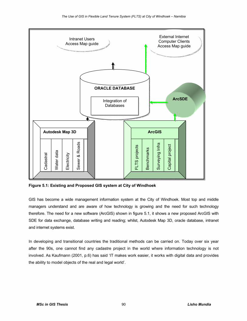
The Use of GIS in Flexible Land Tenure System (FLTS) at City of Windhoek – Namibia
MSc in GIS Thesis Lisho Mundia 90
Figure 5.1: Existing and Proposed GIS system at City of Windhoek
GIS has become a wide management information system at the City of Windhoek. Most top and middle
managers understand and are aware of how technology is growing and the need for such technology
therefore. The need for a new software (ArcGIS) shown in figure 5.1, it shows a new proposed ArcGIS with
SDE for data exchange, database writing and reading; whilst, Autodesk Map 3D, oracle database, intranet
and internet systems exist.
In developing and transitional countries the traditional methods can be carried on. Today over six year
after the 90s, one cannot find any cadastre project in the world where information technology is not
involved. As Kaufmann (2001, p.6) has said ‘IT makes work easier, it works with digital data and provides
the ability to model objects of the real and legal world’.
ArcSDE
Autodesk Map 3D
Cad
astra
l
Wat
er d
ata
Elec
trici
ty
Sew
er &
Roa
ds
ArcGIS FL
TS p
roje
cts
Ben
chm
arks
Sur
veyi
ng In
fra
Cap
ital p
roje
ct
ORACLE DATABASE
Integration of Databases
Intranet Users Access Map guide
External Internet Computer Clients Access Map guide
The Use of GIS in Flexible Land Tenure System (FLTS) at City of Windhoek – Namibia
MSc in GIS Thesis Lisho Mundia 91
5.6 GIS SWOT Analysis The existing Autodesk Map 3D and munsys gave a great chance of motivating the capabilities and
advantages of the use of GIS in FLTS projects, because the current munsys cannot handle the FLTS data
and does not have any FLTS data managed by this system. A focus group interview and organizational
observation done within work environments of the City of Windhoek gave a good guide in analyzing a
good GIS SWOT analysis, which is dominated by strengths and good opportunities.
As it can be seen in chapter four, the advantages of the use of GIS in FLTS projects overpower the
disadvantages due to a high need of the GIS tool and poor land administration tool for FLTS projects.
5.7 General Future and Predictions of GIS Making predictions for a field changing and developing so rapidly as GIS is very difficult. We need to
‘future proof’ a new system, and make sure that it will last and at least be upgraded when the next set of
technological developments comes along. Some of the well-known techniques for justifying investment in
new technology such as cost-benefit analysis involve an element of crystal ball gazing. Costs and benefits
are predicted to justify a project, despite the fact that the benefits may never actually be achieved.
Using the huge amount of data we present some exciting opportunities and challenges for the future.
Heywood et al. (1998, p.263) cites the example of an Internet site that shows real-time maps of traffic
conditions. Human (the richer, the lower-income and the poor) and organizational issues are not going to
go away, data are one commodity we are not going to go short of in coming years, as long as land is
needed; in fact we are more likely to drown in it. The need for tools to handle geographical data effectively
and reliability is growing ever greater (Heywood et al. 1998, p.261). The tools we use to handle
geographical data in the future are likely to be different. Software agents, which search the Internet on
topics in which you are interested, are being developed (Heywood et al. 1998, p.263). Computers and
Internet will be available and affordable, from developed countries to developing countries, whilst, GIS and
IT will merge as one field of study.
The range of views of GIS has increased over the last few years in response to the expansion of the
market for GIS and the applications to which it has applied. In nowadays, most of the predictions of GIS
future made five to ten years has improved i.e. data model development has improved, new analysis
exists, good quality assurance, multimedia support, GIS and GPS data exchange techniques exists, tools
for 3D visualizing exists and has improved, GIS is now in developing countries, existence of cheap
digitizing techniques, good flexible and affordable education like the UNIGIS and other universities.
Heywood et al. (1998, p.260) perhaps rather rashly, suggested that by the end of the century everyone in
the developed world would use GIS everyday for routine operations.
The Use of GIS in Flexible Land Tenure System (FLTS) at City of Windhoek – Namibia
MSc in GIS Thesis Lisho Mundia 92
6. Conclusion Considering the rapid growth of urban informal settlements, the cost of traditional mapping processes, and
the information requirements for planning and management of informal settlements, GIS is the only
valuable tool for handling spatial data for the effective upgrading and formalization of informal settlements
to FLTS.
However, the GIS software to be used in managing and analysis of the FLTS at City of Windhoek was
lately been decided to be ArcGIS. It was evidently proven in the focus group interview’s analyzed results
that GIS is highly required in managing and analyzing the FLTS data.
Even though the City of Windhoek has Autodesk Map 3D running with munsys in place, introducing a GIS
for managing FLTS at City of Windhoek is a complicated job. It does not only consist of building
databases, hardware requirements and purchasing software, but it consist also of people and their jobs,
work flows, organizational matters, and especially what is it the organization wants to do with the
information system. People involved need to be aware of this process, agreements with external
organizations and internal divisions are entered into, finance to run the project need to be budgeted and
made available, information has to be available clearly to all the involved people, technology should be of
good quality with good communication to the involved stakeholders.
One of the tools of City of Windhoek put in the first phase of investigating the internal organization for the
need of GIS before subsequently implement the founded GIS strategy, was the foundation laid for the GIS
through conducting personal consultations in offices at City of Windhoek, conducting focus group
interview, observing existing work processes and analyzing work flow, this determined the demand for
GIS, and how the user (both the outside users and the City of Windhoek users) sees this upcoming
information system. How the user sees this information system has to do with the point of view of looking
at the system. The demand for information is different for a financial department than for a technical
department. It should be noted that management people require other information than people in the field,
thus clarity is of crucial important to management.
Reliable Land Information System (LIS) is a prerequisite for effective and efficient decision making. The
City of Windhoek has put considerable efforts in upgrading its LIS during the past 10 years. Immediate
attentions are necessary to develop a structured strategic planning and analysis of system requirements.
New technologies require a champion (professional), and GIS for FLTS projects is no exception. This person
promotes the system to others in the organization and lobbies for needed resources. The most important
qualifications for this position are enthusiasm and the ability to get the attention of decision makers.
The Use of GIS in Flexible Land Tenure System (FLTS) at City of Windhoek – Namibia
MSc in GIS Thesis Lisho Mundia 93
7. Recommendations The use of GIS in Flexible Land Tenure System (FLTS) at City of Windhoek and in the entire Namibia has
been under consideration since 90s. The Polytechnic of Namibia has had GIS courses since mid 90 in the
context and for the purpose of local land management. A counted number of documentation and
researches inline with this research topic (specifically on flexible land tenure system) has proven to exist,
but very few related technical report papers on GIS in flexible land tenure exist on the net.
In general, local authorities with the responsibility of land administration in Namibia seem not to know that
simple tools for performing the tasks will make the organization more efficient, effective and cost benefits
involved in the use of these tools. GIS tools are one of those tools.
My recommendation therefore is that since land administration activity managed with the right tools like
the GIS system on the one hand deals with huge amounts of data, which moreover are of a very dynamic
nature, and on the other hand requires a continuous system maintenance process; the role of information
technology is of strategic importance and it needs further researching.
I further recommend the need to research on the need of GIS in other local authorities for FLTS project
implementation in Namibia and other countries. Issues of managing land policies and land management
for the poor etc need to be researched as to how there can be managed by GIS technology. This is due to
the value and the poor way the FLTS data are perceived currently by local authorities in Namibia. FLTS
are looked at as data that can simply be management using a pen and paper method.
Lastly, there is a need of a tool that focuses on GIS in relation to formalization of informal settlements in
order to provide secure tenure. Three examples of situations where GIS can be used in unplanned
settlements are:
1) Inventory of existing informal settlements and land suitable for new residential areas for low-
income groups for planning purposes,
2) Inventory for the purpose of formalizing land tenure, and
3) Inventory for the purpose of resettlement of areas, which have to be evicted.
This research will benefit much to future researches of almost similar contents through the tangible theory and
practice applied in this area of study, while the success of it will open doors for other local authorities like the
Otjiwarongo and Rundu Town Councils in the country to seriously bring GIS for FLTS data management, land
administration projects and others perceived to be GIS projects.
The Use of GIS in Flexible Land Tenure System (FLTS) at City of Windhoek – Namibia
MSc in GIS Thesis Lisho Mundia 94
Glossary Adjudication: the process whereby the ownership and rights in land are officially determined.
Attribute: data associated with a spatial or non-spatial entity.
Block erf is a piece of land on which a land hold title scheme or a starter title scheme is established.
Boundary: either the physical objects-marking the limits of a property or an imaginary line or surface
marking the division between two estates. Also used to describe the division between features
with different administrative, legal, land-use, topographic, etc., characteristics
Buffering: the process of creating areas of calculated distance from a feature
Cadastral map: a map showing the boundaries of land parcels, often buildings on land, the parcel
identifier, sometimes references to boundary corner monumentation. Cadastral maps may also
show limited topographic features.
Cadastral surveying: the surveying and mapping of land parcel boundaries in support of a country’s land
administration or land registration system.
Cadastre: a type of land information system that records land parcels. The term includes:
• Juridical cadastre: a register of ownership of parcels of land;
• Fiscal cadastre: a register of properties recording their value;
• Land-use cadastre: a register of land use;
• Multi-purpose cadastre: a register including many attributes of land parcels
Common law: the unwritten law based originally on common customs and precedent but now administered
by the courts
Coordinate: a measurement of distance and direction from a pre-selected origin
Coordinate system: A system that allows a position to be located in two-dimensional space. It has an
origin, two axes and a unit of measurement.
Database: a storage system of linked tables
Demarcation: the marking-out of the boundaries of each land parcel on the ground.
Digital mapping: the processes of acquiring, transforming, manipulating and presenting spatial data held
in digital form.
Fixed boundary: the legal boundary of a land parcel where the precise line has been agreed and
recorded
Freehold: a free tenure, distinct from leasehold, in which the owner has the maximum rights permissible
within the tenure system
Fundamental spatial data sets: spatial data for which there is a justified need for national consistency by
multiple users in order for those users to meet their objectives. A fundamental dataset may
comprise a number of compatible databases maintained by custodians in several jurisdictions.
Geographic Information System (GIS): ‘A system for capturing, storing, checking, manipulating,
analyzing and displaying data which are spatially referenced to the earth’
The Use of GIS in Flexible Land Tenure System (FLTS) at City of Windhoek – Namibia
MSc in GIS Thesis Lisho Mundia 95
Global Positioning System (GPS): a system for fixing positions on the surface of the Earth by measuring
the ranges to a special set of satellites orbiting the Earth
Information: any data processed, organized or classified into categories to serve a useful purpose. It can
be presented in voice, digital, printed, pictorial, image, and graphical or numerical formats.
Internet: an international network of dispersed local and regional computer networks used predominantly
for sharing information and resources.
Intranet: a private network inside a company or organization that uses the same kinds of software that
one would find on the public Internet, but that is only for internal use.
Land: the surface of the Earth, the materials beneath, the air above and all things fixed to the soil.
Land Administration: the processes of determining, recording and disseminating information about the
tenure, value and use of land when implementing land management policies
Land hold title: This links the person to the parcel that he owns. The title owner is issued with an individual
certificate in respect of his erf.
Land Information System (LIS): a system for acquiring, processing, storing and distributing information
about land.
Land management: the activities associated with the management of land as a resource from both an
environmental and an economic perspective
Land parcel: an area of land under homogeneous property rights and unique ownership.
Land tenure: the manner of holding rights in and occupying land.
Land value: the worth of a property, determined in a variety of ways which gives rise to different
estimates of the value
Metadata: is a structured summary of information that describes the data (data about data).
Polygon: a vector graphic figure that represents an area
Projection: formula to transform 3D spherical shape of earth onto a 2D surface
Raster: representation as a regular grid of cells
Spatial: anything dealing with the concept of space. In a geographical context, deals with distribution on
surface of the earth
Starter Title: A starter title is the link between a group and a block. However, ever member of the group
receives a holder’s copy of the certificate.
Tenure: the way in which the rights, restrictions and responsibilities that people have with respect to the
land are held. The cadastre may record different forms of land tenure such as ownership,
leasehold, and different types of common, communal or customary land tenure.
Vector: representation in the form of points, lines and polygons by coordinates
World Wide Web (WWW): the WWW is a system that allows users to access resources stored on
computers worldwide via the Internet. (WWW is frequently used incorrectly when referring to "The
Internet").
The Use of GIS in Flexible Land Tenure System (FLTS) at City of Windhoek – Namibia
MSc in GIS Thesis Lisho Mundia 96
References Aditi K (2002) Foundations of Information Technology School of Library, Archival and Information Studies,
University of British Columbia
Available from http://www.slais.ubc.ca/courses/libr500/01-02-
t2/www/A_Kolachala/Benefits_of_GIS.htm [Accessed 6th April 2006]
Augustinus C (2003) Comparative Study of Land Administration Systems Case Study-Namibia Peer
Review of World Bank Policy Research Report (PRR) on Land, Department for International
Development (DfID), Windhoek, Namibia
Australian Government (2004) User Profiling Techniques - Focus Groups [online] Australia
Available from: http://www.agimo.gov.au/publications/2004/06/toolkit/user/focus_groups
[Accessed 21st July 2006) Barodie G and Barry M (2004) Palm computers for spatially referenced social survey in upgrading informal
settlements, New Zealand Surveyor No 294 June 2004
Bayer, CTH (2000a & 2000b) Information system design for PC based LIS of Local Property Office in
Namibia within the context of the Flexible Urban Land Tenure bill of 1999 ITC, Enschede
Bayer, CTH (2006) Memorandum of Understanding between the City of Windhoek and the Ministry of
Lands and Resettlement, Windhoek, Namibia
City of Windhoek (2006) Some of the City’s Key Projects-2006/7 Budget City of Windhoek’s leaflet, July
2006, Windhoek, Namibia
Deininger K (2004) Land Policies for Growth and Poverty reduction: Key Issues and Challenges Ahead,
UN, FIG, PC IDEA Inter-regional Special Forum on The Building of Land Information Policies in
the Americans, Auascalientes, Mexico 26-27 October 2004
De Soto H (1996) Economic Reform Today, Property Rights and Democracy, An interview with Hernando
de Soto by the Center for International Private Enterprise (CIPE) [online] Washington, DC, USA,
Available From:http://www.cipe.org/publications/fs/ert/e19/desoto.htm [Accessed 16th June 2006].
Drimie S (2002) The Impact of HIV/AIDS on Land: Case Study from Kenya, Lesotho and South Africa,
report for Food and Agricultural Organization of the United Nations (FAO), August 2002
FIG Commission 7 (2003) Proceedings Strategies for renewal of information systems and information
technology, FIG Copenhagen DK
Fourie CD and Nino-Fluck O (1999) Cadastre and Land Information Systems for Decision-Makers in the
Developing World, UN-FIG Conference on Land Tenure and Cadastral Infrastructure for
Sustainable Development, Melbourne, Australia [online] Available from:
http://www.sli.unimelb.edu.au/UNConf99/sessions/session8/fourie.pdf [Accessed 16th June 2006]
Government of Namibia (2006) Flexible Land Tenure Act, Windhoek, Ministry of Land and Resettlement
Government of Namibia (2002) National Land Tenure Policy, Windhoek, Ministry of Land and
Resettlement
The Use of GIS in Flexible Land Tenure System (FLTS) at City of Windhoek – Namibia
MSc in GIS Thesis Lisho Mundia 97
Government of Namibia (2001b) Report of the 2000 Sentinel Sero Survey, Ministry of Health and Social
Services Windhoek - Namibia.
Government of Namibia (1999) Flexible Urban Land Tenure bill, Windhoek, Ministry of Land and
Resettlement
Government of Namibia (1993) Land Survey Act, Windhoek, Ministry of Land and Resettlement
Government of Namibia (1992) Local Authorities Act, Windhoek, Ministry of Regional, Local Government,
Housing and Rural Development
Home & Jackson (1997) Our Common Estate: Land Rights for Informal Settlements: Community Control
and the Single Point Cadastre in South Africa, RICS, 1997
Heywood I, Cornelius S, and Carver S. (1998) An Introduction to Geographical Information Systems
Addison Wesley Longman Ltd
Juma SY and Christensen SF (2001) Bringing the Informal Settlers under the Register – The Namibian
Challenge, International Conference on Spatial Information for Sustainable Development [online]
Nairobi, Kenya 2–5 October 2001
Available from: http://www.fig.net/pub/proceedings/nairobi/juma-christensen-TS8-3.pdf [Accessed
24th May 2006]
Kaufmann J and Steudler D (1998) Cadastre 2014, a Vision for a Future Cadastral System, FIG, 1998
Kaufmann J (2001) Cadastre 2014: From Theory to Practice, Presented at a FIG Working on a Vision for
a Future Cadastral System, Seoul Korea, 6-11 May
Kenny C, Navas-Sabater J, and Qiang C 2004, Information and Communication Technologies, chapter
24, World Bank report.
Available from: http://povlibrary.worldbank.org/files/4414_chap24.pdf [Accessed 28th December
2006]
Lemmen C, Molen P and Van der Oosterom P (2004) Remarks and Observations related to the further
development of the Core Cadastral Domain Model’, Bamberg, Germany, 9 and 10 December
Longley PA., Goodchild MF, Maguire DJ and Rind RW (2001) Geographic Information Systems and
Science Chichester: John Wiley & Sons
Available from: http://www.feweb.vu.nl/unigisonline/ModulesE13/module3/ [Accessed 27
November 2006]
Magel IH (2006) Promoting Land Administration and Good Governance, 5th FIG Regional Conference,
[online] Accra, Ghana, March 8-11
Available from http://www.oicrf.org/pdf.asp?ID=6003 [Accessed 16th May 2006]
Marczak M & Sewell M (1990) Using Focus Groups For Evaluation. [online] The University of Arizona,
Tucson Arizona
Available from: http://ag.arizona.edu/fcs/cyfernet/cyfar/focus.htm [Accessed 21 July 2006)
Merson M E (2004) Manage Data – Manage Hazards: Methods for development of an Urban Hard
Information Infrastructure in Windhoek, MSc Thesis, ITC, the Netherlands.
The Use of GIS in Flexible Land Tenure System (FLTS) at City of Windhoek – Namibia
MSc in GIS Thesis Lisho Mundia 98
Molen P and Lemmen C (2004) Technology and Land Administration: development and innovations, GIS
Development [online] July
Available from: www.gisdevelopment.org.na [Accessed 8th September 2006]
National Planning Commission (2003) 2001 Population and Census Report Namibia, Namibia: Central
Statistics Office, Windhoek-Namibia
Petch JR (1999) UNIGIS Module 1 Course Notes. [online] Vrije Universiteit-Amsterdam, the Netherlands
Available from: http://www.feweb.vu.nl/unigisonline/ModulesE15/module1sep/pdf_other/sect1.pdf.
[Accessed 27 November 2006]
Phororo H 2002, HIV/AIDS: Who Suffers in Namibia? The Namibian Economic Policy Research Unit
Nepru Working Paper No. 84. May, Windhoek – Namibia
Available from: http://www.nepru.org.na/index.php?id=304 [Accessed 04th January 2007]
Redman (1996) Data Quality for the Information Age Boston, Artech House Reeve D (1996) UNIGIS Course Notes, Postgraduate Diploma in GIS, Manchester Metropolitan
University, UK.
Rich C (2004) Land Information Systems 4 study guide, Department of Land Management,
Polytechnic of Namibia, Windhoek-Namibia
Robinson A (2003) Development of an Operational Plan and Land Information System for the proposed
Local Property Offices in Namibia, MSc in GIS dissertation, ITC, Enschede
Sieber RE (2000) GIS Implementation in the Grassroots, Urban and Regional Information Systems
Association (URISA) Journal, Availble from:
http://www.urisa.org/Journal/protect/vol12no1/sieber/sieber.pdf [Accessed 21st April 2006]
Steudler D, Rajabifard A, and Williamson IP (2004) Evaluation of Land Administration, Submitted to the
Journal for Land Use Policy, Department of Geomatics, The University of Melbourne, Victoria
2010, Australia.
Tuladhar AM (2005a) Institutional and Technical Aspects of Cadastral Systems: Experiences and
Reflections. Presented paper at 8th Annual International Conference, Map India 2005 and
Geomatics, 7-9 Hotel Taj Palace, New Delhi, India
Tuladlar AM (2006b) Innovative Land Tools, Surveying and Geo-information technologies Presentation at
workshop on the global network for pro poor land tool developers organized by Sida and UN-
HABITAT, 24-25 November 2005, Stockholm, Sweden
Tuladhar AM (2005c) Innovative use of Remote Sensing Images for Pro Poor Land Management, Expert
Group Meeting on secure land tenure: new legal frameworks and tools, [online] UNESCAP, 8-9
Bangkok, Thailand
Available from: http://www.fig.net/commission7/bangkok_2005/papers/4_3_tuladhar.pdf
[Accessed 16 June 2006]
Tuladhar AM, BC KR & Budhathoki NR (2003) Towards Strategic Planning For Building Land Information
System (LIS) In Nepal, Kathmandu
Available from: http://www.itc.nl/library/Papers/tuladhar_acrs.pdf [Accessed 28th December 2006]
The Use of GIS in Flexible Land Tenure System (FLTS) at City of Windhoek – Namibia
MSc in GIS Thesis Lisho Mundia 99
Vries WT d, Lewis J & Georgiadou Y (2003) The cost of land registration: a case study of cost efficiency in
Namibia, The Australian Surveyor [online]. The Australian Surveyor, 48(no. 1): 7-20..
Available from: http://www.itc.nl/library/Papers_2003/peer_jrnl/devries.pdf [accessed 19th
December 2006]
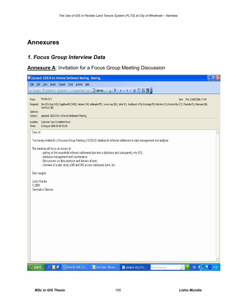
The Use of GIS in Flexible Land Tenure System (FLTS) at City of Windhoek – Namibia
MSc in GIS Thesis Lisho Mundia 100
Annexures
1. Focus Group Interview Data
Annexure A: Invitation for a Focus Group Meeting Discussion
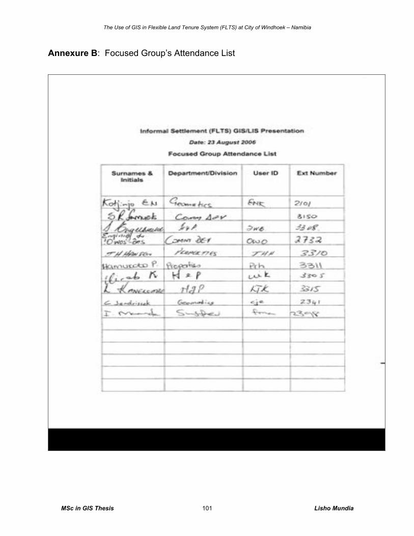
The Use of GIS in Flexible Land Tenure System (FLTS) at City of Windhoek – Namibia
MSc in GIS Thesis Lisho Mundia 101
Annexure B: Focused Group’s Attendance List
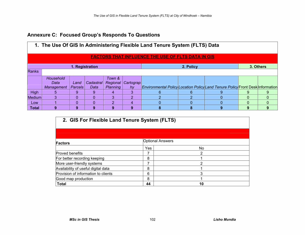
The Use of GIS in Flexible Land Tenure System (FLTS) at City of Windhoek – Namibia
MSc in GIS Thesis Lisho Mundia 102
Annexure C: Focused Group’s Responds To Questions
1. The Use Of GIS In Administering Flexible Land Tenure System (FLTS) Data
FACTORS THAT INFLUENCE THE USE OF FLTS DATA IN GIS
1. Registration 2. Policy 3. Others Ranks
Household Data
Management Land
Parcels Cadastral
Data
Town & Regional Planning
Cartography Environmental Policy Location Policy Land Tenure Policy Front Desk Information
High 5 9 9 4 3 6 6 9 9 9 Medium 3 0 0 3 2 2 2 0 0 0
Low 1 0 0 2 4 0 0 0 0 0 Total 9 9 9 9 9 8 8 9 9 9
2. GIS For Flexible Land Tenure System (FLTS) FACTORS THAT INFLUENCE THE DECISION TO SERIOUSLY BRING THE FLTS DATA INTO GIS Factors Optional Answers
Yes No Proved benefits 7 2 For better recording keeping 8 1 More user-friendly systems 7 2 Availability of useful digital data 8 1 Provision of information to clients 6 3 Good map production 8 1 Total 44 10
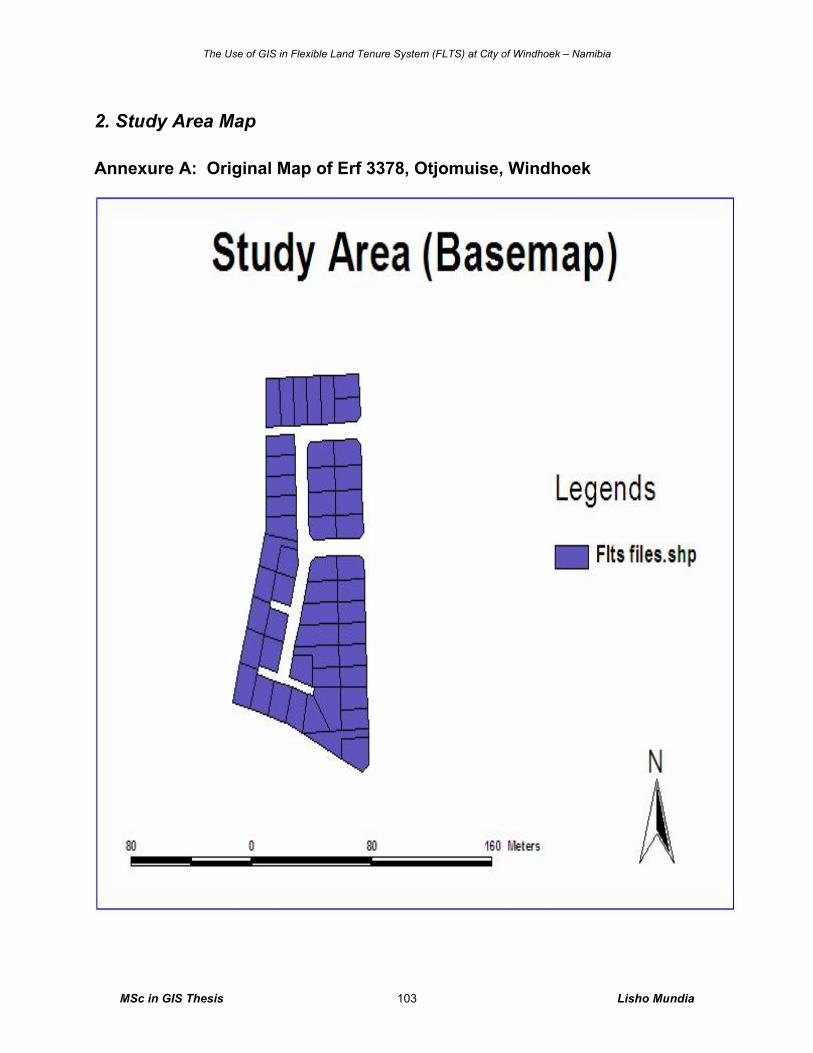
The Use of GIS in Flexible Land Tenure System (FLTS) at City of Windhoek – Namibia
MSc in GIS Thesis Lisho Mundia 103
2. Study Area Map
Annexure A: Original Map of Erf 3378, Otjomuise, Windhoek
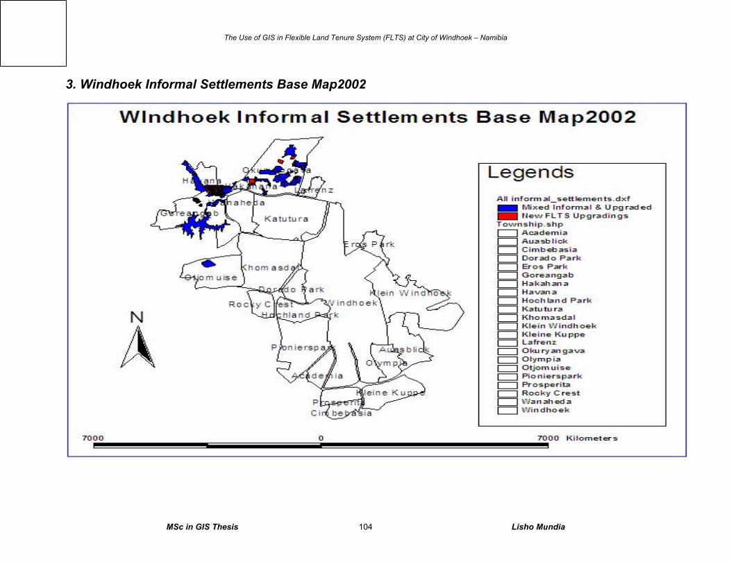
The Use of GIS in Flexible Land Tenure System (FLTS) at City of Windhoek – Namibia
MSc in GIS Thesis Lisho Mundia 104
3. Windhoek Informal Settlements Base Map2002
Integrated
GIS
database