Embed Size (px)
Citation preview

VR-Vantage Stealth
Visualize: From Every Vantage Point
VR-Vantage Stealth is MÄK’s information station where you can view the virtual world in 2D and 3D. Whether you need it for situational awareness, simulation debugging, or after action review, VR-Vantage Stealth provides the most data about your networked virtual world and presents it in a clear and accessible way. With VR-Vantage Stealth, you can quickly achieve a “big picture” understanding of a battlefield situation while retaining an immersive sense of perspective.
VR-Vantage Stealth can also draw 3D representations of tactical graphics from VR-Forces, such as waypoints, routes, and areas. Picture-in-picture inset views allow you to see what any vehicle is seeing, even as you watch it travel across the terrain. Drop simulated cameras anywhere in the world to zoom in on multiple parts of the battle at once. Switch any visual channel from 3D to 2D mode with a single click. Or use a 2D inset to help with navigation as you fly your 3D eyepoint around the battlefield in the main display. VR-Vantage Stealth lets you watch entity-level engagements without losing the command-level view.
Focused on InformationVR-Vantage Stealth visually presents a wide variety of infor-mation about your DIS or HLA virtual environment. You can simultaneously view the virtual world in 2D and 3D, with configurable information overlays presented in both displays. These informational overlays include:
• Trailing effects - special effects that follow moving entities; they appear as dust trails behind ground vehicles, the wake behind ships, or footprints behind people
• Attacker/target lines - graphics that show who is engaging with whom
• Track histories - graphical representations showing where entities have been
• Entity labels - information about an entity, as well as its loca- tion even if it’s hard to locate in the scene
• Sensor volumes - display electromagnetic emissions from an entity’s sensor systems
• Height-above-terrain indicators - show how high above the terrain an entity is located
• Intervisibility lines - display the line-of-sight between entities or between places in a synthetic environment
• Aggregate icons and bounding volumes - show the location of aggregate units and the space they take up
Intuitive NavigationNavigation is easy in VR-Vantage Stealth, whether you’re flying freely over the terrain, following an entity as it moves through the synthetic environment, or tracking a missile from a fixed vantage point. We’ve combined the best elements of first-person-shooters, real-time-strate-gy games, and “spin the earth” virtual globe applications, to provide an interface that you’ll find familiar the moment you start using it.
Navigate through the world by dragging the terrain, clicking on a destination, or maneuvering the eyepoint using familiar first-person-shooter controls. You can orbit around buildings or props, follow or track moving entities, jump in the cockpit for an out-the-window view, or mount your virtual camera on a vehicle. While navigating, you can save a list of your favorite views for rapid retrieval.

• SITUATIONAL AWARENESS
• AFTER ACTION REVIEW
• SIMULATION DEBUGGING
• INSTRUCTOR OPERATOR STATIONS
• PROJECT DEMONSTRATION
• SIMULATION ANALYSIS
• COMMON OPERATING PICTURE
• 2D/3D VISUALIZATION
USE CASES
• SIMULTANEOUS 2D AND 3D VISUALIZATION DISPLAYS
• VIEW ENTITIES, AGGREGATES, TRAJECTORIES, SENSORS, AND MORE
• GAME-LIKE NAVIGATION
• EASY MODEL INTEGRATION
• LOADED WITH CONTENT
• TERRAIN AGILE
• BUILT-IN SUPPORT FOR DIS AND HLA
• GEOCENTRIC OR PROJECTED TERRAINS
• DATABASE PAGING FOR LARGE AREA TERRAINS
• EXAGGERATED REALITY VIEW FOR ENHANCED SITUATIONAL AWARENESS
• CUSTOMIZABLE THROUGH VR-VANTAGE TOOLKIT
• BUILT IN SUPPORT FOR STREAMING VIDEO
FEAT
URES
Distributed RenderingVR-Vantage Stealth’s built-in distributed rendering architecture supports large, multichannel, “situation room” style displays. An intuitive GUI allows you to connect to remote display engines running on additional PCs to in-crease your field of view.
Simulate a Sensor Video StreamVR-Vantage supports Motion Imagery Standards Board (MISB) streaming video and meta-data standards out-of-the-box. You can connect VR-Vantage IG to your MPEG-2 compliant Situation Awareness System control station and receive a simu-lated video stream of your virtual environment. You can also direct your video stream to a TCP socket, web-page, or local file to record what your simulated sensors captured.
With VR-Vantage IG, you can use out-of-the-box camera effects to provide low cost sensor visualization to your video stream, or you can upgrade to our SensorFX module for high fidelity physics-based sensor visualization.
Host-IG InterfaceVR-Vantage IG supports the industry-standard CIGI (Common Image Generator Interface) protocol for controlling the IG from a separate simulation host. Through CIGI, your host application can control the eyepoint, place and control moving models, load terrains, set visual parameters, and more. VR-Vantage IG can also provide mission functions by responding to line-of-sight and height-above-terrain queries.
VR-Vantage IGVR-Vantage IG is MÄK’s configurable desktop Image Generator (IG) for out-the-window (OTW) scenes, camera views, and sensor channels. Its built-in distributed rendering architecture supports many different display configurations — from simple desktop deployments to multi-channel displays for virtual cockpits and training systems.
Terrain Agility - MÄK’s Ability to Easily Load Your TerrainVR-Vantage Stealth is Terrain Agile — able to work with a wide variety of terrain approaches, formats, and protocols. The tool can load traditional databases, like handmodeled OpenFlight, page large-area terrains, like MetaFlight, and build visual databases “on-the-fly” from source data like DTED, GeoTIFF, and Shapefiles. It can even dynamically create 3D terrain by streaming in elevation, imagery, and features from terrain servers, like MÄK’s VR-TheWorld Server, to build up large areas and by cutting-in site models for high fidelity ground detail.
With VR-Vantage Stealth, you can load site models with dense urban build-up and thick vegetation as well as tiled terrain databases that page in over large areas. You can extract buildings and other models from the terrain and manipulate them directly in the synthetic environment. To see human characters interacting inside, you can manipulate specific buildings to make them semi-transparent.
Built-in Content and CapabilityVR-Vantage Stealth comes with a rich set of top-quality 3D entity models from companies like Simthetiq and RealDB that support attached parts, damage representations, and articulated parts such as turrets and guns. Built-in support for Boston Dynamics’ DIGuy™, DiSTI’s GL Studio®, IDV’s SpeedTree®, and Sundog’s SilverLining™ means that you don’t need to in-tegrate and configure extra modules, or buy additional run-time licenses to have great looking human characters, interactive cockpit displays, dynamic trees and bushes, weather effects, and volumetric clouds. And HLA and DIS support through MÄK’s own VR-Link networking toolkit is included, so that interoperability is a given, not an add-on.
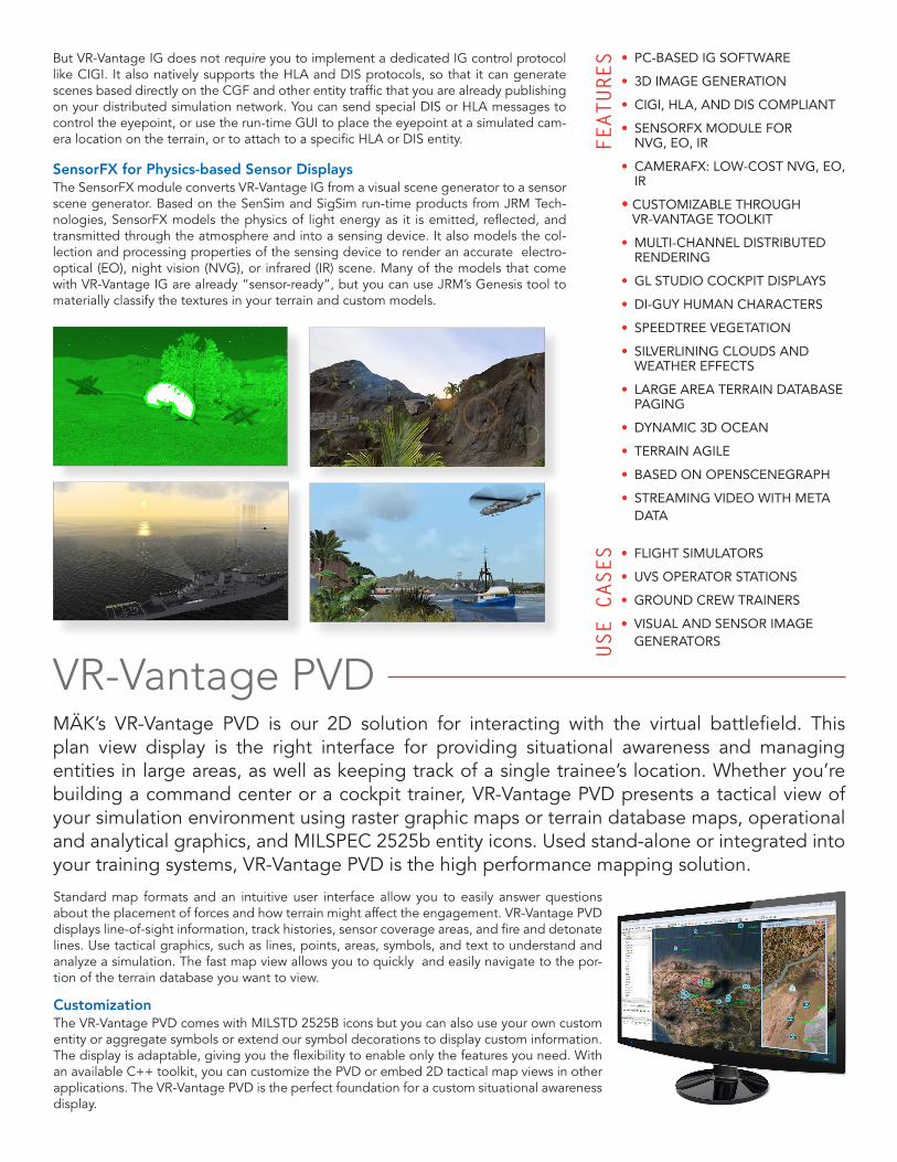
VR-Vantage PVDMÄK’s VR-Vantage PVD is our 2D solution for interacting with the virtual battlefield. This plan view display is the right interface for providing situational awareness and managing entities in large areas, as well as keeping track of a single trainee’s location. Whether you’re building a command center or a cockpit trainer, VR-Vantage PVD presents a tactical view of your simulation environment using raster graphic maps or terrain database maps, operational and analytical graphics, and MILSPEC 2525b entity icons. Used stand-alone or integrated into your training systems, VR-Vantage PVD is the high performance mapping solution.
Standard map formats and an intuitive user interface allow you to easily answer questions about the placement of forces and how terrain might affect the engagement. VR-Vantage PVD displays line-of-sight information, track histories, sensor coverage areas, and fire and detonate lines. Use tactical graphics, such as lines, points, areas, symbols, and text to understand and analyze a simulation. The fast map view allows you to quickly and easily navigate to the por-tion of the terrain database you want to view.
CustomizationThe VR-Vantage PVD comes with MILSTD 2525B icons but you can also use your own custom entity or aggregate symbols or extend our symbol decorations to display custom information. The display is adaptable, giving you the flexibility to enable only the features you need. With an available C++ toolkit, you can customize the PVD or embed 2D tactical map views in other applications. The VR-Vantage PVD is the perfect foundation for a custom situational awareness display.
But VR-Vantage IG does not require you to implement a dedicated IG control protocol like CIGI. It also natively supports the HLA and DIS protocols, so that it can generate scenes based directly on the CGF and other entity traffic that you are already publishing on your distributed simulation network. You can send special DIS or HLA messages to control the eyepoint, or use the run-time GUI to place the eyepoint at a simulated cam-era location on the terrain, or to attach to a specific HLA or DIS entity.
SensorFX for Physics-based Sensor DisplaysThe SensorFX module converts VR-Vantage IG from a visual scene generator to a sensor scene generator. Based on the SenSim and SigSim run-time products from JRM Tech-nologies, SensorFX models the physics of light energy as it is emitted, reflected, and transmitted through the atmosphere and into a sensing device. It also models the col-lection and processing properties of the sensing device to render an accurate electro-optical (EO), night vision (NVG), or infrared (IR) scene. Many of the models that come with VR-Vantage IG are already “sensor-ready”, but you can use JRM’s Genesis tool to materially classify the textures in your terrain and custom models.
• PC-BASED IG SOFTWARE
• 3D IMAGE GENERATION
• CIGI, HLA, AND DIS COMPLIANT
• SENSORFX MODULE FOR NVG, EO, IR
• CAMERAFX: LOW-COST NVG, EO, IR
• CUSTOMIZABLE THROUGH VR-VANTAGE TOOLKIT
• MULTI-CHANNEL DISTRIBUTED RENDERING
• GL STUDIO COCKPIT DISPLAYS
• DI-GUY HUMAN CHARACTERS
• SPEEDTREE VEGETATION
• SILVERLINING CLOUDS AND WEATHER EFFECTS
• LARGE AREA TERRAIN DATABASE PAGING
• DYNAMIC 3D OCEAN
• TERRAIN AGILE
• BASED ON OPENSCENEGRAPH
• STREAMING VIDEO WITH META DATA
FEAT
URES
• FLIGHT SIMULATORS
• UVS OPERATOR STATIONS
• GROUND CREW TRAINERS
• VISUAL AND SENSOR IMAGE GENERATORSUS
E CASES

150 Cambridge park Drive, 3rd Floor | Cambridge, MA 02140 | USA tel 1.617.876.8085 web www.mak.com
Visualize:Fro
m E
very Vantage Po
int
USE
CASE
S • AFTER ACTION REVIEW
• INSTRUCTOR OPERATOR STATIONS
• TACTICAL MAP DISPLAYS
• MISSION PLANNING
• COA ANALYSIS
• VIEW MULTIPLE TYPES OF MAPS
• IMPORTS POLYGONAL DATABASES, RASTER MAPS, AND VECTOR DATA
• TACTICAL OVERLAYS
• LINE-OF-SIGHT TOOL
• TOOLKIT API FOR USER CUSTOMIZATION
• CONTOUR AND GRID LINES
• ENTITY, AGGREGATE, AND SENSOR DISPLAY
• HLA AND DIS COMPLIANT
• DISPLAY VECTOR FEATURE DATA
FEAT
URES
Terrain Agility - Easily Load Your TerrainLike VR-Vantage Stealth, applications built with VR-Vantage PVD are Terrain Agile — able to work with a wide variety of terrain approaches, formats, and protocols. The tool can load map data or traditional databases, like hand-modeled OpenFlight, page large-area terrains, like MetaFlight, and build visual databases “on-the-fly” from source data like DTED, GeoTIFF, and Shapefiles. It can even dynamically create 3D terrain by streaming in elevation, imagery, and features to build up large areas and by cutting-in site models for high fidelity ground detail.
For more information about any of our products, please contact us at [email protected].
VR-Vantage Toolkit: MÄK’s Flexible Platform for 2D/3D Innovation
The VR-Vantage Toolkit is a powerful and flexible platform for developing 2D and 3D visualization applications. With MÄK’s VR-Vantage Toolkit, you can customize, extend, or embed VR-Vantage IG, Stealth, or PVD functionality in your own applica-tion - you can even use the toolkit to build your 2D/3D system from scratch.
Using a C++ API, you can easily embed out-the-window visuals, 2D tactical maps, sensor or camera displays, or 3D informational overlays directly into your own simu-lation applications. If you are building your own application, the VR-Vantage Toolkit provides the visual features you need to get the job done quickly, whether you are building a first-person virtual trainer, a custom command-and-control interface, or a 3D battlefield analysis tool.
![Climatic response to high-latitude volcanic eruptions · 2009-09-24 · eruption of El Chicho´n.Graf and Timmreck [2001] simu-lated the aerosol radiative effects of the Laacher See](https://img.pdfslide.us/doc/110x75/5f590768d30229245175dbd6/climatic-response-to-high-latitude-volcanic-eruptions-2009-09-24-eruption-of-el.jpg)
![arXiv:2007.15506v1 [cs.CV] 30 Jul 2020 · allows training the di cult 2.5D and 3D human representations on the simu-lated people domain and generalize well to the in-the-wild domain](https://img.pdfslide.us/doc/110x75/5fdb77869d4fff1bdc520841/arxiv200715506v1-cscv-30-jul-2020-allows-training-the-di-cult-25d-and-3d-human.jpg)


![Model Predictive Compressor Surge Control - TU/e · In Willems [2000] active surge control of a centrifugal compressor is simu- lated and implemented on a gas turbine installation](https://img.pdfslide.us/doc/110x75/5b52daa17f8b9af4408e25ea/model-predictive-compressor-surge-control-tue-in-willems-2000-active-surge.jpg)
![CFD Simulation of Dilute Gas-Solid Flow in 90oSquare Bend · both the gas and particle phases. Chu and Yu [10] simu- lated numerically gas solid flow in complex three-di- mensional](https://img.pdfslide.us/doc/110x75/5ed9f82228db2d5ca2492bf1/cfd-simulation-of-dilute-gas-solid-flow-in-90osquare-bend-both-the-gas-and-particle.jpg)