Embed Size (px)
Citation preview
AIMA NEWSLETTER
1
www.aima-underwater.org.au/
Australasian Institute for Maritime Archaeology
ABN 37 830 874 307 • Registration No. A0820044J Western Australia Associations Incorporations Act 1987 Section 18(6) • ISSN 1446–8948Australasian Institute of Maritime Archaeology Inc. • Department of Maritime Archaeology • WA Museum • 47 Cliff St • Fremantle WA 6160
ARCHAEOLOGICAL EXCAVATION OF THE NEW DEPTFORD SHIPBUILDING YARD.HOREKE, NEW ZEALAND
IssueIN THIS
Volume 35 Issue 1 March 2016
by Matt Carter
(continued on pp. 8-13)
1 New Deptford Shipbuilding Yard (cont. p.8)
2 AIMA Officers’ Reports AIMA Presidents message 3 News from Flinders Uni 5 News from TAS 7 IKUWA 2016 - Key Dates 13 News from VIC 20 News from Cosmos
Archaeology 23 News from Australian
National Maritime Museum. 28 Wreck Check Inc 30 AIMA Executive
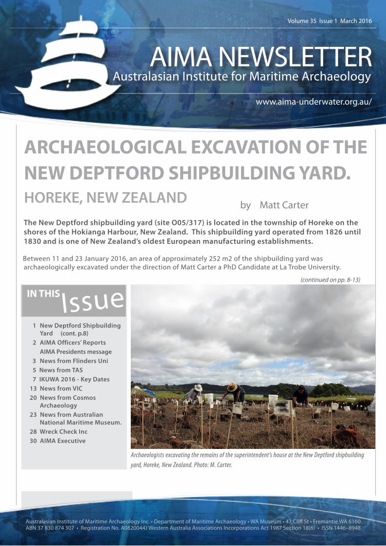
The New Deptford shipbuilding yard (site O05/317) is located in the township of Horeke on the shores of the Hokianga Harbour, New Zealand. This shipbuilding yard operated from 1826 until 1830 and is one of New Zealand’s oldest European manufacturing establishments.
Between 11 and 23 January 2016, an area of approximately 252 m2 of the shipbuilding yard was archaeologically excavated under the direction of Matt Carter a PhD Candidate at La Trobe University.
Archaeologists excavating the remains of the superintendent’s house at the New Deptford shipbuildingyard, Horeke, New Zealand. Photo: M. Carter.

AIMA2 NEWSLETTER
AIMA Newsletter March 2016| Volume 35| Issue 1 ISSN 1446–8948
AIMA President Report
Welcome to the first edition of the AIMA Newsletter for 2016, and congratulations again to newsletter editor Paddy Waterson for putting together another great edition.
This quarter was marked by a heartening announcement from the UK Government committing to ‘review our position on ratifying other international conventions designed to protect cultural heritage and property, including the 2001 UNESCO Convention on the Protection of the Underwater Cultural Heritage’ (The Culture White Paper, March 2016). Encouraging news and a product of considerable hard work from our UK colleagues.
AIMA’s efforts in advocating for Australian ratification continues. AIMA made considerable progress near the end of 2015 with a meeting with Shadow Minister for the Environment and Heritage, Mark Butler (MP). As an outcome of that meeting Mark Butler wrote to Minister Hunt asking for an update on progress on the review of the Historic Shipwrecks Act and the ratification of the Convention. AIMA has contacted Mark Butler’s office twice this quarter and they confirmed that the Minister has not replied.
From the President’s desk
The Advisory Council for Underwater Archaeology (ACUA) held its annual general meeting in January and AIMA member Dr Jennifer McKinnon reported on AIMA’s last year. Thanks Jennifer for keeping our US colleagues in touch with news from Australasia.
Continuing with international news AIMA continues to be updated by the New Zealand Government (Ministry for Culture and Heritage) regarding the management of raised relics from the Ventnor shipwreck. In late 2015 the government ran a public consultation process about the management of these relics. AIMA provided a comprehensive submission and requested ongoing updates. We learned this quarter that some of the findings of the consultation were:
• A majority of submissions agreed that the objects should continue to be held by the Crown, in view of their cultural and historical significance to New Zealand and New Zealanders.
• A majority of submissions agreed that a New Zealand museum would be an appropriate holding place for the objects.
Continuing with news from New Zealand AIMA member Matt Carter ran a successful field project investigating the remains of New Zealand’s first shipyard. As a reminder, Matt was the recipient of the AIMA scholarship, which went towards operational costs.
Finally it’s noteworthy that AIMA donated hard copies of the AIMA bulletin to the library of the Institute of Archaeology in Hanoi, as a resource and contribution to capacity building. Thanks to AIMA member Dr Mark Staniforth for organising this.
Enjoy the newsletter!
Regards
David Steinberg
President
March 2016

NEWSLETTER3
AIMA
AIMA Newsletter |March 2016 | Volume 35 Issue 1ISSN 1446–8948
Australasia NEWSFlinders Maritime Field School
This year, the Flinders University Maritime Archaeology Program Field School took place in Mt Dutton Bay South Australia from 31 January to 13 February 2016. The field team, led by Dr Wendy van Duivenvoorde, consisted of 24 diving and non-diving archaeologists and students from Australia, Indonesia, Japan, the Netherlands, Spain and the USA. Staff and students set out to examine the maritime cultural landscape of Mt Dutton Bay, South Australia and continue the university’s study of the shipwrecked oyster cutter Caprice, the state heritage listed Mt Dutton Bay Jetty and the once profitable woolshed, which provided a significant source of revenue to the local economy.
Prior to European colonization, the Mt Dutton Bay area was the ancestral home of Naou Aboriginal tribe (Baillie 1978:17). European involvement in region began in 1802 when visited by Matthew Flinders. After formal survey, colonization began in the 1860s, with settlers relying on the land mainly for pastoral use. The Bay itself contained abundant marine resources, principally oyster and whiting (Chapman 1998: 23). Mt Dutton Bay, under the ownership of Price Maurice, primarily exported wool. Maurice was responsible for the construction of Mt Dutton Bay’s woolshed and jetty in 1875 and 1881 respectively (Collins 2005:53). The Bay continued to be an economically productive hub in the Eyre Peninsula, until the decline of its oyster industry in the 1920’s. This decline led to the rise of seasonal scale
fishing as the main form of marine exploitation, along with continued pastoral usage of Mount Dutton Bay’s land (SAR, 15 November 1921:8c).
The woolshed was constructed in 1875, from local stone and imported timbers. Once home to more than 1200 sheep, it served as the centre of the regions wool harvesting (Collins 2005:53). The need for wool and grain exportation resulted in the construction, in 1880-81, of the associated Jetty which initially extended a length of 82 metres. Despite this distance, the water depth at low tide measured only 1.3 metres. In 1911 the jetty was expanded an additional 125 metres, resulting in a trivial increase in depth. Major refurbishment occurred in 1960 to restore its structural integrity but later sustained significant fire damage in 1979. After this incident, local authorities closed public access to the jetty, which remained inaccessible until 1986 when the local populace petitioned for full restoration (Khan 2006:47).
Image 1. Staff and students at the 2016 Flinders University Maritime Archaeology Field School, Mt Dutton Bay, South Australia. Photographer: Kotaro Yamafune, Texas A&M University.

AIMA4 NEWSLETTER
AIMA Newsletter March 2016| Volume 35| Issue 1 ISSN 1446–8948
DANIEL CLAGGETT & JUSTIN DALEY
Caprice, an Australian-built oyster cutter, originally operated in the coastal waters of Mt Dutton Bay. The vessel was nearly nine metres in length and had a beam of three meters, it had a single mast, and was clinker-build, i.e. the vessel had lapstraked planking. Caprice wrecked during a severe storm in 1928. Dragging its anchor, it crashed into the Mt Dutton jetty before burning to its waterline (Shefi 2007:35).
Terrestrial survey of the site was carried out through several means, including topographic survey, pedestrian surveys and 3D photogrammetry work. Underwater investigation and survey included visual survey, site mapping of associated features and archaeological materials in and around the Mt Dutton Bay Jetty and the Caprice shipwreck site. In addition students gained experience in archaeological excavation under water—they set out 1x1m grids and excavated with the assistance of a water dredge. The examination of the vessel’s construction features aids the study of Australian boat building practices while excavated material can provide an insight into social and economic circumstances of the region. The students also undertook an ecological and conservation assessment to evaluate the sites’ current levels of preservation and extent of deterioration.
The 2016 field school found there to be a two metre discrepancy in jetty length that conflicted with its shorter reported length of 209
Image 2. Mt Dutton Bay Jetty, north facing south. Photographer: Justin Daley, Flinders University.
Image 3. Dredge operation and mapping under water, featuring supervisors and students Melisa Bendall, Justin Daley, Trevor Winton, Celeste Jordan (clockwise from bottom-left). Photographer: Danielle Wilkinson, Cosmos Archaeology,
metres. Around the Caprice shipwreck site, a relatively shallow sand layer of less than 30 centimetres, directly over limestone bedrock, suggests that more substantial structural timbers are likely present in areas of deeper sedimentary accumulation not yet uncovered and excavated. Scattered wooden fragments and possible associated materials, along with a strong tidal pull suggest that Caprice, after sinking, was broken apart and scattered over a large surface area.
Work on the maritime cultural landscape of Mount Dutton Bay, both terrestrial and underwater, will continue into the future. Evaluation of the preservation status of the sites underwater artefacts will allow for better cultural heritage management and tourism strategies to be developed around the sites. Today, the woolshed operates as public accommodation and museum cafe for students, tourists, and locals alike.

NEWSLETTER5
AIMA
AIMA Newsletter |March 2016 | Volume 35 Issue 1ISSN 1446–8948
References:
Baillie, P. J. 1978 Port Lincoln and District: A Pictorial History. South Australia: Lynton Publications Pty. Limited.
Collins, N. 2005 The Jetties of South Australia: Past and Present. South Australia: Gillingham Printers Pty Ltd.
Colvin, P. 2011 The historical and archaeological investigation of the oyster cutter Caprice. Unpublished Masters Thesis, Department of Archaeology, Flinders University.
Chapman, G. 1998 Wooden Fishing Boats: A Documented and Pictorial History of the Wooden Fishing Vessels that have Fished the Waters off of Kangaroo Island. Adelaide: Gifford Chapman.
Khan, A. 2006 Pier Reviewed: A study of port-related structures in South Australia. Unpublished Masters thesis, Department of Archaeology, Flinders University.
Shefi, D. 2006 The development of cutters in relation to the South Australian oyster industry: an amalgamation of two parallel developing industries. Unpublished Masters thesis, Department of Archaeology, Flinders University.
Randell, W.G. 1921 Oysters and Politicians. South Australian Register. 15 November 1921:8c. Accessed 17 February 2016 from http://trove.nla.gov.au/ndp/del/article/63354179
TASMANIA
Nord Shipwreck The Nord was a British-
registered steamship of 1892 gross tons that was wrecked off the Tasman Peninsula on 7 November 1915 and now lies at a depth of 33-40 metres. The Tasmanian Parks and Wildlife Service have recently completed a major new track at the Tasman Peninsula (the Three Capes Walk) and interpretation material was needed for the three new hut complexes. One of the huts is very close to where the Nord shipwreck occurred, so some interpretation panels were prepared around this event. By complete coincidence, during 2015 we were also made aware of an original builder’s model of the vessel that had become
Image 1. The Nord builder’s model at the PWS office, prior to its journey to the Tasman Peninsula. Parks and Wildlife Service.
available for sale in Sweden. The model was duly acquired, air-freighted to Tasmania in a purpose built packing case and eventually transported to its new hut home by helicopter (image 1).
The walking track has been heavily booked since it opened, and we have received plenty of favorable comment about the general interpretation along the four-day walk, including the Nord display.
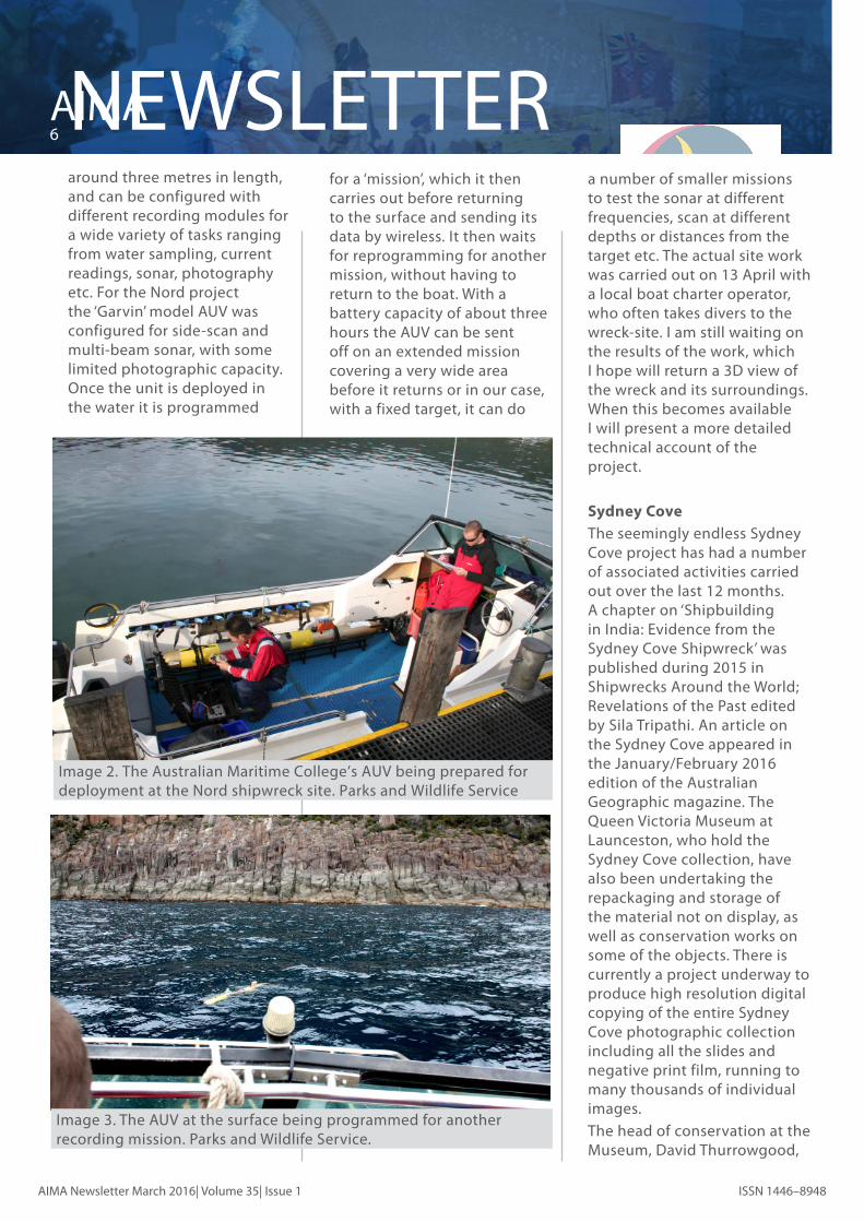
The Nord shipwreck has also been the recent subject of a recording project carried out with the Australian Maritime College, which is part of the University of Tasmania campus at Launceston. The AMC have an Autonomous Underwater Vehicle (AUV) as part of their equipment and have been keen to test its capabilities through the recording of a shipwreck site. This particular model is a torpedo shaped unit of
AIMA6 NEWSLETTER
AIMA Newsletter March 2016| Volume 35| Issue 1 ISSN 1446–8948
Image 2. The Australian Maritime College’s AUV being prepared for deployment at the Nord shipwreck site. Parks and Wildlife Service
around three metres in length, and can be configured with different recording modules for a wide variety of tasks ranging from water sampling, current readings, sonar, photography etc. For the Nord project the ‘Garvin’ model AUV was configured for side-scan and multi-beam sonar, with some limited photographic capacity. Once the unit is deployed in the water it is programmed
Image 3. The AUV at the surface being programmed for another recording mission. Parks and Wildlife Service.
for a ‘mission’, which it then carries out before returning to the surface and sending its data by wireless. It then waits for reprogramming for another mission, without having to return to the boat. With a battery capacity of about three hours the AUV can be sent off on an extended mission covering a very wide area before it returns or in our case, with a fixed target, it can do
a number of smaller missions to test the sonar at different frequencies, scan at different depths or distances from the target etc. The actual site work was carried out on 13 April with a local boat charter operator, who often takes divers to the wreck-site. I am still waiting on the results of the work, which I hope will return a 3D view of the wreck and its surroundings. When this becomes available I will present a more detailed technical account of the project.
Sydney Cove The seemingly endless Sydney
Cove project has had a number of associated activities carried out over the last 12 months. A chapter on ‘Shipbuilding in India: Evidence from the Sydney Cove Shipwreck’ was published during 2015 in Shipwrecks Around the World; Revelations of the Past edited by Sila Tripathi. An article on the Sydney Cove appeared in the January/February 2016 edition of the Australian Geographic magazine. The Queen Victoria Museum at Launceston, who hold the Sydney Cove collection, have also been undertaking the repackaging and storage of the material not on display, as well as conservation works on some of the objects. There is currently a project underway to produce high resolution digital copying of the entire Sydney Cove photographic collection including all the slides and negative print film, running to many thousands of individual images.
The head of conservation at the Museum, David Thurrowgood,
NEWSLETTER7
AIMA
AIMA Newsletter |March 2016 | Volume 35 Issue 1ISSN 1446–8948
has also started up a rather unique research project with the Sydney Cove material. There were a number of intact bottles recovered from the site with some contents still in them, and these were analysed by the South Australian Wine Research Institute during the mid-1990s. With far greater technology available the samples have now been re-analysed, and researchers have been able to regrow the original yeasts from the Sydney Cove beer samples and have used them to brew modern-day versions of the original beer – they are promoting this
as the ‘world’s oldest beer’ and are looking to eventually produce this on a commercial scale. The technological achievement is quite amazing, and the ABC Catalyst program will be filming the story during early May to come out fairly soon afterwards. Who knows, we might have some unique beer samples to offer conference goers at IKUWA later this year!
MIKE NASH
AIMA8 NEWSLETTER
AIMA Newsletter March 2016| Volume 35| Issue 1 ISSN 1446–8948
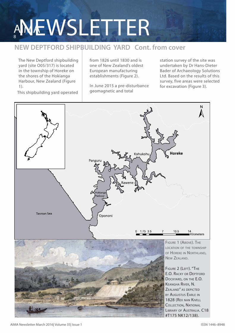
The New Deptford shipbuilding yard (site O05/317) is located in the township of Horeke on the shores of the Hokianga Harbour, New Zealand (Figure 1).
This shipbuilding yard operated
NEW DEPTFORD SHIPBUILDING YARD Cont. from cover
from 1826 until 1830 and is one of New Zealand’s oldest European manufacturing establishments (Figure 2).
In June 2015 a pre-disturbance geomagnetic and total
station survey of the site was undertaken by Dr Hans-Dieter Bader of Archaeology Solutions Ltd. Based on the results of this survey, five areas were selected for excavation (Figure 3).
Figure 1 (Above). The locATion oF The Township oF horeke in norThlAnd, new ZeAlAnd.
Figure 2 (leFT). “The e.o. rAcky or depTFord dockyArd, on The e.o. keAnghA river, n. ZeAlAnd” As depicTed by AugusTus eArle in 1828 (rex nAn kivell collecTion, nATionAl librAry oF AusTrAliA. c18 #T175 nk12/138).

NEWSLETTER9
AIMA
AIMA Newsletter |March 2016 | Volume 35 Issue 1ISSN 1446–8948
Figure 3 (Above). The geomAgneTic And TopogrAphicAl survey wiTh The excAvATion AreAs overlAid. Figure 4 (below). ArchAeologisTs excAvATing A 50 mm spiT in AreA 2.

AIMA10NEWSLETTER
AIMA Newsletter March 2016| Volume 35| Issue 1 ISSN 1446–8948
To capture the selected anomalies recorded during the geomagnetic survey, Sam Lee from Thomson Survey Ltd used a Differential GPS to lay out the excavation units. Once these areas had been established, the excavation areas on the coastal flat had their topsoil removed using a 5-ton mechanical excavator with a 1 metre wide cleaning bucket. Once the topsoil had been removed from each area, all excavation work was undertaken by hand with excavation proceeding in 50 mm spits.
The location of all in situ finds and features was recorded using a Leica robotic total station (Figure 5). Each feature was also drawn (stratigraphic and plan), photographed, and measured, with the information then written on pre-prepared feature forms. The excavated areas and features were also recorded by top-down and oblique photography, enabling 3D photogrammetry models of the areas and features to be made.
Figure 5 (Above). wesley mAguire oF heriTAge survey consulTAnTs recording The locATion oF ArTeFAcT Finds using A leicA roboTic ToTAl sTATion. phoTo: m. cArTer And k. shArpe.
Figure 6. siTe plAn showing The numbered excAvATion AreAs And The FeATures recorded in eAch AreA.
PRELIMINARY EXCAVATION RESULTS
The excavation opened up a total area of 252 m2 across the site, with a total of 2325 finds and 27 features recorded across six excavation areas and one test trench (Figure 6).
Artefacts The analysis of the assemblage
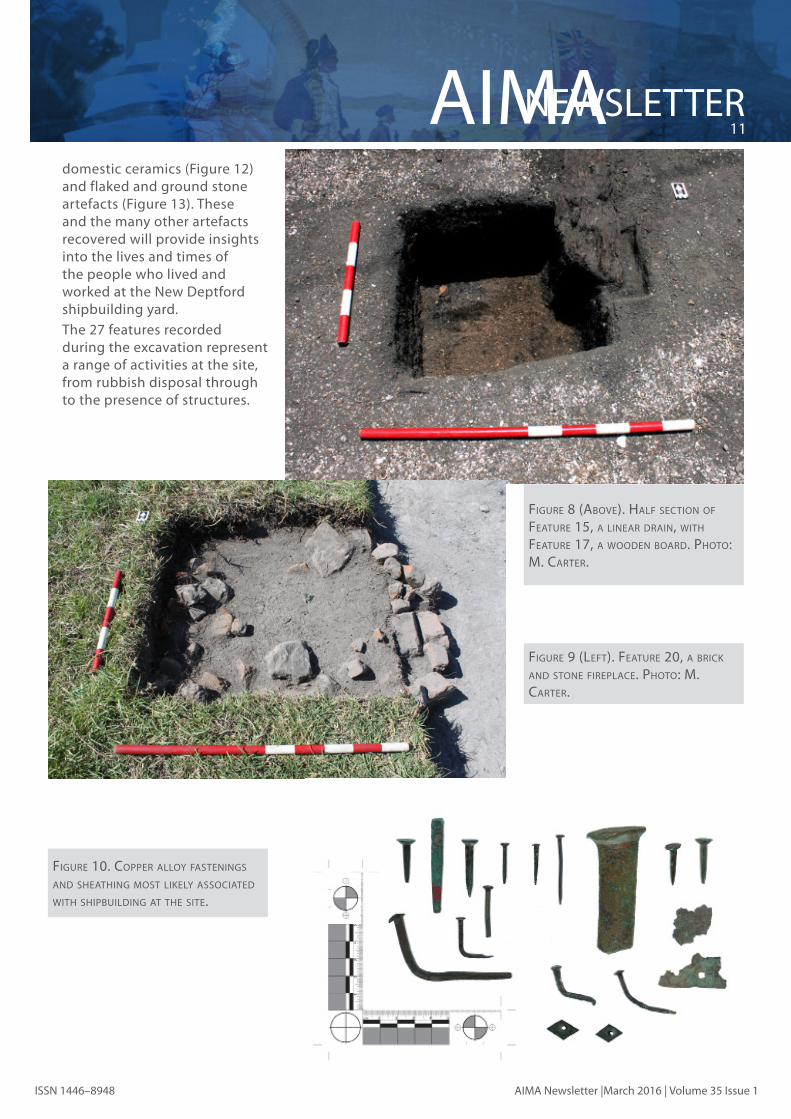
from the New Deptford excavation is yet to be completed in its entirety. However, from the initial work, a range of artefacts have been recorded, including copper alloy ships’ fastenings (Figure 10), gunflints (Figure 11), Figure 7. FeATure 9, A smAll rubbish piT, wiTh The ArTeFAcTs Found wiThin iT.
phoTo: m. cArTer.
NEWSLETTER11
AIMA
AIMA Newsletter |March 2016 | Volume 35 Issue 1ISSN 1446–8948
Figure 8 (Above). hAlF secTion oF FeATure 15, A lineAr drAin, wiTh FeATure 17, A wooden boArd. phoTo: m. cArTer.
domestic ceramics (Figure 12) and flaked and ground stone artefacts (Figure 13). These and the many other artefacts recovered will provide insights into the lives and times of the people who lived and worked at the New Deptford shipbuilding yard.
The 27 features recorded during the excavation represent a range of activities at the site, from rubbish disposal through to the presence of structures.
Figure 9 (leFT). FeATure 20, A brick And sTone FireplAce. phoTo: m. cArTer.
Figure 10. copper Alloy FAsTenings And sheAThing mosT likely AssociATed wiTh shipbuilding AT The siTe.

AIMA12NEWSLETTER
AIMA Newsletter March 2016| Volume 35| Issue 1 ISSN 1446–8948
Figure 11. gun FlinTs recovered From The siTe, mosT likely represenTing The use oF boTh muskeTs And pisTols.
Figure 12. A smAll sAmple oF The blue decorATed cerAmics Found AT The siTe.
Figure 13. FlAked And ground sTone ArTeFAcTs uncovered during The excAvATion.

NEWSLETTER13
AIMA
AIMA Newsletter |March 2016 | Volume 35 Issue 1ISSN 1446–8948
imAge 1 (Above leFT): ciTy oF lAuncesTon skylighT grATe on 10 JAnuAry (imAge J.miTchell)imAge 2 (Above righT): ciTy oF lAuncesTon skylighT grATe on 12 JAnuAry (imAge J.miTchell)
Department of Environment, Land, Water & Planning.
PRELIMINARY CONCLUSIONS The 2016 field season at the site of the New Deptford shipbuilding yard excavated a small percentage
of the overall site but found considerable evidence for the post-1826 use of the site including evidence of shipbuilding. The analysis of the artefacts from the site is ongoing, but based on the initial finds this assemblage has the potential to provide a great deal of interesting information regarding shipbuilding and Māori-Pākehā relations in this pivotal period in New Zealand’s history.
A longer version of this paper appears in the June 2016 issue of Archaeology in New Zealand and more information can be found on the project blog https://thefirstshipsproject.wordpress.com/. Matt would like to thank all of those who gave their time, equipment and experience to make the 2016 field season such a great success.
Part 2: City of Launceston open program
As mentioned in the previous newsletter, the City of Launceston was opened to divers in November 2015 as part of the 150 year anniversary of the wrecking in 1865. Due to weather we were forced to reschedule some of the dive groups and unfortunately, due to staffing constraints, the earliest dates we could offer were 10 and 12 January 2016. These dates, in turn, proved difficult for the divers as many people were on holiday and difficult to contact. However, in spite of these issues, all original dive groups, except one, were able to get on the site. Another eight permits were issued and 62 divers experienced the wreck over the two days. Over the entire program, Heritage Victoria issued 28 permits and 166 divers visited the site.
Heritage Victoria conducted a site inspection on both January access days. The wreck site, at this time of year, had almost completely lost the heavy shroud of weed that protected it in November, some of the smaller artefacts were easier to see and the rust damage from fishing anchors became very apparent. There was also some obvious loss of sediment over the wreck between the first open day and the second.
There was one large group of 15 technical divers on the final day (the largest group in one time slot for the entire program) and this number of people on the site may have caused some of the loss. While this may not have been deliberate action from divers, it is a factor that we will have to consider for future open days.
AIMA14NEWSLETTER
AIMA Newsletter March 2016| Volume 35| Issue 1 ISSN 1446–8948
Post program survey After the final access days,
the maritime unit developed a short survey, using Survey Monkey, in an effort to find out what the divers really thought. While the survey returned some useful information, there were two main issues with the survey itself. The first was that the basic (ie free) survey package allows only 10 questions and 100 respondents and this limits the amount of information we could collect. Secondly, because we didn’t issue individual permits to divers, we only had email details for the permit holders. This meant getting a good response was limited by how widely the permit holders distributed the survey through their networks. Two weeks after distribution, the unit had received 37 replies—a 23% response rate.
Overall, the responses to the survey reinforced the comments made by divers during the actual open days. The responses indicated a high level of community support for the open days and a high level of understanding of the need for the protection of Victoria’s historic shipwrecks. Certainly the responses seem less heated than they were in 2006. There were many divers that also appeared to be looking for more adventure and wrecks in deeper water with better visibility. This was also reflected by the large number of divers who wore heavy technical dive gear at a site where standard SCUBA kit would normally suffice.
There were some responses that would like to see the site
opened more often but every response received indicated that some level of protection and management was required.
Recommendations for future access programs
From the lessons learnt during this open access program, the following recommendations have been made:
Advertising The amount of advertising prior
to the November 2015 open weekends was limited and as such, some dive clubs and charter groups did not hear about the event until after the closing date. One of the permit holders from the Victorian Sub Aqua Group (Victoria’s oldest dive club) said they had 130 enquiries regarding diving on the site but the group had only applied for two permits and could not accommodate all requests.
Due to the short advertising time, only two of the smaller dive charter groups were able to participate. However, they tended to ask for full numbers and multiple time slots without necessarily having divers booked in. This has the potential (which happened in 2006) for charter operators to dominate the allocations and smaller clubs may miss out. This will need to be managed if advertising is more widespread next time.
Everyone who provided feedback on the day suggested that advertising the event earlier and through direct communication with dive clubs would be beneficial. While this would most likely result
in more permit applications, there needs to be a balance between the number of time slots available and the physical resources of Heritage Victoria to schedule the dives, issue permits and be onsite. How much advertising to undertake will need to be carefully considered for the next open program.
Diving schedule For dive boats that had two
groups diving one after the other, the 1.5 hour time slot was generally not quite enough time to complete both dives within the allocated time limit. This was reflected in the post-program survey results. A longer time slot would potentially allow two dives for single tank divers and enable Heritage Victoria staff to debrief divers and ensure they saw some interesting artefacts (particularly in November with the amount of weed present).
Site monitoring Heritage Victoria must continue
to monitor the site regularly for impacts to the integrity of the hull and for any illegal visitation by divers that now have the location of the wreck. Corrosion potential measurements were taken in March 2016 and when these have been analysed, the results will help manage future access opportunities and the effects on the hull.
It is obvious that illegal fishing within the zone is still a major issue, particularly October—January when snapper are in season. More frequent and regular compliance runs are required to educate people fishing in the area.

NEWSLETTER15
AIMA
AIMA Newsletter |March 2016 | Volume 35 Issue 1ISSN 1446–8948
Post access program survey Email contact details need
to be obtained from each individual divers so that a higher response rate can be achieved. A higher level of survey software may need to be purchased to facilitate these higher numbers. This survey should be conducted over a few rounds of open days to track the community’s thoughts over time. This will also help with community engagement activities.
Summary Overall, the 150 anniversary
open access program was a success. Diver feedback was positive and Heritage Victoria continues to field enquiries as to when the site will be open again. In terms of the state government managing agency re-engaging with the diving community, the open days were also beneficial. Depending on the results of the latest round of corrosion potential measurements, Heritage Victoria aims to open the site at more regular intervals with appropriate site monitoring in place to ensure the City of Launceston can sustain the increased level of visitation.
imAge 3: vicki richArds And mATT cArTer TesTing one oF The cerberus guns (imAge: J. cArpenTer)
Port Phillip fieldwork From 16–24 March 2016,
Heritage Victoria’s maritime archaeologists spent eight days in the field around Port Phillip Bay. With the support of the Commonwealth Department of Environment and in conjunction with Western Australian Museum (WAM) scientists, Vicki Richards and Jon Carpenter, the main focus of this season’s fieldwork was to
take corrosion measurements on iron shipwrecks.
Corrosion potential measurements of iron wrecks in Port Phillip, in conjunction with WAM, has been ongoing for over twenty-five years. These measurements have enabled effective management of the degradation of some of Victoria’s significant wrecks like the City of Launceston and Cerberus and have contributed to shipwreck corrosion studies internationally.
This season, conditions only allowed corrosion
measurements to be taken on the City of Launceston and the guns of the Cerberus. We will reschedule the wrecks that we couldn’t get to—Eliza Ramsden, Holyhead, Conside, J-7 and J-3 submarines—for another time.
The four guns of the Cerberus each received a shiny new 40kg zine anode in November 2015 to replace the exhausted twin 25kg anodes. Initial results from this fieldwork appear to indicate that new anodes are working well but this will be confirmed when the analysis is completed over in Western Australia.

AIMA16NEWSLETTER
AIMA Newsletter March 2016| Volume 35| Issue 1 ISSN 1446–8948
As the guns rest in only 4 metres of water in a sheltered environment, it was an ideal training environment for learning how to take corrosion measurements. Vicki Richards trained both Jane Mitchell and Matt Carter in the process, who got to test their new skills in the much more difficult environment surrounding the City of Launceston.
City of Launceston’s anodes had been replaced in October 2015 with 10 x 40kg zinc anodes. This was the first opportunity to check the anodes since they were put in place. The conditions over the two days it took to take the measurements were not ideal with less than two metres visibility. It was also noted that only eight anodes were attached to the hull; one is resting on the seabed off the starboard hull and the other is resting on a hatch near the engine.
Less corrosion was observed on the City of Launceston anodes compared to those attached to the Cerberus guns, indicating less effective cathodic protection. Instead of 400kg of zinc anodes, the wreck has only 320kg in zinc blocks each with a smaller surface area and uncertain connections to the metal hull. A further 80kg of anodes are not attached at all. Heritage Victoria is waiting the results from Western Australia to determine the best course of action moving forward.
The next phase of the Australian Historic Shipwreck Preservation Project was also completed over two days. The aim was to remove three sacrificial samples, two from the hull and one from the artefact
imAge 4: condiTions noT ideAl! mATT cArTer And JAne miTchell ciTy oF lAuncesTon 22 mArch (imAge J.cArpenTer)
imAge 5: ciTy oF lAuncesTon Anode plAcemenT ocTober 2015
depot, take sediment core samples and wrap any exposed timber.
Locating Clarence initially took longer than expected. Despite the Protected Zone pile, the wreck’s covering of shade cloth and tarpaulin has been obscured by weed growth. The
site was eventually located using snorkellers with a shot line placed near the sampson post at the bow as a reference point.
During the first dive on the site, the location of the sacrificial samples was found using measurements from the
NEWSLETTER17
AIMA
AIMA Newsletter |March 2016 | Volume 35 Issue 1ISSN 1446–8948
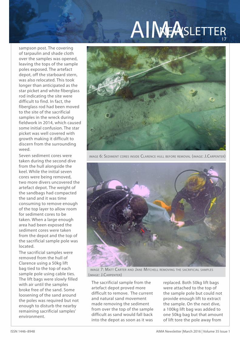
sampson post. The covering of tarpaulin and shade cloth over the samples was opened, leaving the tops of the sample poles exposed. The artefact depot, off the starboard stern, was also relocated. This took longer than anticipated as the star picket and white fiberglass rod indicating the site were difficult to find. In fact, the fiberglass rod had been moved to the site of the sacrificial samples in the wreck during fieldwork in 2014, which caused some initial confusion. The star picket was well covered with growth making it difficult to discern from the surrounding weed.
Seven sediment cores were taken during the second dive from the hull alongside the keel. While the initial seven cores were being removed, two more divers uncovered the artefact depot. The weight of the sandbags had compacted the sand and it was time consuming to remove enough of the top layer to allow room for sediment cores to be taken. When a large enough area had been exposed the sediment cores were taken from the depot and the top of the sacrificial sample pole was located.
The sacrificial samples were removed from the hull of Clarence using a 50kg lift bag tied to the top of each sample pole using cable ties. The lift bags were slowly filled with air until the samples broke free of the sand. Some loosening of the sand around the poles was required but not enough to disturb the nearby remaining sacrificial samples’ environment.
imAge 6: sedimenT cores inside clArence hull beFore removAl (imAge: J.cArpenTer)
imAge 7: mATT cArTer And JAne miTchell removing The sAcriFiciAl sAmples (imAge: J.cArpenTer)
The sacrificial sample from the artefact depot proved more difficult to remove. The current and natural sand movement made removing the sediment from over the top of the sample difficult as sand would fall back into the depot as soon as it was
replaced. Both 50kg lift bags were attached to the top of the sample pole but could not provide enough lift to extract the sample. On the next dive, a 100kg lift bag was added to one 50kg bag but that amount of lift tore the pole away from
AIMA18NEWSLETTER
AIMA Newsletter March 2016| Volume 35| Issue 1 ISSN 1446–8948
the sacrificial sample, which remained firmly buried and out of reach. With no hope of removing the sample, the artefact depot was re-covered with tarpaulin and sandbags.
The final dives involved re-covering the centre of the wreck and the remaining sacrificial samples. The other focus was to cover four frames and the top third of the sampson post that had penetrated their protective layer of tarpaulin. The exposed timber were first wrapped in geotextile, attached with cable ties. Black plastic was then wrapped over the top and tied with cable ties to create as anaerobic environment as possible.
The frozen sediment cores and sacrificial samples have been air freighted to the Western Australian Museum for analysis.
Confirmation of GPS locations Confirming shipwreck positions
is an ongoing project for Heritage Victoria as exact coordinates for shipwrecks are important to effectively manage the sites under State and Commonwealth shipwreck legislation. Due to the development of the data within the Victorian Heritage Database, positions for shipwrecks are not always accurate. The datum used for the GPS locations can sometimes be incorrectly referenced as WGS84 when in some cases, such as when a wreck was located in the early 1980s or 1990s and hasn’t been inspected since, the datum maybe in AGD66. This can provide a location for a wreck 300m away from where it rests. This is the result of a combination of legacy data imported into the VHD and
imAge 8: wrecks AT rye pier (imAge: google eArTh)
human error. In some cases, there can be more than one location from various sources that require confirmation as to which is the correct coordinates. Another difficulty in re-locating wrecks is due to foreshore development as many of the original transit features have disappeared.
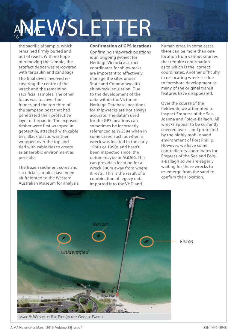
Over the course of the fieldwork, we attempted to inspect Empress of the Sea, Joanna and Foig-a-Ballagh. All wrecks appear to be currently covered over—and protected—by the highly mobile sand environment of Port Phillip. However, we have some contradictory coordinates for Empress of the Sea and Foig-a-Ballagh so we are eagerly waiting for these wrecks to re-emerge from the sand to confirm their location.

NEWSLETTER19
AIMA
AIMA Newsletter |March 2016 | Volume 35 Issue 1ISSN 1446–8948
What wreck is this? During the Port Phillip
fieldwork, the team headed to Rye Pier to investigate two unidentified dark patches on the eastern side of the pier. These dark spots are clearly visible on Google Earth but have never been inspected by Heritage Victoria.
Both sites lie on a clear sandy seabed with maximum depth of 2 metres. Both sites are accessible via the shore or the pier as well as by boat. Both sites are heavily overgrown with weed, making it difficult to distinguish features.
The first inspection was the patch closest to the west side of Rye Pier at -38.3668332, 144.82155 (WGS84). This appears to be a mound of basalt rocks (not dressed) and is typical of a ballast mound from a ship. The second inspection was the patch 110 metres to the west at -38.3668666, 144.82035 (WGS84).
The remains of the wreck
appear to consist of some frames and planking and a small pile of green rounded ballast stones. From the size and shape of the frames, the wreck appears to be the bow section of a wooden vessel approximately 40 tons. The sand in this part of Port Phillip is highly mobile and there maybe more of the wreck underneath the seabed.
While the wreck is currently unidentified, there are two possible vessels listed in the Victorian Heritage Database; Adieu and Barbara. Adieu (S05) was a 2 masted ketch, built at Gravelly Beach, Tasmania in 1877 and was thought to have participated in the lime trade. The vessel was small, possibly just over 15 tons gross. It was wrecked somewhere near Rye on 3 September 1882 and abandoned. The other alternative is Barbara (S68), a two-masted schooner involved in the lime trade, Tasmanian-built and 16 gross tons that was
imAge 9: vicki richArds working on eivion wreck (imAge: J.cArpenTer)
recorded as being wrecked near white cliffs in Rye. Heritage Victoria is planning to go back to this site and take wood samples and collect some ballast to aid in identification purposes.
Vicki Richards and Jon Carpenter also completed a conservation survey on the remains of the Eivion, another small coastal trader involved in lime transportation and located on the western side of Rye Pier.
Overall the fieldwork was considered a success despite the fact we lost almost three days to bad weather. Hopefully we can continue on with the work we couldn’t complete over the 2016/17 financial year.
Acknowledgements This project was generously
supported by the Commonwealth Department of the Environment. Heritage Victoria would also like to thank Vicki Richards and Jon Carpenter for their time and expertise. As always, we want to acknowledge the group of volunteers without whom we would not have been able to complete this fieldwork: Scott Allen, Matt Carter, Cass Philippou, Adelle Scott, Peter Taylor and Des Williams.
Forthcoming fieldwork: Port Fairy site inspections
Heritage Victoria is aiming to confirm wreck positions and current condition of the wrecks at Port Fairy. There are approximately eight recorded wreck sites along the main beach at one of Victoria’s earliest settlements. Reports of serious erosion along the beach have prompted us to schedule this visit.

AIMA20NEWSLETTER
AIMA Newsletter March 2016| Volume 35| Issue 1 ISSN 1446–8948
AIMA/NAS Part one course Heritage Victoria is running an
AIMA/NAS Part one course on the weekend of 16/17 July 2016 at RMIT in Melbourne CBD.
Cosmos Archaeology Summary of Projects in 2015 Below are summaries of
a selection of maritime archaeological projects conducted by Cosmos Archaeology during 2015. Cosmos Archaeology is an Australian based archaeological consulting company working nationally and internationally on various projects. We specialise in historical and maritime archaeology.
New South Wales Halvorsen’s Boat Building
Complex: Maritime Archaeology Assessment and Archival Photographic Recording
A Development Application to Roads and Maritime Services was applied for to demolish a derelict 20th century wharf at the former Halvorsen’s Boat Building Complex in Putney, on the Parramatta River. The Halvorsen’s Boat Building Complex was established at the commencement of WWII, building both military and pleasure craft until the 1970s. The boat building complex and associated 20th century timber wharf were identified in the Sydney Harbour Catchment
Regional Environmental Plan 2005 as a heritage item of State significance and nominated for listing on the State Heritage Register. Cosmos Archaeology undertook a maritime archaeological assessment of the complex, including diving inspections, and identified remains of a 1790s wharf which conveyed produce, beer, stores, supplies and passengers to and from the James Squires estate, where Australia’s first brewery was established. An archaeological sensitivity map was produced which grades the maritime archaeological potential of the site and the report provided advice for management. Cosmos Archaeology later undertook an archival photographic recording of the 20th century derelict timber wharf.
Queensland Removal of Upper Portions of
S.S. Dicky In late July 2015 the Sunshine
Coast Council (SCC) undertook removal of the upper portions of the wreck of S.S. Dicky, which is located in the intertidal zone on Dicky Beach, Caloundra. The SCC cited concerns both for public safety and on-going loss of heritage significance as the reasons for the disturbance of the site, especially in light of recent deterioration of the wreck. Cosmos Archaeology prepared all preliminary documentation for the works including a Heritage Impact Assessment, Conservation Management Plan and Wreck Interpretation Plan. With these documents a permit was obtained from the Department of Environment and Heritage
and Cosmos Archaeology directed the excavation and cutting. The starboard side was cut down the side keelson. This was seen to reduce the risk of vertical elements for public safety. There were also key heritage elements that were at risk of further collapse which were securely removed. The cutting involved hand held circular saws which worked efficiently and cleanly. Extensive recording was also undertaken in order to preserve scientific and archaeological information of the removed elements. Ongoing monitoring is being undertaken of the remaining in situ wreck remains as well as the production of interpretive displays using shipwreck material.
Figure 1: cos coroneos exAmining The resulT AFTer cuTTing A secTion oF hull FrAmes And plATing From The side keelson.

NEWSLETTER21
AIMA
AIMA Newsletter |March 2016 | Volume 35 Issue 1ISSN 1446–8948
Maid of Sker: Conservation Management Plan and Archival Recording
Maid of Sker was a 52 tonne iron hulled paddle steamer constructed in 1884 in Brisbane. The vessel operated between Brisbane and the Gold Coast, notably to Southport and Nerang. The vessel originally serviced a timber mill and sugar farm in the Nerang region and took passengers on day trips. It was later converted to a barge for transporting general cargo and building supplies (gravel) between Brisbane, Moreton Bay and Nerang until 1974. Since 1976, Maid of Sker has been mounted as an installation in Bischof Pioneer Park, Nerang. The vessel is a local heritage item and many local groups were involved in its installation. Cosmos
Figure 2: mAid oF sker vessel insTAllATion in bischoF pioneer pArk, nerAng.
Figure 3: mAid oF sker ship lines.
Archaeology was engaged by City of Gold Coast to complete a CMP for the vessel which led into an archival recording of the installation. Maid of Sker is the only known surviving trading vessel from this region and hence is a rare interpretive example. Extensive refurbishment was undertaken as part of its installation in the park. However, there are many original structural elements that were photographed and drawn as part of the archival record.
Maroochy River Boathouses: Heritage Assessment
Cosmos Archaeology was commissioned by Sunshine Coast Council to prepare a heritage assessment of five boathouses located on the Maroochy River, opposite the
residences located on Bradman Avenue in Maroochydore. The Maroochy River was a popular recreational destination from the early 20th century. There were a large number of timber jetties constructed by boat owners and clubs along the river until 1979, when the State Government refused to issue further permits.
Figure 4: Three oF The boAThouses on mAroochy river, opposiTe 165, 159 And 155 brAdmAn Avenue, mAroochydore.
The five boathouses assessed are the last known boathouses along the Maroochy River. All are visually accessible to the public from the water and the shore. An exterior inspection of the boathouses was undertaken and an interior inspection was provided for three of them. Although limited original material remains of the jetties and boathouses, due to repair and refurbishment for continued use, the little boathouses and jetties maintain the form and shape of the original structures. It was advised to Sunshine Coast Council that the boathouses have local heritage significance they are the last survivors of what once was a ubiquitous feature along the banks of the Maroochy River.

AIMA22NEWSLETTER
AIMA Newsletter March 2016| Volume 35| Issue 1 ISSN 1446–8948
Victoria
Brookes Jetty, St Kilda: Maritime Archaeological Dive Survey
In September, 2015, Parks Victoria received consent to permanently demolish and decommission the heritage listed site of Brookes Jetty, situated off Marine Parade, St Kilda. Recent storm events had destroyed the head of the jetty, resulting in the jetty no longer being able to provide services for recreational boating. It was also becoming a safety hazard to public swimmers. Cosmos Archaeology was engaged to undertake a maritime archaeological survey of the site as part of the consent for demolition. The survey identified a considerable amount of cultural material on the seabed underneath and beside the timber jetty. The bulk of the cultural material of heritage significance was ceramic and glass with some brick fragments. The cultural material was found in association with scatters of basalt rock, which was possibly discarded ballast or deliberately deposited to secure and weigh down the timber piles. The general date range for the artefacts falls within the 20th century to the present day. Artefacts of interest included a wooden cap for a cylinder which may have housed an instrument, a copper alloy
button, a copper alloy coin in concretion and a mid-20th century Vegemite jar.
Western Australia
Proposed Platforms at Busselton Jetty: Heritage Impact Statement
The City of Busselton were proposing to remove Platform 2A, a small boat landing attached to the Busselton Jetty, and replace it with a new platform as well as construct a new 15 m long platform on the western side of the jetty. Busselton Jetty is a rare and important example of long timber jetties that were vital for the movement of goods into and out of ports along the coast of Western Australia, prior to the construction of protected harbours. Busselton Jetty is a structure of high cultural significance to the people of the City of Busselton. The piers around Platform 2A were part of one of the few surviving sections of the original alignment of the skeleton jetty, which was built in 1911, although the fabric was not original. Cosmos Archaeology recommended that the alignment of the jetty be preserved by retaining the piles or replacing them with new piles placed in the exact location of those being removed. The impact on any potential buried cultural material was assessed as minimal due to the limited
size of the proposed impact. Both of these proposals were found to be in accordance with the 2008 Conservation Policy for Busselton Jetty, as they would facilitate berthing at Busselton Jetty and continued recreational use.
Northern Territory
East Arm Multi-User Barge Ramp Facility, Darwin Harbour: Recovered Cultural Objects Maritime Archaeological Analysis
The Northern Territory Land Development Corporation and the Australian Department of Defence, via a joint initiative, are constructing a new Multi-User Barge Ramp Facility (MUBRF) on the southern side of the East Arm Peninsula, Darwin Harbour. Magnetometer surveys specifically targeted towards the identification of potential unexploded ordnance (UXO) and exploded ordnance (EO) were conducted within the proposed MUBRF construction and dredging footprint and identified 52 anomalies. Diving inspections revealed that several of the anomalies consisted of cultural heritage material. Cosmos Archaeology was engaged to identify, record and assess the significance of all recovered cultural items and produce a detailed archaeological analysis. A
NEWSLETTER23
AIMA
AIMA Newsletter |March 2016 | Volume 35 Issue 1ISSN 1446–8948
total of 365 cultural objects were recovered, with the vast majority of artefacts relating to WWII era occupation of the East Arm Royal Australian Air Force (RAAF) Flying Boat (PBY Catalina) Base and Marine Section and the Services Reconnaissance Department (SRD) covert “Lugger Maintenance Section” (LMS). Artefacts included aircraft and marine vessel parts, aircraft weapons, machine gun ammunition, workshop type machinery and remains of wartime infrastructure and equipment.
Searching for ‘Walers’: The Cumberland Entrance and the wreck of the Hydrabad (1845)
The Cumberland Entrance, located 7 nautical miles north east of Mer (Murray) Island, in the eastern section of the Torres Straits, is a tortious seven kilometre long and 800 metres wide passage through the northern section of the Great Barrier Reef – Archaeologists from the Museum were recently given the opportunity to visit the Entrance and search for the remains of the 600 ton ship Hydrabad which was wrecked in the Entrance whilst carrying horses to India in 1845.
When the first European settlers arrived at Sydney Cove in January 1788 and occupied the land of the Gadigal people they established one of the most isolated European settlements
on earth contactable only by ship and only after a lengthy and hazardous voyage either across the Indian or Pacific Oceans or via Torres Strait and the Great Barrier Reef.
Some 13000 miles from England the new penal colony at Sydney Cove was incredible remote and when a series of crop failures required Governor Phillip to look for alternative sources of food for the colony he was forced to send HMS Sirius on an eight month voyage to Cape Town in South Africa for the necessary supplies.
Thankfully in August 1791 permission was granted by Lord Grenville the Home Secretary to Governor Phillip allowing the struggling colony to trade with Calcutta in India for necessary supplies such as rice, flour and livestock.
From these tentative beginnings trade between India and Sydney evolved leading to dozens of ships a year sailing between the colonies carrying all manners of cargo including foodstuffs, ceramics, cloth, shoes, alcohol, spices, tobacco, leather and iron, coal, timber and seal skins. (see Erskine, Nigel., East of India – Forgotten Trade with Australia in Signals No103:01- 13, 2013)
One of the more unusual and profitable exports were colonial horses. The horse trade between Sydney and Calcutta had been slowly developing ever since the Australian colonial merchant John Macarthur (1767-1834) had presented Francis Rawdon-Hastings, Governor General of
India (1813-1823) a New South Wales stallion in 1822.
Originally known as New South Walers or Walers (after the colony of New South Wales) the Australian colonial horses gained a reputation for sturdiness, stamina and the ability to cope under the sub-continents harsh climate. By 1834 the demand for such horses had developed to such an extent that the East India Company were sending military officers Sydney on behalf of artillery and cavalry units in India to not only purchase horses directly from colonial horse breeders in New South Wales but also arrange shipment of these animals back to India.
In September 1845 the Sydney Morning Herald reported that in that year 950 horses (valued at more than 30,000 pounds) had been assessed by the East India Company as being suitable remounts and they were subsequently exported from the colony on 12 ships.
One of the ships selected for transporting the horses was the aptly named Hydrabad which, after taking on-board 25 passengers, 118 horses and 275 tons of Newcastle coal, departed Sydney on 3 May 1845 bound for Calcutta.
The Hydrabad was a large, wooden, three-masted 602/695 ton ship built by the Middle Dock Company of South Shields on the Tyne River in 1843 and owned by one of the most famous 19th century shipowners Duncan Dunbar who in August 1844 chartered the vessel to the
AIMA24NEWSLETTER
AIMA Newsletter March 2016| Volume 35| Issue 1 ISSN 1446–8948
British Government for the transportation of 260 convicts to Norfolk Island.
The Sydney Morning Herald of the 5 March 1845 subsequently reported that the Hydrabad had arrived in Sydney on the 4 March 1845 from the Downs via the Cape of Good Hope and Norfolk Island, where it had discharged its convicts, before sailing onto Sydney.
After arriving at Sydney Captain Robertson taking advantage of the growing trade in horses between Sydney and India, converted the Hydrabad’s wooden internal compartments that formerly housed the male convicts and their guard into horse stalls and installed forced air pumps to ventilate the lower hold and tween decks of the ship. (The Sydney Morning Herald Thursday March 27 1845). Nothing more was heard of the Hydrabad until Lieut Aird of H.M. Cutter Prince George reported that the Hydrabad along with another vessel the Coringa Packet had been wrecked in the Torres Straits.
Newspaper and survivors accounts vary but it appears Captain Robertson originally intending to enter the Great Barrier Reef via the Raine Island Entrance but contrary winds forced the vessel further north and he decided to use the little used and much more difficult Cumberland Entrance.
Captain Robertson entered Cumberland Entrance, almost immediately struck a submerged reef around 5.15pm on May 25 1845, and after a desperate 12 hour battle the vessel was abandoned,
eventually sinking in fifteen fathoms of water almost in the middle of the Cumberland Entrance some seven nautical miles from Murray Island. The survivors took to the ship’s boats and first headed for Booby Island and then Port Essington before being rescued by the crews of HMS Fly, the Shamrock and the Hebe. Tragically all 118 horses on board were drowned trapped in their stalls below decks.
Given the remoteness of the Cumberland Entrance the wreck site has never been found and as the vessel sank in deep water on a sandy bottom, conditions which are very favorable for the preservation of archaeological material, the wreck if located, could provide excellent comparative archaeological data on mid-19th century English shipbuilding along with additional information on early NSW – India trade.
Thanks to the generosity of our sponsor and research partner The Silentworld Foundation
a small team of archaeologists from the Museum were recently given the opportunity to visit Cumberland Entrance in the expedition vessel The Boss and carry out a detailed search for the remains of the ship.
Arriving at the entrance in mid-January the team observed that Cumberland Entrance is bounded by a six kilometer long reef to the north and a 4.5 kilometres long reef to the south separated by a passage varying in depth from 97m at its north-eastern end to 35-40m deep its south-western end.
Although the main Cumberland Entrance through the Barrier is quite distinct – an 800 metre wide band of deep dark blue water threading its way between the light blue/green water which mark the edges of the Northern and Southern Reefs– we found a similar-looking deep water passage a few hundred metres to the south of the actual Entrance – which we designated the Southern Cumberland Entrance.
As some newspaper accounts at the time of the wrecking stated that Captain Robertson may have entered a false passage close to the real Cumberland Entrance, we first decided to survey the more-sheltered southern entrance first before switching our attention to the more open Cumberland Entrance to the north.
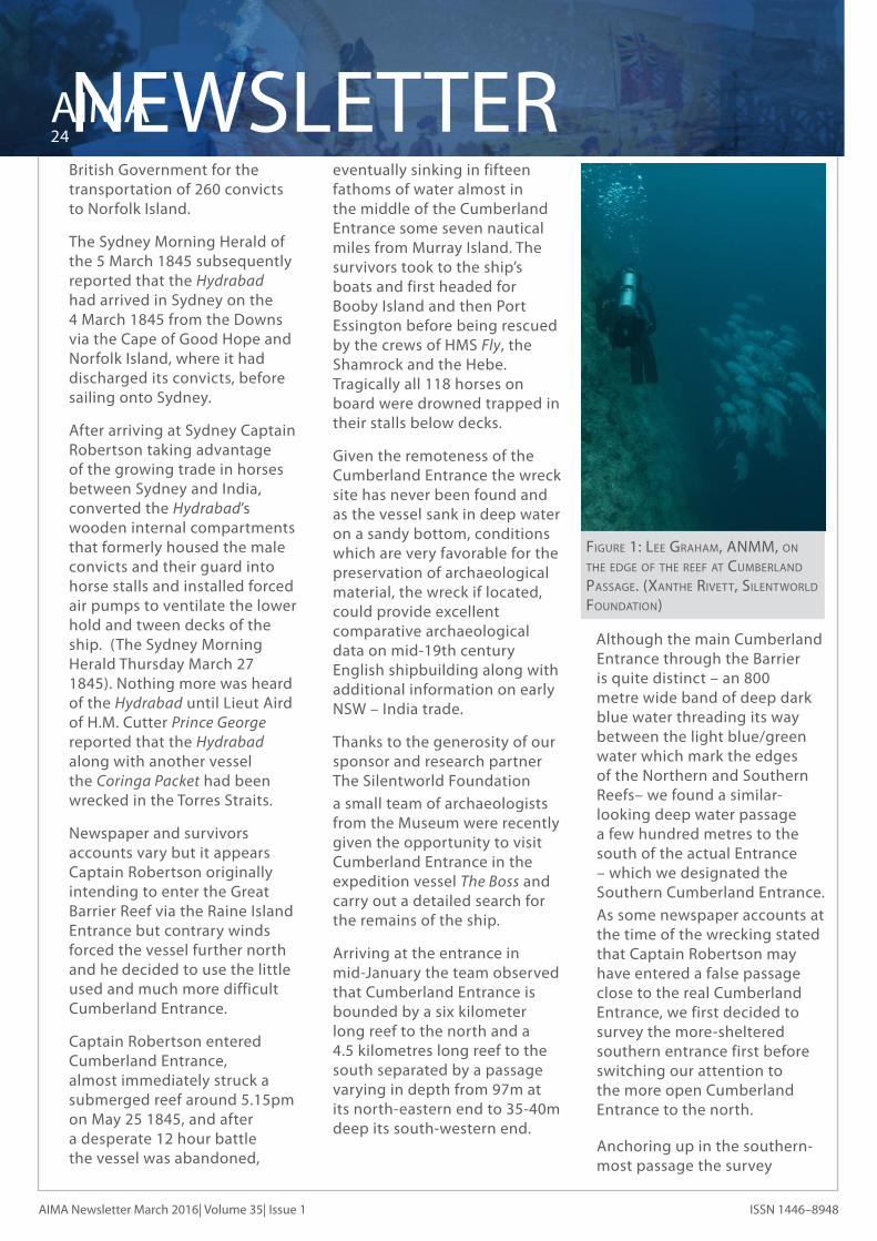
Anchoring up in the southern-most passage the survey
Figure 1: lee grAhAm, Anmm, on The edge oF The reeF AT cumberlAnd pAssAge. (xAnThe riveTT, silenTworld FoundATion)
NEWSLETTER25
AIMA
AIMA Newsletter |March 2016 | Volume 35 Issue 1ISSN 1446–8948
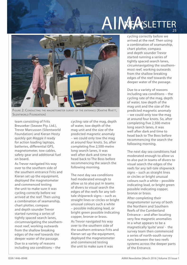
team consisting of Frits Breuseker (Seasee Pty. Ltd.), Trevor Marcusson (Silentworld Foundation) and Kieran Hosty quickly got Maggie II ready for action loading laptops, batteries, differential GPS, magnetometer, tow cables, safety gear and additional fuel on board.
As Trevor navigated his way over to the southern side of the southern entrance Frits and Kieran set up the equipment, deployed the magnetometer and commenced testing the unit to make sure it was cycling correctly before we arrived at the reef. Then using a combination of seamanship, chart plotter, compass and depth sounder Trevor started running a series of tightly spaced search lanes, circumnavigating the southern-most reef, working outwards from the shallow breaking edges of the reef towards the deeper water of the passage.
Due to a variety of reasons including sea conditions – the
Figure 2: conducTing The mAgneTomeTer survey oF The enTrAnce (xAnThe riveTT, silenTworld FoundATion)
cycling rate of the mag, depth of water, tow depth of the mag unit and the size of the predicted magnetic anomaly – we could only tow the mag at around four knots. So, after completing five 2,500-metre long search lanes, it was well after dark and time to head back to The Boss before recommencing the search the following morning.
The next day sea conditions had moderated enough to allow us to also put in teams of divers to visual search the edges of the reefs for any tell-tale shipwreck signs – such as straight lines or circles or bright unusual colours such a white – possible indicating lead, or bright green possible indicating copper, bronze or brass.
As Trevor navigated his way over to the southern side of the southern entrance Frits and Kieran set up the equipment, deployed the magnetometer and commenced testing the unit to make sure it was
cycling correctly before we arrived at the reef. Then using a combination of seamanship, chart plotter, compass and depth sounder Trevor started running a series of tightly spaced search lanes, circumnavigating the southern-most reef, working outwards from the shallow breaking edges of the reef towards the deeper water of the passage.
Due to a variety of reasons including sea conditions – the cycling rate of the mag, depth of water, tow depth of the mag unit and the size of the predicted magnetic anomaly – we could only tow the mag at around four knots. So, after completing five 2,500-metre long search lanes, it was well after dark and time to head back to The Boss before recommencing the search the following morning.
The next day sea conditions had moderated enough to allow us to also put in teams of divers to visual search the edges of the reefs for any tell-tale shipwreck signs – such as straight lines or circles or bright unusual colours such a white – possible indicating lead, or bright green possible indicating copper, bronze or brass.
After completing their magnetometer survey of both the Northern and Southern Reefs of the Cumberland Entrance – and after locating very few magnetic anomalies in a what appears to be a magnetically ‘quite’ area’ - the survey team then commenced a series of north-south survey runs between the two reefs systems across the deeper parts of the Entrance.

AIMA26NEWSLETTER
AIMA Newsletter March 2016| Volume 35| Issue 1 ISSN 1446–8948
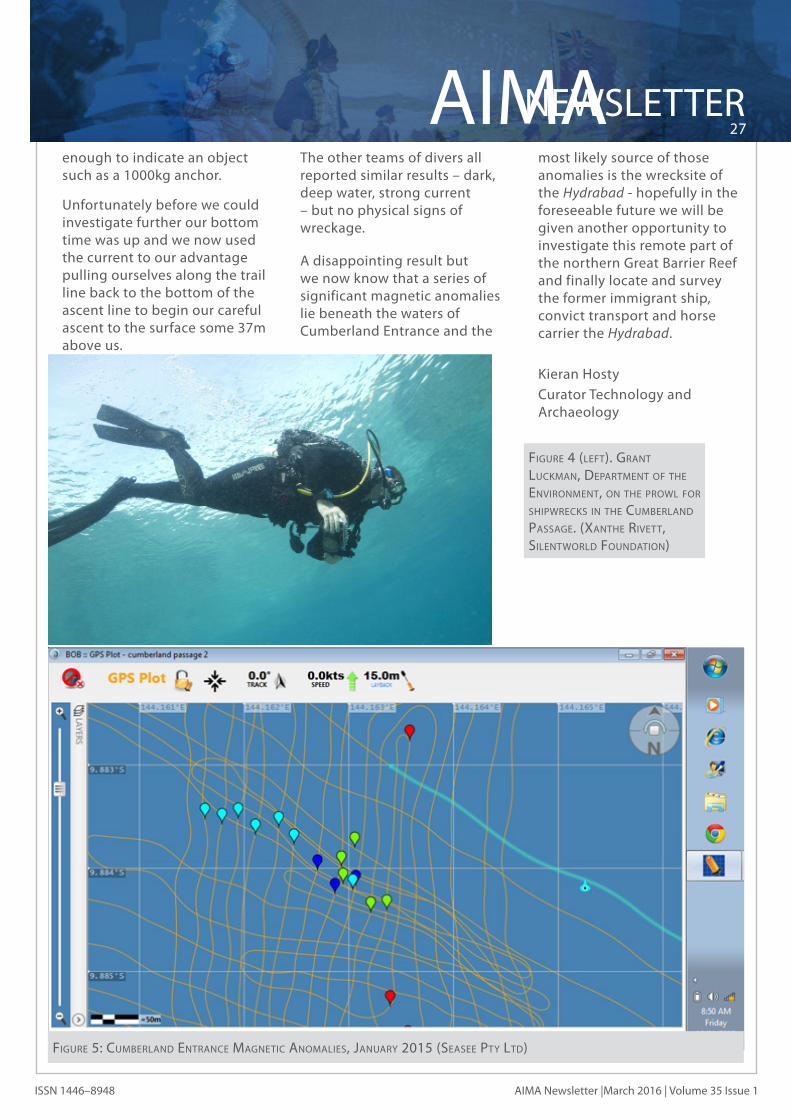
Finally after four days and many kilometres of survey at the western end of the Cumberland Entrance at the team located a series of significant and repeatable magnetic anomalies in 35 to 39 metres of water. The linear nature of the run of anomalies from the south-east towards the north-west was also encouraging – as it is feasible that it represented the spill of magnetic material such as anchors, iron cable and ship’s fittings as the vessel drifted north-west under the influence of the prevailing wind and tide.
Given the lateness of the day and state of the tide it was decided to hold off on diving the anomalies until the following day but the Side Scan Sonar on Maggie III was deployed and several interesting lumps on what was a relatively flat and featureless sea bottom were observed.
The following day the
magnetometer team confirmed the repeatability and size of the anomalies located the day before and reported that they appear to be confined to area approximately 150 metres long by 50 metres wide.
Given the maximum depth of water (39metres), the limited bottom time (7minutes) and the required surface interval it was only possible for us to inspect five of the strongest anomalies out of the more than 20 anomalies that had been recorded in the search area.
These anomalies were bouyed, descent lines rigged up and after going through the usual safety drills and back up plans the divers, working in teams of two were deployed. First Frits working with Xanthe, then Lee Graham (ANMM Fleet) and Grant Luckman (Department of the Environment) and finally Trevor and myself.
Figure 3: mAgneTomeTer ploT oF cumberlAnd enTrAnce showing The norThern reeF And The mAgneTic AnomAly AreA in The cenTer oF The enTrAnce (seAsee pTy lTd)
When Trevor and I hit the bottom at 37 metres it was dark and gloomy (sunlight drops away remarkable quickly even in the clear waters of the northern Great Barrier Reef ) with a very strong current pushing us towards the west. Armed with a metal detector and a trail line – we pulled ourselves eastward along the sea bottom working hard against the current.
After five frantic minutes of searching out of the gloom we spied a ledge of rock some two metres high and some 50 metres long on top of which appeared to be the outline of a large ship’s anchor thickly encrusted with coral growth. Fighting the current we managed to swim over to the object and scan it with the metal detector and it gave off an encouraging but very slight magnetic signal indicating the presence of iron but not
NEWSLETTER27
AIMA
AIMA Newsletter |March 2016 | Volume 35 Issue 1ISSN 1446–8948
enough to indicate an object such as a 1000kg anchor.
Unfortunately before we could investigate further our bottom time was up and we now used the current to our advantage pulling ourselves along the trail line back to the bottom of the ascent line to begin our careful ascent to the surface some 37m above us.
The other teams of divers all reported similar results – dark, deep water, strong current – but no physical signs of wreckage.
A disappointing result but we now know that a series of significant magnetic anomalies lie beneath the waters of Cumberland Entrance and the
most likely source of those anomalies is the wrecksite of the Hydrabad - hopefully in the foreseeable future we will be given another opportunity to investigate this remote part of the northern Great Barrier Reef and finally locate and survey the former immigrant ship, convict transport and horse carrier the Hydrabad.
Kieran Hosty Curator Technology and
Archaeology
Figure 5: cumberlAnd enTrAnce mAgneTic AnomAlies, JAnuAry 2015 (seAsee pTy lTd)
Figure 4 (leFT). grAnT luckmAn, depArTmenT oF The environmenT, on The prowl For shipwrecks in The cumberlAnd pAssAge. (xAnThe riveTT, silenTworld FoundATion)
AIMA28NEWSLETTER
AIMA Newsletter March 2016| Volume 35| Issue 1 ISSN 1446–8948
References
South Australian Register 24/09/1845Sydney Morning Herald 11/08/1845, Port Phillip Gazette 23/08/1845
http://www2.sl.nsw.gov.au/archive/discover_collections/society_art/races/walers/: accessed 15 August 2015
Erskine, Nigel. 2013. East of India – Forgotten Trade with Australia in Signals No103:01- 13, 2013
Linder, M; East of India: Power, Trade and Australia 1788-1857, August 2012., https://anmm.wordpress.com/2012/08/01/happy-birthday-to-australian-horses/
http://www.tynebuiltships.co.uk/MiddleDock.html: accessed 26 February 2015 and Welford, Richard. (2013). pp. 670-1. Men of Mark Twixt Tyne and Tweed (Vol. 3). London: Forgotten Books. (Original work published 1895)
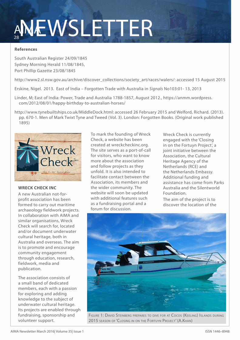
WRECK CHECK INC A new Australian not-for-
profit association has been formed to carry out maritime archaeology fieldwork projects. In collaboration with AIMA and similar organisations, Wreck Check will search for, located and/or document underwater cultural heritage, both in Australia and overseas. The aim is to promote and encourage community engagement through education, research, fieldwork, media and publication.
The association consists of a small band of dedicated members, each with a passion for exploring and adding knowledge to the subject of underwater cultural heritage. Its projects are enabled through fundraising, sponsorship and volunteer support.
To mark the founding of Wreck Check, a website has been created at wreckcheckinc.org. The site serves as a port-of-call for visitors, who want to know more about the association and follow projects as they unfold. It is also intended to facilitate contact between the Association, its members and the wider community. The website will soon be updated with additional features such as a fundraising portal and a forum for discussion.
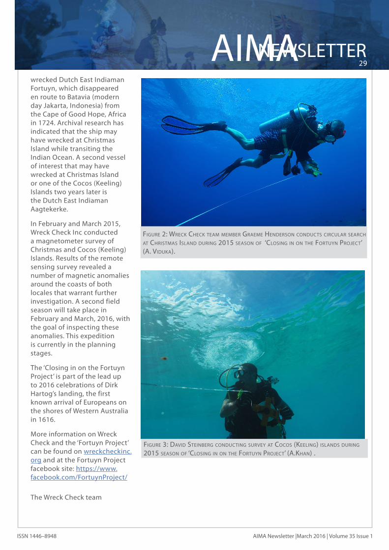
Wreck Check is currently engaged with the ‘Closing in on the Fortuyn Project’, a joint initiative between the Association, the Cultural Heritage Agency of the Netherlands (RCE) and the Netherlands Embassy. Additional funding and assistance has come from Parks Australia and the Silentworld Foundation.
The aim of the project is to discover the location of the
Figure 1: dAvid sTeinberg prepAres To dive For AT cocos (keeling) islAnds during 2015 seAson oF ‘closing in on The ForTuyn proJecT’ (A.khAn)
NEWSLETTER29
AIMA
AIMA Newsletter |March 2016 | Volume 35 Issue 1ISSN 1446–8948
wrecked Dutch East Indiaman Fortuyn, which disappeared en route to Batavia (modern day Jakarta, Indonesia) from the Cape of Good Hope, Africa in 1724. Archival research has indicated that the ship may have wrecked at Christmas Island while transiting the Indian Ocean. A second vessel of interest that may have wrecked at Christmas Island or one of the Cocos (Keeling) Islands two years later is the Dutch East Indiaman Aagtekerke.
In February and March 2015, Wreck Check Inc conducted a magnetometer survey of Christmas and Cocos (Keeling) Islands. Results of the remote sensing survey revealed a number of magnetic anomalies around the coasts of both locales that warrant further investigation. A second field season will take place in February and March, 2016, with the goal of inspecting these anomalies. This expedition is currently in the planning stages.
The ‘Closing in on the Fortuyn Project’ is part of the lead up to 2016 celebrations of Dirk Hartog’s landing, the first known arrival of Europeans on the shores of Western Australia in 1616.
More information on Wreck Check and the ‘Fortuyn Project’ can be found on wreckcheckinc.org and at the Fortuyn Project facebook site: https://www.facebook.com/FortuynProject/
The Wreck Check team
Figure 2: wreck check TeAm member grAeme henderson conducTs circulAr seArch AT chrisTmAs islAnd during 2015 seAson oF ‘closing in on The ForTuyn proJecT’ (A. vidukA).
Figure 3: dAvid sTeinberg conducTing survey AT cocos (keeling) islAnds during 2015 seAson oF ‘closing in on The ForTuyn proJecT’ (A.khAn) .

AIMA Newsletter Vol 35 Issue 1- March 2016 ISSN 1446–8948
EXECUTIVEAIMA 2015–2016
EDITOR’S NOTE
Officers President
Senior Vice President
Vice President
Vice President
Secretary
Treasurer
State Councillors
A.C.T. Queensland New South Wales
New Zealand Northern Territory South Australia
David SteinbergDLPE Heritage BranchGPO Box 1680DARWIN, NT 0801Ph: (08) 8999 5041Fax: (08) 8999 8949E-mail: [email protected]
Ross AndersonWA Museum, DMA47 Cliff StreetFREMANTLE, WA 6160Ph: (08) 9431 8442Fax: (08) 9431 8489E-mail: [email protected]
Cass PhilippouE-mail: [email protected]
Amer KhanE-mail: [email protected]
Charlotte LooramFlinders University, ArchaeologyGPO Box 2100ADELAIDE, SA 5001Email: [email protected]
Celeste JordanFlinders University, ArchaeologyGPO Box 2100ADELAIDE, SA 5001E-mail: [email protected]
Andrew VidukaPeter IllidgeBrad Duncan, Danielle Wilkinson, Chris Lewczak, Stirling Smith
Andy Dodd, Kurt Bennett, Matthew CarterDavid SteinbergJonathan Benjamin, Mark Polzer, Wendy van Duivenvoorde
Tasmania Western Australia
Victoria
USA
Publications Committee
Newsletter Editor
Website Administrator
Public Officer
AIMA/NAS Senior Tutor
AIMA/NAS Tutors
Mike NashNicolas Bigourdan, Vicki Richards, Maddy McAllisterPeter Harvey, Peter Taylor, Mark RyanJennifer McKinnon
Jennifer Rodrigues , Jane Mitchell, Myra Stanbury, Jeremy Green, David Gregory, Peter Harvey, Sarah Holland, William Jeffery, Margaret Leshikar-Denton, David Nutley, Jason Raupp, Nathan Richards, Vicki Richards, Della Scott-Ireton, Debra Shefi, Ross Anderson, Matthew Carter.
Paddy Waterson
Chris Lewczak
Secretary
Cassandra Philippou
(NSW) Cass Phillippou; (NT) David Steinberg; (NZ) Andy Dodd; (QLD) Paddy Waterson; (SA) Peta Straiton; (VIC) Peter Harvey; (WA) Nicolas Bigourdan
Australasian Institute for Maritime Archaeology, Inc. Registration No. A0820044JWestern Australian Associations Incorporation Act 1987 s.18(6)Newsletter Registered by Australia PostPublication No. WBH 1635
Dear Members, A big thanks to all the contributors! Can I please
request the urgent submission of news items and articles for the second quarter of 2016 - at this stage I only have a small number of submissions and want to get the next issue out ASAP.
- Editor.

The AIMA Newsletter is supported by:
THE HISTORIC SHIPWECKS PROGRAM
AIMA NewsletterVolume 35 Number 1 March 2016