Embed Size (px)
Citation preview
THE IMPERIAL GAZETTEER
OF INDIA
VOL. X X I I
S A M A D H I A L A TO SINGHANA
NEW EDITION
PUBLISHED UNDER THE AUTHORITY OF HIS MAJESTY'S SECRETARY OF STATE TOR INDIA IN COUNCIL
OXFORD AT THE CLARENDON TRESS
1908
HENRY FROWDE, M.A. PUBLISHER TO T H E UNIVERSITY OF OXFORD
LONDON, EDINBURGH
NEW YORK AND TORONTO
INTRODUCTORY NOTES
NOTES ON TRANSLITERATION
Votuel-Sounds
a has the sound of a in' woman.' a has the sound of a in ' father.' e has the vowel-sound in 'grey.' i has the sound of i in 'pin.' I has the sound of / in ' police.' o has the sound of o in ' bone.' u has the sound of u in ' bull.' u has the sound of u in ' flute.' ai has the vowel-sound in ' mine.'
au has the vowel-sound in ' house.'
It should be stated that no attempt has been made to distinguish between the long and short sounds of e and o in the Dravidian languages, which possess the vowel-sounds in ' bet' and * hot' in addition to those given above. Nor has it been thought necessary to mark vowels as long in cases where mistakes in pronunciation were not likely to be made. ~
Consonants
Most Indian languages have different forms for a number of consonants, such as d, /, r, & c , marked in scientific works by the use of dots or italics. As the European ear distinguishes these with difficulty in ordinary pronunciation, it has been considered undesirable to embarrass the reader with them ; and only two notes are required. In the first place, the Arabic k, a strong guttural, has been represented by k instead of q, which is often used. Secondly, it should be remarked that aspirated consonants are common; and, in particular, dh and th (except in Burma) never have the sound of th in ' this' or ' th in/ but should be pronounced as in ' woodhouse' and ' boat-hook.'
A 2
IV INTRODUCTORY NOTES
Burmese Words
Burmese and some of the languages on the frontier of China have the following special sounds :—
aw has the vowel-sound in ' law.' o and ii are pronounced as in German,
gy is pronounced almost like j in ' jewel.' ky is pronounced almost like ch in 'church.' th is pronounced in some cases as in (this/ in some cases as i
«thin.' w after a consonant has the force of uw. Thus, ywa and pwe
are disyllables, pronounced as if written yuwa and puwe.
It should also be noted that, whereas in Indian words the accent or stress is distributed almost equally on each syllable, in Burmese there is a tendency to throw special stress on the last syllable.
General The names of some places—e.g. Calcutta, Bombay, Lucknow,
Cawnpore—have obtained a popular fixity of spelling, while special forms have been officially prescribed for others. Names of persons are often spelt and pronounced differently in different parts of India; but the variations have been made as few as possible by assimilating forms almost alike, especially where a particular spelling has been generally adopted in English books.
N O T E S O N M O N E Y , P R I C E S , W E I G H T S A N D M E A S U R E S
As the currency of India is based upon the rupee, all statements with regard to money throughout the Gazetteer have necessarily been expressed in rupees, nor has it been found possible to add generally a conversion into sterling. Down to about 1873 the gold value of the rupee (containing 165 grains of pure silver) was approximately equal to 2s., or one-tenth of a £ ; and for that period it is easy to convert rupees into sterling by striking off the final cipher (Rs. 1,000 = £100). But after 1873, owing to the depreciation of silver as compared with gold throughout the world, there came a serious and progressive fall in the exchange, until at one time the gold value of the rupee dropped as low as is. In order to provide a remedy for the heavy loss caused to the Government of India in respect of its gold payments to be made in England, and also to relieve foreign trade and finance from the inconvenience due to constant and unforeseen fluctuations in exchange, it was resolved in 1893 to close the mints to the free coinage of silver, and thus force up the value of the rupee by restricting the circulation. The intention was to raise
INTRODUCTORY NOTES v
the exchange value of the rupee to is. 4d., and then introduce a gold standard (though not necessarily a gold currency) at the rate of Rs. 15 = £ 1 . Th i s policy has been completely successful. F rom 1899 onwards the value of the rupee has been maintained, wi th insignificant fluctuations, at the proposed rate of i s . \d.; and consequently since that date three rupees have been equivalent to two rupees before 1873. For the intermediate period, between 1873 and 1899, it is manifestly impossible to adopt any fixed sterling value for a constantly changing rupee. But since 1899, if it is desired to convert rupees into sterling, not only must the final cipher be struck off (as before 1873), but also one-third must be subtracted from the result. Thus Rs. 1,000 = £ 1 0 0 — 1/3 = (about) £ 6 7 .
Another matter in connexion wi th the expression of money statements in terms of rupees requires to be explained. The method of numerical notat ion in I n d i a differs from that which prevails throughout Europe. Large numbers are not punctuated in hundreds of thousands and mill ions, but in lakhs and crores. A lakh is one hundred thousand (writ ten out as 1,00,000), and a crore is one hundred lakhs or ten mil l ions (wri t ten out as 1,00,00,000). Consequently, according to the exchange value of the rupee, a lakh of rupees (Rs. 1,00,000) may be read as the equivalent of £10,000 before 1873, and as the equivalent of (about) £6,667 after 1899 ; while a crore of rupees (Rs. 1,00,00,000) may similarly be read as the equivalent of £1,000,000 before 1873, and as the equivalent of (about) £666,667 after 1899.
Final ly, it should be mentioned that the rupee is divided into 16 annas, a fraction commonly used for many purposes by both natives and Europeans. T h e anna was formerly reckoned as i^d.; it may now be considered as exactly corresponding to id. The anna is again subdivided into 1 2 pies.
The various systems of weights used in Ind ia combine uniformity of scale w i th immense variations in the weight of units. The scale used generally throughout Nor thern India , and less commonly in Madras and Bombay, may be thus expressed : one maund = 40 seers ; one seer = 1 6 chittaks or 80 tolas. The ' ac tua l weight of a seer varies greatly from Dis t r ic t to Distr ict , and even from village to v i l lage ; but in the standard system the tola is 180 grains T r o y (the exact weight of the rupee), and the seer thus weighs 2-057 lb. , and the maund 82-28 lb . Th i s standard is used in official reports and throughout the Gazetteer.
For calculating retail prices, the universal custom in Ind i a is to express them in terms of seers to the rupee. Thus, when prices change, what varies is not the amount of money to be paid for the
VI INTRODUCTORY NOTES
same quantity, but the quantity to be obtained for the same amount of money. In other words, prices in India are quantity prices, not money prices. When the figure of quantity goes up, this of course means that the price has gone down, which is at first sight perplexing to an English reader. It may, however, be mentioned that quantity prices are not altogether unknown in England, especially at small shops, where pennyworths of many groceries can be bought. Eggs, likewise, are commonly sold at a varying number for the shilling. If it be desired to convert quantity prices from Indian into English denominations without having recourse to money prices (which would often be misleading), the following scale may be adopted—based upon the assumptions that a seer is exactly 2 lb., and that the value of the rupee remains constant at 1s. 4d.: 1 seer per rupee = (about) 3 lb. for 2s.; 2 seers per rupee = (about) 6 lb. for 2s.; and so on.
The name of the unit for square measurement in India generally is the bigha, which varies greatly in different parts of the countfy. But areas have always been expressed throughout the Gazetteer either in square miles or in acres.
IMPERIAL GAZETTEER OF INDIA VOLUME X X I I
S a m a d h i a l a ( i) .—Petty State in K A T H I A W A R , Bombay. S a m a d h i a l a (Chabharia) (2).—Petty State i n K A T H I A W A R , Bombay. S a m a d h i a l a (Charan) (3).—Petty State in K A T H I A W A R , Bombay. Samaguting.—Village on the lower slopes of the Naga Hi l l s
District, Eastern Bengal and Assam, situated in 2 5 ° 4 7 ' N . a n d 9 3 ° 4 7 / E . It was occupied in 1866 by Lieutenant Gregory, in the hope that an outpost in the hills would put a stop to Naga raids, and remained the head-quarters of the Naga Hi l l s District t i l l 1878, when it was abandoned in favour of K O H I M A , which is situated in the centre of the AngamI country.
S a m a l k o t (Chamarlakota).—Town in the Cocanada taluk of Go-davari District, Madras, situated in 17° 3' N. and 820 i o / E., 7 miles north of Cocanada, on the main line of the East Coast Railway, 391 miles from Madras city, and on the Samalkot canal. Samalkot is a rapidly growing town in the Pithapuram estate. The population in 1901 was 16,015, compared with 4,961 in 1881. A sugar refinery and distillery, employing 520 hands daily, was opened here in 1899. A Government experimental agricultural farm has also been started. Samalkot was formerly a military station, but was abandoned in 1869. Troops were again stationed here from 1879 to 1893.
S a m a n a R a n g e . — A rugged range of hills in the North-West Frontier Province, running east and west about 330 34' N. and between 700 5 6 ' a n d 71 0 5 1 ' E., and separating the Miranzai valley in the T h a i subdivision of Kohat District from the Khank i valley of Ti rah . The range has an elevation of 5,000 to 6,500 feet; and its crest is held by a l ine, of forts, including F O R T L O C K H A R T , S A R A G A R H I , and Fort Cavagnari or Gulistan.
S a m a n a . — T o w n in the Bhawanigarh tahsil, Karmgarh nizamat Patiala State, Punjab, situated in 300 9' N. and 760 15' E., 17 miles south-west of Patiala town, with which it is connected by a metalled road. Population (1901), 10,209. It is a well-built town, with many handsome houses. Samana is a place of considerable antiquity, and
SAMANA
tradition ascribes its foundation to the fugitives of the Samanid dynasty of Persia, on the site of a stil l older Naranjan Khera or Ratangarh. Frequently mentioned in the Muhammadan historians as a fief of Delhi , it surrendered, with Sarsuti, Kuhram, and Hansi, to Muhammad of Ghor after his defeat of Pri thwi Raj in 1192, and became an apanage of Kutb-ud-din Aibak. Under Muhammad bin Tughlak we read that the tribes round Samana, driven to despair by his exactions, fled to the woods. But under the beneficent rule of Firoz Sfiah I I I the tract recovered its prosperity, and became the scene of important events in subsequent reigns. Under Jahanglr it possessed a thriving, colony of weavers who supplied the emperor with fine cloth, and whose descendants still own part of the t own l . Banda Bairagi sacked the place in 1708. It has now few manufactures, but contains an Anglo-vernacular middle school, a police station, and a dispensary.
S a m a r o . — O l d name of the Jamesabad taluka of Thar and Parkar District, Sind, Bombay. See J A M E S A B A D .
Samast ipur Subdivision.—Southern subdivision of Darbhanga District, Bengal, lying between 250 28' and 260 5' N. and 850 3 1 ' and 86° 1' E., with an area of 778 square miles. The population rose from 738,449 in 1891 to 752,637 in 1901, when there were 967 persons per square mile, or more than in any other subdivision of the District. W i t h the exception of part of the doab between the Baghmati and Burhi Gandak rivers, the subdivision consists of a large block of upland, interspersed with a few chaurs or marshes. It is the richest and most fertile part of the District, producing all the most valuable rabi and bhadoi crops, and it is also the centre of the indigo industry. I t contains one town, S A M A S T I P U R (population, 9,101), the head-quarters: and 843 villages. Samastipur town is an important railway junction and contains workshops of the Bengal and North-Western Railway. The Government estate at P U S A has recently been made over to the Government of India as the site for an Imperial agricultural college and research laboratory, and portions of the estate are being utilized as an experimental farm for cultivation and cattle-breeding.
Samast ipur Town.—Head-quarters of the subdivision of the same name in Darbhanga District, Bengal, situated in 250 52 ' N. and 850 48 ' E., on the south bank of the Burhi Gandak river. Population (1901), 9,101. Samastipur is an important junction on the Bengal and North-Western Railway, and the site of railway workshops which employ 1,000 hands. It is also a large trading centre. It was constituted a municipality in 1897. The income during the five years ending 1901-2 averaged Rs. 8,000, and the expenditure Rs. 7,600.
1 As early as 1621 the East India Company sent factors to Samana to purchase calicoes known by the name of * semianoci/ at the price of from Rs. 2\ to Rs. 4! per piece (W. Foster, 7Vte Early Factories in India (1906)).
SAMA YAPURAM 3
In 1903-4 the income was Rs. 9,500, of which Rs. 4,000 was derived from a tax on persons (or property tax) ; and the expenditure was
Rs. 8,600. The town contains the usual public offices, & c . ; the sub-jai l has accommodation for 23 prisoners.
Samatata .—Ancient name for the deltaic tract of Bengal and Eastern Bengal. See B A N G A .
Samayapuram.—Vil lage in the District and taluk of Trichinopoly, Madras, situated in 10° 56' N. and 780 45' E., on the high road about 8 miles north of Trichinopoly city. Population (1901), 1,213. Adjoining it on the south is the village of Kannanur (population, 2,026). The ground covered by the two villages is of much historical interest. It is called Samiavaram in Orme's History and Kannanur in ancient stone inscriptions.
In 1752, when the French army under Law had retreated from the south of the Cauvery to the island of Srirangam, Major LawTence, at Clive's suggestion, determined to divide his army into two divisions, and to send one of them to the north of Trichinopoly, with the view of getting possession of the enemy's posts in that part of the country and intercepting any reinforcements which might be sent from Pondicherry. This expedition was entrusted to Clive, who on Apr i l 7 took possession of the village of Samayapuram. There are two temples in this village and in Kannanur about a quarter of a mile apart: namely, the Bhojeswara shrine on the west, and the Mariamman temple on the east, of the old high road leading to Madras, which then ran a few hundred yards to the east of the present road. The Europeans and sepoys were placed inside these buildings, while the Marathas and Tanjore troops encamped outside. A detachment sent by Dupleix from Pondicherry under D'Auteui l reached Uttattur on Apr i l 14; and, in order to intercept this body while on the march, Clive advanced from Samayapuram towards Uttattur, on which D'Auteuil , who had already started for Trichinopoly, retraced his steps to the latter village. Clive then fell back on his former position. Law, who was commanding at Srirangam, heard of Clive's departure but not of his return, and determined to surprise and cut off whatever force might have been left behind by him. W i t h this object he dispatched a force of 80 Europeans (of whom 40 were English deserters) and 200 sepoys. In the skirmish which ensued, and which is graphically described by Orme, Clive had more than one narrow escape. The French force arrived near the English camp in Samayapuram about midnight ; and the English deserters persuaded the native sentries that they had been sent by Major Lawrence to reinforce Clive, and with all their following were allowed to enter the camp. They reached unchallenged the smaller of the two temples. When challenged there, they answered by a volley and entered the building,
4 SAMA YAPURAM
putting to the sword every person they met. Clive, who had been sleeping in a neighbouring resthouse, thought the firing was that of his own men who had taken some false alarm, and fetched 200 of the,-European troops from the other temple. On regaining the smaller shrine, he found a large body of sepoys firing at random. Stil l mistaking them for his own troops he went among them, ordering the firing to cease, upbraiding some for their supposed panic and even striking others. One of the French sepoys recognifed that he was English, and attacked and wounded him in two places with his sword and then ran away to the temple. Clive, furious at this supposed insolence on the part of one of his own men, pursued him to the gate and there, to his great surprise, was accosted by six Frenchmen. W i t h characteristic composure he told the Frenchmen that he had come to offer them terms, and that if they d id not accept them he would surround them with his whole force and give them no quarter. Three of the Frenchmen ran into the pagoda to carry the intelligence, while the other three surrendered and followed Clive towards the resthouse, whither he now hastened with the intention of attacking the sepoys there, whom he now knew to be enemies; but they had already discovered the danger of their situation and marched off. Clive then stormed the temple where he had been challenged by the six Frenchmen; but the English deserters fought desperately and kil led an officer and fifteen men of Give's force, and the attack was accordingly ordered to cease. At daybreak the officer commanding the French, seeing the danger of his situation, made a sally at the head of his men; but he was received with a heavy fire which kil led h im and the twelve others who first came out of the gateway. The rest ran back into the temple. Clive then advanced into the porch of the gate to parley with the enemy and, weak with loss of blood and fatigue, stood with his back to the wall of the porch leaning forward on the shoulders of two sergeants. The officer of the English deserters conducted himself with great insolence, told Clive in abusive language that he would shoot him, raised his musket and fired. The ball missed Clive, but the two sergeants fell mortally wounded. The Frenchmen, who had hitherto defended the temple with the English deserters, thought it necessary to disavow an outrage which would probably exclude them from any pretensions to quarter, and immediately surrendered.
It appears from an inscription in the Jambukeswaram temple on Srirangam island that the Bhojeswara temple in Samayapuram was founded by a Hoysala Ballala k i n g ; and Kannanur is itself identified as the site of Vikramapura, the Hoysala capital in the Chola country in the thirteenth century. The name Bhojeswara is considered to be a corruption of the original Poysaleswara (or Hoysaleswara), which
SAMBALPUR DISTRICT 5
owes its origin to a confusion between the long-forgotten Hoysaia king and the better-known king Bhoja of the Paramaras in Central India, who never had any connexion with this country. In the Jambukeswaram inscription king Vi ra Someswara mentions ' [ t h e image of] the L o r d Poysaleswara which we have set up in Kannanur, alias V ik ramapuram ' ; and the south wall of the Kannanur temple bears an inscription of the Hoysaia king Vi ra Ramanatha Deva (son of Someswara) in which the temple is called Poysaleswara, ' the Iswara [temple] of the Poysala [k ing] . ' There is also a copperplate edict of Vi ra Someswara in the Bangalore Museum which was issued on March i , A . D . 1253, the day of an eclipse of the sun, 'whi le [the king] was residing in the great capital named Vikramapura, which had been buil t in order to amuse his mind in the Chola country, which he had conquered by the power of his a rm/
Sambalpur Distr ic t .—Dist r ic t of the Orissa Division, Bengal, lying between 200 45 ' and 2 1 0 57' N. and 820 38' and 840 26' E., with an area of 3,773 square miles. Up to 1905 the District formed part of the Chhattlsgarh Division of the Central Provinces; and on its transfer to Bengal, the Phuljhar zamindari and the Chandarpur-Padampur and Malkhurda estates, wi th an area of 1,175 square miles and a population (1901) of 189,455 persons were separated from i t , and attached to the Raipur and Bilaspur Districts of the Central Provinces. It is bounded on the north by the Gangpur State of Bengal; on the east by the States of Bamra and Rairakhol ; on the south by Patna, Sonpur, and Rairakhol States; and on the west by the Raipur and Bilaspur Districts of the Central Provinces. Sambalpur consists of a core of tolerably open country, surrounded on three sides by hills and forests, but continuing on the south into the Feudatory States of Patna and Sonpur and forming the middle basin of the Mahanadl. It is separated from the Chhattlsgarh plain on the west by a range of hills carrying a broad strip of jungle, and running north and south through the Raigarh and Sarangarh States; and this range marks roughly the boundary between the Chhattlsgarh and Oriya tracts in respect of population and language. Speaking broadly, the plain country constitutes the khaha, that is, the area held by village headmen direct from Government, while the wilder tracts on the west, north, and east are in the possession of intermediary proprietors known locally as zamlndars. But this description cannot be accepted as entirely accurate, as some of the zamindari estates lie in the open plain, while the khaha area includes to the north the wi ld mass of hills known as the Barapahar.
The Mahanadl river traverses Sambalpur from north to south-east for a distance of nearly 90 miles. Its width extends to a mile or more
Physical aspects.
6 SAMBALPUR DISTRICT
in flood-time, and its bed is rocky and broken by rapids over portions of its course. The principal tributary is the l b , which enters the District from the Gangpur State, and flowing south and west joino the MahanadI about 12 miles above Sambalpur. The Kelo, another tributary, passes Raigarh and enters the MahanadI near Padampur. The Ong rises in Khariar and passing through Borasambar flows into the MahanadI near Sonpur. Other tributary streams are the Jlra, Borai, and Mand. The Barapahar hills form a compact block 16 miles square in the north-west of the District, and throw out a spur to the south-west for a distance of 30 miles, crossed by the Raipur-Sambalpur road at the Singhora pass. Their highest point is Debngarh, at an altitude of 2,276 feet. Another range of importance is that of Jharghati, which is crossed by the railway at Rengali station. To the southward, and running parallel wi th the MahanadI, a succession of broken chains extends for some 30 miles. The range, however, attains its greatest altitude of about 3,000 feet in the Borasambar zamlndari in the south-west, where the Narsinghnath plateau is situated. Isolated peaks rising abruptly from the plain are also frequent; but the flat-topped trap hills, so common a feature in most Districts to the north and west, are absent. The elevation of the plains falls from nearly 750 feet in the north to 497 at Sambalpur town. The surface of the open country is undulating, and is intersected in every direction by drainage channels leading from the hills to the MahanadI. A considerable portion of the area consists of ground which is too broken by ravines to be banked up into rice-fields, or of broad sandy ridges which are agriculturally of very little value. The configuration of the country is exceedingly well adapted for tank-making, and the number of village tanks is one of the most prominent local features.
The Barapahar hills belong to the Lower Vindhyan sandstone formation, which covers so large an area in Raipur and Bilaspur. Shales, sandstones, and limestones are the prevalent rocks. In the Barapahar group coal-bearing sandstones are found. The rest of the District is mainly occupied by metamorphic or crystalline rocks. Laterite is found more or less abundantly resting upon the older formations in all parts of the area.
Blocks of * reserved' forest clothe the Barapahar hills in the north and the other ranges to the east and south-east, while many of the zamlndari estates are also covered with jungle over the greater part of their area. The forest vegetation of Sambalpur is included in the great sal belt. Other important trees are the beautiful Anogeissus acuminata, saj (Terminalia tomentosa), bijdsal {Pterocarpus Marsupium), and shlsham (Dalbergia Sissoo). The light sandy soil is admirably fitted for the growth of trees, and the abundance of mango groves and clumps of palms gives the village scenery a distinct charm. The semul
HISTORY 7
or cotton-tree (Bombax malabaricum) is also common in the open country.
The usual wild animals occur. Buffaloes, though rare, are found in the denser forests of the west, and bison on several of the hill ranges. Sdmbar are fairly plentiful. Chital or spotted deer, mouse deer, * ravine deer* (gazelle), and the four-horned antelope are also found. Tigers were formerly numerous, but their numbers have greatly decreased in recent years. Leopards are common, especially in the low hills close to villages. The comparatively rare brown flying squirrel {Pteromys oral) is found in Sambalpur. It is a large squirrel with loose folds of skin which can be spread out like a small parachute. Duck and teal are plentiful on the tanks in the cold season, and snipe in the stretches of irrigated rice-fields below the tanks. Flocks of demoiselle cranes frequent the sandy stretches of the Mahanadi at this time. Fish of many kinds, including mahseer, abound in the Mahanadi and other rivers. Poisonous snakes are very common.
The climate of Sambalpur is moist and unhealthy. The ordinary temperature is not excessive, but the heat is aggravated at Sambalpur town during the summer months by radiation from the sandy bed of the Mahanadi. During breaks in the rains the weather at once becomes hot and oppressive, and though the cold season is pleasant it is of short duration. Malarial fever of a virulent type prevails in the autumn months, and diseases of the spleen are common in the forest tracts.
The annual rainfall at Sambalpur town averages 59 inches; that of Bargarh is much lighter, being only 49 inches. Taking the District as a whole, the monsoon is generally regular. Sambalpur is in the track of cyclonic storms from the Bay of Bengal, and this may possibly be assigned as the reason.
The earliest authentic records show Sambalpur as one of a cluster of States held by Chauhan Rajputs, who are supposed to have come from Mainpuri in the United Provinces. In 1797 the District was conquered and annexed by the Marathas; but owing to British influence the Raja was restored in 1817, and placed under the political control of the Bengal Government. On the death of a successor without heirs in 1849 the District was annexed as an escheat, and was administered by the Bengal Government till 1862, when it was transferred to the Central Provinces. During the Mutiny and the five years which followed it, the condition of Sambalpur was exceedingly unsatisfactory, owing to disturbances led by Surendra Sah, a pretender to the State, who had been imprisoned in the Ranch! jail for murder, but was set free by the mutineers. He returned to Sambalpur and instigated a revolt against the British Government, which he prosecuted by harassing the people with dacoities.
8 SAMBALPUR DISTRICT
He was joined by many of the zamindars, and it is not too much to say that for five years the District was in a state of anarchy. Surendra Sah was deported in 1864 and tranquillity restored.
The archaeological remains are not very important. There are temples at Barpali, Gaisama 25 miles south-west of Sambalpur, Padam-pur in Borasambar, Garh-Phuljhar, and Sason, which are ascribed to ancestors of the Sambalpur dynasty and of the respective zamindars. The Narsinghnath plateau in the south of the Borasambar zamindari is locally celebrated for its temple and the waterfall called Sahasra Dhara or ' thousand streams/ which is extremely picturesque. H u m a on the Mahanadi, 15 miles below Sambalpur town, is another place of pilgrimage. It is situated at the junction of a small stream, called the Jholjir, with the Mahanadi, and contains a well-known temple of Mahadeo.
The population of the District at the three enumerations was as follows: (1881) 693,499, (1891) 796,413, and (1901) 829,698. On
. the transfer of territory in 1905 the population was reduced to 640,243 persons. Between 1881 and
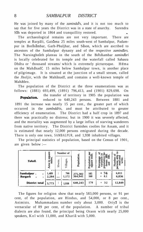
1891 the increase was nearly 15 per cent., the greater part of which occurred in the zamlndaris, and must be attributed to greater efficiency of enumeration. The District had a half crop in 1897 and there was practically no distress; but in 1900 it was severely affected, and the mortality was augmented by a large influx of starving wanderers from native territory. The District furnishes coolies for Assam, and it is estimated that nearly 12,000 persons emigrated during the decade. There is only one town, S A M B A L P U R , and 1,938 inhabited villages.
The principal statistics of population, based on the Census of 1901, are given below :—
Tahsll.
Are
a in
squ
are
mile
s.
Number of
Pop
ulat
ion.
Pop
ulat
ion
per
squa
re m
ile.
Perc
enta
ge
of
vari
atio
n in
po
pula
tion
be
twee
n 18
91
and
1901
.
Num
ber
of
pers
ons
able
to
read
an
d
wri
te.
Tahsll.
Are
a in
squ
are
mile
s.
low
ns.
Vill
ages
.
Pop
ulat
ion.
Pop
ulat
ion
per
squa
re m
ile.
Perc
enta
ge
of
vari
atio
n in
po
pula
tion
be
twee
n 18
91
and
1901
.
Num
ber
of
pers
ons
able
to
read
an
d
wri
te.
Sambalpur . Bargarh
District total
1,489 2,284
I 766 1,172
275,302 364,941
185 160
+ 7-6 + 0.1
6,013 6,836
Sambalpur . Bargarh
District total 3,773 I 1,938 640,243 170 + 3-2 12,849
The figures for religion show that nearly 583,000 persons, or 91 per cent, of the population, are Hindus, and 54,000, or 8 per cent., Animists. Muhammadans number only about 3,000. Oriya is the vernacular of 89 per cent, of the population. A number of tribal dialects are also found, the principal being Oraon with nearly 25,000 speakers, K o l with 11,000, and Kharia with 5,000.
POPULATION 9
The principal castes are Gonds (constituting 8 per cent, of the population), Koltas (n per cent.), Savaras (9 per cent.), Gahras or Ahirs fci per cent) , and Gandas (13 per cent.). Of the sixteen zamindari estates, ten are held by Raj Gonds; two, Rajpur and Barpali, by Chauhan Rajputs; one, Rampur, by another Rajput ; two, Borasambar and Ghens, by Binjhals ; and one, Bijepur, by a Kol ta . The Gond families are ancient; and their numbers seem to indicate that previous to the Oriya immigration they held possession of the country, subduing the Munda tribes who were probably there before them. A trace of the older domination of these is to be found in the fact that the Binjhal zamindar of Borasambar still affixes the tika to the Maharaja of Patna on his accession. Koltas are the great cultivating caste, and have the usual characteristics of frugality, industry, hunger for land, and readiness to resort to any degree of litigation rather than relinquish a supposed right to i t . They strongly appreciate the advantages of irrigation, and show considerable public spirit in constructing tanks which wi l l benefit the lands of their tenants as well as their own. The Savaras or Saonrs of Sambalpur, though a Dravidian tribe, live principally in the open country and have adopted H i n d u usages. They are considered the best farm-servants and are very laborious, but rarely acquire any property. Brahmans (28,000), though not very numerous, are distinctly the leading caste in the District. The Binjhals (39,000) are probably Hinduized Baigas, and live principally in the forest tracts. Kewats (38,000), or boatmen and fishermen, are a numerous caste. The Gandas (105,000), a Dravidian tribe now performing the menial duties of the village or engaging in cotton-weaving, have strong criminal propensities which have recently called for special measures of repression. About 78 per cent, of the population of the District are returned as dependent on agriculture. A noticeable feature of the rural life of Sambalpur is that the jhankar, or village priest, is a universal and recognized village servant of fairly high status. He is nearly always a member of one of the Dravidian tribes, and his business is to conduct the worship of the local deities of the soil, crops, forests, and hills. He generally has a substantial holding, rent free, containing some of the best land in the village. It is said locally that the jhdnkar is looked on as the founder of the village, and the representative of the old owners who were ousted by the Hindus. He worships on their behalf the indigenous deities, with whom he naturally possesses a more intimate acquaintance than the later immigrants; while the gods of these latter cannot be relied on to exercise a sufficient control over the works of nature in the foreign land to which they have been imported, or to ensure that the earth and the seasons wi l l regularly perform their necessary functions in producing sustenance for mankind.
10 SAMBALPUR DISTRICT
Christians number 722, including 575 natives, of whom the majority are Lutherans and Baptists. A station of the Baptist Mission is maintained at Sambalpur town.
The black soil which forms so marked a feature in the adjoining Central Provinces is almost unknown in Sambalpur. It occurs in
. the north-west of the District, beyond the cross range of Vindhyan sandstone whicji shuts off the
Ambabhona pargana, and across the Mahanadi towards the Bilaspur border. The soil which covers the greater part of the country is apparently derived from underlying crystalline rocks, and the differences found in it are due mainly to the elimination and transportation effected by surface drainage. The finer particles have been carried into the low-lying areas along drainage lines, rendering the soil there of a clayey texture, and leaving the uplands light and sandy. The land round Sambalpur town, and a strip running along the north bank of the Mahanadi to the confines of Bilaspur District, is the most productive, being fairly level, while the country over the greater part of the Bargarh tahsil has a very decided slope, and is much cut up by ravines and watercourses. Nearly all the rice is sown broadcast, only about 4 per cent, of the total area being transplanted. For thinning the crop and taking out weeds, the fields are ploughed up when the young plants are a few inches high, as in Chhattisgarh. A considerable proportion of the area under cultivation, consisting of high land which grows crops other than rice, is annually left fallow, as the soil is so poor that it requires periodical rests.
1 No less than 235 square miles are held revenue free or on low quit-rents, these grants being either for the maintenance of temples or gifts to Brahmans, or assignments for the support of relatives of the late ruling family. The zamindari estates cover 48 per cent, of the total area of the District, 109 acres are held ryotivari, and the balance on the tenures described below (p. 15). In 1903-4, 396 square miles, or 9 per cent, of the total area, were included in Government forests; 290 square miles, or 7 per cent., were classed as not available for cultivation; and 1,102 square miles, or 26 per cent., as cultivable waste other than fallow. The remaining area, amounting to about 2,443 square miles, or nearly 64 per cent, of that of the District, excluding Government forests, was occupied for cultivation. In the more level parts of the open country cultivation is close, but elsewhere there seems to be still some room for expansion. Rice is the staple crop of Sambalpur, covering 1,355 square miles in 1903-4. Other crops are
1 The figures in this paragraph refer to the area of the District as it stood before the transfer of Phuljhar, Chandarpur, and Malkhurda, revised statistics of cultivation not being available.
AGRICULTURE 11
til or sesamum (158 square miles), the pulse urad (145), and kodon (94). Nearly 12,000 acres are under cotton and 4,400 under sugar-
cane. The pulses are raised on the inferior high-lying land without manure, the out-turn in consequence being usually very small. The pulse kulthi (Dolichos uniflorus) covers 56 square miles. Cotton and til are also grown on this inferior land. Sugar-cane was formerly a crop of some importance; but its cultivation has decreased in recent years, owing to the local product being unable to compete in price with that imported from Northern India.
The harvests have usually been favourable in recent years, and the cropped area steadily expanded up to 1899, when the famine of 1900 caused a temporary decline. New tanks have also been constructed for irrigation, and manure is now utilized to a larger extent. During the decade ending 1904, a total of Rs. 77,000 was advanced under the Land Improvement Loans Act, and Rs. 68,000 under the Agriculturists' Loans Act.
In 1903-4 the irrigated area was only 31 square miles, but in the previous year it had been over 196, being the maximum recorded. W i t h the exception of 12 square miles under sugar-cane and garden produce, the only crop irrigated is rice. The suitability of the District for tank-making has already been mentioned, and it is not too much to say that the very existence of villages over a large portion of the area is dependent on the tanks which have been constructed near them. There are 9,500 irrigation tanks, or between three and four to every village in the District on an average. The ordinary Sambalpur tank is constructed by throwing a strong embankment across a drainage line, so as to hold up an irregularly shaped sheet of water. Below the embankment a four-sided tank is excavated, which constitutes the drinking supply of the village. Irrigation is generally effected by leading channels from the ends of the embankment, but in years of short rainfall the centre of the tank is sometimes cut through. Embankments of small size are frequently thrown across drainage channels by tenants for the benefit of their individual holdings. The Jambor and Sarsutia nullahs near Machida are perennial streams, and the water is diverted from them by temporary dams and carried into the fields. In certain tracts near the Mahanadi, where water is very close to the surface, temporary wells are also sometimes constructed for the i r r i gation of rice. Irrigation from permanent wells is insignificant. Several projects for new tanks have been prepared by the Irrigation department.
The cattle of the District are miserably poor, and no care is exercised in breeding. As the soil is light and sandy, however, strong cattle are not so requisite here as elsewhere. For draught purposes larger animals are imported from Berar. Buffaloes are largely used for cultivation. They are not as a rule bred locally, but imported from the northern
VOL. x x i i . u

12 SAMBALPUR DISTRICT
Districts through Bilaspur and Surguja. Those reared in the District are distinctly inferior. Buffaloes are frequently also used for draught, and for pressing oi l and sugar-cane. Only a few small ponies are bredr in the District for riding. Goats and sheep are kept by the lower castes for food only. Their manure is also sometimes used, but does not command a price. There are no professional shepherds, and no use is made of the wool of sheep.
The area of 'reserved' forest is 396 square miles. It is situated on the Barapahar hills in the north of the Bargarh tahsil, and on the
ranges in the west and south-west of the Sambalpur tahsll. There are two types of forest, the first con
sisting of the sal tree interspersed with bamboos and other trees, and the second or mixed forest of bamboos and inferior species. Sal forest occupies all the hills and valleys of the Sambalpur range, and the principal valleys of the Barapahar range, or an area of about 238 square miles. It thrives best on well-drained slopes of sandy loam. The mixed forest is situated on the rocky dry hills of the Barapahar range, where sal wi l l not grow, and covers 155 square miles. The revenue in 1903-4 was Rs. 34,000, of which about Rs. 12,000 was realized from the sale of bamboos, Rs. 10,000 from timber, Rs. 3,600 from grazing dues, and Rs. 5,000 from firewood.
The Rampur coal-field is situated within the District. Recent exploration has resulted in the discovery of one seam of good steam
coal and two of rather inferior quality within easy reach of the Bengal-Nagpur Railway. The former,
known as the lb Bridge seam, contains coal more than 7 feet in thickness. Two samples which have been analysed yielded 52 and 55 per cent, respectively of fixed carbon. I ron ores occur in most of the hil ly country on the borders of the District, particularly in the Borasambar, Phuljhar1 , Kolabira, and Rampur zamindaris. Some of them are of good quality, but they are worked by indigenous methods only. There are 160 native furnaces, which produce about 1,120 cwt. of iron annually. When Sambalpur was under native rule diamonds were obtained in the island of Hi rakud ( ' diamond island') in the Mahanadl. T h e Jharias or diamond-seekers were rewarded with grants of land in exchange for the stones found by them. The right to exploit the diamonds, which are of very poor quality, was leased by the British Government for Rs. 200, but the lessee subsequently relinquished it . Gold in minute quantities is obtained by sand-washing in the lb river. Lead ores have been found in Talpatia, Jhunan, and Padampur2, and antimony in Junani opposite Hirakud. Mica exists, but the plates are too small to be of any commercial value.
1 Now in Raipur District, Central Province. 2 Now in Bilaspur District, Central Provinces.-
TRADE AND COMMUNICATIONS
Tavar silk-weaving is an important industry in Sambalpur. The cocoons are at present not cultivated locally, but are imported from Gfrota Nagpur and the adjoining States. Plain and dril led cloth is woven. Remenda, Barpali, Chan-darpur1, and Sambalpur are the principal centres. A l i t t le cloth is sent to Ganjam, but the greater part is sold locally. Cloths of cotton with silk borders, or intermixed with silk, are also largely woven. Bhulias and Koshtas are the castes engaged, the former weaving only the prepared thread, but the latter also spinning it . Cotton cloth of a coarse texture, but of considerable taste in colour and variety of pattern, is also woven in large quantities, imported thread being used almost exclusively. It is generally worn by people of the District in preference to mill-woven cloth. A large bell-metal industry exists at Tukra near Kadobahal, and a number of artisans are also found at Remenda, Barpali, and Bijepur. Brass cooking and water pots are usually imported from Orissa. The iron obtained locally is used for the manufacture of all agricultural implements except cart-wheel tires. Smaller industries include the manufacture of metal beads, saddles, and drums.
Rice is the staple export of Sambalpur, being sent principally to Calcutta, but also to Bombay and Berar. Other exports include oi lseeds, sleepers, dried meat, and .ww-hemp. Salt comes principally from Ganjam, and is now brought by rail instead of river as formerly. Sugar is obtained from Mirzapur and the Mauritius, and gur or unrefined sugar from Bengal. Kerosene o i l is brought from Calcutta, and cotton cloth and yarn from Calcutta and the Nagpur mills. Silk is imported from Berhampur. Wheat, gram, and the pulse arhar are also imported* as they are not grown locally in sufficient quantities to meet the demand. The weekly markets at Sambalpur and Bargarh are the most important in the District. Bhukta, near Ambabhona, is the largest cattle fair; and after it rank those of Bargarh, Saraipali, and Talpatia. Jamurla is a large mart for oilseeds ; Dhama is a timber market ; and Bhlkhampur and Talpatia are centres for the sale of country iron implements. A certain amount of trade in grain and household utensils is transacted at the annual fairs of Narsinghnath and Huma.
The main line of the Bengal-Nagpur Railway passes for a short distance through the north-east of the District, wi th a length of nearly 30 miles and three stations. From Jharsugra junction a branch line runs to Sambalpur town, 30 miles distant, with three intervening stations. The most important trade route is the Raipur-Sambalpur road, which passes through the centre of the Bargarh tahsil Next to this come the Cuttack road down to Sonpur, and the Sambalpur-
1 Now in Bilaspur District, Central Province*. B 2
Trade and communications.
14 SAMBALPUR DISTRICT
Bilaspur road. None of these is metalled throughout, but the Raipur-Sambalpur road is embanked and gravelled. The District has 2 7 miles of metalled and 185 of unmetalled roads, and the expenditure on maintenance is Rs. 24,000. The Public Works department is in charge of 115 miles and the District council of 97 miles of road. There are avenues on 68 miles. The Mahanadi river was formerly the great outlet for the District trade. Boat transport is stilly carried on as far as Sonpur, but since the opening of the railway trade wi th Cuttack by this route has almost entirely ceased. Boats can ascend the Mahanadi as far as Arang in Raipur, but this route is also little used owing to the dangerous character of the navigation.
Sambalpur is recorded as having suffered from partial failures of crops in 1834, 1845, 1874) and 1877-8, but there was nothing more than
slight distress in any of those years. In 1896 the rice crop failed over a small part of the District, prin
cipally in the Chandarpur zaminddri, and some relief was administered here. The numbers, however, never rose to 3,000, while in the rest of the District agriculturists made large profits from the high prices prevailing for rice. The year 1900 was the first in which there is any record of serious famine. Owing to the short rainfall in 1899, a complete failure of the rice crop occurred over large tracts of the District, principally in the north and west. Relief operations extended over a whole year, the highest number relieved being 93,000 in August, 1900, or 12 per cent, of the population; and the total expenditure was 8 lakhs.
The Deputy-Commissioner has a staff of three Assistant or Deputy-Collectors, and a Sub-Deputy-Collector. For administrative purposes
the District is divided into two tahsils, Sambalpur and Bargarh, each having a tahsildar and Bargarh
also a nail)-tahsildar. The Forest officer is generally a member of the Provincial service.
The civil judicial staff consists of a District and two Subordinate Judges and a Munsif at each tahslL Sambalpur is included in the Sessions Division of Cuttack. The civil litigation has greatly increased in recent years, and is now very heavy. Transactions attempting to evade the restrictions of the Central Provinces Tenancy Act on the transfer of immovable property are a common feature of litigation, as also are easement suits for water. The crime of the District is not usually heavy, but the recent famine produced an organized outbreak of dacoity and house-breaking.
Under native rule the village headmen, or gaontids^ were responsible for the payment of a lump sum assessed on the village for a period of years, according to a lease which was periodically revised and re newed. The amount of the assessment was recovered from the
Famine.
Administration.
ADMINISTRATION 15
cultivators, and the headmen were remunerated by holding part of the village area free of revenue. The headmen were occasionally ejected far default in the payment of revenue, and the grant of a new lease was often made an opportunity for imposing a fine which the gaontid paid in great part from his own profits, and d id not recover from the cultivators. The cultivators were seldom ejected except for default in the payment of revenue, but they rendered to their gaontids a variety of miscellaneous services known as bhetl bigari. Taxation under native rule appears to have been light. When the District escheated to the British Government, the total land revenue of the khdlsa area was about a lakh of rupees, nearly a quarter of which was alienated. Short-term settlements were made in the years succeeding the annexation, t i l l on the transfer of the District to the Central Provinces in 1862 a proclamation was issued stating that a regular long-term settlement would be made, at which the gaontids or hereditary managers and rent-collectors of villages would receive proprietary rights. The protracted disturbances caused by the adherents of Surendra Sah, however, prevented any real progress being made with the survey ; and this gave time for the expression of an opinion by the local officers that the system of settlement followed in other Districts was not suited to the circumstances of Sambalpur. After considerable discussion, the incidents of land tenures were considerably modified in 1872. The gaontids or hereditary managers received proprietary rights only in their bhogra or home-farm land, which was granted to them free of revenue in lieu of any share or drawback on the rental paid by tenants. Waste lands and forests remained the property of Government; but the gaontias enjoy the rental on lands newly broken up during the currency of settlement. A sufficiency of forest land to meet the necessities of the villagers was allotted for their use, and in cases where the area was in excess of this it was demarcated and set apart as a fuel and fodder reserve. Occupancy right was conferred on all tenants except sub-tenants of bhogra. The system was intended to restrict the power of alienation of land, the grant of which had led to the expropriation of the agricultural by the money-lending castes, and the same policy has recently received expression in the Central Provinces Tenancy Act of 1898. A settlement was made for twelve years in 1876, by which the revenue demand was raised to 1-16 lakhs, the net revenue, excluding assignments, being Rs. 93,000. On the expiry of this settlement, the District was again settled between 1885 and 1889, and the assessment was raised to 1.59 lakhs, or by 38 per cent. The revenue incidence per acre was stil l extremely low, falling at only R. 0-3-11 (maximum R. 0-8-10, minimum R. 0-2) excluding the zamtndaris. The term of this settlement varied from fourteen to fifteen years. It expired in 1902 and the District is again under settlement.
16 SAMBALPUR DISTRICT
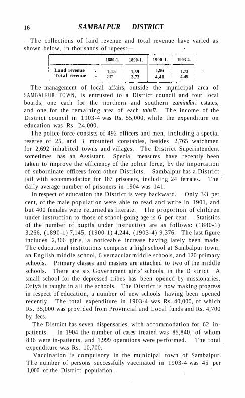
The collections of land revenue and total revenue have varied as shown below, in thousands of rupees:—
1880-1. 1890-1. 1900-1. 1903-4.
Land revenue Total revenue
1,15 2,57
1,59 3,73
1,96 4,41
1.73 4.49
The management of local affairs, outside the municipal area of S A M B A L P U R T O W N , is entrusted to a District council and four local boards, one each for the northern and southern zamindari estates, and one for the remaining area of each tahsiL The income of the District council in 1903-4 was Rs. 55,000, while the expenditure on education was Rs. 24,000.
The police force consists of 492 officers and men, including a special reserve of 25, and 3 mounted constables, besides 2,765 watchmen for 2,692 inhabited towns and villages. The District Superintendent sometimes has an Assistant. Special measures have recently been taken to improve the efficiency of the police force, by the importation of subordinate officers from other Districts. Sambalpur has a District j a i l with accommodation for 187 prisoners, including 24 females. The ' daily average number of prisoners in 1904 was 141.
In respect of education the District is very backward. Only 3-3 per cent, of the male population were able to read and write in 1901, and but 400 females were returned as literate. The proportion of children under instruction to those of school-going age is 6 per cent. Statistics of the number of pupils under instruction are as follows: (1880-1) 3,266, (1890-1) 7,145, (1900-1) 4,244, (1903-4) 9,376. The last figure includes 2,366 girls, a noticeable increase having lately been made. The educational institutions comprise a high school at Sambalpur town, an English middle school, 6 vernacular middle schools, and 120 primary schools. Primary classes and masters are attached to two of the middle schools. There are six Government girls' schools in the Dis t r i c t A small school for the depressed tribes has been opened by missionaries. Oriya is taught in all the schools. The District is now making progress in respect of education, a number of new schools having been opened recently. The total expenditure in 1903-4 was Rs. 40,000, of which Rs. 35,000 was provided from Provincial and Local funds and Rs. 4,700 by fees.
The District has seven dispensaries, with accommodation for 62 inpatients. In 1904 the number of cases treated was 85,840, of whom 836 were in-patients, and 1,999 operations were performed. The total expenditure was Rs. 10,700.
Vaccination is compulsory in the municipal town of Sambalpur. The number of persons successfully vaccinated in 1903-4 was 45 per 1,000 of the District population.
SAMBALPUR TOWN 17 [J , B. Fuller, Settlement Report (1891). A District Gazetteer is being
compiled.] ^ Sambalpur Tahsfl.—Eastern tahstl of the District of the same name, Bengal, lying between 21 0 8' and 2 1 0 57' N. and 8? 26' and 840 26' E., wi th an area, in 1901, of 1,822 square miles. 1 he population in that year was 362,622, compared with 344,391 in 1891. In 1905 the Chandar-pur-Padampur and Malkhurda estates, wi th an area of 333 square miles and a population of 87,320, were transferred to the Bilaspur District of the Central Provinces, and the revised figures of area and populat ion of the tahsll are 1,489 square miles and 275,302 persons. The density is 185 persons per square mile. The tahsll contains one town, S A M B A L P U R (population, 12,870), the District and tahstl head-quarters; and 766 inhabited villages. Excluding 190 square miles of Government forest, 56 per cent, of the available area is occupied for cultivation. If the zammddri estates be also excluded, the percentage is 68. The cultivated area in 1903-4 was 851 square miles. The demand for land revenue in the same year was Rs. 68,000, and for cesses Rs. 14,000. The tahsll consists of a strip of open country along the left bank of the Mahanadi river, flanked to the east and south by hills. It contains seven zamin-dart estates, with a total area of 614 square miles.
S a m b a l p u r Town.—Head-quarters of the District of the same name, Bengal, situated in 21 0 28' N. and 830 58' E. It is the terminus of a branch line of the Bengal-Nagpur Railway, 30 miles from Jharsugra junction, and 349 from Calcutta. The town lies along the left bank of the Mahanadi, and is very picturesquely situated, commanding a beautiful view of the river for several miles, with wooded hills in the background. In flood-time the width of the Mahanadi is more than a mile, and portions of the town have been submerged on one or two occasions, but during most of the year there is only a stream 40 or 50 yards wide. During the open season a pontoon bridge over the Mahanadi is maintained by the Bengal-Nagpur Railway, giving place to a ferry in the monsoon months. The population in 1901 was 12,870, and has risen by more than 30 per cent, since 1891. The town derives its name from the Somlai Devi, its tutelary deity. There are no buildings of importance; but the Brahmapura temple of Jagannath has a great reputation for sanctity, and many civil suits are decided by the oaths of parties taken at this shrine. Sambalpur was constituted a municipality in 1867. The municipal receipts and expenditure during the decade ending 1901 averaged Rs. 28,000 and Rs. 29,000 respectively. In 1903-4 the income had risen to Rs. 48,000, mainly derived from octroi. A wing of a native infantry regiment was stationed here unt i l 1902. Sambalpur is the commercial centre for most of the District, and also the States of Sonpur, Patna, and Rairakhol. It contains a depot for cooly emigrants to Assam.
18 SAMBALPUR TOWN
The principal industries are the weaving of tasar silk and cotton cloth by hand. A printing press with Oriya and English type was established in 1902, to celebrate the restoration of Oriya as the court language 0/ Sambalpur. The town possesses a high school with a boarding-house and 33 pupils, a girls' school, and Oriya and Hindi branch schools. It also has a main dispensary and a police hospital.
Sambhal Tahsil.—South-central tahsil of Moradabad District, United Provinces, conterminous with the pargana of the same name, lying between 280 20' and 280 49' N. and 780 24' and 780 44' E., with an area of 469 square miles. Population increased from 245,619 in 1891 to 245,886 in 1901. There are 466 villages and three towns: SAMBHAL (population, 39,715), the tahsil head-quarters, SOLAH SARAI (10,623), and SIRS! (5,894). The demand for land revenue in 1903-4 was Rs. 3,55,000, and for cesses Rs. 61,000. The density of population, 524 persons per square mile, is about the District average. In the east of the tahsil the soil is sandy, and agriculture is precarious; but the rest consists of fertile loam, including some of the best villages in the District. The Sot or Yar-i-Wafadar drains the central portion, and smaller channels cross the south. Wheat and sugar-cane are the most important crops. In 1902-3 the area under cultivation was 399 square miles, of which 25 were irrigated, mostly from wells.
Sambhal Town.—Head-quarters of the tahsil of the same name in Moradabad District, United Provinces, situated in 280 35' N. and 78° 34' E., 23 miles south-west of Moradabad city by a metalled road. Population (1901), 39,715. The town is believed by the Hindus to have existed in the three epochs {yuga) preceding the present or Kali Yuga, at the end of which the tenth incarnation of Vishnu will appear in Sambhal. Many ancient mounds exist in the neighbourhood, but have not been explored. Tradition relates that Prithwi Raj of Delhi finally defeated Jai Chand of Kanauj close to Sambhal, and an earlier battle is said to have taken place between the Raja of Delhi and Saiyid Salar. Kutb-ud-dln Aibak reduced the neighbourhood for a time; but the turbulent Katehriyas repeatedly engaged the attention of the early Muhammadan kings, who posted a governor here. In 1346 the governor revolted, but was speedily crushed. Firoz Shah I I I appointed an Afghan to Sambhal in 1380, with orders to invade Katehr every year and ravage the whole country ti l l Khargu, the Hindu chief, who had murdered some Saiyids, was given up. In the fifteenth century Sambhal was the subject of contest between the sovereigns of Delhi and the kings of Jaunpur, and on the fall of the latter Sikandar Lodi held his court here for some years. Babar appointed his son, Humayun, to be governor of the place, and is said to have visited it himself. Under Akbar Sambhal was the head-quarters of a sarhdr, but in the reign of Shah Jahan its importance began to wane and
SAMBHAR LAKE 19
Moradabad took its place. In the eighteenth century Sambhal was chiefly celebrated as the birthplace of the Pindari, A m i r Khan, who rajded Rohilkhand in 1805 and afterwards founded the State of T O N K .
The town site is scattered over a considerable area, and contains a mound marking the ruins of the old fort. No building stands on this except a mosque, claimed by the Hindus as a Vaishnava temple, but in reality a specimen of early Pathan architecture in which H i n d u materials were probably used. The mosque contains an inscription recording that it was raised by Babar; but doubts have been cast on the authenticity of this. There are many H i n d u temples and sacred spots in the neighbourhood. The town contains a tahslliy
a munst/i, a dispensary, and a branch of the American Methodist Mission. It has been a municipality since 1871. Dur ing the ten years ending 1901 the income and expenditure averaged Rs. 21,000. In 1903-4 the income was Rs. 30,000, chiefly from octroi (Rs. 23,000); and the expenditure was Rs. 29,000. Refined sugar is the chief article of manufacture and of trade, but other places nearer the railway have drawn away part of its former commerce. Wheat and other grain and ghl are also exported, and there is some trade in hides. Combs of buffalo horn are manufactured. The tahslli school has 142 pupils, and the municipality manages two schools and aids seven others with 349 pupils.
S a m b h a r L a k e . — A famous salt lake in Rajputana, on the borders of the Jodhpur and Jaipur States, lying between 2 6° 53' and 270 i ' N. and 740 54 ' and 750 14' E., and distant, by railway, 53 miles north-east of Ajmer, and 230 miles south-west of Delhi . The lake is situated nearly 1,200 feet above sea-level, and when full is about 20 miles in length (from south-east to north-west), from 2 to 7 miles in breadth, and covers an area of about 90 square miles. In the hot months its bed is generally quite dry, but, after exceptionally heavy rains, it contains water throughout the year. It is dependent for its supply on three rivers which empty themselves into i t ; of these, two come from the spurs of the Aravalli Hi l l s to the west, and the third from the country to the north. The annual rainfall at the town of Sambhar averages nearly 20 inches, and at Nawa about 17 inches. The surrounding country is sandy and sterile, but the view of the lake in the hot season is very striking. Standing on the low sandy ridges to the south, one sees what looks like a great sheet of glittering snow, with sometimes a pool of water here and there, and a network of narrow paths; but what appears to be frozen snow is a white crisp efflorescence of salt. According to local tradition, the goddess Sakambari (the consort of Siva), in return for some service done her, converted a dense forest into a plain of silver, and subsequently, at the request of the inhabitants, who dreaded the cupidity and strife
20 SAMBHAR LAKE
which such a possession would excite, transformed it into the present salt lake, which was named Sambhar (a corruption of Sakambar) after her. This is supposed to have happened in the sixth century. To determine the origin of the salt, a special investigation has recently been conducted by the Geological Survey of India. Borings made in the lake-bed at three places show that the thickness of the silt varies from 61 feet at the eastern end to 70 feet near the centre and 76 feet at the north-western end, and that the rocks below this silt are, in each case, schists of the kind cropping up around the edges of the lake, and forming the hills belonging to the Aravalli series in the neighbourhood. It is therefore considered that the salt resources of Sambhar are confined to this body of silt filling in a depression of the Aravalli schists and gneisses, and that the soluble compounds of sodium stored in the silt have accumulated by the evaporation of the water brought in every year by the rivers which are in flood after heavy rains. The concentration of common salt and of the other less abundant sodium-compounds associated with it has been effected in a manner common to areas of internal closed drainage in all arid regions. There is nothing to show a past inroad of the ocean, and no rock-salt beds exist in the geological formation of the area.
The Sambhar Lake is said to have been worked by the imperial administration of Akbar and his successors up to the time of Ahmad Shah (1748-54), when it came into the hands of its present owners, the chiefs of Jodhpur and Jaipur. The western half belongs entirely to the former, and the eastern half, including the town of Sambhar, is owned by the two States jointly. The lake is said to have passed for a time into the possession of the Marathas and Amir Khan, while from about 1835 to 1843 the British Government, in order to repay itself a portion of the expenses incurred in restoring order in Shekhawati and the neighbouring districts, took the salt-making into its own hands. Finally in 1870 the lake was leased to Government for an annual payment of 7 lakhs—4¼ lakhs to Jodhpur and 2¾ lakhs to Jaipur—on the condition that, if the sales of salt exceeded 1,725,000 maunds (about 63,400 tons) in any year, 40 per cent, of the sale price of such excess would be paid to the States as royalty. Under arrangements made in 1884, Jodhpur receives five-eighths and Jaipur three-eighths of the total royalty payable. These States also receive a certain quantity (Jodhpur 14,000 maunds and Jaipur 7,000 maunds) of salt free of all charges yearly. Including about 74,000 tons taken over when the lease was executed, the quantity of salt manufactured to the end of March, 1904, exceeded 4,300,000 tons, or a yearly average of about 126,600 tons. The quantity disposed of during the same period, including that delivered free of cost under treaty arrangements, wastage, & c , was about 4,240,000 tons. The receipts from sale of
SAMEHAR TOWN 2T
salt have been 326 lakhs, and the expenditure, including all treaty and royalty payments, 294 lakhs, leaving a credit balance on April 1, 1904, of 32 lakhs, or a little over £212,000. The average cost of extraction and storage has been rather more than 7 pies (or one halfpenny) per maund, or about one rupee per ton. Duty was first levied at the lake on October 1, 1878, when the customs line was abolished. Between April 1, 1879, and March 31, 1904, the gross receipts from all sources have been 2452 lakhs and the total expenditure 261 lakhs, leaving a surplus of 2191 lakhs (over i^\ million pounds sterling). The average yearly net receipts have thus been nearly 88 lakhs, or about £584,340.
Salt is obtained by three methods: namely, from permanent saltworks constructed in the bed of the lake, called kydrs; from shallow solar evaporation pans of a temporary nature constructed on the lake-shore ; and from enclosed sections of the bed on which salt forms, so to speak, spontaneously. In 1903-4 (when only about one-fourth of the usual quantity of salt was manufactured) 24,000 labourers of both sexes were employed on the extraction and storage of kyar salt and the storage of pan salt, and the average daily earnings were about 5½ annas per head. The castes employed are Balais, Barars, Gujars, Jats, Kasais (butchers), Khatiks, Kumhars, Malis, Mughals, Pathans, and Regars; and nearly all permanently reside in the neighbourhood. There are three railway stations on the lake—at Sambhar, Gudha, and Kuchawan Road or Nawa—and the line runs into all the principal manufacturing works or walled enclosures. The salt is stored close to the line and loaded direct into the railway wagons; it is largely consumed in Raj-putana, Central India, the United Provinces, and in the Punjab south of Karnal, and it also finds its way into the Central Provinces and Nepal. The lake has been observed to furnish diminished quantities of salt during the last few years; but samples of mud, taken at depths of from 4 to 12 feet below the surface, have recently been found on analysis to contain 6 per cent, of salt, and from this fact it is estimated that, in the upper 12 feet of the lake-silt, the accumulated salt amounts to just one million tons per square mile. As the total quantity removed by artificial means since the commencement of the British lease in 1870 has been only about four million tons, the system of manufacture has resulted in but a small inroad into the total stocks. *
[F. Ashton, 'Salt Industry of Rajputana' in the Journal of Indian Art and Industry, vol. ix.]
Sambhar Town.—Town within the joint jurisdiction of the States of Jodhpur and Jaipur, in Rajputana, situated in 260 55' N. and 750 11' E., at the south-eastern extremity of the SAMBHAR L A K E on the Rajputana-Malwa" Railway. Population (1901), 10,873. In
22 SAMBHAR TOWN
the town are a post and telegraph office, several schools, including one for girls kept up by the United Free Church of Scotland Mission, and a couple of hospitals, one of which is maintained by the British Government for the benefit of those employed on the salt lake. Slm-bhar is a very ancient town. It was the first capital of the Chauhan Rajputs when they came to Rajputana from the Ganges about the middle of the eighth century; and the last Hindu king of Delhi, Prithwi Raj Chauhan, who died in 1192, was proud to be styled Sambhari Rao or lord of Sambhar. It appears to have been held by the Muhammadan kings and emperors of Delhi from the beginning of the thirteenth century ti l l about 1708, when it was taken, with the sixty villages attached to it, by the chiefs of Jodhpur and Jaipur. Subsequently first one State and then the other, taking advantage of any temporary weakness in its neighbour, appropriated the outlying villages ti l l only twelve, besides the town of Sambhar, remained in joint possession.
Sambhuganj.— Village in the head-quarters subdivision of Mymen-singh District, Eastern Bengal and Assam, situated in 240 46' N. and 900 27' E., 3 miles east of Naslrabad. Population (1901), 500. It is one of the busiest marts in the District for country produce of all kinds, exporting large quantities of jute, and also of rice and mustard seed.
Sameswari.—River in the Garo Hills, Eastern Bengal and Assam. See SOMESWARI.
Samka (Burmese, Saga).—State in the central division of the Southern Shan States, Burma, lying between 190 56' and 200 25' N. and 960 48' and 970 10' E., with an area (including the small dependency of Pongmu on the north) of 357 square miles. It is bounded on the north by Yawnghwe; on the east by Hsahtung; on the south by Namtok and Sakoi; and on the west by Loilong. Samka consists of a strip of the Pilu valley, 30 miles long, shut in by high ranges on either side, the higher slopes of which belong to the adjoining States. Rice is grown both in the valleys and in taungyas on the hills, and garden crops and ground-nuts are extensively cultivated. The population in 1901 was 17,643, distributed in 241 villages. Classified according to language, 7,698 of the inhabitants were Shans, 5,187 Taungthus, and 4,385 Inthas. A l l but 350 persons were returned as Buddhists. The head-quarters of the Myoza are at Samka (population, 1,899), in the centre of the State on the bank of the Pilu. The revenue in 1903-4 amounted to Rs. 17,000, the main source being thathameda\ and the expenditure included Rs. 10,000 tribute to the British Government, Rs. 4,300 allotted to the privy purse, Rs. 1,500 spent on public works, and Rs. 1,600 on the pay of officials.
Samla.—Petty State in KATHIAWAR, Bombay.
SAMTHAR STATE 23
Sampgaon.—South-eastern taluka of Belgaum District, Bombay lying between 150 28' and 150 59' N. and 740 38 ' and 740 59' E., wjith an area of 409 square miles. It contains 123 villages, including H O N G A L (population, 8,675). The head-quarters are at Sampgaon, a small village. The population in 1901 was 132,448, compared with 132,632 in 1891. The density, 324 persons per square mile, is above the District average. The demand for land revenue in 1903-4 was 3 lakhs, and for cesses Rs. 21,000. Sampgaon has a great variety of soil and surface. From the hil ly west the country gradually sinks eastwards into a great plain of black cotton soil. In the south-west, ranges of quartz and ironstone, about 150 feet high and a quarter to half a mile apart, run nearly north and south. The Malprabha river crosses the middle of the taluka from west to east. Sampgaon lies in the transition tract between the hills and plains, and enjoys a fair immunity from famine. A portion is also protected by a supply of water from the Gadekeri tank. The annual rainfall averages about 30 inches.
S a m p l a Tahsi l .—Tahsl l of Rohtak District, Punjab, lying between 280 35' and 290 1' N. and 760 35' and 760 58 ' E., with an area of 409 square miles. The population in 1901 was 162,423, compared with 149,818 in 1891. I t contains the towns of B A H A D U R G A R H (population, 5,974) and Kharkhauda (3,765); and 122 villages, including the ' notified area' of Sampla, its head-quarters. The land revenue and cesses in 1903-4 amounted to 3-1 lakhs. The greater part of the tahsll is an arid upland plain, the northern portion of which is now watered by the Western Jumna Canal. In the extreme south-east is a small lowland tract, irrigated by countless water-lifts.
S a m r a l a T a h s i l . — Tahsll of Ludhiana District, Punjab, lying on the south bank of the Sutlej, between 300 37 ' and 300 59' N. and 760 2' and 760 24' E. , with an area of 291 square miles. The population in 1901 was 154,995, compared with 158,770 in 1891. It contains the two towns of K H A N N A (population, 3,838) and M A C H H I W A R A (5>588); and 263 villages, of which Samrala is the head-quarters. The land revenue and cesses in 1903-4 amounted to 3*5 lakhs.
S a m t h a r State.—Treaty State in Central India, under the Bundel-khand Political Agency, lying between 250 43 ' and 250 57' N. and 780 4 8 ' a n d 790 7' E., with an area of about 178 square miles. The name is most probably a corruption of Shamshergarh, by which the capital is still known. It is bounded on the north and east by the Jalaun District of the Uni ted Provinces; on the south by Jhansi Dis t r ic t ; and on the west by the Bhander pargana of the Gwalior State and by Jhansi District. The territory consists of an almost unbroken level plain, sparsely covered with trees. The soil is only moderately fertile, and, though traversed by the Pahuj and Betwa, both large streams, is entirely dependent on the rainfall for its pro
24 SAM THAR STATE
ductivity. Geologically, the State consists of Bundelkhand gneiss and allied rocks, in great part concealed by alluvium. The climate is generally temperate, though hotter than that of Malwa. The rainfajl, as shown by a ten years' record, averages 30 inches.
On the death of Maharaja Ram Chandra of D A T I A in 1733, a dispute arose regarding the succession to that State. In his contest with rival claimants Indrajit, who succeeded, had been assisted by various petty chiefs, among whom was Naune Sah Gujar, a son of a man in the service of the Datia State. On his accession to power Indrajit rewarded Naune Sah's son, Madan ,Singh, with the title of Rajdhar and the governorship of Samthar fort, a Jagir of five villages being later on granted to his son Devi Singh. The latter was succeeded by his son Ranjit Singh. During the disturbances caused by the Maratha invasion, Ranjit Singh became independent and received the title of Raja from the Marathas. On the establishment of the British supremacy he requested to be taken under protection, and a treaty was concluded in 1817, confirming him in; possession of the territory he then held. In 1827 Ranjit Singh died and was succeeded by his son Hindupat, who, however, became of unsound mind, the administration being entrusted to his Rani. In 1862 an adoption sanad was granted to the chief, the obligation to pay succession dues being remitted (1877) in the case of a direct successor. In 1864 the eldest son Chhatar Singh asserted his claim to rule the State, which was recognized by Government, the pargana of Amargarh (Amra) being assigned for the maintenance of the ex-chief, his Rani, and a younger son, Arjun Singh (alias Ali Bahadur). In 1883 this arrangement was changed, a cash allowance being given in lieu of the pargana. Hindupat died in 1890; and Government, in consideration of the length of time Chhatar Singh had been actual ruler, decided that no formal recognition of his succession was needed. Chhatar Singh was a good administrator and improved the condition of the State considerably. During his rule a salt convention was made with the British Government (1879), by which the State received Rs. 1,450 as compensation for dues formerly levied; and land was ceded for the Betwa Canal (1882) and for a railway (1884), In 1877 Chhatar Singh received the title of Maharaja as a personal distinction. He died in 1896, and was succeeded by his son Blr Singh Deo, the present ruler, who received the title of Maharaja as a personal distinction in 1898. The chief bears the hereditary titles of His Highness and Raja, and receives a salute of 11 guns.
The population of the State has been: (1881) 38,633, (1891) 40,541, and (1901) 33,472. It decreased by 17 per cent, during the last decade, owing to famine. Hindus number 31,211, or 93 per cent., and Musalmans 2,229, or 7 Per cent- The density in 1901 was 188 persons per square mile, The principal. castes are Chamars, 4,300
SAMTHAR STATE 25
or 13 per cent.; Brahmans, 3,800, or 11 per cent.; Lodhis, 3,000, or 9 per cent.; Kachhis and Gujars, 2,000 each, or 7 per cent.; Gadarias, 1,700, or 5 per cent. The State contains 90 villages and one town, SAMTHAR (population, 8,286), the capital. For a Hindu State in this part of India the percentage of Musalmans is unusually high. The Muhammadan element also takes a considerable part in the administration. The prevailing form of speech is Bundelkhandi. About 33 per cent, of the population are supported by agriculture and 17 per cent, by general labour.
The soil is for the most part poor, and the country is singularly devoid of tanks, which are fairly common in the rest of Bundelkhand. The principal soils are mar, an inferior black soil; kd&ar, a grey soil; parua, a yellowish red soil, which is the most prevalent; and rankar, a stony soil, strewn with boulders of gneiss, and of very little agricultural value. Of the total area, 85 square miles, or 42 per cent, are cultivated, of which only 519 acres are irrigable; 49 square miles, or 25 per cent., are cultivable but not cultivated; and the rest is jungle and waste. Of the cropped area, jowar occupies 30 square miles, or
"35 per cent.; wheat, 20 square miles, or 23 per cent.; gram, 19 square miles, or 22 per cent.; and cotton, 5 square miles.
The only metalled road in the State is 8 miles in length, and leads to Moth, on the Great Indian Peninsula Railway. The opening of the railway in 1888 has greatly facilitated the export of grain, for which there was formerly no market. Saltpetre is exported in some quantity, mainly to Bhopal.
The administration is carried on by the chief, assisted by his wazlr (minister). The State is divided into four parganas, with head-quarters at Shamshergarh, Amargarh, Maharajganj, and Lohargarh, each under a tahsilddr. In all general administrative matters the wazlr has full powers. The chief exercises plenary criminal jurisdiction, and is the final court of reference in other matters.
The revenues of the State, before its territories were reduced by the Marathas, are said to have amounted to 12 lakhs. The annual receipts are now 1-5 lakhs, mostly derived from land. The expenditure is about the same.
A regular settlement was made in 1895 by Maharaja Chhatar Singh, under which the land is farmed out and the revenue collected in cash from the patta (lease) holders, in two instalments. The incidence of the land revenue demand is Rs. 5 per acre of the cultivated area. No land is alienated in jagirs. Until Maharaja Chhatar Singh's time, when the British rupee was made legal tender, the currency consisted of the Nana shdhi rupee of Jhansi and the Daria coin.
The troops consist of the chiefs body-guard of 12 horsemen and 40 footmen, and an irregular force employed as police, which numbers
26 SAMTHAR STATE
200 horse- and 500 footmen. There are also six guns manned by 50 gunners. A jai l , a post office, a hospital, and five schools with 190 -pupils are maintained in the State.
Samthar Town.—Capital of the State of the same name in Central India, situated in 250 50' N. and 78° 55' E., about 8 miles from the Moth station on the Great Indian Peninsula Railway. Population (1901), 8,286. The town, which is often called Shamshergarh, was built in the seventeenth century, and was subsequently reconstructed by Chhatar Singh. It contains the Raja's palace, a jai l , a post office, and a hospital.
Samulcottah.—Town in Godavari District, Madras. See S A M A L -KOT.
Samundri.—Tahsil of the new Lyallpur District, Punjab, lying between 300 50' and 31 0 20' N. and 720 39' and 730 2 1 ' E., with an area of 1,309 square miles. The population in 1906 was 266,277. It contains 495 villages, including Samundri (population, 765), the head-quarters. The land revenue and cesses in 1905-6 amounted to 6-7 lakhs. The tahsil consists of a level plain sloping gently towards the Ravi and the Deg on the south, and is now wholly irrigated by the Chenab Canal, except for a few scattered plots in the Ravi lowlands which still depend on wells. The soil generally is a fine loam. The boundaries of the tahsil were somewhat modified at the time of the formation of the new District.
Sanala. Petty State i n K A T H I A W A R , Bombay. Sanand Taluka.—Central taluka of Ahmadabad District, Bombay,
lying between 220 47' and 230 7' N. and 720 5' and 720 32' E., with an area of 361 square miles. I t contains one town, S A N A N D (population, 6,783), its head-quarters; and 83 villages. The population in 1901 was 63,053, compared with 81,363 in 1891. The density, 175 persons per square mile, is less than the District average. Land revenue and cesses in 1903-4 exceeded 2 lakhs. Except for an undulating strip of land on the west, Sanand forms the centre of a rich plain of light soil with well-wooded fields; in the south and west is a bare stretch of black soil.
Sanand Town.—Head-quarters of the taluka of the same name in Ahmadabad District, Bombay, situated in 230 N. and 720 23' E., on the Bombay, Baroda, and Central India Railway, 18 miles from Ahmadabad. Population (1901), 6,783. It was formerly one of the capitals of the house of Koth . The municipality, established in 1885, had an average income during the decade ending 1901 of about Rs. 8,000. The income in 1903-4 amounted to Rs. 8,500. The town contains three schools, two for boys and one for girls, attended respectively by 310 and 128 pupils, and including an English middle school with 25 pupils.
SANCHI 27
Sanauda.— Thakurat i n the M A L W A A G E N C Y , Central India. S a n a u r . — T o w n in the Patiala tahstl, Karmgarh nizamat, Patiala
State, Punjab, situated in 300 18' N. and 760 3 1 ' E., 4 miles south-east of Patiala town. Population (1901), 8,580. It is a place of some ant iqui ty ; and in the reign of Babar, Mal ik Baha-ud-dln, the Khokhar, became the chief of Sanaur with 84 circumjacent villages, whence the pargana was known as the Chaurasi. In 1748 it was conquered by Ala Singh, Raja of Patiala, who founded his new capital of Patiala in the neighbourhood. It has a considerable trade in agricultural produce, but is decaying owing to the vicinity of Patiala town. Sanaur has an Anglo-vernacular middle school and a police station.
S a n a w a n Tahsil .—Northernmost tahstl of Muzaffargarh District, Punjab, lying between 300 5' and 300 47' N. and 700 44 ' and 7 1 0 47 ' E., with an area of 1,321 square miles. I ts western border rests on the Indus. The country along the banks is low-lying and is only protected from floods by embankments. The eastern portion of the tahstl lies in the high sandy Tha i . The population in 1901 was 100,091, compared with 94,245 in 1891. It contains 140 villages, including Sana-wan, the head-quarters. D A I R A D I N P A N A H is a place of some religious interest. The land revenue and cesses in 1903-4 amounted to i-8 lakhs.
Sanchi.—Ancient site in the Bhopal State, Central India, situated in 230 29' N. and 770 45 ' E., 5½ miles from Bhilsa, on the Mid land section of the Great Indian Peninsula Railway. The country between Sanchi and Bhilsa is famous as the site of the most extensive Buddhist remains now known in India, though, as Fergusson has pointed out, they may not have possessed the same importance in Buddhist times, and owe their survival to their situation in a remote and thinly-peopled country. The present village of Sanchi stands at the foot of a small flat-topped h i l l of sandstone rising 300 feet above the plain. On the centre of the level summit, and on a narrow belt leading down the western slope of the h i l l , stand the principal remains, which consist of the great stupa, a smaller one, a chaitya hall, and some ruined shrines.
The great stupa, the chief object of interest, stands conspicuously in the centre of the h i l l . This building forms a segment of a sphere, solid throughout, and built of red sandstone blocks, with a diameter of 110 feet at the base. A berm 15 feet high, sloping outwards at the base, forms a raised pathway 5½ feet wide round the stupa, giving it a total diameter of 121 feet 6 inches. The top of the mound is flat and originally supported a stone railing and the usual pinnacle. This railing was still standing in 1819. When complete, the full height must have been 77½ feet. The stupa is enclosed by a massive stone railing, with monolithic uprights n feet high, which is pierced by four
VOL. X X I I . C
28 SANCHI
gates covered with carving both illustrative and decorative. To the north and south originally stood two monoliths, which may have borne edicts of Asoka, one of which near the east gate was still entire in 1862 and measured 15 feet 2 inches in height. Just inside each gate is a nearly life-size figure of one of the Dhyani Buddhas; but unfortunately they have been moved, and no longer occupy their original positions. The carved gates are the most striking features of the edifice. They stand facing the four cardinal points, and measure 28 feet 5 inches to the top of the third architrave, and with the ornamentation above, 32 feet 11 inches. They are cut in a white sandstone rather softer than the red stone used in the mound, and are profusely carved with scenes from the Jataka stories and other legends. It is noteworthy that Buddha himself is nowhere delineated. Bodhi trees or footprints alone represent h im; of the meditating or preaching figures common in later Buddhist sculpture there is no trace.
The construction of the mound is assigned to 250 B. C, and it was probably erected by Asoka. The gates, judging from the inscriptions upon them, are slightly earlier than the beginning of the Christian era. Of the history of Sanchi we know nothing. Neither of the Chinese pilgrims, Fa Hian or Hiuen Tsiang, makes any mention of the place, while the Mahavamso merely narrates a tale of how Asoka, when sent as a young man to be governor of Ujjain, married the daughter of the Sreshtin or headman of Chaitiyagiri or Vasanta-nagar, of which the ruins, now known as Beshnagar, may be seen near BHILSA, but no mention is made of this stupa.
Close by are the ruins of a small temple, built in Gupta style, and probably of the fourth century A . D . Beside it stand the ruins of a chaitya hall or Buddhist church, which is of great importance architecturally, being the only structural building of its kind known to us, the other examples of chaitya halls being rock-cut. Al l that remains are a series of lofty pillars and the foundations of the wall, which show that it was terminated by a solid apse. To the north-east of the great stupa formerly stood a smaller one, which is now a heap of bricks with a carved gateway before it. To the east on a kind of terrace are several shrines with colossal figures of Buddha. On the western slope of the hill, down which a rough flight of steps leads, is the smaller stupa, surrounded by a railing without gates.
Several relic caskets and more than four hundred epigraphical records have been discovered, the last being cut on the railings and gates. A fragment of an edict pillar of the emperor Asoka, carrying a record similar to that on the Allahabad pillar and the pillar lately discovered at SarnSth, has also been unearthed here. The record is addressed to the Maha-matra in charge of Malwii, and appears to refer to the upkeep of a road leading to or round the stupa. Great interest attaches
SANDARPHU 29
to the numerous inscriptions on the gates and railings. Some are from corporate bodies, as from the guild of ivory-workers of Vidisha (Bhilsa), and from private individuals of all classes, landholders, aldermen (Sethi), traders, royal scribes, and troopers, showing how strong a hold Buddhism had obtained on all classes of the* people. No different sects are mentioned, such as are met with in Buddhist cave records, but the presence of Saiva and Vaishnava names proves the existence of these forms of belief at this period. The donors live at various places, Eran (Eranika), Pushkara (Pokhara), Ujjain (Ujeni), and elsewhere. The records run from the first or second century B. C. to the ninth and tenth A . D . , and include some of unusual interest. One assigns the gift of an upper architrave on the south gate to Rano San Satakarni, one of the Andhra kings, in characters which fix the date of its erection in the first half of the second century B. C. Two records dated ( in the Gupta era) in A . D . 412 and 450 record grants of money for the feeding of beggars and lighting of lamps in the great vihara (monastery) of Kakanadabota. Another record appears to refer to a Kushan king, probably Jushka or Vasudeva. In these records the name of the place is written Kakanada, or in Pali Kakanava, the name Sanchi nowhere occurring.
The stupa was first discovered by General Taylor in 1818, and was described by Captain Fell in 1819. It has since been the subject of accounts by various writers, besides forming the basis of three books; A. Cunningham, Bhilsa Topes (1854); J. Fergusson, Tree and Serpent-Worship (1868 and 1873); and F. C, Maisey, Sanchi and its Remains (1892).
In 1828 Mr . Maddock, Political Agent at Bhopal, and Captain Johnson, his Assistant, injured the two stupas by a careless examinat ion. Though then well-known, the place was practically neglected t i l l 1881-2, when the breach in the great stupa was filled in and the fallen gates were re-erected. The site is now in charge of the Director-General of Archaeology, the Bhopal Darbar giving a yearly grant towards its upkeep. In 1868 the emperor Napoleon I I I wrote to the Begam asking for one of the gates as a gift. The Government of India, however, refused to allow it to be removed, and instead plaster casts were taken and sent to Paris; there are also casts at the South Kensington Museum in London, at Dubl in , Edinburgh, and elsewhere.
[ J . Burgess, Journal of the Royal Asiatic Society (1903), p. 323 (gives a summary of Sanchi literature); Epigraphia Indica, vol. v i i i , p. 166.]
Sandakphu.—One of the principal peaks in the Singalila spur of the Himalayas, in the head-quarters subdivision of Darjeeling District, Bengal, situated in 270 6' N. and 88° o' E. The height above
c 2
30 SANDAKPHU
sea-level is 11,930 feet. It commands an unequalled view not only of the Sikkim snows, but also of the Nepal mountains, including Everest. The Nepal frontier road runs over the hill, and there is a staging bungalow which is available to travellers on application to the Deputy-Commissioner of Darjeeling.
Sandarbans.—Government estate in the Twenty-four Parganas and Khulna Districts, Bengal, and Backergunge District, Eastern Bengal and Assam. See SUNDARBANS.
Sandeman, Fort.—Subdivision, tahsil, and town in Zhob District, Baluchistan. See FORT SANDEMAN.
Sandi.—Town in the Bilgram tahsil of Hardol District, United Provinces, situated in 270 18' N. and 790 58' E., at the termination of a metalled road from Hardol town. Population (1901), 9,072. The name is said to be derived from Raja Santan, a Somavansi of JhusI, who expelled the Thatheras and founded a fort. Sandi was subsequently acquired by Saiyids, who held it for many years. It is surrounded by fine groves of mangoes, and north-east lies the great DAHAR L A K E . Sandi was a municipality from 1877 to 1904, when it was constituted a «notified area.' During the ten years ending 1901 the income and expenditure averaged Rs. 4,200, and in 1903-4 amounted to Rs. 9,000. There is an important market, and the town produces blankets and small cotton carpets and cloth. There are two schools with 200 pupils, and a branch of the American Methodist Mission is maintained here.
Sandila Tahsil.—South-eastern tahsil of Hardol District, United Provinces, comprising the parganas of Sandila, Kalyanmal, Gundwa, and Balamau, and lying between 260 53' and 270 21' N. and 8o° 16' and 8o° 49' E., with an area of 558 square miles. Population fell from 277,359 in 1891 to 266,195 in 1901, the rate of decrease being the highest in the District. There are 415 villages and only one town, SANDILA (population, 16,843),the tahsil head-quarters. The demand for land revenue in 1903-4 was Rs. 4,28,000, and for cesses Rs. 68,000. The density of population, 477 persons per square mile, is slightly above the District average. The tahsil lies between the Gumti on the northeast and the Sai on the south-west. Near the rivers inferior sandy tracts are found, the banks of the Gumti being especially poor. In 1903-4 the area under cultivation was 338 square miles, of which 116 were irrigated. Wells and tanks are almost equally important as a source of supply, and the liability of the latter to fail in dry seasons renders the tract very insecure.
Sandila Town.—Head-quarters of the tahsil of the same name, Hardol District, United Provinces, situated in 2 704' N. and 8o°3o' E., on the Oudh and Rohilkhand Railway. Population (1901), 16,843. The town is said to have been founded by Arakhs, who were expelled towards the end of the fourteenth century by the Musalmans,
SANDOWAY DISTRICT 3*
It was visited by Firoz Shah Tughlak, who built a mosque, now in ruins. Other mosques are of later date; and a remarkable building called the Bara Khambha or ' twelve pillars/ which contains a tomb, was erected in Akbar's reign. Sandlla possesses male and female hospitals and a town hall, besides the usual offices. It has been administered as a municipality since 1868. During the ten years ending 1901 the income and expenditure averaged Rs. 11,000. In 1903-4 the income was Rs. 12,000, chiefly from octroi (Rs. 8,000); and the expenditure was Rs. 14,000. A market is held twice a week, and there is a large export trade in firewood to Lucknow. The town also exports pan , ghi, and sweetmeats. Manufactures include art pottery, cotton curtains, and tablecloths which bear artistic designs in large checks. There are three schools for boys and two for girls, with a total of 430 pupils, and the American Methodist Mission has a branch here.
S a n d o w a y Dis tr i c t (Burmese, Tfiandwe).—A coast District in the Arakan Division of Lower Burma, formed by a narrow strip of sea-board lying between 170 15' and 190 32 ' N. and 940 o' and 940 52 ' E., with an extreme length of 179 miles and an extreme breadth of 48 miles, and an area of 3,784 square miles. It is bounded on the north by the Ma-i river, which separates it from Kyaukpyu Dis t r ic t ; on the east by the Arakan Yoma, which divides it from Thayetmyo, Prome, Henzada, and Bassein; on the south by the Kyaukchun stream and the Kyadaung h i l l s ; and on the west by the Bay of Bengal. The southern boundary was formerly the Gwa river, but in 1893 a small tract to the south of that stream was added from Bassein District.
The District is mountainous. The spurs of the Arakan Yoma reach almost to the coast, so that not more than one-eighteenth of the area is level. Except in this plain, and on the sides of the hills where taungya clearings have been made, the District is covered with dense jungle of considerable variety, which adds much to its beauty. The main range of the Arakan Yoma has in the north a direction south-east-by-south; but it gradually curves towards the west, and at the source of the Gwa, where it crosses the border into Bassein District, it runs nearly due north and south. In the north some of the peaks attain an elevation l i t t le short of 5,000 feet, which falls to 3,200 feet at Shaukbin, where the Taungup pass crosses the range. South of 180 2 1 ' N. the height rapidly diminishes, and at the sources of the Gwa is only about 890 feet. From the mouth of the Sandoway river northwards the coast is indented with intercommunicating t idal creeks ; southwards it presents a rugged and rocky barrier to the ocean. An uninhabited island, known as Foul Island, and called by the Burmans Nanthakyun, lies off the coast. The name is derived from a mud volcano, which gives the island its conical
Physical aspects.
32 SANDOWAY DISTRICT
appearance, and at times pours out a strongly smelling torrent of hot mud bubbling with marsh gas.
Most of the rivers draining the District are but mountain torrents to within a few miles of the coast. The most important streams, all of which rise in the western slopes of the Arakan Yoma, are the Ma-i and the Tanlwe, falling into the arm of the sea which divides the island of Ram-ree from the mainland ; the Taungup, entering the Bay of Bengal a little farther down the coast near the village of the same name; the Sandoway, a tidal river navigable by large boats as far as Sandoway town, but unfortunate in its roadstead, which is exposed and dangerous; and the Gwa, which falls into the Bay of Bengal at 170 36' N. , and forms a good anchorage for steamers and vessels drawing from 9 to 10 feet of water.
The rocks of the District are mostly Cretaceous. The Ma-i river has given its name to a group of beds of the Arakan Yoma, which occupies a large part of the ground, the remainder being taken up by beds of eocene age (Nummulitic). The Ma-i beds comprise limestone, shales, and greyish-green sandstone, while shales, sandstone, and some limestones make up the strata of the Nummulitic group.
Almost the whole face of the country is covered with forest, varying in kind according to the elevation of the land, whether low, slightly hilly, or high. The lowest ground, within tidal limits, is covered with dense mangrove jungle. Above this, interspersed among the rice plains, trees such as the pyinma (Lagerstroemia Flos Reginae) and the kanyinbyu (Dipterocarpus alatus) are found in some numbers; and as soon as the ground rises, dry forest appears and forms a belt along the lower hill slopes. The most important and characteristic trees here are the pyingado (Xylia dolabriformis\ the in (Dipterocarpus tuber-culatus), the pyinma, the kanyinbyu, the thingan (Hopea odorata)^ the zinbyun (Dillenia pentagynd), and the myaukchaw (Hot?ialium tomen-tosum). Various kinds of palm are common, especially the dam (Nipa fruticans),
The fauna is very rich and varied, including elephants, tigers, rhinoceros, leopards, wild cats, bears, bison, wild hog, deer, monkeys, and crocodiles. The jackal is pressing in on the north, and has now become quite common in the neighbourhood of Taungup. Game-birds are plentiful.
The climate of Sandoway is generally considered to be more pleasant and healthy than that of any other part of Arakan. As throughout Burma, the year falls into three seasons: the cold season, from November to February; the hot season, from February to May; and the wet season, from May to October. The mean monthly maximum and minimum temperatures are 900 in Juneand 720 in January.
The rainfall is very heavy. During the three' years ending 1904 it averaged 189 inches over the District, ranging from 158 inches at Gwa
HISTORY M
to 201 at Taungup, and amounting to 198 inches at Sandoway town* July is the rainiest month of the year. Floods are not uncommon in the Sandoway township. The creeks being narrow, the superfluous water received during heavy rains causes them to overflow their banks, and in some cases to damage cultivated fields, though in other cases the loam deposited helps to enrich the soil.
The origin of the name of the District is obscure. The following is one of the most imaginative of the derivations assigned to it in the palm-leaf chronicles. There reigned in Benares, at a time when the duration of human life was 90 millions of years, a descendant of the first Buddha of the present epoch, one of whose sons received as his portion the country now forming Sandoway District. For him the nats or spirits built a city* Dwarawadi, near the modern Sandoway. Many ages later a branch of another Benares house overthrew the ruling dynasty and started a line of their own in Dwarawadi. During the reign of the last of these monarchs the country was attacked by the grandsons of a king who ruled in Mogaung. Arriving at the mouth of the Thandwe river, the invaders failed in their attempts to find the city, owing to the devices of its guardian nat, or, as some say, to its miraculous power of soaring above the earth in times of danger. At length the guardian withdrew her protection, and the brothers then bound the city to the earth with an iron chain and divided their conquest into ten shares, making Thandwe (' iron-bound') their capital. The legend of the rule in Sandoway of princely houses from Benares rests probably on no basis of fact; but that there has been at least one Shan invasion of Arakan is certain, and there seems no reason to doubt that at one time Sandoway was the capital of the kingdom of Arakan. In later years Sandoway appears only as a province of the Arakan kingdom, until the conquest of Arakan by the Burmans in 1784. It was then formed into a governorship, and its wun or governor was one of the commanders of the Burmese army which invaded Bengal at the beginning of the first Burmese War. The country was ceded to the British with the rest of Arakan by the Treaty of Yandabo in 1826, and was at first garrisoned by a regiment of native infantry. A few years later the military headquarters were transferred to Kyaukpyu. In 1890 Sandoway town was attacked by a band of fanatics headed by certain pongyis. The insurgents succeeded in setting fire to the courthouse, but dispersed when fired upon by the police, and since then the District has enjoyed uninterrupted quiet.
Sandoway does not boast of many antiquities; but it possesses three features of archaeological interest in the pagodas known as the Sandaw, Andaw, and Nandaw, oh the hills near Sandoway town. These pagodas are said to have been erected by the old Arakanese kings in
History.
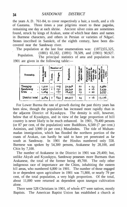
34 SANDOWAY DISTRICT
the years A .D . 761-84, to cover respectively a hair, a tooth, and a rib of Gautama. Three times a year pilgrims resort to these pagodas, remaining one day at each shrine. Ancient silver coins are sometimes found, struck by kings of Arakan, some of which bear dates and names in Burmese characters, and others in Persian or varieties of Nagari. Stones inscribed in Sanskrit, of the eighth century, have been discovered near the Sandoway river.
The population at the last four enumerations was: (1872)55,325, (1881) 65,182, (1891) 78,509, and (1901) 90,927. The principal statistics of area and population in
1901 are given in the following table:—
For Lower Burma the rate of growth during the past thirty years has been slow, though the population has increased more rapidly than in the adjacent District of Kyaukpyu. The density is still, however, below that of Kyaukpyu, and in view of the large proportion of hill country is never likely to be much enhanced. In 1901, 79,400 persons (or 87 per cent, of the population) were Buddhists, 6,500 (7 per cent.) Animists, and 3,900 (4 per cent.) Musalmans. The tide of Muham-madan immigration, which has flooded the northern portion of the coasts of Arakan, can hardly be said to have yet penetrated as far south as Sandoway. In 1901 the Hindus numbered only 558. Burmese was spoken by 54,300 persons, Arakanese by 28,100, and Chin by 7,100.
The number of Arakanese in the District in 1901 was 29,400; but, unlike Akyab and Kyaukpyu, Sandoway possesses more Burmans than Arakanese, the total of the former being 49,700. The only other indigenous race of importance are the Chins, inhabiting the eastern hill areas, who numbered 6,800 in 1901. The number of those engaged in or dependent upon agriculture in 1901 was 71,800, or nearly 79 per cent, of the total population, a very high proportion. Of the total, about 11,000 were returned as dependent upon taungya cultivation alone.
There were 528 Christians in 1901, of whom 477 were natives, mostly Baptists. The American Baptist Union has established a church at
Population.
AGRICULTURE 35
Sandoway town, and a school for Chin children. The mission has a good many converts among the Chins and a few among Burmans.
The prevalent soils are loams, more or less sandy. Owing to the hilly conformation of the surface, there are no large homogeneous tracts. In the low-lying lands which receive the drainage from the surrounding hills, the soil may be excellent, while that on neighbouring slopes may be poor. A tract classification was, however, made at the settlement of 1897-8, as follows. The best land includes the greater portion of the Taungup township, a belt of land on both banks of the Sandoway river, an open space surrounded by hills in the Sandoway township, and a few scattered areas of excellent crop-bearing land in the Gwa township. A second tract consists of the lighter and inferior soils found in the vicinity of Taungup, and some scattered stretches near the sea-coast and on the slopes of the hills in the Sandoway and Gwa townships. The last division is a sandy ridge along the coast of the Bay of Bengal, stretching from Padin to Gwachaung, where the soil is very much exhausted and inferior to that in the two other areas.
Taungya or hill clearings are worked chiefly for sugar-cane, plantains, cotton, and maize, while rice, tobacco, and sesamum are grown in the plains and valleys. Different systems of cultivation are followed in different parts of the District. In the Taungup and Sandoway townships, where the rainfall is exceedingly heavy, an ordinary plough is used to turn the soil soon after the beginning of the rains; but in the Gwa township the surface of the land is simply scraped with harrows before the seed is sown.
The occupations of the people are almost exclusively agriculture and fishing. Rice holdings as a rule are too small to support a family, and rice cultivators engage also in the cultivation of miscellaneous crops, as well as in fishing and cattle-breeding.
Only 106 square miles were cultivated in 1903-4, but this represents an increase of nearly 50 per cent, since 1880-1. The principal crops grown in 1903-4 were: rice, 92 square miles; tobacco, 1,900 acres; and sugar-cane. The staple food-grain is rice; other food-crops are chillies, plantains, coco-nuts, and a little maize. Of garden fruits, mangoes, pine-apple, and jack are grown throughout the District, but are of inferior quality. The area under garden cultivation is 1,900 acres. The dam palm covers 3,100 acres, for the most part in the Taungup township, while tobacco is grown mainly in the Sandoway township.
Agricultural loans amounting to a few hundred rupees yearly are given under the Agriculturists' Loans Act ; but nothing is advanced under the Land Improvement Loans Act, and very little is done by the people themselves to improve their agricultural methods.
Agriculture.
36 SANDOWAY DISTRICT
No systematic cattle-breeding is carried on, but the stock employed is mainly home-bred. Ponies are scarce, and would be of little use in this country of hill ridges and tidal creeks. The grazing problem is not acute, for abundant fodder is to be had on the hills, and almost every village has grazing grounds sufficient for its need. A little difficulty is, however, sometimes experienced near the sea beach, where the grass is apt to dry up by the end of the dry season. Cattle-disease is rare. This has been ascribed to the industry of the cultivators in supplying their cattle with water from wells during the hot season, instead of allowing them to drink from the tanks in which they bathe.
The District has no system of irrigation; cultivation is dependent upon the annual rainfall, which fortunately is on the whole regular. Unseasonable rain or breaks in the monsoon sometimes cause local scarcity owing to the deficiency of communications, but widespread distress is unknown. The only important leased fisheries are the Maungdauk and Migyaungye turtle-banks, which fetch about Rs. 800 annually. Net licences arc issued by township officers and circle thugyis. The number of fishermen and their dependents in 1901 was 1,404.
A description of the forests has been given under the head of Botany. From an economic point of view, the three most valuable
trees are the pyingado (Xylia dolabriformis) or iron-wood, a timber almost equal to teak in hardness, and
much used for house-building, railway sleepers, and furniture; the in {Dipterocarpus tuberculatus), a useful timber from which a thick resin is extracted ; and the kanyinbya {Dipterocarpus alatus), a large tree which yields an inflammable oil, much used in making torches. It is only recently that the Forest department has extended its. operations regularly into the District. There is a teak plantation of 7^ acres near Sandoway town. Teak-trees exist also near Taungup and on the upper waters of the Thade river. The forest receipts in 1903-4 were slightly in excess of Rs. 7,000.
There are no minerals of any importance, so far as is known. Carbonaceous deposits have from time to time been reported in the neighbourhood of Sandoway town, but it is not probable that the coal is of value. Limestone is burnt in certain circles. Salt-boiling is carried on in a few villages near the coast. Salt is manufactured in two ways, known locally as sitpo and lebo (the ' straining' and the * field' processes). By the first method the saline crusts are gathered after ebbtide, the salt contained in them is dissolved and the solution boiled. In the second the salt water is evaporated on the fields and the process repeated til l the brine is sufficiently concentrated, when it is drained off into a tank. In boiling, iron cauldrons and earthen pots are used— the former exclusively in the Sandoway, and the latter in the Taungup township.
Forests.
TRADE AND COMMUNICATIONS 37
The manufactures as a whole are few and unimportant. Bricks are burnt in the neighbourhood of Sandoway. Pots (unglazed) of the usual kind are made at Kinmaw and Natmaw. Rough mat-plaiting and thatch-making are universal. Silk-and cotton-weaving are common in the villages, where the women work on hand-looms to supply the local demand. The Chins weave and embroider shawls of good quality and artistic design. Sugar-cane mills worked by cattle are common. The juice obtained is boiled down into jaggery, which is exported to Akyab in large quantities, the total produce being estimated at over 1,600 tons a year. There is a steam saw-mill at Gyiwa, half-way between Sandoway town and Taungup.
The commerce of Sandoway is not extensive or important. It consists chiefly of a small coasting trade in salted fish, rice, and vegetables with Akyab and Kyaukpyu along the tidal creeks, and of a land trade with the Pegu and Irrawaddy Divisions over the Arakan Yoma by way of several passes : namely, the old military road from Taungup to Prome, and four smaller routes starting from the Gwa township and known as the Ponsogyi, Lekkok, Bawmi, and Thitkauk routes. The Gwa township also carries on a small trade by sea during the favourable season with parts of Bassein District. The merchandise, consisting chiefly of fish, rice, hides, and jaggery, is transported in thanpans, native-built boats of English design, often over 50 feet in length. The principal exports are salted fish and ngapi (fish-paste), rice, timber, cattle, horns, hides, tamarinds, chillies, jaggery, and coco-nuts. These go to Akyab, Kyaukpyu, Bassein, Rangoon, and Prome. Railway sleepers are sent as far as Chittagong. The imports are cotton twist, silk and other apparel, oils, and iron ; large quantities of tobacco and betel-nuts are also imported into the Gwa township.
The means of communication are as yet very imperfect. There are no railway lines, and only three metalled roads of short length, maintained by the Public Works department — one from Sandoway town southwards to Padegaw, about 9 miles, now being continued to Kyeintali; another from Sandoway westwards to Lintha on the coast, 6 miles; and a third of 5 miles from Sandoway north-westwards to Kinmaw. The roads from village to village are mere foot-tracks without any banking or formation. The new road from Sandoway to Kyeintali will eventually be extended to Gwa, and will facilitate communication between the northern parts of the District and the Irrawaddy delta. The only means of communication eastwards are the passes over the Arakan Yoma mentioned above. The chief of these connects the village of Taungup in the north with Padaung on the Irrawaddy, in Prome District. This is an old route which was followed by the Burmans in their invasion of Arakan in 1784, and again by the British
Trade and communications.
3* SANDOWAY DISTRICT
in 1825, though it was then pronounced to be unfit for troops or laden cattle. The road has since been considerably widened and rendered practicable for cart traffic, and has recently been surveyed for a railway line. Its value as a trade route is not, however, very great, for it is not metalled and cannot be used by carts during the rains. The other passes are not much used.
In the Taungup and Sandoway townships travelling by water is practicable during most of the year, as from the mouth of the Sandoway river northwards the coast is indented with navigable tidal creeks, by means of which communications can be kept up. Southwards the coast is rugged and rocky, with few available harbours. The steamers of the British India Company call weekly each way at the mouth of the Sandoway river, communication between the roadstead and the town of Sandoway, 15 miles off, being maintained by launch. Only small steamers of 19 or 20 tons can ascend the river as far as Sandoway town, and in the dry season even these are detained t i l l the tide serves. This is the cause of much delay and inconvenience, both in the delivery of mails and in the expedition of merchandise.
Foul Island has been surveyed with a view to the building of a lighthouse. At present no portion of the coast of the District is lighted.
The District is divided into three townships : TAUNGUP in the north, SANDOWAY in the centre, and GWA in the south. There are no sub
divisions. The head-quarters magistrate is in charge of the treasury at Sandoway town; where also are
an akunwun in charge of the revenue and a superintendent of land records, under whom are 2 inspectors and 10 surveyors. The excise staff is under the District Superintendent of police, subject to the control of the Deputy-Commissioner. The District forms a subdivision of the Arakan Public Works division, which is conterminous with the civil Division.
The northern township, where the system of revenue collection by the agency of village headmen has as yet been introduced only to a small extent, has six circle thugyis; the central four; and the southern none. The total number of village headmen in the District is 233, of whom 106 are revenue collectors, remunerated by commission at 6 and 7 per cent, in the northern and central townships, and at 10 per cent, in the southern township.
The Deputy-Commissioner and the township officers are magistrates and judges for their respective charges, and the treasury officer is additional judge of the Sandoway township court. He does all the civil work of that court, and also tries criminal cases when the township officer is on tour. Fifteen of the village headmen have been empowered to try certain classes of petty civil suits, and two have
Administration.
ADMTNISTRATION 39
special criminal powers under the Village Act. There are benches of honorary magistrates at Sandoway town and Taungup.
Under native rule revenue from land in Sandoway was taken in the shape of a plough tax. Five baskets of paddy were levied for each pair of buffaloes used in ploughing, half a basket being claimed by the keeper of the royal granary as wastage. A poll tax and transit dues were also collected. In 1828, shortly after the annexation of Arakan, it was calculated that every head of a family paid Rs. 17 per annum in the shape of revenue to Government. In 1865-6 a partial settlement was carried out by the Deputy-Commissioner, resulting in a few reductions of rates on account of the alleged exhaustion of the soil and a desire to encourage the cultivation of waste land, and there were further settlement operations in 1890-1; but practically there may be said to have been a uniform rate of Rs. 1-10 per acre throughout the District until 1897-8, when an area of 148 square miles which had been cadastrally surveyed in 1892-3, and brought under supplementary survey in 1894-5, was classified according to the fertility of the soil and regularly settled. The average rate for rice land over the whole District is now Rs. 1-9-1 per acre, and, in the settled areas, ranges from 14 annas to Rs. 2-8. Garden cultivation is assessed at a uniform rate of Rs. 1-12, and miscellaneous cultivation at Rs. 2 to Rs. 4. Over the unsettled area the rates vary from 4 annas to Rs. 1-10. A further area of about 120 square miles was surveyed in 1901-2, and summarily settled in 1903-4. The average extent of a holding in the settled tract is 2.8 acres, and in the unsettled tract 2-5 acres. A grant of 452 acres under the old waste-land grant rules of 1865 still exists at Indainggyi. The capitation tax rates are Rs. 4 on married couples and Rs. 2 on single persons, except in a few Chin villages, where lower rates of Rs. 2 and R. 1 are in force.
The following table shows, in thousands of rupees, the growth in the revenue since 1880-1 :—
1880-1. 1890-1. 1900-I. 1903-4.
1,12 2,68
Land revenue . Total revenue .
47 1,49
55 1,62
79 2,30
1903-4.
1,12 2,68
The total revenue for 1903-4 includes excise (Rs. 62,000) and capitation tax (Rs. 72,000). The excise receipts include Rs. 49,500 from opium, Rs. 4,000 from tart (made from the juice of the dani palm), and Rs. 4,000 from country spirit. Four shops are licensed for the sale of kaung, a favourite liquor among the Chins and an important adjunct at their ^/-worshipping festivals.
The District cess fund, the income of which is derived mainly from
4o SANDOWAY DISTRICT
a rate of 10 per cent, on the total land revenue, is administered by the Deputy-Commissioner for the maintenance and construction of roads and other local necessities. The income in 1903-4 was Rs. 14,000. The only municipality is SANDOWAY TOWN, which was constituted in 1885.
The District contains nine police stations and one outpost. The District Superintendent is assisted by 2 inspectors; and the force consists of 3 head constables and 138 sergeants and constables, besides 1,259 rural police. There are 75 military police, stationed at Sandoway town, Taungup, Lamu, Kyeintali, and Gwa. The District jail has accommodation for 84 prisoners. Mat-making, cane-work, coir-work, gardening, and carpentry are carried on by the prisoners.
The standard of education in Sandoway is not high. At the same time, though below the Provincial mean, the proportion of literate males in every 1,000 (343) is higher than in any of the other Districts of the Arakan Division. For females the corresponding figure is 32, and for both sexes together 189. The total number of pupils was 650 in 1880-1, 1,034 in 1890-1, and 1,586 in 1900-1. In 1903-4 there were 6 secondary, 48 primary, and 60 elementary (private) schools, with 2,329 male and 276 female pupils. The most important schools are the Sandoway municipal Anglo-vernacular school, and the American Baptist Anglo-vernacular Chin school, also in Sandoway town. The American Baptist Union have opened a number of small schools for Chins in the rural areas. The majority of these, however, have not come under the Educational department and draw no results-grants. The expenditure on education in 1903-4 from municipal funds was Rs. 2,800; from Provincial funds, Rs. 600; and from the District cess fund, Rs. 1,900. Receipts from fees at the municipal school yielded Rs. 3,200.
There are two hospitals, with accommodation for 20 in-patients. During 1903 the number of in-patients treated was 318, and that of out-patients 18,677, and 257 operations were performed. The expenditure in the same year was Rs. 4,000, chiefly borne by Local and municipal funds.
Vaccination is compulsory in Sandoway municipality, but not in the interior of the District. The proportion of the inhabitants protected is, however, said to be fairly high. In 1903-4 the number of persons successfully vaccinated was 1,735, representing r9 per 1,000 of population.
[B, Houghton, Settlement Report (1892); Maung Pan Hla, Settlement Report (1899).]
Sandoway Township.—Township of Sandoway District, Lower Burma, lying between 180 2' and 180 46' N, and 940 13' and 940 52' E., with an area of r,oio square miles. It occupies the
SANDOWAY TOWN V
central portion of the District. The population in 1901 was 39,542, compared with 34,090 in 1891. I t contains one town, SANDOWAY (population, 2,845), the head-quarters of the District and township; and 231 villages. It has a fairly large number of Chin inhabitants in the hilly country which forms the greater part of its area, but not so many as the Taungup township, and Indians outnumber the Chin population. It is full of tidal creeks, and there is a little plain land along the valley of the Sandoway river. The area cultivated in 1903-4 was 47 square miles, paying Rs. 48,700 and revenue.
Sandoway Town.—Head-quarters of the District of the same name in Lower Burma, situated in 180 28' N. and 940 21/ R., on the left bank of the Sandoway river, 15 miles to the south-east of its mouth and between 4 and 5 miles due east of the sea-coast in a direct line. The town lies in a hollow, about 12 miles long by 1 broad, which is cultivated with rice and surrounded by hills. The greater part of it slopes gently from the river bank to the Zi chaung, which flows into the river at the west end of the town. The native town is backed by a low hill, on which stands the civil station occupied by the European officials. The officers' residences are in a semicircle overlooking the jail. The courthouse is some little distance off, nearer the river.
It is probable that Dwarawadi, the earliest known capital of the kingdom of Arakan, was, if not identical with Sandoway, at any rate in its neighbourhood. Sandoway was a town of some note at the commencement of the nineteenth century. It was occupied without resistance in the first Burmese War, and was subsequently for some time the head-quarters of the garrison of Arakan. Its growth of late has not been rapid, and it is still little more than a large village. The population in 1901 was 2,845, °f whom 1,640 were Buddhists, 967 Musalmans, and 238 of other beliefs. Sandoway was constituted a municipality in 1885, and is the smallest municipality in Burma. The receipts of the municipal fund during the ten years ending 1901 averaged Rs. 8,300, and the expenditure Rs. 7,500. In 1903-4 the receipts were Rs. 11,000, and the expenditure Rs. 9,000. House and lighting taxes are levied, but market tolls are the most substantial item of revenue, yielding Rs. 6,000. Sandoway, though in direct communication with a roadstead where ocean steamers call, can be reached only by craft of very light draught, and has not been declared a port under the Ports Act. Its trade is registered by the Customs department, but is very small, and its foreign commerce is insignificant. The imports by coasting trade in 1903-4 were valued at Rs. 2,39,000, and the exports at Rs. 26,000. The imports are almost entirely from other ports in Burma. A considerable portion of the export trade of the District does not pass through Sandoway town. It contains a small
42 SAN DOW AY TOWN
jail, with accommodation for 84 prisoners, a hospital, and several schools. One of the most important of these is the municipal Anglo-vernacular school, with an attendance of about 120. There is also a mission school for Chins, managed by the American Baptist Union, with 70 Chin pupils in 1903, of whom 24 were girls.
Sandur.—The smallest and least populous of the five Native States in direct political relations with the Government of Madras. It is surrounded by the District of Bellary, the Collector of which is the Political Agent, and lies between 140 58' and 15° 14' N. and 760 25' and 76° 42' E. In shape it is like a torpedo, with its longer axis running from north-west to south-east, and it is 24 miles long and, at the broadest part, 13 wide. The State is 161 square miles in area, contains 20 villages, and has a population (1901) of 11,200, of whom between one-third and one-half live in Sandur town. It consists of
a long, narrow valley, shut in by two nearly parallel aspects enclosing walls of hills covered with long grass and
forest. These hills are formed of Dharwar rocks, which were deposited upon the older granites and then, as the earth's surface cooled, were, with the granites, subjected to enormous lateral pressure, and so crumpled up into huge wrinkles. The Sandur valley is the hollow of one of these wrinkles, and the hills surrounding it are the sides of a huge trough into which the rocks have been squeezed. The strata in them stand on edge, curve gradually below the valley, and reappear, again on edge, on the other side.
The two enclosing lines of hill are smooth in outline, flat-topped, and very level along their summits, so that from outside the State they resemble long lines of wall shutting it in. Their highest point is at the south-east corner, above the Kumaraswami temple referred to later, where they run up to 3,400 feet. Ramanmalai, in the centre of the southern of the two lines, just above RAMANDRUG hill station, is 3,256 feet above the sea. At right angles to the longer axis of the valley, and through both the walls of hill which enclose it, runs the Narihalla, draining almost the whole of it. The beautiful little gorges in the two lines of hills, by which the stream first enters and then leaves the State, are among the most striking features of the country. That on the western side, by which it enters, called the Obalagandi, lies about z\ miles from Sandur town. At the bottom, where the river runs, it is only some 15 yards wide. On either hand the dark purple and deep red hematite rocks which form the sides of this natural gate rise precipitously to a height of 180 feet, gradually near-ing one another as they ascend. The bed of the stream is strewn with masses of rock which appear to have fallen from the sides of the gate, and their rich colours form a fine contrast to the green of the woods with which the sides of the hills are here clothed. The Bhimagandi,
SANDUR 43
as the eastern gorge by which the Narihalla leaves the valley is called, is wider, but equally picturesque.
Among the game of the State may be mentioned occasional tigers, numerous wild hog, and not a few sambar* Peafowl are plentiful, but are held sacred to the god Kumaraswami.
The valley is cooler than the neighbouring District of Bellary and receives more rain than any part of it, the average fall approaching 30 inches annually. It is singularly free from malaria, considering its conformation.
Sandur has an interesting history. In 1728 it was seized by an ancestor of the present Raja, a Maratha named Siddoji Rao. He belonged to a family called the Ghorpades, which name was earned, according to tradition, by one of them who scaled a precipitous fort by clinging to an iguana (ghorpad) which was crawling up it. Siddoji Rao's grandfather had been in the service of the Sultan of Bijapur, and his three sons joined in the Maratha revolt against that king and prospered in consequence. The second of them, Siddoji's father, earned the hereditary titles of Hindu Rao and Mamalikat (Mamlukat) Madar ('centre of the State'), which are still used by the Rajas of Sandur. Siddoji's eldest son was the famous Morari Rao of GOOTY, who followed his father as ruler of the State. In the campaign of 1775-6 Haidar Ali , after getting possession of BELLARY, took Gooty from him, and sent him to Kabbaldurga hill in Mysore, where he died soon afterwards. Haidar annexed the whole territory, including Sandur, and began the fort of Krishnanagar which is still standing there. It was finished and garrisoned by his son Tipu.
Morari Rao had two sons, but they both died in childhood; and he adopted a distant cousin named Siva Rao, who fell about 1785 in a vain attempt to turn Tipu's troops out of Sandur, and was succeeded by his son SiddojT, then two years old. Siddoji was put under the guardianship of his uncle Venkata Rao, who in 1790, on his ward's behalf, attacked and drove out Tipu's garrison, and gained possession of the place. After the peace with Tipu in 1792 the Ghorpades were allowed to retain Sandur as part of the ancient inheritance of the family, but none of them ventured to reside there as long as Tipu was alive. Siddoji died in 1796, aged thirteen, and his widow adopted a cousin called Siva Rao. On the death of Tipu at the fall of Seringapatam in 1799, Siva Rao went with Venkata Rao to Sandur, and he was jagtrdar there when Bellary District was ceded to the Company.
About this time the Peshwa, Bajl Rao, granted the estate to one Jaswant Rao, a distinguished officer in Sindhia's army. No pro-minence was given to this grant, and Siva Rao continued to hold the
VOL. X X I I . D
44 SANDUR
estate. The Peshwa, however, regarded him as a rebellious vassal, and in 1815 endeavoured to gain possession of Sandur by marching thither with troops, under the pretence of a pilgrimage to the shrine of Kumaraswami. Siva Rao blocked the passes, and Bajl Rao was only allowed to go to the temple with a few attendants by the footpaths over the hills.
The Treaty of Bassein, however, bound the Company to assist the Peshwa in reducing refractory vassals, and Bajf Rao accordingly asked that the British would take Sandur from Siva Rao. Munro was therefore detached from Dharwar with a force to demand the surrender of the valley. Siva Rao resigned possession without opposition and in a dignified manner, and obtained in exchange an estate in Bellary District. Almost immediately afterwards, however, the Peshwa threw off the mask of friendship to the British he had been wearing, and provoked the war which ended in 1818 in the downfall of his power. Munro then recommended that Sandur should be restored to Siva Rao, and Government agreed to the proposal. In 1826 a formal sanad (title-deed) for the State was granted to Siva Rao by the Madras Government. He died in 1840, and was followed by his nephew Venkata Rao, whom he had adopted. The latter died in 1861, and was succeeded by his son Sivashanmukha Rao. In 1876 he received the title of Raja as an hereditary distinction. At his death two years later his brother Ramachandra Vitthala Rao succeeded, who was made a C L E . in July, 1892, but died in the same year. Rama-chandra's son, the present Raja, is a minor and is being educated at Bellary.
The chief buildings of antiquarian interest in the State are the fort of Krishnanagar already mentioned, the ancient fortress at RAMANDRUG referred to in the account of that place, and the temple of Kumaraswami, which is picturesquely situated in a natural amphitheatre of wooded slopes near the top of the hills 7 miles south of Sandur town. Kumaraswami, the Mars of the Hindu pantheon, was the child of Siva and Parvatl. The legend runs that a ferocious demon named Tarak-asura, who dwelt in this part of the Sandur hills, so harassed the Devas that they entreated Siva to send his warrior son to rid them of the monster. Kumaraswami came and slew him and cut off his head. The foundation of the temple commemorates the happy event. Inscriptions in the building show that it was in existence as long ago as A . D . 950, but architecturally it is disappointing.
The population of Sandur in 1871 was 14,996. The famine of 1876-8 was severely felt, and in 1881 the inhabitants numbered only
10,532. In 1891 the total was 11,388, and in 1901, 11,200. More than 2,000 of the people are
Musalmans, a high proportion. Of the Hindus, the most numerous
Population.
FORESTS 45
communities are the sect of the Lingayats and the Bedars, the old fighting-caste of this part of the country, both of whom are over 2,000 strong. Next come the Marathas, who number 1,000; then the agriculturist Sadars and Madigas and the shepherd Kurubas ; and after them the Brahmans, who are more than usually numerous and hold considerable grants of land. Kanarese is the prevalent vernacular.
The soil of the State is a rich heavy loam, which compares favourably with that of the adjoining areas. There is practically no black cotton soil, and consequently no late crops, such as cotton, are grown. By far the most important staple is cholam {Sorghum vulgare), which is followed by korra (Setaria italica) and sajja (Pennisetum typhoideum). Pulses, oilseeds, betel-leaf, and tobacco are also grown. The two last and a few other garden crops are irrigated from wells, there being at present no irrigation by direct flow from either tanks or channels anywhere in Sandur. About 150 of these wells are worked, most being temporary affairs without proper l i n i n g ; and the area supplied is 400 acres, on most of which two crops are raised annually. Sugar-cane used to be a profitable crop, but it is now rarely grown, as it cannot compete with that cultivated under the T U N G A B H A D R A channels. ' Dry crops' are sown from the early part of June to the middle of July and reaped in October. If the rains are late and sowing cannot be carried out unt i l the end of July, the out-turn is invariably inferior. Only one crop is usually obtained from ' d r y ' land, though if good rain falls in November or December a second crop of Bengal gram is sometimes raised. The systems of cultivation are similar to those followed in Bellary District, though perhaps manuring is more common. The agricultural implements employed are also the same. Cattle are chiefly bought, as in that District, from drovers from Nellore on the instalment system.
The forests of Sandur are 87,000 acres, or about 136 square miles, in extent. Of this area, 40,000 acres have been leased to the Madras Government for twenty-five years from 1882 at an annual rental of Rs. 10,000, and are administered by the Forest department of Bellary District. These leased forests, as they are usually called, comprise the growth on the whole of the two ranges which run along each side of the valley and also some part of that on the plateaux south of Sandur town. They contain no really heavy growth, but the supply of Hardwickia wi l l eventually be considerable, and there is some teak and sandal-wood. The thick grass is, however, of great value to cattle in times of scarcity. The chief difficulty in reproducing the growth is the constant occurrence of fires.
The minerals of the State possess unusual interest. The hematites found in it are probably the richest ore in India. An outcrop near
D 2
Forests.
Agriculture.
46 SANDUR
the southern boundary close by the village of Kummataravu forms the crest of a ridge 150 feet in height, which apparently consists
entirely of pure steel-grey crystalline hematite (specular iron) of intense hardness. Some of the softer ores
used to be smelted by the natives, but the industry has been killed by the cheaper English iron. Manganese deposits have also been found in three places, the ore from one of them showing on analysis 43 per cent, of manganese dioxide. There are also traces of an old gold-mine. Jasper rocks of great beauty and a wide range of colours, and many different tints of ochreous mineral pigments^ are also found in large quantities. The pigments are excavated and used for colourwashing houses, and might probably be exploited to commercial advantage.
Except that the shepherd caste of the Kurubas weave coarse woollen blankets from the fleeces of the sheep of the country, there are no manufactures in the State. Nor is any
considerable trade carried on in or through it. The administration is conducted by a Diwan, subject to the general
authority of the Collector of Bellary, who is ex-officio Political Agent for the State. The Diwan has the powers of a divisional officer, first-class magistrate, Additional
Sessions Judge, and District Munsif, while the original, appellate, and revisional powers of a Collector, District Magistrate, and District and Sessions Judge vest, in matters relating to the State, in the Political Agent. No legislation is undertaken in Sandur. Such of the Acts of the Legislative Councils of the Governments of India and Madras as appear to the administration to be suited to the State are brought into force by the simple process of publicly notifying that they have been adopted. Many of the executive powers exercised have no other basis than old custom held to have the force of law.
The gross income of the State averages rather more than Rs. 50,000, of which about Rs. 20,000 is derived from land revenue and the mohtarfa (an old-established tax levied according to no very fixed principles on professions, trades, and, in some cases, on houses) \ Rs. 14,000 from contracts for excise, minor forest produce, &c. ; and Rs. 10,000 from the forests leased to the Madras Government. On the expenditure side the chief items are the Raja's civil list, Rs. 14,000; the charges of administration, Rs. 13,000; and a sum of Rs. 7,576 which since 1885-6 has been set aside yearly for the repayment of the principal and interest of the debts incurred by former Rajas.
Of the 160 square miles of which the State consists, only about 19 square miles, or 12,500 acres, are cultivable, the rest being forest or unfit for tillage. About 15 square miles (9,500 acres) are cropped at
Minerals,
Trade.
Administration.
ADMINTSTRATION 47
present, the remainder, often owing to its distance from the villages, being waste. A field survey under the direction of the Madras Survey department is in progress. When it has been completed, a settlement on the general principles followed in British territory will be carried out. Formerly the accounts showed the fields by their names and their dimensions in huggas or ' ropes,' but the length of the ' rope' was nowhere laid down. Between 1865 and 187T a rough survey was carried out with the aid of the village accountants, and the records so obtained are the existing guides. They do not, however, show particulars of assessment.
Until very recently the assessment payable was fixed on a rack-renting system, each field being put up to auction and leased for five (or sometimes ten) years to the highest bidder. At the end of this lease the field was again put up to auction, and its former tenant was thus often ousted. The uncertainty which this system involved checked any effort to improve the land permanently by fencing it, constructing wells, planting trees, and so on; and consequently it is in contemplation, as soon as the survey and settlement have been completed and the rates of assessment in accordance with them have been prescribed, to give the ryots the same occupancy rights as in British territory. Meanwhile they are allowed to go on holding their fields at the rates fixed by the last auction held, and are not disturbed in their occupation by fresh auctions.
The State contains no natural salt or salt-earth, and therefore no complications arise with the Salt department in British territory. It grows no opium, and the little ganja which is raised is cultivated and harvested under official supervision. The system for the supply of liquor is simple. The exclusive right of manufacturing and selling both spirits and toddy (palm liquor) is sold to the same person. He disti's spirit in Sandur from imported jaggery (coarse sugar), and imports from elsewhere such toddy as is required, there being hardly any palm-trees in the State.
Both short- and long-term prisoners are confined in the jail. The average number of convicts is about 15, and is thus too small to allow of the organization of jail manufactures ; so the prisoners are usually employed in repairing the roads. The police force consists of an inspector, 4 head constables, and 25 constables; and there are 4 police stations. Under the terms on which the State is held, sentences of death cannot be passed without the sanction of the Government of Madras. Special rules regarding criminal jurisdiction are in force in the sanitarium of Ramandrug. Extradition from the State is arranged through the Political Agent, and is usually sanctioned only when the offence is of a minor description. In the case of more serious crimes triable only by a Court of Session, the Political Agent
48 SANDUR
proceeds against the offender as though the offence had been committed in British India.
Sandfir possesses a lower secondary school, seven primary schools, and a girls' school. The first of these was opened at the end of 1882, but the present building was erected in 1887-8, and the institution is consequently known as the Jubilee School. Neither the Muham-madans nor the Lingayats of Sandur place much value on education, and progress is slow. At the Census of 1901 only 109 males and 5 females in every 1,000 could read and write. The girls' school was started by the London Mission in 1898-9, and is still managed by that body.
The Sandur dispensary was opened in 1881 and is very popular, many patients coming to it from adjoining villages in British territory.
[Further particulars regarding Sandur will be found in the Bellary District Gazetteer (1904), and its geology and minerals are referred to at length in Mr. Bruce Foote's account of the geology of that District in Memoirs, Geological Survey, vol. xxv. ]
Sandwip.—Island off the coast of Noakhali District, Eastern Bengal and Assam, lying between 220 23' and 220 37' N. and 910 21' and 910 33' E., and probably formed by the deposit of silt from the Meghna. The area is 258 square miles, and the population in 1901 was 115,127, dwelling in 59 villages.
The island has an interesting history. Cesare de' Federici, the Venetian traveller, writing in 1565, described it as densely populated and well cultivated; he added that 200 ships were laden yearly with salt, and that such was the abundance of materials for ship-building that the Sultan of Constantinople found it cheaper to have his vessels built here than at Alexandria. In 1609 the island was captured from the Muhammadans by a number of Portuguese who had been expelled from the employ of the Raja of Arakan. Headed by one Gonzales, these pirates established themselves in force on the island and seized Shahbazpur and Patelbanga, with an army of 1,000 Portuguese, 2,000 sepoys, and 200 cavalry, and a navy of 80 armed vessels. In 1610 they allied themselves with the Raja of Arakan in an attempt to invade Bengal, but after some successes they were routed by the Mughal troops. In 1615 an attack upon Arakan was made by Gonzales with the help of Portuguese troops from Goa, but this failed; and in the following year the Raja of Arakan invaded Sandwip, defeated Gonzales, and took possession of the island. For the next fifty years Sandwip was a nest of Portuguese and Arakanese pirates who devastated the neighbouring coasts of Bengal, but in 1664 the Nawab Shaista Khan determined to put an end to their depredations. By dint of promises and cajolery he induced the Portuguese to desert to his side, and used them in an attack upon Sandwip in 1665 which was entirely
SANGAMESHWAR TOWN 49
successful. The island, however, long remained an Alsatia for all the bad characters of Eastern Bengal, and its administration was a constant cause of trouble in the early years of British rule. The last pirate of note was Dilal Raja. He is remembered for his attempts to produce a high physical type among the islanders by compelling members of different castes to intermarry. The result has been a confusion of castes upon the island, which has given it a sinister reputation on the mainland. Until 1822 Sandwip formed part of Chittagong District, but in that year it was made over to the newly formed District of Noakhali. A Sub-Deputy-Magistrate-Collector and a Munsif are stationed there.
From its low-lying position Sandwip is peculiarly exposed to inundation from storm-waves, and it suffered severely in loss of life and property by the cyclones of 1864 and 1876. The number of deaths caused by the latter was estimated at 40,000, or nearly half the population, and its effects were aggravated by a terrible epidemic of cholera which immediately followed. Since this disaster the population has rapidly increased, as it was returned at only 72,467 in 1881; •the density is now 446 persons per square mile.
Sangameshwar Taluka.—Inland taluka of Ratnagiri District, Bombay, lying between 160 49' and 170 20' N. and 730 25' and 730
50/ E., with an area of 576 square miles. There are 190 villages, but no town. The head-quarters since 1878 have been at the village of DEVRUKH. The population in 1901 was 129,412, compared with 126,700 in 1891. The density, 225 persons per square mile, is below the District average. The demand for land revenue in 1903-4 was Rs. 89,000, and for cesses Rs. 6,000. The chief river is the Shastri, which cuts the taluka nearly in half. North of the river, the country is hilly and becomes rugged at the foot of the Western Ghats, which are crossed by three passes. A fair amount of alluvial soil is found in the river valleys, yielding good crops of rice and pulse. Almost all the rest of the taluka is crumbled trap. Several hot springs of varying temperature occur. The annual rainfall is heavy, averaging 143 inches.
Sangameshwar Town.—Former head-quarters of the taluka of the same name in Ratnagiri District, Bombay, situated in 170 16' N. and 730 33' E., on the Shastri river, at the confluence of the Alkanda and Varuna, about 20 miles from the coast. Population (1901), 3,233. It is a place of some sanctity and antiquity. The river, which thirty-five years ago was navigable by the largest vessels to the. Sangameshwar quay, is now impassable 6 miles lower down. There is, however, some trade in grain, piece-goods, and salt fish. During the famine of 187 7-8, about 1,440 tons of grain were forwarded from Bombay through Sangameshwar to the Deccan. Early in 1878, 55 houses were burnt;
50 SANGAMESHWAR TOWN
and a few weeks later (March 16) a disastrous conflagration completely destroyed the taluka offices and 75 private houses. On the destruction of the public offices, the head-quarters of the taluka were moved to the more central and convenient village of DEVRUKH.
According to the Sahyadri khanda, Sangameshwar, originally called Ramakshetra, possessed temples built by Parasu Rama or Bh&rgava Rama. In the seventh century it was the capital of a Chalukyan king, Karna, who built temples and a fortress. Of these temples, one called Karneshvara remains. But the shrine of the Sangameshwar temple is said to be older, dating from Parasu Rama's time. In the fourteenth century it was for long the residence of Basava, the founder of the Ling&yat sect. Every year in January-February a fair is held. At the confluence of the rivers are several sacred places (tirthas\ among them one known as ' cleanser of sins' (Dhutapdp). It was here that Sambhajl, son of Sivaji, was taken prisoner by the Mughals and afterwards put to death in 1689. Sangameshwar contains five schools with 325 pupils. • Sangamner Taluka.— Taluka of Ahmadnagar District, Bombay, lying between 190 12' and 190 47' N. and 740 31' and 740 31 ' E., with an area of 704 square miles. I t contains one town, SANGAMNER' (population, 13,801), the head-quarters; and 151 villages. The population in 1901 was 90,381, compared with 82,936 in 1891. The presence of 5,000 immigrants on relief works accounts mainly for the increase. The density, 128 persons per square mile, is almost equal to the District average. The demand for land revenue in 1903-4 was 1.7 lakhs, and for cesses Rs. 11,000. The taluka is divided into three distinct portions by the two mountain ranges which traverse it in a parallel direction. The chief rivers are the Pravara and the Mula. The Pravara flows in the valley between the two mountain ranges. With the exception of irrigation from the Ojhar canal, garden cultivation is carried on chiefly by means of wells.
Sangamner Town. — Head-quarters of the taluka of the same name in Ahmadnagar District, Bombay, situated in 190 34' N. and 740 13' E., 49 miles north-west of Ahmadnagar city. Population (1901), 13,801, including a hamleUof 2,790. The municipality, established in i860, had an average income during the decade ending 1901 of Rs. 15,000. In 1903-4 the income was Rs. 12,500. The town has much trade in yarn, millet, gram, metal, groceries, salt, rice, and silk; and a number of looms are at work. It contains a Sub-Judge's court, a dispensary, and an English school.
Sanganer.—Town in the State of Jaipur, Rajputana, situated in 260 48' N. and 750 47' E., on the Aman-i-Shah river, 7 miles south of Jaipur city, and 3 miles south-west of Sanganer station on the Rajput&na-Malwa Railway. Population (1901), 3,972. The old palace, said to have been once occupied by Akbar, is now used as a hospital.
SANGHI 51 The town, which is walled, possesses a post office, an upper primary school attended by 44 boys, and several Jain temples, one of which, constructed of marble and sandstone, is of considerable size and said to be 950 years old. The place is famous for its dyed and stamped chintzes, the waters of the Aman-i-Shah being held to possess some peculiar properties favourable to the dyeing process; the industry has, however, suffered owing to cheap foreign imitations. Country paper also is manufactured here.
Sangareddipet. — Head-quarters of Medak District, and of the Kalabgur taluk, Hyderabad State, situated in 170 38' N. and 780 5' E. , 34 miles north-west of Hyderabad city, and 14 miles north of Shankar-palli station on the Nizam's State Railway. Population (1901), 4,809. The offices of the First and T h i r d Talukdars, the irrigation Engineer, the Police Superintendent, a District civil court, a District ja i l and dispensary, and two schools with 201 pupils are located here. Six private schools have 85 pupils. Two miles to the west of the town is the Rajampet State stud farm.
S a n g a r h Tahsil .—Northernmost tahsil of Dera Ghazi Khan Dist r i c t , Punjab, lying between 300 27' and 3 1 0 20' N. and 700 24' and
700 50' E., with an area of 1,065 square miles. It is bounded on the east by the Indus, and on the west by independent territory. A narrow strip along the river is irrigated by floods, wells, and inundation canals. A considerable portion is sandy and barren, and water is scarce in many parts. The tahsil is intersected by a number of torrent-beds, the principal of which are the Vihowa and Sangarh, from which it takes its name. The population in 1901 was 86,482, compared with 76,888 in 1891. It contains 1691 villages, including Taunsa (population, 5,200), the head-quarters. The land revenue and cesses in 1903-4 amounted to one lakh.
Sanghar.—Taluka of Thar and Parkar District, Sind, Bombay, lying between 250 40 ' and 260 15' N. and 68° 5 1 ' and 690 25' E. In 1901 it had an area of 1,050 square miles, and the number of villages was 63. The present area is 830 square miles, the reduction being due to the creation of new talukas. The population in 1901 was 40,341, compared with 41,265 in 1891. The density, 49 persons per square mile, is considerably above the District average. The land revenue and cesses in 1903-4 amounted to 1.3 lakhs. The headquarters are at Sanghar. The taluka is mainly irrigated by the Mithrao Canal, rice being the principal crop.
Sanghi. — Village in the District and tahsil of Rohtak, Punjab, situated in 290 1' N. and 760 41 / E. Population (1901), 5,126. It is administered as a ' notified area.'
1 Since the Census of 1901, one village with a population of 16 persons has been transferred to the Dera Ismail Khan District of the North-West Frontier Province.
52 SANGLA
Sangla.—Village in the K h n g a h Dogran tahsll of GujranwSla District, Punjab, situated in 3 1 0 43 ' N. and 730 27' E. Population (1901), 982. W i t h the colonization of the Sandal Bar {see C H E N A B C O L O N Y ) , it has rapidly developed into a place of some importance. It is administered as a * notified area/ and now contains three cotton-ginning factories, which in 1904 gave employment to 192 persons. Trade wi l l probably increase largely when the railway to Shahdara has been opened.
Apart from its recent commercial development, Sangla is chiefly of interest in connexion with the theories woven round the ruins crowning the rocky h i l l known as Sanglawala Tibba, which General Cunningham identified with the Sakala of the Brahmans, the Sagal of Buddhism, and the Sangala of Alexander's historians. Modern authorities, however, have declined to accept the identification as correct; and the Sangala of Alexander is now located in Gurdaspur, while it is possible that Shahkot, a village in Gujranwala District, 11 miles south-east of Sangla, represents the Sakala which was the capital of Mihirakula, the White H u n , in the early part of the sixth century A . D . , and the ruins of which were visited by Hiuen Tsiang. If this identification be correct, we probably have in Shahkot the site of the Sakala of the Mahabharata and the Sagal of Buddhist legend. But the task of identification is beset with difficulties; and it is by no means certain that Chiniot in Jhang is not the modern representative of Sakala, which has also recently been identified with Sialkot. The h i l l of Sanglawala Tibba rises to a height of 215 feet above the surrounding plain on its north side, and slopes southward t i l l i t ends in an abrupt bank only 32 feet i n height, crowned in early times by a brick wall, traces of which still exist. The whole intervening area is strewn with large antique bricks, great quantities of which have been removed during recent years. An extensive swamp covers the approach on the south and east, the least defensible quarters, with a general depth of 3 feet in the rains, but dry during the summer. This must have once been a large lake, which has since silted up by detritus from the h i l l above. On the north-east side of the h i l l , General Cunningham found the remains of two considerable buildings, with bricks of enormous size. Close by stands an old well, lately cleared out by wandering tribes.
[C. J. Rodgers, Report on Sangla Tibba (1896).] Sangl i State.—State under the Political Agent of Kolhapur and
the Southern Maratha Jagirs, Bombay, consisting of six separate divisions: a group of villages near the valley of the Kis tna ; a second group between Kolhapur territory on the west and Jamkhandi State; a th i rd group in Sholapur District, near the junction of the M a n and Bhlma rivers; a fourth in Dharwar Dis t r ic t ; a fifth just north
SANGLI STATE 53 of the town of Belgaum; and the last to the south of the Mal-prabha river and to the north-east of Kittur in Belgaum. The State contains a total area of 1,112 square miles, of which about 93 square miles are forest. The population in 1901 was 226,128, residing in six towns, of which the chief is SANGLI (population, 16,829), the headquarters ; and 3071 villages. Hindus number 196,718; Muhammadans, 15,940; and Jains, 13,226.
The portion of the State watered by the Kistna is flat and the soil particularly rich. The remaining divisions are plains surrounded by undulating lands and occasionally intersected by ridges of hills. The prevailing soil is black. Irrigation is carried on from rivers, wells, and tanks. The climate is the same as that of the Deccan generally, the air being very dry, especially when east winds prevail. The chief crops are millet, rice, wheat, gram, and cotton; and the manufactures are coarse cotton cloth and native articles of apparel.
The chief of Sangli is a member of the Patvardhan family, whose founder Haribhat, a Konkanasth Brahman, was the family priest of the chief of Ichalkaranji. On the occasion of the marriage of the chiefs
• son with the daughter of the first Peshwa, Haribhat was brought to the notice of the Peshwa, one of whose successors, Madhav Rao, granted the jagir to Haribhat's son Govind Rao and two grandsons. In 1772 the jagir, which included MIRAJ, descended to Chintaman Rao, grandson of Govind Rao, the original grantee. Chintaman Rao being a child of six years, the State was managed during his minority by his uncle Gangadhar Rao. When the minor came of age, he quarrelled with his uncle, who attempted to keep him out of his rights. Eventually the estate was divided between them, the uncle retaining Miraj and Chintaman Rao taking Sangli. The revenue of Sangli exceeded 6 lakhs and that of Miraj was nearly 5 lakhs, the estates being respectively subject to a service of 1,920 and 1,219 horse. Chintaman Rao, the grandfather of the present chief of Sangli, became a feudatory of the British Government on the downfall of the Peshwa in 1818. In 1846 the East India Company presented him with a sword in testimony of their respect for his high character, and in acknowledgement of his loyalty. Chintaman Rao died in 1851. The chief of Sangli does not now pay any contribution on account of military service, having ceded lands of the annual value of over 1¼ lakhs in lieu thereof. The family holds a sanad authorizing adoption. The rule of primogeniture is not strictly followed in the matter of succession.
The chief ranks as a first-class Sardar in the Southern Maratha 1 This figure differs from that given in the Census Report', being based on more
recent information, and also by the inclusion of hamlets and unpopulated villages. At the Census of 1901 there were 239 towns and inhabited villages.
54 SANGLI STATE
Country, and has power to try capital offences in the case of his own subjects. He enjoys an estimated revenue of 15 lakhs, and maintains a police force of 497 men, of whom 54 are mounted, 323 are unarmed, and 120 are armed. In 1903-4 there were 89 schools, including nine girls' schools, one high school, and three Anglo-vernacular schools; the number of pupils was 3,997. The State contains six municipalities; the largest are SANGLI with an income of Rs. 13,500, and SHAHAPUR with Rs. 12,900. I n the one jail and eight lock-ups of the State 208 prisoners were confined in 1903-4. There are seven dispensaries, attended by about 44,000 patients in 1903-4. In the same year about 6,000 persons were vaccinated.
SSngli Town.—Capital of the State of Sangli, Southern Maratha Jaglrs, Bombay, situated in 160 52' N. and 740 36' E., on the Kistna river, a little north of the confluence of the Varna. Population (1901), 16,829. The income of the municipality in 1903-4 was Rs. 13,500. The fort, in which are the chiefs palace and most of the public offices, was built about a hundred years ago. The new town is well laid out with broad streets, and is chiefly occupied by bankers, merchants, and the principal officers of the State. It contains a high school and a dispensary.
Sangod.—Head-quarters of the district of the same name in the State of Kotah, Rajputana, situated in 240 55' N. and 760 17' E., on the right bank of the Ujar, a tributary of the Kali Sind, about 34 miles south-east of Kotah city. Population (1901), 4,369. Sangod possesses a post office, a vernacular school, and a hospital with accommodation for 6 in-patients.
Sangola Taiuka.— South-western tahika of Sholapur District, Bombay, lying between 170 8' and 17° 40' N. and 740 54' and 750 27' E., with an area of 654 square miles. It contains one town, SANGOLA (population, 4,763), the head-quarters; and 75 villages. The population in 1901 was 82,634, compared with 78,420 in 1891, The density, 127 persons per square mile, is much below the District average. The demand for land revenue in 1903-4 was I « I lakhs, and for cesses Rs. 8,000. Sangola is a level plain, with a few treeless hillocks fringing its southern border. It is mostly bare of trees. Villages are three or four miles apart. The chief river is the Man, which drains the taiuka from west to north-east for about 35 miles. Most of the soil is stony and barren, and much of it fit only for grazing. The climate is hot.
Sangola Town.—Head-quarters of the tahika of the same name in Sholapur District, Bombay, situated in 170 26' N, and 75°i2 ' E., 19 miles south-west of Pandharpur. Population (1901), 4,763. The fort, which is now occupied by the tahika offices, is said to have been built by a Bijapur king; and so prosperous was the town which grew
S 55
up round it that, unt i l it was plundered by Holkar's Pathans in 1802, it was locally called the Golden Sangola. The municipality, established in 1855, had an average income during the decade ending 1901 of Rs. 5,500. In 1903-4 the income was Rs. 6,400. The town contains a Subordinate Judge's court, a school, and a dispensary.
Sangri .—One of the Simla H i l l States, Punjab, lying between 31° 16' and 3 1 0 22' N. and 770 22' and 770 28' E., on the south bank of the Sutlej, wi th an area of 16 square miles. Population (1901), 2,774. Formerly a dependency of K u l u , it was seized by the Gurkhas in 1803 and restored to the KuiQ Raja in 1815 by the British. In 1840 Raja A j l t Singh of K u l u took refuge in Sangri from the Sikhs, and K u l u was lost to his branch of the family, which retained Sangri under Brit ish protection. The present chief, Rai H i r a Singh, succeeded in 1876. The State has a revenue of Rs. 2,400.
S a n g r u r N i z a m a t , — Head-quarters nizamat or administrative district and tahsil of Jind State, Punjab, lying between 300 6' and 300 2 1 ' N. and 750 48 ' and 760 2' E., with an area of 252 square miles. It comprises several scattered pieces of territory, of which the principal pargana, Sangrur, is bounded on the north and west by Patiala and Nabha, and on the east and south by Patiala. It also includes the ilakas of Kularan, Balanwali, and Bazldpur, which arc. broken up into six detached areas. The population in 1901 was 64,681, compared with 59,521 in 1891. The nizamat contains two towns, S A N G R U R (population, 11,852), the head-quarters and capital of the State, and Balanwali (2,298); and 95 villages. The land revenue and cesses in 1903-4 amounted to 2.2 lakhs. It lies in the great natural tract known as the Jangal.
Sangrur T o w n . — M o d e r n capital of the Jind State, Punjab, situated in 300 15' N. and 750 59' E., 48 miles south of Ludhiana, on the Ludhiana-Dhuri-Jakhal Railway. Population (1901), 11,852. Founded about 300 years ago, it remained a mere village unti l Raja Sangat Singh in 1827 transferred his capital from Jind, which he considered as being too far from Patiala and Nabha. Raja Raghubir Singh, the successor of Sariip Singh, adorned it with many public offices and other buildings. It is administered as a municipality, with an income of about Rs. 3,900, chiefly derived from octroi, and has a considerable local trade. The principal manufactures are leathern goods and furniture. It contains the Diamond Jubilee College, completed in 1902, a high school, the Victoria Golden Jubilee Hospital, and a Zanana hospital.
Sangu.—River of Eastern Bengal and Assam. Rising in the range of hills which divides Arakan from the Chittagong H i l l Tracts, in 2 1 0 13' N. and 920 37 ' E., it pursues a generally northerly course over a rocky bed to Bandarban, from which place it takes a tortuous

56 SANGU
westerly direction through Chittagong District, and finally empties itself into the Bay of Bengal, in 220 6' N. and 910 51 ' E., after a course of 168 miles. The Sangu is tidal as far as Bandarban, where its bed is sandy. Though shallow in ordinary times, during the rains it becomes deep, dangerous, and rapid. In its upper reaches it is called by the hillmen the Rigray Khyoung, and lower down the Sabak Khyoung. It is navigable by large cargo boats for a distance of 30 miles throughout the year. The principal tributaries are the Dolu and Chandkhali, and the chief river-side village is Bandarban.
Sanjan.—Village in the Dahanu taluka of Thana District, Bombay, situated in 200 12' N. and 720 51 ' E., with a station on the Bombay, Baroda, and Central India Railway. Sanjan was in former times a trading town of considerable importance, and according to tradition was founded by one Raja Gaddhe Singh. It covered so large an area that it earned the name of Navteri Nagari, or the city which measured 9 kos by 13. Although some authorities suppose that the Sanjan in which the Parsi refugees from Persia settled about 720 was a town of that name in Cutch, there are better grounds for believing that it was Sanjan in Thana District, which is mentioned under the name of Hamjaman in three Silahara land grants of the tenth and eleventh centuries. By the Arab geographers of the same period the town is repeatedly spoken of, under the name of Sindan, as one of the chief ports of Western India. In 915 it was described as a great city with a Jama Masjid, and as famous for the export of a fine emerald, known as the Mecca emerald owing to its having been brought from Arabia. Al Idrlsi speaks of it in the twelfth century as peopled with industrious and very intelligent inhabitants, large, rich, and warlike, and enjoying a great export and import trade: and it doubtless maintained its wealth and importance t i l l the beginning of the fourteenth century, when it was attacked and after a fierce resistance stormed by Alaf Khan, general of Ala-ud-dln Khil j i . Its Parsi citizens were killed, enslaved, or driven to the hills, and most of those who escaped settled at Nargol, about four miles away, which is still one of the largest Parsi villages on the coast. From that date little is heard of Sanjan until 1534, when it was captured by the Portuguese. Pyrard de Laval and Sir T. Herbert both mention it during the early years of the seventeenth century as subject to Portugal; and the latter writer terms the place St. John (i.e. Sanjan) de Vacas, which is identical with the St. John or St. John's Peak known to English navigators of that period. Sanjan had by this time lost much of its former importance, and yielded through its customs-house a revenue of only £23 (620 pardaos). It was guarded by a fort built in 1613 by the Portuguese and described by a writer of that nation in 1634 as a round fort with six bastions, enclosing a very handsome well and two ponds, some
SANJAWI 57
houses, an arsenal, and a church. The population of the fort then consisted of a commandant and twenty soldiers, a clerk, an inspector, a priest, and forty-two families of Portuguese and native Christians. The garrison was accustomed to add to its pay by cultivation. Dr. Hove, the Polish savant, visited the town in 1787.
Sanjan at the present day contains the remains of several large ponds and lakes, which are filled with silt and are utilized for cultivation. Bricks of an antique type lie scattered over the surrounding fields and form the wails of most of the ruined buildings. Apart from these, the antiquities of Sanjan consist of some carved slabs, the remains of a Parsi ' tower of silence' (1300-1500), the ruins of the Portuguese fort mentioned above, and two inscribed slabs, one bearing H i n d u characters and dated 1432, and the other Kufic characters of eight centuries ago. The latter was probably erected originally over the grave of one of the Arab merchants whose descendants, the Navaits, still form a separate class in the coast towns of Thana District. Sanjan also contains two European graves of unknown date.
Sanjari.—Southern tahsll of the new Drug District, Central 'Provinces, which was constituted in 1906 from portions of Raipur and Bilaspur. The tahsll lies between 200 23' and 21 0 i ' N. and 80° 48 ' and 81° 3 1 ' E. It was formed by taking 373 square miles from the former Drug tahsll, and 944 square miles from the former Dhamtarl tahsll of Raipur. It thus has an area of 1,317 square miles, the population of which in 1901 was 198,399, compared with 239,721 in 1891. The density is 151 persons per square mile, and there are 690 inhabited villages. The head-quarters have been fixed at Balod, a village of 1,228 inhabitants, 55 miles from Drug town by road ; but the tahsll was named after another village, Sanjari, to prevent confusion with the Baloda Bazar tahsil of Raipur. The tahsil contains 164 square miles of Government forest. It includes the zamindari estates of K h u j j i , Dondi-Lohara, and Gundardehl, which have an area of 426 square miles and a population of 51,493 persons, and contain more than 200 square miles of forest. The north of the tahsil is an open black-soil plain, while tracts of h i l l and forest extend to the south and west.
Sanjawi.—Sub-tahsil of Loralai District, Baluchistan, lying between 300 9' and 300 28' N. and 670 49' and 68° 35" E., with an area of 446 square miles and population (1901) of 6,866, an increase of 1,334 since 1891. The head-quarters station, which bears the same name as the tahsil, consists of a military fort occupied by the revenue establishment and local levies. Villages number 37. The land revenue, which is fixed in the case of irrigated lands, in 1903-4 amounted to Rs. 16,000. The Pechi Saiyids, who own lands in Pui, are exempted from payment of land revenue on certain conditions. Much
58 SANJAWI
of the tahsil lies at an elevation of 6,000 feet above sea-level. Its glens, orchards, and gardens are very picturesque, and at Smallan fine myrtle groves of great age are to be seen.
Sanjeli.—-Petty State in REWA K A N T H A , Bombay. S&nkala.—Ruins in Gujranwala District, Punjab. See SANGLA. Sankaranayin&rkovil Taluk.—Taluk in Tinnevelly District,
Madras, lying between 8° 55' and 90 25' N. and 770 14' and 770 52' E., at the foot of the Western Ghats, with an area of 717 square miles. The population in 1901 was 232,980, compared with 213,799 in 1891; the density is 325 persons per square mile. It contains two towns, SIVAGIRI (population, 18,150) and SANKARANAYINARKOVIL (16,775), the head-quarters; and 123 villages. The demand for land revenue and cesses in 1903-4 amounted to Rs. 3,02,000. There are a considerable number of zamindaris in the taluk, the largest of which is the SIVAGIRI ESTATE. I t contains soils of both the red and black classes, and depends for its cultivation chiefly on the north-east monsoon, the rainfall during the earlier or south-west monsoon being trifling and uncertain.
Sankaranayinarkovil Town.—Head-quarters of the taluk of the same name in Tinnevelly District, Madras, situated in 90 10' N. and 770 32' E. It is a Union, with a population (1901) of 16,775. A fine temple is dedicated to both Vishnu and Siva, a combination which is uncommon. A large cattle fair is held annually in August.
Sankaridrug.—Village in the Tiruchengodu taluk of Salem District, Madras, situated in n° 29' N. and 770 52' E., 2 miles from the station of the same name on the Madras Railway. Population (1901)* 2,046. The place is built just under the Sankaridrug hill, which rises to a height of 2,343 feet, and is terraced with fortifications. These point to the vicissitudes of South Indian history, some of them dating from the time of the Hindu chieftains, others from Tipu Sultan's days, and yet others being of British origin. The hill is well worth climbing. Past a Hindu temple, the door of which is riddled with bullets, the traveller toils up a flight of steep steps, and half-way along the ascent reaches a snowy mosque erected in honour of a Musalman saint, which nestles among the green foliage that clothes the hill like a pearl set among emeralds. Leaving this, the path winds among remains of modern fortifications and the houses of the garrison, now overgrown with shrubs and prickly pear, and at length reaches a plateau at the top of the hill. Here is a fount of pure and cold water, supposed to be possessed of medicinal virtues; and the remains of the old Hindu fort, its granary and the subterranean cell into which condemned prisoners were thrown, come into view. Crowning all are the temples of Vishnu, the lights, of which twinkle in the evenings in the surrounding darkness. The village is very healthy, and was a favourite camping-
SANKISA 59 place for the District officers t i l l Yercaud rose into prominence. The public bungalow, one of the finest in the District, is picturesquely situated on a rock just under the h i l l .
S a n k e s h w a r (more correctly Shankheswar, or ' the conch god ' ) .— Village in the Chikodi taluka of Belgaum District, Bombay, situated in i 6 ° 15' N. and 740 29' E., 27 miles north-by-west of Belgaum town. Population (1901), 5,639. Sankeshwar has a large traffic in cotton, dry coco-nuts, dates, spices, and curry-stuff. The ordinary industry is the weaving of waist-cloths, women's saris, and blankets. The village contains an old temple of Shankarling and a monastery, which is the seat of one of the Sankaracharyas of the Smarth sect of Hindus. In 1488 Bahadur Gilani, the Bahmani governor of the Konkan, broke into rebellion and established his head-quarters here, but subsequently submitted to Mahmud I I . In 1659 Sankeshwar fell to Sivaji. The town contains a boys' school wi th 177 pupils and a girls' school with 57.
Sankhatra .—Vil lage in the Zafarwal tahstl of Sialkot District, Punjab, situated in 320 13' N. and 740 56' E., about 39 miles from Sialkot town. Population (1901), 2,233. It is said to have been founded by Hemraj, a Khat t r i , who gave it the name of Hemnagar, by which it was known for upwards of a century. In the time of Akbar a famous fakir, by name Sankhatra, a Deo Jat, settled here, and the place was renamed after him. His tomb still exists near the village. Although of no commercial importance, Sankhatra is the residence of a number of wealthy merchants, and possesses larger and finer mansions than any minor town in the District. In 1901 it was the scene of a plague riot, when the naib-tahslldar in charge of the plague camp was burnt to death. It has a vernacular middle school maintained by the District board.
Sankheda.—Town in the taluka of the same name, Baroda prant, Baroda State, situated in 220 9' N. and 730 37' E., on the left bank of the Orsang river. Population (1901), 4,296. The town possesses Muns i f s and magistrate's courts, other local offices, a dispensary, and a vernacular school. It is administered as a municipality, with an annual grant from the State of Rs. 800. The only object of interest is an old fort, which surrendered to a small British force in 1802. The calico-printing, lacquer-work, dyeing, and wood-carving of Sankheda have a local celebrity. There is also an export trade in seeds and mahua flowers.
Sankisa.—Village in the District and tahsll of Farrukhabad, United Provinces, situated in 270 20' N. and 790 16' E., near the East Ka l i Nadi. Population (1901), 951. The village is also called Sanklsa Basantpur, and is chiefly celebrated for the ruins situated in it. These were identified by Cunningham with the site of the capital of the country called Sankasya by Fa H i a n and Kapitha by Hiuen Tsiang. This town was said to be the place at which Gautama Buddha de-
VOL. X X I I . E
6o SANKlSA
scended from heaven, accompanied by Indra and BrahmS. The identification depends chiefly on measurements and directions which are not perfectly definite, and its correctness has been doubted1. The existing village is perched on a mound of ruins, locally known as i the fort/ 41 feet high, with a superficial extent of 1,500 feet by 1,006. A quarter of a mile southward is another mound, composed of solid brickwork, and surmounted by a temple dedicated to Bisari Devi. Near the temple mound Cunningham found the capital of an ancient pillar, bearing an erect figure of an elephant, which he considered to belong to the pillar of Asoka mentioned by the Chinese pilgrims. The latter describe the pillar as surmounted by a lion—a discrepancy explained away by supposing that the trunk had been broken at an early date, and the animal could not be distinguished at a height of 50 feet. Other smaller mounds containing masses of brickwork surround those mentioned, and there are the remains of an earthen rampart upwards of 3½ miles in circumference. This place has been very imperfectly explored, but ancient coins and clay seals bearing the Buddhist confession of faith are frequently found here.
[Cunningham, Archaeological Survey Reports of Northern India\ vol. i , p. 271, and vol. xi, p. 22.]
Sankosh.—A large river which rises in Bhutan, and at the point where it debouches on the plains forms the boundary between the Districts of Goalpara in Assam and Jalpaigurl in Eastern Bengal. It then flows along the western boundary of the Ripu Duar, and at Maktaigaon divides into two branches. The western arm retains the name of the original river, and, after flowing through Jalpaigurl and Cooch Behar, rejoins the eastern branch, which is called the Gangadhar, near Patamari. The combined stream is then known as the Dudh-kumar and falls into the Brahmaputra below Dhubri. For the greater part of its course it flows through jungle land; but it serves as a trade route, down which timber, thatching grass, and other forest products are brought. The river is nowhere bridged in Goalpara, but is crossed by ten ferries. The total length is about 200 miles.
Sankrail.—Village in Howrah District, Bengal, situated in 220 34' N. and 88° 14' E., on the right bank of the Hooghly. It contains jute-mills and cement works, and pottery of some local repute is also manufactured. The Sankrail Khal, which here enters the Hooghly river, forms a means of communication with the interior of Hooghly District.
Sanosra.—Petty State in KATHIAWAR, Bombay. Santal Parganas.—Southern District of the Bhagalpur Division,
Bengal, lying between 230 48' and 250 18' N. and 86° 28' and 870 57' E., with an area of 5,470 square miles. It is bounded on the north by the Districts of Bhagalpur and Purnea; on the east by Maida, Murshid-
1 V, A. Smith in the Journal of the Royal Asiatic Society, 1898, p. 508, note.
SANTAL PARGANAS 61
abad, and Birbhum; on the south by Burdwln and Manbhum; and on the west by HazaribSgh, Monghyr, and Bhagalpur.
The general aspect of the District is undulating or hilly; to the north-east, however, it abuts on the Gangetic plain, and a narrow strip of alluvial land about 650 square miles in area thus falls within it. The RAJMAHAL H I L L S , which cover 1,366 square miles, here rise steeply from the plain, but are nowhere higher than 2,000 feet above the level of the sea, their average elevation being considerably less. Among the highest ridges are Mori and Sendgarsa. The major portion of these hills falls within the Daman-i-koh Government estate, which has an area of 1,351 square miles. Among the highest ridges outside the Daman-i-koh are the Nuni, Sankara, Ramgarh, Kulanga, Sarbar, Sundardihi, Laksh-manpur, and Sapchala hills. East and south of these hilly tracts the country falls away in undulations, broken by isolated hills and ridges of gneiss of sharp and fantastic outline. The Ganges forms the northern and part of the eastern boundary, and all the rivers of the District eventually flow either into it or into the Bhaglrathi. The chief of these are the Gumani, the Maral, the Bansloi, the Brahmani, the Mor or Morakhi with its tributary the Naubil, the Ajay, and the Bara-kar. None of them is navigable throughout the year.
Archaean gneiss and Gondwana rocks constitute the greater portion of the Santal Parganas, the latter represented principally by the volcanic rocks of the Rajmahal Hills, which occupy an elevated strip of land along the eastern border, while to the west the undulating area that constitutes the greater part of the District consists of Bengal gneiss, which is remarkable for the great variety of crystalline rocks which it contains. The Gondwana division consists of the Talcher, Damodar, Dubrajpur, and Rajmahal groups. The Talcher and Damo-dar belong to the Lower Gondwanas, and the other two groups to the Upper. The volcanic rocks of the Rajmahal group are the predominant member of the series, and they constitute the greatest portion of the hills of that name. They are basic lavas resembling those of the Deccan trap, and vary in their coarser types from a dolerite to a compact basalt in the finer-grained varieties. A trachytic intrusion situated in the Hura coal-field, about 22 miles south-east of Colgong, although petrologically quite different from the basic basalts and dole-rites, may nevertheless belong to the same volcanic series. Sedimentary beds, consisting principally of hard white shales, sometimes also of hard quartzose grits or carbonaceous black shales, occur frequently intercalated between successive flows; and these are of great interest on account of the beautifully preserved fossil plants which they contain. They are mostly cycadaceous plants together with some ferns and conifers, and are identical with those found in the Upper Gondwana
£ 2
Physical aspects.
62 SANTAL PARGANAS
at Jubbulpore, in Cutch and various other places, and have been of great assistance to geologists in determining the age of the series. In the Rajmahal Hills, the Gondwana groups underlying the volcanic group are found principally along the western border of the range. The outcrops are very discontinuous, owing partly to the faulted nature of the western boundary, and partly to the overlaps between the different members, which in the case of the Barakars, Dubrajpur, and Rajmahal amount to a well-marked unconformity. The Talchers are very poorly represented. They consist of the usual greenish silts and sandstones, with only a local development of the well-known boulder bed. These rocks are supposed to be of glacial origin. The next group is the most important from an economic point of view, as it contains the coal-measures. Along the western border of the hills, it constitutes several coal-fields, which, enumerated from north to south, are: the Hura, coal-field, a tract about 15 miles long from north to south, commencing about 13 miles south-east of Colgong; the Chu-parbhita coal-field, about 10 miles farther south in the valley of the Gumani; the Pachwara field, in the Bansloi valley; and the Brahman! coal-field, in the valley of the river from which it is named. In thd three southern fields the Damodar rocks are lithologically similar to the Barakar beds of the Raniganj coal-field, consisting of alternations of grit, sandstone, and shale, with occasional beds of inferior coal. The coal-measures of the Hura field are lithologically different; they consist of friable felspathic grits and soft white shales, with a few thick seams of inferior coal, and correspond possibly with the Raniganj group of the Damodar coal-fields. The Dubrajpur group, which either intervenes between the Damodar and volcanic rocks or rests directly on the gneiss, to be overlapped in its turn by the volcanic rocks themselves, consists of coarse grits and conglomerates, often ferruginous, containing quartz and gneiss pebbles, with occasionally hard and dark ferruginous bands.
The south-western portion of the District contains the small Deogarh coal-fields and the northern edge of the Raniganj coal-field. The Talcher and Barakar are the groups represented. The boundaries of these coal-fields are often faulted. There are numerous dikes and intrusive masses of mica peridotite and augite dolerite, the underground representatives of the Rajmahal flows. These intrusions occur in profusion in the surrounding gneiss. The coal in the Deogarh fields is neither plentiful nor of good quality. In the north of the District the rocks disappear beneath the Gangetic alluvium1.
The narrower valleys are often terraced for rice cultivation, and the 1 Memoirs, Geological Survey of India, vols, vii and xiii, pt. i i , and Records,
Geological Survey of India, vol. xxvii, pt. i i . The above account was contributed by Mr. E. Vredenburg, Deputy-Superintendent, Geological Survey of India.
PHYSICAL ASPECTS 63
rice-fields and their margins abound in marsh and water plants. The surface of the plateau land between the valleys, where level, is often bare and rocky, but where undulating, is usually clothed with a dense scrub jungle, in which Dendrocalamus strictus is prominent. Throughout the District the principal tree is the sal {Shorea robusta), but all trees characteristic of rough and rocky soil are found in the jungles. Such are the palas {Butea frondosa), tun {Cedrela Toona), dsan {Ter-minalia tomentosd), bahera {Terminalia Chebula), haritaki {Terminalia belerica), arjun {Terminalia Arjuna), Phyllanthus Emblica, jdmun {Eugenia Jamboland), babul {Acacia arabica), khair {Acacia Catechu), mahud {Bassia latifolia), bakul {Mimusops Elengi), Mallotus philips pinensis, kantal {Artocarpus integrifolia), Artocarpus Lafcoocha, Lager-stroemia parviflora, Anogeissus latifolia, gamhar {Gmelina arborea), kusum {Schleichera trijuga), and abnus {Diospyros melanoxylon).
Outside the Government estates, where forest is protected, the jungle is being gradually destroyed and big game has almost disappeared. The last elephant was shot in 1893; a few bears, leopards, hyenas, and spotted deer survive, but the Santal is as destructive of game as of jungle. W i l d duck, snipe, and quail abound in the alluvial tract. Partridges are also fairly common, and partridge taming is a favourite amusement of the Santals. Peafowl and jungle-fowl are sti l l to be found in the Daman-i-koh and in the hills to the south and east of Dumka.
The alluvial strip of country above alluded to has the damp heat and moist soil characteristic of Bengal, while the undulating and hilly portions of the District are swept by the hot westerly winds of Bihar, and resemble in their rapid drainage and dry subsoil the lower plateau of Chota Nagpur. In this undulating country the winter months are very cool and the rains not oppressive, but the heat from the end of March to the middle of June is great. Mean temperature rises from 640 in December and January to 88° in A p r i l and May. The mean maximum is highest (100°) in A p r i l ; but after May it drops rapidly, chiefly owing to the fall in night temperature, and from July to October remains almost constant at 88° and 890. The mean minimum is lowest (510) in December and January. The annual rainfall averages 52 inches, of which 8'8 inches fall in June, 13.2 in July, 11.4 in August, and 9.2 in September.
Owing to the completeness of the natural drainage and the custom of accumulating excess rain-water by dams, floods seldom cause much damage. The only destructive flood within recent years occurred on the night of September 23, 1899, in the north-west of the Godda subdivision. The storm began in the afternoon, and by 8 a.m. next morning 10.1 inches of rain had been registered at Godda. The natural watercourses were insufficient to carry away the water, and a disastrous inundation ensued. It was estimated that 881 lives were lost, while
64 SANTAL PARGANAS
upwards of 6,000 cattle perished and 12,000 houses were destroyed. The villages in the submerged area were afterwards visited by a somewhat severe epidemic of cholera, probably due to the contamination of the water-supply.
Until the formation of the District in 1855, the northern half formed part of Bhagalpur, while the southern and western portions belonged
to BirbhGm. The Rajmahal Hills lay within Bhagalpur close to the line of communication between
Bengal and Bihar, and the Paharias (' hillmen') who inhabited them lived by outlawry and soon forced themselves on the attention of the East India Company. The Muhammadan rulers had attempted to confine the Paharias within a ring fence by granting zamlndaris and jagirs for the maintenance of a local police to repel incursions into the plains; but little control was exercised, and in the political unrest of the middle of the eighteenth century these defensive arrangements broke down. Repressive measures were at first attempted with little effect, but between 1779 and 1784 Augustus Clevland succeeded by gentler means in winning the confidence of the Paharias and reducing them to order. He allotted stipends to the tribal headmen, established a corps of hill-rangers recruited among the Paharias, and founded special tribunals presided over by tribal chiefs; his rules were eventually incorporated in Regulation I of 1796. To pacify the country, Government had to take practical possession of the Paharia hills to the exclusion of the zamindars who had previously been their nominal owners. The tract was therefore not dealt with at the Permanent Settlement; and finally in 1823 Government asserted its rights over the hills and the fringe of uncultivated country, the Daman-i-koh or ' skirts of the hills/ lying at their feet. An officer was appointed to demarcate the limits of the Government possessions, and the rights of the jagirdars over the central valley of Manjhua were finally resumed in 1837. A Superintendent of the Daman was appointed in 1835 ; and he encouraged the Santals, who had begun to enter the country about 1820, to clear the jungle and bring the valleys under cultivation. The Paharias, pacified and in receipt of stipends from Government, clung to the tops and slopes of the hills, where they practised shifting cultivation. The valleys offered a virgin jungle to the axes of the Santals who swarmed in from Hazaribagh and Manbhum. On the heels of the Santals came the Bihari and the Bengali mahajans (money-lenders). The Santal was simple and improvident, the mahajan extortionate. The Santals found the lands which they had recently reclaimed passing into the hands of others owing to the action of law courts; and in 1855, starting with the desire to revenge themselves on the Hindu money-lenders, they found themselves arrayed in arms against the British Government. The insurrection was not repressed without
History.
POPULATION 65 bloodshed, but on its conclusion a careful inquiry was held into the grievances of the Santals and a new form of administration was introduced. Regulation X X X V I I of 1855 removed the area of the present District from the operation of the general Regulations and placed the administration in the hands of special officers under the control of the Lieutenant-Governor. The jurisdiction of the ordinary courts was suspended, and the regular police were removed. Five districts (collectively named the Santal Parganas) were formed and placed under the control of a Deputy and four Assistant Commissioners, each of whom had a sub-assistant and was posted with his sub-assistant at a central point of his district. These ten officers were intended simply for the purpose of doing justice to the common people, and tried civil and criminal cases and did police work; revenue work and the trial of civil suits valued above Rs. 1,000 were carried on by the District staff of Birbhum and Bhagalpur.
Under this system the Deputy-Commissioner lived at Bhagalpur, and of the officers left in the districts, three were on the loop and three on the chord line of rail, while only two were posted in the important districts of Dumka and Godda, which contained nearly half the population of the Parganas. In course of time, however, the Santal Parganas were more or less brought under the ordinary law and procedure of the ' regulation' Districts, and the Deputy-Commissioner was practically transformed into a Judge. Accordingly, when in 1872 an agitation again began among the Santals, directed chiefly against the oppression of the zamindars, and attended by acts of violence, it was felt that this tract required a simpler form of administration than other parts of Bengal, and a special Regulation ( I I I of 1872) was passed for the peace and good government of the Santal Parganas. Under its provisions, a revenue ' non-regulation' District was formed ; the Deputy-Commissioner was appointed to be the District officer, with head-quarters at Dumka instead of Bhagalpur, and the three tracts of Deogarh, Rajmahal, and Godda were reduced to the status of subdivisions. The areas now composing the subdivisions of Pakaur and Jamtara were at the same time attached as outposts to Dumka, and that part of the police district of Deogarh which is included in the Jamtara subdivision and in the Tasaria and Gumro taluks was withdrawn from the jurisdiction of the regular police and included in the non-police area. These changes completed the autonomy of the District.
Population increased from 1,259,185 in 1872 to 1,567,966 in 1881, to 1,753,775 in 1891, and to 1,809,737 in 1901: the increases in 1881 and 1891 were largely due to greater accuracy in enumeration. The District is on the whole healthy, but malarial fever prevails in the low-lying country bordering on the Ganges, and also in parts of the hills.
Population.
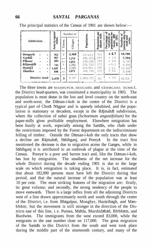
66 SANTAL PARGANAS
The principal statistics of the Census of 1901 are shown below:—
Subdivision.
Are
a in
squ
are
mil
es.
Number of
Pop
ulat
ion.
Pop
ulat
ion
per
squa
re m
ile.
Per
cent
age
of
vari
atio
n in
po
pula
tion
be
twee
n 18
91
and
1901
.
Num
ber
of
pers
ons
able
to
read
an
d
wri
te.
Subdivision.
Are
a in
squ
are
mil
es.
Tow
ns.
Vil
lage
s.
Pop
ulat
ion.
Pop
ulat
ion
per
squa
re m
ile.
Per
cent
age
of
vari
atio
n in
po
pula
tion
be
twee
n 18
91
and
1901
.
Num
ber
of
pers
ons
able
to
read
an
d
wri
te.
The three towns are MADHUPUR, DEOGARH, and SAHIBGANJ; DUMKA,
the District head-quarters, was constituted a municipality in 1903. The population is most dense in the low and level country on the north-east and north-west; the Daman-i-koh in the centre of the District is a typical part of Chota Nagpur and is sparsely inhabited, and the population is stationary or decadent, except in the Rajmahal subdivision, where the collection of sabai grass (Ischoemum angustifolium) for the paper-mills gives profitable employment. Elsewhere emigration has been busily at work, especially among the Santals, who chafe under the restrictions imposed by the Forest department on the indiscriminate felling of timber. Outside the Daman-i-koh the only tracts that show a decline are Rajmahal, Sahibganj, and Poreya. In the tract first mentioned the decrease is due to migration across the Ganges, while in Sahibganj it is attributed to an outbreak of plague at the time of the Census. Poreya is a poor and barren tract and, like the Daman-i-koh, has lost by emigration. The smallness of the net increase for the whole District during the decade ending 1901 is due to the large scale on which emigration is taking place. It is, in fact, estimated that about 182,000 persons must have left the District during that period, and that the natural increase of the population was at least 10 per cent. The most striking features of the migration are: firstly, its great volume; and secondly, the strong tendency of the people to move eastwards. There is a large influx from all the adjoining Districts west of a line drawn approximately north and south through the centre of the District, i.e. from Bhagalpur, Monghyr, Hazaribagh, and Man-bhum; but the movement is still stronger in the direction of the Districts east of this line, i. e. Purnea, Malda, Murshidabad, Birbhum, and Burdwan. The immigrants from the west exceed 83,000, while the emigrants to the east number close on 117,000. The great migration of the Santals to this District from the south and west took place during the middle part of the nineteenth century, and many of the
Deogarh Godda Pakaur Rajmahal . Dumka Jamtara
District total
952 967 683
741 1,429
698
5.470
2
1
3
2,368 1,274 1,055 1,292 2,105 1,073
9,167
297403 390,323 238,648 276,703 416,861 189,799
1,809,737
312 404 349 373 292 272
331
+ 4.7 + 1.4 + 3-6 + 0.1
+ 3-1 + 9.2
+ 3-2
10,788 7,704 3,747 5,559 11,020 5,698
44,516
POPULATION 67
immigrants enumerated in the last Census are probably the survivors of those who took part in the movement. The tribe is stil l spreading east and n o r t h ; and the full effect of the movement is not exhausted in the Districts that adjoin the Santal Parganas, but makes itself felt even farther away in those parts of Dinajpur, Rajshahi, and Bogra which share wi th Malda the elevated tract of quasi-laterite known as the Barind. Of emigration to more distant places the most noticeable feature is the exodus to the Assam tea gardens, where more than 31,000 natives of this District were enumerated in 1901, and to Jalpaiguri, where they numbered more than 10,000. A large variety of dialects are used in the District. Bengali, spoken by 13-5 per cent, of the population, includes the Rarhi bolt, or classical Western Bengali, and Malpaharia or the broken Bengali spoken by converted aborigines in the centre of the District. Bihar! is spoken by 46 per cent.; the main dialect is Mai th i l i , which includes a sub-dialect known as Chhika Chikki bolt, but a dialect of Magadh!, which has been affected by its contact wi th Bengali, is also largely used; this is called by Dr. Grierson Eastern Magadh!, and is locally known as Karmal! or Khot ta or even as Khot ta Bangala. Santali itself, which is spoken by 649,000 persons, is a dialect of the Munda family, while Mai to belongs to the Dravidian group. Hindus constitute 56-1 per cent, of the total population, Animists 34-9 per cent., and Muhammadans 8-4 per cent.
The Santals are now the distinctive caste of the District, and in 1901 numbered 663,000, of whom 74,000 were returned as Hindus and 589,000 as Animists. They are a typical race of aboriginal stock, and are akin to the Bhumijs, Hos, and Mundas. Their complexion varies from very dark brown to an almost charcoal black, and their features are negritic. The original habitat of the race is not known, but there is no doubt that from a comparatively remote period they have been settled on the Hazaribagh table-land ; and it is noticeable that the Damodar river, by which its southern face is drained, is the terrestrial object most venerated by them. Wi th in the last few centuries they have worked eastwards, and are numerous in the eastern half of the Chota Nagpur plateau and in Midnapore; and, as has been already related, they are now emigrating to Nor th Bengal and Assam. They worship various deities, of which the chief is the Marang Buru, who is credited with far-reaching power, in virtue of which he associates both with the gods and with demons. Each Santal family has also two special gods of its own, the Orak bonga or household god and the Abjebonga or secret god. Their principal festival is the Sohrai or harvest festival, celebrated after the chief rice crop of the year has been reaped. Public sacrifices of fowls are offered by the priest in the sacred grove; pigs, goats, and fowls are sacrificed by private families, and a general saturnalia of drunkenness and sexual licence
68 SANTAL PARGANAS
prevails. Chastity is in abeyance for the time, and all unmarried parsons may indulge in promiscuous intercourse. Next in importance is the Bahapuja, held in Phalgun (February-March) when the sal tree comes into flower. Tribal and family sacrifices are held, many victims are slain and eaten by the worshippers, every one entertains his friends, and dancing goes on day and night.
The communal organization of the Santals is singularly complete. The whole number of villages comprising a local settlement of the tribe is divided into certain large groups, each under the superintendence of a parganait or circle headman. This official is the head of the social system of the inhabitants of his circle; his permission has to be obtained for every marriage, and, in consultation with a panchayat of village headmen, he expels or fines persons who infringe the tribal standard of propriety. He is remunerated by a commission on the fines levied, and by a tribute in kind of one leg of the goat or animal cooked at the dinner which the culprits are obliged to give. Each village has, or is supposed to have, an establishment of officials holding rent-free land. The chief of these is the manjhi or headman, who is usually also ijaradar where the village is held on lease under a zamindar; he collects rents, and allots land among the ryots, being paid for this by the proceeds of the man land which he holds free of rent. He receives R. i at each wedding, giving in return a full bowl of rice-beer. The pramanik^ or assistant headman, also holds some man land. The jog-manjhi and the jog-pramanik are executive officers of the manjhi and the pramanik, who, as the Santals describe it, ' sit and give orders' which the jog-manjhi and jog-pramanik carry out. The naiki is the village priest of the aboriginal deities, and the kudam naiki is the assistant priest, whose peculiar function it is to propitiate the spirits (bhuts) of the hills and jungles by scratching his arms ti l l they bleed, mixing the blood with rice, and placing it in spots frequented by the bhuts. The gorait or village messenger holds man land and acts as peon to the headman, and is also to some extent a servant of the zamindar ^ His chief duty within the village is to bring to the manjhiand pramanik any ryot they want. Girls are married as adults mostly to men of their own choice. Sexual intercourse before marriage is tacitly recognized, it being understood that if the girl becomes pregnant the young man is bound to marry her. Should he attempt to evade this obligation, he is severely beaten by the jog-manjhi, and, in addition to this, his father is required to pay a heavy fine.
Other castes are Bhuiyas (119,000), identified by Mr. Oldham with the Mais, whom in many respects they closely resemble; Musahars (28,000), whom Mr. Risley considers to be akin to the Bhuiyas; Male Sauria Paharias (47,000) and Mai Paharias (26,000), two Dravidian
AGRICULTURE 69
tribes of the Rajmahal Hills, the former of whom are closely akin to the Oraons. The Muhammadans are chiefly Shaikhs (77,000) and Jolahas (63,000). Agriculture supports 81 per cent, of the population, industries 7 per cent., commerce 0.6 per cent., and the professions o»8 per cent.
Christians number 9,875, of whom 9,463 are natives, including 7,064 Santals. The largest numbers are to be found in the head-quarters subdivision, where the Scandinavian Lutheran Mission, called the Indian Home Mission, has been at work for over forty years and maintains 29 mission stations and 9 schools; it has also a colony in Assam, where it owns a tea garden. The Church Missionary Society, which works in the Godda and Rajmahal subdivisions, has similarly established an emigrating colony for its converts in the Western Duars. Several Baptist missionaries work in the Jamtara subdivision, one of whom has established two branches of his mission in the head-quarters subdivision. Other missions are the Christian Women's Board of Missions and the Methodist Episcopalian Mission, the latter of which works chiefly among Hindus and Muhammadans; it maintains a boarding-school, with an industrial branch in which boys and girls are taught poultry-keeping, gardening, fruit-farming, and carpentry.
The soil varies with the nature of the surrounding hills: where basalt or felspar or red gneiss prevails, the soil is rich; but where the hills are of grey gneiss or of granite in which quartz prevails, it is comparatively barren. The productiveness of the land is mainly dependent on its situation and its capability of retaining moisture. Where the surface is level and capable of retaining water coming from a higher elevation, it is not affected even by shortness or early cessation of rainfall, and good crops of rice are obtained. If, however, the slope is too steep, the rush of water often brings with it drifts of sand, which spoil the fields for rice cultivation and damage the growing crops. In the alluvial tract the system of cultivation differs in no way from that in vogue throughout the plains of Bihar. On the hill-sides level terraces are cut for rice cultivation, and these are flooded as soon as possible after the rains set in, small banks being left round the edge of each plot to hold in the water. Shifting cultivation is now restricted to the Saurias of the hills in the Rajmahal and Godda subdivisions, and to certain defined areas in Pakaur. Land under cultivation is divided into two main classes, hari or high land forming about 53 per cent, of the cultivated area, and jamin or rice-fields the rest. The former, being uneven and wanting in organic matter, is ordinarily ill-suited for cultivation; but in the immediate vicinity of villages, where the surface is fairly level and rich in organic matter, bari land produces
Agriculture.
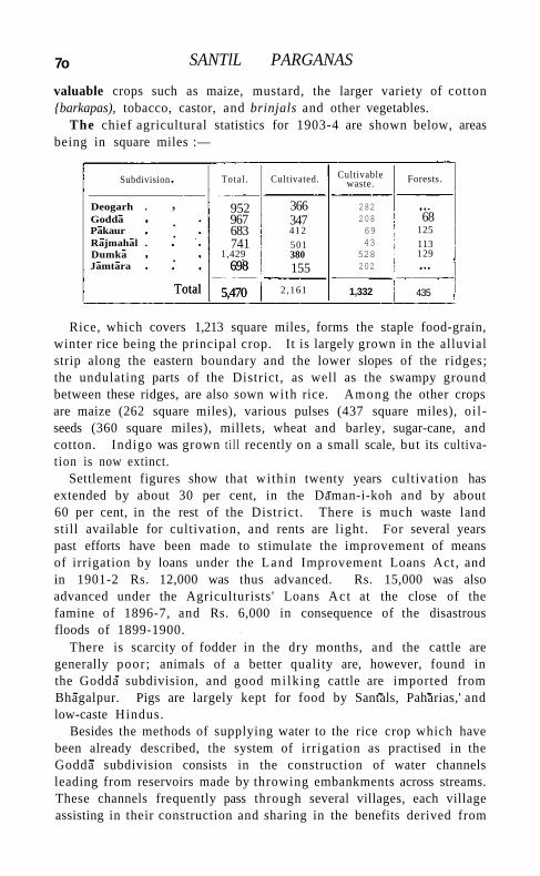
7o SANTlL PARGANAS
valuable crops such as maize, mustard, the larger variety of cotton {barkapas), tobacco, castor, and brinjals and other vegetables.
The chief agricultural statistics for 1903-4 are shown below, areas being in square miles :—
Subdivision Tota l . Cultivated.
Deogarh . , 952 366 Godda . 967 347 Pakaur . 683 412 Rajmahal . 741 501 Dumka . 1,429 380 Jamtara
Total
698
5,470
155
Total
698
5,470 2,161
Rice, which covers 1,213 square miles, forms the staple food-grain, winter rice being the principal crop. It is largely grown in the alluvial strip along the eastern boundary and the lower slopes of the ridges; the undulating parts of the District, as well as the swampy ground between these ridges, are also sown with rice. Among the other crops are maize (262 square miles), various pulses (437 square miles), oi l seeds (360 square miles), millets, wheat and barley, sugar-cane, and cotton. Indigo was grown t i l l recently on a small scale, but its cultivat ion is now extinct.
Settlement figures show that within twenty years cultivation has extended by about 30 per cent, in the Daman-i-koh and by about 60 per cent, in the rest of the District . There is much waste land still available for cultivation, and rents are light. For several years past efforts have been made to stimulate the improvement of means of irrigation by loans under the Land Improvement Loans Act, and in 1901-2 Rs. 12,000 was thus advanced. Rs. 15,000 was also advanced under the Agriculturists' Loans Act at the close of the famine of 1896-7, and Rs. 6,000 in consequence of the disastrous floods of 1899-1900.
There is scarcity of fodder in the dry months, and the cattle are generally poor; animals of a better quality are, however, found in the Godda subdivision, and good mi lk ing cattle are imported from Bhagalpur. Pigs are largely kept for food by Santals, Paharias,' and low-caste Hindus.
Besides the methods of supplying water to the rice crop which have been already described, the system of irrigation as practised in the Godda subdivision consists in the construction of water channels leading from reservoirs made by throwing embankments across streams. These channels frequently pass through several villages, each village assisting in their construction and sharing in the benefits derived from
Cultivable waste.
282 208 69 43 528 202
1,332
Forests.
68 125 113 129
435
FORESTS 71
a network of distributaries. There is but l i t t le irrigation from wells; kacheha wells are sometimes dug for only one season to irrigate the sugar-cane crop from February to May, and tobacco is also grown in small patches by the aid of well-water.
At the beginning of the nineteenth century the District was mostly covered wi th jungle. About 1820 the Santals began to flock into it and betook themselves to the congenial occupation of jungle clearing; while the construction of the loop railway in 1854 and of the chord-line in 1866 hastened the process. In 1875 Government instituted inquiries with a view to bringing under scientific management the Government forests in the Daman-i-koh, and in 1876 an area of 35 square miles was set aside for special reservation. This area was formally constituted a ' reserved' forest, and the forest lands in the southern half of the Daman-i-koh were constituted ' open ' forests, the management being left in the hands of the Deputy-Commissioner. In 1894 all Government land which had not been settled with cultivators was constituted 'protected ' forests under the Indian Forest Act ( V I I of 1878), and in 1895 the forests were placed in charge of the Forest department. The departmental system of management was, however, found not to be sufficiently elastic; and in December, 1900, the forests in the Rajmahal subdivision and part of those in the Godda subdivision were restored to the control of the Deputy-Commissioner. The hills in this tract are inhabited by Male Sauria Paharias, who are allowed the right of shifting cultivation, which renders scientific forestry impossible.
The chief tree is the sal {Shorea robusta), and its distribution is general throughout the District, except where the forest has been destroyed, as is largely the case in the north of the Daman-i-koh, by shifting cultivation and the cultivation of sabai grass. In the plains and valleys the forest is usually of pure sal, the other principal trees being piar {Buchanania latifolia), Semecarpus anacardiam, and dsan (Terminalia tomentosa). On the lower slopes of the hills other species appear in considerable variety; among these are Zizyphus xylopyra, Anogeissus latifolia, Diospyros, Stereospermutn, and Bauhinia. As the hills are ascended, different species are met wi th , such as bamboos (Dendrocalamus strictus), bljasal (Pterocarpus Marsupiuni), sitsdl (Dal-bergia latifolia), gamhdr (Gmelina arborea), Kydia calycina, and Gretvia tiliaefolia, the proportion of sal gradually getting less, t i l l on the upper plateau it almost disappears, and on the old cleared lands gives place to a dense growth of shrubby trees, chief among which are Nyctanthes Arbor-tristis, Wendlandia, Gardenia, Flacourtia, Woodfordia, and Anogeissus. At present most of the sal trees are mere shoots from stumps 2 to 3 feet high, which, when they grow to a large size, are always unsound at the base. Cultivating tenants of Government are allowed
Forests.
7* SANTAL PARGANAS
to remove free of charge all timber of the unreserved species and such minor products as are required for their domestic consumption.
The area under the Forest department is 292 square miles; and in 1903-4 the revenue under its control was Rs. 42,000. Besides this, 143 square miles are managed by the Deputy-Commissioner. The chief sources of revenue are timber, bamboos, and sabai grass, while minor items are fuel, coal, stone, and tasar silk cocoons. Other jungle products are lac, found on the palds {Butea frondosa), ber (Zizyphus Jujuba), and pipal {Ficus religiosa) trees; beeswax, catechu, honey, konjtu and jombar (two creepers used for making rope), and also a variety of edible products. The use of jungle products as a means of subsistence is confined for the most part to Paharias, Santals, and Bhuiyas.
Stone is quarried on the hills bordering the loop-line of the East Indian Railway from Murarai to Sahibganj; the stone quarried is for
the most part supplied as ballast to the railway, the Calcutta municipality, and certain District boards.
In 1903 coal-mines were worked at Bhalkl, Domanpur, Ghatchora, and Sarsabad in the Dumka subdivision, and at Sultanpur and Palasthol mines in the Jamtara subdivision. The average daily number of persons employed was 79, and the output of coal was 2,361 tons. The Jamtara mines, which lie in the Damodar coal-field, produce good coal, but are only worked on a small scale for want of access to the railway; elsewhere the coal is limited in extent and inferior in quality, and is generally fit only for brick-burning. Hand labour is employed as a rule in digging out the coal, the wages paid being Rs. 1-4 to Rs. 1-8 per 100 cubic feet of coal lifted. Copper ores exist at BeherakI in the Deogarh subdivision, and lead ores (principally argentiferous galena) occur in the Sankara hills and at Turipahar, BeherakI, and Panchpahar. At BeherakI 29 oz. 8 dwt. of silver have been obtained per ton of lead, and at Lakshmlpur near Naya Dumka 50 oz. 3 grs. of silver per ton of lead. A considerable area, especially in the Rajmahal Hills, is occupied by laterite, often constituting an excellent iron ore. Siliceous white clays belonging to the coal-measures at Lohandia in the Hura coal-field are suitable for the pottery.
The arts and manufactures are of a primitive character and of little importance. The manufacture of mattocks, picks, ploughs, hooks,
knives, axes, spears, arrows, and shields is carried on as a village industry. The iron was formerly smelted from native ore by Kol settlers; but with
the destruction of jungle and the greater facility that now exists for obtaining old scrap-iron cheap from Deogarh and Rampur Hat, the Marayeahs or blacksmiths of the District no longer use locally smelted
Minerals.
Trade and communications.
TRADE AND COMMUNICATIONS
iron or steel. Bats or measuring cups of a pretty though stereotyped pattern are made on a limited scale by Thatheris and Jadapetias (braziers). Mochis and Chamars carry on a fairly extensive industry in tanning leather and making shoes; Doms, Haris, and Santals cure skins for exportation; Mahlis make baskets, bamboo mats, and screens; Tatwas and JolahSs weave coarse cotton cloths; and Kumhars make tiles, pots, and pans. The manufacture of ghi, oil (mahua, sarguja, and mustard), and gur or coarse sugar is carried on as a domestic industry. Tasar cocoons are grown throughout the District, and spinning and weaving are also carried on. The lac insect is reared on paleis trees on a fairly large scale; a Marwari at Dumka manufactures about 700 maunds of shellac per annum for export, and there are other factories in the neighbourhood of Dumka and at Pakaur, while lacquered bangles are manufactured at Nunihat and a few other places. Village carpenters are numerous, and wood-carving is carried on to a very small extent. Silver and pewter ornaments are also made. Indigo was ti l l recently manufactured in a few European and native factories, but the industry is now extinct. Brick-making on European rhethods has been carried on at Maharajpur for the last few years.
The chief imports are rice, gunny-bags, raw cotton, sugar refined and unrefined, molasses, European and Bombay piece-goods, salt, kerosene oil, coal and coke. The chief exports are food-grains, linseed and mustard seed, sabai grass, road-metal, hides, raw fibres, and tobacco. Trade is carried on at markets, and is almost exclusively in the hands of traders from Bihar and Marwari merchants. The principal entrepot is Sahibganj. About 200,000 maunds of sabai grass are exported to the paper-mills near Calcutta, the approximate value of the export being 4 lakhs. Road-metal is exported chiefly to Calcutta, Hooghly, and Burdwan. The trade in hides is chiefly carried on in the headquarters and Pakaur subdivisions.
The District is traversed on the east by the loop-line and on the west by the chord-line of the East Indian Railway. The Girldih branch leaves the chord-line at Madhupur within the District, and there is also a short branch connecting Rajmahal on the Ganges with the loop-line. A small branch line from Baidyanath junction to Deogarh is worked by a private company. The construction of a line from Bhagalpur to Hansdiha by a private syndicate was sanctioned, but the concession lapsed before the necessary capital was raised. There are also projects for the construction of lines from Bhagalpur to Deogarh, from Ahmadpur to Baidyanath, and from Mangalpur via Suri to Dumka. The District possesses good roads by which its produce is carted to the railway; 848½ miles being maintained by the District road committee, in addition to village roads and roads in Government estates. The chief roads are the Bhagalpur-Suri road passing through
74 SANTAL PARGANAS
Dumka, the Suri-Monghyr road passing through Deogarh, the roads from Dumka to Rampur Ha t and to the different subdivisional headquarters, the road from Murshidabad along the Ganges through Rajmahal and Sahibganj to Bhagalpur, as well as several connecting cross-roads and feeder roads to the railway stations. The Ganges, which skirts the north-east of the District, forms an important channel of communication, but the other streams of the District are of no commercial importance.
The District has thrice suffered from famine within the last fifty years. On occasions of scarcity the mahua and the mango trees
afford food for large numbers; but in 1865-6, when there was great scarcity and distress, the people were
compelled by hunger to eat the mangoes while stil l unripe, and thousands of deaths from cholera resulted. In 1874 relief was afforded by Government on a lavish scale, the fruit was allowed to ripen before being plucked, and there was no outbreak of disease. In 1896-7 part of the Jamtara subdivision and the whole of the Deogarh subdivision were declared affected. Relief works were opened in Jamtara and in Deogarh; but the highest average daily attendance in Jamtara was only 3,258, in the th i rd week of May, 1897, and in Deogarh 1,647, towards the end of June. The works were finally closed on August 15, after an expenditure of Rs. 29,000 on works and Rs. 25,000 on gratuitous relief.
For administrative purposes the District is divided into six subdivisions, with head-quarters at D U M K A , D E O G A R H , G O D D A , R A J
M A H A L , P A K A U R , and J A M T A R A . A Joint-Magistrate
or Deputy-Magistrate-Collector is usually in charge of the Rajmahal subdivision, and a Deputy-Magistrate-Collector of each of the other subdivisions; in addition, three Deputy-Magistrate-Collectors and a Sub-Deputy-Magistrate-Collector are stationed at Dumka, and one Deputy-Magistrate-Collector and one Sub-Deputy-Magistrate-Collector at Rajmahal, Deogarh, and Godda, and one Sub-Deputy-Magistrate-Collector at Jamtara and Pakaur. These officers have c ivi l and criminal jurisdiction as detailed in the following paragraph. The Deputy-Commissioner is vested ex officio with the powers of a Settlement officer under the Santal Parganas Regulation I I I of 1872, and is also Conservator of forests. An Assistant Conservator of forests is stationed in the District.
The civi l and criminal courts are constituted under Regulation V of 1893, as amended by Regulation I I I of 1899. The Sessions Judge of Birbhum is Sessions Judge of the Santal Parganas and holds his court at Dumka. Appeals against his decisions lie to the H i g h Court of Calcutta. The Deputy-Commissioner exercises powers under sect ion 34 of the Criminal Procedure Code and also hears appeals from all Deputy-Magistrates. In all criminal matters, except in regard to
Administration.
Famine.
ADMINISTRATION 75
cases committed to the Court of Sessions and proceedings against European British subjects, the Commissioner of Bhagalpur exercises the powers of a High Court. Suits of a value exceeding Rs. 1,000 are tried by the Deputy-Commissioner as District Judge, or by subdivi-sional officers vested with powers as Subordinate Judges. These courts are established under Act X I I of 1887, and are subordinate to the High Court of Calcutta. Suits valued at less than Rs. 500 are tried by Deputy- and Sub-Deputy-Collectors sitting as courts under Act X X X V I I of 1855, an appeal lying to the subdivisional officer. That officer can try all suits cognizable by courts established under Act X X X V I I of 1855, and an appeal against his decision lies to the Deputy-Commissioner. There is no second appeal where the appellate court has upheld the original decree; if, however, the decree has been reversed, a second appeal lies to the Commissioner of the Division. The Deputy-Commissioner and Commissioner have powers of revision. These courts follow a special procedure, thirty-eight simple rules replacing the Code of Civil Procedure. A decree is barred after three years; imprisonment for debt is not allowed; compound interest may not be decreed, nor may interest be decreed to an amount exceeding the principal debt. When any area is brought under settlement, the jurisdiction of the courts under Act X I I of 1887 is ousted in regard to all suits connected with land, and such suits are tried by the Settlement officer and his assistants or by the courts established under Act X X X V I I of 1855 ; the findings of a Settlement court have the force of a decree. The District is peaceful, and riots are almost unknown. Persons suspected of witchcraft are sometimes murdered; cattle-theft is perhaps the most common form of serious crime.
The current land revenue demand in 1903-4 was 3-84 lakhs, of which I - I 6 lakhs was payable by 449 permanently settled estates, Rs. 1,600 by 5 temporarily settled estates, and 2-66 lakhs by 9 estates held under direct management by Government. Of the latter class, the D A M A N - I - K O H is the most important.
Under Regulation I I I of 1872 a Settlement officer made a settlem e n t of the whole District between the years 1873 and 1879, defining and recording the rights and duties of landlord and tenants, and where necessary fixing fair rents. One of the results of this settlement was to preserve the Santal village community system, under which the village community as a whole holds the village lands and has collective rights over the village waste; these rights, which have failed to secure recognition elsewhere in Bengal, were recorded and saved from encroachment. As regards villages not held by a community, the custom prevailed of leasing them to mustajirs, a system which led to great abuses, and there was also a tendency for the zamindar to treat the Santal manjhi as though he were but a lessee or mustajir. By the
VOL. X X I I . F
76 SANTAL PARGANAS
police rules of 1856 a mandal or headman was elected for each village where the zamindar's mustajir was not approved by the Magistrate and villagers, his duties consisting of the free performance of police and other public duties. As, however, it was unsatisfactory to have two heads to a village, the zamindar's mustajir and the ryot mandal gradually merged into one, wi th the result that a mustajir, when appointed, had to secure the approval of the Magistrate, zamindars, and villagers. The position of the headman thus developed was denned at the settlement: he has duties towards the zamindar, the ryots, and the Magistrate; he may be dismissed by the last-named personage on his own motion or on the complaint of the zamindar or ryots; and the stability of tenure secured by Regulation I I I of 1872 prevents the zamindar from ousting h im. The rights of a headman are not usually transferable, but in the Deogarh subdivision some headmen known as mul-ryo\s are allowed to sell their interest in a v i l lage. In 1887 Government passed orders to prevent the sale of ryots' holdings being recognized by the courts in areas in which no custom of sale had been proved. In 1888 the revision of the settlement of 1873-9 in certain estates was undertaken, and the work is being gradually extended throughout the District .
Prominent among the unusual tenures of the District are the ghat-walls of lappa Sarath Deogarh, which cover almost the whole Deogarh subdivision and are also found in Jamtara and Dumka. These are police tenures, originally established by the Muhammadan government to protect the frontier of Bengal against the Marathas.
Cultivable land is divided generally into five classes : three kinds of dhanl or rice land, and two kinds of hari or high land. Dhanl lands are classified according to the degree by which they are protected from drought, and the average rates or rent may be said to be for the first class Rs. 3, for the second Rs. 2, and for the th i rd R. 1. First-class hari land is the well-manured land near the homesteads, averaging R. 1; while second-class hari lands include the remainder of the cultivation on the dry uplands, and average 4 annas. Rates vary widely and the averages are only an approximation. In the recent settlement, the average rent for dhani land over 600 acres of typical zamindari country was Rs. 1-11 per acre, and for hari land 6 annas, and the corresponding figures for the Daman-i-koh were Rs. 1-9 and R. 0-5-4. Ryots have, however, been allowed abatements in the settlement actually concluded, and the settled rents do not average more than Rs. 1~8 an acre for dhani lands, and 8 annas for hari land. In the Daman-i-koh the average holding of a cultivator is 9\ acres, of which 4½ acres are dhani l and ; the total average rent rate is Rs. 8-14, but the average rent settled is only Rs. 6-1 per holding. In private settled estates the rents payable are somewhat higher.
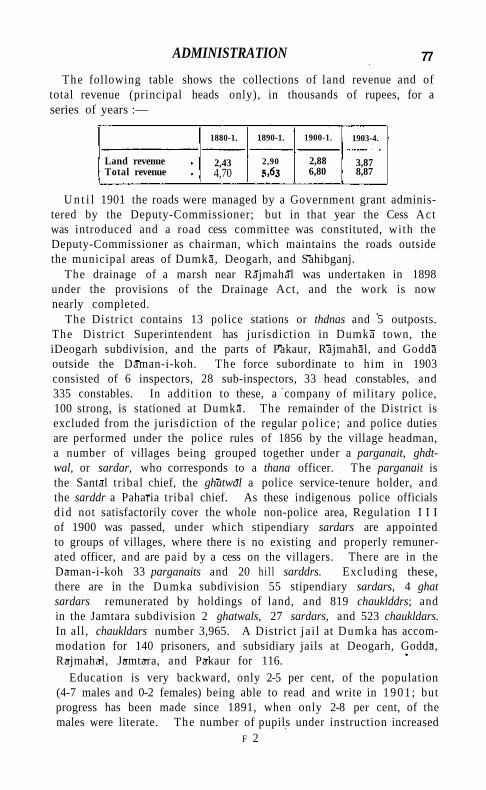
ADMINISTRATION 77
The following table shows the collections of land revenue and of total revenue (principal heads only), in thousands of rupees, for a series of years :—
1880-1. 1890-1. 1900-1. 1903-4.
Land revenue Total revenue
2,43 4,70
2,90 2,88 6,80
3,87 8,87
U n t i l 1901 the roads were managed by a Government grant administered by the Deputy-Commissioner; but in that year the Cess Act was introduced and a road cess committee was constituted, with the Deputy-Commissioner as chairman, which maintains the roads outside the municipal areas of Dumka, Deogarh, and Sahibganj.
The drainage of a marsh near Rajmahal was undertaken in 1898 under the provisions of the Drainage Act, and the work is now nearly completed.
The District contains 13 police stations or thdnas and 5 outposts. The District Superintendent has jurisdiction in Dumka town, the iDeogarh subdivision, and the parts of Pakaur, Rajmahal, and Godda outside the Daman-i-koh. The force subordinate to him in 1903 consisted of 6 inspectors, 28 sub-inspectors, 33 head constables, and 335 constables. In addition to these, a company of military police, 100 strong, is stationed at Dumka. The remainder of the District is excluded from the jurisdiction of the regular pol ice; and police duties are performed under the police rules of 1856 by the village headman, a number of villages being grouped together under a parganait, ghdt-wal, or sardar, who corresponds to a thana officer. The parganait is the Santal tribal chief, the ghatwal a police service-tenure holder, and the sarddr a Paharia tribal chief. As these indigenous police officials d id not satisfactorily cover the whole non-police area, Regulation I I I of 1900 was passed, under which stipendiary sardars are appointed to groups of villages, where there is no existing and properly remunerated officer, and are paid by a cess on the villagers. There are in the Daman-i-koh 33 parganaits and 20 h i l l sarddrs. Excluding these, there are in the Dumka subdivision 55 stipendiary sardars, 4 ghat sardars remunerated by holdings of land, and 819 chauklddrs; and in the Jamtara subdivision 2 ghatwals, 27 sardars, and 523 chaukldars. In all, chaukldars number 3,965. A District ja i l at Dumka has accommodation for 140 prisoners, and subsidiary jails at Deogarh, Godda, Rajmahal, Jamtara, and Pakaur for 116.
Education is very backward, only 2-5 per cent, of the population (4-7 males and 0-2 females) being able to read and write in 1901 ; but progress has been made since 1891, when only 2-8 per cent, of the males were literate. The number of pupils under instruction increased
F 2
78 SANTAL PARGANAS
from about 17,000 in 1883 to 18,650 in 1892-3, to 22,755 in 1900-1, and to 27,284 in 1903-4, of whom 1,314 were females. In that year, 9.3 per cent, of the boys and 0.95 per cent, of the girls of school-going age were at school. The educational institutions consisted of 26 secondary, 912 primary, and 90 special schools, among which may be mentioned a training school for gurus at Taljhari under the Church Missionary Society, a training school at Benagaria under the Lutheran Mission, and the Madhupur industrial school maintained by the East Indian Railway Company. A special grant of Rs. 9,500 is annually made by Government to encourage primary education among the Santals, and 5,555 aborigines were at school in 1900. The total expenditure on education in 1903-4 was 1.81 lakhs, of which Rs. 78,000 was contributed from Provincial revenues, Rs. 1,100 from municipal funds, and Rs. 45,000 from fees.
In 1903 the District contained 10 dispensaries, of which 7 had accommodation for 89 in-patients. The cases of 60,000 out-patients and 800 in-patients were treated, and 2,686 operations were performed. The expenditure was Rs. 15,000, of which Rs. 5,000 was met from Government contributions, Rs. 1,000 from Local and Rs. 2,300 from municipal funds, and Rs. 6,000 from subscriptions. Two of the dispensaries in the Daman-i-koh are maintained by an annual subscription among the Santals of an anna per house, Government providing the services of a civil Hospital Assistant. In addition, the various missionary societies all maintain private dispensaries. The Raj Kumari Leper asylum, a well-endowed institution with substantial buildings, is managed by a committee of which the Deputy-Commissioner is chairman.
Vaccination is compulsory only in municipal areas. In 1903-4 the number of persons successfully vaccinated was 76,000, or 42-5 per 1,000.
[Sir W. W. Hunter, Statistical Account of Bengal, vol. xv (1877), and Annals of Rural Bengal(1868); W. B. Oldham, Santal Parganas Manual (Calcutta, 1898); H. H. Heard, Ghatwali and Mul-ryoti Tenures as found in Deogarh (Calcutta, 1900); F. B. Bradley-Birt, The Story of an Indian Upland (1905).]
Santalpur (with Chadchat).—Petty State in the Political Agency of Palanpur, Bombay. See PALANPUR AGENCY,
Santals.—Tribe in Bengal. See SANTAL PARGANAS. Santapilly.—Village in the Bimlipatam tahsil of Vizagapatam
District, Madras, situated in 180 4' N. and 830 37' E. In 1847 a lighthouse was erected on the summit of a small hill here, to warn coasting vessels making for Bimlipatam off the Santapilly rocks, distant about 6J miles, the lighthouse bearing south-east half east and being distant about 17½ miles north-east of Bimlipatam. The
SANTIPUR 79
light is visible 14 miles seaward. There is a safe passage in clear weather between the rocks and the shore, the channel being 6 miles wide.
Sante Bennur.— T o w n in the Channagiri taluk of Shimoga District, Mysore, situated in 140 10' N. and 760 0' E., 8 miles west of Sasalu railway station. Population (1901), 1,613. It was founded by a chief of the Basavapatna family, probably in the sixteenth century. A palace was buil t by Hanumappa Naik, and an ornamental honda or reservoir made in front of the temple, wi th pavilions at the angles and in the centre. When Basavapatna was taken by the Bijapur forces, the Musalmans destroyed the temple here and buil t a mosque on a large scale in its place, further erecting elegant upper storeys to the pavilions at the honda. The chief, who had been forced to retire to Tarikere, slew the Musalman governor and desecrated the mosque in revenge. The Chitaldroog chief took the place early in the seventeenth century; but in 1717 it was captured by Bednur, which held it t i l l i t fell into the hands of Haidar Ali i n 1761. The Marathas under Parasuram Bhao sacked the town in 1791. The mosque, never used Since its desecration, and the honda, with its ruinous but graceful pavilions, are the only features of interest now left.
Santhal .—Petty State in M A H I K A N T H A , Bombay. Sant ipur .—Town in the Ranaghat subdivision of Nadia District,
Bengal, situated in 230 15' N. and 88° 27' E., on the Hooghly river. Population (1901), 26,898, having declined from 30,437 in 1891 ; but it is still the most populous town in the District. Hindus number 18,219, Muhammadans 8,672, and Christians 6. Santipur was constituted a municipality in 1865. The income during the decade ending 1901-2 averaged Rs. 28,000, and the expenditure Rs. 25,000. In 1903-4 the income was Rs. 31,000, including Rs. 16,000 derived from a tax on houses and lands, and Rs. 7,000 obtained from municipal property; and the expenditure was Rs. 26,000. Santipur was once the centre of a flourishing weaving industry, and its muslins had a European reputation, the town being the site of a Commercial Residency and the centre of large factories under the East India Company. Owing to the competition of machine-made goods, however, the weavers are no longer prosperous. There was at one time a considerable trade in date-sugar, but this too is becoming less profitable. The earthquake of 1897 destroyed many of the largest buildings, and the impoverished owners have been unable to replace them. There is stil l , however, a considerable local trade. The Rash Jatra festival in honour of Krishna, celebrated on the day of the full moon in Kar t ik (October-November), is attended by about 10,000 persons; Santipur is also a celebrated bathing-place. The Zanana Mission has a school and dispensary here.
8o SANTOPILLY
Santopilly. — Village and lighthouse in Vizagapatam District, Madras. See SANTAPILLY.
Saoner.—Town in the District and tahsil of Nagpur, Central Provinces, situated in 210 23' N. and 780 55' E., 23 miles north-west of Nagpur city on the Chhindwara road. The town is built on both sides of the Kolar river, the people on the northern bank consisting of Marathas, and those on the southern of Lodhis, Kirars, and other immigrants from Northern India. The present name is a corruption of the old one of Saraswatpur or ' the city of Saraswati,' the goddess of wisdom. Population (1901), 5,281. The town contains an old temple constructed of large blocks of stone without mortar, and the ruins of a fort ascribed to the Gaolis. Saoner was constituted a municipality in 1867. The municipal receipts during the decade ending 1901 averaged Rs. 2,800. In 1903-4 the income was Rs. 5,000, derived mainly from a house tax, market dues, and rents of land. The town is an important cotton mart, and possesses three ginning factories containing 108 cotton-gins, two of which are combined with cotton-presses. The aggregate capital of these factories is about 4^ lakhs, and two of them have been opened since 1900. The Saoner ginning factory, started in 1883, was the first in the District. A hand-dyeing industry is also carried on, in connexion with which al (Morinda citrifolia) was formerly cultivated round the town. A few trees are still left. A large weekly cattle market is held, and there are an English middle school and branch schools. A dispensary is maintained by the mission of the Scottish Free Church.
Saptagram. — Ruined town in Hooghly District, Bengal. See SATGAON.
Saptashring ('the seven-horned,' otherwise, but wrongly, called Chattar-singh or ' the four-peaked').—One of the highest points in the Chandor range, Nasik District, Bombay, situated in 200 23' N. and 73° 55' E., 4,659 feet above sea-level. It rises about the centre of the range, 15 miles north of Dindori. The highest point towers 900 feet above the plateau, and the rock is perpendicular on all sides but one, where it has crumbled away and grass has grown in the crevices. The rock has more peaks than one, but it seems to have no claim to the title 'seven-horned.' The hill may be climbed from three sides: by a good but steep bridle-road from the north; by a very steep sixty-step path on the east, formerly the only road used by pilgrims, but now abandoned; and on the south by a steep footpath for part of the way which ends in a flight of 350 steps carved in the face of the rock. This last is the road now commonly used by the pilgrims and other visitors. On the steps figures of Rama, Hanuman, Radha, and Krishna, and in one or two places a tortoise, are carved at intervals. These steps were made in 1768-99 by three brothers, Konher, Rudraji, and
SARA 81
Krishnaji of Nasik. At intervals five inscriptions have been carved on and near the steps. One of the inscriptions is in Sanskrit, the others in Marathi. They give the names of the three brothers and of Girmajl their father. At the foot of the steps the three brothers buil t a temple of Devi and a resthouse, and at the top a temple of Ganpati and a pond called Ramtlr th. These steps lead to the plateau, and from the plateau a farther flight of 472 steps leads to the shrine of Saptashringanivasini Devi. The 472 steps to the upper hill-top were built about 1710, before the lower steps, by U m a Bai, wife of Khande Rao Dabhade, the hereditary general of the Maratha army.
The shrine of the goddess, known as Mahishasur Mardin i or Saptashringanivasini, is in a cave at the base of a sheer scarp, the summit of which is the highest point of the h i l l . Something like a portico was added to the shrine of the goddess at the beginning of the eighteenth century by the Satara commander-in-chief, and the present plain structure has been recently bui l t by the chief of Vinchur. At the foot of the steps leading to the shrine is a small stone reservoir dedicated to Siva and called Sivalya-tlrth, which is said to have been built by Uma Bai. On one side of the pond stands a Hemadpanti temple of Siddheshwar Mahadeo, mostly in ruins but with the dome still standing, with some rather elaborate stone-carving. Under the dome stands the lingam, and outside in front of it a carved bull . Not far from the bathing-place is a precipice known as the Sit Kade, which overhangs the valley about 1,200 feet; from this rock human sacrifices are said to have been formerly hur led ; a k i d is now the usual vict im.
A large fair lasting for a week, and attended by about 15,000 pilgrims, is held on the full moon of Chaitra (Apri l ) . On the occasion of the fair the steps leading to the shrine are crowded with the sick and maimed, who are carried up the h i l l in hopes of a cure. Barren women also go in numbers to make vows and gain the gift of a child. Like the top of Mahalakshml in Dahanu, the top of Saptashring is said to be inaccessible to ordinary mortals. The headman of the village of Burigaon alone climbs up on the A p r i l full moon, and next morning at sunrise is seen planting a flag. H o w he climbs and how he gets down is a mystery, any attempt to pry into which, says the tradition, is attended by loss of sight.
Sara.—Vil lage in the head-quarters subdivision of Pabna District, Eastern Bengal and Assam, situated in 240 6' N. and 890 3' E., on the north bank of the Padma. Population (1901), 3,011, including 2,004 persons enumerated within railway limits. Sara is the terminus of the Eastern Bengal State Railway (northern section), and is connected by a steam ferry with Damukdia on the south bank of the river, and is consequently an important trade centre. It is proposed that the
82 SARA
Ganges should here be bridged, to bring the tract north of the Padma into direct railway communication with Calcutta without transhipment.
Saragarhi.—Village on the crest of the Samana range, Kohat District, North-West Frontier Province, situated in 330 55' N. and 700 45' E. It is held by the Babi Khel, a section of the Rabia Khel Orakzai. During the Miranzai expedition of 1891, the village was destroyed after severe fighting and an outpost was built. In 1897 this post, then held by 21 men of the 36th Sikhs, was attacked by several thousand Orakzais, who overwhelmed the little garrison after a heroic defence and massacred the Sikhs to a man on September 12. A monument at Fort Lockhart commemorates the gallantry of the defence, while other memorials have been erected at Amritsar and Ferozepore in the Punjab,
Saraikela.— Feudatory State in Chota Nagpur, Bengal, lying between 220 29' and 220 54' N. and 850 50' and 86° 11' E., with an area of 449 ' square miles. It is bounded on the north by Manbhum District; on the east and west by Singhbhum; and on the south by the State of Mayurbhanj. It consists chiefly of an undulating plain dotted with small rocky hills; towards the east it is more hilly, and the' higher ranges in the extreme north-east still contain valuable timber. The scenery throughout is wild and romantic in places. The forests altogether cover about 50 square miles, the chief tree being the sal {Shorea robustd); sabai grass (Ischoemum angustifolium) grows in the forests. The State is drained by five streams : the Kharkai, the Sanjai, the Sonai, the Asuya, and the Bhangbanga. The largest of these, the Kharkai, rises from a hill in Mayurbhanj and flows northwards past Saraikela village, which it skirts on its southern side, eventually joining the Sanjai, a tributary of the Subarnarekha.
The first ruler of Saraikela was Bikram Singh, a younger son of the Porahat Raj family. Obtaining part of what is now the Saraikela State as a fief, he quickly made himself independent. He and his descendants enlarged their dominions from time to time, and gradually eclipsed the parent family of Porahat in power and importance. Saraikela first came under the notice of the British in 1793, when, in consequence of disturbances on the frontier of the old Jungle Mahals, its chief was compelled to enter into engagements relating to fugitive rebels. Ten years later, Lord Wellesley, the Governor-General, invited Kunwar Abhiram Singh, an ancestor of the present Raja, to render assistance in the war against RaghujI Bhonsla of Nagpur. In 1856 the Kunwar of Saraikela received the personal title of Raja Bahadur; and his services during the Mutiny were rewarded by a khilat and a rent-free grant in perpetuity of the sub-estate of Karaikela, a portion of the
1 This figure, which differs from the area shown in the Census Report of 1901, was supplied by the Surveyor-General.
SARAIKELA 83
escheated territory of the rebel Raja of Porahat. The present chief of Saraikela, Raja Udit Narayan Singh Deo Bahadur, rendered assistance to the British Government in the Bonai and Keonjhar risings of 1888 and 1891; the title of Raja Bahadur was conferred on him in 1884 as a personal distinction. Within the Saraikela State are included the estates of Dugnl, Banksai, and Icha, which were originally maintenance grants to members of the ruling family. They pay no rent, but are subordinate to the chief. The administration is conducted by the chief, who exercises judicial and executive powers subject to the control of the Deputy-Commissioner of Singhbhum and the Commissioner of the Chota Nagpur Division. He is empowered to pass sentences of imprisonment up to five years and of fine to the extent of Rs. 200, but sentences for more than two years' imprisonment require the confirmation of the Commissioner. Heinous offences requiring heavier punishment are dealt with by the Deputy-Commissioner. The present sanad of the chief was granted to him in 1899.
The population increased from 93,839 in 1891 to 104,539 in 1901, the density being 233 persons per square mile. The number of villages in the State is 816, the most important of which are Saraikela (population, 3,711), the head-quarters, which is administered as a municipality, and Sini, a junction on the Bengal-Nagpur Railway. Hindus number 63,650 and Animists 39,956, the most numerous castes or tribes being the Hos (21,000), Santals (20,000), and Kurmls (15,000). Most of the inhabitants are supported by agriculture ; rice is the staple food-grain, other crops raised being maize, pulses, and oilseeds.
Copper and iron are found, and nodular limestone is abundant. Slabs of rock, locally called makrasa, which occur in some parts of the State, serve for building purposes. Copper-smelting by native methods was carried on twenty-five years ago on a comparatively large scale, but has now been abandoned. Soapstone, slate, and mica are found in places. Cotton and tasar cloth, gold, silver and brass ornaments, copper trumpets, bell-metal cups and bowls, iron ploughshares, axes, vices, spades, shovels, knives, and locks are manufactured. The chief imports are cotton cloths, salt, kerosene oil, and spices; and the chief exports are rice, ropes, cotton, tamarind, sabai grass (Ischoemum angusti-folium) and timber. The Bengal-Nagpur Railway line runs from east to west across the north of the State. It is joined by the branch line to Asansol at Sini, where large iron and steel works are projected, to utilize ore from the Mayurbhanj State. The State is traversed by the roads from Chaibasa to Midnapore and Purulia, which are kept up by the Singhbhum road-cess committee; and a metalled road from Sini to Saraikela is maintained by the chief. The total revenue
84 SARAIKELA
of the State is Rs. 92,000, of which Rs. 72,000 is derived from the land. There is a police force of 11 officers and 25 men, and a jail with accommodation for 32 prisoners. The State also maintains a dispensary, 2 middle English, 3 upper primary, and 8 lower primary schools.
Saraj Tahsil.—Tahsil in the Kula subdivision of Kangra District, Punjab, lying between 310 21' and 310 50' N. and 770 17' and 770 47' E., with an area of 289 square miles. It is bounded on the north-east by Spiti; on the east and south by Bashahr and the Simla Hi l l States; and on the west by Suket and Mandl. The population in 1901 was 50,631, compared with 50,551 in 1891. It contains 25 villages, including Banjar, the head-quarters. The tahsil is divided into the two wazlris or cantons of Inner and Outer Saraj, separated from each other by the Jalori ridge, which has an average elevation of 12,000 feet. Inner Saraj lies in the Beas basin, and in physical aspects resembles the K U L U TAHSIL. Outer Saraj belongs to the Sutlej valley, and the country slopes down from the Jalori ridge to the river, which is here only 3,000 feet above the sea. The land revenue and cesses in 1903-4 amounted to Rs. 46,000.
Saralbhanga.—River of Assam, which rises in Bhutan and flows in a tortuous southerly course through Goalpara District, t i l l it falls into the Brahmaputra. Its principal tributary is the Gaurang, which gives its name to the lower reaches of the river. Through the greater part of its course it flows through jungle land, but it is one of the recognized trade routes of the District by which timber and other forest produce are exported. During the rainy season, boats of 4 tons burden can proceed as far as Patgaon, north of the trunk road. The total length of the Saralbhanga is about 81 miles.
Saran District.—District in the Patna Division of Bengal, lying between 250 39' and 260 39' N. and 830 54' and 850 12' E., with an area of 2,6741 square miles. The name is said to be derived from the Sanskrit Sarana, meaning ' refuge'; and there is a legend that some demons converted here by Buddha sought the ' refuge ' of the Buddhist triad, Buddha, Dharma, and Sangha. The District is a wedge of alluvial soil, between the Ganges and the Gandak rivers, with its apex pointing south-eastwards towards Patna city. The Gandak separates it on the east from MuzarTarpur and Champaran, and on the south the Ganges forms the boundary dividing Saran from Patna and Shah-abad. The western boundary marches with the United Provinces. The Gogra, running parallel with the Gandak, meets the Ganges opposite the head-quarters station of Chapra and forms the southwest boundary between Saran and Ballia District, while an irregular
1 This area, which differs from that given in the Census Report of 1901 (2,656 square miles), is that ascertained in the recent survey operations.
SARAN DISTRICT 85
base-line drawn north-east from the Gogra to the Gandak constitutes the western boundary with Gorakhpur.
Saran is a beautifully wooded plain, highly cultivated and densely populated, without a h i l l and hardly any elevations except those which mark the site of some old fortress or deserted village. It is very fertile, and is intersected by numerous water-channels which flow in a southeasterly direction. The G A N G E S , G A N D A K , and G O G R A are described elsewhere. The Daha or Sandl, Gandaki, Dhanai, and Ghangri were originally spill-channels from the Gandak, wi th which, however, their connexion has been severed by the Gandak embankment; they form the system known as the Saran Canals. Similar streams are the Khanua, Jharahi, and Khatsa, which ultimately fall into the Gogra or Ganges. The channels of the Ganges, Gandak, and Gogra are perpetually oscillating; and sandbanks form in the beds of the rivers one year, only to be swept away the next, so that frequent changes in jurisdiction are necessary.
The soil consists of alluvial deposits, the basis of which belongs to an older alluvial formation composed of massive argillaceous beds, disseminated throughout which occur kankar and pisolitic ferruginous concretions. These clay soils, locally known as bhat, are exposed in marshy depressions called chaurs, which are scattered over the District. Elsewhere they are overlaid with more recent sandy deposits known as hangar.
Though the District contains no forests, it is well timbered, the most conspicuous trees being the sissu (Dalbergia Sissoo), red cotton-tree (Bomhax malaharicum), and tamarind. The village sites are embedded in groves of the palmyra palm (Borassus flabellifer), the date palm (Phoenix sylvestris), and other semi-spontaneous and more or less useful species. The groves of mango-trees planted in beautifully regular lines are a marked feature of the landscape. The surface is highly cultivated ; but the banks of streams and patches of waste land are covered by a dry scrub jungle of shrubs of the order of Euphorbiaceae, Butea and other leguminous trees, and species of Ficus, Schleichera, Wendlandia, and Gmelina.
Nilgai and wi ld hog are common in the low scrub jungle which is met wi th on the alluvial islands, and are very destructive to crops. Wolves carry off a considerable number of infants, snakes are very numerous, and crocodiles infest the large rivers.
The winter months are delightfully cool, but the dry heat is intense in May and June. The mean temperature varies from 620 in January to 890 in May, and the maximum from 730 in January to 100° in A p r i l and May, while the mean minimum ranges from 500 in January to 790
in June to August. Saran is one of the driest Districts in Bengal, the
Physical aspects.
86 SARAN DISTRICT
average annual rainfall being only 45 inches. The monsoon commences in June, when 6-9 inches fall, and the maximum monthly fall of 12a inches is reached in July. The average fall for August is 11 inches and for September 7.6 inches. Humidity ranges from 57 per cent, in April to 88 per cent, in August. The rainfall is capricious, and during the decade ending 1901 it varied from 24 inches in 1896-7 (the lowest on record) to 65 inches in 1899-1900.
The District has always been liable to floods, which occur when the waters of the smaller rivers are banked up by high floods in the great rivers into which they flow. An embankment constructed along the right bank of the Gandak for a distance of 99 miles now protects the north-east of the District, but the south-west and south are still exposed to inundation from the Gogra and Ganges.
At the dawn of history Saran formed the eastern limit of the ancient kingdom of the Kosalas, whose head-quarters were in Oudh and who
were separated by the Gandak river from the eastern kingdom of Mithila. Very little is known of it, and
the absence of any reference in the early Vedic literature and the paucity of Buddhist remains render it probable that it maintained* its character as a vast jungle for a much longer period than either of the adjoining Districts of Muzaffarpur or Champaran. Indeed, the earliest authentic relic which has been found in Saran is an inscribed copperplate preserved in the village of Dighwa Dubaulia, about 34 miles north-east of Chapra, which Dr. Rajendralala Mitra declares to be a counterpart of a similar plate found by Colonel Stacy near Benares, dealing with the grant of a village by Raja Bhoja Deva, paramount sovereign of Gwalior about A.D. 876. The mediaeval history of the District is connected with the fortunes of the HATHWA family, whose head-quarters were at Husepur. Siwan and Manjhi were fortified seats of turbulent Musalman freebooters, while Manjha, Parsa, Mirzapur, Paterha, and Cherand were during the same period the head-quarters of powerful Hindu chieftains.
The recorded population increased from 2,076,640 in 1872 to 2,295,207 in 1881, and to 2,465,007 in 1891, but fell to 2,409,509
in 1901. The increases of 10½ per cent, between 1872 and 1881 and of 7-4 per cent, during the next
decade are partly attributable to improved enumeration. Several causes contributed towards the decrease of 2-2 per cent, during the last decade. The District already contained a larger population than it can support and the volume of emigration sensibly increased. The famine of 1897 told severely on the people, and, though it caused no direct mortality, reduced their vitality and lowered the birth-rate. Plague also assumed epidemic proportions during the winter of 1900-1.
History.
Population.
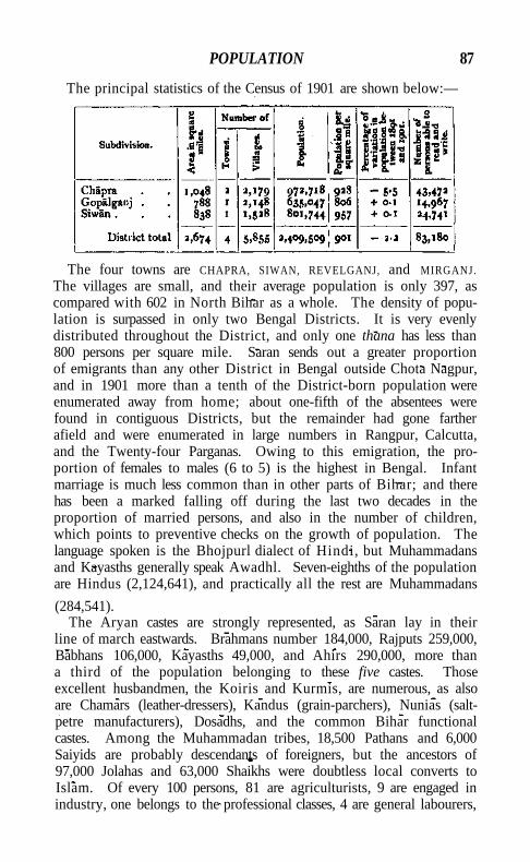
POPULATION 87
The principal statistics of the Census of 1901 are shown below:—
The four towns are CHAPRA, SIWAN, REVELGANJ, and MIRGANJ. The villages are small, and their average population is only 397, as compared with 602 in North Bihar as a whole. The density of population is surpassed in only two Bengal Districts. It is very evenly distributed throughout the District, and only one thana has less than 800 persons per square mile. Saran sends out a greater proportion of emigrants than any other District in Bengal outside Chota Nagpur, and in 1901 more than a tenth of the District-born population were enumerated away from home; about one-fifth of the absentees were found in contiguous Districts, but the remainder had gone farther afield and were enumerated in large numbers in Rangpur, Calcutta, and the Twenty-four Parganas. Owing to this emigration, the proportion of females to males (6 to 5) is the highest in Bengal. Infant marriage is much less common than in other parts of Bihar; and there has been a marked falling off during the last two decades in the proportion of married persons, and also in the number of children, which points to preventive checks on the growth of population. The language spoken is the Bhojpurl dialect of Hindi, but Muhammadans and Kayasths generally speak Awadhl. Seven-eighths of the population are Hindus (2,124,641), and practically all the rest are Muhammadans
(284,541). The Aryan castes are strongly represented, as Saran lay in their
line of march eastwards. Brahmans number 184,000, Rajputs 259,000, Babhans 106,000, Kayasths 49,000, and Ahirs 290,000, more than a third of the population belonging to these five castes. Those excellent husbandmen, the Koiris and Kurmis, are numerous, as also are Chamars (leather-dressers), Kandus (grain-parchers), Nunias (saltpetre manufacturers), Dosadhs, and the common Bihar functional castes. Among the Muhammadan tribes, 18,500 Pathans and 6,000 Saiyids are probably descendants of foreigners, but the ancestors of 97,000 Jolahas and 63,000 Shaikhs were doubtless local converts to Islam. Of every 100 persons, 81 are agriculturists, 9 are engaged in industry, one belongs to the professional classes, 4 are general labourers,
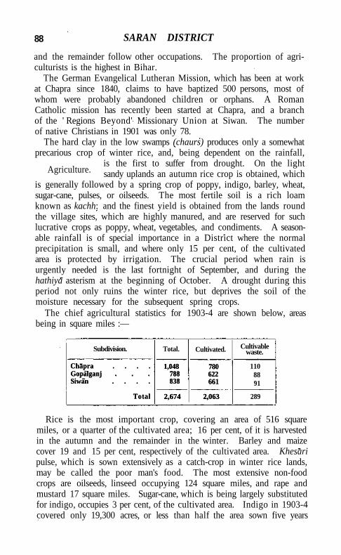
88 SARAN DISTRICT
and the remainder follow other occupations. The proportion of agriculturists is the highest in Bihar.
The German Evangelical Lutheran Mission, which has been at work at Chapra since 1840, claims to have baptized 500 persons, most of whom were probably abandoned children or orphans. A Roman Catholic mission has recently been started at Chapra, and a branch of the ' Regions Beyond' Missionary Union at Siwan. The number of native Christians in 1901 was only 78.
The hard clay in the low swamps (chaurs) produces only a somewhat precarious crop of winter rice, and, being dependent on the rainfall,
is the first to suffer from drought. On the light sandy uplands an autumn rice crop is obtained, which
is generally followed by a spring crop of poppy, indigo, barley, wheat, sugar-cane, pulses, or oilseeds. The most fertile soil is a rich loam known as kachh: and the finest yield is obtained from the lands round the village sites, which are highly manured, and are reserved for such lucrative crops as poppy, wheat, vegetables, and condiments. A seasonable rainfall is of special importance in a District where the normal precipitation is small, and where only 15 per cent, of the cultivated area is protected by irrigation. The crucial period when rain is urgently needed is the last fortnight of September, and during the hathiya asterism at the beginning of October. A drought during this period not only ruins the winter rice, but deprives the soil of the moisture necessary for the subsequent spring crops.
The chief agricultural statistics for 1903-4 are shown below, areas being in square miles :—
Subdivision. Total. Cultivated. Cultivable waste.
Chapra . . . . Gopalganj Siwan . . . .
Total
1,048 788 838
2,674
780 622 661
2,063
110 88 91
Chapra . . . . Gopalganj Siwan . . . .
Total
1,048 788 838
2,674
780 622 661
2,063 289
Rice is the most important crop, covering an area of 516 square miles, or a quarter of the cultivated area; 16 per cent, of it is harvested in the autumn and the remainder in the winter. Barley and maize cover 19 and 15 per cent, respectively of the cultivated area. Khesari pulse, which is sown extensively as a catch-crop in winter rice lands, may be called the poor man's food. The most extensive non-food crops are oilseeds, linseed occupying 124 square miles, and rape and mustard 17 square miles. Sugar-cane, which is being largely substituted for indigo, occupies 3 per cent, of the cultivated area. Indigo in 1903-4 covered only 19,300 acres, or less than half the area sown five years
Agriculture.
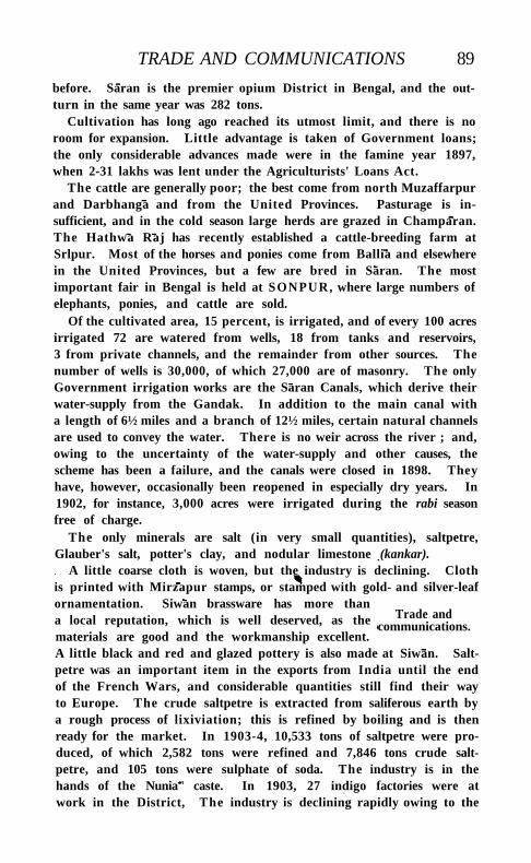
TRADE AND COMMUNICATIONS 89
before. Saran is the premier opium District in Bengal, and the outturn in the same year was 282 tons.
Cultivation has long ago reached its utmost limit, and there is no room for expansion. Little advantage is taken of Government loans; the only considerable advances made were in the famine year 1897, when 2-31 lakhs was lent under the Agriculturists' Loans Act.
The cattle are generally poor; the best come from north Muzaffarpur and Darbhanga and from the United Provinces. Pasturage is insufficient, and in the cold season large herds are grazed in Champaran. The Hathwa Raj has recently established a cattle-breeding farm at Srlpur. Most of the horses and ponies come from Ballia and elsewhere in the United Provinces, but a few are bred in Saran. The most important fair in Bengal is held at SONPUR, where large numbers of elephants, ponies, and cattle are sold.
Of the cultivated area, 15 percent, is irrigated, and of every 100 acres irrigated 72 are watered from wells, 18 from tanks and reservoirs, 3 from private channels, and the remainder from other sources. The number of wells is 30,000, of which 27,000 are of masonry. The only Government irrigation works are the Saran Canals, which derive their water-supply from the Gandak. In addition to the main canal with a length of 6½ miles and a branch of 12½ miles, certain natural channels are used to convey the water. There is no weir across the river ; and, owing to the uncertainty of the water-supply and other causes, the scheme has been a failure, and the canals were closed in 1898. They have, however, occasionally been reopened in especially dry years. In 1902, for instance, 3,000 acres were irrigated during the rabi season free of charge.
The only minerals are salt (in very small quantities), saltpetre, Glauber's salt, potter's clay, and nodular limestone (kankar).
A little coarse cloth is woven, but the industry is declining. Cloth is printed with Mirzapur stamps, or stamped with gold- and silver-leaf ornamentation. Siwan brassware has more than a local reputation, which is well deserved, as the materials are good and the workmanship excellent. A little black and red and glazed pottery is also made at Siwan. Saltpetre was an important item in the exports from India until the end of the French Wars, and considerable quantities still find their way to Europe. The crude saltpetre is extracted from saliferous earth by a rough process of lixiviation; this is refined by boiling and is then ready for the market. In 1903-4, 10,533 tons of saltpetre were produced, of which 2,582 tons were refined and 7,846 tons crude saltpetre, and 105 tons were sulphate of soda. The industry is in the hands of the Nunia" caste. In 1903, 27 indigo factories were at work in the District, The industry is declining rapidly owing to the
Trade and communications.
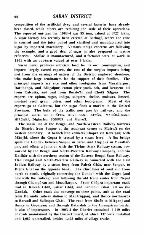
90 SARAN DISTRICT
competition of the artificial dye; and several factories have already been closed, while others are reducing the scale of their operations. The reported out-turn for 1903-4 was 95 tons, valued at 3*27 lakhs. A sugar factory has recently been erected at Barhoga, where the cane is crushed and the juice boiled and clarified and manufactured into sugar by imported machinery. Various indigo concerns are following the example, and a good deal of sugar is also prepared in native refineries. Shellac is manufactured, and 8 factories were at work in 1901 with an out-turn valued at over 3 lakhs.
Saran never produces sufficient food for its own consumption, and imports largely exceed exports, the cost of the surplus imports being met from the earnings of natives of the District employed elsewhere, who make large remittances for the support of their families. The principal imports are rice and other food-grains from Muzaffarpur, Darbhanga, and Bhagalpur, cotton piece-goods, salt, and kerosene oil from Calcutta, and coal from Burdwan and Chota Nagpur. The exports are opium, sugar, indigo, saltpetre, shellac, molasses, linseed, mustard seed, gram, pulses, and other food-grains. Most of the exports go to Calcutta, but the sugar finds a market in the United Provinces. The bulk of the traffic now goes by railway; and the principal marts are C H A P R A , R E V E L G A N J , S I W A N , M A H A R A J G A N J ,
M I R G A N J , Dighwara, SONPUR, and Mairwa.
The main line of the Bengal and North-Western Railway traverses the District from Sonpur at the south-east corner to Mairwa on the western boundary. A branch line connects Chapra via Revelganj with Manjhi, where the Gogra is crossed by a steam ferry. A fine bridge spans the Gandak between Sonpur in Saran and Hajipur in Muzaffarpur, and effects a junction with the Tirhut State Railway system, now worked by the Bengal and North-Western Railway Company, and via Katihar with the northern section of the Eastern Bengal State Railway. The Bengal and North-Western Railway is connected with the East Indian Railway by a steam ferry from Paleza Ghat, near Sonpur, to Digha Ghat on the opposite bank. The chief lines of road run from north to south, originally connecting the Gandak with the Gogra (and now with the railway), and following the old trade routes from Nepal through Champaran and Muzaffarpur. From Chapra important roads lead to Rewah Ghat, Sattar Ghat, and Salimpur Ghat, all on the Gandak. Other roads also converge on these points, such as the road from Doranda railway station to Maharajganj, and thence northwards to Barauli and Salimpur Ghat. The road from Siwan to Mirganj and thence to Gopalganj and through Batardah to the Champaran border is also of importance. In 1903-4 the District contained 1,219 miles of roads maintained by the District board, of which 137 were metalled and 1,082 unmetalled, besides 1,428 miles of village tracks.
ADMINISTRATION 91
The India General Steam Navigation Company has a daily steamer service on the Ganges and Gogra from Dlgha Ghat in Patna District, nearly opposite Sonpur, to Ajodhya in Oudh. These steamers connect at Dlgha Ghat with the Goalundo line, and are often crowded wi th coolies on their way going to or returning from Eastern Bengal. Numerous important ferries cross the Ganges, Gandak, and Gogra rivers.
SSran is less liable to famine than the neighbouring Districts, as it is protected both by the number and variety of its crops, and by the distribution of its harvests throughout the year. Nevertheless famine or scarcity has occurred on several occasions, notably in 1769, 1783, 1866, 1874, and 1897. Li t t le is known of the first two calamities. In 1866, the year of the Orissa famine, the winter rice failed and the spring crops were extremely poor; the relief afforded was inadequate, and over 8,000 persons died of starvation and disease. In 1874 famine was caused by the failure of nine-tenths of the winter rice crop. Relief on this occasion was given on an extravagant scale, and no deaths occurred from starvation; the number on relief works exceeded a quarter of a mi l l ion in June 1874. No less than 40,000 tons of grain were imported by Government, and the expenditure was 24 lakhs. In 1896 the rainfall was very deficient, amounting to only 23 inches, and the autumn crop yielded less than half and the winter rice only one-sixteenth of the normal out-turn. In spite of this, the famine was much less severe than in the neighbouring Districts, and the maximum number on relief works was only 24,000 in May, 1897. The cost of relief was 9 lakhs.
For administrative purposes the District is divided into three subdivisions, with head-quarters at C H A P R A , S I W A N , and G O P A L G A N J . The staff at head-quarters consists of the Magistrate-Collector, an Assistant Magistrate, and five Deputy-Magistrates, besides officers employed specially on partition and excise work. Each of the outlying subdivisions is in charge of a subdivisional officer, assisted by a Sub-Deputy-Collector.
Subordinate to the District Judge are two Sub-Judges and four Munsifs at Chapra, one Munsi f at Siwan and another at Gopalganj. The Sub-Judges hear appeals from the Champaran civi l courts also. Since the completion of the survey and record-of-rights the number of rent suits has greatly increased. Criminal justice is administered by the Sessions Judge, an Assistant Sessions Judge, the District Magistrate, and the above-mentioned stipendiary magistrates. Burglary and petty theft are common and riots are frequent, but there is very l i t t le heinous crime.
In Todar Mai's settlement of 1582 Saran was assessed at 4 lakhs, the area measured being 415 square miles. In 1685 the revenue was
VOL. X X I I . G
Famine.
Administration.
92 SARAN DISTRICT
raised to 8 lakhs, and in 1750 to 9¼ lakhs, of which half a lakh was remitted. In 1773, eight years after the British assumed the financial administration, the revenue was 9.36 lakhs, and in 1793 the Permanent Settlement was concluded for 10.27 lakhs. A number of estates held free of revenue under invalid titles have since been resumed, and the demand in 1903-4 was 12.63 lakhs, payable by 5,506 estates. Almost the entire District is permanently settled; but 78 estates paying Rs. 15,000 are settled temporarily, and 28 estates with a revenue of Rs. 12,000 are managed direct by Government. It is noteworthy that, whereas the allowance fixed for the zaminddrs at the Permanent Settlement was one-tenth of the ' assets,' the Saran landlords now retain no less than 78 per cent. As the result of a very careful calculation by the Settlement officer, the gross annual produce of the soil is valued at 425 lakhs, of which sum the revenue represents less than 3 per cent, and the rental 12 per cent. The District was surveyed and a record-of-rights was prepared between 1893 and 1901. The average area cultivated by a family is estimated at 3-8 acres. Cash rents are almost universal, only 4 per cent, of the holdings of settled and occupancy ryots paying produce rents. The average rates of rent per acre vary for the different classes of ryots : those holding at fixed rates pay Rs. 3-4-9 ; settled or occupancy ryots, Rs. 4-5-4; non-occupancy ryots, Rs. 5-0-6; and under-ryots, Rs. 5-2-8. Lower rents rule in the north than in the south, where the pressure of population is greatest and cultivation more advanced. Of the occupied area 90 per cent, is held by ryots, and practically all of them have a right of occupancy, only 15,000 acres being held by non-occupancy ryots.
The following table shows the collections of land revenue and of total revenue (principal heads only), in thousands of rupees :—
1880-1. 1890-1. 1900-1. 1903-4.
Land revenue Total revenue
12,55 20,22
12,49 22,21
12,70 25,17
12,57 25,21
Outside the municipalities of CHAPRA, SIWAN, and REVELGANJ, local affairs are managed by the District board, with subordinate local boards at Siwan and Gopalganj. As many as 19 Europeans, principally indigo planters, have seats upon the board. In 1903-4 its income was Rs. 2,44,000, of which Rs. 1,54,000 was derived from rates; and the expenditure was Rs. 2,43,000, including Rs. 1,27,000 spent on public works and Rs. 42,000 on education.
The District contains 10 police stations and 16 outposts. The force at the disposal of the District Superintendent in 1903 numbered 4 inspectors, 40 sub-inspectors, 37 head-constables, and 508 constables.
SARANGARH STATE 93
The rural police consisted of 340 daffadars and 3,971 chauktdars. An inspector wi th a special guard is in charge of the settlements of the criminal tribe known as the Magahiya Doms, who in 1901 numbered 1,048 persons. The District ja i l at Chapra has accommodation for 305 prisoners, and subsidiary jails at the other subdivisional headquarters for 50.
Education is backward, and only 3-5 per cent, of the population (7:3 males and 0.2 females) were literate in 1901. The number of pupils under instruction rose from about 18,000 in 1883-4 to 24,088 in 1892-3, but fell to 23,683 in 1900-1. In 1903-4, 23,643 boys and 1,326 girls were at school, being respectively 16-9 and 0-69 per cent, of the children of school-going age. The number of educational institutions, public and private, in that year was 949, including 20 secondary, 687 primary, and 242 special schools. The expenditure on education was Rs. 1,19,000, of which Rs. 12,000 was derived from Provincial funds, Rs. 41,000 from District funds, Rs. 3,500 from municipal funds and Rs. 40,000 from fees. The schools include 12 night schools for bona fide agriculturists and day-labourers, and 3 schools for Doms, Chamars, and other depressed castes.
In 1903 the District contained 12 dispensaries, of which 4 had accommodation for 135 in-patients. The cases of 145,000 out-patients and 1,356 in-patients were treated, and 6,645 operations were performed. The expenditure was Rs. 1,54,000, of which Rs. 1,000 was met from Government contributions, Rs. 6,000 each from Local and from municipal funds, and Rs. 1,37,000 from subscriptions. These figures include a sum of Rs. 1,33,000 subscribed for the Hathwa Victoria Hospital, of which Rs. 1,24,000 was spent on the buildings.
Vaccination is compulsory only in the municipal towns, outside which it is backward. In 1903-4 the number of persons successfully vaccinated was 54,000, representing 23-2 per 1,000 of the population.
[Sir W, W. Hunter, Statistical Account of Bengal^ vol. xi (1877); J. H. Kerr, Settlement Report (Calcutta, 1904).]
S a r a n Subdivision.—Subdivision of Saran District, Bengal. See C H A P R A .
S a r a n d a . — H i l l range in the extreme south-west corner of Singh-bhum District, Bengal, lying between 220 1' and 220 28' N. and 850 o' and 850 26' E. , bordering on the Gangpur State. It consists of a mass of mountains, rising to the height of 3,500 feet. The population inhabiting this region is scattered over a few poor hamlets nestling in deep valleys, and belongs for the most part to the Ho and other aboriginal tribes.
S a r a n g a r h State.—Feudatory State in the Central Provinces, lying between 21° 2 1 ' and 21° 45' N. and 820 56' and 830 26' E., with an
G 2
94 SARA NGARH STATE
area of 540 square miles. It is situated between Bilaspur and Sambal-pur Districts on the west and east, while the Mahanadl river divides it from the Raigarh State and the Chandarpur zamindari on the north. The head-quarters, Sarangarh, is 32 miles from Raigarh station on the Bengal-Nagpur Railway. The country is generally level ; but a chain of hills runs from north to south across the centre of the State dividing the Sarangarh and Saria parganas and another range extends along the southern border adjoining the Phuljhar zamindari of Raipur. The ruling family are Raj Gonds, who, according to their own traditions, migrated from Bhandara many generations ago. Sarangarh was at first a dependency of the Ratanpur kingdom, and afterwards became one of the eighteen Garhjat States subordinate to Sambalpur. It has been under Government management since 1878, in consequence of the deaths of two chiefs at short intervals. The present chief, La i Jawahir Singh, was born in 1886 and is now being educated at the Raj-kumar College, Raipur. During his minority Sarangarh is administered by the Political Agent for the Chhattlsgarh Feudatory States. The population in 1901 was 79,900, having decreased by 4 per cent, during the previous decade. There are 455 inhabited villages and one town, S A R A N G A R H (population, 5,227); and the density of population is 147 persons per square mile. About three-fourths of the population speak the Chhattlsgarh! dialect of H i n d i , and the remainder the Oriya language, and these statistics indicate the proportions in which the population has been recruited from Chhattisgarh and Orissa. The forest tribes are not found in large numbers, and the principal castes are Gandas, Rawats or Gahras, Chamars, and Koltas.
The soil is generally light and sandy and of inferior qual i ty ; but the cultivators are industrious, and supplement its deficiencies by manure and irrigation. In 1904 the area occupied for cultivation amounted to 254 square miles, or 47 per cent, of the total area, having increased by 26 per cent, since the last revenue settlement in 1888. The cropped area was 212 square miles, of which rice occupied 163 square miles, urad 8,000 acres, and kodon 6,000. There are about 790 tanks and 600 wells, from which about 10,000 acres can be irrigated under normal circumstances. The forests occur in patches all over the open country, and are not extensive or valuable. There is a small quantity of sal {Shorea robustd), but the bulk of the forests are composed of inferior trees. I ron ore is found in small quantities in two or three localities. Tasar silk and coarse cotton cloth are the only manufactures. The State contains 57 miles of gravelled and 40 miles of embanked roads. The principal outlet for produce is the Sarangarh-Raigarh road. There is also some traffic from Seraipali to Sarangarh, and from Saria to Raigarh.
The total revenue of the State in 1904 was Rs. 80,000, of which
SARANGPUR 95 Rs. 50,000 was derived from land, Rs. 8,000 from forests, and Rs. 9,000 from excise. The village areas have been cadastrally surveyed, and a regular settlement on the system followed in Brit ish territory was effected in 1904. The land revenue was raised by Rs. 9,000 or 21 per cent , the incidence being about 5 annas per cultivated acre. The total expenditure in 1904 was Rs. 67,000, the principal items being Government tribute (Rs. 3,500), allowances to the chiefs family (Rs. 11,000), general administration (Rs. 8,800), police (Rs. 4,600), and public works (Rs. 14,000). The tribute is liable to periodical revision. Dur ing eleven years since 1893 a sum of 1*74 lakhs has been spent on public works, under the supervision of the Engineer of the Chhattisgarh States division. In addition to the roads already mentioned, various buildings have been constructed for public offices. The educational institutions comprise 18 schools with 1,472 pupils, including 2 vernacular middle schools and a girls' school. In 1901 the number of persons returned as literate was 2,426, the proportion of the males able to read and write being 6 per cent. These results compare not unfavourably with the average for neighbouring Brit ish Districts. The expenditure on education in 1904 was Rs. 4,500. A dispensary is maintained at Sarangarh town, at which 16,000 patients were treated in 1904.
S a r a n g a r h Town.—Head-quarters of the Feudatory State of the same name, Central Provinces, situated in 2 1 0 35' N. and 830 5' E., 32 miles by road from Raigarh railway station. Population (1901), 5,227. Wi th in the town is a large tank with a row of temples on the northern bank, the oldest temple being that of Somleswarl Devi, bui l t 200 years ago by a diwati of the State. The only important industry is the weaving of tasar silk cloth, in which about fifty families are engaged. Sarangarh possesses a vernacular middle school, a girls' school, and a dispensary.
Sarangpur .—Town in Dewas State, Central India, situated on the east bank of the K a l i Sind, in 230 34 ' N. and 76° 29' E., 30 miles from Maksi station on the Ujjain-Bhopal Railway, and 74 miles from Indore on the Bombay-Agra road. Population (1901), 6,339. The site is very old, but the town as it now stands does not date back earlier than the days of the Muhammadan kings of Malwa (fifteenth century), and is entirely Muhammadan in character. That it was a place of importance in H i n d u times is shown by the discovery of old coins of the punch-marked Uj ja in type, while many fragments of H i n d u and Jain temples are to be seen buil t into walls. The place first became important under Sarang Singh K h l c h i in 1298, from whom it received its present name. Dur ing the fifteenth and sixteenth centuries it rose to great importance, and is constantly mentioned by the Muhammadan historians ; while the wide area covered by the ruins of
96 SARANGPUR
the old town shows that it was then a large and flourishing place. In '1526 it was wrested from Mahmud Khilj l II of Malwa by Rana Sanga of Chitor; but during the confusion caused by Babar's invasion it fell to one Mallu Khan, who attempted to assume independence in Malwa, but was soon after subdued by Sher Shah. It was then included in the governorship of Shujaat Khan, and on the fall of the Stiri dynasty passed to his son Bayazld, better known as Baz Bahadur, who assumed independence and struck coins, of which a few have been found. Sarangpur is best known as the scene of the death of the beautiful Rupmati, the famous Hindu wife of Baz Bahadur. She was renowned throughout Malwa for her singing and composition of songs, many of which are still sung. Her lover is described by Muhammadan writers as the most accomplished man of his day in the science of music and in Hindi song, and many tales of their love are current in the legends of Sarangpur and M A N D U . In 1562 Akbar sent a force to Sarangpur under Adham Khan. Baz Bahadur, taken by surprise and deserted by his troops, was forced to fly, and Rupmati and the rest of his wives and all his treasures fell into the hands of Adham Khan. Various accounts of Rupmatfs end are current, but the most probable relates that she took poison to escape falling into the hands of the conqueror. Baz Bahadur, after various vicissitudes, finally presented himself at Delhi, and was graciously received and raised to rank and honour. He died in 1588, and lies buried at Ujjain, according to tradition, beside the remains of Rupmati. Sarangpur was from this time incorporated in the Subah of Malwa, and became the chief town of the Sarangpur sarkdr. In 1734 it fell to the Marathas, and was held at different times by the chiefs of Dewas, Indore, and Gwalior, and the Pindari leader Karlm Khan., In 1818 it was restored to Dewas under the treaty made in that year.
Sarangpur was in former days famous for its fine muslins. The industry has decayed since 1875, and, though it still lingers, is gradually dying out. There are few buildings of any note now standing, and those which remain are in a dilapidated state. One is known as Rupmati ka Gumbaz, or ' Rupmatfs ha l l ' ; but from its absolute similarity to the buildings near it, this title would appear to be an invention of later days. Another similar domed building bears an inscription of 1496, stating that it was erected in the time of Ghiyas-ud-din of Malwa. A Jama Masjid, once a building of some pretensions, bears a record dated in 1640. There was formerly a fort, but all that now remains are portions of the wall and a gateway with an inscription referring to its repair in 1578. A mosque, called the Pir jan ki Bhati, is a picturesque building now in a dilapidated state. Among the numerous Hindu and Jain remains, one statue of a Tirthankar has been found
SARAWAN 97
which was erected in A .D. 1121. Up to 1889 the two branches of the State exercised a joint control; but in that year the town was divided into two equal shares, each section being controlled by a katnasdar with a separate establishment. A joint school and sarat\ an inspection bungalow, and a combined post and telegraph office are maintained in the town.
[A. Cunningham, Archaeological Survey Report of Northern India^ vol. i i , p. 288.]
Saraspur (or Siddheswar Hills).—A range projecting from the Lushai system into the SurmS Valley, Assam. The hills run north and south between 240 26' and 240 52' N. and 920 30' and 920 35' E., forming the boundary between Sylhet and Cachar. The height varies from 600 feet to 2,000 feet above sea-level; the slopes of the hills are steep and covered with tree forest, and are composed of sandstones and shales of Tertiary origin.
Saras wat! (1).—River of the Punjab, rising in Sirmur State close to .the borders of Ambala District. It debouches on the plains at Adh Badri, a place held sacred by all Hindus. A few miles farther on it disappears in the sand, but comes up again about three miles to the south at the village of Bhawanipur. At Balchhapar it again vanishes for a short distance, but emerges once more and flows on in a southwesterly direction across Karnal, until it joins the Ghaggar in Patiala territory after a course of about no miles. A District canal takes off from it near Pehowa in Karnal District. The word SaraswatI, the feminine of Saras wat, is the Sanskrit form of the Zend Haragaiti (Arachosia) and means 'rich in lakes.' The name was probably given to the river by the Aryan invaders in memory of the Haragaiti of Arachosia, the modern Helmand in Seistan.
SaraswatI (2).—A small but holy river of Western India, rising at the south-west end of the Aravalli range near the shrine of Amba Bhawani, and flowing south-westwards for about no miles, through the lands of P&lanpur, Radhanpur, Mahi Kantha, and Baroda, and past the ancient cities of Patan, Anhilvada, and Sidhpur, into the Lesser Rann of Cutch, near Anvarpur. West of Patan its course is underground for some miles, and its stream is small, except in the rains. The river is visited by Hindus, especially those who have lost their mothers. SIDHPUR is considered an especially appropriate place at which to perform rites in honour of a deceased mother.
Sarath Deogarh.—Subdivision and town in the Santal Parganas District, Bengal. See DEOGARH.
Sarawan.—The northern of the two great highland divisions of the Kalat State, Baluchistan, as distinguished from the southern or Jhalawan division. It lies between 280 57' and 300 8' N. and 66° 14' and 670 31' E., and is bounded on the east by Kachhi; on the west
98 SARA WAN
by the Garr hills, a continuation of the Khwaja Amran; on the north by the Quetta-Pishin, Bolan Pass, and Sibi Districts; and on the south by the Jhalawan country. The total area of the country is 4,339 square miles. It consists of a series of parallel mountain ranges running north and south and enclosing valleys, sometimes
of considerable extent, which lie at an elevation of from 5,000 to 6,500 feet above sea-level. Reckoning from east to west, the principal mountain ranges
are the Nagau, Bhaur, and Zamuri hills, which border on Kachhi; and the Bangulzai hills, with the peaks of Moro and Dilband. Southward of these lies the fine Harboi range, about 9,000 feet high. Westward again the Koh-i-maran (10,730 feet) forms another parallel ridge. Next, the Zahri-ghat ridge commences from the Chiltan hill and skirts the Mastung valley to the east, while two more minor ranges separate it from the westernmost ridge, the Garr hills. Most of these mountains are bleak, bare, and barren, but the Harboi and Koh-i-maran contain juniper trees and some picturesque scenery. The drainage of the country is carried off northward by the Shlrlnab and Sarawan rivers. Except in flood time, each contains only a small supply of water, disappearing and reappearing throughout its course. The Shlrlnab rises to the south-east of Kalat. It is joined by the Mobi and Gurgina streams, and eventually falls into the P ISHIN LORA under the name of the Shorarud or Shar-rod. The Sarawan river rises in the Harboi hills and joins the Bolan near Bib! Nani.
The principal peaks of the country consist of massive limestone: and Cretaceous beds of dark, white, and variegated limestone, sometimes compact, sometimes shaly in character, occur. Sandstones, clays, and conglomerates of Siwalik nature have also been found. The botany of Sarawan resembles that of the Quetta-Pishin District. Orchards, containing mulberry, apricots, peaches, pears, apples, almonds, and grapes, abound in the valleys. Poplars and willows grow wherever there is water, and tamarisk is abundant in the riverbeds. In the spring many plants of a bulbous nature appear, including tulips and irises. The hill-sides are covered with southernwood (Artemisia) and many species of Astragali. Mountain sheep and Sind ibex occur in small numbers. Foxes are trapped for their skins, and hares afford coursing to local sportsmen.
From April to September the climate is dry, bright, bracing, and healthy. The winter, especially round Kalat, which receives heavy falls of snow, is severe. Except in the east, near Barari, the heat in summer is nowhere intense. The rain- and snowfall generally occur in winter, from January to March. The annual rainfall averages about 7½ inches, of which 6 inches are received in winter and 1^ in summer.
Physical aspects.
AGRICULTURE 99
The Sarawan country formed part of the Ghaznivid and Ghorid empires, and fell into the hands of the Arghuns towards the end of the fifteenth century. From them it passed to the Mughals unt i l , towards the end of the seventeenth century, M i r Ahmad of Kalat acquired Mastung from Agha Jafar, the Mughal governor. Henceforth Mastung remained under Kalat and was the scene of an engagement between Ahmad Shah Durrani and Naslr Khan I in 1758, in which the Afghans were at first defeated, but Ahmad Shah afterwards advanced and assaulted Kalat. During the first Afghan War, the country was one of the districts assigned by the Brit ish in 1840 to Shah Shuja-ul-mulk, but it was restored to Kalat in 1842. Dur ing 1840 the Sarawan tribesmen revolted and placed Naslr Khan II on the throne. In 1871 another rebellion occurred, and the Brahuis received a crushing defeat from M i r Khudadad Khan at K h a d near Mastung. In 1876 the latter place was the scene of the memorable settlement effected by Sir Robert Sandeman between Khudadad K h a n and his rebellious chiefs.
Curious mounds situated in the centre of the valleys occur throughout the country. Two of the largest are Sampur in Mastung and Karbukha in Mungachar. They are artificial, being composed of layers of soil, ashes, and broken pottery.
K A L A T T O W N , and Mastung, the head-quarters of the Political Agent, are the only towns. The country possesses 298 permanent villages. The population in 1901 was 65,549 Most of the people make their way to Kachhi in the winter. The centre of the country is inhabited by the cultivating classes known as Dehwars, Khorasanis, and Johanis, most of whom are subjects of the Khan of Kalat. In the surrounding hills and vales live the tribesmen composing the Sarawan division of the Brahui confederacy. They include the Lahris (5,400), Bangulzais (9,000), Kurds (3,100), Shahwanis (6,300), Muhammad Shahis (2,800), Rai-sanis (2,400), and Sarparras (900), all of whom are cultivators and flock-owners. In this category must also be included the numerous Langav cultivators of Mungachar (17,000). A l l the Muhammadans are of the Sunni sect. A few H i n d u traders are scattered here and there. Most of the wealthier men possess servile dependants. Artisans' work is done by Loris. The prevailing language is B r a h u i ; but the Langavs, some of the Bangulzais, and a fewr other clans speak Baluchi, and the Dehwars a corrupted form of Persian.
Cultivation is carried on in the centre of the valleys, which possess flat plains of a reddish clay soil, highly fertile when irrigated. This is the best soil and is known as matt, matmal, or hanaina. Dark loam is known as siydhzamin. The greater part of the cultivable area is * dry c rop ' (khushkaba). Owing to the scanty
History.
Agriculture.
Population.
100 SARAWAN
rainfall, it seldom produces a full out-turn oftener than once in four or five years. The principal * dry-crop ' areas are Narmuk, Gwanden, the Bhalla Dasht or Dasht-i-bedaulat, Kabo, Kuak, Khad, the Chhappar valley, and Gurgina. Kalat, Mungachar, Mastung, and Johan are the best irrigated areas. Irrigation is derived from underground water-channels (karez), which number 247, from springs, and from streams. Many of the kdrez are dry at present. Fine springs occur at Kahnak in Mastung, at Kalat, Dudran near Chhappar, and Iskalku; and the Saraw&n and Shirlnab rivers afford a small amount of irrigation. The principal crop is wheat, the flour of which is the best in Baluchistan. In ' wet-crop' areas lucerne, tobacco, and melons are produced in large quantities. Johan tobacco is famous. The cultivation of onions and potatoes is increasing. Fine orchards are to be seen at Mastung and Kalat; and in the former place, where mulberries abound, experiments are being made in the introduction of sericulture.
The sheep are of the fat-tailed variety, and goats and camels are numerous. The best of the latter are to be found in Mungachar. Fine horses are bred, the principal breeders being the Shahwanis, Garrani Bangulzais, Muhammad Shahis, and some Langavs. The number of branded mares is 179, and 12 Government stallions are at stud in summer. Mungachar donkeys are of large size. The bullocks are short and thick-set.
The chief forest tract is the Harboi range, which is well covered with juniper. Pistachio forests also occur here and there. Tribal rights exist in most of the forests, and portions are occasionally reserved for fodder. No systematic reservation is attempted by the State. Great care of pistachio-trees is taken by the people when the fruit is ripening. Coal is worked in the Sor range, and traces of the same mineral have been found near Mastung. Ferrous sulphate exists in the Melabi mountain.
The wool of sheep and goats, of which there is a large production in the country, is utilized in the manufacture of felts (thappur), rugs in
the dart stitch (kont and shifi), saddle-bags {khurjin) and overcoats (zor and shat). The best rugs are manufactured by the Badduzai clan of the Bangul
zais. Al l women do excellent needlework. Embroidered shoes and sandals, which are made at Kalat and Mastung, are popular.
The chief trading centres are Mastung and Kalat. The exports consist chiefly of wool, ghl, wheat, tobacco, melons, carbonate of soda, sheep, and medicinal drugs ; and the imports of cotton cloth, salt, iron, sugar, dates, and green tea. Caravans carry tobacco, wheat, and cloth to Panjgur in Makran, and return laden with dates.
The Mushkaf-Bolan section of the North-Western Railway touches the country, and the Quetta-Nushki line traverses its northern end.
Trade and communications.
ADMINISTRATION 101
A metalled road, 88½ miles long, built in 1897 and since slightly improved at a total cost of 3¼ lakhs of rupees, runs from Quetta to K a l i t Communications from north to south are easy. From west to east the tracks follow two main lines: from Kardgap through the Mastung valley aricl over the Nishpa pass to the Bolan, and through Mungachar andl Johan to Narmuk and to B lb i Nani in the Bolan Pass. Communications with the Mastung valley are being improved by the construction of tracks over several of the passes.
The country is liable to frequent scarcity, but owing to the number of kdrez it is the best-protected part of the State. The nomadic habits of the people afford a safeguard against famine; and, even in years when rainfall is insufficient for 'dry-crop ' cultivation, they manage to subsist on the produce of their flocks, supplemented by a small quantity of grain.
For purposes of administration the people, rather than the area, may be divided into two sections: namely, those subject to the direct jurisdiction of the Khan of Kalat, and those belonging to tribal groups. The principal groups constituting each section have been named above. The areas subject to the Khan are divided into the two niabats of Mastung and Kalat. The Mastung niabat forms the charge of a mastaufi, who is assisted by a naib and a ja-nashin. Kalat is in charge of a naib. The Brahui tribesmen are subject to the control of their chiefs, who in their turn are supervised by the Political Agent through the Native Assistant for the Sarawan country and the Political Adviser to the Khan. For this purpose thdna-ddrs, recruited from the Brahuis, are posted at A l u , Mastung, and Mungachar. In the Khan's niabats the various officials deal with both civil and criminal cases, subject to the supervision of the Political Adviser to the Khan. Cases among the tribesmen, or cases occurring between subjects of the Khan and the tribesmen, are disposed of by the Political Agent or his staff, and are generally referred to jirgas. Cases for the possession of land or of inheritance are sometimes determined by local kazis according to Muhammadan law.
Mastung and Kalat-i-Nichara, i. e. Kalat and the neighbourhood, are mentioned in the Ain-i-Akbari as paying revenue in kind and furnishing mili t ia to Akbar. The only part of the country which has been surveyed is Kahnak, where, owing to disputes between the Rustamzai clan of the Raisani tribe and the chief section, a record-of-rights was made in 1899. The land is vested in a body of cultivating proprietors, who either pay revenue or hold revenue free. The rate of revenue varies from one-fourth to one-tenth of the produce, and is generally taken either by appraisement or by an actual share. Of the areas subject to the Khan, the revenue of Johan with Gazg is leased for an annual payment in kind, and the same system is followed in other scattered tracts. In
Administration.
Famine.
102 SARAWAN
the Kalat niabat, revenue is paid by the cultivators either in kind or in personal service as horsemen, footmen, labourers, and messengers. In Mastung the land revenue is recovered both in kind and at a fixed rate in cash and kind {zarri and kalang). In the case of many of the kdrez in the Mastung and Kalat nidbats, the State, to avoid the trouble of collecting the produce revenue at each harvest, has acquired a proportion of the land and water supplied by a kdrez in perpetuity and converted them into crown property, leaving the remainder of the land and water free of assessment. In 1903 the revenue of each niabat was as follows : Mastung, Rs. 92,800; Kalat, Rs. 32,700; Johan with Gazg, Rs. 1,200 ; total, Rs. 1,26,700.
K A L A T TOWN is the head-quarters of the Khan's military forces, and a regiment of cavalry, 95 sabres strong, is stationed at Mastung. Tribal levies, 32 in number, are posted at Mastung, Alu, and Munga-char. Irregular levies, to the number of 86, maintained by the Khan for the collection of revenue and keeping the peace in his own niabats) are stationed at Kalat. There is a small jail at Mastung and a lock-up at Alu.
During the second Afghan War, the Sarawan chiefs rendered good service in guarding communications and providing supplies, in recognition of which the British Government granted personal allowances to some of them. These payments have since been continued, to assist the sarddrs in maintaining their prestige and in keeping order among their tribesmen, and amount to Rs. 22,800 per annum.
Education is neglected. A few persons of the better class keep mullds to teach their sons, and a school, which promises to be well attended, is about to be opened at Mastung. Two dispensaries are maintained, one by the British Government and the other by the Kalat State. The total number of patients in 1903 was 8,919, and the total cost Rs. 5,300. Inoculation is practised by Saiyids, who generally get fees at the rate of eight annas for a boy and four annas for a girl.
Sards..—The name given to part of a river-system flowing from the Himalayas through north-western Oudh. Two streams, the Kuthi Yankti and Kalapam, rising in the lofty Panch Chulhl mountains in the north-east corner of Kumaun close to the Tibet frontier, unite after a few miles to form the Kali river or Kali Ganga, which divides Nepal from Kumaun. At a distance of 106 miles from its source, the Kali receives the Sarju or Ramganga (East) at Pacheswar. The Sarju and its tributary, the Ramganga (East), rise in a lofty range leading south from the peak of Nanda Kot, and unite at Rameswar, from which point the combined stream is called indifferently by either name. From the junction at Pacheswar the name Kali is gradually lost and the river is known as Sarju or as Sarda. At Barmdeo the waters descend on the plains in a series of rapids, the course to this point being that of a
SARDARPUR 103
mountain stream over a steep rocky bed. The Sarda now divides into several channels, which reunite again after a few miles at Mundia Ghat (ferry), where the last rapids occur, and the bed ceases to be composed of boulders and shingle. From this point the river forms the boundary between Nepal and Pll ibhi t District of the Uni ted Provinces for a short distance, and then cuts across and enters Kher i District. In Pl l ibhi t it is joined on the right bank by the Chauka, which is now a river of the plains, rising in the tarat, but may have been originally formed as an old channel of the Sarda. The river is at first called both Sarda and Chauka in Kher i , and its description is rendered difficult by the many changes which have taken place in its course. Four distinct channels may be recognized, which are, from south to north, the U l , the Sarda or Chauka, the Dahawar, and the Suhell. The first of these is a small stream which joins the Chauka again. The name Sarda is occasionally applied to the second branch in its lower course through Sitapur, but this is more commonly called Chauka. After a long meandering course it falls into the GOGRA at Bahramghat. This channel appears to have been the principal bed from the middle of the eighteenth to the middle of the nineteenth century. The largest volume of water is, however, at present brought down by the Dahawar, which leaves the Chauka in pargana Dhaurahra. The Suhell brings down li t t le water and joins the K A U R I A L A (afterwards called the Gogra).
Sardargarh .—Chief place in an estate of the same name in the State of Udaipur, Rajputana, situated in 250 14' N. and 740 E., on the right bank of the Chandrabhaga river, a tributary of the Bams, about 50 miles north-by-north-east of Udaipur city. Population (1901), 1,865. The old name of the place was Lawa, but it has been called Sardargarh since 1738. A strong fort, surrounded by a double wall, stands on a h i l l to the north. The estate, which consists of 26 villages, yields an income of about Rs. 24,000, and pays a tribute of Rs. 1,390 to the Darbar. The Thakurs of Sardargarh are Rajputs of the Dodia clan, and are descended from one Dhawal who came to Mewar from Gujarat at the end of the fourteenth century.
S a r d a r p u r . — C i v i l and military station in the Amjhera district ot Gwalior State, Central India, being the head-quarters of the Political Agent i n B H O P A W A R and of the Malwa B h l l Corps. I t is situated on the edge of the Vindhyan scarp, in 220 40 ' N. and 740 59' E., on the right bank of the Mah i river, 58 miles by metalled road from Mhow. Population (1901), 2,783. The station derives its name from its original owner, Sardar Singh Rathor, a near relation of the Amjhera chief who was executed in 1857. He was a famous freebooter, notorious for his cruelty, of which tales are stil l current in the neighbourhood. The Malwa Bh l l Corps had its origin in some irregular levies raised about 1837 by Captain Stockley. The men were collected at certain points
104 SARDARPUR
under their own headmen, and in harvest time used to return home, their wives answering for them at muster. A few years later they were regularly organized, and stationed at Depalpur in Indore territory and Dilaura in Dhar, Between 1840 and 1845 the corps was moved to Sardarpur, more regularly equipped and drilled, and employed locally on police and escort duties, a military officer being put in command. In 1857 the corps was called into Indore to protect the Residency, and assisted to escort Colonel Durand in his retreat to Sehore. Sardarpur was at this time sacked by the Afghan and Rohilla levies of the Dhar State, and the detachment there was forced to retire. After order had been restored, the corps was reconstituted at MANDLESHWAR, being subsequently sent back to Sardarpur and put under the Political Agent. Since 1883 it has been regularly officered and disciplined, and was lately rearmed with the magazine rifle. On the reorganization of the Indian Army in 1905, it was again converted into a military police battalion; and in 1907 it was moved to Indore. A school, a combined British post and telegraph office, a hospital, and an inspection bungalow are situated in the station.
Sard&rshahr.—Head-quarters of the tahsil of the same name in the Sujangarh nizamat of the State of Blkaner, Rajputana, situated in 280 27/ N. and 740 30' E., about 76 miles north-east of Blkaner city. Population (1901), 10,052. Maharaja Sardar Singh, before his accession to the chiefship (1851), built a fort here and called the town which grew up round it Sardarshahr. In the town are a combined post and telegraph office, an Anglo-vernacular school attended by 82 boys, and a hospital with accommodation for 7 in-patients. The tahsil^ which used to be called Bharutia from the quantity of Marut grass found here, contains 187 villages, in which Jats and Brahmans preponderate.
Sardhana Tahsil.—Tahsil of Meerut District, United Provinces, comprising the parganas of Sardhana and Barnawa, and lying between 290 1' and 290 16' N. and 770 19' and 770 43' E., with an area of 250 square miles. The population rose from 168,692 in 1891 to 180,141 in 1901. There are 124 villages and only one town, SARDHANA (population, 12,467), the tahsil head-quarters. In 1903-4 the demand for land revenue was Rs. 3,70,000, and for cesses Rs. 59,000. The tahsil is thickly populated, supporting 721 persons per square mile. It lies in the north of the uplands of the District, and its two parganas are separated by the river Hindan, which is also joined by the KrishnI, Both these rivers are fringed with ravines; but the tahsil is a fertile tract, well irrigated by the Upper Ganges and Eastern Jumna Canals. In 1903-4 the area under cultivation was 201 square miles, of which 82 were irrigated.
Sardhana Estate.—An important estate in Meerut District, United Provinces. The area of the estate is about 28 square miles.
SARDHANA TOWN 105
The total demand for rent and other dues in 1904 was 1*3 lakhs, while the Government land revenue and cesses amounted to Rs. 53,000. The head-quarters of the estate are at SARDHANA TOWN. I t belongs to a family of Muswl Saiyids, who claim descent from Al i MusS Raza, the eighth Imam. These Saiyids resided at Paghman near Kabul, but were expelled on account of services rendered to Sir Alexander Burnes in his Kabul mission, and subsequently to the British in the retreat from Kabul. A pension of Rs. 1,000 a month was given to the family, which settled at Sardhana. During the Mutiny Saiyid Muhammad Jan Fishan Khan, the head of the family, raised a body of horse and did good service both in Meerut District and before Delhi. As a reward the title of Nawab Bahadur, and confiscated estates assessed at Rs. 10,000 per annum, were conferred on Jan Fishan Khan, with concessions as to the revenue assessed. The pension was also made permanent. During the lifetime of the first Nawab, and for some time after, the family added largely to the estate, but speculations in indigo and personal extravagance caused losses. The estate was taken under the Court of Wards in 1895, and in 1901 the debts, amounting to 10 lakhs, were paid off by a loan from Government. The present Nawab, Saiyid Ahmad Shah, and his two predecessors were sons of Jan Fishan Khan, who died in 1864.
Sardhana T o w n . — Head-quarters of the tahsil of the same name in Meerut District, United Provinces, situated in 290 9' N. and 770 38' E., on a metalled road 12 miles north-west of Meerut city and 6 miles from Sardhana station on the North-Western Railway. The population rose from 12,059 in 1891 to 12,467 in 1901.
The place is now of small importance, but it was once famous as the residence of the Begam Sumru. According to tradition, the town was founded by a Raja Sarkat, whose family ruled till their expulsion by the Musalmans. The place became the property of Dhusars and Bishnois, who were driven out by Tagas in the eighth century. Walter Reinhardt, better known by the sobriquet of Sombre or Sumru, was a butcher by profession, and a native of Luxemburg. He came to India as a soldier in the French army, and deserting that service, took employment with the British, where he attained the rank of sergeant. Deserting again, he rejoined the French service at Chander-nagore, and on the surrender of that settlement accompanied M. Law in his wanderings throughout India from 1757 to 1760. In the latter year Law's party joined the army of Shah Alam in Bengal, and remained with the emperor until his final defeat near Gaya by Colonel Carnac. Sumru next entered the service of Mir Kasim, by whom he was employed to murder the English prisoners at Patna (PATNA DISTRICT) in October, 1763. He succeeded in escaping into Oudh, and afterwards served several native chiefs, until in 1777 he
106 SARDHANA TOWN
entered the service of Mirza Najaf Khan, the general and minister of Shfih Alam I I , and received the pargana of Sardhana in fief, as an assignment for the support of his battalions. He died here in the following year, and was succeeded by his widow, the Begam Sumru, who continued to maintain the military force. This remarkable woman, the illegitimate daughter of a Musalman of Arab descent, and the mistress of Reinhardt before becoming his wife, assumed the entire management of the estate, and the personal command of the troops, which numbered five battalions of sepoys, about 300 European officers and gunners, with 50 pieces of cannon, and a body of irregular horse.
In 1781 the Begam was baptized into the Roman Catholic Church, under the name of Johanna. Her troops rendered excellent service to the Delhi emperor in the battle of Gokulgarh in 1788, where a charge of Sardhana troops, personally led by the Begam and the celebrated adventurer George Thomas, saved the fortunes of the day at a critical moment. In 1792 the Begam married Levassoult, a Frenchman in command of her artillery. In 1795 her European officers became disaffected, and an illegitimate son of Reinhardt, known as Zafaryab Khan, put himself at their head. The Begam and her husband were forced to fly. In the flight the Begam's palanquin was overtaken by the rebels, and she stabbed herself to prevent falling alive into their hands; whereupon Levassoult shot himself, in pursuance of a vow that if one of them was killed the other would commit suicide. The Begam's wound, however, was but a slight one, and she was brought back to Sardhana. Another account is that the Begam had become tired of her husband, and that her self-inflicted wound was only a device to get rid of him. However, all her power passed temporarily into the hands of Zafaryab Khan, and she was treated with great personal indignity, til l she was restored to power some months later by George Thomas. Henceforth the Begam remained in undisturbed possession of her estates till her death in 1836.
After the battle of Delhi, and the British conquest of the Upper Doab in 1803, the Begam submitted to the new rulers, and ever after remained distinguished for her loyalty. Her possessions were numerous, and included several considerable towns, such as Sardhana, Baraut, Barnawa, and Dankaur, lying in the immediate neighbourhood of great marts like Meerut, Delhi, Khurja, and Baghpat. Her income from her estates in Meerut District alone amounted to £56,721. She kept up a considerable army, and had places of residence at Khirwa-Jalalpur, Meerut, and Delhi, besides her palace at Sardhana. She endowed with large sums the Catholic Churches at Madras, Calcutta, Agra, and Bombay, the Sardhana Cathedral, the Sardhana poor-house, St. John's Roman Catholic College, where natives are trained
SARGODHA TOWN 107
for the priesthood, and the Meerut Catholic Chapel. She also made over a lakh of rupees to the Bishop of Calcutta for charitable purposes, and subscribed liberally to H i n d u and Musalman institutions.
Zafaryab Khan, the son of Sumrti, died in 1802, leaving one daughter, whom the Begam married to M r . Dyce, an officer in her service. David Ouchterlony Dyce Sombre, the issue of this marriage, died in Paris, July, 1851, and the Sardhana estates passed to his widow, the H o n . Mary A n n Forester, daughter of Viscount St. Vincent. The palace and adjoining property have since been purchased by the Roman Catholic Mission, and the former is used as an orphanage.
The town itself lies low, and has a poor and decayed appearance. Immediately to the north is a wide parade-ground, beyond which is the quarter called Lashkarganj, founded by the Begam as a cantonment for her troops, and the old fort now in ruins. East of the town lies the Begam's palace, a fine house wi th a magnificent flight of steps at the entrance and extensive grounds. It formerly contained a valuable collection of paintings, but these have been so ld ; some of them are now in the Indian Museum, and others in Government House, Allahabad. The Roman Catholic Cathedral is an imposing building. The public offices include the tahslli, post office, and police station. In addition to the Roman Catholic Mission, the American Methodists have a branch here.
Sardhana was constituted a municipality in 1883. The income and expenditure during the ten years ending 1901 averaged Rs. 11,000. In 1903-4 the income was Rs. 15,000, chiefly from octroi (Rs. 10,500); and the expenditure was Rs. 13,000. The trade is entirely local, except for the export of grain. The town contains a middle school with 183 pupils, and six primary schools with 280 pupils.
[ H . G. Keene, Calcutta Review, January and A p r i l , 1880.] Sargodha T a h s i l . — Tahsil of Shahpur District, Punjab, lying be
tween 3 1 0 40 ' and 3 20 20' N. and 720 28' and 730 2' E., wi th an area, approximately, of 751 square miles and an estimated population of 3,000 in 1901, but the population has largely increased since the Census. The formation of the tahsil in 1906 out of portions of the Shahpur and Bhera tahslls of Shahpur District and the Chinot tahsil of Jhang was necessitated by the colonization of the Bar (see J H E L U M C O L O N Y ) . The tahsil contains 267 villages, including SARGODHA, the head-quarters. The only cultivation is carried on by means of irrigation from the Lower Jhelum Canal. In the south the soil is a deep and fertile l o a m ; in the north there is a preponderance of sand and clay; in the centre are the Kirana hills, low outcrops of rock resembling those at Sangla and Chiniot .
Sargodha Town.—Head-quarters of the new tahsil of the same name in Shahpur District, Punjab, situated in 320 4 ' N. and 720 43 ' E.
V O L . X X I I . H
108 SARGODHA TOWN
The construction of the town only commenced in 1903, and the estimated population is 4,000. Sargodha is the capital of the JHELUM COLONY, and is connected by the new Jech Doab branch of the Northr Western Railway with Malakwal on the Sind-Sagar line, and also with Shorkot Road on the Wazlrabad-Khanewal branch of that railway. The town possesses an Anglo-vernacular middle school and a civil hospital maintained by the District board.
Sargqja.—Native State in the Central Provinces. See SURGUJA. Sarh Salempur.—Former name of the NARWAL tahsil, Cawnpore
District, United Provinces. Sarila.—Petty sanad State in Central India, under the Bundel-
khand Agency, with an area of about 33 square miles, and entirely surrounded by the Hamlrpur District of the United Provinces. The Sarila holding was founded in 1765, when Aman Singh Bundela, a son of Pahar Singh and great-grandson of Maharaja Chhatars&l of Panna, obtained the jagtr. Tej Singh, who succeeded, was dispossessed by Al i Bahadur of Banda, but was restored to part of his land through the mediation of Himmat Bahadur. On the establishment of British supremacy, Tej Singh held nothing but the fort and village of Sarila. In recognition of his influence in the neighbourhood and his profession of allegiance, he received a cash payment of Rs. 1,000 a month, until a suitable provision of land could be made. In 1807 a grant of eleven villages was made to him and the allowance stopped. The present Raja, Mahipal Singh, succeeded in 1898 as an infant, the State being under administration during his minority.
The population at the last three enumerations was: (1881) 5,014, (1891) 5,622, and (1901) 6,298, giving a density of 191 persons per square mile. Hindus number 5,892, or 94 per cent., and Musal-mans 406. The State contains ten villages. Of the total area, 14 square miles, or 42 per cent., are cultivated; 17 square miles, or 52 per cent., are cultivable; and the rest waste. The chief being a minor, the administration is conducted by his mother, assisted by a kamdar. When not a minor the chief exercises limited powers. The revenue amounts to Rs. 59,000, of which Rs. 42,000, or 71 per cent., is derived from land. A metalled road is under construction, which will connect Sarila with Kalpi station on the Jhansi-Cawnpore section of the Great Indian Peninsula Railway, a distance of nearly 30 miles. The State has been surveyed and settled on the methods followed in adjoining British territory. The chief town of Sarila is situated in 250 46' N. and 790 42' E., and contains a jail, a hospital, and a school. Population (1901), 3,290.
Sarispur.—Hill range between Sylhet and Cachar Districts, Eastern Bengal and Assam. See SARASPUR.
SARSAWA 109
S a r j a p u r . — T o w n in the Anekal taluk of Bangalore District, Mysore, situated in 120 5 1 ' N. and 770 47 ' E., 18 miles south-east of Bangalore city. Population (1901), 3,056. W i t h eighteen other villages, this was formerly a jagir held from the Mughals on condition of maintaining a military force for the service of the emperor. The jagir was confirmed by the succeeding rulers, the Marathas, Haidar A l i , and the British, but was cancelled in the time of Diwan Purnaiya, who, finding that the jagirdar wanted to sell his villages, bought h im out. Cotton cloths, carpets, and tape are made here. Formerly fine muslins were woven. The municipality dates from 1870. The receipts and expenditure during the ten years ending 1901 averaged Rs. 1,200. In 1903-4 they were Rs. 1,400 and Rs. 2,000.
Sarju .—The name applied to parts of two rivers in the Uni ted Provinces. See GOGRA and T O N S ( E A S T E R N ) .
Sarnath .—Ancien t remains in the District and tahsil of Benares, Uni ted Provinces, situated in 250 23' N. and 830 2' E., about 3½ miles north of Benares city. The most imposing building is a large stone stupa, 93 feet in diameter at the base and no feet high above the surrounding ruins, which are themselves 18 feet above the general level of the country. The lower part has eight projecting faces, all but one of which are richly carved; the upper portion is bui l t of bricks and was probably plastered. H a l f a mile away is another stupa composed of bricks, which is now surmounted by a tower with an inscription recording its ascent by the emperor Humayun. The space between the two stupas is thickly strewn with brick and stone debris. Excavations have shown that these ruins mark the site of a large monastery. In 1905 new inscriptions of Asoka and Kanishka were discovered. A Jain temple now stands close to the stone stupa, and a short distance away is a lake with a H i n d u temple on its bank. Sarnath is identified with the Mrigadava or deer-park, in which Gautama Buddha first preached his doctrines, and near which was situated the Isipattana monastery.
[Rev. M. A. Sherring, The Sacred City of the Hindus, chap, xvi i i . ] Sarsa .—Town in the Anand taluka of Kaira District, Bombay,
situated in 220 33' N. and 730 4 ' E. Population (1901), 5,113. Sarsa contains two old wells dating from 1044, and a temple of Vaijanath bui l t in n 56, the supposed year of the foundation of the town. There are two schools, one for boys and one for girls, attended by 230 and 74 pupils respectively.
Sars i iwa .—Ancien t town in the Nakur tahsil of Saharanpur District, Uni ted Provinces, situated in 300 1 ' N. and 770 25' E., near a station of the same name on the North-Western Railway, and on the o ld road from Saharanpur to the Punjab. The population fell from 3,827 in 1891 to 3,439 in 1901. The town takes its name from
H 2
110 SARSAWA
Sims Pal, who was attacked and defeated by Nasir-ud-dln of Ghazni, and it is also said to have been plundered by Mahmud of Ghazni. In Bihar's time the mound was still a strong brick fort, and the town and fort are mentioned as important places in the Ain-i-Akbari. According to one version, Sarsawa was the birthplace of the celebrated saint GugS or Zahir, who is reverenced by both Hindus and Muham-madans all over Northern India 1.
Sarsuti.—River in the Punjab. See SARASWATI ( I ) .
Saru.—Hill in the Gumla subdivision of Ranchi District, Bengal, situated in 230 30' N. and 840 28' E. It is 3,615 feet above sea-level, and is the highest peak on the Chota Nagpur plateau.
Sarvasiddhi.—Coast taluk in the south of Vizagapatam District, Madras, lying between 170 15' and 170 40' N. and 820 31 ' and 830 1' E., with an area of 341 square miles. The population in 1901 was 160,761, compared with 154,966 in 1891; number of villages, 152. The head-quarters are at YELLAMANCHILI (population, 6,536), the only other place of interest being UPMAKA. The demand for land revenue and cesses in 1903-4 amounted to Rs. 2,60,000. The greater part of the taluk is zamindari, but it contains about 83,000 acres of ryotwari land. Of this, 15,000 acres, chiefly small hills lying near the coast, have been constituted forest Reserves; but as most of this had been stripped bare by charcoal-burners, firewood-gatherers, and goats before reservation, it will be some little time before the growth is of much value. The soils are fertile, chiefly red and black loams, and irrigation is available from the Varaha and Sarada rivers and Konda-kirla Ava. Historically, the ryotwari portion of the taluk consists of a number of petty estates purchased by Government between 1831 and 1844 for arrears of revenue or other causes. The zatninddri portion belongs partly to the Vizianagram and Melupaka estates, and partly to the Gode family.
Sarwahi (Seorai, Shurae).—Ancient site in the Ahmadpur Lamma tahsll of Bahawalpur State, Punjab, situated in 2 8° 10' N. and 700 2' E., 8 miles north-east of Kot Sabzal. It was identified by Sir A. Cunningham with the Sodrai or Sogdoi of the Greek historians. It was one of the six forts repaired by Rai Sahasi of Sind in the sixth century, and was destroyed by Shah Husain Arghun in 1525. It is still a place of considerable sanctity to Muhammadans.
Sarwan.— Thakurat'in the M A L W A AGENCY, Central India. Sarwar.—Head-quarters of a district of the same name in the
south of the State of Kishangarh, Rajputana, situated in 260 4' N. and 750 2' E., close to the Naslrabad-Deoli road, and about 40 miles south of Kishangarh town. Population (1901), 4,520. The town possesses a combined post and telegraph office; a steam hydraulic
1 W. Crooke, Popular Religion of Northern India, p. 133.
SASARAM TOWN 111
cotton-press; a small jail with accommodation for 10 prisoners; a vernacular middle school, attended by about 70 boys; and a dispensary for out-patients. A municipal committee of seven members attends to the lighting and conservancy of the place. In the vicinity are garnet quarries which have been worked regularly since 1887-8, and produce perhaps the best garnets in India. The value of the yearly out-turn is estimated at about Rs. 50,000. The quarries consist usually of shallow pits, and are worked by a large colony of Jogis and Malis. The DarbSr takes one-half, or sometimes three-fifths, of the crude out-turn as royalty.
Sasaram Subdivision.—South-eastern subdivision of Shahabad District, Bengal, lying between 240 31 ' and 250 22' N. and 830 30' and 840 27' E., with an area of 1,490 square miles. Its population in 1901 was 539,635, compared with 533,356 in 1891, the density being 362 persons per square mile. The subdivision comprises two distinct tracts, that to the north being an alluvial flat extensively irrigated by canals, while the southern portion is occupied by the Kaimur Hills, an undulating plateau covered with jungle. These hills afford little space for cultivation, and this part of the subdivision suffered severely in the famine of 1896-7. The subdivision contains one town, SASARAM, its head-quarters (population, 23,644); and 1,906 villages. The head-works of the Son Canals system are at D E H R I . There are old forts at SHERGARH and ROHTASGARH, and Sasaram and T I L O T H U also contain antiquities of interest.
Sasaram Town (Sahsarani).—Head-quarters of the subdivision of the same name in Shahabad District, Bengal, situated in 240 57' N. and 840 1' E., on the Mughal Saiai-Gaya section of the East Indian Railway, 406 miles from Calcutta. Population (1901), 23,644, of whom 13,647 were Hindus and 9,994 Musalmans. The name Sasaram signifies ' one thousand toys': a certain Asura or demon is said to have lived here who had a thousand arms, each holding a separate plaything. The town is noted as containing the tomb of the Afghan Sher Shah, who defeated Humayun, and subsequently became emperor of Delhi. His mausoleum is at the west end of the town, within a large tank, the excavated earth of which has been thrown into unshapely banks some distance off. The tomb itself consists of an octagonal hall surrounded by an arcade, which forms a gallery; and the roof is supported by four Gothic arches. The tomb of Sher Shah's father, Hasan Shah Suri, is similar but less imposing. To the east of the town, near the summit of a spur of the Kaimur range on which the tomb of Hazrat Chandan Shahld pir is now venerated, there is an important Asoka inscription. Sasaram was constituted a municipality in 1869. The income during the decade ending 1901-2 averaged Rs. 16,000, and the expenditure Rs. 15,000. In 1903-4 the
112 SASARAM TOWN
income was Rs. 17,000, mainly derived from a tax on persons (or property tax) and the receipts from a large municipal marke t ; and the expenditure was Rs. 16,000.
[ M . Mart in (Buchanan-Hamilton), Eastern India, vol . i , pp. 423-30 (1838); Archaeological Survey Reports, vol . ix, pp. 132-9.]
Sasvad.—Head-quarters of the Purandhar taluka of Poona District, Bombay, situated in 180 2 1 ' N. and 740 2' E., on the left bank of the Karha river, 16 miles south-east of Poona city. Population (1901), 6,294. Sasvad was the original Deccan home of the Peshwa's family. Beyond the town, across the Karha river, stands the old palace of the Peshwa, now used as the Collector's office. Near the junction of the Karha and one of its minor tributaries is a walled building, the palace of the great Brahman family Purandhare of Purandhar, whose fortunes for upwards of a century were closely connected with those of the Peshwas. This latter palace was formerly strongly fortified, and in 1818 was garrisoned and held out for ten days against a detachment of British troops. About 1840 the Mirs of Sind were confined in Sasvad. There is a mosque buil t entirely of Hemadpanti pillars and remains. The municipality, which was established in 1869, had during the decade ending 1901 an average income of Rs. 5,900. In 1903-4 the income was Rs. 6,700. The town contains a Sub-Judge's court, a dispensary, and four schools with 440 pupils, one of which is for girls with an attendance of 60. Sasvad is a station of the Uni ted Free Church of Scotland Mission, which works in the surrounding villages and supports one school.
Sataisgarh.—Ruins in Malda District, Eastern Bengal and Assam. See P A N D U A .
S a t ana .— Taluka in Nasik District, Bombay. See B A G L A N .
Sata-no-nes.—Petty State in K A T H I A W A R , Bombay. S a t a r a Agency.—Polit ical Charge in Satara District, Bombay,
comprising the two jagirs of Aundh, lying between 160 24' and 170 47 ' N. and 740 6' and 750 42 ' E., with an area of 447 square miles; and Phaltan, lying between 170 55' and 180 6' N. and 740 12" and 740 44 ' E., with an area of 397 square miles, under the political superintendence of the Collector of Satara. Phaltan lies to the north of the Mahadeo range, which drains into the Nira, between Poona and Satara Dis t r ic t ; Aundh is scattered wi th in the limits of Satara District, the considerable block of the Atpadi taluka lying to the north-east of Khanapur in that District. The surface of both Phaltan and Aundh is chiefly flat; lines of stony hills divide the former from Satara District. The Nira runs in the north of Phaltan, and the Man flows north and south in the Atpadi taluka of Aundh. Both States lie within the area of Deccan trap. The climate is hot, and the rainfall scanty and uncertain. The annual rainfall averages 20 inches at Phaltan
SATARA AGENCY 113
and 22 inches at Aundh. The temperature at Phaltan rises to 1040
in May and falls to 500 in January. Formerly the group of Native States comprising Akalkot, Aundh,
Bhor, Daphlapur, Jath, and Phaltan was recognized as the S&tara jagirS) once feudatory to the Raja of Satara. In 1849 five of them were placed under the Collector of SatSra, and Akalkot under the Collector of Sholapur. Subsequently, the jagir of Bhor was transferred to the Collector of Poona, and Jath and Daphlapur to the Southern Maratha Country. The last two are now under the Collector of Bijapur. The present chief of Aundh is a H i n d u of Brahman caste, with the title of Pant Pratinidhi. The family is descended from Tr imbak Krishna, accountant of Kinha i village in the Koregaon taluka of Satara District. In 1690 Rajaram, Sivaji's younger son, raised Trimbak's son Parasu-ram Pant to the rank of Sardar, and in 1698 he conferred on him the title of Pratinidhi or 'viceroy. ' In 1713 the office became hereditary in the family. The chief ranks as a first-class Sardar of the Deccan.
The chief of Phaltan is a Maratha of the Ponwar clan. One Podaka Jagdeo entered the service of the emperor of Delhi, and was slain in battle in 1327, whereupon the emperor gave the title of Nayak and a j'agir to his son Nimbraji . In 1825 the State was attached by the Raja of Satara, who permitted Banaji Nayak to succeed in 1827 on payment of a nazardna or succession fee of Rs. 30,000. On his death in the following year Phaltan was again attached by the Satara government unt i l 1841, when the widow of the deceased chief was permitted to adopt a son. The chief is styled Nimbalkar and ranks as a first-class Sardar of the Deccan.
The chiefs of Aundh and Phaltan became tributaries of the British Government on the lapse of the Satara territory. Both families hold sanads authorizing adoption, and in matters of succession follow the custom of primogeniture. Aundh pays no tribute now, while Phaltan pays Rs. 9,600 in lieu of a small mounted contingent.
The population of the Agency in 1901 was 109,660, dwelling in one town and 142 villages, compared with 131,529 in 1891, the decrease being due to the famines of 1896-7 and 1899-1900. It is distributed between the two States as under:—
114 SATARA AGENCY
Hindus numbered 104,376, Musalmans 4,118, and Jains 1,166. The principal castes are Brahmans (5,000), Dhangars (14,000), Kunbis (29,000), Mahars (8,000), Malls (6,000), Marathas (11,000), and Ramoshis (5,000). More than half of the population are supported by agriculture.
The soil is of two kinds, black and red, an intermediate variety being found in Aundh. Of the total area, 25 square miles are under forest, and 76 square miles are not cultivable. The area of cultivable land is 708 square miles, of which 697 square miles were cultivated in 1903-4, and 34 square miles were irrigated. Indian millet, jowdr, wheat, cotton, sugar-cane, and gram are the chief crops. Garden land is mostly watered from wells. Building timber, extensive sheep-grazing lands, and salt are the chief natural resources; the weaving of cotton and silk goods and the carving of stone idols are the only manufactures of importance in Phaltan. The main exports are cotton, molasses, oil, and clarified butter; imports include piece-goods, metals, and miscellaneous European goods. In the town of Phaltan a number of Gujarati Vanis carry on a brisk trade between the coast and the interior.
The Agency suffered severely from famine in 1876-7, 1896-7, and 1899-1900, when a good deal of land fell waste. In 1896-7 the maximum number of persons on relief works exceeded 1,500, while in 1899-1900 it was nearly 4,000, and more than Rs. 40,000 was spent on famine relief in that year. The States were first visited by plague in 1896, and 4,400 persons fell victims up to the end of 1903 : namely, 4,000 in Aundh and 400 in Phaltan.
The Collector of Satara is Political Agent for both States. When the States became tributaries of the British Government in 1849, the jdgirddrs retained all their former rights and privileges, with the exception of the power of life and death and of adjudication upon serious criminal cases. Their administration is conducted on the principles of British law. Criminal and civil justice is administered by the chiefs themselves, with the aid of subordinate courts. Heinous offences requiring capital punishment or transportation for life are tried by the Political Agent, assisted by two assessors, the preliminary proceedings being conducted by the jdgirddrs. The gross annual revenue of the Agency is about 4¼ lakhs: Phaltan 2 lakhs, and Aundh 2 ¼ lakhs. The chief sources of revenue are : land, 3 lakhs; forest and excise, Rs. 21,000. The excise and salt arrangements are in the hands of Government. Survey operations were commenced in 1869, and a revision settlement was introduced in 1894-5 in both States. In Aundh the rates vary per acre from Rs. 1-2 to Rs. 4-0 on ' dry' land, and from Rs. 3 to Rs. 10 in the case of garden lands, while on rice land the maximum rate is Rs. 8. In Phaltan the assessment rates vary
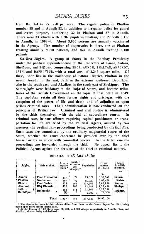
SATARA JAGIRS "5 from Rs. 1-4 to Rs. 2-8 per acre. The regular police in Phaltan number 95 and in Aundh 83, in addition to irregular police for guard and escort purposes, numbering 32 in Phaltan and 87 in Aundh. There were 33 schools with 1,287 pupils in Phaltan, and 27 with 1,117 in Aundh, in 1903-4. About 3,000 persons are annually vaccinated in the Agency. The number of dispensaries is three, one at Phaltan treating annually 9,000 patients, and two in Aundh treating 8,100 patients.
S a t a r a Jagirs .—A group of States in the Bombay Presidency under the political superintendence of the Collectors of Poona, Satara, Sholapur, and Bijapur, comprising B H O R , A U N D H , P H A L T A N , A K A L K O T , J A T H , and D A P H L A P U R , with a total area of 3,247 square miles. Of these, Bhor lies in the north-west of Satara District, Phaltan in the north, Aundh in the east, Jath in the extreme south-east, Daphlapur also in the south-east, and Akalkot in the south-east of Sholapur. The Satara jagirs were feudatory to the Raja of Satara, and became tributaries of the British Government on the lapse of that State in 1849. The jagirdars retain all their former rights and privileges, with the exception of the power of life and death and of adjudication upon serious criminal cases. Their administration is now conducted on the principles of British law. Criminal and civil justice is administered by the chiefs themselves, with the aid of subordinate courts. In criminal cases, heinous offences requiring capital punishment or transportation for life are tried by the Political Agents, assisted by two assessors, the preliminary proceedings being conducted by the jagirdars. Such cases are committed by the ordinary magisterial courts of the States, whether the court concerned be presided over by the chief himself or by an officer with committal powers. In the latter case the proceedings are forwarded through the chief. No appeal lies to the Political Agents against the decisions of the chief in criminal matters.
D E T A I L S OF SATARA JAGIRS
Jagirs. Title of chief. Area in square miles. *
Number of towns
and villages, †
Population. Gross
revenue in 1903-4.
Charge in which included.
Aundh Phaltan Bhor . Akalkot . Jath . Daphlapur
Pant Pratinidhi Nimbalkar Pant Sachiv . Raj Bhonsla .
Deshmukh
447 397 925 498 884
96
72 72
502 108 113
6
63,921 45,739
137,268 82,047 61,868
6,797
Rs. 2,30,700 2,00,400 3,68,800 4,57,400 3,27,300
22,500
Satara District.
Poona, Sholapur.
Bijapur.
Total 3,247 873 397,640 16,07,100
Satara District.
Poona, Sholapur.
Bijapur.
* The figures for area in this column differ from those in the Census Report for 1901, being based upon more recent information.
† At the Census of 1001 there were 71, 484, and 103 villages respectively in Aundh, Bhor, and Akalkot, the rest being uninhabited.
116 SATARA JAGIRS
The charges are now permanent, though the Bombay Government had occasion to effect transfers in the past. Originally the jagirs, with the exception of Akalkot , were placed under the political control of the Collector of Satara. In 1874 Jath and its dependency Daphla-pur, which had been mismanaged, were placed in charge of the Political Agent, Kolhapur and Southern Maratha Country, but were later transferred to the control of the Collector of Bijapur. Bhor was transferred from the Satara to the Poona Agency in 1887. The present chief of Bhor has a personal salute of nine guns.
S a t a r a D i s t r i c t — D i s t r i c t in the Central Division of the Bombay Presidency, lying between 160 48 ' and 180 n ' N. and 730 36' and 740 58 ' E., wi th an area of 4,825 square miles. It is bounded on the north by the States of Bhor and Phaltan and the Nira river, separating it from Poona; on the east by Sholapur District and the States of Aundh and Ja th ; on the south by the river Varna, separating it from the States of Kolhapur and Sangli, and by a few villages of Belgaum Dis t r ic t ; and on the west, along the Western Ghats, by the Districts of Kolaba and Ratnagiri.
From Mahabaleshwar in the north-west corner of the District, 4,717 feet above the sea, start two h i l l ranges of equal height and nearly
at right angles to each other—one the main range of the Western Ghats running towards the south for sixty miles, and the other the Mahadeo range
of hills, which, going first in an easterly and then in a south-easterly direction, extends towards the eastern boundary, where it sinks gradually into the plain. These hills throw out numerous spurs over the District, forming the valleys of the several streams which make up the headwaters of the K I S T N A , one of the largest rivers in Southern India . Except near Mahabaleshwar, and in the valley of the Koyna, the hills of the District are very low and have a strikingly bare and rugged aspect. The Mahadeo range, even in the rainy season, is but scantily covered with verdure. The hills are bold and abrupt, presenting in many cases bare scarps of black rock and looking at a distance like so many fortresses. The highest point of the Western Ghats in the District is M A H A B A L E S H W A R . The crest of the range is guarded by five forts: P R A T A P G A R H the northernmost, Makarandgarh 7 miles south, Jangli-Jaigarh 30 miles south of Makarandgarh, Bhairavgarh 10 miles south of Jangli-Jaigarh, and Prachitgarh about 7 miles south of Bhairavgarh.
Wi th in Satara limits are two river systems : the Bhlma system in a small part of the north-east, and the Kistna system throughout the rest of the District. A narrow belt beyond the Mahadeo hills drains north into the Nira , and the north-east corner of the District drains south-east along the Man. The total area of the Bhlma system,
Physical aspects.
SATARA DISTRICT 117
including part of the Wai taluka, the whole of Phaltan, and the taluka of Man, is probably about 1,100 miles, while the area of the Kistna system is 4,000. Of the Kistna's total length of 800 miles, 150 are within this District. It rises on the eastern brow of the Mahabaleshwar plateau. The six feeders on the right bank of the Kistna are the Kudal i , Vena, Urmodi , Tar l i , Koyna, and Varna ; the two on the left are the Vasna and Yerla. Of the Bhima river system, the chief Satara representatives are the Nlra in the north and the Man in the north-east. The Nira rises within the limits of the State of Bhor, and running through Wai, Phaltan, and Malsiras in Sholapur, after a total length of 130 miles, falls into the Bhima. The Man river rises in the hills in the north-west of the M a n taluka, and, after a course of 100 miles through that taluka and the Atpadi mahal of Aundh State and through Sangola and Pandharpur in Sholapur, joins the Bhima at Sarkoli, 10 miles south-east of Pandharpur.
The whole of Satara lies wi thin the Deccan trap area. As in other parts of the Western Deccan, the hills are layers of soft or amygdaloid trap, separated by flows of hard basalt and capped by laterite or iron-clay.
The botanical features of Satara are similar to those of adjacent Deccan Districts. The spurs and slopes that branch east from the Western Ghats are covered by teak mixed with brush-wood. As is usual in the Deccan, the cultivated parts have but few trees, though mango groves are common near towns and villages. Most of the roadsides are well shaded with avenues of banian and mango. Several types of flowering plant are found on the hills, notably the Capparis, Hibiscus, Impatiens, Crotalaria, Indigo/era, Smithia, Kalanchoe, Am-mania, Senecio, Lobelia, Jasminum, as well as fine examples of the orchid family. Oranges, limes, figs, and pomegranates are widely grown; but an attempt to introduce European fruit trees at Panchgani has met wi th indifferent success. Mahabaleshwar strawberries have gained a well-deserved reputation.
In the west near the Sahyadris, chiefly in the Koyna valley and the Mala pass hills, are found the tiger, leopard, bear, and a few sambar and small deer. In the east antelope or black buck, and the chinkara or Indian gazelle, are met with in certain sparsely populated tracts. Common -to both east and west are the hare, monkey, and hog. The Vena, Kistna, Koyna, and Varna rivers are fairly stocked wi th fish. Game-birds are not numerous, the chief being the common sand-grouse, the painted partridge, common grey partridge, quail, and snipe. From December to March the demoiselle crane is to be found in flocks on some of the rivers and reservoirs. Herons and egrets are common. Of the ibis four species, and of duck seven species, are to be seen on the larger rivers.
n8 SATARA DISTRICT
According to the height above, and distance from, the sea, the climate varies in different parts of the District. In the east, especially in the months of April and May, the heat is considerable. But near the Ghats it is much more moderate, being tempered by the sea-breeze. The temperature falls as low as 5 8° in January and reaches 100° and over in May. During the south-west monsoon the fresh westerly breeze makes the climate agreeable. Again, while few parts of India have a heavier and more continuous rainfall than the western slope of the Western Ghats, in some of the eastern tdlukas the supply is very scanty. The average annual rainfall at Mahabaleshwar is nearly 300 inches, while in Satara town it is only 41 inches, and in some places farther east it is as little as 20 inches. The west of the District draws almost its whole rain-supply from the south-west monsoon between June and October. Some of the eastern talukas, however, have a share in the north-east monsoon, and rain falls there in November and December. The May or ' mango' showers, as they are called, also influence the cultivator's prospects.
It seems probable that, as in the rest of the Bombay Deccan and Konkan, the Andhra or Satavahana kings (200 B .C.-A.D. 218), and
probably their Kolhapur branch, held Satara t i l l the third or fourth century after Christ. For the nine
hundred years ending early in the fourteenth century with the Muham-madan overthrow of the Deogiri Yadavas, no historical information regarding Satara is available; and most of the Devanagari and Kanarese inscriptions which have been found on old temples have not yet been translated. Still, as inscribed stones and copperplates have been found in the neighbouring Districts of Ratnagiri and Belgaum and the State of Kolhapur, it is probable that the early and Western Chalukyas held Satara District from about 550 to 750; the Rashtrakutas to 973; the Western Chalukyas, and under them the Kolhapur Silaharas, to about 1190; and the Deogiri Yadavas ti l l the Muhammadan conquest of the Deccan about 1300.
The first Muhammadan invasion took place in 1294, and the Yadava dynasty was overthrown in 1318. The Muhammadan power was then fairly established, and in 1347 the Bahmani dynasty rose to power. On the fall of the Bahmanis towards the end of the fifteenth century, each chief set up for himself; the Bijapur Sultans finally asserted themselves, and under them the Marathas arose. Satara, with the adjacent Districts of Poona and Sholapur, formed the centre of the Maratha power. It was in this District and in the adjacent tracts of the Konkan that many of the most famous acts in Maratha history occurred. Sivajl first became prominent by the murder of the Raja of javli close to Mahabaleshwar, and by the capture of the strong fort of Vasota and the conquest of Javli. He then built the stronghold
History.
HISTORY 119
of Pratapgarh (1656), against which the Bijapur Sultan directed a large force under Afzal Khan with the object of subduing his rebellious vassal. Sivajl met Afzal K h a n in a conference underneath the walls of Pratapgarh, slew h im wi th the famous vagh-nak (steel tiger's claw), and routed his army in the confusion which ensued. Numerous acquisitions of territory followed, including the capture of Satara in 1673 ; and Sivajl shortly found himself in a position to organize an independent government, placing his capital at Raigarh, where he was crowned in 1674. On the death of Sivajl in 1680 the fortune of the Marathas was temporarily overshadowed. Dissensions occurred between his sons Rajaram and Sambhajl; and though the latter, as the elder, established his claim to succeed, he was surprised and captured by the Mughals under Aurangzeb in 1689, and put to death. Rajaram was equally unable to stay the advance of the emperor, and in 1700 the capture of Satara crowned the efforts of Aurangzeb to reassert his power in the Maratha territory. In 1707 Aurangzeb died, and Sam-bhaji's son Sahu was released. Aided by his minister Balaji Viswanath, the first of the Peshwas, he secured Sivajfs possessions in the face of the opposition of Tara Bai, Rajaram's widow. The remainder of Sahu's reign was devoted to freeing himself from the power of Delhi , and asserting his right to levy chauth and sardeshmukhi in outlying portions of the Deccan. He was gradually superseded in authority by his able minister the Peshwa, who, on his death in 1749, removed the Maratha capital to Poona. Titular kings continued to reside at Satara unt i l the power of the Peshwa was broken in 1818.
The territory was thereupon annexed ; but the British, with a politic generosity, freed the titular Maratha Raja (the descendant of Sivaji) from the Peshwa's control, and assigned to h im the principality of Satara. Captain Grant Duff was appointed his tutor unt i l he should gain some experience in rule. In Apr i l , 1822, the Satara territory was formally handed over to the Raja, and thenceforward was managed by h im entirely. After a time he became impatient of the control exercised by the British Government; and as he persisted in intriguing and holding communications with other princes, in contravention of his engagements, he was deposed in 1839, and sent as a state prisoner to Benares, and his brother Shahji was placed on the throne. This prince, who d id much for the improvement of his people, died in 1848 without male heirs; and after long deliberation it was decided that the State should be resumed by the British Government. Liberal pensions were granted to the Raja's three widows, and they were allowed to live in the palace at Satara. The survivor of these ladies died in 1874. During the Mut iny a widespread conspiracy was discovered at Satara to restore the Maratha power with assistance from the N o r t h ; but the movement was suppressed with only trifling disturbances.
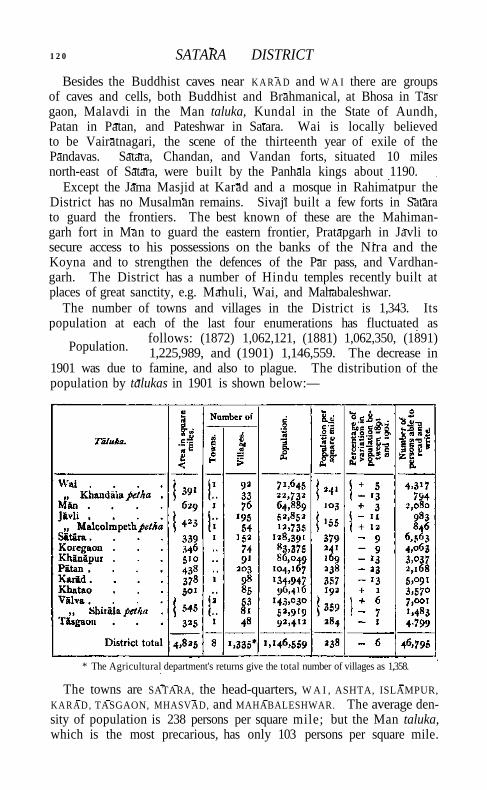
1 2 0 SATARA DISTRICT
Besides the Buddhist caves near K A R A D and W A I there are groups of caves and cells, both Buddhist and Brahmanical, at Bhosa in Tasr gaon, Malavdi in the Man taluka, Kundal in the State of Aundh, Patan in Patan, and Pateshwar in Satara. Wai is locally believed to be Vairatnagari, the scene of the thirteenth year of exile of the Pandavas. Satara, Chandan, and Vandan forts, situated 10 miles north-east of Satara, were built by the Panhala kings about 1190.
Except the Jama Masjid at Karad and a mosque in Rahimatpur the District has no Musalman remains. Sivaji built a few forts in Satara to guard the frontiers. The best known of these are the Mahiman-garh fort in Man to guard the eastern frontier, Pratapgarh in Javli to secure access to his possessions on the banks of the Nira and the Koyna and to strengthen the defences of the Par pass, and Vardhan-garh. The District has a number of Hindu temples recently built at places of great sanctity, e.g. Mahuli, Wai, and Mahabaleshwar.
The number of towns and villages in the District is 1,343. Its population at each of the last four enumerations has fluctuated as
follows: (1872) 1,062,121, (1881) 1,062,350, (1891) 1,225,989, and (1901) 1,146,559. The decrease in
1901 was due to famine, and also to plague. The distribution of the population by talukas in 1901 is shown below:—
* The Agricultural department's returns give the total number of villages as 1,358.
The towns are SATARA, the head-quarters, W A I , ASHTA, ISLAMPUR, KARAD, TASGAON, MHASVAD, and MAHABALESHWAR. The average density of population is 238 persons per square mile; but the Man taluka, which is the most precarious, has only 103 persons per square mile.
Population.
AGRICULTURE 121
Marathi is the prevailing vernacular, being spoken by 95 per cent, of the people. Hindus include 95 per cent, of the total and Musalmans 3 per cent., the proportion of the latter being lower than in any other District in the Presidency. The Jains, who number 18,483, are met with chiefly in the villages in the south of the Valva and Tasgaon talukas. They bear the reputation of being laborious agriculturists, and contrast favourably with their neighbours the Marathas and Maratha Kunbis . They represent a survival of the early Jainism, which was once the religion of the rulers of the kingdoms of the Carnatic.
Of the H i n d u population, 584,000, or 54 per cent., are Marathas or Maratha K u n b i s ; 92,000, or 8 per cent., are Mahars; 46,000, or 4 per cent., Brahmans; and 45,000, or 4 per cent., Dhangars, or shepherds, who are mostly to be found in the hil ly tract. Of the remainder, the following castes are of importance : Chamars or leather-workers (17,000), Kumhars or potters (12,000), Lingayats (29,000), Malls or gardeners (28,000), Mangs (26,000), Nhavis or barbers (15,000), Ramoshis (21,000), and Sutars or carpenters (11,000). The Marathas or Maratha Kunbis, during the period of the Maratha ascendancy (1674-1817), furnished the majority of the fighting men. The Mavlas, Sivaji's best soldiers, were drawn from the ghatmatha ( ' h i l l - t op ' ) portion of the District. During the last half-century they have become quiet and orderly, l iving almost entirely by agriculture. Dark-skinned, and as a rule small, they are active and capable of enduring much fatigue. Brahmans, largely employed as priests or government servants, are found in large numbers in the towns of Satara and Wai . Agriculture is the main occupation of the people, supporting 73 per cent, of the t o t a l ; 12 per cent, are supported by industry, and 1 per cent, by commerce.
In 1901, 975 native Christians were enumerated, chiefly in Javli, Koregaon, Satara, and Wai. The American Mission began work in the District in 1834, when a girls' school was opened at Maha-baleshwar. T i l l 1849 the school was removed to Satara every year during the rainy season. Since 1849 Satara has had resident missionaries.
The soils belong to three main classes: red in the hills and black and light in the plains. The black soil, which is generally found near the river banks, is most widely distributed in the Kistna valley, making it the richest garden and ' dry-crop ' land in the District. Near the heads of the streams which issue from the Western Ghats, the red soil of the valleys yields most of the rice grown in the District.
Satara is mostly ryotwari, about one-fifth of the total area being (nam or jagir land. The chief statistics of cultivation in 1903-4 are shown in the following table, in square miles:—
Agriculture.
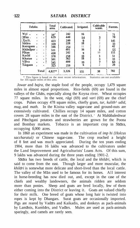
122 SATARA DISTRICT
Taluka. Total area. Cultivated. Irrigated. Cultivable
waste. Forests.
Wai 392 242 16 I 71 | Man . 629 440 14 3 70 | Javl i . 423 240 9 2 145
Satara 339 228 18 2 33 Koregaon 346 254 11 2 42 Khanapur 511 401 16 3 55 Patan 438 242 9 10 111 Karad 378 258 19 3 51 Khatao 501 362 18 3 33 Valva 545 400 19 7 63 Tasgaon , 325 259 6 2 29
Total 4,827* 3,326 155 38 702
* This figure is based on the most recent information. Statistics are not available for 335 square miles of this area.
Jowar and bajra, the staple food of the people, occupy 1,479 square miles in almost equal proportions. Rice-fields (69) are found in the valleys of the Ghats, especially along the Koyna river. Wheat occupies 77 square miles. In the west, ragi (69) and vari (69) are the chief crops. Pulses occupy 478 square miles, chiefly gram, tur, kulith^ udid, mug, and math. In the Kistna valley sugar-cane and ground-nuts are extensively cultivated. Chillies occupy 14 square miles, and cotton covers 28 square miles in the east of the District. At Mahabaleshwar and Panchgani potatoes and strawberries are grown for the Poona and Bombay markets. Tobacco is an important crop in Satara, occupying 8,000 acres.
In 1860 an experiment was made in the cultivation of imp hi {Holcus saccharatus) or Chinese sugar-cane. The crop reached a height of 8 feet and was much appreciated. During the ten years ending 1904, more than 16 lakhs was advanced to the cultivators under the Land Improvement and Agriculturists' Loans Acts. Of this sum, 9 lakhs was advanced during the three years ending 1901-2.
Satara has two breeds of cattle, the local and the khildri, which is said to come from the east. Though larger and more muscular, the khilari is somewhat more delicate and short-lived than the local cattle. The valley of the Man used to be famous for its horses. A l l interest in horse-breeding has now died out, and, except in the case of the chiefs and wealthy landowners, the animals ridden are seldom more than ponies. Sheep and goats are bred locally, few of them either coming into the District or leaving it. Goats are valued chiefly for their milk. One breed of goats whose long hair is twisted into ropes is kept by Dhangars. Surat goats are occasionally imported. Pigs are reared by Vadars and Kaikadis, and donkeys as pack-animals by Lamanis, Kumbars, and Vadars. Mules are used as pack-animals sparingly, and camels are rarely seen.
FORESTS 123
A total area of 154½ square miles, or 6 per cent., was irrigated in 1903-4, the principal sources of supply being Government canals and channels (11 square miles), tanks and wells (88), other sources (55½). The chief irrigation works are : the Kistna, Chikhl i , and Rewari canals, the Yerla and Man river works, and the lakes at Mhasvad and Mayni . The Kistna canal, which has its head-works 2 miles above Karad, has an unfailing supply of water, and irrigates 6 square miles in the talukas of Karad, Valva, and Tasgaon. The works, which cost 8 lakhs, were opened in 1868, and can supply 12,000 acres. The Chikhl i , Rewari, and Gondoli canals cost respectively Rs. 57,000, Rs. 59,000, and 4 lakhs, and can supply 1,500, 1,900, and 2,000 acres. The Yerla river works, begun in 1867 and finished in 1868, the right-bank canal being 9 and the left 8\ miles long, are supplemented by the Nehra lake, finished in 1880-1, wi th a capacity of 523,000,000 cubic feet. The whole scheme involved a cost of nearly 8 lakhs up to 1903-4, and commands an irrigable area of 5,000 acres. The Mhasvad lake, having a catchment area of 480 square miles and a full supply depth of 67 feet, completed at a cost of nearly 21 lakhs, covers an area of 6 square miles and can hold 2,633,000,000 cubic feet of water. It includes a large lake on the river M a n in the M a n taluka, and also a high-level canal (13 miles long) commanding the area between the M a n and the Bhima. The Mayni lake, on a tributary of the Yerla, cost about 4½ lakhs, and commands 4,800 acres.
The water-supply in the west is plentiful, but there is much scarcity in the east during the hot season. The supply comes partly from rivers and partly from numerous ponds and wells. It is estimated that there are 32,600 wells in the District, of which 27,000 are used for irrigation. The cost of bui lding wells varies greatly. They are of every description, from holes sunk in the rock or soil to carefully buil t wells faced with stone.
Forests cover an area of 702 square miles (including one square mile of protected forest), of which 616 square miles in charge of the Forest department are administered by a divisional and a subdivisional officer. The forests are scattered over the District, and are much broken by private and cultivated land. In the west, the belt of evergreen forest along the line of the Western Ghats is divided into six fairly compact ranges wi th l i t t le cultivated land between. The seven eastern ranges are bare hills, wi th here and there a l i t t le scrub and teak. The forests of the western talukas have a large store of timber and firewood. Jambul, gela ( Vangueria spinosa), and pesha (Cylicodaphne Wightiana) grow on the main ridge of the Western Ghats, and small teak on the eastern slopes. Sandal-wood is occasionally found, and the mango, jack, and guava are often grown for their fruit. Patches of bamboo sometimes occur. A cinchona
VOL. XXII. I
Forests.
124 SATARA DISTRICT
plantation, established in Lingmala near Mahabaleshwar, has proved a failure. In 1903-4 the forest revenue amounted to Rs. 46,000.
Iron is found in abundance on the Mahabaleshwar and Mahadeo hills, and was formerly worked by the Musalman tribe of Dhavads.
Owing, however, to the fall in the value of iron and the rise in the price of fuel, smelting is now no longer
carried on. Manganese occurs embedded in laterite in the neighbourhood of Mahabaleshwar. The other mineral products are building stone (trap in the plains and laterite on the hills), road-metal, and limestone.
Cotton is spun by women of the Kunbl, Mahar, and Mang castes. The yarn thus prepared is made up by Hindu weavers of the Sali
or Koshti caste, and by Muhammadans, into cloth, tape, and ropes. Blankets (kamblis), which command a large sale, are woven by men of the Dhangar caste.
Satara brass dishes and Shirala lamps are well-known throughout the Deccan. Notwithstanding the great number of carpenters, wheels and axles for cart-making have to be brought from Chiplun in Ratnagiri. Paper is manufactured to some extent.
The District exports grain and oilseeds, a certain number of blankets, a small quantity of coarse cotton cloth, chillies, gur (unrefined sugar), and a little raw cotton. The chief imports are cotton piece-goods, hardware, and salt. The Southern Mahratta Railway has largely increased the trade with Poona and Belgaum, and at the same time has diminished the road traffic between those places. The road-borne traffic with Chiplun in Ratnagiri District is, however, still considerable, the exports being unrefined sugar, blankets, and cloth, and the imports spices, salt, coco-nuts, and sheets of corrugated iron. Weekly or bi-weekly markets are held in large villages and towns, such as Mhasvad, which is famous for its blankets, and Belavdi for its cattle. The trade-centres are Wai, Satara, Karad, Tasgaon, and Islampur.
The Southern Mahratta Railway traverses the centre of the District for 115 miles from north to south. The total length of roads is 433 metalled, and 284 unmetalled. Of these, 159 miles of metalled and 264 miles of unmetalled road are maintained by the local authorities, the remainder being in charge of the Public Works department. There are avenues of trees on about 400 miles. The Poona and Bangalore road, crossing the District from north to south near the railway, and bridged and metalled throughout, is the most important. A first-class road is maintained from Wathar station via Wai to Panchgani and Mahabaleshwar, whence it passes by the Fitzgerald ghat to Mahad in Kolaba, and another runs from Karad westwards to Chiplun in Ratnagiri and eastwards to Bijapur. An alternative route to Mahabaleshwar runs through Satara town, and there are numerous feeder roads for the railway.
Trade and communications.
Minerals.
FAMINE 125
The uncertain and scanty rainfall makes eastern Satara one of the parts of the Bombay Presidency most liable to suffer from failure of crops. The earliest recorded is the famous famine known as Durga-devI, which, beginning in 1396, is said to have lasted twelve years, and to have spread over all India south of the Narbada. Whole Districts were emptied of their inhabitants ; and for upwards of thirty years a very scanty revenue was obtained from the territory between the Godavari and the Kistna. In 1520, mainly owing to military disturbances, the crops in the Deccan were destroyed and a famine followed. In 1629-30 severe famine raged throughout the Deccan. The rains failed for two years in succession, causing great loss of life. According to local tradition, the famine of 1791-2 was the worst ever known. It seems to have come after a series of bad years, when the evils of scanty rainfall were aggravated by disturbances and war. The native governments granted large remissions of revenue, the export of grain was forbidden, and a sale price was fixed. Rice was imported into Bombay from Bengal. The famine of 1802-3 ranks next in severity. It was most felt in Khandesh, Ahmadnagar, Sholapur, Bijapur, and Dharwar; but it also pressed severely on Bel-gaum, Satara, Poona, Surat, and Cutch. This scarcity was mainly due to the ravages of Jaswant Rao Holkar and his Pindaris, who destroyed the early crops as they were coming to maturity and prevented the late crops being sown. This scarcity was followed by the failure of the late rains in 1803. The pressure was greatest in July and August, 1804, and was so grievous that, according to tradition, men lived on human flesh. Grain is said to have been sold at a shilling the pound. In 1824-5 a failure of the early rains caused considerable and widespread scarcity. In 1862 there was again distress on account of scanty rainfall.
The early rains of 1876 were deficient and badly distributed, and the crops failed, distress amounting to famine over about one-half of the District, the east and south-east portions suffering most. This was followed by a partial failure of the rains in September and October, when only a small area of late crops could be sown. With high prices, millet at 8½ instead of 17½ seers per rupee, and no demand for field work, the poorer classes fell into distress. The need for Government help began about the beginning of October. The long period of dry weather in July and August, 1877, forced prices still higher, and caused much suffering; but the plentiful and timely rainfall of September and October removed all cause of anxiety. By the close of November the demand for special Government help had ceased. On May 19, 1877, when famine pressure was general and severe, 46,000 labourers were on relief works. The total cost of the famine was estimated at about 12 lakhs. In the eastern talukas the number of cattle decreased from
2
Famine.
126 SATARA DISTRICT
994,000 in 1876-7 to 775,000 in 1877-8. In 1878 the cultivated area fell short of that in 1876 by about 18,400 acres.
In the famine of 1896-7 the District again suffered severely. In December, 1896, the number on relief works was 6,700. It rose to 27,000 in April, 1897, and then began to fall. The number on charitable relief was 5,000 in September, 1897. The last scarcity occurred in 1899-1900, when the late rains failed. The drought was specially marked in the region east of the Kistna river. Relief works Were necessary in 1899. By May, 1900, 47,000 persons were on works, excluding 8,000 dependents and 2,000 in receipt of gratuitous relief. The latter number rose to 17,000 in September. The distress continued till October, 1901, owing to the capricious rainfall of 1900. The total cost of the famine was estimated at 16 lakhs, and the advances to agriculturists and remissions of land revenue amounted to 18 lakhs. It is calculated that there was a mortality of nearly 30,000 in excess of the normal during the period, and that 200,000 cattle died.
The Collector's staff usually includes three Assistants or Deputies. The District is divided into eleven talukas: namely, K A R A D , V A L V A ,
SATARA, W A I , J A V L I , K H A N A P U R , K O R E G A O N , P A T A N ,
M A N , K H A T A O , and TASGAON. The talukas of Valva and Wai include the petty divisions (pethas) of Shirala and Khandala, and Javli includes Malcolmpeth. The Collector is Political Agent for the Aundh and Phaltan States.
The District and Sessions Judge is assisted for civil business by an Assistant Judge, one Subordinate Judge under the Deccan Agriculturists' Relief Act, and eight other Subordinate Judges. There are usually 34 magistrates to administer criminal justice. The usual forms of crime are hurt, theft, and mischief. Dacoity is common in the southern portion of the District.
Before the rise of the Marilthas and during their supremacy many surveys were made of parts or the whole of the Satara territory, apparently with the object of readjusting rather than of altering the assessment, which, under the name of karna/ or rack rental, had remained the same for years. No accurate account of the Bijapur survey remains, but the standard of assessment was continued in some villages to the end of the Peshwas' rule (1818). When Sivaji took the country (1655) he made a new but imperfect survey on the model of Malik Ambar's, fixing two-fifths of the produce or its equivalent in money as the government share. The Mughals introduced the system of Todar Mai , fixing the assessment, not by measurement as in the districts conquered earlier, but by the average produce or its equivalent in money. In some cases Aurangzeb raised the rents for a few years as high as he could, and this amount was ever afterwards entered in
Administration.
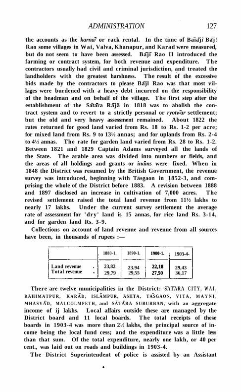
ADMINISTRATION 127
the accounts as the karna/ or rack rental. In the time of Baiaji Baj! Rao some villages in Wai, Valva, Khanapur, and Karad were measured, but do not seem to have been assessed. Baji Rao II introduced the farming or contract system, for both revenue and expenditure. The contractors usually had civil and criminal jurisdiction, and treated the landholders with the greatest harshness. The result of the excessive bids made by the contractors to please Bajl Rao was that most villages were burdened with a heavy debt incurred on the responsibility of the headman and on behalf of the village. The first step after the establishment of the Satara Raja in 1818 was to abolish the contract system and to revert to a strictly personal or ryotwar settlement; but the old and very heavy assessment remained. About 1822 the rates returned for good land varied from Rs. 18 to Rs. 1-2 per acre; for mixed land from Rs. 9 to 13½ annas; and for uplands from Rs. 2-4 to 4½ annas. The rate for garden land varied from Rs. 28 to Rs. 1-2. Between 1821 and 1829 Captain Adams surveyed all the lands of the State. The arable area was divided into numbers or fields, and the areas of all holdings and grants or inams were fixed. When in 1848 the District was resumed by the British Government, the revenue survey was introduced, beginning with Tasgaon in 1852-3, and comprising the whole of the District before 1883. A revision between 1888 and 1897 disclosed an increase in cultivation of 7,000 acres. The revised settlement raised the total land revenue from 11½ lakhs to nearly 17 lakhs. Under the current survey settlement the average rate of assessment for 'dry' land is 15 annas, for rice land Rs. 3-14, and for garden land Rs. 3-9.
Collections on account of land revenue and revenue from all sources have been, in thousands of rupees :—
1880-1. 1890-1. 1900-1.
22,18 27,50
1903-4-
Land revenue Total revenue
23,82 29,79
23.94 29,55
1900-1.
22,18 27,50
29,43 36,17
There are twelve municipalities in the District: SATARA C I T Y , W A I , R A H I M A T P U R , K A R A D , I S L A M P U R , A S H T A , T A S G A O N , V I T A , M A Y N I ,
M H A S V A D , M A L C O L M P E T H , and SATARA SUBURBAN, with an aggregate income of ij lakhs. Local affairs outside these are managed by the District board and 11 local boards. The total receipts of these boards in 1903-4 was more than 2½ lakhs, the principal source of in-come being the local fund cess; and the expenditure was a little less than that sum. Of the total expenditure, nearly one lakh, or 40 per cent., was laid out on roads and buildings in 1903-4.
The District Superintendent of police is assisted by an Assistant
128 SATARA DISTRICT
Superintendent and two inspectors. There are 17 police stations and a total police force of 966, of which 16 are chief constables, 196 head constables, and 754 constables. The mounted police number 7, under one daffadar. The District contains 19 subsidiary jails, with accommodation for 424 prisoners. The daily average number of prisoners during 1904 was 89, of whom 5 were females.
Satara stands nineteenth among the twenty-four Districts of the Presidency in the literacy of its population, of whom 4 per cent (8 per cent, males and 0.3 females) could read and write in 1901. In 1865 there were 104 schools and 6,100 pupils. The number of pupils rose to 12,851 in 1881 and to 23,168 in 1891, but fell in 1901 to 22,146. In 1903-4 there were 352 public schools with 16,962 pupils, of whom 1,519 were girls, besides 47 private schools with 878 pupils. Of the 352 institutions classed as public, one is managed by Government, 282 by the local boards, and 36 by the municipal boards, 31 are aided and 2 unaided. The public schools include 3 high, 7 middle, and 342 primary schools. The total expenditure on education in 1903-4 was more than i | lakhs. Of this, Local funds contributed Rs. 50,000, municipalities Rs. 10,000, and fees Rs. 25,000. About 74 per cent, of the total was devoted to primary schools.
In 1904 the District possessed 2 hospitals and 9 dispensaries and 7 other medical institutions, with accommodation for 124 in-patients. About 106,960 persons were treated, including 818 in-patients, and 3,609 operations were performed. The total expenditure was Rs. 19,770, of which Rs. 11,370 was met from municipal and local board funds.
The number of persons successfully vaccinated in 1903-4 was nearly 28,000, representing a proportion of 24 per 1,000 of population, which is almost equal to the average of the Presidency.
[Sir J. M. Campbell, Bombay Gazetteer, vol. xix (1885); W. W. Loch, Historical Account of the Poona, Satara, and Sholapur Districts (1877).]
S a t a r a Taluka.—Taluka of Satara District, Bombay, lying between 17° 30' and 170 50' N. and 730 48' and 740 10' E., with an area of 339 square miles. I t contains one town, SATARA (population, 26,022), the District and taluka head-quarters; and 152 villages. The population in 1901 was 128,391, compared with 139,892 in 1891. The density, 379 persons per square mile, is the highest in the District. The demand for land revenue in 1903-4 was more than 1-9 lakhs, and for cesses Rs. 19,000. Satara includes the three valleys of the Kistna, Vena, and Urmodi rivers, which are open and slope gently towards the base of steep and bare hills. Clumps of mangoes stud the valleys, and babul grows plentifully on the banks of the Kistna. The soil near the rivers is rich and black, but grows gradually grey and poorer towards the hills. The climate is healthy, and the rainfall, averaging 40 inches, is higher than in most other talukas.
SATHALLI 129
Satara City,—Head-quarters of Satara District, Bombay, situated in 1 7 ° 4 1 ' N . and 740 E., 10 miles from Satara Road station on the Southern Mahratta Railway, near the confluence of the Kistna and the Vena. The strong fort of Satara is perched on the summit of a small, steep, rocky hi l l . I t takes its name from the seventeen {satara) walls, towers, and gates which it is supposed to have possessed. At the close of the war with the Peshwa in 1818, it fell, after a short resistance, into the hands of the British, but was restored with the adjacent territory to the representative of Sivaji's line, who, during the Peshwa's ascendancy, had lived there as a State prisoner. In 1848, on the death of the last Raja, the principality escheated to the British. The town, lying at the foot of the h i l l fortress, consisted in 1820 of one long street of tiled houses, built partly of stone and partly of brick. After the breaking up of the Raja's court, the population considerably decreased. But Satara is still a large place, with a population in 1901 of 26,022, including 2,917 in suburban and 990 in cantonment limits. Hindus numbered 21,795, Muhammadans 3,275, Jains 253, and Christians 599. The municipality, established in 1853, had an average income during the decade ending 1901 of Rs. 69,000. In 1903-4 the income was Rs. 60,000. The suburban municipality, established in 1890, had an average income during the decade ending 1901 of Rs. 7,400. In 1903-4 the income was Rs. 8,000. Satara has few large or ornamental buildings, with the exception of the Raja's palace now used as the Judge's court. On account of its high position, 2,320 feet above sea-level, the climate is unusually pleasant. The water-supply is obtained by aqueducts and pipes from the Kas lake in the hills, 16 miles from the city. A civil hospital is situated here.
Satgaon.—Ruined town in Hooghly District, Bengal, situated in 220 58' N. and 88° 23' E., to the north-west of Hooghly town. Population (1901), 153. Satgaon was the mercantile capital of Bengal from the days of H indu rule until the foundation of Hooghly by the Portuguese. Its decay dates from the silting-up of the channel of the Saraswati; and nothing now remains to indicate its former grandeur except a ruined mosque, the modern village consisting of a few miserable huts. Satgaon is said to have been one of the resting-places of Bhaglrathi. De Barros writes that it was ' less frequented than Chitta-gong, on account of the port not being so convenient for the entrance and the departure of ships.' Purchas states it to be ' a fair citie for a citie of the Moores, and very plentiful, but sometimes subject to Patnaw.' In 1632, when Hooghly was declared a royal port, all the public offices were withdrawn from Satgaon, which rapidly fell into ruins.
Sathalli .—Village in the Hassan taluk of Hassan District, Mysore, situated 10 miles south-west of Hassan town. Population (1901), 105.
130 SATHALLI
It is of interest as the centre of a Christian agricultural community, which had its origin in the labours of the well-known AbW Dubois. There is a group of twelve villages, almost entirely inhabited by Christians, who follow their original customs in all matters not concerned with religion.
Sathamba.—Petty State in M A H I KANTHA, Bombay. Satkhira Subdivision.—Western subdivision of Khulna District,
Bengal, lying between 210 38' and 220 57' N. and 88° 54' and 890 23' E., with an area of 749 square miles. The northern part of the subdivision resembles in its general physical characteristics the adjoining thanas of Jessore; the drainage is bad and there are numerous swamps. The southern portion includes a large area in the Sundarbans, where there is much fertile land awaiting reclamation. The population in 1901 was 488,217, compared with 495,600 in 1891, the density being 652 persons per square mile. I t contains two towns, SATKHIRA (population, 8,356), the head-quarters, and DEBHATA (5,454); and 1,467 villages. ISWARI-PUR was the old capital of Raja Pratapaditya. Debhata and KALIGANJ are trading centres.
Satkhira Town.—Head-quarters of the subdivision of the same name in Khulna District, Bengal, situated in 220 43' N. and 890 $' E., on a khal or channel connected with the Ichamati river. Population (1901), 8,356. Satkhira was constituted a municipality in 1869. The income during the decade ending 1901-2 averaged Rs. 4,600, and the expenditure Rs. 4,500. In 1903-4 the income was Rs. 7,500, mainly from a tax on persons (or property tax); and the expenditure was Rs. 6,500. The town contains the usual public offices, a sub-jail with accommodation for 12 prisoners, as well as many Hindu temples.
Satlasna.—Petty State in M A H I K A N T H A , Bombay. Satmala.—Range of hills in Bombay, Berar, and the Hyderabad
State, which also bears the names of the AJANTA, Chandor, and Indhyadri hills, and Sahyadriparbat.
Satna (or Raghurajnagar).—Town in the Rewah State, Central India, situated in 240 34' N. and 8o° 50' E., on the Jubbulpore-Allahabad section of the East Indian Railway. Population (1901), 7,471. Satna is the head-quarters of the Political Agent in Baghelkhand and of the Raghurajnagar tahsll of Rewah. It is a place of considerable commercial importance and the principal centre of trade in the State, the value of exports and imports passing through the town being about 4 lakhs a year. The principal exports are wheat, rice, linseed, and ghi; and the imports, kerosene oil, cotton, cloth, and sugar. The town is clean and well built, with many good houses. To the west and across the railway lie the Agency limits, containing the residence of the Political Agent, offices, and other buildings. Satna was selected as the head-quarters in 1872, before which date the Political officer lived
SATPUHAS 131
at N A G O D . The Agency limits occupy 95 acres, with a population (1901) of 382. A high school, a Government d5£-bungalow, a combined post and telegraph office, and an Agency hospital and State dispensary are situated in the town.
Satodad-Vavdi .—Petty State in K A T H I A W A R , Bombay. S a t p u r a s (or Satpuras).—A range of hills in the centre of India.
The name, which is modern, originally belonged only to the hills which divide the Narbada and Tapt i valleys in Nimar (Central Provinces), and which were styled the sdtputra or ' seven sons' of the Vindhyan mountains. Another derivation is from satpura (' sevenfolds'), referring to the numerous parallel ridges of the range. The term Satpuras is now, however, customarily applied to the whole range which, commencing at Amarkantak in Rewah, Central India (220 4 1 ' N. and 8 i ° 48 ' E.), runs south of the Narbada river nearly down to the western coast. The Satpuras are sometimes, but incorrectly, included under the V I N D H Y A range. Taking Amarkantak as the eastern boundary, the Satpuras extend from east to west for about 600 miles, and in their greatest width, where they stretch down to Berar, exceed 100 miles from north to south. The shape of the range is almost triangular. From Amarkantak an outer ridge (see M A I K A L A ) runs south-west for about 100 miles to the Saletekri hills in Balaghat District (Central Provinces), thus forming as it were the head of the range which, shrinking as it proceeds westward from a broad table-land to two parallel ridges, ends, so far as the Central Provinces are concerned, at the famous h i l l fortress of A S I R G A R H . Beyond this point the Rajpipla hills, which separate the valley of the Narbada from that of the Tapti , complete the chain as far as the Western Ghats. On the table-land comprised between the northern and southern faces of the range are situated the Central Provinces District of Mandla, and part of Balaghat, SeonI, Chhindwara, and Betul.
The superficial stratum covering the main Satpura range is trappean; but in parts of the Central Provinces crystalline rocks are uppermost, and over the Pachmarhl hills sandstone is also uncovered. In Mandla the higher peaks are capped with laterite. On the north and south the approaches to the Satpuras are marked as far west as Turanmal by low lines of foot-hills. These are succeeded by the steep slopes leading up to the summit of the plateau, traversed in all directions by narrow deep ravines, hollowed out by the action of the streams and rivers, and covered throughout their extent wi th forest.
Portions of the Satpura plateau consist, as in Mandla and the north of Chhindwara, of a rugged mass of hills hurled together by volcanic action. But the greater part is an undulating table-land, a succession of bare stony ridges and narrow fertile valleys, into which the soil has been deposited by drainage. In a few level tracts, as in the valleys
132 SATPURAS
of the Machna and Sampna near Betul, and the open plain between SeonI and Chhindwara, there are extensive areas of productive land. Scattered over the plateau, isolated flat-topped hills rise abruptly from the plain. The scenery of the northern and southern hills, as observed from the roads which traverse them, is of remarkable beauty. The drainage of the Satpuras is carried off on the north by the Narbada, and on the south by the Wainganga, Wardha, and Tapti, all of which have their source in these hills.
The highest peaks are contained in the northern range, rising abruptly from the valley of the Narbada, and generally sloping down to the plateau, but towards the west the southern range has the greater elevation. Another noticeable feature is a number of small table-lands lying among the hills at a greater height than the bulk of the plateau. Of these, PACHMARHI (3,530 feet) and CHIKALDA in Berar (3,664 feet) have been formed into hill stations: while Raigarh (2,200 feet) in Balfighat District and Khamla in Betul (3,800 feet) are famous grazing and breeding grounds for cattle. Dhupgarh (4,454 feet) is the highest point on the range, and there are a few others of over 4,000 feet. Among the peaks that rise from 3,000 to 3,800 feet above sea-level, the grandest is TURANMAL (Bombay Presidency), a long, rather narrow table-land 3,300 feet above the sea and about 16 square miles in area. West of this the mountainous land presents a wall-like appearance towards both the Narbada on the north and the Tapti on the south. On the eastern side the Tasdin Vali (Central India) commands a magnificent view of the surrounding country. The general height of the plateau is about 2,000 feet.
The hills and slopes are clothed with forest extending over some thousands of square miles; but much of this is of little value, owing to unrestricted fellings prior to the adoption of a system of conservancy, and to the shifting cultivation practised by the aboriginal tribes, which led to patches being annually cleared and burnt down. The most valuable forests are those of sal (Shorea robusta) on the eastern hills, and teak on the west.
The Satpura Hills have formed in the past a refuge for aboriginal or Dravidian tribes driven out of the plains by the advance of Hindu civilization. Here they retired, and occupied the stony and barren slopes which the new settlers, with the rich lowlands at their disposal, disdained to cultivate; and here they still rear their light rains crops of millets which are scarcely more than grass, barely tickling the soil with the plough, and eking out a scanty subsistence with the roots and fruits of the forests, and the pursuit of game. The BAIGAS, the wildest of these tribes, have even now scarcely attained to the rudiments of cultivation; but the GONDS, the KORKUS, and the BHILS have made some progress by contact with their Hindu neighbours.
SATTHWA 133
The open plateau has for two or three centuries been peopled by Hindu immigrants; but it is only in the last fifty years that travelling has been rendered safe and easy, by the construction of metalled roads winding up the steep passes and enabling wheeled traffic to pass over the heavy land of the valleys. T i l l then such trade as existed was conducted by nomad Banjaras on pack-bullocks. The first railway across the Satpura plateau, a narrow-gauge extension of the Bengal-Nagpur line from Gondia to Jubbulpore, has recently been opened. The Great Indian Peninsula Railway, from Bombay to Jubbulpore, runs through a breach in the range just east of Aslrgarh, while the Bom bay-Agra road crosses farther to the west.
Satpuras, East.—The eastern extension of the Satpura Hills of Central India, lying east and south of the Son. In the United Provinces they form a wilderness of parallel ridges of low rocky hills, extending over 1,700 square miles in the south of Mirzapur, and covered with jungle, with the exception of a large basin in tappa Singrauli and a smaller area in Dudhi where the soil is alluvial and allows cultivation. Coal has been found in Singrauli, and an attempt was made in 1896 to work it. The few inhabitants are chiefly jungle tribes, Kols, & c , resembling those in Chota Nagpur.
Sattanapalle,—Taluk in the north of Gunttir District, Madras, lying between 160 15' and 160 49' N. and 790 51' and 8o° 26' E., with an area of 714 square miles. The population in 1901 was 159,645, compared with 138,617 in 1891. It contains 168 villages, of which Sattanapalle is the head-quarters. The demand on account of land revenue and cesses in 1903-4 amounted to Rs. 4,49,000. A wide extent of black cotton soil produces heavy crops of cotton, the staple product. There is practically only one main road, with two or three subsidiary branches; and in wet weather the black soil and the watercourses with their treacherous beds become almost impassable.
Sattankulam.—Town in the Srivaikuntam taluk of Tinnevelly District, Madras, situated in 8° 27' N. and 770 55' E. It derives its importance from its situation on the border of the great palmyra forest in the south-east of the District. Jaggery (coarse sugar) goes from here to Palamcottah in large quantities. It is a Union, with a population (1901) of 6,953, and is the head-quarters of a Roman Catholic mission which possesses a church and some schools. Two miles to the east is Mudalur, one of the chief Christian villages in Tinnevelly District, with a fine Gothic church.
Satthwa.—South-eastern township of Magwe District, Upper Burma, lying between 190 39' and 200 9' N. and 950 19' and 950 51 ' E., with an area of 469 square miles. The township is one of the great rice-producing areas of Upper Burma, being low-lying and fairly well watered. Near Kokkogwa, on the Yabe stream, is the old
134 SATTHWA
capital of Paikthado, the walls of three sides of which remain. The population was 53,216 in 1891, and 53,424 in 1901, distributed in one town, TAUNGDWINGYI (population, 5,041), and 223 villages. There were about 1,800 Chins in the township in 1901. The headquarters are at Satthwa (population, 288), a village due south of Taungdwingyi, where there is an important bazar. In 1903-4 the area cultivated was 127 square miles, and the land revenue and thathameda amounted to Rs. 86,000.
Sattur Subdivision.—Subdivision of Tinnevelly District, Madras, consisting of the taluks of SATTUR and SRIVILLIPUTTUR.
Sattur Taluk.—Northernmost taluk of Tinnevelly District, Madras, lying between 90 2" and 90 43' N. and 770 43' and 780 9' E., with an area of 560 square miles. The taluk is comparatively sparsely peopled, the total population in 1901 being 186,694, compared with 184,329 in 1891, or a little more than 330 persons per square mile. It contains three towns, VIRUDUPATTI (population, 16,837), SIVAKASI (13,021), and SATTUR (7,870), the head-quarters; and 206 villages. The demand for land revenue and cesses in 1903-4 amounted to Rs. 2,68,000. The northern and eastern villages are chiefly black cotton soil, while the southern and south-western portions consist of red loam and sand. The only river is the Vaippar, which is not of much use for irrigation. Cotton is the staple product, but cambu is also largely grown. There is a good deal of careful cultivation of garden crops with well-irrigation, but the area of ' wet' lands is small. The taluk includes a considerable number of zamindari and indm villages, none of which, however, is very large.
Sattur Town.—Head-quarters of the taluk of the same name in Tinnevelly District, Madras, situated in 90 22' N. and 770 55' E., with a station on the South Indian Railway. Sattur is also the headquarters of the officer in charge of the subdivision comprising the Sattur and Srivilliputtur taluks. It is a Union, with a population (1901) of 7,870, and has a Local fund hospital. There are two cotton-pressing and ginning factories, which employ in the aggregate 200 hands.
Satwas.—Head-quarters of the Nemawar district of Indore State, Central India, situated in 220 32' N. and 760 43' E., between the Chankeshar and Datum rivers, in the Narbada valley. Population (1901), 1,743. The village is an old one, and from the numerous remains which it contains must have been a place of considerable importance under the Mughals, when it was the head-quarters of a mahal in the sarkar of Hindia in the Subah of Malwa. A fort stands in the centre of the village. Three miles south-east is a fine old dam across the Datum river, now much out of repair. In 1801 a severe encounter took place at Satwas between Jaswant Rao Holkar

SATYAMANGALAM TOWN 135
and Major Brownrigg, who was commanding a force of Sindhia's troops. A l i t t le later the notorious Pindari leader Chi tu obtained land in this district, and made Satwas and Nemawar his two principal places of residence. From 1844 it remained in the hands of the Brit ish authorities t i l l 1861, when i t passed to Holkar . Besides the district offices, the village contains a State post office, a school, and an inspection bungalow.
Satyabadi .—Vil lage in the Khurda subdivision of Pur l District, Bengal, situated in 190 57' N. and 85° 49 ' E. Population (1901), 1,547. It contains a shrine dedicated to Sakhi Gopal, an incarnation of Krishna, which is visited by all pilgrims going to Purl.
S a t y a m a n g a l a m Taluk.—North-west taluk of Coimbatore District, Madras, lying between n ° 15'and n ° 4 9 / N . and 76°5o 'and 77°35 'E . , wi th an area of 1,177 square miles. The population increased from 184,017 in 1891 to 214,101 in 1901, or by 16 per cent. Besides G O P I C H E T T I P A L A I Y A M (population, 10,227), the head-quarters, i t contains 175 villages. The demand for land revenue and cesses in 1903-4 was Rs. 4,42,000. Almost half the taluk, its northern and eastern portions, is covered by hills which contain excellent forests. Of the cultivable area about 13 per cent, is usually irrigated, and this contains a large proportion of the best classes of land in the District. It is fed mainly from the B H A V A N I river, which traverses the taluk from west to east, and the area watered by channels is larger than in any other taluk. On the ' d r y ' land cambu is by far the most common crop. The rainfall averages 27 inches annually. The tract which lies below the hills is well supplied with roads, but there are no railways or telegraphs in any portion of i t . After Kollegal it is the most sparsely peopled taluk in the District.
S a t y a m a n g a l a m T o w n . — T i l l recently the head-quarters of the taluk of the same name in Coimbatore District, Madras, situated in n° 30 ' N. and 770 15' E., on the Bhavani r iver at the foot of the northern Coimbatore hills. Population (1901), 3,680. Though apparently never strongly fortified, it derived some strategical importance from the fact that it lies near the southern end of the Gazalhatti Pass, which was the ordinary route from Mysore to this District. Under the Naik dynasty of Madura it was the residence of a deputy-governor. In the beginning of the seventeenth century it was the local head-quarters of the Jesuits. It fell into the hands of the Mysore kings in 1653, was held by the Bri t ish for some time after Colonel Wood's sudden but short occupation of the District in 1768, and was abandoned before Haidar's advance at the end of the same year. A ruined mud fort in the neighbouring pass was bravely but un* successfully defended in this campaign by Lieutenant Andrews, who was ki l led by the besiegers. The town was occupied by a division
136 SATYAMANGALAM TOWN
under Colonel Floyd during General Medows's campaign in this District in 1790, preparatory to a general advance into Mysore by the Gazalhatti Pass. But Tipu descended the pass in September of that year, crossed the Bhavani above Satyamangalam, and fought two engagements with the British on the same day. In the first of these, a cavalry fight, the British were completely successful, and in the second, an artillery duel, they held their ground though they suffered severely. It was, however, decided not to risk a general encounter, and the place was abandoned by Colonel Floyd on the following morning. Satyamangalam- is now the head-quarters of a deputy-tahslldar and stationary sub-magistrate. It is an ordinary market town without special features.
Saugor District (Sagar).—District of the Jubbulpore Division in the extreme north-west of the Central Provinces, lying between 230 9' and 24° 27' N. and 780 4' and 790 22' E., with an area of 3,962 square miles. It forms with Damoh an extension of the great Malwa plateau, and consists of a flat open black-soil tract about 1,000 feet above the level of the Narbada valley, from which it is separated by the steep escarpment of the Vindhyan Hills. It is bounded on the north by the Jhansi District of the United Provinces and by the Native States of Panna, Bijawar, and Charkharl; on the east by Panna and Damoh District; on the south by Narsinghpur District and the Native State of Bhopal; and on the west by the States of Bhopal and Gwalior.
The District is narrowest at its south-eastern corner, and slopes towards the north-east, gradually extending in width until it culminates in the heights over
looking the Bundelkhand plain. The country generally is undulating, with numerous isolated hills. The most open parts are the plain forming the Khurai tahsll on the north-west, and that which consists of the Garhakota, Rehll, and Deorl parganas on the south-east* East of the Khurai tahsil, which is separated from Saugor and Banda by a low range of hills, the character of the country is very broken, low flat-topped hills rising from the plain in all directions, some covered with trees, others stony and barren. On the south-east and north-east of the District lie thick belts of forest. The drainage of the country is almost entirely to the north and east, the watershed of the Narbada commencing only from the summit of the range immediately overlooking it. The principal rivers are the SONAR, the Bewas, the DHASAN, the Bina, and the BETWA. Of these, the Sonar, Bewas, and Dhasan flow from south-west to north-east, the course of the last named being more northerly than that of the other two. The Bina flows through the extreme west of the District, and the Betwa marks for some distance the border separating the northern portion of the Khurai tahsll from the State of Gwalior. Two small streams, the
Physical aspects.
SAUGOR DISTRICT 137
Biranj and Sindhor, take their rise in the Deori pargana of the Rehli iahsil and flow south to the Narbada.
The greater part of the District is covered by the Deccan trap; but there are two great inliers of Vindhyan sandstone, one to the north running down nearly as far as Saugor, and the other to the east extending from near Garhakotato beyond Surkhi. To the east or south-east of Saugor the infra-trappean or Lameta limestone is largely developed. Calcareous inter-trappean bands with fossilized shells and plants also occur largely near Saugor.
The Vindhyan Hills are generally poorly wooded. Saugor contains some almost pure teak forest in the west near Jaisinghnagar and Rahatgarh, and teak mixed with other species elsewhere. Sandalwood is found in small areas, and bamboos occupy the slopes of most of the hills. The bamboo is fairly well reproduced by seed, but the forests are full of dead trees, and are in poor condition for the most part. Belts of chiula or palas (Butea frondosa) are found in the rich black soil of the open plateaux, and of plains at the foot of the hills, such as those near Saugor. The cultivated portions of the District are marked by the presence near villages of scattered trees or groves of mango, tamarind, mahua (Bassia latifolia)^ and pipaL
Among wild animals, sambar, nilgai', and spotted deer are numerous, and hog are still more common. Four-horned deer, barking-deer, and mouse deer are occasionally met with. Herds of antelope are found all over the open country, especially in the Khurai tahslL Game-birds, such as peafowl, spur-fowl, sand-grouse, partridges, and green pigeons, are fairly numerous; but water-fowl are not plentiful, owing to the absence of tanks. Mahseer of small size are numerous in most of the rivers, and murrel (Ophiocephalus striatus) are caught in every tank.
The climate of the District is pleasant considering the latitude. The minimum temperature is about 41 0 in the cold season, and the maximum summer heat about 1120. The District is healthy during the greater part of the year. The annual rainfall averages 47 inches. Failures of crops appear on the whole to have been caused in equal degree by deficiency and by excess of rainfall.
The early history of Saugor is mainly a matter of tradition. The old capital, Garhpahra, 7 miles north of the present city, is supposed to have been founded by a Gond dynasty. The Gonds were succeeded by a tribe of Ahirs called the FaulSdia, to whom is attributed the foundation of the fort at Rehli. Some Ahir landowners still claim to be their descendants and bear the title of Rao. About 1023 the Ahirs were supplanted by one Nihalsha, a Rajput of J Slaun, who took possession of Saugor and the surrounding country. Nihalsha's descendants retained possession for about
History.
138 SAUGOR DISTRICT
600 years, but are said to have been defeated by the Chandels of Mahoba and subjected to tribute. The two Banaphar warriors of the Chandel Rajas, Alha and Udal, are popular heroes, and their fifty-two battles are celebrated in song. Alha is still supposed to live in the forests of Orchha, and nightly to kindle the lamp in a temple of Devi on a hill in the forest. Saugor itself was founded in 1660 by Udan Sha, a Dangi chief, said to be one of Nihalsha's descendants, who built a small fort on the site of the present one and settled the village of Parkota, which is now part of the town. The grandson of Udan Sha, Prithwipat, a man of weak intellect, was dispossessed by Chhatarsal, the famous Bundela Raja. He was restored by the Raja of Jaipur, but was again ousted by the Muhammadan chief of Kurwai, and retired to Bilehra, which with four other villages is still held free of revenue by his descendants. In 1735 Saugor was taken by a nephew of Baji Rao, the Maratha Peshwa, who left his lieutenant, Govind Rao Pandit, in charge of the conquered territory. Govind Rao paid great attention to the improvement of the town and surrounding country. The fort of Saugor as it now stands was built by him, and the town grew into a city under his administration and became the capital of this part of the country. He was killed in 1761 at the battle of Panipat, and the Peshwa gave Saugor and the surrounding country revenue free to his descendants, who continued to hold possession until it was ceded to the British. During their rule the city was sacked three times : twice by Amir Khan, Pindari, and once by Sindhia after a long siege in 1814. In 1818 Saugor was ceded to the British by the Peshwa, and became part of the Saugor and Nerbudda Territories, which were for a time attached to the North-Western Provinces. In March, 1842, occurred what is known as the Bundela insurrection. Two Bundela landholders, who had been served with civil court decrees, rose in rebellion and sacked several towns. They were joined by a Gond chief, and disaffection extended into the adjoining District of Narsinghpur. In the following year the revolt was put down, but the District had suffefed severely and the land revenue was realized with difficulty for several years.
In 1857 the garrison of Saugor consisted of two regiments of native infantry and one of cavalry, with a few European gunners. Shortly after the commencement of the Mutiny the European residents moved into the fort. The sepoys remained in their lines for a short time, when the 42nd Regiment and the 3rd Irregular Cavalry mutinied, the 31st Regiment remaining faithful. The two mutinous regiments moved off towards Shahgarh, a Native State to the north; the Rajas of Shahgarh and Banpur then entered the District and took possession of the greater part of it. At the same time the Nawab of Garhi Amapani, a place now in Bhopal, occupied Rahatgarh. The whole District was
POPULATION 139 thus in the hands- of the rebels, the Europeans holding only the town and fort of Saugor. This state of things continued for about eight months, during which time three indecisive engagements were fought. In February, 1858, Sir H u g h Rose arrived at Rahatgarh with the Central India Field Force, defeated the rebels, and took the fort. Thence he passed on to Barodia Naunagar, about 10 miles from Rahatgarh, where he met and defeated the troops of the Raja of Banpur, and then came into Saugor. A l l the rebels about Rahatgarh and Khura i now fled. Passing through Saugor Sir Hugh Rose went on to Garhakota, where he met and defeated the Raja of Shahgarh's troops, and took the fort, in which the rebels had left a large quantity of treasure and property of all kinds. He then came back to Saugor and marched towards Jhansi, meeting the remainder of the Shahgarh Raja's troops at Madanpur and defeating them with great slaughter. By the beginning of March, 1858, a regular administration was restored, and the police and revenue offices re-established. The dominions of the Shahgarh Raja were confiscated, and a part of them was added to Saugor District.
Dhamoni, 29 miles north of Saugor, contains a large fort almost in ruins and surrounded by jungle. At Khimlasa, 42 miles north-west of Saugor, and the old head-quarters of the Khura i tahsil^ are situated a fort and a Muhammadan tomb, the walls of the latter being of perforated screen-work. Of the numerous other forts in the District, the largest is that at Rahatgarh, 25 miles west of Saugor, which is ascribed to the Muhammadan rulers of Bhopal. The outer walls consist of 26 enormous round towers, some of which were used as dwellings, connected by curtain walls and enclosing a space of 66 acres. Wi th in is a palace called the Badal Mahal, or ' c loud palace,' from its great height. There are also forts at Rehli, G A R H A K O T A , K H U R A I , D E O R I ,
and Jaisinghnagar, wi th masonry walls protected by massive towers; but these are now for the most part in ruins.
A t the Census of 1901, Saugor contained 5 towns—SAUGOR, G A R H A
KOTA, E T A W A , K H U R A I , and D E O R I — a n d 1,924 villages. The popu
lation at the last three enumerations has been as follows : (1881) 564,950 ; (1891) 591,743 ; and (1901) 471,046. Both in 1881 and 1891 the rate of increase was far below that of the Province as a whole, owing to a long succession of partially unfavourable seasons, which retarded the natural increase of population and also caused a certain amount of emigration to Central India. Between 1891 and 1901 Saugor wi th Damoh suffered from a more disastrous succession of failures of crops than any other part of the Province. In 1902 a tract of 11 villages with some Government forest was transferred from Saugor to Narsinghpur, and the corrected totals of area and population are 3,962 square miles and 469,479 persons. The
VOL. X X I I . K
Population.
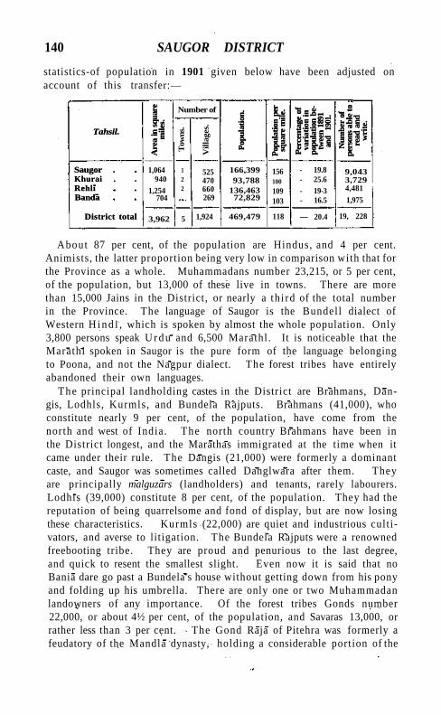
140 SAUGOR DISTRICT
statistics-of population in 1901 given below have been adjusted on account of this transfer:—
Tahsil.
Are
a in
squ
are
mile
s.
Number of
Pop
ulat
ion.
Pop
ulat
ion
per
sq
uare
mile
.
Per
cent
age
of
vari
atio
n in
po
pula
tion
be
twee
n 18
91
and
1901
.
Num
ber
of
pers
ons
able
to ;
read
and
w
rite
.
Tahsil.
Are
a in
squ
are
mile
s.
Tow
ns.
Vill
ages
.
Pop
ulat
ion.
Pop
ulat
ion
per
sq
uare
mile
.
Per
cent
age
of
vari
atio
n in
po
pula
tion
be
twee
n 18
91
and
1901
.
Num
ber
of
pers
ons
able
to ;
read
and
w
rite
.
Saugor . Khurai . Rehli Banda
District total
1,064 940
1,254 704
1 2 2
525 470 660 269
166,399 93,788
136,463 72,829
156 100
109 103
- 19.8 - 25.6 - 19-3 - 16.5
9,043 3,729 4,481
1,975
Saugor . Khurai . Rehli Banda
District total 3,962 5 1,924 469,479 118 — 20.4 19, 228
About 87 per cent, of the population are Hindus, and 4 per cent. Animists, the latter proportion being very low in comparison with that for the Province as a whole. Muhammadans number 23,215, or 5 per cent, of the population, but 13,000 of these live in towns. There are more than 15,000 Jains in the District, or nearly a th i rd of the total number in the Province. The language of Saugor is the Bundell dialect of Western H i n d i , which is spoken by almost the whole population. Only 3,800 persons speak U r d u and 6,500 Marathl. It is noticeable that the Marathi spoken in Saugor is the pure form of the language belonging to Poona, and not the Nagpur dialect. The forest tribes have entirely abandoned their own languages.
The principal landholding castes in the District are Brahmans, Dan-gis, Lodhls, Kurmls, and Bundela Rajputs. Brahmans (41,000), who constitute nearly 9 per cent, of the population, have come from the north and west of India. The north country Brahmans have been in the District longest, and the Marathas immigrated at the time when it came under their rule. The Dangis (21,000) were formerly a dominant caste, and Saugor was sometimes called Danglwara after them. They are principally malguzars (landholders) and tenants, rarely labourers. Lodhis (39,000) constitute 8 per cent, of the population. They had the reputation of being quarrelsome and fond of display, but are now losing these characteristics. Kurmls (22,000) are quiet and industrious cultivators, and averse to litigation. The Bundela Rajputs were a renowned freebooting tribe. They are proud and penurious to the last degree, and quick to resent the smallest slight. Even now it is said that no Bania dare go past a Bundela's house without getting down from his pony and folding up his umbrella. There are only one or two Muhammadan landowners of any importance. Of the forest tribes Gonds number 22,000, or about 4½ per cent, of the population, and Savaras 13,000, or rather less than 3 per cent. The Gond Raja of Pitehra was formerly a feudatory of the Mandla dynasty, holding a considerable portion of the
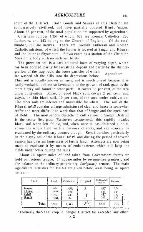
AGRICULTURE 141
south of the District. Both Gonds and Savaras in this District are comparatively civilized, and have partially adopted H i n d u usages. About 65 per cent, of the total population are supported by agriculture.
Christians number 1,357, of whom 665 are Roman Catholics, 230 Lutherans, and 443 belong to the Church of England. Of the total number, 768 are natives. There are Swedish Lutheran and Roman Catholic missions, of which the former is located at Saugor and Khura i and the latter at Shyampura. Etawa contains a station of the Christian Mission, a body with no sectarian tenets.
The prevalent soil is a dark-coloured loam of varying depth, which has been formed partly by lacustrine deposit and partly by the disintegration of the trap rock, the loose particles of which are washed off the hills into the depressions below. This soil is locally known as mund, and is much prized because it is easily workable, and not so favourable to the growth of rank grass as the more clayey soil found in other parts. It covers 56 per cent, of the area under cultivation. Kabar, or good black soil, covers 2 per cent., and raiydn, or thin black soil, 10 per cent, of the area under cultivation. The other soils are inferior and unsuitable for wheat. The soil of the Khura i tahstl contains a large admixture of clay, and hence is somewhat stiffer and more difficult to work than that of Saugor and the open part of Rehli . The most serious obstacle to cultivation in Saugor District is the coarse kans grass (Saccharum spontaneum); this rapidly invades black soil when left fallow, and, when once it has obtained a hold, covers the whole field wi th a network of roots, and can scarcely be eradicated by the ordinary country plough. Kans flourishes particularly in the clayey soil of the Khurai tahstl, and during the period of adverse seasons has overrun large areas of fertile land. Attempts are now being made to eradicate i t by means of embankments which wi l l keep the fields under water during the rains.
About 2½ square miles of land taken from Government forests are held on ryotwari tenure; 14 square miles by revenue-free grantees ; and the balance on the ordinary proprietary (malguzari) tenure. The main agricultural statistics for 1903-4 are given below, areas being in square miles:—
Tahsil. Total . Cultivated. Irrigated. Cultivable waste. Forests.
Saugor Khurai Rehli Banda
Total
1,064 940
1,254 704
435 238 443
. 227
3 I
i 4
437 529 417 243
124 124 327 180 .
Saugor Khurai Rehli Banda
Total 3,962 1,343 81/3 1,626 755
Formerly theVheat crop in Saugor District far exceeded any other.' K 2
Agriculture.
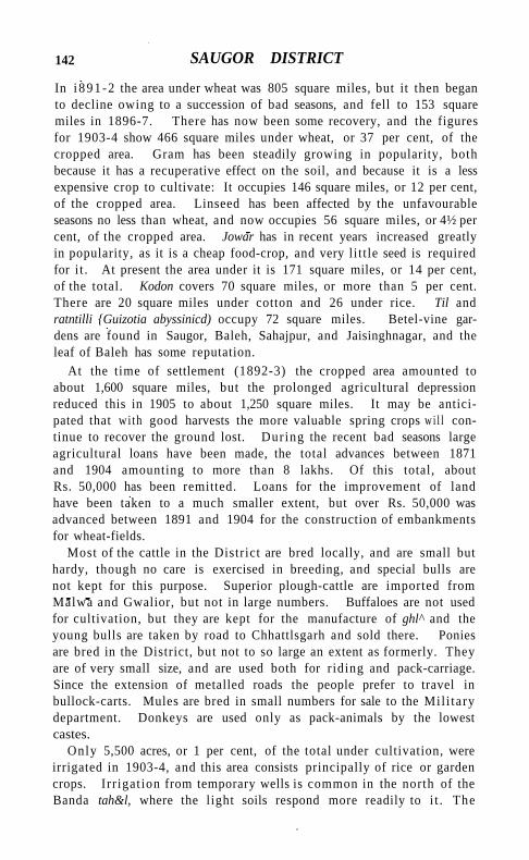
142 SAUGOR DISTRICT
In i 891 -2 the area under wheat was 805 square miles, but it then began to decline owing to a succession of bad seasons, and fell to 153 square miles in 1896-7. There has now been some recovery, and the figures for 1903-4 show 466 square miles under wheat, or 37 per cent, of the cropped area. Gram has been steadily growing in popularity, both because it has a recuperative effect on the soil, and because it is a less expensive crop to cultivate. It occupies 146 square miles, or 12 per cent, of the cropped area. Linseed has been affected by the unfavourable seasons no less than wheat, and now occupies 56 square miles, or 4½ per cent, of the cropped area. Jowar has in recent years increased greatly in popularity, as it is a cheap food-crop, and very li t t le seed is required for i t . At present the area under it is 171 square miles, or 14 per cent, of the total. Kodon covers 70 square miles, or more than 5 per cent. There are 20 square miles under cotton and 26 under rice. Til and ratntilli {Guizotia abyssinicd) occupy 72 square miles. Betel-vine gardens are found in Saugor, Baleh, Sahajpur, and Jaisinghnagar, and the leaf of Baleh has some reputation.
At the time of settlement (1892-3) the cropped area amounted to about 1,600 square miles, but the prolonged agricultural depression reduced this in 1905 to about 1,250 square miles. It may be anticipated that with good harvests the more valuable spring crops wi l l continue to recover the ground lost. During the recent bad seasons large agricultural loans have been made, the total advances between 1871 and 1904 amounting to more than 8 lakhs. Of this total, about Rs. 50,000 has been remitted. Loans for the improvement of land have been taken to a much smaller extent, but over Rs. 50,000 was advanced between 1891 and 1904 for the construction of embankments for wheat-fields.
Most of the cattle in the District are bred locally, and are small but hardy, though no care is exercised in breeding, and special bulls are not kept for this purpose. Superior plough-cattle are imported from Malwa and Gwalior, but not in large numbers. Buffaloes are not used for cultivation, but they are kept for the manufacture of ghl^ and the young bulls are taken by road to Chhattlsgarh and sold there. Ponies are bred in the District, but not to so large an extent as formerly. They are of very small size, and are used both for r iding and pack-carriage. Since the extension of metalled roads the people prefer to travel in bullock-carts. Mules are bred in small numbers for sale to the Mil i tary department. Donkeys are used only as pack-animals by the lowest castes.
Only 5,500 acres, or 1 per cent, of the total under cultivation, were irrigated in 1903-4, and this area consists principally of rice or garden crops. Irr igation from temporary wells is common in the north of the Banda tah&l, where the light soils respond more readily to i t . The
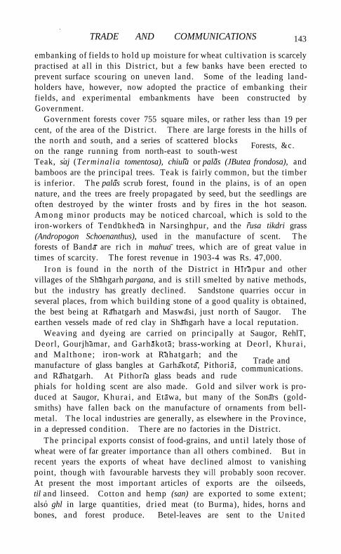
TRADE AND COMMUNICATIONS
embanking of fields to hold up moisture for wheat cultivation is scarcely practised at al l in this District, but a few banks have been erected to prevent surface scouring on uneven land. Some of the leading landholders have, however, now adopted the practice of embanking their fields, and experimental embankments have been constructed by Government.
Government forests cover 755 square miles, or rather less than 19 per cent, of the area of the District. There are large forests in the hills of the north and south, and a series of scattered blocks on the range running from north-east to south-west Teak, saj (Terminalia tomentosa), chiula or palas (JButea frondosa), and bamboos are the principal trees. Teak is fairly common, but the timber is inferior. The palas scrub forest, found in the plains, is of an open nature, and the trees are freely propagated by seed, but the seedlings are often destroyed by the winter frosts and by fires in the hot season. Among minor products may be noticed charcoal, which is sold to the iron-workers of Tendukheda in Narsinghpur, and the rusa tikdri grass (Andropogon Schoenanthus), used in the manufacture of scent. The forests of Banda are rich in mahua trees, which are of great value in times of scarcity. The forest revenue in 1903-4 was Rs. 47,000.
I ron is found in the north of the District in Hirapur and other villages of the Shahgarh pargana, and is still smelted by native methods, but the industry has greatly declined. Sandstone quarries occur in several places, from which building stone of a good quality is obtained, the best being at Rahatgarh and Maswasi, just north of Saugor. The earthen vessels made of red clay in Shahgarh have a local reputation.
Weaving and dyeing are carried on principally at Saugor, RehlT, Deorl , Gourjhamar, and Garhakota; brass-working at Deorl , Khurai , and Mal thone; iron-work at Rahatgarh; and the manufacture of glass bangles at Garhakota, Pithoria, and Rahatgarh. At Pithoria glass beads and rude phials for holding scent are also made. Gold and silver work is produced at Saugor, Khura i , and Etawa, but many of the Sonars (goldsmiths) have fallen back on the manufacture of ornaments from bell-metal. The local industries are generally, as elsewhere in the Province, in a depressed condition. There are no factories in the District.
The principal exports consist of food-grains, and unt i l lately those of wheat were of far greater importance than all others combined. But in recent years the exports of wheat have declined almost to vanishing point, though with favourable harvests they wil l probably soon recover. At present the most important articles of exports are the oilseeds, til and linseed. Cotton and hemp (san) are exported to some extent; also ghl in large quantities, dried meat (to Burma), hides, horns and bones, and forest produce. Betel-leaves are sent to the Uni ted
Trade and communications.
Forests, &c.
143
144 SAUGOR DISTRICT
Provinces, and the skins and horns of antelope are sold for ornamental purposes. The imports are principally cotton piece-goods, kerosene oil, metals, all minor articles of hardware, groceries, and spices. Country cloth comes principally from the Bombay mills; unrefined sugar is imported from the United Provinces, refined sugar from Bombay and Cawnpore, and tobacco from Cawnpore and Bengal. Nearly all the salt used comes from the Pachbhadra salt marshes in Jodhpur.
Before the opening of the railway from Bina to Katni nearly the whole trade of Saugor District went to Kareli station in Narsinghpur District by the Saugor-Karell road, crossing the Narbada at Barmhan; but at present the bulk of the trade of the District is concentrated at Saugor station. The three southern parganas of the Rehll tahsll— Naharmow, Gourjhamar, and Deorl—still send their exports to Kareli, while the Shahgarh pargana in the north of the Banda tahsll has a certain amount of traffic with Cawnpore by road. The branch line from Bina, on the Indian Midland section of the Great Indian Peninsula, to Katni, on the East Indian Railway, passes through the centre of Saugor District. The length of this railway within the District is 71 miles, and there are seven stations, of which Bina, Khurai, Saugor, and Shahpur are trade centres. The main line of the Indian Midland Railway from Itarsi to Cawnpore also runs through the north-west of the Khurai tahsll for 17 miles, and the stations of Bamora, Bina, Agasode, and Karonda are situated on it, while another branch leads from Bina to Baran. The principal roads are those leading from Saugor to Kareli, Rahatgarh, and Rehll, to Cawnpore through Banda, to Damoh through Garhakota, and to Jhansi through Malthone. Of these, the Kareli and Rahatgarh roads are metalled throughout, the Rehll road for most of its length, and the Cawnpore and Jhansi roads for a few miles out of Saugor town. The importance of the Kareli road has now largely decreased. The total length of metalled roads in the District is 117 miles, and of unmetalled roads 162 miles; the annual expenditure on maintenance is about Rs. 50,000. A few minor roads are maintained by the District council, but all others are in charge of the Public Works department. The length of avenues. of trees is 185 miles.
Little is on record concerning the agricultural history of the District prior to the thirty years' settlement of 1867, but severe failures of crops
are known to have occurred more than once during the first half of the century and also in the years
1854-56. In 1868-9 the autumn harvest failed entirely owing to drought, and some distress was felt by the poorer classes. In 1878, 1889, and 1890 the harvests were poor, and there was again a certain amount of privation. The spring crops were below the average in 1892-3, and in 1893-4 and 1894-5 they failed almost entirely from
Famine.
ADMINISTRATION 145
excessive winter rains. Relief works were opened in 1894, but the people d id not resort to them in large numbers. In 1895-6 both crops were again seriously injured by drought, and in 1896-7 an almost complete failure caused severe famine. Relief operations were in progress during the whole of 1897. The total expenditure exceeded 12 lakhs, and the maximum daily number of persons on relief was 58,000 in May, 1897. In 1898-9 Saugor had a poor spring crop, and in 1899-1900 the autumn crops failed entirely, though the spring crops gave an average out-turn. There was again famine in this year, though far less severe in Saugor than over most of the Province. Nearly 11 lakhs was spent on relief, and the numbers relieved rose to 87,000 in August, 1900. I t wi l l thus be seen that the District has lately passed through a most severe and protracted period of agricultural depression.
The executive head of the District is the Deputy-Commissioner, who is also District Magistrate, with three Assistants. For administrative purposes the District is divided into four tahslls, each of which has a tahsildar and a naib-tahsildar, except Banda, which has only a tahsildar. An Executive Engineer and a Forest officer are stationed at Saugor.
The civi l judicial staff consists of a District and a Subordinate Judge, with a Munsif at each tahsil. The Divisional and Sessions Judge of Jubbulpore has superior c ivi l and criminal jurisdiction. The crime of the District is somewhat heavy as compared wi th other parts of the Province. Robberies and dacoities are comparatively frequent, and cattle-stealing and simple theft are also common offences. Opium smuggling from the adjoining Native States is prevalent.
Under the Maratha revenue system villages were farmed out to the highest bidder, and any rights or consideration which the village headmen may have enjoyed in the past were almost entirely effaced. No legal status was given to tenants, and the older cultivators were protected only by custom, which enjoined that, so long as the annual rent demand was paid, their tenure should be hereditary and continuous. The land revenue history of the District during the period following the cession in 1818 consists of a series of abortive attempts to raise a revenue equal to or exceeding that of the Maratha government, when the people had become impoverished by the exactions of that government during the last period of its rule, and by the depredations of the Pindaris. The demand at cession was a l i t t le short of 6 lakhs. A series of annual and short-term settlements ensued t i l l 1835, when a twenty years' settlement was made, and the revenue fixed at Rs. 6,27,000. This settlement d id not work well, and the disturbances of 1842 seriously injured the District, necessitating a general reduction of revenue varying from 10 to 20 per cent. Large remissions of the
Administration.
146 SAUGOR DISTRICT
ordinary demand were also frequently made during the currency of this settlement. In 1854 a revision of settlement was commenced, but owing to the Mutiny and other causes was not completed throughout the District until 1867. The effect of this settlement was to reduce the revenue to Rs. 4,64,000. On this occasion the village headmen received, according to the general policy of the Central Provinces Administration, proprietary and transferable rights in their villages. The settlement was for the term of thirty years, and the District prospered, the cropped area increasing from 1,040 to 1,250 square miles. In 1891, after a preliminary cadastral survey had been completed, a new settlement commenced, but owing to interruptions caused by famine it was not completed t i l l 1897. The revenue then fixed amounted to nearly Rs. 6,96,000. In spite of the enhanced revenue, the share of the ' assets' left to the proprietors was considerably larger than at the former settlement. But the successive failures of crops have so greatly reduced both the area under cultivation and the value of the crops grown that the District has been unable to pay the revised demand, and successive reductions have been made. The revenue as now fixed is Rs. 5,00,000, the incidence per acre being R. 0-10-3 (maximum R, 0-13-7, minimum R. 0-15-11); while the incidence of the rental is Rs. 1-1-6 (maximum Rs. 1-7, minimum R. 0-10-10).
The land revenue and total revenue receipts in the District have varied, as shown below (in thousands of rupees) :—
1880-1. 1890-1. 1900-1. 1903-4.
Land revenue Total revenue ,
4,43 7,23
4,52 4,91 7,34
4,96 7,51
The management of local affairs outside municipal areas is entrusted to a District council, under which are four local boards each having jurisdiction over a single tahsil. The income of the District council in 1903-4 was Rs. 74,000. The main items of expenditure were; education (Rs. 20,000), public works (Rs. 18,000), and medical relief (Rs. 9,000). SAUGOR, DEORI, and K H U R A I are municipal towns.
The sanctioned strength of the police force is 653 of all ranks. This includes a special reserve of 2 officers and 23 men, 7 mounted constables, and cantonment police numbering 31. In proportion to area and population the police force is stronger in Saugor than in any other District of the Central Provinces, owing to the fact that it is surrounded by Native States, and thieves and dacoits find it easy to escape across the border. There are 1,523 village watchmen for 1,929 inhabited towns and villages. Saugor has a first-class District jail, with accommodation for 145 male and 22 female prisoners. The average daily number of prisoners in 1904 was 91.
SAUGOR TOWN 147
In respect of education Saugor stands sixth among the Districts of the Central Provinces, 7.7 per cent, of its male population being able to read and write. Only 919 females were returned as literate in 1901; but this is probably an understatement, as the people object to admitting that their women can read and write. Statistics of the number of pupils under instruction are as follows: (1880-1) 5,255; (1890-1) 5,959 ; (1900-1) 6,339; and (1903-4) 8,401, of whom 1,331 were girls. Owing to the prevalence of famine in 1900-1 the numbers were reduced, but a great advance has been made since. The educational institutions comprise a Government high school at Saugor town, 20 middle and 113 primary schools. Notwithstanding the small number of its women shown by the Census as literate, Saugor is one of the most advanced Districts in the Province in respect of female education. The expenditure on education in 1903-4 was Rs. 74,000, of which Rs. 67,000 was provided from Provincial and Local funds and Rs. 7,000 by fees.
The District has 8 dispensaries, with accommodation for 97 inpatients. The total attendance at all of them in 1904 was 71,166 persons, including 653 in-patients, and 2,549 operations were performed. The expenditure was Rs. 15,000, chiefly derived from Local funds; and they possess Rs. 6,800 invested capital.
Vaccination is compulsory only in the municipal towns of Saugor, Khurai, and Deori. In 1903-4 the number of persons successfully vaccinated was 34 per 1,000 of the population of the District.
[E. A. De Brett, Settlement Report (1901); E. V. Russell, District Gazetteer (1907).]
Saugor Tahsil.—Head-quarters tahsil of Saugor District, Central Provinces, lying between 230 31 ' and 240 1' N. and 780 14' and 790 6' E., with an area of 1,064 square miles. The population decreased from 207,456 in 1891 to 166,399 in 1901. The density in the latter year was 156 persons per square mile, or considerably above the District average. The tahsil contains one town, SAUGOR (population, 42,330), the District and tahsil head-quarters; and 525 inhabited villages. Excluding 124 square miles of Government forest, 57 per cent, of the available area is occupied for cultivation. The cultivated area in 1903-4 was 435 square miles. The demand for land revenue in the same year was Rs. 185,000, and for cesses Rs. 19,000. The lie of the country is undulating, and stretches of good cultivable land alternate with small hills and patches of forest.
Saugor Town.—Head-quarters of the District and tahsil of the same name in the Central Provinces, situated in 230 51' N. and 780 45' E., with a station on the Blna-Katni connexion of the Great Indian Peninsula Railway, 654 miles from Bombay and 760 from
148 SAUGOR TOWN
Calcutta. Its population (1901) is 42,330, including the cantonment (10,918), and it is the third largest town in the Province. The population in 1901 included 32,038 Hindus, 8,286 Muhammadans, 1,027 Jains, and 762 Christians, of whom 406 were Europeans and Eurasians. The population in 1872 was 45,655; in 1881, 44,461; and in 1891, 44,676. The garrison consists of one Native cavalry and one Native infantry regiment, a detachment of British infantry, and a field battery.
Saugor is supposed to be the Sageda of Ptolemy. The name is derived from sdgar, 'a lake/ after the large lake round which it is built. The town is picturesquely situated on spurs of the Vindhyan Hills, which surround the lake on three sides and reach an elevation of about 2,000 feet. Saugor has an old fort extending over an area of six acres, which was built by the Marathas, and which the European residents held for several months in 1857, controlling the town while the surrounding country was in the hands of the rebels. A municipality was constituted in 1867. The municipal receipts during the decade ending 1901 averaged Rs. 77,600. In 1903-4 the income was Rs. 75,000, the main head of receipt being octroi, while water-supply and conservancy form the largest items of expenditure, which amounted to Rs. 73,000 in the same year. The receipts of the cantonment fund in 1903-4 were Rs. 26,000. Saugor is not a growing town, and each Census has shown its population as either stationary or slowly declining. It has no factories; and the industries of weaving, brass-working, oil-pressing, and the manufacture of gold and silver ornaments, which formerly contributed substantially to its wealth, are now declining. There is a printing press with Hindi type. The high school at Saugor was established in 1828 by Captain Paton of the Bengal Artillery from his private funds, and supported by a Maratha gentleman, Rao Krishna Rao. Lord William Bentinck on his visit to Saugor was so struck by the public spirit displayed by the latter gentleman that he invited him to Calcutta and presented him with a gold medal and an estate of the value of Rs. 1,000 a year. The school was subsequently removed to Jubbulpore, but was re-established at Saugor in 1885. The town contains various branch and mission schools, three dispensaries, and a veterinary dispensary. A station of the Swedish Lutheran Mission has been established here.
Saugor Island.—Island at the mouth of the Hooghly river, Bengal. See SAGAR.
Saundatti-Yellamma.—A joint municipality in Belgaum District, Bombay, including the town Saundatti (Sugandhavarti, 'the sweet-smelling '), the head-quarters of the Parasgad taluka, situated in 15° 46' N. and 750 7' E., and Yellamma, a famous hill of pilgrimage 5½ miles south-east of the former. Population (1901), 9,525. Saun-
SAUSAR TAHSIL 149
datti is an important centre of trade. The town is commanded by an old fort in tolerable repair. About 2 miles to the south are the ruins of an extensive h i l l fort called Parasgad, from which the taluka derives its name. The municipality, established in 1876, had an average income during the decade ending 1901 of Rs. 12,400. In 1903-4 the income was Rs. 10,600. The town was formerly the stronghold of the Ratta chiefs (875-1250). It contains a Subordinate Judge's court, a dispensary, and a municipal middle school, besides five other boys' schools with 363 pupils and a girls' school with 55.
Vellamma h i l l takes its name from a shrine of the goddess Yellamma which is held in great veneration throughout the Bombay Carnatic. About 100,000 pilgrims visit the shrine annually, women predominating, and many of them come from great distances. On their way to the h i l l they give utterance repeatedly to a long-drawn cry, 'Ai Yel-lammo—oh I ' which resounds along the high roads for miles as it is taken up by successive bands of pilgrims. The shrine is built in the bed of the Saraswati stream, a tributary of the Malprabha. Though locally said to be about two thousand years old, the temple, excluding the sanctuary, appears to have been buil t in the seventeenth or eighteenth century, on the site of an older building dating from the thirteenth. The temple stands in the middle of a courtyard surrounded by arcades of pointed arches. Fairs are held in honour of the goddess at the full moon of A p r i l - M a y and November-December. A tax of half an anna is levied from each pilgrim, bringing in a revenue of about Rs. 5,000 to the municipality. In the early days of British rule women came to the shrine naked to pray for children or for the cure of skin disease. Hook-swinging was commonly practised at the shrine, and 175 persons were swung in 1834. Both of these practices have been discontinued. Nothing is known of the origin of the shrine.
Saurath.—Vil lage in the Madhubani subdivision of Darbhanga District, Bengal, situated in 260 24' N. and 86° 3' E. Population (1901), 2,062. It is famous for the me/a (religious fair) which takes place annually in June or July, when large numbers of Brahmans assemble to settle their children's marriages. A fine temple to Mahadeo was built in 1845 by the Darbhanga Raj.
Sausar Tahsil .—Southern tahsll of Chhindwara District, Central Provinces, lying between 21 0 28' and 21 0 55' N. and 780 20' and 790 16' E., wi th an area of 1,103 square miles. The population in 1901 was 121,148, compared with 120,451 in 1891. The density is no persons per square mile. The tahsil contains three towns— SAUSAR (population, 4,785), the head-quarters, M O H G A O N (5,730), and P A N D H U R N A (8,904)—and 383 inhabited villages. Excluding 331 square miles of Government forest, 62 per cent, of the available
150 SAUSAR TAHSIL
area is occupied for cultivation. The cultivated area in 1903-4 was 437 square miles. The demand for land revenue in the same year was Rs. 1,25,000, and for cesses Rs. 14,000. The tahsil consists of a tract of undulating country lying below the Satpura range, covered wi th light shallow soil, and is one of the chief cotton-growing areas of the Province.
Sausar Town.—Head-quarters of the tahsil of the same name, Chhindwara District, Central Provinces, situated in 21 0 40' N. and 780 48 ' E. , on the Chhindwara-Nagpur road, 33 miles from Chhindwara town and 46 from Nagpur. Population (1901), 4,785. Sausar was created a municipality in 1867. The municipal receipts during the decade ending 1901 averaged Rs. 1,700. In 1903-4 the income was Rs. 2,000, principally derived from a house tax. Cotton hand-weaving is the only industry. Sausar possesses an English middle school and a dispensary. A weekly cattle-fair is held at BerdI, a mile from the town.
S a v a i i . — T o w n in the Baroda p r a n t , Baroda State. See S A V L I .
S&vandurga .—A conspicuous fortified h i l l , 4,024 feet high, in the west of Bangalore District, Mysore, situated in 120 55' N. and 770 18' E. It is an enormous bare dome-shaped mass of granite, the summit consisting of two peaks separated by a chasm, each well supplied with water. It was first fortified in 1543 by an officer of the Vijayanagar kings. The chief of Bangalore next acquired i t , wi th Magadi, about 1570, and in his family i t remained t i l l taken by Mysore in 1728. Its capture by the Brit ish under L o r d Cornwallis in 1791 was a memorable exploit. It is now deserted, and surrounded on all sides wi th heavy forest.
S a v a n t v a d i S ta te (or Sawantwari).—State in Bombay, lying between 150 38' and 160 14' N. and 730 37 ' and 740 23' E., wi th an area of 925 square miles. It is bounded on the north and west by the Brit ish District of Ratnagir i ; on the east by the Western Ghats; and on the south by the Portuguese territory of Goa. The general aspect of the country is strikingly picturesque. From the sea-
coast to the foot of the Ghats, a distance varying from 20 to 25 miles, are densely wooded hills, and, in the valleys, gardens and groves of coco-nut and
areca-nut palms. Spurs and isolated peaks rising from 300 to 3,000 feet above the plain form strong natural fastnesses, some of which, l ike Manohar and Mansantosh, are said to have been fortified many centuries ago. The chief streams are the K a r l i on the north and the Terekhol on the south, which open out into creeks. Both are navigable for small native craft—the Terekhol for about 15 and the K a r l i for about 14 miles.
The Savantvadi State is composed for the most part of metamorphic
Physical aspects.
SAVANTVADI STATE 151
rocks, but at the northern part a considerable quantity of trap is found, and on the west a narrow band of laterite. These with the Ghats on the east form physical features which serve as a sort of natural boundary to the country. The great metamorphic spurs which run out west from under the mural termination of the Deccan trap at the Ghats extend to varying distances, and either end abruptly or break into clusters of lower hills. The intervening country is low and covered with thicker soil than is usually the case in the Konkan: this renders Savantvadi more open to cultivation than the barren laterite plateau to the west and north. There are a few insignificant outliers of the Kaladgi (Cuddapah) series.
Tigers, leopards, bears, bison, deer, wild hog, wild dogs, jackals, foxes, and hyenas are found. Snakes are common. In the Ghat tracts the State contains good teak; and black-wood, ain, kher, and jdmba are common. Near the sea, jack-wood, mango, bhirand {Gar-cinia indicd), coco-nut palms, and cashew-nut are plentiful.
The climate is humid and relaxing, with a heavy rainfall, the average annual fall being 150 inches. April is the hottest month in the year; in May a strong sea-breeze, the precursor of the south-west monsoon, tempers the heat. The temperature rises to 100° in May and falls to 6 20 in January.
Early inscriptions show that from the sixth to the eighth centuries the Chalukyas ruled over Savantvadi. In the tenth century the rulers were Yadavas. In the thirteenth century the Chalukyas were again in power. At the close of the fourteenth century Savantvadi was under an officer of the Vijayanagar dynasty. About the middle of the fifteenth century it formed part of a powerful Brahman dynasty. On the establishment of the Bijapur power at the close of the fifteenth century, Savantvadi became part of the territory of these kings. In about 1554 one Mang Savant of the Bhonsla family revolted from Bijapur, and making Hodowra, a small village 9 miles from Vadi, his head-quarters, defeated the troops sent against him, and maintained his independence during his lifetime. After his death his successors again became feudatories of the Bijapur kings.
The chief who finally freed his country from the Muhammadan yoke was Khem Savant Bhonsla, who ruled from 1627 to 1640. He was succeeded by his son Som Savant, who, after ruling for eighteen months, was succeeded by his brother, Lakham Savant. When the power of Sivajt seemed in the ascendant (1650), Lakham Savant tendered him allegiance, and was confirmed as Sar Desai of the whole Southern Konkan. Dying in 1665, Lakham was succeeded by his brother, Phond Savant, who, after ruling for ten years, was succeeded by his son, Khem Savant IL This chief, by aiding the
History.
152 SAVANTVADI STATE
Mughals in their struggles with Sivajl, and making frequent raids across the Goa frontier, added considerably to his territory; and subsequently, having supported Sivaji's grandson Sahu in his contest with the Raja of Kolhapur, he was confirmed in his possessions. It was during the time of Khem's successor (1709-37) that the Savant-vadi State first entered into relations with the British Government. A treaty was concluded between them against the piratical chieftain, Kanhoji Angria of Kolaba.
The chief, who ruled from 1755 to 1803 under the name of Khem Savant the Great, married in 1763 the daughter of Jayaji Sindhia ; and consequently the title of Raja Bahadur was conferred upon him by the emperor of Delhi. The Raja of Kolhapur, envious of this honour, made a descent on Vadi, and captured several hill fortresses, which were, however, through Sindhia's influence, subsequently restored. The rule of Khem Savant, who, not content with wars on land, also took to piracy, was one long contest against Kolhapur, the Peshwa, the Portuguese, and the British. Khem Savant died childless in 1803 ; and the contest for the succession was not decided ti l l 1805, when Khem Savant's widow Lakshmi Bai adopted a child, Ramchandra Savant, alias Bhau Sahib. This child lived for three years, and was then strangled in bed. Phond Savant, a minor, was chosen to fill his place. During these years of disorder the ports swarmed with pirates. So severely did British commerce suffer, that in 1812 Phond Savant was forced to enter into a treaty ceding the port of Vengurla to the British, and engaging to give up all his vessels of war. Soon after the conclusion of this treaty, Phond Savant I I I died, and was succeeded by his son Khem Savant I V , a child of eight. This chief, when he came of age, proved unable to manage his State, and, after several revolutions and much disturbance, at last in 1838 agreed to make over the administration to the British Government. After this, rebellion twice broke out (in 1839 and 1844), but the disturbances were soon suppressed, and the country has since remained quiet. The State was eventually restored in 1861, on the chief undertaking to defray the cost (5½ lakhs) of the last rebellion, to pay a succession fee of one year's revenue, to protect his subjects, and to meet the expense of a British Resident and his establishment.
The chief, a Maratha by caste and styled Sar Desai, is entitled to a salute of 9 guns. His family holds a sanad authorizing adoption, and in point of succession follows the rule of primogeniture.
The population numbered 190,814 in 1872; 174,433 in 1881; 192,948 in 1891; .and 217,732 in 1901. The State contains one town,
V A D I , and 226. villages; and the density is 235 .persons per square mile. Hindus form 94 percent,
of the total, and there are 5,634 Musalmans and 5,400 Christians.
Population.
TRADE AND COMMUNICATIONS
Among Hindus the chief castes are Brahmans (14,000), who are of the Karhade, Kudaldeskar, and Shenvi subcastes; Bhandaris, or toddy drawers (25,000); Marathas (117,000), who are largely cultivators; Vanls, or traders (12,000); and Mahars, or low-caste watchmen and labourers (12,000). The Musalmans describe themselves as Shaikhs (4,000). Native Christians are almost entirely Roman Catholics, the only mission in the State being the Portuguese Catholic Mission. They have increased from 2,000 to 5,400 in the last fifty years. The common language is the KonkanI dialect of Marathi. The sturdy and docile Marathas of the State are favourite recruits for the Indian army. They also supply much of the immigrant labour in the adjacent British Districts during the cultivating season. Of the total population, 74 per cent, are supported by agriculture.
The soil is chiefly light, and mixed with stone and gravel, and not suitable for the better class of crops. Of the total area of arable land, 594 square miles, 221 square miles were cultivated in 1903-4: namely, rice 97 square miles, garden land 10 square miles, and varkas or hill crops 114 square miles. The staple crop is rice; but the quantity grown is not sufficient for the wants of the people, and a good deal is imported. Excepting rice, none but the coarsest grains and pulses are raised. A species of oilseed, til, san-hemp, and black and red pepper, are also grown, but neither cotton nor tobacco. Both soil and climate are against the cultivation of wheat and other superior grains. For these, the people have to look to the country east of the Ghats, whence during the fair season, from October to June, large supplies are received.
Savantvadi, with an area of 54 square miles of forest lands, is rich in valuable teak. Iron ore of fair quality is found in the neighbourhood of the Ram ghat and also near Danoli in the Western Ghats. It is worked on a very small scale, which does not suffice even for the local demand. The Aker stone, a slate-coloured talc-schist, extremely hard, compact, and heavy, is unrivalled for building purposes. Laterite is quarried in many places. Talc of inferior quality is found at Kudawal and in other parts of the State.
Salt of an inferior kind was once manufactured, but the salt works have been abolished. The principal industries of the State consist of gold and silver embroidery work on both leather and cloth; fans, baskets, and boxes of khas-khas grass, ornamented with gold thread and beetles' wings; lacquered toys, and playing-cards; and drawing-room ornaments carved from the horn of the buffalo and bison. A pottery establishment for the manufacture of tiles is now at work in the State, and in 1903-4 a factory was established in the jail for extracting plantain and aloe fibre. Before the construction of the Southern Mahratta Railway
Trade and communications.
153
Agriculture.
154 SAVANTVADI STATE
a considerable transit trade existed between Belgaum and Vengurla. The trade is now purely local, the imports being valued at 5^ lakhs and the exports at Rs. 2,500.
There are no railways; but an excellent trunk road from the seaport of Vengurla passes through the State, leading by an easy gradient over the Western Ghats to Belgaum. The other chief lines of communication with the Deccan are the Ram ghat, the Talkat ghat, and the Phonda ghat In 1904 a branch road to Malewad was constructed to facilitate the sea-borne trade via Araonda.
In 1791 the rain failed shortly after the country had been plundered by the Raja of Kolhapur, and scarcity ensued. In 1821 excessive rain destroyed the crops. The State is liable to local floods caused by the rapid falling and overflowing of its mountain streams. In 1883-4 some damage to the crops was done by locusts, and again in 1902-3 and 1903-4.
For administrative purposes the area of the State is divided into the three subdivisions of Vadi, Banda, and Kudal. Under the super
vision of the Political Agent, who is aided by an Assistant Political Agent, the revenue and magisterial
charge of each of these fiscal subdivisions is placed in the hands of an officer styled Katnavisdar. Appeals in revenue matters lie from the Political Agent to the Commissioner, Southern Division. Land is divided into four classes : namely, State, alienated, rented, and ryotwari. State lands are either crown lands or private lands, the latter being the personal property of the chief. Both classes are managed by the revenue officials, and are let to the highest bidder for a fixed term of years. Alienated lands are classed as inam, held free either in perpetuity or during the lifetime of the holder; dastibad, which are rare and are liable only to the payment of certain cesses; and devsu, or religious lands, the produce of which is devoted to temples. Rented or khoti lands are tilled or sublet to others by the hhot, who pays a certain fixed sum to the State, and in turn receives a certain share of the produce from his sub-tenants. Ryotwari or peasant-held lands pay a fixed assessment, as in British territory. The State has been surveyed and a regular settlement introduced since 1877, By its completion in 1895-6, the land revenue was increased from 1-8 to 2-7 lakhs. The rates per acre vary from 1 anna to 6 annas for 'dry' land, Rs. 5 to Rs. 14 for garden land, and Rs. 4 to Rs. 7 for rice land.
There are 5 civil courts exercising original jurisdiction, of which 3 are permanent and 2 are temporary. The Desai of Parma presides over an honorary court of Small Causes; the fifth court is that of the Registrar of the Small Cause Court. The Chief Judge has appellate jurisdiction, and the Political Agent exercises the powers of a High
Administration.
SAVANUR STATE 155
Court. There are nine criminal courts, the Political Agent having the powers of a Sessions Judge.
The revenue of the State in 1903-4 was about 4-3 lakhs, chiefly derived from land (about 2-7 lakhs), abkari and say er (nearly Rs. 60,000), forests (Rs. 35,000), and stamps (over Rs. 33,000) The expenditure was nearly 4-8 lakhs, of which about \\ lakhs is spent as darbdr and paga (stud and cattle-breeding) grants, and fixed assignments amounting to Rs. 50,000. The State spends about Rs. 50,000 annually on public works, and contributed Rs. 28,000 in 1903-4 towards the salaries of the Political Agent and his establishment. Up to 1839 the pirkhani rupee, first struck by the Bijapur minister, was the standard coin. Since then it has been replaced by the British rupee.
The Savantvadi State maintains a local corps, consisting in 1904 of 327 men of all ranks under a European officer, which is to be reduced to 250; and an unarmed police force of 137, of whom 126 belonged to the permanent force and the rest were detailed from the local corps. The State has one jail, with a daily average of 43 prisoners in 1903-4. In that year the State contained 155 schools with 6,389 pupils. Of these, one is an English school with 261 pupils. Of the total population, 6.6 per cent. (12-8 males and o-8 females) were returned as literate in 1901. One hospital and 3 dispensaries are maintained, in which 21,000 patients were treated in 1903-4. There is a lunatic asylum with 14 inmates, and a leper asylum with 77 inmates. In the same year about 6,300 persons were vaccinated.
Savanur State.—Native State within the limits of Dharwar District, Bombay, lying between 140 57' and 150 2' N. and 750 22' and 750 25' E., with an estimated area of 70 square miles. The State is for the most part flat and treeless. In climate and fauna it does not differ from the adjacent portions of Dharwar District. The annual rainfall averages 27 inches. Plague broke out in 1898, and has since caused the death of over 4,000 persons, of whom one-quarter fell victims in the year 1902-3. The town of Savanur alone lost 1,600.
The reigning family are Musalmans of Pathan origin. The founder of the family, Abdul Rauf Khan, obtained in 1680 from the emperor Aurangzeb the grant of a jagir comprising Bankapur, Torgal, and Azamnagar or Belgaum, with a command of 7,000 horse. In 1730 the family, as deputies of the Nizam, received additional territory, which the Peshwa seized in 1747. In 1786 Tipu Sultan, with whom the Nawab was connected by marriage, stripped him of much territory • but allying himself with the Marathas, the Nawab regained some part of it, and obtained from the Peshwa a pension of Rs. 10,000 a month. At the close of the last Maratha War the Nawab, whose conduct had been exceptionally loyal, was confirmed in his original possessions by
VOL. X X I I . L
156 SAVANUR STATE
the British Government, and received during his lifetime an additional yearly grant of Rs. 6,000. The State pays no tribute. The family holds a sanad authorizing adoption, and the succession follows the rule of primogeniture.
The population in 1901 was 18,446, compared with 16,976 in 1891, residing in one town, S A V A N U R , and 22 villages. Hindus number 13,000, Musalmans 5,000. Of the Hindus, nearly one-half (6,000) are Lingayats. The Musalmans describe themselves as Shaikhs (3,600) and Pathans (1,000), with a few Arabs and Saiyids. About two-thirds of the population are supported by agriculture.
The soil' of the northern, eastern, and southern villages is both red and black, and that of the western villages is red. The principal crops are cotton, jowar, kulith, tur, pan, wheat, gram, plantains, and sugar-cane. Of the total area of 70 square miles, about 2 square miles are under forest, and 6 square miles are uncultivable. The area of cultivable land is 62 square miles, of which 51 square miles were cropped in 1903-4, about 3 square miles being irrigated. The betel-leaf grown in the Savanur gardens is celebrated for its superior quality, and has been exported in greater quantity since the opening of the Southern Mahratta Railway. Cotton cloths, such as saris, dhotis, & c , are manufactured to a small extent, and there is some trade in grain and raw cotton. The State escaped the severity of the famine of 1899-1900, only two villages being affected.
The Collector of Dharwar is Political Agent for the State, his Senior Assistant being Assistant Political Agent. There are two criminal courts and one civi l court, and the Political Agent has the powers ot a District Judge. The State laws are modelled on those of Brit ish territory.
The revenue is about one lakh, chiefly derived from land. The State levies no customs or transit duties. A Local fund cess of one anna is levied from all landholders. The survey settlement introduced in 1870-1 was revised in 1895, and the revised rates were levied in 1896-7. The original revenue demand of Rs. 75,320 was increased to Rs. 90,463. The actual demand in 1903-4 was Rs. 61,991, including a quit-rent of Rs. 6,803, but excluding the assessment on indtn, waste, and forest lands. The rates per acre vary from 4 annas to Rs. 5-5 for ' d r y ' land, R. r to Rs. 12 for rice land, and Rs. 3 to R.s. 24 for garden land. The police force consists of 48 men. The State contains 11 schools with 548 pupils. The dispensary at Savanur treated 12,000 persons in 1903-4, and 502 persons were vaccinated in the same year.
S a v a n u r Town.—Capi t a l of the State of SavanQr, Bombay, 40 miles south-east of Dharwar, situated in 140 58' N. and 750 23' E. Population (1901), 9,796. The town covers an area of three-quarters
SAVLI 157
of a mile and is enclosed by a ditch, wi th eight gates, now falling into ruins. Between 1868 and 1876 the town was greatly improved, the roads widened and metalled, and many old wells and ponds repaired. The municipal income is about Rs. 3,700. There are 5 schools with 403 pupils, including 116 girls, and a class for drawing and carpentry. The town contains a dispensary. The chief objects of interest are the Nawab's palace, numerous mosques, a Vaishnava religious establishment, and the math of Sri Satya Bodhaswami.
S&vda.—Town in the Raver taluka of East Khandesh District, Bombay, situated in 2 1 0 9' N. and 750 53' E., on the Great Indian Peninsula Railway. Population (1901), 8,720. Savda was finally ceded by the Nizam to the Peshwa in 1763, and was shortly afterwards bestowed on Sardar Raste, whose daughter was given in marriage to the Peshwa. In 1852, in connexion with the introduction of the revenue survey, a serious disturbance occurred at Savda. From 10,000 to 15,000 malcontents gathered, and were not dispersed t i l l a detachment of troops arrived and arrested 59 of the ringleaders. The municipality, established in 1883, had an average income during the decade ending 1901 of Rs. 9,500. In 1903-4 the income was Rs. 9,700. The chief trade is in cotton, gram, linseed, and wheat. At the weekly market, valuable Nimar and Berar cattle are offered for sale. The town contains two cotton-ginning factories, a dispensary, and four schools, with 520 pupils, of which one, with 36 pupils, is for girls.
Savdi .—Village in the Ron taluka of Dharwar District, Bombay, situated in 150 39 ' N. and 750 45 ' E., about 5 miles south-west of Ron town. Population (1901), 5,202. It contains temples of Brahma-deo and Narayandeo, each with an inscr ipt ion; and two schools, of which one is for girls.
S&vli.—Head-quarters of the taluka of the same name, Baroda pranty Baroda State, situated in 220 34 ' N. and 730 15' E. Population (1901), 4,687. It possesses Munsifs and magistrate's courts, a vernacular school, a dispensary, and local offices, and is administered as a municipality, receiving an annual grant from the State of Rs. 1,000. A considerable trade in grain and cattle is carried on, and the town is the commercial centre of a wide group of villages In the immediate neighbourhood are large tanks, shady trees, and fruitful fields; at no great distance is the wi ld mehwasi country of ravines and jungles bordering the Mahi . At one corner of the Siivli tank stand two temples which commemorate the names of Damaji Gaikwar and his father Piiajl. The latter was assassinated at Dakor in 1732, but his body was carried away from that place by his followers, and the last honours were hurriedly paid it at Savli. The treacherous murder, the invasion of Abhai Singh, and the hasty funeral of the founder of the
L 2
158 SAVLI
Gaikwar's house mark a crisis in the history of the Maratha conquest, and give something of historic dignity to the unpretending temple of Pilajl.
Saw.—South-western township of Pakokku District, Upper Burma, lying between 200 48' and 210 37' N. and 940 o' and 940 20' E., along the eastern edge of the Chin Hills, with an area of 1,200 square miles. The greater part of the township lies in the basin of the Yaw, but the southern portion is watered by the Maw, which rises near Mount Victoria. The population was 22,339 in 1891, and 19,868 in 1901, distributed in 117 villages. The majority of the inhabitants are Burmans, but Chins and Taungthas are also numerous. Saw (population, 742), at the foot of the hills, is the head-quarters. The area cultivated in 1903-4 was about 23 square miles, and the land revenue and tkathameda amounted to Rs. 47,000,
Sawai Madhopur.—-Head-quarters of the nizamat and tahsil of the same name in the State of Jaipur, Rajputana, situated in 26° N. and 760 23' E., about 76 miles south-east of Jaipur city. It is connected with the Rajputana-Malwa Railway at Daosa station by a road running via Lalsot, and will be the terminus of the Jaipur-Sawai Madhopur branch now under construction. Population (1901), 10,328. The town, which is walled, takes its name from M&dho Singh, chief of Jaipur from 1751 to 1768, by whom it was laid out somewhat on the plan of the capital. There are numerous schools, including a vernacular middle, a Jain pathsd/a, and 6 indigenous schools attended by about 300 boys, besides a hospital with accommodation for 4 inpatients. Copper and brass vessels are largely manufactured and exported southwards; and there is a brisk trade in lacquered wooden articles, round playing-cards, and the scent extracted from the khas-khas grass (Andropogon muricatus).
Sawantwari.—State and town in Bombay. See SAVANTVADI and V A D I respectively.
Sayla State.—State in the Kathiawar Political Agency, Bombay, lying between 210 26' and 220 51' N. and 710 12' and 710 34' E., with an area of 222 square miles. The population in 1901 was 11,661, residing in one town and 38 villages. The revenue in 1903-4 was Rs. 66,000, and 59 square miles were cultivated. The State ranks as a third-class State in Kathiawar. Sayla is mentioned as a pargana of Jhalawar in the Ain-i-Akbati, but by the eighteenth century it had fallen into the hands of the Kathis. Sheshabhai, the son of the Halavad chief, took possession of Sayla in 1751, and added it to the girds of Narichana and Liya, which he had obtained in his struggle for the possession of Dhrangadhra. He was succeeded by Kakobhai, also called Vikmatsingh (1794-1813), in whose time a permanent settlement of tribute was made with the British Government His
SECUNDERABAD 159
family now rules over the State. The title is Thakur; but the present chief bears the title of Thakur Sahib, conferred on him as a personal distinction.
Sayla Town.—Chief town of the State of the same name in Kathiawar, Bombay, situated in 220 32' N. and 71°32 /E., 16 miles from the Chuda railway station, 18 miles south-west of Wadhwan, on the bank of a large tank called Manasarowar, the excavation and building of which is popularly attributed to Sidhraj Jai-Singh, the celebrated sovereign of Anhilvada. Population (1901), 5,367. Sayla is famous for the temple of Ramchandra, built by Lala Bhagat, a Bania saint who flourished in the beginning of the last century. Food is distributed daily to travellers, ascetics, and others. There is a brisk trade in cotton and grain.
Sayyidpore.—Town in Rangpur District, Eastern Bengal and Assam. See SAIDPUR.
Scinde.—Division of the Bombay Presidency. See SIND. Sealdah.—A quarter of Calcutta, Bengal. See CALCUTTA. Sealkote. — District, tahsll, and town in the Lahore Division,
Punjab. See SIALKOT. Secunderabad (Sikandarabad).—British cantonment in the Hyder
abad State, situated in 170 27' N. and 780 30'E., 6 miles north-east of Hyderabad city. The population of Secunderabad in 1901 was 83,550, and the population of Bolarum and Trimulgherry 12,888.
Secunderabad, named after the Nizam Sikandar Jah, is one of the largest military stations in India. The British troops stationed here were formerly known as the Subsidiary Force, and were paid from the revenues of the districts ceded by the Nizam for this purpose under the treaty of 1800. The Nizam also agreed to maintain a Contingent to act with the Subsidiary Force in case of necessity. This Contingent, for the payment of which Berar was assigned to the British Government by the treaty of 1853, modified by the treaty of i860, had its head-quarters at Bolarum, other stations being Ellichpur in Berar, and five towns in the Hyderabad State: namely, Aurangabad, Hingoli, Jalna, Amba (Mominabad), and Raichur. During the Mutiny of 1857 an unsuccessful attempt was made to tamper with the fidelity of the troops at Secunderabad. An attack on the Residency was repulsed, and during the troubled times of 1857-8 much good service was rendered by both the Subsidiary Force and the Hyderabad Contingent. By an agreement entered into in 1902, the Contingent ceased to exist as a separate force, and was incorporated in the Indian army. The cantonments, except Aurangabad, were vacated, and Bolarum was merged in Secunderabad. The garrison of Secunderabad and Bolarum consisted in 1904 of one regiment of British and two of Native cavalry; one battery of horse and three of field artillery, with ammunition
i6o SECUNDERABAD
columns; two battalions of British and six regiments of Native infantry; a company of sappers and miners, with a proportion of mule corps and transport bearers. The combined cantonment comprises the areas of Secunderabad, Chilkalguda, Bowanpalli, Begampett, Trimulgherry, North Trimulgherry, and Bolarum.
Up to 1850 the cantonment of Secunderabad consisted of a line of barracks and huts, extending for a distance of three miles from east to west, with the artillery in front and on the left flank, and the infantry on the right. Since that date, however, the cantonment boundaries have been extended so as to include the areas already mentioned, covering 22 square miles, including many interspersed villages. New double-storeyed barracks have been erected for the European troops, and improved quarters for the Native troops.
The country for miles round Secunderabad undulates into hummocks, with outcrops of underlying rock, crossed from east to west by greenstone dikes. East of the cantonment are two large outcrops of granite and a hill of some size, known as Maula Ali , and near it another called Kadam Rasul from a legend that it bears an impress of the Prophet's foot. Shady trees line the roads of the cantonment, and here and there are clusters of date and palmyra palms; but otherwise the face of the country is bare, with but little depth of soil on the more elevated spots. Rice is cultivated in the dips and villages, in most of which tanks have been constructed. The water-supply from wells is not abundant; and of late years the Jidimatla tank, which has not been an unqualified success, has been constructed for the purpose of providing an adequate supply of water for the troops and civil population of Secunderabad.
The climate of Secunderabad is generally healthy, though at the latter end of the rainy season, in September, fever is somewhat prevalent. The rainfall varies considerably; during the twenty-five years ending 1903 it averaged 33 inches.
Seebsaugar.—District, subdivision, and town, Eastern Bengal and Assam. See SIBSAGAR.
Seepra.—River in Malwa. See SIPRA. Seetamau.—State and town in Central India. See SITAMAU.
Segowlie.—Village in Champaran District, Bengal. See SAGAULI.
Sehore (Sihor).—British military station and head-quarters of a State taAsif and of the Bhopal Agency, situated in the Nizamat-i-Maghrib or western district of Bhopal State, Central India, in 230 12' N. and 770 5' E., on the Ujjain-Bhopal Railway, 1,750 feet above sea-level. Population (1901), 16,864, of whom 5,109 inhabited the native town, and 11,755 the military station, the two portions forming one continuous site, near the junction of the Siwan and Lotia streams, which have been dammed to give an ample water-supply.
SEHORE 161
A mosque erected in 1332 shows that Sehore was even at that time a place of some importance. In 1814 it was the scene of the famous fight between SindmVs generals, Jaswant Rao and Jean Baptiste Filose, which practically saved the city of Bhopal from capture. The real importance, however, of Sehore dates from 1818, when, after the treaty made with the Bhopal State, it was selected as the head-quarters of the Political officer and the newly raised local contingent. Up to 1842 the Political officer ranked as an Agent to the Governor-General, but then became a Political Agent. Sehore is also the head-quarters of the Agency Surgeon.
In 1818, after the treaty concluded with the Nawab in the previous year, the contingent force which the Bhopal State had agreed to maintain was quartered at Sehore. The Bhopal Contingent, as it was designated, was supplied from the Bhopal State army, deficiencies being made good by drafting men from the State regiments. There were no British officers with the corps, which was directly under the orders of the Political officer. These State levies, however, objected to wearing uniform or undergoing proper discipline; and in 1824 the Contingent was reorganized and a British officer attached as commandant, the force then consisting of 20 gunners, 302 cavalry, and 674 infantry, the last being rearmed with muskets in place of matchlocks. The troops were employed to police the district and furnish escorts. Several reorganizations took place at different periods, the number of British officers being raised to 3 in 1847. In 1857 the force consisted of 72 gunners, 255 cavalry, and 712 infantry. Most of the men were then recruited in Northern India, Sikhs being enlisted in both the cavalry and infantry. The regiment showed symptoms of unrest at this period, but never mutinied in force, and assisted in protecting the Agent to the Governor-General at Indore, and also escorted the Political Agent and European residents of Sehore to Hoshangabad, to which place they retired at the request of the Begam. The artillery served as a complete unit under Sir Hugh Rose throughout the campaign. In 1859 the force was reconstituted as an infantry battalion and became the Bhopal Levy. In 1865 it was again reconstituted as the Bhopal Battalion, and in 1878 was employed in the Afghan campaign on the lines of communication. In 1897 it was brought under the orders of the Commander-in-Chief, and the station was included in the Nerbudda district instead of being, as hitherto, a political corps, directly under the Governor-General In 1903 it was reconstituted in four double companies of Sikhs, Muham-madans, Rajputs, and Brahmans, with 8 British officers and 896 rank and file, and delocalized, receiving the title of the 9th Bhopal Infantry; and in the following year, for the first time since its creation, it was moved from Sehore on relief, being replaced by a regiment of the regular army. The Bhopal State contributes towards the upkeep of
162 SEHORE
the force. The contribution, originally fixed at 1*3 lakhs, was finally raised in 1849 to 1.6 lakhs. . The station is directly under the control of a Superintendent, acting under the Political officer. He exercises the powers of a first-class Magistrate and Small Cause Court judge. An income of about Rs* 60,000 is derived from taxes on houses and lands and other miscellaneous sources, which is spent on drainage, water-supply, lighting, education, and hospitals. The station has increased considerably of late years, and is now an important trading centre, the yearly fair called the Hardaul Lala mela, held in the last week of December, being attended by merchants from Cawnpore, Agra, and Saugor. A high school, opened in 1839, and a girls' school, opened in 1865, both largely supported by the chiefs of the Agency, are maintained in the station, besides a charitable hospital, a leper asylum, a d&fc-bungalow for Europeans, two sarais for native travellers, a Protestant church, and a Government post and telegraph office. The native town contains a school, a State post office, and a sarai.
Sehwan Subdivision.—Subdivision of Larkana District, Sind, Bombay, composed of the DADU, JOHI, and SEHWAN tdlukas.
Sehwan Taluka.—Taluka of Larkana District, Sind, Bombay, lying between 250 53' and 260 39' N. and 670 29' and 670 58' E., with an area of 1,272 square miles. The population in 1901 was 54,779, compared with 53,574 in 1891. The taluka contains two towns—SEHWAN (population, 5,244), the head-quarters, and BUBAK (3,300)—and 65 villages. Owing to its physical features this taluka^ with a density of only 43 persons per square mile, is less thickly populated than any other. The land revenue and cesses in 1903-4 amounted to i«6 lakhs. Sehwan is the most picturesque taluka in the District, for the hills curve south-west almost up to the Indus, while the Manchhar Lake forms its north-western boundary. The lands round the lake are irrigated by its overflow and produce excellent wheat, but south of them there is little regular cultivation. The Chitawah, a meandering stream, which enters the taluka from the north and winds towards the Indus, is the chief source of irrigation in the north-east. The riparian lands of the Indus are irrigated by small watercourses which debouch from and again flow into the river.
Sehwan Town.—Head-quarters of the taluka of the same name in Larkana District, Sind, Bombay, situated in 2 6° 26' N. and 670 54' E., on a branch of the North-Western Railway, and on the main road from Kotri to Shikarpur via Larkana, 84 miles north-northwest of Kotri, and 95 miles south-south-west of Larkana; elevation above sea-level 117 feet. Population (1901), 5,244. The river Indus, which formerly flowed close to the town, has now quite deserted it. A few miles south of Sehwan, the Lakhi hills terminate abruptly, form-
SEIKPYU 163
ing a characteristic feature of this portion of the taluka. The Muham-madan inhabitants are for the most part engaged in fishing; the Hindus in trade. A large section of the people are professional mendicants, supported by the offerings of pilgrims at the shrine of Lai Shahbaz. The tomb containing the remains of this saint is enclosed in a quadrangular edifice, covered with a dome and lantern, said to have been built in 1356, and having beautiful encaustic tiles with Arabic inscriptions. Mirza Janl, of the Tarkhan dynasty, built a still larger tomb to this saint, which was completed in 1639. The gate and balustrade are said to have been of hammered silver, the gift of Mir Karam Ali Khan, Talpur, who also crowned the domes with silver spires. The chief object, however, of antiquarian interest in Sehwan is the fort, ascribed to Alexander the Great. This is an artificial mound 80 or 90 feet high, measuring round the summit 1,500 by 800 feet, and surrounded by a broken wall. The interior is strewn with broken pottery and tiles. The mound is evidently an artificial structure, and the remains of several towers are visible. The fortifications are now in disrepair. An old Christian graveyard below the fort contains a few tombs dating from the early part of the nineteenth century. Sehwan is undoubtedly a place of great antiquity. Tradition asserts that the town was in existence at the time of the first Muhammadan invasion of Sind by Muhammad bin Kasim Safiki, about A. D. 711; and it is believed to be the place which submitted to his arms after the conquest of Nerankot, the modern Hyderabad.
The town was constituted a municipality in 1854, and had an average income during the decade ending 1901 of Rs. 12,200. In 1903-4 the income was Rs. 14,000. The transit trade is mainly in wheat and rice; and the local commerce in cloth and grain. The manufactures comprise carpets, coarse cloth, and pottery. The art of seal-engraving, which was formerly much practised, is now extinct. The town contains a Subordinate Judge's court, a dispensary, and a middle school.
Seikpyu.—Southern township of Pakokku District, Upper Burma, lying between 200 50' and 210 21' N. and 940 20' and 940 48' E., with an area of 559 square miles. The level of the country rises on all sides towards the centre, from which spring numerous streams draining into the Yaw river, which sweeps round the township, first in a north-easterly and then in a southerly course. The inhabitants are confined to the valleys of the Yaw and its tributary, the Sada-on, which drains the south. The hilly centre is uninhabited. The population was 47,502 in 1891, and 31,100 in 1901, distributed in 152 villages, Seikpyu (population, 1,195) on the Irrawaddy being the head-quarters. The area cultivated in 1903-4 was 107 square miles, and the land revenue and thathameda amounted to Rs. 72,000.
164 SEJAKPUR
Sejakpur.—Petty State in KATHIAWAR, Bombay. Sembiem.—Town in the Saidapet taluk of Chingleput District,
Madras, situated in 130 7' N. and 80° 16' E. Population (1901), 17,567. It lies near the Perambur railway station of the Madras Railway and just beyond the limits of the Madras municipality, and within it are the Perambur railway workshops, which employ 4,500 hands. It is consequently almost a suburb of Madras, and being a healthy locality, with good water, is growing rapidly in population. There is a considerable Eurasian community in the place. It contains ten small paper-making establishments, which give employment to about a dozen hands apiece.
Sendamangalam.—Town in the Namakkal taluk of Salem District, Madras, situated in n° 17' N. and 78015' E. Population (1901), 13,584. It is the third largest town in the District, but the occupations of the people are purely agricultural, and it is of little other interest.
Sendurjana.—Town in the Mors! taluk of Amraoti District, Berar, situated in 210 N. and 780 6' E. Population (1901), 6,860. The town has declined in importance since 1872, but a large bazar is held here once a week.
Seohara (Siuhara).—Town in the Dhampur tahsil of Bijnor District, United Provinces, situated in 290 13' N. and 780 35' E., on the main line of the Oudh and Rohilkhand Railway. Population (1901), 10,062. The town contains a police station and a handsome mosque, and also a branch of the American Methodist Mission. It is administered under Act XX of 1856, with an income of about Rs. 3,000. Its trade is of some importance. A primary school has 63 and five aided schools have 182 pupils.
Seondha (Seora),—Head-quarters of a pargana in the Datia State, Central India, situated in 260 10' N. and 780 47' E., on the east bank of the Sind river, 36 miles from Datia town. Population (1901), 5,542. The town has been steadily declining in importance of late years. It is of old foundation, the remains of the earlier settlement lying close to the modern town. Seondha was a flourishing place in the fifteenth century, and the fort is supposed to have been of importance some centuries before. It may possibly be the Sarua fort taken by Mahmud of Ghazni in the eleventh century when in pursuit of Chand Rai. At the beginning of the nineteenth century Raja Parichhat of Datia gave asylum at Seondha to the mother of Daulat Rao Sindhia, who had fled from Gwalior; and the fort was unsuccessfully attacked on Sindhia's behalf by Raghunath Rao and General Perron. A school and a combined British and State post office are situated in the town.
Seoni District.—District in the Jubbulpore Division of the Central Provinces, consisting of a long narrow section of the Satpura plateau overlooking the Narbada valley on the north and the Nagpur plain on
SEONI DISTRICT 165
the south, and lying between 2 1 0 36 ' and 220 5 7 ' ' N . and 790 19' and 8o° 17' E., wi th an area of 3,206 square miles. It is bounded on the north by Narsinghpur and Jubbulpore Dis t r ic t s ; on the east by Mandla, Balaghat, and Bhandara; on the south by Nagpur; and on the west by Chhindwara. A l l round the north and north-west of the District the border hills of the Satpura range, thickly fringed with forest and overlooking the Narbada, separate Seoni from Jubbulpore and Narsinghpur, except along a strip to the north-east, where the Narbada itself is the boundary towards Mandla, and 44 villages lying below the hills are included in the District. In the extreme north-west also a few villages below the hills belong to Seoni. South of the northern passes lies the Lakhnadon plateau, a roll ing country of alternate ridges and hollows, terminating i n another belt of h i l l and forest which leads down to the Wainganga. Except to the east where an open plain stretches to the Mandla border, and along part of the western boundary, the Lakhnadon plateau is surrounded by jungle. The Sher river flows through the centre of the plateau from east to west, and passes into Narsinghpur to jo in the Narbada. The Temur and Soner are other tributaries of the Narbada rising in the south. To the south-west of the District, and separated from the Lakhnadon plateau by the The l and Wainganga rivers, lies the Seoni Haveli , a level tract of the most fertile black soil in the District, extending from the line of hills east of Seoni town to the Chhindwara border. In this plateau the Wainganga rises at Partabpur, a few miles south of Seoni, and flows for some distance to the north unti l it is joined by the Thel from Chhindwara, and then across the District to the east, crossing the Nagpur-Jubbulpore road at Chhapara. On the south-west the Pench separates Seoni from Chhindwara. The heights of the Seoni and Lakhnadon plateaux are about 2,000 feet above sea-level, but the peak of Manor! on the western border of the District rises to 2,749 feet, and that of Kariapahar near Seoni to 2,379 feet. East of Seoni a line of hills runs from south to n o r t h ; and beyond this lies another open tract, about 200 feet lower than the Seoni plain, constituting the valleys of the Sagar and H i r r i rivers, and containing the tracts of Ghansor and Barghat. Another line of hills separates the Ghansor plain from the valley of the Wainganga, which, after crossing the District from west to east, turns south at the point where it is joined by the Thanwar river from Mandla, and forms the boundary of Seoni for some miles unt i l it diverges into Balaghat. The valley of the Wainganga, at first stony and broken and confined by hills as it winds round the northern spurs of the Seoni plateau, becomes afterwards an alternation of rich alluvial basins and narrow gorges, unt i l just before reaching the eastern border of the District it commences its descent to the lower country, passing over
Physical aspects.
166 SEONl DISTRICT
a series of rapid and deep stony channels, overhung by walls of granite 200 feet high. The falls of the Wainganga and its course for the last six miles, before its junction with the Thanwar on the border of the District, may perhaps rank next to the Bheraghat gorge of the Nar-bada for beauty of river scenery. The lower valley of the Wainganga is about 400 feet below the Ghansor plain, from which it is separated by another line of forest-clad hills, and a narrow rice-growing strip along its western bank, called the Ugli tract, is included in Seonl. In the extreme south of the Seonl tahsil a small area of submontane land, forming the Dongartal or Kurai tract, and largely covered with forest, is the residence of numbers of Gaolis, who are professional cattle-breeders. The Bawanthari river rises in the southern hills, and, receiving the waters of numerous small streams, carries the drainage of this area into Nagpur District on its way to join the Wainganga.
The District is covered by the Deccan trap, except on the southern and south-eastern borders, where gneissic rocks prevail.
The forests are extensive, forming a thick belt along the northern and southern hills, with numerous isolated patches in the interior. In the north they are stunted and scanty, and the open country is bare of trees, and presents a bleak appearance, the villages consisting of squalid-looking collections of mud huts perched generally on a bare ridge. In the rice tracts, on the other hand, the vegetation is luxuriant, and fruit trees are scattered over the open country and round the villages. Owing to the abundance of wood the houses are large and well-built, and surrounded by bamboo fences enclosing small garden plots. The northern forests have much teak, but usually of small size, and there is also teak along the Wainganga river; the forests in the south-east are principally composed of bamboos. The open country in the south is wooded with trees and groves of mahua (Bets-sia latifolia), tendu or ebony (Diospyros tomentosa), achar (Buchanania latifolia), and fruit trees, such as mango and tamarind.
Tigers and leopards are not very common; but deer are found in considerable numbers, and both land and water birds are fairly frequent in different parts of the District.
The climate is cool and pleasant, excessive heat being rarely felt even in the summer months.
The annual rainfall averages 53 inches. During the thirty years previous to 1896 the rainfall was only once less than 30 inches, in 1867-8. Irregular distribution is, however, not uncommon.
From the inscription on a copperplate found in Seonl combined with others in the Ajanta caves, it has been inferred that a line of
princes, the Vakataka dynasty, was ruling on the Satpura plateau from the third century A.D. , the
name of the perhaps mythical hero who founded it being given as
History.

HISTORY 167
VindhySsakti, Little is known of this dynasty except the names of ten princes, and the fact that they contracted alliances with better-known ruling houses. The architectural remains at Deogarh and Lakhnadon may, however, be attributed to them or their successors, as they could not have been constructed by the Gonds. History is then a blank until the sixteenth century, when Seoni fell under the dominion of the rising Gond dynasty of Garha-Mandla. Ghansor, Chauri, and Dongartal were three of the fifty-two forts included in the possessions of Raja Sangram Sah in 1530, and the territories attached to these made up the bulk of the present District. A century and a half afterwards the Mandla Raja was obliged to call in the help of Bakht Buland, the Deogarh prince, to assist in the suppression of a revolt of two Pathan adventurers, and in return for this ceded to him the territories now constituting Seoni. Bakht Buland came to take possession of his new dominions, and was engaged one day in a hunting expedition near Seoni, when he was attacked by a wounded bear. An unknown Pathan adventurer, Taj Khan, came to his assistance and killed the bear; and Bakht Buland was so pleased with his dexterous courage that he made him governor of the Dongartal taluka, then in a very unsettled condition. When Seoni, with the rest of the Deogarh kingdom, was seized by Raghuji Bhonsla, Muhammad Khan, the son of Taj Khan, held out in Dongartal for three years on behalf of his old master; and Raghuji finally, in admiration of his fidelity, appointed him governor of Seoni-Chhapara with the title of Diwan, and his descendants continued to administer the District until shortly before the cession. In the beginning of the nineteenth century Chhapara, at that period a flourishing town with 2,000 Pathan fighting men, was sacked by the Pindaris during the absence of the garrison at Nagpur and utterly ruined. A tombstone near the Wain-ganga bridge still marks the site where 40,000 persons are said to have been buried in a common grave 1.
Seoni became British territory in 1818, being ceded by the treaty which followed the battle of Sitabaldi. During the Mutiny the tranquillity of the District was disturbed only by the revolt of a Lodhi landholder in the north, who joined the rebels of Jubbulpore and Narsinghpur. They established themselves on some hills overlooking the Jubbulpore road near Sukri, from which they made excursions to burn and plunder villages. The rebels were dispersed and the country pacified on the arrival of the Nagpur Irregulars at the end of 1857. The representative of the Diwan family firmly supported the British Government. In 1873 the greater part of the old Katangi tahsiloi Seoni was transferred to BSlaghat, and 51 villages below the
1 According to another account, the 40,000 perished in a battle between the rulers of Seoni and Mandla.
168 SEONI DISTRICT
hills to Nagpur, while Seoni received accessions o f . 122 villages, including the Adegaon taluka from Chhindwara, and 8 villages from Mandla.
The archaeological remains are of little importance. At Ghansor in the Seoni tahsll are the ruins of numerous Jain temples, now only heaps of cut and broken stone, and several tanks. Ashta, 28 miles from Seoni in the Barghat tract, contains three temples built of cut stone without cement. There are three similar temples in Lakhnadon and some sculptures in the tahsll. Blsapur near Kurai has an old temple which is said to have been buil t by Sona Rani, widow of the Gond Raja Bhopat, and a favourite popular heroine. The ruins of her palace and an old fort are also to be seen at Amodagarh near UgH on the H i r r l river. Along the southern spurs of the Satpuras, the remains of a number of other Gond forts are visible at Umargarh, Bhainsagarh, Partabgarh, and Kohwagarh.
The population of Seoni at the last three enumerations was as follows: (1881) 335,997; (1891) 370,767; and (1901) 327,709- Be
tween 1881 and 1891 the District prospered, and the rate of increase was about the same as that for
the Province as a whole. The decrease of more than n per cent, during the last decade was due to bad seasons and emigration to Assam. The principal statistics in 1901 are shown below:—
The statistics of religion show that 55 per cent, of the population are Hindus, 40 per cent. Animists, and about 4½ per cent. Muham-madans. There are some large Muhammadan landlords, the principal being the representative of the Dlwan's family, who holds a considerable estate, the Gondi taluka, on quit-rent tenure. The people are for the most part immigrants from the north-west, and rather more than half speak the Bundeli dialect of Western H ind i . Urdu is the language of nearly 11,000 of the Muhammadans and Kayasths, and about 20,000 persons in the south-east of the District below the hills speak Marathl. The Ponwars have a dialect of their own akin to Rajasthani; and Gondi is spoken by 102,000 persons, or rather more than three-fourths of the number of Gonds in the District.
Gonds number 130,000, or 40 per cent, of the population. They
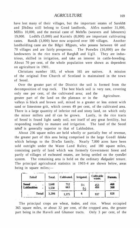
AGRICULTURE 169
have lost many of their villages, but the important estates of Sarekha and Dhuma still belong to Gond landlords, Ahirs number 31,000, Malis 10,000, and the menial caste of Mehras (weavers and labourers) 19,000. Lodhis (5,000) and Kurmls (8,000) are important cultivating castes. Banias (3,000) have now acquired over 100 villages. Another landholding caste are the Bagri Rajputs, who possess between 60 and 70 villages and are fairly prosperous. The Ponwars (16,000) are the landowners in the rice tracts of Barghat and U g l l . They are industrious, skilled in irrigation, and take an interest in cattle-breeding. About 70 per cent, of the whole population were shown as dependent on agriculture in 1901.
Christians number 183, of whom 165 are natives. A mission of the original Free Church of Scotland is maintained in the town of Seoni.
Over the greater part of the District the soil is formed from the decomposition of trap rock. The best black soil is very rare, covering only one per cent, of the cultivated area; and the greater part of the land on the plateaux or in the valleys is black and brown soil, mixed to a greater or less extent wi th sand or limestone grit, which covers 49 per cent, of the cultivated area. There is a large quantity of inferior red and stony land, on which only the minor millets and til can be grown. Lastly, in the rice tracts of Seoni is found light sandy soil, not itself of any great fertility, but responding readily to manure and irrigation. The land of the Seoni tahsil is generally superior to that of Lakhnadon.
About 236 square miles are held wholly or partially free of revenue, the greater part of this area being comprised in the large Gondl taluka which belongs to the Diwan family. Nearly 7,000 acres have been sold outright under the Waste Land Rules; and 180 square miles, consisting partly of land which was formerly Government forest and partly of villages of escheated estates, are being settled on the ryotwari system. The remaining area is held on the ordinary malguzari tenure. The principal agricultural statistics in 1903-4 are shown below, areas being in square miles;—
Tahsil Total. Cultivated. Irrigated. Cultivable waste. Forests.
468 360
Seoni Lakhnadon
Total
1,648 1,558
712 663
5½
½ 453 484
Forests.
468 360
Seoni Lakhnadon
Total 3,206 1,375 6 937 828
The principal crops are wheat, kodon, and rice. Wheat occupied 365 square miles, or about 32 per cent, of the cropped area, the greater part being in the Haveli and Ghansor tracts. Only 3 per cent, of the
Agriculture.
170 SEONI DISTRICT
fields classed as fit to grow wheat are embanked. Kodon and kutkl, the light autumn millets, were sown in 195 square miles, or 17 per cent, of the cropped area. Rice occupied about 114 square miles, or 8 per cent, of the cropped area. It has decreased in popularity during the last few years, owing to the distribution of the rainfall having been generally unfavourable, and the area under it at present is about 50 square miles less than at the time of settlement. Rice is generally transplanted, only about 20 per cent, of the total area being sown broadcast in normal years. Linseed, til and other oilseeds, gram, lentils, tiura, jowar, and cotton are the other crops. Jowar and cotton have lately increased in popularity, while the area under linseed has greatly fallen off.
A great deal of new land has been broken up since the settlement of 1864-5, the increase in cultivated area up to the last settlement (1894-6) amounting to 50 per cent. A considerable proportion of the new land is of inferior quality and requires periodical resting fallows. The three-coultered sowing drill and weeding harrow used by cultivators of the Deccan for jowar have lately been introduced into Seoni. Saw-hemp is a profitable minor crop, which has recently come into favour. No considerable sums have been taken under the Land Improvement Act, the total amount borrowed between 1894 and 1904 being Rs. 29,000; but nearly 2½ lakhs has been advanced in agricultural loans.
Cattle are bred principally in the Kurai tract and in the north of the Lakhnadon tahsil The Gaolls and Golars in Kurai are professional cattle-breeders, and keep bulls, Large white bullocks are reared, and sold in Nagpur and Berar, where they fetch Rs. 50 or Rs. 60 a pair as yearlings. The Lakhnadon bullocks are smaller, and the majority are of a grey colour. Frequently no special bulls are kept, and the immature males are allowed to mix with the cows before castration. Gonds and poor Muhammadans sometimes use cows for ploughing, especially when they are barren. In the rice tracts buffaloes are used for cultivation. Small ponies are bred and are used for riding in the Haveli, especially during the rains. Sheep are not numerous, but considerable numbers of goats are bred by ordinary agriculturists both for food and for religious offerings. Lakhnadon has an especially good breed of goats.
About 46 square miles of rice land and 2,000 acres of sugar-cane and garden crop land are classed as irrigable, and this area was shown as irrigated in the year of settlement. In 1903-4 the irrigated area was only 6 square miles, owing to the unfavourable rainfall, which was insufficient to fill the tanks. About 18 square miles are irrigated from tanks and 4,000 acres from wells and other sources in a good year. Rice is watered from tanks, both by percolation and by cutting the
TRADE AND COMMUNICATIONS 171
embankments. Sugar-cane and garden crops are supplied from wells. There are about 650 tanks and 1,300 wells.
The Government forests cover an area of 828 square miles, of which 11 have been demarcated for disforestation and settlement on ryoiwari tenure. They are well distributed in all parts of the District. Teak and saj (Terminatia tomentosa) are the chief timber trees, the best teak growing in the Kura i range, where there are three plantations. Bamboos are also plentiful. Mahua and lac are the most important minor products. The forest revenue in 1903-4 amounted to Rs. 63,000.
I ron is found in the Kura i range in the south of the District and was formerly smelted by native methods, but has now been displaced by English iron. Other deposits occur in the valley of the H i r r i river. In Khaira on the Sagar river, 23 miles from SeonI towards Mandla, coal has been discovered, and a prospecting licence granted. The sands of the Pachdhar and Bawan-thari rivers have long been washed for gold in insignificant quantities. An inferior k ind of mica has been met wi th in Rukhar on the Seonl-Nagpur road and the hills near i t . A smooth greyish-white chalk is obtained near Chhapara on the north bank of the Wainganga. Light-coloured amethysts and topazes are found among the rocks in the Adegaon tract. A good hard stone is obtained from quarries in the hills and in the villages of Chakki-Khamaria, Janawarkheda, and Khan-kara, from which grindstones, rolling-slabs, and mortars are made, and sold all over SeonI and the adjoining Districts of Chhindwara and Bhandara.
The weaving of coarse cotton cloth is carried on in several villages, principally at SeonI, Barghat, and Chhapara. Tasar silk cloth was formerly woven at SeonI, but the industry is nearly extinct. Cotton cloth is dyed at Mungwani, Chhapara, Kahani, and other villages, al ( Indian madder) being still used, though it has to a large extent been supplanted by the imported German dye. At Adegaon the amohiva cloths are dyed green with a mixture of madder and myrabolams. Glass bangles are made from imported glass at ChaonrI, Patan, and Chhapara; and lac bangles at SeonI, Chhapara, Bakhari, and Lakhnadon. Earthen vessels are made in several villages, those of Kaniwara and Pachdhar having a special reputation. These are universally used for water, and aVso for the storage of such articles as grain and ghi, while Muhammadans and Gonds employ them as cooking vessels. I r o n implements are made at Piparwani in the Kura i tract from English scrap iron, and are used throughout the south of the District, the Lakhnadon tahsll obtaining its supplies from Narsinghpur and Jubbulpore. Skins are tanned and leather-work is done at Khawasa.
VOL. X X I I .
Trade and communications.
Forests.
Minerals.
172 SEONI DISTRICT
Wheat is the principal export; but rice is exported to Chhindwara and the Narbada valley, and .raw-hemp fibre is sent to Calcutta, often to the value of four or five lakhs annually. Gram and oilseeds are exported to some extent, and also the oil of the kasar plant, a variety of safflower, which is very prickly and is sown on the borders of wheat-fields to keep out cattle. The exports of forest produce are teak, sdj\ bijasal (Pterocarpus Marsupium) and bamboos for building, mahua oil, lac, chironji (the fruit of Buchanania latifolia), and myrabolams. Ghi cotton, and hides and horns are also exported. Salt comes principally from the marshes near Ahmadabad and to a less extent from Bombay. Both sugar and gur are obtained from the United Provinces, and the latter also from Chhindwara. Mill-made piece-goods, from both Bombay and Calcutta, are now generally worn by the better classes, in place of hand-made cloth. Betel-leaves, turmeric, and catechu are imported from surrounding Districts. Superior country-made shoes come from Calcutta and Delhi. The trade in grain and ghi is principally in the hands of Agarwal and Parwar Banias, and there are one or two shops of Cutchi Muhammadans. The centre of the timber trade is at Kurai, to which wholesale dealers come from Kamptee to make purchases. Barghat is the most important weekly market, and after it Gopalganj, Kaniwara, and Keolari.
The narrow-gauge Satpura extension of the Bengal-Nagpur Railway has recently been constructed. A branch line runs from Nainpur junction in Mandla through Seoni to Chhindwara, following closely the direction of the Seonl-Mandla and Seoni-Chhindwara roads; the length of line in the District is 55 miles. The main connecting line between Gondia and Jubbulpore also crosses the north-eastern portion of the Lakhnadon tahsil, with stations at Ghansor, Binaiki, and Shikara; the length of line in the District is 20 miles. The great northern road from Nagpur to Jubbulpore, metalled and bridged throughout, except at the Narbada, passes from south to north of the District. The trade of Seoni has hitherto been almost entirely along this road, that of the portion south from Chhapara going to Kamptee, and that of the northern part of the Lakhnadon tahsil to Jubbulpore. Roads have also been constructed from Seoni to Chhindwara, Mandla, Balaghat, and Katangi, along which produce is brought from the interior. From the hilly country in the east and west of the Lakhnadon tahsll carriage has hitherto been by pack-bullocks, and over all the rest of the District by carts. The length of metalled roads is 133 miles and of unmetalled roads 116 miles, all maintained by the Public Works department. The maintenance charges in 1903-4 were Rs. 64,000. Avenues of trees exist for short and broken lengths on the principal toads.
From 1823 to 1827 the District suffered from a succession of short
ADMINISTRATION 173
crops due to floods, hail, and blight, resulting in the desertion of many villages. In 1833-4 the autumn rains failed and a part of the spring-crop area was left unsown. Grain was imported by Government from Chhattisgarh. The winter rains were excessive in 1854-5, and the spring crops were totally destroyed by rust. In 1868 the monsoon failed in August, and the year's rainfall was only about half the normal, but a heavy storm in September saved a portion of the crops. Distress was not severe in Seoni, and the people made great use of forest produce. From 1893 to 1895 the winter rains were abnormally heavy and the spring crops were damaged by rust; and this was followed in 1895 and 1896 by early cessation of the rains. In the former year the autumn crops failed partially, and in the latter year completely, while in 1896 a considerable portion of the spring-crop area could not be sown owing to the dryness of the land. There was severe famine during the year 1897, when 44 lakhs was expended on relief, the numbers relieved rising to 19,000, or 5 per cent, of the population, in September. In 1899-1900 Seoni had a very bad autumn harvest and a moderate spring harvest. The distress was considerable but not acute, the numbers on relief rising to 45,000, or 12 per cent, of the population, and the total expenditure being 6.6 lakhs.
The Deputy-Commissioner is aided by one Extra-Assistant Commissioner. For administrative purposes the District is divided into two tahsih) each of which has a tahslldar and a naib-tahslldar. The District staff includes a Forest officer, but public works are in charge of the Executive Engineer of Jubbul-pore.
The civil judicial staff consists of a District and a Subordinate Judge, and a Munsif at each tahsil. The Divisional and Sessions Judge of the Jubbulpore Division has jurisdiction in Seoni. The crime of the District is light.
Neither the Gond nor Maratha governments recognized any kind of right in land, and the cultivators were protected only by the strong custom enjoining hereditary tenure. The rule of the Gonds was never oppressive, but the policy of the Marathas was latterly directed to the extortion of the largest possible revenue. Rents were generally collected direct, and leases of villages were granted only for very short terms. The measure, however, which contributed most largely towards the impoverishment of the country was the levy of the revenue before the crops on which it was charged could be cut and sold. In 1810, eight years before coming under British rule, it was reported that Seoni had paid a revenue of more than three lakhs; but in the interval the exactions of the last Maratha ruler, Appa Sahib, and the depredations of the Pindaris, had caused the annual realizations to shrink to less
M 2
Famine.
Administration.
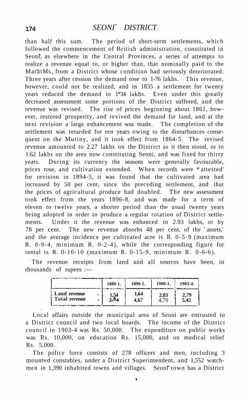
174 SEONI DISTRICT
than half this sum. The period of short-term settlements, which followed the commencement of British administration, constituted in Seoni, as elsewhere in the Central Provinces, a series of attempts to realize a revenue equal to, or higher than, that nominally paid to the MaratMs, from a District whose condition had seriously deteriorated. Three years after cession the demand rose to 1-76 lakhs. This revenue, however, could not be realized, and in 1835 a settlement for twenty years reduced the demand to 1*34 lakhs. Even under this greatly decreased assessment some portions of the District suffered, and the revenue was revised. The rise of prices beginning about 1861, however, restored prosperity, and revived the demand for land, and at the next revision a large enhancement was made. The completion of the settlement was retarded for ten years owing to the disturbances consequent on the Mutiny, and it took effect from 1864-5. The revised revenue amounted to 2.27 lakhs on the District as it then stood, or to 1.62 lakhs on the area now constituting Seoni, and was fixed for thirty years. During its currency the seasons were generally favourable, prices rose, and cultivation extended. When records were * attested' for revision in 1894-5, it was found that the cultivated area had increased by 50 per cent, since the preceding settlement, and that the prices of agricultural produce had doubled. The new assessment took effect from the years 1896-8, and was made for a term of eleven to twelve years, a shorter period than the usual twenty years being adopted in order to produce a regular rotation of District settlements. Under it the revenue was enhanced to 2.93 lakhs, or by 78 per cent. The new revenue absorbs 48 per cent, of the i assets,' and the average incidence per cultivated acre is R. 0 -5-9 (maximum R. 0-9-4, min imum R. 0-2-4) , while the corresponding figure for rental is R. 0-10-10 (maximum R. 0-15-9, minimum R. 0-6-6) .
The revenue receipts from land and all sources have been, in thousands of rupees :—
1880-1. 1890-1. 1900-1. 1903-4.
Land revenue Total revenue
1,54 1,64 4,67
2,83 4,70
2,79 5,42
Local affairs outside the municipal area of Seoni are entrusted to a District council and two local boards. The income of the District council in 1903-4 was Rs. 50,000. The expenditure on public works was Rs. 10,000, on education Rs. 15,000, and on medical relief Rs. 5,000.
The police force consists of 278 officers and men, including 3 mounted constables, under a District Superintendent, and 1,552 watch-men in 1,390 inhabited towns and villages. Seoni town has a District
SE0N7 TOWN 175 jail with accommodation for 162 prisoners, including 16 females. The daily average number of prisoners in 1904 was 53.
In respect of education the District stands eleventh in the Province, 4.3 per cent, of the male population being able to read and write in 1901, while only 335 females were returned as literate. The percentage of children under instruction to those of school-going age is 8. Statistics of the number of pupils under instruction are as follows : (1880-1) 1,786; (1890-1) 2,564; (1900-1) 3,420; and (1903-4) 4,344, including 337 girls. The educational institutions comprise a high school at Seoni supported by the Scottish Free Church Mission; 2 English middle schools, 4 vernacular middle, and 60 primary schools, of which 5 are girls' schools. The expenditure on education in 1903-4 was Rs. 36,000, of which Rs. 20,000 was derived from Provincial and Local funds and Rs. 3,000 from fees.
The District has 5 dispensaries, with accommodation for 56 inpatients. In 1904 the number of cases treated was 25,774, of whom 383 were in-patients, and 611 operations were performed. The expenditure was Rs. 8,000, the greater part of which was provided from Provincial and Local funds.
Vaccination is compulsory only in the municipality of Seoni. The number of persons successfully vaccinated in 1903-4 was 51 per 1,000 of the District population, a very favourable result.
[Khan Bahadur Aulad Husain, Settlement Report (1899); R. A. Sterndale, Seonee, or Camp Life on the Satpura Range (1877); R. V. Russell, District Gazetteer (1907).]
Seoni Tahsll.—Southern tahsll of Seoni District, Central Provinces, lying between 210 36' and 220 24' N. and 790 19' and 8o° 6' E., with an area of 1,648 square miles. The population decreased from 219,284 in 1891 to 192,364 in 1901. The density in the latter year was 117 persons per square mile. The tahsll contains one town, SEONI (population, 11,864), the head-quarters of the District and tahsil ; and 677 villages. Excluding 468 square miles of Government forest, 60 per cent, of the available area is occupied for cultivation. The cultivated area in 1903-4 was 712 square miles. The demand for land revenue in the same year was Rs. 1,69,000, and for cesses Rs. 21,000. The western portion of the tahsll towards Chhindwara consists of a fertile black-soil plain, while on the south and east there are tracts of rice country. The remainder is hilly and undulating.
Seoni Town.—Head-quarters of the District and tahsll of the same name, Central Provinces, situated in 220 5' N. and 790 33' E., on the road from Nagpur to Jubbulpore, 79 miles from the former town and 86 from the latter. A branch line of the Satpura narrow-gauge railway runs from Nainpur junction through Seoni to Chhindwara. Population (1901), 11,864, including nearly 3,000 Muhammadans. Seoni was
176 SEONI TOWN
founded in 1774 by the Pathan governor of ChhapSra, who removed his head-quarters here, and built a fort in which his descendant still resides. It was created a municipality in 1867. The municipal receipts during the decade ending 1901 averaged Rs. 25,000. In 1903-4 the receipts were Rs. 39,000, of which Rs. 29,000 was derived from octroi. Seoni is the principal commercial town on the Satpura plateau, and has a cotton hand-weaving industry. The water-supply is obtained from the Bubaria tank, 2½ miles distant, from which pipes have been carried to the town. The large ornamental Dalsagar tank in the town is kept filled from the same source. Seoni contains a high school with 33 pupils, and boys' and girls' schools, supported by the Scottish Free Church Mission, besides municipal English middle and branch schools. The medical institutions comprise three dispensaries, including a police hospital and a veterinary dispensary.
S e o n i - M a l w a Tahsl l .—Tahsi l of Hoshangabad District, Central Provinces, lying between 220 13' and 220 39 ' N. and 770 13' and 770 44 ' E., wi th an area of 490 square miles. The population in 1901 was 66,793, compared with 75,901 in 1891. The density is 136 persons per square mile. The tahsil has one town, S E O N I - M A L W A (population, 7,531), the head-quarters; and 196 inhabited villages. Excluding 126 square miles of Government forest, 75 per cent, of the available area is occupied for cultivation. The cultivated area in 1903-4 was 232 square miles. The demand for land revenue in the same year was Rs. 1,29,000, and for cesses Rs. 12,000. The tahsil, which is a very small one, consists of a highly fertile black-soil plain adjoining the Narbada and a strip of hi l ly country to the south.
Seoni -Malwa Town.—Head-quarters of the tahsil of the same name in Hoshangabad District, Central Provinces, situated in 220 27' N. and 770 29' E., on the Great Indian Peninsula Railway, 443 miles from Bombay. Population (1901), 7,531. The town was created a municipality in 1867. The municipal receipts during the decade ending 1901 averaged Rs. 11,000. In 1903-4 they were Rs. 9,000, derived mainly from octroi. Seoni-Malwa was formerly the most important trading town in the District, but it has been supplanted in recent years by Harda and Itarsi. A number of betel-vine gardens are situated near the town, in which a special variety of leaf is grown. Seoni-Malwa possesses an English middle school and a dispensary.
Seorai .—Ancient site in Bahawalpur State, Punjab. See S A R W A H I . Seoraj.—Tahsi l in Kangra District, Punjab. See S A R A J . Serajgunge.—Subdivision and town in Pabna District, Eastern
Bengal and Assam. See S IRAJGANJ. S e r a m Taluk,—Eastern taluk of Gulbarga District, Hyderabad
State. The population in 1901, including jagirs, was 82,349, compared with 54,106 in 1891 ; the area was 404 square miles. Up to
SERAMPORE TOWN 177 1905 the taluk contained one town, SERAM (population, 5,503), the headquarters; and 117 villages, of which 45 were jagir. The land revenue in 1901 was 1-8 lakhs. In 1905, 21 villages from Gurmatkal were added to Seram. Rice is grown in the taluk by tank-irrigation. The paigah taluk of Chitapur, with a population (1901) of 28,930 and 38 villages, lies to the east of this taluk, and has an area of about 121 square miles.
Seram Town.—Head-quarters of the taluk of the same name in Gulbarga District, Hyderabad State, situated in 170 11' N. and 7 70 18' E., on the Nizam's State Railway. Population (1901), 5,503. Seram contains many old temples and mosques, notable among them being the old Jama Masjid, constructed in the pillar and lintel style, and the temple of Panchalinga, the pillars of which are richly carved, while the ceilings are well decorated. It has a ginning factory also.
Serampore Subdivision.—South-eastern subdivision of Hooghly District, Bengal, lying between 220 40' and 220 55' N. and 870 59' and 88° 22' E., with an area of 343 square miles. The subdivision consists of a level strip of land bounded on the east by the Hooghly river, and exhibits all the features of a thickly peopled deltaic tract. The population in 1901 was 413,178, compared with 399,987 in 1891. It contains five towns, SERAMPORE (population, 44,451), the head-quarters, UTTARPARA (7,036), BAIDYABATI (17,174), BHADRESWAR (15,150), and KOTRANG (5,944); and 783 villages. The towns, which are all situated along the bank of the Hooghly, contain a large industrial population, and the subdivision is .more thickly populated than the rest of the District, there being no fewer than 1,205 persons per square mile. A shrine at TARAKESWAR is largely resorted to by pilgrims.
Serampore T o w n (Srirampur).—Head-quarters of the subdivision of the same name in Hooghly District, Bengal, situated in 220 45' N. and 88° 21' E., on the right bank of the Hooghly river, opposite Barrackpore. The population increased from 24,440 in 1872 to 25,559 in 1881, to 35,952 in 1891, and to 44,451 in i9or, the progress being due to the important mills which it contains. Of the total, 80 per cent, are Hindus and 19 per cent. Musalmans, while of the remainder 405 are Christians.
Serampore was originally a settlement of the Danes, who remained here until 1845, when by a treaty with the King of Denmark all the Danish possessions in India, consisting of the towns of Tranquebar and Serampore (or Frederiksnagar, as it was called) and a small piece of ground at Balasore, formerly occupied as a Danish factory, were sold to the East India Company for 12½ lakhs of rupees. Serampore was the scene of the labours of the famous Baptist missionaries, Carey, Marshman, and Ward; and the mission, in connexion with which its founder established a church, school, and library, still flourishes. Two
178 SERAMPORE TOWN
great me/as, the Snanjatra and the Rathjatra, are annually held in the Mahesh and Ballabhpur suburbs of the town. At the first the image of Jaganhath is brought from his temple at Mahesh and bathed; at the second and more important the image is dragged to the temple of a brother god, Radhaballabh, and brought back after an eight days' visit During these days an important fair is held at Mahesh, which is very largely attended, as many as 50,000 persons, being present on the first and last days of the festival. The town contains several important mills, and silk- and cotton-weaving by hand is also largely carried on; other industries are silk-dyeing, brick-making, pottery, and mat-making.
Serampore was constituted a municipality in 1865. The income during the decade ending 1901-2 averaged Rs. 55,000, and the expenditure Rs. 53,000. In 1903-4 the income was Rs. 60,000, including Rs. 29,000 derived from a tax on houses and lands, Rs* 16,000 from a conservancy rate, Rs. 5,000 from tolls, Rs. 1,600 from a tax on vehicles, Rs. 1,500 from a tax on professions, & c , and Rs. 2,000 from the municipal market, which is held in a corrugated iron building. The incidence of taxation was Rs. 1-3-5 Per head of the population. In the same year the expenditure was Rs. 54,000, the chief items being Rs. 3,000 spent on lighting, Rs. 9,000 on drainage, Rs. 19,000 on conservancy, Rs. 7,000 on medical relief, Rs. 4,000 on roads, and Rs. 2,000 on education. The town contains 37 miles of metalled and 18 miles of unmetalled roads.
The chief buildings are the courts, which occupy the site of the old Danish Government House, the school (late the college), the Danish (now the English) church built by subscription in 1805, the Mission chapel, the Roman Catholic chapel, a sub-jail with accommodation for 28 prisoners, which was formerly the Danish courthouse, a dispensary with 42 beds, and the temples of Radhaballabh at Ballabhpur and of Jagannath at Mahesh. The former college, which was founded by the three Serampore missionaries, is now a high school. It possesses a fine library in which are several historic pictures, and had 312 boys on the rolls in 1902; attached to it is a training school for native pastors of the Baptist Church. There are 3 other high schools, 6 middle vernacular schools, and 15 primary schools, of which 4 are for girls. A public library is maintained by subscriptions.
Seringapatam Taluk.—Central taluk of Mysore District, Mysore State, including the French Rocks sub-taluk, and lying between 120 18' and 120 44' N. and 76° 32' and 760 55' E., with an area of 274 square miles. The population in 1901 was 88,691, compared with 85,242 in 1891. The taluk contains four towns, SERINGAPATAM (population, 8,584), the head-quarters, MELUKOTE (3,129), French Rocks (1,936),
SERINGAPATAM TOWN 179
and Palhalli (1,793); and 210 villages. The land revenue demand in 1903-4 was Rs. 2,07,000. The Cauvery flows through the south from west to east, receiving the LokapSvani from the north. A line of hills runs north from the Cauvery, the prominent peaks of which are Kari-ghatta (2,697 feet), French Rocks (2,882 feet), and Yadugiri (3,579 feet) at Melukote. The country, rising gradually on both sides of the Cauvery, is naturally fertile, and is irrigated by fine channels from the river, taken off from five or six dams. Rice and sugar-cane are generally grown. In the north-east are a few poorly populated wild tracts. The best gardens are those supplied by the channels.
Seringapatam Town (properly Srtrangapattand).— Head-quarters of the taluk of the same name in Mysore District, Mysore, situated in 120 25' N. and 760 42' E., on an island in the Cauvery, 10 miles northeast of Mysore city. The population fell from 12,553 in 1891 to 8,584 in 1901, chiefly owing to plague. The island on which the town stands is about 3 miles long and about 1 in breadth.
In the earliest ages Gautama Rishi is said to have had a hermitage here, and worshipped the god Ranganatha, whose temple is the principal building in the fort. The Gautama kshetra is a small island west of Seringapatam, where the river divides. Under two large boulders is the Rishi's cave, now closed up. In 894, during the reign of the Ganga kings, one Tirumalayya appears to have founded the temples of Ranganatha and Tirumala on the island, then overrun with jungle, and, enclosing them with a wall, called the place Sri-Rangapura. About 1117 the country on both sides of the Cauvery was bestowed by the Hoysala king on the reformer Ramanuja, who formed the ASHTAGRAMA or eight townships' there, appointing over them his own agents under the designation of Prabhus and Hebbars. In 1454 the Hebbar of Nagamangala, descended from one of these, obtained permission from the Vijayanagar king to erect a fort, and was appointed governor of the district, with the title of Danayak. His descendants held it till 1495, when it passed into the direct possession of the Vijayanagar kings, who made it the seat of a viceroy known as the Sri Ranga RSyal. In 1610 the Vijayanagar viceroy was ousted by the Raja of Mysore, who made Seringapatam his capital. It was besieged on a number of occasions, but without success, the enemy being either repulsed or bought off. The most memorable of these sieges were: in 1638 by the Bijapur army ; in 1646 by Sivappa Naik of Bednur ; in 1697 by the Marathas; in 1732 by the Nawab of Arcot; in 1755 by the Subahdar of the Deccan; and in 1757 and 1759 by the Marathas. Haidar took possession in 1761, and it was again besieged by the Marathas in 1771* In 1792 and 1799 took place the two sieges by the British, previous to which the fort had been greatly strengthened and extended. On the former occasion Tipil Sultan submitted to the terms imposed; but in
180 SERINGAPATAM TOWN
1799 he prolonged resistance t i l l the place was stormed, losing his life during the assault. By this victory Seringapatam became the property of the British, who leased it to Mysore for Rs. 50,000 a year. At the rendition in 1881 it was given up to Mysore, the Bangalore cantonment being taken over instead as an ' assigned tract.'
The historical interest of the place continues to attract many visitors, who view the site of the breach, the ramparts, the dungeons in which British prisoners were chained, and other parts in the fort itself. Outside the fort, on the east, is the Darya Daulat, a pleasure garden, with a lavishly painted summer palace of Tipu Sultan's time, afterwards occupied by Colonel Wellesley (the future Duke of Wellington). On the walls are elaborate panoramic paintings of the defeat of Colonel Baillie at Pollilore in 1780, Haidar and Tipu in processions, and numerous representations of Rajas and other notabilities. Farther east is the suburb of Ganjam or Shahr Ganjam, to populate which Tipu forcibly deported 12,000 families from Sira. East again of this is the Gumbaz or mausoleum of Haidar and Tipu, situated in what was the Lai Bagh, another pleasure garden with a palace of which nothing now remains. The island is watered by a canal which is carried across the south branch of the river by an aqueduct constructed by Tipu. In 1804 the Wellesley Bridge was built across the eastern branch by the Diwan Purnaiya, and named after the Governor-General. It is an interesting specimen of native architecture, being supported on rough stone pillars let into the rock in the bed of the river.
Since 1882 the railway has run through Seringapatam, the fort walls being pierced in two places for it. Several new buildings for office purposes have been erected, with a new bathing ghat as a memorial to the late Maharaja. These, and various municipal improvements, have given the place a more prosperous look than it had worn since the removal of the British garrison in 1809. The municipality dates from 1871. The receipts and expenditure during the ten years ending 1901 averaged Rs. 11,000. In 1903-4 they were Rs. 8,400 and Rs. 14,600 respectively.
Seringham.—Island and town in Trichinopoly District, Madras. See SRIRANGAM.
Sermadevi Subdivision.—Subdivision of Tinnevelly District, Madras, consisting of the AMBASAMUDRAM, TENKASI, and NANGU-NERI taluks.
Sermadevi Town.—Town in the Ambasamudram taluk of Tinnevelly District, Madras, situated in 8° 41 ' N. and 770 34" E. It is a Union, with a population (1901) of 13,474. Sermadevi is the headquarters of the divisional officer in charge of the NSnguneri, Ambasamudram, and Tenkasi taluks, and a station on the recently opened Tinnevelly-Quilon branch of the South Indian Railway. The fields in
SETTUR 181
the neighbourhood are very fertile, and the population is entirely agricultural Three miles distant is Pattamadai, where mats of fine texture are manufactured from reeds by a few Musalman families.
Seronj.—Pargana and town in Tonk State, Central India. See SIRONJ.
Seshachalam.—Mountain range in Cuddapah District, Madras. See PALKONDA.
Set Mahet.—A vast collection of ruins lying partly in the Gonda and partly in the Bahraich District of Oudh, United Provinces, in 270 31 ' N. and 820 1' E., on the south bank of the Raptl. The ruins were examined by General Cunningham, and excavated more completely by Dr. W. Hoey in 1884-5. They include two mounds, the larger of which is known as Mahet and the smaller as Set or Sahet. These cover the remains of an ancient city, with many temples and other buildings. In the course of the excavations a number of interesting sculptures and terra-cotta figures were found, specimens of which are now in the Provincial Museum at Lucknow. A noteworthy inscription, dated in 1176 or 1276 Sam vat (A .D. 1119 or 1219), records the survival of Buddhism to that date. For many years it was held that Set Mahet was the site of the ancient city of SravastI. At the death of Rama, according to the Hindu sacred writings, the northern part of the kingdom of KOSALA was ruled by his son, Lava, from this city. Throughout the Buddhist period references to SravastI are frequent, and Gautama Buddha spent many periods of retreat in the Jetavana garden there. When Fa Hian visited the place in the fifth century A.D. , it was inhabited by only 200 families; and Hiuen Tsiang, a couple of centuries later, found it completely deserted. The recent discoveries of the approximate site of KAPILAVASTU increased doubts which had been before felt as to the correctness of the identification, and it has now been suggested that SravastI must be sought for on the upper course of the Raptl within Nepal territory. The word SravastI occurs on the pedestal of an image dug up at Set Mahet; but this fact is not conclusive.
[A. Cunningham, Archaeological Survey Reports, vol. i, p. 30, and vol. xi, p. 78; W. Hoey, Journal, Asiatic Society of Bengal, 1892, extra number) V. A. Smith, Journal, Royal Asiatic Society, 1898, p. 520, and 1900, p. 1; J. Bloch, Journal, Asiatic Society of Bengal, 1898, p. 274; T. W. Rhys Davids, Buddhist India, passim.]
Settur.—Chief town of the zaminddri of the same name in the south-west corner of the Srivilliputtur taluk of Tinnevelly District, Madras, situated in 90 24' N. and 770 20' E. It is a Union, with
. a population (1901) of 14,328. The zamindar is of the Maravan caste, and is descended from an old family of poligdrs. The estate is irrigated by the streams flowing down from the Western Ghats.
182 SEVEN PAGODAS
Seven Pagodas.—Village in the District and taluk oi Chingleputj Madras, situated in 120 37' N. and 8o° 12' E., 35 miles south of Madras city, on the Buckingham Canal, between it and the sea. Population (1901), 1,229. The vernacular name is variously spelt as Mahabalipur, Mahavellipur, MHvallipur, Mamalaipur, Mamallapur, and Mallapur. The disputations regarding its form are discussed in Major M. W. Carr's book regarding it and in Mr . Crole's Manual of the District.
The village itself is insignificant, but near it are some of the most interesting and, to archaeologists, the most important architectural remains in Southern India . These antiquities may be divided into three groups: the five so-called raths (monolithic temples) to the south of the village, belonging perhaps to the latest Buddhist per iod; the cave-temples, monolithic figures, carvings, and sculptures, west of the village, perhaps of the sixth or seventh century, which contain some marvellous reliefs, ranking with those of Ellora and Elephanta; the more modern temples of Vishnu and Siva, the latter being washed by the sea. To these last two, wi th five other pagodas buried (according to tradition) under the sea, the place owes its English name. Who were the authors of the older of these constructions is a question which cannot be considered to be definitely set at rest. Mr . Sewell, after examining the question in its different aspects, concludes by observing that exactly at the period when, according to the style of architecture, as judged by the best authorities, we find a northern race temporarily residing at or near this place, sculpturing these wonderful relics and suddenly departing, leaving them unfinished, inscriptions give us the ChSlukyas from the north conquering the Pallava dynasty of Kanchi , temporarily residing there and then driven out of the country, after a struggle, permanently and for ever. Everything, therefore, would seem to point to the Chalukyas of Kalyanapura as being the sculptors of the Seven Pagodas. M r . Crole describes the antiquities as fol lows:—
* The best, and by far the most important, of its class is the pastoral group in the Krishna mantapam, as it is called. The fact is, that it represents Indra, the god of the sky, supporting the clouds ' with his left hand, to protect the cattle of Bala from the fury of the Maruts or tempest demons. Near h im, the cattle are being tended and milked. To the right, a young bul l is seen, wi th head slightly turned and forefoot extended, as if suddenly startled. This is one of the most spirited and lifelike pieces of sculpture to be seen anywhere.
* A l i t t le to the north of this is the great bas-relief which goes by the name of "Arjuna 's Penance." It covers a mass of rock 96 feet in length and 43 feet in height, and is described by Fergusson as " the most remarkable thing of its class in India ." " Now," says he, " that
1 More correctly, Krishna supporting a hi l l ; see GlRl RAJ.
SEVEN PAGODAS 183
it is known to be wholly devoted to serpent-worship, it acquires an interest it had not before, and opens a new chapter in Indian mythology. There seems nothing to enable us to fix its age with absolute certainty; it can hardly, however, be doubted that it is anterior to the tenth century, and may be a couple of centuries earlier."
* Near the stone choultry by the side of the road, and a little to the north of the rock last described, stands a well-executed group lately exhumed, representing a couple of monkeys catching fleas on each other after the manner of their kind, while a young one is extracting nourishment from the female.
* Near this point, a spectator, looking southwards, may see, formed by the ridges on which the caves are cut, the recumbent figure of a man with his hands in the attitude of prayer or meditation. This figure measures at least 1,500 feet long, the partly natural resemblance having been assisted by the rolling away of rocks and boulders. On the spot, this is called the " Giant Raja Bali," but it is no doubt the work of Jains.
'The whole of this ridge is pitted with caves and temples. There are fourteen or fifteen Rishi caves in it, and much carving and figuring of a later period. These are distinguished by the marked transition from the representations of scenes of peace to scenes of battle, treading down of opposition and destruction, the too truthful emblems of the dark centuries of religious strife which preceded and followed the final expulsion of the Buddhists. Their age is not more than 600 or 700 years; and the art is poor, and shows as great a decadence in matter as in religion. The representations are too often gross and disgusting, and the carving stiff and unnatural—entirely wanting in ease and grace and truth to nature.
' Behind this ridge, and near the canal, are two more of the monolithic raths, and one similar in form, but built of large blocks of stone.
' The last period is represented by the Shore Temple, the Varaha-swami Temple in the village, and by some of the remains in a hamlet called Salewankuppen, 2 miles to the northward. In the two former there is little distinguishable in construction and general plan from similar buildings to be found everywhere in the South.'
Mr. Fergusson discusses the architectural aspects as follows :— 'The oldest and most interesting group of monuments are the so-
called five raths, or monolithic temples, standing on the sea-shore. One of these, that with the apsidal termination, stands a little detached from the rest. The other four stand in a line north and south, and look as if they had been carved out of a single stone or rock, which originally, if that were so, must have been between 35 feet and 40 feet high at its southern end, sinking to half that height at its northern extremity, and its width diminishing in a like proportion.
' The first on the north is a mere pansala or cell, 11 feet square externally and 16 feet high. It is the only one, too, that seems finished or nearly so, but it has no throne or image internally, from which we might guess its destination.
' The next is a small copy of the last to the southward, and measures
184 SEVEN PAGODAS
11 feet by 16 feet in plan, and 20 feet in height. The third is very remarkable; it is an oblong building with a curvilinear-shaped roof with a straight ridge. Its dimensions are 42 feet long, 25 feet wide, and 25 feet high. Externally it seems to have been completely carved, but internally only partially excavated, the work being apparently stopped by an accident. It is cracked completely through, so that daylight can be seen through it, and several masses of the rock have fallen to the ground. This has been ascribed to an earthquake and other causes. My impression is that the explanation is not far to seek, but arose from unskilfulness on the part of workmen employed in a first attempt. Having completed the exterior, they set to work to excavate the interior, so as to make it resemble a structural building of the same class, leaving only such pillars and supports as were sufficient to support a wooden roof of the ordinary construction. In this instance, it was a mass of solid granite which, had the excavation been completed, would certainly have crushed the lower storey to powder. As it was, the builders seem to have taken the hint of the crack, and stopped the further progress of the work.
' The last, however, is the most interesting of the series. Its dimensions are 27 feet by 25 feet in plan, 34 feet in height. Its upper part is entirely finished with its sculptures, the lower merely blocked out. It may be that, frightened by the crack in the last-named rath, or from some other cause, they desisted, and it still remains in an unfinished state.
' The materials for fixing the age of this rath are, first, the palaeo-graphic form of the characters used in the numerous inscriptions with which it is covered. Comparing these with Prinsep's alphabets, allowing for difference of locality, they seem certainly to be anterior to the seventh century. The language, too, is Sanskrit, while all the Chola inscriptions of the tenth and subsequent centuries are in Tamil, and in very much more modern characters. Another proof of antiquity is the character of the sculpture. We have on this rath most of the Hindu Pantheon, such as Brahma and Vishnu; Siva, too, appears in most of his characters, but all in forms more subdued than to be found elsewhere. The one extravagance is that the gods have generally four arms—never more—to distinguish them from mortals; but none of the combinations or extravagances we find in the caves here, as at Ellora or Elephanta. It is the soberest and most reasonable version of the Hindu Pantheon yet discovered, and consequently one of the most interesting, as well, probably, as the earliest.
' None of the inscriptions on the raths have dates; but from the mention of the Pallavas in connexion with this place, I see no reason for doubting the inference drawn by Sir Walter Elliot from their inscriptions—"that the excavations could not well have been made later than the sixth century." Add to all this, that these raths are certainly very like Buddhist buildings, and it seems hardly to admit of doubt that we have here petrifactions of the last forms of Buddhist architecture, and the first forms of that of the Dravidian.
' The want of interiors in these raths makes it sometimes difficult to make this as clear as it might be. We cannot, for instance, tell whether the apsidal rath was meant to reproduce a chaitya hall, or
SEVEN PAGODAS 185
a vihara. From its being in several storeys, I would infer the latter; but the whole is so conventionalized by transplantation to the South, and by the different uses to which they are applied for the purposes of a different religion, that we must not stretch analogies too far.
'There is one other rath, at some distance from the others, called " Arjuna's Rath," which, strange to say, is finished, or nearly so, and gives a fair idea of the form their oblong temples took before we have any structural buildings of the class. This temple, though entered in the side, was never intended to be pierced through, but always to contain a cell. The large oblong rath, on the contrary, was intended to be open all round; and whether, consequently, we should consider it as a choultry or a gopuram is not quite clear. One thing, at all events, seems certain—and it is what interests us most here—that the square raths are copies of Buddhist vihdras, and are the originals from which all the vimanas in Southern India were copied, and continued to be copied nearly unchanged to a very late period. . . . On the other hand, the oblong raths were halls or porticoes with the Buddhists, and became the gopurams or gateways which are frequently, indeed generally, more important parts of Dravidian temples than the vimanas themselves. They, too, like the vimanas, retain their original features very little changed to the present day.
'The other antiquities at Mahabalipur, though very interesting in themselves, are not nearly so important as the raths just described. The caves are generally small, and fail architecturally, from the feebleness and tenuity of their supports. The Southern cave-diggers had evidently not been grounded in the art like their Northern compeers, the Buddhists. The long experience of the latter in the art taught them that ponderous masses were not only necessary to support their roofs, but for architectural effect; and neither they nor the Hindus who succeeded them in the North ever hesitated to use pillars of two or three diameters in height, or to crowd them together to any required extent. In the South, on the contrary, the cave-diggers tried to copy literally the structural pillar used to support wooden roofs. Hence, I believe, the accident to the long rath; and hence certainly the poor and modern look of all the Southern caves, which has hitherto proved such a stumbling-block to all who have tried to guess their age. Their sculpture is better, and some of their best designs rank with those of Ellora and Elephanta, with which they were, in ail probability, contemporary. Now, however, that we know that the sculptures in Cave No. 3 at Badami were executed in the sixth century ( A . D . 579), we are enabled to approximate to the date of those in the Mahabalipur caves with very tolerable certainty. The Badami sculptures are so similar in style with the best examples there, that they cannot be far distant in date; and if placed in the following century it will not, probably, be far from the truth.'
A number of coins of all ages have been found in the neighbourhood, among others Roman, Chinese, and Persian. A Roman coin, damaged, but believed to be of Theodosius ( A . D . 393), formed part of Colonel Mackenzie's collection. Others have been found on the sandhills along the shore south of Madras city.
186 SEWAN
Se wan.—Subdivision and town in Saran District, Bengal. See SlWAN.
Shabkadar .—For t in the Charsadda tahstl of Peshawar District, North-West Frontier Province, situated in 340 1 3 ' N . and 71 0 34 ' E. , 17 miles north-west of Peshawar city, with which it is connected by a good road leading to Abazai across three branches of the Kabu l river. Originally buil t by the Sikhs, and by them called Shankargarh, the fort lies 2 miles from the village of Shabkadar; but a town has now sprung up round it , which is a local centre of trade wi th the adjoining Mohmand hills, and which in 1901 had a population of 2,373. The fort is a strong one, and used to be garrisoned by regular troops; but in 1885 it was made over to the border military police, who now hold it with 28 men. In August, 1897, it was suddenly attacked by a force of Mohmands, who succeeded in plundering the town and burning the H i n d u shops and houses, but the small police garrison was able to hold the fort itself. On August 9 the Mohmands were defeated with loss by a small force under General Elles, an engagement signalized by a brilliant charge of two squadrons of the 13th Duke of Connaught's Lancers.
Shadiwal .—Vil lage in the District and tahsll of Gujrat, Punjab, situated in 320 3 1 ' N. and 740 6 ' E. Population (1901), 7,445. I t is administered as a ' notified area.'
Shahabad District.—-District in the Patna Division of Bengal, lying between 240 3 1 ' a n d 250 46 ' N. and 830 19' and 840 5 1 ' E., wi th an area of 4,373 square miles. It is bounded on the north by the Districts of Ghazlpur and Ballia in the Uni ted Provinces and by the Bengal District of Saran; on the east by Patna and Gaya Distr ic ts ; on the south by Palamau ; and on the west by the Districts of Mirzapur and Benares in the Uni ted Provinces. The Karamnasa river forms part of the western boundary.
Shahabad consists of two distinct tracts differing in climate, scenery, and productions. The northern portion, comprising about three-
fourths of the whole, presents the ordinary flat appearance common to the valley of the Ganges in the sub-province of Bihar ; but it has a barer aspect
than the trans-Gangetic Districts of Saran, Darbhanga, and Muzaffarpur. This tract is entirely under cultivation, and is dotted over with clumps of trees. The south of the District is occupied by the Kaimur Hi l l s , a branch of the great Vindhyan range. The Son and the Ganges may be called the chief rivers of Shahabad, although neither of them anywhere crosses the boundary. The District lies in the angle formed by the junct ion of these two rivers, and is watered by several minor streams, all of which rise among the Kaimur Hi l l s and flow northwards towards the Ganges. The most noteworthy of these is the Karamnasa,
Physical aspects.
SHAHABAD DISTRICT 187
the accursed stream of Hindu mythology, which rises on the southern ridge of the Kaimur plateau, and flows north-west, crossing into Mirzapur District near Kuluha. After a course of 15 miles in that District, it again touches Shahabad, which it separates from Benares; finally, it falls into the Ganges near ChausS. The Dhoba or Kao rises on the plateau, and flowing north, forms a fine waterfall and enters the plains at the Tarrachandi pass, 2 miles south-east of Sasar&m. Here it bifurcates—one branch, the Kudra, turning to the west and ultimately joining the Durgauti; while the other, preserving the name of Kao, flows north and falls into the Ganges near Gaighat. The Durgauti rises on the southern ridge of the plateau and, after flowing north for 9 miles, rushes over a precipice 300 feet high into the deep glen of Kadhar K h o ; eventually it joins the Karamnasa. It contains water all the year round, and during the rains boats of 1^ tons burden can sail up-stream 50 or 60 miles from its mouth. Its chief tributaries are the Sura, Kora, Gonhua, and Kudra.
The northern portion of the District is covered with alluvium. The Kaimur Hills in the south are formed of limestones, shales, and red sandstones belonging to the Vindhyan system.
Near the Ganges the rice-fields have the usual weeds of such localities. Near villages there are often considerable groves of mangoes and palmyras (Borassus flabellifer), some date palms {Phoenix sy/vestris), and numerous isolated examples of Tamarindus and similar more or less useful species. Farther from the river the country is more diversified, and sometimes a dry scrub jungle is met with, the constituent species of which are shrubs of the order of Eup}wrbiaceaey Butea and other leguminous trees, species of Ficus, Schleicfiera, IVend/andia, and Gmelina. The grasses that clothe the drier parts are generally of a coarse character. There are no Government forests, but the northern face of the Kaimur Hills is overgrown with a stunted jungle of various species, while their southern slopes are covered with bamboos.
Large game abounds in the Kaimur Hills. Tigers, bears, and leopards are common; five or six kinds of deer are found; and among other animals wild hog, jackals, hyenas, and foxes are also met with.
Owing to its distance from the sea, Shahabad has greater extremes of climate than the south and east of Bengal. The mean temperature varies from 620 in January to 900 in May, the average maximum rising to 1020 in the latter month. Owing to the hot and dry westerly winds which prevail in March and April, the humidity at this season is only 52 per cent. With the approach of the monsoon the humidity steadily increases; it remains steady at 88° throughout July and August, and then falls to 790 in November. The annual rainfall averages 43 inches,
VOL. X X I I . N
188 SHAHABAD DISTRICT
of which 5-5 fall in June, 11.7 in July, 12.3 in August, and 6*8 in September.
Floods are occasionally caused by the river Son overflowing its banks. In recent times the highest floods occurred in 1876 and 1901; in the latter year the water rose 1.2 feet above any previously recorded level, and it is stated that the river was at one point 17 miles wide. Owing to the cutting of an embankment at Darara by some villagers, the flood found its way into Arrah town and caused considerable damage to house property.
Shahabad was comprised within the ancient kingdom of Magadha, whose capital was at Rajglr in Patna District, and its general history
is outlined in the articles on MAGADHA and BIHAR, in which Magadha was eventually merged. It may
be added that, when the country relapsed into anarchy on the decline of the Gupta dynasty, Shahabad came under the sway of a number of petty aboriginal chiefs and had a very small Aryan population. The ruling tribe at this period was the Chero, and the District was till a comparatively recent period in a great degree owned by the Cheros and governed by their chieftains. They were subsequently conquered by Rajput immigrants, and few of them are now found in Shahabad, though they still number several thousands in the adjoining District of Palamau. Under the Muhammadans Shahabad formed part of the Sudah of Bihar, and in the sixteenth century was the scene of part of the struggles which made Sher Shah emperor of Delhi. Sher Shah, after establishing himself at Chunar in the United Provinces, was engaged on the conquest of Bengal. In 1537 Humayun advanced against him, and after a siege of six months reduced his fortress of Chunar and marched into Bengal. Sher Shah then shut himself up in Rohtasgarh, which he had captured by a stratagem, and made no effort to oppose his advance. Humayun spent six months in dissipation in Bengal; but then, finding that Sher Shah had cut off his communications and that his brother at Delhi would not come to his assistance, he retraced his steps and was defeated at Chausa near Buxar. Buxar is also famous as the scene of the defeat in 1764 by Sir Hector Munro of Mir Kasim, in the battle which finally won the Lower Provinces of Bengal for the British. Since then the only event of historical interest is the defence of the Judge's house at ARRAH in the Mutiny of 1857.
Among Hindu remains may be mentioned the temple on the MUNDESWARI H i l l dating from the sixth or seventh century. The short reign of Sher Shah is still borne witness to by one of the finest specimens of Muhammadan sepulchral architecture, his own tomb at SASARAM, which he originally held as his jagir. His fathers tomb in the same town and the tomb of Bakhtyar Khan, near Chain-
History.
POPULATION 189
pur, in the Bhabua subdivision, are similar but less imposing. The small hill fort of S H E R G A R H , 26 miles south-west of Sasaram, dates from Sher Shah's time, but at ROHTASGARH itself few traces of this period remain; the palace at this place is attributed to Man Singh, Akbar's Hindu general. Other places of interest in Shahabad are the C H A I N P U R fort with several interesting monuments and tombs; Ram-garh with a fort, and DarautI and Baidyanath with ruins attributed to the Savaras or Suars; M A S A R , the Mo-ho-so-lo of Hiuen Tsiang; T I L O T H U , near which are a fine waterfall and a very ancient Chero image ; Patana, once the capital of a Hindu Raja of the Suar tribe; and Deo-Barunark and Deo-Markandeya, villages which contain several old temples and other remains, including an elaborately carved monolith at the former place. The sacred cave of Gupteswar lies in a valley in the Kaimur Hills, 7 or 8 miles from Shergarh.
The population increased from 1,710,471 in 1872 to 1,940,900 in 1881, and to 2,060,579 in 1891, but fell again to 1,962,696 in 1901. The increase in the first two decades was largely due to the extension of cultivation, owing to the opening of the irrigation canals. The climate of the northern part of the District is said to be steadily deteriorating. The surface is so flat and low that there is no outlet for the water which accumulates, while the introduction of the canals is said to have raised the water-level and made the drainage even worse than before. Fever began to make its ravages felt in 1879, and from that time the epidemic grew steadily worse until 1886, when the District was stigmatized as the worst in Bengal in respect of fever mortality.
At the Census of 1891 a decrease was averted only by a large gain from immigration. From 1892 to 1900 the vital statistics showed an excess of deaths over births amounting to 25,000, and in 1894 the death-rate exceeded 53 per 1,000. After fever, the principal diseases are dysentery, diarrhoea, cholera, and small-pox. Blindness is very common. Plague broke out at Arrah just before the Census of 1901. The number of deaths reported was small, but the alarm which the epidemic created sufficed to drive to their homes most of the temporary settlers from other Districts.
The principal statistics of the Census of 1901 are shown in the table on the next page.
The principal towns are A R R A H , the head-quarters, SASARAM, D U M -RAON, and B U X A R . With the exception of Sasaram, all the towns seem to be decadent. The population is densest in the north and east of the District, on the banks of the Ganges and Son, and decreases rapidly towards the south and south-east, where the Kaimur Hills afford but small space for cultivation. The Bhabua thana with 181 persons per square mile, has the scantiest population of any tract in
N 2
Population.
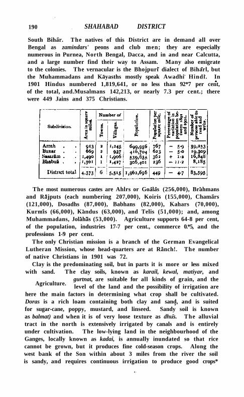
190 SHAHABAD DISTRICT
South Bihar. The natives of this District are in demand all over Bengal as zamindars' peons and club men; they are especially numerous in Purnea, North Bengal, Dacca, and in and near Calcutta, and a large number find their way to Assam. Many also emigrate to the colonies. The vernacular is the Bhojpuri dialect of Biharl, but the Muhammadans and Kayasths mostly speak Awadhi Hindi. In 1901 Hindus numbered 1,819,641, or no less than 92*7 per cent, of the total, and.Musalmans 142,213, or nearly 7.3 per cent.; there were 449 Jains and 375 Christians.
The most numerous castes are Ahlrs or Goalas (256,000), Brahmans and Rajputs (each numbering 207,000), Koiris (155,000), Chamars (121,000), Dosadhs (87,000), Babhans (82,000), Kahars (70,000), Kurmis (66,000), Kandus (63,000), and Telis (51,000); and, among Muhammadans, Jolahas (53,000). Agriculture supports 64-8 per cent, of the population, industries 17-7 per cent., commerce 0.*5, and the professions 1-9 per cent.
The only Christian mission is a branch of the German Evangelical Lutheran Mission, whose head-quarters are at Ranch!. The number of native Christians in 1901 was 72.
Clay is the predominating soil, but in parts it is more or less mixed with sand. The clay soils, known as karail, kewal, matiyar, and
gurtnat, are suitable for all kinds of grain, and the level of the land and the possibility of irrigation are
here the main factors in determining what crop shall be cultivated. Doras is a rich loam containing both clay and sand, and is suited for sugar-cane, poppy, mustard, and linseed. Sandy soil is known as balmat) and when it is of very loose texture as dhus. The alluvial tract in the north is extensively irrigated by canals and is entirely under cultivation. The low-lying land in the neighbourhood of the Ganges, locally known as kadai, is annually inundated so that rice cannot be grown, but it produces fine cold-season crops. Along the west bank of the Son within about 3 miles from the river the soil is sandy, and requires continuous irrigation to produce good crops*
Agriculture.
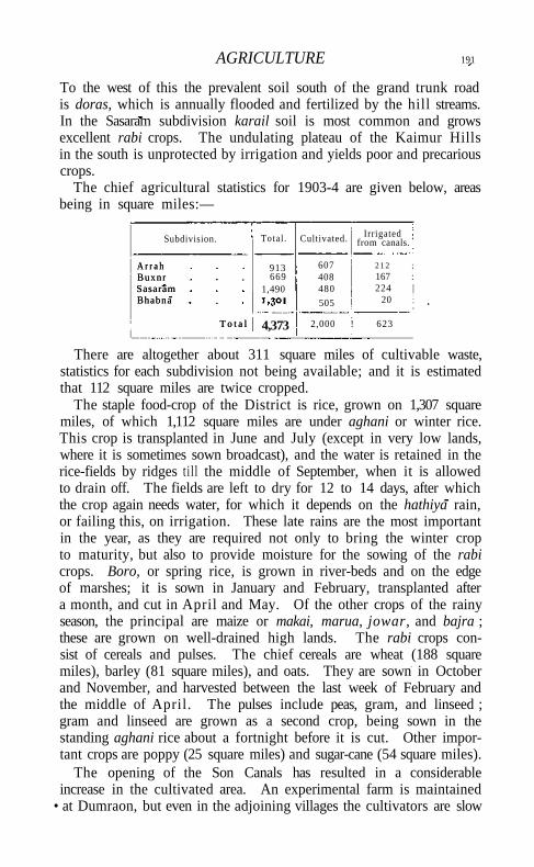
AGRICULTURE 191
To the west of this the prevalent soil south of the grand trunk road is doras, which is annually flooded and fertilized by the hill streams. In the Sasaram subdivision karail soil is most common and grows excellent rabi crops. The undulating plateau of the Kaimur Hills in the south is unprotected by irrigation and yields poor and precarious crops.
The chief agricultural statistics for 1903-4 are given below, areas being in square miles:—
Subdivision. Total . Cultivated. Irrigated from canals.
A r r a h Buxnr Sasaram Bhabna
T o t a l
913 669
1,490
607 408 480
505
2 1 2 ; 167 : 224 |
20
A r r a h Buxnr Sasaram Bhabna
T o t a l 4,373 2,000 ! 623
There are altogether about 311 square miles of cultivable waste, statistics for each subdivision not being available; and it is estimated that 112 square miles are twice cropped.
The staple food-crop of the District is rice, grown on 1,307 square miles, of which 1,112 square miles are under aghani or winter rice. This crop is transplanted in June and July (except in very low lands, where it is sometimes sown broadcast), and the water is retained in the rice-fields by ridges t i l l the middle of September, when it is allowed to drain off. The fields are left to dry for 12 to 14 days, after which the crop again needs water, for which it depends on the hathiya rain, or failing this, on irrigation. These late rains are the most important in the year, as they are required not only to bring the winter crop to maturity, but also to provide moisture for the sowing of the rabi crops. Boro, or spring rice, is grown in river-beds and on the edge of marshes; it is sown in January and February, transplanted after a month, and cut in April and May. Of the other crops of the rainy season, the principal are maize or makai, marua, jowar, and bajra ; these are grown on well-drained high lands. The rabi crops consist of cereals and pulses. The chief cereals are wheat (188 square miles), barley (81 square miles), and oats. They are sown in October and November, and harvested between the last week of February and the middle of April. The pulses include peas, gram, and linseed ; gram and linseed are grown as a second crop, being sown in the standing aghani rice about a fortnight before it is cut. Other important crops are poppy (25 square miles) and sugar-cane (54 square miles).
The opening of the Son Canals has resulted in a considerable increase in the cultivated area. An experimental farm is maintained
• at Dumraon, but even in the adjoining villages the cultivators are slow
192 SHAHABAD DISTRICT
to profit by its lessons. Little advantage has been taken of the Land Improvement and Agriculturists' Loans Acts, except in the famine years 1896-8, when Rs. 75,000 was advanced under the latter Act.
The cattle are for the most part poor, but good bulls are kept at the Buxar Central jail, and their offspring find a ready sale. Pasture is scarce except in the Kaimur Hills, where numerous herds are sent to graze during the rains. A large cattle fair is held at Barahpur, at which agricultural stock and produce are exhibited for prizes.
The District 4s served-by-the S O N - C A N A L S system, receiving about 80 per cent, of the total quantity of water supplied by it. Wells and ahars, or reservoirs, are also maintained all over the District for the purposes of irrigation. In 1901 it was estimated that 489 square miles were irrigated from the canals, 364 square miles from wells, and 937 square miles from ahars. The extent to which an artificial water-supply is used depends on the variations in the rainfall; in 1903-4 the area irrigated from the Government canals was 623 square miles.
Red sandstone from the Kaimur Hills is used extensively for building purposes, for which it is admirably adapted. Limestone, which is obtained from the same locality, is commonly dark grey or blackish, and burns into a very good white lime. Kankar or nodular limestone is found in almost all parts of the plains, and especially in the beds of rivers and along the banks of the Son ; it is used for metalling roads and is also burnt to make lime. A small quantity of alum was formerly manufactured in the area north of Rohtasgarh from slates belonging to the Kaimur group of the Vindhyan series. Copperas or iron sulphate is found in the same region.
Sugar is manufactured throughout the District, the principal centres of the industry being at Nasriganj and Jagdlspur. Iron sugar-cane
mills, manufactured at Bihiya, are now in general use over a great part of Northern India. Carpets and pottery are made at Sasaram ; the speciality of the
pottery consists in its being painted with lac and overlaid with mercury and gilt. Blankets and cotton cloth are woven throughout the District. A small quantity of hand-made paper is produced at Hariharganj. Saltpetre is manufactured in small quantities, the out-turn in 1903-4 being 5,000 maunds.
The principal imports are rice, gram, and other food-grains from the neighbouring Districts, European cotton piece-goods and kerosene oil from Calcutta, and coal and coke from Hazaribagh and Palamau. The exports include wheat, gram, pulses, and oilseeds, chiefly to Calcutta, and raw sugar and gur to the United Provinces and elsewhere. The chief centres of trade are Arrah, Dumraon, Buxar, and Chausa on the East Indian Railway, Sasaram and Dehri on the Mughal Sarai-Gaya branch, and Nasriganj on the Son. The main lines of communication
Trade and communications.
FAMINE 193
are the railways, the Ganges and Son rivers, and the Son Canals, to which goods are brought by bullock carts and pack-bullocks.
The main line of the East Indian Railway runs for 60 miles from east to west through the north of the District, and the Mughal Sarai-Gaya section opened in 1900 traverses the south. In addition to 58 miles of the grand trunk road from Calcutta to Benares, which passes through Dehri-on-Son, Sasaram, and Jahanabad, and is maintained from Provincial funds, the District contains 186 miles of metalled and 532 miles of unmetalled roads under the control of the District board; there are also 1,218 miles of village tracks. The principal local roads are those which connect Arrah with Buxar and Sasaram. Feeder roads connect the main roads with the stations on the railway and with the principal places on the rivers.
The Ganges is navigable throughout the year, and a tri-weekly steamer service for passengers and goods traffic plies as far as Benares, touching at Buxar and Chausa in this District. Navigation on the Son is intermittent and of little commercial importance. In the dry season the small depth of water prevents boats of more than 20 maunds proceeding up-stream, while in the rains the violent floods greatly impede navigation, though boats of 500 or 600 maunds occasionally sail up. Of the other rivers the Karamnasa, the Dhoba, or Kao, the DurgautI, and the Sura are navigable only during the rainy season. The main canals of the Son Canals system are navigable; a biweekly service of steamers runs from Dehrl to Arrah. But here, as elsewhere, most of the water-borne traffic is carried in country boats, some of which have a capacity of as much as 1,000 maunds. The canal-borne traffic used to be considerable, but has suffered greatly from competition with the Mughal Sarai-Gaya branch of the East Indian Railway. The only ferries of any importance are those across the Ganges.
The District has frequently suffered from famine. The famine of 1866, having been preceded by two years of bad harvests, caused great distress. The Government relief measures were supplemented by private liberality, but 3,161 deaths from starvation were reported. There was another, but less severe, famine in 1869. In 1873 more than three-fourths of the rice crop was destroyed by very heavy floods and the subsequent complete absence of rain; the loss would have been even greater had not the Son water been turned into the unfinished canals and freely distributed. Relief works, in the shape of road repairs, were opened in December, and a sum of 1.18 lakhs was spent in wages, in addition to Rs. 30,000 paid to non-workers, and Rs. 1,600 advanced to cultivators for the purchase of seed-grain. In the famine of 1896-7 the distressed area comprised the whole of the Bhabua and the southern portion of the Sasaram sub-
Famine.
194 SHAHABAD DISTRICT
division. Relief works were started in October, 1896, and were not finally closed till July, 1897, during which period 560,031 days' wages were paid to adult males employed on piece-work, and 175,105 to those on a daily wage, the aggregate payments amounting to Rs. 74,000. Gratuitous relief by means of grain doles was also given, and poor-houses and kitchens were opened. The cost of gratuitous relief was rather less than 2 lakhs, and the total cost of the famine operations was 3-36 lakhs, of which Rs. 30,000 was paid from District and the balance from Provincial funds.
For administrative purposes the District is divided into 4 subdivisions, with head-quarters at ARRAH, BUXAR, SASARAM, and BHABUA.
Subordinate to the District Magistrate-Collector at Arrah, the District head-quarters, is a staff consist
ing of an Assistant Magistrate-Collector, six Deputy-Magistrate-Collectors, and two Sub-Deputy-Collectors. The subdivisions of Sasaram and Buxar are each in the charge of an Assistant Collector aided by a Sub-Deputy-Collector, and the Bhabua subdivision is under a Deputy-Magistrate-Collector. The Executive Engineer of the Arrah division is stationed at Arrah ; an Assistant Engineer resides at Koath and the Executive Engineer of the Buxar division at Buxar.
The permanent civil judicial staff consists of a District Judge, who is also Sessions Judge, two Subordinate Judges and three Munsifs at Arrah, one Munsif at Sasaram and another at Buxar. For the disposal of criminal work, there are the courts of the Sessions Judge, District Magistrate, and the above-mentioned Assistant, Deputy, and Sub-Deputy-Magistrates. The District was formerly notorious for the number of its dacoits and for the boldness of their depredations; but this crime is no longer common. The crimes now most prevalent are burglary, cattle-theft, and rioting, the last being due to disputes about land and irrigation.
During the reign of Akbar, Shahabad formed a part of sarkar Rohtas, lying for the most part between the rivers Son and KaramnSsa. Half of it, comprising the zamindari of Bhojpur, was subsequently formed into a separate sarkar called Shahabad. The land revenue demand of these two sarkars, which was fixed at 10-22 lakhs by Todar Mai in 1582, had risen to 13.66 lakhs at the time of the settlement under Al i Vardi Khan in 1750, but it had again fallen to 10*38 lakhs at the time of the Decennial Settlement which was concluded in 1790 and declared to be permanent in 1793. The demand gradually rose to 13.55 lakhs in 1843 and 16-72 lakhs in 1862, the increase being due to the revenue survey which took place in 1846. In 1903-4 the total demand was 17.27 lakhs payable by 10,147 estates, of which 9,463 with a demand of 14-98 lakhs were permanently settled, 544 with a demand of 1.38 lakhs were temporarily settled, while the remainder were held direct by Govern-
Administration.
ADMINISTRATION 195
ment. The incidence of land revenue is R. 0-13-9 per cultivated acre, being about 22 per cent, of the estimated rental. Rents vary with the class of.soil, and for very good land suitable for poppy as much as Rs. 30 per acre is occasionally paid. Rent is generally paid in kind, especially in the Bhabua and Sasaram subdivisions. The average holding of a ryot is estimated at 5¾ acres. The only unusual tenure is the guzastha, which connotes not only a right to hold at a fixed rate in perpetuity but an hereditary and transferable interest in the land. The true guzastha tenure is confined mainly to the Bhojpur pargana, but the term is used elsewhere to indicate the existence of occupancy rights.
The following table shows the collections of land revenue and total revenue (principal heads only), in thousands of rupees :—
1880-1.
17,35 25,00
1890-1. 1900-1. 1903-4.
Land revenue Total revenue
1880-1.
17,35 25,00
16,74 26,30
17,26 28,96
17,21
29,57
Outside the municipalities of ARRAH, JAGDISPUR, BUXAR, DUMRAON,
BHABUA, and SASARAM, local affairs are managed by the District board with subordinate local boards in each subdivision. In 1903-4 its income was Rs. 2,63,000, of which Rs. 2,03,000 was derived from rates; and the expenditure was Rs. 2,89,000, the chief item being Rs. 2,15,000 expended on public works.
In 1903 the District contained n police stations and 18 outposts. The force subordinate to the District Superintendent in that year consisted of 4 inspectors, 43 sub-inspectors, 46 head constables, and 526 constables; there was also a rural police force of 301 daffadars and 4,254 chaukidars. In addition to the District jail at Arrah with accommodation for 278 prisoners, there is a Central jail at Buxar with accommodation for 1,391, while subsidiary jails at Sasaram, Buxar, and Bhabua can hold 69. The prisoners in the Central jail are chiefly employed in weaving and tent-making.
Of the population in 1901, 4-3 per cent. (8-6 males and 03 females) could read and write. The total number of pupils under instruction fell from 20,883 in 1883-4 to 16,922 in 1892-3, but increased again to 23,032 in 1900-1. In 1903-4, 26,218 boys and 445 girls were at school, being respectively 18.6 and 0.28 per cent, of the children of school-going age. The number of educational institutions, public and private, in that year was 1,004, including 23 secondary, 623 primary, and 358 special schools. Two small schools for aborigines are maintained at Rehal and Dahar. The expenditure on education was 1-36 lakhs, of which Rs. 17,000 was paid from Provincial funds, Rs. 40,000 from District funds, Rs. 3,000 from municipal funds, and Rs. 59,000 from fees.
196 SHAHABAD DISTRICT
In 1903 the District contained 12 dispensaries, of which 7 had accommodation for 115 in-patients. The cases of 81,000 out-patients and 2,300 in-patients were treated, and 8,000 operations were performed. The expenditure was Rs. 35,000, of which Rs. 5,000 was derived from Government contributions, Rs. 7,000 from Local and Rs. 10,000 from municipal funds, and Rs. 10,000 from subscriptions.
Vaccination is compulsory only in municipal areas. In 1903-4 the number of persons successfully vaccinated was 48,000, or 25*8 per r,ooo of the population.
[ L . S. S. O'Malley, District Gazetteer (Calcutta, 1906); M. Martin (Buchanan-Hamilton), Eastern India, vol. i (1838).]
Shahabad Taluk.—* Crown' taluk in the south of the Atraf-i-balda District, Hyderabad State, also known as the Junubi or 'southern taluk] with an area, including jagirs, of 654 square miles. The population in 1901 was 76,905, compared with 73,245 in 1891. The taluk contains 168 villages, of which 103 are jagir, and Shahabad (3,955) is the head-quarters. The land revenue in 1901 was I - I lakhs. The paigdh taluk of Vikarabad with 25 villages, a population of 11,270 and an area of about 82 square miles, is situated to the north-west of Shahabad.
Shahabad Tahsil (1).—Northern tahsll of Hardol District, United Provinces, comprising the parganas of Alamnagar, Shahabad, Sarah (North), Pandarwa, Saromannagar, Pachhoha, Pali, and Mansurnagar, and lying between 270 25' and 270 47' N. and 790 41" and 8o° 19' E., with an area of 542 square miles. Population increased from 248,034 in 1891 to 250,533 in 1901. There are 518 villages and three towns, SHAHABAD (population, 20,036), the tahsil head-quarters, and P I H A N I (7,616) being the largest. The demand for land revenue in 1903-4 was Rs. 3,31,000, and for cesses Rs. 53,000. The density of population, 462 persons per square mile, is almost equal to the District average. Shahabad is a poor tahsil, containing large areas of sandy soil. It lies between the Sendha, a tributary of the Ramganga, on the west, and the Gumtl on the east, and is also crossed by the Garra and its tributary the Sukheta, and by the Sai. In 1901-2 the area under cultivation was 365 square miles, of which 69 were irrigated. Wells supply two-thirds of the irrigated area, and tanks and small streams the remainder.
Shahabad T o w n (1).—Head-quarters of the tahsiloi the same name in Hardol District, United Provinces, situated in 270 38' N. and 790 57' E., on the Oudh and Rohilkhand Railway. Population (1901), 20,036. The town was founded in 1677 by Nawab Diler KMn, an Afghan officer of Shah Jahan, who was sent to suppress a rising in Shahjahan-pur. Diler Khan built a large palace called the Barl Deorhi, and filled the town with his kinsmen and troops. Shahabad rose to considerable importance during Mughal rule, but declined under the
SHAHABAD TOWN 197
Nawabs of Oudh. It was still a considerable town when visited by Tieffenthaler in 1770, but Tennant found it an expanse of ruins in 1799. In 1824 Bishop Heber described it as a considerable town or almost city, with the remains of fortifications and many large houses. The inhabitants have obtained notoriety for the ill-feeling which exists between Hindus and Musalmans, and serious riots took place in 1850 and 1868. Nothing is left of the Ban Deorhl but two fine gateways, and Diler Khan's tomb is also in ruins. The fine Jama Masjid erected by the same noble is stil l used. Shahabad contains the usual tahsili offices and also a munsifi, a dispensary, and a branch of the American Methodist Mission. It has been administered as a municipality since 1872. During the ten years ending 1901 the income and expenditure averaged Rs. 11,000. In 1903-4 the income was Rs. 17,000, chiefly derived from taxes on houses and professions and trades, and from rents and market dues, while the expenditure was also Rs. 17,000. A daily market is held, and grain and sugar are exported. The town is noted for the vegetables and fruit produced in the neighbourhood. Fine cotton cloth used to be woven here, but the manufacture is extinct. There are three schools for boys and one for girls, with a total of 400 pupils.
Shahabad T a h s i l (2).—Southern tahsll in the State of Rampur, Uni ted Provinces, lying between 280 25' and 280 43 ' N. and 780 52' and 790 5' E., wi th an area of r66 square miles. Population (1901), 82,716. There are 197 villages and one town, S H A H A B A D (population, 7,338), the tahsil head-quarters. The demand for land revenue in 1903-4 was Rs. 3,56,000, and for cesses Rs. 43,000. The density of population, 498 persons per square mile, is below the State average. The tahsil lies on both banks of the Ramganga, and is less protected by canals than other parts of the State. In 1903-4 the area under cultivation was no square miles, of which 8 were irrigated, chiefly from wells.
Shahabad T o w n (2).—Head-quarters of the tahsil of the same name in the State of Rampur, Uni ted Provinces, situated in 280 34' N. and 790 2' E. Population (1901), 7,338. The town stands on rising ground and is considered the healthiest place in the State. The Nawab has a summer residence here, built on the ruins of an old fo r t ; it is about 100 feet higher than the surrounding country and commands a fine view for miles round. The old name of the town was Lakhnor, and it has been suggested that this was the ancient capital of the Katehriya Rajas of R O H I L K H A N D . There are dispensaries for treatment by both European and indigenous methods, and also a tahsili school. The town is noted for its sugar.
Shahabad T o w n (3) .—Town in the paigah taluk of Firozabad, Gulbarga District, Hyderabad State, situated in 170 8' N. and 760 56' E.
198 SHAHABAD TOWN
Population (1901), 5,105. Laminated limestone, known as Shahabftd stone, is largely quarried in the vicinity, and takes its name from the town. It is an important station on the Great Indian Peninsula Railway. An elegant masonry enclosure in the centre of the town is supposed to be the wall of a royal palace, and encloses a large mosque and a well . The town contains two post offices, Brit ish and Nizam's, a police station, a dispensary, and three vernacular primary schools.
ShahabSd T o w n (4) .—Town in the Thanesar tahstl of Karnal District, Punjab, situated in 300 10' N. and 760 52 ' E., on the Delhi-Umbal la -Kalka Railway, 16 miles south of Ambala. Population (1901), 11,009. The town was founded by one of the followers of Muhammad of Ghor at the end of the twelfth century. It is of no commercial importance. The municipality was created in 1867-8. The income during the ten years ending 1902-3 averaged Rs. 10,900, and the expenditure Rs. 10,200. In 1903-4 the income was Rs. 12,300, chiefly derived from oc t ro i ; and the expenditure was Rs. 11,200. The town has a vernacular middle school and a dispensary.
Shahada Talvika..—Taluka of West Khandesh District, Bombay, lying between 2 1 0 24' and 2 1 0 48 ' N. and 740 24' and 740 47 ' E., wi th an area of 479 square miles. I t contains two towns, S H A H A D A (population, 5,399), the head-quarters, being the larger; and 155 villages. The population in 1901 was 59,758, compared with 64,733 in 1891. This is the most thinly populated taluka in the District, the density being only 125 persons per square mile. The demand for land revenue in 1903-4 was nearly 3 lakhs, and for cesses Rs. 21,000. Although Shahada possesses two perennial streams, the Tapt i and its tributary the Gomi, it is on the whole scantily provided wi th surface water. The prevailing soil is a r ich loam resting on a yellowish subsoil. The annual rainfall averages 24 inches.
Shahada Town.—Head-quarters of the taluka of the same name in West Khandesh District, Bombay, situated in 21 0 33 ' N. and 740 28' E. , 48 miles north-west of Dhi i l ia . Together with Kukdel , it contained in 1901 a population of 5,399. A municipality was constituted in 1869. The income during the ten years ending 1901 averaged Rs. 7,000. In 1903-4 the income was Rs. 8,500. The town contains three cotton-ginning factories, a dispensary, and four schools, wi th 262 pupils, of which one, with 21 pupils, is for girls.
Shahapur Taluka.—Eas te rn taluka of Thana District, Bombay, lying between 190 18' and 190 44 ' N. and 730 10' and 730 43 ' E., wi th an area of 610 square miles. It contains 197 villages, Shahapur being the head-quarters. The population in 1901 was 83,881, compared with 92,029 in 1891. It is the most thinly populated taluka in the District, and the density, 138 persons per square mile, is much below the District average. Land revenue and cesses in 1903-4 amounted
SHAHBANDAR VILLAGE 199
to i«4 lakhs. The country, which was formerly known as Kolvan, is for the most part wi ld , broken by hills and covered wi th large forests. In the south there are wide tracts of rice lands. * The soil is mostly red and stony, and the climate unhealthy, except in the rains. There are five factories for husking rice in ShaMpur.
Shahapur Town.—Head-quarters of the subdivision of the same name in the State of Sangli, Bombay, situated in 150 50' N. and 740 34 / E., close to the town of Belgaum. Population (1901), 9,056. Shahapur is the most important trading place in Sangli State. The dyeing of cotton and silk yarn and the weaving of cotton and silk cloth are largely carried on. The population is chiefly composed of bankers, traders, and weavers. The town is governed by a municipal body, with an income of nearly Rs. 13,000. Besides H i n d u temples, Shahapur has a Protestant church and a Roman Catholic chapel. Methodist Episcopal and Catholic missions are both at work in Shahapur. There is also a dispensary.
Shahbandar Subdivision.—Subdivision of Karachi District, Sind, Bombay, composed of the M I R P U R BATORO, S U J A W A L , J A T I , and
S H A H B A N D A R talukas. S h a h b a n d a r T a l u k a . — T a l u k a of Karachi District, Sind, Bombay,
lying between 230 4 1 ' and 240 25' N. and 670 32' and 68° 26' E. , with an area of 1,388 square miles. Population increased from 28,246 in 1891 to 33,609 in 1901. The number of villages is 104, of which Ladiun is the head-quarters, but the most important place is S H A H B A N D A R . The land revenue and cesses in 1903-4 amounted to I - I lakhs. The taluka contains large tracts of kalar lands and salt deposits. The soil is the usual alluvial loam, mixed with sand; but in the south, where the Indus outflow meets the incoming tide, a deposit of soft mud, locally known as bhal, appears. The taluka is irrigated by more than ten canals; and the chief crops are jowar, bajra, rice, barley, and mung.
Shahbandar Village.—Head-quarters of the taluka of the same name in Karachi District, Sind, Bombay, situated in 240 i o ' N. and 670 56 ' E., in the delta of the Indus. Population (1901), 785. Shahbandar stood formerly on the east bank of the Malir , one of the mouths of the Indus, but it is at present 10 miles distant from the nearest point of the river. A great salt waste commences about a mile to the south-east of the town, and on its westward side are extensive jungles of long bin grass. It was to Shahbandar that the English factory was removed from Aurangbandar when the latter place was deserted by the Indus ; and previous to the abandonment of the factory in 1775, it supported an establishment of fourteen vessels for the navigation of the river. The disastrous flood which occurred about 1819 caused material changes in the lower part of the Indus,
200 SHAHBANDAR VILLAGE
and hastened the decay of Shahbandar, which is now an insignificant village. Carless states that the native rulers of Sind had a fleet of fifteen ships stationed here. Vessels entered by the Richal, the only accessible mouth, and, passing into the Hajamro through what is now the Khedewari creek, ascended that stream to about 10 miles above Ghorabari, where it joined the Malir.
Shahdadpur Taluka (i).—Taluka of Hyderabad District, Sind, Bombay, lying between 250 42' and 260 16'N. and 68° 27'and 690 o' E., with an area of 644 square miles. The population in 1901 was 73,504, compared with 58,720 in 1891. The density, 114 persons per square mile, is a little less than the District average. The land revenue and cesses in 1903-4 amounted to about i-8 lakhs. The number of villages is 102, of which Shahdadpur is the head-quarters. The taluka stands at a high level and is therefore devoid of grass ; but it produces the best cotton in the District, and also good bdjra and tobacco crops.
Shahdadpur Taluka (2).—Taluka of the Upper Sind Frontier District, Sind, Bombay, lying between 270 40' and 28° 3' N. and 670 22' and 68° 11' E., with an area of 622 square miles. It contains 62 villages, of which Shahdadpur is the head-quarters. The population in 1901 was 32,385, compared with 27,380 in 1891. It is the most thinly populated taluka in the District, with a density of only 52 persons per square mile. The land revenue and cesses in 1903-4 amounted to 1-8 lakhs. Portions of the Begari, Ghar, and Sukkur canals irrigate the taluka, and a certain amount of cultivation is usually carried out in the neighbourhood of hill torrents.
Shahdara.—Town in the Ghaziabad tahsil of Meerut District, United Provinces, situated in 280 40' N. and 770 18' E., on the East Indian Railway, 5 miles from Delhi. A light railway to Saharanpur is being constructed. Population (1901), 5,540. It was founded by Shah Jahan as a market, and was sacked in the eighteenth century by Suraj Mai, the J at Raja of Bharatpur, and plundered by the soldiers of Ahmad Shah Durrani just before the battle of Panipat. It is badly drained, and drinking-water is obtained from a distance. The American Methodist and Reformed Presbyterian Missions have branches here. From 1872 to 1904 Shahdara was a municipality, with an income and expenditure averaging about Rs. 3,000. It is now administered as a 'notified area/ The trade of the place has fallen away, and it is chiefly celebrated for sweetmeats; but there is still a small manufacture of shoes and leather, and a little sugar-refining. In 1904 there was a primary school with 75 pupils.
Shahdheri (Dheri Shahan, 'the kings' mound').—Village in the District and tahsil of Rawalpindi, Punjab, situated in 330 17' N. and 7 20 49' E. 8 miles south-east of Hassan Abdal. To the north-east lie
SHAHJAHlNPUR DISTRICT
extensive and well-preserved ruins, identified by Sir Alexander Cunningham as those of Takshasila, the Taxila of the Greek historians. These ruins lie in six distinct sites—Bir, Hatial , Sir-Kap-ka-kot, Kacha K o t , Babarkhana, and Sir-Sukh-ka-kot. Of these, the mound at Bir rises above the banks of the Tapra Nala, the Tiber-nabon of the Pseudo-Kallisthenes. Hat ial , a fortified spur of the Mar-gala (' beheaded') range, was probably the ancient citadel. Sir-Kap, or the fort of ' the beheaded,' was a fortified city, united to the citadel by a wall of circum-valiation. The remaining three sites appear to be more modern; but near Babarkhana lie the ruins called Sirl-ki-pind, which would appear to be the great Sirsha-danam or ' head-offering' stupa of Buddha buil t by Asoka and mentioned by Hiuen Tsiang. Takshasila, the Sanskrit form of the name, means ' the hewn rock,' or more probably ' the rock of Takshaka,' the great Naga king. At the Macedonian invasion, and for many centuries later, Taxila was a rich and flourishing city. Alexander found it ruled by Omphis (Sanskrit, Ambhi) , generally known by his dynastic title of Taxiles, who resigned his kingdom to the invader. About eighty years later it was taken by Asoka, and from it he governed the Punjab before his accession to the throne of Magadha. About 200 B.C. it became a Graeco-Bactrian dependency, and rather more than half a century later passed to the Indo-Parthians, from whom it was wrested by the Kushans at the end of the first century A . D . About A . D . 50 Apollonius of Tyana visited it , and says it was the capital of Phraates, whose dominions corresponded with the ancient kingdom of Porus, and describes its beautiful temple of porphyry. It was also visited by Fa Hian in A . D . 400, and by Hiuen Tsiang in 630 and 643. Both these pilgrims describe it as a place of great sanctity and the scene of Buddha's sacrifice of his head. After this Taxila disappears from history.
Shahganj.—Head-quarters of the Khutahan tahsil of Jaunpur District, Uni ted Provinces, situated in 260 3' N. and 820 42' E., at the junct ion of a branch of the Bengal and North-Western Railway from Azamgarh wi th the Oudh and Rohilkhand Railway. Population (1901), 6,430. The town was founded by Shuja-ud-daula, Nawab of Oudh, who buil t a market-place, a baradari, and a dargah, or tomb, in honour of Shah Hazrat A l l . Shahganj is administered under Act XX of 1856, wi th an income of about Rs. 6,000. It is a thriving mart, second only to Jaunpur city, and is the centre of the sugar-refining industry, besides being a depdt for the export of grain and the distribution of imported cotton. The town contains a dispensary, a branch of the Wesleyan Mission, and two schools with 113 pupils.
Shahjahanpur District.—Southern District of the Bareilly Division, Uni ted Provinces, lying between 270 35' and 280 29' N. and 790 20' and 8o° 23' E., wi th an area of 1,727 square miles. It is bounded on
201
202 . SHAHJAHANPUR DISTRICT
the north by Bareiily and Pilibhit; on the east by K h e r l ; on the south by Hardoi and Farrukhabad; and on the west by Budaun. The District consists of a narrow alluvial tract, running north-east from
the river Ganges towards the Himalayas. It is crossed nearly at right angles by the river system of South Rohilkhand, and its natural features thus depend
almost entirely upon the various streams which have cut deep channels through the alluvial soil of the Gangetic basin. The principal rivers are the RAMGANGA, the Deoha or Garra, and the G U M T I . Near the Ganges is a stretch of wild khadar, from which an area of stiff clay, drained by the Sot or Yar-i-Wafadar, reaches to the Ramganga. The channel of the latter river shifts from side to side of a broad valley to an extraordinary extent. Between the Ramganga and the Garra lies an extensive tract of sandy soil, which changes east of the Garai to clay and then to a fertile loam extending north-east of the Garra. The loam tract is crossed by the Khanaut, a tributary of the Garra, beyond which another sandy area is found, gradually changing to a forest tract on the border of the damp sub-Himalayan Districts.
Shahjahanpur is situated entirely in the Gangetic alluvium, and kankar or nodular limestone is the only stone found in it.
The District is fairly well wooded, and contains nearly 50 square miles of groves. Mango, bamboo, babul {Acacia arabica), s his ham {Dalbergia Sissoo), tun {Cedrela Toona), and, in the north, sal {Shorea robustd) are the chief timber trees.
Leopards are sometimes seen in the jungles in the north of the District, and the tiger and lynx have been shot there, but not recently. Spotted deer frequent the same tract, and nilgai and wild hog are common everywhere, especially near the rivers. Antelope are found near the Gumti and Ganges. Hares, partridges, quail, sand-grouse, and peafowl are included in the smaller game, while the large ponds and marshes abound in the cold season with geese, duck, and teal.
The climate is moister than in the Doab, though drier than in the more northern Districts of Rohilkhand. The central portion is healthy; but in the north bad fever and ague are prevalent, and in the south the neighbourhood of the Sot is also unhealthy.
The annual rainfall averages about 37 inches, varying from 33 in the south-west of the District to 40 inches at Shahjahanpur city. In 1895-6 the fall was only 23 inches, and in 1893-4 as much as 57 inches.
In ancient times this District must have been included in the kingdom of P A N C H A L A , and during the early Muhammadan period
it formed part of the tract known as Katehr. Shahjahanpur city was founded in the reign of Shah Jahan
by Nawab Bahadur Khan, who named it in honour of the emperor.
History.
Physical aspects.
HISTORY 203
Early in the eighteenth century part of the south of the District was included in the territory of Muhammad Khan, Nawab of Farrukhabad; but the central portions were acquired by Ali Muhammad, the Rohilla chief. On the east the Katehriyas retained their independence, and the land held by them formed a debatable ground between O U D H and R O H I L K H A N D . I n 1774, after the defeat of the Rohillas by the allied forces of Oudh and the British, the two provinces became united; and in 1801 this District, with other territory, was ceded to the British.
Thenceforward order was never seriously disturbed until the Mutiny, although the District bordered upon the most turbulent part of Oudh. In 1857, however, Shahjahanpur became the scene of open rebellion. The news of the Meerut outbreak arrived on May 15 ; but all remained quiet till the 25th, when the sepoys informed their officers that the mob intended to plunder the treasury. Precautions were taken against such an attempt; but on the 31st, while most of the officers, civil and military, were at church, some of the sepoys forced their way into the building and attacked them. Three Europeans were shot down at once; the remainder were joined by the other officers, and the whole party escaped first to Pawayan, and afterwards to Muhamdl in Kheri District. The mutineers burnt the station, plundered the treasury, and made their way to the centre of local disaffection at Bareiily. A rebel government under Kadir Al l Khan was proclaimed on June 1. On the 18th Ghulam Kadir Khan, the hereditary Nawab of Shahjahanpur, passed through on his way to Bareiily, where he was appointed Nazim of Shahjahanpur by Khan Bahadur Khan. On the 23rd the Nawab returned to his titular post, and superseded Kadir All. He remained in power from June, 1857, till January, 1858, when British troops reoccupied Fatehgarh. The Nawab of Fatehgarh and Flroz Shah then hastened to Shahjahanpur and on to Bareiily. After the fall of Luck-now, the Nana Sahib also fled through Shahjahanpur to Bareiily. In January the Nawab put to death Hamid Hasan Khan, Deputy-Collector, and Muhammad Hasan, Subordinate Judge, for corresponding with the British. On April 30, 1858, the British force, under Sir Colin Campbell, reached Shahjahanpur. The rebels fled to Muhamdl and Sir Colin went on to Bareilly on May 2, leaving only a small detachment to guard the station. The rebels then assembled once more, and besieged the detachment for nine days; but Brigadier Jones's column relieved them on the 12th, and authority was then finally re-established.
The District contains a few ancient sites which have not been explored, the largest being Gola and Mati in the Pawayan tahsii. A copperplate grant by Harsha of Kanauj, dated A . D . 628, was found at Banskhera1. There are no Muhammadan buildings of importance.
1 Epigraphia Indica, vol. iv, p. 208. VOL. X X I I . O
204 SHAHJAHANPUR DISTRICT
The District contains 6 towns and 2,034 villages. The population has fluctuated during the last thirty years. The numbers at the four
enumerations were as follows: (1872) 951,006, (1881) 856,946, (1891) 918,551, and (1901) 921,535. Be
tween 1872 and 1881 the District suffered severely in the famine of 1877-8 and the fever epidemic of 1879. There are four tahsils— SHAHJAHANPUR, JALALABAD, T I L H A R , and PAWAYAN—each of which is named after its head-quarters. The principal towns are the municipalities of SHAHJAHANPUR CITY, the District head-quarters, and T I L H A R . The following table gives the chief statistics of population in 1901 :—
Tahsil.
Are
a in
squ
are
mil
es.
Number of
Pop
ulat
ion.
Pop
ulat
ion
per
squa
re m
ile.
Per
cent
age-
of
vari
atio
n in
"
popu
lati
on b
etw
een
1891
an
d 19
01.
Num
ber
of
pers
ons
able
to
read
an
d
wri
te.
Tahsil.
Are
a in
squ
are
mil
es.
Tow
ns.
Vill
ages
.
Pop
ulat
ion.
Pop
ulat
ion
per
squa
re m
ile.
Per
cent
age-
of
vari
atio
n in
"
popu
lati
on b
etw
een
1891
an
d 19
01.
Num
ber
of
pers
ons
able
to
read
an
d
wri
te.
Shahjahanpur . Jalalabad . Tilhar Pawayan .
District total
394
418 591
1 I 3 1
463 360 558 653
265,467 175,674 257,035 223,359
674 542 615 378
- 2.8 + 10.6 + 8.3 — 104
9,672 3,340 4.924 5,189
Shahjahanpur . Jalalabad . Tilhar Pawayan .
District total 1,727 6 2,034 921,535 534 + 0.3 23,125
About 85 per cent, of the total are Hindus and more than 14 per cent. Musalmans. The Arya Samaj, though its members number only 1,646, is increasing in importance. More than 99 per cent of the people speak Western Hindi, the prevailing dialect being Kanaujia.
Chamars (leather-dressers and cultivators), 98,000, are the most numerous Hindu caste. The other large castes are Kisans (cultivators), 79,000; Ahirs (graziers and cultivators), 71,000; Rajputs, 68,000; Brahmans, 61,000; Kahars (fishermen and cultivators), 40,000; Kachhls (cultivators), 34,000; Muraos (market-gardeners), 31,000; and Kurmis (agriculturists), 27,000. Among Musalmans, Pathans number 41,000, followed by Shaikhs, 24,000, and Julahas (weavers), 18,000. The proportion of the population supported by agriculture is 69 per cent.— a high figure. Personal services support 5 per cent., general labour 4 per cent., and cotton-weaving 2 per cent. Rajputs and Brahmans are the chief holders of land; and Rajputs, Kachhi's, Muraos, Ahirs, and Chamars are the principal cultivators.
Out of 1,739 native Christians in 1901, 1,495 were Methodists. The American Methodist Mission opened work in the District in 1859, and has seven stations, besides two in Oudh.
Agricultural conditions are exceedingly complex, owing to the varied character of the soil and of the facilities for irrigation. The Ganges
khadar is either sand or light loam, and suffers from drought, though it is also liable to disastrous floods.
The clay tract adjoining it produces rice in the autumn, and requires
Agriculture,
Population.
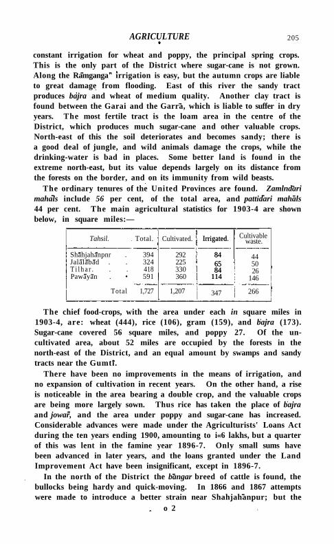
AGRICULTURE 205
constant irrigation for wheat and poppy, the principal spring crops. This is the only part of the District where sugar-cane is not grown. Along the Ramganga" irrigation is easy, but the autumn crops are liable to great damage from flooding. East of this river the sandy tract produces bajra and wheat of medium quality. Another clay tract is found between the Garai and the Garra, which is liable to suffer in dry years. The most fertile tract is the loam area in the centre of the District, which produces much sugar-cane and other valuable crops. North-east of this the soil deteriorates and becomes sandy; there is a good deal of jungle, and wild animals damage the crops, while the drinking-water is bad in places. Some better land is found in the extreme north-east, but its value depends largely on its distance from the forests on the border, and on its immunity from wild beasts.
The ordinary tenures of the United Provinces are found. Zamlndari mahals include 56 per cent, of the total area, and pattidari mahals 44 per cent. The main agricultural statistics for 1903-4 are shown below, in square miles:—
Tahsil. Total. Cultivated. Irrigated.
84 65 84
114
Cultivable waste.
Shahjahanpnr . 394 Jalalabad . . 324 T i l h a r . . . 418 Pawayan . • 591
292 225 330 360
Irrigated.
84 65 84
114
44 50 26
146
Total 1,727 1,207 347 266
The chief food-crops, with the area under each in square miles in 1903-4, are: wheat (444), rice (106), gram (159), and bajra (173). Sugar-cane covered 56 square miles, and poppy 27. Of the uncultivated area, about 52 miles are occupied by the forests in the north-east of the District, and an equal amount by swamps and sandy tracts near the Gumti.
There have been no improvements in the means of irrigation, and no expansion of cultivation in recent years. On the other hand, a rise is noticeable in the area bearing a double crop, and the valuable crops are being more largely sown. Thus rice has taken the place of bajra and jowar, and the area under poppy and sugar-cane has increased. Considerable advances were made under the Agriculturists' Loans Act during the ten years ending 1900, amounting to i«6 lakhs, but a quarter of this was lent in the famine year 1896-7. Only small sums have been advanced in later years, and the loans granted under the Land Improvement Act have been insignificant, except in 1896-7.
In the north of the District the bangar breed of cattle is found, the bullocks being hardy and quick-moving. In 1866 and 1867 attempts were made to introduce a better strain near Shahjahanpur; but the
o 2
206 SHAHJAHANPUR DISTRICT
climate d id not suit the animals imported. The ordinary breed of horses is also poor ; stallions have been kept by Government for some years, and two are now at stud. The sheep and goats are inferior.
In 1903-4, out of 347 square miles irrigated, wells supplied 207 square miles, tanks or jhih 86, and other sources 54. The spring-level is high, and in ordinary years irrigation is not required for many crops, or can be supplied easily by temporary wells lasting for a single harvest. In two tracts a deficiency of water is experienced in dry years. The sandy area along the Gumt l is unprotected, while the clay tract in the south of the District depends on the numerous small channels which intersect i t , and which are dammed at the end of the rains, to supply water for the spring harvest.
There are no * reserved' or ' protected' forests the property of Government; but in the north-east of the District are some tracts of unreclaimed forest, chiefly sal, which, with a few exceptions, do not now contain any large timber, but supply poles for use in housebuilding. Their total area is about 52 square miles.
Kankar or nodular limestone is the only mineral product, and is used for metalling roads and for burning into lime.
Sugar-refining is by far the most important industry in the District. Indigo was once manufactured, but has now become a minor product.
The matting made from a jungle grass called baib is largely exported. Coarse cotton cloth, chintz, and brass vessels are made in various places for local use,
and there are small manufactures of ironware inlaid with gold and silver, and of lacquered goods. The Rosa sugar and rum factory near Shahjahanpur city is one of the largest in India, and employed 632 hands in 1903.
The grain trade is of ordinary dimensions, and sugar is the principal article of export, the Shahjahanpur production being celebrated throughout India. It is largely exported to Rajputana and the Punjab. There is also a considerable trade in oilseeds at Tilhar. European goods, metals, and salt are the principal imports. Forest produce is floated down the rivers from P i l l b h i t ; but the spread of railways has largely decreased the river traffic, which was formerly important. Ti lhar and Shahjahanpur are the chief trade centres, though markets are held at many smaller places.
The Oudh and Rohilkhand main line crosses the centre of the District and is the chief trade route; but a l i t t le traffic is carried by the Lucknow-Sltapur-Bareilly State Railway, which traverses the northeast corner. The two lines are connected by a steam tramway or l ight railway, 40 miles long, from Shahjahanpur city to Mailani in K h e r l District. The District is well supplied with roads, except in the tract south-west of the Ramganga. Of these, 118 miles are metalled,
Trade and communications.
ADMINISTRATION 207
and are maintained by the Public Works department, but the cost of 46 miles is charged to Local funds. The remaining 326 miles are unmetalled. Avenues of trees are maintained on 222 miles. The principal routes comprise the branch of the grand trunk road from Fatehgarh which divides at Jalalabad, one line going to Bareilly and one to Shahjahanpur c i t y ; the road from Bareilly through Ti lhar and Shahjahanpur to Sltapur and L u c k n o w ; and the road from Shahjahanpur through the north of the District.
In a large part of the District the effects of drought can be mitigated as long as the cultivators are able to make temporary wel ls ; but elsewhere a failure of the rains is disastrous, and Shahjahanpur has often suffered severely. The great famine of 1783-4 d i d not press so heavily here as in the tracts south of the Ganges. In 1803-4, two years after cession, rain completely failed for the autumn harvest. In 1825-6 drought again occurred, but hardly caused famine. The autumn rains failed in 1837-8, but a slight fall in February saved the spring harvests. The famine of 1860-1 was severely felt throughout Rohilkhand, though Shahjahanpur escaped more lightly than the contiguous District of Budaun. In 1868-9 the period of pressure was severe, but only lasted for seven weeks. The famine of 1877-8 was the worst since the commencement of British rule. A series of bad harvests had followed the previous scarcity of 1868-9, and prices had risen owing to the demand for grain in Southern India. On August 17, 1877, the Collector reported ' roaring hot winds, and not a vestige of green anywhere.' The autumn harvest, which provides the chief food-grains for the lower classes, was a complete failure. Rain early in October enabled the sowings for the rabi or spring crop to be made, and advances were given for seed. Relief works were opened in December; but the people refused to come on them, and large numbers succumbed in the cold season. The after-effects of the famine were severely felt when an epidemic of fever broke out in 1879. The registered death-rate rose from 29-37 per 1,000 in 1877 to 57*04 in 1878, and stood at 53-59 in 1879. In 1895 the rains ceased prematurely, and distress was felt in the north of the District by May, 1896. The monsoon of 1896 closed even earlier than in 1895, and the sugar-cane and rice were seriously damaged, besides the ordinary food-crops. Great use was made of river water, so that a fair spring harvest was secured, and the relief works opened were not resorted to by any large number.
The Collector is usually assisted by a member of the Indian Civ i l Service, and by four Deputy-Collectors recruited in India . A tahsildar is stationed at the head-quarters of each tahstL T w o officers of the Opium department are posted to this District.
Administration,
Famine.
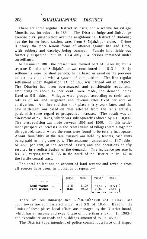
208 SHAHJAHANPUR DISTRICT
There are three regular District Munsifs, and a scheme for village Munsifs was introduced in 1894. The District Judge and Sub-Judge exercise c ivi l jurisdiction over the neighbouring District of Budaun ; but the former hears sessions cases from Shahjahanpur alone. Crime is heavy, the more serious forms of offences against life and l imb, with robbery and dacoity, being common. Female infanticide was formerly suspected; but in 1904 only 154 persons remained under surveillance.
At cession in 1801 the present area formed part of Bareil ly; but a separate District of Shahjahanpur was constituted in 1813-4. Early settlements were for short periods, being based as usual on the previous collections coupled with a system of competition. The first regular settlement under Regulation IX of 1833 was carried out in 1838-9. The District had been over-assessed, and considerable reductions, amounting to about 12 per cent, were made, the demand being fixed at 9-8 lakhs. Villages were grouped according to their capabilities of soil and irrigation, and revenue rates fixed per acre of cultivation. Another revision took place thirty years later, and the new settlement was based on rates selected from the rents actually paid, wi th some regard to prospective increases. The result was an assessment of n - 8 lakhs, which was subsequently reduced by Rs. 18,000. The latest revision was made between 1896 and 1900. In this settlement prospective increases in the rental value of villages were altogether disregarded, except where the rents were found to be totally inadequate. About four-fifths of the area assessed was held by tenants, cash rents being paid in the greater part. The assessment amounted to 11-7 lakhs, or 48-6 per cent, of the accepted ' assets,'and the operations chiefly resulted in a redistribution of the demand. The incidence per acre is Rs. i»2, varying from R. 0-5 in the north of the District to Rs. 1-7 in the fertile central tract.
The total collections on account of land revenue and revenue from al l sources have been, in thousands of rupees :—
Land revenue Total revenue
1880-1. 1890-1. 1900-1." 1903 4.
Land revenue Total revenue
11,20 16,87
11,09 19,92
13,91 25,80
11,53 26,01
There are two municipalities, S H A H J A H A N P U R and T I L H A R , and
four towns are administered under Ac t XX of 1856. Beyond the limits of these places local affairs are managed by the District board, which has an income and expenditure of more than a lakh. In 1903-4 the expenditure on roads and buildings amounted to Rs. 46,000.
The District Superintendent of police commands a force of 3 inspec-
SHAHJAHANPUR CITY 209
tors, 89 subordinate officers, and 365 constables, besides 302 municipal and town police, and 2,097 rural and road police. There are 19 police stations. The District j a i l contained a daily average of 316 prisoners i n 1903.
The population of Shahjahanpur is not conspicuous for literacy, and in 1901 only 2-6 per cent. (4 males and 0*3 females) could read and write. The number of public schools, however, increased from 149 in 1880-1 to 184 in 1900-1, and the number of pupils from 4,324 to 8,796. In 1903-4 there were 186 public schools with 8,744 pupils, of whom 514 were girls, and 60 private schools with 667 pupils. Four of the public schools are managed by Government and 124 by the District and municipal boards. Out of a total expenditure on education of Rs. 52,000, Local funds provided Rs. 41,000 and fees Rs. 10,000.
The District possesses 11 hospitals and dispensaries, wi th accommodation for 130 in-patients. About 85,000 cases were treated in 1903, of whom 1,400 were in-patients, and 3,000 operations were performed. The total expenditure was Rs. 16,000, chiefly met from Local funds.
In 1903-4, 30,000 persons were vaccinated, representing a proportion of 32 per r,ooo of population. Vaccination is compulsory only in the two municipalities.
\District Gazetteer (1883, under revision); W. A. W. Last, Settlement Report (1901).]
Shahjahanpur Tahsil.—Head-quarters tahsil of Shahjahanpur District, Uni ted Provinces, comprising the parganas of Shahjahanpur, Jamaur, and Kant , and lying between 270 39' and 280 i ' N. and 790 36 ' and 8o° 5' E., with an area of 394 square miles. Population fell from 273,146 in 1891 to 265,467 in 1901. There are 463 villages and only one town, S H A H J A H A N P U R C I T Y (population, 76,458), the District and tahsil head-quarters. The demand for land revenue in 1903-4 was Rs. 3,00,000, and for cesses Rs. 49,000. The density of population, 674 persons per square mile, is considerably above the District average, owing to the inclusion of the city. Through the centre of the tahsil flows the Garra, wi th a narrow belt of r ich alluvial soil on either bank, while several smaller streams act as drainage channels. The eastern portion has a good loam so i l ; but the centre is clay, and the western tract is sandy and liable to periods of depression. In 1903-4 the area under cultivation was 293 square miles, of which 84 were irrigated, mostly from wells.
Shahjahanpur City.—Administrat ive head-quarters of Shahjahanpur District and tahsil^ wi th cantonment, Uni ted Provinces, situated in 27° 53 ' N. and 790 54' E., on the left bank of the Deoha or Garra river, crowning the high ground just above its junction with the Khanaut, wi th a station on the Oudh and Rohilkhand Railway, 768 miles by rail from Calcutta and 987 from Bombay. Population
210 SHAHJAHANPUR CITY
has fluctuated. The numbers at the four enumerations were as follows: (1872) 72,136, (1881) 77,404, (1891) 78,522, and (1901) 76,458, of whom 73,544 resided in the municipality and 2,914 in cantonments. Hindus numbered 35,636 in 1901 and Muhammadans 40,017.
The date usually assigned to the foundation of the city is 1647, a ^ t e r
the defeat of the Rajputs in this neighbourhood by Diler K h a n and Bahadur K M n , and a mosque was bui l t here by the latter in that year. The city has no history apart from that of the District, which has already been related. There are few buildings of any interest. The old fort was completely destroyed after the M u t i n y ; and the mosque referred to above and a few tombs, including that of Bahadur Khan , one of the founders of the city, are the only memorials of the former rulers. The principal public buildings, besides the ordinary District offices, are the municipal hall, the District school, and the male and female dispensaries. The American Methodist Mission has its headquarters here, and possesses several churches and an orphanage. A new meeting-house has recently been buil t by the Arya Samaj. Shahjahanpur is the head-quarters of an officer of the Opium department. The municipality was constituted in 1864. Dur ing the ten years ending 1901 the income and expenditure averaged Rs. 74,000 and Rs. 72,000 respectively. In 1903-4 the income was 1-4 lakhs, including octroi (Rs. 58,000), rents of municipal markets (Rs. 27,000), and sale of refuse (Rs. 23,000). The municipality also has Rs. 30,000 invested. The expenditure amounted to 1-3 lakhs, including conservancy (Rs. 39,000), roads and buildings (Rs. 13,000), public safety (Rs. 24,000), and administration (Rs. 18,000). Shahjahanpur is remarkable for the excellence of its drainage and general sanitation. Brit ish troops form the usual garrison of the cantonment, and in 1901-2 Boer prisoners were encamped here. The income and expenditure of the cantonment fund in 1903-4 were Rs. 15,000 and Rs. 18,000. The trade of Shahjahanpur is small compared wi th its population. Sugar is the chief article of manufacture and commerce. The Rosa (Rausar) factory, which lies two miles south of the city, is the only establishment managed by Europeans. It deals with about 10 or 12 per cent, of the sugar produced in the District, and employed 632 hands in 1903. Raw sugar was formerly purchased for refining, but cane-crushing machinery has recently been erected, to supplement the supply. R u m is also manufactured and exported to many parts of India . The District high school has 188 pupils, and the tahsili school 214, while the municipality maintains 4 schools and aids 17 others, wi th 1,452 pupils.
Shah-ki-Dheri .—Village and ruins in Rawalpindi District, Punjab. See S H A H D H E R I .
SHAHPUR DISTRICT 211
Shahpur Dis tr ic t *.—District in the Rawalpindi Division of the Punjab, lying between 3 1 0 32 ' and 320 42 ' N. and 71 0 37' and 730 23' E., with an area of 4,840 square miles. It adjoins the Districts of Attock and Jhelum on the north, Gujrat on the east, Gujranwala on the south-east, Jhang on the south, and Mianwali on the west.
The Jhelum river divides Shahpur into two parts, nearly equal in area. Entering the District at its north-east corner, the river flows almost due west for 60 miles, and then near Khushab turns southward, its width increasing from 2 to 15 miles during its course through the District. The tendency of the river to move westward has caused it to cut in under its right bank, receding from the eastern bank, under which deposits of silt have formed a fertile stretch of low-lying land densely populated by prosperous cultivators. The Jhelum valley, though it comprises at most a fourth of the area of the whole District, contains more than a half of its population and all its towns.
East of the Jhelum, the District includes that part of the Chaj Doab, or country between the Chenab and Jhelum, which is called the Bar, consisting of a level uncultivated upland covered with brushwood. Its climate is dry and healthy. The character of this tract is, however, being rapidly changed by the Jhelum Canal. As the network of irrigation spreads, trees and bushes are cut down, and the country cleared for cultivation. Metalled roads are being built, and colonists imported from the congested Districts of the Province, while the Jech Doab branch of the North-Western Railway has been extended to Sargodha, the head-quarters of the new Jhelum Colony.
West of the Jhelum stretches an undulating waste of sandhills known as the Thai , extending to the border of Mianwali . Broken only by an occasional well, and stretching on three sides to the horizon, the Tha i from Nurpur offers a dreary spectacle of rolling sandhills and stunted bushes, relieved only by the Salt Range which rises to the north. Good rain wi l l produce a plentiful crop of grass, but a failure of the rains, which is more usual, means starvation for men and cattle. Nor th of the Tha i runs the Salt Range. Rising abruptly from the plains, these hills run east and west, turning sharply to the north into Jhelum District at one end and Mianwali at the other. The general height of the range is 2,500 feet, rising frequently to over 3,000 feet and culminating in the lit t le h i l l station of Sakesar (5,010 feet). The mirage is very common where the Salt Range drops into the T h a i
1 Throughout this article the information given relates to the District as it was before the formation of the Sargodha tahsil in 1906. Brief notices of the new tahsil and its head-quarters will be found in the articles on SARGODHA TAHSIL and SARGODHA TOWN.
Physical aspects.
212 SHAHPUR DISTRICT
The greater part of the District lies on the alluvium, but the central portion of the Salt Range, lying to the north of the Jhelum river, is of interest. The chief feature of this portion of the range is the great development attained by the Productus limestone, with its wealth of Permian fossils. It is overlain by the Triassic ceratite beds, which are also highly fossiliferous. Here, too, upper mesozoic beds first begin to appear; they consist of a series of variegated sandstones with Jurassic fossils, and are unconformably overlain by Nummulitic limestone and other Tertiary beds. The lower part of the palaeozoic group is less extensively developed than in the eastern part of the range, but the salt marl, with its accompanying rock-salt, is still a constant feature in most sections. Salt of great purity is excavated at the village of Warcha \
East of the Jhelum the flora is that of the Western Punjab, with an admixture of Oriental and desert species; but recent canal extensions tend to destroy some of the characteristic forms, notably the saltworts (species of Haloxylon, Salicornia, and Salsola), which in the southeast of the District often constitute almost the sole vegetation. The Thai steppe, west of the Jhelum, is a prolongation northwards of the Indian desert, and its flora is very similar to that of Western Rajputana. In the Salt Range a good many Himalayan species are found, but the general aspect of the flora is Oriental. The box (Buxus), a wild olive, species of Zizyphus, Sageretia, and Dodonaea are associated with a number of herbaceous plants belonging to genera well-known in the Levant as well as in the arid North-Western Himalaya, e.g. Dianthus, Scorzonera, and Merendera. At higher levels Himalayan forms also appear. Trees are unknown in the Thai, and, except Acacia modesta and Tecoma undulata, are usually planted; but the klkar {Acacia arabica) is naturalized on a large scale on the east bank of the Jhelum.
'Ravine deer' (Indian gazelle) are found in the Salt Range, the Thai, and the Bar. There are antelope in very small numbers in the Shahpur tahsil, while hog are found in the south-east of the District and occasionally in the Salt Range. In the Salt Range leopards are rare and wolves common. Uridl (a kind of moufflon) also live on the hills, and jackals are numerous everywhere.
The town of Khushab and the waterless tracts of the Bar and Thai are, in May and June, among the hottest parts of India. The thermometer rises day after day to 1150 or more, and the average daily maximum for June is 1080. When the monsoon has once begun, the temperature rarely rises above 1050. The Salt Range valleys are
1 Wynne, 'Geology of the Salt Range,' Memoirs, Geological Survey of ftidia, vol. xxiv; C. S. Middlemiss,' Geology of the Salt Range,' Records, Geological Survey of India, vol. xiv, pt. i.
HISTORY 213
generally about 10° cooler than the plains, while at Sakesar the temperature seldom ranges above 900 or below 700 in the hot months. January is the coldest month. The average minimum at Khushab is 390. The District is comparatively healthy, though it suffers considerably from fever in the autumn months. The Bar has a better climate than the river valleys, but has deteriorated since the opening of the Jhelum Canal.
The rainfall decreases rapidly as one goes south-west, away from the Himalayas. In the Jhelum valley and Salt Range it averages 15 inches. In the Thai the average is 7 inches. The great flood of 1893 wil l be long remembered. On July 20-1 in that year the Chenab discharged 700,000 cubic feet per second, compared with an average discharge of 127,000.
At the time of Alexander's invasion, the Salt Range between the Indus and the Jhelum was ruled by Sophytes, who submitted without resistance to Hephaestion and Craterus in the autumn of 326 13.c. The capital of his kingdom is possibly to be found at O l d B H E R A . After Alexander left India, the country comprised in the present District passed successively, with intervals of comparative independence, under the sway of Mauryan, Bactrian, Parthian, and Kushan kings, and was included within the limits of the H i n d u kingdom of Ohind or Kabul . In the seventh and eighth centuries, the Salt Range chieftain was a tributary of Kashmir. Bhera was sacked by Mahmud of Ghazni, and again two centuries later by the generals of Chingiz Khan. In 1519 Babar held it to ransom; and in 1540 Sher Shah founded a new town, which under Akbar became the head-quarters of one of the subdivisions of the Subah of Lahore. In the reign of Muhammad Shah, Raja Salamat Rai, a Rajput of the Anand tribe, administered Bhera and the surrounding country; while Khushab was managed by Nawab Ahmadyar Khan, and the south-eastern tract along the Chenab formed part of the territories under the charge of Maharaja Kaura Mai , governor of Mul tan . At the same time, the Tha i was included among the dominions of the Baloch families of Dera Ghazi Khan and Dera Ismail Khan.
During the anarchic period which succeeded the disruption of the Mughal empire, this remote region became the scene of Sikh and Afghan incursions. In 1757 a force under Nur-ud-dln Bamizai, dispatched by Ahmad Shah Durrani to assist his son T i m u r Shah in repelling the Marathas, crossed the Jhelum at Khushab, marched up the left bank of the river, and laid waste the three largest towns of the District. Bhera and M i a n i rose again from their ruins, but only the foundations of Chak Sanu now mark its former site. About the same time, by the death of Nawab Ahmadyar Khan, Khushab also passed into the hands of Raja Salamat Rai. Shortly afterwards Abbas
214 SHAHPUR DISTRICT
Khan, a Khattak, who held Pind Dadan Khan and the Salt Range for Ahmad Shah, treacherously put the Raja to death, and seized Bhera. But Abbas Khan was himself thrown into prison as a revenue defaulter; and Fateh Singh, nephew of Salamat Rai, then recovered his uncle's dominions.
After the final success of the Sikhs against Ahmad Shah in 1763, Chattar Singh, of the Sukarchakia misl or confederacy, overran the whole Salt Range, while the Bhangi chieftains parcelled out among themselves the country between those hills and the Chenab. Meanwhile, the Muhammadan rulers of Sahiwal, Mitha Tiwana, and Khushab had assumed independence, and managed, though hard pressed, to resist the encroachments of the Sikhs. The succeeding period was one of constant anarchy, checked only by the gradual rise of Mahan Singh, and his son, the great Maharaja Ranjlt Singh. The former made himself master of Miani in 1783, and the latter succeeded in annexing Bhera in 1803. Six years later, Ranjlt Singh turned his arms against the Baloch chieftains of Sahiwal and Khushab, whom he overcame by combined force and treachery. At the same time he swallowed up certain smaller domains in the same neighbourhood; and in 1810 he effected the conquest of all the country subject to the Sial chiefs of Jhang. In 1816 the conqueror turned his attention to the Maliks of Mitha Tiwana. The Muhammadan chief retired to Nurpur, in the heart of the Thai, hoping that scarcity of water and supplies might check the Sikh advance. But Ranjlt Singh's general sank wells as he marched, so that the Tiwanas fled in despair, and wandered about for a time as outcasts. The Maharaja, however, after annexing their territory, dreaded their influence and invited them to Lahore, where he made a liberal provision for their support. On the death of the famous Hari Singh, to whom the Tiwana estates had been assigned, Fateh Khan, the representative of the Tiwana family, obtained a grant of the ancestral domains. Thenceforward, Malik Fateh Khan took a prominent part in the turbulent politics of the Sikh realm, after the rapidly succeeding deaths of Ranjlt Singh, his son, and grandson. Thrown into prison by the opposite faction, he was released by Lieutenant (afterwards Sir Herbert) Edwardes, who sent him to Bannu on the outbreak of the Muitan rebellion to relieve Lieutenant Reynell Taylor. Shortly afterwards the Sikh troops mutinied, and Fateh Khan was shot down while boldly challenging the bravest champion of the Sikhs to meet him in single combat. His son and a cousin proved themselves actively loyal during the revolt, and were rewarded for their good service both at this period and after the Mutiny of 1857.
Shahpur District passed under direct British rule, with the rest of the Punjab, at the close of the second Sikh War. At that time the greater part of the country was peppled only by wild pastoral tribes, without
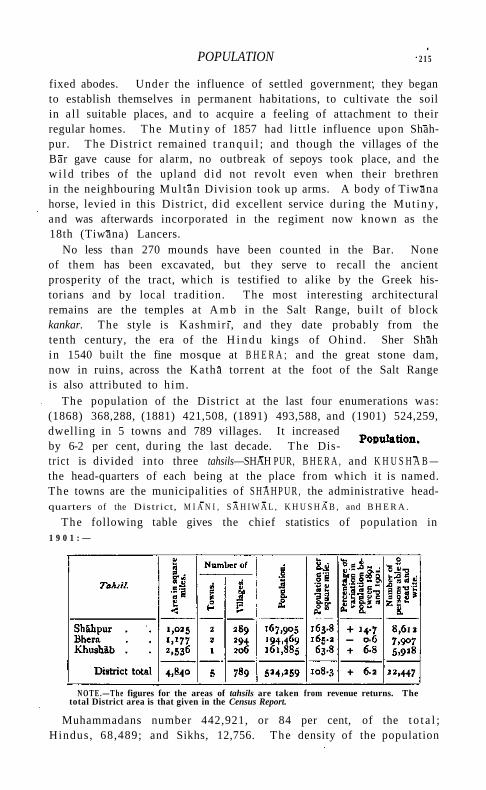
POPULATION 2 1 5
fixed abodes. Under the influence of settled government, they began to establish themselves in permanent habitations, to cultivate the soil in a l l suitable places, and to acquire a feeling of attachment to their regular homes. The Mut iny of 1857 had l i t t le influence upon Shah-pur. The District remained t r anqu i l ; and though the villages of the Bar gave cause for alarm, no outbreak of sepoys took place, and the w i l d tribes of the upland d id not revolt even when their brethren in the neighbouring Mul tan Division took up arms. A body of Tiwana horse, levied in this District, d id excellent service during the Mut iny , and was afterwards incorporated in the regiment now known as the 18th (Tiwana) Lancers.
No less than 270 mounds have been counted in the Bar. None of them has been excavated, but they serve to recall the ancient prosperity of the tract, which is testified to alike by the Greek historians and by local tradition. The most interesting architectural remains are the temples at A m b in the Salt Range, bui l t of block kankar. The style is Kashmiri , and they date probably from the tenth century, the era of the H i n d u kings of Ohind. Sher Shah in 1540 buil t the fine mosque at B H E R A ; and the great stone dam, now in ruins, across the Katha torrent at the foot of the Salt Range is also attributed to h im.
The population of the District at the last four enumerations was: (1868) 368,288, (1881) 421,508, (1891) 493,588, and (1901) 524,259, dwelling in 5 towns and 789 villages. It increased by 6-2 per cent, during the last decade. The District is divided into three tahsils—SHAH PUR, B H E R A , and K H U S H A B — the head-quarters of each being at the place from which it is named. The towns are the municipalities of S H A H P U R , the administrative headquarters of the District, M I A N I , S A H I W A L , K H U S H A B , and B H E R A .
The following table gives the chief statistics of population in 1 9 0 1 : —
N O T E . — T h e figures for the areas of tahsils are taken from revenue returns. The total District area is that given in the Census Report.
Muhammadans number 442,921, or 84 per cent, of the t o t a l ; Hindus , 68,489; and Sikhs, 12,756. The density of the population
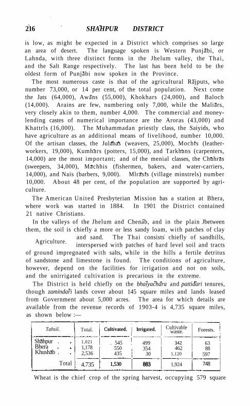
216 SHAHPUR DISTRICT
is low, as might be expected in a District which comprises so large an area of desert. The language spoken is Western Punjabi, or Lahnda, with three distinct forms in the Jhelum valley, the Thai , and the Salt Range respectively. The last has been held to be the oldest form of Punjabi now spoken in the Province.
The most numerous caste is that of the agricultural Rajputs, who number 73,000, or 14 per cent, of the total population. Next come the Jats (64,000), Awans (55,000), Khokhars (24,000), and Baloch (14,000). Arains are few, numbering only 7,000, while the Maliars, very closely akin to them, number 4,000. The commercial and money-lending castes of numerical importance are the Aroras (43,000) and Khattrls (16,000). The Muhammadan priestly class, the Saiyids, who have agriculture as an additional means of livelihood, number 10,000. Of the artisan classes, the Julahas (weavers, 25,000), Mochis (leather-workers, 19,000), Kumhars (potters, 15,000), and Tarkhans (carpenters, 14,000) are the most important ; and of the menial classes, the Chuhras (sweepers, 34,000), Machhis (fishermen, bakers, and water-carriers, 14,000), and Nais (barbers, 9,000). Mlrasis (village minstrels) number 10,000. About 48 per cent, of the population are supported by agriculture.
The American Uni ted Presbyterian Mission has a station at Bhera, where work was started in 1884. In 1901 the District contained 21 native Christians.
In the valleys of the Jhelum and Chenab, and in the plain Jbetween them, the soil is chiefly a more or less sandy loam, with patches of clay
and sand. The Thai consists chiefly of sandhills, interspersed with patches of hard level soil and tracts
of ground impregnated with salts, while in the hills a fertile detritus of sandstone and limestone is found. The conditions of agriculture, however, depend on the facilities for irrigation and not on soils, and the unirrigated cultivation is precarious in the extreme.
The District is held chiefly on the bhaiyachara and pattidari tenures, though zamindari lands cover about 145 square miles and lands leased from Government about 5,000 acres. The area for which details are available from the revenue records of 1903-4 is 4,735 square miles, as shown below :—
Total. Cultivated. | Irrigated. Cultivable waste. Tahsil.
Shahpur . Bhera Khushab .
Total
1,021 1,178 2,536
Cultivated. Irrigated.
. 545 550 435
499 354
30
1,530 883
342 462
1,120
Forests.
63 88
597
748 4.735 1,530 883 1,924
Wheat is the chief crop of the spring harvest, occupying 579 square
Agriculture.
AGRICULTURE 217
miles in 1903-4. Gram and barley covered 92 and 19 square miles respectively. In the autumn harvest spiked millet (bajra) is the principal staple, covering 209 square miles; cotton covered 66 square milesr pulses 50, and great millet (jowdr) 56.
During the ten years ending 1900-1, the area under cultivation increased by 19 per cent., and it is still extending with the aid of the new Jhelum Canal. There is little prospect of irrigation in the Thai, as, although it lies within the scope of the proposed Sind-Sagar Canal, the soil is too sterile to make irrigation profitable. Nothing has been done to improve the quality of the crops grown. Loans for the sinking of wells are appreciated in the tract beneath the hills and in the Jhelum valley; more than Rs. 5,800 was advanced under the Land Improvement Loans Act during the five years ending 1903-4.
There are no very distinct breeds of cattle, though the services of Hissar bulls are generally appreciated. The cattle of the Bar are, however, larger and stronger than those of the plains, and there is an excellent breed of peculiarly mottled cattle in the Salt Range. A great deal of cattle-breeding is done in the Bar, and a large profit is made by the export of g/il. Many buffaloes are kept. The District is one of the first in the Punjab for horse-breeding, and the Shahpur stock is considered to be one of the best stamp of remounts to be found in the Province. A considerable number of mules are bred. A large horse fair is held annually, and 44 horse and 13 donkey stallions are maintained by the Army Remount department and 3 horse stallions by the District board. Large areas have been set apart in the Jhelum Colony for horse runs, and many grants of land have been made on condition that a branded mare is kept for every z\ acres. Camels are bred in the Bar and Thai. A large number of sheep are kept, both of the black-faced and of the fat-tailed breed, and goats are also kept in large numbers. The donkeys, except in the Jhelum and Chenab valleys, are of an inferior breed, but are largely used as beasts of burden.
Of the total area cultivated in 1903-4, 883 square miles, or 58 per cent., were classed as irrigated. Of this area, 343 square miles were irrigated from wells, and 540 from canals. In addition, 107 square miles, or 7 per cent, of the cultivated area, are subject to inundation from the Chenab and Jhelum, and much of the land in the hills classed as unirrigated receives benefit from the hill torrents. The LOWER JHELUM CANAL, which was opened in October, 1901, irrigates the uplands of the Bar. The remainder of the canal-irrigation is from the inundation canals (see SHAHPUR CANALS), which, with the exception of three private canals on the Chenab, all take off from the Jhelum. It is intended to supersede them gradually by extensions
218 SHAHPUR DISTRICT
of the Lower Jhelum Canal. In 1903-4 the District had 7,545 masonry wells, worked by cattle with Persian wheels, besides 241 unbricked wells, lever wells, and water-lifts. Fields in the Salt Range are embanked so as to utilize to the utmost the surface drainage of the hills, and embankments are thrown across the h i l l torrents for the same purpose.
In 1903-4 the District contained 775 square miles of 'reserved' and 25 of unclassed forest under the Deputy-Conservator of the
Shahpur Forest division, besides 21 square miles of military reserved forest, and 3 square miles of
' reserved ' forest and 692 of waste lands under the Deputy-Commissioner. These forests are for the most part tracts of desert thinly covered with scrub, consisting of the van (Salvadora), jand (Prosofiis), leafless caper and other bushes, which form the characteristic vegetation. The Acacia arabica, s hi sham (Dalbergia Sissoo\ and other common trees of the plains are to be found by the rivers, and planted along roads and canals and by wells ; but as a whole the District is very poorly wooded. The forest revenue from the areas under the Forest department in 1903-4 was Rs. 77,000, and from those under the Deputy-Commissioner Rs. 59,000.
Salt is found in large quantities all over the Salt Range, and is excavated at the village of Warcha, the average output exceeding 100,000 maunds a year. Small quantities of lignite have been found in the hills south of Sakesar; gypsum and mica are common in places, and traces of iron and lead have been found in the Salt Range. Petroleum also has been noticed on the surface of a spring. Limestone is quarried from the hills in large quantities, and a great deal of lime is burnt. Crude saltpetre is manufactured to a large extent from the earth of deserted village sites, and refined at five licensed distilleries, whence it is exported. The manufacture of impure carbonate of soda from the ashes of Sahola Griffithii is of some importance.
Cotton cloth is woven in all parts, and is exported in large quantities, while silk and mixtures of silk and cotton are woven at
Khushab, and cotton prints are produced. Felt rugs are made at that town and at Bhera. Bhera also turns out' a good deal of cutlery, and various
kinds of serpentine and other stones are used there for the handles of knives, caskets, paper weights, &c. The woodwork of Bhera is above the average, and good lacquered turnery is made at Sahiwal. Gunpowder and fireworks are prepared on a large scale at several places. Soap is also manufactured.
Cotton is exported both raw and manufactured, and there is a large export of wheat and other grains, which wi l l increase with the development of the Jhelum Colony. Other exports are wool, ghi, hides and
Trade and communications.
Forests.
ADMINTSTRATION 219
bones, salt, lime, and saltpetre. The chief imports are piece-goods, metals, sugar, and rice.
The Sind-Sagar branch of the North-Western Railway crosses the north-eastern corner of the Bhera tahsil, and, after passing into Jhelum District, again enters the District, crossing the Khushab tahsil The Jech Doab branch strikes off through the heart of the District, running as far as Sargodha, the head-quarters of the Jhelum Colony. There is also a short branch to Bhera. A light railway from Dhak to the foot of the hills near Katha\ a distance of about 10 miles, is under survey, in the interests of the coal trade.
The District is traversed in all directions by good unmetalled roads, the most important leading from Lahore to the frontier through Shah-pur town and Khushab, and from Shah pur to Jhang and Gujrat. The total length of metalled roads is 20 miles, and of unmetalled roads 838 miles. Of these, 13 miles of metalled and 26 miles of unmetalled roads are under the Public Works department and the rest under the District board.
The Jhelum is crossed between Shahpur and Khushab by a bridge of boats, dismantled during the rains; and a footway is attached to the railway bridge in the Bhera tahsil. There are sixteen ferries on the Jhelum, those on the Chenab being under the management of the authorities of Gujranwala District. A certain amount of traffic is carried by the former river, but very little by the latter.
Prior to annexation, the greater part of Shahpur was a sparsely populated tract, in which cultivation was mostly dependent on wells and on the floods of the Jhelum river; and although the District has been affected by all the famines which have visited the Punjab, it is not one in which distress can ever rise to a very high pitch. No serious famine has occurred since annexation, and with the construction of the Lower Jhelum Canal the Chaj Doab may be said to be thoroughly protected.
The District is in charge of a Deputy-Commissioner, aided by two Assistant or Extra-Assistant Commissioners, of whom one is in charge of the District treasury. It is divided for administrative purposes into the three tahsils of S H A H P U R ,
B H E R A , and K H U S H A B .
The Deputy-Commissioner as District Magistrate is responsible for criminal justice. Civi l judicial work is under a District Judge; and both officers are subordinate to the Divisional Judge of the Shahpur Civi l Division, who is also Sessions Judge. There are two Munsifs, one at head-quarters and the other at Bhera. The principal crime of the District is cattle-lifting, though dacoities and murders are not uncommon. In the Salt Range blood-feuds are carried on for generations.
VOL. X X I I . I '
Administration.
220 SHAHPUR DISTRICT
At the beginning of the nineteenth century the tract which now forms the District was held by various independent petty chiefs, all of whom were subdued by Ran j i t Singh between 1803 and 1816. T i l l 1849 it was governed by Sikh kardars, who took leases of the land revenue of various blocks of country, exacting all they could and paying only what they were obliged. The usual modes of collection were by taking a share of the grain produce or by appraisement of the standing crops, and the demand was not l imi ted to any fixed share of the harvest. On annexation in 1849 the District was assessed village by village in cash, the Sikh demand being reduced by 20 per cent.; but even this proved too high. In 1851 the distress found voice, and the revenue was reduced in the Kalowal (Chenab) tahsil from Rs. 1,00,000 to Rs. 75,000. In 1852 a summary settlement was carried out, giving a reduction of 22 per cent. In 1854 began the regular settlement, which lasted twenty years and resulted in a further decrease of a quarter of a lakh. A revised settlement was concluded in 1894. The average rates of assessment were Rs. 2 (maximum Rs. 3-10, minimum 6 annas) on ' w e t ' land, and R. 0-15-6 (maximum Rs. 1-9, minimum 6 annas) on ' d r y ' land. These rates resulted in an immediate increase of 38 per cent, in the demand, the incidence per acre of cultivation being R. 0-15-9. The average size of a proprietary holding is 5 acres.
The collections of land revenue and of total revenue are shown below, in thousands of rupees :—
1880-1. 1890-1. 1900-1. 1903-4.
Land revenue Total revenue
4.33 5,50
4>97 6,53
5,53 8,19
9,08 " , 9 5
The District contains five municipalities, S H A H P U R , B H E R A , M I A N I ,
S A H I W A L , and K H U S H A B . Outside these, local affairs are managed by the District board, whose income, derived mainly from a local rate, was a lakh in 1903-4, while the expenditure was Rs. 85,000, education being the largest item.
The regular police force consists of 502 of all ranks, including 100 municipal police, and the Superintendent usually has one Assistant Superintendent and four inspectors under him. Village watchmen number 538. There are 17 police stations and 5 outposts. The District ja i l at head-quarters has accommodation for 280 prisoners.
Shahpur stands tenth among the twenty-eight Districts of the Province in respect of the literacy of its population. In 1901 the proportion of literate persons was 4*2 per cent. (7-5 males and 0-7 females). The number of pupils under instruction was 2,119 in 1880-1, 8,560 in 1890-1, 7,961 in 1900-1, and 8,495 in 1903--4.
SHAHPUR INUNDATION CANALS 2 2 1
In the last year there were 7 secondary and 74 primary (public) schools, and 11 advanced and 231 elementary (private) schools, with 696 girls in the public and 293 in the private schools. The District possesses two high schools, both at Bhera. It also has twelve girls' schools, among which Pandit Diwan Chand's school at Shahpur is one of the best of its k i n d in the Province. The total expenditure on education in 1903-4 was Rs. 48,000, of which the municipalities contributed Rs. 5,800, fees Rs. 21,000, endowments Rs. 1,400, Government Rs. 4,000, and District funds Rs. 15,600.
Besides the c ivi l hospital at Shahpur, the District has eight outlying dispensaries. At these institutions 109,428 out-patients and 1,463 in-patients were treated in 1904, and 4,977 operations were performed. The income was Rs. 17,000, the greater part of it coming from municipal funds.
The number of successful vaccinations in 1903-4 was 12,072, representing 23 per 1,000 of the population.
[J . Wilson, District Gazetteer (1897); Settlement Report (1894); Grammar and Dictionary of Western Panjabi, as spoken in the Shah
pur District(1899); and General Code of Tribal Custom in the Shahpur District (1896).]
Shahpur Tahsi l .—Tahs i l of Shahpur District, Punjab, lying between 3 1 0 42 ' and 320 27' N. and 720 12' and 720 5 1 ' E., with an area of 1,021 square miles. It is bounded on the west and north-west by the Jhelum river. The tract along the river is very fertile, and is separated from the hard clay uplands by a well-marked bank. The tahsil is well wooded. The population in 1901 was 167,905, compared with 146,376 in 1891. The head-quarters are at the town of S H A H P U R (population, 9,386); and the tahsil also contains the town of S A H I W A L (9,163) and 289 villages. The land revenue and cesses in 1903-4 amounted to 5.3 lakhs.
Shahpur Inundat ion Canals .—A system of inundation canals in the Punjab, fed from the Jhelum river and mainly situated in Shahpur District. About sixteen of them are owned by private persons and six by Government. Of the latter, three are classed as Imperial and two as Provincial, while one, the Pind Dadan Khan Canal in Jhelum District, has recently been made over to the municipal committee of Pind Dadan Khan for management. The three Imperial canals lie wholly in the Shahpur tahsil, and are developments of a canal dug in 1864 by Colonel Sir Wil l iam Davies, to supply water to the civi l station of Shahpur. In 1870 Government acquired this canal and added two new canals. The Imperial canals command an area of 105 square miles and irrigate 50 square miles a year on an average, yielding a net revenue of Rs. 50,000, or 24 per cent, on the capital outlay. Of the two Provincial canals, the largest is the Raniwah, an old native canal
p 2
222 SHAHPUR INUNDATION CANALS
which had fallen into disuse and was reopened in 1870-1. It commands 72 square miles in the Bhera fahsil and irrigates 30 square miles annually, yielding a net revenue of Rs. 11,000. It has extinguished its capital cost and yielded a net profit of 4*1 lakhs to Government. The Corbynwah, constructed in 1879, irrigates about 4,500 acres, mostly grass lands, in the Khushab tahsfl on the right bank of the Jhelum.
The Pind Dadan Khan Canal does not pay expenses, but it supplies the town with sweet water. It performs a small amount of irrigation as well, the area irrigated in 1904-5 having been 395 acres. The private canals have a total length of about 227 miles and irrigate 87 square miles. Many of them are old canals which had silted up and were re-excavated, under Sir Donald McNabb and other Deputy-Commissioners of the District, by owners or lessees to irrigate their own lands. They also irrigate the lands of other persons on payment of a water rate. As noted in the article on the LOWER JHELUM CANAL, most of these inundation canals will cease to exist as such when the Shahpur branch of the Lower Jhelum Canal has been constructed.
Shahpur Town.—Head-quarters of the District and tahsll of Shah-pur, Punjab, situated in 320 18' N. and 720 27' E., on the left bank of the Jhelum river. Population (1901), 9,386. The town, founded by a colony of Saiyids, and called after their leader, Shah Shams, lies 3 miles from the civil lines, in which are the District offices, jail, and church, and 5 miles from Khushab, the nearest railway station on the North-Western Railway. The place is of no commercial importance. The municipality was created in 1867. The income and expenditure during the ten years ending 1902-3 averaged Rs. 1,900. In 1903-4 the income amounted to Rs. 1,900, chiefly from octroi; and the expenditure was Rs. 1,800. The town has an Anglo-vernacular middle school, maintained by the District board, besides Pandit DlwSn Chand's girls' school, one of the best in the Province; and a civil hospital.
Shahpur State.—Petty State in KATHIAWAR, Bombay. Shahpur Taluk.—Taluk in Gulbarga District, Hyderabad State,
with an area of 585 square miles, including j'agirs. The population in 1901 was 104,274, compared with 93,210 in 1891. It contains one town, SAGAR (population, 5,445), and 150 villages, of which 40 are jagfr. Shahpur (population, 3,251) is the head-quarters. The Bhlma flows along the south-east border. The land revenue in 1901 amounted to 1-7 lakhs. The soil is chiefly of the black cotton description.
Shahpura Chiefship.—-Chiefship under the political supervision of the Haraoti and Tonk Agency, Rajputana, lying between 250 29' and 250 53' N. and 740 44' and 750 7' E., with an area of 405 square miles. It is bounded on the north and north-east by the British Dis-
SHAHPURA CHIEFSHIP 223
trict of Ajmer, and on every other side by the Udaipur State, except in the north-east corner, where kits border touches that of Kishangarh. A. small detached tract lies about 5 miles to the west of its southwestern boundary. The country is for the most part flat, open, and treeless, and contains much pasture-land. In the north are two small rivers, the Khari and the Mansi, which flow from west to east, unite near Phulia, and eventually join the Banas river north of Deoli.
The northern portion of Shahpura is covered by the alluvium of these rivers. A few isolated rocky hills are to be found, formed of the schists of the ArUvalli system, while in the south a large area is covered by the same rocks, traversed by numerous dikes and veins of granite.
The annual rainfall averages about 26 inches, and has varied from over 44 inches in 1892 to about 10 in 1895.
The Shahpura family belongs to the Sesodia clan of Rajputs, being descended from Amar Singh I, Rana of Mewar about the end of the sixteenth century, through his son Suraj Mai. The chiefship of Shahpura came into existence about 1629, when Suraj Mai's son, Sujan Singh, received from the emperor Shah Jahan, as a reward for gallant services, a grant of the pargana of Phulia out of the crown lands of Ajmer, on condition of performing service with 50 horsemen. Sujan Singh at once changed the name of this district to Shahpura, after his benefactor, and founded the town of the same name; he was thus the first chief of Shahpura. He was killed in 1658 at Fatehabad near Ujjain, when fighting on the side of Dara against Aurangzeb. His grandson, Bharat Singh, was the third chief, and received from the emperor Aurangzeb the title of Raja. The next chief was Umed Singh, who was killed at Ujjain in 1768, when fighting for Rana Ari Singh of Mewar against Mahadji Sindhia. The seventh chief, Amar Singh (1796-1827), is said to have received from the Maharana of Mewar the title of Raja Dhiraj, which is accorded to his successors to this day. The eleventh and present chief is Raja Dhiraj Nahar Singh, who succeeded by adoption in 1870, received full powers in 1876, and was made a K.C.I.E. in 1903. Under the sanad of June 27, 1848, the chiefship pays to the British Government a tribute of Rs. 10,000, subject to the proviso that, if the customs duties levied in Ajmer District be abolished, the chief shall, if the Government so wish, also cease to collect such duties, and in such a case the tribute shall be reduced to Rs. 2,000 a year. The chief has received the right of adoption. In addition to holding Shahpura directly by grant from the British Government, the Raja Dhiraj possesses the estate of KACHHOLA in Udaipur, for which he pays tribute and does formal service as a great noble of that State.
The number of towns and villages in Shahpura is 133, and the popu-
Physical aspects.
History.
224 SHAHPURA CHIEFSHIP
lation at each of the three enumerations was: (1881) 51,750, (1891) 63,646, and (1901)42,676. The decline in the last decade was due
to the famine of 1899-1900, and the severe outbreak of malarial fever which followed it . The chiefship
is divided into the four tahsils of Shahpura, Dhikola, Kothian, and Phulia, wi th head-quarters at the places from which each is named. In 1901 Hindus numbered 38,541, or 90 per cent,; Musalmans, 2,520, or nearly 6 per cent.; and Jains, 1,543, or 3 per cent.
The most numerous castes are the Brahmans, Gujars, and Jats, almost all of whom are agriculturists; and the Mahajans, who are traders and money-lenders. Nearly 50 per cent, of the population are supported by agriculture, and about 20 per cent, are engaged in such industries as cotton-weaving and dyeing, pottery, carpentry, bootT
making, &c . The soil is for the most part a fertile loam. The principal crops are
bajra, jowar, maize, ///, and cotton in the rainy season, and wheat, barley, gram, and poppy in the cold season. The area said to have been cultivated in 1902-3 was
247 square miles, or three-fifths of the entire area of the chiefship. About 30 square miles were irrigated: namely, 17 from tanks and 13 from wells. The country is well suited for tanks, and the subject of irrigation has been receiving considerable attention during recent years.
There are no real forests, but extensive grass reserves contain babuly
niw, and other common trees useful for fuel. Surplus grass is regularly stored.
The principal manufactures are the lacquered tables, shields, and toys, which have more than a local reputation; other arts are cotton-
weaving of the ordinary k ind , printing on fabrics, dyeing, and the manufacture of bangles from coconut shells. A cotton-press at Shahpura town, the
property of the chiefship, gives employment to 80 men during the working season, and about 4,500 bales of cotton are pressed yearly.
The chief exports are cotton and ghl to Bombay, and opium, hides, barley, maize, and til mostly to Beawar. The chief imports are piece-goods and sugar from Bombay, salt from Sambhar and Pachbhadra, wheat from Cawnpore, rice and tobacco from Ajmer, and cattle from Marwar and Malwa.
There is no railway in the chiefship, but the Rajputana-Malwa line runs parallel to, and about 12 miles distant from, the western border. The proposed Baran-Ajmer-Marwar Railway wi l l , however, pass through the territory. The only metalled roads are in the vicinity of Shahpura town, and. their length is about 2 miles. The only British post office is at the capital, where there is also a telegraph office. The chiefship maintains a postal system of its own. Letters on State service are
Trade and communications.
Agriculture.
Population.
A DMINISTRATION 225
carried free, and private letters at \ anna each. The mails are carried by runners.
. O f famines prior to 1899-1900 there is very li t t le on record. In 1869-70 there was severe distress ; 68 per cent, of the cattle are said to have perished, about 2,000 persons emigrated, and 9,000 died, mostly from fever or scurvy. There was scarcity in 1877-8, 1891-2, and 1895-6. The famine of 1899-1900 was a severe one; the rainfall was about half the average, and practically no rain fell after the middle of July. Relief works were started in September, 1899, and continued t i l l August, 1900; 880,000 units were relieved on works, and 157,000 gratuitously, at a cost of Rs. 77,600. Land revenue was remitted and suspended, advances were made, and loans were given to the jdgirddrs. Owing to the absence of fodder 66 per cent, of the cattle died, but among human beings deaths from starvation or the immediate effects of insufficient food were comparatively few.
The chiefship is administered by the Raja Dhiraj, assisted by a Kamdar. Under the latter are a Revenue Collector and four tahsildars.
In the administration of justice the courts are guided generally by the codes of British India. The lowest courts are those of the tahsildars, two of whom have the powers of a third-class magistrate, while three decide c ivi l suits not exceeding Rs. 50 in value. Over them are the Faujddri (criminal) and JDlivdni (civi l) courts, presided over by two officials called hakims. The former can sentence to three years' imprisonment and Rs. 500 fine, while the latter decides suits not exceeding Rs. 3,000 in value. Both hear appeals against the decisions of tahsildars. Over them is the Judicial Officer, who has the powers of a Court of Session except that he does not hear appeals, and decides suits not exceeding Rs. 5,000 in value. Lastly, there is the Mahakma khda, which is the final appellate authority, and disposes of a l l cases beyond the powers of the Judicial Officer, subject to the proviso that all cases of heinous crime involving the punishment of death or imprisonment for life are reported to the Political Agent and disposed of in accordance with his advice.
The normal revenue of the chiefship is nearly 3 lakhs, the chief sources be ing : land, about 1-7 lakhs; cotton-press, Rs. 29,000; customs, Rs. 17,000; and payments by jagirdars, Rs. 8,500. The normal expenditure is about 2-6 lakhs, the chief items being : civi l and judicial staff, 1-4 lakhs; private and household expenditure, Rs. 46,000; troops and police, Rs. 11,000; and tribute, Rs. 10,000. These figures relate also to the estate of Kachhola.
The coins current in the chiefship are the British, the Chitori of Mewar, and the Gyarah sana or Igdrdh sana. The latter is a local coin
Famine.
Administration.
226 SHAHPURA CHIEFSHIP
struck by the Rajas of Shahpura since 1760 or 1780, but the mint has been closed since 1870 under the orders of Government. The Gyarah sana rupee was formerly worth about 10 or 10\ British annas, but nowr
exchanges for about 8 annas. Of the 132 villages in the chiefship, 64 are khdlsa, 52 Jagir, and
16 muqfi. Land under the last tenure is held free, while the holders of jagir land have to perform service and pay tribute. In the khalsa area the land revenue is paid in cash on the kharif or rains crops, varying from Rs. 3 to Rs. 8 per acre, while on the rabi or spring crops it is levied in kind, varying from one-fourth to one-half of the produce. Save in a few cases, the tenants have no proprietary rights, and can be dispossessed at any time; but with the chiefs permission they can dispose of, or transfer, their right of cultivation.
The military force consists of 44 cavalry, 65 armed and 176 general infantry, or a total of 285 of all ranks, with 10 serviceable guns.
The police force consists of 400 men, of whom 42 are mounted and 130 are chaukldars. The only jail is at the capital and has accommodation for 29 prisoners; the daily average number in 1904 was 20. The jail manufactures are unimportant and on a very small scale, consisting of cotton carpets, matting, and rope.
In respect of the literacy of its population, Shahpura stands third among the States and chiefships of Rajputana with 53 per cent, able to read and write: namely, 9-8 per cent, of the males and 0-4 of the females. There are only four schools, of which three, including a girls' school, are at the capital, and one at Kothian in the north-west. The daily average attendance at these four institutions in 1904-5 was 200, and the expenditure about Rs. 4,000.
A hospital is maintained at the capital, which cost Rs. 1,840 in 1904. Vaccination is not popular. In 1904-5 the vaccinator successfully vaccinated 894 persons, or about 21 per 1,000 of the population.
Shahpura T o w n (1).—Capital of the chiefship of the same name in Rajputana, founded about 1629 by Sfijan Singh, the first chief of Shahpura, and named after the emperor Shah Jahan. It is situated in 250 38' N. and 740 56' E., about 19 miles by unmetalled road east of Sareri station on the Rajputana-Malwa Railway, and 60 miles south-by-south-east of Ajmer city. Population (1901), 8,974. The town is surrounded by a wall having four gates, and possesses a combined post and telegraph office; a jail with accommodation for 29 prisoners; an Anglo-vernacular school, with boarding-house attached, at which the daily average attendance in 1904-5 was 50; a couple of primary schools attended by 129 boys and 20 girls; and a hospital with accommodation for 20 in-patients. Outside the walls and close to the Kund gate stands the Ramdwara or monastery of the Ramsanehi sect of mendicants. This sect is said to have been founded about
SHAJAPUR ZILA 227
150 years ago by one Ram Charan Das, and the mahant or high priest resides here. The Ramsanehis (or Movers of Ram' ) have no belief in the worship of idols, and their chief tenet is the repeating of the name Ram. They shave the head, moustache, and beard completely, and usually cover their bodies with an ochre-coloured sheet, though some do not wear more than a simple loin-cloth at any season. They live by begging and do not marry, but adopt chelas or disciples from the Brahman, Rajput, and Mahajan castes.
S h a h p u r a T o w n (2) .—Town in the Sawai Jaipur nizamat of the State of Jaipur, Rajputana, situated in 270 23' N. and 750 58 ' E., about 34 miles north-by-north-east of Jaipur city. It belongs to the Rao of Manoharpur. Population (1901), 5,245. There are 2 elementary indigenous schools, attended by 46 boys.
Shahpuri .— Is land in the Naaf estuary in the Cox's Bazar subdivision of Chittagong District, Eastern Bengal and Assam, situated in 200 $%' N. and 920 19' E., on the border of Arakan. In 1823 the Burmans claimed possession of the island, and overpowered a British guard stationed upon i t , but they were afterwards driven out. A second attempt led to the commencement of the first Burmese War.
Shahr ig . — Subdivision and tahsll of Sibi District, Baluchistan, lying between 290 49 ' and 300 37 ' N. and 670 14' and 68° 22' E. Its area is 1,595 square miles, and the population in 1901 was 16,573, showing an increase of only 332 since 1891. The head-quarters are at Shahrig, but the Assistant Political Agent in charge of the subdivision generally resides at Z I A R A T or S I B I . The number of villages is 93. The land revenue, including grazing tax, in 1903-4 was Rs. 28,900. A l l irrigated lands are under a fixed cash assessment for a term of ten years, which terminates in 1911. The incidence per irrigated acre ranges from Rs. 2-14-11 to Rs. 2-2-6. Besides the Zawar or Harnai valley, the tahsil includes a mass of mountainous country on the north, intersected by the picturesque Kach-Kawas valley leading to Ziarat. It possesses the distinction of having the highest recorded rainfall in Baluchistan (11*67 inches).
Sha ikhawat i .—Dis t r i c t in Jaipur State, Rajputana. See S H E K H A -VVATI.
S h a i k h Othiuan.—Suburb of Aden Settlement. Population (1901), 6,948. See A D E N .
Sha ikhpura .—Town in Monghyr District, Bengal. See S H E I K H P U R A . Shajapur Z i l a (or Shajahanpur).—District in the Malwa division
of the Gwalior State, Central India, lying between 220 34 ' and 240 1 9 ' N . and 750 44 ' and 770 6' E. , with an area of 3,494 square miles. The population in 1901 was 361,050, giving a density of 103 persons per square mile. The district contains three towns, S H A J A P U R (population, 9,953),the head-quarters, S H U J A L P U R (5,731), and A G A R (including
228 SHAJAPUR ZILA
the military station, 10,442); and 1,393 villages. The country is typical of the Malwa plateau, and the soil possesses high fertility. It is drained by the Kali Sind, Chambal, and Parbati rivers, with the minor tributary streams of the Lakundar and Newaj. Shajapur is divided into six parganas, with head-quarters at Shajapur, Shujal-pur, Sonkach, Agar, Susner, and Nalkhera. The land revenue is Rs. 14,02,000. Besides these regular parganas, the Bhainsoda tappa is separately administered by a special naib-kamasdar,^ and is cut off from the rest of the district by intervening portions of the Dhar and Indore States.
Sh§japur Town.—Head-quarters of the district and pargana of the same name in Gwalior State, Central India, situated in 230 26' N. and 760 17' E., on the left bank of the Lakundar river, a tributary of the Kali Sind, 1,480 feet above sea-level. Population (1901), 9,953. The town was founded by Shah Jahan, who stayed here in 1640 during one of his visits to Malwa; and the present name is corrupted from Shahjahanpur. It contains a British post and telegraph office, a State post office, a afo£-bungalow, a dispensary, and a school.
Shakargarh.— Tahsll of Gurdaspur District, Punjab, lying between 320 2/ and 320 30' N. and 740 57' and 750 23' E., with an area of 485 square miles. The Ravi divides it from the rest of the District to the south, while on the north it touches Jammu territory. West of the narrow lowlands along the Ravi, the country is an arid expanse of rolling downs intersected by torrent beds. The population in 1901 was 234,465, compared with 250,336 in 1891. It contains 703 villages, of wrhich Shakargarh is the head-quarters. The land revenue and cesses in 1903-4 amounted to Rs. 4,29,000.
Shakarkhelda.—Village in Buldana District, Berar. See FATH-
KHELDA.
Sham Bazar.—A quarter of Calcutta, Bengal. See CALCUTTA.
Shamli.—Town in the Kairana tahsll of Muzaffarnagar District, United Provinces, situated in 290 27' N. and 770 iS' E., on the metalled road from Muzaffarnagar town to Kairana. Population (1901), 7,478. It was originally known as Muhammadpur Zanardar, and formed part of the grant made to Mukarrab Khan, physician to Jahangir and Shah Jahan. The town was built later by a follower of Mukarrab Khan's called Shyam. In 1794 it was the residence of a Maratha commandant, who was suspected of intriguing with the Sikhs. Lakwa Dada, the Maratha governor, sent George Thomas against the town. Thomas stormed it, and killed the commandant and his principal adherents. In 1804 Colonel Burn was surrounded near this place by an overwhelming force of Marathas, who were joined by the inhabitants, but he was relieved by the opportune advance of Lord Lake. During the Mutiny the tahslldar of Shamli gallantly held the town
NORTHERN SHAN STATES 229
and kept communications open for several months, but was defeated and slain by the Shaikhzadas of Thana Bhawan in September, 1857. The head-quarters of the tahsil and munsifi have been removed to K A I R A N A, owing to a terrible epidemic of fever. The place was once a municipality, but decayed, and is now administered under Act XX of 1856, wi th an income of about Rs. 2,500. Four schools are maintained.
Shamsabad.—Town in the Kaimganj tahsil of Farrukhabad District, Uni ted Provinces, situated in 270 32 ' N. and 790 28' E., on an unmetalled road 18 miles north-west of Farrukhabad, and also on a branch of the metalled road to Kaimganj. Population (1901), 8,375. A n old town called Khor was founded on the cliff of the Ganges three miles away, at the beginning of the thirteenth century, by a Rathor descended from Jai Chand, last king of Kanauj. About 1228 Shams-ud-dln Altamsh came down the Ganges, which then flowed under the cliff, and expelled the Rathors, founding Shamsabad in his own name. The Rathors returned to Khor, however, and later took Shamsabad, and often rebelled against Muhammadan rule. In the contest between Delhi and Jaunpur the Rajas of Khor or Shamsabad supported the emperor and were finally driven out by the Jaunpur kings. Only the mound where the fort stood remains of Old Shamsabad, and the new town was founded about 1585. In the Mut iny of 1857 a European planter lost his life here. The place has now decayed, and is divided into scattered groups of houses by patches of cultivation. The principal thoroughfare is a long paved street, wi th a small grain market opening into a larger market-place. Shamsabad is administered under Act XX of 1856, with an income of about Rs. 1,200. Trade suffered by the alignment of the metalled road and railway, which left the town some distance away, and the old manufacture of fine cloth has died out. There is, however, a small export of potatoes and tobacco. The town school has 177 pupils.
S h a n States , Nor thern . —A group of Native States lying to the east of Upper Burma proper, and for the most part west of the Salween river, between 21 0 3 1 ' and 240 9' N. and 960 13' and 990 45' E. The area of the States is about 21,000 square miles ; their shape is roughly that of an obtuse-angled triangle, with the obtuse angle pointing north. On the north this area is bounded by China ; on the east by China and the Southern Shan State of Kengtung, from which it is separated by the Nam H k a r iver; on the south by the Southern Shan States; and on the west by the Mandalay and Ruby Mines Districts and Mongmit. A portion of the eastern boundary, from the point where it crosses the Nam T i n g to where it strikes the Nam H k a (both tributaries of the Salween), has not yet been precisely delimited, but it roughly follows the watershed between the Salween and Mekong rivers.
The S A L W E E N river is one of the most important features of the

230 NORTHERN SHAN STATES
States, constituting a formidable natural obstacle between the country east and west. It has a general north to south direction, and flows
from China through the entire length of the States, which it roughly divides into two parts. Throughout its course it preserves the same appearance
of a gigantic ditch or railway cutting, scooped through the hills, which everywhere rise on either bank 3,000 to 5,000 feet above the river. Another important natural feature of the country is the fault or rift, which marks a line of great geological disturbance, running from the Gokteik pass in Hsipaw State, in a north-easterly direction, towards the Kunlong ferry on the Salween, and continuing in the same direction far into China along the valley of the Nam Ting. It is roughly defined by the valley of the Nam Tu (Myitnge), below its junction with the Nam Yao, and by the high range of hills called the Loi Hpa Tan, which joins the eminence known as Loi Sak (6,000 feet) farther to the east, and divides North from South Hsenwi. The greater portion of the Northern Shan States, lying west of the Salween and south of this rift, consists of the Shan table-land or plateau, stretching from Hsumhsai eastwards, with a mean altitude of about 3,000 feet. This comparatively flat area embraces the greater portions of the States of Hsipaw and South Hsenwi. It is, however, intersected by many hill masses that rise above the level of the plateau, such as Loi Pan in eastern Hsipaw, which attains a height of nearly 7,000 feet, and Loi Leng in South Hsenwi, nearly 9,000 feet above the sea. The intervening and surrounding country consists of grassy uplands. North of the Nam Tu and the fault referred to above stretches the State of Tawngpeng, a mass of mountains culminating north of the capital in a range 7,500 feet high. The northern portion of North Hsenwi is a huge stretch of upland affected by the fault, which has thrown up a series of parallel ranges extending to the Shweli valley in the north-west, without, however, altogether destroying the general north and south trend, which is characteristic of the Shan hills as a whole. Its large grassy upland plains are sufficiently uniform in their altitude (4,000 feet) to be looked upon for all practical purposes as a plateau.
The central physical feature of South Hsenwi is the huge mountain mass of Loi Leng, referred to above. East of Loi Leng is a range comprising eminences known as Loi Maw, Loi Se, and Loi Lan, which forms the watershed separating the Nam Pang from the Salween, and runs in a north and south direction along the right bank of the latter stream. East of the Salween in the north, and separated from the hilly district of Mongsi in North Hsenwi by the great gulf of the Salween, which flows many thousand feet below, extends the mountainous tract of Kokang, where many of the peaks rise to over 7,000 feet.
Physical aspects.
PHYSICAL ASPECTS 231
South of Kokang, in the Sonmu State, the country becomes a medley of hills and valleys, and retains this character throughout the rest of the trans-Salween portion of the Northern Shan States, rising higher and higher towards the eastern range which forms the watershed between the Salween and the Mekong. South of this the country of East Mangl6n consists, broadly speaking, of the mountain mass which divides the Salween from the upper courses of its tributary, the Nam Hka.
The Northern Shan States are in the drainage area of the Irrawaddy and Salween rivers, all the streams on the west of the watershed finding their way ultimately into the Irrawaddy by way of the Nam Tu (Myitnge) or the Nam Mao (Shweli), and those on the east into the Salween. The watershed lies at no great distance from the last-named river; and the streams entering its right bank, with the exception of the Nam Pang, referred to below, have consequently a comparatively short course, with a fall which makes many of them sheer mountain torrents. Among the largest are the Nam Nim and Nam Kyet. Those entering from the left bank of the Salween are of greater length, among the most important being the Nam Ting, which flows from the east, rising in the neighbourhood of Shunning Fu in China, the Nam Nang of the Mothai country, and the Nam Hka which flows through the Wa States. The Nam Pang, although a tributary of the Salween, does not join that river in these States. It is the most important of all the Salween's affluents in this part of the country. Its head-waters are in the hills between Loi Leng and Loi Maw in the South Hsenwi State; and it flows from north to south, parallel to the Salween, for more than 100 miles, separated from it by the intervening hills of Loi Maw, Loi Se, and Loi Lan, and enters the Salween on its right bank four miles below the village of Kenghkam, in the Southern Shan States. It has many tributaries, which flow down from Loi Leng and Loi Maw, and farther south it is joined by the streams which water the circles of Tangyan and Mongyai in South Hsenwi. The Nam Pang has recently been bridged by the Sawbwa of South Hsenwi at Mankat on the Lashio-Tangyan cart-road, where it has a breadth of nearly 200 feet. The Nam T u or M Y I T N G E is, after the Salween, the most important river in the Northern Shan States. The main stream rises in the Salween-Irrawaddy watershed, east of Hsenwi town, and, flowing generally westwards and southwards, is swelled above Hsipaw to a considerable river by the Nam Yao, which comes down from the Lashio valley, and by the Nam Ma, which winds through the South Hsenwi hills from Loi Leng. Farther down it is joined by the Nam Hsim on its right and by the Nam Hka on its left bank. Ever pursuing its southward and westward course, it runs through deep gorges between Hsumhsai and Lawksawk, and finally
232 NORTHERN SHAN STATES
quits the Shan States near the south-west corner of Hsipaw. The Nam K u t , one of its tributaries, which rushes down from the northwest, is crossed, not far from where it empties itself into the main stream, by the steel girders of the Gokteik viaduct. A cart-bridge over the Nam Tu at Hslpaw is in course of construction. The Nam Mao or Shweli river (called by the Chinese Lung Kiang) skirts the Northern Shan States on their north-western frontier at Namhkam. One of its more important tributaries, the Nam Paw, has its entire course in Nor th Hsenwi State. There are no lakes worthy of the name, except the Nawng Hkeo lake in the Wa country. This sheet of water is said to be about half a mile long and 200 yards broad, but l i t t le is known of its appearance or surroundings.
The geology of the Northern Shan States has not been entirely worked out in detail, but enough has been done to show that the rocks for the most part belong to the Palaeozoic period. To the north, in contact with the gneiss of the Ruby Mines District, there is a broad zone of mica schists, followed to the south by a great series of quartzites, slaty shales, and greywackes, which may be of Cambrian age. These rocks formed an o ld land surface, along the borders of which a series of rocks ranging from Lower Silurian to Mesozoic times is laid down. A l l these have yielded characteristic fossils. At the base there is a great thickness of limestones, calcareous sandstones, and shales, in which the detached plates of cystideans are very common, especially in the shales. Next follow sandstones with Upper Silurian fossils, which frequently overlie the Lower Silurians, and rest directly upon the older rocks beneath. These rocks are folded and denuded, forming a fresh land surface upon which a great thickness of limestone, which has yielded fossils of Devonian type, is laid down. This limestone extends over the whole of the Shan plateau, and may include strata of Carboniferous as well as Devonian age. To the east of Hslpaw thick beds of red sandstone are folded in among the limestones, and a calcareous band in these has yielded brachiopods and other fossils which are probably Jurassic or Lower Cretaceous. About 5 miles north of Lashio, in the valley of the Nam Yao river, and in the valley of the Nam Ma, farther south, are patches of Tertiary clays and sandstones, containing workable seams of coal. The fault referred to in an earlier paragraph is perhaps the most prominent geological feature of the country.
The wi ld crab-apple tree is very common, being met with almost everywhere above 3,000 feet. W i l d pear and cherry trees are much in evidence in East Manglon and elsewhere in the States. The giant bamboo and other kinds are frequently met with both in the jungles and round the villages. They form a most important branch of the economic products; in fact, it is difficult to imagine what the
HISTORY 233
Shan would do without plenty of bamboos. Bracken and other ferns abound in certain localities; and these, wi th the wi ld violets and wild strawberries that are found on some of the higher ridges, recall the flora of the temperate zone, and afford a marked contrast to the vegetation of the valleys.
The fauna of the States includes the elephant, rhinoceros, tiger, leopard, bear, gaur, tsine or hsaing (Bos sondaicus), sambar, thamin (or brow-antlered deer), hog deer, barking-deer, the serow, the hare, several species of monkeys, the fly Mates hoolock or white-browed gibbon, hog, and porcupine, wi th jungle cats, civet cats, foxes, and squirrels. The game-birds include peafowl, jungle fowl, Chinese pheasant, two or three kinds of partridges, quail, duck, snipe, geese, teal, and green and imperial pigeons.
The climate of the States as a whole is temperate and salubrious. W i t h the exception, perhaps, of the valley of the Salween, the Hslpaw valley is the hottest part. The average maximum temperature there at the beginning of A p r i l is about 96°, and the minimum at the same period about 650. The rainfall at Hslpaw is less heavy than at Lashio, but in the cold season a dense wet mist hangs over the valley for some hours after sunrise. The health of the police stationed at Hslpaw has always been very bad, owing to the wide range of daily temperature in the hot season, and to the drenching fogs of the cold season. The climate of Nor th and South Hsenwi is, on the whole, temperate. In the uplands frost occurs in January, February, and March, and as much as ten degrees of frost has been recorded in Mongyin in March. Round Hsenwi town and in the Lashio valley the thermometer rarely falls to freezing-point, but in the hot season the temperature never exceeds 900 for any length of time. The annual rainfall, except on the higher ranges, seems to average about 60 inches. In Tawngpeng it is heavier than elsewhere in the States. Throughout the whole of West Manglon the climate is unhealthy, as the country alternates between storm-swept hills and steamy valleys. The soil, moreover, except in the narrow basins, is distinctly unproductive, so that i t seems improbable that this State wi l l ever increase greatly in prosperity or population. The highest maximum temperature recorded in the shade at Lashio is 990, the lowest being 620, while the highest minimum is 700 and the lowest 4 1 0 . The rainfall recorded at Lashio for the years 1900-4 was as follows: 1900, 60 inches; 1901, 62 inches; 1902, 51 inches; 1903, 61 inches; and 1904, 76 inches.
The Shans are the representatives, within the limits of the Province, of a very considerable T a i migration wave which swept over Indo-China, from the regions about South-western China, during the sixth century of the Christian era. The Siamese of the south, the Laos of the country east of Lower Burma,
History.
234 NORTHERN SHAN STATES
the Hkun and the Lui of Kengtung, and a host of other communities in the interior of the Indo-Chinese Peninsula, such for instance as the Muongs of Tongking, are all the descendants of the primitive hordes which swarmed down from the northern uplands in those early ages. The Shans proper settled first in the valley of the Shweli or Nam Mao in the extreme north of the existing Shan States; and in course of time a powerful Shan kingdom, known as Mong Mao Long, was established in this region, with its capital at Selan in the north of North Hsenwi, about 13 miles east of Namhkam, where the remains of fortifications are still to be seen. From this centre the movement of the people was westwards and southwards, so that, in process of time, not only had the greater part of the present Southern Shan States been overrun by a Tai folk, but Shans had also occupied a considerable portion of the country lying between the Irrawaddy and the Chindwin (Hkamti, Mogaung, Hsawnghsup, &c), and had extended into what is now Assam. The ancient chronicles relate that the Mao kingdom, established about the seventh century, was a considerable political force up to the time of Anawrata, the most distinguished monarch of the Pagan dynasty. During the reign of this king the Mao Shan ruler appears to have been his vassal, but the suzerainty was temporary. The Shans regained their independence later ; and the break-up of the Pagan dynasty in the thirteenth century was to a large extent caused by a so-called Chinese invasion from the north-east, which, if not wholly, was, at any rate, partially Shan. After this the Shans were a power in Burma for several centuries, and the early rulers of Sagaing, Pinya, and Myinzaing were of Tai descent. But while these monarchs were making their mark in Upper Burma, the remnants of cohesion among the Tai peoples of the east and north gradually disappeared, the Siamese and Lao dependencies broke off from the main body and united to form a separate kingdom, and the Shans eventually split up into a swarm of petty principalities, which, by the beginning of the seventeenth century, had been subjugated by the Burmans and never wholly threw off the Burmese yoke. Sir George Scott has observed in the Upper Burma Gazetteer that the Tai race came very near to being the predominant power in the Farther East. How close they were to this achievement will never, probably, be known with any degree of precision. What is certain, however, is that on the annexation of Upper Burma the British found the Shan States subject to the Burmese crown, but administered by their own rulers, and decided to treat them on their existing footing, and not to bring them under direct administration. From the time of the annexation onwards the histories of the different Northern Shan States are distinct, and will be found in the articles on HSIPAW, NORTH and SOUTH HSENWI, MANG-LON, and TAWNGPENG. The most important events were the disturb-
POPULATION 235
ances in Hsenwi which led, in 1888, to the splitting up of the State into two portions; the troubles in West Manglon which resulted in its incorporation in East Mang lon ; the suppression of disaffection among the Kachins in the n o r t h ; and the visit of the Anglo-Chinese Boundary Commission. The Was have given trouble in the east from time to time.
The most famous pagoda is the Mwedaw at Bawgyo on the Nam Tu near Hsipaw. The annual festival held there in Tabaung (March) is attended by about 50,000 people from all parts of the States. At Mongheng in South Hsenwi is an ancient and revered shrine, buil t on a rocky eminence 200 feet high. Several thousand people (including Was from across the Salween) worship at its annual festival in Tabaung. At Manwap in the same State is the Kawnghmu Mwedaw Manloi , supposed to have been built on the spot where Gautama Buddha died in one of his earlier incarnations as a parrot. The pagoda at Mongyai contains a brazen image of Suddhodana, father of Gautama Buddha. The Kawnghmu Kawmong at Manhpai is popularly supposed to be il luminated by nats on moonless nights, and another enchanted pagoda is the large Homang shrine at Tangyan. The Palaungs particularly revere the L o i Hseng pagoda on one of the highest hills in Tawngpeng. Near it stands an ancient tea-tree, said to have been grown from the first seed ever introduced into the State. At Tawnio in Kokang (trans-Salween Hsenwi) is a Chinese ' joss-house' consecrated to Kwang Fu Tso, the military god of the Flan dynasty. Its portals are guarded by statues of mounted soldiers, and within are statues of armed foot-soldiers. Other Nor th Hsenwi shrines of importance are the Se-u and the Mongyaw pagodas, and the pagoda of the White Tiger at Namhkam.
The population of the Northern Shan States was not known with any accuracy t i l l the Census of 1901. Even then the whole country lying east of the Salween—Kokang, East Manglon, and the Wa States, as well as West Manglon, a mountainous tract of no great width, extending along the western bank of the Salween—was omitted altogether from the operations, while the population of portions of Nor th Hsenwi was estimated. The total of the estimated and enumerated areas was 321,090 (enumerated 275,963, estimated 45,127). That of the omitted areas cannot have been less than 50,000 (it was probably well above this figure), so that there is reason to believe that, if a complete census could have been taken, the total population of the States would have been found to be about 400,000. The distribution of population for the area covered by the Census of 1901 is shown in the table on the next page.
Religion and language statistics were collected in the enumerated areas only. Here 263,985 out of a total population of 275,963 were
VOL. X X I I . Q
Population.
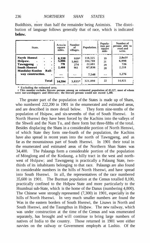
236 NORTHERN SHAN STATES
Buddhists, more than half the remainder being Animists. The distribution of language follows generally that of race, which is indicated below.
State. Area in square miles.
Number of
villages. Population.
Population per square mile-
Number of persons able to
read and write.
North Hsenwi Hsipaw. Tawngpeng . South Hsenwi Mandalay-Kunlon Rail
way construction.
Total
6,330 5,086
778 2,400
14,594
939* 1,661
274 961
118,325 104,700
22,681 67,836
7,548
19 21 29 28
2,8o3† 6,998
726 2,218
1,276
North Hsenwi Hsipaw. Tawngpeng . South Hsenwi Mandalay-Kunlon Rail
way construction.
Total
6,330 5,086
778 2,400
14,594 3,835* 321,090 22 14,021
* Excluding the estimated area. t This number excludes literate persons among an estimated population of 45,127, most of whom
were nat-worshippers and illiterate; the literate persons would not exceed 1,200.
The greater part of the population of the States is made up of Shans, who numbered 222,200 in 1901 in the enumerated and estimated areas, and are described in more detail below. They form nine-tenths of the population of Hsipaw, and six-sevenths of that of South Hsenwi. In North Hsenwi they have been forced by the Kachins into the valleys of the Shweli and the Nam Tu, and there form but three-fifths of the total. Besides displacing the Shans in a considerable portion of North Henswi, of which State they form one-fourth of the population, the Kachins have also spread in recent years into the north of Tawngpeng, and as far as the mountainous part of South Hsenwi. In 1901 their total in the enumerated and estimated areas of the Northern Shan States was 34,400. The Palaungs form a considerable portion of the population of Monglong and of the Kodaung, a hilly tract in the west and northwest of Hsipaw; and Tawngpeng is practically a Palaung State, two-thirds of its inhabitants belonging to that race. Palaungs are also found in considerable numbers in the hills of North Hsenwi, and have spread into South Hsenwi. In all, the representatives of the race numbered 35,600 in 1901. The Burman population at the Census totalled 8,100, practically confined to the Hsipaw State and more particularly to the Hsumhsai sub-State, which is the home of the Danus (numbering 4,800). The Chinese were strongly represented (7,300) in 1901, especially in the hills of North Hsenwi. In very much smaller numbers are found the Was in the eastern borders of South Hsenwi, the Lisaws in North and South Hsenwi, and the Taungthus in Hsipaw. The new railway, which was under construction at the time of the Census and was enumerated separately, has brought and will continue to bring large numbers of natives of India to the country. Those returned in 1901 were either navvies on the railway or Government employes at Lashio. Of the
POPULATION 237
population in the omitted portion of the Northern Shan States—that is, the trans-Salween part of Hsenwi (Kokang, the Wa States, and Mang-lon)—nothing but the roughest guess can be hazarded. The Kokang population is mainly Chinese, wi th a few Paiaungs, Shans, Lisaws, and Was; and much the same conditions prevail in Sonmu, except that Was predominate. The Wa States are inhabited by Was. Manglon is divided by the Salween into two portions, east and west. The eastern part is estimated to have a population of about 6,000 to 7,000, of whom 5,000 are Was; and it was calculated that the western part in 1892 contained 12,200 persons, of whom by far the greater number were Shans, the other races including Paiaungs, Lisaws, and Muhsds. Christians numbered 238, of whom 165 were natives. In 1901 the number of persons directly dependent upon agriculture was 217,775, or 79 per cent, of the total enumerated population. Of this total, 107,482 were dependent on taungya (shifting) cultivation. The figures do not include the 45,127 persons estimated in Nor th Hsenwi, who were nearly all cultivators, and mostly taungya-cutters. No fewer than 17,354 persons are supported by tea cultivation.
The T a i have been divided into the following divisions: the northwestern, the north-eastern, the eastern, and the southern. W i t h the southern, whose principal representatives are the Siamese and the Laos, we have here no immediate concern. The north-western are found for the most part on the west of the Irrawaddy, in the country between that stream and Assam ; they include the Hkamt i Shans, the T a i inhabitants of the now mainly obsolete States of Mogaung, Wuntho, Hsawnghsup, and Kale, and of the Districts of the Mandalay and Sagaing Divisions. The eastern T a i may be roughly said to inhabit the Southern Shan States, including the Shans proper of those States, and the Hkun and Lu of Kengtung and Kenghung. The north-eastern division comprises the Shan Tayoks or Shan-Chinese of the Chinese border, and the Shans of the Northern Shan States. The physical characteristics of the Shans differ but l i t t le. They are somewhat fairer than the Burmans, their features are rather flatter and their eyes often more prominent, but otherwise there is l i t t le to distinguish them from their neighbours. The northwestern Shans dress as a rule like the Burmans among whom they l i v e ; the eastern and north-eastern Shans, on the other hand, wear, instead of the Burmese waistcloth, a pair of loose, very baggy cotton trousers, and their head-cloth is fuller and more like the Indian's pagri than the Burman's gaungbaung. The men, moreover, are seldom seen without the characteristic l imp plaited grass hat of the Shan country. The dress of the women is much the same as that of the Burmans, with the addition of a head-cloth. The men tattoo their legs and body even more freely than the Burmans. The Shans are Buddhists, and their yellow-robed monks inhabit pongyi-kyaungs similar to those of Burma proper. Shan
• Q 2
238 NORTHERN SHAN STATES
is an isolating language, abounding in tones. Burmese Shan (spoken in the States), Hkamti, and Chinese Shan have been placed in the northern, and Hkun and Lu in the southern subgroup of the Tai group, one of the main subdivisions of the Siamese-Chinese sub-family of the Indo-Chinese language family. The total of Shans of all kinds in the Province in 1901 was approximately 850,000.
There is nothing peculiar connected with the agricultural conditions of the country. The valleys of the States are devoted to low-lying
irrigated rice (Shan, na), and the hills to taungya (Shan, hai) shifting cultivation. In many parts the
numerous deserted paddy-fields appear to point to exhaustion of the soil. This is especially the case at some distance from the hill-slopes; but nearer the hills, the decayed vegetable matter brought down yearly by the torrents after the destructive jungle fires fertilizes the rice lands, 'and maintains their yield. Artificial manures are hardly ever used in ' wet' cultivation. In taungya or hat cultivation the selected hill-slope is prepared by burning the grass, and ploughing and harrowing the ground. The trees are then ringed, the branches lopped off and piled round the trunk, and the whole fired just before the first rains are expected. The ashes are next distributed in small heaps and loose earth is raked over them, the leaves and stubble below are then fired, and the earth is burnt and becomes brick-red in colour, after which the heaps are again spread out and the seed is sown when the rains begin. A taungya can be worked for a term varying in different parts of the country, but rarely exceeding three years. It is a ruinous method of cultivation, for the organic matter is volatilized, and the ash constituents only are left in a highly soluble condition; the available plant-food is in consequence rapidly taken up by the crop, which diminishes each year, and a great quantity of the fertilizing matter is carried down the hill-slopes by surface drainage. In parts of the South Hsenwi State the land has been so thoroughly deforested that little remains but grass, and manure has to take the place of wood-ash in the process described above. Garden crops are grown on the slopes throughout the States in much the same way as taungyas, but cattle-manure and ashes are always freely used. The tea cultivation which affords their chief occupation to the Palaungs of Tawngpeng, and to the inhabitants of the hilly Kodaung district of Hsipaw and of Namlawk in the Wa State of Kanghso, is deserving of special mention. In Tawngpeng the dark-brown clayey loam is covered With large quantities of decaying vegetable matter, and, as the tea shrub luxuriates in the shade, a hill-slope covered with dense forest is usually selected. The gardens are not laid out on any system, but at random. Seed is collected in November and sown in nurseries in February or later. The plants are kept there till they reach a height of 2 feet or so (generally in the second year), and are then planted out in the clearings
Agriculture.
AGRICULTURE 239
in August and September. No manure is used and the trees are never pruned, as they are said to die off if this is done. They are first picked in the fourth year and continue bearing for ten or twelve years, producing three crops a year between March and October. When the yield of leaves begins to get poor, the trees are often cut down. New shoots are thrown up from the stool, and these are in turn picked. In gardens, where sufficient room is allowed for growth, the trees attain a much larger size than where close planting prevails. Trees said to be thirty years old and upwards, and still in bearing, are found here.
The total area under crops in the trans-Salween States is approximately 312 square miles, of which about three-quarters are under rice. Tea covers rather over 12 square miles. In addition to rice and tea, poppy, sesamum, ground-nuts, cotton, buckwheat, and maize are grown in the taungyas. Poppy is confined for the most part to the trans-Salween country, the hilliest portions of North and South Hsenwi, and the west of Manglon. Rice taungyas are sometimes sown with sesamum in the second and with cotton in the third year. Maize and buckwheat are grown by some of the hill tribes, and peas and beans by the Was. In the homestead plots, onions, yams, brinjals, indigo, maize, sugar-cane, millet, and beans are cultivated. The orange flourishes in many parts along the Salween and some of its tributaries, and along the Namma in Hsipaw; and the HsTpaw Sawbwa possesses excellent orange plantations on the banks of the Nam T u . The indigenous pineapple is good and is freely cultivated in South Hsenwi, the valley of the Shweli, and the Hsumhsai sub-State of Hsipaw, where also papayas are plentiful. The local mangoes and plantains do not compare well with those produced in the plains of Burma; and the crab-apples, wild plums, peaches, and pears are more interesting for their associations than for their edible properties. Wild raspberries are found in most parts of the country, and walnuts in the Wa States.
Cattle are bred for pack-work and for sale as draught bullocks to Burmans and natives of India, but are not used for ploughing, slaughtering, or even milking. Buffaloes are bred for ploughing, and are sometimes used for pressing sugar-cane and sesamum oil. By the Was they are employed for sacrificial purposes. There is a good deal of pony-breeding; but young stallions are allowed to run wild with the mares and fillies, and no care whatever is taken in selecting suitable mature beasts for propagating the breed. The small animals produced are mostly used for pack purposes, or exported to Burma for use in hired carriages. Goats and sheep are imported from China, and the latter have done well at Lashio and Tangyan. Grazing for all animals is plentiful throughout the States.
The area irrigated by means of channels taking off from the streams in the valleys is large. No precise data as to its extent are available,
240 NORTHERN SHAN STATES
but in the cis-Salween States the total is probably nearly roo square miles. Much ingenuity is spent on these canals, and on the embankments keeping the water in the terraces of paddy-fields, which follow the contour of the ground. A considerable amount is spent in some States on irrigation works, the actual digging of the waterways being often done by Maingthas. In places fields are irrigated by means of the Persian water-wheel.
Teak is found in Hsipaw, Tawngpeng, and North Hsenwi; but so far Reserves of teak have been formed in Hslpaw only, which cover
181 square miles, the largest being the Kainggyi Reserve (121 square miles) and the Nam ma Reserve
(50 square miles). It is not possible to give even the approximate areas of other forest tracts, though there are thousands of square miles of virgin forest. The hill-sides are often covered with pines (Pinus Khasya), oaks (of which there are several varieties, including the Himalayan species), and chestnuts. The pine forests are very extensive and probably cover many hundreds of square miles; they are generally found on the more exposed ridges at an altitude of about 4,000 feet. Chestnut-trees always form a subordinate feature in the forests in which they occur. Ingyin (Pentacme siamensis) and thitya {Shorea obtusd) are found in many parts of the Northern Shan States, the latter being very common in both South Hsenwi and Manglon, often occurring in the midst of pine and oak forests. Thitsl (Melano-rrhoea usitata\ the black varnish tree, grows in Hslpaw, on the northern slopes of Loi Leng, and in the Manhsang circle of South Hsenwi. The gum or resin that exudes from it is much prized for varnishing and for making lacquer-work. The Cedrela Toona is another useful tree common in both North and South Hsenwi. The wood has been found admirably adapted for da sheaths. The paper mulberry {Brous-sonetia papyrifera) furnishes the raw material used in the manufacture of Shan paper; and the silk cotton-tree {Bombax malabaricum) is valued for its down, which is employed for stuffing the pillows or pads inserted below the pack-saddles of bullocks. Both these latter trees are common throughout the States. Bamboos grow freely in the vicinity of the villages, and, as elsewhere, are put to almost every conceivable household use. The right to the timber in the forests is reserved to the British Government.
Coal has been found along the valley of the Nam Yao in the Lashio circle of the North Hsenwi State, and higher up the same stream
near Mtingyaw, as well as along the valleys of the Namma and Nam Pawng in South Hsenwi and
Hslpaw. Analysis has shown the coal found at Lashio to be of very inferior quality. The product of the Namma valley is described as bituminous coal, which should properly be called lignite, and is
Forests.
Minerals.
MINERALS 241
believed to be good fuel. A seam of lignite was recently struck in the Nam Pat valley in South Hsenwi State in the course of road-making. Tourmaline mines are worked on both sides of the Nam Pai north of the town of Mtinglong in Hsipaw, where well-rounded pebbles of black tourmaline are not uncommon, sometimes attaining the size of a walnut. Rose-pink tourmaline, on the other hand, is much rarer, and is comparatively seldom met with. Salt is manufactured at Mawhho (Bawgyo) in the Hsipaw State. The Bawgyo salt-well is said to have been worked for the last 500 years, and expert opinion has pronounced the brine from it to be the richest known in Burma. Unfortunately it has a bitter taste, which hinders its sale when other salt can be procured. A good deal of the Bawgyo salt is sold, however, in the Shan States, in parts where Mandalay salt is too expensive and where Yunnan block salt does not penetrate.
Silver and lead mines were formerly worked at Bawdwingyi in the Tawngpeng State, and at Konghka on the northern aspect of Loi Leng in the South Hsenwi State. The Bawdwingyi mines are situated in a valley 10 miles south-east of the village of Katlwi, and 5 or 6 miles north of Pangyang. Silver, lead, and copper used to be extracted from these mines, the last only in small quantities. The hills are completely honey-combed with shafts, horizontal and perpendicular, in some of which human skeletons in chains have been discovered. It is said that 2,000 Chinamen were engaged in mining here; and the ruins of stone houses, extending along the valley, and long rows of beehive-shaped smelting ovens and Chinese stone bridges, in perfect preservation, speak to the energy with which these mines were exploited a generation ago. A prospecting licence for this area was issued to a Rangoon firm early in 1902. Silver is said to have been worked in South Hsenwi also, and in the Wa country east of Monghka. Lead is found in East Manglon, and in the Wa States of Loilon and Santong. Iron is extracted at Hsoptung in the sub-State of Mongtung in Hsipaw ; and gold occurs near Hopai in the Lantaii circle, South Hsenwi, as well as in the streams tributary to the Salween. For years Burmans and Shans have cherished the story that gold in dust, nuggets, and veins was to be found in the Nam Yang Long, which runs into the Nam Hka through the Wa Pet Ken. A visit made to the locality in 1897 failed to disclose any traces of gold. Gold is, however, certainly washed from the sands of the neighbouring stream; in fact, gold-dust is nowhere a rarity in the Shan States, and washing is regularly carried on at many points along the Salween. A mining lease for 3-84 square miles in the valley of the Namma, a small tributary of the Salween, has been granted to a Rangoon firm. The project is to obtain gold by dredging and hydraulic methods. Saltpetre is obtained from bats' guano, collected from the limestone caverns common throughout the
242 NORTHERN SHAN STATES
States. Many of the Was are said to be adepts at extracting saltpetre, which they bring from beyond the Salween for sale at the Tangyan bazar and elsewhere.
The pickling of tea is the chief industry of the Palaungs in Tawng-peng and HsTpaw. On the evening of the day they are plucked, the
tea-leaves are steamed over a cauldron of boiling water. They are then spread on a mat, where they are 'rolled by hand, after which they are thrown into
pits and compressed by means of heavy weights. The leaves ferment in the pits and become pickled tea. For preparing dry tea the leaves are steamed and rolled, after which they are spread out in the sun to dry. After about three days water is sprinkled on the leaves, which are again rolled and allowed to dry. They are then sifted through a bamboo sieve, only such leaves as pass through the sieve being accepted. The best quality of pickled tea fetches from Rs. 30 to Rs. 45 per 100 viss (365 lb.), and the best dry tea from Rs. 1-4 to Rs. 2 a viss at the gardens. Pickled tea is exported in conical baskets carried by bullocks. Dry tea is packed in gunny-bags for mule transport, or is carried by porters to the railway.
Cotton-spinning and weaving are carried on by the women in nearly every household in the States, a good deal of cotton being grown in the taungyas and sold in the bazars. The implements used, the spinning-wheel, loom, and other plant, and the methods of cleaning, dressing, spinning, and weaving the cotton, are almost identical with those of the Burmans. The more expensive skirts and blankets are often interwoven with graceful and artistic patterns. Among the Shans of North and South Hsenwi curious sleeping webs of cloth are made with zigzag and diamond-shaped patterns, woven in black, red, green, and yellow, the cross-threads being often of silk. Still more intricate is the Kachin work employed in the adornment of shoulder-bags and of the female costume. The work is usually dark blue, with longitudinal blue stripes, but is sometimes all white or composed of equal stripes of red, white, and blue, into which are woven, at intervals, little stars, crosses, or squares of various colours and irregular shapes. Raw silk is obtained by the Shans from the Wa and Lao States, and finds favour in South Hsenwi in the weaving of skirts and blankets. Dyeing is practised in most Shan households where weaving is done, and in most parts of South Hsenwi State, where the beautiful natural dyes of the country still hold their own against the cruder aniline colours of European manufacture. The most common dyes used by the Shans are obtained from the Bixa Orellana, from stick-lac, from indigo, and from the yellow wood of the jack-fruit tree.
The Shan gold- and silversmiths are clever workers, and occasionally turn out very good repousse work in the shape of gold and silver lime,
Trade and communications.
TRADE AND COMMUNICATIONS; 243
betel, and other boxes, and da and dagger scabbards, gold and silver trappings for Sawbwas' ponies, hairpins, rings, jewellery, goblets, and other articles. Blacksmiths are common throughout the States. Ploughshares are forged, and dos, choppers, spades, and other agricultural implements are manufactured locally. Many of the Was are clever smiths, and Namhkam in North Hsenwi is a great centre for local hardware, which is, however, all manufactured by Chinese or Maingtha smiths, who set up their forges in the town every year. Brass-work is less common, but occasionally large monastery bells are cast, as well as the booming bullock bells which swing on the necks of the leading beasts of the caravans. Images of Buddha and tattooing implements are made at Hsenwi town, also brass buckles for belts and betel-nut pounders.
Pottery, in the shape of clay water-bottles and earthen chatties, is manufactured at Tapong and Namhon and other villages in South Hsenwi, at Manpan in Mongtung (Hslpaw), and at Namhkam, Kokang, and elsewhere. North and South Hsenwi turn out a certain amount of red lacquer-work, the principal articles manufactured being the round trays or salvers standing on legs which are used for religious offerings. The lacquered goods consist of a framework of woven bamboo, smeared over with a mixture of rice ash and black varnish extracted from the mai hak or thitsi tree (Melanorrhoea usitata), which, after being dried in the sun, receives a coat of red sulphide of mercury. A certain amount of wood-carving is done. It generally takes the form of wooden images of Gautama and of gilded scroll-work (known as tawng-lai-mawk to the Shans), used for decorative purposes in the monasteries, and on the tazaungdaings which are placed round or near pagodas. Mat-weaving and basket-making are practised generally. Grass mats are woven at Tangyan and Namhkam ; but the ordinary kinds are the hsatpyu mats, made from the outer, and hsatnu from the inner part of the bamboo. The manufacture of a coarse-textured paper from the bark of the paper mulberry (Broussonetia papyrifera) is carried on wherever that particular tree is found.
The means of transport employed in the trade of the Northern Shan States now includes the railway from Mandalay to Lashio; and the system of feeder cart-roads connecting the railway with the interior has, to some extent, superseded the older means of transport by mules, pack-bullocks, and pakondans (petty traders who carry their goods on their shoulders). A large trade in surplus rice finds its way by means of bullock caravans to Tawngpeng, the great tea-producing area, where very little rice is cultivated. In former days the rice was exchanged for tea, pickled and dry, which the traders brought down and sold in Mandalay. The cash they received for their tea enabled the traders to return to the Shan States with salt, ngapi, salted fish, cotton goods,
244 NORTHERN SHAN STATES
yarn, matches, kerosene oil, and betel-nuts. Since the opening of the railway, however, the great bulk of the tea produced is exported, and most of the goods for the Shan market are imported, by rail. But few caravans now make the through trip to Mandalay. As a means of transport the pack-bullock is probably as much used as ever; but the bullock caravans now ply between the tea gardens and the railway, or find their profit in bringing rice to the railway and distributing rail-borne imports throughout the country. Chinese caravans pass through the Northern Shan States every open season on their way to and from the Southern Shan States and Northern Siam. They bring iron cauldrons, copper cooking pots, straw hats made especially for the Shan market, walnuts, persimmons, satin, opium, felted woollen carpets, and fine tobacco. The Panthay settlement at Panglong in Sonmu is a large trading community which does business with Burma and the trans-Salween States. The Was cultivate and export to China large quantities of opium, and agents from Kengtung come north as far as West Manglon and South Hsenwi to purchase the drug. Karenni cutch is brought north by Mongnai bullock traders, who also fetch up iron agricultural implements from Laihkal. A considerable trade is carried on during the winter months in oranges from Nawnghkam (West Manglon), Namma (Hslpaw), and Hsipaw itself, and during the rains in Salween betel-leaf from Nawnghkam. Stick-lac is collected to a large extent by the Kachins of North Hsenwi, who sell it to Indian dealers in the Lashio bazar, whence it is exported to Burma; and carts from "Mandalay and Hslpaw now go far afield into South Hsenwi for rice and sesamum. There is a busy local trade in the interior in home-grown tobacco, fruit, and vegetables; and the bazars are always well attended. The largest marts are those at Namhkam, Hslpaw, Nawnghkio, My-aukme, and Namlan. Manchester cotton goods are rapidly supplanting home-made stuffs. Imported yarns and twist, aniline dyes, German-made pencils, and imitation two-anna-piece buttons are among the most noticeable of the imported articles. The value of the imports from Burma to the Northern Shan States reached a total of 38 lakhs in 1903-4: by the Mandalay-Lashio railway, 22-6 lakhs; by the Maymyo road, 5.8 lakhs; by Namhkam and Bhamo, 5 lakhs; via the Ruby Mines District, 4.7 lakhs. The principal items were European cotton piece-goods (valued at 8.4 lakhs), salted fish and ngapi (5.5 lakhs), salt (3*2 lakhs), twist and yarn (mostly European) (3.9 lakhs), Indian cotton piece-goods, petroleum, cattle, betel-leaf, and tobacco. The exports from the States to Burma in the same year were valued at 56½ lakhs: by the railway, 31.7 lakhs; by the Maymyo road, 6.6 lakhs; by Namhkam and Bhamo, 5.7 lakhs; through the Ruby Mines District, 4.5 lakhs; timber and forest produce floated down the Shweli and other streams, 8 lakhs. The chief items were pickled tea (22 lakhs),
ADMINISTRATION 245
other tea (9 lakhs), teak timber (7.5 lakhs), husked rice (2.3 lakhs), ponies and mules, til seed, and wax.
Of prime importance in the economy of the country is the Mandalay -Lashio railway, 180 miles in length, of which 126 miles lie within the Northern Shan States. The line is a single track, and was constructed in the face of considerable engineering difficulties, of which not the least notable was the Gokteik gorge, now spanned by a viaduct. It had been proposed to continue the railway about 90 miles farther east to the Kunlong, an important ferry over the Sal ween, and eventually to penetrate into Yunnan; but this extension is for the present in abeyance. The railway enters the south-west corner of the Hslpaw State from Mandalay District, and traverses the State in a north-easterly direction, passing through Hslpaw town and ending at Lashio in North Hsenwi. The Sawbwas of Hslpaw and North and South Hsenwi have spent large sums in constructing feeder roads through their States to the railway. Practically parallel with the railway is the Government cart-road from Mandalay to Lashio, bridged but not metalled, running for in miles through the States. The principal branch cart-roads, connecting with either the railway or the Government cart-road, are: Nawnghkio to Tawnghkam (24 miles), Nawnghkio to Kalagwe (35 miles), Gokteik to Haikwi and Pongwo (18 miles), Pyawnggawng to Monglong (55 miles), Hslpaw to Mongtung (76 miles), with branches to Kehsi Mansam (13 miles) and to the Mongkiing border, connecting with the Southern Shan States system, Hslpaw to Tati (7 miles), Hslpaw to Mongyai (61 miles), Mongyai to Mongheng (37 miles), Lashio to Tangyan (80 miles), with a branch to Mongyai, Lashio to Hslpaw (14 miles), Lashio to Mongyang (21 miles), and Lashio to Kutkai (51 miles). Innumerable rapids and rocks limit navigation on the rivers to short reaches, and the only boats in use are dug-outs, excepting at the ferries. The ferries across the Salween (as we descend the river) are the Mongpawn and the Monghawm, connecting the Kokang district of North Hsenwi with the cis-Salween country, and the Kunlong (near the mouth of the Nam Ting). These lead into North Hsenwi. Below them are the Mongnawng (or Hsaileng) and the Kawngpong, between South Hsenwi and the Wa country; the Kwipong, the Loihseng, and the Manhsum, used by traders crossing from West Manglon to East Manglon, Monglem, and other places east of the Salween.
Five States are controlled by the Superintendent of the Northern Shan States, the chief civil officer (a member of the Burma Commission), who has his head-quarters at LASHIO. These are: NORTH HSENWI in the north, SOUTH HSENWI near the Salween in the east, MANGLON in the south-east, HSIPAW in the south-west, and TAWNGPENG in the north-west. The W A STATES
Administration.
246 NORTHERN SHAN STATES
east of the Sahveen can hardly be said to be under British control. In ordinary matters the States are administered by their Sawbwas, who are assisted by amats or ministers in various departments. An Assistant Superintendent at Hsipaw advises the Sawbwas of Hslpaw and Tawng-peng, officers of similar rank at Kutkai and Tangyan supervise the affairs of the Sawbwas of North and South Hsenwi and Manglon, and an officer of the Subordinate civil service has lately been posted to Namhsan to help the Tawngpeng Sawbwa in the administration of his charge. The extensive Kachin colony in the North Hsenwi State is directly under the civil officer at Kutkai. Lashio itself has been made practically part of Burma proper.
In the Northern Shan States the criminal and civil administration is vested in the Sawbwas, subject to the limitations laid down in their sanads (deeds of appointment), and to restrictions imposed by the extension of enactments and the issue of orders under the Shan States Act or the Burma Laws Act. The customary law of these States has been modified by a notification which specifies the punishments that may be inflicted for offences against the criminal law, limits the infliction of certain punishments to the more heinous offences, and prescribes simple rules of procedure in criminal cases. The Superintendent exercises general control over the administration of criminal justice, has power to call for cases, and is vested with wide revisionary powers. Al l criminal jurisdiction in cases in which either the complainant or accused is a European or American, or a Government servant, or a British subject not a native of a Shan State, is withdrawn from the chiefs, and vested in the Superintendent and Assistant Superintendents. In the cases above mentioned the ordinary criminal law in Upper Burma, as modified by the Shan States Laws and Criminal Justice Order, 1895, is in force. In such cases the Superintendent exercises the powers of a District Magistrate and Sessions Judge, and the Assistant Superintendents exercise the powers of a District Magistrate under sections 30 and 34 of the Code of Criminal Procedure. The Superintendent and Assistant Superintendents, if European British subjects, are also ex-officio justices of the peace in the States. The Superintendent has been especially empowered to withdraw from subordinate magistrates such cases as he thinks fit. He can now also take cognizance of any criminal case, and try or refer it to a subordinate magistrate for trial. The Superintendent and each Assistant Superintendent exercise the powers of a magistrate under the Foreign Jurisdiction and Extradition Act, parts of which are in force in the States. In regard to the administration of civil justice, the customary law has been modified by a notification of 1900, which confers original appellate and revisional jurisdiction on the Superintendent and Assistant Superintendents, creates local courts, and prescrites a simple judicial pro-
ADMINISTRATION 247
cedure. Various Acts and Regulations have been extended to the Northern Shan States, and the Gambling, Excise, Cattle Trespass, and certain other Acts are now in force in the civil station of Lashio. In North Hsenwi, the Kachin H i l l Tribes Regulation has been extended to the Kachin area. The most prevalent offences occurring in the Northern Shan States are cattle and pony thefts, and (in Hsipaw State) opium cases.
In revenue matters the Sawbwas administer their States in accordance with local customs, which have been but little modified. The main source of revenue is thathameda. In Hsipaw it is levied at the rate of Rs. 10 per household; in Tawngpeng, at Rs. 20 on tea-garden cultivators, Rs. 10 on cultivators of irrigated land, and Rs. 5 on Kachins; in North Hsenwi, at Rs. 4-8 on Kachin families in the Kachin tract, and at Rs. 5 on Shans or other races, whether settled in the Kachin tract or in the Shan circles; in South Hsenwi, at Rs. 10 on cultivators of low-lying rice land and Rs. 6 on taungya-cuttexs. Taxes on rice and tea cultivation, bringing in Rs. 58,000 in 1903-4, are levied in the Hsipaw State, and a tax, yielding Rs. 62,000, is assessed on every bullock-load of tea exported from Tawngpeng. A tax on opium and liquor is raised by means of licence fees in Hsipaw and Tawngpeng, which brought in Rs. 42,000 in 1903-4. The total revenue collected in the five cis-Salween States in that year amounted to Rs. 6,26,000, the Hsipaw State alone receiving considerably more than half. Thathameda realized Rs. 3,87,000, and the total tribute paid to the British Government was Rs. 1,20,000.
The Sawbwas are responsible for the suppression of crime and the preservation of order in their States, and some of them maintain small irregular police forces. In addition, Government maintains a civil police force, which consists of one European Assistant Superintendent of police, who is stationed at Lashio, one Burman head constable, and 65 policemen recruited in the Shan States. These police are for the most part engaged in the prevention and detection of crime in the tract of country directly bordering on the railway. There are 3 police stations—at Lashio, Hsipaw, and Nawnghkio. The Northern Shan States military police battalion has its headquarters at Lashio. The force is under a commandant, with one assistant commandant, and the total strength of the battalion is 505 men. The majority of them are stationed at Lashio, and there are 100 at Kutkai and 30 each at Hsipaw and Tangyan.
Hsipaw State maintains a jail of its own, with an average of about 20 convicts. The prisoners are engaged in outdoor work, and keep up the jail garden, which produces vegetables for sale in the local bazar. They also undertake repairs on State buildings, the jail itself being a product of prison labour. Short-term prisoners in other
248 NORTHERN SHAN STATES
States are kept in the State lock-ups. Long-term prisoners are sent to serve out their sentences in a Burma jail.
Elementary education is imparted in the pongyi kyaungs of the States, but the standard of literacy is low, and in 1901 only 9.7 per cent, of the male population were able to read and write. American Baptist Mission schools are maintained at Hsipaw and Namhkam, and the Hsipaw school has 2 masters and about 40 pupils.
There are civil hospitals at Lashio and Hsipaw, with accommodation for 22 in-patients, and a dispensary at Kutkai. In 1903 the number of cases treated was 10,336, including 366 in-patients, and 119 operations were performed. The income amounted to Rs. 7,800, derived almost entirely from Provincial funds. There is a hospital at Hsipaw, managed by the American Baptist Mission, with 24 beds. In 1903 the number of cases treated at this institution was 1,846, including 20 in-patients. Another hospital, under the same agency, is situated at Namhkam.
In 1903-4 the number of persons successfully vaccinated was 7,233, representing 23 per 1,000 of the population.
[Sir J. G. Scott, Upper Burma Gazetteer (5 vols., Rangoon, 1900-1); Burma: a Handbook of Practical Information (1906); C. C Lowis, A Note on the Palaungs (Rangoon, 1906).]
Shan States, Southern,—A group of Native States in Burma, under the charge of a Superintendent, lying between 190 20' and 220 16' N. and 960 13' and 1010 9' E., with an area of about 36,000 square miles. They are bounded on the north by the Northern Shan States, from which they are separated for some distance by the Nam Tu or Myitnge river; on the east by China; on the south by China, the French Lao territory, Siam, and Karenni; and on the west by the Kyaukse, Meiktila, and Yamethin Districts of Upper Burma, and the Toungoo District of Lower Burma.
With the exception of a tract on the western boundary and the eastern half of the Kengtung State towards the China border, the
States lie in the drainage area of the Salween, which roughly bisects them, flowing first in a general southerly course, and then south-west into Karenni.
The eastern part of the Kengtung State drains into the Mekong, of which the principal tributaries are the Nam Lwi, the Nam Lin, and the Nam Hkok, the last named flowing for the greater part of its course in Chinese territory. The most noteworthy tributaries of the Salween on its eastern side within the limits of the Southern Shan States are the Nam Hka, forming the northern boundary of the trans-Salween areas, and the Nam Hsim farther south. Its western tributaries are of more importance than its eastern, and their courses are all more or less parallel with that of the Salween itself. The Nam Pang rises in South Hsenwi in the Northern Shan States, and waters the north-eastern
Physical aspects.
SOUTHERN SHAN STATES 249
cis-Salween States, joining the Salween in the Kenghkam State after a general southerly course. The Nam Teng rises in the north in Mongkung and flows south into Mongnai; there it bends eastwards till within 13 miles of the Salween, after which it turns south-west, and eventually joins the Salween about 15 miles above the Karenni boundary, after a course of about 250 miles. West of the Nam Teng is the Nam Pawn. This stream has its source in the hills of Laihka and flows southwards into Karenni, emptying itself finally into the Salween after a course of 300 miles. At about 200 N. it is joined from the west by the Nam Tamhpak, which rises in the small Hopong State and drains the eastern half of the central division, running parallel with the Nam Pawn, at a mean distance of 20 miles to the west of it. West of the Tamhpak again is the Nam Pilu or Balu chaung) which waters several of the small Myelat States, enters the Inle Lake, and then leaves it in a southerly direction, draining the southern States of the central division. It finally enters Karenni, where it disappears underground, its waters flowing in unknown channels to the Nam Pawn. A portion of the western States belongs to the Irrawaddy drainage. The Nam Tu or Myitnge runs along the northern boundary, receiving the waters of the Nam Lang, with its tributary the Nam Et, from the south, before entering the Irrawaddy valley. The last two rivers water the whole of the extreme northwestern area except the south-western portion of Lawksawk, which is drained by the Zawgyi. This stream has its fountain-head in the Myelat, runs north for some distance in the Lawksawk State, then bends abruptly south-west, traversing the north of Maw, and finally leaves the hills in Kyaukse District to join the Irrawaddy. The Paunglaung river rises in the hills that form the boundary between Yarnethin and the Myelat, and emerges on the plains in Yamethin District, where it is renamed the Sittang.
The principal hill ranges, like the rivers, run generally north and south. Along the western boundary is a lofty range towering over the plains of Yamethin and Kyaukse Districts, containing the prominent peaks of Sindaung and Myinmati, near Kalaw, and averaging over 5,000 feet. East of this range lies the Menetaung range in Pangtara, a bold block of hills culminating in a peak known as Ashe-myin-anauk-myin (7,678 feet); and east of that again the Loi Sang range divides the valleys of Yawnghwe and the Tamhpak. Farther east, separating the valleys of the Tamhpak and the Nam Pawn, is a long range terminating in the north of Karenni, and rising to over 8,000 feet in two peaks, Loi Mai and Loi Maw. Beyond the Nam Pawn runs a parallel range, twice exceeding 8,000 feet. Eastward of this system are no well-defined continuous hill ranges, the country up to the Salween consisting of a high plateau cut up by valleys; nor do such
250 SOUTHERN SHAN STATES
ridges exist in the trans-Salween States, though the country is for the most part very rugged, and lofty hill masses are grouped near the frontiers. The Myelat, east of the high range separating it from Burma proper, is characterized by open rolling downs, large tracts of which are almost treeless and rather dry, the average level of the country being at a considerable altitude. Eastwards of the Myelat the scenery changes from tropical to alpine, the main features being the lateral ranges and intervening valleys described above. The first of these tracts of lowland is the well-watered Yawnghwe valley, which displays alternate expanses of park-like savannah forest and well-tilled land, with the great Inle Lake in its centre. Eastwards of this comes the basin of the Tamhpak, where broad plains of irrigated rice land are backed by grassy downs sloping up to the hills; and beyond this lies the typical highland strath in which the Nam Pawn runs. Thence to the Salween extends a wide plateau, with its rolling prairies well timbered in parts, broken up in places by outcrops of detached hills, and varied by stretches of picturesque river scenery along the Nam Teng and Nam Pang.
The only large lake in the States is the Inle in Yawnghwe, about 12 miles long and 6 broad, draining by the Nam Pilu river into the Salween. Two smaller lakes are situated in the north-east of Mongnai and in Hsahtung.
Not much is known of the geology of the Southern Shan States, except along the section east and west of Taunggyi, where the rocks have been classified as follows 1 The oldest rocks consist of gneisses with veins of syenite and granite, and are exposed only along the western edge of the plateau. Beyond these, limestone is the prevailing rock, the lower portion probably corresponding to the Devonian limestone of the Northern Shan States, but it includes also fossiliferous beds of Permian age which are found east of Taunggyi. Purple sandstones are either faulted or folded in among the limestones, and may represent the Mesozoic sandstones found between Hsipaw and Lashio. Sub-recent beds of conglomerate sands and loams occupy longitudinal valleys between the ridges of limestone.
Along the western border runs a belt of tarai forest reaching to about 2,000 feet, of which the most conspicuous constituents are bamboos, Dipterocarpus, Dillenia, and climbers like Spatholobus and Congea tomentosa. From 2,500 to 4,000 feet the hills are clad with vegetation of a different character and composed of much larger trees, comprising such genera as Schima, Saurauja, Turpinia, Dcdbergia, Caesalpinia, Bauhinia, Terminally Lagerstroemta, Strychnos, and Quercus. Several arboreous Compositae are also to be found in this
1 C. S. Middlemiss, General Report', Geological Survey of India, 1899-1900, p. 112.
HISTORY 251
belt There is a plentiful undergrowth of shrubs and herbaceous plants; and ferns, mosses, and lichens abound. At an altitude of over 4,000 feet the forest gives place to an open rolling plateau of rounded grassy hills, with scattered clumps of oaks and pines, the vegetation being temperate in character. Species of Ranunculus, Clematis, Viola, Polygala, Hypericum, Primula, and Swertia abound, as well as representatives of the more tropical genera, such as Les-pedeza, Codonopsis, Ipomaea, and many Labiatae 1. Further particulars about the vegetation of the States will be found under the head of Forests.
The elephant, bison, tsine or hsaing (Bos sondaicus), and rhinoceros are met with, as well as the tiger, leopard, and other felidae. Sambar, swamp deer, hog deer, and barking-deer are common; bears are widely distributed; but the wild dog and the jackal are rare, as also is the serow. Hog are found everywhere, and the gibbon and monkeys of various kinds are numerous. Among snakes the Russell's viper is the commonest, while the hamadryad, cobra, and python are all occasionally met with. The harrier and kestrel are often seen, and very rarely the Himalayan eagle. The cuckoo is a regular visitor, and a lark (identical with the English bird) is common. The list of waterfowl, both migratory and indigenous, is large, and among the rarer visitors may be mentioned the wood-snipe and woodcock.
Portions of the States, such for instance as the country about the town of Kengtung and several of the tarai areas, are very unhealthy, but on the whole the climate is fairly temperate and salubrious. In the deeper valleys the weather is humid in the rainy season, and very hot during March and Apri l ; on the uplands the heat during the day in those two months is considerable, but there is always an appreciable drop in the temperature at night. In December and January frost is quite common, and even in Mawkmai, one of the lowest valleys, the thermometer has been known to fall to freezing-point. The headquarters station of Taunggyi has an annual mean temperature of 66°. The rainfall throughout is moderate, lessening towards the east. In Taunggyi the annual average is about 60 inches, and at Thamakan (Hsamonghkam) in the Myelat about 38.
It cannot be said with certainty who were the original inhabitants of the Shan States, but it is probable that the Ta i (see N O R T H E R N S H A N STATES) came into a country already occupied by Was, Palaungs, Yins, Taungthus, and Karens. At any rate Burmese authority was undoubtedly brought to bear on the Southern Shan States long before permanent control was gained over Hsenwi, which was early in the seventeenth century, when the
1 H. Collett and W. B. Hemsley, ' On a Collection of Plants from Upper Burma and the Shan States,' Journal of the Linnean Society, Botany, vol. xxviii.
VOL. X X I I . R
History.
252 SOUTHERN SHAN STATES
Mao Shan kingdom came to an end. In the remoter parts Burmese suzerainty was practically without effect in those early days, but in the nearer States it was an active and oppressive reality which slowly crept eastward, despite the influence of China. Wasted by internecine warfare of the most savage description, and by the rapacity of the Bur-mans, the States in time declined in power. The government of Ava fostered feuds both between the States and within them, so as to keep their rulers too weak for resistance. Risings were put down by calling out troops from the surrounding principalities, who were only too ready to ravage the rebellious area; in fact, some of the States are but now beginning fully to recover from the effects of those troublous days. The chief centre of Burmese administration in the years preceding the annexation of Upper Burma was Mongnai, the capital of the most powerful chief, where an officer with the title of Bohtnumintha had his head-quarters. Troops were kept here and at Paikong, in Karenni, opposite Mongpai, the latter for the purpose of watching the Red Karens. Burmese Residents were appointed to the courts of all the States, but their counsels received but scant attention across the Sal-ween. As at present, the Sawbwas administered their own charges, and exercised powers of life and death, and, what was probably more important, collected taxes. There was no check on oppression, though it was always open to the persecuted subject to remove to another State. After the death of king Mindon M i n the administration collapsed, as it did over all the outlying parts of the Burmese dominions. The first chief to revolt was the Sawbwa of Kengtung across the Salween, who quarrelled with his suzerain over the appointment of a new Sawbwa to the neighbouring State of Kenghung (now in Chinese territory), massacred the Burmese Resident and staff, and burnt Kenghung. King Thibaw was too weak to retaliate, and the powerful chief of Mongnai joined in the revolt, followed by the Sawbwas of Mongnawng and Lawksawk. These more accessible States, however, on joining the general rebellion, were overrun by the Burmese troops, and the three Sawbwas had to take refuge in Kengtung in 1884. Here the first attempt was made at a Shan coalition with the intention of throwing off the Burmese yoke, and it appears probable that only the unexpected annexation of Burma itself by the British prevented the formation of a powerful Shan kingdom. A leader was selected in the Linbin prince, a nephew of king Mindon, who had escaped the wholesale massacre of the royal family by Thibaw's servants, and who arrived at Kengtung at the very time when the British expedition was being dispatched to Mandalay. The Burmese troops had been withdrawn, and it was a question of forcing on the States, some more or less unwilling, the ruler the allies had chosen. The Linbin faction crossed the Salween early in 1886; Mangnai was
HISTORY 253
attacked, and an unfrocked pongyi named Twet Nga L u , who had been administering the State since the Sawbwa's flight, was driven o u t ; the rightful ruler was restored, and the Lawksawk and Mongnawng chiefs regained their dominions. The allies, who were soon joined by the south-western and many of the Myelat States, next set themselves to the task of persuading or compelling the other States to accept the L inb in prince as their leader. To this end they turned their attention to Kehsi Mansam, Mongkiing, and Laihka, which had furnished troops to drive the Mongnai Sawbwa from his k ingdom; the last was ravaged from end to end, and the two former fared nearly as badly. About the same time Mongpan in the south was raided by the Mawk-mai ruler, and the capital was sacked. The Sawbwa of Lawksawk then proceeded to avenge himself on Yawnghwe, to which the former State had been subordinated by the Burmese government when the Sawbwa fled to Kengtung; but the Sawbwa of Yawnghwe had by this time tendered his allegiance to the British Government, and, with some of the Myelat States behind h im, was able to maintain himself against the L inb in confederacy, which had been pressing on him from the north and east. It was not, however, unt i l the arrival of an expedition under Colonel Stedman in 1886 that the investment of Yawnghwe and its Myelat allies ceased. This expedition started from Hlaingdet in Meik-tila District, and encountered some slight opposition from the Lawksawk forces; but beyond this there was no resistance. The submission of Yawnghwe and the Myelat States was obtained without difficulty, and the Superintendent of the Shan States was installed in his charge, a post being established at Fort Stedman on the Inle Lake near Yawnghwe. The submission of these States was followed by that of the south-western States, where there had been trouble with the Red Karens; and the Superintendent then called on the Sawbwas of Mongnai and Mongpawn, the most active of the L i n b i n coalition, to submit to the British Government. They, however, merely withdrew to their territories. Matters were complicated at this stage by the States of Laihka, Mongkung, and Kehsi Mansam, which had suffered at the hands of the L i n b i n confederacy, and which took the opportunity of making a retaliatory raid on Mongpawn, the Sawbwa of which was the L i n b i n prince's most influential supporter. The Superintendent, accordingly, after driving the hostile Sawbwa of Lawksawk out of his State, marched into Mongpawn, and brought about the reconciliation of the chiefs and the submission of the L i n b i n faction. The prince himself surrendered and was deported; and by June, 1887, al l the cis-Salween Shan States had been brought under British rule and were free from disturbance. The Superintendent in 1887-8 made a tour throughout the States, and received the personal submission of the Sawbwas, settling their relations to the Government and to
R 2
254 SOUTHERN SHAN STATES
each other, without a shot being fired. Some trouble was caused by the ex-pongyi Twet Nga Lu, who in 1888 was able to drive out the M6ngnai Sawbwa and establish himself in his capital, but he was eventually shot in the same year. The column which dealt with Twet Nga Lu was called upon to quell disturbances in the Southern Myelat States, which had been brought about by the chief of Yawn-ghwe; and, after it had settled matters in Mongnai, had to turn its attention to Mawkmai, which had been invaded and reduced to vassalage by Sawlapaw, the chief of Eastern Karenni, or Gantarawadi. Order was re-established in Mawkmai, but in June, 1888, Sawlapaw again attacked the State. He was, however, driven back with very severe loss; and as he refused to surrender, a punitive expedition entered Sawlon, his capital, in 1889 and, on his flight, Sawlawi, his heir, was appointed in his place. Finally, the Kengtung State on the farther side of the Sal ween submitted in 1890. Considerable difficulties arose with Siam about this time concerning certain trans-Salween dependencies of Mawkmai, Mongpan, and Karenni. In 1889-90 an Anglo-Siamese Commission, in which the Siamese government declined to join at the last moment, partitioned these tracts, and the Siamese garrisons were withdrawn from so much of the country as was found not to belong to Siam. The demarcation of this frontier was finally carried out by a joint Commission in 1892-3. The Anglo-French boundary was settled in 1894-5, when the State of Kengcheng was divided between the two countries, the Mekong forming the boundary, and the cis-Mekong portion being added to Kengtung. The boundary of the Kengtung State and China was settled by the Anglo-Chinese Boundary Commission of 1898-9.
The most important pagodas are those at Angteng and Thandaung in Yawnghwe, said to have been built by Dhamma Thawka Min (Asoka) and Anawrata; their annual festivals are largely attended. In the Pangtara State is the Shweonhmin pagoda, a richly gilt shrine in a grotto in the hill-side. The sides and roof of the cave are crowded with statues of Buddha and emblems of the faith. There is a larger attendance at its festival than at any other in the Southern Shan States, except perhaps that of Mongkiing. In the Poila State is the Tame pagoda, covered on the upper half with copper plates and much revered. Both the Pangtara and Poila pagodas are said to have been built by Asoka and repaired by Anawrata of Pagan.
The population of the Southern Shan States in 1901 was 770,559. Its distribution is given in the table on the next page, which shows
considerable variation in density of population. The small States of Pangmi and Nawngwawn are as
thickly populated as the delta Districts of Lower Burma. With the exception of Yawnghwe, none of the larger Sawbwaships show a high
Population.
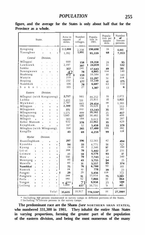
POPULATION 255 figure, and the average for the States is only about half that for the Province as a whole.
State. Area in square miles.
Number of
villages.
Population in 1901.
Population per square
mile.
Number 1 of
literate persons.
K e n g t u n g . . . . 1 2,000 2,338 190,698 16 4,441 Y a w n g h w e 1,392 1,091 95,339 68 7,353
Central Division,
M o n g p a i . . . . 660 158 19,358 29 95 L a w k s a w k . . . . 2,197 397 1 24,839 1 1 532 S a m k a . . . . 357 241 17,643 49 581 N a w n g w a w n 42 78 4,805 1 1 4 140 H s a h t u n g . . . . 472 I 159 10,584 2 2 143 W a n y i n . . . . 219 158 11,297 51 2 1 8
H o p o n g . . . . 232 177 11,140 48 175 N a m h k o k . . . . 106 78 6,687 63 114 S a k o i . . . . . 103 27 1,387 13 6
Eastern Division.
M o n g n a i ( w i t h K e n g t a w n g ) 2,717 981 44,252 16 2,072 L a i h k a . . . . 1,433 531 25,811 18 1,022 M a w k m a i . 2,787 443 29.454 1 0 1,393 M o n g p a n . 2,300 196 16,629 7 553 M o n g p a w n 371 2 1 2 13,143 35 302 M o n g n a w n g 1,575 777 39,102 25 417 M o n g k i i n g . 1,643 627 30,482 18 400 M o n g s i t 303 184 9,013 30 207 Kehs i M a n s a m 632 378 22,062 35 429 K e n g h k a m . 167 52 5,458 33 379 M o n g h s u ( w i t h M o n g s a n g ) . 164 265 17,480 106 2 6 2
K e n g l o n . . . . 43 69 4,259 99 1 2 8
Myelat Division.
H s a n i o n g h k a m . 297 196 12,561 42 494 K y a w k k u . 94 33 4,771 51 323 K y o n g 24 2 0 2,340 97 160 L o i - a i 2 0 0 70 5,442 27 231 L o i m a w 49 59 4,576 93 37 M a w . 550 70 7,743 14 340 M a w n a n g 40 43 3,755 94 25 M a w s o n 40 31 3,557 89 374 Namhkai 75 76 6,780 90 103 N a m t o k 2 0 12 778 39 23 P a n g m i I 29 29 3,456 1 1 9 372 Pangtara 2 0 0 91 15,014 75 1,565 P o i l a . 1 0 2 62 7,866 77 864 Y e n g a n • 4°° i 71 9,958 25 1 580 L o i l o n g 1,600 437 30,731 l9 461
T o l a ! 35,635 10,917 770,559* 2 2 27,390†
* Including 300 persons enumerated in survey camps in different portions of the States. f Including 76 literate persons in the survey camps.
The predominant race are the Shans (see NORTHERN SHAN STATES),
who numbered 331,300 in 1901. They inhabit the entire Shan States in varying proportions, forming the greater part of the population of the eastern division, and being the most numerous of the many
i$6 SOUTHERN SHAN STATES
races inhabiting the Kengtung State across the Salween. In the central division they are not in the majority, the Taungthus taking their place, and they tend to confine themselves to the valleys, as along the Nam Tamhpak. In these States and in Loilong they are, however, numerous. In the rest of the Myelat States they are poorly represented. Next in importance from a numerical point of view are the T A U N G T H U S , of whom there were 124,900 in 1901. They abound most in the southern States of the central division, forming the entire h i l l population there; and they are strongly represented in all but the Northern Myelat States, gathering most thickly on the mountains bordering Burma proper. Considerable numbers of them inhabit the western half of the eastern division, but in the Salween valley and in the north-eastern States they are practically unknown. The D A N U S , a race of mixed Burman and Shan origin, and to a large extent speakers of Burmese, numbered 50,900 in 1901. They are the preponderating race in the Northern Myelat States, and are strongly represented in the northern States of the central division. The total in 1901 of the I N T H A S (lake-dwellers), who inhabit the valley of the Inle Lake and of the Upper Nam Fi l i i , was 50,500. The Hkun Shans, numbering 41,500, are practically confined to the Kengtung State beyond the Salween, where too are found the hill-dwelling Kaws or A K H A S (26,000), the Lu Shans (16,200), and the W A S (23,800). The Taungyos (16,500)—a h i l l tribe, who have been hitherto classified with the Taungthus, but who are probably more closely allied with the Burmans—are met with in the centre of the Myelat d ivis ion; the Karens (18,700) live in the southern States of the central and eastern divisions bordering on K A R E N N I , and the Muhsos (15,800)—a Tibeto-Burman community who appear to be connected with the Lisaws— on the highest hills i n the east of the Kengtung State. The F A L A U N G S in 1901 numbered 11,800. They are nowhere thickly distributed, but are spread over all the northern half of the Southern Shan States from Burma proper to the Salween, as well as in parts of Kengtung. The Padaungs (7,800)—a Karen community, best known to Europeans by reason of the brass rings with which their women elongate their necks— form a large part of the population of Mongpai, a State in the extreme south-western corner, on the Karenni border. Only 12,100 Burmans were enumerated in the States in 1901, although 91,700 persons were returned as ordinarily speaking Burmese. Less important from a numerical point of view are the Riangs or Yins (3,100), a pre-Shan tribe of Mon-Anam extraction, inhabiting the north-eastern cis-Salween States, and very closely allied wi th the Palaungs; and the Zayein Karens (4,140) of Loilong, the southernmost State of the Myelat division. There were not quite 1,000 Chinese in 1901, most of whom were born in the States. According to religion, Buddhists in 1901
AGRICULTURE 257
numbered 696,800, and Animists (mainly trans-Salween non-Shan tribes) 69,900. Comparatively few Musalmans and Hindus are found. Almost the only natives of India are Government servants and followers. Christians numbered 1,528, of whom 1,483 were natives. The American Baptist Mission has stations at Mongnai, in the eastern division, and at Kengtung. The population dependent upoa agriculture in 1901 was 524,100, or 68 per cent, of the total; and of this total 262,200 persons, or about half, were dependent almost wholly on taungya (shifting) cultivation.
Cultivation in the Southern Shan States may be grouped under three heads: irrigated crops, ' dry' field crops, and garden crops. There are no regularly constructed canals; but advantage is taken of every stream in the country, and by means of weirs and small distribution channels, or water-wheels where the banks are high, large areas in the valleys are irrigated. Terraced fields also, fed by the waters of mountain brooks, are constructed with great labour wherever the ground allows, and the agricultural conditions are such that in some of the more favoured localities as many as three crops a year are gathered from irrigated land. The 'dry crops/ of which the most important is taungya rice, depend upon the rainfall for the moisture they require. There is nothing peculiar to the Southern Shan States in the methods of taungya cultivation, which have been described in the article on the N O R T H E R N S H A N STATES. Irrigation in the case of garden cultivation is effected mainly by hand from wells and other sources.
Rice is the staple food-grain; wheat is also grown, but chiefly for the use of the foreign residents. Potatoes, capsicums, and onions are produced in considerable quantities and exported; and other important crops are maize, millet, beans, sugar-cane, and gram. Cotton is cultivated over a large area, sesamum and ground-nuts are grown for the oil they produce, and the rhea plant for the sake of its fibre, which is in large demand among the local shoe- and sandal-makers. On the higher ranges the cultivation of thanat trees, the leaves of which are used for cigar-wrappers, is extensive; and here poppy and indigo are also grown. Cinnamon is found in some of the States. Tobacco is a universal crop, and the Langhkii variety has a wide reputation. The principal garden crops are pineapples, bananas, oranges, limes and citrons, custard-apples, guavas, pomegranates, peaches, and plums; and English fruits have been tried with success at Taunggyi. In the hotter valleys coco-nut and areca palms flourish. Tea is indigenous, though the leaf is of very poor quality, and coffee has been successfully grown in Samka and Hsahtung.
With the increasing population the area under cultivation is gradually extending, but, except in the Myelat, no reliable statistics of the acreage
Agriculture.
258 SOUTHERN SHAN STATES
under crop now and in the past are available. In the Myeiat, exclusive of Loilong, about 40 square miles are cultivated, more than one-third of which is irrigated. The people are timid in regard to experimental cultivation, and in consequence no new varieties have supplanted the indigenous staples.
Cattle-breeding is carried on extensively throughout the States. The • Taungthus are born cattle and pony breeders ; and in East Yawnghwe and the States in the Htamhpak valley, where they predominate, the rearing of live-stock is freely carried on. Cows are never milked, the calves being allowed to suckle at will; and the village bulls are permitted to roam about with the herds. Cattle are not used for plough-work in the Shan States ; but buffaloes are extensively bred in every State for local agricultural work, and in the States of Kehsi Mansam and Mongnawng for export also. Ponies are bred largely in the States of Mongkung, Kehsi Mansam, Mongnawng, and East Yawnghwe, and to a limited extent generally throughout the States; but unfortunately sufficient attention is not given to the selection of sires. The result is that the ordinary pony now procurable is a very indifferent animal. In some States the chiefs keep Arab stallions, and there is keen competition for their foals. The smaller animals are exported to Chieng-mai, where a diminutive animal is preferred, if showy. Two Persian donkey stallions were at one time placed in various parts of the States, but mule-breeding did not prove popular, and the experiment was discontinued. An indigenous goat, of a small black variety, is bred in the Kengtung State; but otherwise goat-breeding is in the hands of Indian residents, who confine themselves for the most part to imported varieties. Sheep are not indigenous. Several kinds have been tried, but with little success. It seems probable, however, that a hardy breed from the hills in India would do well.
Grazing is abundant both in the rains and in the dry season. At the beginning of the wet season cattle-diseases (anthrax, rinderpest, surra, glanders, &c.) are nearly always present in some part of the States. Occasionally the disease is imported along the Government cart-road or by the caravans from China, but much is due to carelessness in the grazing of animals on low-lying and swampy ground. Since the engagement of trained veterinary assistants at the cost of the chiefs, the livestock has been better cared for and the segregation of diseased animals is now practised.
The most important fisheries are in the Inle Lake (Yawnghwe), and on the Nam Pilu which drains that piece of water. These fisheries
are of great value, and yield a considerable revenue to the Yawnghwe Sawbwa. Besides supplying the
local bazars, salted and dried fish are exported to all parts of the States from the Yawnghwe fishing area. In the lake a close season is
Fisheries.
FORESTS 259
observed during the Buddhist Lent. The spawning-beds are carefully preserved and supplied with food, in the shape of rice, ground-nut, and sesamum paste, &c.
Under native rule the right of the paramount power to the forests . in the Shan States was always asserted, and the same principle has been followed since annexation. The right to the timber extracted from their States is reserved to the British Government by the Sawbwas' sanads, and revenue is paid whether the trees are extracted by the Sawbwas themselves or by private contractors. The distribution of the forests in the Southern Shan States is dependent chiefly on the elevation. The average height of the Shan plateau is probably between 2,000 and 3,000 feet above sea-level; but the hills frequently exceed 7,000 and sometimes 8,000 feet. The lower-lying streams are fringed by a very narrow belt of evergreen forest. This gives place almost at once, higher up, to a dry deciduous forest, frequently of the indaing type. Teak is limited to this deciduous belt, and is rarely found above 3,000 feet. Consequently, as even the minor watersheds generally exceed this elevation, teak occurs only in narrow belts parallel to the streams. Other characteristic trees of the deciduous forest are: pyingado (Xylia dolabri-formis\ padauk (Pterocarpus macrocarpus), pyinma (Lagerstroemia Flos Reginae), in {Dipterocarpus tuberculatus), ingyin (Pentacme siatn-ensis), thitya {Shorea oblusa), and thitsi (Melanorrhoea usitata). At from 2,500 to 3,500 feet the deciduous forest may be associated with pines {Pinus Merkusii). This tree is rare west of the Nam Teng, and never forms pure forest. At 3,500 feet Pinus Khasya begins to appear; and finally at 4,000 feet the deciduous forest disappears, and its place is taken either by pure forest of Pinus Khasya, or by mixed forest of broad-leaved species, characterized by oaks, chestnuts, and Schimae. At 6,000 feet the pine or oak forests are generally replaced by a dark-foliaged evergreen forest, containing magnolias, Lauriniae, and rhododendrons.
The forests can best be considered in detail with reference to the drainage basins. These are five in number, all containing teak and other valuable timber. In order of their economic importance they may be ranked as follows : the Salween, the Myitnge (or Nam Tu), the Mekong, the Nam Pawn, and the Paunglang or Sittang. In the Salween basin it is said that Mongnawng once contained teak forests. These have now, however, been completely destroyed by reckless over-working. Only the States in the lower course of the Salween and its tributaries, the Nam Pang and Nam Teng, now possess teak; and working-plans have been prepared for the forests of Kenghkam, Mongnai, and Mongpan, where the teak area exceeds 300 square miles. Most of these forests have been oyer-worked; and the forests
Forests.
260 SOUTHERN SHAN STATES
of Mawkmai and of the Mongpu and Monghsat sub-States of Kengtung are too exhausted for exploitation at present, though the teak tracts are extensive. The timber extracted from these forests is floated down the Salween to the Kado forest depdt above Moulmein. The teak forests in the Nam Tu drainage area are mostly confined to Lawksawk, from which timber is extracted by way of the Nam Lang and the Nam Tu, to be collected at Ava, where the latter stream, there known as the Myitnge, falls into the Irrawaddy. The working of the forests in Kengtung in the Mekong drainage area has been taken in hand recently, but all the timber from this tract is destined for the French market at Saigon. The Nam Pawn drainage area includes the valleys of the Nam Pilu and Nam Tamhpak. It contains but little teak, and the streams are too full of obstructions to be of use for floating timber. The forests of Loilong on the Paunglaung drainage area have been reported as not worth exploiting, owing to their small value and their remoteness. The minor forest products include lac, turpentine, thitsi, thanat leaves, Boehmeria nivea, rubber, Chinese varnish, and canes. Cutch-bearing tracts are said to be fairly common, but have for the most part been ruined by reckless cutting. Details of the export of lac and thitsi (from the Melanorrhoea usitatd) are given below under Commerce and Trade. Turpentine and Chinese varnish (from the Aleuriiis cordatd) could be exported in large quantities, but as yet little business has been done in either commodity. Rubber has been exported from Kengtung, but the cost of carriage is too great to allow of its being sold at a profit. The Boehmeria nivea is said to be common near the Salween; it is used locally for the manufacture of strong fishing-lines, and is a very valuable product. The wholesale girdling of unmarketable teak, the careless logging of the timber, and the ruinous taimgya system of cultivation have done immeasurable damage to the forests of the Shan States, and the ruin brought about by the last-named cause increases annually. The cutch forests have been nearly destroyed by excessive and thoughtless working. The forest revenue from the Southern Shan States in 1904 was Rs. 87,652, to which Kengtung contributed Rs. 34,000, Mawkmai Rs. 18,524, Mongpan Rs. 17,736, and Mongnai Rs. 15,344.
Coal is found in the State of Laihka and in the Myelat, but in neither locality is it worked. Reports on its value are, however,
favourable. Washings for gold are carried on in the stream-beds at various localities, but nothing
in paying quantity has yet rewarded the washers. Silver, lead, and plumbago are mined in a small way in the Myelat, and iron occurs in some quantity in Laihka and Samka, in the former State giving employment to a number of villages. Copper ore, so far as is known, occurs only in the Myelat. In the trans-Salween sub-State of Mongpan,
Minerals.
TRADE AND COMMUNICATIONS 261
and in Namtok, saltpetre is collected, and mica (of no marketable size) is gathered on the Nam Teng. A few spinels of very poor quality have been found in Mawkmai and elsewhere, but rubies have not been met with, and neither jade nor amber is known to exist. Fine pottery clay is worked in Mongkung, Yawnghwe, and Samka. Laterite is found everywhere, and limestone has been largely employed in building houses and offices in Taunggyi, and is extensively used for metalling Government roads. Lime-burning is a common occupation among the Shans.
Cotton-weaving is carried on in practically every house in the States, and all articles of wearing apparel among the poorer classes are woven on the spot from locally grown cotton. In the neighbourhood of the Inle Lake in the Yawnghwe State silk-weaving is an important industry, the silks having a finish superior to those of the Mandalay looms. Embroidery (or more correctly a species of tapestry work) is practised among the Taungthus and Taungyos, being applied mostly to curtains (kalagas) and women's head-dresses.
In gold and silver-work the local goldsmiths are but little, if at all, behind the artificers of Burma ; but, though deft, they lack individuality, for the designs in use are mainly modelled on Burmese originals. The iron-work made locally is for the most part confined to articles of domestic and agricultural ut i l i ty , such as ploughshares, hoes, axes, choppers, scissors, tongs, and tripods for cooking pots; and these are made mainly in Laihka, where iron is smelted, though das of very superior quality are forged in Mongkung and Kehsi Mansam. Very l i t t le work is done in brass, wood, or ivory. Pottery is a widespread industry. A l l vessels for domestic use are manufactured \ and in artistic work the potters of Mongkung, Yawnghwe, and Samka have a wide reputation, the glazed work of Hona (Mongkung) and Kyawk-taing (Yawnghwe) being especially popular.
Mat-weaving is a universal employment during seasons of leisure from agricultural operations, but the products are ' usually rough. Lacquer-work has its centres in the States of Laihka and Mongnai. In the former the industry gives employment to a large number of families near the capital, but the Shan lacquer-work is generally inferior to that of Pagan. Basket-weaving is fairly well distributed through the country, and umbrellas and hats (kamauks) made of bamboo spathes are produced at various towns. In the State of Kengh-kam the manufacture of Shan paper from the bark of a species of mulberry-tree (Broussonetia papyri/era) has assumed considerable proportions.
The chief centres of trade are at Taunggyi, Monghsawk (Fort Stedman), Panglong (in Laihka), Kehsi Mansam, Langhku (Mawkmai),
Trade and communications.
262 SOUTHERN SHAN STATES
Samka, and Hsahtung. Most of the chiefs are large traders, and many of their officials follow suit; at Panglong and Kehsi Mansam and in the Hsahtung State whole communities are entirely dependent on trade, and engage in agriculture only to a limited extent. A considerable portion of the internal trade consists of cart traffic from the plains to Taunggyi and Monghsawk. From the former pack-bullocks carry merchandise eastwards; from the latter it is borne southwards by river to Karenni. Internal trade is still largely in the hands of caravan traders, who employ bullock transport.
External trade is with Burma on the one hand, and with China and Siam on the other. The exports to Burma by all routes in 1903-4 were valued at 47«6 lakhs. The value of the forest produce exported to Moulmein and to Ava down the Salween and Myitnge rivers in that year amounted to 10 lakhs, the greater part being teak timber. Nearly 12,000 head of cattle, valued at 7 lakhs, and more than 1,000 ponies and mules, valued at 2 lakhs, were sent down during the year to Burma. Other exports included lac (valued at 6 lakhs), potatoes (0*4 lakh), and other vegetables and fruits (1-5 lakhs); varnishes, provisions of various kinds, Shan paper for umbrellas and ornaments, leathern goods, gums and resins (including thitsi), turmeric, silk piece-goods, thanatpet (for cigar-wrappers), sesamum and ground-nut oil, iron implements, and lacquered boxes and bowls. The imports from Burma in the same year were valued at 39-6 lakhs; the main items were European cotton piece-goods ( i r lakhs), silk goods (3-9 lakhs), dried fish (i-8 lakhs), betel-nuts (1-7 lakhs), salt (1-3 lakhs), cotton twist and yarn (1-9 lakhs), petroleum (1 lakh), woollen goods (1 lakh), apparel, metal-work, sugar, wheat, and drugs of various kinds in smaller quantities. Most of the trade with Burma, whether carried in carts or on bullocks, goes by the Government cart-road from Taunggyi to Thazi, although the bullock-tracks through the Natteik pass to Myittha in Kyaukse District and through Mongpai to Toungoo are also used. A certain amount of trade passes via the Northern Shan States to Upper Burma, being registered at Maymyo. To China and Si^m the exports are much the same as to Burma; from China the chief imports are straw hats, copper and iron cooking pots, gold-leaf, fur-lined coats, silk, satin, opium-smoking requisites, sulphur, camphor, drugs and other articles; from Siam they include cutch, raw silk, betel-nuts, and kerosene oil. The China and Siam trade is not registered, and statistics of its volume and value cannot be given. The main route of the Chinese trade is through Kengtung and the Northern Shan States, that of the Siamese trade through Mongpan.
There are as yet no railways, but a light railway on the 2 feet 6 inch gauge is projected, to connect the main Rangoon-Mandalay line with Taunggyi. A few good roads have been constructed. The principal
TRADE AND COMMUNICATIONS 263
land highway is the Thazi-Taunggyi road (105 miles in length). This thoroughfare starts from Thazi on the Burma Railway, and the first 41 miles of it are in Burma. It then passes through the Hsamonghkam State for 34 miles, then through the Yawnghwe State for 30 miles, and ends at Taunggyi. It is metalled and bridged for its entire length, and is very largely used by carts and mule and bullock caravans. A count taken at a given point showed that about forty carts passed that point daily. There are ten furnished inspection bungalows at suitable intervals along the route. The Sinhe-Fort Stedman branch road (14 miles) is an unmetalled cart-road branching off near the 92nd mile of the Thazi-Taunggyi road. It has good timber bridges and lies entirely in the Yawnghwe State. A furnished inspection bungalow is situated at Mawlikhsat, 3 miles from its junction with the Thazi-Taunggyi road, and another at Fort Stedman, 107 miles from Thazi. The Taunggyi-Wanpong cart-road (69 miles) forms part of the proposed Taunggyi-Kengtung cart-road. It is unmetalled but bridged, and the first 12 miles will probably be metalled shortly. I t passes through the following States: Yawnghwe (10½ miles), Hopong (18½ miles), Mong-pawn (21½ miles), Laihka (9 miles), and Mongnai (9 ! miles); and five furnished inspection bungalows stand on it. The Wanpong-Takaw cart-road as far as Kyusawk (48 miles) is a continuation of the Taunggyi-Wanpong cart-road towards Kengtung. It is unmetalled but bridged, and has four inspection bungalows. The whole of it is in the Mongnai State. The mule-road from Fort Stedman to Kengtung starts from near the 105th mile of the Sinhe-Fort Stedman branch road, close to Fort Stedman, and 21 miles farther on joins the Taunggyi-Wanpong cart-road near Hopong; it then leaves the latter highway at Mongpawn and goes 77 miles to Hsaikao and thence to Kengtung. It passes through the following States : Yawnghwe (20½ miles), Hopong (1 mile), Mongpawn (6 miles), Mongnai (64 miles), and Kenghkam (7 miles); and five inspection bungalows are situated along it. Feeder roads (bridged but not metalled), constructed by the chiefs, connect Lawk-sawk, the States in the Nam Tamhpak valley, Karenni, Laihka, Mong-kiing, Kehsi Mansam, Mongnai, Mongnawng, and Mawkmai with the Government cart-road. Similar tracks travel north and south of the Thazi-Taunggyi road through the Myelat States.
With the exception of the Nam Pilu, none of the rivers of the States is navigable for any great distance, the Salween itself being too much obstructed by rapids. Country boats navigate the Nam Pilu between Loikaw, Fort Stedman (the mart for Karenni), Samka, and Mongpai. There are nine ferries across the Salween, three across the Nam Pang, four across the Nam Teng, and two across the Nam Pawn. The ferries at Hko-ut (on the Nam Teng), Kenghkam (on the Nam Pang), and the Ta Kaw (on the Salween) are on the main road to Kengtung, and are
264 SOUTHERN SHAN STATES
subsidized by Government. The other ferries are kept up by the chiefs, and small tolls are levied.
A daily postal service plies between Thazi, Hsamonghkam, Fort Stedman, and Taunggyi, mule transport being used. Weekly services are maintained between Fort Stedman and Loikaw in Karenni, and between Taunggyi and Loilem, Mongnai, and Kengtung. Letter-boxes are placed at several of the chief places throughout the States and their contents are collected periodically, this subsidiary postal service being maintained by the chiefs.
The rainfall of the States is, on the whole, ample and reliable, the population is sparse, and the soil is not infertile. Thus, except for a scarcity of food-grains in Laihka, in 1889, caused by the ravages of the troops of the Linbin confederacy, when several people died of want of food, there has been no famine in the country within recent years.
The Southern Shan States are administered by a Superintendent and Political officer (a member of the Burma Commission) at Taunggyi,
with Assistant Superintendents at Kengtung, in charge of the Kengtung State; at Thamakan or Hsamongh
kam, in charge of the Myelat division and Yawnghwe (16 States); at Taunggyi, in charge of the central division (9 States); at Loilem, in charge of the eastern division (12 States); and at Taunggyi as headquarters Assistant and treasury officer. A sub-treasury officer and head-quarters magistrate resides at Kengtung. A certain amount of control is exercised by the Superintendent and Political officer over the K A R E N N I States, which do not form part of British India and are not dealt with in the present article.
Under the supervision of the Superintendent and Political officer and his Assistants, the chiefs—known as Sawbwas, Myozas, and Ngwe-gunhmus—control their own States, exercising revenue, civil, and criminal jurisdiction therein. There are in all 9 Sawbwas, 18 Myozas, and 11 Ngwegunhmus.
The system of criminal and civil justice administration in force throughout the greater part of the Southern Shan States is the same as that obtaining in the NORTHERN SHAN STATES. I n the Myelat States the administration of criminal justice more resembles that of Burma proper. The chiefs have all been appointed first or second class magistrates under the Code of Criminal Procedure, and the law in force is practically that of Upper Burma. The administration of civil justice in Taunggyi, and in the stations of Kengtung and Fort Stedman, is vested exclusively in the Superintendent and Assistant Superintendents. The Gambling, Excise, Cattle Trespass, and certain other Acts have been specially extended to the civil station of Taunggyi.
Considering the vast area of the Southern Shan States there is
ADMINISTRATION 265
remarkably little crime; cattle-theft is the most common offence, especially in the northern States of the eastern division and in Western Karenni. The civil courts of the chiefs are freely applied to, succession cases being numerous, and litigation between timber traders is common. Appeals from decisions in the civil courts of the chiefs lie to the Superintendent, and to Assistant Superintendents when so empowered specially by notification.
Budgets for the different States are submitted annually for the sanction of the Superintendent. These budgets show only purely State revenue, and do not include the income from forests in cases where chiefs are the lessees under Government. The principal source of revenue is thathameda. Land tax is collected in many States in kind, the rate varying from State to State, and is a cess on the number of baskets of seed sown. Al l near relatives of the chiefs are exempted from taxation, as are the majority of the officials, both ministers and circle officers, and the headmen of villages. Many families, mostly resident near the chief towns, hold land free for services performed for the chief, such as tilling the chief's private lands, acting as servants in various capacities, liability to be called on to swell the chief's retinue as occasion requires, and to serve as local police or as body-guards. Many such tenures are hereditary.
The chiefs control the excise and opium arrangements in their charges in accordance with the terms of their sanads; but they are prohibited from permitting opium, spirits, fermented liquor, and other articles liable to customs duties or excise to be sent into Burma from their States, except in accordance with the rules made by the Government and on payment of the duties prescribed by those rules. Generally the chiefs administer revenue matters according to local rules and customs, which have been modified only to the extent of limiting their power to alienate communal lands and to grant land to persons who are not natives of the Shan States.
In 1903-4 the total revenue raised in the various States, apart from forest revenue credited to the British Government, amounted to 7.9 lakhs, made up as follows: from the Myelat division, I - I lakhs; from the central division (including Yawnghwe), 3.3 lakhs; from the eastern division, 2.4 lakhs; and from Kengtung, 11 lakhs. The tribute to the British Government is fixed for periods of five years. The actual collections in 1903-4 were: from the Myelat division, Rs. 60,500; from the central division (including Yawnghwe), i '2 lakhs; from the eastern division, 1 lakh; and from Kengtung, Rs. 30,000.
The chiefs are responsible for the maintenance of law and order in their States, and the village and circle headmen form the real police of the country, assisted by a few retainers. The civil police force consists of only 70 men, under an Assistant District Superintendent
266 SOUTHERN SHAN STATES
and a head constable. It is recruited locally, and there is no difficulty in obtaining men to serve, for the pay is higher than in Burma. The men are armed with cut-down Sniders, and 14 of them are mounted. Half of the force is stationed at Taunggyi, the rest at Loilem, Thama-kan (Hsamonghkam), Loikaw (in Karenni), and Kengtung. Their duties are to investigate such cases as the Superintendent or his Assistants may direct, and to furnish escorts and patrols. With the preservation of order in the States they are not concerned. A military police battalion has recently been formed for the Southern Shan States, which has displaced the troops that formerly composed the garrisons at Fort Stedman and Kengtung. It consists of ten companies—nine and a half companies of Indians (Sikhs, Gurkhas, and Punjabi Musalmans) and half a company of Shans. It is officered by a commandant and faz assistant commandants, and is distributed at all the principal stations. There are no jails in the States, only lock-ups at the headquarters, in which short-term convicts are confined. Long-term prisoners are sent to the Meiktila jail to serve out their sentences.
Education in the States is backward. Considering the large number of hill tribes, it is not surprising that the proportion of literate persons in 1901 was only 3-6 per cent. (7 males and 3 females). Indigenous teaching does, however, exist. To every village of any size is attached a Buddhist monastery, and there such smattering of letters as the priests can give is imparted. The ordinary peasant is, however, for the most part unlettered; for the period of novitiate in the monastery rarely exceeds a single Lent, and, except in the more richly endowed pongyi-kyaimgs, the monks themselves can scarcely be termed literate. Shan is naturally the language taught in the religious schools; but in the Taungthu districts Taungthu is the medium, although it does not possess an alphabet of its own. In the Western States the Burmese characters are adopted, and in the Eastern the Shan. Among the Inthas in the Yawnghwe State Burmese alone is taught; and at all the chief places in the larger States monasteries are managed by pongyis literate in Burmese, who teach that language. Very few details regarding the number of monastic schools are available, but it has been calculated that there were 294 in the Myelat in 1903. Lay schools do not exist except in the haws (palaces) of several of the wealthier chiefs, where the chiefs children and relations receive a rudimentary education.
Schools are maintained in connexion with the American Baptist Mission at Mongnai, where Shan is taught in addition to English. In 1901 a school for the sons of Shan chiefs was opened by Government at Taunggyi, with a staff of one head master and three assistant-masters. Admission to this institution is confined to sons and relatives of chiefs, their officials, and respectable commoners. At the begin-
SHEGAON 267
ning of 1905 the school contained 70 pupils. The education given is Anglo-vernacular (Burmese), and Shan is not taught.
There are hospitals at Taunggyi, Hsamonghkam, Loi lem, and Kengtung; and dispensaries at Kuheing in Mongnai, and at Kalaw on the Taunggyi-Thazi road. These contain accommodation for 52 in-patients, of whom 691 were treated in 1903. The out-patients treated during the same year numbered 22,129, and the total of operations was 255. The income of these hospitals, derived (with the exception of Rs. 473 subscribed at Taunggyi and Hsamonghkam) from Provincial funds, amounted to Rs. 11,000.
In 1903-4 the number of persons successfully vaccinated was 6,083, representing 7 per 1,000 of population.
[Sir J. G. Scott, Upper Burma Gazetteer•, 5 vols. (Rangoon, 1900-1).] Shankargarh .—Vil lage and fort in Peshawar District, North-West
Frontier Province. See S H A B K A D A R . Shanor.—Petty State in R E W A K A N T H A , Bombay. S h a r a k p u r Tahsl l .—Northern tahsil of Lahore District, Punjab,
lying between 3 1 0 15' and 3 1 0 54' N. and 730 38 ' and 740 29' E., with an area of 887 square miles, of which about three-quarters are almost barren waste, and hence the density of population (134 persons per square mile) is much below the District average. The western portion of the tahsil lies in the upland plateau of the Rechna Doab, and the south-western corner is irrigated by the Chenab Canal. The rest lies in the lowlands of the Degh river. The population in 1901 was 118,957, compared with 133,457 in 1891. The head-quarters are at the town of S H A R A K P U R (4,474), and the number of villages is 386. The land revenue and cesses in 1903-4 amounted to Rs. 1,69,000.
S h a r a k p u r Town.—Head-quarters of the tahsil of the same name in Lahore District, Punjab, situated in 3 1 0 28' N. and 740 6 ' E. Population (1901), 4,474. The municipality was created in 1875. The income during the ten years ending 1902-3 averaged Rs. 4,700, and the expenditure Rs. 4,500. In 1903-4 the income was Rs. 3,700, chiefly derived from oc t ro i ; and the expenditure was Rs. 3,600. Sharakpur is the centre of the trade of Lahore District north of the Ravi, and is famous for its rice. It has a vernacular middle school, maintained by the municipality, and a dispensary.
Shegaon.—Town in the Khamgaon taluk of Buldana District, Berar, situated in 200 48 ' N. and 760 45 ' E., wi th a station on the Nagpur branch of the Great Indian Peninsula Railway, 340 miles from Bombay and 180 from Nagpur. Population (1901), 15,057. The town is an important centre of the cotton trade, and contains many presses and ginning factories. The municipality was constituted in 1881. The receipts and expenditure during the ten years ending 1901 both averaged Rs. 9,000. In 1903-4 the income was
VOL. X X I I . S
268 SHEGAON
Rs. 14,300, mainly derived from taxes; and the expenditure was Rs. 9,000, the principal heads being conservancy and administration.
She ikh B u d i n . — H i l l station on the borders of Bannu and Dera Ismail Khan Districts, North-West Frontier Province, situated in 320 18' N. and 700 49 ' E., at the extremity of the Ni la K o h , 40 miles north of Dera Ismail Khan and 64 south of Bannu; 4,516 feet above sea-level. It was first occupied as a sanitarium in i860. Sheikh Budin is now the summer head-quarters of the Derajat Brigade, and the civi l officers of Bannu and Dera Ismail Khan Districts also spend part of the hot season here. T h e sanitarium crowns a bare limestone rock, which rises abruptly from the Marwat range, forming its highest point. A few stunted wi ld olives and acacias compose the only vegetation on the shadeless slopes. The heat is frequently excessive, the thermometer inside a bungalow ranging from 83° to 940, though mi t i gated from June to October by a south-west breeze. Water is scarce, and in dry years has to be fetched from the bottom of the h i l l .
Sheikhpura (Shaikhpura).—Town in the head-quarters subdivision of Monghyr District, Bengal, situated in 250 8 ' N. and 850 5 1 ' E. Population (1901), 10,135. It is on the South Bihar Railway and is an important centre of the grain trade. Tubes for hukkas are manufactured.
Sheinmaga. — South-easternmost township of Shwebo District, Upper Burma, extending from the Irrawaddy to the Mu river, and lying between 220 n ' and 220 32' N. and 950 32 ' and 960 o ' E., wi th an area of 465 square miles. It is very dry and almost perfectly level. The population was 32,538 in 1891, and 39,255 in 1901, distributed in 120 villages, the head-quarters being at Sheinmaga (population, 1,544), on the right bank of the Irrawaddy about 25 miles south-east of Shwebo town. The area cultivated in 1903-4 was 43 square miles, and the land revenue and thathameda amounted to Rs. 58,100.
S h e k h a w a t i . — T h e largest nizamat or district in the State of Jaipur, Rajputana, lying between 270 20' and 280 34 ' N. and 740 4 1 ' and 760 6' E. It is bounded on the north and west by Blkaner ; on the south-west by Jodhpur; on the south and east by Jaipur proper; and on the north-east by the States of Patiala and Loharu. The area is estimated at about 4,200 square miles. The district contains 12 towns and 953 villages; and the population in 1901 was 471,961, Hindus numbering 413,237, or 87 per cent , and Musalmans 55,251, or more than r 1 per cent. The principal towns are S I K A R , F A T E H -PUR, N A W A L G A R H , J H U N J H U N U , R A M G A R H , L A C H M A N G A R H , and U D A I -
PUR. Some of them present a fine appearance, the houses being bui l t of blocks of white stiff clay, cut from the kankar beds and allowed to d r y ; but, on the other hand, the numerous mansions of the wealthy
SHEKHAWATI 269
bankers, though nearly always palatial, are in many cases gaudy. The country is for the most part a mass of rolling sandhills; the rainfall is precarious, averaging from 15 to 18 inches; and there is, speaking generally, but one harvest in the year, raised during the rainy season, consisting of bajra, mung, and moth. The mode of cultivation is of the rudest description, and the ploughing is frequently done by camels. The minerals of Shekhawati used to be important, but the copper-mines near Khetri and Singh ana and the salt lake of Kachor Rewassa (the latter leased to the British Government in 1879) have not been worked for many years. Nickel and cobalt are, however, found at Babai in the. east, and the ore is largely used for enamelling.
Shekhawati takes its name from Shekhji, the great-grandson of Udaikaran, who was chief of Amber towards the end of the fourteenth century. The country was wrested either by Udaikaran or his fourth son, Balaji, from the Kaimkhanis, or Musalman descendants of converted Chauhan Rajputs, who had been permitted by the Delhi kings to hold their estates as a reward for their apostasy. It is recorded that Balaji and his son, Mokal, used to pay as tribute to the chief of Amber all the colts reared on their land; but Shekhji so enlarged his powers that for some generations the lords of Shekhawati became independent of the parent State. The Shekhawats or descendants of Shekhji are a sept of the Kachwaha clan, of which the Maharaja of Jaipur is the head, and may be divided into two main branches, Raisilots and Sadhanis. The former are descended from Raisil, a great-grandson of Shekhji, who, for services rendered to the emperor Akbar, was made a mansabdar of 1,250 horse, and obtained several districts, such as Khandela, Rewassa, and Udaipur. The principal Raisilot chieftains are now the Rao Raja of SIKAR, the two Rajas of KHANDELA, and the Rao of MANOHARPUR. The Sadhanis claim descent from Raisil's third son, Bhoj Raj, and take their name from one of his descendants called Sadhu ; the chief representatives of this branch are the Raja of K H E T R I and the Thakurs of BISSAU, NAWALGARH, and SURAJGARH.
The numerous chiefs forming the Shekhawati confederacy were, as stated above, for many years practically independent; but in the beginning of the eighteenth century, Maharaja Jai Singh I I , with his means as lieutenant of the empire, forced them to become to some extent tributary, though their submission was not complete ti l l after the Marathas had ravaged the country. In 1836-7, in consequence of the disturbed state of the district, it was decided to raise a corps of cavalry in order to give employment to the plundering classes. Two regiments of infantry and a battery of. six guns were subsequently added; and the whole force formed the Shekhawati Brigade under Lieutenant Forster, who received the rank of major from the
s 2
270 SHEKHAWATI
Jaipur Darbar. The force attained a high degree of efficiency and proved of valuable service on many occasions under the gallant leading of its commander and his sons. A l l plundering was soon repressed, and the country enjoyed a degree of freedom from highway robberies previously unknown. The brigade was disbanded in 1842 ; one of the infantry Regiments was taken over by the Brit ish Government, and is now represented by the 13th Rajputs (the Shekhawati regiment), of which Maharaja Madho Singh, the present chief of Jaipur, was appointed honorary colonel in 1904. The tenures of Shekhawati have this peculiarity, that, excepting two or three of the greater estates, all holdings are regularly divided among all the sons on the death of the father.
Shekhupura Estate.—Estate in the Districts of Gujranwala, Sial-kot, Lahore, and Amritsar, Punjab. It comprises 180 villages held in iagir, wi th 14 square miles of proprietary land, and yields an income of about Rs. 1,20,000. Founded by a Brahman of Meerut, the family supplied several soldiers and courtiers to the Sikh court, including Raja Teja Singh, governor at Peshawar and commander-in-chief of the Sikh army in 1845. Raja K i r i Singh, a grandson of Teja Singh, died suddenly in 1906. The estate, however, is so heavily in debt that it is under the Court of Wards, and likely to remain so for some time. The rule of primogeniture prevails in the family.
Shekhupura Vi l lage.—Ancient town in the Khangah Dogran tahslloi Gujranwala District, Punjab, situated in 31°43' N. and 740 i ' E., on the road between Hafizabad and Lahore, 22 miles from the former town. Population (1901), 2,205. It contains a ruined fort, buil t by the emperor Jahangir. Prince Dara Shikoh, grandson of Jahangir, from whom the place may derive its name, is said to have connected it by a cut wi th the A i k r ivu le t ; and this cut now forms the main channel of the stream. Under Ranjlt Singh Shekhupura became the residence of one of his queens, Rani Raj Kauran, better known as Rani Nakayan, whose brick palace sti l l remains the most conspicuous object in the village. After annexation, the head-quarters of the District were fixed for a time at Shekhupura; but since their removal to Gujranwala, it has possessed no importance except as a resort for sportsmen. About 2 miles from the village is a large tank surrounded by handsome flights of steps, wi th a three storeyed baradari in the centre. The tank, however, is dry, and indeed is said to have never held water. A lofty watch-tower stands beside i t . Both tank and buildings are the work of Dara Shikoh.
Shei la . — Petty State in the Khasi Hi l l s , Eastern Bengal and Assam, consisting of a confederacy of villages ruled by four officers elected by the people. Many lives were lost in the earthquake of 1897; and the population, which was 6,358 in 1891, had fallen to 4,358 in 1901. The gross revenue in 1903-4 was Rs. 4,172. The principal
SHEOPUR TOWN 271
products are pineapples, areca-nuts, and oranges, which prior to the earthquake were a source of great wealth to the people, but much damage was done to the orange groves by deposits of sand. There is also some trade in lime.
Shencottah.—Head-quarters of the taluk of the same name in Travancore State, Madras, situated in 8° 59' N. and 770 15' E., on the high road from Quilon across the Ghats to Tinnevelly, from which place it is about 40 miles distant. Population (1901), 9,039, of whom 90 per cent, are Hindus. The Tinnevelly-Quilon Railway enters Travancore through this town. There are several tea and coffee estates in the neighbourhood. About 3 miles to the south are the KUTTALAM waterfalls. It formerly belonged to the Rajas of Ilayatatunad and was annexed to Travancore in 1734.
Shendamangalam.—Town in Salem District, Madras. See SENDA-MANGALAM.
Shendurni.—Town in the Jamner taluka of East Khandesh District, Bombay, situated in 20°39' N. and 75°36 /E., 12 miles east of Pachora on the Great Indian Peninsula Railway. Population (1901), 6,423-Shendurni was a grant made to the family priest of the Peshwa Bajl Rao. It contains a ruined Hemadpanti temple. An annual fair is held here in honour of the god Trimbak. The town has a cotton-pressing factory, and two boys' schools with 260 pupils.
Sheoganj.—Town in the north-east of the State of Sirohi, Rajput-ana, situated on the left bank of the Jawai river, and adjoining the cantonment of ERINPURA, whence it derives such importance as it possesses. It takes its name from Rao Sheo Singh, by whom it was founded in 1854. Population (1901), 4,36 r. It possesses an elementary indigenous school attended by about 60 boys, and a hospital with accommodation for 12 in-patients.
Sheopur Zila.—District of the Gwalior State, Central India, lying between 250 15' and 26°24 /N. and 76°38/ and 77°47'E., with an area of 2,862 square miles. The population in 1901 was 214,624, giving a density of 75 persons per square mile. The district contains three towns, SHEOPUR (population, 6,712), BARODA (6,381), and SABALGARH (6,039), the head-quarters; and 729 villages. The south-western and north-eastern portions form a level plain, but the rest is much cut up by hills. The Chambal and Parbati rivers, and their tributaries the Kunu, Aheli, Sip, and Kunwari, drain the district. The crops are of good quality, wheat being largely grown. The district is divided into three parganas, with head-quarters at Sheopur, Bijaipur, and Sabalgarh, and also contains the estate of Sheopur-Baroda and the jagirs of Khatauli, Amalda, Balapur, and Iklod. The land revenue is Rs. 8,13,000.
Sheopur Town.—Town in the Sheopur district of Gwalior State,
272 SHEOPUR TOWN
Central India, situated in 25° 40 'N . and 76^42' E., on the right bank of the Sip river, 959 feet above sea-level. Population (1901), 6,712. The town and fort are said to have been founded in 1537 by Gaur Rajputs, and take their name from a Saharia who was sacrificed to ensure the permanency of the settlement, and whose descendants still hold an hereditary grant of land in the neighbourhood. When Akbar was advancing on Chitor in 1567, this fort surrendered to him without a blow. In 1808 the country fell to Daulat Rao Sindhia. He granted Sheopur and the adjoining tract to his general, Jean Baptiste Filose, who at once proceeded to occupy his jagir, and invested the fort. Though unable to take the latter by assault, he finally starved out the Gaurs, who vacated it in 1809, and retired to BARODA TOWN. The fort from that time practically became Jean Baptiste's home; and in 1814 it was seized together with his family by Jai Singh Khichi of Raghugarh, whose territory Filose was then engaged in ravaging. After the Treaty of Gwalior in 1818, Filose fell into disfavour and was for a time imprisoned at Gwalior. On his release he retired to Sheopur, which was then his only remaining possession. Sheopur is famous for its coloured lacquer-work on wood, bedstead legs being a speciality; playing-cards are another article of local manufacture. Besides the pargana offices, a school, a hospital, a police station, and a State post office are situated in the town.
Shergarh.—Ruined fort in the Sasaram subdivision of Shahabad District, Bengal, situated in 240 50' N. and 830 44' E., 20 miles southwest of Sasaram town. The spot was selected by Sher Shah as the site of a fortress soon after he had begun strengthening Rohtasgarh, which he abandoned on discovering the superior advantages of Shergarh. The top of the rock is crowned with a rampart strengthened by numerous bastions and bulwarks, with a grand ascent to the principal gate on the north. The fort itself contains several subterranean halls. About 7 miles from Shergarh is a cave called the Gupteswar cave, containing numerous stalactites, one of which is worshipped as the god Mahadeo. The cave has never been thoroughly explored.
Sherghati.—Town in the head-quarters subdivision of Gaya District, Bengal, situated in 240 33' N. and 840 48' E., 21 miles south of GayS town, on the right bank of the river Morhar at the point where it is crossed by the grand trunk road. Population (1901), 2,641. Owing to its position on the grand trunk road, Sherghati was formerly a place of great importance, and it was the head-quarters of a subdivision which was broken up in 1871. It has since somewhat declined. There are still to be found here the descendants of skilled artisans, workers in brass, wood, and iron. An interesting fort, said to have been built by the Kol Rajas, contains numerous pillars of
SHEVAROY HILLS 273
polished granite, which are probably coeval with the later Barabar caves.
Sherkot.—Town in the Dhampur tahsll of Bijnor District, United Provinces, situated in 290 20' N. and 78°35/ E., 28 miles east of Bijnor town. Population (1901), 14,999. Sherkot was founded during the reign of Sher Shah, and under Akbar it was the chief town of a mahal or pargana. In 1805 it was sacked by Amir Khan, the Pindari, and in the Mutiny of 1857 it became the scene of struggles between loyal Hindus and rebel Musalmans. Up to 1844 it was the head-quarters of the tahsily and a dispensary is maintained here. Sherkot is administered under Act XX of 1856, with an income of about Rs. 4,000. There is a considerable trade in sugar, and embroidered rugs are made. A middle school has 135 pupils, and three aided schools are attended by 42 boys and 65 girls.
Shermadevi.—Subdivision and town in Tinnevelly District, Madras. See SERMADEVI.
Sherpur Town (1).—Town in Bogra District, Eastern Bengal and Assam, situated in 240 40' N. and 890 26' E. Population (1901), 4,104. Sherpur is mentioned in the Ain~i-Akbari in 1595 as the site of a fort called Salimnagar, named in honour of Salim, the son of Akbar, afterwards famous as the emperor Jahangir. It was an important frontier post of the Muhammadans before they established their capital at Dacca; and Akbar's Hindu general, Raja Man Singh, is said to have built a palace here. It is referred to by old writers as Sherpur Murcha, to distinguish it from Sherpur in Mymensingh, and is marked in Van Den Broucke's map (1660) as Ceerpoor Mirts. It formerly possessed a large number of brick houses, but has suffered severely in recent earthquakes. Sherpur was constituted a municipality in 1876. The income during the decade ending 1901-2 averaged Rs. 6,800, and the expenditure Rs. 6,600. In 1903-4 the income was Rs. 8,500, mainly from a tax on persons (or property tax) and a conservancy rate; and the expenditure was Rs. 7,500.
Sherpur Town (2).—Town in the Jamalpur subdivision of Mymensingh District, Eastern Bengal and Assam, situated in 250 i' N. and 900 i' E., between the Shirl and Mirghi rivers, about half a mile from the former and a mile from the latter, 9 miles north of Jamalpur. Population (1901), 12,535. There is a considerable river trade, the exports being chiefly jute, rice, and mustard-seeds, and the imports, European piece-goods and betel-nuts. Sherpur was constituted a municipality in 1869. The income during the decade ending 1901-2 averaged Rs. 7,800, and the expenditure Rs. 7,400. In 1903-4 the income was Rs. 10,700, mainly derived from a property tax and a conservancy rate; and the expenditure was Rs. 11,400.
Shevaroy Hills (Shervarayar Mafai).—A small detached range
274 SHEVAROY HILLS
in Salem District, Madras, lying between n° 43'and 11° 57' N. and 780 8' and 780 27' E., and occupying an area of 150 square miles. They are divided into an eastern and a western section by the deep valley of the Vaniar stream. The western portion consists of three plateaux, of which the Green Hills, the highest point of which is 5,410 feet above the sea, is the largest; and on the southern extremity of the eastern portion, at an elevation of 4,500 feet, stands the well-known sanitarium of YERCAUD. The valley between the two was clearly once a deep lake fed by the Vaniar, but the stream gradually cut through the barrier which held back the water and the lake became the bed of the river.
Geologically, the range consists of Archaean plutonic rocks of the charnockite series, and these have weathered into the rugged masses characteristic of that family.
There are three routes up the hills. From the Mallapuram station on the Madras Railway a neglected but easy ghat leads for 19 miles to Yercaud, and from the Kadiampatti station a steeper way reaches the same place in 11 miles. But the usual route is up the ghat on the side facing Salem town. This begins 5 miles from the town and is about 6 miles long. A good cart-road has recently been constructed up it.
The upper levels of the Green Hills plateau are covered with grass, and on no part of the Shevaroys is there any considerable growth of forest. The rainfall, though nearly double that of the surrounding low country, averages only 63 inches annually and is scarcely sufficient to support heavy timber. The temperature is most equable, rarely exceeding 750 or falling below 6o°; and the soil and climate are peculiarly favourable to smaller vegetation, which grows with the greatest exuberance and adds largely to the natural beauty of this picturesque range. Up to 3,000 feet there is a zone of bamboo, and on the higher levels some teak, black-wood, and sandal-wood are found. Among the imported trees and plants which thrive readily may be mentioned the pear, peach, apple, guava, citron, orange, lime, lemon, strawberry, and potato; and the Australian acacias, eucalyptus, and casuarina do well. There are 9,000 acres planted with coffee, most of it under European management.
The indigenous inhabitants of the range are the Malaiyalis ( 'h i l l men') or Vellalas. They are not an aboriginal tribe, but are without doubt Tamils from the low country who either emigrated or fled to the hills within comparatively recent times, and their customs present few points of ethnological interest. Their own tradition is that they came from Conjeeveram at the time when the Musalmans became the dominant power in the South. They speak Tamil and are nominally Hindus, but have very vague ideas of the principles of their faith. They are
SHIKAR PUR TALURA 275
a timid and harmless people, who now live chiefly by primitive cultivation or by working on the coffee estates.
Shevdivadar.—Petty State in KATHIAWAR, Bombay. Shevgaon.—Easternmost tdluka of Ahmadnagar District, Bombay,
lying between 190 1' and 19° 33' N. and 740 58' and 750 32' E., with an area of 678 square miles. I t contains one town, PATHARDI (population, 6,299), and 179 villages. The head-quarters are at Shevgaon. The population in 1901 was 92,384, compared with 100,373 in 1891. The decrease is attributable mainly to emigration to relief works in other talukas and to the Nizam's Dominions, consequent upon famine conditions. The density, 136 persons per square mile, is slightly above the District average. The demand for land revenue in 1903-4 was 2 lakhs, and for cesses Rs. 15,000. Shevgaon lies in the valley of the Godavari. The average annual rainfall, over 26 inches, is higher than in other talukas. With one or two exceptions, the streams which drain the tract all rise in the hills on the south and south-east, and flow northward into the Godavari. The villages are for the most part well supplied with water, which throughout the low grounds is always to be found at a moderate depth. Near the Godavari the soil is deep and stiff, but near the hills it is of a lighter composition and more easily worked. Early and late crops are grown in about equal proportions. The principal manufacture is coarse cotton cloth of various kinds.
Shiggaon.—Head-quarters of the Bankapur tdluka, Dharwar District, Bombay, situated in 140 59' N. and 750 13' E., on the Poona-Harihar road. Population (1901), 5,232. Shiggaon contains temples of Kalmeshwar and Basappa and ten inscriptions, one in the temple of Basappa being dated 1121. There are three schools, of which one is for girls.
Shikarpur District.—Former District in Sind, Bombay, lying between 270 and 290 N. and 670 and 700 E., and comprising the four subdivisions of Rohri, Sukkur, Larkana, and Mehar. Of these, the last two were detached in 1901 to form the new District of Larkana, and the other two now constitute Sukkur District. See LARKANA and SUKKUR DISTRICTS.
Shikarpur Subdivision.—Subdivision of Sukkur District, Sind, Bombay, composed of the SHIKARPUR, NAUSHAHRO ABRO, and SUKKUR talukas.
Shikarpur Taluka.—Taluka of Sukkur District, Sind, Bombay, lying between 270 55' and 280 10' N. and 68° 25' and 690 9' E., with an area of 492 square miles. The population rose from 86,932 in 1891 to 108,097 in 1901. The taluka contains one town, SHIKARPUR (population, 49,491), the head-quarters; and 88 villages. The density, 220 persons per square mile, largely exceeds the District average. The land revenue and cesses amounted in 1903-4 to 2*7 lakhs.
276 SHIKARPUR TALURA
The northern portion of the taluka is but poorly irrigated, but excellent garden crops are raised near Shikarpur town and good early crops in the tracts irrigated by the Sind Canal.
Shikarpur Town (i).—Head-quarters of the taluka of the same name in Sukkur District, Sind, Bombay, situated in 270 57' N. and 68° 40' E., and connected by good roads and the North-Western Railway with Jacobabad, from which it is distant 26 miles south-east, with Sukkur 23 miles north-west, and Larkana 40 miles north-east. It stands in a tract of low-lying country, annually flooded by canals from the Indus, the nearest point of which river is 18 miles west. The elevation of the town is only 194 feet above sea-level. Two branches of the Sind Canal—the Chhota Begari and the Rais Wah—flow on either side of the town, the former to the south and the latter to the north. The soil in the immediate vicinity is very rich, and produces heavy crops of grain and fruit. Population: (1881) 42,496, (1891) 42,004, and (1901) 49,49r. Hindus number 31,589, Muhammadans 17,804. The Municipal Act was brought into force in 1855, since which date great sanitary improvements have been effected. Before that time, Shikarpur was notorious for its unsightly appearance. The Stewartganj market (so called after a popular District officer) is a continuation of the old bazar, and is a commodious structure. The great covered bazar of Shikarpur is famous throughout Asia. To the east of the town are three large tanks, known as Sarwar Khan's, the Gillespie, and the Hazari tank. Broad roads and avenues to the east of the town still mark the site of the old cantonment; but most of the barracks and houses are now dilapidated. Other features of interest are the European cemetery, opened in 1851; the Collector's residence, shortly to be converted into a circuit-house; a swimming bath near the Executive Engineer's house; and the military farm buildings occupying the old police lines. The income of the municipality during the decade ending 1901 averaged Rs. 1,14,270. In 1903-4 the income was Rs. 1,28,000, derived chiefly from octroi (Rs. 81,000) and conservancy taxes (Rs. 12,000) ; and the expenditure was Rs. 74,000, including Rs. 32,000 for conservancy, Rs. 18,000 for education, and Rs. 9,000 for lighting. The town contains a Subordinate Judge's court, a civil hospital, and a dispensary. The schools, including a Government high school with 330 pupils, number 16, of which 12 are for boys and 4 for girls. The boys' schools have 1,606 pupils; and the girls' schools, of which 2 are for Muhammadans and 2 for Hindus, have 562 pupils. Besides these, there are several private schools, including an English school with 159 pupils.
The trade of Shikarpur has long been famous, under both native and British rule. The town is situated on one of the great routes from Sind to Khorasan via the Bolan Pass; and its commerce in 1841,
SHIKARPUR TALUK - 277
which in quality remains much the same to-day, was thus described by Postans:—
'Shikarpur receives from Karachi, Marwar, Mult ln , BahHwalpur, Khairpur, and Ludhiana, European piece-goods, raw silk, ivory, cochineal, spices of sorts, coarse cotton cloth, kinkhabs, manufactured silk, sugar-candy, coco-nuts, metals, kirami (groceries), drugs of sorts, indigo and other dyes, opium, and saffron; from Kachhi, Khorasan, and the north-west, raw silk (Turkestan), various kinds of fruit, madder, turquoises, antimony, medicinal herbs, sulphur, alum, saffron, asafoetida, gums, cochineal, and horses. The exports from Shikarpur are confined to the transmission of goods to Khorasan through the Bolan Pass, and a tolerable trade with Kachhi (Bagh, Gandava, Kotri, and Dadar). They consist of indigo (the most important), henna, metals of all kinds, country coarse and fine cloths, European piece-goods (chintzes, &c ) , Multani coarse cloth, silks (manufactured), groceries and spices, raw cotton, coarse sugar, opium, hemp-seeds, shields, embroidered horsecloths, and dry grains. The revenue of Shikarpur derivable from trade amounted in 1840 to Rs. 54,736, and other taxes and revenue from lands belonging to the town, Rs. 16,645, making a total of Rs. 71,381, which was divided among the Khairpur and Hyderabad Talpur Mirs in the proportion of three-sevenths and four-sevenths, respectively.'
Since Postans wrote, Shikarpur has lost much of its commercial importance, owing to the construction of the North-Western Railway and its extension to Quetta. The enterprise of its merchants, however, renders it still a considerable entrepot. The local traders deal largely with Central Asia, where many of them pass long periods, while others travel to Bombay and all parts of India, and even to Europe or Japan. The principal manufactures are carpets and coarse cotton cloth. In the Government jail, baskets, reed chairs covered with leather, carpets, shoes, &c., are made by the prisoners.
Shikarpur Taluk.—Northern taluk of Shimoga District, Mysore, lying between 140 5' and 140 31 ' N. and 750 8' and 750 32' E., with an area of 429 square miles. The population in 1901 was 63,604, compared with 64,404 in 1891. The taluk contains two towns, SHIKARPUR (population, 5,007), the head-quarters, and SIRALKOPPA (2,270); and 202 villages. The land revenue demand in 1903-4 was Rs. 1,80,000. The taluk is crossed from south to north by the Choradi or Kumudvati, which forms the large Masur-Madag tank on the northern border. Lines of low hills on all sides, covered with jungle, give shelter to numerous tigers, leopards, and other wild animals. Malnad ('highland') and MaidSn ('lowland') here meet, so that the country partakes of the character of both. The Jambu hills run down the middle; but the rest is gently undulating, the uncultivated parts being covered with scrub jungle, which in the south and west rises into forest. The best soil is in the north, on the banks of the Choradi. ' Dry cultivation' is most successful in the east. Sugar-cane and rice, especially the former,
21% SHIKARPUR TALUK
are the chief crops. Jaggery and rice are the principal exports, the former being sent mostly to Dharwar, and the latter in various directions. Siralkoppa is the chief market for grain, and Shikarpur for cloth.
Shikarpur Town (2),—Head-quarters of the taluk of the same name in Shimoga District, Mysore, situated in 140 16' N. and 750 21' E , 33 miles north-west of Shimoga town. Population (1901), 5,007. It was originally a village called Malenhalli. The Keladi chiefs on gaining possession changed the name to Mahadanpur. During the time of either Haidar or Tipu it received the present name of Shikarpur or Shikaripur, ' hunting or hunters' town,' from the abundance of game met with during a royal hunt. It has a thriving trade in cloth. The old fort, at the east end, is now in ruins. The municipality dates from 1870. The receipts and expenditure during the ten years ending 1901 averaged Rs. 2,800 and Rs. 2,400. In 1903-4 they were Rs. 4,500.
Shikarpur Town (3).—Town in the District and tahsil of Buland-shahr, United Provinces, situated in 280 17' N. and 78° 1' E., 13 miles south of Bulandshahr. Population (1901), 12,249. The present town owes ite existence to Sikandar Lodi, who built a hunting-lodge here at the end of the fifteenth century, near the site of an older town now represented by a mound called the Talpat Nagarl or Anyai Khera. North of the site is a remarkable building of red sandstone called the Bara Khamba, or 'twelve pillars,' forming an unfinished tomb begun by Saiyid Fazl-ullah, son-in-law of the emperor Farrukh Siyar, about 1718. The town contains a fine walled sarai built in the seventeenth century, and many substantial brick houses and a few handsome mosques. The American Methodists have a branch mission here. The town is administered under Act XX of 1856, with an income of about Rs. 4,500. The chief manufactures are cotton cloth and shoes, and excellent wood-carving is turned out on a small scale. There are a middle school with 190 pupils, and an aided primary school with 30.
Shikohabad Tahsil.—South-western tahsil of Mainpurl District, United Provinces, conterminous with the pargana of the same name, lying between 260 53' and 270 11 N. and 780 29'and 780 50' E., with an area of 294 square miles. Population increased from 140,093 in 1891 to 157,659 in 1901. There are 287 villages and two towns, the larger of which is SHIKOHABAD (population, 10,798), the tahsil headquarters. The demand for land revenue in 1903-4 was Rs. 2,71,000, and for cesses Rs. 44,000. The density of population, 536 persons per square mile, is the highest in the District. On the south-west the tahsil is bounded by the Jumna, while the Sirsa flows through the centre. The Sengar crosses the northern portion, and the Aganga rises near Shikohabad. North of the Sirsa the soil, though light, is very fertile; but south of this river it becomes sandy and continues to deteriorate t i l l the Jumna ravines are reached. The tract south of the Sirsa is irri-
SHILLONG SUBDIVISION 279
gated by the Bhognipur branch of the Lower Ganges Canal. When first constructed this work interfered with drainage, but cuts have been made to improve this. In 1902-3 the cultivated area was 196 square miles, of which 160 were irrigated. Wells supply more than half of the irrigated area, and the canal about a th i rd . The dry tract suffered to some extent during the scarcity of 1896-7.
Shikohabad Town.—Head-quarters of the tahsiloi the same name in Mainpur l District, Uni ted Provinces, situated in 270 6 ' N. and 780 57 ' E., on the Agra branch of the grand trunk road, and 2 miles from the Shikohabad station on the East Indian Railway. Populat ion (1901), 10,798. The town is said to have been first colonized by a Musalman emigrant from Raprl, named Muhammad, after whom it was called Muhammadabad. The name was changed to Shikohabad in honour of Dara Shikoh. The Marathas held the place and built a fort north of the site; but during the eighteenth century it often changed hands, and belonged at different times to the Jats, the Rohillas, H immat Bahadur, and Oudh. The Brit ish obtained possession in 1801 and established a cantonment south-west of the town, the garrison of which was surprised by a Maratha force under Fleury in 1802, after which the troops were moved to Mainpurl . Besides the tahsili, a dispensary is situated here. The town is administered under Act XX of 1856, wi th an income of about Rs. 2,600. Shikohabad is celebrated for its sweetmeats and manufacture of country cloth. A steam cotton-gin employed about 100 hands in 1904. The tahslli school has about 140 pupils and a girls' school 45.
Shil long Subdivision. — Subdivision of the Khasi and Jaintia Hi l l s District, Eastern Bengal and Assam, lying between 250 7' and 260 7' N. and 900 45' and 920 16' E., wi th an area of 3,941 square miles. I t contains one town, S H I L L O N G (population, 8,384), the head-quarters of the Adminis t ra t ion; and 1,199 villages. The subdivision is a section of the Assam Range, and consists of a high tableland, which rises sharply from the Surma Valley to a height of about 4,000 feet, and north of the Shillong peak, which is over 6,000 feet, gradually falls away in a succession of low hills towards the Brahmaputra. Almost the whole of this country is outside the limits of British India, and consists of a number of petty Native States under the pol i t i cal superintendence of the Deputy-Commissioner. The majority of the indigenous inhabitants are Khasis, a tribe of Tibeto-Burman origin, which is possibly connected with the Mons of Anam and Cambodia. Coal is found in both the Nummul i t ic and Cretaceous strata, and there are enormous deposits of limestone on the southern face of the hills. The rainfall in this region is extraordinary, the average annual fall at C H E R R A P U N J I being 458 inches. The clouds, however, quickly lose their moisture, and at Shillong, which is less than 30 miles away, the
280 SHILLONG SUBDIVISION
fall is but 82 inches. The population in 1901 was 134,329, compared with 133,383 in 1891, the density being only 34 persons per square mile.
Shillong Town.—Head-quarters of the Khasi and Jaintia Hills District, and summer capital of the Government of Eastern Bengal and Assam, situated in 250 34' N. and 910 53' E. It is connected with Gau-hati by a metalled road, 63 miles in length, on which there is a daily tonga service, and which is continued to Cherrapunji, a village overlooking the plains of Sylhet. The population at the last three enumerations was: (1881) 3,737, (1891) 6,720, and (1901) 8,384.
Shillong first became the civil station of the Khasi and Jaintia Hills in 1864, in the place of Cherrapunji. In 1874, on the formation ol Assam into a separate Province, it was chosen as the head-quarters of the new Administration, on account of its salubrity and its convenient position between the Brahmaputra and Surma Valleys. The climate is singularly mild and equable, and the thermometer seldom rises in the hottest weather above 8o° Fahrenheit. In the winter shallow water freezes at night, but snow seldom falls. The average annual rainfall is 82 inches. The town has been laid out with great taste and judgement among the pine woods at the foot of the Shillong range, which rises to a height of 6,450 feet above the sea. It is surrounded with rolling downs; and visitors enjoy facilities for riding and driving, polo, golf, and cricket, which cannot usually be obtained in the hill stations of the Himalayas.
Prior to 1897 most of the public offices and private houses were built of rough-hewn masonry. The earthquake of June 12 in that year reduced them to a heap of ruins in the space of a few seconds, wrecked the water-supply, and destroyed the embankment which dammed up the waters of the lake near Government House. The shock occurred at 5 o'clock on Saturday afternoon, when nearly every one was out of doors, and only 2 Europeans and 27 natives were killed. Had it taken place at night, there would have been few survivors. The station has since been rebuilt, but the use of brick and stone has been sedulously avoided. The water-supply is derived from the neighbouring hill streams, and is distributed in pipes all over the town. Shillong is the head-quarters of the Officer Commanding the Assam Brigade, of the heads of all the departments of Government, and of the Welsh Presbyterian Mission, which has done much to promote the spread of education in the hills. The garrison consists of a regiment of native infantry and a volunteer corps, which in 1904 had a strength of 34. There are a large Government press and two small private presses. Three monthly papers appear in the Khasi vernacular.
The jail contains accommodation for 78 persons, and the charitable dispensary has 17 beds. Shillong is administered as a Station under
SHIMOGA DISTRICT 281
(Bengal) Act V of 1876. The municipal receipts and expenditure during the ten years ending 1902-3 averaged Rs. 29,000. In 1903-4 the income was Rs. 25,500, chiefly from taxes on houses and lands and water-rate (Rs. 17,100), while the expenditure of Rs. 22,800 included conservancy (Rs. 10,100) and public works and water-supply (Rs. 7,100). The receipts and expenditure from cantonment funds in 1903~4 were Rs. 8,300 and Rs. 7,000 respectively. The bazar contains a few shops, at which both Europeans and natives can satisfy most of their requirements, while the Khasi market is one of the principal centres of trade in the hills. The principal educational institution is a high school, which in 1903-4 had an average attendance of 135 boys.
Shimoga District. — District in the north-west of the State of Mysore, lying between 130 27' and 140 39' N. and 740 38' and 760 4' E., with an area of 4,025 square miles. It is bounded on the north by the Dharwar District of Bombay; on the east by Chitaldroog; on the south by Kadur; and on the west by South and North Kanara Districts.
The greater part of the District is Malnad (' hill country'), which includes the whole area west of a line drawn from Shikarpur to Gajanur; the east is Maidan or Bayal-sime ('plain country'). The first is a region of tropical forests and mountain wilds. Trees of the largest size stand thickly together in miles of unbroken ranks, their giant trunks entwined with python-like creepers, their massive arms decked with a thousand bright blossoming' orchids. Birds of rare plumage flit from bough to bough. From the thick woods, which abruptly terminate on verdant swards, bison issue forth at dawn and afternoon to browse on the rich herbage, while large herds of sambar pass rapidly across the hill-sides. Packs of wild dogs cross the path, hunting in company, and the warning boom of the great langur monkey is heard from the lofty trees. The bamboo forest has beauties of its own. The elegant areca-palms of Nagar; the kans of Sorab, with the rich hues of wild cinnamon and the sombre green of the jack, intermingled with the truncated leaf of the bagni-palm, and the waving branches of the pepper-vine; the magnificent avenues of the dhupa-tree in Sagar—all unite to vary the attractions of this region of natural beauty. The view from the head of the descent to the Gersoppa Falls is probably one of the choicest bits of scenery in the world. The features of the open country are tame in comparison with those of the woodland tracts, but there is much that is picturesque in the fertile taluk of Channagiri, with its splendid Sulekere tank.
The main part of the District consists of the western slopes of the upper Tungabhadra valley. This river is formed by the union at Kadali in the Shimoga taluk of the twin streams Tunga and Bhadra,
Physical aspects.
282 SHIMOGA DISTRICT
of which the former runs for most of its course within this District, in a north-easterly direction. From the point of confluence the united river runs north to the frontier. The Sharavati rises near Kavaledurga in the south-west, and runs north-west to the frontier, where it turns west and hurls itself down the Ghats in the Jog or far-famed GERSOPPA FALLS, a sheer descent of 830 feet. The streams between Kodachadri and Kavaledurga flow west or south-west into Kanara. The west of the District, resting upon the Ghats, is very mountainous, the highest point being Kodachadri, 4,411 feet above the sea. Govardhan-giri and Chandragutti are also conspicuous hills, the latter rising to 2,794 feet. A chain of hills runs from Mandagadde on the Tunga north by Anantapur towards Sorab, with a ridge west from Atavadi to Talguppa. On the east are two lines of low stony hills stretching from the south of Channagiri to the frontier, one following the course of the Tungabhadra northwards, the other crossing the river near Holehonnur and passing near Shikarpur. The south-west around Nagar and Kavaledurga is full of hills.
The Shimoga schist band is a southern continuation of that on which the town of Dharwar is situated. Crossing the Tungabhadra near Harihar, it extends southwards into Kadur District. Its western boundary is probably continuous from Anantapur to the Kudremukh. West from Anantapur to Talguppa the country is covered by a great spread of laterite, beneath which gneiss is exposed in deep nullahs. In places the laterite is over 100 feet in thickness. It is quarried in square blocks, which form the most common building material, being used not only for dwelling-houses but for bridges and other public structures. Broken up, it forms metal for roads.
Magnificent evergreen forest covers the west, many of the hills being heavily wooded up to their summits. On all sides trunks with clear stems of from 80 to 100 feet to the first branch meet the eye. The more valuable kinds are poon {Calophyllum tomentosum), wild jack, ebony, some (Soymida febrifuga), heigni {Hopea Wightiana), eruol, dhupa {Vateria indicd), the large devadaram (Erythroxylon), gamboge, and a species of cedar. Farther east is a rich belt, in which the more important trees are teak, black-wood, honne (Pterocarpus Marsupium), matti (Terminalia tomentosa), sampagi (Michelia Champacd), arsentega (Adina cordifolia), alale {Terminalia Chebula), bagi {Albizzia Lebbek), dindiga {Anogeissus latifolia), and others. Sorab abounds with kans apparently the remains of old forests. Many are cultivated with pepper-vines, and sometimes coffee. The sago-palm {Caryota urens) is also grown for the sake of its toddy. From Mandagadde a long stretch of wooded country runs north, in which are found good teak, and much second-class timber, with a large quantity of Inga xylocarpa, used for making charcoal for the iron mines.
HISTORY 283
The rainfall rapidly diminishes eastwards from the Ghat region. Thus, while the annual fall at Nagar averages about 190 inches, at Tirthahalli 114, at Sagar 70, and at Sorab 57, it is only about 35 at Shimoga and 25 at Channagiri. For about 25 miles from the Ghats the south-west monsoon is felt in full force. At Shimoga town, which is 40 miles distant, it often produces nothing more than driving clouds, with occasional drizzle and a few days of moderately heavy rain. East of the Tungabhadra the wind blows with much force, but the clouds rarely break. The heaviest rains on this side are in May and October, and come in thunderstorms from the eastward. The mean temperature at Shimoga town may be stated as ranging from 550 to 870. The sea-breeze relieves the heat in the hot season, and is distinctly felt at Shimoga.
The Mauryas are said in inscriptions to have ruled over Kuntala, which included some parts of this District. A Chandra Gupta is described as having ruled Nagarakhanda (the Shikar-pur taluk). Asoka sent a Buddhist missionary to Banavasi, on the north-west frontier, in the third century B.C. The next record is of the Satavahanas, containing a grant by Satakarni at Malavalli in the Shikarpur taluk, probably of the second century A . D . They were followed by the Kadambas, whose capital was Banavasi, but their place of origin was Sthanakundur (Talagunda in the Shikarpur taluk), where the interesting story of their rise is recorded on a pillar. Their progenitor, who was a Brahman, went to the Pallava capital Kanchi (Conjeeveram) in order to complete his Vedic studies. While there, he had a violent quarrel with Pallava horsemen, and in order to be revenged adopted the life of a Kshattriya. Perfecting himself in the use of arms, he overcame the frontier guards, and established himself in the inaccessible forests near Sriparvata (Kurnool District), where he became so powerful that he levied tribute from the great Bana and other kings. The Pallavas tried to put him down, but he defeated them in various ways, till they were compelled to make peace with him, and recognize him as king of the Kadamba territory. These events must be assigned to the second or third century. Among his successors, Kakustha gave his daughter in marriage to the Gupta king, perhaps Samudra Gupta, whose expedition to the South in the fourth century is recorded on the pillar in the fort at Allahabad.
While the Kadambas were ruling in the west of the District, the Gangas were established in the east. The story of their rise is
. recorded in inscriptions at Humcha and near Shimoga. In the fourth century the Ganga king married the Kadamba king's sister. In the fifth century the Chalukyas from the north had subdued the whole of Kuntala, and made Vatapi (Badami in Bijapur District) their capital. They profess to have subjected the Kadambas in the sixth century.
VOL. X X I I . T
History.
284 SHIMOGA DISTRICT
In the seventh century they separated into two families, of whom the Western Chalukyas continued to rule from Badami. Shimoga District was formed into the Banavase 'twelve thousand'1 province, with its seat of government at Belgami (Shikarpur taluk). But in the eighth century they were overcome by the Rashtrakutas, and d id not regain supremacy for 200 years. The Rashtrakutas had their capital at Manya-kheta (Malkhed in the Nizam's Dominions). They first seized and imprisoned the Ganga king, appointing their own viceroys to govern his territories. But eventually they reinstated him and entered into alliance with the Gangas. Intermarriages now took place between the two families ; and in the tenth century, in return for their help in defeating the Cholas, the Banavase 'twelve thousand' and other provinces were again added to the Ganga kingdom by the Rashtrakutas. Meanwhile, in the seventh or eighth century, a Jain principality was established at Pomburchchha or Honibucha (Humcha) by Jina-datta, a prince of the Ugra family and Solar race from Muttra. His line assumed the name of Santara; and, bringing under their control all the country as far as Kalasa (Kadur District), they descended the Ghats to Sisila or Sisukali, and finally established their capital at Karkala (South Kanara), appointing lieutenants at Barkiir, Bangadi, Mudu-Bidare, and M u l k i . The territories thus acquired yielded a revenue of 9 lakhs of pagodas above and 9 lakhs below the Ghats. In course of time the kings became Lingayats, and under the name of Bhairarasa Wodeyars continued in power down to the sixteenth century, being subordinate in turn to the Chalukyas, Hoysalas, and Vijayanagar, t i l l their territories were subdued by the Keladi chiefs.
In 973 the Rashtrakutas were overthrown, and the Western Chalukyas regained their ascendancy. Their capital was now established at Kalyani. The Banavase 'twelve thousand' was one of the most important provinces of their empire. But in 1155 the Chalukyas were supplanted by their minister Bijjala, of the Kalachuri family. In his reign the Lingayat religion, which prevails throughout the Kannada and Telugu countries, was founded by Basava, who was his minister, and who gave his sister to the king in marriage. But the dynasty lasted for only three generations, t i l l 1183. By this time the Hoysalas of Dorasamudra (Halebld in Hassan District) had subdued the whole of Mysore, and Banavase was one of their provinces. They pushed on to the Kistna, and thus came into collision with the Seunas, or Yadavas, of Deogiri (Daulatabad). The latter made some head in the thirteenth century, and established themselves in parts of the north of the country. But in the next century, both Seunas
1 These numerical designations, almost invariably attached to the names of ancient divisions in Mysore, apparently refer to their revenue capacity or to the number of their nads.
HISTORY 285
and Hoysalas fell victims to the Musalman invasions from Delhi. The Vijayanagar kingdom then arose, which ultimately ruled over all the countries south of the Kistna. Under it , in the sixteenth century, were established the line of the Keladi, Ikkeri , or Bednur chiefs in the west of the District, and of the Basavapatna or Tarikere chiefs in the east. The Keladi chiefs were Lingayats; and their founder, Sadasiva Raya Naik, who took his name from his overlord, first received the government of Barkur, Mangalore, and Chandragutti. His successor removed the capital to Ikker i . After the fall of Vijayanagar, Venkatappa Naik (whom the Portuguese called Venkapor, king of Kanara) assumed independence, and in the next reign the capital was finally removed to Bednur (now Nagar). Sivappa Naik, who came to the throne in 1645, overran all the country east to vShimoga, south to Manjarabad, and west throughout the whole of Kanara. 'The fugitive king of Vijayanagar, who came to him for protection, was established by him at Belur and Sakkarepatna, and he even attempted to besiege Seringapatam on his behalf. Sivappa Naik died in 1660; and his successors held the country tilt 1763, when Haidar A l i captured Bednur, and brought their power to an end. . Haidar formed the design of making here a new capital for himself, and gave it the name of Haidarnagar, the present Nagar. The Basavapatna chiefs were driven from their seat by the Bijapur invasions, and retired first to Sante-Bennur, and finally to Tarikere (Kadur District). In 1783, in the war between the British and Mysore, troops from Bombay captured Bednur, but it was recovered by T i p u Sultan. After the fall of Seringapatam in 1799, a Maratha chief named Dhundia Wagh ravaged Shimoga and the east, but was pursued and slain by a force under Colonel Wellesley (the future Duke of Wellington). In 1830 a rebellion broke out in the Nagar country, owing to the Raja's misrule, and the Tarikere chief escaped from Mysore to jo in the insurgents. When the insurrection had been put down, the Mysore State was placed under a British Commission, which continued to govern the country t i l l the rendition in 1881.
The Shikarpur taluk is full of antiquities. The Satakarni inscription at Malavalli, perhaps of the second century, is the oldest, and on the same pillar, in the same Prakrit language, is a Kadamba inscription. But the remains at Belgami, the former capital of this Banavase province, throw all the others into the shade. They include many ruined temples remarkable for their carving, and numerous inscriptions, mostly of the eleventh and twelfth centuries. The fine Bherundesvara pillar is an elegant monolith, 30½ feet high and 1½ thick, with a double-headed eagle of human form, 4 feet high, at the top, called Ganda-bherunda. At Bandanikke, the chief city of Nagarakhanda, are also
• T 2
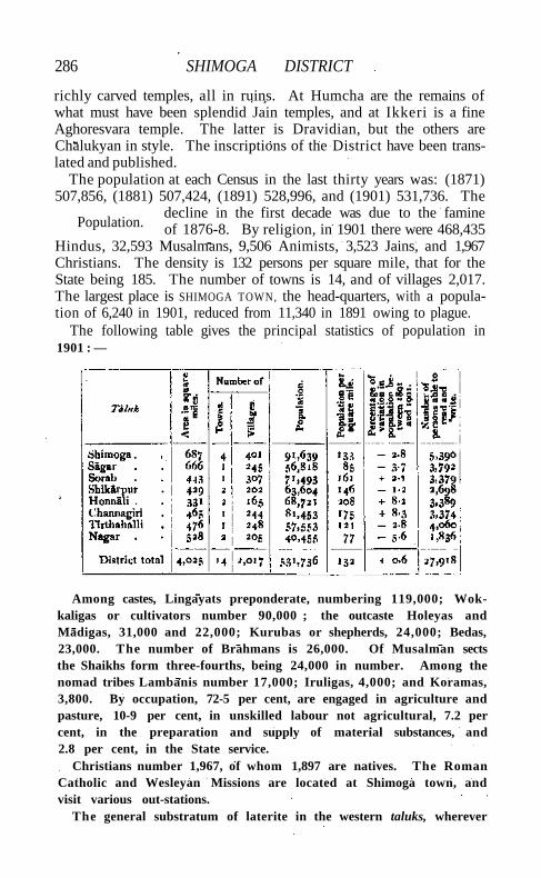
286 SHIMOGA DISTRICT
richly carved temples, all in ruins. At Humcha are the remains of what must have been splendid Jain temples, and at Ikkeri is a fine Aghoresvara temple. The latter is Dravidian, but the others are Chalukyan in style. The inscriptions of the District have been translated and published.
The population at each Census in the last thirty years was: (1871) 507,856, (1881) 507,424, (1891) 528,996, and (1901) 531,736. The
decline in the first decade was due to the famine of 1876-8. By religion, in 1901 there were 468,435
Hindus, 32,593 Musalmans, 9,506 Animists, 3,523 Jains, and 1,967 Christians. The density is 132 persons per square mile, that for the State being 185. The number of towns is 14, and of villages 2,017. The largest place is SHIMOGA TOWN, the head-quarters, with a population of 6,240 in 1901, reduced from 11,340 in 1891 owing to plague.
The following table gives the principal statistics of population in 1901 : —
Among castes, Lingayats preponderate, numbering 119,000; Wok-kaligas or cultivators number 90,000 ; the outcaste Holeyas and Madigas, 31,000 and 22,000; Kurubas or shepherds, 24,000; Bedas, 23,000. The number of Brahmans is 26,000. Of Musalman sects the Shaikhs form three-fourths, being 24,000 in number. Among the nomad tribes Lambanis number 17,000; Iruligas, 4,000; and Koramas, 3,800. By occupation, 72-5 per cent, are engaged in agriculture and pasture, 10-9 per cent, in unskilled labour not agricultural, 7.2 per cent, in the preparation and supply of material substances, and 2.8 per cent, in the State service.
Christians number 1,967, of whom 1,897 are natives. The Roman Catholic and Wesleyan Missions are located at Shimoga town, and visit various out-stations.
The general substratum of laterite in the western taluks, wherever
Population.
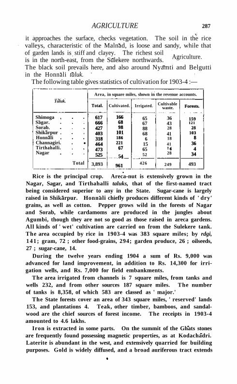
AGRICULTURE 287
it approaches the surface, checks vegetation. The soil in the rice valleys, characteristic of the Malnad, is loose and sandy, while that of garden lands is stiff and clayey. The richest soil is in the north-east, from the Sulekere northwards. The black soil prevails here, and also around Nyamti and Belgutti in the Honnali taluk.
The following table gives statistics of cultivation for 1903-4 :—
Area, in square miles, shown in the revenue accounts.
Taluk. Total.
617 666 427 403 318 464 473 525
Cultivated. Irrigated. Cultivable waste. Forests.
159 1 2 1
28 103
8 36 4
34
Shimoga Sagar. Sorab. Shikarpur . Honnali Channagiri. Tirthahalli. Nagar
•
Total.
617 666 427 403 318 464 473 525
166 68 98
101 186 221 67
54
961
65 67 88 68 6
15 65 52
36 43 28 41 18 41
28
Forests.
159 1 2 1
28 103
8 36 4
34
Total 3,893
166 68 98
101 186 221 67
54
961 426 249 493
Rice is the principal crop. Areca-nut is extensively grown in the Nagar, Sagar, and Tirthahalli taluks, that of the first-named tract being considered superior to any in the State. Sugar-cane is largely raised in Shikarpur. Honnali chiefly produces different kinds of ' dry' grains, as well as cotton. Pepper grows wild in the forests of Nagar and Sorab, while cardamoms are produced in the jungles about Agumbi, though they are not so good as those raised in areca gardens. All kinds of ' wet' cultivation are carried on from the Sulekere tank. The area occupied by rice in 1903-4 was 383 square miles; by rdgi, 141; gram, 72 ; other food-grains, 294; garden produce, 26 ; oilseeds, 27 ; sugar-cane, 14.
During the twelve years ending 1904 a sum of Rs. 9,000 was advanced for land improvement, in addition to Rs. 14,300 for irrigation wells, and Rs. 7,000 for field embankments.
The area irrigated from channels is 7 square miles, from tanks and wells 232, and from other sources 187 square miles. The number of tanks is 8,358, of which 583 are classed as ' major.'
The State forests cover an area of 343 square miles, ' reserved' lands 153, and plantations 4. Teak, other timber, bamboos, and sandalwood are the chief sources of forest income. The receipts in 1903-4 amounted to 4.6 lakhs.
Iron is extracted in some parts. On the summit of the Ghats stones are frequently found possessing magnetic properties, as at Kodachadri. Laterite is abundant in the west, and extensively quarried for building purposes. Gold is widely diffused, and a broad auriferous tract extends
Agriculture.
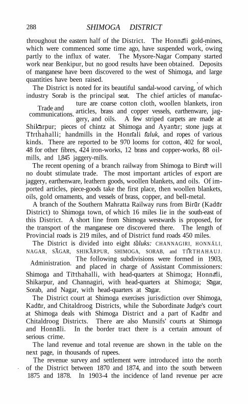
288 SHIMOGA DISTRICT
throughout the eastern half of the District. The Honnali gold-mines, which were commenced some time ago, have suspended work, owing partly to the influx of water. The Mysore-Nagar Company started work near Benkipur, but no good results have been obtained. Deposits of manganese have been discovered to the west of Shimoga, and large quantities have been raised.
The District is noted for its beautiful sandal-wood carving, of which industry Sorab is the principal seat. The chief articles of manufac
ture are coarse cotton cloth, woollen blankets, iron articles, brass and copper vessels, earthenware, jaggery, and oils. A few striped carpets are made at
Shikarpur; pieces of chintz at Shimoga and Ayanur; stone jugs at Tirthahalli; handmills in the Honnali taluk, and ropes of various kinds. There are reported to be 970 looms for cotton, 402 for wool, 48 for other fibres, 424 iron-works, 12 brass and copper-works, 88 oil-mills, and 1,845 jaggery-mills.
The recent opening of a branch railway from Shimoga to Birur will no doubt stimulate trade. The most important articles of export are jaggery, earthenware, leathern goods, woollen blankets, and oils. Of imported articles, piece-goods take the first place, then woollen blankets, oils, gold ornaments, and vessels of brass, copper, and bell-metal.
A branch of the Southern Mahratta Railway runs from Birur (Kadur District) to Shimoga town, of which 16 miles lie in the south-east of this District. A short line from Shimoga westwards is proposed, for the transport of the manganese ore discovered there. The length of Provincial roads is 219 miles, and of District fund roads 450 miles.
The District is divided into eight taluks: CHANNAGIRI, HONNALI , NAGAR, SAGAR, SHIKARPUR, SHIMOGA, SORAB, and T I R T H A H A U J .
The following subdivisions were formed in 1903, and placed in charge of Assistant Commissioners:
Shimoga and Tirthahalli, with head-quarters at Shimoga; Honnali, Shikarpur, and Channagiri, with head-quarters at Shimoga; Sagar, Sorab, and Nagar, with head-quarters at Sagar.
The District court at Shimoga exercises jurisdiction over Shimoga, Kadur, and Chitaldroog Districts, while the Subordinate Judge's court at Shimoga deals with Shimoga District and a part of Kadur and Chitaldroog Districts. There are also Munsifs' courts at Shimoga and Honnali. In the border tract there is a certain amount of serious crime.
The land revenue and total revenue are shown in the table on the next page, in thousands of rupees.
The revenue survey and settlement were introduced into the north of the District between 1870 and 1874, and into the south between 1875 and 1878. In 1903-4 the incidence of land revenue per acre
Administration.
Trade and communications.
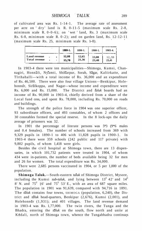
SHIMOGA TALUK 289
of cultivated area was Rs. 1-14-1. The average rate of assessment per acre on ' d r y ' land is R. 0-11-5 (maximum scale Rs. 2-8, minimum scale R. 0 - 0 - 6 ) ; on ' wet ' land, Rs. 3 (maximum scale Rs. 6-8, minimum scale R. 0 - 2 ) ; and on garden land, Rs. 12-12-11 (maximum scale Rs. 25, minimum scale Rs. 1-8).
1880-1.
12,08
15,70
1890-1. 1900-1. 1903-4.
Land revenue Total revenue
1880-1.
12,08
15,70 12,65 21,36
13,08 23,48
12,,59 23,41
In 1903-4 there were ten municipalities—Shimoga, Kumsi , Chan-nagiri, Honnali , Nyamti , Shikarpur, Sorab, Sagar, Kaliirkatte, and Tlr thahal l i—with a total income of Rs. 36,000 and an expenditure of Rs. 46,500. There were also four village Unions—Benkipur, Hole-honnur, Siralkoppa, and Nagar—whose income and expenditure were Rs. 6,000 and Rs. 15,000. The District and taluk boards had an income of Rs. 90,000 in 1903-4, chiefly derived from a share of the Local fund cess, and spent Rs. 78,000, including Rs. 70,000 on roads and buildings.
The strength of the police force in 1904 was one superior officer, 93 subordinate officers, and 493 constables, of whom 2 officers and 30 constables formed the special reserve. In the 8 lock-ups the daily average of prisoners was 32.
In 1901 the percentage of literate persons was 5*3 (9*6 males and 0.4 females). The number of schools increased from 369 with 9,329 pupils in 1890-1 to 406 with 11,828 pupils in 1900-1. In 1903-4 there were 359 schools (242 public and 117 private) with 9,802 pupils, of whom 1,418 were girls.
Besides the civi l hospital at Shimoga town, there are 13 dispensaries, in which 101,732 patients were treated in 1904, of whom 434 were in-patients, the number of beds available being 32 for men and 26 for women. The total expenditure was Rs. 34,000.
There were 2,685 persons vaccinated in 1904, or 5 per 1,000 of the population.
Shimoga Taluk.—South-eastern taluk of Shimoga District, Mysore, including the Kumsi sub-taluk, and lying between 130 42 ' and 140
8' N. and 750 16' and 750 53' E., with an area of 687 square miles. The population in 1901 was 91,639, compared with 94,716 in 1891. The taluk contains four towns, S H I M O G A (population, 6,240), the District and taluk head-quarters, Benkipur (2,676), Kumsi (2,001), and Holehonnur (1,931); and 401 villages. The land revenue demand in 1903-4 was Rs. 1,77,000. The twin rivers, the Tunga and the Bhadra, entering the taluk on the south, flow north and unite at Kudal i , north of Shimoga town, whence the Tungabhadra continues
290 SHIMOGA TALUK
north with a winding course. The greater part of the taluk in the west and south is covered wi th hills and forests, abounding in tigers, leopards, bears, and other wi ld animals. Cultivation is almost confined to the level valleys of the rivers, but the beds of these are too deep to be used for irrigation. On the other hand, timber is floated down, especially in the Tunga. The soils on either bank of the Tungabhadra to the north are very rich, and the climate is remarkably favourable to ' dry ' cultivation. Ragi is the staple crop on red soil, but the black soils produce Jola, cotton, and oilseeds. The rice lands are poor. A li t t le sugar-cane is grown, besides areca-nut, betel-leaf, and plantains.
Shimoga Town.—Head-quarters of the District and taluk of the same name, Mysore State, situated in 130 56' N. and 750 35' E., on the Tunga river, and terminus of the Birur-Shimoga railway line. Population fell to 6,240 in 1901 from 11,340 in 1891, chiefly owing to plague. In early times Mandali, a suburb to the south, was an important place under the Gangas. At a later period Shimoga was ruled by the Chalukyas and the Hoysalas, after which it came under Vijayanagar. From the sixteenth century it was held by the Keladi or Bednur kings, unt i l Bednur was taken by Haidar A l i in 1763. The Marathas under Parasuram Bhao, in a battle near Shimoga in 1798, forced T i p u Sultan's army under the Benki Nawab to retire on Bednur, and besieged Shimoga, which had to capitulate, and was plundered and burnt. After the fall of T i p u in 1799 it was again pillaged by Dhundia Wagh, and left a heap of ruins. The present town has mostly sprung up during the last half of the nineteenth century, the Tunga being here crossed by a fine bridge. It is a principal station of the Roman Catholic and Wesleyan Missions. The municipality dates from 1870. The receipts and expenditure during the ten years ending 1901 averaged Rs. 15,600 and Rs. 16,000. In 1903-4 they were Rs. 17,000 and Rs. 24,600.
S h i n a k i . — A group of small republics in the valley of the Indus, lying west of Kashmir and south of Gilgit . The territory extends from the junction of the Astor river with the Indus to Seo on the right bank and Jalkot on the left bank of the latter river. Wi th in this area the people are grouped in communities inhabiting one or more nullahs, each community forming a separate republic. Starting from the junct ion at Ramghat these are, in order : on the right bank, Gor, Kinergah, and H o d a r ; and on the left bank, Bunar, Thak, Butogah, Giche, and Thor . They constitute the area known as the Chilas subdivision of the Gilgit Agency, while Chilas proper includes Kinergah, Butogah, and Giche. Lower down the river are Darel, Tangir, K h i l l i , and Seo on the right bank, and Harban, Sazln, and Jalkot on the left bank.
After the conquest of Chilas by Kashmir in 1851, the Maharaja
SHIRANI COUNTRY 291
imposed a tribute in gold-dust, and arranged for the administration of the country as part of the Gilgit district. A British Agency was re-established at Gilgit in 1889, which included, among other territory, the Chilas subdivision described above except Thor. In 1892 a British mission to Gor was attacked by the Chilasis, which led to the occupation of their country and the appointment of a Political officer at Chilas. The right of the Kashmir Darbar to construct roads and station a limited number of troops in the territory was secured, but the autonomy of the Chilasis was guaranteed. Under the revised arrangements made in 1897 the republics pay small fixed sums to the Maharaja, and in 1899 Thor was incorporated in Chilas. Darel has rendered a tribute of gold-dust to Kashmir since 1866, when the Maharaja's troops raided the country. The tribute is now paid through the Punial governor. Tangir pays a small tribute to the governor of Yasln. The remaining communities have no political relations with either Kashmir or British India, except Jalkot, which from its position dominates Thor and the head of the Kagan valley in the North-West Frontier Province.
Shipki Pass.—A pass in Tibet at the eastern extremity of the Hindustan-Tibet road, situated in 31° 49' N. and 780 44' E. Strictly speaking, Shipki is a large Tartar village, 10,000 feet above the sea, in Tibet, which is reached from the Kanawar valley, Bashahr State, Punjab, by two routes, one leading through the gorge by which the Sutlej enters India, the other over the Kang-wa La or pass, 15,000 feet in height.
Shirani Country.—A tract on the western border of Dera Ismail Khan District, North-West Frontier Province, lying between 310 30' and 320 N. and 690 45' and 700 20' E. It is bordered on the north by Wazlristan, on the west by Baluchistan, and on the south by the Usterana Afghans. The Sulaiman range, running from north to south, divides the country into two parts, Largha or ' lowland,' and Bargha or 'highland/ The former had a population of 12,371 in 1901, and is under the political control of the North-West Frontier Province; the latter is under that of Baluchistan. The Largha Shirani country is administered by an Extra-Assistant Commissioner with head-quarters at Drazinda, acting under the general supervision of the Deputy-Commissioner of Dera Ismail Khan. The country is poor, the lowlanders being dependent on agriculture, while the Bar Shiranis lead a pastoral life on the higher slopes of the Takht-i-Sulaiman, to which the flocks and herds of both sections are sent in summer. The higher hills are covered with forests of the chilgoza {Pinus gerardiana), in which each section of the tribe has a recognized share, and the profits from the sale of the fruit form a considerable item in their income. The Shiranis are Afghans, and intensely democratic,
292 SHIRANl COUNTRY
though each section has a nominal chief or neka. Tribal cohesion is weak. Before annexation the Shiranis had been the terror of the frontier, carrying off cattle and men and women, whom they held to ransom. They sacked Draband, which was held by a small Sikh garrison, and by 1848 had laid waste the border for miles. In 1853 a British expedition sent against the tribe secured their submission, but in 1890 a force had to be sent to coerce the Khiddarzai clan.
In 1899 an agreement was concluded with the tribe, whereby they agreed to pay Rs. 2,000 as revenue, and the British undertook the internal administration of the country. This was carried on successfully until 1902, when the Extra-Assistant Commissioner was murdered by a jamadar in the Shirani levies. The murderer was joined by thirty or forty malcontents, mostly from the Khiddarzai section of the Oba Khel, and for some months evaded a military force in the higher ranges of the Takht-i-Sulaiman. He finally made good his escape to Afghanistan with his gang, whence they come raiding from time to time.
Shirhatti.—Head-quarters of the subdivision of the same name in the Sangli State, Bombay, situated in 150 14' N. and 750 39' E., 12 miles south-east of Gadag on the Southern Mahratta Railway. Population (1901), 4,393. The town is administered as a municipality with an income of Rs. 1,200, and contains a dispensary. The three most important places of interest are the fort, Avlingva's math, and Fakirswami's math. The fort, according to one account, was built by Khangavnda Desai, and according to another by Ankushkhan of Lakshmeshwar. At Shirhatti a fair in honour of Fakirswami is held in April-May, attended by about 30,000 people.
Shirol.—Head-quarters of the subdivision of the same name in the Kolhapur State, Bombay, situated in 160 44' N. and 740 38' E., about 4 miles north of the meeting of the Panchganga and Kistna, and about 6 miles from Shirol Road station on the Kolhapur State Railway. Population (1901), 7,864. Shirol is administered as a municipality, with an income of Rs. 2,000. It contains two large temples, two mosques, and a tower. Shirol is sometimes called Ghumat Shirol or ' Shirol-with-the-dome,' because it used to contain the large domed tomb of a Bijapur officer named Nur Khan, which Parasuram Bhau Patvardhan is said to have destroyed in 1779. The town is guarded by a ditch and a wall and is strengthened by an inner citadel. During the wars between Kolhapur and the Patvardhans in the latter part of the eighteenth century Shirol changed hands several times. In 1780 it was finally taken by Sivaji I I I , and has since remained under Kolhapur. At a suburb known as Narsoba Vadi a large fair, attended by 10,000 people, is held twice a year in honour of Dattatraya.
SHIVARAjPUR 393
Shirpur T a l u k a . — Tdluka of West Kh&ndesh District, Bombay, lying between 2 1 0 1 1 ' and 2 1 0 38 ' N. and 740 42 ' and 75° 17' E., with an area of 651 square miles. I t contains one town, S H I R P U R (papulation, 9,023), the head-quarters ; and 99 villages. The population in 1901 was 50,177, compared wi th 56,012 in 1891. The density, 77 persons per square mile, is only about half the average for the District. The demand for land revenue in 1903-4 was 1*9 lakhs, and for cesses Rs. 12,000. A broken range of the Satpuras, running from east to west, divides Shirpur into two parts, each with distinct natural features. The northern part comprises a wi ld and hil ly country, sparsely peopled by Bhils. The southern is an unbroken plain, with no trees except near village sites. The population is dense near the banks of the Tapti , but becomes scanty as the hills are approached. Although the taluka has three rivers that flow throughout the year—the Tapt i , and its tributaries the Anar and the ArunavatI— and numerous other streams from the Satpuras, the supply of surface water is on the whole scanty. The prevailing black soil is a rich loam resting on a yellowish subsoil. The annual rainfall averages nearly 24 inches.
Shirpur Town.—Head-quarters of the taluka of the same name in West Khandesh District, Bombay, situated in 2 1 0 2 1 ' N. and 740 53' E., on the Bombay-Agra road, 33 miles north of Dhulia. Population (1901), 9,023. Shirpur suffered severely from floods in 1875, when water stood in places 6 feet deep, destroying property to the value of Rs. 32,000. It has been a municipality since 1870, with an average income during the decade ending 1901 of Rs. 9,700. In 1903-4 the income was Rs. 9,800. The town contains four cotton-ginning and pressing factories, a Subordinate Judge's court, a dispensary, and five schools, with 552 pupils, of which one, with 20 pupils, is for girls.
Shivaganga.—Zaminddri taksll, estate, and town in Madura District, Madras. See S IVAGANGA.
Shivarajpur .—Tahs t l of Cawnpore District, Un i ted Provinces, conterminous with the pargana of the same name, lying along the Ganges between 260 3 1 ' and 260 46 ' N. and 790 55' and 8o° 12' E., with an area of 276 square miles. Population increased very slightly from 147,823 in 1891 to 147,910 in 1901. There are 311 villages, but no town. The demand for land revenue in 1903-4 was Rs. 2,75,000, and for cesses Rs. 44,000. The density of population, 536 persons per square mile, is above the District average. Along the Ganges lies a high ridge of hard barren or sandy soil. A small river, called the Non, drains a fertile tract south of this area, and the rest of the tahsll is composed of r ich loam through which the Pandu flows. In the west extensive swamps and clay land are found, where rice is grown. In 1903-4 the area under cultivation was 145 square miles, of which 80
294 SHIVARAJPUR
were irrigated. The Cawnpore branch of the Lower Ganges Canal supplies more than two-thirds of the irrigated area.
Shivbara.—Petty State in KATHIAWAR, Bombay. Sblvganga.—Valley in the Salt Range, Jhelum District, Punjab,
situated in 320 43' N. and 720 53' E., 3 miles north-east of Malot. In it stands a small temple in the later Kashmir style; and near Warala, a hamlet on the adjacent spur, a Buddhist sculpture was found by the villagers some years ago and set up by Hindus in a small temple at Shivganga. Having recently been broken and thus rendered useless for purposes of worship, the Hindus allowed its fragments to be sent to the Lahore Museum, where it was restored. The relief originally contained eighteen or nineteen figures, the central one, a Bodhisattva, carved in a somewhat late stage of Gandhara art.
Shivner.—Hill fort of the town of Junnar, in the Junnar taluka of Poona District, Bombay, situated in 190 12' N. and 730 52' E., not far from Harischandragarh, and about 56 miles north of Poona city. The hill of Shivner rises over 1,000 feet, and stretches about a mile across the plain. It is triangular in shape, narrowing from a southern base of about 800 yards to a point of rock in the north. Near the south, the lower slopes of its eastern face are crossed by a belt of rock 40 or 50 feet high. The south-west of the hill is broken, and about half-way up is strengthened by outworks and bastioned walls. During the first and second and probably the third centuries after Christ, the hill seems to have been a great Buddhist centre. About 50 cells and chapels remain. They are found on three sides of the hill, but most of them are cut in its eastern face. Shivner was granted in 1599 to Sivajfs grandfather, Maloji Bhonsla; and here in 1627 Sivaji was born. It was often taken and retaken; and once, in 1670, the forces of Sivaji himself were beaten back by its Mughal garrison. Besides its five gates and solid fortifications, it is celebrated for its deep springs. They rise in pillared tanks of great depth, supposed to be coeval with the series of Buddhist caves which pierce the lower portion of the scarp. The fort commands the road leading to the Nanaghat and Malsejghat, formerly the chief line of communication between this part of the Deccan and the coast.
[For further information respecting Shivner fort and caves, see the Gazetteer of the Bombay Presidency', vol. xviii, part i i i , pp. 153-63, 184-201 (Bombay, 1885).]
Shiyaii Taluk.—North-eastern taluk of Tanjore District, Madras, lying between 11° 8' and n° 25' N. and 790 39' and 790 52' E., with an area of 171 square miles. Its boundaries are the Coleroon, the sea, and the Mayavaram taluk. I t contains one town, SHIYALI (population, 9,722), the head-quarters; and 96 villages. The population fell from 119,803 in 1891 to 116,563 in 1901, and includes unusually few
SHOLAPUR DISTRICT 295
Muhammadans or Christians. The demand for land revenue and cesses in 1903-4 amounted to Rs. 4,06,000. Being situated in the delta of the Cauvery river, Shiyali contains much more ' wet ' land than ' d r y ' ; but this is generally not of the best kind, because the irrigation channels have deposited most of their fertilizing silt before they reach land which extends so far towards the sea. The Coleroon channels from the Lower Anicut give a better deposit, and some of these run through the taluk. I ts position on the coast results in its receiving the large rainfall of 54 inches, and agriculturally it is prosperous on the whole, though nearly 20 per cent, of the cultivable area is unoccupied.
S h i y a l i T o w n (Sirgali).—Head-quarters of the taluk of the same name in Tanjore District, Madras, situated in 11° 14' N. and 790 44 ' E., with a station on the main line of the South Indian Railway. Populat ion (1901), 9,722. It was the birthplace of the'famous T a m i l poet and saint, Tirugnana Sambandha, who lived in the first half of the seventh century. In the Siva temple there is a shrine dedicated to this saint, with a Chola inscription recording a gift. There are two high schools, one maintained by the Leipzig Evangelical Lutheran Mission and the other by a native gentleman. Shiyali is noted for mats made of a k ind of Cyperus. Cotton cloths are also woven of an inferior k ind .
Sholapur Agency .—A Political Charge, consisting of a single State lying south-east of Sholapur District, Bombay. See A K A L K O T .
Sholapur Dis tr ic t . — District in the Central Division of the Bombay Presidency, lying between 170 8' and 180 33' N. and 740 37 ' and 760 26' E., with an area of 4,541 square miles. Except the Barsi taluka, which is surrounded by the Nizam's territory, Sholapur is bounded on the north by Ahmadnagar D i s t r i c t ; on the east by the Nizam's Dominions and the State of A k a l k o t ; on the south by Bija-pur District and the States of Jath and M i r a j ; and on the west by Aundh State, Satara District, Phaltan State, and Poona and Ahmadnagar Districts. On the west, in some places Mira j villages are included, and isolated Sholapur villages lie beyond the District l imits.
Except north of Barsi, west of Madha, and south-west of Malsiras and of Karmala, where there is a good deal of hil ly ground, the District is generally flat or undulating. Most of the surface rolls in long low uplands separated by hollows, with an occasional level. The shallow soil of the uplands is suited for pasture, and the deep soil of the lowlands under careful tillage yields the richest crops. The uplands are gently rounded swellings of trap, overgrown with yellow stunted spear-grass. The District is somewhat bare of vegetation, and presents in many parts a bleak, treeless appearance. The chief rivers are the B H I M A and its
Physical aspects.

296 SHOLAPUR DISTRICT
tributaries the Man, the Nira, and the Slna, all flowing towards the south-east, with the exception of the Man, which runs north-east for 50 miles within the limits of the District. Besides these, there are several minor streams. Of the principal reservoirs, Ekrtik and Siddh-eswar are near Sholapur city, one is at Ashti, one is at Koregaon, and one at Pandharpur, and there are also water-supply works at Barsi and Karmala. The Ekruk lake is one of the largest artificial pieces of water in the Presidency.
As in most of the Deccan, the geological formation is trap, covered in most places with a shallow layer of very light soil, and in parts with a good depth of rich loam suited for cotton.
The flora of Sholapur is of the purely Deccan type. Babul, mango, nim, and pipal are the only timber trees found. Among flowering plants the most common are Cleome, Capparis, Cassia, Woodfordia, Vicoa, Echinops, Celosia, and several species of Acacia.
The District is too well tilled to leave much cover for wild beasts. The jackal, grey fox, antelope, and hare are, however, common. The commonest game-birds are : kalam (Anthropoides virgo\ black and grey partridges, quail, and snipe. Bustard are scarce. The maral is noted among river fish.
The climate, except from March to May, is healthy and agreeable. In the hot season, March to June, the mean temperature is 830, very hot and oppressive in the day-time, but cool at night; it falls to 52° in November and rises to 1080 in May: annual mean 8o°. During the cold season, from November to February, the weather with keen easterly and north-easterly winds is clear and bracing. The rainy season is pleasant; the sky is more or less overcast, and the rain falls in heavy showers, alternating with intervals of sunshine. The annual rainfall averages 26 inches, being on the whole scanty and uncertain. Barsi, owing to the proximity of the Balaghat hills, is comparatively well off with an average fall of 28 inches, while Madha and Karmala receive 26 and 23 inches respectively, but so unevenly distributed that only one out of every four seasons can be adjudged really satisfactory. Malsiras has the lowest average, namely 2 2 inches.
Sholapur is one of the Districts which formed the early home of the Marathas, and is still a great centre of the Maratha population. In the
early centuries of the Christian era (90 B .C . -A.D. 230) it probably formed part of the territories of the Sata-
vahana or Andhra dynasty, whose capital was Paithan on the Godavari, about 150 miles north-west of Sholapur city. During the nine hundred years previous to the overthrow of the Deogiri Yadavas by the Muham-madans in the beginning of the fourteenth century, Sholapur, like the neighbouring Districts of Bijapur, Ahmadnagar, and Poona, was held by the early Chaiukyas from 550 to 750, by the Rashtrakutas to 973, by
History.
POPULATION 297
the revived or Western Chalukyas to 1156, and by the Deogiri Yadavas t i l l the Muhammadan conquest of the Deccan.
The first Muhammadan invasion of the Deccan took place in 1294, but the power of the Deogiri Yadavas was not crushed t i l l 1318. From 1318 Maharashtra began to be ruled by governors appointed from Delhi and stationed at Deogiri, which name was changed in 1338 by Muhammad bin Tughlak to Daulatabad, the 'abode of wealth.' In 1346 there was widespread disorder, and Delhi officers plundered and wasted the country. These cruelties led to the revolt of the Deccan nobles under the leadership of a soldier named Hasan Gangu. The nobles were successful, and freed the Deccan from dependence on Northern India. Hasan founded a dynasty, which he called Bahmani after the Persian from whom he claimed descent, and which held sway over the Deccan for nearly a hundred and fifty years. In 1489 Yusuf A d i l Shah, governor of Bijapur, assumed independence, and overran all the country north of Bijapur as far as the Bhima. For nearly two hundred years Sholapur belonged either to the Bijapur or to the Ahmadnagar Sultans, as the one or the other succeeded in retaining it . In 1668, by the treaty concluded between Aurangzeb and A l i A d i l Shah of Bijapur, the fort of Sholapur and territory yielding Rs. 6,30,000 of revenue was ceded to the Mughals as the price of peace. The general decay of the Mughal empire from 1700 to 1750 opened the way for Maratha supremacy. In 1795 the Marathas wrested from the Nizam his Sholapur possessions. The greater part of the District formed a portion of the Peshwa's dominions. On the overthrow of the Peshwa 430 villages passed to the British, the decisive actions being the battles of Pan-dharpur and Ashta (1817-8) and the siege of Sholapur (1818). To the territory taken from the Marathas, 232 villages ceded by the Nizam were added in 1822, and 488 more villages which lapsed in 1848 on the death of the Raja of Satara brought the District to its present dimensions. It has been a Collectorate since 1838.
Traces of Yadava rule are to be found in the Hemadpanti temples at Bavi, Mohol , M A L S I R A S , Nateputa, Velapur, P A N D H A R P U R , Pulunj, Kandalgaon, Kasegaon, and Marde. There is a fine old well dating from this period at Marde. Musalman architecture is represented by the tomb of one of the daughters of Aurangzeb at the village of B E G A M P U R .
There are 7 towns and 712 villages in the District. The population is approximately the same as it was in 1872. At the last four enumerations it has been: (1872) 720,203, (1881) 583,411,(1891) 750,689, and (1901) 720,977- The decrease of 19 per cent, in 1881 was due to mortality or emigration in the famine of 1876-8; and the population decreased by 4 per cent, during the last decade owing to the famine years of 1896-1901.
Population.

298 SHOLAPUR DISTRICT
Part of this decrease has been made good by immigration since the famine. The distribution by talukas, according to the Census of 1901, was:—
* The Agricul tural department's returns give the total area as4,547 square miles and the total number of villages as 718.
The chief towns are S H O L A P U R , P A N D H A R P U K , B A R S I , and K A R -M A L A . The predominant language is Marathi, which is spoken by 82 per cent, of the population. Kanarese is spoken in the south of the District on the Bijapur border. Of the total population, 91 per cent, are Hindus and 8 per cent. Musalmans.
Among Hindus, Brahmans number 29,000. The most important and the oldest settlers of this caste are Deshasths (24,000). The Vaishya Vanis are the last remnant of the H i n d u traders of the District, who are now mainly Lingayats (51,000) and are known as Lingayat Varus. Marathas (220,000) are the strongest caste numerically and are mostly agriculturists. Malls or gardeners (24,000), found throughout the District, have two divisions, Khirsagur and Raut. Craftsmen include Salis, Koshtls, Devang and other weavers (23,000), and Chamars or shoemakers (16,000). Dhangars or shepherds (74,000) have three divisions, Bargis, Hatgars, and Kutigars, which neither marry nor eat together. KolTs (10,000) are divided into Maratha Kolis and Panbhari Kol is . Mahars (66,000) and Mangs (28,000) are the watchmen and scavengers of the old village community. There are 37,000 Muhammadan converts from Hinduism, who describe themselves as Shaikhs. The population is supported mainly by agriculture (60 per cent.), industries and commerce supporting 19 per cent, and one per cent, respectively.
In 1901, 1,555 native Christians were enumerated, most of whom are converts of the American Maratha Mission, which commenced work in the District in 1862. There are churches at Sholapur, Dhotre, Vat vat, and a few other places. The American Protestant Congregational Mission is at work in Karmala, and an inter-denominational village mission has a branch at Pandharpur.
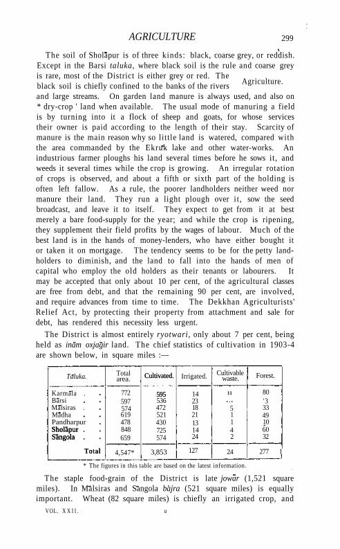
AGRICULTURE 299
The soil of Sholapur is of three kinds: black, coarse grey, or reddish. Except in the Barsi taluka, where black soil is the rule and coarse grey is rare, most of the District is either grey or red. The black soil is chiefly confined to the banks of the rivers and large streams. On garden land manure is always used, and also on * dry-crop ' land when available. The usual mode of manuring a field is by turning into it a flock of sheep and goats, for whose services their owner is paid according to the length of their stay. Scarcity of manure is the main reason why so little land is watered, compared with the area commanded by the Ekruk lake and other water-works. An industrious farmer ploughs his land several times before he sows it, and weeds it several times while the crop is growing. An irregular rotation of crops is observed, and about a fifth or sixth part of the holding is often left fallow. As a rule, the poorer landholders neither weed nor manure their land. They run a light plough over i t , sow the seed broadcast, and leave it to itself. They expect to get from it at best merely a bare food-supply for the year; and while the crop is ripening, they supplement their field profits by the wages of labour. Much of the best land is in the hands of money-lenders, who have either bought it or taken it on mortgage. The tendency seems to be for the petty landholders to diminish, and the land to fall into the hands of men of capital who employ the old holders as their tenants or labourers. It may be accepted that only about 10 per cent, of the agricultural classes are free from debt, and that the remaining 90 per cent, are involved, and require advances from time to time. The Dekkhan Agriculturists' Relief Act, by protecting their property from attachment and sale for debt, has rendered this necessity less urgent.
The District is almost entirely ryotwari, only about 7 per cent, being held as inam oxjagir land. The chief statistics of cultivation in 1903-4 are shown below, in square miles :—
Taluka. Total area. Cultivated.
595
Irrigated. Cultivable waste. Forest.
Karmala . 772
Cultivated.
595 14 11 80 Barsi 597 536 23 '3 Malsiras . 574 472 18 5 33 Madha 619 521 21 1 49 Pandharpur 478 430 13 1 10 Sholapur . Sangola .
Total
848 725 14 4 60 Sholapur . Sangola .
Total
659 574 24 2 32 Sholapur . Sangola .
Total 4,547* 3,853 127 24 277 1
* The figures in this table are based on the latest information.
The staple food-grain of the District is late jowar (1,521 square miles). In Malsiras and Sangola bajra (521 square miles) is equally important. Wheat (82 square miles) is chiefly an irrigated crop, and
VOL. X X I I . u
Agriculture.
300 SHOLAPUR DISTRICT
is of inferior quality. Of pulses, tur (155 square miles) and gram (104) are important; math and kulith occupy 64 and 37 square miles respectively. Oilseeds (292 square miles) are grown in rows among the jmvdr. Of other crops, chillies (9 square miles), cotton (72 square miles), and oui-hemp (45 square miles) are the most important. There has been a gradual tendency of late years to discard old forms of field-implements in favour of more modern appliances ; and especially is this the case with iron sugar-cane presses and iron ploughs. The latter were exhibited in Bombay in 1904, and have been ordered by several cultivators. Iron lifts for wells have also taken the place of leathern bags in many places. The opening of cotton-mills in Sholapur city has led the people to pay more attention to seed-selection and staple; while the better kinds of manure are now largely employed for sugar-cane cultivation.
During the ten years ending 1904, 18-3 lakhs was advanced to agriculturists under the Land Improvement and Agriculturists' Loans Acts. Of this sum 5 lakhs was advanced in 1896-7, and 9 lakhs during the three years ending 1901-2.
The chief breeds of cattle are the khildri, raised by Dhangars; the desiy bred by Lamanis, and breeds from Malwa, Gujarat, and Gokak in Belgaum. The khildri breed is the best, and the desi is the commonest. Buffaloes are classed as gaulis or ' milkmen's,' and desi or * local/ The famine of 1876 and the Afghan War of 1879 combined to deprive Sholapur of its reputation as a pony-breeding District. The Civil Veterinary department, however, maintains 3 pony stallions at Sholapur, Sangola, and Karmala. The dry plains of the southern talukas are specially suited for rearing sheep and goats. The Dhangars breed flocks of sheep, and the poorer classes keep goats. Donkeys are bred by Beldars or quarrymen, and pigs are reared by Vaddars or earth-workers.
The chief irrigation works in Sholapur District are the Koregaon, Ashti, Ekruk, and Mhasvad lakes. The first named is a pre-British work improved, and the three last are new works. Large projects have been undertaken at Patri, Budhihal, Bhamburda, Wadshivne, Hotgi, and Mangi. The total area under irrigation from various sources in 1903-4 was 127 square miles. Government works supplied 12 square miles, private canals one square mile, wells in square miles, tanks one square mile, and other sources 2 square miles. Koregaon lake, 13 miles north-east of Barsi, is formed by throwing two earthen dams across two separate valleys. The lake has now a capacity of 81,000,000 cubic feet and supplies 282 acres of land, the estimated irrigable area being nearly 2 square miles. The Ashti lake lies in the Madha taluka, 12 miles north-east of Pandharpur. The lake when full holds 1,419,000,000 cubic feet of water. It is
TRADE AND COMMUNICATIONS 301
estimated to irrigate 19 square miles, and actually supplies about 2 square miles. The Ekruk lake, the largest artificial lake in the Bombay Presidency, lies 5 miles north-east of Sholapur city. The lake is 60 feet deep when full, and holds 3,310,000,000 cubic feet of water. It supplies 4 and commands 26 square miles. The Mhasvad tank in Satara District, recently constructed by throwing a dam across the Man river, supplies 7 square miles of land with water, and could irrigate 38 square miles. The capital outlay on these tanks has been (1903-4): Mhasvad 21 lakhs, Ekruk 13, Koregaon 2/5, and Ashti 8 lakhs. There are 24,629 wells in the District, with an average depth of 15 to 40 feet, of which 20,865 are used for irrigation.
The dry, shallow soil of the uplands of Sholapur is ill-suited for trees. The District now possesses 219 square miles of ' reserved' land under the Forest department. The fodder reserves and pasture land in charge of the Revenue department amount to 58 square miles. There are no ' protected' forests. The forest area is much scattered. It may be roughly divided into two tracts: on the hills between Barsi and the Nizam's territories in the extreme north-east, and on the hills to the south of Malsiras and Sangola in the extreme south-west. Before December, 1871, when forest conservancy was introduced, Sholapur was extremely bare of trees and brushwood. In the whole of the forest area, no timber-cutting rights are admitted to exist. The forest lands are of two classes: scrub forest and babul meadows. The scrub forest is found on the hills, and babul meadows occur all over the District.
Forest receipts are comparatively small, being only Rs. 18,000 in 1903-4. About nineteen-twentieths of the Reserves are yearly leased for grazing; the remainder are leased yearly for grass-cutting, and in these tree plantations are formed. The timber of the babul and the nlm are used for fuel, and also for making beams, posts, doors, carts, ploughs, and other implements. The bark of the babul and of the tarvad {Cassia auriculata) is used for tanning, and the pods as well as the flowers of the palas (Butea frondosd) for dyeing. The bark of the apta is made into ropes. The forests are in charge of an Extra-Assistant Conservator.
Except trap or basalt used as building stone and for road-metal, and nodular limestone used in cement, Sholapur has no mineral products.
The chief industries are spinning, weaving, and dyeing. Silks and the finer sorts of cotton cloth, such as dhotis and women's saris, prepared in Sholapur, bear a good name. Blankets are also woven in large numbers. Besides hand-loom weaving, 3 cotton-mills, with 144,520 spindles and 528 looms, have been established, which give employment to
u 2
Forests.
Trade and communications,
302 SHOIAPUR DISTRICT
5,239 hands, and turn out 14,000,000 pounds of yarn and 2,000,000 pounds of cloth. The mill of the Sholapur Spinning and Weaving Company began working at Sholapur city in 1877 with a nominal capital of 8 lakhs. In addition to the cotton-mills, there are 2 ginning factories, employing about 174 operatives. Oil-presses of the native type are worked by Tells in many places, and saltpetre is manufactured to some extent by Mahars and Mangs.
Since the opening of the railway, trade has greatly increased. Next to cotton, a large proportion of which comes from other Districts, the chief exports are oil, oilseeds, ghi, turmeric, and cotton cloth. The imports are salt, piece-goods, yarn, gunny-bags, and iron-ware. Trade is carried on at the towns and in markets, fairs, village shops, and also by travelling carriers. The largest centres of internal trade are Sholapur city, Barsi, and Pandharpur; and next to these Vairag, Madha, Mohol, Karmala, Akluj, Nateputa, and Sangola. The traders are chiefly Lingayats, Bhatias, Hindu Vanis, and Marwaris.
The south-east line of the Great Indian Peninsula Railway, which connects with the Madras Railway at Raichur, passes through the District with a length of 115 miles. From Hotgi near Sholapur city, the eastern branch of the Southern Mahratta Railway runs south towards Bijapur, for a distance of about 8 miles within the District. At Barsi Road a pioneer enterprise in light railways connects Barsi town with the Great Indian Peninsula Railway. This line, which is on a 2 foot 6 inch gauge, was opened in 1897. Extensions of the Barsi Light Railway to Tadwalla, 27 miles from Barsi town, and to Pandharpur, were opened in 1906. There are (1904) 567 miles of roads in the District, of which 140 miles are metalled. Of these the Poona-Hyderabad trunk road is the most important, traversing the District in a south-easterly direction for 78 miles. Except 341 miles of unmetalled roads in charge of the local authorities, all these roads are maintained by the Public Works department. The Barsi Light Railway Company maintains and repairs 21 miles of metalled road.
The earliest recorded famine is the great Durga-devi famine, which began about 1396 and is said to have lasted nearly twelve years.
Next came the famine of 1460. About 1520 a great famine is said to have been caused by military hordes
destroying and plundering the crops. The famine of 1791 was very severe, especially in the Carnatic, where the crops entirely failed. In the Deccan the yield was one-fourth to one-half the usual out-turn ; and as thousands flocked from the Carnatic to the Deccan for food, the distress became very severe. During this famine grain sold at 3 seers a rupee. In 1802 the plunder and destruction of crops by Holkar and the Pindaris caused a serious scarcity, which the failure of the rains in October and November, 1803, turned into a famine of
Famine.
ADMINISTRATION 303
terrible severity. In 1818, owing partly to the ravages of the Peshwa's armies, and partly to the failure of crops, the District again suffered from famine, accompanied by cholera, which destroyed thousands. Other famines or scarcities occurred in 1824, 1832-3, 1845, 1854, 1862, 1876-7, 1896-7, and 1899-1900, owing to scanty rainfall.
In the famine of 1876-7 the District suffered very severely. At the height of distress the largest number on works was 95,617 in January, 1877. A considerable number of people left the District and went to Berar and the Nizam's Dominions, and many cattle died. During the cold season of 1879, from January to March, swarms of rats and mice appeared and about seven-eighths of the crops were wholly destroyed. The scanty rainfall of 1896 caused a failure of the crops throughout the whole of the District, thus necessitating relief measures. The largest number on works was 124,800 in Apr i l . The maximum number on gratuitous relief was 15,600 in September, The distress continued t i l l the end of November. The last scarcity, which extended over two consecutive years, was in 1899-1901. In October, 1899, relief works were opened which continued t i l l October, 1902. The maximum on relief was reached in Apr i l , 1900, when nearly 156,000 persons were on works and 13,000 in receipt of gratuitous relief. By August, 1900, the number on gratuitous relief had reached 25,000. The excess of mortality over the normal in 1899-1900 was 18,800, and it is calculated that 70,000 cattle died. Including advances to agriculturists and weavers, and remissions of land revenue, the famine in this District alone cost the state 84 lakhs. More than 10^ lakhs was advanced under the Land Improvement and Agriculturists' Loans Acts.
The District consists of seven talukas, in two subdivisions under an Assistant Collector and a Deputy-Collector. The talukas are SHOLAPUR, M A D H A , K A R M A L A , B A R S I ,
P A N D H A R P U R , SANGOLA, and M A L S I R A S . The Collector is Political
Agent of the State of Akalkot. The District and Sessions Judge at Sholapur is assisted for civil
business by six Subordinate Judges. There are twenty-eight officers to administer criminal justice in the District. The proximity of the Nizam's Dominions facilitates dacoities by small bands of bad characters, who take refuge across the frontier. The commonest forms of crime are theft and hurt.
Sholapur is mainly ryotwari. The revenue history of the District differs l i t t le from that of Ahmadnagar and Poona, of which many of the villages once formed a part. L ike those Districts, Sholapur, after a few years of rapid advance after British annexation, suffered from 1825 onwards from low prices, and large remissions had in consequence to be granted. In 1830 the old rates were replaced by Mr. Pringle's
Administration.
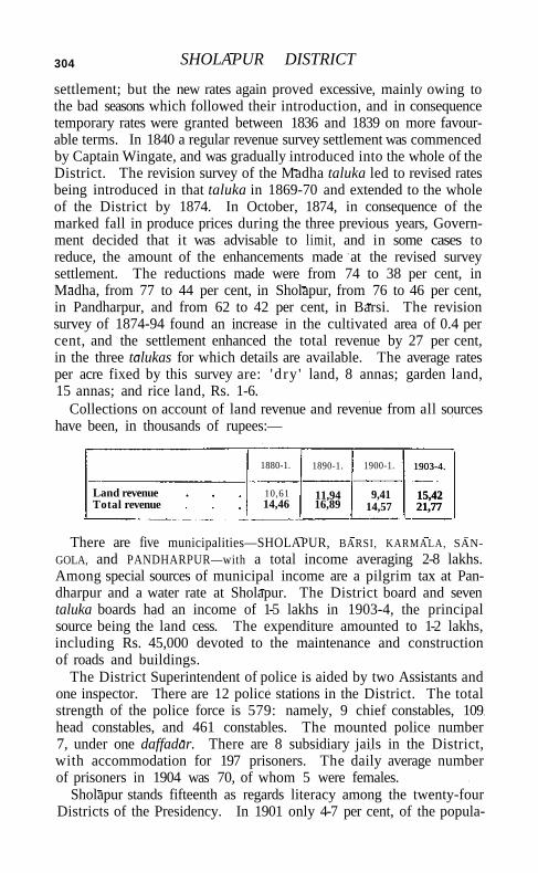
304 SHOLAPUR DISTRICT
settlement; but the new rates again proved excessive, mainly owing to the bad seasons which followed their introduction, and in consequence temporary rates were granted between 1836 and 1839 on more favourable terms. In 1840 a regular revenue survey settlement was commenced by Captain Wingate, and was gradually introduced into the whole of the District. The revision survey of the Madha taluka led to revised rates being introduced in that taluka in 1869-70 and extended to the whole of the District by 1874. In October, 1874, in consequence of the marked fall in produce prices during the three previous years, Government decided that it was advisable to limit, and in some cases to reduce, the amount of the enhancements made at the revised survey settlement. The reductions made were from 74 to 38 per cent, in Madha, from 77 to 44 per cent, in Sholapur, from 76 to 46 per cent, in Pandharpur, and from 62 to 42 per cent, in Barsi. The revision survey of 1874-94 found an increase in the cultivated area of 0.4 per cent, and the settlement enhanced the total revenue by 27 per cent, in the three talukas for which details are available. The average rates per acre fixed by this survey are: 'dry ' land, 8 annas; garden land, 15 annas; and rice land, Rs. 1-6.
Collections on account of land revenue and revenue from all sources have been, in thousands of rupees:—
1880-1. 1890-1. 1900-1. 1903-4.
15,42 21,77
Land revenue Total revenue
10,61 14,46
11,94 16,89
9,41 14,57
1903-4.
15,42 21,77
There are five municipalities—SHOLAPUR, BARSI, KARMALA, SAN-
GOLA, and PANDHARPUR—with a total income averaging 2-8 lakhs. Among special sources of municipal income are a pilgrim tax at Pandharpur and a water rate at Sholapur. The District board and seven taluka boards had an income of 1-5 lakhs in 1903-4, the principal source being the land cess. The expenditure amounted to 1-2 lakhs, including Rs. 45,000 devoted to the maintenance and construction of roads and buildings.
The District Superintendent of police is aided by two Assistants and one inspector. There are 12 police stations in the District. The total strength of the police force is 579: namely, 9 chief constables, 109 head constables, and 461 constables. The mounted police number 7, under one daffadar. There are 8 subsidiary jails in the District, with accommodation for 197 prisoners. The daily average number of prisoners in 1904 was 70, of whom 5 were females.
Sholapur stands fifteenth as regards literacy among the twenty-four Districts of the Presidency. In 1901 only 4-7 per cent, of the popula-
SHOLAPUR CITY 305
tion (8.9 males and 0-4 females) could read and write. In 1881 tliere were 174 schools with 7,060 pupils. The number of pupils increased to 14,711 in 1891 and to 14,984 in 1901. In 1903-4 the number of educational institutions was 297, comprising 2 high schools, 7 middle, and 258 primary schools, one training school, 2 industrial schools, and one commercial school; and the number of pupils was 6,162, including 547 girls. Of the 271 schools classed as public, one is managed by Government, 176 by local boards, 36 by municipalities, 57 are aided, and 2 are unaided. The total expenditure on education in 1903-4 was 1¼ lakhs, of which Provincial revenues contributed Rs. 47,000, Local funds Rs. 27,000, and fees Rs. 16,000. Of the total, 70 per cent, was devoted to primary schools.
The District contains two hospitals, including one for females, 8 dispensaries, one leper asylum, and 3 other medical institutions, with accommodation for 83 in-patients. In 1904 the number of patients treated was 151,682, of whom 1,118 were in-patients, and 3,802 operations were performed. The total expenditure on the civil hospital and 8 dispensaries and the leper asylum was Rs. 24,667, of which Rs. 15,229 was met from Local and municipal funds.
The number of people successfully vaccinated in 1903-4 was 18,000, representing 25 per 1,000 of population, which is slightly higher than the average of the Presidency.
[Sir J. M. Campbell, Bombay Gazetteer, vol. xx (1884); W. W. Loch, Historical Account of the Poona, Satara, and Sholapur Districts (1877).]
Sholapur T a l u k a . — South-eastern taluka of Sholapur District, Bombay, lying between 170 22' and 170 50' N. and 750 33/ and 760 26' E., with an area of 848 square miles. It contains one town, SHOLAPUR (population, 75,288), the head-quarters; and 151 villages. The population in 1901 was 203,905, compared with 180,630 in 1891. It is the most thickly populated taluka in the District, with a density of 240 persons per square mile. The demand for land revenue in 1903-4 was 2*6 lakhs, and for cesses Rs. 18,000. The taluka is undulating and devoid of trees, rising in places into small hillocks showing bare rock. The climate is d ry ; the cold season is clear and bracing. The two chief rivers are the Bhima and the Sina. The Bhima forms the southern boundary for about 35 miles; and the Sina runs south through the taluka for about 40 miles,
Sholapur City (Solapur = ' sixteen villages').—Head-quarters of Sholapur District, Bombay, situated in 170 40' N. and 750 54' E., on the Great Indian Peninsula Railway. Population (1881), 61,281, (1891) 61,915, and (1901) 75,288. Hindus number 55,988; Muham-madans, 16,103; Jains, 1,206; and Christians, 1,681.
The strong fort in the south-west corner of the city, surrounded by a ditch, is ascribed to Hasan Gangu, the founder of the Bahmani
306 SHOLAPUR CITY
dynasty (1347). On the dissolution of that kingdom in 1489, Shola-pur was held by Zain Khan; but during the minority of his son it was in 1511 besieged and taken by Kamal Khan, who annexed it with the surrounding districts to the Bijapur kingdom. In 1523 Sholapur formed part of the dowry of Ismail Adil Shah's sister, given in marriage to the king of Ahmadnagar. But not being handed over to Ahmadnagar, it was for forty years a source of constant quarrels between the two dynasties, until it was given back to Bijapur as the dowry of the Ahmadnagar princess Chand Bibl (1562). In 1668, in accordance with the terms of the treaty of Agra, Sholapur fort passed to the Mughals, from whose possession it fell to the Nizam in 1723, at the time when Ramchandra Pant, the Maratha, threw off his allegiance to Muhammad Shah the emperor. In 1795 it was ceded by the Nizam to the Marathas, after the battle of Kharda. At the close of the war with the Peshwa in 1818, it was stormed by General Munro. Since then the city has been steadily increasing in importance. Its convenient situation between Poona and Hyderabad has made it, especially since the opening of the railway in 1859, the centre for the collection and distribution of goods over a large extent of country. The chief industry of Sholapur is the manufacture of silk and cotton cloth, more than 12,000 persons being engaged as hand-loom weavers, spinners, and dyers. Sholapur has one spinning and weaving mill and two spinning-mills. The first mill, belonging to the Sholapur Spinning and Weaving Company, was opened in 1877, with a capital of 8 lakhs. The three mills have 528 looms and 144,520 spindles, giving employment to more than 5,000 persons. The total capital invested is 30 lakhs.
Sholapur is situated in the centre of a large plain 1,800 feet above sea-level, on the watershed of the Adila, a feeder of the Sina. To the south-west, close to the city wall, lies the fort, and farther on are the officers' bungalows of the old cavalry lines, now mostly occupied by railway servants and the railway station. To the south is the Siddh-eswar lake, with a temple in the centre. On the south-east bank of the lake is the municipal garden; and about 1,000 yards more to the south-east are the Collector's office and bungalow. About 100 to 500 yards south-west of the Collector's office stretch the officers' bungalows of the old cantonment; to the west of the officers' bungalows are the Protestant church and the post office. The chief public building is the Ripon Hall. The old military cantonment of Sholapur has been transferred to the civil authorities, and is included within municipal limits. No troops are now stationed here.
Sholapur was formerly enclosed by a wall 2\ miles in circuit. About 1872, to give room to the growing town, the municipality pulled down the whole of the east wall and parts on the south-west and north. The
SHOLINGHUR 307
walls, where still standing, are 8 to 10 feet high, 4 to 6 feet wide St the base, and 3 to 4 feet wide at the top.
The fort is an irregular oblong about 230 yards by 176, enclosed by a double line of lofty battlemented and towered walls of rough stone 10 to 20 yards apart, and surrounded, except on the east or Siddheswar lake side, by a wet moat 100 to 150 feet broad and 15 to 30 deep. The whole work is Muhammadan, the outer wall dating from the fourteenth century, and the inner wall and four great square towers from the sixteenth and seventeenth centuries. The outer wall, with battlemented curtains and four corner and twenty-three side towers pierced for musketry, and with openings and vaulted chambers for cannon, rises 20 to 30 feet from the edge of the moat. About 20 yards behind, the inner wall, also towered and battlemented, rises 5 to 10 feet above the outer wall. It has about twenty-five towers, exclusive of the four square towers.
The houses in the city are mostly built of mud, but sometimes of stone and burnt bricks, and are covered with flat roofs. On account of the absence of any high ground in the neighbourhood, Sholapur is on all sides exposed to the winds. The climate, except during the months of March, Apr i l , and May, is agreeable and healthy. The municipality, established in 1853, had an average income during the decade ending 1901 of 1½ lakhs. In 1903-4 the income was 1½ lakhs, including loans from Government (Rs. 45,000) and octroi dues (Rs. 60,000). Water-works, constructed by the municipality between 1879 and 1881, give a daily supply of about 13 gallons a head. The water is drawn from the Ekruk lower level canal through a line of 10-inch pipes into a settling tank, and thence pumped by steam-power. Sholapur has 39 schools, attended by 1,425 boys and 638 girls, including a Government high school with 165 pupils, four middle schools, one normal school, an industrial and a commercial school. There is also a kindergarten class supported by the American Mission. Besides the chief revenue and judicial offices there are two Subordinate Judges' courts, two hospitals, of which one is for females, and four dispensaries. Sholapur is the head-quarters of the American Protestant Mission, which has branches at 8 villages in the Sholapur taluka.
Shol inghur .—Town in the Walajapet taluk of Nor th Arcot District, Madras, situated in 130 7 ' N . and 79°25 'E . Population (1901), 6,442. The station of the same name on the Madras Railway is 7¼ miles from the town. The name is said to be a contraction of the words Chola-linga-puram, and to have been given to it because one of the Chola kings here found a natural lingam and built a shrine over it called the Choleswara or Sholeswara temple. The town is extensive, and a brisk trade is carried on in its bazars and at its weekly fair ;
308 SHOLINGHUR
but the place derives its chief importance from its temples. Besides that of Sholeswara, another shrine within the town is dedicated to Bhaktavatsala. This is of fine proportions and is thought to have been built by one of the Vijayanagar kings. The other chief temples lie outside the town. The most celebrated is that of Narasimhaswami, situated upon the summit of the loftiest hill in the neighbourhood. From it a magnificent view may be obtained of the country round, with its reservoirs and fertile cultivation. Upon a lower hill to the east is a temple to Anjaneyaswami which, though not so pretentious as its neighbour architecturally, enjoys an equally wide reputation. Women suffering from dementia or hysteria (who are supposed to be possessed by evil spirits) are brought to it to be cured. Another fine shrine lies below the Narasimhaswami hill. It is now in ruins, having been struck, it would appear, by lightning, and its finely carved columns lie about in confusion. There are very many sacred pools or ttrthams round Sholinghur, the chief being the Brahma firthatn, in which people bathe on Thursdays. In the neighbourhood of Sholinghur, in 1781, was fought the battle between Sir Eyre Coote and Haidar Al i in which the latter lost heavily. Two large Muhammadan tombs by the side of the road on the south of the town mark the spot where the bodies of the slain of the Mysore army were interred in two common graves.
Shorapur.—Taluk and town of Gulbarga District, Hyderabad State. See SURAPUR.
Shorarud.-—Sub-tahsil of Quetta-Pishin District, Baluchistan. See QUETTA TAHSIL.
Shorkot Tahsil.— Tahslloi J hang District, Punjab, lying between 300 35' and 310 17' N. and 71° 37' and 720 31 ' E., with an area of 916 square miles. It lies on both banks of the Chenab. The population in 1901 was 95,136, the density, 104 persons per square mile, being lower than in the more fully irrigated tahsils of the District. It contains 176 villages, including SHORKOT, which is a place of some historical interest. The land revenue and cesses in 1905-6 amounted to 1 -8 lakhs. The north-west of the tahsil occupies a corner of the great desert plateau of the Thai. The lowlands on either side of the Chenab are studded with prosperous villages, picturesquely situated among palm groves. Farther towards the east, past Shorkot town, the ancient site of which forms a conspicuous landmark, is a remnant of the old Jangal Bar, which soon gives place to the highly cultivated lands watered by the Chenab Canal.
Shorkot Town.—Head-quarters of the tahsil of the same name in Jhang District, Punjab, situated in 30°48' N. and 720 8' E., among the lowlands of the Chenab, about 4 miles from the left bank of the river, and 36 miles south-west of Jhang town. Population (1901), 3,907.
SHUJABAD TAHSIL 309
The modern town stands at the foot of a huge mound of "ruins, marking the site of the ancient city, which is surrounded by a wall of large antique bricks, and so high as to be visible for 8 miles around. Gold coins are frequently washed out of the ruins after rain. Cunningham identified Shorkot with one of the towns of the Malli attacked and taken by Alexander. He also inferred, from the evidence of coins, that the town flourished under the Greek kings of Ariana and the Punjab, as well as under the Indo-Scythian dynasties up to A.D. 250. It was probably destroyed by the White Huns in the sixth century, and reoccupied in the tenth by the Brahman kings of Ohind and the Punjab. The modern town is of little importance. It is surrounded by fine groves of date-palms. Many of the buildings are lofty, but most are more or less in ruins. Shorkot is now administered as a ' notified area/
Shravan Belgola. — Village in Hassan District, Mysore. See SRAVANA BELGOLA.
Shrigonda Taluka.—Southern taluka of Ahmadnagar District, Bombay, lying between 180 27'and 180 54' N. and 740 23' and 740
56' E., with an area of 615 square miles. I t contains one town, SHRIGONDA (population, 5,415), the head-quarters; and 83 villages. The population in 1901 was 61,240, compared with 66,658 in 1891. The density, 100 persons per square mile, is much below the District average. The demand for land revenue in 1903-4 was 1.4 lakhs, and for cesses Rs. 10,000. The greater part of the taluka lies in the valley of the Bhlma, and has a gentle slope from the north-east towards that river on the south and its tributary the Ghod on the south-west. For the most part it is a level plain, with an average elevation of 1,900 feet above sea-level, skirted on the north-east by a chain of low hills with flat summits, or Pathars, which have a uniform elevation of about 2,500 feet. Towards the hills the soil is generally of a very poor description. That of the centre of the taluka is tolerably fertile; but in the neighbourhood of the Bhlma deep clayey soils prevail which require much labour in their cultivation, and only yield good crops in years of plentiful rainfall. The old trunk road from Ahmadnagar enters the taluka on the north at the fifteenth mile from Ahmadnagar city and runs south. The Dhond-Manmad Railway completely traverses the taluka from north to south.
Shrigonda Town (also called Chamargonda, from Govind, a pious Chamax).—Head-quarters of the taluka of the same name in Ahmadnagar District, Bombay, situated in 18°37 /N. and 740 42' E., 32 miles south of Ahmadnagar city. Population (1901), 5,415. It has four temples, and two mansions belonging to Maharaja Sindhia of Gwalior.
Shujabad Tahsil.—Tahsil of Multan District, Punjab, lying between 290 22' and 300 1' N. and 710 2' and 710 31' E., with an area of 680 square miles. The Chenab bounds it on its longest (north-west)
310 SHUJABAD TAHSlL
border. Above the Chenab lowlands, which are subject to periodical inundation from the river, is a high-lying tract of Bar country mainly unirrigated. The surface of the country slopes away towards the junction of the Sutlej and the Chenab in the south-west corner. The population in 1901 was 124,907, compared with 114,714 in 1891. It contains the towns of SHUJABAD (population, 5,880), the head-quarters, and JALALPUR (5,149); and 148 villages. The land revenue and cesses in 1903-4 amounted to 32 lakhs.
Shujabad Town,—Head-quarters of the tahsil of the same name in Multan District, Punjab, situated in 290 53' N. and 710 18' E., 5 miles east of the Chenab, on the North-Western Railway. Population (1901), 5,880. The town, which is surrounded by a wall, was founded in 1750 by Nawab Shuja Khan, a kinsman of Ahmad Shah Durrani and Subahdar of Multan. His son, MuzarTar Khan, who governed Multan from 1779 to 1818, greatly advanced the prosperity of the town and built the Jahaz Mahal, which contains some curious frescoes said to represent Arabian cities, and had a beautiful marble floor, since removed to the public library at Multan. The building is now used as a tahsil court. Having capitulated to Edwardes in J 848 after the action at Kineri, it was used as a commissariat depot throughout the siege of Multan. The municipality was created in 1867. The income during the ten years ending 1902-3 averaged Rs. 10,500, and the expenditure Rs. 10,700. In 1903-4 the income was Rs. 11,700, chiefly from octroi; and the expenditure was Rs. 11,100. The town has an Anglo-vernacular middle school, maintained by the municipality, and a dispensary. It contains one small cotton-ginning factory with 21 hands, but is of no commercial importance.
Shujalpur (or Shujawalpur).—Head-quarters of the pargana of the same name in the Shajapur district of Gwalior State, Central India, situated in 230 24' N. and 760 43' E., on the Ujjain-Bhopal Railway. Population (1901), 5,731. The town was originally founded by a Jain merchant, and called after him Rai Karanpur, one of the wards still bearing this title. The real interest of the place, however, lies in its connexion with Shujaat Khan, an active champion of Sher Shah, who raised the place from a small village into a flourishing town. Shujaat Khan was locally known as Shujawal Khan, and a further contraction has given the name of the town. Though Mandu and Ujjain were his official residences as governor of MalwS, Shujaat always had a predilection for this place. In 1808 it fell to the Pindari leader Karlm Khan, as part of his jagtr. It was one of the places of which the revenues were assigned to the British Government by Article 5 of the treaty of 1844, but was restored to Sindhia under the treaty of 1860. Near Shujalpur is the cenotaph of Ranoji Sindhia, the founder of the Gwalior house, who died in 1745. Besides the pargana offices, a police station,
SHWEBO DISTRICT 311
a school, a State post office, a dispensary, and an inspection bungalow are situated here.
Shujaota .— Thakurat in the M A L W A A G E N C Y , Central India . S h w e b o Di s t r i c t .—A dry zone District of the Sagaing Division ot
Upper Burma, lying between 220 n ' and 230 52' N. and 940 50' and 960 1' E., wi th an area of 5,634 square miles. It is bounded on the north by K a t h a ; on the east by the Ruby Mines and Mandalay Districts; on the south by Sagaing; and on the west by the Upper and Lower Chindwin Districts. The M u , flowing down from the north, divides it into almost equal portions east and west, and the Irrawaddy forms the boundary on the east. It is for the most part a wide, almost rectangular plain running north and south, dotted with th in bushes and scrub jungle, with a low ridge of hills known as the M i n w u n range skirting the Irrawaddy in the east, and with small isolated clumps of rising ground in the north and north-east, and fringes of forest-clad upland in the west and north-west. The level is generally uniform and somewhat uninteresting ; but the river-side villages with their pagodas and monasteries, and the interior plain, viewed from the crest of the M i n w u n range, are not without a picturesqueness of their own. The most important rivers are the I R R A W A D D Y and the M u . The former enters the District near its north-eastern corner, and flows due south t i l l i t reaches Kabwet, about half-way down the eastern border. Here it bends westwards for a few miles, and again turning, runs south for a further stretch t i l l it enters Sagaing District. It is navigable all the year round by river steamers of the deepest draught. The M u is full of snags, and, except in the rains, is navigable only in its lower reaches. Running in a tortuous channel through arid country, it dwindles away in the dry season to a rivulet fordable everywhere along its course, though at the appropriate season it is freely used for timber-floating. The principal lakes are the Mahananda, the Ha l in (or Thayaing), the Kadu, and the Thamantha. The first, north-east of Shwebo town, fed by the old Mu canal, is the largest. The other three, lying south of Shwebo, are shallow meres depending on the drainage from the adjacent country, but are rarely dry, though they seldom have much water in them.
The surface of the District is, to a great extent, covered by the alluvium of the Mu river, from beneath which rise low undulating hills of sandstone of Upper Tertiary (pliocene) age. To the east these are brought down by a great fault against crystalline rocks, gneiss, granite, and crystalline limestone, which form the Minwun range. The alluvium is largely impregnated with salt. Coal occurs in the Tertiary beds.
From a botanical point of view the District is very poor. Only three kinds of bamboos are found : namely, thaikwa (Bambusa Tulda\
Physical aspects.
312 SHWEBO DISTRICT
myinwa (Dendrocalamus strictus), and tinwa (Cephalostachyum per-gracile). The most important trees are teak (Tectona grandis), in Dipterocarpus tuberculatus), thitya (Shorea obtusa), thitsi (Melanorrhoea usitata), yinma (Chickrassia tabularis), ingyin (Pentacme siamensis), pyingado (Xylia dolabriformis), sha {Acacia Catechu\ and tanaung (Acacia leucophloea). Further details regarding the vegetation will be found under the head of Forests.
The wild animals are the elephant, the bison, the hsaing (Bos son-daicus), the hog deer, the sambar, the barking-deer, the brow-antlered deer (Cervus eldi) the wild hog, the hare, the jackal (Cam's aureus), the jungle dog (Cyon rutilans), and the common tree cat or palm-civet (Paradoxurus hermaphrodites). Tigers are scarce, but leopards are common everywhere; and during the cold season water-fowl abound. Quail visit the District in the rains, and the jungle-fowl and francolin breed and are plentiful.
The climate is good, except in the north and north-west, where it is malarious. The heat in the dry season is very great, as elsewhere in the dry zone, but is less intense in the north and north-west of the District. The mean temperature recorded at Shwebo is 8o°, the thermometer readings varying from 560 in January to 1040 in May. The rainfall is scanty and irregular, except in the north and north-wrest. The average varies from 29 to 49 inches, but the maximum would, no doubt, be higher if a record were kept in the hilly tracts. The rainfall follows the valleys of the Irrawaddy and M u , and leaves the rest of the District comparatively dry.
According to tradition, Shwebo town was founded by a hunter (Burmese, mokso) named Nga Po at the end of the sixteenth century,
and was then called Moksongapoywa. It was from this hunter ancestor that Alaungpaya" (Alompra), the
redoubtable Burmese conqueror, traced his descent. The warrior king, who is said to have been born in the hunter's village, fortified the place after he had risen from obscurity to prominence, surrounded it with a moat and walls, and made it his capital after his successful rebellion against the Talaings. None of the successors of Alaungpaya ever used Shwebo as a capital for any length of time; but it was with the aid of men from this District that prince Tharrawaddy displaced Bagyidaw from the throne, and Mindon successfully rebelled against his half-brother Pagan M i n ; while the Shwebo people maintained their character as king-makers by supporting Mindon against the futile rebellion of the Myingun and Padein princes. When the British force first marched into Shwebo, after the annexation of Upper Burma, the kayaing wun (the chief official of the place) submitted with all his subordinates, and greatly assisted the administration by putting down the organized dacoit bands under the leadership of the notorious
History.
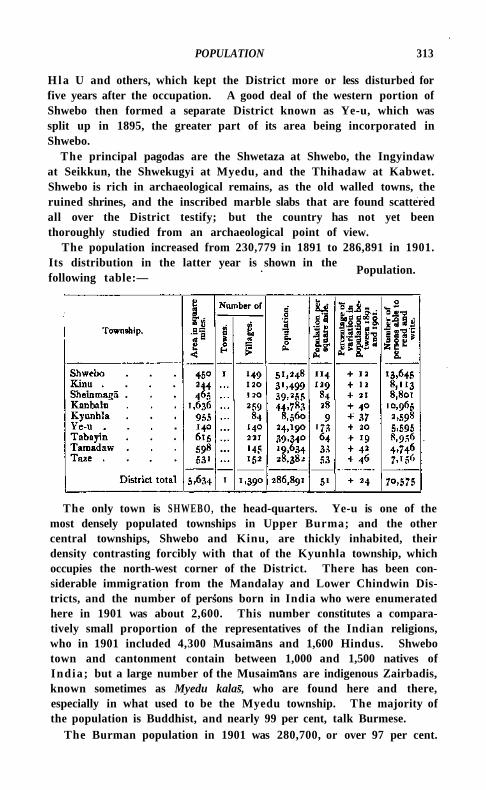
POPULATION 313
H l a U and others, which kept the District more or less disturbed for five years after the occupation. A good deal of the western portion of Shwebo then formed a separate District known as Ye-u, which was split up in 1895, the greater part of its area being incorporated in Shwebo.
The principal pagodas are the Shwetaza at Shwebo, the Ingyindaw at Seikkun, the Shwekugyi at Myedu, and the Thihadaw at Kabwet. Shwebo is rich in archaeological remains, as the old walled towns, the ruined shrines, and the inscribed marble slabs that are found scattered all over the District testify; but the country has not yet been thoroughly studied from an archaeological point of view.
The population increased from 230,779 in 1891 to 286,891 in 1901. Its distribution in the latter year is shown in the following table:—
Population.
The only town is SHWEBO, the head-quarters. Ye-u is one of the most densely populated townships in Upper Burma; and the other central townships, Shwebo and Kinu, are thickly inhabited, their density contrasting forcibly with that of the Kyunhla township, which occupies the north-west corner of the District. There has been considerable immigration from the Mandalay and Lower Chindwin Districts, and the number of persons born in India who were enumerated here in 1901 was about 2,600. This number constitutes a comparatively small proportion of the representatives of the Indian religions, who in 1901 included 4,300 Musaimans and 1,600 Hindus. Shwebo town and cantonment contain between 1,000 and 1,500 natives of India; but a large number of the Musaimans are indigenous Zairbadis, known sometimes as Myedu kalas, who are found here and there, especially in what used to be the Myedu township. The majority of the population is Buddhist, and nearly 99 per cent, talk Burmese.
The Burman population in 1901 was 280,700, or over 97 per cent.
3*4 SHWEBO DISTRICT
of the total. The other indigenous races are represented by less than 1,000 Shans in the northern areas.
No less than 216,686 persons, or 75 per cent, of the total population, were in 1901 engaged in , or dependent upon, agriculture. Owing to the frequent failure of the rains, the cultivator has to supplement his income by selling firewood, bamboos, and timber, by extracting resin o i l , by making mats and thatch, or by working as a cooly on the railway or on the Shwebo Canal, or as a field-labourer in other Distr ic ts ; but with the beginning of the monsoon he drifts back to his ancestral fields.
Christians are fairly numerous; their total in 1901 was 2,493, including 1,328 Roman Catholics. The Roman communion has long been at work in the District. It has its head-quarters at Monhla and Chanthaywa, possesses several churches, and ministers to 11 Christian villages, in which it keeps up vernacular schools. The Anglican (S.P.G.) Mission at Shwebo was started in 1887. It maintains a church and an Anglo-vernacular school. Altogether, 1,555 of the Christians are natives.
The soil varies from a stiff black cotton soil to light sand, and the surface from rich ravines annually fertilized by leaf-mould washed down
from the neighbouring highlands to sterile ridges (kons) of alkali and gravel. The rainfall is precarious
throughout the greater part of the District, but is fairly reliable in the hi l ly areas in the north and north-west. The husbandman in Shwebo is as conservative and short-sighted as elsewhere in Burma, and makes rice his main crop, in defiance of the varying soil and the fickle rain supply. On the southern and south-western borders, however, sesa-mum, millet, and a l i t t le cotton are g rown; and the alluvial formations of the rivers are covered in the dry season with island crops of various kinds, such as peas and beans, tobacco, onions, brinjals, tomatoes, gram, and the like. Rice is cultivated in the usual manner, except in the Tabayin and Ye-u townships, where the fields are ploughed dry, and the seed is sown broadcast and left to mature without transplanting.
The area cultivated depends entirely upon the local rainfall, and thus varies very considerably from year to year. In 1890-1 about 372 square miles were under crop, in 1891-2 only 130 square miles, a total which increased steadily t i l l 1897-8, excluding the bad year 1895-6. There was a large increase in 1899-1900, and by 1900-1 the cultivated area had risen to 645 square miles, but this total fell to 239 square miles in 1902-3. The main agricultural statistics for 1903-4 are given in the table on the next page, in square miles.
The promise of the early rains caused the increase in 1903-4, but of the total shown above no less than 167 square miles failed to mature.
Agriculture.
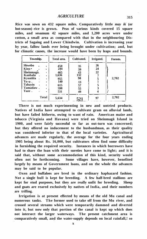
AGRICULTURE 315
Rice was sown on 432 square miles. Comparatively little may ik (or hot-season) rice is grown. Peas of various kinds covered 15 square miles, and sesamum 42 square miles, and 1,200 acres were under cotton, a small area as compared with that in the neighbouring Districts of Sagaing and Lower Chindwin. Cultivation is increasing year by year, fallow lands ever being brought under cultivation; and, but for climatic causes, the increase would have been by leaps and bounds.
Township. Total area. Cultivated. Irrigated. Forests.
Shwebo 450 35 26 \ Kinu • 244 39 24 Sheinmaga. 465 43 22 Kanbalu . 1,636 132 7 Kyunhla . 955 98 5 2,702 Ye-u . 140 13 1 Tabayin 615 57 5 Tamadaw . 598 55 3 Taze . 531 49 4 /
Total 5,634 521 97 2,702
There is not much experimenting in new and untried products. Natives of India have attempted to cultivate gram on alluvial lands, but have failed hitherto, owing to want of rain. American maize and tobacco (Virginia and Havana) were tried on Sheinmaga Island in 1900, and were fairly successful so far as out-turn was concerned; but they offered no inducement to the husbandman, as their quality was considered inferior to that of the local varieties. Agricultural advances are made regularly, the average for the four years ending 1905 being about Rs. 16,000, but cultivators often find some difficulty in furnishing the required security. Instances in which borrowers have had to share the loan with their sureties have come to light; and it is said that, without some accommodation of this kind, security would often not be forthcoming. Some villages have, however, benefited largely by means of Government loans, and on the whole the advances may be said to be popular.
Oxen and buffaloes are bred in the ordinary haphazard fashion. Not a single bull is kept for breeding. A few half-bred stallions are kept for stud purposes, but they are really unfit for breeding. Sheep and goats are reared exclusively by natives of India, and their numbers are trifling.
Irrigation is at present effected by means of the old Mu canal and numerous tanks. The former used to take off from the Mu river, and crossed several streams which were temporarily dammed and diverted into it, but now only that portion of the canal is kept up which does not intersect the larger waterways. The present catchment area is comparatively small, and the water-supply depends on local rainfall,! so
x
3*6 SHWEBO DISTRICT
that when rain fails the work is of little use. In a favourable year, on the other hand, it gets too full, and fear of a breach of the embankment occasionally makes it necessary to open the sluices, with the result that the water flows over and deluges the already inundated fields. The Shwebo Canal, opened in 1906, has been designed to draw a large quantity of water from the M u ; and as it will be possible to control it effectually, it should prove an invaluable irrigation work. The cost of the work was 51 lakhs, and the area irrigable is 295 square miles. The principal tanks are at Hladaw, Payan, Palaing, Kywezin, Gyogya, Yinba, Pindin, Kanthaya, Yatha, and Taze. Their catchment area, lik6 that of the old Mu canal, is small, and they depend solely on the rainfall and the drainage from the adjacent country. At certain times they have a reserve of water which may prove really useful, but such occasions are very rare. In 1903-4 about 97 square miles, mostly under rice, were irrigated. Of this total, 18,800 acres obtained their water-supply from tanks, 5,000 acres from wells, and 39,100 acres from Government canals. These last had irrigated only 4,000 acres in the previous year (1902-3), the increase in 1903-4 being due to the improvements made in the old Mu canal, assisted by propitious rainfall. The irrigated lands lie almost entirely in the Shwebo subdivision and the Tabayin township.
The only two large fisheries are the Bandiba and the Kyauksaung in the Irrawaddy.
Shwebo is included in the Mu Forest division, which also comprises Sagaing and a part of Katha. The forests are confined to the north
and north-west, and are of two kinds, teak and cutch. In the former, padauk {Pterocarpus indicus) and in
(Dipterocarpus tuberculatus) are also found to some extent. The Yabin and Kanbalu Reserves are the only ones in the District. In the former the planting of teak, to the extent of a square mile, has been carried out successfully. In the latter experiments have been tried with sandal-wood seed, which germinated well, though the young plants have suffered from the attacks of insects and rodents. The area of 1 reserved' forests is 595 square miles, of which 10 square miles are cutch, and the rest teak, with a sprinkling of padauk and indaing. The area of the 'unclassed' forests is 2,107 square miles; and it has been proposed to convert 83 square miles of these into a cutch Reserve, though the final settlement has not yet been completed. The chief minor forest products are thitsl (resin oil), cutch, and bamboos, all of which are abundant. Five Chinese firms are engaged in the cutch trade, and their business is brisk. The forest revenue in 1903-4 was nearly a lakh and a half.
Coal was worked from 1892 to 1903 by the Burma Coal Mines Company at Letkokpin, 6 miles from Kabwet on the Irrawaddy, by
Forests.
TRADE AND COMMUNICATIONS 317
means of shaftings, the hauling being done by steam. The mines were capable of turning out 2,000 tons monthly, but the Burma Railways Company were the chief purchasers, consuming about 800 tons a month. The mine has now been shut down. A prospecting licence for rubies, gold, and silver has been issued, and leases of land for the purpose of boring for earth-oil have been granted; but though good petroleum has been obtained, the wells, which are in the Kyunhla township, have been abandoned owing to the unhealthiness of the place. Salt is extracted from brine-wells in the Kanbalu, Shwebo, and Sheinmaga townships. The average earnings of the workers are four annas a day, and the salt produced is used locally, besides being exported to other Districts. Pottery clay exists in places. Gravel, laterite, and sandstone are extracted, mostly by natives of India, to meet local demands on account of public works.
Silk-weaving is carried on at Chiba and Seikkun in the Shwebo township. The produce of the village looms holds its own, in spite of the competition of imported fabrics, which, though cheaper, are far less strong and durable. The method of working is purely Burmese, and the patterns have improved greatly in design of late. For weaving purposes raw silk (Indian or Chinese) is brought from Mandalay, and the articles turned out are mainly pasos (waistcloths) of various kinds. Articles other than pasos are woven only.when special orders have been given. The dyeing of the raw silk is largely done on the spot. The manufacture of pottery is practised all the year round at Kyauk-myaung, Shwegun, Shwedaik, and a few other villages on the Irra-waddy by professional potters; elsewhere it is carried on only during the dry months of the year as a subsidiary occupation by agriculturists. Unglazed pottery is manufactured in the ordinary way from clay mixed with sand, and fired in heaps that are coated with clay. If black instead of the usual red ware is required, bran is poured on the burning heap and the articles are coloured by the smoke. In the manufacture of glazed pottery, the only essential difference is the smearing of the green pots with what is known as chaw, the slag left after silver has been extracted from lead ore. The making of glazed pots is a more profitable industry than that of unglazed, as it is attended with less breakage. In the Kanbalu township a considerable section of the population are engaged during the dry season in weaving mats and rough baskets of various kinds. Tantabin is the centre of the mat and basket industry.
The principal exports are salt, which is taken by local traders in boats to Katha from Sheinmaga and Thitseingyi on the Irrawaddy, and cutch, sent by rail to Rangoon by a few Chinese firms which have been established in the District since the opening of the cutch
x 2
Trade and communications.
318 SHWEBO DISTRICT
forests. Pulse is sent out in boats by merchants living on the Irrawaddy and the M u ; rice and European goods come in by rail, principally from Mandalay; and sesamum oil in carts from the Sagaing and Lower Cnindwin Districts. Boats fetch tobacco from Sagaing, Mymgyan, and Pakokku; ngapi (fish-paste) is brought by rail from Mandalay and in boats from the deltaic Districts of Lower Burma; and rice comes by rail from Kawlin and Wuntho in the neighbouring District of Katha. As Shwebo District is poor, the wants of the people are confined for the most part to these main articles of consumption. The., chief centres for boats are Kyaukmyaung, Thitseingyi, and Shein-magt on the Irrawaddy, and Mugan, Sinin, and Ye-u on the Mu. The.jaggery sugar from the Ye-u subdivision is exported in carts to Katha, where it finds a ready sale owing to its damp-resisting properties. Mandalay supplies the raw Chinese or Indian silk used by the silk-weavers of the District. • The Burma Railway runs through the heart of Shwebo, linking Myitkyina with Mandalay, and serving the whole District, as from almost every station a road branches out either east to the Irrawaddy or west to the Mu. The Public Works department maintains 48 miles of metalled, and 203 miles of unmetalied roads. The principal metalled roads are from Shwebo to Kyaukmyaung (17 miles), connecting the Mu valley with the Irrawaddy, and from Kinu to Ye-u (13 miles). The most important unmetalied tracks are from Kinu to Kabwet on the Irrawaddy 9 miles below Thabeikkyin, whence an important metalled road climbs to Mogok, the head-quarters of the Ruby Mines District; from Ye-u to Paga on the Upper Chindwin border; and from Ye-u to Saingbyin on the Lower Chindwin border. The District fund keeps up 86 miles of unmetalied roads. The Irrawaddy is navigable all the year round, and the Irrawaddy Flotilla Company's express and cargo steamers between Mandalay and Bhamo call at Kyaukmyaung and at Kabwet every week in each direction. The ferry steamer plying between Mandalay and Thabeikkyin also calls at those two stations, as well as at Sheinmaga and Thitseingyi, twice a week in each direction. The Mu is navigable in the rains by native craft to the borders of Katha District. There are five ferries across the Irrawaddy, and eleven across the Mu, at convenient distances from each other.
Its capricious rainfall always renders the District liable to partial scarcity, but the only serious failure of crops that has occurred in
recent years was in 1891. Ye-u was then a separate District, comprising the present Ye-u subdivision
and the Kyunhla township, and it was in the former area that the distress was most acute. It was due to a series of bad harvests caused by deficient rainfall, and pressed all the more heavily on the people
Famine.
ADMINISTRATION 319
because they had not then fully recovered from the effects of the troublous times that followed close on annexation. Many o f the v i l lagers were compelled to sell their cattle to procure food, to resort to roots as a means of subsistence, and to emigrate to the Lower province and to the Ruby Mines District for their l iving. Relief works were not opened on the east of the M u , as the railway afforded ample employment there for the able-bodied, but they were started in Ye-u. Advances were liberally made to cultivators to enable them to buy seed and to retain their cattle, partial or total remissions and suspensions of revenue were granted, while rice was imported by Government and distributed at cost price, and gratuitous relief was given to the disabled. Fortunately the famine was of short duration.
The District contains three subdivisions: Shwebo, Kanbalu, and Ye-u. The first comprises the SHWEBO, K I N U , and S H E I N M A G A townships, the second the K A N B A L U and K Y U N H L A townships, and the third the Y E - U , T A B A Y I N , T A M A D A W , and T A Z E townships. The subdivisions and townships are in charge of the usual executive officers, under whom are 884 village headmen. Of the latter, 258 are subordinate to circle headmen. Shwebo forms (with Sagaing District) a Public Works division, with two subdivisional officers in the Dis t r ic t ; and the forests are included in the Mu Forest division.
As elsewhere, the subdivisional and township courts are presided over by the subdivisional and township o'fficers concerned, but the latter do not try suits relating to immovable property or to any right or interest in such property. At District head-quarters, the treasury officer is additional judge of the Shwebo township court as well as head-quarters magistrate. Lit igation is normal and crime is on the whole light. Dacoity, murder, and cattle-theft are infrequent, and opium cases are few. Ordinary thefts and excise and gambling cases, for the most part committed in Shwebo town and its suburbs, are, on the other hand, fairly numerous.
Prior to the reign of Mindon M i n there was no organized scheme of revenue collection in Shwebo; that monarch, however, introduced some k ind of system into the methods of the rapacious officials. Thathameda was then for the first time levied, royal lands were taxed on a uniform scale of one-fourth of the produce, and imposts were placed on monopolies, carts, fisheries, and other sources of income. After annexation the thathameda continued to be levied on much the same system as before. The land revenue administration is at present in a state of transition. Most of the District is occupied under the ordinary bobabaing (non-state) and state land tenures, which are common to al l the dry zone Districts of Upper Burma. In the Kyunhla township the conditions were at one time peculiar. Tradi t ion relates
Administration.
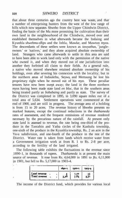
320 SHWEBO DISTRICT
that about three centuries ago the country here was waste, and that a number of enterprising hunters from the west of the low range of hills which now separates Shwebo from the Upper Chindwin District, finding the basin of the Mu more promising for cultivation than their own land in the neighbourhood of the Chindwin, moved over and established themselves in what afterwards became the Indaing and Kyunhla shwehmu-ships and the Inhla, Mawke, and Mawton tnyos. The descendants of these settlers were known as tawyathas, i jungle-owners ' or 'natives,' and they alone acquired absolute ownership of land. Strangers who came afterwards to settle in this area are said to have been able to work land only with the permission of the native who owned it, and when they moved out of one jurisdiction into another they forfeited all claim to their fields. As a general rule, a native who moved elsewhere retained absolute ownership of his holdings, even after severing his connexion with the locality; but in the northern areas of Indauktha, Seywa, and Mettaung he lost his proprietary right when he moved out of his myo. These peculiar tenures have now been swept away; the land in the three northern myos having been made state land en bloc, that in the southern areas being treated partly as bobabaing and partly as state. The survey of the District was completed in 1895, in 3,090 square miles out of a total area of 5,634. Settlement operations were commenced at the end of 1900, and are still in progress. The average area of a holding is from 15 to 20 acres. The revenue history of Shwebo presents no marked features, except the continual reductions in the thathameda rates of assessment, and the frequent remissions of revenue rendered necessary by the precarious nature of the rainfall. At present only state land is assessed to revenue, the rate being one-third of the produce in the Tantabin and Yatha circles of the Kanbalu township, one-sixth of the produce in the Kyunhla township, Rs. 2 an acre in the Ye-u subdivision, and one-fourth of the produce in the rest of the District. Water rate is taken from lands which receive water from a Government irrigation work at from R. 1 to Rs. 2-8 per acre, according to the fertility of the land irrigated.
The following table exhibits the fluctuations in the revenue since 1890-1, in thousands of rupees. Thathameda is at present the main source of revenue. It rose from Rs. 4,64,000 in 1891 to Rs. 6,11,000 in 1901, but fell to Rs. 5,17,000 in 1903-4.
The income of the District fund, which provides for various local
ADMINISTRATION 321
needs such as roads, dak-bungalows, & c , was Rs. 21,000 in 1903-4, and the chief item of expenditure was Rs. 21,000 on public works. The municipality of SHWEBO is the only one in the District.
Soon after annexation, both European and Native troops were stationed at Shwebo, and at Kyaukmyaung on the Irrawaddy, which, previous to the building of the railway, was the key to the District; and in 1888 a cantonment was established at Shwebo. It is situated to the north-east of the town on high ground and on a very healthy site. With the pacification of the country the Native troops were gradually withdrawn, and a reduction followed in the strength of the European troops, who during the last five years have numbered only five companies. Shwebo is the head-quarters of a company of the Upper Burma Volunteer Rifles, drawn from the Shwebo, Katha, Bhamo, and Myitkyina Districts.
The District Superintendent of police is assisted by subdivisional police officers, who are either Assistant Superintendents or inspectors, and by a head-quarters inspector. The sanctioned strength of the force is 473 men, consisting of 16 head constables, 37 sergeants, and 420 constables, posted at 13 police stations and 18 outposts. Shwebo is the head-quarters of a military police battalion, and the sanctioned strength of the force serving within the limits of the District is 495 men, of whom 415 are stationed at Shwebo, 30 at Kanbalu, and 50 at Ye-u. There is a District jail at Shwebo, with accommodation for 237 males and 3 females. Wheat-grinding is the only important industry carried on within its walls, the flour turned out by the prisoners being consumed by the military police.
The proportion of literate persons in 1901 was 50 per cent, in the case of males and 2 per cent, in that of females, or 25 per cent, for both sexes together—figures which place Shwebo in the very front rank of the Districts of Burma from an educational point of view. The chief educational institution is the Al i Saints' S.P.G. Mission school at Shwebo. Among the purely vernacular schools, which are mainly responsible for the high standard of literacy, two lay institutions in Shwebo town and two monastic schools at Tabayin and Kanbauk deserve special mention. Altogether there were n secondary, 142 primary, and 694 elementary (private) schools in the District in 1904, with a total of 9,175 male and 954 female scholars, as compared with 1,678 pupils in 1891 and 6,583 in 1901. The expenditure on education in 1903-4 amounted to Rs. 12,500. To this total Provincial funds contributed Rs. 9,000, fees Rs. 2,200, subscriptions Rs. 700, and the Shwebo municipality Rs. 600.
There are 3 hospitals and one dispensary, with accommodation for 62 inmates. In 1903 the number of cases treated was 15,890, including 662 in-patients, and 244 operations were performed. The annual
322 SHWEBO DISTRICT
cost is about Rs. 9,500, towards which municipal funds contributed Rs. 3,300 in 1903 and Provincial funds Rs. 4,500, the dispensary being maintained by the railway.
Vaccination is compulsory within Shwebo municipal limits. The operation is so popular among the people that the number of vaccinators has of late been increased from two to eight for the whole District. In 1903-4 the number of persons vaccinated was 11,799, representing 41 per 1,000 of the population.
Shwebo Subdivision.—Subdivision of Shwebo District, Upper Burma, containing the SHWEBO, K I N U , and SHEINMAGA townships.
Shwebo Township.—South-eastern township of Shwebo District, Upper Burma, lying between 220 26' and 220 46' N. and 950 27' and 950 59' E., with an area of 450 square miles. It stretches from the Irrawaddy on the east to the Mu river on the west, and is flat and dry throughout. The population was 45,713 in 1891, and 51,248 in 1901, distributed in one town, SHWEBO (population, 9,626), the head-quarters, and 149 villages. The area cultivated in 1903-4 was 35 square miles, and the land revenue and thathameda amounted to Rs. 1,03,300.
Shwebo Town.—Head-quarters of the District of the same name in Upper Burma, situated in 220 35' N. and 950 42' E., on the Sagaing-Myitkyina" railway, 53 miles from Sagaing. The town occupies part of what was once a vast rice plain, the country north, south, and west adjoining the walls being still devoted to rice cultivation; and its surroundings are bare and not outwardly attractive. Away to the east beyond the Irrawaddy can be seen the Shan plateau; while from the same direction a spur of the higher ground that forms the watershed between the Mu and the Irrawaddy runs down almost to the town, and on this spur are placed the present cantonments. The soil is poor and the water is brackish, so that there is little cause for surprise at the dreariness of the general prospect round Shwebo, and little hope for improvement until an efficient water scheme is in working order. The royal garden at Uyindaw, about a mile north of the town, and a smaller garden about half a mile beyond it, are the only plots of successful arboriculture in the neighbourhood; for the rest, there is little to relieve the eye but the tamarinds and other trees in the urban area. Two conspicuous objects are the Roman Catholic church in the south-east corner of the town and the stone S.P.G. church in the north-west. The condition of the town has improved of late years, a succession of mat-walled, thatch-roofed houses, swept away in periodical conflagrations, having been replaced by more pretentious buildings with carved wooden fronts. The roofs of corrugated iron, if they do not add to the beauty of the town, at any rate contribute to its security from fire. In a few instances large brick buildings have been erected.
SHWEBO TOWN 323
The old town of Shwebo is of considerable historical interest, haying been the birthplace and capital of Maung Aung Zeya, who seized the throne of Burma under the title of Alaungpaya, and founded the last dynasty of Burmese kings. In 1752 this monarch commenced serious operations against the Talaings, and in 1753 had made such progress that he had himself anointed king at his old home, and then proceeded to lay out and build a town there. This city, known as Moksobo, comprised an outer moat and wall, in the form of a square, over 2 miles each way, which exist to the present day, and a square inner citadel with a side of about 500 yards. Wi th in this citadel was an inner wall, which contained in its turn the palace \ but the palace and nearly the whole of the innermost wall have entirely disappeared. Alaungpaya also constructed the Shwechettho pagoda, a shrine still to be seen on the remains of the north inner w a l l ; the bahosin in front of the palace, on which was hung the big drum for beating the hours; the natsin or spirit shrine of the nine evil spirits whom all kings feared and propitiated: and a royal lake north of the town. The natsin still stands near the south of the ja i l , and the lake is the Mahananda. The present town of Shwebo just includes the fringe of the eastern portion of the old town of Moksobo.
After building the town described above, Alaungpaya turned his restless ambition towards Siam, but died during the course of a campaign in the south. His remains were brought back to Moksobo, and interred in the year 1760 near the entrance 10 the present courthouse. He was succeeded by his eldest son, who assumed the title of Naung-dawgyi, and whose successor and brother Sinbyushin, after reigning for two years at Moksobo, moved the capital to Ava in the year 1766, taking with him some of the famous Moksobo soil. The town then began to decline, t i l l 1837, in the reign of king Bagyidaw, when this monarch's brother, who was prince of Thayetmyo and Tharrawaddy, changed the name from Moksobo to Shwebo. In the same year he conspired against his elder brother and seized the throne. From the earliest days of its greatness the town had been named Yangyi-aung or ' the victorious,' and to use Shwebo as a base of operations was thought to be a guarantee of success in any enterprise. Accordingly, in 1852 king Tharrawaddy's son, Mindon, came to Shwebo when maturing his designs on the throne, which culminated in a successful conspiracy against his brother, Pagan M i n . Again, in Mindon's reign his nephew, the Padein prince, came to Shwebo, and plotted for his uncle's overthrow ; but on this occasion the proverbial luck of the city failed. It may be said, however, that the use of Shwebo as a capital ceased 140 years ago.
Immediately after the annexation of Upper Burma a detachment of British troops came up to Shwebo, but returned almost immediately
324 SHWEBO TOWN
to Mandalay. This withdrawal stimulated the rebels who were abroad in the land, and a confederacy of dacoit gangs, under a leader known as Mintha Hmat, devastated the town. On this the British troops returned and have held the place ever since.
The population of the town was 9,368 in 1891, and 9,626 in 1901, the majority being Burmans. The Indian colony consists of 700 Musal-mans and more than 600 Hindus, about half of whom are military followers and other residents of the cantonment The Christian population exceeds 1,000. A large proportion of the inhabitants are agriculturists, the rest work at the usual petty trades and crafts of the urban areas of Upper Burma. There are many special industries for which villages in the District are famous, but from an industrial and artistic point of view Shwebo itself is inconspicuous. A local blacksmith trained in France does excellent work in steel and iron. He and his pupils, however, are the only artisans who have endowed Shwebo with anything approaching an industry of its own.
The town was constituted a municipality in 1888. The receipts and expenditure during the ten years ending 1900-1 averaged Rs. 20,000. In 1903-4 the income was Rs. 36,000, of which bazar rents contributed Rs. 19,700, and a house and land tax Rs. 4,400. The expenditure amounted to Rs. 41,000, the chief ordinary items being lighting (Rs. 4,000), conservancy (Rs. 4,700), and roads (Rs. 11,500). The municipality contributes Rs. 600 annually to the S.P.G. Anglo-vernacular school, besides which there are two good lay schools. The municipal hospital has accommodation for 45 in-patients. The income and expenditure of the cantonment fund in 1903-4 was Rs. 6,000.
Shwedaung Subdivision.—Western subdivision of Prome District, Lower Burma, containing two townships, SHWEDAUNG and PADAUNG.
Shwedaung Township.—Township in the Shwedaung subdivision of Prome District, Lower Burma, lying along the eastern bank of the Irrawaddy, between 180 18' and 180 48' N. and 95° 4' and 950 21' E., with an area of 300 square miles. The population was 66,388 in 1891, and 66,743 in 1901, but the agricultural population increased from 25,700 to 36,300. There are 311 villages and one town, SHWEDAUNG (population, 10,787), the head-quarters. The area cultivated in 1903-4 was 87 square miles, paying Rs. 90,000 land revenue.
Shwedaung Town.—Head-quarters of the subdivision of the same name in Prome District, Lower Burma, situated in 180 42' N. and 950 13' E., on the Rangoon-Prome road, 8 miles due south of Prome town. Population (1901), 10,787. Shwedaung is administered by a town committee constituted in 1882. The income of the town fund in 1903-4 was Rs. 24,000 and the expenditure Rs. 29,000.
SHWEGYIN TOWN 325
There is a hospital in the town with 24 beds. A considerable amount of silk is manufactured, almost every house in the town having its loom.
Shwegu.—Western subdivision and township of Bhamo District, Upper Burma, lying between 230 37' and 240 50' N. and 960 34' and 970 16' E., with an area of 2,423 square miles. The population in 1901 was 21,943, Kachins numbering about 5,300, Shans about 3,800, and Burmans over 12,500. The subdivision contains 185 villages, the head-quarters being at Shwegu (population, 2,493), a long straggling collection of villages on the high left bank of the Irrawaddy, a regular calling-place for the Flotilla steamers. Valuable forests are found in the township, and ample room for extension of cultivation exists in the almost-deserted Sinkan valley. The Kachin areas lie in the east of the township, north and south of the Irrawaddy. The area cultivated in 1903-4 was 12 square miles, and the land revenue and thathameda amounted to Rs. 45,000.
Shwegyin Subdivision.—-Subdivision of Toungoo District, Lower Burma, containing the KYAUKKYI and SHWEGYIN townships.
Shwegyin Township.—Southernmost township of Toungoo District, Lower Burma, lying between 17° 33' and 180 13' N. and 960 48' and 970 13' E., with an area of 493 square miles. It extends from the Sittang, which separates it from Pegu District, to the borders of Sal-ween District. The population was 30,628 in 1891, and 26,894 in 1901 (nearly all Burmans or Talaings), residing in one town, SHWEGYIN (population, 7,616), the head-quarters, and 164 villages. The area cultivated in 1903-4 was 23 square miles, paying Rs. 22,000 land revenue.
Shwegyin Town.—Head-quarters of the subdivision of the same name in Toungoo District, Lower Burma, and formerly head-quarters of a District called after it. It is picturesquely situated in 170 55' N. and 960 53' E., close to the western slopes of the Paunglaung Hills, on the left bank of the Sittang river, immediately to the north of the point where the Shwegyin stream enters it from the east. It is well laid out, but is low-lying and apt to be flooded during the rains. Shwegyin means in Burmese 'gold-washing/ and it is probable that gold was found in the neighbourhood at one time. The place has, however, no history, having grown from a small village in comparatively recent times. Neither in the first nor the second Burmese War was any resistance offered to the British, who on both occasions occupied the town. Population (1901), 7,616. Shwegyin ceased to be a District head-quarters in 1895, and this accounts for part of the decrease in population during the last decade. The falling off had, however, begun earlier, and was largely caused by the remoteness of the town and its inaccessibility from the railway.
326 SHWEGYIN TOWN
The town was constituted a municipality in 1888, the present committee consisting of 3 ex-officio and 8 nominated members. The municipal income and expenditure during the ten years ending 1901 averaged Rs. 20,000. In 1903-4 the income was Rs. 22,000, of which Rs. 11,000 was derived from markets, and Rs. 3,300 from house and land tax; and the expenditure was Rs. 19,000, including Rs. 3,200 spent on conservancy and Rs. 3,500 on education. The municipal school contains 95 pupils, and an American Baptist Karen school 138. The municipal hospital has accommodation for 27 in-patients.
Shweli.—River of Burma, called Nam Mao by the Shans, who in ancient days first established themselves in what is now Burma along the Shweli valley. The stream rises in China in the neighbourhood of Tengyiieh, and flows first in a south-westerly and then in a northerly direction past Namhkam village, through the Shan State of Mongmit and along the northern end of the Ruby Mines District into the Irra-waddy, which it reaches at a point 20 miles south of the town of Katha. The total length of the river is about 260 miles. It abounds in rapids, and is but little used for navigation, but is employed freely for floating timber. It has no tributaries of importance.
Siahan. — Mountain range in Baluchistan, separating Makran from Kharan. The eastern part is known as Band. It runs south-south-west and east-north-east between 270 7' and 28° 2' N. and 630 22' and 650 42' E., and unites with the Jhalawan hills near Shireza, having a total length of 176 miles. It is the narrowest range in Western Baluchistan, the width nowhere exceeding 20 miles. North of Panjgur the general mass bifurcates, the spur on the south being known as the Koh-i-Sabz. Its general aspect is abrupt and rugged, and its geological formation a slaty shale. It has a mean elevation of about 5,000 feet. On the west are the two fine defiles of Tank-i-Grawag and Tank-i-Zurrati, through which the Rakhshan river passes.
Siaikot District.—District in the Lahore Division of the Punjab, lying between 310 43' and 320 51 ' N. and 740 n' and 750 1' E., with an area of 1,991 square miles. It is an oblong tract of country, occupying the submontane portion of the Rechna or Ravi-Chenab Doab, with a length from north-west to south-east of a little over 50 miles, and an average breadth of 44 miles, stretching from the valley of the Ravi on the south-east to that of the Chenab on the north-western border. On the north-east the District is bounded by the Jammu province of Kashmir; on the east by Gurdaspur; and on the west by Lahore and Gujranwala. Along the bank of both great boundary
rivers, a narrow fringe of alluvial lowland marks the central depression in which they run; while above them rise the high banks that form the limits
of their wider beds. Parallel to the Ravi, another stream, the Degh,
Physical aspects.
SIALKOT DISTRICT 327
which rises in the Jammu hills, traverses the centre of the District. A torrent in the rains, at other times the Degh dwindles to the merest trickle; like the greater rivers it is fringed on either side by a strip of alluvial soil, but in the upper part of its course through the Zafarwal tahsll the shifting of its bed has covered a large area with barren sand. Several other minor streams, of which the Aik is the most important, traverse the District. Midway between the Ravi and the Chenab is a raised dorsal tract, which forms a slightly elevated plateau stretching from beyond the Jammu border far into the heart of the dodb. The upper portion of the District near the hills wears an aspect of remarkable greenness and fertility. The dorsal ridge, however, is dry and sandy; and between the Degh and the Ravi the wild and unproductive upland grows more and more impregnated with saltpetre as it recedes from the hills, t i l l near the Lahore border it merges into a tangled jungle of brushwood and reeds. The District also comprises a small tract of low hills, called the Bajwat, on the north of the Chenab, a country of green grass and flowing streams, which presents an agreeable change from the arid plains of the Punjab.
There is nothing of geological interest in Sialkot, which is situated entirely on the alluvium. Cultivation is close, leaving little room for an indigenous flora of perennial plants. Towards the Jammu border, especially in the north-west of the District, plants of the Outer Himalayan fringe appear. Trees are rare, except where planted about wells, by roadsides, and in gardens.
A few wolves are the only representatives of the carnivora, while even hares and deer find little cover in so highly cultivated a tract. A few wild hog and nilgai are found, but no antelope have been shot in recent years. In the cold season wild geese, ducks, and other water-fowl abound in the marshes and on the river banks and islands; quail are plentiful in spring, but partridges are scarce.
The climate in summer is, for the plains, good; and, though there are generally a few days of most intense heat, the neighbourhood of the hills prevents any long-continued spell. The cold season resembles that in the Punjab generally, but begins early and ends late. The low hills are cool but very malarious, as is also the waterlogged valley of the Degh, while other parts are decidedly healthy. Pneumonia is common in the winter and fever in the autumn.
Owing to its submontane position the District has an abundant rainfall, but this diminishes rapidly in amount as the distance from the hills increases. The average rainfall varies from 22 inches at Raya to 35 at Sialkot; at the latter place 28 inches fall in the summer months, and 7 in the winter. The heaviest rainfall recorded during the twenty years ending 1901 was 64 inches at Sialkot in 1881-2, and the lowest 10 inches at Daska in 1891-2.
328 SIALKOT DISTRICT
The legendary history of the District is connected with Raja Sali-vahan, the reputed founder of the town of Sialkot, and his famous son
Rasalu, and is described under SIALKOT TOWN. PASRUR is also an ancient place. At an early date
the District fell to the Rajas of Jammu, and under the Mughals formed the Rechna Doab sarkar of the Siibah of Lahore, Under Shah Jahan the sarkar was entrusted to Ali Mardan Khan, the famous engineer, who dug a canal through it to bring water from the Chenab to the imperial gardens at Lahore. On the decline of the Mughal empire Ranjit Singh Deo, Rajput, a hill chief, extended his sway over the lowlands, owning a nominal allegiance to Delhi. In 1748 he transferred his allegiance to Ahmad Shah Durrani, who added Zafarwal and two other parganas to his fief. Before his death in 1773 Ranjit Deo had secured possession of the whole District, except Sialkot town and its dependencies, which were held by a Pathan family. After his death the Bhangi confederacy of the Sikhs took Sialkot from the Pathans, and eventually overran the whole country up to the foot of the Jammu hills, dividing it among a score of leaders. These petty States were, however, attached by Ranjit Singh in 1791; and his annexation of Pasrur in 1807 gave him control of the tract, after his general, Dlwan Mohkam Chand, had defeated the Sardars of Sialkot at Atari.
In the Mutiny of 1857 the station was denuded of British troops; and the Native regiments which were left behind rose, and, after sacking the jail, treasury, and courthouse, and massacring several of the European inhabitants, marched off towards Delhi, only to be destroyed by Nicholson at Trimmu Ghat. The rest of the Europeans took refuge in the fort, and on the morning after the departure of the mutineers order was restored. The only events of interest in the subsequent history of the District are the plague riots which occurred at the villages of Shahzada and Sankhatra in 1901.
Numerous mounds are scattered about the District, which mark the sites of ancient villages and towns. None of them, except that on which the Sialkot fort stood, has been excavated, but silver and copper utensils and coins have been dug up from time to time by villagers. Most of the coins are those of Indo-Bactrian kings. The excavations in Sialkot revealed the existence of some old baths, with hot-water pipes of solid masonry. The fort itself, of which very little now remains, is not more than 1,000 years old, and is said to have been rebuilt by Shahab-ud-dln Ghori at the end of the twelfth century. For further information; reference should be made to the articles on SIALKOT TOWN and PASRUR TOWN,
The District contains 7 towns and 2,348 villages. The population at the last four enumerations was: (1868) 1,004,695, (1881) 1,012,148, (1891) 1,119,847, and (1901) 1,083,909, It decreased by 3-2 per cent.
History.
POPULATION 329
during the last decade, the decrease being greatest in the Raya tahsil and least in Daska. The Chenab Colony is responsible for this fall in population, no less than 103,000 persons having left to take land in the newly irrigated tracts. The District is divided into five tahsils—SIALKOT, PASRUR, ZAFARWAL,
RAVA, and DASKA—the head-quarters of each being at the place from which it is named. The chief towns are the municipalities of SIALKOT,
the administrative head-quarters of the District, DASKA, JAMKI , PASRUR,
K I L A SOBHA SINGH, ZAFARWAL, and NAROWAL.
The following table shows the chief statistics of population in 1901:—
Tahsil
Are
a in
squ
are
mile
s.
Number of
Pop
ulat
ion.
Pop
ulat
ion
per
sq
uare
mil
e.
Per
cent
age
of
vari
atio
n in
po
pula
tion
be
twee
n 1
891
and
1901
.
Num
ber
of
pers
ons
able
to
read
and
w
rite
.
Tahsil
Are
a in
squ
are
mile
s.
Tow
ns.
Vill
ages
.
Pop
ulat
ion.
Pop
ulat
ion
per
sq
uare
mil
e.
Per
cent
age
of
vari
atio
n in
po
pula
tion
be
twee
n 1
891
and
1901
.
Num
ber
of
pers
ons
able
to
read
and
w
rite
.
Sialkot Zafarwal . Pasrur R a y a . . . . Daska
District total
428 310 394 485 360
I I 2 I 2
637 480 443 456 332
2,348
312,688 178,887
193,746 192,440 206,148
730-5 + 3-2 577-1 ; - 6.3 491.7 - 5.0 396.8 -10 .4 572.6 - 0.6
12,101 3,950 5,601 5,586 4,103
Sialkot Zafarwal . Pasrur R a y a . . . . Daska
District total 1,991 7
637 480 443 456 332
2,348 1,083,909 544-4 - 3-2 31,341
NOTE.—The figures for the areas of tahsils are taken from revenue returns. The total area of the Distr ict is that given in the Census Report.
Muhammadans number 716,953, or over 66 per cent, of the total; Hindus, 302,012, or 28 per cent. ; and Sikhs, 50,982, or less than 5 per cent. Sialkot town contains the famous shrine of Baba Nanak, the first Sikh Guru. The density of the population is high. The language of the people is Punjabi, but the dialect known as DogrI is largely spoken by Hindus on the Jammu border.
The Jats are in greater numerical strength in Sialkot than in any other District in the Province, numbering 258,000, or 24 per cent, of the total. Other agricultural tribes include the Arains (67,000), Rajputs (60,000), A wans (24,000), and Gujars (10,000). The commercial classes are Khattrls (19,000), Aroras (19,000), and Pahari Mahajans (11,000). The Bhatias (6,000) are stronger in Sialkot than anywhere else. Brahmans number 35,000 and Saiyids 15,000. Of the artisan classes, the most important are the Tarkhans (carpenters, 44,000), Kumhars (potters, 32,000), Julahas (weavers, 28,000), Lohars (blacksmiths, 21,000), Mochls (shoemakers and leather-workers, 17,000), Telis (oil-pressers, 14,000), and Sonars (goldsmiths, 10,000). Kashmiris number 32,000. Of the menial classes, the ChQhras (sweepers, 64,000) are the most numerous; other large menial castes are Jhlnwars (water-carriers, 23,000), Nais (barbers, 22,000), Chhlmbas and Dhobis
Population,
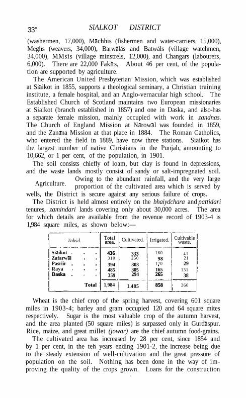
33° SlALKOT DISTRICT
(washermen, 17,000), Machhis (fishermen and water-carriers, 15,000), Meghs (weavers, 34,000), Barwalas and Batwals (village watchmen, 34,000), MMsis (village minstrels, 12,000), and Changars (labourers, 6,000). There are 22,000 Fakirs, About 46 per cent, of the population are supported by agriculture.
The American United Presbyterian Mission, which was established at Siaikot in 1855, supports a theological seminary, a Christian training institute, a female hospital, and an Anglo-vernacular high school. The Established Church of Scotland maintains two European missionaries at Siaikot (branch established in 1857) and one in Daska, and also-has a separate female mission, mainly occupied with work in zandnas. The Church of England Mission at Narowal was founded in 1859, and the Zanana Mission at that place in 1884. The Roman Catholics, who entered the field in 1889, have now three stations. Siaikot has the largest number of native Christians in the Punjab, amounting to 10,662, or 1 per cent, of the population, in 1901.
The soil consists chiefly of loam, but clay is found in depressions, and the waste lands mostly consist of sandy or salt-impregnated soil.
Owing to the abundant rainfall, and the very large proportion of the cultivated area which is served by
wells, the District is secure against any serious failure of crops. The District is held almost entirely on the bhaiydchara and pattidari
tenures, zamindari lands covering only about 30,000 acres. The area for which details are available from the revenue record of 1903-4 is 1,984 square miles, as shown below:—
Tahsil. Total area.
436
Cultivated. Irrigated. Cultivable waste.
Siaikot .
Total area.
436 333 160 41 Zafarwal 310 250 98 21 Pasriir , , , 394 303 170 29 Raya 485 305 165 131 Daska .
Total
359 294 265
858
38 Daska .
Total 1,984 I.485
265
858 260
Wheat is the chief crop of the spring harvest, covering 601 square miles in 1903-4; barley and gram occupied 120 and 64 square mites respectively. Sugar is the most valuable crop of the autumn harvest, and the area planted (50 square miles) is surpassed only in Gurdaspur. Rice, maize, and great millet (jowar) are the chief autumn food-grains.
The cultivated area has increased by 28 per cent, since 1854 and by 1 per cent, in the ten years ending 1901-2, the increase being due to the steady extension of well-cultivation and the great pressure of population on the soil. Nothing has been done in the way of improving the quality of the crops grown. Loans for the construction
Agriculture.
TRADE AND COMMUNICATIONS
of wells are extremely popular, over Rs. 60,000 having been advanced during the five years ending 1903-4.
Very few cattle are bred locally. Agricultural stock is purchased at the Amritsar fairs or at the Gulu Shah cattle fair in the Pasrur tahsti) and imported from Jhang, Gujranwala, and Gujrat Horses and ponies are not common, and the indigenous breed is poor; two pony and five donkey stallions are kept by the District board. Sheep and goats are numerous, and donkeys are largely used as pack animals, but camels are scarce.
Of the total area cultivated in 1903-4, 858 square miles, or 58 per cent., were classed as irrigated. Of this area, 788 square miles were irrigated from wells, 16 from canals, and 54 from streams. In addition, 135 square miles, or 9 per cent., are subject to inundation by the Chenab, Ravi, and minor streams. Irrigation from canals is confined to small private channels taken from the Degh and other streams; irrigation from streams is either by lift or from the perennial brooks of the Bajwat. Wells are the mainstay of the cultivation, owing to the copious supply of subsoil water, and the fact that they can be constructed at comparatively small cost. In 1903-4 the District possessed 24,452 masonry wells worked with Persian wheels by cattle, besides 1,450 unbricked wells, lever wells, and water-lifts.
The District contains only one square mile of ' reserved' forest under the Deputy-Conservator of the Chenab Forest division, 1-4 square miles of military reserve, and 7 of unclassed forest and Government waste under the Deputy-Commissioner. With the exception of one plantation these are chiefly grass reserves, and even an ordinary coppice can hardly be found. In 1904 the forest revenue was Rs. 1,500.
The District contains several beds of kankar or nodular limestone, and saltpetre is prepared to a small extent.
Sialkot town was once famous for its paper, but the industry has much declined of recent years owing to the competition of mill-made paper. It also possesses a recently introduced and flourishing industry in the manufacture of cricket bats, polo and hockey sticks, and the like, which have a wide popularity all over India. Tents, tin boxes, and surgical instruments are made; and three flour-mills, in one of which cotton-ginning is also carried on, employed 85 hands in 1904. Cotton is woven all over the District, and printed cotton stuffs are made at Pasrur; shawls of pashm, the fine wool of the Tibetan goat, are produced at Kila Sobha Singh. Damascened work on iron is made at the village of Kotli Loharan near Sialkot, and Daska and other places produce vessels of brass and white metal on a considerable scale. In 1869 an undertaking was started at Sialkot under the name of the Belfast Flax Company, to encourage the growth of flax for export to
VOL. X X I I . Y
Trade and communications.
332 SIALKOT DISTRICT
England; but, though an excellent fibre was raised in the District, the difficulty of procuring good seed and the apathy of the peasantry caused the enterprise to prove a failure after some years' trial.
Sialkot town is the only important centre of commerce, and receives such surplus raw produce as the District produces, most of which is consumed in the town and cantonment. The chief exports are rice, sugar, paper, cotton, cloth, and brass vessels; and the chief imports are grain, rice, tobacco, ghi, timber, and tea, besides the various necessaries for the British troops in cantonments. There is a branch of the Alliance Bank of Simla at Sialkot.
A branch of what is now the North-Western Railway from Wazirabad to Sialkot, a distance of 27 miles, was opened for traffic in 1880, and its continuation to Jammu in 1890. The principal metalled road runs parallel to the railway from Wazirabad to Jammu. An important metalled road connects Sialkot and Amritsar. The chief unmetalled roads are from Sialkot to Gurdaspur, to Gujranwala, and via Eminabad to Lahore. The total length of metalled roads is 56 miles, and of unmetalled roads 785 miles; of these, 24 miles of metalled and 29 of unmetalled roads are under the Public Works department, and the rest are maintained by the District board. The Chenab is crossed by nine ferries and the Ravi by five, but there is little traffic on either river.
The District was visited by famine in 1783, 1812, 1843, and 1861. Neither in 1870 nor 1878 did it suffer severely, and with the extension
of well-irrigation that has taken place in the last twenty years it is believed to have become practically
secure. The crops matured in the famine year 1899-1900 amounted to 63 per cent, of the normal.
The District is in charge of a Deputy-Commissioner, aided by five Assistant or Extra-Assistant Commissioners, of whom one is in charge
of the District treasury. The tahslh of Sialkot, Zafarwal, Raya, Daska, and Pasrur are each under
a tahslldar and a naib-tahsildar Sialkot is the head-quarters of a Superintending Engineer and two Executive Engineers of the Canal department.
The Deputy-Commissioner as District Magistrate is responsible for criminal justice, and civil judicial work is under a District Judge. Both officers are supervised by the Divisional Judge of the Sialkot Civil Division, who is also Sessions Judge. The District Judge has one Subordinate Judge and five Munsifs under him, one at headquarters and one at each outlying tahsil A cantonment magistrate is posted to Sialkot cantonment. The District is singularly free from serious crime, despite the large number of Sansis and other criminal tribes domiciled in it.
Famine.
Administration.
ADMINISTRATION 333
The revenue history in pre-annexation times presents no special features. A summary settlement was made in 1847 by the European Political officers under the Regency. The k ind rents of the Sikhs were appraised and a reduction of 10 per cent, made, while a l l extra cesses were abolished. This assessment worked well unt i l the fall in prices which followed annexation. Bad seasons and bad management aggravated the distress, and even large remissions failed to prevent the people from abandoning their holdings. In 1850 the Rechna Doab settlement began, including the present Districts of Sialkot and Gujran-wala, and the tahslls of Shakargarh and Shahdara. The demand of the summary settlement was reduced from 15 lakhs to 13. Cesses were also reimposed at the rate of 16 per cent, on the demand. The settlement was revised in 1863-6, and a general reduction made, one-sixth of the gross produce being assumed as the equivalent of half the net 'assets.' The ini t ial demand was slightly over 12 lakhs, and the ultimate demand 12½ lakhs. The sanctioned theoretical rates at the next revision (1888-93) indicated a revenue of 181/3 lakhs, but the actual demand was 15 lakhs, an increase of 21 per cent. The average assessment on ' d r y ' land is Rs. 1-4-6 (maximum Rs. 1-14, minimum R. 0-11), and on ' w e t ' land Rs. 2-0-6 (maximum Rs. 3, minimum Rs. 1-1). The demand in 1903-4, including cesses, was over 17*3 lakhs. The average size of a proprietary holding is 7*6 acres.
The collections of land revenue alone and of total revenue are shown below, in thousands of rupees:—
Land revenue Total revenue
1880-1.
1 1 , 1 2
14,11
1890-1. I 1900-1. ' 1903-4.
11,49 13,93 15,75 20,19
14,55 20.62
The District contains seven municipalities, S I A L K O T , DASKA-cum-Kot Daska, J A M K I , PASRUR, K I L A SOBHA S I N G H , Z A F A R W A L , and N A R O -
W A L ; and nine ' notified areas.' Outside these, local affairs are managed by the District board, whose income, mainly derived from a local rate, amounted in 1903-4 to i-8 lakhs. The expenditure was also 1.8 lakhs, hospitals, schools, and public works forming the chief items. Sialkot is one of the few Districts in the Punjab in which local boards have answered expectations.
The regular police force consists of 576 of all ranks, including 59 cantonment and 146 municipal police, in charge of a Superintendent, who usually has 6 inspectors under h im. The village watchmen number 2,149. There are 17 police stations. The District ja i l at Sialkot town has accommodation for 482 prisoners.
Sialkot stands twenty-third among the twenty-eight Districts of the Punjab in respect of the literacy of its population. In 1901 the
Y 2
334 SIALKOT DISTRICT
proportion of literate persons was 2.8 per cent. (5.2 males and 0.3 females). The number of pupils under instruction was 5,266 in 1880-1, 13,300 in 1890-1, 13,745 in 1900-1, and 15,780 in 1903-4, In the last year there were one Arts college, 21 secondary, and 183 primary (public) schools, besides 9 advanced and 228 elementary (private) schools, with 1,415 girls in the public and 278 in the private schools. The principal educational institutions are the Sialkot Arts college and 5 high schools. The total expenditure on education in 1903-4 was 1.2 lakhs, of which Rs. 24,497 was contributed by municipalities, Rs. 42,000 came from fees, Rs. 7,000 from Government grants, and Rs. 35,000 from Local funds.
Besides the civil hospital and a branch dispensary at head-quarters, local bodies maintain 7 outlying dispensaries. At these institutions in 1904 a total of 139,968 out-patients and 1,872 in-patients were treated, and 7,562 operations were performed. A leper asylum and four Kot dispensaries, for the inmates of the * K o t ' or reformatory for criminal tribes, are also maintained in the District. The Kot dispensaries treat a large number of out-patients. The expenditure in 1904 was Rs. 23,000, of which Rs. 11,000 was contributed by Local and Rs. 12,000 by municipal funds. The District also has four mission dispensaries, aided from Local and municipal funds, one for males and three for women and children; and in Sialkot town a charitable dispensary is maintained by the representative of an old family of hakims or native physicians.
The number of successful vaccinations in 1903-4 was 34,609, representing 32.3 per 1,000 of population.
[J. R. Dunlop-Smith, District Gazetteer (1894-5); Settlement Report (1895) ; and Customary Law of the Main Tribes in the Sialkot District (1895).]
Sialkot Tahsil.—Northern tahsil of Sialkot District, Punjab, lying between 320 17' and 320 51 ' N. and 740 11' and 740 43' E., with an area of 436 square miles. The Chenab forms part of the north-western boundary of the tahsil, which includes a submontane tract known as the Bajwat to the north of that river. The country is traversed by a number of hill torrents, and except in the south-east is extremely fertile and is fairly well supplied with irrigation wells. The population in 1901 was 312,688, compared with 302,866 in 1891. The headquarters are at the town of SIALKOT (population, 57,956), and it also contains 637 villages. The land revenue and cesses in 1903-4 amounted to Rs. 4,00,000.
Sialkot Town.—Head-quarters of Sialkot District and tahsil, Punjab, situated in 320 3o/ N. and 740 32' E., on the Wazlrabad-Jammu branch of the North-Western Railway; distant by rail from Calcutta 1,341 miles, from Bombay 1,369, and from Karachi 808. Population (1901), 57,956. Sialkot stands on the northern bank of
SIALKOT TOWN 335
the A i k torrent, upon the edge of the high triangular ridge which extends southward from the Jammu hills, and is 72 miles from Lahore.
Popular legends attribute its foundation to Raja SSLla, the uncle of the Pandavas, and say that it was refounded in the time of Vikram&ditya by Raja Salivahan, who buil t the fort and city. Salivahan had two sons: one, Puran by name, was kil led by the instrumentality of a wicked stepmother, and thrown into a well, sti l l the resort of pilgrims, near Sialkot; the other, Rasalu, the great mythical hero of Punjab folk-tales, is said to have reigned at Sialkot. Towards the end of his reign Rasalu became involved in wars with Raja H u d i , popularly stated to have been a Gakhar chieftain. Being worsted in battle, Rasalu, as the price of peace, was forced to give his daughter in marriage to his conqueror, who gave the territory he had conquered to Rasalu's adopted son. According to a further legend related to M r . Prinsep:—
' After the death of Raja Rasalu, the country is said to have fallen under the curse of Puran (brother of Rasalu, who had become a fakir) for 300 years, lying totally devastated from famine and incessant plunder.'
It has recently been suggested that Sialkot is the ancient site known as Sakala or Sagal. In A . D . 790 the fort and city were demolished by an army under Raja Naraut, supported by the Ghandaurs of the Yusufzai country. Under the Mughal emperors, Sialkot became the head-quarters of a fiscal district (sarkar). The country was afterwards occupied in the seventeenth century by the Rajput princes of Jammu. The mound which rises in the centre of the town, crowned with the remains of an ancient fort, is popularly believed to mark the site of the original stronghold of Raja Salivahan; but the fort itself is not more than 1,000 years old, and is said to have been rebuilt by Shahab-ud-dln at the end of the twelfth century. Some old baths with hot-wTater pipes of solid masonry have been discovered here. Other similar mounds stand among the outskirts of the town. In modern times, the old fort is of historical interest for its gallant defence by the few European residents who took refuge here during the Mut iny of 1857. It is now dismantled, and the few buildings it contains are used for public purposes. The town also contains the shrine of the first Sikh Guru, Baba Nanak {see A M R I T S A R D I S T R I C T ) , the scene of an annual fair largely attended by Sikhs from all parts of the Dis t r i c t ; the Darbar Baoli Sahib, a covered well, erected by a Rajput disciple of Baba Nanak, held high in religious consideration among the Sikhs; the Muhammadan shrine of Imam Ali-ul-hakk, a handsome building of ancient construction; and a temple erected by Raja Tej Singh. The municipality was created in 1867. The income and expenditure during the ten years ending 1902-3 averaged about a lakh. In 1903-4 the
336 SIALKOT TOWN
income was a lakh, chiefly derived from octroi (Rs. 80,500); and the expenditure was also a lakh, including conservancy (Rs. 13,200), education (Rs. 17,000), medical (Rs. 12,000), and administration (Rs. 25,900).
The large military cantonment is situated about a mile and a half from the native town. The garrison, which belongs to the Rawalpindi division, consists of one battery and one ammunition column of horse artillery, one regiment of British cavalry, two regiments of Native cavalry, one battalion of Native infantry, and one company of sappers and miners. There is also a mounted infantry school. During the ten years ending 1902-3 the income and expenditure of cantonment funds averaged Rs. 37,000.
Sialkot is a flourishing trade centre and dep6t for agricultural produce. It has an extensive manufacture of cricket and tennis bats, hockey sticks, &c , tents, surgical instruments, and tin boxes. Boots are also made, and various cotton stuffs, chiefly twill {susi). The manufacture of paper is said to have been introduced four centuries ago, and under the Mughal emperors Sialkot paper was largely used at the Delhi court. The manufacture has now greatly declined, owing to the competition of mill-made paper. The town contains three flour-mills, in one of which cotton-ginning is also carried on. The number of employes in 1904 was 85. The Alliance Bank of Simla has a branch in the town. The principal educational institutions are the Sialkot Arts college and four Anglo-vernacular high schools, of which one is managed by the Educational department, two by the Scottish and American Missions, while the fourth is the Christian Training Institute of the Scottish Mission. There are five middle schools for girls, one of which is attached to the convent. In the town are a civil hospital with a branch dispensary, an American Mission hospital for women and children, and a charitable dispensary maintained by a member of an old family of hakims or native physicians.
S ib i Dis t r ic t (Shw).—District of Baluchistan, lying between 270
55' and 300 38' N. and 670 17/ and 690 50' E. Its total area is 11,281 square miles; but this includes the MARRI-BUGTI country (7,129 square miles), which is only under political control, leaving 4,152 square miles of directly Administered territory. The Lahri niabat of the Kalat State in Kachhi (1,282 square miles) is also politically controlled from Sibi. The District is bounded on the north by Loralai District; on the south by the Upper Sind Frontier District ; on the east by the Dera Ghazi Khan District of the Punjab; and on the west by Kachhi, the Bolan Pass, and Quetta-Pishln. The portion under political control occupies the centre, east, and south of the District; the areas under direct administration form protrusions in the north-western, north-eastern, and south-western corners.
SIBI DISTRICT 337
No area in Baluchistan presents such strongly marked variations, both physical and climatic, between its various parts as Sibi Distr ict . T w o portions of i t , the Sibi and Naslrabad tahslls, consist of perfectly level plain, lying respectively at the apex and base of Kachhi . The remainder of the District consists entirely of mountainous country, rising in a series of terraces from the lower hills of the S U L A I M A N range. These hills include Zen (3,625 feet) in the Bugti country, and Bambor (4,890 feet) and Dungan with Butur (about 6,000 feet) in the Marr i country. North-westward the mountains stretch to the watershed of the Central Brahui range in Zarghun and Khalifat, at an elevation of 11,700 feet. W i t h the exception of the eastern side of the Marri-Bugti country, the drainage of the whole of this area is carried off by the Nari , which in traversing the Mar r i country is known as the Beji. On the south it is joined by three considerable h i l l -torrents, the Chakar or Ta l l i , the Lahri , and the Chhatr. A l l of these streams are subject to high floods, especially in July and August, when the fertile lands of Kachhi are irrigated from them.
The Upper, Middle, and Lower Siwaliks (upper and middle miocene); Spintangi limestone and Ghazij group (middle eocene); volcanic agglomerates and ash-beds of the Deccan t rap; the Dunghan group (Upper Cretaceous); belemnite beds (neocomian); and some massive limestone (Jurassic), as well as spreads of recent deposits, are exposed in the District.
The vegetation of the District is as varied as its physical aspects. On the south it is similar to that of Sind, the uncultivated land producing Prosopis spicigera, Capparis aphylla, Salvadora oleoides^ Zizy-phus nummularia, Tamarix Indica, Acacia arabica, and Acacia modes fa. In the lower highlands the dwarf-palm (Nannorhops Ritchieana) abounds, and the blue gum (Eucatyptus) has been found to grow well. In the higher hills are found the juniper, pistachio, ash, wi ld almond, and Caragana. Cumin seed grows in the Ziarat hills, which also produce many varieties of grass.
Mountain sheep and markhor are found in the higher ' hills, ' where leopards and black bears are also sometimes seen. ' Ravine deer' or gazelle and hares occur in the plains. Large flocks of sand-grouse visit the District when there is a good mustard crop. Fair fishing is to be had in the Nar i .
Whi le the highlands possess a climate which is pleasantly cool in summer and very cold in winter, the plains suffer from the great heat common in Sind. Naslrabad has a mean temperature in July of 960, and is subject to the effects of the simoom. For five months alone, during the cold season, are the climatic conditions tolerable to Europeans. The Marri-Bugti country and the Shahrig tahsll (2,300
Physical aspects.
338 SIBI DISTRICT
to 4,000 feet) possess a climate intermediate between the extremes of the plains and the highlands. The annual rainfall varies with the altitude, from 3 inches in Naslrabad to 5 in Sibi and nearly 12 in Shahrig, where the vapour-bearing clouds strike Khalifat and empty their contents into the valley.
Up to the end of the fifteenth century the District was always a dependency of Multan. It is known to have formed part of the
Ghaznivid empire, and was ruled by a petty chief in the time of Nasir-ud-din Kubacha. About 1500,
it was taken by Shah Beg, Arghun, and thus passed under Kandahar; but, under the Mughal empire, it again became subordinate to Multan. It was taken by the Kalhoras of Sind in 1714; but they had to retire before the power of the Durranis, by whom the local governors were generally selected from the Barozai clan of the Panni Afghans, which still retains much influence. During the last two years of the first Afghan War an Assistant Political Agent was posted to Sibi, and on its conclusion the District was handed over to Kalat, but again came under Barakzai rule in 1843. In the succeeding years the Marris acquired ground in the District; and their depredations were not checked until Sibi, Shahrig, and Duki were assigned to the British, in 1879, by the Treaty of Gandamak. The Marris and Bugtis had been controlled from the Dera Ghazi Khan District of the Punjab previous to the establishment of the Baluchistan Agency in 1877 ;and this charge now devolved on the Political Agent in Thal-Chotiali, the name first given to the District on its establishment in 1879. The Kuat-Mandai valley, which belongs to the Marri tribe, has been held since 1881 as security for the payment of a fine inflicted after the Marri expedition of 1880. Owing to disputes between the Zarkun Afghans and the Marris, the Kohlu valley was brought under British protection in 1891. Naslrabad was a nidbat of the Kalat State t i l l 1903, when it was taken over on a perpetual lease for an annual payment of Rs. 1,15,000, increased by Rs. 2,500 in April, 1904. The name of the District was changed to Sibi in 1903, at which time the Sanjawi, Duki, and Barkhan tahsils, which had hitherto formed part of the old Thal-Chotiali District, were transferred to the new Loralai District.
Sibi District proper possesses one town and 304 villages, and its population in 1901 amounted to 73,893, or 18 persons per square
mile. The Marri-Bugti country has 8 villages and a population of 38,919. The total population,
Including tribal areas, is therefore 112,812. But this does not include the Dombkis (12,400), Umranis (i,roo), and Kaheris (7,100), who live in that portion of Kachhi which is controlled from Sibi District. The following table gives statistics of the area, &c., of the Administered territory by tahsils in 1901:—
Population,
History.
POPULATION 339
Tahsil. Area in square miles.
Number of Population.
Population per square
mile. Tahsil.
Area in square miles. Towns. Villages.
Population. Population per square
mile.
Kohlu. Sibi . Shahrig Nasirabad .
Total
362 1,343 1,595
852
I 9
32 93
170
1,743 20,526 16,573 35,713
5 15 10 42
Kohlu. Sibi . Shahrig Nasirabad .
Total 4,152 I 304 74,555* 18
* Includes 662 Marris enumerated in the Kohlu tahsil.
In the Administered area 90 per cent of the population are Muham-madans of the Sunni sect and 9 per cent, are Hindus; in the Marri-Bugti country the Muhammadans number 99 per cent. About 43 per cent of the people speak Baluchi; the other languages spoken are Pashtu, Jatkf, and Sindf. A peculiar dialect, called Tarino, is spoken in Shahrig. The Baloch number about 48,000; Afghans follow with 18,000. The Marris and Bugtis and the Dumars are large flock-owners; the other inhabitants are cultivators.
The soil of the plains is alluvium, locally known as pat; in the lower highlands it is sandy; in Kohlu it is much impregnated with salt. Clay and gravel occur at the higher elevations. The directly Administered area is well irrigated and fertile, but the Marri and Bugti hills afford small opportunity for agriculture. Of all the tahsils, Kohlu alone has not been surveyed. The total cultivable area in the remaining tahsils is 878 square miles, of which about 234 square miles are cultivated annually. The principal harvest is the sanwanri or autumn crop; wheat and oilseeds compose the spring crop (arhari). The largest area is under jowar, after which come oilseeds and wheat. Rice, millets, and gram are also grown. Cultivation has extended everywhere with the advent of peace and security; in Nasirabad it has risen from 76 square miles in 1880-1 to 165 square miles in 1902-3, and in Sibi from about 7 square miles in 1879-80 to about 59 square miles in 1904. Quantities of vegetables are raised in Sibi for the Quetta market, and the cultivation of tobacco, potatoes, and melons is increasing. Between 1897 and 1904 advances for agricultural improvements were given to the amount of nearly Rs. 50,000.
The class of cattle in the plains is excellent. The ponies of the Marri and Bugti hills are light in limb and body, but carry heavy weights unshod over the roughest ground. In the plains larger animals are kept. The number of branded mares is 164. Government stallions are stationed at Sibi in the winter. Camels are bred in the southern part of the District. A horse and cattle fair is held at Sibi in February.
The Nasirabad tahsil is irrigated by the Desert and Begari branches
340 SIBI DISTRICT
of the Government canals in Sind. The water is brought to the land either by gravitation (moki) or by lift (charkhi). The area irrigated annually between 1893 and 1903 averaged 80,000 acres. In the Sibi tahsil a system of channels from the Nari river irrigates about 26,000 acres. Elsewhere, excluding Kohlu, about 13,700 acres are irrigated from springs and streams. Wells are used for irrigation in Nasirabad, but their number is limited. Most of the irrigated land is allowed to lie fallow for a year or two. The karez number 14.
' Reserved' juniper forests number seven, with an area of 69 square miles; and mixed forests, nine in number, cover about 41 square miles. The former are situated in Shahrig, and seven of the latter are in the Sibi tahsil. The juniper forests contain an undergrowth of wild almond (Prunus eburnea) and makhi (Caragana); and the mixed forests grow Prosopis spicigera, Capparis aphylla, tamarisk, and acacia.
Coal occurs in the Shahrig tahsil, and petroleum at Khattan in the Marri country. An account of the methods of working them will be found in the article on BALUCHISTAN. The output of coal from Khost in 1903 amounted to 37,000 tons, but petroleum is no longer worked. An unsuccessful boring for oil was made in 1891 near Spintangi. Earth-salt was manufactured in Nasirabad up to 1902.
Rough woollen fabrics, coarse carpets in the dart stitch, nose-bags, and saddle-bags are produced in many places. Felts and felt coats
are made by the women of the highlands for domestic use. Mats, ropes, sacks, baskets, camel-pads, and many other articles are woven from the
dwarf-palm, which is one of the most useful plants of the District. Embroidery is made by the Bugti women, the stitch chiefly used being herring-bone, with the threads looping through each other. The design often consists of large circular buttons or medallions joined by rings of chain stitch.
The District produces jowar, wheat, ghi, and wool, and in years of good rainfall medicinal drugs, especially cumin seed, in some quantities. The only centre of trade is Sibi, the total imports and exports of which town by rail have risen from 11,800 tons in 1898 to 13,700 tons in 1903. Trade is largely carried on by agents of firms from Shikarpur in Sind. The principal imports into Sibi are gram, pulse, rice, dried fruits, and piece-goods; the exports are jowar, bajra, wheat, and oilseeds.
The Sind-Pishin section of the North-Western Railway, on the standard gauge, enters the District near Jhatpat and, after crossing the Kachhi plain, passes to Kach Kotal. Sibi town is the junction for the Mushkaf-Bolan branch. The centre and south of the District are i l l provided with roads. Partially metalled roads extend to 125 and
Trade and communications.
ADMINISTRATION 341
unmetalled tracks to 444 miles. They are maintained chiefly from Provincial revenues and partly from Local funds. The main routes consist of part of the Harnai-Fort Sandeman road, and a cart-road from Sibi to Kach and thence to Ziarat. A bridle-path, which will form an important artery, is in course of construction from Babar Kach station to Kohlu via Mawand.
The Nasirabad and Shahrig tahsih are fairly well protected from famine, owing to their extensive irrigation. Parts of the Sibi and Kohlu tahsih and of the Marri-Bugti country, however, depend almost entirely on rainfall, the failure of which frequently results in scarcity. Between 1897 and 1901 the rainfall was continuously deficient, and in 1897-8 about Rs. 3,400 was expended in the Sibi tahsil out of money allotted by the Indian Famine Relief Fund. In 1899-1900 a sum of Rs. 18,000 was supplied from Imperial revenues for grain doles to the Marris and Bugtis, and in the following year Rs. 7,000 from the same source was distributed among them for the purchase of bullocks and seed grain. A contribution of Rs. 6,459 from the Indian Famine Relief Fund was also spent on the same objects in Sibi, Shahrig, and Kohlu. Between 1899 and 1901 District relief works cost about Rs. 24,400.
The District consists of two portions: Sibi District, containing the Sibi and Shahrig tahsih, which form part of British Baluchistan ; and the Kohlu and Railway District, consisting of the Kohlu and Nasirabad tahsils and the railway line lying in Kachhi and the Marri country, which form part of the Agency Territories. For purposes of administration the District is treated as a single unit, in charge of a Political Agent and Deputy Commissioner, with three subdivisions : N A S I R A B A D , S I B I , and S H A H R I G . Each of the first two is in charge of an Extra-Assistant Commissioner, and the latter of the Assistant Political Agent. The Political Agent exercises political control in the M A R R I - B U G T I country, and over the Dombki and Kaheri tribes of the Lahri niabat in Kachhi through the Extra-Assistant Commissioner at Sibi. Each tahsil has a naih-tahsildar, except Kohlu, where a naib-tahsildar exercises the powers of a tahsildar. A Munsif is stationed at Sibi.
The Deputy-Commissioner and Political Agent is the District and Sessions Judge. The Assistant Political Agent and the Extra-Assistant Commissioners are magistrates of the first class, with power to try suits to the value of Rs. 10,000. Tahsildars are magistrates of the second class, with civil powers up to Rs. 300. Naib-tahsildars are magistrates of the third class, with civil powers in suits of the value of Rs. 50. The Munsif at Sibi is also a magistrate of the second class. Appeals from the officers of the lower grades lie to the subdivisional officers. Many cases in which the people of the country are concerned are
Administration.
Famine.
342 SIBI DISTRICT
referred to jirgas for an award under the Frontier Grimes Regulation. The number of cognizable cases reported during 1903 was 134, convictions being obtained in 73 instances. The total number of criminal cases was 304 and of civil suits 1,209. The cases referred to jirgas numbered 645, including 17 cases of murder, 7 cases of robbery, 24 of adultery, and 15 cases of adultery accompanied by murder.
In Akbar's time Sibi was a mahal of the Bhakkar sarkar of the Multan Subah. It paid about Rs. 34,500, and furnished 500 cavalry and 1,500 infantry. The Panni tribe also supplied a separate contingent. Chhalgari, i. e. the Harnai valley, which depended on Kandahar, paid Rs. 240 in money, 415 khartwars of grain, and supplied 200 horse and 300 foot. Under the Durrani's the revenue of the Sibi tahsil was about Rs. 4,500. The present system of levying revenue varies in different parts of the District, and even in different areas within the same tahsiL Fixed cash assessments, varying from Rs. 2 to Rs. 2-8 per acre on irrigated lands, are to be found side by side with the collection of an actual share of the produce (batai) at rates varying from one-fourth to one-twelfth. Details of each system are given in the separate articles on the tahsils of the District. The annual value of the revenue-free holdings and grants of grain is Rs. 19,300. The land revenue, including grazing tax but excluding water rate, amounted in 1903-4 to nearly 2 lakhs. This includes the revenue of Nasirabad for six months only. The water rate in Nasir-abad, amounting to 1.2 lakhs in 1903-4, is paid over to the Government of Bombay, as the Begari and Desert Canals, which irrigate it, belong to the Sind system. The total revenue of the District from all sources was 2.4 lakhs in the same year.
The Sibi bazar fund and the Ziarat improvement fund are referred to in the articles on S IBI TOWN and ZIARAT. Octroi and conservancy cess are levied in some bazars near the Sind-Pishin railway, and are credited to the Shahrig bazar fund, the money being spent on sanitary and other works under the direction of the Assistant Political Agent in charge of Shahrig. The income in 1903-4 was Rs. 6,800, and the expenditure Rs. 6,300.
A small detachment of native infantry is stationed at Sibi. The District Superintendent of police at Quetta is in charge of the regular police, which consisted, in 1904, of 199 constables and 23 mounted men, under a European inspector and Honorary Assistant District Superintendent, with 6 deputy-inspectors and 56 sergeants. It was distributed in twenty-four stations. The police employed on the rail-way line numbered 63. The total force of levies available amounts to 439 men, of whom 238 are mounted and 91 are employed on the railway. These figures do not include 225 men stationed in the Marri-Bugti country, and 26 in the Lahri niabat. Local funds main-
SIBI TAHSIL 343
tain 21 watchmen. There is a District jail at Sibi town and four subsidiary jails, with total accommodation for 100 male and 24 female prisoners. Prisoners whose terms exceed six months are sent to the Shikarpur jail in Sind.
In 1904 the District had one middle and eight primary schools, including a school for native girls and another for European and Eurasian boys and girls. The number of pupils was 342, and the annual cost Rs. 6,511, of which Rs. 2,284 was paid from Provincial revenues and Rs, 4,187 from Local funds. The number of boys and girls receiving elementary instruction in mosque and other private schools was 926. Education in the Marri-Bugti country is represented by a single school at Dera Bugti.
The District possesses one hospital and four civil and railway dispensaries, with accommodation for 74 patients. The average daily attendance of patients in 1903 was 21. Two of the institutions are maintained by the North-Western Railway, two are aided from Local funds, and the other is maintained from Provincial revenues. The expenditure from Local funds and Provincial revenues in 1903 was Rs. 9,000. A female dispensary has recently been established at Sibi. Shahrig has an evil reputation for malaria in summer, and syphilis is common in parts of the tahsil. Malarial fever is the most prevalent disease throughout the District. Vaccination is optional and most of the people still resort to inoculation. The number of persons successfully vaccinated in 1903 was 3,363, or 46 per 1,000 on the total population of the Administered area.
[O. T. Duke, Report on the District of Thal-Chotiali and Harnai (Foreign Department Press, 1883); R. I. Bruce, History of the Marri Baloch Tribe and its Relations with the Bugti Tribe (Lahore, 1884); Bombay Records, No. X V I I , New Series, containing, among other papers, a Diary kept by Captain Lewis Brown while besieged in Kahan ; R. D, Oldham, ' Geology of Thal-Chotiali and part of the Marri Country/ Records, Geological Survey of India, vol. xxv, part i; C. L. Griesbach, ' Geology of the Country between the Chappar Rift and Harnai,' ib. vol. xxvi, part iv; Major A. McConaghey, District Gazetteer (1907).]
Sibi Subdivision.—Subdivision of Sibi District, Baluchistan, comprising the tahsils of S IBI and K O H L U . The Extra-Assistant Com-missioner in charge also exercises political control in the Marri-Bugti country and in the Lahri niabat of the Kalat State in Kachhi.
Sibi Tahsil (Siwi).—Tahsil of Sibi District, Baluchistan, lying between 290 21 ' and 300 15' N. and 670 11' and 68° 9' E., at the apex of the Kachhi plain, and including the hilly country round Sangan, It has an area of 1,343 square miles, and a population (1901) of 20,526, showing an increase of 7,125 since 1891. It con-
344 SIBI TAHSlL
tains one town, S I B I (population, 4,551), the head-quarters; and 32 villages. The land revenue in 1903-4 amounted to I.I. . lakhs. The rate of revenue levied in Sibi is two-ninths of the produce, as distinguished from the usual one-sixth; in Sangan it is one-fourth, half of which is paid over to the Barozai chief, and in Kuat-Mandai one-twelfth, the Marri chief taking an equal amount. The tahsil is irrigated by canals from the Nari river.
S ib i T o w n (67a//).—Head-quarters of Sibi District, Baluchistan, situated in the tahsil of the same name, in 290 33' N. and 670 53' E. , 88 miles from Quetta and 448 from Karachi. The population numbered 4,551 in 1901, an increase of 1,607 since 1891. The place is very old, being mentioned as early as the thirteenth century. Owing to its exposed situation, between the mouths of the Harnai and Bolan Passes, it has suffered from frequent sieges, including an assault by the British in 1841. The existing town dates from 1878. It possesses a considerable trade. The Victoria Memorial Hall , erected by public subscription in 1903, is the only building of importance. A piped water-supply has been provided by military funds from the Nari river at a cost of Rs. 1,15,000. Though not a municipality, a town fund is maintained, the income of which in 1903-4 amounted to Rs. 23,700 and the expenditure to Rs. 23,000.
Sibpur.—Southern suburb of H O W R A H C I T Y , Bengal, opposite Fort William. During the last century the place has grown from a small village into a flourishing town, possessing jute-mills, flour-mills, and engineering and rope works. On the river side, to the south, are the Royal Botanical Gardens, among the finest of their kind in the world. A fort was erected here in the sixteenth century to defend the shipping from the piratical incursions of the Maghs or Arakanese. A little above the gardens stands the Sibpur Engineering College.
Sibsagar District.—-District in Eastern Bengal and Assam, lying between 250 49' and 270 16' N. and 930 3' and 950 22' E., with an area of 4,996 square miles. It is bounded on the east by Lakhim-pur; on the north by the Brahmaputra and Subansiri, which divide it from Lakhimpur and Darrang; on the west by Nowgong; and on the south by hills inhabited by Naga tribes. The eastern half of the
District consists of a wide well-cultivated plain stretching from the foot of the Naga Hills to the Brahmaputra; but west of the Dhansiri the forest-
clad ranges of the M I K I R H I L L S , which rise in places to an elevation of 4,500 feet, project into the valley. South of the Brahmaputra lies a belt of land 3 or 4 miles in width, which affords excellent grazing in the dry season, but is exposed to heavy inundations during the, rains. Beyond this the level rises, and the central portion of the District presents a succession of wide plains, producing rice, and dotted
Physical aspects.
SIBSAGAR DISTRICT 345
in every direction with the groves of bamboos and areca palms by which the houses of the villagers are concealed. Much of the high land in the centre and south was originally covered with tree forest, but this has been largely taken up by tea planters; and neat bungalows and trim tea gardens are now a conspicuous feature in the scenery. Along some of the tributaries of the Brahmaputra the country is too low for cultivation, and is covered with grass and reeds, while the foot of the hills is clothed with forest; but, generally speaking, very little land in the plains is available for settlement, and over considerable areas the density of population exceeds 400 persons per square mile. The M A J U L I , a large island which lies north of the main channel of the Brahmaputra, presents a very different appearance. The land lies low, the population is comparatively sparse, and extensive tracts are covered with high grass jungle and forest, which is rendered particularly beautiful by the luxuriant growth of the creeping cane.
The Brahmaputra flows through the northern portion of the District, and at the western end divides Sibsagar from Darrang. The principal tributaries on the south bank from east to west are the B U R H I D I H I N G , which for part of its course divides Sibsagar from Lakhimpur, the D I S A N G , D I K H O , J H A N Z I , B H O G D A I or Disai, Kakadanga, and D H A N S I R I .
All of these rivers flow in a northerly and westerly direction from the Naga Hills. The District contains no lakes of any importance.
The plain is of alluvial origin, and is composed of a mixture of clay and sand. West of the Disai there is a protrusion of the subsoil, which is a stiff clay, abounding in iron nodules. The Mikir Hills consist of gneiss, which towards the south is overlaid by sedimentary strata of Tertiary origin. These younger rocks consist of soft yellow sandstones, finely laminated grey clay shales, and nodular earthy limestones.
Except in the west, the proportion of forest land is comparatively small. Marsh lands are covered with high grass and reeds, the two most prominent kinds being ikra (Saccharum arundinaceum) and nal (Phragmites Roxburghii); but a large part of the District is under cultivation. The high land between the rice-fields is usually covered with short grass.
Wild animals are not common, except in the Mikir Hills and the marshy country at their foot, where elephant, rhinoceros, buffalo, bison, tigers, leopards, bears, and various kinds of deer are found. In 1904, 6 persons and 990 cattle were killed by wild animals and rewards were paid for the destruction of 27 tigers and leopards. Small game include partridges, pheasants, jungle fowl, ducks, geese, and snipe.
The climate, though damp, is comparatively cool and is healthy for both Europeans and natives. During the winter months the sun has little effect, as fogs often hang over the plains till a late hour, and in
346 SIBSAGAR DISTRICT
January the mean temperature in Sibsagar is less than 6o°. In July it rises to 840, and the atmosphere is overcharged with moisture, and therefore oppressive,
In the plains, the average annual rainfall varies from 80 inches in the west to 95 near the Lakhimpur border. The supply of rain is thus always abundant, and flood is a more serious obstacle to cultivation than drought. Hailstorms occasionally do damage, especially to the tea gardens. The great earthquake of June 12,1897, was distinctly felt in Sibsagar, but in comparison with Lower Assam the amount of damage done was small.
About the eleventh century the dominant power in the eastern portion of the District was the Chutiya king, who ruled over a tribe
of Bodo origin, which is believed to have entered Assam from the north-east and to have overthrown
a Hindu Pal dynasty reigning at Sadiya. In the south there were scattered tribes of Morans, and the west was within the sphere of influence of the Kachari king at Dimapur. In 1228 the Ahoms, a Shan tribe from the kingdom of Pong, crossed the Patkai range and established themselves in the south-east of Sibsagar. These foreigners gradually consolidated their power, conquered the Chutiyas, and by the end of the fifteenth century had become the dominant tribe in Upper Assam. The Kacharis were next defeated; and about the middle of the sixteenth century the Ahom capital was established at Gargaon, the modern NAZIRA, 9 miles south-east of Sibsagar town. I t was captured by Mir Jumla in 1662 ; but during the rains the Muhammadan force melted away, and by the end of the seventeenth century the Ahoms had succeeded in making themselves masters of the whole of the Brahmaputra Valley above the town of Goalpara. About this time the seat of government was shifted to Rangpur, near the modern town of Sibsagar, which is said to have been founded by Rudra Singh, the greatest of the Ahom Rajas, in 1699. The District at this time appears to have been very prosperous. There was a strong government, and justice seems to have been administered in a fairly liberal manner, though the death penalty, when inflicted, took savage forms, and no mercy was shown to rebels or their families. Buchanan-Hamilton, writing in 1804, reported that three-fourths of the whole area of Upper Assam south of the Brahmaputra was under cultivation, and the system of compulsory labour which prevailed enabled the Raja to construct numerous good roads, and large embankments which kept the flood-water off the fields. At the same time the extreme aversion which the Assamese now have to all forms of labour for the state, and the rapidity with which, as soon as Assam passed into the hands of the British, they abandoned the various trades imposed upon them by their former rulers, shows that the Ahom system, though tending to develop
History.
POPULATION 347
the material prosperity of the country, was far from acceptable to- the mass of the people. Rangpur continued to be the capital till after the accession of Gaurinath Singh in 1780. This prince was driven from his palace by a rising of the Moamarias, a powerful religious sect, and established himself first at Jorhat and afterwards at Gauhati. Then ensued a period of extreme misery. The Moamarias ravaged the country on their way to Gauhati; and, after their defeat by the British troops in 1793, the Ahom prime minister laid waste the whole of the province north of the Dikho river. A fierce struggle broke out between the different pretenders to the crown, one of whom called in the Burmans to his aid. The Burmans established themselves in the province, and were only expelled by the British in 1825, after they had been guilty of the utmost barbarity. The Brahmaputra Valley was then incorporated with the territories of the East India Company; but in 1833 Upper Assam, including the District of Sibsagar, was handed over to the Ahom Raja, Purandar Singh. This prince, however, proved incapable of carrying out the duties entrusted to him, and in 1838 the District was placed under the direct management of British officers. Since that date its history has been one of peaceful progress. The native gentry were, however, impoverished by the abolition of the offices they had formerly enjoyed, and by the liberation of their slaves, and they had some grounds for feeling discontented with British rule. In 1857 one of them named Mani Ram Datta, who had been the chief revenue authority under Raja Purandar Singh, engaged in treasonable correspondence with the young Raja, Kandar-peswar Singh, who was residing at Jorhat, and other disaffected persons. Mani Ram was, however, convicted and hanged, and all tendencies to rebellion were thus nipped in the bud.
The District contains several enormous tanks, the largest of which are those at Sibsagar, Rudrasagar, Jaysagar, and Gaurisagar. These tanks were made by the Ahom Rajas in the eighteenth century, and in most cases have fine brick temples standing on the broad banks by which they are surrounded. In the south-west corner of Sibsagar the ruins of the Kachari capital at D I M A P U R lie buried in dense jungle.
The population at the last four enumerations was: (1872) 317,799, (1881) 392,545, (1891) 480,659, and (1901) 597,969. The enormous increase of 88 per cent., which took place in the twenty-nine years, was due partly to the fact that Sibsagar, unlike Lower and Central Assam, has been healthy, so that the indigenous population increased instead of dying out, but even more to the importation of a large number of garden coolies. The District is divided into three subdivisions—SIBSAGAR, J O R H A T , and G O L A G H A T — w i t h head-quarters at the towns of the same name, and contains 2,109 villages.
VOL. xx i i . z
Population.
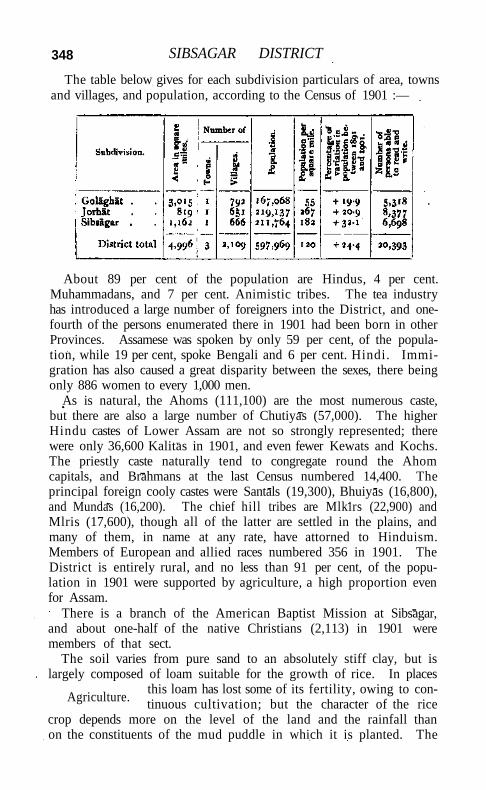
348 SIBSAGAR DISTRICT
The table below gives for each subdivision particulars of area, towns and villages, and population, according to the Census of 1901 :—
About 89 per cent of the population are Hindus, 4 per cent. Muhammadans, and 7 per cent. Animistic tribes. The tea industry has introduced a large number of foreigners into the District, and one-fourth of the persons enumerated there in 1901 had been born in other Provinces. Assamese was spoken by only 59 per cent, of the population, while 19 per cent, spoke Bengali and 6 per cent. Hindi. Immigration has also caused a great disparity between the sexes, there being only 886 women to every 1,000 men.
As is natural, the Ahoms (111,100) are the most numerous caste, but there are also a large number of Chutiyas (57,000). The higher Hindu castes of Lower Assam are not so strongly represented; there were only 36,600 Kalitas in 1901, and even fewer Kewats and Kochs. The priestly caste naturally tend to congregate round the Ahom capitals, and Brahmans at the last Census numbered 14,400. The principal foreign cooly castes were Santals (19,300), Bhuiyas (16,800), and Mundas (16,200). The chief hill tribes are Mlkirs (22,900) and Mlris (17,600), though all of the latter are settled in the plains, and many of them, in name at any rate, have attorned to Hinduism. Members of European and allied races numbered 356 in 1901. The District is entirely rural, and no less than 91 per cent, of the population in 1901 were supported by agriculture, a high proportion even for Assam.
There is a branch of the American Baptist Mission at Sibsagar, and about one-half of the native Christians (2,113) in 1901 were members of that sect.
The soil varies from pure sand to an absolutely stiff clay, but is largely composed of loam suitable for the growth of rice. In places
this loam has lost some of its fertility, owing to continuous cultivation; but the character of the rice
crop depends more on the level of the land and the rainfall than on the constituents of the mud puddle in which it is planted. The
Agriculture.
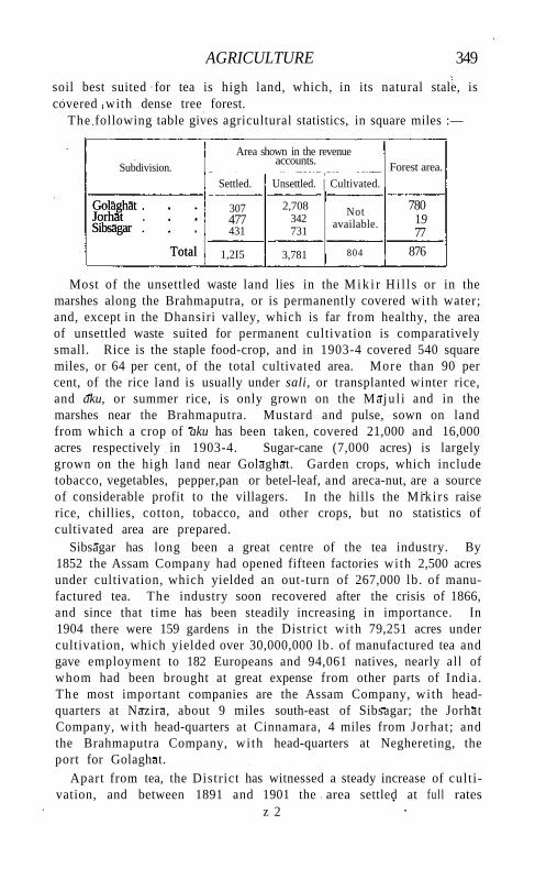
AGRICULTURE 349
soil best suited for tea is high land, which, in its natural stale, is covered with dense tree forest.
The following table gives agricultural statistics, in square miles :—
Subdivision. Area shown in the revenue
accounts.
Settled. Unsettled. | Cultivated.
Forest area.
Golaghat . Jorhat Sibsagar .
Total
307 477 431
2,708 342 731
Not available.
780 19 77
Golaghat . Jorhat Sibsagar .
Total 1,2I5 3,781 804 876
Most of the unsettled waste land lies in the M i k i r Hi l l s or in the marshes along the Brahmaputra, or is permanently covered with water; and, except in the Dhansiri valley, which is far from healthy, the area of unsettled waste suited for permanent cultivation is comparatively small. Rice is the staple food-crop, and in 1903-4 covered 540 square miles, or 64 per cent, of the total cultivated area. More than 90 per cent, of the rice land is usually under sali, or transplanted winter rice, and aku, or summer rice, is only grown on the Maju l i and in the marshes near the Brahmaputra. Mustard and pulse, sown on land from which a crop of aku has been taken, covered 21,000 and 16,000 acres respectively in 1903-4. Sugar-cane (7,000 acres) is largely grown on the high land near Golaghat. Garden crops, which include tobacco, vegetables, pepper,pan or betel-leaf, and areca-nut, are a source of considerable profit to the villagers. In the hills the Miki rs raise rice, chillies, cotton, tobacco, and other crops, but no statistics of cultivated area are prepared.
Sibsagar has long been a great centre of the tea industry. By 1852 the Assam Company had opened fifteen factories with 2,500 acres under cultivation, which yielded an out-turn of 267,000 lb. of manufactured tea. The industry soon recovered after the crisis of 1866, and since that time has been steadily increasing in importance. In 1904 there were 159 gardens in the District with 79,251 acres under cultivation, which yielded over 30,000,000 lb . of manufactured tea and gave employment to 182 Europeans and 94,061 natives, nearly all of whom had been brought at great expense from other parts of India. The most important companies are the Assam Company, with headquarters at Nazira, about 9 miles south-east of Sibsagar; the Jorhat Company, wi th head-quarters at Cinnamara, 4 miles from Jorhat; and the Brahmaputra Company, wi th head-quarters at Neghereting, the port for Golaghat.
Apart from tea, the District has witnessed a steady increase of cult ivation, and between 1891 and 1901 the area settled at full rates
z 2
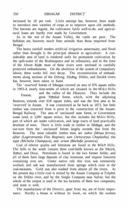
350 SIBSAGAR DISTRICT
increased by 18 per cent. Little attempt has, however, been made to introduce new varieties of crops or to improve upon old methods. The harvests are regular, the cultivators fairly well-to-do, and agricultural loans are hardly ever made by Government.
As in the rest of the Assam Valley, the cattle are poor. The buffaloes are, however, much finer animals than those imported from Bengal.
The heavy rainfall renders artificial irrigation unnecessary, and flood rather than drought is the principal obstacle to agriculture. A considerable area of land is rendered unfit for permanent cultivation by the spill-water of the Brahmaputra and its tributaries, and in the time of the Ahom Rajas most of these rivers were enclosed in carefully protected embankments. On the abolition of the system of compulsory labour, these works fell into decay. The reconstruction of embankments along sections of the Dihing, Disang, Dikho, and Darika rivers has, however, been taken in hand.
The ' reserved' forests of Sibsagar covered an area of 876 square miles in 1903-4, nearly nine-tenths of which are situated in the Mikir Hills
and the valley of the Dhansiri. They include the great Nambar forest, which, with the adjoining
Reserves, extends over 618 square miles, and was the first area to be 'reserved' in Assam. It was constituted as far back as 1873, but little timber was extracted from it prior to the construction of the Assam-Bengal Railway. The area of ' unclassed' state forest, or Government waste land, is 3,091 square miles; but this includes the Mikir Hills, part of which are under cultivation, and large tracts of land practically destitute of trees. There is little trade in timber in Sibsagar, and the out-turn from the ' unclassed' forests largely exceeds that from the Reserves. The most valuable timber trees are nahor (Mesua ferrea), ajhar (Lagerstroemia Flos Reginae), sam {Artocarpus Chaplasha), tita sapa (Michelia Champaca), and uriam (Bischofia javanica).
Coal of inferior quality and limestone are found in the Mlkir Hills. The hills to the south contain three coal-fields known as the Nazira, Jhanzi, and Disai. Petroleum is found in the two former fields; and all of them have large deposits of clay ironstone, and impure limonite containing iron ore. Under native rule this iron was extensively worked, and salt was manufactured from springs which exist in the coal-measures. Gold was also washed from almost all the rivers. At the present day a little coal is mined by the Assam Company at Telpum on the Dikho river, and by the Singlo Company near Safrai; but the whole of the output is used in the tea factories of these two companies, and none is sold.
The manufactures of the District, apart from tea, are of little importance. Hardly a house is without its loom, on which the women
Forests.
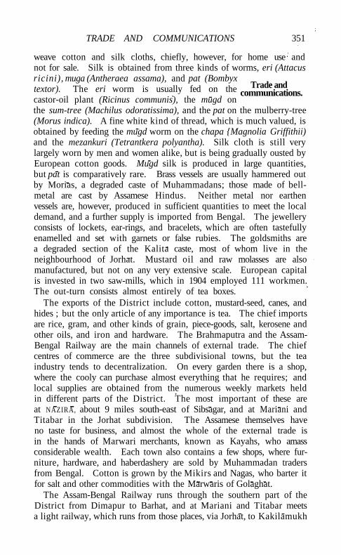
TRADE AND COMMUNICATIONS 351
weave cotton and silk cloths, chiefly, however, for home use and not for sale. Silk is obtained from three kinds of worms, eri (Attacus ricini), muga (Antheraea assama), and pat (Bombyx textor). The eri worm is usually fed on the castor-oil plant (Ricinus communis), the mugd on the sum-tree (Machilus odoratissima), and the pat on the mulberry-tree (Morus indica). A fine white kind of thread, which is much valued, is obtained by feeding the mugd worm on the chapa {Magnolia Griffithii) and the mezankuri (Tetrantkera polyantha). Silk cloth is still very largely worn by men and women alike, but is being gradually ousted by European cotton goods. Mugd silk is produced in large quantities, but pat is comparatively rare. Brass vessels are usually hammered out by Morias, a degraded caste of Muhammadans; those made of bell-metal are cast by Assamese Hindus. Neither metal nor earthen vessels are, however, produced in sufficient quantities to meet the local demand, and a further supply is imported from Bengal. The jewellery consists of lockets, ear-rings, and bracelets, which are often tastefully enamelled and set with garnets or false rubies. The goldsmiths are a degraded section of the Kalita caste, most of whom live in the neighbourhood of Jorhat. Mustard oil and raw molasses are also manufactured, but not on any very extensive scale. European capital is invested in two saw-mills, which in 1904 employed 111 workmen. The out-turn consists almost entirely of tea boxes.
The exports of the District include cotton, mustard-seed, canes, and hides ; but the only article of any importance is tea. The chief imports are rice, gram, and other kinds of grain, piece-goods, salt, kerosene and other oils, and iron and hardware. The Brahmaputra and the Assam-Bengal Railway are the main channels of external trade. The chief centres of commerce are the three subdivisional towns, but the tea industry tends to decentralization. On every garden there is a shop, where the cooly can purchase almost everything that he requires; and local supplies are obtained from the numerous weekly markets held in different parts of the District. The most important of these are at NAZIRA, about 9 miles south-east of Sibsagar, and at Mariani and Titabar in the Jorhat subdivision. The Assamese themselves have no taste for business, and almost the whole of the external trade is in the hands of Marwari merchants, known as Kayahs, who amass considerable wealth. Each town also contains a few shops, where furniture, hardware, and haberdashery are sold by Muhammadan traders from Bengal. Cotton is grown by the Mikirs and Nagas, who barter it for salt and other commodities with the Marwaris of Golaghat.
The Assam-Bengal Railway runs through the southern part of the District from Dimapur to Barhat, and at Mariani and Titabar meets a light railway, which runs from those places, via Jorhat, to Kakilamukh
Trade and communications.
35* SIBSAGAR DISTRICT
on the Brahmaputra. A daily service of passenger steamers and a large fleet of cargo boats, owned and managed by the India General Steam Navigation Company and the Rivers Steam Navigation Company, ply on the Brahmaputra between Goalundo and Dibrugarh. Disangmukh is the port for Sibsagar, Kakilamukh for Jorhat, and Neghereting for Golaghat; but steamers also call at the mouths of the Dihing, Dikho, Jhanzi, and Dhansiri. In the rains feeder vessels go up the Dikho to Santak, up the Disang to Safrai, and up the Dhansiri to Golaghat.
The principal roads are the trunk road, which runs for no miles through the District, passing through Jorhat and Sibsagar, and the Dhodar Al i , which leaves the trunk road at Kamargaon in the Golaghat subdivision, and runs through the south-east of the District into Lakh-impur. Numerous branch roads, many of which follow the lines of the alis, or old embankments constructed by forced labour under the Ahom kings, run from north to south and connect the Dhodar Ali and the trunk road. North of the Brahmaputra there is only one road, which crosses the Majuli from Kamalabari to Garamur. In 1903-4, 237 miles of unmetalled roads were maintained by the Public Works department and 705 miles by the local boards. Most of these roads are bridged throughout, and ferries are maintained only over the larger rivers.
For general administrative purposes the District is divided into three subdivisions: SIBSAGAR, which is under the immediate charge of the
Deputy-Commissioner; and JORHAT and GOLAGHAT, which are usually entrusted to European magistrates.
The transfer of the head-quarters of the District from Sibsagar to Jorhat has, however, recently been sanctioned. The staff includes six Assistant Magistrates, two of whom are stationed at Jorhat and two at Golaghat, and a Forest officer.
The Deputy-Commissioner has the powers of a Sub-Judge, and the Assistant Magistrates exercise jurisdiction as Munsifs. Appeals, both civil and criminal, lie to the Judge of the Assam Valley; but the chief appellate authority is the High Court at Calcutta. The people are, as a whole, law-abiding, and there is not much serious crime. In the Mikir Hills and in the tract recently transferred from the Naga Hills District a special form of procedure is in force. The High Court has no jurisdiction, and the Deputy-Commissioner exercises the powers of life and death subject to confirmation by the Chief Commissioner.
The land revenue system does not differ materially from that in force in the rest of Assam proper, which is described in the article on ASSAM. The settlement is ryotwari, and is liable to periodical revision. Mustard and summer rice are seldom grown on the same land for more than three years in succession, and the villagers are allowed to resign their holdings and take up new plots of land on giving notice to the revenue authorities. In 1903-4, 17,000 acres
Administration.
ADMINISTRATION 353
of land were so resigned and about 32,000 acres of new land taken up. Fresh leases are issued every year for this shifting cultivation, and a large staff of mandah is maintained to measure new land, test applications for relinquishment, and keep the record up to date. In the Mlklr Hills the villagers pay a tax of Rs. 3 per house, irrespective of the area brought under cultivation. The District was last settled in 1893, and the average assessment per settled acre assessed at full rates in 1903-4 was Rs. 2-10-2 (maximum Rs. 4-2, minimum Rs. 1-11). A resettlement is now in progress.
The following table shows the revenue from land and the total revenue, in thousands of rupees:—
1880-1. 1890-1. 1900-1. 1903-4.
Land revenue Total revenue .
6,19 14,11*
8,11 17,66
13,96 26,01
14,22 25,92
* Exclusive of forest receipts.
Outside the station of Sibsagar and the Jorhat and Golaghat unions, the local affairs of each subdivision are managed by a board presided over by the Deputy-Commissioner or the Subdivisional officer. The presence of a strong European element on these boards, elected by the planting community, lends to them a considerable degree of vitality. The total expenditure in 1903-4 amounted to Rs. 1,82,000, about three-fifths of which was laid out on public works. Nearly the whole of the income is derived from local rates, supplemented by a grant from Provincial revenues.
For the purposes of the prevention and detection of crime, the District is divided into ten investigating centres, and the civil police force consisted in 1904 of 50 officers and 278 men. There are no rural police, their duties being discharged by the village headmen. In addition to the District jail at Sibsagar, subsidiary jails are maintained at Jorhat and Golaghat, with accommodation for 56 males and 7 females.
Education has made more progress in Sibsagar than in most Districts of the Assam Valley. The number of pupils under instruction in 1880-1, 1890-1, 1900-1, and 1903-4 was 4,547, 8,798, 12,063, and 12,451 respectively; and the number of pupils in the last year was more than three times the number twenty-nine years before. At the Census of 1901, 3.4 per cent, of the population (6.1 males and 0.4 females) were returned as literate. The District contained 302 primary and 15 secondary schools and one special school in 1903-4. The number of female scholars was 236. The great majority of the pupils are in primary classes. Of the male population of school-going age 21 per cent, were in the primary stage of instruction, and
354 SIBSAGAR DISTRICT
of the female population of the same age less than one per cent. The total expenditure on education in 1903-4 was Rs. 1,01,000, of which Rs. 35,000 was derived from fees. About 34 per cent, of the direct expenditure was devoted to primary schools.
The District possesses 3 hospitals and 4 dispensaries, with accommodation for 58 in-patients. In 1904 the number of cases treated was 89,000, of which 600 were in-patients, and 1,000 operations were performed. The expenditure was Rs. 15,000, half of which was met from local and municipal funds.
In 1903-4, 46 per 1,000 of the population were successfully vaccinated, which is a l i t t le above the proportion for the Province as a whole. Vaccination is compulsory only in the towns of Sibsagar, Jorhat, and Golaghat.
[Sir W. W. Hunter, A Statistical Account of Assam, vol . i (1879); L. J. Kershaw, Assessment Reports, Central Golaghat, Western Gola-ghat, Northern Jorhat, Central Jorhat, and Southern Jorhat Group (1905); B. C. Allen, District Gazetteer (1906).]
Sibsagar Subdivision.—Subdivision of Sibsagar District, Eastern Bengal and Assam, lying between 260 42 ' and 270 16' N. and 940 24' and 950 22' E., with an area of 1,162 square miles. It contains one town, SIBSAGAR (population, 5,712), the head-quarters; and 666 villages. The subdivision lies on the south bank of the Brahmaputra, and is bounded on the south by the hills inhabited by Nagas. It was the original centre from which the Ahom tribe extended their influence over the valley of the Brahmaputra, and evidences of their occupation are to be found in numerous large tanks, embankments, and ruins of temples and palaces. The population in 1901 was 211,764, or nearly one-third more than in 1891 (160,304). This enormous increase is due to natural growth among the Assamese, who are found here in large numbers, and to the importation of coolies for tea cultivation. In 1904 there were 56 gardens with 28,076 acres under plant, which gave employment to 75 Europeans and 33,329 natives. The staple food-crop is sali', or transplanted winter r ice ; but much damage is done to cultivation by the tributaries of the Brahmaputra, and steps have recently been taken to restore the embankments which enclosed these rivers in the time of the Ahom Rajas. The subdivision, as a whole, supports 182 persons per square mile, but in the Namdi to l tahsil, which covers an area of 160 square miles, the density is as high as 364, and l i t t le good land remains available for settlement except in tracts which require to be protected from flood. In the west the rainfall is 85 inches, but on the eastern border it is about 10 inches more. The assessment for land revenue and local rates in 1903-4 was Rs. 5,66,000.
Sibsagar Town.—Head-quarters of the District and subdivision
SIDDAPUR 355
of the same name, Eastern Bengal and Assam, situated in 26° 59 N. and 940 38' E., on the right bank of the Dikho river. It lies on the trunk road along the south bank of the Brahmaputra, and is connected by road wi th the railway at Nazira and with the Brahmaputra at Disangmukh, the distance to each of these places being about 9 miles. Population (1901), 5,712. Sibsagar is somewhat unfavourably situated for trade, and the population shows little tendency to increase. The town takes its name from a tank (sagar), a mile and three-quarters in circumference, which was constructed by the Ahom Raja Sib Singh in 1722. Between 1699 and 1786 Rangpur near Sibsagar was the capital of the Ahoms, but in the latter year the Raja was driven by his rebellious subjects to Jorhat. The rainfall is heavy (94 inches), but the town is healthy, though during the rains most of the country in the neighbourhood is flooded. It is the head-quarters of the District staff and of a branch of the American Baptist Mission. In addition to the usual public buildings, there are a hospital with 20 beds and a jai l with accommodation for 77 prisoners. Sibsagar was constituted a station under (Bengal) Act V of 1876 in 188O. The municipal receipts and expenditure during the ten years ending 1902-3 averaged Rs. 11,000. In 1903-4 the income was Rs. 11,500, including taxes on houses and lands (Rs. 2,400) and grant from Provincial Revenues (Rs. 5,000), while the expenditure was Rs. 11,200. The principal imports are cotton piece-goods, o i l , grain, and salt; the exports are inconsiderable. The chief educational institutions are two high schools, which had an average attendance of 393 boys m 1903-4. About 150 members of the Assam Valley Light Horse were resident in the District in 1904. The transfer of the head-quarters of the District to Jorhat has recently been sanctioned.
Siddapur.—South-easternmost taluka of Nor th Kanara District, Bombay, lying between 140 12' and 140 3 1 ' N. and 740 40 ' and 750 1' E., with an area of 332 square miles. There are 197 villages, the head-quarters being at Siddapur. The population in 1901 was 41,342, compared wi th 42,751 in 1891. The density, 125 persons per square mile, exceeds the District average. The demand for land revenue in 1903-4 was 1-46 lakhs, and for cesses Rs. 9,000. Siddapur is covered with hills in the west, which are thickly wooded towards the south but are bare in the north. The valleys among the western hills are generally planted with spice gardens. The centre of the taluka is a series of low hills, crossed by rich valleys and many perennial streams. In the east the hills are few and the country stretches in wide fairly-wooded plains, in parts dotted with sugar-cane and rice-fields ; the extreme south-east is hi l ly and thickly wooded, mostly wi th evergreen forests containing timber of great girth and height. The small streams are of great value for garden irrigation. In the west
356 SIDDAPUR
the soil is red, and in the valleys a rich alluvial mould is found. In the east the soil is red in places, but is not rich. The chief products are rice, sugar-cane, Bengal gram, kulith, areca-nuts, pepper, cardamoms, betel-leaf, lemons, and oranges. Except in the west, where fever prevails during the later rains and the cold season, the taluka is fairly healthy, and during the hot months the climate is agreeable. The annual rainfall averages 115 inches.
Siddapura.—Village in the Molakalmuru taluk of Chitaldroog District, Mysore, situated in 140 49' N. and 760 47' E., on the Janagahalla, 9 miles north-east of Molakalmuru town. Population (1901), 1,796. It has become of special interest from the discovery of edicts of Asoka in the neighbourhood. They are addressed to the officials in Isila, which may represent the ' Sidda' of Siddapura. If so, the place was in existence in the third century B.C. The other inscriptions found are Pallava, Hoysala, and Vijayanagar of the eleventh, thirteenth, and sixteenth centuries.
Siddhavattam.—Subdivision and taluk of Cuddapah District, Madras. See SIDHOUT.
Siddheswar.—Hills between Sylhet and Cachar Districts, Eastern Bengal and Assam. See SARASPUR.
Siddipet Taluk.— Taluk in Medak District, Hyderabad State, with an area of 1,199 square miles. The population in 1901 was 150,551, compared with 155,523 in 1891, the decrease being due to cholera. The taluk has one town, SIDDIPET (population, 8,302), the head-quarters; and 233 villages, of which 102 are jagfr. The land revenue in 1901 was 3.6 lakhs. Tanks supply a considerable area of rice cultivation.
Siddipet Town.—Head-quarters of the taluk of the same name in Medak District, Hyderabad State, situated in 180 6' N. and 78° 61' E. Population (1901), 8,302. Siddipet is a commercial town of some importance, and contains a dispensary, a State school, a mission school, and a post office. An old fort adjoins it to the west. Brass and copper vessels of a superior kind, as well as silk and cotton fabrics, are manufactured here.
Sidhauli.—South-eastern tahsil of Sitapur District, United Provinces, comprising the parganas of Ban, Sadrpur, Kondri (South), Mahmudabad, and Manwan, and lying between 270 6' and 270 31 ' N. and 8o° 46' and 81° 24' E., with an area of 502 square miles. Population increased from 269,122 in 1891 to 299,492 in 1901, the rate of increase being the highest in the District. There are 544 villages and two towns, including MAHMUDABAD (population, 8,664). The demand for land revenue in 1903-4 was Rs. 4,60,000, and for cesses Rs. 74,000. The tahsll supports 597 persons per square mite, being the most densely populated in the District. It extends from the
SIDHOUT TALUK 357
Gumt i on the south-west to the Gogra on the east, and thus lies partly in the uplands and partly in the low alluvial tract bordering the latter river, which is also intersected by the Chauka. In 1905-4 the area under cultivation was 362 square miles, of which 98 were irrigated. Wells supply one-fifth of the irrigated area, and tanks and ihils most of the remainder.
Sidhnai C a n a l . — A n irrigation work in the Punjab, taking off from the left bank of the Ravi and watering part of Multan District. It derives its name, meaning * straight/ from a remarkable reach of the Ravi, which extends in a perfectly straight cutting for 10 or 12 miles from Tulamba to Sarai Sidhu. It was opened for irrigation in 1886. The head-works consist of a weir 737 feet long, built across this reach. The main line has a bed-width of 90 feet and a maximum discharge of 1,820 cubic feet per second; after 30 miles it divides into two large distributaries, which between them take nearly one-third of the whole supply. The very short length of the canal compared with the area irrigated is one cause of its financial success. There are in all 13 main distributary channels taking out of the main line, and three subsidiary canals which take out of the river above the dam. The gross area commanded is 595 square miles, of which the greater part was Government waste, and was settled by colonists brought from various parts of the Punjab, the land being given out for the most part in 90-acre plots. Although the whole of the water in the Sidhnai reach can be turned into the canal, the Ravi in the winter is often absolutely dry owing to the supply taken by the Bari Doab Canal, so that the spring crop has to be matured by the aid of wells. The average area irrigated during the three years ending 1903-4 was 190 square miles. The capital outlay up to the end of 1903-4 was about 13 lakhs, and the average annual profit more than 11 per cent.
Sidhout Subdivision.—Subdivision of Cuddapah District, Madras, consisting of the S I D H O U T , B A D V E L , and P U L L A M P E T taluks.
Sidhout T a l u k ( ' the hermit's banyan-tree').—Eastern taluk of Cuddapah District, Madras, lying between 140 16' and 140 4 1 ' N. and 780 52' and 790 22' E., with an area of 606 square miles. It is situated between the Palkonda Hi l l s and the Velikonda range. The population in 1901 was 68,087, compared with 66,810 in 1891 ; and the density is 112 persons per square mile, compared with the District average of 148. It contains 79 villages, including Sidhout, the headquarters. The demand for land revenue and cesses in X903-4 amounted to Rs. 1,10,000. The annual rainfall is 33 inches, against the District average of 28 inches. The best land is in the valley of the Penner, where water is easily obtained by sinking wells. L i t t le of the taluk is cultivated except the valleys, owing to the numerous rugged hills by which it is cut up. Though four rivers cross it,
358 SIDHOUT TALUK
few irrigation channels are drawn from them, as they run in deep beds; and almost the only benefit derived from the wealth of water which runs away to the sea is the increase in the moisture of the subsoil in the valleys. The principal products are indigo and cotton. More than half of the taluk consists of ' reserved ' forests.
Sidhout, the head-quarters, is a place of some importance and of considerable sanctity. Owing to a fancied resemblance in its position on the Penner to that of Benares on the Ganges, and to the relative situation of some neighbouring villages and rivers, it is sometimes called Dakshina Kasi or the Southern Benares.' It is known for its m fons, the cultivation of which is carried on from January to March in the dry sandy bed of the Penner.
Sidhpur Taluka.—Northern taluka of the Kadi prant, Baroda State, with an area of 254 square miles. The population fell from 107,470 in 1891 to 90,161 in 1901. The taluka contains two towns, SIDHPUR (population, 14,743), the head-quarters, and U N J H A (9,800); and 78 villages. It is flat and undulating by turns, and is somewhat bare of trees, while the surface soil is light and sandy. The Saras-wati river flows through the centre. In 1904-5 the land revenue was Rs. 2,89,000.
Sidhpur Town.—Head-quarters of the taluka of the same name, Kadi prant, Baroda State, situated in 230 55' N. and 720 26' E., on the Saraswati river, with a station on the Rajputana-Malwa Railway, 64 miles north of Ahmadabad. Population (1901), 14,743. Sidhpur, which was formerly known as Sristhala, is a town of much religious importance, and is frequented by great crowds of Hindu pilgrims. They resort here because it is said to be the only place where shrdddha can be performed for the propitiation of the manes of deceased mothers. What Gaya is for the fathers, Sidhpur is for the mothers.
A. K. Forbes in his Ras Mala has described the celebrated Rudra Mahalaya or Mala, founded in the tenth century by Mularaja, and reconstituted by Jay Singh Siddha Raja, once the glory of Sidhpur, but now only a massive ruin:—
' The Rudra Mala was a very large edifice of the usual form and apparently three storeys high. In the centre of three sides of the mandapa projected two-storeyed porticoes called rup choris; on the fourth the adytum, a most massive structure rising to the extreme height of the central building, and then mounting beyond it into a sikara or spire. On either side stood a kirtti stambha or triumphal pillar, one of which exists in a nearly perfect state. Two richly adorned columns support an entablature and sculptured pediment. Above the brackets, formed of the heads of marine monsters, springs a delicately chiselled arch called the torana or ' garland.' The temple stood in the centre of an extensive court, to which access was given by
SIDLAGHATTA TOWN 359
three large gate-houses, that in front opening on to the terrace leading to the river, The rest of the surrounding wall was composed of numerous lesser shrines, three of which remain and have been converted into a Muhammadan mosque/
But the work of destruction has proceeded rapidly since the time of Forbes, and now there is lit t le left save gigantic stones with superb carving to show the former magnificence of the great temple. Opposite Sidhpur and across the river is a large square building forming a dharmsala of Kewalpuri Gosains. The town also contains numerous other temples, and several tanks, one of which, the Bindu Sarovar, is held peculiarly holy. The tortuous and narrow streets, the crowded houses, and the population too great for the area inhabited, unite in making Sidhpur an unattractive town for all except the Audichya Brahmans, who derive comfortable incomes from this holy place, and the Bohras. The latter are merchants who carry on business in Burma, Zanzibar, & c , and then retire to Sidhpur to spend the rest of their existence in their well-built houses and pleasant gardens. The town possesses a magistrate's court, Anglo-vernacular and vernacular schools, a dispensary, and the usual public offices. It is administered as a municipality, which was reconstituted on a partly elective basis in 1905, and has an income of Rs. 6,500 from customs, excise, and tolls. The chief arts are dyeing and printing of cloth, but the wood-carving on the houses is also worthy of notice. Sidhpur is locally known as the centre of the poppy-growing tract in Baroda, and the place where the State manufactures opium.
Sidlaghatta Taluk.—Centra l taluk of Kolar District, Mysore, lying between 13° 13' and 130 4 1 ' N. and 770 48' and 780 8' E., with an area of 329 square miles. The population in 1901 was 70,022, compared with 58,977 in 1891. The taluk contains one town, S I D L A G H A T T A (population, 7,638) the head-quarters; and 353 villages. The land revenue demand in 1903-4 was Rs. 1,44,000. The Pa-paghni river crosses the taluk to the north-east. The Ponnaiyar drains the south-west angle, forming some large tanks. The north-west is hilly and rugged, and the soil poor and stony; but black soil occurs near the river. South of Sidlaghatta the soil is good, and potatoes are grown.
Sidlaghatta Town.—Head-quarters of the taluk of the same name in Kolar District, Mysore, situated in 130 23' N. and 770 52' E., 30 miles north-west of Kolar town. Population (1901), 7,638. It was founded about 1524 by a robber chief, in whose family it remained for eighty-seven years. The Marathas then took and held it for forty-five years, when it was captured by the Mughals. The Marathas again got possession, and sold i t to the chief of C H I K - B A L L A P U R . For about 5 miles round the town occurs a kind of laterite called chattu, which
360 SIDLAGHATTA TOWN
differs from the ordinary formation in allowing the growth of large trees. Reduced to clay it forms a durable plastering for walls, and makes roofs watertight. The municipality dates from 1870. The receipts and expenditure during the ten years ending 1901 averaged Rs. 3,750 and Rs. 4,550. In 1903-4 they were Rs. 5,000.
Sidoktaya.—North-western township of Minbu District, Upper Burma, lying between 200 7' and 200 54' N. and 940 2' and 940 30' E., on the eastern slopes of the Arakan Yoma, in the Mon river basin, with an area of 1,121 square miles. It is sparsely populated, and cursed with a malarious climate which no Burman from the plains can endure. The population fell from 24,337 in 1891 to 22,511 in 1901, and in the latter year included 10,400 Chins, while the nominally Burman population is much mixed with Chin. There are 208 villages, the headquarters being at Sidoktaya (population, 1,207),on the Mon river. In 1903-4 the area cultivated was 15 square miles, and the land revenue and thathameda amounted to Rs. 39,000.
Sidri.— Thakurat in the MALWA AGENCY, Central India. Sihawal.—Head-quarters of the Bardi tahsil of the Rewah State,
Central India, situated in 24°34/ N. and 820 17' E. Population (1901), 198. The place is of no importance except as the head-quarters of a tahsil, but contains a British post office.
Sihor. — Town in the State of Bhaunagar, Kathiawar, Bombay, situated in 210 43' N. and 720 E., on the Bhavnagar-Gondal Railway, about 13 miles west of Bhaunagar town, and on the slope of the Sihor range of hills. Population (1901), 10,101. The name is a corruption of Singhpur, 'the lion city.' A still more ancient name is Saraswatpur. It formed a capital of the Bhaunagar branch of the Gohel Rajputs until Bhaunagar town was founded in 1723. The old site of the city is about half a mile to the south. Sihor is famous for its copper- and brasswork, snuff, and plaster (ckundm). The dyers are numerous and skilful, and dye women's scarves (sad/as) with various colours, but they are especially famous for their chocolate dye. Sihor is also a great place for oil-pressers. Near the southern wall of the town is situated the Brahma kund, the water of which possesses special virtues for bathers. Farther up the river Gautami lie the Gautami kund and Gautameshwar Maha-deo. The Sihor stone found in the Ranio hill is much used for building.
Sihor.—Town and military station in Central India. See SEHORE. Sihora State.—Petty State in REWA KANTHA, Bombay. Sihora Tahsil.—Central tahsil of Jubbulpore District, Central
Provinces, lying between 230 19' and 230 55' N. and 790 49' and 8o° 38' E., with an area of 1,197 square miles. The population decreased from 212,949 in 1891 to 186,424 in 1901. The density in the latter year was 156 persons per square mile, which is below
SIKANDARABAD TOWN 361
the District average. The tahsil contains one town, SIHORA (population, 5,595), the head-quarters; and 706 inhabited villages. Excluding 96 square miles of Government forest, 55 per cent, of the available area is occupied for cultivation. The cultivated area in 1903-4 was 563 square miles. The demand for land revenue in the same year was Rs. 2,87,000, and for cesses Rs. 32,000. The tahsil contains part of the highly fertile wheat-growing tract known as the Jubbulpore Haveli, though in Sihora the land is not quite so level or productive as in the Jubbulpore tahsil On the west and east broken and hilly country borders the Vindhyan and Satpura ranges.
Sihora Town.—Head-quarters of the tahsil of the same name in Jubbulpore District, Central Provinces, situated in 230 29' N. and 8o° 6' E., 26 miles from Jubbulpore city by rail. Population (1901), 5,595. Sihora was created a municipality in 1867. The municipal receipts during the decade ending 1901 averaged Rs. 5,100. In 1903-4 the receipts were Rs. 5,000, mainly derived from a house tax and brokers' fees. The iron ore found locally is smelted by indigenous methods in Sihora, and there is a certain amount of local trade; but the town is not growing. It contains a vernacular middle school, a girls' school supported by the Zanana Mission of the Church of England, and a dispensary.
Sikandarabad Tahsil.—North-western tahsil of Bulandshahr District, United Provinces, comprising the parganas of Sikandarabad, Dadri, and Dankaur, and lying along the Jumna, between 280 15' and 28° 39' N. and 770 18' and 770 50' E., with an area of 516 square miles. The population rose from 224,368 in 1891 to 260,849 in 1901. There are 404 villages and seven towns, the largest of which are SIKANDARABAD (population, 18,290), the tahsil head-quarters, and D A N K A U R (5,444). The demand for land revenue in 1903-4 was Rs. 4,32,000, and for cesses Rs. 74,000. The tahsil is the poorest in the District, and supports only 505 persons per square mile, against an average of 599. It is crossed from north to south by two main lines of drainage—the Patwai and the Karon or Karwan. Both of these are naturally ill-defined, but their channels have been deepened and straightened. The area between the Patwai and Jumma is poor, being largely covered with tamarisk and grass jungle varied by patches of salt waste. I n the north the H I N D A N and Bhuriya rivers increase the saturation, while they bring down fertile deposits of earth. The tahsil is well supplied with irrigation by the Mat branch of the Upper Ganges Canal, which passes through the centre from north to south. In 1903-4 the area under cultivation was 358 square miles, of which 150 were irrigated. More than two-thirds of the irrigated area is supplied from the canal.
Sikandarabad Town.—Head-quarters of the tahsil of the same
362 SIKANDARABAD TOWN
name in Bulandshahr District, Uni ted Provinces, situated in 280 28' N. and 770 42 ' E., on the grand trunk road, 4 miles from Sikandarabad station on the East Ind ian Railway. Population (1901), 18,290, of whom 10,599 were Hindus and 6,814 Musalmans. The town was bui l t by Sikandar L o d I in 1498, and was the head-quarters of a pargana or mahal under Akbar. In the eighteenth century it was held for a time by Najlb-ud-daula. Saadat Khan, Nawab of Oudh, attacked and defeated a Maratha force here in 1736. The Jat army of Bharatpur encamped at Sikandarabad in 1763, but fled across the Jumna on the death of Suraj M a i and defeat of Jawahir Singh. Under Maratha rule the town was the head-quarters of a brigade under Perron; and after the fall of Aligarh, Colonel James Skinner held i t . During the Mut iny of 1857, the neighbouring Gujars, Rajputs, and Muhammadans attacked and plundered Sikandarabad; but Colonel Greathed's column relieved the town on September 27, 1857. There are several tombs and mosques of some antiquity. Besides the tahsili and police station there is a dispensary; and the American Methodists, the Church Missionary Society, and the Zanana Bible and Medical Mission have branches here. Sikandarabad has been a municipality since 1872. Dur ing the ten years ending 1901 the income and expenditure averaged Rs. 15,000. In 1903-4 the income was Rs. 23,000, chiefly derived from octroi (Rs. 17,000); and the expenditure was Rs. 21,000. There is not much trade ; but fine cloth or muslin is manufactured and exported to Delhi , and a cotton-gin has been recently opened, which employed 105 hands in 1903. The town contains a flourishing Anglo-vernacular school with more than 200 pupils, a tahsili school with 120, and five primary schools wi th 240 pupils.
S i k a n d a r p u r . — T o w n in the Bansdih tahsil of Ballia District, Uni ted Provinces, situated in 260 3' N. and 840 4' E., 24 miles north of Ballia town and 2 miles from the right bank of the Gogra. Population (1901), 7,214. Tradi t ion ascribes the founding of the town to the reign of Sikandar Lod i , from whom its name was taken. Its former importance is attested by the ruins of a large fort, and of houses extending over a large area. I ts decadence is locally ascribed to the wholesale migration of the inhabitants to Patna, but nothing is known as to the cause or even the date of this abandonment. Sikandarpur is administered under Act XX of 1856, with an income from taxation of Rs. 1,200. The local market is famous for its otto of roses and other perfumes, produced from flowers grown locally and exported to Bengal. There is also a small manufacture of coarse cloth. The town school has 63 pupils.
Sikandra.—Vil lage in the District and tahsil of Agra, Uni ted Provinces, situated in 270 13' N. and 770 57 ' E., 5 miles north-west of Agra city on the Mut t ra road. Population (1901), 1,618. The
SIKANDRA RAO TAHSlL 363
village is said to have received its name from Sikandar Lod i , Who buil t a palace here in 1495, which now forms part of the orphanage. Jahangir's mother, who died at Agra in 1623, is buried here; but the place is chiefly famous for the tomb of Akbar, which was built by JahSnglr, and completed in 1612-3. It stands in a spacious garden of 150 acres, surrounded by massive walls and gateways in the middle of each side. The entrance is by a gateway of magnificent proportions, wi th four lofty minarets of white marble. The building is of unusual design, and according to Fergusson was probably copied from a H i n d u or Buddhist model. It consists of a series of four square terraces, placed one above the other and gradually decreasing in size. The lowest is 320 feet square and 30 feet high, and has a large entrance adorned with marble mosaic. Above the highest of these four terraces, which are chiefly of sandstone, stands a white marble enclosure, 157 feet square, the outer wall of which is composed of beautifully carved screens. The space within is surrounded by cloisters of marble, and paved with the same material. In the centre is the marble cenotaph of the great emperor, a perfect example of the most delicate arabesque tracery, among which may be seen the ninety-nine names of God. Finch, after describing his visit to the tomb in 1609, says that the intention was to cover this upper enclosure with a marble dome lined with gold. The Church Missionary Society has an important branch at Sikandra, with a church built in 1840, and an orphanage established after the famine of 1837-8, which contains about 409 boys and girls, mostly famine waifs. In addition to ordinary literary subjects, some of the children are taught cloth and carpet weaving, bookbinding, printing, and other trades.
S i k a n d r a Dhar.—Range of hills in the Punjab, which, starting from a point on the border of the Suket, Bilaspur, and Mandi States, runs north-west for 50 miles in the last State. It is pierced by the Beas river about 20 miles north-west of Mandi town. Its name is derived from that of Sikandar Khan Siirl, who is said to have established a cantonment on its summit, intending to conquer Kangra.
S i k a n d r a R a o Tahsil.—South-eastern tahsi l of Allgarh District, Uni ted Provinces, comprising the parganas of Sikandra and Akrabad, and lying between 270 32' and 270 53' N. and 780 JO ' and 780 32' E., with an area of 337 square miles. The population rose from 183,185 in 1891 to 211,532 in 1901. There are 248 villages and seven towns, the largest of which are S I K A N D R A R A O (population, 11,372), the tahsil head-quarters, and P I L K H A N A (5,109). The demand for land revenue in 1903-4 was Rs. 4,32,oop, and for cesses Rs. 69,000. On the northeast the K a l i Nadi forms the boundary, and in the south one or two small streams rise. Irrigation is supplied by the Etawah branch of the
VOL. x x i i . A a
364 SIKANDRA RAO TAHSIL
Upper Ganges Canal; and the tahsil is one of the most prosperous in the District, in spite of the presence of large waste areas covered with saline efflorescences. In 1903-4 the area under cultivation was 218 square miles, of which 164 were irrigated.
Sikandra Rao Town.—Head-quarters of the tahsil of the same name in Allgarh District, United Provinces, situated in 270 41 ' N. and 780 23' E., on the grand trunk road and on the Cawnpore-Achhnera-Railway. Population (1901), 11,372. The town was founded in the fifteenth century by Sikandar LodI, and afterwards given as a jagzr to Rao Khan, an Afghan, from which circumstances the double name is derived. During the Mutiny of 1857, Ghaus Khan, of Sikandra Rao, was one of the leading rebels, and held Koil or Allgarh as deputy for Walldad Khan of Malagarh in Bulandshahr District. Kundan Singh, a Pundir Rajput, did good service on the British side, and held the pargana as nazim, Sikandra Rao is a squalid, poor-looking town, on a high mound surrounded by low, badly-drained environs. A great swamp spreads eastwards, attaining a length of 4 miles in the rains. There is a mosque dating from Akbar's time, and a ruined house in the town was once the residence of a Muhammadan governor. The public buildings include the tahsili, dispensary, and school. Sikandra Rao has been a municipality since 1865. During the ten years ending 1901, the income and expenditure averaged Rs. 8,ooo. In 1903-4 the income was Rs. 13,000, chiefly derived from octroi (Rs. 9,000); and the expenditure was Rs. 14,000. The town is declining, and its trade is chiefly local. There is a small export of glass and saltpetre, which are made in the neighbourhood. The middle school has 220 pupils, and five primary schools 270 pupils.
Slkar.—Head-quarters of the chiefship of the same name in the Shekhawati nizamat of the State of Jaipur, Rajputana, situated in 270
37' N. and 750 8' E., about 64 miles north-west of Jaipur city, and about 45 miles north of Kuchawan Road junction on the Rajput-ana-Malwa Railway. The town is walled, and possesses some large bazars and a combined post and telegraph office. The population in 1901 was 21,523, thus making Slkar the second largest town in the State; Hindus numbered 12,967, or 60 per cent., and Musalmans 7,704, or over 35 per cent. The Rao Raja maintains an Anglo-vernacular school, attended in 1904 by 90 boys, and a hospital with accommodation for 16 in-patients. There are also seven indigenous schools in the town. The Rao Raja's palace, the top of which is illuminated at night by an electric light, rises 1,491 feet above sea-level, and can be seen from a long distance across the desert. About 7 miles to the south-east is a ruined temple of Harasnath, which stands on a hill 2,998 feet above sea-level, and is said to be 900 years old.
SIKKIM 365
The Sikar chiefship contains four prosperous towns—Sikar, F A T E H V U R , L A C H H M A N G A R H , and R A M G A R H — a n d 426 villages. The total population in 1901 was 173,485, Hindus numbering 147,973, or more than 85 per cent., and Musalmans 23,033, or over 13 per cent. The ordinary income of the chiefship is about 8 lakhs, and the Rao Raja pays a tribute to the Jaipur Darbar of about Rs. 41,200.
Sikkim.—Native State in the Eastern Himalayas, lying between 270 5' and 280 9' N. and 870 59" and 88° 56' E. , with an area of 2,818 square miles. It is bounded on the north and east by Tibet; on the south-east by Bhutan; on the south by Darjeeling District; and on the west by Nepal. The Tibetan name for Sikkim is pronounced Denjong, and more rarely Demojong or Demoshong; and the people are called Rong-pa, or 'dwellers in the valleys/ the term Mom-pa, or ' dwellers in the low country,' being used occasionally to describe the Lepcha inhabitants.
The main axis of the Himalayas, which runs east and west, forms the boundary between Sikkim and Tibet. The Singalila and Chola ranges, which run southwards from the main chain, separate Sikkim from Nepal on the west, and from Tibet and Bhutan on the east. From the eastern flank of the Singalila range rise the great snow peaks of K I N C H I N J U N G A (28,146 feet), one of the highest mountains in the world; it throws out a second spur terminating at Tendong. The Chola range, which is much loftier than that of Singalila, leaves the main chain at the D O N G K Y A mountain; it is pierced by several passes, the most frequented of which are the Tangkar La (16,000 feet), Natu La (14,200 feet), and JELEP L A (14,390 feet). Over the last named comes practically the whole trade between Bengal and Tibet. From the northwest face of the Dongkya mountain an immense spur takes off and runs first west and then south-west to Kinchinjunga, forming the watershed of all the remote sources of the Tista. This spur has a mean elevation of from 18,000 to 19,000 feet; but several of its peaks, of which Chomiomo is one, rise much higher. Sikkim may be in fact described as the catchment area of the headwaters of the Tista river. The whole of the State is situated at a considerable elevation within the Himalayan mountain zone, the ranges that bound it on three sides forming a kind of horseshoe, from the sides of which dependent spurs project, serving as lateral barriers to the Rangit and the Tista's greater affluents, the Lachung, Lachen, Zemu, Talung, Rongni, and Rangpo. These basins have a southward slope, being broad at the top where they leave the watershed, and gradually contracting, like a fan from its rim to its handle, in the Tista valley near Pashok. The rivers are very rapid and generally run in deep ravines, the ascent from the bank for the first few hundred feet being almost precipitous.
A a 2
Physical aspects.
366 SIKKIM
Sikkim is covered by gneissic rocks, except in the central portion where metamorphic rocks belonging to the Daling series occur \
Sir J. D. Hooker divides the country into three zones, calling the lower up to 5,000 feet above the sea, the tropical; thence to 13,000 feet, the upper limit of tree vegetation, the temperate; and above to the perpetual snowline at 16,000 feet, the alpine. South of the Penlong La, where the Nepalese have been allowed to settle, the more productive sites have been cleared for cultivation up to 6,000 feet, the greatest height at which maize ripens; and trees ordinarily remain only in the rocky ravines and on the steepest slopes where no crops can be grown. The tropical zone is characterized by large figs, Terminalia, Vatica, Myrtaceae, laurels, Euphorbiaceae, Meliaceae, Bauhinia, Bombax, Morus, Artocarpus and other Urticaceae, and many Leguminosae; and the undergrowth consists of Acanthaceae, bamboos, several Calami, two dwarf Arecae, Wallichia, and Caryota urens. Plantains and tree-ferns, as well as Pandanus, are common; and, as in all moist tropical countries, ferns, orchids, Sciiamineae, and Pothos are extremely abundant. Oaks, of which (including chestnuts) there are upwards of eleven species in Sikkim, become abundant at about 4,000 feet; and at 5,000 feet the temperate zone begins, the vegetation varying with the degree of humidity. On the outermost ranges, and on northern exposures, there is a dense forest of cherry, laurels, oaks, and chestnuts, Magnolia\ Andromeda, Styrax, Pyrus, maple and birch, with an underwood of Araliaceae, Holboellia, Limonia, Daphne, Ardisia, Myr-sineae, Symplocos, Rubia, and a prodigious variety of ferns. Plectocomia and Musa ascend to 7,000 feet. On drier exposures bamboo and tall grasses form the underwood. Rhododendrons appear below 6,000 feet, becoming abundant at 8,000 feet, while from 10,000 to 14,000 feet they form the mass of the shrubby vegetation. Orchids are plentiful from 6,000 to 8,000 feet and Vaccinia between 5,000 and 8,000 feet. The sub-alpine zone begins at about 13,000 feet, at which elevation a dense rhododendron scrub occupies the slopes of the mountains, filling up the valleys so as to render them impenetrable. In this zone the chief forms of the vegetation are Gentiana, Primula, Pedicu laris, Meconopsis, and such-like genera, gradually changing to a Siberian flora, which at last entirely supersedes that of the sub-alpine zone and ascends above 18,000 feet.
The tiger is only an occasional visitor; but the leopard (Felis pardus) and the clouded leopard (F nebulosa) are fairly common, the latter
1 Journal, Asiatic Society, Bengal, vol . xxxi, ' Journal of a T r ip undertaken to explore the Glaciers of the Kinchinjunga Group in the Sikkim Himalaya,' by J. L. Sherwil l ; Records, Geological Survey of India, vol. xxiv, pts. i and iv, ' Extracts from the Journal of a T r ip to the Glaciers of Kabru, Pandim, &c. , ' and 'The Geology and Mineral Resources of Sikkim,' by P. N. Bose.
HISTORY 367
ascending to about 7,000 feet. The snow leopard (F. uncia) inhabits the higher altitudes, while the marbled cat (F. marmorata) and the leopard cat (F. bengalensis) are found on the warmer slopes. The large Indian civet cat (Viverra zibetha) is not uncommon up to 5,500 feet, and the spotted tiger-civet (Prionodon pardicolor), though rare, occurs between 5,000 and 6,000 feet. A palm-civet (Farodoxurus grayi) is fairly common in the warmer forest. The cat-bear (Aelurus fulgens) occurs from about 7,000 feet upwards. The brown bear {Ursus arctus) is found at high altitudes, rarely below 11,000 or 12,000 feet, and the Himalayan black bear (U. torquatus) is common from that point down to about 4,000 feet. Though these are the only two bears recorded, the Lepchas assert the existence of a third species, possibly to be identified with U. malay anus. The sambar (Cervus unicolor) is frequent at all elevations up to 9,000 or 10,000 feet. The commonest of the deer tribe is the barking-deer (Cervulus muntjac), found from the lowest valleys up to 9,000 feet; the musk deer (Moschus moschi-ferus) remains always at high elevations, rarely descending below 8,000 feet even in winter. The serow (Nemorhaedus bubalinus) frequents the rockiest ravines over 6,000 feet, while the goral (Cemas goral) affects similar localities, but descends to 3,000 feet and is found up to 8,000. The bharal (Ovis nahura) is found in considerable herds at high altitudes. An exceptionally large number of birds and butterflies occur in the State.
The climate varies between the tropical heat of the valleys and the alpine cold of the snowy ranges. The rainfall is very heavy, averaging 137 inches annually at Gangtok. From November to February the rainfall is light, and the weather in November and December is clear and fine. In March thunderstorms commence and, growing more and more frequent, usher in the rainy season, which lasts t i l l October.
Sikkim was known to early European travellers, such as Horace della Penna and Samuel Van de Putte, under the name of Bramashon (see Markham's Tibet, p. 64 ) ; while Bogle called it Demojong. Local traditions assert that the ancestors of the Rajas of Sikkim originally came from the neighbourhood of Lhasa in Tibet . About the middle of the seventeenth century, the head of the family was named Puntso Namgye; and to him repaired three Tibetan monks, professors of the Nyingmapa (or i red cap' sect of Buddhism), who were disgusted at the predominance of the Gelukpa sect in Tibet. These Lamas, according to Mr . Edgar's Report, succeeded in converting the Lepchas of Sikkim to their own faith, and in making Piintso Namgye Raja of the country. The avatars of two of these Lamas are now the heads, respectively, of the great monasteries of Pemiongchi and Tassiding. In 1788 the Gurkhas invaded Sikkim in the governorship of the Morang or tarai, and only retired, in 1789,
History.
368 S1KKIM
on the Tibetan government ceding to them a piece of territory at the head of the Koti pass. But in 1792, on a second invasion of Tibetan territory by the Gurkhas, an immense Chinese army advanced to the support of the Tibetans, defeated the Gurkhas, and dictated terms to them almost at the gates of Katmandu.
On the breaking out of the Nepal War in 1814, Major Latter at the head of a British force occupied the Morang, and formed an alliance with the Raja of Sikkim, who gladly seized the opportunity of revenging himself on the Gurkhas. At the close of the war in 1816, the Raja was rewarded by a considerable accession of territory, which had been ceded to the British by Nepal. In February, 1835, the Raja granted the site of Darjeeling to the British, and received a pension of Rs. 3,000 per annum in lieu of it.
There was, however, a standing cause of quarrel between the Raja and the paramount power, due to the prevalence of slavery in Sikkim; the Raja's subjects were inveterate kidnappers, and the Raja himself was most anxious to obtain from the British authorities the restoration of runaway slaves. With some notion of enforcing the latter demand, Dr. Campbell, the Superintendent of Darjeeling, and Dr. Hooker, the famous naturalist, were seized in 1849 whilst travelling in Sikkim, and detained for six weeks. As a punishment for this outrage the Raja's pension was stopped, and a piece of territory, including the lower course of the Tlsta and the Sikkim tarai', was annexed. The practice of kidnapping Bengali subjects of the British Crown was, however, not discontinued; and two especially gross cases in i860 led to an order that the Sikkim territory, north of the Ramman river and west of the Ranglt, should be occupied until restitution was made. Colonel Gawler, at the head of a British force, with the Hon. Ashley Eden as envoy, advanced into Sikkim and proceeded to Tumlong, when the Raja was forced to make full restitution, and to sign a treaty (in March, 1861) which secured the rights of free trade, of protection for travellers, and of road-making. For many years the State was left to manage its own affairs; but for some time prior to 1888 the Tibetans were found to be intriguing with the Maharaja, who became more and more unfriendly. Affairs reached a climax in 1888, when war broke out with the Tibetans, who took up a position 11 miles within Sikkim territory. British troops were sent against them, and they were driven off with ease. In 1889. a Political officer subordinate to the Commissioner of the Rajshahi Division was stationed at Gangtok to advise and assist the Maharaja and his council; and this was followed in 1890 by the execution of a convention with the Chinese, by which the British protectorate over Sikkim and its exclusive control over the internal administration and foreign relations of the State were recognized. Since the Tibetan expedition of 1904, the Political officer has been directly responsible
POPULATION 369
to the Government of India. The Maharaja receives a salute of 15 guns.
After the appointment of the Political officer in 1889 communications were greatly improved by the construction of roads and bridges, and the settlement of Nepalese was permitted in certain parts of the State. These measures were followed by a rapid development of the country. Settlers from Nepal flocked in, and the population, which in 1891 was returned at 30,458, had grown to 59,014 ten years later; an increase of 93.7 per cent. The first Census was admittedly incomplete; but a great deal of the increase is accounted for by the growth of the immigrant population, as of the total inhabitants in 1901 no fewer than 22,720, or 38-5 per cent., had been born in Nepal. In addition, the climate is good; there have been no serious epidemics; the people have been prosperous and they are very prolific, the crowds of children being a striking feature of every Sikkim hamlet. The State is still very sparsely populated, having a density of only 21 persons per square mile; but a great quantity of waste land is fit for cultivation, and it is probable that the population will continue to grow at a very rapid rate. As elsewhere where the Mongoloid element of the population preponderates, there is a great excess of males over females. The principal diseases are fever, diseases of the respiratory system, worms, bowel complaints, and skin diseases. Deaf-mutism is far more common than elsewhere in Bengal. The Census of 1901 returned 125 villages; but in reality Sikkim contains few true villages, except in the Lachen and Lachung valleys in the north of the State. Here the houses, somewhat similar in appearance to Swiss chalets, cluster together in the valley bottoms. In southern Sikkim the nearest approach to villages is to be found in the groups of houses near the Maharaja's palaces at Tumlong and Gangtok; round some of the larger monasteries, such as Pemiongchi, Tassiding, and Pensung; and at the copper-mines of Pache near Dikyiling, and the bazars at Rangpo, Rhenok, Pakhyong, Namchi, Manjhltar, Tokul, and Seriong. Khas-kura is the dialect of 2 7 per cent, of the population, while most of the others speak languages of the Tibeto-Burman family, including Bhotia, Limbu, Lepcha, Murmi, Mangar, Khambu, and Newar. Of the total population, 38,306, or 65 per cent., are Hindus, and 20,544, or nearly 35 per cent., are Buddhists. Buddhism, which is of the Tibetan or Lamaist type, is the State religion of Sikkim, which contains about 36 monasteries. Most of the Buddhists are members of the two main indigenous castes, Lepchas and Bhotias (8,000 each). The Lepchas claim to be the autochthpnes of Sikkim proper. Their physical characteristics stamp them as members of the Mongolian race, and certain peculiarities of language and religion render it probable that the tribe
Population.
370 SIKKIM
is a very ancient colony from southern Tibet . They are above all things woodmen, knowing the ways of birds and beasts and possessing an extensive zoological and botanical nomenclature of their own. The chief Nepalese tribes represented are the Khambu, L imbu , M u r m l , Gurung, Khas, Kami , Mangar, Newar, and Damai. The great majority of the population (92 per cent.) are supported by agriculture.
In 1901 Christians numbered 135, of whom 125 were natives. The missions at work in the State are the Church of Scotland Mission and the Scandinavian Alliance Mission.
By far the most important crop is maize, which occupies a larger area than all the other crops together; it is estimated to cover
94 square miles. After maize, the largest areas are under marua, buckwheat, rice, wheat, and barley,
which are estimated to cover from 4,000 to 12,000 acres each. Cardamoms, grown on about 600 acres, are a valuable crop. Cultivation has rapidly extended in recent years, but a large quantity of cultivable waste still remains. Plantains, oranges, and other fruits are grown in the gardens, and the Government apple orchards started at Lachung and Lachen are proving a success. Cattle, yaks, and sheep of various kinds are bred in the State and are also imported from Tibet .
The principal trees have been enumerated in the section on Botany. The forests have suffered much from promiscuous cutting, and also
from fires caused by villagers when clearing ground for cultivation. An attempt is now being made to
introduce a proper system of forest conservancy. Pine, tun (Cedrela Toona), Cryptomeria, fir, alder, beech, chestnut, and a few other kinds have been raised in nurseries for planting by the roadsides; and an avenue of 150 rubber-trees planted at Singtam is doing well. The receipts from forests in 1903-4 were Rs. 19,000, derived chiefly from the sale of railway sleepers and tea-box planking; the expenditure in the same year was Rs. 12,000.
Copper ores are very widespread in Sikkim. The ore is copper pyrites, often accompanied by mundic, and occurs chiefly in the Baling
beds. It is generally disseminated in slates and schists, and seldom occurs in true lodes. The
analysis of a sample taken at random from the deeper part of a copper mine at Pachikhani gave 20.3 per cent, of copper. Some ores have been recently smelted and exported for sale on a small scale under State supervision, but the experiments have not proved remunerative. I r o n occurs chiefly as pyrites, being most plentiful at Bhotang, where magnetite is also found; but it has not yet been put to any economic use. Garnet is in places abundant in the gneiss and mica schists, but it is of poor quality.
A weaving school at Lachung has done w e l l ; tweed suitings and
Minerals.
Forests
Agriculture.
ADMINISTRATION 371
blankets are the chief articles made. There are several trade routes through Sikkim from Darjeeling District into Tibet ; but owing partly to the natural difficulties of the country, and partly to the jealousy of the Tibetan authorities, trade over these roads has never been fully developed. In the convention of 1890 provision was made for the opening of a trade route; but the results were disappointing, and the failure of the Tibetans to fulfil their obligations resulted in 1904 in the dispatch of a mission to Lhasa, where a new convention has been signed. In 1902-3 the total value of the trans-frontier trade was 19 lakhs, the principal imports being wool, musk, and yaks' tails, and the principal exports cotton piece-goods, woollen cloths, silk, tobacco, copper, iron and other metals, Chinese caps, chinaware, maize, and indigo. In 1903-4, when trade was disorganized, the value fell to 7½ lakhs.
Good roads, properly bridged throughout, have been opened since 1889 from Pedong in British territory to the Jelep La and to Tumlong, and in 1903-4 the State contained 376 miles of road. A cart-road has recently been constructed from Rangpo to Gangtok from Imperial funds, and a mule-track on a gradient of 1 in 15 has been made from Gangtok to Chumbi via the Natula. I ron bridges have been constructed across the Tista, the Rangit, and other streams.
The Political officer, who is stationed at Gangtok, advises and assists the Maharaja and his council, but no rules have yet been laid down for the civil and criminal administration. The landlords referred to in a later paragraph exercise a l imited civil and criminal jurisdiction within the lands of which they collect the revenue, but all important cases are referred to the Maharaja or the Political officer. Those referred to the Maharaja are decided by him in consultation with his ministers (lompo), at present five in number, two of whom are always in attendance on him. Appeals are heard by the Maharaja sitting with one or more members of his council, or by a committee of the council. Capital sentences passed by other authorities require the confirmation of the Maharaja. The annual budget estimates of income and expenditure are, in the first instance, approved by the Maharaja and his council, and are then submitted for the sanction of the Government of India by the Political officer.
The total receipts in 1902-3 amounted to 1.58 lakhs, of which Rs. 61,000 was derived from the land, Rs. 37,000 from excise, Rs. 25,000 from forests, and Rs. 10,000 under the head of agriculture, of which Rs. 9,000 was derived from cardamom rents. In 1903-4 a great demand for labour was created by the Tibet mission and many v i l lagers left their houses a marked decrease in the collections of land and excise revenue resulted, and the total receipts dropped to 1-54 lakhs. The excise revenue is mainly derived from the fees
Trade and communications.
Administration.
372 SIKKIM
charged for licences to brew pachwai or rice-beer for home consumption, and from the fees charged for the manufacture and sale of country spirit; the manufacture of the latter is conducted on the out-still system.
The collection of the land revenue is in the hands of landlords variously known as Kazi landlords (numbering 21), L&ma landlords (13), and thikadars (37). Under these are village headmen (styled pipon in Bhotia, tassa in Lepcha, and mandal in Khaskura), each headman . being over those ryots whom he or his predecessors have introduced. The sum payable by each ryot is fixed by an informal committee of headmen and villagers, presided over by the landlord and his agent. The rate now allowed to the landlord is 14 annas per pathi (about 4 seers) of seed for Nepalese ryots, and 8 annas per pathi for Lepcha and Bhotia ryots. In maize and other ' dry' lands of fair quality about 4pathis, and in terraced rice lands about 6 pathis, go to the acre. Terraced rice lands, however, more often pay produce rents on the kuth system, one-fourth of the out-turn being taken by the landlord. New land pays no rent for three years, in consideration of the labour involved in constructing the terraces. The pathi and kuth systems were introduced from Nepal and have now been adopted throughout the greater part of Sikkim. The monasteries, however, and some of the Sikkim Kazis still maintain the old practice of assessing each household according to its circumstances. Each landlord pays to the State a sum fixed at the commencement of his lease. A man can settle down and cultivate any land he may find unoccupied without any formality whatever; and when once he has occupied the land, no one but the Maharaja can turn him out. The latter, however, can eject him at any time; and if he ceases to occupy the land, he does not retain any lien upon it, unless he pays rent for it as though he had cultivated it. In the Lachung and Lachen valleys the system is peculiar. Here the assessment on each village is communicated each year to the pipon, or village headman, who collects the rents but gets nothing for his trouble except exemption from the obligation of carrying loads and from the labour tax. The pipon calls a committee of all the adult males over fifteen years of age at the end of the year and, in consultation with them, fixes what each individual should pay, having regard to his general condition, the number of his cows, mules, ponies, and yaks, and the quantity of land in his possession. There are no fixed rates; but the assessment on animals appears to work out at about 3 annas for each cow or yak, and 4 annas for each mule or pony. In the upper part of Lachung the villagers redistribute the fields among themselves every three years by lot, the richer people throwing for the big plots and the poorer villagers for the small ones. Grazing lands are divided in the same way, but not the house and homestead. The Lamas are not bound to labour for the Maharaja, and they pay no dues
SILCHAR SUBDIVISION '373
of any kind, no matter how much land may be cultivated by themselves or their bondsmen.
The State maintains a small force of military police, composed of one havildar, 3 head constables, and 16 naiks and constables. A jai l wi th accommodation for 24 prisoners has recently been built at Gangtok.
Of the total population, 5 per cent. (9-5 males and 0-3 females) could read and write in 1901. A school is maintained at Gangtok ; in 1903-4 it had 37 pupils on its rolls, and the expense of maintenance was Rs. 2,000.
A civil hospital building has been constructed at Gangtok and a dispensary at Chidam. In 1903-4 these were attended by 14,000 patients, and 153 operations were performed. In addition to this, 1,500 persons were vaccinated during the year. The medical charges borne by the State were Rs. 4,000.
[Aitchison's Treaties, vol. i, 3rd Edit ion (1892); W. T. Blanford, ' Journey through Sikkim, ' Journal, Astatic Society of Bengal, vol. xl , part i i , p. 367 (1871); Journal of the Royal Asiatic Society, September (1873); Abbe C. H. Desgodins, La Mission du Tibet (Verdun, 1872); Sir J. Ware Edgar, Report on a Visit to Sikkim and the Tibetan Frontier in 1873 (Calcutta, 1874); Col. J. C. Gawler, Sikkim (1873) ; Sir J. D. Hooker, Himalayan Journals (1854); Colman Macaulay, Report of a Mission to Sikkim and the Tibetan Frontier (Calcutta, 1885); Gazetteer of Sikkim (Calcutta, 1894).]
Silana.—Petty State in K A T H I A W A R , Bombay. Silao.—Village in the Bihar subdivision of Patna District, Bengal,
situated in 250 5' N. and 85° 24' E. Population (1901), 1,502. It is a large grain mart where the best table rice in Patna is sold, and is also noted for its sweetmeats and parched rice sold to pilgrims en route to Rajgir.
Si lchar Subdivision.—Head-quarters subdivision of Cachar District, Eastern Bengal and Assam, lying between 240 15' and 250 8' N. and 920 27' and 930 16' E., with an area of 1,649 square miles. The population in 1901 was 301,884, compared with 267,673 in 1891. It contains one town, S I L C H A R (population, 9,256), the head-quarters of the District and the principal centre of local trade; and 809 villages. The demand on account of land revenue and local rates in 1903-4 was Rs. 3,81,000. The subdivision consists of a level plain surrounded on three sides by mountains, through the centre of which the Barak flows in a tortuous course. The surface of the plain is dotted over with low isolated hills called tilas, many of which have been planted with tea. The staple crops are tea and rice, and the former industry is of considerable importance. In 1904 there were 133 gardens with 47,972 acres under plant, which gave employment to 113 Europeans and 49,900 natives. The population is fairly dense, the subdivision supporting 183 persons per square mile, in spite of the fact that more
374 SILCHAR SUBDIVISION
than one-third of the total area is ' reserved' forest, while a considerable portion of the remainder lies too low even for the cultivation of rice. For administrative purposes the subdivision is divided into the three thanas of Silchar, Lakhipur, and Katigara. The rainfall is heavy even for Assam. At Silchar it is 124 inches in the year, but near the hills it exceeds 160 inches.
Silchar Town.—Head-quarters of Cachar District, and of the subdivision of the same name, in Eastern Bengal and Assam, situated in 240 49' N. and 920 48' E., on the left bank of the Barak river. Silchar used formerly to be extremely inaccessible, as during the dry season only small stern-wheel steamers can ply over the upper waters of the Barak, and the journey from Calcutta used to take as much as four or five days. The Assam-Bengal Railway has now reduced the time to li hours, the route followed being by Goalundo and Chandpur. During the rainy season a service of large steamers plies between Calcutta and Silchar. The town, though small, has been steadily increasing in size and importance, and the population at the last four enumerations was: (1872) 4,925, (1881) 6,567, (1891) 7,523, and (1901) 9,256. As is the case with many of the towns of Assam, the great majority of the inhabitants are foreigners.
Silchar is very prettily situated and commands a charming view down the Barak, which is lined with groves of areca palm and dotted with the sails of native craft, while a little to the north the blue hills of North Cachar rise sharply from the plain. The heavy rainfall (124 inches) and the comparatively high mean temperature render the climate somewhat oppressive during the rains. The place is subject to earthquakes, and in 1869 some damage was done to the buildings. Another severe shock was felt in 1882, but the great earthquake of 1897 did comparatively little harm. Silchar is the head-quarters of the District staff, and of the Surma Valley Light Horse, which in 1904 had a strength of 156 resident in the District. A detachment of military police is also stationed in the town. The jail contains accommodation for 76 males and 8 females, and a hospital provides 33 beds. A clergyman of the Church of England resides here, and there is a branch of the Welsh Presbyterian Mission. Silchar was constituted a municipality in 1893. The receipts and expenditure during the ten years ending 1902-3 averaged Rs. 20,000. In 1903-4 the income and expenditure were Rs. 21,000, the chief sources of income being tax on houses and lands (Rs. 5,900) and tolls on ferries and markets (Rs. 7,400), while the main items of outlay were conservancy (Rs. 7,000) and public works (Rs. 4,300). Silchar is the industrial and educational centre of the District. A considerable trade is carried on in rice, European piece-goods, timber, and other forest produce, and tea-boxes are manufactured by native firms. There is also a small printing press, at which a ver-
SIMHACHALAM 375
nacular paper is published. The principal educational institution is the high school, which in 1903-4 had an average attendance of 251 pupils.
Silghat.—Village in Nowgong District, Eastern Bengal and Assam, situated in 260 37' N. and 920 56' E., on the left bank of the Brahmaputra, which derives its name from the rocky spur of the KamSkhya hills, which at this point come down to the river. It is a place of call for river steamers, and prior to the construction of the railway nearly all the external trade of the District passed by this route. A temple sacred to Durga stands on the hills immediately to the east of Silghat.
Sillguri.—Village in the Kurseong subdivision of Darjeeling District, Bengal, situated in 260 43' N. and 88° 26' E., near the left bank of the Mahananda. Population (1901), 784. Sillguri is the northern terminus of the Eastern Bengal State Railway, where it is joined by the Darjeeling-Himalayan Railway. It is also the terminus of the cart-road from Kalimpong and Sikkim, and it thus focuses the whole trade of Darjeeling, Sikkim, and Tibet. Several jute firms are established here, and, in addition to the permanent shops, there is a bi-weekly Government market. A Deputy-Magistrate is stationed at Sillguri. The sub-jail has accommodation for 8 prisoners, and the dispensary has 20 beds.
Sillana.—State and town in Central India. See SAILAN A. Sillod.—' Crown' taluk in the north of Aurangabad District, Hyder
abad State, with an area of 249 square miles. The population in 1901, including jagirs, was 29,916, compared with 35,521 in 1891, the decrease being due to the famines of 1897 and 1899-1900. The taluk contains 54 villages, of which 8 are Jagir, and Seona (population, 3,412) is the head-quarters. The land revenue in 1901 was I - I lakhs. The country is hilly in the north, and is composed of black cotton soil.
Simhachalam.—Temple in the District and tahsil of Vizagapatam, Madras, situated in 170 46' N. and 830 15" E., 6 miles north-west of Vizagapatam town. It stands picturesquely in a steep wooded glen, down which flows a stream broken by numerous cascades, about half-way up the northern flank of Kailasa hill. At the foot of the hill lies the village of Adivivaram, from which a long series of flights of stone steps wind up the glen to the temple. These steps are continued up to the top of the hill and down its other side. The temple, which is the most famous place of local pilgrimage in the Northern Circars, is dedicated to the Lion incarnation of Vishnu, and is believed to have been built by Langula Gajapati of Orissa. Apart from its surroundings the shrine possesses no striking beauties, though there are some fine black stone carvings. An inscription dated 1516 records the visit of Krishna Deva Raya, the greatest of the kings of Vijayanagar. The temple is now in the charge of the Raja of Vizianagram, who has a bungalow and a beautiful rose-garden at the foot of the hill.
376 SIMLA DISTRICT
S i m l a Distr ict (Shamla).—District in the Delhi Division of the Punjab, consisting of nine small tracts lying among the S I M L A H I L L STATES, between 300 58' and 3 1 0 22' N. and 770 f and 770 43 ' E. , with a total area of 101 square miles. The town lies on the spurs which run down from Jakko hi l l , and occupies an area of only 6 square miles. North-east of it lie the parganas of K o t Kha i and Kotgarh, the former 32 miles by road from Simla in the valley of the Gir i , the latter 22 miles (50 by road) on a northern spur of the Hatu range overlooking the Sutlej valley. The Bharauli tract is a narrow strip of h i l l country, extending from Sabathu to Kiarighat, about 8 miles long and from 2 to 6 wide. Besides these tracts, the cantonments of J U T O O H , S A B A T H U , SOLON, D A G S H A I , and Sanawar, the site of the Lawrence Mili tary Asylum, are included in the District.
The hills and the surrounding Native States compose the southern outliers of the great central chain of the Western Himalayas. They
descend in a gradual series from the main chain itself in Bashahr State to the general level of the Punjab plain in Ambala District, thus forming a
transverse south-westerly spur between the great basins of the Ganges and the Indus, here represented by their tributaries, the Jumna and the Sutlej. A few miles north-east of Simla the spur divides into two main ridges, one of which curves round the Sutlej valley towards the northwest, while the other, crowned by the town of Simla, trends southeastward to a point a few miles north of Sabathu, where it merges at right angles in the mountains of the Outer or Sub-Himalayan system, which run parallel to the principal range. South and east of Simla, the hills between the Sutlej and the Tons centre in the great peak of C H A U R , 11,982 feet above the sea. Throughout all the hills forests of deodar abound, while rhododendrons clothe the slopes up to the l imi t of perpetual snow. The scenery in the immediate neighbourhood of Simla itself presents a series of magnificent views, embracing on the south the Ambala plains, with the Sabathu and Kasauli hills in the foreground, and the massive block of the Chaur a l i t t le to the left, while just below the spectator's feet a series of huge ravines lead down into the deep valleys which score the mountain-sides. Northwards, the eye wanders over a network of confused chains, rising range above range, and crowned in the distance by a crescent of snowy peaks, which stand out in bold relief against the clear background of the sky. The principal rivers of the surrounding tracts are the Sutlej, Pabar, Gi r i Ganga, Gambhar, and Sarsa.
The rocks found in the neighbourhood of Simla belong entirely to the carbonaceous system and fall into four groups—the K r o l , the infra-Krol, the Blaini, and the infra-Blaini, or Simla slates. The Simla slates are the lowest beds seen ; they are succeeded by the Blaini group,
Physical aspects.
PHYSICAL ASPECTS 377 i
consisting of two bands of boulder-slate, separated by white-weathering slates (bleach slates), and overlain by a thin band of pink dolomitic limestone. The Blaini group is overlain by a band of black carbonaceous slate, which follows the outcrop of the Blaini beds. The overlying beds consist of a great mass of quartzite and schist, known as the Boileauganj beds; they cover the greater part of Simla and extend to Jutogh. Above these is the Krol group, consisting of carbonaceous slates and carbonaceous and crystalline limestones, with beds of hornblende-garnet schist which probably represent old volcanic ash-beds; they are largely developed in Prospect Hi l l and Jutogh. Intrusive diorite is found among the lower limestones of the Krol group on the southern slopes of Jutogh. No fossils have been found in any of these rocks, and in consequence their geological age is unknown1.
In the Flora Simlensis (edited by Mr. W. B. Hemsley), the late Sir Henry Collett has enumerated 1,237 species of trees and flowering plants; but this number would be raised considerably if a botanical census of the smaller Native States were available, and if the alpine region in Bashahr including Kanawar, with which the work does not deal, were added. Deodar', pines, and firs, several oaks and maples, a tree-rhododendron, the Himalayan horse-chestnut, and different kinds of buckthorn and spindle-tree {Rhamnus and Euonymus\ and of Ficus with Ce/tis, are common; climbers such as ivy, vines, and hydrangea are frequent, with a host of shrubs and herbs belonging to familiar European genera. In Bashahr the alpine flora is varied and plentiful, while that of Kanawar is almost purely Tibetan.
The leopard and bear are common in the Simla hills. The aitnu or serow, the gural, the kakar or barking-deer, and the musk deer are found. Pheasants of various kinds are found in the higher ranges, while chikor and jungle-fowl abound in the lower.
The climate is admirably adapted to the European constitution, and the District has therefore been selected as the site of numerous sanitaria and cantonments. There are four seasons in Simla. The winter lasts from December to February, when the mean maximum temperature ranges from 490 to 440, while sharp frosts and heavy snow bring the mean minimum sometimes down to 340. The temperature rises rapidly from February to March, and from March to June hot-season conditions prevail, the mean maximum ranging from 56° in March to 740 in June. The maximum recorded during recent years was 940 in May, 1879. The rainy season extends from July to Sep-
1 McMahon, 'The Blaini Group and Central Gneiss in the Simla Himalayas,' Records, Geological Survey of India, vol. x, pt. iv; Oldham, ' Geology of Simla and Jutogh,' ibid., vol. xx, pt. i i ; Manual of Geology of India, second edition, p. 132 (The Carbonaceous System).
378 SIMLA DISTRICT
tember. About the middle of September the monsoon currents withdraw, and during October and November fine weather prevails wi th rapidly falling temperature. Cholera visited Simla, Sabathu, and Dagshai in 1857, 1867, 1872, and 1875, though one or other station escaped in each visitation. In 1857 the death-rate among Europeans from cholera was 3-5 per 1,000, and in 1867 it was 4.2 per 1,000. Goitre, leprosy, and stone are prevailing endemic diseases, and syphilis is said to be very common amongst the h i l l people.
The annual rainfall averages 65 inches at Simla, 46 at Kotgarh, and 40 at Ki lba . During the three monsoon months the average fall at Simla is 41 inches.
The acquisition of the patches of territory composing Simla District datesfrom the period of the Gurkha War in 1815-6. A t a very early
time the H i l l States, together with the outer portion of Kangra District, probably formed part of the
Katoch kingdom of Jalandhar ( J U L L U N D U R ) ; and, after the disruption of that principality, they continued to be governed by petty Rajas t i l l the beginning of the nineteenth century. After the encroachments of the Gurkhas had led to the invasion of their dominions in 1815, the British troops remained in possession of the whole block of h i l l country between the Sarda and the Sutlej. Kumaon and Dehra D u n became a portion of British terr i tory; a few separate localities were retained as military posts, and a portion of Keonthal State was sold to the Raja of Patiala. Wi th these exceptions, however, the tract conquered in 1815 was restored to the h i l l chiefs from whom it had been wrested by the Gurkhas. Garhwal State became attached to the Uni ted Provinces; but the remaining principalities rank among the dependencies of the Punjab, and are known collectively as the S I M L A H I L L STATES. From one or other of these the plots composing the l i t t le District of Simla have been gradually acquired. Part of the h i l l over which the station of Simla spreads was retained by Government in 1816, and an additional strip of land was obtained from Keonthal in 1830. The spur known as Jutogh, 3½ miles from the centre of the station, was acquired by exchange from Patiala in 1843, as the equivalent of two villages in Bharauli. K o t Kha i and Kotgarh, again, fell into our hands through the abdication of the Rana, who refused to accept charge of the petty State. Sabathu h i l l was retained from the beginning as a military fo r t ; and the other fragments of the District have been added at various dates. As a result of some administrative changes made in 1899, Kasauli and Kalka, which t i l l then belonged to the District, were transferred to Ambala.
The District contains 6 towns and 45 villages. The population at each of the three enumerations was: (1881) 36,119, (1891) 35,851, and (1901) 40,351. It increased by 12.6 per cent, in the last decade.
History.
AGRICULTURE 379 These enumerations having Deen maae in tne winter ao not give an adequate idea of the summer population, which in Simla town alone in the season of 1904 amounted to 45,587 (municipal limits 35,250, outside area 10,337). The District is divided into the two sub~tateils of SIMLA-CUM-BHARAULI and Kox KHAI-CUM-KOTGARH, with head-quarters at Simla and Kot Khai respec-tively. The only town of importance is SIMLA, the summer headquarters of the Government of India; the cantonments have already been mentioned. The village population is almost entirely Hindu, the few Muhammadans which it includes being for the most part travellers. The density of population is 399-5 persons per square mile. The language spoken in the villages is Paharl.
The Kanets (9,000) are by far the most important element in the rural population. Like all hill tribes, they are a simple-minded, orderly people, quiet and peaceful in their pursuits and submissive to authority. The Dagls and Kolis (4,000) are the principal menial tribes. About 39 per cent, of the total population are returned as agricultural.
The Simla Baptist Mission was started in 1865. The American Presbyterian Mission has an out-station at Sabathu, occupied in 1837, and supports a leper asylum and various schools. The Kotgarh branch of the Church Missionary Society, established in 1840, is an itinerant mission to the hill tribes. The Church Missionary Society also has a branch, with a mission church, in Simla, and the Society for the Propagation of the Gospel Zanana Mission has a station. In 1901 the District contained 368 native Christians.
Cultivation is carried on in all the lower valleys. Wherever the slope of the ground will permit, fields are built up in terraces against the hill-side, the earth often having to be banked up with considerable labour. The only classification of soil recognized by the people is that depending on irrigation and manure; lands irrigated or manured generally yield two crops in the year, while the poor sloping fields lying at some distance from the homestead, and neither irrigated nor manured, yield only catch-crops either of wheat or barley in the spring or of the inferior autumn grains. Every husbandman has, besides his plot of cultivated land, a considerable area of grass land, which is closed to grazing when the monsoon rains begin, and reaped in October and November.
The area dealt with in the revenue returns of 1903-4 was 77 square miles, of which 36 per cent, were not available for cultivation, 44 per cent, were cultivable waste other than fallows, and 9,956 acres, or 20 per cent., were cultivated. The chief crop of the spring harvest is wheat, which occupied 3,586 acres in that year; the area under barley was 1,534 acres ; practically no gram is grown. There were 274 acres under poppy. Maize and rice, the principal staples of the
VOL. x x i i . B b
Agriculture.
Population.
380 SIMLA DISTRICT
autumn harvest, covered 1,560 and 875 acres respectively. Of millets china and mandal (Eleusine coracana), and of pulses mash (Phaseolus radiatus) and kulthi (Dolichos uniftorus), are the most common. Potatoes, hemp, turmeric, and ginger are largely cultivated. Tea is grown at Kotgarh, where 51 acres were picked in 1904. No increase worth mention has occurred in the cultivated area during the last ten or fifteen years; the demand made by the expansion of Simla town on the surrounding hills being rather for grass, wood, and labour than for agricultural produce. Practically no advances are taken by the people from Government. The cattle are of the small mountain breed. Very few ponies are kept, and the sheep and goats are not of importance. Of the total area cultivated in 1903-4, 745 acres, or 7 per cent., were irrigated by small channels, by which the waters of the hill streams are led to and distributed over the terraced fields.
Forests of timber abound, but only a small part of the Simla Forest division lies within British territory, the greater portion being leased
from the Rajas of the various States. In 1903-4 the District contained 13 square miles of 'reserved' and
510 acres of 'unclassed' forest under the Forest department, and 33 square miles of 'unclassed' forest and Government waste lands under the control of the Deputy-Commissioner. It also contains 457 acres of 'reserved' and 2,678 of 'unclassed' forest belonging to the Simla municipality, which are preserved as the catchment area for the Simla water-supply. In 1903-4 the total revenue of the forests under the Forest department was Rs. 10,000.
The only mineral product of importance is iron, which is found in the Kot Khai tract and smelted roughly by the natives.
Most of the artistic industries of Northern India are represented in Simla town by artisans who come up for the season, but very few really belong to the District. Shawls are made at Sabathu by a colony of Kashmiris;
basket-weaving and some rough iron-smelting at Kot Khai are the only indigenous arts.
There is a considerable trade with Chinese Tibet, which is registered at Wangtu, near Kotgarh. Most of the trade, however, is with Rampur in Bashahr, Imports are chiefly wool, borax, and salt; and the exports are cotton piece-goods. The principal imports from the plains are the various articles of consumption required by the residents at Simla.
The Kalka-Simla Railway (2 feet 6 inches gauge) has its terminus at Simla, which is also connected with Kalka by a cart-road and a road through Kasauli. The Hindustan-Tibet bridle-road leads from Simla to Rampur and Chlni in Bashahr, and a road from Sultanpur in Kulu joins this at Narkanda, forming the easiest line of communication between Simla and Leh. A road to Mussoorie branches off from that
Trade and communications.
Forests. &c.
ADMINISTRATION 381
to Rampur. Another runs westwards to Bilaspur, whence it leads to Mandl and Suket on one side, and to Nadaun and Kangra on the other. Sabathu, Dagshai, Solon, Sanawar, and Kasauli are all connected by cross-roads.
The District has never been visited by famine, the rainfall being constant and the crops always sufficient for the wants of its small agricultural population.
The two sub-ta/isl/s, S I M L A - C U M - B H A R A U L I and K O T KHAI-cum-K O T G A R H , are each under a naib4ahslldar. The Deputy-Commissioner, who is also Superintendent of H i l l States, is aided by two Assistant or Extra-Assistant Commissioners, of whom one is in charge of the District treasury. Simla and the H i l l States form an executive division of the Public Works department, and also a Forest division.
The Deputy-Commissioner as District Magistrate is responsible for the criminal justice of the Dis t r i c t ; civi l judicial work is under a District Judge; and both officers are supervised by the Divisional Judge of the Ambala Civ i l Division (who is also Sessions Judge). The District Judge is also Judge of the Small Cause Courts of Simla and Jutogh. The Cantonment Magistrate of Kasauli, Jutogh, Dagshai, Solon, and Sabathu has jurisdiction throughout the District. He also has the powers of a Small Cause Court in all these cantonments except Jutogh. The station staff officers of Dagshai, Solon, Sabathu, and Jutogh are appointed magistrates of the third class in the District, but exercise powers only within their own cantonments. The District is free from serious crime.
Li t t le is known of the revenue systems which obtained in the Simla hills before annexation. After various summary settlements made between 1834 and 1856, a regular settlement was made between 1856 and 1859, the rates varying between Rs. 5-14 per acre on the best irrigated land and R. 0-3-8 on the worst k ind of ' d r y ' land. In 1882 the assessment was revised by Colonel Wace; an increase of 36 per cent, in Kotgarh and K o t Khai , and of 20 per cent, in Bharauli, was taken, while the assessment of Simla was maintained. The people are prosperous and well-to-do, and the revenue is easily paid. The demand in 1903-4, including cesses, amounted to Rs. 21,000. The average size of a proprietary holding is 1-2 acres.
The collections of land revenue alone and of total revenue are shown below, in thousands of rupees :—
1880-1. 1890-1. 1900-1. 1902-3-
Land revenue . Total revenue .
14 1,4
17 1,81
42 4,07
17 3,77
B b 2
382 SIMLA DISTRICT
S I M L A is the only municipality i n the District, though the Deputy-Commissioner exercises the functions of a municipal committee in K A S U M P T I , and those of a District board throughout the District. The income of the District fund, derived mainly from a local rate of Rs. 9 -5-4 per cent, on the revenue, except in the Simla and Kotguru parganas, where the rate is Rs. 8-5-4, amounted in 1903-4 to Rs. 2,767; and the expenditure was Rs. 1,971, more than half being devoted to education.
The regular police force consists of 315 of all ranks, including 11 cantonment and 128 municipal police, under a Superintendent, who is usually assisted by two inspectors. There are three police stations and one outpost. The District ja i l at Simla town has accommodation for 44 male and 12 female prisoners.
The District stands first among the twenty-eight Districts of the Province in respect of the literacy of its population. In 1901 the proportion of literate persons was 17.4 per cent. (22.2 males and 8.5 females). The number of pupils under instruction was 827 in 1880-1, 2,077 in 1900-1, and 1,881 in 1903-4. In the last year the District possessed 12 secondary, 16 primary (public) schools, and 10 elementary (private) schools, with 492 girls in the public and 42 in the private schools. Most of these are in Simla town. The Lawrence Asylum at Sanawar, founded in 1847 by Sir Henry Lawrence for the children of European soldiers, and now containing some 450 boys and girls, is supported by the Government of India. The total expenditure on education in the District in 1903-4 was 3.7 lakhs, i-6 lakhs being derived from Provincial revenues and 1.1 lakhs from fees.
Besides the Ripon Hospital and the Walker Hospital in Simla town, the District has one outlying dispensary at K o t Kha i . In 1904 these three institutions treated a total of 26,032 out-patients and 1,365 inpatients, and 2,399 operations were performed. The expenditure was Rs. 68,000, derived almost entirely from municipal funds and sale of securities.
The number of successful vaccinations in 1903-4 was 641, representing 16 per 1,000 of the population. Vaccination is compulsory in Simla town.
[ D . C. J. Ibbetson, Gazetteer (1883-4, under revision); E. G. Wace, Settlement Report (1884); H. F. Blanford, The Silver Ferns of Simla and their Allies (1886); Sir H. Collett, Flora Simlensis (1902); E. J. Buck Simla, Past and Present (1904).}
S i m l a T o w n . — Head-quarters of Simla District, Punjab, arid summer capital of the Government of India, situated on a transverse spur of the .Central Himalayan system, in 31° 6' N. and 770 i o ' E., at a mean elevation above sea-level of 7,084 feet. It is distant by rai l from Calcutta 1,176 miles, from Bombay 1,112 miles, and from

SIMLA TOWN 383
Karachi 947 miles; from Kalka, at the foot of the hills, by cart-road, 58 miles. The population of Simla (excluding Jutogh and Kasumpti) was: (1881) 12,305, (1891) 13,034, and (1901) 13,960, enumerated in February or March when it was at its lowest. At a municipal census taken in July, 1904, the population within municipal limits was returned at 35,250. Of the population enumerated in 1901, Hindus numbered 8,563, Muhammadans 3,545, Sikhs 346, Christians 1,471, and Jains and Parsls 35.
A tract of land, including part of the hill now crowned by the station, was retained by the British Government at the close of the Gurkha War in 1816. Lieutenant Ross, Assistant Political Agent for the H i l l States, erected the first residence, a thatched wooden cottage, in 1819. Three years afterwards, his successor, Lieutenant Kennedy, built a permanent house. Officers from Ambala and neighbouring stations followed the example, and in 1826 the new settlement had acquired a name. A year later, Lord Amherst, the Governor-General, after completing his progress through the North-West on the conclusion of the successful Bharatpur campaign, spent the summer at Simla. From that date the sanitarium rose rapidly into favour with the European population of Northern India. Year after year, irregularly at first, but as a matter of course after a few seasons, the seat of Government was transferred for a few weeks in every summer from the heat of Calcutta to the cool climate of the Himalayas. Successive Governors-General resorted with increasing regularity to Simla during the hot season. Situated in the recently annexed Punjab, it formed an advantageous spot for receiving the great chiefs of Northern India, numbers of whom annually come to Simla to pay their respects. It also presented greater conveniences than Calcutta as a starting-point for the Governor-General's cold-season tour. At first only a small staff of officials accompanied the Governor-General to Simla; but since the administration of Lord Lawrence (1864) Simla has, except in 1874, the year of famine in Bengal, been the summer capital of the Government of India, with its secretariats and head-quarters establishments. Simla was the regular head-quarters of the Commander-in-Chief before it was that of the Governor-General, and now several of the Army headquarters offices remain in Simla all the year round. The Punjab Government first came to Simla in 1871, and, except for a three years' sojourn at Murree from 1873 to 1875, has had its summer head-quarters at Simla ever since.
Under these circumstances, the station has grown with extraordinary rapidity. From 30 houses in 1830 it increased to upwards of 100 in 1841 and 290 in 1866., In February, 1881, the number of occupied houses was 1,141, and in March, 1901, it was 1,847 (including Kasumpti). Schemes for extending the station are under considera-
384 SIMLA TOWN
tion. At present, the bungalows extend over the whole length of a considerable ridge, which runs east and west in a crescent shape, with its concave side pointing southward. The extreme ends of the station lie at a distance of 6 miles from one another. Eastward, the ridge culminates in the peak of Jakko, over 8,000 feet in height, and nearly 1,000 feet above the average elevation of the station. Woods of deodar,, oak, and rhododendron clothe its sides, while a tolerably level road, 5 miles long, runs round its base. Another grassy height, known as Prospect Hi l l , of inferior elevation to Jakko and devoid of timber, closes the western extremity of the crescent. The houses cluster thickest upon the southern slopes of Jakko, and of two other hills lying near the western end, one of which, known as Observatory Hi l l , is crowned by Viceregal Lodge. The church stands at the western base of Jakko, below which, on the south side of the hill, the native quarter cuts off one end of the station from the other. The eastern portion bears the name of Chota Simla, while the most western extremity is known as Boileauganj. A beautiful northern spur, running at right angles to the main ridge, and still clothed with oak and old rhododendron trees, has acquired the complimentary designation of Elysium. Not far from the western end, two batteries of artillery occupy the detached hill of Jutogh. The exquisite scenery of the neighbourhood has been described in the article on SIMLA DISTRICT.
Simla, besides being the summer head-quarters of the Governments of India and of the Punjab, and of the various Departments of Army head-quarters, is the head-quarters of the Deputy-Conservator of Forests, Simla division, and of the Executive Engineer, Simla division, as well as of the ordinary District staff, and the summer head-quarters of the Commissioner of the Delhi Division. A battalion of Volunteers, the 2nd Punjab (Simla) Rifles, is stationed here. There are four churches of the Church of England: Christ Church (the station church) opened in 1844, a chapel of ease at Boileauganj, a chapel attached to Bishop Cotton School, and a native church in the bazar. There are also a Roman Catholic cathedral and two convents, and an undenominational church following the Presbyterian form of worship. The Church Missionary Society, the Society for the Propagation of the Gospel Zanana Mission, and the Baptist Mission have branches in the town. There are two masonic lodges. Simla also contains the United Service Institution of India, and a large club. The Government offices are for the most part accommodated in large blocks of buildings; and a town hall contains a theatre, reading-room, and ball-room. Annan-dale, the Simla cricket ground and racecourse, has recently been greatly enlarged. The municipality was created in 1850. The income during the ten years ending 1902-3 averaged 4-2 lakhs, and the expenditure 4.1 lakhs. In 1903-4 the income Was 5-5 lakhs, chiefly derived from
SIMLA HILL STATES 385 V
octroi (1.7 lakhs), taxes on houses and lands (1*3 lakhs), municipal property and fines, &c. (Rs. 51,000), and loans from Government (Rs. 39,000). The expenditure of 5.4 lakhs included : general administration (Rs. 57,000), water-supply (Rs. 89,000), conservancy (Rs. 33,000), hospitals and dispensaries (Rs. 36,000), public safety (Rs. 37,000), public works (1 lakh), interest on loans (Rs. 53,000), and repayment of loans (Rs. 64,000). Water is supplied to the station by a system of water-works constructed at a cost of about 6 lakhs, and supposed to be capable of supplying a minimum of 300,000 gallons a day. The supply is not, however, sufficient for the rapidly growing needs of the town. A drainage system is now being extended at a cost of nearly 6 lakhs. The consolidated municipal debt amounts to about 12 lakhs.
The commerce of Simla consists chiefly in the supply of necessaries to the summer visitors and their dependants, but the town is also an entrepot for the trade with China and Tibet mentioned in the article on S I M L A D I S T R I C T . There are a large number of European shops, and four banks. The chief exports of the town are beer and spirits, there being two breweries and one distillery.
The chief educational institutions are the Bishop Cotton School, a public school for European boys founded by Bishop Cotton in 1866 in thanksgiving for the deliverance of the British in India during the Mut iny of 1857; the Auckland high school for g i r l s ; the Christ Church day school for boys and gi r ls ; two convent schools and a convent orphanage; the Mayo Orphanage for European and Eurasian orphan gi r l s ; and a municipal high school. The two chief medical institutions are the Ripon and Walker Hospitals, the latter founded in 1902 through the munificence of Sir James Walker, C L E . , as a hospital for Europeans.
Simla-cum-Bharauli.—These two isolated tracts form a svib-tahsil of Simla District, Punjab, lying between 300 58' and 3 1 0 8 ' N. and 770 i ' and 770 15' E., with an area of 25 square miles. It is bounded on all sides by the Simla H i l l States. The population in 1901 was 29,668, compared with 25,405 in 1891. S I M L A (population, 13,960) is the head-quarters, and there are 35 villages. The land revenue and cesses in 1903-4 amounted to Rs. 7,000. The suh-tahsil lies entirely in the hills.
S i m l a H i l l States .—A collection of Native States in the Punjab, surrounding the sanitarium of Simla, and extending between 300 46 ' and 3 20 5' N. and 76° 28' and 790 14' E. They are bounded on the east by the high wall of the Himalayas; on the north-west by the mountains of Spiti and K u l u belonging to the District of Kangra, and lower down by the Sutlej, separating them from the State of Suket and Kangra proper; on the south-west by the plains of Ambala ; and on the south-east by Dehra D u n and the Native State of Tehri . They are
386 SIMLA HILL STATES
controlled by the Superintendent, Simla H i l l States, in subordination to the Punjab Government. Table I I I appended to the article on the P U N J A B (Vol. X X , p. 381) gives some of the leading statistics regarding them.
The mountains here form a continuous series of ranges, ascending from the low hills which bound the plains of Ambala to the great central chain of the Western Himalayas. This central chain terminates a few miles south of the Sutlej in Bashahr, the most northern of the States. The same State is broken on its northern frontier by spurs from the snowy hills which separate it from Spiti, and on the east by similar spurs from the range shutting it off from Chinese Tartary. Starting from the termination of the Central Himalayas, a transverse range, the last to the south of the Sutlej, runs south-west throughout the length of the Simla States, forming the watershed between the Sutlej and the Jumna. A few miles north-east of Simla, it divides into two main branches, one following the line of the Sutlej in a north-west direction, and the other, on which Simla stands, continuing south-west, until, at a few miles north of Sabathu, it meets at right angles the mountains of the Outer or sub-Himalayan system, which have a direction parallel to the Central Himalayas, i.e. from north-west to southeast. South and east of Simla, the hills lying between the Sutlej and the Tons, the principal feeder of the Jumna, centre in the great Chaur peak, 11,982 feet high, itself the termination of a minor chain that branches off southwards from the main Simla range. The mountain system (excluding Bashahr) may be thus mapped out roughly into three portions : the Chaur peak, and the spurs radiating from it, occupying the south-east corner; the Simla range, extending from the Central Himalayas to the neighbourhood of Sabathu; and the mountains of the sub-Himalayan series, running from north-west to south-east, and forming the boundary of the Ambala plains. The last-mentioned group may be subdivided into the sub-Himalayas proper, and an outer range, corresponding to the Siwalik hills of Hoshiarpur on the one side and of the Gangetic Doab on the other. The sub-Himalayan and the Siwalik ranges form parallel lines, having between them an open space of varying width, known as the Kiarda Dun, a broad and well-cultivated valley. The Dun in Nalagarh is open and richly cultivated, like the corresponding Kiarda Dun in Sirmur and Jaswan Dun in Hoshiarpur.
The wilder parts of Bashahr beyond the Sutlej are thus described by Sir H. Davies :—
'Immediately to the south of Spiti and Lahul is the district of Kan&war, which forms the largest subdivision of the Bashahr principality, and consists of a series of rocky and precipitous ravines, descending rapidly to the bed of the Sutlej. The district is about 70 miles long, by 40 and 20 broad at its northern and southern
SIMLA HILL STATES 387
extremities respectively. In middle Kanawar the cultivated spots have an average elevation of 7,000 feet. The climate .is genial, being beyond the influence of the periodical rains of India; and the winters are comparatively mild. Upper Kanawar more resembles the alpine region of Tibet. Grain and fuel are produced abundantly; the poppy also flourishes. The Kanawaris are probably of Indian race, though in manners and religion they partially assimilate to the Tibetans. The people of the north are active traders, proceeding to Leh for charas, and to Gardokh for shawl-wool, giving in exchange money, clothes, and spices. The mountain paths are scarcely practicable for laden mules, and merchandise is carried chiefly on the backs of sheep and goats.'
The principal rivers by which the drainage of these hills is effected are the Sutlej, the Pabar, the Giri or Giri Ganga, the Gambhar, and the Sirsa. The Sutlej enters Bashahr State from Chinese territory by a pass between two peaks, the northern of which is 22,183 feet above sea-level, and flows south-west through Bashahr, receiving the drainage from the Central Himalayas on the one side and from the Spiti hills on the other, til l it reaches the border of Kulu, a few miles above the town of Rampur. From this point it forms the boundary of the Simla States, until, shortly before reaching the border of Kangra proper, it turns southwards, and passes through the State of Bilaspur, which it divides into two nearly equal portions. It is crossed by bridges at Wangtu, and at Lauri below Kotgarh. In Bilaspur small boats are employed on the river; elsewhere inflated skins are used to effect a passage. The Sutlej is not fordable at any point. Its principal feeders in Bashahr are the Baspa from the south, and the Spiti from the north. The Pabar, which is one of the principal feeders of the Tons, and therefore of the Jumna, rises in the State of Bashahr, having feeders on the southern slopes- of both the Central Himalayas and the transverse Simla range. It flows southwards into Garhwal. The Giri, or Giri Ganga, rises in the hills north of the Chaur, and, collecting the drainage of the whole tract between that mountain and the Simla range, flows south-west until, meeting the line of the Outer Himalayas, it turns sharply to the southeast, and enters the State of Sirmur. Its principal feeder is the Ashmi, or Assan river, which rises near Mahasu, in the Simla range, and, after receiving a considerable contribution from the eastern face of the hill upon which Simla station stands, joins the Giri just at the point where that river turns south-east. The Gambhar rises in the Dagshai hill, and, running north-west past Sabathu, receives the Blairii and several other streams which rise in the hills to the south of Simla station, and, still continuing its course north-west, empties itself into the Sutlej about 8 miles below the town of Bilaspur. The Sirsa collects the drainage of the Dun of Nalagarh. Of these streams, the Pabar and Giri Ganga are of considerable volume. Except the Sirsa, all are perennial, retaining a small supply of water even in the winter months, and swelling to
388 SIMLA HILL STATES
formidable torrents during the rainy season. The Pabar is fed from perennial snow. Further information regarding the Simla H i l l States will be found in the separate articles on each. Opium made in the H i l l States is imported into the Punjab on payment o f a duty of Rs. 2 per seer.
The chiefs of the H i l l States possess full powers, except that sentences of death passed by them require the confirmation of the Superintendent, H i l l States, who is also the Deputy-Commissioner of Simla District. I n thirteen of the twenty-eight States, owing to the minority or incapacity of the chiefs, the administration is not at present in their hands. In Bija, Kunihar, Madhan, and Mailog it is carried on by councils of State officials; in Dhadi it is in the hands of a relative of the chief, and in Tharoch in those of the Wazlr ; Bilaspur, Jubbal, Bashahr, Kumharsain, and Kanethi are administered by native officials of the British service, deputed by Government, who are styled managers ; in Baghal the council consists of a brother of the late chief and an official deputed by Government; and in Kuthar the manager is a member of the ruling family of Suket. In all these cases, the authority in charge of the administration exercises in practice the powers of the chief.
Sinbaungwe. — North-eastern township of Thayetmyo District, Burma, lying between 190 30 'and 190 47 ' N. and 950 10' and 950 50' E. , and stretching from the Irrawaddy eastwards to the confines of Magwe and Yamethin Districts, wi th an area of 1,873 square miles. Its headquarters are at Sinbaungwe, a village of 2,394 inhabitants, on the left or east bank of the Irrawaddy. The country is dry and undulating, and sparsely inhabited. The population was 22,108 in 1891, and 23,395 in 1901, distributed in 105 villages. Thathameda was the main source of revenue up to 1902-3, when it was replaced by capitation tax. The area under cultivation in 1903-4 was 36 square miles, paying Rs. 36,000 land revenue.
Sinchula.— H i l l range i n Jalpaiguri District, Eastern Bengal and Assam, lying between 260 4 1 ' and 260 49 ' N. and 890 29" and 890 45 ' E., and forming the boundary between Brit ish territory and Bhutan. The average elevation of the range is from 4,000 to a l i t t le over 6,000 feet, the highest peak, Renigango, in 260 47 ' N. and 890 34' E., being 6,222 feet above sea-level. The hills run generally in long even ridges, thickly wooded from base to summit, but occasionally the summits bristle wi th bare crags from 200 to 300 feet in height. From C H O T A S I N C H U L A (5,695 feet high) a magnificent view is obtained over the whole of the Buxa Duars. In the distance are seen large green patches of cultivation in the midst of wide tracts of brown grass and reed jungle, the cultivated spots being dotted with homesteads; in the foreground, near the hills, are dense sal {Shorea robasta) and other forests, the whole being intersected by numerous rivers and streams. The Sinchula range can nearly
SIND 389
everywhere be ascended by men and by beasts of burden, but not by wheeled vehicles.
Siad.—The province of Sind forms the extreme north-western portion of the Bombay Presidency, consisting of the lower valley and delta of the Indus, and lying between 230 35' and 280 29' N. and 66° 40' and 710 10' E.1 It has an area of 53,116 square miles and a population (1901) of 3,410,223, and includes one Native State, KHAIRPUR, with an area of 6,050 square miles and a population of 199,313-
Sind is bounded on the north by Baluchistan, the Punjab, and the State of Bahawalpur; on the east by the Rajputana States of Jaisalmer and Jodhpur; on the south by the Rann of Cutch and the Arabian Sea; and on the west by the territory of the Jam of Las Bela and of the Khan of Kalat (Baluchistan). It comprises three well-defined tracts: the Kohistan, or hilly country, which lies as a solid block between Karachi and SehwSn, and is thence continued north as a narrow fringe along the skirts of the Kirthar range; Sind proper, the central alluvial plain, watered by the Indus; and the Registan, or Thar, a band of so-called desert on the eastern border, where rolling sandhills alternating with valleys are often fairly wooded, and there are extensive level tracts of pasture land.
Almost every portion of the great alluvial tract of Sind has at some lime or other formed a channel for the river INDUS (Sanskrit, Sindhu, which gives its name to the province), or one of its many branches. This main central stream of North-Western India, after collecting into its bed the waters of the five Punjab rivers, has deposited near its debouchure into the Arabian Sea a vast mass of deltaic matter, through which it flows by several shifting channels to join the sea on the southern border of the province. In every direction traces of ancient river-beds may be discovered, crossing the country like elevated dikes, for the level of the land, as in all other deltaic regions, is highest at the river bank. The Indus brings down from the turbid hill torrents a greater quantity of detritus than can be carried forward by its diminished velocity in the plain; and hence a constant accumulation of silt takes place along its various beds, raising their level above that of the surrounding country, and incidentally affording an easy means of irrigation, on which the agricultural prosperity of Sind entirely depends, by side channels drawn from the central river. Besides the Indus there are some hill streams or nais, of which the H A B , which may almost be called a river, is important. Appearing as a string of unconnected pools in the dry season,
1 Al l spherical values were obtained from the Compiler, Sind Gazetteer, and are based upon the latest information.
Physical aspects.
300 SIND
it forms the boundary between Sind and Baluchistan. Other important nais are the Malir from which the city of Karachi obtains its drinking-water supply, the Baran which supplies Kohistan, and the Gaj.
The only elevations deserving the name of mountains occur in the KIRTHAR range, which separates Sind from Baluchistan, and attains in places a height of about 7,000 feet above sea-level, sinking in the south to the Pab hills. The wild and rocky tract of KOHISTAN, in the western portion of Karachi District, forms almost the only remaining exception to the general flatness of the province. Another offshoot of the Kirthar chain, however, known as the L A K H I range, extends in a barren mass eastward into the Kotri taluka of Karachi District, presenting evident marks of volcanic origin in its hot springs and sulphurous exhalations. A few insignificant limestone ranges intersect the Indus valley, on one of which, known as the Ganjo hills, with an elevation of only 100 feet, stands the Talpur capital of Hyderabad. A second small chain, running in a north-westerly direction from the neighbourhood of Jaisalmer, attains towards the Indus a height of 150 feet, and forms the rocks on which are perched the towns of Rohri and Sukkur.
The plain country comprises a mixed tract of dry desert and alluvial plain. The finest and most productive region lies in the neighbourhood of Shikarpur and Larkana, where a long narrow island extends for 160 miles from north to south, enclosed on one side by the river Indus, and on the other by the Western Nara. Another great alluvial tract, with an average width of 70 or 80 miles, stretches eastward from the Indus to the Eastern Nara. The Indus is known to have frequently changed its course within historical times. Vestiges of ancient towns still stud the neighbourhood of the Rann of Cutch. Sandhills abound near the eastern border. Large tracts rendered sterile for want of irrigation also occur in many other parts of Sind.
The scenery of the province naturally lacks variety or grandeur, and its monotony renders it tame and uninteresting. Nothing can be more dreary to a stranger approaching the shore than the low and flat coast, entirely devoid of trees and shrubs. Even among the hills of Kohistan, where fine rocky scenery abounds, the charm of foliage is almost totally wanting. In the Thar and Parkar District, in the eastern portions of Khairpur State, and in the talukas of Rohri, Mirpur Mathelo, and Ubauro (Sukkur District), the Registan or desert tract consists of nothing but sandhills, many of which, however, derive picturesqueness from their bold outline, and are sometimes even fairly wooded. The several ranges of sandhills succeed one another like vast waves.
The alluvial strip which borders either bank of the Indus for a distance of 12 miles, though superior to every other part of Sind in
PHYSICAL ASPECTS 391 soil and productiveness, can lay no claim to picturesque beauty. Even here, however, extensive forests of babul {Acacia arabica) in many places skirt the reaches of the river for miles together. Near the town of Sehwan, the Lakhi range forms an abrupt escarpment towards the Indus in a perpendicular face of rock 600 feet high. But the finest views in the province are those which embrace the towns of Sukkur and Rohri, and the island fortress of Bukkur, with its lofty walls, lying in the river between them. All three crown the range of limestone hills through which the Indus has here cut its way, and the minarets and houses, especially in Rohri, overhang the stream from a towering height, A little to the south of Bukkur, again, lies the green island of Sadh Bela with its sacred shrine, while groves of date-palm and acacia stud the banks of the Indus on either side.
The extreme south-eastern border of Sind is formed by the R A N N OF CUTCH, an immense salt-water waste, with an area of about 9,000 square miles. It bounds the District of Thar and Parkar for a distance of nearly 80 miles. Every part of it is devoid of herbage, and a large portion is annually converted into a salt lake from June to November, owing to the influx of the sea at Lakh pat Bandar on the Kori mouth of the Indus, as well as at other places in Cutch and Kathiawar. During the remaining six months of the year, after the evaporation of the water, the surface becomes encrusted with salt, while herds of chinkara (gazelle) and a few wild asses roam over the desert expanse. According to local tradition, a well-tilled plain, irrigated by a branch of the Indus, once covered the western portion of the Rann; but the hand of man assisted by an earthquake diverted the waters, and the tract has ever since remained a waste of salt. The upper part of the Kori mouth still bears the name of the purana or (ancient' stream; and there is little doubt that the Indus once took a more easterly course than at present, and so rendered some portion of the Ranri a fertile lowland.
The whole sea-coast of Sind, except the part between Karachi and Cape Monze, where the Pab hills approach the shore, is low and flat, and submerged at spring-tides. It consists, in fact, of a series of mudbanks deposited by the Indus, or in a few places of sandhills blown from seaward. The sea near the shore is very shallow, owing to the quantity of mud brought down by the river. A bank extends along the coast from Karachi to Cutch, about 2 miles from the land and 3 miles in width, and which is generally dry at low water. This circumstance renders the approach to the shore extremely dangerous for large vessels, and the only harbour in the province is at KARACHI .
Lakes are rare, the Jargest being the MANCHHAR in the Sehwan taluka, formed by the surplus waters of the Western Nara and the rain torrents of the Kirthar hills. During the inundation season, it
392 SIND
measures 20 miles in length, and covers an area of about 180 square miles. At the same period, the flood-hollows (dandhs) of the Eastern Nara form pretty lakelets. The Makhi dandh, 50 miles in circumference, through which the Eastern Nara winds ti l l it emerges at Bukkur, was, owing to its thick jungle and wooded islets, the favourite haunt of the Hur outlaws.
The greater part of Sind is occupied by the alluvium of the Indus, frequently covered by sand-dunes in the eastern part of the province, which is an extension of the Rajputana desert. Western Sind between the Indus and the Baluchistan frontier is a hilly region, consisting almost entirely of Tertiary strata folded into a succession of anticlines and synclines. The following are the principal geological divisions of this series:—
Miocene.
9. Manchhar or Siwalik (sandstones, clays, and conglomerates of fluviatile or terrestrial origin, with fossil wood and remains of extinct mammalia).
8. Gaj (limestones, shales, and sandstones, partly fluviatile, partly marine).
Oligocene.
7. Upper Nan (principally shales and sandstones, partly fluviatile, partly marine).
Eocene.
6. Lower Nari (principally limestone and shale, marine). 5. Kirthar (mostly Nummulitic limestone of great thickness,
forming the higher hill ranges). 4. Upper Ranlkot (shales and limestones, marine, corresponding
in age with the London clay). 3. Lower Ranlkot (mostly sandstone of fluviatile origin, with beds
of lignite and fossil plants). 2. Cardita beaumonti beds and Deccan trap (sandstones, shales,
impure limestones, and intercalated volcanic beds, approximately of the same age as the Thanet Sands in England).
Cretaceous.
1. Hippuritic limestones (only locally developed).
Hot sulphurous springs occur at a number of places along the hills of Western Sind, the best known being those of Lakhi, near Sehwan, and Magar Plr north of Karachi. At Nagar Parkar, on the northern border of the Rann of Cutch, there is an outcrop of granitic rocks similar to those of the Aravalli range. The geology of Western Sind has beea described in detail by Dr. W. T. Blanford in vol. xvii of the Memoirs of the Geological Survey of India, . Whatever is cultivated in Egypt, in Arabia, and in the countries
PHYSICAL ASPECTS 393 bordering the Persian Gulf may be grown with success in Sind, since these countries are equally characterized by great summer heat, but little tempered by rain; great winter cold; a dry soil and similar geological formations. The chief trees of Sind are the babul {Acacia arabica\ bahan (Populus euphratica), kandi (Prosopis spicigera), and siras. The nim, pipal, banyan, and ber also occur. The babul is the staple tree of Lower Sind, its wood yielding timber for boat-building and fuel, its bark being used in tanning, and its leaves and pods as fodder for camels and goats. Siras and lat (tamarisk) are found in all forms from scrub to big trees. The bahan, common in Upper Sind, furnishes a light soft wood used in house-building and in the manufacture of the celebrated lacquer-boxes of Hala and Khanot. The shores of the Indus delta abound with low mangrove thickets, which yield good fuel and fodder. Among exotic trees are the tali (Dal-bergia Sissoo) and the tamarind.
The commoner wild animals are the wolf, wild hog, chinkara (gazelle), hog-deer, jackal, wild-cat, and hare. The hyena is rare. Ibex and gad (mountain sheep) are found in the western hills, and the wild ass in the eastern desert. The lynx is rarely found, while the leopard and bear are occasionally met with in the western hills as stragglers from Baluchistan. Antelope have been introduced with success into the Khairpur State. The migratory birds which visit the province in large numbers include geese, ducks, teal, snipe, crane, flamingo, pelican, and ibis. The Indian bustard is found east of the Indus and the tilur and lekh or florican in all parts. Quail and many kinds of sand-grouse occur in large numbers, while swans are seen on rare occasions. The principal local game-birds are the francolin, or black partridge, and the grey partridge. The blue rock-pigeon is common near the Kirthar hills. Mortality caused by snakes has greatly diminished, but the black cobra, the fiarait, and the kappar are common. An unusually large species of the first (Bungarus sindanus) is found in Rohri. Pythons are occasionally met with in Karachi District.
Owing to its prevalent aridity, and the absence of the monsoons, the climate of Sind ranks among the hottest and most variable in India. The average temperature of the summer months is 950, and that of the winter months 6o°. But the thermometer frequently rises in summer to 1140 and occasionally to 1200, while in winter it falls at night a few degrees below freezing-point, and ranges even in the daytime from 400
to 8o°. No other part of India has so long a continuance of excessively hot weather, owing to the deficiency of rain. The climate on the sea-coast, however, is much more equable in temperature than in Upper Sind; and Karachi, the great centre of European population, enjoys a strong sea-breeze, which blows day and night from April to October.
394 SIND
In Northern Sind the extremes of temperature are strongly marked. The thermometer at Shikarpur often sinks below freezing-point in winter, and ice forms as late as February; yet in summer, for weeks together, the readings at midnight do not fall below ioo°. Jacobab&d boasts of the highest temperature yet recorded at an Indian meteorological station (1260 in June, 1897).
On the verge of two monsoons, Sind is unrefreshed by either. The south-west monsoon stops at Lakhpat, in Cutch, in the south-east; the north-east monsoon passes no farther than Karachi in the extreme south-west. The rainfall of Sind is thus scanty and irregular, and it averages only about 8 inches. The record of series of almost rainless seasons is occasionally broken by a sudden excessive fall. Of such deluges, the most notable occurred at Karachi in 1902, when 12 inches fell in 24 hours.
In the earliest times of which records are available the Aryans were already settled on the Indus and traded by sea with both East Africa
and the Persian Gulf (1000 B. c.). About five hundred years later Darius Hystaspes conquered the whole of
the Indus valley and gave a further impetus to trade, which led to the introduction of the art of coining money. Persian rule in Sind had passed away, and with it the traffic by sea with the Persian Gulf and Arabia, before the advent of Alexander the Great, who, after passing through the plains of the Punjab, sailed down the Indus in the year 325 B.c. The departure of Alexander was followed by the rise of the Mauryan empire, which included within its boundaries the whole of Northern India as well as Gujarat and Sind. When this empire fell, the Bactrian Greeks invaded the Punjab about 200 B.C.; and it is probable that both Apollodotus and his successor Menander ruled over Sind a hundred years before the Christian era. From this time until the 7th century A.D. India was the scene of numerous invasions by the hordes of Central Asia, of whom the Ephthalites or White Huns settled in Sind and established the Rai dynasty at Alor and Brahmanabad. At this time sun-worship flourished in Northern Sind, while Buddhism had a firm hold on the people of the south. The Rai dynasty was terminated by the usurpation of the Brahman minister Chach, whose family was soon after ousted by the rising power of the Muhammadans. During the reign of Chach's son Dahir, a few peaceful Muhammadan merchants, as the Arab version of the conquest asserts, who had been sent into Sind by the Khalif Abdul Malik to purchase female slaves and other articles of lawful commerce, were attacked by robbers, and either made prisoners or killed on the spot. One or two of the injured merchants alone escaped to make their complaints to the Khalif, and the latter readily embraced so excellent an opportunity of spreading Islam into the delta of the Indus. He died before the army collected for the
History.
HISTORY 395
purpose could invade S ind ; but his son dispatched Muhammad b in Kasim, Sakifi, to carry out the conquest about 711. t Muhammad b in Kasim set out from Shiraz with a large force, and first captured the seaport of Debal, identified by some with Manora and by others with the village of Kakar Bukera 20 miles to the southwest of Tatta, or, more probably, with T A T T A itself. Thence he marched upon Nerankot, the modern Hyderabad; and after its capitulation he next took the strong fortress of Sehwan. Returning to Nerankot, the Musalman leader proceeded to cross the Indus, whose main channel then flowed east of the city, and successfully engaged the army of Raja Dahir. The native prince was slain at the fort of Rawar, while his family were carried away prisoners by the conqueror. In 712 Muhammad bin Kasim arrived at the capital, Alor , which was taken; and then advanced upon M U L T A N (in the present Punjab Province), which submitted with an immense treasure. The end of the first great Musalman conqueror of India was tragic. The story runs that he was falsely accused by the daughters of Dahir, whom he had dispatched to his master's harem, of having violated their chastity, and that he was thereupon sewn up alive in a raw cow-hide by the Kha l i f s orders.
Sind remained thenceforward, with scarcely a break, in the hands of the Muhammadans, but the hold of the Khalifs upon this distant province grew slowly weaker, and became virtually extinct in 871. Two Arab chiefs founded what were practically independent kingdoms at Mul tan and Mansura. The former comprised the upper valley of the united Indus as far as A r o r ; the latter extended from that town to the sea, and nearly coincided wi th the modern province of Sind. The country was then well cult ivated; and Aror, the capital, surrounded by a double wall, is said to have almost equalled Multan in size, and to have possessed a considerable commerce. The Arab princes apparently derived but a very small revenue from Sind, and left the administration wholly in the hands of natives. Arab soldiers held lands on military tenure, and liberal grants provided for the sacred buildings and institutions of Islam. Commerce was carried on by caravans with Khorasan, Seistan, and Zabulistan, and by sea with China, Ceylon, and Malabar. The Arabs also permitted the native Sindis the free exercise of their own religion to a considerable extent.
While Mahmud of Ghazni was leading raids upon India , early in the eleventh century, Sind was ruled by a governor who nominally represented the Khalif . In 1010 Mahmud captured Multan, and in 1024 appointed his Wazir, Abdur Razzak, governor of the province, which was subdued by 1026. In 1053 the Sumras, a Rajput tribe in Lower Sind, taking advantage of the weak and indolent character of the Ghazni sovereign, shook off their allegiance and succeeded in establishing a chief of their own tribe as the independent ruler of the eastern
VOL. X X I I . c c
39* SIND
delta. Their authority never extended to Upper Sind, which continued under the rule of MahmQd's successors and thus in time became part of. the Delhi kingdom. The Sumras were eventually overthrown and their capital, Tur, destroyed by the troops of Ala-ud-din Khilj l about the end of the thirteenth or early in the fourteenth century. In 1333 the Sammas, another Rajput tribe of Cutch and Lower Sind, following the example of the Sumras, seized the reins of government and set up a ruler of their own under the title of Jam. A few years later (about 1340) Tatta was founded and became their capital.
The connexion of Sind with the rest of India is slight during this period; but it may be mentioned that the province was conquered by Muhammad Ghori, and that Kubacha, who held it for him and for. Kutb-ud-din, the first of the Slave kings of Delhi, rebelled after the latter's'death, but was overthrown by Altamsh. In 1221 Jalal-ud-dm, the last Shah of Khwarizm (Khiva), was driven into Sind by his enemy Chingiz Khan. ' The adventures of this heroic prince, who battled his way back through Persia only to succumb after a decade of daring energy, form a stirring page of romantic history.'1 Muhammad bin Tughlak died on the banks of the Indus, in 1351, in pursuit of a rebel leader whom the Sammas had sheltered.
The history of the Sammas after their accession to power is of interest, by reason of the ability with which they held their own in several campaigns against the forces of the imperial government, and by reason also of the conversion of large numbers of people from Hinduism to Islam. The first ruler of the line was a Muhammadan with a Hindu name, Jam Unar, a fact which seems to argue recent conversion. Under J una, the second Jam, Bukkur in Upper Sind, which had hitherto been held on behalf of the Sultan of Delhi, was added to the Samma" dominions; but under his successor, Tamachi, Flroz Tughlak retook Bukkur and carried Tamachi and his son, Khair-ud-din, captives to Delhi. On the.death of Tamachi a few years later, Khair-ud-din was released and allowed to resume the government of Sind. It was during his reign, in 1351, that Muhammad bin Tughlak entered Sind in pursuit of the rebel whom Khair-ud-din had sheltered. Muhammad's successor, Flroz. Shah, was so harassed by the Sammas on his way back to Delhi that eight years later he returned to avenge himself upon them, accomplishing his purpose after preliminary failure. The Samma kings gradually extended their authority over the whole of Sind, the zenith of their fame being reached in the time of Jam Nizam-ud-dln, better known as Jam Nanda, who died in 1509 after a reign of forty-six years. The line ended with Jam Flroz, who was conquered by Shah Beg Arghun in 1520.
The Arghun dynasty traced its origin to Chingiz Khan, and commenced its rule in Sind in 1521. The first prince of the line, Shah Beg
1 S. Lane Poole, Mediaeval India, p. 71.
HISTORY 39,7
Arghta, having been driven out of Kandahar by Babar, defeated the Sarama army in 1520, and sacked Tatta, the capital of Jam Flroz Samraa. By a subsequent agreement the Jam retained all Sind between Sukkur and Tatta, while the Shah took the region north of Lakhi. But the Sammas soon after repudiated this agreement; and a battle fought, probably in the south-east of the present Hyderabad District, resulted in their utter defeat and the secure establishment of the Arghun power. Shah Beg afterwards captured the fort of Bukkur, and rebuilt the fortifications with bricks taken from the ancient stronghold of Aror. Just before his death in 1522 he made preparations to invade Gujarat, but did not live to accomplish his purpose. Shah Beg was not only a bold soldier, but also a learned Musalman theologian and commentator. His son and successor, Mirza Shah Hasan, finally drove Jam Flroz from Tatta to Cutch, and at length to Gujarat, where he died. During Shah Hasan's reign, the Mughal emperor Humayun being defeated by the Afghan Sher Shah in 1540 fled to Sind, where he endeavoured unsuccessfully to take the fort of Bukkur. After a short stay in Jodhpur, Humayun returned to Sind by way of Umarkot in 1542, and again attempted without success to conquer the country. Shah Hasan died childless in 1554, after a reign of twenty-two years, and with him ended the Arghun dynasty.
A short-lived line, the Turkhan, succeeded and witnessed the sack of Tatta in 1555 by the Portuguese; but in 1592 the Mughal emperor Akbar, who was himself born at Umarkot during the flight of his father Humayun, defeated Mirza Jam Beg, ruler of Tatta, and united Sind with the empire of Delhi. The province was incorporated under Akbar's organization in the Subah of Multan. During the flourishing period of the Mughal empire, the general peace of the great monarchy extended to Sind, and but few historical events of importance occurred for the next century. In the interval, however, between the consolidation of the empire by Akbar and the dismemberment which followed on the invasion of Nadir Shah, the Daudputras, or sons of Daud Khan, rose to distinction. Weavers and warriors by profession, they led a wild and wandering life at Khanpur, Tarai, and throughout the Sukkur country. After a long and sanguinary conflict with the Mahars, a race of Hindu origin, the Daudputras succeeded in establishing their supremacy over Upper Sind, and founded the town of Shikarpur,
Towards the end of the seventeenth century, another race, closely allied to the Daudputras, rose to power in the lower Indus valley; The Kalhoras traced their descent historically to Muhammad of Kjambatha (1204), and more mythically to Abbas, the uncle of the Prophet About 1558, the family rose into notice through the sanctity of one Adam Shah, the chief of a large sect of mendicants in Chanduka, whom the governor of Multan attacked and put to death. The fakirs
c c 2
398 SIND
descended from this family long lived a life of warfare against the Mughal lieutenants, until at length, in 1658, under Naslr Muhammad Kalhora, they began successfully to oppose the imperial troops, and to organize themselves into a regular government. At length, about 1701, Yar Muhammad Kalhora, assisted by the Sirai or Talpur tribe, seized upon Shikarpur, where he fixed his court, and obtained from the emperor Aurangzeb a grant of the tract between the Indus and the Nara, together with a regular title (Khuda Yar Khan) under the imperial system. By the year 1711 Yar Muhammad had farther overrun the Kandiaro and Larkana tracts, as well as the country around Sukkur.
On the death of Yar Muhammad Kalhora, in 1719, his son Nur Muhammad succeeded to his territories, and conquered the Shikarpur territory from the Daudputras. Sehwan and its dependencies also fell under his rule, and his territory extended from the Multan border to Tatta. The fort of Bukkur, however, did not come into the possession of the Kalhoras ti l l 1736. With this exception, Nur Muhammad's authority stretched from the desert to the Baluchi mountains. During his reign the Talpur tribe of Baloch, who were to be the last native rulers of Sind, first came into notice in the person of Mir Bahram, an able officer of the Kalhora kings. When Nadir Shah, the Persian conqueror, swooped upon" Delhi in February, 1739, and broke down the decaying Mughal organization, all the provinces west of the Indus were detached from the empire and incorporated with the Persian dominions. Tatta and Shikarpur formed part of the territory thus ceded to Nadir Shah. Shortly after his return to Kabul, Nadir set out upon a second expedition against Sind and the Punjab, in order to repress his troublesome vassal Nur Muhammad. Two years earlier, the Kalhora prince had persuaded Sadik Ali , subahdar of Tatta, to make over that province in return for a sum of 3 lakhs; and this transaction apparently aroused the anger of his new suzerain. On Nadir's approach Nur Muhammad at first fled to Umarkot, but afterwards surrendered with the loss of Shikarpur and Sibi, which the Shah made over to the Daudputras and Afghans. An annual tribute of 20 lakhs was also imposed upon the Kalhora prince.
On Nadir Shah's death Sind became tributary, in 1748, to Ahmad Shah, Durrani. In 1754, the tribute being in arrears, Ahmad Shah-advanced against Sind, and Nur Muhammad fled to Jaisalmer, where he died. His son, Muhammad Murad Yar Khan, managed to appease the Afghan ruler, and obtained a confirmation of his rank and power. He founded the town of Muradabad. In 1757 his subjects rose against, his oppressive government and dethroned him, placing his brother Ghulam Shah upon the throne. The new prince, in 1762, invaded Cutch, and during the next year took the seaports of Basta
HISTORY 399
and Lakhpat oh the Indus. In 1768 he founded the city of Hyderabad on the ancient site of Nerankot. During the early part of his reign, in 1758, the East India Company established a factory at Tatta. Sarfaraz Khan, his son and successor (1772), discouraged the Company's operations, and the factory was eventually withdrawn in 1775. Soon afterwards the Baloch deposed the chief, and two years of anarchy followed. In 1777 Ghulam Nabi Khan, a brother of Ghulam Shah, succeeded in obtaining the throne. During his" reign Mir Bijar, a Talpur chief, rose in rebellion, and in the battle between them the Kalhora prince lost his life. Abdun Nabi Khan, his brother, succeeded to the throne and made a compromise with Mir Bijar, retaining the sovereignty for himself, but appointing the Talpur chief as his minister. In 1781 an Afghan army invaded Sind, where the tribute remained always in a chronic state of arrears, but Mir Bijar defeated it near Shikarpur. Thereupon, Abdun Nabi Khan assassinated his too successful general. Abdullah Khan Talpur, son of the murdered man, at once seized upon the government, and the last of the Kalhoras fled to Kalat. Thence he made many unsuccessful efforts to regain his kingdom, and at last re-established himself for a while by Afghan aid. But on his putting Abdullah Khan to death, Mir Fateh Al i , a kinsman of the murdered Talpur, once more expelled him. The Kalhora king made a final effort to recover his throne; but, being defeated by Mir Fateh All , he fled to Jodhpur, where his descendants still hold distinguished rank. With him ended the dynasty of the Kalhoras.
In 1783 Mir Fateh Ali Khan, first of the Talpur line, established himself as Rais of Sind and obtained a farman from the Afghan Shah Zaman for its government. The history of Sind under its new dynasty— generally spoken of as the Talpur Mirs—is rendered very complicated by the numerous branches into which the ruling house split up. Fateh Al i Khan's nephew, Mir Sohrab Khan, settled with his adherents at Rohri; his son, Mir Tharo Khan, removed to Shahbandar; and each of them occupied the adjacent country as an independent ruler, throwing off all allegiance to the head of their house at Hyderabad.
The Talpurs thus fell into three distinct branches—the Hyderabad or Shahdadpur family, ruling in central Sind; the Mirpur or Manikani house, descendants of Mir Tharo, ruling at Mirpur; and the Sohrabani line, derived from Mir Sohrab, ruling at Khairpur. Further, to increase the complication, Fateh Ali , head of the Hyderabad Mirs, associated with himself in the government his three younger brothers, Ghulam AH, Karrarn Ali , and Murad Al l . He then turned his attention to the recovery of Karachi, and Umarkot. The former, alienated to the Khan of Kalat, he recovered in 1795; the latter, held by the Raja of Jodhpur, the Mirs regained in 1813. In 1801 Mir Fateh Al l died,
400 SIND
leaving one son, Sobhdiir, and bequeathing his dominions to his three brothers. Of these, Ghulam Al i died in 1811, and left a son, Mir Muhammad; but the two surviving brothers retained the chief power in Hyderabad. Karram Al i died without issue in 1828; but Murad A l i left two sons, Nur Muhammad and Naslr Khan. Up to 1840 the government of Hyderabad was carried on by these two Mlrs, together with their cousins, Sobhdar and Mir Muhammad. The Talpur Mlrs adorned Hyderabad and its rival Khudabad with many handsome buildings, of which their own tombs are the most remarkable.
The first connexion of the British with Sind took place as early as 1758, in the matter of the factory at Tatta. In 1799 a commercial mission was sent to Sind, to conduct business between the British and the Talpur Mlrs ; but it ended unsatisfactorily. The agent resided from time to time at Tatta, Shahbandar, or Karachi, and endured numerous indignities, until at length he received a peremptory order from the Mlrs to quit their territory. The East India Company took no notice of this insult. In 1809 an arrangement was effected between the Mlrs and the Company, mainly for the purpose of excluding the French from settling in Sind. In 1825 the Khosas, a Baloch tribe, made incursions into Cutch, and a military demonstration became necessary as a preventive measure. In 1830 Lieutenant (afterwards Sir Alexander) Burnes, after many delays and threats on the part of the Mlrs, was permitted to follow up the course of the Indus, then unexplored, taking with him presents from the King of England to Ranjft Singh at Lahore. Two years later Colonel Pottinger concluded a treaty with the Hyderabad Mlrs for the advancement of commerce, by which traders and merchants were permitted to use the roads and rivers of Sind, though no Englishman might settle in the country. The Khairpur Mlrs also ratified this treaty. In 1835 Colonel Pottinger obtained leave to survey the sea-coast of Sind and the delta of the Indus; yet trade did not enter the river, and the Mlrs clearly mistrusted the intentions of their powerful neighbours.
In 1838 the first Afghan War necessitated the dispatch of British troops to join the main army by way of .the Indus, in spite of a clause in the treaty expressly forbidding the employment of the river as a military highway. Lord Auckland considered that so great an emergency overrode the text of the agreement. In December of that year •a large force under Sir John Keane landed in Sind, but found itself unable to proceed, owing to the obstacles thrown in its way by the Mlrs in withholding stores and carriage. After a threat to march upon Hyderabad, Sir John Keane at length succeeded in continuing his course. Owing to this hostile demeanour, p. reserve force was dispatched from Bombay in 1839 to take up its station in Sind. The Baloch garrison at Manora, near Karachi, endeavoured to prevent it
HISTORY 401
from landing, and the British accordingly found it necessary to occupy that fort.
A treaty was afterwards, in 1839, concluded with the Hyderabad Mirs, by which they agreed to pay 23 lakhs to Shah Shu ja, in commutation of all arrears of tribute due to the Afghans; to admit the establishment in Sind of a British force not exceeding 5,000 men, the expenses being defrayed in part by the Mirs themselves; and finally, to abolish all tolls upon trading boats on the Indus. The Khairpur Mirs concluded a similar treaty, except as regards the subsidy. The British then took possession of the fort of Bukkur, under the terms of the engagement. By careful conciliatory measures, the British representatives secured the tranquillity of the country, so that a steam flotilla navigated the Indus unimpeded. Nur Muhammad, the senior Hyderabad Mir, died in 1841, and the government passed to his two sons, conjointly with their uncle, Nasir Khan.
In 1842 Sir Charles Napier arrived in Sind, with sole authority over all the territory on the lower Indus. New conditions were proposed to the Mirs, owing to delay in payment of the tribute, these terms including the cession of Karachi, Tatta, Sukkur, Bukkur, and Rohri. After some delay and a slight military demonstration, the treaty was signed in February, 1843. But the Baloch composing the Sindl army did not acquiesce in this surrender of independence; and shortly afterwards they attacked the Residency, which stood near the Indus, a few miles from Hyderabad. The Resident (Major Outram) and his small suite, after defending the building for a short time, found themselves compelled to retreat and soon after joined Sir C. Napier's force. On February 17, 1843, Napier found the Mirs' army, 22,000 strong, posted on the Fuleli river near Miani. He gave them battle with only 2,800 men of all arms and 12 pieces of artillery, and gained a complete and brilliant victory. The Baloch loss amounted to about 5,000 men, while that of the British did not exceed 257. Shortly after, the chief Mirs of Hyderabad and Khairpur surrendered as prisoners of war, and the fort of Hyderabad was captured, together with the Mirs' treasure, computed at about a crore of rupees. In March Napier received reinforcements from Sukkur, and went in search of the rest of the enemy, with 5,000 men. He found the Baloch army, 20,000 strong, under Sher Muhammad of Mirpur, in a strong position near Dabo. After a desperate resistance, the Sindis fled in disorder, their leader retreating to the desert Soon afterwards our troops occupied Mirpur Khas and Umarkot. Sind was declared a conquered country, and annexed to the British dominions, with the exception of the present Khairpur State, which was made over to A l l Murad, one of the Khairpur Mirs who had supported the British policy.
The Talpur family thus ceased to be a ruling power, save in Khair-
402 SIND
pur, after a sovereignty of 53 years. The Mlrs were removed successively to Bombay, Poona, and Calcutta; but in 1854 Lord Dalhousie allowed them to return to Sind and take up their residence at Hyderabad. Under the Talpurs the government of Sind consisted of a rude military feudalism. The Mirs themselves had little education or refinement, and lived in primitive Baloch simplicity, their extravagant propensities being shown in their fondness for horses, arms, and field sports. Their sole aim was to hoard up wealth, oppose all improvements,.and enjoy themselves after their own fashion.
Immediately after annexation Sir C. Napier was appointed the first British Governor, while a pension of 3¾ lakhs, together with lands in jagir, was distributed amongst the deposed Mlrs. The judicial and revenue systems underwent a speedy remodelling, and the province was divided into extensive Districts. The wild border tribes were reduced to order by the skilful management of General John Jacob. Since the British annexation the chief events in Sind have consisted of commercial improvements, including especially the immense harbour works at Karachi, which have rendered the modern capital one of the most important seaports of India. Under the Commissionership of Sir Bartle Frere (1851-9), in whose time the province was so peaceful that he was able to send his only European regiment to the Punjab during the Mutiny, Sind took most important steps in the direction of mercantile progress; and at a later date the construction of the Indus valley portion of what is now the North-Western Railway contributed greatly to the prosperity of the country, by linking Karachi with the wheat-growing tracts of the Punjab.
In 1881 a staff of village officers was organized in Sind, and the present system of irrigation settlements introduced, under which the assessment depends on the means of irrigation used. Of recent years Sind has progressed rapidly in population and prosperity; Karachi is now a very important port, with a steadily growing export of wheat, cotton, and oilseeds. Cultivation is extending as schemes of immigration bring settlers for the lands watered by the new canals. Sind now contains more Baloch inhabitants than the whole of Baluchistan. There are numerous settlers from the Punjab on the Jamrao Canal; and the future of the province, which knows not famine, seems assured.
The most famous ruins are at BRAHMANABAD in Thar and Parkar District. Throughout the province are scattered remains of Muham-madan buildings, built of burnt bricks decorated with enamelled tiles in beautiful patterns. These bear legible inscriptions in Arabic characters. The finest specimens are at Tatta, and include the tomb of Jam Nizam-ud-dln, built in great part fronj the remains of some magnificent Hindu temples; Diwan Sarfa Khan's tomb, with an elaborately carved gravestone, and a mihrab decorated with glazed blue
POPULATION 403
and white tiles; Nawab Isa Khan's tomb, decorated throughout with surface tracery; and the great jama Masjid, built in 1647 and still in use. In Sen wan there are the remains of an old fort which legend ascribes to Alexander, besides other forts known as Charlo Rani-jo-kot, Kot Nurpur, Dharnjo, and Dilniji. Later tile-work is found in abundance upon the Talpur tombs at Hyderabad. In the delta of the Indus are sites of many ruined cities, such as Lahori, Kakar Bukera, Samui, Fateh-bagh, Kat Bambhan, Jun, Thari, Badin, and Tur. Close to the village of Virawah in Thar and Parkar are the ruins of a large and once prosperous city, Pari Nagar, said to have been founded in A.D. 456 by Jeso Paramara of Balmir, and supposed to have been destroyed by the Muhammadans. In these ruins are the fragments of many Jain temples.
The following table exhibits the area and popu-lation of Sind according to the Census of 1901:—
Including towns, the average density is 64 persons per square mile. The population, which is extremely scattered in all parts of the province, gathers thickest in Larkana (129 per square mile), Hyderabad (119), and Sukkur (97). In the Frontier District of Upper Sind, the density falls to 89. The extensive District of Karachi, though it contains the capital town and largest commercial centre, has but 37 persons to the square mile; in the Khairpur State the density is only 33; and in the wide but desert expanse of Thar and Parkar District it does not exceed 27.
Of the 4,429 towns and villages of British Sind, 2,367 contain less than 500 inhabitants; 1,200 between 500 and 1,000; 693 between 1,000 and 2,000; 150 between 2,000 and 5,000; 12 between 5,000 and 10,000; 3 between IO,OQO and 20,000; 2 between 20,000 and 50,000; and 2 above 50,000.
KARACHI, the capital city, had a population in 1901 of 116,663
404 SIND
persons, including 8,019 in cantonments; but its commercial importance is far greater than this total would seem to imply. SHIKARPUR, still a dep6t of transit trade with the Bolan Pass and Khorasan, had, in 1901, 49,491; HYDERABAD CITY, the Talpur capital, 69,378, including 4,588 in cantonments. The other chief towns and places of interest include ALOR, the capital of Sind under its Hindu Rajas ; BRAHMAN-ABAD, a mass of extensive ruins of very great antiquity near Shahdadpur the fortified island of B U K K U R in the Indus; K E T I , the port on the principal mouth of the Indus (2,727); KHAIRPUR, the capital of the State of the same name; KOTRI , the station on the North-Western Railway opposite Hyderabad city (7,617); LARKANA, the head-quarters of the newly formed District of that name (14,543); ROHRI (9,537); SEHWAN (5,244); the deserted port of SHAHBANDAR; SUKKUR, the great inland port of the Indus, and point of departure for the line of rail to Quetta (31,316); TATTA, the old emporium on the sea-board (10,783); JACOBABAD, the military station of the Frontier District (10,787, including 3,107 in cantonments); UMARKOT (4,924), Akbar's birthplace; MIRPUR KHAS (2,787), a rising town in the Jamrao tract; and TANDO ADAM (8,664), an important trading centre in Hyderabad.
Sind is very sparsely populated even at the present day. No statistics are available as to the number of inhabitants under its native rulers, though a probable conjecture sets it down in the early part of the nineteenth century at not more than 1,000,000, or only about 16 persons per square mile. A Census taken in 1856, exclusive of the Khairpur State, returned the population at 1,772,367. A more accurate enumeration undertaken in 1872 gave the total, again excluding the Khairpur State, at 2,206,565, thus showing a gain of 434,198 persons, or 26 per cent., in the fifteen years. The Census of 1881 disclosed a total population in British Districts of 2,417,057, which had
•increased to 2,875,100 in 1891. In 1901 the population was 12 per cent, greater than at the previous Census, a striking increase of over 1,000,000 having taken place in thirty years.
The main feature of this increase, which is found in every District of the province, seems to be the influx of foreigners, chiefly from the adjacent territories and the Punjab. In Karachi, as in the city of Bombay and other large seaports, the indigenous population is in the minority. Much of the increase in the more rural parts of the province may be attributed to the general development of the people, under the influence of prosperous harvests and improved means of access to markets. The rate of increase in the towns has been generally higher than in the surrounding country. Karachi owes its prosperity to the development of its sea trade, and to the opening of direct railway communication with Upper India and the western frontier. The
POPULATION 405
extension of railway communication has adversely affected Sukkur and Shikarpur, which depended largely on their overland and river traffic.
The collection and registration of vital statistics does not differ materially in system from the rest of the Presidency. The average birth-rate per 1,000 in the province for the year 1904 is 22, the highest being 26 in Sukkur and the lowest 18 in Hyderabad; while the death-rate is 17, the highest being 25 in Karachi and the lowest 12 in Upper Sind Frontier. The mortality is swelled by the fever which prevails after the annual inundations have subsided with the arrival of the cold season. Other common diseases are smallpox and cholera.
Plague appeared for the first time in Karachi city in December, 1896, having probably been introduced from Bombay. From Karachi it spread to Hyderabad in January, 1897, and to Sukkur in the following month. The epidemic in Sukkur and the neighbouring town of Rohri was virulent; but very effective measures of repression and disinfection were adopted at a cost of Rs. 1,20,000, and there has been no recrudescence of the disease. Shikarpur has altogether escaped attack; Hyderabad has been free on several occasions, of varying duration; but Karachi has enjoyed no respite, save for a few weeks, since the first outbreak. Plague has exercised little effect on the population, except in Karachi city. During the seven years preceding the outbreak the average annual birth-rate for the city was 47 per 1,000, and the average annual death-rate 37. This difference of 10 represents the normal growth of population, apart from variations owing to migration. For the seven years ending 1903 the birth-rate declined to 42 and the death-rate rose to 70, showing that the population was annually decreasing at the rate of 28 per 1,000. Adding to this the potential loss of normal accretion, the full effect of plague is expressed by an annual loss of 38 per 1,000. In Karachi the number of deaths ascribed to plague from its commencement up to the end of 1903 is about 18,000, but in reality was probably larger. The mortality in Hyderabad and Sukkur Districts up to the close of 1903 was 3,581 and 697 respectively.
Classified according to sex, the native population of British Districts in 1901 consisted of—males 1,758,432, and females 1,447,649. The European element was represented by 4,829 persons: namely, males 3,358, and females 1,471. Classified according to sex and age, there were returned (i) under 15 years—boys 704,544, and girls 584,785 ; total children 1,289,329, or 40 per cent.; (ii) of 15 years and upwards— males 1,057,246, and females 864,335 ; total adults 1,921,581, or 60 per cent. In Sind the proportion of females has always been notably low. So far, no complete explanation is forthcoming of this peculiarity; but it is doubtless due, in some measure, to a large portion of the
406 SIND
population being recently arrived immigrants, who leave their women behind.
Of the total population in British Districts the unmarried number 1,626,175 ; the married 1,298,630 ; and the widowed 286,105, of whom two-thirds are women. The proportion of widowed is considerably less than in the rest of the Presidency, doubtless owing to the absence of prejudice against widow marriage among the majority of the population, which is Muhammadan. The premier Hindu caste of Sind, namely, the Lohanas, do not favour widow marriage, though it is not forbidden. It is noteworthy that, in some sections of the Lohana caste, the practice of marrying a widow to her deceased husband's younger brother still prevails.
More than five-sixths of the population of Sind speak Sindl. The only other languages of importance are RajasthanI, Baluchi, and Punjabi, spoken by immigrants from Rajputana, Baluchistan, and the Punjab. GujaratI is spoken in parts of Thar and Parkar and in Karachi city. Sindl belongs to the north-western group of Indo-Aryan languages, and is more closely connected with the Prakrit than either MarathI or GujaratI, having preserved numerous phonetic and grammatical forms that have dropped out of other vernaculars. In Karachi and Hyderabad, a dialect of Sindl known as SiraikI is spoken. Another known as Lari is the literary dialect, dealt with in grammars of the language. Sindl literature consists mainly of translations from Arabic and Persian, chiefly theological works, and a few rude national ballads.
Classified by religion, the Muhammadans number 2,446,489, or 76 per cent, of the total population in British Districts; Hindus, 751,252; Christians, 7,817; Parsls, 2,000; Jains, 921; and Jews, 428. The Sikhs, of whom a considerable number were returned in previous years, are concealed in the Census statistics of 1901 under the denomination of Nanakpanthi Hindus. They probably amount to 150,000. The Musalmans by race are divided into Afghans or Pathans, Arabs, Baloch, Brahuis, Jats, Makranis, Mughals, Sindls, Shaikhs, and the menial or slave tribes, including those of African descent.
Of these ten divisions, the Jat and Makrani are allied to the Baloch. Arabs, numbering 122,000, are largely Saiyids, or at least claim this distinction. Shaikhs, who are partly Arab, but mainly Hindu converts, number 32,000. The Afghans reside chiefly in Sukkur and Shikarpur Districts, and are greatly superior to the Sindls in physical development and personal courage. The Baloch consist of many tribes, originally wild mountaineers from the barren hills to the westward, who settled in Sind under the Talpur dynasty and received large jagirs in return for military service. They are fairer, more powerful, and hardier than the Sindls; they have genuine, though peculiar, ideas of honour; and they are brave soldiers with a large share of national pride. They are
POPULATION 407
on the other hand, grossly illiterate, rough in manners and debauched, violent and revengeful, and addicted to coarse amusements. Formerly inveterate cattle thieves, they are now less given to dishonest practices. In religion they belong to the Sunni sect, though the Talpur Mirs, on arrival in Sind, adopted the Shiah persuasion. The Baloch number 514,000, divided into sixteen main tribes. Of these, the most important numerically is the Rind, with its offshoots, the Dombki, Khosa, Jamali, Jakrani, and Lighari, who all claim descent from Rind, the grandson of the mythical progenitor of the Baloch tribes, Harin. After the Rind group come the Chandias and Burdis. Of the Marri and Bugti tribes, who are famous on the frontier, only a small number are found in Sind. The Talpurs, included in the Marri tribe in the Census, claim to be a branch of the Rind. From the Census of 1901 it appears that the Baloch in Sind consist of Rind and allied tribes, 254,000; Chandias, 72,000; Burdis, 65,000; others, 117,000. The Sindis, numbering over a million, represent the original Hindu population, converted to Islam under the Abbaside Khalifs. They are taller and more robust than the natives of the rest of the Bombay Presidency, of dark complexion and muscular frame. Their detractors represent them as idle and apathetic, addicted to drunkenness and other vices, and wanting in personal cleanliness. Though naturally indolent, they are capable of sustained effort; they are kindly, inoffensive, and on the whole honest. In religion, they are Sunnis. Of the numerous tribal divisions of the Sindis, the Sumro and Samo, representing the dynasties which ruled in Sind from the eleventh to the sixteenth century, are interesting. They number 102,000 and 733,000 respectively, and form the majority of the Sindis. The Muhanos (107,383) are boatmen and fishermen, forming a distinct section with peculiar customs.
The Hindus occupy in Sind a position analogous to that of the Musalmans in the rest of the Presidency, being in the minority and greatly influenced by the former predominance of Musalman ideas. The Brahmans are illiterate and depraved, and form a very small proportion (0-4 per cent.) of the population. The premier Hindu caste is here the L6hanas, who represent half the total Hindu population. They are the Banias or merchants of Sind. The Amil section of the Lohanas are clerks and writers; they wear the Musalman beard. The castes of numerical importance are: Lohanas, 413,000; Dhers, 70,000; Kolis, 32,000; Rajputs, 26,000; and Brahmans, 13,000. Among the Christians of the province, 4,437 are Roman Catholics, 3,136 belong to the Anglican communion, and 244 are of other sects. There are 4,221 Europeans, 2,988 native Christians, and 608 Eurasians. The native Christians are mostly Roman Catholics. The missions working in Sind are the Church of England Zanana Mission, with
408 SIND
stations at both Karachi and Hyderabad, and the Methodist Episcopal Mission and the Roman Catholic Mission, which work only in Karachi District.
The occupational distribution of the population in the British Districts and Khairpur State in 1901 was; agriculture, 75 per cent.; industries and commerce, 5 per cent.; general labour, 12 per cent. There are very few industries.
The Sindl Muhammadan is taller and more robust than the native of other Provinces of India. He is strong, extremely hardy of exposure and fatigue, and in the main truthful and honest. On the other hand, he is incapable or impatient of any prolonged labour, except earthwork or when engaged in his own cultivation. Though extremely simple in his habits in the villages, he is liable to become addicted to gambling and intoxication in the towns. He is unclean in his person and immoral. He makes a poor artisan, and nearly all the skilled workmen in the large towns are foreigners. The landowners have on the whole retrograded. Their influence oyer their cultivators and tribesmen has decreased with the establishment of criminal and civil courts, the increase of cultivation, and the general relaxation of feudal ties. Careless habits of living, illiteracy, inability to cope with the money-lenders and the uncertainties of cultivation have, rather than the extravagance so loosely ascribed to them, caused the impoverishment of many of the old families. Those surviving live for the most part within their means, and are of great assistance in local matters to the administration. The Baloch, who form a large proportion of the population, have adopted the language and approximated in habits to the Sindls; but many tribes retain to the full their predatory instincts, especially in regard to cattle. The Baloch is also a poorer cultivator than the Sindl.
Of the Hindus, the Amils have perhaps changed more in their habits than any other class. They have been the only class freely to seek education, and with education have adopted many Western habits. Although many now enter other professions, they still hold the great majority of government appointments, for which their talents qualify them. A small number of the Banias have availed themselves of education to enter government service, but the majority continue to follow purely mercantile pursuits. Their most profitable traffic in the past has been money-lending, in which many have acquired fortunes in both real and personal property. They are frugal and avaricious, and generally manage to secure a competency in whatever trade they adopt.
In Upper Sind, the ordinary food of the lower classes consists of boiled rice or flat cakes of jowar. The accompaniment to this fare, in the shape.of a little meat, vegetables, or fish, is designated bor; but
POPULATION 409
meat is rare. Buttermilk, khir, is the usual beverage. In Lower Sind bajra is eaten as well as jowar, and in rice districts rice becomes the staple diet. Muhammadans do not take alcohol, but they are addicted to bhang. Hindus take native liquor freely, and there is a growing taste for English spirits. Well-to-do Muhammadans eat wheaten cakes and a pulao of boiled rice and spiced goat's flesh. The diet of Hindus of the better class consists for the most part of rice, wheaten cakes, vegetables, and pulse. A few are vegetarians; the rest partake almost daily of spiced goat's flesh and occasionally indulge in pulao. Both Hindus and Muhammadans are very fond of sweetmeats.
Dress is undergoing a considerable change; garments of European materials and cut are every day becoming more prevalent. The educated and official classes, more particularly among the Amils, have evolved a compromise between Oriental and occidental costume, the principal features of which are a long black or dark cloth coat buttoned up to the throat, with a turned-down collar, and cotton cloth or flannel trousers. European boots are also becoming general. The old Baloch hat or siraiki topi, now hardly ever worn by Muhammadans, has, in a modified shape, become the distinctive head-dress of the pleaders, though, even among them, it is giving way before the turban. Among Muhammadans, the almost universal head-dress is the voluminous white turban or patko. A flowing shirt (pekryan), and the loosest of trousers (suthan), plaited at the waist and drawn in at the ankle, are the principal garments, though among the better classes the former is surmounted in winter by a coat of English tweed or of broadcloth or green velvet, embroidered with gold lace or silk and sometimes trimmed with fur. In summer, a shawl is thrown over the shoulders or, when riding, tied round the waist. The Baloch of Upper Sind wears a white smock gathered in at the waist and reaching down to the ankles ; in winter, he puts on a sheepskin postin which, according to strict Baloch custom, is the only coloured garment permissible. In the Frontier District dark clothes were formerly the sign of a blood-feud; but the tradition is dying out, and the chiefs and landowners now often wear coloured coats and waistcoats, which some hide under the white smock. Instead of, or in addition to, the smock a very long shirt is frequently worn. The working costume of the cultivating classes consists of a turban, a tight cotton coat with short sleeves, and trousers dyed with indigo to conceal the dirt. The ordinary cultivator wears no warm clothes even in frosty weather, but goes about shivering with a sheet thrown over his head. In the desert, the men dress in the Kachhi fashion. The Banias are the most conservative in their dress, though the moment a member of that class enters Government service or a profession he discards his hereditary costume for the garb of the Amil. Their ordinary dress consists of
410 SIND
the white cotton vest {cholo), the waistcloth (dhoti), and a small flat red or white turban (pagri). A short coat (angarakho) fastened with tapes completes their costume. In the Frontier District the pagri is replaced by a small round cap or loose white turban.
Muhammadan women generally wear a cotton vest (sholi\ red cotton trousers (suthan), and a shawl {rod) thrown over the head. In some parts a skirt (paro), mostly of red cotton, is worn instead of trousers. Baloch women wear a long white gown {ghagho\ reaching to the ankles. Parda womenj when they venture out in public, are enveloped from head to foot in the long white burko, which corresponds to the yashmak of the nearer East. Hindu women wear a white muslin vest (cholo\ a red cotton skirt (peshgir), and a white muslin shawl (rao)> which is replaced in public by a thicker garment (chadar) drawn over the face, leaving only one eye exposed. In the desert, the women wear a red cotton skirt, fully plaited, known as the ghaghro. Among Hindu ladies of the upper classes garments of a semi-European cut are coming into favour; the rudimentary Sindi slippers covering only the toes are being displaced by the European shoe, and the unwholesome fashion of encasing both entire arms in ivory bangles, which once put on are never removed till the wearer dies or becomes a widow, is gradually losing influence. Married women among both Muhammadans and Hindus are generally distinguished by the nose-ring.
In the cities substantial storeyed houses are common ; in Karachi, stone is used; in Hyderabad, brick; and in Upper Sind, sun-dried brick. These, however, are the dwellings of the wealthy; the majority live in mud houses devoid of verandas and of all but the smallest window apertures. The Muhammadan peasantry live in wattle huts or mud cottages. The large landowners of the Frontier District usually have substantial bungalows surrounded by high crenellated walls; and everywhere the Muhammadan nobleman surrounds his private apartments with a wall (alam pandh), sheltering them from the public gaze.
The favourite game of the Sindis is wrestling (malakhro), in which the negroes or Sidls are the most expert performers. At fairs and festivals a wrestling competition is certain to be one of the chief attractions. The national sport of the Baloch is horse-racing; the great meeting is held at the Jacobabad horse show, but there are generally races at Baloch wedding feasts, and matches and small sweepstakes are not uncommon. Cock-, quail-, partridge-, and ram-fighting are also popular amusements with the lower classes; in the riverain forests hog-baiting is occasionally practised. Hawking was formerly the favourite pastime of the Muhammadan nobility and gentry; but it is being driven out by the universal taste for breech* loaders, which, however, are rarely discharged at a bird on the wing.
POPULATION 411
The educated classes have taken readily to cricket and lawn-tennis. Chaupar, a game played with dice on a board, is common among Hindus and Muhammadans; the former also play various card games, such as pisakot, chovih, and bezique, which afford opportunities for gambling. Among Muhammadans, the nautch is stil l a source of supreme delectation, though it is losing favour with Hindus, who, in Upper Sind, delight to watch a bhagat or performance in which Bania men dance and sing religious songs to the sound of drums. Both Hindus and Muhammadans are fond of instrumental music and singing; concertinas and American organs are being introduced. There are no amusements in the home.
The important Muhammadan festivals are the Bakri I d , Muharram, and Ramzan I d . They are the occasion of feasting, prayers, the putting on of new clothes, and, above all, visits to spiritual guides (murshids) and to the popular shrines with which Sind is so plentifully endowed. Fairs are generally held in connexion with these shrines, of which the most famous are the shrines of Kalandar La i Shahbaz at Sehwan, Shah A b d u l La t i f at Bhi t Shah near Hala, Shaikh Tabir or Uderolal at Uderolal near Hala, and Shah Khair-ud-dln in Sukkur. The fair at Sehwan is attended by a vast concourse; one of the principal features is the dancing of the dervishes who come in large numbers from all parts of the East. The chief H i n d u festivals are Mahasivaratri, H o l i , Chetichand, Thadri , Dasarah, and Dival i . The first is specially observed by the votaries of Siva, who fast and decorate the lingam. The H o l i , or H o n as it is also called, though not the occasion for the bacchanalian orgies seen in other parts of India, is still the pretext for noisy and sometimes drunken and obscene revels. Chetichand, the H i n d u New Year, the first day of Chet Sudh, is observed as a rule on the river-side, where large numbers collect. The Thadr i in Sawan is the occasion for much gambling. The Dasarah and Dival i or Diar i are the two most important festivals of the H i n d u s ; the former is celebrated wi th fireworks and the latter with displays of lamps.
The jo int family system exists among both Hindus and Muhammadans, but it is disappearing. The tendency is for the sons to separate on the death of the father, and among Hindus the family generally breaks up on the death of both parents.
Both Hindus and Muhammadans are known by their personal names, coupled with their patronymics. The Muhammadan is further distinguished by the designation of his tribe, which is generally, though not necessarily, an endogamous division, marriages between first cousins being regarded, as among the Arabs, with approval. A Muhammadan of the lower classes is simply known by his personal name, followed by the name of his tribe. The Muhammadans employ the usual
VOL. XXII . D d
412 SIND
Arabic or Persian names, but, especially among the lower classes, names of Indian origin are frequent. The Persian terminations bakhsh and dad, meaning 'granted,' used with one or other of the many names of the Almighty are common, while the Sindl equivalent dino and the Siraiki ditto are frequently substituted. A few special Sindl names are Mitho, 'sweet'; Kauro, 'bi t ter ' ; Warayo, 'returned'; Bacho, 'preserved.' The day of birth frequently inspires a name, e.g. Sumar (Monday), Jumo (Friday). Saiyids always add the honorific Shah to their names; Pathans and Baloch append the title Khan.
Among Hindus, names are usually formed by suffixing to appropriate nouns such terminations as -das,' slave'; -mal,' brave'; -ram, an incarnation of deity; -nand, the name of Krishna's father; -rai, 'a k ing ' ; and -chand, 'the moon.' Thus Narayandas means 'the servant of Narayan,' i.e. God; Hotchand signifies the friend of the moon. The followers of Guru Nanak and others attach the termination Singh, ' l ion, ' to certain words, e.g. Awat Singh. Some Sikhs even use the Persian termination Bakhsh, e.g. Gobind Bakhsh. By some, the names of the days of the week are employed, though both Shukur (Friday) and Chanchar (Saturday) are avoided, being considered unlucky. Among Hindus, the descendants of a common ancestor are designated by an adjectival form of his name: thus Gidvani from Gidu, Advani from A d u ; and a tendency is exhibiting itself in the educated ranks of the younger generation to extend the use of the cognomen with a view to the introduction of the European style, but the paucity of names exposes the system to obvious disadvantages.
The soil of Sind is plastic clay, deposited by the Indus. With water, it develops into a rich mould; without water, it degenerates into a
desert. There are two principal harvests—the spring or rabi, sown in September, October, or November,
and reaped in February, March, or Apr i l ; and the autumn or kharif, sown during the floods of the river from May to August, and reaped from October to December.
The total extent of cultivated land in British Sind in 1903-4 amounted to 6,444 square miles, the greater portion of the province being uncultivable for want of water. The rati harvest consists of wheat, barley, gram, vetches, oilseeds, and vegetables. The khaftf includes the millets known as bajra and jowar, the two chief food-grains in Sind; rice, indigo, sau hemp, til, pulses, and cotton. The area under each staple in 1903-4 was as follows: jowar, 1,051 square miles; bajra, 1,478; rice, 1,381; wheat, 858; gram, 129; mug, 38; lang, 339; tobacco, 13; til, 182; miscellaneous products, such as vegetables, fruits, &c., 64 square miles. The average yield of each crop in pounds per acre is—wheat, 1,066; barley, 965; bajra, 763; jowar, 1,798; gram, 469; cotton (cleaned), 466; til, 448; sugar-cane, 4,315.
Agriculture.
AGRICULTURE 413
The fruits common to the country include dates, plantains, mangoes, limes, oranges, pomegranates, citrons, figs, grapes, tamarinds, mulberries, and melons. The British have introduced .apricots, peaches, and nectarines, with excellent results; and Egyptian cotton, with a longer staple than the ordinary variety, has been grown with considerable success.
The methods of cultivation still differ little, if at all, from the primitive type. Rotation of crops is unknown, and the implements belong to the coarsest patterns. Two bullocks generally draw the clumsy native plough, while a heavy log of wood, with a man perched on either end, and drawn by four bullocks, does duty for a harrow.
Loans under the Land Improvement and Agriculturists' Loans Acts were slow in gaining popularity in Sind, owing partly to the ignorance of cultivators and partly to the hold of the money-lenders, who threatened foreclosure if money was borrowed from Government. Recently, however, the system has been much extended, and is now indispensable, in consequence of the contraction of credit caused by the introduction of the Dekkhan Agriculturists' Relief Act. But Government loans are made only to the owners of land, and not to the large class of cultivators. This class is in a chronic state of indebtedness, though much of the burden of their debts is assumed by the landowners, the money-lenders generally exacting a condition that the landowner shall be responsible for his tenants' debts. Among the landowners, especially those holding 50 acres or less, indebtedness is widespread; the larger landholders, however, find it easier to keep out of debt. The creditors are almost invariably professional moneylenders, though most of them fall in the category of agriculturists, in so far that they own land which they generally cultivate through the medium of the original owners reduced to the status of tenants. The ordinary rate of interest paid on private loans by agriculturists is 18 per cent, per annum.
Among domestic animals, the camel of the one-humped species ranks first as a beast of burden, numbers being bred in the salt marshes of the Indus in Hyderabad and the Kohistan. Great herds of buffaloes graze on the swampy tracts of the delta; and ghi (clarified butter), made from their milk, forms an important item of export. The fat-tailed sheep and the goat abound in Upper Sind, Sukkur, Thar and Parkar, and the Kohistan. The horses, though small, are active, hardy, and capable of enduring great fatigue. The Baloch of Upper Sind pay much attention to the breeding of mares. The Government has introduced English stallions; and horse-breeding is carried on for the purpose of furnishing a superior class of remounts for the cavalry, as well as to improve the local breed. There is a strong and useful type of mule. Bullocks are chiefly used for draught
D d 2
414 SIND
or for turning irrigation. wheels. Good cattle are bred, of medium size. The milch cows are well-known, and are exported to other parts of the Presidency,
The dry character of the soil and the almost complete absence of rain render irrigation a matter of prime importance. Sometimes, indeed, for two or three years in succession, no rain whatever falls in the province. Under these circumstances the Indus is to Sind what the Nile is to Egypt. When the province was annexed in 1843, numerous irrigation canals existed which derived their supply direct from the river. These canals are carried away from the river bank in the direction the water can most easily flow to reach the fields that are to be irrigated. None of them has its head where the bank is really permanent, and they can draw off water only during the inundation season. The river must consequently rise several feet before the canals will fill. Many of these canals are but old deltaic channels, reopened and extended, and all have the appearance of rivers rather than artificial cuts. The system is very imperfect; but much has been done since the country came under British rule to improve it, and to minimize the risks to which cultivation is necessarily exposed, owing to its dependence on the capricious nature of the supply in the river. Enormous areas, formerly waste, have moreover been brought under cultivation by the construction of new canals, also dependent, as must be the case, on the river inundation, but designed on more modern principles and kept under control by means of masonry regulators near the heads. Owing to the nature of the Indus, which in its course through Sind offers only three points—Sukkur, Kotri, and Jerruck— sufficiently stable for the permanent heads necessary for perennial canals, these inundation canals far exceed the perennial canals in number, revenue production, irrigational scope, and paying properties. The Eastern Nara, a depression on the left bank of the Indus, has, by means of a cut through the rock above the Bukkur gorge, been converted into a river of manageable size, from which, by means of weirs, a system of perennial canals has been carried out. The latest of these—the Jamrao Canal—is designed throughout, from headworks to village watercourses, on the most modern scientific principles. The other perennial canals are the Fuleli, the Mithrao, the Thar, and the Hiral, all of which, together with their branches, have regulators at their heads to control the water passing down them. Their mouths are not liable to be choked with silt or masked by sandbanks, as is the case with the inundation canals. Remodellings, improvements, and extensions to the old canals are being actively carried out by the Government Engineers, and cultivation now is much less speculative than it used to be. The supply of water from all canals is obtained in two ways, by flow, and by lift. Flow, which is due to the action of
AGRICULTURE 415
gravity, is necessary only for rice, hut is much in favour 'with the culti vators for all kinds of crops, as it saves personal labour. On the other hand, it leads to great waste of water and waterlogging. Lift, which is represented by the Persian wheel and bullock-power, economizes water, but necessitates industry and adds about Rs. 2 per acre to the cost of raising a crop.
The principal canals on the right bank of the Indus are -.—Major— the Desert Canal, dug to irrigate the waterless tract along the north frontier and to convert the raiders of Kalat into agriculturists; the Unar Wah and the Begari, which with the Desert Canal irrigate the Upper Sind Frontier and Sukkur Districts. Minor— the Sukkur Canal, which is the only perennial canal on the right bank, irrigating the northern portion of Sukkur District and 109 square miles of Larkana ; the Ghar, which waters Larkana; the Western Nara, taking off 15 miles south of the Ghar, and passing through Larkana into the Manchhar Lake and the Sind Wah. Of these, the Begari, the Sind, the Ghar, the Western Nara, together with the Kalri, the Baghar near Tatta, the Pinyari, and the Sattah, were in use at the time of annexation. On the left bank :—Major—the Eastern Nara works, the Jam-rao, the Thar, and the Mithrao Canals, deriving their supply from the Eastern Nara, and watering the talukas of Thar and Parkar and of Hyderabad; the Nasrat, Naolakhl, and the Mahl Wah—the first two irrigating parts of Hyderabad and the third irrigating parts of Sukkur District; and the Dad, known from its great velocity as the Khune Wah throughout the first reaches. Minor—the Fuleli, with numerous branches, which takes off north of Hyderabad and supplies the whole of the Tando subdivision and some parts of Karachi; the Gharo Mahmudo, which waters parts of Hyderabad District and is really a side channel of the Indus; the Nasir, the Karl Shamuli, the Mihrab Wah, Alibar Kacheri, and the great Marak and the Sarfaraz Wah, all irrigating Hyderabad District; and the Dahar canal in Sukkur.
The total number of 'major' productive works is 9, and of the minor' works and navigation channels for which capital accounts
are kept is 8. There are 26 other 'minor ' works. The area irrigated by canals has increased by about 50 per cent, since the advent of British rule, and the proportion of area protected by irrigation to the total cultivated area is now 87 per cent. The Begari, the Ghar, the Eastern and Western Nara, and the Fuleli with their branches and some ' minor' works are also navigable channels. The financial results of the irrigation works for a series of years are shown in the table on the next page.
Cultivation is also carried on either within embankments, which are raised to impound the scanty rainfall, or on watercourses which distribute the water of the hill streams or nais. Some of these nais are
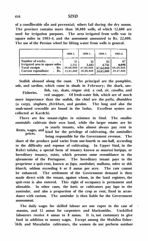
4 i6 SIND
of a considerable size and perennial; others fail during the dry season. The province contains more than 30,000 wells, of which 12,600 are used for irrigation purposes. The area irrigated from wells was in square miles in 1903-4, and the assessment amounted to Rs. 22,000. The use of the Persian wheel for lifting water from wells is general.
1880-1. 1890-1. 1900-1. 1903-4.
Number of works. Irrigated area in square miles Total receipts . . Rs. Current expenditure . Rs.
33 2,332
30,68,000 13,01,000
33 3,443
47,00,000 20,88,000
63 4,756
67,64,000 24,65,000
67
69,69,000 29,47,000
Fisheries.
Seafish abound along the coast. The principal are the pomphlet, sole, and sardine, which come in shoals in February; the shark, saw
fish, ray, skate, ringan sird, a cod, sir, cavalho, and red snapper. Of fresh-water fish, which are of much
more importance than the seafish, the chief are the palla, dhambhro (a carp), singharo, jhirkhan, and gandan. The long and also the snub-nosed crocodile are found in the Indus. Excellent oysters are collected at Karachi.
There are few tenant-rights in existence in Sind. The smaller zamindars cultivate their own land, while the larger estates are let
to yearly tenants, who almost always pay rent in kind for the privilege of cultivating, the zamindars being responsible for the Government revenue. The
share of the produce paid varies from one-fourth to one-half, according to the difficulty and expense of cultivating. In Upper Sind, in the Rohri taluka, a special form of tenancy known as maurusi haripqn, or hereditary tenancy, exists, which presents some resemblance to the aforamento of the Portuguese. The hereditary tenant pays to the proprietor a quit-rent, known as fapo, zamlndari, malkano, tobro or dek kharch, seldom exceeding 6 or 8 annas per acre. The rate cannot be enhanced. The settlement of the Government demand is then made direct with the tenant, against whom, in the land registers, the quit-rent is also entered. This right of occupancy is permanent and alienable. In other cases, the karis or cultivators pay lapo to the zamindar, and also a proportion of the crop as rent, fixed in accordance with custom. The zamindar is then liable for the Government assessment.
The daily wages for skilled labour are one rupee in the case of masons, and 12 annas for carpenters and blacksmiths. Unskilled labourers receive 4 annas to 8 annas. It is, not customary to give food in addition to money wages. Except among the Muhano fisher-iblk and Musalman cultivators, the women do not perform outdoor
Rents, wages, and prices.
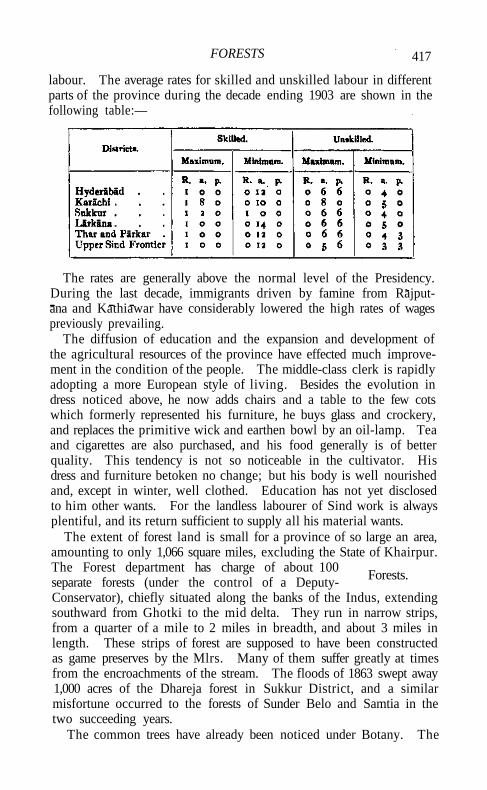
FORESTS 417
labour. The average rates for skilled and unskilled labour in different parts of the province during the decade ending 1903 are shown in the following table:—
The rates are generally above the normal level of the Presidency. During the last decade, immigrants driven by famine from Rajput-ana and Kathiawar have considerably lowered the high rates of wages previously prevailing.
The diffusion of education and the expansion and development of the agricultural resources of the province have effected much improvement in the condition of the people. The middle-class clerk is rapidly adopting a more European style of living. Besides the evolution in dress noticed above, he now adds chairs and a table to the few cots which formerly represented his furniture, he buys glass and crockery, and replaces the primitive wick and earthen bowl by an oil-lamp. Tea and cigarettes are also purchased, and his food generally is of better quality. This tendency is not so noticeable in the cultivator. His dress and furniture betoken no change; but his body is well nourished and, except in winter, well clothed. Education has not yet disclosed to him other wants. For the landless labourer of Sind work is always plentiful, and its return sufficient to supply all his material wants.
The extent of forest land is small for a province of so large an area, amounting to only 1,066 square miles, excluding the State of Khairpur. The Forest department has charge of about 100 separate forests (under the control of a Deputy-Conservator), chiefly situated along the banks of the Indus, extending southward from Ghotki to the mid delta. They run in narrow strips, from a quarter of a mile to 2 miles in breadth, and about 3 miles in length. These strips of forest are supposed to have been constructed as game preserves by the Mlrs. Many of them suffer greatly at times from the encroachments of the stream. The floods of 1863 swept away 1,000 acres of the Dhareja forest in Sukkur District, and a similar misfortune occurred to the forests of Sunder Belo and Samtia in the two succeeding years.
The common trees have already been noticed under Botany. The
Forests.
418 SIND
delta of the Indus contains no forests, but its shores and inlets abound with low thickets of mangrove-trees, the wood of which makes good fuel. The Forest department has lately introduced several valuable exotics, including the tamarind, the water-chestnut, and the tallow-tree. In 1860-1 the revenue derived from the Sind forests was i»2 lakhs, while the receipts in 1903-4 amounted to nearly 3¼ lakhs. These are mainly from grazing fees, the sale of firewood and timber, cultivation, fisheries, charcoal, babul pods and seeds, reeds, &c. Large quantities of firewood are exported.
The salt of the delta is the only mineral product of commercial importance. Extensive beds of remarkably pure bay salt occur on the
Sirganda creek, an eastern arm of the Indus, said to be capable of supplying the consumption of the whole world for a century. Since 1880, no salt has
been taken from these deposits, all that is required being manufactured at Maurypur. The only deposits now worked are at Dilyar and Saran in Thar and Parkar. Fuller's earth and soda compounds are found in Sind.
Lignite occurs interbedded with the lower Ranikot formation, southwest of Kotri. Limestone is found abundantly over Western Sind, often containing numerous flint nodules which were, at one time, largely made use of for flintlocks. Hot sulphurous springs occur at a number of places along the hills of Western Sind, the best known being those of Lakhi near Sehwan, and Magar Plr north of Karachi.
Though chiefly an agricultural and pastoral country, Sind has a reputation for pottery, leathern work, and carpets, which in design and
finish are equal to the productions of any part of the Bombay Presidency. The chief articles produced in Hyderabad are blankets, coarse cotton cloth, camel
fittings, metal-work, lacquered work, enamel, and gold and silver embroidery. Hala is famous for pottery and tiles, Bubak for carpets, and Tatta for cotton lungis. The principal productions of Shikarpur are earthenware, metal vessels of all descriptions, coarse cotton cloth, and leathern articles. Lacquered work, embroidered shoes, woollen carpets, and saddle-bags are the chief products of the Upper Sind Frontier District.
In 1904 there were 30 cotton-ginning mills in the province, mostly in Hyderabad (23), which employed more than 4,000 hands. Many rice-husking factories have been opened in Larkana District. In Karachi District the numerous factories include an arsenal, 6 cotton-ginning, cleaning, and pressing factories, 2 bone-mills, 2 metal works, arid a railway workshop. The province has in all 40 factories, employing over 8,000 operatives.
The trade of Sind centres almost entirely in the great seaport of
Mines and minerals.
Arts and manufactures.
COMMERCE AND TRADE 419
Karachi, a creation of British rule, and now the chief port of entry and exit for the Punjab. The total value of the imports into Karachi in 1903-4 amounted to 9.6 crores, while those into the rest of the province were only about 3 lakhs. In the same year, the exports from Karachi amounted to about 15 crores, and from the remainder of Sind to nearly 8-| lakhs. The staple articles of export are raw cotton, wool, wheat and Other grains.
Karachi has long formed the chief outlet for the cotton crops of Sind and the Punjab. The province at one time actually imported the material necessary for its own petty domestic manufactures from Cutch and Gujarat, to the amount of several thousand maunds annually. About 1840, however, extensive cotton plantations sprang up in Sind itself. In 1861 exports first began; and in 1866, by which time cotton was also received from the Punjab, they exceeded 250,000 cwts. At present, cotton cultivation occupies 319 square miles, and the province annually supplies Karachi with about 369,000 cwts. The remainder exported consists of Punjab cotton, from the Districts of Multan, Lahore, and Amritsar; but it bears in European markets the name of Sind,' from its place of shipment. Since 1870, a large trade in raw cotton has sprung up with China. The total export of raw cotton in 1903-4 amounted to 1,026,330 cwts.
The wool of Sind forms a staple of almost equal importance, though the larger portion of the exports comes, not from the province itself» but from Ferozepore District in the Punjab, and from Afghanistan and Baluchistan. The supply from the latter countries is brought into the market in a dirty condition. The value of wool exported from Karachi in 1873-4 was 63*5 lakhs, which increased to 76 lakhs in 1903-4.
Of late years, a very important and increasing trade in wheat with Europe has been developed. The supply comes almost entirely from the Punjab. The following table shows the exports (in tons) of wheat from Karachi for a series of years:—
1872-3 , 8,499 1892-3 . 173,691 1882-3 . 136,614 1902-3 . 442,411
1903-4 . 869,355
The external land trade of Sind is with Afghanistan, Baluchistan, and Seistan. The value of imports and exports in 1903-4 amounted to 48 and 41 lakhs, respectively. The share of Baluchistan is 15 per cent., of Seistan 9 per cent., and the rest (76 per cent.) is with Afghanistan. The chief imports are horses, sheep, goats, piece-goods, drugs and medicines, ghi, mustard, grapes, and raw wool; the exports are piece-goods of European and Indian manufacture, indigo, wheat, rice, and sugar.
Commerce and trade.
420 SIND
Karachi has a Chamber of Commerce and a Port Trust. The great harbour works of KARACHI are described under that article.
Communications are carried on by means of the Indus, by numerous excellent roads, by the North-Western Railway, and by the Hyderabad-
Jodhpur metre-gauge line which connects the frontier with the Jodhpur-Bikaner Railway, thus linking
Sind at Hyderabad with Rajputana, Northern and Central India, and Gujarat. The Indus is under the charge of a special Government department, the Indus Conservancy , the duty of which is to remove all obstructions to navigation as soon as they appear. The main line of the North-Western Railway traverses the province from north to south, entering it at Reti and terminating at Karachi and Kiamari. Between Karachi and Kotri the line is double; between Rohri and Reti it is being doubled; and between Kotri and Rohri there is a single line on either side of the Indus. The eastern Kotri-Rohri chord was originally constructed in consequence of the shifting of the right bank of the Indus and frequent breaches, which dislocated communication. The line on the left bank is on high ground and less liable to inundation, and saves about 36½ miles on the through distance from the Punjab to Karachi. The Quetta branch commences at Ruk, and running northwest leaves the province some little way beyond Jacobabad. Another branch runs south-east from Hyderabad to Badin, and is likely before long to form part of the Bombay-Sind connexion railway. A short branch of 3 miles connects Phulji with Puranadero on the Indus right bank. The North-Western Railway facilitates the transmission of goods from Karachi to Northern Sind and the Punjab, or vice versa, thus saving the long detour by sea and river between Karachi and Kotri, via the Indus delta. The Indus has been bridged at Sukkur and Kotri. The distance from Karachi to Delhi by standard gauge throughout via Bhatinda is 907 miles, and by mixed gauge via Hyderabad and Jodhpur 781 miles.
Karachi is also the focus of a number of trade routes from Afghanistan and Central Asia. Three important lines converge at Karachi, placing it in direct communication with the interior of Sind, with Las Bela and Kalat Trunk roads connect Sukkur District with the adjoining Districts of Upper Sind, and with Larkana, Hyderabad, and Karachi. The total length of roads (1903-4) in the province is 12,776 miles, of which 153 miles are metalled.
The Indus is navigable by country boats at all times of the year, and affords facilities of CQmmunication for both the import and export trade of the areas in proximity to the river. On the Fuleli canal about 100 country boats ply for the greater part of the ypar, and steam launches have recently been introduced for passenger traffic.
1 This department and the fees levied for its upkeep were abolished in March, 1906.
Communications.
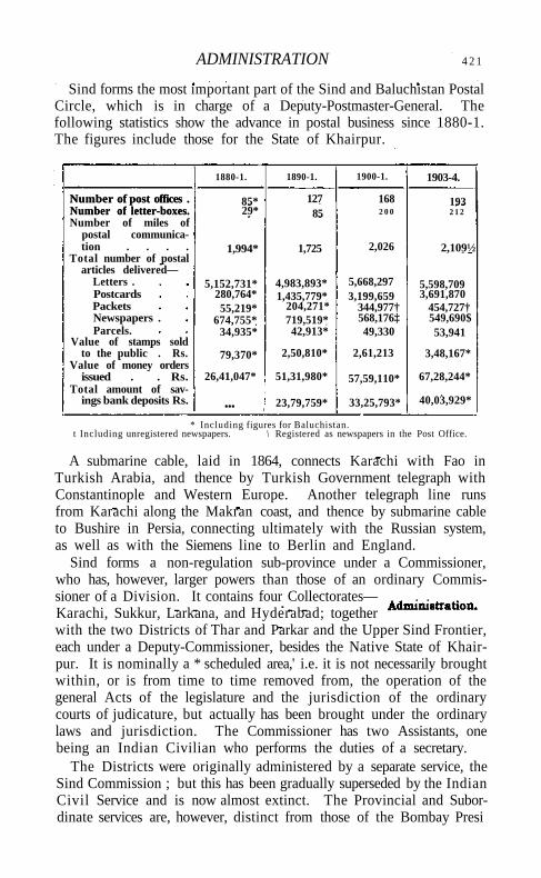
ADMINISTRATION 4 2 1
Sind forms the most important part of the Sind and Baluchistan Postal Circle, which is in charge of a Deputy-Postmaster-General. The following statistics show the advance in postal business since 1880-1. The figures include those for the State of Khairpur.
1880-1. 1890-1. 1900-1. 1903-4.
Number of post offices . Number of letter-boxes.
85* 127 168 193 Number of post offices . Number of letter-boxes. 29* 85 2 0 0 2 1 2 Number of miles of
postal communication . . . . 1,994* 1,725 2,026 2,109½
Total number of postal articles delivered—
Letters . 5,152,731* 4,983,893* 5,668,297 5,598,709 Postcards 280,764* 1,435,779* 3,199,659 3,691,870 Packets 55,219* 204,271* 344,977† 454,727† Newspapers . 674,755* 719,519* 568,176‡ 549,690$ Parcels. 34,935* 42,913* 49,330 53,941
Value of stamps sold to the public . Rs. 79,370* 2,50,810* 2,61,213 3,48,167*
Value of money orders issued . . Rs. 26,41,047* 51,31,980* 57,59,110* 67,28,244*
Total amount of savings bank deposits Rs. ... 23,79,759* 33,25,793* 40,03,929*
* Including figures for Baluchistan. t Including unregistered newspapers. \ Registered as newspapers in the Post Office.
A submarine cable, laid in 1864, connects Karachi with Fao in Turkish Arabia, and thence by Turkish Government telegraph with Constantinople and Western Europe. Another telegraph line runs from Karachi along the Makran coast, and thence by submarine cable to Bushire in Persia, connecting ultimately with the Russian system, as well as with the Siemens line to Berlin and England.
Sind forms a non-regulation sub-province under a Commissioner, who has, however, larger powers than those of an ordinary Commissioner of a Division. It contains four Collectorates— . . Karachi, Sukkur, Larkana, and Hyderabad; together with the two Districts of Thar and Parkar and the Upper Sind Frontier, each under a Deputy-Commissioner, besides the Native State of Khairpur. It is nominally a * scheduled area,' i.e. it is not necessarily brought within, or is from time to time removed from, the operation of the general Acts of the legislature and the jurisdiction of the ordinary courts of judicature, but actually has been brought under the ordinary laws and jurisdiction. The Commissioner has two Assistants, one being an Indian Civilian who performs the duties of a secretary.
The Districts were originally administered by a separate service, the Sind Commission ; but this has been gradually superseded by the Indian Civil Service and is now almost extinct. The Provincial and Subordinate services are, however, distinct from those of the Bombay Presi
422 SIND
dency. The Collector of Sukkur is Political Agent for the KHAIRPUR
STATE.
The Sadr Court, presided over by a Judicial Commissioner, is the highest court of civil and criminal appeal, and the High Court at
Bombay has no jurisdiction in or over Sind, except as regards ( i ) its powers under the Administrator-General Act, 1874; (2) probates and administrations;
(3) decrees in matrimonial cases; and (4) European British subjects. The District Court of Karachi is a Colonial Court of Admiralty, from which an appeal lies to the Sadr Court, and ultimately to His Majesty in Council1. The Subordinate Judges in Sind form a distinct service; otherwise, the judicial system does not differ from that in the rest of the Presidency. In certain parts of Upper Sind, the Sind Frontier Regulations are still in force, whereby the District Magistrate can refer murders and other offences likely to give rise to reprisals among Baloch and Pathans to the speedier and more primitive procedure of a jirga or council of their own elders, and himself punish those found guilty. In such matters he is not subject to the jurisdiction of the Sadr Court.
The revenue of Sind under Arab rule appears to have been small, and was chiefly derived from the land tax. The assessment of Sind and Multan was 27 lakhs; and this is supposed to have comprised the poll tax, customs duties, and other miscellaneous items, besides the land tax, which was fixed at two-fifths of the produce of wheat and barley if the fields were watered by public canals, and three-tenths if irrigated by wheels or other artificial means, and at one-fourth if altogether unirrigated. The form of government under the Talpurs may be described as a purely military despotism on feudal principles, their Baloch chieftains holding jdgfrs or grants of land for rendering service to the state when called upon. The land revenue was mainly paid in kind, the state share being one-eighth, two-fifths, or one-fifth of the produce according to the nature of the land cultivated. A cess, payable usually in kind, was levied on land irrigated by water-wheels, and a capitation tax on Hindus and traders. A cash payment, fixed at a certain sum per jarib (about half an acre) and varying according to the nature of the soil, was also exacted. The average seems to have ranged from Rs. 6 to Rs. 12 per jarib. An
1 Since 1906 the Sadr Court and the District Court, Karachi, have been amalgamated in a new Court, known as the Court of the Judicial Commissioner of Sind. It is presided over by a Judicial Commissioner and two additional Judicial Commissioners, one of whom is to be a barrister especially qualified to deal with mercantile cases. The new court performs all the functions of i. High Court, and the two additional Commissioners also perform the duties of the District and Sessions Court of Karachi. .
Legislation and justice.
LAND REVENUE 423
ad valorem duty of 6 per cent, was levied on all goods imposed into, and 2½ per cent, on those exported from, Karachi, in addition to a 3 per cent, town duty. Al l fishermen were forced to surrender one-third of the produce of their nets to Government, and each boat on the Indus paid a fixed tax. The Mirs farmed the greater part of the revenue to contractors, a system which led to great abuses. The amount of revenue collected from every source under the Talpur dynasty has been variously estimated; its real value was never known, but in 1809 it was said to be nearly 43 lakhs; in 1814, 61 lakhs; in 1824, under 50 lakhs, and this subsequently decreased to 35 lakhs.
The land in Sind is held by a large number of ryots (peasant occupants), and by a small number of large zamindar proprietors. At the present time there are in round figures 32,700 holdings of under 5 acres, 61,000 of from 5 to 25 acres, 27,500 of from 25 to 100 acres, and 11,400 of 100 acres and over. With few exceptions, 5,000 acres is the limit of large holdings. Both ryotwari and zamindari tenures occur, but the latter is the commonest tenure throughout the province. The zamindar supplies the seed, plough, cattle, and labour, divides the crop, and pays the assessment out of his share of it, after recovering the value of the seed advanced. At annexation, and for many years afterwards, the revenue was collected in kind. Sir Bartle Frere introduced cash payments, and a regular survey was commenced in 1863. In 1882-3 the existing forms of settlements were three in number—the original, revised, and irrigational settlements; but by 1902-3 the whole of the province had been brought under the irrigational settlement, which includes the charge for irrigation water under land revenue. The special feature of the Sind land settlement is the allowance for fallows, which are common owing to the poorness of the soil, the abundance of waste land, and the absence of a sufficient supply of manure. The assessment is now based on the mode of irrigation adopted, it being open to the farmer to choose the best method of irrigation, season by season. Occupants are liable to the full assessment on each survey number when cultivated, but fallow lands are free provided that assessment is paid thereon once in five years. Remissions are freely granted, and the fallow rules are suspended in years of bad inundation.
To protect the owners of large estates from the results of financial embarrassment, two Encumbered Estates Acts, Bombay Acts X I V of 1876 and XX of 1896, have been introduced, and in March, 1901, certain sections of the Dekkhan Agriculturists' Relief Act (1879) were applied to Sind. A special officer is entrusted with the charge of encumbered estates administered by Government on behalf of the
Land revenue.
424 SIND
owners. In the lands commanded by the Jamrao Canal, grants made since 1900 are subject to the condition that they shall not be transferred without the sanction of the Commissioner. The rent-free or partial rent-free tenures in Sind comprise Jagirs, charitable grants khairats and garden grants. The descendants of the Talpur dynasty
hold jagfrs permanently alienated. Many other jagirs have been granted on terms involving their eventual lapse to Government. On the Sind frontier, an interesting survival of former land grants made by the Afghan government to Pathan settlers is to be found in the pattadari grants, equivalent to an assignment of a fixed portion of the revenue of certain lands, and amounting in all to half a lakh of rupees. These grants are also found in Karachi and Sukkur Districts. Khairats, or charitable grants to Saiyids, amount to 6 lakhs, being the estimated revenue of the lands so granted. , In addition to these ordinary alienations, large tracts of land in the Upper Sind Frontier District have been granted rent-free to Baloch chiefs and their tribesmen. The area of these grants is 26,000 acres. Garden grants are either rent-free or on reduced assessment, to encourage the cultivation of garden produce, while hurt and sert grants represent lands allotted for the growing of trees or in reward for public service such as the detection of crime.
The minimum and maximum rates of assessment per acre on ' dry' land vary from R. 1 to Rs. 3-8, on rice lands Rs. 2-3 to Rs. 5-4, and on garden lands Rs. 2-3 to Rs. 6-8. The total land revenue in 1903-4 was 92.2 lakhs, of which 69-6 was from canal-irrigation. The gross revenue in the same year from all sources amounted to 1-5 crores. The land tax ordinarily forms two-thirds of the net revenues of Sind; but remissions are constantly necessitated by droughts, floods, or bursting of embankments. In spite of these drawbacks, however, the revenue has steadily increased under British rule. The cost of clearing canals forms one of the most important items of public expenditure.
The chief port in Sind is Karachi. The Commissioner in Sind is the chief customs authority; and the Collector of Customs and Salt
Revenue in Sind, aided by two Assistants, is chief customs officer for all ports in the province. Small establishments are maintained at Keti Bandar and
Sirganda—two subordinate ports, which have practically no foreign trade. The average annual receipts of Karachi port were 8 lakhs during the decade 1881-90, and 25½ lakhs during the next ten years, the principal items in both periods being spirits and liquors 4¼ lakhs and 5½ lakhs, and petroleum Rs. 66,000 and 1-3 lakhs, respectively. Between 1894 and 1900 duties on sugar realized 5 lakhs and those on cotton goods more than 6½ lakhs. In 1903-4 the total receipts
Miscellaneous revenue.
MISCELLANEOUS REVENUE 425.
exceeded 33½ lakhs, the chief heads of receipt being petroleum about 2¾ lakhs, sugar 62/3 lakhs, spirits and wines 7 lakhs, and cotton goods more than 7 lakhs.
The Collector of Customs and Salt Revenue administers the Salt department, subject to the control of the Commissioner in Sind. The province produces nearly all the salt required for local consumption, the chief sources of supply being the Maurypur salt-works, 7 miles from Karachi, and the Dilyar and Saran deposits in Thar and Parkar District. At these three centres and also at Sukkur, where a depdt is maintained for the convenience of the people of Upper Sind, salt is issued to the public after payment of duty. A small extra charge is made at Maurypur, Dilyar, and Saran to cover the cost of manufacture, and at the Sukkur depdt for railway freight. The State of Khairpur is annually supplied with about 12,000 maunds of salt from Maurypur, free of duty. The manufacture of salt by private individuals is strictly prohibited. The quantity of salt manufactured during the, decades ending 1890 and 1900 averaged 225,000 maunds and 288,000 maunds, and in 1903 amounted to 349,000 maunds. Rock-salt is imported from the Punjab by private individuals, chiefly for the use of Punjabi residents, the imports amounting to 11,000 maunds in 1903. Small quantities of table and packing salt are imported from Europe. The average consumption per head rose from 5-8 lb. in 1881 to 7.3 lb. in 1891 and 7.4 lb. in 1903. The total revenue from salt in 1903-4 amounted to 6.3 lakhs. There are two Government fishing yards at Shamspir and Khadda, near Karachi, to which salt is supplied at a reduced rate of R. 1 per maund, on condition that the curing is performed within the Government enclosure. The extension of railway communications has had no appreciable effect on the consumption of salt in the province.
The opium revenue of Sind is derived partly from transhipment or re-exportation fees levied upon foreign opium transhipped or reexported at Karachi, and partly from excise duty upon opium sold at the District treasuries to licensed dealers for local consumption. The average number of chests of opium carried annually from the Persian Gulf to Hongkong and other ports via Karachi and Bombay rose from 1,990 between 1881 and 1890 to 2,389 in the next decade. In 1903 the number was 2,873. The amount of fees for each of these periods was Rs. 9,500, Rs. 11,400, and Rs. 13,800. Poppy cultivation being prohibited, opium for local consumption is obtained from Bombay and issued to persons selected by the Commissioner in Sind from the tenderers, who are allowed to sell opium at single shops, and are bound to regulate their selling prices according to a standard fixed by the Commissioner. Licensed practitioners are allowed to keep one seer of opium for medical purposes, while private persons may possess
426 SIND
three tolas of opium and five seers of poppy-heads, except in a portion of Thar and Parkar District on the east of the Nara Canal, where the limit for private possession is ten tolas. The revenue from opium fluctuates with the price of labour, the character of the harvest, and the general condition of the classes addicted to the use of it.
Excise revenue in Sind includes receipts on account of country liquor, intoxicating drugs other than opium, foreign imported liquors, and toddy. Country liquor is either mahua spirit, obtained from distilleries at Uran near Bombay, or molasses spirit from a central distillery at Kotri in Hyderabad District. Licences for distillation are granted to persons chosen by Government, who pay an annual fee of R. i per gallon of the capacity of their stills. A few wholesale licences are granted free of charge, while the retail traders, selected by the Collector or Deputy-Commissioner for each District, pay licence fees varying from Rs. 500 in Karachi town to Rs. 6 in rural areas. The trade in intoxicating drugs, namely bhang, charas, and ganja, is regulated by the Bombay Abkari Act. The cultivation of hemp under licence is restricted to Deho Yakubani and Bubak in Larkana District, the-bhang produced being stored in a central warehouse at Bubak, whence the retail and wholesale dealers are supplied. Ganja is usually obtained from Panvel in the Kolaba District of Bombay, and charas from the Government warehouse at Amritsar in the Punjab. A quantitative duty is levied of R. 1 per seer on bhang, Rs. 6 per seer on charas, and Rs. 5 per seer on ganja, the retail licences for each shop being sold by auction every year. Government regulates the maximum daily quantity which may be purchased by one person.
The excise revenue from foreign liquors is derived from licences for the right of sale, which are of three kinds: importers' licences, granted only in Karachi town to large firms for the sale of not less than 2 gallons at a time; wholesale licences, at fees varying from Rs. 25 to Rs. 250, for the sale of not less than one pint at a time ; and retail licences, which permit unrestricted sale on payment of fees ranging from Rs. 500 to Rs. 700. Rum and malt liquor manufactured by the Murree Brewery Company at Quetta are treated as foreign spirit, and are sold only in the towns of Karachi, Hyderabad, and Sukkur. The consumption of toddy is very small, there being only nine shops in Sind authorized to sell it. The incidence of excise revenue per head of population was 2 annas in 1881, 4.4 annas in 1891, and 5.4 annas in 1901. Imports of foreign liquor rose from 264,000 gallons in 1887-8 to 488,000 gallons in 1890-1, 538,000 in 1900-1, and 601,000 in 1903-4. The average net revenue from country liquor and intoxicating drugs rose from 3½ to 5 lakhs and from Rs. 84,000 to 1-3 lakhs, respectively, during the decade ending 1890, and to nearly 8 lakhs and 2.7 lakhs during the following decade, the
PUBLIC WORKS 427
actual revenue under each head in 1903-4 being about 8½ lakhs and 23 lakhs. Government are considering the question of still further restricting the sale of cheap European spirits, which are much in favour with the Christian, Parsi, and Hindu population; but the consumption of country liquor and intoxicating drugs by both Hindus and Muhammadans has, of recent years, been practically stationary, subject to slight fluctuations in accordance with retail prices and the character of the harvests. The number of shops for each District is strictly fixed by the Commissioner; and no shop is opened or removed to a new locality without previously consulting local opinion.
There is a special irrigation branch of the Public Works department in Sind, for dealing with the work arising from the canal system, the control being vested in two Superintending Engineers —one for the Indus right-bank canals and the other for the canals of the left bank. Each of these two divisions is again subdivided into five districts, each under an Executive Engineer; and to cope with new work, a special survey and construction district, also under an Executive Engineer, has lately been organized.
The Indus Commission, consisting of the Commissioner in Sind as president, with the two Superintending Engineers and a secretary as members, was constituted in 1901. The duties of the Indus Commission, which acts as an advisory board to Government in ail matters relating to the Indus within the boundaries of the province, are briefly as follows: to record scientific observations upon the velocity and discharge of the current; to superintend topographical or hydro-graphical surveys in connexion with changes in the bed and water-level, and with alluvion and diluvion; to maintain river gauges and register their readings; to record on maps all changes noted by their own engineer or reported from various Districts and the Native States; to investigate the relation between the rise of level at Sukkur and Kot r i ; to discuss and decide proposals for works upon old and new canals, for new embankments, sluices, and extensions ; to consider and decide what expenditure shall be incurred upon the maintenance of lines of embankment; to carry out works required for the conservation of the river banks, and for the improvement and clearance of channels, especially such as feed irrigation canals; and to supervise the collection of registration fees payable by boat-owners under Act I of 1863,
The chief works carried out in Sind during recent years are the Jamrao Canal, the largest irrigation work in the province, which cost 72 lakhs; the enlargement and improvement of the Mahi Wah, Nasrat, Dad, and Begari Canals; the great bridges across the Indus at Sukkur and Hyderabad, which* cost together more than 56 lakhs; water-works at Karachi, Sukkur, and Hyderabad, District offices at Larkana, the
VOL. X X I I . E e
428 SIND
Empress market at Karachi, and the Sind College. Extensive works have been carried out in Karachi harbour since 1886.
Seven years' experience of the working of Municipal Act X X V I of 1850 had proved that the people of Sind, though unfitted to
control their own municipal affairs, were quite ready to contribute funds for public improvements. Accordingly, Mr. (afterwards Sir Bartle) Frere drew
up proposals in 1858 to amend that Act so as to make it lawful to constitute any District or portion thereof a municipality, and to impose a cess on the land tax, and a shop and house tax. Under this scheme the expenditure of funds was to be left in the hands of District officers, assisted by a board for each municipal division thus constituted, corresponding to the modern taluka local board. The superintendence of large and important works was to vest in the Collector, subject to the control of the Commissioner, and the immediate supervision of minor works devolved upon the heads of villages. The system advocated was neither new nor experimental. It had been in force for some years in parts of the province, and had operated to relieve cultivators from statute labour in road-making and bridge construction. The scheme, however, was ultimately withdrawn in favour of Act X X X I I I of 1860, which abolished the land cess and shop tax hitherto levied as a Local fund in parts of Sind. The cess was nevertheless revived soon afterwards in the shape of a levy of one anna per rupee of assessment, wherever the limit of assessment had not been authoritatively fixed. In 1863 Government, by executive order, appointed District and taluka committees with definite duties to promote education and the construction of roads. The proceeds of a cess fixed at one anna per rupee of land revenue and subsequently legalized by Act V I I I of 1865, tolls, ferry fees, and cattle pound receipts were placed under the control of these committees. The members, however, met but rarely, owing to lack of interest on the part of the ratepayers; and save for improvements, which the Collectors and their deputies personally supervised and effected, no progress was made till the passing of the Local Boards (Bombay) Act I of 1884, which aimed at carrying out local improvements by local taxation, at decentralizing the management of local funds, and at giving a large share in their management to the ratepayers. By 1903-4 there were 6 District and 51 taluka boards in Sind, composed of 716 members, of whom 407 were nominated and 299 elected. Al l members are elected except those for 8 talukas in the Thar and Parkar District and for the whole of the Upper Sind Frontier District. The total revenue of the boards rose from 7½ lakhs in 1890-1 to 8 lakhs in 1900-1 and to 8| lakhs in 1903-4, and their expenditure from 71/3 lakfis to 72/5 and 9 lakhs in the same period. The chief heads of expenditure in 1903-4 were :
Local and municipal.
LOCAL AND MUNICIPAL 429
education (2-7 lakhs), roads (Rs. 92,000), repairs to roads (2.2 lakhs), horse- and cattle-breeding, experimental cultivation and tree planting, and the improvement of rural water-supply and village sanitation. In many places village sanitary committees have been established, under a system whereby half the cost of village sanitation is borne by the villagers, one-third by Local funds, and one-sixth by Government. Though progress in local self-government is necessarily slow, the local boards are all in a sound financial condition, and continue to effect considerable improvement within the areas of their jurisdiction.
The history of municipal administration in Sind commenced with the establishment by Sir Charles Napier of conservancy boards under Act X X I of 1841 in Karachi and Hyderabad, shortly after the conquest of Sind (1843). In the rest of the province the responsibility for urban conservancy and the provision of roads, lighting, and water-supply rested with the local panchayats and inhabitants, who, though helped by small grants from the District Magistrates, were unable to effect much progress. In 1852, at the instance of Sir Bartle Frere, Act X X V I of 1850 was applied to Karachi, and subsequently to Hyderabad, Sukkur, Shikarpur, and other towns. Its provisions were simple, contemplating only the levy of a house tax and town duties, the prevention of nuisances, and the establishment of dispensaries. Act X X V I of 1850 was subsequently amended by Act I of 1871, which obliged municipalities to pay a certain proportion of the local police charges, and was finally repealed by Act VI of 1873, which was not actually applied to Sind until 1878. Bombay Act II of 1884 introduced further changes, by extending the elective principle, exempting all municipalities from police charges, and obliging them to establish and maintain middle and primary schools; and further progress in municipal government has been effected by the passing of Bombay Act I I I of 1901.
There are 26 municipalities in the province, with a total income in 1903-4 of nearly 25 lakhs, and an expenditure of 23½ lakhs, these figures being almost treble the corresponding items in 1884-5. The chief sources of income are octroi, which has risen during the last two decades from 5 lakhs to 15 lakhs, house tax, halalkhor cess, water rate, and the sale proceeds of lands. A house tax is perhaps the most unpopular source of income, and is levied in only 5 out of the 26 municipalities : the haklkhor or conservancy cess is levied in 14 places and the receipts have largely increased. The diminution of waste areas and the depreciation of the value of building-sites in Karachi in consequence of plague epidemics has effected a marked reduction in the sale proceeds of waste lands. during recent years. A large water-rate revenue in the Karachi, Hyderabad, and Sukkur municipalities is chiefly earmarked for the repayment of loans and the maintenance of water-works.
VOL. X X I I . E e 2
430 SIND
The larger municipalities evince rather more desire for progress than those in the Districts of the Presidency proper; but the efficiency of the smaller boards depends chiefly upon the energy of the officials and members.
The total strength of the army stationed in Sind in 1904 was: British troops, 1,666; Indian, 2,049; total, 3,715. This force became
under the reorganization scheme of 1904 the Karachi brigade, and is distributed in cantonments at Karachi,
Hyderabad, and Jacobabad. The volunteer corps include the Sind Volunteer Rifle Corps, the Karachi Volunteer Artillery, and the North-Western Railway Volunteer Rifles, with a total strength of about 1,000 men.
The total police force consisted, in 1904, of 4,501 officers and men, exclusive of four District Superintendents. In Thar and Parkar the
Deputy-Commissioner, and in the Upper Sind Frontier District an Assistant Superintendent, are in charge of the force; but the area includes so large
an extent of desert that any general statement of numbers per square mile would only mislead. In Hyderabad District, where the population is thickest, there is one policeman to every 12 square miles and to every 1,403 inhabitants; in Karachi District, including the capital, there is one policeman to every 14 square miles and to every 538 of the population; while in the desert District of Thar and Parkar there is one policeman to every 33 square miles and to every 910 inhabitants. The Commissioner is ex officio the head of the police, but direct control has recently been transferred to a Deputy-Inspector-General.
Sind possesses no hereditary village police. The local zamindars assist the police in all criminal cases. The tracking of criminals and stolen animals by their footprints is skilfully performed by village pagis, who are paid by the village cess fund. Cattle-lifting and thefts in general are the chief offences with which the police in Sind are called upon to deal.
The Central jail at Hyderabad contains accommodation for 865 inmates. There are, besides, 2 District jails and 54 subsidiary jails. Two jails at Karachi and Sukkur are being constructed. The convicts are employed in preparing articles for use or consumption in the jails, in jail repairs, and in manufacturing cloth or carpets.
Sind stands last among the four Divisions of the Bombay Presidency in regard to the literacy of its population, of whom only about 2.9 per
cent. (4.9 males and 0.5 females) are able to read and write. The most backward District is Thar and
Parkar. Education has, however, made relatively rapid progress since annexation. In 1859-60 the province contained only 20 Government
Army.
Police and jails.
Education,
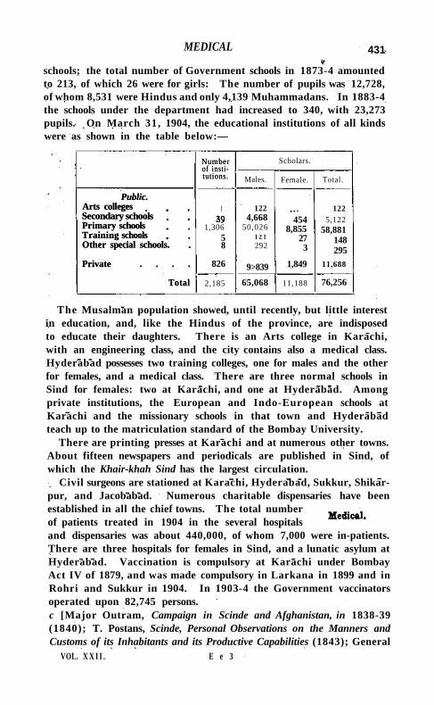
MEDICAL 431
schools; the total number of Government schools in 1873-4 amounted to 213, of which 26 were for girls: The number of pupils was 12,728, of whom 8,531 were Hindus and only 4,139 Muhammadans. In 1883-4 the schools under the department had increased to 340, with 23,273 pupils. On March 31, 1904, the educational institutions of all kinds were as shown in the table below:—
Number of institutions.
Scholars. Number of institutions. Males. Female. Total.
Public. Arts colleges Secondary schools Primary schools Training schools Other special schools.
Private . . . .
Total
I
1,306 5 8
826
122 4,668
50,026 1 2 1 292
9>839
454 8,855
27 3
1,849
122 5,122
58,881 148 295
11,688
Public. Arts colleges Secondary schools Primary schools Training schools Other special schools.
Private . . . .
Total 2,185 65,068 11,188 76,256
The Musalman population showed, until recently, but little interest in education, and, like the Hindus of the province, are indisposed to educate their daughters. There is an Arts college in Karachi, with an engineering class, and the city contains also a medical class. Hyderabad possesses two training colleges, one for males and the other for females, and a medical class. There are three normal schools in Sind for females: two at Karachi, and one at Hyderabad. Among private institutions, the European and Indo-European schools at Karachi and the missionary schools in that town and Hyderabad teach up to the matriculation standard of the Bombay University.
There are printing presses at Karachi and at numerous other towns. About fifteen newspapers and periodicals are published in Sind, of which the Khair-khah Sind has the largest circulation.
Civil surgeons are stationed at Karachi, Hyderabad, Sukkur, Shikar-pur, and Jacobabad. Numerous charitable dispensaries have been established in all the chief towns. The total number of patients treated in 1904 in the several hospitals and dispensaries was about 440,000, of whom 7,000 were in-patients. There are three hospitals for females in Sind, and a lunatic asylum at Hyderabad. Vaccination is compulsory at Karachi under Bombay Act IV of 1879, and was made compulsory in Larkana in 1899 and in Rohri and Sukkur in 1904. In 1903-4 the Government vaccinators operated upon 82,745 persons. c [Major Outram, Campaign in Scinde and Afghanistan, in 1838-39 (1840); T. Postans, Scinde, Personal Observations on the Manners and Customs of its Inhabitants and its Productive Capabilities (1843); General
VOL. X X I I . E e 3
432 SIND
W. F. P. Napier, The Conquest of Scinde (1845); Sir W. Napier, History of Sir Charles Napier's Administration of Scinde (1851); Richard F. Burton, Scinde or the Unhappy Valley (1851); Scinde Revisited, 2 vols. (1877); Captain G. Malet, Translation if Muhammad Masum Shah's History of Sind from 710 to 1590 (Bombay, 1855); A. W. Hughes, Gazetteer of the Province of Sind (1876); Major Raverty, 'The Mihran of Sind and its Tributaries' (vol. lxi, Journal, Asiatic Society of Bengal, 1893); General Haig, The Indus Delta Country\ a Memoir on its Ancient Geography and History (1894); W. P. Andrew, The Indus and its Pro-vinces (1858); Mirza Kalichbeg Fredunbeg, Chackndma, an Ancient History of Sind, in two parts (Karachi, 1902); Official Correspondence relative to Scinde, 1836-43 (1843); Miscellaneous Information connected with Sind (Bombay, 1855); Official Sketch of the Judicial Administration of Scinde under the Talpur Dynasty (Bombay, 1858); Official History of Alienations in Sind (Karachi, 1886); History of the Plague in Sind, 1896-7 (Karachi, 1897). A new Gazetteer is in preparation.]
Sind River.—One of the largest rivers of Central India, flowing in a north-easterly direction for 250 miles through the Agency, t i l l it enters the United Provinces near Jagmanpur (260 24' N. and 790 12' E.), finally joining the JumnS about 10 miles farther north. The origin of the name is not known, but a river called the Sindhu is mentioned in the Vishnu Purana, together with the Dhasan, which is probably this stream. Cunningham wished to identify it with the Sindhu mentioned in Bhavabhuti's play of Malatl Madhava, taking the Para, Lavana or Lun, and Madhumati to be the Parvati, Nun, and Mahuar, which are tributaries of this stream. Its nominal source is a tank 1,780 feet above sea-level, situated in the village of Nainwas (240 N. and 770 31 ' E.) in the Sironj pargana of Tonk State. It first flows for 20 miles through Tonk, being crossed by the Guna-Bina section of the Great Indian Peninsula Railway near Pagara. The Sind then enters Gwalior, which it does not again quit during its course in the Agency, forming the boundary between that State and Datia during the more northern part of its course. For the first 130 miles the Sind is a stream of very moderate dimensions, but at Narwar it commences to widen and rapidly develops into a large river. It is fed by numerous affluents. The Parvati and Mahuar join it, on its west and east banks, respectively, near Parwai; 10 miles north of this place the Nun enters, close to the spot where the Agra-Jhansi branch of the Great Indian Peninsula Rail* way, and the Agra-Jhansi road, cross the river. The latter is served by a temporary wooden bridge during eight months of the year. The Saon and Besli enter 70 miles farther north, and the Kunwari and Pahuj, two large streams, 22 miles above them. The Sind hr.s a continuous stream during the whole year throughout most of its course; but, owing to its
SINDKHED 433
high rocky banks, it is, as a rule, quite unsuited for irrigation purposes. In the rains it is apt to rise with great suddenness, often causing serious floods. Between Kolaras and Narwar the river flows through the most picturesque scenery, winding in and out among hills covered with thick tree-jungle down to the water's edge.
Sindgi.—North-eastern taluka of Bijapur District, Bombay, lying between 16° 35' and 170 12' N. and 750 57' and 760 28' E., with an area of 810 square miles. There are 144 villages, including Sindgi, the head-quarters ; but no town. The population in 1901 was 86,238, compared with 93,618 in 1891. The density, 106 persons per square mile, is much below the District average. The demand for land revenue in 1903-4 was 2.20 lakhs, and for cesses Rs. 16,000. Except some villages on the Bhima river, the east of Sindgi is a rough rocky plain, with frequent and, in some cases, abrupt undulations. It is scantily cultivated, treeless, and monotonous. The portion of the taluka on the banks of the Bhima to the north and east is a plain of black soil. This is well tilled, and, along the river banks, dotted with rich villages. In the south the part watered by the Don river is the best cultivated portion. The supply of water is scanty. The annual rainfall averages 25 inches.
Sindhnur Taluk.—Taluk in Raichur District, Hyderabad State, with an area of 621 square miles, including jagirs. The population in 1901 was 65,434, compared with 49,776 in 1891. The taluk contains one town, SINDHNUR (population, 5,242), the head-quarters; and 126 villages, of which 61 are jagir. It is separated on the south-east from the Madras District of Bellary by the Tungabhadra river. The land revenue in 1901 amounted to 2-5 lakhs.
Sindhnur Town.—Head-quarters of the taluk of the same name in Raichur District, Hyderabad State, situated in 150 47' N. and 760 46' E. Population (1901), 5,242. The town contains a post office and a school. Country cloth, grain, and especially cotton are largely exported. Half a mile from the town is an old stone mosque said to have been erected during Aurangzeb's reign.
Sindiapura.—Petty State in REWA KANTHA, Bombay. Sindkhed.—Village in the Mehkar taluk of Buldana District, Berar,
situated in 190 57' N. and 760 10' E. Population (1901), 2,711. The pargana of Sindkhed was granted in jagir to the kazl of the town about 1450, and he afterwards gave it voluntarily to the famous Maratha family of Jadon or Jadav, the most famous member of which was LakhjT. Lakhjl was, according to one account, a Rajput from Kur-wali in Hindustan, but the family also claimed descent from the Yadava Rajas of Deogiri. Lakhjl obtained a command of 10,000 horse under the Ahmadnagar government, but afterwards espoused the Mughal cause, receiving a command of 15,000 horse in the imperial army. He was entrapped by Maloji Bhonsla into giving his daughter in
434 SINDKHED
marriage to Shahji, and she thus became the mother of Sivajl. Notwithstanding this connexion, the Jadons were, except on one occasion, steady imperialists throughout the wars between Mughal and Maratha, and held high rank in the imperial army. The representatives of the family are now settled at Kingaon Raja ; but they lost their possessions in 1851, owing to an act of rebellion by Arab troops under their command.
The temple of Nilkantheshwar to the south-west of the village is the oldest structure traditionally assigned to Hemad Pant. Several fine buildings attest the former magnificence and prosperity of the place. Sindkhed was held by Sindhia for nearly sixty years, and was restored to the Nizam in 1803. In 1804 General Wellesley wrote : " Sindkhed is a nest of thieves; the situation of this country is shocking ; the people are starving in hundreds, and there is no government to afford the slightest relief." Baji Rao Peshwa encamped at Sindkhed for some days in 1818, when the British troops were on his track. The decline of the place was hastened by marauders, whose names—Mohan Singh, Budlam Shah, and Ghazi Khan—were long remembered with terror.
Sindkheda Taluka .—Taluka of West Khandesh District, Bombay, lying between 21 0 4' and 21 0 66' N. and 740 28' and 740 58' E., with an area of 505 square miles. I t contains two towns, S I N D K H E D A (population, 5,021), its head-quarters, being the larger; and 141 villages. The population in 1901 was 76,811, compared with 73,385 in 1891. The density, 152 persons per square mile, is above the District average. The demand for land revenue in 1903-4 was 3.4 lakhs, and for cesses Rs. 24,000. The northern portion forms a continuation of the rich black soil of the Tapt i p l a i n ; the southern is for the most part hilly or undulating, with large tracts of waste land used for grazing cattle. Except along the banks of the Tapt i and the Panjhra, Sindkheda is poorly supplied with surface water. The two chief rivers are the Tapti , flowing along the entire northern boundary for a distance of 35 miles, and its tributary the Panjhra, flowing along the eastern boundary. The annual rainfall averages 22 inches.
Sindkheda Town.—Head-quarters of the taluka of the same name in West Khandesh District, Bombay, situated in 21° 16' N. and 740 45 ' E., on the Tapt i Valley Railway. Population (1901), 5,021. The municipality, established in 1864, had an average income during the decade ending 1901 of Rs. 4,000. In 1903-4 the income was Rs. 3,800. The town contains two cotton-ginning and pressing factories, a dispensary, and three schools, with 284 pupils, of which one, wi th 20 pupils, is for girls. . S ind-Sagar Doab,—A doab or ' tract between, two rivers' (the Indus
and Chenab, and higher up the Indus and Jhelum) in the Punjab, lying
SINGHANA 435
between 290 58 ' and 330 15' N. and 700 33 ' and 730 50' E. It comprises the Districts of Jhelum, Rawalpindi, Attock, Mianwali, and Muzaffargarh, and parts of Shahpur and J hang.
Singahi B h a d a u r a . — T o w n in the Nighasan tahsil of Kher i District, Uni ted Provinces, situated in 2 8° 18' N. and 80° 55' E. Population (1901), 5,298. The place consists of two separate sites, from which it derives its double name, and it belongs to the Rai i l of Khairigarh, who resides here. There is a dispensary and a primary school with 70 pupils.
Singaing.—Northern township of Kyaukse District, Upper Burma, lying between 21 0 39 / and 220 1 ' N . and 96°and 96°54 'E . , with an area of 825 square miles. The population was 37,244 in 1891, and 40,123 in 1901, distributed in 169 villages, Singaing (population, 4,057), on the railway 10 miles north of Kyaukse town, being the head-quarters. An important village is Paleik (population, 3,070), near where the railway crosses the Myitnge river. The township proper is extremely well irrigated by canals. I ts boundaries now include the mountainous Yeyaman tract to the east, wi th an area of 700 square miles and a population of only 1,648. This stretch of upland is inhabited by Danus, who are engaged in taungya ( 'hill-slope') cultivation. In 1903-4 the township as a whole contained 67 square miles under cultivation, of which 47 square miles were irrigated, and the land revenue and thathameda amounted to Rs. 2,04,000.
S i n g a l i l a . — H i l l range in Darjeeling District, Bengal, lying between 260 38" and 270 42" N. and 88° o' and 88° 9' E., and consisting of an immense spur 60 miles long which stretches south from Kinchinjunga to the plains of India and separates Sikkim and Darjeeling District from Nepal. The waters from its west flank flow into the Tambar, and those from the east into the Great Rangit, a feeder of the Tlsta. The highest peaks are S I N G A L I L A (12,130 feet), S A N D A K P H U (11,930 feet), P H A L U T (11,811 feet), and SABARGAM (11,636 feet).
Singhana ,—Town in the Shekhawati nizamat of the State 01 Jaipur, Rajputana, situated in 280 6 ' N. and 750 5 i / E., on the skirts of a h i l l which attains a height of 1,817 feet above the sea, and about 82 miles north of Jaipur city. H a l f of the town belongs to the Raja of K H E T R I and the other half is held joint ly by nine Thakurs. Population (1901), 5,176. Singhana possesses a post office, and 4 elementary indigenous schools attended by 150 boys. The copper-mines in the vicinity, mentioned in the Ain-i-Akbari , have not been worked for many years.
Oxford : Printed at the Clarendon Press by H O R A C E H A R T , M.A.