Embed Size (px)
DESCRIPTION
Scenarios for Up-cycling Reciprocal Landscapes in Årdal Volume one: Research and Development .
Citation preview

VOLUME I: RESEARCH AND DEVELOPMENT
EBB & FLOWSCENARIOS FOR UP-CYCLING RECIPROCAL LANDSCAPES IN ÅRDAL NORWAY
PATRYCJA PERKIEWICZ

January 2013Scenarios: The impacts of empowered changes in Årdal region.

PART I: INTRODUCTION
Norway is characterized by its spectacular and very often dramatic landscape. The landscape is often rich in resources: minerals, biomaterial, metalsand energy sources. Norway with a population of just over 5 million people has a massive amount of open spaces. The average density is 15.5 inhabitants per square km. Norwegians are settled in various sized settlements scattered all along the country. Some areas are still expanding and there are cities which offer more attractive economies and opportunities. As a counter point, little villages and settlements have become more vulnerable and dependant on industries or a specif-ic trade that fuels the local economy. The narrow focus of these settlements often specialize in specific types of industry. This focus leaves these communities, in times of crisis, in a very fragile situation. Villages therefore experience the effects of the’ shrinking cities’ phenomenon. Shrink-ing cities refer to cities with a declining demography and/or a declining economy due to a range of causes (Tietjen and Laursen 2008). This creates a surplus of built structures which makes the city become more fragmented and fall into ruin. People migrate to bigger sized towns or cities and it is a complex problem. As a counter point and side effect of expanding cities, they require more energy in order to handle growth. As we are in the era of global warming and increasingly unstable climatic patterns it is crucial to look for new solutions, in order to create stability and secure their futures. The need to minimize the amount of greenhouse gases forces are to look for new types of energy.Norway has a huge hydroelectric power potential. Because of this potential, untouched land-scapes as well as the structure of small settlements are in danger of a radical change. New structures and infrastructures are to be introduces around the country. Hydro-power politics often meet criticism from local communities, which do not approve transformation of the Norwegian monumental landscapes and their traditions. In order to envision a future where both of the con-flicted sides comes to an agreement, this diploma project will seek to envision and analyse a series of scenarios in Årdal that predict or reveal the potential impacts of changes in the region. These scenarios will vary in scope and “realism” and will be assessed on the basis of their likeli-ness to happen. Regardless, it is imperative to envision potential futures in order to better prepare for the changes to come.

Research Overview This research explores possible futures in the Årdal region. In the same time, it seeks to envision potential outcomes and scenarios that could take place in the future. These scenarios could include important topics such as: expansion of hydro-power production; expansion of industries; shrinking cities and climate change, etc.
There is not much of the research into future scenarios in the region. My goal is to reveal the potential of the region through the use of scenarios within the municipality of Årdal. In order to better understand the regions untapped potential, as well as give it an idea of possible ventures for further research into topics such as “the prevention of shrinking city syndrome or the implications of an increase in hydro-power and power management.”This approach and research could bring potential benefits to the community of Årdal as well as similar villages located around Norway.
I seek to understand the potential scenarios through two key parts in this research project.The first part will account for the current situation. This part provides grounding and a platform to provide study and the ability to comprehend the issues at hand.The second part will focus on the future. How scenarios come to pass. What is their potential impact on the future and what are its ramifications?
The research will to this end question:
How do small settlements, the landscape and the industry adapt to the future?
How will the direction they take during their transformation phase impact future choices?
I want to explore the relationship between the industry, the settlement and the landscape. I wish to research possible transformation of each of these elements in order to create set of scenarios. The variety of possible futures can reveal potentials and what impacts that arrive from these inevitable changes.
Research objectives:
What is the current potential in the Årdal region?
How can we maximize the potential of the industry; landscape; hydro-power expansion; the ‘shrinking city’
How does the scenario come to pass and what does it mean for the region. E.g.What would happen if the landscape was take over the area currently inhabited by the local communi-ty? What consequences would an expansion of the power grid within the region cause?
In order to answer the primary questions, problem statements has been further subdivided into more detailed inquiries.
• What is the background for the scenarios?• In light of the current scenario what is the most probable future?• Is it possible for the scenario to change?• What sort of changes need to take place in order for scenario to come to pass?• What are the impacts and implications of the scenario?
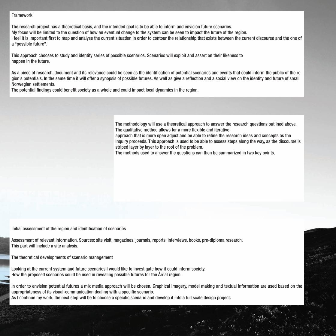
The methodology will use a theoretical approach to answer the research questions outlined above. The qualitative method allows for a more flexible and iterative approach that is more open adjust and be able to refine the research ideas and concepts as the inquiry proceeds. This approach is used to be able to assess steps along the way, as the discourse is striped layer by layer to the root of the problem.The methods used to answer the questions can then be summarized in two key points.
Framework
The research project has a theoretical basis, and the intended goal is to be able to inform and envision future scenarios.My focus will be limited to the question of how an eventual change to the system can be seen to impact the future of the region.I feel it is important first to map and analyse the current situation in order to contour the relationship that exists between the current discourse and the one of a “possible future”.
This approach chooses to study and identify series of possible scenarios. Scenarios will exploit and assert on their likeness to happen in the future.
As a piece of research, document and its relevance could be seen as the identification of potential scenarios and events that could inform the public of the re-gion’s potentials. In the same time it will offer a synopsis of possible futures. As well as give a reflection and a social view on the identity and future of small Norwegian settlements.The potential findings could benefit society as a whole and could impact local dynamics in the region.
Initial assessment of the region and identification of scenarios
Assessment of relevant information. Sources: site visit, magazines, journals, reports, interviews, books, pre-diploma research. This part will include a site analysis.
The theoretical developments of scenario management
Looking at the current system and future scenarios I would like to investigate how it could inform society. How the proposed scenarios could be used in revealing possible futures for the Årdal region.
In order to envision potential futures a mix media approach will be chosen. Graphical imagery, model making and textual information are used based on the appropriateness of its visual-communication dealing with a specific scenario.As I continue my work, the next step will be to choose a specific scenario and develop it into a full scale design project.

Table of Contents

PART I: INTRODUCTION Research Overview Framework
VOLUME I: RESEARCH AND DEVELOPMENT Norway as the Battery of Europe 8-9 Sognefjord on the Map 10-11Sognefjord Origins 12-15 Årdal on the Map 16- 17Årdal’s Story Line 18-19Årdal’s Landscape Characteristics 20-25Powered Natural Forces 26-33Remains of a Viking Village in Ytre Moa 34-35Transition from the farming to the Industrial village 36-37Årdals Fragile Landscape 38- 39Årdal’s Hydro Power System 40-51A Landscape Shaped by Natural Events 52-53A landscape Regulated by the Need of Power 53-54Clean Energy allowing for Clean Aluminium Production 55-56The Shrinking City Phenomena and the Potential Årdal Touristic Routes 57-58
BIBLIOGRAPHY

Norway is the world’s largest hydro-power producer per Capitan is the sixth largest hydro-power producer in the world. Approximately 120 TWh has been produced during the current year and it stands for 99% of all power production in Norway).
Norway as a country is full of natural resources and has a geography which allows for several hydro-power stations to be established. Norwegian hydro-power projects have a reservoir often located high in a mountain area, with melting water from glaciers or rainfall. The melting water travels through tunnels into plants located underground with an outlet connected with a fjord, or into a river system.
The Battery of Europe
8

In the same time water reservoirs will play an important role in the mitigation of floods and
droughts, as well as the generation of renewable energy. It is estimated that 50% of Europe reser-voir capacity is located in Norway. As hydroelectric power can be much cheaper than electricity generated from fossil fuel or nuclear energy the hunger increases for more grows every day. This added pressure brings new transmission capacity needs. A new grid is required and with it new infrastructure.
There is a great potential to build new hy-dro-power plants across globe. Climate
changes will increase the amount of challenges their economies. It is important to transform global infrastructure in order to minimize the emission of greenhouse gases. To achieve it fossil fuels will have to replace with hydro-power energy produc-tion. With increasing climatic changes and increasing-ly unstable weather patterns the importance of security is paramount. Hydro-power with a large storage capacity will become much more impor-
tant than before. As an energy source hydro-power is one of the cleanest in regards to the emission of green house gasses or other types of climatic disturbances.With a rising significance to the production of energy, hydro-power has the potential to become a stable solution.
2030 Next Generation Main Grid 2011 Main Grid
Power Grid Expansion
Sources: www.statnett.no P.Perkiewicz
8 9

Sognefjord cutting through he mainland in 1668
Sognefjorden streaches between the mountains in 1720
The Sognefjord on the Map
Sources: www.davidrumsey.com
10

Fjord,Hills and Villages in 1832
Villages along the Fjord in 1761
Sources: www.davidrumsey.com
10 11

Sognefjord is the world’s second longest fjord and Norway’s longest and deepest fjord. Located between Caledonian moun-
tain range it stretches inwards 205km in to the land and with a maximum depth of 1308m at its deepest point.
The fjord origins can be traced back to the melting of the gigan-tic glaciers during ice ages. Sognefjorden is a natural laborato-
ry of origin studies, the variety of rocks and layering, designates the area as a geological interesting location.
Sources: P.Perkiewicz
12

It extends into six main arms, reaching towards the Jotunheimen mountain range in central Norway.
The Sognefjord is characterized with dramatic scenery, as well as being a host to small towns and villages along its shore. The fjord has been used for trafficking industrial materials from the
local industrial cities of Høyanger and Årdal. Around 30 000 peo-ple live along the Sognefjord in little villages in the valleys. The Sognefjord is filled with various cruise ships. Each season cruise ships carrying between 1500 and 4000 tourists during the season.
From the top of the Mountain to the bottom of the Fjord
Sources: www.sfj.no
12 13

Because of its landscape characteristics Sognefjord became an important source of water based energy
production. Some of the local communities along the fjord take important part in the generation and export of hydroelectric power to major Norwegian cities including Oslo.
The economical situation of the affected municipalities has improved over the last decades due to a large amount of potential sites that could be developed in order to build new hydroelectricity stations and water dams.
Hydroelectric plants are seen by locals as a blessing and curse at the same time. Con-
stantly the growing pressure for finding new renewable energy sources brings lots of new jobs into the local communities, stabilizing their economic situation. The resistance comes from a belief that hydroelectricity production ruins the natural beauty nature of the fjord, by placing heavy structures and installations across the so far untouched monumental landscape. This is further supported by locals whom believe that hydro power is a threat to animal life and ecosystem.
Norwegian ”Alps” origins
Sources: A. Nesje ‘Erosion of Sognefjord, Norway’ P.Perkiewicz
14

Sources: P.Perkiewicz
14 15

An interpretation of the Farnes in 1713 An interpretation of the characteristics of Årdal in 1743 Årdal’s Mountain Arms in 1873
‘Flat’ Årdal from 1970
Sources: Source: Årdal : verket og bygda 1947-1997, Årdal kommune
16

Årdal’s Mountain Arms in 1873
Årdal Municipality’s General Plan
General plan for Årdalstangen 1987-2000 General plan for Øvre Årdal 1987-2000
Sources: Source: greateraardal, Årdal kommune
16 17

Topographical Relief Sources: P.Perkiewicz
18

The name Årdal is taken from the Old Norse :
ARDALR which means RIVER; DALR means VALLEY. Giving it the name “the River Valley”
Mountains,Water and Sky Sources: P.Perkiewicz
18 19

20

Sources: Fylkesarkivet i Sogn og Fjordane, www.sogelaget.com
20 21

Årdalstangen 1912
Øvre Årdal 1941Øvre Årdal infrastructural developments in 1941
From the bottom of the Valley
22

1000m Mountain Road
1000meter Mountain 1918
View over Øvre Årdal
The 1000 meter Mountain view
Sources: Fylkesarkivet i Sogn og Fjordane, www.sogelaget.com
22 23

Sognefjord
Årdalstangen
Årdal lies at the bottom of Utladalen and Jotunheimen National Park.
Its location is characterised by a very dramatic and powerful landscape. Located in the traditional part of the fjord it is surrounded by tall mountains and waterfalls. Manmade structures are well hidden between monumen-tal and powerful mountains.
At the edge of Sognefjorden
Sources: Fylkesarkivet i Sogn og Fjordane, www.sogelaget.com,
24

Man made vs Årdal’s Landscape
Årdals Lake 1918
The dramatic landscape is very characteristic for the area. Two villages Øvre Årdal and Årdalstangen is separated by Årdal Lake. Most of local water systems have been modified due to hydroelectric
power production.
Nature(made) versus man(made) a sense of scale
Sources: Fylkesarkivet i Sogn og Fjordane, P.Perkiewicz
24 25
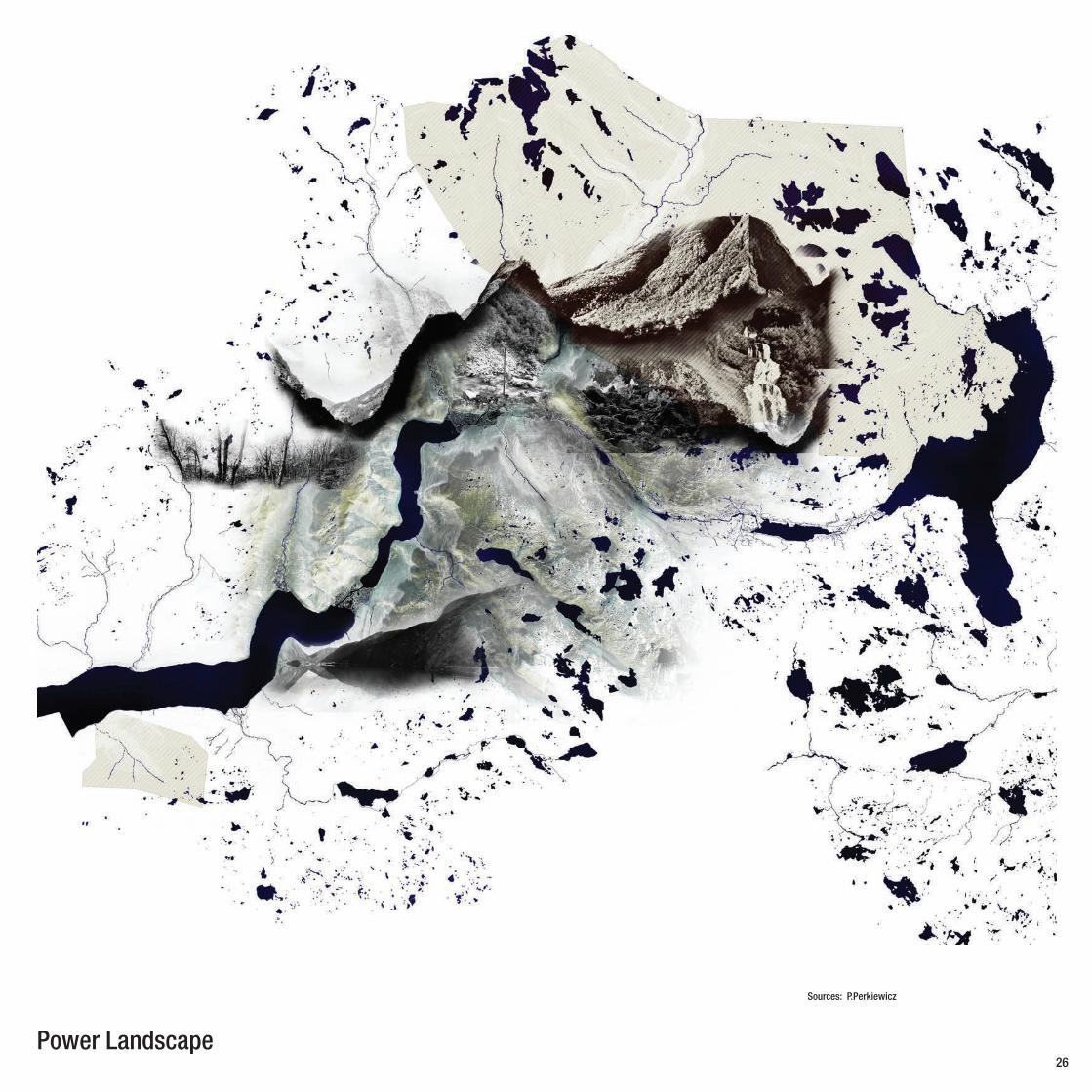
Power Landscape
Sources: P.Perkiewicz
26

Local waterfall systems are not on a priority list of the hydroelectric company. Årdal’s hillsides are riddled with
stone and debris due to regular landslides. Masses of stone brought with the melting water and avalanches during the winter and spring season.
In-Between V-Valleys26 27

Powered Natural Forces
28

Consequences of rock-slides in Utla Valley
Remains of rock-slides in close proximity to Årdalstangen
Consequences of the Landslide 2004
Landslides and snow avalanches are a rather com-mon occurrence in the slopes around Øvre Årdal
and Årdalstangen. Due to the characteristics of the Årdal’s landscape the area is under constant threat of landslide and avalanche events. The municipality has been recording the events in order to investigate the phenomena. In 1983 a landslides caused great damage to small boats and docks at Årdalstangen. A tsunami wave was triggered by a large rock slide on the south side of the bay. No one was hurt by the resultant tsunami or falling rocks.
Constantly transforming Landscape
28 29

2 500 7 500
Landscape on the Move
Sources: P.Perkiewicz
30

Boat damage after rock-slide from 1983 Damages to the coastline after the landslide event in 1983 Årdalstangen’s harbour after landslide event in 1983
Årdalstangen from the top of Middagshaugen (1122 m)
Årdalstangen August 1983
Middagshaugen after a rock-slide event from 1983
Damages after an rock-slide event from 1983
View from Årdalstangen after rock-slide event from 1983
Damages after an rock-slide event from 1983
Touched by Tsunami 1983
30 31

2 500 7 500
Triggered LandscapeLandslides
Sources: P.Perkiewicz
32

2 500 7 500
Avalanches
Sources: P.Perkiewicz
32 33

320 960
Sources: www.norgedigitalt.no, nrk.no, Remains of a Viking Village in Ytre Moa
34

Remains of the settlement in Ytra Moa
Excavation of burial mounds in the Ytra Moa
View towards Ytra Moa 1921
Ytre Moa is regarded as one of the biggest discoveries regarding the Viking age 800 - 900AD. The farm proves that this place had been cultivated, although abandoned after a short period of time, it is theorised this could be because of water shortages.
Sogn villages are one of the driest in the country; therefore development of artificial irrigation became an important aspect of the farming industry in the area of Sognefjord.
Reminder of the Viking Era
34 35

2 500 7 500
Built Up Area
Agriculture
Forest
Water system
Contour lines
Land-use in ÅrdalSources: ngu.no, ‘Bygdebok for Årdal.’ H.Turid: Kulturlandskap og kulturmark stypar i Årdal kommune
36

Bjørn Tvedt art representing People of Årdal Bjørn Tvedt art representing People of Årdal
Stained glass art from Årdal
Jørgine Asperheim Øvre Årda 1921
Farmers from Årdalstangen 1941
Farm in Seim
As a traditional fjord based village Årdal has strong agriculture roots. Nevertheless
the rise of industrial production has man-aged to replace the farming and forestry as its main sources of income. The industry and farming has had a significant impact on the Årdal’s character.
Transitioning from farming to the Industrial village
Sources: Fylkesarkivet i Sogn og Fjordane, ‘Bygdebok for Årdal’ “ Årdal , kamp, krefter og kunnskap”
36 37

2 500 7 500
38
Årdals Agriculture Roots
In Årdals’ past the community had a variety of industries and was based on farming, fishing, trade and mining.This can be seen as an abundance of potential in the local landscape and acts as a generator of potential.The unexpected closure of the Tyin hydro-power production, results in the
limitation of Årdal Smelter activity.As chaineffect a numbers of jobs have been frozen.With it comes a need for a new energy source.. in otder to keep the status quo.Meanwhile a domino effect a house of cards event force people to look for other jobs and opportunities.However a reinvention of Årdal’s in-dustry is seen as necessary in order to decrease vulnerability and reliance on
a singular industry, this can be done through the use of landscape activation strategies.A Landscape activation strategy empha-sizes that the landscape that become an active part of social change within the area. This includes traditional elements as well as new innovations. This will allow for a new landscape to be more diverse and multifaceted.The affected industrial activity requires
scenarios that will include reparation of the environmental damages and to pro-tect the cultural heritage of Årdalstange and Øvre Årdal.The potential lies in the vulnerability as-pect to use it as a motivator for change. Vulnerability becomes an opportunity to strengthen the settlement through the redesign of landscape based opportunities this done through a set of interventions
2 500 7 500
Sources: ngu.no, ‘Bygdebok for Årdal.’ H.Turid: Kulturlandskap og kulturmark stypar i Årdal kommune P.Perkiewicz
38 39
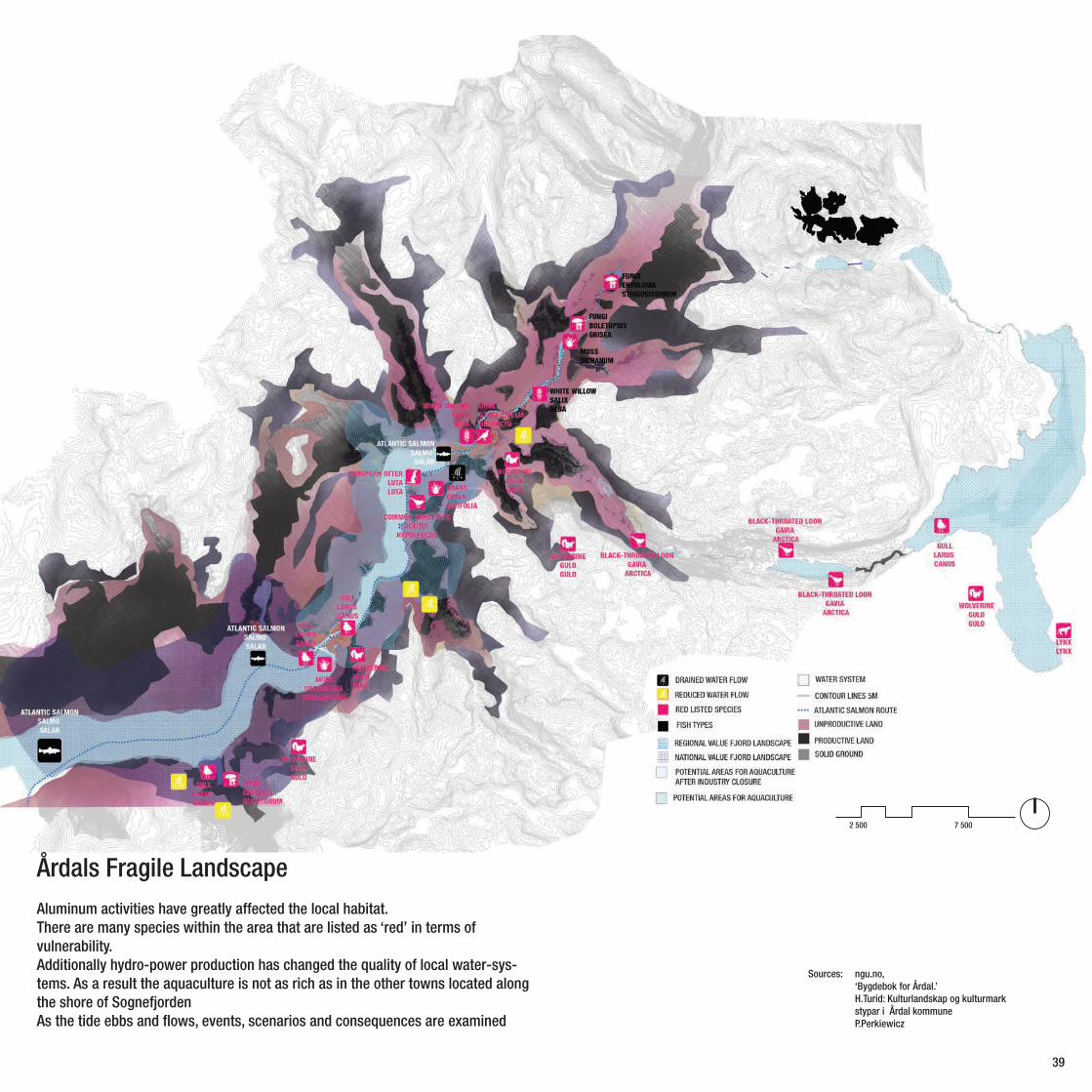
Årdals Fragile LandscapeAluminum activities have greatly affected the local habitat.There are many species within the area that are listed as ‘red’ in terms of vulnerability.Additionally hydro-power production has changed the quality of local water-sys-tems. As a result the aquaculture is not as rich as in the other towns located along the shore of SognefjordenAs the tide ebbs and flows, events, scenarios and consequences are examined

Hydro Powered System Sources: P.Perkiewicz
40

Torolmen Lake 1956
The great height differences invoke a high hydro-power development potential. Most rivers are directed to Årdal lake, which has been dammed by a moraine and is regulated by the hydroelectric
activities in the area. Årdal’s energy consumption increases by an average 5% each year. Most of the energy produced in the municipality is consumed by Hydro’s Aluminium plant.
The lakes of Årdal
Sources: P.Perkiewicz 2012, Fylkesarkivet i Sogn og Fjordane, www.sogelaget.com
40 41

2 500 7 500
There is a market and a need for more renewable energy in the area.
Too increases the flow of energy larger 300-420kV power lines are needed.
This proposal is very controversial as a lines sup-posed to cross Sognefjorden itself. Local commu-
nities are against the project.
The Power from inside the Mountain labyrinth
Sources: Hydro Energy, www. atlasnav.no, Statnett: ‘Strømnettet på Vestlan det mot 2025’
42

Tyin Power Station was opened in 1918.The main reason was to support local farms.
In 1933 Tyin Power Station was expanded due to the need of supplying Årdal itself.From 1945 Tyin Power station has been providing energy to all local farms in the whole municipality. A new Tyin Power Station project will offer a greater Production of energy.
The new tunnel is 2,5 km in length and is located in-side the mountain. All lakes on the surface in which
creates a system of 8-9 has been used as reservoirs in the production of energy. Norway is one of the biggest Hydro electric power exporters in Europe. The energy produced in Årdal has mostly a regional and national use. However the new proposal including 420kV power line transmitters will provide allow for export towards UK and the Netherlands.
An Interlinked Water-system
Sources: P.Perkiewicz Hydro Energy, Norge Digitalt.no
42 43

N orway is about to upgrade energy national grid. It consequences will be highly visible in the landscape. Local communities strongly opposing the
idea of an upgrade of power lines
Expansion of the New Grid
Sources: P.Perkiewicz Hydro Energy,
44

44 45

As most of water system within Årdal community is directly connected with hydro power production,the water quality is often being checked in order
to establish levels the effects this has in regards to the tax it has on the land-scape.
Årdal’s Hydro GridSources: P.Perkiewicz Hydro Energy,
46

Sources: P.Perkiewicz Hydro Energy, nve.no Brugrand, Odd Helge: “Årdal sett ovanfrå”
46 47

2 500 7 500
Sources: P.Perkiewicz Årdal Kommune, Offerdal Kraftverk AS, www.nve.no
48

Sources: Patrycja Perkiewicz
48 49

2 500 7 500
Energy Flow
Sources: P.Perkiewicz Årdal Kommune, Offerdal Kraftverk AS, www.nve.no NGU rapport 2008-2011, Statnett:‘Strømnettet på Vestlan det mot 2025’
50

Power Line in Sognefjord 1958
Artistic vision of 420kV Årdal LandscapeArtistic vision of 420kV Årdal Landscape
Snow collected on the power line cables Construction of power lines in Sognfjord
Power Lines cutting through the Landscape
Sources: ‘Hvor Årdal’, www.nve.no, www.statnett.no, Fylkesarkivet i Sogn og Fjordane,
50 51

2 500 7 500
52

Sources: skredatlas.nve.no ,Årdal komune.no, ngu.no
A Landscape Shaped by Natural EventsÅrdal is an area heavily influenced by human actions as well as natural forces. Both have resulted in modi-fication of the areas powerful topography.As a result the urban area has been restricted to per-ceived ‘safe zones’. Human interventions in the land-scape cannot prevent the multitude of natural events that can cause devastation. The understanding of the risk factors involved in the area, could contribute to develop a strategy in order to better provide stable living conditions in Årdal as well as well as protect significant characteristics of the landscape.
52 53

2 500 7 500
54

Sources: Hydro.com, Hydro Energy Rapports 2004-2011, Ngu.no, ngu.no, ‘Bygdebok for Årdal.’ H.Turid: ‘Kulturlandskap og kulturmarkstypar i Årdal kommune’
A landscape Regulated by the Need of PowerÅrdal is located in the end of the Sogn Fjord. A split water system and the close proximity of mountains create fertile grounds for the establishment of Hydro Electric Power plants. Most of rivers and lakes within Årdal’s water system has already been regulated and modified by hydroelectric companies. It was original-ly introduced as an energy source for farming. The greater part of the energy produced in the munic-ipal¬ity is consumed by Hydro’s Aluminium plant. There is a marked and a need for more renewable energy in the area.In order to deliver more power 300-420kV power lines are needed. The proposal is very controversial as power lines are supposed to cross Sognefjorden.
54 55

2 500 7 500
56

Sources: Statnett:‘Strømnettet på Vestlan det mot 2025’, Hydro.com, Hydro Energy Rapports 2004-2011,
Clean Energy allows for Clean Aluminium
Årdal has a long industry roots. The importance of the industry and the impact it has on the landscape. Has in the past forced new solution to be developed, in 2020 Hydro Aluminium As will introduce carbon Zero production technologies. This will be possible with the use of the energy coming from the local water systems.
56 57

2 500 7 500
58

Sources: ngu.no, ‘Bygdebok for Årdal.’ H.Turid: Kulturlandskap og kulturmarkstypar i Årdal kommune
The Shrinking City Phenomena and the potential Årdal Tourist RoutesÅrdal is a part of Sogn og Fjordane a county char-acterized by an aging population. As a result the average age of habitants in the area is 43. Instead Årdal has decreasing amount of inhabitants and an increasing population over the age of 60.Its attempts towards keeping the youth in the county has not been successful, heavy industry does not seem provide the possibilities or the “glue” for young people to stay. Årdal has many natural features that are very rare in comparison with the rest of the country. Its closeness to national park and Jotunheimen should generate tourism, however this aspect seems to currently be non-existing.
58 59

BIBLIOGRAPHY
Amdam, Rolv Petter,Gjestland, Dag,Hompland, Andreas (1997) Årdal : verket og bygda 1947-1997, Oslo : Samlaget
ARCHIS (2004) ARCHIS is shrinking, Amsterdam: Artimo, No. 1
Birdsall, Nancy/Kelley, Allen/Sinding, Steven (2001), Population Matters: Demographic Change, Economic Growth, and Poverty in the Developing World, Oxford: Oxford University Press
Corner, James (2003) Landscape Urbanism, in Mostafavi, Mohsen (2003) Landscape Urbanism. A Manual for the Mechanic Landscape, London: Architectural Association
Engesæter, Aage (2004): Då framtida kom til Sogn : industristadane Høyanger og Årda
Faugli, Per Einar (2011) the Norwegian Water Landscape: A Historical View on Watercourse Management, Oslo: NVE
Frampton, Kenneth (1992) Modern Architecture – a Critical History, New York: Thames and Hudson
Heineman, Bjørn (2011) The Green Battery of Europe. Balancing renewable energy with Norwegian hydro power, Zurich: ETH Zurich
Helle, Turid(1990)Kulturlandskap og kulturmarkstypar i Årdal kommune, Sogndal : Sogn og Fjordane distriktshøgskule
Holmqvist, Jonas Å (2012) Norway’s Role in the Global Hydro-power Industry, Oslo :International Rivers Network
Jacobs, Jane (1961) The Death and Life of Great American Cities, New York :Modern Library Editions
Kjølle, Arne (2001) HYDROPOWER IN NORWAY in Mechanical Equipment, Trondheim : NTNU
Koolhaas, Rem (1998) S, M, L, XL, Rotterdam : 010 Publisher
Krossen, Dagfinn (1978) Bygdebok for Årdal 2: Kulturbandet, utgjeven av Sogndal: Årdal kommune
Mulder, A. (2006) Trams and the regeneration of brownfield sites. Proceedings UECB 2006 3rd International Conference on Urban Ecology: Berlin

Nielsen, J. B., Schultz, A. T. Hovgesen, H. H. og Nielsen, T. S. (2005), “Byen, Vejen og Landskabet: Motorvejen - landskabskunst og hverdagslandskab”, København: Skov og Landskab
Nesse, Jon Gunnar(2004)Er det håp for Hydroland. Sogndal : Høgskulen i Sogn og Fjordane
Norsk hydro,(1990) Norsk Hydro miljørapport, Oslo : Norsk Hydro
NVE, Ellen Skaansar(2010)Energistatus, Oslo:NVE
Overmeyer, Klaus (2007) Urban Pioneers. Temporary Use and Urban Development in Berlin, Berlin: Jovis
Sassen, Saskia (2001) The Global City – New York, London, Tokyo. Oxford: Princeton University Press
Schwarzott, Jan(1997)Under Storen : portrett av Utladalen og Vettisfossen.Oslo : Grøndahl Dreyer
Sieverts, Thomas (2003) Cities without Cities – an interpretation of the Zwischenstadt, London: Spon Press
Skauli, Kristian (1999) Flukten fra industrien : kontinuitet eller endring iflyttingen fra Årdal de siste 30 år?, Oslo : UiO
Soja, Edward W (2000) Postmetropolis – Critical Studies of Cities and Regions, Oxford: Blackwell Publishers Ltd
Statnett (2011) Grid development plan 2011, Summary, Oslo: Statnett
Thue, Johs. B. (1999)Fortun: bygda og krafta. Leikanger: Skald
Tiebout, Charles (1956), A Pure Theory of Local Expenditures, in: Journal of Political Economy 64. pp. 416-24.
Tietjen, Anne and Laursen, Lea Holst (2008) Urbanity without growth - Planning and urban design principles in shrinking Danish territories, working paper submitted for European Planning Studies
Vee, Marianne(2004) Årdal før, under og etter krigen, Sogndal :Høgskulen i Sognog Fjordane