Embed Size (px)
Citation preview

VOLCANOES AND OTHER VOLCANOES AND OTHER IGNEOUS FEATURESIGNEOUS FEATURES
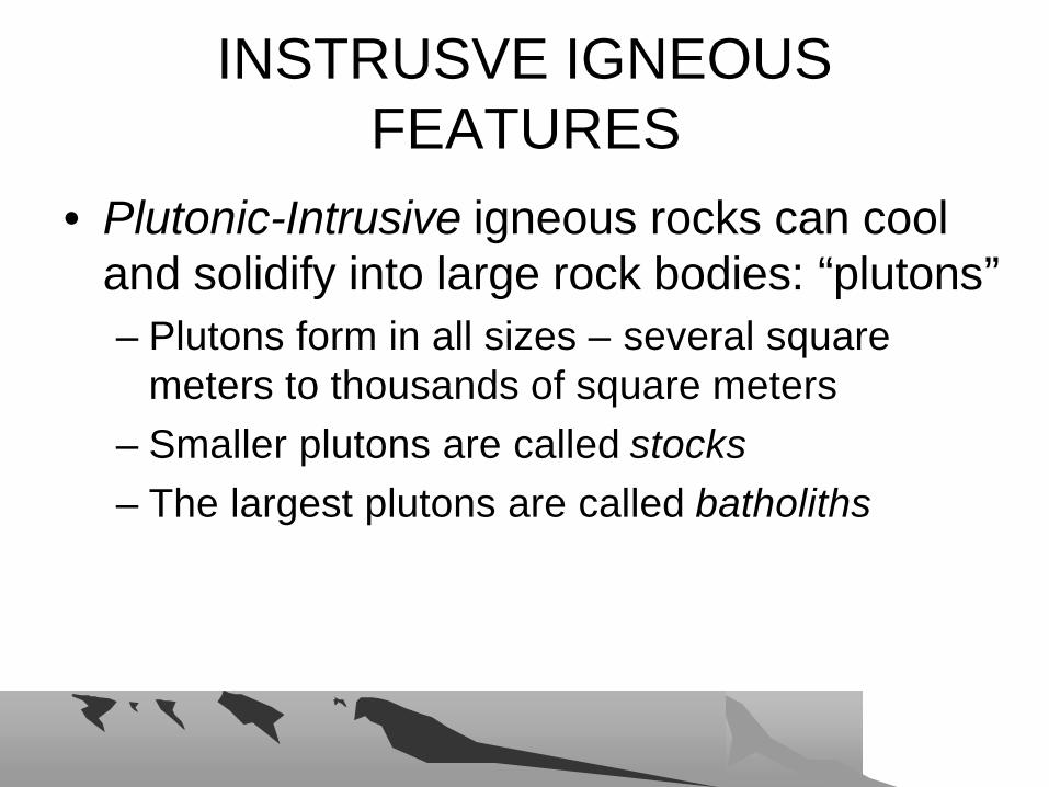
INSTRUSVE IGNEOUS INSTRUSVE IGNEOUS FEATURESFEATURES
• Plutonic-Intrusive igneous rocks can cool and solidify into large rock bodies: “plutons”– Plutons form in all sizes – several square
meters to thousands of square meters– Smaller plutons are called stocks– The largest plutons are called batholiths
PLUTONIC INTRUSIVE IGNEOUS PLUTONIC INTRUSIVE IGNEOUS FEATURESFEATURES
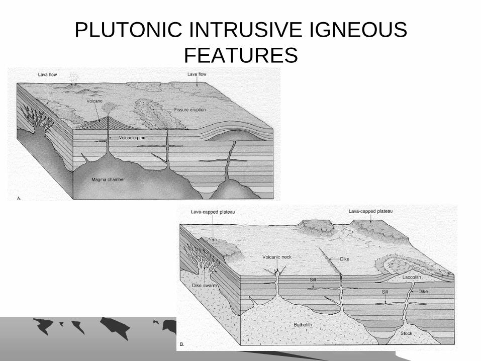
Igneous Features Igneous Features –– Plutonic and VolcanicPlutonic and Volcanic
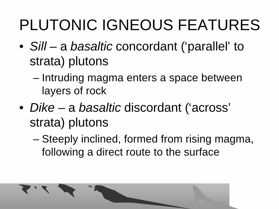
PLUTONIC IGNEOUS FEATURESPLUTONIC IGNEOUS FEATURES• Sill – a basaltic concordant (‘parallel’ to
strata) plutons– Intruding magma enters a space between
layers of rock
• Dike – a basaltic discordant (‘across’strata) plutons– Steeply inclined, formed from rising magma,
following a direct route to the surface
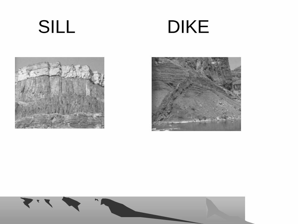
SILLSILL DIKEDIKE

PLUTONIC IGNEOUS FEATURESPLUTONIC IGNEOUS FEATURES
• Laccolith – a felsic magma, dome-shaped concordant pluton – formed at shallow depth, pushing up overlying
rock
• Lopolith – a mafic magma, saucer-shaped concordant pluton– sags downward compressing underlying rock
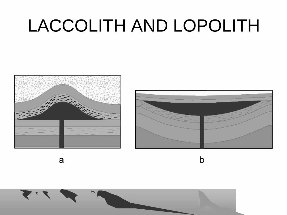
LACCOLITH AND LOPOLITHLACCOLITH AND LOPOLITH
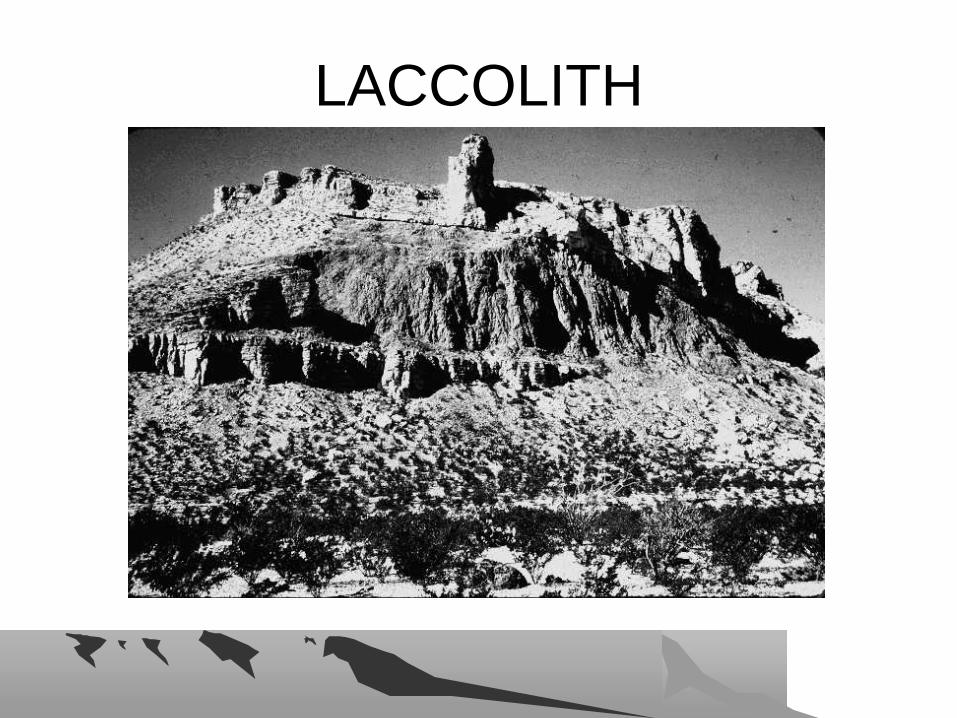
LACCOLITHLACCOLITH

VOLCANOESVOLCANOES
• Volcanoes – cone-shaped or dome-shaped initial landform created by emission of lava and gases from a constricted opening
• Magma rises through a narrow pipelike conduit – a volcanic neck
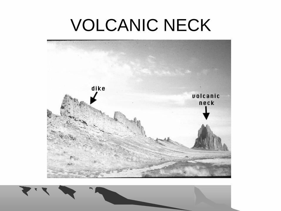
VOLCANIC NECKVOLCANIC NECK
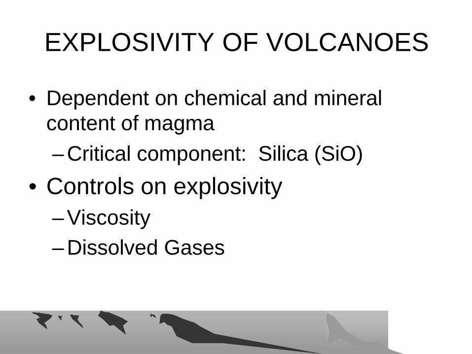
EXPLOSIVITY OF VOLCANOESEXPLOSIVITY OF VOLCANOES
• Dependent on chemical and mineral content of magma– Critical component: Silica (SiO)
• Controls on explosivity– Viscosity– Dissolved Gases
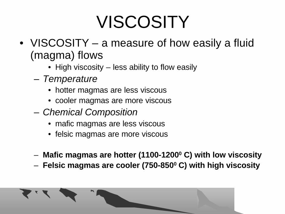
VISCOSITYVISCOSITY• VISCOSITY – a measure of how easily a fluid
(magma) flows• High viscosity – less ability to flow easily
– Temperature • hotter magmas are less viscous • cooler magmas are more viscous
– Chemical Composition• mafic magmas are less viscous • felsic magmas are more viscous
– Mafic magmas are hotter (1100-12000 C) with low viscosity– Felsic magmas are cooler (750-8500 C) with high viscosity
DISSOLVED GASESDISSOLVED GASES
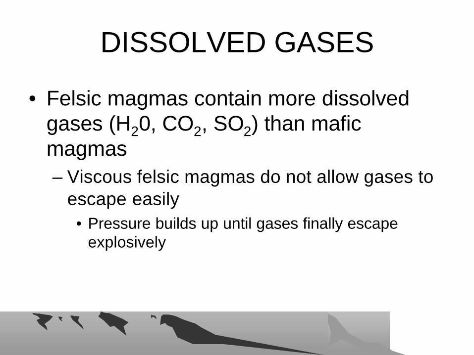
• Felsic magmas contain more dissolved gases (H20, CO2, SO2) than mafic magmas– Viscous felsic magmas do not allow gases to
escape easily• Pressure builds up until gases finally escape
explosively

WHY DO MAGMAS RISE AND WHY DO MAGMAS RISE AND ERUPT ?ERUPT ?
• BUOYANCY – hot magma is less dense than overlying rocks
• HYDROSTATIC PRESSURE – Buoyancy of magma below puts pressure on entire column of magma forcing it upwards
HOW DO MAGMAS RISE?HOW DO MAGMAS RISE?
• SEGREGATION OF LIQUIDS –accumulating liquids in magma less dense than remaining magma and separate out flowing into ‘veins’
• DIAPIRIC RISE – the magma, with lower density, rises in a bulbous form
• ZONE MELTING – upward migration of a pocket of magma, melting at top and crystallizing at bottom
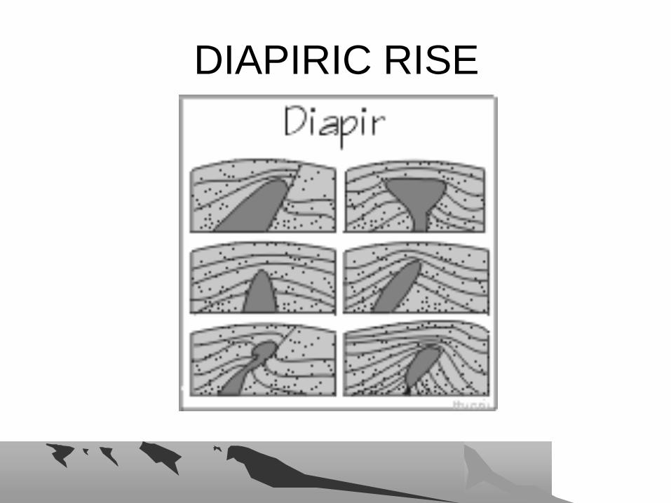
DIAPIRIC RISEDIAPIRIC RISE
WHAT MAKES ROCK MELT?WHAT MAKES ROCK MELT?
• Increase the temperature
• Decrease the pressure
• Add a flux
WHERE ARE VOLCANOES FOUND?WHERE ARE VOLCANOES FOUND?• Convergent Plate boundaries - Subduction Zones
– Oceanic-oceanic – island arcs• Aleutian, Kurile, Marianas, Tonga
– Oceanic-continental – active continental margins• South America, North America, Central America, Kamchatka
• Divergent Plate boundaries – Mid-Ocean Ridges and Rift Zones– Continental rifts
• East Africa– Oceanic rifts
• Mid-ocean spreading centers– Iceland, Azores
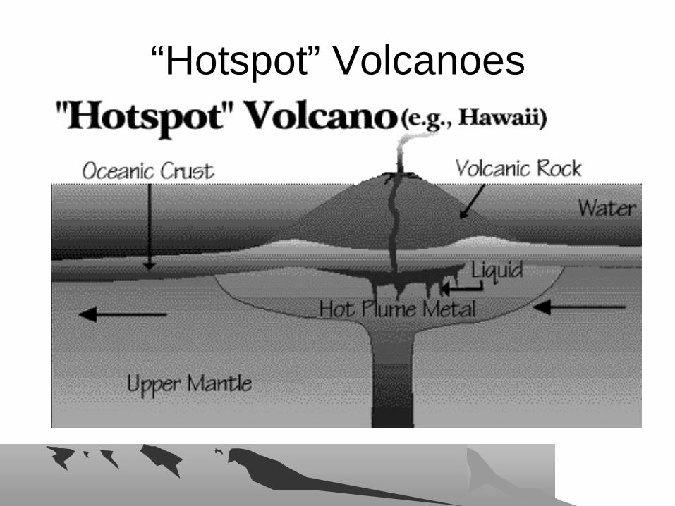
• Intraplate – “Hotspots” or “Mantle Plumes”– Oceanic islands
• Hawaii, Emperor Seamount Chains – Pacific Ocean– Continental
• Yellowstone, Wyoming, USA
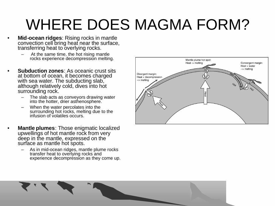
WHERE DOES MAGMA FORM?WHERE DOES MAGMA FORM?• Mid-ocean ridges: Rising rocks in mantle
convection cell bring heat near the surface, transferring heat to overlying rocks.
– At the same time, the hot rising mantle rocks experience decompression melting.
• Subduction zones: As oceanic crust sits at bottom of ocean, it becomes charged with sea water. The subducting slab, although relatively cold, dives into hot surrounding rock.
– The slab acts as conveyors drawing water into the hotter, drier asthenosphere.
– When the water percolates into the surrounding hot rocks, melting due to the infusion of volatiles occurs.
• Mantle plumes: Those enigmatic localized upwellings of hot mantle rock from very deep in the mantle, expressed on the surface as mantle hot spots.
– As in mid-ocean ridges, mantle plume rocks transfer heat to overlying rocks and experience decompression as they come up.
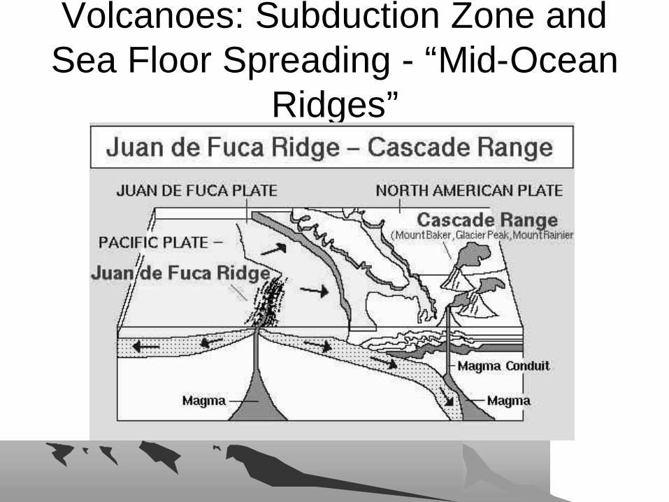
Volcanoes: Subduction Zone and Volcanoes: Subduction Zone and Sea Floor Spreading Sea Floor Spreading -- ““MidMid--Ocean Ocean
RidgesRidges””

INTRAPLATE VOLCANOESINTRAPLATE VOLCANOES• Intraplate volcanoes are caused by hot spots
deep within the Earth. – Magmatism is generated by buoyant upwellings in the
mantle– Upwellings, or "plumes", are believed to originate at
the core–mantle boundary • They might also form near the boundary at ~670 km between
the upper and lower mantle
– Magma rises and erupts as lava through cracks in the Earth's surface, forming volcanoes

INTRAPLATE VOLCANOES INTRAPLATE VOLCANOES
““HotspotHotspot”” VolcanoesVolcanoes

INTRAPLATE VOLCANOESINTRAPLATE VOLCANOES

““HotspotsHotspots”” MapMap

VOLCANIC SHAPESVOLCANIC SHAPES• Three basic shapes due to magma type
and eruptive style– Composite Volcanoes
• Stratovolcano• Plug Dome volcano
– Shield Volcanoes
– Cinder Cones

COMPOSITE VOLCANOES COMPOSITE VOLCANOES --STRATOVOLCANOESSTRATOVOLCANOES
• Steep-sided cones produced by felsic magmas– Convex sides, shallow slope angles at base,
steepening sides towards top
• Eruptions are explosive with little to no lava– Pyroclastic Flow
• Volcanic ash, gas, tephra and volcanic bombs• Lahars

A composite volcanoA composite volcano

Mt. St. Helens Mt. St. Helens –– a typical a typical composite volcanocomposite volcano

Mt. St. Helens following the Mt. St. Helens following the 1980 eruption1980 eruption
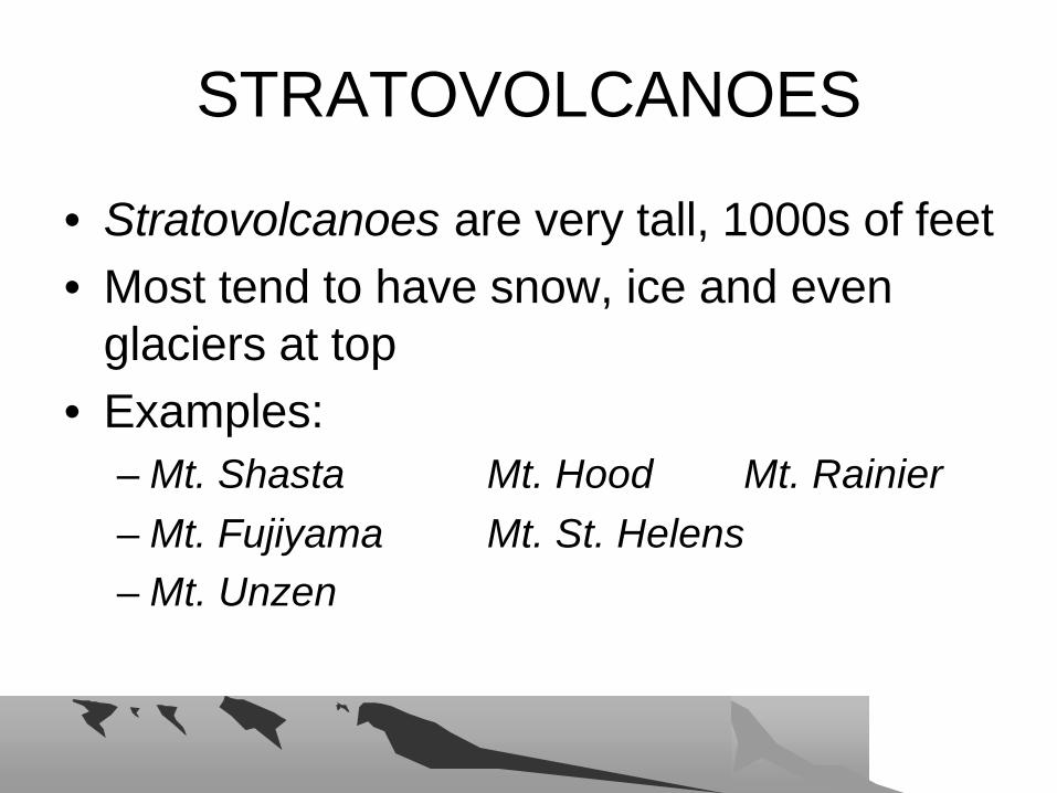
STRATOVOLCANOESSTRATOVOLCANOES
• Stratovolcanoes are very tall, 1000s of feet• Most tend to have snow, ice and even
glaciers at top• Examples:
– Mt. Shasta Mt. Hood Mt. Rainier– Mt. Fujiyama Mt. St. Helens– Mt. Unzen

STRATOVOLCANO IMAGESSTRATOVOLCANO IMAGES

COMPOSITE VOLCANOES COMPOSITE VOLCANOES ––PLUG DOMESPLUG DOMES
• PLUG DOME VOLCANOES – volcanoes that produce thick pasty lava – DACITE.
• The lava cools into angular blocks after it is slowly squeezed out of the vents
• Not stratovolcanoes

PLUG DOME VOLCANOESPLUG DOME VOLCANOES
SHIELD VOLCANOESSHIELD VOLCANOES
• Shield volcanoes are volcanic mountains built up by the eruption of fluid, basaltic lava flowing out of a central vent.
• They have broad bases with very gentle slopes
• The largest shield volcano on Earth is Mauna Loa in Hawaii which rises from its base on the seafloor to a height of 17 km (10.5 miles).

SHIELD VOLCANOSHIELD VOLCANO

SHIELD VOLCANO IMAGESSHIELD VOLCANO IMAGES
• Fluid, basaltic lava erupts onto the surface and flows freely across the ground for great distances forming a broad cone.

HAWAIIAN ISLANDS HAWAIIAN ISLANDS –– SHIELD SHIELD VOLCANOESVOLCANOES
CINDER CONE VOLCANOESCINDER CONE VOLCANOES
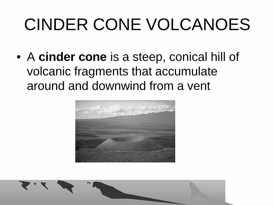
• A cinder cone is a steep, conical hill of volcanic fragments that accumulate around and downwind from a vent
CINDER CONESCINDER CONES
• Cinders, or scoria, are glassy and contain numerous gas bubbles "frozen" into place as magma exploded into the air and then cooled quickly.
• Cinder cones range in size from tens to hundreds of meters tall.

CINDER CONE IMAGESCINDER CONE IMAGES
FISSURE ERUPTIONSFISSURE ERUPTIONS
• FLOOD BASALTS• Very fluid basaltic magmas rise to surface
through linear fractures or fissures in crust• At surface, fluid basalt flows for thousands
of square kilometers.• Columbia River Plateau, eastern WA
– 60 separate lava flows– More than 2 kilometers thick– Dated to approximately ~15 million years ago

COLUMBIA RIVER PLATEAUCOLUMBIA RIVER PLATEAU

A Pahoehoe lava flowA Pahoehoe lava flow
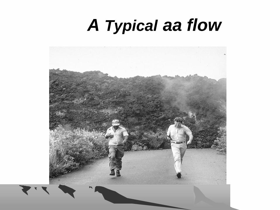
A A TypicalTypical aa flowaa flow
Materials extruded from a Materials extruded from a volcanovolcano
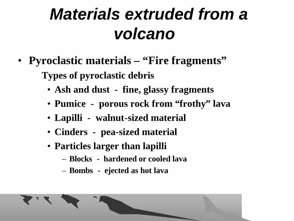
• Pyroclastic materials – “Fire fragments”Types of pyroclastic debris
• Ash and dust - fine, glassy fragments• Pumice - porous rock from “frothy” lava• Lapilli - walnut-sized material • Cinders - pea-sized material • Particles larger than lapilli
– Blocks - hardened or cooled lava– Bombs - ejected as hot lava

A volcanic bombA volcanic bomb
Bomb is approximately 10 cm long

PYROCLASTIC FLOWSPYROCLASTIC FLOWS

PYROCLASTIC FLOWSPYROCLASTIC FLOWS
• A ground-hugging avalanche of hot ash, pumice, rock fragments, and volcanic gas that rushes down the side of a volcano as fast as 100 km/hour or more.
• The temperature within a pyroclastic flow may be greater than 500° C, sufficient to burn and carbonize wood.
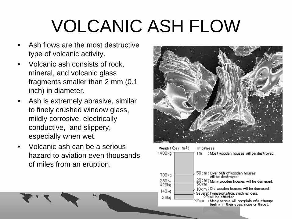
VOLCANIC ASH FLOWVOLCANIC ASH FLOW• Ash flows are the most destructive
type of volcanic activity. • Volcanic ash consists of rock,
mineral, and volcanic glass fragments smaller than 2 mm (0.1 inch) in diameter.
• Ash is extremely abrasive, similar to finely crushed window glass, mildly corrosive, electrically conductive, and slippery, especially when wet.
• Volcanic ash can be a serious hazard to aviation even thousands of miles from an eruption.
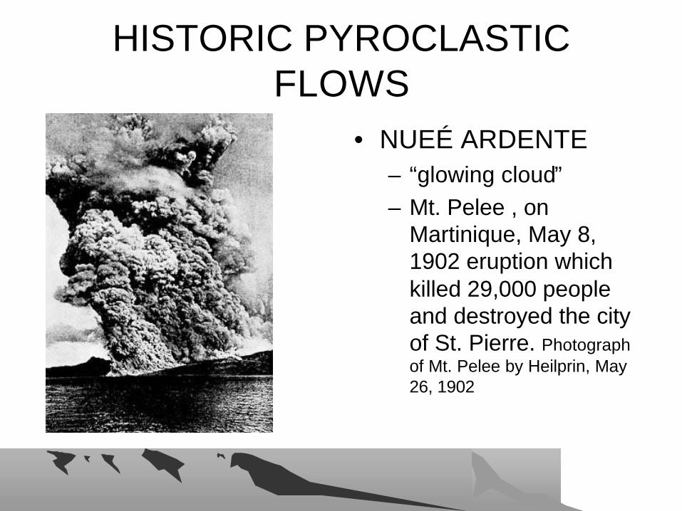
HISTORIC PYROCLASTIC HISTORIC PYROCLASTIC FLOWSFLOWS
• NUEÉ ARDENTE– “glowing cloud”– Mt. Pelee , on
Martinique, May 8, 1902 eruption which killed 29,000 people and destroyed the city of St. Pierre. Photograph of Mt. Pelee by Heilprin, May 26, 1902
CALDERASCALDERAS
• When a large volume of magma is removed from beneath a volcano, the ground subsides or collapses into the emptied space, to form a huge depression called a caldera.
• Some calderas are more than 25 kilometers in diameter and several kilometers deep.
CALDERASCALDERAS
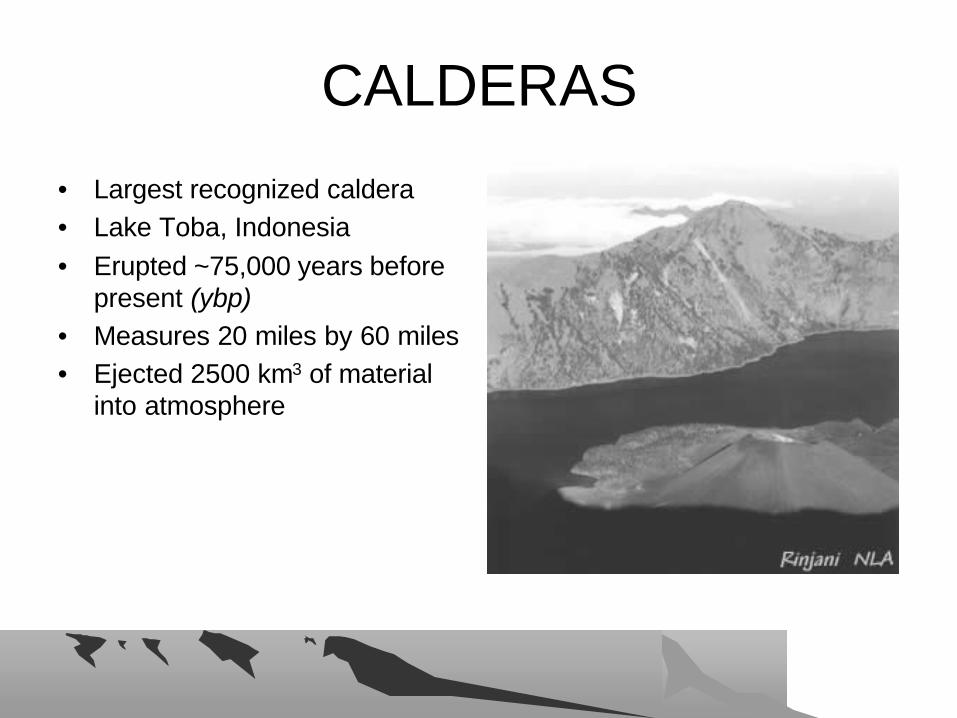
• Largest recognized caldera• Lake Toba, Indonesia• Erupted ~75,000 years before
present (ybp)• Measures 20 miles by 60 miles• Ejected 2500 km3 of material
into atmosphere
CALDERASCALDERAS• Long Valley Caldera, northeastern California
• About 760,000 years ago • 15 miles by 20 miles
– A cataclysmic volcanic eruption in the area blew out 150 cubic miles of magma from a depth of about 4 miles beneath the Earth's surface.
– Pyroclastic flows covered much of east-central California
– Airborne ash fell as far east as Nebraska and Texas – The Earth's surface sank more than 1 mile into the
space once occupied by the erupted magma
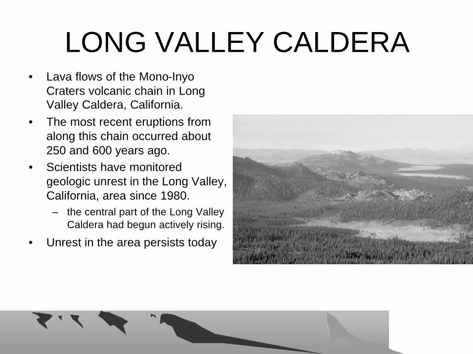
LONG VALLEY CALDERALONG VALLEY CALDERA• Lava flows of the Mono-Inyo
Craters volcanic chain in Long Valley Caldera, California.
• The most recent eruptions from along this chain occurred about 250 and 600 years ago.
• Scientists have monitored geologic unrest in the Long Valley, California, area since 1980.
– the central part of the Long Valley Caldera had begun actively rising.
• Unrest in the area persists today
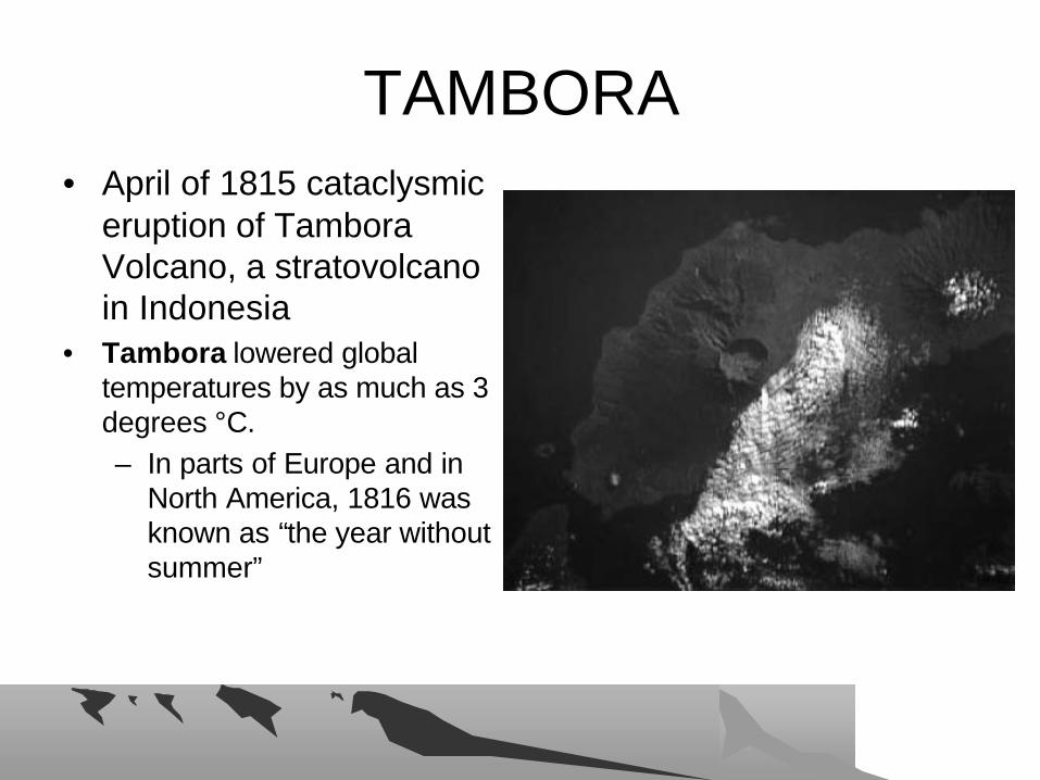
TAMBORATAMBORA• April of 1815 cataclysmic
eruption of Tambora Volcano, a stratovolcano in Indonesia
• Tambora lowered global temperatures by as much as 3 degrees °C. – In parts of Europe and in
North America, 1816 was known as “the year without summer”
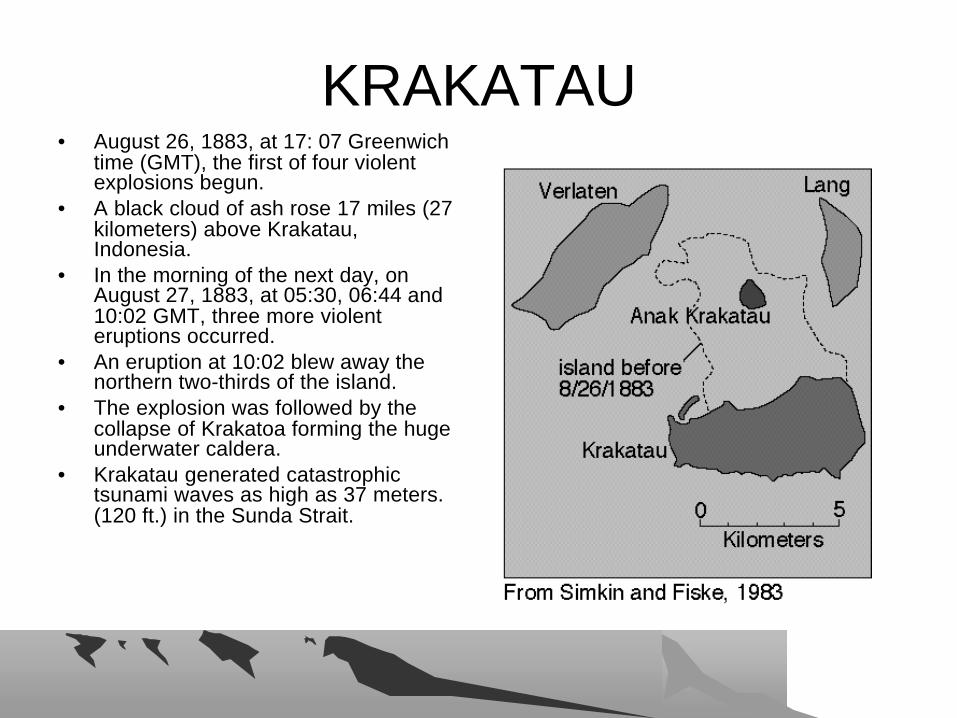
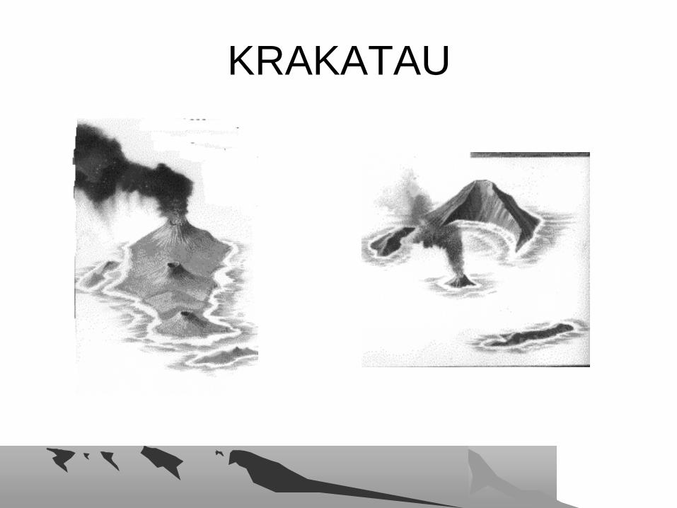
KRAKATAUKRAKATAU• August 26, 1883, at 17: 07 Greenwich
time (GMT), the first of four violent explosions begun.
• A black cloud of ash rose 17 miles (27 kilometers) above Krakatau, Indonesia.
• In the morning of the next day, on August 27, 1883, at 05:30, 06:44 and 10:02 GMT, three more violent eruptions occurred.
• An eruption at 10:02 blew away the northern two-thirds of the island.
• The explosion was followed by the collapse of Krakatoa forming the huge underwater caldera.
• Krakatau generated catastrophic tsunami waves as high as 37 meters. (120 ft.) in the Sunda Strait.
KRAKATAU KRAKATAU

MT. MAZAMA MT. MAZAMA –– CRATER LAKECRATER LAKE• Crater Lake caldera • formed by collapse during the
catastrophic eruption of approximately 50 cubic kilometers of magma, 6,845 carbon-14 years B.P. (before present)
• Prior to its climactic eruption, Mount Mazama's summit elevation was between 3,300 meters and 3,700 meters (10,800 - 12,000 feet)
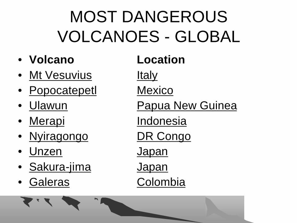
MOST DANGEROUS MOST DANGEROUS VOLCANOES VOLCANOES -- GLOBALGLOBAL
• Volcano Location• Mt Vesuvius Italy• Popocatepetl Mexico• Ulawun Papua New Guinea• Merapi Indonesia• Nyiragongo DR Congo• Unzen Japan• Sakura-jima Japan• Galeras Colombia
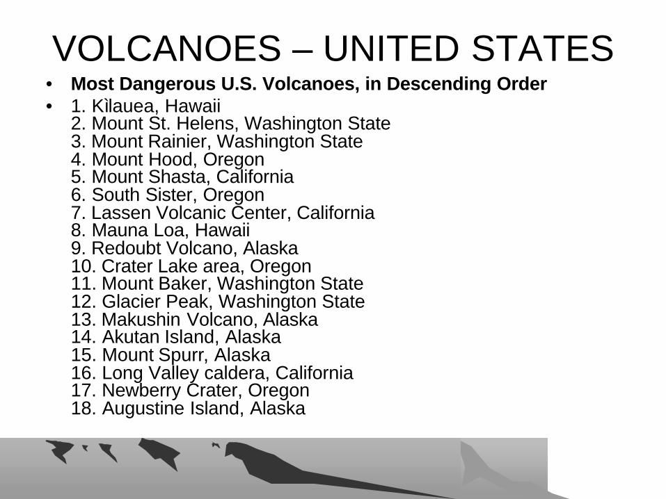
VOLCANOES VOLCANOES –– UNITED STATESUNITED STATES• Most Dangerous U.S. Volcanoes, in Descending Order• 1. Kìlauea, Hawaii
2. Mount St. Helens, Washington State3. Mount Rainier, Washington State4. Mount Hood, Oregon5. Mount Shasta, California 6. South Sister, Oregon7. Lassen Volcanic Center, California 8. Mauna Loa, Hawaii9. Redoubt Volcano, Alaska 10. Crater Lake area, Oregon 11. Mount Baker, Washington State12. Glacier Peak, Washington State13. Makushin Volcano, Alaska 14. Akutan Island, Alaska15. Mount Spurr, Alaska16. Long Valley caldera, California17. Newberry Crater, Oregon18. Augustine Island, Alaska
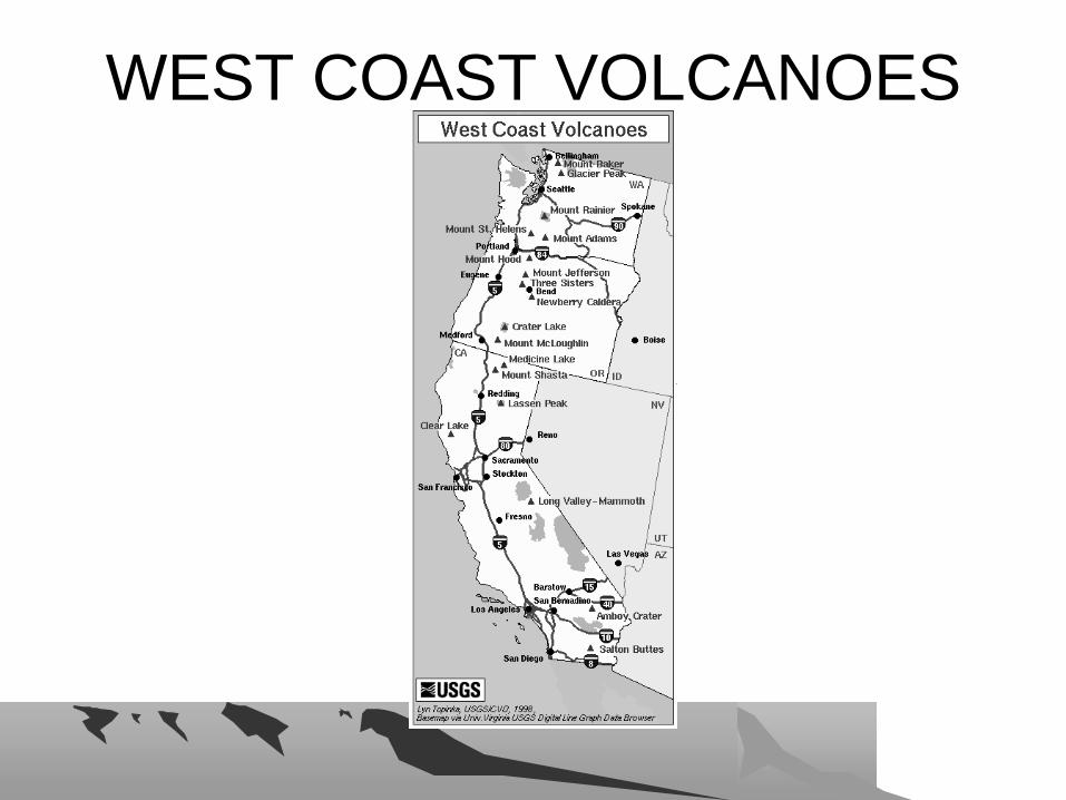
WEST COAST VOLCANOESWEST COAST VOLCANOES
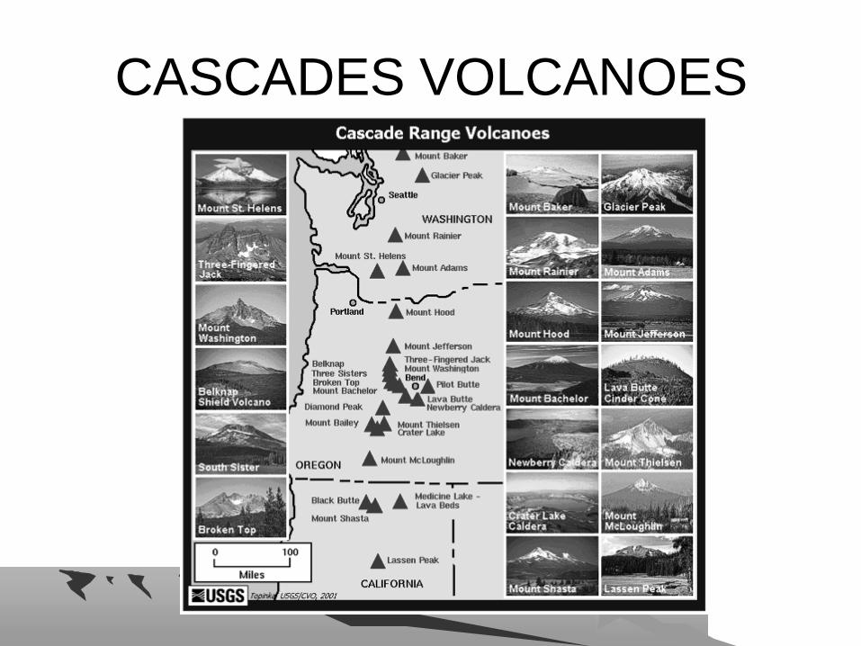
CASCADES VOLCANOESCASCADES VOLCANOES
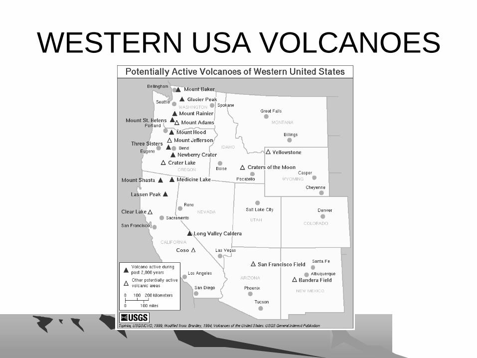
WESTERN USA VOLCANOESWESTERN USA VOLCANOES