Embed Size (px)
Citation preview

Monitoring Colombia’sSlumbering Volcanoes
Science Fares Well in U.S. Proposed Federal Budget
Caterpillar-Like Motionof the Greenland Ice Sheet
VOL. 96 NO. 4 1 MAR 2015
Earth & Space Science News
Big OneHow Ready is Los AngelesHow Ready is Los Angeles
Big One ?How Ready is Los Angelesfor the Next “Big One”?
How Ready is Los AngelesHow Ready is Los Angeles
How Ready is Los AngelesHow Ready is Los AngelesHow Ready is Los Angeles
for the Next for the Next How Ready is Los Angeles
for the Next How Ready is Los Angelesfor the Next for the Next for the Next “How Ready is Los Angeles
“How Ready is Los AngelesBig OneHow Ready is Los AngelesBig OneHow Ready is Los Angeles
“Big One“Big OneBig One
Big One”How Ready is Los Angeles”How Ready is Los Angeles ??How Ready Is Los Angeles
for the Next “Big One”?

Recognize The Exceptional Scientific Contributions And Achievements
Of Your Colleagues
Union Awards • Prizes • Fellows • MedalsAwards
Ambassador Award
Edward A. Flinn III Award
Charles S. Falkenberg Award
Athlestan Spilhaus Award
International Award
Excellence in Geophysical Education Award
Science for Solutions Award
Robert C. Cowen Award for Sustained Achievement in Science Journalism
Walter Sullivan Award for Excellence in Science Journalism – Features
David Perlman Award for Excellence in Science Journalism – News
PrizesClimate Communication Prize
NEW The Asahiko Taira International Scientific Ocean Drilling Research Prize
MedalsWilliam Bowie Medal
James B. Macelwane Medal
John Adam Fleming Medal
Maurice Ewing Medal
Robert E. Horton Medal
Harry H. Hess Medal
Inge Lehmann Medal
Roger Revelle Medal
honors.agu.orgNominations Deadline: 15 March
FellowsScientific eminence in the Earth and space sciences through achievements in research, as demonstrated by
one or more of the following: breakthrough or discovery; innovation in disciplinary science, cross-disciplinary science, instrument development, or methods development; or sustained scientific impact.

Earth & Space Science News Contents
Earth & Space Science News Eos.org // 1
1 MARCH 2015VOLUME 96, ISSUE 4
Developing Deep-Life Continental Drilling Projects
Exploring How Wind Blows Sand on DunesSand dunes migrate—so why haven’t some budged in 60 years?
Los Angeles Gets Serious About Preparing for the “Big One”A large earthquake in southern California could devastate Los Angeles. To help reduce the city’s risks, one scientist spent last year working in the LA mayor’s office.
Keeping Watch Over Colombia’s Slumbering VolcanoesA new GPS network helps geophysicists track subtle deformations at the surfaces of volcanoes months before eruptions may occur.
9
26
PROJECT UPDATE
MEETING REPORT
RESEARCH SPOTLIGHT
COVER
18
12Recognize The Exceptional Scientific
Contributions And Achievements Of Your Colleagues
Union Awards • Prizes • Fellows • MedalsAwards
Ambassador Award
Edward A. Flinn III Award
Charles S. Falkenberg Award
Athlestan Spilhaus Award
International Award
Excellence in Geophysical Education Award
Science for Solutions Award
Robert C. Cowen Award for Sustained Achievement in Science Journalism
Walter Sullivan Award for Excellence in Science Journalism – Features
David Perlman Award for Excellence in Science Journalism – News
PrizesClimate Communication Prize
NEW The Asahiko Taira International Scientific Ocean Drilling Research Prize
MedalsWilliam Bowie Medal
James B. Macelwane Medal
John Adam Fleming Medal
Maurice Ewing Medal
Robert E. Horton Medal
Harry H. Hess Medal
Inge Lehmann Medal
Roger Revelle Medal
honors.agu.orgNominations Deadline: 15 March
FellowsScientific eminence in the Earth and space sciences through achievements in research, as demonstrated by
one or more of the following: breakthrough or discovery; innovation in disciplinary science, cross-disciplinary science, instrument development, or methods development; or sustained scientific impact.

2 // Eos 1 March 2015
Contents
facebook.com/AmericanGeophysicalUnion linkedin.com/company/american-geophysical-union@AGU_Eos youtube.com/user/AGUvideos
Editor in ChiefBarbara T. Richman: AGU, Washington, D. C., USA; eos_ [email protected]
Christina M. S. Cohen:California Institute of Technology, Pasadena, Calif., USA; cohen@srl .caltech.edu
José D. Fuentes:Department of Meteorology, Pennsylvania State University, University Park, Pa., USA; [email protected]
Wendy S. Gordon:Ecologia Consulting, Austin, Texas, USA; wendy@ecologiaconsulting .com
David Halpern:Jet Propulsion Laboratory, Pasadena, Calif., USA; davidhalpern29@gmail .com
Carol A. Stein:Department of Earth and Environmental Sciences, University of Illinois at Chicago, Chicago, Ill., USA; [email protected]
Editors
M. Lee Allison, Earth and Space Science InformaticsLora S. Armstrong, Volcanology, Geochemistry, and PetrologyMichael A. Ellis, Earth and Planetary Surface ProcessesArlene M. Fiore, Atmospheric SciencesNicola J. Fox, Space Physics and AeronomySteve Frolking, Biogeosciences Edward J. Garnero, Study of the Earth’s Deep Interior Michael N. Gooseff, HydrologyKristine C. Harper, History of GeophysicsKeith D. Koper, SeismologyRobert E. Kopp, Geomagnetism and PaleomagnetismJohn W. Lane, Near-Surface Geophysics
Xin-Zhong Liang, Global Environmental ChangeJian Lin, TectonophysicsFigen Mekik, Paleoceanography and PaleoclimatologyJerry L. Miller, Ocean SciencesMichael A. Mischna, Planetary SciencesThomas H. Painter, Cryosphere SciencesRoger A. Pielke Sr., Natural HazardsMichael Poland, GeodesyEric M. Riggs, Education Adrian Tuck, Nonlinear GeophysicsSergio Vinciguerra, Mineral and Rock PhysicsEarle Williams, Atmospheric and Space ElectricityMary Lou Zoback, Societal Impacts and Policy Sciences
Editorial Advisory Board
StaffProduction: Faith A. Ishii, Program Manager; Liz Castenson, Editor’s Assistant; Valerie Bassett and Travis Frazier, Electronic Graphics SpecialistsEditorial: Randy Showstack, Senior Writer; Mohi Kumar, Science Writer/Editor; JoAnna Wendel, Writer;Marketing: Angelo Bouselli and Mirelle Moscovitch, Marketing AnalystsAdvertising: Christy Hanson, Manager; Tel: +1-202-777-7536; Email: [email protected]
©2015. American Geophysical Union. All Rights Reserved. Material in this issue may be photocopied by individual scientists for research or classroom use. Permission is also granted to use short quotes, figures, and tables for publication in scientific books and journals. For permission for any other uses, contact the AGU Publications Office.
Eos (ISSN 0096-3941) is published semi-monthly, on the 1st and 15th of the month except the 1st of January 2015 by the American Geophysical Union, 2000 Florida Ave., NW, Washington, DC 20009, USA. Periodical Class postage paid at Washington, D. C., and at additional mailing offices. POSTMASTER: Send address changes to Member Service Center, 2000 Florida Ave., NW, Washington, DC 20009, USA.
Member Service Center: 8:00 a.m.–6:00 p.m. Eastern time; Tel: +1-202-462-6900; Fax: +1-202-328-0566; Tel. orders in U.S.: 1-800-966-2481; Email: [email protected].
Use AGU’s Geophysical Electronic Manuscript Submissions system to submit a manuscript: http://eos-submit.agu.org.
Views expressed in this publication do not necessarily reflect official positions of the American Geophysical Union unless expressly stated.
Christine W. McEntee, Executive Director/CEO
3–8 NewsPacific Plate’s Underbelly Revealed Through Explosive Means; White House Budget Calls for Increased Science Funding; Study Stresses Ocean Science Priorities and Budget Rebalance.
10–11 OpinionProtecting the Science of Climate Change.
24 AGU NewsNew Section and Focus Group Honors for 2015
25–28 Research SpotlightPolar Warming Makes the Jet Stream Stable, Not Wavy or Blocked; Exploring How Wind Blows Sand on Dunes; Wave Energy Affects Surf Zone Heat Budget; How Does the Flow of Water Affect Bed Forms?; Caterpillar-Like Motion of the Greenland Ice Sheet; Clouds Visible at Twilight Reveal Mysteries of Gravity Waves; Tracking Down a Subduction Zone Earthquake
29–32 Positions AvailableCurrent job openings in the Earth and space sciences.
Inside Back Cover:Postcards from the FieldA magma chamber, located under the Thrihnukagigur volcano in Iceland.
25
DEPARTMENTS
On the CoverA section of California’s Golden State Freeway, which collapsed during the Mw = 6.7 Northridge earthquake on 17 January 1994. Credit: FEMA
5

Earth & Space Science News Eos.org // 3
NEWS
In the predawn hours of a damp May night, a team of seismologists detonated half a ton of explosive slurry, tucked 50 meters below and
200 meters away from them. The ground beneath their feet rumbled, and they saw rocks and water spew from the ground.
At the bottom of a borehole cased with steel, the explosion sent waves of energy through the Earth’s surface, which echoed back from under-ground rock layers in just under a minute. These echoes were recorded by hundreds of soda bottle– sized seismographs buried underground.
A dozen such boreholes had been drilled and filled with explosives in 2011, spread in a 90-kilometer line across the southern end of New Zealand’s North Island, near the capital city of Wellington. The line of boreholes runs paral-lel to the diving direction of the Pacific Plate, which is subducting underneath the Australian Plate roughly 25 kilometers below the boreholes.
This explosive experiment was originally intended to image the top of the Pacific Plate, which moves about 9 centimeters per year and threatens Wellington with potentially large earthquakes. However, the data unexpectedly allowed scientists to take an unprecedented peek at the bottom of the subducting slab, 100 kilometers below the boreholes. The new research was published on 5 February in Nature (doi:10.1038/nature14146).
Finding What Lies Below The behavior of seismic waves in the Earth’s interior can help geoscientists find out what kinds of rocks make up the Earth’s layers and how viscous these rocks are. The speed and direction of these waves change as they propa-gate through different types of rocks, and those changes can tell scientists about the properties of the rock itself. Earthquake- produced waves, however, are unpredictable and travel long distances, so scientists have turned to creating their own seismic waves with underground explosions.
“This seismic method is much [higher] reso-lution because we’re shooting from the surface down rather than requiring earthquake waves coming from below” or much farther away, Tim Stern, lead author on the paper and professor of
geophysics at Victoria University of Wellington, told Eos.
Similar to the way research vessels bounce sound waves off the bottom of the ocean to image its mountains and valleys, seismic waves bounce back from rock layers in the Earth’s interior, creating a snapshot of the layers themselves or of different types or densities of rocks within these layers.
The explosion-induced seismic waves reflect back at 5–30 times the frequency of earthquake waves because their wavelengths are much shorter and they travel shorter distances, Stern explained.
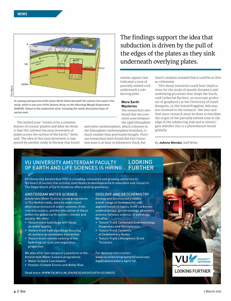
A Snapshot of SubductionOver two nights—to avoid bothering any of the surrounding population—several graduate stu-dents detonated all the explosives. By analyz-ing the reflected waves—or “echoes,” as Stern called them—the team was able to create an image of the bottom layer of the subducting plate. The researchers found that over a 10-kilometer region at the bottom of the plate, the velocity of the waves slowed, indicating that the region was partially melted and weaker than the layers of rock above it.
Stern compared this soft layer to a moving ski on snow—the pressure exerted by the ski creates a thin layer of melted water just under-neath the ski that allows for smooth, friction-less movement. Similarly, the layer of partial melt at the bottom of the Pacific Plate allows the plate to slide several centimeters per year.
Theories of MovementAlthough the idea that tectonic plates slide around like enormous puzzle pieces on the Earth is widely understood, scientists remain unclear about how the plates actually move.
Two leading theories describe the underlying mechanism of plate tectonics, Stern explained. One is that the plates are coupled with the con-vection in the mantle and thus feel a downward drag after upward heating cools. The other is that subduction is driven by the pull of the edges of the plates as they sink underneath overlying plates, a process driven by gravity.
Stern said that this new research supports the latter process because the layer of partially melted rock at the base of the subducting plate does not suggest that the hotter, weaker man-tle couples with the cooler, more brittle crust in a smooth convection cell.
Pacific Plate’s Underbelly Revealed Through Explosive Means
Similar to the way research vessels use sound waves to image the ocean floor, seismic waves are used to image the Earth’s interior.
Researchers drive on the North Island of New Zealand to sites where they will bury seismic receivers that will
record explosion-induced seismic waves. In total, they buried 900 receivers.
Tim
Ste
rn
The melted zone “seems to be a common feature of oceanic planets and what we think is that this [allows] the easy movement of plates across the surface of the Earth,” Stern said. The idea of this easy movement is sup-ported by another study in Norway that found
similar signals that indicated a zone of partially melted rock underneath a sub-ducting plate.
More Earth MysteriesThe researchers also found that the tran-sition zone between the rigid lithosphere
and softer asthenosphere, which is known as the lithosphere-asthenosphere boundary, is much smaller than previously thought. Previ-ous researchers have found that this transi-tion zone is at least 10 kilometers thick, but
Stern’s analysis revealed that it could be as thin as 1 kilometer.
This sharp transition could have implica-tions for the study of mantle dynamics and underlying processes that shape the Earth, said Catherine Rychert, an associate profes-sor of geophysics at the University of South Hampton, in the United Kingdom, who was not involved in the research. She also said that more research must be done to elucidate the origin of the partially melted zone at the edge of the subducting slab and to investi-gate whether this is a phenomenon found globally.
By JoAnna Wendel, Staff Writer
4 // Eos 1 March 2015
NEWSNEWS
4 // Eos
The findings support the idea that subduction is driven by the pull of the edges of the plates as they sink underneath overlying plates.
Tim
Ste
rn
A cutaway perspective of the lower North Island beneath the seismic line used in the study, which is one arm of the Seismic Array on the Hikurangi Margin Experiment (SAKHE). Shown is the subduction zone, including the newly discovered layer of partial melt.

Earth & Space Science News Eos.org // 5Earth & Space Science News Eos.org // 5
NEWS
The White House’s proposed budget for fiscal year (FY) 2016, released on 2 Feb-ruary, calls for a substantial increase for
federal science agencies. The proposal also would provide significant funding for areas related to climate change, clean energy tech-nology, Earth observations, basic research, space exploration, stewardship of natural resources, and infrastructure modernization.
The budget would provide $146 billion for research and development overall, an $8 bil-lion (6%) increase above 2015 enacted budget levels, according to the White House Office of Science and Technology Policy (OSTP). The budget also would provide $67 billion for basic and applied research, which represents a $2 billion (3%) increase above 2015 enacted levels, according to OSTP. FY 2016 runs from 1 October 2015 to 30 September 2016.
The budget request includes about $2.7 bil-lion for programs to understand and respond to climate change and its impacts. In addition, the budget includes about $7.4 billion for clean energy technology programs; more than $3 billion for science, technology, engineering, and mathematics education programs (an increase of 3.6% from 2015); and funding to support investments in Earth observations—including Earth-observing satellites—aligned with the White House’s National Plan for Civil Earth Observations (see http://bit.ly/EOplan).
The budget proposal also calls for ending spending cuts known as “sequestration.”
Those cuts were “damaging and short-sighted” and they resulted in hundreds of important scientific projects going unfunded, according to budget documents.
Budget Overview and Initial ReactionAt a 2 February budget briefing, OSTP director John Holdren focused on several key scien-tific challenges and opportunities, including climate change. Holdren said that Congress, which would need to approve the budget, should be supportive of the administration’s proposals focusing on climate change, Earth observations, and other areas.
“Climate change really ought to be a bipartisan proposition,” Holdren said, noting that measures to deal with it would be good for the economy, environment, national security, and public health. “None of those have historically been partisan propositions. I think we have a good case to make with the Congress on why people of both parties should support the initiatives that we are try-ing to advance,” he said.
Many Republicans, however, expressed disapproval of the budget proposal. For example, Lamar Smith (R-Texas), chairman of the House of Representatives’ Science, Space, and Technology Committee, commented, “Investments in science and technology have the potential to create jobs and yield future economic growth. Rather than focus on areas that have clear benefits for Americans, the
president instead chose to push a partisan agenda.”
The White House’s budget, Smith continued, “includes new spending for costly ineffective energy subsidies and a new $500 million United Nations program to promote ‘climate change resiliency’ in other countries. I’m dis-appointed the president chose to play politics with taxpayers’ dollars instead of offering real solutions.”
NASA Budget Ups Earth Sciences and Other AreasThe proposed budget for NASA is $18.53 bil-lion, up from the $18.01 billion in the 2015 enacted budget. The FY 2016 budget includes increases in many areas within the agency.
The Science Mission Directorate—which includes the Earth Science, Heliophysics, Planetary Science, and Astrophysics divi-sions and the Joint Agency Satellite Divi-sion—would see its funding increase to $5.289 billion (up from the FY 2015 enacted budget of $5.245 billion). Specific line items give budgets for Earth science at $1.95 bil-lion (up from $1.82 billion in 2014), plane-tary science at $1.36 billion (up from of $1.35 billion in 2014), astrophysics at $709.1 mil-lion (up from $678.3 million in 2014), and heliophysics at $651 million (up from $641 million in 2014).
In addition, funding for exploration would jump to $4.51 billion (from $4.37 billion in the enacted FY 2015 budget). However, fund-ing for education would drop significantly from $119 million in FY 2015 to $88.9 million. Also, aeronautics would dip from $651 mil-lion in FY 2015 to $571.4 million.
The budget also continues the development of the Space Launch System rocket and Orion spacecraft for deep-space missions. It also includes funding for the next Mars rover mis-sion and funding for NASA to proceed with a project formulation for a mission to Jupiter’s moon Europa. Funding for the James Webb Space Telescope is $620 million, down from the FY 2015 enacted level of $645.4 million.
NSF Budget Includes Increase for All Geoscience DivisionsThe administration’s request for the National Science Foundation (NSF) for FY 2016 is $7.7 billion, an increase of $379 million over FY 2015. Funding for research and related activities would rise to $6.19 billion from FY 2015’s estimated $5.93 billion; education and human resources would move to $962.6 million from $866 million, and major research equipment and facilities construction stay fairly flat at $200.3 million (FY 2015’s estimate is $200.8 million).
The budget for NSF’s Directorate for Geosci-ences would increase to $1.37 billion from $1.30
White House Budget Calls for Increased Science Funding
The federal budget, hot off the presses.
GP
O

6 // Eos 1 March 2015
NEWSNEWS
6 // Eos
billion. The added funding spans all divisions within the directorate, including atmospheric and geospace sciences, Earth sciences, ocean science, polar programs, and inte-grative and collaborative education and research.
The overall NSF budget includes several key cross-disciplinary activities. The Innovations at the Nexus of Food, Energy and Water Systems (INFEWS) project would be funded at $75 million. A Risk and Resilience initiative to address resilience in response to natural and man-made disasters would receive $58 mil-lion.
NSF director France Córdova said that the budget request “reflects the president’s vote of confidence in NSF’s ability to make invest-ments in learning and discovery that will grow our economy, sustain our global com-petitiveness, and enable America to remain the world leader in innovation.”
Interior Budget Would Increase by Nearly 8%The proposed budget for the Department of the Interior (DOI) is $13.2 billion, an increase of $752.6 million, almost 8%, above the FY 2015 enacted level.
Among the agency’s key priorities is imple-menting the president’s Climate Action Plan. To accomplish this, the budget includes $195.3 million to increase the resilience of communi-ties and ecosystems to floods, sea level rise, and drought. Another priority is funding for responsible development of oil and gas resources, including supporting stronger over-sight for oil and gas development on the nation’s outer continental shelf.
All of the bureaus within DOI would receive increases: the U.S. Geological Survey (USGS) would receive $1.2 billion, an increase of $150 million. Acting USGS director Suzette Kimball commented, “This budget request recognizes our unique capabilities with multi- disciplinary Earth science research and will allow the USGS to meet societal needs for our nation now and in the future.”
DOI increases also would be slated for the Fish and Wildlife Service ($1.58 billion, up $131 million), the National Park Service ($3.04 bil-lion, up $433 million), and the Bureau of Land Management ($1.25 billion, up $108 million). The budget for the Bureau of Ocean Energy Management would tick up $1 million for a total of $74 million.
NOAA Line Offices Would See Rise in FundingThe proposed budget for the National Oceanic and Atmospheric Administration (NOAA), which is part of the Department of
Commerce, calls for $5.98 billion, an increase from the FY 2015 enacted level of $5.45 bil-lion. Within the total budget, NOAA’s opera-
tions, research, and facilities account would rise to $3.41 billion from $3.27 billion, and the procurement, acquisition, and construction account would move to $2.5 billion from $2.18 billion.
Specifically, within NOAA, the National Ocean Service would receive $574 million (up from $535.7 in the FY 2015 enacted budget). The National Marine Fisheries Service would be slated to receive $990.1 million (up from $958.2 million), oceanic and atmospheric research would rise to $507 million (from $446.3 million), the National Weather Service (NWS) would inch up to $1.099 billion from $1.087 billion, and the National Environmen-tal Satellite, Data, and Information Service would move to $2.38 billion from $2.22 bil-lion.
The budget document indicates that the budget makes targeted investments in four agency priorities: building community and economic resilience, evolving the NWS, improving observational infrastructure, and achieving organizational excellence. “In particular, this budget requests major initia-tives to fortify the NOAA fleet via an Ocean Survey Vessel (OSV) and to advance next-generation polar satellite technology via the Polar Follow On,” according to the budget.
In an introduction to the agency’s budget summary, NOAA administrator Kathryn Sul-livan, who also serves as undersecretary of commerce for oceans and atmosphere, stated, “The FY 2016 budget request will improve NOAA’s ability to provide people, communi-ties, businesses, and governments with information they can understand and use to make smart decisions, assess risk, and mini-mize losses.”
More Funding for the Department of EnergyThe Department of Energy’s (DOE) budget would increase to $29.92 billion, up from the FY 2015 enacted level of $27.4 billion. DOE’s science and energy programs would receive $10.63 billion, up from $9.23 billion. The sci-ence line item would increase to $5.34 billion (up from $5.07 billion), energy efficiency and renewable energy would increase to $2.72 billion from $1.91 billion, and the Advanced
Research Projects Agency-Energy would receive $325 million (up from $278 million).
The budget also includes funding for a num-ber of proposed crosscutting ini-tiatives, including $244 million for subsurface engineering to support a variety of energy sources and $38 million for an energy-water nexus activity.
A Boost to the Environmental Protection AgencyUnder the president’s proposed budget, the Environmental Protection Agency (EPA) would receive $8.59 billion ($452 million above the FY 2015 enacted level). Those funds would be divided among five goals.
The first goal, addressing climate change and improving air quality, would receive $1.11 billion, 13% of the budget total and an increase of $120.2 million above the FY 2015 enacted level. Of that amount, $239 million would sup-port EPA’s efforts to address climate change.
Another agency goal, protecting Ameri-ca’s waters, would receive $4.05 billion, 47.2% of the total. The budget for that area would increase modestly by $70 million. However, the subgoal to protect human health by achieving and maintaining stan-dards for drinking water and other resources would increase by $304.4 million, offset by a nearly equal cut to programs that protect and restore watersheds and aquatic ecosystems.
The three remaining goals include clean-ing up communities and advancing sustain-able development would receive $1.95 billion (22.7% of the total, an increase of $177.9 million), ensuring the safety of chemicals and promoting pollution prevention would get $668 million (7.8% of the total, an increase of $47.4 million), and protecting human health and the environment by enforcing laws to achieve compliance would see $804 million (9% of the total, a $66.2 million increase).
EPA acting deputy administrator Stan Meiburg said that the funding allows EPA “to further our important work to combat the impacts of climate change and deliver on the President’s Climate Action Plan while improv-ing air quality, protecting our water, executing rigorous scientific research, and ensuring the public safety from toxic chemicals.”
More in-depth Eos coverage of the admin-istration’s proposed budget for federal agencies will come over the next few weeks. Full FY 2016 budget documents can be found at http://www .whitehouse.gov/omb/.
By Randy Showstack, Staff Writer
The overall NSF budget includes several key cross-disciplinary activities.

Earth & Space Science News Eos.org // 7Earth & Space Science News Eos.org // 7
NEWS
A new report on ocean sciences at the National Science Foundation (NSF) rec-ommends a major course correction to
adjust an imbalance between funding for core science research and escalating infrastructure costs. The report also identifies eight priority science questions as the key topics in ocean science for the next decade.
Sea Change: 2015-2025 Decadal Survey of Ocean Sciences (see http://bit.ly/NSFSeaChange), issued by the U.S. National Research Council (NRC) on 23 January, states that ocean infrastructure operations and maintenance costs need to be cut back because they have outstripped funding for core research programs. Core programs within the Division of Ocean Sciences (OCE) of NSF’s Directorate for Geosciences received 62% of the division’s funding in 2000 but just 46% in 2014. Over the past decade, OCE’s budget has declined by more than 10% when adjusted for inflation, the report notes. NSF is the principal U.S. federal agency funding basic research in the ocean sciences.
“The OCE budget has drifted out of bal-ance,” according to the report. “Due to rela-tively flat budgets, inflation, and increasing costs of [operations and maintenance] for OCE major infrastructure, funding for OCE’s core programs has decreased by 25% (in infla-tion-adjusted dollars) over the past four years.”
Cuts to Infrastructure ProgramsWith a mandate that assumes a flat OCE budget over the next decade, the NRC committee rec-ommends reallocating at least 20%—about $40 million in 2014 dollars—of the major infra-structure operations and maintenance budget to core sciences and OCE’s Oceanographic Technology and Interdisciplinary Coordination (OTIC) program. Major infrastructure programs should comprise no more than 40-50% of OCE’s total annual program budget, according to the report, if budgets remain flat or include only inflationary increases.
“The only way to recover funding for core science and OTIC is to reduce the amount of money spent on infrastructure,” the report states. “Such reductions are not easy and will cause disruptions for parts of the ocean science community.” There should be an immediate 10% reduction in major infrastructure costs in OCE’s next budget and an additional 10-20% decrease over the following 5 years, according to the report.
Reconfiguring the budget would mean reducing funding for some major infrastructure programs. These include the International Ocean Discovery Program (IODP), which under-takes scientific ocean drilling; the Ocean Observatories Initiative (OOI), which has not yet entered full operation; and the Universi-ty-National Oceanographic Laboratory System (UNOLS) academic research fleet.
The report recommends that the initial 10% cost reduction should be “weighted”—rather
than across the board—to include a 20% reduc-tion to OOI, 10% to IODP, and 5% to the fleet, based in large part on how these programs align with priority research questions.
“The strongest match between current infrastructure and the decadal science priori-ties is the academic research fleet,” the report states. While the report recognizes earlier efforts by IODP to address budget concerns, it notes that “NSF has the ability to renegotiate its contribution to the IODP consortium and is strongly urged to pursue a more cost-effective partnership.” According to the report, OOI would receive the largest initial percentage reduction because “fewer of its components align strongly with the science priorities,” among other reasons.
To achieve infrastructure program reduc-tions, the report recommends specific cost-cutting options and encourages partner-ship opportunities with federal agencies, inter-national programs, and other sectors.
Priority Science QuestionsThe report outlines eight broad priority science questions “with the highest potential payoff” for the coming decade. The questions, which the report notes each represent an integrative and strategic research area, are ordered spatially from ocean surface to seafloor. The questions include: What are the rates, mechanisms, impacts, and geographic variability of sea level change? And, what is the geophysical, chemical, and biological character of the subseafloor environment?
Additional questions focus on the coastal and estuarine ocean and ecosystems; the relation-ship between biogeochemical and physical pro-cesses and today’s climate and its variability; the role of biodiversity in the resilience of marine ecosystems; and how to improve the ability to forecast geohazards, among other topics. The committee applied four criteria to determine top priorities: transformative research potential, societal impact, readiness, and partnership potential.
Belt Tightening with a PayoffShirley Pomponi, cochair of the NRC committee that produced the report, told Eos “the decade ahead is going to be 5 years of belt tightening and adjusting, and then 5 years to really pursue that vision that we have articulated.”
The decadal survey addressed two broad challenges, according to Pomponi, research professor and executive director of the National Oceanic and Atmospheric Administration’s
Study Stresses Ocean Science Priorities and Budget Rebalance
NA
SA
/Rei
d W
isem
an
The report focuses on key ocean science priorities. Pictured is the ocean as seen from the International Space Station.

8 // Eos 1 March 2015
NEWSNEWS
8 // Eos
Cooperative Institute for Ocean Exploration, Research, and Technology at Harbor Branch Oceanographic Institute, Florida Atlantic Uni-versity, Fort Pierce. The first challenge was to identify important research questions. “The second challenge was to figure out how we could implement those [priorities], given the fact that the budget has flip-flopped in the last year or so,” with more money currently going to infrastructure rather than science.
“We need to restore a balance of funding between ocean science infrastructure and the ocean science research. And we need to take immediate action to get that plan in place. And then, ocean sciences needs to have a long-term plan to maintain that balance to ensure a robust ocean science enterprise,” she said.
NSF Carefully Studying the ReportRichard Murray, OCE’s new division director who started on 12 January, told Eos, “We hear loud and clear the sense of urgency” expressed in the report.
“I look forward to putting as much care and attention into reading it and understanding and massaging its recommendations and dis-cussing [it] with our teams as these folks clearly put into it” in preparing the report, Murray said. “It would be premature, given that we just received [the report] ourselves, to comment specifically on any of the recom-mendations other than [to say that] we under-stand and appreciate the scope of the report and their highlighting the significance and urgency of addressing a variety of issues.”
David Conover, who was OCE division direc-tor during 2010-2013 when NSF commissioned NRC to conduct the decadal survey, told Eos the report “is an attempt to grapple with the
real issues and to produce a strategic plan that is grounded in reality regarding what the nation can afford.” Conover, vice president for research at Stony Brook University, New York, said the report’s “compelling” priorities are “the lever” to rebalance funding between core science and infrastructure. “It’s not just rebal-ancing for the sake of rebalancing. It’ not just, ’oh, we’ve got too much infrastructure.’ It’s actually linked to those priorities, which is exactly the way it should be done.”
Conover said the ocean sciences community’s support for the report is critical. “Some groups may push back hard, but I think NSF now has a report that is comprehensive, fair, and rep-resents the overall voice of the community.” He added, “There is very strong support for making sure that the basic science in every one of the divisions in the foundation is adequately sup-ported, and that that balance between facilities and science reflects the best pathway forward.”
Deborah Bronk, who served as OCE division director from 2013 to mid-January before Mur-ray arrived, noted that the committee “was handed a very difficult task because their rec-ommendations needed to be constrained by current fiscal limitations, and I congratulate them on the detailed and insightful report they produced.”
OOI and IODP ResponsesOOI Program Advisory Committee chairman William Boicourt told Eos that the report’s recommendations are “measured, careful, and constructive.” “I don’t agree completely with [the committee], but I thought they did a good job of laying out the situation.” Boi-court, a professor at the University of Maryland’s Center for Environmental Sci-ence, said the overall decline in ocean sci-ence funding is “the number one bleak
aspect” of the report. “It’s unfortunate this bud-get crunch has come at a time just as [the] Ocean Observatories Initiative is starting out. The worry is that if they cut operations and mainte-nance that the data that will define the success of this program won’t be available in a way that will allow good science to happen,” he said.
Boicourt said funding cuts should be more evenly distributed between OOI and IODP. He also said OOI is more relevant to the eight pri-ority science questions than the report depicts. He added, though, that if a reduction in funding to OOI is required, the report’s suggested cuts of two OOI southern global stations would be a way to trim costs. “If we are going to re-scope [OOI], those are the ones that are going to have to go,” he said.
Bradford Clement is director of the JOIDES Resolution Science Operator for IODP, which operates the JOIDES Resolution scientific drill-ship on behalf of NSF. He told Eos, “We are very encouraged by the findings in the decadal sur-vey, specifically that ocean drilling performed through [IODP] addresses a majority of priori-ties identified in the decadal survey.”
“The capabilities of the IODP and the JOIDES Resolution provide the only capability in the international science community to access sed-iments and rocks at deep ocean levels,” he said. “Addressing the survey’s priorities without these capabilities would be like asking astrono-mers to understand the cosmos by using tele-scopes that cannot see beyond our solar sys-tem. Nevertheless, any reductions to the program as suggested in the survey would pro-vide significant challenges. It is not clear from my initial read that the committee recognized the total savings to [NSF] that have been imple-mented” for IODP, Clement said.
Industry ViewpointRandall Luthi, president of the National Ocean Industries Association, told Eos that the report outlines important fiscal challenges for the ocean sciences. “Creative solutions are needed and one clear path is to increase partnerships with the offshore energy industry,” he said.
“Our companies have both a large applied research operation of their own and a deployed infrastructure in the ocean. We are committed to sound science to inform decision making, and we stand ready to partner with our aca-demic counterparts where it makes sense,” Luthi said. “But the composition of the board compiling this report includes only one repre-sentative from the industry, and that individual is retired. This, in itself, underscores that there is a ‘silo-ing’ of research, where instead we should be seeking synergies.”
By Randy Showstack, Staff Writer
International Ocean Discovery Program (IODP)Call For Scientic Ocean Drilling ProposalsSUBMIT BY: APRIL 1, 2015
The International Ocean Discovery Program explores Earth’s history, structure, dynamics, and deep biosphere through seafloor drilling, coring, and downhole measurements. Themes of highest priority are described in the program’s science plan (www.iodp.org/Science-Plan-for-2013-2023). Three types of drilling platforms permit operations in a variety of environments: (1) The D/V JOIDES Resolution (JR); (2) the riser-equipped (with riserless option) D/V Chikyu; and (3) Mission Specific Platforms (MSP), which provide a wide range of technologies for drilling and long-coring in environments not accessible or suitable to JR and Chikyu.
JR is planned to operate for 8 months or more per year, depending on available support, under a long-term, global circumnavigation plan based on proposal pressure. MSP expeditions are planned to operate once per year on average. Operations of Chikyu will be project-based.
JR is expected to operate in the eastern Indian and western and southwestern Pacific Oceans through 2016 and 2017, followed by a track across the southern Pacific Ocean, with an opportunity for drilling in the Southern and Atlantic Oceans in 2018 and 2019. Although JR proposals for any region are strongly encouraged, proposals for the Southern Ocean, and the south and central Atlantic in particular are encouraged. Chikyu and MSP proposals for any ocean are welcomed.
See www.iodp.org for proposal guidance and a description of program activities. For questions regarding this call contact [email protected].
“It’s unfortunate this budget crunch has come at a time just as [the] Ocean Observatories Initiative is starting out.”

Earth & Space Science News Eos.org // 9
MEETING REPORT
T he continental lithosphere hosts geo-chemically active and diverse microbial ecosystems, or deep life, that comprise
roughly half of the Earth’s microbial biomass. However, opportunities to study deep life have been limited.
The coring of continental set-tings for micro-biology began with Soviet sci-entists examin-ing petroleum- bearing sediments in the 1950s and gained momentum in the mid-1980s with support from the U.S. Department of Energy and the U.S. Geological Survey. The Deep Sea Drilling Project (now the Integrated Ocean Discovery Program (IODP)) also began exploring the subseafloor biosphere in the 1980s. Since 2000, IODP has supported several highly successful microbi-ally focused coring expeditions, beginning with Leg 201’s exploration of the Peruvian continental margin.
The International Continental Scientific Drilling Program (ICDP) is the land-based coun-terpart of IODP. Although deep life has been an ICDP theme since its inception, deep-life stud-ies have so far only piggybacked on drilling for other purposes. No ICDP project has ever been
conceived and executed with the primary objective of studying deep life.
In part, this failing stems from the lack of competitive proj-ects proposed by the deep-life
community. A workshop was organized, there-fore, to develop one or more deep-life conti-nental drilling proposals.
Workshop HighlightsNineteen scientists from eight countries met in early November at the German Research Centre for Geosciences (GFZ) in Potsdam, Ger-many, with support from the Deep Carbon Observatory (DCO) and ICDP. Participants dis-
cussed targeting previously unex-plored, globally sig-nificant deep-life habitats and biomes based on physical (temperature, pres-sure, porosity), geo-logical (sedimentary versus igneous), geohydrological (high versus low biome interconnec-tivity), and geo-chemical (salinity and low organic car-bon and abiotic hydrogen versus organic-rich shale) parameters.
Workshop attend-ees agreed to a num-ber of specific criteria for selecting and developing the
strongest possible proposals. Specifically, the projects should
• meet the DCO Decadal Goals (http://bit.ly/DCOgoals)
• meet the ICDP selection criteria (http://bit .ly/ICDPcriteria)
• start with a reasonable understanding of site characteristics
• focus on areas with high physical, geo-chemical, and biological diversity
• focus on areas that have a high probabil-ity of active microbial communities
• explore the potential to transect the depth and temperature limit for life
• select sites that are accessible, preferably with long-term access to the completed bore-hole(s)
The participants heard presentations on 10 proposed drilling sites. These included the Basin and Range Province (United States), the Eger Rift (Czech Republic), an active fold and thrust belt (Taiwan), ancient evaporite deposits (Europe), Phanerozoic (450-350 million years old) black shale inter-faces (United States), the Deccan Traps (India), Precambrian (2 billion years old) metamorphic and igneous rocks (Finland), subglacial basaltic aquifers (Iceland), and subpermafrost sediments (Canada). Deltaic fans (or megafans) and ophiolite complexes were also discussed.
Future StepsICDP executive secretary Uli Harms advised project proponents on proposal preparation. As a result of this meeting, one of the attendees submitted a proposal for an ICDP-sponsored drilling workshop (the first step in the ICDP process) on 15 January. Other attendees plan to submit drilling workshop proposals within the next 2 years. These workshops will provide opportunities for continental deep-life investigators to reach out to the Earth science community and build momentum for these deep-life-driven drilling projects.
By Tullis C. Onstott, Princeton University, Princeton, N.J.; email: [email protected]; and Thomas L. Kieft, New Mexico Institute of Mining and Technology, Socorro
Developing Deep-Life Continental Drilling ProjectsDeep Carbon Observatory Deep-Life WorkshopPotsdam, Germany, 3–4 November 2014
No ICDP project has ever been conceived and executed with the primary objective of studying deep life.
Scanning electron microscope image of sulfate- reducing bacterial cells in the interior
of a 2.9-billion-year-old quartzite drill core collected at 2 kilometers depth. The bac-
teria are the elongated balloon-shaped features. Image courtesy of Mark Davidson,
Princeton University; and Greg Wanger and Gordon Southam, University of Western
Ontario.

10 // Eos 1 March 2015
OPINION
Rick Piltz, a “whistleblower” who decried the politically motivated editing of cli-mate change science in government
reports, died on 18 October 2014. Piltz’s death reminded me that getting government offi-cials to accept the reality of climate change was a challenge over the past decades.
During my tenure on the Council on Envi-ronmental Quality (CEQ) from 2001 to 2003, I witnessed firsthand the fight to protect scien-tific integrity in government documents. You may ask, Why did the government edit research reports? In my judgment, the editing reflected an overriding fear that regulating greenhouse gas emissions would create eco-nomic burdens [Hecht, 2009]. The recession of 1992 likely contributed to George H. W. Bush’s loss of the presidential race to Bill Clinton, which might account for such anxieties in George W. Bush’s administration.
A decade later, this lingering fear remains an obstacle to any serious discussion of actions to address climate change.
Piltz’s LegacyDuring his career as a House Science Commit-tee aide, Piltz helped write the 1990 Global Change Research Act, which called for periodic national climate change assess-ments, a 10-year climate research plan, and annual prog-ress updates for Congress.
The act also created the U.S. Global Change Research Pro-gram (USGCRP), which coordi-nates climate activities across all federal agencies. Piltz held a key position in the USGCRP, and in this role he became aware that the Bush administration was editing government research reports to downplay any links between human activity and climate change.
Piltz left the USGCRP in 2005, citing his frustration with the Bush administration. The Washington Post’s obituary noted that he was disturbed by the “altered descriptions of climate research written by government sci-entists and their supervisors with the appar-ent intent of raising doubts where many cli-mate experts thought there were none” [Eilperin, 2014]. Piltz leaked many of these edits to the New York Times, which eventually forced the resignation of a key Bush adminis-tration official.
The Politics of Climate ChangeIn 2003 I had firsthand experience with politi-cally driven editing of government research while I was on detail to the White House as assistant director for sustainable development at CEQ. During that period, U.S. Environmental Protection Agency (EPA) administrator Christie Todd Whitman was attempting to launch the first EPA Report on the Environment (RoE). This landmark document aimed to provide the American public with a current snapshot of U.S. environmental conditions while also establish-ing a set of environmental indicators to track changes over time.
The RoE ran into considerable difficulties because of disagreements among federal agencies. In January 2003, a frustrated EPA chief of staff came to visit CEQ chairman Jim Connaughton and asked for help in finalizing the report. Chairman Connaughton was sup-portive and directed me to resolve the inter-agency disputes.
One major issue in the RoE was the chapter on climate change. CEQ’s initial view was that such a chapter was unnecessary because so many other climate reports were available. I argued with Connaughton that an EPA RoE without a chapter on climate change would not
be credible. In the end he agreed but made it clear that the chapter should reflect the state of knowledge as described in publicly available documents.
I circulated the draft RoE to all federal agen-cies and executive offices and resolved nearly all outstanding issues except the chapter on climate change. On 27 January 2003, I received an email from staff at the Office of Science Pol-icy and Technology advising that “this chapter should be thoroughly reviewed for content and usefulness of that content. The section ‘What are the contributors to climate change?’ is not balanced and virtually ignores any mention of natural variability…if this cannot be balanced, it needs to be removed.”
The situation only got worse when the Office of Management and Budget (OMB) sent a note to CEQ chief of staff Phil Cooney on 4 March 2003 saying, “Phil, I don’t know whether you have reviewed the Climate Section of the EPA report, but I think you and Jim need to focus on it before it goes final. Even though the infor-mation is generally not new, I suspect this will generate negative press coverage.”
The Final StrawI worked with EPA and CEQ to try to resolve all concerns about the tone and conclusions of the chapter, although CEQ was trying to overplay the uncertainty of results. This focus became clear to me when Phil Cooney brought me a controversial science paper [Soon and Baliunas, 2003] and asked me to include an illustration from the paper in the RoE. This paper clearly contradicted the published accounts of histori-cal climate trends. It concluded that “the 20th century is probably not the warmest nor a uniquely extreme climatic period of the last millennium.”
I quickly canvassed the scientific community about the paper and received strong rebuttals. Eventually, in an 8 July 2003 Eos article [Mann et al., 2003], 13 of the authors cited in this paper
refuted the interpretation of their work. The Soon and Baliunas paper eventually led to the serious criti-cism of the journal editors and its publication. EPA, of course, refused to include the paper in its RoE, and I informed Cooney about this impasse.
As I worked though this issue, it was clear to me that Cooney was under pressure from others in the White House who wanted nothing
in the RoE that could be used to justify regula-tion of greenhouse gas emissions. Four ver-sions of the chapter went back and forth between CEQ and EPA. CEQ was clearly frus-trated by the process and in April gave me a final version with instructions to tell EPA “to take it or leave it.”
On 23 May 2003, after several days of inter-nal EPA discussions, EPA staff called me and reported that EPA administrator Whitman had yanked the climate chapter from the report. Whitman’s position was that the chapter—as edited—would diminish EPA’s credibility as an environmental agency. According to her imme-diate staff, the benefits of removing the
Protecting the Science of Climate Change
Officials were under pressure from others in the White House who wanted nothing in government documents that could be used to justify regulation of greenhouse gas emissions.

Earth & Space Science News Eos.org // 11
OPINION
chapter were that “it would provide little con-tent for attacks on EPA’s science and that removing it may be the only way to meet White House and EPA needs.” Although politics may dominate much of our lives, principles must also be protected. In this case, much to her credit, Whitman put science above politics and protected the integrity of EPA.
Public Disclosure in 2003 and 2005 After the EPA RoE was published in 2003, an unidentified person leaked to the New York Times copies of the text before and after edit-ing. News on the front page of the New York Times on 19 June 2003 said that White House officials had tried to force EPA to substantially alter the report’s section on climate change [Revkin and Seelye, 2003].
As noted by the Union of Concerned Scien-tists (see http://bit.ly/RoEUCS), the unidenti-fied White House officials demanded so many qualifying words such as “potentially” and “may” that the result would have been to insert “uncertainty…where there is essen-tially none.”
That was in 2003. Two years later, on 8 June 2005, more examples of White House editing were reported in the New York Times. They had been leaked by Piltz, who had resigned from his government position a week earlier. In this case a report prepared by the National Oceanic and Atmospheric Administration had been heavily edited. Unlike the edits in 2003, the editor was now clearly identified as Cooney—the New York Times actually printed reproductions of his handwritten edits [Revkin, 2005].
Two days after this leak, Cooney resigned and joined Exxon Mobil. Two years later, Con-gress held hearings on the White House edit-ing of climate science in government docu-ments. In December 2007, the U.S. House of Representatives’ Committee on Oversight and Government Reform produced its analy-sis of the Bush administration’s relationship to climate change issues. According to the report [U.S. House of Representatives, Committee on Oversight and Government Reform, 2007], these findings “led to one inescapable con-clusion: the Bush Administration has engaged in a systematic effort to manipulate climate change science and mislead policy-makers and the public about the dangers of global warming.”
Science Integrity Upheld Piltz’s commitment to protecting science led him to found the group called Climate Science Watch, which is a nonprofit organization devoted to promoting the integrity of climate science (http:// www . climatesciencewatch .org/). Today we do not see the kind of editing
showcased in the period between 2003 and 2007. However, the debate on human-induced climate change continues.
The battle over climate science has gone on for decades [Hecht, 2014]. Today the science pro-vides a compelling case that human- induced climate change is real. This was affirmed by the 2013 Intergovernmental Panel on Climate Change Fifth Assessment Report and the 2014 National Climate Assessment report, which concluded that global warming over the past 50 years is primarily due to human activities, pre-dominantly the burning of fossil fuels.
Impacts related to climate change, already evident in many sectors, are expected to become increasingly disruptive across the nation throughout this century and beyond. Many U.S. states, Native American tribes, and local communities have begun to take action to reduce greenhouse gas emissions and adapt to the impacts of climate change, which are disproportionately felt by poor and disadvan-taged communities.
Sadly, it has taken more than 40 years to reach the point where the urgency of action on climate change is acknowledged in both the federal government and most of the private sector. Congress has yet to catch up.
Protecting Scientific Integrity Requires CourageDuring his more than 20 years in Washing-ton, Piltz’s primary focus was the colli-sion of climate sci-ence with the reality of climate politics and policy. Many government and uni-versity scientists were part of this bat-tle and often were subject to personal attacks. However, the integrity of science was protected by courageous officials, including Piltz and Whitman.
Unfortunately, the debate on climate change is not over. Building a national consensus on how to mitigate greenhouse gas emissions and adapt to the threats of climate change remains an ongoing
challenge. As political tides shift, overcoming these challenges will surely require the courage of more people who are unafraid to stand up for scientific integrity.
ReferencesEilperin, J. (2014), Rick S. Piltz, whistleblower on federal climate
policy, dies at 71, Washington Post, 21 Oct.Hecht, A. (2009), Resolving the climate wars, Sustainable Dev. Law
Policy, 9, 4–15. Hecht, A. (2014), Past, present and future: Urgency of dealing with
climate change, Atmos. Clim. Sci., 4, 779–795.Mann, M., et al. (2003), On past temperatures and anomalous
late-20th-century warmth, Eos Trans. AGU, 84(27), 256, doi:10.1029/2003EO270003.
Revkin, A. C. (2005), Bush aide softened greenhouse gas links to global warming, New York Times, 8 June.
Revkin, A. C., and K. Q. Seelye (2003), Report by E.P.A. leaves out data on climate change, New York Times, 19 June.
Soon, W., and S. Baliunas (2003), Proxy climatic and environmental changes of the past 1000 years, Clim. Res., 23, 89–110.
U.S. House of Representatives, Committee on Oversight and Gov-ernment Reform (2007), Political interference with climate change science under the Bush administration, report, Washington, D. C.
By Alan D. Hecht, Office of Research and Devel-opment, U.S. Environmental Protection Agency; Washington, D.C.; email: [email protected]
Views expressed in this article are those of the author and do not necessarily reflect the views or policies of the U.S. Environ-mental Protection Agency.

The smoldering crater of the Nevado del Ruiz volcano in northern
Colombia. GPS-based monitoring of deformation at the volcano’s sur-
face provided an early warning of an impending eruption in 2012, which
led to evacuations that saved hundreds of lives. Credit: Milton Ordoñez.
1 March 201512 // Eos

By Milton Ordoñez, Cristian López, Jorge Alpala, Lourdes Narváez, Dario Arcos, and Maurizio Battaglia
Eos.org // 13Earth & Space Science News

14 // Eos 1 March 2015
Technology used in your car’s navigation system can help save the lives of those living in the shadows of volcanoes.
When a volcano is about to erupt, its surface deforms in ways that scientists can recognize from GPS data. For instance, the rock near a volcano’s crater can rise by sev-eral centimeters as magma intrudes underneath. Such
deformations can yield clues about what is happening deep below the surface and can help volcano observatories provide eruption warnings to local governments and residents.
Recent efforts to monitor volcanoes in Colombia illustrate how eruption forecasting using GPS has the potential to save large num-bers of lives. After a devastating and unexpected eruption of the Nevado del Ruiz in 1985, the Colombian government searched for ways to ensure that the country would not be caught unawares again. Sci-entists have installed GPS receivers at strategic locations along Colombia’s volcanoes in recent years, and data collected are trans-forming how people cope with hazards from the slumbering volcanoes that dominate the horizon.
A Deadly HistoryGlacier-capped Nevado del Ruiz rises 5321 meters above sea level in the Colombian Andes. A series of earthquakes began in the area during the fall of 1985, and the mountain began emitting ash, signal-ing a possible imminent eruption.
Despite these warnings, the limited ground-based geodetic measure-ments available at the time showed no significant surface deformation. Without clear evidence of an impending eruption, local government offi-cials were reluctant to order a costly evacuation.
Then, on 13 November 1985, a relatively small explosive eruption from Ruiz’s summit crater generated an eruption column and sent a series of pyroclastic flows and surges—high-speed currents of hot gas and rock—across the volcano’s summit. The gas and rock mixed with glacial ice to form rapid mudflows known as lahars.
Less than 2 hours after the eruption began, the lahars had traveled 75 kilometers down the valley to the east of the mountain, leaving a wake of destruction. Mud buried the town of Armero and neighborhoods in nearby Chinchiná, killing more than 25,000 people (23,000 in Armero and 2000 in Chinchiná), injuring about 5000, and destroying more than 5000 homes along the Chinchiná, Gualí, and Lagunilla rivers [Voight,
1990]. It was the second deadliest volcanic eruption in the 20th century and the deadliest natural disaster in Colombia’s history.
Volcanic Activity in ColombiaAlthough it is the most seismically active volcano in Colombia, Nevado del Ruiz is not the only mountain presenting a danger to local residents. Ruiz is part of a 50- kilometer chain of seven volcanoes aligned north-south along the Colombian Central Cordillera.
The chain includes Machín (2750 meters), whose last eruption was 800 years ago, and Nevado del Huila (5364 meters), whose last eruption was in 2008. The 2008 eruption was successfully predicted and produced a large lahar with no casualties. Puracé (4640 meters) has experienced more than 10 eruptions during the 20th century, the last one a minor event in 1977. Galeras (4276 meters) has been the site of more than 25 eruptions during the 20th and 21st centuries and was last active in 2012 (more details can be found at http://www .sgc .gov .co).
GPS: A Watchful Eye Searching for Impending DisastersFollowing the tragic 1985 Nevado del Ruiz eruption, the Colombian government recognized the need to invest in longer- term monitoring of the country’s active volcanoes. After the catastrophe, scientists began regular seismic and geodetic monitoring at Nevado del Ruiz and, later, at other volcanoes (see http://www .sgc .gov .co for more information).
However, the information that can be gleaned from ground-based measurements is limited. Space-based surveying techniques such as satellite- based GPS can more precisely capture most volcanic surface deformations. In particular, continuous GPS (CGPS) measurements can alert scientists to time- varying displacements before and during magmatic intrusions [Dzurisin, 2007], enabling early warnings and evacuations.
The technology works like this: A GPS receiver placed in the ground locates four or more GPS satellites flying overhead. Signals from the satellites allow each receiver to triangulate its location. The orbits of GPS satellites are arranged such that at any time, at least four satellites can transmit signals to any receiver on Earth.
The continuous transmission of signals from the satellites to the receivers allows scientists to track the receivers’ subtle movements in time and space. The abnormal movements detected by a network of
The abnormal movements detected by a network of continuous GPS stations can alert scientists that a volcano is deforming and that magma might be intruding beneath the volcano.

Earth & Space Science News Eos.org // 15
CGPS stations can alert scientists that a vol-cano is deforming and that magma might be intruding beneath the volcano. In this way, GPS gives scientists a broad and quick view of the location of volcanic hazards as they emerge.
Colombia’s CGPS NetworkIn 2009, with advice from the U.S. Geological Survey (USGS) and the geodesy research con-sortium UNAVCO, the Colombian Geological Survey (CGS) began siting CGPS stations for monitoring volcanic deformation. In 2010, CGS began acquiring equipment for GPS stations to complement the classical geodetic monitoring it had carried out for decades. A pilot CGPS station was installed in 2010 at the Cerro Machín volcano.
The standard GPS setup includes a 1-meter concrete pillar coupled to rock with a stainless steel rod. An antenna is mounted on the rod and connected to the receiver. A radio modem transmits the data received by satellites to a scientific observatory assigned to each vol-cano. Colombia has three such observatories: Manizales (in northern Colombia), Popayán (in central Colombia), and Pasto (in southern Colombia).
Twelve stations were set up at the Nevado del Ruiz, Cerro Machín, Puracé, and Galeras volcanoes by the end of 2012 (Figure 1), and a total of 23 stations are scheduled to be installed on these four volcanoes later this year. CGS will install additional GPS stations at other volcanoes in the future.
International CooperationIn addition to installing monitoring stations, CGS is working with other countries’ geologi-cal agencies to improve its volcano forecasting program. In 2009, CGS established an interna-tional cooperative agreement on volcano geodesy with the Volcano Disaster Assistance Program (VDAP), which is run by USGS and the U.S. Office of Foreign Disaster Assistance.
CGS and VDAP have organized three work-shops in Colombia and one visit to the VDAP office in Menlo Park, Calif., to study model-ing of volcanic deformation and processing of GPS data. In addition, CGS scientists made one visit to the Cascades Volcano Observa-tory in Washington state to discuss tech-niques for improving GPS station installa-tion. This sharing of expertise has significantly aided monitoring and prediction of volcanic eruptions in Colombia.
There are no plans yet to make the raw monitoring data publicly available because archiving and Web infra-structure have yet to be set up.
Early Results of CGPS MonitoringThe CGPS receiver network is beginning to help scientists working at the Colombian volcano observatories better monitor precursory
volcanic unrest and better understand the hazards in the three volca-nic regions of Colombia.
For now, the volcanoes are mostly quiet. Cerro Machín, which geo-logical surveys show has not erupted during the last 800 years, has experienced a large number of seismic swarms in the past decade (its rate of seismic activity is the highest among Colombian volcanoes) but
Fig. 1. Continuous GPS sites (CGPS; labeled in white) monitoring Colombian volcanoes and horizontal deformation
velocities for 2012 relative to the North Andes tectonic plate. Green arrows show deformation velocities for the vol-
cano GPS stations. Red arrows show deformation velocities for the Geodesia: Red de Estudios de Deformación
(GEORED) sites, used to define the North Andes regional reference frame. Ellipses show the 95% horizontal errors
for each site. Cerro Machín and Nevado del Ruiz volcanoes are monitored by the Manizales Observatory, Puracé is
monitored by the Popayan Observatory, and Galeras is monitored by the Pasto Observatory. The time series for
the vertical deformation at the CGPS site Nereidas (NERE) is shown in Figure 2.

16 // Eos 1 March 2015
little or no deformation since GPS receivers were installed (Figure 1). Puracé, the site of more than 10 minor erup-tions in the past century (most recently in 1977), has seen increased seismic activity since 1994 but with little or no detectable deformation since GPS stations were installed (Figure 1).
Galeras, with more than 25 moderate eruptions since 1989, hosted significant deformation that was associated with magma migration and the extrusion of lava domes in 1991, 2005, 2008, and 2012. The volcano has been moni-tored using classical geodetic monitoring techniques (electronic tilt meters) since 1991, but the GPS network caught the 2012 deformation, showing how the added network helped to build a suite of instruments watching the volcano.
The Nevado del Ruiz volcano has remained the most dynamic of the active Colombian volcanoes since its erup-tion in November 1985. Since GPS monitoring began in 2010, it has shown a clear deformation trend, with its sur-face rising around 6 centimeters over the monitoring period.
The most significant inflation episode seen at Nevado del Ruiz occurred before the volcano erupted in May and June 2012 (Figure 2). Figure 2 also shows the seismicity (gray lines) and the alert levels issued by the Manizales Volcano Observatory to government officials.
Fig. 2. Vertical deformation (inflation of the volcano’s surface) at Nevado del Ruiz, measured at the
CGPS site Nereidas (NERE; see Figure 1), is shown in blue. Deformation is compared to seismicity
(gray lines) and alert levels issued by the Manizales Volcano Observatory and government officials.
Seismic data are critical for the monitoring of Nevado del Ruiz, and the alerts correspond to spikes
in seismic activity and release of volcanic gases.

Earth & Space Science News Eos.org // 17
In sharp contrast to 1985, scientists measured this deformation months before the volcano erupted, and government officials issued several warnings to residents. Days before the 2012 eruption occurred, officials closed a nearby national park, limited access to the volcano, and evacuated hundreds of people living in river valleys surrounding the volcano. The eruption, which produced small volumes of volcanic ash, did not generate large lahars and did not result in a single casualty.
More Monitoring to ComeScientists are analyzing daily positions and baseline time series data derived from the GPS network to better track pre- eruption deforma-tion. This information, combined with seismic and geochemical data, will help provide early warnings of eruptive activity at the four instrumented volcanoes.
Scientists at the three volcano observatories can now combine CGPS with tilt, seismic, and gas data to estimate how magma reservoirs change in depth and volume and how rates of magma ascent change during volcanic unrest. Together, these studies should help scientists better forecast eruptions and understand volcanic hazards in Colombia.
AcknowledgmentsSupport from the Volcano Disaster Assistance Program (USGS) has been critical in improving the potential for data processing and mod-eling. Mike Poland (USGS) and Phil Davies (UNAVCO) gave valuable initial recommendations and advice on the purchasing of GPS hard-ware. Hector Mora (CGS’s Geodesia: Red de Estudios de Deformación)
kindly provided regional GPS data for Colombia. Comments by Mike Lisowski and Mike Poland helped to greatly improve the manuscript.
ReferencesDzurisin, D. (2007), The Global Position System: A multipurpose tool, in Volcano Deformation, Geodetic
Monitoring Techniques, pp. 111–152, Springer, New York.Voight, B. (1990), The 1985 Nevado del Ruiz volcano catastrophe: Anatomy and retrospection, J. Volca-
nol. Geotherm. Res., 42, 151–188.
Author InformationMilton Ordoñez and Cristian López, Volcanological and Seismological Observatory of Manizales, Colombian Geological Survey (CGS), Man-izales, Colombia; email: [email protected]; Jorge Alpala, Volca-nological and Seismological Observatory of Popayán, CGS, Popayán, Colombia; Lourdes Narváez and Dario Arcos, Volcanological and Seis-mological Observatory of Pasto, CGS, Pasto, Colombia; and Maurizio Battaglia, Volcano Disaster Assistance Program, U.S. Geological Survey, and Department of Earth Sciences, Sapienza-University of Rome, Rome, Italy
Together, these studies should help scientists better forecast eruptions and understand volcanic hazards in Colombia.
Call for Session ProposalsConvene a session at the 2016 Ocean Sciences Meeting.
www.oceansciencesmeeting.org/2016
The theme for the 2016 Ocean Sciences Meeting is Ocean Sciences at the Interface. Complex interactions often occur at interfaces. The meeting will highlight processes at interfaces and how the work at such interfaces pervades the study of ocean sciences and shapes the impact of our research on society.
About the Meeting
Session Proposal Submissions Deadline: 29 April, 11:59 P.M. EDT

1 March 201518 // Eos

A large earthquake in southern California could devastate Los Angeles. To help reduce the city’s risks, one scientist spent last year working in the LA mayor’s office.
By Julia Rosen
FEM
A
Earth & Space Science News Eos.org // 19

20 // Eos 1 March 2015
Most days last year, Lucy Jones did not show up in her office at the U.S. Geological Survey (USGS) in Pas-adena, Calif., or on the serene grounds of the Cali-fornia Institute of Technology, where she has served as a visiting associate in the Seismological Labora-tory for more than 30 years. Instead, the renowned
seismologist boarded the Gold subway line and rumbled into the heart of downtown Los Angeles, where she reported to a temporary office in city hall.
Jones spent 2014 there, on loan from the USGS, working on a plan to transform LA from an “epicenter of risk” into an “epicenter of seismic preparedness, resilience, and safety,” as the city’s mayor, Eric Garcetti, put it. Together with members of Garcetti’s staff, Jones helped develop a set of recommendations that outline the steps the city should take to brace itself for an inevitable future quake. The mayor’s office approved and released the recommendations in December 2014.
These measures include retrofitting thousands of existing buildings, revamping the city’s aging and decentralized water system, and devel-oping robust telecommunications systems that can survive a disaster. By Jones’s own account, the proposals are ambitious but absolutely nec-essary.
“I’m a fourth generation southern Californian,” Jones told Eos at AGU’s 2014 Fall Meeting, where she spoke about her year in the mayor’s office. Her great- great- grandparents lie buried on the San Andreas Fault, out in the dry hills near Banning, and for her, this work is per-sonal as well as professional.
“It really is about having a future to our city,” she said.
Not a Matter of If, But WhenJones specializes in statistical seismology, and she built a career around understanding the seismic hazards that threaten Southern California. As a result, she has spent a great deal of energy over the years trying to explain to policy makers and the public that it is not a matter of if the “big one” will strike, but when. As she explained in her Public Lecture at the 2013 AGU Fall Meeting (see http://bit .ly/ 2013publiclecture), omi-nously titled “Imagine America Without Los Angeles,” cities like Los Angeles must be ready.
“The community of scientists, whenever we have the opportunity, try to make the point that this is not a problem that should be ignored,” said Lisa Grant Ludwig, a geologist turned professor of public health at the University of California, Irvine, and the president of the Seismolog-ical Society of America. “You can never prevent earthquakes, so we have to look at human actions and what we can do to minimize conse-quences,” she said.
To drive this point home, Jones and 300 other scientists and engi-neers produced a comprehensive earthquake scenario for Southern Cal-ifornia in 2008 called ShakeOut. It synthesized the best available scien-tific information regarding what the quake itself would be like (a magnitude 7.8 event is likely, although it could be larger) and what it would do to the city’s buildings, infrastructure, and economy.
The results were sobering: Jones’s team found that such a quake—unleashed by a 300- kilometer- long rupture of the San Andreas Fault—would produce damaging shaking throughout the city and offsets across the fault of up to 9 meters. Their models predicted that the disaster would kill about 1,800 people; injure more than 50,000; and lead to
U.S. Geological Survey seismologist Lucille Jones, speaking during a news conference following a magnitude 4.4 earthquake that rolled across the Los Angeles basin in
the pre-dawn hours of 17 March 2014.
AP
Pho
to/N
ick
Ut

Earth & Space Science News Eos.org // 21
severe building damage, widespread fires, landslides, and long-term economic losses.
If such a catastrophe were to strike the city in its current state of pre-paredness, the total estimated cost would exceed $210 billion. The ShakeOut report ends with a call for action by communities and their leaders: “The risks can be analyzed and described by scientists but the solutions will come from southern Californians themselves.”
From Reactive to ProactiveDespite the fact that the ShakeOut scenario garnered attention, Jones felt that people were missing one of the main points of the simulation: to highlight vulnerabilities so that they could be fixed. “People were using it for response rather than how to stop those damages,” she said. “They needed help getting from ‘here’s a picture of something awful’ to ‘this is the exact point at which you make the decision [where the effect of an earthquake] goes from bad to awful.’”
So in 2013, Jones approached the newly elected mayor, Garcetti, and told him that the city had a problem. Her visit coincided with a surge in public concern: The Los Angeles Times had just published the results of an investigation that found more than 1000 of LA’s concrete build-ings could collapse in an earthquake.
During the meeting, Jones mentioned San Francisco’s efforts to brace itself for the eventuality of a severe quake in hopes that Los Angeles too could start “grappling with our issues,” she said.
San Francisco long ago established an emergency water supply for fighting fires after blazes destroyed the city in the wake of the 1906 earthquake. More recently, San Francisco’s mayor implemented a voter-backed community action plan for seismic safety that requires retrofitting unsafe buildings and devising ways to help residents and businesses survive and recover from an earthquake.
Garcetti’s office agreed that Los Angeles needed something similar, with one difference: “Their proposal was to do in one year what San Francisco did in ten, for five times as many people,” Jones recalls. So she hashed out a deal that allowed her to remain on the payroll of the USGS but spend 75% of her time in 2014 working with the city.
From the beginning, her role was very clear: Jones would provide technical assis-tance, but the mayor would make the final decisions about what the city should do.
Designing ResilienceA report released on 10 December 2014, entitled “Resilience by Design,” presents the recom-mendations developed by Jones’s team and approved by Garcetti. The aim of the report is not just to save lives but also to build a city that can survive a disaster.
“When we really look at how catastrophes happen, it’s because of collapse of an urban system,” Jones said. “It’s not so much a million people dying; it’s a million people going, ‘I can’t live here anymore.’” As an example, she cites how New Orleans and its economy languished long after Hurricane Katrina.
So Jones’s team used the ShakeOut scenario to identify three main goals: strengthen the city’s buildings, fortify its water system, and enhance reliable telecommunications. The report lays out the mayor’s proposals for how to achieve them.
Retrofitting BuildingsTo reduce building vulnerability, “Resilience by Design” calls for an aggressive approach. Although the city already dealt with the most dan-gerous category of buildings—brick and stone structures held together with only mortar—the report zeroes in on two other dangerous types. The first includes most concrete buildings constructed prior to 1976, when building codes did not require frames to be reinforced with ductile materials that better withstand shaking. The second is “soft-first-story” apartments—those with an open space like a garage on the ground floor, known colloquially as “dingbat” apartments.
If approved by city council, the mayor’s proposal would require man-datory retrofits of nearly 17,500 buildings in Los Angeles over the next 5 to 30 years, depending on the building type. The recommendations also introduce a voluntary rating system to incentivize above- code building
A screen shot of earthquake rupture during the ShakeOut simulation, showing a view of southern California
with the seismic waves radiating outward from the San Andreas fault as the rupture propagates toward the
northwest. Warmer colors indicate stronger shaking. To view the full movie along with animated simulations of
shaking from neighborhood perspectives, see http://bit.ly/ShakeOutMovies.
A “dingbat” apartment in Los Angeles, characterized by an overhang sheltering
street-front parking. Popular in the 1950s and 1960s, these types of structures are
particularly vulnerable to collapse during earthquakes.
Trad
er C
hris
, CC
BY
NC
-ND
2.0
US
GS

22 // Eos 1 March 2015
practices with tax breaks and a back- to- business plan to expedite recov-ery after an earthquake, among other measures.
The price tag associated with just the retrofits—which Jones says will likely top a billion dollars—explains why politicians have historically seen tackling earthquake problems as political suicide, said Greg Beroza, a seismologist at Stanford University who was not involved in the report.
“In any 4-year term of an elected official, an earthquake is probably not going to happen, so it’s fairly easy to kick the can down the road,” Beroza told Eos. “It’s beyond impressive to me that the mayor’s office is willing to take this on.”
Water WoesIn addition to the danger of collapsing buildings, the ShakeOut scenario highlighted the need to preserve access to water after a major temblor, not just to quench thirst but to fight the fires that will rage through the city after the shaking stops. Unfortunately, Southern California has water problems even in the best of times.
“LA gets 88% of its water from outside the region,” Jones said, “and every drop of that crosses the San Andreas Fault to get to us.”
All told, the three major aqueducts that supply the city traverse the fault more than 30 times, and their pipes and canals will face the full brunt of fault offsets during an earthquake. Prior to ShakeOut, Jones said, “nobody in the public sphere was getting it that these fault offsets were guaranteed. We know exactly where they’re going to happen, we know exactly what’s going to break.” Her attitude, she said, was, “Let’s deal with it, guys!”
The mayor agreed. The report reflects an executive action directing the Los Angeles Department of Water and Power (LADWP) and other agencies that supply the city’s water to take measures to improve the chances that these vital conduits will survive expected ground motion and maintain operation during a disaster.
The report acknowledges that the LADWP is actually a step ahead—it has already hatched a plan to upgrade the Los Angeles Aqueduct, which crosses the San Andreas in a 100-year-old tunnel. The department is currently developing a proposal to install a plastic pipe that “will have a certain amount of extra material, kind of like the baggy skin on one of those dogs,” said Marty Adams, senior assistant general manager in charge of water systems for the LADWP.
The idea is that “if there’s an offset, the plastic pipe will remain intact and we’ll still have a pathway to move water,” he said.
Sourcing Sustainable Water SuppliesAlthough retrofits to secure a supply of water offer a short-term solution to seismic risks, Jones sees a better way. “The best defense against the breaking aqueducts is to not need them,” she said.
The report suggests that a well- developed reclaimed water system, along with methods of utilizing seawater in coastal areas, could play a major role in providing an earthquake- ravaged city with an alternative water supply to fight fires. Jones said that these are just a few of the ways that efforts to build long-term seismic resilience often overlap with efforts to increase sustainability.
LA’s San Fernando Valley Groundwater Basin, a vast reserve of nearly a trillion gallons that used to supply drinking water to close to a million residents, could also play a valuable role if its much of its current con-tents weren’t contaminated.
“Remediating the groundwater basin really ties into everything,” Adams says, from reducing dependence on outside sources to providing a place to store recycled water. “All these things all hinge on that ground-water basin being able to be fully utilized, which will only happen when we clean it up.”
The problem that remediation will be expensive. The state recently passed a bond measure that will provide some of the funds needed to clean up the industrial waste that caused the city to abandon many of its wells in the 1980s. But with additional contributions from polluter fines and LADWP’s customers, Adams thinks that cleanup efforts will ulti-mately succeed.
However, having a supply of water helps only if city pipes can trans-port it to fire hydrants and residents. The mayor’s executive action also calls for the LADWP to weigh the broader seismic implications of its ongoing infrastructure updates—for instance, by prioritizing work on critical backbones of the water system—and to use pipes that can with-stand seismic motion whenever possible, Adams said.
Going WirelessThe population centers of Southern California last experienced major shaking on 17 January 1994, during the magnitude 6.7 Northridge earth-quake, which Jones said pales in comparison to a ShakeOut-sized event. Even so, the Northridge quake killed 57 people, left 20,000 homeless, and damaged 40,000 buildings. However, it did not disrupt cellular ser-vices—because they barely existed.
Preserving telecommunications now ranks as one of the most important aspects of any large-scale emergency response. Using other recent disasters as a guide, Jones’s team found that the main obstacle for cellular service appears to be congestion. “Hell, the system doesn’t survive rush hour!” she joked.
Expanding capacity falls beyond the purview of the mayor’s office, so instead, the team recommended pursuing a memorandum of under-standing with major telecommunications companies to share band-width in the event of a disaster. This cooperation is not without prece-dent—a few companies did this on their own in New Orleans after Katrina. Upon Jones’s team’s recommendations, Garcetti’s staff have already entered into these discussions.
The second—and equally challenging—set of problems revolves around coping with the physical damage to cell towers and the electri-cal grid when an earthquake occurs. In an unfortunate coincidence, most cell towers currently sit atop older buildings, which will probably fare the worst in an earthquake. Even on new buildings, towers face significant threats; the magnitude 7.9 Wenchuan earthquake toppled more than 2000 towers in China, which has building codes comparable to those of the United States.
Securing power and backup power to surviving towers presents an even greater challenge. Most of LA’s towers currently have only a few
If approved by city council, the mayor’s proposal would require mandatory retrofits of nearly 17,500 buildings in Los Angeles over the next 5 to 30 years, depending on the building type.

Earth & Space Science News Eos.org // 23
hours of back-up battery capacity, and increasing that power would require installing many large, dirty diesel generators. Jones said that her team quickly realized that these generators would be impractical to install, test, and maintain.
Instead, they proposed another solution: encouraging residents to use WiFi and building a universal network. “There’s a social justice pro-posal in the city to get city-wide WiFi to try to bring Internet access to all of our citizens,” Jones said. “If we power that with solar power, we have an amazing back-up system.”
Where Science Stops and Policy BeginsJust after the “Resilience by Design” report came out, the Los Angeles Times reported broad—albeit tentative—support amongst law makers and business groups for the measures, some of which still require the city council to pass ordinances before they are cemented into law. Jones attributes this uneventful reception to the team’s efforts to include the public in the process of developing the recommendations.
Over the course of the past year, Jones barnstormed the city, holding about 150 meetings with various community groups, building associa-tions, and city departments. “I didn’t tell them they had to do this,” she said. She told them, “Here are the consequences of not doing it.”
Nonetheless, the recommendations will certainly face challenges, for example, as building managers and tenants’ rights groups deter-mine how to distribute the burden of cost. Martha Cox- Nitikman, vice president of public policy for the Building Owners and Managers Asso-ciation of Greater Los Angeles, said that her organization appreciated the efforts by Jones and the mayor to include them in the conversa-tion. She was also pleased to see some of association’s proposals make it into the report. “But clearly the financing is something that needs to be addressed,” she added.
Logistics aside, Ludwig thinks it is the momentum behind the rec-ommendations that matters most. “A journey consists of a bunch of steps. And this is more than a step; this is a leap forward,” she said.
Fellow seismologists gave Jones ample credit for taking that leap. Not only does she have the respect of the scientific community, Beroza said,
“she’s very good at countering arguments for why we should wait to learn more and do nothing for now.” She also possesses a certain degree of celebrity with residents of Southern California. She has appeared frequently on news programs and in the papers to explain seismic events to the public, starting with the 1994 Northridge earthquake.
“She was the spokesperson in the middle of the night when everyone was scared,” said Ludwig. “She has main-tained that role. People believe her and people trust her.”
Scientists Have a Valuable Role to PlayJones is well aware of the public’s trust, and she attri-
butes it to the fact that as a scientist, she is not perceived as representing anyone’s interests or advocating for par-ticular choices. She said that this served her well during conversations with business groups and the public.
Scientists’ “reputation for impartial information is the most valuable thing we have,” she said. Jones firmly believes that scientists should not do policy, and she rec-ognized that it was not her place to say what measures LA should enact to prepare for an earthquake. “It’s not a sci-entific question,” she said. “The scientific question is what the consequences of the different choices are.”
In the end, however, Jones was pleased with the may-or’s decisions and the report’s recommendations. “I am certain there will be an earthquake that will be a lot less awful because we did this,” Jones said.
Author InformationJulia Rosen, Freelance Writer; email: [email protected]
Destruction from the 17 January 1994 Northridge Earthquake damaged more than 100,000 resi-
dential and commercial structures and snapped off a portion of the Golden State Freeway (see
page 18).FE
MA

24 // Eos 1 March 2015
AGU NEWS
New Section and Focus Group Honors for 2015
AGU sections and focus groups recog-nize outstanding work within their scientific fields by hosting nearly
25 named lecture presentations as well as more than 30 awards and prizes annually.
Awardees in various stages of their careers and named lecturers who represent some of the most innovative minds in their fields are selected for contributing meritorious work or service toward the advancement and promo-tion of discovery in the Earth and space sci-ences for the benefit of humanity.
This year, the AGU Honors Program announces the creation of three new honors: the Dansgaard Award, the William S. and Carelyn Y. Reeburgh Lecture, and the GSSI Student Grant.
The Dansgaard Award, from the Paleocean-ography and Paleoclimatology section, will recognize a midcareer scientist (within 8 to 20 years postdegree) for sustained and unique contributions to paleoceanography and paleo-climatology research, such as research impact, innovative interdisciplinary work, educational accomplishments (e.g., mentoring), societal impact, exceptional promise for continued leadership, or other relevant contributions in paleoceanography or paleoclimatology.
The William S. and Carelyn Y. Reeburgh Lecture, from the Ocean Sciences and Biogeo-sciences sections, will recognize a midcareer scientist or senior scientist who has made sig-nificant contributions in the fields of ocean sciences or biogeosciences. The goal is to cre-ate opportunities for AGU members to interact with well-known and accomplished scientists and peers by sponsoring an annual lecture at the AGU Fall Meeting, alternating between the Biogeosciences and Ocean Sciences sections.
The GSSI Student Grant, from the Near-Surface Geophysics focus group, will be awarded in recognition of a focus group stu-dent member who is performing outstanding field geophysical research using ground-pen-etrating radar and electromagnetic methods. The grant is being established through the generosity of Geophysical Survey Systems, Inc. (GSSI).
For additional information, please visit the Honors Program website at http://honors.agu .org.
By Beth Paredes, Assistant Director, Executive Operations and Awards Administration, AGU; email: [email protected]
Check out Eos.org for more Earth and space science news:
• Rapid Gas Hydrate Form Pockmarks in Nigeria’s Seafloor (http://bit.ly/EOSrapidgas)
• Radio Blackout! Ham Radio as an Operational and Scientif-ic Instrument (http://bit.ly/EOSradioblackout)
• Developing Databases of Ancient Sea Level and Ice Sheet Extents (http://bit.ly/EOSdevelopingdatabases)
• How a River Gets Its Width (http://bit.ly/EOSriverwidth)
• Fluctuations in Atlantic Meridonal Overturning Circulation (http://bit.ly/EOSfluctuationsAMOC)

Earth & Space Science News Eos.org // 25
RESEARCH SPOTLIGHT
Polar Warming Makes the Jet Stream Stable, Not Wavy or Blocked
Over the past few years the working hypothesis among many cli-mate scientists is that global warming—specifically strong polar warming—is causing an increase in extreme weather events at
midlatitudes. The leading proposed mechanism revolves around two main factors: the midlatitude jet stream and atmospheric blocking. Although the idea has been well covered in public discussions and in the media, the actual physical basis behind it is still under considerable debate. In their new study, Hassanzadeh et al. suggest that previous research has overlooked one crucial detail and, in the process, gotten the connection between polar warming and midlatitude extreme weather backward.
Based on previous research, the proposed mechanism tying polar warming to extreme weather worked like this: By increasing the tem-perature in the Arctic faster than at the equator, climate change is reducing the meridional pressure and tempera-ture gradients, and the speed of west-to-east zonal winds. Slower winds cause a more “wavy” jet stream and more incidences of atmo-spheric blocking at
midlatitudes. Atmospheric blocking causes regions of high or low atmospheric pressure to become stuck in place, causing weather pat-terns to stagnate for days or even weeks at a time, resulting in heat waves; cold spells; long, deep droughts; or periods of seemingly endless precipitation.
Using a highly idealized model of atmospheric circulation, however, the authors of the current study show that this previous research had overlooked one important factor: Polar warming doesn’t just reduce the meridional pressure and temperature gradients; it also reduces the variabilities of pressure and temperature at the jet stream’s altitude. Polar warming, they find, stabilizes the atmospheric circulation.
In their idealized model, which accounts for changes in pressure and temperature variabilities, the authors found that rather than making
the jet stream wavier and causing more atmospheric blocking, polar warming is actually streamlining the jet
stream and reducing the incidence of blocking events. (Geophysical
Research Letters, doi:10.1002/ 2014GL060764, 2014) —Colin
Schultz, Freelance Writer
A visualization of a wavy jet stream.
NAS
A G
SFC

26 // Eos 1 March 2015
RESEARCH SPOTLIGHT
Exploring How Wind Blows Sand on Dunes
The White Sands dune field in New Mexico, where scientists study how dunes move over time.
Sta
this
h Jo
thik
umar
, CC
BY-
NC
-ND
2.0
The edge of the White Sands dune field in New Mexico transitions abruptly from sand to a dune-free area where grass
grows. The wind pushes the sand around within the 400-square-kilometer dune field, so much so that the sandy dunes are said to “migrate.” But the line between dunes and vegetation has remained relatively stable for 60 years: The dunes near the edge of the field seem to stay put. A new study from Pelletier and Jerolmack reveals why.
The authors took advantage of recent advances in laser scanning technology and surveyed the area near the dunes’ edge over a 3-month period. From that data, they were able to determine how much the sand was moving. Closer to the dune-vegetation line,
the amount the sand was moving decreased. Next, they used a numerical model to investi-gate the aerodynamics of the dunes and the force the wind exerts on the sand. They found that closer to the edge of the dune, the pres-sure from the wind reduced and the velocity of the displaced sand slowed.
The authors concluded that the crest of the dunes upwind from the edge shielded the sand. The improved understanding of the evo-lution of the dunes at White Sands may increase our understanding of dune evolution in general—perhaps even of the dunes that have been imaged on Titan and Mars. (Journal of Geophysical Research: Earth Surface, doi:10.1002/ 2014JF003210, 2014) —Shannon
Palus, Freelance Writer
Wave Energy Affects Surf Zone Heat Budget
The delicate balance of the nearshore envi-ronment is important for native fauna as well as economic activity. Temperature
variations in the nearshore environment, including the surf zone and inner shelf, are especially important. For example, fluctuations can affect mussel and barnacle growth rates and coastal crab egg production. Water temperature is also crucial to the growth of harmful bacteria that could limit surf zone recreational use.
Sinnett and Feddersen conducted a study of water temperature in nearshore environments to determine how much wave energy flux con-tributes to the surf zone heat budget. Prior to this study, the main drivers for water tempera-ture in the surf zone were unknown.
Heat is generated through viscous dissipation when waves break in the surf zone. Cooling results from internal waves, rip currents, and undertow. The surf zone heat budget combines these factors and others to determine the net daily heating or cooling of ocean water and over longer time periods.
The team observed the nearshore water tem-perature at the Scripps Institute of Oceanography pier in La Jolla, Calif., for 47 days in June and July 2013. They inserted thermistors at set points in the surf zone and along the inner shelf to mea-sure the water temperature at 0.9 meters below sea level. They also collected meteorological measurements, tidal elevations, and wave data.
The authors concluded that short-wave solar radiation was the largest driver of temperature in the surf zone heat budget for diurnal and longer time periods. Wave energy flux contrib-uted to surf zone heating at a rate one quarter of that of solar radiation and was the second- largest driver of temperature. (Geophysical Research Letters, doi:10.1002/ 2014GL061398, 2014) —Catherine Minnehan, Freelance Writer
A view looking south over Scripps Beach and the Scripps
Institution of Oceanography pier, where scientists moni-
tored temperature in the nearshore environment.
Gre
g S
inne
tt

Earth & Space Science News Eos.org // 27
RESEARCH SPOTLIGHT
How Does the Flow of Water Affect Bed Forms?
Water flowing over the bottom of a sandy river or beach bed can lead to ripples in the surface. To explore how these bed forms are born and take shape, Perillo et al. used a time-
lapse camera, a laboratory-made river and ocean, and an initially flat bed of sand.
The authors conducted experiments in a flume called the Large Oscillatory Water Sediment Tunnel (LOWST), a tunnel equipped with pistons and pumps to generate different kinds of water flow (simulat-ing river flows and ocean waves). They covered the bottom of the LOWST with sand and evened it out. Using a wooden rod, the authors made a small indent in the sand and let water flow over the system. The authors experimented with water that flowed in one direction, water that oscillated, and water that switched between an oscillating flow and a unidirectional flow (combined flows).
In all cases, the defect developed a crest and two “horns,” or small indents. Bed form development looks the same (i.e., has the same geom-etries) whether it occurs in the bed of a river or in a coastal environment,
The researchers also saw that sediment transport under combined flows with a long wave period is more susceptible to being dominated
by the unidirec-tional flow compo-nent. This domi-nance suggests that the occurrence and significance of un idirectional flows may be underrepresented in the ancient sedimentary record from the bed forms and sedimentary structures produced.
The authors expect that their work will contribute to a universal model of how fluid movement can turn flat sand into a bed full of fea-tures and their ancient counterparts. (Journal of Geophysical Research: Earth Surface, doi:10.1002/2014JF003167, 2014) — Shannon Palus, Freelance
Writer
Caterpillar-Like Motion of the Greenland Ice Sheet
Rising temperatures are moving increasing amounts of meltwater through Greenland’s ice sheets. This has a direct impact on how the ice behaves over both the short and long term.
Scientists have held that meltwater flow-ing beneath the ice sheet is the primary factor that determines how strongly the ice sticks to the earth below. This in turn sets how fast an ice sheet flows. Now a new look the subject suggests the flow could be much more complicated.
Ryser et al. present measurements of ice deformation and water pressure beneath the glacier as well as surface ice velocity. By planting sensors at various depths throughout the ice column, the researchers retrieved unique data that show how the ice sheet moves in a caterpillar-like manner, extending and compressing with differing surface velocities and deformation patterns.
The researchers used two test sites close to the ice sheet margin. There they found that movement at the base of the ice sheet was responsible for 40% to 70% of the motion on the surface during winter and caused as
much as 90% of the motion in summer, when activity speeds up. Their models show that shifting stress between slip-pery and sticky bed patches beneath the ice proved to be a crucial factor in determining the speed. Until recently, it was unclear exactly how surface speeds were set by ice melt and movement at the base of the ice sheet. In the past, ice sheet studies had to use untested assump-tions.
The team’s find of a caterpillar-like flow in the ice sheet sets
the stage for future fieldwork and modeling using refined data from else-where in Greenland. (Journal of Geophysical Research: Earth Surface, doi:10.1002/ 2013JF003067, 2014) — Eric O. Betz, Freelance Writer
Frozen meltwater lake on the Greenland coast.
Bed forms made out of combined flows in southwest Ore-
gon. A pen is shown for scale.
Mau
ricio
Per
illo
NA
SA
/Jim
Yun
gel,
CC
BY
2.0
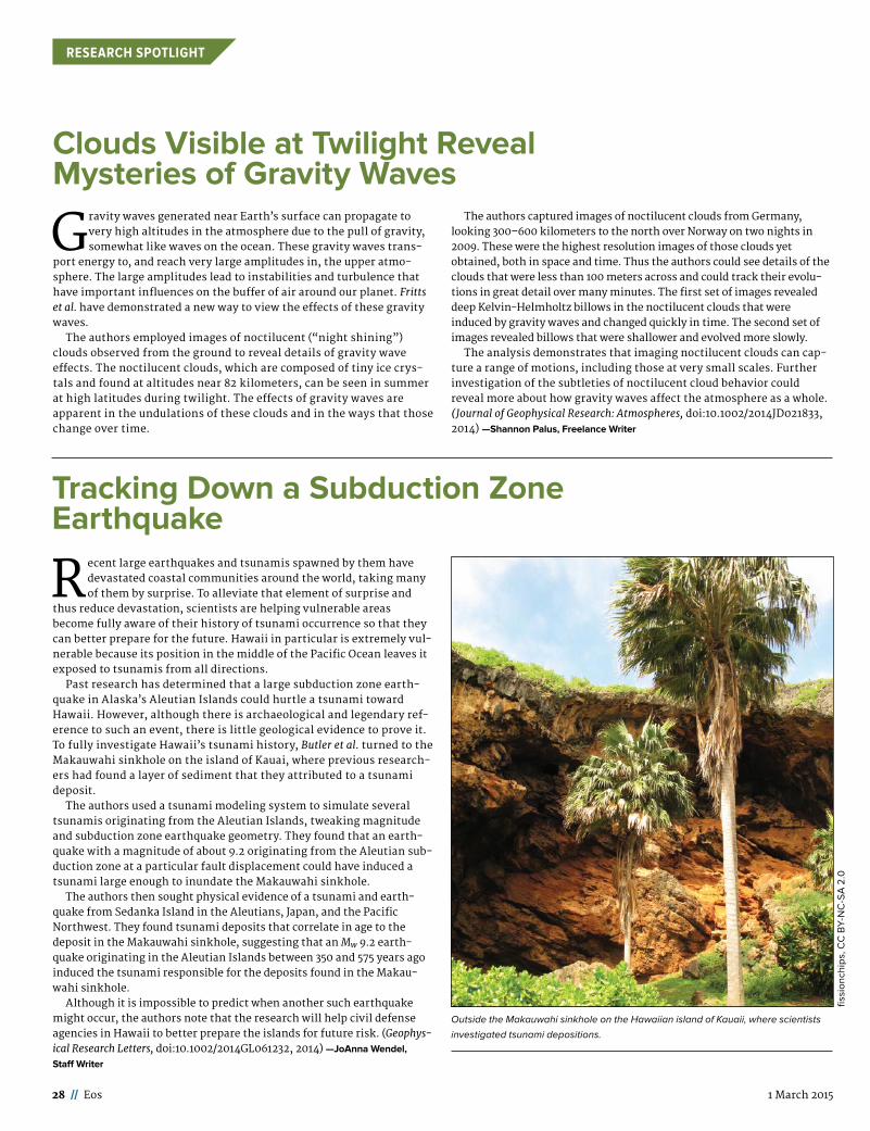
28 // Eos 1 March 2015
RESEARCH SPOTLIGHT
Tracking Down a Subduction Zone Earthquake
Recent large earthquakes and tsunamis spawned by them have devastated coastal communities around the world, taking many of them by surprise. To alleviate that element of surprise and
thus reduce devastation, scientists are helping vulnerable areas become fully aware of their history of tsunami occurrence so that they can better prepare for the future. Hawaii in particular is extremely vul-nerable because its position in the middle of the Pacific Ocean leaves it exposed to tsunamis from all directions.
Past research has determined that a large subduction zone earth-quake in Alaska’s Aleutian Islands could hurtle a tsunami toward Hawaii. However, although there is archaeological and legendary ref-erence to such an event, there is little geological evidence to prove it. To fully investigate Hawaii’s tsunami history, Butler et al. turned to the Makauwahi sinkhole on the island of Kauai, where previous research-ers had found a layer of sediment that they attributed to a tsunami deposit.
The authors used a tsunami modeling system to simulate several tsunamis originating from the Aleutian Islands, tweaking magnitude and subduction zone earthquake geometry. They found that an earth-quake with a magnitude of about 9.2 originating from the Aleutian sub-duction zone at a particular fault displacement could have induced a tsunami large enough to inundate the Makauwahi sinkhole.
The authors then sought physical evidence of a tsunami and earth-quake from Sedanka Island in the Aleutians, Japan, and the Pacific Northwest. They found tsunami deposits that correlate in age to the deposit in the Makauwahi sinkhole, suggesting that an Mw 9.2 earth-quake originating in the Aleutian Islands between 350 and 575 years ago induced the tsunami responsible for the deposits found in the Makau-wahi sinkhole.
Although it is impossible to predict when another such earthquake might occur, the authors note that the research will help civil defense agencies in Hawaii to better prepare the islands for future risk. (Geophys-ical Research Letters, doi:10.1002/2014GL061232, 2014) —JoAnna Wendel,
Staff Writer
Outside the Makauwahi sinkhole on the Hawaiian island of Kauaii, where scientists
investigated tsunami depositions.
fissi
onch
ips,
CC
BY-
NC
-SA
2.0
Clouds Visible at Twilight Reveal Mysteries of Gravity Waves
Gravity waves generated near Earth’s surface can propagate to very high altitudes in the atmosphere due to the pull of gravity, somewhat like waves on the ocean. These gravity waves trans-
port energy to, and reach very large amplitudes in, the upper atmo-sphere. The large amplitudes lead to instabilities and turbulence that have important influences on the buffer of air around our planet. Fritts et al. have demonstrated a new way to view the effects of these gravity waves.
The authors employed images of noctilucent (“night shining”) clouds observed from the ground to reveal details of gravity wave effects. The noctilucent clouds, which are composed of tiny ice crys-tals and found at altitudes near 82 kilometers, can be seen in summer at high latitudes during twilight. The effects of gravity waves are apparent in the undulations of these clouds and in the ways that those change over time.
The authors captured images of noctilucent clouds from Germany, looking 300–600 kilometers to the north over Norway on two nights in 2009. These were the highest resolution images of those clouds yet obtained, both in space and time. Thus the authors could see details of the clouds that were less than 100 meters across and could track their evolu-tions in great detail over many minutes. The first set of images revealed deep Kelvin-Helmholtz billows in the noctilucent clouds that were induced by gravity waves and changed quickly in time. The second set of images revealed billows that were shallower and evolved more slowly.
The analysis demonstrates that imaging noctilucent clouds can cap-ture a range of motions, including those at very small scales. Further investigation of the subtleties of noctilucent cloud behavior could reveal more about how gravity waves affect the atmosphere as a whole. (Journal of Geophysical Research: Atmospheres, doi:10.1002/ 2014JD021833, 2014) — Shannon Palus, Freelance Writer
Earth & Space Science News Eos.org // 29
POSITIONS AVAILABLE
Geochemistry
ASSISTANT or ASSOCIATE PROFESSOR IN PETROLEUM GEOCHEMISTRY CONO-COPHILLIPS SCHOOL OF GEOLOGY AND GEOPHYSICS THE UNIVERSITY OF OKLA-HOMA
The University of Oklahoma invites applications for a tenure-track posi-tion in Petroleum Geochemistry at the assistant or associate professor level. The ConocoPhillips School of Geology and Geophysics has a long and distin-guished history in Petroleum Geo-chemistry. We are seeking a creative, dynamic person to help us move for-ward into new and exciting areas of petroleum geochemical research, in particular, with respect to biomarker and stable isotope studies, and an effective teacher who will educate students so they can move into suc-cessful careers. The successful appli-cant will hold a Ph.D., have an aca-demic background in the geosciences, develop an externally funded research program, and teach undergraduate courses in geology in addition to grad-uate-level courses in petroleum geo-chemistry.
The ConocoPhillips School of Geol-ogy and Geophysics is housed in the Sarkeys Energy Center. The Petro-leum Geochemistry research facili-ties include wet chemistry laborato-ries for sample preparation and experimentation, all of which are equipped with fume hoods, chemical and solvent storage facilities, micro-balances, ovens, water purification facilities, etc. Instrumentation is state of the art, including 7 gas chro-matographs, gas chromatography/mass spectrometry instruments (a Thermo TSQ 8000 GC/MS/MS and two 5975 MSD systems), pyrolysis/gas chromatography instrumentation and high performance liquid chro-matographic equipment. Our stable isotope laboratories are equipped with conventional facilities for the off-line combustion, isolation, and purification of gases for stable iso-tope analysis. The laboratory houses 5 stable isotope ratio mass spectrom-eters, including a Thermo Delta V Plus, a MAT 252, a MAT 253, a Delta Plus XL and a Delta E for bulk and compound specific stable isotope analyses of organic and inorganic materials via dual inlet and in con-tinuous flow modes using elemental analyzers and gas chromatographs interfaced to the instruments.
Review of applications will begin April 1, 2015. The search will continue until the position is filled. The antici-pated start date for the position is August 15, 2015. Applicants are requested to submit a vita/resume, statement of research and teaching interests, and a list of five references who can be contacted, including tele-phone numbers, e-mail addresses, and mailing addresses. Questions or information requests should be addressed to the Chair of the Petroleum
Eos Positions Available ads can be viewed on Eos.org at https://eos.org/jobs-support.
LINE LISTING RATES: ➢ $0.32 per character for first issue of publication
➢ $0.26 per character for each additional issue of publication
STUDENT OPPORTUNITY RATES: ➢ No Cost up to 500 characters
➢ $0.16 per character over 500 characters for first issue of publication
➢ $0.16 per character for each additional issue of publication
EMPLOYMENT DISPLAY ADVERTISING RATES (OPEN RATE, BLACK AND WHITE): ➢ Full Page : $5,500.00 net
➢ Half Page: $2,160.00 net
➢ Third Page: $1,450.00 net
➢ Quarter Page: $1,090.00 net
➢ Sixth Page: $730.00 net
➢ Eighth Page: $590.00 net
➢ To view all employment display ad Rates, visit http://sites.agu.org/media-kitsfiles/2014/12/Eos-Employment-Advertising.pdf
COLOR RATES: ➢ One Color: $315.00 net
➢ Full Color: $980.00 net
➢ Eos is published semi-monthly on the 1st and 15th of every month. Deadlines for ads in each issue are published at http://sites.agu.org/media-kits/eos-advertising-deadlines/. ➢ Eos accepts employment and open position advertisements from governments, individuals, organizations, and academic institutions. We reserve the right to accept or reject ads at our discretion. ➢ Eos is not responsible for typographical errors.
For more information or to reserve an employment ad in Eos, contact [email protected]

30 // Eos 1 March 2015
POSITIONS AVAILABLE
Geochemistry Search Committee, at (405) 325-3253 or ougeochemistrysearchchair@ ou .edu. Applications should be addressed to Petroleum Geochemistry Search Com-mittee, ConocoPhillips School of Geology and Geophysics, The Univer-sity of Oklahoma, 100 East Boyd St., Room 710, Norman, OK 73019-1008.
The University of Oklahoma is an Affirmative Action, Equal Opportunity Employer. Women and minorities are encouraged to apply. Protected veter-ans and individuals with disabilities are encouraged to apply.
Research Associate in Stable Isotope Geo-chemistry Northern Illinois University
The Dept. of Geology and Environ-mental Geosciences at Northern Illi-nois University (NIU) invites applica-tions for a research associate position in stable isotope geochemistry. The successful candidate will hold a full-time, non-tenure track appointment. We seek candidates with a research focus in isotope ratio mass spectrom-etry, the ability to operate and main-tain analytical laboratory facilities supporting allied research across the university, and a desire to train stu-dents in analytical laboratory tech-niques. The capacity to collaboratively develop successful research propos-als, publish research results, and suc-cessfully generate and conduct con-tracted analyses is essential to the position. Applicants must have a
Ph.D. in geoscience or a related field; post-doctoral experience in a stable isotope laboratory is preferred. Appli-cations including CV, statement of research experience, accomplishments and interests, and 3 letters of recom-mendation should be submitted elec-tronically to the Dept. Chair, Mark P. Fischer, at [email protected]. Screen-ing of applications will begin March 1, 2015, and continues until the position is filled. For additional information about the position and the department, visit: www.niu.edu/geology. NIU is an AA/EEO institution that values diver-sity in its faculty, staff and students: we strongly encourage applications from diverse candidates, including women and minorities. A state-man-dated pre-employment criminal back-ground investigation is required.
Ocean Sciences
Faculty Positions in the Department of Geological Oceanography, Xiamen Uni-versity, China
Xiamen University (XMU) is located in the city of Xiamen, a “garden on the sea” in southern China, and has established a new Department of Geo-logical Oceanography as part of the College of Ocean and Earth Sciences (http://coe.xmu.edu.cn/) that offers undergraduate and graduate degrees. The college is one of the top oceano-graphic programs in China. We are also building a 3600-ton (78 m)
research vessel and a marine station for cutting-edge education and research in oceanography. XMU envi-sions the development of a world-class program in Geological Oceanog-raphy with focus on interdisciplinary studies of sediment processes and the sedimentary record in China’s unique marginal seas.
POSITION ONE: HEAD OF DEPART-MENT
We are seeking applications from international scientists for the posi-tion of the head of the department. The search will remain open until the position is filled.
Duties:1. Be in charge of the organization
and general operation of the Geologi-cal Oceanography Department, for-mulating and implementing the strat-egy in the development of the Geological Oceanography discipline, and leading the Department towards growth and excellence.
2. Be responsible for building up a strong teaching and research team; and improving the overall academic level of the team in such efforts as devising a long-term team-building plan, recruiting high-level talents, cultivating young researchers and enhancing teamwork.
3. Explore new approach for talent cultivation and nurture talents with creative thinking.
Qualifications: 1. The applicant should hold a doc-
toral degree and a full professorship (or an equivalent position) in a promi-nent overseas university (or research institutes).
2. The candidate may be a specialist in any field related to geological ocean-ography, including (but not exclu-sively): sedimentology, sedimentary geochemistry, sediment transport, seismic stratigraphy, sediment acous-tics, geotechnology, remote sensing, and numerical modeling of sediment transport and sedimentation.
3. Overseas experience (study or work) is required for this position. The candidate should have international perspective, strategic and creative thinking on the discipline develop-ment.
4. The candidate is expected to have distinguished academic credentials and international recognition for his/her achievements in research, schol-arship and teaching.
5. The candidate should have a proven record of high-level adminis-trative and leadership experience in a university setting, such as a depart-ment, a research institute or a labora-tory, and will be able to take charge of teaching, research, team-building, discipline development, social ser-vices and administration.
Salary and Benefits:1. Contract term: 4 years;2. Annual Salary: 600K-900K RMB
(1 US$~ 6.18 CYN) ;3. Other benefits and issues can be
negotiated.
POSITION TWO: FACULTY MEM-BERS
We are seeking applications from international scientists for up to 15 faculty positions. The search will remain open until positions are filled.
Duties:1. To teach undergraduate and grad-
uate courses in a full English or bi-lin-gual capacity;
2. Be capable to obtain university and outside funding to establish their own research laboratories and facili-ties and build a research program of global interests;
3. Be able to participate in research cruises.
Qualifications: 1. Applicants must hold a doctoral
degree in any field related to geological oceanography, and be a specialist in any field related to geological oceanog-raphy, including (but not exclusively): sedimentology, sedimentary geo-chemistry, sediment transport, seis-mic stratigraphy, sediment acoustics, geotechnology, remote sensing, and numerical modeling of sediment transport and sedimentation.
2. The applicants should be able to work across disciplinary boundaries, and have essential qualities for teamwork.
3. The rank of the appointment will be commensurate with the applicant’s qualifications and experiences.
Salary and Benefits:1. Contract term: 3 years for assis-
tant professor; 5 years for associate professor and full professor.
2. The appointment system will be applied to the successful candidates. The selected candidates will receive the standard compensation for the faculty members of Xiamen University at the same rank.
HOW TO APPLYInterested applicants should send a
cover letter indicating the intent of the application (department head or faculty), his/her CV, contact informa-tion for 3-5 references, a statement of purpose that includes courses intended to teach and research inter-ests and professional goals, and other supporting materials for the evalua-tion process to the Dean, Prof. Kejian Wang ([email protected]).
Research Positions in Ocean ModelingThe Department of Earth & Plane-
tary Sciences, Johns Hopkins Univer-sity, invites applications for postdoc-toral research associate or assistant research scientist positions. The suc-cessful candidate(s) will join a team that is developing and applying ocean circulation models to understand mechanisms of exchange across con-tinental shelves, particularly at high latitudes. Other opportunities in Arc-tic/Subarctic and Southern Ocean dynamical oceanography may also be available. The positions involve col-laboration with: Woods Hole Oceano-graphic Institution, Massachusetts Institute of Technology, and/or the Center for Environmental and Applied
PLACE YOUR AD
HEREContact [email protected] for information

Earth & Space Science News Eos.org // 31
POSITIONS AVAILABLE
Fluid Mechanics at Johns Hopkins. Further information about our rele-vant research and these collaborations may be found at: http://pages.jh.edu/~thaine1/
An ideal candidate will be a creative independent thinker with a Ph.D. in dynamical or physical oceanography, but applicants in related fields will also be closely considered. Knowledge in one or more of the following areas is advantageous: ocean circulation, numerical ocean models, high-lati-tude climate dynamics, and geophysi-cal fluid dynamics. The start date is negotiable, but completion of the Ph.D. is required. The appointment(s) will last up to three years. Appointees will receive a competitive salary and benefits and will be eligible to partici-pate in Johns Hopkins University health plans.
Applications should be submitted electronically through Interfolio at http://apply.interfolio.com/28665 by March 15, 2015 to receive full consid-eration. They should include a cover letter, your curriculum vitae plus the names and email addresses of three or more academic referees.
Johns Hopkins University is an equal opportunities/affirmative action employer. Minorities and women are particularly encouraged to apply.
|The University of Rhode IslandAssistant Professor, Coastal Oceanography
The Graduate School of Oceanogra-phy invites applications for a ten-ure-track Assistant Professorship in biological or chemical coastal ocean-ography. The position will be filled at the Assistant Professor level as an academic-year (nine-month) appointment. The anticipated start date is September 2015.
Located on the water’s edge at the URI Narragansett Bay Campus, the GSO is the State’s center for marine studies, research and outreach. Major facilities and programs at the GSO include the R/V Endeavor, the Coastal Resources Center, the Office of Marine Programs, Rhode Island SeaGrant, and the Inner Space Cen-ter. Relevant university-wide pro-grams include the URI Coastal Insti-tute. GSO students, faculty and staff collaboratively address the science questions and challenges of today. The new faculty member will be expected to develop a strong exter-nally funded research program, advise graduate students, and teach undergraduate and graduate courses.
Visit the URI jobs website at: https://pa660.peopleadmin.com to apply and read the full position description with required and pre-ferred qualifications for posting # (6001735). Application Deadline: Search will remain open until filled. First considerations will be given to applications received by April 15, 2015. Second consideration may be given to applications received by
May 15, 2015. Applications received subsequent to the second consider-ation date (May 15, 2015) may not be given full consideration. Please attach 3 (PDF) documents to your Fac-ulty Profile Application: (#1) Cover letter, (#2) Curriculum Vitae to include the names, email addresses, and telephone numbers of three ref-erences, and (#3) “Other Document” to include a statement of teaching and research interests (one combined document).
Only online applications will be accepted.
The University of Rhode Island is an AA/EEOD employer. Women, persons of color, protected veterans, individu-als with disabilities, and other pro-tected groups members are encour-aged to apply.
Vacancy AnnouncementTenure Track Assistant Professor in
Chemical OceanographyDecember 2014The School of Fisheries and Ocean
Sciences (SFOS) at the University of Alaska Fairbanks (UAF) seeks applica-tions from exceptional candidates for a tenure-track assistant professor posi-tion in chemical oceanography. Spe-cialties of interest include ocean acidi-fication, marine inorganic carbon chemistry, carbon biogeochemistry, carbon cycle-climate interactions, iso-tope biogeochemistry, and evaluation of the biological impact of ocean acidi-fication. We are particularly interested in applicants whose research plan involves the new ice-capable, Global Class Research Vessel Sikuliaq.
UAF is Alaska’s research university, North America’s Arctic university and a world leader in Arctic and climate change research. The successful applicant will enjoy opportunities for collaboration within SFOS’s vibrant high-latitude research program. The School offers a Minor in marine sci-ence, and MS and PhDs in oceanogra-phy and in marine biology. The UAF campus houses the Ocean Acidifica-tion Research Center (OARC), Alaska Stable Isotope Facility (ASIF), UAF’s Advanced Instrumentation Laboratory (AIL), the Core Facility for Nucleic Acid Analysis, and is linked to the joint NOAA, UAF Kasitsna Bay Laboratory, Alaska SeaLife Center and the Seward Marine Center. SFOS has over 60 fac-ulty based throughout Alaska and over 150 graduate students engaged in the-sis research in Alaska waters, and throughout the world.
Applicants must hold a Ph.D. in oceanography or closely related disci-pline, and preferably have post-doc-toral and teaching experience. The position requires research, education and service that support Alaska’s ocean resources and the communities that rely on them. The successful can-didate will be expected to teach core and/or develop specialty oceanogra-phy courses for the graduate and undergraduate academic programs,
develop a vigorous externally-funded research program and mentor gradu-ate students. Applicants must submit a statement of interest that outlines their qualifications for this position and includes a research plan, teaching statement, curriculum vitae, and names and contact information of at least three references. Applications must be submitted to Job Posting #0069942 at https:// www.uakjobs .com. For questions about the position, please contact Dr. Matthew Wooller, chair of the search committee, at [email protected]. Review of applications will begin February 15th. For full consideration applications should be received by March 1st, 2015.
Solid Earth Geophysics
Director, Study of Environmental Arctic Change (SEARCH)
The Study of Environmental Arctic Change (SEARCH) is a system-scale, cross-disciplinary, long-term Arctic research effort to understand the nature, extent, and future develop-ment of the system-scale change presently seen in the Arctic. SEARCH-related projects are sup-ported through US agencies, other national and international programs. The core mission of SEARCH is to pro-vide a foundation of Arctic change sci-ence through collaboration with the research community, funding agen-cies, and other stakeholders. SEARCH aims for scientific understanding of Arctic environmental change to help society understand and respond to a rapidly changing Arctic.
Recently SEARCH completed a stra-tegic planning process to define clear directions and priorities to move SEARCH to a fully implemented pro-gram. In addition to a new vision and mission, a set of 5-year science goals will advance knowledge of environ-mental Arctic change; details can be
found at www.arcus.org/search-pro-gram. SEARCH was recently awarded a grant to undertake new activities related to the science goals.
We are seeking a Director, report-ing to a SEARCH Science Steering Committee (SSC), to provide the pro-gram with management and scien-tific leadership to carry out its mis-sion. As a public leader, the Director represents the best interests of SEARCH to diverse constituencies, including scientists, federal agencies, decision-makers, and stakeholders on the international, national, state and local level. The Director will be responsible for directing day-to-day activities. The Director will enable and coordinate several SEARCH com-mittees in implementing the SEARCH mission.
Primary duties of the Director include management and evaluation of SEARCH program quality and effec-tiveness, including work with SEARCH “Action Teams” and various working groups; development of agency and stakeholder alliances in support of program goals; acquisition of external funding support; communication and coordination of program goals at the national and international level; work with the SSC on the development of a long-term strategy and associated implementation documents. We expect the successful candidate to seek external funding as opportuni-ties arise in order to support SEARCH program goals.
The position will be located at the International Arctic Research Center (IARC) at the University of Alaska Fairbanks (UAF), and will require travel to national and international coordination meetings. The position comes with a competitive employee package and - depending on level of success and accomplishments during the first two years - the potential for flexible work arrangements.

32 // Eos 1 March 2015
POSITIONS AVAILABLE
Position requirements include research experience in a scientific field relevant to studies of Arctic change and a Ph.D. degree (or equiva-lent) in a relevant field with ten or more years of subsequent, relevant experience. A strong background in and understanding of interdisciplin-ary research are important attributes of the position. The various duties require strong communication skills, both interpersonal and oral/written. The desired candidate will have the flexibility necessary to provide direc-tion in an evolving organization, with consensus-building skills to balance diverse perspectives while maintain-ing a sense of common purpose. This is a 12-month full-time contract, sub-ject to annual renewal. Full details are available at www.uakjobs.com/appli-cants/Central?quickFind=86322. For more information about the position contact Hajo Eicken ([email protected], SEARCH SSC Chair) or Helen Wig-gins ([email protected], ARCUS Direc-tor of Programs). Review of applica-tions will begin March 15, 2015 and the position will remain open until a suit-able candidate has been selected.
UAF is an Equal Opportunity Employer.
Space Physics
Tenure Track Faculty Position in Space or Planetary sciences, Embry-Riddle Aero-nautical University, FL
The Department of Physical Sci-ences at Embry-Riddle Aeronautical University Daytona Beach Campus invites applications for a Tenure-Track faculty position emphasizing space- or ground-based instrumentation and space systems engineering in the areas of space, atmospheric, or plane-tary sciences. The successful candi-date must have a strong experimental background. Any experience or strong interest in pursuing a research pro-gram involving small satellites or sounding rockets, or installations of ground-based instrumentation, would be an advantage. This position may be at any rank: assistant through full professor. Candidates must have a Ph.D. in any related discipline and be available by August 15, 2015.
The Physical Sciences Department has over 30 faculty members and a growing prominence in space and upper atmospheric research which has culminated recently in the founding of Center for Space and Atmospheric Research (http://csar.erau.edu/). The department is home to one of the leading ABET-accredited undergradu-ate Engineering Physics programs in the US, as well as growing BS Space Physics, BS Astronomy & Astrophys-ics, MS and PhD Engineering Physics programs.
Applications are under consider-ation now and the position will remain open until filled. Please submit appli-cations online, including a cover let-
ter, full CV, statements of teaching philosophy and research interests, as well as the names, telephone numbers and email addresses of at least three professional references. All materials should be submitted through the link at:
www.erau.edu/jobs, search for ‘Tenure Track’ at location Daytona Beach.
Inquiries may be addressed to: Dr. Terry D. Oswalt, Chair Dept. Physi-cal Sciences, (386) 226-7571; [email protected]
Interdisciplinary/Other
Colorado School of Mines Department of Geophysics Associate or Full Professor - Reservoir Characterization
Colorado School of Mines Depart-ment of Geophysics invites applica-tions for a regular academic faculty position in Geophysics, which is anticipated to be filled at the rank of Associate or Full Professor. For this position we seek an individual with a distinguished international reputa-tion in seismic techniques applied to exploration for, and development of, natural resources, who can integrate geophysical methods with applicable multi-disciplinary data for successful reservoir characterization.
Candidates must possess a doctoral degree in geophysics or a related field. Candidates must also possess superb interpersonal and communication skills and a collaborative style of research and teaching, and must have experience in collaboration with industry. Preference will be given to candidates whose research interests hold potential for multidisciplinary collaboration.
For the complete job announce-ment and directions on how to apply, visit: http://inside.mines.edu/ HR -Academic-Faculty
Mines is an EEO/AA employer.
GDL Foundation Fellowships in Structure and Diagenesis
The GDL Foundation supports study and research of chemical and mechanical interactions, structural diagenesis, in sedimentary basins. Practical applications are of particular interest.
We are currently seeking applica-tions from M.S. and Ph.D. candidates, post-doctoral researchers, and scien-tists for fellowships, up to $10,000, based on specific proposals for research and participation in meet-ings and conferences to share results.
Submit applications (available at: www.gdlfoundation.org) by April 1, 2015.
The Department of Environmental Studies & Sciences at Santa Clara University, a private Jesuit, Catholic university, seeks a renewable term lecturer in Environmental Science with a focus on energy and envi-ronmental technology, starting Fall 2015.
The nine-month, full-time, non-ten-urable position is for a three-year term, with reappointment contingent upon superior performance, per-sistent programmatic need, and avail-ability of funds. Deadline for applica-tion materials March 8, 2015. The full job ad is at https://jobs.scu.edu/ postings/2457. EEO/AA employer.
The stable isotope lab at Duke (DEVIL) seeks new clients for 13C,15N, 2H and 18O analyses. Quick turn-around for EA, GC-C, TCEA, dual inlet, GasBench. 20% discount for first-time clients. Contact Jon Karr at [email protected] or 919-660-7418.http:// nicholas.duke.edu/devil/
THE UNIVERSITY OF NEW BRUNSWICK, FREDERICTON
Department of Earth Scienceshttp://www.unb.ca/fredericton/
science/depts/earth-sciences/ index . html
The University of New Brunswick, Department of Earth Sciences, invites applications for a continuing (ten-ure-track) position at the Assistant Professor level to commence July 1, 2015 or as soon as possible thereafter.
The Department of Earth Sciences offers degrees in Earth Science, Envi-ronmental Geochemistry and Geolog-ical Engineering. We seek a candidate with teaching interests that will sup-port at least two of the Geological Engineering undergraduate program options of geoenvironmental, geo-technical and mineral resource geo-logical engineering. Qualifications required include a Ph.D. and postdoc-toral experience. Demonstrated excellence in research and excellent potential for teaching at the under-graduate and graduate levels are required.
The successful candidate is expected to develop an externally funded research program that com-plements the research in the Depart-ment of Earth Sciences and fosters faculty-student collaboration.
The successful candidate must have a PhD in Earth Sciences or Geological Engineering and must be registered, or be eligible to register, as a Profes-sional Engineer in the province of New Brunswick.
A letter of application including CV, statement of teaching and research interests, and the names of three ref-erees should be sent to:
Dr. Cliff Shaw, ChairDepartment of Earth SciencesUniversity of New BrunswickP. O. Box 4400Fredericton, NBE3B [email protected] deadline for receipt of applica-
tions is March 27th 2015. Interviews will occur on or before April 23rd 2015.
All qualified candidates are encour-aged to apply, however, Canadians and permanent residents will be given pri-
ority. Applicants should indicate cur-rent citizenship status. The Univer-sity of New Brunswick is committed to the principle of employment equity. This position is subject to budgetary approval.
Two Job Openings: Computational Earth Science Group, Los Alamos National Lab-oratory
Deputy Group Leader, Computa-tional Earth Science Group, Job ID# IRC37040 This position is 50% man-agement and 50% technical/science in either atmospheric modeling or sub-surface flow and transport modeling. Scientist 3/4: Subsurface Flow and Transport Modeling, Job ID# IRC36086 This position is for an experienced professional (generally greater than 5 years since degree) in the general area of computational hydrology, reservoir simulation, computational fluid dynamics or reactive transport. For full job descriptions visit the LANL web site: http://careers.lanl.gov
EOE
Student Opportunities
PhD/MSc opportunities Queen’s UniversityThe Railway Ground Hazard
Research Program is a collaborative effort among industry, academic institutions and the federal govern-ment of Canada. The program aims at developing innovative scientific and technical solutions to help railways manage the risks associated with ground hazards.
The Department of Geological Sci-ences and Geological Engineering at Queen’s University is seeking graduate students (both Phd and MSc) to fur-ther develop and optimize methodol-ogies for including remotely sensed data into a formal system to identify/characterize/monitor hazardous natu-ral rock slopes. Specifically, we invite candidates with expertise or interest in InSAR/PSInSAR, photogrammetry, LiDAR, rock mechanics, and natural hazards to apply. Further information is available by contacting Prof. J. Hutchinson ([email protected]) or Prof. A. Braun ([email protected]). To apply, please visit https://eservices.queensu.ca/apps/sgsapp/.
The Department of Civil and Environ-mental Engineering at Utah State Univer-sity invites applications for a PhD-level research assistantship beginning summer 2015. This opportunity is part of an NSF-funded study focused on the influences of river regulation on groundwater/surface water interac-tions and instream water quality at large reach scales. Candidates should have an M.S. preferably in engineer-ing, however those with degrees in related fields will also be considered. Please contact Dr. Bethany Neilson ([email protected]) for more information.

Dear Everyone,
There is one place in the world where you can actually go inside a magma chamber, predictably located in Iceland under the Thrihnukagigur volcano. Luckily for us, the magma had been long gone and the roof of the magma chamber is still intact. A very tall German Ph.D. student, David Diekrup, for scale.
Wish you were here,Melissa AndersonPh.D. student at the University of Ottawa, Canada
View more postcards athttp://americangeophysicalunion.tumblr .com/tagged/postcards-from-the-fi eld.
Postcards from the Field

Have an Idea or Topic to Present at the Fall Meeting?
Submit A Session Proposal
Deadline: 22 April, 11:59 P.M. EDT
You must be current in your 2015 membership dues in order to propose a session.
fallmeeting.agu.org