Embed Size (px)
Citation preview
Methow Valley Airport Beacon
VISUAL REPORT
February, 2013

Americans with Disabilities Act (ADA) Information
Materials can be provided in alternative formats by calling the ADA Compliance Manager at
360-705-7097 or [email protected]. Persons who are deaf or hard of hearing may contact
that number via the Washington Relay Service at 7-1-1.
Title VI Notice to the Public
It is Washington State Department of Transportation (WSDOT) policy to ensure no person
shall, on the grounds of race, color, national origin, or sex, as provided by Title VI of the Civil
Rights Act of 1964, be excluded from participation in, be denied the benefits of, or be otherwise
discriminated against under any of its federally funded programs and activities. Any person who
believes his/her Title VI protection has been violated may file a complaint with WSDOT’s Office
of Equal Opportunity (OEO). For Title VI complaint forms and advice, please contact OEO’s Title
VI Coordinator, Jonté Sulton, at 360-705-7082 or [email protected].
Methow Valley Airport Beacon Visual Report Page i
February 2013
Contents Acronyms and Abbreviations ................................................................................................................... ii
Introduction .................................................................................................................................................. 1
What is the Methow Valley Airport Beacon Visual Study? ............................................................... 1
Why is visual quality considered by WSDOT? .................................................................................... 6
What vocabulary and tools are used in this visual quality assessment?.......................................... 7
What government regulations apply to the views and visual characteristics within the study
area? ......................................................................................................................................................... 13
Existing Conditions.................................................................................................................................... 14
How does WSDOT collect the visual assessment information? ...................................................... 14
What is the study area and how was it determined? ........................................................................ 15
Who are the viewers and what stake do they have in visual quality? ........................................... 16
What is the current visual character of the study area?.................................................................... 20
How were the observation points determined? ................................................................................ 21
What is the current visual quality of the study area? ....................................................................... 21
Potential Effects .......................................................................................................................................... 27
How was the testing conducted? ......................................................................................................... 27
How were the photographs and video taken? ................................................................................... 29
Alternative 1: 8-Degree Angle .............................................................................................................. 30
Alternative 2: 10-Degree Angle ............................................................................................................ 38
Alternative 3: 12-Degree Angle and Baffling ..................................................................................... 45
Mitigation .................................................................................................................................................... 52
Which method provided the most mitigation? .................................................................................. 52
What other forms of mitigation can be applied? ............................................................................... 53
Recommendations .................................................................................................................................. 53
Appendix A: Feedback From Residents ................................................................................................. 55
Appendix B: Photographic Settings Used .............................................................................................. 79
Appendix C: Visual Quality Ratings ....................................................................................................... 82
Page ii Methow Valley Airport Beacon Visual Report
February 2013
Acronyms and Abbreviations
ACP Asphalt Concrete Pavement
CSS Context Sensitive Solutions
dbh diameter at breast height
EB Eastbound
FHWA Federal Highway Administration
GIS Geographic Information Systems
MP Mile Post
NEPA National Environmental Policy Act
NHS National Highway System
SEPA State Environmental Policy Act
USFS U.S. Forest Service
WB Westbound
WSDOT Washington State Department of Transportation
Methow Valley Airport Beacon Visual Report Page 1 February 2013
Introduction
What is the Methow Valley Airport Beacon Visual Study?
The Methow Valley State Airport is part of the National Plan of Integrated
Airport Systems (NPIAS). The Federal Aviation Administration (FAA)
recognizes NPIAS airports as public-use airports that are vital to serving the
public needs for air transportation. NPIAS airports must meet certain FAA
requirements. One of FAA’s requirements is that a NPIAS airport must
periodically update its Airport Layout Plan. The purpose of an Airport Layout
Plan is to define the current, short-term, and long-term needs of the airport
through a comprehensive evaluation of existing conditions and FAA airport
planning and design standards.
Beginning in March 2008, the Washington State Department of Transportation-
Aviation Division (WSDOT-Aviation) contracted with Century West
Engineering to update the Methow Valley State Airport’s Airport Layout Plan,
which had not been updated since 1995. As a part of this process, community
input was sought by Century West and WSDOT-Aviation, including:
The formation of a public advisory committee, made up of members of
the local community.
Public meetings:
March 25, 2008 – Aero Methow Rescue training room
November 18, 2008 – Aero Methow Rescue training room
March 19, 2009 – Twisp Community Center
May 20, 2009 – Sun Mountain Lodge, to present the preferred alternative
produced by the Plan
Following the May 20 public meeting, WSDOT-Aviation hosted a 30-day
public review and comment period, with documents posted on the WSDOT-
Aviation website. Based upon comments provided, refinements were made
that led to the final Airport Layout Plan-Preferred Alternative, which was
accepted by WSDOT-Aviation on July 1, 2009.
NPIAS airports are eligible to apply through FAA for federal funding of
improvements. WSDOT-Aviation applied for and received a federal grant for
this purpose. Safety improvements at the airport included replacing the
existing airport lighting and signing, adding visual approach aids, improving
the airport’s security, clearing obstructions, and improving the surface grading
Page 2 Methow Valley Airport Beacon Visual Report February 2013
at both runway ends. These improvements were intended to enhance the
safety and operations of the airport.
Upon substantial completion of the improvements project by July 14, 2012,
WSDOT-Aviation activated the new rotating beacon, which replaced the
previous pilot-activated beacon that was removed from service during winter
2007-2008. This new beacon meets FAA standards. This type of beacon is
operated from dusk to dawn at light intensity between 25,000 and 50,000
candelas at angles of 1 to 10 degrees operating at 22 to 26 flashes per minute—
flash duration of 75 to 300 milliseconds (ms)—and at an angle between 1 and
10 degrees measured at the center of the light beam. In no case shall the
elevation of the beam adjustment be less than 2 degrees above the horizon. The
Methow Airport’s beacon was set to 5 degrees, which is the factory setting, and
is now set at 8 degrees. Public response was immediate and highly
unfavorable. Residents reported that the sweeping beam filled the interiors
of their homes, preventing sleep, and blotted out the night sky environment,
which is highly valued by the Methow Community. Several residents
expressed concern for the local and transient wildlife in the area.
Following are examples of the feedback received at the time of activation and
after the visual testing. All feedback received by WSDOT-Aviation in regard to
this matter is included in Appendix A.
We live in the Methow valley overlooking the Winthrop Airport. This valley is known for its natural beauty, which includes the night skies resplendent with the milky way, planets, and sometimes, the Northern Lights. People in this valley are very conscientious about "Dark Sky" standards and work to keep the natural beauty primary in many ways, including reducing or eliminating outdoor lighting.
The new beacon at the Winthrop airport is massively intrusive to this environment. Our night time view is essentially eliminated since it turned on the night of 7/14/12. It turns around and around at 5 second intervals, illuminating only the hills on the surrounding valley, and the windows of the neighbors. It is the most obnoxious possible installation in this setting. I could see the light through my closed eyes last night and lost many hours of sleep.
I note the laudable intent of the airport improvement project: Safety. However, there is a glitch: Hardly any aircraft use the Methow facility. We watch the airport continuously and see occasional daytime aircraft come and go, including smokejumpers. However, the light is on all night, and over 4 years of residency, I cannot remember ever seeing a night landing of an airplane. Please note: The Winthrop airport has very light traffic, and virtually none at night. This beacon adds no tangible safety benefit to the airport, and has a substantial environmental and social impact. There are no regularly travelled flight paths over the Methow Valley, particularly at night.
Methow Valley Airport Beacon Visual Report Page 3 February 2013
This light could also disrupt night migrations of songbirds and bats at critical times of the year. Was this considered as a project impact?
It is my understanding that in the analysis of the original project it was emphasized that the new lighting system would be activated only by pilots when approaching, and therefore save our beautiful night skies. This is a good idea. Why is not the beacon attached to this same system?
The new Winthrop Airport beacon is a massive detriment to the quality of life in the mid Methow Valley. It serves no useful purpose and a sensible alternative exists for making it meaningful (i.e. pilot activated). Please, immediately place the beacon onto the same system as the runway lights (or turn it off) and save our night skies, our local beauty, and the neighbor's sanity.
Residents who contributed the initial feedback to WSDOT-Aviation had
impacted homes at various elevations, ranging from approximately 1,600’ to
over 2100’, and they were located in all four directions from the airport beacon.
Some of the reporting residents had homes that could be expected to have
experienced direct impacts from the beacon, and some were partially or total
blocked from direct effects and may have seen indirect impacts to the night
sky.
Indirect impacts to the night sky environment is also called light pollution,
photopollution, luminous pollution, or sky glow, and refers to the artificial
lightening of the night sky by light that is excessive, obtrusive, or scattered
from a beneficial source. Light pollution has been linked to disruption of the
circadian rhythm in humans and to hormone imbalances in humans and other
living organisms. Levels of acceptable artificial night lighting are subjective
and it is an evolving area of study. Measurements of levels of light pollution
(or sky glow) are in the early stages of becoming standardized, and are often
not governed by any local, state, or federal authority.
WSDOT-Aviation turned the beacon off in response to community feedback on
July 18, 2012.
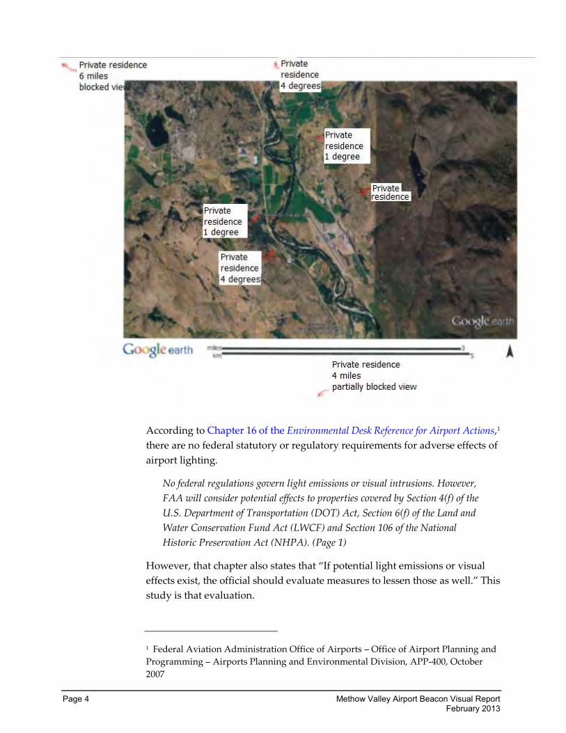
Exhibit 1-1 shows the general locations of the citizens who responded to
WSDOT-Aviation in regard to negative impacts of the new beacon. The
degrees shown on the map identify the difference between the center of the
beam and the location of the citizen responding based on the elevation and
distance from the beacon.
Page 4 Methow Valley Airport Beacon Visual Report February 2013
According to Chapter 16 of the Environmental Desk Reference for Airport Actions,1
there are no federal statutory or regulatory requirements for adverse effects of
airport lighting.
No federal regulations govern light emissions or visual intrusions. However,
FAA will consider potential effects to properties covered by Section 4(f) of the
U.S. Department of Transportation (DOT) Act, Section 6(f) of the Land and
Water Conservation Fund Act (LWCF) and Section 106 of the National
Historic Preservation Act (NHPA). (Page 1)
However, that chapter also states that “If potential light emissions or visual
effects exist, the official should evaluate measures to lessen those as well.” This
study is that evaluation.
1 Federal Aviation Administration Office of Airports – Office of Airport Planning and
Programming – Airports Planning and Environmental Division, APP-400, October
2007
Methow Valley Airport Beacon Visual Report Page 5 February 2013
The Methow Valley State Airport project does not impact lands protected by
Section 4(f) nor by Section 6(f). The State Historic Preservation Office was
contacted during the Environmental Review process to determine whether the
USFS North Cascades Smokejumper base qualified for inclusion under Section
106. The State Historic Preservation Officer determined that it did not. The
Airport Desk Reference also makes note of the fact that no federal thresholds
exist for light emission impacts.
Okanogan County code does not address airport lighting, and no night sky
ordinances govern the airport. There is a “Handbook of Suggested Development
Guidelines” that is used in the Methow Valley. While it could be applied to
some of the lighting used at the airport, it does not specifically address airport
beacons or runway lighting, and these lights are generally outside of its
purview.
FAA does provide guidance for mitigation of light impacts, including but not
limited to, those caused by airport beacons. This guidance includes altering the
angle of the beam, shielding the lighting fixture, using directional lighting, and
using minimal pole heights or reducing the wattage of the bulbs. Directional
lighting, minimal pole heights, and reduced wattage bulbs used in lighting are
typically mitigation efforts used for lighting of facilities at the airport, and are
inappropriate for mitigation of an airport beacon.
FAA also recommends that a lighting study be conducted “in locales where
high-intensity strobe lights shine directly into homes or other sensitive areas or
habitats.”
WSDOT does not have specific requirements concerning mitigation of light
impacts from an airport beacon, but does recognize the importance of
aesthetics and impacts to the visual environment. WSDOT-Aviation decided to
prepare a Visual Impact Report to analyze beacon impacts and to address the
concerns of local citizens. This report is prepared in accordance with Federal
Highway Administration (FHWA) standards, and includes testing angle
changes and light shielding of the beacon as suggested in the FAA Airport Desk
Reference.
This report is intended to assess the light impacts in order to assist
WSDOT-Aviation to begin the process of determining the appropriate
mitigation for the light emission effects of the new rotating beacon.
Accordingly, the following alternatives were tested and reviewed.
Page 6 Methow Valley Airport Beacon Visual Report February 2013
Alternative 1: 8-Degree Angle
Alternative 1 changed the angle of the rotating beacon from the manufacturer’s
recommended setting of 5 degrees to 8 degrees.
Alternative 2: 10-Degree Angle
Alternative 2 increased the angle of the rotating beacon to 10 degrees.
Alternative 3: 12-Degree Angle with Baffling
Alternative 3 adjusted the angle of the rotating beacon further to 12 degrees.
This is outside of the allowable angle range required by FAA for this type of
beacon. WSDOT-Aviation decided to test this angle to determine if enough
mitigation was offered at this angle to warrant the pursuit of a “modification to
standard” decision from FAA.
Shielding of the beacon was included in this alternative. This shielding covered
the bottom third of the beacon light, blocking light emissions traveling at a
downward angle and onto the reflective surface of the runway.
Existing Conditions
Existing conditions form the baseline for a visual analysis. In this instance, the
existing condition is considered to be the view without the beacon turned on,
which is most representative of the pilot-activated beacon system used by the
airport prior to 2008.
Why is visual quality considered by WSDOT?
The construction or modification of public facilities can have a considerable
effect on the quality and character of the landscape.
The National Environmental Policy Act (NEPA) requires that all actions
sponsored, funded, permitted, or approved by federal agencies undergo
planning to ensure environmental considerations, such as effects related to
aesthetics and visual quality, are given due weight in project decision making.
The State Environmental Policy Act (SEPA) mandates a similar procedure for
state and local actions.
Both SEPA and NEPA require that an environmental analysis be performed
during project development to minimize harm to the human, physical, or
biological environment. Both acts seek to provide safe, healthful, productive,
and aesthetically and culturally pleasing surroundings.
Methow Valley Airport Beacon Visual Report Page 7 February 2013
What vocabulary and tools are used in this visual quality
assessment?
FHWA’s method for assessing visual effects uses a generally accepted set of
tools and well-defined terms to describe the visual effects assessment. This is
composed of the following three criteria used to perform an appraisal of the
landscape visual quality:
Vividness: The memorability of the visual impression received from
contrasting landscape elements as they combine to form a striking and
distinctive visual pattern.
Intactness: The integrity of visual order in the natural and built landscape, and
the extent to which the landscape is free from visual encroachment or eyesores.
Unity: The degree to which the visual resources of the landscape join together
to form a coherent, harmonious visual pattern. Unity refers to the
compositional harmony or intercompatibility between landscape elements.
Expert evaluations based on the three criteria have proven to be good
predictors of the visual quality using the following equation:
Visual Quality = Vividness + Intactness + Unity
3
Each of the three criteria is independent. Each is intended to evaluate one
aspect of visual quality to determine the total visual quality rating for each
viewpoint.
Tools to Assess Visual Effects
The basic components used to describe visual character for most visual
assessments are the elements of form, line, color, and texture of the landscape
features. To further define visual character, the appearance of the landscape
can be defined in terms of its visible features, scale, diversity, and continuity.
These components make up the perceived “grain” of the landscape.
Page 8 Methow Valley Airport Beacon Visual Report February 2013
Vegetation
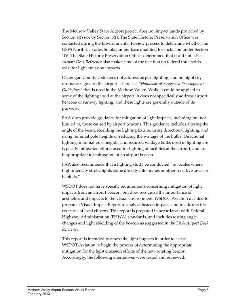
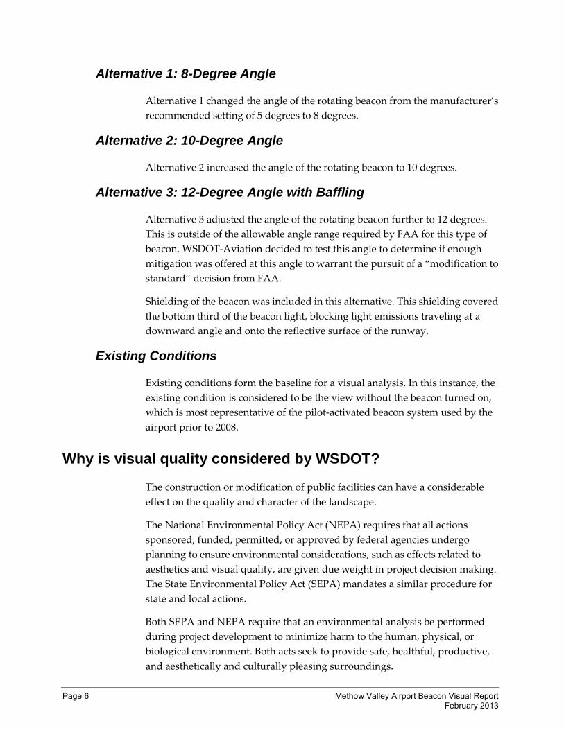
The natural resources and features used to define visual character include:
Landforms: Visual mass, scale, and shape of an object such as a
mountain, hill, or plain.
Vegetation: Species, color, size, maturity, form, placement and scale.
Water forms: Existence in the view, mass, color, linear form, size, type,
and condition of lakes, rivers, ponds, wetlands, estuaries, and oceans,
including reflected light.
The human-use features and resources used to define visual character include
the following:
Land uses: Size, scale, and character of associated buildings and features
making up land uses, including historic structures, downtown skylines,
and the apparent upkeep and maintenance of the built environment.
Transportation facilities: Types, sizes, scale, and orientation.
Overhead utility structures and lighting: Types, sizes, and scale.
Open space: Type (e.g., parks, reserves, greenbelts, and undeveloped
land), extent, and continuity.
Viewpoints and views to visual resources.
Methow Valley Airport Beacon Visual Report Page 9 February 2013
The FHWA Visual Assessment Method also uses three important analytical
tools, which are described below:
Landscape Character Units: Subunits of a study area that make
evaluating the entire study area easier. Visual character and visual
continuity define these landscape units. Landscape character units are
experienced by a viewer as passing through outdoor “rooms.”
Viewshed: Defined as the study area that viewers can see from a
viewpoint or from which a viewpoint is seen.
Visual Simulations: A means of graphically depicting the probable
changes due to the project and the relative scales of the existing and
proposed features apparent from the key viewpoints.
Source: Visual Impact Assessment for Highway Projects, FHWA 1988.
Quantitative Analysis
FAA does not have an established methodology for reviewing the visual
impacts of a project outside of NEPA. WSDOT routinely uses FHWA’s process
for reviewing visual impacts to its projects. Although this is not a highway
project, the FHWA methodology is well established and accepted and can be
applied to an aviation project. The visual quality analysis was conducted in
accordance with the U.S. Department of Transportation, FHWA Visual Impact
Analysis for Highway Projects (FHWA, 1988). This study complies with the
guidelines outlined in the WSDOT Environmental Procedures Manual (M 31-11),
Chapter 459 “Visual Impacts.”
This visual quality report reviews and analyzes the visual or aesthetic effects of
the Methow Valley Airport beacon replacement. Visual effects will be analyzed
from five viewpoints, known as observations points. The analysis describes
both the existing conditions with the beacon turned off, as well as the effect of
the beacon modification upon the viewer.
Visual quality is inherently subjective. It reflects the perspective of the person
(viewer) perceiving the visual environment and the various values,
expectations, and interests the viewer relates to as the viewer processes the
surroundings. WSDOT uses the FHWA methodology to evaluate the visual
resource in an objective qualitative process. This method is rigorous and
systematic. It ensures that the information gathered is adequate to contribute
to the project decision-making process, and that the assessment and
descriptions are as objective as possible. Visual assessments are prepared by
trained professionals exercising professional judgment. The process is
repeatable by other experts. The concerns of local citizens are taken into
Page 10 Methow Valley Airport Beacon Visual Report February 2013
consideration through the use of public documents such as local ordinances,
planning documents, corridor planning guidelines, websites, and letters from
citizens.
WSDOT uses the Visual Quality Criteria Rating Scale and Visual Analysis
Matrix to evaluate the existing conditions and the potential effects and benefits
of the project. This matrix, developed by WSDOT for conducting visual quality
assessments, includes a numeric ranking system to measure visual quality.
Examples of the rating system are shown below.
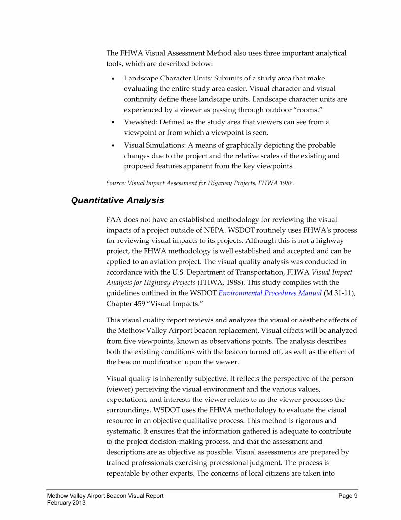
Vividness Rating
This view toward Mt. Rainier is exceptionally vivid.
Very High (Rating value = 7): The visual impression received is highly
memorable as contrasting landscape elements combine to form distinctive
visual patterns. Strongly defined landscapes or landforms are noted, including
mountains, large bodies of water, distinctive patterns, colors, and textures of
vegetation or significant human-built structures.
Average (Rating value = 4): The visual impression received is moderately
memorable, with some distinctive patterns; moderately defined landscape or
landforms are present, including low rolling hills and smaller water bodies.
Vegetation patterns, colors, and textures are less visible. Some significant
human-built structures may be present.
Very Low (Rating value = 1): The visual impression received is of low
memorability. Little visual pattern is formed because landscape elements do
not combine to form a striking and distinctive pattern. Homogeneous
landforms or landscapes and small bodies of water may be present. Vegetation
patterns, colors, and textures are not noticeable and human-built structures are
insignificant or not memorable.
Methow Valley Airport Beacon Visual Report Page 11 February 2013
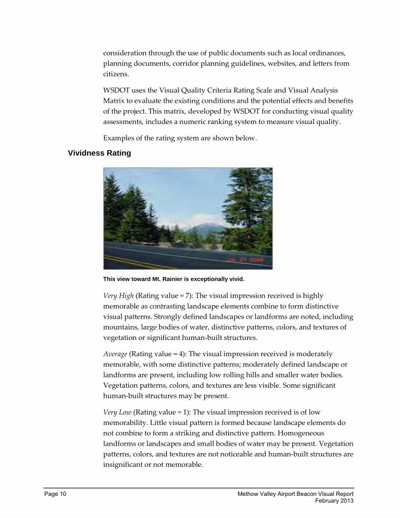
Intactness Ratings
Very High (Rating value = 7): There is a high visual integrity between the
natural and human-built landscape, to the extent that the landscape is free
from visual encroachment. Visual integrity occurs where natural areas and
human-built landscapes blend into the surrounding character and create no
visual discontinuity between the natural and human-built elements. Natural
and human-built patterns are not disturbed and they maintain visual order.
Average (Rating value = 4): There is an average visual integrity between the
natural and human-built landscape. Some visual encroachment onto the
landscape is present and it lacks visual order. There is some disruption of the
natural and human-built patterns.
Very Low (Rating value = 1): There is low visual integrity between the natural
and human-built landscape features. Visual encroachment onto the landscape
is very apparent. The pattern of elements is disrupted and the integrity of the
natural visual order is lost.
Page 12 Methow Valley Airport Beacon Visual Report February 2013
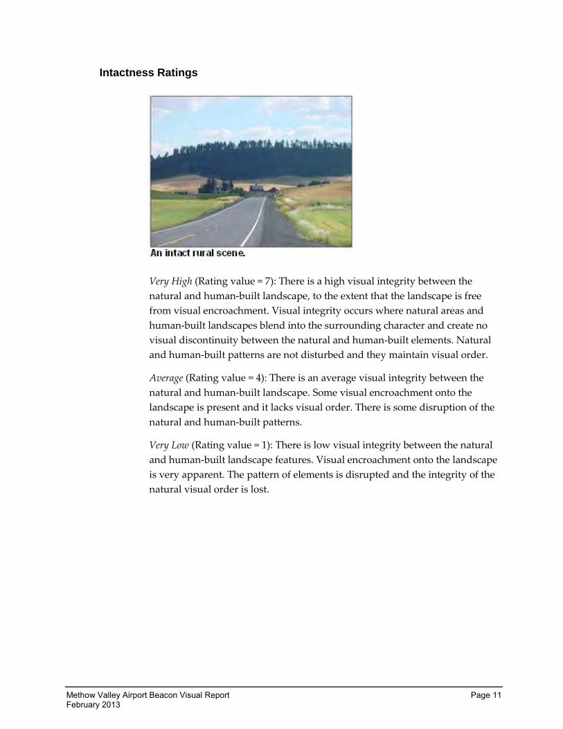
Unity Rating
Very High (Rating value = 7): The visual elements of the landscape join together
to form a highly coherent, harmonious visual pattern. Human-built and
natural elements blend together.
Average (Rating value = 4): The visual elements of the landscape join to form a
moderately coherent, harmonious visual pattern. Human-built elements blend
with natural elements, but the visual order is disrupted.
Very Low (Rating value = 1): Visual resources do not join to form a coherent,
harmonious visual pattern. Human-built elements do not have a visual
relationship to natural landforms or land cover patterns and visual order is
lacking.
Total Visual Quality Ratings:
The visual quality rating is the sum of the three scores divided by three. Visual
quality ratings are based on the following ranges:
5.7 – 7.0 = Very High
4.7 – 5.6 = High
3.7 – 4.6 = Moderately High
2.7 – 3.6 = Average
1.9 – 2.6 = Moderately Low
1.1 – 1.8 = Low
0.0 – 1.0 = Very Low
Views may improve or decline after a project. Change in a view that results in a
lower rating than existing is considered a decline in visual quality. Conversely,
change in a view that results in a higher rating than existing is considered an
improvement in visual quality.
Methow Valley Airport Beacon Visual Report Page 13 February 2013
Based on the evaluation of potential effects on visual quality and aesthetics,
this report will review the mitigation measures that may be taken to reduce
negative impacts to visual quality.
What government regulations apply to the views and visual
characteristics within the study area?
A number of federal and state regulations ensure the effects of transportation
projects on visual resources and aesthetics are adequately considered. NEPA
Section 101(b)(2) states that it is the “continuous responsibility” of the federal
government to “use all practicable means” to “assure for all Americans
safe, healthful, productive, and aesthetically and culturally pleasing
surroundings.” Federal regulations, which address visual quality, include
the following:
Federal Regulations
National Environmental Policy Act (NEPA), 42 USC Section 4231-4335;
Section 101(b)(2)
Section 4(f) of the Department of Transportation Act, 49 USC
303(b)-303(c)
Highway Beautification Act, 23 USC, 131, 136, and 319 and 23 CFD
750-752
Wild and Scenic Rivers Act, 16 USC 1271-1287
Historic Preservation Act, 16 USC 470-1
State Regulations
In addition to federal regulations, several state regulations address visual
quality and aesthetics, including those listed below:
State Environmental Policy Act (SEPA) (Revised Code of Washington
43.21C)
Washington Administrative Code (WAC) 197-11; WAC 468-12
Page 14 Methow Valley Airport Beacon Visual Report February 2013
Existing Conditions
How does WSDOT collect the visual assessment information?
The first step in assessing visual quality is to understand existing conditions.
Existing conditions are assessed by visiting the project vicinity and the
surrounding area multiple times. During these site visits, existing conditions
are documented, such as the user groups, visual resources, and viewsheds.
WSDOT also documents and photographs visual resources at selected
viewpoints, referred to as observation points, during the site analysis.
Subsequent to the site visits, additional background materials such as maps,
aerial photographs, and various FAA guidance documents, and pertinent data
on the airport improvements are reviewed.
Existing conditions are then evaluated in accordance with the FHWA’s Visual
Impact Assessment for Highway Projects methodology. This includes the
following components:
Identifying the existing regional visual character
Identifying the affected viewshed
Determining the visual resources of the project site
Identifying observation points
Determining the viewers—those who have a view of and from the project
Identifying the sensitivity of the viewers
Describing and evaluating the visual landscape under existing conditions
Describing and evaluating the differences to the visual landscape as it
appears under each alternative
Methow Valley Airport Beacon Visual Report Page 15 February 2013
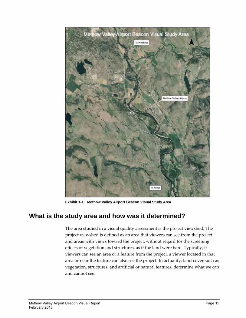
Exhibit 1-1 Methow Valley Airport Beacon Visual Study Area
What is the study area and how was it determined?
The area studied in a visual quality assessment is the project viewshed. The
project viewshed is defined as an area that viewers can see from the project
and areas with views toward the project, without regard for the screening
effects of vegetation and structures, as if the land were bare. Typically, if
viewers can see an area or a feature from the project, a viewer located in that
area or near the feature can also see the project. In actuality, land cover such as
vegetation, structures, and artificial or natural features, determine what we can
and cannot see.
Page 16 Methow Valley Airport Beacon Visual Report February 2013
For the purposes of this study, the project area can be defined as a single
viewshed. The Methow Valley Airport lies on the valley floor adjacent to the
Methow River. On the other side of the river as well as behind the airport, the
hills rise rapidly to enclose the valley. The valley runs in a mainly north-south
direction. The hillsides to the east and west are steep and the valley floor is
relatively narrow. The riparian area around the Methow River is treed and
filters some of the light from the airport to similar elevations on the opposite
shore. Because the beacon shines upward at an angle between the original
factory setting of 5 and the maximum setting of 12 degrees, these trees do not
provide screening for residences on the hillsides around the airport. The
hillsides are partially treed; however, the majority of the native vegetation is
shrub-steppe. Shrub-steppe environments are arid and are made up of shrubs
such as bitterbrush, rabbit brush, and greasewood, along with native grasses
and low-growing forbs. These plants do not provide a visual buffer for the
effects of the airport beacon.
The project area was based largely on feedback received from the general
public after the new beacon was turned on, aerial mapping, and on-site
reconnaissance completed prior to testing. The project area extends from the
Bear Creek Golf Course, approximately 2 miles to the north, to the Riverbend
RV Park, approximately 2 miles to the south of the airport. Hillsides to the east
were viewed from an elevation of approximately 2,300’ and to the west at an
elevation of approximately 1,850’. All of the project area lies outside the
jurisdictional boundaries of Twisp and Winthrop.
Who are the viewers and what stake do they have in visual
quality?
The Methow Valley Airport Beacon Study groups the viewers into two
categories: those who travel through the corridor around the airport and those
who are neighbors of the airport. Transient users can be described as tourists
or commuters. Tourism plays a strong role in the economy of the Methow
Valley, and special attention was paid to this group. Neighbors of the Methow
Valley Airport include residents, adjacent property users, and adjacent
business users who have views of the airport or whose view may be impacted
by the airport beacon. These two groups sometimes overlap.
User groups were also evaluated for viewer “sensitivity.” The activity that the
viewer is involved in, the duration or period of time the view is perceived by
the viewer, and the frequency or how often the view is perceived by the viewer
affects the sensitivity of the viewer. In general, a person living near the airport
Methow Valley Airport Beacon Visual Report Page 17 February 2013
will be more “sensitive” to visual changes than a traveler driving past the
airport once, because the resident’s duration or frequency of view will be
greater. The identified user groups are described in the following sections.
Transient Users
Transient users can be split into three categories with various degrees of
sensitivity. These groups include drivers using SR 20, who are simply passing
through the area; commuters, who live in the area or nearby and use the
roadway daily or nearly daily; and tourists/recreationalists who are making
the Methow Valley and the towns of Twisp and Winthrop (or adjacent lands)
a destination. SR 20, the North Cascades Highway, is also a popular scenic
drive in its own right and is part of both the Cascade Loop and the North
Cascades Scenic Highway. The North Cascades Smokejumper Base is specifically
mentioned in the description of activities on the North Cascades Scenic Highway.
Drivers, those viewers who are using SR 20 infrequently, exclusive of those
driving SR 20 as a destination/activity, have a moderate sensitivity.
Tourists/Recreationalists may be unused to the area and more likely to be
taking in their surroundings, whereas those using the corridor more frequently
are more focused on the purpose of the trip rather than the experience. These
viewers, while moderately sensitive have low viewing frequency. The beacon
is designed to be active from dusk to dawn.
Drivers who are using SR 20 as its own destination can be expected to be very
sensitive to the view. Passive motorists, such as vehicular passengers, are also
generally more sensitive to views. Motorist recognition increases where
changes in the landscape character occur. All individual views from the
roadway last a relatively short time due to the movement and speed of the
viewer. View duration varies with the season and climatic conditions. Since
tourists travel to see the countryside through which they are passing, the
sensitivity of this group is high. Recreational driving is typically timed during
daylight hours when the beacon is not active.
Commuters who frequently and routinely travel the roadway generally
possess moderate visual sensitivity to their surroundings. The passing
landscape becomes familiar to these viewers, and they typically focus their
attention on the technical aspects of driving, rather than the passing views. At
standard roadway speeds, views are of short duration and roadway users are
fleetingly aware of their surroundings, including traffic, road signs, and other
visual features. However, these viewers do notice changes in the visual
environment. Therefore, these viewers are generally considered to have
moderate visual sensitivity. Viewers with this level of sensitivity can be
Page 18 Methow Valley Airport Beacon Visual Report February 2013
anticipated to become more sensitive during winter driving conditions during
darkness when the effects of the beacon become more noticeable. However,
SR 20 is at a similar elevation as the airport and is partially screened from the
effects of the beacon by riparian vegetation when leaves are on the trees.
Visual sensitivity is generally highest for views seen by tourists and other
recreationalists as well as seasonal residents. Like recreational drivers, these
groups are actively viewing the landscape. The area around the Methow
Valley Airport is used by fisherman, campers, day hikers, bicyclists, and other
sports enthusiasts. The towns of Twisp and Winthrop base a significant
portion of their economy on tourism.
This area has a number of seasonal residents, who have sought out the area for
its scenic beauty as a place to keep a second home. These viewers can be
expected to be very sensitive to changes in the viewshed.
Neighbors
Residents
Residences surround the Methow Valley State Airport at various elevations
and have various levels of naturally occurring plant screening. Homes located
above the airport on the exposed hillsides to the east and west experience the
maximum direct effects of the beacon. Other homes located nearby may
experience the ambient effects of the beacon and reflected light, as well as
impacts to stargazing.
Residential viewers typically have extended viewing periods and are
concerned about changes in the views from their homes; these viewers are
generally considered to have high visual sensitivity.
Those residents that experience the direct effects of the beacon can be
described as the most sensitive viewers. They not only have extended viewing
periods and concerns about the changes in the views from their homes, but
also have light directly intruding into their homes from the beacon. As this is a
rotating beacon, these effects become difficult for the average viewer to
acclimatize to, as the effects are intermittent in nature. Several of the directly
affected residents have also complained of the impacts to the night sky
environment, noting that the beacon makes photographing or observing the
sky with a telescope difficult. They report that the transient nature of the
beacon causes the eye to be drawn to the light, further negatively impacting
their enjoyment of the view from their own property. Several have stated that
their sleep was impacted by the beacon, and that their daily lives inside their
own homes were impaired by its light.
Methow Valley Airport Beacon Visual Report Page 19 February 2013
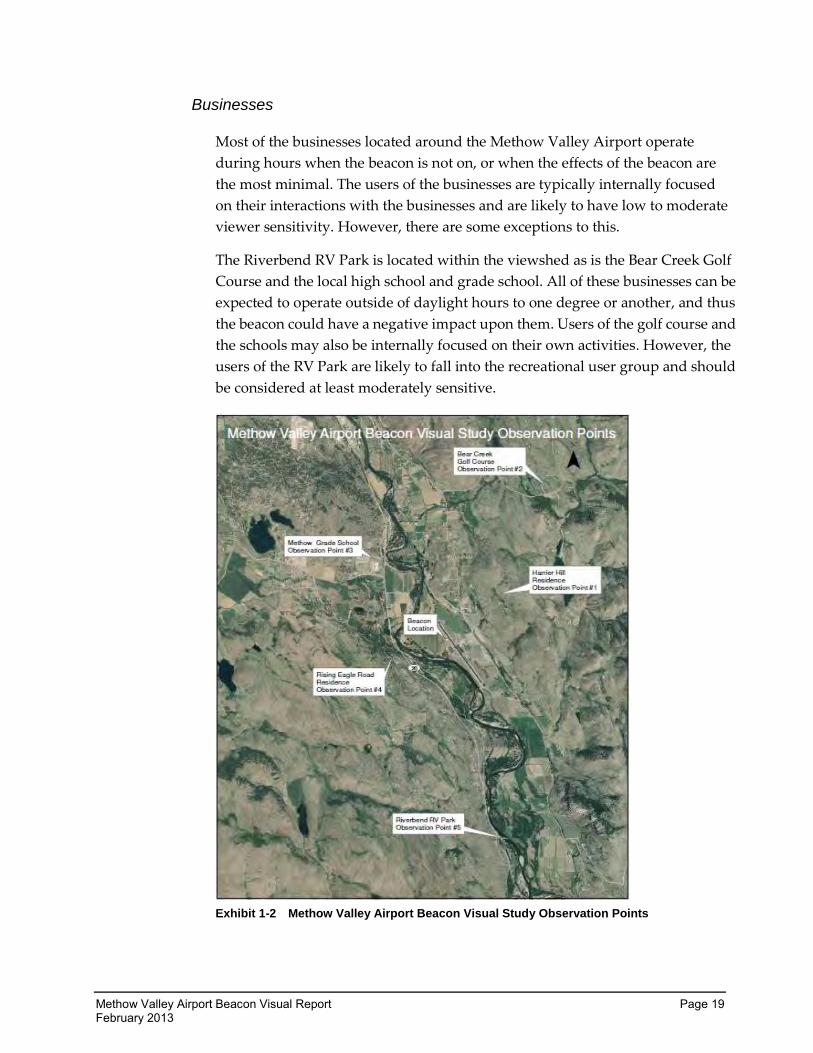
Businesses
Most of the businesses located around the Methow Valley Airport operate
during hours when the beacon is not on, or when the effects of the beacon are
the most minimal. The users of the businesses are typically internally focused
on their interactions with the businesses and are likely to have low to moderate
viewer sensitivity. However, there are some exceptions to this.
The Riverbend RV Park is located within the viewshed as is the Bear Creek Golf
Course and the local high school and grade school. All of these businesses can be
expected to operate outside of daylight hours to one degree or another, and thus
the beacon could have a negative impact upon them. Users of the golf course and
the schools may also be internally focused on their own activities. However, the
users of the RV Park are likely to fall into the recreational user group and should
be considered at least moderately sensitive.
Exhibit 1-2 Methow Valley Airport Beacon Visual Study Observation Points
Page 20 Methow Valley Airport Beacon Visual Report February 2013
What is the current visual character of the study area?
Visual character describes how form, line, color, and texture combine to create
a sense of dominance, scale, diversity, or continuity within a particular area.
Visual character is not a description from a particular view, but rather an
overview of the natural and built landscape features and their relationships
that together lend a distinct character to an area.
Regional Character
The regional landscape establishes a frame of reference for comparing the
visual effects of project alternatives and determining the significance of these
effects.
Project Vicinity Character
This analysis includes a portion of the Methow Valley between the towns of
Twisp and Winthrop. This area can be described as rural in character. Most of
the valley floor has been converted from native vegetation to agricultural or
commercial usage. The steep hillsides are lightly populated with large areas of
native shrub-steppe vegetation. The Methow River runs alongside the airport
and the river has a treed riparian buffer. SR 20 lies across the Methow River
from the airport and runs in a northwest-southeast direction. The town of
Twisp is located 4 miles to the southeast, and the town of Winthrop is located
3 miles to the northwest.
The airport itself falls into the Okanogan County Airport Development
District. This zone permits all aviation-related uses and a variety of
non-aviation uses that exclude residential. Okanogan County designates the
area outside the airport as Methow Review District, which was established to
“protect the sensitive environmental, aesthetic, and economic qualities of the
Methow Valley through review and in the imposition of more stringent
development and subdivision standards.” Parcel size for residential dwellings
is limited to 1 dwelling unit per 5 or 20 acres, depending on the exact location.
Study Area Roadside Classification
The WSDOT Roadside Classification Plan designates roadside character
classifications for state roadways and is the policy for management of the
roadside. The section of SR 20 that runs the length of the study area is
designated as rural. Areas located both immediately north and south of the
study area are designated suburban and include the towns of Winthrop on one
end and Twisp on the other.
Methow Valley Airport Beacon Visual Report Page 21 February 2013
The rural landscape is characterized by intermixed built and natural or
naturalized elements. Built elements begin to encroach on the natural
environment and human manipulations of the land are evident; however,
landforms and vegetation appear natural and vegetation is predominantly
native. Non-native vegetation, where it exists, reflects historical land use, such
as an orchard next to the roadway or a pasture sown with forage grasses for
grazing livestock. Roadsides classified as rural may also contain remnants of
the indigenous forested landscape. The rural designation in this corridor refers
to a pattern of sparse residential and agricultural development and scattered
neighborhood commercial centers in the greater context of a prevailing rural or
forested landscape.
How were the observation points determined?
Observation points identify and compare the visual effects of existing
conditions to conditions during beacon testing. There were five observation
points chosen, which reflect the views of identified viewers. Care was taken to
ensure all types of viewers were considered.
Four possible criteria were used in the selection of observation points:
The view is typical of other similar landscape profiles and is in a public
location that has a number of sensitive viewers nearby.
The view represents moderate to extreme changes in the visual quality or
character of scenic views, historic buildings, designated viewpoints, or
view corridors and is in a location where there are sensitive viewers.
The view is what a person walking, biking, driving, or riding will see.
A substantial portion of the impacted area is visible from the observation
point.
What is the current visual quality of the study area?
This visual quality of the Methow Valley is generally high. It is largely a
shrub-steppe environment, and native vegetation in the area surrounding the
airport is healthy and diverse. Much of the valley floor has been converted to
agriculture. Many residents volunteered that they value the night sky in the
area, which is naturally dark with little ambient light pollution.
Page 22 Methow Valley Airport Beacon Visual Report February 2013
Observation Points
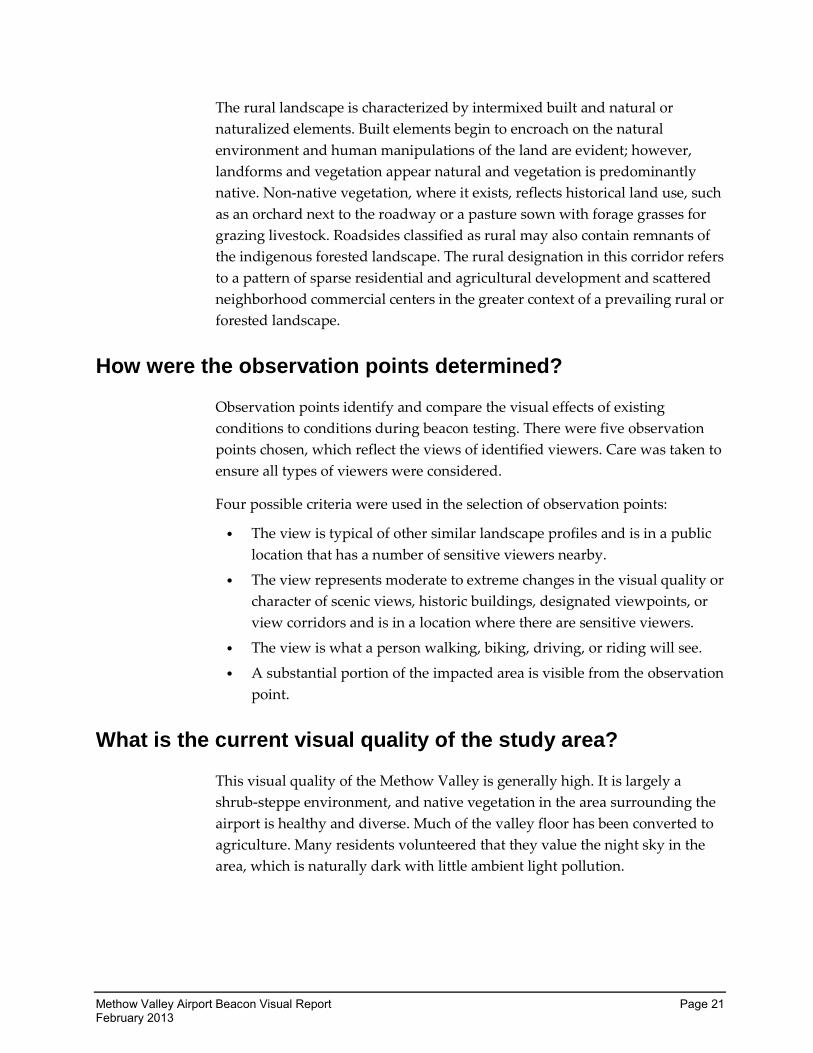
Observation Point 1: Harrier Hill Residence
Exhibit 1-3 Observation Point 1: View from the Harrier Hill Residence toward the airport
This observation point is located on private property. Prior to the visual
quality report, the Harrier Hill residents reported to WSDOT-Aviation that
they were negatively impacted by the new airport beacon, both by direct
effects of the beacon and by the ambient effects. They are located northeast of
the airport at an approximate elevation of approximately 2,300’. There are no
naturally occurring vegetated buffers between the airport and the Harrier Hill
residence. The Harrier Hill residence represents the group of viewers thought
to be most impacted by the new beacon and the viewer type most sensitive to
changes in the viewshed.
The Vividness at the observation point is high. The landform is high in
Vividness, the vegetation is an excellent example of a mature shrub-steppe
ecosystem, and constructed elements are average. No water is visible in this
view. Observation Point 1 received a high rating for Intactness. The level of
development is limited and has few visual encroachments or eyesores within
the view. This is a unified rural landscape. The total visual quality rating based
on these three categories is 6, a high score.
Methow Valley Airport Beacon Visual Report Page 23 February 2013
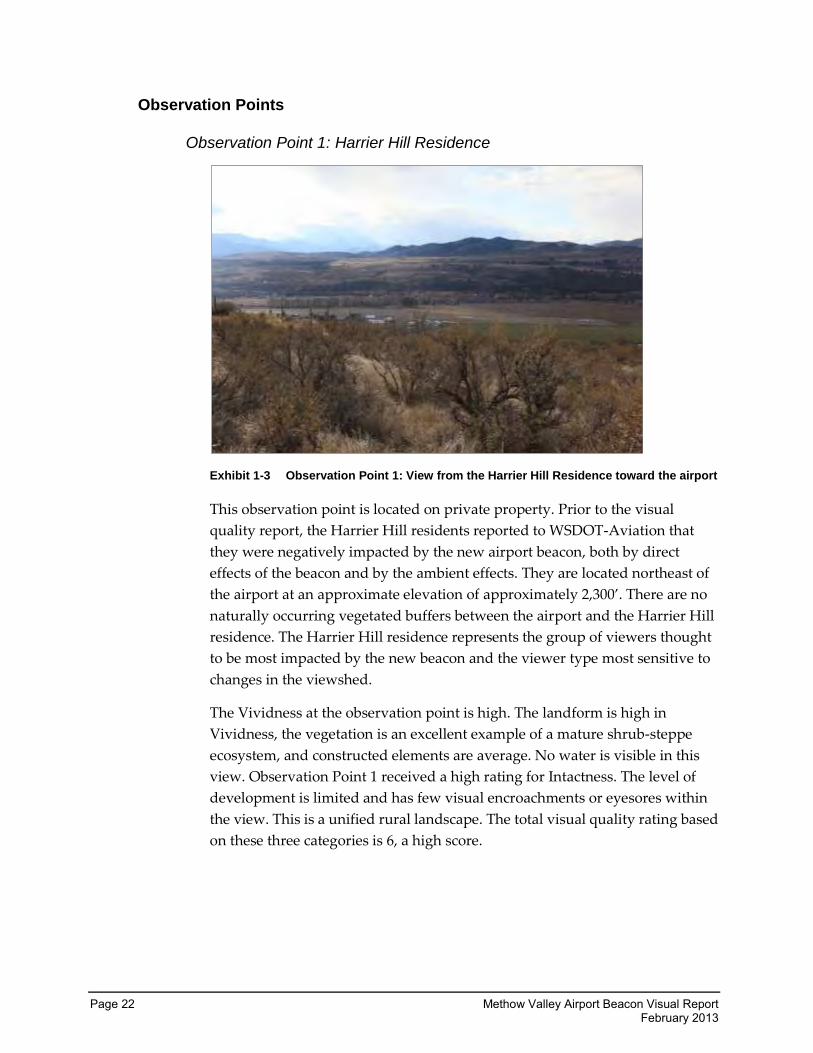
Observation Point 2: Bear Mountain Golf Course
Exhibit 1-4 Observation Point 2: View from Bear Mountain Golf Course toward the airport
Observation Point 2 is located in a parking area associated with the Bear
Mountain Golf Course. This location is also northeast of the Methow Valley
Airport. Elevation at this location is approximately 2,000’. A natural visual
buffer exists between Observation Point 2 and the airport. The hillside to the
south also partially blocks the direct effects of the beacon. This observation
point was chosen to evaluate the ambient effects of the beacon and to represent
both neighboring businesses and recreational users, both of whom can be
expected to be moderately to highly sensitive.
This observation point was rated high for Vividness due to its striking rolling
topography and variety of native vegetation. Observation Point 2 is an intact
rural landscape with a lack of encroaching development. It has a very high
rating for its Unity with the surrounding landforms and land cover. The
overall visual quality rating for this viewpoint is 6, a high score.
Page 24 Methow Valley Airport Beacon Visual Report February 2013
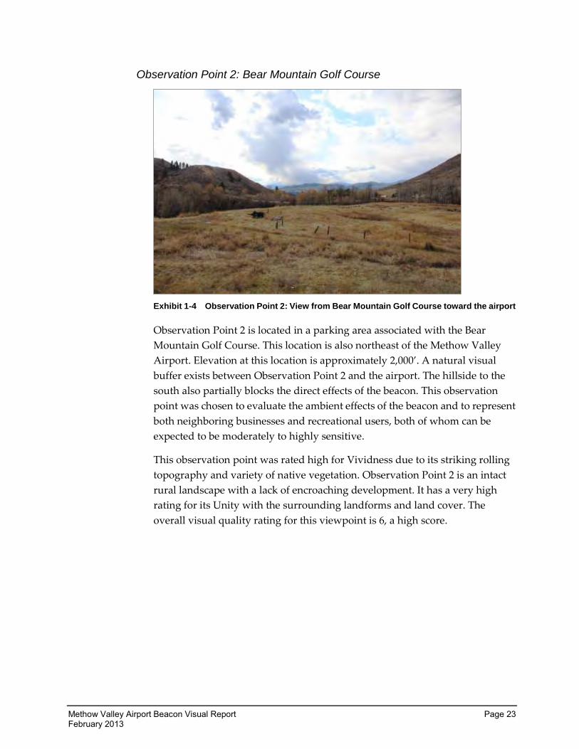
Observation Point 3: Methow Valley Grade School
Exhibit 1-5 Observation Point 3: View from Methow Grade School toward the airport
Observation Point 3 is located just south of the Methow Valley Grade School,
which is located northwest of the airport and is at approximately 1,750’
elevation. This is very nearly the same elevation as the airport. Some vegetative
buffer exists between the airport and the grade school. This observation point
was chosen to represent views by the general public, which may not otherwise
experience impacts from the new beacon. This view also represents a
“business” that can be expected to be in operation during nighttime hours
when the effects of the beacon become most noticeable. Observation Point 3 is
further located just to the west of SR 20 and at a very similar elevation. This
observation point can also represent views that the traveling public can be
expected to experience.
The view of the hills to the east is striking from this location, and the line they
form helps to draw the eye down along the valley floor. Vegetation is robust
and ecologically appropriate. Observation Point 3 rated very high for
Vividness. Little development is observed from this location and very few
encroachments are visible. The location is several feet higher than SR 20,
effectively shielding the viewer from this encroachment as well. It is a very
intact view with little disturbance seen. Like the other views, the Unity of the
area is high. The overall visual quality rating is 5.0, a high rating.
Methow Valley Airport Beacon Visual Report Page 25 February 2013
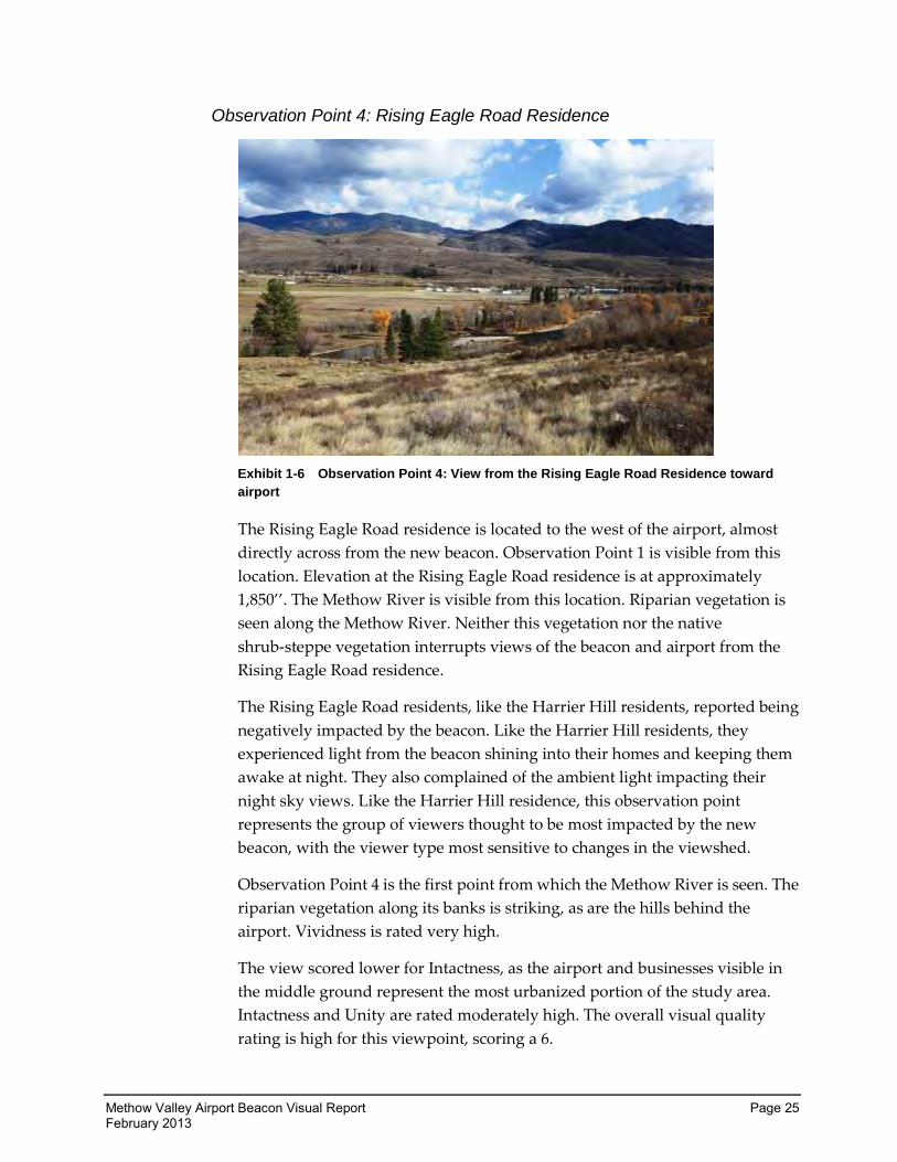
Observation Point 4: Rising Eagle Road Residence
Exhibit 1-6 Observation Point 4: View from the Rising Eagle Road Residence toward
airport
The Rising Eagle Road residence is located to the west of the airport, almost
directly across from the new beacon. Observation Point 1 is visible from this
location. Elevation at the Rising Eagle Road residence is at approximately
1,850’’. The Methow River is visible from this location. Riparian vegetation is
seen along the Methow River. Neither this vegetation nor the native
shrub-steppe vegetation interrupts views of the beacon and airport from the
Rising Eagle Road residence.
The Rising Eagle Road residents, like the Harrier Hill residents, reported being
negatively impacted by the beacon. Like the Harrier Hill residents, they
experienced light from the beacon shining into their homes and keeping them
awake at night. They also complained of the ambient light impacting their
night sky views. Like the Harrier Hill residence, this observation point
represents the group of viewers thought to be most impacted by the new
beacon, with the viewer type most sensitive to changes in the viewshed.
Observation Point 4 is the first point from which the Methow River is seen. The
riparian vegetation along its banks is striking, as are the hills behind the
airport. Vividness is rated very high.
The view scored lower for Intactness, as the airport and businesses visible in
the middle ground represent the most urbanized portion of the study area.
Intactness and Unity are rated moderately high. The overall visual quality
rating is high for this viewpoint, scoring a 6.
Page 26 Methow Valley Airport Beacon Visual Report February 2013
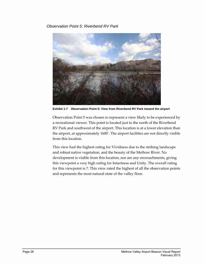
Observation Point 5: Riverbend RV Park
Exhibit 1-7 Observation Point 5: View from Riverbend RV Park toward the airport
Observation Point 5 was chosen to represent a view likely to be experienced by
a recreational viewer. This point is located just to the north of the Riverbend
RV Park and southwest of the airport. This location is at a lower elevation than
the airport, at approximately 1600’. The airport facilities are not directly visible
from this location.
This view had the highest rating for Vividness due to the striking landscape
and robust native vegetation, and the beauty of the Methow River. No
development is visible from this location, nor are any encroachments, giving
this viewpoint a very high rating for Intactness and Unity. The overall rating
for this viewpoint is 7. This view rated the highest of all the observation points
and represents the most natural state of the valley floor.
Methow Valley Airport Beacon Visual Report Page 27 February 2013
Potential Effects
This section describes the changes to views and visual quality for each
alternative and compares them to the existing night sky conditions from the
observation points described in the previous section.
The effects for each alternative are described below in narrative form. The
visual analysis matrix summarizes the visual quality ratings, so you can easily
compare the changes in the visual quality ratings from the observation point
for each alternative. The change in total visual quality for each view is
considered to be the positive or negative visual impact. Views may improve or
decline after a project. A total visual quality rating change of 1.0 or greater is
considered to be a significant visual impact for the purposes of this report.
How was the testing conducted?
Prior to testing mitigation for the new beacon, WSDOT personnel visited the
area around the airport. Staff reviewed possible locations for observation
points to fairly represent all viewer types identified. WSDOT-Aviation had
compiled a map showing the location of residents who had reported negative
impacts. Additionally, two residents, when contacted by WSDOT-Aviation,
offered their private property as a viewpoint. A third resident offered their
property as well; however, a site visit determined that the natural vegetation in
front of their home made photography of the beacon problematic. This
residence was located to the north of the Rising Eagle Road property and at a
slightly lower elevation. It was felt that the Rising Eagle Road property would
not only photograph better but would more accurately represent impacts at
both locations. Observation points were limited to five in order to allow
WSDOT staff time to move from one to the other between the hours set for
testing. Testing hours were set to begin at 6:30 p.m., when it would be dark and
residents would likely have returned from work, and run to 8:00 p.m. After the
first night, testing was extended to 8:30 p.m. to accommodate travel between
observation points. Testing was not extended past 8:30 p.m., as it was
conducted during the week and WSDOT did not wish to unduly impose on
residents’ privacy.
Page 28 Methow Valley Airport Beacon Visual Report February 2013
Three other sites were chosen in addition to the private residences. These
locations were chosen to represent other viewer types and to surround the
airport on all sides to accurately capture the effects of the beacon on the valley.
These other sites are the Bear Creek Golf Course, located to the northeast of the
airport, the Methow Grade School, located to the northwest of the airport, and
the Riverbend RV Park, located to the southwest of the airport. All of the sites
chosen are located at different elevations in an attempt to further capture the
effects of the beacon.
Once the observation points were selected, the testing team visited them and
determined where best to place the cameras. These locations were staked so
that the cameras could be set up in the same location each night of testing.
Prior to the first night of testing, WSDOT-Aviation changed the angle of the
beacon to 8 degrees from the factory setting of 5 degrees. Testing for the
8-degree angle was conducted that same night, November 5. No other angle
was tested on that night, nor was shielding applied. The following day,
November 6, the angle of the beacon was changed to 10 degrees, and it was
tested the same night. Again, no other angle or shielding was tested. On the
final night of testing, the angle of the beacon was changed to 12 degrees. The
bottom 1/3 of the beacon was temporarily shielded. This was the only
mitigation tested on the evening of November 7.
On October 25, 2012, and October 30, 2012, WSDOT sent news releases
regarding the testing to local media as well as sending emails to the Methow
community contact list members who had commented on the beacon in the
past. WSDOT gave interviews, which resulted in printed articles for the
Methow Valley News and an on-air radio interview with KOZI in Lake
Chelan. The news releases were also posted on the WSDOT-Aviation website.
During the nights of testing, WSDOT personnel would arrive at Observation
Point 1 at approximately 6:00 p.m. and set up the cameras. Cameras were kept
at a uniform height on their respective tripods. WSDOT staff recorded climatic
conditions, including temperature and cloud cover, and made notes of any
other observations. Observations were made prior to turning the beacon on,
and again after the beacon was turned off. Prior to the beacon being turned on,
photographs were taken from the observation point toward the airport beacon
and then 180 degrees from the beacon to capture views of the dark sky. These
photographs were also used to compare impacts of the beacon, as accurately as
possible, under the same climate conditions.
Atmospheric conditions can greatly impact the effects of lighting. On a clear
night, light can travel unimpeded away from the viewer. On an overcast night,
Methow Valley Airport Beacon Visual Report Page 29 February 2013
the light is reflected back toward the ground by cloud cover. Nights where a
great deal of moisture is in the air, or when there is snow cover, will also reflect
the light from the beacon.
At 6:30 p.m., WSDOT staff radioed personnel at the beacon and requested that
the beacon be turned on. Photographs were again taken and observations
made and recorded. The observer moved around the observation point during
testing to replicate the experience of someone living at, or visiting, that site. As
soon as the photographer and observer had obtained enough data, staff
radioed the airport and requested that the beacon be turned off. They did so in
order to minimize lighting impacts to local residents who had already objected
to the beacon and to maintain the process of photographing each observation
point with the beacon off as well as on. The beacon remained off while WSDOT
staff travelled to the next observation point.
It is important to note that WSDOT-Aviation received several complaints from
residents that not enough time was given for them to observe the beacon. This
same process was repeated at each observation point and the beacon was
turned on five separate times between the hours of 6:30 p.m. and 8:30 p.m. The
beacon remained on for approximately 15 minutes at each observation point,
for a total of about 75 minutes out of a possible 90 minutes. This process was
repeated for three nights while WSDOT tested multiple angle settings and
shielding of the beacon.
At the end of testing, the public was invited to comment on the effects of the
mitigation via the SurveyMonkey™ website, and the survey was made
available for download. Paper versions of the survey were printed out and
made available at the Twisp library, the community center, and the Methow
Valley News office upon request for those without internet connections or who
preferred not to use them.
How were the photographs and video taken?
Because pictures were needed at night, WSDOT-Aviation contacted WSDOT’s
Visual Engineering Resource Group (VERG) to photographically document the
visual impacts of the new airport beacon. VERG was asked to use camera
settings that most mimic what the human eye sees. VERG chose to use a Canon
5D Mark II for the still camera work and suggested that WSDOT-Aviation
make use of its Sony DSR-PD150 DV Camcorder to capture a video of the
beacon effects as well. Personnel at VERG cautioned that no camera or setting
fully replicates the human experience and that exposure times can amplify or
diminish effects that a human observer would see. This report acknowledges
Page 30 Methow Valley Airport Beacon Visual Report February 2013
these inherent problems and has attempted to mitigate for them by the use of
human observers and input from the impacted public.
The still camera made use of a Canon 50mm f/1.4 USM Autofocus lens. The
camera was placed at a previously staked location, at a set height on a tripod.
The camera was set at ISO 640 to balance image quality and light-gathering
ability. Multiple exposures were then captured facing toward the beacon with
the beacon turned off. The beacon was then turned on at the setting being
tested and a second set of photographs were taken. The camera was then
turned 180 degrees to capture the effects of the beacon on the land behind the
observation point. These photographs used the same settings as those taken
facing the beacon. An exception to this was at the Riverbend RV Park, where
the neighboring house lights were so bright that they obscured the results of
the camera when facing away from the airport.
The video camera was set up in the same way and the aperture was fully
opened to allow the most amount of light in at shutter speed 1/30 of a second
for clarity. The autofocus lens varied from 6 to 72mm when zooming in and
out. This camera, too, was rotated 180 degrees after the beacon was turned on.
All camera locations were staked to ensure consistency between testing nights,
and GPS was used to document the location prior to each night’s photography.
Additional information about the camera setting is available in Appendix B as
supplied to WSDOT-Aviation by VERG. VERG personnel also included first
person impressions of the light impacts observed during testing.
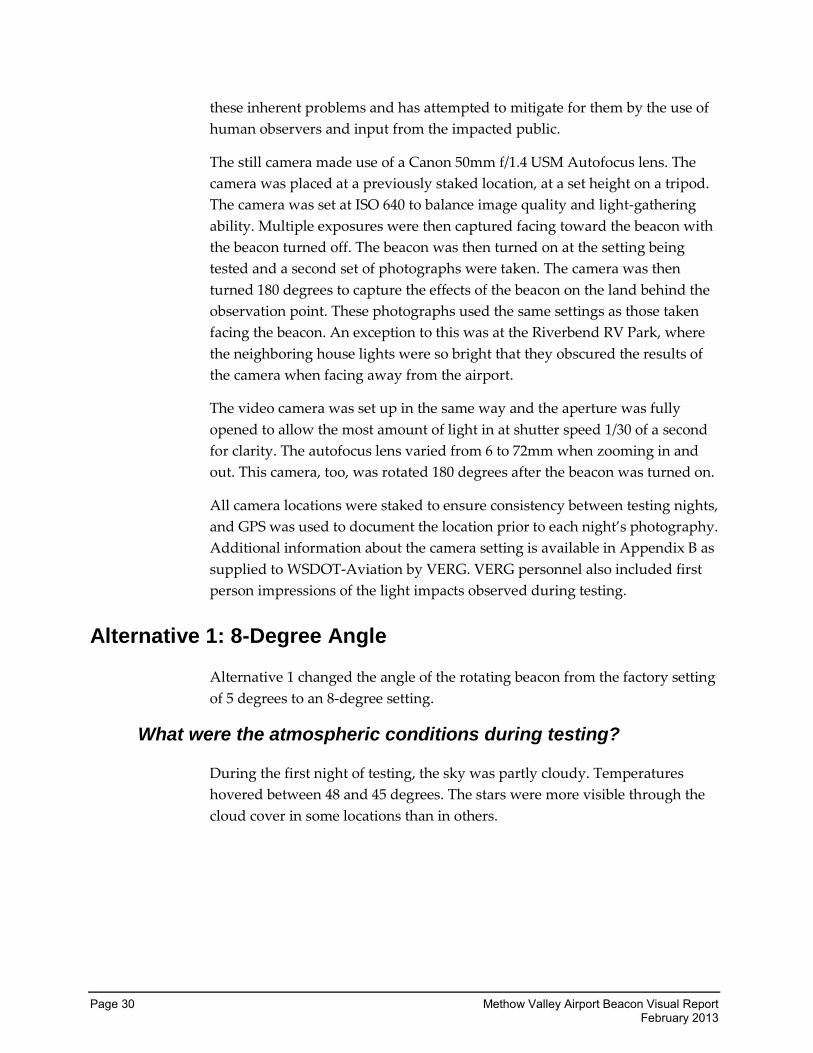
Alternative 1: 8-Degree Angle
Alternative 1 changed the angle of the rotating beacon from the factory setting
of 5 degrees to an 8-degree setting.
What were the atmospheric conditions during testing?
During the first night of testing, the sky was partly cloudy. Temperatures
hovered between 48 and 45 degrees. The stars were more visible through the
cloud cover in some locations than in others.
Methow Valley Airport Beacon Visual Report Page 31 February 2013
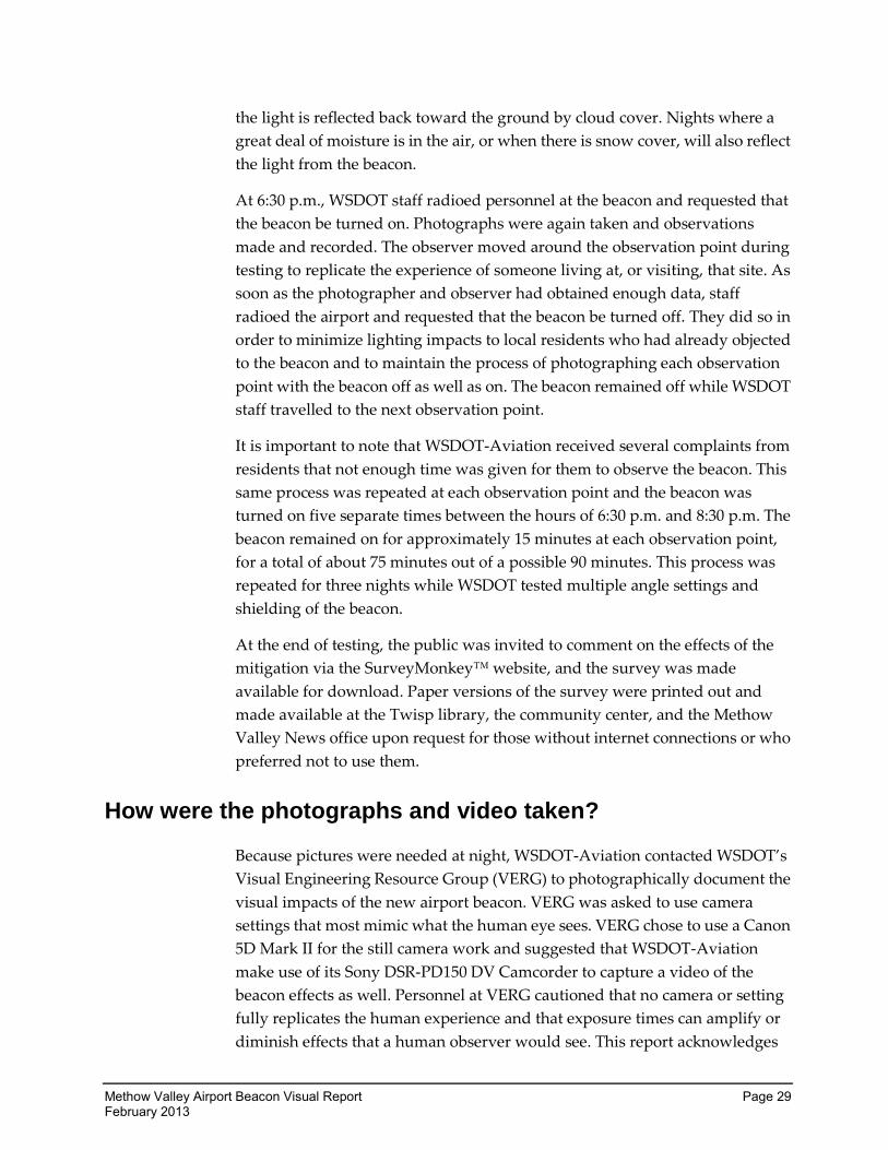
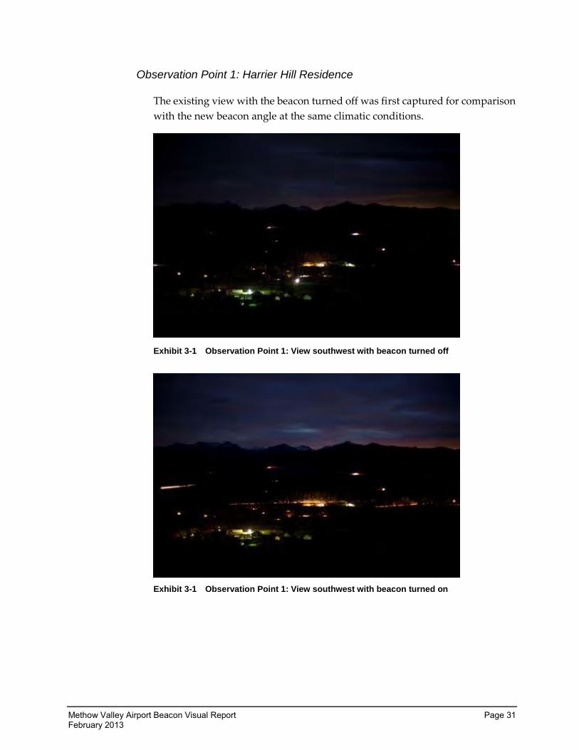
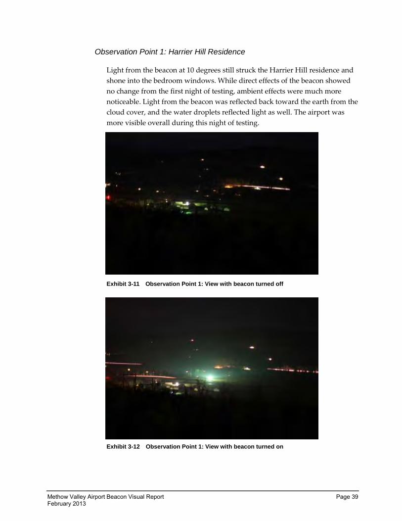
Observation Point 1: Harrier Hill Residence
The existing view with the beacon turned off was first captured for comparison
with the new beacon angle at the same climatic conditions.
Exhibit 3-1 Observation Point 1: View southwest with beacon turned off
Exhibit 3-1 Observation Point 1: View southwest with beacon turned on
Page 32 Methow Valley Airport Beacon Visual Report February 2013
Observations were made after the beacon was turned on. The observer moved
around the site to see as many of the effects as possible:
Light from the beacon at 8 degrees shone into the Harrier Hill residence’s
bedroom illuminating the walls.
The front of the home was washed with light and objects in the yard were
clearly visible as the beacon passed.
The hills behind Observation Point 1 were clearly illuminated as the
beacon swept across them. There were several homes on the hillside
above the Harrier Hill residence, which likely were experiencing the
same sort of impacts. Those at a higher elevation may have experienced
more negative direct impacts.
The effects of the indirect light were minimal to the naked eye and the
unaccustomed observer. They included a visible lightening of the sky and
intrusion of sky glow. It should be noted that the homeowner is a professional
photographer with a strong interest in nighttime photography. Further, both of
the homeowners have spent significant time in areas such as Antarctica and
Greenland and can be expected to have a high standard for night sky
environments. One of the homeowners was on-site for all nights of testing and
indicated that she felt the night sky was significantly impaired.
Unfortunately, the still camera was not able to capture the full effects that were
observed. In the photographs above, the only visible difference between
having the airport lights on or off is the view of the runway lights and the
lighter sky visible behind the hills. The photographer was asked to record his
observations as well as take photos, and his comments are included in
Appendix B.
The results from the video camera also failed to capture the effects. As this was
true throughout testing, the views are rated based upon the observations of the
viewer and only make reference to the photographs for ease of comparison.
This viewpoint has a visual quality rating of 6 based on existing conditions.
With the beacon on, the vividness rating was unaffected. Landforms,
vegetation, and human-built elements were the same as without the beacon.
Intactness scores dropped due to the increased sense of development and
because of the light encroachment. Unity was also impaired. The airport
beacon made the surrounding areas feel more urban in nature than the
previous rural feel. The total visual quality of this viewpoint thus drops from 6
to 4 with Alternative 1.
Methow Valley Airport Beacon Visual Report Page 33 February 2013
Observation Point 2: Bear Mountain Golf Course
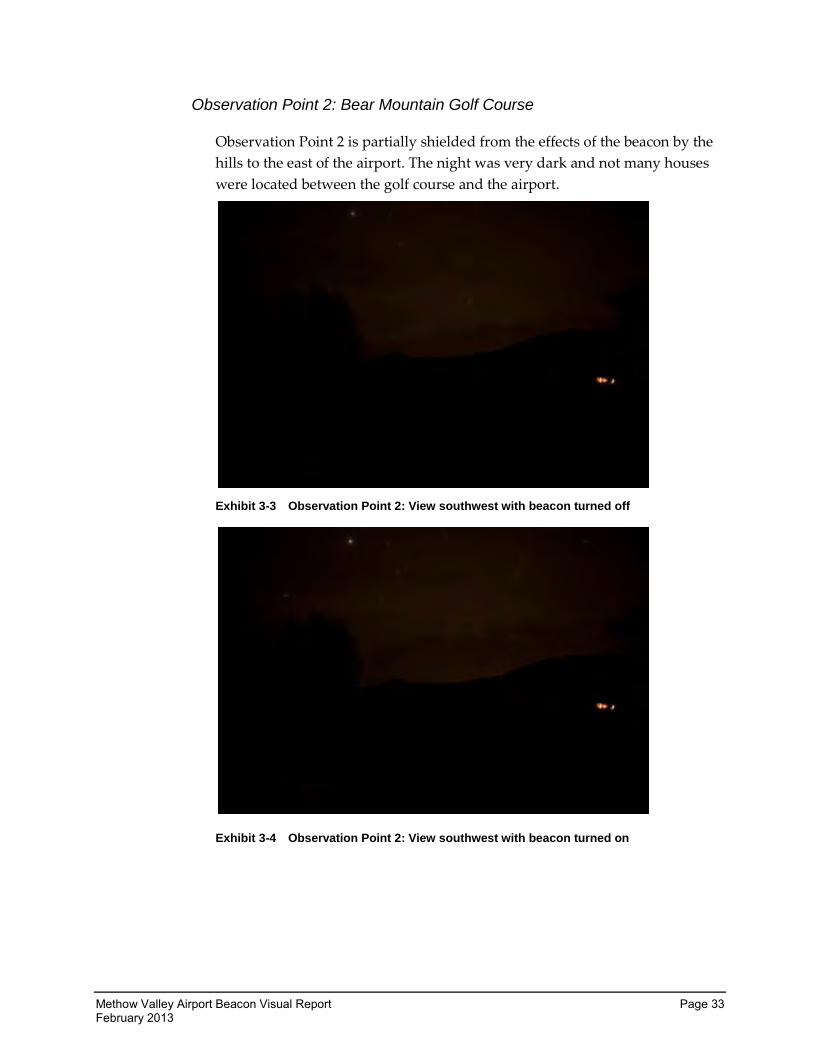
Observation Point 2 is partially shielded from the effects of the beacon by the
hills to the east of the airport. The night was very dark and not many houses
were located between the golf course and the airport.
Exhibit 3-3 Observation Point 2: View southwest with beacon turned off
Exhibit 3-4 Observation Point 2: View southwest with beacon turned on
Page 34 Methow Valley Airport Beacon Visual Report February 2013
While it is not readily visible in the photographs, the beacon was observable as
it rotated in the valley, washing the adjacent hillsides and reflecting off the
clouds. This location experienced more cloud cover than other locations.
Typically, cloud cover holds in the effects of light pollution and makes the
impacts greater. In Exhibit 3-4, more light is reflected off the clouds and the
hills are more visible between the observation point and the airport.
Intactness was slightly reduced due to encroachments and increased
development, and Unity likewise was lowered slightly. This viewpoint has an
overall visual quality rating of 6 based on existing conditions. Alternative 1
dropped the overall visual quality rating to 4.
Observation Point 3: Methow Valley Grade School
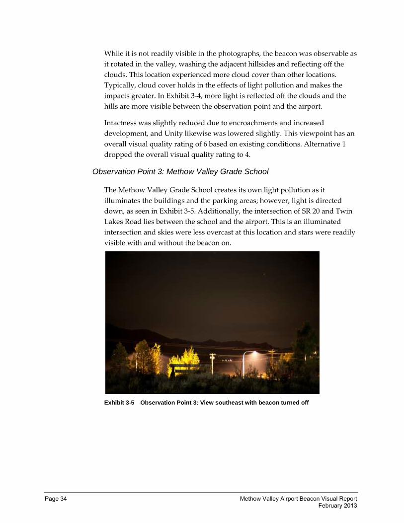
The Methow Valley Grade School creates its own light pollution as it
illuminates the buildings and the parking areas; however, light is directed
down, as seen in Exhibit 3-5. Additionally, the intersection of SR 20 and Twin
Lakes Road lies between the school and the airport. This is an illuminated
intersection and skies were less overcast at this location and stars were readily
visible with and without the beacon on.
Exhibit 3-5 Observation Point 3: View southeast with beacon turned off
Methow Valley Airport Beacon Visual Report Page 35 February 2013
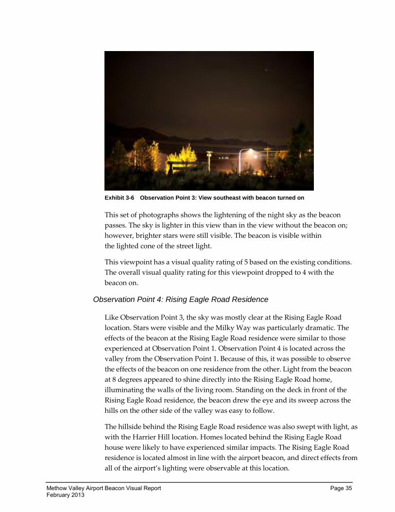
Exhibit 3-6 Observation Point 3: View southeast with beacon turned on
This set of photographs shows the lightening of the night sky as the beacon
passes. The sky is lighter in this view than in the view without the beacon on;
however, brighter stars were still visible. The beacon is visible within
the lighted cone of the street light.
This viewpoint has a visual quality rating of 5 based on the existing conditions.
The overall visual quality rating for this viewpoint dropped to 4 with the
beacon on.
Observation Point 4: Rising Eagle Road Residence
Like Observation Point 3, the sky was mostly clear at the Rising Eagle Road
location. Stars were visible and the Milky Way was particularly dramatic. The
effects of the beacon at the Rising Eagle Road residence were similar to those
experienced at Observation Point 1. Observation Point 4 is located across the
valley from the Observation Point 1. Because of this, it was possible to observe
the effects of the beacon on one residence from the other. Light from the beacon
at 8 degrees appeared to shine directly into the Rising Eagle Road home,
illuminating the walls of the living room. Standing on the deck in front of the
Rising Eagle Road residence, the beacon drew the eye and its sweep across the
hills on the other side of the valley was easy to follow.
The hillside behind the Rising Eagle Road residence was also swept with light, as
with the Harrier Hill location. Homes located behind the Rising Eagle Road
house were likely to have experienced similar impacts. The Rising Eagle Road
residence is located almost in line with the airport beacon, and direct effects from
all of the airport’s lighting were observable at this location.
Page 36 Methow Valley Airport Beacon Visual Report February 2013
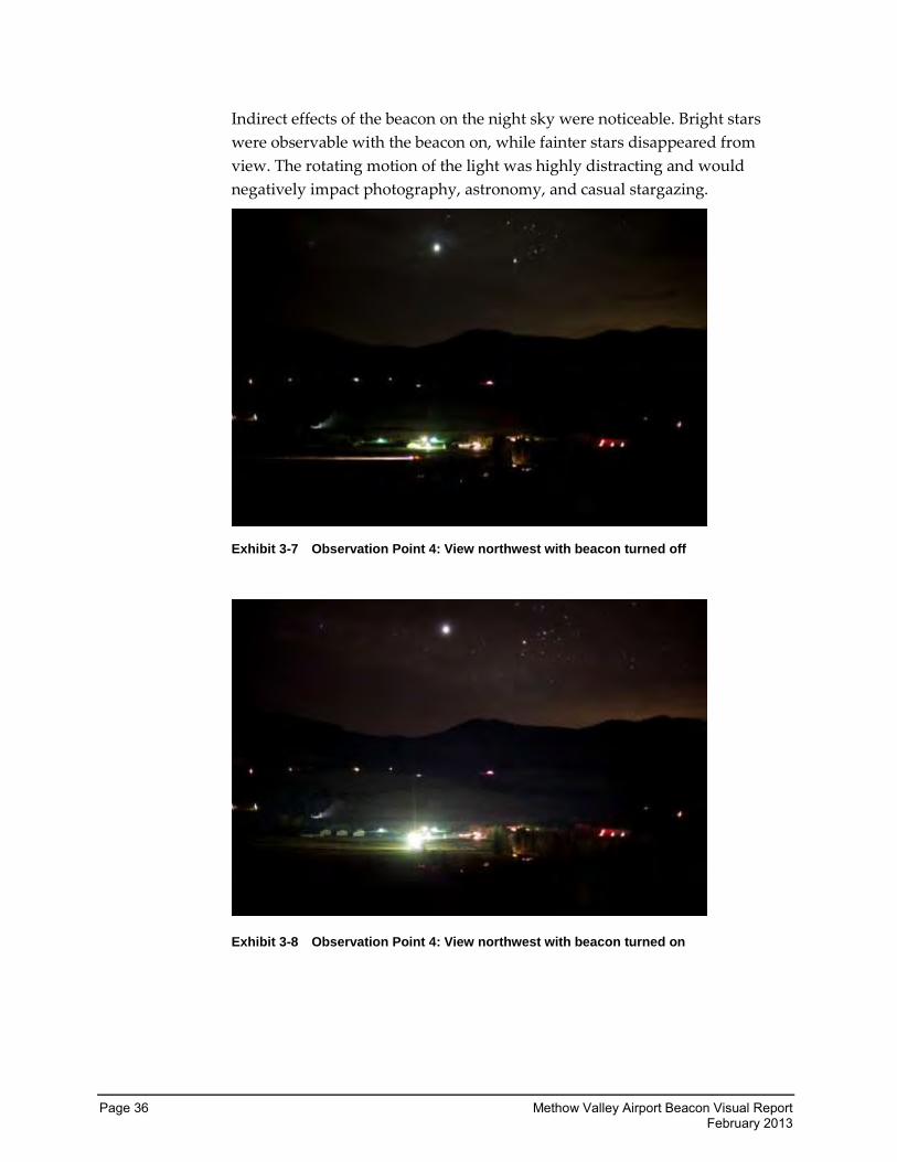
Indirect effects of the beacon on the night sky were noticeable. Bright stars
were observable with the beacon on, while fainter stars disappeared from
view. The rotating motion of the light was highly distracting and would
negatively impact photography, astronomy, and casual stargazing.
Exhibit 3-7 Observation Point 4: View northwest with beacon turned off
Exhibit 3-8 Observation Point 4: View northwest with beacon turned on
Methow Valley Airport Beacon Visual Report Page 37 February 2013
Light from the beacon clearly illuminated the airport buildings and drew the
eye. With the beacon on, the rating was lowered due to a loss in Intactness and
Unity. The sense of development was heightened and light from the beacon
encroached into the Rising Eagle Road residence. The rural feel of the valley
was impacted by the rotating beacon as well. The total visual quality for this
viewpoint with the beacon on and set at 8 degrees drops from 6 to 4.
Observation Point 5: Riverbend RV Park
This location is immediately west of the RV Park, and WSDOT vehicles were
kept on the WSDOT right of way. Light from a neighboring home created so
much ambient light that the photography protocol used at other locations was
omitted at Observation Point 5. Photographs were only taken toward the
airport and not of the hills behind. This location required that the photographs
also be taken at a longer exposure as the site was darker overall. Just as at all
locations, however, the observer moved around and took this view into
account.
This location is shielded from the direct effects of the beacon by a large buffer
of riparian vegetation and is located at a lower elevation than the airport. The
photographs taken at this location appear black as there is so little light
encroachment from any source. This was the most pristine night environment
included in the study. Atmospheric conditions at this location were partially
overcast and stars were visible between clouds. Before the beacon was turned
on, there were very few impacts to the night sky environment at Observation
Point 5.
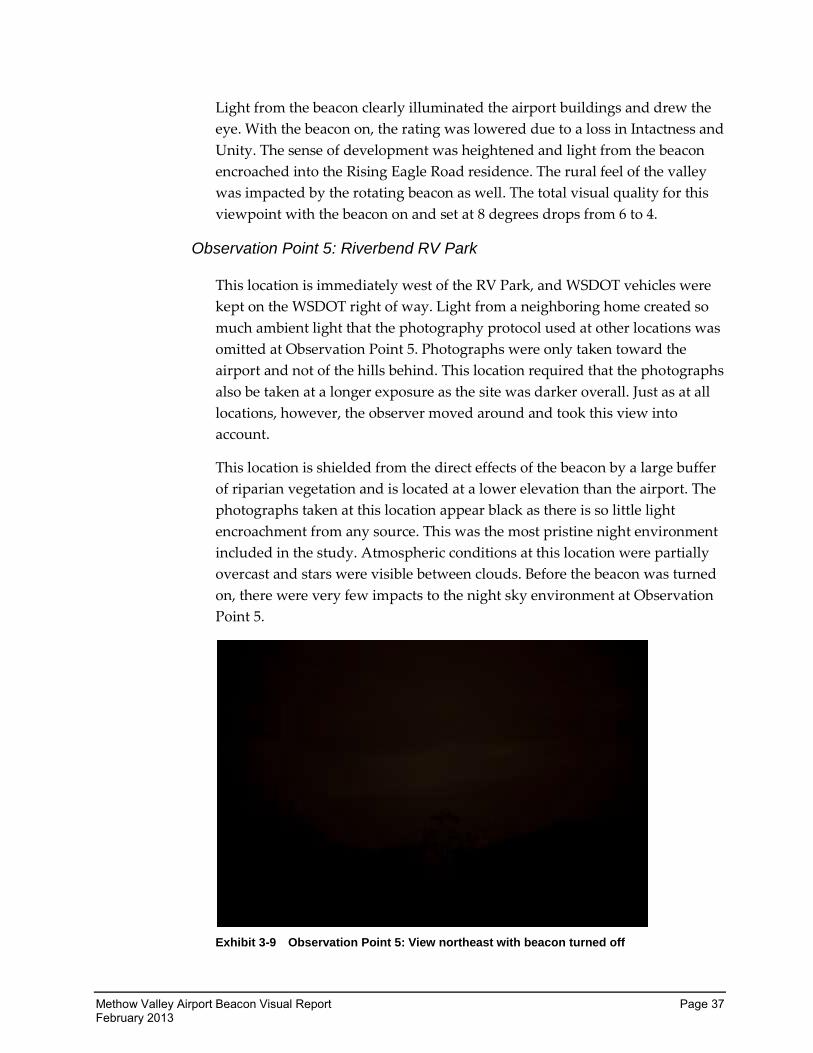
Exhibit 3-9 Observation Point 5: View northeast with beacon turned off
Page 38 Methow Valley Airport Beacon Visual Report February 2013
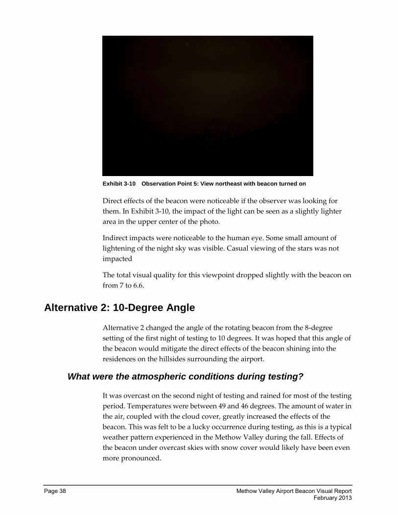
Exhibit 3-10 Observation Point 5: View northeast with beacon turned on
Direct effects of the beacon were noticeable if the observer was looking for
them. In Exhibit 3-10, the impact of the light can be seen as a slightly lighter
area in the upper center of the photo.
Indirect impacts were noticeable to the human eye. Some small amount of
lightening of the night sky was visible. Casual viewing of the stars was not
impacted
The total visual quality for this viewpoint dropped slightly with the beacon on
from 7 to 6.6.
Alternative 2: 10-Degree Angle
Alternative 2 changed the angle of the rotating beacon from the 8-degree
setting of the first night of testing to 10 degrees. It was hoped that this angle of
the beacon would mitigate the direct effects of the beacon shining into the
residences on the hillsides surrounding the airport.
What were the atmospheric conditions during testing?
It was overcast on the second night of testing and rained for most of the testing
period. Temperatures were between 49 and 46 degrees. The amount of water in
the air, coupled with the cloud cover, greatly increased the effects of the
beacon. This was felt to be a lucky occurrence during testing, as this is a typical
weather pattern experienced in the Methow Valley during the fall. Effects of
the beacon under overcast skies with snow cover would likely have been even
more pronounced.
Methow Valley Airport Beacon Visual Report Page 39 February 2013
Observation Point 1: Harrier Hill Residence
Light from the beacon at 10 degrees still struck the Harrier Hill residence and
shone into the bedroom windows. While direct effects of the beacon showed
no change from the first night of testing, ambient effects were much more
noticeable. Light from the beacon was reflected back toward the earth from the
cloud cover, and the water droplets reflected light as well. The airport was
more visible overall during this night of testing.
Exhibit 3-11 Observation Point 1: View with beacon turned off
Exhibit 3-12 Observation Point 1: View with beacon turned on
Page 40 Methow Valley Airport Beacon Visual Report February 2013
The camera’s exposure setting produced streaking of light, which is visible in
the photographs. The airport was more intrusive with the beacon on, and with
the beacon unshielded, light spilled onto the hard surface beneath the beacon
and was further scattered. As before, the Vividness rating was unaffected by
the beacon. Intactness scores dropped slightly more than before due to the
increased sense of development and because of the light encroachment. The
Unity score was lowered, as it had been on the previous night of testing. The
total visual quality of this viewpoint dropped from 6 to 3.8 with Alternative 2. It
was difficult to see any difference between the 8-degree and 10-degree-angle
settings. It appeared to the observer that the differences in light intrusion were
due to the effects of cloud cover and moisture in the air.
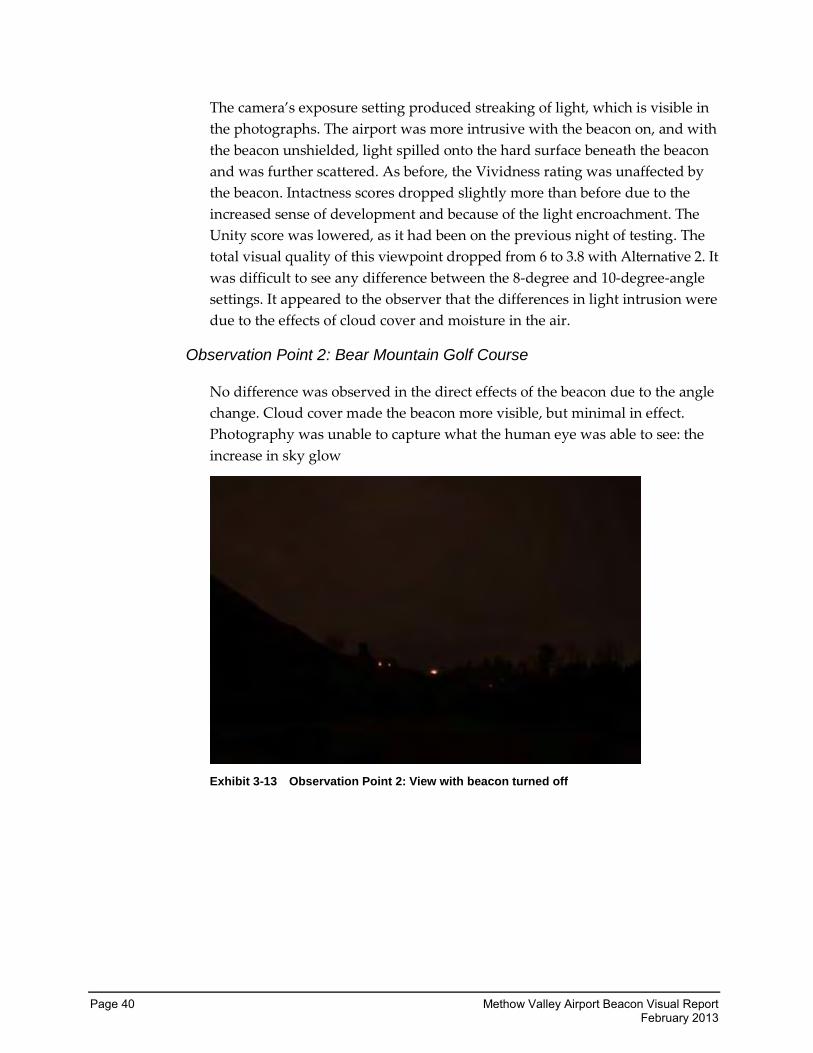
Observation Point 2: Bear Mountain Golf Course
No difference was observed in the direct effects of the beacon due to the angle
change. Cloud cover made the beacon more visible, but minimal in effect.
Photography was unable to capture what the human eye was able to see: the
increase in sky glow
Exhibit 3-13 Observation Point 2: View with beacon turned off
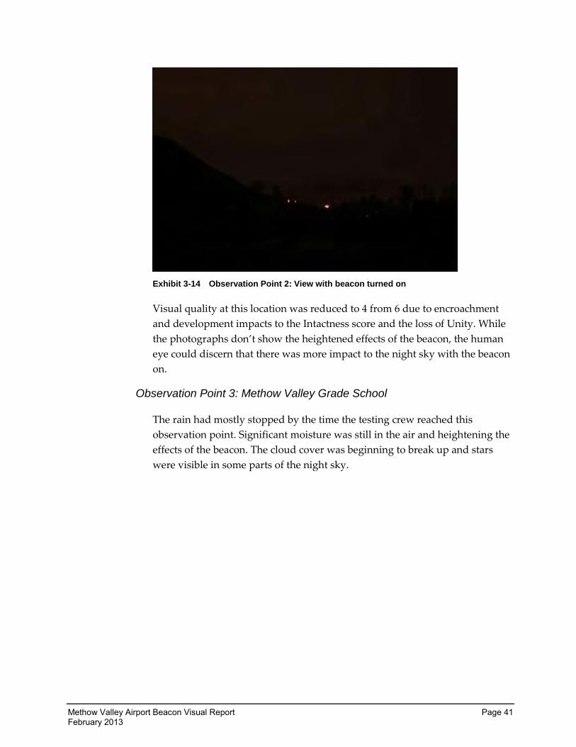
Methow Valley Airport Beacon Visual Report Page 41 February 2013
Exhibit 3-14 Observation Point 2: View with beacon turned on
Visual quality at this location was reduced to 4 from 6 due to encroachment
and development impacts to the Intactness score and the loss of Unity. While
the photographs don’t show the heightened effects of the beacon, the human
eye could discern that there was more impact to the night sky with the beacon
on.
Observation Point 3: Methow Valley Grade School
The rain had mostly stopped by the time the testing crew reached this
observation point. Significant moisture was still in the air and heightening the
effects of the beacon. The cloud cover was beginning to break up and stars
were visible in some parts of the night sky.
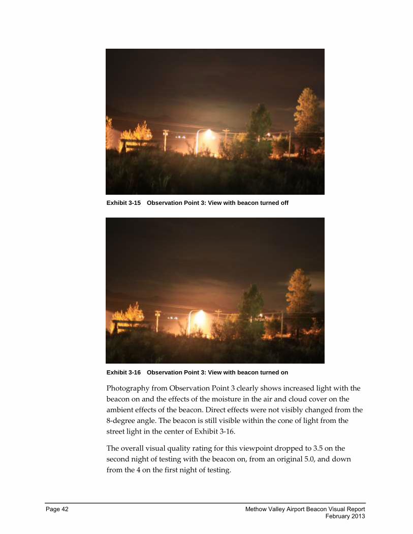
Page 42 Methow Valley Airport Beacon Visual Report February 2013
Exhibit 3-15 Observation Point 3: View with beacon turned off
Exhibit 3-16 Observation Point 3: View with beacon turned on
Photography from Observation Point 3 clearly shows increased light with the
beacon on and the effects of the moisture in the air and cloud cover on the
ambient effects of the beacon. Direct effects were not visibly changed from the
8-degree angle. The beacon is still visible within the cone of light from the
street light in the center of Exhibit 3-16.
The overall visual quality rating for this viewpoint dropped to 3.5 on the
second night of testing with the beacon on, from an original 5.0, and down
from the 4 on the first night of testing.
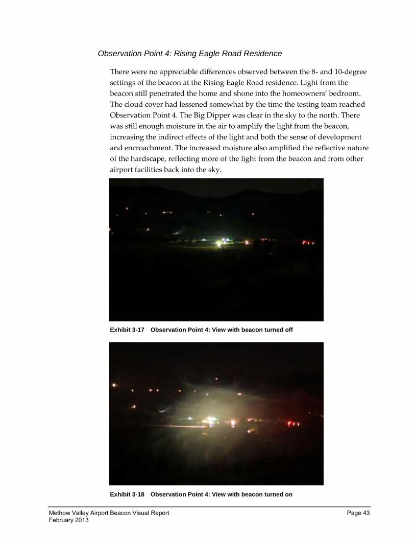
Methow Valley Airport Beacon Visual Report Page 43 February 2013
Observation Point 4: Rising Eagle Road Residence
There were no appreciable differences observed between the 8- and 10-degree
settings of the beacon at the Rising Eagle Road residence. Light from the
beacon still penetrated the home and shone into the homeowners’ bedroom.
The cloud cover had lessened somewhat by the time the testing team reached
Observation Point 4. The Big Dipper was clear in the sky to the north. There
was still enough moisture in the air to amplify the light from the beacon,
increasing the indirect effects of the light and both the sense of development
and encroachment. The increased moisture also amplified the reflective nature
of the hardscape, reflecting more of the light from the beacon and from other
airport facilities back into the sky.
Exhibit 3-17 Observation Point 4: View with beacon turned off
Exhibit 3-18 Observation Point 4: View with beacon turned on
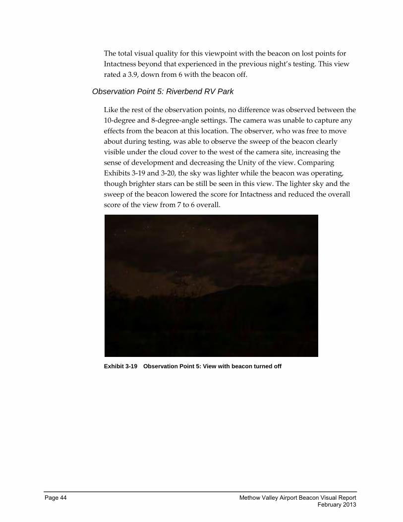
Page 44 Methow Valley Airport Beacon Visual Report February 2013
The total visual quality for this viewpoint with the beacon on lost points for
Intactness beyond that experienced in the previous night’s testing. This view
rated a 3.9, down from 6 with the beacon off.
Observation Point 5: Riverbend RV Park
Like the rest of the observation points, no difference was observed between the
10-degree and 8-degree-angle settings. The camera was unable to capture any
effects from the beacon at this location. The observer, who was free to move
about during testing, was able to observe the sweep of the beacon clearly
visible under the cloud cover to the west of the camera site, increasing the
sense of development and decreasing the Unity of the view. Comparing
Exhibits 3-19 and 3-20, the sky was lighter while the beacon was operating,
though brighter stars can be still be seen in this view. The lighter sky and the
sweep of the beacon lowered the score for Intactness and reduced the overall
score of the view from 7 to 6 overall.
Exhibit 3-19 Observation Point 5: View with beacon turned off
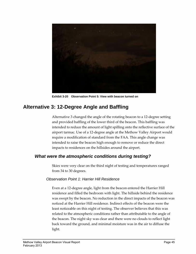
Methow Valley Airport Beacon Visual Report Page 45 February 2013
Exhibit 3-20 Observation Point 5: View with beacon turned on
Alternative 3: 12-Degree Angle and Baffling
Alternative 3 changed the angle of the rotating beacon to a 12-degree setting
and provided baffling of the lower third of the beacon. This baffling was
intended to reduce the amount of light spilling onto the reflective surface of the
airport tarmac. Use of a 12-degree angle at the Methow Valley Airport would
require a modification of standard from the FAA. This angle change was
intended to raise the beacon high enough to remove or reduce the direct
impacts to residences on the hillsides around the airport.
What were the atmospheric conditions during testing?
Skies were very clear on the third night of testing and temperatures ranged
from 34 to 30 degrees.
Observation Point 1: Harrier Hill Residence
Even at a 12-degree angle, light from the beacon entered the Harrier Hill
residence and filled the bedroom with light. The hillside behind the residence
was swept by the beacon. No reduction in the direct impacts of the beacon was
noticed at the Harrier Hill residence. Indirect effects of the beacon were the
least noticeable on this night of testing. The observer believes that this was
related to the atmospheric conditions rather than attributable to the angle of
the beacon. The night sky was clear and there were no clouds to reflect light
back toward the ground, and minimal moisture was in the air to diffuse the
light.
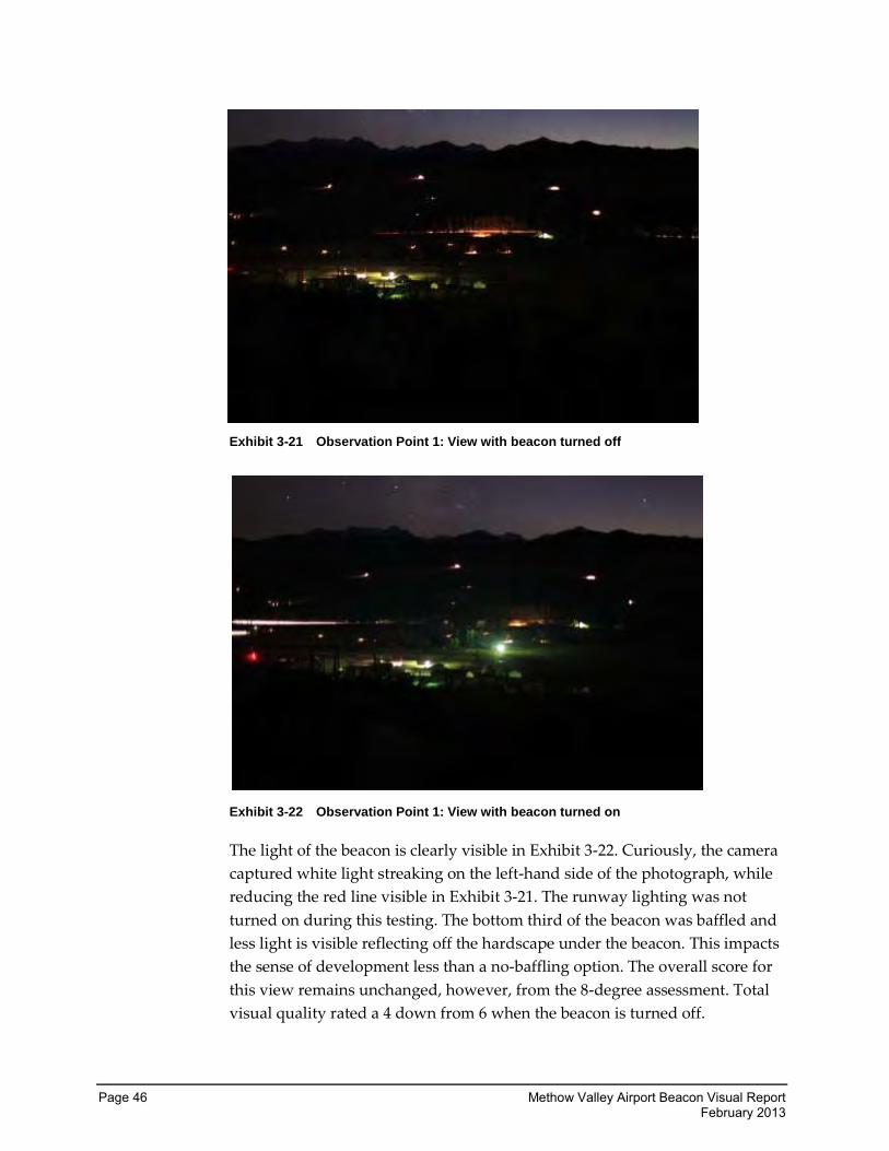
Page 46 Methow Valley Airport Beacon Visual Report February 2013
Exhibit 3-21 Observation Point 1: View with beacon turned off
Exhibit 3-22 Observation Point 1: View with beacon turned on
The light of the beacon is clearly visible in Exhibit 3-22. Curiously, the camera
captured white light streaking on the left-hand side of the photograph, while
reducing the red line visible in Exhibit 3-21. The runway lighting was not
turned on during this testing. The bottom third of the beacon was baffled and
less light is visible reflecting off the hardscape under the beacon. This impacts
the sense of development less than a no-baffling option. The overall score for
this view remains unchanged, however, from the 8-degree assessment. Total
visual quality rated a 4 down from 6 when the beacon is turned off.
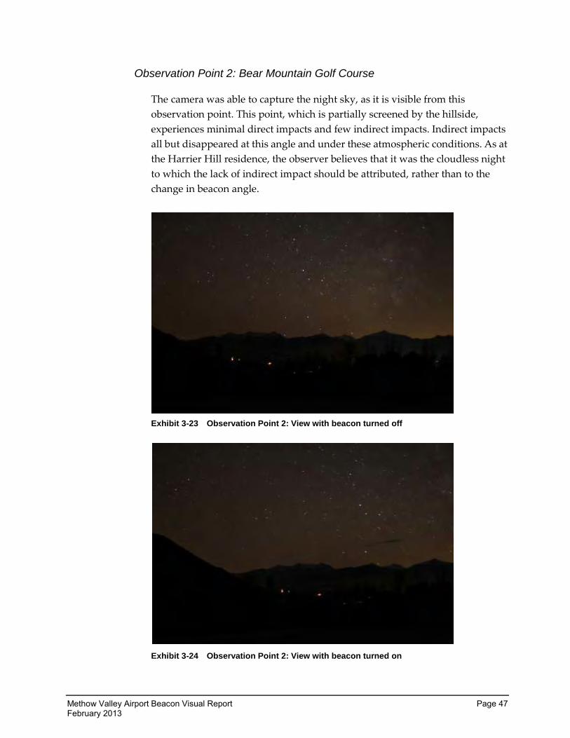
Methow Valley Airport Beacon Visual Report Page 47 February 2013
Observation Point 2: Bear Mountain Golf Course
The camera was able to capture the night sky, as it is visible from this
observation point. This point, which is partially screened by the hillside,
experiences minimal direct impacts and few indirect impacts. Indirect impacts
all but disappeared at this angle and under these atmospheric conditions. As at
the Harrier Hill residence, the observer believes that it was the cloudless night
to which the lack of indirect impact should be attributed, rather than to the
change in beacon angle.
Exhibit 3-23 Observation Point 2: View with beacon turned off
Exhibit 3-24 Observation Point 2: View with beacon turned on
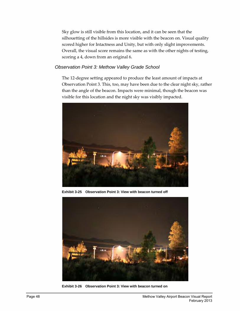
Page 48 Methow Valley Airport Beacon Visual Report February 2013
Sky glow is still visible from this location, and it can be seen that the
silhouetting of the hillsides is more visible with the beacon on. Visual quality
scored higher for Intactness and Unity, but with only slight improvements.
Overall, the visual score remains the same as with the other nights of testing,
scoring a 4, down from an original 6.
Observation Point 3: Methow Valley Grade School
The 12-degree setting appeared to produce the least amount of impacts at
Observation Point 3. This, too, may have been due to the clear night sky, rather
than the angle of the beacon. Impacts were minimal, though the beacon was
visible for this location and the night sky was visibly impacted.
Exhibit 3-25 Observation Point 3: View with beacon turned off
Exhibit 3-26 Observation Point 3: View with beacon turned on
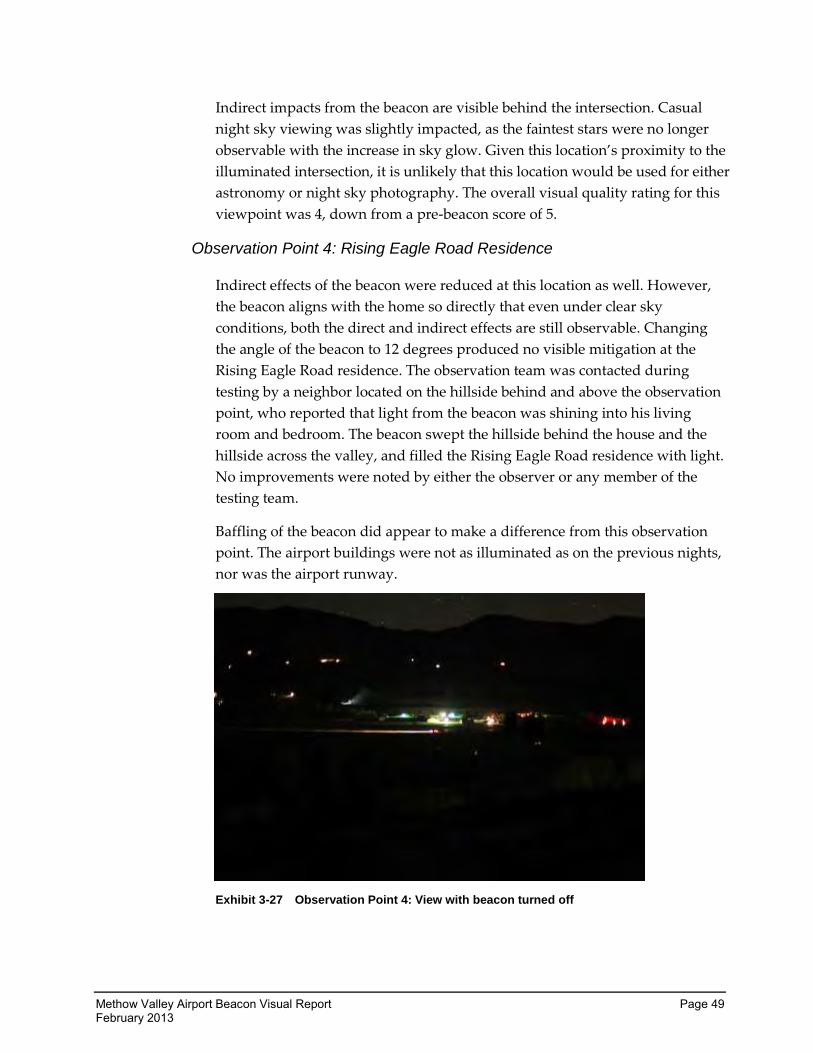
Methow Valley Airport Beacon Visual Report Page 49 February 2013
Indirect impacts from the beacon are visible behind the intersection. Casual
night sky viewing was slightly impacted, as the faintest stars were no longer
observable with the increase in sky glow. Given this location’s proximity to the
illuminated intersection, it is unlikely that this location would be used for either
astronomy or night sky photography. The overall visual quality rating for this
viewpoint was 4, down from a pre-beacon score of 5.
Observation Point 4: Rising Eagle Road Residence
Indirect effects of the beacon were reduced at this location as well. However,
the beacon aligns with the home so directly that even under clear sky
conditions, both the direct and indirect effects are still observable. Changing
the angle of the beacon to 12 degrees produced no visible mitigation at the
Rising Eagle Road residence. The observation team was contacted during
testing by a neighbor located on the hillside behind and above the observation
point, who reported that light from the beacon was shining into his living
room and bedroom. The beacon swept the hillside behind the house and the
hillside across the valley, and filled the Rising Eagle Road residence with light.
No improvements were noted by either the observer or any member of the
testing team.
Baffling of the beacon did appear to make a difference from this observation
point. The airport buildings were not as illuminated as on the previous nights,
nor was the airport runway.
Exhibit 3-27 Observation Point 4: View with beacon turned off
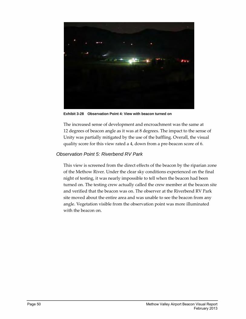
Page 50 Methow Valley Airport Beacon Visual Report February 2013
Exhibit 3-28 Observation Point 4: View with beacon turned on
The increased sense of development and encroachment was the same at
12 degrees of beacon angle as it was at 8 degrees. The impact to the sense of
Unity was partially mitigated by the use of the baffling. Overall, the visual
quality score for this view rated a 4, down from a pre-beacon score of 6.
Observation Point 5: Riverbend RV Park
This view is screened from the direct effects of the beacon by the riparian zone
of the Methow River. Under the clear sky conditions experienced on the final
night of testing, it was nearly impossible to tell when the beacon had been
turned on. The testing crew actually called the crew member at the beacon site
and verified that the beacon was on. The observer at the Riverbend RV Park
site moved about the entire area and was unable to see the beacon from any
angle. Vegetation visible from the observation point was more illuminated
with the beacon on.
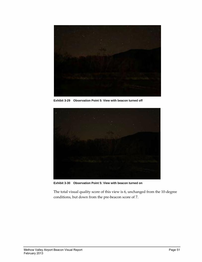
Methow Valley Airport Beacon Visual Report Page 51 February 2013
Exhibit 3-29 Observation Point 5: View with beacon turned off
Exhibit 3-30 Observation Point 5: View with beacon turned on
The total visual quality score of this view is 6, unchanged from the 10-degree
conditions, but down from the pre-beacon score of 7.
Page 52 Methow Valley Airport Beacon Visual Report February 2013
Mitigation
WSDOT-Aviation recognizes that the homeowners around the Methow Valley
Airport have been visually impacted by the operation of the new airport
beacon. Four different options were tested as mitigation for the impacts of the
beacon. All mitigation options tested had substantial visual impacts when
compared to night sky conditions with the beacon off. The effects of these
options are summarized below.
Which method provided the most mitigation?
The effects of the beacon had the least impact at the five observation points on
the third night of testing using the 12-degree angle with the baffling.
It is difficult to determine how much the change in angle contributed to this
reduction and how much is attributable to the clear night sky on that night of
testing. It is possible that, under the same atmospheric conditions, the
10-degree angle would produce the same results. However, a neighbor uphill
from the Rising Eagle Road residence was also impacted by light shining into
their windows using the 12-degree angle. Additionally, while the 12-degree
angle produced the least impact to the views of those tested, there is still a
large difference in view quality between the 12-degree angle option and the
view without the beacon on.
The baffling option is more readily assessed. Views from Observation Points 1
and 4 were improved by restricting the light from reflecting off the asphalt and
concrete surrounding the beacon. This mitigation may also be useful for those
residents living closer to the airport or, like Observation Points 1 and 4, directly
overlooking the airport. However, the beacon could still be seen sweeping
across the higher hills. Views from Observation Points 2, 3, and 5 were
unaffected by this mitigation.
Tabulation of results from public feedback supports the conclusion that the
12-degree angle with shielding option produced the greatest amount of
mitigation. This did not, however, significantly improve the situation for most
residents. The overwhelming comment received on the survey form after
testing was to move to pilot activation. It was felt by respondents that this was
the only mitigation that could fully address their concerns, while still meeting
the safety requirements of airport users.
Methow Valley Airport Beacon Visual Report Page 53 February 2013
What other forms of mitigation can be applied?
The mitigation most requested by viewers of the Methow Valley Airport
beacon is to change the beacon to pilot activation. This option is contingent
upon approval by the FAA. WSDOT-Aviation will request that the FAA
approve this change, since testing of the beacon options for mitigation failed to
provide another form of mitigation that was comparable.
Other options of partial mitigation for the light impacts from the airport are
available and can be applied. These options are discussed below.
Baffling the Beacon
Regardless of the beacon angle chosen, or if the beacon is placed on pilot
activation, testing showed a marked improvement from some observation
points with the addition of baffling. While no homes immediately adjacent to
the airport were part of the testing group, these homes are located at or slightly
above the elevation of the airport and many lack any vegetative buffer. These
residences and businesses, like Observation Point 4, may benefit from baffling
to reduce the reflective glare of the beacon.
Vegetative Buffers
None of the riparian buffer, which effectively screens Observation Points 3 and
5, as well as other residences and businesses not included in testing, exists on
lands owned by WSDOT-Aviation. These buffer areas are extremely important
for this and many other uses. WSDOT-Aviation does not have lands available
to create additional vegetative buffers, nor is it able to control the protection of
the existing buffer. Therefore, vegetative buffers on public lands are not a
viable option.
Recommendations
All beacon angles tested had substantial direct impacts to neighbors and
substantial indirect impacts to views of the night sky from properties not
directly in the line of sight of the airport. We recommend that the airport
beacon be pilot activated to minimize light and glare impacts and to reduce
night sky impacts to the few times of the year when the airport is needed at
night.
Page 54 Methow Valley Airport Beacon Visual Report February 2013
Other Lights at the Airport
Ambient light, which damages the night sky environment, is cumulative in its
effects. Under NEPA, cumulative effects of the project, when added to other
projects, and past, present, and reasonably foreseeable future actions,
regardless of what agency or person undertakes those other actions, must be
considered. This report additionally recommends the following:
1. Security lights and other lighting on the airport buildings should have
night sky-approved lighting techniques applied. These include:
a. Fully shielding the lighting to direct the light downward only; showing
a preference for those fixtures that do not emit any light above a
90-degree angle.
b. Using lower-wattage lights to minimize impacts outside the
illuminated radius of the light.
c. Using non-white bulbs and avoiding mercury vapor bulbs.
d. Shutting off all lights when not in use. Using motion detectors could be
an option.
Methow Valley Airport Beacon Visual Report Page 55 February 2013
Appendix A: Feedback From Residents
Following are the letters and emails that WSDOT-Aviation and Century West Engineering
received regarding the Methow Valley Beacon and the testing being done. This appendix also
contains some of the responses from WSDOT-Aviation when specific information was requested.
All email addresses, names, phone numbers, and physical addresses of residents have been
removed. Other than spacing, no other alterations were made to the originals.
Sent: Sunday, November 18, 2012 11:12 AM To: Johnson, Eric (Aviation) Subject: Beacon We very strongly oppose the beacon aspect of your project. This is completely unacceptable to a large number of valley residents. To benefit a very few and seriously degrade the environment for the remainder of us is wrong. We will continue to fight this in every way possible. Sent from my iPad
Sent: Friday, November 16, 2012 2:25 PM
To: Johnson, Eric (Aviation)
Subject: Methow Valley State Airport Beacon Dear Mr. Johnson,
We are writing to voice our concern over a dawn-to-dusk beacon at the Methow Valley State Airport. While we are all for safety and not opposed to a beacon per se, we are very concerned about the impact of a light sweeping across the sky all night, every night.
In the almost ten years we have lived across the river from the airport, I can recall only a few night landings at the airport. Is it really necessary to have a light shining in our community 365 nights a year to enable a handful of night landings that could easily be accommodated by a pilot-activated beacon? The airport is in what is essentially a neighborhood. Are the needs of a few rare night pilots to be put ahead of the needs of those who live in the surrounding neighborhood and will be affected every night?
When we were considering the purchase of our home across the river from the airport, we spent a fair amount of time weighing whether the airport would be an issue in terms of noise and light. We talked with neighbors and others who live nearby. In the end, we determined that there wasn’t enough air traffic to significantly affect the peace and quiet that we were seeking, and that the air traffic affects so much of the valley that living near the airport wouldn’t be much different than living in many other neighborhoods. The lights, while sometimes visible at night, were generally nonintrusive. The night sky was clear and bright, enabling star and aurora viewing year-round.
With a beacon shining dawn to dusk, this situation will change drastically, not just for us but for all who live in the valley. Like many valley residents, we have large windows in our living spaces and bedrooms that we enjoy day and night. With the beacon, we will need to cover these windows with light-blocking
Page 56 Methow Valley Airport Beacon Visual Report February 2013
shades just to sleep. In addition, the bright light creates light pollution that makes it difficult (at best) to see the nighttime sky and the northern lights, from our home and from many other locations. The first night it was on was a great night for aurora viewing, but we saw nothing but flashes of light to the north of us. The airport beacon, not the aurora.
Would we have purchased our home if the beacon had been shining dawn to dusk? Likely not. Does it affect our property value? Most likely, and surely we aren’t the only ones. The clear night sky is a significant asset for the Methow Valley, as one of the darkest areas left in the country. This is appreciated not just by residents, but by visitors as well. Let’s not destroy this with an unwanted light show.
The test scenario was absurdly limited as a way for residents to adequately evaluate impact. According to those who did manage to see it, the light was on for just a few minutes at a time over the course of several hours. We were never able to verify whether it was on or off, nor did we know clearly what angle was being tested. How can we comment in a survey or otherwise when the testing was so limited? To truly assess impact, we need to have the light on over the course of a number of nights, in different weather situations. If the beacon is truly to be considered, let’s give the community a fair chance to evaluate what the impact will be.
Regards,
We appreciate the opportunity to express our concern about the rotating, dusk-to-dawn beacon at the
Winthrop Airport. Dark night skies are one reason that we have a home in the Winthrop area, both for
the chance to view unobstructed skies with stars and auroras, and for the health benefits of restful sleep
provided by natural dark night skies. We ask that WSDOT explore other reasonable options for lighting
the airport for nighttime landings, which we understand are few, such as pilot-operated, short-term
lighting and runway lights. And we also ask that the community (both full and part-time residents)
potentially affected by the decision be given the opportunity for involvement in the decision process.
Thank you for including these comments as part of the public record for the beacon project.
Sent: Thursday, November 15, 2012 1:45 PM
To: Wolf, Paul; Johnson, Eric (Aviation);
Subject: Methow Airport Beacon
Re: Airport Beacon
November, 15 1012
WSDOT PMs. I am lending my voice to the chorus of concerns over the installation and operation of the "airport
beacon". Most, if not all of the concerned residences live in the Methow valley by choice, one born out of a love for nature, solitude and peace. Additionally, there’s a price to living in the valley, with a lack of economic opportunities “we” have traded away the financial security found in urban centers for a serene idyllic setting. Correspondingly we are fiercely protective of the environment around us. Speaking as part of the collective, we are a reasonable lot. Before making a decision please come meet with our community – in a Town Hall setting - to work out a solution that is in everyone’s best interest.
Kind regards,
Methow Valley Airport Beacon Visual Report Page 57 February 2013
Sent: Thursday, November 15, 2012 6:33 PM
To: Johnson, Eric (Aviation)
Subject: Airport Beacon The 70-member Friends of Bear Creek is dedicated to encouraging the stewardship of the land, the rural scale and pace, and the careful use of water resources in the Pearrygin Lake and Bear Creek Watersheds. We request that you pursue a pilot activated beacon solution vs. a dawn to dusk beacon. Dawn to dusk coverage is unnecessary, intrusive to residents and wildlife, and just plain obnoxious. We suggest you hold a public meeting and reschedule the testing. The intermittent duration of your previous tests could not have resulted in an accurate picture of how far reaching the beam actually is. Please reconsider your actions and discuss alternatives with the FAA. Thank You.
Sent: Thursday, November 15, 2012 10:03 PM
To: '[email protected]'
Subject: beacon
DOT and the Feds are missing the point with this beacon issue. Technology has
changed with radios and GPS navigation used by any sane pilot. There was a time
when pioneers in wagon trains marked their route for others by planting
sunflower seeds. This is not done anymore. Please respect our night skis in this
remote area by using technology to have the beacon pilot activated. It is an
oxymoron to attempt to make a beacon shine less! Make the beacon as bright as
possible but only when needed, ie pilot activated.
Below is the section on lighting (page 27) from the “Handbook of Suggested
Development Guidelines” that is used for the upper Methow Valley.
Page 58 Methow Valley Airport Beacon Visual Report February 2013
Here is a typical Design standard regarding lighting used in developments in the
Methow:
Decorative Lighting Standards
Decorative architectural night lighting, e.g., a light post, wall-mounted sconce, or recessed light fixture, is required near or directly on the entrance of each residence in Wilson Ranch. Lighting fixtures must have internal reflectors to minimize the spread of light outside the lighted area.
Methow Valley Airport Beacon Visual Report Page 59 February 2013
Sent: Monday, November 12, 2012 1:46 PM
To: Johnson, Eric (Aviation); [email protected]; Marvel, Nisha; Johnson, Eric (Aviation); Wolf, Paul
Subject: airport beacon at Methow valley smokejumper base
Dear WSDOT,
I am writing this letter in response to the installation of the airport beacon at the Methow Valley Smokejumper Base and its recent testing. I live directly across the Methow River and therefore am directly impacted by its use. Earlier this year the beacon was operated a number of nights much to the dismay of valley residents. I personally was awoken by one of the brightest lights I have ever seen flashing across the night sky and directly into my bedroom. The beacon was turned off a few nights later due to significant public outcry. Most recently, the beacon was tested on successive nights at a variety of angles and with different degrees of shielding.
It amazes me that the beacon was turned on in the first place with no public notification given the amount of outcry at the meeting called to address the proposed lengthening of the airport runway. The testing of November 5 thru 7 was flawed at best if informed public comment was the desired result. First, the light was operated from 6:30 to 8:00pm, a time when most people have any number of inside and outside lights on and are involved in activities that divert their attention from impacts. Second, the sequencing of angle changes and shielding was haphazard and intermittent, the light was on, the light was off. Frankly, it was hard to tell what was going on and when exactly was time to look. As I understand it, technicians would change the light, drive to a number of viewing locations, and observe the results. This process, along with inadequate public information beforehand, does not foster meaningful public input. According to the local grapevine, the SEPA prepared for the entire airport project, stated the operation of the proposed beacon would have no significant impacts and would not be different from the light that operated at the airport a number of years ago. The original light was of a much lower intensity and operated only when activated by an incoming plane.
I have lived in Okanogan county since 1975 and the Methow valley since 1990. I, along with my neighbors and fellow valley residents, live here because of the beauty, quiet and rural ambiance. A high intensity airport beacon shining through my bedroom window affecting my sleep, destroying the majesty of the night sky, negatively impacting my property’s economic value, and terrorizing the local wildlife, seems completely unnecessary and patently absurd given the use pattern at the airport. Having lived in proximity to the airport for 22 years, I am aware of the negligible amount of nighttime air traffic. Would not a pilot activated beacon make more sense? The beacon, as tested in all of its various configurations, significantly impacts the quality of life here in the valley and should only be allowed to operate on an as needed, non-continuous basis with maximum shielding and the highest angle possible.
Given the lack of planning and public information before testing, an inadequate testing procedure for public comment, significant negative impacts of beacon operation, and the absence of a demonstrated need, a public meeting should be held to gauge community sentiment on this issue. Thank you.
Sincerely,
Page 60 Methow Valley Airport Beacon Visual Report February 2013
-----Original Message-----
Sent: Monday, November 12, 2012 1:38 PM
To: Johnson, Eric (Aviation)
Subject: Twisp airport beacon
Dear Eric,
I am writing to continue to communicate my request that the beacon at NCSB be pilot activated rather than
constant: dusk to dawn. I completed the survey and there is no amount of angulation/baffling changes that
will mitigate the negative impact of a light like that on the Methow sky and the quality of life here- both for
people and creatures.
I appreciate the responsiveness you all showed this summer when you actually turned the light off due to
public comment. Please keep it off and make it pilot activated.
Thank you,
Sent: Monday, November 12, 2012 9:13 PM
To: Marvel, Nisha; Wolf, Paul; Johnson, Eric (Aviation)
Subject:
To whom it may concern @ WSDOT:
I am writing regarding the installation of the new beacon at the Methow Valley airport (Smokejumper's Base). I
think it is obvious that the citizens of the Methow Valley are overwhelmingly opposed to any beacon operating
during all nighttime hours. I know that regulations are sometimes necessary for safety but it is pretty clear that
the Smokejumper's Base does not need that kind of operating schedule. There are very few nighttime landings
and those could be safely performed with a pilot keyed beacon and landing lights. I live directly across the river
from the airport and I will not support and will vigorously oppose nighttime operation of the beacon as
proposed. It would be the most egregious form of light pollution in a valley that is traditionally a rural refuge
from such intrusion. We love our night sky and sense of isolation and will not allow it to be disturbed by rules
and regulations that have no application here.
Sincerely,
Methow Valley Airport Beacon Visual Report Page 61 February 2013
Sent: Monday, November 12, 2012 2:40 PM
To: Wolf, Paul; Marvel, Nisha
Subject: Winthrop Airport Beacon
November 12, 2012
Dear Mr Wolf
In regard to the Winthrop Airport beacon, I wish to make a few comments and ask some questions.
This beacon will interfere with sleep, causing much stress and strain on the households located around it.
It also destroys the pleasure of the night skies – star gazing, meteor watching and observing the Aurora
Borealis. This beacon has taken a rural area and turned it into something that feels like a prison ground
with a rotating search light constantly blinking in our windows and lighting up the walls inside our house
and the clouds outside as well.
While it was courteous of you to do some testing during the past week, your methodology appears
flawed. It seemed that the testing was set up for the convenience of the numerous DOT employees
driving around the valley in multiple vehicles. The notice given said the test would run from 6:30 til 8:00
pm when in fact it ran for a few minutes several times between those hours. I asked people if they’d had
a chance to see the testing and many said they had not. Additionally, you scheduled it during the election
when most people wanted to follow the returns. And in November, most people who have second homes
in the Methow are not even here.
It seems that the Washington State Department of Transportation saw an opportunity to get some ‘easy
money’ from the federal government and for some reason, thought that people in this rural valley would
not mind having a dusk to dawn rotating light in their houses 365 days of the year. Really? What were
you thinking? You have in fact with this beacon, destroyed my quality of life.
Has the DOT demonstrated a need for the beacon other than the fact that FAA requires it when
you spend federal money to improve an airport?
Did the DOT actually inform the public that they were installing a dusk to dawn rotating beacon
that would light up the night sky of the middle Methow Valley in addition to lighting up many
households? I can find no record of it.
Did the DOT do an adequate SEPA for this project? In light of the uproar caused by this beacon, is
the DOT going to start over and do an EIS? What is the cost of an EIS – approximately?
How much federal money did the DOT take?
Has the DOT considered returning the money to the federal government?
Has the DOT considered the impacts to wildlife, including migrating birds and bats?
I think that everyone around the airport is in favor of pilot safety and no one has argued that the
pilot-activated runway lights are a bother. Perhaps it is time for you to make the beacon also
pilot-activated.
Sincerely
Page 62 Methow Valley Airport Beacon Visual Report February 2013
Sent: Thursday, November 15, 2012 12:42 AM
To: Wolf, Paul
Subject: Methow Valley Beacon
Hello, I am writing as a homeowner in the Methow Valley. The use of a all night beacon on an airport
that gets zero night flights is just beyond reason. In fact there is not one flight a week in the day for
most of the year, much less at night. The situation of the airport being at the center part of the valley
makes it uniquely qualified to ruin the night sky from top to bottom. From our families house when the
light is turned on, it feels like a prisoner of war camp with a beam lighting us up ever few seconds.
Is there any documentation of night flights to this airport? Keep in mind that it is only busy with
flights in the summer, when the night does not come till 10 PM. We all have to live here all winter
when the night lasts forever, with a beacon in our eyes-----and NEVER a night flight on the way!
Thank you for your attention on this issue.
From: Wolf, Paul
Sent: Thursday, November 15, 2012 8:37 AM
Subject: Airport light
Dear
Thank you for your comments regarding the Methow Valley State Airport Beacon issue. Your comments will become part of the public record and I will forward them on for inclusion into the visual analysis currently being conducted. WSDOT Aviation will provide answers to your questions via the analysis report.
Sincerely,
Paul Wolf WSDOT Aviaiton Division State Airports Manager
WSDOT
Please consider my letter concerning the rotating light at the Smoke-jumper Base. I live on Old Twisp Highway almost directly across the river from the airport and have been a resident there for nearly forty years. I appreciate the need for the Jumper Base and as an EMT, I have helped load many patients on planes and helicopters to send them to distant hospitals. The light in the past has been an infrequent annoyance that we endured because it was supposedly needed. I question the need for the bigger better replacement. Pilot friends have said that to activate the old light you only needed to click your radio microphone on a particular frequency and the light came on. Why the need for the new light in this age of modern electronics? The new light can surely be seen from space and a modern GPS unit should be all that's required to find the airport. An upgrade of facilities shouldn't always mean bigger and more annoying. Do what is necessary but remember that people live near the airport and don't want their world disrupted with unnecessary gadgets in the name of progress. Keep the Methow Valley a friendly place to live.
Methow Valley Airport Beacon Visual Report Page 63 February 2013
Sent: Tuesday, November 13, 2012 9:15 PM
To: Wolf, Paul
Subject: Winthrop Airport Beacon
Dear Paul, I agree wholeheartedly with those many folks who vehemently oppose the light pollution caused by the airport Beacon. I say NO to this intrusion anecdotes degradation to the quality of life here in our cherished Methow Valley. Please remover this eyesore for good. Thank you.
Sent: Monday, November 12, 2012 1:12 PM To: Marvel, Nisha Cc: Wolf, Paul; Turner, Jacqueline; Salisbury, Sandy; Hodgman, Robert; Ken Bevis; Alan and Marcia Ringgold; [email protected] Subject: Re: Airport beacon testing to address community concerns
I appreciate the difficult spot WSDOT is in trying to backtrack and analyze the impacts of the beacon. It doesn't change the fact that this was not part of the original SEPA process. Had it been, WSDOT would have received similar comment when the beacon was turned on, and could probably have avoided this outrage. In addition to the procedural issue of evaluating the beacon, we don't need it because: 1. There are no night landings in the Methow Valley in the winter, and few in the summer. Other regional airports with beacons (Cle Elum, Chelan, Omak) suffice for an emergency landing, if necessary. 2. The community did not ask for these upgrades, nor did the smokejumpers. We would have asked WSDOT to turn away the federal funds had adequate analysis been conducted. 3. The technology is outdated. The community already offered a compromise - hook it to the pilot activated lights. If that can't be done, it makes no sense to have a rotating beacon from dusk to dawn (14 hours in the winter!) with today's technology in planes. 4. The FAA circular sighted by WSDOT appears to allow remote control activation of a beacon. Section 8.6.3 of circular 150/5345-56B suggests that "the beacon may be connected via a radio, fiber optic, telephone line or photocell." Therefore, WSDOT just needs to tell FAA that is what will happen.
Please keep it off.
Good luck,
Sent: Thursday, November 15, 2012 6:51 AM To: Wolf, Paul Subject: LIGHT
Why are you doing this to a place like the Methow Valley. We do so much to preserve the night sky and
something so not needed comes along and puts everyone in a angry mood. Please keep the light on the
airport out.
Page 64 Methow Valley Airport Beacon Visual Report February 2013
Sent: Sunday, November 11, 2012 7:39 PM To: Wolf, Paul Subject: Winthrop Wa. airport beacon
Dear Mr. Wolf,
I am writing to express my concerns about the beacon at the Winthrop Airport. I have lived in the Methow Valley for over 20 years and it is considered to be one of the premiere areas for viewing the night skies. The beacon will have a negative impact on this viewing as well as the surrounding households, who will constantly be seeing it every night. Also, the public was not informed of the potential effects of the beacon, prior to going forward with the project.
It has been documented that there are very few planes that land at night at the airport. Therefore a beacon is not needed. I am in favor of a pilot activated beacon for the airport. This would satisfy both parties.
Please add my comments to the community’s feedback. Thank you.
Sincerely,
Sent: Sunday, November 11, 2012 5:36 PM To: [email protected] Cc: Wolf, Paul Subject: methow valley beacon
the following is a letter sent to you recently concerning the beacon at the methow valley airport in north
central washington. since i could not possible write anything more to the point than this, i am sending it
along to let you know that i agree 100% with the opinions stated herein.
thanks for your consideration.
Dear WSDOT,
I am writing in regards to the beacon which has been installed at the Methow Valley State Airport
(Smokejumper Base). With all due respect I must tell you the beacon is intolerable. It creates horrible
light pollution worse than I've ever experienced in any city. The old beacon came on only when a plane
was landing at night, was significantly less bright, and stayed on for about 1/2 hour. It was unpleasant
and annoying but one could live with it. I must emphasize that there is no comparison between the old
beacon and the new beacon. The new beacon is HORRIFIC! At most it should only be used right when a
plane is landing and then it should be shielded as much as possible and aimed at the highest angle for the
shortest duration possible.
I would also like to point out the inadequacy of the so-called test period and opportunity for public
comment. The test times were inconsistent in that the beacon was tuned off and on at sporadic
intervals so that a person might turn off their house lights during the test period and sit in their home
and think that the beacon was not even noticeable when in actuality the beacon wasn't even on. I had
this happen to me. On the first test night I turned my house lights off, lay down in my bed, and thought
all was fine; then the beacon came on and I was absolutely shocked at the intensity of the flashing light in
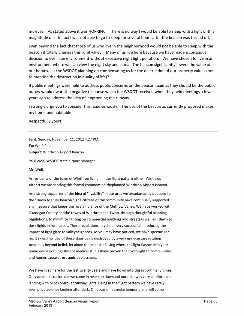
Methow Valley Airport Beacon Visual Report Page 65 February 2013
my eyes. As stated above it was HORRIFIC. There is no way I would be able to sleep with a light of this
magnitude on. In fact I was not able to go to sleep for several hours after the beacon was turned off.
Even beyond the fact that those of us who live in the neighborhood would not be able to sleep with the
beacon it totally changes this rural valley. Many of us live here because we have made a conscious
decision to live in an environment without excessive night light pollution. We have chosen to live in an
environment where we can view the night sky and stars. The beacon significantly lowers the value of
our homes. Is the WSDOT planning on compensating us for the destruction of our property values (not
to mention the destruction in quality of life)?
If public meetings were held to address public concerns on the beacon issue as they should be the public
outcry would dwarf the negative response which the WSDOT received when they held meetings a few
years ago to address the idea of lengthening the runway.
I strongly urge you to consider this issue seriously. The use of the beacon as currently proposed makes
my home uninhabitable.
Respectfully yours,
Sent: Sunday, November 11, 2012 4:27 PM
To: Wolf, Paul
Subject: Winthrop Airport Beacon
Paul Wolf, WSDOT state airport manager
Mr. Wolf,
As residents of the town of Winthrop living in the flight pattern ofthe Winthrop
Airport we are sending this formal comment on theplanned Winthrop Airport Beacon.
As a strong supporter of the idea of "livability" in our area we areadamantly opposed to
the "Dawn to Dusk Beacon." The citizens of thiscommunity have continually supported
any measure that keeps the ruralambience of the Methow Valley. We have worked with
Okanogan County andthe towns of Winthrop and Twisp, through thoughtful planning
regulations, to minimize lighting on commercial buildings and streetsas well as dawn to
dusk lights in rural areas. These regulations havebeen very successful in reducing the
impact of light glare to valleyneighbors. As you may have noticed, we have spectacular
night skies.The idea of these skies being destroyed by a very unnecessary rotating
beacon is beyond belief, let alone the impact of living where thislight flashes into your
home every evening! Recent medical studieshave proven that over-lighted communities
and homes cause stress andsleeplessness.
We have lived here for the last twenty years and have flown into thisairport many times.
Only on one occasion did we come in near sun downand our pilot was very comfortable
landing with pilot controlledrunway lights. Being in the flight pattern we have rarely
seen privateplanes landing after dark. On occasion a smoke jumper plane will come
Page 66 Methow Valley Airport Beacon Visual Report February 2013
in late. We support having the Beacon being pilot activated whennecessary but never a
continuing rotating beacon.
Respectfully,
Sent: Wednesday, November 14, 2012 2:31 PM To: Johnson, Eric (Aviation) Subject: Methow Valley airport
Dear Sir: I am writing to register my unequivocal opposition to the permanent airport beacon at the Methow Valley airport. Anyone who lives here knows that this is an airport with very little night traffic. Since the existing lighting has been adequate in the past for those rare occasions when the airport must be accessed at night, there is absolutely no reason to pollute our beautiful night skies with a permanent beacon. Have you ever been here in the Methow Valley to see our skies at night? Have you ever slept outside at night here? Can you name the constellations, and do you know their nightly and seasonal movements? Do you know the cycles of the moon, and can you identify the shape of the crescent moon as it is waxing or waning? Do you know the date of our next meteor shower? Can you identify the planets and their seasonal changes? Have you ever seen the northern lights here? Have you seen the northern lights and a meteor shower at the same time? It is a truly awesome experience, and something never to be forgotten. You should come here sometime and spend an entire night outside, looking at the sky. A permanent airport beacon is an outrageous affront to one of our most beloved and cherished environmental assets--our night skies. Night skies are free to everyone, and the beauty of the night skies is enjoyed by locals and visitors alike. Very few communities are able to enjoy and learn from dark night skies; we are so very fortunate here in the Methow. Furthermore, I am completely appalled to think that this permanent beacon is part of a money-grab for federal dollars. Improvements are one thing when they are made as a result of a real and pressing need. If improvements need to be made to the airport, fine. But a permanent night light is not necessary by any means. Turn the beacon off. Let incoming pilots activate a beacon when it is needed, as often as it is needed, and ONLY when it is needed. Sincerely,
Methow Valley Airport Beacon Visual Report Page 67 February 2013
To whom it may concern @ WSDOT
I am writing regarding the installation of the new beacon at the Methow Valley airport (Smokejumper's Base). I
think it is obvious that the citizens of the Methow Valley are overwhelmingly opposed to any beacon operating
during all nighttime hours. I know that regulations are sometimes necessary for safety but it is pretty clear that
the Smokejumper's Base does not need that kind of operating schedule. There are very few nighttime landings
and those could be safely performed with a pilot keyed beacon and landing lights. I live directly across the river
from the airport and I will not support and will vigorously oppose nighttime operation of the beacon as
proposed. It would be the most egregious form of light pollution in a valley that is traditionally a rural refuge
from such intrusion. We love our night sky and sense of isolation and will not allow it to be disturbed by rules
and regulations that have no application here.
Sincerely,
November 12, 2012
Dear Mr Wolf
In regard to the Winthrop Airport beacon, I wish to make a few comments and ask some questions.
This beacon will interfere with sleep, causing much stress and strain on the households located around it.
It also destroys the pleasure of the night skies – star gazing, meteor watching and observing the Aurora
Borealis. This beacon has taken a rural area and turned it into something that feels like a prison ground
with a rotating search light constantly blinking in our windows and lighting up the walls inside our house
and the clouds outside as well.
While it was courteous of you to do some testing during the past week, your methodology appears
flawed. It seemed that the testing was set up for the convenience of the numerous DOT employees
driving around the valley in multiple vehicles. The notice given said the test would run from 6:30 til 8:00
pm when in fact it ran for a few minutes several times between those hours. I asked people if they’d had
a chance to see the testing and many said they had not. Additionally, you scheduled it during the election
when most people wanted to follow the returns. And in November, most people who have second homes
in the Methow are not even here.
It seems that the Washington State Department of Transportation saw an opportunity to get some ‘easy
money’ from the federal government and for some reason, thought that people in this rural valley would
not mind having a dusk to dawn rotating light in their houses 365 days of the year. Really? What were
you thinking? You have in fact with this beacon, destroyed my quality of life.
Has the DOT demonstrated a need for the beacon other than the fact that FAA requires it when
you spend federal money to improve an airport?
Did the DOT actually inform the public that they were installing a dusk to dawn rotating beacon
that would light up the night sky of the middle Methow Valley in addition to lighting up many
households? I can find no record of it.
Page 68 Methow Valley Airport Beacon Visual Report February 2013
Did the DOT do an adequate SEPA for this project? In light of the uproar caused by this beacon, is
the DOT going to start over and do an EIS? What is the cost of an EIS – approximately?
How much federal money did the DOT take?
Has the DOT considered returning the money to the federal government?
Has the DOT considered the impacts to wildlife, including migrating birds and bats?
I think that everyone around the airport is in favor of pilot safety and no one has argued that the
pilot-activated runway lights are a bother. Perhaps it is time for you to make the beacon also
pilot-activated.
Sincerely
Sent: Friday, November 09, 2012 5:27 AM
To: Wolf, Paul
Subject: Beacon at Methow Airport
Good Morning.
We have recently purchased property on Rising Eagle Road just above the Methow Airport, and we are
contemplating with great misgivings your proposals for a safety beacon. We would like to weigh in on
your project and offer you some thoughts to consider.
The Methow Valley is one of those remaining idyllic spaces where people can live an active and healthy
outdoor life, free of urban congestion, surrounded by natural beauty, simplicity, and only those
intrusions that they find crucial to a safe, healthy and meaningful life. Your beacon, no matter at what
angle you place it or how you shield it, is an unwanted and unneeded intrusion on this beauty, severely
infringing on the stupendous Methow Valley night sky. We assume you have had the opportunity to
view the Methow skies on clear nights and to be awed by their natural beauty. Having that beauty
ruined by a bright light shining from the airport is unthinkable.
We recognize that this small airport is an important aviation presence in the area, serving as the center
for fire fighting activities and as an emergency site for us and our area. We also can see the need to
allow the airport to be an ever-present available landing site for aircraft with issues. However it is clear
that the airport is not, and was not meant to be, a permanent aviation facility. To us, that means that
there is no safety-related need to have a permanent beacon situated on the airport site. One that could
be put into service for use in times of need would certainly suffice. The technology obviously exists for
pilots to activate beacons remotely when they have a reasonable need for them. We would certainly
not object to a beacon in times of emergency. We would not be in favor of a pilot-activated beacon if it
could be used for recreational pilots to use the airport at night for their pleasure or
convenience. Emergencies would certainly be acceptable.
Methow Valley Airport Beacon Visual Report Page 69 February 2013
There's no need for a permanent beacon at this airport. It would be an extremely intrusive and
destructive presence in our night skis, ruining one of the truly important reasons we all bought here and
enjoy living here. We urge you to forget this disastrous venture and to consider something more
intelligent, more efficient and more nature and neighbor friendly.
Thank you very much.
Dear Nisha, We wanted to be sure all is told about the testing done on the airport beacon. My wife and I built our home 12 years ago in this valley for a reason. The valley is a "one of a kind" location. The dark sky's at night are a specticle to see. One of the testing areas was completed from our neighbor's home just below ours on the west side of the valley above the airport. All three nights we were watching to see of any change. There were none noticed. The beacon light lights up our livingroom and bedroom ceiling like someone is outside with a flash light going off every two seconds. Our front deck faces the valley and we can no longer sit outside and view the beautiful dark night sky's. We were told this beacon is a requirement of the FAA. Who decided without any property owners input this was necessary? This beacon must not be started in its current configuration. We witnessed a neighbor who is shielded by the trees on the south/west side of the beacon. These trees are higher than the 12 degree test. It seems to us there has been no consideration for property owners who choose to live in this beautiful valley. Why does this airport not have pilot activated lights like other airports. As you are aware, night landing do not happen enough for this beacon. We are prepared to make a stand on this issue and visit every property owner in the valley for a voice who can be heard.
I would like to comment on the Methow Valley State airport Beacon; Driving by the state airport beacon on Highway 20 I did notice the beacon on Wednesday Nov. 7th. Though it was not as intrusive as I though, there was no cloud cover, which would enhance the reflection of the beacon light. This would be very intrusive. Also it does seem to be a waste of energy and and expense to taxpayers to keep the beacon on and rotating from dusk to dawn every night, when the airport does not support any commercial aviation traffic or even private traffic. This beacon should be pilot controlled along with the airport runway lights to really be cost effective.
Michael Real , Commercial pilot, former air transport pilot and aircraft owner.
Page 70 Methow Valley Airport Beacon Visual Report February 2013
Sent: Thursday, November 08, 2012 3:20 PM To: Hodgman, Robert Subject: Methow Airport
Good afternoon Rob Hodgman, Senior Aviation Planner
I appreciate your phone call earlier. I have attached an unsigned copy of the letter you will receive by
mail. I will also ask Sharon to forward you a signed copy electronically when we get it scanned. The
letter should be consistent with our phone conversation. Please let Sharon know if you have need for
the forms listed in the letter.
Thank you again for your prompt attention to this matter.
Sent: Wednesday, November 07, 2012 9:15 AM To: Marvel, Nisha Subject: methow airport beacon -- copy of permits
Dear Nisha,
How can I obtain copies of the original permit application and environmental checklist associated with the recent Methow Valley airport improvements, including the new beacon?
Best regards,
Hello,
Please send me or email me the form for public comment for the beacon light at the
Methow Valley Airport. The light will totally stop any form of contentment or
relaxation at night for me and my neighbors. It's horrific!
Thank you,
Methow Valley Airport Beacon Visual Report Page 71 February 2013
An open letter to the WSDOT personnel responsible for airport beacon testing
----------------------------------------------------------------------------------------------------------------
Dear Sirs,
Your testing process makes it practically impossible for local valley residents to asses the impact of your beacon because,
1) You haven't told us what test is being done when,
2) Your beacon fires off at unpredictable times, and
3) Today, you arbitrarily changed the test window.
It is raining this evening, in case you haven't noticed. Do you expect us to stand outside in the rain, waiting to see what will happen next? During most of the test interval, we see nothing but darkness because the beacon operates only sporadically. It's like waiting for the cable guy to show up. You never know when it might happen. I call my neighbors and tell them to look, then it goes off. This is infuriating.
Simply leaving the beacon on during the entire test period, or telling us when it will be on so we can look for it and observe it, would have been not just polite but necessary to maintaining good relations with the community during this difficult period.
Photographs of the beacon are impossible to take with ordinary photographic equipment because the beam moves too rapidly to be caught in the exposure time required by ordinary digital cameras. YOU DID NOT PLAN A PERIOD WHEN THE BEAM WAS STILL SO WE COULD TAKE PHOTOGRAPHS. You are supposed to be the "experts". Did you not think of this??? The way your test program has been constructed, only you can make photographs of the event. Frankly, I do not trust you to take photographs representative of the event.
The consequences of this test will affect the lives of everyone within eyesight of the beacon, and their children, and their children's children. I would think you would take more care to do the tests in a clear manner that the public can understand.
Best regards,
REPORT ON BEACON TESTING DURING THE FIRST NIGHT
(Don, you are welcome to use any or all of this text in whatever manner suits you).
At 6:30pm Nov. 5, testing began. The sky here is partly cloudy. I am observing the test from my home at 150 Signal Hill Rd, on the West side of the Methow River, at an elevation of approximately 2400 feet. We enjoy an unobstructed 180-degree view of the opposite side of the river and the hills behind. The view of the airport itself is blocked by a small foothill in our foreground. The siting of this house was planned intentionally so that the foothill would block all view of the airport lights. From our location, due to the foothill, we do not see the flash of the beacon itself -- only the wash of light sweeping the sky. How, you may ask, can you see a light penetrating the clear sky? The answer, of course, is the the sky is never clear. There is always some humidity, dust, or smoke that makes rays of light perfectly visible at night. This is how laser light shows work. Try it with a flashlight, the beam at night is clearly visible.
Page 72 Methow Valley Airport Beacon Visual Report February 2013
Try it with a 100,000 candela narrow-beam light source like the airport beacon, and the beam becomes dramatically more visible. When the beam spins, the light cuts a swath through the air. It scours the hills behind the airport. Emotionally, you can feel the beacon washing over your face each time it passes, every two seconds. It looks like a laser light show that never ends. Late in the testing, the clouds have receded and the sky cleared. That reduces the intensity of the effect here to a slight degree, but the flash of the beam as it diffuses through the sky still remains more intense than the glow of the Milky Way. One cannot look at the heavens in any direction without constantly being reminded of the beacon. The pulsing light penetrates my windows. It flashes through the skylight above my bed. I understand that the DOT is testing various changes to the exact angle of light "shielding". In my opinion, no change in the angle of shielding will make any difference. It does not matter precisely how the little shield around the bulb is adjusted. The mere existence of the light is the problem. Pouring that many lumens into the sky at night, pulsating madly, destroys the beauty of the night sky. In a city, competing against millions of other existing lights, perhaps the people there could decide that one more affront to nature is worth the perceived benefits to aviation. Here in the country, where people visit my home every year and comment that they have, "Never seen the Milky Way," the thought of losing our ability to enjoy a clear view of the night sky is too much to bear.
Aristides Pappidas, talking about the "foreverness" of what might happen, said this:
People affected by it......and the 'test' last night revealed scores of homes containing multi-scores of people..... are only one aspect of something human that must be publicly revealed and addressed. It's just not ourselves being affected but also our children, our grandchildren, our descendants and all the peoples who will be living in visual range of the airport's beacon. They who are going to be deprived every night, forever, of looking up into the cosmos and making that most direct connection to what we are and what we are made of..... where we come from. We've got to stop that beacon from being used (unless whatever government controls things like airports in Washington State creates an exception that would allow it to be used only on an emergency, need-to-use basis.
Sent: Monday, November 05, 2012 8:51 PM To: Marvel, Nisha Subject: RE: Methow airport beacon light
Dear Nisha Marvel
I live directly across the river from the airport and the beacon light is so obnoxious that I cannot even
begin to express myself in a rationale manner about my reaction to it. It is intolerable! I have never
experienced such horrible light pollution in my entire life. Never in a visit to a large city have I ever
experienced anything that comes anywhere near equaling what I experienced when I turned off my
bedroom light shortly after 8 pm tonight. Again it is intolerable.
-----Original Message-----
Methow Valley Airport Beacon Visual Report Page 73 February 2013
Sent: Friday, November 02, 2012 11:27 PM To: Wolf, Paul Subject: Methow Valley airport beacon
I own a home on Signal Hill road, directly above the Methow Valley airport. I am leaving the country on November 4th, and don't return until November 30th so I won't be present during the brief "test" that is proposed for November 5-8 of the beacon, however I very much want my comments to be included in the public comment period. Quite frankly I cannot imagine that the proposed angle alteration is going to solve the outrage that this beacon would bring to the valley. A higher angle may lesson to some degree the impact for residences lower down in elevation, but is likely to only increase the impact on those of us higher up. In addition to the residences directly impacted cloudy skies will likely diffuse the light to impact even more residents. It is unbelievable to me that this beacon is being considered at all. One of the great amenities of the Methow Valley is the peaceful and DARK night sky where the stars are so brilliant. A constantly flashing beacon is totally at odds with this environment. In addition I can't imagine that such a beacon is even remotely "necessary." Because my property is located across from and above the airport, I hear almost every plane that lands or takes off at the airport and I almost never hear landings at night. Even during the day the landings and take offs are infrequent, except during fire season. I am not privy to the statistics of night-time landings and take offs at the airport but they can't be very significant. And yet, even with the paucity of nighttime airport use this horror is being perpetrated on valley. This is quite frankly insane and an enormous insult to the wishes of the public. It is this kind of thing that fuels disgust and distrust of a remote "big" government. I normally support governmental regulations for public health and safety, but there has to be an exception for situations when the normal benefits of a regulation are not likely to felt and instead a significant burden will be laid at the feet of the public, without expectation of benefit. Please assist us in preventing this beacon from becoming a valley nightmare.
Sent: Mon 10/29/2012 9:50 PM To: Johnson, Eric (Aviation); Wolf, Paul Subject: Winthrop Airport Beacon and upcoming Test Nov 5-7
Dear Mr. Wolf and DOT staff involved w/ the Winthrop Airport Beacon:
On October 1, 2012, I sat on our deck looking north at an incredible display of the Northern Lights. Tall candles of white light stood 20-30 degrees into the dark sky, faint cloudlike waves came and went. It was amazing. Tonight, I looked to the NE and watched the spectacular full moon rise over the ridge. The tree silhouettes appearing in the face were stark and jagged. On many nights we enjoy the milky way sweeping across the night sky.
All of these sights are only slightly diminished by the scattering of background lights in the valley we look out upon. Our view encompasses the Winthrop airport, and the operation of the beacon would significantly diminish these night sky wonders.
The strong response you received when the incredibly bright rotating beacon appeared in the valley bottom, illuminating the ridges and shining brightly in our windows indicates the depth of value placed on the aesthetic of the sky here. I understand you plan to turn the beacon back on, and appreciate the gesture of testing different possible methods to deal w/ the concerns of neighbors. However, I am extremely doubtful that any angle adjustment or partial shielding will significantly diminish the effects of the beacon. Our home would be particularly impacted by operation of the beacon. To this end, I have sent an email invite to the DOT team (Mr. Stiles) studying this situation to use our home as one of their test viewpoints.
Page 74 Methow Valley Airport Beacon Visual Report February 2013
The Aviation Safety reasoning for the beacon holds little meaning in this world of GPS and fast communication. The new runway lighting apparently comes on when airplanes key their mike, or somehow signal presence, somewhere in a vicinity radius (?right?). The runway lights come on periodically, and no one lands. I have been watching from our home overlooking the airport closely for night landings since mid July: I have personally witnessed only one night landing since July 14, and that was the smokejumper plane returning just after dark. The likelihood of an airplane with no radio, no GPS, flying lost across remote N. Central Washington, and suddenly finding the Winthrop Airport Beacon is extremely remote, if not impossible. Winthrop has no commercial service of any kind, and recreational use is during the day, mostly on weekends.
In addition to the extremely unlikely nature of the beacon's use as an emergency signal, the beacon is unnecessary as a continuous signal for regular landings, as there are no airplanes landing here at night. No airplanes. Emergency beacons are outdated technology, as virtually all airplanes have radios and could cue the runway lights. The beacon could be hooked into the runway lights and be pilot activated. Simple. Did I mention that there aren't any airplanes landing at night in Winthrop?
Excessive night lighting is thought to disrupt migratory patterns of birds, bats and insects. The Methow is a "dark sky" environment and this continuous bright source would negatively effect these migrating organisms who otherwise encounter natural night. This element of the beacon would be invisible and substantial. It would need to be investigated for environmental impact.
No matter how the beacon might be operated, it will significantly hurt the aesthetics, wildlife and property values of the upper Methow Valley.
Although I appreciate the nature of the upcoming tests, I strongly suspect that upon their completion I will still feel that:
The Winthrop Airport Beacon should be either 1) Pilot activated or 2) turned off.
Sincerely
Hi Paul,
Thanks for sending out the press release about the upcoming beacon testing at the Methow Valley State
Airport. It has generated some community buzz already.
I just left a message on your voice mail. I'll write my questions here so you can look at them and respond
either by email or give me a call and we can talk.
I assume that if you reply in writing, I can quote you as in a conversation.
1. Is the upcoming beacon testing a result of meetings with the FAA? When/Where/and who met to discuss the community's issues with the beacon? What was the result of those meetings?
WSDOT met with the FAA on August 1, 2012 at FAA office is Renton to discuss solutions to the
beacon concerns.
After meeting with the FAA, WSDOT initiated a Visual Analysis Study to the assess the potential
for visual impacts and recommend mitigation strategies. The testing is part of that analysis.
Methow Valley Airport Beacon Visual Report Page 75 February 2013
2. Was the option of not having a 24-hour lighted beacon discussed?
WSDOT discussed several options with the FAA, including not having a 24-hour lighted beacon.
Since it was a federally funded project, WSDOT must comply with FAA grant assurances to
operate the beacon from dusk until dawn. However, the visual analysis will assess the potential
impacts and offer us mitigation strategies and explore different options. The FAA is working
closely with WSDOT on the analysis.
3. Who will be conducting the testing on Nov. 5-7?
WSDOT’s North Central Region (NCR) is conducting the visual analysis. They are supported by
WSDOT HQ Geometrix Visual Engineering Group (VERG) and Century West Engineering.
4. What exactly is "visual analysis?"
The visual analysis is a study to determine the effects of the beacon’s light emission on Methow’s
community, develop mitigation strategies, test strategies, obtain public input and provide
suggested modifications.
5. What are the shielding options?
WSDOT cannot modify the airport beacon outside of manufacturer’s specifications; therefore, we
are working with our engineers and the beacon manufacturer to obtain authorized “baffles” for
our beacon model. The baffle is simply a cover that partially blocks or shields light emitted from
the beacon. WSDOT will test the shielding as a potential mitigation measure.
6. Why do you think that adjusting the angle or shielding the beacon will take care of the issues?
The beacon was originally set to the FAA and manufacturer’s recommended 5-degree angle,
which prompted complaints from airport neighbors. We are testing the beacon at higher angles
to determine if this minimizes the light impact on the valley. We will also test shielding options
and ask the community for feedback. It is our goal to consider and test options that will help us
find reasonable solutions for neighbors, while also allowing us to remain in compliance with
regulatory requirements for both the airport and surrounding environment.
7. How do you plan to assess the impacts on residents living above the valley floor?
The visual analysis will follow a scope of work and conduct testing through a series of specified
observation points established before the testing occurs. Public feedback will be included.
8. How will you solicit feedback from the community?
Following the testing, WSDOT will solicit comments from Nov. 9 - 16. WSDOT will send notices to
residents and provide a comment form on our website. We will also provide forms to those
without Internet access.
9. After the testing on Nov. 5-7 will the beacon remain turned off?
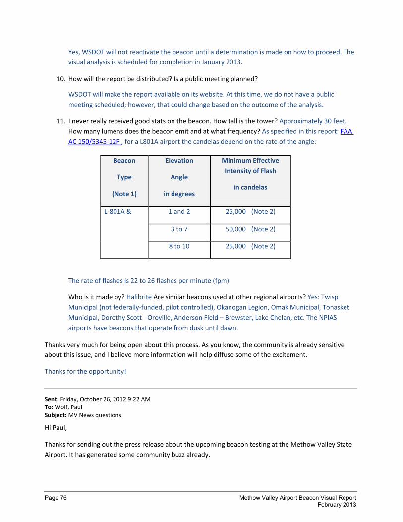
Page 76 Methow Valley Airport Beacon Visual Report February 2013
Yes, WSDOT will not reactivate the beacon until a determination is made on how to proceed. The
visual analysis is scheduled for completion in January 2013.
10. How will the report be distributed? Is a public meeting planned?
WSDOT will make the report available on its website. At this time, we do not have a public
meeting scheduled; however, that could change based on the outcome of the analysis.
11. I never really received good stats on the beacon. How tall is the tower? Approximately 30 feet.
How many lumens does the beacon emit and at what frequency? As specified in this report: FAA
AC 150/5345-12F , for a L801A airport the candelas depend on the rate of the angle:
Beacon
Type
(Note 1)
Elevation
Angle
in degrees
Minimum Effective
Intensity of Flash
in candelas
L-801A & 1 and 2 25,000 (Note 2)
3 to 7 50,000 (Note 2)
8 to 10 25,000 (Note 2)
The rate of flashes is 22 to 26 flashes per minute (fpm)
Who is it made by? Halibrite Are similar beacons used at other regional airports? Yes: Twisp
Municipal (not federally-funded, pilot controlled), Okanogan Legion, Omak Municipal, Tonasket
Municipal, Dorothy Scott - Oroville, Anderson Field – Brewster, Lake Chelan, etc. The NPIAS
airports have beacons that operate from dusk until dawn.
Thanks very much for being open about this process. As you know, the community is already sensitive
about this issue, and I believe more information will help diffuse some of the excitement.
Thanks for the opportunity!
Sent: Friday, October 26, 2012 9:22 AM To: Wolf, Paul Subject: MV News questions
Hi Paul,
Thanks for sending out the press release about the upcoming beacon testing at the Methow Valley State
Airport. It has generated some community buzz already.
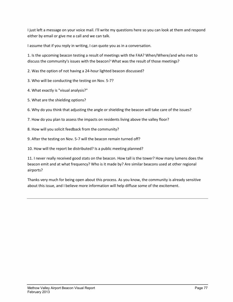
Methow Valley Airport Beacon Visual Report Page 77 February 2013
I just left a message on your voice mail. I'll write my questions here so you can look at them and respond
either by email or give me a call and we can talk.
I assume that if you reply in writing, I can quote you as in a conversation.
1. Is the upcoming beacon testing a result of meetings with the FAA? When/Where/and who met to
discuss the community's issues with the beacon? What was the result of those meetings?
2. Was the option of not having a 24-hour lighted beacon discussed?
3. Who will be conducting the testing on Nov. 5-7?
4. What exactly is "visual analysis?"
5. What are the shielding options?
6. Why do you think that adjusting the angle or shielding the beacon will take care of the issues?
7. How do you plan to assess the impacts on residents living above the valley floor?
8. How will you solicit feedback from the community?
9. After the testing on Nov. 5-7 will the beacon remain turned off?
10. How will the report be distributed? Is a public meeting planned?
11. I never really received good stats on the beacon. How tall is the tower? How many lumens does the
beacon emit and at what frequency? Who is it made by? Are similar beacons used at other regional
airports?
Thanks very much for being open about this process. As you know, the community is already sensitive
about this issue, and I believe more information will help diffuse some of the excitement.
Page 78 Methow Valley Airport Beacon Visual Report February 2013
hello Paul,
One concern that your tests should consider is cloud cover. I saw some quite (pardon the language)
hellacious reflections off clouds last summer. Quite disturbing. Honestly I feel like the community has
been duped by WSDoT and this beacon. It will be interesting to see what occurs and I hope you get some
film (I hope we all get some film) of these events to review when you are finished. And take some night
photos without the light as well. We live in a nearly pristine night environment. This beacon no matter
what angle will effect our valley.
Interesting term "normally required." That would give me some hope there could be no light at all.
This is one thing I love about this valley:
http://www.flickr.com/photos/coastaleddy/6993647405/
In my opinion a beacon would have ruined this scene.
regards,
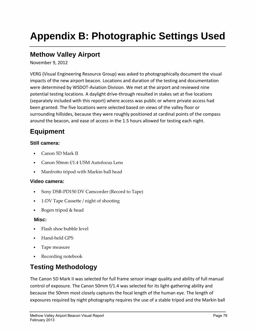
Methow Valley Airport Beacon Visual Report Page 79 February 2013
Appendix B: Photographic Settings Used
Methow Valley Airport November 9, 2012
VERG (Visual Engineering Resource Group) was asked to photographically document the visual
impacts of the new airport beacon. Locations and duration of the testing and documentation
were determined by WSDOT-Aviation Division. We met at the airport and reviewed nine
potential testing locations. A daylight drive-through resulted in stakes set at five locations
(separately included with this report) where access was public or where private access had
been granted. The five locations were selected based on views of the valley floor or
surrounding hillsides, because they were roughly positioned at cardinal points of the compass
around the beacon, and ease of access in the 1.5 hours allowed for testing each night.
Equipment
Still camera:
Canon 5D Mark II
Canon 50mm f/1.4 USM Autofocus Lens
Manfrotto tripod with Markin ball head
Video camera:
Sony DSR-PD150 DV Camcorder (Record to Tape)
1-DV Tape Cassette / night of shooting
Bogen tripod & head
Misc:
Flash shoe bubble level
Hand-held GPS
Tape measure
Recording notebook
Testing Methodology
The Canon 5D Mark II was selected for full frame sensor image quality and ability of full manual
control of exposure. The Canon 50mm f/1.4 was selected for its light-gathering ability and
because the 50mm most closely captures the focal length of the human eye. The length of
exposures required by night photography requires the use of a stable tripod and the Markin ball
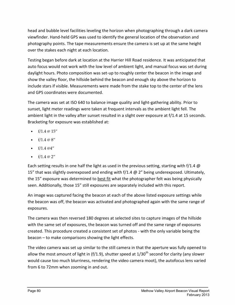
Page 80 Methow Valley Airport Beacon Visual Report February 2013
head and bubble level facilities leveling the horizon when photographing through a dark camera
viewfinder. Hand-held GPS was used to identify the general location of the observation and
photography points. The tape measurements ensure the camera is set up at the same height
over the stakes each night at each location.
Testing began before dark at location at the Harrier Hill Road residence. It was anticipated that
auto focus would not work with the low level of ambient light, and manual focus was set during
daylight hours. Photo composition was set-up to roughly center the beacon in the image and
show the valley floor, the hillside behind the beacon and enough sky above the horizon to
include stars if visible. Measurements were made from the stake top to the center of the lens
and GPS coordinates were documented.
The camera was set at ISO 640 to balance image quality and light-gathering ability. Prior to
sunset, light meter readings were taken at frequent intervals as the ambient light fell. The
ambient light in the valley after sunset resulted in a slight over exposure at f/1.4 at 15 seconds.
Bracketing for exposure was established at:
f/1.4 @ 15”
f/1.4 @ 8”
f/1.4 @4”
f/1.4 @ 2”
Each setting results in one half the light as used in the previous setting, starting with f/1.4 @
15” that was slightly overexposed and ending with f/1.4 @ 2” being underexposed. Ultimately,
the 15” exposure was determined to best fit what the photographer felt was being physically
seen. Additionally, those 15” still exposures are separately included with this report.
An image was captured facing the beacon at each of the above listed exposure settings while
the beacon was off, the beacon was activated and photographed again with the same range of
exposures.
The camera was then reversed 180 degrees at selected sites to capture images of the hillside
with the same set of exposures, the beacon was turned off and the same range of exposures
created. This procedure created a consistent set of photos - with the only variable being the
beacon – to make comparisons showing the light effects.
The video camera was set up similar to the still camera in that the aperture was fully opened to
allow the most amount of light in (f/1.9), shutter speed at 1/30th second for clarity (any slower
would cause too much blurriness, rendering the video camera moot), the autofocus lens varied
from 6 to 72mm when zooming in and out.
Methow Valley Airport Beacon Visual Report Page 81 February 2013
The video camera too captured valley views while looking at the beacon and also hill side views
where appropriate.
Conclusions
Still / Video Camera:
All still photography is subjective to some degree. No camera exists that is capable of capturing
light in exactly the same way as the human eye. Time exposures are essentially “Painting with
light”, as the number of seconds of exposure will multiply the effects of light. It is possible to
capture photographs when the human eye perceives only darkness. The airport beacon is
flashing alternating green and white lights at a frequency (verify this) of x per minute. A fifteen
second exposure will actually capture 7 – 8 flashes of the beacon and “burn in” the light much
brighter than would be captured in a shorter daylight exposure that may capture only a single
flash of the beacon. Conversely, while the hillsides would be exposed for 15 seconds, the band
of beacon light will only be exposed for half that. This will effectively make the beacon much
brighter in time exposures directly at the beacon and about half as bright when looking at the
hillsides.
While planning this exercise, Intuition suggested that videography would be beneficial in
recording these testing scenarios. In retrospect though, using this particular video camera set to
record at the lowest possible light level it is capable of did not capture very much beacon light
of what was physically being seen by the videographer. Being a tool that captures motion, the
shutter speed could not duplicate that of the still camera, thus less could be seen in some of
the video product – especially the hill side captures. Much of the available light from the
rotating beacon that was being physically viewed could never be recorded. Although the
separate video files are included in this report, it is thought by VERG little can be gained from
their review.
In final review, it is believed that while conducting the tests, VERG physically viewed the beacon
appearing brighter to the human eye than what it appears in the photographs. Also, that a
discernible seeping light-cone occurred from the beacon on the hill side, mostly bright at the
Harrier Hill residence and Rising Eagle Road residence observation sites, somewhat bright at
others, each night of the different angle tests. Some of the beacon light was recorded through
the still photography on each night – very little was recorded though videography.
Kurt Stiles
WSDOT/VERG manager
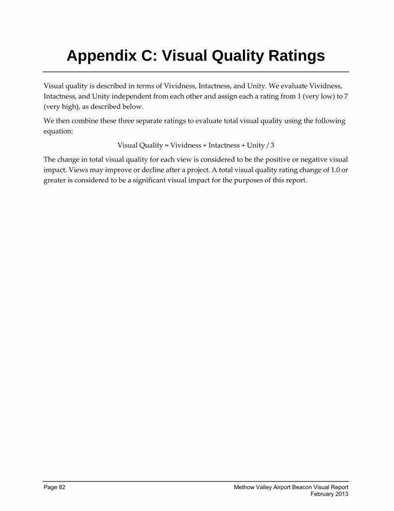
Page 82 Methow Valley Airport Beacon Visual Report February 2013
Appendix C: Visual Quality Ratings
Visual quality is described in terms of Vividness, Intactness, and Unity. We evaluate Vividness,
Intactness, and Unity independent from each other and assign each a rating from 1 (very low) to 7
(very high), as described below.
We then combine these three separate ratings to evaluate total visual quality using the following
equation:
Visual Quality = Vividness + Intactness + Unity / 3
The change in total visual quality for each view is considered to be the positive or negative visual
impact. Views may improve or decline after a project. A total visual quality rating change of 1.0 or
greater is considered to be a significant visual impact for the purposes of this report.
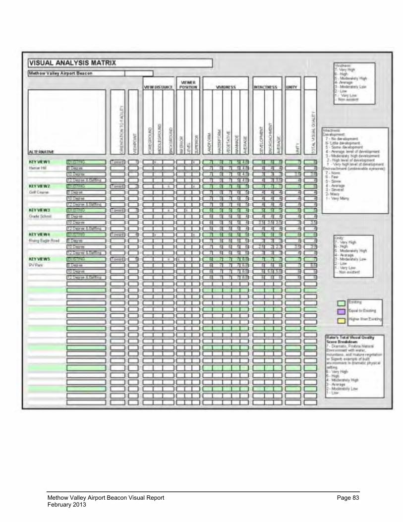
Methow Valley Airport Beacon Visual Report Page 83 February 2013