Embed Size (px)
Citation preview
VISUAL IMPACTPROVISION
New Forest National Park
Options Appraisal Study
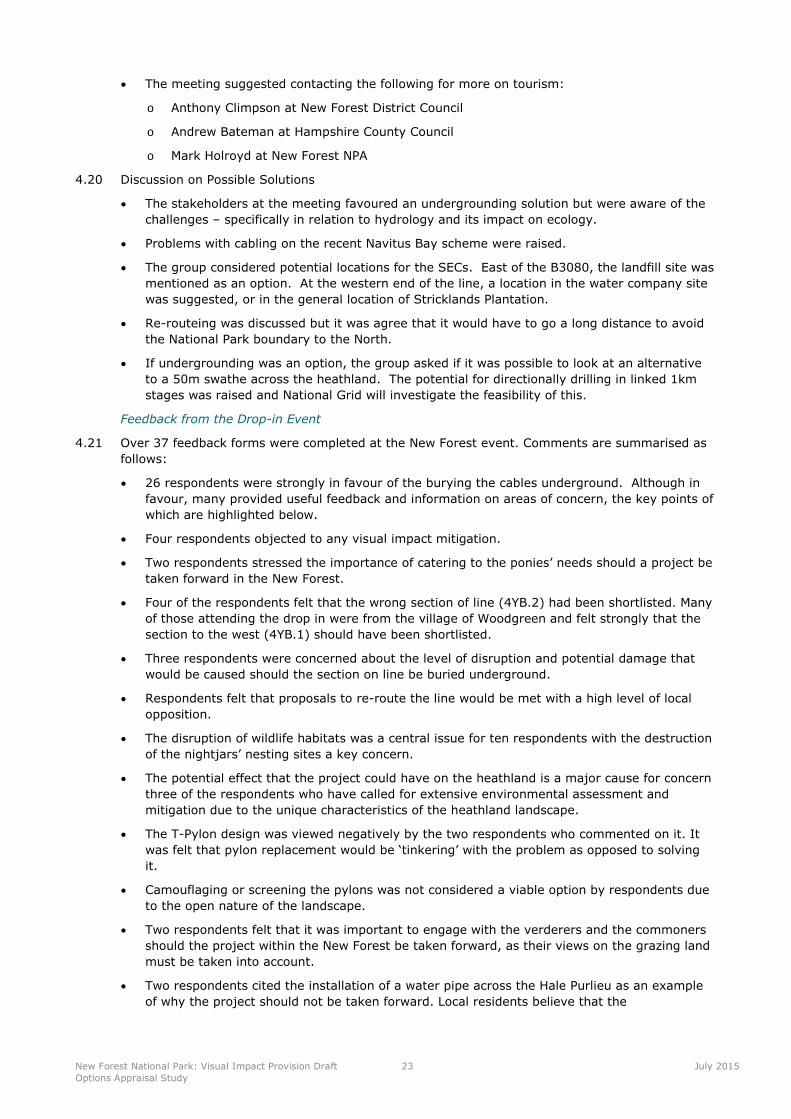
August 2015

This report has been prepared by LUC on behalf of National Grid. Detailed engineering and technicalinformation was provided by National Grid. Stakeholder engagement inputs were provided by Camargue.We are also grateful to New Forest National Park and the stakeholder reference group for providingbackground information.
Front Cover: 400kV overhead transmission line subsection 4YB.2 at Hale Purlieu, New Forest.

Contents
1 Introduction 1
Visual Impact Provision 1
The New Forest National Park Project 2
2 Methodology 6
Environmental Statement 6
3 Study Area and Baseline 8
Route History 8
Study Area 8
Environmental Baseline 10
Socio-Economic Baseline 17
4 Stakeholder Engagement 19
Introduction 19
Stakeholder Meeting 19
Engagement Events 20
5 Potential Mitigation Solutions 25
Introduction 25
Option 1: Alternative Pylon Design 25
Option 2: Overhead Line on Alternative Route Alignment 27
Option 3: Underground Cable – Direct Burial 28
Option 4: Underground Cable – Tunnel 32
6 Appraisal of Preferred Option and Conclusion 33
Option 3: Direct burial of Section 4YB.2 33
Overall Conclusion 35
Appendix 1 - Summary of Potential Primary Consenting Requirements 36
Tables
Table 1.1: Twelve Shortlisted Sections of Overhead Line 1
Table 2.1: Appraisal Topics 6
Figures
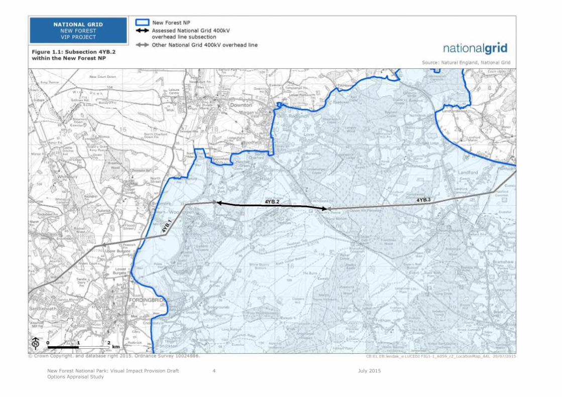
Figure 1.1 Subsection 4YB.2 within the New Forest National Park 4
Figure 1.2: 4YB.2 crosses the Hale Purlieu, seen from footpath near car park 5
Figure 3.1 Study Area 9
Figure 3.2 Landscape Character 13
Figure 3.3 Ecology 14
Figure 3.4 Historic Environment 16
Figure 5.1 Alternative pylon designs 26
Figure 5.2 Example T-pylon (artist’s impression) 27
Figure 5.3 Example low-height pylon 27

Figure 5.4 Typical underground cable construction swathe drawing 29
Figure 5.5 Horizontal directional drilling rig 29
Figure 5.6 Diagram of a typical sealing end compound 29
Figure 5.7 An operational sealing end compound 30
Figure 5.8 Direct Burial 31
Figure 5.9 Tunnel boring machine being lowered into a vertical shaft 32
New Forest National Park: Visual Impact Provision Draft
Options Appraisal Study
1 July 2015
1 Introduction
Visual Impact Provision
1.1 Ofgem and National Grid have agreed a new set of price controls and incentives for the period
from April 2013 to March 2021. This includes a provision of £500 million for electricity
transmission owners to mitigate the visual impact of existing electricity infrastructure in nationally
protected landscapes in Great Britain. For National Grid, which is the transmission owner in
England and Wales, this means considering the effects of existing infrastructure on the visual
amenity and landscapes of National Parks and Areas of Outstanding Natural Beauty (AONBs).
National Grid has referred to this as the Visual Impact Provision (VIP).
1.2 In 2012-13, National Grid prepared a Visual Impact Provision policy setting out how the fund
would be used and how stakeholders would be engaged in identifying opportunities for
maximising benefits from it. After a public consultation on the draft between July and September
2013 the policy statement was presented to Ofgem for review. The policy statement made it
clear that National Grid’s objective:
“is to achieve the maximum enhancement to the landscape from the available funds whilst
ensuring that no significant adverse impacts arise as a result”.
1.3 The policy document included a set of guiding principles and a commitment to the creation of a
Stakeholder Advisory Group consisting of stakeholders with national remits for England and
Wales, and ways of engaging other stakeholders. National Grid is committed to using the VIP in a
collaborative and transparent way.
1.4 In 2014, a landscape and visual impact assessment project was undertaken to provide evidence
to National Grid and its Stakeholder Advisory Group about the relative impacts of the different
transmission lines to inform the decision making process. The purpose of the landscape and
visual impact assessment project was to identify those sections of electricity transmission lines in
England and Wales that have the most important impacts on the landscape and visual amenity of
these designated landscapes. The emphasis was on making a comparative assessment of the
landscape and visual impacts of the sections of transmission lines that lie within the designated
areas and identifying a possible shortlist of candidate schemes for consideration by the
Stakeholder Advisory Group, in order to decide which ones should be taken forward for more
detailed technical assessment.
1.5 The landscape and visual impact assessment Technical Report was published in October 2014,
and included a suggested shortlist of twelve subsections of overhead line which emerged as
having the highest level of combined landscape and visual impacts, and therefore merited further
investigation. The twelve subsections (listed in order of combined landscape and visual impact
score and by alphabetical order where scores are the same) are presented in Table 1.1.
Table 1.1: Twelve Shortlisted Sections of Overhead Line
Designated Area Subsection
Tamar Valley AONB YF.1
Peak District NP 4ZO.4
Dorset AONB 4YA.7
Peak District NP 4ZO.2
Peak District NP 4ZO.3

New Forest National Park: Visual Impact Provision Draft
Options Appraisal Study
2 July 2015
Designated Area Subsection
Brecon Beacons NP 4YU.3
North Wessex Downs AONB YYM.4
Snowdonia NP 4ZC.1
Dorset AONB 4VN.2
Dorset AONB 4YA.5
High Weald AONB 4ZJ.1
New Forest NP 4YB.2
1.6 The Stakeholder Advisory Group accepted all 12 of these subsections as worthy of progression to
the next stage of the work. The Tamar Valley AONB was used to pilot an approach to the
appraisal of the different mitigation options that might be feasible. The approach was then rolled
out to all of the shortlisted subsections of line. The aim of this work was to define one or at most
two preferred options for mitigation in the form of ‘mitigation projects’ for each shortlisted
subsection of line.
1.7 Since undergrounding is likely to emerge in many cases as a preferred approach, a prime
consideration in defining the projects in each case was the potential location of sealing end
compounds (SECs) where the transition from overhead to underground lines takes place. In
identifying suitable locations, it has often been the case that the most suitable place for the SECs
will lie outside the extent of the line subsection on the shortlist. This means that the projects may
include an adjacent part of a line subsection, not assessed as having the highest level of
landscape and visual impact, but which must be included for practical purposes.
1.8 Conversely, in some cases not all of the shortlisted subsection is included within the study area.
Reasons for this, where applicable, are highlighted in the individual reports but include changes as
a result of subsequent stakeholder discussions, and further appraisal from site visits (the divisions
between subsections were originally determined based on changes in landscape character, as
presented in published documents prior to field surveys being carried out, rather than on the
basis of scale of impact).
1.9 Following approval by the Stakeholder Advisory Group, National Grid, is also developing an
initiative which will use part of the £500 million allocation for smaller localised visual improvement
projects which can be accessed by all AONBs and National Parks with existing National Grid
electricity infrastructure. This landscape enhancement initiative (LEI) has an ambition to provide
up to £24 million over six years (2015 to March 2021), with the aim of reducing the visual impact
of National Grid’s existing infrastructure and improving the related visual quality of the landscape.
The New Forest National Park Project
1.10 Following the acceptance of the findings of the Technical Report by the Stakeholder Advisory
Group, National Grid decided to progress all of the other 11 sections to the same stage. The
identified section of 400kV OHL (4YB.2) runs from Stricklands Plantation on the upper slopes of
Avon Valley near Woodgreen, in the north-west corner of the Park, across Hale Purlieu Common,
the B3080 at Golden Cross, and finishes within Pound Bottom quarry east of the B3080. This
section of 400kV OHL is 3.6km in length, and is shown in the context of the National Park in
Figure 1.1.
1.11 Section 4YB.2 is part of the longer 4YB 400kV OHL which runs from the Avon Valley in the west to
Landford in the East.
New Forest National Park: Visual Impact Provision Draft
Options Appraisal Study
3 July 2015
1.12 The New Forest National Park was designated in 2005, for the areas natural beauty, the value of
its wildlife habitats and cultural heritage with the responsibility:
“To conserve and enhance the natural beauty, wildlife and cultural heritage of the area. And
To promote opportunities for the understanding and enjoyment of the special qualities of the Park
by the public.”1
1.13 Special qualities of the National Park are defined in the New Forest National Park Management
Plan as follows:
“The New Forest’s outstanding natural beauty;
An extraordinary diversity of plants and animals and habitats of national and international
importance;
A unique historic, cultural and archaeological heritage;
An historic commoning system;
The iconic New Forest pony;
Tranquillity in the midst of the busy, built up south of England;
Wonderful opportunities for quiet recreation, learning and discovery;
A healthy environment: fresh air, clean water, local produce and a sense of ‘wildness’; and
Strong and distinctive local communities.”2
1http://www.nationalparks.gov.uk/learningabout/whatisanationalpark/aimsandpurposesofnationalparks
2New Forest National Park Management Plan 2010 – 2015. Pages 1-2.
New Forest National Park: Visual Impact Provision Draft
Options Appraisal Study
4 July 2015
Figure 1.1 Subsection 4YB.2 within the New Forest National Park
New Forest National Park: Visual Impact Provision Draft
Options Appraisal Study
5 July 2015
1.14 The focus of the VIP project is on the mitigation of landscape and visual impacts, and the
assessment of these impacts is set out in the landscape and visual impact assessment Technical
Report3. The summary sections relating to the 4YB.2 subsection are reproduced below.
1.15 Engagement events (‘Stakeholder Reference Group’ and public ‘drop in’) were undertaken in
March 2015 (see Section 4).
1.16 A number of potential solutions may exist which would mitigate the landscape and visual impact
of the 400kV OHL on the National Park. The purpose of this Options Appraisal Study is to identify
these and determine which, if any, will deliver the necessary mitigation without giving rise to
adverse impacts that would be greater than those being mitigated.
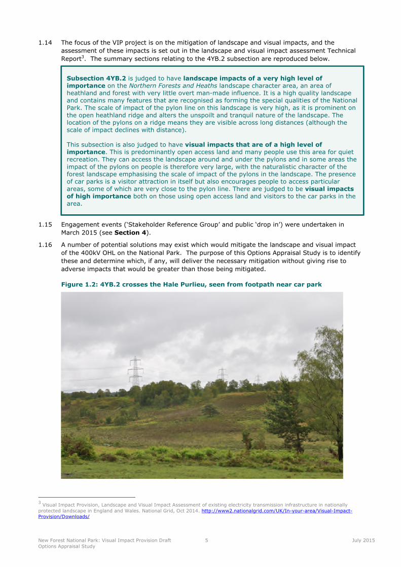
Figure 1.2: 4YB.2 crosses the Hale Purlieu, seen from footpath near car park
3Visual Impact Provision, Landscape and Visual Impact Assessment of existing electricity transmission infrastructure in nationally
protected landscape in England and Wales. National Grid, Oct 2014. http://www2.nationalgrid.com/UK/In-your-area/Visual-Impact-Provision/Downloads/
Subsection 4YB.2 is judged to have landscape impacts of a very high level ofimportance on the Northern Forests and Heaths landscape character area, an area ofheathland and forest with very little overt man-made influence. It is a high quality landscapeand contains many features that are recognised as forming the special qualities of the NationalPark. The scale of impact of the pylon line on this landscape is very high, as it is prominent onthe open heathland ridge and alters the unspoilt and tranquil nature of the landscape. Thelocation of the pylons on a ridge means they are visible across long distances (although thescale of impact declines with distance).
This subsection is also judged to have visual impacts that are of a high level ofimportance. This is predominantly open access land and many people use this area for quietrecreation. They can access the landscape around and under the pylons and in some areas theimpact of the pylons on people is therefore very large, with the naturalistic character of theforest landscape emphasising the scale of impact of the pylons in the landscape. The presenceof car parks is a visitor attraction in itself but also encourages people to access particularareas, some of which are very close to the pylon line. There are judged to be visual impactsof high importance both on those using open access land and visitors to the car parks in thearea.
New Forest National Park: Visual Impact Provision Draft
Options Appraisal Study
6 July 2015
2 Methodology
2.1 This study identifies potentially feasible methods of mitigating the identified impacts of the 4YB.2
route on the New Forest National Park. The appraisal of the identified options follows the general
approach set out in National Grid’s document Our approach to Options Appraisal (2012). It
covers the three main topic areas (Technical, Environmental and Socio-Economic) which can be
broken down into sub-topics as identified in Table 2.1 below. Sub-topics are only considered
where they may influence the choice of option.
Table 2.1: Appraisal Topics
Technical Environmental Socio-economic
Technical complexity Landscape and visual Local economic impact
Construction/project delivery
issues
Ecology Aviation and defence
Suitability of technology Historic environment Traffic and transport
Network capacity Water
Network efficiencies/ benefits Local air quality
Noise and vibration
Soils and geology
2.2 The methodology for this study comprises the following key stages:
Establish a study area and gather baseline information, including information assembled for
the landscape and visual impact assessment (see Section 3);
Undertake local stakeholder engagement to gather information, organised by National Grid in
association with the National Park Authority (see Section 4);
Identify options which would mitigate the identified impacts without giving rise to other
significant adverse impacts (see Section 5); and
Undertake an appraisal of these options and report on their potential impacts, and make a
recommendation to the Stakeholder Advisory Group on the favourable option (see
Section 6).
2.3 In addition, the table in Appendix 1 provides a preliminary overview of the likely primary
consents associated with each option. It should be noted that that this is an initial view based on
the draft options and has not been the subject of discussions with stakeholders. The purpose at
this stage is to assist in understanding the complexity of the options, in consenting terms and to
provide an indication of the associated timescale for achieving consent. Any option chosen would
also need agreement from the landowner. If an option is selected to be taken forward to the next
stage of development a detailed Consents and Land Strategy will be produced.
Environmental Statement
2.4 If this area is selected to be taken forward to the next stage whereby a detailed scheme will be
developed, regardless of whether the proposal requires an Environmental Impact Assessment

New Forest National Park: Visual Impact Provision Draft
Options Appraisal Study
7 July 2015
under the terms of the Town and Country Planning (Environmental Impact Assessment)
Regulations, National Grid would undertake an Environmental Impact Assessment and produce a
detailed Environmental Statement to accompany the planning application.
New Forest National Park: Visual Impact Provision Draft
Options Appraisal Study
8 July 2015
3 Study Area and Baseline
Route History
3.1 The existing 4YB route is a 400kV OHL constructed in 1966 by BICC and is of L6 standard lattice
pylon design carrying quad conductor bundles. The 4YB route which runs between Mannington
and Nursling also provides interconnection to Lovedean and Fawley substations, each providing
supplies for the local Distribution Network Owner (DNO) substations.
3.2 The 4YB route is an integral part of the National Electricity infrastructure and any potential
options as part of this project would need to be designed to meet the capability of the existing
infrastructure.
Study Area
3.3 The study area has been defined based on the extent of subsection 4YB.2, which was assessed as
having important impacts on landscape and visual amenity. 4YB.2 is shown in Figure 3.1, and
crosses the northern part of the National Park continuing from subsection 4YB.1 in the Avon
Valley and climbing the valley side through an area of mixed woodland at Stricklands Plantation.
The 400kV OHL then crosses an area of open access land at Hale Purlieu Common running due
east, through Millersford Plantation on higher ground towards Golden Cross before it leaves the
Common and crosses the B3080. Section 4YB.2 stops adjacent to Pound Bottom quarry just
south of the settlement of Hale Purlieu. Subsection 4YB.3 continues east, taking the 400kV OHL
across Cloven Hill Plantation towards Langford before the 400kV OHL turns north and out of the
National Park. Subsections 4YB.1 and 4YB.3 were found to have overall combined lesser impacts
on the National Park than 4YB.2: subsection 4YB.1 scored highly for visual impacts, but lower in
landscape terms.
3.4 4YB.2 kinks slightly as it steps up the steeply wooded valley sides, entering Hale Purlieu Common
just north of a National Trust car park. It crosses the common in a straight line. The National
Trust and Forestry Commission own the common land on which the 400kV OHL is situated. An
undergrounding solution would largely follow the current alignment as to significantly deviate
north or south would add unnecessary length to the OHL and disruption.
3.5 The outer limits of the study area have therefore been defined as:
Woodgreen to the west;
The settlement of Hatchet Green, North Charford to the north;
Cloven Hill Plantation in the east; and
The B3078 to the south.
3.6 The resulting study area is shown in Figure 3.1. The rest of this section outlines features and
potential constraints of the study area and its immediate surroundings which are likely to
influence a decision on which mitigation solution to pursue for the New Forest, with reference to
the environmental topics listed in Table 2.1.

New Forest National Park: Visual Impact Provision Draft
Options Appraisal Study
9 July 2015
Figure 3.1 Study area
New Forest National Park: Visual Impact Provision Draft
Options Appraisal Study
10 July 2015
Environmental Baseline
Landscape and Visual
3.7 Landscape and visual impacts are defined in the Guidelines for Landscape and Visual Impact
Assessment (GLVIA3), as follows:
Landscape impacts means effects on the landscape as a resource in its own right; and
Visual impacts means effects on specific views and on the general visual amenity experienced
by people.4
3.8 The 400kV OHL runs up the wooded slopes of the Avon Valley from Woodgreen in the west,
cutting through Stricklands Plantation before crossing a minor seasonally wet valley on Hale
Purlieu Common, running due east across the open common and area of woodland at Millersford
Plantation on higher ground. The 400kV OHL turns slightly, off due east, before crossing the
B3080 where this subsection ends at the waste disposal site.
Landscape Character
3.9 This section presents an overview of the landscape baseline including landscape character, current
landscape condition.
3.10 Sub-section 4YB.2 crosses an area of high tranquillity and relatively remoteness, well used by
recreational walkers and with a number of car parks provided for people’s enjoyment of the
landscape. The B3078 is a scenic route that runs parallel to the 400kV OHL, to the south.
3.11 This route sub-section falls entirely within the Northern Heath and Forest landscape character
area (LCA), an area of heathland and forest with very little man-made influence. It is a high
quality landscape and contains many features that are recognised as forming the special qualities
of the New Forest National Park, such as the mosaic of lowland heath, mire, ancient pasture
woodland and Forest lawns that forms the Open Forest, the historic commoning system which
results in the presence of New Forest ponies, donkeys, pigs and cattle roaming free, the provision
for quiet recreation, and the high levels of tranquillity and sense of ‘wildness’. The scale of impact
of the 400kV OHL is very high - it is prominent on the open ridge and alters the unspoilt and
tranquil nature of the landscape (see the New Forest National Park Tranquillity Map 2015 below
that clearly picks up the route of the pylon line).
4Landscape Institute and Institute of Environmental Management and Assessment (2013) Guidelines for Landscape and Visual Impact
Assessment. 3rd Edition. Routledge. Paragraph 2.21.
New Forest National Park: Visual Impact Provision Draft
Options Appraisal Study
11 July 2015
3.12 The location of the pylons on a ridge mean they are visible across long distances (although scale
of impact declines with distance). The importance of the impact on landscape character is
considered to be very high. LCAs are illustrated on Figure 3.2.
3.13 The importance of Hale Purlieu’s tranquil character to the National Park landscape is highlighted
by the New Forest Management Plan5. Of particular relevance is the reference, in the description,
the New Forest’s outstanding natural beauty to the “extensive area of unspoilt and ancient
countryside”, and in the description under Tranquillity; “tranquillity and sense of remoteness that
can still be found in many parts of the National Park is a quality of importance to many people.
The relative peace and naturalness, combined with the open and unfenced landscape of much of
the area, gives a sense of space and freedom”.
3.14 The New Forest Acts of Parliament set out how the Park is protected from development and
managed for the benefit of communing, wildlife and amenity.
Visual Amenity
3.15 Hale Purlieu is situated on a locally high ridge which has an open character. This section identifies
the visual amenity and availability of views as experienced by people (visual receptors). Visual
receptors include local communities, residents in scattered houses, visitors to the area,
recreational users including users of the commons, motorists on the local road network and
people working within the area.
3.16 The fact that this is open access land means that people can access the landscape around and
under the pylons and, from some areas, the impact of the pylons is therefore very large. Many
people using this part of the forest for quiet recreation will be in the vicinity of the 400kV OHL and
the naturalistic context of the forest landscape emphasises the scale of impact of the pylons in the
landscape. The presence of car parks encourages people to access certain areas and some of
these are very close to the 400kV OHL. The B3078 scenic route runs parallel to the 400kV OHL to
the south and from here the pylons are clearly seen on the skyline. High importance impacts are
recorded for these receptors.
5New Forest National Park Management Plan 2010 – 2015.
New Forest National Park: Visual Impact Provision Draft
Options Appraisal Study
12 July 2015
3.17 General visibility across the common is restricted from the north, east and west by topography
and presence of large areas of woodland. However, to the south, longer distance views can be
gained along the B3078 and from open areas around the settlements of Cadham and Lyndhurst.
3.18 People who will experience these views are the users of open access land across the Northern
Heath and Forest, visitors to the car parks across the heath and users of the B0378 scenic road.
Residents of Hale Purlieu, Hale and around Warren Farm would experience glimpsed and partially
screen views over the common to the 400kV OHL. Visitors (including walkers) to the area enjoy
the scenery of the common, and would also experience effects on their visual resource having
frequent opportunities to gain very near views of transmission pylons, due to the relationship
between the 400kV OHL and the roads/common.
Ecology
3.19 The New Forest has a very high number of notable species and an extremely diverse range of
important habitats. As a result the whole of the New Forest has been designated at international
and national level including:
New Forest Ramsar Site;
New Forest Special Area of Conservation (SAC);
New Forest Special Protection Area (SPA); and
The New Forest Site of Special Scientific Interest (SSSI).
3.20 The New Forest SSSI covers 29,000 hectares of important lowland habitats including heaths,
mires, grassland and woodland. It is also home to many notable, rare and nationally scarce
species. On top of the SSSI designation, the area is also a SPA due to the presence of honey
buzzard, nightjar, woodlark, Dartford warbler and overwintering hen harrier which are
internationally important.
3.21 The New Forest SAC primary reason for site selection include the presence of Annex 1 habitats;
Northern Atlantic wet heaths with Erica tetralix, European dry heaths, Bog woodland, Alluvial
forest with Alnus glutinosa and Fraxinus excelsior, and Annex II species such as the southern
damselfly and stag beetle.
3.22 The New Forest Ramsar Site is designated because of the rare plant and invertebrate species
associated with the areas wetlands. Areas of semi-natural vegetation include valley mires, fens
and wet heath, habitats of high ecological quality and diversity, with undisturbed transition zones.
Of particular note regarding the study area is the presence of a network of small streams which
are acidic in character, as there is no lowland equivalent in the UK.
3.23 The New Forest is home to a large number of species, some of which are protected, including 13
species of bat6. These designations are shown on Figure 3.3.
6http://www.newforestnpa.gov.uk/info/20090/wildlife
New Forest National Park: Visual Impact Provision Draft
Options Appraisal Study
13 July 2015
Figure 3.2 Landscape character
New Forest National Park: Visual Impact Provision Draft
Options Appraisal Study
14 July 2015
Figure 3.3 Ecology
New Forest National Park: Visual Impact Provision Draft
Options Appraisal Study
15 July 2015
Historic Environment
3.24 The New Forest is a royal former hunting area constituted by William the Conqueror in the 11th
Century and is protected by the Verderers. It has a varied and rich heritage and contains listed
buildings and scheduled monuments. The New Forest, in its present condition is the result of a
sustained close relationship between the landscape and its people over thousands of years, with
areas of traditional agriculture, and a strong system of commoning which continues today. Man
has influenced this area since the late Mesolithic to Neolithic periods, with Bronze Age barrows
still present on the open heathlands, through to 20th century archaeological records of military
and industrial relics. There are a number of listed buildings within the study area concentrated at
Hale and Hatchet Green, including The Old Rectory, Grade II and Old Thatch, Grade II. There are
no scheduled monuments within the study area, however there is a Burnt Mound within
Millersford Plantation and Golden Cross/Jacob’s Barrow on the eastern side of the B3080, which
are of historic interest. The stakeholders highlighted that there is Bronze Age, Iron Age and
Roman archaeology in the area and also noted its use as a WWII bomb testing site. Evidence of
this testing can be seen at Turf Hill where there are a number of possible bomb craters.
3.25 Hale Park is a Grade II* Registered Park and Garden which is located adjacent to the study area’s
north-western boundary and is of historical interest because of the formal and informal gardens,
wooded pleasure grounds and parkland. Although not within the study area, Hale Park does have
a visual relationship with the surrounding landscape including the heathland within the study
area. The local Historic Environment Record (HER) may identify further historic features within
the study area and would be reviewed as part of the next stage of assessment if this subsection is
selected. Historic designations in the local area are shown on Figure 3.4.
New Forest National Park: Visual Impact Provision Draft
Options Appraisal Study
16 July 2015
Figure 3.4 Historic environment
New Forest National Park: Visual Impact Provision Draft
Options Appraisal Study
17 July 2015
Water
3.26 The Environment Agency’s Flood Map shows a narrow part of the Millersford Bottom valley in the
south-west corner of the study area as a Flood Zone 3, which have a ‘High’ risk of flooding.7
3.27 To the west of Hale Purlieu, there is a shallow valley which is seasonally wet. There are two
further seasonally wet valleys on within Millersford Plantation and one in Millersford Bottom. The
stakeholders raised concerns about the complex hydrology in the area with the western valley
being an area of particular concern. A full hydrological survey will be carried out as part of any
further detailed assessment. The stakeholders showed an interest in the possibility of improving
the condition of the habitat in this area by making it wetter, although it should be noted that the
mire unit 160 of the SSSI is already in favourable condition, having been restored in 2002 and
stakeholders would not wish to see this altered.
Soils and Geology
3.28 The bedrock underlying most of the area comprises clays and sand of the Tertiary deposits with
Bagshot formation and Bracklesham group present within the study area. ‘The Bracklesham Beds
and underlying Bagshot Sands show the most dramatic landforms and are exposed in the
relatively high elevation plateaux and U-shaped valleys of the northern part of the Park’.8 The
underlying geology gives rise to very acidic soils.
3.29 Available records will be investigated as part of further assessment stages prior to the selection of
a detailed route alignment and stakeholders have noted that no materials should be used which
would alter the pH balance of the soils (ie concrete is too alkaline).
Other Environmental Issues
3.30 At this stage of the appraisal process, it is considered that certain environmental topics, for
example local air quality, noise and vibration would not influence the choice of a preferred option
and hence have not been included. More detailed assessment of a wide range of topics (including
air quality, noise and vibration) is likely to be required for construction and operational activities
as part of the supporting documentation to accompany a planning application(s).
Socio-Economic Baseline
Local Economic Activity
3.31 Hale Purlieu is owned and managed by the National Trust with Millersford Plantation owned and
managed by the Forestry Commission. Both organisations provide access opportunities for
tourist/visitors within the New Forest to walk and explore the countryside. The tourism industry
contributes significantly to the local economy, in the region of £175 million with the tourism
sector employing approximately 2,800 people. In addition the Forestry Commission manages
large areas of plantation contributing to forestry and woodland management industries. Farming
and commoning are vital in the area and contribute to the character of the National Park which
attracts so many visitors. The majority of the National Park is registered common land, which
allows the public the ‘right to roam’, and use it for specific activities like birdwatching, walking
and picnicking. Langley Wood National Nature Reserve, as well as more general nature tourism
and birdwatching, attract large numbers of visitors to the National Park. Sandy Balls Holiday
Village, located on the western edge of the National Park provides visitors with holiday
accommodation and facilities as do the numerous B&Bs, hotels and campsites. Other outdoor
activities include fishing at Hale Park Fishery along the banks of the River Avon, horse riding,
cycling and golfing.
7http://maps.environment-
agency.gov.uk/wiyby/wiybyController?x=357683.0&y=355134.0&scale=1&layerGroups=default&ep=map&textonly=off&lang=_e&topic=floodmap#x=420333&y=117439&lg=1,2,&scale=88
New Forest National Park Authority. Landscape in the New Forest National Park, 1 Shaping the land. Page 2.
New Forest National Park: Visual Impact Provision Draft
Options Appraisal Study
18 July 2015
Aviation and Defence
3.32 Apart from a historic association with the New Forest National Park, the MOD do not currently use
the area for military practices and training.
3.33 Hurn airspace incorporates airspace over central southern England and covers the New Forest
National Park and the study area. Here, low-flying aircraft mainly helicopters use the unpopulated
area to practice flying manoeuvres.
Traffic and Transport
3.34 Access in the north-west of the National Park is fairly limited by the road network with only three
B-road and a number of unclassified roads, compared to the south and east which are supported
by the M27/A31 and several A and B-roads. Within the study area, the B3080 and B3078 link to
an unclassified local road, serving the villages of Hale and Woodgreen, as well as surrounding
isolated properties. The B3078 is classified as a Scenic Route which encourages drivers along this
road to experience the natural scenic beauty of the local landscape.
3.35 Hale Purlieu Common can be accessed via three car parks (Deadmans Hill, Turf Hill and Hale
Purlieu) situated just off of the road network. Impacts of construction activity on the road network
have been highlighted as an issue for the project.
Access and Recreation
3.36 The majority of the National Park is registered common land which allows the public the ‘right to
roam’ and as a result there are very few formal Public Rights of Way. The Avon Valley Path, a
National Trail, skirts the edge of the Park to the west, crossing the Park boundary just west of
North Charford, before running through Woodgreen and back out of the Park at Fordingbridge to
the south west of the study area.
3.37 Commoners use Hale Purlieu Common for depasturing of cattle, pigs, donkeys and ponies.
New Forest National Park: Visual Impact Provision Draft
Options Appraisal Study
19 July 2015
4 Stakeholder Engagement
Introduction
4.1 Having identified a shortlist of 12 subsections of line in eight designated areas using the
landscape assessment methodology, the Stakeholder Advisory Group asked National Grid to carry
out early stage engagement with stakeholders and the public at a local level.
4.2 The aim of this early engagement was to gather information and intelligence on the area to inform
the options assessment and to gauge local attitudes and opinions to the work. It was also felt
that involving local groups and individuals at the outset would not only help to identify any
potential problems and challenges, but also to give the local community a sense of ownership. It
should be a requirement of any scheme taken forward to major engineering work that it has the
support and involvement of local people.
4.3 It was also agreed at the Stakeholder Advisory Group that National Grid should work closely with
the New Forest National Park Authority to present a collaborative, inclusive partnership approach
to the local community.
Stakeholder Meeting
4.4 A meeting was held on 27 November 2014, attended by National Grid, Camargue and
representatives from New Forest National Park (Sarah Kelly) and North Wessex Downs AONB
(Andrew Lord).
4.5 The following points were discussed and agreed during the meeting:
Stakeholder engagement would take place as soon as practical in the New Year.
Ideally engagement events would take place on the same day with a workshop for selected,
relevant individuals / organisations followed by a drop in event for the public (afternoon and
evening).
This initial stakeholder engagement will inform the landscape and technical work.
The workshop would be a closed session, focused on a smaller group and technical in nature.
Attendees would comprise primarily key representatives from the AONB Partnership / National
Park Authority and other key statutory bodies identified by the AONB Partnership / National
Park Authority and agreed with National Grid.
Personal invites would be issued to the workshop. Personal invites would also be issued to
the drop in sessions to selected groups / individuals (as advised by the AONB Partnership /
NPA officers).
General invites would be sent to other relevant groups / local affected communities primarily
using the AONB’s and NPA’s networks / databases. National Grid would work with the AONB’s
/ NPA’s communications officers to ensure that the message was delivered to relevant
audiences.
Drop in events would need to take place at a convenient location for members of the
community as advised by the AONB Partnership / NPA.
National Grid would take responsibility for organising and delivering the events but they
would be collaborative activities between National Grid and the AONB / NPA teams.
Invites and materials for each event would be co-branded.
New Forest National Park: Visual Impact Provision Draft
Options Appraisal Study
20 July 2015
Engagement Events
4.6 On the advice of the New Forest National Park Authority team, the events were held as follows.
Both workshop and drop in events took place on Thursday 5th March 2015. The workshop was
held at the National Park Authority’s HQ in Lyndhurst. The drop in event was held in Hale Village
Hall, close to the location of the shortlisted line.
4.7 The workshop ran from 9.30am until 1.00pm and was attended by 12 representatives from local
stakeholders including New Forest NPA officers and representatives from Hampshire County
Council, the appointed New Forest Verderers, the Forestry Commission, National Trust and
Natural England. Representatives from National Grid, LUC and Camargue were in attendance and
Dr Ingrid Samuel, Historic Environments Director of the National Trust attended on behalf of the
Stakeholder Advisory Group as an observer.
4.8 The drop in event ran from 2.00pm until 8.00pm and was staffed by representatives from
National Grid (VIP project team) along with LUC and Camargue. It was attended by a broad cross
section of the local community with some local landowners represented, as well as local residents.
In total, 115 people attended the event.
Promoting the Events
4.9 The event was publicised as agreed with the National Park with direct invitations sent to the
National Park’s mailing list of key stakeholders. The event was also promoted via the National
Park’s e-newsletter, an e-poster on its website, a piece on its Facebook page and regular Tweets
by its communications officer. The National Park’s Landscape Officer Sarah Kelly was also active
in encouraging people to attend via word of mouth. National Grid worked closely with the
National Park’s communications officer and provided material for use in publicity proactively and
on demand.
4.10 A press release was produced and issued to local media resulting in coverage in the Southern
Daily Echo and Bournemouth Echo.
Stakeholder Feedback
Technical Workshop
4.11 The following key issues were discussed at the Technical Workshop:
4.12 Overview
The key stakeholder present had met before the workshop and circulated a list of questions
arising to National Grid. These questions were all addressed during the meeting.
The stakeholder group made it clear that they welcomed being on the shortlist and wanted to
work closely with each other and with National Grid to find a potential workable solution for
the shortlisted section of line.
A number of stakeholders including the National Park Authority highlighted the complex
hydrology of the area and the need to maintain soil profiles after any work is completed (this
may cause issues if an undergrounding solution is proposed.
The Verderers made clear that the New Forest Act requires them to have a regard to the
amenity of the New Forest as well as the flora and fauna. Grazing and the ability for livestock
to get from one part of the New Forest to another unhindered is extremely important.
The site is particularly wet- although some stakeholders believe that it should be wetter – and
the creating of a wayleave across the site may prove challenging.
The group felt that the quality of heathland in the area around the shortlisted line was not the
best and work on the transmission infrastructure could create an opportunity to improve its
overall quality.
Sensitive undergrounding was considered to be the most desirable approach, although this
would need to be carefully monitored and a long-term restoration plan put in place.
4.13 Landscape and Visual

New Forest National Park: Visual Impact Provision Draft
Options Appraisal Study
21 July 2015
To improve the quality and authenticity of the heathland, stakeholders (and in particular the
National Trust) expressed a desire to take away some of the trees in the commercial
plantation areas. They felt that there was an opportunity to regain heathland by reducing
commercial forestry.
It was pointed out that the Forestry Commission intends to remove the trees in the south of
the plantation in the near future.
Tree planting to shield pylons doesn’t achieve much in an open area of heathland such as this.
4.14 Ecology / Environment
The complex hydrology of the area was considered to be the biggest issue in ecological and
environmental terms – see section below. In the western part under consideration, it is very
wet and the soil profiles are also very complex. Maintaining the soil profiles after any work
would be a challenge.
There is a raft of designations in the area under consideration including SACs, SPAs and
SSSIs. This will have an impact on any methodology used.
There are a number of protected species found in the dry part of the heat including adder and
Dartford warbler.
The implication of heat from the underground cables on the soil, water and the ecology would
need careful consideration. The ecosystems are finely balanced and a slight increase in
temperature below the surface could upset a delicate equilibrium.
There is a large amount of grazing in the open access areas and this would need to be
maintained. The Verderers are required by the New Forest Act to have regard to amenity,
flora and fauna. The Verderers would like to see an undergrounding solution but are aware of
the many issues.
Concerns were raised over a water pipe project across the heathland. The pipe had been laid
some 40 years ago but the area above it had remained grassed over and had not returned to
its original heathland state.
A full Environmental Impact Assessment would be required to cover the work ‘cradle to grave’
as it would take some years to restore the heathland if it is disturbed for, say,
undergrounding.
Concerns were raised by the group over the need to excavate the cable for maintenance.
How frequent would this be and how disruptive?
4.15 Hydrology
The Stakeholders outlined the heathland vision for the New Forest which is linked closely with
the complex hydrology of the area.
Evidence from other sites and other work suggests that there can be problems with seepage
areas, the backfilling of mires and ducting taking water away from an area that should be
wet.
A full hydrological survey would be required. It was suggested that National Grid gather
evidence from other sites to inform its proposals and should look at the temporary – as well
as long term – impact on vegetation and associated ecology linked to the hydrology.
Stakeholders commented that it is essential to cross a water course rather than run parallel to
it with any undergrounding / ducting work.
Heat from the cables would be an issue as a slight temperature differential can have a major
impact on vegetation.
Change in vegetation and hydrology could also affect grazing.
Some stakeholders suggested the possibility of taking advantage of any National Grid work to
‘bung’ the area up and make it wetter. This could improve the quality of the heathland in the
area significantly.
New Forest National Park: Visual Impact Provision Draft
Options Appraisal Study
22 July 2015
The National Park is currently involved in a stream / mire restoration programme. Works
associated with VIP could be an opportunity here rather than a threat – digging up soil could
be beneficial.
Some stakeholders suggested looking for an underground route on drier land to make access
easier. Possibly consider a route to the north, the west and then south to rejoin the line.
This would enable the project team to stay on relatively dry land.
4.16 Archaeology / Heritage
A full geophysical survey would be required in the area. The archaeologists were not worried
about excavation and would keep a watching brief on progress with regular site visits.
There are a number of scheduled monuments and important sites at Jacob’s Barrow and
Golden Cross. There is Bronze Age, Iron Age and Roman archaeology in the area and the
potential for discovery could be very exciting.
LIDAR surveys were requested and the New Forest NPA confirmed that it has access to LiDAR
surveys of the area and will check its license agreement to see if they can be shared with
National Grid.
A pack of information was highly relevant and useful supplied by the New Forest NPA’s
archaeologist.
The Turf Hill area was also used for ordnance testing during WWII – the bouncing bomb was
tested here. There is the possibility of discovering unexploded ordnance.
The MoD at Latchmore has ground radar surveys of the area which may prove useful.
It was also suggested that National Grid speak to Anthony Passmore – a former Verderer and
active local archaeologist on the area in question as he knows it extremely well and is highly
knowledgeable on its archaeology.
4.17 Land Ownership
The vast majority of the site is open access land owned and / or managed by the National
Trust and the Forestry Commission.
Stricklands Plantation is under multiple ownership at the western end of the shortlisted line,
and at its eastern end the Hamptworth Estate – which includes the landfill site – is up for sale.
There are other smaller landowners along the B3080.
The Longford Estate is a major landowner in the area with landholdings on either side of the
Avon.
4.18 Access / PRoWs
The Avon Valley Path is a National Trail that runs through the area crossing under the
adjacent section of line near the village of Woodgreen.
There are a number of other footpaths from Hale House and in Stricklands Plantation.
The majority of the area under consideration is open access land.
Stakeholders suggested contacting Sam Jones, Hampshire CC’s rights of way officer.
4.19 Socio-Economic / Tourism / Community Impacts
The area is very busy during the summer months with tourist traffic in the area and passing
through to go south.
Traffic movements from the landfill site are an issue at present and a highways management
plan would be required to support any work / planning application.
The meeting suggested contacting Tim Lawton at Hampshire County Council’s Highways
Department.
The area is currently used more by local people than visitors – any work could be an
opportunity to encourage more visitors to the area.
It would be sensible to engage with the owners of Sandyballs holiday centre.
New Forest National Park: Visual Impact Provision Draft
Options Appraisal Study
23 July 2015
The meeting suggested contacting the following for more on tourism:
o Anthony Climpson at New Forest District Council
o Andrew Bateman at Hampshire County Council
o Mark Holroyd at New Forest NPA
4.20 Discussion on Possible Solutions
The stakeholders at the meeting favoured an undergrounding solution but were aware of the
challenges – specifically in relation to hydrology and its impact on ecology.
Problems with cabling on the recent Navitus Bay scheme were raised.
The group considered potential locations for the SECs. East of the B3080, the landfill site was
mentioned as an option. At the western end of the line, a location in the water company site
was suggested, or in the general location of Stricklands Plantation.
Re-routeing was discussed but it was agree that it would have to go a long distance to avoid
the National Park boundary to the North.
If undergrounding was an option, the group asked if it was possible to look at an alternative
to a 50m swathe across the heathland. The potential for directionally drilling in linked 1km
stages was raised and National Grid will investigate the feasibility of this.
Feedback from the Drop-in Event
4.21 Over 37 feedback forms were completed at the New Forest event. Comments are summarised as
follows:
26 respondents were strongly in favour of the burying the cables underground. Although in
favour, many provided useful feedback and information on areas of concern, the key points of
which are highlighted below.
Four respondents objected to any visual impact mitigation.
Two respondents stressed the importance of catering to the ponies’ needs should a project be
taken forward in the New Forest.
Four of the respondents felt that the wrong section of line (4YB.2) had been shortlisted. Many
of those attending the drop in were from the village of Woodgreen and felt strongly that the
section to the west (4YB.1) should have been shortlisted.
Three respondents were concerned about the level of disruption and potential damage that
would be caused should the section on line be buried underground.
Respondents felt that proposals to re-route the line would be met with a high level of local
opposition.
The disruption of wildlife habitats was a central issue for ten respondents with the destruction
of the nightjars’ nesting sites a key concern.
The potential effect that the project could have on the heathland is a major cause for concern
three of the respondents who have called for extensive environmental assessment and
mitigation due to the unique characteristics of the heathland landscape.
The T-Pylon design was viewed negatively by the two respondents who commented on it. It
was felt that pylon replacement would be ‘tinkering’ with the problem as opposed to solving
it.
Camouflaging or screening the pylons was not considered a viable option by respondents due
to the open nature of the landscape.
Two respondents felt that it was important to engage with the verderers and the commoners
should the project within the New Forest be taken forward, as their views on the grazing land
must be taken into account.
Two respondents cited the installation of a water pipe across the Hale Purlieu as an example
of why the project should not be taken forward. Local residents believe that the

New Forest National Park: Visual Impact Provision Draft
Options Appraisal Study
24 July 2015
environmental impact of that project is still being felt today and that the landscape has never
recovered.
Three local residents highlighted the fact that the pylons across Hale Purlieu are heavily used
as a landmark by people walking and riding and that the removal of the pylons could cause a
problem for these users.
One respondent felt that the assessment was incomplete and that the views from the A338
should have been taken into account. In his opinion, these views are accessible to a larger
number of people than those within the Forest and are therefore of higher value.
Feedback from Second Stakeholder Engagement Session
4.22 A second meeting of technical stakeholders took place at the New Forest Visitor Centre on 6
August 2015. Prior to the meeting each attendee was sent a copy of the Options Appraisal report.
The aim of the session was to obtain their feedback on the report and to provide attendees with a
forum in which they could raise any issues before the report is formally presented to the project’s
Stakeholder Advisory Group in September 2015.
4.23 Attendees were asked by National Grid to highlight any issues or inaccuracies in the report.
4.24 The meeting discussed the options for the section of line, 4YB.2 and the following key points:
It was noted that a gas pipeline was installed within heathland in the National Park and it is
now unnoticeable. British Gas produced a subsequent book on heathland restoration following
the project.
A representative from the Verderers felt that the dry areas of the proposed route outlined in
the Options Appraisal are technically achievable but the project could be more challenging in
wetter areas of the National Park.
A representative from Natural England enquired whether National Grid has explored an
alternative route for an underground option to the north on higher and dryer ground.
National Grid stated that it currently hasn’t explored this option because this would require a
significantly longer length of cables.
It was felt by some attendees that the Options Appraisal could provide more detail about why
the route had been chosen and clearly explain why a second option to the north has not been
considered.
A National Park Authority representative stated that there potentially is a good opportunity to
locate and mitigate the visual impact of a sealing end compound in the Stricklands Plantation.
A representative the Verderers agreed that this offered a good location.
It was noted that soil in the National Park is acidic and an alkaline concrete structure such as
trough is unlikely to be acceptable because of this.
A National Trust representative felt that a future Environmental Impact Assessment must
consider the lifecycle of the rare Silver Studded Blue butterfly.
A National Trust representative stated that it was important that National Grid prepares a
detailed restoration plan
It was felt that post monitoring of a completed scheme would be critical to helping inform
future schemes and there should be financial provision as part of the project to allow for this.
Some attendees felt that construction of 2.5 years was a significant period for a European
designated site. It was stressed that this should be made clear to the project’s Stakeholder
Advisory Group.
The National Park stated that it has developed a tranquillity map and this should be
referenced within the Options Appraisal.
New Forest National Park: Visual Impact Provision Options
Appraisal Study
25 July 2015
5 Potential Mitigation Solutions
Introduction
5.1 A number of alternative solutions exist which could mitigate the impact of the 400kV OHL on the
National Park, and these are described below. All routes shown are entirely indicative, and will be
subject to detailed route design if shown to be feasible. Construction and operational impacts
have been included in the consideration of these potential solutions. Decommissioning of the
existing 400kV OHL has not been factored in at this appraisal stage as it is unlikely to influence
the mitigation options. However, the following paragraph outlines the envisaged
decommissioning process of the redundant infrastructure once the new connection is operational.
5.2 Decommissioning would involve many of the activities associated with the construction phase, for
example provision of access points and haul roads and associated traffic movements for the
removal of equipment. Upon removal, much of the material would be taken for reuse or
recycling. Pylon fittings, such as dampers and spacers, would be removed from the conductors.
The conductors would be cut into manageable lengths or would be winched onto drums. Each
pylon may be dismantled by crane, with sections cut and lowered to the ground for further
dismantling and removal from site. If space is particularly restricted, the pylon can act as the
scaffold and be dismantled from the inside. Conversely, in large areas it may be possible to cut
the pylon at the base and then pull the pylon to the ground using a tractor and then cut into
sections. A decision as to whether pylon foundations would be left in the ground would be made
at such time in the future and would also take account of land owner wishes and environmental
issues.
5.3 For the mitigation options identified, it may be necessary for the erection of temporary structures
whilst cable sealing end and/or overhead line works are undertaken. These temporary structures
would require new designated access routes, however, these access routes and structures would
be removed once the new connection becomes operational.
Option 1: Alternative Pylon Design
5.4 In this option, the route of the current 400kV OHL would be maintained, but alternative pylon
designs would be deployed. This could include either of the following designs, which are
illustrated in Figure 5.1 together with a conventional lattice pylon, which is included for
comparison purposes:
The new T-pylon design; or
Low height pylon design (L12/LH).
New Forest National Park: Visual Impact Provision Options
Appraisal Study
26 July 2015
Figure 5.1 Alternative pylon designs
5.5 The T-pylon design was introduced by National Grid following a competition, as it was considered
to be an attractive, innovative and simple design while still offering the required structural
performance. It is around 10m shorter than the typical lattice pylon. Operational T-pylons have
not yet been deployed in the UK, though prototypes have been erected. An artist’s impression of
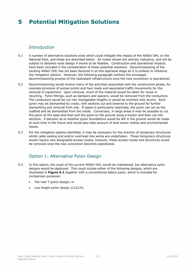
a T-Pylon is shown in Figure 5.2. Discussion of this option with the project team, together with
the feedback from the stakeholder engagement, indicated that this option would not mitigate the
landscape and visual impacts of the 400kV OHL on the National Park.
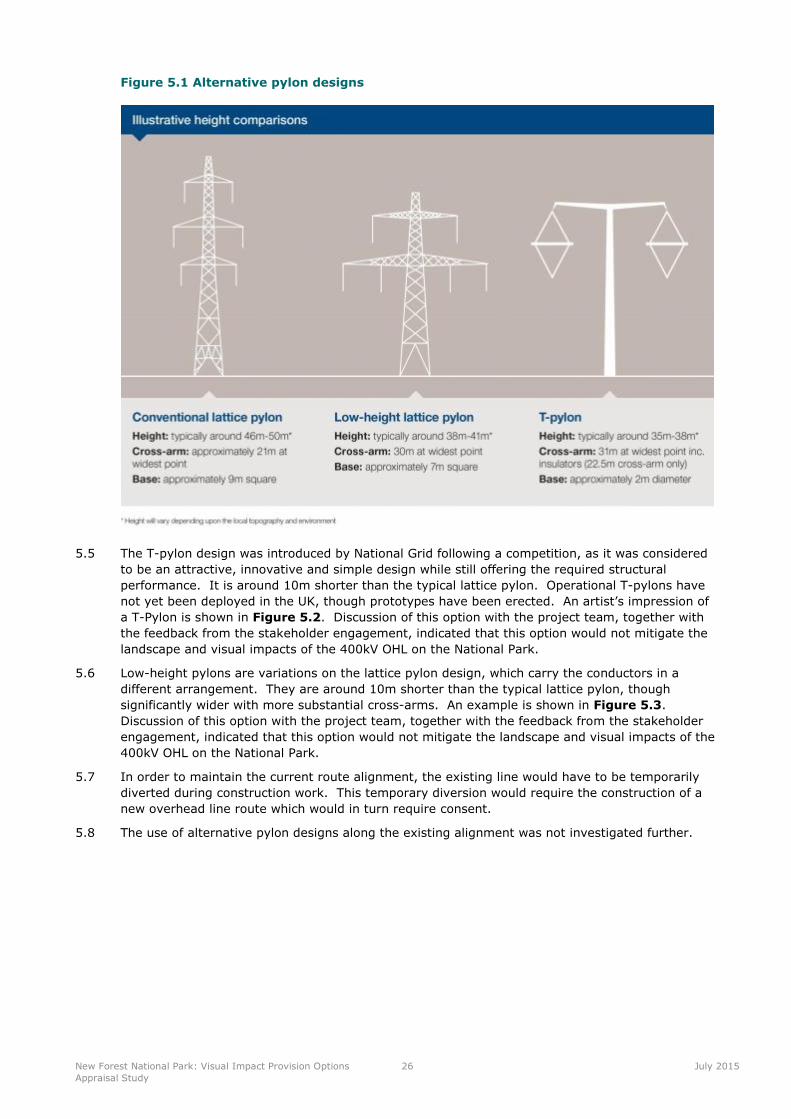
5.6 Low-height pylons are variations on the lattice pylon design, which carry the conductors in a
different arrangement. They are around 10m shorter than the typical lattice pylon, though
significantly wider with more substantial cross-arms. An example is shown in Figure 5.3.
Discussion of this option with the project team, together with the feedback from the stakeholder
engagement, indicated that this option would not mitigate the landscape and visual impacts of the
400kV OHL on the National Park.
5.7 In order to maintain the current route alignment, the existing line would have to be temporarily
diverted during construction work. This temporary diversion would require the construction of a
new overhead line route which would in turn require consent.
5.8 The use of alternative pylon designs along the existing alignment was not investigated further.
New Forest National Park: Visual Impact Provision Options
Appraisal Study
27 July 2015
Figure 5.2 Example T-pylon (artist’s impression)
Figure 5.3 Example low-height pylon
Option 2: Overhead Line on Alternative Route Alignment
5.9 This option would involve re-routeing the 400kV OHL along an alternative alignment (either using
conventional lattice or alternative pylon design). As this subsection is relatively straight and is
situated in a generally flat landform, if it was re-routed north or south within the common it would
not mitigate the landscape and visual effects on this part of the National Park. Re-routeing the
400kV OHL north, out of the National Park, would not be feasible due to the additional length of
line required and the impacts this would have on the surrounding communities. Therefore, no
New Forest National Park: Visual Impact Provision Options
Appraisal Study
28 July 2015
reasonable alternative routes have been identified for this subsection. The development of
alternative route alignments was therefore not investigated further.
Option 3: Underground Cable – Direct Burial
5.10 This option would involve replacement of the 400kV OHL with an underground cable (the existing
400kV OHL would be removed following installation and commission of the cable).
5.11 Direct burial of an underground cable would require a construction corridor typically 30-50m wide
along the length of the cable route. This width is to accommodate the cable trenches, haul road,
storage areas for stripped topsoil and sub soil from the cable trench excavation, and inclusion of
any temporary and permanent land drainage requirements. This is based on the assumption that
direct burial is using twelve cables to maintain circuit capacity. Following completion of the cable
installation, the ground would be returned to its previous use. Hedgerows and other field
boundaries would be reinstated. Trees felled would not be replanted over the buried cable but
would be replaced elsewhere. Figure 5.4 shows a typical cross section for underground cable
construction.
5.12 An alternative to direct burial is the use of cable troughs which may be able to reduce the number
of cables required to six in total. This method is generally used where the width of the cable
corridor is restricted or where vegetative reinstatement is not required (for example along cycle
trails or canal tow paths).
5.13 Each cable would be installed in an individual concrete trough, with a total single circuit trough
width of typically 2m (a double circuit installation would require two of these). The trough is laid
at a depth of approximately 1m and the achievable electrical rating is critically dependant on
maintaining a constant minimum burial depth. As such, any points/obstacles along a route
normally necessitating deeper burial, such as under watercourses and roads, would require
special design considerations. A cable trough construction swathe would be less than that of
direct burial largely because there is less of a requirement for material storage on site.
5.14 In conjunction with direct burial and cable troughs, National Grid can use horizontal directional
drilling (HDD) technology (see Figure 5.5) to negotiate steep topography and sensitive terrain.
The directional drilling provides a bore beneath the sensitive /difficult area that the cable is then
sleeved into using a biodegradable lubricant. There is no space available to accommodate a cable
joint within the HDD bore. The maximum length that can be achieved with HDD techniques will
be determined by the length of suitably rated cable that can be delivered to site on a single cable
drum.
5.15 A SEC would be located at each end of the cable route, to achieve the transition from an overhead
to an underground cable. A terminal pylon forms the end of the 400kV OHL, with a fenced
compound approximately 80m by 40m. A diagram of a typical SEC is shown in Figure 5.6, with
a photograph of an existing compound in Figure 5.7. Both cable SECs would require permanent
road access which would result in additional construction activities. It is important to note that
the designs for SECs do vary, and normally each compound is slightly different, the SEC is likely
to be similar to the examples shown; and the pylon is often contained within the compound.
5.16 Broad sealing end search areas have been identified at either end of this subsection to give
flexibility in where the SECs are sited. These areas are quite large as it cannot be determined at
this stage where exactly the SECs would be located.
5.17 A single indicative route option has been identified for the underground cables, crossing Hale
Purlieu along the existing 400kV OHL alignment from the western SEC location (search area A) in
Stricklands Plantation, to the eastern SEC search area (search area B) within Pound Bottom
quarry. This option is shown in Figure 5.8. This figure also shows the SEC search areas. It is
assumed that the western SEC would be in or around Strickland Plantation. The eastern SEC
would be located within Pound Bottom quarry.
5.18 It is considered that direct burial of section 4YB.2 and the associated SECs has the potential to
mitigate the impacts on the AONB sufficiently to be investigated further and this option is
appraised in Section 6.
New Forest National Park: Visual Impact Provision Options
Appraisal Study
29 July 2015
Figure 5.4 Typical underground cable construction swathe drawing
Figure 5.5 Horizontal directional drilling rig
Figure 5.6 Diagram of a typical sealing end compound
New Forest National Park: Visual Impact Provision Options
Appraisal Study
30 July 2015
Figure 5.7 An operational sealing end compound

New Forest National Park: Visual Impact Provision Options
Appraisal Study
31 July 2015
Figure 5.8 Direct Burial
New Forest National Park: Visual Impact Provision Options
Appraisal Study
32 July 2015
Option 4: Underground Cable – Tunnel
5.19 Under this option, construction of a bored tunnel would require the sinking of vertical shafts at
each end, to enable access for a tunnel boring machine which would complete the subsurface
excavation (Figure 5.9). Additionally a shaft may be required at the midpoint for access and
egress. A substantial construction compound would be required at each shaft location, and access
would be required for bringing in plant and material. The diameter of a cable tunnel is very much
dependant on the geology and the quantity of cables that need to be installed. It is envisaged
that a cable tunnel diameter of approximately 4-5m would be required for this option. Disposal of
spoil would be necessary, either on-site through creation of earth mounding, or off-site,
necessitating numerous lorry movements. Following completion of the tunnel and installation of
the cable, the construction compounds would be restored although the permanent tunnel
headhouses and SECs would remain.
5.20 Whilst both bored tunnels and direct burial of underground cables are major engineering
exercises, bored tunnels are only usually considered where the traditional direct burial method is
not a realistic technical or environmental option (for example under a large water body) or when
located in a highly urbanised environment (where direct burial would cause unacceptable
disruption). No compelling reasons have been identified which would require a tunnel rather than
direct burial, and tunnelling has not been investigated further.
Figure 5.9 Tunnel boring machine being lowered into a vertical shaft
New Forest National Park: Visual Impact Provision Options
Appraisal Study
33 July 2015
6 Appraisal of Preferred Option and Conclusion
6.1 Discussions between LUC and National Grid, informed by site visits in May 2015 and by the
stakeholder engagement (Section 4), led to a decision on which solutions to pursue for
subsection 4YB.2 in the New Forest National Park. Sub-topics are only considered where they
may influence the choice of option.
6.2 Direct burial of the cables was considered to be the most effective means of mitigating the
impacts of 4YB.2 on the National Park. The remainder of this section describes the alternative
means of achieving this. The route shown is entirely indicative, and will be subject to detailed
route design if shown to be feasible.
Option 3: Direct burial of Section 4YB.2
Corridors and Search Areas
6.3 For the purposes of direct burial, a corridor has been defined which follows the route of the 400kV
OHL, since this is the shortest route. The corridor has been defined as up to 200m wide to
accommodate avoidance of known constraints such as wet ground and slopes. Two search areas
for SEC locations have been identified as follows:
Search area A is located to the south of Hale Park, within Strickland Plantation (adjacent a
water pumping station), on relatively flat ground on the same alignment of the existing 400kV
OHL.
Search area B is located within Pound Bottom quarry (landfill site).
6.4 An alternative route corridor to the north or south was less preferred due to the increase in the
length of cable required, leading to a larger area of ground disturbance and increased vehicle
movements. However should further investigation prove a route to the north or south to be less
disruptive, then this will be considered. While it is acknowledged that ground water may be a
technical challenge for construction, without more detailed hydrogeological assessments this isn’t
considered an overriding concern.
6.5 The remainder of the chapter considers the burial of the 400kV OHL between search areas A and
B, along the existing 400kV OHL alignment. The corridors and search areas are shown on Figure
5.8.
Appraisal
Landscape and Visual
6.6 The burial of the 400kV line between search areas A and B would result in the removal of up to
10-12 pylons and approximately 3km of 400kV OHL from the sensitive Northern Heath and Forest
LCA. This option would also mitigate impacts on views from the B3078 Scenic Route and from the
open areas around the settlements of Cadham and Lyndhurst. However, the benefit of the
removal of the 400kV OHL would also result in scarring of the landscape, affecting the appearance
of Hale Purlieu. The severity and longevity of this impact would be dependent upon the success
of the heathland restoration. It should be noted that there are innovative techniques that can
reduce the impact, which National Grid would explore, including soil profile storing and ‘turf’
lifting.
6.7 The insertion of a SEC at Search Area A could affect views from Hale Park (Registered Park and
Garden) if located to the north of the search area, or in an open part of the search area. A SEC at
Search Area B would be well screened, being in the quarry and surrounded by Cloven Hill
Plantation, Burnt Ground Wood and Quar Hill Plantation.
New Forest National Park: Visual Impact Provision Options
Appraisal Study
34 July 2015
Ecology
6.8 Undergrounding would disturb the wet and dry heathland habitats on Hale Purlieu common, which
are designated a Ramsar site, SSSI, SAC, and SPA (New Forest). South of the existing 400kV
OHL, there is an area of deciduous woodland and conifer plantation at Millersford Plantation,
which is under multiple ownership. National Trust, one of the owners, has expressed a desire to
restore the existing plantation to heathland. There may be an opportunity to reduce disruption in
the area by working cooperatively with the landowners, to maximise the extent of heathland
habitat restoration as part of this option.
6.9 Search Area A is located within an area of mixed deciduous woodland, conifer plantation and
wood pasture. Although construction of a SEC in this location would be unlikely to have impacts
on important heathland habitats such as those found on the Common, it may have impacts on the
wood pasture within Strickland Plantation, which is a UK BAP Priority Habitat. Further
investigation of the areas will be needed to identify species and habitats in detail.
6.10 Search Area B is located within Pound Bottom quarry (disused) which is a large area of disturbed
land cover. As such locating a SEC is unlikely to affect important habitats.
Historic Environment
6.11 There are no scheduled monuments in the Study Area, however the presence of Golden
Cross/Jacob’s Barrow is of archaeological interest and may be affected by the undergrounding of
the 400kV OHL. Along the search corridor there is the potential for undiscovered archaeology,
including unexploded ordnance. Development of a SEC in Search Area A could give rise to
impacts on the setting of the grade I listed property of Hale House and the grade II* listed Hale
Park Registered Park and Garden, though this may not be any greater than the impact of the
existing 400kV OHL.
Hydrology
6.12 Although the 400kV OHL is not situated within a flood risk area, hydrology is important to the
health of the wet heath and the species it supports. The shallow valley located to the west of
Hale Purlieu is seasonally wet. It is likely that this area would be affected by construction and
careful surveying and mitigation would be required to monitor the complex hydrology in this area.
A full hydrological survey will be required as part of any further detailed assessment. There is an
opportunity to improve the condition of this area by making it wetter and/or permanently wet.
This could be incorporated into any mitigation proposals.
Other Environmental Topics
6.13 No issues have been identified under other environmental topics.
Socio-Economic Appraisal
6.14 With the removal of the 400kV OHL, there may be beneficial impacts on this part of the National
Park by mitigating the impact on the open common. This may have a slight beneficial impact on
tourism arising from visitors coming to this area.
Technical Appraisal
6.15 The direct burial of the route from Search Areas A to B would require the installation of
approximately 3km of high voltage (HV) electric cables and the construction of two cable SECs at
either end, with terminal pylons to transition between the cables and existing 400kV OHL route.
6.16 Innovative construction techniques such as utilising Horizontal Directional Drilling (HDD) may be
used to reduce the amount of ground surface disturbance along the length of the route.
6.17 A temporary haul road would be built along the length of the cable installation. The SECs would
require significant land take and full planning permission (see Appendix 1). Permanent road
access is required to the compounds. Where possible, this may be via an existing access,
otherwise a permanent route would need to be established.
6.18 During the construction period, access for heavy vehicles and plant would be required along the
proposed cable route. It is envisaged at this stage that a total of 12 HV cables would need to be
installed to ensure there are no restrictions on the capacity of the existing 400kV OHL. Horizontal
directional drilling (HDD) may be used where the cable route crosses existing roads.
New Forest National Park: Visual Impact Provision Options
Appraisal Study
35 July 2015
6.19 Access to the eastern location is not thought to be a concern due to the proximity to the B308.
Access to the western SEC would need to be carefully managed to ensure the road network is able
to support the heavy construction traffic required to construct an underground cable route.
6.20 On completion of the construction activities, redundant pylons between A and B, would be
decommissioned. Reinstatement of soil profiles and vegetation cover along the cable route will
need be carefully managed to ensure successful establishment and recovery, working closely with
the landowners/managers.
6.21 The use of cable technology is suitable to achieve this option, but further detailed assessment
would be required to ensure that network capacity is not unduly affected. Shunt reactors may be
required on the electricity network in order to compensate for the electrical properties of the
cable.
Overall Conclusion
6.22 This section of the report has presented the option which seems to be the most feasible for
addressing the visual impact of this existing subsection of National Grid overhead line.
6.23 It is proposed that, should the VIP Stakeholder Advisory Group recommend to National Grid that
4YB.2 be taken forward into the next stage of the VIP process, National Grid would work closely
with the stakeholders in identifying a specific route alignment and locations for the two SECs
within the search areas. In order to do this, it would be necessary to undertake physical site
investigations (such as borehole surveys). Potential innovative techniques, for example the use of
HDD, to reduce the impact on the designated areas will also be explored. The ability to
reinstatement the ground back to the standard of the surrounding land will be critical to the
success of this scheme. The provision of this information would inform further decision making,
again through the Stakeholder Advisory Group, for progressing this project under VI
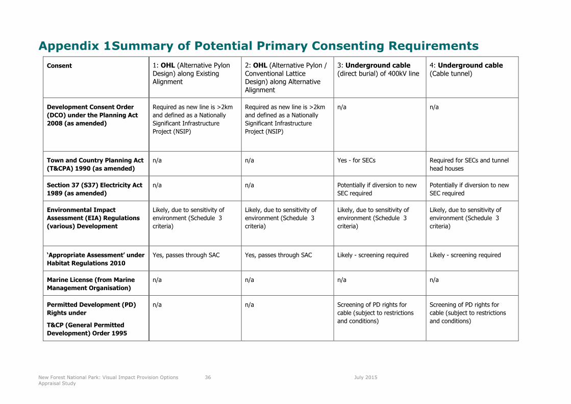
New Forest National Park: Visual Impact Provision Options
Appraisal Study
36 July 2015
Appendix 1Summary of Potential Primary Consenting Requirements
Consent 1: OHL (Alternative PylonDesign) along ExistingAlignment
2: OHL (Alternative Pylon /Conventional LatticeDesign) along AlternativeAlignment
3: Underground cable(direct burial) of 400kV line
4: Underground cable(Cable tunnel)
Development Consent Order
(DCO) under the Planning Act
2008 (as amended)
Required as new line is >2km
and defined as a Nationally
Significant Infrastructure
Project (NSIP)
Required as new line is >2km
and defined as a Nationally
Significant Infrastructure
Project (NSIP)
n/a n/a
Town and Country Planning Act
(T&CPA) 1990 (as amended)
n/a n/a Yes - for SECs Required for SECs and tunnel
head houses
Section 37 (S37) Electricity Act
1989 (as amended)
n/a n/a Potentially if diversion to new
SEC required
Potentially if diversion to new
SEC required
Environmental Impact
Assessment (EIA) Regulations
(various) Development
Likely, due to sensitivity of
environment (Schedule 3
criteria)
Likely, due to sensitivity of
environment (Schedule 3
criteria)
Likely, due to sensitivity of
environment (Schedule 3
criteria)
Likely, due to sensitivity of
environment (Schedule 3
criteria)
‘Appropriate Assessment’ under
Habitat Regulations 2010
Yes, passes through SAC Yes, passes through SAC Likely - screening required Likely - screening required
Marine License (from Marine
Management Organisation)
n/a n/a n/a n/a
Permitted Development (PD)
Rights under
T&CP (General Permitted
Development) Order 1995
n/a n/a Screening of PD rights for
cable (subject to restrictions
and conditions)
Screening of PD rights for
cable (subject to restrictions
and conditions)

New Forest National Park: Visual Impact Provision Options
Appraisal Study
37 July 2015