Embed Size (px)
Citation preview
“Scenic Roads in Virginia” courtesy of the Virginia Department of Transportation, Office of Public Affairs.
10
9
87
6
54
2
3
1
11
12
13
14
15
1617
18
19
20
21
22
23
24
25
26
27
28
29
30
31
32
33
WEST
VIRGINIA
VIRGINIA
E S
L A S K I
M O N T G O M E R Y
A L L E G H A N YA L L E G H A N YA L L E G H A N Y
B O T E T O U R T
R O C K B R I D G EN E L S
A M H E R S T
A P P O
C A M P B E L L
A U G U S T
B A T HB A T HB A T H
H I G H L A N DH I G H L A N DH I G H L A N D
C R A I G
R O A N O K E
B E D F O R D
Cloyd's Mountain
Forest
S i n k i n g Cr .
C r ai g
Cr ee
k
Was
hing
ton
Georg
e
Jeffe
rson
Nation
al
Fores
t
Mead ow
C r .
J o hn '
s
C r .
R o a no k
e( Stau
n
R i v
e r
B
ac
k
J ac
k so
nR
i ve
r
Cr ee
k
Wash in
g ton
WE
ST
V
IR
GI N
I A
Lake
Moomaw
Lake
Moomaw
BlowingSpring
Hidden Valley
Rawley Springs
Moscow
Monterey
Vanderpool
Hightown
Mustoe
Warm Springs
MillboroSprings
SweetChalybeate
White SulphurSprings
Lewisburg
Callaghan
Crows
Low Moor
IronGate
Glasgow
BuchananElon
Monroe
Wright Shop
Montebello
Nellysford
Winter
Colleen
MassiesMill
PineyRiver
Concord
Appo
Rustburg
LynchStation
Amherst
Paint Bank
Paint BankState
Fish Hatchery
HavensWMA
Va. MineralSprings
Vinton
Daleville
Catawba
Eagle Rock
ChessieTrail
Oriskany
BuffaloGap
West Augusta
Churchville
AugustaSprings
Craigsville
Goshen
Healing Spring
Hollins
MadisonHeights
Hot Springs
Head WatersMcDowell
NaturalChimneysReg. Park
Sherando Lake
Piedmont
Waynesb
HA
CrossKeysMcDowell
HighlandWMA
The HomesteadResort
Goshen-LittleNorth Mnt. WMA
Montebello FishCulture Station
Coursey Springs FishCulture Station
DouthatState Park
T.M. GathrightMWA
VirginiaHorse Center
Theatre AtLime Kiln
Longdale
RoanokeFarmer'sMkt.
ExplorePark
Peaks of Otter
PoplarForest
Point ofHonor
StonewallVineyard
North Creek
StonewallJacksonHouse
Roanoke Mt.
RoanokeMt. CampGrounds
DixieCaverns
SmithfieldPlantation
Booker T.
WhiteRocks
MountainLake
ResortRipplemead
Sinking Creek
Bent Mountain
Pembroke
CascadeFalls
Cave Mtn.Lake
AppomCourtNat'l His
Appalachain T
rail
GoshenPass
CyrusMcCormick's
Farm SherandoRec. Area
Woodrow Wilson'sBirthplace
Museum of American
Frontier Culture
North River
Todd Lake
Hone Quarry
GranReg
Crabtree Falls
Afton MVineyar
WintergreenResort
WintergreenVineyards & Winery
Rebec
Vineyards
Otter Creek
Natural Bridgeand
Caverns
Bul l
pas
ture
PearisburgNewport
Christiansburg
BLACKSBURG
LYNCHBURG
ROANOKE
Bold Knob4200 Ft.
Mad Sheep Mtn.4225 Ft.
North Fork ValleyRHD
Bullpasture Mtn. 3240 Ft.
Bearcamp Knob 4170 Ft.
Jack Mtn.4378 Ft.
Reddish Knob 4398 Ft.
Elliott Knob 4458 Ft.
Devil's Knob 3851 Ft.
Big Knob Mtn.3994 Ft.
Bother Knob4344 Ft.
Bridgewater
Staunton
Dayton
Shenandoah Mtn. 3760 Ft.
Elk Pond Mtn.4034 Ft.
Horseshoe Mtn.2533 Ft
Mt. Pleasant 4054 Ft.
Flat Top Mtn.3994 Ft.
Pott's Mtn.3800 Ft.
Bedford
Buena
Vista
RockbridgeBaths
Poor Mtn.3831 Ft.
Masons Knob3170 Ft.
New Castle
Fincastle
LexingtonCovington
CliftonForge
River
River
Cowpas
ture
Cowpas
ture
Ri v
er
Jam
esR.
C re
ek
CalfpastureRiver
Middle
River
Otter
R iver
Thaxton
Blue Ridge
460
11
11
29
29
460
221460
221460
460
501
501
60
60
11
1
250
220
220
460
220
220
60 6060
33
785723
785
669622
62
677
696696 696
701
629
600
780
616616
615
606
621615 663
635
Forest
National
84
39
39
3942
15156
5615
42
42
42311
311
159311
43
43
43
130
24
CifaxRHD
64
64
64
81
81
851
Lake
Robertson
Lake
Moomaw
Craig
Ja
m
es R i v e r
R I D G E
Sou
t h
R.
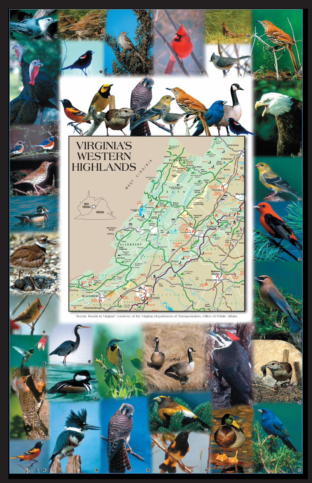
VIRGINIA’SWESTERN HIGHLANDS
Alleghany Highlands Chamber of Commerce
Bath County Chamber of Commerce &the Forest Place Visitors Ctr.
Highland County Chamber of Commerce
Photos by
ALLEGHANY – BATH – HIGHLAND COUNTIES
Experience The Wonder……a land of rugged mountains, quiet valleys,
sparkling streams and endless skies… many other trails and outdoor recreation opportunities…
PHOTOBIRD-COMMON NAMEHABITAT
#______1White-breasted Nuthatch
______2Song Sparrow
______3Red-winged Blackbird
______4Northern Mockingbird
______5Northern Cardinal (male)
______6Ruffed Grouse
______7Tufted Titmouse
______8Brown Thrasher
______9Bald Eagle
______10American Goldfinch (winter plumage)
______11Scarlet Tanager
______12Cedar Waxwing
______13Carolina Wren
______14Indigo Bunting
______15Pileated Woodpecker
______16Mallard
______17American Redstart
______18Evening Grosbeak
______19Canada Goose
______20American Kestrel
______21Eastern Meadowlark
______22Belted Kingfisher
______23Hooded Merganser
______24Great Blue Heron
______25Baltimore Oriole
______26Northern Flicker
______27Ruby-throated Hummingbird
______28Northern Cardinal (female)
______29Killdeer
______30Wood Duck
______31Wood Thrush
______32Eastern Bluebird
______33Wild Turkey
______34Hooded Warbler
______35Red-tailed Hawk
______36Eastern Towhee
______37Osprey
______38Blue Jay
Habitat Key:= Open Areas
= Conifer
= Hardwoods
= Near Water
= Brush/Shrub
= Edge
E
O
B
E
B
W
H
C
O
E
E
H
W
C
C
W
W
W
W
W
W
B
B
B
B
B
O
O
O
O
O
O
O
H
H
H
H
H
H
H
H
H
W
H
1. EVAN’S TRACTTake Hwy 220S turn left onto VA SR 633 for 2.5miles. After crossing the one-lane bridge overriver, the tract is on the left. Parking is signed as“U.S. Forest Service Walter L. Robinson AccessPoint.”
2. TOP DRIVEFrom I-64 E., take exit 35 (Longdale) to U.S. Hwy60 W. Turn left onto VA SR 770 & bear left atsummit onto FR 447, to the North MountainOverlook.
3. SWEET ROADFrom Covington, take State Rt. 185. Turn right atState Rt. 613 at Boiling Springs turn left where itruns into FDR 350 (Sweet Road) it junctions withState Rt. 18 again, turn left and follow toCovington.
4. LAKE MOOMAW/GATHRIGHT DAMFrom Covington, take U.S. Hwy 220 N. to VA SR687. Turn left & to VA SR 641 turn left to VA SR666, turn right & to VA SR 605. Turn right to dam.
5. DOLLY ANNE HOLLOW (FR 125),SANDY SPRINGS (FR 125), LIME KILN(FR 194), DOUTHAT ROAD (FR 629)From Covington, take I-64 Exit 16 & follow StateRt. 220 N. approximately 1.25 miles, turn right atState Rt. 625 it turns into FR 125 (Dolly AnneRoad) it junctions with State Rt. 606, turn leftapproximately 2.00 miles to FR 125 SandySprings where it makes a right goes for 12.0miles to Rt. 629. Turn right to Douthat State Park& Douthat Lake 10.8 miles down the road with I-64 another 4.8 miles.
1. BOLAR MOUNTAIN AREA/LAKE MOOMAWRt. 220 to Warm Springs, Rt. 39 W to 600 S.
2. BACK CREEK PUMPEDSTORAGE RECREATION AREARt. 220 to Warm Springs, Rt. 39 W to 600 N.
3. HIDDEN VALLEY RECREATION AREARt. 220 to Warm Springs, Rt. 39 W to Rt. 621 N.to Hidden Valley Rd.
4. DOUTHAT STATE PARKRt. 220 to Warm Springs, Rt. 39 E to Rt. 629 S.
5. POOR FARM AREARt. 220 N. to Rt. 623 W. (2.3 miles to Poor Farm)
6. WALTON TRACTRt. 220 N. to Rt. 39 E. to Rt. 42 S. to Rt. 632 W.(Crisers Gap Rd)
7. GILLUM RUN TRAILRt. 220 to Rt. 39 E. to Rt. 629 S. to FR 361
8. PINEY MOUNTAIN TRAILRt. 220 to Rt. 39 E. to FR 358 N.
9. BOTH THE VILLAGES OF HOTSPRINGS AND WARM SPRINGSare registered Bird Sanctuaries. You can findthe majority of the birds in this brochure inthese two villages.
1. BLUE GRASS VALLEY TRAILFrom Monterey, follow US 220 north to Route642. Turn left (west) on Route 642 to junctionwith Route 640 in Blue Grass. Follow Route 640the length of the Blue Grass Valley, crossing US250 at Hightown. Turn left (east) on Route 84 toUS 220. Follow US 220 north to Monterey.ÍMonterey ÍBlue Grass Valley ÍMonterey=27.87 mi.
2. BULLPASTURE VALLEY TRAILFrom Monterey, follow US 250 east to McDowell.Turn right (south) on Route 678 into the BullpastureValley to Williamsville. Turn left on Route 614 andfollow gravel road north to US 250.ÍMcDowell ÍBullpasture/Cowpasture Valleys ÍMcDowell=63.11 mi.
3. US 220 (South) BLUEBIRD TRAILFrom Monterey, follow US 220 south to the BathCounty line. (This stretch of road is lined with blue-bird boxes!)ÍMonterey ÍBath County line ÍMonterey=31.26 mi.
4. TOWN OF MONTEREYLocated at the junction of US Route 250 and USRoute 220, the town of Monterey is a designatedbird sanctuary. A number of the town’s residentsare keen birders, and bird feeders and nestingboxes are located in yards and gardens throughoutthe town.
5. LAUREL FORKThis is a remote wooded area requiring a lengthyscenic drive with the last 21 miles graveled road.Contact the Highland County Chamber ofCommerce for a map and detailed directions.
6. JACK MOUNTAIN WILDLIFEMANAGEMENT AREAThe graveled road into this area is best suited tofoot traffic and/or 4wheel drive. Contact theHighland County Chamber of Commerce for a mapand detailed directions.
Richmond
Roanoke
Lexington
Staunton
Washington D.C.
VIRGINIA 77
81
64
6495
66
85
Virginia Accredited
Tourism Community
ALLEGHANY COUNTY BATH COUNTY HIGHLAND COUNTYBirding Trails In Birding Trails In Birding Trails In
27
34
35
36
37
38
9
ForAdditional Information Contact:
Alleghany Highlands Chamber of [email protected]
241 W. Main St. • Covington VA 24426540/962-2178 • Fax 540/962-2179
Bath County Chamber of Commerce &the Forest Place Visitors Ctr.www.DiscoverBath.com
P.O. Box 718 • Hot Springs VA [email protected]
1-800-628-8092 • 540/839-5409Fax 540/839-5409
Highland County Chamber of Commercewww.highlandcounty.org
[email protected]. Box 223 • Monterey VA24465 540/468-2550 • Fax 540/468-2551
Photos bySimpson’s Nature Photography
Ann & Rob Simpson1932 East Refuge Church Road
Stephens City, VA 22655540/869-2051
www.agpix.com/snphotosand
U.S. Forest Service


![[XLS] · Web view12 cft 11 cft 16 cft 25-90 lb 12.5 ft 16.5 ft 40 gal 90 gal 120 gal 12 gal to 10 ft to 14 ft to 15 ft 61 ft 80 ft 100 ft 37 ft 60 ft 70 ft 125 ft 150 ft 24000 lb](https://img.pdfslide.us/doc/110x75/5af970177f8b9aac248e662f/xls-view12-cft-11-cft-16-cft-25-90-lb-125-ft-165-ft-40-gal-90-gal-120-gal-12.jpg)