Embed Size (px)
Citation preview

Government of Haryana Department of Revenue & Disaster Management
Haryana Institute of Public AdministrationPlot No. 76, HIPA Complex, Sector-18, Gurgaon-122015
Village Disaster Management Plan Ambala
UDAIPUR(2015-16)

Contents
Page No.
1. Introduction 01 1.1 Village profile 01 1.2 Demography 01 1.3 Topography 01 1.4 Social and Economic structure 01 1.5 Climate & rainfall 01 1.6 Land Use pattern 01 1.7 Drinking water & Sanitation facilities 01 1.8 Transport facilities 01
2. Hazard, Vulnerability and Capacity Analysis 03 2.1 Hazards profile of Village 01 2.2 Vulnerability assessment 01 2.3 Capacity Analysis 01
2.3.1 Skilled/Trained Human Resource 01 2.3.2 Resource Inventory 01
2.4 Risk Analysis 01 3. Response plan 06
3.1 Village Disaster Management Committee 01 3.2 Teams under VDMC 01
3.2.1 Early warning, Communication & Awareness Generation Team 01 3.2.2 Evacuation Team 01 3.2.3 Search and Rescue Team 01 3.2.4 First Aid Team 01 3.2.5 Relief management team 01 3.2.6 Shelter Management team 01 3.2.7 Carcass management team 01 3.2.8 Damage & Need assessment team 3.2.9 Rehabilitation & Reconstruction team 01
3.3 Local NGOs & SHGs 01 4. Mitigation and Preparedness Plan 09
4.1 Standard operating Procedure of teams 01 4.2 Identification of open spaces 01 4.3 Community level Mitigation programme 4.4 Rural Development Schemes and Disaster Management 01
5. Contact Detail & updating of plan 10

Chapter -01
Introduction
Village Profile:- Udaipur is a Village in Ambala-i Tehsil in Ambala District of Haryana State, India. It belongs to Ambala Division . It is located 4 KM towards East from District head quarters Ambala. 48 KM from State capital Chandigarh Udaipur Pin code is 134003 and postal head office is Ambala City . Udaipur is surrounded by Ambala-Ii Tehsil towards North , Saha Tehsil towards East , Ghanaur Tehsil towards west , Shahbad Tehsil towards South . Ambala , Babiyal , Shahbad , Rajpura are the nearby Cities to Udaipur. This Place is in the border of the Ambala District and Patiala District. Patiala District Ghanaur is west towards this place . It is near to the Punjab State Border.
Colleges near Udaipur Govt. College Narain Garh Address : Govt. College Narain Garh Gurukulam Institution Of Technical Education Address : Gurukulam Institution Of Technical Education chd Raipurani Road vill Khora Bhura disst Ambala Shri Sardari Lal College Of Education Address : Vpo Nahoni -- 133104; Block--saha Distt. Ambala Mm College Of Pharmacy Address : Mullana Ambala Mm Institute Of Management Address : M.m. Educational Cplx; Mullanaambala -- 133 203haryana
Schools in Udaipur Ghs Udaipur Address : udaipur , ambala 1 , ambala , Haryana . PIN- 134003 , Post - Ambala City 1.1 Village at-a-glance as under:-
Particulars Detail
Village hadbast Number 295
Area (Hectares) -
Gram Panchayat Udaipur
Patwar halka Niharsi
No. of House Holds 187

CD Block Ambala-1
Tehsil Ambala
Police Station Naggal
Education Institutes 12th
Health Institutions Chourmastpur
Religious Institutions Temple
Primary Source of Livelihood Farming
Natural resources Farming
No. of factories/Industries NA
1.2 Demography :- the total population of village is 772 with Male Population of 395 and female of 377 . Its other statics are as below:-
Description Persons Males Females
Total Population 772 395 377
Population in the age-group 0-6
25 17 8
SC population 105 57 48
Literacy rate - - -
Total workers 100 80 20
Total Non-workers
50 - -
People with disability
5 - -
Senior citizens 89 - -
1.3 Topography:- elevation Plane area, Sand dunes, hill locked.
1.4 Social culture & Economic structure:-

1.5 Temperature and rainfall:- The climate is Semiarid and hot which is mainly dry with very hot summer and cold winter except during monsoon. Here experience extreme temperature ranges 2-47 degree centigrade with severe cold in month of December & January and the month of May & June are of bitter summer. The annual average rainfall in the district is 569.6 mm. About 70 per cent of the annual rainfall is received during period from July to September.
1.6 Land use pattern:- The total area of village is ……. Hectares according to Village papers.
Sr.No Land use Area in hectrs %
1. Habitation -
2. Agriculture -
3. Forest -
4. Wasteland -
5. Samlat land -
6. Others -
1.7 Drinking Water & Sanitation facilities:- the main source of drinking water located within premises of Village and supply of drinking water in village as per below:-
Tap water from treated sources
Tap water from untreated sources
Covered wells
Uncovered wells
Hand pumps
Tube wells/ boreholes
Other sources
1 - 1 0 30 4 0
Sanitation Facilities:- the total Households are ……… in the village. Out of which only …..% households having latrine facility at their own house premises and rest ……..% of households have not latrine facility. These households use alternative sources i.e public toilets and open spaces.
Total House holds Latrine Facility at house Latrine facility not at house
187 181 6

1.8 Transportation Facilities:- The village is well connected with surrounding village with local roads and SH/NH/ District road/other roads connected village to other important places such as Block, Tehsil, District headquarter.
Chapter-02
Hazard, Risk, vulnerability and Capacity Assessment
2.1 Hazard profile of Village:-
Hazards (in and around the village )
Hazard Probability (High / Med / Low)
Possible causes
Households vulnerable
Road Accidents Low
Flood Low
Earthquake Low
Landslide Low
Building collapse Low
Epidemic / Contagious disease
Low

Fire Low
Heat Wave Low
Cold Wave Low
Industrial / Chemical hazard
Low
Stampede Low
Animal Bite Low
Snake Bite Low
Food Poisoning Low
Others (specify)
2.1.2 Details of industries/ factories located near the village
Name of industry NA
Type -
Chemical/ Gas usage -
No. Of people employed -
Waste Disposal technique followed by Industry
-
Hazardous Chemicals (If any give details)
-
2.1.2 Disaster History
Sr. No.
Disaster/Accidents Date & Time of occurrence
Percentage of Village affected
Total No. of people affected (injured & dead)
Dead Injured 1 Flood
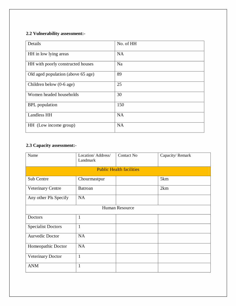
2.2 Vulnerability assessment:-
Details No. of HH
HH in low lying areas NA
HH with poorly constructed houses Na
Old aged population (above 65 age) 89
Children below (0-6 age) 25
Women headed households 30
BPL population 150
Landless HH NA
HH (Low income group) NA
2.3 Capacity assessment:-
Name Location/ Address/ Landmark
Contact No Capacity/ Remark
Public Health facilities
Sub Centre Chourmastpur 5km
Veterinary Centre Batroan 2km
Any other Pls Specify NA
Human Resource
Doctors 1
Specialist Doctors 1
Aurvedic Doctor NA
Homeopathic Doctor NA
Veterinary Doctor 1
ANM 1

Paramedical staff (Other than ANM)
1
Trained Dai NA
Any other, Pls. Specify NA
Health [Private
Hospital NA
Clinic NA
Veterinary centre NA
ANM NA
Ambulance NA
Medical Shops NA
Pathological Lab NA
Manpower [Private] Nos.
Doctos NA
Specialist Doctor NA
Paramedicals [Except ANMs]
NA
Public
Police Station Naggal 8km
Fair Price Shop Ambala 15km
Petrol Pump Khanna Majra 4km
Kerosene Depot Udaipur
Gas Agency / Depot Udaipur
Other
Education
Infrastructure Nos. No. of Rooms
No. of Teachers No. of Students
Safe Shelters
(Yes / No)

Anganwadi centre 1 1 1 25 -
Primary school 1 2 2 54 -
Medium school - - - - -
High school 10 12 7 150 -
Secondary school - - - - -
Power & Communication
Electricity Yes / No Contact no Remarks
Electric Sub Station No
Electricity Available in Village Yes
Street Light Facility Yes
Any Other No
Generator (Public) No
Generator (Private) Yes
Torches Yes
Communication (Public) Yes / No Contact no Remarks
Telephone Exchange No
Telephone Connection Yes 50
Mobile Phones Yes 150
Sirens No
Public Announcement System
Loud speakers Yes / No Contact no Remarks
Loud Speakers (Temple/ Masjid/ other religious institutions )
Yes 2
Gram Panchayats No
Sound Systems (Private) No
Tent house No
Other No

Market/ Shop
Grocery No
PDS No
Medicine No
Vegetables/ fruits market No
Internet Shop No
Major Bank Branches
Name of Banks -
ATM Machines No
Drinking Water Sources/ Water Supply
Water Supply (Public) Yes No If yes, numbers
Dam/ Check Dam No
Pond Yes 1
Well Yes 1
Tube well Yes 1
Hand pump Yes 30
Tap water Supply (at household) Yes 200
Community water post Yes 15
Water Tanker Supplier (GP owned) No
Water Tankers (Govt.) No
Other sources No
Water Supply (Private) Yes No If yes, numbers
Private Wells No
Private Tube Wells / Bore wells Yes 2
Private Hand Pumps Yes 2
Other No

Sanitation
Facility Yes No Numbers, if yes
Public toilets No
Any open defecation site No
Open Defecation site No
Waste Disposal
Waste disposal area Yes 1
Dumpsters No
Burial Ground
Location of burial ground -
Location of animal carcass disposal area
-
Public Places of Recreation
Community hall Yes 1
Library No
Sports ground No
Parks No
Place of village meetings/ chaupal Yes 2
Place of Worship
Temple Yes 1
Mosque No
Church No
Gurudwara Yes 1
Monastery No
Others No
Connectivity
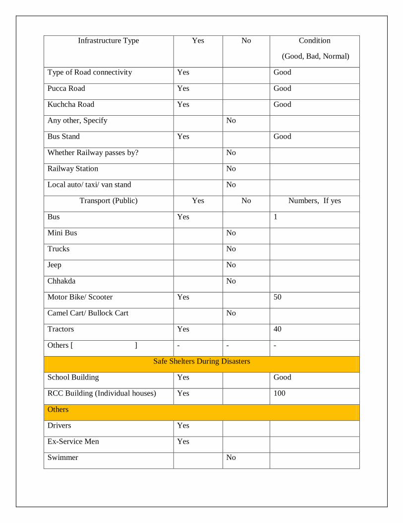
Infrastructure Type Yes No Condition
(Good, Bad, Normal)
Type of Road connectivity Yes Good
Pucca Road Yes Good
Kuchcha Road Yes Good
Any other, Specify No
Bus Stand Yes Good
Whether Railway passes by? No
Railway Station No
Local auto/ taxi/ van stand No
Transport (Public) Yes No Numbers, If yes
Bus Yes 1
Mini Bus No
Trucks No
Jeep No
Chhakda No
Motor Bike/ Scooter Yes 50
Camel Cart/ Bullock Cart No
Tractors Yes 40
Others [ ] - - -
Safe Shelters During Disasters
School Building Yes Good
RCC Building (Individual houses) Yes 100
Others
Drivers Yes
Ex-Service Men Yes
Swimmer No

First Aid trainer No
Meson Yes 20
Carpenter Yes 5
1. Equipments:
Search & Rescue Equipments QTY Public
Contact No. Public
QTY Private
Contact Nos. Private
JCB No
Aara mashin No
Dumper No
Loader No
Others No
2.4 Risk Analysis:-
Severity Hazard Elements at Risk
Vulnerable Areas
High Risk Hazards
Earthquake Human life, cattle life, public infrastructure, environment, etc.
Entire village falls in EQ Zone- IV i.e. high damage risk zone.
Chemical Accidents
Human Life, cattle life, Environment, etc.
No
Fires Human Loss, cattle life, agricultural produce, kutcha houses, industries, etc.
Households,Shops
Road Accidents
People travelling on roof/ inside buses. on national Highways, state Highways

and other district. Cattle and other animals.
Medium Risk Hazards
Extreme Temperature
Human life, Cattle population, Crops, transportation activities.
Floods Human life, cattle life, crop life, property and public infrastructure.
Epidemic Human Life, animal life
Low risk Hazards
Drought Human Life, crop life, Cattle life,
Entire district is prone to drought like condition. Ground water depletion is maximum as tube wells remain the alternate source of water.
Frost Thunder storm Hailstorm
Crop, cattle life Human life, crop , Cattle life, Public infrastructure
People with poor housing conditions in the village.
Terrorist Attack
Crowded places
Bus stops, Malls, Hospitals, Places of Worship, Melas etc in the district
Chapter-03

Response Plan
3.1 Village Disaster Management Committee :- to carry out disaster management activities
i.e. village disaster management plan, training and awareness activities, identification of
resources and search & rescue activity at village level conducted by Village Disaster
Management Committee. The following is the suggestive list of committee members:-
Sr.No. Name Designation Contact number
1. Sarpanch – Ashok Kumar Chairman 9416062126
2. Panchayat secy - Nodal Officer 9466070376
3. Patwari – Gurudhyan Singh Member 8199830128
4. Numbardar –Narender Singh Member 9416494061
5. SC panch – Kamlesh Rani Member 8901145265
6. BC panch – Harjeet Kaur Member 9466714917
7. Anganwari worker - Sunita Member 9467469214
8. SHG heads Member -
9. School representative Member -
10. Sub-Centre representative Member -
11. Woman Panch Member -
12. Ex-servicemen Member -
13. Agriculture Development Officer Member -
14. Animal Husbandry representative Member -
15. (Any other representative that can be resourceful as per the village)
Member -

3.2 Village Disaster Management teams :-
S. No. Name Designation Contact Number Contact Address
Early Warning and Information Dissemination Team
1 Tejinder 9050462126 Udaipur
2 Narender Kumar 9416494061 Udaipur
3 Kulwant Singh 9416399147 Udaipur
4 Prenan Kumar 9416162126 Udaipur
Evacuation Team
1 Ashok 9416062126 Udaipur
2 Raj Singh 0171285211 Udaipur
Search and Rescue Team
1 Som Nath 01712852568 Udaipur
2 Parveen Kumar 9416162126 Udaipur
First Aid Team
1 Tejinder Singh 90504621626
Relief Management Team
1 Kulwant Singh 9416399147
Sanitation Team
1 Ashok 9416062126
Shelter Management Team
1 Raj Singh 0171285291

Carcass Disposal Team
1 Narender Kumar 9416494061
Damage & Need Assessment Team
1 Tejinder Singh 9050462126
Rehabilitation & Reconstruction Team
1 Parveen Kumar 9416162126 Udaipur
3.3 Working NGOs and Self Help Groups in Village:-
Sr.No Name of organisation Sector Contact number
1.
2.
3.

Chapter-04
Mitigation and Preparedness plan
4.1. Standard Operating Procedures
The teams formed in the previous chapter, their SOPs shall be listed down here. For eg:
4.1.1. Early Warning & Information Dissemination Team Communicate the information with other teams. Update contact details of local resources/ offices, etc...
4.1.2. Evacuation Team Keeping evacuation map of the village with them. Knowing the way of evacuation from the village. Identifying safe evacuation routes, places, assembly points in and around the
village. 4.1.3. Search & rescue team
Search people who trapped in buildings and rescue them. Transport victims to safe location.
4.1.4. First Aid Team Maintain list of pregnant women, infants, people with special medical needs,
etc. Keeping First-Aid box with disinfectants, antiseptics, ORS, etc. Updated contact number of emergency services i.e. Ambulance, near hospital
public & private. 4.1.5. Relief Management team
To provide relief materials i.e. food, water, cloths, utensils and other essential material for who evacuated and rescued from village.

4.1.6. Shelter Management team Identify safe shelter in village, open spaces for tents installation and nearby
areas in case of evacuate the people from village. 4.1.7. Carcass Disposal Team Identification of space for carcass disposal. Stocking kerosene and fuel for disposal of carcass. Maintaining storage of sackcloth to cover dead bodies of animals. Proper spray of disinfectants (eg: DDT) to keep the air clean
4.1.8. Damage & Need Assessment Team Help in forecasting damages including lives lost and losses to property and
assets such as houses, livestock, agriculture, plantation, etc. Sensitizing families of village to keep their important documents safe, and in
emergency kit. 4.1.9. Reconstruction & Rehabilitation Team Get purified water sources in village. Prepare reconstruction and rehabilitation plan for vulnerable groups/areas in
the village.
4.2. Identify Safe Evacuation Routes Selection of evacuation route that minimize the exposure to the hazard and
other obstacles Evacuation route to be easily accessible even for vulnerable groups such as,
women, children, and elderly. Evacuation Map of the village
4.3. Community level Mitigation Programme Include hazard specific mitigation measures and schemes running in the village
4.3.1. Flood Mitigation Construction of bundhs around settlement. Construction of flood shelter Drainage channels to be cleared Construction of raised platforms near important/ vulnerable areas, such as
school, shelter of animals, gaushalas, etc. 4.3.2. Earthquake Mitigation Detailed survey of buildings for assessment of damage and repair/
reconstruction and seismic strengthening or demolition Training the local masons for constructing earthquake resistant structures Conducting mock drills in villages for evacuation during an earthquake Fix all objects in houses that can fall and cause injury (non structural
mitigation) 4.3.3. Drought Mitigation
Continuous drought monitoring through rainfall situation, water availability in reservoirs, rivers, canals, etc. and comparing with existing water needs of society.
Water conservation through rainwater harvesting in houses and farmers’ fields.
Allowing runoff water from all fields to a common point (eg: pond) or allowing it to infiltrate in the soil where it has fallen.
Generating awareness among the village people on implementing water conservation and agriculture awareness programs through television, pamphlets, nukkad natak, etc.
4.4. Schemes & Disaster Mitigation Identify the schemes/ projects running in the village and segregate them relevant to Mitigation and Preparedness measures. For eg: o Sansad Adarsh Gram Yojana o NREGA o IAY o Swarn Jayanti Gram Swarozgar Yojana o Pradhan Mantri Gram Sadak Yojana o National Social Assistance Programme o Rural Water Supply Programme o Total Sanitation Campaign o Rural Connectivity Programme o Hariyali – implementation of Watershed Development Program o Drought Prone Area Programme.

Chapter-05
Contact number and Updation of plan
1. Administrative contact:-
Sr.No.
Designation Contact Number Contact Address
1. Deputy Commissioner
2. Superintendent of Police
3. Additional Deputy Commissioner
4. District Revenue Officer
5. SDM
6. Tehsildar
7. Naib-Tehsildar
8. BDPO
9. SDO Public Health Engineering
10. SDO Power Supply
11. Police Officer (SHO)

12. Sub Inspector
13. Police Post In-charge
14. Patwari
15. Panchayat Secretary
16. Project Officer (MGNREGA/ IAY, etc)
17. Medical Officer
18. CDPO
19. BEO
20. Fire Officer
21. Agriculture Development Officer
2. Gram Panchayat contacts:-
Sr.No Elected person Name Contact
1. Sarpanch Ashok 9416062126
2. Block Samiti Member Saroj bala 9416195080
3. Ward No.1 Panch Kamlesh Rani 8901145265
4. Ward No.2 Panch Raj Singh 01712852211
5. Ward No.3 Panch Yshoda Rani -
6. Ward No.4 Panch Baldev Singh -
7. Ward No.5 Panch Som Nath 01712852568
3. Contact No. NGOs and SHGs
Sr.No. Organisation Name of Pardhan/Secretary Contact No.
1.
2.

3.
4.
5.
6.
7.
4. Public Distributors
Sr.No Name Contact no.
1.
2.
5.4 Other Important contact numbers:-
Sr.No. Name Contact No.
1. Namardar Narender Kumar 9416494061
2. Chokidar Gurmail Singh
3. ANM Renu
4. ASHA Renu
5. Aganwari Sunita 9467469214
6.