Embed Size (px)
Citation preview
EDST201
School Name Unit Title Unit Duration
Australian Catholic University Tectonic Plates and their effect on the Earth Min. 9 Lessons
Unit Goal Statement
By the end of this Unit, Students should be able to demonstrate new knowledge and skills which they constructed through the key unit inquiry questions. These Students will be able to demonstrate new learning about: The layers of the Earth, Tectonic Plates including divergent
boundaries, convergent boundaries, transform boundaries, plate boundary zones and how they affect the Earth in terms of Continental Drift and the landscapes they hold.
Unit Concepts Key Unit Inquiry Questions
Layers of the Earth; Lithosphere, Mantle, Core. Tectonic plates; divergent boundaries, convergent
boundaries, transform boundaries, plate boundary zones.
What are the layers of the Earth called? How do they differ from each other? How do tectonic plates shape the Earth? Are continents affected by tectonic plates?
Teacher Background Information
To comprehensively teach the unit, teachers need to have a foundational understanding of many key elements. These may include;
Knowledge of local, national and international landforms, rocks or fossils An understanding of the characteristics of the Earth’s layers, such as crust, lithosphere, mantel and core A comprehensive knowledge of tectonic plates, including elements such as divergent boundaries, convergent boundaries, transform
boundaries and plate boundary zones.
1Ash Harland, Rebecca South & Matthew Bibo
EDST201
The Students
Year 4 The class is comprised of students who have:
- Sound achievement in all KLA’s.- Some students demonstrate a low cognitive ability to process new information on the spot.- Come from a middle class SES home environment.
Student Misconceptions
Misconceptions student may about regarding the unit topic may include that;
Students believe that the Earth’s crust layer is like the outside of a ball, rather than like a jigsaw puzzle. Students may think that tectonic plates are always neatly divided along continental lines, although some tectonic plates cut through
continents. Students believe that the Earth is made up of a single solid material, rather than fluctuating layers.
2Ash Harland, Rebecca South & Matthew Bibo
EDST201
Unit at a Glance
Aims of Unit Student Outcomes Assessment
The aim of the unit is;
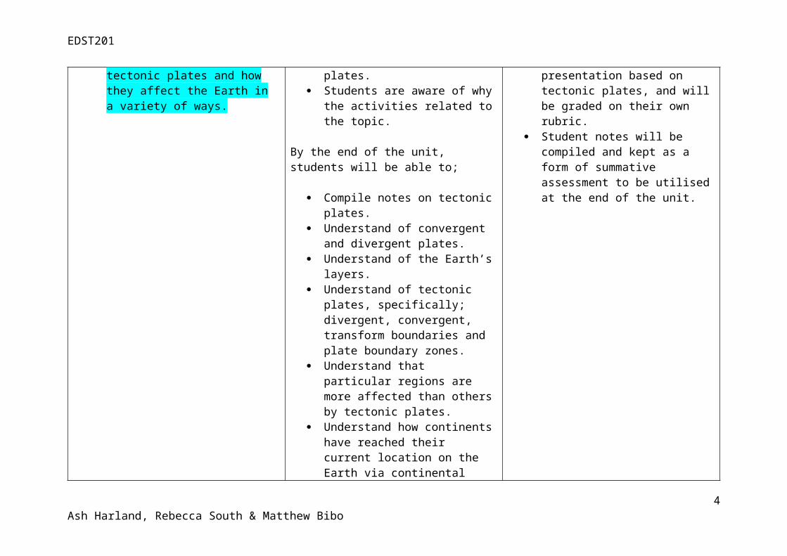
To have students reach a level of critical understanding about tectonic plates and how they affect the Earth in a variety of ways.
By the end of the unit, students will;
Have a general idea about the workings of tectonic plates.
Students are aware of why the activities related to the topic.
By the end of the unit, students will be able to;
Compile notes on tectonic plates. Understand of convergent and
divergent plates. Understand of the Earth’s layers. Understand of tectonic plates,
specifically; divergent, convergent, transform boundaries and plate boundary zones.
Understand that particular regions are more affected than others by tectonic plates.
Understand how continents have reached their current location on the Earth via continental drift.
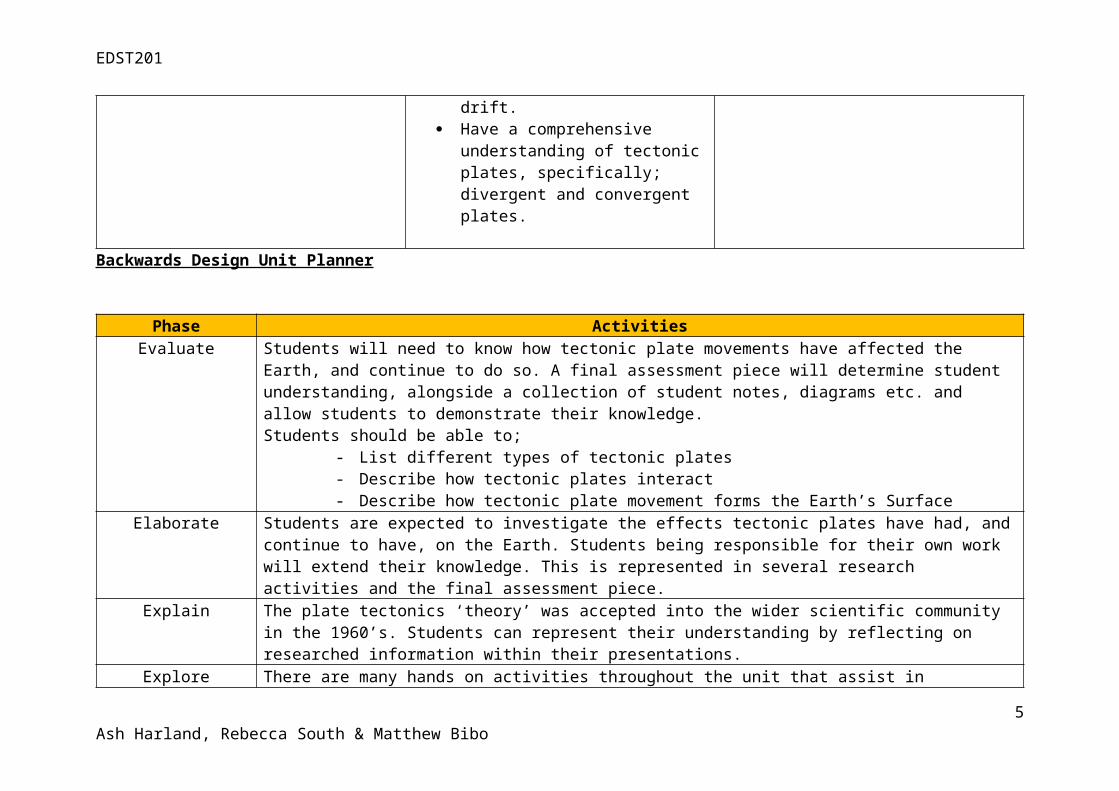
Have a comprehensive understanding of tectonic plates, specifically; divergent and convergent plates.
Assessment contained in the unit;
Students will form groups of 4 to do a PowerPoint presentation based on tectonic plates, and will be graded on their own rubric.
Student notes will be compiled and kept as a form of summative assessment to be utilised at the end of the unit.
Backwards Design Unit Planner
3Ash Harland, Rebecca South & Matthew Bibo
EDST201
Phase Activities Evaluate Students will need to know how tectonic plate movements have affected the Earth, and continue to do so. A final
assessment piece will determine student understanding, alongside a collection of student notes, diagrams etc. and allow students to demonstrate their knowledge. Students should be able to;
- List different types of tectonic plates- Describe how tectonic plates interact- Describe how tectonic plate movement forms the Earth’s Surface
Elaborate Students are expected to investigate the effects tectonic plates have had, and continue to have, on the Earth. Students being responsible for their own work will extend their knowledge. This is represented in several research activities and the final assessment piece.
Explain The plate tectonics ‘theory’ was accepted into the wider scientific community in the 1960’s. Students can represent their understanding by reflecting on researched information within their presentations.
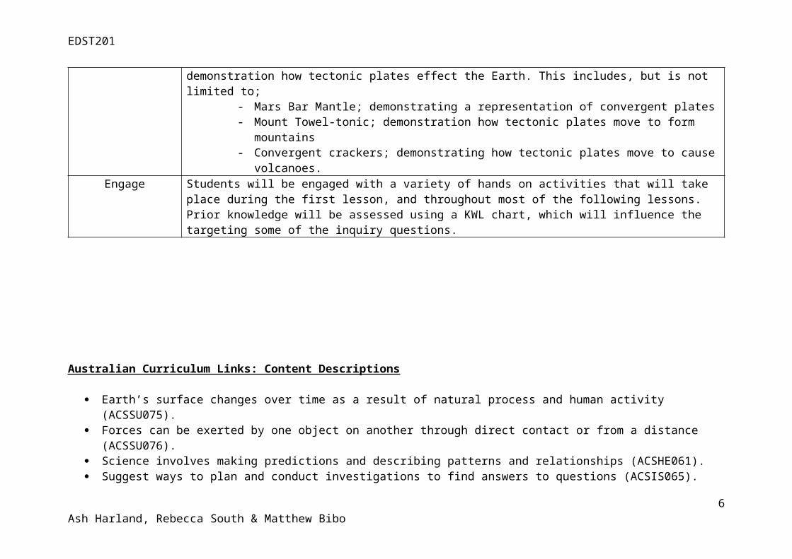
Explore There are many hands on activities throughout the unit that assist in demonstration how tectonic plates effect the Earth. This includes, but is not limited to;
- Mars Bar Mantle; demonstrating a representation of convergent plates- Mount Towel-tonic; demonstration how tectonic plates move to form mountains- Convergent crackers; demonstrating how tectonic plates move to cause volcanoes.
Engage Students will be engaged with a variety of hands on activities that will take place during the first lesson, and throughout most of the following lessons. Prior knowledge will be assessed using a KWL chart, which will influence the targeting some of the inquiry questions.
Australian Curriculum Links: Content Descriptions
4Ash Harland, Rebecca South & Matthew Bibo
EDST201
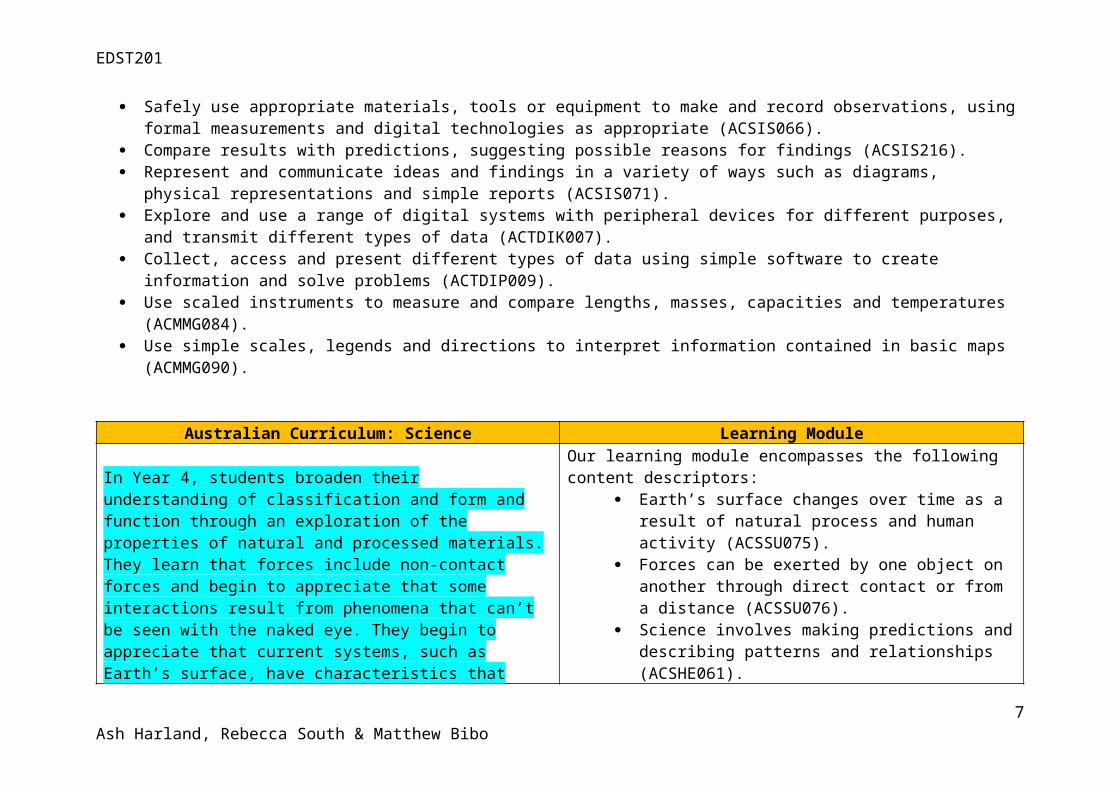
Earth’s surface changes over time as a result of natural process and human activity (ACSSU075). Forces can be exerted by one object on another through direct contact or from a distance (ACSSU076). Science involves making predictions and describing patterns and relationships (ACSHE061). Suggest ways to plan and conduct investigations to find answers to questions (ACSIS065). Safely use appropriate materials, tools or equipment to make and record observations, using formal measurements and digital
technologies as appropriate (ACSIS066). Compare results with predictions, suggesting possible reasons for findings (ACSIS216). Represent and communicate ideas and findings in a variety of ways such as diagrams, physical representations and simple reports
(ACSIS071). Explore and use a range of digital systems with peripheral devices for different purposes, and transmit different types of data
(ACTDIK007). Collect, access and present different types of data using simple software to create information and solve problems (ACTDIP009). Use scaled instruments to measure and compare lengths, masses, capacities and temperatures (ACMMG084). Use simple scales, legends and directions to interpret information contained in basic maps (ACMMG090).
Australian Curriculum: Science Learning Module
In Year 4, students broaden their understanding of classification and form and function through an exploration of the properties of natural and processed materials. They learn that forces include non-contact forces and begin to appreciate that some interactions result from phenomena that can’t be seen with the naked eye. They begin to appreciate that current systems, such as Earth’s surface, have characteristics that have resulted from past changes and that living things form part of systems. They understand that some systems change in predictable ways, such as through cycles. They apply their knowledge to make predictions based on interactions within systems, including those involving the actions of humans.
By the end of Year 4, students apply the observable properties of
Our learning module encompasses the following content descriptors: Earth’s surface changes over time as a result of natural
process and human activity (ACSSU075). Forces can be exerted by one object on another through
direct contact or from a distance (ACSSU076). Science involves making predictions and describing
patterns and relationships (ACSHE061). Suggest ways to plan and conduct investigations to find
answers to questions (ACSIS065). Safely use appropriate materials, tools or equipment to
make and record observations, using formal measurements and digital technologies as appropriate (ACSIS066).
Compare results with predictions, suggesting possible reasons for findings (ACSIS216).
5Ash Harland, Rebecca South & Matthew Bibo
EDST201
materials to explain how objects and materials can be used. They use contact and non-contact forces to describe interactions between objects. They discuss how natural and human processes cause changes to the Earth’s surface.
Represent and communicate ideas and findings in a variety of ways such as diagrams, physical representations and simple reports (ACSIS071).
Australian Curriculum: Technologies Learning Module
In Year 3 and 4, students explore digital systems in terms of their components, and peripheral devices such as digital microscopes, cameras and interactive whiteboards. They collect, manipulate and interpret data, developing an understanding of the characteristics of data and their representation.
By the end of Year 4, students describe how a range of digital systems (hardware and software) and their peripheral devices can be used for different purposes. They explain how the same data sets can be represented in different ways.
Our learning module encompasses the following content descriptors: Explore and use a range of digital systems with peripheral
devices for different purposes, and transmit different types of data (ACTDIK007).
Collect, access and present different types of data using simple software to create information and solve problems (ACTDIP009).
Cross Curriculum Priorities
Australian Curriculum Cross-Curriculum Priorities Our Learning Module
The first key concept highlights the diversity within and between the countries of the Asia region, from their cultures, societies and traditions through to their diverse environments and the effects of these on the lives of people.
The Australian Curriculum says that Students “will develop knowledge and understanding of Asian societies, cultures, beliefs and environments and the connections between the peoples of Asia and Australia” (ACARA [a], 2014). Our module partly focuses on the varying environments of Asia by looking at countries and Regions such as Japan and the Himalayas and how they have been shaped by their environments.
The assessment in our learning module incorporates Asia and its
6Ash Harland, Rebecca South & Matthew Bibo
EDST201
environments as well. Some of the topics given to the students to research will be about areas in Asia. Those students who receive areas that are not in Asia will have opportunities to learn about the other topics through their peers.
General Capabilities
Australian Curriculum General Capabilities Learning Module
General capabilities are a key dimension of the Australian Curriculum. They encompass knowledge, skills, behaviours and dispositions that, together with curriculum content in each learning area and the cross-curriculum priorities, will assist students to live and work successfully in the twenty-first century. The Australian Curriculum includes seven general capabilities. These are:
Literacy Numeracy Information and communication technology capability Critical and creative thinking Personal and social capability Ethical understanding Intercultural understanding.
Within our learning module we have included the following general capabilities in to the students' learning:
Literacy Numeracy Information and communication technology capability Critical and creative thinking
Sequence of Lessons
7Ash Harland, Rebecca South & Matthew Bibo
EDST201
Lesson Number
Social Investigation
Strategy Stage(s)
Lesson Length Lesson Overview & Structure Assessment Links/Resources Australian
Curriculum Links
1 Engage 50 minutes This lesson will allow students to; Establishing learning goals. Determining readiness for
learning. Gauging prior knowledge
(linking curriculum). Correct any misconceptions
- Begin lesson with students sitting together on floor.
- Create KWL chart, discovering student’s knowledge and interest levels in the topic. Ask students what they already know, and what they would like to know about the Earth’s structure. Scaffold for answers such as why volcanoes happen, how mountains are formed etc.
- Instruct students to break up into mixed groups. Inform students that they will rotationally look at different stations around the classrooms with a variety of activities.
- Each of these activities will have an instruction card for students to follow.
Assessment: Student note taking will
be compiled for a piece of summative assessment.
Resources: KWL chart to be
referred to for student’s enquiry questions at a later stage.
Two jawbreakers cut in half, with the outside painted to look like the Earth.
Several Mars bars for the convergent/divergent activity.
3D spherical puzzle. Vita Wheats. Vegemite. Several Towels. Student books and
writing utensils for note taking.
Curriculum Links:
(ACSSU075) (ACSHE061) (ACSIS065)
Lesson Outcomes:
Have a general idea about the workings of tectonic plates.
Students are aware of why the activities related to the topic.
8Ash Harland, Rebecca South & Matthew Bibo
EDST201
- Activities will include; 1. a jawbreaker cut in half to
demonstrate the Earth’s layers
2. Mars bar demonstration displaying divergent and convergent boundaries
3. 3D spherical puzzle to display how tectonic plates fit together
4. Vita Wheats with Vegemite: students squish the crackers together to have the Vegemite come up over and through the cracker to display volcanic eruptions
5. Fold mountain towel demonstration: layers of towels are place on top of each other to display the Earth’s layers and are then pushed to form mountains and valleys.
- Ensure all activities have instruction cards.
- Students will be instructed to reflect on and write down why they think each activity represents something to do with the topic.
- Students will come together and share ideas about each activity.
9Ash Harland, Rebecca South & Matthew Bibo
EDST201
Encourage students to try to create a link between each activity.
- Show diagrams and pictures of Earth and its layers, briefly touching on each. Explain that the unit will be about tectonic plates, an important part of the Earth’s anatomy. Add to the KWL chart about what they would like to learn about tectonic plates specifically.
2 Explore 40 minutes This lesson will; Prompt and structure inquiry Introduce and inform about
tectonic plates as a topic.
- Explicitly teach the Mars bar demonstration. Allow one mars bar per 4/5 students to ensure students are able to see and understand demonstration.
- Explain too students that the mars bar represents how tectonic plates move together and away from each and the effects this can have.
- Instruct students to push the mars bar together and apart and explain how this represents movement of tectonic plates.
- As a class, create inquiry
Assessment:
Student note taking will be compiled for a piece of summative assessment.
Resources:
Mars bars. Computers. I-Pads. Books about tectonic
plates. Hands on plate models Poster paper for class
poster.
Curriculum:
(ACSSU075) (ACSSU076) (ACSIS065) (ACSIS066) (ACTDIK007)
Lesson Outcomes:
Students will have compiled notes on tectonic plates.
Students will have some understanding of convergent and divergent
10Ash Harland, Rebecca South & Matthew Bibo
EDST201
questions based on tectonic plates for students to answer. Scaffold to ensure inquiry questions are relevant and interesting.
- Instruct students to work in small, planned groups at research stations (including iPads, computers, books and hands on models) to research all that they can on tectonic plates; how they work, what they do and the effects they have on the Earth. Ensure students are researching relevant and appropriate content and that they take notes to share.
- After 30/35 mins bring class together and discuss information gathered. Compile information on a class ‘Tectonic Plates’ poster.
plates.
3 Explain 40 minutes This lesson will Present new topics Develop language about topics Strengthen learning connections Explicitly teach the characteristics
of Earth’s layers, including; crust, lithosphere, mantle and core, elements of tectonic plates such as; divergent, convergent, transform boundaries and plate boundary zones.
Assessment: Student note taking will
be compiled for a piece of summative assessment.
Students will be formatively assessed on Earth Structure diagram.
Resources:
Student notebooks and
Curriculum:
(ACSIS065) (ACSSU076) (ACSSU075)
Lesson Outcomes:
Students will have an understanding of the Earth’s layers.
11Ash Harland, Rebecca South & Matthew Bibo
EDST201
- Begin with students sitting together in front of interactive whiteboard with book and pencil.
- Play video to students, stopping when necessary to explain topics and answers any questions about different sections. Pause video at important parts and instruct students to take notes.
- Once video is complete answer any questions and explain topics using diagrams and notes. Instruct students to copy any important notes/images/diagrams into book.
- Instruct students to move back to desks.
- Ask them to draw a diagram of the Earth’s structure using circles and write one or two things they learnt about each layer.
- Show students example of diagram before beginning.
writing utensils. Video (link)
Students will have an understanding of tectonic plates, specifically; divergent, convergent, transform boundaries and plate boundary zones.
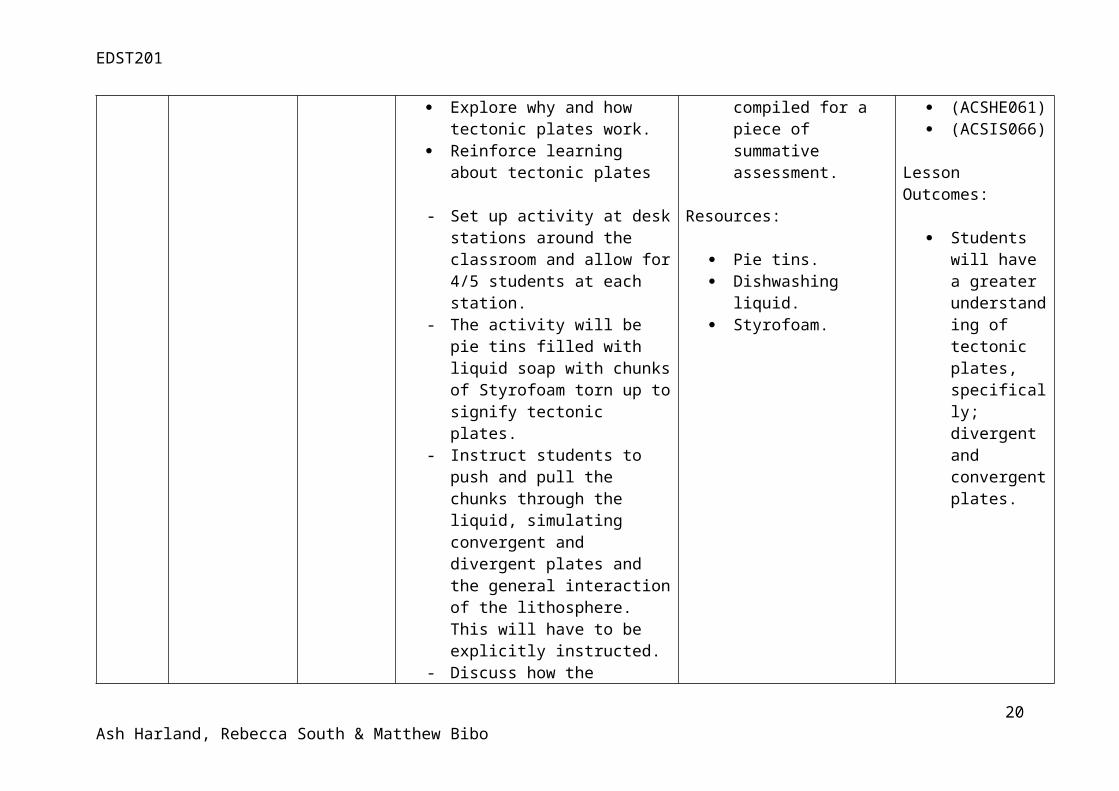
4 Explore 30 minutes This lesson will allow student to; prompt and structure inquiry Explore why and how tectonic
plates work. Reinforce learning about tectonic
plates
Assessment:
Student note taking will be compiled for a piece of summative assessment.
Curriculum:
(ACSIS065) (ACSSU076) (ACSHE061) (ACSIS066)
12Ash Harland, Rebecca South & Matthew Bibo
EDST201
- Set up activity at desk stations around the classroom and allow for 4/5 students at each station.
- The activity will be pie tins filled with liquid soap with chunks of Styrofoam torn up to signify tectonic plates.
- Instruct students to push and pull the chunks through the liquid, simulating convergent and divergent plates and the general interaction of the lithosphere. This will have to be explicitly instructed.
- Discuss how the students interacted with the activity and answer any questions.
- Reinforce relevant language throughout activity.
-
Resources:
Pie tins. Dishwashing liquid. Styrofoam.
Lesson Outcomes:
Students will have a greater understanding of tectonic plates, specifically; divergent and convergent plates.
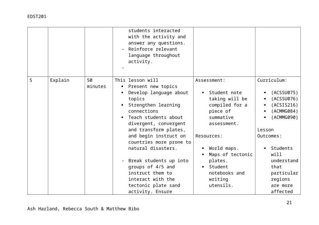
5 Explain 50 minutes This lesson will Present new topics Develop language about topics Strengthen learning connections Teach students about divergent,
convergent and transform plates, and begin instruct on countries more prone to natural disasters.
- Break students up into groups of 4/5 and instruct them to interact
Assessment:
Student note taking will be compiled for a piece of summative assessment.
Resources:
World maps. Maps of tectonic plates.
Curriculum:
(ACSSU075) (ACSSU076) (ACSIS216) (ACMMG084) (ACMMG090)
Lesson Outcomes:
Students will
13Ash Harland, Rebecca South & Matthew Bibo
EDST201
with the tectonic plate sand activity. Ensure activity has instruction cards. After 5 minutes, discuss the activity and answer any questions.
- Have students return to their desks for individual work.
- Explicitly teach the interaction of tectonic plates, with a focus on divergent, transform and convergent plates. Write important and relevant information on board, including diagrams and instruct students to copy into books.
- Using Google Maps or Google Earth on an interactive whiteboard, focus in on several particular regions, in this case Japan, New Zealand, West Coast USA and the Himalayas and inform students that these areas are prone to natural disasters such as volcanoes and earthquakes.
- Using what they have already learnt, ask students to discuss why they think these places are more prone to natural disasters over countries such as Australia.
Student notebooks and writing utensils.
understand that particular regions are more affected than others by tectonic plates.
6 Explore 40 minutes This lesson will allow students to; Assessment: Curriculum:
14Ash Harland, Rebecca South & Matthew Bibo
EDST201
Prompt and structure inquiry based learning
Explore the effects that tectonic plates have on continents and continental drift.
- In small groups of 3/4, instruct students to firstly observe a flat map of the world, focussing on where the continents are and any interesting land masses.
- Provide students with OHP sheets that fit directly over the map. The OHP sheets will have the lines of tectonic plates and fault lines of the Earth.
- Instruct students to place the OHP sheet over the map and look at how the tectonic plates and bodies of land overlay.
- Have students write down any important information, such as what fault lines have large effects on which continent etc.
- Sit students in front of interactive whiteboard and show students interactive websites, particularly the tectonic plate’s motion page.
Student note taking will be compiled for a piece of summative assessment.
Resources:
OHP sheets with maps of the world printed onto them.
OHP sheets with maps of the tectonic plates printed on them.
http://ees.as.uky . edu/sites/default/files/elearning/module04swf.swf (interactive website)
(ACTDIK007) (ACSSU076) (ACMMG090) (ACSSU075)
Lesson Outcomes:
Students will understand how continents have reached their current location on the Earth via continental drift.
7 Elaborate 30/40 This Lesson will; Assessment: Curriculum:
15Ash Harland, Rebecca South & Matthew Bibo
EDST201
minutes
Monitor student progress Strengthen connections between
learning Introduce the formative
assessment piece.
- Students will be divided into groups of 3/4, and will begin work on a PowerPoint presentation that will be delivered over the next two lessons.
- Students will once again be set up at research stations, and given the entirety of the lesson to plan their presentation together, while the teacher goes through an example on the board.
- Students will be given topics stemmed from the overall topic of Tectonic Plates. Topics will include;1. Convergent plates2. Divergent plates3. Transform plates4. Plate boundary zones5. Continental drift (this topic
will be for a more advances group).
Working on the formative assessment piece.
Resources:
Mars bars. Computers. I-Pads. Books about tectonic
plates.
(ACTDIK007) (ACTDIP009) (ACSIS066) (ACSIS216) (ACSIS065) (ACSIS071)
Lesson Outcomes:
Students begin work on their assessment piece.
8 Elaborate 30/40 minutes
This lesson will continue on from previous lesson and allow students to;
Assessment: Curriculum:
16Ash Harland, Rebecca South & Matthew Bibo
EDST201
- A second lesson dedicated to the assessment piece.
- Give guidance and assistance to students who need it.
- Allow all students the opportunity to present findings/draft for support and guidance.
- Allow students who have finished early up to standard to assist their peers.
Students continue work on the formative assessment piece.
Resources:
Mars bars. Computers. I-Pads. Books about tectonic
plates.
(ACTDIK007) (ACTDIP009) (ACSIS066) (ACSIS216) (ACSIS065) (ACSIS071)
Lesson Outcomes:
Students continue work on their assessment piece.
9 Evaluate 40/50 minutes
This lesson will;
Assess performance against standards for formative assessment
Facilitate student self and peer assessment.
- Students are to deliver their presentations in this lesson.
- Students will be assessed by an agreed upon rubric that was developed with input from the students themselves.
- Students are given the opportunity to give feedback to peers and self.
- At the end of the unit, students recap and complete the KWL chart.
Assessment:
Students will be assessed on the formative assessment piece.
Resources:
KWL chart. Available upon student
request, e.g. props, etc.
Curriculum:
(ACTDIK007) (ACTDIP009) (ACSIS066) (ACSIS216) (ACSIS065) (ACSIS071)
Lesson Outcomes:
Students present their assessment.
Students complete KWL chart, and record all new
17Ash Harland, Rebecca South & Matthew Bibo
EDST201
- Instruct students to hand in note taking in their science journal for summative assessment.
knowledge. Students will
have a comprehensive understanding of tectonic plates.
Assessment
Formative Summative
The student presentation is a formative piece of assessment which will require students to work in groups and research a topic given to them. Topics will be given out depending on student ability. The presentation’s rubric will be agreed upon with the class, but an example of a potential rubric has been provided. At least 8 slides must be present, and all students must speak for a predetermined amount of time.
The summative piece of assessment will be a summarisation of student notes to see what they have and haven’t deemed as important learning. If there is a particular element missing from student note taking, a revision lesson can be done on that topic.
References:
18Ash Harland, Rebecca South & Matthew Bibo
EDST201
Appendix 1: Equipment List
Equipment: Use:
Two jawbreakers painted on the outside to look like the Earth. To signify the different layers of the Earth’s surface down to the core.
19Ash Harland, Rebecca South & Matthew Bibo
EDST201
Several Mars bars. To display convergent and divergent plates.3D Spherical Puzzle. To demonstrate how the tectonic plates interlock and form the Earth.Vita Wheat & Vegemite. To show how convergent plates can create mountains and volcanoes.Towels. To display how mountain ranges can be formed from pressure.Computers. To allow children access to interactive activities and information.I-Pads. To allow children access to interactive activities and information.Butcher’s paper. For classroom use to create a poster/word-wall.Pie tins. To act as part of an experiment.Dishwashing liquid. To simulate the lithosphere in an experiment. Styrofoam. To act as tectonic plates in an experiment.World maps. To familiarise children with the layout of the Earth.Maps of tectonic plates. To allow children to learn where plate boundaries lay.OHP sheet with world maps printed. To be used as part of an activity.OHP sheet with tectonic plates printed. To be overlayed on the world map as part of an activity.Laminated Instruction Cards To instruct students how to complete activities.
Appendix 2: Unit Overview Table
Lesson No: Lessons: Assessment:
1 Engage students and establish learning goals. Students begin compiling notes for summative
20Ash Harland, Rebecca South & Matthew Bibo
EDST201
Variety of activities use to engage children and stimulate questions.
assessment. Students formatively assessed on how they follow
and complete experiment instructions.2 Particular activity is explicitly taught, and students
invent own inquiry questions. Continue compiling notes.
3 Explicit teaching of Earth’s layers. Continued note taking.4 Exploring the effects of tectonic plates via an
activity. Continued note taking. Students formatively assessed on how they follow
and complete experiment instructions.5 Focus on divergent, transform and convergent
plates. Continued note taking. Students formatively assessed on how they follow
and complete experiment instructions.6 Explaining how tectonic plates’ movement affects
continental drift. Continued note taking.
7 Students start work on formative assessment. Students begin their group work.8 Students continue work on formative assessment. Students continue group work assessment.9 Students perform presentations. Students are assessed by a classroom rubric.
Appendix 3: Grading Rubric
CRITERIA A B C D Speaking Loud and clear voice
with effective pace, pitch and eye contact.
Reasonably loud and clear voice with appropriate pace, pitch and eye contact.
Average loud and clear voice with reasonable pace, pitch and eye contact.
Little loud and clear voice with limited pace, pitch and eye contact.
21Ash Harland, Rebecca South & Matthew Bibo
EDST201
Information Information clearly relates to topic.All information is relevant and correct with no errors
Information mostly relates to topic. Most Information is relevant with 1-2 errors
Information slightly relates to topic. Some information is relevant with few errors
Information barely relates to topic. Little to no relevant information with many errors
Fonts and Colours Presentation visibly attractive. All headings clearly labelled and visible with appropriate font size. Presentation set out well.
Most headings clearly labelled. Suitable font size. Presentation with 1-2 errors.
Some headings clearly labelled. Consistent font sizes. Presentation structure sound with 2-3 errors.
Few headings clearly labelled. Variation in font sizes. Presentation structure confusing with 4 or more errors.
Pictures/Graphics All pictures and graphics compliment information, and are visibly engaging within the presentation.
Most pictures and graphics compliment information, and are visibly engaging within the presentation.
Some pictures and graphics compliment information, and are visibly engaging within the presentation.
Few pictures and graphics compliment information, and are visibly engaging within the presentation.
Appendix 4: Instruction Card Examples (Lesson One)
22Ash Harland, Rebecca South & Matthew Bibo
Thickly coat one cracker in vegemite. Place a second on the edge of the first cracker.
Slowly and gently push the crackers together so the crackers are parallel and become
closer together. What happens? What part of the Earth does this represent?
Look at the Jawbreaker as a whole, then take out the sector. Observe
how the Jawbreaker is constructed. How does this represent the Earth?
EDST201
23Ash Harland, Rebecca South & Matthew Bibo
Lay each towel, folded in half on top of each other. Push the ends of the
towels together. What happens? Pull the ends of the towel apart. What happens? What part of the Earth
represent?
Pull apart the puzzle. Look at all the pieces and try to see how the pieces
fit into each other. Put the puzzle back together. How does this
represent the Earth?
Snap a mars bar in half. Look at the
different layers of the mars bar. Try and fit the two pieces back together. Move the joined pieces up and down. What happens? What part of the Earth does
this represent?


![Landforms Mady By Wind [Desert Landforms]](https://img.pdfslide.us/doc/110x75/56813971550346895da1066c/landforms-mady-by-wind-desert-landforms.jpg)