Embed Size (px)
Citation preview

Amy 2D Seismic Survey 2013
ENVIRONMENTAL MANAGEMENT PLAN
SUMMARY
PetroFrontierLevel 1, 262 Franklin Street
ADELAIDE SA 500008 8104 3250
1
TABLE OF CONTENTS
1. INTRODUCTION 3
2. LOCATION 4
3. ACTIVITY 8
4. ENVIRONMENT DESCRIPTION 9
5. ENVIRONMENTAL MANAGEMENT 40
6. DESCRIPTION AND ASSESSMENT OF ENVIRONMENTAL RISKS
AND IMPACTS 50
7. CONSULTATION 58
8. CONTACT DETAILS 59
2

1. INTRODUCTIONPetroFrontier Corp. is a publicly listed Canadian company focused on exploring anddeveloping petroleum resources in the Georgina Basin in the Northern Territory. PetroFrontier Corp. operates in Australia through its wholly owned subsidiary, PetroFrontier (Australia) Pty Ltd (collectively referred to as PFC). PFC is the custodian of the EMP and has overall responsibility for its implementation.
PFC Corporate Environmental Policy
PFC undertakes all operations with a commitment to health, safety and environmentalmanagement. PFC adopts specific procedures to minimise the impact of the project on the local environment. The key environmental objectives are:
Minimise the total area of disturbance.
Maximise the use of existing tracks, existing seismic lines and firebreaks for
access. Minimise the potential for the introduction of weeds.
Avoid disturbance to significant habitat.
Avoid clearing trees where possible.
Minimise soil damage by operating during dry season and using dust abatement
techniques if required.
Avoid sensitive sites, such as areas prone to erosion, where possible.
Minimise the risk of fire.
Minimise any adverse effects on amenity.
Prevent land and water contamination; and
Promote effective rehabilitation of disturbed areas.
Overview
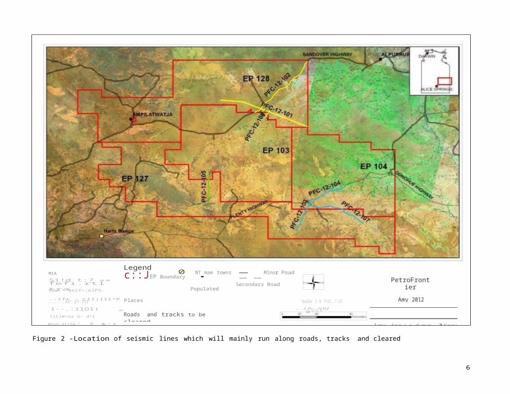
PFC will run regional seismic lines within exploration permits (EPs) 103, 104, 127 and 128 inthe Southern Georgina Basin. The survey will build upon seismic data collected in 2009 by Texalta Australia Pty Ltd, in 2010 by Georgina Basin Energy Pty Ltd and in 2011 by PFC. The proposed seven seismic lines will mainly be on existing highways and roads with a minor amount of clearing of tracks in EPs 127, 128 and 104. The survey will be conducted in the Sandover and Plenty Rivers region approximately between 180km and 440km north-east of Alice Springs.
The seismic program is scheduled to commence in July 2013. Environmental, heritage andTraditional Owner clearances were undertaken in July 2012 with environmental information updated to May 2013.
3

Table 1: Seismic Survey Data Sheet
Demobilisation ~ 2 days
be required to reduce the requirement for connecting tracks,
Up to 12 vehicles operating at any one time
2. LOCATION
The seismic survey will take place on: Annitowa, Argadargada, Georgina Downs, Lake Nash,Lucy Creek, Manners Creek, Marqua and Tarlton Downs Pastoral properties. The area is accessible via the Plenty and Sandover Highways and there are a number of station tracks that allow access to the proposed seismic lines.
4
Element Description
Type of survey 2D seismic
Commencement of line preparation Mid-July 2013
Timing of survey July-August 2013
Maximum duration of survey
Preparatory work ~10 daysSurvey 38 days
Rehabilitation – until completion criteria achieved
Total length of seismic lines (line kilometres) Approximately 385 km
Maximum width of line
4.5 m, blade up wherever possible
Note: some ‗turning areas‘ or ‗passing areas‘ (up to 5 m × 5 m) will
facilitate avoidance of environmental constraints and allow for exceptional circumstances (e.g. tyre repairs)
Number of data acquisition holes (up-holes)required
Not needed on this survey
Plant and equipment details for surveyTrailer camp (including office, mess and accommodation) Three truck-mounted source vehicles
Camp(s) area 50 m x 50 m
Approximate number of persons involved ~37 personnel including any sub-contractors
Operation hours Daylight hours only, 7 days/week

ANNITOWA
ELKEORA EP 128
LAKE: NASH
EP 103OORATIPPAA
SCale 1:1,716,43
10 oopyrlghiMIPCOIOp•lfO M•y2013':..-oi'4t==3i0
MANN RS CREEKMANNERS CREEK
I..UCV CPIEEK
PetroFrontierAmy 2012
Northern Territory
Low Ee o l oglo e l S ervi ce s P/l
Legend 0 NT main townsPopulated Places
-- Roads
DATII80URCHIllockglllUnd lt1_motolo.tcWFOI UrlhtllniOIIIlOIIOO, piUit COI\IICI,
t:=) EP Boundary •
Low EOOIOIIII8t<v10ot I'lL Roads and tracks to be cleared
AmyPFC_12_101_102_108
AmyPFC_12_103_104_107
AmyPFC_12_105
Pastoral StationsANNITOWA
PhoM.(0818Q555 222 Fax:(08 j8Q555 722
LAKE NASH-Mop Atl' Amy 2012
i'lo)oellon ll,.,oltoi lr•n•••,,.Mon>•too (IJ IM) LUCY CREEK
] MANNERS CREEK
MARQUA
I TARLTON DOWNS
j ARGAOARGADA
GEORGINA DOWNSOrld of "'"""lloiMOAJ, Zono &fm<onlnlCl"h"'' Oood.,.ln I:MIIIm ol flu•lrll&o (01).4.Pll
Figure 1- Pastoral stations and planned seismic lines
5
GEOGINA OOWNS
MAROUA
EP 104
c::JEP Boundary • Populated Places
Roads and tracks to be cleared
AmyPFC_12_101_102_ 108
ArnyPFC_12_103_104_ 107
- ArnyPFC_12_105
MiA S-- Secondary Road--- - Track PetroFrontier
Amy 2012Northern TerritorY
fefi.rtltra .
F'<'tr. r:f:UQZllF• 122
......lr".y?.l1l
I--.:IIQI). I.'"l4 ,. .i.h;.,l()t]-tiClW<oa G-.d!t ol...,.._,'(i:()t&:
Figure 2 -Location of seismic lines which will mainly run along roads, tracks and cleared lines where available or permitted
6
Legend 0 NT mam towns - M1nor PoadSi!d t:7 «»
tow.· $eiY>;elPt.
.-ift - CII)III*P 'Sule 1 1 71tl..?.CS
0"""""MlpQ.OIIfA_"..Z $'1 low £co t o ica lServ lce.s P/L

Table 2: Seismic line length within each EP
7
EP line ID total length (km) of seismic line in EP
EP103: 12-105 8.45
EP103: 12-108 5.88
Total EP 103 14.33
EP104: 12-104 41.22
EP104: 12-103 13.50
EP104: 12-107 39.85
Total EP 104 94.57
EP127: 12-103 28.35
EP127: 12-107 29.42
EP127: 12-105 25.49
Total EP 127 83.26
EP128: 12-102 89.23
EP128: 12-108 3.33
EP128: 12-101 100.94
Total EP 128 193.51
Total 385.66

3. ACTIVITYThe EMP includes all operational activities for the seismic survey. The key activities include:
Establishing a minimal environmental impact camp using temporary trailer camp(s).
Preparing survey lines (access track, line surveying and line preparation). Access on
Argadargada Station will be on seismic lines and not via station tracks. Access on other
properties will be station tracks, seismic lines or highway.
Acquiring data (surface seismic acquisition); and,
Demobilising,
rehabilitation.
rehabilitating seismic lines and ongoing monitoring to ensure successful
8

4. ENVIRONMENT DESCRIPTIONBioregion description
The seismic lines lie within the Channel Country, the Mitchell Grass Downs and the Tanami bioregions.
Figure 3: Bioregions
Channel Country is described as ―extensive gidgee (Acacia georginae) plains and rolling hills (which)characterise the NT part of this bioregion. Elevation is between 180 m and 400 m, with minor reliefprovided by the Tarlton and Toko Ranges. Vegetation is predominantly spinifex grassland and acacia tall open-shrubland, with occasional large bluebush (Chenopodium auricomum) swamps‖ (Baker et al.
The Tanami bioregion comprises mainly red Quaternary sandplains overlying Permian and Proterozoicstrata which are exposed locally as hills and ranges. The sandplains support mixed shrub steppes of Hakea suburea, desert bloodwoods, acacias and grevilleas over Triodia pungens hummock grasslands. Acacia shrublands over hummock grass communities occur on the ranges. Alluvail and lacustrine calcareous deposits occur throughout. In the north they are associated with Sturt Creek drainage and support Chrysopogon and Iseilema short-grasslands often as savannas with River Gum. In the south, the saline alluvia of Lake Mackay support Samphire low shrubland and Melaleuca lasiandra - M. glomerata shrublands. Arid tropical with summer rain.
A fraction of the lines lie within the Mitchell Grass Downs bioregion. The bioregion is described as―Georgina and Dunmurra Basins containing sedimentary rocks of Cretaceous, Tertiary and Cambrianages and soils are predominantly cracking clays. The vegetation is predominantly Eucalyptus microthecalow open-woodland with bluebush (Chenopodium auricomum) sparse shrubland understorey, and
9

Mitchell grass (Astrebla) grassland on the Barkly Tableland. The southern section contains gidgee(Acacia georginae) low open woodland with Astrebla open grassland understorey. Drainage in thetableland is complex, with a number of short creeks and rivers flowing toward several large seasonal lakes, while the Rankin and Georgina Rivers flow southeast of the bioregion‖ (Baker et al. 2005). Nolakes occur in the region of the proposed seismic line although the line does cross over numerous small areas of cracking clay flats which can remain flooded for extended periods after rain. In the current year,2013, minimal rain has fallen during the wet season and the cracking clay plains are in a state of drought.
There are no Sites of Botanical Significance (SOBS) along the lines. SOBS are determined by the NTGovernment Department of Land Resource Management (DLRM) Parks and Conservation Masterplan.
Figure 4: SOBS
Hydrology
The line PFC-12-101 crosses the floodout of the Sandover River. Minor drainage channels and drainagedepressions are within the vicinity of the proposed seismic lines. These are non-permanent and rely on above average local rain events or floods from the Sandover catchment for surface water to be present.
The drainage lines appearing on the map below are based on the background map and they are derivedfrom NT Government‘s shape files. Shallow drainage depressions are shown by vegetation patterns inthe Sandover floodout. All water courses in the area are ephemeral. The crossing of the Sandover river bed, normally dry, may require special attention. The lines must be positioned at least 50 – 100 m distantfrom any important ephemeral water courses. Crossing points should be positioned away from surface water holes that might be present.
Rainfall conditions during 2012-2013 were very dry and the Sandover floodout will therefore be dry duringthe June-July survey.
10

Figure 5: Hydrology for PFC-12-101-102-108, PFC-12-105, PFC-12-103-104-107.
11
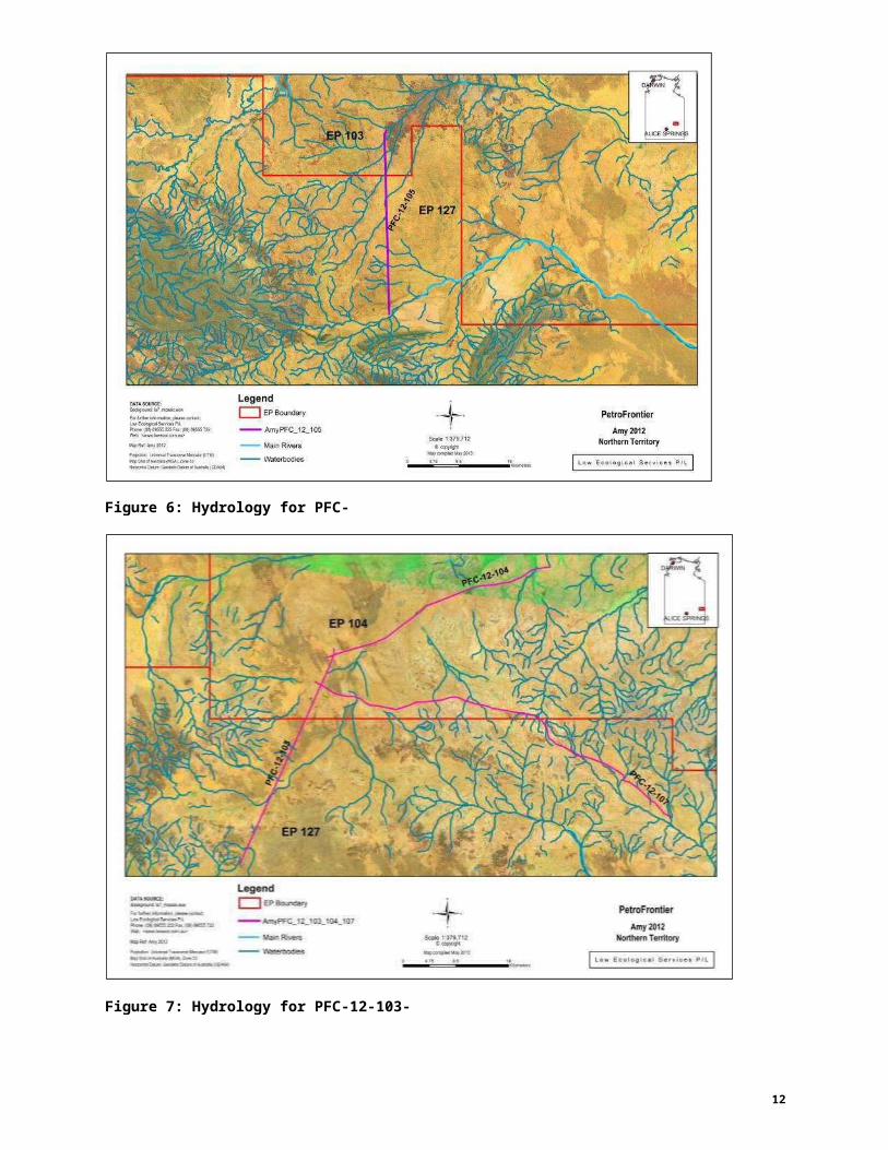
Figure 6: Hydrology for PFC-12-105.
Figure 7: Hydrology for PFC-12-103-104-107.
12
Soils
The Digital Atlas of Australian Soils (Australian Soil Resource Information System 1991) shows the soiltypes intersected by the proposed lines.
The PFC-12-101-102-108 roads intersect soil types:
AB31 Flat to gently undulating sand plains with some low broad sand rises and intervening
swales; some small alluvial flats; some clay pans; and some stone-covered ridges: chief soils are red
earthy sands on the plains and swales. Associated are red siliceous sands on the sand rises. Small
areas of sandy red earths occur on the plains, in the swales, and on the alluvial flats. Other soils
include shallow (< 12 in.) stony red loose siliceous sands on the stone-covered ridges.
BA42 Rugged mountain ridges, plateaux, and low hilly areas on limestone, dolomite,
calcareous sandstones, siltstones, and sandstones; narrow valleys; some small plains; extensive
rock outcrop: chief soils are shallow stony siliceous and calcareous sands and earthy loams. Small
areas of other soils, notably red sands with coherent earthy subsoils and calcareous soils, may occur
in areas of gentler relief. Small areas of unit My128 are included in eastern portions of this unit.
CC60 Flat to gently undulating plains with widely spaced narrow drainage-ways, low gravelly
(chert) rises with variable gilgai development, some shallow depressions, some stony rises, the
proportion of which varies locally: chief soils are deep grey clays such as (Ug5.24, Ug5.25). Other
soils include (Uf6.33) on gravel covered calcareous rises and possibly small areas of (Ug5.3) soils
along the southern margins of the unit. Small areas of units My80 and II6 of Sheet 8 and II9 may be
included locally.
CC76 Plains with broad shallow depressions, some drainage-ways with narrow levees: chief
soils are deep grey and brown clays (Ug5.24, Ug5.25) and (Ug5.34), often in gilgai complex with
(Dy2.13, Dy2.12) soils. Other soils may occur. As mapped, small residual islands of unit My128 are
included.
My125 Flood-out plains, levees, and sand banks: chief soils are probably neutral red earths and
red earthy sands. Associated are a variety of soils including red a brown duplex and mottled soils on
flood-plain areas; grey and brown cracking clays in depressions; and sandy soils on levees and sand
banks.
My126 Gently undulating sandy plain with some limestone ridges: dominant soils are sandy
neutral red earths. Other soils include grey, brown and red cracking clays in depressions; and firm
calcareous sands, powdery calcareous loams, and calcareous earths on the ridges. Small areas of
units II13 and Lh2 are included
My127 Gently undulating sandy plains: chief soils are neutral red earths and red earthy sands.
Other soils are likely also.
Mx30 Plains on dolomite, limestone, and shale: chief soils are alkaline and neutral red earths
(Gn2.13, Gn2.12). Associated locally are (Uc1.3), (Um5.11), and (Gc1.22) soils.
13

The PFC-12-103-104-107 lines intersect soil types:
BA42 Rugged mountain ridges, plateaux, and low hilly areas on limestone, dolomite,
calcareous sandstones, siltstones, and sandstones; narrow valleys; some small plains; extensive
rock outcrop: chief soils are shallow stony siliceous and calcareous sands and earthy loams. Small
areas of other soils, notably red sands with coherent earthy subsoils and calcareous soils, may occur
in areas of gentler relief. Small areas of unit My128 are included in eastern portions of this unit.
Fd1 Undulating limestone ridges, usually with broad crests and long gentle slopes; in some
areas low benched scarps occur; outcrop is common: dominant soils are shallow gravelly calcareous
loams, with other similar but looser, more powdery or friable shallow gravelly calcareous loams
associated. In lower sites shallow to moderately deep loamy calcareous earths are common.
My128 Sandy plains: chief soils are neutral and alkaline red earths with areas of red sands with
coherent earthy subsoils. There are scattered limestone ridges of unit BA42 in the western portion
and unit Fd1 in the eastern portion.
My131 Plains with some mesas and buttes: chief soils are neutral red earths (Gn2.12) and red
earthy sands (Uc5.21). Associated are mesas and buttes of unit Fc2 and small hilly areas similar to
unit BA43. Other soils include (Dr) soils on pediments of the mesas and (Uc1.23) on dunes .
Oc78 Undulating very low dissected plateaux or broadly undulating ridges; surface soil is
usually strewn with chert gravel: dominant are thin-surfaced loamy red duplex soils. Adjacent to more
calcareous outcrops are shallow calcareous loams , both powdery and firm. On some slopes there
are small areas of red calcareous earths, and in broad valley floors are loamy red earths or
occasionally deep red sands. Data are fairly limited.
Ld2 Undulating or occasionally level low limestone plateaux, the margins of the unit are
usually scarped and have much silicified limestone outcrop; the soil surface throughout the unit is
usually strewn with chalcedony and silicified limestone gravel: dominant soils are shallow to
moderately deep gravelly brown calcareous earths (Gc1.22), with lesser (Gc2.22) and (Gc1.12). In
parts of the unit, moderately deep to deep loamy red earths (Gn2.13) occur. Adjacent to limestone
outcrop, shallow gravelly calcareous loams (Um1.3), (Um5.11), and (Um5.61) are common.
The PFC-12-105 line intersects soil class
BA44 Broken terrain on dolomite, limestone, shale, and sandstone; rock outcrop is common:
chief soils are loose and firm shallow stony sands, with some deeper firm siliceous sands.
Associated are red non-calcareous earths, red sands with coherent earthy substrates and calcerous
earth soils in valley areas. Inclusions of unit BA45 are likely.
14

Figure 8: Layout of the seismic survey in relation to The Digital Atlas of Australian Soils (AustraliaSoil Resource Information System 1991).
Flora and Vegetation
Northern Territory vegetation classes have been mapped and described by at a scale of 1:1,000,000 byWilson (1991).
The PFC-12-101-102-108 lines intersect vegetation classes:
Class 62 Acacia georginae (Giddier) low open-woodland with Astrebla pectinata (Bull Mitchell
Grass) open-grassland understorey.
Class 71 A. aneura (Mulga) tall sparse-shrubland with grassland understorey.
Class 76 Triodia pungens (Soft Spinifex), Triodia schinzii (Curly Spinifex) hummock grassland with
Acacia tall sparse-shrubland overstorey.
Class 84 Triodia basedowii (Hard Spinifex) hummock grassland with Eucalyptus gamophylla (Blue
Mallee) tall sparse-shrubland overstorey.
Class 96 Astrebla pectinata (Barley Mitchell grass) grassland.
The PFC-105 line intersects vegetation classes:
Class 63 A. georginae (Gidyea) low open-woodland with open-grassland understorey.
15

Class 68 Acacia kempeana (Witchetty Bush) Acacia tall open-shrubland with Cassia, Eremophila
(Fuchsia) open-shrubland understorey.
Class 71 A. aneura (Mulga) tall sparse-shrubland with grassland understorey.
The PFC-12-103_104_107 lines intersect vegetation classes:
Class 63 A. georginae (Gidyea) low open-woodland with open-grassland understorey.
Class 70 A. aneura (Mulga) tall sparse-shrubland with Cassia, Eremophila (Fuchsia) low sparse-
shrubland understorey.
Class 84 Triodia basedowii (Hard Spinifex) hummock grassland with Eucalyptus gamophylla (Blue
Mallee) tall sparse-shrubland overstorey.
Figure 9: Layout of the seismic survey in relation to NT vegetation map (B. A. Wilson et al. 1991).
16

Flora – database searches
A protected matters search from Department of Sustainability, Environment, Water, Population and Communities (DSEWPC) was performed on the 24thth May 2013. No flora species of conservation significance were identified in the Protected Matters search.
Searches of the NT Parks and Wildlife Flora Atlas, have been performed 20km either side of the seismiclines with flora of conservation significance. There are:
4 species are listed as endemic (Alternanthera angustifolia var. lanata, Stemodia sp. MannersCreek, Sida sp. Hale River, Eremophila christophori ) and 14 species (Cynodon dactylon var. dactylon, Malvastrum americanum, Portulaca pilosa subsp. Indeterminate, Salsola tragus subsp. Indeterminate,Tribulus terrestris, Chloris virgata, Datura ferox, Sida cordifolia, Cenchrus pennisetiformis, Cucumis myriocarpus, Digitaria ciliaris, Malva parviflora, Melia azedarach var.australasica, Salsola tragus subsp. grandiflora) as exotic.
1 flora species within the roads and tracks identified as PFC-12-101-102-108 are listed as NearThreatened, 6 are listed as Data Deficient and 1 as Not Evaluated.
1 Near-Threatened flora species is listed within 20km from the road identified as PFC-12-105-106; 1is listed as Data Deficient and 1 as Not Evaluated.
7 flora species within 20km from the road identified as PFC-12-103-104-107 are listed as NearThreatened, 3 are listed as Data Deficient and 3 as Not Evaluated.
17
0 EP Bounda
ry
OA TA SOURCE:PetroFrontier
1« iJr.nerii'ibrn; pea:s.eoo".' ::i;.
Pl."«e"(OS) S22Uax(OS) 9S5S i22
Low for?
.t
Sca'e: t:1,7i8,243 Northern Territory
I . L o w Ec o l og ies! Se rv ices P /
L
AmyPFC_12_101_102_108
AmyPFC_12_103_104_107o neFtm o-f...etl ra-,'.'ef le1.1en:(\m
l)Atap CDC9.lJ1y 2>)12
:_._ _,; ;;::' ::::52S0..
.-
3CKfome:e
Figure 10: PFC-12-101-102-108 Flora of conservation significance from NT Parks and Wildlife Flora Atlas
18
Legend.s.;ago<LIO: sr_rrm.aic.ecw
STATUS_NT_Web: <JNNN:meootoomJJJ>
Roads and tracks to be cleared 0 dd Amy 2012
"l:i? Ret .Wj2V12 ti>oor;g'/ot
lpGtid ei AAnlis(MG::).l«.eSJ
- AmyPFC_12_105 • nt

Table 3: PFC-12-101-102-108 Flora of conservation significance from NT Parks and Wildlife Flora Atlas
19
DATE_ NAMEINFRA FAMILY STATUS_NT_ STATUS_COM EXOTIC ENDEMIC1/05/1996 Alternanthera angustifolia var. lanata AMARANTHACEAE ne 2
21/09/1992 Cynodon dactylon var. dactylon POACEAE N28/03/1995 Eragrostis lanicaulis POACEAE dd23/09/1992 Euphorbia ferdinandii EUPHORBIACEAE dd30/08/1984 Iotasperma sessilifolium ASTERACEAE dd30/08/1984 Ixiochlamys integerrima ASTERACEAE nt
Malvastrum americanum MALVACEAE N
1/05/1996Portulaca pilosa subsp. indeterminate PORTULACACEAE N
30/08/1984 Rhodanthe gossypina ASTERACEAE ddSalsola tragus subsp. indeterminate AMARANTHACEAE N
28/08/1984 Senecio depressicola ASTERACEAE dd
1/09/1984Stemodia sp. Manners Creek(T.S.Henshall 1779) PLANTAGINACEAE lc 1
24/10/1956 Tribulus terrestris ZYGOPHYLLACEAE ne B9/08/1979 Triumfetta deserticola MALVACEAE dd
c:J EP Boundary
Roads and tracks to be cleared
AmyPFC_12_101_102_108
AmyPFC_12_103_104_10 7
AmyPFC_12_105
DA TA SOURCE:
1« til rrn rna:oo,pea:seco."J ::i;. STATUS_NT_P!i:n' 3) S222lax(OS) e.955S i22 Amy 2012
Northern Territoryne
nt
0
•Pr'*'M o-il'efl-l:i'lr¥'"·'e!')e AI'erc;e-.or (tro.J)
Map CDa'91:ed.JJ!f 2012
«k.eniis(G- S£)f'e1'i o:G :'.¥11
Figure 11: PFC-12-105 Flora of conservation significance from NT Parks and Wildlife Flora Atlas
20
Legend
&d.9'0<Lld: Sf _(OOSJ:ic.eoN PetroFrontiert.nM Eoo 5e"ke;P.t
'1\'eb: HNtooNm13J:>oo 0 dd 'Scae:t1,7t8,243
® oo_wr;gW
l Gtid:offo nefie.(M). W.eSJ ;.....;<==:::::0l;. . _ _ '<fom L ow Ec o log ical S e rv ices P / L

Table 4: PFC-12-105 Flora of conservation significance from NT Parks and Wildlife Flora Atlas
21
DATE_ NAMEINFRA FAMILY STATUS_NT_ STATUS_COM EXOTIC ENDEMIC6/06/1985 Chloris virgata POACEAE N
26/08/2001 Datura ferox SOLANACEAE A6/09/1987 Eremophila dalyana SCROPHULARIACEAE nt6/06/1985 Malvastrum americanum MALVACEAE N6/06/1985 Sida cordifolia MALVACEAE B
25/08/1999 Sida sp. Hale River (P.K.Latz 12036) MALVACEAE dd 16/06/1985 Tribulus terrestris ZYGOPHYLLACEAE ne B
0 EP Boundary
Roads and tracks to be cleared
AmyPFC_12_101_102_108
OA TA SOURCE:
STATUS_NT_ PetroFrontier1« rrnn:na:oo, pea:seco"J :::t;.
Pr :r.e· o, 'S.SSS222.fax:(OS) %55.5 i22 Amy 2012Northern Territory
I L ow Ecological Se rv ices P / L
® oo_wr;g'l't
-- ='=o-.. -'-m
" Gtid:oio.n ier.(M), Zor.e5JFa i : G:'.m O:k.•miis(OO!) • nt- AmyPFC_12_105
Figure 12:PFC-12-103-104-107 Flora of conservation significance from NT Parks and Wildlife Flora Atlas
22
Legend&a.go<L!O: S7_1'.l))S.31ic..eoN
lnMfOOls:N.ossP.t
'1\'eb: <>NNNlCMt»tCOm4J> 0 dd 'Scae:t1,7t8,243
M o-i...etTr¥,\-et".>e &l en: .«(tro.l) - AmyPFC_12_103_104_10 7 o ne
Map CD!!f9!:ed.Jity 2012

Table 5: PFC-12-103-104-107 Flora of conservation significance from NT Parks and Wildlife Flora Atlas
23
DATE_ NAMEINFRA FAMILYSTATUS_NT_
STATUS_ COM EXOTIC ENDEMIC
25/08/2001Alternanthera angustifolia var. lanata AMARANTHACEAE ne 2
24/04/2006 Amaranthus centralis AMARANTHACEAE dd
17/04/2006Amaranthus macrocarpus var. macrocarpus AMARANTHACEAE dd
12/07/2007 Brachyachne prostrata POACEAE nt9/05/1955 Cenchrus pennisetiformis POACEAE N
16/04/2006 Chloris virgata POACEAE N20/03/2010 Cleome oxalidea CLEOMACEAE nt
11/02/1968Crotalaria dissitiflora subsp. dissitiflora FABACEAE dd
25/05/1972 Cucumis myriocarpus CUCURBITACEAE N22/08/2001 Cynodon dactylon var. dactylon POACEAE N16/04/2006 Digitaria ciliaris POACEAE N24/04/2006 Eragrostis minor POACEAE N
9/05/1955 Eremophila christophori SCROPHULARIACEAE lc 125/05/1972 Eremophila cordatisepala SCROPHULARIACEAE nt25/05/1972 Goodenia angustifolia GOODENIACEAE nt
6/06/1997 Gossypium nelsonii MALVACEAE ntMalva parviflora MALVACEAE N
22/08/2001 Malvastrum americanum MALVACEAE N16/10/1995 Melia azedarach var. australasica MELIACEAE N25/05/1972 Polygala glaucifolia POLYGALACEAE ne17/08/1982 Potamogeton crispus POTAMOGETONACEAE nt11/10/1961 Salsola tragus subsp. grandiflora AMARANTHACEAE lc N
Salsola tragus subsp. indeterminate AMARANTHACEAE N
17/04/2006 Sauropus rigens PHYLLANTHACEAE nt
25/08/2001Stemodia sp. Manners Creek(T.S.Henshall 1779) PLANTAGINACEAE lc 1Tribulus terrestris ZYGOPHYLLACEAE ne B

Noxious species and weeds
Acacia georginae
Acacia georginae (Georgina Gidgee) is a stocky spreading tree to 6 or 7m high. The leaves,seeds and pods contain sodium monofluoroacetate (1080) which can cause death in cattle.It occurs in Vegetation Class 62, Acacia georginae (Giddier) low open-woodland with Astrebla pectinata (Bull Mitchell Grass) open-grassland understorey and Class 63, A. georginae (Gidyea)low open-woodland with open-grassland understorey.Gidgee, A. georginae, shrublands cover large areas of central Australia east and north-east ofAlice Springs and into Queensland on calcareous soils. The understory usually consists of open tussock grassland, including Mitchell Grass (Astrebla spp.) and occasionally herbland. Gidgee patches also occur in inter-dune flats in the southern Simpson Desert, increasing towards Queensland. A small area of scattered Gidgee occurs near the SA border on New Crown Station. Although Gidgee may make good "top feed" for cattle, over much of its range it contains the poison 1080, especially in the seeds. Gidgee may exude an unpleasant rotten egg smell, especially during wet weather (DLRM).
24
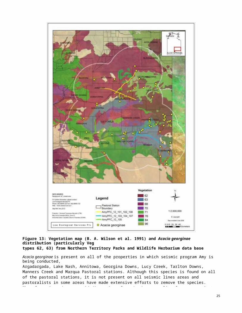
Figure 13: Vegetation map (B. A. Wilson et al. 1991) and Acacia georginae distribution (particularly Vegtypes 62, 63) from Northern Territory Parks and Wildlife Herbarium data base within 70 km buffer around seismic lines.
Acacia georginae is present on all of the properties in which seismic program Amy is being conducted,Argadargada, Lake Nash, Annitowa, Georgina Downs, Lucy Creek, Tarlton Downs, Manners Creek and Marqua Pastoral stations. Although this species is found on all of the pastoral stations, it is not present on all seismic lines areas and pastoralists in some areas have made extensive efforts to remove the species. Therefore, in order to avoid dispersion of seeds when traveling from one project area to the others, ensure vehicles andequipment are washed or cleaned with compressed air in a dedicated area, inspected and free of weeds and soil prior to mobilization.
25
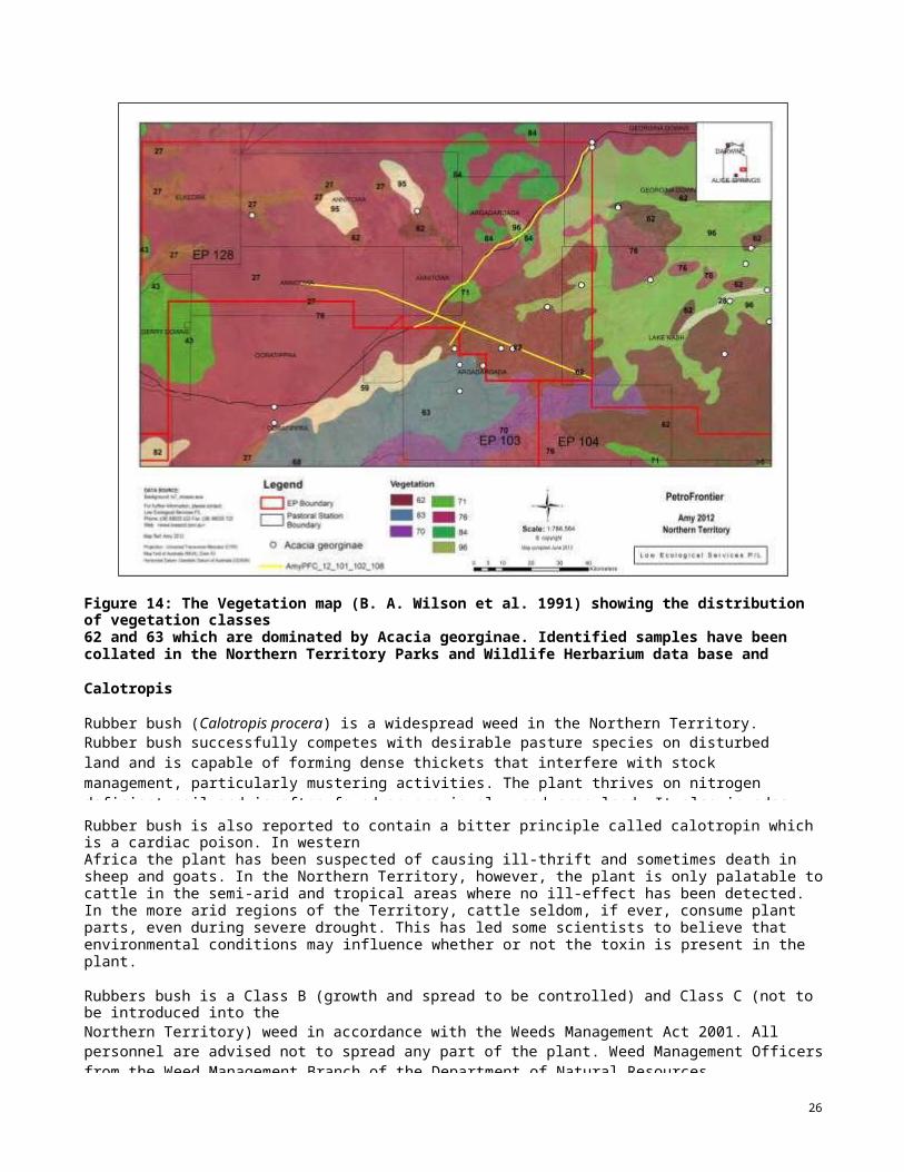
Figure 14: The Vegetation map (B. A. Wilson et al. 1991) showing the distribution of vegetation classes62 and 63 which are dominated by Acacia georginae. Identified samples have been collated in the Northern Territory Parks and Wildlife Herbarium data base and specimens (white spots) within a 70 km buffer around the seismic lines identified as PFC-12-101-102-108 are shown on the map.
Calotropis procera
Rubber bush (Calotropis procera) is a widespread weed in the Northern Territory.Rubber bush successfully competes with desirable pasture species on disturbed land and is capable of forming dense thickets that interfere with stock management, particularly mustering activities. The plant thrives on nitrogen deficient soil and is often found on previously used crop-land. It also invades roadsides, alluvial river flats and other disturbed areas.
Rubber bush is also reported to contain a bitter principle called calotropin which is a cardiac poison. In westernAfrica the plant has been suspected of causing ill-thrift and sometimes death in sheep and goats. In the Northern Territory, however, the plant is only palatable to cattle in the semi-arid and tropical areas where no ill-effect has been detected. In the more arid regions of the Territory, cattle seldom, if ever, consume plant parts, even during severe drought. This has led some scientists to believe that environmental conditions may influence whether or not the toxin is present in the plant.Surveys have confirmed that rubber bush is becoming more invasive in the southern part of the Territory, and accordingly, the species is declared a Class B weed south of latitude 16°30" where it has no nutritive value tostock.Rubbers bush is a Class B (growth and spread to be controlled) and Class C (not to be introduced into theNorthern Territory) weed in accordance with the Weeds Management Act 2001. All personnel are advised not to spread any part of the plant. Weed Management Officers from the Weed Management Branch of the Department of Natural Resources, Environment, the Arts and Sport (NRETAS) advised that the best method of eradication was to cut the plant as close to the ground as possible and apply a 60:1 dilution of Grazon DS to the cut stem
26
within ten seconds. Any seeds and flowers should be burnt. The rest of the plant should then be placed high in atree where it cannot access soil to dry out and die, or could be burnt (Low Ecological Services, (2012) MacIntyre-2H Completion & Testing Operations Environmental Audit Report prepared for Petro Frontier Pty Ltd, September2012).
A search of the DSEWPAC EPBC Act Protected Matters Search was performed and Calotropis procera weedspecies was not identified from the search area.
DLRM records do not show any Rubber bush in the region, however populations are known at Lucy Creek andAmmaroo. Therefore seismic crew will use appropriate wash down procedures to prevent seed transfer from identified populations.
Fauna
Several species are endemic to the region, but as with other central Australian bioregions, mammalian faunahas suffered substantial losses. Several mammal species have become extinct from the bioregion, including burrowing bettong (Bettongia lesueur), (Australian Natural Resources Atlas 2007a; Baker et al. 2005).
Searches of the NT Parks and Wildlife Flora Atlas, have been performed 20km either side of the seismic lineswith fauna of conservation significance.
Within the lines identified as PFC-12-101-102-108, 1 mammal is listed as Endangered and 1 mammal asVulnerable under the EPBCA 2007 Act. Under the TPWC Act (2007), 1 mammal and 1 bird are listed as vulnerable and 3 birds and 2 mammals are listed as Near Threatened.
Within the lines identified as PFC-12-105-106, 3 species are listed as Vulnerable under the EPBCA 2007 Act.Under the TPWC Act (2007), 2 mammals species are listed as Endangered, 2 birds and 1 mammal are listed asVulnerable and 1 bird and 5 mammals are listed as Near Threatened.
Within the lines identified as PFC-12-103-104-107, 1 mammals is identified as Endangered and 1 mammal isidentified as Vulnerable under the EPBCA Act (2007). Under the TPWC Act (2007), 2 mammals and 2 birds are identified as Vulnerable and 2 mammals and 2 birds are identified as Near Threatened.
EPBCTPWFA
EPBC Act protected matters searchTerritory Parks and Wildlife Fauna Atlas
C l a ss i f i c at i on EXEN NT NE Ma INV
ExtinctEndangeredNear Threatened Not Evaluated MarineInvasive
ERVU DD M Int
Extinct RegionallyVulnerable Data Deficient Migratory Introduced
27
-0 EP Bounda ry
Roads and tracks to be cleared.-Jr.
Scae:1:1,71:8,243
OA TA sotmCE:
F« iJJ"/lH iinbi"'l'i 'oo, pe<MO).'.I:..;;;.Pro"e'(03) S222iax:(OS) 9S5S i22\\'eb: <JNNN:m:ootoom;IJ>
Northern Territory
••
?-:;,-.; o-i'<ef'l-:l lt¥"\'et&l et :e'.«(OD.i) -H:1'i101'0:G'rie .:rn «A..nais{G..-.:.)
NT
vuAmyPFC_12_103_104_107
AmyPFC_12_105
A CDC'9 ""1 12
I L o wKfome:ti$
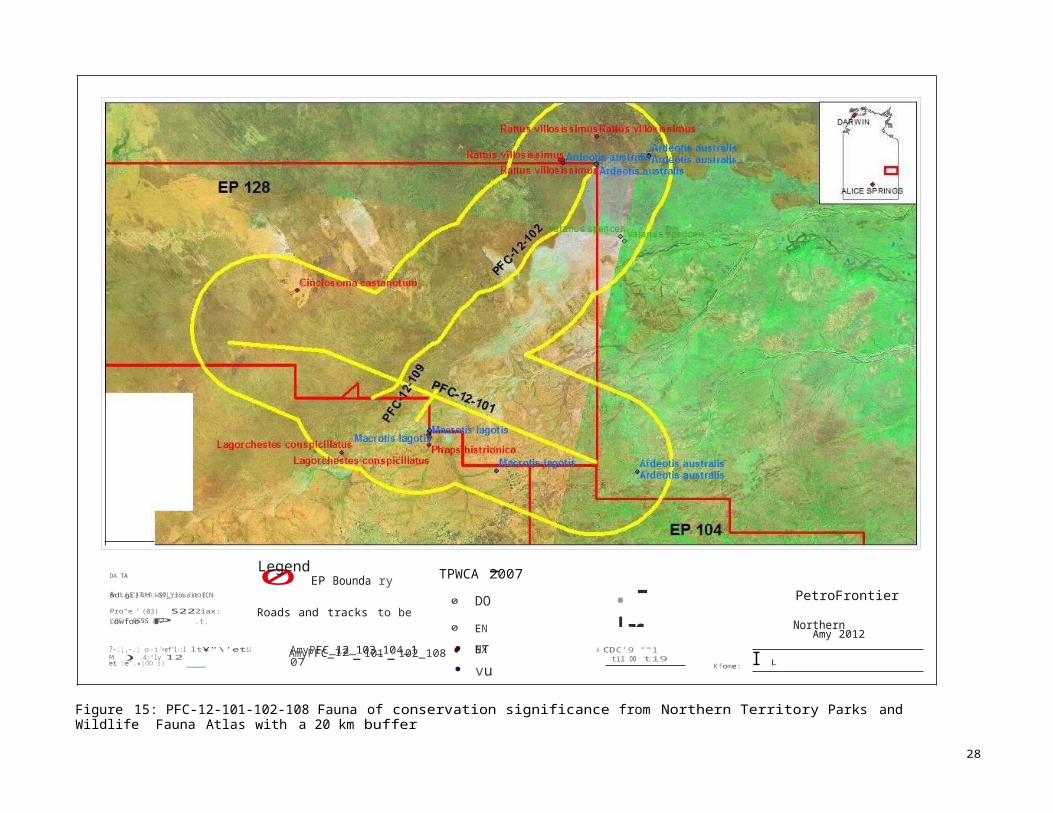
Figure 15: PFC-12-101-102-108 Fauna of conservation significance from Northern Territory Parks and Wildlife Fauna Atlas with a 20 km bufferaround the lines identified as PFC-12-101-102-108
28
EP103
Legend TPWCA 2007&d:gi)<L;O:-S7_rrosaic.ECN
0 DO PetroFrontier
Lowfoo J P .t. 0 EN Amy 2012
M ).4:!ly 12 AmyPFC_12-101-102_108 • EX til OO ti9
"l=t?Gtid:oik.,t!lis(M).,l«.e5J 10 "' "' Ec o log-ical Se rv ices P / L
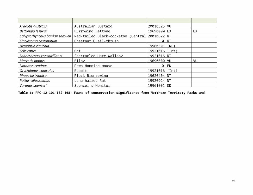
Table 6: PFC-12-101-102-108: Fauna of conservation significance from Northern Territory Parks and Wildlife Fauna Atlas search
29
FULLNAME COMMON_NAME DATE_ TPWCA_2007 EPBCA_2007Ardeotis australis Australian Bustard 20010525 VUBettongia lesueur Burrowing Bettong 19690000 EX EXCalyptorhynchus banksii samueli Red-tailed Black-cockatoo (Central Australia) 20010622 NTCinclosoma castanotum Chestnut Quail-thrush 0 NTDemansia rimicola 19960501 (NL)Felis catus Cat 19921016 (Int)Lagorchestes conspicillatus Spectacled Hare-wallaby 19921016 NTMacrotis lagotis Bilby 19690000 VU VUNotomys cervinus Fawn Hopping-mouse 0 ENOryctolagus cuniculus Rabbit 19921016 (Int)Phaps histrionica Flock Bronzewing 19620404 NTRattus villosissimus Long-haired Rat 19920924 NTVaranus spenceri Spencer's Monitor 19961001 DD

CJEP Boundary
Roads and tracks to be clea red
Am yPFC_12_101_102_108
Am yPFC_12_103_104_10 7
Am yPFC_12_105
DA TA SOURCE:
STATUS_NT_1« h rW!b ma!pea:seco".J ::i;.
Pa:n· 3) S222lax(OS) ss i22 Amy 2012
Northern Territoryne
nt
0
•Pr'*'M o-il'efl-l:i' lr¥"'·'e!' )e AI'erc; .or (UlU)
MapCD a'9!:ed .JJ!y 12
;.......i<=::::i0.-- rome:ef'e1'i o:G:'Jn «k•miis(OO!)-
Figure 16: PFC-12-105 Fauna of conservation significance from Northern Territory Parks and Wildlife Fauna Atlas search with a 20 km bufferaround the lines identified as PFC-12-105-106
30
Legend
PetroFrontiert.nMEoo 5e"ke;P.t
'1\'eb: HNooNt1oom3J> 0 dd 'Sca'e: ti,7t8,243
@ OOJ¥t;gl-t
l Gtid:offo nefie.(M). W.eSJ10 I L ow Eco log ic al S e rv ic es P / L
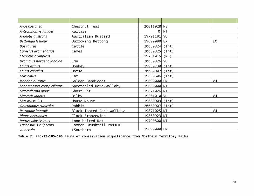
Table 7: PFC-12-105-106 Fauna of conservation significance from Northern Territory Parks and Wildlife Fauna Atlas
31
FULLNAME COMMON_NAM DATE_ TPWCA_2007 EPBCA_2007Anas castanea Chestnut Teal 20011028 NEAntechinomys laniger Kultarr 0 NTArdeotis australis Australian Bustard 19791101 VUBettongia lesueur Burrowing Bettong 19690000 EX EXBos taurus Cattle 20050824 (Int)Camelus dromedarius Camel 20050825 (Int)Ctenotus olympicus 19751015 (NL)Dromaius novaehollandiae Emu 20050826 VUEquus asinus Donkey 19930730 (Int)Equus caballus Horse 20060907 (Int)Felis catus Cat 19850606 (Int)Isoodon auratus Golden Bandicoot 19690000 EN VULagorchestes conspicillatus Spectacled Hare-wallaby 19880000 NTMacroderma gigas Ghost Bat 19871026 NTMacrotis lagotis Bilby 19301010 VU VUMus musculus House Mouse 19680909 (Int)Oryctolagus cuniculus Rabbit 20060907 (Int)Petrogale lateralis Black-footed Rock-wallaby 19871025 NT VUPhaps histrionica Flock Bronzewing 19860923 NTRattus villosissimus Long-haired Rat 19790800 NTTrichosurus vulpecula vulpecula
Common Brushtail Possum (SouthernN.T.) 19690000 EN

CJ EP Boundary
Roads and tracks to be cleared
AmyPFC_12_101_102_108
AmyPFC_12_103_104_10 7
Am yPFC_12_105
DA TA SOURCE:
PetroFrontierSTATUS_NT_1« tilrrn rnpea:seo •IJ #:::i;.P!i:n' 3) S222lax(OS) e.955S i22 Amy 2012
Northern Territory
I L ow Ec o log ic al S e rv ic es P / L
Pr'*'M o-il'efl-l:i' lr¥"'·'e!')e AI' erc;e.-or (tro.J)
-
-lGtid:offo nefie.(M). W.eSJ
.¥11 • nt
Figure 17:PFC-12-103-104-107 Fauna of conservation significance from Northern Territory Parks and Wildlife Fauna Atlas search with a 20 kmbuffer around the lines identified as PFC-12-103-104-107106.
32
Legend&d.gi)!X;(t sv:oosaic.ecw
l.o'M OOt
'1\'eb: HNtooNm13J:>oo 0 dd 'Sca'e: ti,7t8,243
o nef'e1'io:G:' «k.e niis(G- S£)
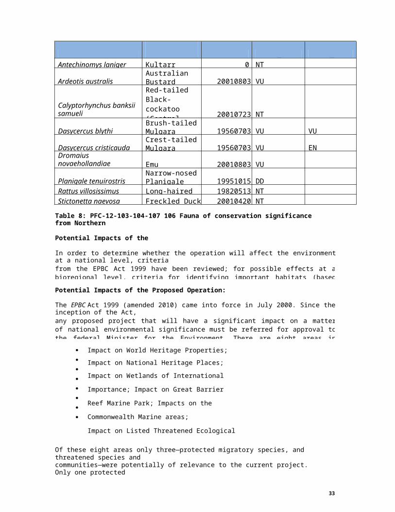
Table 8: PFC-12-103-104-107 106 Fauna of conservation significance from NorthernTerritory Parks and Wildlife Fauna Atlas search
Potential Impacts of the Operation
In order to determine whether the operation will affect the environment at a national level, criteriafrom the EPBC Act 1999 have been reviewed; for possible effects at a bioregional level, criteria for identifying important habitats (based on criteria from Neave et al. 2006) are reviewed; for effects at a local level, data provided herein are reviewed.
Potential Impacts of the Proposed Operation: National Level
The EPBC Act 1999 (amended 2010) came into force in July 2000. Since the inception of the Act,any proposed project that will have a significant impact on a matter of national environmental significance must be referred for approval to the federal Minister for the Environment. There are eight areas in which a project may have an impact of national environmental significance. These include:
Impact on World Heritage Properties;
Impact on National Heritage Places;
Impact on Wetlands of International Importance;
Impact on Great Barrier Reef Marine Park;
Impacts on the Commonwealth Marine areas;
Impact on Listed Threatened Ecological Communities;
Impact on Listed Threatened Species, and
Impact on Listed Migratory Species.
Of these eight areas only three—protected migratory species, and threatened species andcommunities—were potentially of relevance to the current project. Only one protectedmigratory species—Rostratula benghalensis—has been identified within the project area(PFC-12-101/102/108, PFC-12-105 and PFC-12-103-104-107), although seven species are
33
FULLNAMECOMMON NAME DATE TPWCA_2007 EPBCA_2007
Antechinomys laniger Kultarr 0 NT
Ardeotis australisAustralianBustard 20010803 VU
Calyptorhynchus banksii samueli
Red-tailed Black-cockatoo (Central Australia) 20010723 NT
Dasycercus blythiBrush-tailedMulgara 19560703 VU VU
Dasycercus cristicaudaCrest-tailedMulgara 19560703 VU EN
Dromaius novaehollandiae Emu 20010803 VU
Planigale tenuirostrisNarrow-nosedPlanigale 19951015 DD
Rattus villosissimus Long-haired Rat 19820513 NTStictonetta naevosa Freckled Duck 20010420 NT

listed by DEWHA in the EPBC Act 1999 as potentially occurring in the area. Several minordrainage channels and drainage basins are within the vicinity of the proposed seismic lines. These are non-permanent and rely on above average rain events and are only likely to be important for protected migratory species in wet seasons. Whilst there has been above average rainfall in 2010-2011, land clearing guidelines of the NT restrict vegetation clearing around drainage lines, watercourses, wetlands and seepage zones and watercourses should not be diverted from their natural path. Hence, in accordance with best practice guidelines, no modifications should be made to the habitat of protected migratory species and protected migratory species are not likely to be affected on a national level.
No threatened ecological communities or flora listed under the EPBC Act 1999, have beenidentified within the project area although threatened fauna species have been recorded within a 2 km radius of the 2012 proposed seismic lines. The proposed operations are not likely to affect the status of these species at a national level however, due to the scale of the operation, the environmental impact is spread over a significant area and particular attention to management recommendations is necessary to ensure that the potential impact of the operations is minimised.
Table 9: Threatened species listed in the EPBC Act Protected Matter Search.
Vulnerable
Vulnerable
Vulnerable
Potential Impacts of the Proposed Operation: Bioregional Level
Neave et al. (2006) identify a number of criteria for identifying important habitats in CentralAustralia, which have been adopted for this EMP. Each of these is discussed with reference tocurrent and previous surveys conducted within the project area and surrounding region.
Criteria for identifying important habitats include:
1. Habitat with high species richness that supports a high abundance of native species,
and/or is structurally complex.
These attributes may relate to:
the number of vegetation types and the degree of contrast between them;
34
PFC-12 LINE Species Name Status
101-102-108
Rostratula australis (Australian Painted Snipe)Macrotis lagotis (Greater Bilby)Notoryctes typhlops (Southern Marsupial Mole) Petrogale lateralis MacDonnell Ranges race (Black-footed Rock-wallaby)Acanthophis hawkei (Plains Death Adder)
Vulnerable Vulnerable Endangered
Vulnerable
105
Rostratula australis (Australian Painted Snipe)Macrotis lagotis (Greater Bilby)Notoryctes typhlops (Southern Marsupial Mole)Petrogale lateralis MacDonnell Ranges race
(Black-footed Rock-wallaby)
Vulnerable Vulnerable Endangered
103- 104- 107
Rostratula australis (Australian Painted Snipe)Macrotis lagotis (Greater Bilby)Notoryctes typhlops (Southern Marsupial Mole)Dasycercus cristicauda (Crest-tailed Mulgara)
Vulnerable Vulnerable Endangered

availability of shelter sites (e.g. nesting sites, ground litter and logs, rock
crevices) and water and food resources (e.g. presence of nectar producing
shrubs);
topographic/geological complexity creating a range of micro-habitats
Assessment: The seismic acquisition areas do not fully meet the characteristics of thiscriterion. With the exception of the Illungara Site of Botanical Significance, the main vegetation communities of the seismic acquisition area are relatively common and cover hundreds of square kilometres in the Northern Territory (B. A. Wilson et al. 1991). Further, the majority of the vegetation and landscape of the seismic acquisition areas is not considered threatened or significant. This is highlighted in existing data sets by therelatively low number of flora and fauna species listed at or above a vulnerable level(TPWC Act) within a 50 km radius of the seismic acquisition area.
2. Habitat supporting species of high conservation value (e.g. threatened species,
endemic species, poorly reserved species and/or rare species).
Assessment: The project area and surrounding region do not fully meet the characteristicsof this criterion. No legislated protected areas have been identified within the Channel Country, Mitchell Grass Downs, or Tanami bioregions. Two percent of the Davenport Murchinson Ranges bioregion is protected, however, only the most northern end of one seismic line is proposed in this area (Baker et al. 2005). The two endangered species(TPWC Act)—brush tail possum (Trichosurus vulpecula vulpecula), golden bandicoot(Isoodon auratus)—recorded within a 50 km radius of the proposed seismic lines have notbeen recorded since 1969. Likewise, none of the five vulnerable species listed under theEPBC Act 1999 have been recorded since 1987. Nonetheless, habitat in the project area and surrounding region supports a small number of flora and fauna species of lower level conservation significance, and there is potential for these species to occur.
3. Habitat that is of good quality (i.e. its compositional and structural integrity and
ecological processes have not been undermined).
The level of habitat integrity is influenced by:
the presence/absence (or low cover abundance) of environmental weeds,
especially Buffel Grass and Couch Grass, both of which are known to
outcompete native plant taxa and alter habitat parameters for native fauna;
the presence/absence (or low abundance) of introduced animal species;
the presence/absence of an appropriate fire regime (inappropriate regimes
are known to impact on species composition and canopy condition);
degree of isolation from infrastructure such as roads and waterpoints
(reduced risk of weed invasion and over-grazing); and,
the state of the hydrological regime (altered regimes may lead to changes in
site species composition).
Assessment: The project area and surrounding region do not fully meet the characteristicsof this criterion. Several introduced species (flora and fauna) are known to occur in the area. The project area is also in close proximity to infrastructure (highways, station tracks
35

and water points) and the area has been subject to extensive localised grazing pressurefor many years.
4. Habitat that is poorly reserved elsewhere.
Assessment: The project area and surrounding region do not fully meet the characteristicsof this criterion. Although there are no national parks or protected areas, habitat found within the seismic acquisition area is characteristic of typical habitat found within the surrounding bioregion and flora and fauna in the area are generally common and widespread.
Potential Impacts of the Proposed Operation: Local Level
Vegetation communities in the vicinity of the seismic acquisition area are dominated bycommon species such as Mulga (Acacia aneura), Ghost Gum (Corymbia aparrerinja), Coolabah (Eucalyptus coolabah subsp. arida), Georgina Gidgee (Acacia georginae) over sparse annual grasses, tussock grasses and spinifex (Triodia spp). If best practicetechniques are followed, the proposed operations should have little impact on the larger flora species (>2 m tall) as the path of the seismic line can follow a route causing minimal vegetation loss. There will be localised loss of flora and habitat for fauna, where lineestablishment requires removal of small shrubs to allow for access of vehicles. Line establishment can also result in the removal of topsoil and the formation of windrows, which can channel water and create erosion. Top soil is also lost in areas where vegetation is removed and bulldust is created due to traffic use. In areas where soils are prone to erosion, where existing erosion is present, or where seismic lines are established up and down slopes, soils can become eroded if best practice techniques are not followed. Mining exploration can indirect impact on local fauna through increased noise, vibration, dust, lights, roads, and increased human activity. A number of management strategies (outlined in followingsections) can be adopted to minimise this disturbance.
The NT Parks and Wildlife Flora Atlas identify several flora species with lower conservationlistings, which have been identified within a 20 km radius of the proposed seismic lines. However, if best practice techniques are followed and management recommendations outlined in sections to follow are adhered to, impacts on these species by the proposed operations will be minimal.
A number fauna species listed under the TPWC Act and/or EPBC Act 1999 for conservationsignificance have been identified within the vicinity of the proposed seismic lines and/or surrounding region. Species with a conservation status at or above vulnerable are discussed below. Species that are extinct or regionally extinct are not discussed.
The Crest-tailed Mulgara, or Ampurta, (Dasycercus cristicauda) is listed as vulnerable underthe TPWC Act and Endangered under the EPBC Act. Previously the Ampurta was known as D. hillieri (as listed in the EPBC Act status). The Ampurta is a mid-sized, robust carnivorous marsupial. There has been considerable taxonomic confusion between the Ampurta and Brush-tailed Mulgara, and most records did not distinguish between the two species, so theAmpurta‘s distribution is ambiguous. Due to this confusion, while there are no records in theTPW Fauna Atlas, it may be present in the survey area. Most records are from the SimpsonDesert and northern South Australia, but it may occur much more widely across arid Australia, with records from the Canning Stock Route in WA and the Nullabor Plain. Environmental degradation and habitat homogenisation are likely contributors to its decline (NT Parks and Wildlife Commission 2006c)The Greater Bilby (Macrotis lagotis) is listed as vulnerable under the TPWC Act and EPBCAct 1999. There are only a few recordings of this species in the eastern desert country of the NT, with populations more prominent in the west. Woinarski et al. (2007) describe the suitable habitat as sandy soils dominated by hummock grasslands covered predominantly by spinifex and an overstorey of low shrub cover dominated by Acacia and Melaleuca. The sandy landscape also often comprises rocky outcrops, lateritic rises and low-lying drainage
36
depressions. Whilst we cannot rule out the possibility of this species occurring in the vicinityof the proposed seismic lines and/or surrounding region it is unlikely that small, localised disturbance will affect the status of this species on a local scale.
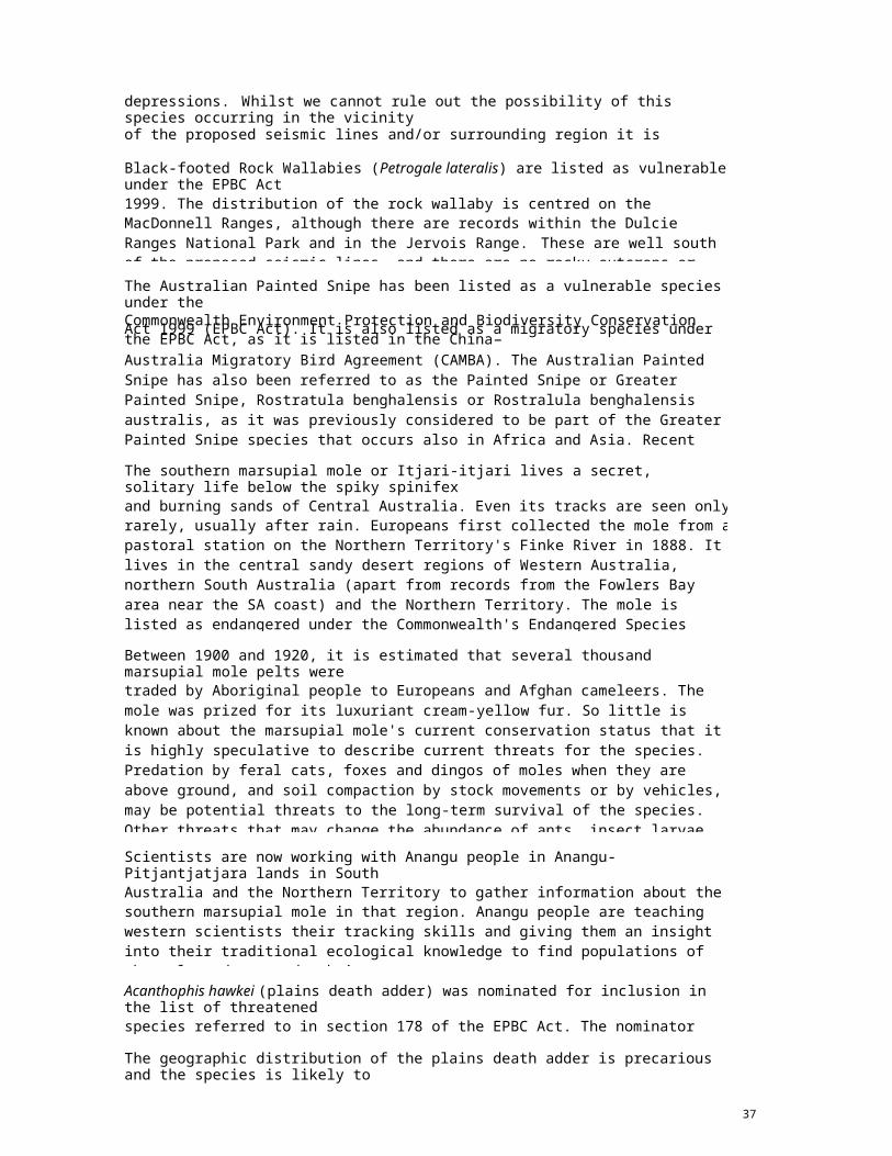
Black-footed Rock Wallabies (Petrogale lateralis) are listed as vulnerable under the EPBC Act1999. The distribution of the rock wallaby is centred on the MacDonnell Ranges, although there are records within the Dulcie Ranges National Park and in the Jervois Range. These are well south of the proposed seismic lines, and there are no rocky outcrops or steep rocky slopes within the vicinity of the proposed seismic lines. Mesas and stony lowlands exist although rock wallaby populations in these areas are unlikely.
The Australian Painted Snipe has been listed as a vulnerable species under theCommonwealth Environment Protection and Biodiversity Conservation Act 1999 (EPBC Act). It is also listed as a migratory species under the EPBC Act, as it is listed in the China–Australia Migratory Bird Agreement (CAMBA). The Australian Painted Snipe has also been referred to as the Painted Snipe or Greater Painted Snipe, Rostratula benghalensis or Rostralula benghalensis australis, as it was previously considered to be part of the Greater Painted Snipe species that occurs also in Africa and Asia. Recent research indicates that the Australian Painted Snipe is a separate species. This taxonomic history is reflected in the names that have been used to list the species under State and Territory threatened species legislation, under CAMBA and under the migratory provisions of the EPBC Act.
The southern marsupial mole or Itjari-itjari lives a secret, solitary life below the spiky spinifexand burning sands of Central Australia. Even its tracks are seen only rarely, usually after rain. Europeans first collected the mole from a pastoral station on the Northern Territory's Finke River in 1888. It lives in the central sandy desert regions of Western Australia, northern South Australia (apart from records from the Fowlers Bay area near the SA coast) and the Northern Territory. The mole is listed as endangered under the Commonwealth's Endangered Species Protection Act 1992. Some researchers think that comparisons of past and present records are biased by the large numbers of specimens collected during early scientific expeditions. Overall, the number of specimens added to museum collections has not varied much this century.
Between 1900 and 1920, it is estimated that several thousand marsupial mole pelts weretraded by Aboriginal people to Europeans and Afghan cameleers. The mole was prized for its luxuriant cream-yellow fur. So little is known about the marsupial mole's current conservation status that it is highly speculative to describe current threats for the species. Predation by feral cats, foxes and dingos of moles when they are above ground, and soil compaction by stock movements or by vehicles, may be potential threats to the long-term survival of the species. Other threats that may change the abundance of ants, insect larvae and termites, such as altered fire regimes and grazing, may also be included.The most pressing needs are to find out more about the mole's past and present distribution, and to find a living population that can be studied. This will provide the facts needed to prepare a recovery plan for the species.
Scientists are now working with Anangu people in Anangu-Pitjantjatjara lands in SouthAustralia and the Northern Territory to gather information about the southern marsupial mole in that region. Anangu people are teaching western scientists their tracking skills and giving them an insight into their traditional ecological knowledge to find populations of the mole and to study their movements.The habitat in the region of seismic lines 101 and 108 are dominated by cracking clay and limestone soils and are not appropriate to Desert Moles.
Acanthophis hawkei (plains death adder) was nominated for inclusion in the list of threatenedspecies referred to in section 178 of the EPBC Act. The nominator suggested listing in the vulnerable category of the list.
The geographic distribution of the plains death adder is precarious and the species is likely todecline as a result of the introduction of cane toads to Northern Australia. Given that the cane
37

toad is expected to encompass almost all of the species‘ range in the future, it is consideredthat the plains death adder is likely to undergo a substantial reduction in numbers. Therefore,the species has been demonstrated to have met the relevant elements of Criterion 1 to make it eligible for listing as vulnerable. The exact distribution of the species is unclear. Suitable habitat for the plains death adder consists of flat, treeless, cracking-soil riverine floodplains (Cogger, 2000). Based on the presence of suitable habitat, the potential geographic range of the plains death adder extends from Western Queensland, across the north of the Northern Territory to north-east Western Australia. Fragmented populations of the plains death adder are known to occur in the Mitchell Grass Downs of western Queensland, the Barkly Tableland on the Northern Territory / Queensland border and east of Darwin in the Northern Territory.The species‘ extent of occurrence is estimated to be approximately 720,000 km2 and its areaof occupancy is estimated to be approximately 233,480 km2 (Phillips, pers. comm., 2009).Based upon field experience, and encounter rates across its range, the species can be locally common (in the absence of cane toads (Rhinella marinus)) on the highly productive floodplains of northern Australian rivers. On the Barkly Tableland and Mitchell Grass Downs, however, the species is less-commonly encountered, so can probably be considered scarceClimate
The Channel Country IBRA region has an arid climate with very hot, dry summers and short, drywinters (Department of Sustainability, Environment, Water, Population and Communities, 2013). Rainfall is unpredictable in both timing and quantity, with most of the 300-400 mm of rain occurring in the summer months (Baker, et al., 2005; Department of Sustainability, Environment, Water, Population and Communities, 2012a).
The long-term temperature data for Jervois weather station. (Bureau of Meteorology, 2013) areshown in Figure 6.12.1. The mean maximum temperature at Jervois ranges between 21.9°C inJuly and 38.4°C in January. The mean minimum temperature ranges between 5.2°C in July and22.7°C in January.
The rainfall data were recorded at Argadargada, (Bureau of Meteorology, 2013). Mean monthlyrainfall at Argadargada ranges from 1.9 mm in August to 79.7 mm in January. Mean annual rainfall at Argadargada is 322.5 mm. Annual rainfall in 2010 and 2011 was well above the mean annual, with 826.8 mm in 2010 and 727 mm in 2011 (Bureau of Meteorology, 2013). Annual rainfall in 2012, however, was below average at 281.8 mm. November and December 2012 had above the monthly average rainfall (Bureau of Meteorology, 2013). This data shows that the majority of the rainfall in these areas falls in the summer months. This is consistent with the bioregional description given by Baker et al, (2005).
January and February 2013 were much drier than the monthly average, with 9 mm and 16.4 mmrainfall respectively (Bureau of Meteorology, 2013). Monthly temperature averages at Jervios over January and February 2013 were 41.1 oC and 37.9 oC respectively. In January there were sixteen consecutive days over 40 oC (Bureau of Meteorology, 2013).
38
10080604020
0
50403020100
Jan Feb Mar Apr May Jun Jul Aug Sep Oct Nov DecMonth
Mean Rainfall - Argadargada
Mean max. temperature - Jervois
Mean min. temperature - Jervois
Figure 18: Mean monthly rainfall at Argadargada between November 1968 and February2013, and mean minimum and mean maximum temperature at Jervois between January1967 and August 2012 (Bureau of Meteorology, 2013)
Cultural and Socio-Economic Environment
The primary land use in the region is pastoral (commercial). The area is occasionally visited byfour-wheel drive campers however other recreational or tourism related activities are uncommon. The Irraman (Ermarne) Indigenous community area boarders Argadargada station and the Anatye Aboriginal Land Trust area shares boundaries with Manners Creek, Tarlton Downs andMarqua stations. Line clearing and recording crews may be observed from these areas, however operations will only be conducted during daylight hours and are of a temporary nature. It isunlikely there will be any impact on the community.
39
Rain
fall
(mm
)
Tem
pera
ture
(°C)
5. ENVIRONMENTAL MANAGEMENTDuring the planning and scouting phase the seismic lines will be deviated, where possible,without compromising the technical requirements of the seismic data to:
Make the maximum use of existing roads, tracks and old seismic lines.
Avoid significant watercourse and riparian vegetation.
Avoid erosion sensitive soils and large trees.
Avoid areas of cultural significance.
Minimise disturbance to dunes; and
Conserve biodiversity.
Several assessments of environmental sensitivities have been undertaken which are applicableto this project and these are detailed in Section 6. The seismic survey area avoids all known environmental sensitivities and PFC considers these assessments to be sufficient for line planning, given the following:
LES has conducted desktop, aerial and ground surveys, the results of which are
incorporated into this EMP.
The survey area consists primarily of open Gidgee sand plain habitat with minor hills and
black soil plains. These habitat types are widespread in the region.
River, Wetland and Dune Management Plans in force.
Seismic lines will avoid erodible soils wherever possible and erosion control measures
utilised on sloping terrain.
The area impacted by the proposal relative to the extent of the vegetation associations is
relatively small.
PFC has a commitment to follow on from rehabilitation programs conducted in the area.
The risk to biodiversity is minimal. At induction, line pointers/clearers will be alerted to
identify and avoid areas indicating native fauna habitation.
Heritage surveys have been conducted within the seismic survey area and an
assessment report submitted and approved in September 2012. Sacred Site Clearance
Certificates have been granted by the Central Land Council covering all lines.
The seismic lines will be accessed from existing tracks where possible; and,
Weed hygiene management measures (i.e., use of hygiene stations) are essential for this
project to prevent the spread of weeds. Vehicles will be cleaned of mud and plant
material prior to entry into the site. Hand tools, personnel boots and clothing and any item
that is used in contact with soils or organic matter will also be cleaned prior to entry into
the site. Weed identification will be included as part of the site induction.
40

Mobilisation and Camp Construction
The seismic crew will be housed in purpose built trailer camp(s) located on or close to the surveyarea. The camp(s) will occupy an area of approximately 50 m x 50 m. The campsite will be located in existing cleared areas or areas of sparse vegetation with clearing kept to a minimum.Sewage will be treated and then disposed of in a fenced pit. Grey-water will be disposed of viaabsorption trench and/or sprinkler. This pit will be backfilled when no longer required.
All waste produced by the workforce operating in the field will be brought back to the camp eachday for correct disposal. The nature of these operational wastes and information on their disposal management are detailed in Table 10.
All personnel involved in field activities will undergo a site-specific induction prior to commencingwork. The site-specific environmental component of the pre-survey induction will educate the workforce of the issues presented in this EMP including:
Native flora and fauna (including scat and burrow identification).
Soil instability and degradation issues.
Watercourse and surface water flow management.
Bushfire prevention and management.
Weed management including weed identification; and,
Training in identification of archaeological indicators.
Personnel will be advised of the provisions in the Northern Territory Sacred Site Act and HeritageConservation Act where a person constitutes an offence if they knowingly interfere with Aboriginal or Heritage sites.
In the event that any archaeological material, including human skeletal material, is uncovered asa result of line preparation, the discovery will be immediately reported to the PFC Authorised Representative who will then report to relevant authorities. All work within the affected area will stop immediately and the area will be isolated.
41

Table 10: Waste Management
area and disposed of at an
will be stored separately and
area and disposed of at an
goods procedures.
completed.
camp(s) will be disposed of
All hazardous materials and wastes associated with the seismic survey will be stored separatelyat the camp and clearly labelled. Hazardous inventory items such as hydraulic fluid, solvents and battery acid will be stored in accordance with Australian Standard AS 1940 - 1993. The primary hazardous material stored will be diesel fuel. The seismic source vehicles will be the largest consumers of diesel, requiring daily refuelling.
Vehicles will be re-fuelled either:
At the base camp from an on-site fuel trailer (generally the case for all light vehicles).
In the field with a stationary fuel trailer of up to 20,000 L capacity; or
In the field with a 2,000 L capacity seismic service unit; (e.g. to refuel the vibrators and
recorders in the field).
Refuelling vehicles will, at all times, carry a spill kit and a drip tray, which is to be placed beneaththe nozzle while refuelling. Additionally, refuelling vehicles will carry a shovel and thick plastic bags for the collection of any soil contaminated by a fuel spill.
Spill kits, bio-remedial products, drip trays and shovels will be available in the case of a spill ofhazardous materials or wastes. For every hazardous substance brought onto the seismic survey area, a materials safety data sheet (MSDS) that conforms with the Work Safe Australia Code of Practice will be made easily available to all personnel. A Hazardous Materials Registry will be maintained by Terrex.
Table presents the hazardous materials which will be used during the seismic survey, includinghow each substance is used and the estimated mean volumes maintained as inventory.
Purchasing and transport will be undertaken in accordance with provisions of explosives anddangerous goods legislation, Work Health and Safety (National Uniform Legislation) Act 2011, codes of practice and Australian Standards.
42
Waste Item Source Handling Method Disposal Route
Domestic wastes (food, scraps, light paper, cardboard, putrescibles and plastic waste)
Workforce when in the field
All domestic wastes will be collected and stored in pest proof bins.
Waste removed from the
appropriate facility
Industrial waste: (wood, scrap steel and other metals, scrap tyres, rubber and synthetic materials, and other inert mixed industrial waste) and waste oils, etc.
Hazardous wastes produced from operating, maintaining and repairing machinery as part of survey activities.
Hazardous waste materials
handling of these materialswill be done in accordance with contractor dangerous
Waste removed from the
appropriate facility
Sewage and grey water Workforce camp
Treated domestic sewage will be deposited into a fenced pit in a benign area away from water courses or areas of potential run-off.
The fenced pit will be backfilled when the survey is
Greywater generated from
via absorption trench and/orsprinkler.
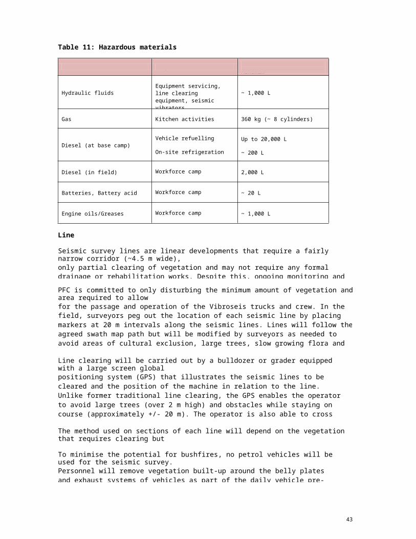
Table 11: Hazardous materials inventory
Inventory
Line Establishment
Seismic survey lines are linear developments that require a fairly narrow corridor (~4.5 m wide),only partial clearing of vegetation and may not require any formal drainage or rehabilitation works. Despite this, ongoing monitoring and maintenance to prevent erosion is important, particularly in floodout fine silt and bulldust prone area.
PFC is committed to only disturbing the minimum amount of vegetation and area required to allowfor the passage and operation of the Vibroseis trucks and crew. In the field, surveyors peg out the location of each seismic line by placing markers at 20 m intervals along the seismic lines. Lines will follow the agreed swath map path but will be modified by surveyors as needed to avoid areas of cultural exclusion, large trees, slow growing flora and areas with high erosion potential.Fencing crews construct temporary gates and fence crossings where lines cross fences, although there are few fences within the survey area. These gates will be kept closed when not in use to ensure stock do not move between paddocks.
Line clearing will be carried out by a bulldozer or grader equipped with a large screen globalpositioning system (GPS) that illustrates the seismic lines to be cleared and the position of the machine in relation to the line. Unlike former traditional line clearing, the GPS enables the operator to avoid large trees (over 2 m high) and obstacles while staying on course (approximately +/- 20 m). The operator is also able to cross landscape features such as dunes and gullies obliquely, reducing potential for erosion and creating a minimal line of sight. PFC will follow the recommendations included in the September 2012 approved Archaeological Assessment Report by Tim Hill Heritage Management and Planning to avoid heritage sites.
The method used on sections of each line will depend on the vegetation that requires clearing butthe following best practice guidelines will be followed at all times.
To minimise the potential for bushfires, no petrol vehicles will be used for the seismic survey.Personnel will remove vegetation built-up around the belly plates and exhaust systems of vehicles as part of the daily vehicle pre-start inspection. Every vehicle involved in the seismic survey will carry:
43
Substance Purpose Estimated or Indicative Maximum
Hydraulic fluidsEquipment servicing, line clearing equipment, seismic vibrators
~ 1,000 L
Gas Kitchen activities 360 kg (~ 8 cylinders)
Diesel (at base camp)Vehicle refuelling
On-site refrigeration
Up to 20,000 L
~ 200 L
Diesel (in field) Workforce camp 2,000 L
Batteries, Battery acid Workforce camp ~ 20 L
Engine oils/Greases Workforce camp ~ 1,000 L
A rake or shovel for each work team to assist in suppressing a small fire if it
occurs.
A 9 kg pressurised water fire extinguisher applicable to scrub fires; and
The all-terrain trucks used in seismic acquisition will carry two 2 kg multi-
purpose fire extinguishers
All fire-fighting equipment will be maintained in good working order, including full water levels,and all personnel will be trained in the use of this equipment. Appropriate Terrex personnel will be trained in fire-fighting techniques and equipment/vehicle use and the Terrex OHS Advisor will conduct inspections at mobilisation and monthly intervals thereafter to ensure compliance withfire regulations, including inspections of all vehicles and equipment for possible sources of ignition.
For small fires that can be contained or extinguished immediately without further risk topersonnel, the fire-fighting equipment provided to the seismic crews will be used to control thefire. If the fire cannot be contained without risk to the seismic crew, seismic personnel will remove themselves from danger and call for help. All information with regard to bushfire outbreaks on the project area, either due to seismic activities or from outside activities shall be reported via the site environmental incident reporting system. This system will also be used to The short and long term activities to be implemented after the impact of a fire include:
Debriefing all stakeholders.
Compiling records relating to the fire for future reference.
Investigating the cause of the fire.
Assessing public facilities for re-ignition and safety hazards created by the fire;
and,
Animal rescue may commence once the fire ground has been declared safe.
Weed eradication measures will be implemented to reduce the potential for early
domination of non-endemic species. Access to the site will be restricted to
authorised personnel only to reduce:
The damage to regrowth; and,
The potential to increase erosion.
o
o
Seismic Line Layout Seismic survey lines will avoid lower areas of the landscape (e.g. floodplains, broad
drainage lines).
These areas are subject to inundation and lines in these areas can drastically
increase the likelihood of erosion as a result of the disruption to natural water
flows. Access to higher areas requires the placement of seismic survey lines up
and down steeper slopes. This can cause accelerated erosion and consequently
sediment loads. Ideal alignments follow the contour of the landscape, avoiding
(where possible) major watercourses, significant or dense stands of vegetation,
steep slopes and soils with high erosion risk.
o
44
All associated seismic survey works will remain within the designated corridor (including,
wherever possible, construction camps, turn-around points, watering points and
stockpiles).
This reduces the impact on the surrounding environment and reduces the
likelihood of initiating erosion, making maintenance easier.
Seismic survey lines will make use of existing tracks and fence lines where possible.
o
The only seismic survey lines that will remain open after the completion of the
survey are those required by the landholder or those required for future
exploration. Seismic survey lines not required after the completion of the survey
will be rehabilitated and re-vegetated back to their natural state.
Seismic lines that cross dunes will require specific planning and rehabilitation. Seismic
lines that cross dunes will be planned according to the Dune Management Plan.
Seismic survey lines will not require any major constructed drainage or formalised
drainage such as table and mitre drains because to the survey will seek to avoid impact
to natural waterways (e.g. drainage lines, creeks and rivers). However, whoa-boys may
be required in some areas). PFC will also ensure that:
o
o Receiving waterways and habitats are protected from the impacts of runoff (e.g.
using buffer zones or sediment filter strips).
Crossfall drainage is incorporated on seismic survey lines. It is important that
water can move across the lines unimpeded by windrows. Allowing natural cross
flow will reduce the likelihood of erosion, sedimentation, ponding and water
starvation of down slope vegetation.
The surface of the lines will not be below natural ground level. Lines constructed
below ground level intercept natural sheet flows and watercourses, concentrating
and directing them away from their natural paths, and therefore will be avoided.
Windrows are not created. Windrows concentrate and divert natural overland
water flows causing erosion and sedimentation.
o
o
o
No works will be undertaken during or shortly after a significant rainfall event.
The use of machinery on wet soils causes compaction and rutting, ultimately
leading to an increased possibility of initiating erosion or destroying soil structure.
Hence, all works will be suspended until the work area has sufficiently dried out.
o
Conservation of fauna
To reduce any impact on the possible (but not yet identified) presence of significant burrowingmammal species (Bilby, Mulgara and Kultarr) discussed later, line clearance crews will be instructed at induction on the detection of these species scats and signs. If these species are detected, then no ground disturbance will take place within 100 m of these areas. Indications of the presence of these species will be reported. Safe speed limits and minimising travel at dusk and dawn will be applied to roads and cleared lines to avoid wildlife collisions.
45
Vegetation Clearing
The construction of seismic survey lines does not require complete removal of vegetation andgrading down to bare earth is not necessary. There are a number of ways in which this can be done with similar results. In the case of seismic survey lines, the removal of vegetation may not be necessary at all.
Vegetation clearing will be kept to a minimum to retain or preserve as much native
vegetation as possible.
o Retained vegetation is very effective in reducing runoff and filtering
sediments and can be utilised throughout the construction phase. Retained
native vegetation can also greatly assist in the rehabilitation of disturbed
areas. Areas not to be cleared will be clearly identified as NO-GO areas and
flagged to ensure the area is not affected by the clearing of surrounding
vegetation.
Riparian vegetation associated with seasonal, permanent or intermittent watercourses will
be avoided wherever possible, as these vegetation types play an important role in
protecting watercourses and water quality.
o Riparian vegetation is the vegetation occurring adjacent to permanent or
intermittent waterways (e.g. rivers, creeks, lagoons and broad drainage lines). This area is commonly referred to as the ‗riparian zone‘. Riparianzones provide a buffer between the land and water environments, assist in
maintaining water quality by filtering nutrients and sediment from overland
water flows, and reduce erosion on embankments. These zones provide
habitat, shade, food and corridors for the movement of wildlife. The health of
vegetation and animals along and within any watercourses depends on the
health of its riparian vegetation.
Riparian vegetation areas are to be protected. The recommended width of
such zones depends on the size and character of the waterway. Such areas
can vary from well-defined creeks or rivers, to less defined drainage lines,
seepage areas and wetlands. Drainage lines collect and safely channel
runoff into more significant waterways or water bodies. Disturbance of
drainage lines can have serious consequences in terms of flooding and
erosion. Drainage lines often have no obvious channels and can be difficult
to define, especially during the drier months of the year. Certain types of
vegetation indicate wet or seasonally inundated areas and seepage zones.
Such areas are largely unsuitable for development and importantly can
extend above the 1% annual exceedence probability (AEP) flood line.
o
Data Acquisition
Once lines are prepared using the approved swath maps, the seismic crew, consisting of cablelaying trucks, line crews, Vibroseis trucks and a recording truck will move onto the line. The
46

Vibroseis trucks each have a vibrator pad that is lowered to the ground at each energy sourceposition and vibrated with a range of low to medium frequencies (5 Hz to 80 Hz). Geophones, which detect the seismic signal, are placed along the receiver lines. The electrical signals generated by the geophones are converted to digital signals and transmitted along a cable to the recording truck. The energy source is systematically applied along the line. Once a section of the line is completed, the geophones and cables are picked up and moved to the next section of the line. Daily toolbox meetings will be used to highlight sensitive areas requiring conservation andrehabilitation management within each day‘s working area.Whilst a small number of permanent markers will be left along some fence lines at the end of theseismic program, the survey pegs and all other equipment are removed from the line. Any temporary fencing will be removed and permanent fencing reinstated.The survey, including preparatory works, will be conducted only during daylight hours to avoidimpacts to nocturnal species and noise impacts on landowners in the area. The survey will conform to the Australian Standard on vibration (AS/NZS 1170.0:2002) to ensure that vibration does not adversely impact structures. Since the survey area is far removed from any habitations or communities, this aspect will be of minor importance. Any damage to infrastructure will be recorded as an environmental incident and managed according to the incident management procedures. The noise generated during the seismic survey will be primarily associated withvehicle movement and running diesel engines, and will be similar to that from running agriculturalmachinery. The seismic survey will be compliant with statutory noise level requirements andlandowners will be informed of PFC‘s progress and areas of operations throughout the survey.Records of landowner consultation will be maintained. Any complaints from affected landownerswill be recorded as an environmental incident and handled according to the incident management procedures. Noise is not expected to impact fauna significantly, given that the survey will be undertaken over a short duration (~ 6 weeks) during the dry season and will be For safety and to limit the potential for road kill of both native and domestic fauna, vehicle speedwill be limited to 40 km/h on seismic tracks, except in case of an emergency. Fauna injuries or fatalities will be reported through the internal incident reporting system. All practicable measures to rehabilitate any injured animal found within the operations boundaries will be implemented.Rehabilitation
Rehabilitation of seismic lines will ensure that the seismic survey will avoid land degradationwithin the seismic survey area. The type and extent of rehabilitation will vary depending on the extent of disturbance, location, soil type and slope. The rehabilitation of an area is required for maintaining ongoing soil stability, soil health, dust suppression, natural water flow as well asvegetation productivity, biodiversity and aesthetic values. Rehabilitation may be in the form of diversion banks, earth shaping or ripping on the contour to slow runoff and allow for natural regeneration from the seed bank located in the soil. It can also be a combination of earthworksand revegetation to reduce the velocity of runoff and to provide short and long term soilprotection. In the case of seismic survey lines, any cleared vegetation should be stockpiled for later use during rehabilitation. An inspection of the site will be undertaken to identify areas of active erosion and the level of works required.Disturbance of native vegetation will be minimised through forward planning and using seismicsurvey methods that have the least environmental impact (e.g. raised blade clearing of seismic lines) (see Section 5.2.4). This will also improve the likelihood of successful rehabilitation.To promote successful rehabilitation of the seismic lines the Terrex Crew Manager will ensurethat the following are carried out on completion of the survey:
All temporary fencing is removed and any permanent fencing, which may have been
removed to allow access for the seismic crew, is reinstated.
47

All unnecessary seismic lines are closed within four weeks of the completion of the
seismic data acquisition to prevent third party access.
All permanent markers, steel pegs and other materials are removed from the seismic
lines and camp site, except for permanent markers required under legislation.
Sump and adsorption trenches used for greywater disposal backfilled and;All intersections of seismic lines with public roads are disguised with ―dog legs‖ toprevent third party access.
A post-survey inspection will be carried out to determine if there is any need for activerehabilitation. The methods used for line closure will be determined on a case-by-case basis. Site rehabilitation will ideally be completed immediately after data acquisition is completed and certainly within 3-6 months of seismic line closure, depending on weather conditions. Should rehabilitation be delayed due to the onset of the wet season, rehabilitation will be completed inthe next dry season. The following is a list of active measures to improve rehabilitation performance that may be carried out, if required, immediately following completion of the seismic survey: Compacted or rutted soils may be lightly scarified using a three cut snake pattern to
decompress soils and improve aeration and prevent channelling of surface water flows.
Substantial vegetation pushed to one side of the seismic lines during operations will be
pulled and spread back over the lines.
Once the seismic survey is complete all equipment and any waste will also be removed from thecamp. On completion of field activities each pastoral leaseholder will be notified of completion of line rehabilitation.
Monitoring and assessment of the seismic survey will be implemented to determine ifrehabilitation has been successful or if additional measures are necessary to achieve the rehabilitation criteria listed below: No evidence of infestations of new weed species on seismic lines due to seismic
survey activities.
Total vegetation percentage cover on the seismic lines should be at least 50% of the
surrounding undisturbed vegetation after 3 years.
No obvious areas of soil erosion or compaction after 3 years due to the seismic
survey activities.
Percentage of keystone species on the seismic lines within each vegetation type
should be 50% of the surrounding vegetation within 3 years.
The above rehabilitation criteria will also apply to any watercourse or wetland
damaged during crossing;
If monitoring identifies poor rehabilitation of seismic lines, appropriate contingency actions will beimplemented in consultation with the DME.
48

Table 12: Contingencies for closure of seismic lines due to poor rehabilitation.
based on monitoring.
seismic lines. If necessary the lines will be ripped and/or re-seeded
49
Cause Contingency
Unauthorised third party access. Alternative means of line closure will be assessed and implemented.
Presence of infestations of new weed specieson seismic lines due to seismic survey activities. Weed control measures will be assessed and implemented.
Erosion evident on seismic lines.Erosion control measures will be implemented as required in accessible areas based on monitoring. Whoa boys, check banks or mitre drains will be installed where required.
Soil compaction linked to seismic lines. Compaction reduction measures will be implemented as required
Poor germination linked to seismic lines.
Follow up surveys will be conducted to determine if poor germination has resulted from poor climatic conditions or from poor closure of
with approved species to encourage seed germination.

6. DESCRIPTION AND ASSESSMENT OF ENVIRONMENTAL
Scope
The scope of the environmental risk assessment covers all aspects of seismic survey activity. The web siteguidelines (Department of Mines and Energy, Northern Territory Government, August 2012) have been followed in establishing the environmental risk table (Table 7.7.1 and 7.7.2).
Key Definitions
Incident Event: An event capable of causing critical, major, moderate, minor damage to the environment ornegligible damage with no significant environmental effect.
Hazard: A physical situation with the potential for damage to the environment, human injury,damage to property or some combination of these.
Risk: The likelihood of a specified undesired event occurring within a specified period or inspecified circumstances. It may be either a frequency (the number of specified events occurring in a time unit) or a probability (the probability of specified event following a prior event), depending upon circumstances.
Risk Assessment Methodology
This section describes the environmental risk assessment for potential events that may impact theenvironment during operational activities. The purpose of this assessment is to identify hazards and develop risk-reducing measures to prevent and mitigate impacts from operational activities. An environmental hazard- type assessment was undertaken to identify, analyse and evaluate the environmental risks associated with operation and to recommend management actions to reduce the risk to ALARP. Environmental risk assessment consists of four basic steps:
1.
2.
3.
4.
Hazard identification.
Hazard analysis.
Risk evaluation.
Risk treatment.
These steps are described briefly below.
Hazard Identification
Hazard identification involves identifying the sources of risk i.e. those activities or incidents that could resultin an environmental impact. Hazards are categorised into those arising from routine operations, and those arising from incidents.
Hazard Analysis
Hazard analysis determines the likelihood of an activity or event occurring, and the consequences of thatactivity or event on the environment. The PFC risk ranking matrix was used to assess the consequence and likelihood of all identified events. The matrix is based on six classifications of severity and six for the likelihood of a hazard.
Risk Evaluation
50

Risk evaluation prioritises the risks i.e. determining if the risk of an activity or incident is acceptably low, or ifmanagement actions are required to reduce the risk to as low as reasonably practicable (ALARP). The risk evaluation presented in Table takes existing safeguards/management measures into consideration i.e. represents the residual risk with existing or planned safeguards in place.
Risk Management
The following Tables present the detailed assessment of risks, impacts and their management for theproposed Seismic Survey. The Implementation Strategy in Sections 7 and 8 focuses on the significant issues identified to ensure the ongoing management of environmental risks to ALARP.
51
Risk Score Risk Rating Action Required
9 - 10 Extreme Immediate
7 - 8 High Action plan required. Senior management attention
5 - 6 Medium Specific monitoring or procedures required
2 - 4 Low Management through routine procedures
LIKELIHOOD CONSEQUENCES
5Almost Certain
Expected to occur in most circumstances
5Catastrophic Environmental disaster
4Likely
Will probably occur in most circumstances
4Major Severe environmental damage
3Possible Might possibly occur at some time 3
Moderate Contained environmental impact
2Unlikely Could occur at some time 2
Minor Some environmental impact
1Rare
May occur only in exceptional circumstances
1Insignificant Low environmental impact
Table 14: Risk assessment matrix and interpretation (adapted from Griffith University)
52
LikelihoodConsequences/Severity
5Catastrophic
4Major
3Moderate
2Minor
1Insignificant
5Almost certain
Extreme Extreme High High Medium
4Likely Extreme High High Medium Medium
3Possible High High Medium Medium Low
2Unlikely High Medium Medium Low Low
1Rare Medium Medium Low Low Low

Table 15: Detailed assessment of environmental risks, impacts and their management
No threatened flora identified during on ground flora surveys
No clearing of trees.
prior to arriving at site , moving between areas/properties, and
53
RISK IDENTIFICATION RISK ANALYSISRISK EVALUATION
RISK TREATMENT
Activity Event/ Incident Potential Impact Causes Severity Likelihood Risk Ranking Safeguards / Management Methods
CLEARING OF CAMPSITE
Preparation of
a cleared area
for Seismic
Camp and
access route
Clearing or removal of native vegetation and potential fauna habitat.
Loss of nativevegetation, declared rare flora or priority species. Destruction of fauna habitat.
Onsite flora not previously determined during botanical assessment.
3 2 MediumDesktop assessment indicates that threatened flora is unlikely to occur in proposed survey area.
Clear area chosen for Camp site(s) to eliminate or minimise need for clearing.
Camp site(s) rehabilitated to former condition when no longer required.
Dispersal or death of priority fauna.
Loss of declared rare fauna locally.Loss of local biodiversity.
Onsite fauna not determined during ecological assessments. Improper training. Uncontrolled vehicle access.
3 1 LowSelect a clear area with sparse vegetative cover. Effective, site-specific environmental inductions for PFC employees and contractors.Personnel trained to identify and avoid sensitive areas and potential fauna habitat.Use existing access tracks and infrastructure where possible. Vegetation clearing kept to a minimum.Access tracks and camp site avoid native fauna burrows andhabitat.Implement a no off-road policy for all workers and create designated turn around points to minimise unnecessary disturbance to potential habitat.
Soil disturbance. Erosion and sedimentation. Compaction. Subsidence. Dust emissions.
Vegetation clearing causing erosion Traffic causing soil compaction
3 3 MediumSelect Camp site(s) on a level stable soil area to avoid any erosion potential.Following the first wet season after decommissioning, camp site will be inspected to determine whether any soil disturbanceissues persist.Remediation actions initiated if needed.
Disturbance of indigenous heritage site.
Damage to indigenous heritage sites.
Onsite indigenous heritage sites not previously determined during ethnographic study.
4 1 LowEthnographic and archaeological studies to be completed before activities begin.Personnel trained in local environmental and heritage sensitivities during induction.Conform to conditions set out in the SSSCC‘s.
Noise. Disturbance to local residents, wildlife or adjacent activities.
Noise generated during routine camp operation, e.g. generator.
4 1 LowGeneral area has low population density and is remote from high-density populations.Well maintained and muffled generator(s).
MOBILISATION
Mobilisation to
survey area
for
Introduction of noxious weedsand vermin, exotic species, flora and animal diseases.
Infection of soil with diseases and pathogens Infestation of weeds in cleared areas.Increased vermin
Weeds and contaminated soil on vehicles.
4 1 LowAll Vehicles and equipment cleaned by washdown and inspected for soil, plant material and pest animal contamination
at demobilisation, to minimise the risk of introducing exotic species. All washdown sites geo-referenced for future
Personnel trained/refreshed in need for hygiene management
Detailed planning of seismic lines to avoid environmental
54
RISK IDENTIFICATION RISK ANALYSISRISK EVALUATION
RISK TREATMENT
Activity Event/ Incident Potential Impact Causes Severity Likelihood Risk Ranking Safeguards / Management Methods
preparatory
works
numbers. monitoring. All personnel provided with weed identification training at induction.
during induction.Food scraps collected and disposed in animal pest proof bins. Vehicles cleaned when leaving areas with weed infestations.
Removal of native vegetation and potential fauna habitat.
Loss of native vegetation.Loss of declared rare flora or priority species.Destruction of fauna habitat.
Uncontrolled vehicle access.Off-road driving to access sites.
2 2 LowUse access tracks to avoid native fauna burrows and habitat. Minimise disturbance to native vegetation when driving off-road.
Vehicle collision with fauna.
Fauna death or injury. Unpredictable movement of animals. Vehicles travelling at high speeds.Vehicles travelling at dawn or dusk or in times of poor visibility.
2 2 LowDrivers to take extra care in times of poor visibility or when driving at dawn or dusk.Drivers to adhere to speed limits at all times.
CLEARING OF SEISMIC SURVEY LINES
Preparation of
seismic
survey sites
Raised blade clearing or removal of native vegetation and potential fauna habitat.
Loss of native vegetation, declared rare flora or priority species.Destruction of fauna habitat.
Onsite flora and habitat not previously determined during botanical assessment.
4 3 MediumPersonnel to be trained in the identification of threatened flora present in the area.
sensitivities.Planning of seismic lines in accordance with Dune ManagementPlanSeismic survey lines and access route rehabilitated within 3 months of the completion of the survey if no longer required where possible.If initial rehabilitation fails, follow up work will occur until area satisfactorily rehabilitated.
Dispersal or death of priority fauna.
Loss of declared rare fauna locally.Loss of local biodiversity.
Onsite fauna not determined during ecological assessments. Improper training. Uncontrolled vehicle access.
3 1 LowEffective, site-specific environmental inductions for all personnel.Personnel trained to identify and avoid sensitive areas and potential fauna habitat.Use existing access tracks and infrastructure where possible. Vegetation clearing kept to a minimum.Access seismic lines avoid native fauna burrows and habitat.Implement a no off-road policy for all workers and create designated turn around points to minimise unnecessary disturbance to potential habitat.
Soil disturbance Erosion. Sedimentation. Compaction. Subsidence.
Vegetation clearing causing erosion. Light compactionrequired for rig stability.
2 2 LowLines planned and implemented to avoid areas with high erosion potential.Line preparation, survey and rehabilitation of dune crossingsconducted in accordance with the Dune Management Plan.

and highlighted at toolbox meetings.
meetings.
project area will be inspected to determine whether any weed
55
RISK IDENTIFICATION RISK ANALYSISRISK EVALUATION
RISK TREATMENT
Activity Event/ Incident Potential Impact Causes Severity Likelihood Risk Ranking Safeguards / Management Methods
Dust emissions. Lines follow swales or run perpendicular to dunes to minimise impact.PFC representative on-site to oversee program.Use recognised and experienced seismic contractor (Terrex). Seismic contractor informed of risks and trained to avoid areas of high erosion potential.During line closure, areas with severe compaction and/or rutting will be identified and will be ripped and/or levelled.Survey area will be inspected to determine whether any soildisturbance issues persist following the first wet season after decommissioning.Active remediation actions initiated if needed.
Disturbance of indigenous heritage site.
Damage to indigenous heritage sites.
Onsite indigenous heritage sites not previously determined during ethnographic study.
4 2 MediumHeritage assessment completed prior to works commencing. Personnel trained in local environmental and heritage sensitivities during induction.Survey lines situated to avoid known indigenous cultural areas.
SEISMIC SURVEY
Seismic
survey
equipment,
personnel and
supplies to
site.
Introduction of noxious weedsand vermin, exotic species, flora and animal disease.
Infection of soil with diseases and pathogens Infestation of weeds in cleared areas.Local increase in pest fauna.
Weeds and contaminated soil on vehicles.
4 1 LowLine clearing crew to be provided with weed identification training. Any known weed locations included on swath maps
Significant weed locations identified during field activities included on seismic line maps and highlighted at toolbox
Food waste properly disposed of in animal proof bins. Following the first wet season after decommissioning, the
species have established during auditing and inspection program and remediation actions initiated if needed.
Disruption of local traffic.
Inconvenience to local landholders, residents and other road users.
Movement of heavy machinery on public roads.
1 2 LowDue to remote location a significant distance from public access roads, traffic volume will be minimal - Operations along Sandover and plenty highways will be conducted on road verges, not on roadway.
Ignition sources e.g. vehicle exhaust, smokers.
Loss of vegetation and native fauna
Grass fires and bush fires in uncleared areas from sources of ignition.
3 1 LowDiesel used in all vehicles.Adequate fire equipment located on-site and in vehicles. Personnel trained in its use.Spark arresters fitted to vehicles.EPR vehicles on site during seismic activities.
Soil compaction. Physical or chemical impacts on flora, fauna, soil, surface water or groundwater from soil compaction.
Movement of heavy vehicles. 2 1 Low
All personnel to be inducted into this EMP. Use recognised seismic contractor. Seismic contractor informed of potential risks and trained to minimise soil disturbance where possibleLines planned and implemented to avoid highly sensitive areas. Dune management plan in placeDuring line closure, areas identified with severe compaction

56
RISK IDENTIFICATION RISK ANALYSISRISK EVALUATION
RISK TREATMENT
Activity Event/ Incident Potential Impact Causes Severity Likelihood Risk Ranking Safeguards / Management Methods
and/or rutting will be ripped and/or levelled.Following first wet season after decommissioning, proposed survey area will be inspected to determine whether soil disturbance issues persist.Remediation actions initiated if needed (including tilling of compacted soil to aid rehabilitation if required)
During survey Noise. Disturbance to local residents, wildlife or adjacent activities.
Noise generated during routine seismic operations.
1 1 LowArea remote, so negligible, if any, disturbance to residents. Operate only during daylight hours, minimise disturbance to most fauna.
Visual amenity. Disturbance to local residents
Presence of seismic vehicles
1 1 Low General area has low population density and is remote from high density populations e.g. Alice Springs.
Disturbance or damage to infrastructure and services.
Disruption of services to local residents e.g. power, telecommunications. Damage to fence lines and farm gates
Unknown infrastructure located in the planned survey location.Human error.
2 2 LowConsultation with relevant utility authorities for the early identification of the locations of existing overhead and buried cables, lines, pipes, water mains or other potentially affected infrastructure.General area has low population density and is remote from high density populations e.g. Alice Springs so will have little in the way of infrastructure and services.Re-instatement of all fences and affected infrastructure to pre- survey conditions as agreed with the relevant landowners.
Fuel, oil, chemical or waste spills.
Contamination of soil, surface water or groundwater.Mortality of flora and fauna arising from soil, surface andgroundwatercontamination. Visual pollution from rubbish.
Lack of appropriate bunding around storage and refuelling areas. Inappropriate storage of fuel, oil or chemical drums.Inappropriate handling of fuel, oil or chemicals during use.Improper disposal ofwastes.
2 1 LowInduction to cover refuelling procedures.Use of experienced and reputable contractor (i.e. TerrexSeismic).Fuel, oil and chemical storage areas appropriately segregated, labelled and bunded.Refuelling only at designated areas/no refuelling within 50 m of wetlands or watercoursesDrip trays used while refuelling.Clean-up materials available in all relevant areas.Waste oils and chemicals labelled and stored appropriately for offsite disposal by waste management contractor. Maintenance of mandatory waste records including type and volume.Site inspected at conclusion of survey.
Waste
Disposal
Visual amenity. Disturbance to local residents.
Presence of seismic vehicles.
1 1 Low Area of seismic survey is extremely remote. Line start and end points offset from roads.
Disturbance or damage to infrastructure and services.
Disruption of services to local residents e.g. power, telecommunications.
Unknown infrastructure located in the planned survey locationHuman error.
2 2 LowConsultation with relevant utility authorities for the early identification of the locations of existing overhead and buried cables, lines, pipes, water mains or other potentially affected infrastructure.Area of seismic survey is extremely remote and so will have little in the way of infrastructure and services.
Release of waste oils or chemicals into the environment. Accidental rubbish
Soil, surface water and groundwater contamination.Mortality of flora and fauna arising from soil,
Site wastes and chemicals not removed at end of seismic programImproper disposal of
3 2 MediumSpill Kit readily available, crew trained in use.Maintenance of mandatory waste records including type and volumes.Program in place to minimise the volume of wastes generated and to encourage recycling.
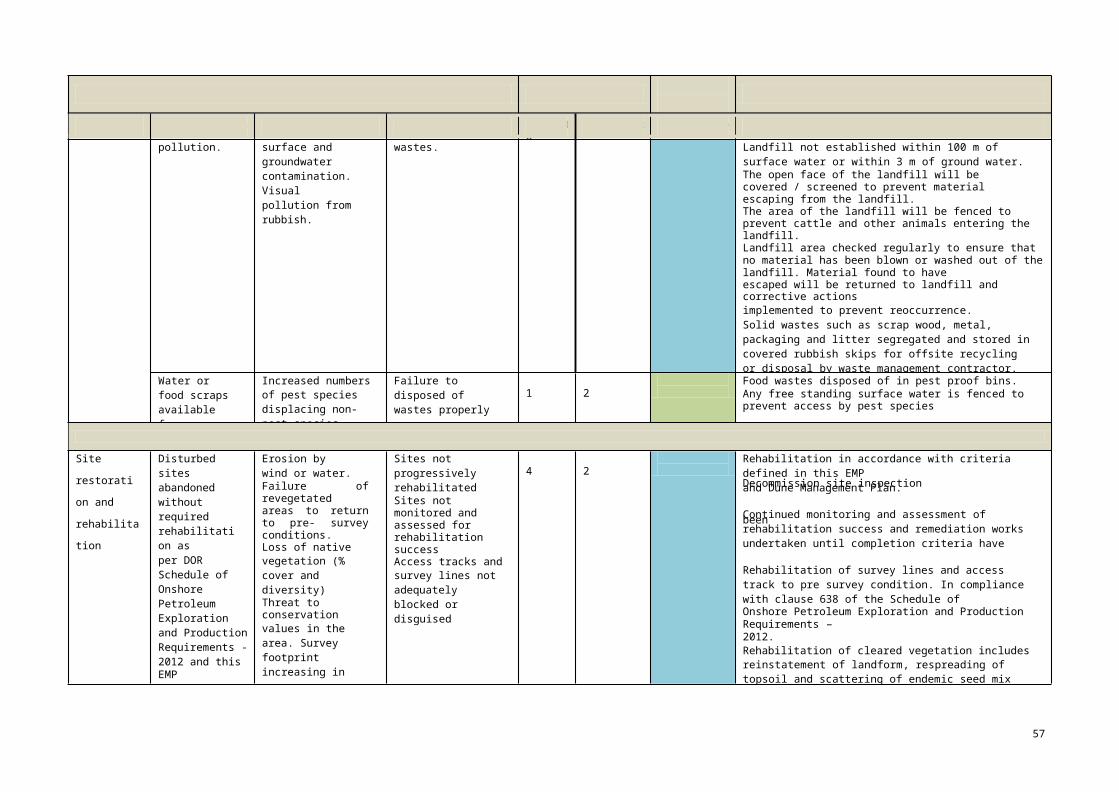
Decommission site inspection conclusion of survey.
been achieved.
57
RISK IDENTIFICATION RISK ANALYSISRISK EVALUATION
RISK TREATMENT
Activity Event/ Incident Potential Impact Causes Severity Likelihood Risk Ranking Safeguards / Management Methods
pollution. surface and groundwater contamination. Visual pollution from rubbish.
wastes. Landfill not established within 100 m of surface water or within 3 m of ground water.The open face of the landfill will be covered / screened to prevent material escaping from the landfill.The area of the landfill will be fenced to prevent cattle and other animals entering the landfill.Landfill area checked regularly to ensure that no material has been blown or washed out of the landfill. Material found to haveescaped will be returned to landfill and corrective actionsimplemented to prevent reoccurrence.Solid wastes such as scrap wood, metal, packaging and litter segregated and stored in covered rubbish skips for offsite recycling or disposal by waste management contractor. Pallets and oily waste not to be disposed of in landfill.Waste oils and chemicals labelled and stored appropriately for offsite disposal by waste management contractorSite inspected at conclusion of the seismic survey.All top soil will be stockpiled separately from the subsoil removed from the landfill.
Water or food scraps available for consumption by pests
Increased numbers of pest species displacing non-pest species
Failure to disposed of wastes properly 1 2 Low
Food wastes disposed of in pest proof bins.Any free standing surface water is fenced to prevent access by pest species
DEMOBILISATION AND SITE RESTORATION
Site
restoration
and
rehabilitation
Disturbed sites abandoned without required rehabilitation asper DOR Schedule of Onshore Petroleum Exploration and Production Requirements -2012 and thisEMP
Erosion by wind or water.Failure of revegetated areas to return to pre- survey conditions.Loss of nativevegetation (% cover and diversity)Threat to conservationvalues in the area. Survey footprint increasing in area, particularly through erosion or sedimentation. Impact on local aestheticsInappropriate third party access.
Sites not progressively rehabilitatedSites not monitored and assessed for rehabilitation successAccess tracks andsurvey lines not adequately blocked or disguised
4 2 MediumRehabilitation in accordance with criteria defined in this EMPand Dune Management Plan.
Continued monitoring and assessment of rehabilitation success and remediation works undertaken until completion criteria have
Rehabilitation of survey lines and access track to pre survey condition. In compliance with clause 638 of the Schedule ofOnshore Petroleum Exploration and Production Requirements –2012.Rehabilitation of cleared vegetation includes reinstatement of landform, respreading of topsoil and scattering of endemic seed mix prior to wet season.Seismic line and access road intersections blocked within 3 months of the completion of the survey to deter third party access.
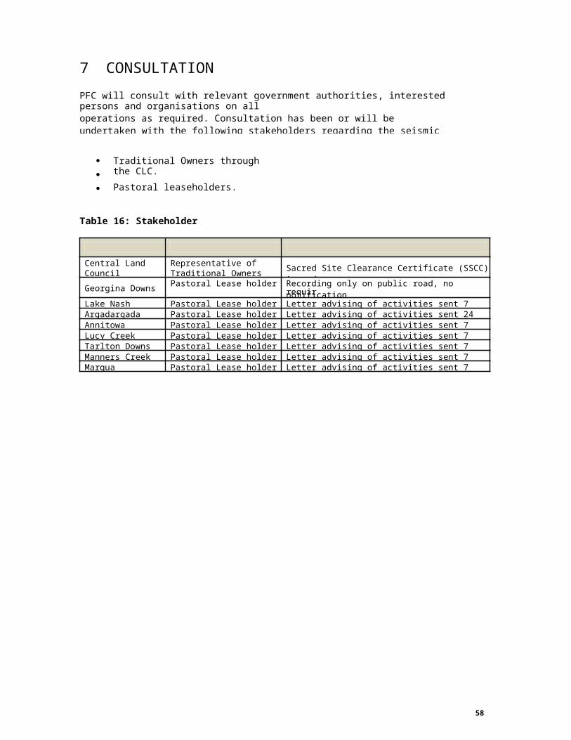
7. CPFC will consult with relevant government authorities, interested persons and organisations on alloperations as required. Consultation has been or will be undertaken with the following stakeholders regarding the seismic survey (see Table) and will continue during surveying activities:
Traditional Owners through the CLC.
Pastoral leaseholders.
Department of Mines and Energy
Table 16: Stakeholder consultation
required
58
Stakeholder Status PFC Consultation
Central LandCouncil
Representative ofTraditional Owners Sacred Site Clearance Certificate (SSCC) issued.
Georgina Downs Pastoral Lease holder Recording only on public road, no notification
Lake Nash Pastoral Lease holder Letter advising of activities sent 7 June 2013Argadargada Pastoral Lease holder Letter advising of activities sent 24 April 2013Annitowa Pastoral Lease holder Letter advising of activities sent 7 June 2013Lucy Creek Pastoral Lease holder Letter advising of activities sent 7 June 2013Tarlton Downs Pastoral Lease holder Letter advising of activities sent 7 June 2013Manners Creek Pastoral Lease holder Letter advising of activities sent 7 June 2013Marqua Pastoral Lease holder Letter advising of activities sent 7 June 2013

8. CONTACT DETAILS
Griff WesteOperations Geologist PetroFrontier (Australia) Pty Ltd Level 1, 262 Franklin Street Adelaide SA 5000
Telephone:Facsimile: Email:
08 8104 320208 8231 8532 [email protected]
Erik VikManager, Engineering & Operations PetroFrontier (Australia) Pty Ltd Level 1, 262 Franklin StreetAdelaide SA 5000
Telephone:Facsimile: Email:
08 8104 325208 8231 8532 [email protected]
59