Embed Size (px)
Citation preview
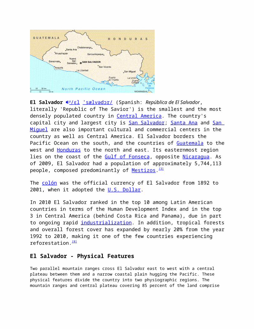
El Salvador i / ɛ l ̍ s æ l v ə d ɔ r / (Spanish: República de El Salvador, literally 'Republic of The Savior') is the smallest and the most densely populated country in Central America. The country's capital city and largest city is San Salvador; Santa Ana and San Miguel are also important cultural and commercial centers in the country as well as Central America. El Salvador borders the Pacific Ocean on the south, and the countries of Guatemala to the west and Honduras to the north and east. Its easternmost region lies on the coast of the Gulf of Fonseca, opposite Nicaragua. As of 2009, El Salvador had a population of approximately 5,744,113 people, composed predominantly of Mestizos.[3]
The colón was the official currency of El Salvador from 1892 to 2001, when it adopted the U.S. Dollar.
In 2010 El Salvador ranked in the top 10 among Latin American countries in terms of the Human Development Index and in the top 3 in Central America (behind Costa Rica and Panama), due in part to ongoing rapid industrialization. In addition, tropical forests and overall forest cover has expanded by nearly 20% from the year 1992 to 2010, making it one of the few countries experiencing reforestation.[8]
El Salvador - Physical Features
Two parallel mountain ranges cross El Salvador east to west with a central plateau between them and a narrow coastal plain hugging the Pacific. These physical features divide the country into two physiographic regions. The mountain ranges and central plateau covering 85 percent of the land comprise the interior highlands. The remaining coastal plains are referred to as the Pacific lowlands.
The northern range of mountains, the Sierra Madre, forms a continuous chain along the border with Honduras. Elevations in this region range from 1,600 to 2,200 meters. The area was once heavily forested, but overexploitation led to extensive erosion, and it has become semibarren. As a result, it is the country's most sparsely populated zone, with little farming or other development.
The southern range of mountains is actually a discontinuous chain of more than twenty volcanoes, clustered into five groups. The westernmost group, near the Guatemalan border, contains Izalco and Santa Ana, which at 2,365 meters is the highest point in El Salvador. Between the cones lie alluvial basins and rolling hills eroded from ash deposits. The volcanic soil is rich, and much of El Salvador's coffee is planted on these slopes.
The central plateau constitutes only 25 percent of the land area but contains the heaviest concentration of population and the country's largest cities. This plain is about 50 kilometers wide and has an average elevation of 600 meters. Terrain here is rolling, with occasional escarpments, lava fields, and geysers.
A narrow plain extends from the coastal volcanic range to the Pacific Ocean. This region has a width ranging from one to thirty-two kilometers with the widest section in the east, adjacent to the Golfo de Fonseca. Near La Libertad, however, the mountains pinch the lowlands out; the slopes of adjacent volcanoes come down directly to the sea. Surfaces in the Pacific lowlands are generally flat or gently rolling and result from alluvial deposits from nearby slopes.
El Salvador has over 300 rivers, the most important of which is the Rio Lempa. Originating in Guatemala, the Rio Lempa cuts across the northern range of mountains, flows along much of the central plateau, and finally cuts through the southern volcanic range to empty into the Pacific. It is El Salvador's only navigable river, and it and its tributaries drain about half the country. Other rivers are generally short and drain the Pacific lowlands or flow from the central plateau through gaps in the southern mountain range to the Pacific.
Numerous lakes of volcanic origin are found in the interior highlands; many of these lakes are surrounded by mountains and have high, steep banks. The largest lake, the Lago de Ilopango, lies just to the east of the capital. Other large lakes include the Lago de Coatepeque in the west and the Lago de Güija on the Guatemalan border. The Cerron Grande Dam on the Rio Lempa has created a large reservoir, the Embalse Cerron Grande, in northern El Salvador.
El Salvador - Climate
El Salvador has a tropical climate with pronounced wet and dry seasons. Temperatures vary primarily with elevation and show little seasonal change. The Pacific lowlands are uniformly hot; the central plateau and mountain areas are more moderate.
The rainy season, known locally as invierno, or winter, extends from May to October. Almost all the annual rainfall occurs during this time, and yearly totals, particularly on southern-facing mountain slopes, can be as high as 200 centimeters. Protected areas and the central plateau receive lesser, although still significant, amounts. Rainfall during this season generally comes from low pressure over the Pacific and usually falls in heavy afternoon thunderstorms. Although hurricanes occasionally form in the Pacific, they seldom affect El Salvador.
From November through April, the northeast trade winds control weather patterns. During these months, air flowing from the Caribbean has had most of the precipitation wrung out of it passing over the mountains in Honduras. By the time this air reaches El Salvador, it is dry, hot, and hazy. This season is known locally as verano, or summer.
Temperatures vary little with season; elevation is the primary determinant. The Pacific lowlands are the hottest region, with annual averages ranging from 25°C to 29°C. San Salvador is representative of the central plateau, with an annual average temperature of 23°C and absolute high and low readings of 38°C and 7°C, respectively. Mountain areas are the coolest, with annual averages from 12°C to 23°C and minimum temperatures sometimes approaching freezing
Introduction El Salvador
Background: El Salvador achieved independence from Spain in 1821 and from the Central American Federation in 1839. A 12-year civil war, which cost about 75,000 lives, was brought to a close in 1992 when
the government and leftist rebels signed a treaty that provided for military and political reforms.
Geography El Salvador
Location: Central America, bordering the North Pacific Ocean, between Guatemala and Honduras
Geographic coordinates:
13 50 N, 88 55 W
Map references:
Central America and the Caribbean
Area: total: 21,040 sq km land: 20,720 sq km water: 320 sq km
Area - comparative:
slightly smaller than Massachusetts
Land boundaries:
total: 545 km border countries: Guatemala 203 km, Honduras 342 km
Coastline: 307 km
Maritime claims:
territorial sea: 200 nm
Climate: tropical; rainy season (May to October); dry season (November to April); tropical on coast; temperate in uplands
Terrain: mostly mountains with narrow coastal belt and central plateau
Elevation extremes:
lowest point: Pacific Ocean 0 m highest point: Cerro El Pital 2,730 m
Natural resources:
hydropower, geothermal power, petroleum, arable land
Land use: arable land: 31.85% permanent crops: 12.07% other: 56.08% (2001)
Irrigated land: 360 sq km (1998 est.)
Natural hazards:
known as the Land of Volcanoes; frequent and sometimes very destructive earthquakes and volcanic activity; extremely susceptible to hurricanes
Environment - current issues:
deforestation; soil erosion; water pollution; contamination of soils from disposal of toxic wastes
Environment - international agreements:
party to: Biodiversity, Climate Change, Climate Change-Kyoto Protocol, Desertification, Endangered Species, Hazardous Wastes, Ozone Layer Protection, Wetlands signed, but not ratified: Law of the Sea
Geography - note:
smallest Central American country and only one without a coastline on Caribbean Sea
People El Salvador
Population: 6,704,932 (July 2005 est.)
Age structure: 0-14 years: 36.5% (male 1,250,901/female 1,198,589) 15-64 years: 58.3% (male 1,860,084/female 2,051,140) 65 years and over: 5.1% (male 153,133/female 191,085) (2005 est.)
Median age: total: 21.57 years male: 20.44 years female: 22.69 years (2005 est.)
Population growth rate:
1.75% (2005 est.)
Birth rate: 27.04 births/1,000 population (2005 est.)
Death rate: 5.85 deaths/1,000 population (2005 est.)
Net migration rate:
-3.67 migrant(s)/1,000 population (2005 est.)
Sex ratio: at birth: 1.05 male(s)/female under 15 years: 1.04 male(s)/female 15-64 years: 0.91 male(s)/female 65 years and over: 0.8 male(s)/female total population: 0.95 male(s)/female (2005 est.)
Infant mortality rate:
total: 25.1 deaths/1,000 live births male: 27.98 deaths/1,000 live births female: 22.08 deaths/1,000 live births (2005 est.)
Life expectancy at
birth:
total population: 71.22 years male: 67.61 years female: 75.01 years (2005 est.)
Total fertility rate:
3.16 children born/woman (2005 est.)
HIV/AIDS - adult
prevalence rate:
0.7% (2003 est.)
HIV/AIDS - people living
with HIV/AIDS:
29,000 (2003 est.)
HIV/AIDS - deaths:
2,200 (2003 est.)
Nationality: noun: Salvadoran(s) adjective: Salvadoran
Ethnic groups: mestizo 90%, white 9%, Amerindian 1%
Religions: Roman Catholic 83%, other 17% note: there is extensive activity by Protestant groups throughout the country; by the end of 1992, there were an estimated 1 million Protestant evangelicals in El Salvador
Languages: Spanish, Nahua (among some Amerindians)
Literacy: definition: age 10 and over can read and write total population: 80.2% male: 82.8% female: 77.7% (2003 est.)
Government El Salvador
Country name: conventional long form: Republic of El Salvador conventional short form: El Salvador local long form: Republica de El Salvador local short form: El Salvador
Government type:
republic
Capital: San Salvador
Administrative divisions:
14 departments (departamentos, singular - departamento); Ahuachapan, Cabanas, Chalatenango, Cuscatlan, La Libertad, La Paz, La Union, Morazan, San Miguel, San Salvador, Santa Ana, San Vicente, Sonsonate, Usulutan
Independence: 15 September 1821 (from Spain)
National holiday:
Independence Day, 15 September (1821)
Constitution: 23 December 1983
Legal system: based on civil and Roman law, with traces of common law; judicial review of legislative acts in the Supreme Court; accepts compulsory
ICJ jurisdiction, with reservations
Suffrage: 18 years of age; universal
Executive branch:
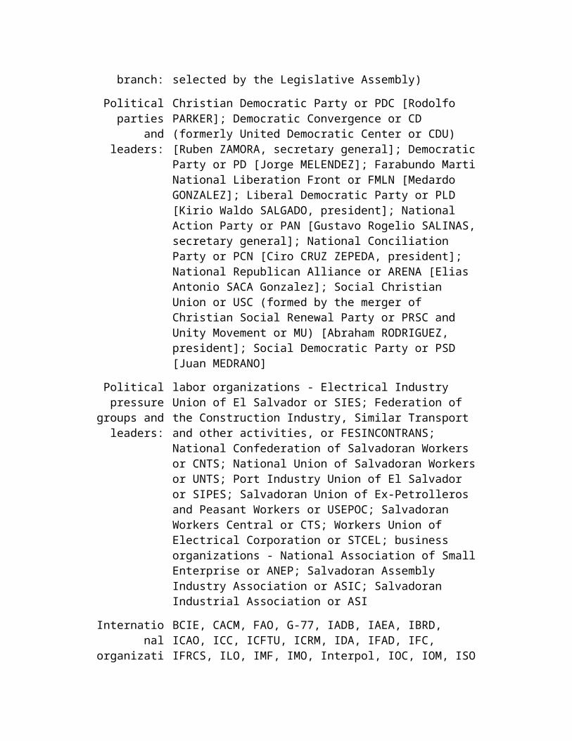
chief of state: President Elias Antonio SACA Gonzalez (since 1 June 2004); Vice President Ana Vilma DE ESCOBAR (since 1 June 2004); note - the president is both the chief of state and head of government head of government: President Elias Antonio SACA Gonzalez (since 1 June 2004); Vice President Ana Vilma DE ESCOBAR (since 1 June 2004); note - the president is both the chief of state and head of government cabinet: Council of Ministers selected by the president elections: president and vice president elected on the same ticket by popular vote for five-year terms; election last held 21 March 2004 (next to be held March 2009) election results: Elias Antonio SACA Gonzalez elected president; percent of vote - Elias Antonio SACA Gonzalez (ARENA) 57.7%, Schafik HANDAL (FMLN) 35.6%, Hector SILVA (CDU-PDC) 3.9%, other 2.8%
Legislative branch:
unicameral Legislative Assembly or Asamblea Legislativa (84 seats; members are elected by direct, popular vote to serve three-year terms) elections: last held 16 March 2003 (next to be held March 2006) election results: percent of vote by party - NA%; seats by party - FMLN 31, ARENA 28, PCN 15, PDC 5, CD 5
Judicial branch:
Supreme Court or Corte Suprema (judges are selected by the Legislative Assembly)
Political parties and leaders:
Christian Democratic Party or PDC [Rodolfo PARKER]; Democratic Convergence or CD (formerly United Democratic Center or CDU) [Ruben ZAMORA, secretary general]; Democratic Party or PD [Jorge MELENDEZ]; Farabundo Marti National Liberation Front or FMLN [Medardo GONZALEZ]; Liberal Democratic Party or PLD [Kirio Waldo SALGADO, president]; National Action Party or PAN [Gustavo Rogelio SALINAS, secretary general]; National Conciliation Party or PCN [Ciro CRUZ ZEPEDA, president]; National Republican Alliance or ARENA [Elias Antonio SACA Gonzalez]; Social Christian Union or USC (formed by the merger of Christian Social Renewal Party or PRSC and Unity Movement or MU) [Abraham RODRIGUEZ, president]; Social Democratic Party or PSD [Juan MEDRANO]
Political pressure
groups and
labor organizations - Electrical Industry Union of El Salvador or SIES; Federation of the Construction Industry, Similar Transport and other activities, or FESINCONTRANS; National Confederation
leaders: of Salvadoran Workers or CNTS; National Union of Salvadoran Workers or UNTS; Port Industry Union of El Salvador or SIPES; Salvadoran Union of Ex-Petrolleros and Peasant Workers or USEPOC; Salvadoran Workers Central or CTS; Workers Union of Electrical Corporation or STCEL; business organizations - National Association of Small Enterprise or ANEP; Salvadoran Assembly Industry Association or ASIC; Salvadoran Industrial Association or ASI
International organization
participation:
BCIE, CACM, FAO, G-77, IADB, IAEA, IBRD, ICAO, ICC, ICFTU, ICRM, IDA, IFAD, IFC, IFRCS, ILO, IMF, IMO, Interpol, IOC, IOM, ISO (correspondent), ITU, MIGA, MINURSO, OAS, OPANAL, OPCW, PCA, RG, UN, UNCTAD, UNESCO, UNIDO, UNMIL, UNOCI, UPU, WCL, WFTU, WHO, WIPO, WMO, WToO, WTO
Diplomatic representation
in the US:
chief of mission: Ambassador Rene Antonio LEON Rodriguez chancery: 2308 California Street NW, Washington, DC 20008 telephone: [1] (202) 265-9671 FAX: [1] (202) 234-3834 consulate(s) general: Chicago, Dallas, Houston, Las Vegas, Los Angeles, Miami, New York (2), San Francisco, and Washington, DC consulate(s): Boston
Diplomatic representation from the US:
chief of mission: Ambassador H. Douglas BARCLAY embassy: Final Boulevard Santa Elena Sur, Antiguo Cuscatlan, La Libertad, San Salvador mailing address: Unit 3116, APO AA 34023 telephone: [503] 278-4444 FAX: [503] 278-5522
Flag description:
three equal horizontal bands of blue (top), white, and blue with the national coat of arms centered in the white band; the coat of arms features a round emblem encircled by the words REPUBLICA DE EL SALVADOR EN LA AMERICA CENTRAL; similar to the flag of Nicaragua, which has a different coat of arms centered in the white band - it features a triangle encircled by the words REPUBLICA DE NICARAGUA on top and AMERICA CENTRAL on the bottom; also similar to the flag of Honduras, which has five blue stars arranged in an X pattern centered in the white band
Economy El Salvador
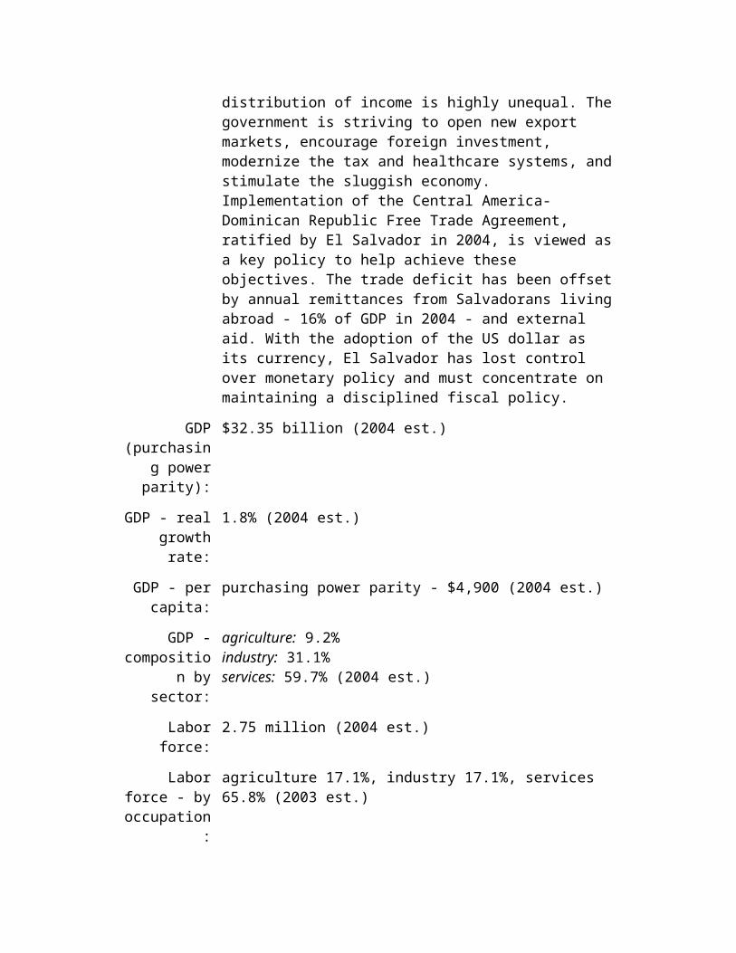
Economy - overview:
GDP per capita is roughly half that of Brazil, Argentina, and Chile, and the distribution of income is highly unequal. The government is striving to open new export markets, encourage foreign investment,
modernize the tax and healthcare systems, and stimulate the sluggish economy. Implementation of the Central America-Dominican Republic Free Trade Agreement, ratified by El Salvador in 2004, is viewed as a key policy to help achieve these objectives. The trade deficit has been offset by annual remittances from Salvadorans living abroad - 16% of GDP in 2004 - and external aid. With the adoption of the US dollar as its currency, El Salvador has lost control over monetary policy and must concentrate on maintaining a disciplined fiscal policy.
GDP (purchasing
power parity):
$32.35 billion (2004 est.)
GDP - real growth rate:
1.8% (2004 est.)
GDP - per capita:
purchasing power parity - $4,900 (2004 est.)
GDP - composition by
sector:
agriculture: 9.2% industry: 31.1% services: 59.7% (2004 est.)
Labor force: 2.75 million (2004 est.)
Labor force - by occupation:
agriculture 17.1%, industry 17.1%, services 65.8% (2003 est.)
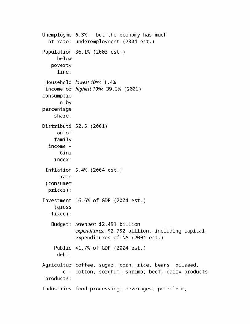
Unemployment rate:
6.3% - but the economy has much underemployment (2004 est.)
Population below poverty
line:
36.1% (2003 est.)
Household income or
consumption by percentage
share:
lowest 10%: 1.4% highest 10%: 39.3% (2001)
Distribution of family income
- Gini index:
52.5 (2001)
Inflation rate (consumer
prices):
5.4% (2004 est.)
Investment (gross fixed):
16.6% of GDP (2004 est.)
Budget: revenues: $2.491 billion expenditures: $2.782 billion, including capital expenditures of NA (2004 est.)
Public debt: 41.7% of GDP (2004 est.)
Agriculture - products:
coffee, sugar, corn, rice, beans, oilseed, cotton, sorghum; shrimp; beef, dairy products
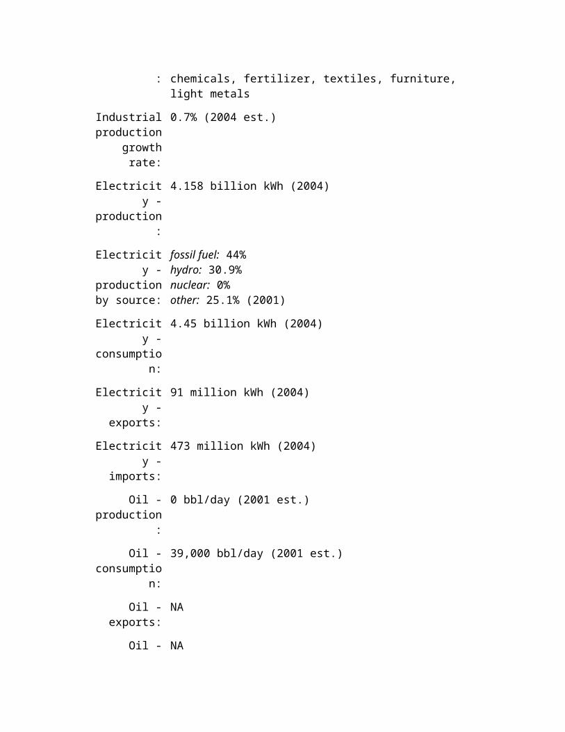
Industries: food processing, beverages, petroleum, chemicals, fertilizer, textiles, furniture, light metals
Industrial production
growth rate:
0.7% (2004 est.)
Electricity - production:
4.158 billion kWh (2004)
Electricity - production by
source:
fossil fuel: 44% hydro: 30.9% nuclear: 0% other: 25.1% (2001)
Electricity - consumption:
4.45 billion kWh (2004)
Electricity - exports:
91 million kWh (2004)
Electricity - imports:
473 million kWh (2004)
Oil - production:
0 bbl/day (2001 est.)
Oil - consumption:
39,000 bbl/day (2001 est.)
Oil - exports: NA
Oil - imports: NA
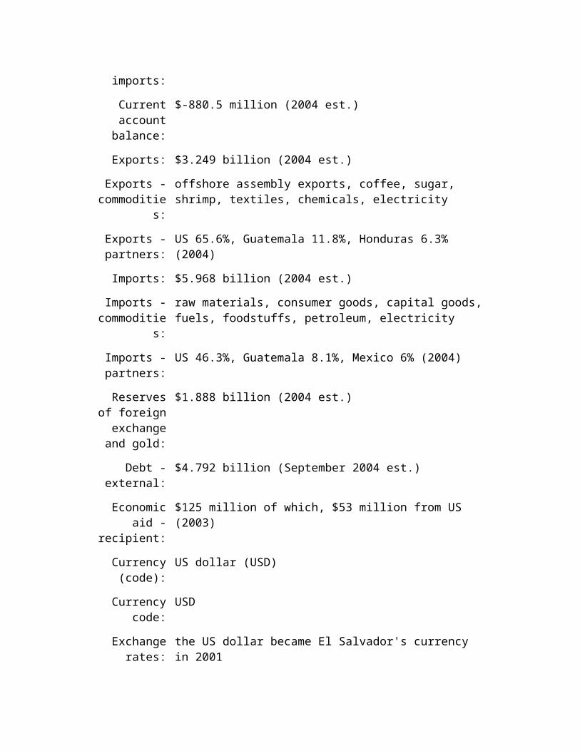
Current account balance:
$-880.5 million (2004 est.)
Exports: $3.249 billion (2004 est.)

Exports - commodities:
offshore assembly exports, coffee, sugar, shrimp, textiles, chemicals, electricity
Exports - partners:
US 65.6%, Guatemala 11.8%, Honduras 6.3% (2004)
Imports: $5.968 billion (2004 est.)
Imports - commodities:
raw materials, consumer goods, capital goods, fuels, foodstuffs, petroleum, electricity
Imports - partners:
US 46.3%, Guatemala 8.1%, Mexico 6% (2004)
Reserves of foreign
exchange and gold:
$1.888 billion (2004 est.)
Debt - external:
$4.792 billion (September 2004 est.)
Economic aid - recipient:
$125 million of which, $53 million from US (2003)
Currency (code):
US dollar (USD)
Currency code: USD
Exchange rates:
the US dollar became El Salvador's currency in 2001
Fiscal year: calendar year
Communications El Salvador
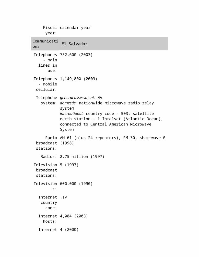
Telephones - main lines in
use:
752,600 (2003)
Telephones - mobile
cellular:
1,149,800 (2003)
Telephone system:
general assessment: NA domestic: nationwide microwave radio relay system international: country code - 503; satellite earth station - 1 Intelsat (Atlantic Ocean); connected to Central American Microwave System
Radio broadcast stations:
AM 61 (plus 24 repeaters), FM 30, shortwave 0 (1998)
Radios: 2.75 million (1997)
Television broadcast stations:
5 (1997)
Televisions: 600,000 (1990)
Internet country code:
.sv
Internet hosts: 4,084 (2003)
Internet Service
Providers (ISPs):
4 (2000)
Internet users: 550,000 (2003)
Transportation El Salvador
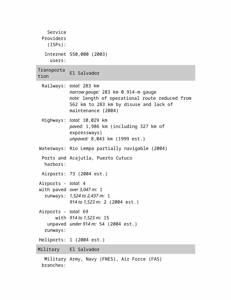
Railways: total: 283 km narrow gauge: 283 km 0.914-m gauge note: length of operational route reduced from 562 km to 283 km by disuse and lack of maintenance (2004)
Highways: total: 10,029 km paved: 1,986 km (including 327 km of expressways) unpaved: 8,043 km (1999 est.)
Waterways: Rio Lempa partially navigable (2004)
Ports and harbors:
Acajutla, Puerto Cutuco
Airports: 73 (2004 est.)
Airports - with paved
runways:
total: 4 over 3,047 m: 1 1,524 to 2,437 m: 1 914 to 1,523 m: 2 (2004 est.)
Airports - with unpaved
runways:
total: 69 914 to 1,523 m: 15 under 914 m: 54 (2004 est.)
Heliports: 1 (2004 est.)
Military El Salvador
Military branches:
Army, Navy (FNES), Air Force (FAS)
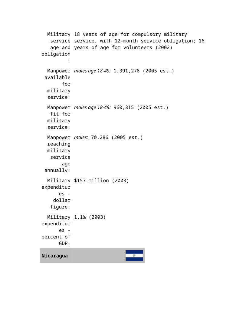
Military service age and
obligation:
18 years of age for compulsory military service, with 12-month service obligation; 16 years of age for volunteers (2002)
Manpower available for
military service:
males age 18-49: 1,391,278 (2005 est.)
Manpower fit for military
service:
males age 18-49: 960,315 (2005 est.)
Manpower reaching
military service age annually:
males: 70,286 (2005 est.)
Military expenditures - dollar figure:
$157 million (2003)
Military expenditures -
percent of GDP:
1.1% (2003)
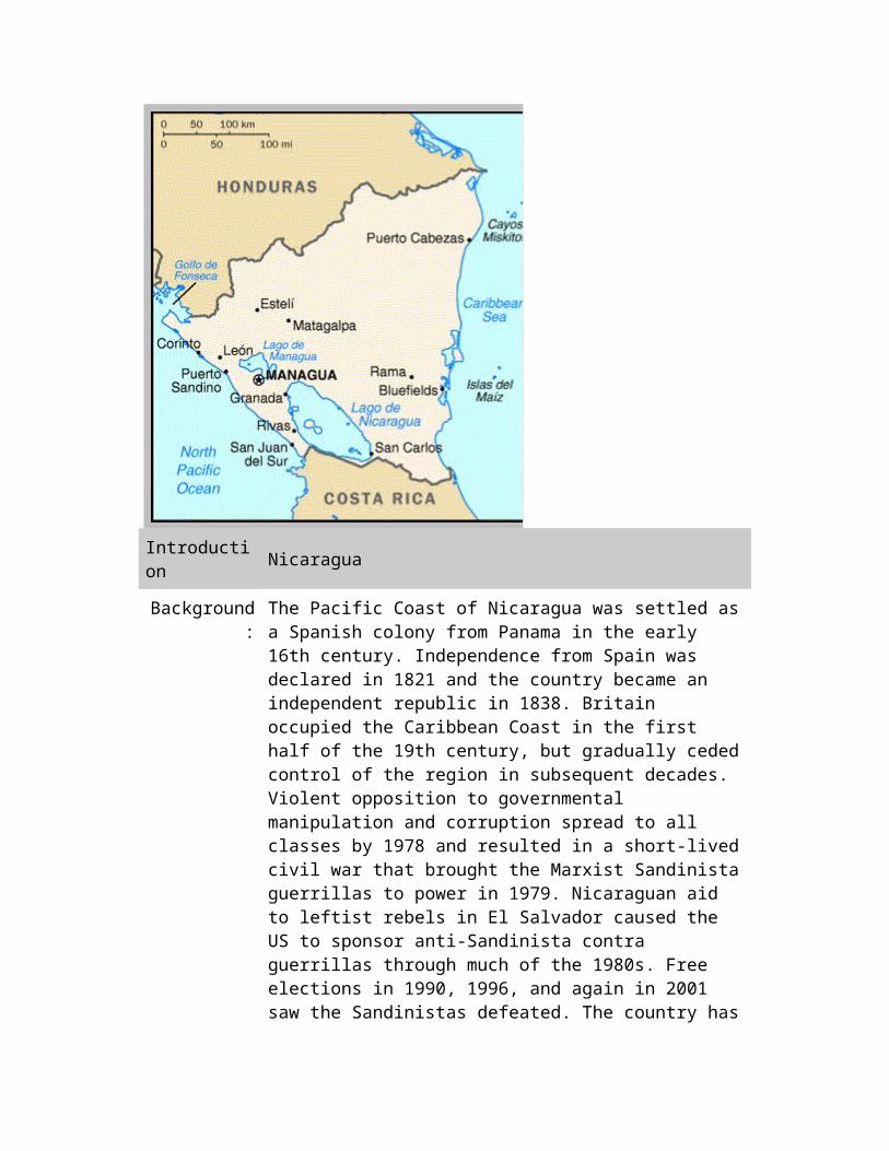
Nicaragua
Introduction Nicaragua
Background: The Pacific Coast of Nicaragua was settled as a Spanish colony from Panama in the early 16th century. Independence from Spain was declared in 1821 and the country became an independent republic in 1838. Britain occupied the Caribbean Coast in the first half of the 19th century, but gradually ceded control of the region in subsequent decades. Violent opposition to governmental manipulation and corruption spread to all classes by 1978 and resulted in a short-lived civil war that brought the Marxist Sandinista guerrillas to power in 1979. Nicaraguan aid to leftist rebels in El Salvador caused the US to sponsor anti-Sandinista contra guerrillas through much of the 1980s. Free elections in 1990, 1996, and again in 2001 saw the Sandinistas defeated. The country has slowly rebuilt its economy during the 1990s, but was hard hit by Hurricane Mitch in 1998.
Geography Nicaragua
Location: Central America, bordering both the Caribbean Sea and the North Pacific Ocean, between Costa Rica and Honduras
Geographic coordinates:
13 00 N, 85 00 W
Map Central America and the Caribbean
references:
Area: total: 129,494 sq km land: 120,254 sq km water: 9,240 sq km
Area - comparative:
slightly smaller than the state of New York
Land boundaries:
total: 1,231 km border countries: Costa Rica 309 km, Honduras 922 km
Coastline: 910 km
Maritime claims:
territorial sea: 200 nm continental shelf: natural prolongation
Climate: tropical in lowlands, cooler in highlands
Terrain: extensive Atlantic coastal plains rising to central interior mountains; narrow Pacific coastal plain interrupted by volcanoes
Elevation extremes:
lowest point: Pacific Ocean 0 m highest point: Mogoton 2,438 m
Natural resources:
gold, silver, copper, tungsten, lead, zinc, timber, fish
Land use: arable land: 15.94% permanent crops: 1.94% other: 82.12% (2001)
Irrigated land: 880 sq km (1998 est.)
Natural hazards:
destructive earthquakes, volcanoes, landslides; extremely susceptible to hurricanes
Environment - current issues:
deforestation; soil erosion; water pollution
Environment - international agreements:
party to: Biodiversity, Climate Change, Climate Change-Kyoto Protocol, Desertification, Endangered Species, Hazardous Wastes, Law of the Sea, Ozone Layer Protection, Ship Pollution, Wetlands signed, but not ratified: Environmental Modification
Geography - note:
largest country in Central America; contains the largest freshwater body in Central America, Lago de Nicaragua
People Nicaragua
Population: 5,465,100 (July 2005 est.)
Age structure: 0-14 years: 37.2% (male 1,036,487/female 999,226) 15-64 years: 59.7% (male 1,623,065/female 1,638,017) 65 years and over: 3.1% (male 73,935/female 94,370) (2005 est.)
Median age: total: 20.56 years male: 20.15 years female: 20.98 years (2005 est.)
Population growth rate:
1.92% (2005 est.)
Birth rate: 24.88 births/1,000 population (2005 est.)
Death rate: 4.49 deaths/1,000 population (2005 est.)
Net migration rate:
-1.19 migrant(s)/1,000 population (2005 est.)
Sex ratio: at birth: 1.05 male(s)/female under 15 years: 1.04 male(s)/female 15-64 years: 0.99 male(s)/female 65 years and over: 0.78 male(s)/female total population: 1 male(s)/female (2005 est.)
Infant mortality rate:
total: 29.11 deaths/1,000 live births male: 32.6 deaths/1,000 live births female: 25.44 deaths/1,000 live births (2005 est.)
Life expectancy at
birth:
total population: 70.33 years male: 68.27 years female: 72.49 years (2005 est.)
Total fertility rate:
2.81 children born/woman (2005 est.)
HIV/AIDS - adult
prevalence rate:
0.2% (2003 est.)
HIV/AIDS - people living
with HIV/AIDS:
6,400 (2003 est.)
HIV/AIDS - deaths:
less than 500 (2003 est.)
Nationality: noun: Nicaraguan(s) adjective: Nicaraguan
Ethnic groups: mestizo (mixed Amerindian and white) 69%, white 17%, black 9%, Amerindian 5%
Religions: Roman Catholic 72.9%, Evangelical 15.1%, Moravian 1.5%, Episcopal 0.1%, other 1.9%, none 8.5% (1995 census)
Languages: Spanish 97.5% (official), Miskito 1.7%, other 0.8% (1995 census) note: English and indigenous languages on Atlantic coast
Literacy: definition: age 15 and over can read and write total population: 67.5% male: 67.2% female: 67.8% (2003 est.)
Government Nicaragua
Country name: conventional long form: Republic of Nicaragua conventional short form: Nicaragua local long form: Republica de Nicaragua local short form: Nicaragua
Government type:
republic
Capital: Managua
Administrative divisions:
15 departments (departamentos, singular - departamento) and 2 autonomous regions* (regiones autonomistas, singular - region autonomista); Atlantico Norte*, Atlantico Sur*, Boaco, Carazo, Chinandega, Chontales, Esteli, Granada, Jinotega, Leon, Madriz, Managua, Masaya, Matagalpa, Nueva Segovia, Rio San Juan, Rivas
Independence: 15 September 1821 (from Spain)
National holiday:
Independence Day, 15 September (1821)
Constitution: 9 January 1987; reforms in 1995 and 2000
Legal system: civil law system; Supreme Court may review administrative acts
Suffrage: 16 years of age; universal
Executive branch:
chief of state: President Enrique BOLANOS Geyer (since 10 January 2002); Vice President Alfredo GOMEZ (since 10 October 2005); note - the president is both chief of state and head of government head of government: President Enrique BOLANOS Geyer (since 10 January 2002); Vice President Alfredo GOMEZ (since 10 October 2005); note - the president is both chief of state and head of government
cabinet: Council of Ministers appointed by the president elections: president and vice president elected on the same ticket by popular vote for a five-year term; election last held 4 November 2001 (next to be held by November 2006) election results: Enrique BOLANOS Geyer (PLC) elected president - 56.3%, Daniel ORTEGA Saavedra (FSLN) 42.3%, Alberto SABORIO (PCN) 1.4%; Jose RIZO Castellon elected vice president
Legislative branch:
unicameral National Assembly or Asamblea Nacional (92 seats; members are elected by proportional representation and party lists to serve five-year terms; one seat for previous President, one seat for runner-up in previous Presidential election elections: last held 4 November 2001 (next to be held by November 2006) election results: percent of vote by party - Liberal Alliance (ruling party - includes PCCN, PLC, PALI, PLIUN, and PUCA) 46.03%, FSLN 36.55%, PCN 2.12%; seats by party - Liberal Alliance 53, FSLN 38, PCN 1
Judicial branch:
Supreme Court or Corte Suprema (16 judges elected for five-year terms by the National Assembly)
Political parties and leaders:
Alliance for the Republic or APRE [Miguel LOPEZ Baldizon, Oscar WENDOLYN Vargas, Karla WHITE]; Central American Unionist Party or PUCA [leader NA]; Christian Alternative Party or AC [Orlando TARDENCILLA Espinoza]; Conservative Party of Nicaragua or PCN [Mario RAPPACCIOLI]; Independent Liberal Party or PLI [Anibal MARTINEZ Nunez, Pedro REYES Vallejos]; Independent Liberal Party for National Unity or PLIUN [leader NA]; Liberal Constitutional Party or PLC [Jorge CASTILLO Quant]; Liberal Salvation Movement or MSL [Eliseo NUNEZ Hernandez]; New Liberal Party or PALI [leader NA]; Nicaraguan Party of the Christian Path or PCCN [Guillermo OSORNO Molina]; Nicaraguan Resistance Party or PRN [Salvador TALAVERA]; Sandinista National Liberation Front or FSLN [Daniel ORTEGA Saavedra]; Sandinista Renovation Movement or MRS [leader NA]; Unity Alliance or AU [leader NA]
Political pressure
groups and leaders:
National Workers Front or FNT is a Sandinista umbrella group of eight labor unions including - Farm Workers Association or ATC, Health Workers Federation or FETASALUD, Heroes and Martyrs Confederation of Professional Associations or CONAPRO, National Association of Educators of Nicaragua or ANDEN, National Union of Employees or UNE, National Union of Farmers and Ranchers or UNAG, Sandinista Workers Central or CST, and Union of Journalists of Nicaragua or UPN; Permanent Congress of
Workers or CPT is an umbrella group of four non-Sandinista labor unions including - Autonomous Nicaraguan Workers Central or CTN-A, Confederation of Labor Unification or CUS, Independent General Confederation of Labor or CGT-I, and Labor Action and Unity Central or CAUS; Nicaraguan Workers' Central or CTN is an independent labor union; Superior Council of Private Enterprise or COSEP is a confederation of business groups
International organization
participation:
BCIE, CACM, FAO, G-77, IADB, IAEA, IBRD, ICAO, ICFTU, ICRM, IDA, IFAD, IFC, IFRCS, ILO, IMF, IMO, Interpol, IOC, IOM, ISO (correspondent), ITU, LAES, LAIA (observer), MIGA, NAM, OAS, OPANAL, OPCW, PCA, RG, UN, UNCTAD, UNESCO, UNHCR, UNIDO, UPU, WCL, WCO, WHO, WIPO, WMO, WToO, WTO
Diplomatic representation
in the US:
chief of mission: Ambassador Salvador STADTHAGEN (since 5 December 2003) chancery: 1627 New Hampshire Avenue NW, Washington, DC 20009 telephone: [1] (202) 939-6570, [1] (202) 939-6573 FAX: [1] (202) 939-6545 consulate(s) general: Houston, Los Angeles, Miami, New York, San Francisco
Diplomatic representation from the US:
chief of mission: Ambassador Barbara Calandra MOORE embassy: Kilometer 4.5 Carretera Sur, Managua mailing address: APO AA 34021 telephone: [505] 266-6010 FAX: [505] 266-9074
Flag description:
three equal horizontal bands of blue (top), white, and blue with the national coat of arms centered in the white band; the coat of arms features a triangle encircled by the words REPUBLICA DE NICARAGUA on the top and AMERICA CENTRAL on the bottom; similar to the flag of El Salvador, which features a round emblem encircled by the words REPUBLICA DE EL SALVADOR EN LA AMERICA CENTRAL centered in the white band; also similar to the flag of Honduras, which has five blue stars arranged in an X pattern centered in the white band
Economy Nicaragua
Economy - overview:
Nicaragua, one of the hemisphere's poorest countries, faces low per capita income, massive unemployment, and huge external debt. Distribution of income is one of the most unequal on the globe. While the country has made progress toward macroeconomic stability over the past few years, GDP annual growth has been far too low to meet the country's needs. As a result of successful

performance under its International Monetary Fund policy program and other efforts, Nicaragua qualified in early 2004 for some $4 billion in foreign debt reduction under the Heavily Indebted Poor Countries (HIPC) initiative. Even after this reduction, however, the government continues to bear a significant foreign and domestic debt burden. If ratified, the US-Central America Free Trade Agreement (CAFTA) will provide an opportunity for Nicaragua to attract investment, create jobs, and deepen economic development. While President BOLANOS enjoys the support of the international financial bodies, his internal political base is meager.
GDP (purchasing
power parity):
$12.34 billion (2004 est.)
GDP - real growth rate:
4% (2004 est.)
GDP - per capita:
purchasing power parity - $2,300 (2004 est.)
GDP - composition by
sector:
agriculture: 20.7% industry: 24.7% services: 54.6% (2004 est.)
Labor force: 1.93 million (2004 est.)
Labor force - by occupation:
agriculture 30.5%, industry 17.3%, services 52.2% (2003 est.)
Unemployment rate:
7.8% plus underemployment of 46.5% (2003 est.)
Population below poverty
line:
50% (2001 est.)
Household income or
consumption by percentage
share:
lowest 10%: 1.2% highest 10%: 45% (2001)
Distribution of family income
- Gini index:
55.1 (2001)
Inflation rate (consumer
prices):
9.3% (2004 est.)
Investment (gross fixed):
28% of GDP (2004 est.)
Budget: revenues: $725.5 million expenditures: $1.039 billion, including capital expenditures of NA (2004 est.)
Public debt: 69.5% of GDP (2004 est.)
Agriculture - products:
coffee, bananas, sugarcane, cotton, rice, corn, tobacco, sesame, soya, beans; beef, veal, pork, poultry, dairy products
Industries: food processing, chemicals, machinery and metal products, textiles, clothing, petroleum refining and distribution, beverages, footwear, wood
Industrial production
growth rate:
4.4% (2000 est.)
Electricity - production:
2.553 billion kWh (2002)
Electricity - production by
source:
fossil fuel: 83.9% hydro: 7.7% nuclear: 0% other: 8.4% (2001)
Electricity - consumption:
2.318 billion kWh (2002)
Electricity - exports:
6.8 million kWh (2002)
Electricity - imports:
15.3 million kWh (2002)
Oil - production:
0 bbl/day (2003 est.)
Oil - consumption:
25,770 bbl/day (2003 est.)
Oil - exports: 738 bbl/day (2003)
Oil - imports: 27,950 bbl/day (2003)
Current account balance:
$-843.1 million (2004 est.)

Exports: $750 million f.o.b. (2004 est.)
Exports - commodities:
coffee, beef, shrimp and lobster, tobacco, sugar, gold, peanuts
Exports - partners:
US 64.8%, El Salvador 7%, Mexico 3.6% (2004)
Imports: $2.02 billion f.o.b. (2004 est.)
Imports - commodities:
consumer goods, machinery and equipment, raw materials, petroleum products
Imports - partners:
US 22.6%, Costa Rica 8.5%, Venezuela 8.4%, Guatemala 6.8%, Mexico 5.8%, El Salvador 4.9%, South Korea 4.5% (2004)
Reserves of foreign
exchange and gold:
$670 million (2004 est.)
Debt - external:
$4.573 billion (2004 est.)
Economic aid - recipient:
$541.8 million (2003)
Currency (code):
gold cordoba (NIO)
Currency code: NIO
Exchange rates:
gold cordobas per US dollar - 15.937 (2004), 15.105 (2003), 14.251 (2002), 13.372 (2001), 12.684 (2000)
Fiscal year: calendar year
Communications Nicaragua
Telephones - main lines in
use:
171,600 (2002)
Telephones - mobile
cellular:
202,800 (2002)
Telephone system:
general assessment: inadequate system being upgraded by foreign investment domestic: low-capacity microwave radio relay and wire system
being expanded; connected to Central American Microwave System
international: country code - 505; satellite earth stations - 1 Intersputnik (Atlantic Ocean region) and 1 Intelsat (Atlantic Ocean)
Radio broadcast stations:
AM 63, FM 32, shortwave 1 (1998)
Radios: 1.24 million (1997)
Television broadcast stations:
3 (plus seven low-power repeaters) (1997)
Televisions: 320,000 (1997)
Internet country code:
.ni
Internet hosts: 7,094 (2003)
Internet Service
Providers (ISPs):
3 (2000)
Internet users: 90,000 (2002)
Transportation Nicaragua
Railways: total: 6 km narrow gauge: 6 km 1.067-m gauge (2004)
Highways: total: 18,712 km paved: 2,126 km unpaved: 16,586 km (2002)
Waterways: 2,220 km (including lakes Managua and Nicaragua) (1997)
Pipelines: oil 54 km (2004)
Ports and harbors:
Bluefields, Corinto, El Bluff
Airports: 176 (2004 est.)
Airports - with paved
runways:
total: 11 2,438 to 3,047 m: 3 1,524 to 2,437 m: 2 914 to 1,523 m: 3

under 914 m: 3 (2004 est.)
Airports - with unpaved
runways:
total: 165 1,524 to 2,437 m: 1 914 to 1,523 m: 23 under 914 m: 141 (2004 est.)
Military Nicaragua
Military branches:
Army (includes Navy, Air Force)
Military service age and
obligation:
17 years of age for voluntary military service (2001)
Manpower available for
military service:
males age 17-49: 1,309,970 (2005 est.)
Manpower fit for military
service:
males age 17-49: 1,051,425 (2005 est.)
Manpower reaching
military service age annually:
males: 65,170 (2005 est.)
Military expenditures - dollar figure:
$32.8 million (2004)
Military expenditures -
percent of GDP:
0.7% (2004)
Costa Rica
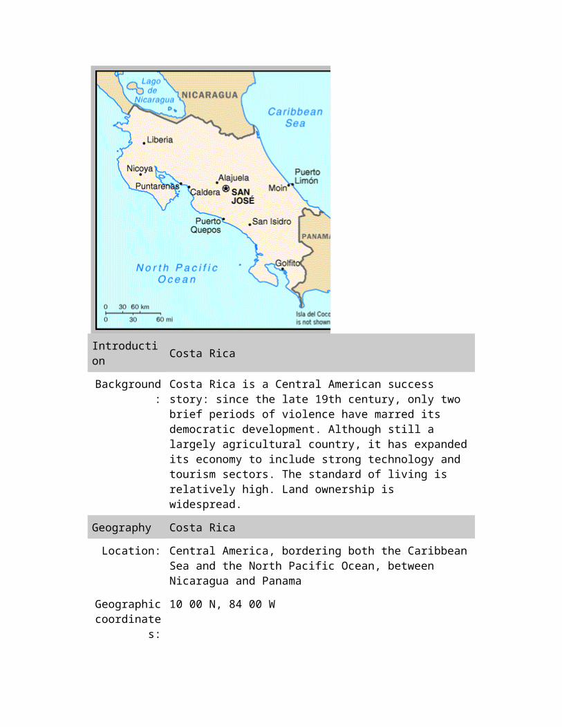
Introduction Costa Rica
Background: Costa Rica is a Central American success story: since the late 19th century, only two brief periods of violence have marred its democratic development. Although still a largely agricultural country, it has expanded its economy to include strong technology and tourism sectors. The standard of living is relatively high. Land ownership is widespread.
Geography Costa Rica
Location: Central America, bordering both the Caribbean Sea and the North Pacific Ocean, between Nicaragua and Panama
Geographic coordinates:
10 00 N, 84 00 W
Map references:
Central America and the Caribbean
Area: total: 51,100 sq km land: 50,660 sq km water: 440 sq km note: includes Isla del Coco
Area - comparative:
slightly smaller than West Virginia
Land boundaries:
total: 639 km border countries: Nicaragua 309 km, Panama 330 km
Coastline: 1,290 km
Maritime claims:
territorial sea: 12 nm exclusive economic zone: 200 nm continental shelf: 200 nm
Climate: tropical and subtropical; dry season (December to April); rainy season (May to November); cooler in highlands
Terrain: coastal plains separated by rugged mountains including over 100 volcanic cones, of which several are major volcanoes
Elevation extremes:
lowest point: Pacific Ocean 0 m highest point: Cerro Chirripo 3,810 m
Natural resources:
hydropower
Land use: arable land: 4.41% permanent crops: 5.88% other: 89.71% (2001)
Irrigated land: 1,260 sq km (1998 est.)
Natural hazards:
occasional earthquakes, hurricanes along Atlantic coast; frequent flooding of lowlands at onset of rainy season and landslides; active volcanoes
Environment - current issues:
deforestation and land use change, largely a result of the clearing of land for cattle ranching and agriculture; soil erosion; coastal marine pollution; fisheries protection; solid waste management; air pollution
Environment - international agreements:
party to: Biodiversity, Climate Change, Climate Change-Kyoto Protocol, Desertification, Endangered Species, Environmental Modification, Hazardous Wastes, Law of the Sea, Marine Dumping, Ozone Layer Protection, Wetlands, Whaling signed, but not ratified: Marine Life Conservation
Geography - note:
four volcanoes, two of them active, rise near the capital of San Jose in the center of the country; one of the volcanoes, Irazu, erupted destructively in 1963-65
People Costa Rica
Population: 4,016,173 (July 2005 est.)
Age structure: 0-14 years: 28.9% (male 593,540/female 566,361)
15-64 years: 65.5% (male 1,330,481/female 1,300,664) 65 years and over: 5.6% (male 104,564/female 120,563) (2005 est.)
Median age: total: 26.03 years male: 25.59 years female: 26.5 years (2005 est.)
Population growth rate:
1.48% (2005 est.)
Birth rate: 18.6 births/1,000 population (2005 est.)
Death rate: 4.33 deaths/1,000 population (2005 est.)
Net migration rate:
0.5 migrant(s)/1,000 population (2005 est.)
Sex ratio: at birth: 1.05 male(s)/female under 15 years: 1.05 male(s)/female 15-64 years: 1.02 male(s)/female 65 years and over: 0.87 male(s)/female total population: 1.02 male(s)/female (2005 est.)
Infant mortality rate:
total: 9.95 deaths/1,000 live births male: 10.85 deaths/1,000 live births female: 9 deaths/1,000 live births (2005 est.)
Life expectancy at
birth:
total population: 76.84 years male: 74.26 years female: 79.55 years (2005 est.)
Total fertility rate:
2.28 children born/woman (2005 est.)
HIV/AIDS - adult
prevalence rate:
0.6% (2003 est.)
HIV/AIDS - people living
with HIV/AIDS:
12,000 (2003 est.)
HIV/AIDS - deaths:
900 (2003 est.)
Nationality: noun: Costa Rican(s) adjective: Costa Rican
Ethnic groups: white (including mestizo) 94%, black 3%, Amerindian 1%, Chinese

1%, other 1%
Religions: Roman Catholic 76.3%, Evangelical 13.7%, Jehovah's Witnesses 1.3%, other Protestant 0.7%, other 4.8%, none 3.2%
Languages: Spanish (official), English
Literacy: definition: age 15 and over can read and write total population: 96% male: 95.9% female: 96.1% (2003 est.)
Government Costa Rica
Country name: conventional long form: Republic of Costa Rica conventional short form: Costa Rica local long form: Republica de Costa Rica local short form: Costa Rica
Government type:
democratic republic
Capital: San Jose
Administrative divisions:
7 provinces (provincias, singular - provincia); Alajuela, Cartago, Guanacaste, Heredia, Limon, Puntarenas, San Jose
Independence: 15 September 1821 (from Spain)
National holiday:
Independence Day, 15 September (1821)
Constitution: 7 November 1949
Legal system: based on Spanish civil law system; judicial review of legislative acts in the Supreme Court; has accepted compulsory ICJ jurisdiction
Suffrage: 18 years of age; universal and compulsory
Executive branch:
chief of state: President Abel PACHECO (since 8 May 2002); First Vice President Lineth SABORIO (since 8 May 2002); Second Vice President (vacant); note - the president is both the chief of state and head of government head of government: President Abel PACHECO (since 8 May 2002); First Vice President Lineth SABORIO (since 8 May 2002); Second Vice President (vacant); note - the president is both the chief of state and head of government cabinet: Cabinet selected by the president elections: president and vice presidents elected on the same ticket by popular vote for four-year terms; election last held 3 February

2002; run-off election held 7 April 2002 (next to be held February 2006) election results: Abel PACHECO elected president; percent of vote - Abel PACHECO (PUSC) 58%; Rolando ARAYA (PLN) 42%
Legislative branch:
unicameral Legislative Assembly or Asamblea Legislativa (57 seats; members are elected by direct, popular vote to serve four-year terms) elections: last held 3 February 2002 (next to be held 3 February 2006) election results: percent of vote by party - NA%; seats by party - PUSC 19, PLN 17, PAC 14, PML 6, PRC 1; note - seats by party as of January 2005 - PUSC 19, PLN 16, PAC 8, PML 5, PRC 1, Patriotic Union 3, Homeland First 1, Authentic Member from Heredia 1, Democratic National Alliance 1, independent 2
Judicial branch:
Supreme Court or Corte Suprema (22 justices are elected for eight-year terms by the Legislative Assembly)
Political parties and leaders:
Authentic Member from Heredia [Jose SALAS]; Citizen Action Party or PAC [Otton SOLIS]; Costa Rican Renovation Party or PRC [Justo OROZCO]; Democratic Force Party or PFD [Juan Carlos CHAVES Mora]; Democratic National Alliance [Emilia RODRIGUEZ]; General Union Party or PUGEN [Carlos Alberto FERNANDEZ Vega]; Homeland First [Juan Jose VARGAS]; Independent Worker Party or PIO [Jose Alberto CUBERO Carmona]; Libertarian Movement Party or PML [Otto GUEVARA Guth]; National Christian Alliance Party or ANC [Victor GONZALEZ]; National Integration Party or PIN [Walter MUNOZ Cespedes]; National Liberation Party or PLN [Francisco Antonio PACHECO]; National Patriotic Party or PPN [Daniel Enrique REYNOLDS Vargas]; National Rescue Party or PRN [Carlos VARGAS Solano]; Patriotic Union [Humberto ARCE]; Popular Vanguard [Trino BARRANTES Araya]; Social Christian Unity Party or PUSC [Lorena VASQUEZ Badilla]
Political pressure
groups and leaders:
Authentic Confederation of Democratic Workers or CATD (Communist Party affiliate); Chamber of Coffee Growers; Confederated Union of Workers or CUT (Communist Party affiliate); Costa Rican Confederation of Democratic Workers or CCTD (Liberation Party affiliate); Federation of Public Service Workers or FTSP; National Association for Economic Development or ANFE; National Association of Educators or ANDE; Rerum Novarum or CTRN (PLN affiliate) [Gilbert Brown]
International organization
participation:
BCIE, CACM, FAO, G-77, IADB, IAEA, IBRD, ICAO, ICC, ICCt, ICFTU, ICRM, IDA, IFAD, IFC, IFRCS, ILO, IMF, IMO, Interpol, IOC, IOM, ISO, ITU, LAES, LAIA (observer), MIGA, NAM

(observer), OAS, OPANAL, OPCW, PCA, RG, UN, UNCTAD, UNESCO, UNIDO, UPU, WCL, WCO, WFTU, WHO, WIPO, WMO, WToO, WTO
Diplomatic representation
in the US:
chief of mission: Ambassador Tomas DUENAS chancery: 2114 S Street NW, Washington, DC 20008 telephone: [1] (202) 234-2945 FAX: [1] (202) 265-4795 consulate(s) general: Atlanta, Chicago, Houston, Los Angeles, Miami, New Orleans, New York, San Francisco, San Juan (Puerto Rico), and Tampa consulate(s): Austin
Diplomatic representation from the US:
chief of mission: Ambassador (vacant); Charge d'Affaires Douglas M. BARNES embassy: Calle 120 Avenida O, Pavas, San Jose mailing address: APO AA 34020 telephone: [506] 220-3939 FAX: [506] 519-2305
Flag description:
five horizontal bands of blue (top), white, red (double width), white, and blue, with the coat of arms in a white elliptical disk on the hoist side of the red band; above the coat of arms a light blue ribbon contains the words, AMERICA CENTRAL, and just below it near the top of the coat of arms is a white ribbon with the words, REPUBLICA COSTA RICA
Economy Costa Rica
Economy - overview:
Costa Rica's basically stable economy depends on tourism, agriculture, and electronics exports. Poverty has been substantially reduced over the past 15 years, and a strong social safety net has been put into place. Foreign investors remain attracted by the country's political stability and high education levels, and tourism continues to bring in foreign exchange. Low prices for coffee and bananas have hurt the agricultural sector. The government continues to grapple with its large deficit and massive internal debt. The reduction of inflation remains a difficult problem because of rises in the price of imports, labor market rigidities, and fiscal deficits. The country also needs to reform its tax system and its pattern of public expenditure. Costa Rica recently concluded negotiations to participate in the US-Central American Free Trade Agreement, which, if ratified by the Costa Rican Legislature, would result in economic reforms and an improved investment climate.
GDP (purchasing
power parity):
$37.97 billion (2004 est.)
GDP - real growth rate:
3.9% (2004 est.)
GDP - per capita:
purchasing power parity - $9,600 (2004 est.)
GDP - composition by
sector:
agriculture: 8.5% industry: 29.7% services: 61.8% (2004 est.)
Labor force: 1.81 million (2004 est.)
Labor force - by occupation:
agriculture 20%, industry 22%, services 58% (1999 est.)
Unemployment rate:
6.6% (2004 est.)
Population below poverty
line:
18% (2004 est.)
Household income or
consumption by percentage
share:
lowest 10%: 1.1% highest 10%: 36.8% (2002)
Distribution of family income
- Gini index:
45.9 (1997)
Inflation rate (consumer
prices):
11.5% (2004 est.)
Investment (gross fixed):
19.2% of GDP (2004 est.)
Budget: revenues: $2.497 billion expenditures: $3.094 billion, including capital expenditures of NA (2004 est.)
Public debt: 58% of GDP (2004 est.)
Agriculture - products:
coffee, pineapples, bananas, sugar, corn, rice, beans, potatoes; beef; timber
Industries: microprocessors, food processing, textiles and clothing, construction materials, fertilizer, plastic products
Industrial production
growth rate:
3.1% (2004 est.)
Electricity - production:
6.614 billion kWh (2002)
Electricity - production by
source:
fossil fuel: 1.5% hydro: 81.9% nuclear: 0% other: 16.6% (2001)
Electricity - consumption:
5.733 billion kWh (2002)
Electricity - exports:
477 million kWh (2002)
Electricity - imports:
59 million kWh (2002)
Oil - production:
0 bbl/day (2001 est.)
Oil - consumption:
37,000 bbl/day (2001 est.)
Oil - exports: NA
Oil - imports: NA
Current account balance:
$-980.3 million (2004 est.)
Exports: $6.184 billion (2004 est.)
Exports - commodities:
coffee, bananas, sugar; pineapples; textiles, electronic components, medical equipment
Exports - partners:
US 46.9%, Netherlands 5.3%, Guatemala 4.4% (2004)
Imports: $7.842 billion (2004 est.)
Imports - commodities:
raw materials, consumer goods, capital equipment, petroleum
Imports - partners:
US 46.1%, Japan 5.9%, Mexico 5.1%, Brazil 4.2% (2004)
Reserves of $1.736 billion (2004 est.)
foreign exchange and
gold:
Debt - external:
$5.962 billion (2004 est.)
Currency (code):
Costa Rican colon (CRC)
Currency code: CRC
Exchange rates:
Costa Rican colones per US dollar - 437.91 (2004), 398.66 (2003), 359.82 (2002), 328.87 (2001), 308.19 (2000)
Fiscal year: calendar year
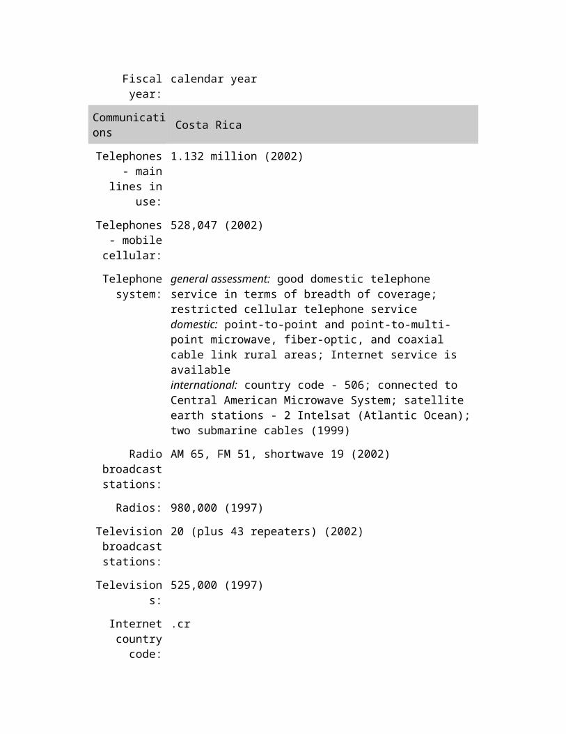
Communications Costa Rica
Telephones - main lines in
use:
1.132 million (2002)
Telephones - mobile
cellular:
528,047 (2002)
Telephone system:
general assessment: good domestic telephone service in terms of breadth of coverage; restricted cellular telephone service domestic: point-to-point and point-to-multi-point microwave, fiber-optic, and coaxial cable link rural areas; Internet service is available
international: country code - 506; connected to Central American Microwave System; satellite earth stations - 2 Intelsat (Atlantic Ocean); two submarine cables (1999)
Radio broadcast stations:
AM 65, FM 51, shortwave 19 (2002)
Radios: 980,000 (1997)
Television broadcast stations:
20 (plus 43 repeaters) (2002)
Televisions: 525,000 (1997)
Internet country code:
.cr
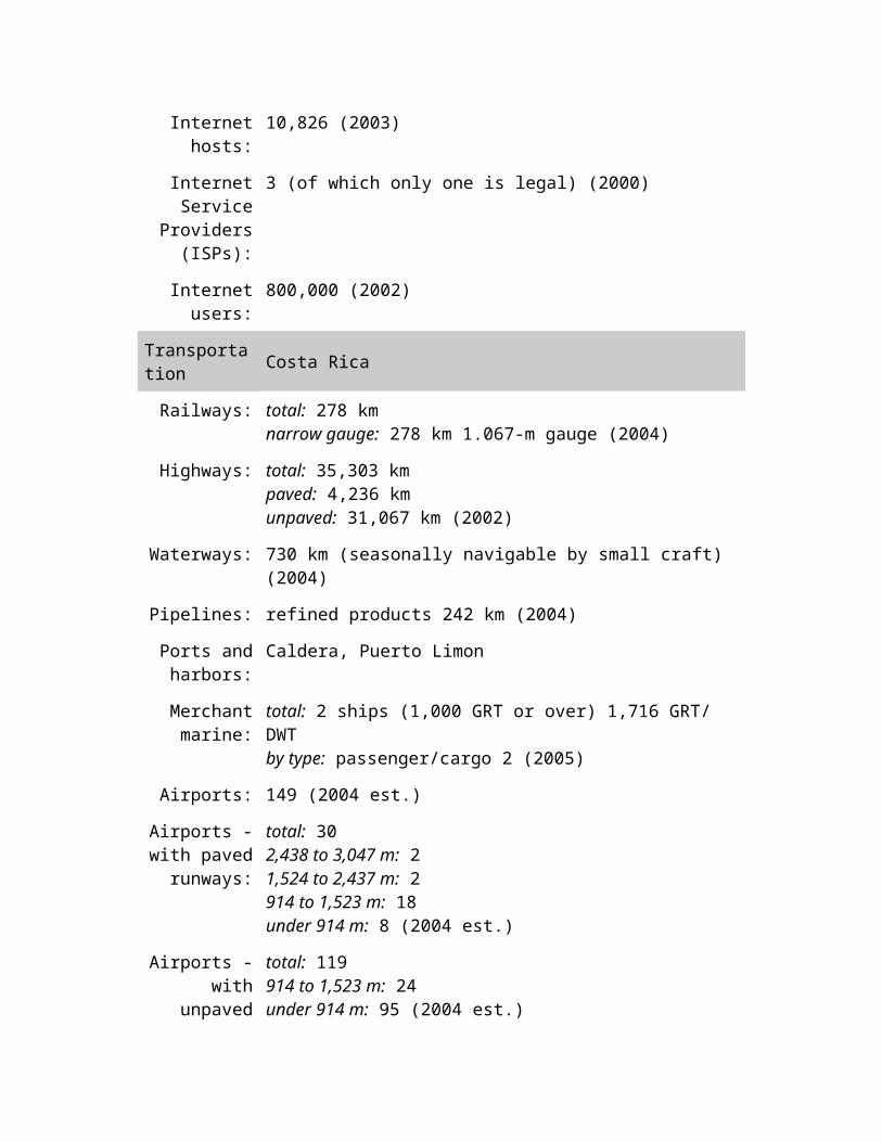
Internet hosts: 10,826 (2003)
Internet Service
Providers (ISPs):
3 (of which only one is legal) (2000)
Internet users: 800,000 (2002)
Transportation Costa Rica
Railways: total: 278 km narrow gauge: 278 km 1.067-m gauge (2004)
Highways: total: 35,303 km paved: 4,236 km unpaved: 31,067 km (2002)
Waterways: 730 km (seasonally navigable by small craft) (2004)
Pipelines: refined products 242 km (2004)
Ports and harbors:
Caldera, Puerto Limon
Merchant marine:
total: 2 ships (1,000 GRT or over) 1,716 GRT/ DWT by type: passenger/cargo 2 (2005)
Airports: 149 (2004 est.)
Airports - with paved
runways:
total: 30 2,438 to 3,047 m: 2 1,524 to 2,437 m: 2 914 to 1,523 m: 18 under 914 m: 8 (2004 est.)
Airports - with unpaved
runways:
total: 119 914 to 1,523 m: 24 under 914 m: 95 (2004 est.)
Military Costa Rica
Military branches:
no regular military forces; Ministry of Public Security, Government, and Police
Military service age and
obligation:
18 years of age (2004)
Manpower available for
males age 18-49: 997,690 (2005 est.)
military service:
Manpower fit for military
service:
males age 18-49: 829,874 (2005 est.)
Manpower reaching military
service age annually:
males: 41,097 (2005 est.)
Military expenditures - dollar figure:
$64.2 million (2004)
Military expenditures -
percent of GDP:
0.4% (2003)
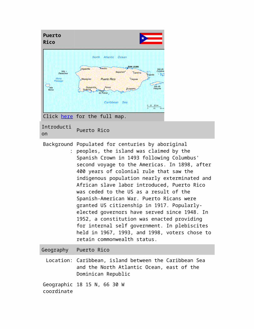
Puerto Rico
Click here for the full map.
Introduction Puerto Rico
Background: Populated for centuries by aboriginal peoples, the island was claimed by the Spanish Crown in 1493 following Columbus' second voyage to the Americas. In 1898, after 400 years of colonial rule that saw the indigenous population nearly exterminated and African slave labor introduced, Puerto Rico was ceded to the US as a result of the Spanish-American War. Puerto Ricans were granted US citizenship in 1917. Popularly-elected governors have served since 1948. In 1952, a constitution was enacted providing for internal self government. In plebiscites held in 1967, 1993, and 1998, voters
chose to retain commonwealth status.
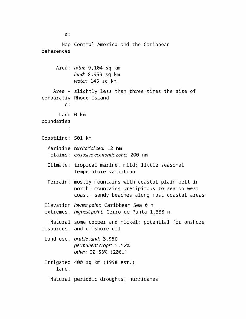
Geography Puerto Rico
Location: Caribbean, island between the Caribbean Sea and the North Atlantic Ocean, east of the Dominican Republic
Geographic coordinates:
18 15 N, 66 30 W
Map references:
Central America and the Caribbean
Area: total: 9,104 sq km land: 8,959 sq km water: 145 sq km
Area - comparative:
slightly less than three times the size of Rhode Island
Land boundaries:
0 km
Coastline: 501 km
Maritime claims:
territorial sea: 12 nm exclusive economic zone: 200 nm
Climate: tropical marine, mild; little seasonal temperature variation
Terrain: mostly mountains with coastal plain belt in north; mountains precipitous to sea on west coast; sandy beaches along most coastal areas
Elevation extremes:
lowest point: Caribbean Sea 0 m highest point: Cerro de Punta 1,338 m
Natural resources:
some copper and nickel; potential for onshore and offshore oil
Land use: arable land: 3.95% permanent crops: 5.52% other: 90.53% (2001)
Irrigated land: 400 sq km (1998 est.)
Natural hazards:
periodic droughts; hurricanes
Environment - current issues:
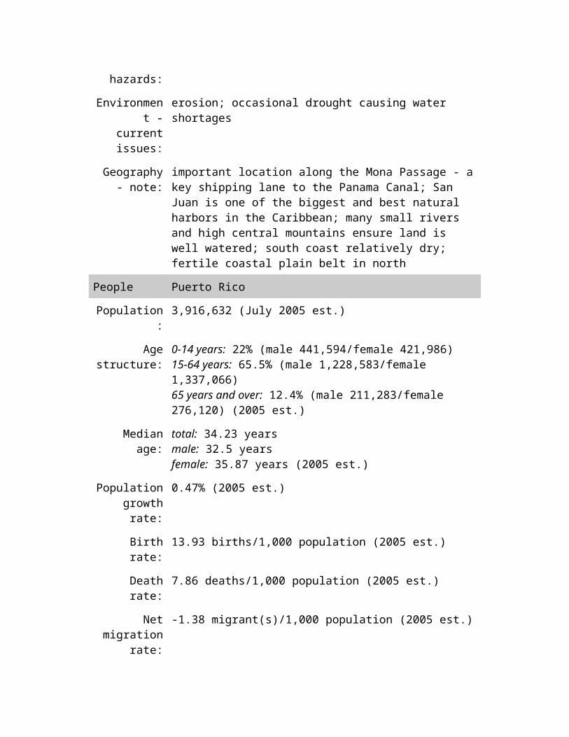
erosion; occasional drought causing water shortages
Geography - note:
important location along the Mona Passage - a key shipping lane to the Panama Canal; San Juan is one of the biggest and best natural harbors in the Caribbean; many small rivers and high central mountains ensure land is well watered; south coast relatively dry; fertile coastal plain belt in north
People Puerto Rico
Population: 3,916,632 (July 2005 est.)
Age structure: 0-14 years: 22% (male 441,594/female 421,986) 15-64 years: 65.5% (male 1,228,583/female 1,337,066) 65 years and over: 12.4% (male 211,283/female 276,120) (2005 est.)
Median age: total: 34.23 years male: 32.5 years female: 35.87 years (2005 est.)
Population growth rate:
0.47% (2005 est.)
Birth rate: 13.93 births/1,000 population (2005 est.)
Death rate: 7.86 deaths/1,000 population (2005 est.)
Net migration rate:
-1.38 migrant(s)/1,000 population (2005 est.)
Sex ratio: at birth: 1.05 male(s)/female under 15 years: 1.05 male(s)/female 15-64 years: 0.92 male(s)/female 65 years and over: 0.76 male(s)/female total population: 0.92 male(s)/female (2005 est.)
Infant mortality rate:
total: 8.24 deaths/1,000 live births male: 9.52 deaths/1,000 live births female: 6.9 deaths/1,000 live births (2005 est.)
Life expectancy at
birth:
total population: 78.29 years male: 74.35 years female: 82.43 years (2005 est.)
Total fertility rate:
1.91 children born/woman (2005 est.)
HIV/AIDS - adult
prevalence rate:
NA

HIV/AIDS - people living
with HIV/AIDS:
7,397 (1997)
HIV/AIDS - deaths:
NA
Nationality: noun: Puerto Rican(s) (US citizens) adjective: Puerto Rican
Ethnic groups: white (mostly Spanish origin) 80.5%, black 8%, Amerindian 0.4%, Asian 0.2%, mixed and other 10.9%
Religions: Roman Catholic 85%, Protestant and other 15%
Languages: Spanish, English
Literacy: definition: age 15 and over can read and write total population: 94.1% male: 93.9% female: 94.4% (2002 est.)
Government Puerto Rico
Country name: conventional long form: Commonwealth of Puerto Rico conventional short form: Puerto Rico
Dependency status:
commonwealth associated with the US
Government type:
commonwealth
Capital: San Juan
Administrative divisions:
none (commonwealth associated with the US); there are no first-order administrative divisions as defined by the US Government, but there are 78 municipalities (municipios, singular - municipio) at the second order; Adjuntas, Aguada, Aguadilla, Aguas Buenas, Aibonito, Anasco, Arecibo, Arroyo, Barceloneta, Barranquitas, Bayamon, Cabo Rojo, Caguas, Camuy, Canovanas, Carolina, Catano, Cayey, Ceiba, Ciales, Cidra, Coamo, Comerio, Corozal, Culebra, Dorado, Fajardo, Florida, Guanica, Guayama, Guayanilla, Guaynabo, Gurabo, Hatillo, Hormigueros, Humacao, Isabela, Jayuya, Juana Diaz, Juncos, Lajas, Lares, Las Marias, Las Piedras, Loiza, Luquillo, Manati, Maricao, Maunabo, Mayaguez, Moca, Morovis, Naguabo, Naranjito, Orocovis, Patillas, Penuelas, Ponce, Quebradillas, Rincon, Rio Grande, Sabana Grande, Salinas, San German, San Juan, San Lorenzo, San Sebastian, Santa Isabel, Toa
Alta, Toa Baja, Trujillo Alto, Utuado, Vega Alta, Vega Baja, Vieques, Villalba, Yabucoa, Yauco
Independence: none (commonwealth associated with the US)
National holiday:
US Independence Day, 4 July (1776); Puerto Rico Constitution Day, 25 July (1952)
Constitution: ratified 3 March 1952, approved by US Congress 3 July 1952, effective 25 July 1952
Legal system: based on Spanish civil code and within the US Federal system of justice
Suffrage: 18 years of age; universal; island residents are US citizens but do not vote in US presidential elections
Executive branch:
chief of state: President George W. BUSH of the US (since 20 January 2001) head of government: Governor Anibal ACEVEDO-VILA (since 2 January 2005) cabinet: Cabinet appointed by the governor with the consent of the legislature elections: US president and vice president elected on the same ticket for four-year terms; governor elected by popular vote for a four-year term; election last held 2 November 2004 (next to be held November 2008) election results: Anibal ACEVEDO-VILA (PPD) elected governor; percent of vote - 48.4%
Legislative branch:
bicameral Legislative Assembly consists of the Senate (at least 27 seats - currently 29; members are directly elected by popular vote to serve four-year terms) and the House of Representatives (51 seats; members are directly elected by popular vote to serve four-year terms) elections: Senate - last held 2 November 2004 (next to be held November 2008); House of Representatives - last held 2 November 2004 (next to be held November 2008) election results: Senate - percent of vote by party - PNP 43.4%, PPD 40.3%, PIP 9.4%; seats by party - PNP 17, PPD 9, PIP 1; House of Representatives - percent of vote by party - PNP 46.3%, PPD 43.1%, PIP 9.7%; seats by party - PNP 32, PPD 18, PIP 1 note: Puerto Rico elects, by popular vote, a resident commissioner to serve a four-year term as a nonvoting representative in the US House of Representatives; aside from not voting on the House floor, he enjoys all the rights of a member of Congress; elections last held 2 November 2004 (next to be held November 2008); results - percent of vote by party - PNP 48.6%; seats by party - PNP 1; Luis
FORTUNO elected resident commissioner
Judicial branch:
Supreme Court; Appellate Court; Court of First Instance composed of two sections: a Superior Court and a Municipal Court (justices for all these courts appointed by the governor with the consent of the Senate)
Political parties and leaders:
National Democratic Party [Celeste BENITEZ]; National Republican Party of Puerto Rico [Dr. Tiody FERRE]; New Progressive Party or PNP (pro-US statehood) [Pedro ROSSELLO]; Popular Democratic Party or PPD (pro-commonwealth) [Anibal ACEVEDO-VILA]; Puerto Rican Independence Party or PIP (pro-independence) [Ruben BERRIOS Martinez]
Political pressure
groups and leaders:
Armed Forces for National Liberation or FALN; Armed Forces of Popular Resistance; Boricua Popular Army (also known as the Macheteros); Volunteers of the Puerto Rican Revolution
International organization
participation:
ICFTU, Interpol (subbureau), IOC, UPU, WCL, WFTU, WToO (associate)
Diplomatic representation
in the US:
none (commonwealth associated with the US)
Diplomatic representation from the US:
none (commonwealth associated with the US)
Flag description:
five equal horizontal bands of red (top and bottom) alternating with white; a blue isosceles triangle based on the hoist side bears a large, white, five-pointed star in the center; design initially influenced by the US flag, but similar to the Cuban flag, with the colors of the bands and triangle reversed
Economy Puerto Rico
Economy - overview:
Puerto Rico has one of the most dynamic economies in the Caribbean region. A diverse industrial sector has far surpassed agriculture as the primary locus of economic activity and income. Encouraged by duty-free access to the US and by tax incentives, US firms have invested heavily in Puerto Rico since the 1950s. US minimum wage laws apply. Sugar production has lost out to dairy production and other livestock products as the main source of income in the agricultural sector. Tourism has traditionally been an important source of income, with estimated arrivals of nearly 5 million tourists in 1999. Growth fell off in 2001-03, largely due to

the slowdown in the US economy, and has recovered in 2004.
GDP (purchasing
power parity):
$68.95 billion (2004 est.)
GDP - real growth rate:
2.7% (2004 est.)
GDP - per capita:
purchasing power parity - $17,700 (2004 est.)
GDP - composition by
sector:
agriculture: 1% industry: 45% services: 54% (2002 est.)
Labor force: 1.3 million (2000)
Labor force - by occupation:
agriculture 3%, industry 20%, services 77% (2000 est.)
Unemployment rate:
12% (2002)
Population below poverty
line:
NA
Household income or
consumption by percentage
share:
lowest 10%: NA highest 10%: NA
Inflation rate (consumer
prices):
6.5% (2003 est.)
Budget: revenues: $6.7 billion expenditures: $9.6 billion, including capital expenditures of NA (FY99/00)
Agriculture - products:
sugarcane, coffee, pineapples, plantains, bananas, livestock products, chickens
Industries: pharmaceuticals, electronics, apparel, food products, tourism
Industrial production
growth rate:
NA%
Electricity - production:
22.09 billion kWh (2002)
Electricity - production by
source:
fossil fuel: 99.2% hydro: 0.8% nuclear: 0% other: 0% (2001)
Electricity - consumption:
20.54 billion kWh (2002)
Electricity - exports:
0 kWh (2002)
Electricity - imports:
0 kWh (2002)
Oil - production:
0 bbl/day (2001 est.)
Oil - consumption:
190,000 bbl/day (2001 est.)
Oil - exports: NA
Oil - imports: NA
Natural gas - production:
0 cu m (2001 est.)
Natural gas - consumption:
630 million cu m (2001 est.)
Natural gas - exports:
0 cu m (2001 est.)
Natural gas - imports:
630 million cu m (2001 est.)
Exports: $46.9 billion f.o.b. (2001)
Exports - commodities:
chemicals, electronics, apparel, canned tuna, rum, beverage concentrates, medical equipment
Exports - partners:
US 90.3%, UK 1.6%, Netherlands 1.4%, Dominican Republic 1.4% (2002 est.)
Imports: $29.1 billion c.i.f. (2001)
Imports - commodities:
chemicals, machinery and equipment, clothing, food, fish, petroleum products
Imports - partners:
US 55.0%, Ireland 23.7%, Japan 5.4% (2002 est.)
Debt - external:
NA
Economic aid - recipient:
NA (2001)
Currency (code):
US dollar (USD)
Currency code: USD
Exchange rates:
the US dollar is used
Fiscal year: 1 July - 30 June
Communications Puerto Rico
Telephones - main lines in
use:
1,329,500 (2002)
Telephones - mobile
cellular:
1,211,111 (2001)
Telephone system:
general assessment: modern system integrated with that of the US by high-capacity submarine cable and Intelsat with high-speed data capability domestic: digital telephone system; cellular telephone service international: country code - 1-787, 939; satellite earth station - 1 Intelsat; submarine cable to US
Radio broadcast stations:
AM 72, FM 17, shortwave 0 (1998)
Radios: 2.7 million (1997)
Television broadcast stations:
6 (19 relay stations) (2004)
Televisions: 1.021 million (1997)
Internet country code:
.pr
Internet Service
Providers (ISPs):
76 (2000)
Internet users: 600,000 (2002)
Transportation Puerto Rico
Railways: total: 96 km narrow gauge: 96 km 1.000-m gauge (2004)
Highways: total: 25,328 km paved: 23,665 km (including 426 km of expressways) unpaved: 1,363 km (2004)
Ports and harbors:
Las Mareas, Mayaguez, San Juan
Merchant marine:
total: 2 ships (1,000 GRT or over) 36,728 GRT/37,048 DWT by type: roll on/roll off 2 foreign-owned: 2 (United States 2) registered in other countries: 1 (2005)
Airports: 30 (2004 est.)
Airports - with paved
runways:
total: 17 over 3,047 m: 3 1,524 to 2,437 m: 2 914 to 1,523 m: 7 under 914 m: 5 (2004 est.)
Airports - with unpaved
runways:
total: 13 1,524 to 2,437 m: 1 914 to 1,523 m: 2 under 914 m: 10 (2004 est.)
Military Puerto Rico
Military branches:
no regular indigenous military forces; paramilitary National Guard, Police Force
Military - note: defense is the responsibility of the US
United States
Click here for the full map.
Introduction United States
Background: Britain's American colonies broke with the mother country in 1776 and were recognized as the new nation of the United States of America following the Treaty of Paris in 1783. During the 19th and 20th centuries, 37 new states were added to the original 13 as the nation expanded across the North American continent and acquired a number of overseas possessions. The two most traumatic experiences in the nation's history
were the Civil War (1861-65) and the Great Depression of the 1930s. Buoyed by victories in World Wars I and II and the end of the Cold War in 1991, the US remains the world's most powerful nation state. The economy is marked by steady growth, low unemployment and inflation, and rapid advances in technology.
Ads
Singapore MapNew Hotel Deals Every Day. Lowest Rates Guaranteed. Book Now!www.agoda.com/Singapore-Hotels
Expat & Local CounsellingInternational team of therapists for kids, teens, adults, & coupleswww.thecounsellingplace.com
Military Life InsuranceMilitary term life insurance for all Coast Guard and families.www.AAFMAA.com
Geography United States
Location: North America, bordering both the North Atlantic Ocean and the North Pacific Ocean, between Canada and Mexico
Geographic coordinates:
38 00 N, 97 00 W
Map references: North America
Area: total: 9,631,418 sq kmland: 9,161,923 sq kmwater: 469,495 sq kmnote: includes only the 50 states and District of Columbia
Area - comparative:
about half the size of Russia; about three-tenths the size of Africa; about half the size of South America (or slightly larger than Brazil); slightly larger than China; almost two and a half times the size of the European Union
Land boundaries:
total: 12,034 kmborder countries: Canada 8,893 km (including 2,477 km with Alaska), Mexico 3,141 km
note: US Naval Base at Guantanamo Bay, Cuba is leased by the US and is part of Cuba; the base boundary is 29 km
Coastline: 19,924 km
Maritime claims: territorial sea: 12 nmcontiguous zone: 24 nmexclusive economic zone: 200 nmcontinental shelf: not specified
Climate: mostly temperate, but tropical in Hawaii and Florida, arctic in Alaska, semiarid in the great plains west of the Mississippi River, and arid in the Great Basin of the southwest; low winter temperatures in the northwest are ameliorated occasionally in January and February by warm chinook winds from the eastern slopes of the Rocky Mountains
Terrain: vast central plain, mountains in west, hills and low mountains in east; rugged mountains and broad river valleys in Alaska; rugged, volcanic topography in Hawaii
Elevation extremes:
lowest point: Death Valley -86 mhighest point: Mount McKinley 6,194 m
Natural resources:
coal, copper, lead, molybdenum, phosphates, uranium, bauxite, gold, iron, mercury, nickel, potash, silver, tungsten, zinc, petroleum, natural gas, timber
Land use: arable land: 19.13%permanent crops: 0.22%other: 80.65% (2001)
Irrigated land: 214,000 sq km (1998 est.)
Natural hazards: tsunamis, volcanoes, and earthquake activity around Pacific Basin; hurricanes along the Atlantic and Gulf of Mexico coasts; tornadoes in the midwest and southeast; mud slides in California; forest fires in the west; flooding; permafrost in northern Alaska, a major impediment to development
Environment - current issues:
air pollution resulting in acid rain in both the US and Canada; the US is the largest single emitter of carbon dioxide from the burning of fossil fuels; water pollution from runoff of pesticides and fertilizers; limited natural fresh water resources in much of the western part of the country require careful management; desertification
Environment - international agreements:
party to: Air Pollution, Air Pollution-Nitrogen Oxides, Antarctic-Environmental Protocol, Antarctic-Marine Living Resources, Antarctic Seals, Antarctic Treaty, Climate Change, Desertification, Endangered Species, Environmental Modification, Marine Dumping, Marine Life Conservation, Ozone Layer Protection, Ship Pollution, Tropical Timber 83, Tropical Timber 94, Wetlands, Whalingsigned, but not ratified: Air Pollution-Persistent Organic Pollutants, Air Pollution-Volatile Organic Compounds, Biodiversity, Climate Change-Kyoto Protocol, Hazardous Wastes
Geography - note:
world's third-largest country by size (after Russia and Canada) and by population (after China and India); Mt. McKinley is highest point in North America and Death Valley the lowest point on the continent
People United States
Population: 295,734,134 (July 2005 est.)
Age structure: 0-14 years: 20.6% (male 31,095,725/female 29,703,997)15-64 years: 67% (male 98,914,382/female 99,324,126)65 years and over: 12.4% (male 15,298,676/female 21,397,228) (2005 est.)
Median age: total: 36.27 yearsmale: 34.94 yearsfemale: 37.6 years (2005 est.)
Population growth rate:
0.92% (2005 est.)
Birth rate: 14.14 births/1,000 population (2005 est.)
Death rate: 8.25 deaths/1,000 population (2005 est.)

Net migration rate:
3.31 migrant(s)/1,000 population (2005 est.)
Sex ratio: at birth: 1.05 male(s)/femaleunder 15 years: 1.05 male(s)/female15-64 years: 1 male(s)/female65 years and over: 0.72 male(s)/femaletotal population: 0.97 male(s)/female (2005 est.)
Infant mortality rate:
total: 6.5 deaths/1,000 live birthsmale: 7.17 deaths/1,000 live birthsfemale: 5.8 deaths/1,000 live births (2005 est.)
Life expectancy at birth:
total population: 77.71 yearsmale: 74.89 yearsfemale: 80.67 years (2005 est.)
Total fertility rate:
2.08 children born/woman (2005 est.)
HIV/AIDS - adult prevalence rate:
0.6% (2003 est.)
HIV/AIDS - people living
with HIV/AIDS:
950,000 (2003 est.)
HIV/AIDS - deaths:
14,000 (2003 est.)
Nationality: noun: American(s)adjective: American
Ethnic groups: white 81.7%, black 12.9%, Asian 4.2%, Amerindian and Alaska native 1%, native Hawaiian and other Pacific islander 0.2% (2003 est.)note: a separate listing for Hispanic is not included because the US Census Bureau considers Hispanic to mean a person of Latin American
descent (including persons of Cuban, Mexican, or Puerto Rican origin) living in the US who may be of any race or ethnic group (white, black, Asian, etc.)
Religions: Protestant 52%, Roman Catholic 24%, Mormon 2%, Jewish 1%, Muslim 1%, other 10%, none 10% (2002 est.)
Languages: English 82.1%, Spanish 10.7%, other Indo-European 3.8%, Asian and Pacific island 2.7%, other 0.7% (2000 census)
Literacy: definition: age 15 and over can read and writetotal population: 97%male: 97%female: 97% (1999 est.)
Government United States
Country name: conventional long form: United States of Americaconventional short form: United Statesabbreviation: US or USA
Government type:
Constitution-based federal republic; strong democratic tradition
Capital: Washington, DC
Administrative divisions:
50 states and 1 district*; Alabama, Alaska, Arizona, Arkansas, California, Colorado, Connecticut, Delaware, District of Columbia*, Florida, Georgia, Hawaii, Idaho, Illinois, Indiana, Iowa, Kansas, Kentucky, Louisiana, Maine, Maryland, Massachusetts, Michigan, Minnesota, Mississippi, Missouri, Montana, Nebraska, Nevada, New Hampshire, New Jersey, New Mexico, New York, North Carolina, North Dakota, Ohio, Oklahoma, Oregon, Pennsylvania, Rhode Island, South Carolina, South Dakota, Tennessee, Texas, Utah, Vermont, Virginia, Washington, West Virginia, Wisconsin, Wyoming
Dependent areas:
American Samoa, Baker Island, Guam, Howland Island, Jarvis Island, Johnston Atoll, Kingman Reef, Midway Islands, Navassa Island, Northern Mariana Islands, Palmyra Atoll, Puerto Rico, Virgin Islands, Wake Island
note: from 18 July 1947 until 1 October 1994, the US administered the Trust Territory of the Pacific Islands; it entered into a political relationship with all four political units: the Northern Mariana Islands is a commonwealth in political union with the US (effective 3 November 1986); the Republic of the Marshall Islands signed a Compact of Free Association with the US (effective 21 October 1986); the Federated States of Micronesia signed a Compact of Free Association with the US (effective 3 November 1986); Palau concluded a Compact of Free Association with the US (effective 1 October 1994)
Independence: 4 July 1776 (from Great Britain)
National holiday:
Independence Day, 4 July (1776)
Constitution: 17 September 1787, effective 4 March 1789
Legal system: federal court system based on English common law; each state has its own unique legal system, of which all but one (Louisiana's) is based on English common law; judicial review of legislative acts; accepts compulsory ICJ jurisdiction with reservations
Suffrage: 18 years of age; universal
Executive branch:
chief of state: President George W. BUSH (since 20 January 2001); note - the president is both the chief of state and head of governmenthead of government: President George W. BUSH (since 20 January 2001); note - the president is both the chief of state and head of governmentcabinet: Cabinet appointed by the president with Senate approvalelections: president and vice president elected on the same ticket by a college of representatives who are elected directly from each state; president and vice president serve four-year terms; election last held 2 November 2004 (next to be held November 2008)election results: George W. BUSH reelected president; percent of popular vote - George W. BUSH (Republican Party) 50.9%, John KERRY (Democratic Party) 48.1%, other 1.0%
Legislative branch:
bicameral Congress consists of the Senate (100 seats, one-third are renewed every two years; two members are elected from each state by
popular vote to serve six-year terms) and the House of Representatives (435 seats; members are directly elected by popular vote to serve two-year terms)elections: Senate - last held 2 November 2004 (next to be held November 2006); House of Representatives - last held 2 November 2004 (next to be held November 2006)election results: Senate - percent of vote by party - NA%; seats by party - Republican Party 55, Democratic Party 44, independent 1; House of Representatives - percent of vote by party - NA%; seats by party - Republican Party 231, Democratic Party 200, undecided 4
Judicial branch: Supreme Court (its nine justices are appointed for life on condition of good behavior by the president with confirmation by the Senate); United States Courts of Appeal; United States District Courts; State and County Courts
Political parties and leaders:
Democratic Party [Howard DEAN]; Green Party [leader NA]; Libertarian Party [Steve DAMERELL]; Republican Party [Ken MEHLMAN]
Political pressure groups
and leaders:
NA
International organization
participation:
AfDB, ANZUS, APEC, ARF, AsDB, ASEAN (dialogue partner), Australia Group, BIS, CE (observer), CERN (observer), CP, EAPC, EBRD, FAO, G-5, G-7, G- 8, G-10, IADB, IAEA, IBRD, ICAO, ICC, ICCt (signatory), ICFTU, ICRM, IDA, IEA, IFAD, IFC, IFRCS, IHO, ILO, IMF, IMO, Interpol, IOC, IOM, ISO, ITU, MIGA, MINUSTAH, NAM (guest), NATO, NEA, NSG, OAS, OECD, OPCW, OSCE, Paris Club, PCA, UN, UN Security Council, UNCTAD, UNESCO, UNHCR, UNITAR, UNMEE, UNMIK, UNMIL, UNMOVIC, UNOMIG, UNRWA, UNTSO, UPU, WCL, WCO, WHO, WIPO, WMO, WTO, ZC
Flag description: 13 equal horizontal stripes of red (top and bottom) alternating with white; there is a blue rectangle in the upper hoist-side corner bearing 50 small, white, five-pointed stars arranged in nine offset horizontal rows of six stars (top and bottom) alternating with rows of five stars; the 50 stars represent the 50 states, the 13 stripes represent the 13 original colonies; known as Old Glory; the design and colors have been the basis for a
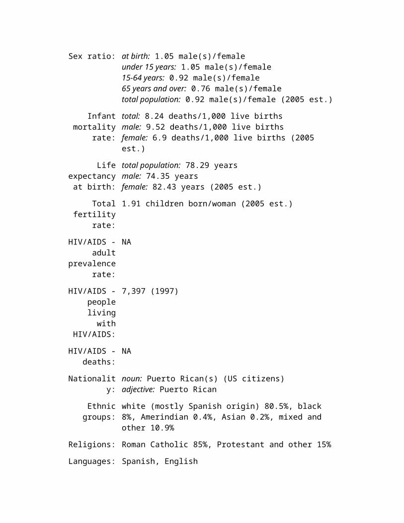
number of other flags, including Chile, Liberia, Malaysia, and Puerto Rico
Economy United States
Economy - overview:
The US has the largest and most technologically powerful economy in the world, with a per capita GDP of $40,100. In this market-oriented economy, private individuals and business firms make most of the decisions, and the federal and state governments buy needed goods and services predominantly in the private marketplace. US business firms enjoy considerably greater flexibility than their counterparts in Western Europe and Japan in decisions to expand capital plant, to lay off surplus workers, and to develop new products. At the same time, they face higher barriers to entry in their rivals' home markets than the barriers to entry of foreign firms in US markets. US firms are at or near the forefront in technological advances, especially in computers and in medical, aerospace, and military equipment; their advantage has narrowed since the end of World War II. The onrush of technology largely explains the gradual development of a "two-tier labor market" in which those at the bottom lack the education and the professional/technical skills of those at the top and, more and more, fail to get comparable pay raises, health insurance coverage, and other benefits. Since 1975, practically all the gains in household income have gone to the top 20% of households. The response to the terrorist attacks of 11 September 2001 showed the remarkable resilience of the economy. The war in March/April 2003 between a US-led coalition and Iraq, and the subsequent occupation of Iraq, required major shifts in national resources to the military. The rise in GDP in 2004 was undergirded by substantial gains in labor productivity. The economy suffered from a sharp increase in energy prices in the second half of 2004. Long-term problems include inadequate investment in economic infrastructure, rapidly rising medical and pension costs of an aging population, sizable trade and budget deficits, and stagnation of family income in the lower economic groups.
GDP (purchasing power parity):
$11.75 trillion (2004 est.)
GDP - real growth rate:
4.4% (2004 est.)
GDP - per purchasing power parity - $40,100 (2004 est.)
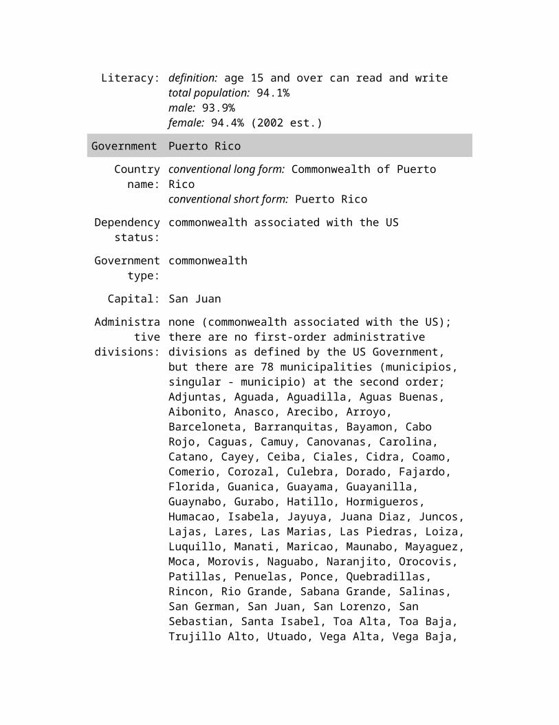
capita:
GDP - composition by
sector:
agriculture: 0.9%industry: 19.7%services: 79.4% (2004 est.)
Labor force: 147.4 million (includes unemployed) (2004 est.)
Labor force - by occupation:
farming, forestry, and fishing 0.7%, manufacturing, extraction, transportation, and crafts 22.7%, managerial, professional, and technical 34.9%, sales and office 25.5%, other services 16.3%note: figures exclude the unemployed (2004)
Unemployment rate:
5.5% (2004 est.)
Population below poverty
line:
12% (2004 est.)
Household income or
consumption by percentage
share:
lowest 10%: 1.8%highest 10%: 30.5% (1997)
Distribution of family income -
Gini index:
45 (2004)
Inflation rate (consumer
prices):
2.5% (2004 est.)
Investment (gross fixed):
15.7% of GDP (2004 est.)
Budget: revenues: $1.862 trillionexpenditures: $2.338 trillion, including capital expenditures of NA (2004
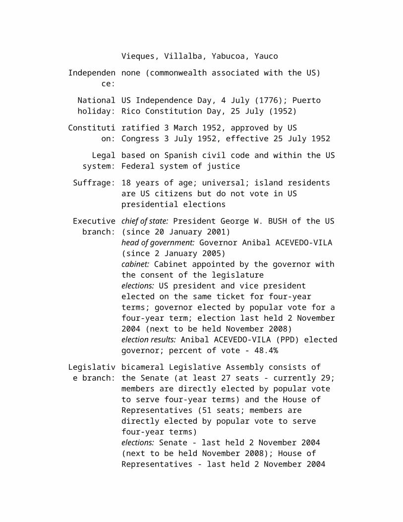
est.)
Public debt: 65% of GDP (2004 est.)
Agriculture - products:
wheat, corn, other grains, fruits, vegetables, cotton; beef, pork, poultry, dairy products; forest products; fish
Industries: leading industrial power in the world, highly diversified and technologically advanced; petroleum, steel, motor vehicles, aerospace, telecommunications, chemicals, electronics, food processing, consumer goods, lumber, mining
Industrial production
growth rate:
4.4% (2004 est.)
Electricity - production:
3.839 trillion kWh (2002)
Electricity - production by
source:
fossil fuel: 71.4%hydro: 5.6%nuclear: 20.7%other: 2.3% (2001)
Electricity - consumption:
3.66 trillion kWh (2002)
Electricity - exports:
13.36 billion kWh (2002)
Electricity - imports:
36.23 billion kWh (2002)
Oil - production: 7.8 million bbl/day (2004 est.)
Oil - consumption:
19.65 million bbl/day (2001 est.)

Oil - exports: NA
Oil - imports: NA
Oil - proved reserves:
22.45 billion bbl (1 January 2002)
Natural gas - production:
548.1 billion cu m (2001 est.)
Natural gas - consumption:
640.9 billion cu m (2001 est.)
Natural gas - exports:
11.16 billion cu m (2001 est.)
Natural gas - imports:
114.1 billion cu m (2001 est.)
Natural gas - proved reserves:
5.195 trillion cu m (1 January 2002)
Current account balance:
$-646.5 billion (2004 est.)
Exports: $795 billion f.o.b. (2004 est.)
Exports - commodities:
agricultural products (soybeans, fruit, corn) 9.2%, industrial supplies (organic chemicals) 26.8%, capital goods (transistors, aircraft, motor vehicle parts, computers, telecommunications equipment) 49.0%, consumer goods (automobiles, medicines) 15.0% (2003)
Exports - partners:
Canada 23%, Mexico 13.6%, Japan 6.7%, UK 4.4%, China 4.3% (2004)
Imports: $1.476 trillion f.o.b. (2004 est.)
Imports - agricultural products 4.9%, industrial supplies 32.9% (crude oil 8.2%),
commodities: capital goods 30.4% (computers, telecommunications equipment, motor vehicle parts, office machines, electric power machinery), consumer goods 31.8% (automobiles, clothing, medicines, furniture, toys) (2003)
Imports - partners:
Canada 17%, China 13.8%, Mexico 10.3%, Japan 8.7%, Germany 5.2% (2004)
Reserves of foreign
exchange and gold:
$85.94 billion (2003)
Debt - external: $1.4 trillion (2001 est.)
Economic aid - donor:
ODA, $6.9 billion (1997)
Currency (code): US dollar (USD)
Currency code: USD
Exchange rates: British pounds per US dollar - 0.5457 (2004), 0.6139 (2003), 0.6661 (2002), 0.6944 (2001), 0.6596 (2000); Canadian dollars per US dollar - 1.3014 (2004), 1.4045 (2003), 1.5693 (2002), 1.5488 (2001), 1.4851 (2000); Japanese yen per US dollar - 108.13 (2004), 116.08 (2003), 125.39 (2002), 121.53 (2001), 107.77 (2000); euros per US dollar - 0.8048 (2004), 0.8866 (2003), 1.0626 (2002), 1.1175 (2001), 1.08540 (2000)
Fiscal year: 1 October - 30 September
Communications
United States
Telephones - main lines in
use:
181,599,900 (2003)

Telephones - mobile cellular:
158.722 million (2003)
Telephone system:
general assessment: a large, technologically advanced, multipurpose communications systemdomestic: a large system of fiber-optic cable, microwave radio relay, coaxial cable, and domestic satellites carries every form of telephone traffic; a rapidly growing cellular system carries mobile telephone traffic throughout the countryinternational: country code - 1; 24 ocean cable systems in use; satellite earth stations - 61 Intelsat (45 Atlantic Ocean and 16 Pacific Ocean), 5 Intersputnik (Atlantic Ocean region), and 4 Inmarsat (Pacific and Atlantic Ocean regions) (2000)
Radio broadcast stations:
AM 4,854, FM 8,950, shortwave 18 (2004)
Radios: 575 million (1997)
Television broadcast
stations:
more than 1,500 (including nearly 1,000 stations affiliated with the five major networks - NBC, ABC, CBS, FOX, and PBS; in addition, there are about 9,000 cable TV systems) (1997)
Televisions: 219 million (1997)
Internet country code:
.us
Internet hosts: 115,311,958 (2002)
Internet Service Providers (ISPs):
7,000 (2002 est.)
Internet users: 159 million (2002)
Transportation United States
Railways: total: 227,736 km
standard gauge: 227,736 km 1.435-m gauge (2003)
Highways: total: 6,393,603 kmpaved: 4,180,053 km (including 74,406 km of expressways)unpaved: 2,213,550 km (2003)
Waterways: 41,009 km (19,312 km used for commerce)note: Saint Lawrence Seaway of 3,769 km, including the Saint Lawrence River of 3,058 km, shared with Canada (2004)
Pipelines: petroleum products 244,620 km; natural gas 548,665 km (2003)
Ports and harbors:
Corpus Christi, Duluth, Hampton Roads, Houston, Long Beach, Los Angeles, New Orleans, New York, Philadelphia, Tampa, Texas Citynote: 13 ports north of New Orleans (South Louisiana Ports) on the Mississippi River handle 290,000,000 tons of cargo annually.
Merchant marine:
total: 486 ships (1,000 GRT or over) 12,436,658 GRT/14,630,116 DWTby type: barge carrier 7, bulk carrier 19, cargo 152, chemical tanker 19, container 92, passenger 17, passenger/cargo 57, petroleum tanker 79, refrigerated cargo 2, roll on/roll off 28, vehicle carrier 14foreign-owned: 49 (Australia 2, Canada 8, China 1, Denmark 20, Malaysia 2, Netherlands 1, Norway 2, Singapore 11, Sweden 1, United Kingdom 1)registered in other countries: 680 (2005)
Airports: 14,857 (2004 est.)
Airports - with paved runways:
total: 5,128over 3,047 m: 1882,438 to 3,047 m: 2211,524 to 2,437 m: 1,375914 to 1,523 m: 2,383under 914 m: 961 (2004 est.)
Airports - with unpaved runways:
total: 9,729over 3,047 m: 12,438 to 3,047 m: 71,524 to 2,437 m: 160914 to 1,523 m: 1,718

under 914 m: 7,843 (2004 est.)
Heliports: 155 (2004 est.)
Military United States
Military branches:
Army, Navy and Marine Corps, Air Force, and Coast Guard (Coast Guard administered in peacetime by the Department of Homeland Security, but in wartime reports to the Department of the Navy)
Military service age and
obligation:
18 years of age (2004)
Manpower available for
military service:
males age 18-49: 67,742,879females age 18-49: 67,070,144 (2005 est.)
Manpower fit for military
service:
males age 18-49: 54,609,050females age 18-49: 54,696,706 (2005 est.)
Manpower reaching military
service age annually:
males: 2,143,873females: 2,036,201 (2005 est.)
Military expenditures -
dollar figure:
$370.7 billion (FY04 est.) (March 2003)
Military expenditures -
percent of GDP:
3.3% (FY03 est.) (February 2004)
Transnational Issues
United States
Disputes - prolonged drought, population growth, and outmoded practices and
international: infrastructure in the border region strains water-sharing arrangements with Mexico; the US has stepped up efforts to stem nationals from Mexico, Central America, and other parts of the world from crossing illegally into the United States from Mexico; illegal immigrants from the Caribbean, notably Haiti and the Dominican Republic, attempt to enter the US through Florida by sea; 1990 Maritime Boundary Agreement in the Bering Sea still awaits Russian Duma ratification; managed maritime boundary disputes with Canada at Dixon Entrance, Beaufort Sea, Strait of Juan de Fuca, and around the disputed Machias Seal Island and North Rock; US and Canada seek greater cooperation in monitoring people and commodities crossing the border; The Bahamas and US have not been able to agree on a maritime boundary; US Naval Base at Guantanamo Bay is leased from Cuba and only mutual agreement or US abandonment of the area can terminate the lease; Haiti claims US-administered Navassa Island; US has made no territorial claim in Antarctica (but has reserved the right to do so) and does not recognize the claims of any other state; Marshall Islands claims Wake Island
Refugees and internally displaced persons:
refugees (country of origin): the United States admitted 52,868 refugees during FY03/04 including: 13,331 (Somalia), 6,000 (Laos), 3,482 (Ukraine), 2,959 (Cuba), 1,787 (Iran); note - 27,239 refugees have been admitted as of 31 May 2005
Illicit drugs: consumer of cocaine shipped from Colombia through Mexico and the Caribbean; consumer of heroin, marijuana, and increasingly methamphetamine from Mexico; consumer of high-quality Southeast Asian heroin; illicit producer of cannabis, marijuana, depressants, stimulants, hallucinogens, and methamphetamine; money-laundering center