Embed Size (px)
Citation preview
JUNE TORNADO GUIDE (1950-2014)FOR NORTH CENTRAL AND NORTHEAST WISCONSIN
1
JUNE TORNADO GUIDE (1950-2014)FOR NORTH CENTRAL AND NORTHEAST WISCONSIN
2
JUNE TORNADO GUIDE (1950-2014)FOR NORTH CENTRAL AND NORTHEAST WISCONSIN
JUNE
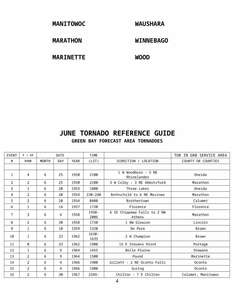
BROWN MENOMINEE
CALUMET OCONTO
DOOR ONEIDA
FOREST OUTAGAMIE
FLORENCE PORTAGE
KEWAUNEE SHAWANO
LANGLADE VILAS
LINCOLN WAUPACA
MANITOWOC WAUSHARA
MARATHON WINNEBAGO
MARINETTE WOOD
3
JUNE TORNADO REFERENCE GUIDE GREEN BAY FORECAST AREA TORNADOES
EVENT F / EF DATE TIME TOR IN GRB SERVICE AREA# RANK MONTH DAY YEAR (LST) DIRECTION / LOCATION COUNTY OR COUNTIES
1 4 6 25 1950 2100 1 W Woodboro - 5 NE Rhinelander Oneida
2 2 6 25 1950 2100 3 W Colby - 3 NE Abbotsford Marathon
3 1 6 20 1953 1800 Three Lakes Oneida
4 2 6 20 1954 230-240 Rothschild to 6 NE Mosinee Marathon
5 2 6 20 1954 0400 Brothertown Calumet
6 1 6 14 1957 1730 Florence Florence
7 3 6 4 1958 1930-2006 6 SE Chippewa Falls to 2 NW Athens Marathon
8 2 6 30 1958 1730 1 NW Gleason Lincoln
9 1 6 10 1959 1320 De Pere Brown
10 1 6 23 1962 1630-1635 2 W Champion Brown
11 0 6 23 1962 1900 15 E Stevens Point Portage
12 1 6 9 1964 1455 Belle Plaine Shawano
13 2 6 9 1964 1500 Pound Marinette
14 2 6 4 1966 1900 Gillett - 2 NE Oconto Falls Oconto
15 2 6 4 1966 1900 Suring Oconto
16 2 6 30 1967 2349-2359 Chilton - 7 E Chilton Calumet, Manitowoc
17 2 6 30 1968 0400 3 NW Cavour Forest
18 1 6 30 1968 0445 3 S Pembine Marinette
19 3 6 26 1969 1115-1130 Black Creek - 8 W Sobieski Outagamie, Shawano, Oconto
20 1 6 26 1969 1630 2 W Manitowish Waters - 3 SW Presque Is. Vilas
21 2 6 26 1969 1700 Lac Du Flambeau - 9 NW Land O Lakes Vilas
22 1 6 26 1969 1700 Skanawank - Pelican Lake Lincoln
23 0 6 17 1970 1835 3 S Wisconsin Rapids Wood
24 1 6 6 1971 2315 5 SW Oshkosh Winnebago
25 1 6 13 1971 1630 8 NW Oshkosh Winnebago
26 1 6 18 1971 1345 5 W Marinette Marinette
27 1 6 3 1973 1815 2 NE Amberg Marinette
28 1 6 18 1973 1100 2 W Athens Marathon
29 1 6 9 1974 1445 Bancroft Portage
30 1 6 14 1974 1610 5 NW Gillett Oconto
31 2 6 12 1976 2030 1 W Alban Portage
32 1 6 12 1976 2100 Amherst Portage
33 1 6 13 1976 1840-1920 4 Wisc. Rapids - 3 NE Stevens Point Portage
34 2 6 13 1976 1900 Plover Portage
35 1 6 13 1976 2030-2010 2 W Hogarty - Elton Langlade, Marathon, Lincoln
JUNE TORNADO REFERENCE GUIDE 4
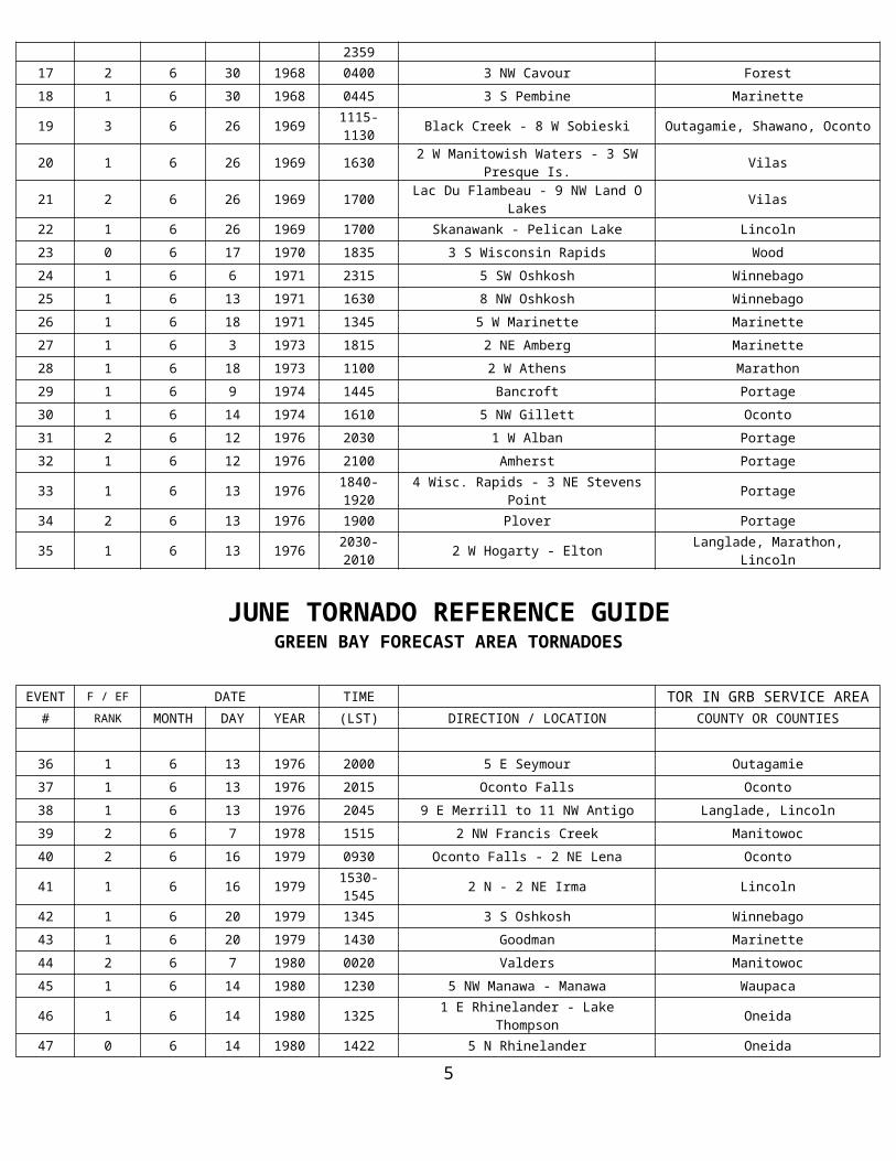
GREEN BAY FORECAST AREA TORNADOES
EVENT F / EF DATE TIME TOR IN GRB SERVICE AREA# RANK MONTH DAY YEAR (LST) DIRECTION / LOCATION COUNTY OR COUNTIES
36 1 6 13 1976 2000 5 E Seymour Outagamie
37 1 6 13 1976 2015 Oconto Falls Oconto
38 1 6 13 1976 2045 9 E Merrill to 11 NW Antigo Langlade, Lincoln
39 2 6 7 1978 1515 2 NW Francis Creek Manitowoc
40 2 6 16 1979 0930 Oconto Falls - 2 NE Lena Oconto
41 1 6 16 1979 1530-1545 2 N - 2 NE Irma Lincoln
42 1 6 20 1979 1345 3 S Oshkosh Winnebago
43 1 6 20 1979 1430 Goodman Marinette
44 2 6 7 1980 0020 Valders Manitowoc
45 1 6 14 1980 1230 5 NW Manawa - Manawa Waupaca
46 1 6 14 1980 1325 1 E Rhinelander - Lake Thompson Oneida
47 0 6 14 1980 1422 5 N Rhinelander Oneida
48 1 6 13 1981 2040 1 N Hazelhurst Oneida
49 1 6 13 1981 2045 Sayner - 3 NE Sayner Vilas
50 2 6 13 1981 2100 Three Lakes Oneida
51 1 6 26 1984 1655 13 N Wausau - Texas Marathon
52 1 6 26 1984 1900 Caroline Shawano
53 3 6 8 1985 1815-1852 Park Falls - 3 SE Monico Price, Oneida
54 2 6 8 1985 2000-2030 Sand Bay - Sturgeon Bay Door
55 1 6 12 1990 1835 2 W Stratford Marathon
56 1 6 14 1991 1155 8 WNW Merrill Lincoln
57 2 6 27 1991 1820-1830 12 WSW Minocqua - Marian Lake Oneida
58 0 6 17 1992 1255 2 NE Denmark Brown
59 0 6 8 1993 1838 2.5 S Spring Lake - 2 W Auroraville Waushara
60 0 6 8 1993 1915 0.5 E Dakota - 2 S Redgranite Waushara
61 0 6 8 1993 1935-1945 5 SE Redgranite - 3 SE Auroraville Waushara
62 0 6 8 1993 1735 1 E Pickett Winnebago
63 0 6 29 1995 1105 10 SW Kewaunee Kewaunee
64 0 6 11 1996 1608-1609 5 NW Chilton Calumet
65 0 6 16 1998 1500 3 WNW Coloma Waushara
66 0 6 8 2003 1140 4 W Oshkosh - Wittman Field Winnebago
67 0 6 8 2003 1220-1226 5 E - 5.5 ESE Oshkosh Wittman Field (waterspout) Winnebago
68 0 6 8 2003 1242 4.3 W - 4.1 WSW Brothertown (waterspout) Calumet
69 0 6 8 2003 1259-1302 4 S - 4.1 S Marshfield Airport Wood
70 1 6 23 2004 1846-1848 3 NNW Almond - 3 NNE Almond Portage
JUNE TORNADO REFERENCE GUIDE GREEN BAY FORECAST AREA TORNADOES
5
EVENT F / EF DATE TIME TOR IN GRB SERVICE AREA# RANK MONTH DAY YEAR (LST) DIRECTION / LOCATION COUNTY OR COUNTIES
71 0 6 23 2004 1847 Whiting Portage
72 1 6 23 2004 1853-1856 3 SE Blaine - 5 ESE Blaine Portage
73 2 6 23 2004 1856-1906 9 W Waupaca to 2 SW Lind Center Waupaca
74 1 6 23 2004 2000-2008 Little Chute - Kaukauna Outagamie
75 0 6 23 2004 2027 Green Bay - northwest Brown
76 0 6 4 2005 1354 1 E - 1.1 ENE Auroraville Waushara
77 0 6 4 2005 1405 2 NW Borth Waushara
78 0 6 4 2005 1527 4 W - 4.5 WNW Edgar Marathon
79 0 6 4 2005 1539-1542 1 W - 1.5 NW Athens Marathon
80 0 6 4 2005 1706 4 S Athens Marathon
81 0 6 4 2005 1720 3 W Marathon Marathon
82 0 6 4 2005 1730 5 E Kewaunee (waterspout) Kewaunee
83 0 6 4 2005 1918 7 S Hogarty Marathon
84 0 6 9 2005 1740-1750 5 SE - 5 E Oshkosh Winnebago
85 0 6 9 2005 1814 4 NW Stockbridge Calumet
86 0 6 10 2005 1303 4 W Mosinee Marathon
87 0 6 10 2005 1505 1 N Winneconne Winnebago
88 0 6 10 2005 1510 2 W Clintonville Waupaca
89 0 6 10 2005 1910 4 ESE Oshkosh Winnebago
90 0 6 10 2005 1922 3 E Oshkosh Winnebago
91 0 6 10 2005 1948 3 E Oshkosh Winnebago
92 0 6 13 2005 1449-1450 4.1 NNE - 4 NNE Black Creek Outagamie
93 0 6 18 2006 1643 3 NW Sister Bay Door
94 0 6 24 2006 1614-1615 4 W Sherwood Calumet
95 0 6 3 2007 1811 1.6 ESE Shawano Shawano
96 2 6 7 2007 1501-1514 1.4 W Peplin to 0.9 N Pike Lake Marathon
97 0 6 7 2007 1526 2.2 W - 2.1 W Wisconsin Rapids Airport Wood
98 3 6 7 2007 1531-1618 2 ENE Mattoon - 9.5 ENE Lakewood Shawano, Langlade, Oconto
99 1 6 7 2007 1637-1640 0.5 W -2.5 ENE Cedarville Marinette
100 1 6 7 2007 1716-1720 3.5 W Harmony to 1.2 N Harmony Marinette
101 0 6 20 2007 1606 6 NW Ellison Bay (waterspout) Door
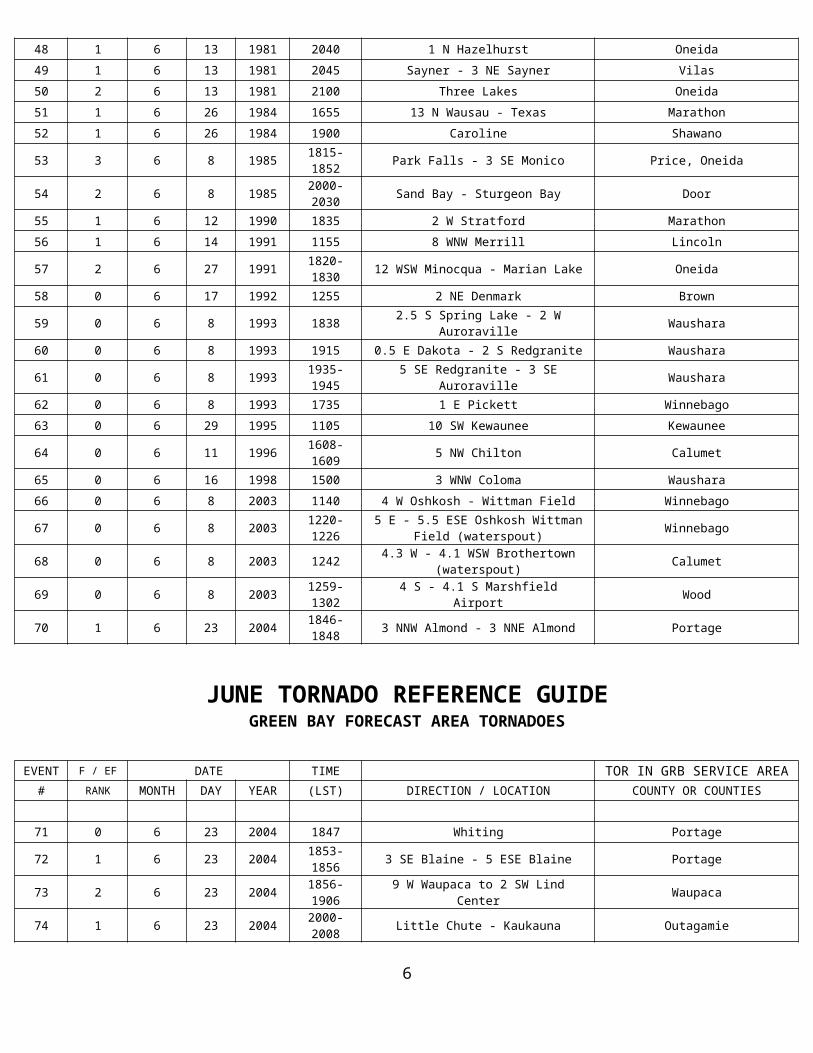
JUNE TORNADO REFERENCE GUIDE GREEN BAY FORECAST AREA TORNADOES
6
Event 1: June 25, 1950
The F/EF-4 tornado touched down one mile west of Woodboro in Oneida County around 9 pm CST and traveled 13.1 miles to five miles northeast of Rhinelander. The tornado reached a maximum width of 880 yards. Two deaths were reported in Oneida County.
Event 2: June 25, 1950
The F/EF-2 tornado touched down 3 miles west of Colby in Marathon County and travelled to three miles northeast of Abbotsford around 9 pm CST. There was no additional information on this tornado. The tornado travelled approximately 3 miles with a maximum width of 20 yards.
Event 3: June 20, 1953
A brief F/EF-1 tornado touched down in Three Lakes in Oneida County around 6 pm CST. The tornado was 100 yards wide and travelled two miles before dissipating. Trees and power lines were downed along with some damage to summer homes.
Event 4: June 20, 1954
The F/EF-2 tornado developed around 2:30 am CST in Rothschild in Marathon County. The tornado travelled approximately 6.3 miles and dissipated six miles northeast of Mosinee around 2:40 am CST. The maximum width of the tornado was 70 yards. Another tornado was reported in Brothertown in Calumet County around 4 am CST.
Event 5: June 20, 1954
The F/EF-2 tornado developed around 4 am CST in Brothertown in Calumet County. The tornado travelled one mile and had a maximum width of less than 50 yards.
Event 6: June 14, 1957
The F/EF-1 tornado touched down at Florence in Florence County around 5:30 pm CST. The tornado travelled approximately 8 miles and reached a maximum width of 100 yards before dissipating.
Event 7: June 4, 1958
According to several sources, it appears that there was a long tracked F/EF-3 tornado that developed 6 miles southeast of Chippewa Falls in Chippewa County around 7:30 pm CST. The tornado then moved to the east northeast for just over 59 miles before dissipating 2 miles northwest of Athens in Marathon County around 8:06 pm CST. The tornado reached a maximum width of 880 yards. Newspaper accounts indicated there were three separate tornadoes during this event. The tornado or tornadoes killed 28 people across western Wisconsin. Four people died in Chippewa Falls and near Menominie while two deaths were reported Knapp and Boyd in western Wisconsin.
Event 8: June 30, 1958
A brief F/EF-2 tornado touched down around 5:30 pm CST one mile northwest of Gleason in Lincoln County. The tornado travelled approximately 2 miles and reached a maximum width of 50 yards. According to the Rhinelander Daily News, the United States Weather Bureau stated a Northwest Orient Airlines plane and an Antigo radar station both reported radar echoes with the dangling hooks characteristic of tornado clouds.
Event 9: June 10, 1959
The F/EF-1 tornado touched down near De Pere in Brown County around 1:20 pm CST. The tornado traveled about a mile and was less than twenty yards wide.
JUNE TORNADO REFERENCE GUIDE GREEN BAY FORECAST AREA TORNADOES
7
Event 10: June 23, 1962
The F/EF-1 tornado touched down 2 miles west of Champion in eastern Brown County around 4:30 pm CST. According to the local storm report for June of 1962, the tornado became or originated as a waterspout near Point Sauble as the storm was picking up water at times. The tornado/waterspout had a maximum width of less than 50 yards and travelled 3 miles before dissipating at 4:35 pm CST.
Event 11: June 23, 1962
The F/EF-0 tornado touched down 15 miles east of Stevens Point in Portage County around 7 pm CST.
Event 12: June 9, 1964
The F/EF-1 tornado was sighted in Belle Plaine in Shawano County around 2:55 pm CST. The Adams Beach area was hit the hardest according to newspaper reports.
Event 13: June 9, 1964 The F/EF-2 tornado touched down near Pound in Marinette County around 3 pm CST. The tornado travelled approximately 3 miles and had a maximum width of 50 yards.
Event 14: June 4, 1966
There were two F/EF-2 tornadoes reported on this date in Oconto County. The F/EF-2 tornado touched down near Gillett and then travelled nearly 5 miles to two miles northeast of Oconto Falls in Oconto County around 7 pm CST. The tornado was 50 yards wide. Another F/EF-2 tornado was reported near Suring around 7 pm CST. There were a total of three tornadoes across Oconto County on this night. The tornadoes brought 37 barns and many trees and wires down across the county near Gillett and Suring. Event 15: June 4, 1966
There were two F/EF-2 tornadoes reported on this date in Oconto County. The F/EF-2 tornado was reported near Suring around 7 pm CST. The tornado was 50 yards wide and travelled for 2 miles before dissipating. Another F/EF-2 tornado touched down near Gillett and then travelled nearly 5 miles to two miles northeast of Oconto Falls in Oconto County around 7 pm CST. There were a total of three tornadoes across Oconto County on this night. The tornadoes brought 37 barns and many trees and wires down across the county near Gillett and Suring.
Event 16: June 30, 1967
The F/EF-2 tornado struck Chilton in Calumet County around 11:49 pm CST. The tornado then travelled to 7 miles east of Chilton before dissipating around 11:59 pm CST. The maximum width of the tornado was 100 yards. The city of Chilton took the brunt of the damage. At least five buildings were destroyed beyond repair. A trailer home tumbled end over end across a lot and a good share of trees were torn up.
Event 17: June 30, 1968 The F/EF-2 tornado touched down 3 miles northwest of Cavour in Forest County around 4 am CST. The tornado travelled east northeast approximately one mile and had a maximum width of 200 yards. Several buildings were damaged on the Aschenbrenner Farm near Cavour.
JUNE TORNADO REFERENCE GUIDE GREEN BAY FORECAST AREA TORNADOES
8
Event 18: June 30, 1968
The F/EF-1 tornado touched down on the Zern property 3 miles south of Pembine in Marinette County around 4:45 am CST. The tornado was 100 yards wide and travelled on the ground for a half mile. Trees and a garage were destroyed by the tornado.
Event 19: June 26, 1969
A rare morning tornado was reported across northeast Wisconsin. Around 11:15 am CST, the F/EF-3 tornado was noted moving northeast between Black Creek and near Pulaski in Outagamie County. The tornado traveled across far southeast Shawano County before dissipating 8 miles west of Sobieski in Oconto County around 11:30 am CST. The tornado caused extensive damage to trees and buildings in Black Creek, Seymour, Hofa Park, Elm Lawn and near Pulaski. A seven year old girl was hospitalized from injuries when a barn fell on her. The tornado travelled 18 miles and reached a maximum width of 100 yards.
Event 20: June 26, 1969
According to the local storm report, the F/EF-1 tornado skipped northeast through the forests of Price, southeast Iron and western Vilas Counties. The tornado struck Vilas County from 2 miles west of Manitowish Waters around 4:30 pm CST and moved to three miles southwest of Presque Isle. Most of the damage occurred around Manitowish Waters.
Event 21: June 26, 1969
The F/EF-2 tornado formed near Lac Du Flambeau in Vilas County around 5 pm CST and skipped northeast for nearly 29 miles. The tornado dissipated along the Michigan border 9 miles northwest of Land O’ Lakes. Maximum width of the tornado was 35 yards. Resort areas from Fence Lake northeastward across Big Crooked and High Lakes suffered damage.
Event 22: June 26, 1969
The F/EF-1 tornado travelled 22 miles across Clark, Taylor and Lincoln Counties. The tornado did major damage from the Withee area in northern Clark County around 4:10 pm CST. Two persons were injured and about ten farms sustained damage. Major damage from the tornado was reported at the Taylor County Airport near Medford around 4:30 pm CST. Seven planes and one hangar suffered severe damage. The tornado entered western Lincoln County and travelled to near Pelican Lake around 5 pm CST before dissipating. Five more farms suffered serious damage in northeast Lincoln County. Tree and wire damage termed “worst ever” by utilities in the northern resort areas.
Event 23: June 17, 1970
The F/EF-0 touched down briefly 3 miles south of Wisconsin Rapids in Wood County around 6:35 pm CST. The tornado was 100 yards wide and only travelled a tenth of a mile. According to the monthly storm report, the tornado touched down in open country.
Event 24: June 6, 1971
The F/EF-1 tornado was reported 5 miles southwest of Oshkosh in Winnebago County around 11:15 pm CST. The tornado was 50 yards wide and travelled nearly 4 miles before it dissipated. The tornado demolished one barn and damaged several others on highway 26 about five miles southwest of Oshkosh.
Event 25: June 13, 1971
The public reported the tornado 8 miles northwest of Oshkosh in Winnebago County around 4:30 pm CST. The F/EF-1 tornado was 50 yards wide and only travelled a quarter of a mile. Many trees were down in small grove eight miles northwest of Oshkosh.
JUNE TORNADO REFERENCE GUIDE GREEN BAY FORECAST AREA TORNADOES
9
Event 26: June 18, 1971
The F/EF-1 tornado struck about 5 miles west of Marinette in Marinette County, near Highway 64 and Right O Way Road around 1:45 pm CST. The tornado was 100 yards wide and travelled just over four miles before it dissipated. Many trees were uprooted and several resort and farm buildings were damaged.
Event 27: June 3, 1973
The F/EF-1 tornado first touched down just north of Amberg in Marinette County around 6:15 pm CST. The tornado was 100 yards wide and moved four and a half miles across Marinette County before dissipating. The tornado upended several house trailers and destroyed several wooden structures at the Sparkling Springs Campground just north of Amberg. Several acres of trees were leveled at the campsite and northeastward to Assembly of God Church in Beecher Township.
Event 28: June 18, 1973
The F/EF-1 tornado touched down on the Brunke Farm 2 miles west of Athens in Marathon County around 11 am CST. The tornado was 200 yards wide and travelled east for two miles before dissipating.
Event 29: June 9, 1974
The tornado formed in Adams County and then the F/EF-1 tornado moved into southwest Portage County where it touched down briefly on the Sawyer Farm Route 1, Bancroft around 2:45 pm CST. The tornado was 30 yards wide and travelled two and a half miles. The tornado damaged a barn, a chicken coop and a porch on house. Only minor tree damage was noted.
Event 30: June 14, 1974
On the afternoon of June 14th, the F/EF-1 tornado touched down 5 miles northwest of Gillett in Oconto County around 4:10 pm CST. The tornado was 30 yards wide and travelled only a quarter of a mile. The tornado downed trees and power lines and threw a chopper wagon thirty yards.
Event 31: June 12, 1976
The F/EF-2 tornado touched down a mile west of Alban in Portage County around 8:30 pm CST. The tornado only traveled about a quarter of a mile and reached a maximum width of fifty yards. The tornado leveled a mobile home a mile west of Alban.
Event 32: June 12, 1976
The F/EF-1 tornado touched down near Amherst in Portage County around 9 pm CST. The tornado was 50 yards wide and travelled around a quarter of a mile. The Amherst High School roof was ripped off.
Event 33: June 13, 1976
The F/EF-1 tornado formed 4 miles west of Wisconsin Rapids in Wood County around 6:40 pm CST. The tornado continued to move east northeast to three miles northeast of Stevens Point near the intersection of Highway 51 and Business 51 before dissipating around 7:20 pm CST three miles northeast of Stevens Point. The tornado traveled nineteen miles and reached a maximum width of 100 yards. Many trees were flattened. In Stevens Point, scattered damage was reported just north of the city and a roof was blown off an apartment complex. Several other buildings also suffered damage. Two people in the apartment complex were injured from fallen debris.
JUNE TORNADO REFERENCE GUIDE GREEN BAY FORECAST AREA TORNADOES
Event 34: June 13, 197610
The F/EF-2 tornado was observed by the police chief of Plover in Portage County around 7 pm CST. The tornado touched down at the intersection of Highway 54 and County B. The tornado was only on the ground for about a quarter of a mile and had a maximum width of about fifty yards.
Event 35: June 13, 1976
The F/EF-1 tornado hit first about two miles west of Hogarty in Marathon County around 8 pm CST. The tornado skipped along and moved east northeast into extreme southwest Langlade County near Elmhurst and then continued to near Elton before dissipating at 8:10 pm. The tornado was 50 yards wide and travelled 21.3 miles. Some sheds were destroyed while windows of some buildings were damaged. Tree limbs and power lines were downed by the tornado.
Event 36: June 13, 1976
The tornado (F/EF-1) developed near county highway H and Highway 54 about five miles east of Seymour in Outagamie County around 8 pm CST. The tornado was 50 yards wide and travelled a half mile. Three barns were destroyed.
Event 37: June 13, 1976
The F/EF-1 tornado developed just west of Oconto Falls in Oconto County around 8:15 pm CST. The tornado was 50 yards wide and travelled less than a quarter of a mile. The damage from the tornado included: a barn was destroyed, a farm house was damaged, trees and power lines were down and a good portion of an orchard was destroyed.
Event 38: June 13, 1976
The tornado first reached the ground near Highway 64 in extreme southeast Lincoln County around 8:45 pm CST. The tornado then moved into western Langlade County about 3 miles north of Highway 64. The tornado skipped along to near county Highway I about 11 miles northwest of Antigo where it was last reported. The tornado was 50 yards wide and travelled nearly eleven miles. The only report of damage was some downed trees.
Event 39: June 7, 1978 The F/EF-2 tornado touched down briefly 2 miles northwest of Francis Creek in Manitowoc County around 3:15 pm CST. The path length and maximum width of the tornado were not documented.
Event 40: June 16, 1979
The F/EF-2 tornado developed near Oconto Falls in Oconto County around 9:30 am CST. The tornado travelled just over 15 miles and reached a maximum width of 100 yards before dissipating 2 miles northeast of Lena. At least 17 frame and mobile homes along with numerous barns were damaged or destroyed. Heavy rains and large hail accompanied the tornado destroying crops along the thunderstorm path.
Event 41: June 16, 1979
The F/EF-1 tornado developed 2 miles north of Irma in Lincoln County around 3:30 pm CST. The tornado moved to 2 miles northeast of Irma before dissipating at 3:45 pm CST.
JUNE TORNADO REFERENCE GUIDE GREEN BAY FORECAST AREA TORNADOES
Event 42: June 20, 197911
The F/EF-1 tornado touched down 3 miles south of Oshkosh in Winnebago County around 1:45 pm CST. The tornado on this date followed almost the same path as another more destructive twister that hit the city in April 1974. The tornado destroyed two mobile homes and severely damaged five others. Four people were hospitalized due to the injuries they suffered from the tornado.
Event 43: June 20, 1979
Goodman in Marinette County was hit by the F/EF-1 tornado around 2:30 pm CST. The tornado tore the roof off Louisiana Pacific Corps Seaway Division. Clarence Richards, personnel manager said 100 to 125 people were working inside the building when the tornado struck. Company officials said some of the workers were trapped when the roof collapsed. Only one injury was reported. There was no documentation on path length or width of the tornado.
Event 44: June 7, 1980
A brief F/EF-2 tornado touched down in Valders in Manitowoc County around 12:20 am CST. The tornado was less than 50 yards wide and was on the ground for less than a quarter of a mile. The brief touchdown resulted in the destruction of a large modern barn and heavy farm equipment. Field crops were beaten down in the vicinity of the storm.
Event 45: June 14, 1980
The tornado (F/EF-1) developed about 5 miles northwest of Manawa at Highway 161 near County Highway E in Waupaca County around 12:30 pm CST. The tornado crossed Highway 161 and then turned eastward and dissipated near Manawa. The tornado was 50 yards wide and travelled five miles before dissipating. Several residents in the area took several spectacular photographs of the twister.
Event 46: June 14, 1980
A small tornado (F/EF-1) formed at Highway C one mile east of Rhinelander in Oneida County at 1:25 pm CST. The tornado was 50 yards wide and travelled eastward for a mile and a half before the tornado dissipated over Lake Thompson. A falling tree injured one person seriously and two other injuries were noted in a trailer court. One house and three trailers and several rural buildings suffered damage.
Event 47: June 14, 1980
The F/EF-0 tornado was reported 5 miles north of Rhinelander by the Oneida County sheriff’s department at 2:22 pm CST. The brief tornado touched down in a rural area. There was no documentation on path length or width of the tornado.
Event 48: June 13, 1981
The F/EF-1 tornado touched down at the Timber Ridge Country Club on Route 51 one mile north of Hazelhurst in Oneida County around 8:40 pm. There was no documentation on path length or width of the tornado. The tornado destroyed about one thousand trees.
Event 49: June 13, 1981
The F/EF-1 tornado touched down at County Highway N about a half mile north Sayner. The tornado moved east for three miles through the dense forest and cross the intersection of Highway N and Highway G then dissipated. The tornado damaged electric lines, telephone poles and trees. The tornado was fifty yards wide.
JUNE TORNADO REFERENCE GUIDE GREEN BAY FORECAST AREA TORNADOES
Event 50: June 13, 1981
12
There is very little information available on this F/EF-2 tornado that struck Three Lakes in Oneida County around 9 pm. Path length and width were not available.
Event 51: June 26, 1984
The F/EF-1 tornado touched 13 miles north of Wausau in Marathon County around 4:55 pm CST. The tornado was 100 yards wide and skipped eastward for 8 miles before dissipating in the town of Texas. The tornado damaged four homes and three farm buildings. It also destroyed a few sheds and uprooted trees.
Event 52: June 26, 1984
The F/EF-1 tornado touched down on the west side of Caroline in Shawano County around 7 pm CST. The tornado was 50 yards wide and travelled 4 miles before dissipating east of Caroline. On the west side of Caroline, the tornado flattened sheds and knocking over several large trees and gravestones in a cemetery. A church roof was ripped off on the east side of Caroline. The entire town was without power for three hours.
Event 53: June 8, 1985 A severe thunderstorm spawned a killer F/EF-3 tornado and dropped large hail as it rolled through Price and Oneida Counties, causing widespread property, crop and timber damage. The tornado skipped from Park Falls to about 15 miles southeast of Rhinelander. The tornado first touched down one mile west of Park Falls around 6:15 pm CST and moved through the southern portion of the city. In Park Falls, 125 buildings were damaged with 12 houses and businesses were heavily damaged or destroyed. 26 people received mostly minor injuries in Park Falls. The tornado continued southeast, cutting an eighteen mile and 1.5 mile wide swath through eastern Price County and into Minocqua in Oneida County where the tornado dissipated around 6:52 pm CST. Two people were killed and sixteen injured at Swamsauger Lake and Cedar Falls resort in the Willow Reservoir area in Oneida County. A man apparently drowned when the tornado lifted him and his house and deposited it into Swamsauger Lake. A woman was killed when a tree crashed through a vehicle in which she was seeking refuge. The tornado continued to the southwest portion of Rhinelander and then dissipated southeast of Monico. A total of 47 residences were heavily damaged or destroyed while another 43 more received some damage in Oneida County. 9,900 acres of timber and cranberry bogs were lost in Oneida County.
Event 54: June 8, 1985
The F/EF-2 tornado touched down around 8 pm CST near Sand Bay in Door County, causing some building damage. The tornado skipped east 5 miles across across portions of Sturgeon Bay. The tornado was 150 yards wide. Garages, sheds and ten barns were leveled or blown away. Yachts were blown off cradles and hundreds of trees were downed. Property damage was estimated at $1.8 million dollars. Hail up to five inches in diameter covered the ground to a depth of six inches just northeast of Sturgeon Bay. The storm caused an estimated $1.5 million dollars in crop damage.
Event 55: June 12, 1990
The F/EF-1 tornado hit a farm 2 miles west of Stratford in Marathon County around 6:35 pm CST. The tornado was 25 yards wide and was only on the ground for a tenth of a mile. According to newspaper reports, there was damage to some farm structures.
Event 56: June 14, 1991
The tornado touched down 8 miles west northwest of Merrill in Lincoln County around 11:55 am CST. The F/EF-1 tornado was 50 yards wide and was on the ground for a mile. The tornado destroyed several trees, a barn and damaged a roof and porch of a house.
JUNE TORNADO REFERENCE GUIDE GREEN BAY FORECAST AREA TORNADOES
Event 57: June 27, 199113
The F/EF-2 tornado touched down 12 miles west-southwest of Minocqua in Oneida County around 6:20 pm CST. The tornado cut a 6 mile swath from near Pine Lake to Franklin Lake to Marion Lake before dissipating around 6:30 pm CST. The tornado was 400 yards wide. Thirteen homes and one car were damaged along its path with damage estimated at $350,000 dollars. In addition, 1,600 acres of industrial forest valued at $240,000 were also damaged.
Event 58: June 17, 1992
The F/EF-0 tornado briefly touched down in an open field 2 miles northeast of Denmark in Brown County around 12:55 pm CST. The tornado was 25 yards wide and only travelled a tenth of a mile.
Event 59: June 8, 1993
The F/EF-0 small tornado briefly touched down in an open filed one mile east of Pickett in Winnebago County around 5:35 pm CST. The tornado was 25 yards wide and travelled a tenth of a mile.
Event 60: June 8, 1993
Three weak tornadoes touched down across Waushara County on the evening of June 8 th. The F/EF-0 tornado developed a half mile east of Dakota around 7:15 pm CST. The tornado was 35 yards wide and travelled 12 miles before dissipating around 7:35 pm CST two miles south of Redgranite. Only minor damage was noted.
Event 61: June 8, 1993
Three weak tornadoes touched down across Waushara County on the evening of June 8 th. The F/EF-0 tornado touched down 5 miles southeast of Redgranite around 7:35 pm CST. The tornado was 25 yards wide and travelled 6 miles before dissipating at 7:45 pm three miles southeast of Auroraville. Only minor damage was noted.
Event 62: June 8, 1993
The F/EF-0 small tornado briefly touched down in an open filed one mile east of Pickett in Winnebago County around 5:35 pm CST. The tornado was 25 yards wide and travelled a tenth of a mile.
Event 63: June 29, 1995
The F/EF-0 tornado touched down 10 miles southwest of Kewaunee in Kewaunee County around 11:05 am CST. The tornado was 10 yards wide and travelled a tenth of a mile. The weak tornado touched down only for a few seconds in southern Kewaunee County. Minimal crop damage was reported since this brief tornado occurred in open rural country. The tornado appeared to form on the Lake Michigan lake breeze.
Event 64: June 11, 1996
The F/EF-0 tornado briefly touched down 5 miles northwest of Chilton in Calumet County near the intersection of County Trunk BB and Killsnake Road around 4:08 pm CST. The tornado was 30 yards wide and was on the ground for a tenth of a mile before dissipating around 4:09 pm CST. The tornado threw a pile of lumber 30 feet in the air, tore shingles off of a shed and broke a window.
JUNE TORNADO REFERENCE GUIDE GREEN BAY FORECAST AREA TORNADOES
Event 65: June 16, 1998
14
The F/EF-0 was designated a landspout in the monthly storm report. The tornado touched down 3 miles west northwest of Coloma in Waushara County at 3 pm CST. The tornado was 20 yards wide and was on the ground for a tenth of a mile. No damage was reported.
Event 66: June 8, 2003
A brief F/EF-0 tornado touched down 4 miles west of Oshkosh in Winnebago County at 11:40 am CST. The tornado was 15 yards wide and travelled a tenth of a mile before dissipating.
Event 67: June 8, 2003
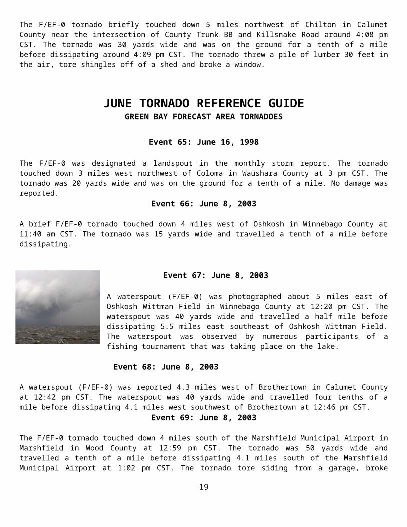
A waterspout (F/EF-0) was photographed about 5 miles east of Oshkosh Wittman Field in Winnebago County at 12:20 pm CST. The waterspout was 40 yards wide and travelled a half mile before dissipating 5.5 miles east southeast of Oshkosh Wittman Field. The waterspout was observed by numerous participants of a fishing tournament that was taking place on the lake.
Event 68: June 8, 2003
A waterspout (F/EF-0) was reported 4.3 miles west of Brothertown in Calumet County at 12:42 pm CST. The waterspout was 40 yards wide and travelled four tenths of a mile before dissipating 4.1 miles west southwest of Brothertown at 12:46 pm CST.
Event 69: June 8, 2003
The F/EF-0 tornado touched down 4 miles south of the Marshfield Municipal Airport in Marshfield in Wood County at 12:59 pm CST. The tornado was 50 yards wide and travelled a tenth of a mile before dissipating 4.1 miles south of the Marshfield Municipal Airport at 1:02 pm CST. The tornado tore siding from a garage, broke windows, destroyed a play house and dog house, and blew two 50 pound barrels 200 yards away.
Event 70: June 23, 2004
The F/EF-1 tornado touched down 3 miles west northwest of Almond around 6:46 pm CST. The tornado was 25 yards wide and was on the ground for a mile and a half before dissipating 3 miles north northeast of Almond around 6:48 pm CST. The tornado knocked down several trees and a fence, damaged the roof of a house and damaged some outbuildings.
Event 71: June 23, 2004
The F/EF-0 tornado touched down in Whiting in Portage County at 6:47 pm CST. The tornado was 10 yards wide and was on the ground for a tenth of a mile. The tornado caused minor tree damage in an industrial park in Whiting. Eyewitnesses observed water being sucked out of a pond at the same time as doors to an office were sucked open.
Event 72: June 23, 2004
The F/EF-1 tornado touched down 3 miles southeast of Blaine in southeastern Portage County around 6:53 pm CST. The tornado was 100 yards wide and travelled two and a half miles to 5 miles east southeast of Blaine at 6:56 pm CST. The tornado downed trees and overturned an irrigation system.
JUNE TORNADO REFERENCE GUIDE GREEN BAY FORECAST AREA TORNADOES
Event 73: June 23, 200415
The F/EF-2 tornado originally touched down in southeast Portage County. The tornado then strengthened as it moved into southwest Waupaca County 9 miles west of Waupaca around 6:56 pm CST. The tornado was 125 yards wide and travelled 11 miles before dissipating 2 miles southwest of Lind Center at 7:06 pm CST. The tornado scoured asphalt off a road, destroyed a barn, sheared off the top 50 feet of a silo crushing 3 calves, damaged a sheet metal outbuilding, and killed 3 sheep. The tornado tore the roof from a house and destroyed the garage, overturned a semi trailer and moved it 50 feet. Many trees were snapped off or uprooted. Some of the debris from this tornado landed several miles to the east in the Fremont area of Waupaca County.
Event 74: June 23, 2004
The F/EF-1 tornado touched down in at least four locations from Little Chute to Kaukauna in Outagamie County between 8 pm and 8:08 pm CST. The tornado was 100 yards wide and travelled 3.5 miles before dissipating. The tornado toppled or twisted large trees, ripped parts of the roofs from residential and commercial buildings, destroyed storage sheds and an old barn. Semi trailers were overturned, some of them onto other vehicles.
Event 75: June 23, 2004
A brief F/EF-0 tornado touched down on the northwest side of Green Bay in Brown County at 8:27 pm CST. The tornado was 10 yards wide and travelled a tenth of a mile. The tornado caused some tree damage.
Event 76: June 4, 2005
The F/EF-0 touched down one mile east of Auroraville in Waushara County at 1:54 pm CST. The tornado was 75 yards wide and was on the ground for two tenths of a mile. No significant damage was noted from this tornado.
Event 77: June 4, 2005
The F/EF-0 touched down 2 miles northwest of Borth in Waushara County at 2:05 pm CST. The tornado was 50 yards wide and was on the ground for a tenth of a mile. No significant damage was noted from this tornado.
Event 78: June 4, 2005
The F/EF-0 touched down 4 miles west of Edgar in Marathon County at 3:27 pm CST. The tornado was 75 yards wide and was on the ground for 1.2 miles before dissipating four and a half miles west northwest of Edgar at 3:29 pm CST. No damage was noted in the month storm report for this tornado.
Event 79: June 4, 2005
The F/EF-0 touched down a mile west of Athens in Marathon County at 3:39 pm CST. The tornado was 100 yards wide and was on the ground for 1.3 miles before the tornado dissipated a mile and a half northwest of Athens at 3:42 pm CST. The tornado downed some trees, flattened a barn and tore the roof from another barn.
Event 80: June 4, 2005
The F/EF-0 touched down 4 miles south of Athens in Marathon County at 5:06 pm CST. The tornado was 25 yards wide and was on the ground for a tenth of a mile. The monthly local storm report did not indicate any damage from this tornado.
JUNE TORNADO REFERENCE GUIDE GREEN BAY FORECAST AREA TORNADOES
Event 81: June 4, 2005
16
The F/EF-0 touched down 3 miles west of Marathon in Marathon County at 5:20 pm CST. The tornado was 25 yards wide and was on the ground for a tenth of a mile. The monthly local storm report did not indicate any damage from this tornado.
Event 82: June 4, 2005
A waterspout (F/EF-0) touched down on Lake Michigan 5 miles east of Kewaunee in Kewaunee County at 5:30 pm CST.
Event 83: June 4, 2005
The F/EF-0 touched down 7 miles south of Hogarty in Marathon County at 7:18 pm CST. The tornado was 25 yards wide and was on the ground for a tenth of a mile. The monthly local storm report did not indicate any damage from this tornado.
Event 84: June 9, 2005
A waterspout (F/EF-0) touched down 5 miles southeast of Oshkosh on Lake Winnebago in Winnebago County at 5:40 pm CST. The waterspout was 40 yards wide and travelled 3 miles before dissipating 5 miles east of Oshkosh at 5:50 pm CST.
Event 85: June 9, 2005
A waterspout (F/EF-0) touched down 4 miles northwest of Stockbridge on Lake Winnebago in Calumet County at 6:14 pm CST. The waterspout was 25 yards wide and was on the water for a tenth of a mile.
Event 86: June 10, 2005
The F/EF-0 tornado touched down 4 miles west of Mosinee in Marathon County at 1:03 pm CST. The tornado was 20 yards wide and was on the ground for a tenth of a mile. No damage was noted in the monthly storm data.
Event 87: June 10, 2005
The F/EF-0 tornado touched down one mile north of Winneconne in Winnebago County at 3:05 pm CST. The tornado was 20 yards wide and was on the ground a tenth of a mile.
Event 88: June 10, 2005
The F/EF-0 tornado touched down 2 miles west of Clintonville in Waupaca County at 3:10 pm CST. The tornado was 20 yards wide and was on the ground a tenth of a mile.
Event 89: June 10, 2005
A waterspout (F/EF-0) was reported 4 miles east southeast of Oshkosh on Lake Winnebago in Winnebago County at 7:10 pm CST. The waterspout was 20 yards wide and was on the water a tenth of a mile. This was one of 3 waterspouts reported on Lake Winnebago on this evening.
Event 90: June 10, 2005
A waterspout (F/EF-0) was reported 3 miles east southeast of Oshkosh on Lake Winnebago in Winnebago County at 7:22 pm CST. The waterspout was 20 yards wide and was on the water a tenth of a mile. This was one of 3 waterspouts reported on Lake Winnebago on this evening.
JUNE TORNADO REFERENCE GUIDE GREEN BAY FORECAST AREA TORNADOES
Event 91: June 10, 200517
A waterspout (F/EF-0) was reported 3 miles east southeast of Oshkosh on Lake Winnebago in Winnebago County at 7:48 pm CST. The waterspout was 20 yards wide and was on the water a tenth of a mile. This was one of 3 waterspouts reported on Lake Winnebago on this evening.
Event 92: June 13, 2005
The F/EF-0 tornado touched down 4.1 miles north northeast of Black Creek in Outagamie County at 2:49 pm CST. The tornado was 75 yards wide and was on the ground two tenths of a mile before it dissipated 4.1 miles north northeast of Black Creek at 2:50 pm CST. The tornado knocked down a tree and caused damage to shingles at a residence.
Event 93: June 18, 2006
A waterspout (F/EF-0) was reported 3 miles northwest of Sister Bay in Door County at 4:43 pm CST.
Event 94: June 24, 2006
A waterspout (F/EF-0) was reported 4 miles west of Sherwood on Lake Winnebago in Calumet County at 4:14 pm CST. The waterspout remained nearly stationary for a minute before dissipating.
Event 95: June 3, 2007
A brief landspout (F/EF-0) was reported about 2 miles east southeast of Shawano in Shawano County at 6:11 pm CST. The landspout lasted 20 seconds and was observed and photographed. No damage was reported.
Event 96: June 7, 2007
There were five tornadoes on this date across north central and northeast Wisconsin. The F/EF-2 tornado developed nine tenths of a mile west Peplin in Marathon County around 3:01 pm CST. The tornado travelled just over 7 miles and reached a maximum width of 225 yards before it dissipated nearly a mile north of Pike Lane around 3:14 pm CST. At least 8 homes, 10 barns, and numerous trees were damaged.
Event 97: June 7, 2007
The F/EF-0 tornado touched down 2.2 miles south of Wisconsin Rapids in Wood County at 3:26 pm CST. The brief tornado was seen by a storm chaser before dissipating 2.1 miles south of Wisconsin Rapids. The same storm also produced hail up to 5.5 inches in diameter in Port Edwards and Wisconsin Rapids.
JUNE TORNADO REFERENCE GUIDE GREEN BAY FORECAST AREA TORNADOES
18
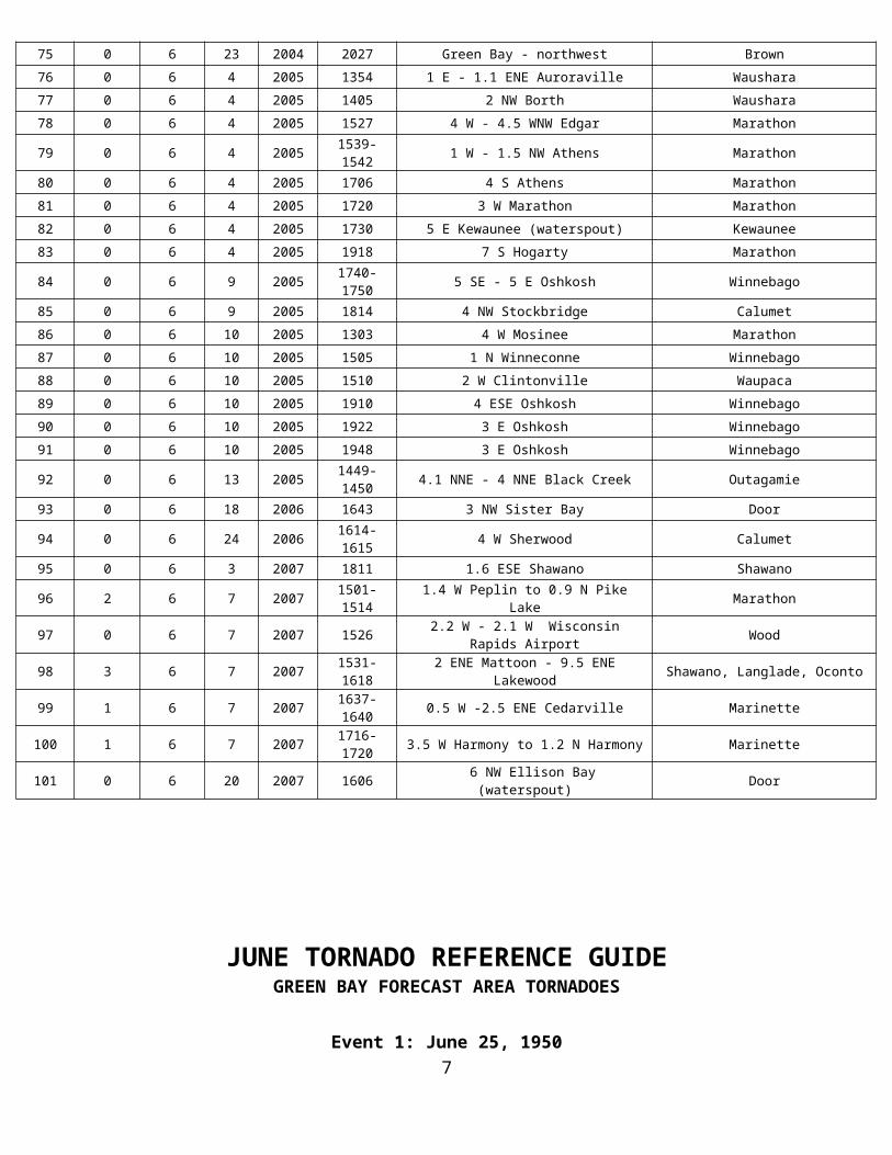
Event 98: June 7, 2007
By National Weather Service Green Bay Staff
Fast moving supercell thunderstorms with damaging winds, hail larger than 5 inches in diameter, and tornadoes ripped across central and northeast Wisconsin on June 7, 2007. Five tornadoes touched down in central and northeast Wisconsin.
Map of northeast Wisconsin and tornado tracks. Not denoted on the map is an area of straight-line wind damage in the Thunder Mountain area of western Marinette County, caused by the same supercell that produced the long-track tornado.
Menominee-Langlade-Oconto Counties Long-Track Tornado
A long-track tornado touched down at 3:31 pm CST east of Mattoon in Shawano County and continued northeast to the Oconto-Marinette County line. The tornado was on the ground for at least 40 miles, and was over 1/2 mile wide at times. Over 14,000 acres of trees were snapped or flattened and many dozens of buildings were damaged or destroyed. The twister was rated an EF3 on the Enhanced Fujita scale, with estimated winds of 140 to 160 mph
Picture on left: Tornado passing south of the city of White Lake in Langlade Co. Picture courtesy WAOW-TV.
Picture on right: Tornado as seen from HWY T in southwest Oconto Co. Picture courtesy of the Wisconsin Department of Natural Resources.
JUNE TORNADO REFERENCE GUIDE GREEN BAY FORECAST AREA TORNADOES
19
June 7, 2007: Tornadoes and Monster Hail
Note: Path of tornado damage viewed by Aqua MODIS satellite, courtesy ERSC, UW-Madison.
JUNE TORNADO REFERENCE GUIDE GREEN BAY FORECAST AREA TORNADOES
June 7, 2007: Tornadoes and Monster Hail20
Picture above: Damage at the Bear Paw Resort.
Picture on the left: More damage at the Bear Paw Resort.
Picture on the right: This is what remained of a double-wide mobile home in the town of Riverview. The owner heard the Tornado Warning and went into the bathtub (circled in large view), and escaped without a scratch!
JUNE TORNADO REFERENCE GUIDE GREEN BAY FORECAST AREA TORNADOES
21
Looking northeast across Hwy 64 in Oconto Co. The damage path was as much as 3/4 mile wide in this area. Picture courtesy Wisconsin DNR
Event 99: June 7, 2007
The F/EF-1 tornado developed a half mile west of Cedarville in Marinette County around 4:37 pm CST. The tornado was 200 yards wide and travelled three miles before it dissipated 2.5 miles east northeast of Cedarville around 4:40 pm CST. The tornado tore a significant portion of the roof from one home, snapped a few trees and uprooted numerous others. A manufactured home was moved off its foundation and down an embankment.
Event 100: June 7, 2007
The F/EF-1 tornado developed three and a half miles west of Harmony in Marinette County around 5:16 pm CST. The tornado was 200 yards wide and travelled 3.6 miles before dissipating 1.2 miles north of Harmony, or 2.9 miles south-southwest of Porterfield around 5:20 pm CST. One person was injured by flying debris as she sought refuge in their home. The tornado flattened a barn, tore a significant part of a sheet metal roof from an outbuilding, blew in a garage door and tore part of a roof deck over the garage from a home that was under construction.
Event 101: June 20, 2007
A waterspout (F/EF-0) was reported 6 miles northwest of Ellison Bay in Door County at 4:06 pm CST.
22