Embed Size (px)
Citation preview

VESSEL STRIKES AND ACOUSTIC IMPACTS
GULF OF THE FARALLONES AND CORDELL BANK NATIONAL MARINE SANCTUARIES
Sanctuary Advisory Council Report to the Gulf of the Farallones and Cordell Bank National Marine Sanctuaries
June 2012

CITATION
Vessel Strikes and Acoustic Impacts. 2012. Vessel Strikes and Acoustic Impacts. Sanctuary Advisory Council Report to the Farallones and Cordell Bank National Marine Sanctuaries. San Francisco, CA. 43 pp.
The work was made possible with financial support from the
With additional financial support from the
2
Joint Working Group Members
Co-Chairs: Jackie Dragon, Greenpeace; Gulf of the Farallones National Marine Sanctuary Advisory Council Lance Morgan, Marine Conservation Institute; Cordell Bank National Marine Sanctuary Advisory Council
John Berge, Pacific Merchant Shipping Association John Calambokidis, Cascadia Research Collective Frances Gulland, The Marine Mammal Center Michael Jasny, Natural Resources Defense Council Carol Keiper, Oikonos Ecosystem Knowledge Captain Bill Mahoney, APL Ltd. Kathy Metcalf, Chamber of Shipping of America
Technical Experts
Monica DeAngelis, NOAA National Marine Fisheries Service Leila Hatch, Stellwagen Bank National Marine Sanctuary John Hildebrand, University of California San Diego; Scripps Institute of Oceanography Jaime Jahncke, PRBO Conservation Science Kevin Krick, APL Ltd. LT Lucas Mancini, U.S. Coast Guard, District 11 Megan McKenna, Marine Mammal Commission Chris Miller, Naval Post Graduate School Ingrid Overgard, International Ocean Noise Coalition Elizabeth Petras, NOAA National Marine Fisheries Service CDR Kiley Ross, Inspections and Investigations Branch Chief, U.S. Coast Guard Brandon Southall, Southall Associates Mike VanHouten, U.S. Coast Guard, District 11
Staff to the Joint Working Group
Leslie Abramson, Gulf of the Farallones National Marine Sanctuary Michael Carver, Cordell Bank National Marine Sanctuary
Sanctuary Superintendents
Maria Brown, Gulf of the Farallones National Marine Sanctuary Dan Howard, Cordell Bank National Marine Sanctuary
3
Table of Contents
EXECUTIVE SUMMARY............................................................................................................ 5
INTRODUCTION ........................................................................................................................ 7
Problem ................................................................................................................................... 7
Vessel Strikes........................................................................................................................... 7
Acoustic Impacts ...................................................................................................................... 8
JOINT WORKING GROUP ON VESSEL STRIKES AND ACOUSTIC IMPACTS............................ 9
CHARACTERIZATION OF THE AREA ......................................................................................10
Whales ...................................................................................................................................10
Vessel Traffic..........................................................................................................................11
Regulatory Context ..................................................................................................................13
JOINT WORKING GROUP RECOMMENDATIONS ....................................................................14
Management Recommendations ................................................................................................14
Modification to shipping lanes ...............................................................................................14
Dynamic Management Areas .................................................................................................15
Real-Time Monitoring ..........................................................................................................17
Observations from ships ........................................................................................................18
Reporting and compiling sightings..........................................................................................18
Additional Management Recommendations: ...............................................................................18
National Marine Sanctuaries Act consultation ..........................................................................18
Incentives for ship-quieting ...................................................................................................19
Acoustic Research and Monitoring Recommendations..................................................................19
Ship Strike Research Recommendations .....................................................................................23
Education and Outreach Recommendations.................................................................................24
References..................................................................................................................................26
Appendix A: Commonly Used Acronyms.......................................................................................29
Appendix B: Joint Working Group Guidance Documents .................................................................30
Appendix C: AIS Analysis............................................................................................................32
Appendix D: Research and Monitoring Expert Team Report.............................................................32
Appendix E: Education and Outreach Expert Team Report ...............................................................42
4
EXECUTIVE SUMMARY
Problem Endangered blue, fin and humpback whales (Balaenoptera musculus, Balaenoptera physalus and Megaptera novaeangliae) feed within Gulf of the Farallones (GFNMS) and Cordell Bank National Marine Sanctuaries (CBNMS). Large commercial vessels1 utilize an internationally approved traffic separation scheme (TSS) when they transit these sanctuaries, heading to and from ports in San Francisco Bay and major ports in the Pacific Rim. The co-occurrence of these two global populations (whales and ships) in space and time creates an elevated risk of vessel strike, and thus mortality, to whales.
High densities of vessel traffic also expose marine mammals to chronic underwater engine and propeller noise. Exposure to this underwater noise can impact the ability of whales to communicate with each other, navigate and forage.
Joint Working Group on Vessel Strikes and Acoustic Impacts Protecting endangered species and sanctuary resources is a priority issue for the National Oceanic and Atmospheric Administration (NOAA) and the Office of National Marine Sanctuaries (ONMS). To address this issue locally, Gulf of the Farallones (GF) and Cordell Bank (CB) Sanctuary Advisory Councils formed a Joint Working Group (JWG) on Vessel Strikes and Acoustic Impacts, including representatives from conservation groups, the shipping industry, and the scientific community. Additional technical expertise was provided by staff from government agencies, conservation groups and scientists, who were not formal members of the JWG but contributed to the process. The purpose of the JWG is to recommend actions to reduce ship strike and ocean noise impacts in the two sanctuaries.
This report contains several specific recommendations for policy and management, education and outreach, and research and monitoring within Gulf of the Farallones and Cordell Bank sanctuaries. The majority of these actions – which are discussed in greater detail in the report – would be implemented through partnerships between NOAA and the U.S. Coast Guard (USCG).
Recommendations • NOAA and USCG should pursue the modification of shipping lanes to avoid areas of
whale concentration, such as extension of the proposed western approach lane beyond the continental shelf edge.
• The sanctuaries and NOAA’s National Marine Fisheries Service (NMFS), working with external partners, should establish dynamic management areas (DMAs) at the entrance to San Francisco Bay. DMAs should be implemented in areas with high whale concentrations for at least one week or longer as the whale spatial and temporal distribution warrants. The implementation response should be that vessels slow down within the DMA, or preferably, choose alternate lanes where there would be no active DMA.
1 The JWG chose to focus their discussion on vessels greater than 300 gross registered tons, as these vessels are required to carry Automated Identification Systems (AIS), which can provide detailed data on vessel behavior.
5

• The sanctuaries and NMFS, working with external partners, should implement a real-time whale sighting and monitoring network with participation from commercial ships, to provide data on whale occurrence and inform the designation of the onset, duration and location of DMAs.
• The sanctuaries should consult with other federal agencies on activities that would affect vessel traffic or vessel noise within sanctuary boundaries. This authority derives from the National Marine Sanctuaries Act § 304(d), under which sanctuaries are entitled to consult over federal agency actions, including licensing or approving private activities, that are likely to injure a sanctuary resource.
• The sanctuaries, together with NMFS and external partners, should work with the port authorities in San Francisco Bay, other west coast ports and industry to establish port-based incentives for the reduction of underwater shipping noise.
• The sanctuaries, together with NMFS and external partners, should implement a passive acoustic monitoring program within GF and CB sanctuary waters to better understand the abundance and distribution of marine mammal species in the sanctuaries, as well as the potential noise impacts from shipping on sanctuary resources.
• The West Coast Region sanctuaries should draft an Education and Outreach Strategic Plan, with measurable outputs and an implementation schedule that will seek to inform all stakeholders on the issues as well as possible solutions. Education and outreach materials should first be focused on engaging and informing the commercial maritime industry.
• The West Coast Region sanctuaries and NMFS should develop a regional education and outreach program to leverage scarce resources, avoid duplication of efforts in areas already addressed by other NMS (e.g. CINMS, Stellwagen Bank NMS), and recognize that commercial vessels often call or transit close to any one of the NMS on many voyages.
Conclusion
These consensus recommendations represent a collaborative, stakeholder-included approach to the problems of vessel strikes and acoustic impacts on the large whales in the National Marine Sanctuaries. Recommendations for research and monitoring will provide baseline information on the acoustic environment of the sanctuaries to inform future management decisions. Collectively, these recommendations are designed to benefit the marine life of the sanctuary while minimizing impacts on the shipping industry. The JWG presented this document to Gulf of the Farallones and Cordell Bank Sanctuary Advisory Councils on June 7, 2012 and it was unanimously adopted by both councils and forwarded on to the Superintendents for review and potential implementation by sanctuary management.
6
INTRODUCTION
Problem Endangered blue, fin and humpback whales (Balaenoptera musculus, Balaenoptera physalus and Megaptera novaeangliae) feed within Gulf of the Farallones (GFNMS) and Cordell Bank National Marine Sanctuaries (CBNMS. Large commercial vessels2 utilize an internationally approved traffic separation scheme (TSS) when they transit these sanctuaries, heading to and from ports in San Francisco Bay and major ports in the Pacific Rim. The co-occurrence of these two global populations (whales and ships) in space and time creates an elevated risk of vessel strike, and thus mortality, to whales.
High densities of vessel traffic also expose marine mammals to chronic underwater engine and propeller noise. Exposure to this underwater noise can impact the ability of whales to communicate with each other, navigate, forage, and detect danger.
Vessel Strikes Ship strikes of whales have been recognized as a growing concern worldwide. Documented ship strikes from NOAA NMFS data from 1988-2011, occurring just within the GFNMS/CBNMS region, total 20 whales killed by ships (i.e., death caused by vessel collision or carcass exhibited signs of trauma consistent with vessel collision) and an additional 10 injured and possibly killed (i.e., collision observed, but final status unknown). The true number of ship strikes is likely higher since most ship strikes go undocumented (Williams et al. 2011; Kraus et al. 2005; Vanderlaan et al. 2009). This underestimation is attributed largely to the fact that most whales are negatively buoyant and sink rather than wash ashore or float (Allison et al. 1991). The proportion of struck whales that strand has been estimated to range from <5% to 17% of true mortality, suggesting ship strikes could be at least 10 times higher than the number documented (Williams et al. 2011).
Four primary species of whales (blue, fin, humpback, and gray, Eschrichtius robustus) have been killed by ship strikes in the GFNMS/CBNMS region. The impact of ship strikes on blue whales may be of greatest concern, given their smaller population, lack of population recovery and the high proportion of their mortality attributed to ship strikes (Berman-Kowalewski et al. 2010). Conversely, gray whales are the most frequently recovered species of ship-struck whale along the California coast, but this could reflect their larger population size and possibly their coastal distribution, resulting in a higher proportion of ship strikes getting documented. The potential sensitivity of a species to ship strikes is also somewhat indicated by a population’s level of Potential Biological Removal (PBR), as determined by NMFS in stock assessments. The PBR is based on the abundance, reproductive rate, and recovery status of a population, and represents the maximum number of animals, not including natural mortalities, that may be removed from a marine mammal stock while allowing that stock to reach or maintain its optimum sustainable
2 The JWG chose to focus their discussion on vessels greater than 300 gross registered tons, as these vessels are required to carry Automated Identification Systems (AIS), which can provide detailed data on vessel behavior.
7
population. For blue whales, the annual PBR for the eastern North Pacific is 3.1 (the lowest among blue, fin, humpback, and gray whales), while ship strikes number up to 4 per year and are certainly much higher if unreported collisions are included. Based on population status, distribution and PBR, ship-strike risk in this region should be considered highest for blue whales, intermediate for fin and humpback whales, and lowest for gray whales.
In 2010, the West Coast Region of the Office of National Marine Sanctuaries (ONMS) determined that this issue had relevance to all the sanctuaries along the west coast of the United States and made the project a regional initiative. Ship strikes have been identified by NOAA's National Marine Fisheries Service (NMFS) as a threat to the population recovery of endangered blue, right, humpback and fin whales (NMFS 1998; NMFS 2005; NMFS 1991; NMFS 2010) in the Eastern Pacific. The west coast of the United States also contains some of the highest densities of commercial maritime traffic in the world, with 50% of the nation’s commerce visiting major deep draft ports-of-call. Documented vessel strikes appear to be more prevalent around California’s major ports of San Diego, Los Angeles/Long Beach, and the entrance to the San Francisco Bay. Additionally, the Santa Barbara Channel has been identified as an area where blue whale strikes appear to be more common (Berman-Kowalewski et al 2010).
Acoustic Impacts At present very little is known about the historical acoustic environment within the sanctuaries. However, anthropogenic noise in the ocean, including off the California coast, has increased exponentially over the past 60 years, largely due to the increased number, size, and tonnage of vessels in the commercial fleet (NRC 2003; McDonald et al. 2006). The sanctuaries, given their coincidence with the TSS adjacent to San Francisco Bay ports, are especially susceptible to increased amounts of anthropogenic noise.
Commercial vessels are responsible for relatively loud, low-frequency underwater noise, with source levels in the range of 180-195 dB (re 1μPa), and are the dominant source of underwater noise in the low frequency band, 10 to 500 Hz (NRC 2003; Hildebrand 2009; McKenna et al. 2012 ). Propeller cavitation, the loud hiss created by the formation and collapse of bubbles in the water, has been identified as the primary source of noise from commercial ships (Ross 1976; Renilson 2009).
This ship noise overlaps significantly with the frequency range used by many cetacean species, especially with low-frequency vocalizers such as blue, fin, humpback, and grey whales, and can cause what is known as masking (Clark et al. 2009). Considered a key concern for marine mammals, masking occurs when increased levels of background noise reduce an animal’s ability to detect relevant sounds (Richardson et al. 1995; Hildebrand 2006). Masking can hinder prey detection and reduce the range of communication (Clark et al. 2009; CBD 2012). There is an increasing body of scientific evidence showing that some marine mammals attempt to compensate for masking by changing the frequency, source level, redundancy, or timing of their signals, but the costs and effectiveness of these changes are not clear (Parks et al. 2007; CBD 2012; Rolland et al. 2012).
8
Exposure to underwater vessel noise has also been linked to both short and long-term behavioral disturbances in marine mammals. Behavioral changes can include habitat abandonment, disruption of foraging activity, suppression or alteration of vocalization, and other effects, and lead to chronic stress and population-level impacts (Richardson et al. 1995; Weilgart 2007; Nowacek et al. 2007; CBD 2012; Rolland et al. 2012). Complex behavioral changes to the same signal source can range from mild to severe and can vary dramatically among species and individuals, making it challenging to broadly characterize the impacts of shipping noise on marine mammal species (Ellison et al. 2012).
JOINT WORKING GROUP ON VESSEL STRIKES AND ACOUSTIC IMPACTS
Protecting endangered species and sanctuary resources is a priority issue for the National Oceanic and Atmospheric Administration (NOAA). To address this issue locally, Gulf of the Farallones (GF) and Cordell Bank (CB) Sanctuary Advisory Councils formed a Joint Working Group (JWG) on Vessel Strikes and Acoustic Impacts to provide them with recommendations for reducing ship strikes and ocean noise impacts, which the advisory councils could recommend to the sanctuary superintendents. The Superintendents may then incorporate some or all of the recommendations into the Sanctuary Joint Management Plan and begin implementation at any time. The JWG was asked to achieve consensus to the fullest extent possible within the one-year timeframe provided.
The JWG was represented by a diversity of stakeholders, and included representatives from the shipping industry (the potentially regulated entity in these negotiations), and the conservation and scientific communities. Staff from federal agencies (including NMFS, the Sanctuaries, and the U.S. Coast Guard), as well as members of the scientific community and environmental organizations served as technical experts to the JWG. These experts were not voting members of the JWG, although they provided invaluable information used during the JWG’s deliberations and development of the recommendations. It should be noted that government representatives working with the JWG could not, in their official capacity, endorse these recommendations. Having these people at the table, paired with a high level of commitment and engagement to the process, enabled the group to formulate practicable recommendations, while simultaneously building up initial support for these recommendations among the key members of the JWG. Our membership also included members engaged in these issues nationally and internationally. This gave the group the benefit of hearing lessons-learned from other regions as well as ensuring that the recommendations were developed in the context of national and international regulations, complementing many.
The JWG strove for specificity in its recommendations, in terms of both geographic focus (the GF and CB sanctuaries) and direction to managers. The group agreed that valuable work had been done by others to identify general mitigation measures that might apply to acoustics and vessel strike risk, but also recognized the geographic and species-specific differences found on the Pacific coast and the distinctive management scheme for ship routing outside San Francisco Bay. It was agreed that the group would dig deeper and make specific recommendations that could easily translate to real-world sanctuary management.
9
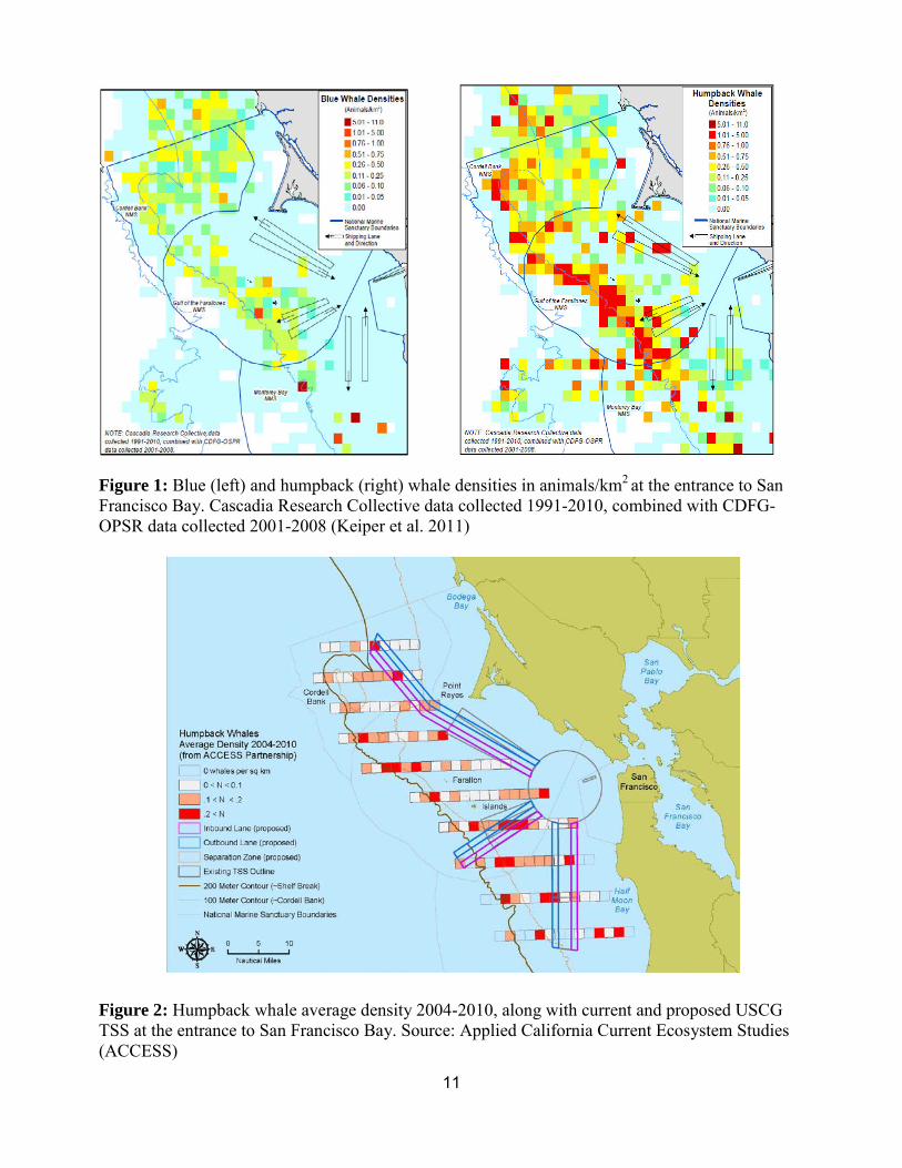
Additionally, several JWG members worked closely with NOAA and the USCG during the Port Access Route Study (PARS) process for this region, which was initiated for the entrance to San Francisco Bay in December 2009. The goal of the study was to help reduce the risk of maritime casualties and increase the efficiency of vessel traffic in the study area, while also considering threats to the marine environment. The JWG members placed special emphasis on reducing the co-occurrence of whales and ships through lane modification, as well as extending the western traffic lanes beyond the continental shelf edge in order to move vessels quickly and efficiently through the area of highest whale concentrations (See Fig. 2 to view current and proposed TSS and whale data used to inform PARS).
The JWG held six meetings over the course of one year, as well as numerous conference calls and online collaborations. This document is the result of those discussions. The Guidance Documents for the JWG can be found in Appendix B.
CHARACTERIZATION OF THE AREA
Whales Gulf of the Farallones and Cordell Bank National Marine Sanctuaries are known for some of the most diverse and abundant marine mammal assemblages in the world. This is due to a number of factors, such as the region's location on a whale migratory pathway between Arctic feeding grounds and warmer breeding areas, its high biological productivity, bathymetry and habitat diversity.
The sanctuaries are a feeding ground for blue and humpback whales and part of a major migration route for gray whales. The numbers of humpback (California, Oregon, Washington stock) and Eastern Pacific blue whales are estimated at 2,043 and 2,497 individuals respectively (Carretta et al. 2011), and both species are listed as endangered under the Endangered Species Act (ESA). All three species feed in the sanctuaries and represent some of the largest concentrations of these whales in the Northern Hemisphere. Endangered fin whales have also been sighted in the waters of the two sanctuaries.
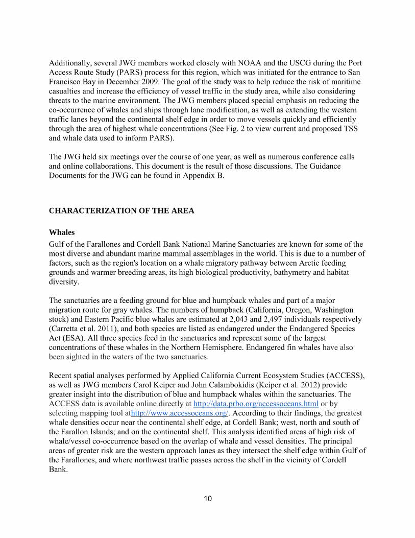
Recent spatial analyses performed by Applied California Current Ecosystem Studies (ACCESS), as well as JWG members Carol Keiper and John Calambokidis (Keiper et al. 2012) provide greater insight into the distribution of blue and humpback whales within the sanctuaries. The ACCESS data is available online directly at http://data.prbo.org/accessoceans.html or by selecting mapping tool athttp://www.accessoceans.org/. According to their findings, the greatest whale densities occur near the continental shelf edge, at Cordell Bank; west, north and south of the Farallon Islands; and on the continental shelf. This analysis identified areas of high risk of whale/vessel co-occurrence based on the overlap of whale and vessel densities. The principal areas of greater risk are the western approach lanes as they intersect the shelf edge within Gulf of the Farallones, and where northwest traffic passes across the shelf in the vicinity of Cordell Bank.
10
\
Figure 1: Blue (left) and humpback (right) whale densities in animals/km2 at the entrance to San Francisco Bay. Cascadia Research Collective data collected 1991-2010, combined with CDFG-OPSR data collected 2001-2008 (Keiper et al. 2011)
Figure 2: Humpback whale average density 2004-2010, along with current and proposed USCG TSS at the entrance to San Francisco Bay. Source: Applied California Current Ecosystem Studies (ACCESS)
11
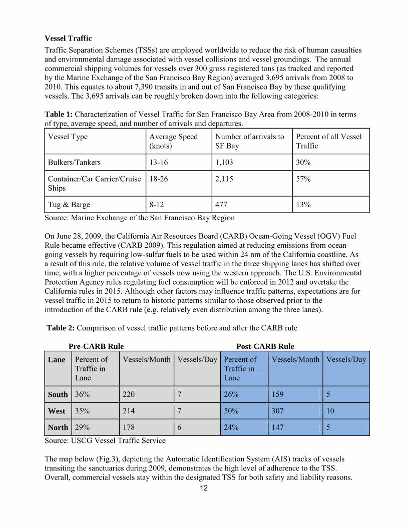
Table 1: Characterization of Vessel Traffic for San Francisco Bay Area from 2008-2010 in terms of type, average speed, and number of arrivals and departures.
Vessel Traffic Traffic Separation Schemes (TSSs) are employed worldwide to reduce the risk of human casualties and environmental damage associated with vessel collisions and vessel groundings. The annual commercial shipping volumes for vessels over 300 gross registered tons (as tracked and reported by the Marine Exchange of the San Francisco Bay Region) averaged 3,695 arrivals from 2008 to 2010. This equates to about 7,390 transits in and out of San Francisco Bay by these qualifying vessels. The 3,695 arrivals can be roughly broken down into the following categories:
Vessel Type Average Speed (knots)
Number of arrivals to SF Bay
Percent of all Vessel Traffic
Bulkers/Tankers 13-16 1,103 30%
Container/Car Carrier/Cruise Ships
18-26 2,115 57%
Tug & Barge 8-12 477 13%
Source: Marine Exchange of the San Francisco Bay Region
On June 28, 2009, the California Air Resources Board (CARB) Ocean-Going Vessel (OGV) Fuel Rule became effective (CARB 2009). This regulation aimed at reducing emissions from ocean-going vessels by requiring low-sulfur fuels to be used within 24 nm of the California coastline. As a result of this rule, the relative volume of vessel traffic in the three shipping lanes has shifted over time, with a higher percentage of vessels now using the western approach. The U.S. Environmental Protection Agency rules regulating fuel consumption will be enforced in 2012 and overtake the California rules in 2015. Although other factors may influence traffic patterns, expectations are for vessel traffic in 2015 to return to historic patterns similar to those observed prior to the introduction of the CARB rule (e.g. relatively even distribution among the three lanes).
Table 2: Comparison of vessel traffic patterns before and after the CARB rule
Pre-CARB Rule Post-CARB Rule Lane Percent of
Traffic in Lane
Vessels/Month Vessels/Day Percent of Traffic in Lane
Vessels/Month Vessels/Day
South 36% 220 7 26% 159 5
West 35% 214 7 50% 307 10
North 29% 178 6 24% 147 5
Source: USCG Vessel Traffic Service
The map below (Fig.3), depicting the Automatic Identification System (AIS) tracks of vessels transiting the sanctuaries during 2009, demonstrates the high level of adherence to the TSS. Overall, commercial vessels stay within the designated TSS for both safety and liability reasons.
12
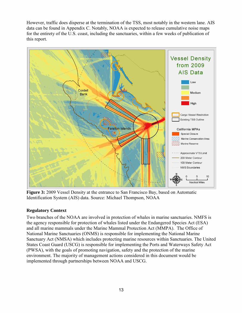
However, traffic does disperse at the termination of the TSS, most notably in the western lane. AIS data can be found in Appendix C. Notably, NOAA is expected to release cumulative noise maps for the entirety of the U.S. coast, including the sanctuaries, within a few weeks of publication of this report.
Figure 3: 2009 Vessel Density at the entrance to San Francisco Bay, based on Automatic Identification System (AIS) data. Source: Michael Thompson, NOAA
Regulatory Context Two branches of the NOAA are involved in protection of whales in marine sanctuaries. NMFS is the agency responsible for protection of whales listed under the Endangered Species Act (ESA) and all marine mammals under the Marine Mammal Protection Act (MMPA). The Office of National Marine Sanctuaries (ONMS) is responsible for implementing the National Marine Sanctuary Act (NMSA) which includes protecting marine resources within Sanctuaries. The United States Coast Guard (USCG) is responsible for implementing the Ports and Waterways Safety Act (PWSA), with the goals of promoting navigation, safety and the protection of the marine environment. The majority of management actions considered in this document would be implemented through partnerships between NOAA and USCG.
13
JOINT WORKING GROUP RECOMMENDATIONS
Management Recommendations The JWG agreed unanimously on the need for additional measures to protect whales related to ship strikes and ship noise. In summary, the key parts of the recommendations include: 1) modification of shipping lanes to avoid areas of whale concentration, 2) dynamic management areas reflecting areas and times of whale concentration where faster ships would either slow down or preferably avoid by choosing alternate lanes, and 3) a real-time whale sighting/monitoring network with participation by commercial ships, to provide data on whale occurrence and inform the designation of the timing and location of these management areas. These recommendations could result in lower risk of ship strikes, and fewer acoustic exposures of endangered baleen whales, by reducing ship passages through areas of whale concentration (through both the shipping lane changes and encouraging ships to use alternate routes away from whale concentrations); and lower the lethality of any ship strikes and decrease acoustic exposures by slowing ships that need to go through areas of whale concentration. Two additional recommendations would establish port-based incentives to reduce noise from commercial ships pursuant to IMO efforts; and would encourage the sanctuaries to consult with federal agencies whose activities would affect vessel traffic or vessel noise within their boundaries. Details of this plan are outlined below.
The JWG recognizes the responsibility of the vessel master to ensure the safety of their vessel at all times, and acknowledges that a vessel may be exempt from any or all management actions in situations that may put the safety of the vessel, crew, cargo or environment at risk. The recommendations below are intended to be implemented and practiced by commercial vessels only when the master deems it consistent with the safe and prudent operation of the vessel. The JWG also considered the future budget climate when developing these recommendations, and our recommendations were scaled or tailored to provide the most economical options available. We strongly affirm the need for funding over time within the federal budget process, and additionally encourage the involvement of appropriate sanctuary-affiliated associations, partners and industry to leverage public/private partnerships.
Modification to shipping lanes The JWG recommends that wherever possible, shipping lanes extend well across the continental shelf edge to minimize ship traffic in this high ship-strike risk area. The shelf edge has some of the highest biological productivity and therefore highest densities of some of the baleen whale species, including endangered blue and humpback whales, and so is one of the areas of highest risk of ship strikes during certain whale feeding periods. To reduce the risk of ship strikes, ship routing across the shelf edge is best accomplished in a way that minimizes the distance and duration of ship transits of this zone.
The JWG recommends that the western approach to San Francisco Bay be extended at least 3 nautical miles beyond the shelf edge. As additional information becomes available from analysis of additional data collected in the region or new analyses of available data (see Research/Monitoring Recommendations), the group further recommend that the location of shipping lanes relative to areas of whale concentration be re-evaluated.
14
Dynamic Management Areas The JWG recommends the establishment of Dynamic Management Areas (DMAs) around each of the three major shipping routes (and surrounding waters) into San Francisco Bay (Fig. 4) based on real-time sightings of whale concentrations. DMAs would be preferable to Seasonal Management Areas (SMAs) here because they would reduce the impact on industry and could be more effective in reducing ship strikes given their focus on actual whale occurrence, which are likely to vary geographically from year to year in this region. In addition, use of DMAs creates more flexibility for management because of San Francisco Bay’s multiple-approach TSS. DMAs require more resources for management than permanently restricted areas, however, and commitment from the agencies and industry will be critical to their success.
When concentrations of whales are present in or near one of the shipping lanes, the DMA that includes that lane and surrounding waters would be deemed "whale sensitive”3. The determination of when an area is deemed "whale sensitive" will be based on all sources of sighting information discussed below and will also incorporate information from historical sighting patterns and habitat model predictions. For example, an approach might be designated “whale sensitive” due to the presence of multiple groups of whales aggregated in the same area, plus ancillary information, such as surface chlorophyll concentration, that give greater confidence to predictability of whale locations. The system must be managed and implemented by NOAA staff experienced with whale distribution and sighting patterns. “Whale sensitive” designation should also recognize the differing vulnerability among whale species to ship strikes discussed in the introduction.
Where such a lane has been designated, vessels would have the option of either using the designated lane and following a speed limit of 10 knots, or using a different lane but maintaining normal speed. Such a designation would be made with enough warning (at least 24 hours) to allow ships to plan their routes, speeds and schedules accordingly and would be in place at least one week or longer, with duration depending on whale locations and densities, weather and sea conditions and other available data.
The JWG recognizes, on the basis of existing information, that there may be infrequent periods when high concentrations of whales, especially blue or fin whales, occur in multiple lanes simultaneously. Such a case prevents a clear designation of a single lane as “whale sensitive” as well as eliminates the benefit of encouraging a shift of traffic away from a single lane. The obvious benefit to designating multiple lanes would be to reduce the lethality of a ship strike and the potential for acoustic impacts; but the JWG also recognized the drawbacks of multiple lane designations, namely the inability to reduce co-occurrence where the entire TSS is designated and negative navigational safety impacts stemming from concentration of vessels in a non-designated lane where two lanes are designated. A two-lane designation is not a desirable option because it may impact vessel safety by concentrating ships in one lane and creating cross-traffic conditions outside of the area. Other options include a sanctuaries-wide speed restriction, as well as multiple restrictions tailored to specific segments of the lanes. While the need for multiple lane designations was considered an infrequent occurrence, it must be addressed through an appropriate management response.
3 An expert panel should be convened to discuss trigger criteria and develop guidelines for “whale sensitive” designation.
15
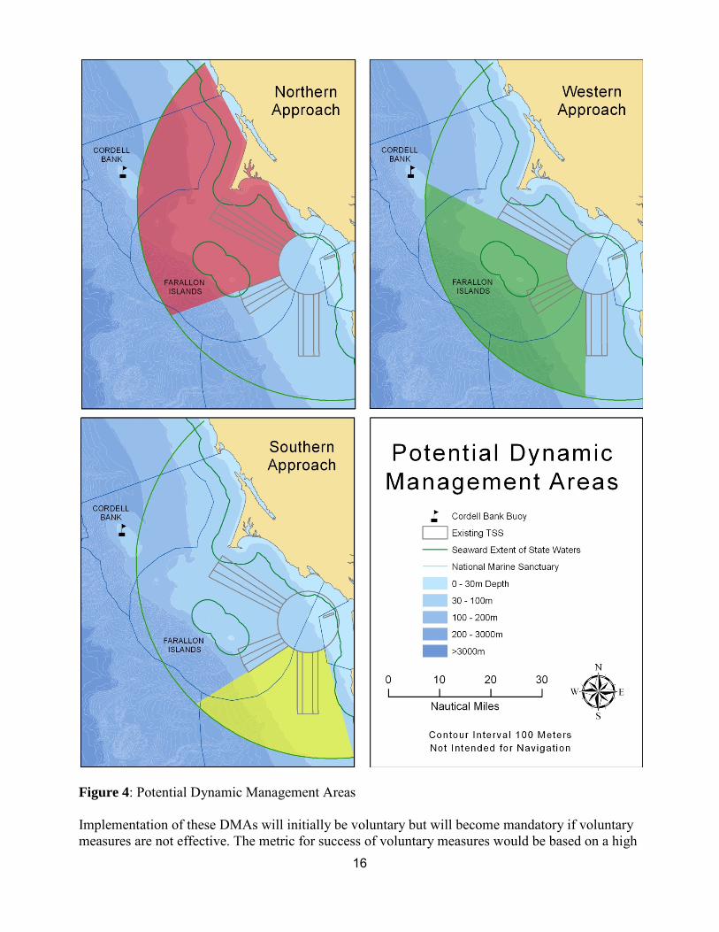
Figure 4: Potential Dynamic Management Areas
Implementation of these DMAs will initially be voluntary but will become mandatory if voluntary measures are not effective. The metric for success of voluntary measures would be based on a high
16
level of compliance/commitment with the speed restriction or rerouting when a single zone was declared "whale-sensitive". If a high level is not achieved within two seasons after the system is operational, a mandatory DMA approach should be implemented. Additionally, NOAA should conduct a periodic evaluation of the effectiveness of this program to determine the value of management measures to reduce the risk of ship strikes and acoustic impacts. This evaluation should be considered when deciding how to address the program needs in the future.
Implementation would occur according to the following timeline, which assumes prompt (within 6 months) response by the SACs, Sanctuary Superintendants, and NOAA Headquarters with regard to these recommendations:
• The reporting, sensitive lane designation, and voluntary compliance system would be operational by May/June 2013, to enable monitoring for compliance/commitment in 2013 and 2014.
• A simultaneous regulatory process that would allow NMFS to put mandatory DMA regulations in place by May/June 2015, should the voluntary measures not achieve the desired high level of compliance/commitment and there not be good progress towards that high level of commitment to the voluntary program.
• If the system of real-time monitoring and DMA designation is not successful by the close of 2017, and there is not a plan being implemented that would correct this in a timely manner, a seasonal, GF and CB sanctuary-wide 10 knot speed restriction that does not rely on real-time sighting data should be implemented through a regulatory process.
Real-Time Monitoring In order to provide information for the Dynamic Management Areas, we recommend the establishment of a real-time whale monitoring system based on reporting of sightings from a wide variety of opportunistic and dedicated platforms, as well as from commercial ships themselves.
Sources of whale data would include: • Commercial ships, which represent the most critical platform for sightings. This component is
described in greater detail below. • Opportunistic platforms, including whale-watch boats, fishing boats, and collaborating research
vessels, with participation by fishermen and naturalists. • Dedicated overflights of shipping lanes conducted with available Coast Guard aircraft hours.
Flight hours for whale observations (ideally one overflight per week during peak whale season) can be requested under federal co-op hours as part of a cooperative agreement between the USCG and other federal agencies.
• Dedicated vessel surveys for marine mammals and birds, including ACCESS, have provided useful distribution data. Directed legs would be added to these surveys as funding allows, covering the shipping lanes themselves, with the results used to fill gaps in other platforms of opportunity and verify or clarify sighting reports from other sources.
• Whale Observations from Southeast Farallon Islands, conducted by PRBO Conservation Science
• In addition to sightings, any blue, humpback, or fin whale strandings could trigger dedicated surveys of all shipping lanes through USCG overflights or vessel-based surveys.
17
Observations from ships Observations made directly from commercial ships represent the most promising source of information and, given the need for adequate, up-to-date data, an indispensable element of the monitoring scheme. Ships transit along the shipping lanes, the area of primary concern, multiple times per day and are excellent sighting platforms. Industry has participated in collaborative efforts for a variety of other data gathering initiatives, which indicates that this effort shows promise. U.S. and foreign flag shipping lines with robust environmental management programs may have the most potential for early participation.
A key element of the proposed system would include the deployment of Observer/Trainers on ships transiting between Los Angeles/Long Beach and San Francisco. This program would serve primarily to get the system of ship self-reporting under way and would serve several important functions:
• Provide an initial source of reliable data. • Train ship personnel in both sighting large whales, and identifying and reporting sightings. • Build enthusiasm and participation for self-reporting.
It is important for the success of this effort, and to address the significant logistical hurdles and safety/security concerns, that these individuals be experienced mariners, familiar with proper protocols, and trained in marine mammal sighting and reporting. One promising direction would be for these personnel to come from a Maritime Academy or other institution that has expertise in both ship operations and biological data gathering. Another possibility to facilitate training of ships’ personnel would be mariner attendance at shore-based courses or the use of computer-based training onboard the vessels.
Reporting and compiling sightings To provide for real-time integration of these sightings, tools would be developed to facilitate rapid uploading and visualization of sighting data. These tools would have two components: a mechanism for observers to upload data at the end of a survey into a database; and a website that enables managers as well as ship personnel to view the sighting data.
Several efforts are under way in other regions (around Cape Cod Bay in the northeast region and the Santa Barbara Channel in the southwest) to develop a custom application for smart phones or tablets that would allow entry of sightings and visualization. Members of the working group were informed by Google Oceans that the Cape Cod Bay application has a modular design, and could be adapted for local needs at relatively low cost. These applications will be evaluated as they become available but are not essential to the start of the program. For sightings from ships, reports would be submitted through a simple form email (most ships have the capability to send short emails), and submitting sightings by email is consistent with other ship reporting efforts. Communications back to ships can be transmitted via NAVTEX or other established communication systems.
Additional Management Recommendations:
National Marine Sanctuaries Act consultation The sanctuaries should consult with other federal agencies on activities that would affect vessel traffic or vessel noise within their boundaries. This authority derives from the National Marine
18
Sanctuaries Act § 304(d), under which sanctuaries are entitled to consult over federal agency actions, including licensing and other approvals of private activity, that are likely to injure a sanctuary resource. For most sanctuaries, including CBNMS and GFNMS, the Act and its implementing regulations define “resource” to include both living and non-living features that contribute to a sanctuary value; such resources may be considered “injured” by activities that take place outside their bounds. Through the consultation process, sanctuaries may recommend “reasonable and prudent alternatives” to reduce harm from proposed activities.
Incentives for ship-quieting The sanctuaries, together with NMFS, should work with the Los Angeles, Long Beach, and San Francisco Bay port authorities and industry to establish port-based incentives for the reduction of underwater shipping noise. These incentives would apply to ships that comply with voluntary ship-quieting guidelines for underwater noise, which are presently in development at the International Maritime Organization (IMO). The IMO could approve the guidelines as early as fall 2013, although a longer timeline is likely.
This recommendation for future management would help reduce shipping noise both within and outside of the sanctuaries. As noted above, it would depend on production of ship-quieting guidelines, which are under development at the International Maritime Organization. In addition, implementation of the mandatory Energy Efficiency Design Index (EEDI) to new ships, which has already been agreed to by IMO, may well result in reduced cavitation and thus less low-frequency noise from EEDI compliant vessels. Any port-based incentive program should also consider additional measures taken by existing vessels (to which the EEDI does not apply) from an energy efficiency perspective that result in reduced ship-generated noise. Additionally, implementation of the IMO agreement on the Energy Efficiency Design Index (EEDI) for new ships, and implementation of the IMO agreement on the Ship Energy Efficiency Management Plan (SEEMP), may well result in reduced ship operating speeds. We strongly support U.S. leadership on all of these issues at IMO and full implementation in U.S. waters.
Acoustic Research and Monitoring Recommendations
Three options for long-term monitoring to characterize the acoustic environment within the sanctuaries are proposed, depending on funding opportunities. In addition to whichever long-term option is implemented, it is also recommended that short-term acoustic monitoring can be accomplished throughout other areas within the sanctuaries using more portable recording systems (drifters, moored tags, etc.), which would allow opportunistic, quick turn-around (1-week) for acoustic characterization in other areas not near the long-term monitoring sites.
Priority Acoustic Objectives
1) Monitor long-term variance and trends in underwater ambient noise arising from anthropogenic and natural sources. These data are essential to understanding existing acoustic conditions within the sanctuary to support and monitor management efforts, including identifying sources of anthropogenic noise in the sanctuary. 2) Document occurrence of marine mammal species acoustically that cannot be monitored with
19
current visual surveys (sperm whales and beaked whales). Add additional understanding to the distribution and abundance of blue and humpback whales in between at-sea surveys and at night. 3) Provide data on spatial and temporal overlap between anthropogenic sound and marine mammals in the sanctuaries. This would potentially include examination of changes in acoustic detections of some species in relation to anthropogenic sound and assessment of whether sound exposure conditions approach those expected to cause impacts. 4) Acoustic model validation. Ambient noise recordings from acoustic moorings can be integrated with vessel traffic data (AIS messages) to validate shipping noise models. With additional bathymetric and oceanographic data throughout the sanctuaries, vessel traffic noise could be modeled for other areas within the sanctuary. Modeled noise levels can provide estimates of ambient acoustic noise to evaluate potential areas of interest; predict exposure levels in areas where marine mammals are observed (but not currently instrumented); and provide baseline noise levels for future management decisions.
The ideal acoustic monitoring effort would provide both archival, longer term measurements of spatial and temporal patterns in noise and real-time data from a network of acoustic sensors, with the ability to localize all marine mammals of interest (by triangulating on their vocalizations) for the purpose of updating “aids to navigation” notifications for nearby shipping. This type of solution requires either many widely spaced sensors that can be used for a long-baseline, time-delay of arrival solution or many closely spaced sensors in a horizontal array, which can provide bearing information to a vocalizing animal (with multiple arrays providing cross-bearing locations). Real-time data access would require either radio telemetered surface buoys, or a shore-cabled system. A large surface buoy would be required to provide sufficient autonomous power (solar/wind) to support the radio telemetry link, acoustic data collection and transmission to shore; alternatively, a battery-powered solution would require regular maintenance for power replacement. The ideal solution for this type of system is to run a cable from shore, which would provide both shore-based power and a data network link to the ocean sensors. These types of sensor nodes are now well-developed technology, supporting the National Science Foundation’s Ocean Observatories Initiative, for example; but large installation costs are associated with these systems (~$50M/node + installation). Cabled hydrophone arrays have also been widely used for Navy applications, but these systems still entail large costs associated (~10M). Due to the large costs and lack of identified sponsor, we have focused on several options for non-real time systems that will provide data in support of the objectives above.
The monitoring system proposed for deployment in the sanctuaries would consist of a small number of archival acoustic systems with characteristics and deployment locations strategically selected in order to best meet the priority objectives in important areas. The units would be deployed and record for some period of time and would then be retrieved and the data analyzed in terms of natural and anthropogenic sounds. As the archival systems require recovery of the onboard data for processing and analysis, these systems will not provide real-time alerts or notifications of marine mammal vocalizations.
Current Hardware Options Many types of autonomous acoustic recorder (AAR) systems have been developed. A comprehensive survey of available acoustic equipment was done by Lori Mazzuca in 2010 for the U.S. Navy, with a summary of the long-term monitoring recorders listed in Table 3.
20
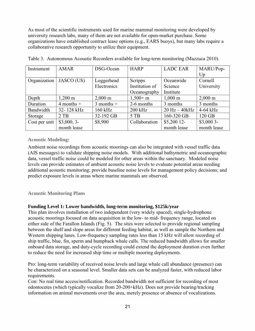
As most of the scientific instruments used for marine mammal monitoring were developed by university research labs, many of them are not available for open-market purchase. Some organizations have established contract lease options (e.g., EARS buoys), but many labs require a collaborative research opportunity to utilize their equipment.
Table 3. Autonomous Acoustic Recorders available for long-term monitoring (Mazzuca 2010).
Instrument AMAR DSG-Ocean HARP LADC EAR MARU/Pop-Up
Organization JASCO (US) Loggerhead Electronics
Scripps Institution of Oceanography
Oceanwide Science Institute
Cornell University
Depth 1,200 m 2,000 m 1,500+ m 1,000 m 2,000 m Duration 4 months + 3 months + 2-6 months 3 months 3 months Bandwidth 32- 128 kHz 160 kHz 200 kHz 20 Hz – 40kHz 4-64 kHz Storage 2 TB 32-192 GB 5 TB 160-320 GB 120 GB Cost per unit $3,000, 3-
month lease $8,900 Collaboration $5,200 12-
month lease $3,000 3-month lease
Acoustic Modeling: Ambient noise recordings from acoustic moorings can also be integrated with vessel traffic data (AIS messages) to validate shipping noise models. With additional bathymetric and oceanographic data, vessel traffic noise could be modeled for other areas within the sanctuary. Modeled noise levels can provide estimates of ambient acoustic noise levels to evaluate potential areas needing additional acoustic monitoring; provide baseline noise levels for management policy decisions; and predict exposure levels in areas where marine mammals are observed.
Acoustic Monitoring Plans
Funding Level 1: Lower bandwidth, long-term monitoring, $125k/year This plan involves installation of two independent (very widely spaced), single-hydrophone acoustic moorings focused on data acquisition in the low- to mid- frequency range, located on either side of the Farallon Islands (Fig. 5). The sites were selected to provide regional sampling between the shelf and slope areas for different feeding habitat, as well as sample the Northern and Western shipping lanes. Low-frequency sampling rates less than 15 kHz will allow recording of ship traffic, blue, fin, sperm and humpback whale calls. The reduced bandwidth allows for smaller onboard data storage, and duty-cycle recording could extend the deployment duration even further to reduce the need for increased ship time or multiple mooring deployments.
Pro: long-term variability of received noise levels and large whale call abundance (presence) can be characterized on a seasonal level. Smaller data sets can be analyzed faster, with reduced labor requirements. Con: No real time access/notification. Recorded bandwidth not sufficient for recording of most odontocetes (which typically vocalize from 20-200+kHz). Does not provide bearing/tracking information on animal movements over the area, merely presence or absence of vocalizations.
21
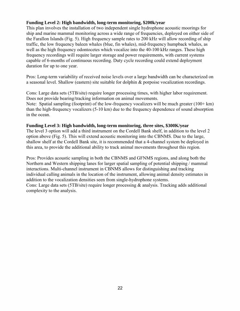
Funding Level 2: High bandwidth, long-term monitoring, $200k/year This plan involves the installation of two independent single hydrophone acoustic moorings for ship and marine mammal monitoring across a wide range of frequencies, deployed on either side of the Farallon Islands (Fig. 5). High frequency sample rates to 200 kHz will allow recording of ship traffic, the low frequency baleen whales (blue, fin whales), mid-frequency humpback whales, as well as the high frequency odontocetes which vocalize into the 40-100 kHz ranges. These high frequency recordings will require larger storage and power requirements, with current systems capable of 6-months of continuous recording. Duty cycle recording could extend deployment duration for up to one year.
Pros: Long-term variability of received noise levels over a large bandwidth can be characterized on a seasonal level. Shallow (eastern) site suitable for dolphin & porpoise vocalization recordings.
Cons: Large data sets (5TB/site) require longer processing times, with higher labor requirement. Does not provide bearing/tracking information on animal movements. Note: Spatial sampling (footprint) of the low-frequency vocalizers will be much greater (100+ km) than the high-frequency vocalizers (5-10 km) due to the frequency dependence of sound absorption in the ocean.
Funding Level 3: High bandwidth, long-term monitoring, three sites, $300K/year The level 3 option will add a third instrument on the Cordell Bank shelf, in addition to the level 2 option above (Fig. 5). This will extend acoustic monitoring into the CBNMS. Due to the large, shallow shelf at the Cordell Bank site, it is recommended that a 4-channel system be deployed in this area, to provide the additional ability to track animal movements throughout this region.
Pros: Provides acoustic sampling in both the CBNMS and GFNMS regions, and along both the Northern and Western shipping lanes for larger spatial sampling of potential shipping / mammal interactions. Multi-channel instrument in CBNMS allows for distinguishing and tracking individual calling animals in the location of the instrument, allowing animal density estimates in addition to the vocalization densities seen from single-hydrophone systems. Cons: Large data sets (5TB/site) require longer processing & analysis. Tracking adds additional complexity to the analysis.
22
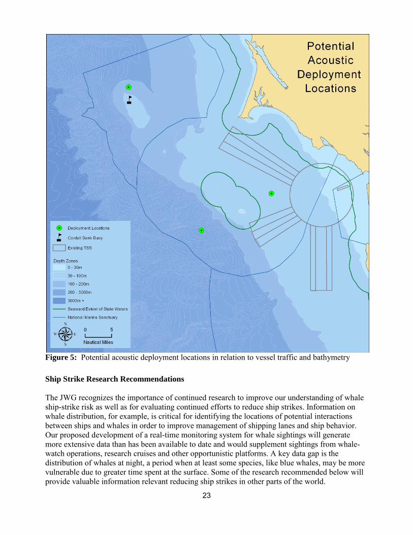
Figure 5: Potential acoustic deployment locations in relation to vessel traffic and bathymetry
Ship Strike Research Recommendations
The JWG recognizes the importance of continued research to improve our understanding of whale ship-strike risk as well as for evaluating continued efforts to reduce ship strikes. Information on whale distribution, for example, is critical for identifying the locations of potential interactions between ships and whales in order to improve management of shipping lanes and ship behavior. Our proposed development of a real-time monitoring system for whale sightings will generate more extensive data than has been available to date and would supplement sightings from whale-watch operations, research cruises and other opportunistic platforms. A key data gap is the distribution of whales at night, a period when at least some species, like blue whales, may be more vulnerable due to greater time spent at the surface. Some of the research recommended below will provide valuable information relevant reducing ship strikes in other parts of the world.
23

The JWG recommends continued research effort on the following topics related to risk of ship-strikes to whales: • Continue compilation and analysis of historical and new data (including from real-time sighting
data) in terms of whale distribution and habitats to inform possible future modifications of shipping lanes. It is important that some of these data include whale movements and distribution at night to allow evaluation of how well daytime sightings accurately represent nighttime distribution.
• Compile ship traffic data to determine emerging changes in ship traffic patterns and speeds over time, especially in the context of changes in CARB rules, IMO Emission Control Areas, and other management and economic factors.
• Using data on whale abundance, trends, distribution, duration of time in vulnerable areas, reaction to ships, and proportion and location of strandings involving ship strikes to evaluate the degree to which documented ship strike mortalities reflect true mortalities of whales and consider the relative risk of ship strikes to different species.
• Continue monitoring whale population trends to provide data for the above calculations and to determine the conservation status of the potentially affected populations.
• Ensure that stranded whales are systematically examined to determine whether they were hit by ships prior to death.
• Gather data on behavior of whales in and around shipping lanes relevant to vulnerability to ship strikes, including the proportion of time whales spend near the surface and how this varies by species, region, and time of day, and whether other whale species differ as dramatically in their diurnal behavior as blue whales.
• Examine how whales react to approaching ships to determine differential vulnerability to collisions with ships, and how changes in noise levels from ships or speed changes alter vulnerability.
The full Research and Monitoring Expert Team Report can be found in Appendix D.
Education and Outreach Recommendations
Regardless of subject matter, the JWG notes that the fundamental components of any Education and Outreach Plan must address three basic questions: 1) what is the substantive message to be communicated, 2) to whom will the message be communicated, and 3) how the message will be communicated. The recommendations address each of these three critical elements.
First, it was agreed that a strategic plan for addressing education and outreach must be prepared and be specific enough to inform all stakeholders on the issues as well as on possible solutions. This can only be accomplished by consolidating the information produced by the JWG in the areas of policy, research, and analysis.
Second, it was agreed that the number-one priority audience for education and outreach materials should be the commercial maritime industry, although it was recognized that Plan effectiveness requires communication of information to all stakeholders in the medium and long term.
Third, it was agreed that all elements of the Plan should be clearly defined and include expected and measured outputs (outcomes) and be subdivided into those with short-, medium- and long-term implementation schedules. While the CBNMS and GFNMS region has specific information needs, which can be added to this template replacing CINMS specific information (or a consolidated
24

matrix could be produced for all three NMS), the CINMS matrix provides a good listing of resources, activities, and outputs and expected short-, medium- and long-term outcomes. The matrix also includes guidance on the development of a needs assessment, as well as the design, development, implementation and evaluation of the program.
Fourth, it was agreed that, using the current CINMS education and outreach needs assessment text, CINMS, CBNMS, and GFNMS and NMFS should develop a regional education and outreach program to leverage scarce resources, avoid duplication of efforts in areas already addressed by other NMS (e.g. CINMS, Stellwagen Bank NMS), and recognize that commercial vessels often call/transit near all three NMS on many voyages.
Further information on the Education and Outreach Expert Team Report can be found in Appendix E.
25
References
Allison, P.A., Smith, C.R., Kukert, H., Deming, J.W., & Bennet, B.A. 1991. Deep-water taphonomy of vertebrate carcasses: A whale skeleton in the bathyal Santa Catalina Basin. Paleobiology, 17(1), 78-89.
Berman-Kowalewski, M., F.M.D. Gulland, S. Wilkin, J. Calambokidis, B. Mate, J. Cordaro, D. Rotstein, J. St. Leger, P. Collins, K. Fahy, and S. Dover. 2010. Association between blue whale (Balaenoptera musculus) mortality and ship strikes along the California coast. Aquatic Mammals 36: 59-66.
California Air Resources Board (CARB) 2009. Final regulation order. California Code of Regulations. Available from: http://www.arb.ca.gov/regact/2008/fuelogv08/fuelogv08.htm
Carretta, J.V., Forney, K.A., Oleson, E., Martien, K., Muto, M.M., Lowry, M.S., Barlow, J., Baker, J., Hanson, B., Lynch, D., Carswell, L., Brownell Jr., R.L., Robbins, J., Mattila, D.K., Ralls, K., Hill, M.C. 2011. U.S. Pacific Marine Mammal Stock Assessments: 2010. NOAA-TM-NMFS-SWFSC-476. U.S. Department of Commerce. National Oceanic and Atmospheric Administration. National Marine Fisheries Service, Southwest Fisheries Science Center. 169-183 pp.
Clark, C. W., W. T. Ellison, B. L. Southall, L. Hatch, S. M. Van Parijs, A. Frankel, D. Ponirakis. 2009. Acoustic masking in marine ecosystems: intuitions, analysis, and implication. Marine Ecology Progress Series 395: 201-222.
Convention on Biological Diversity (CBD). 2012. Scientific synthesis on the impacts of underwater noise on marine and coastal biodiversity and habitats. UNEP/CBD/SBSTTA/16/INF/12. Available online: http://www.cbd.int/doc/?meeting=SBSTTA-16
Ellison, W.T., Southall, B.L., Clark, C.W. & Frankel, A.S. A new context-based approach to assess marine mammal behavioral responses to anthropogenic sounds. Conserv. Biol. 26, 21-28 (2012).
Hildebrand, JA. 2009. Anthropogenic and natural sources of ambient noise in the ocean. Marine Ecology Progress Series, 395:5-20.
Hildebrand, J. 2006. Impacts of anthropogenic sound. Pages 101-123 in: Ragen, T.J., Reynolds III, J.E., Perrin, W.F., Reeves, R.R., and Montgomery, S. 2006. Marine Mammal Research: Conservation beyond Crisis. Baltimore: Johns Hopkins.
Keiper, C., Calambokidis, J., Ford, G., Casey, J., Miller, C., Kieckhefer, T.R. 2012. Risk assessment of vessel traffic on endangered blue and humpback whales in Gulf of the Farallones and Cordell Bank National Marine Sanctuaries, summary of research results. Oikonos Ecosystem Knowledge.
26

Kraus, S.D., Brown, M.W., Caswell, H., Clark, C.W., Fujiwara, M., Hamilton, P.K., Kenney, R.D., et al. 2005. North Atlantic right whales in crisis. Science, 309, 561-562. Retrieved from www.sciencemag.org/content/309/5734/561.full.pdf
McDonald MA, Mesnick SL, Hildebrand JA. 2006. Biogeographic characterization of blue whale song worldwide: using song to identify populations. Journal of Cetacean Research and Management 8 55-65
McDonald MA, Hildebrand JA, Wiggins SM. 2006. Increases in deep ocean ambient noise in the northeast pacific west of San Nicolas Island, California. Journal of the Acoustical Society of America 120:711-8
McKenna, M. F., D. Ross, S. M. Wiggins, and J. A. Hildebrand, Underwater radiated noise from modern commercial ships. J. Acoust. Soc. Am 131(1), 92-103 (2012).
National Marine Fisheries Service. 1998. Recovery plan for the blue whale (Balaenoptera musculus). Prepared by Reeves R.R., P.J. Clapham, R.L. Brownell, Jr., and G.K. Silber for the National Marine Fisheries Service, Silver Spring, MD. 42 pp.
National Marine Fisheries Service. 2005. Recovery Plan for the North Atlantic Right Whale (Eubalaena glacialis). National Marine Fisheries Service, Silver Spring, MD.
National Marine Fisheries Service. 1991. Recovery Plan for the humpback Whale (Megaptera novaegangliae). Prepared by the humpback Whale Recovery team for the National Marine Fisheries Service, Silver Spring, Maryland. 105 pp.
National Marine Fisheries Service. 2010. Recovery plan for the fin whale (Balaenoptera physalus). National Marine Fisheries Service, Silver Spring, MD. 121 pp.
National Research Council (NRC). 2003. Ocean Noise and Marine Mammals. Washington: National Academy Press. 204 pp.
Nowacek, DP, Thorne, L.H., Johnston, D.W., and Tyack, P.L. 2007. Responses of cetaceans to anthropogenic noise. Mammal Rev. 37: 81-115.
Parks, SE, Clark, CW, Tyack, PL. 2007. Short and long-term changes in right whale calling behavior: the potential effects of noise on acoustic communication. Journal of Acoustical Society of America. 122:3725-3731.
Renilson, M. 2009. Reducing underwater noise pollution from large commercial vessels. Report to IFAW. 44 pages. ISBN: 978-1-906920-02-9. Available from www.ifaw.org/oceannoise/reports
Richardson, WJ, Greene, C.R., Jr., Malme, C.I., and Thomson, D.H. 1995. Marine Mammals and Noise. New York: Academic Press. 576 pp.
Rolland, R.M. Parks, S.E. Hunt, K.E. Castellote, M. Corkeron, P.J. Nowacek, D.P. Wasser S.K. & Kraus, S.D.. Evidence that ship noise increases stress in right whales. Proc. R. Soc.B. (2012) doi:10.1098/rspb.2011.2429.
27
Ross, D., 1976. Mechanics of underwater noise (Pergamon, New York), pgs. 272-287.
Vanderlaan , A.S.M., Corbett, J.J., Green, S.L., Callahan, J.A., Wang, C., Kenney, R.D., Taggart, C.T., et al. 2009. Probability and mitigation of vessel encounters with North Atlantic right whales. Endangered Species Research, 6, 273-285.
Weilgart, L. 2007. The impacts of anthropogenic ocean noise on cetaceans and implication for management. Canadian Journal of Zoology 85: 1091-1116
Williams, R., S. Gero, L. Bejder, J. Calambokidis, S.D. Kraus, D. Lusseau, A.J. Read, and J Robbins. 2011. Underestimating the damage: interpreting cetacean carcass recoveries in the context of the Deepwater Horizon/BP incident. Conservation Letters 4: 228-233.
28
Appendix A: Commonly Used Acronyms
AIS – Automatic Identification System
CARB – California Air Resources Board
CBNMS – Cordell Bank National Marine Sanctuary
CDFG – California Department of Fish and Game
ESA – Endangered Species Act
GFNMS – Gulf of the Farallones National Marine Sanctuary
IMO – International Maritime Organization
JWG – Joint Working Group
NOAA – National Oceanic and Atmospheric Administration
NMFS – National Marine Fisheries Service
NMSA – National Marine Sanctuaries Act
ONMS – Office of National Marine Sanctuaries
OSPR – Oil Spill Prevention and Response
PARS – Port Access Route Study
PBR – Potential Biological Removal
TSS – Traffic Separation Scheme
USCG – United States Coast Guard
VTS – Vessel Traffic System
29

Appendix B: Joint Working Group Guidance Documents
Mission The purpose of the Joint Working Group (JWG) is to recommend actions to reduce ship strikes and ocean noise impacts to the sanctuary. This JWG will seek to achieve consensus in the recommendations it provides to the SAC to the fullest extent possible within the timeframe provided (May 2011 through May 2012).
Background The waters of Cordell Bank and Gulf of the Farallones National Marine Sanctuaries support a high degree of shipping activity that could affect a range of sanctuary resources. The Joint JWG will provide information that accurately characterizes the issues and problems related to vessel traffic’s impacts, and based on its findings provide recommendations to the Sanctuary Advisory Councils for adoption and development of future Action Plans. This proposed Joint JWG will consider vessel traffic’s potential contribution to resource management issues including acoustic impacts and ship strikes on marine mammals. The JWG will take a marine spatial planning approach to evaluating impacts and determining recommendations.
Anticipated potential recommendations range from: identifying needed monitoring and research, to increased outreach and education, to modified or new regulations. Additional goals of the JWG include fostering cooperation with cross-jurisdictional partners addressing the same issues, building upon progress that has already been made in addressing these issues, and educating sanctuary users regarding the issues.
The JWG will enlist a representative stakeholder group for this collaborative process including members from the CBNMS and GFNMS SACs, government agencies, the conservation community, the shipping industry, and the scientific community to investigate and analyze these issues, and develop a comprehensive report for the SACs. In identifying appropriate applications for our unique resources, the JWG will endeavor to build upon the path-breaking work and research efforts of other sanctuaries (i.e., Stellwagen Bank and Channel Islands), while also adding to the knowledge base for use by other sites, as applicable, across the Office of National Marine Sanctuaries.
Objectives • Recommend research and monitoring to characterize the risk and impact of ship strikes to
whales and the acoustic environment. The scope of discussion on this objective includes: o Noise distribution and impacts o Predictive modeling o Marine mammal distribution o Data gaps o Monitoring ship traffic (Automatic Identification System)
• Recommend education and outreach to inform stakeholders and the public on the risk and impact of ship strikes to whales and the possible impacts of acoustics to sanctuary resources. The scope of discussion on this objective includes:
o Working with the shipping industry, Harbor Safety Committee, and Bar Pilots on best practices to reduce potential impacts
o Developing an outreach strategy to implement JWG recommendations
30

• Recommend policy actions to address ship strikes to whales and possible impacts of acoustics on sanctuary resources. The scope of discussion on this objective includes:
o Routing measures o Incentives and potential mandate of vessel speed o Dynamic management and seasonal management areas
• Recommend funding to implement recommendations. The scope of discussion on this objective includes:
o Linking JWG data with regional Coastal and Marine Spatial Planning efforts.
Roles and Responsibilities The JWG members will provide feedback on proposed ideas and concepts, exchange facts and information, and assist in seeking further information. Staff to the JWG will assist in providing technical information and taking meeting notes. Staff will share summary notes, actions items, and recommendations developed in this JWG with the Interagency Committee on Vessel Management in Tomales Bay. The facilitators, together with the staff, will develop meeting agendas, prepare for the meetings, seek clearest understanding of each member’s perspective, and maintain a productive and positive process.
Participation and Representation The JWG will consist of a body of individuals representing diverse interests and perspectives that will provide input toward developing a set of recommendations that will be forwarded to the SAC.
31
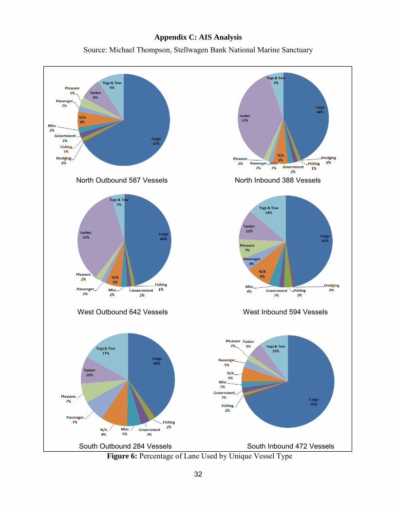
Appendix C: AIS Analysis Source: Michael Thompson, Stellwagen Bank National Marine Sanctuary
North Outbound 587 Vessels North Inbound 388 Vessels
West Outbound 642 Vessels West Inbound 594 Vessels
South Outbound 284 Vessels South Inbound 472 Vessels Figure 6: Percentage of Lane Used by Unique Vessel Type
32
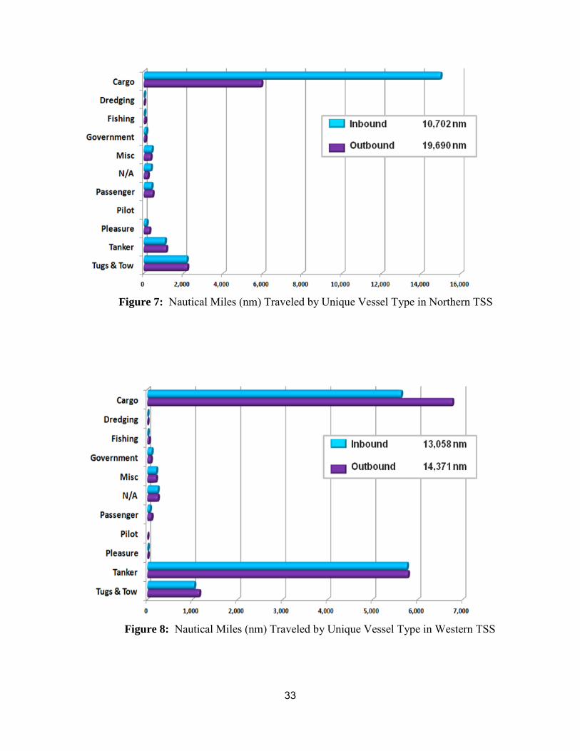
Figure 7: Nautical Miles (nm) Traveled by Unique Vessel Type in Northern TSS
Figure 8: Nautical Miles (nm) Traveled by Unique Vessel Type in Western TSS
33
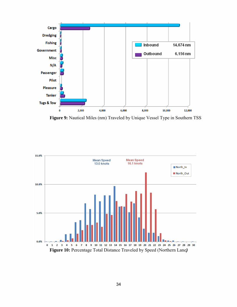
Figure 9: Nautical Miles (nm) Traveled by Unique Vessel Type in Southern TSS
Figure 10: Percentage Total Distance Traveled by Speed (Northern Lane)
34
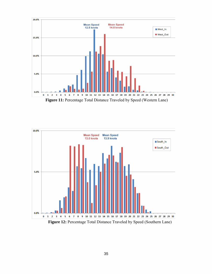
Figure 11: Percentage Total Distance Traveled by Speed (Western Lane)
Figure 12: Percentage Total Distance Traveled by Speed (Southern Lane)
35
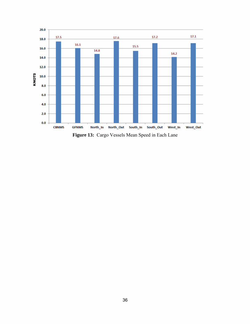
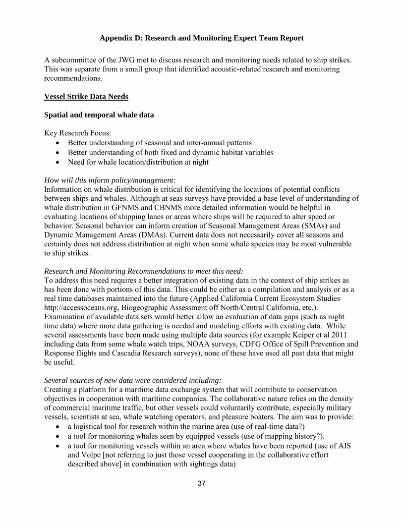
Figure 13: Cargo Vessels Mean Speed in Each Lane
36
Appendix D: Research and Monitoring Expert Team Report
A subcommittee of the JWG met to discuss research and monitoring needs related to ship strikes. This was separate from a small group that identified acoustic-related research and monitoring recommendations.
Vessel Strike Data Needs
Spatial and temporal whale data
Key Research Focus: • Better understanding of seasonal and inter-annual patterns • Better understanding of both fixed and dynamic habitat variables • Need for whale location/distribution at night
How will this inform policy/management: Information on whale distribution is critical for identifying the locations of potential conflicts between ships and whales. Although at seas surveys have provided a base level of understanding of whale distribution in GFNMS and CBNMS more detailed information would be helpful in evaluating locations of shipping lanes or areas where ships will be required to alter speed or behavior. Seasonal behavior can inform creation of Seasonal Management Areas (SMAs) and Dynamic Management Areas (DMAs). Current data does not necessarily cover all seasons and certainly does not address distribution at night when some whale species may be most vulnerable to ship strikes.
Research and Monitoring Recommendations to meet this need: To address this need requires a better integration of existing data in the context of ship strikes as has been done with portions of this data. This could be either as a compilation and analysis or as a real time databases maintained into the future (Applied California Current Ecosystem Studies http://accessoceans.org, Biogeographic Assessment off North/Central California, etc.). Examination of available data sets would better allow an evaluation of data gaps (such as night time data) where more data gathering is needed and modeling efforts with existing data. While several assessments have been made using multiple data sources (for example Keiper et al 2011 including data from some whale watch trips, NOAA surveys, CDFG Office of Spill Prevention and Response flights and Cascadia Research surveys), none of these have used all past data that might be useful.
Several sources of new data were considered including: Creating a platform for a maritime data exchange system that will contribute to conservation objectives in cooperation with maritime companies. The collaborative nature relies on the density of commercial maritime traffic, but other vessels could voluntarily contribute, especially military vessels, scientists at sea, whale watching operators, and pleasure boaters. The aim was to provide:
• a logistical tool for research within the marine area (use of real-time data?) • a tool for monitoring whales seen by equipped vessels (use of mapping history?). • a tool for monitoring vessels within an area where whales have been reported (use of AIS
and Volpe [not referring to just those vessel cooperating in the collaborative effort described above] in combination with sightings data)
37
Sightings from whale watch operations could be extremely useful and were used in recent assessment of areas of potential risk to ship strikes in this region (Keiper et al. 2011). Sanctuaries in other areas have had a more direct involvement with aspects of this such as in the Channel Islands where sanctuaries run a naturalist programs that puts trained naturalists on board whale watch boats as well as train volunteer naturalists in collecting sightings and photo-ID data (provided to Cascadia Research) and compile and make this data available. Because whale watch effort is often not evenly distributed, it is important that effort also be recorded so sightings can be considered in the context of areas of effort. Sanctuaries can play a valuable role ensuring whale watch operators collect these data and make them available to all researchers examining these types of questions.
There was discussion of the use of additional platforms of opportunity such as Coast Guard flights that could be used to gather additional sighting data. USCG has dedicated hours that could be used for aerial monitoring. Every year they dedicate federal coop hours that can be used by any other federal agency by request. A federal agency could put forth a proposal to use these hours for whale monitoring. If the demand for federal coop hours increases, USCG could potentially increase those hours. Dedicated aerial surveys were also considered. However, there was concern about conducting additional dedicated aerial surveys due to safety issues.
There was a suggestion that where possible additional sighting data should be gathered in the context of prey and environmental variables to support habitat modeling and the connection between whales and prey. Coordination with the NOAA science centers such as SWFSC would be critical with any additional survey work and habitat modeling since SWFSC conducts regular abundance assessment surveys along the U.S. West Coast and has partnered with the sanctuaries in the past for more fine scale coverage of sanctuary waters.
Data on night-time distribution and behavior can best be gathered with deployments of tags that can record night time data. Most appropriate are Fast-loc GPS tags that can record very accurate positions of every whale surface series and which have been deployed for this purpose in the shipping lanes off LA/Long Beach (Calambokidis et al., 2011 and McKenna et al. 2011 presented at the Biennial Conference on the Biology of Marine Mammals).
There was also some suggestion of the value of providing real time access to sightings through a satellite linked systems as has been conducted in some other areas like the Mediterranean. This could be a valuable way to keep shipping personnel aware of whale distribution and the issue of ship strikes. In general it was viewed that shippers would not have a clear way to make use of this information (outside of the DMA approach recommended by the JWG).
Ship movements and behavior including speed
Key Research Focus: • How does ship traffic change over time and with changes to CARB rules, implementation
of IMO Emission Control Area, and new proposed shipping lane options? • Routes for approaching shipping lanes • How does ship traffic patterns and speed change in response to management actions?
How will this inform policy/management? Information on ship distribution and use patterns is critical for identifying the locations of potential
38
conflicts between ships and whales. Ship use patterns have shifted dramatically in recent years with changes to the CARB rules and are likely to change again in the future. Models of risk to whales require information on current and future ship areas of use.
Research and Monitoring Recommendations to Meet this Need: AIS data are collected by a number of government and private parties. The United States Coast Guard in cooperation with the Department of Transportation’s VOLPE center collects, archives and broadcasts a live stream of AIS data that is a compilation of numerous high quality AIS data streams. This data set is streamed live to ONMS. One of the suppliers of high quality AIS data is the Naval Post Graduate School (NPS). They serve VOLPE data from their network of AIS antennas co-located at CODAR stations along the California coast. NPS also archives VOLPE data for its own uses.
Analyzing AIS data is not a trivial undertaking and takes considerable specialized expertise. Although ONMS currently has the capacity to analyze AIS data, every effort should be made to automate this process as much as possible so that GFNMS and CBNMS can utilize this information. To address this need scripts should be written that automate to the extent practical the processing of AIS data. When possible, expertise from across the ONMS should be leveraged to ensure data are processed in as efficient and consistent way as possible.
Species/degree of risk (Which species are more or less vulnerable and need to be prioritized?)
• Identify critical factors to consider (abundance, trend, distribution, duration of time in vulnerable areas, reaction to ships, proportion and location of strandings involving ship strikes)
• Determine degree to which documented ship strike mortality's reflect true mortalities
How will this inform policy/management? Prioritization of species is important to policy because funding is often limited and policy changes can differentially benefit or harm different species. Without a clearer set of priority species either of these would be hard to do. Understanding the degree to which certain species are actually at risk from ship strikes would be one way to prioritize but also indicates the degree of urgency for action. NMFS for example determines a level of Potential Biological Removal (PBR) that does not threaten a population and when something like fishery takes exceed this level they are required to convene a Take Reduction Team to find a way to reduce the level of mortality to below PBR. Currently, observed ship strike mortality of blue whales is close to PBR, but that is with no correction for the likely high proportion of ship struck whales that go unobserved or undocumented. An accurate method to estimate this should reveal the true level of threat to each population and would show whether ship strikes are above PBR, which would typically trigger their designation as a critical stock.
Research and Monitoring Recommendations to Meet this Need: To meet this need requires accurate data on population size, trends and vital rates of whales and then development of simple population models of true mortality to compare to observed mortality from strandings. Monitoring of population trends of whale abundance would need to continue to provide the data for these calculations. Stranded whales need to be examined to determine whether they were hit by ships prior to death. Currently approximately half of the whale strandings in central California are not examined in sufficient detail to make this determination due to logistical
39
constraints. Designated sites to land whales for necropsy are needed, as well as funding to support towing and carcass disposal. Population monitoring and stranding response need to be performed in collaboration with NMFS and the Stranding Network.
Whale Behavior (what are whales doing and when are they doing it?)
Key Research Focus: • Proportions of time whales are near surface • Do other species show as dramatic differences between day/night as blue whales?
How will this inform policy/management? Whale vulnerability to ship strikes is in part driven by their behavior and time near the surface. Whales feeding near the surface or resting near the surface at night are more vulnerable to ship strikes than those that are diving deeply or rapidly transiting an area. This information is needed to better prioritize critical locations for ships to avoid or change speed as well as to effectively evaluate various mitigation strategies.
Research and Monitoring Recommendations to Meet this need: Research that would address this need would include visual surveys of the shipping lanes to examine whale occurrence and behavior and also deployment of behavioral tags to get continuous detailed data on whale behavior (movement and dive) especially at night. Some aspects of this could be conducted at the same time as some of the work discussed above for examining whale distribution.
Ship/Whale Interactions (how does speed or noise from ships affect whales?)
Key Research Focus: • How do different species react to approaching ships that makes them more or less
vulnerable to ship strikes? • Does sound help whales avoid ships or make them more vulnerable? • How does speed of vessel increase or decrease the probability of a ship strike based on
whale reaction? • How does ship speed alter the lethality of a ship strike for different species and types of
vessels?
How will this inform policy/management? Slowing ships is one of the primary options being considered for reducing ship strikes. Slowing ships is thought to reduce the potential lethality of a ship strike but it is not known how it will change the incidence of ship strikes. Some environmental groups are pressuring the sanctuary to enact speed restrictions for ships in sanctuary waters but some in the shipping industry have expressed concern that such a measure is not supported by data and would be costly. There have also been proposed measured to make ships more quiet and reduce noise pollution but it has not been clear how that might alter the vulnerability of whales to ship strikes. On the opposite end of the spectrum, putting some type of noise generation on the bow of ship has been suggested as a way to alert whales to the presence of a ship. Evaluating the consequence of effectiveness of any of these measures requires a better understanding how whales react to noise of ships or their different speeds.
40
Research and Monitoring Recommendations to Meet this need: To address this need, continued research is needed deploying behavior tags to whales in shipping lanes to examine reaction to close approach of ships. This has been started with blue whales off southern California but not yet done off central California especially with humpback whales.
41
Appendix E: Education and Outreach Expert Team Report
A subcommittee of the JWG met to discuss education and outreach needs related to ship strikes..
Elements of an Effective Education and Outreach Plan
What Is The Substantive Message To Be Communicated?
There are a number of components to the substantive message to be communicated not only to commercial shipping, but also to other stakeholders. These components are:
• Specific recommendations of the JWG in this final report • Emphasis on the legal and moral need for protection of living marine resources • Recognition of the continuing need for all ocean users (shipping, fishing, recreational
boating) to maintain current level of activities but with an aim toward mitigating negative impacts of these users on living marine resources.
• Species and regionally specific information relative to current impacts including temporal and spatial distribution data and expected benefits on a species specific basis from implementation of JWG recommendations.
• A full listing of all mandatory (legal) and voluntary measures including MMPA and ESA as well as compliance levels with these measures and their benefits/negative impacts on living marine resources and ocean users.
• The protections afforded by the MMPA and ESA and the liability associated with violating these federal laws
• Define what is at risk if (1) no action is taken e.g. status quo or (2) if specific actions are taken creating future legal requirements and/or recommended voluntary programs.
• Listing of all available resources both web-based and other
To Whom Should The Message Be Communicated?
As noted in the recommendations section above, it was agreed that the highest priority for communicating this information should focused on the commercial shipping industry. However, it was also agreed that other stakeholders be considered during the Plan preparation process since a great deal of the “what” is of value to all stakeholders. The identified stakeholders are:
• Commercial maritime industry (owners, operators, charterers) • Fishing industry • Recreational boaters • Shipping industry trade associations (regional, national and international such as the Pacific
Merchant Shipping Association, Chamber of Shipping of America, the International Chamber of Shipping, respectively)
• Marine Exchanges • Ships’ Agents • Pilots
42

• Federal, state, regional and local government agencies with jurisdiction and/or interest in living marine resource protection initiatives and/or the free flow of commerce and trade resulting from activities of the commercial maritime and fishing industries as well as recreational boating.
• Environmental NGOs • Maritime/Environmental lawyers and bar associations • Media (national, state and regional) • Public at Large
How Will The Message Be Communicated?
The JWG recognized that a number of communication methods already exist for the purpose of sharing information between ship and shore. While many of these methods are one way communication which permit the widespread broadcast of information from shore sources to ships, the JWG also recognized the need to identify existing and potential systems which would facilitate two way communications among ship and shore sources. Specific to the charge given to the JWG, two way communications systems would facilitate the exchange of information from ships to appropriate shore sources relative to locations of real time sightings of whales which would further facilitate the broadcast of whale sighting locations to other ships in and approaching a specific area and provide advance warning of potential ship/whale encounters enabling vessel to take appropriate measures to either avoid or mitigate the potential for ship strikes in that specific area. The JWG also recognizes the need to communicate appropriate information to other stakeholders and thus the communication methods listed below focus first on systems which enable information flow between ships and shore sources followed by other systems appropriate to other stakeholders, including the public at large. The various communications methods identified by the JWG include:
• Local Broadcast Notice to Mariners • Coast Pilots • Maritime Trade Association emails to members • Maritime Exchange emails to members • Shipping Agents – Contact with arriving and transiting vessels • Internet – existing or new websites (list of existing websites included at the end of this
section) • Traditional written and broadcast media • School systems (all levels) via developed curricula • Mail outs (hard copy – paper and CD) to all stakeholders including the regulated
community
Existing information sources (websites)
• Existing NOAA Ship Strike website for ship strike mitigation of the North Atlantic Right Whale at http://www.nero.noaa.gov/shipstrike/ and http://www.nmfs.noaa.gov/pr/shipstrike/
• CBNMS at http://cordellbank.noaa.gov/ • GFNMS at http://farallones.noaa.gov/
43
• CINMS (already has ship strike/whales section) websites at http://channelislands.noaa.gov/ and http://channelislands.noaa.gov/focus/alert.html
• NOAA GCIL IMO activities at http://www.gc.noaa.gov/gcil_sound.html • National Academy of Science (2004 report) at
http://www.nap.edu/openbook.php?isbn=0309085365&page=1 • NOAA Symposia (2004 and 2007) at
http://www.nmfs.noaa.gov/pr/acoustics/shipnoise2004.htm and http://www.nmfs.noaa.gov/pr/acoustics/shipnoise.htm
• CINMS specific paper “Reducing noise pollution from commercial shipping in the Channel Islands National Marine Sanctuary: a case study in marine protected area management of underwater noise. (Case Study)”, Angela M. Haren, Journal of International Wildlife Law & Policy, June 1, 2007 at http://www.highbeam.com/doc/1G1-165933935.html (members only)
• Marine Mammal Commission Report to Congress (2008) including Advisory Committee Report on Acoustic Impacts on Marine Mammals Appendix (2006) at www.mmc.gov/reports/workshop/pdf/fullsoundreport.pdf
• NRDC Report “Sounding the Depths II: The Rising Toll of Sonar, Shipping and Industrial Noise on Marine Life”, Jasny et al (2005) at www.nrdc.org/wildlife/marine/sound/sound.pdf
Existing information sources (other)
• Species History/Background/Populations Trends (Fact Sheet) • Area (geographical/hydrographical) Background • Statutory/regulatory background • How to Report a Ship Strike • Real Time Sighting Information and Broadcasts (DMAs) • Seasonal Migration Patterns and Broadcasts (SMAs) • Interactive Guide for Mariners • Merchant Mariner Educational Module • Other Educational Modules? (general public, K-12, undergraduate, graduate)
44


![Data Quality Control for Vessel Mounted Acoustic Doppler Current ...digital.csic.es/bitstream/10261/28218/1/sm61n4417[1].pdf · The Vessel Mounted Acoustic Doppler Current Profiler](https://img.pdfslide.us/doc/110x75/5b8af9e57f8b9a9b7c8d67dc/data-quality-control-for-vessel-mounted-acoustic-doppler-current-1pdf.jpg)