Embed Size (px)
Citation preview

Country profile – Turkmenistan
Version 2012

Recommended citation: FAO. 2012. AQUASTAT Country Profile – Turkmenistan.
Food and Agriculture Organization of the United Nations (FAO). Rome, Italy
The designations employed and the presentation of material in this information product do not imply the expression of any opinion whatsoever on the part of the Food and Agriculture Organization of the United Nations (FAO) concerning the legal or development status of any country, territory, city or area or of its authorities, or concerning the delimitation of its frontiers or boundaries. The mention of specific companies or products of manufacturers, whether or not these have been patented, does not imply that these have been endorsed or recommended by FAO in preference to others of a similar nature that are not mentioned. The views expressed in this information product are those of the author(s) and do not necessarily reflect the views or policies of FAO. FAO encourages the use, reproduction and dissemination of material in this information product. Except where otherwise indicated, material may be copied, downloaded and printed for private study, research and teaching purposes, or for use in non-commercial products or services, provided that appropriate acknowledgement of FAO as the source and copyright holder is given and that FAO’s endorsement of users’ views, products or services is not implied in any way. All requests for translation and adaptation rights, and for resale and other commercial use rights should be made via www.fao.org/contact-us/licencerequest or addressed to [email protected]. FAO information products are available on the FAO website (www.fao.org/ publications) and can be purchased through [email protected]. © FAO 2012

1
Turkmenistan
GEOGRAPHY, CLIMATE AND POPULATION
Geography
Turkmenistan is bordered in the west by the Caspian Sea, in the northwest by Kazakhstan, in the north
and northeast by Uzbekistan, in the southeast by Afghanistan and in the south and southwest by the
Islamic Republic of Iran. Total area is 488 100 km2 (Table 1). The country formally declared
independence from the Union of Soviet Socialist Republics (USSR) in October 1991. For administrative
purposes, the country is divided into five provinces (velayat) and one independent city, Ashgabat, which
is the capital.
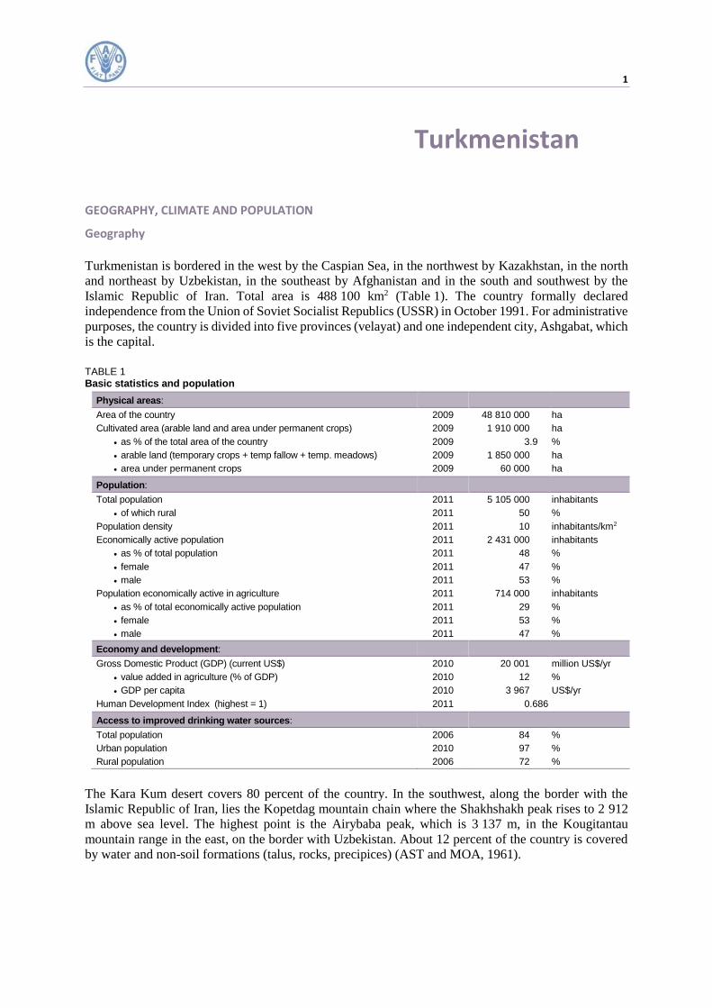
TABLE 1 Basic statistics and population
Physical areas:
Area of the country 2009 48 810 000 ha
Cultivated area (arable land and area under permanent crops) 2009 1 910 000 ha
as % of the total area of the country 2009 3.9 %
arable land (temporary crops + temp fallow + temp. meadows) 2009 1 850 000 ha
area under permanent crops 2009 60 000 ha
Population:
Total population 2011 5 105 000 inhabitants
of which rural 2011 50 %
Population density 2011 10 inhabitants/km2
Economically active population 2011 2 431 000 inhabitants
as % of total population 2011 48 %
female 2011 47 %
male 2011 53 %
Population economically active in agriculture 2011 714 000 inhabitants
as % of total economically active population 2011 29 %
female 2011 53 %
male 2011 47 %
Economy and development:
Gross Domestic Product (GDP) (current US$) 2010 20 001 million US$/yr
value added in agriculture (% of GDP) 2010 12 %
GDP per capita 2010 3 967 US$/yr
Human Development Index (highest = 1) 2011 0.686
Access to improved drinking water sources:
Total population 2006 84 %
Urban population 2010 97 %
Rural population 2006 72 %
The Kara Kum desert covers 80 percent of the country. In the southwest, along the border with the
Islamic Republic of Iran, lies the Kopetdag mountain chain where the Shakhshakh peak rises to 2 912
m above sea level. The highest point is the Airybaba peak, which is 3 137 m, in the Kougitantau
mountain range in the east, on the border with Uzbekistan. About 12 percent of the country is covered
by water and non-soil formations (talus, rocks, precipices) (AST and MOA, 1961).

2 Irrigation in Central Asia in figures - AQUASTAT Survey - 2012
FIGURE 1 Map of Turkmenistan

Turkmenistan 3
The cultivable area is an estimated 7 million ha, or 14 percent of the total area. In 2009, total cultivated
area was an estimated 1 910 000 ha, of which 1 850 000 ha was comprised of temporary crops, and
60 000 ha permanent, mostly vineyards, pistachio nuts, figs and olives. In 1994, the cultivated area
1 755 200 ha, was divided into kolkhoz (collective farms) and sovkhoz (state farms), which together
covered 1 596 400 ha (91 percent of total cultivated area); the ‘citizens’ land’, corresponds to gardens
and individual plots, on 109 900 ha (6 percent); and private farms, owned by 4 500 households, on
48 900 ha (3 percent). In May 1994, the government approved land reform, which should eventually
result in the privatization of agricultural land. The sovkhoz and kolkhoz land are to be distributed to
employees under a lease contract of 99 years. At the end of 1994, about 720 000 ha of this land (or 41
percent of total cultivated land) had been distributed to 260 000 farmers.
Climate
The climate in Turkmenistan is distinctly continental and arid, because of the nature of the underlying
surface, and the presence of mountain ranges in the southeast and south. Average annual precipitation
is about 191 mm, ranging from less that 80 mm in the northeast to 300 mm in the Kopetdag mountains
in the southwest. Precipitation occurs during winter, between October and April. Sometimes there may
be no precipitation during summer. Agriculture, therefore, depends entirely on irrigation.
Average annual temperature varies from 11-13 °C in the north to 15–18 °C in the southeast. Winters are
mild, with little snow and moderate frost. The average temperature in January, the coldest month, is
about minus 4 °C throughout most of the country, except in the southwest where the climate is milder
with an average temperature of 4 °C in the coldest month. The summer is very hot and dry. In July,
average temperatures exceed 30 °C throughout the country. Average annual evaporation from water
surface varies from 2 000 to 2 300 mm (Berdiyev, 2006).
Population
The total population was an estimated 5.1 million inhabitants in 2011, of which 50 percent rural, while
in 2001 54 percent was rural. During the period 2001–2011, annual population growth rate was an
estimated 1.1 percent. The population density is about 10 inhabitants/km2.
In 2006, 84 percent of the population had access to improved water sources (97 and 72 percent in urban
and rural areas respectively). Sanitation coverage accounted for 98 percent (99 and 97 percent in urban
and rural areas respectively) (Table 1).
ECONOMY, AGRICULTURE AND FOOD SECURITY
In 2010, the gross domestic product (GDP) was US$20 001 million, of which the agriculture sector
accounted for 12 percent, in 2000 it accounted for 24 percent.
In 2011, the total economically active population was 2.4 million, or 48 percent of the total population.
The economically active population in agriculture is an estimated 0.7 million (29 percent of total active
population), of which 53 percent is female.
Practically all the rural population possess irrigated land ranging from 0.01 to 0.25 ha for small-scale
agricultural production, mainly fruit, vegetables, beans, berries and for raising cattle and poultry. A
considerable proportion of the urban population possesses rural irrigated land of up to 0.01 ha, used to
grow agricultural products for their own consumption. During the past years the urban population has
tended towards accessing their rural plots to keep cattle and poultry (National Bureau, 2000).
In 2004, about 576 large-scale farm associations and 600 other legal entities, took part in large-scale
agricultural production (Turkmenmillihasabat, 2005). About 6 100 individuals participated in medium-
scale production and more than 620 000 families engaged in small-scale agricultural production.
4 Irrigation in Central Asia in figures - AQUASTAT Survey - 2012
The Government priority is to ensure food self-sufficiency by focussing on key food products. Wheat
and rice are the main traditional crops cultivated to ensure food security. These crops are closely
correlated to large-scale irrigation schemes. Individual rural entrepreneurs produce 99 percent of
potatoes, 69 percent of watermelons, 24 percent of grape production, 82.5 percent of meat, 96 percent
of milk and 93 percent of eggs. The population’s food demands are met by large-scale irrigation
schemes, small-scale production and imported goods. In 2004, the importation of cattle breeding stock
amounted to US$55.6 million, crops to US$28 million and animal and vegetable oils and fats to US$13.9
million (Turkmenmillihasabat, 2005).
WATER RESOURCES
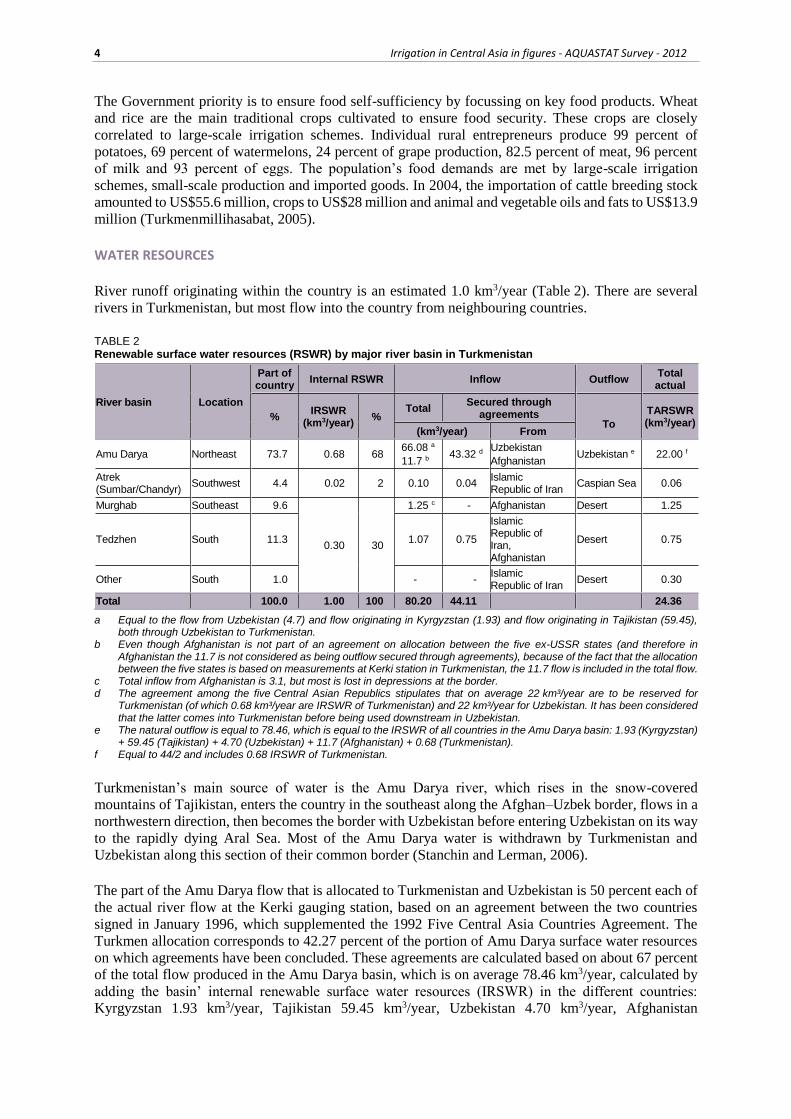
River runoff originating within the country is an estimated 1.0 km3/year (Table 2). There are several
rivers in Turkmenistan, but most flow into the country from neighbouring countries.
TABLE 2 Renewable surface water resources (RSWR) by major river basin in Turkmenistan
River basin Location
Part of country
Internal RSWR Inflow Outflow Total actual
% IRSWR
(km3/year) %
Total Secured through
agreements
To
TARSWR (km3/year)
(km3/year) From
Amu Darya Northeast 73.7 0.68 68 66.08 a
11.7 b 43.32 d
Uzbekistan
Afghanistan Uzbekistan e 22.00 f
Atrek (Sumbar/Chandyr)
Southwest 4.4 0.02 2 0.10 0.04 Islamic Republic of Iran
Caspian Sea 0.06
Murghab Southeast 9.6
0.30 30
1.25 c - Afghanistan Desert 1.25
Tedzhen South 11.3 1.07 0.75
Islamic Republic of Iran, Afghanistan
Desert 0.75
Other South 1.0 - - Islamic Republic of Iran
Desert 0.30
Total 100.0 1.00 100 80.20 44.11 24.36
a Equal to the flow from Uzbekistan (4.7) and flow originating in Kyrgyzstan (1.93) and flow originating in Tajikistan (59.45), both through Uzbekistan to Turkmenistan.
b Even though Afghanistan is not part of an agreement on allocation between the five ex-USSR states (and therefore in Afghanistan the 11.7 is not considered as being outflow secured through agreements), because of the fact that the allocation between the five states is based on measurements at Kerki station in Turkmenistan, the 11.7 flow is included in the total flow.
c Total inflow from Afghanistan is 3.1, but most is lost in depressions at the border. d The agreement among the five Central Asian Republics stipulates that on average 22 km³/year are to be reserved for
Turkmenistan (of which 0.68 km³/year are IRSWR of Turkmenistan) and 22 km³/year for Uzbekistan. It has been considered that the latter comes into Turkmenistan before being used downstream in Uzbekistan.
e The natural outflow is equal to 78.46, which is equal to the IRSWR of all countries in the Amu Darya basin: 1.93 (Kyrgyzstan) + 59.45 (Tajikistan) + 4.70 (Uzbekistan) + 11.7 (Afghanistan) + 0.68 (Turkmenistan).
f Equal to 44/2 and includes 0.68 IRSWR of Turkmenistan.
Turkmenistan’s main source of water is the Amu Darya river, which rises in the snow-covered
mountains of Tajikistan, enters the country in the southeast along the Afghan–Uzbek border, flows in a
northwestern direction, then becomes the border with Uzbekistan before entering Uzbekistan on its way
to the rapidly dying Aral Sea. Most of the Amu Darya water is withdrawn by Turkmenistan and
Uzbekistan along this section of their common border (Stanchin and Lerman, 2006).
The part of the Amu Darya flow that is allocated to Turkmenistan and Uzbekistan is 50 percent each of
the actual river flow at the Kerki gauging station, based on an agreement between the two countries
signed in January 1996, which supplemented the 1992 Five Central Asia Countries Agreement. The
Turkmen allocation corresponds to 42.27 percent of the portion of Amu Darya surface water resources
on which agreements have been concluded. These agreements are calculated based on about 67 percent
of the total flow produced in the Amu Darya basin, which is on average 78.46 km3/year, calculated by
adding the basin’ internal renewable surface water resources (IRSWR) in the different countries:
Kyrgyzstan 1.93 km3/year, Tajikistan 59.45 km3/year, Uzbekistan 4.70 km3/year, Afghanistan

Turkmenistan 5
11.70 km3/year and Turkmenistan 0.68 km3/year. The surface water resources allocated to Turkmenistan
are thus calculated every year, depending on the flows. On average, water resources allocated to
Turkmenistan in the Amu Darya basin are about 22 km3/year, including 0.68 km3/year of IRSWR. Even
though Afghanistan is not part of the five former Soviet states, and therefore not part of the agreement
concerning allocations between the five states, the flow of 11.7 km3/year is included in the flow
measured at Kerki station in Turkmenistan, based on which allocations to the five states are calculated.
As far as the Tedzhen and Atrek waters are concerned, the treaty signed in February 1926 between Iran
and Turkmenistan remains in force. This treaty stipulates that each year Turkmenistan receives a
quantity equal to 70 percent of the total Tedzhen average runoff, and 50 percent of the total Atrek
average runoff. This corresponds to an average of 0.75 km3/year for the Tedzhen river and 0.06 km3/year
for the Atrek river (including 0.02 km3/year IRSWR).
Renewable groundwater resources are an estimated 0.405 km3/year, while the overlap between surface
water and groundwater is considered negligible. Total internal renewable water resources (IRWR) are
thus estimated at 1.405 km3/year. Total actual renewable water resources (ARWR) are an estimated
24.765 km3/year, equal to the total actual renewable surface water resources (ARSWR) of 24.36 plus
the groundwater resources of 0.405 km3/year (Table 2 and Table 3).
TABLE 3 Water resources
Renewable freshwater resources:
Precipitation (long-term average) - 191 mm/yr
- 78 580 million m3/yr
Internal renewable water resources (long-term average) - 1 405 million m3/yr
Total actual renewable water resources - 24 765 million m3/yr
Dependency ratio - 97 %
Total actual renewable water resources per inhabitant 2011 4 851 m3/yr
Total dam capacity 2004 6 219.5 million m3
The largest and most important waterway in Turkmenistan is the Kara Kum canal. This canal was
constructed in the 1950s and is at 1 400 km the longest canal in the world. The canal capacity is an
estimated 630 m3/s. Its inlet on the Amu Darya river is located just after the river enters Turkmenistan
from Uzbekistan. The Kara Kum canal pools the Amu Darya, Murghab and Tedzhen rivers into the
integrated water management system and supplies water to the densely populated southern region and
irrigates more than 1 200 000 ha. The canal brings water to the capital Ashgabat and to the oases in the
south. Each year the canal takes 10–12 km3 from the Amu Darya river (Orlovsky and Orlovsky, after
2002).
Produced and treated desalinated water and wastewater do not play a significant role in Turkmenistan.
Agricultural drainage water, however, is a substantial additional source for pasture irrigation (the Sarajin
sheep breed can drink water with a salinity of up to 10 g/litre), growing salt-resistant trees and forage
crops and for fisheries. Currently, a drainage water collector is being constructed, which will accumulate
practically all drainage water from all regions of Turkmenistan into the artificial ‘Golden Age Lake’,
located southwest of Sarykamish lake in the north.
In 2004, wastewater production was an estimated 1.275 km3,and treated wastewater 0.336 km3 all of
which was directly reused. In 1994, the volume of treated industrial and municipal wastewater was an
estimated 0.025 km3/year, all of which was directly reused. For the period 1990–1994, agricultural
drainage water was on average an estimated 5.4 km3/year. After being collected in the collector-drainage
canals, about 2.35 km3/year (44 percent) is returned to rivers, mainly the Amu Darya river, about
2.97 km3/year (55 percent) went to natural depressions, mainly the Sarykamish lake in the north on the
border with Uzbekistan, and the remaining 0.08 km3/year (1 percent) was reused for irrigation.

6 Irrigation in Central Asia in figures - AQUASTAT Survey - 2012
In 2004, total dam capacity accounted for about 6.22 km3. All reservoirs were designed and constructed
for irrigation and heavily affected by silt. There are five dams with a capacity of more than 0.5 km3:
Zeid on the Kara Kum canal (2.20 km3), Dostluk on the Tedzhen river (1.25 km3), Oguzkhan on the
Kara Kum canal (0.88 km3), Sary-Yazy on the Murghab river (0.66 km3) and Kopetdag on the Kara
Kum canal (0.55 km3). The Dostluk dam is on the border between the Islamic Republic of Iran and
Turkmenistan and has been designed for flood control, hydropower generation and flow regulation.
In 1993, gross hydropower potential was an estimated 5.8 GWh, while total installed capacity was about
0.7 GWh.
The outflow of agricultural drainage water has led to the creation of artificial lakes in natural
depressions. The largest is Sarykamish lake, which stores about 8 km3. A major environmental issue in
Turkmenistan is the permanent accumulation of pollutant salt in these lakes, which leads to the
degradation of flora and fauna.
INTERNATIONAL WATER ISSUES
Water resources in Turkmenistan are almost fully formed from transboundary watercourses such as the
Amu Darya, Murghab, Tedzhen, Atrek rivers and small rivers.
During the period Soviet era, water sharing among the five Central Asian republics was based on master
plans for water resources development in the Amu Darya (1987) and Syr Darya (1984) basins.
After the country’s independence, Turkmenistan confirmed its obligations to agreements concerning
transboundary rivers and water. These obligations are set out in the following (Berdiyev, 2005):
Agreement of 20 February 1926 between the USSR and Persia about the joint use of rivers and
water along the borderline from the river Geri-Rud (Tedjen) to the Caspian Sea;
Protocol (paragraph 11) to Agreement of 2 December 1954 between the USSR and Iran about
settlement of borderline and financial issues;
Treaty of 15 May 1957 between the USSR and Shahinshah Government of Iran about the
Soviet-Iranian boundary and procedures to address borderline conflicts and case adjustment;
Soviet-Iranian Agreement of 11 August 1957 on the Araks (with the Caucasus countries) and
Atrek rivers;
Agreement of 5 March 1958 between the USSR and Shahinshah Government of Iran on the
preparation of draft projects on the equitable use of the Araks (with the Caucasus countries)
and Atrek rivers for irrigation and power generation.
In 1992, with establishment of the Interstate Commission for Water Coordination (ICWC), the newly
independent republics prepared a regional water strategy covered by the Agreement of 18 February
1992. It was decided,that existing principles be respected until a new water sharing strategy could be
adopted. This new ‘Agreement on joint actions to address the problem of the Aral Sea and socio-
economic development of the Aral Sea basin’, was signed by the Heads of the five states in 1996. Over
the years, the ICWC has achieved the conflict-free supply of water to all water users, despite the
complexities and variations of dry and wet years.
In 1993, with the development of the Aral Sea basin programme, two new organizations came into
being: the Interstate Council for the Aral Sea (ICAS) to coordinate implementation of the programme
and the International Fund for Saving the Aral Sea (IFAS) to raise and manage its funds. In 1997, the
two organizations merged to create IFAS (UNDP, 2004).
Turkmenistan and Uzbekistan signed agreements on the principles of basic water allocation, which have
proved viable. Both countries have gained experience in the joint management of the Amu Darya river.
ICWC played and still plays a positive role in this respect. All the above led to the conclusion of a

Turkmenistan 7
permanent agreement in 1996 between Turkmenistan and Uzbekistan on cooperation on water
management issues. This agreement is based on the principles that the parties:
recognize the need for joint use of interstate rivers and other water sources;
reject application of economic and other means of pressure when solving water issues;
acknowledge the interdependence of water problems and the responsibility for rational water
use;
focus on increased water inflow to the Aral Sea;
understand the need to respect mutual interests and settle water-related issues by consensus.
The above-mentioned agreement was signed in Turkmenabad on 15 January 1996 and established:
land used by Uzbekistan and located within the borders of Turkmenistan is the sole property
of Turkmenistan;
waterworks and water management organizations on the Karshi and Amu-Bukhara canals and
Tuyamuin reservoir, located in Turkmenistan, are the property of Uzbekistan;
land for the Karshi and Amu-Bukhara canals and for the Tuyamuin hydro-unit are placed at
the disposal of Uzbekistan on a chargeable basis;
countries will make all necessary attempts to provide normal operation of interstate
waterworks located within their territories;
companies and organizations, including those dealing with interstate waterworks operation
located on the territory of the other Party, act in accordance with international rules and the
laws of that country;
the flow of the Amu Darya river at Kerki gauging station is divided into equal shares (50/50);
countries should allocate a portion of their shares to the Aral Sea;
countries should stop disposal of drainage water to the Amu Darya river, independent of the
quality of the drainage water;
countries jointly implement measures on the reclamation of land, reconstruction and operation
of interstate collectors and irrigation systems and construction of water disposal canals;
countries will prevent channel deformations and flooding of adjacent areas, caused by
operation of the Amu-Bukhara, Karshi, Sovetyab, Dashoguz, Tashsaka, Kylychbay and
Shabat-Gazavat water systems;
countries will make necessary attempts to prevent flooding of land located along the Daryalyk
and Ozerny collectors crossing Turkmenistan, and will bear the costs of reconstruction of the
collectors and their operation in proportion to drainage flow;
reduce limits to water withdrawal during the driest years as defined by the ICWC, which
includes ministries of water economies of all five Central Asian countries.
In a meeting in 2004, the presidents of Uzbekistan and Turkmenistan reiterated the importance of
observing mutual understanding concerning all questions related to water allocation from the Amu
Darya river.
The partnership between the European Union Water Initiative (EUWI) and its Eastern Europe, Caucasus
and Central Asia (EECCA) programme seeks to improve management of water resources in the EECCA
region. The partnership was established between EUWI and EECCA countries at the World Summit for
Sustainable Development in 2002. A significant component is the ‘Integrated water resources
management, including transboundary river basin management and regional seas issues’ (SIWI, 2010).
In 2002, Central Asian countries and the Caucasus, formed the CACENA Regional Water Partnership
under the Global Water Partnership (GWP). Within this framework, state departments, local and
regional organizations, professional organizations, scientific and research institutes as well as the private
sector and NGOs cooperate to establish a common understanding of the critical issues threatening water
security in the region (SIWI, 2010).

8 Irrigation in Central Asia in figures - AQUASTAT Survey - 2012
The Islamic Republic of Iran and Turkmenistan are planning to set up a joint water consortium (SIWI,
2010).
WATER USE
In 2004, total water withdrawal was an estimated 27.958 km3, of which 94.3 percent for agriculture
(93.6 percent for irrigated farming, 0.3 percent for livestock breeding complexes and farms, 0.3 percent
for pastures, 0.1 percent for fisheries), 2.7 percent for municipalities and 3.0 percent for industries
(Table 4 and Figure 2). In 1994, total annual water withdrawal was an estimated 23.8 km³, of which 98
percent for agriculture, 1 percent for municipalities and 1 percent for industry.
TABLE 4 Water use
Water withdrawal:
Total water withdrawal by sector 2004 27 958 million m3/yr
- agriculture 2004 26 364 million m3/yr
- municipalities 2004 755 million m3/yr
- industry 2004 839 million m3/yr
per inhabitant 2004 5 952 m3/yr
Surface water and groundwater withdrawal (primary and secondary) 2004 27 542 million m3/yr
as % of total actual renewable water resources 2004 111 %
Non-conventional sources of water:
Produced municipal wastewater 2004 1 275 million m3/yr
Treated municipal wastewater 2004 336 million m3/yr
Direct use of treated municipal wastewater 2004 336 million m3/yr
Desalinated water produced - million m3/yr
Direct use of agricultural drainage water 1994 80 million m3/yr
FIGURE 2 Water withdrawal by sector Total 27.958 km3 in 2004
Since 1970, water withdrawal from the Amu Darya and other rivers has nearly doubled. At the same
time the loss rate has increased alarmingly, from 20 percent of the intake in the 1970s and the 1980s, to
more than 30 percent since 2000. In 2004, the loss rate was around 31 percent. The main reasons for
conveyance loss in the system are evaporation and filtration (Stanchin and Lerman, 2006).
Of total withdrawal of 27.958 km3, 97.4 percent or 27.237 km3 was primary and secondary surface
water, 1.1 percent or 0.305 km3 was primary and secondary groundwater, 1.2 percent or 0.336 km3 was
direct use of treated wastewater and 0.3 percent or 0.080 km3 was direct use of agricultural drainage

Turkmenistan 9
water (Figure 3). In 1994, 0.401 km3 of groundwater was withdrawn, of which 0.214 km3 for municipal
use, 0.151 km3 for agriculture and 0.036 km3 for industry.
FIGURE 3 Water withdrawal by source Total 27.958 km3 in 2004
Increasing production of desalinated water meets less than 1 percent of the demand for drinking water
and industrial needs. Desalinated water and treated wastewater (direct use) are not used for irrigation.
IRRIGATION AND DRAINAGE
Evolution of irrigation development
Recent estimates consider irrigation potential to be 7 013 000 ha, which is equal to the cultivable area.
Taking into consideration, however, water resources, are an estimated 2 353 000 ha. If techniques to
desalinate the water of the Golden Age Lake become available, it is estimated that the irrigation area
could be doubled. However there are varying opinions about the feasibility of this option.
Irrigation and drainage development in Turkmenistan can be divided into three stages: traditional
irrigation up to the 1930s; irrigation development during the Soviet era between the 1930s and 1990s;
and irrigation development since independence.
During the first stage, small and medium canals were hand dug and sporadically equipped with primitive
wooden water management structures/regulators. Some main canals are 400–600 years old and are still
operational. Water was taken from the rivers by means of canals and transported by gravity over 5–6
km to fields. The water intake facility was the wooden ‘water wheel’. Over 400 kyariz (underground
water gathering galleries) were used in the foothill regions. The person responsible for water
management was the mirab who was elected by community leaders.
During the Soviet era, state institutions were responsible for water management. Up to the 1950s little
technical progress was made in water management, but upon initiation of construction of the Kara Kum
canal, launched in 1954, there was a boom in irrigation development. This earth canal takes water from
the Amu Darya river and transports it to the west over 1 400 km through the basins of Murghab and
Tedzhen to the foothills of the Kopetdag mountain system. Construction of the 840 km main section,
from the Amu Darya river in the east to Gok-Tepe just west of Ashgabat, was completed in 1967. Work
continued through the 1970s and well into the 1980s, extending the canal west towards the Caspian Sea.
Today it is the longest canal in the world.
10 Irrigation in Central Asia in figures - AQUASTAT Survey - 2012
The virgin territories along the course of the canal were intensively developed and agriculture
introduced. The canal increased the irrigated area surrounding it from 141 500 ha in 1954 to 530 000 ha
30 years later. Since the 1970s irrigation from the canal has accounted for about 50 percent of the total
irrigated area in Turkmenistan (the other 50 percent receives water through a system of smaller
provincial-level canals). In addition, the canal permits irrigation of 5 million ha of desert pasture. The
canal is colloquially known in Turkmenistan as the “river of life” because of its role in reclaiming desert
for agriculture and providing livelihoods to hundreds of thousands of rural people. Yet benefits for some
people have brought adversity to others: the diversion of water from the Amu Darya river into the Kara
Kum canal and of river water for irrigation has contributed to the Aral Sea disaster, adversely affecting
large parts of the population in Uzbekistan and Kazakhstan.
The third stage is characterized by development of the area close to the middle section of the Amu Darya
river and western territories of Dashoguz region. A great water reservoir, equipped with modern
equipment for water management, constructed in collaboration with the Islamic Republic of Iran on the
Tedzhen river.
The emphasis on the expansion of cotton production in the Soviet era, and the strategy of ensuring food
self-sufficiency, which has been aggressively implemented since 1992, has led to accelerated growth of
irrigated areas, which have increased by nearly four-fold in the last 40 years (Stanchin and Lerman,
2006).
Given the climatic and soil conditions, the entire agricultural production is dependent on irrigation (AST
and MOA, 1961). In 2006, the area equipped for irrigation was an estimated 1 990 800 ha (Table 5).
The entire area is actually irrigated, which is larger than the cultivated area, since the irrigated area
includes irrigated permanent pasture, while permanent pasture is not included as cultivated area. In 1994
and 1975 the area equipped for irrigation was 1 744 100 ha and 857 000 ha respectively.
Irrigation in Turkmenistan is mainly concentrated in oases, where water is diverted from the Murghab,
Atrek and Tedzhen rivers and from the Kara Kum canal in the south, or from a system of canals that
have been built along the Amu Darya river in the north.
In 2006 the only technique used was surface irrigation. Options for localized irrigation are being
explored in a number of ongoing pilot projects. Israeli drip-irrigation technology has been installed on
600 ha near Ashgabat (Stanchin and Lerman, 2006).
Surface water is mainly used for irrigation. The share of groundwater is small and tends to decrease
because of increased demand for drinking water. In 2006, surface water covered about 1 981 190 ha or
99.5 percent of total equipped area, groundwater 9 610 ha or 0.5 percent (Figure 4). In 1994, about 98
percent of the equipped area was irrigated with surface water: 54 percent from reservoirs, 28 percent
from river diversions and 16 percent from pumping from rivers. Sometimes there is direct use of
agricultural drainage water with salinity level of up to 3 g/litres, where there is a substantial lack of
freshwater, but total volume of this water comprises less than 1 percent of total freshwater used for
irrigation (MWE, 1998).
All large water pumps and many small water pumps are electric, while less than one-third of small
pumps, are diesel with a production capacity of less than 0.5 m3/s and pressure of less than 10 m. There
are no statistics regarding energy use for water pumps. The most common type of water pump is cascade.
Systems with lengthy pipes (more than 1 km) comprise less than 10 percent of the total number of water
pumping systems, and are used mainly in the foothills.
The total length of inter-farm irrigation canals is more than 8 000 km, out of which around 94 percent
are earthen canals and about 6 percent concrete-lined canals (MWE, 1993 and 1998). The total length
of on-farm canals is more than 34 000 km, of which around 83 percent are earthen canals, about

Turkmenistan 11
6 percent concrete-lined, 4 percent chute systems, 7 percent pipelines. The irrigation chute system is
mainly in Mary and Ahal velayats, and irrigation is by pipeline in Ahal and Lebap velayats.
TABLE 5 Irrigation and drainage
Irrigation potential 2 353 000 ha
Irrigation:
1. Full control irrigation: equipped area 2006 1 990 800 ha
- surface irrigation 2006 1 990 800 ha
- sprinkler irrigation 2006 0 ha
- localized irrigation 2006 0 ha
% of area irrigated from surface water 2006 99.5 %
% of area irrigated from groundwater 2006 0.5 %
% of area irrigated from mixed surface water and groundwater - %
% of area irrigated from mixed non-conventional sources of water - %
area equipped for full control irrigation actually irrigated 2006 1 990 800 ha
- as % of full control area equipped 2006 100 %
2. Equipped lowlands (wetland, ivb, flood plains, mangroves) - ha
3. Spate irrigation - ha
Total area equipped for irrigation (1+2+3) 2006 1 990 800 ha
as % of cultivated area 2006 102 %
% of total area equipped for irrigation actually irrigated 2006 100 %
average increase per year over the last 12 years 1994-2006 1.1 %
power irrigated area as % of total area equipped 1994 16.3 %
4. Non-equipped cultivated wetlands and inland valley bottoms - ha
5. Non-equipped flood recession cropping area - ha
Total water-managed area (1+2+3+4+5) 2006 1 990 800 ha
as % of cultivated area 2006 102 %
Full control irrigation schemes: Criteria:
Small-scale schemes < - ha - ha
Medium-scale schemes > - ha and < - ha - ha
large-scale schemes > - ha - ha
Total number of households in irrigation -
Irrigated crops in full control irrigation schemes:
Total irrigated grain production (wheat and barley) - metric tons
as % of total grain production - %
Harvested crops:
Total harvested irrigated cropped area 2006 2 013 800 ha
Temporary crops: total 2006 1 823 300 ha
- Wheat 2006 917 000 ha
- Rice 2006 11 000 ha
- Potatoes 2006 8 800 ha
- Sugar beet 2006 12 000 ha
- Vegetables 2006 29 400 ha
- Cotton 2006 652 000 ha
- Fodder 2006 93 000 ha
- Other temporary crops 2006 100 100 ha
Permanent crops: total 2006 65 000 ha
Permanent meadows and pasture 2006 125 500 ha
Irrigated cropping intensity (on full control area actually irrigated) 2006 101 %
Drainage - Environment:
Total drained area 1998 1 011 897 ha
- part of the area equipped for irrigation drained 1998 1 011 897 ha
- other drained area (non-irrigated) - ha
drained area as % of cultivated area 1998 59 %
Flood-protected areas - ha
Area salinized by irrigation 2002 1 353 744 ha
Population affected by water-related diseases 2004 12 295 inhabitants

12 Irrigation in Central Asia in figures - AQUASTAT Survey - 2012
The Kara Kum and Turkmenderya canals are classified as large multi-purpose canals. Canals, that serve
two or more farm associations, are classified as inter-farm canals. Canals, located within a territory of
one farm association (around 500–3 000 ha), are classified as on-farm canals. Almost everywhere on-
farm irrigation systems have been constructed in earthen canals and almost half of the diverted water is
lost as a result of seepage (MWE, 1993 and 1998).
FIGURE 4 Source of irrigation water on area equipped for full control irrigation Total 1 990 800 ha in 2006
Role of irrigation in agricultural production, the economy and society
In 2006, total harvested irrigated cropping area was an estimated 2 013 800 ha. Wheat accounts for
917 000 ha or 45.5 percent, cotton 652 000 ha (32.4 percent), vegetables 29 400 ha (1.5 percent), sugar
beet 12 000 ha (0.6 percent), rice 11 000 ha (0.5 percent), potatoes 8 800 ha (0.4 percent), temporary
fodder 93 000 ha (4.6 percent), other temporary crops 100 100 ha (5 percent), perennial crops 65 000 ha
(3.2 percent) and permanent pasture 125 500 ha (6.2 percent) (Table 5 and Figure 5). In 1994, total
harvested irrigated crop area was an estimated 1 794 200 ha and cotton and vegetables were the most
important export crops.
FIGURE 5 Irrigated crops on area equipped for full control irrigation Total harvested area 2 013 800 ha in 2006 (cropping intensity on actually irrigated area: 101 %)

Turkmenistan 13
In 2004, irrigated crop yields were 1.2 tonnes/ha for raw cotton, 3.1 tonnes/ha for grains including maize,
and 30.1, 26.8 and 21.0 tonnes/ha for vegetables, melons and potatoes respectively
(Turkmenmillihasabat, 2005).
In 2004, the average cost of irrigation development on public schemes was an estimated US$8 654/ha.
The average annual operation and maintenance cost is about US$47/ha, the average cost of drainage
development US$2 256/ha and of irrigation rehabilitation US$6 943/ha.
Most work in the field (weeding, tipping, manual cotton harvesting, etc.) is carried out by women. Men
are involved in ploughing, furrowing, sowing, fertilizing, crop harvesting with machinery, primary
processing of crops, etc. (National Bureau, 2000). Manual watering is mainly done by men. Men and
women participate equally in the decision-making process. However, appointments to management
positions in agriculture and the water economy are made by prioritizing qualification and experience as
selection criteria and not gender.
Status and evolution of drainage systems
The construction of mostly open drainage systems started at the beginning of the 1950s. About 90
percent of the total length of drainage was constructed during the period 1965–1985. The intensive
development of virgin land for agriculture, with little attention being paid to the installation of water
regulators on the irrigation canals, resulted in the irrational use of water. Further construction of drainage
structures continued to lag behind the development of virgin land and the construction of unlined
irrigation canals. All these factors – unlined canals, insufficient length of the drainage system, irrational
irrigation norms and poor quality of construction works – resulted in catastrophic soil salinity, that is a
currently a major problem that needs to be resolved. The economic crisis at the beginning of the 1990s
resulted in the shutting down of the construction of any new drainage structures.
Following a decision adopted in 2000 by the President of Turkmenistan, the country initiated the trans-
Turkmen collector for drainage water, with the construction of a huge artificial lake in the middle of the
Kara Kum desert, the Turkmen Golden Age Lake, on the site of a natural dry lake in the Karashor
lowlands. The lake is on the border between Ahal and Dashoguz velayats, 350 km north of the capital
Ashgabat. The lake is to be filled with drainage water through two new collectors, the Great Turkmen
Collector from the south and the Dashoguz Collector from the north, with a combined length of over
1 000 km. The lake’s capacity is foreseen to be 150 km3, with a surface area of 3 500 km2 and a depth
of 130 m. Starting in 2009, the collectors have been diverting up to 10 km3 of saline drainage water to
the lake annually. This water currently discharges into the Amu Darya river, which is a unique source
of drinking water for much of the region. Construction of the trans-Turkmen collector aims to improve
water quality in the Amu Darya river by stopping the discharge of drainage water into the river.
The extension of the collector-drainage network has lagged far behind irrigation expansion. The
collector-drainage network was increased by 7 percent between 2000–2004, while the irrigated area
increased by 26 percent. This led to accelerated raising of the groundwater table, deterioration of soil
quality and increased salinity (Stanchin and Lerman, 2006).
Local water experts argue that the Golden Age Lake will reclaim 450 000 ha of waterlogged land,
dramatically reduce salinization in the Amu Darya river and provide a huge reservoir of water that will
be recycled for irrigation after partial desalination treatment. The exact nature of desalination is not
clear, but Turkmen scientists are working on bio-plateau techniques and harnessing of solar energy for
desalination. If successful, these techniques will produce huge amounts of new water for irrigation and
make it possible to double the irrigated area. Cotton and wheat production would increase by at least 30
percent, and the brackish lake would create new opportunities for the development of fisheries. There is
a generally optimistic vision of a ‘huge oasis’ that will arise in the desert around the lake and along the
new waterways (Stanchin and Lerman, 2006).

14 Irrigation in Central Asia in figures - AQUASTAT Survey - 2012
Foreign experts working on the Aral Sea crisis are less optimistic. They claim that the lake water will
simply disappear through evaporation under the fierce desert sun, leaving salt sediments that will poison
the entire area. The use of recycled lake water will only increase salinization of agricultural soils, as
proved by the experience of other countries that use brackish water for irrigation. They fear that, by
virtue of its sheer size, the lake may be a source of considerable environmental damage to the entire
region (Stanchin and Lerman, 2006).
Drainage water should be collected at a great distance from oases, otherwise the water level in the
collectors will rise and many areas become waterlogged. Moreover, because of drainage water, the
pasture quality has degraded and the probability of ecological risks (desertification, wind and water
erosion, decreased wild populations) has increased.
Soil productivity without drainage is 30–70 percent less than the productivity of soils with drainage
(MWE, 1989). Without drainage, land accumulates many toxic salts in the root zone during irrigation,
which leads to doubling the level of salinity. In 1998, drainage infrastructures were constructed on about
1 011 897 ha of irrigated area. In 1995, subsurface drainage accounted for approximately 32 percent of
the total drainage area, mainly on newly reclaimed areas, horizontal surface drainage for 60 percent, and
vertical surface drainage for 8 percent.
Most of the known drainage types are applied, including channels for safe removal of mudflows.
Vertical drainage is mainly used in urban areas for protection from waterlogging. When the water quality
is good it is used to water trees in the cities.
WATER MANAGEMENT, POLICIES AND LEGISLATION RELATED TO WATER USE IN AGRICULTURE
Institutions
Water resources management in Turkmenistan is carried out by both national organizations and
departments, and international organizations, such as the Amu Darya River Basin Authority (BVO),
IFAS and the ICWC of Central Asia. The Cabinet Ministers of Turkmenistan have complete
responsibility for water resources and maintenance of reliable water supply for both the agriculture,
municipal and industrial sectors. The following state departments and organizations are engaged in
management of water resources:
Ministry of Water Resources (MWR): construction and operation of irrigation and drainage
systems, delivery of water to water users at primary off-takes (down to inter-farm level);
local administrations at village level (hakimliks, archyns): address water management issues
within the limits of their territory (on-farm irrigation and drainage networks);
land users (farmers, tenants and others): independently decide issues of operation of intra-
contour irrigation and drainage network within the limits of their land areas;
Ministry of Nature Protection: responsible for protection of water from pollution and
exhaustion;
State Corporation (SC) ‘Turkmengeologiya’: responsible for assessment, control of use and
protection from pollution and exhaustion of groundwater aquifers;
Ministry of Construction and Building Materials: responsible for licensing, technical
supervision and control of activities on water supply and drainage of settlements.
Water management
During the Soviet era, water management was the responsibility of state institutions.
All inter-farm canals are managed by authorized state agencies. MWR manages water resources related
to water infrastructure through specialized organizations that administer territories within the state.

Turkmenistan 15
Production associations of velayats are responsible for the operation, repair-restoration, construction
and auxiliary subdivisions of etraps (districts).
Farm unions manage all on-farm canals, even when the irrigated land is rented or privately owned by
individual farmers. Water resources management at on-farm level, i.e. distribution of water between
final water users (farmers, tenants and brigades), repair-restoration and construction works on structures,
clearing of channels, drains and collectors, etc. is the responsibility of the local authorities (hakimliks,
archyns). The mirap (irrigator) position was introduced for decisions on these matters at the level of the
municipal authorities.
Training of personnel for agriculture and water management is carried out by the Turkmen State
Agricultural University, named after S.A. Niyazov, including its hydro-improvement faculty. Since
2001, the Central Asian region has been working with the Training Centre at Sepang International
Circuit (SIC) of the ICWC to improve the professional skills of those working in water management.
Finances
The state is responsible for all expenses related to capital investment in irrigated agriculture, such as the
development of land, construction of main structures and water infrastructure. Except for the on-farm
irrigation system, the costs of operating water infrastructure are met by the state budget. Water for
irrigation is supplied without charge. The so-called ‘private charges’ for the O&M of irrigation systems
is an accepted practice, and comprises a deduction of 3 percent from the total of crops produced by the
tenants. A calculation shows that over the past years these charges have amounted to US$10–18 million.
Article 58 of the Water Code states: “Water management agencies provide technical assistance to
farmers’ unions and other legal entities at the expense of the latter in operation of on-farm irrigation and
drainage systems and hydro-technical structures...”. The following principles of water consumption and
use regulation in Turkmenistan are legally bound (GoT, 2004b):
water for drinking and household use is provided to the population without charge; water
supply systems construction, renovation and maintenance costs are covered by municipal and
state budgets;
water for industrial use is supplied against payment according to set tariffs;
enterprises are fined for exceeding water intake limits and discharging unprocessed industrial
liquid wastes;
water for irrigation is supplied free within set limits; costs of water management agencies for
maintenance of on-farm systems are covered by the 3 percent charges raised from the total
cost of agricultural crops;
state budget finances construction, renovation and maintenance of water supply facilities at
state, inter-basin, interregional and inter-farm levels.
In 2006, total investment in irrigation and drainage was US$140 million, including US$87 million state
investment (MWE, 2007). About US$53 million were classified as indirect investments because they
were given as credits by banks. The long-term (up to 2030) irrigation and drainage development
programme, adopted in 2007, states that investment of US$730 million is planned for irrigation and
US$537 million for drainage up to 2010. Planned investment for 2010–2015 is US$4 720 million, out
of which US$3 643 million is investment by the state. It is expected that the investments will be
increased 2016–2020 up to US$8 770 million, including US$6 875 million state investments. The
amount is estimated based on average world prices during the period 2001–2006. It should be clarified,
however, that fuel prices for most local construction materials are several times lower than the world
average. For example, the price of petrol in Turkmenistan is less than US$0.02 per litre.
Annual investment in land-reclamation is around US$11–12 million (MWE, 2007). Annual expenditures
of the state budget for operation of irrigation systems varies between US$37–49 million.

16 Irrigation in Central Asia in figures - AQUASTAT Survey - 2012
Policies and legislation
The constitution of Turkmenistan states that the Cabinet of Ministers undertake state management of
economic and social development and ensure the rational use and protection of natural resources. The
Water Code, issued on 27 December 1972, details the competences of the Cabinet of Ministers, the
authorized state body for water use and protection, local executive power, civil societies and individuals.
In particular, the Cabinet of Ministers defines water consumption limits for each velayat and etrap,
including distribution of main water sources to the economic sectors. According to the Water Code,
water is owned solely by the state, whereas both legal entities and individuals can own water structures.
In February 2007 a national development programme for the water economy of Turkmenistan up to
2030 was approved by all ministries and agencies involved (MWE, 2007). Main development priorities
are to:
reduce the water discharge rate per hectare by decreasing filtration losses and by improving
watering technology (including application of drip irrigation);
increase the capacity of water reservoirs for long-term regulation of water flows and
accumulating of silt;
construct the trans-Turkmen collector for accumulating all drainage waters from all oases into
one reservoir.
The programme takes into account population growth, increase of industrial and agricultural production
as well as environmental issues and international commitments of Turkmenistan.
The national programme for economic, political and cultural development of Turkmenistan up to 2020
foresees an increase in the number of private agricultural producers and their support through the
implementation of infrastructure projects for development of territories paid for our of the state budget
(GoT, 2002). Currently state producers use about 90 percent of irrigated land, up to 2020 it is planned
that this irrigated land will be transferred to the private sector based on new legislation. Joint-stock
enterprises, farm unions and cooperatives will become the organizational forms for private land use.
Legislation reforms in the water sector have overlapped with the adoption of the Land Code, which for
the first time legally sets out the right for private ownership of land. In 2007 drafts of laws on ‘farm’
and ‘farm unions’ were published in the newspaper, whereby the role of farmers in decision-making
process is further increased, with the objective of decentralization of land resources management (GoT,
2007a and 2007b).
ENVIRONMENT AND HEALTH
Environmental issues are particularly acute in Turkmenistan. Water in the rivers and the drainage
networks is of very poor quality, containing high concentrations of salts and pesticides from both the
country itself and from upstream countries. This affects the Aral Sea area, where some of the main
collector-drainage canals discharge. A trans-desert collector running about 720 km from the northeast
to the Caspian Sea in the far west is under construction as explained in the section: Status and evolution
of drainage system.
The irrational use of water resources by the countries of the Central Asian region during the last 50 years
is one of the most critical reasons for lack of water. This has resulted in an environmental crisis in the
Aral Sea basin, salinization of irrigated lands and decreased fertility. Currently, around 90–95 percent
of irrigated land in the Turkmen Aral Sea zone is saline (Berdiyev, 2006). In 2001, the total area salinized
by irrigation was and estimated 1 353 744 ha, including land with medium and high salinity.
In 2001, the direct economic loss of land with different degrees of salinization was US$142 million. By
yield classes, about 32 percent are highly fertile soils. About 36 percent of the land are affected by

Turkmenistan 17
medium and severe salinity and are exposed to secondary salinization and waterlogging because of close
bedding (up to 2 m) of groundwater. Waterlogging also appears in desert pastures because of drainage
water discharges. In 2002, irrigation caused waterlogging on about 756 500 ha.
During the past decades water quality in the Amu Darya river has deteriorated considerably as a result
of discharge of drainage and industrial water from neighbouring countries. Average annual salinity level
was 0.3 g/litre before 1962, increased to 0.8 g/litre in 1967. In the 1990s, it stabilized within the range
of 1.5–1.6 g/litre reaching 2 g/litre during certain periods (Berdiyev, 2006).
The human pressure on surface water is high; although pollution with biogenic elements or organic
substances has not yet reached dangerous levels, special attention must be paid to monitoring
concentration (especially phenols and nitrates). About 4 km3 of drainage water with salinity level of
6.5–8.5 g/litre is discharged annually into the Amu Darya river from neighbouring Uzbekistan. Because
of this, salinity level in the Amu Darya can be up to 2.2 g/litre in certain periods, which negatively
affects the health of the population in Dashoguz province, as well as the productivity of irrigated land
(Berdiyev, 2006).
Over the past years, application of pesticides, herbicides, defoliants and other chemicals has decreased
2.9 times. The area of their use has been reduced four-fold, as a result of government policy to ensure
food security through introduction of Integrated Pest Management (IPM). This has resulted in reduced
pollution in the water catchment areas.
In 2004, people affected by water-related diseases amounted to 12 295, of which 7 955 by intestinal
infections, 22 by typhoid and 4 318 by virus hepatitis.
In 1998, there was an outbreak of malaria, 137 cases were recorded. Since then, cases of malaria have
fallen and Turkmenistan has made significant progress with malaria control; the disease is reported as
having been eliminated.
PROSPECTS FOR AGRICULTURAL WATER MANAGEMENT
Surface water resources are almost all entirely used. The government states that the irrigation area can
be increased and that water supply to irrigated areas be ensured by (MWE, 2007):
increasing the efficiency factor of the irrigation systems from 0.58 to 0.75 by canal lining and
modernizing and rehabilitating irrigation systems;
improving land levelling, optimizing furrow length and introducing crops requiring less water,
from 6 441 m3/ha to 5 286 m3/ha;
increasing the capacity of water reservoirs to 11 361 million m3 for accumulation of water
from floods and mudflows;
introducing IWRM principles (management of water demand, intersectoral coordination,
allocating management among hydrographical basins and not among administrative territories,
management of water catchment areas, etc.) and automated management systems for
irrigation;
introducing modern watering technologies including localized and sprinkler irrigation on
260 000 ha;
using about 1 km3 of drainage water with mineralization of up to 3 g/litre for irrigation;
constructing the trans-Turkmen collector for drainage water to improve removal of salts from
irrigated land; this should lead to decreasing demand for water flushing and/or for alternative
use of water (for fisheries, improvement of pastures productivity, growing of halophytes, etc.)
improving the quality of groundwater to meet irrigation requirements;
increasing treated wastewater use for cultivation of agricultural crops (cotton).

18 Irrigation in Central Asia in figures - AQUASTAT Survey - 2012
MAIN SOURCES OF INFORMATION
AST & MOA. 1961. Agricultural system of Turkmenistan. Academy of Sciences of Turkmenistan & Ministry of
Agriculture. Published in Russian.
Berdiyev, A. 2005. National water law of Turkmenistan and international agreements on transboundary water,
Lectures on international and national water law and policy. ICWC Training Centre. Published in Russian and
English.
Berdiyev, A. 2006. Progress in domestic water supply in view of the achievement of UN Millennium Development
Goals, issues of the implementation of integrated water resourse management in view of the achievement of UN
Millennium Development Goals (national seminar materials). (Turkmen)
EBRD. 2006. Turkmenistan - EBRD country factsheet. European Bank for Reconstruction and Development.
FAO. 1997. Irrigation in the countries of the former Soviet Union in figures. FAO Water Report No. 15. Rome,
Food and Agriculture Organization of the United Nations.
GoT. Official site of Turkmen government (including legislation). Government of Turkmenistan.
GoT. 1992. Constitution of Turkmenistan. Government of Turkmenistan.
GoT. 2002. National Programme Strategy of economical, political and cultural development of Turkmenistan up
to 2020. Government of Turkmenistan. (Turkmen and Russian)
GoT. 2004a. Land Code of Turkmenistan. Government of Turkmenistan. (Turkmen and Russian)
GoT. 2004b. Water Code of Turkmenistan. Government of Turkmenistan. (Turkmen and Russian)
GoT. 2007a. Draft of the Law of Turkmenistan About farmer unions. Government of Turkmenistan.(Turkmen and
Russian)
GoT. 2007b. Draft of the Law of Turkmenistan. About individual farmer enterprise. Government of Turkmenistan
(Turkmen and Russian)
Hydro Meteo Center. 1976. Surface water resources of USSR, Vol.14, Central Asia. Gidrometeoizdat USSR
Gidrometcentr. (Russian)
ICWC. Web site: www.sic.icwc-aral.uz. Interstate Commission for Water Coordination.
Ministry of Health & Medical Industry. 2007. Presentation of sanitary-epidemiologic service of the Ministry of
Health and Medical Industry of Turkmenistan at WHO organized Conference devoted to launch of malaria
elimination campaign. Ashgabat, Turkmenistan, 31 May 2007.
MWE. 1989. Watering regimes on agricultural crops. Ministry of the Water Economy. (Russian)
MWE. 1993. Annual report on irrigation schemes maintenance. Ministry of the Water Economy. (Russian)
MWE. 1998. Report on water & soil survey of the irrigated land of Turkmenistan. Water & soil monitoring service
under the Ministry of the Water Economy. (Russian)
MWE. 2007. Programme for development of agriculture for the period up to year 2030 – water sector. Ministry
of the Water Economy. (Turkmen)

Turkmenistan 19
MWE, MNP, MOF, MOA, National Agency ‘Turkmengeology’, National Agency ‘Turkmenstandardlary’. 2002. National environmental action plan of Turkmenistan. Ministry of the Water Economy, Ministry of the
Natural Protection, Ministry of Finance, Ministry of Agriculture. (Turkmen, Russian and English)
National Bureau. 2000. Women in development. National report on the status of women in Turkmenistan
(Russian)
Orlovsky N. & Orlovsky L. After 2002. Water resources of Turkmenistan: use and conservation. Israel, The
Jacob Blaustein Institute for Desert Research, Ben-Gurion University of the Negev.
SIWI. 2010. Regional Water Intelligence Report Central Asia. Stockholm International Water Institute.
Stanchin I. & Lerman Z. 2006. Water in Turkmenistan. In: (Eds.) M. Spoor and M. Arsel. 2008. The Last Drop.
Water, security, and sustainable development in Central Eurasia. London, Routledge, 2008.
Turkmenmillihasabat. 2005. Statistical yearbook of Turkmenistan. National Institute of State Statistics and
Information of Turkmenistan. (Turkmen)
Turkmengeology. 2004. The fresh groundwater resources of Turkmenistan register. (Russian)
UNDP. 2004. Water resources of Kazakhstan in the new millennium. New York, United Nations Development.
Programme
World Bank. 2006. Structure of output. Table 4.2 – Structure of output. Washington, DC.

![Untitled (4) [extwprlegs1.fao.org]extwprlegs1.fao.org/docs/pdf/bel45247.pdf · 2012. 12. 11. · Untitled (4).max. Title: Untitled (4).max Author: defranchis Created Date: 7/26/2004](https://img.pdfslide.us/doc/110x75/5fd958298c3dc761fa781192/untitled-4-2012-12-11-untitled-4max-title-untitled-4max-author.jpg)