Embed Size (px)
Citation preview
September, 2014
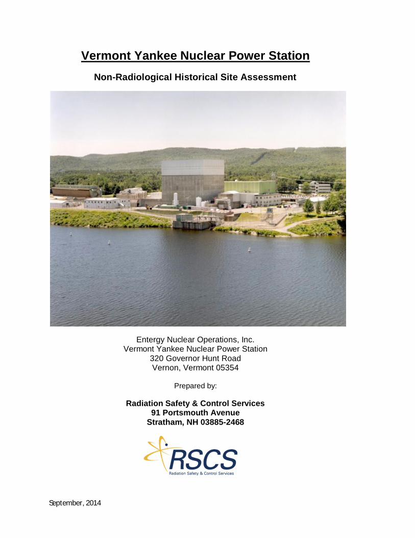
Vermont Yankee Nuclear Power StationNon-Radiological Historical Site Assessment
Entergy Nuclear Operations, Inc.Vermont Yankee Nuclear Power Station
320 Governor Hunt RoadVernon, Vermont 05354
Prepared by:
Radiation Safety & Control Services91 Portsmouth Avenue
Stratham, NH 03885-2468
September, 2014VYNPS Non-Radiological Historical Site Assessment Page 2 of 12
Non-RadiologicalHistoricalSiteAssessmentoftheVermontYankeeNuclearPowerStation
ExecutiveSummary
This Historical Site Assessment (HSA) has been completed to identify areas of the Vermont YankeeNuclear Power Station (VYNPS) (the “Site”) where environmental media may have been impacted bynon-radiological contaminants throughout the operating history of the plant. In addition, this documentaddresses areas of the plant where future decommissioning activities may encounter hazardousmaterials or areas that contain historic impacts and, therefore, discusses considerations to minimizeenvironmental impacts. The purpose of the assessment is to assist in planning for decommissioning ofthe power plant. The investigation included: 1) review of a phase I and II environmental site assessmentreport for the Site prepared as due diligence prior to purchase of the station by Entergy NuclearVermont Yankee, LLC, (Reference 1), 2) reports related to incidents of non-radiological contamination ofthe Site, 3) review of the file required by federal regulation 10 CFR 50.75(g) to document contaminationincidents pertinent to decommissioning of the Site, 4) review of selected inspection reports prepared byAmerican Nuclear Insurers (ANI), 5) search of company records describing equipment leaks, spills ofhazardous materials and an inventory of components containing elemental mercury, 6) review ofdatabases maintained by the Waste Management Division of the Vermont Agency of Natural Resources,7) review of various permits related to environmental regulation and issues related to the station, 8)interviews of current or former long-time station employees to identify incidents that may not havebeen documented in plant records, and 9) inspections of the power station to observe each identifiedpotentially impacted area. This HSA is a living document and will be modified or augmented asadditional information is identified.
The assessment identified one hundred thirty four areas on or adjacent to the VYNPS site where currentor former activities may have resulted in non-radiological impacts potentially significant to thedecommissioning effort. These areas are summarized in the attached Table 1. Potentially impactedareas are classified as Class 1, Class 2 or Class 3, using a classification system similar to the one set forthfor classifying potentially radiologically contaminated areas in NUREG-1575, Rev 1 (MARSSIM)(Reference 2), where Class 1 areas have the highest potential for impacts that may be significant todecommissioning. For purposes of classifying potentially non-radiologically contaminated areas, thesame concept has been applied, with the substitution of Vermont primary groundwater qualitystandards (PGQS), federal maximum contaminant levels (MCLs) or risk-based concentrations (RBCs) forMARSSIM’s derived concentration guideline levels (DCGLs), which are site-specific radiological criteriafor release of an area for unrestricted use.
Eleven areas at VYNPS have been classified as Class 1, fifty two areas as Class 2 and seventy one areas asClass 3. None of the areas is considered to pose a current or expected threat to human health or the
September, 2014VYNPS Non-Radiological Historical Site Assessment Page 3 of 12
environment that would warrant immediate corrective action. Each area will be characterized for thepresence of contamination as it becomes more accessible during decommissioning, to determine theextent to which it may have been impacted. Consistent with the approach prescribed in MARSSIM,those areas classified Class 1 will receive a relatively higher level of scrutiny.
Non-RadiologicalHistoricalSiteAssessmentoftheVermontYankeeNuclearPowerStation
The 134 potentially impacted areas are subdivided into twelve categories as follows: septic systems (7),owner-controlled areas (16), underground and above ground storage tanks (29), transformers andbreakers (21), miscellaneous containers (24), switchyards (3), storm water drainage systems (5), watersupply wells (4), chemical storage areas (4), small satellite chemical and flammable material storageareas (10), compressed gas storage areas (6) and nearby off-site areas owned by Entergy (5). Theseareas are summarized on Table 1 and their locations are shown on Figures 1, 2 or 3. The areas shown onFigures 2 and 3 are also identified in VYNPS operating procedure OP-2106 rev33 “Oil and HazardousMaterial Spill Prevention and Control” (Reference 3).
Eighty two of the identified areas were evaluated in 2001 when a comprehensive phase I and phase IIenvironmental site assessment of the power station was completed prior to purchase of the Site byEntergy Nuclear Vermont Yankee, LLC . An additional 52 areas have been identified by the currenthistorical site assessment. Three of the areas not discussed in the 2001 report are generic plant-wideareas where lead and lead-based paint, asbestos or elemental mercury may be present. An additionalten areas either did not exist in 2001 (i.e. the Construction Office Building Overflow Septic System) orwere not associated with VYNPS (i.e. off-site properties on Governor Hunt Road). Twenty four areas notpreviously identified are categorized as the location of miscellaneous containers, are relatively small andpose little risk of contamination that would be significant to decommissioning. The remaining sixteenareas not discussed in the 2001 report may not have been in their current configuration at the time thereport was prepared or are areas that were only active early in the plant history and whose existence isnot well known or documented.
This investigation has included review of the 2001 phase I and phase II environmental site assessment ofthe Site, reports related to incidents of non-radiological contamination of the Site, review of the filerequired by federal regulation 10 CFR 50.75(g) to document contamination incidents pertinent todecommissioning of the Site, review of selected inspection reports by ANI, search of company recordsof leaks, spills of hazardous materials and an inventory of components containing elemental mercury,review of the spills database maintained by the Waste Management Division of the Vermont Agency ofNatural Resources, review of various permits related to environmental regulation of the Site, interviewsof current or former long-time station employees, and an inspection of the power plant to observe eachidentified potentially impacted area.
September, 2014VYNPS Non-Radiological Historical Site Assessment Page 4 of 12
In 1999 a search was completed of all Potentially Reportable Occurrences (PROs) for the years 1973–1994 and all Event Reports (ERs) for the years 1995-1998 to identify incidents of spills or releases ofradioactive materials and hazardous chemicals. That search identified 42 incidents, most of whichrelated to radiological materials. Fourteen of the incidents related to hazardous materials, most ofwhich were relatively minor spills that were immediately contained and remediated. Only one of the 14(PRO 91-06, describing a leak in a chemistry laboratory drain), appears to have the potential to requireremediation during decommissioning. In May 2014 a search was completed of all Condition Reports(CRs) for the years 1999-2014 (Appendix D) to identify spills of hazardous materials that have beendocumented since the 1999 records search. The 2014 search identified 50 incidents. Thirty four of theincidents were of minor spills (less than a few gallons) of petroleum products including fuel oil, gasolineand hydraulic oil that were immediately contained and remediated. Other incidents included spills ofsmall volumes of elemental mercury from thermometers and gauges, antifreeze from a truck enginecooling system and various chemical leaks including sodium hypochlorite at the plant intake structure.Each of these spills was immediately contained and remediated. CRs 04-2036 and 05-3663, relating to afire in the Main transformer and a slow leak of oil from the Spare Main transformer, respectively, arethe only CRs found that appear to be potentially significant for decommissioning. Table 2 is a summaryof spills of petroleum products or other hazardous materials at VYNPS that are recorded in the VermontDepartment of Environmental Conservation, Waste Management Division on-line database. As shownin Table 2, all of the spills have been “closed” by VT WMD and all but the two that occurred in the 1970sconsisted of small volumes.
Interviews of current or former long-time employees of VYNPS were conducted during April and May2014 as a means of identifying areas where either radiological or non-radiological contamination mayhave occurred but that may not have been documented in plant records (Appendix E). Employees whowere at VYNPS for many years, particularly during plant construction and early operation, were soughtbecause spill reporting and documentation of contamination incidents then may not have been ascomplete as they have become more recently. For example, federal regulation 10 CFR 50.75(g), whichrequires compilation of records of contamination incidents that may have significance duringdecommissioning, did not exist prior to 1988. Therefore, incidents that occurred prior to approximately1988 may have been documented but those records may not appear in the 10 CFR 50.75(g) file and maynot be easily found.
Nine individuals who still live near VYNPS, were available, and who have an average length ofemployment at the plant of 36 years were interviewed. All but one of the interviewees beganemployment at VYNPS during the years 1967 to 1972 and, therefore, had first-hand experience duringplant construction. In addition, one of the interviewers had worked at the plant as a Chemistry andHealth Physics manager during the years 1969 to 1997. The available interviewees provided arepresentative sampling of the various departments at VYNPS. In general, results of the interviewscorroborated information developed by record searches and plant tours, and did not identify any Class 1areas that had not been identified by other lines of investigation. A common comment was thatinterviewees were not aware of incidents that were not reported and recorded, and that it was their
September, 2014VYNPS Non-Radiological Historical Site Assessment Page 5 of 12
experience that their coworkers generally followed procedures and performed their duties to the best oftheir ability.
American Nuclear Insurers (ANI) conducts annual inspections of VYNPS as the basis for determining thenuclear liability insurance risk for the station. Inspection Reports for 1998 and 2000 were reviewed. The1998 ANI report recommended that “underground tanks and piping which contain potentiallyradioactive fluids or gases should be identified and included in an evaluation/inspection program toverify their mechanical integrity”. Although not stated in the report, the recommendation is alsorelevant to underground tanks and piping which contain hazardous materials other than radioactivefluids, such as petroleum products. The 2000 ANI report acknowledged receipt of a list from VYNPS ofall underground piping and the results of a test boring program that did not show contamination levelsor isotopes that would be indicative of a piping leak. Nevertheless, because of the age of the piping andthe potential for undetected leakage, ANI recommended risk ranking the underground segments ofpiping based on an engineering protocol that considers piping age, contents, material composition, soilcomposition, etc. The Nuclear Energy Institute established NEI 09-14 rev 1 (Reference 4) in December2010. This guideline for the management of underground piping and tank integrity applies tounderground piping and tanks containing both radiological and non-radiological fluids. The NEIguideline specifies development of the type of engineering protocol suggested by ANI. VYNPS hasimplemented NEI 09-14 by development and use of VYNPS procedure SEP-UIP-VTY rev 5 (Reference 5)that provides an inspection schedule based on risk ranking. Therefore, VYNPS appears to be incompliance with ANI’s recommendation regarding underground tanks and piping.
Based on identified historical use, each area listed in Table 1 is presumed to have some potential to havebeen impacted by non-radiological contamination. Other areas not listed in Table 1, such as the plantaccess gates, metrological towers, parking areas and most plant buildings outside of the power block arepresumed not to have been impacted by non-radiological contamination. Potentially impacted areasare classified as Class 1, Class 2 or Class 3, similar to the classification approach in NUREG-1575, Rev 1(MARSSIM), where Class 1 areas have the highest potential for impacts that may be significant todecommissioning. For purposes of classifying potentially radiologically contaminated areas, MARSSIMdefines both Class 1 and Class 2 impacted areas as “areas that have, or had prior to remediation, apotential for radioactive contamination (based on Site operating history) or known contamination(based on previous radiological surveys)”. Class 1 areas are distinguished from Class 2 areas in thatcontaminant concentrations in a Class 1 area are expected to exceed the derived concentrationguideline levels (DCGLs), which are the site-specific criteria for release of the Site, whereas in a Class 2area they are not. Class 3 areas are expected to contain levels of residual contamination at a smallfraction of the DCGLs, or none at concentrations greater than the laboratory minimum detection levels.For purposes of classifying potentially non-radiologically contaminated areas, the same concept hasbeen applied, with the substitution of Vermont primary groundwater quality standards (PGQS), federalmaximum contaminant levels (MCLs) or risk-based concentrations (RBCs) for DCGLs. Table 3 is a listingof the Vermont primary groundwater quality standards.
September, 2014VYNPS Non-Radiological Historical Site Assessment Page 6 of 12
As summarized in Table 1, eleven areas at VYNPS have been classified as Class 1, fifty two areas as Class2 and seventy one areas as Class 3. Class 1 areas have been judged to have a relatively high potential tobe impacted by non-radiological contamination that may be significant during decommissioning.Because they are all presumed to have some potential to have been impacted, Class 1, Class 2, and Class3 areas will each require an appropriate level of characterization before they can be released forunrestricted use. Class 1 areas will require more comprehensive characterization duringdecommissioning. Class 3 areas will require the least rigorous level of characterization. Each of theClass 1 areas is described below.
This HSA has considered both current and historic uses of the Site which include the following:
· Operational areas – Areas of chemical use, where spills have occurred and where maintenanceand storage activities have occurred;
· Leach fields – Considerations include potential chemical releases, permit compliance and use ofthe permitted North and South Field Application Areas;
· Solid waste management and disposal areas – Historic areas include Area B-2, Area B-5, theformer Sonotube Area, the former Wood Burning Area, and any on-site fill disposal area(s)dating back to plant construction;
· Storm water discharge areas – Site runoff directed through the Northern and Southernconveyance systems to the Connecticut River and installed equipment (oil/water separators)
· Transformer and switchyard locations;· Current and former hazardous waste storage areas;· Former railroad tracks – Creosote timbers, oils, rails;· Current and historic above ground storage tanks (ASTs) and underground storage tanks (USTs) –
Records indicate that there are 4 active USTs and 6 historic tanks that have been removed;· Potable water wells; and· Abutter properties.
In addition to the above, this HSA also has identified specific materials that either have been reviewedor will be sampled during decommissioning to minimize impact to the Site. These include:
· PCBs in caulk, paint or transformer oil;· Asbestos in paint and insulation;· Sand blast grit – including RCRA metals and PCBs· Herbicides and pesticides· Dioxins potentially related to the 1975 transformer fire
Structural Component Materials - Areas Containing Lead-Based Paint, Asbestos or Elemental Mercury
Three Class 1 locations are generic and apply to relatively wide-spread areas of the plant where lead-based paint, asbestos or components containing elemental mercury are present. Use of lead-basedpaint was not controlled prior to 1978 and it was widely used during plant construction. In addition,lead blankets and blocks are currently used for shielding in parts of the radiologically controlled area
September, 2014VYNPS Non-Radiological Historical Site Assessment Page 7 of 12
(RCA). In addition to lead, the potential presence of other RCRA metals (i.e. chromium) will beevaluated to determine their appropriate disposition during future Site decommissioning activities.Investigations will be performed to determine whether asbestos is a structural component (i.e. theMechanical Cooling Tower bay dividers) or is a component of building materials (i.e. caulk, flooring orpaint). Asbestos insulation will require removal by licensed personnel using appropriate personalprotective equipment and control of the removed asbestos. Components containing elementalmercury, including switches, gauges, fluorescent bulbs and light ballasts, will require special handlingand disposal as universal waste.
Underground Storage Tanks
Based on Site documentation, 4 underground storage tanks exist on Site. These are:
· Tank 1997-1; 550-gallon diesel; double-walled fiberglass tank (installed in 1997)· Tank 1997-2; 550-gallon diesel; double-walled fiberglass tank (installed in 1997)· Tank 1997-3; 1000-gallon diesel; double-walled fiberglass tank (installed in 1997)· Tank 1998-4; 3000-gallon #2 fuel oil; double-walled fiberglass tank (installed in 1998)
All of these tanks are double-walled fiberglass tanks that have automatic interstitial space monitoringand associated alarming systems. Historically, six other USTs were located on the Site. These tankscontained either diesel fuel, gasoline or No. 2 fuel oil and were removed between 1988 and 1997. Thelargest of these tanks is discussed below; however, all will be evaluated during future site activities.
Former 5,000-Gallon House Heating Boiler Fuel Oil Underground Storage Tank
The former 5,000-gallon house heating boiler fuel oil underground storage tank (UST) was located nearthe roll up door on the southwest side of the turbine building. The tank was removed in 1994 andreplaced with an above ground tank. A buried fill pipe runs westerly more than 200 feet from the fueloil pump room near the 75,000-gallon main fuel oil tank, under the maintenance building and thennortherly under the new warehouse to the UST. The pipe failed a tightness test after the UST wasremoved. The fill pipe was drained and blanked off but not removed because most of it wasinaccessible.
During an environmental site assessment of the station in 1999 prior to its potential sale, fourgroundwater monitoring wells were drilled in the vicinity of the UST and contaminated soil andgroundwater were discovered. An additional five monitoring wells were drilled in 1999 to characterizethe extent of contamination. Free-phase fuel oil accumulated in two of the nine monitoring wells. Agroundwater monitoring program and a recovery system to remove the accumulated oil were approvedby the Vermont Department of Environmental Conservation (VTDEC), Sites Management Section (SMSSite No. 99-2617) and operated for several years. In September, 2008 the SMS issued a “SMAC” (sitesmanagement activity complete) designation for Site 99-2617. This designation effectively closed thespill incident, even though low levels of fuel oil constituents and chlorinated solvents were stilldetectable in some groundwater samples. The nine monitoring wells associated with the spill werepermanently abandoned. Although recent guidance for tank closure and investigation published by the
September, 2014VYNPS Non-Radiological Historical Site Assessment Page 8 of 12
VTDEC (Reference 6) was not available at the time of the tank leak, the associated investigation andremediation appear to have been conducted effectively in accordance with that guidance.
The chlorinated solvents detected were tetrachloroethylene (PCE) and its degradation products. Thesource of the PCE was likely a dry cleaning operation that had been located in the nearby turbinebuilding truck bay during the mid-1980s. When the turbine building and new warehouse are dismantledsoil in the vicinity of the truck bay, the former UST and inaccessible portions of the fill pipe will becharacterized in accordance with applicable Vermont guidance (Reference 7) and remediated asrequired.
Site Transformers
Multiple switch yards, substations and transformers are located at the Site:
· Switchyards and Substations – 345 kV Switchyard, 115 kV Switchyard, VELCO Substation· Transformers – Main Transformer, Spare Main Transformer (removed), Auto Transformer, Start-
up Transformer (T-3A), Start-up Transformer (T-3B), Auxiliary Transformer, West SwitchgearTransformer, East Switchgear Transformer, (2) Cooling Tower Transformers, Construction OfficeBuilding Transformer, Administration Building Transformer, Turbine Building Transformers,Generator Neutral Grounding Transformer, Peebles Transformer (removed), Spare CoolingTower Transformer (removed), Plant Service Building Transformer and Circuit Breakers
Most of the larger transformers (Main Transformer, Auxiliary Transformer and (2) Start-upTransformers) are contained within secondary containment vaults whose drainage passes through anoil/water separator and is managed and monitored by Site Procedure OP 2106 ( Oil and HazardousMaterials Spill Prevention and Control). Those transformers where releases of oil to the environmentare known to have occurred are discussed below.
Main, Spare Main, Auxiliary and Auto Transformers
The Main, Spare Main, Auxiliary and Auto transformers are oil-cooled and have capacities of 27,400,26,500, 4,920 and 17,200 gallons of oil, respectively. Because of their dielectric and thermalconductivity properties, oils containing polychlorinated biphenyl compounds (PCBs) were commonlyused in transformers. Their use was banned in 1979 due to their environmental toxicity and persistence.All transformers at VYNPS now contain non-PCB oil, but because the plant was constructed before 1979,residual PCBs may still be detectable.
An oil spill was reported at the Main transformer in 1996. Sampling conducted in 2001 during the PhaseI and II Environmental Site Assessment of the VYNPS site identified PCBs in oil in the oil/water separator(MH-A) to which the containments for the Main and Auxiliary transformers drain. Soil staining wasnoted at that time in the vicinity of the Main transformer and an active leak was indicated by thepresence of sorbent pads within its containment. In June 2004 there was a fire at the Main transformerand transformer oil and fire-fighting foam were spread outside of the transformer containment .
September, 2014VYNPS Non-Radiological Historical Site Assessment Page 9 of 12
Soil staining that appeared to be weathered and not from an active oil leak was also observed in thevicinity of the Spare Main transformer during the 2001 Phase I and II Environmental Site Assessment.An oil leak from that transformer was reported in 2005 (CR 05-3663) and it was removed from the Sitein 2007. No soil staining has been observed in the vicinity of the Auxiliary transformer. However, duringthe employee interviews conducted during April and May 2014 it was reported that a fire occurred inthe Auxiliary transformer prior to 1975 and oil sprayed on the ground beyond the transformercontainment. A leak in the Auto transformer occurred in 2003. The spill was remediated by excavationand removal of approximately 25 cubic yards of impacted soil. However, inaccessible impacted soil mayremain beneath the concrete pad on which the Auto transformer sits. The areas in the vicinity of eachof these transformers, including their containments and oil/water separator MH-A, to which the Mainand Auxiliary transformers drain, will be fully characterized during decommissioning.
Chemistry Laboratory Sink Drain Leak
The sink drain in the turbine building chemistry laboratory was discovered to be leaking under the floorslab in 1991. A limited subsurface investigation was conducted in 1991 by drilling one soil boringthrough the lab floor near the location of the leaking drain. Three soil samples from the depth intervalbetween 2 and 13 feet below the floor were analyzed for both radiological and non-radiologicalcontaminants. A monitoring well was installed to the bottom of the soil boring (15.75 feet below thefloor), where bedrock was encountered, but no groundwater entered the well.
Non-radiological contaminants (volatile organic compounds, semi-volatile organic compounds, totalmetals, ammonia, chloride, nitrite and pH) were not detected in the soil samples at concentrationsgreater than regulatory limits. Several radionuclides, including H-3, Mn-54, Fe-55, Co-60, Cs-134, Cs-137and Sr-90, were detected in the soil throughout the sampled depth interval. VYNPS submitted a permitapplication to the NRC in 1991 to leave low levels of radionuclides in place in accordance with federalregulation 10 CFR 20.302. On March 7, 1996 the NRC approved the application and published a Findingof No Significant Impact in the Federal Register (61 FR 8984).
The drain pipe was abandoned and a new pipeline was installed. Although no non-radiologicalcontaminants were detected at concentrations greater than regulatory limits by the 1991 investigation,the inquiry was limited in scope due to limited accessibility. A more thorough characterization of thearea will be conducted during decommissioning to determine if non-radiological contaminationassociated with disposal of laboratory chemicals in the leaking drain remain in the adjacent soil.
Nearby Off-Site Properties Owned by Entergy
Two Class 1 areas are not located on the VYNPS site, but are properties owned by Entergy near the planton Governor Hunt Road. The former Evelyn Edson residence at 298 Governor Hunt Road was aresidential property from the time it was constructed in approximately 1955 until its purchase byEntergy. A Phase I environmental site assessment of the property (Reference 8) was completed inNovember 2009, shortly before its purchase by Entergy and no “recognized environmental conditions”(RECs) were identified at that time. During a brief property tour completed in May 2014, the house was
September, 2014VYNPS Non-Radiological Historical Site Assessment Page 10 of 12
in use by the Town of Vernon as their Emergency Operations Center. The floor in one room in the southend of the basement contains approximately 9-inch square floor tiles. Based upon their size (which ischaracteristic of floor tiles containing asbestos) and the age of the house, it is likely that these tiles are“asbestos-containing material” (ACM). Also based on the age of the house, lead-based paint may bepresent. Both the suspected asbestos floor tiles and lead-based paint will require characterization.
The former Edson’s Gulf property at 306 Governor Hunt Road is immediately north of the former EvelynEdson residence. The former Edson’s Gulf property was a gasoline filling station and automobile repairfacility that was developed in 1967, after the property was subdivided from the 298 Governor HuntRoad property. A Phase I environmental site assessment of the property was completed in October,2001, shortly before it was purchased by Entergy (Reference 8).
Two USTs containing gasoline were removed from the former Edson’s Gulf property in 1990 and werefound to be leaking. The incident was reported to VTDEC and is listed as SMS Site No. 93-1485. Sevengroundwater monitoring wells were installed during a site investigation in 1993. A soil vapor extraction(SVE) system was operated from December 1994 until August 1999 to remediate contaminated soil andgroundwater. Deeper water supply wells were drilled in the bedrock to replace contaminated shallowwells at the nearby Evelyn Edson and Bailey residences. During and after operation of the SVE system agroundwater monitoring program was undertaken to demonstrate further remediation of the spill bynatural attenuation. Concentrations of two volatile organic compounds (constituents of gasoline) werestill greater than the Vermont PGQS in one monitoring well in 2006.
In addition to the leaking USTs, an oil-stained floor drain in the northern garage bay formerly drained toa drywell located northeast of the garage. An in-ground hydraulic lift in the garage bay may havecontained PCB oil. These areas of concern were the subject of a Phase II investigation in November2007. The upper components of the hydraulic lift (but not the in-ground cylinder) were removed andthe floor drain and lift pit were sealed with concrete. A January 20, 2009 letter from VTDEC designatedSMS Site No. 93-1485 “SMAC” (site management activities completed) and no additional activityregarding the gasoline leak was required. The drywell to which the former floor drain flowed and thehydraulic lift cylinder apparently have not been removed and will require further characterization.
During a brief property tour completed in May 2014, the former Edson’s Gulf property was observed tobe in use by the VYNPS Maintenance Department. The garage bays were occupied by various pieces ofmaintenance equipment. The back room was occupied by various containers of virgin and waste oilstaged on secondary containment skids, a 275-gallon above-ground storage tank containing fuel oil forspace heating, two steel cabinets for storage of non-flammable chemicals and two steel cabinets forstorage of flammable material. A sea-van storage container in the south yard contained additionalmaintenance equipment and several polyethylene 55-gallon drums filled with water were stored at theexterior rear of the building. All containers appeared to be in good condition, with no indication of spillsor leaks.
September, 2014VYNPS Non-Radiological Historical Site Assessment Page 11 of 12
SummaryandConclusionsNone of the potentially impacted areas identified is considered to pose a current or expected threat tohuman health or the environment that would warrant immediate corrective action. Each area will becharacterized as it becomes more accessible during decommissioning, to determine the extent to whichit may have been impacted, if at all. It should be noted that the two Class 1 areas where petroleumproducts were released have been designated “SMAC” sites by the VTDEC. While, a finding of “nosignificant impact” has been issued by the NRC regarding the chemistry laboratory drain leak, additionalcharacterization for both radiological and non-radiological constituents will be performed whenaccessibility to the drain line becomes available during decommissioning. As to the remaining Class 1areas, those where lead-based paint, asbestos or elemental mercury exist are within buildings, notexposed to the environment and are being managed in accordance with site procedures. Both the Mainand Auxiliary Transformers are within concrete containment structures that drain to an oil/waterseparator. Most of the oil released from these transformers during past incidents has been captured inand removed from the separator. The Spare Main Transformer has been removed from the Site and isnot a continuing source of contamination. Additional characterization will be conducted in the area ofthese transformers at the time of their decommissioning.
FutureDecommissioningActivitiesThis historical site assessment has been prepared to catalog available information concerning past andcurrent operation of the Site and the potential for environmental impact. As decommissioning of thestation advances and areas become accessible, all areas of the Site will be evaluated to documentcurrent conditions and select appropriate remedial responses, if any are required. Characterization willinclude not only environmental media (soils, sediment and groundwater), but also building materials todetermine whether or not hazardous materials are present and may potentially pose a risk to humanhealth and safety or the environment during Site-related activities. Class 1 areas containing lead-basedpaint, asbestos or elemental mercury will be characterized by sampling suspect surfaces or materials todetermine the need for remediation. Subsurface soil and groundwater sampling will be conducted atthe remaining Class 1 areas. Several soil and groundwater samples from each area will be analyzed forthe contaminants of concern and the results compared to appropriate regulatory criteria to determinethe need for remediation. Screening of Class 2 and Class 3 areas to determine whether or notenvironmental contaminants are present will follow the same process as that used in Class 1 areas butmay be less rigorous and require fewer sample analyses. In some areas characterization may be limitedto sampling of containment surfaces, surface soil or groundwater from nearby existing monitoring wells.
ReferencesReference 1- Phase I and II Environmental Site Assessment, Vermont Yankee Nuclear PowerCorporation, Environmental Compliance Services, Inc., June 4, 2001.
Reference 2- NUREG-1575 Rev 1, “MULTI-AGENCY RADIATION SURVEY AND SITE INVESTIGATIONMANUAL (MARSSIM)”, U.S. Nuclear Regulatory Commission, U.S. Environmental Protection Agency, U.S.Department of Energy, and U.S. Department of Defense, August, 2000.
September, 2014VYNPS Non-Radiological Historical Site Assessment Page 12 of 12
Reference 3- Vermont Yankee Nuclear Power Station Operating Procedure OP 2106, Rev 33: Oil andHazardous Materials Spill Prevention and Control.
Reference 4 – NEI 09-14 Rev 3, “GUIDELINE FOR THE MANAGEMENT OF UNDERGROUND TANK ANDPIPING INTEGRITY”, Nuclear Energy Institute, April 2013.
Reference 5 – SEP-UIP-VTY Rev 5, “VERMONT YANKEE UNDERGROUND COMPONENTS INSPECTIONPLAN”, Entergy Nuclear Engineering Programs, November, 2013
Reference 6 – “UNDERGROUND STORAGE TANK CLOSURE AND SITE ASSESSMENT REQUIREMENTS”,Vermont Agency of Natural Resources, Department of Environmental Conservation, WasteManagement and Prevention Division, June, 2010.
Reference 7 – “INVESTIGATION AND REMEDIATION OF CONTAMINATED PROPERTIES PROCEDURE”,Vermont Agency of Natural Resources, Department of Environmental Conservation, Waste Managementand Prevention Division, April 5, 2012.
Reference 8- Phase I Environmental Site Assessment Reports of Properties Off-Site from VermontYankee Nuclear Power Station.
TablesTable 1 - Summary of Potentially Non-Radiologically Impacted Areas at Vermont Yankee Nuclear PowerStation
Table 2 – Summary of Vermont Waste Management Division Spills Database for Vermont YankeeNuclear Power Station
Table 3 – Vermont Primary Groundwater Quality Standards
FiguresFigure 1 – Site Plan Showing Locations Potentially Impacted by Non-Radiological Contaminants
Figure 2 – Oil Storage Locations
Figure 3 – Chemical and Hazardous Material Storage Locations
September, 2014VYNPS Non-Radiological Historical Site Assessment Page 1 of 39
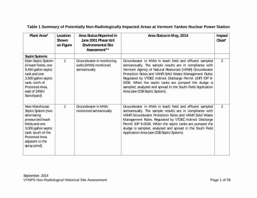
Table 1 Summary of Potentially Non-Radiologically Impacted Areas at Vermont Yankee Nuclear Power Station
Plant Area* LocationShownon Figure
Area Status Reported inJune 2001 Phase I&IIEnvironmental Site
Assessment**
Area Status in May, 2014 ImpactClass*
Septic SystemsMain Septic System(4 leach fields, one9,450-gallon septictank and one3,500-gallon septictank; north ofProtected Area,east of 345kVSwitchyard)
1 Groundwater in monitoringwells (MWs) monitoredsemiannually
Groundwater in MWs in leach field and effluent sampledsemiannually. The sample results are in compliance withVermont Agency of Natural Resources (VANR) GroundwaterProtection Rules and VANR Solid Waste Management Rules.Regulated by VTDEC Indirect Discharge Permit (IDP) IDP 9-0036. When the septic tanks are pumped the sludge issampled, analyzed and spread in the South Field ApplicationArea (see COB Septic System).
2
New WarehouseSeptic System (twoalternatingpressurized leachfields and one3,000-gallon septictank; south of theProtected Areaadjacent to thespray pond)
1 Groundwater in MWsmonitored semiannually
Groundwater in MWs in leach field and effluent sampledsemiannually. The sample results are in compliance withVANR Groundwater Protection Rules and VANR Solid WasteManagement Rules. Regulated by VTDEC Indirect DischargePermit IDP 9-0036. When the septic tanks are pumped thesludge is sampled, analyzed and spread in the South FieldApplication Area (see COB Septic System).
2
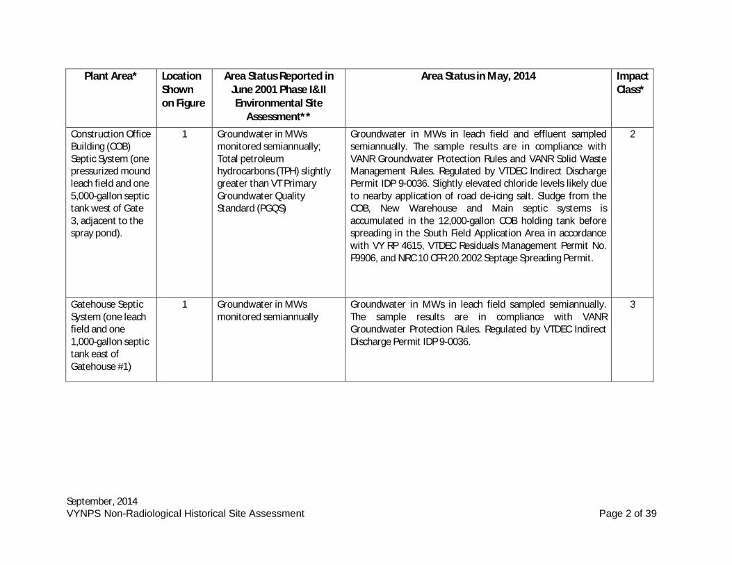
September, 2014VYNPS Non-Radiological Historical Site Assessment Page 2 of 39
Plant Area* LocationShownon Figure
Area Status Reported inJune 2001 Phase I&IIEnvironmental Site
Assessment**
Area Status in May, 2014 ImpactClass*
Construction OfficeBuilding (COB)Septic System (onepressurized moundleach field and one5,000-gallon septictank west of Gate3, adjacent to thespray pond).
1 Groundwater in MWsmonitored semiannually;Total petroleumhydrocarbons (TPH) slightlygreater than VT PrimaryGroundwater QualityStandard (PGQS)
Groundwater in MWs in leach field and effluent sampledsemiannually. The sample results are in compliance withVANR Groundwater Protection Rules and VANR Solid WasteManagement Rules. Regulated by VTDEC Indirect DischargePermit IDP 9-0036. Slightly elevated chloride levels likely dueto nearby application of road de-icing salt. Sludge from theCOB, New Warehouse and Main septic systems isaccumulated in the 12,000-gallon COB holding tank beforespreading in the South Field Application Area in accordancewith VY RP 4615, VTDEC Residuals Management Permit No.F9906, and NRC 10 CFR 20.2002 Septage Spreading Permit.
2
Gatehouse SepticSystem (one leachfield and one1,000-gallon septictank east ofGatehouse #1)
1 Groundwater in MWsmonitored semiannually
Groundwater in MWs in leach field sampled semiannually.The sample results are in compliance with VANRGroundwater Protection Rules. Regulated by VTDEC IndirectDischarge Permit IDP 9-0036.
3
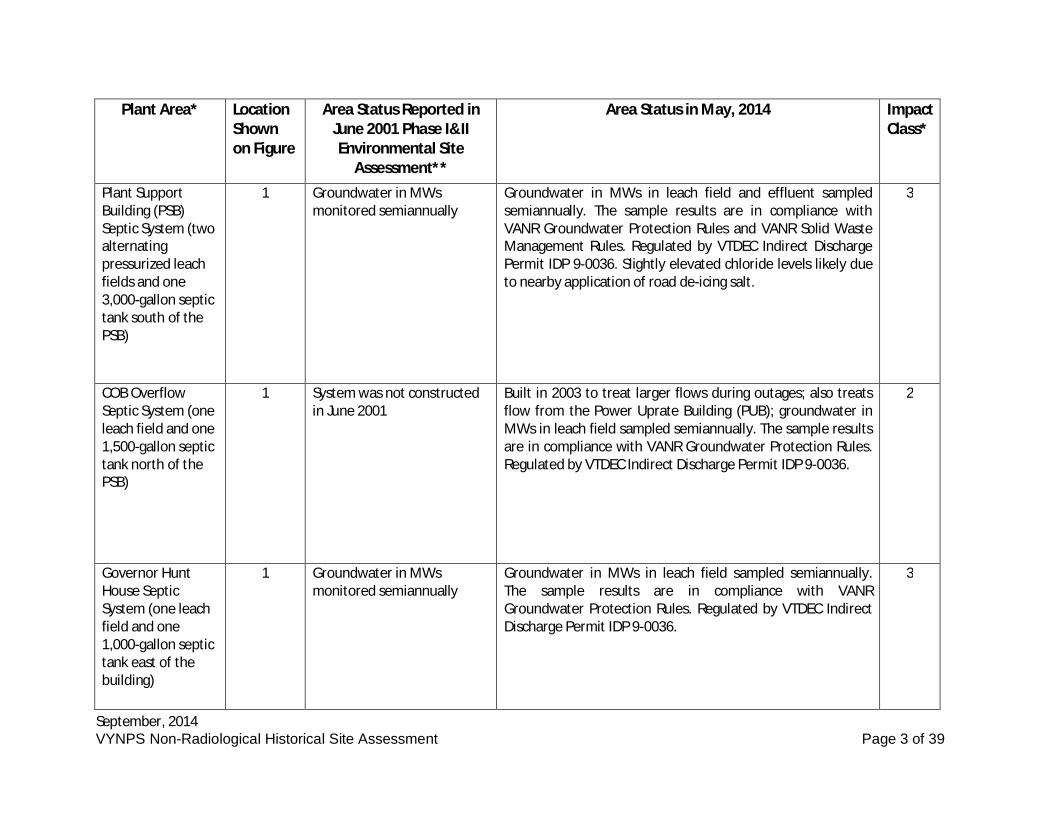
September, 2014VYNPS Non-Radiological Historical Site Assessment Page 3 of 39
Plant Area* LocationShownon Figure
Area Status Reported inJune 2001 Phase I&IIEnvironmental Site
Assessment**
Area Status in May, 2014 ImpactClass*
Plant SupportBuilding (PSB)Septic System (twoalternatingpressurized leachfields and one3,000-gallon septictank south of thePSB)
1 Groundwater in MWsmonitored semiannually
Groundwater in MWs in leach field and effluent sampledsemiannually. The sample results are in compliance withVANR Groundwater Protection Rules and VANR Solid WasteManagement Rules. Regulated by VTDEC Indirect DischargePermit IDP 9-0036. Slightly elevated chloride levels likely dueto nearby application of road de-icing salt.
3
COB OverflowSeptic System (oneleach field and one1,500-gallon septictank north of thePSB)
1 System was not constructedin June 2001
Built in 2003 to treat larger flows during outages; also treatsflow from the Power Uprate Building (PUB); groundwater inMWs in leach field sampled semiannually. The sample resultsare in compliance with VANR Groundwater Protection Rules.Regulated by VTDEC Indirect Discharge Permit IDP 9-0036.
2
Governor HuntHouse SepticSystem (one leachfield and one1,000-gallon septictank east of thebuilding)
1 Groundwater in MWsmonitored semiannually
Groundwater in MWs in leach field sampled semiannually.The sample results are in compliance with VANRGroundwater Protection Rules. Regulated by VTDEC IndirectDischarge Permit IDP 9-0036.
3
September, 2014VYNPS Non-Radiological Historical Site Assessment Page 4 of 39
Plant Area* LocationShownon Figure
Area Status Reported inJune 2001 Phase I&IIEnvironmental Site
Assessment**
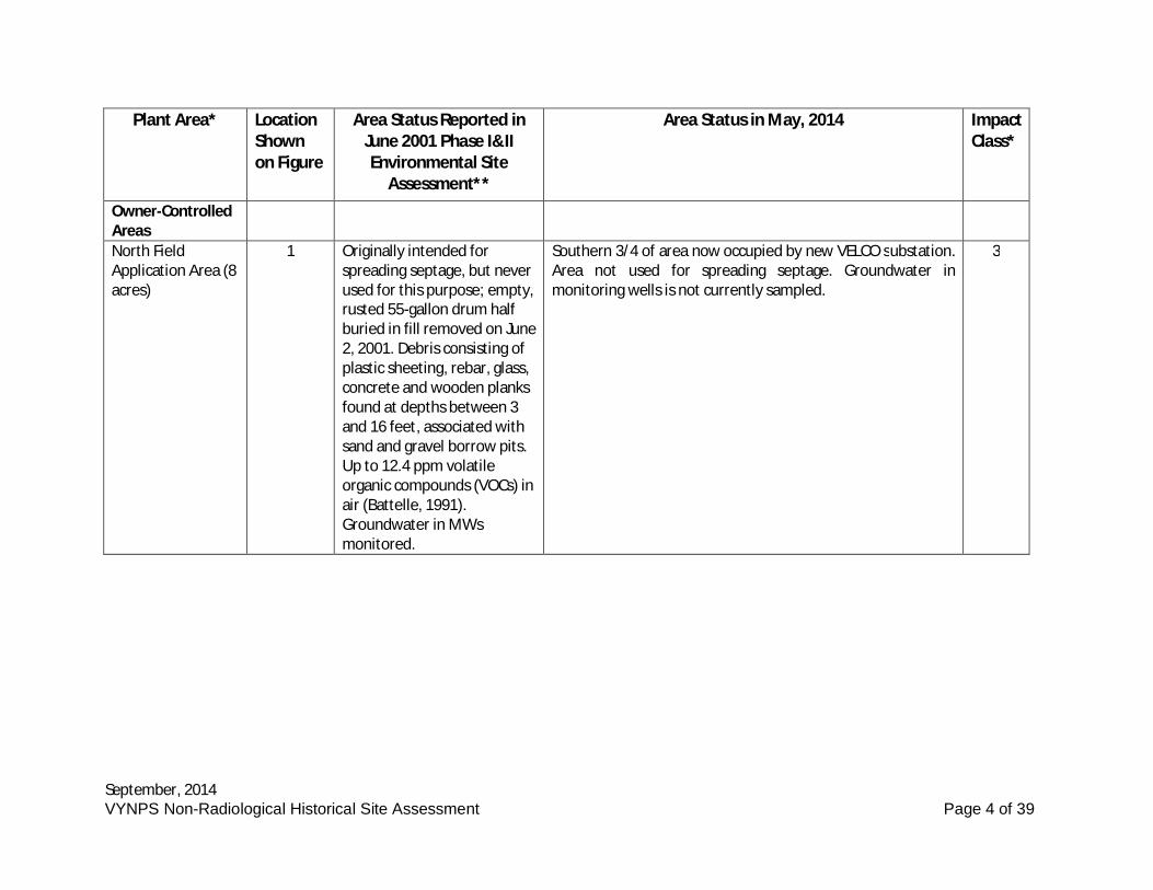
Area Status in May, 2014 ImpactClass*
Owner-ControlledAreasNorth FieldApplication Area (8acres)
1 Originally intended forspreading septage, but neverused for this purpose; empty,rusted 55-gallon drum halfburied in fill removed on June2, 2001. Debris consisting ofplastic sheeting, rebar, glass,concrete and wooden planksfound at depths between 3and 16 feet, associated withsand and gravel borrow pits.Up to 12.4 ppm volatileorganic compounds (VOCs) inair (Battelle, 1991).Groundwater in MWsmonitored.
Southern 3/4 of area now occupied by new VELCO substation.Area not used for spreading septage. Groundwater inmonitoring wells is not currently sampled.
3
September, 2014VYNPS Non-Radiological Historical Site Assessment Page 5 of 39
Plant Area* LocationShownon Figure
Area Status Reported inJune 2001 Phase I&IIEnvironmental Site
Assessment**
Area Status in May, 2014 ImpactClass*
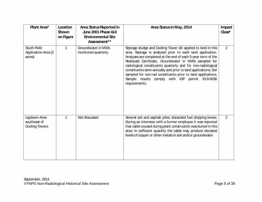
South FieldApplication Area (2acres)
1 Groundwater in MWsmonitored quarterly.
Septage sludge and Cooling Tower silt applied to land in thisarea. Septage is analyzed prior to each land application.Analyses are completed at the end of each 5-year term of theResiduals Certificate. Groundwater in MWs sampled forradiological constituents quarterly and for non-radiologicalconstituents semi-annually and prior to land applications; Soilsampled for non-rad constituents prior to land applications.Sample results comply with IDP permit ID-9-0036requirements.
2
Laydown Areasoutheast ofCooling Towers
1 Not discussed Several soil and asphalt piles; discarded fuel shipping boxes.During an interview with a former employee it was reportedthat cable unused during plant construction was buried in thisarea. In sufficient quantity the cable may produce elevatedlevels of copper or other metals in soil and/or groundwater.
2
September, 2014VYNPS Non-Radiological Historical Site Assessment Page 6 of 39
Plant Area* LocationShownon Figure
Area Status Reported inJune 2001 Phase I&IIEnvironmental Site
Assessment**
Area Status in May, 2014 ImpactClass*
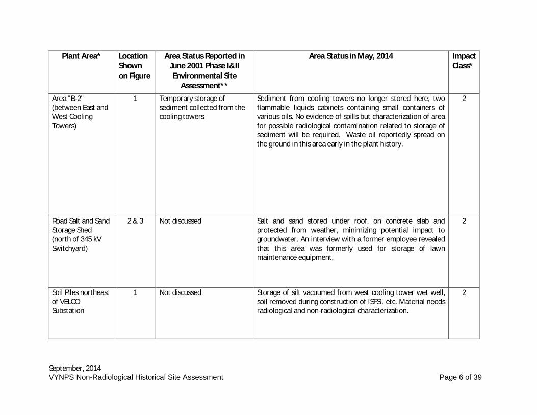
Area "B-2"(between East andWest CoolingTowers)
1 Temporary storage ofsediment collected from thecooling towers
Sediment from cooling towers no longer stored here; twoflammable liquids cabinets containing small containers ofvarious oils. No evidence of spills but characterization of areafor possible radiological contamination related to storage ofsediment will be required. Waste oil reportedly spread onthe ground in this area early in the plant history.
2
Road Salt and SandStorage Shed(north of 345 kVSwitchyard)
2 & 3 Not discussed Salt and sand stored under roof, on concrete slab andprotected from weather, minimizing potential impact togroundwater. An interview with a former employee revealedthat this area was formerly used for storage of lawnmaintenance equipment.
2
Soil Piles northeastof VELCOSubstation
1 Not discussed Storage of silt vacuumed from west cooling tower wet well,soil removed during construction of ISFSI, etc. Material needsradiological and non-radiological characterization.
2
September, 2014VYNPS Non-Radiological Historical Site Assessment Page 7 of 39
Plant Area* LocationShownon Figure
Area Status Reported inJune 2001 Phase I&IIEnvironmental Site
Assessment**
Area Status in May, 2014 ImpactClass*
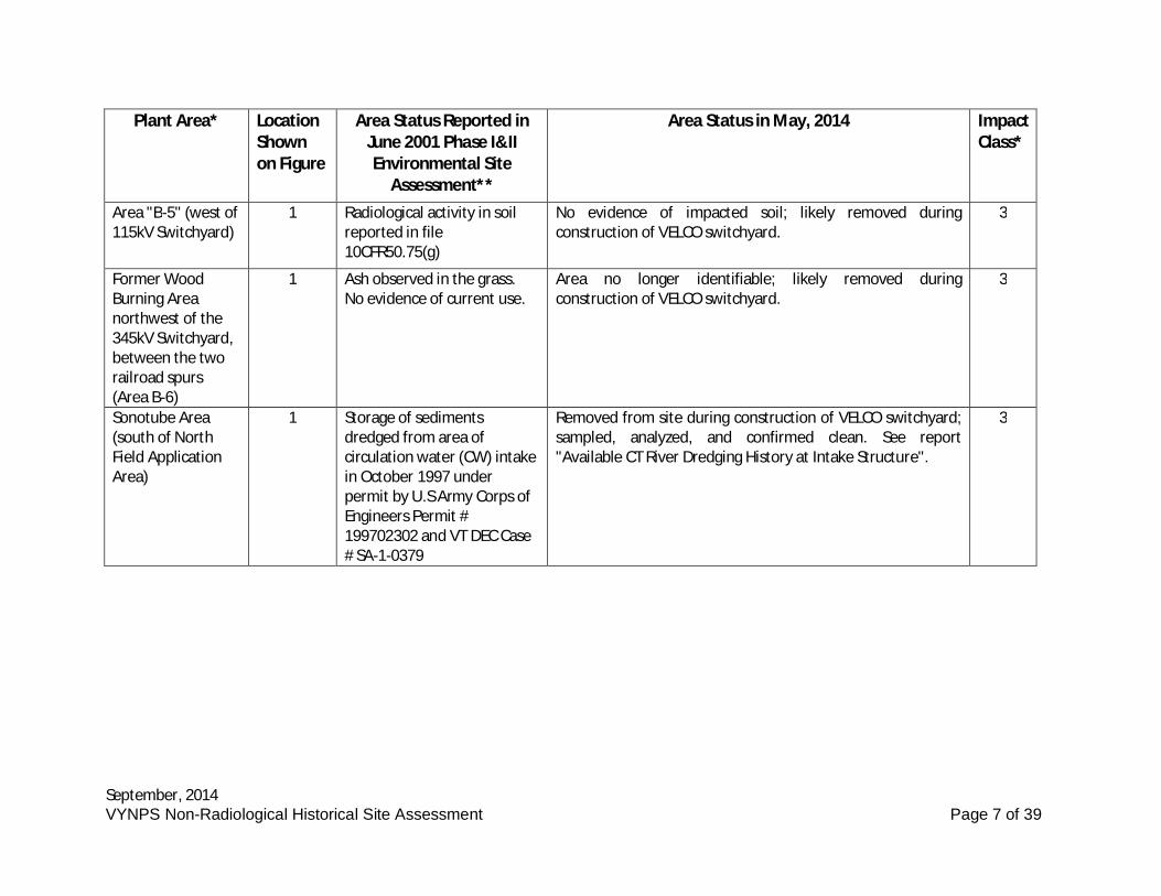
Area "B-5" (west of115kV Switchyard)
1 Radiological activity in soilreported in file10CFR50.75(g)
No evidence of impacted soil; likely removed duringconstruction of VELCO switchyard.
3
Former WoodBurning Areanorthwest of the345kV Switchyard,between the tworailroad spurs(Area B-6)
1 Ash observed in the grass.No evidence of current use.
Area no longer identifiable; likely removed duringconstruction of VELCO switchyard.
3
Sonotube Area(south of NorthField ApplicationArea)
1 Storage of sedimentsdredged from area ofcirculation water (CW) intakein October 1997 underpermit by U.S Army Corps ofEngineers Permit #199702302 and VT DEC Case# SA-1-0379
Removed from site during construction of VELCO switchyard;sampled, analyzed, and confirmed clean. See report"Available CT River Dredging History at Intake Structure".
3
September, 2014VYNPS Non-Radiological Historical Site Assessment Page 8 of 39
Plant Area* LocationShownon Figure
Area Status Reported inJune 2001 Phase I&IIEnvironmental Site
Assessment**
Area Status in May, 2014 ImpactClass*
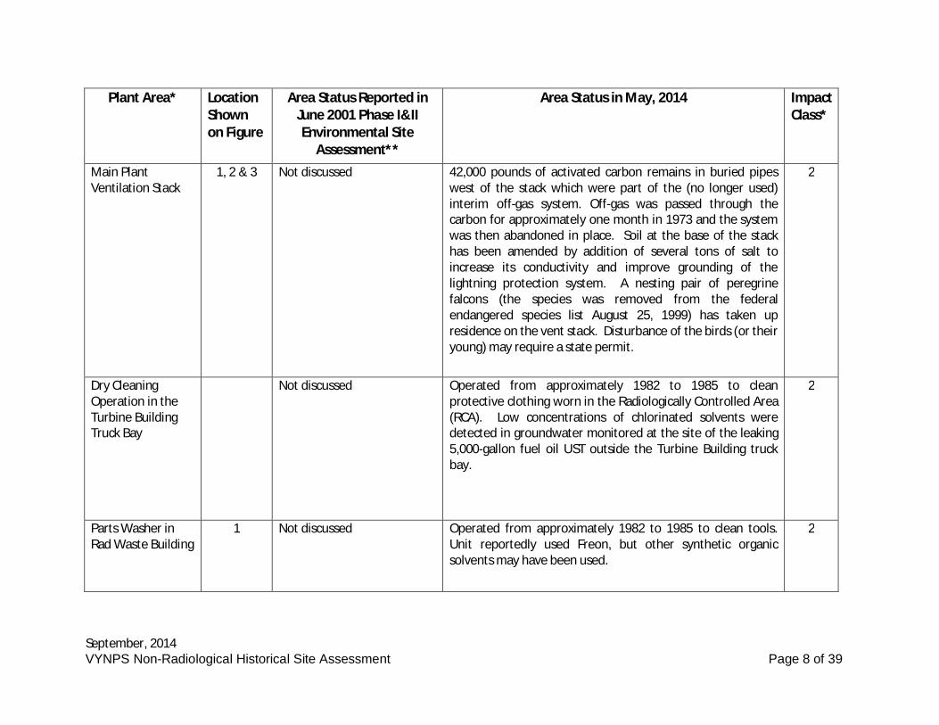
Main PlantVentilation Stack
1, 2 & 3 Not discussed 42,000 pounds of activated carbon remains in buried pipeswest of the stack which were part of the (no longer used)interim off-gas system. Off-gas was passed through thecarbon for approximately one month in 1973 and the systemwas then abandoned in place. Soil at the base of the stackhas been amended by addition of several tons of salt toincrease its conductivity and improve grounding of thelightning protection system. A nesting pair of peregrinefalcons (the species was removed from the federalendangered species list August 25, 1999) has taken upresidence on the vent stack. Disturbance of the birds (or theiryoung) may require a state permit.
2
Dry CleaningOperation in theTurbine BuildingTruck Bay
Not discussed Operated from approximately 1982 to 1985 to cleanprotective clothing worn in the Radiologically Controlled Area(RCA). Low concentrations of chlorinated solvents weredetected in groundwater monitored at the site of the leaking5,000-gallon fuel oil UST outside the Turbine Building truckbay.
2
Parts Washer inRad Waste Building
1 Not discussed Operated from approximately 1982 to 1985 to clean tools.Unit reportedly used Freon, but other synthetic organicsolvents may have been used.
2
September, 2014VYNPS Non-Radiological Historical Site Assessment Page 9 of 39
Plant Area* LocationShownon Figure
Area Status Reported inJune 2001 Phase I&IIEnvironmental Site
Assessment**
Area Status in May, 2014 ImpactClass*
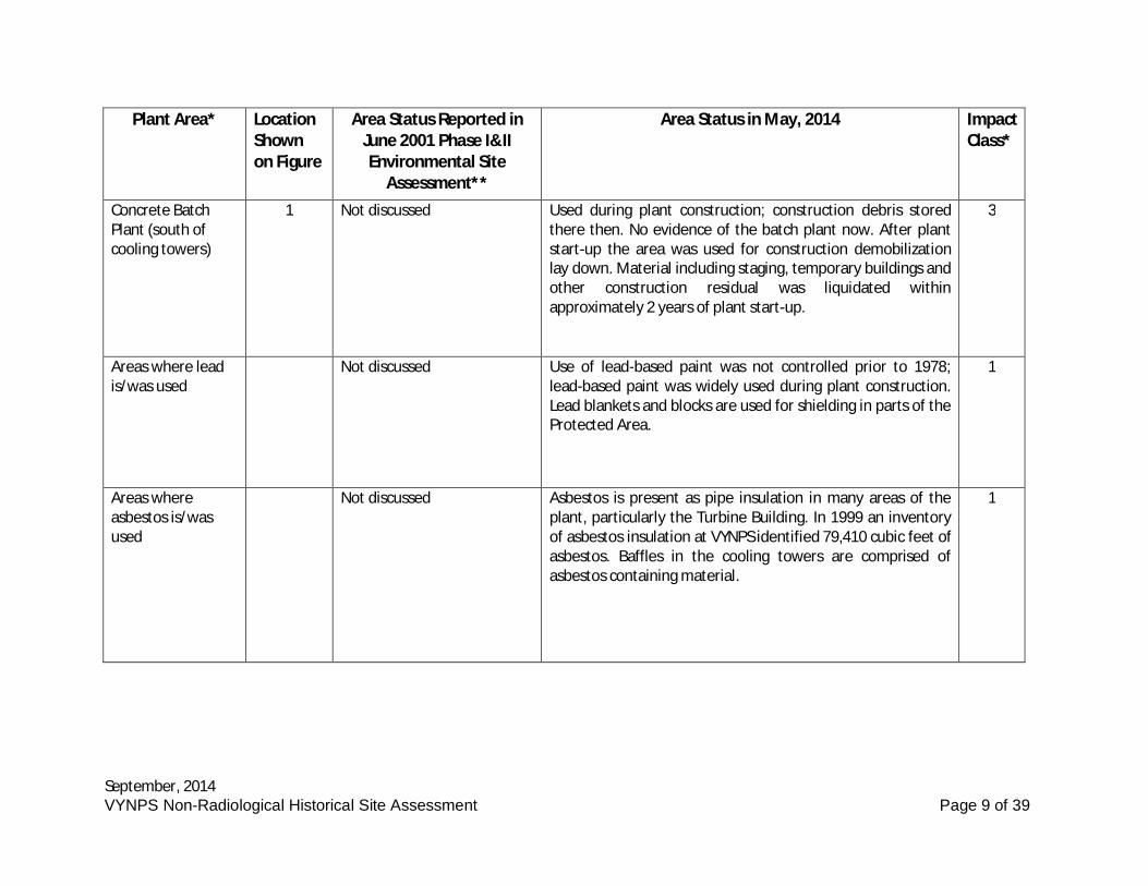
Concrete BatchPlant (south ofcooling towers)
1 Not discussed Used during plant construction; construction debris storedthere then. No evidence of the batch plant now. After plantstart-up the area was used for construction demobilizationlay down. Material including staging, temporary buildings andother construction residual was liquidated withinapproximately 2 years of plant start-up.
3
Areas where leadis/was used
Not discussed Use of lead-based paint was not controlled prior to 1978;lead-based paint was widely used during plant construction.Lead blankets and blocks are used for shielding in parts of theProtected Area.
1
Areas whereasbestos is/wasused
Not discussed Asbestos is present as pipe insulation in many areas of theplant, particularly the Turbine Building. In 1999 an inventoryof asbestos insulation at VYNPS identified 79,410 cubic feet ofasbestos. Baffles in the cooling towers are comprised ofasbestos containing material.
1
September, 2014VYNPS Non-Radiological Historical Site Assessment Page 10 of 39
Plant Area* LocationShownon Figure
Area Status Reported inJune 2001 Phase I&IIEnvironmental Site
Assessment**
Area Status in May, 2014 ImpactClass*
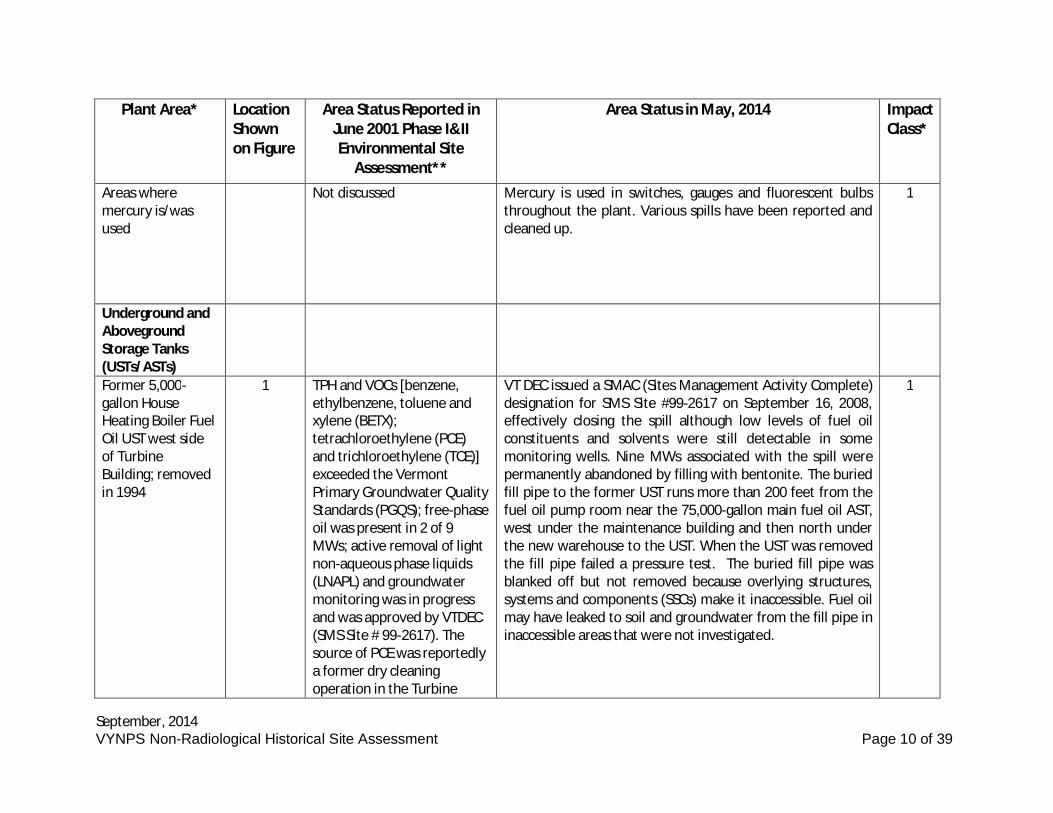
Areas wheremercury is/wasused
Not discussed Mercury is used in switches, gauges and fluorescent bulbsthroughout the plant. Various spills have been reported andcleaned up.
1
Underground andAbovegroundStorage Tanks(USTs/ASTs)Former 5,000-gallon HouseHeating Boiler FuelOil UST west sideof TurbineBuilding; removedin 1994
1 TPH and VOCs [benzene,ethylbenzene, toluene andxylene (BETX);tetrachloroethylene (PCE)and trichloroethylene (TCE)]exceeded the VermontPrimary Groundwater QualityStandards (PGQS); free-phaseoil was present in 2 of 9MWs; active removal of lightnon-aqueous phase liquids(LNAPL) and groundwatermonitoring was in progressand was approved by VTDEC(SMS Site # 99-2617). Thesource of PCE was reportedlya former dry cleaningoperation in the Turbine
VT DEC issued a SMAC (Sites Management Activity Complete)designation for SMS Site #99-2617 on September 16, 2008,effectively closing the spill although low levels of fuel oilconstituents and solvents were still detectable in somemonitoring wells. Nine MWs associated with the spill werepermanently abandoned by filling with bentonite. The buriedfill pipe to the former UST runs more than 200 feet from thefuel oil pump room near the 75,000-gallon main fuel oil AST,west under the maintenance building and then north underthe new warehouse to the UST. When the UST was removedthe fill pipe failed a pressure test. The buried fill pipe wasblanked off but not removed because overlying structures,systems and components (SSCs) make it inaccessible. Fuel oilmay have leaked to soil and groundwater from the fill pipe ininaccessible areas that were not investigated.
1
September, 2014VYNPS Non-Radiological Historical Site Assessment Page 11 of 39
Plant Area* LocationShownon Figure
Area Status Reported inJune 2001 Phase I&IIEnvironmental Site
Assessment**
Area Status in May, 2014 ImpactClass*
Building truck bay.
1,000-gallongasoline double-walled fiberglassUST northeast ofthe SouthWarehouseBuilding
2 Installed in 1997. Used to fuelvehicles. Passed April 2001leak detection monitoring.
The 1,000-gallon double-walled UST has a Veeder-Rootautomatic interstitial monitoring system. The new UST wasconverted from gasoline to diesel after September 11, 2001because the more flammable gasoline presented a highersecurity risk. VT UST Program ID No. 806.
2
550-gallon dieseldouble-walledfiberglass USTnortheast of theSouth WarehouseBuilding
2 Installed in 1997. Used to fuelvehicles. Passed April 2001leak detection monitoring.
Tank has a Veeder-Root automatic interstitial monitoringsystem. VT UST Program ID No. 806.
2
550-gallon dieseldouble-walledfiberglass USTadjacent to theJohn Deere dieselemergencygenerator building,south of NorthWarehouse
1 & 2 Installed in 1997. Used tooperate the small John Deereemergency generator. PassedApril 2001 leak detectionmonitoring.
Tank has a Veeder-Root automatic interstitial monitoringsystem. VT UST Program ID No. 806.
2
September, 2014VYNPS Non-Radiological Historical Site Assessment Page 12 of 39
Plant Area* LocationShownon Figure
Area Status Reported inJune 2001 Phase I&IIEnvironmental Site
Assessment**
Area Status in May, 2014 ImpactClass*
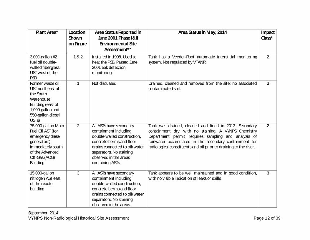
3,000-gallon #2fuel oil double-walled fiberglassUST west of thePSB
1 & 2 Installed in 1998. Used toheat the PSB. Passed June2001leak detectionmonitoring.
Tank has a Veeder-Root automatic interstitial monitoringsystem. Not regulated by VTANR.
2
Former waste oilUST northeast ofthe SouthWarehouseBuilding (east of1,000-gallon and550-gallon dieselUSTs)
1 Not discussed Drained, cleaned and removed from the site; no associatedcontaminated soil.
3
75,000-gallon MainFuel Oil AST (foremergency dieselgenerators)immediately southof the AdvancedOff-Gas (AOG)Building
2 All ASTs have secondarycontainment includingdouble-walled construction,concrete berms and floordrains connected to oil/waterseparators. No stainingobserved in the areascontaining ASTs.
Tank was drained, cleaned and lined in 2013. Secondarycontainment dry, with no staining. A VYNPS ChemistryDepartment permit requires sampling and analysis ofrainwater accumulated in the secondary containment forradiological constituents and oil prior to draining to the river.
2
15,000-gallonnitrogen AST eastof the reactorbuilding
3 All ASTs have secondarycontainment includingdouble-walled construction,concrete berms and floordrains connected to oil/waterseparators. No stainingobserved in the areas
Tank appears to be well maintained and in good condition,with no visible indication of leaks or spills.
3
September, 2014VYNPS Non-Radiological Historical Site Assessment Page 13 of 39
Plant Area* LocationShownon Figure
Area Status Reported inJune 2001 Phase I&IIEnvironmental Site
Assessment**
Area Status in May, 2014 ImpactClass*
containing ASTs.
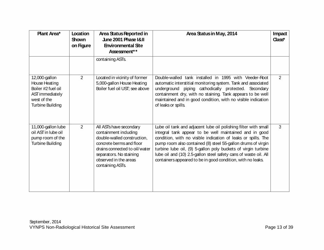
12,000-gallonHouse HeatingBoiler #2 fuel oilAST immediatelywest of theTurbine Building
2 Located in vicinity of former5,000-gallon House HeatingBoiler fuel oil UST; see above
Double-walled tank installed in 1995 with Veeder-Rootautomatic interstitial monitoring system. Tank and associatedunderground piping cathodically protected. Secondarycontainment dry, with no staining. Tank appears to be wellmaintained and in good condition, with no visible indicationof leaks or spills.
2
11,000-gallon lubeoil AST in lube oilpump room of theTurbine Building
2 All ASTs have secondarycontainment includingdouble-walled construction,concrete berms and floordrains connected to oil/waterseparators. No stainingobserved in the areascontaining ASTs.
Lube oil tank and adjacent lube oil polishing filter with smallintegral tank appear to be well maintained and in goodcondition, with no visible indication of leaks or spills. Thepump room also contained (8) steel 55-gallon drums of virginturbine lube oil, (9) 5-gallon poly buckets of virgin turbinelube oil and (10) 2.5-gallon steel safety cans of waste oil. Allcontainers appeared to be in good condition, with no leaks.
3
September, 2014VYNPS Non-Radiological Historical Site Assessment Page 14 of 39
Plant Area* LocationShownon Figure
Area Status Reported inJune 2001 Phase I&IIEnvironmental Site
Assessment**
Area Status in May, 2014 ImpactClass*
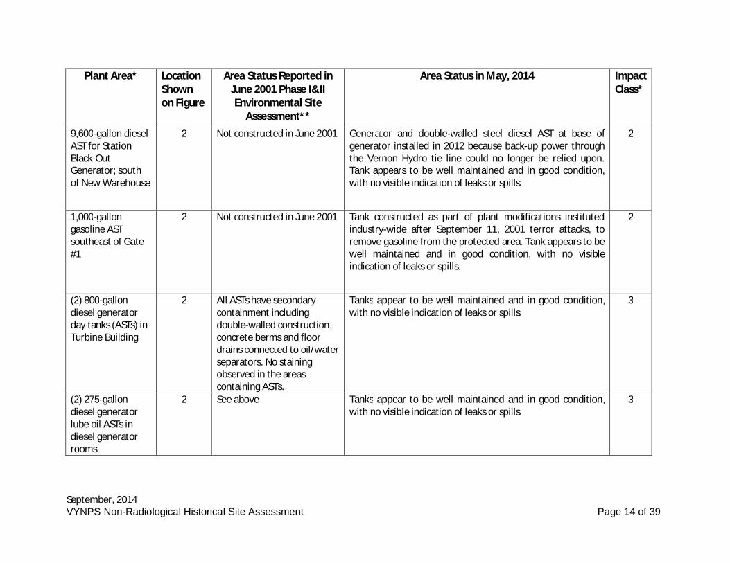
9,600-gallon dieselAST for StationBlack-OutGenerator; southof New Warehouse
2 Not constructed in June 2001 Generator and double-walled steel diesel AST at base ofgenerator installed in 2012 because back-up power throughthe Vernon Hydro tie line could no longer be relied upon.Tank appears to be well maintained and in good condition,with no visible indication of leaks or spills.
2
1,000-gallongasoline ASTsoutheast of Gate#1
2 Not constructed in June 2001 Tank constructed as part of plant modifications institutedindustry-wide after September 11, 2001 terror attacks, toremove gasoline from the protected area. Tank appears to bewell maintained and in good condition, with no visibleindication of leaks or spills.
2
(2) 800-gallondiesel generatorday tanks (ASTs) inTurbine Building
2 All ASTs have secondarycontainment includingdouble-walled construction,concrete berms and floordrains connected to oil/waterseparators. No stainingobserved in the areascontaining ASTs.
Tanks appear to be well maintained and in good condition,with no visible indication of leaks or spills.
3
(2) 275-gallondiesel generatorlube oil ASTs indiesel generatorrooms
2 See above Tanks appear to be well maintained and in good condition,with no visible indication of leaks or spills.
3
September, 2014VYNPS Non-Radiological Historical Site Assessment Page 15 of 39
Plant Area* LocationShownon Figure
Area Status Reported inJune 2001 Phase I&IIEnvironmental Site
Assessment**
Area Status in May, 2014 ImpactClass*
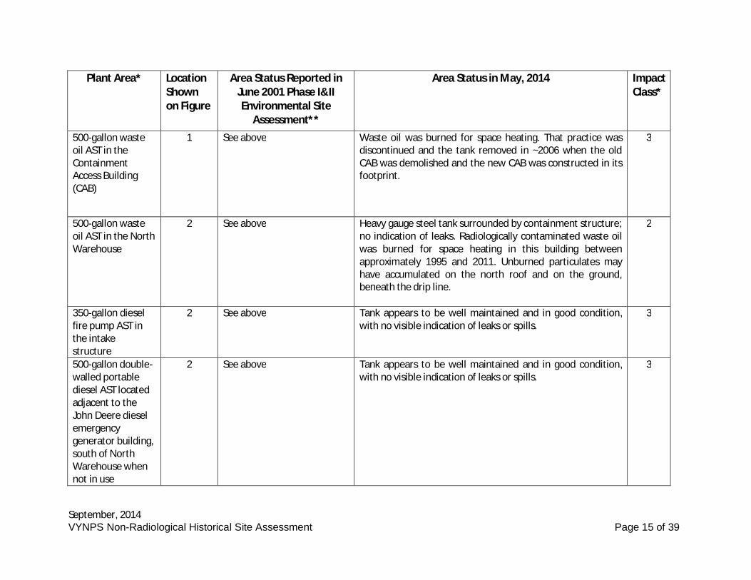
500-gallon wasteoil AST in theContainmentAccess Building(CAB)
1 See above Waste oil was burned for space heating. That practice wasdiscontinued and the tank removed in ~2006 when the oldCAB was demolished and the new CAB was constructed in itsfootprint.
3
500-gallon wasteoil AST in the NorthWarehouse
2 See above Heavy gauge steel tank surrounded by containment structure;no indication of leaks. Radiologically contaminated waste oilwas burned for space heating in this building betweenapproximately 1995 and 2011. Unburned particulates mayhave accumulated on the north roof and on the ground,beneath the drip line.
2
350-gallon dieselfire pump AST inthe intakestructure
2 See above Tank appears to be well maintained and in good condition,with no visible indication of leaks or spills.
3
500-gallon double-walled portablediesel AST locatedadjacent to theJohn Deere dieselemergencygenerator building,south of NorthWarehouse whennot in use
2 See above Tank appears to be well maintained and in good condition,with no visible indication of leaks or spills.
3
September, 2014VYNPS Non-Radiological Historical Site Assessment Page 16 of 39
Plant Area* LocationShownon Figure
Area Status Reported inJune 2001 Phase I&IIEnvironmental Site
Assessment**
Area Status in May, 2014 ImpactClass*
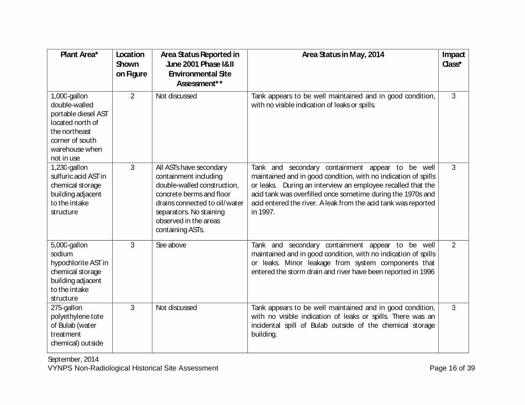
1,000-gallondouble-walledportable diesel ASTlocated north ofthe northeastcorner of southwarehouse whennot in use
2 Not discussed Tank appears to be well maintained and in good condition,with no visible indication of leaks or spills.
3
1,230-gallonsulfuric acid AST inchemical storagebuilding adjacentto the intakestructure
3 All ASTs have secondarycontainment includingdouble-walled construction,concrete berms and floordrains connected to oil/waterseparators. No stainingobserved in the areascontaining ASTs.
Tank and secondary containment appear to be wellmaintained and in good condition, with no indication of spillsor leaks. During an interview an employee recalled that theacid tank was overfilled once sometime during the 1970s andacid entered the river. A leak from the acid tank was reportedin 1997.
3
5,000-gallonsodiumhypochlorite AST inchemical storagebuilding adjacentto the intakestructure
3 See above Tank and secondary containment appear to be wellmaintained and in good condition, with no indication of spillsor leaks. Minor leakage from system components thatentered the storm drain and river have been reported in 1996
2
275-gallonpolyethylene toteof Bulab (watertreatmentchemical) outside
3 Not discussed Tank appears to be well maintained and in good condition,with no visible indication of leaks or spills. There was anincidental spill of Bulab outside of the chemical storagebuilding.
3
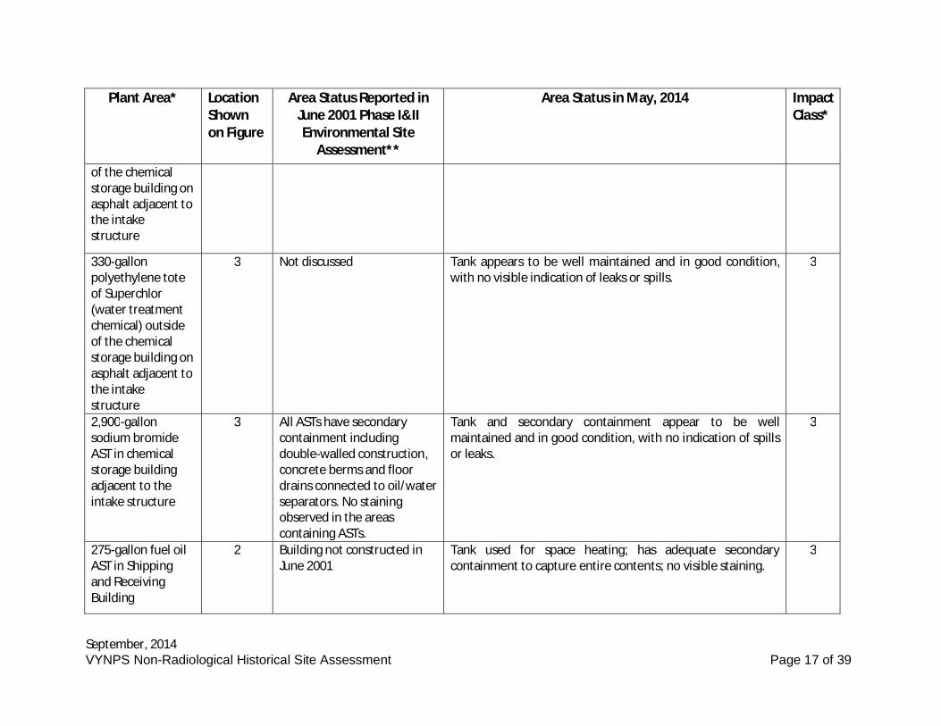
September, 2014VYNPS Non-Radiological Historical Site Assessment Page 17 of 39
Plant Area* LocationShownon Figure
Area Status Reported inJune 2001 Phase I&IIEnvironmental Site
Assessment**
Area Status in May, 2014 ImpactClass*
of the chemicalstorage building onasphalt adjacent tothe intakestructure
330-gallonpolyethylene toteof Superchlor(water treatmentchemical) outsideof the chemicalstorage building onasphalt adjacent tothe intakestructure
3 Not discussed Tank appears to be well maintained and in good condition,with no visible indication of leaks or spills.
3
2,900-gallonsodium bromideAST in chemicalstorage buildingadjacent to theintake structure
3 All ASTs have secondarycontainment includingdouble-walled construction,concrete berms and floordrains connected to oil/waterseparators. No stainingobserved in the areascontaining ASTs.
Tank and secondary containment appear to be wellmaintained and in good condition, with no indication of spillsor leaks.
3
275-gallon fuel oilAST in Shippingand ReceivingBuilding
2 Building not constructed inJune 2001
Tank used for space heating; has adequate secondarycontainment to capture entire contents; no visible staining.
3
September, 2014VYNPS Non-Radiological Historical Site Assessment Page 18 of 39
Plant Area* LocationShownon Figure
Area Status Reported inJune 2001 Phase I&IIEnvironmental Site
Assessment**
Area Status in May, 2014 ImpactClass*
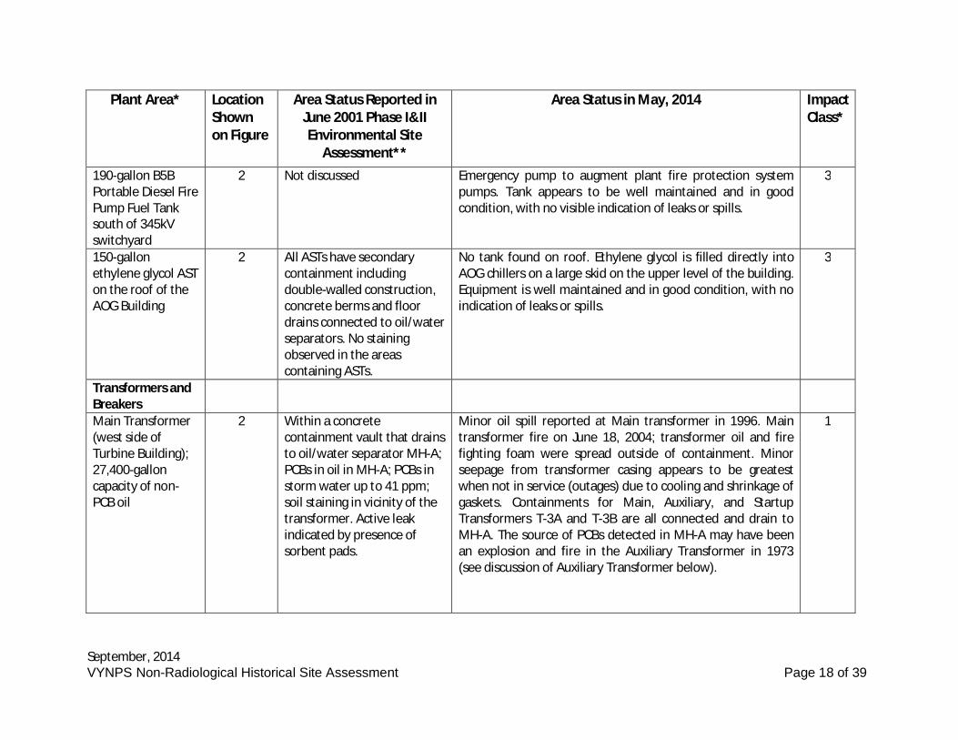
190-gallon B5BPortable Diesel FirePump Fuel Tanksouth of 345kVswitchyard
2 Not discussed Emergency pump to augment plant fire protection systempumps. Tank appears to be well maintained and in goodcondition, with no visible indication of leaks or spills.
3
150-gallonethylene glycol ASTon the roof of theAOG Building
2 All ASTs have secondarycontainment includingdouble-walled construction,concrete berms and floordrains connected to oil/waterseparators. No stainingobserved in the areascontaining ASTs.
No tank found on roof. Ethylene glycol is filled directly intoAOG chillers on a large skid on the upper level of the building.Equipment is well maintained and in good condition, with noindication of leaks or spills.
3
Transformers andBreakersMain Transformer(west side ofTurbine Building);27,400-galloncapacity of non-PCB oil
2 Within a concretecontainment vault that drainsto oil/water separator MH-A;PCBs in oil in MH-A; PCBs instorm water up to 41 ppm;soil staining in vicinity of thetransformer. Active leakindicated by presence ofsorbent pads.
Minor oil spill reported at Main transformer in 1996. Maintransformer fire on June 18, 2004; transformer oil and firefighting foam were spread outside of containment. Minorseepage from transformer casing appears to be greatestwhen not in service (outages) due to cooling and shrinkage ofgaskets. Containments for Main, Auxiliary, and StartupTransformers T-3A and T-3B are all connected and drain toMH-A. The source of PCBs detected in MH-A may have beenan explosion and fire in the Auxiliary Transformer in 1973(see discussion of Auxiliary Transformer below).
1
September, 2014VYNPS Non-Radiological Historical Site Assessment Page 19 of 39
Plant Area* LocationShownon Figure
Area Status Reported inJune 2001 Phase I&IIEnvironmental Site
Assessment**
Area Status in May, 2014 ImpactClass*
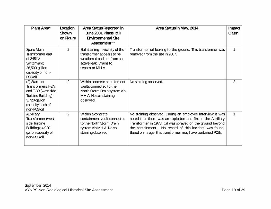
Spare MainTransformer eastof 345kVSwitchyard;26,500-galloncapacity of non-PCB oil
2 Soil staining in vicinity of thetransformer appears to beweathered and not from anactive leak. Drains toseparator MH-A
Transformer oil leaking to the ground. This transformer wasremoved from the site in 2007.
1
(2) Start-upTransformers T-3Aand T-3B (west sideTurbine Building);3,720-galloncapacity each ofnon-PCB oil
2 Within concrete containmentvaults connected to theNorth Storm Drain system viaMH-A. No soil stainingobserved.
No staining observed. 2
AuxiliaryTransformer (westside TurbineBuilding); 4,920-gallon capacity ofnon-PCB oil
2 Within a concretecontainment vault connectedto the North Storm Drainsystem via MH-A. No soilstaining observed.
No staining observed. During an employee interview it wasnoted that there was an explosion and fire in the AuxiliaryTransformer in 1973. Oil was sprayed on the ground beyondthe containment. No record of this incident was found.Based on its age, this transformer may have contained PCBs.
1
September, 2014VYNPS Non-Radiological Historical Site Assessment Page 20 of 39
Plant Area* LocationShownon Figure
Area Status Reported inJune 2001 Phase I&IIEnvironmental Site
Assessment**
Area Status in May, 2014 ImpactClass*
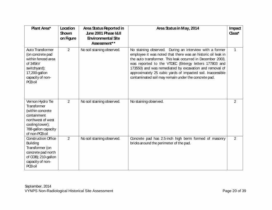
Auto Transformer(on concrete padwithin fenced areaof 345kVswitchyard);17,200-galloncapacity of non-PCB oil
2 No soil staining observed. No staining observed. During an interview with a formeremployee it was noted that there was an historic oil leak inthe auto transformer. This leak occurred in December 2003,was reported to the VTDEC (Entergy letters 177803 and173550) and was remediated by excavation and removal ofapproximately 25 cubic yards of impacted soil. Inaccessiblecontaminated soil may remain under the concrete pad.
1
Vernon Hydro TieTransformer(within concretecontainmentnorthwest of westcooling tower);788-gallon capacityof non-PCB oil
2 No soil staining observed. No staining observed. 2
Construction OfficeBuildingTransformer (onconcrete pad northof COB); 210-galloncapacity of non-PCB oil
2 No soil staining observed. Concrete pad has 2.5-inch high berm formed of masonrybricks around the perimeter of the pad.
2
September, 2014VYNPS Non-Radiological Historical Site Assessment Page 21 of 39
Plant Area* LocationShownon Figure
Area Status Reported inJune 2001 Phase I&IIEnvironmental Site
Assessment**
Area Status in May, 2014 ImpactClass*
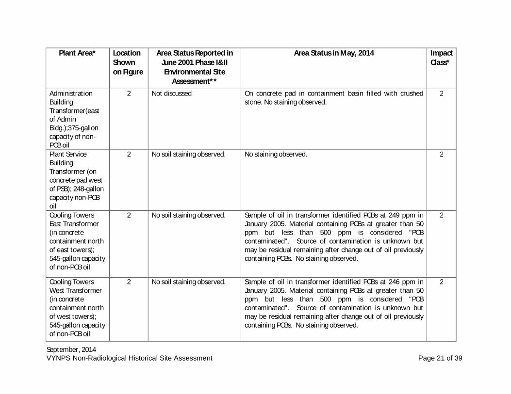
AdministrationBuildingTransformer(eastof AdminBldg.);375-galloncapacity of non-PCB oil
2 Not discussed On concrete pad in containment basin filled with crushedstone. No staining observed.
2
Plant ServiceBuildingTransformer (onconcrete pad westof PSB); 248-galloncapacity non-PCBoil
2 No soil staining observed. No staining observed. 2
Cooling TowersEast Transformer(in concretecontainment northof east towers);545-gallon capacityof non-PCB oil
2 No soil staining observed. Sample of oil in transformer identified PCBs at 249 ppm inJanuary 2005. Material containing PCBs at greater than 50ppm but less than 500 ppm is considered "PCBcontaminated". Source of contamination is unknown butmay be residual remaining after change out of oil previouslycontaining PCBs. No staining observed.
2
Cooling TowersWest Transformer(in concretecontainment northof west towers);545-gallon capacityof non-PCB oil
2 No soil staining observed. Sample of oil in transformer identified PCBs at 246 ppm inJanuary 2005. Material containing PCBs at greater than 50ppm but less than 500 ppm is considered "PCBcontaminated". Source of contamination is unknown butmay be residual remaining after change out of oil previouslycontaining PCBs. No staining observed.
2
September, 2014VYNPS Non-Radiological Historical Site Assessment Page 22 of 39
Plant Area* LocationShownon Figure
Area Status Reported inJune 2001 Phase I&IIEnvironmental Site
Assessment**
Area Status in May, 2014 ImpactClass*
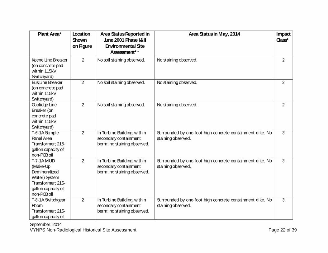
Keene Line Breaker(on concrete padwithin 115kVSwitchyard)
2 No soil staining observed. No staining observed. 2
Bus Line Breaker(on concrete padwithin 115kVSwitchyard)
2 No soil staining observed. No staining observed. 2
Coolidge LineBreaker (onconcrete padwithin 115kVSwitchyard)
2 No soil staining observed. No staining observed. 2
T-6-1A SamplePanel AreaTransformer; 215-gallon capacity ofnon-PCB oil
2 In Turbine Building, withinsecondary containmentberm; no staining observed.
Surrounded by one-foot high concrete containment dike. Nostaining observed.
3
T-7-1A MUD(Make-UpDemineralizedWater) SystemTransformer; 215-gallon capacity ofnon-PCB oil
2 In Turbine Building, withinsecondary containmentberm; no staining observed.
Surrounded by one-foot high concrete containment dike. Nostaining observed.
3
T-8-1A SwitchgearRoomTransformer; 215-gallon capacity of
2 In Turbine Building, withinsecondary containmentberm; no staining observed.
Surrounded by one-foot high concrete containment dike. Nostaining observed.
3
September, 2014VYNPS Non-Radiological Historical Site Assessment Page 23 of 39
Plant Area* LocationShownon Figure
Area Status Reported inJune 2001 Phase I&IIEnvironmental Site
Assessment**
Area Status in May, 2014 ImpactClass*
non-PCB oil
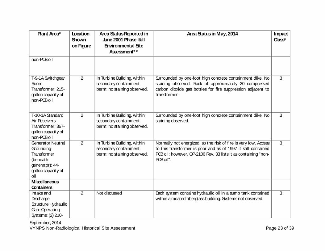
T-9-1A SwitchgearRoomTransformer; 215-gallon capacity ofnon-PCB oil
2 In Turbine Building, withinsecondary containmentberm; no staining observed.
Surrounded by one-foot high concrete containment dike. Nostaining observed. Rack of approximately 20 compressedcarbon dioxide gas bottles for fire suppression adjacent totransformer.
3
T-10-1A StandardAir ReceiversTransformer; 367-gallon capacity ofnon-PCB oil
2 In Turbine Building, withinsecondary containmentberm; no staining observed.
Surrounded by one-foot high concrete containment dike. Nostaining observed.
3
Generator NeutralGroundingTransformer(beneathgenerator); 44-gallon capacity ofoil
2 In Turbine Building, withinsecondary containmentberm; no staining observed.
Normally not energized, so the risk of fire is very low. Accessto this transformer is poor and as of 1997 it still containedPCB oil; however, OP-2106 Rev. 33 lists it as containing "non-PCB oil".
3
MiscellaneousContainersIntake andDischargeStructure HydraulicGate OperatingSystems; (2) 210-
2 Not discussed Each system contains hydraulic oil in a sump tank containedwithin a moated fiberglass building. Systems not observed.
3
September, 2014VYNPS Non-Radiological Historical Site Assessment Page 24 of 39
Plant Area* LocationShownon Figure
Area Status Reported inJune 2001 Phase I&IIEnvironmental Site
Assessment**
Area Status in May, 2014 ImpactClass*
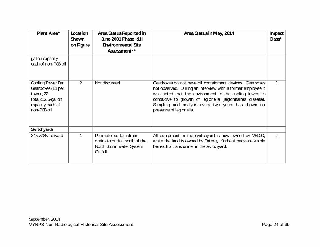
gallon capacityeach of non-PCB oil
Cooling Tower FanGearboxes (11 pertower, 22total);12.5-galloncapacity each ofnon-PCB oil
2 Not discussed Gearboxes do not have oil containment devices. Gearboxesnot observed. During an interview with a former employee itwas noted that the environment in the cooling towers isconducive to growth of legionella (legionnaires' disease).Sampling and analysis every two years has shown nopresence of legionella.
3
Switchyards345kV Switchyard 1 Perimeter curtain drain
drains to outfall north of theNorth Storm water SystemOutfall.
All equipment in the switchyard is now owned by VELCO,while the land is owned by Entergy. Sorbent pads are visiblebeneath a transformer in the switchyard.
2
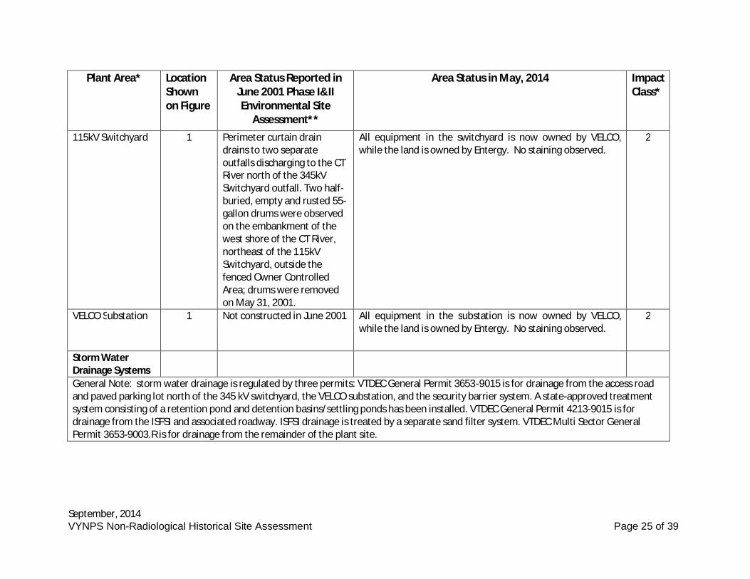
September, 2014VYNPS Non-Radiological Historical Site Assessment Page 25 of 39
Plant Area* LocationShownon Figure
Area Status Reported inJune 2001 Phase I&IIEnvironmental Site
Assessment**
Area Status in May, 2014 ImpactClass*
115kV Switchyard 1 Perimeter curtain draindrains to two separateoutfalls discharging to the CTRiver north of the 345kVSwitchyard outfall. Two half-buried, empty and rusted 55-gallon drums were observedon the embankment of thewest shore of the CT River,northeast of the 115kVSwitchyard, outside thefenced Owner ControlledArea; drums were removedon May 31, 2001.
All equipment in the switchyard is now owned by VELCO,while the land is owned by Entergy. No staining observed.
2
VELCO Substation 1 Not constructed in June 2001 All equipment in the substation is now owned by VELCO,while the land is owned by Entergy. No staining observed.
2
Storm WaterDrainage SystemsGeneral Note: storm water drainage is regulated by three permits: VTDEC General Permit 3653-9015 is for drainage from the access roadand paved parking lot north of the 345 kV switchyard, the VELCO substation, and the security barrier system. A state-approved treatmentsystem consisting of a retention pond and detention basins/settling ponds has been installed. VTDEC General Permit 4213-9015 is fordrainage from the ISFSI and associated roadway. ISFSI drainage is treated by a separate sand filter system. VTDEC Multi Sector GeneralPermit 3653-9003.R is for drainage from the remainder of the plant site.
September, 2014VYNPS Non-Radiological Historical Site Assessment Page 26 of 39
Plant Area* LocationShownon Figure
Area Status Reported inJune 2001 Phase I&IIEnvironmental Site
Assessment**
Area Status in May, 2014 ImpactClass*
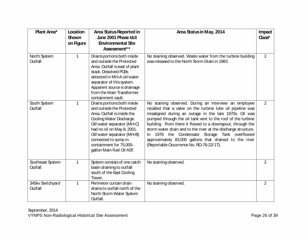
North SystemOutfall
1 Drains portions both insideand outside the ProtectedArea. Outfall is east of plantstack. Dissolved PCBsdetected in MH-A oil/waterseparator of this system.Apparent source is drainagefrom the Main Transformercontainment vault.
No staining observed. Waste water from the turbine buildingwas released to the North Storm Drain in 1983.
2
South SystemOutfall
1 Drains portions both insideand outside the ProtectedArea. Outfall is inside theCooling Water Discharge.Oil/water separator (MH-C)had no oil on May 8, 2001.Oil/water separator (MH-B)connected to sump incontainment for 75,000-gallon Main Fuel Oil AST.
No staining observed. During an interview an employeerecalled that a valve on the turbine lube oil pipeline wasmisaligned during an outage in the late 1970s. Oil waspumped through the oil tank vent to the roof of the turbinebuilding. From there it flowed to a downspout, through thestorm water drain and to the river at the discharge structure.In 1976 the Condensate Storage Tank overflowedapproximately 83,000 gallons that drained to the river(Reportable Occurrence No. RO-76-22/1T).
2
Southeast SystemOutfall
1 System consists of one catchbasin draining to outfallsouth of the East CoolingTower.
No staining observed. 2
345kv SwitchyardOutfall
1 Perimeter curtain draindrains to outfall north of theNorth Storm Water SystemOutfall.
No staining observed. 2
September, 2014VYNPS Non-Radiological Historical Site Assessment Page 27 of 39
Plant Area* LocationShownon Figure
Area Status Reported inJune 2001 Phase I&IIEnvironmental Site
Assessment**
Area Status in May, 2014 ImpactClass*
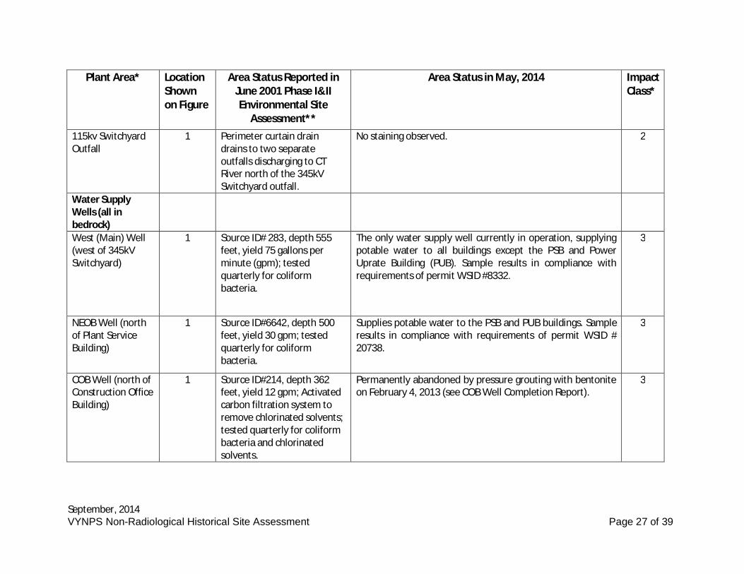
115kv SwitchyardOutfall
1 Perimeter curtain draindrains to two separateoutfalls discharging to CTRiver north of the 345kVSwitchyard outfall.
No staining observed. 2
Water SupplyWells (all inbedrock)West (Main) Well(west of 345kVSwitchyard)
1 Source ID# 283, depth 555feet, yield 75 gallons perminute (gpm); testedquarterly for coliformbacteria.
The only water supply well currently in operation, supplyingpotable water to all buildings except the PSB and PowerUprate Building (PUB). Sample results in compliance withrequirements of permit WSID #8332.
3
NEOB Well (northof Plant ServiceBuilding)
1 Source ID#6642, depth 500feet, yield 30 gpm; testedquarterly for coliformbacteria.
Supplies potable water to the PSB and PUB buildings. Sampleresults in compliance with requirements of permit WSID #20738.
3
COB Well (north ofConstruction OfficeBuilding)
1 Source ID#214, depth 362feet, yield 12 gpm; Activatedcarbon filtration system toremove chlorinated solvents;tested quarterly for coliformbacteria and chlorinatedsolvents.
Permanently abandoned by pressure grouting with bentoniteon February 4, 2013 (see COB Well Completion Report).
3
September, 2014VYNPS Non-Radiological Historical Site Assessment Page 28 of 39
Plant Area* LocationShownon Figure
Area Status Reported inJune 2001 Phase I&IIEnvironmental Site
Assessment**
Area Status in May, 2014 ImpactClass*
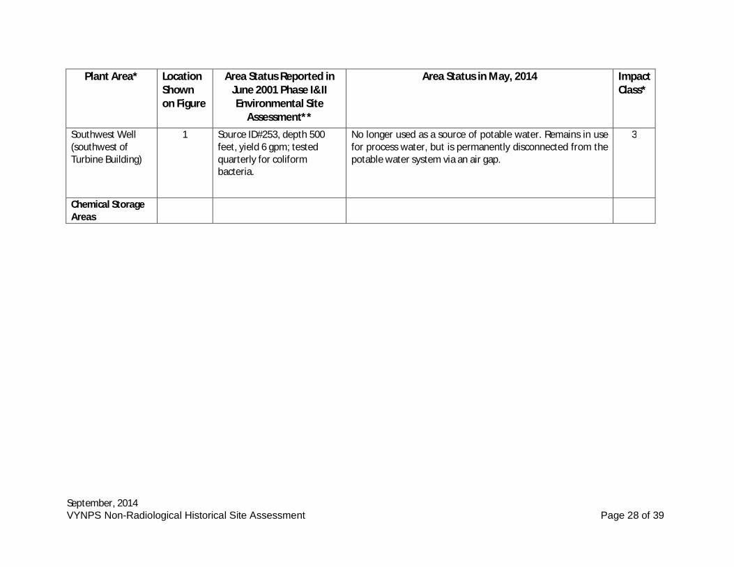
Southwest Well(southwest ofTurbine Building)
1 Source ID#253, depth 500feet, yield 6 gpm; testedquarterly for coliformbacteria.
No longer used as a source of potable water. Remains in usefor process water, but is permanently disconnected from thepotable water system via an air gap.
3
Chemical StorageAreas
September, 2014VYNPS Non-Radiological Historical Site Assessment Page 29 of 39
Plant Area* LocationShownon Figure
Area Status Reported inJune 2001 Phase I&IIEnvironmental Site
Assessment**
Area Status in May, 2014 ImpactClass*
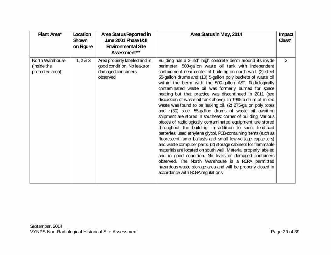
North Warehouse(inside theprotected area)
1, 2 & 3 Area properly labeled and ingood condition; No leaks ordamaged containersobserved
Building has a 3-inch high concrete berm around its insideperimeter; 500-gallon waste oil tank with independentcontainment near center of building on north wall. (2) steel55-gallon drums and (10) 5-gallon poly buckets of waste oilwithin the berm with the 500-gallon AST. Radiologicallycontaminated waste oil was formerly burned for spaceheating but that practice was discontinued in 2011 (seediscussion of waste oil tank above). In 1995 a drum of mixedwaste was found to be leaking oil. (2) 275-gallon poly totesand ~(30) steel 55-gallon drums of waste oil awaitingshipment are stored in southeast corner of building. Variouspieces of radiologically contaminated equipment are storedthroughout the building, in addition to spent lead-acidbatteries, used ethylene glycol, PCB-containing items (such asfluorescent lamp ballasts and small low-voltage capacitors)and waste computer parts. (2) storage cabinets for flammablematerials are located on south wall. Material properly labeledand in good condition. No leaks or damaged containersobserved. The North Warehouse is a RCRA permittedhazardous waste storage area and will be properly closed inaccordance with RCRA regulations.
2
September, 2014VYNPS Non-Radiological Historical Site Assessment Page 30 of 39
Plant Area* LocationShownon Figure
Area Status Reported inJune 2001 Phase I&IIEnvironmental Site
Assessment**
Area Status in May, 2014 ImpactClass*
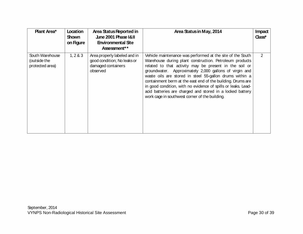
South Warehouse(outside theprotected area)
1, 2 & 3 Area properly labeled and ingood condition; No leaks ordamaged containersobserved
Vehicle maintenance was performed at the site of the SouthWarehouse during plant construction. Petroleum productsrelated to that activity may be present in the soil orgroundwater. Approximately 2,000 gallons of virgin andwaste oils are stored in steel 55-gallon drums within acontainment berm at the east end of the building. Drums arein good condition, with no evidence of spills or leaks. Lead-acid batteries are charged and stored in a locked batterywork cage in southwest corner of the building.
2
September, 2014VYNPS Non-Radiological Historical Site Assessment Page 31 of 39
Plant Area* LocationShownon Figure
Area Status Reported inJune 2001 Phase I&IIEnvironmental Site
Assessment**
Area Status in May, 2014 ImpactClass*
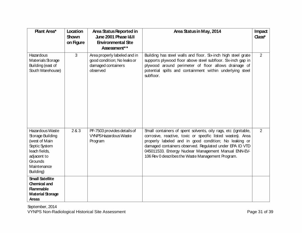
HazardousMaterials StorageBuilding (east ofSouth Warehouse)
3 Area properly labeled and ingood condition; No leaks ordamaged containersobserved
Building has steel walls and floor. Six-inch high steel gratesupports plywood floor above steel subfloor. Six-inch gap inplywood around perimeter of floor allows drainage ofpotential spills and containment within underlying steelsubfloor.
2
Hazardous WasteStorage Building(west of MainSeptic Systemleach fields,adjacent toGroundsMaintenanceBuilding)
2 & 3 PP-7503 provides details ofVYNPS Hazardous WasteProgram
Small containers of spent solvents, oily rags, etc (ignitable,corrosive, reactive, toxic or specific listed wastes). Areaproperly labeled and in good condition; No leaking ordamaged containers observed. Regulated under EPA ID VTD045011533. Entergy Nuclear Management Manual ENN-EV-106 Rev 0 describes the Waste Management Program.
2
Small SatelliteChemical andFlammableMaterial StorageAreas
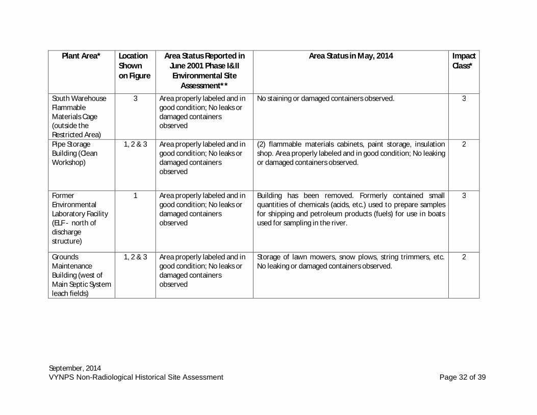
September, 2014VYNPS Non-Radiological Historical Site Assessment Page 32 of 39
Plant Area* LocationShownon Figure
Area Status Reported inJune 2001 Phase I&IIEnvironmental Site
Assessment**
Area Status in May, 2014 ImpactClass*
South WarehouseFlammableMaterials Cage(outside theRestricted Area)
3 Area properly labeled and ingood condition; No leaks ordamaged containersobserved
No staining or damaged containers observed. 3
Pipe StorageBuilding (CleanWorkshop)
1, 2 & 3 Area properly labeled and ingood condition; No leaks ordamaged containersobserved
(2) flammable materials cabinets, paint storage, insulationshop. Area properly labeled and in good condition; No leakingor damaged containers observed.
2
FormerEnvironmentalLaboratory Facility(ELF - north ofdischargestructure)
1 Area properly labeled and ingood condition; No leaks ordamaged containersobserved
Building has been removed. Formerly contained smallquantities of chemicals (acids, etc.) used to prepare samplesfor shipping and petroleum products (fuels) for use in boatsused for sampling in the river.
3
GroundsMaintenanceBuilding (west ofMain Septic Systemleach fields)
1, 2 & 3 Area properly labeled and ingood condition; No leaks ordamaged containersobserved
Storage of lawn mowers, snow plows, string trimmers, etc.No leaking or damaged containers observed.
2
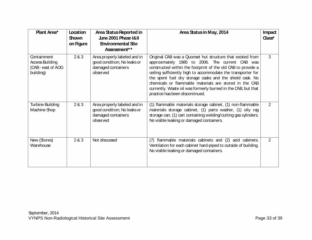
September, 2014VYNPS Non-Radiological Historical Site Assessment Page 33 of 39
Plant Area* LocationShownon Figure
Area Status Reported inJune 2001 Phase I&IIEnvironmental Site
Assessment**
Area Status in May, 2014 ImpactClass*
ContainmentAccess Building(CAB - east of AOGbuilding)
2 & 3 Area properly labeled and ingood condition; No leaks ordamaged containersobserved
Original CAB was a Quonset hut structure that existed fromapproximately 1985 to 2006. The current CAB wasconstructed within the footprint of the old CAB to provide aceiling sufficiently high to accommodate the transporter forthe spent fuel dry storage casks and the shield cask. Nochemicals or flammable materials are stored in the CABcurrently. Waste oil was formerly burned in the CAB, but thatpractice has been discontinued.
3
Turbine BuildingMachine Shop
2 & 3 Area properly labeled and ingood condition; No leaks ordamaged containersobserved
(1) flammable materials storage cabinet, (1) non-flammablematerials storage cabinet, (1) parts washer, (1) oily ragstorage can, (1) cart containing welding/cutting gas cylinders.No visible leaking or damaged containers.
2
New (Stores)Warehouse
2 & 3 Not discussed (7) flammable materials cabinets and (2) acid cabinets.Ventilation for each cabinet hard-piped to outside of building.No visible leaking or damaged containers.
2
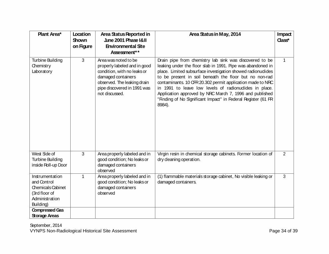
September, 2014VYNPS Non-Radiological Historical Site Assessment Page 34 of 39
Plant Area* LocationShownon Figure
Area Status Reported inJune 2001 Phase I&IIEnvironmental Site
Assessment**
Area Status in May, 2014 ImpactClass*
Turbine BuildingChemistryLaboratory
3 Area was noted to beproperly labeled and in goodcondition, with no leaks ordamaged containersobserved. The leaking drainpipe discovered in 1991 wasnot discussed.
Drain pipe from chemistry lab sink was discovered to beleaking under the floor slab in 1991. Pipe was abandoned inplace. Limited subsurface investigation showed radionuclidesto be present in soil beneath the floor but no non-radcontaminants. 10 CFR 20.302 permit application made to NRCin 1991 to leave low levels of radionuclides in place.Application approved by NRC March 7, 1996 and published"Finding of No Significant Impact" in Federal Register (61 FR8984).
1
West Side ofTurbine Buildinginside Roll-up Door
3 Area properly labeled and ingood condition; No leaks ordamaged containersobserved
Virgin resin in chemical storage cabinets. Former location ofdry cleaning operation.
2
Instrumentationand ControlChemicals Cabinet(3rd floor ofAdministrationBuilding)
1 Area properly labeled and ingood condition; No leaks ordamaged containersobserved
(1) flammable materials storage cabinet, No visible leaking ordamaged containers.
3
Compressed GasStorage Areas
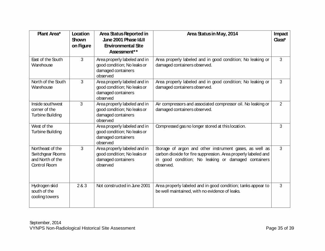
September, 2014VYNPS Non-Radiological Historical Site Assessment Page 35 of 39
Plant Area* LocationShownon Figure
Area Status Reported inJune 2001 Phase I&IIEnvironmental Site
Assessment**
Area Status in May, 2014 ImpactClass*
East of the SouthWarehouse
3 Area properly labeled and ingood condition; No leaks ordamaged containersobserved
Area properly labeled and in good condition; No leaking ordamaged containers observed.
3
North of the SouthWarehouse
3 Area properly labeled and ingood condition; No leaks ordamaged containersobserved
Area properly labeled and in good condition; No leaking ordamaged containers observed.
3
Inside southwestcorner of theTurbine Building
3 Area properly labeled and ingood condition; No leaks ordamaged containersobserved
Air compressors and associated compressor oil. No leaking ordamaged containers observed.
2
West of theTurbine Building
Area properly labeled and ingood condition; No leaks ordamaged containersobserved
Compressed gas no longer stored at this location. 3
Northeast of theSwitchgear Roomsand North of theControl Room
3 Area properly labeled and ingood condition; No leaks ordamaged containersobserved
Storage of argon and other instrument gases, as well ascarbon dioxide for fire suppression. Area properly labeled andin good condition; No leaking or damaged containersobserved.
3
Hydrogen skidsouth of thecooling towers
2 & 3 Not constructed in June 2001 Area properly labeled and in good condition; tanks appear tobe well maintained, with no evidence of leaks.
3
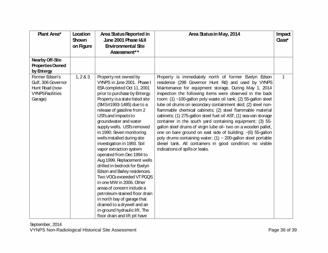
September, 2014VYNPS Non-Radiological Historical Site Assessment Page 36 of 39
Plant Area* LocationShownon Figure
Area Status Reported inJune 2001 Phase I&IIEnvironmental Site
Assessment**
Area Status in May, 2014 ImpactClass*
Nearby Off-SiteProperties Ownedby EntergyFormer Edson'sGulf, 306 GovernorHunt Road (nowVYNPS FacilitiesGarage)
1, 2 & 3 Property not owned byVYNPS in June 2001. Phase IESA completed Oct 11, 2001prior to purchase by Entergy.Property is a state listed site(SMS #1993-1485) due to arelease of gasoline from 2USTs and impacts togroundwater and watersupply wells. USTs removedin 1990. Seven monitoringwells installed during siteinvestigation in 1993. Soilvapor extraction systemoperated from Dec 1994 toAug 1999. Replacement wellsdrilled in bedrock for EvelynEdson and Bailey residences.Two VOCs exceeded VT PGQSin one MW in 2006. Otherareas of concern include apetroleum-stained floor drainin north bay of garage thatdrained to a drywell and anin-ground hydraulic lift. Thefloor drain and lift pit have
Property is immediately north of former Evelyn Edsonresidence (298 Governor Hunt Rd) and used by VYNPSMaintenance for equipment storage. During May 1, 2014inspection the following items were observed in the backroom: (1) ~100-gallon poly waste oil tank; (2) 55-gallon steellube oil drums on secondary containment skid; (2) steel non-flammable chemical cabinets; (2) steel flammable materialcabinets; (1) 275-gallon steel fuel oil AST; (1) sea-van storagecontainer in the south yard containing equipment; (3) 55-gallon steel drums of virgin lube oil- two on a wooden pallet,one on bare ground on east side of building; ~(6) 55-gallonpoly drums containing water; (1) ~ 200-gallon steel portablediesel tank. All containers in good condition; no visibleindications of spills or leaks.
1
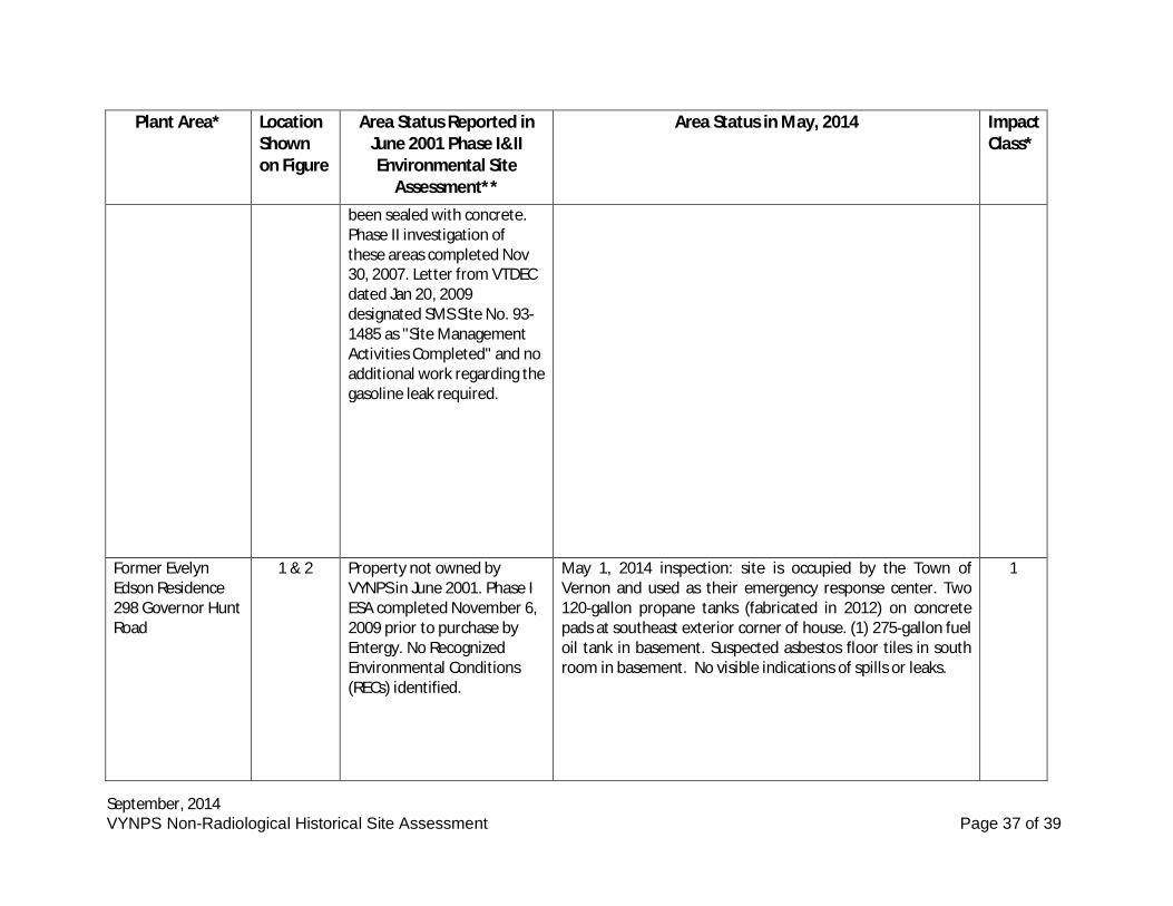
September, 2014VYNPS Non-Radiological Historical Site Assessment Page 37 of 39
Plant Area* LocationShownon Figure
Area Status Reported inJune 2001 Phase I&IIEnvironmental Site
Assessment**
Area Status in May, 2014 ImpactClass*
been sealed with concrete.Phase II investigation ofthese areas completed Nov30, 2007. Letter from VTDECdated Jan 20, 2009designated SMS Site No. 93-1485 as "Site ManagementActivities Completed" and noadditional work regarding thegasoline leak required.
Former EvelynEdson Residence298 Governor HuntRoad
1 & 2 Property not owned byVYNPS in June 2001. Phase IESA completed November 6,2009 prior to purchase byEntergy. No RecognizedEnvironmental Conditions(RECs) identified.
May 1, 2014 inspection: site is occupied by the Town ofVernon and used as their emergency response center. Two120-gallon propane tanks (fabricated in 2012) on concretepads at southeast exterior corner of house. (1) 275-gallon fueloil tank in basement. Suspected asbestos floor tiles in southroom in basement. No visible indications of spills or leaks.
1
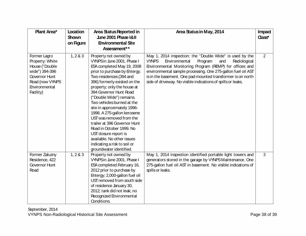
September, 2014VYNPS Non-Radiological Historical Site Assessment Page 38 of 39
Plant Area* LocationShownon Figure
Area Status Reported inJune 2001 Phase I&IIEnvironmental Site
Assessment**
Area Status in May, 2014 ImpactClass*
Former LagroProperty: WhiteHouse ("Doublewide") 394-396Governor HuntRoad (now VYNPSEnvironmentalFacility)
1, 2 & 3 Property not owned byVYNPS in June 2001. Phase IESA completed May 19, 2008prior to purchase by Entergy.Two residences (394 and396) formerly existed on theproperty; only the house at394 Governor Hunt Road("Double Wide") remains.Two vehicles burned at thesite in approximately 1996-1998. A 275-gallon keroseneUST was removed from thetrailer at 396 Governor HuntRoad in October 1999. NoUST closure report isavailable. No other issuesindicating a risk to soil orgroundwater identified.
May 1, 2014 inspection: the "Double Wide" is used by theVYNPS Environmental Program and RadiologicalEnvironmental Monitoring Program (REMP) for offices andenvironmental sample processing. One 275-gallon fuel oil ASTis in the basement. One pad-mounted transformer is on northside of driveway. No visible indications of spills or leaks.
2
Former ZaluznyResidence, 422Governor HuntRoad
1, 2 & 3 Property not owned byVYNPS in June 2001. Phase IESA completed February 16,2012 prior to purchase byEntergy; 2,000-gallon fuel oilUST removed from south sideof residence January 30,2012; tank did not leak; noRecognized EnvironmentalConditions.
May 1, 2014 inspection identified portable light towers andgenerators stored in the garage by VYNPS Maintenance. One275-gallon fuel oil AST in basement. No visible indications ofspills or leaks.
3
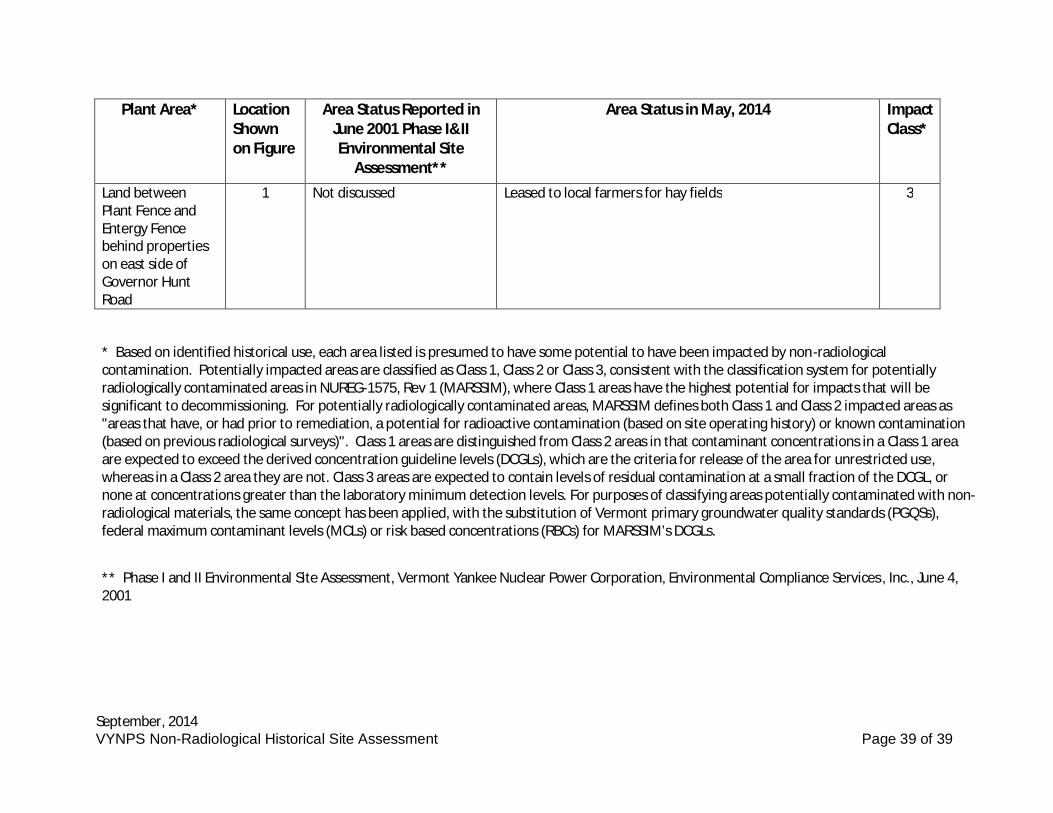
September, 2014VYNPS Non-Radiological Historical Site Assessment Page 39 of 39
Plant Area* LocationShownon Figure
Area Status Reported inJune 2001 Phase I&IIEnvironmental Site
Assessment**
Area Status in May, 2014 ImpactClass*
Land betweenPlant Fence andEntergy Fencebehind propertieson east side ofGovernor HuntRoad
1 Not discussed Leased to local farmers for hay fields 3
* Based on identified historical use, each area listed is presumed to have some potential to have been impacted by non-radiologicalcontamination. Potentially impacted areas are classified as Class 1, Class 2 or Class 3, consistent with the classification system for potentiallyradiologically contaminated areas in NUREG-1575, Rev 1 (MARSSIM), where Class 1 areas have the highest potential for impacts that will besignificant to decommissioning. For potentially radiologically contaminated areas, MARSSIM defines both Class 1 and Class 2 impacted areas as"areas that have, or had prior to remediation, a potential for radioactive contamination (based on site operating history) or known contamination(based on previous radiological surveys)". Class 1 areas are distinguished from Class 2 areas in that contaminant concentrations in a Class 1 areaare expected to exceed the derived concentration guideline levels (DCGLs), which are the criteria for release of the area for unrestricted use,whereas in a Class 2 area they are not. Class 3 areas are expected to contain levels of residual contamination at a small fraction of the DCGL, ornone at concentrations greater than the laboratory minimum detection levels. For purposes of classifying areas potentially contaminated with non-radiological materials, the same concept has been applied, with the substitution of Vermont primary groundwater quality standards (PGQSs),federal maximum contaminant levels (MCLs) or risk based concentrations (RBCs) for MARSSIM’s DCGLs.
** Phase I and II Environmental Site Assessment, Vermont Yankee Nuclear Power Corporation, Environmental Compliance Services , Inc., June 4,2001
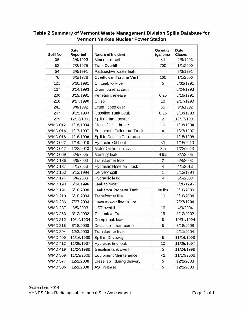
September, 2014VYNPS Non-Radiological Historical Site Assessment Page 1 of 1
Table 2 Summary of Vermont Waste Management Division Spills Database forVermont Yankee Nuclear Power Station
Spill No.DateReported Nature of Incident
Quantity(gallons)
DateClosed
36 2/6/1993 Mineral oil spill <1 2/8/199353 7/2/1975 Tank Overfill 700 1/1/200054 3/6/1991 Radioactive waste leak 3/6/199176 8/5/1978 Overflow in Turbine Vent 100 1/1/2000
121 5/30/1991 Oil Leak to River 5 5/31/1991167 6/14/1993 Drum found at dam 8/24/1993200 8/19/1991 Penetrant release 0.25 8/19/1991218 9/17/1990 Oil spill 10 9/17/1990241 9/8/1992 Drum tipped over 55 9/8/1992267 9/15/1993 Gasoline Tank Leak 0.25 9/16/1993279 12/13/1991 Spill during transfer 2 12/17/1991
WMD 012 1/18/1994 Diesel fill line broke 10 1/18/1994WMD 016 1/17/1997 Equipment Failure on Truck 6 1/27/1997WMD 018 1/16/1996 Spill in Cooling Tank area 1 1/15/1996WMD 022 1/14/2010 Hydraulic Oil Leak <1 1/15/2010WMD 042 1/23/2013 Motor Oil from Truck 3.5 1/23/2013WMD 069 3/4/2005 Mercury leak 4 lbs 3/7/2005WMD 136 5/8/2003 Transformer leak 2 5/8/2003WMD 137 4/1/2013 Hydraulic Hose on Truck 4 4/1/2013WMD 163 5/13/1994 Delivery spill 1 5/13/1994WMD 174 6/6/2003 Hydraulic leak 4 6/6/2003WMD 193 6/24/1996 Leak to moat 6/26/1996WMD 194 5/16/2000 Leak from Propane Tank 40 lbs 5/16/2000WMD 210 6/18/2004 Transformer fire 10 6/18/2004WMD 236 7/27/2004 Lawn mower line failure 7/27/1994WMD 237 8/5/2003 UST overfill 16 4/9/2004WMD 263 8/12/2002 Oil Leak at Fan 15 8/12/2002WMD 312 10/14/1994 Dump truck leak 5 10/31/1994WMD 315 6/18/2008 Diesel spill from pump 5 6/18/2008WMD 394 12/3/2003 Transformer leak 2/11/2004WMD 409 11/16/1999 Spill in Driveway 5 11/16/1999WMD 413 11/25/1997 Hydraulic line leak 10 11/25/1997WMD 419 11/24/1999 Gasoline tank overfill 5 11/24/1999WMD 559 11/19/2008 Equipment Maintenance <1 11/19/2008WMD 577 12/1/2008 Diesel spill during delivery 5 12/1/2008WMD 586 12/1/2008 AST release 5 12/1/2008
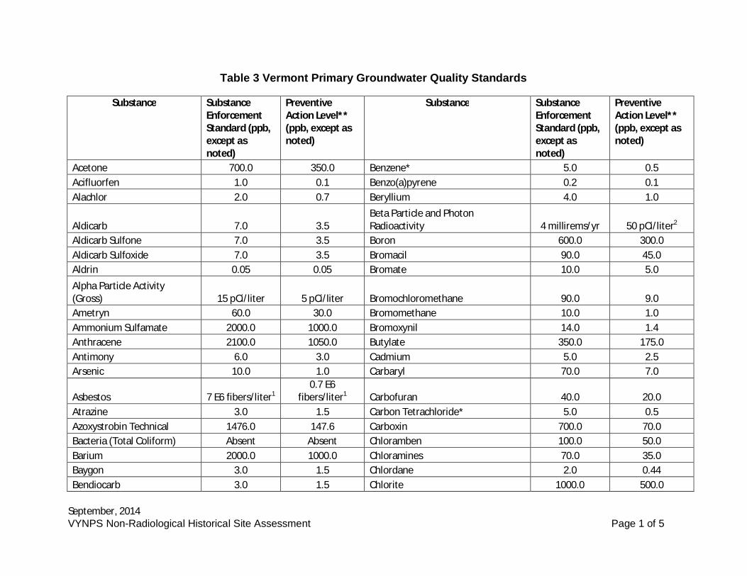
September, 2014VYNPS Non-Radiological Historical Site Assessment Page 1 of 5
Table 3 Vermont Primary Groundwater Quality Standards
Substance SubstanceEnforcementStandard (ppb,except asnoted)
PreventiveAction Level**(ppb, except asnoted)
Substance SubstanceEnforcementStandard (ppb,except asnoted)
PreventiveAction Level**(ppb, except asnoted)
Acetone 700.0 350.0 Benzene* 5.0 0.5Acifluorfen 1.0 0.1 Benzo(a)pyrene 0.2 0.1Alachlor 2.0 0.7 Beryllium 4.0 1.0
Aldicarb 7.0 3.5Beta Particle and PhotonRadioactivity 4 millirems/yr 50 pCi/liter2
Aldicarb Sulfone 7.0 3.5 Boron 600.0 300.0Aldicarb Sulfoxide 7.0 3.5 Bromacil 90.0 45.0Aldrin 0.05 0.05 Bromate 10.0 5.0Alpha Particle Activity(Gross) 15 pCi/liter 5 pCi/liter Bromochloromethane 90.0 9.0Ametryn 60.0 30.0 Bromomethane 10.0 1.0Ammonium Sulfamate 2000.0 1000.0 Bromoxynil 14.0 1.4Anthracene 2100.0 1050.0 Butylate 350.0 175.0Antimony 6.0 3.0 Cadmium 5.0 2.5Arsenic 10.0 1.0 Carbaryl 70.0 7.0
Asbestos 7 E6 fibers/liter10.7 E6
fibers/liter1 Carbofuran 40.0 20.0Atrazine 3.0 1.5 Carbon Tetrachloride* 5.0 0.5Azoxystrobin Technical 1476.0 147.6 Carboxin 700.0 70.0Bacteria (Total Coliform) Absent Absent Chloramben 100.0 50.0Barium 2000.0 1000.0 Chloramines 70.0 35.0Baygon 3.0 1.5 Chlordane 2.0 0.44Bendiocarb 3.0 1.5 Chlorite 1000.0 500.0
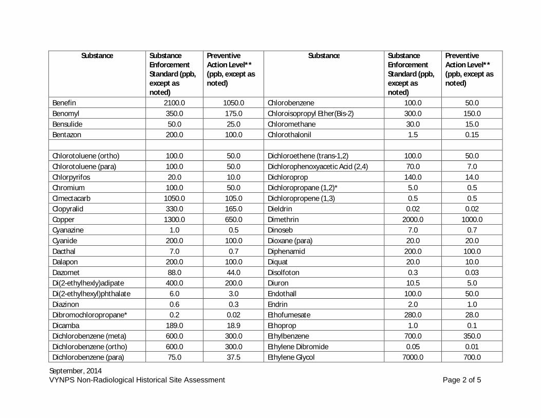
September, 2014VYNPS Non-Radiological Historical Site Assessment Page 2 of 5
Substance SubstanceEnforcementStandard (ppb,except asnoted)
PreventiveAction Level**(ppb, except asnoted)
Substance SubstanceEnforcementStandard (ppb,except asnoted)
PreventiveAction Level**(ppb, except asnoted)
Benefin 2100.0 1050.0 Chlorobenzene 100.0 50.0Benomyl 350.0 175.0 Chloroisopropyl Ether(Bis-2) 300.0 150.0Bensulide 50.0 25.0 Chloromethane 30.0 15.0Bentazon 200.0 100.0 Chlorothalonil 1.5 0.15
Chlorotoluene (ortho) 100.0 50.0 Dichloroethene (trans-1,2) 100.0 50.0Chlorotoluene (para) 100.0 50.0 Dichlorophenoxyacetic Acid (2,4) 70.0 7.0Chlorpyrifos 20.0 10.0 Dichloroprop 140.0 14.0Chromium 100.0 50.0 Dichloropropane (1,2)* 5.0 0.5Cimectacarb 1050.0 105.0 Dichloropropene (1,3) 0.5 0.5Clopyralid 330.0 165.0 Dieldrin 0.02 0.02Copper 1300.0 650.0 Dimethrin 2000.0 1000.0Cyanazine 1.0 0.5 Dinoseb 7.0 0.7Cyanide 200.0 100.0 Dioxane (para) 20.0 20.0Dacthal 7.0 0.7 Diphenamid 200.0 100.0Dalapon 200.0 100.0 Diquat 20.0 10.0Dazomet 88.0 44.0 Disolfoton 0.3 0.03Di(2-ethylhexly)adipate 400.0 200.0 Diuron 10.5 5.0Di(2-ethylhexyl)phthalate 6.0 3.0 Endothall 100.0 50.0Diazinon 0.6 0.3 Endrin 2.0 1.0Dibromochloropropane* 0.2 0.02 Ethofumesate 280.0 28.0Dicamba 189.0 18.9 Ethoprop 1.0 0.1Dichlorobenzene (meta) 600.0 300.0 Ethylbenzene 700.0 350.0Dichlorobenzene (ortho) 600.0 300.0 Ethylene Dibromide 0.05 0.01Dichlorobenzene (para) 75.0 37.5 Ethylene Glycol 7000.0 700.0
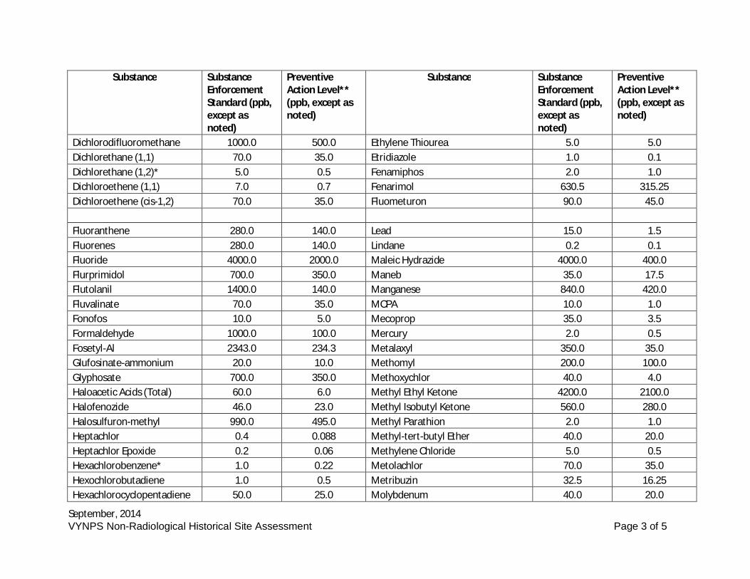
September, 2014VYNPS Non-Radiological Historical Site Assessment Page 3 of 5
Substance SubstanceEnforcementStandard (ppb,except asnoted)
PreventiveAction Level**(ppb, except asnoted)
Substance SubstanceEnforcementStandard (ppb,except asnoted)
PreventiveAction Level**(ppb, except asnoted)
Dichlorodifluoromethane 1000.0 500.0 Ethylene Thiourea 5.0 5.0Dichlorethane (1,1) 70.0 35.0 Etridiazole 1.0 0.1Dichlorethane (1,2)* 5.0 0.5 Fenamiphos 2.0 1.0Dichloroethene (1,1) 7.0 0.7 Fenarimol 630.5 315.25Dichloroethene (cis-1,2) 70.0 35.0 Fluometuron 90.0 45.0
Fluoranthene 280.0 140.0 Lead 15.0 1.5Fluorenes 280.0 140.0 Lindane 0.2 0.1Fluoride 4000.0 2000.0 Maleic Hydrazide 4000.0 400.0Flurprimidol 700.0 350.0 Maneb 35.0 17.5Flutolanil 1400.0 140.0 Manganese 840.0 420.0Fluvalinate 70.0 35.0 MCPA 10.0 1.0Fonofos 10.0 5.0 Mecoprop 35.0 3.5Formaldehyde 1000.0 100.0 Mercury 2.0 0.5Fosetyl-Al 2343.0 234.3 Metalaxyl 350.0 35.0Glufosinate-ammonium 20.0 10.0 Methomyl 200.0 100.0Glyphosate 700.0 350.0 Methoxychlor 40.0 4.0Haloacetic Acids (Total) 60.0 6.0 Methyl Ethyl Ketone 4200.0 2100.0Halofenozide 46.0 23.0 Methyl Isobutyl Ketone 560.0 280.0Halosulfuron-methyl 990.0 495.0 Methyl Parathion 2.0 1.0Heptachlor 0.4 0.088 Methyl-tert-butyl Ether 40.0 20.0Heptachlor Epoxide 0.2 0.06 Methylene Chloride 5.0 0.5Hexachlorobenzene* 1.0 0.22 Metolachlor 70.0 35.0Hexochlorobutadiene 1.0 0.5 Metribuzin 32.5 16.25Hexachlorocyclopentadiene 50.0 25.0 Molybdenum 40.0 20.0
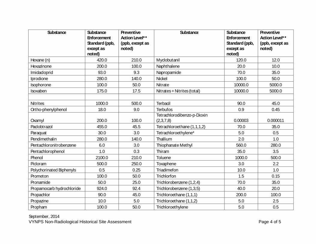
September, 2014VYNPS Non-Radiological Historical Site Assessment Page 4 of 5
Substance SubstanceEnforcementStandard (ppb,except asnoted)
PreventiveAction Level**(ppb, except asnoted)
Substance SubstanceEnforcementStandard (ppb,except asnoted)
PreventiveAction Level**(ppb, except asnoted)
Hexane (n) 420.0 210.0 Myclobutanil 120.0 12.0Hexazinone 200.0 100.0 Naphthalene 20.0 10.0Imidacloprid 93.0 9.3 Napropamide 70.0 35.0Iprodione 280.0 140.0 Nickel 100.0 50.0Isophorone 100.0 50.0 Nitrate 10000.0 5000.0Isoxaben 175.0 17.5 Nitrates + Nitrites (total) 10000.0 5000.0
Nitrites 1000.0 500.0 Terbacil 90.0 45.0Ortho-phenylphenol 18.0 9.0 Terbufos 0.9 0.45
Oxamyl 200.0 100.0Tetrachlorodibenzo-p-Dioxin(2,3,7,8) 0.00003 0.000011
Paclobtrazol 455.0 45.5 Tetrachloroethane (1,1,1,2) 70.0 35.0Paraquat 30.0 3.0 Tetrachloroethylene* 5.0 0.5Pendimethalin 280.0 140.0 Thallium 2.0 1.0Pentachloronitrobenzene 6.0 3.0 Thiophanate Methyl 560.0 280.0Pentachlorophenol 1.0 0.3 Thiram 35.0 3.5Phenol 2100.0 210.0 Toluene 1000.0 500.0Picloram 500.0 250.0 Toxaphene 3.0 2.2Polychorinated Biphenyls 0.5 0.25 Triadimefon 10.0 1.0Prometon 100.0 50.0 Trichlorfon 1.5 0.15Pronamide 50.0 25.0 Trichlorobenzene (1,2,4) 70.0 35.0Propamocarb hydrochloride 924.0 92.4 Trichlorobenzene (1,3,5) 40.0 20.0Propachlor 90.0 45.0 Trichloroethane (1,1,1) 200.0 100.0Propazine 10.0 5.0 Trichloroethane (1,1,2) 5.0 2.5Propham 100.0 50.0 Trichloroethylene 5.0 0.5
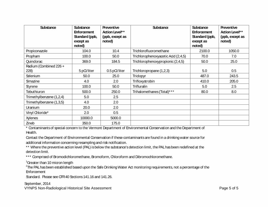
September, 2014VYNPS Non-Radiological Historical Site Assessment Page 5 of 5
Substance SubstanceEnforcementStandard (ppb,except asnoted)
PreventiveAction Level**(ppb, except asnoted)
Substance SubstanceEnforcementStandard (ppb,except asnoted)
PreventiveAction Level**(ppb, except asnoted)
Propiconazole 104.0 10.4 Trichlorofluoromethane 2100.0 1050.0Propham 100.0 50.0 Trichlorophenoxyacetic Acid (2,4,5) 70.0 7.0Quinclorac 369.0 184.5 Trichlorophenoxypropionic (2,4,5) 50.0 25.0Radium (Combined 226 +228) 5 pCi/liter 0.5 pCi/liter Trichloropropane (1,2,3) 5.0 0.5Selenium 50.0 25.0 Triclopyr 487.0 243.5Simazine 4.0 2.0 Trifloxystrobin 410.0 205.0Styrene 100.0 50.0 Trifluralin 5.0 2.5Tebuthiuron 500.0 250.0 Trihalomethanes (Total)*** 80.0 8.0Trimethylbenzene (1,2,4) 5.0 2.5Trimethylbenzene (1,3,5) 4.0 2.0Uranium 20.0 2.0Vinyl Chloride* 2.0 0.5Xylenes 10000.0 5000.0Zineb 350.0 175.0* Contaminants of special concern to the Vermont Department of Environmental Conservation and the Department ofHealth.Contact the Department of Environmental Conservation if these contaminants are found in a drinking water source foradditional information concerning resampling and risk notification.** Where the preventive action level (PAL) is below the substance's detection limit, the PAL has been redefined at thedetection limit.*** Comprised of Bromodichloromethane, Bromoform, Chloroform and Dibromochloromethane.1Greater than 10 micron length2The PAL has been established based upon the Safe Drinking Water Act monitoring requirements, not a percentage of theEnforcementStandard. Please see CFR 40 Sections 141.16 and 141.26.
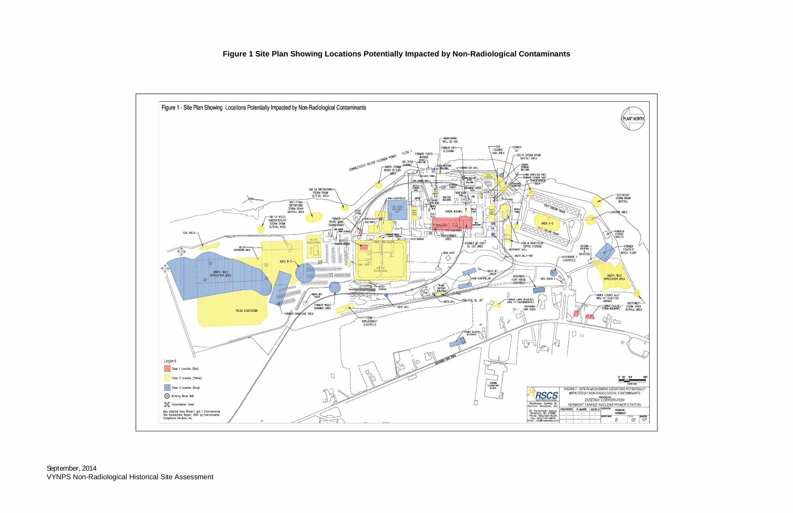
September, 2014VYNPS Non-Radiological Historical Site Assessment
Figure 1 Site Plan Showing Locations Potentially Impacted by Non-Radiological Contaminants
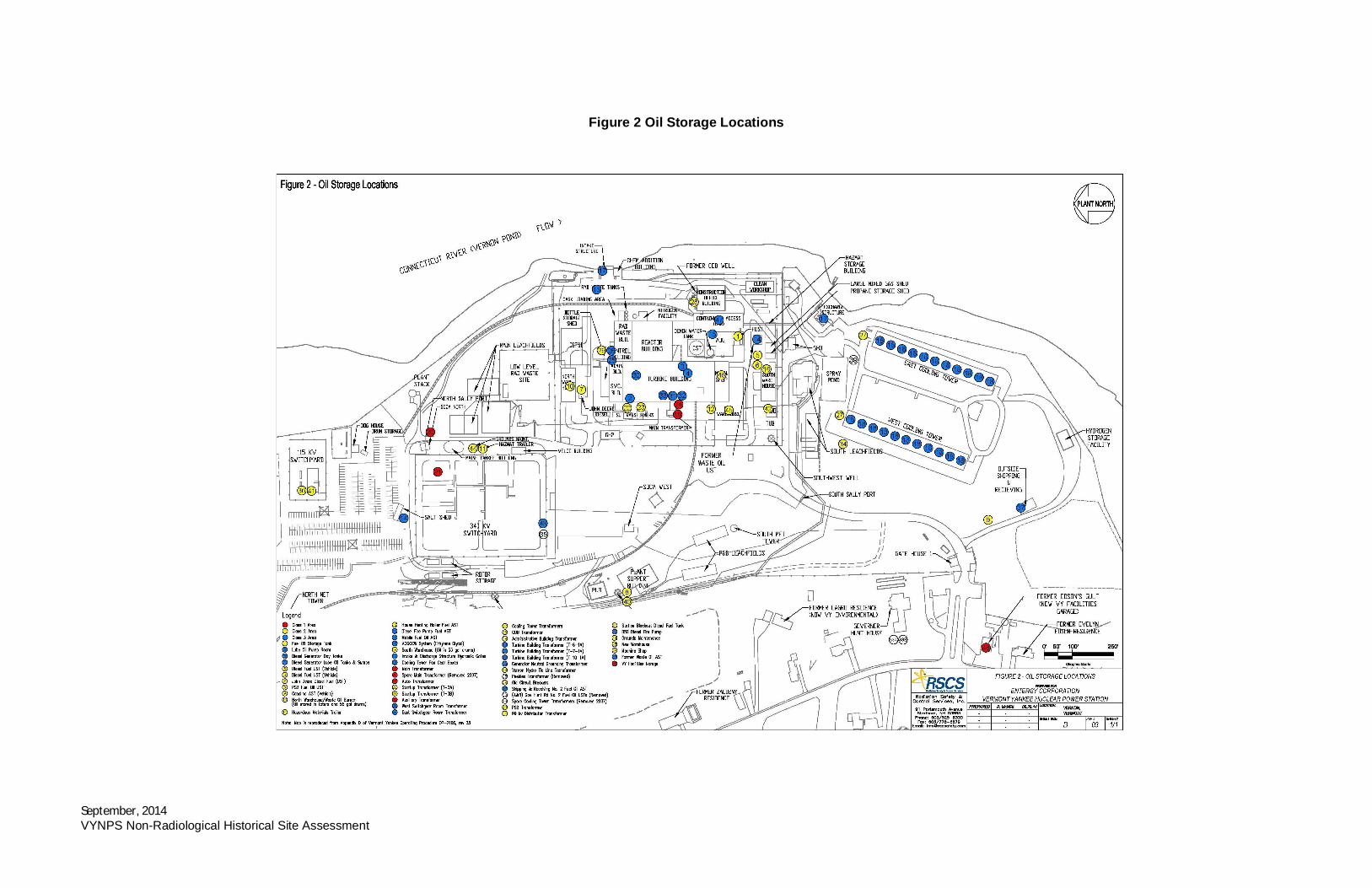
September, 2014VYNPS Non-Radiological Historical Site Assessment
Figure 2 Oil Storage Locations
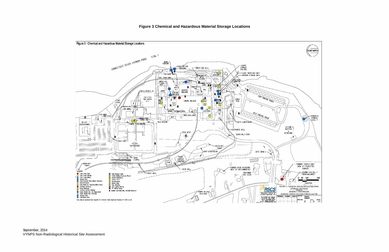
September, 2014VYNPS Non-Radiological Historical Site Assessment
Figure 3 Chemical and Hazardous Material Storage Locations