Embed Size (px)
Citation preview

Variation 1 – Omahu Industrial – as amended by decisions March 2017
Variation 1 – Omahu North Industrial Area
Amendments to Proposed Hastings District Plan – as amended by Decisions 25 March 2017
Parts of the District Plan: Planning Maps
Section 2.9 Industrial Strategy
Section 14.1 Industrial Zones Section 30.1 Subdivision and Land Development Section 6.2 Plains Production Zone Appendices: 17, 36, and 66
The changes proposed by the decisions on submissions are shown highlighted in blue. The changes as per Notification in July 2016 are shown highlighted in red and strikethroughs. The notified version (May 2016) is also available for viewing on www.hastingsdc.govt.nz/irongate-industrial-2016 Comment boxes to the side identify which issue and submission the change relates to. They reference back to the hearing commissioner’s decision report which is available for viewing on www.hastingsdc.govt.nz/irongate-industrial-2016 With regard to Section 14.1, text that is not amended by the variation is also shown to provide context. Any minor changes as a result of this Variation (such as numbering adjustments) will be addressed at the end of the Variation process.

Variation 1 – Omahu Industrial – as amended by decisions March 2017
Planning Map as amended by Decisions Note that for the purpose of clarity this map does not show the pre-existing designations (D116, 155, 156, 157). Note the colour of the zone is differentiated from the industrial zone the south side of Omahu Road for ease of viewing.

Variation 1 – Omahu Industrial – as amended by decisions March 2017
Section 2.9 Industrial Strategy
2.9.2.2 Omahu Road Strip Industrial Area
The Omahu Road Strip industrial area is located opposite the existing General Industrial zone Industrial 2 Zone on the northern side of Omahu Road. It has an area of 65 63 36ha and has been rezoned General Industrial Deferred Industrial 2 (Omahu North). The Deferred zoning will be lifted in two stages. Stage 1 will be lifted once the appropriate infrastructure has been completed. The deferment for Stage 2 will not be lifted until demand warrants it; based on current projections this might not occur until around 10 years after the Stage 1 deferment is lifted.
2.9.2.4 Future Growth Areas
The Heretaunga Plains Urban Development Strategy (HPUDS) considered the future industrial needs of both Napier and Hastings. One of the policies outlined in HPUDS is that “in locating future industrial land it must be in suitable areas to avoid sensitivity issues and maximise efficient use of existing and planned infrastructure”… Future need has been considered under the three categories of Dry, Service and Wet Industry.
SITES DEEMED SUFFICIENT TO CATER FOR THE GROWTH NEEDS OUT TO 2045
LOCATION CAPACITY (HA)
TIMING POTENTIAL ACTIVITIES
Irongate Stage 1 35.4 Now Dry Industry
Irongate Stage 2 36.2 After Irongate 1 Dry Industry
Omahu Road north 65 Now Service Industry
Omahu Stage 1 13 2015 Service Industry
Omahu Stage 2 23 After Omahu 1 Service Industry
Tomoana/Whakatu 60 After Whakatu full Wet Industry
Unlike the 2003 Industrial Strategy, HPUDS identifies that the future demand for land for wet industry may be accommodated adjacent to the existing Tomoana industrial area and/or existing Whakatu industrial area. These potential expansion areas both have recognised soil values. This is an issue that will require careful consideration as much of the infrastructure that is suited to industry is already in place in these areas. HPUDS has identified that the above sites are deemed sufficient to cater for the growth needs out to 2045 which is a period well beyond the lifespan of the District Plan.
The original proposal for Omahu Stages 1 & 2 identified in HPUDS and shown in the above table was for 36 ha of land. The provision for and location of, a new infrastructure servicing corridor allows for a greater area of land to be rezoned. The 63ha total is consistent with the length of the strip of land along Omahu Road identified in the HPUDS maps, with the additional area being made up by a greater depth to the zone from the Omahu Road frontage. The larger area:
provides for a more logical use of existing property boundaries in defining the extent of the General Industrial Zone;
is better aligned to changes in soil type along the strip; and
provides for a stormwater solution and reticulated wastewater and water services that result in significantly lower per hectare development contributions and improved sustainability of land use than was possible under the 36ha proposal.
Commented [MG1]: V1 Issue Consequential amendment resulting from decision on Issues 9 and 10 of commissioners decision report

Variation 1 – Omahu Industrial – as amended by decisions March 2017
Section 6. 2 ‘Plains Production Zone’
Rule Table 6.2.4
Rule PP34 Residential Activities and visitor accommodation within 50 30 metres of any the General Industrial Zone (Omahu North) as on land identified within by Appendix 17 36, Figure 2
Non Complying Activity
Section 14.1 Industrial
14.1.1 INTRODUCTION
NO CHANGES.
14.1.2 ANTICIPATED OUTCOMES
IZAO2 Concentration of specific industry in appropriate locations, specifically:
(a) Wet industry and Food Industry in the Tomoana and Whakatu areas utilising existing
infrastructure. (b) Dry industry in the Irongate Industrial Area. (c) Dry Industry requiring with profile along the Omahu Road arterial route.
14.1.3 OBJECTIVES AND POLICIES
POLICY IZP4 Ensure the integrated and efficient development of the Omahu North Industrial Area through the use of a Structure Plan, a deferred zone, and staging.
Explanation
The Omahu North Industrial Area (shown in the Structure Plan in Appendix 17) is anticipated to provide in the vicinity of twenty years supply of ‘high profile’ dry industrial land for the District. However, the actual take up of this land will depend upon the prevailing economic and market conditions. A flexible approach to the timing of infrastructural development of this area is therefore needed. The entire area is initially to be zoned Deferred Industrial 2 (Omahu North) This deferred zone is inte nded to prov ide a clear signal o f the Co uncil’s inte ntio n to pro gressiv ely develop this land for industrial use. The two stages proposed for the infrastructural development of this area are shown on the Structure Plan (Appendix 17). The Structure Plan (see Appendix 17)also provides details of: the bulk infrastructure to be provided; the infrastructure corridors to be set aside; and the stormwater infiltration basin swale which must be addressed in developing the area. The Stage 1 deferment is intended to allow time for the detailed planning and construction of the infrastructure shown on the Structure Plan (Appendix 17). This deferment is to be lifted when this infrastructure has been commissioned. The Stage 2 deferment is intended to be much longer. It will only be lifted if and when demand and uptake in Stage 1 warrants the Council’s im plementatio n o f the n ecessary infrastructure for Stage 2. .
Commented [MG2]: V1 Issue 5 Federated Farmers (submission 9) and Hawke’s Bay Fruitgrowers Assn Inc (FS5)
Commented [MG3]: V1 Issue 3 HBRC (Submission 4) change to terminology throughout

Variation 1 – Omahu Industrial – as amended by decisions March 2017
POLICY IZP5 Avoid industrial development within Stage 2 of the Irongate Industrial Area and within Stage 2 of the Omahu North Industrial Area prior to the deferred zoning of each this area being lifted and rezoned General Industrial.
Explanation
Concentrating the initial development of the Irongate and Omahu North Industrial Areas within Stage 1 is an effective and efficient means of servicing these this zones over time as it allows the investment in infrastructure to be staged to meet demand. Allowing industrial development in Stage 2 prior to the deferment being lifted from that area has the potential to delay the rate at which land within Stage 1 is developed. Such delays would increase the financial costs of the Stage 1 water, sewer, stormwater and roading infrastructure for the community. It may also affect the efficient and effective operation of that infrastructure – especially the pressure sewer main servicing Irongate. The potential for the timely, efficient and effective development of the infrastructure necessary for Stage 2 would also be reduced by such development, as the Council is unlikely to contemplate the implementation of any infrastructure for Stage 2 until there has been a substantial uptake of Stage 1 land.
POLICY IZP15
To restrict the establishment of activities within the Omahu North General Industrial area to 'dry industry' and 'profile oriented' activities that have a low risk of contamination of the Heretaunga Plains Unconfined Aquifer. Provide for the establishment of predominantly dry and ‘profile’ oriented industrial activities in the Omahu North Industrial Area. Explanation
The Omahu North Industrial Area is particularly suited to dry industrial or industrial related activities that require a site with a profile to a busy road. Examples of industrial related activities requiring profile are the sales and hire of machinery, equipment and supplies used for industrial, agricultural, horticultural, building or landscape purposes. There is no provision for Large Format Retail or general retail stores within the Zone. The District Plan seeks to promote the continued viability of the Hastings CBD through the existing Commercial Zones and precincts (Appendix 31). The location of Large Format Retail developments within an Industrial Zone on the periphery of the City conflicts with this objective. The establishment of Large Format Retailing stores within this Zone also creates the potential for adverse traffic safety and network effects. The infrastructure within the Omahu North Industrial Area is suited to predominantly ‘dry’ activities as the capacity of the adjacent trade waste sewer is limited and access to it is not assured.
Certain industrial activities have been identified as being a high risk to the Heretaunga Plains Unconfined Aquifer owing to the potential for pathogenic contamination of ground water to occur. This situation arises as a result of stormwater discharges from development in the zone being into an infiltration basin rather than a reticulated system. These activities include waste management sites, transfer stations and composting areas, and stock sale yards, which are not anticipated in the zone and are non-complying.
For similar reasons, bakeries which have outside washing areas, which otherwise would be permitted under the definition of 'dairies and food premises', are also non-complying.
Commented [MG4]: V1 Issue 3 Hawke’s Bay Regional Council (Submission 4)

Variation 1 – Omahu Industrial – as amended by decisions March 2017
14.1.5 RULES
14.1.5.1 GENERAL INDUSTRIAL ZONE
The following table sets out the status of activities within the General Industrial Zone. These activities are all subject to the standards and terms set out in this Plan.
RULE TABLE 14.1.5.1 - GENERAL INDUSTRIAL ZONE
RULE LAND USE ACTIVITIES ACTIVITY
STATUS
GI1 Industrial activities P
GI2 Dairies and food premises except bakeries with outside wash down areas in the Omahu North General Industrial zone
P
GI3 Service Stations P
GI4 Retail sales and offices on the same site and ancillary to an
Industrial Activity.
P
GI5 The sale or hire of:
Machinery, equipment and supplies used for industrial, agricultural, horticultural, viticultural, building or
landscaping purposes1;
Buildings This rule only applies to those Omahu Road sites identified within the area identified in Appendix 36.
P
GI6 Tyre Storage complying with Specific Performance Standard
14.1.7.5
P
GI7 Temporary Events P
GI8 Emergency Service Facilities P
GI9 Any Permitted Activity not meeting one or more of the General
Performance Standards and Terms in Section 14.1.6.
RD
GI10 Tyre Storage not complying with specific performance standard
14.1.7.5
D
GI11 Any Permitted or Restricted Discretionary Activity not meeting one
or more of the Specific Standards and Terms in Section 14.1.7.
D
GI12 Residential activities complying with Specific Performance
Standard 14.1.7.2.
D
GI13 Residential activities that do not comply with Specific Performance
Standard 14.1.7.2.
NC
GI14 Visitor Accommodation NC
GI15 Places of Assembly NC
GI16 Any activity which is not provided for as a Permitted, Restricted
Discretionary or Discretionary Activity.
NC
Note 1: For clarification this does not include the merchandising of comparison goods, being household furnishings, fittings and apparel.
Commented [MG5]: V1 Issue 3 HBRC (Submission 4)
Commented [MG6]: V1 Issue 6 Kevin & Karen Bayley, Totara Hastings Limited, Rimu Hastings Limited & Bayley Family Trust (Submission 6) and Development Nous (Submission 10)
Variation 1 – Omahu Industrial – as amended by decisions March 2017
14.1.5.2 DEFERRED GENERAL INDUSTRIAL ZONE (RULES)
All provisions relating to Omahu Road North Deferred General Industrial zone are removed from the Proposed Hastings District Plan.
The following table sets out the status of activities within the Deferred General Industrial Zone. These activities are all subject to the standards and terms set out in this Plan.
Uplift of the Deferred Zone
The Deferred General Industrial Zone will be lifted from the Irongate Area and the subject land will be zoned General Industrial Zone once the infrastructure (water, sewer, stormwater and roading) for this area has been constructed and the Hastings District Council has confirmed that it has been commissioned and is operational. This will occur in the two stages identified on the Structure Plan in Appendix 16.
The Deferred General Industrial Zone will be lifted from the Omahu North Area and the subject land
will be zoned General Industrial Zone once the infrastructure (water, sewer, stormwater and roading)
for this area has been constructed and the Hastings District Council has confirmed that it has been
commissioned and is operational. This will occur in the two stages identified on the Structure Plan in
Appendix 17.
The Deferred Industrial Zoning will cease to have effect once the Council passes a resolution that it is appropriate that the deferred status can be lifted due to the zone being substantially developed or the Council having otherwise concluded that it is appropriate for the deferred status to be lifted. After the deferred status ceases to have effect, the provisions of the General Industrial Zone will apply.
The Deferred General Industrial Zone will be uplifted from Lot 1 and Lot 3 DP 22545 (232 and 268 Ruahapia Road) and the subject land will be zoned General Industrial Zone once the Whakatu Arterial Project (new arterial road) has been constructed and the Council has confirmed it has been commissioned and is operational.
RULE TABLE 14.1.5.2 DEFERRED GENERAL INDUSTRIAL ZONE
RULE LAND USE ACTIVITIES ACTIVITY STATUS
DGI1 Land based primary production (excluding forestry) P
DGI2 Commercial activities (excluding visitor accommodation) complying
with Specific Performance Standard 6.2.6D of the Plains Zone
P
DGI3 Temporary Events P
DGI4 Industrial activities within Stage 1 of the Irongate Area as defined
within Appendix 16
RD
DGI5 Industrial activities within Stage 1 of the Omahu North Area as defined within Appendix 17
RD

Variation 1 – Omahu Industrial – as amended by decisions March 2017
RULE TABLE 14.1.5.2 DEFERRED GENERAL INDUSTRIAL ZONE
RULE LAND USE ACTIVITIES ACTIVITY STATUS
DGI6 Retail sales and offices on the same site and ancillary to an Industrial
Activity within Stage 1 of the Irongate Area as defined within Appendix 16
RD
DGI7 Retail sales and offices on the same site and ancillary to an Industrial Activity within Stage 1 of the Omahu North Area as defined within Appendix 17
RD
DGI8 The sale or hire of: Machinery, equipment and supplies used for industrial,
agricultural, horticultural, building or landscaping
purposes1;
Buildings This rule only applies to those Omahu Road sites identified within the area identified in Appendix 17
RD
DGI9 Tyre Storage within Stage 1 of the Irongate Area as defined within
Appendix 16 complying with Specific Performance Standard 14.1.7.5
RD
DGI10 Tyre Storage within Stage 1 of the Omahu North Area as defined within Appendix 17 complying with Specific Performance Standard 14.1.7.5
RD
DGI11 Any Permitted or Restricted Discretionary Activity not meeting
one or more of the General Performance Standards and Terms in Section 14.1.6 or the Specific Standards and Terms in Section 14.1.7.
D
DGI12 Residential activities complying with Specific Performance Standard
14.1.7.2.
D
DGI13 Tyre Storage within Stage 1 of the Irongate Area as defined within
Appendix 16 not complying with Specific Performance Standard 14.1.7.5.
D
DGI14 Tyre Storage within Stage 1 of the Omahu North Area as defined within Appendix 17 not complying with Specific Performance Standard 14.1.7.5
D
DGI15 Residential activities that do not comply with Specific Performance
Standard 14.1.7.2.
NC
DGI16 Industrial activities within Stage 2 of the Irongate Area as defined
within Appendix 16
NC
DGI17 Industrial activities within Stage 2 of the Omahu North Area as defined within Appendix 17
NC
DGI18 Visitor Accommodation NC
DGI19 Places of Assembly NC
DGI20 Any activity which is not provided for as a Permitted, Restricted
Discretionary or Discretionary Activity.
NC
Note 1: For clarification this does not include the merchandising of comparison goods, being household furnishings, fittings and apparel.
Note that numbering of the Rules listed above my change as a result of the variation

Variation 1 – Omahu Industrial – as amended by decisions March 2017
14.1.6 GENERAL PERFORMANCE STANDARDS AND TERMS FOR ALL ACTIVITIES
14.1.6A GENERAL INDUSTRIAL ZONE
Refer to Appendix 16 and 17 for maps of the land within the Irongate and Omahu North areas.
14.1.6A.1 BUILDING HEIGHT
Zone Maximum Height
Irongate Area 15 metres
All other locations 30 metres
Outcome
The amenity of the Zone will be maintained by preventing tall obtrusive structures or buildings.
14.1.6A.2 HEIGHT IN RELATION TO BOUNDARY
(a) On any boundary with a site zoned Plains1, Rural, Residential or Public Open Space, buildings shall not project beyond a building envelope constructed by recession planes from points 2.75 metres above the boundary. The angle of such recession planes shall be determined for each site by use of the recession plane indicator in Appendix 60. Note 1: Except: In the case of the boundary of the Omahu North General Industrial Zone with the designated stormwater infiltration basin and / or access corridor, the recession plane calculation shall be from the Plains Production Zone side of this designated corridor.
(b) That in addition to 14.1.6.A2(a), no building shall exceed 11m height within 15m of a boundary with the Flaxmere General Residential Zone.
Outcome Sites on the industrial interface will be provided access to daylight and sunlight.
Commented [MG7]: V1 issue 12 Hawke’s Bay Fruitgrowers Assn (submission 12)

Variation 1 – Omahu Industrial – as amended by decisions March 2017
14.1.6A.3 SETBACKS
Front Yards
No part of any building shall be located within the following yards:
Areas Front Yard
Irongate Area
All instances Note 1 10 metres
All other General Industrial Areas
Sites opposite or adjacent to a Residential Zone
6 metres
Boundaries adjacent to Kirkwood Road
10 metres
Boundaries adjacent to Omahu Road (and not opposite a Residential Zone)
3 metres
Boundaries adjacent to any other Arterial Route
2 metres
All other instances Nil
Note 1: …
Outcome The provision of suitable setbacks in order to separate incompatible activities and to facilitate the establishment of planting and screening.
Internal Yards No part of any building shall be located within the following yards:
Areas Front Yard
Irongate Area
Boundaries adjacent to the Plains Zone
10 metres
Boundaries adjacent to Section 17 SO 438108 (HB131/166) Note 1
10 metres
All other instances Nil
All other Locations
Boundaries adjacent to Flaxmere General Residential Zone
10 metres
Boundaries adjacent to any other Residential Zone
5 metres
Boundaries adjacent to Open Space or Plains Zone
5 metres
All other instances Nil
Note 1…
Outcome The provision of suitable setbacks in order to separate incompatible activities and to facilitate the establishment of planting and screening.

Variation 1 – Omahu Industrial – as amended by decisions March 2017
Storage Setbacks
No structure shall be erected or item/s stored in manner that exceeds a height of 1.5m from ground level within 2m of a boundary adjacent to a
Residential, Open Space or Plains Zone1.
Note 1: Except: In the case of the boundary of the Omahu North General Industrial Zone with the designated stormwater infiltration basin and access corridor, this storage setback rule shall not apply as the designated corridor will ensure a physical separation from industrial activities to adjoining Plains Production Zone properties. For the avoidance of doubt, this exemption does not apply where there is an easement for underground service connections only. Setback from Irongate Stream…
Outcome The amenity values of sites on the industrial interface will be maintained.
14.1.6A.4 LANDSCAPING
(a) The full length of each front boundary (excluding vehicle entrances) shall be landscaped for the minimum width identified below; except for boundaries fronting Omahu Road (North), where a minimum of 25% of the length of each front boundary (excluding vehicle entrances) shall be landscaped for the minimum width identified below:
Areas Minimum Width
Irongate
Area Boundaries adjacent to State Highway 50A
Nil
All other instances 2.5 metres
All other General Industrial Areas
Sites opposite or adjacent to a Residential Zone
2 3 metres
Boundaries adjacent to Kirkwood Road
5 metres
Boundaries adjacent to Omahu Road (North)
3 metres
All other instances Nil
Note: Except as required in 14.1.6A.4(b) below, landscaping required by way of Standard 14.1.6A.4(a) shall be provided and thereafter
Outcome The provision of landscape plantings that maintain the amenity of industrial sites and provide a visually coherent streetscape whilst not unduly enclosing road corridors. Outcome To ensure that planting is visually interesting a variety of species will be planted including specimen trees which add to a wider sense of place
Commented [MG8]: V1 Issue 12 Hawke’s Bay Fruitgrowers Assn (submission 12)
Commented [MG9]: V1 issue 7 Minor Amendment pursuant to Clause 16 of Schedule 1 of the RMA to clarify that the 25% to 3m depth only applies to Omahu Road North
Commented [MG10]: V1 issue 7 Minor Amendment

Variation 1 – Omahu Industrial – as amended by decisions March 2017
maintained in accordance with the definition of landscaped in Section 33.1. (b)…
14.1.6A.5
SCREENING
All other Internal boundaries adjacent to a Plains Production zone
Either a 1.8m high solid fence; or a 2m wide landscaping strip shall be provided along the full length of any side or rear boundary adjacent to a Plains Zone. This requirement does not apply to boundaries adjacent to the designated stormwater infiltration basin corridor in the Omahu North General Industrial Zone.
Omahu North: All boundaries adjacent to the designated stormwater swale corridor in the Omahu North General Industrial Zone Either a 1.8m high fence, which may be a standard 7-wire fence or a 2m wide landscaping strip shall be provided along the full length of any side or rear boundary adjacent to a Plains Production Zone. A 4m wide gap shall be provided in the landscaping strip to allow access for firefighting.
…
Outcome Industrial activities adjoining Open Space, Residential or Plains Zones will have a pleasant appearance. Outcome Industrial activities shall have a pleasant appearance from the neighbouring state highway and Residential Zone.
14.1.6A.6
STORMWATER
(a) to (c) NO CHANGES
(d) Omahu North Area (Appendix 17 Fig 1)
i) All roof surfaces shall be constructed from inert materials or painted with non- metal based paint and thereafter maintained in good order.
ii) All stormwater shall be conveyed to the designated infiltration swale on the northern boundary of the Zone. A Stormwater Management Plan must be provided to the Council for the approval of the Environmental Consents Manager prior to the commencement of any new activity before discharging into the Stormwater Network. The Stormwater Management Plan must be prepared by a suitably qualified and experienced person and shall include the following:
Outcome The potential for effects from stormwater discharges associated with the industrial land use will be avoided, remedied or mitigated.
Commented [MG11]: V1 Issue 1 Hawkes’ Bay Regional Council (submission 4)
Commented [MG12]: V1 Issue 7 Hawke’s Bay Fruitgrowers (Submission 12)
Commented [MG13]: V1 Issue 7 Hawke’s Bay Fruitgrowers (Submission 12)
Commented [MG14]: V1 Issue 1 Hawkes Bay Regional Council (submission 4)

Variation 1 – Omahu Industrial – as amended by decisions March 2017
Details of the proposed land use, including an assessment of any risks associated with contaminants on the site, detailing how contaminants will be managed;
The method of monitoring the performance of pre-treatment devices, prior to discharge to the infiltration basin;
A to scale site plan, including details of the stormwater management proposed for the site;
A calculation of the expected stormwater run-off, storage volumes and post development discharge rates.
Note: Under the Hastings District Council Water Services Bylaw Approval is required to connect and discharge to the Stormwater Network.
iii) All stormwater shall be conveyed to the designated stormwater infiltration swale basin on the northern boundary of the zone within the designated service corridor D161.
iv) Where the stormwater infiltration basin has not yet been constructed, any new development requires the construction of the stormwater infiltration basin within the designated service corridor in accordance with the specifications set out in subdivision standard 30.1.7R.
v) The above clauses (iii) and (iv) shall not apply to:
- those properties identified within the Omahu Road Structure Plan area in Appendix 17, Figure 1 that require a method of stormwater disposal alternative to and different from disposal by connection to the designated stormwater infiltration basin alternative stormwater disposal methods to the designated swale. For the avoidance of doubt, these properties are subject to the requirements of standard 14.1.6A.6 as it applies to ‘All Other Areas’ below.
- Building extensions / new buildings resulting in an increased gross floor area across the site of less than 100m2 over a 24 month period from the date of the release of decisions on Variation 1 (25 March 2017).
Commented [MG15]: V1 Issue 4 Kevin & Karen Bayley, Totara Hastings Limited, Rimu Holdings Limited, Bayley Family Trust (submission 6)
Commented [MG16]: V1 Issue 4 Kevin & Karen Bayley, Totara Hastings Limited, Rimu Holdings Limited, Bayley Family Trust (submission 6)
Commented [MG17]: V1 Issue 4 Kevin & Karen Bayley, Totara Hastings Limited, Rimu Holdings Limited, Bayley Family Trust (submission 6)
Commented [MG18]: V1 issue 4 Consequential amendment

Variation 1 – Omahu Industrial – as amended by decisions March 2017
All Other Areas
Where a reticulated stormwater network is available for the site to connect to the site shall not exceed the following standards:
Average Recurrence Interval (ARI)
Runoff Coefficient
5 year 0.7
50 year 0.75
The peak stormwater runoff shall be calculated in accordance with the Rational Method. These methods are described in the New Zealand Building Code, approved Document E1 – Surface Water. See Hastings District Council website to assist with calculations.
Where no reticulated stormwater network is available for the site to connect to stormwater shall be disposed of on-site:
Note: All on-site stormwater discharges are regulated through the Hawke’s Bay Regional Resource Management Plan.
All Areas
Inert Roofing
All roof surfaces shall be constructed from inert materials or painted with non-metal based paint and thereafter maintained in good order.
Outcome The use of inert roofing materials will reduce the level of contaminants in stormwater
14.1.6A.7 TRANSPORT AND PARKING Activities shall comply with the provisions of Section 26.1 of the District Plan on Traffic Sightlines, Parking, Access and Loading.
Outcome The outcomes of the Transport and Parking Section of the District Plan on Traffic Sightlines, Parking, Access and Loading will be achieved.
14.1.6A.8
NOISE Activities shall comply with the provisions of Section 25.1 of the District Plan on Noise.
Outcome The outcomes of the Noise Section of the District Plan will be achieved.

Variation 1 – Omahu Industrial – as amended by decisions March 2017
14.1.6A.9 LIGHT AND GLARE
…Any outdoor lighting shall be selected, located, aimed, adjusted and screened as to direct such lighting away from any residential activity, homes for the aged, visitor accommodation, marae, health care services, State Highways or formed public roads.
Outcome Adjoining residential activities will not be adversely affected by glare from lighting associated with industrial activities.
14.1.6B GENERAL PERFORMANCE STANDARDS AND TERMS FOR THE DEFERRED GENERAL INDUSTRIAL ZONE
All provisions relating to Omahu Road North Deferred General Industrial zone are removed from the Proposed Hastings District Plan. It has now replaced with a General Industrial zone (Omahu Road north)
Refer to Appendix 16 and 17 for a map of the land within the Irongate and Omahu North areas
14.1.6B.1 BUILDING HEIGHT
Omahu area - 30 metres
14.1.6B.2 HEIGHT IN RELATION TO BOUNDARY
On any boundary with a site zoned Plains or Public Open Space, buildings shall not
project beyond a building envelope constructed by recession planes from points 2.75
metres above the boundary. The angle of such recession planes shall be determined for
each site by use of the recession plane indicator in Appendix 60.
14.1.6B.3 SETBACKS
Front Yards:
No part of any building shall be located within the following
yards: Omahu Area
Boundaries adjacent to Omahu Road - 3
metres All other instances – Nil
Internal Yards:
No part of any building shall be located within the following
yards: Boundaries adjacent to the Plains Production Zone - 5
metres All other instances Nil
Storage Setbacks:
No structure shall be erected or item/s stored in manner that exceeds a height of 1.5m

Variation 1 – Omahu Industrial – as amended by decisions March 2017
from ground level, within 2m of a boundary adjacent to a Residential or Plains Zone.
14.1.6 LANDSCAPING
(a) Where a site is used for an industrial activity or for the sale or hire of machinery,
equipment or supplies, the full length of each front boundary (excluding vehicle
entrances) shall be landscaped for the minimum width identified below.
Omahu Road
Boundaries adjacent to Omahu Road - 2
metres All other instances – Nil
Note: Except as required in 14.1.6B.4(b) below, landscaping required by way of
Standard 14.1.6B.4(a) shall be provided and thereafter maintained in accordance
with the definition of landscaped in section 33.1.
14.1.6B.5 SCREENING
Where a site is used for an industrial activity or for the sale or hire of machinery,
equipment or supplies, the full length of each boundary (excluding vehicle entrances) shall
be in accordance with 14.1.6B.5(a) to and (c) (b) below.
(a) Irongate - (b) Irongate
(c) Omahu Area Boundaries Adjacent to a Plains Zone Either: a 1.8m high solid fence; or
a 2m wide landscaping strip shall be provided along the full length of any side or rear
boundary adjoining land zoned Plains.
14.1.6 SERVICING
Stage 1 of the Irongate Area: …
Stage 1 of the Omahu North
Area: Any proposal shall
demonstrate that:
i)A legal mechanism has been implemented to ensure that the activity will connect to
the Council’s reticulated water, sewer and stormwater networks when
these are available.
ii) A suitable water supply will be available for the activity in advance
of a reticulated system being available;
iii) A suitable on-site wastewater system will be provided to service
the activity in advance of a reticulated system being available.
iv) A suitable on-site stormwater system will be provided for the
disposal of the stormwater generated from yard surfaces in
advance of a reticulated system being available.
v) A suitable on-site stormwater system will be provided for the
disposal of stormwater generated from roof surfaces.

Variation 1 – Omahu Industrial – as amended by decisions March 2017
Note: All on-site stormwater and wastewater discharges are regulated by
the Hawke’s Bay Regional Resource Management Plan.
14.1.6B.7 STORMWATER
Irongate Area…
Omahu North
Area
All roof surfaces shall be constructed from inert materials or painted with non-metal
based paint and thereafter maintained in good order.
Stormwater from roof surfaces shall be disposed of on-site. All other stormwater shall be
disposed via a council reticulated network when they become available.
Note: Stormwater may only be discharged to a Council reticulated network in compliance
with the Hastings District Council Water Services Bylaw. All on-site stormwater
discharges are
regulated by the Hawke’s Bay Regional Resource Management Plan.
14.1.6B.8 TRANSPORT AND PARKING
Activities shall comply with the provisions of Section 26.1 of the District Plan on
Traffic Sightlines, Parking, Access and Loading.
14.1.6B.9 NOISE
Activities shall comply with the provisions of Section 25.1 of the District Plan on Noise.
14.1.6B.10 LIGHT AND GLARE
Irongate Area…
Omahu North Area
At no time between the hours of 2200 and 0700 shall any outdoor lighting be used in a
manner that causes an added illuminance in excess of 125 lux, measured horizontally or
vertically at any point 2 metres within the boundary of any adjoining site which is zoned
Residential.
At no time between the hours of 2200 and 0700 shall any outdoor lighting be used in a manner that the use of such lighting causes:
An added illuminance in excess of 15 lux measured horizontally or vertically (at a
height of 1.5m above the ground) at any window of an adjoining building within a
Residential Zone; An added illuminance in excess of 15 lux measured horizontally or
vertically (at a height of 1.5m above the ground) at any point along any residentially
zoned boundary or site used for residential purposes, except for those in the Industrial

Variation 1 – Omahu Industrial – as amended by decisions March 2017
Zones.
Where measurement of any added illuminance cannot be made because any person
refuses to turn off outdoor lighting, measurements may be made in locations of a similar
nature which are not affected by such outdoor lighting.
Those measurements may be used to determine the added illuminance, if any, of
such outdoor lighting. Any outdoor lighting shall be so selected, located, aimed,
adjusted and screened as to direct such lighting away from any residential activity,
homes for the aged, visitor accommodation, marae, health care services, State Highways
or formed public roads.
14.1.7 SPECIFIC PERFORMANCE STANDARDS AND TERMS
The following Specific Performance Standards and Terms apply to the activities
specified below. Note: Specific Performance Standards and Terms for activities in the
Deferred Residential Zone shall be those for the Plains Zone.
14.1.7.1 ACTIVITY THRESHOLD LIMITS
(a) General Industrial Zone and Deferred General
Industrial Zone:
i. Dairies and food premises: The gross floor area of the premise shall not exceed 50m².
ii. Service Stations: No limit.
iii. Retail sales on same site as, and ancillary to, an Industrial Activity: The activity shall not occupy more than 15% of the total gross floor area of the buildings on the site; or 100m² retail display space (indoor and outdoor) whichever is the lesser.
iv. Offices on same site as, and ancillary to, an Industrial Activity: The activity shall not occupy more than 15% of the total gross floor area of the buildings on the site; or 100m2 gross floor area whichever is the lesser.
v. Offices on same site as, and ancillary to, an
Industrial Activity on land shown in the Omahu North Industrial Area - Structure Plan (Appendix 17 Figure 1): The maximum gross
Outcome Optimum and efficient use of industrial land resources and the avoidance of significant adverse effects. Non-industrial activities will remain ancillary to the principal activities taking place in the Industrial Zones

Variation 1 – Omahu Industrial – as amended by decisions March 2017
floor area for offices on the same site as, and ancillary to, an Industrial Activity shall be 200m2.
vi. The sale or hire of machinery, equipment and
supplies used for industrial, agricultural, horticultural, viticultural, building or landscaping purposes and the sale or hire of buildings on sites fronting Omahu Road: No limit.
14.1.7.2 RESIDENTIAL ACTIVITY…
14.1.7.3 TEMPORARY EVENTS…
14.1.7.4 STRUCTURE PLANS All Zones
Activities shall be carried out in a way which ensures that the infrastructure shown on the following structure plans can be implemented and is not restricted in any way:
Structure Plan (Irongate Area) – Appendix 16
Structure Plan (Omahu North Area) – Appendix 17
Outcome Development will occur in a manner that enables the efficient and effective servicing of the entire Irongate and Omahu Industrial areas.
14.1.7.5 TYRE STORAGE…
14.1.8 ASSESSMENT CRITERIA – RESTRICTED DISCRETIONARY AND DISCRETIONARY ACTIVITIES
This part of the Plan sets out the assessment criteria for different types of Restricted Discretionary and Discretionary Activities. The criteria are designed to be flexible and provide opportunities for site responsive designs, while ensuring that developments provide a positive contribution to the character and amenity of both residential and/or commercial areas.
For Restricted Discretionary Activities, the following identify those matters which Council has restricted the exercise of its discretion over in assessing Resource Consent applications.
14.1.8.1 ANY PERMITTED OR CONTROLLED ACTIVITY NOT MEETING ONE OR MORE OF THE
STANDARDS AND TERMS IN SECTION 14.1.6 AND IN SECTION 14.1.7
An assessment of the effects of the activity shall be made considering the following:
The ability of the activity to achieve the particular stated outcome of the General or Specific Performance Standard(s) and Terms which it fails to meet.
Commented [MG19]: V1 Issue 6 Kevin & Karen Bayley, Totara Hastings Limited, Rimu Hastings Limited & Bayley Family Trust (Submission 6) and Development Nous (Submission 10),
Commented [MG20]: V1 Issue 6 Kevin & Karen Bayley, Totara Hastings Limited, Rimu Hastings Limited & Bayley Family Trust (Submission 6) and Development Nous (Submission 10),

Variation 1 – Omahu Industrial – as amended by decisions March 2017
14.1.8.2 ACTIVITIES NOT COMPLYING WITH THE GENERAL STANDARDS AND TERMS IN SECTION 14.1.6
(a) Building Height and Height in relation to boundary
i) The extent to which the height and scale of the building is consistent with that of the surrounding industrial zone and the extent to which the infringement will disrupt the visual amenity of that area.
ii) The extent to which the infringement will disrupt the visual amenity of any land zoned Open Space, Residential, Rural or Plains.
iii) The extent to which the infringement will overshadow any site/s zoned Open Space, Residential, Rural or Plains.
iv) The extent to which the infringement will compromise the privacy of any site/s zoned Residential or any existing dwelling within the Rural or Plains Zone.
v) Whether existing or proposed new trees will soften or screen the proposed infringement from any adjoining site/s zoned Open Space, Residential, Rural or Plains.
(b) Setbacks, Landscaping and Screening
Front Yards:
i) The extent of the proposed infringement and whether this will disrupt the visual amenity of the surrounding industrial zone and the streetscape within it, with particular regard to ‘gateway routes’ into Hastings.
ii) Whether the site retains capacity for Landscaping and tree planting in the front yard.
iii) The extent to which the proposed infringement compromises the visual amenities, or privacy of any land zoned Open Space, Residential, Rural or Plains.
iv) The extent to which the reduced setback from the road boundary compromises the safe movement of traffic on and off the site and / or along any adjacent road.
Other Yards:
i) The extent to which the infringement will disrupt the visual amenity of any land zoned Open Space, Residential, Rural or Plains.
ii) The extent to which the infringement will compromise the privacy of any site/s zoned Residential or any existing dwelling within the Rural or Plains Zone.
iii) Whether existing or proposed new trees will soften or screen the proposed infringement from any adjoining site/s zoned Open Space, Residential, Rural or Plains.
Landscaping:
i) The extent to which existing vegetation is retained.
ii) The extent to which new tree plantings are proposed, and whether this adequately softens the effect of built form. This may include an assessment of the species selection and whether replacement plantings adequately replace the loss of existing trees.

Variation 1 – Omahu Industrial – as amended by decisions March 2017
iii) A landscaping plan is submitted with the application, showing how the character and amenity of the neighbourhood will continue to be maintained.
Shelterbelts:
i) The extent to which the proposed shelterbelt, or alternate treatment, will screen the activities on the site from adjacent properties and nearby roads and public spaces
ii) The extent to which the proposed shelterbelt, or alternate treatment, will be of a consistent character as to other sites within the area.
(c) Screening
i) The extent to which any proposed landscaping, shelterbelt, or fencing will screen the activities on the site from adjacent properties and nearby roads and public spaces
ii) The extent to which the infringement will compromise the privacy of any site/s zoned Residential or any existing dwelling within the Rural or Plains Zone
iii) The extent to which the infringement will disrupt the visual amenity of any land zoned Open Space, Residential, Rural or Plains.
(d) Stormwater and Servicing
i) Whether the site can be adequately serviced
ii) Whether it is proposed to connect the development to the Council’s reticulated services.
iii) If it is proposed to connect the development to the Council’s reticulated services:
Whether such connections are practical;
Whether the volume of the discharge and/or the anticipated peak flows have the potential to overload the sewage and stormwater systems;
Whether the nature or quality of the discharge has the potential to cause adverse effects on either the Council’s infrastructure or the receiving environment
The extent to which any methods proposed such as holding tanks, pre-treatment devices and discharge volume controls will avoid or mitigate any potential adverse effects on the environment.
iv) If it is not proposed to connect the development to one or more of the Council’s reticulated services, whether the proposed methods are sufficient to meet the anticipate requirements of the development and to avoid, remedy or mitigate adverse effects on the environment
v) The methods proposed to ensure that an adequate water supply will be available to meet the needs of the activity and fire-fighting requirements while ensuring that the demand does not compromise the Council’s ability to service the remainder of the Zone.
vi) The methods proposed to avoid, mitigate, or remedy any accidental discharges, sewer overloads or other emergencies with potential for adverse effects on the environment.
vii) The adequacy of any monitoring programme including frequency of monitoring

Variation 1 – Omahu Industrial – as amended by decisions March 2017
viii) Whether the development incorporates low impact designs and techniques which will be utilised to promote sustainable solutions that contribute to efficient resource use and the overall quality of the environment.
ix) Whether the activity will have adverse effects in terms of stormwater runoff or ponding on the subject site, adjoining or downstream sites and whether it would be appropriate to limit the scale of impervious surfaces and/or impose conditions requiring the incorporation of low impact design solutions into the development.
(e) Light and Glare
i) Whether the infringement will adversely affect the safe movement of traffic and pedestrians.
ii) The extent to which the infringement will disrupt the visual amenity of any land zoned Open Space, Residential, Rural or Plains
(f) Activities not Complying with the Activity Threshold Limit in Standard 14.1.7
Dairies and Food Premises
Retail Sales and Offices ancillary to an Industrial Activity
(i) The extent to which the retail and/or sale of food activity, or any cumulative effects arising from these activities, may affect the vibrancy and vitality of the Hastings CBD, Flaxmere Village Centre or the Suburban or Commercial Service Zones.
(ii) The extent to which there are opportunities within the existing Commercial Centres/Zones to establish the proposed food premises (in the same or different format). If there are such opportunities, whether the community would be better served by those opportunities rather than the proposed premises.
(iii) The extent to which the site is of adequate size to accommodate the proposed development, together with car parking and landscape treatment.
(iv) The extent to which the site can be developed in keeping with the character of the area in which it is to be located.
(v) The extent to which retailing or food and beverage sales may create a ‘reverse sensitivity’ effects with industrial activities within the surrounding environment.
(vi) The extent to which alternative site or locations have been considered.
(vii) The extent to which the activity promotes the optimum and efficient use of the industrial resource.
(viii) The impact of the scale and intensity of the use and its compatibility with surrounding activities.
(g) Tyre Storage
(i) The extent to which the tyres will be screened from residential and open space zoned land and from roads.
(ii) The layout of the proposed facility including the size and height of storage piles, the distances between piles and fire breaks proposed.
(iii) The extent to which the location of the site and the proposed layout, screening and security measures minimise the potential for arson.

Variation 1 – Omahu Industrial – as amended by decisions March 2017
(iv) The mechanisms proposed, by way of a fire management plan, to minimise the risks of fires starting and maximise the chances of fires being extinguished as quickly as possible.
(v) The mechanisms proposed for the control of stormwater, such as on-site treatment devices, covering storage areas, and the use of impervious surfaces, and the extent to which these will avoid adverse effects on the Council’s reticulated network and on the receiving environment.
(vi) The mechanisms proposed for the control of insects and vermin.
(vii) The extent to which the site is of adequate size to accommodate the proposed tyre storage together with the proposed stormwater management regime, fire-fighting facilities, car parking and landscape treatments.
(viii) The extent to which alternative sites or locations have been considered.
(ix) The duration for which it is proposed the tyres will be stored on the site, and the duration for which the activity is to be undertaken.
(x) The mechanisms proposed to ensure that all tyres will be removed from the site when the activity ceases – for example the provision of a bond to Council.
14.1.8.1 ACTIVITIES WITHIN THE DEFERRED GENERAL INDUSTRIAL ZONE:
1) Stage 1 of the Irongate Area
(a) The suitability of the sewage disposal method to be used in advance of the implementation of a reticulated sanitary sewer.
(b) The adequacy of the water supply proposed to be utilised in advance of the implementation of a reticulated water supply. Particular attention must be given to the ability to effectively and efficiently meet the fire fighting requirements of the activity.
(c) Where a reticulated stormwater system is to be provided for the site (refer to the Structure Plans in Appendix 16), the adequacy of the method proposed to dispose of stormwater in advance of the implementation of a reticulated system.
(d) Where no reticulated stormwater system is to be provided for the site, the suitability of the proposed on-site stormwater system.
(e) Whether a practical method is available to connect each of the sites to the Council’s reticulated services when they become available.
(f) Whether the legal instrument proposed to ensure the future connection to the Council’s reticulated services will be effective.
2) Stage 1 of the Irongate Area
(g) The extent and nature of traffic to be generated by the activity and the resultant potential for adverse effects (including cumulative effects) to occur on the safe operation of the Maraekakaho Road / Irongate Road intersection.
3) Stage 1 of the Omahu North Area
(h) The extent to which adverse effects (including cumulative effects) on the safe operation of the road network will be avoided in advance of the Council’s implementation of the road upgrades and roundabouts proposed for the zone.
(i) Whether a practical method is available for safe and efficient access from each site to

Variation 1 – Omahu Industrial – as amended by decisions March 2017
the road network once the road upgrades and roundabouts proposed for the zone have been implemented. the road network once the road upgrades and roundabouts proposed for the zone have been implemented.
Section 30. 1 Subdivision and Land Development
30.1.3 OBJECTIVES AND POLICIES
POLICY SLDP12
To ensure that subdividers and developers accommodate within the design and layout of any subdivision or development, any Structure Road or Structure Utilities identified on an approved Structure Plan within any Urban Development Area, or other areas subject to a Structure Plan (such as the Irongate and Omahu North Industrial Areas). Explanation
In order to ensure the orderly and efficient development of the Urban Development Areas, or other areas (such as the Irongate and Omahu North Industrial Areas) the Council will identify, where necessary, key Structure Roads and Structure Utilities. The general route and construction standards may be identified on an approved Structure Plan and subdivisions or developments will be required to make provision for them
30.1.4 METHODS
STRUCTURE PLANS Urban Development Areas (Section 2.4 Urban Strategy) or other areas such as the Irongate and Omahu North Industrial Areas may have Structure Plans developed for them. These will identify the preferred location and outcomes for key infrastructural elements required. Subdividers and Developers will need to have regard to these, and their outcomes, in the design and placement of roads and services which will be required to be constructed to approved standards. Any approved Structure Plan shall be included as an Appendix of the District Plan.
30.1.5 RULES
Rule
SLD11
Stage 1 Deferred General Industrial Irongate a n d O m a h u N o r t h Areas Subdivisions in Stage 1 of the Deferred General Industrial Zone Irongate Area which comply with all relevant Subdivision Site and General Site Performance Standards and Terms specified in 30.1.6 and 30.1.7.
Restricted
Discretionary Non Notified
30.1.6 SUBDIVISION SITE STANDARDS AND TERMS
Note: Development Contributions are charged under the Local Government Act for subdivisions that create additional development rights; refer to Council’s Development Contributions Policy: http://www.hastingsdc.govt.nz/development-contributions

Variation 1 – Omahu Industrial – as amended by decisions March 2017
The minimum net site area specified below in 30.1.6A and 30.1.6B shall be exclusive of all legal access strips to or over the site.
30.1.6A GENERAL SITE STANDARDS (EXCEPT LIFESTYLE, FARM PARK AND CONSERVATION LOT SUBDIVISION)
Sites created by subdivision shall comply with the Standards specified for each SMA/Zone in Table 30.1.6A.
Table 30.1.6A
7. INDUSTRIAL MINIMUM NET SITE AREA
A General Industrial Deferred General Industrial Stage 1 of Omahu North Area
Front & Corner Sites: 1,000m2
Rear Sites: 2,000m2
C Deferred General Industrial Stage 2 of Irongate Area Deferred General Industrial Stage 2 of Omahu North Area – 12ha
12 hectares
30.1.6C EXEMPTION TO MINIMUM SITE PROVISIONS
1. General
Notwithstanding the provisions of Sections 30.1.6A and 30.1.6B, there shall be no minimum site size in any zone for the following:
(i) Subdivisions which effect a boundary adjustment.
(ii) Subdivisions to increase the area of existing non-complying sites, provided that no existing complying site is rendered non-complying. That is, the subdivision of land off an existing complying site to amalgamate with a non-complying site(s).
2. Irongate Industrial Area…
3. Omahu North Industrial Area1
Where:
(i) A subdivision creates a site or sites within either the Deferred Industrial 2 Zone (Omahu North) or the General Industrial 2 Zone (Omahu North) which complies with 30.1.7R and a single site within the Plains Zone There shall be no minimum site size for
the Plains Zone site1. Note 1: New Residential Activities and Visitor Accommodation are defined as a Non complying activity where they are located within 50m of the General Industrial Zone (Omahu North). the area identified in Appendix 36 Figure 2. 30 metres of the General Industrial Zone (Omahu North). Refer to Rule PP345 (Section 6.2).
Commented [MG21]: V1 Issue 5 Federated Farmers (9) & Hawke’s Bay Fruitgrowers Assn Inc (FS5)

Variation 1 – Omahu Industrial – as amended by decisions March 2017
30.1.7 E PROPERTY ACCESS
3. Access to property in General Industrial zone (Omahu North Area) and Deferred General Industrial Omahu North area:
(a) All accessways to a property or properties located within the General Industrial zone (Omahu North) the Deferred I2 (Omahu North) Zone or shall comply with Drawing Number C38 “Pedestrian Visibility Splay” in Appendix 73.
Outcome
Safe access will be provided for vehicular traffic entering and exiting sites.
(b) The minimum separation distance between vehicle crossings on the same side of the
road shall be:
(i) Omahu Road – 50m.
(ii) Any other road – 15m
The appropriate level of on-road car and truck parking can be achieved on Omahu Road between vehicle crossings.
30.1.7R GENERAL INDUSTRIAL OMAHU NORTH AREA AND DEFERRED GENERAL INDUSTRIAL OMAHU NORTH AREA
1. The subdivision shall be in general accordance with the Structure Plan in Appendix 17.
Outcomes
To provide for efficient use of infrastructure provided in the Omahu North Industrial Area
2. Each site shall be connected to the Council’s reticulated water and, wastewater and stormwater networks when these networks become available.
Subdivision will occur in a manner that enables the efficient and effective servicing of the entire Omahu North Industrial Area.
3. (a) The subdivision design shall ensure that stormwater from each site created can be conveyed to the designated infiltration swale on the northern boundary of the Zone. stormwater infiltration basin within the designated service corridor (D161) located on the northern boundary of the Zone.
(b) A stormwater infiltration basin The designation infiltration swale shall be constructed in accordance with the specifications set out in Appendix 17, Figure 2 within the designated service corridor (D161). The length of the swale required to be constructed will be proportionate to the size of the parent title being subdivided as set out in Appendix 17, Figure 3. The area of the infiltration basin to be constructed shall be determined in accordance with the Appendix 17, Figure 3. For the avoidance of doubt:
That the potential needs of activities on the sites created are met in a manner that avoids significant adverse effects on the environment.
Commented [MG22]: V1 Issue 8 Villa Maria Estate Ltd (submission 7)
Commented [MG23]: V1 Issue 8 Villa Maria Estate Ltd (submission 7)
Commented [MG24]: V1 Issue 4 - Kevin & Karen Bayley, Totara Hastings Limited, Rimu Holdings Limited, Bayley Family Trust (submission 6)

Variation 1 – Omahu Industrial – as amended by decisions March 2017
the area of stormwater infiltration basin stated in Column 4 has been determined for each of the ‘Parent Sites’ listed in Column 3;
the area of stormwater infiltration basin required for a new site shall be proportionate to its total area relative to the Parent Site(s) from which it has been created.
For example: A property at Omahu Road north is to be subdivided into 3 lots:
Parent Site (P01) is 13743m2 (Column 3)
Total S/W basin (S04) = 1151m2
(Column 4)
New Lot 1 = 4000m2 Required S/W basin = 335m2
New Lot 2 = 4000m2 Required S/W basin = 335m2
New Lot 3 = 5743m2 Required S/W basin = 481m2
The above clauses 3(a) and (b) shall not apply to:
- those properties identified within the Omahu Road Structure Plan area in Appendix 17, Figure 1 that require an alternative stormwater disposal method to the designated stormwater infiltration basin. For the avoidance of doubt, these properties are subject to the requirements of standard 14.1.6A.6 as it applies to ‘All Other Areas’ below.
Except that (a) and (b) above shall not apply to those properties identified in the Structure Plan in Appendix 17, Figure 1 as requiring alternative stormwater disposal methods to the designated swale. These properties are subject to the requirements of standard 14.1.6A.6 as it applies to ‘All Other Areas’ with regards to stormwater disposal.
Where a subdivision occurs in advance of the Council’s reticulated water, wastewater and stormwater networks becoming available:
(a) a suitable legal mechanism shall be implemented to ensure that this occurs
(b) the subdivider shall demonstrate that a satisfactory:
(i) water supply
(ii) wastewater system; and
(iii) stormwater system is available to service

Variation 1 – Omahu Industrial – as amended by decisions March 2017
each site in advance of the Council’s reticulated systems being available.
Consequential amendments are made to Appendix 17, Figure 3 and associated table and map, as ATTACHED.
30.1.8 ASSESSMENT CRITERIA - CONTROLLED, RESTRICTED DISCRETIONARY AND DISCRETIONARY ACTIVITIES
The following identify those matters which Council may exercise its control over, or matters in respect of which Council may impose conditions.
30.1.8.1 GENERAL ASSESSMENT CRITERIA
1. Structure Plans
Council will have regard to any approved Structure Plan for an Urban Development Area (as identified in Appendices 11, 12, 13, 14 and 15), the Irongate Industrial Area (as identified in Appendix 16), or the Omahu North Industrial Area (as identified in Appendix 17) and any other approved Structure Plan (including Appendices 18, 19, 21, 22, and 23) in regard to the placement of roads, infrastructural elements, reserves and other identified amenity elements. Subdividers and/or developers will be expected to address how the outcomes proposed in any Structure Plan will be achieved by their proposals. If a road, infrastructural elements, reserves and other identified elements have already been provided by another approved subdivision or development and vested in Council, then the need to provide these will not be necessary.
2. Subdivision Design
There are six key elements to the design of subdivisions that the Council focuses its assessment around. These are described below. Guidance on the application of these design elements can be found in the document Subdivision and Infrastructure Development in Hastings: Best Practice Design Guide (Best Practice Design Guide).
(a) – (f) No Change
3. Property access
Council will have regard to the following:
(i) – (vi) No Change
(vii) The ability to achieve the access separation requirements on the subject site and adjoining sites in the General Industrial Irongate Area, Omahu North Area, and the Deferred General Industrial Irongate Area and Omahu North Area.
4. Water Supply, Wastewater Disposal, Stormwater Disposal - No Change 5. Natural Hazards - No Change 6. Building Platforms - No Change
Variation 1 – Omahu Industrial – as amended by decisions March 2017
7. Esplanade Areas - No Change 8. Access Strips - No Change 9. General - No Change 10. Subdivisions with building platforms and/or vehicle access within the National Grid
Corridor and 50m of a designated National Grid Substation - No Change
30.1.8.2 SPECIFIC ASSESSMENT CRITERIA
1 – 13 No Change
14. Stage 1 of the Deferred General Industrial Irongate Area and Stage 1 of the Deferred
General Industrial Omahu North Area
Council will have regard to the following:
Both Zones: (a) The suitability of the wastewater disposal method to be used in advance of the
implementation of a reticulated sanitary sewer. (b) The adequacy of the water supply proposed to be utilised in advance of the
implementation of a reticulated water supply. Particular attention must be given to the ability to effectively and efficiently meet the fire fighting requirements of the activity.
(c) Where a reticulated stormwater system is to be provided for the site (refer to the Structure Plans in Appendices 16 and 17), the adequacy of the method proposed to dispose of stormwater in advance of the implementation of a reticulated system.
(d) Where no reticulated stormwater system is to be provided for the site, the suitability of the proposed on-site stormwater system.
(e) Whether a practical method is available to connect each of the sites to the Council’s reticulated services when they become available.
(f) Whether the legal instrument proposed to ensure the future connection to the Council’s reticulated services will be effective.
Stage 1 of the Deferred General Industrial Irongate Area:
(g) The extent and nature of traffic to be generated by the activity and the resultant potential for adverse effects (including cumulative effects) to occur on the safe operation of the Maraekakaho Road / Irongate Road intersection. Stage 1 of the Deferred General Industrial Omahu North Area:
(h) The extent to which adverse effects (including cumulative effects) on the safe operation of the road network will be avoided in advance of the Council’s implementation of the road upgrades and roundabouts proposed for the Zone.
(i) Whether a practical method is available for safe and efficient access from each site to the road network once the road upgrades and roundabouts proposed for the Zone have been implemented.
15.- 19. No Change

Variation 1 – Omahu Industrial – as amended by decisions March 2017
Appendix 66 Designations
APPENDIX 66: DESIGNATIONS
Ref Number
Legal Description Map Number
Designation Purpose Designating Authority
161 Lot 2 DP440763,
Lot 2 DP416250,
Lot 1 DP2209,
Lot 1 DP2767,
Lot 2 DP425145,
Lot 2 DP328509, Pt Lot 1 DP4953,
Lot 2 DP 24260,
Lot 2 DP402958,
Lot 2 DP419221,
Lot 3 DP27351,
Lot 2 DP8336,
Lot 2 DP377104,
Lot 2 DP22884, Lot 3 DP22884, Lot 2 DP342661, Lot 2 DP22262, Lot 1 DP22262, Sec 1 SO486816
8, 24, 25, 65, 73, 74, 75
Infrastructure servicing corridor to provide reticulated water supply, waste water disposal and stormwater disposal and vehicle access
Hastings District Council
Commented [MG25]: Added as a result of confirmation of the associated Notice of Requirement (Designation of the service corridor)

Variation 1 – Omahu Industrial – May 2016
Appendix 17 Figure 1 - Omahu Industrial Structure Plan (over two Pages)

Variation 1 – Omahu Industrial – May 2016

Variation 1 – Omahu Industrial – May 2016
Appendix 17 Figure 2 – Omahu North General Industrial Zone - Stormwater Infiltration Basin Swale Design & Construction Specifications

Variation 1 – Omahu Industrial – May 2016
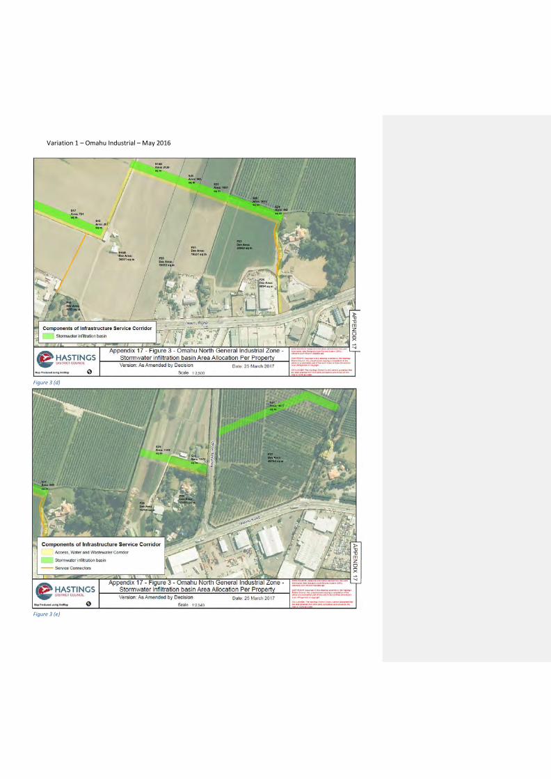
Appendix 17, Figure 3 - Land information and Land Areas of properties subject to stormwater Swale Corridor Formation Requirement Land required for the stormwater infiltration basin & service connectors per site
This table is to be read in conjunction with standards 14.1.6A.6 and 30.1.7R and the Maps in Appendix 17, Figure 3. This table provides details of the land required for the Stormwater Infiltration Basin to serve each site within the Omahu Road Structure Plan area. The reference ‘P#’ is used to identify each separate property in the Table below and the accompanying maps in Appendix 17, Figure 3. The reference ‘S#’ is used to identify the proportional area of Stormwater Infiltration Basin needed for each site ‘P#’ on the accompanying table and maps in Appendix 17, Figure 3. The Stormwater Infiltration Basin is to be constructed prior to the subdivision or development. All land within the Designated Service Corridor 161 is owned by Hastings District Council and is set aside for servicing of the land within the Omahu Road Structure Plan area. Land within the Designated Service Corridor is not available for development. Similarly the area (m2) on the accompanying maps (in Appendix 17, Figure 3) shown in orange is set aside to provide a service connector easement and is not available for development. The service connectors correspond to the column titled ‘Service Connector (m2)’. Note: The properties highlighted red have two properties on same Property Number (PID). P16a and 16b has been split because of size/shape of the property.
Note: Figures used in table below may have a small margin of error as the land has not been surveyed at the time of creating this table. These areas shall be confirmed at the time of subdivision.
Site
P#
Address &
Legal Description
Developable
Area (m2)
S#
Stormwater Basin per
Site (m2)
Service
Connector (m2)
P01 1393 Omahu Road HASTINGS
LOT 2 DP 440763 LOT 2 DP 416250 13743 1151 656
P02 1411 Omahu Road HASTINGS
LOT 1 DP 313846 11990 1016 n/a
P03 1409 Omahu Road HASTINGS
LOT 1 DP 26855 BLK 3284 310 n/a
P04 1393 Omahu Road HASTINGS
LOT 2 DP 440763 LOT 2 DP 416250 48968 3902 347
P05 1 Twyford Road TWYFORD
LOT 3 DP 416250 LOT 1 DP 2209 35622 3385 n/a
P06
4 Twyford Road TWYFORD
LOT 1 D.P. 2767
19902
1627
n/a
P07
55 Twyford Road TWYFORD
LOT 2 DP 463981 LOT 2 DP 425145
LOT 2 DP 328509 LOT 2 DP 10520
13947 1380
348
P08 1347 Omahu Road HASTINGS
LOT 3 DP 425145 8985 887
n/a
P09 1337 Omahu Road HASTINGS 31460 2368
Commented [MG26]: V1 Issue 10 The changes to Appendix 17 Figure 3 are to provide clearer instructions, labelling and removal of all information not necessary for the purposes of standards 14.1.6A.6 and 30.1.7R. Where the table is highlighted blue this is a consequential change resulting from accepting changes to the boundary / service corridor on the Bayley property (issue 9) and the Raupare Partnership property (Issue 10) and removing sites that are exempt from Standard 14.1.6A.6 and 30.1.7R
Commented [MG27]: Consequential amendment

Variation 1 – Omahu Industrial – May 2016
PT LOT 1 DP 4953 422
P10 1327 Omahu Road HASTINGS
LOT 1 DP 8689 4047 294
n/a
P11 1319 Omahu Road HASTINGS
LOT 1 DP 24260 3927 280
n/a
P12 1309 Omahu Road HASTINGS
LOT 2 DP 24260 49886 3596
n/a
P13
18 Jarvis Road TWYFORD
LOT 2 DP 402958
31381
2830
n/a
P14 1275 Omahu Road HASTINGS
Lot 1 Dp 402958 6533 798 0
n/a
P15 Jarvis Road TWYFORD
LOT 2 DP 419221 9565 815
n/a
P16a
1241 Omahu Road HASTINGS
LOT 3 DP 27351 SUBJ TO & INT IN
EASEMENTS
43168 2818
426
P16b
1241 Omahu Road HASTINGS
LOT 3 DP 27351 SUBJ TO & INT IN
EASEMENTS
36071 2120 n/a
P17
1255 Omahu Road HASTINGS
LOT 2 DP 27351 SUBJ TO & INT IN
EASEMENTS
11393 724 n/a
P18
1243 Omahu Road HASTINGS
LOT 1 DP 27351 INT IN EASTMENTS 4033 267 n/a
P19
55 Twyford Road TWYFORD
LOT 2 DP 463981 LOT 2 DP 425145
LOT 2 DP 328509 LOT 2 DP 10520
0 0 n/a
P20
Omahu Road HASTINGS
LOT 2 DP 8336 15472 942 n/a
P21
1219 Omahu Road HASTINGS
PT LOT 2 DP 377104 LOT 2 DP 400858
LOT 2 DP 329917 - INDUSTRIAL
APPORTIONMENT
18551 1061 n/a
P22
1215 Omahu Road HASTINGS
LOT 2 DP 22884 23968 1415 348
P23
1203 Omahu Road HASTINGS
LOT 2 DP 392031 2306 0
P24
1199 Omahu Road HASTINGS
LOT 1 DP 392031 6094 352 n/a
P25
15 Raupare Road TWYFORD
LOT 2 DP 22262 15765 1109 n/a
P26
7 Raupare Road TWYFORD
LOT 1 DP 22262 15595 1372 n/a
Commented [MG28]: Issue 9 Bayley - Consequential amendment from Realignment of zone boundary – this property (CNC) is exempt from stormwater standard 14.1.6A.6 as shown on the structure plan.
Commented [MG29]: Issue 9 Bayley – Consequential amendment from Realignment of zone boundary
Commented [MG30]: Consequential amendment
Commented [MG31]: Consequential amendment S16 RMA

Variation 1 – Omahu Industrial – May 2016
P27
Omahu Road HASTINGS
SEC 1 SO 486816 45754 4577 n/a
P28
1431 Omahu Road HASTINGS
LOT 1 DP 435466 5002 406 n/a
P29
1429 Omahu Road
HASTINGS
LOT 1 DP 440763
5710 466 n/a
P30
1351 Omahu Road HASTINGS
LOT 1 DP 425145 3485 341 n/a
P31 1189 Omahu Road HASTINGS 24490 0
P32
1189 Omahu Road HASTINGS
LOT 3 DP 22884 LOT 2 DP 342661 4016 0
Appendix 17 - Figures 3 Stormwater Infiltration Basin (S#) Swale Area Allocation Per Property (P#).
To be read in conjunction with standards 14.1.6A.6 and 30.1.7R and the Table in Appendix 17, Figure 3.
Figure 3 (a)
Commented [MG32]: Issue 10 - Consequential amendment from Raupare Partnership submission
Commented [MG33R32]:
Commented [MG34]: Consequential amendment S16 RMA
Commented [MG35]: Consequential amendment S16 RMA

Variation 1 – Omahu Industrial – May 2016
Figure 3 (c)
Figure 3 (B)
Variation 1 – Omahu Industrial – May 2016
Figure 3 (d)
Figure 3 (e)

Variation 1 – Omahu Industrial – May 2016