Embed Size (px)
Citation preview
Valuation of ground penetrating radar for the record of structures in fluvio-lacustrine soils,
D. Rangel, D. Carreón, M. Cerca & E. Méndez, 85-93
85 Journal of Applied Research and Technology
VALUATION OF GROUND PENETRATING RADAR FOR THE RECORD OF
STRUCTURES IN FLUVIO LACUSTRINE SOILS D. Rangel1, D. Carreón2, M. Cerca3 & E. Méndez1
1. Instituto de Física UNAM, Laboratorio Juriquilla, A.P. 1-1010, Querétaro, México. E-mail: [email protected] 2. Unidad de Investigación en Ciencias de la Tierra UNAM, A.P. 1-742, C.P. 76230, Juriquilla, Qro, México. E-mail: [email protected] 3. Posgrado en Ciencias de la Tierra, Instituto de Geologia, Campus Juriquilla UNAM, A.P. 1-742, C.P. 76230, Juriquilla, Qro, México. E-mail: [email protected] Received: January 11 th 2002 and accepted March 11th 2002 ABSTRACT In this work, the response of Ground Penetrating Radar (GPR) to geological characteristics of fluvio-lacustrine soils is analyzed. GPR method is a very useful tool for structural studies of the geological media because it provides continuous profiles from the subsoil (radargrams). The identification of thin geological structures in the radar profiles allowed the evaluation of the detection capacity of the GPR Zond 12c for stratigraphical purposes. Its detection capacity depends on the achieved depth of penetration and resolution, on the transmitted wave frequency, and of the system used for acquisition and processing of the signals. The prospecting principle is based on the emission and reception of short electromagnetic pulses that are reflected by electric discontinuities related to physical or structural properties of the ground. RESUMEN En este trabajo se analiza la respuesta del Radar de Penetración Terrestre (RPT) a las características geológicas de suelos fluvio-lacustres. El RPT constituye una herramienta útil para el estudio de la estructura del medio geológico debido a que proporciona perfi les continuos del subsuelo (también llamados radargramas). La identificación de estructuras delgadas en las capas de suelos fluvio-lacustres de los radargramas presentados permite evaluar la capacidad de detección del RPT Zond 12c para fines estratigráficos. La capacidad de detección del método depende principalmente de la profundidad alcanzada y de la resolución obtenida durante la prospección, de las frecuencias util izadas, así como del sistema electrónico para adquisición y procesamiento de las señales. El principio de la prospección se basa en la emisión de impulsos electromagnéticos de corta duración, los cuales son captados después de haber sido reflejados por discontinuidades eléctricas. Estas se asocian normalmente a discontinuidades físicas o estructurales en el subsuelo y dependen directamente de las propiedades del mismo. KEYWORDS: Radar Parameters, Antenna, Transmitter-Receiver, Detection capacity, Radargrams, Soil properties, geological prospecting. 1. INTRODUCTION The Ground Penetrating Radar (GPR) is a geophysical method of non destructive and indirect prospecting of the ground. Principle and application of GPR to diverse geological and geotechnical problems have been discussed in detail in the literature [1, 2, 3, 4, and 5]. GPR equipments send short electromagnetic pulses in the frequency range of 10 MHz to 3000 MHz, to the ground by a transmitter antenna. When the transmitted w ave f inds heterogeneities in the electric properties of the ground
Valuation of ground penetrating radar for the record of structures in fluvio-lacustrine soils,
D. Rangel, D. Carreón, M. Cerca & E. Méndez, 85-93
86 Vol. 1 No. 1 April 2003
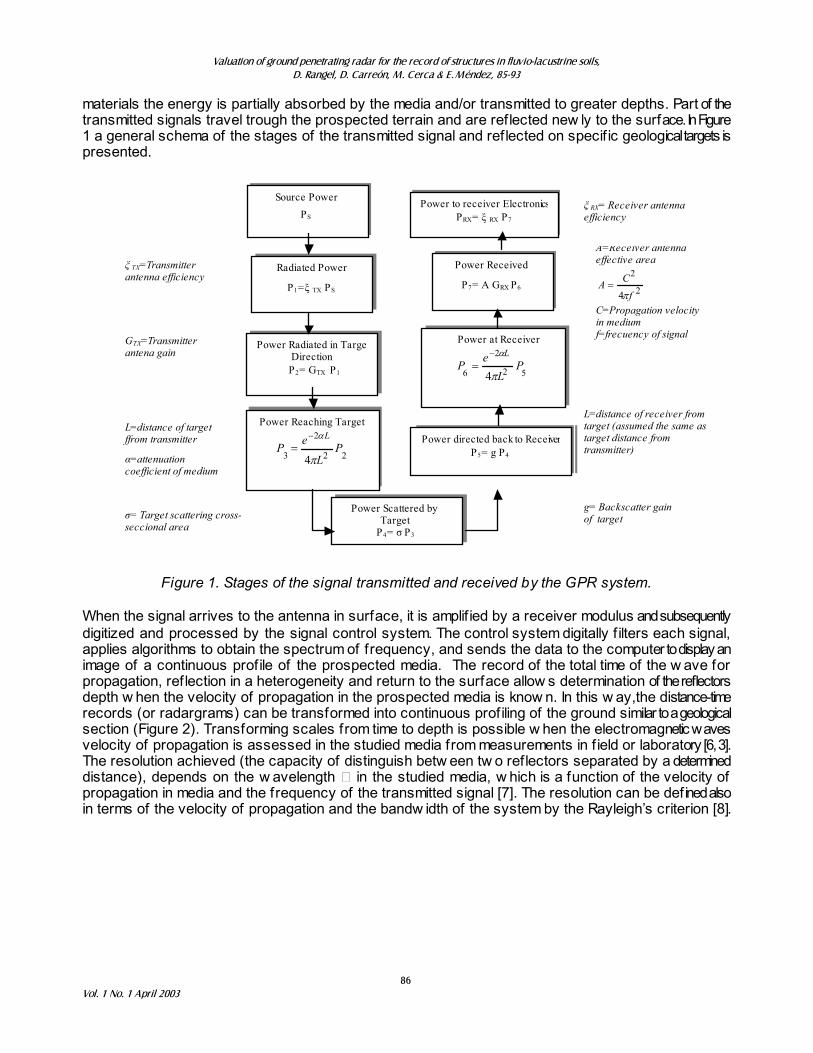
materials the energy is partially absorbed by the media and/or transmitted to greater depths. Part of the transmitted signals travel trough the prospected terrain and are reflected new ly to the surface. In Figure 1 a general schema of the stages of the transmitted signal and reflected on specif ic geological targets is presented.
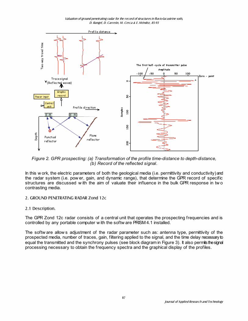
Figure 1. Stages of the signal transmitted and received by the GPR system. When the signal arrives to the antenna in surface, it is amplif ied by a receiver modulus and subsequently digitized and processed by the signal control system. The control system digitally f ilters each signal, applies algorithms to obtain the spectrum of frequency, and sends the data to the computer to display an image of a continuous profile of the prospected media. The record of the total time of the w ave for propagation, reflection in a heterogeneity and return to the surface allow s determination of the reflectors depth w hen the velocity of propagation in the prospected media is know n. In this w ay,the distance-time records (or radargrams) can be transformed into continuous profiling of the ground similar to a geological section (Figure 2). Transforming scales from time to depth is possible w hen the electromagnetic waves velocity of propagation is assessed in the studied media from measurements in f ield or laboratory [6, 3]. The resolution achieved (the capacity of distinguish betw een tw o reflectors separated by a determined distance), depends on the w avelength � in the studied media, w hich is a function of the velocity of propagation in media and the frequency of the transmitted signal [7]. The resolution can be defined also in terms of the velocity of propagation and the bandw idth of the system by the Rayleigh’s criterion [8].
GRX=Receiver antenna gain A=Receiver antenna effective area
2
2
4 f
CAS
C=Propagation velocity in medium f=frecuency of signal
Source Power
PS
Power to receiver Electronics PRX= ȟ RX P7
Radiated Power
P1=ȟ TX PS
Power Radiated in TargeDirection
P2= GTX P1
ȟ TX=Transmitter antenna efficiency
Power Received
P7= A GRX P6
Power at Receiver
52
2
6 4P
Le
PL
S
D�
Power Reaching Target
22
2
3 4P
L
eP
L
S
D�
Power directed back to Receiver P5= g P4
Power Scattered by Target
P4= ı P3
GTX=Transmitter antena gain
L=distance of target ffrom transmitter
Į=attenuation coefficient of medium
ı= Target scattering cross-seccional area
ȟ RX= Receiver antenna efficiency
L=distance of receiver from target (assumed the same as target distance from transmitter)
g= Backscatter gain of target
Valuation of ground penetrating radar for the record of structures in fluvio-lacustrine soils,
D. Rangel, D. Carreón, M. Cerca & E. Méndez, 85-93
87 Journal of Applied Research and Technology
E -R E -R
Profil e distance
Tw
o-wa
y tr
avel
tim
e
Trace signal(Reflected waves)
Profile di rection
Dep
th
Power input
Centra lun it
Graphicrecord
Punctualreflector
Planereflector
-100 -50 100500
200
150
100
500
Zero - point
Sample
s
The first half-cycle of transmitter pulse
Amplitude
Figure 2. GPR prospecting: (a) Transformation of the profile time-distance to depth-distance, (b) Record of the reflected signal.
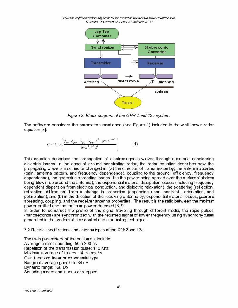
In this w ork, the electric parameters of both the geological media (i.e. permittivity and conductivity) and the radar system (i.e. pow er, gain, and dynamic range), that determine the GPR record of specif ic structures are discussed w ith the aim of valuate their inf luence in the bulk GPR response in tw o contrasting media. 2. GROUND PENETRATING RADAR Zond 12c 2.1 Description. The GPR Zond 12c radar consists of a central unit that operates the prospecting frequencies and is controlled by any portable computer w ith the softw are PRISM 4.1 installed. The softw are allow s adjustment of the radar parameter such as: antenna type, permittivity of the prospected media, number of traces, gain, f iltering applied to the signal, and the time delay necessary to equal the transmitted and the synchrony pulses (see block diagram in Figure 3). It also permits the signal processing necessary to obtain the frequency spectra and the graphical display of the profiles.
Valuation of ground penetrating radar for the record of structures in fluvio-lacustrine soils,
D. Rangel, D. Carreón, M. Cerca & E. Méndez, 85-93
88 Vol. 1 No. 1 April 2003
Figure 3. Block diagram of the GPR Zond 12c system. The softw are considers the parameters mentioned (see Figure 1) included in the w ell know n radar equation [8]:
¸̧¸
¹
·
¨̈¨
©
§ ������
�
423
42
64log10
Lf
egcGGQ
LRXTXRXTX
S
V[[ D
(1)
This equation describes the propagation of electromagnetic w aves through a material considering dielectric losses. In the case of ground penetrating radar, the radar equation describes how the propagating w ave is modif ied or changed in: (a) the direction of transmission by; the antenna properties (gain, antenna pattern, and frequency dependence), coupling to the ground (eff iciency, frequency dependence), the geometric spreading losses (like the pow er being spread over the surface of a balloon being blow n up around the antenna), the exponential material dissipation losses (including frequency dependent dispersion from electrical conduction, and dielectric relaxation), the scattering (reflection, refraction, diffraction) from a change in properties (depending upon contrast , orientation, and polarization); and (b) in the direction of the receiving antenna by; exponential material losses, geometric spreading, coupling, and the receiver antenna properties. The result is the ratio betw een the maximum pow er emitted and the minimum pow er detected [8, 9]. In order to construct the profile of the signal traveling through different media, the rapid pulses (nanoseconds) are synchronized w ith the returned signal of low er frequency using synchrony pulses generated in the system of time control and a sampling technique. 2.2 Electric specifications and antenna types of the GPR Zond 12c. The main parameters of the equipment include: Average time of sounding: 50 a 200 ns Repetition of the transmission pulse: 115 Khz Maximum average of traces: 14 traces / s Gain function: linear or exponential type Range of average gain: 0 to 84 dB Dynamic range: 128 Db Sounding mode: continuous or stepped
Valuation of ground penetrating radar for the record of structures in fluvio-lacustrine soils,
D. Rangel, D. Carreón, M. Cerca & E. Méndez, 85-93
89 Journal of Applied Research and Technology
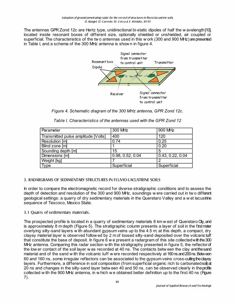
The antennas GPR Zond 12c are Hertz type, unidirectional bi-static dipoles of half the w avelength [10], located inside resonant boxes of different size, optionally shielded or unshielded, air coupled or superficial. The characteristics of the tw o antennas used in this w ork (300 and 900 MHz) are presented in Table I, and a schema of the 300 MHz antenna is show n in f igure 4.
Transmitter
Signal connectorfrom transmitterto control unit Resonant box
Dipole
Receiver Signal connectorfrom transmitterto control unit
Figure 4. Schematic diagram of the 300 MHz antenna, GPR Zond 12c.
Table I. Characteristics of the antennas used with the GPR Zond 12
Parameter 300 MHz 900 MHz Transmitted pulse amplitude [Volts] 400 120 Resolution [m] 0.74 0.25 Blind zone [m] 1 0.20 Sounding depth [m] 15 5 Dimensions [m] 0.98, 0.52, 0.04 0.43, 0.22, 0.04 Weight [kg] 7 2 Type Superficial Superficial
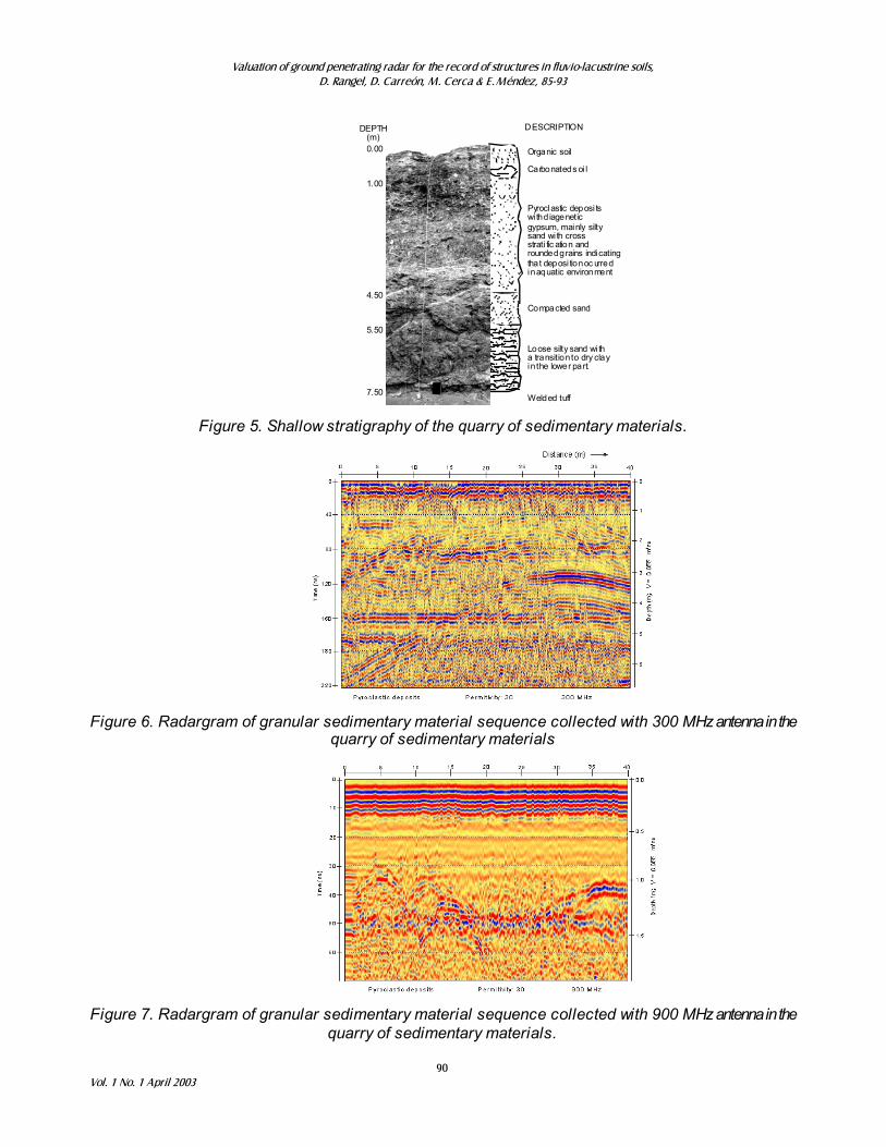
3. RADARGRAMS OF SEDIMENTARY STRUCTURES IN FLUVIO-LACUSTRINE SOILS In order to compare the electromagnetic record for diverse stratigraphic conditions and to assess the depth of detection and resolution of the 300 and 900 MHz, soundings w ere carried out in tw o different geological settings: a quarry of dry sedimentary materials in the Queretaro Valley and a w et lacustrine sequence of Texcoco, Mexico State. 3.1 Quarry of sedimentary materials. The prospected profile is located in a quarry of sedimentary materials 8 km w est of Queretaro City, and is approximately 8 m depth (Figure 5). The stratigraphic column presents a layer of soil in the f irst meter overlying silty-sand layers w ith abundant gypsum veins up to the 4.5 m; at this depth, a compact, dry clayey material layer is observed follow ed by 2 m of loosed silty-sand deposited over the volcanic tuff that constitute the base of deposit. In f igure 6 w e present a radargram of this site collected with the 300 MHz antenna. Comparing this radar section w ith the stratigraphy presented in f igure 5, the reflector of the low er contact of the soil layer w as recorded at 40 ns. The contacts betw een the clay and the sand material and of the sand w ith the volcanic tuff w ere recorded respectively at 160 ns and 200 ns. Between 60 and 160 ns, some irregular reflectors can be associated to the gypsum veins cross-cutting the clayey layers. Furthermore, a difference in soil composition (from superficial organic rich to carbonated soil) at 20 ns and changes in the silty-sand layer betw een 40 and 50 ns, can be observed clearly in the profile collected w ith the 900 MHz antenna, in w hich w e obtained better definition up to the f irst 40 ns (Figure 7).
Valuation of ground penetrating radar for the record of structures in fluvio-lacustrine soils,
D. Rangel, D. Carreón, M. Cerca & E. Méndez, 85-93
90 Vol. 1 No. 1 April 2003
Carbonated s oi l
Pyroclastic deposi tswi th d iageneticgypsum, mainly siltysand wi th crossstrati fic ation androunded grains indicatingthat deposi tion oc urredin aquatic environment
Compacted sand
Loose silty sand wi tha transition to dry clayin the lower part.
0.00
1.00
4.50
5.50
7.50
DESCRIPTIONDEPTH(m)
Organic soil
Welded tuff
Figure 5. Shallow stratigraphy of the quarry of sedimentary materials.
Figure 6. Radargram of granular sedimentary material sequence collected with 300 MHz antenna in the
quarry of sedimentary materials
Figure 7. Radargram of granular sedimentary material sequence collected with 900 MHz antenna in the
quarry of sedimentary materials.
Valuation of ground penetrating radar for the record of structures in fluvio-lacustrine soils,
D. Rangel, D. Carreón, M. Cerca & E. Méndez, 85-93
91 Journal of Applied Research and Technology
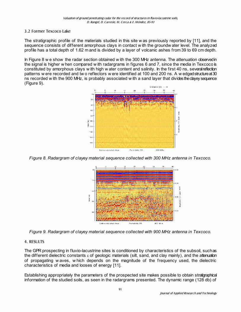
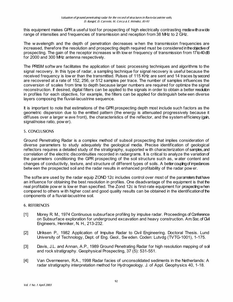
3.2 Former Texcoco Lake The stratigraphic profile of the materials studied in this site w as previously reported by [11], and the sequence consists of different amorphous clays in contact w ith the groundw ater level. The analyzed profile has a total depth of 1.62 m and is divided by a layer of volcanic ashes from 39 to 69 cm depth. In Figure 8 w e show the radar section obtained w ith the 300 MHz antenna. The attenuation observed in the signal is higher w hen compared w ith radargrams in f igures 6 and 7, since the media in Texcoco is constituted by amorphous clays w ith high w ater content and salinity. In the f irst 40 ns, several reflection patterns w ere recorded and tw o reflectors w ere identif ied at 100 and 200 ns. A w edged structure at 30 ns recorded w ith the 900 MHz, is probably associated w ith a sand layer that divides the clayey sequence (Figure 9).
Figure 8. Radargram of clayey material sequence collected with 300 MHz antenna in Texcoco.
Figure 9. Radargram of clayey material sequence collected with 900 MHz antenna in Texcoco. 4. RESULTS The GPR prospecting in f luvio-lacustrine sites is conditioned by characteristics of the subsoil, such as the different dielectric constants H of geologic materials (silt, sand, and clay mainly), and the attenuation of propagating w aves, w hich depends on the magnitude of the frequency used, the dielectric characteristics of media and looses of energy [11]. Establishing appropriately the parameters of the prospected site makes possible to obtain stratigraphical information of the studied soils, as seen in the radargrams presented. The dynamic range (128 db) of
Valuation of ground penetrating radar for the record of structures in fluvio-lacustrine soils,
D. Rangel, D. Carreón, M. Cerca & E. Méndez, 85-93
92 Vol. 1 No. 1 April 2003
this equipment makes GPR a useful tool for prospecting of high electrically contrasting media with a wide range of intensities and frequencies of transmission and reception from 38 MHz to 2 GHz. The w avelength and the depth of penetration decreases w hen the transmission frequencies are increased, therefore the resolution and prospecting depth required must be considered in the objective of prospecting. The gain of the receptor increases w ith low er frequency of transmission from 17 to 40 dB for 2000 and 300 MHz antenna respectively. The PRISM softw are facilitates the application of basic processing techniques and algorithms to the signal recovery. In this type of radar, a sampling technique for signal recovery is useful because the received frequency is low er than the transmitted. Pulses of 115 KHz are sent and 14 traces by second are recovered at a rate of 152, 256, or 512 samples per trace. The number of samples influences the conversion of scales from time to depth because larger numbers are required for optimize the signal reconstruction. If desired, digital f ilters can be applied to the signals in order to obtain a better resolution in profiles for each objective, for example, the f ilters can be applied for distinguish betw een diverse layers composing the f luvial-lacustrine sequence. It is important to note that estimations of the GPR prospecting depth most include such factors as the geometric dispersion due to the emitted pattern (the energy is attenuated progressively because it diffuses over a larger w ave front), the characteristics of the reflector, and the system eff iciency (gain, signal/noise ratio, pow er). 5. CONCLUSIONS Ground Penetrating Radar is a complex method of subsoil prospecting that implies consideration of diverse parameters to study adequately the geological media. Precise identif ication of geological reflectors requires a detailed study of the stratigraphy, supported w ith characterization of samples, and correlation of the electric discontinuities recorded in radargrams. It is critical to analyze the variation of the parameters conditioning the GPR prospecting of the soil structure such as, w ater content and changes of conductivity, texture, and structure of different types of soils. A better coupling of impedances betw een the prospected soil and the radar results in enhanced profitability of the radar pow er. The softw are used by the radar equip ZOND 12c includes control over most of the parameters that have an influence for obtaining the best resolution in profiles. One disadvantage of the equipment is that the real profitable pow er is low er than specif ied. The Zond 12c is f irst-rate equipment for prospecting when compared to others w ith higher cost and good quality results can be obtained in the identif ication of the components of a f luvial-lacustrine soil. 6. REFERENCES [1] Morey R. M., 1974 Continuous subsurface prof iling by impulse radar. Proceedings of Conference
on Subsurface exploration for underground excavation and heavy construction. Am. Soc. of Civil Engineers, Henniker, N. H., 213-232.
[2] Ulriksen P., 1982 Application of Impulse Radar to Civil Engineering. Doctoral Thesis. Lund
University of Technology, Dept. of Eng. Geol., Sw eden. Coden: Lutvdg (TVTG-1001), 1-175. [3] Davis, J.L. and Annan, A.P., 1989 Ground Penetrating Radar for high resolution mapping of soil
and rock stratigraphy. Geophysical Prospecting, 37 (5): 531-551. [4] Van Overmeeren, R.A., 1998 Radar facies of unconsolidated sediments in the Netherlands: A
radar stratigraphy interpretation method for Hydrogeology. J. of Appl. Geophysics 40, 1-18.
Valuation of ground penetrating radar for the record of structures in fluvio-lacustrine soils,
D. Rangel, D. Carreón, M. Cerca & E. Méndez, 85-93
93 Journal of Applied Research and Technology
[5] Saarenketo, T., and Scuillon, T., 2000 Road evaluation w ith Ground Penetrating Radar. J. of Appl. Geophysics 43, 119-138.
[6] Cook J., 1975 Radar transparencies of mine and tunnel rocks. Geophysics. Off icial Journal of
Exploration Geophysics. Vol. 40, No. 5, 865-885. [7] Merrill S. I. 1990 Radar Handbook. McGraw Hill. 345-570. [8] Noon, D. A., Sticley, Glen F., Longstaff, Dennis. 1998 A frecuency-independent characterization
of GPR penetration and resolution performance. Journal of Applied Geophysics 40, 127- 137. [9] Olhoeft, G.R., 2000 Maximizing the information return from ground penetrating radar. J. of Appl.
Geophysics 43, 175-187. [10] Whinnery J. R., Ramo S., Van Duzer T., 1994. Fields and Waves in Comunication Electronics,
John Wiley Sons Inc. U.S.A., 280-295. [11] Oleschko, K., Figueroa, S.B., Miranda, M. M.E., Vuelvas, M.A., and Solleiro E., R. 2000. Mass
fractal dimensions and some selected physical properties of contrasting soils and sediments of Mexico. Soil & Tillage Research 55, 43-61.
[12] Saarenketo, T., 1998. Electrical properties of w ater in clay and silty soils. J. of Appl. Geophysics
40, 73-88.