Embed Size (px)
Citation preview
Development Management Validation Checklist for Planning Applications
Adopted 5 September 2011, Revised January, August & December 2018
Further updated February 2019, June 2019 & September 2021
Introduction The purpose of this Validation Checklist is to provide applicants with clear guidance on the information required for the submission of planning applications, in accordance with Government policy and legislation. Since the initial adoption of this Validation Checklist in 2011 there have been changes in local and national planning policy, including:
- Three Rivers Core Strategy has been adopted (October 2011) as well as the Development Management Policies LDD (July 2013) and Site Allocations LDD (November 2014)
- The Localism Act received Royal Assent on 15 November 2011 - The National Planning Practice Guidance (NPPG) (March 2014) and National Planning Policy
Framework (NPPF). The NPPF and NPPG replace numerous Government documents including the CLG publication Guidance on Information Requirements (2010).
- The Community Infrastructure Levy Regulations 2010 have been amended - Croxley Green Neighbourhood Plan 2017-2032 (December 2018) - Chorleywood Neighbourhood Development Plan 2020-2035 (August 2020)
With regard to validation the NPPF states: ‘Local planning authorities should publish a list of their information requirements for applications for planning permission. These requirements should be kept to the minimum needed to make decisions, and should be reviewed at least every two years. Local planning authorities should only request supporting information that is relevant, necessary and material to the application in question’ (para 44). The NPPG states: ‘The local list is prepared by the local planning authority to clarify what information is usually required for applications of a particular type, scale or location. In addition to being specified on an up-to-date local list published on the local planning authority’s website, information requested with a particular planning application must be:
- reasonable having regard, in particular, to the nature and scale of the proposed development; and
- about a matter which it is reasonable to think will be a material consideration in the determination of the application.
These statutory tests are set out in section 62 (4A) of the Town and Country Planning Act 1990 (inserted by the Growth and Infrastructure Act) and article 11(3)(c) of the Town and Country Planning (Development Management Procedure) (England) (Order) 2015’ (DMPO).. Consequently this Validation Checklist has been revised to reflect the changes in national and local planning policy. Any supporting information should add to the Local Planning Authority’s understanding of the development scheme that is submitted for determination. The information requested and provided should help to explain the nature of the proposed development, its anticipated impacts – positive and negative – and any measures that are proposed to mitigate any anticipated adverse impacts.
If an applicant does not submit an application in accordance with the statutory requirements and locally adopted requirements the Local Planning Authority is entitled to declare that the application is invalid, and so decline to register it. In doing so, the Local Planning Authority will set out its reasons for declaring an application invalid in writing to the applicant specifying the information required in order to make the application valid. The information must be submitted within a defined timescale otherwise the application will be returned. Where an application is not accompanied by information required by the Local Planning Authority, applicants should provide a short written justification to accompany the application as to why they consider it is not appropriate to include the information in the particular circumstances. In such cases, the Local Planning Authority will not consider applications to be invalid unless it is satisfied that it can give reasons and provide them to the applicant. For larger or more complex schemes applicants should seek agreement on the Validation Checklist requirements through pre-application discussions. All applicants should aim for succinctness in their supporting documentation. However, a number of detailed reports may be necessary to support some applications. Where the supporting information for a major application exceeds 100 pages (excluding the application form itself), applicants should submit a summary of the whole scheme. This summary should be no more than 20 pages long and should provide an overview of the proposal and a clear description of its key impacts. In circumstances where applicants do not agree with the requirement for information or plans set out by the Local Planning Authority, they should discuss the point of concern with the Local Planning Authority. Where discussions fail to resolve any conflict in views there is no right of appeal. However, where applicants consider that any particulars or evidence required by the Local Planning Authority do not meet the requirements set out in Article 11(3)(c)) they may dispute the decision in accordance with Article 12 of the DMPO. Applicants who want to challenge a decision to not validate an application can do so under other procedures, such as the judicial process on legal grounds. If the Local Planning Authority considers that the quality of the supporting information is inadequate and fails to validate an application on this basis, an applicant may appeal to the Planning Inspectorate under Section 78 of the Town and Country Planning Act 1990 with the relevant grounds for appeal being non-determination within the 8 or 13 week determination period.
Notes on how this guidance should be used by applicants This Validation Checklist is in four parts: Part A sets out the statutory national requirements for all applications. Planning applications submitted without any one of the listed items are unlikely to be validated. Plans marked “not to scale” or “do not scale” will not be registered. Applicants will be informed in writing of where the application is deficient and the timescale within which it should be provided. Part B provides a list of additional local requirements. These requirements will need to be met in particular circumstances and will be dependent on factors such as site location, characteristics of the site, the scale and nature of the development and national and local policy requirements. They will not necessarily be required in every case. Indicative thresholds are therefore included to guide applicants where appropriate. Applicants will be informed in writing of where the application is deficient and the timescale within which it should be provided. Part C contains a summary matrix of the information likely to be required for different application types. Part D contains a LOCAL BIODIVERSITY CHECKLIST which must be completed and submitted with all applications. PLEASE SUBMIT THE COMPLETED BIODIVERSITY CHECKLIST WITH ATTACHED CONCLUSION TO THE LOCAL PLANNING AUTHORITY WITH YOUR PLANNING APPLICATION.
General points
Applicants can apply online via the Planning Portal: www.planningportal.gov.uk. Alternatively application forms can be accessed via the Three Rivers District Council website and the Planning Portal. All plans and drawings must state the paper size, key dimensions, a scale and include a scale bar. All plans must be to a recognised metric scale i.e. 1:100, 1:50. The Council welcomes pre application discussions, particularly for larger, complex and sensitive applications. The Council charges for pre-application advice. The Validation Checklist is based on the adopted policies of the Core Strategy and Development Management Policies LLD which form the Development Plan. The adopted policies of Three Rivers District Council reflect the content of the NPPF. Where a householder or full application is accompanied by an application for Listed Building Consent and the householder / full application is found to be invalid, the Council will request that the Listed Building Consent application is also held in abeyance until such time that all relevant information is received. This is to ensure that the scheme can be assessed comprehensively. For major applications, an electronic copy and one hard copy of all plans and documents will be required, as well as an index listing all plan numbers. Please note that since 1 October 2018, the grant of planning permission subject to a pre-commencement condition is prohibited without the written agreement of the applicant to the terms of the condition, except in prescribed circumstances. Our ability to minimise pre-commencement conditions is in part dependent on the level of information submitted by applicants as part of a planning application. As such, should you wish to submitted additional details (for example full specification of site levels, materials, boundary treatments, hard and soft landscaping, and tree protection and construction works methodology) these details can be considered during the course of the formal application.
PART A National Requirements for Applications National information requirements are set out in the Town and Country Planning (Development Management Procedure) (England) Order 2015 and in the NPPG. Please supply the following with your application: 1) Application form / certificates: - The completed application form, signed and dated. Select the relevant application form on the
Planning Portal. - Completed ownership certificate (A, B, C or D) as required by Article 14 of the Town and Country
Planning (Development Management Procedure) (England) Order 2015. Where Ownership Certificates B or C have been completed, notices required by Article 13 of the Town and Country Planning (Development Management Procedure) (England) Order 2015 must be given and/or published in accordance with this Article. A failure to comply with the requirements of Article 14 will result in the Local Planning Authority refusing to entertain the application in accordance with section 327A of the 1990 Act.
2) Location plan: - A plan which identifies the land to which the application relates drawn to an identified scale and
showing the direction of north (at a scale of 1:1250 or 1:2500). Application site (including access) to be outlined in red, any other land in which the applicant has an interest outlined in blue.
Location Plans are available to purchase online via the Planning Portal.
3) Other plans: - Any other plans, drawings and information necessary to describe the development which is the
subject of the application, such as: - a site / block plan (at a scale of 1:100 or 1:200) - proposed elevations (at a scale of 1:50 or 1:100) - proposed floor plans (at a scale of 1:50 or 1:100) - proposed site sections and finished floor and site levels (at a scale of 1:50 or 1:100) - proposed roof plan (at a scale of 1:50 or 1:100)
4) Other:
A Design and Access Statement for: - all major developments, as defined in article 2 of the Town and Country Planning (Development
Management Procedure (England) Order 2015; - applications within Conservation Areas which comprise provision of one or more dwellings or
building(s) where the floorspace to be created is 100m2 or more - Listed Building Consent (Listed Building Consent applications should also include a Heritage
Statement) Details of what to include in a Design and Access Statement are set out in the validation requirements in the NPPG (paragraph 29 onwards).
5) Fee: The appropriate fee can be calculated using Planning Portal Fee Calculator, or see the current fee schedule.
PART B Three Rivers Local Requirements 1) Biodiversity Checklist: See Section 11 and Part D. 2) Location and site / block plan: When identifying the application site on the location plan, please
outline the application site boundary in red, detail two named roads and include all neighbouring properties. The site / block plan showing site boundaries (usually at a scale of 1:100 or 1:200) should clearly show the location of the proposed development (e.g. hatched) in relation to neighbouring properties as well as other details such as car parking spaces and the location of bin stores where appropriate.
3) Existing and proposed plans: Existing elevations and floorplans are required where applicable, at
a scale of 1:50 or 1:100. This is particularly important for sites within the Green Belt. Proposed elevations and floorplans are required, as well as a roof plan, site sections and finished
floor and site levels where relevant. 4) Streetscene elevation: An elevation drawing showing the relationship of the proposed
development in the streetscene (i.e. in relation to development either side of the site) is required for all extensions to dwellings involving a raise in ridge height, all new or replacement dwellings and all new commercial developments. If a site fronts two highways it may be that more than one streetscene elevation is required.
5) Community Infrastructure Levy (CIL) forms and floorspace calculations:
CIL is a tool for Local Authorities to help deliver infrastructure to support the development of their area, such as new schools, roads, leisure facilities, open space, children’s play areas, health care facilities and community facilities. It came into force on 6 April 2010 through the Community Infrastructure Levy Regulations 2010 (as amended) Development may be liable for a charge under CIL, including new dwellings, annexes and outbuildings , extensions comprising 100 sqm of new build floorspace (net gain), and conversion of buildings. Development carried out under Permitted Development (‘General Consent’) may also be liable for CIL. Three Rivers adopted its CIL Charging Schedule on 24 February 2015. Detail can be found at the following web page: http://www.threerivers.gov.uk/egcl-page/community-infrastructure-levy As such the following CIL Determining whether a Development may be CIL Liable Planning Application Additional Information Requirement form must be submitted with ALL planning applications: CIL Additional Questions Form (Form 1) The following Notice of Chargeable Development form should be submitted with ALL certificate of lawfulness applications: Notice of Chargeable Development
If you consider that your development would be CIL liable you must also provide existing and proposed floorspace calculations (sqm) for each use. If amendments are made during the course of the application process you will also be asked to provide amended floorspace calculations. If you consider that your development would be CIL liable you must assume the liability for the payment of CIL, or to claim for relief or exemption, including self-build exemption. The following form must be submitted with your application:
CIL form 1 - Assumption of liability
It is possible to claim exemption for a self-build development if you are extending your own property or building a new dwelling to occupy as your primary residence. For domestic extensions you should submit the following form with your application:
CIL Form 9 - Self build residential extension exemption claim Form For domestic annexes you should submit the following form with your application: CIL Form 8 - Self build residential annex exemption claim Form For new dwellings, you should submit the self-build exemption claim form ‘Part 1’ with your application, paying particular attention to the declarations in Section B: CIL Form 7 - Self build exemption claim Form (part 1)
Please note that within 6 months of completion of a new dwelling for which exemption has been granted you will need to submit the self-build exemption claim form ‘Part 2’ below, along with supporting evidence:
CIL Form 7 - Self build exemption claim Form (part 2)If you are claiming relief for affordable housing or charitable purposes the following form is applicable: Claiming Exemption and Relief
Further details regarding what development is CIL liable and how to calculate CIL charges is contained in the Three Rivers CIL Guidance Note for Applicants. Further information is also available on the following websites: Planning Portal CIL page Government’s Community Infrastructure Levy Guidance
6) Draft Section 106 Agreement / Unilateral Undertaking:
Please note that a Section 106 Agreement or Section 106 Unilateral Undertaking is likely to be required for applications involving residential development of 1 or more dwellings
If the planning obligations in respect of a planning application relate solely to financial contributions and are not complex then it is likely that the Council will accept a legal agreement in the form of a Unilateral Undertaking (which has the advantage of not requiring the Council and County Council to be a signatory to the deed). A draft Section 106 Unilateral Undertaking must be submitted at the time of the application securing the relevant heads of terms unless the application is accompanied by a viability assessment which demonstrates that the scheme would be financially unviable with those heads of terms secured and the Council’s costs to independently assess that evidence is enclosed with the application. The deed should be in draft form only i.e. not completed and signed by the parties. The
Council accepts that numerous details required to be contained within the deed will be unknown at the time of the submission of the application.
Applications which attract different types of obligations e.g. the provision of on site affordable housing may be required by the Council to be secured by way of a Section 106 Agreement, rather than planning condition Standard templates for Section 106 Agreements and Unilateral Undertakings are available on the Council’s website.
If the proposal is likely to require planning obligations of a non financial nature the applicant should enter into pre-application discussions with the Planning and / or Legal Officers of the Council. In addition, at the date of submission of your application the following should be resolved and the information provided to the Council with the relevant contact details:
Solicitor name and full contact details. Whilst it is always a matter for the applicant to decide, ideally a solicitor will have been instructed to act on your behalf to protect your legal interests. As part of the application process the detail of the Section 106 Agreement will have to be agreed by the Councils legal department. The Council's legal department will act for the Council, not the applicant. Failure to negotiate with and secure the agreement of the Council's legal department to a section 106 may result in the completed deed being unacceptable to the Council and the planning application being refused.
The solicitor instructed should have been placed in funds so as to give an undertaking regarding the District and County Council’s likely legal costs (£750 - 1500 per Council dependent on likely complexity of the matter).
The electronic title to the application site should have been deduced (including the plan).
Please note that ALL parties with an interest in the application site must be a party to any Section 106 Agreement / Unilateral Undertaking (including any mortgagees)
Requirements for such Agreements include the following: Affordable Housing - The Council has approved a policy requiring the provision of 45% affordable housing. This is set out in Policy CP4 of the adopted Core Strategy and in the approved Supplementary Planning Document (SPD): Affordable Housing. Policy CP4 requires affordable housing provision for all developments with a net gain of 1 or more dwelling(s). The Policy requirement is for 45% on-site affordable housing provision. It is recognised that on-site provision may not always be possible / practical for smaller developments, therefore in exceptional circumstances monetary contributions may be accepted. The commuted payment calculation is expressed as a sum per square metre of the gross internal floor area of the market housing proposed, on the assumption that no affordable housing would be provided on-site. The sum per square metre varies according to the location of the development: Sums required per square metre of the gross internal floor area of habitable accommodation of the market housing provided on site: Oxhey and Watford Fringe £350 per sqm Rickmansworth South and Maple Cross £550 per sqm The Langleys and Croxley £750 per sqm Rickmansworth and Hinterland £950 per sqm Highest Value Three Rivers £1,250 per sqm A map and table of postcodes detailing each market area are set out in Appendix 5 of the Affordable Housing SPD.
Please note that for redevelopment schemes, the sum is based on the average floorspace of the dwellings proposed multiplied by the net gain in the number of dwelling(s). It is expected that schemes shall provide policy compliant provision of affordable housing. Where policy requirements cannot be met due to viability, a Viability Assessment / Financial Appraisal must be submitted at validation stage. The Council will send any viability information submitted to an independent financial advisor, the cost of which shall be borne by the applicant/developer, as set out in the approved Affordable Housing SPD. The fee for this external assessment must be received at validation stage, as a separate payment to the planning fee.
Transparency & Confidentiality: The Council considers that information submitted as a part of, and in support of viability assessment should be treated transparently and be available for wider scrutiny. National Planning Practice Guidance is clear that any viability assessment should be prepared on the basis that it will be made publicly available other than in exceptional circumstances. Even in those circumstances an executive summary should be made publicly available. Where an exemption from publication is sought, the LPA must be satisfied that the information to be excluded is commercially sensitive. An executive summary should present the data and findings of a viability assessment more clearly so that the process and findings are accessible to affected communities. As a minimum, the government recommends that the executive summary sets out the gross development value, benchmark land value including landowner premium, costs, as set out in this guidance where applicable, and return to developer. PLEASE ENSURE THAT ANY VIABILITY ASSESSMENT IS ACCOMPANIED BY AN EXECUTIVE SUMMARY. PLEASE BE AWARE THAT BOTH WILL BE PUBLISHED UNLESS AN EXEMPTION IS SOUGHT AND AGREED. Please also note the requirement for an Affordable Housing Statement to be submitted – see section 6 below. For further information on affordable housing requirements applicants are advised to contact the Council’s Development Plans section or Housing Department on telephone number 01923 776611. Please note that for Section 106BA applications (VAR) for modification or discharge of affordable housing clauses viability evidence must be provided, along with a fee for the information to be assessed by an independent financial advisor.
Other Council Contributions – Dependent on the scale of development, there may be other
requirements such as contributions towards creation of wildlife habitats and ecology management. It is likely that these will have been made apparent and discussed at pre-application stage.
Monitoring Fee – This type of financial obligation will generally not be required, it being recognised that routine administration and enforcement duties are part of the Councils statutory duties. However where officers would be required to undertake monitoring duties in respect of the performance of planning obligations which would exceed what would otherwise be usual or routine, a monitoring fee may be necessary to make the development acceptable. In such cases the monitoring fee will be calculated having regard to the amount of work which the Council may have to carry out to administer, monitor and enforce the obligation(s) in question.
7) Affordable Housing Statement: An Affordable Housing Statement is required for development
where affordable housing is to be provided on-site. Such Statements must detail how the affordable housing requirements set out in Policy CP4 of the adopted Core Strategy and the Affordable Housing SPD are to be met. Affordable Housing Statements should include the following:
- Plans of the layout of the scheme clearly indicating the location of the market and
affordable housing - Details of both the affordable and market housing e.g. the number of residential units,
location, mix and type of accommodation; the number bedroom sizes, and floorspace of units; location of the different tenures of the affordable units (i.e. social rented, affordable rented units (if applicable) and shared ownership properties)
- The design standards of both the affordable and market housing - Details of any Registered Providers acting as partners in the development.
If an application is made in outline, indicative details of affordable housing will still be required.
For further information on affordable housing requirements applicants are advised to contact the Council’s Development Plans section or Housing Department on telephone number 01923 776611.
8) Energy and Sustainability Statements: Policy CP1 of the adopted Core Strategy requires all
applications for new residential development of one unit and above and all new commercial development to be accompanied by a CPLAN Energy Statement and Sustainability Checklist in order to demonstrate the extent to which sustainability principles have been incorporated into the location, design, construction and future use of proposals, and the expected carbon emissions.
Policy DM4 of the Development Management Policies document sets out that developments must produce at least 5% less carbon dioxide emissions than Building Regulations Part L (2013) requirements having regard to feasibility and viability. This may be achieved through a combination of energy efficiency measures, on-site low carbon and renewable technologies or connection to a local, decentralised, renewable or low carbon energy supply.
The CPLAN Energy Statement and Sustainability Checklist are no longer available. Therefore
applicants cannot submit a CPLAN Energy and Sustainability Statement but should submit an Energy Statement demonstrating the extent to which relevant proposals meet the requirements of Policy DM4 of the Development Management Policies document. For building conversions, development proposals must still demonstrate that there would be an overall improvement in the energy performance of the building.
For further guidance on producing an Energy Statement applicants are advised to see the Council’s Development Management Policies document and Guidance on Producing an Energy Statement.
9) Tree Survey and Report: In accordance with Policy DM6 of the Development Management
Policies LDD, if the site is covered by a Tree Preservation Order or within a Conservation Area, or if the site has trees within or adjacent to it which are greater than 75mm in diameter, then the advice of an arboriculturalist should be sought to identify all relevant trees to be included in a Tree Survey. A Tree Survey should be undertaken by an arboriculturalist and should record information about trees on the site independently from any proposed development.
The survey should be carried out in accordance with section 4 of BS 5837: 2012 and should include
details such as reference number, species, height, stem diameter, branch spread, height in meters of crown clearance above ground level, age class, physiological condition, structural condition, preliminary management recommendations, estimated remaining contribution in years and a U or A to C category grading in accordance with the BS document. If it is acknowledged that significant trees on the site are affected by the proposals it will be necessary to provide an Arboricultural Method Statement (AMS) and Tree Protection Plan (TPP). It is good practice to provide this at the application stage, however if it is not this is likely to be required as a condition of any permission granted.
An Arboricultural Implications Assessment report and Tree Constraints Plan should be drawn up in conjunction with development proposals, identifying any trees necessary to be removed as a result of the proposed development, the Root Protection Area of trees on the site and mechanisms for their protection identified.
Further information is available on the Arboricultural Association website at www.trees.org.uk and
from the Council’s Tree and Landscape Unit on telephone number 01923 776611. 10) Landscaping Proposals: Landscaping is the treatment of private and public spaces to enhance
and/or protect the amenities of the site and the area in which it is situated through hard and soft landscaping measures. Where applicable a hard and soft landscaping scheme should be submitted, in accordance with Policy DM6 of the Development Management Policies LDD. This should provide: - Justification for the scheme - Identification of land in private and/or public spaces and its relationship to the surrounding area - Schedule of planting and details of proposed hard landscaping and materials, including the
visual appearance of elements - Details of boundary treatments, including position, height, design and materials
The landscape scheme should also provide details of permeability of hard paving elements and provision for water run-off, avoiding peat use in planting mediums, use of native species where appropriate, use of recycled materials and wood products sourced from sustainably managed woodlands. Long term maintenance plans should be provided where land forming communal facilities (not to be adopted by the Council) will need to maintained to a particular standard to secure the long-term amenity of the area.
Landscape management plans may be required for larger sites where longer term management needs to be secured, e.g. the management of woodlands, areas important to wildlife and areas linking into green infrastructure. These should ideally be included as a separate document but should also be referenced in the Design and Access Statement.
The Chorleywood Neighbourhood Development Plan also requests that for all major applications a proportionate landscape strategy shall be submitted, which, where necessary will include the following details: i) Existing and proposed hard and soft landscaping ii) A condition survey of all existing trees and hedgerows iii) An outline of the measures to be taken to protect existing trees and hedgerows during
construction iv) Consideration of both near and distant views of the development from the principal public
vantage points showing existing landscaping and that proposed to be established after 10 years; and
v) Details, where appropriate, of how those areas to be retained for open space and/or woodland will be managed in the future
Advice regarding trees and landscaping can be sought from the Tree and Landscape Unit on
telephone number 01923 776611. 11) Transport Assessments, Transport Statements and Travel Plans: As set out in the NPPF, all
developments that generate significant amounts of movement should be supported by a Transport Statement or Transport Assessment to allow an assessment as to whether the effects of a proposal on the transport system are acceptable, and to consider the traffic and road safety implications of
development. In addition, developments generating a significant amount of movement should provide a Travel Plan. Submitted information will be assessed by Hertfordshire County Council.
A Transport Statement will generally be required for the following development proposals:
Residential in excess of 50 units and less than 80 units
Non-food retail of more than 800m2 and less than 1,500m2 Gross Floor Area (GFA)
Offices (Class B1) of more than 1500m2 and less than 2,500m2 GFA
General industrial development (Class B2) of more than 2,500m2 and less than 4,000m2 GFA
Warehousing (Class B8) of more than 3,000m2 and less than 5,000m2 GFA Where a Transport Statement is required, Hertfordshire County Council may require an agreed Travel Plan Statement with clearly defined targets and monitoring proposals. A Transport Assessment is required where a development has more significant transport implications and will generally be required for the following development proposals:
Residential in excess of 80 units
Non-food retail in excess of 1,500m2 Gross Floor Area (GFA)
Offices (Class B1) in excess of 2500m2 GFA
General industrial development (Class B2) in excess of 4,000m2 GFA
Warehousing (Class B8) in excess of 5,000m2 GFA A Transport Assessment is a comprehensive and systematic process that sets out transport issues
relating to a proposed development, identifying what measures will be taken to deal with the anticipated transport impacts of the scheme as well as measures to improve accessibility and safety for all modes of travel, particularly for alternatives to the car such as walking, cycling and public transport. Having established the need for a Transport Assessment, Hertfordshire Council County suggest that a scoping study is carried out at an early stage to establish the data required and availability; the area over which analysis is required; the assessment years and analysis period at which assessment is required; development trip generation, trip distribution, assignment and traffic growth factors to be used; and the general methodology to be employed.
The following main headings will be expected to be covered within any Transport Assessment:
Non-technical summary
Existing conditions
Proposed development
Assessment years/analysis period
Development trip generation
Environmental impact issues
Promoting Smarter Choices via Travel Plans
Transport impacts and mitigation measures Where a Transport Assessment is required, Hertfordshire County Council will require an agreed
Travel Plan with clearly defined targets and monitoring proposals. The thresholds referred to above are for guidance purposes only and should not be read as
absolutes. In some circumstances a Transport Assessment may be appropriate for a smaller development, while in others, a Transport Statement may be appropriate for a larger development than is suggested by the thresholds.
The HCC Highways Development Management page includes useful information including the HCC
Highways Pre-application Charging Protocol, Travel Plan guidance and the Roads in Hertfordshire Design Guide. The Roads in Hertfordshire Design Guide provides further information regarding potential flexibility in the trigger points for Transport Statements and Assessments. Applicants should contact HCC Highways early in the process to agree the scope of the transport analysis required ([email protected], telephone number 0300 123 4047). Further information and guidance is set out in the NPPG.
The Chorleywood Neighbourhood Development Plan requires for developments of 10 or more
dwellings the submission of a proportionate statement as to how the development will incorporate cabling and electric charging points to cater for current and future electric vehicle usage.
Access for refuse vehicles must be considered in all new developments. Turning circle diagrams
may be required by the Council’s Environmental Protection team (telephone number 01923 776611) and HCC Highways.
Additional information in the form of details of surface water drainage, layout and construction of
new accesses and a Construction Management Plan (including details of construction vehicle movements, access arrangements and wheel washing facilities) may negate the need for certain conditions if the proposal is found to be acceptable.
12) Biodiversity Assessment: The Natural Environment and Rural Communities Act 2006 places a
duty on Local Authorities to have regard to the conservation of biodiversity in exercising their functions, and includes the planning process. This is also reflected in the NPPF and accompanying NPPG, highlighting the need for the planning system to minimise impacts on biodiversity and provide net gains in biodiversity where possible, based on adequate ecological information. Natural England’s Standing Advice on Protected Species is important and the British Standards Institution has published a detailed Code of practice for planning and development, Ref BS 42020:2013. Biodiversity Offsetting is another means of assessing impacts and delivering enhancement opportunities and may be appropriate in certain situations, which includes the DEFRA biodiversity assessment metric (e.g. Biodiversity Impact Calculator, Environment Bank 2015 or as amended). The Environment Bank Biodiversity Impact Calculator (Excel format) can be obtained by contacting the Environment Bank ([email protected], 07710 192295, www.environmentbank.com).
Development Management therefore requires sufficient information to enable this process to operate successfully, which should be relevant, necessary and material to the proposals.
Information provided by professional ecologists should be submitted with an application when it is likely to affect:
Internationally and nationally designated sites
European and nationally protected species
Non-statutory designated sites
Priority habitats and species
Non-priority habitats impacted by major development and
Significant populations of national or local red list or notable species
These habitat resources and protected species are outlined within the Biodiversity Checklist in Part D which must be submitted with applications. Statutory Sites and non-statutory Wildlife Sites are highlighted in the development plan. Where the biodiversity checklist indicates a need for further surveys, these should also be submitted with the application. Information on biodiversity can be obtained from MAGIC (Multi Agency Geographic Information for the Countryside) or NBN (National Biodiversity Network) websites: www.magic.gov.uk www.nbn.org.uk. More detailed local biodiversity information can be obtained from Hertfordshire Environmental Records Centre at www.hercinfo.org.uk. Further information on the need for surveys can be obtained from Hertfordshire Ecology, telephone number 01992 555220. Herts and Middlesex Wildlife Trust also provide advice on planning matters at www.hertswildlifetrust.org.uk or telephone number 01727 858901.
Where a European Protected Species (EPS) may be affected, information should be submitted in support of an application prior to determination to enable the Local Authority to take any impacts and recommendations properly into account as part of the planning process, as required by the Conservation of Habitats and Species Regulations 2010 and ODPM Circular 06/05. If a European Protected Species Mitigation Licence is required, answers to the 3 tests of that licence will need to be provided to enable the LPA to discharge its duties under the Regulations.
Work associated with ecological surveys, impact assessments and measures for avoidance, mitigation or compensation and enhancement should be proportionate to the predicted degree of risk to biodiversity and to the nature and scale of the proposed development. In order to fulfil the NPPF requirement for no net loss or net gain in biodiversity, the DEFRA biodiversity metric calculation should show a net positive score.
In addition to any planning permission, European Protected Species licences or licences for other species e.g. badgers may be needed to satisfy associated legal requirements and may result in other obligations.
Where appropriate, proposals for new developments should include provision for new and retained wildlife habitats. For major developments, arrangements for subsequent management are likely to be an integral component of acceptable development proposals and are likely to be secured by planning conditions or Section 106 Agreement (see section 4). Compensatory measures should be agreed between the developer and Local Planning Authority, subject to suitable plans, delivery mechanisms and timescales, consistent with the approach to Biodiversity Offsetting where appropriate.
13) Land Contamination Assessment: Paragraph 184 of the NPPF makes it clear that the
responsibility for providing information on whether a site is contaminated rests with the developer and that it is the responsibility of the developer to ensure that the development is safe and suitable for its intended use.
A preliminary risk assessment may be required on sites which have or are suspected to have contamination, or which are proposing a potentially contaminating development in a sensitive area. Sufficient information should be submitted to determine the existence or otherwise of contamination, its nature and the risks it may pose and whether these can be satisfactorily reduced to an acceptable level. Where contamination is known or suspected or the proposed use would be particularly vulnerable, the applicant should provide such information with the application as is necessary to determine whether the proposed development can proceed.
The Environment Agency’s Land Contamination Technical Guidance provides further information. The Council’s Environmental Health section can provide advice on telephone number 01923 776611. In association with the Environment Agency and the other local authorities in Hertfordshire and Bedfordshire, the Council has jointly published a Technical Guide.
14) Light Impact Assessment: Proposals involving the provision of publicly accessible developments
in the vicinity of residential property, a Listed Building or a Conservation Area or open countryside where external lighting would be provided or made necessary by the development, are required to be accompanied by a Lighting Impact Assessment prepared by a lighting specialist. This must include details of any external lighting, the proposed hours when the lighting would be switched on, a layout plan with beam orientation and a schedule of equipment.
The Council’s Residential Environmental Health Team can be contacted on telephone number
01923 776611 for advice on lighting assessments.
15) Noise Impact Assessment: Proposals that raise issues of noise and / or disturbance to the occupants of nearby buildings, and for developments that are considered to be noise sensitive, e.g. residential developments in close proximity to railway lines, must be supported by a Noise Impact Assessment prepared by a suitably qualified acoustician.
Application proposals which include plant such as air conditioning systems, ground and air source
heat pumps, swimming pool pumps and extraction systems must be accompanied by:
- A plan showing the location of the unit in relation to the closest residential property - Data relating to the noise level, in octave bands, at 1 metre from the unit
The Council’s Residential Environmental Health Team can be on telephone number 01923 776611
for further advice on noise assessments. 16) Ventilation and Extraction Details: Proposals that raise issues of odour emissions e.g. extraction
systems for restaurants / takeaways, must be accompanied by details of the equipment to be installed including odour abatement measures. Such details must demonstrate that odours will not be discernible at the nearest residential property.
The Council’s Residential Environmental Health Team can be on telephone number 01923 776611
for further advice on odour assessments. 17) Heritage Statement: A ‘heritage asset’ is a building, monument, site, place, area or landscape
identified as having a degree of significance meriting consideration in planning decisions, because of its heritage interest. Heritage assets include designated and undesignated heritage assets, and assets identified by the Local Planning Authority. Any of the following would be considered a heritage asset:
- Designated assets
Scheduled Monuments
Listed Buildings
Conservation Areas
Registered Historic Parks and Gardens
- Undesignated assets
Archaeological Sites
Sites, buildings or landscapes recorded in the Hertfordshire County Historic Environment Record
Locally Important Buildings (Locally Listed Buildings)
Locally Important Historic Parks and Gardens Records of historic sites and buildings are held on the Hertfordshire County Historic Environment
Record ([email protected] or 01992 555021) and on the Heritage Gateway website at www.heritagegateway.org.uk. Historic England holds details of Designated Historic Assets. Details of Locally Important Buildings (Locally Listed Buildings) and Conservation Areas are on the Council’s website. Please note that these records may not be all inclusive.
Applications for, or that could impact upon, a heritage asset or its setting should be accompanied by
a Desk-Based Assessment or a Heritage Statement. Paragraph 194 of the NPPF states that where a site on which development is proposed includes or has the potential to include heritage assets with archaeological interest, Local Planning Authorities should require developers to submit an appropriate Desk-Based Assessment and, where necessary, a field evaluation. Development in this context includes but is not limited to; any works which require Listed Building Consent, works requiring planning permission within a Conservation Area, development adjacent to a Listed Building or Conservation Area and development in an Area of Archaeological Significance.
As a guide a Heritage Statement must:
- Include an assessment/description of the significance of the heritage asset or assets which may be affected by the proposed development. The contribution of the heritage assets setting to that significance should also be considered.
o Significance is defined as ‘the value of a heritage asset to this and future generations because of its heritage interest. That interest may be archaeological, architectural, artistic or historic. Significance derives not only for a heritage asset’s physical presence, but also from its setting.’
- Set out the works proposed and explain the principles behind and the justification for the proposed development.
- Detail the expected impact the proposed works will have on the heritage asset and its setting
- Outline the steps taken to avoid or minimise any identified impacts. This could include modifications to methods, materials chosen or design and/or archaeological/architectural investigation and recording.
The level of detail should be proportionate to the importance of the heritage asset and the types of
work being proposed. For example a proposal that would involve significant large scale work to a Listed Building would require a detailed and extensive statement produced by a suitably qualified professional. In contrast an application for relatively minor works to an un-listed building in a Conservation Area is likely to only require a short statement.
For further information and guidance regarding Heritage Statements please contact The Council's
Conservation Officer on telephone number 01923 776611.
As a guide an Archaeological Desk-Based Assessment must:
- Include the aims and purposes of the assessment including the context of development or other land change
- Include methodology including sources consulted (as a minimum the relevant historic environment record should have been consulted, para. 194, NPPF)
- Include an assessment of the potential for heritage assets to survive within the area of study - Include an assessment/description of the significance of the known or predicted heritage
asset or assets which may be affected by the proposed development. The contribution of the heritage assets setting to that significance should also be considered.
o Significance is defined as ‘the value of a heritage asset to this and future generations because of its heritage interest. That interest may be archaeological, architectural, artistic or historic. Significance derives not only for a heritage asset’s physical presence, but also from its setting.’
- Strategies for further evaluation whether or not intrusive, where the nature, extent or significance of the resource is not sufficiently well defined
- An assessment of the impact of proposed development or other land use changes on the significance of the heritage assets and their settings
- Strategies to conserve the significance of heritage assets, and their settings and to ensure new development makes a positive contribution to the character and local distinctiveness of the historic environment and local place-shaping
- Proposals for further archaeological investigation within a programme Where an application site includes, or is considered to have the potential to include, heritage assets
with archaeological interest, a desk-based Archaeological Assessment must be submitted. This should be in accordance with the Standard and Guidance for Archaeological Desk-Based Assessments published by the Chartered Institute for Archaeologists available at http://www.archaeologists.net/codes/cifa. If this is insufficient to properly assess the interest a field survey and Written Scheme of Investigation will also be required. This may include, for example, a non-invasive topographical or geophysical survey, the results of a field evaluation via trial trenches and/or limited excavation to confirm the extent, quality and importance of the surviving archaeology.
For further information regarding Archaeological Assessments, and to obtain advice prior to the submission of a planning application, please contact the County Planning Archaeologist on telephone number 01992 555021.
18) Flood Risk Assessment (FRA): A FRA is required for development proposals of 1 hectare or
greater in Flood Zone 1 and for proposals for new development located in Flood Zones 2 and 3 as designated by the Environment Agency.
The Moor Park Conservation Area Appraisal (2006) requires an FRA with any application that includes provision of a basement. The FRA should detail the effects of the proposals on any existing underground water courses. Further details of when a FRA is required to be submitted, and what it should include, are contained in the Environment Agency’s Planning Applications: Assessing Flood Risk guidance. The Environment Agency also provides site-specific pre-application advice for some types of development. This includes a preliminary opinion and additional technical advice, if required, for which there is a charge.
19) Drainage: With regard to surface water drainage, the Flood and Water Management Act (2010)
introduced the requirement for Sustainable Drainage Systems (SuDs) in new developments. The Government’s Ministerial Statement of 18 December 2014 requires that all developments of 10 dwellings or more and all major commercial developments must incorporate SuDs, details of which must be submitted at the planning application stage.
Hertfordshire County Council (Flood Risk Management Team) are the Lead Local Flood Authority. Further information regarding SuDS can be found on the Surface Water Drainage pages of the Hertfordshire County Council website.
The DEFRA guidance Sustainable Drainage Systems: Non-statutory technical standards provides
information on the design, maintenance and operation of SuDS. For any major application, confirmation from Thames Water that Foul Water, Surface and Potable
water capacity exists should be provided. Where sufficient capacity does not exist the application must be accompanied by a Drainage Strategy. This should include the following information:
Current foul water and surface water discharge rates
Proposed foul water and surface water discharge rates
Current point of connection to the public sewer for both foul water and surface water
Proposed point of connection into the public sewer for both foul water and surface water
An onsite drainage plan indicating the type and location of drainage features
A demonstration of surface water attenuation to greenfield run-off rates
Evidence to show the developer has considered the sequential approach to the disposal of surface water before connection to the public network
Where additional infrastructure is required, the Strategy should go on to identify what infrastructure needs to be upgraded, where it is required, when it is required (phasing) and who is to fund it. A Water Impact Study may also be required. This should determine the magnitude of any new additional capacity required in the system and a suitable connection point. Please note the following Thames Water requirements: Basements: A positively pumped device must be installed. Swimming pools: The relevant trade effluent consent must be obtained.
Restaurants, cafes and takeaways (Class A3 / A5): The relevant trade effluent consent must be obtained and fat traps used. Car parks with 20+ spaces and car washing / repair facilities: The relevant trade effluent consent must be obtained and oil interceptors must be fitted. For further information contact Thames Water Developer Services on telephone number 0845 850 2777 or visit www.thameswater.co.uk.
20) Fire Statements: A Fire Statement is required for planning permission for development which
includes ‘a relevant building’, defined as:
- Contains two or more dwellings or educational accommodation and
- Meet the height condition: 18m or more in height, or 7 or more storeys
Fire Statements are also required for: - The provision of one or more relevant buildings, or - Development of an existing relevant building - Or development within the curtilage of a relevant building
Fire Statements will evidence thinking on safety matters to ensure they have been incorporated into planning applications. A prescribed form is required to be used and can be downloaded from: Planning application and fire statement forms: templates - GOV.UK (www.gov.uk) Exemptions also apply. For greater information please visit: Fire safety and high-rise residential buildings (from 1 August 2021) - GOV.UK (www.gov.uk)
General notes on Local Requirements This list is not exhaustive and applications for major development are likely to require additional supporting information in the form of submissions such as a Planning Statement and Statement of Community Involvement. Also, certain applications may require further specialist assessments such as a Retail Impact Assessment, Economic Assessment, Air Quality Assessment (including an Odour Assessment) or Open Space Assessment to be submitted. An Environmental Statement (ES) must be provided for any development that falls within Schedule 1 of the Environmental Impact Assessment Regulations 2011 (as amended by the 2017 Regulations). For development included within Schedule 2 an ES must be provided where its location and scale corresponds with the criteria listed in the EIA Regulations. A screening opinion from the Council as to whether an ES is needed for Schedule 2 development may be requested. The application should be accompanied by a plan to identify the site, a brief description of the nature and purpose of the development and of its possible effects on the environment. Other information considered relevant to determining the screening opinion may be requested also. Where a screening opinion indicates that an ES is required applicants can request from the Council a scoping opinion to indicate the information required to be included in the ES.
Please contact the Development Management section on telephone number 01923 776611 if you wish to discuss any of these local requirements.
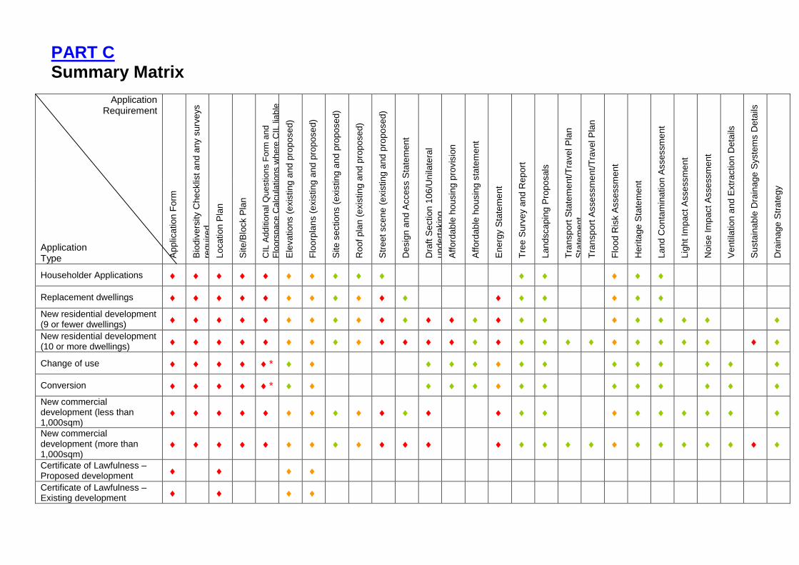
PART C Summary Matrix
Application Requirement
Applic
ation F
orm
Bio
div
ers
ity C
hecklis
t and
any s
urv
eys
requir
ed
Location P
lan
Site/B
lock P
lan
CIL
Ad
ditio
na
l Q
uestio
ns F
orm
an
d
Flo
ors
pace
Calc
ula
tio
ns w
he
re C
IL lia
ble
Ele
vations (
exis
ting a
nd p
roposed)
Flo
orp
lans (
exis
ting a
nd p
roposed)
Site s
ections (
exis
ting a
nd p
roposed)
Roof p
lan (
exis
ting a
nd p
roposed)
Str
eet scene (
exis
ting a
nd p
roposed)
Desig
n a
nd A
ccess S
tate
ment
Dra
ft S
ection
106/U
nila
tera
l
unde
rtakin
g
Afford
able
ho
usin
g p
rovis
ion
Afford
able
ho
usin
g s
tate
ment
Energ
y S
tate
ment
Tre
e S
urv
ey a
nd
Report
Land
scapin
g P
roposals
Tra
nsport
Sta
tem
ent/T
ravel P
lan
Sta
tem
ent
Tra
nsport
Assessm
ent/T
ravel P
lan
Flo
od R
isk A
ssessm
ent
Heri
tage
Sta
tem
ent
Land
Conta
min
ation A
ssessm
ent
Lig
ht Im
pact A
ssessm
ent
Nois
e Im
pact A
ssessm
ent
Ventila
tion a
nd E
xtr
action D
eta
ils
Susta
inable
Dra
inage
Syste
ms D
eta
ils
Dra
inage
Str
ate
gy
Application Type
Householder Applications
Replacement dwellings
New residential development (9 or fewer dwellings)
New residential development (10 or more dwellings)
Change of use *
Conversion *
New commercial development (less than 1,000sqm)
New commercial development (more than 1,000sqm)
Certificate of Lawfulness – Proposed development
Certificate of Lawfulness – Existing development

Listed Building Consent
Advertisement Consent
Outline
Required
Required in most circumstances
Required in some circumstances * Where building no longer in lawful use These details are not exhaustive and applications for major development are likely to require additional supporting information in the form of submissions such as Planning Statement of Statement of Community Involvement. Certain applications may also require specific assessments such as an air quality assessment, retail impact assessment or open space assessment. An Environmental Statement may also be required in accordance with the The Town and Country Planning (Environmental Impact Assessment) Regulations 2017.
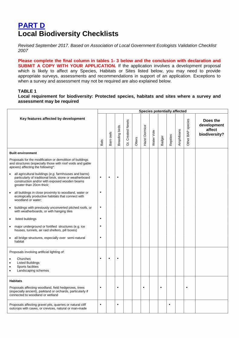
PART D Local Biodiversity Checklists
Revised September 2017. Based on Association of Local Government Ecologists Validation Checklist 2007
Please complete the final column in tables 1- 3 below and the conclusion with declaration and SUBMIT A COPY WITH YOUR APPLICATION. If the application involves a development proposal which is likely to affect any Species, Habitats or Sites listed below, you may need to provide appropriate surveys, assessments and recommendations in support of an application. Exceptions to when a survey and assessment may not be required are also explained below. TABLE 1 Local requirement for biodiversity: Protected species, habitats and sites where a survey and assessment may be required
Key features affected by development
Species potentially affected
Bats
Barn
ow
ls
Bre
edin
g b
irds
Gt. C
reate
d N
ew
ts
Ott
ers
Hazel D
orm
ice
Wate
r V
ole
Badger
Reptile
s
Am
phib
ians
Oth
er
BA
P s
pecie
s
Does the
development affect
biodiversity?
Built environment
Proposals for the modification or demolition of buildings and structures (especially those with roof voids and gable apexes) affecting the following*:
all agricultural buildings (e.g. farmhouses and barns) particularly of traditional brick, stone or weatherboard construction and/or with exposed wooden beams greater than 20cm thick;
all buildings in close proximity to woodland, water or ecologically productive habitats that connect with woodland or water;
buildings with previously unconverted pitched roofs, or with weatherboards, or with hanging tiles
listed buildings
major underground or fortified structures (e.g. ice houses, tunnels, air raid shelters, pill boxes)
all bridge structures, especially over semi-natural habitat
Proposals involving artificial lighting of:
Churches
Listed Buildings
Sports facilities
Landscaping schemes
Habitats
Proposals affecting woodland, field hedgerows, trees (especially ancient), parkland or orchards, particularly if connected to woodland or wetland
Proposals affecting gravel pits, quarries or natural cliff outcrops with caves, or crevices, natural or man-made
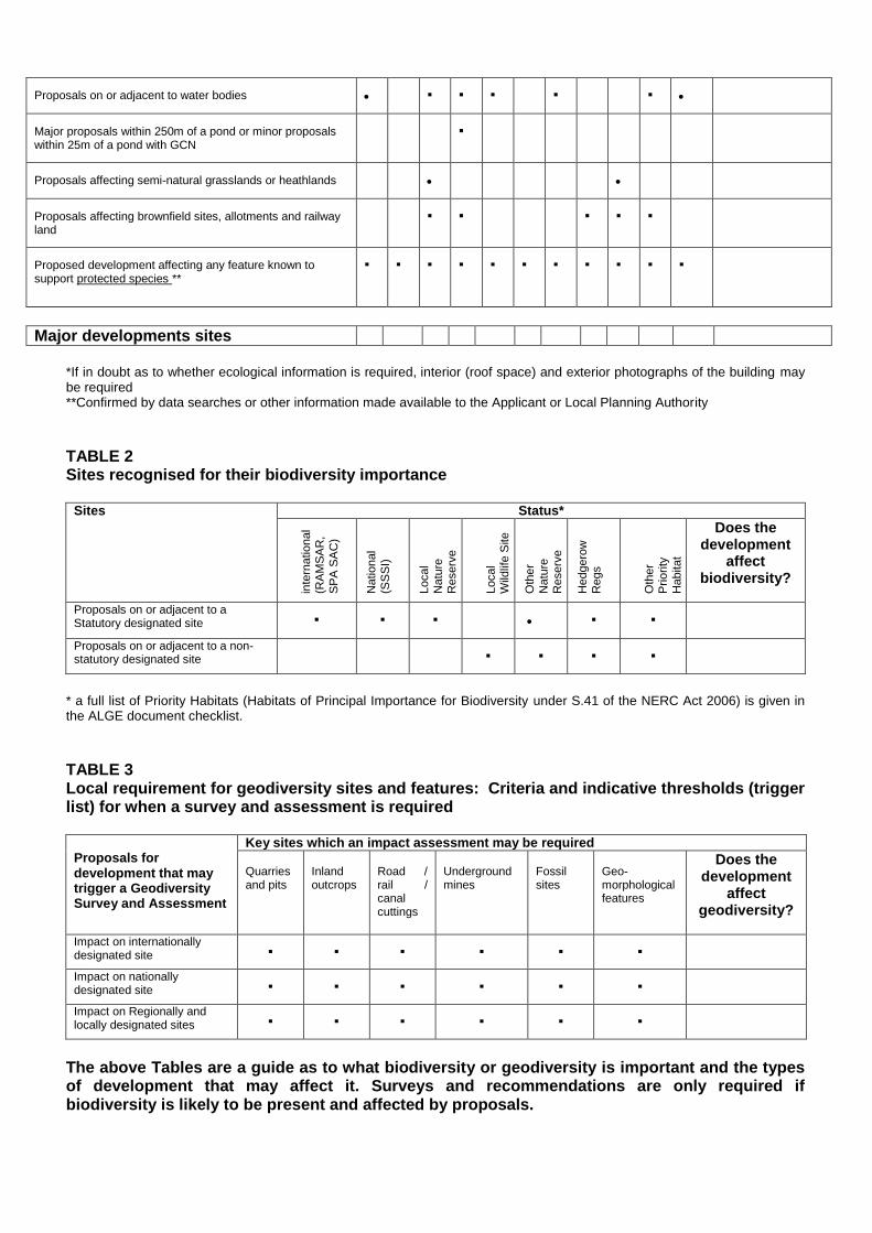
Proposals on or adjacent to water bodies
Major proposals within 250m of a pond or minor proposals within 25m of a pond with GCN
Proposals affecting semi-natural grasslands or heathlands
Proposals affecting brownfield sites, allotments and railway land
Proposed development affecting any feature known to support protected species **
Major developments sites
*If in doubt as to whether ecological information is required, interior (roof space) and exterior photographs of the building may be required **Confirmed by data searches or other information made available to the Applicant or Local Planning Authority
TABLE 2 Sites recognised for their biodiversity importance
Sites
Status*
inte
rnatio
nal
(RA
MS
AR
,
SP
A S
AC
)
Natio
nal
(SS
SI)
Local
Natu
re
Reserv
e
Local
Wild
life S
ite
Oth
er
Natu
re
Reserv
e
Hedgero
w
Regs
Oth
er
Prio
rity
Habitat
Does the development
affect biodiversity?
Proposals on or adjacent to a Statutory designated site
Proposals on or adjacent to a non-statutory designated site
* a full list of Priority Habitats (Habitats of Principal Importance for Biodiversity under S.41 of the NERC Act 2006) is given in the ALGE document checklist.
TABLE 3 Local requirement for geodiversity sites and features: Criteria and indicative thresholds (trigger list) for when a survey and assessment is required
Proposals for development that may trigger a Geodiversity Survey and Assessment
Key sites which an impact assessment may be required Quarries and pits
Inland outcrops
Road / rail / canal cuttings
Underground mines
Fossil sites
Geo- morphological features
Does the development
affect geodiversity?
Impact on internationally designated site
Impact on nationally designated site
Impact on Regionally and locally designated sites
The above Tables are a guide as to what biodiversity or geodiversity is important and the types of development that may affect it. Surveys and recommendations are only required if biodiversity is likely to be present and affected by proposals.
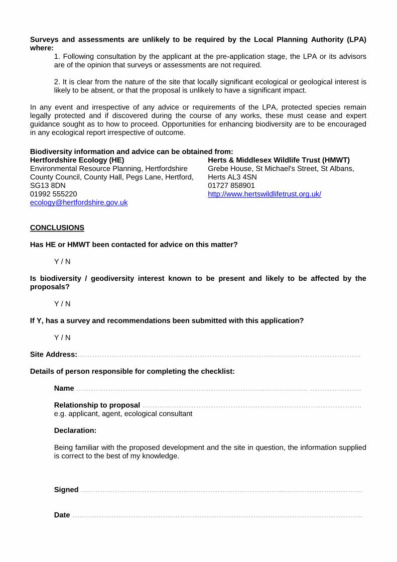
Surveys and assessments are unlikely to be required by the Local Planning Authority (LPA) where:
1. Following consultation by the applicant at the pre-application stage, the LPA or its advisors are of the opinion that surveys or assessments are not required. 2. It is clear from the nature of the site that locally significant ecological or geological interest is likely to be absent, or that the proposal is unlikely to have a significant impact.
In any event and irrespective of any advice or requirements of the LPA, protected species remain legally protected and if discovered during the course of any works, these must cease and expert guidance sought as to how to proceed. Opportunities for enhancing biodiversity are to be encouraged in any ecological report irrespective of outcome.
Biodiversity information and advice can be obtained from: Hertfordshire Ecology (HE) Environmental Resource Planning, Hertfordshire County Council, County Hall, Pegs Lane, Hertford, SG13 8DN 01992 555220 [email protected]
Herts & Middlesex Wildlife Trust (HMWT) Grebe House, St Michael's Street, St Albans, Herts AL3 4SN 01727 858901 http://www.hertswildlifetrust.org.uk/
CONCLUSIONS Has HE or HMWT been contacted for advice on this matter?
Y / N Is biodiversity / geodiversity interest known to be present and likely to be affected by the proposals?
Y / N
If Y, has a survey and recommendations been submitted with this application?
Y / N Site Address:…………………………………………………………………………………………………….. Details of person responsible for completing the checklist:
Name …………………………………………………………………………….……. ………………… Relationship to proposal ……………………………………………….…………………………….. e.g. applicant, agent, ecological consultant Declaration: Being familiar with the proposed development and the site in question, the information supplied is correct to the best of my knowledge. Signed ………………………………………………………………………...………….…….…………
Date ……………………………………………………………………….…………………….…………