Embed Size (px)
Citation preview
Vale District Office 100 Oregon Street
Vale, Oregon 97918-9630http://www.or.blm.gov/Vale/
IN REPLY REFER TO: 1601, LCGMA November 6, 2003
Dear Interested Public:
I am pleased to present the Louse Canyon Geographic Management Area (LCGMA) Evaluation for your review and consideration. This document summarizes the results of the LCGMA rangeland health assessment and evaluation, and presents recommendations to address the assessment findings.
This document ends the assessment and evaluation phase, and outlines a range of alternatives for upcoming NEPA analysis. The decisions that can be expected to flow from the NEPA analysis are activity level decisions, rather than land use level decisions, which may be implemented in accordance with and subject to the guiding land use plan – the Southeastern Oregon Resource Management Plan and Final EIS.
We would appreciate your comments. We are particularly interested in your views on the range of alternatives and preferred alternative recommended. The team has worked diligently to involve the public and include a range of alternatives for analysis that reflect the input received thus far. Of course there have been some recommendations that are outside the scope of the LCGMA Evaluation which are not addressed here in.
We are anxious to begin the NEPA analysis, but first we want to give the interested public the opportunity to comment on the range of alternatives proposed. If you would like to comment, please do so in writing. Address your comments to the Jordan Field Manager, Vale District BLM at the address on the letterhead above. To be considered, your comments must be received in this office by January 1, 2004.
Sincerely,
Jerry L. Taylor Field Office Manager Jordan Resource Area
U.S. Department of the Interior Bureau of Land Management
Vale District Office Jordan Resource Area 100 Oregon Street
Vale, Oregon 97918 Fall 2002
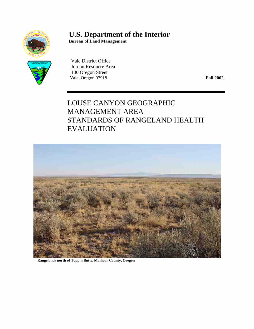
LOUSE CANYON GEOGRAPHIC MANAGEMENT AREA STANDARDS OF RANGELAND HEALTH EVALUATION
Rangelands north of Toppin Butte, Malheur County, Oregon

i Chapter 1 – Background
Table of Contents Executive Summary Chapter 1 - Background
• Describes the origin and definitions of Oregon/Washington Standards of Rangeland Health • Describes Geographic Management Areas (GMA’s) and how they are used as the land base for
ecosystem management that is adaptive under the direction of the Southeastern Oregon Resource Management Plan (SEORMP)
• Describes public scoping, issues identified, and information meetings • Describes rangeland health evaluation criteria used by BLM
Chapter 2 – LCGMA Environment and Resources Description
• Existing environment and assessment results Chapter 3 –LCGMA Rangeland Health Determinations
• Summary of resource conditions observed in specific pastures within grazing allotments; determinations show BLM conclusions on conformance of resource conditions to Oregon/Washington BLM Standards and Guides (S&G’s) and criteria specified in the SEORMP.
Chapter 4 – LCGMA Evaluation Recommendations
Chapter 5 – LCGMA Activity Level Objectives
• Reasonable, attainable, and measurable resource management objectives
Chapter 6 – Proposed Management Alternatives for LCGMA • Potential options for BLM resolution of resource conflicts
Supporting Information
• Appendices • Tables • Maps • Graphs • References
Information on compact disk (CD) • Field data collection forms and digital images taken at each assessment area are organized by
grazing allotment and pasture.
ii Chapter 1 – Background
Table of Contents for Supporting Information Appendix A - Fundamentals of Rangeland Health Appendix B - OR/WA BLM Standards and Indicators for Rangeland Health Appendix C - Ecosystem Management (SEORMP, Chapter 3, pp 141-151) Appendix D - Adaptive Management (SEORMP, Chapter 3, pp 141-151) Appendix E – Calculations of Big Game Forage Demand Appendix F - Public Scoping Information Appendix G – Upland Wildlife Habitat Field Measurements Appendix H – Common and Scientific Names for Plants and Animals Appendix I – Riparian/Wetland Areas and Assessment Methods Appendix J – Landscape Appearance Photo Series Appendix K – Interim Grazing Monitoring Photos Table 1 – Reference (Baseline) Sites Used for Range Health Assessments Table 2 - Allotment Seasons of Use, Active Preferences, Objectives Table 3 - Allotment Actual Use, Utilizations, and Ownership Table 4 - Riparian Proper Functioning Condition Summary Table 5 – Wildlife Habitat - Sagebrush Cover Class Summary Table 6 – Range Improvement Project Summary Table 7 –Interim Grazing Management Use Dates (Beginning in 2002) Table 8 – Riparian Trend Indicators (SEORMP, Volume 2, page 42) Table 9 – Shrub Cover Canopy Classes (SEORMP, Appendix F) Table 10 –Alternative I—Livestock Stocking Levels Calculation Graph 1 - Comparison of wildlife use in crested wheatgrass grasslands and big sagebrush shrublands Graph 2 - Greater sage-grouse leks in Malheur and Jordan Resource Area GMA’s References Map 1 – GMA’s in Jordan Resource Area Map 2 – Grazing Allotments and Pastures Map 3 – Painted Relief, Interior Columbia Basin Management Plan Area Map 4 – Vegetation Types in LCGMA (OAESIS data) Map 5 – Rangeland Health Upland Assessment Sites Map 6 – Rangeland Ecological Condition (OAESIS data) Map 7 – Streams and Proper Functioning Condition Ratings Map 8 – Springs/Seeps and Proper Functioning Condition Ratings Map 9 – Perennial and Fish-bearing Stream Reaches Map 10 – Precipitation Isobars Map 11 – Wilderness Study Areas and Wild and Scenic Rivers Map 12 – Greater Sage-Grouse Lek Locations Map 13 – Altered Vegetation Communities Map 14 – General Soils Map 15 –Alternative I Map 16 –Alternative III Map 17 –Alternative IV
iii Chapter 1 – Background
Executive Summary
This document is an Oregon/Washington Standards of Rangeland Health evaluation for Louse Canyon Geographic Management Area (LCGMA), Jordan Resource Area (JRA), Vale District, Bureau of Land Management (BLM). Resource conditions are described for nearly 523,000 acres of public land. The evaluation pertains to Louse Canyon, Campbell, Anderson, Star Valley Community, Quinn, and Little Owyhee BLM grazing allotments and is based on an interdisciplinary team (ID) field assessment conducted during the summer of 2000. Field data gathered support the following general observations about LCGMA:
• With some localized exceptions, native uplands support healthy, diverse plant communities that have been grazed at conservative stocking levels and at times of the year that allow for rangeland processes to function properly. Water sources for livestock grazing administration are limited in both distribution and abundance for much of the unit.
• Soil compaction resulting from historic grazing use near former homestead areas is probably still
influencing the productivity of lower elevation rangelands. Evidence of accelerated soil erosion is generally absent in upland areas.
• Riparian and wetland habitats that have been grazed during summer and fall (hot season) for the
last several decades are in need of grazing season adjustments in order to attain range health standards. Most riparian and wetland areas with perennial water sources are Functioning at Risk, and accelerated erosion is ongoing in certain stream reaches. Key vegetation components necessary to support proper functioning riparian systems are still present in most areas
• Seedings and brush control projects have influenced about 43,000 acres (approximately 8%) of
LCGMA. Starvation Seeding is the only monotypic (pure grassland habitat with little or no shrub cover) rangeland type present. Substantial sagebrush recolonization has taken place in most treatment areas.
• More than 96% of all sagebrush steppe communities are complex shrubland habitat types capable
of supporting greater sage-grouse and other animals that use sagebrush habitats. Habitat connectivity is excellent and fragmentation from fires and other historic treatments is proportionally low.
• Bald eagles (winter residents) are the only federally listed vertebrate occupying LCGMA. There
are no federal or state listed plants or invertebrates present.
• LCGMA currently supports few noxious and invasive upland plant species. Whitetop invasions are present on the main stem of the Owyhee River and along primary access roads at the present time.
1 Chapter 1 – Background
Chapter 1 – Background A. History and Process for Assessing Rangeland Health Standards Subsequent to the approval of revised BLM grazing regulations in 1995, BLM State Directors were assigned the task of developing state level rangeland health standards (Title 43 Code of Federal Regulations [CFR] 4180.2). The process of developing standards and defining standard indicators was conducted in consultation with BLM Resource Advisory Councils (RAC’s). The purpose for setting standards and identifying their indicators was to provide BLM with a rational basis for determining whether current management is meeting the Fundamentals of Rangeland Health as described under 43 CFR 4180.1. See Appendix A, Fundamentals of Rangeland Health, for a description of objectives and principles underlying rangeland health standards. On August 12, 1997, Interior Secretary Bruce Babbitt approved the Oregon/Washington BLM Standards and Guides (S&G’s) for Rangeland Health. BLM field offices in Oregon/Washington were subsequently directed to conduct assessments and then use that assessment information to craft range health evaluations in relation to the state standards. These sequential actions were therefore used to implement 43 CFR 4180.1 and .2. In order to accomplish this assessment and evaluation workload and conform to the need for completing work on a watershed basis, Jordan Resource Area was divided into eight land based administrative units now referred to as Geographic Management Areas (GMA’s) as shown in Map 1. Each GMA was assigned a boundary and a priority order for assessment based on resource issues such as riparian habitat, wilderness study areas, Wild and Scenic Rivers, wild horses, and presence of special status plants or animals. GMA boundaries correspond to grazing allotment boundaries and substantially overlap with defined watershed subunits. Based on multiple resource values and ongoing management issues needing resolution, the Louse Canyon GMA (LCGMA) was selected to be the first GMA to be assessed in Jordan Resource Area. The boundary identification and assessment priority phase of this process was conducted with public review and comment as a key element of the Southeast Oregon Resource Management Plan (SEORMP) and Environmental Impact Statement (EIS). BLM’s intent is to implement SEORMP objectives in concert with S&G evaluations. The proposed assessment schedule and method of approach was reviewed and approved by the Southeast Oregon RAC on September 29, 1998. The sequence and location of GMA assessments has been described to the public in a BLM letter dated March 3, 1999 (shown in Appendix F of this evaluation). GMA assessments and evaluations represent a continuation of Vale BLM management oversight that has been ongoing for decades. Past assessments and evaluations were referred to as “allotment evaluations”. B. BLM Obligations Prescribed Under Range Health Regulations BLM regulations specify that “the authorized officer shall take appropriate action as soon as practicable but not later than the start of the next grazing year upon determining, through assessment or monitoring
2 Chapter 1 – Background
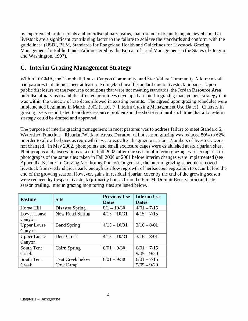
by experienced professionals and interdisciplinary teams, that a standard is not being achieved and that livestock are a significant contributing factor to the failure to achieve the standards and conform with the guidelines” (USDI, BLM, Standards for Rangeland Health and Guidelines for Livestock Grazing Management for Public Lands Administered by the Bureau of Land Management in the States of Oregon and Washington, 1997). C. Interim Grazing Management Strategy Within LCGMA, the Campbell, Louse Canyon Community, and Star Valley Community Allotments all had pastures that did not meet at least one rangeland health standard due to livestock impacts. Upon public disclosure of the resource conditions that were not meeting standards, the Jordan Resource Area interdisciplinary team and the affected permittees developed an interim grazing management strategy that was within the window of use dates allowed in existing permits. The agreed upon grazing schedules were implemented beginning in March, 2002 (Table 7, Interim Grazing Management Use Dates). Changes in grazing use were initiated to address resource problems in the short-term until such time that a long-term strategy could be drafted and approved. The purpose of interim grazing management in most pastures was to address failure to meet Standard 2, Watershed Function—Riparian/Wetland Areas. Duration of hot season grazing was reduced 50% to 62% in order to allow herbaceous regrowth in wet areas after the grazing season. Numbers of livestock were not changed. In May 2002, photopoints and small exclosure cages were established at six riparian sites. Photographs and observations taken in Fall 2002, after one season of interim grazing, were compared to photographs of the same sites taken in Fall 2000 or 2001 before interim changes were implemented (see Appendix K, Interim Grazing Monitoring Photos). In general, the interim grazing schedule removed livestock from wetland areas early enough to allow regrowth of herbaceous vegetation to occur before the end of the growing season. However, gains in residual riparian cover by the end of the growing season were reduced by trespass livestock (primarily horses from the Fort McDermitt Reservation) and late season trailing. Interim grazing monitoring sites are listed below.
Pasture Site Previous Use Dates
Interim Use Dates
Horse Hill Disaster Spring 8/1 – 10/30 4/01 – 7/15 Lower Louse Canyon
New Road Spring 4/15 – 10/31 4/15 – 7/15
Upper Louse Canyon
Bend Spring 4/15 – 10/31 3/16 – 8/01
Upper Louse Canyon
Deer Creek 4/15 – 10/31 3/16 – 8/01
South Tent Creek
Cairn Spring 6/01 – 9/30 6/01 – 7/15 9/05 – 9/20
South Tent Creek
Tent Creek below Cow Camp
6/01 – 9/30 6/01 – 7/15 9/05 – 9/20
3 Chapter 1 – Background
D. Public Involvement Consultation, cooperation, and coordination with both the interested public and grazing permittees are critical components of BLM’s range health assessment and evaluation process. On numerous occasions, BLM has communicated with both groups on range health standards and GMA assessments, by way of mailed written materials, public meetings, and onsite visits within LCGMA. BLM first disclosed the proposed sequence and methods for GMA evaluations to the public as part of the SEORMP scoping process, and therefore GMA evaluations were discussed often with the public prior to the LCGMA assessment. Refer to “Summary of key public involvement events”, SEORMP, Volume 1, pages 668-669. BLM conferred with Malheur County Court regarding the SEORMP on six occasions between January 1996 and April 1997, and sought the Court’s input in public meetings in Vale before and after the LCGMA assessment. BLM consulted with tribal leaders of Fort McDermitt Indian Reservation in McDermitt, Nevada, before and after the assessment. Routine livestock grazing permittee meetings were used as opportunities to further discuss and clarify any issues and concerns that surfaced during LCGMA assessment scoping or as a consequence of information discovered during the assessment. BLM accommodated a request made by Oregon Natural Desert Association (ONDA) and Committee for Idaho’s High Deserts (CIHD) to hold some separate public meetings (where permittees would meet separately from environmentalist groups) to discuss their views and interpretations of the 2000 LCGMA assessment findings. E. Chronology of LCGMA Public Meetings and Field Visits Appendix F, Public Scoping Information, shows a complete record of LCGMA specific public notices, meeting dates, and attendees that are summarized briefly by date below. March 3, 1999 BLM sent a letter to 659 individuals and entities (e.g. federal, state, and county government contacts, and environmental groups) announcing and explaining the process for implementation of new grazing regulations for rangeland health. The letter explained ties to the SEORMP and the sequential GMA process of prioritization, assessment, and evaluation. October 21, 1999 Jordan Resource Area staff and Area Manager Jerry Taylor met with Katie Fite (CIHD) to review resource problems associated with LCGMA. March 8, 2000 Jordan Valley range permittee meeting June 26 and 27, 2000 Formal BLM Public Scoping Meetings were set for public land users to comment and identify issues needing resolution in range health assessments and evaluations. Meetings were held in Vale, OR, Jordan Valley, OR, and McDermitt, NV. Attendees included Bob Kindschy (citizen and member of Southeast

4 Chapter 1 – Background
Oregon RAC), Wayne Bowers (Oregon Department of Fish and Wildlife), Connie Hottell, Larry Hottell, Ernie Hottell (citizens), and the following BLM permittees: Chris Bengoa, Bruce Easterday, Tom Pedroli, and John Albisu. September 2000 BLM flew by helicopter with range permittees Cheryl Anderson, Kimball Wilkinson, and Chris Bengoa into selected riparian areas within Campbell and Louse Canyon Allotments to demonstrate and explain riparian Proper Functioning Condition (PFC) assessment protocols. February 12, 2001 McDermitt range permittee meeting May 30, 2001 Range permittee meeting in McDermitt and Jordan Valley to discuss information collected for the LCGMA assessment and evaluation. May 30, 2001 Range user meeting to discuss range management issues of importance within LCGMA. June 29, 2001 BLM issued a public news release announcing an opportunity to share and discuss information collected for the LCGMA assessment and evaluation. The meeting was temporarily postponed and did not occur until July 12 and 19, 2001. July 12, 2001 BLM public meeting in Vale to discuss resource findings collected during the LCGMA assessment. Attendees included Russ Hursh (Malheur County Judge), Bob Moore (citizen and member of ONDA), and Jim Shake (citizen and member of ONDA). July 17, 2001 Jordan Resource Area interdisciplinary team (ID) conducted a field tour of Proper Functioning Condition stream reach assessment determinations with National Riparian Team member Ronald Wiley. July 19, 2001 BLM public meeting in Vale to discuss resource findings of the LCGMA assessment. Attendees included Bob Moore (citizen and member of ONDA), Jim Shake (citizen and member of ONDA), Gene Bray (citizen and member of Western Watersheds Project) and Katie Fite (citizen and member of CIHD). October, 2001 BLM met and conferred with Fort McDermitt Indian Tribe at the Reservation to explain the 2000 LCGMA assessment findings and review methodologies used to determine range health conditions. November 29, 2001 BLM conducted a meeting in Vale in which LCGMA assessment information was described to fish and wildlife agency representatives from U. S. Fish and Wildlife Service, Oregon Department of Fish and
5 Chapter 1 – Background
Wildlife, and Oregon/Washington BLM State Office. Two representatives from the local Owyhee Watershed Council (Carl Hill and Jennifer Fenwick) also attended. December 19 and 20, 2001 BLM conducted meetings with range permittees to formulate long and short term grazing system adjustments in LCGMA. Meetings were held in McDermitt and Jordan Valley. February 20, 2002 McDermitt range permittee meeting March 14, 2002 Jordan Valley range permittee meeting April 23, 2002 BLM meeting in Vale was set to discuss actions and alternatives for issue resolution in the LCGMA evaluation. October 16, 2002 BLM field tour for permittees and the interested public was conducted to evaluate the effectiveness and impacts of interim grazing management measures in LCGMA for the 2002 grazing season. Members of the interested public from ONDA and CIHD declined to attend a field meeting that included livestock permittees and asked for a separate tour meeting with BLM to review the findings. BLM denied a second separate field meeting due to time limitations and staff workloads. January 27, 2003 McDermitt range permittee meeting February 12, 2003 Jordan valley range permittee meeting F. Oregon/Washington Rangeland Health Standards This evaluation addresses five Oregon/Washington BLM Standards for Rangeland Health, shown below. Appendix B, OR/WA Standards and Indicators for Rangeland Health, reviews the environmental indicators that are considered when each rangeland health standard is assessed.
• Standard 1 – Watershed Function – Uplands: upland soils exhibit infiltration and permeability rates, moisture storage, and stability that are appropriate to soil, climate, and landform.
• Standard 2 – Watershed Function --Riparian/wetland areas: riparian-wetland areas are in properly functioning physical condition appropriate to soil, climate, and landform.
• Standard 3 – Ecological Processes –Uplands: healthy, productive and diverse plant and animal populations and communities appropriate to soil, climate, and landform are supported by ecological processes of nutrient cycling, energy flow, and the hydrologic cycle.
• Standard 4 – Water Quality: surface water and ground water quality, influenced by agency actions, complies with State water quality standards.
6 Chapter 1 – Background
• Standard 5 – Native, Threatened and Endangered (T&E), and Locally Important Species: habitats support healthy, productive, and diverse populations and communities of native plants and animals (including special status species and species of local importance) appropriate to soil, climate, and landform.
G. Adaptive, Ecosystem-Based Management Appendix C, Ecosystem Management, and D, Adaptive Management, explain adaptive, ecosystem-based management as stated in the SEORMP. Both appendices should be read to gain an understanding of how different scales of assessment and management are intended to be carried out over time in Malheur and Jordan Resource Areas of Vale District. Criteria described in Appendix C and D apply to this evaluation. H. Assessment and Evaluation Criteria BLM used a variety of information sources and the professional judgment of senior staff specialists to conduct upland and riparian health assessments. The best available rangeland vegetation and soils maps were consulted and agency-approved technical references and methodology, including protocols outlined in BLM Manual H-4180-1, “Rangeland Health Standards”, were used to arrive at conclusions about range health conditions. Selection of Areas Used for Assessment Determinations Jordan Resource Area ID Team members assessed upland and riparian health based on predominant conditions observed within particular vegetation types. Upland and riparian areas isolated in size or occurrence that were not meeting standards, such as those typically found immediately around livestock watering facilities, were not considered to be indicative of overall range health status for the pasture. Instead, range health assessments (as well as trend plots and other long-term monitoring sites) were based on areas at reasonable distances from livestock water in order to avoid localized heavy-use or ungrazed areas that do not accurately reflect the overall impacts of grazing. Assessment determinations were made after observing as much of the area as possible by foot, vehicle, and aircraft. In BLM’s response to public comments concerning revised range regulations, the selection of representative areas for range health assessment was addressed:
“The Department [of Interior] recognizes that rangelands within a given area may be in functional, healthy conditions even though individual isolated sites do not meet the standards or guidelines. However, the Department believes that general failure to meet the benchmarks across a broader area, such as a typical BLM grazing pasture or BLM allotment, would be reliable evidence that the area is not in healthy, functional condition” [italics added] (43 CFR, Fundamentals of Rangeland Health and Standards and Guidelines for Grazing Administration, Vol. 60, No. 35, Wednesday, February 22, 1995).
Sites selected for upland assessments are shown on Map 5, Rangeland Health Upland Assessment Sites.
7 Chapter 1 – Background
Assessment Methods for Upland Sites Existing Survey Data and Reference Areas Current Ecological Site Inventory (ESI) data are not available for this assessment area. Ecological site potential determinations were based on relatively pristine “reference” sites (referred to as “baseline” in BLM Manual H-4180-1) that have not been substantially impacted by human activities. Sites selected as baseline or reference in LCGMA are listed in Table 1, Reference Sites Used for Rangeland Health Assessments. The ID team used the best available range survey data, which were collected during the late 1970’s (Oregon Automated Ecological Site Information System [OAESIS]), to assure that representative plant communities were visited and assessed in each allotment pasture. OAESIS data were based on Natural Resource Conservation Service (NRCS) standards for range site descriptions. Statewide Order IV soil surveys from 1969 were also used to help interpret observed conditions. Baseline areas were relatively common in many pastures due to historical grazing use patterns and seasons of grazing use. In other words, predominantly conservative stocking levels, grazing use taken after the critical growing season, limited water source availability to distribute livestock use, and large pasture sizes all contributed towards the presence of reference quality areas in LCGMA. In some pastures, quality baseline areas were even found at the edge of existing reservoirs. All baseline areas supported a diverse composition of native grasses, forbs, and shrubs. Assessing Plant Cover, Plant Diversity, and Wildlife Habitat The ID team determined percent plant cover for assessment sites by using three BLM approved methods: line intercept, step-point transects, and ocular estimates (“Sampling Vegetation Attributes”, USDI, BLM Tech. Ref. 1734-4, 1996). Initially, the line intercept method alone was used to determine percent cover of vegetation at each assessment site. Due to time constraints, the ID team chose to sample rangeland with a combination of 500 point step-point transects and ocular estimates. Ocular estimates were made on the basis of experience gained from conducting step-point and line intercept measures. In other words, actual detailed measurements were used as the method of “calibration” for ocular estimates. For each assessment site, vegetation data and observations concerning the site’s physical integrity were recorded on worksheets derived from “Interpreting Indicators of Rangeland Health”, USDI, BLM Tech. Ref. 1734-6 (2000). These worksheets included Rangeland Health Evaluation Summary, Ground Cover, Species Dominance, and Degree of Departure from Ecological Site Description, and/or Ecological Reference Area(s). Copies of worksheets with data for each LCGMA assessment site are included on the compact disk provided with this document. In order to assess suitability of upland range for terrestrial wildlife values, BLM also measured vegetation attributes that affect wildlife security and production. These attributes included the heights of sagebrush overstories and bluebunch wheatgrass understories, and the distribution of sagebrush canopy classes as described in the SEORMP (Table 9, Shrub Canopy Cover Classes). In addition, about 180 digital images of upland habitat were taken, a subset of which were used as a representative Landscape Appearance Photo Series (Appendix J, Photos). See Appendix G, Upland Wildlife Habitat Field Measurements, for more detailed descriptions of methods. Long-Term Rangeland Trend Studies Long term upland trend studies, consisting of 100 foot line intercept transects and 3’ by 3’ photo plots, were re-read as part of the assessment process. Over the last decades, these studies have been established
8 Chapter 1 – Background
in Vale District in order to determine whether key grass species most influenced by grazing were showing evidence of basal cover increases (upward trend), decreases (downward trend), or non-significant change (not apparent trend). These methods conform to current interagency monitoring guidance (“Sampling Vegetation Attributes”, USDI, BLM Tech. Ref. 1734-4, 1996). Upland trend determinations are based on several factors that influence vigor and reproduction of grasses. These factors include precipitation timing and amount; patterns of livestock use; permittee records submitted as actual use (numbers of livestock and number of days livestock actually grazed in a pasture); annual grazing utilization surveys; changes visible from trend plot photos; changes in plant cover indicated in 3’ X 3’ trend plots; changes in plant cover under line intercept transects; impacts from plant disease or insects; and professional judgment. Because so many factors influence plant health, professional judgment is used to take all these considerations into account and arrive at a final conclusion. Riparian Trend for Proper Functioning Condition (PFC) Assessments Riparian trend is determined by comparing the present situation with previous photos, trend studies, inventories, and any other documentation or personal knowledge existing prior to the PFC assessment. If information prior to the assessment is lacking, indicators of “apparent trend” may be deduced during the assessment process. Presence or absence of riparian/wetland species that correlate with soil moisture characteristics can be especially useful. However, care must be taken to relate these indicators to recent climatic conditions as well as management. If insufficient evidence exists to allow recognition of a trend toward PFC (upward) or away from PFC (downward), then trend is considered to be “not apparent” (BLM, TR 1737-15, 1998, p20). Water Quality Assessment The quality of the water yielded by a watershed is determined by physical and chemical properties of the geology and soils unique to the watershed, the prevailing climate and weather patterns, current resource conditions, current land uses, and quality of management of those uses. Assessments of upland rangelands for Rangeland Health Standards 1 and 3, and riparian area assessments for Standard 2, have direct relevance to evaluation of Standard 4 (Water Quality). For streams that lack specific water quality data, the Interdisciplinary Team evaluated pertinent data from all sources available, including information gathered for Standards 1, 2, and 3, to make a final determination for the assessment of the water quality standard. I. Supporting Documents
Documents used as reference material for this assessment are shown in References. In addition, some of these documents are posted on the Vale District internet web site: http://www.or.blm.gov/Vale/Range/range-index.htm

Chapter 2 – LCGMA Environment and Resources Description
A. General
Louse Canyon GMA occupies nearly 523,000 acres of public land located in the southeastern corner of Malheur County, OR. This area is administered by Jordan Resource Area, Vale District, BLM (Map 1, Geographic Management Areas and Map 2, Grazing Allotments and Pastures) and is bordered by Nevada and Idaho to the south and east, by Main Fork Owyhee River on the northeast, and by Fort McDermitt Indian Reservation to the southwest. McDermitt, Nevada (pop. 400) is the nearest community.
Two allotments, the Quinn River and Little Owyhee, include approximately 11,240 acres in Nevada and are contiguous with the Louse Canyon Community and Star Valley Community Allotments, respectively. Grazing in these Nevada allotments is administered by the Vale District Office via an agreement with Winnemucca District, BLM, effective April 30, 1968. Because the Quinn River and Little Owyhee allotments are not fenced separately from the Oregon allotments, grazing use is the same as in adjoining Louse Canyon and Star Valley Community allotments.
Elevations in LCGMA range from about 4,000 feet near Five Bar on Main Fork Owyhee River to 6,440 feet at Horse Hill in the southwestern quarter (Map 3, Painted Relief of Interior Columbia Basin Ecosystem Management Area). The GMA averages 5,000-6,000 feet in elevation.
Louse Canyon GMA encompasses portions of 9 watersheds which are components primarily of Middle Owyhee and East Little Owyhee subbasins, with minor portions in three other subbasins (South Fork Owyhee, Crooked-Rattlesnake, and Upper Quinn). The GMA has open, rolling topography with steep canyon descents into major drainages such as the Owyhee River, West Little Owyhee River, and Antelope Creek. Headwaters of these streams arise at about 6,000 feet to the southwest and are characterized by open meadows with springs. As the streams flow to the north and east, their channels cut down through rhyolites and basalts, forming spectacular dissected canyons.
Refer to Appendix J, Photos, for a series of representative landscape photos taken in LCGMA riparian and upland communities.
B. Climate
Climate in this semiarid area is influenced by maritime air moving east from the Pacific Ocean over the Sierra and Cascade Mountain ranges. As air masses rise to cross these mountains, moisture condenses and falls, making the air relatively dry by the time it reaches this corner of southeastern Oregon.
Average annual precipitation in LCGMA ranges between 8 and 22 inches (Map 10, Precipitation Isobars). As recorded at the McDermitt, Nevada, weather station, most precipitation (51 percent), occurs from March through June. About 21 percent occurs from September through November and 21 percent from December through February, most of this falling as snow.
1 Chapter 2 – LCGMA Environment and Resources Description
Snowpack usually melts by April at elevations below 6,000 feet, with snow at higher elevations remaining until mid-June. Localized flooding often follows late winter or spring snowmelt. The amount of precipitation in any particular location within the GMA depends on topography— precipitation increases with elevation. Some precipitation occurs as thunderstorms, occasionally accompanied by hail, with isolated high-intensity, short-duration thunderstorms occurring frequently between April and October. Storms that occur July through August are typically drier with more lightning strikes than those in September or October.
Total annual precipitation in the area varies greatly by year which is shown by Crop Year (CY) precipitation data recorded between 1961 and 2002. To calculate CY precipitation, the last four months of the previous year are added to the first six months of the current year. The lowest CY precipitation occurred in 1966 (3.05 inches) while the highest was in 1984 (14.28 inches). Below average precipitation occurred during two intervals, 1988-1992 (CY precipitation = 5.95-8.63 inches) and 1999-2002 (CY precipitation = 4.55-8.47 inches), with above average precipitation occurring from 1993-1998 (CY precipitation = 9.32-11.94 inches) between the two droughty cycles.
This area also receives an abundance of sunshine and air temperatures have wide daily fluctuations. Generally, the last spring frost occurs in late May and first frost by early September. The frost-free period (temperatures above 32 o F) varies from approximately 139 days at lower elevations to 74 days at higher elevations. However, frost may occur during any month of the year.
Prevailing winds are west-southwest, with the most intense winds occurring during March and April. December and January are usually the calmest months.
C. General Description of Rangeland Vegetation
Native Rangelands LCGMA falls within sagebrush steppe communities of the Snake River Plain (Miller and Eddleman 2000) and predominantly supports sagebrush/grass communities. (Map 4, Vegetation Types). There are no forest habitat types present, although the western edge of Idaho’s juniper woodlands are scattered within parts of the unit. Quaking aspen and occasional narrowleaf cottonwoods are found in the headwater and rim areas of several watersheds.
Predominant shrubs in the GMA are Wyoming big sagebrush, two species of low sagebrush (A. arbuscula, and A. longiloba), green and gray rabbitbrush, shadscale, horsebrush, and spiny hopsage. Mountain sagebrush is present but only as a subdominant type or in scattered communities at upper elevations. Basin big sagebrush occurs in low elevations in association with certain major drainages. Dominant perennial grasses include bluebunch wheatgrass, Idaho fescue, bottlebrush squirreltail, Sandberg bluegrass, crested wheatgrass, and Thurber’s needlegrass. Common forb species include phlox, penstemon, hawksbeard, aster, fleabane, buckwheat, biscuit root, onion, and milk-vetch.
Generally, the GMA’s southwest portion (about 25% of total land area) is dominated by the two species of low sagebrush and Idaho fescue/bluebunch wheatgrass habitat types while the remainder of the GMA is predominately Wyoming big sagebrush and bluebunch wheatgrass
2 Chapter 2 – LCGMA Environment and Resources Description
types (Map 4). Scattered communities of mountain shrubs, such as mountain mahogany and snowberry, occur at high elevations near the Nevada state line. Salt desert shrub habitat types interspersed with drier phases of Wyoming big sagebrush types typically occur at low elevations areas such as the southeastern GMA corner. These drier Wyoming big sagebrush communities have understories of bottlebrush squirreltail, Sandberg bluegrass, and Thurber’s needlegrass, whereas understories in the wetter Wyoming big sagebrush types are primarily bluebunch wheatgrass, Idaho fescue, and Sandberg bluegrass.
Modified Rangelands Crested wheatgrass seedings occupy about 5% of LCGMA (Map 13). The three seeded pastures are Starvation Seeding (14,000 seeded acres or 96% of pasture), Steer Canyon Seeding (6,300 seeded acres or 56% of pasture) and Pole Creek Seeding (4,000 seeded acres or 26% of pasture).
Seedings and brush control projects were completed during the Vale Project era that spanned a period from 1962 to1973. The Vale Project was a major range rehabilitation effort that was politically and financially supported by the US Congress. About 10 million dollars were expended to improve rangeland conditions and increase forage production for livestock and wildlife, primarily through construction of water developments, fencing public land into manageable grazing units, and creation of a reliable forage base in those rangelands that were severely depleted from decades of improper grazing use.
Starvation Seeding has a grassland appearance and, except for a trace of Sandberg bluegrass and Wyoming big sagebrush, few plant species other than crested wheatgrass are present (Photo 10, Appendix J). The other two seedings have greater plant diversity and support Wyoming big sagebrush, rabbitbrush, spiny hopsage, bottlebrush squirreltail, bluebunch wheatgrass, Sandberg bluegrass, asters, buckwheats, and annual mustards.
Vale Project was also involved in removing shrubs from rangelands in an effort to create forage for livestock and wildlife. In Campbell Allotment, 20,000 acres of Starvation Brush Control Pasture were sprayed with the herbicide 2, 4-D but were not seeded. Sagebrush recolonization has occurred within this treatment area and has now established a 14-16% canopy cover (Photo 12, Appendix J).
D. Grazing Allotments
Introduction Public lands within the GMA are an important source of annual forage for five permittees in four grazing allotments (Map 2). Table 2 (Allotment Active Preferences and RPS Objectives) and Table 3 (Allotment Actual Use, Utilizations, Production, and Ownership) provide specific information for these allotments. Table 2 gives Rangeland Program Summary (RPS) objectives and active preference (Animal Unit Months, or AUMs). Table 3 shows monitoring data for each pasture (from 1978 to 2001), including utilization and actual use. All acreages for allotment and pasture data were derived from the Vale District BLM Geographical Information System (GIS), which is periodically updated with new data as it becomes available. GIS data for all rangeland grazing use calculations are from years 1997, 2000, and 2001.
Louse Canyon GMA permittees with their current grazing preferences are shown below:
3 Chapter 2 – LCGMA Environment and Resources Description
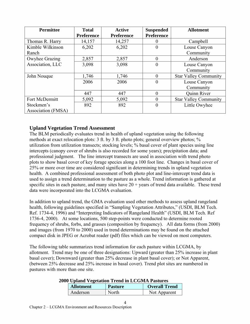
Permittee Total Preference
Active Preference
Suspended Preference
Allotment
Thomas R. Harry 14,157 14,257 0 Campbell Kimble Wilkinson Ranch
6,202 6,202 0 Louse Canyon Community
Owyhee Grazing 2,857 2,857 0 Anderson Association, LLC 3,098 3,098 0 Louse Canyon
Community John Nouque 1,746 1,746 0 Star Valley Community
2006 2006 0 Louse Canyon Community
447 447 0 Quinn River Fort McDermitt 5,092 5,092 0 Star Valley Community Stockmen’s Association (FMSA)
892 892 0 Little Owyhee
Upland Vegetation Trend Assessment The BLM periodically evaluates trend in health of upland vegetation using the following methods at exact relocation plots: 3 ft. by 3 ft. photo plots; general overview photos; % utilization from utilization transects; stocking levels; % basal cover of plant species using line intercepts (canopy cover of shrubs is also recorded for some years); precipitation data; and professional judgment. The line intercept transects are used in association with trend photo plots to show basal cover of key forage species along a 100 foot line. Changes in basal cover of 25% or more over time are considered significant in determining trends in upland vegetation health. A combined professional assessment of both photo plot and line-intercept trend data is used to assign a trend determination to the pasture as a whole. Trend information is gathered at specific sites in each pasture, and many sites have 20 + years of trend data available. These trend data were incorporated into the LCGMA evaluation.
In addition to upland trend, the GMA evaluation used other methods to assess upland rangeland health, following guidelines specified in “Sampling Vegetation Attributes,” (USDI, BLM Tech. Ref. 1734-4, 1996) and “Interpreting Indicators of Rangeland Health” (USDI, BLM Tech. Ref 1736-4, 2000). At some locations, 500 step-points were conducted to determine rooted frequency of shrubs, forbs, and grasses (composition by frequency). All data forms (from 2000) and images (from 1970 to 2000) used in trend determinations may be found on the attached compact disk in JPEG or Acrobat reader (pdf) files which can be viewed on most computers.
The following table summarizes trend information for each pasture within LCGMA, by allotment. Trend may be one of three designations: Upward (greater than 25% increase in plant basal cover); Downward (greater than 25% decrease in plant basal cover); or Not Apparent, (between 25% decrease and 25% increase in basal cover). Trend plot sites are numbered in pastures with more than one site.
2000 Upland Vegetation Trend in LCGMA Pastures Allotment Pasture Overall Trend Anderson North Not Apparent
4 Chapter 2 – LCGMA Environment and Resources Description

Allotment Pasture Overall Trend Bull Flat Not Apparent Spring Not Apparent
Louse Canyon Community
Drummond Basin Upward
Steer Canyon Seeding
Native - Not Apparent Seeding -Downward
Pole Creek Seeding
1. Not Apparent 2. Not Apparent
Louse Canyon Not Apparent
Star Valley Community
North Stony Corral Not Apparent
North Tent Creek Not Apparent
Tristate Not Apparent
South Tent Creek Upward
Campbell Peacock Not Apparent
Twin Springs Not Apparent
Sacramento Hill Not Apparent Starvation Seeding Not Apparent
Starvation Brush Control Not Apparent
Horse Hill 1. Not Apparent 2. Not Apparent 3. Not Apparent
Ambrose Maher Ambrose Maher Not Apparent
Key Forage Plant Code for Upland Trend The following codes are used in this document for common forage grasses that appear in trend plots and studies.
Common Name Genus and Species Code
Bluebunch wheatgrass AGSP Idaho fescue FEID Bottlebrush squirreltail SIHY Thurber’s needlegrass STTH
5 Chapter 2 – LCGMA Environment and Resources Description
Crested wheatgrass AGCR Sandberg bluegrass POSE
Data for Individual Allotments and Pastures Specific data for allotments and pastures are given below, including range improvement projects, grazing usages, and rationales for vegetation trend based on monitoring studies.
(a) Anderson Allotment (# 01401)
Background Anderson Allotment is divided into three pastures grazed March 1 to July 31. The Southern Malheur Rangeland Program Summary (RPS) of 1986 indicated an active preference of 2,964 AUMs for Anderson Allotment and a proposed RPS livestock allocation of 6,564 AUMs. In accordance with Civil No. 97-98-RE: Order of Modified Injunction (see Section M., Owyhee River Litigation), portions of this allotment which allowed livestock access to areas of concern on the West Little Owyhee and Upper Main Owyhee Wild and Scenic Rivers were closed to livestock grazing, and permitted use was reduced to 2,857 AUMs of active preference.
Rangeland Health Standard 3 (Ecological Processes--Uplands) Uplands within Anderson Allotment currently support an ecologically functioning vegetative community with diverse structure and composition of perennial grasses, forbs, and shrubs. Impacts to uplands from livestock grazing are localized, very limited in extent, and are not detrimental to the ecological function and sustainability of the existing vegetative community. Assessment data showed that all pastures in Anderson Allotment met Rangeland Health Standard 3 (Ecological Processes). See Chapter 3, Rangeland Health Determinations, for specific assessment results for each pasture. Rangeland Health Standard 1 (Watershed Function— Uplands) is discussed in Section Q., Soil Resources.
Current Grazing System Due to inadequate late season water availability, the current permitted season from March 1 to July 31 results in slight to light levels of utilization when livestock water is available. Annual turnout statements are being used to set specific pasture use periods within the permitted dates. The basic pasture rotation for Anderson Allotment is as follows:
Pasture Season North 3/1 – 3/31
Bull Flat 4/1 – 7/31 Spring 4/1 –7/31
Summary of Actual Livestock Use and Utilization Data Actual use data has been gathered annually since 1979, but has not been reported by individual pasture. Most reports have combined AUM use for the allotment as a whole rather than by pasture. Actual use for Anderson Allotment is:
6 Chapter 2 – LCGMA Environment and Resources Description
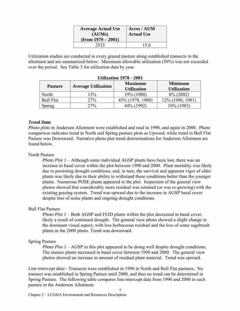
Average Actual Use Acres / AUM (AUMs) Actual Use
(from 1979 – 2001) 2533 15.6
Utilization studies are conducted in every grazed pasture along established transects in the allotment and are summarized below. Maximum allowable utilization (50%) was not exceeded over the period. See Table 3 for utilization data by year.
Utilization 1978 - 2001
Pasture Average Utilization Maximum Utilization
Minimum Utilization
North 13% 19% (1980) 8% (2002) Bull Flat 27% 43% (1978, 1988) 12% (1980, 1981) Spring 27% 44% (1992) 10% (1983)
Trend Data Photo plots in Anderson Allotment were established and read in 1990, and again in 2000. Photo comparison indicates trend in North and Spring pasture plots as Upward, while trend in Bull Flat Pasture was Downward. Narrative photo plot trend determinations for Anderson Allotment are found below.
North Pasture Photo Plot 1 – Although some individual AGSP plants have been lost, there was an increase in basal cover within the plot between 1990 and 2000. Plant mortality was likely due to persisting drought conditions, and, in turn, the survival and apparent vigor of older plants was likely due to their ability to withstand these conditions better than the younger plants. Numerous POSE plants appeared in the plot. Inspection of the general view photos showed that considerably more residual was retained (or was re-growing) with the existing grazing system. Trend was upward due to the increase in AGSP basal cover despite loss of some plants and ongoing drought conditions.
Bull Flat Pasture Photo Plot 1 – Both AGSP and FEID plants within the plot decreased in basal cover, likely a result of continued drought. The general view photo showed a slight change in the dominant visual aspect, with less herbaceous residual and the loss of some sagebrush plants in the 2000 photo. Trend was downward.
Spring Pasture Photo Plot 1 – AGSP in this plot appeared to be doing well despite drought conditions. The mature plants increased in basal cover between 1990 and 2000. The general view photos showed an increase in amount of residual plant material. Trend was upward.
Line-intercept data - Transects were established in 1990 in North and Bull Flat pastures. No transect was established in Spring Pasture until 2000, and thus no trend can be determined in Spring Pasture. The following table compares line-intercept data from 1990 and 2000 in each pasture in the Anderson Allotment.
7 Chapter 2 – LCGMA Environment and Resources Description
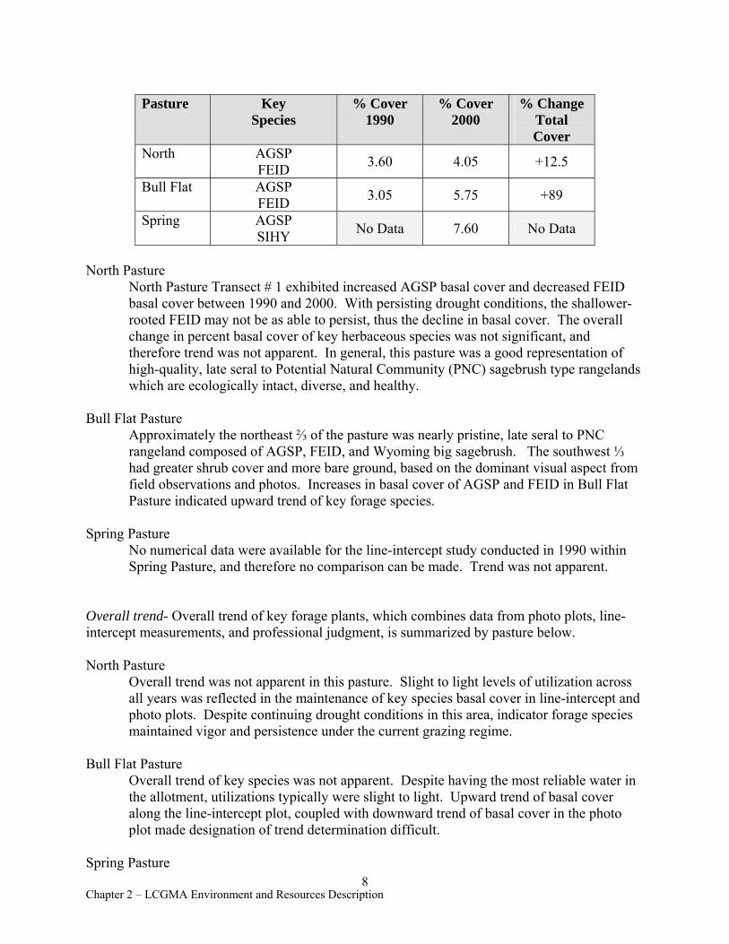
Pasture Key Species
% Cover 1990
% Cover 2000
% Change Total Cover
North AGSP FEID 3.60 4.05 +12.5
Bull Flat AGSP FEID 3.05 5.75 +89
Spring AGSP SIHY No Data 7.60 No Data
North Pasture North Pasture Transect # 1 exhibited increased AGSP basal cover and decreased FEID basal cover between 1990 and 2000. With persisting drought conditions, the shallower-rooted FEID may not be as able to persist, thus the decline in basal cover. The overall change in percent basal cover of key herbaceous species was not significant, and therefore trend was not apparent. In general, this pasture was a good representation of high-quality, late seral to Potential Natural Community (PNC) sagebrush type rangelands which are ecologically intact, diverse, and healthy.
Bull Flat Pasture Approximately the northeast ⅔ of the pasture was nearly pristine, late seral to PNC rangeland composed of AGSP, FEID, and Wyoming big sagebrush. The southwest ⅓ had greater shrub cover and more bare ground, based on the dominant visual aspect from field observations and photos. Increases in basal cover of AGSP and FEID in Bull Flat Pasture indicated upward trend of key forage species.
Spring Pasture No numerical data were available for the line-intercept study conducted in 1990 within Spring Pasture, and therefore no comparison can be made. Trend was not apparent.
Overall trend- Overall trend of key forage plants, which combines data from photo plots, line-intercept measurements, and professional judgment, is summarized by pasture below.
North Pasture Overall trend was not apparent in this pasture. Slight to light levels of utilization across all years was reflected in the maintenance of key species basal cover in line-intercept and photo plots. Despite continuing drought conditions in this area, indicator forage species maintained vigor and persistence under the current grazing regime.
Bull Flat Pasture Overall trend of key species was not apparent. Despite having the most reliable water in the allotment, utilizations typically were slight to light. Upward trend of basal cover along the line-intercept plot, coupled with downward trend of basal cover in the photo plot made designation of trend determination difficult.
Spring Pasture 8
Chapter 2 – LCGMA Environment and Resources Description
Pasture Season Peacock Rest (year 1)
3/01--6/15 (year 2)
Overall trend was not apparent in Spring Pasture. Lack of data from the line-intercept transect for 1990, slight to light utilization across years, and upward photo-plot trend did not yield a clear trend in basal cover of key species or trend in conditions toward or away from established objectives.
Range Improvement Projects Anderson Allotment had 17 range improvement projects (15 reservoirs, 2 fences) all in good functional condition. One reservoir provided little livestock water due to poor catchment of runoff. The boundary fence between Bull Flat and Spring pastures did not prevent livestock movement due to numerous gaps in the rimrock along Toppin Creek. This fence never extended to these gaps. See Table 6, Range Improvement Project Summary, for more information.
(b) Campbell Allotment (#11306)
Background Campbell Allotment is divided into six pastures grazed March 1 to September 30 by one permittee. The RPS showed Campbell Allotment to have an active preference of 14,514 AUMs and a proposed RPS livestock allocation of 35,064 AUMs. In accordance with Civil No. 97-98RE: Order of Modified Injunction (Section L., Owyhee River Litigation), portions of this allotment which allowed access to the West Little Owyhee Wild and Scenic River were closed to livestock grazing, and permitted use was reduced to 14,157 AUMs of active preference.
Rangeland Health Standard 3 (Ecological Processes--Uplands) Uplands within Campbell Allotment currently support an ecologically functioning vegetative community with diverse structure and composition of perennial grasses, forbs, and shrubs. Impacts to uplands due to livestock grazing were localized, very limited in extent, and were not detrimental to ecological function and sustainability of the existing vegetative community. Assessment data showed that pastures in Campbell Allotment were meeting Rangeland Health Standard 3, with the exception of Starvation Seeding Pasture which was seeded with non-native crested wheatgrass. The seeding lacks forbs and diversity of herbaceous species, and was dominated by AGCR and POSE. Starvation Seeding is currently being managed as a relief pasture to ensure proper use of the native pastures in the allotment. See Chapter 3, Rangeland Health Determinations, for specific assessment results for each pasture. Rangeland Health Standard 1 (Watershed Function—Uplands) is discussed in Section Q., Soil Resources.
Current grazing system Permitted grazing use in Campbell Allotment is consistent with the Campbell Allotment Management Plan (1971). The grazing schedule for each pasture is listed in the table below. Larribeau Pasture, listed below, is composed of two distinct areas. Only the eastern part of Larribeau Pasture was assessed because the western portion was outside the assessment area. Larribeau Pasture is used for short-term holding and trailing in the late fall and has no trend or utilization information. Another pasture, the FFR (Fenced Federal Range), lies completely outside the current assessment boundary.
9 Chapter 2 – LCGMA Environment and Resources Description
Twin Springs 3/01--6/15 (year 1) Rest (year 2)
Sacramento Hill 3/01 – 6/15 (year 1 and 2) (first calf heifers) Rest (year 3)
Starvation Brush Control 6/01--9/01 (year 1) 7/15--9/01 (year 2)
Starvation Seeding 7/15--9/01 (year 1) 6/01--9/01 (year 2)
Horse Hill 8/01 – 10/30 (annually) Larribeau Trailing - 9/01--10/31 (annually)
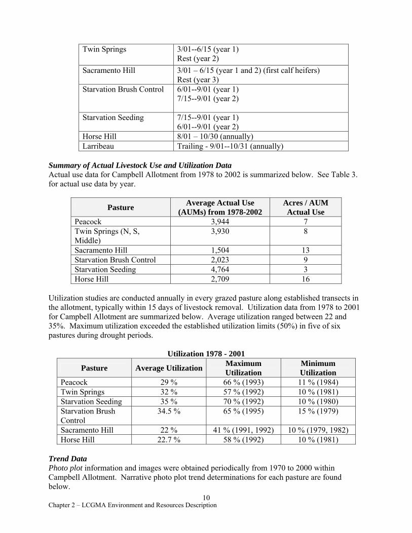
Summary of Actual Livestock Use and Utilization Data Actual use data for Campbell Allotment from 1978 to 2002 is summarized below. See Table 3. for actual use data by year.
Pasture Average Actual Use (AUMs) from 1978-2002
Acres / AUM Actual Use
Peacock 3,944 7 Twin Springs (N, S, Middle)
3,930 8
Sacramento Hill 1,504 13 Starvation Brush Control 2,023 9 Starvation Seeding 4,764 3 Horse Hill 2,709 16
Utilization studies are conducted annually in every grazed pasture along established transects in the allotment, typically within 15 days of livestock removal. Utilization data from 1978 to 2001 for Campbell Allotment are summarized below. Average utilization ranged between 22 and 35%. Maximum utilization exceeded the established utilization limits (50%) in five of six pastures during drought periods.
Utilization 1978 - 2001
Pasture Average Utilization Maximum Utilization
Minimum Utilization
Peacock 29 % 66 % (1993) 11 % (1984) Twin Springs 32 % 57 % (1992) 10 % (1981) Starvation Seeding 35 % 70 % (1992) 10 % (1980) Starvation Brush Control
34.5 % 65 % (1995) 15 % (1979)
Sacramento Hill 22 % 41 % (1991, 1992) 10 % (1979, 1982) Horse Hill 22.7 % 58 % (1992) 10 % (1981)
Trend Data Photo plot information and images were obtained periodically from 1970 to 2000 within Campbell Allotment. Narrative photo plot trend determinations for each pasture are found below.
10 Chapter 2 – LCGMA Environment and Resources Description

Peacock Pasture Photo Plot 1 – While photos from 1990, 1995, and 2000 showed basal plant cover in the plot to have increased somewhat, general view photos did not show a notable difference in litter, shrub, grass, and crust cover across all years. Trend at this site was not apparent.
Photo Plot 2 – Key perennial forage species appeared healthy and were persisting under drought conditions. Basal cover increased. Photos of the immediate area show many dying sagebrush, but grasses appeared healthy and maintained basal cover on the site in general. Trend at this site was upward.
Twin Springs Photo Plot 1 – This plot, established in 1970, maintained its perennial plant basal cover. General view photos also did not change between years 1990, 1995, and 2000. Trend was not apparent.
Sacramento Hill Photo Plot 1 – No changes in plant basal cover in this plot were apparent over time, although amount of residual herbaceous canopy cover increased. Trend of this plot was not apparent.
Starvation Brush Control Photo Plot 2 – Basal plant cover in this plot has decreased since establishment of the monitoring site in 1978. While perennial grass plants have survived, they exhibited low vigor, likely a product of drought. Trend was downward.
Starvation Seeding Photo Plot 4 – Mature AGCR plants on the site maintained their health and vigor despite drought conditions, although one seedling died between 1995 and 2000. Trend was not apparent.
Horse Hill Photo Plot 1 – FEID here was in better condition in 2000 than in 1995 despite drought conditions. However, basal cover of other perennial herbaceous species was unchanged between 1990 and 2000. Trend of this plot was not apparent.
Photo Plot 2 – The photo of this plot taken in 1970 showed greater canopy cover of shrubs and residual cover of herbaceous species than in 2000. Drought conditions likely have influenced plant health. However, basal cover of the plants showed no net gain or loss. Trend indicated was not apparent.
Photo Plot 3 – AGSP only slightly increased in basal size, with much of the previous year’s growth still present. SIHY, while having greatly reduced bases compared to 1970 photos, were persisting. Trend of this plot was not apparent.
Line-intercept data – The following table compares line-intercept data for the years 1982, 1987, 1990, and 2000 in each pasture within Campbell Allotment.
11 Chapter 2 – LCGMA Environment and Resources Description
Line Intercept Trend Data-Campbell Allotment
Pasture Transect Plot #
Key Species
% Cover 1982
% Cover 1987
% Cover 1990
% Cover 1995
% Cover 2000
% Change Total Cover
Short-Term
Change1
Long-Term
Change2
Peacock 1 AGSP SIHY 1.11 1.20 1.55 0.50 0.60 +20 -46
2 AGSP SIHY
No Data 1.55 No
Data 0.55 1.15 +109 -26
Twin Springs 1 AGSP
SIHY 1.16 0.95 0.15 0.25 0.25 0 -78
Sacramento Hill 1 AGSP
SIHY 3.27 2.90 3.20 3.95 5.40 +37 +65
Starvation Seeding 1 AGCR
SIHY No
Data 12.4 6.8 6.85 11.55 +69 -7
Starvation Brush
Control
1 AGSP SIHY
No Data 2.30 No
Data No
Data 10.10 No
Data +339
2 AGSP SIHY
No Data
No Data
No Data 0.90 4.90 +444 No
Data
Horse Hill
1 FEID SIHY 0.61 1.20 1.30 0.75 0.85 +13 +39
2 SIHY 0.5 No Data
No Data 0.2 0.2 0 -60
3 AGSP FEID SIHY
0.93 1.30 1.65 1.65 0.4 -76 -57
1Short term change compares key species % cover between 2000 and 1995. 2 Long term change compares key species % cover between 2000 and 1982, or the earliest year of data.
Peacock Pasture Trend data was available for two transects for this pasture. Between 1995 and 2000, Plot 1 showed a minor increase in basal cover but the increase was not significant; in Plot 2 both AGSP and SIHY increased, indicating upward trend. Relative to 1987, however, the long trend in both transects was downward. Effects of drought appeared to have impacted these sites. A major drought period for eastern Oregon lasted between 1987 and 1993.
Twin Springs Pastures (Middle, North, South) Trend data were available at one site for Twin Springs North Pasture only. Long term trend was downward between 1982 and 1990, but between 1995 and 2000 basal cover of AGSP was maintained and short term trend was not apparent.
Sacramento Hill
12 Chapter 2 – LCGMA Environment and Resources Description
Line-intercept data indicated a moderate increase in AGSP basal cover since 1987. SIHY plants along the transect had disappeared, however. A moderate increase in basal cover of AGSP and the minimal loss of basal cover of SIHY suggested that trend is upward.
Starvation Brush Control Trend data at plot 1 was collected in 1987, and again in 2000. Trend data was not available prior to 1995 at plot 2. Long term trend at Plot 1 was upward with a large increase in basal cover. Short term trend was strongly upward at Plot 2. Differences in soil ecological potential and site capability coupled with historic grazing have played a role in the southern third of the pasture, with perceptibly less herbaceous cover (based on photos and site visits).
Starvation Seeding Plant diversity and structure was lacking in this pasture because it was seeded to AGCR during the Vale Project. Long term trend was slightly downward from 1987 to 1995 but short term trend was upward between 1995 and 2000. Drought may explain this fluctuation, especially since AGCR seedings typically show drought effects more so than native plant communities. However, reader error may also have been a factor. Trend is not apparent in this pasture.
Horse Hill Short term line-intercept data (1987-2000) exhibited no apparent trend at Plot # 1 and #2, and a downward trend at Plot # 3. Long term trend in basal cover was upward at plot #1 and downward at plots #2 and #3. Plots #1 and #2 both showed decreases in SIHY basal cover, although AGSP basal cover decreased while SIHY and FEID increased in Plot #3.
Overall trend- Overall trend of key forage plants, which combines data from photo plots, line-intercept measurements, and professional judgment, is summarized by pasture below.
Peacock Pasture Overall trend was not apparent in Peacock Pasture. Light livestock utilizations were typical for this pasture, with fair water availability throughout. Areas with traditionally heavier use may be receiving lighter utilization due to decreased water availability because of extended drought, which may explain the upward trend at photo Plot #2, as cattle use is shifted away from the area. Non-apparent trend at photo Plot #1 may indicate that with these shifts in cattle use, maintenance of key perennial species was still achieved.
Twin Springs Pastures (Middle, North, South) Overall trend is not apparent in Twin Springs Pastures. Light utilization during the spring season in combination with biennial rest is allowing for key species to maintain basal cover and vigor at the pasture scale. Although long-term line-intercept trend was downward, the photo plot and general view photos did not indicate perceptible changes in cover.
Sacramento Hill Overall trend was upward in this pasture. Slight to light utilization in combination with one in three years rest from grazing has allowed key herbaceous species to maintain or
13 Chapter 2 – LCGMA Environment and Resources Description
increase basal cover over the monitoring period. More evenly spread water sources would likely maintain this trend.
Starvation Brush Control Overall trend was not apparent. This pasture received deferred use annually, with utilizations in the light category on average. Water sources in this pasture were evenly distributed, and the pasture appeared to be maintaining key species cover.
Starvation Seeding Overall trend in this seeding was not apparent. Deferment during the summer allowed AGCR to withstand drought with only a slight reduction in plant vigor. The pipeline through this pasture, in addition to reservoirs, provided well-distributed water late in the season to effectively spread grazing use across the pasture.
Horse Hill Overall trend in Horse Hill Pasture was not apparent. Key herbaceous species maintained cover and vigor with late season use. Water availability was fair, with many sources in north and west portions of the pasture. Utilization was typically slight to light.
Range Improvement Projects Campbell Allotment has 32 reservoirs, 7 cattle guards, six developed springs, one well, one irrigation diversion, three pipelines, and 19 fences, exclosures, or test plots. Of these 69 projects, 11 were in need of repair, replacement, or removal. See Tables 6.1 - 6.4 for projects other than exclosures, and Table 6.5 for information and recommendations on exclosures.
Project inadequacies included five poorly sealed reservoirs, two springs, and three fencing projects. The reservoirs required cleaning and addition of bentonite to seal the collection area. Spring maintenance needs included rehabilitation or redevelopment and repositioning of two troughs. Two livestock holding facilities and one reservoir exclosure fence were in disrepair.
(c) Louse Canyon Community Allotment (# 01307)
Background Louse Canyon Community Allotment is composed of seven pastures grazed March 1 to October 31 by three permittees. Frenchman Seeding Pasture, Horse Pasture, and Wilkinson FFR Pasture are parts of the allotment, but are not within the boundaries of the assessment area and are not discussed here. An eighth pasture, south of West Little Owyhee River, is not yet designated but was effectively split from Louse Canyon Pasture following closure of the river canyon to grazing. This pasture is here identified as “Upper” Louse Canyon Pasture and is recognized as a distinct pasture for management purposes. The portion of Louse Canyon Pasture north and west of the river is here identified as “Lower” Louse Canyon Pasture.
The southern portion of Upper Louse Canyon Pasture extends into Nevada and is separately designated as Quinn River Allotment, although lack of fencing allows livestock to freely move between Louse Canyon Community and Quinn River allotments. Quinn River Allotment has one permittee, the Nouque Family Trust, and is grazed in common with Upper Louse Canyon Pasture. Grazing administration of this allotment is currently being conducted by Vale District through an agreement initiated in April 1968 with Winnemucca, NV, District.
14 Chapter 2 – LCGMA Environment and Resources Description
Louse Canyon Community Allotment has an active preference of 11,533 AUMs and a proposed RPS livestock allocation of 15,113 AUMs. In accordance with Civil No. 97-98-RE: Order of Modified Injunction (Section L., Owyhee River Litigation), portions of this allotment which allowed access to West Little Owyhee Wild and Scenic River were closed to livestock grazing, and permitted use was reduced to 11,306 AUMs of active preference. Quinn River Allotment has 447 AUMs active preference.
Rangeland Health Standard 3 (Ecological Processes--Uplands) Uplands within Louse Canyon Community Allotment currently support a diverse, ecologically functioning vegetative community with diverse structure and composition of perennial grasses, forbs, and shrubs. Impacts to uplands due to livestock grazing were localized, very limited in extent, and were not detrimental to ecological function and sustainability of existing plant communities. Assessment data shows that all pastures in Louse Canyon Community Allotment were meeting Rangeland Health Standard 3. See Chapter 3, Rangeland Health Determinations, for specific assessment results for each pasture. Rangeland Health Standard 1 (Watershed Function—Uplands) is discussed in Section Q., Soil Resources.
Current grazing system Permitted grazing use in Louse Canyon Allotment is authorized as follows:
Pasture Season Drummond Basin 3/01-5/15 Steer Canyon Seeding (aka Rawhide Seeding)
5/01-6/15 8/01-9/30
Pole Creek Seeding 5/20-5/30 9/15-10/15
Louse Canyon (Upper1 & Lower2) 4/15-10/31 Quinn River Allotment 3/16-10/31
1South of West Little Owyhee River 2North and west of West Little Owyhee River
Summary of Actual Livestock Use and Utilization Data Actual use data for Louse Canyon Community Allotment has been gathered annually from 1978 through 2001 and is summarized below. See Table 3 for actual use data by year.
Actual Use 1978 - 2001
Pasture Average Actual Use (AUMs)
Acres / AUM Actual Use
Drummond Basin 1378 23 Steer Canyon Seeding (aka Rawhide Seeding) 1472 7
Pole Creek Seeding 880 10 Louse Canyon (Upper1
& Lower2, not 6887 11
15 Chapter 2 – LCGMA Environment and Resources Description
including Quinn River Allotment)
1South of West Little Owyhee River 2 North and west of West Little Owyhee River
Utilization studies are conducted annually in every grazed pasture along established transects in the allotment, typically within 15 days of livestock removal. Annual utilization data from 1978 to 2001 for Louse Canyon Allotment are summarized below. While fluctuation in utilization was evident, averages fell well within the Light to Moderate use categories. See Table 3 for utilization data by year.
Utilization 1978 - 2001
Pasture Average Utilization Maximum Utilization
Minimum Utilization
Drummond Basin 15.5 % 32 % (1992) 6 % (1998) Steer Canyon Seeding 38 % 64 % (1992) 10 % (1994)
Pole Creek Seeding 31.5 % 55 % (1989-1991) 5 % (1994) Louse Canyon (Upper1 & Lower2 , including Quinn River Allotment)
40 % 62 % (1992) 22 % (1994)
1 South of West Little Owyhee River 2 North and west of West Little Owyhee River
Trend Data Photo-plot trend information and images were obtained 1990, 1994, and 2000 within Louse Canyon Community Allotment. Narrative photo plot trend determinations for each pasture are found below.
Drummond Basin Photo Plot 1 – Trend at this location was upward as indicated by expansion of AGSP basal cover.
Steer Canyon Seeding Photo Plot 1 – This plot was located in the seeded portion of Steer Canyon Seeding, which makes up about 56% of the pasture. The remainder of Steer Canyon Seeding consists of native vegetation. This seeding showed effects of drought. AGCR plants present in 1994 were either dead or dying in 2000 photos, with decreased basal area and increased amounts of bare soil. Trend was downward.
Pole Creek Seeding Photo Plot 1 – (Seeded area, 20% of the pasture)-Plants in this plot appeared to be suffering from the combination of drought and livestock use. AGCR basal area decreased with the loss of some smaller plants. Trend was downward.
16 Chapter 2 – LCGMA Environment and Resources Description
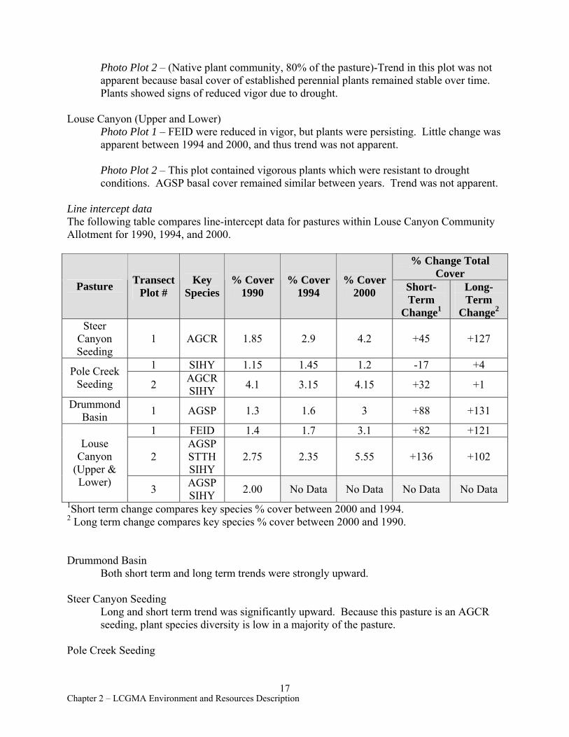
Photo Plot 2 – (Native plant community, 80% of the pasture)-Trend in this plot was not apparent because basal cover of established perennial plants remained stable over time. Plants showed signs of reduced vigor due to drought.
Louse Canyon (Upper and Lower) Photo Plot 1 – FEID were reduced in vigor, but plants were persisting. Little change was apparent between 1994 and 2000, and thus trend was not apparent.
Photo Plot 2 – This plot contained vigorous plants which were resistant to drought conditions. AGSP basal cover remained similar between years. Trend was not apparent.
Line intercept data The following table compares line-intercept data for pastures within Louse Canyon Community Allotment for 1990, 1994, and 2000.
Pasture Transect Plot #
Key Species
% Cover 1990
% Cover 1994
% Cover 2000
% Change Total Cover
Short-Term
Change1
Long-Term
Change2
Steer Canyon Seeding
1 AGCR 1.85 2.9 4.2 +45 +127
Pole Creek Seeding
1 SIHY 1.15 1.45 1.2 -17 +4
2 AGCR SIHY 4.1 3.15 4.15 +32 +1
Drummond Basin 1 AGSP 1.3 1.6 3 +88 +131
Louse Canyon
(Upper & Lower)
1 FEID 1.4 1.7 3.1 +82 +121
2 AGSP STTH SIHY
2.75 2.35 5.55 +136 +102
3 AGSP SIHY 2.00 No Data No Data No Data No Data
1Short term change compares key species % cover between 2000 and 1994. 2 Long term change compares key species % cover between 2000 and 1990.
Drummond Basin Both short term and long term trends were strongly upward.
Steer Canyon Seeding Long and short term trend was significantly upward. Because this pasture is an AGCR seeding, plant species diversity is low in a majority of the pasture.
Pole Creek Seeding
17 Chapter 2 – LCGMA Environment and Resources Description
Long term trend was not apparent in Plots 1 and 2. Short term trend was not apparent at Plot # 1 and was upward at Plot # 2. The native portion of the pasture (Plot #2) lacked herbaceous cover and diversity, and was heavily dominated by sagebrush with few forbs and less than expected grass cover. The seeded part of the pasture (Plot #1) actually had higher species diversity than the native portion because native species had re-established themselves in the transect area.
Louse Canyon (Upper and Lower) Long and short term trend is strongly upward at Plots 1 and 2. Plot three was not found in 2000, and lacked data for the period after 1990.
Overall trend Overall trend of key forage plants, which combines data from photo plots, line-intercept measurements, and professional judgment, is summarized by pasture below.
Drummond Basin Overall trend was upward, as indicated by increased basal cover shown by range studies and patterns of use over the monitoring period. Drummond Basin typically receives slight utilization in early season with water sources primarily in the north half of the pasture.
Steer Canyon Seeding Overall trend was not apparent in the native portion of the pasture (44%) and downward in the seeding (56%). This pasture typically receives light to moderate levels of utilization, with most use occurring in the eastern, AGCR third of the pasture. Water is situated primarily in the east of the pasture, except during drought periods, when water is made available in the western portions. The native west side typically receives less use than the non-native east side. The combination of drought and use impacted the eastern third of this pasture, and plants showed decreased vigor and reduced basal cover (as indicated by ocular assessments). The other areas of the pasture were maintaining cover and plant vigor.
Pole Creek Seeding Overall trend for this pasture was not apparent. Utilization was typically light with fair distribution of grazing use. Cattle congregated in the seeded portion at water sources in both public and private lands. When the pipeline in the east was fully operating, utilization and distribution was evenly spread between native and non-native areas of the pasture. With the brief early-season use and 30 days of late season use of the grazing system, key herbaceous species were maintaining basal cover.
Louse Canyon (Upper, Lower, and Quinn River Allotment) Overall trend in Louse Canyon Pasture was not apparent. Average utilization in a majority of this pasture ranged from slight to light, with moderate to heavy utilization periodically occurring near Steer Canyon Reservoir (primarily because cattle funnel through the area twice annually). However, there is the potential risk of downward trend in some areas if utilizations continue to be moderate to heavy. Water was available throughout the pastures, allowing wide cattle distribution. Key herbaceous species were maintaining or increasing basal cover.
18 Chapter 2 – LCGMA Environment and Resources Description
Range Improvement Projects Louse Canyon Community Allotment has 53 range improvement projects, including 16 reservoirs, 2 cattle guards, 18 spring developments, 3 water pipelines, 1 diversion ditch, and 13 fence projects. Twenty-one projects were in various levels of disrepair at the time of assessment, including 1 deteriorating reservoir; 6 damaged spring developments; 8 nonfunctioning spring developments; minor problems on 2 pipeline systems; major trough and pipe repair on 1 pipeline; 1 fence project repair; and removal or rehabilitation of 2 fences. The boundary fence with Fort McDermitt Reservation, owned and maintained by tribal members, is currently in poor condition due to snow and lack of maintenance and allows access of trespass livestock. See Tables 6.1 - 6.4 for projects other than exclosures, and Table 6.5 for information and recommendations on exclosures. The boundary fence with Fort McDermitt Reservation, owned and maintained by tribal members, is currently in poor condition due to snow and lack of maintenance and allows access of trespass livestock.
(d) Star Valley Community Allotment (# 01402)
Background Star Valley Community Allotment is divided into four pastures grazed March 1 to September 30 by two permittees. The RPS incorrectly shows Star Valley Allotment to have an active preference of 6,495 AUMs and a proposed RPS livestock allocation of 7,717 AUMs. The correct AUM figures for the 1986 RPS update should be 6,849 AUMs current active preference and a proposed increase to 7,714 AUMs. This discrepancy in preference was due to the state land exchange of 1974, where BLM obtained ownership of lands within the allotment previously managed by the state of Oregon. These acquired lands held AUMs that were then allocated to existing permittees. In accordance with Civil No. 97-98-RE: Order of Modified Injunction (Section M., Owyhee River Litigation), portions of this allotment which allowed access to the West Little Owyhee Wild and Scenic River were closed to livestock grazing, and permitted use was reduced to 6,838 AUMs of active preference.
The southern portion of South Tent Creek Pasture extends into Nevada and is separately designated as Little Owyhee Allotment, although lack of fencing allows livestock to freely move between Star Valley Community Allotment and Little Owyhee allotments. Little Owyhee Allotment has one permittee, the Fort McDermitt Stockmen’s Association (FMSA), and is grazed in common with South Tent Creek Pasture. Grazing administration of this allotment is currently conducted by Vale District through an agreement initiated in April 1968 with Winnemucca, NV, District.
Rangeland Health Standard 3 (Ecological Processes--Uplands) Uplands within Star Valley Community Allotment currently support an ecologically functioning vegetative community with diverse structure and composition of perennial grasses, forbs, and shrubs. Impacts to uplands due to livestock grazing were localized, very limited in extent, and were not detrimental to ecological function and sustainability of existing plant communities. Assessment data shows that all pastures in Star Valley Community Allotment were meeting Rangeland Health Standard 3. See Chapter 3, Rangeland Health Determinations, for specific assessment results for each pasture. Rangeland Health Standard 1 (Watershed Function— Uplands) is discussed in Section Q., Soil Resources.
19 Chapter 2 – LCGMA Environment and Resources Description
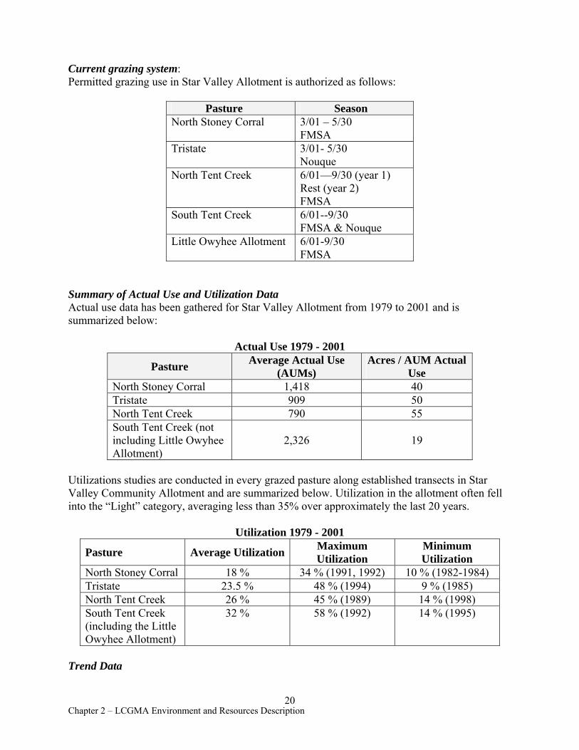
Current grazing system: Permitted grazing use in Star Valley Allotment is authorized as follows:
Pasture Season North Stoney Corral 3/01 – 5/30
FMSA Tristate 3/01- 5/30
Nouque North Tent Creek 6/01—9/30 (year 1)
Rest (year 2) FMSA
South Tent Creek 6/01--9/30 FMSA & Nouque
Little Owyhee Allotment 6/01-9/30 FMSA
Summary of Actual Use and Utilization Data Actual use data has been gathered for Star Valley Allotment from 1979 to 2001 and is summarized below:
Actual Use 1979 - 2001
Pasture Average Actual Use (AUMs)
Acres / AUM Actual Use
North Stoney Corral 1,418 40 Tristate 909 50 North Tent Creek 790 55 South Tent Creek (not including Little Owyhee Allotment)
2,326 19
Utilizations studies are conducted in every grazed pasture along established transects in Star Valley Community Allotment and are summarized below. Utilization in the allotment often fell into the “Light” category, averaging less than 35% over approximately the last 20 years.
Utilization 1979 - 2001
Pasture Average Utilization Maximum Utilization
Minimum Utilization
North Stoney Corral 18 % 34 % (1991, 1992) 10 % (1982-1984) Tristate 23.5 % 48 % (1994) 9 % (1985) North Tent Creek 26 % 45 % (1989) 14 % (1998) South Tent Creek (including the Little Owyhee Allotment)
32 % 58 % (1992) 14 % (1995)
Trend Data
20 Chapter 2 – LCGMA Environment and Resources Description
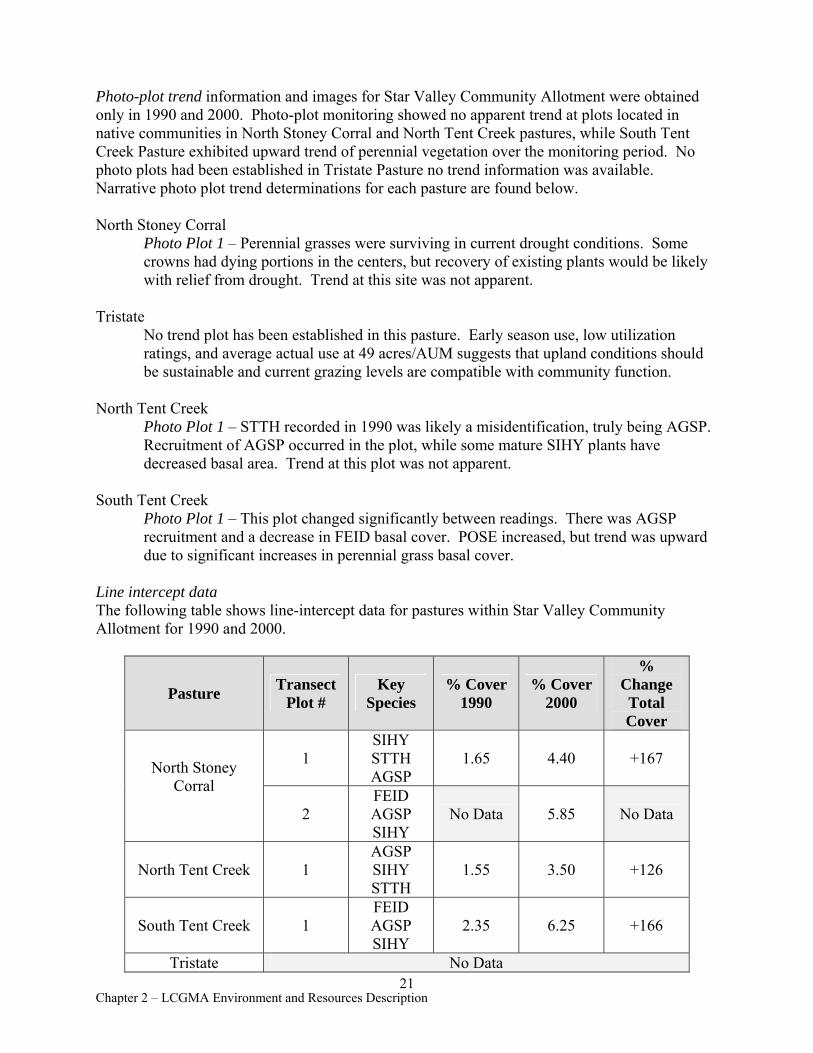
Photo-plot trend information and images for Star Valley Community Allotment were obtained only in 1990 and 2000. Photo-plot monitoring showed no apparent trend at plots located in native communities in North Stoney Corral and North Tent Creek pastures, while South Tent Creek Pasture exhibited upward trend of perennial vegetation over the monitoring period. No photo plots had been established in Tristate Pasture no trend information was available. Narrative photo plot trend determinations for each pasture are found below.
North Stoney Corral Photo Plot 1 – Perennial grasses were surviving in current drought conditions. Some crowns had dying portions in the centers, but recovery of existing plants would be likely with relief from drought. Trend at this site was not apparent.
Tristate No trend plot has been established in this pasture. Early season use, low utilization ratings, and average actual use at 49 acres/AUM suggests that upland conditions should be sustainable and current grazing levels are compatible with community function.
North Tent Creek Photo Plot 1 – STTH recorded in 1990 was likely a misidentification, truly being AGSP. Recruitment of AGSP occurred in the plot, while some mature SIHY plants have decreased basal area. Trend at this plot was not apparent.
South Tent Creek Photo Plot 1 – This plot changed significantly between readings. There was AGSP recruitment and a decrease in FEID basal cover. POSE increased, but trend was upward due to significant increases in perennial grass basal cover.
Line intercept data The following table shows line-intercept data for pastures within Star Valley Community Allotment for 1990 and 2000.
Pasture Transect Plot #
Key Species
% Cover 1990
% Cover 2000
% Change Total Cover
North Stoney Corral
1 SIHY STTH AGSP
1.65 4.40 +167
2 FEID AGSP SIHY
No Data 5.85 No Data
North Tent Creek 1 AGSP SIHY STTH
1.55 3.50 +126
South Tent Creek 1 FEID AGSP SIHY
2.35 6.25 +166
Tristate No Data 21
Chapter 2 – LCGMA Environment and Resources Description
North Stoney Corral Plot # 2 was established in 2000 and therefore trend was lacking at that site. Trend for Plot #1 was upward due to increases in SIHY and AGSP basal cover.
North Tent Creek Trend was upward based on an increase in AGSP basal cover.
South Tent Creek Trend was upward, due to an increase in FEID basal cover.
Overall trend Overall trend of key forage plants, which combines data from photo plots, line-intercept measurements, and professional judgment, is summarized by pasture below.
North Stoney Corral Overall trend for this pasture was not apparent. Typical annual utilization was slight, with a low stocking level (approximately 40 acres/AUM) due to lack of water in the pasture. Reservoirs were the only sources of water, and with current drought, few were able to retain spring/winter runoff into the grazing season. Key herbaceous species were maintaining cover.
North Tent Creek Overall trend was not apparent. This pasture was infrequently used due to lack of water, with utilization typically in the light category. When water was available, cattle distribution was uniform across the pasture. The light stocking and current use of this pasture allowed key species to maintain or increase basal cover and vigor.
South Tent Creek Overall trend was upward. While stocked somewhat heavier than other pastures in the allotment, use was typically light, with many areas receiving only slight use due to lack of water. Key species increased basal cover and maintained vigor with the current grazing regime.
Tristate Overall trend in Tristate Pasture was not apparent. Due to lack of data for comparisons, only professional judgment was used to make a determination for this pasture. With the current stocking level and regular light utilization, the key species in this pasture appeared to be maintaining vigor. Many areas were inaccessible to livestock due to lack of water. The current grazing system was maintaining key upland species.
Range Improvement Projects Star Valley Community Allotment contains 62 range improvements projects, including 47 reservoirs, 1 cattle-guard, 3 spring developments, 3 wells, and 8 fences. See Tables 6.1 - 6.4 for projects other than exclosures, and Table 6.5 for information and recommendations on exclosures.
22 Chapter 2 – LCGMA Environment and Resources Description
Nine projects were inoperable at time of inspection. These include 3 reservoirs requiring bentonite for sealing; 1 reservoir with poor water catchment; 2 wells needing pumps; and 2 spring developments with leaking troughs and misaligned inlets or outlets.
(e) Ambrose Maher (# 01102)
Background Ambrose Maher Allotment consists of one pasture grazed annually from February to May and during October. The RPS (1986) indicated an active preference of 580 AUMs for Ambrose Maher Allotment. In accordance with Civil No. 97-98-RE: Order of Modified Injunction (see Section M., Owyhee River Litigation), portions of this allotment which allowed livestock access to areas of concern on the Owyhee River were closed to livestock grazing, and permitted use was reduced to 517 AUMs of active preference. There are no suspended AUMs for this allotment.
Rangeland Health Standard 3 (Ecological Processes--Uplands) Uplands within Ambrose Maher Allotment currently support an ecologically functioning vegetative community with diverse structure and composition of perennial grasses and forbs. Wyoming big sagebrush is absent in most of the area due to wildfire. Impacts to uplands from livestock grazing are localized, very limited in extent, and are not detrimental to the ecological function and sustainability of the existing vegetative community. Assessment data showed that the Ambrose Maher Allotment met Rangeland Health Standard 3 (Ecological Processes). See Chapter 3, Rangeland Health Determinations, for specific assessment results the allotment. Rangeland Health Standard 1 (Watershed Function—Uplands) is discussed in Section Q., Soil Resources.
Current Grazing System Due to often inadequate late season water availability, the current permitted split grazing season results in slight levels of utilization when livestock water is available. Annual turnout statements are being used to set specific pasture use periods within the permitted dates. The basic pasture rotation for Ambrose Maher Allotment is as follows:
Pasture Season 2/12 - 5/30Ambrose Maher 10/15 - 10/21
Summary of Actual Livestock Use and Utilization Data Actual use data has been gathered for certain years between 1978 and 1990 and is summarized below. See Table 3.16 for actual use data by year.
Average Actual Use Acres / AUM (AUMs) Actual Use
(from 1978 – 2001) 397 7.32
One utilization study was conducted in 1979 in the pasture, the only year the transect was read. Utilization was 10% for that year.
23 Chapter 2 – LCGMA Environment and Resources Description
Trend Data One photo plot in Ambrose Maher Allotment was established and read only in 1979, and therefore no trend comparisons can be made. The general view photos show that herbaceous vegetation was the dominant visual aspect in 1979, suggesting that wildfire occurred in the allotment well before the wildfire that burned approximately 2500 acres in 1985.
Line-intercept data A transect was established in Ambrose Maher Pasture in 1979. This plot was read in 1982, but was not relocated in 2000 and no recent trend comparisons can be made. Basal cover of the key species declined significantly between 1979 and 1982, indicating downward trend. The 1979 and 1982 data are presented below:
Pasture Key Species
% Cover 1979
% Cover 1982
% Change Total Cover
Ambrose Maher
AGSP FEID 8.5 3.4 - 60.0
Overall trend Overall trend of upland perennial vegetation, which combines data from photo plots, line-intercept measurements, site visits, and professional judgment, is summarized below.
Ambrose Maher Pasture The trailing nature of grazing in this allotment allows the maintenance and expression of the herbaceous species AGSP, POSE, and SIHY. This pasture is predominantly grassland with minor shrub inclusions that were not burned in the 1985 Lone Tree Fire. Due to lack of data, no recent trend can be determined for this allotment, but all indications from site visits and actual use data suggest that all critical life processes of the key forage species are being maintained and current levels of use are sustainable. Trend is not apparent.
Range Improvement Projects Ambrose Maher Allotment has 3 range improvement projects (fences), all in good functional condition. See Tables 6.1 - 6.4 for projects other than exclosures, and Table 6.5 for information and recommendations on exclosures.
E. Fire History
According to Vale District geographic information system (GIS) fire data, about 7,200 acres of native range in LCGMA have been disturbed by wildfire, and no prescribed fires have been ignited in the unit. Apparently, for the past several decades LCGMA has had a low incidence of lightning storm patterns that ignite wildfires. Even in significant fire years such as 1986, 2000, and 2001, LCGMA has not sustained appreciable shrub cover loss due to fire.
24 Chapter 2 – LCGMA Environment and Resources Description
Evidence of fire disturbance was observed in the following locations:
• Toppin Butte / Sharon Creek vicinity - Approximately 1,500 acres in Anderson Allotment; incident date is unknown but likely occurred in the 1970’s or early 1980’s (Tom Forre, former Rangeland Specialist, Jordan Resource Area, pers. comm.)
• Massey Canyon vicinity - Approximately 360 acres in Louse Canyon Community Allotment; incident date was 1999.
• Peacock Pasture - Approximately 2800 acres in Campbell Allotment; incident date was 1985.
• Chipmunk Basin vicinity - A military jet crash in 1999 ignited a 5-10 acre fire in T39S, R45E, Section 3 NE¼; Chipmunk Basin Quad. The crash site is marked with a small tower and will be easy to relocate for vegetation studies if desired.
• Ambrose Maher Allotment - Approximately 2500 acres; incident date was 1985.
F. Special Status Plants
While there are no known plant species listed under the Endangered Species Act in LCGMA, the management area encompasses habitat supporting a number of special status plant species. There are no studies within the GMA which would indicate population trends of the following species. Two of the List 1 species described below are protected at Anderson Crossing, and studies should be established for profuse-flowered mesa mint (Pogogyne floribunda) and Davis’ peppergrass (Lepidium davisii) to determine trends of the species at their respective playas. List 2 and 4 species are considered secure at this time due to lack of threats, number of sites identified within the GMA, and/or protection of their specific habitats. Little is known about List 3 species.
Bureau Sensitive Species are those found on List 1 of the Oregon Natural Heritage Program (ONHP), which was updated in 2003. Species on this list are considered endangered or threatened throughout their range. Within LCGMA these species include Barren Valley collomia (Collomia renacta) and disappearing monkeyflower (Mimulus evanescens), both found in talus at Anderson Crossing; Davis’ peppergrass at Pigeontoe playa; and profuse-flowered mesa mint, found at Bull Flat Playa near Toppin Butte. The sites supporting the monkeyflower and mint are the only ones known for these species in Vale District. The collomia occurs at two other sites in the District. Davis peppergrass is listed by the State of Oregon as Threatened. It occurs at five other sites in the district and is the least rare globally of the List 1 species.
Bureau Assessment Species are those found on List 2 of the ONHP. These species are considered threatened or endangered in Oregon but are stable or more common elsewhere. Five Bureau Assessment species occur within LCGMA: Owyhee sagebrush (Artemisia papposa) which is discussed below, Cusick’s primrose (Primula cusickiana), broad fleabane (Erigeron latus), Shockley’s ivesia (Ivesia shockleyi), and Bolander’s spikerush (Eleocharis bolanderi).
Bureau Tracking Species are on List 3 (species for which more information is needed before status can be determined, but which may be threatened or endangered in Oregon or throughout their range) and List 4 (taxa of concern which are not currently threatened or endangered) of the ONHP. List 3 species in LCGMA include a King’s bladderpod variety (Lesquerella kingii var.
25 Chapter 2 – LCGMA Environment and Resources Description
cobrensis), Rocky Mount helianthella (Helianthella uniflora var. uniflora), and Ibapah wavewing (Cymopterus longipes ssp. ibapensis). List 4 species include: Webber needlegrass (Achnatherum webberi), inverted pale paintbrush (Castilleja pallescens var. inverta), two-stemmed onion (Allium bisceptrum), flowering quillwort (Lilaea scilloides), narrow-leaved cottonwood (Populus angustifolia), and weak-stemmed stonecrop (Sedum debile).
Two species of sagebrush (Artemisia sp.) are worthy of mention for consideration in activity level planning. One of the most notable, Artemisia longiloba, is part of the low sagebrush (Artemisia arbuscula) complex. There are several taxonomic treatments of this species, all of which identify its early blooming (mid-July to mid-August) habit. Although it had not received species status in Intermountain Flora (Cronquist et al. 1994), sagebrush expert, Dr. Al Winward (US Forest Service, Region 4 Ecologist), has specifically identified specimens of plants collected in this area as A. longiloba. Vast expanses of the species are found in LCGMA, along with pockets of the more common low sagebrush. A. longiloba is distinguished by huge blooming scapes which present a yellow hue across the landscape in late June and early July, followed by persistent rust-colored heads. This is the only area in Oregon known to support these kinds of extensive stands of this otherwise rather uncommon species. While A. longiloba is indicative of shallow, clay soils, specific habitat features that distinguish this species from low sagebrush have not been determined.
The other unusual species of sagebrush found in the area is Owyhee sagebrush, which occurs at the western edge of its global range in this GMA. Owyhee sagebrush is found on rocky swales, dry meadows, and mud flats in LCGMA and throughout its range in Idaho, where it is abundant. Although the sites it occupies are not large, numerous localities supporting the species have been found throughout the LCGMA. There do not appear to be threats that would imperil the existence of Owyhee sagebrush in Oregon at this time.
G. Noxious Weeds and Invasive Species
In general, noxious weeds and invasive plant species are uncommon in LCGMA, with cheatgrass being the most prevalent weedy species found. Cheatgrass occurred in trace amounts along roads and in disturbed areas throughout the GMA. In some pastures, cheatgrass composed about 1% of the vegetation sampled. Cheatgrass was found in a 60’x 60’ wildlife guzzler exclosure in Campbell Allotment (Twin Springs South Pasture) and made up about 1% of the total vegetation cover there.
Whitetop (Cardaria spp) was found in small patches near Bell Springs and Stoney Corral, and is invading at an alarming rate along main access roads within the assessment area. The spread of whitetop represents a significant threat to habitat integrity in both upland and riparian communities.
Scotch thistle and puncture-vine have been treated at Anderson Crossing Air Strip in Louse Canyon Allotment (Louse Canyon Pasture). Clasping pepperweed and several other annual mustard species were observed at various locations in the GMA. No other weeds were found during the GMA assessment. Overall, the assessment showed approximately 1% of total plant cover in LCGMA occupied by weeds.
26 Chapter 2 – LCGMA Environment and Resources Description
The limited amount of weed invasion is likely attributable to several factors including relatively low levels of recreational use, overall upland plant community health, and limited seed dispersal by livestock or wildlife. Weeds traveling via waterways within the GMA have not been identified as a problem, probably due to lack of major farming or community activities near the West Little Owyhee or Antelope drainages. However, the Main Owyhee River currently transports weeds downstream from source areas in Idaho and Nevada.
H. Water Resources and Riparian/Wetland Areas
Water Resources
LCGMA encompasses three major stream systems that flow to the Owyhee River--West Little Owyhee River, Antelope Creek, and Tent Creek--and one small system that drains south to Quinn River. Each stream system contains interrupted perennial and intermittent seasonally flowing segments (Map 9, Perennial and Fish-bearing Reaches). Subsurface recharge and overland flow to these streams are mainly from snowmelt, with peak flows and overland runoff occurring in April and tailing off by late May. By late June and early July surface flow in many streams are reduced to only short, discontinuous segments.
Interrupted perennial streams within the GMA are characterized by submergence and emergence of surface water along the stream length, such that flow is interrupted by dry reaches. Perennial stream flow usually occurs as: (1) a continuous surface flow originating within the stream channel and flowing from ¼ mile to several miles before disappearing into channel substrates; (2) a series of short, perennial flowing segments (<¼ mile); or (3) a series of perennial scour pools that receive subsurface water from alluvial fill. No streams within the GMA flow continuously from headwaters to confluence. All are interrupted by stretches of subsidence or flow briefly during seasonal recharge and runoff from uplands.
In segments of all streams within the GMA, water quality and quantity were affected by incised channels, absent or reduced streamside vegetation, excessive concentration and duration of livestock use, and unstable streambank structure (see Chapter 3, Range Health Determinations, Rangeland Health Standards 2 and 4). Increased water temperature may occur in incised streams where riparian vegetation does not provide adequate shade for surface flows. Lack of riparian vegetation may also lead to increased erosion, higher stream velocities, and accelerated migration of headcuts and lateral stream movement.
Current and historic livestock grazing during “hot season” months have affected riparian vegetation composition and channel stability in LCGMA. With warmer weather, livestock tend to concentrate in riparian areas seeking quality forage, browse, water, and shade. If livestock are removed following late spring use, regrowth of herbaceous species occurs throughout the summer as long as available moisture is present in riparian area soils. When livestock concentrate in riparian areas and moderate to heavy grazing use occurs in late-spring, summer and into early autumn, herbaceous and woody riparian vegetation is affected. During this season active leader growth on woody riparian species, such as willows, becomes vulnerable to livestock utilization. Livestock use during this period typically provides no rest during the growing period to ensure plant vigor, reproduction, or litter accumulation. If rest is not provided, riparian plants do not replace food reserves in roots and seed may not be produced. Concentrated use along drainages generally results in heavy utilization of woody riparian
27 Chapter 2 – LCGMA Environment and Resources Description

vegetation, trampling, bank shearing damage, soil compaction, and accelerated streambank erosion. Amount of available water storage in riparian areas and peak flow quantity and duration are also reduced by excessive levels of livestock utilization during the hot season.
For LCGMA, existing water quality data include water temperatures recorded by BLM in West Little Owyhee River at Anderson Crossing and detailed water chemistry, temperature, and invertebrates gathered by US Geologic Survey (2002) for BLM at sites on the Owyhee River, including the confluence with West Little Owyhee River. Because water temperatures were not in compliance with State standards for salmonid streams, BLM’s data led to placement of West Little Owyhee River on the 1998 303(d) list by Oregon Department of Environmental Quality from Anderson Crossing upstream. The data were suspect, however, because the recording thermograph was inadvertently placed in a reach where surface flows recede in mid-summer. Because these data were not representative of perennial flow, the West Little Owyhee River was recommended by ODEQ to be withdrawn from the 2002 303(d) list for streams affected by temperature. The Environmental Protection Agency subsequently approved the delisting.
Because available site-specific water quality data were limited for LCGMA, assessing Rangeland Health Standard 4 (Water Quality) was done through evaluation of pertinent data from several sources:
1. Waterbody status, whether the stream is on the State 303(d) list (ODEQ) 2. Limitations on Beneficial Uses identified for the stream’s river basin 3. Existing water quality data 4. Existing supporting data, such as range monitoring data, soil surveys, slope steepness,
and aerial photography 5. Assessments for Rangeland Health Standards 1 (Watershed Function –Uplands),
Standard 3 (Watershed Function –Riparian), and Standard 3 (Ecological Processes) 6. Drainage patterns 7. Land ownership within watersheds
Main Drainages of Louse Canyon GMA
West Little Owyhee River The West Little Owyhee River drains about 200,000 acres (312 square miles) with a main channel length of approximately 60 miles. West Little Owyhee has numerous perennial segments, many with scour pools, which cover about two-thirds of its length and vary considerably in water quantity. Many of these perennial segments receive their flow from small, perennial side channels and from Toppin Creek, Jack Creek, and Massey Canyon.
Toppin Creek (76,000 acres), Jack Creek (23,000 acres), and Deer Creek, a major tributary to Jack Creek, are intermittent streams with small, perennial scour pools scattered throughout. Massey Canyon (10,000 acres) drainage has many short, perennial stream segments and scour pools. These four tributaries comprise about fifty-five percent of the West Little Owyhee River drainage area.
Antelope Creek Antelope Creek has four major tributaries, Pole, Little Antelope, Trail, and Hansen Flat creeks,
28 Chapter 2 – LCGMA Environment and Resources Description

as well as several smaller tributaries. This system drains about 220,633 acres (345 square miles) with a main channel length of 46 miles. Antelope Creek has several short, perennial segments in its headwaters, transitions to intermittent flow in its mid reaches, and becomes perennial for the lowest eight miles. About 43 percent of Antelope Creek has perennial flow.
Pole Creek, the main tributary to Antelope Creek, is also comprised of short, perennial segments and scour pools draining about 77,300 acres (121 square miles). Pole Creek’s main channel consists of short perennial reaches with scour pools. Spring/meadow complexes are distributed throughout the length of Pole Creek. Three main tributaries to Pole Creek are Field Creek, Chipmunk Creek, and the Steer Canyon drainage. Field Creek, draining 17,030 acres (26.5 square miles), has a few perennial scour holes and a short perennial reach starting at Disaster Spring, a spring/meadow complex. Chipmunk Creek and Steer Canyon drainage are intermittent streams with only two wet meadow/spring areas located in Chipmunk Creek. The entire Pole Creek watershed contains only 9.5 stream miles of perennial flow.
Little Antelope Creek, the second largest tributary to Antelope Creek, is an intermittent system that drains about 55,980 acres (87.5 square miles) and usually goes dry by mid-June to early-July. This creek does not have reliable year-round water sources.
Trail Creek and Hansen Flat Creek watersheds drain areas with several springs and small perennial scour pools. The headwaters of Trail and Hansen Flat creeks, located west and southwest of the GMA, occur at higher elevations that have quaking aspen clumps and small discontinuous channel segments of flowing water.
Tent Creek Tent Creek is an intermittent stream system with only one perennially flowing reach about 0.25 miles in length and with no large tributaries. Tent Creek watershed drains about 80,160 acres or 125.5 square miles and has several spring/wet meadow complexes.
Riparian/Wetland Areas in LCGMA
The BLM Manual (Tech. Ref. 1737-9) defines riparian areas as “. . . a form of wetland transition between permanently saturated wetlands and upland areas. These areas exhibit vegetation or physical characteristics reflective of permanent surface or subsurface water influence. Typical riparian areas are land along, adjacent to, or contiguous with perennially and intermittently flowing rivers and streams, glacial potholes, and the shores of lakes and reservoirs with stable water levels. Excluded are sites such as ephemeral streams or washes that do not have vegetation dependent upon free water in the soil.” In the GMA, wetlands occur wherever the water table is usually at or near the surface, or where the land is at least seasonally covered by shallow water. This includes sloughs or scour pools, seeps, and wet meadows.
Riparian areas provide food and shelter for the animal community and are critically important to fish, birds, and other wildlife species. Riparian areas affect the quantity and quality of water for on-site and downstream water uses, such as irrigation, water for wildlife, livestock and wild horses, and recreation. Riparian areas also help store water and reduce risk of flash floods. For riparian areas to provide these benefits, they must have the plant species diversity, structure, and abundance appropriate for the area.
29 Chapter 2 – LCGMA Environment and Resources Description
In LCGMA, riparian and wetland areas occur along approximately 200 miles of stream channels. Riparian vegetation, both herbaceous and woody, is found in upland meadows, at springs and seeps, and in drainage channels that vary from short, interrupted perennial systems to seasonal streams that only flow until mid June and early July in most years.
Seep and spring areas are mainly associated with wet meadows in upper watershed areas. These seeps and springs occur in shallow soils on broad, gently sloping uplands or in dissected, rocky stream bottoms. Meadows associated with seeps and springs on upland slopes range in size from less than an acre to five or more acres, and support many herbaceous sedge and rush species.
In stream channels in upper watersheds, riparian vegetation is mostly herbaceous, but sparsely scattered woody species, such as yellow willow and quaking aspen, are found in wetter protected areas. Positioned lower downstream are perennial stream segments that support a wider diversity of both herbaceous and woody riparian species, including coyote, yellow, lemmon, and whiplash willow. These areas are usually located in slightly steeper and rockier terrain where woody species may become established when large hydrologic events scour stream channels and allow seed establishment. At lower elevations where slopes become flatter and channels are usually wider, riparian vegetation is again dominated by sedges and rushes and, like the upper watershed areas, contains scattered willow species.
Although riparian areas and wetlands cover less than 1 percent of the GMA, their ecological significance far exceeds their limited physical area. Riparian and wetland areas are major contributors to ecosystem productivity and structural and biological diversity, particularly in drier climates (Elmore and Beschta 1987).
Rangeland Health Standard 2: (Watershed Function - Riparian/Wetland Areas) Proper Functioning Condition and Other Ratings
Riparian Assessment Methods The quality of riparian productivity and diversity has been evaluated using two methods (Appendix I, Riparian/wetland Areas and Assessment Methods). One method, long-term trend, assesses trends in riparian health over time. The second method, Proper Functioning Condition (PFC), assesses condition of riparian function, which is a result of interactions between geology, soil, water, and vegetation (USDI,BLM, TR1737-9, 1993). In general, both assessment methods address physical as well as biological attributes and their interrelationships. These attributes include the abundance, structure, and diversity of riparian vegetation and the stability of streambanks. The BLM has adopted the PFC assessment as a standard for evaluating riparian areas and will use it to supplement existing stream channel and riparian evaluations and assessments.
The PFC Rating System The term “Proper Functioning Condition” is used to describe both the assessment process and the condition of a specific riparian/wetland area. PFC assessments provide a consistent approach that considers hydrology, vegetation, erosion, and depositional processes in the evaluation of the condition of riparian/wetland areas. A specific riparian area whose condition is designated to be “at PFC” is in a state of resiliency that will hold together during high-flow events with a high degree of reliability. Riparian areas rated PFC are also considered to be meeting Rangeland Health Standard 2 (Watershed Function—Riparian/wetland Areas).
30 Chapter 2 – LCGMA Environment and Resources Description
Proper Functioning Condition assessments were conducted on approximately 200 miles of stream riparian habitat within the GMA. These stream miles were divided into lengths with similar physical characteristics that are referred to as “reaches.” Reaches that were rated PFC supported the minimum amount and type of plant components needed to store water and resist bank detachment during large flow events (5-20 year return intervals). However, many reaches that were rated PFC (and meeting Rangeland Health Standard 2) still may not support the desired quantity and composition of vegetation associated with healthier, more resilient systems. For instance, in wet meadows, early- to mid-seral plants (such as Douglas sedge) are less desirable than mid- to late-seral plants (such as Nebraska sedge). In those PFC-rated riparian/wetland areas with early seral vegetation, a change in management is needed to attain desired plant composition and to improve stream channel physical conditions.
One of five possible ratings was assigned to each stream reach and wetland area:
• Proper Function Condition (PFC) = Meeting Rangeland Health Standard 2 • Functioning at Risk, Upward Trend (FARU) = Meeting Rangeland Health Standard 2 • Functioning at Risk, Trend not Apparent (FARN) = Not Meeting Rangeland Health
Standard 2 • Function at Risk, Downward Trend (FARD) = Not Meeting Rangeland Health Standard 2 • Non Functioning (NF) = Not Meeting Rangeland Health Standard 2
See Appendix I for more information on the PFC assessment method and ratings, and refer to Table 4, Riparian PFC Summary; Map 7, Streams and PFC; and Map 8, Springs/seeps and PFC, for detailed information on all reach ratings.
PFC Assessment Results for LCGMA
Sites Rated as Proper Functioning Condition Approximately 52 percent of all riparian stream miles within the GMA were rated PFC (Table 4a, Streams--Riparian PFC Summary).
All riparian reaches of the West Little Owyhee River were rated PFC. This river is the only stream in the GMA with additional assessment data in the form of long-term trend information for some of its reaches. Long-term trend data were assembled from monumented photopoints, habitat surveys conducted between 1979 and 2000, and low level aerial photography (1982, 1991, 1994, 1998). Long-term trend data is not available for other riparian areas within the GMA because information was not recorded prior to the 2000 PFC assessments. These riparian areas now have baseline information established through the PFC assessments but will require additional years of study before definitive long-term trend can be established.
The long-term trend studies indicated upward trend in riparian vegetation for West Little Owyhee River, although the level of improvement varied between reaches. Presently, the river is excluded by corridor fencing from livestock entry. In general, substantial increases in abundance and diversity of woody (whiplash, yellow, and lemmon willow) and herbaceous (sedges and rushes) species have occurred from Anderson Crossing to the headwaters. In some upper reaches, woody plant recruitment is restricted due to intermittent flows and competition with
31 Chapter 2 – LCGMA Environment and Resources Description

thick-rooted herbaceous plants. Conversely, limited increase in herbaceous cover occurs where porous cobble and boulder substrates allow fine soil particles to pass easily through the rock matrix. In most reaches, increased vegetative cover along streambanks has captured fine sediments, resulting in improved bank stabilization and channel narrowing.
Sites Rated as Functioning at Risk, Upward Trend (FARU) Antelope Creek, Reach #2 (1.3 mi), in Twin Springs South and Sacramento Hill pastures was the only stream segment designated FARU (Table 4a). Although no long-term trend information was available, the Interdisciplinary Team gave this reach an Upward Trend rating based on abundant herbaceous and woody plant reproduction along channel banks and floodplain terraces. The presence of several age classes of whiplash and yellow willows indicated that recruitment and expansion of willow species has occurred for many years.
Sites Rated as Functioning at Risk, Trend not Apparent (FARN) Approximately 43 percent of all riparian stream miles within the GMA were rated FARN (Table 4a). A Functioning at Risk rating with a trend of “Not Apparent” indicates that one or more physical or vegetative attributes in that stream reach are significantly impaired. These attributes may include excessive erosion or headcutting, hydrologic heaving (hummocking) and compacted soils, bank trampling, lack of plant cover, low plant diversity or lack of reproduction, and impacts from irrigation, water developments, or roads. Although the Interdisciplinary Team determined that these reaches were Functioning at Risk, a trend rating of Not Apparent was applicable due to lack of prior baseline or long-term trend information.
Most FARN ratings in the GMA resulted from livestock grazing which caused soil and bank damage and affected riparian vegetation. However, some FARN designations were caused by other factors. For example, New Road Spring drainage, Reach #1, in Louse Canyon Pasture has a spring development within a wet meadow (which concentrates livestock), an access road to Jeff Reservoir that crosses the wet meadow, and a major headcut immediately below the road. Three Week Spring, Reach #2, in Louse Canyon Pasture also has a road crossing that intercepts most stream flow, desiccating riparian vegetation and subsurface saturation downstream.
Twenty-three springs with wet meadows were rated FARN (Table 4b, Springs—Riparian PFC Summary; and Map 8). Most FARN meadows were hummocked from livestock trampling and lacked plant diversity and reproduction from livestock concentration around spring troughs and headboxes. Hummocks decrease vegetative cover and increase bare soil, directly affecting potential saturation and water yield of the site.
All reaches with a FARN rating will be addressed by changes in management that focus on factors, such as current livestock grazing or water developments, which contribute to existing conditions. Many reaches will respond quickly to minor adjustments in management while others may need more intense treatment.
Sites Rated as Functioning at Risk, Downward Trend (FARD) Five stream reaches received a FARD rating, four reaches along Pole Creek (#5, 6, 9, 11) in Louse Canyon Pasture and one on Tent Creek in South Tent Creek Pasture (Table 4a). A spring/meadow complex adjoining Chipmunk Creek, a tributary to Pole Creek, was also rated FARD (Table 4b). Although long-term trend information was not available, the FARD ratings were based on representative indicators of downward trend, such as active channel erosion;
32 Chapter 2 – LCGMA Environment and Resources Description
sloughing, unvegetated streambanks; deeply incised stream channels; severely hedged willows; and lack of reproduction for woody riparian species. For one reach, conditions were caused in part by inappropriate trough and pipeline placement.
Pole Creek, Reach #5, downstream of private land, had a six to eight foot entrenched stream channel with raw banks. The streambed consisted of boulders and exposed bedrock, with siltation caused by lateral erosion. Riparian vegetation received intense livestock utilization; sedges and rushes were patchy and willows severely hedged and lacking reproduction. Reach #6, upstream of the private parcel, had impaired components similar to Reach #5. Reach #9, located between private parcels, had perennial flow, although the channel was incised four to eight feet in the central third of the reach. Active headcutting, downcutting, and lateral erosion was occurring along channel bed and banks. Riparian vegetation consisted of sedges, rushes, grasses, some rose, and currant that were all heavily utilized by livestock.
A perennial spring and pipeline system developed for livestock water is located in Reach #11 at the headwaters of Pole Creek. This delivery system conveys large quantities of water to storage tanks and troughs located outside of the drainage channel. Three problems are associated with Reach #11. First, exporting water away from the headwaters reduces the amount available to maintain saturation of meadows and stream channels in Reach #11. Second, the pipeline system that connects to the spring source bisects the meadow and extends downstream over half the meadow’s length. At the time of development in the 1970’s, this pipeline route was chosen because deep, saturated (hydric) meadow soils were easy to excavate. Over many years, runoff following the natural meadow contour and the buried pipeline trench has eroded the surface, re-exposing the pipeline. Currently, two to three foot eroded areas extend over many sections of the meadow. The third problem in Reach #11 is that the spring source, trough, and wet meadow adjacent to the trough receive concentrated use by livestock, reducing the potential of riparian herbaceous vegetation and limiting expansion of the meadow’s wetted perimeter.
Chipmunk Creek Tributary #1, Reach #1, has a spring development and associated wet meadow. The small meadow area feeds a collection gallery for a livestock trough located approximately 100 yards downstream. The meadow and trough area receive concentrated livestock use which limits the potential extent of surface area able to support riparian herbaceous plants.
Tent Creek, Reach #5, begins as a spring-fed perennial stream and meadow complex, transitions into a wet meadow with scour pools, and ends as an intermittent channel which is entrenched and scoured during spring runoff. Historically, this reach received concentrated use by livestock as the only reliable source of water for many miles. Although intensely utilized by livestock, riparian vegetation, both sedges/rushes and yellow willows, was well established in the perennial upper third of the reach. Downstream, riparian vegetation rapidly diminished with decreasing stream flow. Over time, heavy grazing combined with low potential for regrowth have caused gradual upstream migration of scour pools, continual channel widening, and loss of hydric soils.
Sites Rated as Non-Functioning (NF) Non-functioning assessment ratings were assigned to three reaches in three pastures. Field Creek, Reach #1, in Steer Canyon Seeding was located downstream of private land. Field Creek flows only briefly in spring, diminishing by mid-June or early July. By late spring, available flow in Field Creek has been diverted for irrigation on the private parcel, dewatering Reach #1 below and resulting in the non-functioning rating. Riparian vegetation in Reach #1 was minimal,
33 Chapter 2 – LCGMA Environment and Resources Description
consisting of only scattered patches of Baltic rush and Douglas sedge.
Massey Canyon, Reach #2, in the Louse Canyon Pasture, also rated NF, was located in a tributary immediately upstream of Jeff’s Reservoir. The reach was straight, with large cobble and boulder substrates and scattered upland vegetation, such as Wyoming big sagebrush, on upper edges of the streambanks. Seasonal flows pass through this reach very quickly, scouring the streambed and depositing rocky debris at the entrance to the reservoir. This non-functioning rating is likely a result of geomorphology rather than livestock use.
Jack Creek, Reach #3a and b, in South Tent Creek and Louse Canyon pastures, is also rated NF. Riparian vegetation consisted of scattered coyote willow in the stream channel and Douglas sedge and Baltic rush on the terraces. The stream channel was incised six to eight feet, with raw silty banks and scour pools with permanent water. Because this reach is the only perennial source of water for many miles, it receives concentrated use by livestock. Livestock utilization, trampling, and soil compaction have lead to low riparian plant diversity and reduced reproduction of existing plants. Loss of vegetative cover has decreased bank stability and accelerated erosion.
I. Terrestrial Wildlife and Habitats
Overall conclusions in this section pertaining to sagebrush habitat health and suitability for wildlife are based on a comparison of LCGMA conditions with current wildlife habitat management literature related to greater sage-grouse, sagebrush steppe land-birds other than sage grouse, and habitat relationships information described in “Wildlife Habitats in Managed Rangelands; The Great Basin of Southeastern Oregon” (Maser et al. 1984). Evaluation narratives that follow are derived from field estimates of resource attributes, quantitative field data, professional judgment, and data available from other agencies such as US Fish and Wildlife Service Breeding Bird Surveys (LCGMA wildlife habitat file stored at the Vale District Office).
The topics and the desired conditions for communities of wildlife on public land addressed in this evaluation are also based on the SEORMP (Chapter 2 and Appendix F). More specific details and supporting information that pertain to observed conditions for wildlife are cited in Chapter 3, Range Health Determinations, and References.
Terrestrial Wildlife Species of Management Importance in LCGMA Northern bald eagles (Federally Threatened) are the only federally listed vertebrate species known to occupy LCGMA. Eagles winter on the Owyhee River at the edge of LCGMA but do not nest there.
Bald eagles usually require tall trees for roosting, but tree species such as cottonwoods are not established in the upper reaches of the Owyhee River due to site potential limitations including severe hydrologic scouring events. Mature trees upstream that could potentially recruit cottonwoods from seed sources are absent. Cottonwoods are common and fairly well developed as gallery stands on parts of the Owyhee Reservoir outside of LCGMA. Based on observations made during winter surveys, bald eagles that occupy LCGMA roost on cliffs because it is the only substrate available for them to use.
34 Chapter 2 – LCGMA Environment and Resources Description
Grazing practices and recreational river floating activities are not likely to adversely affect wintering bald eagle populations within LCGMA. Consequently, there are no violations of the Endangered Species Act (Section 7) and consultation with the U. S. Fish and Wildlife Service is not necessary. Refer to the Biological Assessment for the SEORMP, Vale District Office, for further information
Terrestrial special status vertebrate species and other species of interest likely to inhabit LCGMA are listed below. Species associated with shrub steppe habitats that have declined substantially in the ICBEMP area since historical times are denoted with an asterisk (*). FT = Federally Threatened; BT = Bureau Tracking species; BA = Bureau Assessment species.
Landbirds *Brewer’s sparrow, *horned lark, *western meadowlark, *black-throated sparrow, *sage sparrow, *loggerhead shrike, *sage thrasher, *greater sage-grouse (BA), northern bald eagle (FT)
Mammals California bighorn sheep (BT), *pygmy rabbit, pronghorn
Reptiles Northern sagebrush lizard (BT), short-horned lizard
Terrestrial Source Habitats With the exception of LCGMA seedings, the assessment area is comprised of plant communities that meet the criteria of Terrestrial Source Habitats referred to in Source Habitats for Terrestrial Vertebrates of Focus in the Interior Columbia Basin: Broad-Scale Trends and Management Implications; Volumes 1 through 3, (May 2000).
ICBEMP defined Terrestrial Source Habitats for wildlife and used a broad scale predictive model to estimate their locations within the Interior Columbia Basin. The location of source habitats was identified geographically within areas referred to as “T” watersheds (“T” watersheds and source habitats are therefore related to one another). “’T’ watersheds contain source habitats that are relatively similar in pattern across the landscape compared with historical vegetation patterns (that is, they have low departure from historical patterns)” (ICBEMP Supplemental Draft EIS, Chapter 3, page 124).
The greatest volume of Wyoming, mountain, and basin big sagebrush habitats within LCGMA conform to what ICBEMP termed “Closed Mid Shrub” structural types, meaning that sagebrush canopy cover is 15% or greater as measured by line intercept. “Open Mid Shrub” structural types, meaning that sagebrush canopy cover is less than 15% as measured by line intercept, are present in low sagebrush and mesic Wyoming big sagebrush communities. Mid to upper elevation sagebrush habitats within LCGMA generally support a good complement of forbs and deep rooted perennial grass species that provide food and cover for wildlife. These rangeland conditions are indicative of quality wildlife habitats.
Assessment Criteria for Wildlife and Special Status Species (Rangeland Health Standard 5- Native, T&E, and Locally Important Species) LCGMA wildlife habitats were evaluated in relation to the SEORMP, which described a variety of desired habitat conditions and management considerations that, when met, would result in the
35 Chapter 2 – LCGMA Environment and Resources Description
support of healthy, self-sustaining populations and communities of wildlife on public land. These attributes (SEORMP/FEIS, Appendix F, pages 283 to 298) of riparian and upland habitats are to be assessed periodically within each GMA and then used as the basis for determining conformance with Rangeland Health Standard 5.
Upland habitats Wildlife diversity and productivity is profoundly influenced by the relative abundance, structure, and spatial arrangement of sagebrush communities (Graph 1, Comparison of Crested Wheatgrass Grasslands to Big Sagebrush Shrublands). Management of sagebrush communities that is appropriate to soil, climate, and landform needs to incorporate the following overstory and understory components which contribute towards healthy wildlife habitats:
Shrub overstory: Big sagebrush, low sagebrush, and other shrubby species within the genus Artemisia provide wildlife habitat structure, food, and cover.
Herbaceous understory: Grasses and forbs provide wildlife habitat structure, food, and cover. Herbaceous cover also produces insects that are consumed by birds and other small animals.
Sagebrush upland management criteria suitable for Rangeland Health assessments for wildlife habitat values (SEORMP, Appendix F, Section F-5) are described below. See Table 9, Shrub Cover Canopy Classes, for a description of sagebrush canopy cover Classes 1-5.
(a) Shrub structural characteristics and general distribution at mid landscape scales (GMA's) Shrub cover capable of supporting life history requirements of sage grouse and other wildlife (e.g., Classes 3, 4, and 5 that use sagebrush habitats should be present at multiple spatial scales, over a large area, and in a variety of spatial arrangements (e.g., at a landscape level and with connectivity present). Shrub cover should include a central core of sagebrush habitat present in large contiguous blocks as well as some other habitat arrangements such as islands, corridors, and mosaic patterns. Each of these patterns has significance to wildlife within geographic areas. Shrub cover should be some mix of height and age classes but with an overall emphasis on shrub communities with a mature structural status (Maser et al. 1984).
(b)Big sagebrush shrub cover on native range at fine landscape scales (pastures) Where a native range pasture is capable of supporting a big sagebrush community, shrub overstories suitable for sage grouse and other sagebrush-dependent species should be present on at least 50 to 75 percent of the pasture. For example, a 1000-acre native range pasture that can support Wyoming, mountain, or basin big sagebrush should provide adequate wildlife shrub cover on at least 500 to 750 acres (e.g., Shrub Classes 3, 4, and 5).
(c) Big sagebrush shrub cover on seeded range at fine landscape scales (pastures) Where a seeded pasture is capable of supporting a big sagebrush community, shrub overstories suitable for sage grouse and other sagebrush-dependent species should be present on at least 25 to 50 percent of the pasture. For example, a 1000-acre seeded pasture that can support Wyoming, mountain, or basin big sagebrush should provide adequate wildlife shrub cover on at least 250 to 500 acres (e.g., Shrub Classes 3, 4, and 5).
(d) Herbaceous understory on native range at fine landscape scales (pastures)
36 Chapter 2 – LCGMA Environment and Resources Description
Herbaceous understory composition throughout most native range habitats should exhibit a diversity of native forbs and grasses consistent with site potential at mid, late, or PNC seral stages.
(e) Herbaceous understory on seeded range at fine landscape scales (pastures) In seedings, herbaceous cover should include one or more forb species.
Riparian habitats In riparian habitats, grazing use at a minimum should promote properly functioning riparian/wetland areas.
Rangeland Fragmentation and Affects on Wildlife Habitat Wildlife habitat fragmentation in sagebrush steppe is a concern throughout the intermountain west and it is highlighted as an issue in the SEORMP. Habitat fragmentation impacts to species such as greater sage-grouse can be caused by a variety of factors such as physical disturbance to plant communities (e.g., wildfire or land treatments), powerlines, roads, and fences. In this LCGMA assessment, fragmented habitats are defined as rangelands with Shrub Cover Class 1 or 2 (Table 9). These seeded or native rangelands exhibit a strong grassland appearance (with either perennial or annual vegetation) and lack the shrub structure necessary to provide wildlife life history functions such as foraging, nesting, hiding, and thermal relief. Site potential and presence of invasive species may affect the capability of Class 1 or 2 areas to support a complete array of native plant components without management intervention such as seeding.
Fragmentation may have significance at very fine scales (tens of acres) for some species where surrounding rangelands have already suffered losses in shrub structure and remaining sagebrush steppe is in limited supply. Fragmentation at a scale of thousands of acres can threaten native wildlife such as greater sage-grouse and sage sparrows since both species require large areas of connected shrub overstory. Both species have declining population trends within the Interior Columbia Basin area.
Fragmented habitats do not always pose a threat to sagebrush steppe wildlife, as they are simply one stage of ecological succession with both positive and negative impacts on the life histories of wildlife. Fragmented habitats may in fact be desirable and provide the requirements for species such as grasshopper sparrows and pronghorn. Fine scale habitat mosaics (see Landscape Appearance Photos #1 - 6, 12, and 14) are desirable in that they can provide an abundance of plant-based resources used by wildlife.
The size, spatial arrangement, and likelihood of further fragmentation of Class 1 and 2 habitats define potential risks and impacts to wildlife.
Overview of LCGMA Wildlife Habitat Conditions
(a)Uplands Upland communities within LCGMA show attributes that can be expected to result in the long-term persistence of terrestrial wildlife, including greater sage-grouse and a wide variety of other animals that occupy sagebrush habitats. These are desired conditions that are in conformance with the SEORMP.
37 Chapter 2 – LCGMA Environment and Resources Description
Important sagebrush steppe wildlife habitat components, which include forage, cover, and structure, are well distributed spatially across the assessment area. The structure and composition of plant species in the GMA are sufficient to sustain healthy, reproducing communities of wildlife. With certain isolated exceptions (see Specific Upland Wildlife Habitat Assessment Results, this section), the structure and continuity of sagebrush overstory is excellent for wildlife. Potentially negative consequences of habitat fragmentation from fires and vegetation treatments (i.e. seedings and chemical applications) over the last four decades are localized and proportionally small in relation to the evaluation area. Starvation Seeding is the only treated rangeland without substantial sagebrush recolonization.
About 96% of the LCGMA landscape (including all native, chemically treated, or seeded rangeland) consists of complex shrubland communities capable of supporting life history requirements of sage grouse and other shrub-dependent species (see Table 5, Shrub Cover Characteristics Summary by Pasture). These shrub habitats conform to desired canopy cover conditions, and are described as Shrub Class 3, 4, or 5 wildlife habitats (Table 9). Ninety-six percent of the 394,100 acres in LCGMA with big sagebrush communities (Wyoming, basin, or mountain big sagebrush) is in Class 3, 4, or 5 status.
The remaining 4% of LCGMA is composed of native or seeded rangeland that exhibits a grassland appearance. These grass / forb dominated habitats are classified as Class 1 and 2 wildlife habitats.
In contrast to LCGMA, the adjacent GMA to the north (Jackies Butte) and neighboring areas south in Nevada (Winnemucca District, BLM and Santa Rosa Mountains, Humboldt National Forest) have been impacted by substantial wildfire impacts due to the combined effects of severe summer storm patterns and cheat-grass presence. In both these adjoining areas, fires have taken a serious toll on shrub overstory continuity and have left thousands of acres with little or no native shrub canopy.
Native rangeland (about 90% of LCGMA) is a nearly complete block of sagebrush steppe with relatively minor, fine-scale inclusions of habitat with a grassland appearance. Habitat patterns that appear as corridors, mosaics, or islands of shrubland are observable only at very fine scales, and are consistent with soil/climate/landform differences rather than recent disturbance.
Composition of the herbaceous understory in most native range is diverse, made up of predominantly native species with specific site capabilities determined by soil, climate, and landform. Even where understory diversity and density is relatively weak, the communities are not high fire risk areas because cheatgrass is limited or absent. Invasive plant species with potential for direct and indirect adverse impacts on wildlife habitats presently have only minor and localized influences.
Due to relatively low livestock stocking rates and large pasture sizes, residual cover and ungrazed plants were well distributed throughout most of the assessment unit. “Thorough search” grazing use, which can have potentially negative influences on wildlife by reducing hiding cover for small animals and forage availability for wildlife, is generally limited. Poor shrub structural quality (i.e., umbrella-form shrubs with heavily grazed understories (USDI, BLM Tech. Ref., 1996) due to livestock use was observed in some tall big sagebrush patches
38 Chapter 2 – LCGMA Environment and Resources Description
found within low sagebrush communities. Generally, however, impacts from grazing were confined to areas close to water sources.
(b) Streams and Meadows LCGMA supports an extensive network of dry and wet meadow complexes that are especially prevalent in southern reaches of the assessment area (Table 4b). All wet meadow habitats showed heavy livestock utilization leaving little residual cover available in the fall. For the past few decades, summer and fall grazing use has been authorized annually in higher elevation areas where riparian habitats are most abundant
Pronghorn, mule deer, and other wildlife also utilize riparian areas, but, due to their current low numbers, big game have significantly fewer impacts to riparian areas than domestic livestock.
In most meadow areas, plant community composition is diverse and comprised of grasses, sedges, rushes, and forbs. Invasive and noxious plant species are limited in their presence and dominance. Nevertheless, rest and/or other seasonal grazing adjustments that avoid repeated summer use are needed to promote revegetation of bare banks and improvement in plant vigor and composition.
Quaking aspen occur in the headwaters of Antelope Creek, upper West Little Owyhee River, Bob’s Draw, and Pole Creek. Private lands near Hoppin Springs and Fort McDermitt Reservation lands also support aspen. Small stands of narrow-leaf cottonwood occur on upper West Little Owyhee River.
Woody riparian habitat quality and structural character varied significantly by stream. Refer to Table 4, Riparian PFC Summary, Chapter 3, Range Health Determinations, and Appendix J, Photos, for specific information. Isolated water sources that support aspen and are accessible by livestock (in both wet meadow and stream habitats) were heavily utilized and trampled. These areas show highly modified aspen and willow growth forms consistent with severe hedging as described in the Cole browse monitoring methodology.
Specific Upland Wildlife Habitat Assessment Results
(a) Native Uplands Wyoming big sagebrush habitats occupy about 70% (365,000 acres) or more of LCGMA (Table 5). Both xeric (8-10 inch or less precipitation zones) and mesic (> 10 inch precipitation zones) Wyoming big sagebrush variants were observed, showing very different understory composition and shrub structure. Consequently, these variants are described separately below.
Due to site differences in rainfall and soils, productivity of xeric and mesic Wyoming big sagebrush types did not correlate exactly with changes in elevation. Lower elevation communities were often more productive, with better wildlife habitat quality compared to communities at higher elevations. For example, compare Landscape Appearance Photo #4 (5180' elevation, high relative productivity) in Anderson Allotment with Photo #9 (5370' elevation, low relative productivity) in Star Valley Community Allotment.
Most mesic Wyoming big sagebrush shrub cover types exhibited fine scale patchiness comprised of co-mingled shrub cover Classes 3 and 4. In the GMA, Wyoming big sagebrush canopy cover
39 Chapter 2 – LCGMA Environment and Resources Description
ranged between 5% and 25%. Heavier sagebrush canopies were considered to be between 15% to 20% cover, while lighter canopies were between 5% and 10% cover. These arrays of cover densities provide both shrub cover and quality herbaceous understories that support communities of shrub steppe wildlife.
Mesic Wyoming big sagebrush types also showed heterogeneous shrub ages, densities, and canopy heights which were desirable for wildlife forage and habitat structure (see Landscape Appearance Photos #1- #6, #12 in Appendix J). Sage grouse nesting and wintering cover was abundant. Virtually all mesic Wyoming big sagebrush communities showed forb compositions and densities consistent with mid-seral ecological conditions or higher.
Sagebrush and bluebunch wheatgrass heights were sampled in mesic Wyoming big sagebrush communities to determine habitat structure for wildlife. Field data showed that sagebrush and grass height characteristics met the lateral and overhead cover nesting requirements of sage grouse as well as many other ground or canopy nesting landbird species.
Xeric Wyoming big sagebrush types, such as those found in Star Valley Community Allotment, tended to exhibit herbaceous understories weak in both composition and density. Moreover, xeric shrub overstories tended to be smaller in stature and exhibited a more homogeneous, denser canopy cover than observed in mesic Wyoming big sagebrush communities (See Landscape Appearance Photos #8, 9, Appendix J). Xeric Wyoming big sagebrush cover was typically 20% to 25%, or slightly higher.
Based on OAESIS range survey data, early seral ecological conditions were present in parts or all of Sacramento Hill, Pole Creek Seeding, North Stoney Corral, North Tent Creek, and South Tent Creek pastures. These areas did not meet Rangeland Health Standard 5 (Wildlife). Although shrub overstory was adequate, the herbaceous understory conditions were not consistent with mid, late, or PNC ecological conditions.
No sagebrush or grass height measurements were taken in xeric Wyoming big sagebrush types, but photos from Star Valley Allotment clearly showed the appearance of the xeric community and enabled comparisons to mesic Wyoming big sagebrush. Due to low site capability based on soil types and precipitation, grasses and forbs in xeric Wyoming sage sites in LCGMA were not able to produce the lateral cover associated with successful sage grouse nesting, e.g. plant heights of 7 inches or more. However, based availability of better quality nesting habitat and water sources elsewhere in LCGMA, it is questionable whether sage grouse would choose to nest in these xeric Wyoming big sagebrush habitats.
Although historic livestock and wild horse grazing likely contributed to weak herbaceous understories in xeric Wyoming big sagebrush communities in LCGMA’s lower elevations, ongoing livestock grazing practices do not appear to be causing current conditions. Outside of the immediate areas around water, signs of extensive trampling damage and heavy utilization were not observed. Based on the relatively small stature of un-grazed xeric sagebrush habitats, site potential and productivity appears to be naturally low.
Low sagebrush communities occupied the highest elevations, especially regions south of Star Valley Road. Low sagebrush was present as a subdominant inclusion along the rims of the Owyhee River. Low sagebrush communities made up about 25% (133,000 acres) of the GMA,
40 Chapter 2 – LCGMA Environment and Resources Description
and were comprised of a combination of shrub cover Classes 3 and 4. Low sagebrush communities typically supported a robust and diverse understory of grasses and forbs that are of value to nearly all species of terrestrial wildlife.
Although mountain sagebrush communities were present in LCGMA, they were not abundant. They were generally confined to small, scattered patches (tens of acres or less) that are subdominant communities nested within low sagebrush at about 5800' elevation or higher. Mountain sagebrush canopy cover appeared to be primarily within the 20% to 30%+ range, i.e., shrub cover Class 4 and 5. No line intercept or shrub height measures were taken in mountain sagebrush communities.
Based on aerial and vehicle reconnaissance, it was estimated that about 10% or less of low sagebrush types also support subdominant communities of tall sage (mountain, basin big, and Wyoming big sagebrush). Many of these “nested” habitat types are particularly valuable for sage grouse nesting and escape cover. They are also excellent habitat patches for landbirds such as sage thrashers, gray flycatchers, and loggerhead shrikes. These species were frequently flushed from tall sagebrush cover during the assessment process.
Basin big sagebrush occupied many low elevation drainages including Tent Creek, Toppin Creek, Pole Creek and Antelope Creek. It generally occurred in narrow and often discontinuous patches of deeper soils. OAESIS range survey data did not delineate basin big sagebrush communities and they were not mapped in the assessment process. Canopy cover within these communities was also not measured, but based on visual estimates cover appeared to be 25% or more; e.g. Classes 4 and 5. Basin big sagebrush communities typically showed well connected overstories but generally tended to have weak herbaceous understories, presumably from historic grazing practices and diminished site capability.
Bitterbrush and mountain mahogany communities are present but limited to a few sites in Little Owyhee Allotment. No data were collected about their growth forms or reproductive success.
Salt desert communities, which include shadscale, budsage, and spiny hopsage, were present as minor components of shrublands within Star Valley Allotment. Salt desert communities were not continuous and homogeneous as is the case in other parts of the intermountain west. Overall, salt desert generally comprises a very small proportion of the rangeland in LCGMA.
(b) Seeded and chemically treated uplands Seedings and brush control projects have influenced about 43,500 acres, over 8% of LCGMA. All existing land treatments occurred during the Vale Project era between late 1960's through the mid 1970's. Locations of the projects have been mapped in the Vale District Geographic Information System. In contrast to other rangeland within Malheur County, LCGMA has sustained a relatively small proportion of land treatment disturbance. Class 1 and 2 crested wheatgrass rangelands support substantially fewer species of wildlife in comparison to native shrublands (see Graph 1).
Starvation Seeding was the only pasture which showed a strong grassland appearance (shrub cover Classes 1 and 2) and it is the only project area that does not meet Rangeland Health Standard 5 for wildlife forage, structure, and cover. None of the LCGMA seedings were planted with forbs and so they do not currently meet the minimum wildlife habitat standard for forb
41 Chapter 2 – LCGMA Environment and Resources Description
composition in seedings specified in the SEORMP.
Starvation Seeding, Campbell Allotment (14,000 acres seeded in 1964) Approximately 91% of Starvation Seeding was seeded to crested wheatgrass. This seeding exhibited a shrub cover Class 1 aspect with little or no shrub overstory. Starvation Seeding comprises less than 3% of LCGMA and thus wildlife habitat values are impacted only locally. There are no recent burns or Class 1 seedings nearby that would increase the impacts of grassland habitat conditions present in Starvation Seeding. The original seeding project left a corridor of Wyoming big sagebrush cover along Big Antelope Creek, amounting to about 10% of the pasture. The sagebrush extends out several hundred yards to either side of the creek, which bisects the pasture. Shrub cover within the corridor was a combination of Class 3 and 4 types; herbaceous understory conditions there were generally weak, both in terms of species composition and density.
Pole Creek Seeding, Louse Canyon Allotment (4,000 acres were seeded in 1970, out of 19,600 total pasture acres) Pole Creek Seeding is one of several pastures referred to as “seedings” in BLM records but which were only partially impacted by the effects of vegetation treatment. Approximately 26% of Pole Creek Seeding (about 4,000 acres) supported a Wyoming big sagebrush/ crested wheatgrass community. The seeded area has had substantial post-treatment shrub overstory recovery (shrub cover =10%) and currently could provide habitat for some wildlife. Sagebrush canopy character (volume, maturity, height, and ability to conceal animals) in the seeded area was of a lower quality than on native range due to the young age of the plants and physical disturbances caused by the concentrated livestock grazing use typical of seedings.
The remaining 74% (15,600 acres) of Pole Creek Seeding had native plant cover that was not treated. Shrubs in these undisturbed areas were cover Classes 4 and 5.
Steer Canyon Seeding, Louse Canyon Allotment (6,300 acres seeded in 1965) About 56% of the Steer Canyon Seeding was planted with crested wheatgrass. The seeded area showed substantial post-treatment shrub recovery (shrub cover = 10% to 15%) and currently could support wildlife that use sagebrush habitats. Sagebrush canopy character (volume, maturity, height, and ability to conceal animals) in the seeded area was a lower quality than on native range due to the young age of the plants and physical disturbance from concentrated livestock grazing use.
The remaining 44% of the pasture supports sagebrush cover predominantly in Class 4, with a weak herbaceous understory.
Starvation Brush Control (20,000 acres chemically treated (sprayed) with 2-4D in 1963) Starvation Brush Control showed a substantial post-treatment shrub canopy recovery and supported a heterogeneous mix of Class 3, 4, and 5 shrub cover types. There was little visible evidence, such as low canopy density and presence of shrub skeletons, of the 1963 treatment. Sagebrush cover in Starvation Brush Control was not substantially different from the cover character of adjoining native rangelands. Due to the combined effects of droughty soils and heavy historic livestock grazing, Class 5 shrub cover types had a depleted herbaceous understory.
42 Chapter 2 – LCGMA Environment and Resources Description
(C) General livestock utilization patterns and extent of use by livestock observed Livestock utilization levels and impacts to wildlife habitat vary from year to year depending on a variety of factors. Nevertheless, it is possible to get a general sense of recent historical grazing patterns and how they may be influencing wildlife habitat by looking at factors such as residual cover, fence-line contrasts, trampling effects, plant composition, and shrub canopy conditions.
Substantial livestock grazing use impacts in LCGMA uplands are typically confined to areas within ¼ mile or less of developed and natural water sources. Because most LCGMA pasture units are quite large, natural water is limited, and stocking rates have been comparatively low, livestock use has generally not resulted in thorough understory search over large areas. Consequently, the forage, structure, and cover values associated with herbaceous plants are generally abundant and available for wildlife to use. It is significant that these good upland herbaceous cover conditions were observed in 2000, which was a drought period with relatively low plant production.
It is not uncommon to see perennial upland grasses and forbs growing at the edge of reservoirs used by livestock in LCGMA. This condition is indicative of favorable moisture conditions and grazing use practices that sustain the productivity of native rangelands over a prolonged time period.
Exceptions to the generally favorable patterns of livestock utilization observed in LCGMA include the following:
* Terrace uplands adjoining streams and meadows (such as Chipmunk Basin and Deer Creek) showed signs of high livestock utilization and generally weak understory conditions.
* Isolated mountain and/or basin big sagebrush communities (those “nested” within low sagebrush types) often showed heavy livestock grazing use such as damaged shrub structure and depleted understory conditions. Some of these shrub habitat patches were tall enough to be used as shading areas for livestock.
* Livestock utilization around troughs in seedings was particularly severe, but the overall impacts of this use were limited in spatial extent and impact to wildlife cover and forage values. Crested wheatgrass seedings generally provide limited herbaceous forage values for wildlife. No invasive weed species were observed in these severely used areas, but they would be vulnerable to noxious and invasive weeds over the long term.
Big Game Forage Demand Refer to Appendix E, Calculation of Big Game Forage Demand, for an explanation about the origin and calculation of forage demand for mule deer, pronghorn and bighorn sheep. The Oregon Department of Fish and Wildlife was unable to supply the information necessary to calculate a forage demand for bighorn sheep on a pasture or allotment basis in LCGMA so sheep are not listed in the following table.
The current seasonally adjusted competitive forage demand for big game at state management plan objective levels is as follows:
43 Chapter 2 – LCGMA Environment and Resources Description
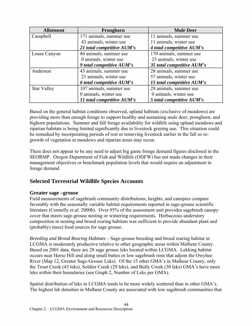
Allotment Pronghorn Mule Deer Campbell 171 animals, summer use
43 animals, winter use 21 total competitive AUM’s
11 animals, summer use 11 animals, winter use 4 total competitive AUM’s
Louse Canyon 86 animals, summer use 0 animals, winter use 9 total competitive AUM’s
170 animals, summer use 23 animals, winter use 35 total competitive AUM’s
Anderson 43 animals, summer use 21 animals, winter use 6 total competitive AUM’s
28 animals, summer use 57 animals, winter use 15 total competitive AUM’s
Star Valley 107 animals, summer use 0 animals, winter use 11 total competitive AUM’s
28 animals, summer use 0 animals, winter use 5 total competitive AUM’s
Based on the general habitat conditions observed, upland habitats (exclusive of meadows) are providing more than enough forage to support healthy and sustaining mule deer, pronghorn, and bighorn populations. Summer and fall forage availability for wildlife using upland meadows and riparian habitats is being limited significantly due to livestock grazing use. This situation could be remedied by incorporating periods of rest or removing livestock earlier in the fall so regrowth of vegetation in meadows and riparian areas may occur.
There does not appear to be any need to adjust big game forage demand figures disclosed in the SEORMP. Oregon Department of Fish and Wildlife (ODFW) has not made changes in their management objectives or benchmark population levels that would require an adjustment in forage demand.
Selected Terrestrial Wildlife Species Accounts
Greater sage –grouse Field measurements of sagebrush community distributions, heights, and canopies compare favorably with the seasonally variable habitat requirements reported in sage-grouse scientific literature (Connelly et al. 2000b). Over 95% of the assessment unit provides sagebrush canopy cover that meets sage-grouse nesting or wintering requirements. Herbaceous understory composition in nesting and brood rearing habitats was sufficient to provide abundant plant and (probably) insect food sources for sage grouse.
Breeding and Brood Rearing Habitats – Sage-grouse breeding and brood rearing habitat in LCGMA is moderately productive relative to other geographic areas within Malheur County. Based on 2001 data, there are 28 sage grouse leks located within LCGMA. Lekking habitat occurs near Horse Hill and along small buttes or low sagebrush rims that adjoin the Owyhee River (Map 12, Greater Sage-Grouse Leks). Of the 15 other GMA’s in Malheur County, only the Trout Creek (43 leks), Soldier Creek (29 leks), and Bully Creek (30 leks) GMA’s have more leks within their boundaries (see Graph 2, Number of Leks per GMA).
Spatial distribution of leks in LCGMA tends to be more widely scattered than in other GMA’s. The highest lek densities in Malheur County are associated with low sagebrush communities that
44 Chapter 2 – LCGMA Environment and Resources Description
are close to mountainous topography with abundant natural water sources. LCGMA has less relief and fewer natural water sources than highly productive habitats.
The best nesting and brood rearing areas for Malheur County are typically moist mid to upper elevation rangelands comprised of low sagebrush and mountain or Wyoming big sagebrush communities with a network of springs, meadows, and streams. Xeric Wyoming sage communities in LCGMA provide too few water sources and spring/meadow complexes to support significant late season brood rearing or yearlong use.
Winter range - No sage-grouse winter survey data are available from LCGMA. However, as evidenced by observation of winter pellet groups in 2000, most low and big sagebrush communities showed some winter sage-grouse use, even on lowest elevation (5500' - 6000') Wyoming big sagebrush terraces. Sagebrush habitats in general are so well connected, exhibit so few grassy openings of significant size, and provide such good structure and forage, that winter habitat availability for sage-grouse appears to be abundant and of a generally high quality.
Landbirds (formerly known as Neotropical Migrants)
In addition to sage-grouse, LCGMA supports several birds that have been described as species of interest in ICEBMP and the Conservation Strategy for Landbirds in the Columbia Plateau of Eastern Oregon and Washington (Altman 2000). These species include: gray flycatcher, horned lark, sage thrasher, sage sparrow and Brewer’s sparrow.
Data from the U. S. Fish and Wildlife Service Lookout Lake and Louse Canyon Breeding Bird Surveys are used as reference material
for characterizing landbird presence and relative abundance in LCGMA. Although there is not an identical overlap between these routes and the LCGMA boundary, the habitat types surveyed on these routes are virtually identical to those present in LCGMA. Based on these data, landbirds dependent upon sagebrush types are well represented in LCGMA. Although no systematic bird surveys were conducted during this assessment, the species of interest were commonly encountered during summer fieldwork.
Mature shrub habitat structure, good landscape connectivity, and generally favorable understory conditions in this unit likely account for good diversity and relative abundance of sagebrush associated birds. Landbirds of management importance were most abundant in mid to upper elevation sagebrush types and frequently associated with tall shrubs and canopy cover of 15% or more. These areas are typically associated with small changes in topography and aspect that foster the most productive and diverse steppe habitat conditions.
Based on general observations throughout the summer, raptors are not particularly abundant or diverse in LCGMA. Although small rodent burrows were common, ground squirrels and black-tailed jackrabbits were not frequently encountered. In short, raptor mammalian food sources appear to be relatively limited. Only 1 ferruginous hawk was observed within the assessment unit in 2000. Cliff nesting habitats for golden eagles and prairie falcons are largely confined to canyons of West Little Owyhee River. Tree species such as aspen and juniper are also limited in their abundance and distribution.
45 Chapter 2 – LCGMA Environment and Resources Description
White-tailed jackrabbit This nocturnal species can be seen in low and big sagebrush complexes of high elevation rangelands but is not common in Malheur County. Over the last few decades, BLM and ODFW biologists have observed significant numbers of white-tailed jackrabbits in the area, and a few rabbits were seen by day during the assessment process. It is not known whether the population residing within LCGMA is of a size and distribution typical for the species. Based on general habitat requirements for the rabbit and overall quality of sagebrush habitat available in LCGMA, no significant limiting factors related to BLM authorizations are apparent.
Snowshoe Hare Bruce Easterday (McDermitt, NV, rancher) reported seeing snowshoe hare in Jack Creek meadows around Nouque Cow Camp. BLM range technicians John Whitley and Doug Wiggins also reported snowshoe hares near Jackson Summit east of the LCGMA boundary. Bill Olson (retired ODFW biologist) and Bob Kindschy (retired BLM biologist) suggested that these observations were most likely white-tailed jackrabbits. Neither of these retired wildlife professionals has seen snowshoe hare in LCGMA. Moreover, Verts and Carraway (2000) indicated that snowshoe hares occupy forest types, not sagebrush steppe habitats.
Pygmy Rabbit LCGMA likely supports pygmy rabbits along major drainages with tall sagebrush (basin big or Wyoming big sagebrush) and in mixed big sagebrush / low sagebrush areas. BLM pygmy rabbit surveys conducted in Lake and Harney Counties (Oregon) during 2002 and 2003 have revealed that substantial populations of pygmy rabbits are found in big sagebrush / low sagebrush complexes not previously considered prime habitat for the species. The greatest concentration of basin big sagebrush occurs from Rawhide Springs and the lowlands east towards Pole Creek. We did not observe pygmy rabbits in 2000 and historical surveys for the species did not include the assessment area.
Challenge Cost Share pygmy rabbit survey work in LCGMA was conducted between February 6 and November 6, 2001, by Peggy Bartels. Field data were collected near Anderson Crossing, Horse Hill, and Big Antelope Creek. No confirmed observations of pygmy rabbits or burrows were made but some areas near Horse Hill appeared be potential habitat. More detailed survey work would be needed to confirm pygmy rabbit presence in LCGMA.
California Bighorn Sheep Based on ODFW data from the early 1990's, approximately 65,000 acres of public land are currently occupied by California bighorn sheep in LCGMA. The SEORMP identified a total of 183,000+ acres of “Bighorn Range” within LCGMA which is defined as the area in which ODFW is authorized to pursue new releases, supplemental releases, and captures of bighorn for the purpose of implementing state management goals for the species.
As of 2001, ODFW indicated that bighorn numbers in this unit were low. Predation by cougar was suspected to be one of the primary limiting factors to their current population level. There are no known forage or security issues related to BLM authorizations currently affecting bighorn populations in LCGMA. Domestic sheep grazing does not occur within LCGMA so there are no conflicts concerning disease transmission that would require resolution.
46 Chapter 2 – LCGMA Environment and Resources Description
Reptiles Several reptile species occupy LCGMA habitats and were seen regularly during the course of the assessment. Site locations were recorded on field maps and entered into the District wildlife observations database, though standardized surveys were not conducted. Most GMA reptiles had no special status designation, indicating a widespread, common distribution. Some species were designated Bureau tracking, which is a status conferred on species for which more information is needed or which no longer need active management. BLM collects occurrence data on tracking species but does not consider them special status species for management purposes.
The northern sagebrush lizard, Bureau tracking, is the only special status reptile observed within the GMA. Its distribution was widespread and it was observed in nearly every pasture assessed. Sagebrush lizards are ground dwellers and inhabit open, brushy flats, using shrubs for cover or hiding in rodent burrows.
The short-horned lizard also utilizes open sagebrush habitats, and can live on hardpan and rocky soils but requires patches of loose soil for burrowing. It is less dependent on shrubs for cover than sagebrush lizards, but is not likely to be found in seedings. Its diet includes a high proportion of ants and thus lizard densities are higher where anthills are abundant. The short-horned lizard is more cold tolerant than many lizards, and its live-bearing mode of reproduction allows it to incubate its eggs internally. These lizards were widely distributed throughout the GMA and were frequently found at the same sites as sagebrush lizards.
Except for crested wheat seedings and rimrock areas, the GMA provides extensive areas of suitable habitat for both sagebrush and short-horned lizards, which were widespread and utilized sagebrush with a variety of canopy densities. However, neither species frequented seeded pastures. In an Idaho study investigating responses of sagebrush steppe reptiles to crested wheatgrass plantings, the relative densities of sagebrush and short-horned lizards in seedings were significantly below those of ungrazed sagebrush/squirreltail habitats (Reynolds and Trost 1980). The study also showed that lizard densities on sagebrush habitats grazed by sheep were not different from the ungrazed sagebrush, suggesting that upland livestock use in LCGMA may have little impact on these reptiles.
Western fence lizards and side-blotched lizards tend to be restricted to rocky habitats with a vertical component, such as cliffs, boulders, and rimrock. In the GMA, these lizards were found along rock canyons such as Pole Creek and West Little Owyhee River and were absent from open sagebrush flats. These rock-dwellers were encountered less frequently than sagebrush or short-horned lizards during the assessment, undoubtedly because the assessment focused on open rangeland where they do not occur. LCGMA provides suitable habitat for these species.
Other lizard species may occur in the GMA but have not been observed. Mohave black-collared lizard (Bureau tracking), which require sparsely vegetated, rocky slopes, and longnose leopard lizards (Bureau tracking), common in greasewood flats with sandy soils, are documented in the Sheephead Mountains, near Burns Junction, and in the Owyhee River canyon. The desert horned lizard occurs in lower elevations near McDermitt and Burns Junction, but usually does not cooccur with its short-horned relative. Western whiptail lizards utilize a variety of sagebrush and rocky habitats and occur in the Owyhee River Canyon, but have not been observed in LCGMA.
47 Chapter 2 – LCGMA Environment and Resources Description
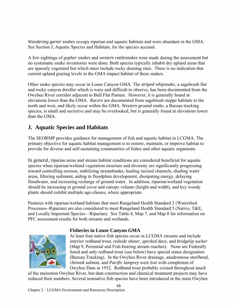
Wandering garter snakes occupy riparian and aquatic habitats and were abundant in the GMA. See Section J, Aquatic Species and Habitats, for the species account.
A few sightings of gopher snakes and western rattlesnakes were made during the assessment but no systematic snake inventories were done. Both species typically inhabit dry upland areas that are sparsely vegetated but which must include rocky denning sites. There is no indication that current upland grazing levels in the GMA impact habitat of these snakes.
Other snake species may occur in Louse Canyon GMA. The striped whipsnake, a sagebrush flat and rocky canyon dweller which is wary and difficult to observe, has been documented from the Owyhee River corridor adjacent to Bull Flat Pasture. However, it is generally found at elevations lower than the GMA. Racers are documented from sagebrush steppe habitats to the north and west, and likely occur within the GMA. Western ground snake, a Bureau tracking species, is small and secretive and may be overlooked, but is generally found at elevations lower than the GMA.
J. Aquatic Species and Habitats
The SEORMP provides guidance for management of fish and aquatic habitat in LCGMA. The primary objective for aquatic habitat management is to restore, maintain, or improve habitat to provide for diverse and self-sustaining communities of fishes and other aquatic organisms.
In general, riparian areas and stream habitat conditions are considered beneficial for aquatic species when riparian/wetland vegetation structure and diversity are significantly progressing toward controlling erosion, stabilizing streambanks, healing incised channels, shading water areas, filtering sediment, aiding in floodplain development, dissipating energy, delaying floodwater, and increasing recharge of ground water. In addition, riparian/wetland vegetation should be increasing in ground cover and canopy volume (height and width), and key woody plants should exhibit multiple age-classes, where appropriate.
Pastures with riparian/wetland habitats that meet Rangeland Health Standard 2 (Watershed Processes--Riparian) are also considered to meet Rangeland Health Standard 5 (Native, T&E, and Locally Important Species—Riparian). See Table 4, Map 7, and Map 8 for information on PFC assessment results for both streams and wetlands.
Fisheries in Louse Canyon GMA At least four native fish species occur in LCGMA streams and include interior redband trout, redside shiner, specked dace, and bridgelip sucker (Map 9, Perennial and Fish-bearing stream reaches). None are Federally listed and only redband trout (see below) have special status designation (Bureau Tracking). In the Owyhee River drainage, anadromous steelhead, chinook salmon, and Pacific lamprey were lost with completion of Owyhee Dam in 1932. Redband trout probably existed throughout much
of the mainstem Owyhee River, but dam construction and chemical treatment projects may have reduced their numbers. Several nonnative fish species have been introduced in the main Owyhee
48 Chapter 2 – LCGMA Environment and Resources Description
River downstream of GMA streams. Smallmouth bass and channel catfish originated from a 1970 stocking project where ODFW treated the Main Owyhee River with chemicals applied at Three Forks, and then introduced bass, catfish, and hatchery rainbow trout (ODFW Report, Buckman, 1969). ODFW fish surveys conducted on the upper and lower sections of the Main Owyhee in 1988, 1996 and 1997 (Wayne Bowers, ODFW, Hines, OR) observed few trout of any species, but recorded an abundance of smallmouth bass and channel catfish. BLM surveys in side tributaries have located bass spawning sites and small populations of native fishes. Although exotic species have access to lower reaches of Antelope Creek and West Little Owyhee River, they are not known to be present upstream.
ODFW periodically stocks a coastal strain of hatchery rainbow trout in Steer Canyon, Cavieta (a.k.a.Chico), Coyote Holes, and Jeff’s reservoirs. In most reservoirs, spawning habitat is lacking, and natural reproduction does not occur. However, rainbow trout stocked in Jeffs Reservoir have successfully spawned in Massey Canyon and probably have access to West Little Owyhee River during high flows. When Cavietta and Steer Canyon reservoirs spill, stocked trout may be able to move downstream toward Pole Creek, but perennial refuges for trout would be extremely limited.
Interior Redband Trout Native redband trout in southeastern Oregon have evolved adaptations to live in harsh environments characterized by great extremes of water temperature and flow. In these situations, hatchery strains of rainbow trout may not be effective predators or competitors. However, hatchery trout have hybridized with most populations of resident redband trout in much of the Columbia River basin and undoubtedly a considerable amount of genetic diversity has been lost during the last 100 years. In 1994, allozyme genetic testing of 25 trout from Cold Spring on West Little Owyhee River showed that these fish had allelic frequencies characteristic of native inland Columbia Basin redband trout, with some genetic drift but no evidence of hybridization with hatchery stock (Currens 1994, 1996). Consequently, maintenance and improvement of habitat for this headwaters trout population is a high priority.
The genetic makeup of trout downstream of the Cold Springs area has not been determined. The downstream extent of the distribution of West Little Owyhee River redband trout is unknown, but it is possible that they move extensively during spring runoff. A BLM survey conducted in August 1979 recorded large trout in isolated pools from Cold Spring to within a few miles of the mouth, but no recent surveys have occurred. An attempt in 2001 by ODFW and BLM biologists to sample genetic material from trout at Anderson Crossing, 43 miles below Cold Spring, was unsuccessful. The potential exists for intermingling of native West Little Owyhee River redband trout with Jeffs Reservoir hatchery trout in Massey Canyon. As a result, the BLM negotiated an agreement with ODFW to terminate planting of hatchery trout in reservoirs with outflows to the West Little Owyhee in order to protect the native trout from hybridization.
In order to investigate the relatedness of West Little Owyhee River redband trout with populations in other basins, BLM and ODFW biologists collected additional tissue
49 Chapter 2 – LCGMA Environment and Resources Description
samples in 2001 from Cold Spring trout, which will be analyzed using mitochondrial DNA technology.
Amphibians and Aquatic Reptiles in LCGMA No special status amphibians have been documented from LCGMA. The Pacific treefrog is abundant and well distributed along GMA streams, breeding in side channels, sloughs, and pools. Treefrogs also occur at springs and reservoirs, often isolated by several miles of inhospitable sagebrush steppe. Pacific treefrogs are particularly adapted to arid ecosystems, opportunistically laying eggs in almost any small body of temporary water and, during dry periods, taking refuge under rocks or in rodent burrows. Habitat for treefrogs in the GMA is generally heavily utilized by livestock and is characterized by reduced vegetative cover and trampling of pool margins. While lack of cover probably affects vulnerability of treefrogs to predation, few studies have quantified the impacts of grazing on amphibians.
Columbia spotted frog, a Federal candidate species, and blotched tiger salamanders, Bureau Tracking, occur north of LCGMA and east in Idaho, but have not been documented in Vale District south of the Main Owyhee River.
Wandering garter snakes were found near water along GMA streams such as Antelope Creek, Toppin Creek, and West Little Owyhee River and were especially abundant where fish and tadpole prey was concentrated in isolated pools and sloughs. Although wandering garter snakes forage on open stream banks, they utilize vegetative or structural cover, such as shrubs, herbaceous plants, or rock, for escape and may be impacted by complete removal of riparian cover by livestock. In a study of a willow riparian community in New Mexico, wandering garter snake captures were five times greater in exclosures with 17% shrub cover than in adjacent grazed areas that lacked vegetative cover (Szaro et al. 1985).
Aquatic Invertebrates in LCGMA Limited information is available on invertebrates, and more is known about aquatic than terrestrial species. Stream invertebrates are routinely collected as part of the fisheries habitat monitoring program. These collections are analyzed for species composition, abundance of organisms, and the presence of certain indicator species. If many species that are adapted to polluted or degraded environments are found, then the stream being assessed may be a candidate for restoration or improvement. Conversely, the presence of invertebrates found only in clean water, such as certain stoneflies or mayflies, indicates good stream conditions.
Invertebrate samples collected in 1995 from the perennial portion of West Little Owyhee River below Cold Spring showed that the invertebrate community was dominated by three mayfly species: Paraleptophlebia and Epeorus, mayflies with low tolerances to pollution or nutrient enrichment; and Baetis, a somewhat more tolerant species. Midge larvae, which are adapted to high sediment loads and organic enrichment, were common. Other pollution tolerant taxa included dragonflies, damselflies, and water mites. The stonefly Zapada, an indicator of clean water, was present in low numbers. In general, invertebrate species with low tolerances to nutrient enrichment made up 30% of the benthic community, a proportion that suggests slight organic enrichment of this portion of West Little Owyhee River.
50 Chapter 2 – LCGMA Environment and Resources Description
Springs can be a source of unique, often endemic, assemblages of invertebrates that are adapted to the constant temperatures and distinctive geochemical environments that springs provide. Because these habitats are uncommon and isolated, a particular species, such as a snail or beetle, may be found only at that site and may have little opportunity for dispersal or migration to other areas. In some cases, these invertebrates are vulnerable to development that eliminates shallow pools and surrounding riparian vegetation. It is expected that spring systems that meet Standard 2 (Watershed Function--Riparian) should provide habitat that sustains healthy invertebrate communities, and that these systems will also meet Standard 5 for riparian species.
Overview of Aquatic Habitat Conditions The quality of aquatic habitat for fish and other species is closely related to the condition of riparian areas and the stream channel (Table 8, Riparian Trend Analysis). Riparian vegetation moderates water temperatures, adds structure to the banks to reduce erosion, and provides overhead cover. Intact vegetated floodplains dissipate stream energy, store water for later release, and provide rearing areas for juveniles. Water quality, especially in regard to factors such as temperature, sediment, and dissolved oxygen, also greatly affects aquatic habitat.
Fisheries and aquatic habitats in LCGMA include perennial streams, intermittent streams that support fish and other species through at least a portion of the year, and four stocked reservoirs. There are about 68 miles of fishbearing waters which include portions of West Little Owyhee River, Antelope Creek, Pole Creek, and Field Creek (Map 9). Non-fishbearing stream reaches, springs, and seeps support other aquatic species such as amphibians, reptiles (wandering garter snakes), and invertebrates.
West Little Owyhee River The entire length of West Little Owyhee River lies within LCGMA. The river’s interrupted upper reaches start on Larribeau Field of Campbell Allotment at an elevation of 6400 ft, but perennial flow begins 8 miles downstream at Cold Spring, where spring waters emerge at 9o C, and continues approximately 3 miles until the river once again becomes interrupted. West Little Owyhee River is dry at its mouth (el. 4100 ft) after spring runoff.
Except for the perennial reach, the river’s discharge is dependent on spring snow melt and flow is generally reduced to isolated sloughs and pools by early summer. Most of the deeper or spring-fed pools retain fish throughout the summer, even in the highest reaches above Cold Spring where typically 70% of the channel is dry in summer. These fishes include redside shiners, speckled dace, bridgelip suckers, and redband trout. Pacific treefrogs and wandering garter snakes are also abundant in isolated pools.
Although West Little Owyhee River has limited potential for fisheries due to low summer discharge, the stream provides good spawning and rearing fish habitat in the cool water and clean substrates of its perennial reach, and where water is retained in deep pools in intermittent reaches. Currently, grazing is excluded from most of the river canyon and livestock impacts are minimal.
51 Chapter 2 – LCGMA Environment and Resources Description
Tributaries to West Little Owyhee River Except for portions of Massey Canyon, none of the tributaries of West Little Owyhee River are known to be fish-bearing. Substantial seasonal flows occur from Jack Creek, Dry Canyon, Spring Creek, and Toppin Creek, but these streams have barriers or are short with steep gradients.
Based on PFC assessments for Rangeland Health Standard 2 (Watershed Function-Riparian), riparian conditions observed on 49% of Jack and Deer Creeks, 60% of Massey Canyon streams, and 85% of Dry Canyon were not sufficient to dissipate stream energy, reduce erosion, store water for later release, or provide rearing and foraging areas for fish, amphibians, or invertebrates. These habitats were adversely affected by livestock grazing, which reduced plant cover and compacted wet soils. However, Toppin Creek (4.7 miles) was in properly functioning condition.
Antelope Creek This watershed is comprised of Antelope Creek and its main tributaries, Pole Creek and Field Creek. As with West Little Owyhee River, discharge of these streams is dependent on spring snow melt. During the brief spring runoff period, flows are apparently sufficient to allow free movement of fishes throughout the drainage, but distribution is restricted by early summer when water is reduced to isolated pools. In some reaches, the deeper or spring-fed pools may retain fish throughout the summer, and provide breeding areas for amphibians.
Antelope Creek is the dominant stream in the watershed, maintaining some perennial reaches even during drought years. The channel originates at 6100 feet elevation in Horse Hill Pasture of Campbell Allotment and travels 25 miles to its confluence with the Main Owyhee River (el. 4000 ft).
The upper 15 miles of Antelope Creek is an interrupted system, and redside shiners, bridgelip suckers, Pacific treefrogs, and wandering garter snakes inhabit isolated pools to within 1.5 miles of the top of the drainage. Because of limited availability of stock water in the vicinity, this fishbearing reach is adversely affected by watering livestock concentrations, which impair the habitat quality for aquatic species. The lowest 9.5 miles of Antelope Creek are perennial and provide good habitat for native fishes and probably amphibians. Redside shiners, speckled dace, and bridgelip suckers were abundant in this perennial reach.
Pole Creek Pole Creek arises from springs and meadow systems in Louse Canyon Pasture of Louse Canyon Allotment (el. 5900 ft) and flows north to its confluence with Antelope Creek. Several miles of Pole Creek are privately owned. An interrupted system, the upper half of Pole Creek retains water late in the season in scattered spring-fed pools inhabited by redside shiners, speckled dace, bridgelip suckers, and Pacific treefrogs. About three miles of this fishbearing portion of Pole Creek does not meet Standard 2 or Standard 5 criteria. Aquatic habitats are impacted by vegetation removal, soil compaction, and reduced water quality due to livestock.
52 Chapter 2 – LCGMA Environment and Resources Description
Field Creek Field Creek has the lowest flow of streams in this watershed and has the least potential for fish habitat, although at least one fish species traverses it during runoff and may persist later in isolated pools. During drought years few pools retain water throughout the summer, though speckled dace were observed in one isolated pool in September. Field Creek provides breeding sites for Pacific treefrogs and possibly other amphibians. Though water is limiting, trampling and utilization from grazing lowers the quality and extent of aquatic habitat.
Tent Creek Riparian conditions on segments of upper Tent Creek and its tributaries were not sufficient to dissipate stream energy, reduce erosion, or store water for later release. These habitats were adversely affected by livestock grazing, which reduced plant cover and compacted wet soils. Fish do not occur in the Tent Creek watershed, but these riparian areas provide rearing and foraging areas for Pacific treefrog and possibly other amphibians, garter snakes, and aquatic invertebrates.
Springs, seeps, and wetlands In LCGMA, seventy-five percent of approximately 80 acres of meadow/wetland complexes and almost 30 springs were assessed as not functioning properly due to livestock trampling, overgrazing, or dewatering by developments (Table 4b; Map 8). These habitat conditions impact amphibians, aquatic reptiles and invertebrates, and upland species that use wetlands for water sources, breeding, or forage.
K. Recreation
Primary recreation activities and opportunities within LCGMA include big game hunting (mainly deer and antelope, with occasional bighorn sheep), backpacking, wildlife viewing, fishing and nature study. Due to the area’s extreme remoteness and abundance of rough, 4-wheel-drive access routes, recreational visitation numbers for most years, including 2001, are estimated to total less than 2000 to 3000 visitor-days. Most of that amount probably comes during late summer antelope season and autumn deer season. In an average runoff year, one or two hundred visitor-days typically derive from springtime upper Owyhee River float trips.
The GMA includes all of the 62,500-acre Upper West Little Owyhee River Wilderness Study Area (WSA) and all of the 65,200-acre Lookout Butte WSA. Also included are over 100,000 acres of the 190,700-acre Owyhee River Canyon WSA. (See Map 11, Wilderness Study Areas and Wild and Scenic Rivers.)
Upper West Little Owyhee WSA is bisected by18 miles of West Little Owyhee River, a federally designated “Wild” river. This WSA contains the largest summer concentration of antelope, sage-grouse and white-tailed jackrabbits in Malheur County and offers outstanding opportunities for solitude and primitive, unconfined recreation, as well as special opportunities for scientific and educational study of diverse flora and fauna. Because drivable roads and trails are limited, off-highway vehicle (OHV) impacts are a constant threat to BLM’s efforts to preserve wilderness values. Pressure during hunting seasons can be particularly intense, as hunters venture out in the WSA to scout wildlife and retrieve game, often up to the rims of canyons. Rocky, hardened
53 Chapter 2 – LCGMA Environment and Resources Description
ground surfaces protect some sites, but crushed vegetation and topsoil disturbance are indications of potential scarring that such reckless OHV activities can produce. Sites within this WSA that receive heaviest visitation (primarily for hunting and fishing) are Jeff’s Reservoir, Bell Spring, and Anderson Crossing.
Lookout Butte WSA consists mostly of gently sloped buttes and several playas. It has not been recommended for wilderness designation by BLM due to lack of outstanding scenery, landform diversity, or challenging terrain. On the other hand, it does offer exceptional opportunities for solitude. In fact, BLM estimates that the entire WSA probably receives fewer than 200 to 300 recreational visitor-days in any given year. Favorable big game or sage-grouse habitat is lacking, and consequently this WSA receives very light hunting pressure.
Dramatic 500 to 1000-foot canyons, spectacular scenery, and abundant wildlife characterize Owyhee River Canyon WSA. It offers solitude and a primitive, challenging environment. Recreational activities include nationally renowned whitewater boating, hunting, fishing, hiking, photography, camping, and nature study. The river is a federally designated “Wild” river within the National Wild and Scenic Rivers system. The Owyhee drainage also contains many cultural sites, from prehistoric to early 1900’s era.
WSA’s are currently managed in accordance with BLM’s Interim Management Policy for Lands Under Wilderness Review. Under this direction, surface-disturbing activities requiring reclamation are generally precluded from the WSA’s until Congress makes a decision on wilderness designation.
L. Areas of Critical Environmental Concern/Research Natural Areas
Toppin Butte ACEC/RNA (3996 acres) is located 30 miles northeast of McDermitt, Nevada, adjacent to the Idaho state line, and is part of Star Valley Community Allotment. The relevant and important values for which this ACEC/RNA was designated are low sagebrush/bluebunch wheatgrass communities in excellent condition and low sagebrush/Idaho fescue plant community cells identified by Oregon Natural Heritage Program. These plant communities will be specially managed for current and future research. Other relevant and important values are sage-grouse and associated habitat for landbirds (see Section I, “Selected Terrestrial Wildlife Species Accounts”, for more details on landbirds).
Little water has been available for livestock in Toppin Butte ACEC, and topography limits livestock use on the upper slopes of the butte. Two playas at the base of Toppin Butte have playa and silver sagebrush plant communities but have diminished research potential due to disturbance from a road and a water development.
Current recreation use within the ACEC/RNA is extremely light due to remoteness and poor accessibility. Recreation opportunities include hiking, sightseeing, wildlife/nature study, photography, and hunting.
54 Chapter 2 – LCGMA Environment and Resources Description
M. Owyhee Wild & Scenic River (WSR)
The Main Owyhee River was included in the Wild and Scenic Rivers System in 1984. The West Little Owyhee was added in 1988. Both rivers are classified as “Wild.” Formal designation recognized recreation, scenic and wildlife values as “outstandingly remarkable values” (ORVs) for these rivers. Moreover, geologic and cultural values are two additional ORVs for the Main Owyhee.
Within the formal WSR boundaries of the Main Owyhee that lies within the GMA, whitewater boating, hunting, fishing, photography, nature study, rockhounding and sightseeing probably comprise the majority of human uses. The West Little Owyhee lacks boatable flows and is more remotely accessed. On the other hand, the upper reaches of the West Little Owyhee tend to open up considerably from the steep and deep, rocky confines of the canyon downstream. As a result, hunting, fishing and hiking/backpacking uses tend to increase. The more open nature of the river canyon in the upper West Little Owyhee also offers much easier access by livestock, deer and pronghorn antelope. With the exception of just a half dozen or so vehicular access points, reaching the river’s edge throughout the entire GMA requires long hikes over rocky, broken terrain. Reaching the river by vehicle requires one- to three-hours over rocky, dusty backroads.
On June 6, 1998, a lawsuit concerning grazing in Owyhee River Wild and Scenic River corridors was collectively brought against BLM by Oregon Natural Desert Association (ONDA), Oregon Wildlife Federation, Idaho Watersheds Project and Committee for Idaho’s High Desert.
The lawsuit challenged the BLM’s management of Main, West Little, and North Fork Owyhee River corridors, contending that BLM failed to comply with the National Environmental Policy Act (NEPA) because the agency did not prepare an environmental impact statement (EIS) analyzing the effect of cattle grazing on the area. The lawsuit also contended that grazing violates BLM’s mandate under the Wild and Scenic Rivers Act.
Judge James A. Redden, U. S. District Judge, issued the first opinion and order on November 3, 1998, requiring the completion of an EIS, but reserved his opinion on an injunction on grazing pending further briefings and hearings.
On November 18, 1999, Judge Redden issued his second opinion and order, ruling grazing of cattle in twelve areas of concern totaling 18 miles would be permanently closed, or in certain cases restricted, beginning April 1, 2000. The court subsequently changed this date to May 1, 2000. LCGMA includes and/or influences four of the areas of concern which were closed to grazing – Five Bar, Anderson Crossing, Three Forks, and Louse Canyon Water Gap.
Subsequent to a failed attempt at a mediated agreement, Judge Redden ordered BLM to present an alternative that the agency believed would both eliminate livestock impacts in the areas of concern, and negate the full effects of the injunction on the upper pastures and allotments within the canyon.
55 Chapter 2 – LCGMA Environment and Resources Description
On March 13, 2000, BLM submitted its declaration (Declaration 5) on implementation and a proposal on what modifications to the order the agency believed could be made to eliminate grazing impacts within the areas of concern, but allow for livestock grazing in the upper allotments and pasture. The proposals included strategically placed gap fences within WSAs. Gap fences are short lengths of fence that are constructed between natural barriers to impede livestock access to the river.
An “Order of Modified Injunction” was filed in the District Court of Oregon on April 28, 2000. The order directed that certain fences and water developments (wells, pipelines and troughs) could be constructed by the grazing permittees to facilitate the elimination of grazing at the previously identified areas of concern. The order also directed BLM to complete an Environmental Impact Statement (EIS) specific to grazing in areas still open to grazing within the Wild and Scenic River corridor.
Specifically, within the Louse Canyon GMA, the court ordered construction of gap fencing necessary to exclude livestock from the four affected areas of concern. All new fencing is located within either the Upper West Little Owyhee WSA or the Owyhee River Canyon WSA. Intensive monitoring of the river corridor since the initial 2000 fence construction indicated the need for two additional, small gap fences to further “plug holes” and prevent livestock entry into the areas of concern. These were built soon after their need was identified. Periodic surveys by BLM staff on foot, horseback or vehicle have seemed to indicate that the new fencing is adequately excluding livestock from the areas of concern. BLM will continue to closely monitor the area to ensure adherence to terms of the court orders. The current grazing and that proposed under this evaluation is in accordance with the Modified Order of Injunction, pending the outcome of the court-ordered EIS.
N. Cultural Resources
Prehistoric Archaeological evidence from Dirty Shame Rockshelter, located on Antelope Creek within LCGMA, indicates this immediate area of southeastern Oregon has been inhabited by humans for at least 9,500 years, and evidence from surrounding areas suggests human have occupied the region for at least 12,000 years. Occupation has been continuous, although population locations and densities have varied according to climatological cycles. Small, semi-nomadic groups of hunters and gatherers appear to have been the norm. Evidence of sedentary fixed-place groups has not been found, although the archaeological record suggests certain areas were utilized for seasons at a time. The mobile lifestyle implied by the present archaeological record represents a functional adaptation to the scarce, scattered resources of the western high desert.
Ethnographically, the Mono-Bannock speaking Northern Paiute and Western Shoshone peoples are known to have occupied southeastern Oregon as well as southwestern Idaho and northwestern Nevada. Information on population densities is incomplete at this time. Evidence of cultural influences from the Columbia Plateau as well as the Great Basin culture areas intermix in southeastern Oregon, complicating a regional cultural chronology. Traditionally, LCGMA appears to have been most closely affiliated with Northern Great Basin cultures.
56 Chapter 2 – LCGMA Environment and Resources Description

Northern Paiute people occupied the area beginning about 1000 A.D. Paiute settlements were of two types: villages and camps. Winter villages of up to fifty huts have been reported in the historical record, but generally winter villages consisted of small, unstable groups of about three families located near a major lake or river. Seasonal camps were located near water and food. Living structures were typically a fence-like windbreak of sagebrush for a temporary or summer camp with a tree or brush sunshade or domed wickiup for both winter and summer use. The subsistence economy of Northern Paiutes was strongly oriented toward gathering and collecting because plant foods were more abundant and dependable than fowl, fish or mammals, and could be used for medicines and fiber. However, when mammals were available almost all parts were utilized, providing skins, furs, tools and many other by-products of aesthetic and practical value. Insects, including beetles, locusts, and caterpillars, were also eaten and provided a readily available source of protein.
Identified prehistoric sites in the area consist of hunting-related lithic scatters and rock alignments, multi-task occupation sites, toolstone quarries, rockshelters, rock art, and other rock structures such as cairns. Pithouses have been located nearby along the Owyhee River. None have been found in LCGMA, but potential for these structures exists.
No American Indian subsistence or traditional use areas have been identified in LCGMA. Traditional use resources include edible roots such as biscuitroot, camas, and onions; goosefoot and Indian ricegrass seeds and basin wild rye; willow; quaking aspen posts for hide working; lichens; basketry grasses; various berries; and toolstone sources such as obsidian, basalt, and cryptocrystalline silicates. The tribes may have used specific places as fish harvest areas as well.
Although sacred sites and traditional use resource sites may exist in LCGMA, the BLM is unaware of any. The tribes historically associated with the area have chosen not to share specific site and use areas with the Vale BLM office. Coordination efforts are ongoing in the form of annual meetings with the tribes, and project specific consultation.
Approximately .01% of LCGMA has been inventoried for cultural resources. Fourteen rockshelters, 44 prehistoric lithic scatters, rock art sites, hunting blinds and camps, and 3 areas of camas root concentrations are known to exist in LCGMA.
Many of the prehistoric sites occur at springs and other areas where water is present. Surface sites located at these areas exhibit disturbance by livestock in the form of congregation areas and trails. These disturbances cause artifacts to be broken and moved from their original locations through livestock trampling. In wet areas, hooves penetrating the soil profile may move artifacts vertically through the soil profile, further damaging site integrity. In addition, the destruction of vegetative cover allows erosional activity that causes artifacts to be moved from their original locations, and may cause subsurface site disturbance if the erosion is deeper than 10cm.
Livestock also congregate in rockshelters and overhangs, seeking shade. Fourteen rockshelters occur in the LCGMA and livestock are known to frequent one of them. Cultural artifacts in areas such as this are vulnerable to breakage and sites are open to
57 Chapter 2 – LCGMA Environment and Resources Description
destruction of surface integrity by the moving of artifacts from their original locations by getting stuck in hooves and kicked.
No complaints have been filed under the environmental justice program by American Indians concerned about the effects of BLM plans, programs or policies in the planning area.
Historic Fur trappers represented the first non-Indian presence in southeastern Oregon early in the 19th century. Euro-American development undermined native subsistence patterns and provoked conflicts between European and American Indian cultures. From 1821 to 1846, contact between Native Americans and immigrants increased with European exploration westward. The movement to exploit new fur trapping areas and to establish overland migration routes formed the basis for more intensive settlement and development. After 1847, pressures on the indigenous peoples increased with more concentrated use of overland travel routes by miners and settlers.
From 1864 to 1867, numerous military maps were completed, roads were constructed and posts were established throughout eastern Oregon. The army functioned primarily as protection for transport routes to the Owyhee Mines near Silver City, Idaho, and protection for new civilian settlements. The Ft McDermitt to Silver City and Winnemucca Wagon Road ran through LCGMA. Parts of this route have had continuous use and exist now as two-track and gravel roads.
When General Crook's campaign ended in 1868, Indians in southeastern Oregon were subdued and confined to reservations where they attempted to sustain their cultures within a context established and regulated by unreliable agents of the United States Government. Some Paiutes accompanied the Fort Hall Bannocks in a brief uprising (the Bannock War) of 1878.
Historic sites identified within LCGMA include rock cabins and corrals, trash dumps, and dryland farms. Themes of the historical development of the area include the Bannock War, early settlement of ranches, a dryland farming boom and bust of the early 20th century, Prohibition whiskey production, and Depression era Civilian Conservation Corps camps and constructions.
Summary More than 30 cultural properties, historic and prehistoric, have been recorded in LCGMA. An additional 44 sites have been reported and have yet to be formally recorded. Only about 6500 acres (approximately .012%) of the GMA have been surveyed for cultural resources. Although the percentage of surveyed areas is currently inadequate to draw reliable conclusions, using evidence from surrounding areas it would appear that density of scientifically significant prehistoric and historic sites is high along major drainages, rimrock areas, and around springs. Low site density is expected in large areas of undifferentiated uplands where surface water and various life-sustaining resources are less prevalent.
Impacts to cultural resources located in the LCGMA include illegal digging, surface collection, livestock congregation and trampling, and natural forces such as erosion. In
58 Chapter 2 – LCGMA Environment and Resources Description
some cases, development of water sources and other ground disturbing activities such as vehicle traffic and livestock congregation and trailing constitute potential threats to cultural resources in the area. Stabilization of head cuts and stream migrations, locating livestock troughs outside riparian areas, including surface site boundaries within exclusion fences, and maintenance of healthy vegetative cover all aid in the stabilization of cultural resource sites.
O. Paleontology
Miocene, Pliocene, and Pleistocene fossils are located in volcanic tuffs, sandstone and siltstone beds and Pleistocene gravels in areas of southeastern Oregon near LCGMA, but little paleontological work has been conducted within the GMA. Vertebrate and plant fossils are known to be present at Rome, Oregon, and in other tuffaceous sediments associated with the large pluvial lakebeds that existed when climatic conditions were wetter. Most finds in southeastern Oregon have been exposed through erosion by wind, water or road traffic.
P. Economics
During the 1880s when settlement increased in southeast Oregon, small communities were established near reliable water sources. Most communities were in the northern part of Malheur County and all did not survive. By 1884, sheep had become more profitable than cattle and were moved to market in Idaho along the same routes that brought settlers west. The advent of the railroad facilitated livestock shipment to stockyards, and the cattle and sheep industries prospered during the 1890s. Sheep outfits tended to be small and numerous, while cattle operations were larger and fewer. The Taylor Grazing Act of 1934, along with the Great Depression, led to an abrupt and permanent drop in the number of sheep, but fostered a long-term increase in beef cattle, which has continued to the present.
Major industries in Malheur County today are agriculture, food processing, and recreation. Agricultural production includes grains (barley and wheat), onions, sugar beets, corn, potatoes, and livestock. Crops have led to a growing food products industry, dominated by Simplot and Ore-Ida. Two cinnabar (mercury) mines, the Bretz and Opalite, operated near McDermitt until shortly after World War II. Although numerous mining claims have been staked in the mineralized McDermitt Caldera area, commercial quantities of minerals other than cinnabar have not been found.
Q. Soil Resources
Soil resources found in LCGMA occur predominantly on gently sloping to rolling lava plateau uplands underlain by basaltic or rhyolitic flows and tuffs. Soils were surveyed and described in Oregon's Long Range Requirements for Water (1969), Appendix I-11, Owyhee Drainage Basin. The GMA consists of eighteen soil mapping units from this Order IV soil survey. Soil mapping units are complexes of soils that are made up of one or more soil types, known as classification units, or CUs. The GMA’s eighteen soil mapping units incorporate eight classification units (CU) which, in turn, have slope groups (1-6) that range between 0 and ≥60 percent slope. See Map 14, General Soil
59 Chapter 2 – LCGMA Environment and Resources Description
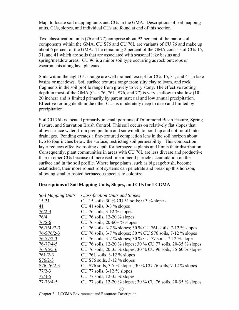
Map, to locate soil mapping units and CUs in the GMA. Descriptions of soil mapping units, CUs, slopes, and individual CUs are found at end of this section.
Two classification units (76 and 77) comprise about 92 percent of the major soil components within the GMA. CU S76 and CU 76L are variants of CU 76 and make up about 6 percent of the GMA. The remaining 2 percent of the GMA consists of CUs 15, 31, and 41 which are soils that are associated with seasonal lake basins and spring/meadow areas. CU 96 is a minor soil type occurring as rock outcrops or escarpments along lava plateaus.
Soils within the eight CUs range are well drained, except for CUs 15, 31, and 41 in lake basins or meadows. Soil surface textures range from silty clay to loam, and rock fragments in the soil profile range from gravely to very stony. The effective rooting depth in most of the GMA (CUs 76, 76L, S76, and 77) is very shallow to shallow (1020 inches) and is limited primarily by parent material and low annual precipitation. Effective rooting depth in the other CUs is moderately deep to deep and limited by precipitation.
Soil CU 76L is located primarily in small portions of Drummond Basin Pasture, Spring Pasture, and Starvation Brush Control. This soil occurs on relatively flat slopes that allow surface water, from precipitation and snowmelt, to pond-up and not runoff into drainages. Ponding creates a fine-textured compaction lens in the soil horizon about two to four inches below the surface, restricting soil permeability. This compaction layer reduces effective rooting depth for herbaceous plants and limits their distribution. Consequently, plant communities in areas with CU 76L are less diverse and productive than in other CUs because of increased fine mineral particle accumulation on the surface and in the soil profile. Where large plants, such as big sagebrush, become established, their more robust root systems can penetrate and break up this horizon, allowing smaller rooted herbaceous species to colonize.
Descriptions of Soil Mapping Units, Slopes, and CUs for LCGMA
Soil Mapping Units Classification Units and Slopes 15-31 CU 15 soils; 30 % CU 31 soils; 0-3 % slopes 41 CU 41 soils, 0-3 % slopes 76/2-3 CU 76 soils, 3-12 % slopes. 76/4 CU 76 soils, 12-20 % slopes 76/5-6 CU 76 soils, 20-60+ % slopes 76-76L/2-3 CU 76 soils, 3-7 % slopes; 30 % CU 76L soils, 7-12 % slopes 76-S76/2-3 CU 76 soils, 3-7 % slopes; 30 % CU S76 soils, 7-12 % slopes 76-77/2-3 CU 76 soils, 3-7 % slopes; 30 % CU 77 soils, 7-12 % slopes 76-77/4-5 CU 76 soils, 12-20 % slopes; 30 % CU 77 soils, 20-35 % slopes 76-96/5-6 CU 76 soils, 20-35 % slopes; 30 % CU 96 soils, 35-60 % slopes 76L/2-3 CU 76L soils, 3-12 % slopes S76/2-3 CU S76 soils, 3-12 % slopes S76-76/2-3 CU S76 soils, 3-7 % slopes; 30 % CU 76 soils, 7-12 % slopes 77/2-3 CU 77 soils, 3-12 % slopes 77/4-5 CU 77 soils, 12-35 % slopes 77-76/4-5 CU 77 soils, 12-20 % slopes; 30 % CU 76 soils, 20-35 % slopes
60 Chapter 2 – LCGMA Environment and Resources Description
77-S76/2-3 CU 77 soils, 3-7 % slopes; 30 % CU S76 soils, 7-12 % slopes 77-96/4-6 CU 77 soils, 20-35 % slopes; 30 % CU 96 soils, 35-60 % slopes
CU 15 Soils are deep, silty, poorly drained, on nearly level stream bottomlands. Soils occur usually at elevations of 3,000 to 4,500 feet and have a high potential for range seeding. Average annual precipitation ranges from 9-12 inches and mean annual air temperature centers around 47 degrees F. The soil profile by depth consist of dark brown peaty silt loam, black silty clay loam, grayish-brown silty clay loam to grayish-brown silt loam. The soil profile becomes coarser textured with depth. Native vegetation consists mostly of water tolerant grasses and sedges.
CU 31 Soils are deep, somewhat poorly drained, and are derived from fine-textured alluvium. They occur on flat basins, old playa bottoms, and sometimes on subdued clayey dune areas, leeward of playas. Soils occur usually at elevations of 4,000 to 5,000 feet and have a high potential for range seeding. Average annual precipitation ranges from 8-10 inches and mean annual air temperature centers around 45 degrees F. The soil profile by depth consists of light gray silty clay, light brownish-gray silty clay to light gray silty clay loam. Native vegetation consists mostly of western wheatgrass, big sagebrush, and rabbitbrush.
CU 41 Soils are deep, somewhat poorly drained, and are derived from fine-textured alluvium. They occur on flat basins, old playa bottoms. Soils occur usually at elevations of 4,000 to 4,500 feet and have a high potential for range seeding. Average annual precipitation ranges from 8-10 inches and mean annual air temperature centers around 45 degrees F. The soil profile consists of silt loam, clay, to silty clay loam. Native vegetation is mainly western wheatgrass, big sagebrush, and rabbitbrush.
CU 76 Soils are shallow, clayey, very stony, well drained soils over basalt, rhyolite, or welded tuff. They occur on gently undulating to rolling lava plateaus and some very steep faulted and dissected terrain. Soils occur at elevations from 3,500 to 6,500 feet and stones limit potential for range seeding. Average annual precipitation ranges from 8 to 11 inches, and mean annual air temperature centers around 47 degrees F. The soil profile by depth consists of gray, very stony, silt loam, brown stony silty clay, to brown stony and channery, heavy, silty clay loams over fractured bedrock at 18+ inches. Native vegetation consists mostly of bluebunch wheatgrass, Sandberg bluegrass, big and low sagebrush.
CU 76L Soils are shallow, clayey, stony, well drained soils over basalt, rhyolite, or welded tuff. They occur on gently undulating to rolling lava plateaus. Soils occur at elevations from 4,000 to 5,500 feet and have a high potential for range seeding. Average annual precipitation ranges from 8 to 11 inches, and mean annual air temperature centers around 45 degrees F. The soil profile consists of stony silt loam, stony heavy silty clay loam over basalt bedrock at 18+ inches. Native vegetation consists mostly of bluebunch wheatgrass, Sandberg bluegrass, big and low sagebrush.
61 Chapter 2 – LCGMA Environment and Resources Description
CU S76 Soils are shallow, extremely stony, well drained soils over basalt, rhyolite, or welded tuff. They occur on gently undulating to steep plateaus. Soils occur at elevations from 4,000 to 6,000 feet and have little potential for range seeding due to the large amount of rocks. Average annual precipitation ranges from 8 to 11 inches, and mean annual air temperature centers around 45 degrees F. The soil profile by depth consist of stony loam, extremely stony clay loam, extremely stony clay over fractured bedrock at 11+ inches. Native vegetation consists mostly of low sagebrush, Sandberg bluegrass, and bluebunch wheatgrass.
CU 77 Soils are very shallow, very stony, rocky, well drained soils over basalt, rhyolite, or welded tuff. They occur on gently undulating to rolling lava plateaus. Soils occur at elevations from 3,500 to 6,000 feet and have no potential for range seeding due to depth to bedrock and stoniness. Average annual precipitation ranges from 8 to 11 inches, and mean annual air temperature centers around 45 degrees F. The soil profile consists of very stony gravelly loam, very stony gravelly loam over basalt bedrock at 10+ inches. Native vegetation consists mostly of low sagebrush, big sagebrush, and Sandberg bluegrass.
CU 96 (Steep rock land) This is a miscellaneous land unit consisting of rough, steeply sloping areas that are predominantly shallow, very stony soils interspersed with rock outcrop. Steep rock land occurs mainly as canyons and escarpments along margins and dissected portions of lava plateaus.
Rangeland Health Standard 1 (Watershed Function – Uplands) As part of Standards of Rangeland Health, soil resources in the GMA were assessed for upland watershed function. This assessment focused on basic physical functions of upland soils that support plant communities and promote dependable flows of water from the watershed. Seventeen upland rangeland health indicators (BLM Tech Ref. 1734-6, 2000) were assessed at forty-three sites in twenty-one pastures for Soil/Site Stability (capacity to limit redistribution and loss of soil resources, including nutrients and organic matter, by wind and water), Hydrologic Function (capacity to capture, store, and safely release water, to resist a reduction in this capacity, and to recover this capacity following degradation), and Integrity of the Biotic Community (capacity to support functional and structural communities, to resist losses due to disturbance, and to recover following disturbance). At each assessment site, all indicators were compared to indicators obtained at relatively pristine reference areas.
All LCGMA pastures met Rangeland Standard 1. At twenty-two assessment sites, all indicators were equivalent to the reference area or to ecological site descriptions from OAESIS (Map 6). The remaining twenty-one assessment sites had some indicators which were somewhat impaired relative to the reference sites. In most cases, the impairments were associated with Biotic Integrity and not Soil Stability or Hydrologic Function. Over all, the soil, hydrologic, and biotic characteristics in all pastures were very comparable to reference sites and ecological site descriptions.
62 Chapter 2 – LCGMA Environment and Resources Description
Microbiotic Crusts Microbiotic crusts consist of lichens, bryophytes, algae, microfungi, cyanobacteria, and bacteria growing on or just below the soil surface (Eldridge and Greene 1994). Found in open spaces between larger plants, these crusts play a role in fixing nitrogen, filtering water, retaining soil moisture, and controlling soil erosion (Friedmann and Galun 1974; Belnap 1994). Cover types in the GMA that are associated with biological crust development include salt desert shrub, low sagebrush, and big sagebrush. Occurrence of curst in these cover types is directly related to elevation, precipitation, soil depth, soil texture, and interspaces between vascular plant cover. Crust is usually in greater abundance in salt-desert shrub communities occurring in lower elevations that receive limited precipitation, and have shallow soils depths and fine soil textures.
Microbiotic crust information was recorded at forty-three LCGMA assessment sites as percentage of total vegetative cover and percentage of ground cover. Crust ranged up to categories of 31-50 percent of total vegetative cover and to 16-30 percent of ground cover throughout the GMA. The highest percentage of crust in both categories occurred in the salt-desert transition cover type found in North Stoney Corral, Pole Creek Seeding, and Tristate pastures. Refer to Chapter 3, Rangeland Health Determinations, for microbiotic crust cover percentages for individual pastures. Because no Ecological Site Guides for microbiotic crusts exist, the cover values recorded in the GMA cannot be compared to Potential Natural Community or to microbiotic cover that existed historically (Roger Rosentreter, Botanist, BLM, Idaho State Office, pers. com., 2002).
63 Chapter 2 – LCGMA Environment and Resources Description

Chapter 3 - LCGMA Rangeland Health Determinations
Documents in this Chapter show specific results of the Rangeland Health Standards and Guides assessment for each pasture of LCGMA and determine whether Rangeland Health Standards 1-5 were met. Justifications and rationales for each determination are given. Rangeland health determinations were made on the basis of:
• Upland trend plot data analyses (Standards 1, 3) • Interpreting Indicators of Rangeland Health (USDI, BLM Tech. Ref. 1734-6, 2000) field
worksheets (Standards 1, 3, 5) • Proper Functioning Condition ratings for riparian/wetland areas (Process for Assessing
Proper Functioning Condition, BLM Tech. Ref. 1737-9, 1993) (Standards 2, 4, 5) • Determinations for Rangeland Health Standard 5 were also based on wildlife habitat
criteria from the SEORMP, Appendix F. • Site and landscape photographs • Professional judgment
Determinations for Rangeland Health Standard 4 (Water Quality) were based on:
1. Waterbody status, whether the stream is on the State 303(d) list (ODEQ) 2. Limitations on Beneficial Uses identified for the stream’s river basin 3. Existing water quality data 4. Existing supporting data, such as range monitoring data, soil surveys, slope steepness,
and aerial photography 5. Assessments for Rangeland Health Standards 1 (Watershed Function –Uplands),
Standard 3 (Watershed Function –Riparian), and Standard 3 (Ecological Processes) 6. Drainage patterns 7. Land ownership within watersheds
Determinations for all pastures were authorized by the Jordan Resource Area Manager.
1 Chapter 3 – Rangeland Health Determinations
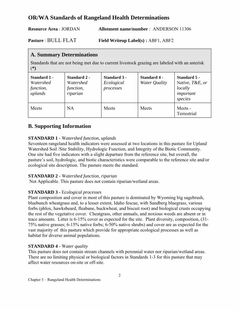
OR/WA Standards of Rangeland Health Determinations
Resource Area : JORDAN Allotment name/number : ANDERSON 11306
Pasture : BULL FLAT Field Writeup Label(s) : ABF1, ABF2
A. Summary Determinations Standards that are not being met due to current livestock grazing are labeled with an asterisk (*)
Standard 1 -Watershed function, uplands
Standard 2 -Watershed function, riparian
Standard 3 -Ecological processes
Standard 4 -Water Quality
Standard 5 -Native, T&E, or locally important species
Meets NA Meets Meets Meets - Terrestrial
B. Supporting Information
STANDARD 1 - Watershed function, uplandsSeventeen rangeland health indicators were assessed at two locations in this pasture for Upland Watershed Soil /Site Stability, Hydrologic Function, and Integrity of the Biotic Community. One site had five indicators with a slight departure from the reference site, but overall, the pasture’s soil, hydrologic, and biotic characteristics were comparable to the reference site and/or ecological site description. The pasture meets the standard.
STANDARD 2 - Watershed function, riparian Not Applicable. This pasture does not contain riparian/wetland areas.
STANDARD 3 - Ecological processesPlant composition and cover in most of this pasture is dominated by Wyoming big sagebrush, bluebunch wheatgrass and, to a lesser extent, Idaho fescue, with Sandberg bluegrass, various forbs (phlox, hawksbeard, fleabane, buckwheat, and biscuit root) and biological crusts occupying the rest of the vegetative cover. Cheatgrass, other annuals, and noxious weeds are absent or in trace amounts. Litter is 6-15% cover as expected for the site. Plant diversity, composition, (3175% native grasses; 6-15% native forbs; 6-50% native shrubs) and cover are as expected for the vast majority of this pasture which provide for appropriate ecological processes as well as habitat for diverse animal populations.
STANDARD 4 - Water quality This pasture does not contain stream channels with perennial water nor riparian/wetland areas. There are no limiting physical or biological factors in Standards 1-3 for this pasture that may affect water resources on-site or off-site.
2 Chapter 3 – Rangeland Health Determinations
STANDARD 5 - Native, T&E, or locally important species Based on an assessment of plant composition and structure criteria cited in Appendix F of the Southeast Oregon Resource Management Plan, the following conclusions about terrestrial wildlife habitat health have been made:
Native sagebrush rangelands SHRUB COVER – Habitats observed meet or exceed the minimum desired pasture level shrub cover conditions for native rangeland. The amount and quality of most shrubland habitat necessary to meet the forage, cover, and structure needs of wildlife (including sage grouse and other animals that occupy sagebrush habitats) is present.
HERBACEOUS COVER - Most habitats observed meet the desired herbaceous understory conditions for native rangeland (e.g. multiple species of native forbs and grasses consistent with mid, late, or potential natural community ecological conditions).
HABITAT CONNECTIVITY - There are no Shrub Class 1 or 2 (grassland) habitats of significant size within this pasture. The Geographic Management Area this pasture lies within exhibits a high level of connectivity and very low overall overstory fragmentation.
TERRESTRIAL SOURCE HABITATS - Most of the upland habitat observed conforms to Terrestrial Source Habitat criteria described in the Interior Columbia Basin Ecosystem Management Project.
Other supporting information - Refer to Jordan Resource Area wildlife evaluation file: Louse Canyon Geographic Management Area Summary Evaluation (Summer-Fall 2000) for other details.
Range Health Interdisciplinary Team Members - Tom Forre, Tom Miles, Cynthia Tait, Jack Wenderoth, Jon Sadowski
Authorized officer /s/ JERRY L. TAYLOR Jerry L. Taylor, Area Manager
Date of determination 12/7/01
3 Chapter 3 – Rangeland Health Determinations

OR/WA Standards of Rangeland Health Determinations
Resource Area : JORDAN Allotment name/number : ANDERSON 1401 Pasture : NORTH Field Writeup Label(s) : AN1, AN2
A. Summary Determinations Standards that are not being met due to current livestock grazing are labeled with an asterisk (*)
Standard 1 -Watershed function, uplands
Standard 2 -Watershed function, riparian
Standard 3 -Ecological processes
Standard 4 -Water Quality
Standard 5 -Native, T&E, or locally important species
Meets NA Meets Meets Meets Terrestrial
B. Supporting Narratives
STANDARD 1 - watershed function, uplands Seventeen rangeland health indicators were assessed at two locations in this pasture for Upland Watershed Soil /Site Stability, Hydrologic Function, and Integrity of the Biotic Community. All indicators at both sites were what would be expected for the area relative to the ecological reference area and/or the ecological site description. Overall the pasture had soil, hydrologic, and biotic characteristics comparable to the reference site and/or ecological site description. The pasture meets the standard.
STANDARD 2 - watershed function, riparian Not Applicable. This pasture does not contain riparian/wetland areas.
STANDARD 3 - ecological processes Plant composition and cover in most of this pasture are dominated by Wyoming big sagebrush, bluebunch wheatgrass and, to a lesser extent, Idaho fescue with Sandberg bluegrass, various forbs (phlox, hawksbeard, fleabane, buckwheat, lupine, and aster) and biological crusts occupying the rest of the vegetative cover. Reference quality sites are found in this pasture. Cheatgrass, other annuals, and noxious weeds are absent or occur in trace amounts. Litter is 617% cover as expected for the site. Plant diversity, composition, (50-75% native grasses; 1015% native forbs; 4-35% native shrubs) and cover are more than expected for this pasture, providing for appropriate ecological processes as well as habitat for diverse animal populations.
STANDARD 4 - water quality This pasture does not contain stream channels with perennial water nor riparian/wetland areas. There are no limiting physical or biological factors in Standards 1-3 for this pasture that may affect water resources on-site or off-site.
4 Chapter 3 – Rangeland Health Determinations
STANDARD 5 - native, T&E, or locally important species Based on an assessment of plant composition and structure criteria cited in Appendix F of the Southeast Oregon Resource Management Plan, the following conclusions about terrestrial wildlife habitat health have been made:
Native sagebrush rangelands SHRUB COVER – Habitats observed meet or exceed the minimum desired pasture level shrub cover conditions for native rangeland. The amount and quality of most shrubland habitat necessary to meet the forage, cover, and structure needs of wildlife (including sage grouse and other animals that occupy sagebrush habitats) is present.
HERBACEOUS COVER - Most habitats observed meet the desired herbaceous understory conditions for native rangeland (e.g. multiple species of native forbs and grasses consistent with mid, late, or potential natural community ecological conditions).
HABITAT CONNECTIVITY - Although there is evidence of an old 1,000 – 2,000 acre burn in North Pasture (date undetermined), it does not dominate the overall habitat aspect. Due to the overall degree of sagebrush community connectivity within the Geographic Management Area, Class 1 & 2 (grassland) conditions do not contribute towards landscape level habitat fragmentation problems for wildlife.
TERRESTRIAL SOURCE HABITATS - Most of the upland habitat observed conforms to Terrestrial Source Habitat criteria described in the Interior Columbia Basin Ecosystem Management Project.
Other supporting information - Refer to Jordan Resource Area wildlife evaluation file: Louse Canyon Geographic Management Area Summary Evaluation (Summer-Fall 2000) for other details.
Range Health Interdisciplinary Team Members - Tom Forre, Tom Miles, Cynthia Tait, Jack Wenderoth, Jon Sadowski
Authorized officer /s/ JERRY L. TAYLOR Jerry L. Taylor, Area Manager
Date of determination 12/7/01
5 Chapter 3 – Rangeland Health Determinations
OR/WA Standards of Rangeland Health Determinations
Resource Area : JORDAN Allotment name/number : ANDERSON 1401 Pasture : SPRING Field Writeup Label(s) : AS1, AS2
A. Summary Determinations Standards that are not being met due to current livestock grazing are labeled with an asterisk (*)
Standard 1 -Watershed function, uplands
Standard 2 -Watershed function, riparian
Standard 3 -Ecological processes
Standard 4 -Water Quality
Standard 5 -Native, T&E, or locally important species
Meets NA Meets Meets Meets - Terrestrial
B. Supporting Narratives
STANDARD 1 - Watershed function, uplands Seventeen rangeland health indicators were assessed at two locations in this pasture for upland watershed Soil /Site Stability, Hydrologic Function, and Integrity of the Biotic Community. All indicators at one site were what would be expected for the area as compared to the ecological reference area and/or the ecological site description. The second site contained three indicators with a slightly higher degree of departure from the reference site. Overall the pasture contained soil, hydrologic, and biotic characteristics comparable to the reference site and/or ecological site description. The pasture meets the standard.
STANDARD 2 - Watershed function, riparian Not Applicable. This pasture does not contain riparian/wetland areas.
STANDARD 3 -Ecological processes Plant composition and cover in most of this pasture are dominated by Wyoming big sagebrush and bluebunch wheatgrass, with Sandberg bluegrass, various forbs (phlox, hawksbeard, fleabane, buckwheat, penstemon, and biscuit root) and biological crusts occupying the rest of the vegetative cover. Noxious weeds are absent in this pasture, but trace amounts of cheatgrass exist in drainage and rocky scab areas. Litter was 6-15% cover as expected for the site. About ¾ of the pasture is late seral to PNC sagebrush rangeland. However, a small area in the southeast portion of the pasture is definitely different than the rest of the pasture. There is an obvious difference in soils (color is different, texture, amount of gravel, etc.). In addition, the perennial grass cover is dominated by Sandberg bluegrass and some bottlebrush squirreltail with bluebunch wheatgrass lacking. Litter and biological crust cover is the same as the reference quality sites of the pasture. Water location does not seem to be congregating cattle in this southeast area as there are three other good reservoirs in the reference quality sites of the pasture. All indications are that the soils and drougthy nature of this site have resulted in lack of bluebunch wheatgrass production. Possibly, historical grazing reduced the bluebunch wheatgrass, and the site is slow to recover. We have no indication that current grazing would be
6 Chapter 3 – Rangeland Health Determinations
a factor in the lack of bluebunch wheatgrass on this southeast area since bluebunch wheatgrass is so plentiful elsewhere in the pasture. Overall, plant diversity, composition, (31-50% native grasses; 10-15% native forbs; 16-50% native shrubs) and cover is at least as expected for this pasture (with the exception of the southeast area mentioned above) which provides for ecological processes as well as habitat for diverse animal populations.
STANDARD 4 - Water Quality This pasture does not contain stream channels with perennial water nor riparian/wetland areas. There are no limiting physical or biological factors in Standards 1-3 for this pasture that may affect water resources on-site or off-site, therefore this pasture meets Standard 4.
STANDARD 5 - Native, T&E, or locally important speciesBased on an assessment of plant composition and structure criteria cited in Appendix F of the Southeast Oregon Resource Management Plan, the following conclusions about wildlife habitat health have been made:
Native sagebrush rangelands SHRUB COVER – Habitats observed meet or exceed the minimum desired pasture level shrub cover conditions for native rangeland. The amount and quality of most shrubland habitat necessary to meet the forage, cover, and structure needs of wildlife (including sage grouse and other animals that occupy sagebrush habitats) is present.
HERBACEOUS COVER - Most habitats observed meet the desired herbaceous understory conditions for native rangeland (e.g. multiple species of native forbs and grasses consistent with mid, late, or potential natural community ecological conditions).
HABITAT CONNECTIVITY - There are no Class 1/2 (grassland) habitats of significant size within this pasture. The Geographic Management Area this pasture lies within exhibits a high level of connectivity and very low overall overstory fragmentation.
TERRESTRIAL SOURCE HABITATS - Most of the upland habitat observed conforms to Terrestrial Source Habitat criteria described in the Interior Columbia Basin Ecosystem Management Project.
Other supporting information - Refer to Jordan Resource Area wildlife evaluation file: Louse Canyon Geographic Management Area Summary Evaluation ( Summer-Fall 2000) for other details.
Range Health Interdisciplinary Team Members – Tom Forre, Tom Miles, Cynthia Tait, Jack Wenderoth, Jon Sadowski
Authorized officer /s/ JERRY L. TAYLOR Jerry L. Taylor, Area Manager
Date of determination 12/7/01
7 Chapter 3 – Rangeland Health Determinations
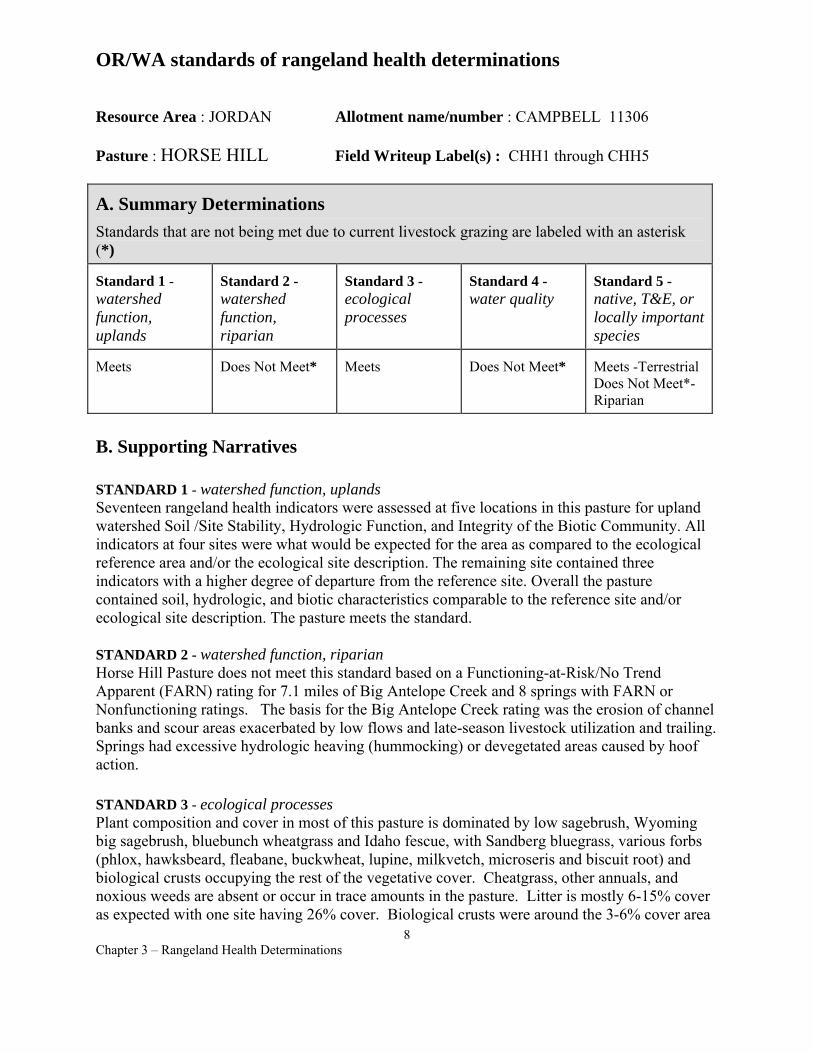
OR/WA standards of rangeland health determinations
Resource Area : JORDAN Allotment name/number : CAMPBELL 11306
Pasture : HORSE HILL Field Writeup Label(s) : CHH1 through CHH5
A. Summary Determinations Standards that are not being met due to current livestock grazing are labeled with an asterisk (*)
Standard 1 -watershed function, uplands
Standard 2 -watershed function, riparian
Standard 3 -ecological processes
Standard 4 -water quality
Standard 5 -native, T&E, or locally important species
Meets Does Not Meet* Meets Does Not Meet* Meets -Terrestrial Does Not Meet*Riparian
B. Supporting Narratives
STANDARD 1 - watershed function, uplands Seventeen rangeland health indicators were assessed at five locations in this pasture for upland watershed Soil /Site Stability, Hydrologic Function, and Integrity of the Biotic Community. All indicators at four sites were what would be expected for the area as compared to the ecological reference area and/or the ecological site description. The remaining site contained three indicators with a higher degree of departure from the reference site. Overall the pasture contained soil, hydrologic, and biotic characteristics comparable to the reference site and/or ecological site description. The pasture meets the standard.
STANDARD 2 - watershed function, riparian Horse Hill Pasture does not meet this standard based on a Functioning-at-Risk/No Trend Apparent (FARN) rating for 7.1 miles of Big Antelope Creek and 8 springs with FARN or Nonfunctioning ratings. The basis for the Big Antelope Creek rating was the erosion of channel banks and scour areas exacerbated by low flows and late-season livestock utilization and trailing. Springs had excessive hydrologic heaving (hummocking) or devegetated areas caused by hoof action.
STANDARD 3 - ecological processes Plant composition and cover in most of this pasture is dominated by low sagebrush, Wyoming big sagebrush, bluebunch wheatgrass and Idaho fescue, with Sandberg bluegrass, various forbs (phlox, hawksbeard, fleabane, buckwheat, lupine, milkvetch, microseris and biscuit root) and biological crusts occupying the rest of the vegetative cover. Cheatgrass, other annuals, and noxious weeds are absent or occur in trace amounts in the pasture. Litter is mostly 6-15% cover as expected with one site having 26% cover. Biological crusts were around the 3-6% cover area
8 Chapter 3 – Rangeland Health Determinations
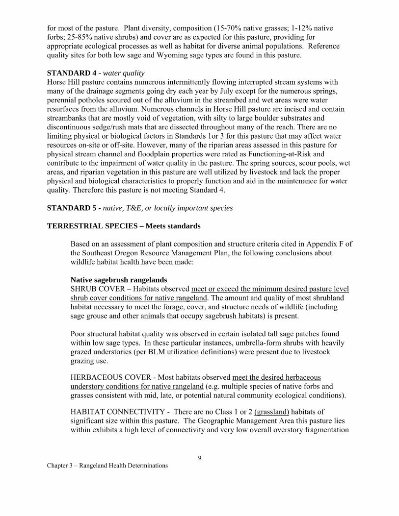
for most of the pasture. Plant diversity, composition (15-70% native grasses; 1-12% native forbs; 25-85% native shrubs) and cover are as expected for this pasture, providing for appropriate ecological processes as well as habitat for diverse animal populations. Reference quality sites for both low sage and Wyoming sage types are found in this pasture.
STANDARD 4 - water quality Horse Hill pasture contains numerous intermittently flowing interrupted stream systems with many of the drainage segments going dry each year by July except for the numerous springs, perennial potholes scoured out of the alluvium in the streambed and wet areas were water resurfaces from the alluvium. Numerous channels in Horse Hill pasture are incised and contain streambanks that are mostly void of vegetation, with silty to large boulder substrates and discontinuous sedge/rush mats that are dissected throughout many of the reach. There are no limiting physical or biological factors in Standards 1or 3 for this pasture that may affect water resources on-site or off-site. However, many of the riparian areas assessed in this pasture for physical stream channel and floodplain properties were rated as Functioning-at-Risk and contribute to the impairment of water quality in the pasture. The spring sources, scour pools, wet areas, and riparian vegetation in this pasture are well utilized by livestock and lack the proper physical and biological characteristics to properly function and aid in the maintenance for water quality. Therefore this pasture is not meeting Standard 4.
STANDARD 5 - native, T&E, or locally important species
TERRESTRIAL SPECIES – Meets standards
Based on an assessment of plant composition and structure criteria cited in Appendix F of the Southeast Oregon Resource Management Plan, the following conclusions about wildlife habitat health have been made:
Native sagebrush rangelands SHRUB COVER – Habitats observed meet or exceed the minimum desired pasture level shrub cover conditions for native rangeland. The amount and quality of most shrubland habitat necessary to meet the forage, cover, and structure needs of wildlife (including sage grouse and other animals that occupy sagebrush habitats) is present.
Poor structural habitat quality was observed in certain isolated tall sage patches found within low sage types. In these particular instances, umbrella-form shrubs with heavily grazed understories (per BLM utilization definitions) were present due to livestock grazing use.
HERBACEOUS COVER - Most habitats observed meet the desired herbaceous understory conditions for native rangeland (e.g. multiple species of native forbs and grasses consistent with mid, late, or potential natural community ecological conditions).
HABITAT CONNECTIVITY - There are no Class 1 or 2 (grassland) habitats of significant size within this pasture. The Geographic Management Area this pasture lies within exhibits a high level of connectivity and very low overall overstory fragmentation
9 Chapter 3 – Rangeland Health Determinations
TERRESTRIAL SOURCE HABITATS - Most of the upland habitat observed conforms to Terrestrial Source Habitat criteria described in the Interior Columbia Basin Ecosystem Management Project.
Riparian plant composition and structure Some of the riparian conditions observed meet the desired forage, cover, and structure needs of terrestrial wildlife. The locations, types, and amounts of habitat adversely affected by livestock grazing use warrant a change in grazing use management. Refer to Standard 2 narrative above.
Other supporting information - Refer to Jordan Resource Area wildlife evaluation file: Louse Canyon Geographic Management Area Summary Evaluation (Summer-Fall 2000) for other details.
RIPARIAN SPECIES – Does Not Meet Standards
Based on assessments for Standard 2 (watershed function, riparian) the riparian conditions observed on 7.1 stream miles and 8 spring areas were not sufficient to dissipate stream energy, reduce erosion, store water for later release, or provide rearing and foraging areas for fish, amphibians, and invertebrates. These habitats were adversely affected by livestock grazing that reduced plant cover and compacted wet soils.
Range Health Interdisciplinary Team Members - Tom Forre, Tom Miles, Cynthia Tait, Jack Wenderoth, Jon Sadowski
Authorized officer /s/ JERRY L. TAYLOR Jerry L. Taylor, Area Manager
Date of determination 12/7/01
10 Chapter 3 – Rangeland Health Determinations
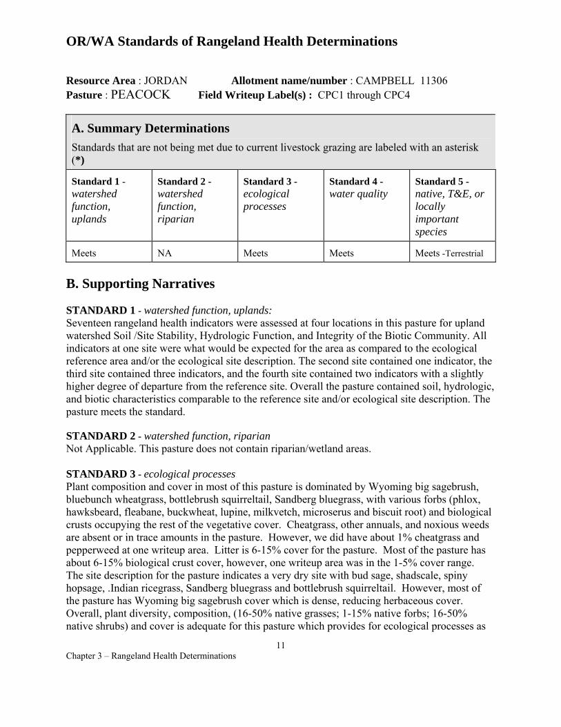
OR/WA Standards of Rangeland Health Determinations
Resource Area : JORDAN Allotment name/number : CAMPBELL 11306 Pasture : PEACOCK Field Writeup Label(s) : CPC1 through CPC4
A. Summary Determinations Standards that are not being met due to current livestock grazing are labeled with an asterisk (*)
Standard 1 -watershed function, uplands
Standard 2 -watershed function, riparian
Standard 3 -ecological processes
Standard 4 -water quality
Standard 5 -native, T&E, or locally important species
Meets NA Meets Meets Meets -Terrestrial
B. Supporting Narratives
STANDARD 1 - watershed function, uplands: Seventeen rangeland health indicators were assessed at four locations in this pasture for upland watershed Soil /Site Stability, Hydrologic Function, and Integrity of the Biotic Community. All indicators at one site were what would be expected for the area as compared to the ecological reference area and/or the ecological site description. The second site contained one indicator, the third site contained three indicators, and the fourth site contained two indicators with a slightly higher degree of departure from the reference site. Overall the pasture contained soil, hydrologic, and biotic characteristics comparable to the reference site and/or ecological site description. The pasture meets the standard.
STANDARD 2 - watershed function, riparian Not Applicable. This pasture does not contain riparian/wetland areas.
STANDARD 3 - ecological processes Plant composition and cover in most of this pasture is dominated by Wyoming big sagebrush, bluebunch wheatgrass, bottlebrush squirreltail, Sandberg bluegrass, with various forbs (phlox, hawksbeard, fleabane, buckwheat, lupine, milkvetch, microserus and biscuit root) and biological crusts occupying the rest of the vegetative cover. Cheatgrass, other annuals, and noxious weeds are absent or in trace amounts in the pasture. However, we did have about 1% cheatgrass and pepperweed at one writeup area. Litter is 6-15% cover for the pasture. Most of the pasture has about 6-15% biological crust cover, however, one writeup area was in the 1-5% cover range. The site description for the pasture indicates a very dry site with bud sage, shadscale, spiny hopsage, .Indian ricegrass, Sandberg bluegrass and bottlebrush squirreltail. However, most of the pasture has Wyoming big sagebrush cover which is dense, reducing herbaceous cover. Overall, plant diversity, composition, (16-50% native grasses; 1-15% native forbs; 16-50% native shrubs) and cover is adequate for this pasture which provides for ecological processes as
11 Chapter 3 – Rangeland Health Determinations
well as habitat for diverse animal populations. Therefore, Standard 3 is met.
STANDARD 4 - water quality: This pasture does not contain stream channels with perennial water nor riparian/wetland areas. There are no limiting physical or biological factors in Standards 1-3 for this pasture that may affect water resources on-site or off-site.
STANDARD 5 - native, T&E, or locally important species Based on an assessment of plant composition and structure criteria cited in Appendix F of the Southeast Oregon Resource Management Plan, the following conclusions about terrestrial wildlife habitat health have been made:
Native sagebrush rangelands SHRUB COVER – Habitats observed meet or exceed the minimum desired pasture level shrub cover conditions for native rangeland. The amount and quality of most shrubland habitat necessary to meet the forage, cover, and structure needs of wildlife (including sage grouse and other animals that occupy sagebrush habitats) is present.
HERBACEOUS COVER - Most habitats observed meet the desired herbaceous understory conditions for native rangeland (e.g. multiple species of native forbs and grasses consistent with mid, late, or potential natural community ecological conditions).
HABITAT CONNECTIVITY - There are no Class 1 & 2 (grassland) habitats of significant size within this pasture. The Geographic Management Area this pasture lies within exhibits a high level of connectivity and very low overall overstory fragmentation.
TERRESTRIAL SOURCE HABITATS - Most of the upland habitat observed conforms to Terrestrial Source Habitat criteria described in the Interior Columbia Basin Ecosystem Management Project.
Other supporting information - Refer to Jordan Resource Area wildlife evaluation file: Louse Canyon Geographic Management Area Summary Evaluation ( Summer-Fall 2000) for other details.
Range Health Interdisciplinary Team Members - Tom Forre, Tom Miles, Cynthia Tait, Jack Wenderoth, Jon Sadowski
Authorized officer /s/ JERRY L. TAYLOR Jerry L. Taylor, Area Manager
Date of determination 12/7/01
12 Chapter 3 – Rangeland Health Determinations
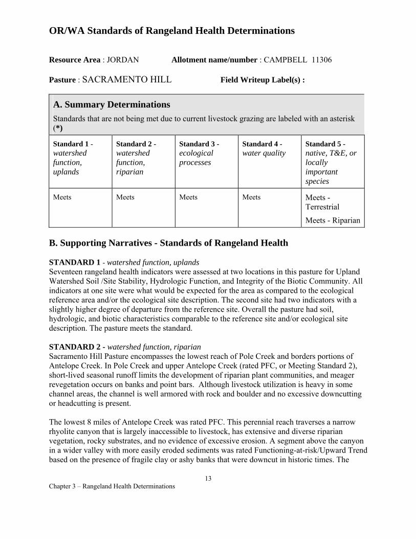
OR/WA Standards of Rangeland Health Determinations
Resource Area : JORDAN Allotment name/number : CAMPBELL 11306
Pasture : SACRAMENTO HILL Field Writeup Label(s) :
A. Summary Determinations Standards that are not being met due to current livestock grazing are labeled with an asterisk (*)
Standard 1 -watershed function, uplands
Standard 2 -watershed function, riparian
Standard 3 -ecological processes
Standard 4 -water quality
Standard 5 -native, T&E, or locally important species
Meets Meets Meets Meets Meets Terrestrial
Meets - Riparian
B. Supporting Narratives - Standards of Rangeland Health
STANDARD 1 - watershed function, uplands Seventeen rangeland health indicators were assessed at two locations in this pasture for Upland Watershed Soil /Site Stability, Hydrologic Function, and Integrity of the Biotic Community. All indicators at one site were what would be expected for the area as compared to the ecological reference area and/or the ecological site description. The second site had two indicators with a slightly higher degree of departure from the reference site. Overall the pasture had soil, hydrologic, and biotic characteristics comparable to the reference site and/or ecological site description. The pasture meets the standard.
STANDARD 2 - watershed function, riparian Sacramento Hill Pasture encompasses the lowest reach of Pole Creek and borders portions of Antelope Creek. In Pole Creek and upper Antelope Creek (rated PFC, or Meeting Standard 2), short-lived seasonal runoff limits the development of riparian plant communities, and meager revegetation occurs on banks and point bars. Although livestock utilization is heavy in some channel areas, the channel is well armored with rock and boulder and no excessive downcutting or headcutting is present.
The lowest 8 miles of Antelope Creek was rated PFC. This perennial reach traverses a narrow rhyolite canyon that is largely inaccessible to livestock, has extensive and diverse riparian vegetation, rocky substrates, and no evidence of excessive erosion. A segment above the canyon in a wider valley with more easily eroded sediments was rated Functioning-at-risk/Upward Trend based on the presence of fragile clay or ashy banks that were downcut in historic times. The
13 Chapter 3 – Rangeland Health Determinations
abundance of two willow species showing vigorous reproduction, along with a diverse sedge/rush community, indicates an Upward Trend.
STANDARD 3 - ecological processes Standard 3 is met in Sacramento Hill Pasture. Plant composition and cover in most of this pasture is dominated by Wyoming big sagebrush, bluebunch wheatgrass, bottlebrush squirreltail and Sandberg bluegrass, with various forbs (phlox, fleabane, buckwheat, lupine, and hawksbeard) and biological crusts occupying the rest of the vegetative cover. Cheatgrass, other annuals, and noxious weeds are absent or in trace amounts in the pasture (one site had <1% cheatgrass and pepperweed). Litter is at 6-15% cover as expected for the site. Plant diversity, composition (31-50% native grasses; 1-5% native forbs; 31-50% native shrubs (Wyoming big sagebrush, horsebrush, spiny hopsage)) and cover are adequate for these sites and provide for ecological processes as well as habitat for diverse animal populations.
STANDARD 4 - water quality This pasture does not contain stream channels with perennial water and has limited riparian/wetland areas. There are no limiting physical or biological factors in Standards 1-3 for this pasture that may affect water resources on-site or off-site.
STANDARD 5 - native, T&E, or locally important species
TERRESTRIAL SPECIES – Meets standards
Based on an assessment of plant composition and structure criteria cited in Appendix F of the SEORMP the following conclusions about terrestrial wildlife habitat health have been made:
Native sagebrush rangelands SHRUB COVER – Habitats observed meet or exceed the minimum desired pasture level shrub cover conditions for native rangeland. The amount and quality of most shrubland habitat necessary to meet the forage, cover, and structure needs of wildlife (including sage grouse and other animals that occupy sagebrush habitats) is present.
HERBACEOUS COVER - Most habitats observed meet the desired herbaceous understory conditions for native rangeland (e.g. multiple species of native forbs and grasses consistent with mid, late, or potential natural community ecological conditions).
HABITAT CONNECTIVITY - There are no Class 1 & 2 (grassland) habitats of significant size within this pasture. The Geographic Management Area this pasture lies within exhibits a high level of connectivity and very low overall overstory fragmentation
TERRESTRIAL SOURCE HABITATS - Most of the upland habitat observed conforms to Terrestrial Source Habitat criteria described in the Interior Columbia Basin Ecosystem Management Project.
14 Chapter 3 – Rangeland Health Determinations
Other supporting information - Refer to Jordan Resource Area wildlife evaluation file: Louse Canyon Geographic Management Area Summary Evaluation (Summer-Fall 2000) for other details.
RIPARIAN SPECIES –Meets Standards
Based on assessments for Standard 2, Sacramento Hill Pasture meets the criteria for Standard 5 for riparian species. Pole Creek and the intermittent reach of Antelope Creek provide passage for fish during runoff, and Antelope Creek, Reaches 1 & 2, provides good perennial habitat for four native fishes and probably amphibians.
Range Health Interdisciplinary Team Members - Tom Forre, Tom Miles, Cynthia Tait, Jack Wenderoth, Jon Sadowski
Authorized officer /s/ JERRY L. TAYLOR Jerry L. Taylor, Area Manager
Date of determination 12/7/01
15 Chapter 3 – Rangeland Health Determinations
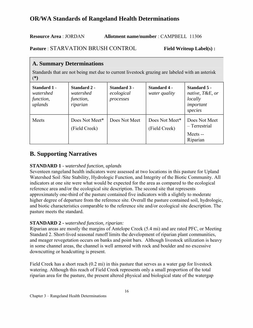
OR/WA Standards of Rangeland Health Determinations
Resource Area : JORDAN Allotment name/number : CAMPBELL 11306
Pasture : STARVATION BRUSH CONTROL Field Writeup Label(s) :
A. Summary Determinations Standards that are not being met due to current livestock grazing are labeled with an asterisk (*)
Standard 1 -watershed function, uplands
Standard 2 -watershed function, riparian
Standard 3 -ecological processes
Standard 4 -water quality
Standard 5 -native, T&E, or locally important species
Meets Does Not Meet*
(Field Creek)
Does Not Meet Does Not Meet*
(Field Creek)
Does Not Meet – Terrestrial
Meets --Riparian
B. Supporting Narratives
STANDARD 1 - watershed function, uplands Seventeen rangeland health indicators were assessed at two locations in this pasture for Upland Watershed Soil /Site Stability, Hydrologic Function, and Integrity of the Biotic Community. All indicators at one site were what would be expected for the area as compared to the ecological reference area and/or the ecological site description. The second site that represents approximately one-third of the pasture contained five indicators with a slightly to moderate higher degree of departure from the reference site. Overall the pasture contained soil, hydrologic, and biotic characteristics comparable to the reference site and/or ecological site description. The pasture meets the standard.
STANDARD 2 - watershed function, riparian: Riparian areas are mostly the margins of Antelope Creek (5.4 mi) and are rated PFC, or Meeting Standard 2. Short-lived seasonal runoff limits the development of riparian plant communities, and meager revegetation occurs on banks and point bars. Although livestock utilization is heavy in some channel areas, the channel is well armored with rock and boulder and no excessive downcutting or headcutting is present.
Field Creek has a short reach (0.2 mi) in this pasture that serves as a water gap for livestock watering. Although this reach of Field Creek represents only a small proportion of the total riparian area for the pasture, the present altered physical and biological state of the watergap
16 Chapter 3 – Rangeland Health Determinations
consequently rates this reach as Functioning at Risk. Therefore, Starvation Brush Control overall was rated as Not Meeting Standard 2.
STANDARD 3 - ecological processes Standard 3 is barely met in Starvation Brush Control. Plant composition and cover in most of this pasture is dominated by Wyoming big sagebrush, bluebunch wheatgrass, and Sandberg bluegrass, with various forbs (hawksbeard and phlox) and biological crusts occupying the rest of the vegetative cover. Cheatgrass, other annuals, and noxious weeds are absent or in trace amounts (one site had <1% cheatgrass). Litter is about 2-6% cover which is not as high as similar sites in other pastures. Plant diversity, composition (39-46% native grasses; 1-3% native forbs; 53-59% native shrubs) and cover are as expected for the northern two-thirds of the pasture. However, the southern ⅓ lacks diversity in the understory (bluebunch wheatgrass and forbs lacking).
STANDARD 4 - water quality: Segments of Antelope Creek (5.4 mi.) and Field Creek (0.2 mi.) flow through Starvation Brush Control pasture. Both creeks are intermittently flowing interrupted stream systems that usually dry up each year by July. There are no limiting physical or biological factors in Standards 1-3 for this pasture that may affect water resources on-site or off-site except for the water gap in Field Creek. However, riparian areas assessed in Field Creek for physical stream channel and floodplain properties were rated as Functioning-at-Risk and contribute to the impairment of water quality in the pasture. The spring source, wet areas, and riparian vegetation of the watergap are well utilized by livestock and lack the proper physical and biological characteristics to properly function and aid in the maintenance for water quality. Therefore this pasture is not meeting Standard 4.
STANDARD 5 - native, T&E, or locally important species
TERRESTRIAL SPECIES – Does not meet standards
Based on an assessment of plant composition and structure criteria cited in Appendix F of the Southeast Oregon Resource Management Plan, Final Environmental Impact Statement, the following conclusions about terrestrial wildlife habitat health have been made:
Native sagebrush rangelands SHRUB COVER – Habitats observed meet or exceed the minimum desired pasture level shrub cover conditions for native rangeland. The amount and quality of shrubland habitat necessary to meet the forage, cover, and structure needs of wildlife (including sage grouse and other animals that occupy sagebrush habitats) is present.
HERBACEOUS COVER - Most habitats observed meet the desired herbaceous understory conditions for native rangeland (e.g. multiple species of native forbs and grasses consistent with mid, late, or potential natural community ecological conditions). However, the southern ⅓ of the pasture near Lucky Seven Cow Camp is more consistent with early ecological conditions and does not meet the desired herbaceous understory conditions for native rangeland. Therefore, the pasture does not meet standards.
17 Chapter 3 – Rangeland Health Determinations
HABITAT CONNECTIVITY - There are no Class 1 or 2 (grassland) habitats of significant size within this pasture. The Geographic Management Area this pasture lies within exhibits a high level of connectivity and very low overall overstory fragmentation
TERRESTRIAL SOURCE HABITATS - Upland habitat observed in the northern 2/3 of this pasture conforms to Terrestrial Source Habitat criteria described in the Interior Columbia Basin Ecosystem Management Project.
Other supporting information - Refer to Jordan Resource Area wildlife evaluation file: Louse Canyon Geographic Management Area Summary Evaluation (Summer-Fall 2000) for other details.
RIPARIAN SPECIES –Meets Standards
Antelope Creek provides passage for fish only during spring runoff periods. Not enough water is present naturally to furnish season-long habitat for aquatic species.
See Steer Canyon Seeding (Louse Canyon Allotment) and Horse Hill Pasture (Campbell Allotment) for assessments of riparian species in Field Creek.
Range Health Interdisciplinary Team Members - Tom Forre, Tom Miles, Cynthia Tait, Jack Wenderoth, Jon Sadowski
Authorized officer /s/ JERRY L. TAYLOR Jerry L. Taylor, Area Manager
Date of determination 12/7/01
18 Chapter 3 – Rangeland Health Determinations

OR/WA Standards of Rangeland Health Determinations
Resource Area : JORDAN Allotment name/number : CAMPBELL 11306
Pasture : STARVATION SEEDING Field Writeup Label(s) :
A. Summary Determinations Standards that are not being met due to current livestock grazing are labeled with an asterisk (*)
Standard 1 -watershed function, uplands
Standard 2 -watershed function, riparian
Standard 3 -ecological processes
Standard 4 -water quality
Standard 5 -native, T&E, or locally important species
Meets Meets Does Not Meet Meets Does Not Meet – Terrestrial
Meets --Riparian
B. Supporting Narratives
STANDARD 1 - watershed function, uplands: Seventeen rangeland health indicators were assessed at two locations in this pasture for Upland Watershed Soil /Site Stability, Hydrologic Function, and Integrity of the Biotic Community. All indicators at one site were what would be expected for the area as compared to the ecological reference area and/or the ecological site description. The second site contained three indicators with a slightly higher degree of departure from the reference site. Overall the pasture contained soil, hydrologic, and biotic characteristics comparable to the reference site and/or ecological site description. The pasture meets the standard.
STANDARD 2 - watershed function, riparian: Riparian areas consist of the margins of Antelope Creek (8.8 mi) and are rated Proper Functioning Condition, or Meeting Standard 2. Short-lived seasonal runoff limits the development of riparian plant communities, and meager revegetation occurs on banks and point bars. Although livestock utilization is heavy in some channel areas, the channel is well armored with rock and boulder and no excessive downcutting or headcutting is present.
STANDARD 3 - ecological processes Plant composition and cover in most of this pasture is dominated by Wyoming big sagebrush, crested wheatgrass, and Sandberg bluegrass, with very little else occupying the rest of the vegetative cover. Cheatgrass, other annuals, and noxious weeds are absent or in trace amounts in the pasture. Litter is at 16-30% which was higher than most sites. Plant diversity and
19 Chapter 3 – Rangeland Health Determinations
composition (98% exotic grasses and some natives; trace forbs; 2% native shubs), is not as expected for these sites as the pasture is a crested wheatgrass seeding. Herbaceous diversity is especially lacking as crested wheatgrass and Sandberg bluegrass are nearly the only plants in the understory. Standard 3 is not being met as a diverse understory of native grass and forb species would be needed to provide the ecological processes typical for this site.
STANDARD 4 - water quality: Antelope Creek in Starvation Seeding is an intermittently flowing, interrupted stream system that usually dries up each year by July. There are no limiting physical or biological factors in Standards 1-3 for this pasture that may affect water resources on-site or off-site, and therefore this pasture meets Standard 4.
STANDARD 5 - native, T&E, or locally important species
TERRESTRIAL SPECIES – Does Not Meets Standards
Based on an assessment of plant composition and structure criteria cited in Appendix F of the Southeast Oregon Resource Management Plan, the following conclusions about terrestrial wildlife habitat health have been made:
Seeded sagebrush rangelands SHRUB COVER – Habitats observed do not meet the minimum desired pasture level shrub cover conditions for seeded rangeland. The amount and quality of shrubland habitat necessary to meet the forage, cover, and structure needs of wildlife (including sage grouse and other animals that occupy sagebrush habitats) is not present. Little or no sagebrush recolonization has occurred within the Starvation Seeding since 1964 when 14,000 acres were planted to crested wheatgrass. About 10% of the pasture remains in a native, unseeded state with Class 3/4/5 (shrubland) overstory conditions.
HERBACEOUS COVER - Habitats observed do not meet the minimum desired herbaceous understory conditions for seeded rangeland (e.g. at least some native or introduced forb species)
HABITAT CONNECTIVITY – Although this seeding does not meet the minimum habitat criteria mentioned above, its habitat limitations for wildlife communities are fine scale and localized. Due to the overall degree of sagebrush community connectivity within the Geographic Management Area, Class 1 & 2 (grassland) conditions in this pasture do not contribute towards landscape level habitat fragmentation problems for wildlife.
TERRESTRIAL SOURCE HABITATS - Little or none of the upland habitat observed conforms to Terrestrial Source Habitat criteria described in the Interior Columbia Basin Ecosystem Management Project.
Other supporting information - Refer to Jordan Resource Area wildlife evaluation file: Louse Canyon Geographic Management Area Summary Evaluation (Summer-Fall 2000) for other details.
20 Chapter 3 – Rangeland Health Determinations

RIPARIAN SPECIES –Meets Standards
Based on assessments for Standard 2 (watershed function, riparian) the riparian condition on this reach of Antelope Creek (intermittent) was Proper Functioning Condition. Antelope Creek provides passage for fish during runoff only. Not enough water is present naturally to furnish season-long habitat for aquatic species.
Range Health Interdisciplinary Team Members - Tom Forre, Tom Miles, Cynthia Tait, Jack Wenderoth, Jon Sadowski
Authorized officer /s/ JERRY L. TAYLOR Jerry L. Taylor, Area Manager
Date of determination 12/7/01
21 Chapter 3 – Rangeland Health Determinations
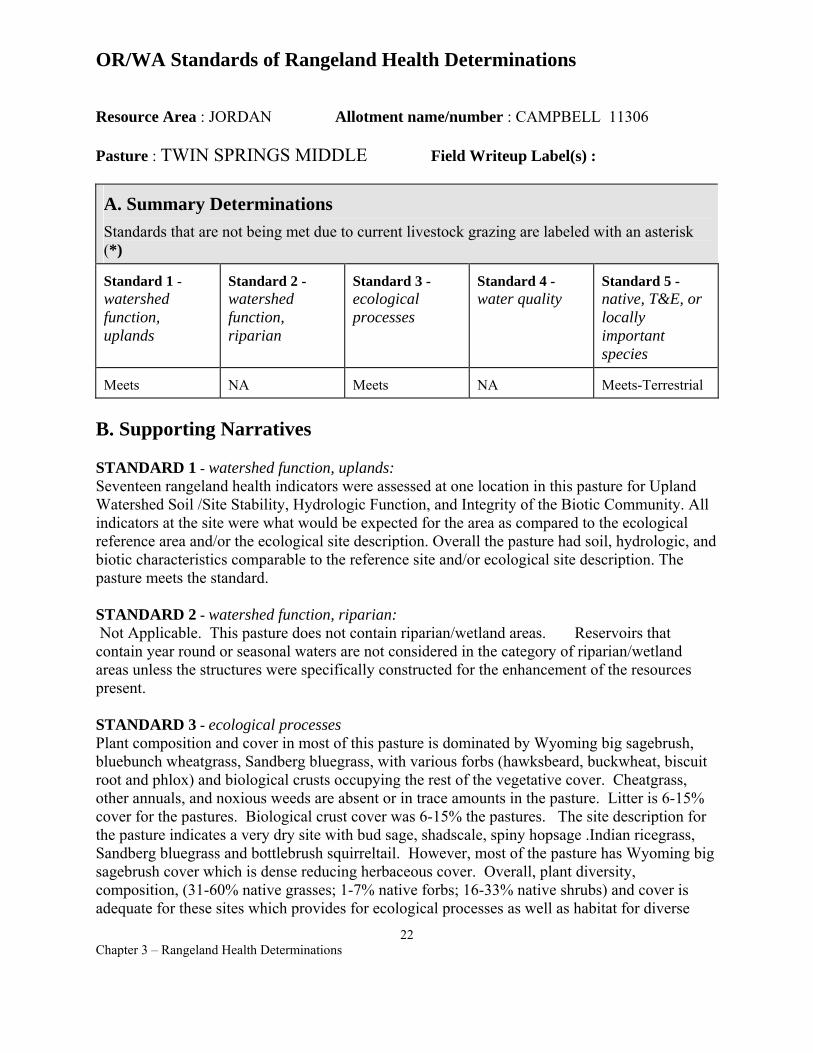
OR/WA Standards of Rangeland Health Determinations
Resource Area : JORDAN Allotment name/number : CAMPBELL 11306
Pasture : TWIN SPRINGS MIDDLE Field Writeup Label(s) :
A. Summary Determinations Standards that are not being met due to current livestock grazing are labeled with an asterisk (*)
Standard 1 -watershed function, uplands
Standard 2 -watershed function, riparian
Standard 3 -ecological processes
Standard 4 -water quality
Standard 5 -native, T&E, or locally important species
Meets NA Meets NA Meets-Terrestrial
B. Supporting Narratives
STANDARD 1 - watershed function, uplands: Seventeen rangeland health indicators were assessed at one location in this pasture for Upland Watershed Soil /Site Stability, Hydrologic Function, and Integrity of the Biotic Community. All indicators at the site were what would be expected for the area as compared to the ecological reference area and/or the ecological site description. Overall the pasture had soil, hydrologic, and biotic characteristics comparable to the reference site and/or ecological site description. The pasture meets the standard.
STANDARD 2 - watershed function, riparian: Not Applicable. This pasture does not contain riparian/wetland areas. Reservoirs that contain year round or seasonal waters are not considered in the category of riparian/wetland areas unless the structures were specifically constructed for the enhancement of the resources present.
STANDARD 3 - ecological processes Plant composition and cover in most of this pasture is dominated by Wyoming big sagebrush, bluebunch wheatgrass, Sandberg bluegrass, with various forbs (hawksbeard, buckwheat, biscuit root and phlox) and biological crusts occupying the rest of the vegetative cover. Cheatgrass, other annuals, and noxious weeds are absent or in trace amounts in the pasture. Litter is 6-15% cover for the pastures. Biological crust cover was 6-15% the pastures. The site description for the pasture indicates a very dry site with bud sage, shadscale, spiny hopsage .Indian ricegrass, Sandberg bluegrass and bottlebrush squirreltail. However, most of the pasture has Wyoming big sagebrush cover which is dense reducing herbaceous cover. Overall, plant diversity, composition, (31-60% native grasses; 1-7% native forbs; 16-33% native shrubs) and cover is adequate for these sites which provides for ecological processes as well as habitat for diverse
22 Chapter 3 – Rangeland Health Determinations
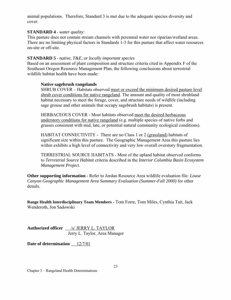
animal populations. Therefore, Standard 3 is met due to the adequate species diversity and cover.
STANDARD 4 - water quality: This pasture does not contain stream channels with perennial water nor riparian/wetland areas. There are no limiting physical factors in Standards 1-3 for this pasture that affect water resources on-site or off-site.
STANDARD 5 - native, T&E, or locally important species Based on an assessment of plant composition and structure criteria cited in Appendix F of the Southeast Oregon Resource Management Plan, the following conclusions about terrestrial wildlife habitat health have been made:
Native sagebrush rangelands SHRUB COVER – Habitats observed meet or exceed the minimum desired pasture level shrub cover conditions for native rangeland. The amount and quality of most shrubland habitat necessary to meet the forage, cover, and structure needs of wildlife (including sage grouse and other animals that occupy sagebrush habitats) is present.
HERBACEOUS COVER - Most habitats observed meet the desired herbaceous understory conditions for native rangeland (e.g. multiple species of native forbs and grasses consistent with mid, late, or potential natural community ecological conditions).
HABITAT CONNECTIVITY - There are no Class 1 or 2 (grassland) habitats of significant size within this pasture. The Geographic Management Area this pasture lies within exhibits a high level of connectivity and very low overall overstory fragmentation.
TERRESTRIAL SOURCE HABITATS - Most of the upland habitat observed conforms to Terrestrial Source Habitat criteria described in the Interior Columbia Basin Ecosystem Management Project.
Other supporting information - Refer to Jordan Resource Area wildlife evaluation file: Louse Canyon Geographic Management Area Summary Evaluation (Summer-Fall 2000) for other details.
Range Health Interdisciplinary Team Members - Tom Forre, Tom Miles, Cynthia Tait, Jack Wenderoth, Jon Sadowski
Authorized officer /s/ JERRY L. TAYLOR Jerry L. Taylor, Area Manager
Date of determination 12/7/01
23 Chapter 3 – Rangeland Health Determinations
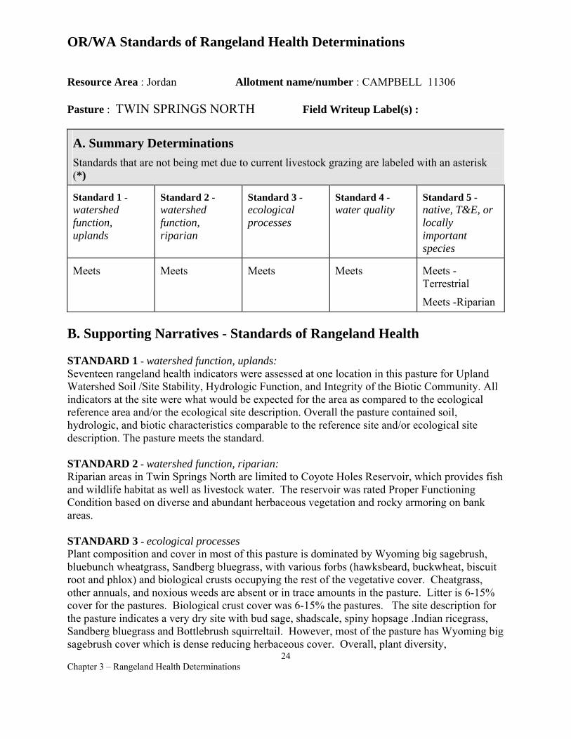
OR/WA Standards of Rangeland Health Determinations
Resource Area : Jordan Allotment name/number : CAMPBELL 11306
Pasture : TWIN SPRINGS NORTH Field Writeup Label(s) :
A. Summary Determinations Standards that are not being met due to current livestock grazing are labeled with an asterisk (*)
Standard 1 -watershed function, uplands
Standard 2 -watershed function, riparian
Standard 3 -ecological processes
Standard 4 -water quality
Standard 5 -native, T&E, or locally important species
Meets Meets Meets Meets Meets Terrestrial
Meets -Riparian
B. Supporting Narratives - Standards of Rangeland Health
STANDARD 1 - watershed function, uplands: Seventeen rangeland health indicators were assessed at one location in this pasture for Upland Watershed Soil /Site Stability, Hydrologic Function, and Integrity of the Biotic Community. All indicators at the site were what would be expected for the area as compared to the ecological reference area and/or the ecological site description. Overall the pasture contained soil, hydrologic, and biotic characteristics comparable to the reference site and/or ecological site description. The pasture meets the standard.
STANDARD 2 - watershed function, riparian: Riparian areas in Twin Springs North are limited to Coyote Holes Reservoir, which provides fish and wildlife habitat as well as livestock water. The reservoir was rated Proper Functioning Condition based on diverse and abundant herbaceous vegetation and rocky armoring on bank areas.
STANDARD 3 - ecological processes Plant composition and cover in most of this pasture is dominated by Wyoming big sagebrush, bluebunch wheatgrass, Sandberg bluegrass, with various forbs (hawksbeard, buckwheat, biscuit root and phlox) and biological crusts occupying the rest of the vegetative cover. Cheatgrass, other annuals, and noxious weeds are absent or in trace amounts in the pasture. Litter is 6-15% cover for the pastures. Biological crust cover was 6-15% the pastures. The site description for the pasture indicates a very dry site with bud sage, shadscale, spiny hopsage .Indian ricegrass, Sandberg bluegrass and Bottlebrush squirreltail. However, most of the pasture has Wyoming big sagebrush cover which is dense reducing herbaceous cover. Overall, plant diversity,
24 Chapter 3 – Rangeland Health Determinations
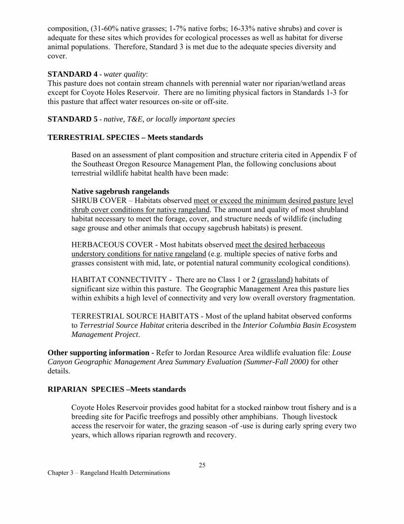
composition, (31-60% native grasses; 1-7% native forbs; 16-33% native shrubs) and cover is adequate for these sites which provides for ecological processes as well as habitat for diverse animal populations. Therefore, Standard 3 is met due to the adequate species diversity and cover.
STANDARD 4 - water quality: This pasture does not contain stream channels with perennial water nor riparian/wetland areas except for Coyote Holes Reservoir. There are no limiting physical factors in Standards 1-3 for this pasture that affect water resources on-site or off-site.
STANDARD 5 - native, T&E, or locally important species
TERRESTRIAL SPECIES – Meets standards
Based on an assessment of plant composition and structure criteria cited in Appendix F of the Southeast Oregon Resource Management Plan, the following conclusions about terrestrial wildlife habitat health have been made:
Native sagebrush rangelands SHRUB COVER – Habitats observed meet or exceed the minimum desired pasture level shrub cover conditions for native rangeland. The amount and quality of most shrubland habitat necessary to meet the forage, cover, and structure needs of wildlife (including sage grouse and other animals that occupy sagebrush habitats) is present.
HERBACEOUS COVER - Most habitats observed meet the desired herbaceous understory conditions for native rangeland (e.g. multiple species of native forbs and grasses consistent with mid, late, or potential natural community ecological conditions).
HABITAT CONNECTIVITY - There are no Class 1 or 2 (grassland) habitats of significant size within this pasture. The Geographic Management Area this pasture lies within exhibits a high level of connectivity and very low overall overstory fragmentation.
TERRESTRIAL SOURCE HABITATS - Most of the upland habitat observed conforms to Terrestrial Source Habitat criteria described in the Interior Columbia Basin Ecosystem Management Project.
Other supporting information - Refer to Jordan Resource Area wildlife evaluation file: Louse Canyon Geographic Management Area Summary Evaluation (Summer-Fall 2000) for other details.
RIPARIAN SPECIES –Meets standards
Coyote Holes Reservoir provides good habitat for a stocked rainbow trout fishery and is a breeding site for Pacific treefrogs and possibly other amphibians. Though livestock access the reservoir for water, the grazing season -of -use is during early spring every two years, which allows riparian regrowth and recovery.
25 Chapter 3 – Rangeland Health Determinations

Range Health Interdisciplinary Team Members - Tom Forre, Tom Miles, Cynthia Tait, Jack Wenderoth, Jon Sadowski
Authorized officer /s/ JERRY L. TAYLOR Jerry L. Taylor, Area Manager
Date of determination 12/7/01
26 Chapter 3 – Rangeland Health Determinations
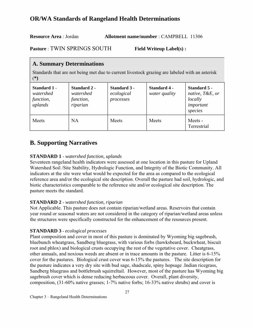
OR/WA Standards of Rangeland Health Determinations
Resource Area : Jordan Allotment name/number : CAMPBELL 11306
Pasture : TWIN SPRINGS SOUTH Field Writeup Label(s) :
A. Summary Determinations Standards that are not being met due to current livestock grazing are labeled with an asterisk (*)
Standard 1 -watershed function, uplands
Standard 2 -watershed function, riparian
Standard 3 -ecological processes
Standard 4 -water quality
Standard 5 -native, T&E, or locally important species
Meets NA Meets Meets Meets Terrestrial
B. Supporting Narratives
STANDARD 1 - watershed function, uplands Seventeen rangeland health indicators were assessed at one location in this pasture for Upland Watershed Soil /Site Stability, Hydrologic Function, and Integrity of the Biotic Community. All indicators at the site were what would be expected for the area as compared to the ecological reference area and/or the ecological site description. Overall the pasture had soil, hydrologic, and biotic characteristics comparable to the reference site and/or ecological site description. The pasture meets the standard.
STANDARD 2 - watershed function, riparian Not Applicable. This pasture does not contain riparian/wetland areas. Reservoirs that contain year round or seasonal waters are not considered in the category of riparian/wetland areas unless the structures were specifically constructed for the enhancement of the resources present.
STANDARD 3 - ecological processes Plant composition and cover in most of this pasture is dominated by Wyoming big sagebrush, bluebunch wheatgrass, Sandberg bluegrass, with various forbs (hawksbeard, buckwheat, biscuit root and phlox) and biological crusts occupying the rest of the vegetative cover. Cheatgrass, other annuals, and noxious weeds are absent or in trace amounts in the pasture. Litter is 6-15% cover for the pastures. Biological crust cover was 6-15% the pastures. The site description for the pasture indicates a very dry site with bud sage, shadscale, spiny hopsage .Indian ricegrass, Sandberg bluegrass and bottlebrush squirreltail. However, most of the pasture has Wyoming big sagebrush cover which is dense reducing herbaceous cover. Overall, plant diversity, composition, (31-60% native grasses; 1-7% native forbs; 16-33% native shrubs) and cover is
27 Chapter 3 – Rangeland Health Determinations
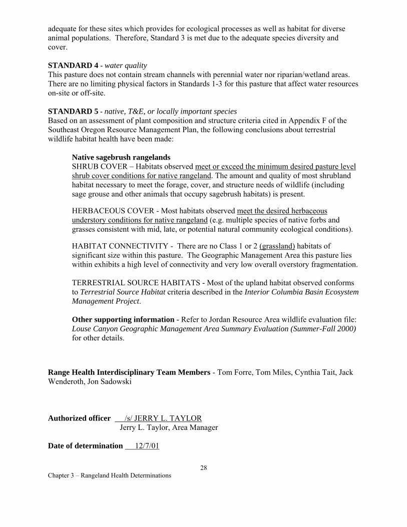
adequate for these sites which provides for ecological processes as well as habitat for diverse animal populations. Therefore, Standard 3 is met due to the adequate species diversity and cover.
STANDARD 4 - water quality This pasture does not contain stream channels with perennial water nor riparian/wetland areas. There are no limiting physical factors in Standards 1-3 for this pasture that affect water resources on-site or off-site.
STANDARD 5 - native, T&E, or locally important species Based on an assessment of plant composition and structure criteria cited in Appendix F of the Southeast Oregon Resource Management Plan, the following conclusions about terrestrial wildlife habitat health have been made:
Native sagebrush rangelands SHRUB COVER – Habitats observed meet or exceed the minimum desired pasture level shrub cover conditions for native rangeland. The amount and quality of most shrubland habitat necessary to meet the forage, cover, and structure needs of wildlife (including sage grouse and other animals that occupy sagebrush habitats) is present.
HERBACEOUS COVER - Most habitats observed meet the desired herbaceous understory conditions for native rangeland (e.g. multiple species of native forbs and grasses consistent with mid, late, or potential natural community ecological conditions).
HABITAT CONNECTIVITY - There are no Class 1 or 2 (grassland) habitats of significant size within this pasture. The Geographic Management Area this pasture lies within exhibits a high level of connectivity and very low overall overstory fragmentation.
TERRESTRIAL SOURCE HABITATS - Most of the upland habitat observed conforms to Terrestrial Source Habitat criteria described in the Interior Columbia Basin Ecosystem Management Project.
Other supporting information - Refer to Jordan Resource Area wildlife evaluation file: Louse Canyon Geographic Management Area Summary Evaluation (Summer-Fall 2000) for other details.
Range Health Interdisciplinary Team Members - Tom Forre, Tom Miles, Cynthia Tait, Jack Wenderoth, Jon Sadowski
Authorized officer /s/ JERRY L. TAYLOR Jerry L. Taylor, Area Manager
Date of determination 12/7/01
28 Chapter 3 – Rangeland Health Determinations
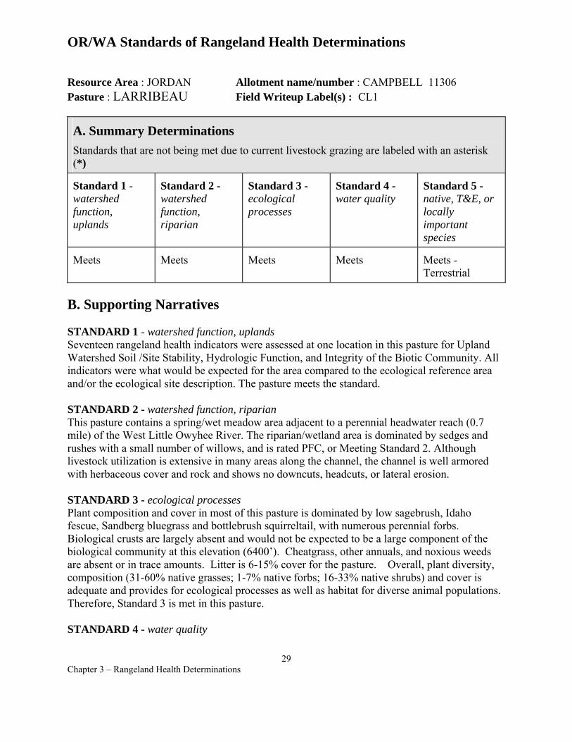
OR/WA Standards of Rangeland Health Determinations
Resource Area : JORDAN Allotment name/number : CAMPBELL 11306 Pasture : LARRIBEAU Field Writeup Label(s) : CL1
A. Summary Determinations Standards that are not being met due to current livestock grazing are labeled with an asterisk (*)
Standard 1 -watershed function, uplands
Standard 2 -watershed function, riparian
Standard 3 -ecological processes
Standard 4 -water quality
Standard 5 -native, T&E, or locally important species
Meets Meets Meets Meets Meets Terrestrial
B. Supporting Narratives
STANDARD 1 - watershed function, uplands Seventeen rangeland health indicators were assessed at one location in this pasture for Upland Watershed Soil /Site Stability, Hydrologic Function, and Integrity of the Biotic Community. All indicators were what would be expected for the area compared to the ecological reference area and/or the ecological site description. The pasture meets the standard.
STANDARD 2 - watershed function, riparian This pasture contains a spring/wet meadow area adjacent to a perennial headwater reach (0.7 mile) of the West Little Owyhee River. The riparian/wetland area is dominated by sedges and rushes with a small number of willows, and is rated PFC, or Meeting Standard 2. Although livestock utilization is extensive in many areas along the channel, the channel is well armored with herbaceous cover and rock and shows no downcuts, headcuts, or lateral erosion.
STANDARD 3 - ecological processes Plant composition and cover in most of this pasture is dominated by low sagebrush, Idaho fescue, Sandberg bluegrass and bottlebrush squirreltail, with numerous perennial forbs. Biological crusts are largely absent and would not be expected to be a large component of the biological community at this elevation (6400’). Cheatgrass, other annuals, and noxious weeds are absent or in trace amounts. Litter is 6-15% cover for the pasture. Overall, plant diversity, composition (31-60% native grasses; 1-7% native forbs; 16-33% native shrubs) and cover is adequate and provides for ecological processes as well as habitat for diverse animal populations. Therefore, Standard 3 is met in this pasture.
STANDARD 4 - water quality
29 Chapter 3 – Rangeland Health Determinations

The West Little Owyhee River flows intermittently in the upper portion of the pasture until the spring/wet meadow enters the channel. There are no limiting physical or biological factors in Standards 1-3 that may affect water resources on-site or off-site.
STANDARD 5 - native, T&E, or locally important species Based on an assessment of plant composition and structure criteria cited in Appendix F of the Southeast Oregon Resource Management Plan, the following conclusions about terrestrial wildlife habitat health have been made:
Native sagebrush rangelands SHRUB COVER – Habitats observed meet or exceed the minimum desired pasture level shrub cover conditions for native rangeland. The amount and quality of most shrubland habitat necessary to meet the forage, cover, and structure needs of wildlife (including sage grouse and other animals that occupy sagebrush habitats) is present.
HERBACEOUS COVER - Most habitats observed meet the desired herbaceous understory conditions for native rangeland (e.g. multiple species of native forbs and grasses consistent with mid, late, or potential natural community ecological conditions).
HABITAT CONNECTIVITY - There are no Class 1 or 2 (grassland) habitats of significant size within this pasture. The Geographic Management Area this pasture lies within exhibits a high level of connectivity and very low overall overstory fragmentation.
TERRESTRIAL SOURCE HABITATS - Most if not all of the upland habitat observed conforms to Terrestrial Source Habitat criteria described in the Interior Columbia Basin Ecosystem Management Project
Other supporting information - Refer to Jordan Resource Area wildlife evaluation file: Louse Canyon Geographic Management Area Summary Evaluation (Summer-Fall 2000) for other details.
Range Health Interdisciplinary Team Members – Travis Fletcher, Brandon Knapton, Cynthia Tait, Jack Wenderoth, Jon Sadowski
Authorized officer /s/ JERRY L. TAYLOR Jerry L. Taylor, Area Manager
Date of determination 12/7/01 _
30 Chapter 3 – Rangeland Health Determinations
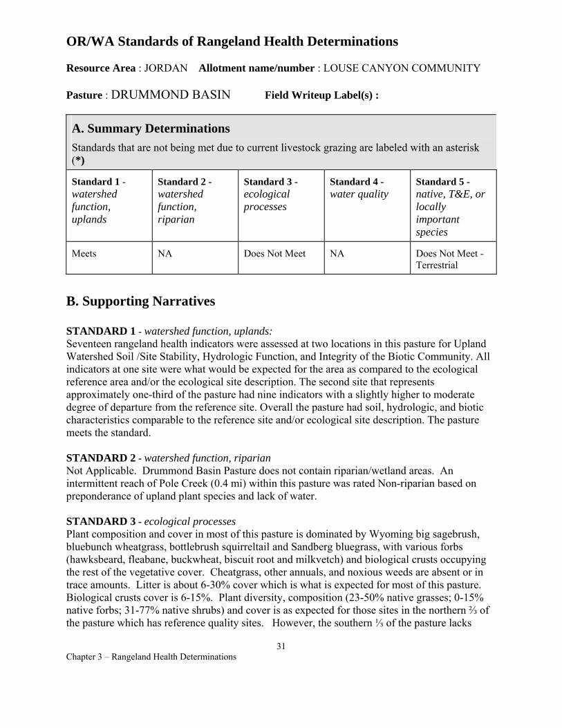
OR/WA Standards of Rangeland Health Determinations
Resource Area : JORDAN Allotment name/number : LOUSE CANYON COMMUNITY
Pasture : DRUMMOND BASIN Field Writeup Label(s) :
A. Summary Determinations Standards that are not being met due to current livestock grazing are labeled with an asterisk (*)
Standard 1 -watershed function, uplands
Standard 2 -watershed function, riparian
Standard 3 -ecological processes
Standard 4 -water quality
Standard 5 -native, T&E, or locally important species
Meets NA Does Not Meet NA Does Not Meet Terrestrial
B. Supporting Narratives
STANDARD 1 - watershed function, uplands: Seventeen rangeland health indicators were assessed at two locations in this pasture for Upland Watershed Soil /Site Stability, Hydrologic Function, and Integrity of the Biotic Community. All indicators at one site were what would be expected for the area as compared to the ecological reference area and/or the ecological site description. The second site that represents approximately one-third of the pasture had nine indicators with a slightly higher to moderate degree of departure from the reference site. Overall the pasture had soil, hydrologic, and biotic characteristics comparable to the reference site and/or ecological site description. The pasture meets the standard.
STANDARD 2 - watershed function, riparian Not Applicable. Drummond Basin Pasture does not contain riparian/wetland areas. An intermittent reach of Pole Creek (0.4 mi) within this pasture was rated Non-riparian based on preponderance of upland plant species and lack of water.
STANDARD 3 - ecological processes Plant composition and cover in most of this pasture is dominated by Wyoming big sagebrush, bluebunch wheatgrass, bottlebrush squirreltail and Sandberg bluegrass, with various forbs (hawksbeard, fleabane, buckwheat, biscuit root and milkvetch) and biological crusts occupying the rest of the vegetative cover. Cheatgrass, other annuals, and noxious weeds are absent or in trace amounts. Litter is about 6-30% cover which is what is expected for most of this pasture. Biological crusts cover is 6-15%. Plant diversity, composition (23-50% native grasses; 0-15% native forbs; 31-77% native shrubs) and cover is as expected for those sites in the northern ⅔ of the pasture which has reference quality sites. However, the southern ⅓ of the pasture lacks
31 Chapter 3 – Rangeland Health Determinations
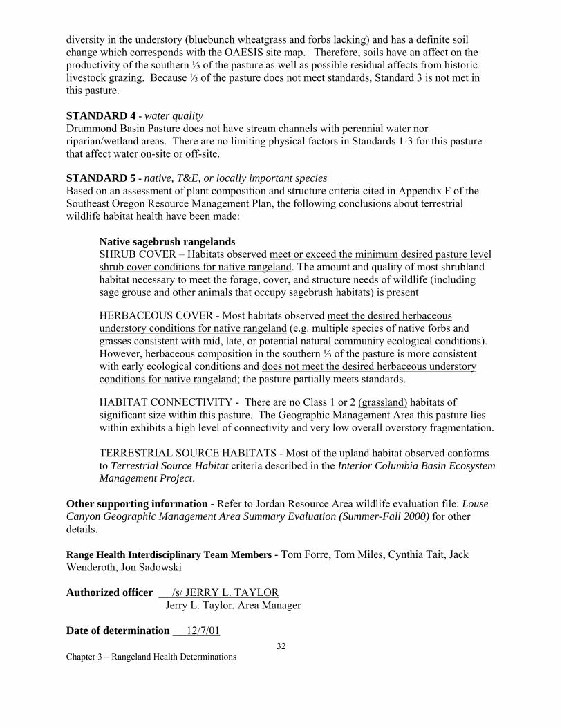
diversity in the understory (bluebunch wheatgrass and forbs lacking) and has a definite soil change which corresponds with the OAESIS site map. Therefore, soils have an affect on the productivity of the southern ⅓ of the pasture as well as possible residual affects from historic livestock grazing. Because ⅓ of the pasture does not meet standards, Standard 3 is not met in this pasture.
STANDARD 4 - water quality Drummond Basin Pasture does not have stream channels with perennial water nor riparian/wetland areas. There are no limiting physical factors in Standards 1-3 for this pasture that affect water on-site or off-site.
STANDARD 5 - native, T&E, or locally important species Based on an assessment of plant composition and structure criteria cited in Appendix F of the Southeast Oregon Resource Management Plan, the following conclusions about terrestrial wildlife habitat health have been made:
Native sagebrush rangelands SHRUB COVER – Habitats observed meet or exceed the minimum desired pasture level shrub cover conditions for native rangeland. The amount and quality of most shrubland habitat necessary to meet the forage, cover, and structure needs of wildlife (including sage grouse and other animals that occupy sagebrush habitats) is present
HERBACEOUS COVER - Most habitats observed meet the desired herbaceous understory conditions for native rangeland (e.g. multiple species of native forbs and grasses consistent with mid, late, or potential natural community ecological conditions). However, herbaceous composition in the southern ⅓ of the pasture is more consistent with early ecological conditions and does not meet the desired herbaceous understory conditions for native rangeland; the pasture partially meets standards.
HABITAT CONNECTIVITY - There are no Class 1 or 2 (grassland) habitats of significant size within this pasture. The Geographic Management Area this pasture lies within exhibits a high level of connectivity and very low overall overstory fragmentation.
TERRESTRIAL SOURCE HABITATS - Most of the upland habitat observed conforms to Terrestrial Source Habitat criteria described in the Interior Columbia Basin Ecosystem Management Project.
Other supporting information - Refer to Jordan Resource Area wildlife evaluation file: Louse Canyon Geographic Management Area Summary Evaluation (Summer-Fall 2000) for other details.
Range Health Interdisciplinary Team Members - Tom Forre, Tom Miles, Cynthia Tait, Jack Wenderoth, Jon Sadowski
Authorized officer /s/ JERRY L. TAYLOR Jerry L. Taylor, Area Manager
Date of determination 12/7/01 32
Chapter 3 – Rangeland Health Determinations
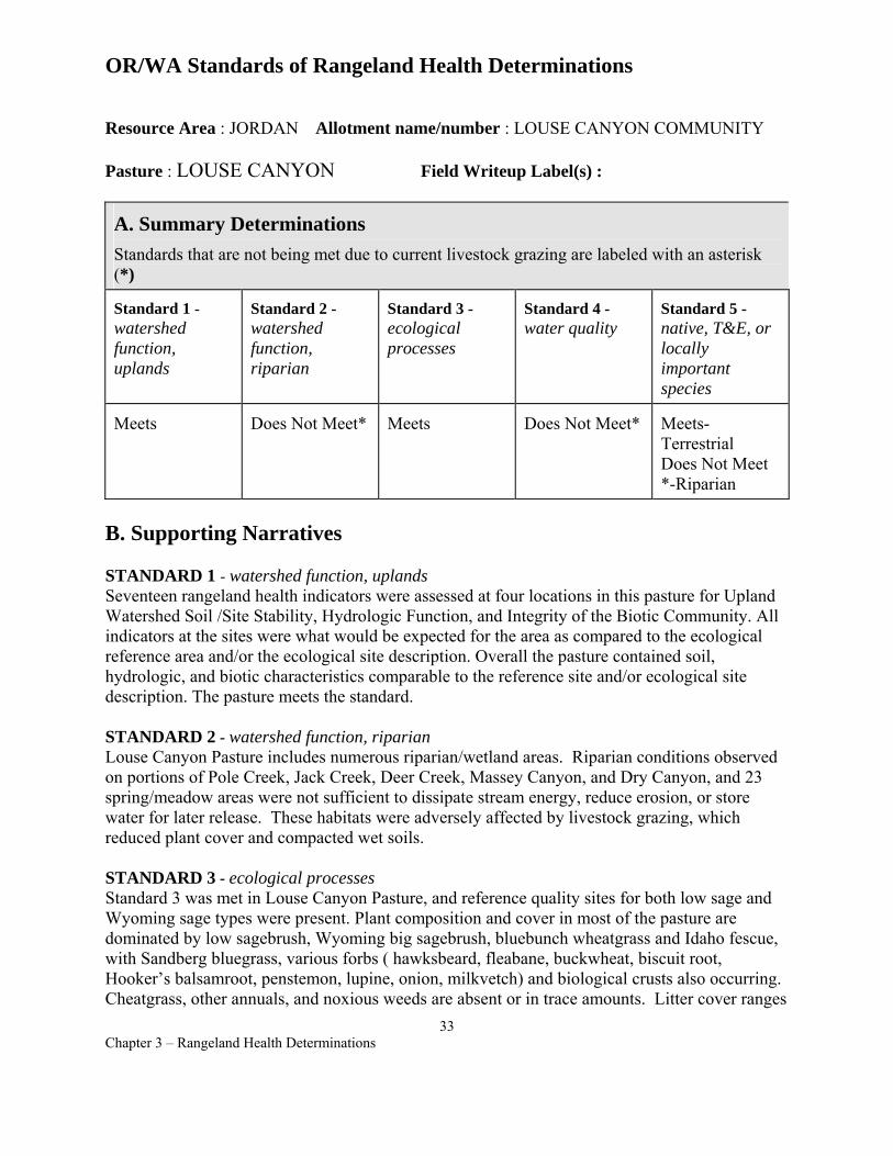
OR/WA Standards of Rangeland Health Determinations
Resource Area : JORDAN Allotment name/number : LOUSE CANYON COMMUNITY
Pasture : LOUSE CANYON Field Writeup Label(s) :
A. Summary Determinations Standards that are not being met due to current livestock grazing are labeled with an asterisk (*)
Standard 1 -watershed function, uplands
Standard 2 -watershed function, riparian
Standard 3 -ecological processes
Standard 4 -water quality
Standard 5 -native, T&E, or locally important species
Meets Does Not Meet* Meets Does Not Meet* Meets-Terrestrial Does Not Meet *-Riparian
B. Supporting Narratives
STANDARD 1 - watershed function, uplands Seventeen rangeland health indicators were assessed at four locations in this pasture for Upland Watershed Soil /Site Stability, Hydrologic Function, and Integrity of the Biotic Community. All indicators at the sites were what would be expected for the area as compared to the ecological reference area and/or the ecological site description. Overall the pasture contained soil, hydrologic, and biotic characteristics comparable to the reference site and/or ecological site description. The pasture meets the standard.
STANDARD 2 - watershed function, riparian Louse Canyon Pasture includes numerous riparian/wetland areas. Riparian conditions observed on portions of Pole Creek, Jack Creek, Deer Creek, Massey Canyon, and Dry Canyon, and 23 spring/meadow areas were not sufficient to dissipate stream energy, reduce erosion, or store water for later release. These habitats were adversely affected by livestock grazing, which reduced plant cover and compacted wet soils.
STANDARD 3 - ecological processes Standard 3 was met in Louse Canyon Pasture, and reference quality sites for both low sage and Wyoming sage types were present. Plant composition and cover in most of the pasture are dominated by low sagebrush, Wyoming big sagebrush, bluebunch wheatgrass and Idaho fescue, with Sandberg bluegrass, various forbs ( hawksbeard, fleabane, buckwheat, biscuit root, Hooker’s balsamroot, penstemon, lupine, onion, milkvetch) and biological crusts also occurring. Cheatgrass, other annuals, and noxious weeds are absent or in trace amounts. Litter cover ranges
33 Chapter 3 – Rangeland Health Determinations
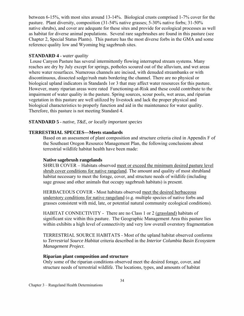
between 6-15%, with most sites around 13-14%. Biological crusts comprised 1-7% cover for the pasture. Plant diversity, composition (31-54% native grasses; 5-30% native forbs; 31-50% native shrubs), and cover are adequate for these sites and provide for ecological processes as well as habitat for diverse animal populations. Several rare sagebrushes are found in this pasture (see Chapter 2, Special Status Plants). This pasture has the most diverse forbs in the GMA and some reference quality low and Wyoming big sagebrush sites.
STANDARD 4 - water quality Louse Canyon Pasture has several intermittently flowing interrupted stream systems. Many reaches are dry by July except for springs, potholes scoured out of the alluvium, and wet areas where water resurfaces. Numerous channels are incised, with denuded streambanks or with discontinuous, dissected sedge/rush mats bordering the channel. There are no physical or biological upland indicators in Standards 1or 3 that may affect water resources for this pasture. However, many riparian areas were rated Functioning-at-Risk and these could contribute to the impairment of water quality in the pasture. Spring sources, scour pools, wet areas, and riparian vegetation in this pasture are well utilized by livestock and lack the proper physical and biological characteristics to properly function and aid in the maintenance for water quality. Therefore, this pasture is not meeting Standard 4.
STANDARD 5 - native, T&E, or locally important species
TERRESTRIAL SPECIES—Meets standards Based on an assessment of plant composition and structure criteria cited in Appendix F of the Southeast Oregon Resource Management Plan, the following conclusions about terrestrial wildlife habitat health have been made:
Native sagebrush rangelands SHRUB COVER – Habitats observed meet or exceed the minimum desired pasture level shrub cover conditions for native rangeland. The amount and quality of most shrubland habitat necessary to meet the forage, cover, and structure needs of wildlife (including sage grouse and other animals that occupy sagebrush habitats) is present.
HERBACEOUS COVER - Most habitats observed meet the desired herbaceous understory conditions for native rangeland (e.g. multiple species of native forbs and grasses consistent with mid, late, or potential natural community ecological conditions).
HABITAT CONNECTIVITY - There are no Class 1 or 2 (grassland) habitats of significant size within this pasture. The Geographic Management Area this pasture lies within exhibits a high level of connectivity and very low overall overstory fragmentation
TERRESTRIAL SOURCE HABITATS - Most of the upland habitat observed conforms to Terrestrial Source Habitat criteria described in the Interior Columbia Basin Ecosystem Management Project.
Riparian plant composition and structure Only some of the riparian conditions observed meet the desired forage, cover, and structure needs of terrestrial wildlife. The locations, types, and amounts of habitat
34 Chapter 3 – Rangeland Health Determinations
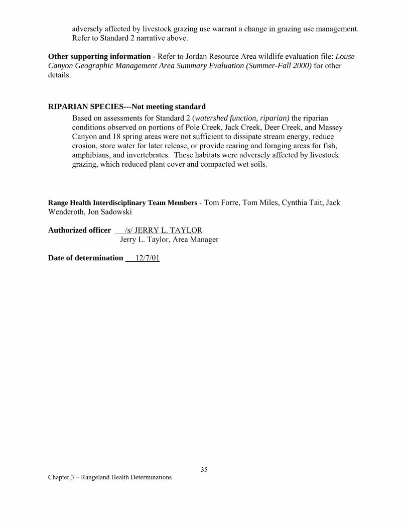
adversely affected by livestock grazing use warrant a change in grazing use management. Refer to Standard 2 narrative above.
Other supporting information - Refer to Jordan Resource Area wildlife evaluation file: Louse Canyon Geographic Management Area Summary Evaluation (Summer-Fall 2000) for other details.
RIPARIAN SPECIES---Not meeting standard Based on assessments for Standard 2 (watershed function, riparian) the riparian conditions observed on portions of Pole Creek, Jack Creek, Deer Creek, and Massey Canyon and 18 spring areas were not sufficient to dissipate stream energy, reduce erosion, store water for later release, or provide rearing and foraging areas for fish, amphibians, and invertebrates. These habitats were adversely affected by livestock grazing, which reduced plant cover and compacted wet soils.
Range Health Interdisciplinary Team Members - Tom Forre, Tom Miles, Cynthia Tait, Jack Wenderoth, Jon Sadowski
Authorized officer /s/ JERRY L. TAYLOR Jerry L. Taylor, Area Manager
Date of determination 12/7/01
35 Chapter 3 – Rangeland Health Determinations
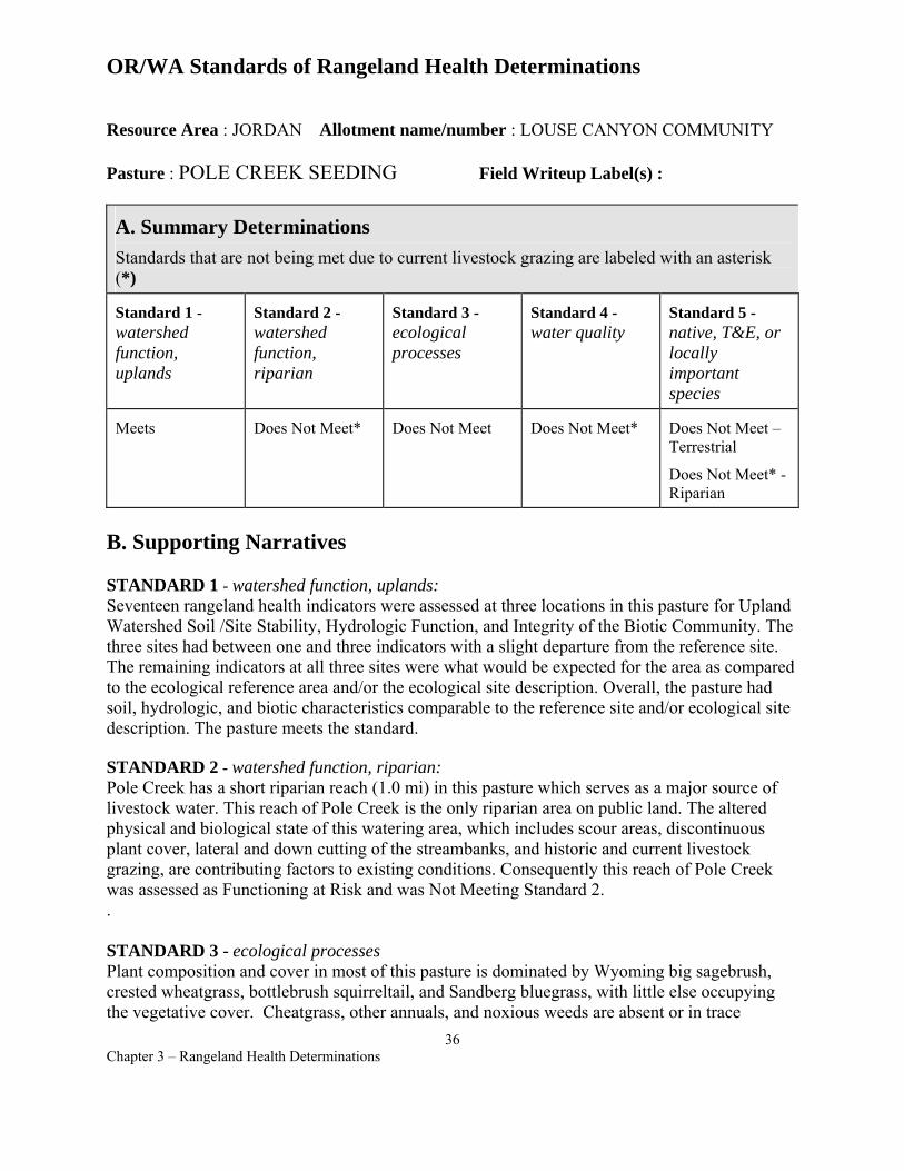
OR/WA Standards of Rangeland Health Determinations
Resource Area : JORDAN Allotment name/number : LOUSE CANYON COMMUNITY
Pasture : POLE CREEK SEEDING Field Writeup Label(s) :
A. Summary Determinations Standards that are not being met due to current livestock grazing are labeled with an asterisk (*)
Standard 1 -watershed function, uplands
Standard 2 -watershed function, riparian
Standard 3 -ecological processes
Standard 4 -water quality
Standard 5 -native, T&E, or locally important species
Meets Does Not Meet* Does Not Meet Does Not Meet* Does Not Meet – Terrestrial
Does Not Meet* - Riparian
B. Supporting Narratives
STANDARD 1 - watershed function, uplands: Seventeen rangeland health indicators were assessed at three locations in this pasture for Upland Watershed Soil /Site Stability, Hydrologic Function, and Integrity of the Biotic Community. The three sites had between one and three indicators with a slight departure from the reference site. The remaining indicators at all three sites were what would be expected for the area as compared to the ecological reference area and/or the ecological site description. Overall, the pasture had soil, hydrologic, and biotic characteristics comparable to the reference site and/or ecological site description. The pasture meets the standard.
STANDARD 2 - watershed function, riparian: Pole Creek has a short riparian reach (1.0 mi) in this pasture which serves as a major source of livestock water. This reach of Pole Creek is the only riparian area on public land. The altered physical and biological state of this watering area, which includes scour areas, discontinuous plant cover, lateral and down cutting of the streambanks, and historic and current livestock grazing, are contributing factors to existing conditions. Consequently this reach of Pole Creek was assessed as Functioning at Risk and was Not Meeting Standard 2. .
STANDARD 3 - ecological processes Plant composition and cover in most of this pasture is dominated by Wyoming big sagebrush, crested wheatgrass, bottlebrush squirreltail, and Sandberg bluegrass, with little else occupying the vegetative cover. Cheatgrass, other annuals, and noxious weeds are absent or in trace
36 Chapter 3 – Rangeland Health Determinations
amounts. Litter is at 6-30% which is slightly higher than expected for this pasture. Plant diversity and composition (6-65% exotic and native grasses; 1-15% native forbs; 16-75% native shrubs), is not as expected for this pasture as it is a crested wheatgrass seeding. But there are substantial native portions in this seeding that also lack in herbaceous cover and diversity. Actually, the seeded portion of the pasture has the most diversity because of native species moving in. Standard 3 is not being met as a diverse understory of native grass and forb species would be needed in the native portion to provide the ecological processes typical for this site. However, the seeded portion has a more diverse herbaceous understory than most seedings and would meet the standard if it was not dominated by crested wheatgrass. In summary, the standard is not met in this pasture.
STANDARD 4 - water quality: Pole Creek in this pasture is an intermittently flowing, interrupted stream system with much of the segment dry by July except for a few perennial scour pools. Pole Creek channel is incised and has streambanks mostly void of vegetation, a silty substrate, and a discontinuous sedge/rush mat that is dissected throughout the reach. There are physical and/or biological factors in Standards 1 and 3 for this pasture that may affect water resources on-site or off-site. However, riparian areas assessed in Pole Creek for physical stream channel and floodplain properties were rated as Functioning-at-Risk and contribute to the impairment of water quality in the pasture. The scour pools, wet areas, and riparian vegetation of this reach are well utilized by livestock and lack the proper physical and biological characteristics to properly function and aid in the maintenance for water quality. Therefore this pasture is not meeting Standard 4.
STANDARD 5 - native, T&E, or locally important species Based on an assessment of plant composition and structure criteria cited in Appendix F of the Southeast Oregon Resource Management Plan, the following conclusions about wildlife habitat health have been made:
Seeded sagebrush rangelands SHRUB COVER – Habitats observed meet or exceed the minimum desired pasture level shrub cover conditions for seeded rangeland. The amount of shrubland habitat necessary to meet the forage, cover, and structure needs of wildlife (including sage grouse and other animals that occupy sagebrush habitats) is present. Substantial sagebrush recolonization has occurred within the Pole Creek Seeding since 1970 when about 4,000 acres (26% of the pasture) were planted to crested wheatgrass. Structural quality is somewhat limited in the seeded area due to the relatively young age and structural maturity of shrubs.
HERBACEOUS COVER - Habitats observed do not meet the minimum desired herbaceous understory conditions for seeded rangeland (e.g. at least some native or introduced forb species).
Native sagebrush rangelands SHRUB COVER – Habitats observed meet or exceed the minimum desired pasture level shrub cover conditions for native rangeland for the remaining 74% of the pasture comprised of native rangeland. The amount and quality of most shrubland habitat necessary to meet the forage, cover, and structure needs of wildlife (including sage grouse and other animals that occupy sagebrush habitats) is present.
37 Chapter 3 – Rangeland Health Determinations
HERBACEOUS COVER - Most habitats observed meet the desired herbaceous understory conditions for native rangeland (e.g. multiple species of native forbs and grasses consistent with mid, late, or potential natural community ecological conditions).
HABITAT CONNECTIVITY - Due to the overall degree of sagebrush community connectivity within the Geographic Management Area, Class 1 or 2 (grassland) conditions in this pasture do not contribute towards landscape level habitat fragmentation problems for wildlife.
Riparian plant composition and structure Few of the riparian conditions observed meet the desired forage, cover, and structure needs of terrestrial wildlife. The locations, types, and amounts of habitat adversely affected by livestock grazing use warrant a change in grazing use management. Refer to Standard 2 narrative above.
Other supporting information - Refer to Jordan Resource Area wildlife evaluation file: Louse Canyon Geographic Management Area Summary Evaluation (Summer-Fall 2000) for other details.
Range Health Interdisciplinary Team Members - Tom Forre, Tom Miles, Cynthia Tait, Jack Wenderoth, Jon Sadowski
Authorized officer /s/ JERRY L. TAYLOR Jerry L. Taylor, Area Manager
Date of determination 12/7/01
38 Chapter 3 – Rangeland Health Determinations
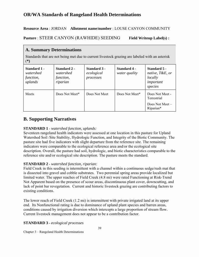
OR/WA Standards of Rangeland Health Determinations
Resource Area : JORDAN Allotment name/number : LOUSE CANYON COMMUNITY
Pasture : STEER CANYON (RAWHIDE) SEEDING Field Writeup Label(s) :
A. Summary Determinations Standards that are not being met due to current livestock grazing are labeled with an asterisk (*)
Standard 1 -watershed function, uplands
Standard 2 -watershed function, riparian
Standard 3 -ecological processes
Standard 4 -water quality
Standard 5 -native, T&E, or locally important species
Meets Does Not Meet* Does Not Meet Does Not Meet* Does Not Meet Terrestrial
Does Not Meet – Riparian*
B. Supporting Narratives
STANDARD 1 - watershed function, uplands: Seventeen rangeland health indicators were assessed at one location in this pasture for Upland Watershed Soil /Site Stability, Hydrologic Function, and Integrity of the Biotic Community. The pasture site had five indicators with slight departure from the reference site. The remaining indicators were comparable to the ecological reference area and/or the ecological site description. Overall, the pasture had soil, hydrologic, and biotic characteristics comparable to the reference site and/or ecological site description. The pasture meets the standard.
STANDARD 2 - watershed function, riparian: Field Creek in this seeding is intermittent with a channel within a continuous sedge/rush mat that is dissected into gravel and cobble substrates. Two perennial spring areas provide localized but limited water. The upper reaches of Field Creek (4.8 mi) were rated Functioning at Risk-Trend Not Apparent based on the presence of scour areas, discontinuous plant cover, downcutting, and lack of point bar revegetation. Current and historic livestock grazing are contributing factors to existing conditions.
The lower reach of Field Creek (1.2 mi) is intermittent with private irrigated land at its upper end. Its Nonfunctional rating is due to dominance of upland plant species and barren areas, conditions caused by irrigation diversion which intercepts a large proportion of stream flow. Current livestock management does not appear to be a contribution factor.
STANDARD 3 - ecological processes 39
Chapter 3 – Rangeland Health Determinations
Steer Canyon Seeding is not meeting Standard 3. Plant composition and cover in most of this pasture are dominated by Wyoming big sagebrush, crested wheatgrass, and Sandberg bluegrass, but herbaceous diversity is lacking in the understory. A diverse understory of native grass and forb species would be needed to provide the ecological processes typical for this site. Cheatgrass, other annuals, and noxious weeds are absent or in trace amounts. Litter is about 15% cover, higher than most crested wheatgrass seedings. Biological crust cover was unexpectedly about 9% for this seeding. Plant diversity and composition (45 % exotic and native grasses; <1% native forbs; 55% native shrubs) was not as expected for a crested wheatgrass seeding.
STANDARD 4 - water quality: A short segment of Field Creek (4.2 mi.) flows through Steer Canyon Seeding. This creek is an intermittently flowing interrupted stream system that dries by July except for areas around the Brown Place and another spring. There are no physical or biological factors in Standards 1or3 for this pasture that may affect water resources on-site or off-site. The Standard 2 Functioning-at-Risk assessment rating for physical stream channel and floodplain properties contributes to impairment of water quality in this area of Field Creek. The spring sources, wet areas, and riparian vegetation are well utilized by livestock and lack the proper characteristics to function and aid in the maintenance for water quality. Therefore this pasture is not meeting Standard 4.
STANDARD 5 - native, T&E, or locally important species
TERRESTRIAL SPECIES – Does not meet standards
Based on an assessment of plant composition and structure criteria cited in Appendix F of the Southeast Oregon Resource Management Plan, Final Environmental Impact Statement, the following conclusions about terrestrial wildlife habitat health have been made:
Seeded sagebrush rangelands SHRUB COVER – Habitats observed meet or exceed the minimum desired pasture level shrub cover conditions for seeded rangeland. The amount of shrubland habitat necessary to meet the forage, cover, and structure needs of wildlife (including sage grouse and other animals that occupy sagebrush habitats) is present.
Substantial sagebrush recolonization has occurred within the Steer Canyon (Rawhide) Seeding since 1965 when about 3,500 acres (56% of the pasture) were planted to crested wheatgrass. Structural quality is somewhat limited in the seeded area due to the relatively young age and structural maturity of shrubs. The remaining 44% of the pasture is comprised of native rangeland with Class 3/4/5 (shrubland) overstory conditions.
HERBACEOUS COVER - Habitats observed do not meet the minimum desired herbaceous understory conditions for seeded rangeland (e.g. at least some native or introduced forb species).
HABITAT CONNECTIVITY - Due to the overall degree of sagebrush community connectivity within the Geographic Management Area, Class 1 or 2 (grassland)
40 Chapter 3 – Rangeland Health Determinations
conditions in this pasture do not contribute towards landscape level habitat fragmentation problems for wildlife.
Riparian plant composition and structure Few of the riparian conditions observed meet the desired forage, cover, and structure needs of terrestrial wildlife. The locations, types, and amounts of habitat adversely affected by livestock grazing use warrant a change in grazing use management. Refer to Standard 2 narrative above.
Other supporting information - Refer to Jordan Resource Area wildlife evaluation file: Louse Canyon Geographic Management Area Summary Evaluation (Summer-Fall 2000) for other details.
RIPARIAN SPECIES – Does not meet standards
Field Creek has few perennial pools and low potential for fish habitat, although at least one fish species traverses it during runoff and may persist later in isolated pools. Field Creek provides breeding sites for Pacific treefrogs and possibly other amphibians. Though water is limiting, trampling and utilization from grazing lowers the quality and extent of aquatic habitat.
Range Health Interdisciplinary Team Members - Tom Forre, Tom Miles, Cynthia Tait, Jack Wenderoth, Jon Sadowski
Authorized officer /s/ JERRY L. TAYLOR Jerry L. Taylor, Area Manager
Date of determination 12/7/01
41 Chapter 3 – Rangeland Health Determinations
OR/WA Standards of Rangeland Health Determinations
Resource Area : JORDAN Allotment name/number : STAR VALLEY COMMUNITY 1402
Pasture : NORTH STONEY CORRAL Field Writeup Label(s) :
A. Summary Determinations Standards that are not being met due to current livestock grazing are labeled with an asterisk (*)
Standard 1 -watershed function, uplands
Standard 2 -watershed function, riparian
Standard 3 -ecological processes
Standard 4 -water quality
Standard 5 -native, T&E, or locally important species
Meets NA Meets Meets Meets Terrestrial
B. Supporting Narratives
STANDARD 1 - watershed function, uplands: Seventeen rangeland health indicators were assessed at four locations in this pasture for Upland Watershed Soil /Site Stability, Hydrologic Function, and Integrity of the Biotic Community. All indicators at one site were comparable to the ecological reference area and/or the ecological site description. The other four sites had between one and four indicators with slight departure from the reference site. Overall, the pasture had soil, hydrologic, and biotic characteristics comparable to the reference site and/or ecological site description. The pasture meets the standard.
STANDARD 2 - watershed function, riparian: Not Applicable. This pasture does not contain riparian/wetland areas.
STANDARD 3 - ecological processes Plant composition and cover in most of this pasture is dominated by Wyoming big sagebrush, bluebunch wheatgrass, Thurber’s needlegrass, and, to a lesser extent, Sandberg bluegrass and Idaho fescue, with various forbs (hawksbeard, buckwheat, Hooker’s balsamroot, fleabane, onion, and death camas) and biological crusts occupying the rest of the vegetative cover. Cheatgrass, other annuals, and noxious weeds are absent or in trace amounts in the pasture. Litter is at 615% cover as expected for the site. Biological crust cover is at least 6-15%, although one step-point transect had a 17% cover for crusts. The soils in about ⅓ to ½ of the pasture are similar to soils found in the SE portion of Spring Pasture (Anderson Allotment) and are not as productive as other sites. Sagebrush cover for most of this pasture is higher cover than what is listed in OAESIS site descriptions. In addition, OAESIS Site OR159 lists Indian ricegrass as a major component, but Indian ricegrass was not observed this pasture. It would seem that the OAESIS site description was in error. The sites appear to be a xeric Wyoming big sagebrush/bluebunch
42 Chapter 3 – Rangeland Health Determinations
wheatgrass or Thurber’s needlegrass community. Overall, plant diversity, composition, (16-50% native grasses; 6-30% native forbs; 16-50% native shrubs) and cover are adequate for this pasture to provide for ecological processes as well as habitat for diverse animal populations. Therefore, the standard is met.
STANDARD 4 - water quality: This pasture does not contain stream channels with perennial water nor riparian/wetland areas. There are no limiting physical factors in Standards 1-3 for this pasture that may affect water resources on-site or off-site.
STANDARD 5 - native, T&E, or locally important species Based on an assessment of plant composition and structure criteria cited in Appendix F of the Southeast Oregon Resource Management Plan, the following conclusions about wildlife habitat health have been made:
Native sagebrush rangelands SHRUB COVER – Habitats observed meet or exceed the minimum desired pasture level shrub cover conditions for native rangeland. The amount and quality of most shrubland habitat necessary to meet the forage, cover, and structure needs of wildlife (including sage grouse and other animals that occupy sagebrush habitats) is present.
HERBACEOUS COVER - Most habitats observed meet the desired herbaceous understory conditions for native rangeland (e.g. multiple species of native forbs and grasses consistent with mid, late, or potential natural community ecological conditions).
HABITAT CONNECTIVITY - There are no Class 1 or 2 (grassland) habitats of significant size within this pasture. The Geographic Management Area this pasture lies within exhibits a high level of connectivity and low overall overstory fragmentation.
TERRESTRIAL SOURCE HABITATS - Most of the upland habitat observed conforms to Terrestrial Source Habitat criteria described in the Interior Columbia Basin Ecosystem Management Project.
Other supporting information - Refer to Jordan Resource Area wildlife evaluation file: Louse Canyon Geographic Management Area Summary Evaluation ( Summer-Fall 2000) for other details
Range Health Interdisciplinary Team Members - Tom Forre, Tom Miles, Cynthia Tait, Jack Wenderoth, Jon Sadowski
Authorized officer /s/ JERRY L. TAYLOR Jerry L. Taylor, Area Manager
Date of determination 12/7/01
43 Chapter 3 – Rangeland Health Determinations
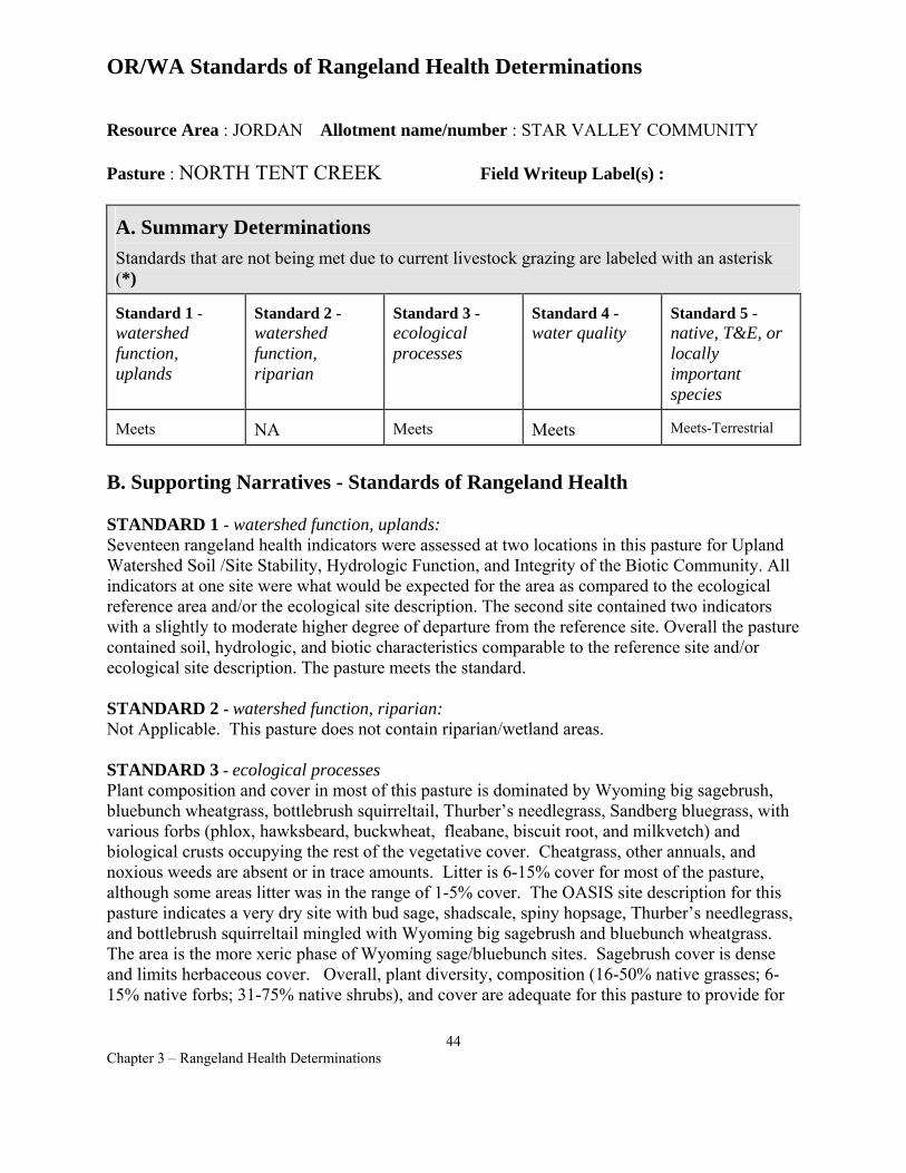
OR/WA Standards of Rangeland Health Determinations
Resource Area : JORDAN Allotment name/number : STAR VALLEY COMMUNITY
Pasture : NORTH TENT CREEK Field Writeup Label(s) :
A. Summary Determinations Standards that are not being met due to current livestock grazing are labeled with an asterisk (*)
Standard 1 -watershed function, uplands
Standard 2 -watershed function, riparian
Standard 3 -ecological processes
Standard 4 -water quality
Standard 5 -native, T&E, or locally important species
Meets NA Meets Meets Meets-Terrestrial
B. Supporting Narratives - Standards of Rangeland Health
STANDARD 1 - watershed function, uplands: Seventeen rangeland health indicators were assessed at two locations in this pasture for Upland Watershed Soil /Site Stability, Hydrologic Function, and Integrity of the Biotic Community. All indicators at one site were what would be expected for the area as compared to the ecological reference area and/or the ecological site description. The second site contained two indicators with a slightly to moderate higher degree of departure from the reference site. Overall the pasture contained soil, hydrologic, and biotic characteristics comparable to the reference site and/or ecological site description. The pasture meets the standard.
STANDARD 2 - watershed function, riparian: Not Applicable. This pasture does not contain riparian/wetland areas.
STANDARD 3 - ecological processes Plant composition and cover in most of this pasture is dominated by Wyoming big sagebrush, bluebunch wheatgrass, bottlebrush squirreltail, Thurber’s needlegrass, Sandberg bluegrass, with various forbs (phlox, hawksbeard, buckwheat, fleabane, biscuit root, and milkvetch) and biological crusts occupying the rest of the vegetative cover. Cheatgrass, other annuals, and noxious weeds are absent or in trace amounts. Litter is 6-15% cover for most of the pasture, although some areas litter was in the range of 1-5% cover. The OASIS site description for this pasture indicates a very dry site with bud sage, shadscale, spiny hopsage, Thurber’s needlegrass, and bottlebrush squirreltail mingled with Wyoming big sagebrush and bluebunch wheatgrass. The area is the more xeric phase of Wyoming sage/bluebunch sites. Sagebrush cover is dense and limits herbaceous cover. Overall, plant diversity, composition (16-50% native grasses; 615% native forbs; 31-75% native shrubs), and cover are adequate for this pasture to provide for
44 Chapter 3 – Rangeland Health Determinations
ecological processes as well as habitat for diverse animal populations. Therefore, the standard is met.
STANDARD 4 - water quality: This pasture does not contain stream channels with perennial water nor riparian/wetland areas. There are no limiting physical factors in Standards 1-3 that may affect water resources on-site or off-site.
STANDARD 5 - native, T&E, or locally important species Based on an assessment of plant composition and structure criteria cited in Appendix F of the Southeast Oregon Resource Management Plan, the following conclusions about wildlife habitat health have been made:
Native sagebrush rangelands SHRUB COVER – Habitats observed meet or exceed the minimum desired pasture level shrub cover conditions for native rangeland. The amount and quality of most shrubland habitat necessary to meet the forage, cover, and structure needs of wildlife (including sage grouse and other animals that occupy sagebrush habitats) is present.
HERBACEOUS COVER - Most habitats observed meet the desired herbaceous understory conditions for native rangeland (e.g. multiple species of native forbs and grasses consistent with mid, late, or potential natural community ecological conditions).
HABITAT CONNECTIVITY - There are no Class 1/2 (grassland) habitats of significant size within this pasture. The Geographic Management Area this pasture lies within exhibits a high level of connectivity and very low overall overstory fragmentation.
TERRESTRIAL SOURCE HABITATS - Most of the upland habitat observed conforms to Terrestrial Source Habitat criteria described in the Interior Columbia Basin Ecosystem Management Project.
Other supporting information - Refer to Jordan Resource Area wildlife evaluation file: Louse Canyon Geographic Management Area Summary Evaluation ( Summer-Fall 2000) for other details.
Range Health Interdisciplinary Team Members - Tom Forre, Tom Miles, Cynthia Tait, Jack Wenderoth, Jon Sadowski
Authorized officer /s/ JERRY L. TAYLOR Jerry L. Taylor, Area Manager
Date of determination 12/7/01
45 Chapter 3 – Rangeland Health Determinations

OR/WA Standards of Rangeland Health Determinations
Resource Area : JORDAN Allotment name/number : STAR VALLEY COMMUNITY
Pasture : SOUTH TENT CREEK Field Writeup Label(s) :
A. Summary Determinations Standards that are not being met due to current livestock grazing are labeled with an asterisk (*)
Standard 1 -watershed function, uplands
Standard 2 -watershed function, riparian
Standard 3 -ecological processes
Standard 4 -water quality
Standard 5 -native, T&E, or locally important species
Meets Does Not Meet* Meets Does Not Meet* Meets-Terrestrial
Does Not Meet*- Riparian
Supporting Narratives
STANDARD 1 - watershed function, uplands Seventeen rangeland health indicators were assessed at three locations in this pasture for Upland Watershed Soil /Site Stability, Hydrologic Function, and Integrity of the Biotic Community. All sites had one or two indicators with a slight departure from the reference site, but most were comparable to the ecological reference area and/or the ecological site description. Overall, the pasture had soil, hydrologic, and biotic characteristics comparable to the reference site and/or ecological site description. The pasture meets the standard.
STANDARD 2 - watershed function, riparian South Tent Creek Pasture riparian areas are mostly limited to upper portions of the Tent Creek watershed. Mahogany Creek was rated PFC, but riparian conditions observed on segments of Tent Creek, Jack Creek, and 3 spring/meadow areas were not sufficient to dissipate stream energy, reduce erosion, or store water for later release. These habitats were adversely affected by livestock grazing, which reduced plant cover and compacted wet soils.
STANDARD 3 - ecological processes Standard 3 was met in South Tent Creek Pasture. Plant composition and cover in most of this pasture are dominated by Wyoming big sagebrush, low sagebrush, bluebunch wheatgrass, Idaho fescue, bottlebrush squirreltail, and Sandberg bluegrass, with various forbs (phlox, hawksbeard, buckwheat, fleabane, biscuit root, and onion) and biological crusts occupying the rest of the vegetative cover. Cheatgrass, other annuals, and noxious weeds are absent or occur in trace amounts. Litter cover is 6-15%. For two-thirds of the pasture, the OAESIS site description indicates a very dry site with bud sage, shadscale, spiny hopsage, Thurber’s needlegrass, and
46 Chapter 3 – Rangeland Health Determinations
bottlebrush squirreltail expected to accompany the dry phase of Wyoming big sagebrush and bluebunch wheatgrass. Wyoming big sagebrush cover is dense, causing a lower cover of key grass species relative to the grass cover expected in the site descriptions. Shrub cover in the low sagebrush portion of the pasture was not dense, and perennial grass and forb components were what would be expected for this site. Overall, plant diversity, composition (16-50% native grasses; 1-30% native forbs; 16-75% native shrubs), and cover are adequate and provide for ecological processes as well as habitat for diverse animal populations.
STANDARD 4 - water quality South Tent Creek pasture has intermittently flowing interrupted stream systems that usually dry by July except for spring areas. There are no limiting physical or biological factors identified in Standards 1or 3 for this pasture that may affect water resources on-site or off-site. However, riparian areas assessed for physical stream channel and floodplain properties were rated as Functioning-at-Risk and contribute to the impairment of water quality in the pasture. Spring sources, wet areas, and riparian vegetation are well utilized by livestock and lack the proper characteristics to function and aid in the maintenance for water quality. Therefore this pasture is not meeting Standard 4.
STANDARD 5 - native, T&E, or locally important species
TERRESTRIAL SPECIES –Meets Standards
Based on an assessment of plant composition and structure criteria cited in Appendix F of the SEORMP, the following conclusions about wildlife habitat health have been made:
Native sagebrush rangelands SHRUB COVER – Habitats observed meet or exceed the minimum desired pasture level shrub cover conditions for native rangeland. The amount and quality of most shrubland habitat necessary to meet the forage, cover, and structure needs of wildlife (including sage grouse and other animals that occupy sagebrush habitats) is present.
Poor structural habitat quality was observed in certain isolated basin big sagebrush subtypes that are nested within low sagebrush dominated communities. These areas comprise a small fraction of the pasture. In these particular instances, umbrella-form shrubs with heavily grazed understories (as per BLM utilization definitions) were observed.
HERBACEOUS COVER - Most habitats observed meet the desired herbaceous understory conditions for native rangeland (e.g. multiple species of native forbs and grasses consistent with mid, late, or potential natural community ecological conditions).
HABITAT CONNECTIVITY - There are no Class 1 or 2 (grassland) habitats of significant size within this pasture. The Geographic Management Area this pasture lies within exhibits a high level of connectivity and low overall overstory fragmentation.
TERRESTRIAL SOURCE HABITATS - Most of the upland habitat observed conforms to Terrestrial Source Habitat criteria described in the Interior Columbia Basin Ecosystem Management Project.
47 Chapter 3 – Rangeland Health Determinations
Riparian plant composition and structure Only some of the riparian conditions observed meet the desired forage, cover, and structure needs of terrestrial wildlife. The locations, types, and amounts of habitat adversely affected by livestock grazing use, especially in wet meadow types, warrant a change in grazing use management. Refer to Standard 2 narrative above.
Other supporting information - Refer to Jordan Resource Area wildlife evaluation file: Louse Canyon Geographic Management Area Summary Evaluation (Summer-Fall 2000) for other details.
RIPARIAN SPECIES---Not meeting standard Based on assessments for Standard 2, riparian conditions observed on segments of Tent Creek, Jack Creek, and 3 spring/meadow areas were not sufficient to dissipate stream energy, reduce erosion, store water for later release. These habitats were adversely affected by livestock grazing, which reduced plant cover and compacted wet soils. Although fish do not occur in South Tent Creek Pasture, these riparian areas provide rearing and foraging areas for amphibians, especially Pacific treefrogs, and invertebrates.
Range Health Interdisciplinary Team Members - Tom Forre, Tom Miles, Cynthia Tait, Jack Wenderoth, Jon Sadowski
Authorized officer /s/ JERRY L. TAYLOR Jerry L. Taylor, Area Manager
Date of determination 12/7/01
48 Chapter 3 – Rangeland Health Determinations
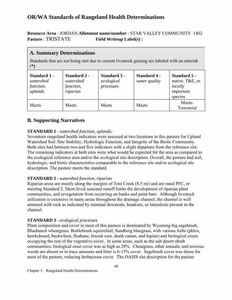
OR/WA Standards of Rangeland Health Determinations
Resource Area : JORDAN Allotment name/number : STAR VALLEY COMMUNITY 1402 Pasture : TRISTATE Field Writeup Label(s) :
A. Summary Determinations Standards that are not being met due to current livestock grazing are labeled with an asterisk (*)
Standard 1 -watershed function, uplands
Standard 2 -watershed function, riparian
Standard 3 -ecological processes
Standard 4 -water quality
Standard 5 -native, T&E, or locally important species
Meets Meets Meets Meets Meets-Terrestrial
B. Supporting Narratives
STANDARD 1 - watershed function, uplands: Seventeen rangeland health indicators were assessed at two locations in this pasture for Upland Watershed Soil /Site Stability, Hydrologic Function, and Integrity of the Biotic Community. Both sites had between two and five indicators with a slight departure from the reference site. The remaining indicators at both sites were what would be expected for the area as compared to the ecological reference area and/or the ecological site description. Overall, the pasture had soil, hydrologic, and biotic characteristics comparable to the reference site and/or ecological site description. The pasture meets the standard.
STANDARD 2 - watershed function, riparian Riparian areas are mostly along the margins of Tent Creek (8.5 mi) and are rated PFC, or meeting Standard 2. Short-lived seasonal runoff limits the development of riparian plant communities, and revegetation from occurring on banks and point bars. Although livestock utilization is extensive in many areas throughout the drainage channel, the channel is well armored with rock as indicated by minimal downcuts, headcuts, or lateralcuts present in the channel.
STANDARD 3 - ecological processes Plant composition and cover in most of this pasture is dominated by Wyoming big sagebrush, Bluebunch wheatgrass, Bottlebrush squirreltail, Sandberg bluegrass, with various forbs (phlox, hawksbeard, buckwheat, fleabane, biscuit root, death camas, and lupine) and biological crusts occupying the rest of the vegetative cover. In some areas, such as the salt desert shrub communities, biological crust cover was as high as 28%. Cheatgrass, other annuals, and noxious weeds are absent or in trace amounts and litter is 6-15% cover. Sagebrush cover was dense for most of the pasture, reducing herbaceous cover. The OASIS site description for the pasture
49 Chapter 3 – Rangeland Health Determinations
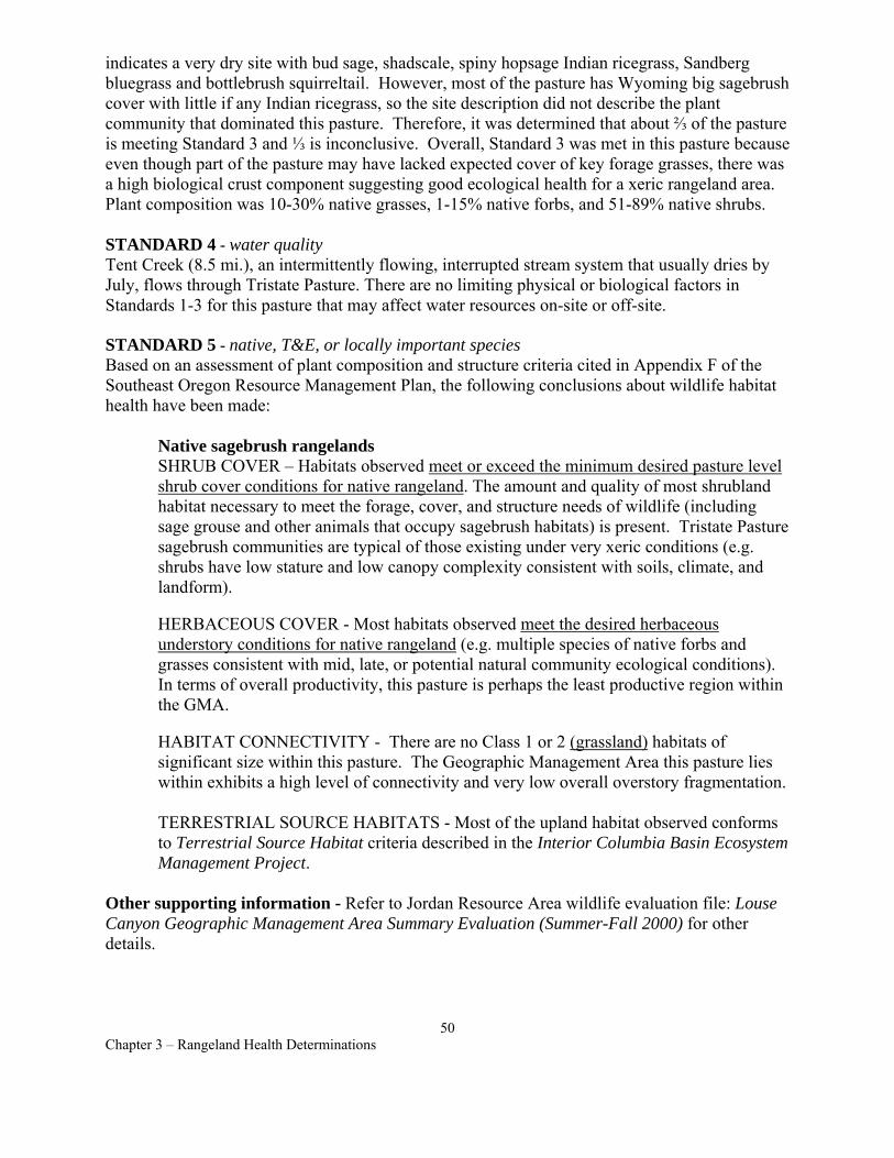
indicates a very dry site with bud sage, shadscale, spiny hopsage Indian ricegrass, Sandberg bluegrass and bottlebrush squirreltail. However, most of the pasture has Wyoming big sagebrush cover with little if any Indian ricegrass, so the site description did not describe the plant community that dominated this pasture. Therefore, it was determined that about ⅔ of the pasture is meeting Standard 3 and ⅓ is inconclusive. Overall, Standard 3 was met in this pasture because even though part of the pasture may have lacked expected cover of key forage grasses, there was a high biological crust component suggesting good ecological health for a xeric rangeland area. Plant composition was 10-30% native grasses, 1-15% native forbs, and 51-89% native shrubs.
STANDARD 4 - water quality Tent Creek (8.5 mi.), an intermittently flowing, interrupted stream system that usually dries by July, flows through Tristate Pasture. There are no limiting physical or biological factors in Standards 1-3 for this pasture that may affect water resources on-site or off-site.
STANDARD 5 - native, T&E, or locally important species Based on an assessment of plant composition and structure criteria cited in Appendix F of the Southeast Oregon Resource Management Plan, the following conclusions about wildlife habitat health have been made:
Native sagebrush rangelands SHRUB COVER – Habitats observed meet or exceed the minimum desired pasture level shrub cover conditions for native rangeland. The amount and quality of most shrubland habitat necessary to meet the forage, cover, and structure needs of wildlife (including sage grouse and other animals that occupy sagebrush habitats) is present. Tristate Pasture sagebrush communities are typical of those existing under very xeric conditions (e.g. shrubs have low stature and low canopy complexity consistent with soils, climate, and landform).
HERBACEOUS COVER - Most habitats observed meet the desired herbaceous understory conditions for native rangeland (e.g. multiple species of native forbs and grasses consistent with mid, late, or potential natural community ecological conditions). In terms of overall productivity, this pasture is perhaps the least productive region within the GMA.
HABITAT CONNECTIVITY - There are no Class 1 or 2 (grassland) habitats of significant size within this pasture. The Geographic Management Area this pasture lies within exhibits a high level of connectivity and very low overall overstory fragmentation.
TERRESTRIAL SOURCE HABITATS - Most of the upland habitat observed conforms to Terrestrial Source Habitat criteria described in the Interior Columbia Basin Ecosystem Management Project.
Other supporting information - Refer to Jordan Resource Area wildlife evaluation file: Louse Canyon Geographic Management Area Summary Evaluation (Summer-Fall 2000) for other details.
50 Chapter 3 – Rangeland Health Determinations

Range Health Interdisciplinary Team Members - Tom Forre, Tom Miles, Cynthia Tait, Jack Wenderoth, Jon Sadowski
Authorized officer /s/ JERRY L. TAYLOR Jerry L. Taylor, Area Manager
Date of determination 12/7/01
51 Chapter 3 – Rangeland Health Determinations

OR/WA Standards of Rangeland Health Determinations
Resource Area : JORDAN Allotment name/number : AMBROSE MAHER 01102
Pasture : AMBROSE MAHER Field Writeup Label(s) : AM1
A. Summary Determinations Standards that are not being met due to current livestock grazing are labeled with an asterisk (*)
Standard 1 -watershed function, uplands
Standard 2 -watershed function, riparian
Standard 3 -ecological processes
Standard 4 -water quality
Standard 5 -native, T&E, or locally important species
Meets NA Meets Meets Does Not Meet – Terrestrial
B. Supporting Narratives
STANDARD 1 - watershed function, uplands Seventeen rangeland health indicators were assessed at one location in this pasture for Upland Watershed Soil /Site Stability, Hydrologic Function, and Integrity of the Biotic Community. Twelve indicators at the site were rated at what would be expected for the area as compared to the ecological reference area and/or the ecological site description. Slight departure of five indicators (four biotic and one soil/hydrologic) from the reference site was attributed to the 1985 Lone Tree wildfire which removed shrub overstory. The pasture meets the standard.
STANDARD 2 - watershed function, riparian Not Applicable. This pasture does not contain riparian/wetland areas.
STANDARD 3 - ecological processes Due to wildfire disturbance, plant composition and cover in most of this pasture is dominated by bluebunch wheatgrass, bottlebrush squirreltail, and Sandberg bluegrass, and native shrub cover is absent. Perennial forbs are sparse. These conditions are either wholly or partially related to wildfire impacts and are not likely to be the result of livestock use. Despite lack of shrubs and forbs, the biological integrity of Ambrose Maher allotment is not impaired by invasive or noxious plant species. Standard 3 is met because the pasture is expected to recover a more balanced plant community over time.
STANDARD 4 - water quality This pasture does not have stream channels with perennial water nor riparian/wetland areas. There are no limiting physical or biological factors in Standards 1-3 for this pasture that may affect water resources on-site or off-site.
52 Chapter 3 – Rangeland Health Determinations
STANDARD 5 - native, T&E, or locally important species Based on an assessment of plant composition and structure criteria cited in Appendix F of the Southeast Oregon Resource Management Plan, the following conclusions about terrestrial wildlife habitat health have been made:
Native sagebrush rangelands SHRUB COVER – Habitats observed meet the minimum desired pasture level shrub cover conditions for native rangeland. The amount and quality of most shrubland habitat necessary to meet the forage, cover, and structure needs of wildlife (including sage grouse and other animals that occupy sagebrush habitats) is present. However, the 1985 wildfire has temporarily eliminated 49% of sagebrush shrub communities that could potentially be present in Ambrose Maher allotment. Most remaining shrubland communities are located in canyon landforms.
HERBACEOUS COVER - Most habitats observed do not meet the desired herbaceous understory conditions for native rangeland. Perennial grass composition was vigorous and healthy but forb composition was very limited. Whether lack of forbs is caused by (1) wildfire; (2) site potential; or (3) conducting the S&G assessment at the end of the growing season is not clear. Given the limited amount and duration of livestock grazing use authorized, it is not likely that the limited forb composition is due to livestock grazing impacts.
HABITAT CONNECTIVITY - Due to the overall amount of sagebrush community fragmentation in the adjoining Jackies Butte GMA, Class 1 & 2 (grassland) conditions in Ambrose Maher Allotment contribute towards landscape level habitat fragmentation problems for wildlife. Nearly 45% of Jackies Butte GMA is comprised of native, exotic perennial, and invasive annual grassland communities that are hostile environments for sage grouse and other animals that occupy sagebrush habitats.
TERRESTRIAL SOURCE HABITATS - Most if not all of the upland habitat observed conforms to Terrestrial Source Habitat criteria described in the Interior Columbia Basin Ecosystem Management Project.
Other supporting information - Refer to Jordan Resource Area wildlife evaluation file: Louse Canyon Geographic Management Area Summary Evaluation Summer-Fall 2000) for other details.
Range Health Interdisciplinary Team Members – Travis Fletcher, Brandon Knapton, Cynthia Tait, Jack Wenderoth, Jon Sadowski
Authorized officer /s/ JERRY L. TAYLOR Jerry L. Taylor, Area Manager
Date of determination 12/7/01
53 Chapter 3 – Rangeland Health Determinations
Chapter 4 - LCGMA Evaluation Recommendations (RECs)
Based on examination and evaluation of the 2000 LCGMA Rangeland Health assessment data, the following recommendations for resource management have been proposed by the Jordan Resource Area interdisciplinary team.
RANGELAND VEGETATION The following recommendations address Rangeland Health Standard 1 (Watershed function, uplands) and Standard 3 (Ecological processes):
RV REC1: Manage grazing use in native rangelands so that utilization levels are consistent with other resource values.
RV REC2: Manage Starvation Brush Control Pasture south of Antelope Creek to allow for the expression of understory herbaceous and forb species.
SPECIAL STATUS PLANT SPECIES The following recommendation addresses Rangeland Health Standard 3 (Ecological processes):
SS PLANTS REC1: Manage the land within the LCGMA to maintain, restore, or enhance populations and habitats of special status plant species with particular emphasis on the two species considered most vulnerable: Davis peppergrass and profuse-flowered mesa mint.
RIPARIAN AND AQUATIC HABITATS (RIP) The following recommendations address Rangeland Health Standard 2 (Watershed function, riparian), Standard 4 (Water Quality), and Standard 5 (Native, T&E, or locally important species—Riparian):
RIP REC 1: Alleviate hot and late-season grazing in riparian areas, where, because of livestock grazing impacts, riparian/wetland areas do not meet Rangeland Health Standards 2, 4, and 5. Incorporate early-season or winter use and rest to allow regrowth of riparian vegetation and avoid utilization of woody riparian species, such as willows.
RIP REC 2: Fence or otherwise exclude livestock from streams and riparian/wetland areas if early-season grazing is not feasible. In addition, fence to exclude livestock from those riparian areas (springs, wetlands, or streams) that are assessed as Functioning-at-Risk with a downward trend. Ensure that corridor fence placement is sufficiently outside of Riparian Conservation Areas to allow for lateral expansion of hydric soils and riparian vegetation.
RIP REC 3: In pastures, where, because of livestock grazing impacts, riparian/wetland areas do not meet the physical component of Rangeland Health Standards 2 and 5, implement grazing systems which will alleviate hot season impacts and increase desirable herbaceous and woody riparian vegetation to attain proper functioning condition appropriate to soil, climate, and landform and also to promote the achievement of state water quality standards.
1 Chapter 4 – LCGMA Evaluation Recommendations
RIP REC 4: In pastures, where, because of livestock grazing impacts, riparian/wetland areas do not meet the biological component of Rangeland Health Standards 2 and 5, implement grazing systems to achieve an upward trend appropriate to soil, climate, and landform.
RIP REC 5: Avoid new spring developments and remove developments from water sources that are not essential for livestock management. Similarly, avoid new pipeline construction that sequesters natural water sources thereby desiccating other wetland areas.
RIP REC 6: Where spring developments exist, implement proper trough placement away from wet areas so that livestock are not concentrated on fragile wet soils and vegetation. Ensure that troughs are equipped with valves or water return systems to prevent leakage and diversion of water away from the stream channel or riparian/wetland area.
RIP REC 7: Relocate Exchange Spring and Coffeepot Spring pipelines out of riparian meadows and restore associated meadows to remedy stream channel flow interception, erosion, and exposed hydric soils caused by the original pipeline placement.
RIP REC 9: Relocate or repair road crossings in New Road Spring and Three Week Spring drainages that impair riparian/wetland areas and water quality. Repair road at New Road Spring where it crosses, intercepts, and channels streamflow along the road. Relocate and repair the road crossing at Three Week Spring to stabilize a head cut and prevent an upstream migration that could endanger wetland habitat.
RIP REC 10: Deviations in authorized annual grazing use within pastures supporting riparian communities will be considered on a case basis after a review of existing resource conditions is conducted by the Jordan Resource Area Interdisciplinary Team.
WILDLIFE AND WILDLIFE HABITAT / SPECIAL STATUS ANIMAL SPECIES (WLDF) The following recommendations address Rangeland Health Standard 5 (Native, T&E, or locally important species– Terrestrial):
WLDF REC1: Manage LCGMA in a way that will maintain a large geographic extent of complex sagebrush shrublands capable of supporting terrestrial wildlife species of management importance. By doing so, BLM will conserve valuable sagebrush steppe habitats that possess ICBEMP Terrestrial Source Habitat qualities and conform to the wildlife-community based objective identified in the SEORMP.
WLDF REC2: Design future land treatment disturbances within LCGMA so the geographic extent of large blocks of grassland habitat (320 acres or larger) is limited and a high level of sagebrush habitat connectivity among LCGMA grazing allotment pastures is maintained.
WLDF REC3: Manage to maintain or improve the distribution and health of deep rooted native perennial grasses and native forbs important to native wildlife.
2 Chapter 4 – LCGMA Evaluation Recommendations
WLDF REC4: Mechanical methods of land treatment are preferred over fire disturbance or chemical applications.
WLDF REC5: Avoid new water developments for the purpose of extending livestock grazing access into previously un-grazed rangelands that support greater sage-grouse nesting and early brood-rearing activities.
WLDF REC6: Avoid temporary non-renewable native range grazing use authorizations in pastures that support sage grouse nesting and early brood-rearing activities.
WLDF REC7: Adjust livestock grazing sequences so that stream, wetland, and meadow quality and quantity is improved over time.
WLDF REC8: Expend upland habitat restoration dollars (for the purpose of improving upland habitat structure and forage quality in monotypic crested wheatgrass habitats) in Jordan Resource Area locations other than Starvation Seeding. Due to the relatively high level of sagebrush habitat connectivity already existing within LCGMA, limited federal dollars available for restoration and enhancement would be more wisely spent where greater benefits to wildlife habitat values would be anticipated.
RANGELAND/GRAZING USE MANAGEMENT (RANGE) The following recommendations address Rangeland Health Standard 1 (Watershed function, uplands) and Standard 3 (Ecological processes):
RANGE REC1: Manage grazing to provide for sustainable rangelands and livestock operations.
RANGE REC2: Re-establish utilization transects in all pastures. Utilization readings are to be taken at established locations.
RANGE REC3: Allow for 15 days flexibility in pasture move dates, as long as use is within permitted AUMs, consistent with resource objectives, and is applied for in writing.
RANGE REC4: Provide livestock watering facilities, and fences where needed, consistent with other resource values.
RANGE REC5: Proposed permittee deviations from planned grazing use authorizations must be provided in writing to the authorized officer at least two weeks prior to the proposed change date.
WILD AND SCENIC RIVERS (WSR)
WSR REC1: The National Wild and Scenic Rivers Act of 1968 mandates that BLM “protect and enhance” the “outstandingly remarkable values” (ORVs) for which the Owyhee River system received its federal “wild” designation. For the West Little Owyhee River located entirely within the Louse Canyon GMA, the ORVs include recreation, scenic and wildlife values.
3 Chapter 4 – LCGMA Evaluation Recommendations
The GMA also borders a portion of the Main Owyhee River, which adds cultural and geologic ORVs to the three listed above.
Planned management actions and projects should, therefore, both protect and enhance those ORVs of the affected river segments. The ORVs most prone to potentially negative impact would probably be the scenic and recreation values, since man-made alterations (i.e., projects) to the natural environment could create unnatural, visible contrasts that might affect visitors’ recreational experiences and opportunities. Projects should be designed so that the net benefits they provide, such as healthier riparian communities with more diverse species composition, would visually outweigh intrusions from the projects’ actual structural or architectural components.
WSR REC2: Manage the LCGMA in accordance with the District Court’s Order of Modified Injunction while implementing adaptive management described in the riparian, vegetation, wildlife and grazing sections, which will enhance ORVs in areas available to grazing.
CULTURAL RESOURCES (CR)
CR REC1: Design water source exclusion fences and other livestock exclusion fences to encompass cultural resource sites to surface manifestation boundaries.
CR REC2: Avoid new spring developments that include surface or subsurface ground disturbance in areas where cultural resources are present
CR REC3: Avoid new spring developments and remove developments from water sources that are not essential for livestock management where cultural resource sites are located. Similarly, avoid new pipeline construction that sequesters natural water sources thereby desiccating other wetland areas where cultural resources are present.
CR REC4: Where spring developments exist, implement proper trough placement away from wet areas so that livestock are not concentrated on fragile wet soils and vegetation where cultural resources are present. Ensure that troughs are equipped with valves or water return systems to prevent leakage and diversion of water away from the stream channel or riparian/wetland area.
CR REC5: Manage LCGMA in a way that will maintain a large geographic extent of complex sagebrush shrublands. By doing so, BLM will conserve valuable cultural resources in situ. Native vegetation of sagebrush steppe ensures minimum erosional activity that may threaten cultural resources.
CR REC6: Manage to maintain or improve the distribution and health of deep rooted native perennial grasses and native forbs. By doing so, BLM will conserve valuable cultural resources in situ. Native vegetation of sagebrush steppe ensures minimum erosional activity that may threaten cultural resources.
4 Chapter 4 – LCGMA Evaluation Recommendations
Chapter 5 – LCGMA Activity Plan Level Objectives
1
Chapter 5 LCGMA Activity Plan Level Objectives Activity plan level objectives appropriate to LCGMA and identified in this section are consistent with Resource Management Plan Objectives in the SEORMP/Record of Decision (pages 28 to 111) for Rangeland Vegetation, Special Status Plant Species, Water Resources and Riparian/Wetlands, Fish and Aquatic Habitat, Wildlife and Wildlife Habitat, Special Status Animal Species, Rangeland/Grazing Use Management, Wild and Scenic Rivers, Cultural Resources, and Human Uses and Values. RANGELAND VEGETATION RANGE VEG OBJ1: Maintain ecological function and health of vegetation communities. This would be evidenced by overall trend (photo-plot, line intercept, and professional judgment determinations) in either a not apparent or upward designation. RANGE VEG OBJ2: Manage livestock grazing use in native range so that utilization levels are predominantly light (21 – 40%) and consistent with other resource values. RANGE VEG OBJ3: Manage livestock grazing use in non-native seedings so that utilization levels do not exceed 60%. SPECIAL STATUS PLANT SPECIES SS PLANT OBJ1: Maintain or increase population numbers of two List 1 special status plant species found at Bull Flat Playa (profuse-flowered mesa mint) and Pigeontoe Playa (Davis’ peppergrass). SS PLANT OBJ2: Maintain population numbers of all other special status plant species. SS PLANT OBJ3: Continue inventory and assessments for List 3 species so that their status can be more adequately addressed within the area. RIPARIAN AND AQUATIC HABITATS See Table 8, Riparian Trend Analysis, for methods that would be used to measure riparian objectives. RIP OBJ 1: Maintain ecological function and health of vegetation communities. Increase streambank stability through increase of riparian species that provide a root matrix for holding soil particles together. Make progress toward >80 percent stable banks (same as INFISH Riparian Management Objective 1), and attain an upward trend in the following indicators:
• stream meanders are increasing • incised channels are healing with vegetation cover
Chapter 5 – LCGMA Activity Plan Level Objectives
2
RIP OBJ 2: Decrease stream channel width/depth ratio (same as INFISH Riparian Management Objective 2), such that water depth is increasing and stream channel width is narrowing RIP OBJ 3: Increase streambank shade through the improvement of riparian/wetland areas that support desired shade-providing riparian herbaceous and woody species. Using increases in height and volume of streambank-shading canopy as a surrogate indicator of lower stream temperatures, stream temperatures in perennial reaches will have no measurable increase (same as INFISH Riparian Management Objective 3). RIP OBJ 4: Increase abundance and diversity of desirable woody and herbaceous riparian vegetation by attaining upward trends in the following indicators (same as INFISH Riparian Management Objective 4):
• at sites with ecological potential for woody vegetation, increase the overall number, species diversity, and canopy volume (height and width) of key woody plants
• at sites with ecological potential for woody vegetation, acquire healthy uneven-aged stands of key woody plants
• increase the overall surface area of herbaceous ground cover • shift herbaceous species composition toward more late-succession species, such as
Nebraska sedge, replacing more xeric-adapted species such as Douglas sedge and Baltic rush
WILDLIFE/WILDLIFE HABITAT AND SPECIAL STATUS ANIMAL SPECIES TERRESTRIAL WLDF OBJ1 Terrestrial species of management importance in LCGMA are identified as the following: Brewer’s sparrow, horned lark, western meadowlark, black-throated sparrow, sage sparrow, loggerhead shrike, greater sage-grouse, sage thrasher, northern bald eagle, California bighorn sheep, pygmy rabbit, pronghorn, northern sagebrush lizard, and short-horned lizard. Maintain a high level of sagebrush shrub cover connectivity among the pastures and grazing allotments of LCGMA over the next 20 years as described below. Provide herbaceous plant cover in sagebrush upland communities that will supply the necessary forage, cover, and structure needed to sustain terrestrial wildlife communities. Adaptive management involving BLM land treatments and wildfire suppression will incorporate wildlife habitat needs at multiple-scales (fine and site scale) in order to limit sagebrush community fragmentation.
• Maintain 85% or more of LCGMA Wyoming, mountain, and basin big sagebrush communities as shrub cover Class 3, 4, and 5 habitats as indicated in Table 9. This objective includes both native and modified rangelands. The structural class objective is met in all three sagebrush habitat types where sagebrush canopy cover ranges from approximately 10% to 35% (measured by line intercept) and shrub plants are in a
Chapter 5 – LCGMA Activity Plan Level Objectives
3
predominantly middle to late structural condition. • BLM initiated land treatments resulting in grassland conditions will not exceed 5% of
LCGMA, or about 26,000 acres, at any given time. This includes future actions such as fire fuel treatments, enhancement of existing seedings for livestock forage production, watershed treatments, and wildlife habitat improvement manipulations.
• Where necessary, allow land treatments in native rangeland as long as the combined amount of disturbance resulting in grassland conditions does not exceed 30% to 40% of any LCGMA pasture unit.
• Minimize the geographic extent of grassland habitats that occur in large blocks (320 acres or more).
• In seeded areas, maintain 40% or more shrubland cover conditions favorable for sagebrush dependent terrestrial wildlife. The structural class objective in shrublands is met where sagebrush canopy cover ranges from 10% to 35% and is in a predominantly middle to late structural condition.
• Appropriate fire management response planning for LCGMA will promote and complement the attainment of LCGMA sagebrush habitat management objectives. To the extent that it is possible, manage wildfire so that disturbance to rangeland does not exceed 10% of LCGMA over the next 20 years. Appropriate management responses to wildfire should be planned on an annual basis.
• Maintain herbaceous plant cover consistent with mid, late, and Potential Natural Community ecological status in big sagebrush, low sagebrush, and salt desert habitats. Desirable herbaceous plant communities for wildlife are comprised of native perennial grasses and multiple species of native forbs consistent with site potential as determined by Natural Resource Conservation Service (NRCS) site guides.
• Manage grazing use impacts on native rangeland so that utilization levels are predominantly slight (6-20%) or light (21-40%) at reasonable distances from livestock water sources and salting areas.
The quality, distribution, and amount of shrubland habitat described in this activity plan objective can be expected to support the life history requirements of LCGMA Terrestrial Wildlife Species of Management Importance and substantially conserve ICBEMP Terrestrial Source Habitat values. The combined environmental impacts of disturbance from BLM initiated land treatments and wildfire over the next 20 years are addressed in this objective. Based on assessment findings, the objective assumes that 10% or less of LCGMA may be affected by wildfire disturbance over the next 20 years. TERRESTRIAL WLDF OBJ 2 Provide quality riparian habitat for terrestrial wildlife, consistent with site potential and capability.
• Manage grazing use over the long term so that woody riparian plant species show signs of successful reproduction as evidenced by the presence of multiple-age class willow and aspen.
• Manage grazing use so that quality herbaceous plant cover is available for terrestrial wildlife communities.
Chapter 5 – LCGMA Activity Plan Level Objectives
4
• Where wildlife habitat improvement is needed and undesirable conditions are caused by livestock grazing use, riparian wildlife habitat objectives will be met when substantial upward trend is indicated in monitoring studies. Evidence of management success in meeting wildlife habitat objectives is based on the presence of multiple upward trend indicators shown in Table 8, Riparian Trend Analysis.
Wildlife habitat management objectives for LCGMA will be addressed sufficiently in LCGMA by managing for a substantial upward trend in habitat conditions. Refer to Specific Desired Plant Community Objectives in SEORMP, Appendix F (pages 287-288). TERRESTRIAL WLDF OBJ 3 Management of Temporary Non-renewable (TNR) livestock grazing use authorizations.
• Allow for periodic fall TNR grazing use authorizations in crested wheatgrass or other exotic perennial grass seedings. Livestock utilization on fall green-up is allowed and will protect wildlife values as long as it does not exceed 40% by key forage plant method estimates.
• In LCGMA native rangelands, protect herbaceous forage, cover, and structure values important to terrestrial wildlife by denying requests for TNR grazing.
TERRESTRIAL WLDF OBJ 4
• Facilitate the maintenance, restoration, and enhancement of bighorn sheep populations and habitats on public land. Pursue management in accordance with the most current State bighorn sheep management plan in a manner consistent with the principles of multiple use management.
RANGELAND/GRAZING USE MANAGEMENT RANGE OBJ1: Provide for a sustained level of livestock grazing consistent with other resource objectives and public land use allocations. HUMAN USES AND VALUES HUMAN USES OBJ1: Work cooperatively with private, community, and local government groups to diversify local economies and expand new industries consistent with other resource objectives. Continue to provide for customary commodity uses when consistent with other resource objectives.
Chapter 6 – Proposed Management Alternatives for Louse Canyon GMA
Development of management alternatives for the Louse Canyon GMA was guided by the “National Environmental Policy Act” (NEPA), BLM resource management planning regulations, and comments from the public that were received during scoping. The basic goal for developing alternatives was to prepare different combinations of management actions that address identified issues and concerns, and to resolve conflicts among uses. A range of resource management actions and allocations was developed based on identified issues and comments received from the public. Data obtained during the LCGMA assessment and presented in this evaluation form the foundation for development of these alternatives.
LCGMA is open to livestock grazing under the existing land use plan (SEORMP), and, under the Federal Land Policy and Management Act (FLPMA), sustainable multiple use management is a priority. Therefore, there is strong emphasis in pursuing management alternatives that do not eliminate uses but manage them so that resource objectives can be achieved.
The six alternatives presented in this chapter are consistent with those analyzed in the SEORMP. However, the direct, indirect, and cumulative effects caused by implementing the actions proposed in each alternative, and the relative efficacy of alternate management actions, are not analyzed in this document. Detailed analyses of environmental consequences for each alternative will be part of NEPA analysis that will follow this evaluation. Finally, a preferred alternative, Alternative III, was identified and recommended for further analysis through the NEPA process.
Maps 15-17 depict pasture boundaries, fence locations, and range improvement sites for Alternatives I, III, and IV.
Range of Recommended Alternatives
Alternative I: Commodity
Alternative I emphasizes commodity production and extraction. Under this alternative, constraints on commodity production for the protection of sensitive resources would be the least restrictive possible within the limits defined by law, regulation, and BLM policy (Map 15).
Emphasis would be placed on construction and maintenance of rangeland projects (primarily fencing and water development) which mitigate livestock impacts, access underutilized forage resources, and improve livestock distribution. Temporary and permanent fencing and other structural developments that protect resources values, while retaining an optimum quantity of forage resources available for livestock use, would be a priority. These structures would include stream corridor fencing, wetland riparian fencing, pipelines, and trough relocations. The vegetation treatments proposed here would be used to enhance forage production, and would include one or more of the following methods: prescribed burning, herbicide application, brush-beating, and seeding, with temporary protection fencing. Starvation Seeding Pasture, however, would not receive any vegetation manipulation treatment despite its failure to meet Rangeland Health Standards 3
1 Chapter 6 – Proposed Management Alternatives for LCGMA

(Ecological Processes) and 5 (Native, T&E, and Locally Important Species), but would continue to be managed as a non-native seeding. Seedings would be retained to provide flexibility in resource management by relieving grazing pressure on vulnerable native pastures and riparian areas. Along with vegetation treatments, new pipelines would also make more forage available by providing water to dry areas previously inaccessible to livestock.
Livestock grazing use would increase in this alternative. This increase would be attributed to increased forage availability due to vegetation manipulations, increases in water availability, and fencing projects. To quantify the permanent availability of forage within the GMA, existing stocking levels were increased to 10 acre/AUM in native range and up to 3 acre/AUM in non-native seedings (Table 10, Alternative I—Livestock Stocking Level Calculations). The anticipated increase in grazing preference caused by these increased stocking levels would be allocated to the existing permit holders in proportion to their existing grazing preference. Maximum utilization would be 40% on native range and 60% for seedings.
Existing structural rangeland projects, such as pipelines, wells, and troughs, which support livestock grazing use would be maintained. Projects that no longer function to meet objectives would be abandoned and sites would be rehabilitated.
The following grazing systems and projects are those needed to implement Alternative I. These projects are designed to improve livestock distribution and provide conditions necessary for implementing the grazing system and meeting rangeland health standards.
Louse Canyon GMA (all allotments) Projects Summary:
New pipelines 36.75 miles New fences 122.5 miles New troughs 24 troughs AUM change (#) up to +10,123 Spring renovation/reconstruction 17 springs Spring abandonment 6 springs Spring development 1 spring Upland vegetation treatments 17,900 acres
Grazing Systems and Projects by Allotment
(a) Anderson Allotment (#01401) Grazing System
Use Period Livestock AUMs numbers
2/15 – 7/31 830 cows 3699
2 Chapter 6 – Proposed Management Alternatives for LCGMA
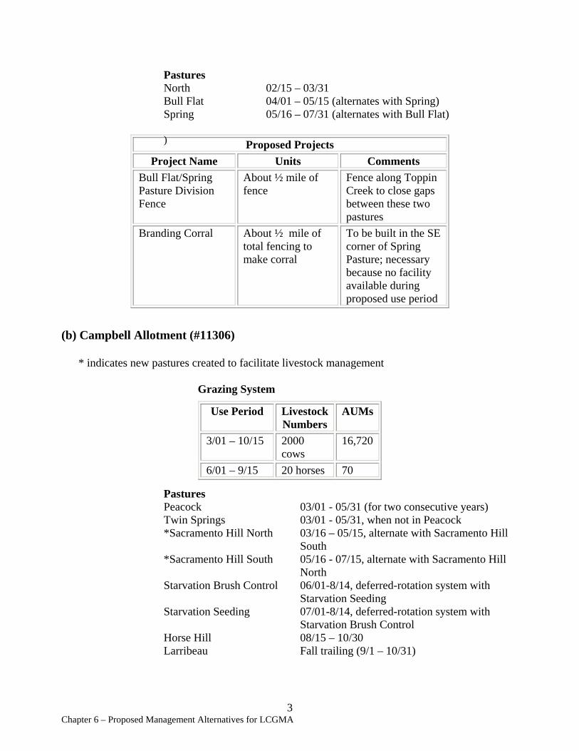
Pastures North 02/15 – 03/31 Bull Flat 04/01 – 05/15 (alternates with Spring) Spring 05/16 – 07/31 (alternates with Bull Flat)
) Proposed Projects Project Name Units Comments
Bull Flat/Spring Pasture Division Fence
About ½ mile of fence
Fence along Toppin Creek to close gaps between these two pastures
Branding Corral About ½ mile of total fencing to make corral
To be built in the SE corner of Spring Pasture; necessary because no facility available during proposed use period
(b) Campbell Allotment (#11306)
* indicates new pastures created to facilitate livestock management
Grazing System
Use Period Livestock AUMs Numbers
3/01 – 10/15 2000 16,720 cows
6/01 – 9/15 20 horses 70
Pastures Peacock 03/01 - 05/31 (for two consecutive years) Twin Springs 03/01 - 05/31, when not in Peacock *Sacramento Hill North 03/16 – 05/15, alternate with Sacramento Hill
South *Sacramento Hill South 05/16 - 07/15, alternate with Sacramento Hill
North Starvation Brush Control 06/01-8/14, deferred-rotation system with
Starvation Seeding Starvation Seeding 07/01-8/14, deferred-rotation system with
Starvation Brush Control Horse Hill 08/15 – 10/30 Larribeau Fall trailing (9/1 – 10/31)
3 Chapter 6 – Proposed Management Alternatives for LCGMA
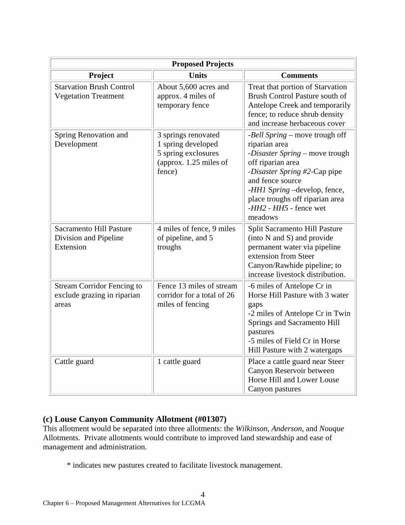
Proposed Projects Project Units Comments
Starvation Brush Control Vegetation Treatment
About 5,600 acres and approx. 4 miles of temporary fence
Treat that portion of Starvation Brush Control Pasture south of Antelope Creek and temporarily fence; to reduce shrub density and increase herbaceous cover
Spring Renovation and Development
3 springs renovated 1 spring developed 5 spring exclosures (approx. 1.25 miles of fence)
-Bell Spring – move trough off riparian area -Disaster Spring – move trough off riparian area -Disaster Spring #2-Cap pipe and fence source -HH1 Spring –develop, fence, place troughs off riparian area -HH2 - HH5 - fence wet meadows
Sacramento Hill Pasture Division and Pipeline Extension
4 miles of fence, 9 miles of pipeline, and 5 troughs
Split Sacramento Hill Pasture (into N and S) and provide permanent water via pipeline extension from Steer Canyon/Rawhide pipeline; to increase livestock distribution.
Stream Corridor Fencing to exclude grazing in riparian areas
Fence 13 miles of stream corridor for a total of 26 miles of fencing
-6 miles of Antelope Cr in Horse Hill Pasture with 3 water gaps -2 miles of Antelope Cr in Twin Springs and Sacramento Hill pastures -5 miles of Field Cr in Horse Hill Pasture with 2 watergaps
Cattle guard 1 cattle guard Place a cattle guard near Steer Canyon Reservoir between Horse Hill and Lower Louse Canyon pastures
(c) Louse Canyon Community Allotment (#01307) This allotment would be separated into three allotments: the Wilkinson, Anderson, and Nouque Allotments. Private allotments would contribute to improved land stewardship and ease of management and administration.
* indicates new pastures created to facilitate livestock management.
4 Chapter 6 – Proposed Management Alternatives for LCGMA

Wilkinson Allotment Grazing System
Use Period Livestock Numbers
AUMs
3-01 – 10/30 871 cows 7,363
3/15 – 9/27 20 horses 123
Pastures *Drummond Basin N&S 03/01 – 05/15 *Steer Canyon Native 05/16 – 05/31 *Lower Louse Canyon 06/01 – 07/15, alternate with Chipmunk *Chipmunk 07/16 - 09/30, alternate with Lower Louse
Canyon *Chino 06/01 - 08/01 Steer Canyon Seeding 08/15 - 10/30 *Horse Pasture/FFR 10/01 - 02/28
Anderson Allotment Grazing System
Use Period Livestock AUMs Numbers
06/01 - 10/15 830 cows 3,739
Pastures *Pole Creek 06/01 – 06/31 10/01 - 10/15 *Anderson 07/01 - 7/31, alternate with Cavietta *Cavietta 08/01 - 9/30, alternate with Anderson
Nouque Allotment Grazing System
Use Period Livestock Numbers
AUMs
3/16 – 0/30 469 cows 2,421 4/01 – 10/31 20 horses 95
Pastures Frenchman Creek Seeding 03/16 - 05/31 *Upper Louse Canyon 06/01 - 09/30
Proposed projects
5 Chapter 6 – Proposed Management Alternatives for LCGMA
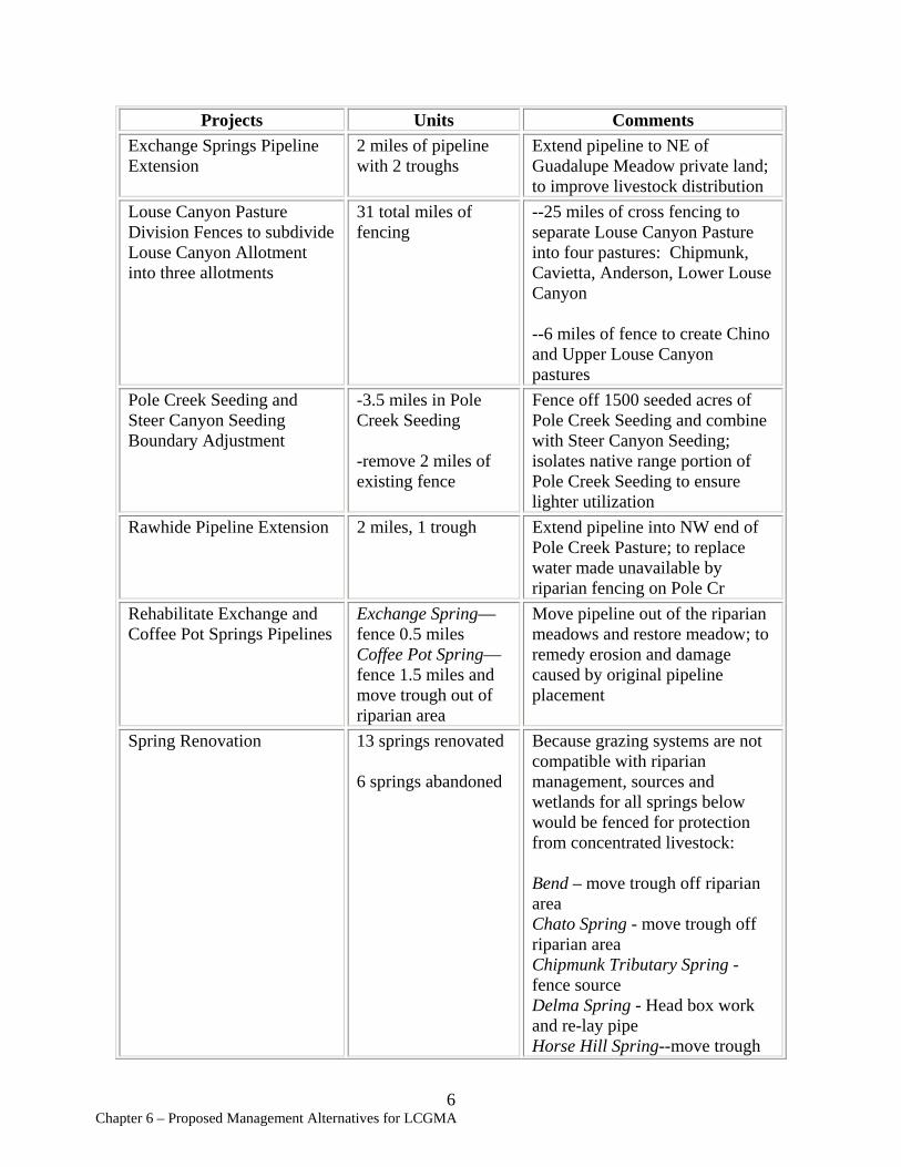
Projects Units Exchange Springs Pipeline Extension
2 miles of pipeline with 2 troughs
Louse Canyon Pasture Division Fences to subdivide Louse Canyon Allotment into three allotments
31 total miles of fencing
Pole Creek Seeding and -3.5 miles in Pole Steer Canyon Seeding Creek Seeding Boundary Adjustment
-remove 2 miles of existing fence
Rawhide Pipeline Extension 2 miles, 1 trough
Rehabilitate Exchange and Coffee Pot Springs Pipelines
Spring Renovation
Exchange Spring— fence 0.5 miles Coffee Pot Spring— fence 1.5 miles and move trough out of riparian area 13 springs renovated
6 springs abandoned
Comments Extend pipeline to NE of Guadalupe Meadow private land; to improve livestock distribution --25 miles of cross fencing to separate Louse Canyon Pasture into four pastures: Chipmunk, Cavietta, Anderson, Lower Louse Canyon
--6 miles of fence to create Chino and Upper Louse Canyon pastures Fence off 1500 seeded acres of Pole Creek Seeding and combine with Steer Canyon Seeding; isolates native range portion of Pole Creek Seeding to ensure lighter utilization Extend pipeline into NW end of Pole Creek Pasture; to replace water made unavailable by riparian fencing on Pole Cr Move pipeline out of the riparian meadows and restore meadow; to remedy erosion and damage caused by original pipeline placement
Because grazing systems are not compatible with riparian management, sources and wetlands for all springs below would be fenced for protection from concentrated livestock:
Bend – move trough off riparian area Chato Spring - move trough off riparian area Chipmunk Tributary Spring -fence source Delma Spring - Head box work and re-lay pipe Horse Hill Spring--move trough
6 Chapter 6 – Proposed Management Alternatives for LCGMA
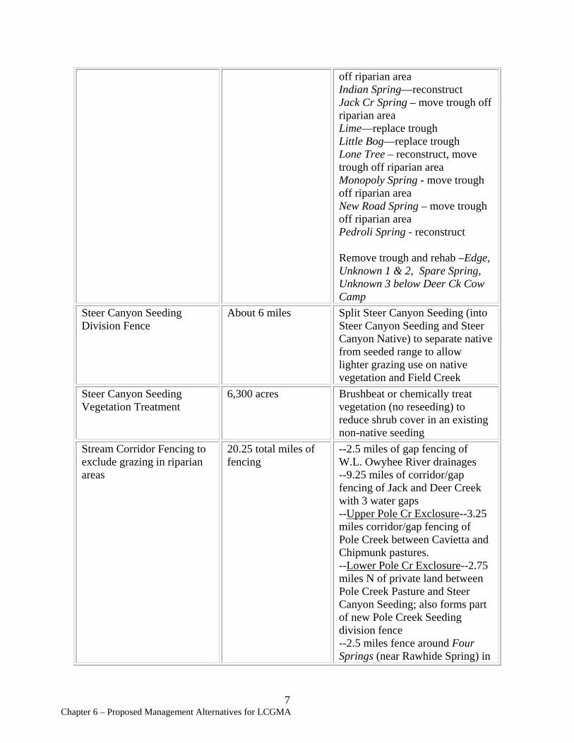
Steer Canyon Seeding Division Fence
Steer Canyon Seeding Vegetation Treatment
Stream Corridor Fencing to exclude grazing in riparian areas
About 6 miles
6,300 acres
20.25 total miles of fencing
off riparian area Indian Spring—reconstruct Jack Cr Spring – move trough off riparian area Lime—replace trough Little Bog—replace trough Lone Tree – reconstruct, move trough off riparian area Monopoly Spring - move trough off riparian area New Road Spring – move trough off riparian area Pedroli Spring - reconstruct
Remove trough and rehab –Edge, Unknown 1 & 2, Spare Spring, Unknown 3 below Deer Ck Cow Camp Split Steer Canyon Seeding (into Steer Canyon Seeding and Steer Canyon Native) to separate native from seeded range to allow lighter grazing use on native vegetation and Field Creek Brushbeat or chemically treat vegetation (no reseeding) to reduce shrub cover in an existing non-native seeding --2.5 miles of gap fencing of W.L. Owyhee River drainages --9.25 miles of corridor/gap fencing of Jack and Deer Creek with 3 water gaps --Upper Pole Cr Exclosure--3.25 miles corridor/gap fencing of Pole Creek between Cavietta and Chipmunk pastures. --Lower Pole Cr Exclosure--2.75 miles N of private land between Pole Creek Pasture and Steer Canyon Seeding; also forms part of new Pole Creek Seeding division fence --2.5 miles fence around Four Springs (near Rawhide Spring) in
7 Chapter 6 – Proposed Management Alternatives for LCGMA
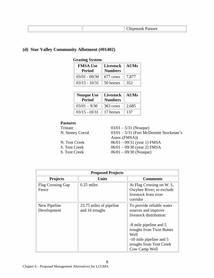
Chipmunk Pasture
(d) Star Valley Community Allotment (#01402)
Grazing System FMSA Use Livestock AUMs
Period Numbers 03/01 - 09/30 677 cows 7,877 03/15 - 10/31 50 horses 352
Nouque Use Period
Livestock Numbers
AUMs
03/01 – 9/30 363 cows 2,685 03/15 –10/31 17 horses 137
Pastures Tristate 03/01 – 5/31 (Nouque) N. Stoney Corral 03/01 – 5/31 (Fort McDermitt Stockman’s
Assoc.(FMSA)) N. Tent Creek 06/01 – 09/31 (year 1) FMSA S. Tent Creek 06/01 – 09/30 (year 2) FMSA S. Tent Creek 06/01 – 09/30 (Nouque)
Proposed Projects Projects Units Comments
Flag Crossing Gap Fence
0.25 miles At Flag Crossing on W. L. Owyhee River; to exclude livestock from river corridor
New Pipeline Development
23.75 miles of pipeline and 16 troughs
To provide reliable water sources and improve livestock distribution:
-8 mile pipeline and 5 troughs from Twin Buttes Well -10 mile pipeline and 5 troughs from Tent Creek Cow Camp Well
8 Chapter 6 – Proposed Management Alternatives for LCGMA
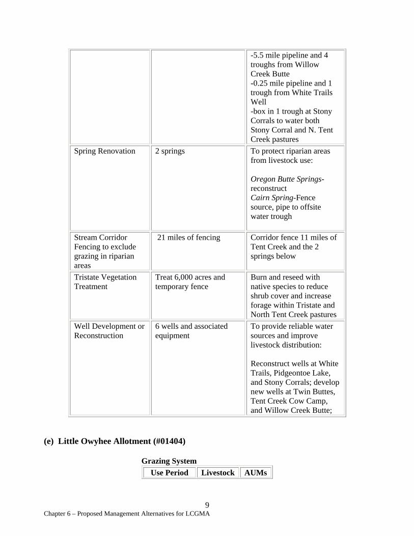
-5.5 mile pipeline and 4 troughs from Willow Creek Butte -0.25 mile pipeline and 1 trough from White Trails Well -box in 1 trough at Stony Corrals to water both Stony Corral and N. Tent Creek pastures
Spring Renovation 2 springs To protect riparian areas from livestock use:
Oregon Butte Springs-reconstruct Cairn Spring-Fence source, pipe to offsite water trough
Stream Corridor 21 miles of fencing Corridor fence 11 miles of Fencing to exclude Tent Creek and the 2 grazing in riparian springs below areas Tristate Vegetation Treat 6,000 acres and Burn and reseed with Treatment temporary fence native species to reduce
shrub cover and increase forage within Tristate and North Tent Creek pastures
Well Development or 6 wells and associated To provide reliable water Reconstruction equipment sources and improve
livestock distribution:
Reconstruct wells at White Trails, Pidgeontoe Lake, and Stony Corrals; develop new wells at Twin Buttes, Tent Creek Cow Camp, and Willow Creek Butte;
(e) Little Owyhee Allotment (#01404)
Grazing System Use Period Livestock AUMs
9 Chapter 6 – Proposed Management Alternatives for LCGMA

Numbers 06/01 – 9/30 222 cows 892
Pastures S. Tent Creek 06/01 – 9/30
Proposed Projects No new projects would be built or reconstructed.
(f) Quinn River Allotment (#01403)
Grazing System Use Period Livestock
Numbers AUMs
03/16 – 9/30 59 cows 384 04/01 - 10/31 9 horses 63
Pastures *Upper Louse Canyon 06/01 – 9/30
Proposed Projects No new projects would be built or reconstructed.
(g) Ambrose Maher Allotment (#01102)
Grazing System Use Period Livestock
numbers AUMs
2/12 – 5/24 40 cows 134 10/16 - 10/29 830 cows 383
Proposed Projects No new projects would be built or reconstructed.
10 Chapter 6 – Proposed Management Alternatives for LCGMA
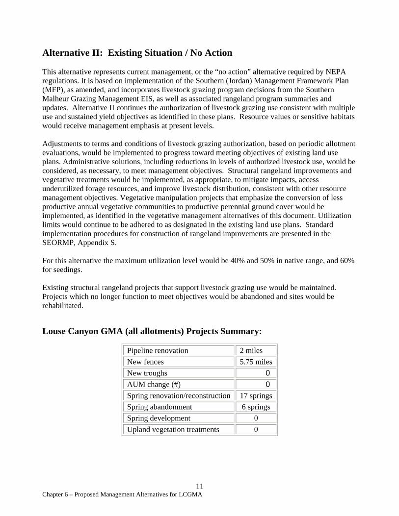
Alternative II: Existing Situation / No Action
This alternative represents current management, or the “no action” alternative required by NEPA regulations. It is based on implementation of the Southern (Jordan) Management Framework Plan (MFP), as amended, and incorporates livestock grazing program decisions from the Southern Malheur Grazing Management EIS, as well as associated rangeland program summaries and updates. Alternative II continues the authorization of livestock grazing use consistent with multiple use and sustained yield objectives as identified in these plans. Resource values or sensitive habitats would receive management emphasis at present levels.
Adjustments to terms and conditions of livestock grazing authorization, based on periodic allotment evaluations, would be implemented to progress toward meeting objectives of existing land use plans. Administrative solutions, including reductions in levels of authorized livestock use, would be considered, as necessary, to meet management objectives. Structural rangeland improvements and vegetative treatments would be implemented, as appropriate, to mitigate impacts, access underutilized forage resources, and improve livestock distribution, consistent with other resource management objectives. Vegetative manipulation projects that emphasize the conversion of less productive annual vegetative communities to productive perennial ground cover would be implemented, as identified in the vegetative management alternatives of this document. Utilization limits would continue to be adhered to as designated in the existing land use plans. Standard implementation procedures for construction of rangeland improvements are presented in the SEORMP, Appendix S.
For this alternative the maximum utilization level would be 40% and 50% in native range, and 60% for seedings.
Existing structural rangeland projects that support livestock grazing use would be maintained. Projects which no longer function to meet objectives would be abandoned and sites would be rehabilitated.
Louse Canyon GMA (all allotments) Projects Summary:
Pipeline renovation 2 miles New fences 5.75 miles New troughs 0 AUM change (#) 0 Spring renovation/reconstruction 17 springs Spring abandonment 6 springs Spring development 0 Upland vegetation treatments 0
11 Chapter 6 – Proposed Management Alternatives for LCGMA
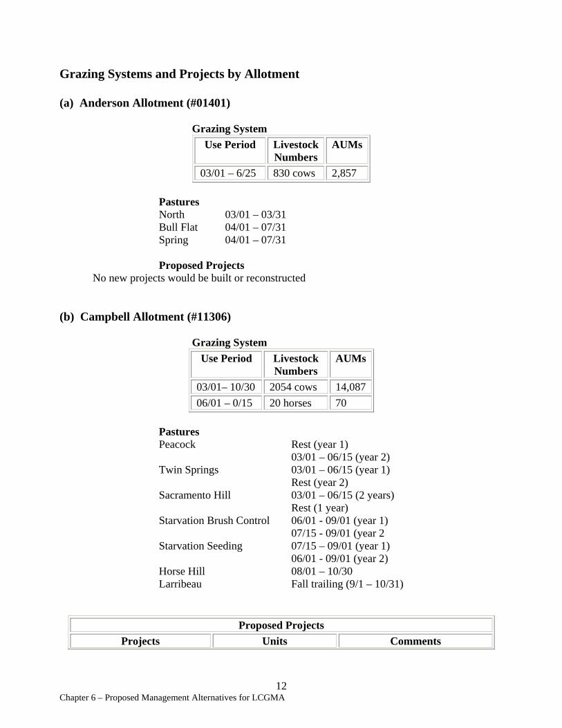
Grazing Systems and Projects by Allotment
(a) Anderson Allotment (#01401)
Grazing System Use Period Livestock AUMs
Numbers 03/01 – 6/25 830 cows 2,857
Pastures North 03/01 – 03/31 Bull Flat 04/01 – 07/31 Spring 04/01 – 07/31
Proposed Projects No new projects would be built or reconstructed
(b) Campbell Allotment (#11306)
Grazing System Use Period Livestock
Numbers AUMs
03/01– 10/30 2054 cows 14,087 06/01 – 0/15 20 horses 70
Pastures Peacock Rest (year 1) 03/01 – 06/15 (year 2) Twin Springs 03/01 – 06/15 (year 1) Rest (year 2) Sacramento Hill 03/01 – 06/15 (2 years) Rest (1 year) Starvation Brush Control 06/01 - 09/01 (year 1) 07/15 - 09/01 (year 2 Starvation Seeding 07/15 – 09/01 (year 1) 06/01 - 09/01 (year 2) Horse Hill 08/01 – 10/30 Larribeau Fall trailing (9/1 – 10/31)
Proposed Projects Projects Units Comments
12 Chapter 6 – Proposed Management Alternatives for LCGMA
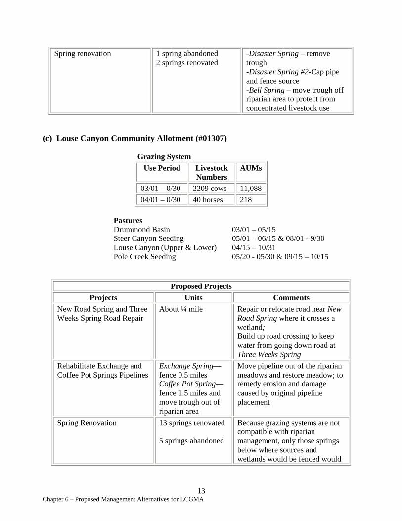
Spring renovation 1 spring abandoned -Disaster Spring – remove 2 springs renovated trough
-Disaster Spring #2-Cap pipe and fence source -Bell Spring – move trough off riparian area to protect from concentrated livestock use
(c) Louse Canyon Community Allotment (#01307)
Grazing System Use Period Livestock
Numbers AUMs
03/01 – 0/30 2209 cows 11,088 04/01 – 0/30 40 horses 218
Pastures Drummond Basin 03/01 – 05/15 Steer Canyon Seeding 05/01 – 06/15 & 08/01 - 9/30 Louse Canyon (Upper & Lower) 04/15 – 10/31 Pole Creek Seeding 05/20 - 05/30 & 09/15 – 10/15
Proposed Projects Projects Units Comments
New Road Spring and Three Weeks Spring Road Repair
About ¼ mile Repair or relocate road near New Road Spring where it crosses a wetland; Build up road crossing to keep water from going down road at Three Weeks Spring
Rehabilitate Exchange and Coffee Pot Springs Pipelines
Exchange Spring— fence 0.5 miles Coffee Pot Spring— fence 1.5 miles and move trough out of riparian area
Move pipeline out of the riparian meadows and restore meadow; to remedy erosion and damage caused by original pipeline placement
Spring Renovation 13 springs renovated
5 springs abandoned
Because grazing systems are not compatible with riparian management, only those springs below where sources and wetlands would be fenced would
13 Chapter 6 – Proposed Management Alternatives for LCGMA
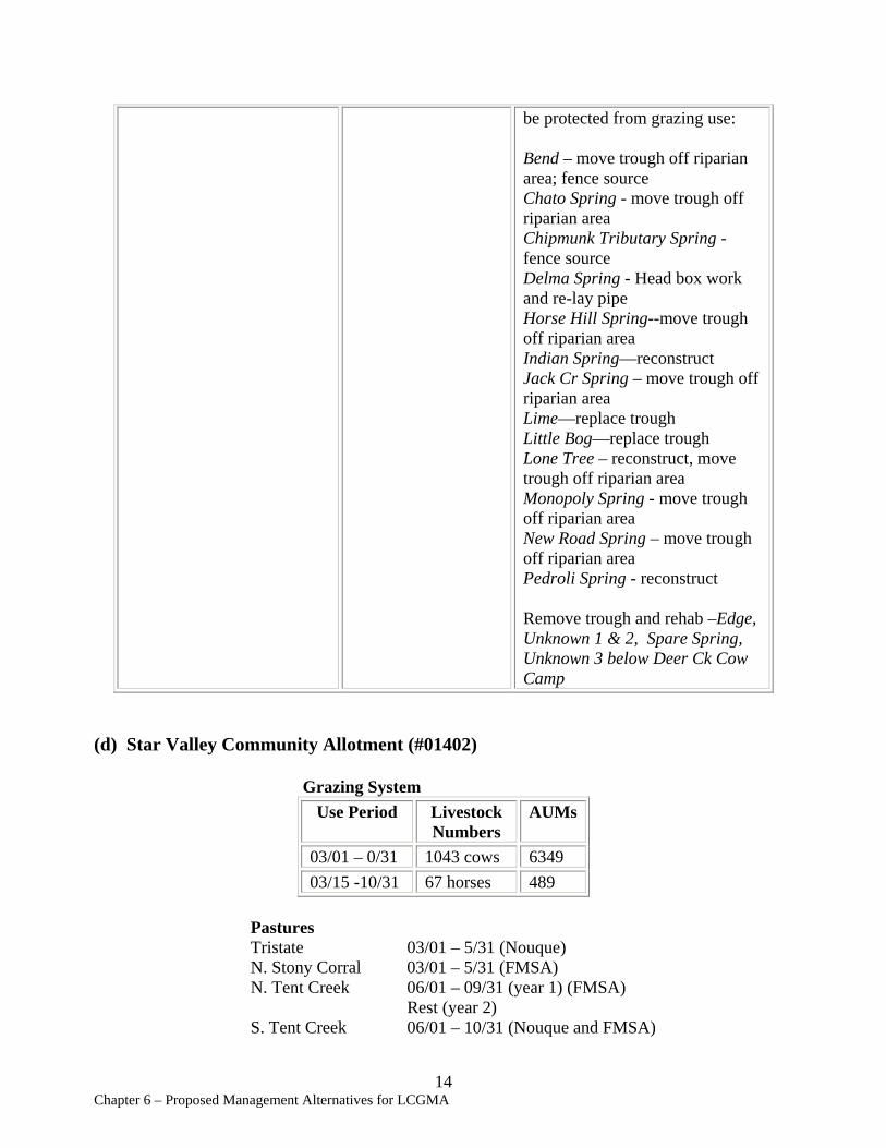
be protected from grazing use:
Bend – move trough off riparian area; fence source Chato Spring - move trough off riparian area Chipmunk Tributary Spring -fence source Delma Spring - Head box work and re-lay pipe Horse Hill Spring--move trough off riparian area Indian Spring—reconstruct Jack Cr Spring – move trough off riparian area Lime—replace trough Little Bog—replace trough Lone Tree – reconstruct, move trough off riparian area Monopoly Spring - move trough off riparian area New Road Spring – move trough off riparian area Pedroli Spring - reconstruct
Remove trough and rehab –Edge, Unknown 1 & 2, Spare Spring, Unknown 3 below Deer Ck Cow Camp
(d) Star Valley Community Allotment (#01402)
Grazing System Use Period Livestock
Numbers AUMs
03/01 – 0/31 1043 cows 6349 03/15 -10/31 67 horses 489
Pastures Tristate 03/01 – 5/31 (Nouque) N. Stony Corral 03/01 – 5/31 (FMSA) N. Tent Creek 06/01 – 09/31 (year 1) (FMSA)
Rest (year 2) S. Tent Creek 06/01 – 10/31 (Nouque and FMSA)
14 Chapter 6 – Proposed Management Alternatives for LCGMA
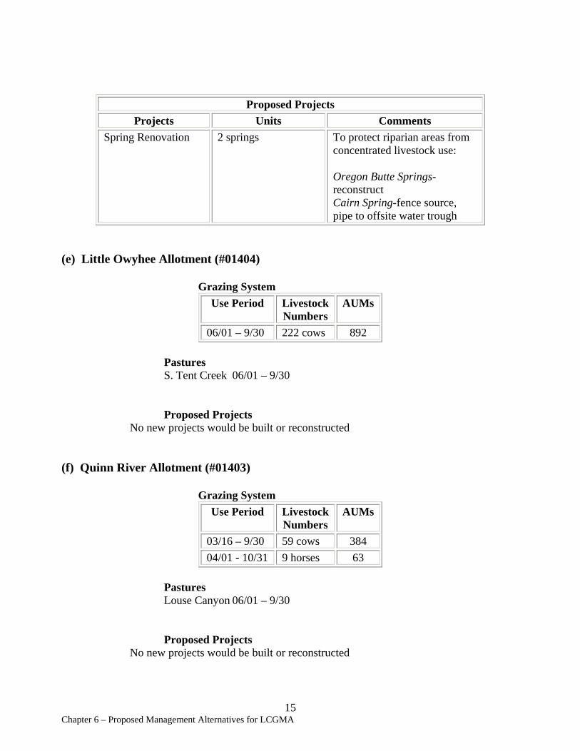
Proposed Projects Projects Units Comments
Spring Renovation 2 springs To protect riparian areas from concentrated livestock use:
Oregon Butte Springs-reconstruct Cairn Spring-fence source, pipe to offsite water trough
(e) Little Owyhee Allotment (#01404)
Grazing System Use Period Livestock AUMs
Numbers 06/01 – 9/30 222 cows 892
Pastures S. Tent Creek 06/01 – 9/30
Proposed Projects No new projects would be built or reconstructed
(f) Quinn River Allotment (#01403)
Grazing System Use Period Livestock
Numbers AUMs
03/16 – 9/30 59 cows 384 04/01 - 10/31 9 horses 63
Pastures Louse Canyon 06/01 – 9/30
Proposed Projects No new projects would be built or reconstructed
15 Chapter 6 – Proposed Management Alternatives for LCGMA
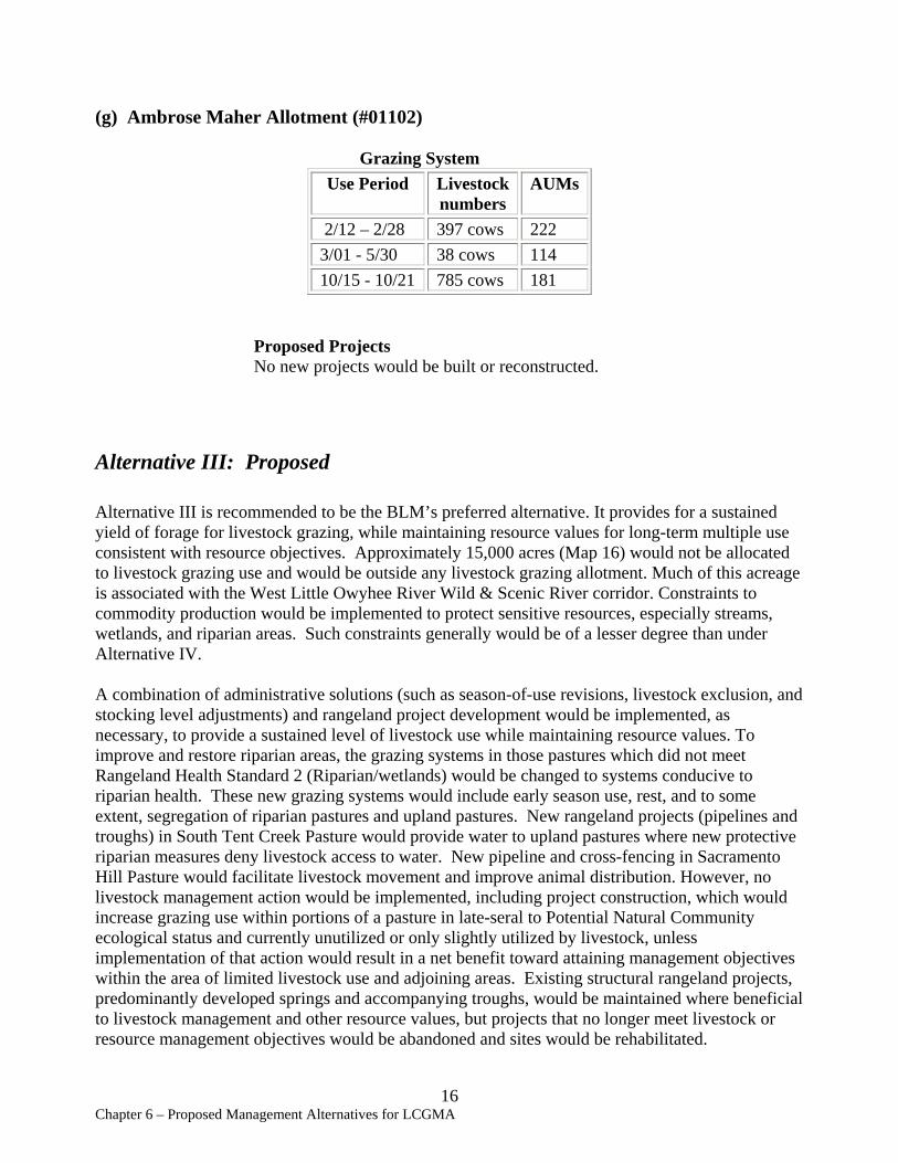
(g) Ambrose Maher Allotment (#01102)
Grazing System Use Period Livestock
numbers AUMs
2/12 – 2/28 397 cows 222 3/01 - 5/30 38 cows 114 10/15 - 10/21 785 cows 181
Proposed Projects No new projects would be built or reconstructed.
Alternative III: Proposed
Alternative III is recommended to be the BLM’s preferred alternative. It provides for a sustained yield of forage for livestock grazing, while maintaining resource values for long-term multiple use consistent with resource objectives. Approximately 15,000 acres (Map 16) would not be allocated to livestock grazing use and would be outside any livestock grazing allotment. Much of this acreage is associated with the West Little Owyhee River Wild & Scenic River corridor. Constraints to commodity production would be implemented to protect sensitive resources, especially streams, wetlands, and riparian areas. Such constraints generally would be of a lesser degree than under Alternative IV.
A combination of administrative solutions (such as season-of-use revisions, livestock exclusion, and stocking level adjustments) and rangeland project development would be implemented, as necessary, to provide a sustained level of livestock use while maintaining resource values. To improve and restore riparian areas, the grazing systems in those pastures which did not meet Rangeland Health Standard 2 (Riparian/wetlands) would be changed to systems conducive to riparian health. These new grazing systems would include early season use, rest, and to some extent, segregation of riparian pastures and upland pastures. New rangeland projects (pipelines and troughs) in South Tent Creek Pasture would provide water to upland pastures where new protective riparian measures deny livestock access to water. New pipeline and cross-fencing in Sacramento Hill Pasture would facilitate livestock movement and improve animal distribution. However, no livestock management action would be implemented, including project construction, which would increase grazing use within portions of a pasture in late-seral to Potential Natural Community ecological status and currently unutilized or only slightly utilized by livestock, unless implementation of that action would result in a net benefit toward attaining management objectives within the area of limited livestock use and adjoining areas. Existing structural rangeland projects, predominantly developed springs and accompanying troughs, would be maintained where beneficial to livestock management and other resource values, but projects that no longer meet livestock or resource management objectives would be abandoned and sites would be rehabilitated.
16 Chapter 6 – Proposed Management Alternatives for LCGMA

Livestock usage in this alternative would not increase over current levels. The maximum allowable utilization level in native range would be “light” (21-40%) (USDI, BLM 1996, Utilization Studies and Residual Measurements) to ensure that native early-season pastures continue to maintain existing plant species assemblages. Maximum utilization levels for seeded range would be 60%.
Upland vegetation treatment in Starvation Brush Control Pasture would target reduction of shrub cover and increase of herbaceous understory vegetation. Treatment methods may include one or more of the following: prescribed burning, herbicide application, brush-beating, and reseeding with native species. Standard implementation procedures for rangeland improvements are presented in the SEORMP, Appendix S.
The following grazing systems and projects would be needed in order to implement Alternative III. These projects are designed to improve livestock distribution and provide conditions necessary for implementing the grazing system and meeting rangeland health standards.
Louse Canyon GMA (all allotments) Projects Summary:
New Pipelines 16 miles New Fences 64.25 miles New Troughs (#) 9 AUM change (#) 0 Spring renovation/reconstruction 17 springs Spring abandonment 6 springs Spring development 0 Upland Vegetation Treatments 3500 acres
Grazing Systems and Projects by Allotment
(a) Anderson Allotment (#01401)
Grazing System Use Period Livestock AUMs
Numbers 02/15 – 6/30 850 cows 2,857
Pastures North 02/15 – 03/31
Bull Flat 04/01 – 05/15 (alternates with Spring Pasture) Spring 05/16 – 06/30 (alternates with Bull Flat Pasture)
17 Chapter 6 – Proposed Management Alternatives for LCGMA
Proposed Projects Project Name Units Comments
Bull Flat/Spring Pasture Division Fence
About ½ mile of fence
Fence along Toppin Creek to close gaps between these two pastures
Toppin Butte Reservoir Rehabilitation
1 reservoir Abandon project, smooth and reseed to native species
(b) Campbell Allotment (#11306) * indicates new pastures created to facilitate livestock management.
Grazing System Use Period Livestock
Numbers AUMs
03/01 – 0/15 2054 cows 14,087 05/01 –10/15 20 horses 70
Pastures Peacock Rest or 3/1 – 05/31 Twin Springs 03/1 – 05/31 or rest *Sacramento Hill North 03/16 – 05/15, alternate with Sacramento Hill
South *Sacramento Hill South 05/16 - 07/15, alternate with Sacramento Hill
North *Horse Hill (N&S) 04/15 – 05/31 (350 cows)
06/01 – 07/15 (1945 cows) Starvation Seeding 07/16 – 09/15 Starvation Brush Control 09/16 - 10/15 Larribeau Fall trailing (9/1 – 10/31)
Proposed Projects Project Units Comments
Cattle Guard 1 cattle guard Place one cattle guard near Steer Canyon Reservoir between Horse Hill and North
18 Chapter 6 – Proposed Management Alternatives for LCGMA
Louse Canyon pastures Sacramento Hill Pasture Division and Pipeline Extension
4 miles of fence, 9 miles of pipeline, and 3 troughs
Split Sacramento Hill Pasture (into N and S) and provide permanent water via pipeline extension from Steer Canyon/Rawhide pipeline to increase livestock distribution.
Spring Renovation and Exclosures
1 spring abandoned 1 spring renovated 2 spring exclosures
Disaster Spring – remove trough Disaster Spring #2—cap pipe and fence source Bell Spring – move trough off riparian area HH-1 Spring – fence source and wetland
Star Valley Road Fence
About 11 miles of fence
Split Horse Hill Pasture (into N and S) along Star Valley Road to avoid excessive critical growing season use and improve livestock distribution
Starvation Brush Control Vegetation Treatment
About 3,500 acres and approx. 4 miles of temporary fence
Treat that portion of Starvation Brush Control south of Antelope Creek and temporarily fence; to reduce shrub density and increase herbaceous cover
(c) Louse Canyon Community Allotment (#01307) *indicates new pastures created to facilitate livestock management.
Grazing System Use Period Livestock
Numbers AUMs
03/01 –10/15 2209 cows 11,088 04/01 –10/15 40 horses 218
Pastures Drummond Basin 03/01 – 05/01 *Steer Canyon Native 05/01 – 05/31 *Upper Louse Canyon 05/15 – 09/30 (20 horses) 06/01 – 07/30 (year 1)
19 Chapter 6 – Proposed Management Alternatives for LCGMA
06/01 – 06/30 (year 2) *Middle Louse Canyon 06/01 – 07/15 *Lower Louse Canyon 07/16 – 08/31 Pole Creek Seeding 09/01 – 09/30 Steer Canyon Seeding 09/01 – 10/15
Proposed Projects Projects Units Comments
Louse Canyon Pasture Division Fence
About 8 miles Split Louse Canyon Pasture (into Lower and Middle) to separate riparian areas from uplands to allow early season use for riparian; most riparian would be in Middle Louse Canyon Pasture
Lower Pole Creek and Four Springs Exclosures
Pole Creek— fence 3 miles
Four Springs— fence 1.5 miles
To protect riparian areas in late-season-use pastures from livestock; fence also forms part of new Pole Creek Seeding division fence: -Corridor fence 1.5 miles of lower Pole Creek in Pole Creek Seeding -Exclude Four Springs in Lower Louse Canyon Pasture near Rawhide Spring
New Road Spring and Three Weeks Spring Road Repair
About ¼ mile Repair or relocate road near New Road Spring where it crosses a wetland; Build up road crossing to keep water from going down road at Three Weeks Spring
Pole Creek Seeding and Steer Canyon Seeding Boundary Adjustment
-3.5 miles in Pole Creek Seeding
-remove 2 miles of existing fence
Fence off 1500 seeded acres of Pole Creek Seeding and combine with Steer Canyon Seeding; isolates native range portion of Pole Creek Seeding to ensure lighter utilization
Rawhide Spring Pipeline Extension
0.75 miles of pipeline and 1 trough
Extend existing pipeline into Pole Creek Seeding on north end to compensate for livestock exclusion (Lower Pole Cr Exclosure) from traditional watering areas on lower Pole Creek
20Chapter 6 – Proposed Management Alternatives for LCGMA
Rehabilitate Exchange and Coffeepot Springs Pipelines
Exchange Spring—fence 0.5 miles Coffee Pot Spring-fence 1.5 miles and move trough out of riparian area
Move pipeline out of riparian meadows and restore meadow; to remedy erosion and damage caused by original pipeline placements
Spring Renovation 13 springs renovated
5 springs abandoned
Because grazing systems are compatible with riparian management, fencing would not be needed to protect most springs listed below from grazing use:
Renovate: Bend – move trough off riparian area; fence meadow Chato Spring - move trough off riparian area Chipmunk Tributary Spring -fence source Delma Spring - Head box work and re-lay pipe Horse Hill Spring--move trough off riparian area Indian Spring—reconstruct Jack Cr Spring – move trough off riparian area Lime—replace trough Little Bog—replace trough Lone Tree – reconstruct, move trough off riparian area Monopoly Spring - move trough off riparian area New Road Spring – move trough off riparian area Pedroli Spring - reconstruct
Abandon and rehab –Edge, Unknown 1 & 2, Spare Spring, Unknown 3 below Deer Ck Cow Camp
Steer Canyon Seeding Division Fence
About 6 miles Split Steer Canyon Seeding (into Steer Canyon Seeding and Steer Canyon Native) to separate native from seeded range to allow
21 Chapter 6 – Proposed Management Alternatives for LCGMA
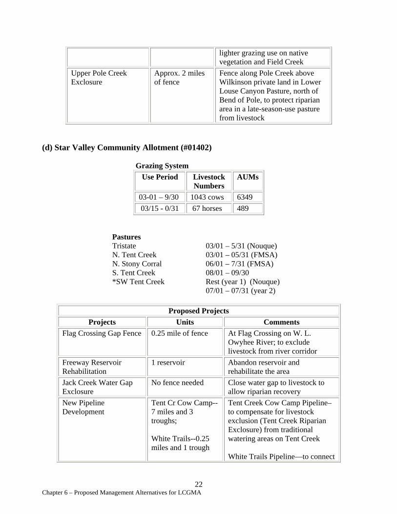
lighter grazing use on native vegetation and Field Creek
Upper Pole Creek Exclosure
Approx. 2 miles of fence
Fence along Pole Creek above Wilkinson private land in Lower Louse Canyon Pasture, north of Bend of Pole, to protect riparian area in a late-season-use pasture from livestock
(d) Star Valley Community Allotment (#01402)
Grazing System Use Period Livestock
Numbers AUMs
03-01 – 9/30 1043 cows 6349 03/15 - 0/31 67 horses 489
Pastures Tristate 03/01 – 5/31 (Nouque) N. Tent Creek 03/01 – 05/31 (FMSA) N. Stony Corral 06/01 – 7/31 (FMSA) S. Tent Creek 08/01 – 09/30 *SW Tent Creek Rest (year 1) (Nouque) 07/01 – 07/31 (year 2)
Proposed Projects Projects Units Comments
Flag Crossing Gap Fence 0.25 mile of fence At Flag Crossing on W. L. Owyhee River; to exclude livestock from river corridor
Freeway Reservoir Rehabilitation
1 reservoir Abandon reservoir and rehabilitate the area
Jack Creek Water Gap Exclosure
No fence needed Close water gap to livestock to allow riparian recovery
New Pipeline Development
Tent Cr Cow Camp-7 miles and 3 troughs;
White Trails--0.25 miles and 1 trough
Tent Creek Cow Camp Pipeline– to compensate for livestock exclusion (Tent Creek Riparian Exclosure) from traditional watering areas on Tent Creek
White Trails Pipeline—to connect
22 Chapter 6 – Proposed Management Alternatives for LCGMA
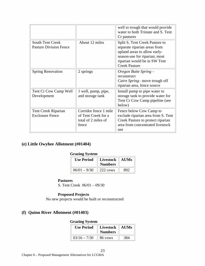
South Tent Creek About 12 miles Pasture Division Fence
Spring Renovation 2 springs
Tent Cr Cow Camp Well Development
1 well, pump, pipe, and storage tank
Tent Creek Riparian Corridor fence 1 mile Exclosure Fence of Tent Creek for a
total of 2 miles of fence
well to trough that would provide water to both Tristate and S. Tent Cr pastures Split S. Tent Creek Pasture to separate riparian areas from upland areas to allow early-season-use for riparian; most riparian would be in SW Tent Creek Pasture Oregon Butte Spring – reconstruct Cairn Spring– move trough off riparian area, fence source Install pump to pipe water to storage tank to provide water for Tent Cr Cow Camp pipeline (see below) Fence below Cow Camp to exclude riparian area from S. Tent Creek Pasture to protect riparian area from concentrated livestock use
(e) Little Owyhee Allotment (#01404)
Grazing System Use Period
06/01 – 9/30
Livestock Numbers 222 cows
AUMs
892
Pastures S. Tent Creek 06/01 – 09/30
Proposed Projects No new projects would be built or reconstructed
(f) Quinn River Allotment (#01403)
Grazing System Use Period Livestock AUMs
Numbers 03/16 – 7/30 86 cows 384
23 Chapter 6 – Proposed Management Alternatives for LCGMA
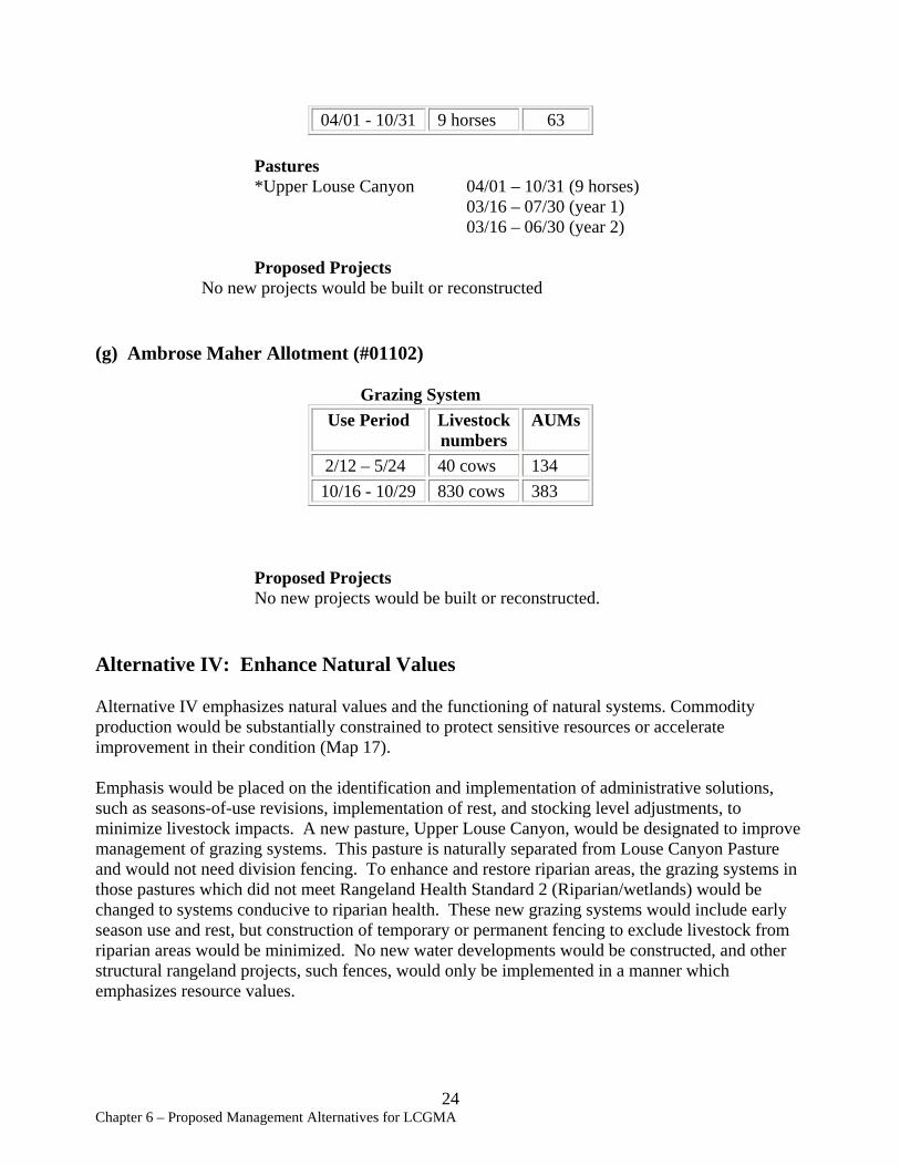
04/01 - 10/31 9 horses 63
Pastures *Upper Louse Canyon 04/01 – 10/31 (9 horses) 03/16 – 07/30 (year 1) 03/16 – 06/30 (year 2)
Proposed Projects No new projects would be built or reconstructed
(g) Ambrose Maher Allotment (#01102)
Grazing System Use Period Livestock
numbers AUMs
2/12 – 5/24 40 cows 134 10/16 - 10/29 830 cows 383
Proposed Projects No new projects would be built or reconstructed.
Alternative IV: Enhance Natural Values
Alternative IV emphasizes natural values and the functioning of natural systems. Commodity production would be substantially constrained to protect sensitive resources or accelerate improvement in their condition (Map 17).
Emphasis would be placed on the identification and implementation of administrative solutions, such as seasons-of-use revisions, implementation of rest, and stocking level adjustments, to minimize livestock impacts. A new pasture, Upper Louse Canyon, would be designated to improve management of grazing systems. This pasture is naturally separated from Louse Canyon Pasture and would not need division fencing. To enhance and restore riparian areas, the grazing systems in those pastures which did not meet Rangeland Health Standard 2 (Riparian/wetlands) would be changed to systems conducive to riparian health. These new grazing systems would include early season use and rest, but construction of temporary or permanent fencing to exclude livestock from riparian areas would be minimized. No new water developments would be constructed, and other structural rangeland projects, such fences, would only be implemented in a manner which emphasizes resource values.
24 Chapter 6 – Proposed Management Alternatives for LCGMA

Existing structural rangeland projects would be maintained where beneficial to resource values. Projects which no longer meet livestock or resource management objectives and enhance resource values may be abandoned and sites would be rehabilitated. The remaining projects would be maintained to design standards to meet management objectives.
Livestock usage in this alternative would decrease compared to current levels. The maximum utilization level in native range would be 30% to ensure that native early-season pastures continued to maintain existing plant species assemblages. Maximum utilization levels for seeded range would be 50%.
Upland vegetation treatment in Starvation Brush Control Pasture would target reduction of shrub cover and increase of herbaceous understory vegetation. Treatment methods may include one or more of the following: prescribed burning, herbicide application, brush-beating, and reseeding with native species. Standard implementation procedures for rangeland improvements are presented in the SEORMP, Appendix S.
The following grazing systems and projects would be needed in order to implement Alternative IV. These projects are designed to improve livestock distribution and provide conditions necessary for implementing the grazing system and meeting rangeland health standards.
Louse Canyon GMA (all allotments) Projects Summary:
New pipelines 2 miles New fences 5.5 miles New troughs (#) 0 AUM change (#) -12,453 Spring renovation/reconstruction 17 springs Spring abandonment 6 springs Spring development 0 Upland vegetation treatments 3500 acres
Grazing Systems and Projects by Allotment
(a) Anderson Allotment (#01401)
Grazing System Use Period Livestock AUMs
Numbers 03/01 – 7/01 830 cows 2,857
Pastures North 03/01 – 03/31 Bull Flat 04/01 – 05/15
25 Chapter 6 – Proposed Management Alternatives for LCGMA
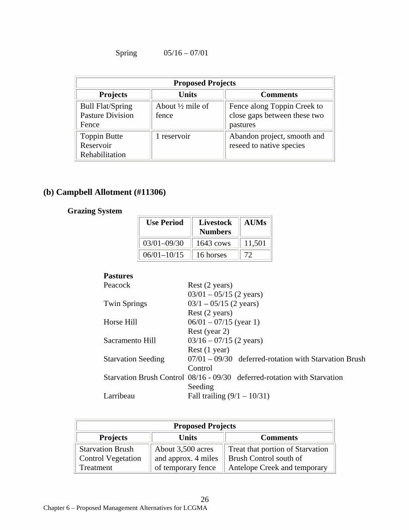
Spring 05/16 – 07/01
Proposed Projects Projects Units Comments
Bull Flat/Spring Pasture Division Fence
About ½ mile of fence
Fence along Toppin Creek to close gaps between these two pastures
Toppin Butte Reservoir Rehabilitation
1 reservoir Abandon project, smooth and reseed to native species
(b) Campbell Allotment (#11306)
Grazing System Use Period Livestock
Numbers AUMs
03/01–09/30 1643 cows 11,501 06/01–10/15 16 horses 72
Pastures Peacock Rest (2 years)
03/01 – 05/15 (2 years) Twin Springs 03/1 – 05/15 (2 years)
Rest (2 years) Horse Hill 06/01 – 07/15 (year 1)
Rest (year 2) Sacramento Hill 03/16 – 07/15 (2 years)
Rest (1 year) Starvation Seeding 07/01 – 09/30 deferred-rotation with Starvation Brush
Control Starvation Brush Control 08/16 - 09/30 deferred-rotation with Starvation
Seeding Larribeau Fall trailing (9/1 – 10/31)
Proposed Projects Projects Units Comments
Starvation Brush About 3,500 acres Treat that portion of Starvation Control Vegetation and approx. 4 miles Brush Control south of Treatment of temporary fence Antelope Creek and temporary
26 Chapter 6 – Proposed Management Alternatives for LCGMA
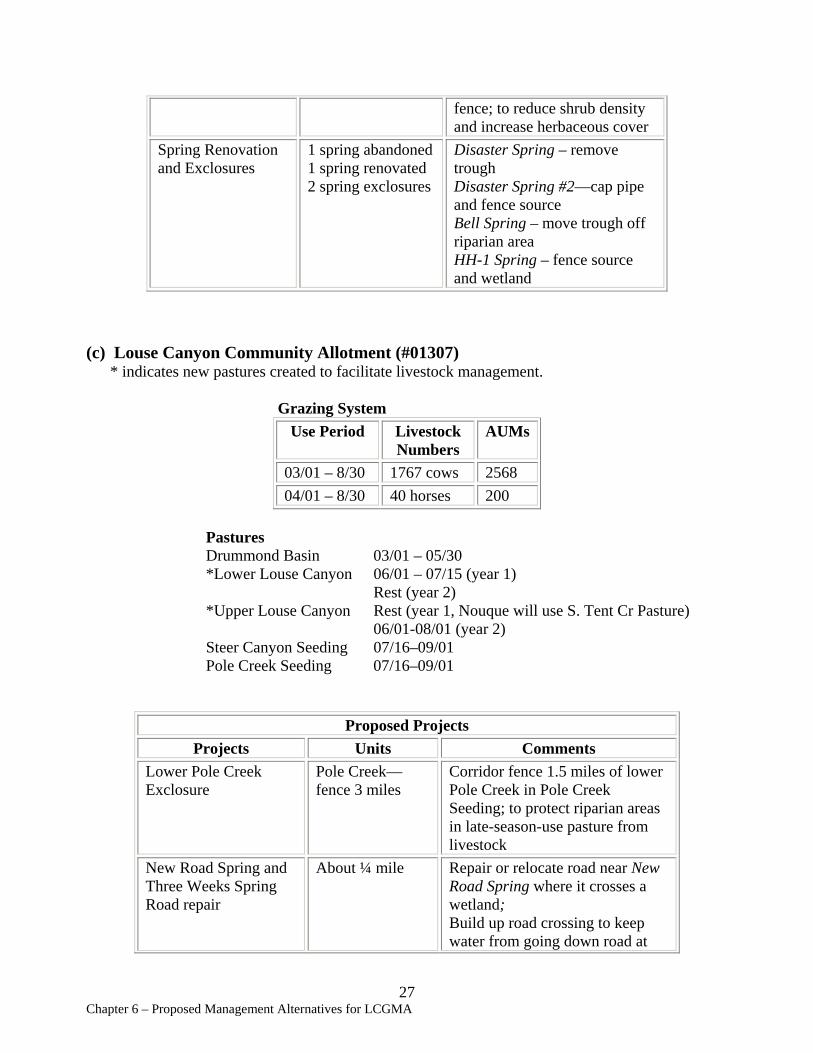
fence; to reduce shrub density and increase herbaceous cover
Spring Renovation and Exclosures
1 spring abandoned 1 spring renovated 2 spring exclosures
Disaster Spring – remove trough Disaster Spring #2—cap pipe and fence source Bell Spring – move trough off riparian area HH-1 Spring – fence source and wetland
(c) Louse Canyon Community Allotment (#01307) * indicates new pastures created to facilitate livestock management.
Grazing System Use Period Livestock
Numbers AUMs
03/01 – 8/30 1767 cows 2568 04/01 – 8/30 40 horses 200
Pastures Drummond Basin 03/01 – 05/30 *Lower Louse Canyon 06/01 – 07/15 (year 1)
Rest (year 2) *Upper Louse Canyon Rest (year 1, Nouque will use S. Tent Cr Pasture)
06/01-08/01 (year 2) Steer Canyon Seeding 07/16–09/01 Pole Creek Seeding 07/16–09/01
Proposed Projects Projects Units Comments
Lower Pole Creek Exclosure
Pole Creek— fence 3 miles
Corridor fence 1.5 miles of lower Pole Creek in Pole Creek Seeding; to protect riparian areas in late-season-use pasture from livestock
New Road Spring and Three Weeks Spring Road repair
About ¼ mile Repair or relocate road near New Road Spring where it crosses a wetland; Build up road crossing to keep water from going down road at
27 Chapter 6 – Proposed Management Alternatives for LCGMA
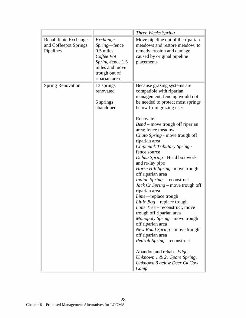
Three Weeks Spring Rehabilitate Exchange and Coffeepot Springs Pipelines
Exchange Spring—fence 0.5 miles Coffee Pot Spring-fence 1.5 miles and move trough out of riparian area
Move pipeline out of the riparian meadows and restore meadow; to remedy erosion and damage caused by original pipeline placements
Spring Renovation 13 springs renovated
5 springs abandoned
Because grazing systems are compatible with riparian management, fencing would not be needed to protect most springs below from grazing use:
Renovate: Bend – move trough off riparian area; fence meadow Chato Spring - move trough off riparian area Chipmunk Tributary Spring -fence source Delma Spring - Head box work and re-lay pipe Horse Hill Spring--move trough off riparian area Indian Spring—reconstruct Jack Cr Spring – move trough off riparian area Lime—replace trough Little Bog—replace trough Lone Tree – reconstruct, move trough off riparian area Monopoly Spring - move trough off riparian area New Road Spring – move trough off riparian area Pedroli Spring - reconstruct
Abandon and rehab –Edge, Unknown 1 & 2, Spare Spring, Unknown 3 below Deer Ck Cow Camp
28 Chapter 6 – Proposed Management Alternatives for LCGMA
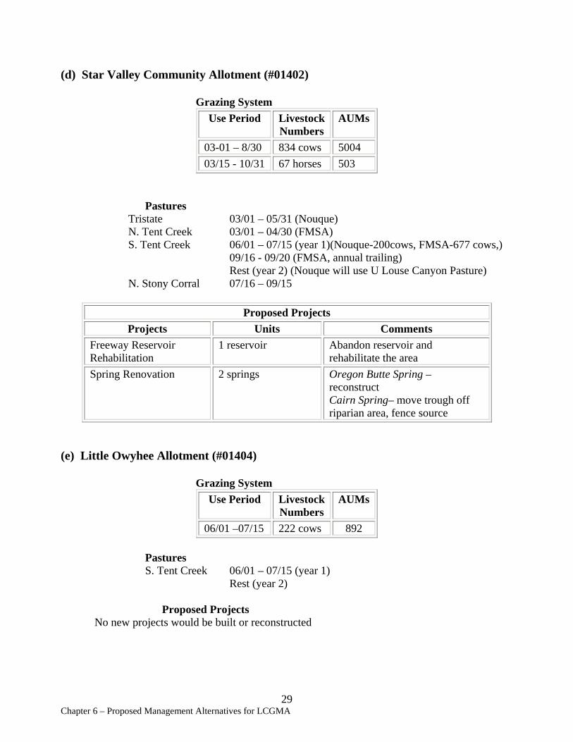
(d) Star Valley Community Allotment (#01402)
Grazing System Use Period Livestock
Numbers AUMs
03-01 – 8/30 834 cows 5004 03/15 - 10/31 67 horses 503
Pastures Tristate 03/01 – 05/31 (Nouque) N. Tent Creek 03/01 – 04/30 (FMSA) S. Tent Creek 06/01 – 07/15 (year 1)(Nouque-200cows, FMSA-677 cows,)
09/16 - 09/20 (FMSA, annual trailing) Rest (year 2) (Nouque will use U Louse Canyon Pasture)
N. Stony Corral 07/16 – 09/15
Proposed Projects Projects Units Comments
Freeway Reservoir Rehabilitation
1 reservoir Abandon reservoir and rehabilitate the area
Spring Renovation 2 springs Oregon Butte Spring – reconstruct Cairn Spring– move trough off riparian area, fence source
(e) Little Owyhee Allotment (#01404)
Grazing System Use Period Livestock AUMs
Numbers 06/01 –07/15 222 cows 892
Pastures S. Tent Creek 06/01 – 07/15 (year 1)
Rest (year 2)
Proposed Projects No new projects would be built or reconstructed
29 Chapter 6 – Proposed Management Alternatives for LCGMA

(f) Quinn River Allotment (#01403)
Grazing System Use Period Livestock AUMs
Numbers 03/16 – 7/30 59 cows 384 04/01 - 10/31 9 horses 63
Pastures *Upper Louse Canyon 04/01 – 10/31 (9 horses)
03/16 – 07/30 (year 1) Rest (year 2)
Proposed Projects No new projects would be built or reconstructed
(g) Ambrose Maher Allotment (#01102)
Grazing System Use Period Livestock
numbers AUMs
2/12 – 2/28 397 cows 222 3/01 - 5/30 40 cows 114 9/01 - 9/07 830 cows 181
Proposed Projects No new projects would be built or reconstructed.
Alternative V: Protect Sensitive Values
This alternative emphasizes natural values and the functioning of natural systems, and would exclude commodities and certain other public uses from pastures with sensitive resource values. It would provide for a sustained yield of forage for livestock at a limited level.
Emphasis would be placed on the identification and implementation of administrative solutions, such as seasons-of-use revisions, implementation of rest, and stocking level adjustments, to minimize livestock impacts. Livestock grazing would be excluded from those pastures containing riparian vegetation communities which, due to current livestock management actions, are Functioning-At-Risk with a Downward trend or are not properly functioning, until appropriate livestock management can be implemented and a condition of Functioning-At-Risk with an Upward trend is attained.
30 Chapter 6 – Proposed Management Alternatives for LCGMA

In addition, certain pastures would be partitioned from affected grazing allotments and would not be allocated to livestock grazing based on the following criteria:
1) the pasture includes redband trout strongholds or habitat of species listed under the Endangered Species Act;
2) the pasture includes substantially intact sagebrush-dependent species habitat, using sage grouse as an indicator species;
Structural rangeland projects would only be implemented in a manner that emphasizes resource values. Construction of temporary or permanent fencing to exclude livestock from resource values would be minimized. Vegetation manipulation projects would emphasize the conversion of rangelands dominated by exotic annuals (as occur in Starvation, Pole Creek, and Steer Canyon seedings) to properly functioning native perennial communities. Treatment methods may include one or more of the following: prescribed burning, herbicide application, brush-beating, and reseeding with native species. Standard implementation procedures for rangeland improvements are presented in SEORMP, Appendix S.
Existing structural rangeland projects would be maintained where beneficial to resource values, but projects which no longer meet livestock or resource management objectives would be abandoned and sites rehabilitated.
No livestock management action would be implemented which would increase grazing use within portions of a pasture in late to PNC ecological status and currently unutilized or only slightly utilized by livestock.
Livestock usage would decrease in this alternative. To quantify the permanent availability of forage within the GMA, existing stocking levels were decreased to a conservative stocking rate of 15 acres per AUM, except in those pastures where the average acreage per AUM was greater than 15 acres per AUM. Maximum utilization levels would be set at 30% for native range. Seedings would be restored to native perennial vegetation.
The following grazing systems and projects would be needed in order to implement Alternative V. These projects are designed to restore functioning of natural rangeland systems and to meet rangeland health standards.
Louse Canyon GMA (all allotments) Projects Summary:
Pipelines Remove 21 miles Fences Remove 100 miles Troughs Remove 20 troughs AUM change (#) -28,763 Spring renovation/reconstruction 0 Spring abandonment 28 springs Spring development 0
31 Chapter 6 – Proposed Management Alternatives for LCGMA
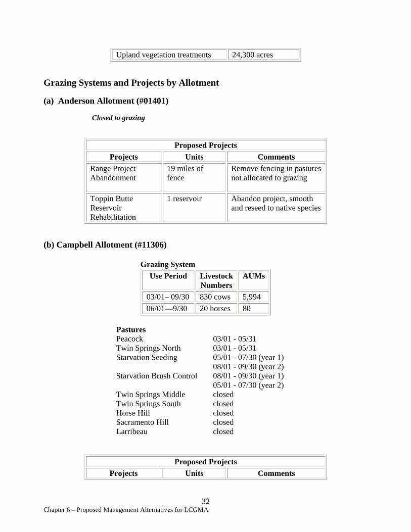
Upland vegetation treatments 24,300 acres
Grazing Systems and Projects by Allotment
(a) Anderson Allotment (#01401)
Closed to grazing
Proposed Projects Projects Units Comments
Range Project Abandonment
19 miles of fence
Remove fencing in pastures not allocated to grazing
Toppin Butte Reservoir Rehabilitation
1 reservoir Abandon project, smooth and reseed to native species
(b) Campbell Allotment (#11306)
Grazing System Use Period Livestock AUMs
Numbers 03/01– 09/30 830 cows 5,994 06/01—9/30 20 horses 80
Pastures Peacock 03/01 - 05/31 Twin Springs North 03/01 - 05/31 Starvation Seeding 05/01 - 07/30 (year 1)
08/01 - 09/30 (year 2) Starvation Brush Control 08/01 - 09/30 (year 1)
05/01 - 07/30 (year 2) Twin Springs Middle closed Twin Springs South closed Horse Hill closed Sacramento Hill closed Larribeau closed
Proposed Projects Projects Units Comments
32 Chapter 6 – Proposed Management Alternatives for LCGMA
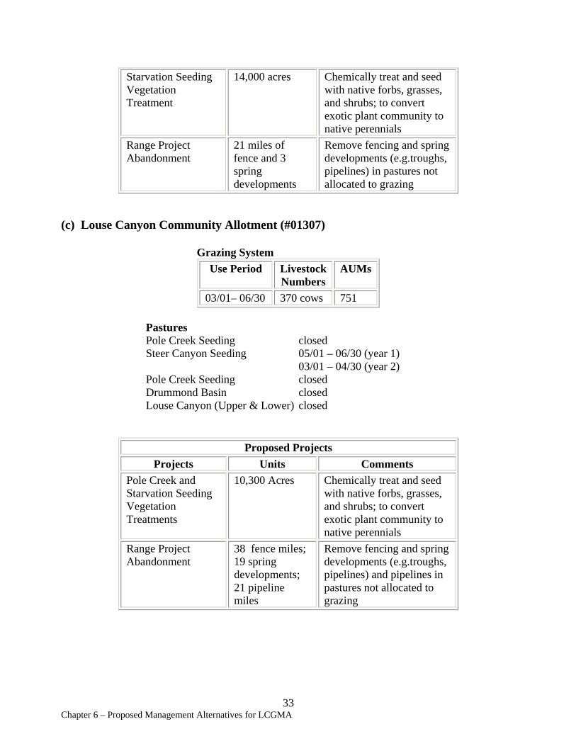
Starvation Seeding 14,000 acres Chemically treat and seed Vegetation with native forbs, grasses, Treatment and shrubs; to convert
exotic plant community to native perennials
Range Project 21 miles of Remove fencing and spring Abandonment fence and 3 developments (e.g.troughs,
spring pipelines) in pastures not developments allocated to grazing
(c) Louse Canyon Community Allotment (#01307)
Grazing System Use Period Livestock AUMs
Numbers 03/01– 06/30 370 cows 751
Pastures Pole Creek Seeding closed Steer Canyon Seeding 05/01 – 06/30 (year 1)
03/01 – 04/30 (year 2) Pole Creek Seeding closed Drummond Basin closed Louse Canyon (Upper & Lower) closed
Proposed Projects Projects Units Comments
Pole Creek and Starvation Seeding Vegetation Treatments
10,300 Acres Chemically treat and seed with native forbs, grasses, and shrubs; to convert exotic plant community to native perennials
Range Project Abandonment
38 fence miles; 19 spring developments; 21 pipeline miles
Remove fencing and spring developments (e.g.troughs, pipelines) and pipelines in pastures not allocated to grazing
33 Chapter 6 – Proposed Management Alternatives for LCGMA
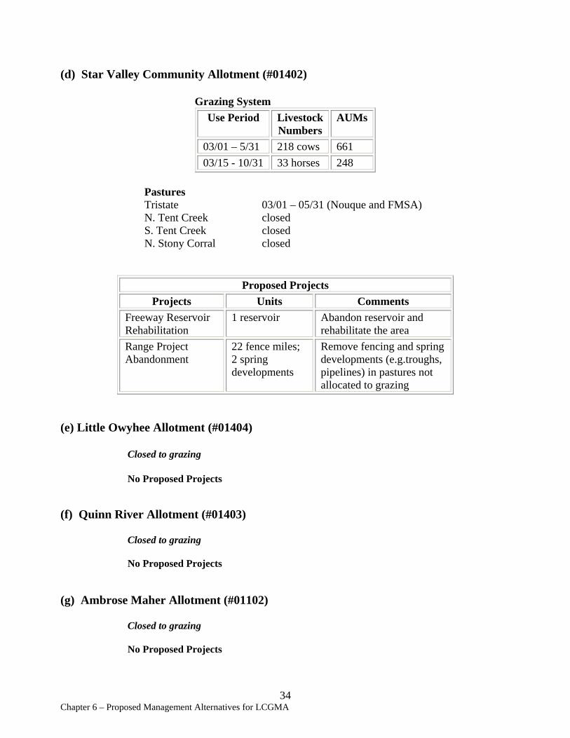
(d) Star Valley Community Allotment (#01402)
Grazing System Use Period Livestock AUMs
Numbers 03/01 – 5/31 218 cows 661 03/15 - 10/31 33 horses 248
Pastures Tristate 03/01 – 05/31 (Nouque and FMSA) N. Tent Creek closed S. Tent Creek closed N. Stony Corral closed
Proposed Projects Projects Units Comments
Freeway Reservoir Rehabilitation
1 reservoir Abandon reservoir and rehabilitate the area
Range Project Abandonment
22 fence miles; 2 spring developments
Remove fencing and spring developments (e.g.troughs, pipelines) in pastures not allocated to grazing
(e) Little Owyhee Allotment (#01404)
Closed to grazing
No Proposed Projects
(f) Quinn River Allotment (#01403)
Closed to grazing
No Proposed Projects
(g) Ambrose Maher Allotment (#01102)
Closed to grazing
No Proposed Projects
34 Chapter 6 – Proposed Management Alternatives for LCGMA
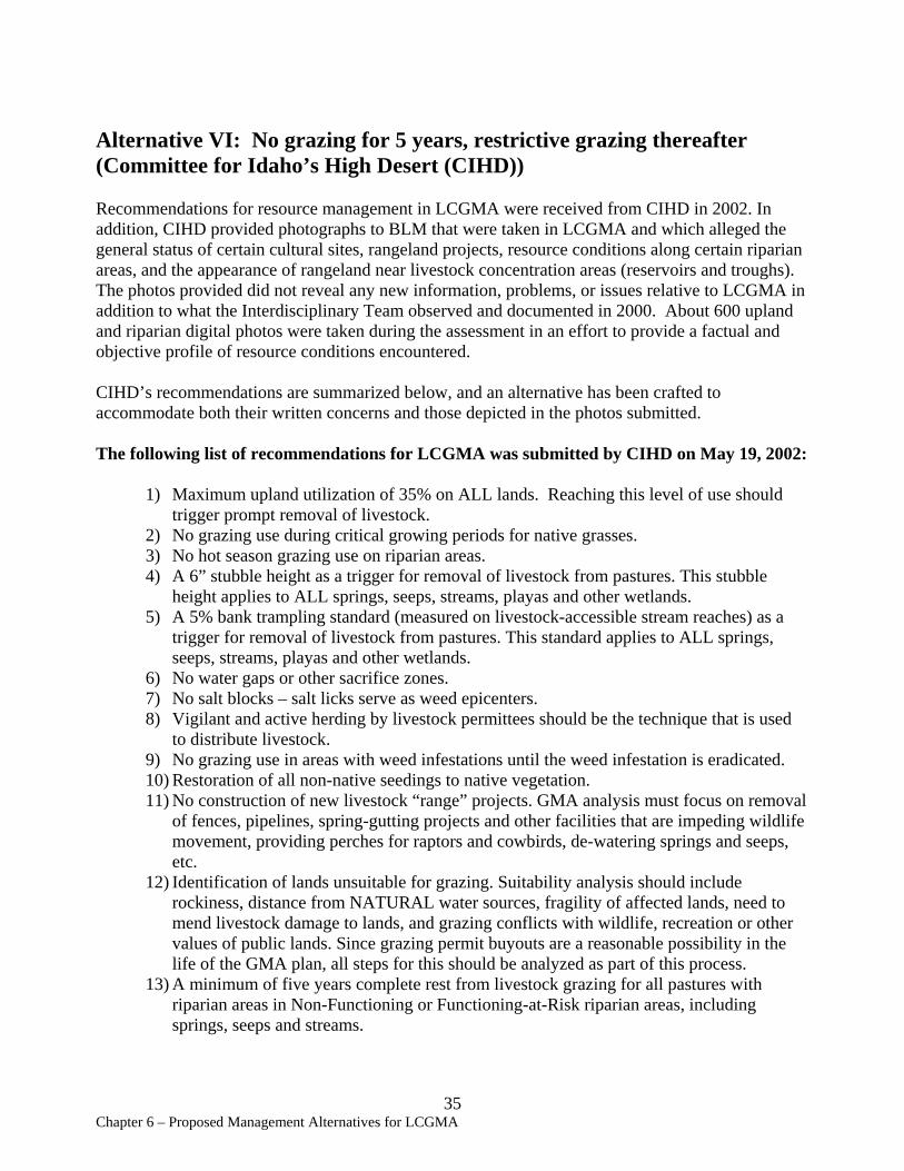
Alternative VI: No grazing for 5 years, restrictive grazing thereafter (Committee for Idaho’s High Desert (CIHD))
Recommendations for resource management in LCGMA were received from CIHD in 2002. In addition, CIHD provided photographs to BLM that were taken in LCGMA and which alleged the general status of certain cultural sites, rangeland projects, resource conditions along certain riparian areas, and the appearance of rangeland near livestock concentration areas (reservoirs and troughs). The photos provided did not reveal any new information, problems, or issues relative to LCGMA in addition to what the Interdisciplinary Team observed and documented in 2000. About 600 upland and riparian digital photos were taken during the assessment in an effort to provide a factual and objective profile of resource conditions encountered.
CIHD’s recommendations are summarized below, and an alternative has been crafted to accommodate both their written concerns and those depicted in the photos submitted.
The following list of recommendations for LCGMA was submitted by CIHD on May 19, 2002:
1) Maximum upland utilization of 35% on ALL lands. Reaching this level of use should trigger prompt removal of livestock.
2) No grazing use during critical growing periods for native grasses. 3) No hot season grazing use on riparian areas. 4) A 6” stubble height as a trigger for removal of livestock from pastures. This stubble
height applies to ALL springs, seeps, streams, playas and other wetlands. 5) A 5% bank trampling standard (measured on livestock-accessible stream reaches) as a
trigger for removal of livestock from pastures. This standard applies to ALL springs, seeps, streams, playas and other wetlands.
6) No water gaps or other sacrifice zones. 7) No salt blocks – salt licks serve as weed epicenters. 8) Vigilant and active herding by livestock permittees should be the technique that is used
to distribute livestock. 9) No grazing use in areas with weed infestations until the weed infestation is eradicated. 10) Restoration of all non-native seedings to native vegetation. 11) No construction of new livestock “range” projects. GMA analysis must focus on removal
of fences, pipelines, spring-gutting projects and other facilities that are impeding wildlife movement, providing perches for raptors and cowbirds, de-watering springs and seeps, etc.
12) Identification of lands unsuitable for grazing. Suitability analysis should include rockiness, distance from NATURAL water sources, fragility of affected lands, need to mend livestock damage to lands, and grazing conflicts with wildlife, recreation or other values of public lands. Since grazing permit buyouts are a reasonable possibility in the life of the GMA plan, all steps for this should be analyzed as part of this process.
13) A minimum of five years complete rest from livestock grazing for all pastures with riparian areas in Non-Functioning or Functioning-at-Risk riparian areas, including springs, seeps and streams.
35 Chapter 6 – Proposed Management Alternatives for LCGMA

14) Preparation of an EIS. Issuance of an Full Force & Effect order to put the above stubble heights, trampling standards, utilization standards, rest and other elements in place as interim management measures while the EIS is completed.
The BLM considers the following Alternative VI to be a reasonable interpretation of the management that would be required to implement CIHD’s proposals:
Alternative VI emphasizes resting all pastures with riparian areas that are Non-Functioning or Functioning-At-Risk for a minimum of 5 years to “jump start” riparian recovery. All upland areas would be grazed to a maximum of 35% utilization during non-critical growing seasons, which is usually 5/1 – 7/1 for LCGMA. No hot season grazing use on riparian areas would occur. A 6” stubble height and a 5% bank trampling standard (measured on livestock-accessible stream reaches) would serve as triggers for removal of livestock from pastures with springs, seeps, streams, playas, and other wetlands.
No water gaps or salting would be allowed. Areas of weed infestations would be closed to grazing until weedy areas are fully restored to native vegetation. Crested wheatgrass seedings would be rehabilitated and converted to native rangelands. Existing rangeland improvement projects would be removed where not beneficial to key wildlife species of concern in the area, and no new range improvements would be constructed. Lands unsuitable for livestock grazing would be identified and not allocated for livestock forage. Vigilant and active herding by permittees would be required to distribute livestock. All pastures where BLM's data show degradation of soils, native vegetation, riparian/wetland areas, or wildlife habitat, or invasion of exotic species/noxious weeds, would be closed for a minimum of five years. After this time period, no livestock use would be allowed to resume until specific standards of recovery are met.
Louse Canyon GMA (all allotments) Projects Summary:
Pipelines Remove 45 miles Fences Remove 13 miles Troughs Remove 38 miles AUM change (#) -15,357 Spring renovation/reconstruction 0 Spring abandonment 28 springs Spring development 0 Upland Vegetation Treatments 24,300 acres
36 Chapter 6 – Proposed Management Alternatives for LCGMA
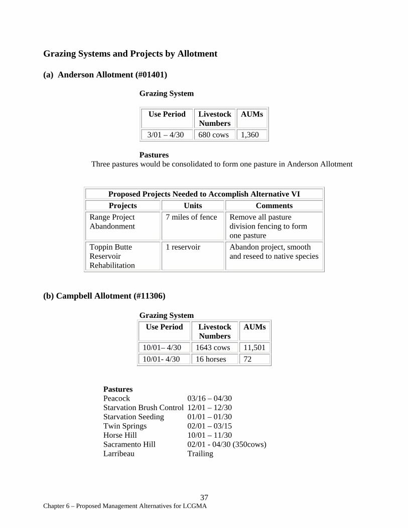
Grazing Systems and Projects by Allotment
(a) Anderson Allotment (#01401)
Grazing System
Use Period Livestock AUMs Numbers
3/01 – 4/30 680 cows 1,360
Pastures Three pastures would be consolidated to form one pasture in Anderson Allotment
Proposed Projects Needed to Accomplish Alternative VI Projects Units Comments
Range Project Abandonment
7 miles of fence Remove all pasture division fencing to form one pasture
Toppin Butte Reservoir Rehabilitation
1 reservoir Abandon project, smooth and reseed to native species
(b) Campbell Allotment (#11306)
Grazing System Use Period Livestock
Numbers AUMs
10/01– 4/30 1643 cows 11,501 10/01- 4/30 16 horses 72
Pastures Peacock 03/16 – 04/30Starvation Brush Control 12/01 – 12/30 Starvation Seeding 01/01 – 01/30 Twin Springs 02/01 – 03/15 Horse Hill 10/01 – 11/30 Sacramento Hill 02/01 - 04/30 (350cows) Larribeau Trailing
37 Chapter 6 – Proposed Management Alternatives for LCGMA
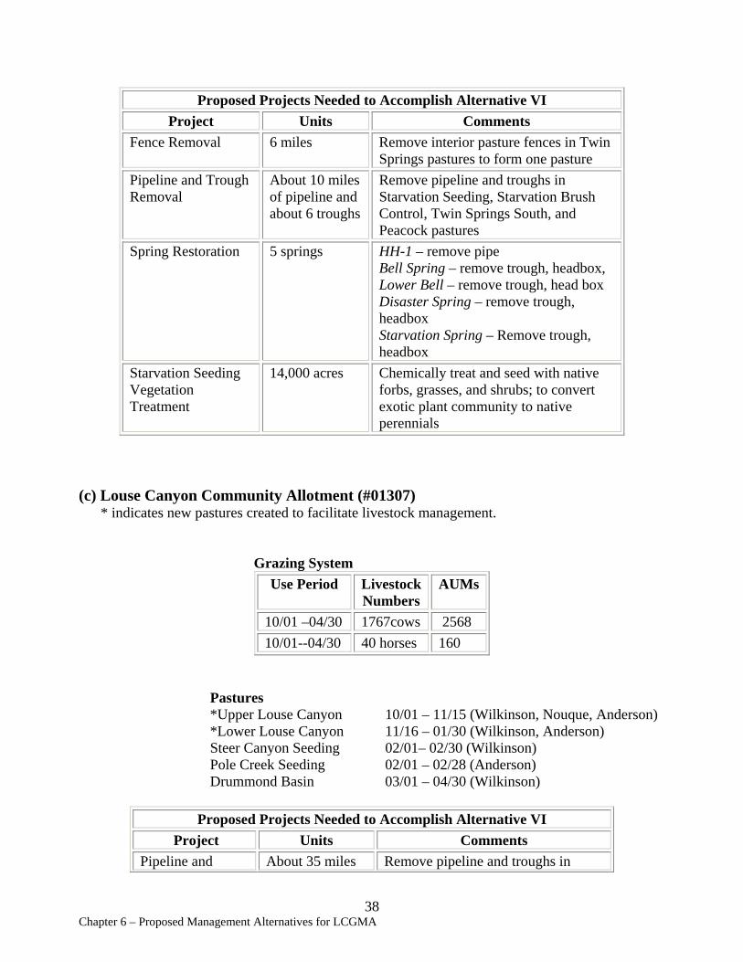
Proposed Projects Needed to Accomplish Alternative VI Project Units Comments
Fence Removal 6 miles Remove interior pasture fences in Twin Springs pastures to form one pasture
Pipeline and Trough Removal
About 10 miles of pipeline and about 6 troughs
Remove pipeline and troughs in Starvation Seeding, Starvation Brush Control, Twin Springs South, and Peacock pastures
Spring Restoration 5 springs HH-1 – remove pipe Bell Spring – remove trough, headbox, Lower Bell – remove trough, head box Disaster Spring – remove trough, headbox Starvation Spring – Remove trough, headbox
Starvation Seeding Vegetation Treatment
14,000 acres Chemically treat and seed with native forbs, grasses, and shrubs; to convert exotic plant community to native perennials
(c) Louse Canyon Community Allotment (#01307) * indicates new pastures created to facilitate livestock management.
Grazing System Use Period Livestock AUMs
Numbers 10/01 –04/30 1767cows 2568 10/01--04/30 40 horses 160
Pastures *Upper Louse Canyon 10/01 – 11/15 (Wilkinson, Nouque, Anderson) *Lower Louse Canyon 11/16 – 01/30 (Wilkinson, Anderson) Steer Canyon Seeding 02/01– 02/30 (Wilkinson) Pole Creek Seeding 02/01 – 02/28 (Anderson) Drummond Basin 03/01 – 04/30 (Wilkinson)
Proposed Projects Needed to Accomplish Alternative VI Project Units Comments
Pipeline and About 35 miles Remove pipeline and troughs in
38 Chapter 6 – Proposed Management Alternatives for LCGMA
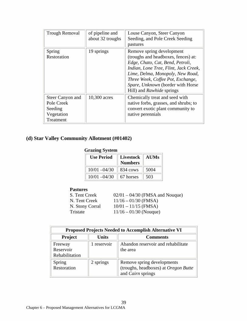
Trough Removal of pipeline and Louse Canyon, Steer Canyon about 32 troughs Seeding, and Pole Creek Seeding
pastures Spring Restoration
19 springs Remove spring development (troughs and headboxes, fences) at: Edge, Chato, Cat, Bend, Petroli, Indian, Lone Tree, Flint, Jack Creek, Lime, Delma, Monopoly, New Road, Three Week, Coffee Pot, Exchange, Spare, Unknown (border with Horse Hill) and Rawhide springs
Steer Canyon and 10,300 acres Chemically treat and seed with Pole Creek native forbs, grasses, and shrubs; to Seeding convert exotic plant community to Vegetation native perennials Treatment
(d) Star Valley Community Allotment (#01402)
Grazing System Use Period Livestock AUMs
Numbers 10/01 –04/30 834 cows 5004 10/01 –04/30 67 horses 503
Pastures S. Tent Creek 02/01 – 04/30 (FMSA and Nouque) N. Tent Creek 11/16 – 01/30 (FMSA) N. Stony Corral 10/01 – 11/15 (FMSA) Tristate 11/16 – 01/30 (Nouque)
Proposed Projects Needed to Accomplish Alternative VI Project Units Comments
Freeway Reservoir Rehabilitation
1 reservoir Abandon reservoir and rehabilitate the area
Spring Restoration
2 springs Remove spring developments (troughs, headboxes) at Oregon Butte and Cairn springs
39 Chapter 6 – Proposed Management Alternatives for LCGMA
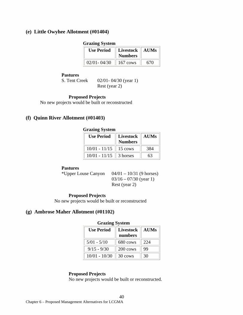
(e) Little Owyhee Allotment (#01404)
Grazing System Use Period Livestock AUMs
Numbers 02/01- 04/30 167 cows 670
Pastures S. Tent Creek 02/01- 04/30 (year 1)
Rest (year 2)
Proposed Projects No new projects would be built or reconstructed
(f) Quinn River Allotment (#01403)
Grazing System Use Period Livestock
Numbers AUMs
10/01 - 11/15 15 cows 384 10/01 - 11/15 3 horses 63
Pastures *Upper Louse Canyon 04/01 – 10/31 (9 horses)
03/16 – 07/30 (year 1) Rest (year 2)
Proposed Projects No new projects would be built or reconstructed
(g) Ambrose Maher Allotment (#01102)
Grazing System Use Period Livestock
numbers AUMs
5/01 - 5/10 680 cows 224 9/15 - 9/30 200 cows 99 10/01 - 10/30 30 cows 30
Proposed Projects No new projects would be built or reconstructed.
40 Chapter 6 – Proposed Management Alternatives for LCGMA
Other Alternatives Considered but Eliminated from Further Analysis:
(1) No Grazing – livestock grazing would not be allowed and all range improvements would be removed.
The “No Grazing” alternative was eliminated from further study because it is not consistent with federal law (Taylor Grazing Act, FLPMA, PRIA), or the SEORMP. See the SEORMP, Alternative E, for analyses of the “No Grazing” alternative.
(2) Short duration/low intensity grazing – livestock would be herded rapidly through the allotments with stops at various watering areas for short periods of 5 – 10 days. Most fences and pipeline systems would be removed. Most springs and reservoirs would be retained to provide water sources.
This alternative was eliminated from further study because livestock permittees considered the intense herding effort to be impractical. This level of herd management would be cost prohibitive at current labor prices.
41 Chapter 6 – Proposed Management Alternatives for LCGMA