Embed Size (px)
Citation preview
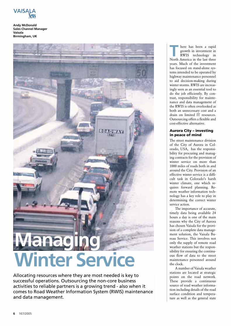
Managing Winter Service
Vaisala Aviation WeatherCelebrates its 30th Anniversary
A New Look at Synoptic Data Harvesting
Helsinki Four-SeasonMesoscale Testbed
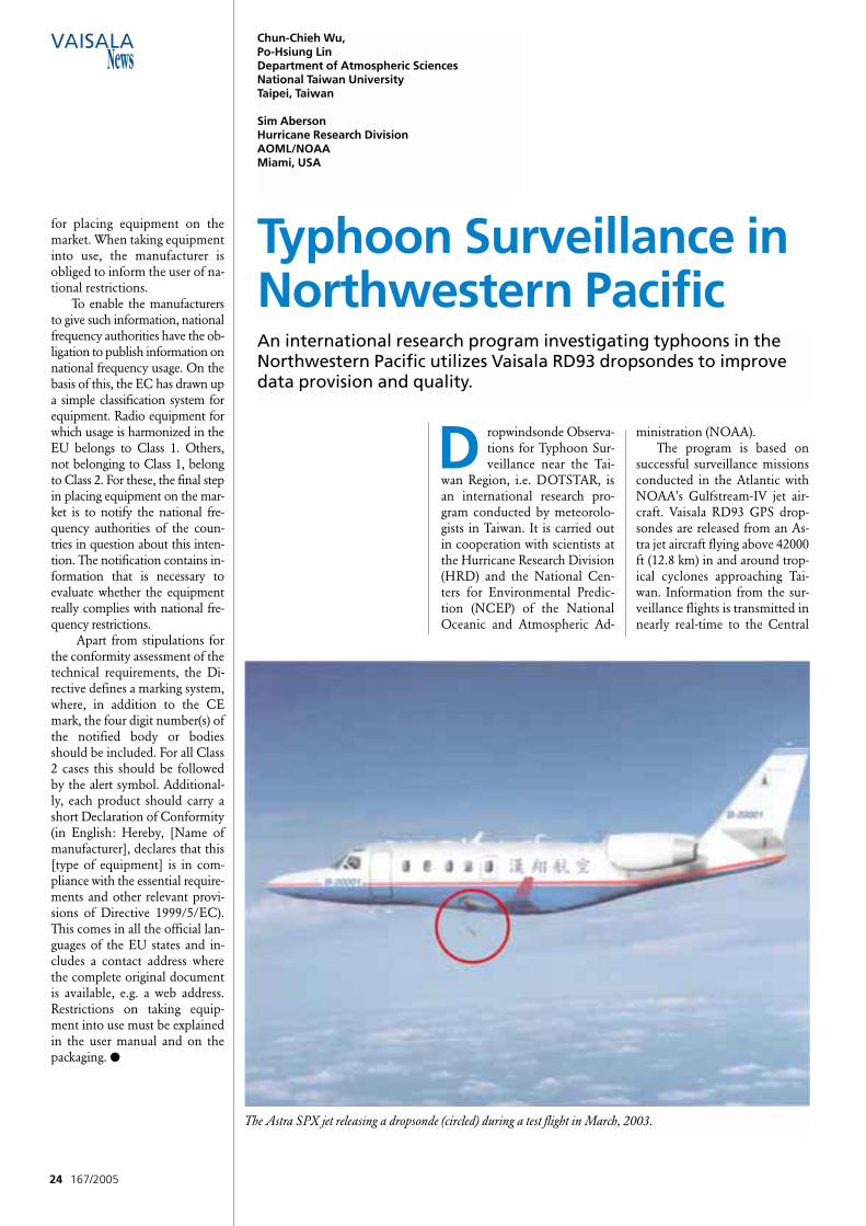
Typhoon Surveillance inNorthwestern Pacific
167/2005
2 167/2005
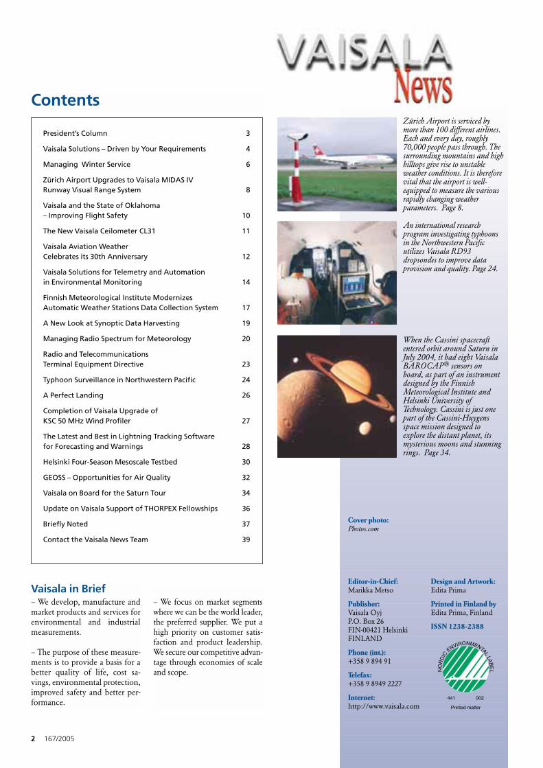
Contents
Editor-in-Chief:Marikka Metso
Publisher:Vaisala Oyj P.O. Box 26FIN-00421 HelsinkiFINLAND
Phone (int.):+358 9 894 91
Telefax:+358 9 8949 2227
Internet:http://www.vaisala.com
Design and Artwork:Edita Prima
Printed in Finland byEdita Prima, Finland
ISSN 1238-2388
Cover photo:Photos.com
NO
RD
IC
ENVIRONMENTALLA
BE
L
441 002
Printed matter
Vaisala in Brief– We develop, manufacture andmarket products and services forenvironmental and industrialmeasurements.
– The purpose of these measure-ments is to provide a basis for abetter quality of life, cost sa-vings, environmental protection,improved safety and better per-formance.
– We focus on market segmentswhere we can be the world leader,the preferred supplier. We put ahigh priority on customer satis-faction and product leadership.We secure our competitive advan-tage through economies of scaleand scope.
Zürich Airport is serviced bymore than 100 different airlines.Each and every day, roughly70,000 people pass through. Thesurrounding mountains and highhilltops give rise to unstableweather conditions. It is thereforevital that the airport is well-equipped to measure the variousrapidly changing weatherparameters. Page 8.
When the Cassini spacecraftentered orbit around Saturn inJuly 2004, it had eight VaisalaBAROCAP® sensors onboard, as part of an instrumentdesigned by the FinnishMeteorological Institute andHelsinki University ofTechnology. Cassini is just onepart of the Cassini-Huygensspace mission designed toexplore the distant planet, itsmysterious moons and stunningrings. Page 34.
An international researchprogram investigating typhoonsin the Northwestern Pacificutilizes Vaisala RD93dropsondes to improve dataprovision and quality. Page 24.
President’s Column 3
Vaisala Solutions – Driven by Your Requirements 4
Managing Winter Service 6
Zürich Airport Upgrades to Vaisala MIDAS IV Runway Visual Range System 8
Vaisala and the State of Oklahoma – Improving Flight Safety 10
The New Vaisala Ceilometer CL31 11
Vaisala Aviation Weather Celebrates its 30th Anniversary 12
Vaisala Solutions for Telemetry and Automation in Environmental Monitoring 14
Finnish Meteorological Institute Modernizes Automatic Weather Stations Data Collection System 17
A New Look at Synoptic Data Harvesting 19
Managing Radio Spectrum for Meteorology 20
Radio and Telecommunications Terminal Equipment Directive 23
Typhoon Surveillance in Northwestern Pacific 24
A Perfect Landing 26
Completion of Vaisala Upgrade of KSC 50 MHz Wind Profiler 27
The Latest and Best in Lightning Tracking Software for Forecasting and Warnings 28
Helsinki Four-Season Mesoscale Testbed 30
GEOSS – Opportunities for Air Quality 32
Vaisala on Board for the Saturn Tour 34
Update on Vaisala Support of THORPEX Fellowships 36
Briefly Noted 37
Contact the Vaisala News Team 39
pertise either. Your businesschallenges may concern, for ex-ample, improving safety or qual-ity, reducing cost or environ-mental damage, or increasing ca-pacity.
At some stage, every organi-zation faces the problem ofcomplexity; too many differentactivities are operated in-house.There is a risk of losing focusand having little energy left forcore activities. One way out is tooutsource the non-core activitiesto a specialized service compa-ny. What is outsourced is theworry relating to the chosen is-sue. A reliable partner provides asolution tailor-made for the cus-tomer's needs, applies the besttechnologies, takes care of main-tenance, upgrades the systems -and even operates them, if de-sired.
Vaisala's solution businessapplies a three step approach:understanding the customer'sproblem, proposing alternativesolutions and implementing thecustomer’s chosen solution.
In order to be successful inthe solutions business we haveto master both the customer'sapplication and the technologiesthat can address the challenges.Efficient operations are also nec-essary.
Customer focus is also im-portant in our other businessmodels, that is, when customersneed an instrument or a measu-rement system. Today, theseproducts are configurable andflexible. In order to get the best
167/2005 3
President’s Column
C ustomer focus is one ofour corporate values.Simply put this means
seeking out and solving cus-tomers' problems. This is certain-ly the number one value in oursolutions business. You mayhave at least two different kindsof reasons to buy our solutions:
When you define a problemmore in business than in techni-cal terms, you are looking for asolution. Perhaps you do nothave all the technical expertise tosolve the problem yourself - anddo not wish to acquire that ex-
possible benefit from the prod-ucts, our people help customerschoose the ones best suited totheir application.
Customer focus is a mindset,a willingness to solve customers'problems rather than merelyselling products. It also meansthat we focus on individual cus-tomer needs.
I believe we have done ourhomework well in this respect;we always concentrate on one ofthe most important guidelines inour operations: Customer Fo-cus. ●
Pekka KetonenPresident and CEO
Customer Focus
T he mission of Vaisala So-lutions is to attend to allthe weather-related re-
quirements of our customers -whatever they may be. Although
customer needs vary, most are in-terested in improving the perfor-mance of current operations, low-ering lifecycle costs, or tackling aparticular problem. Vaisala Solu-
tions can act as either a systemsupplier or a solution provider.Our strategy is based on the solidfoundation of four business pri-orities: strategic partnership, cus-
4 167/2005
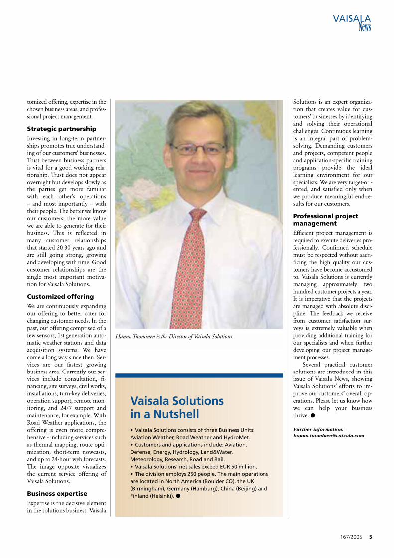
Hannu TuominenDirectorVaisala SolutionsHelsinki, Finland
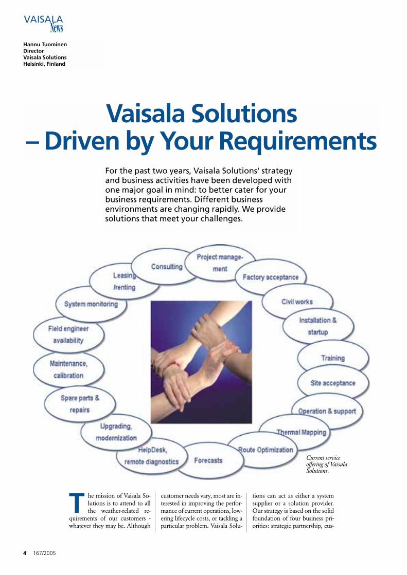
Vaisala Solutions – Driven by Your Requirements
For the past two years, Vaisala Solutions' strategyand business activities have been developed withone major goal in mind: to better cater for yourbusiness requirements. Different businessenvironments are changing rapidly. We providesolutions that meet your challenges.
Current serviceoffering of VaisalaSolutions.
tomized offering, expertise in thechosen business areas, and profes-sional project management.
Strategic partnershipInvesting in long-term partner-ships promotes true understand-ing of our customers' businesses.Trust between business partnersis vital for a good working rela-tionship. Trust does not appearovernight but develops slowly asthe parties get more familiarwith each other's operations – and most importantly – withtheir people. The better we knowour customers, the more valuewe are able to generate for theirbusiness. This is reflected inmany customer relationshipsthat started 20-30 years ago andare still going strong, growingand developing with time. Goodcustomer relationships are thesingle most important motiva-tion for Vaisala Solutions.
Customized offeringWe are continuously expandingour offering to better cater forchanging customer needs. In thepast, our offering comprised of afew sensors, 1st generation auto-matic weather stations and dataacquisition systems. We havecome a long way since then. Ser-vices are our fastest growingbusiness area. Currently our ser-vices include consultation, fi-nancing, site surveys, civil works,installations, turn-key deliveries,operation support, remote mon-itoring, and 24/7 support andmaintenance, for example. WithRoad Weather applications, theoffering is even more compre-hensive - including services suchas thermal mapping, route opti-mization, short-term nowcasts,and up to 24-hour web forecasts.The image opposite visualizesthe current service offering ofVaisala Solutions.
Business expertiseExpertise is the decisive elementin the solutions business. Vaisala
Solutions is an expert organiza-tion that creates value for cus-tomers' businesses by identifyingand solving their operationalchallenges. Continuous learningis an integral part of problem-solving. Demanding customersand projects, competent peopleand application-specific trainingprograms provide the ideallearning environment for ourspecialists. We are very target-ori-ented, and satisfied only whenwe produce meaningful end-re-sults for our customers.
Professional projectmanagementEfficient project management isrequired to execute deliveries pro-fessionally. Confirmed schedulemust be respected without sacri-ficing the high quality our cus-tomers have become accustomedto. Vaisala Solutions is currentlymanaging approximately twohundred customer projects a year.It is imperative that the projectsare managed with absolute disci-pline. The feedback we receivefrom customer satisfaction sur-veys is extremely valuable whenproviding additional training forour specialists and when furtherdeveloping our project manage-ment processes.
Several practical customersolutions are introduced in thisissue of Vaisala News, showingVaisala Solutions' efforts to im-prove our customers’ overall op-erations. Please let us know howwe can help your businessthrive. ●
Further information:[email protected]
167/2005 5
Vaisala Solutions in a Nutshell• Vaisala Solutions consists of three Business Units: Aviation Weather, Road Weather and HydroMet. • Customers and applications include: Aviation, Defense, Energy, Hydrology, Land&Water, Meteorology, Research, Road and Rail. • Vaisala Solutions’ net sales exceed EUR 50 million. • The division employs 250 people. The main operationsare located in North America (Boulder CO), the UK(Birmingham), Germany (Hamburg), China (Beijing) andFinland (Helsinki). ●
Hannu Tuominen is the Director of Vaisala Solutions.
T here has been a rapidgrowth in investment inRWIS technology in
North America in the last threeyears. Much of the investmenthas focused on stand-alone sys-tems intended to be operated byhighway maintenance personnelto aid decision-making duringwinter storms. RWIS are increas-ingly seen as an essential tool todo the job efficiently. By con-trast, responsibility for mainte-nance and data management ofthe RWIS is often overlooked asboth an unnecessary cost and adrain on limited IT resources.Outsourcing offers a flexible andcost-effective alternative.
Aurora City – investingin peace of mindThe street maintenance divisionof the City of Aurora in Col-orado, USA, has the responsi-bility for procuring and manag-ing contracts for the provision ofwinter service on more than1000 miles of roads both in andaround the City. Provision of aneffective winter service is a diffi-cult task in Colorado’s harshwinter climate, one which re-quires forward planning. Re-mote weather information tech-nology has a key role to play indetermining the correct winterservice action.
The importance of accurate,timely data being available 24hours a day is one of the mainreasons why the City of Aurorahas chosen Vaisala for the provi-sion of a complete data manage-ment solution, the Vaisala Bu-reau Service. This involves notonly the supply of remote roadweather stations but the respon-sibility for ensuring the continu-ous flow of data to the streetmaintenance personnel aroundthe clock.
A number of Vaisala weatherstations are located at strategicpoints on the road network.These provide a continuoussource of road weather informa-tion including details of the roadsurface condition and tempera-ture as well as the general state
6 167/2005
Managing Winter Service
Andy McDonaldSales Channel ManagerVaisala Birmingham, UK
Allocating resources where they are most needed is key tosuccessful operations. Outsourcing the non-core businessactivities to reliable partners is a growing trend - also when itcomes to Road Weather Information System (RWIS) maintenanceand data management.
of the atmosphere, for exampleair temperature and precipita-tion. The information is auto-matically transmitted to Vaisala’sdata management center whereit is stored and processed. Auro-ra’s maintenance engineers ac-cess the data via web browser ina configured display of graphicaland textual images. Data are up-dated every 20 minutes.
Continuous and accuratedata supply are two of the mostimportant criteria for the City ofAurora. To address these points,the data management solutionincorporates a number of safe-guards and monitoring func-tions. Weather station calibra-tion and servicing is offered pri-or to the start of winter. Oncethe winter starts the Bureau ismanned 24 hours per day, 7 daysper week to provide a continu-ous backup and ensure smoothoperation. By duplicating com-munication structures and otherprocesses the Bureau ensures areliable service.
Every time a new piece ofdata is received by the data cen-ter from a weather station it isautomatically scrutinized for er-rors and any evidence of calibra-tion drift. If an error does occurat any time Vaisala maintenancepersonnel are on constant stand-by ready to carry out repairs in atimely fashion and bring the sta-tion or sensor back online asquickly as possible.
In the words of Aurora’sProject Engineer, Lynne Center“This solution is making a realdifference. We can rely on thesystem to provide good qualityroad weather information whenwe need it. It's really easy to gethold of the data both in the of-fice or at home. Vaisala just takescare of the system and we canconcentrate on using the infor-mation to keep our roads safe.”
E-470 maintenance – a strategic partnershipE-470 is a highway that runsalong the eastern perimeter ofthe Denver metropolitan area.The E-470 Public Highway Au-
thority has a need to keep on topof winter storms and ensure thatits customers, the driving public,have a safe road on which totravel at all times. The E-470Public Highway Authority isworking with Vaisala for the sup-ply of road weather forecast ser-vices. The Vaisala Bureau Serviceis being used to facilitate this, asit also has the capability of pro-ducing and delivering forecastinformation, as well as managingweather station data.
Working in partnership witha local forecast provider for thesupply of atmospheric data, anumber of 24 hour forecasts aregenerated by the Vaisala BureauService each day for strategicweather station points on thehighway. Forecasts comprise arange of browser based productstailored for the E-470 PublicHighway Authority. Each graph-ical forecast provides detailed in-formation on the expected tem-perature and road condition forthe coming 24 hours, which canbe directly compared againstmeasured data from the weatherstation points. To complementthese point forecasts, forecastthermal maps of the completehighway are also provided.These indicate which sections ofroad will fall below freezing andat what time, giving crucial in-formation in sufficient time totake preventative treatment ac-tion.
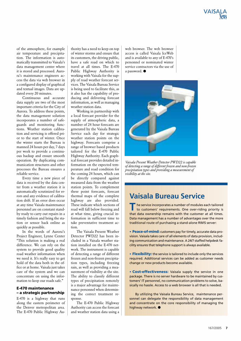
The Vaisala Present WeatherDetector PWD22 has been in-cluded in a Vaisala weather sta-tion installed on the E-470 net-work. The instrument is capableof detecting a range of differentfrozen and non-frozen precipita-tion types, including freezingrain, as well as providing a mea-surement of visibility at the site.The ability to classify differenttypes of precipitation remotelyis a major advantage for mainte-nance personnel when determin-ing the correct treatment re-sponse.
The E-470 Public HighwayAuthority can access the forecastand weather station data using a
web browser. The web browseraccess is called Vaisala IceWeband is available to any of E-470’spersonnel or nominated winterservice contractors via the use ofa password. ●
167/2005 7
Vaisala Bureau Service
T he service incorporates a number of modules each tailoredto customers’ requirements. One over-riding priority is
that data ownership remains with the customer at all times.Data management has a number of advantages over the moretraditional route of purchasing a stand-alone RWIS server:
• Peace-of-mind: customers pay for timely, accurate data pro-vision. Vaisala takes care of all elements of data provision, includ-ing communication and maintenance. A 24/7 staffed helpdesk fa-cility ensures that telephone support is always available.
• Flexibility: the service is tailored to include only the servicesrequired. Additional services can be added as customer needschange or new products become available.
• Cost-effectiveness: Vaisala supply the service in onepackage. There is no server hardware to be maintained by cus-tomers’ IT personnel, no communication problems to solve, ba-sically no hassle. Access to a web browser is all that is needed.
By utilizing the Vaisala Bureau Service, maintenance per-sonnel can delegate the responsibility of data managementand concentrate on the core responsibility of managing thehighway network. ●
Vaisala Present Weather Detector PWD22 is capableof detecting a range of different frozen and non-frozenprecipitation types and providing a measurement ofvisibility at the site.
8 167/2005
Zürich Airport Upgrades to Vaisala MIDASNew Vaisala Transmissometer LT31 chosen for superior visibility data
Marikka MetsoEditor-in-ChiefVaisalaHelsinki, Finland
Zürich Airport is serviced by more than 100 different airlines. Eachand every day, roughly 70,000 people pass through. The surroundingmountains and high hilltops give rise to unstable weather conditions.It is therefore vital that the airport is well-equipped to measure thevarious rapidly changing weather parameters.
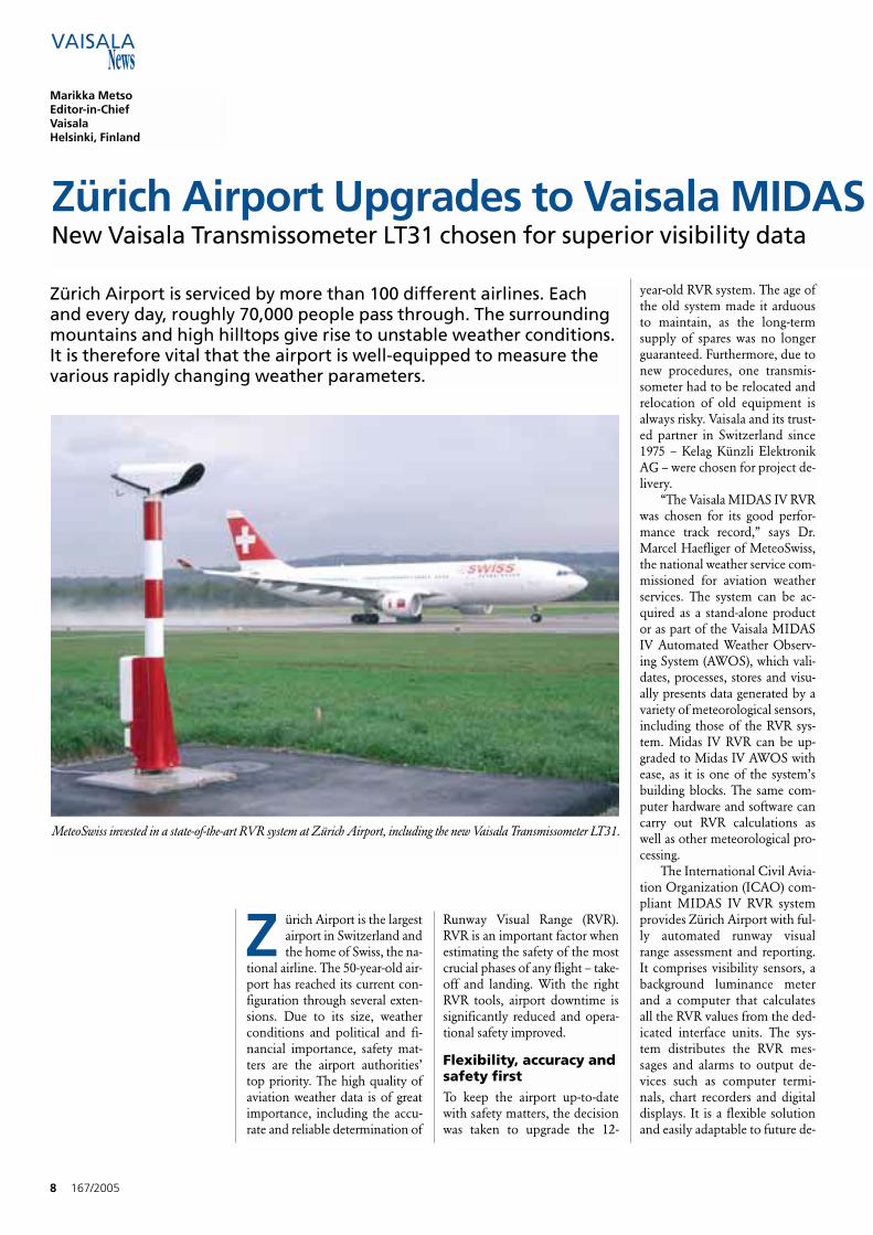
MeteoSwiss invested in a state-of-the-art RVR system at Zürich Airport, including the new Vaisala Transmissometer LT31.
Z ürich Airport is the largestairport in Switzerland andthe home of Swiss, the na-
tional airline. The 50-year-old air-port has reached its current con-figuration through several exten-sions. Due to its size, weatherconditions and political and fi-nancial importance, safety mat-ters are the airport authorities’top priority. The high quality ofaviation weather data is of greatimportance, including the accu-rate and reliable determination of
Runway Visual Range (RVR).RVR is an important factor whenestimating the safety of the mostcrucial phases of any flight – take-off and landing. With the rightRVR tools, airport downtime issignificantly reduced and opera-tional safety improved.
Flexibility, accuracy andsafety firstTo keep the airport up-to-datewith safety matters, the decisionwas taken to upgrade the 12-
year-old RVR system. The age ofthe old system made it arduousto maintain, as the long-termsupply of spares was no longerguaranteed. Furthermore, due tonew procedures, one transmis-someter had to be relocated andrelocation of old equipment isalways risky. Vaisala and its trust-ed partner in Switzerland since1975 – Kelag Künzli ElektronikAG – were chosen for project de-livery.
“The Vaisala MIDAS IV RVRwas chosen for its good perfor-mance track record,” says Dr.Marcel Haefliger of MeteoSwiss,the national weather service com-missioned for aviation weatherservices. The system can be ac-quired as a stand-alone productor as part of the Vaisala MIDASIV Automated Weather Observ-ing System (AWOS), which vali-dates, processes, stores and visu-ally presents data generated by avariety of meteorological sensors,including those of the RVR sys-tem. Midas IV RVR can be up-graded to Midas IV AWOS withease, as it is one of the system’sbuilding blocks. The same com-puter hardware and software cancarry out RVR calculations aswell as other meteorological pro-cessing.
The International Civil Avia-tion Organization (ICAO) com-pliant MIDAS IV RVR systemprovides Zürich Airport with ful-ly automated runway visualrange assessment and reporting.It comprises visibility sensors, abackground luminance meterand a computer that calculatesall the RVR values from the ded-icated interface units. The sys-tem distributes the RVR mes-sages and alarms to output de-vices such as computer termi-nals, chart recorders and digitaldisplays. It is a flexible solutionand easily adaptable to future de-
167/2005 9
IV Runway Visual Range System
velopments and upgrades.
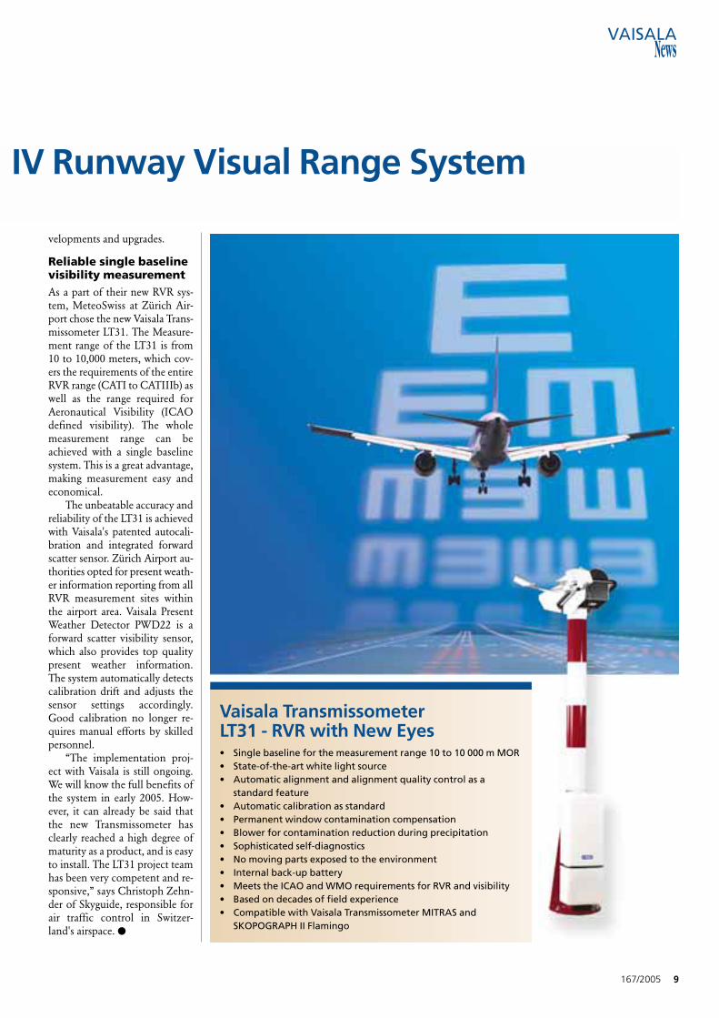
Reliable single baselinevisibility measurementAs a part of their new RVR sys-tem, MeteoSwiss at Zürich Air-port chose the new Vaisala Trans-missometer LT31. The Measure-ment range of the LT31 is from10 to 10,000 meters, which cov-ers the requirements of the entireRVR range (CATI to CATIIIb) aswell as the range required forAeronautical Visibility (ICAOdefined visibility). The wholemeasurement range can beachieved with a single baselinesystem. This is a great advantage,making measurement easy andeconomical.
The unbeatable accuracy andreliability of the LT31 is achievedwith Vaisala's patented autocali-bration and integrated forwardscatter sensor. Zürich Airport au-thorities opted for present weath-er information reporting from allRVR measurement sites withinthe airport area. Vaisala PresentWeather Detector PWD22 is aforward scatter visibility sensor,which also provides top qualitypresent weather information.The system automatically detectscalibration drift and adjusts thesensor settings accordingly.Good calibration no longer re-quires manual efforts by skilledpersonnel.
“The implementation proj-ect with Vaisala is still ongoing.We will know the full benefits ofthe system in early 2005. How-ever, it can already be said thatthe new Transmissometer hasclearly reached a high degree ofmaturity as a product, and is easyto install. The LT31 project teamhas been very competent and re-sponsive,” says Christoph Zehn-der of Skyguide, responsible forair traffic control in Switzer-land's airspace. ●
Vaisala Transmissometer LT31 - RVR with New Eyes• Single baseline for the measurement range 10 to 10 000 m MOR• State-of-the-art white light source• Automatic alignment and alignment quality control as a
standard feature• Automatic calibration as standard• Permanent window contamination compensation• Blower for contamination reduction during precipitation• Sophisticated self-diagnostics• No moving parts exposed to the environment• Internal back-up battery• Meets the ICAO and WMO requirements for RVR and visibility• Based on decades of field experience• Compatible with Vaisala Transmissometer MITRAS and
SKOPOGRAPH II Flamingo
T he Commission is in theprocess of developing astatewide network of
AWOS at key airports to monitorand provide weather informationfor the safety of the flying public.The systems will also be fed intoNational Airspace Data Inter-change Network (NADIN) andwill become available to pilotsnationwide.
The Commission is confi-dent the systems will provide un-interrupted, accurate weather in-formation, resulting in increasedaircraft traffic throughout thestate.
“Vaisala has proven to be avaluable resource to the Com-mission for AWOS-related infor-mation,” says Vivek Khanna,Airports Engineer for the Okla-homa Aeronautics Commission.
Seven Vaisala AWOS III PTs
are being installed at RegionalBusiness Airports in the state.Regional Business Airports areidentified by the Oklahoma Air-port System Plan as having atleast a 5,000 ft. long primaryrunway that is jet capable.
The airports receiving anAWOS include:• Altus/Quartz Mountain
Regional Airport• Ardmore Municipal Airport • Clinton Municipal Airport • Cushing Municipal Airport • El Reno Municipal Air Park • Enid/Woodring Regional
Airport • Seminole Municipal Airport
All seven installations are ex-pected to be completed by early2005. ●
10 167/2005
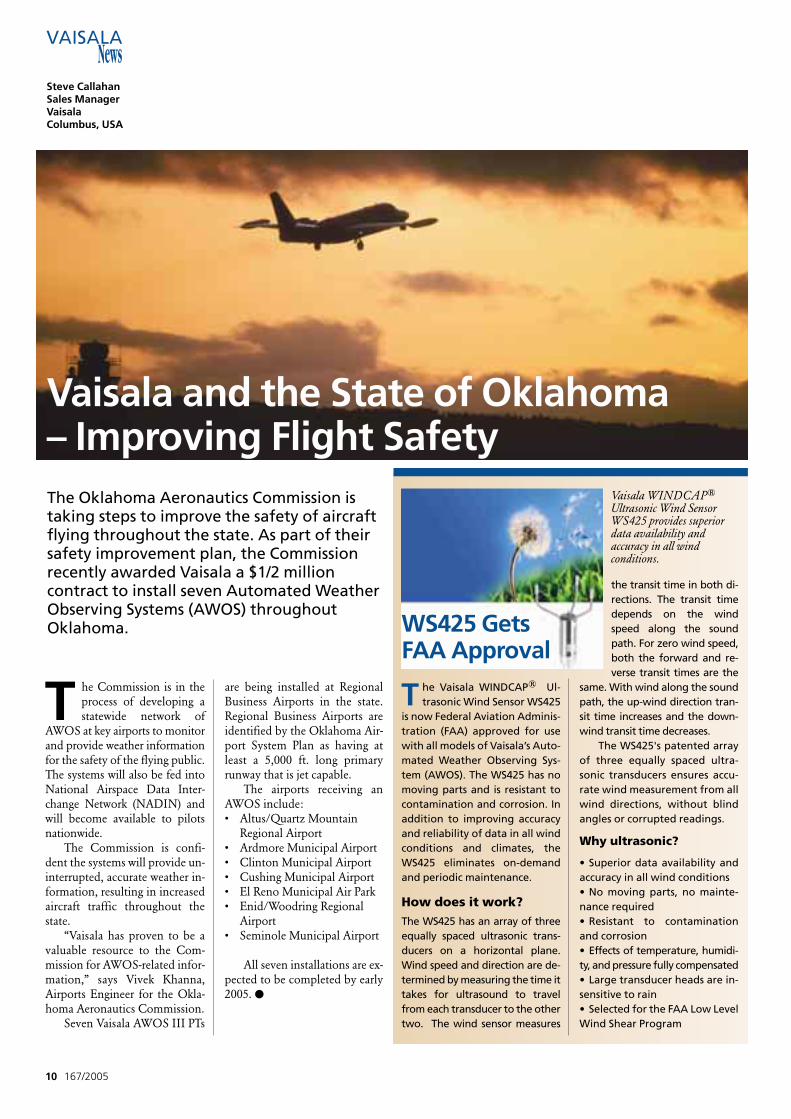
T he Vaisala WINDCAP® Ul-trasonic Wind Sensor WS425
is now Federal Aviation Adminis-tration (FAA) approved for usewith all models of Vaisala’s Auto-mated Weather Observing Sys-tem (AWOS). The WS425 has nomoving parts and is resistant tocontamination and corrosion. Inaddition to improving accuracyand reliability of data in all windconditions and climates, theWS425 eliminates on-demandand periodic maintenance.
How does it work?The WS425 has an array of threeequally spaced ultrasonic trans-ducers on a horizontal plane.Wind speed and direction are de-termined by measuring the time ittakes for ultrasound to travelfrom each transducer to the othertwo. The wind sensor measures
the transit time in both di-rections. The transit timedepends on the windspeed along the soundpath. For zero wind speed,both the forward and re-verse transit times are the
same. With wind along the soundpath, the up-wind direction tran-sit time increases and the down-wind transit time decreases.
The WS425's patented arrayof three equally spaced ultra-sonic transducers ensures accu-rate wind measurement from allwind directions, without blindangles or corrupted readings.
Why ultrasonic?
• Superior data availability andaccuracy in all wind conditions• No moving parts, no mainte-nance required• Resistant to contaminationand corrosion• Effects of temperature, humidi-ty, and pressure fully compensated• Large transducer heads are in-sensitive to rain• Selected for the FAA Low LevelWind Shear Program
The Oklahoma Aeronautics Commission istaking steps to improve the safety of aircraftflying throughout the state. As part of theirsafety improvement plan, the Commissionrecently awarded Vaisala a $1/2 millioncontract to install seven Automated WeatherObserving Systems (AWOS) throughoutOklahoma.
Vaisala and the State of Oklahoma – Improving Flight Safety
Steve CallahanSales ManagerVaisala Columbus, USA
WS425 GetsFAA Approval
Vaisala WINDCAP®
Ultrasonic Wind SensorWS425 provides superiordata availability andaccuracy in all windconditions.
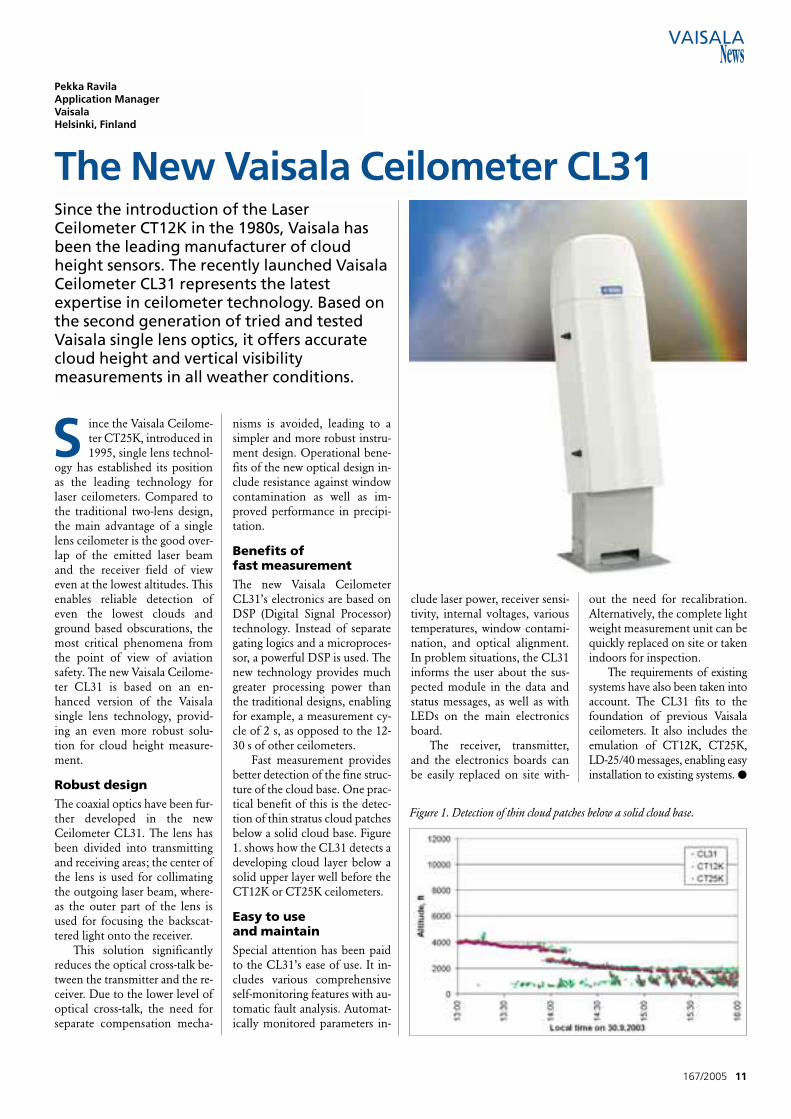
S ince the Vaisala Ceilome-ter CT25K, introduced in1995, single lens technol-
ogy has established its positionas the leading technology forlaser ceilometers. Compared tothe traditional two-lens design,the main advantage of a singlelens ceilometer is the good over-lap of the emitted laser beamand the receiver field of vieweven at the lowest altitudes. Thisenables reliable detection ofeven the lowest clouds andground based obscurations, themost critical phenomena fromthe point of view of aviationsafety. The new Vaisala Ceilome-ter CL31 is based on an en-hanced version of the Vaisalasingle lens technology, provid-ing an even more robust solu-tion for cloud height measure-ment.
Robust designThe coaxial optics have been fur-ther developed in the newCeilometer CL31. The lens hasbeen divided into transmittingand receiving areas; the center ofthe lens is used for collimatingthe outgoing laser beam, where-as the outer part of the lens isused for focusing the backscat-tered light onto the receiver.
This solution significantlyreduces the optical cross-talk be-tween the transmitter and the re-ceiver. Due to the lower level ofoptical cross-talk, the need forseparate compensation mecha-
nisms is avoided, leading to asimpler and more robust instru-ment design. Operational bene-fits of the new optical design in-clude resistance against windowcontamination as well as im-proved performance in precipi-tation.
Benefits of fast measurementThe new Vaisala CeilometerCL31’s electronics are based onDSP (Digital Signal Processor)technology. Instead of separategating logics and a microproces-sor, a powerful DSP is used. Thenew technology provides muchgreater processing power thanthe traditional designs, enablingfor example, a measurement cy-cle of 2 s, as opposed to the 12-30 s of other ceilometers.
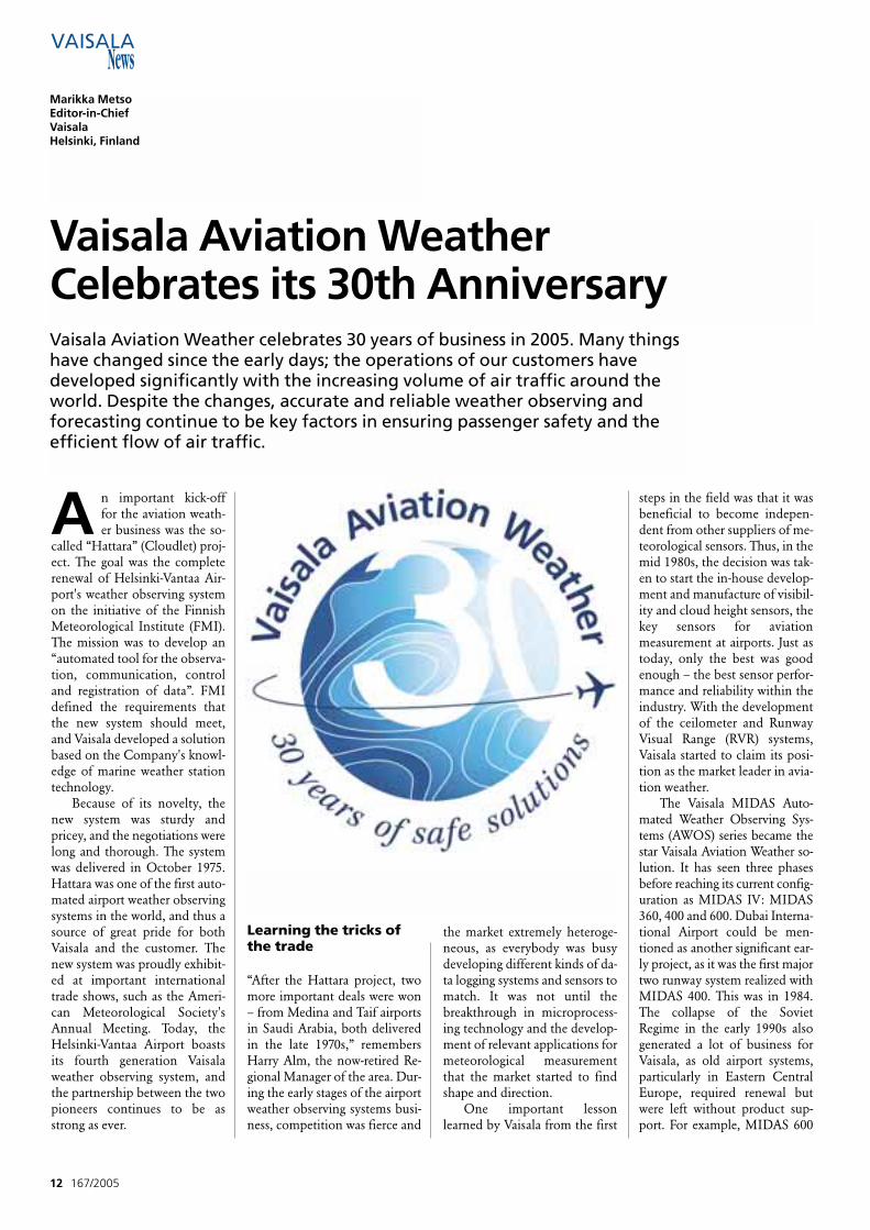
Fast measurement providesbetter detection of the fine struc-ture of the cloud base. One prac-tical benefit of this is the detec-tion of thin stratus cloud patchesbelow a solid cloud base. Figure1. shows how the CL31 detects adeveloping cloud layer below asolid upper layer well before theCT12K or CT25K ceilometers.
Easy to use and maintainSpecial attention has been paidto the CL31’s ease of use. It in-cludes various comprehensiveself-monitoring features with au-tomatic fault analysis. Automat-ically monitored parameters in-
clude laser power, receiver sensi-tivity, internal voltages, varioustemperatures, window contami-nation, and optical alignment.In problem situations, the CL31informs the user about the sus-pected module in the data andstatus messages, as well as withLEDs on the main electronicsboard.
The receiver, transmitter,and the electronics boards canbe easily replaced on site with-
out the need for recalibration.Alternatively, the complete lightweight measurement unit can bequickly replaced on site or takenindoors for inspection.
The requirements of existingsystems have also been taken intoaccount. The CL31 fits to thefoundation of previous Vaisalaceilometers. It also includes theemulation of CT12K, CT25K,LD-25/40 messages, enabling easyinstallation to existing systems. ●
167/2005 11
Pekka RavilaApplication ManagerVaisala Helsinki, Finland
Since the introduction of the LaserCeilometer CT12K in the 1980s, Vaisala hasbeen the leading manufacturer of cloudheight sensors. The recently launched VaisalaCeilometer CL31 represents the latestexpertise in ceilometer technology. Based onthe second generation of tried and testedVaisala single lens optics, it offers accuratecloud height and vertical visibilitymeasurements in all weather conditions.
The New Vaisala Ceilometer CL31
Figure 1. Detection of thin cloud patches below a solid cloud base.
A n important kick-offfor the aviation weath-er business was the so-
called “Hattara” (Cloudlet) proj-ect. The goal was the completerenewal of Helsinki-Vantaa Air-port's weather observing systemon the initiative of the FinnishMeteorological Institute (FMI).The mission was to develop an“automated tool for the observa-tion, communication, controland registration of data”. FMIdefined the requirements thatthe new system should meet,and Vaisala developed a solutionbased on the Company's knowl-edge of marine weather stationtechnology.
Because of its novelty, thenew system was sturdy andpricey, and the negotiations werelong and thorough. The systemwas delivered in October 1975.Hattara was one of the first auto-mated airport weather observingsystems in the world, and thus asource of great pride for bothVaisala and the customer. Thenew system was proudly exhibit-ed at important internationaltrade shows, such as the Ameri-can Meteorological Society'sAnnual Meeting. Today, theHelsinki-Vantaa Airport boastsits fourth generation Vaisalaweather observing system, andthe partnership between the twopioneers continues to be asstrong as ever.
Learning the tricks ofthe trade
“After the Hattara project, twomore important deals were won– from Medina and Taif airportsin Saudi Arabia, both deliveredin the late 1970s,” remembersHarry Alm, the now-retired Re-gional Manager of the area. Dur-ing the early stages of the airportweather observing systems busi-ness, competition was fierce and
the market extremely heteroge-neous, as everybody was busydeveloping different kinds of da-ta logging systems and sensors tomatch. It was not until thebreakthrough in microprocess-ing technology and the develop-ment of relevant applications formeteorological measurementthat the market started to findshape and direction.
One important lessonlearned by Vaisala from the first
steps in the field was that it wasbeneficial to become indepen-dent from other suppliers of me-teorological sensors. Thus, in themid 1980s, the decision was tak-en to start the in-house develop-ment and manufacture of visibil-ity and cloud height sensors, thekey sensors for aviation measurement at airports. Just astoday, only the best was goodenough – the best sensor perfor-mance and reliability within theindustry. With the developmentof the ceilometer and RunwayVisual Range (RVR) systems,Vaisala started to claim its posi-tion as the market leader in avia-tion weather.
The Vaisala MIDAS Auto-mated Weather Observing Sys-tems (AWOS) series became thestar Vaisala Aviation Weather so-lution. It has seen three phasesbefore reaching its current config-uration as MIDAS IV: MIDAS360, 400 and 600. Dubai Interna-tional Airport could be men-tioned as another significant ear-ly project, as it was the first majortwo runway system realized withMIDAS 400. This was in 1984.The collapse of the SovietRegime in the early 1990s alsogenerated a lot of business forVaisala, as old airport systems,particularly in Eastern CentralEurope, required renewal butwere left without product sup-port. For example, MIDAS 600
12 167/2005
Vaisala Aviation Weather Celebrates its 30th Anniversary
Marikka MetsoEditor-in-ChiefVaisalaHelsinki, Finland
Vaisala Aviation Weather celebrates 30 years of business in 2005. Many thingshave changed since the early days; the operations of our customers havedeveloped significantly with the increasing volume of air traffic around theworld. Despite the changes, accurate and reliable weather observing andforecasting continue to be key factors in ensuring passenger safety and theefficient flow of air traffic.
based multi runway systems weredelivered to both Prague andBratislava International Airports.
From field to automationAs flight traffic increased, air-ports became more and morebusiness-like. Airport authoritiesquickly understood that it wasimportant to generate as muchtraffic as possible to bring inmore business. Following ICAOrecommendations was, and stillis, key in meeting the safety cri-teria. Having the most advancedequipment meant less opera-tional down time and a higherairport category - both of whichincrease airport revenues. Forthe airport authorities, theICAO recommendations servedas a helpful tool for evaluatingthe performance of the airportweather observing system.
“Before automation, it wascommonplace to perform obser-vations on-site, quite literally: atairports, this meant that a Metobserver had to make live obser-vations of weather phenomenavisible to the naked eye,” Almpoints out. Although RVR tech-nology had been around forsome time already, data process-ing was a true challenge beforethe invention of the micro-processor. After this, the devel-opment was from visual percep-tion to automation and from la-bor-intensive to cost-efficient.
Investing in continuity Today, Vaisala Aviation Weatheris one of the oldest and most ex-perienced solution providers inits field. Two business acquisi-tions in the past nine years, in-cluding the German JenoptikImpulsphysik GmbH and theU.S. Artais Weather Check Inc.,have further strengthenedVaisala's position in the market.
Most of the older MIDASsystems have been upgraded toMIDAS IV, reflecting customerloyalty and continuity in
Vaisala's business. One of thefirst two runway MIDAS IV de-liveries was for Gardenmoen Air-port in Oslo, Norway, in 1997.
Investment in continuousproduct development, innova-tion and improvement is a highpriority for Vaisala. But evenmore important than the abilityto manufacture leading hightechnology is Vaisala's under-standing of how to best cater forindividual and varying businessrequirements. “A growing num-ber of customers opt for Vaisalanot only as their trusted equip-ment provider but also asprovider of a wide range of ser-vices which facilitate day-to-dayoperations and introduce con-siderable cost-savings,” explainsHannu Katajamäki, Manager ofthe Vaisala Aviation WeatherBusiness Unit.
Customer firstWhen venturing into the worldof aviation weather, Vaisala hadthe advantage of knowing many
of the “new” customers in thisniche through the Company'sother activities in the meteoro-logical field. Vaisala's ability toproduce reliable and accuratemeasurement systems was al-ready known. This trust hassince been rewarded many timesover, as Vaisala's philosophy hasalways insisted on the same fun-damental – the customer is inthe driving seat. Investment insolid, long-term partnerships isan investment in the future.During its 30 years of opera-tions, Vaisala Aviation Weatherhas built a solid customer baseof its own that now in turn ben-efits other Vaisala operations.
“I would like to thank all ourcustomers for the past 30 yearsof successful partnerships. Welook forward to many moreyears of learning from you andyour operations, as each projectand customer is different. Beingreceptive to continuous learningis beneficial to business – yoursand ours,” says Katajamäki. ●
167/2005 13
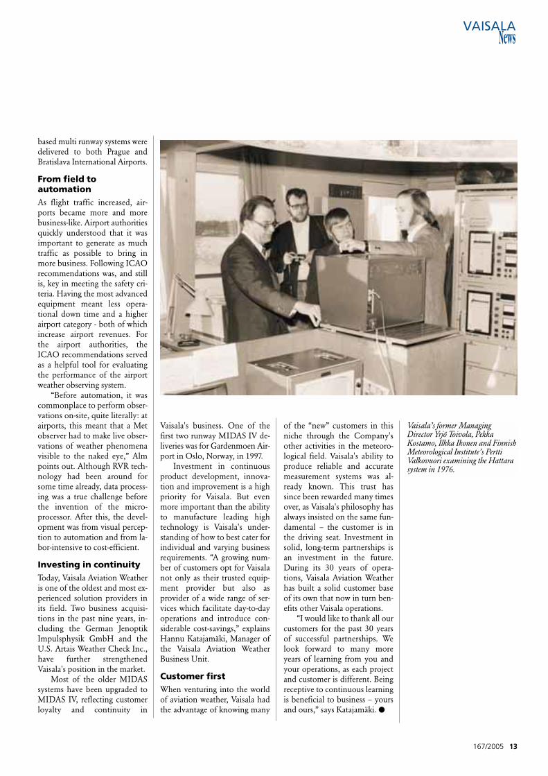
Vaisala’s former ManagingDirector Yrjö Toivola, PekkaKostamo, Ilkka Ikonen and FinnishMeteorological Institute’s PerttiValkovuori examining the Hattarasystem in 1976.
A n up-to-date hydrome-teorological observationnetwork is expected to
produce real-time measurementdata that is more accurate anddense both geographically and inrelation to time than ever before.It is also expected to include newmeasurement parameters.
The capacity requirementsfor observation networks growwith the number of applications.The significance of traditionalhydrology applications, such asflood forecasting, water level reg-ulation and irrigation control,increase continuously. At thesame time, new fields of applica-tion come into being, particular-ly in relation to water quality,the effects of climate change,and the maintenance of waterand sewage systems. Fortunatelythe simultaneous advancementsin data processing capacity facil-itate the handling of increasingquantities of data as well asquick response times for manyapplications, for example real-time flood forecasts.
Although the rapid develop-ment of remote sensing systems– such as weather radars andsatellite measurement – partlycaters for these requirements, in-situ measurement will continueto form the basis of hydrologicaland meteorological measure-ments in the future. The chal-lenge is to implement increas-ingly dense and geographicallydecentralized observation net-works with reasonable initial in-vestment, maintenance and data
14 167/2005
Samuli RäisänenProduct Development Manager
Heikki TurtiainenSenior ScientistVaisalaHelsinki, Finland
Vaisala Solutions for Telemetry andModern telemetry and measurement system automation help to gather morecomprehensive data on our water systems. The improved performance ofmeasurement equipment, reduced power usage and unit price, together with newwireless communications systems, enable dense observation networks. The real-time utilization of data is possible thanks to the Internet. The biggest challengesfacing the observation networks are maintenance and sensor calibration.
processing costs. The solutionlies in measurement automationand telemetry.
Measurement automationMeasurement automation is aby-product of technological ad-vancement. The main drivingforce is cost minimization, ashuman observation becomes in-creasingly costly with dense net-works and shorter sampling in-tervals. The evolution of elec-tronics, telecommunicationsand sensor technology enablehuman observers to be replacedby automated telemetric equip-ment in almost all hydrometeo-rological applications.
When observation stationsare located in remote and deso-late regions, automation is facedwith power supply and equip-ment maintenance challenges.
With the development of elec-tronics, the power consumptionof measurement equipment hasgone down. This has enabled theuse of reasonably priced solarcell & battery combinations as apower source.
The maintenance costs ofobservation stations havebeen considerably reduced bytelecommunications networks inremote maintenance, configura-tion, diagnostics and softwareupdates. The person responsiblefor the maintenance of the ob-servation network is now able torun all these operations from hisor her PC, without having toleave the office. However, thesensors continue to require regu-lar on-the-spot calibration andmaintenance. Maintenance costswill present the biggest challengefor the expansion and thicken-ing of observation networks in
the near future. Equipmentmanufacturers will thereforecontinue to address the chal-lenge of developing sensors thatrequire less and less mainte-nance.
Telemetry – remote access to mea-surement dataThe complete automation of ob-servation networks also requiresthe automatic transfer of mea-surement data to the user. Thereare a number of methods forthis, either via radio waves, te-lephony or information net-works. In a typical hydrometeo-rological application, data istransferred at regular intervals,the quantity of data is reason-ably small, and mostly, to ensurereliability, more than one datatransfer method is supported.
The most reliable way to
transfer measurement data con-tinues to be either the traditionalmodem via fixed telephone lineor, increasingly, information net-works – typically implementedwith local area network (LAN)architecture. One benefit of thelatter is the easy connectivity ofthe observation station to the In-ternet or the organization's In-tranet. If the measurement in-strument or observation stationis equipped with a serial inter-face port (RS232/485), the Eth-ernet connection can be imple-mented easily with a so-calleddevice server, or COM server.
SMS messaging is the bestmethod when it is necessary toget the data direct to the user,typically to a mobile device. It ismost advantageous in conjunc-tion with applications sendingalarm signals. SMS messaging al-so enables inquiries for measure-ment data to be sent as the needoccurs: e.g. for road weatheralong a route.
When measurement data isbeing collected at regular inter-vals or when there is a lot of it, itis more economical to use aGSM or GPRS modem. A GSMdata call is charged as a normalcall – according to the connec-tion time – whereas a GPRS con-nection is open all the time andcharges are based on the amountof data transferred. In hydrome-teorological applications, theamount of data is typicallysmall, which makes the use ofGPRS modems economical.
When it comes to reliability,the wireless network is reason-ably stable. However, servicebreaks due to overloading arepossible, so it should not be usedas the only data transfer methodfor telemetry that requires ex-treme reliability or speed.
A radiomodem using VHFor UHF frequencies is a tradi-tional data transfer method
167/2005 15
Automation in Environmental Monitoring
➤
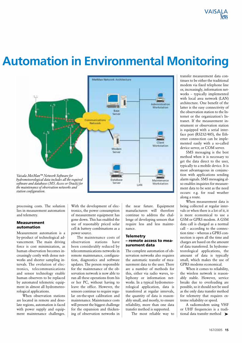
Vaisala MetMan™ Network Software forhydrometeorological data includes all the requiredsoftware and databases (MS Access or Oracle) forthe maintenance of observation networks andstation configuration.
which is still in use, particularlywhere no reliable mobile net-work is available. Typically ra-diomodems are used as nodalpoints between the measurementinstrument and the closest fixedtelephone or GSM network. Theadvantage of radiotelemetry isthat, after the equipment invest-ment, it is nearly free for the user.
The use of radiomodem, likeany other radio transmitter, nor-mally requires a license from theauthorities. However, low powertransmitters operating on so-called license free frequenciesare exempt from the license pro-cedures. These radiomodemsreach at best a few kilometers’operating range.
Communications satellitesenable wireless data transfer from
almost anywhere on Earth, in-cluding the seas. Satellite systemsare divided into LEO (Low EarthOrbit), which consist of satellitescirculating a low orbit and GEO(Geostationary Earth Orbit),which orbit the Earth on the so-called geostationary path at theequator - looking stationary whenobserved from the Earth. LEOsystems offering a global commer-cial service include ORBCOMM,consisting of 30 satellites. Anotheris Iridium. A corresponding globalGEO system is Inmarsat. Hydro-logical and meteorological mea-surements in the U.S. are mostlyenabled by data transfer providedby the geostationary GOESweather satellite, as its use is free tomany public organizations.
The selection of a suitable
telemetry method is influencedby the geographic location of theobservation station, transmissiondistance, amount of data trans-ferred and sample intervals, reli-ability and response time re-quirements, and by the transmis-sion methods available at the lo-cation. Since there is no one-size-fits-all solution, it is possible touse several alternative telemetricmethods at modern hydromete-orological stations.
A significant part of the ope-rations of observation networksis data quality control, the man-ner of expressing and controllingdata as well as network mainte-nance, configuration and up-dates. These require network anddata management software, suchas the Vaisala MetMan™ Net-work Software.
Future outlookThe unit prices of intelligentwireless measurement equip-ment will continue to drop whiletheir performance grows andpower consumption decreases. Alow unit price enables redundantmeasurement. Thanks to lowpower consumption, the equip-ment will run on the same bat-tery or (in the future) fuel cell forseveral years. Together, these de-velopments enable the lengthen-ing of service intervals and thusthe considerable reduction ofmaintenance cost per station.
Wireless data transmissionenabled by cellular networks iscurrently in a strong develop-ment phase. As the traditionalmobile market becomes saturat-ed, telecommunications busi-nesses seek new markets withinso-called machine-to-machine orM2M communications. The de-velopment of M2M technolo-gies simplifies data transmissionsolutions and reduces costs bothfor equipment and data transfer– though only in geographic are-as with wireless infrastructure.
Due to the trends men-tioned, increasingly dense andcomprehensive observation net-works will become technicallyand economically feasible in
densely populated areas. Howev-er, sparsely populated areas likeSiberia or African rainforests willcontinue to depend on satelliteconnections and thus limiteddata transfer capacity.
The advancement of tech-nology in both telecommunica-tions (more bandwidth) and pro-cessing power (more intelligentsensors) seems to offer two alter-native ways forward for observa-tion stations. The first is a moreconventional solution: data col-lection is performed by a centralunit, which processes and com-presses the measurement databefore passing it on. This solu-tion remains the most suitablefor those locations where datatransfer is costly or data transfercapacity is limited. In locationswhere the capacity of communi-cations networks is good, anoth-er option is more probable: themeasurement and processing ofdata will be distributed to intelli-gent sensors. The sensors will bedirectly connected to a telemet-ric unit, rendering a separatecentral unit unnecessary.
Connecting observation net-works to the Internet is a cleartrend. The observed data will beavailable wherever and to all rele-vant people in nearly real-time.Communications networks alsoenable the combining of datafrom different sources. The reli-ability and coverage of environ-mental measurement data will sig-nificantly improve when integrat-ed observation systems are intro-duced. They will simultaneouslybenefit from all in-situ, radar andsatellite measurement data. ●
16 167/2005
Summary
A dvanced telemetry en-ables the development
of comprehensive real-timeobservation networks. In thefuture, our water systems willbe observed with integratedsystems that benefit from theInternet. ●
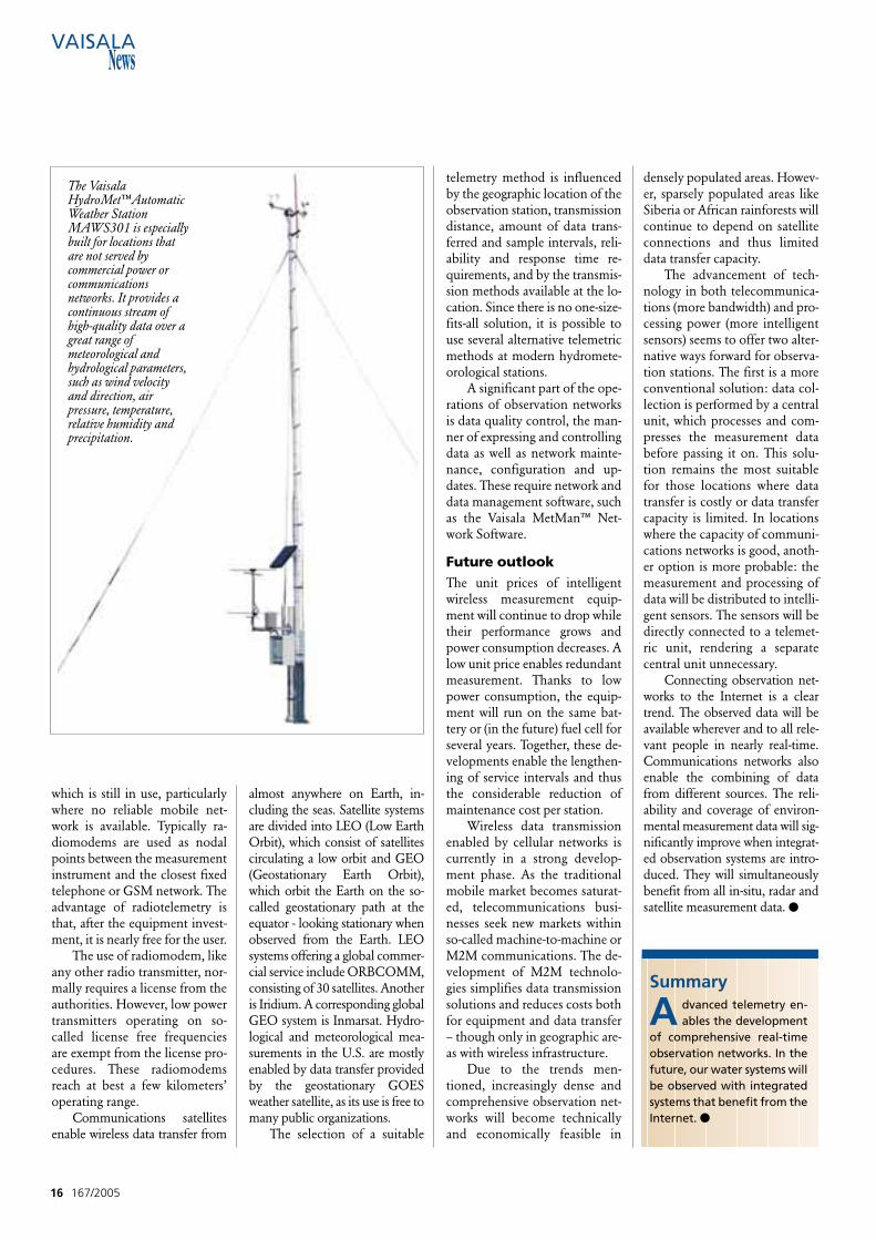
The VaisalaHydroMet™AutomaticWeather StationMAWS301 is especiallybuilt for locations thatare not served bycommercial power orcommunicationsnetworks. It provides acontinuous stream ofhigh-quality data over agreat range ofmeteorological andhydrological parameters,such as wind velocityand direction, airpressure, temperature,relative humidity andprecipitation.

A nationwide surface ob-servation network typi-cally consists of dozens
or hundreds of weather stations.The stations may be fully auto-matic or manned. In the lattercase, the station may still trans-mit some of the messages auto-matically.
At the FMI, the station net-work is very heterogeneous, con-sisting of roughly 120 VaisalaAutomatic Weather Stations MI-LOS 500, some 30 MILOS 200stations for synoptic and clima-tological use, airports, radiationmeasurement and air quality sta-tions. The stations have been in-stalled over a long period of timeand have different types of oper-ating configurations, modes of
communications and data col-lection schedules. Consequent-ly, the management of such anetwork poses challenges to thedesign of the network data col-lection system.
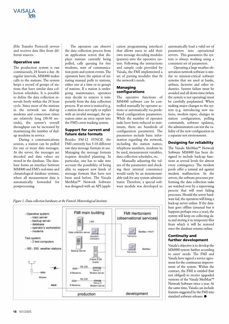
Central stationThe hardware setup of the cen-tral station is shown in figure 1.The central station consists of aproduction system and develop-ment subsystems, each havingtheir own servers and modems.New PC servers were acquired toreplace the old servers, whichwere running under an Open-VMS (Virtual Memory System)operating system. Once the datahas been collected from weatherstations, it is stored in an Oracle
9i database running in high-availability cluster servers.
Vaisala MetMan™ NetworkSoftware MM400 uses the samemodem bank as the old system.Utilizing the existing hardwarenot only resulted in cost savingsfor the FMI but also guaranteedthere would be no problems dueto mismatch between AWSmodems and central weather sta-tion modems. The modems atthe data collection center havebeen divided into three groups.Any modem in a given groupcan be used to call stations thathave a similar type of modem.Currently, the system has beenequipped with 20 modems. Inaddition to dial-up modems, thesystem polls data from FTP
167/2005 17
Finnish Meteorological Institute Modernizes Automatic Weather Stations Data Collection System
Sami LeinoProduct ManagerVaisalaHelsinki, Finland
Vaisala MetMan™ Network Software MM400 wastaken into operative use at the Finnish MeteorologicalInstitute (FMI) in April 2004. The software controls dataacquisition in the national observation networkconsisting of 193 weather stations.
➤
(File Transfer Protocol) serversand receives data files from dif-ferent sources.
Operative useThe production system is runcontinuously, 24 hours a day. Atregular intervals, MM400 makescalls to the stations. The systemkeeps a record of groups of sta-tions that have similar data col-lection schedules. It is possibleto define the data collection in-tervals freely within the 24 hourcycle. Since most of the stationsin the network use dial-upmodems and connection timesare relatively long (30-50 sec-onds), the system’s overallthroughput can be increased bymaximizing the number of dial-up modems in service.
During a communicationssession, a station can be polledfor one or more data messages.At the server, the messages aredecoded and data values arestored in the database. The data-base forms an interface betweenMM400 and FMI's real-time andclimatological database systems,where all measurement data isautomatically forwarded forpostprocessing.
The operators can observethe data collection process froman application screen that dis-plays stations currently beingpolled, calls queuing for freemodems, state of communica-tion ports and system events. Theoperators have the option of ini-tiating manual polls to stations,either one at a time or to groupsof stations. If a station is under-going maintenance, operatorsmay decide to remove it tem-porarily from the data collectionprocess. If an error is noticed (e.g.a station does not reply or replieswith an invalid message), the op-erators enter an error report intothe FMI's error tracking system.
Support for current andfuture data formatsBesides FM-12 SYNOP, theFMI currently has 5-10 differentraw data message formats in use.Managing the message formatsrequires detailed planning. Inparticular, one has to take intoaccount the possibility of beingable to support new kinds ofmessage formats that have notbeen used before. The VaisalaMetMan™ Network Softwarewas designed with an API (appli-
cation programming interface)that allows users to add theirown message decoding modules(parsers) into the operative sys-tem. Following the instructionsand sample code provided byVaisala, the FMI implemented aset of parsing modules that fitthe network's needs.
Managing configurations The operative functions ofMM400 software can be con-trolled manually by operator ac-tions or automatically via prede-fined configuration parameters.While the number of operatortasks have been reduced to min-imum, there are hundreds ofconfiguration parameters. Theparameters include basic infor-mation regarding the network,including the station names,telephone numbers, modems tobe used, measurement variables,data collection schedules, etc.
Manually adjusting the val-ues of the parameters and check-ing their internal consistencywould easily be an insurmount-able task for any system adminis-trator. Therefore, a special soft-ware module was developed to
automatically load a valid set ofparameters into operationalservers. This guarantees the sys-tem is always working using aconsistent set of parameters.
Operating a large weather ob-servation network software is sim-ilar to mission-critical softwaresystems that are used at banks,airlines, factories and other in-dustries. System failure must beavoided and all down-time (whenthe system is not operating) mustbe carefully preplanned. Whenmaking major changes to the sys-tem (e.g. introducing new sta-tions, modem types, changes instation configuration, pollingcommands, software updates),the administrators can test the va-lidity of the new configuration ina separate test environment.
Designing for reliabilityThe Vaisala MetMan™ NetworkSoftware MM400 has been de-signed to include back-up func-tions at several levels for almostevery contingency. The modempools offer a natural aid againstmodem malfunction. In theservers, the software processes per-forming the data collection tasksare watched over by a supervisingprocess that will reset failingprocesses. Should the server hard-ware fail, the operators will bring aback-up server online. If the data-base goes offline (unusual but ithappens perhaps once a year), thesystem will keep on collecting da-ta and storing it in temporary filesfrom which it will be restoredonce the database returns online.
Continuity and further developmentVaisala's objective is to develop theMM400 system further accordingto users' needs. The FMI andVaisala have signed a service agree-ment for the continuous improve-ment of the system. Within thecontract, the FMI is entitled (butnot obliged) to receive upgradedversions of the Vaisala MetMan™Network Software twice a year. Atthe same time, Vaisala can includefeatures suggested by the FMI intostandard software releases. ●
18 167/2005
Figure 1. Data collection hardware at the Finnish Meteorological Institute.
A bout twenty years ago,many national meteo-rological services be-
gan to look at their synoptic dataharvesting activities in a newway. They started to call for au-tomated sounding systems thatwould allow their skilled person-nel to reduce the time devotedto the routine, manual tasks ofupper-air sounding. Vaisala an-swered the call by introducingsuccessive generations of sound-ing systems that offered increas-ingly sophisticated automatedfunctions. Today, Vaisala cus-tomers have considerable flexi-bility when they investigate waysto build sounding automationinto an upper-air network.
This flexibility extends tothe services that Vaisala offers insupport of our sounding sys-tems. In recent years, we havestrengthened our service offeringby creating a number of “serviceproducts” that are grouped un-der the umbrella of the VaisalaService Contract. These serviceproducts have been well-re-ceived: some 15 national meteo-rological services are now VaisalaService Contract customers. Wewill continue to improve ourcurrent portfolio of services butwe are also keen to explore en-tirely new ways of serving youbetter.
Core versus contextAt the 4th Annual Meeting ofthe European MeteorologicalSociety (EMS), held in Nice,France, I gave a presentation to aroom full of national meteoro-logical service representatives.My presentation asked the basicquestion: “Are there other ways
to harvest synoptic observationdata?” The background to thisquestion is the fact that in everyarea of business today, compa-nies are taking a complete inven-tory of their business activities.They are defining their “core ac-tivities” (activities critical tobusiness success) and “context”activities (activities that are notcritical to business success).Once their context activities aredefined, companies are improv-ing their bottom-line efficiencyby outsourcing these activities to
subcontractor partners that arebetter equipped to carry themout.
During my EMS presenta-tion, I asked the audiencewhether they thought it was pos-sible to operate their upper-airnetworks more efficiently in fu-ture. I now ask the same ques-tion of you: are you attemptingto define the core activities relat-ed to operating your upper-airnetwork? Are you attempting todefine the context activities?What is the balance between the
two? Is it possible to look at thewhole area of synoptic data har-vesting in terms of core activityvs. context activity?
I have asked a lot of ques-tions and the only way to answerthem is to begin a discussionwith you about the future ofsynoptic data harvesting. If youare interested in such a discus-sion, please contact me([email protected]). Youwill find that Vaisala has a lot ofknowledge, expertise and inter-est to contribute. ●
167/2005 19
A New Look at Synoptic Data Harvesting
What options might the future hold? Is it possible to operate upper-air networks more efficiently?
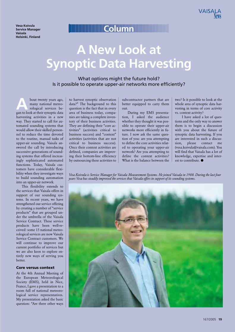
Vesa KoivulaService ManagerVaisalaHelsinki, Finland
Vesa Koivula is Service Manager for Vaisala Measurement Systems. He joined Vaisala in 1988. During the last fouryears Vesa has steadily improved the services that Vaisala offers in support of its sounding systems.
Column
R adio-frequency applica-tions range from a fewkHz to several hundred
GHz, and make use of a varietyof radio technologies, such astelecommunication (e.g. for ra-
diosondes or satellites), radars(precipitation and windprofilers)and teledetection (e.g. passivesatellite remote sensing or light-ning detection).
In 2002, the International
Telecommunication Union(ITU) and the World Meteoro-logical Organization (WMO) is-sued a Handbook on the “Use ofradio spectrum for meteorol-ogy”. It describes in detail all therelated applications, including:
- Radiosondes operatingmainly in the 400 and 1700MHz bands
- Weather radars operatingmainly at 2.8, 5.6 and 9.4 GHz
- Windprofilers operatingmainly in the 400 and 1300MHz bands
- Earth exploration by satel-lite (passive), performing measureson natural radiation in frequencybands that depend on physicallaws (e.g. 1.4 GHz, 24 GHz, andup to 200 GHz nowadays)
- Earth exploration by satel-lite (active) for physical measures(altimeters, cloud profiling andprecipitation detection), e.g. inthe 1.3, 5, 9.5, and 35 GHz bands
- Lightning detection inbands around 100 kHz
Apart from certain purely pas-sive bands used for the passivesensing of the atmosphere, the fre-quency bands allocated to meteo-rological uses are in general sharedwith other radiocommunicationservices under regulatory or tech-nical conditions that in theoryshould allow all applications tooperate on a nominal basis.
Radio regulationsThe provisions mentioned aboveare given in the “Radio Regula-tions”, an international treaty elab-orated during the ITU World Ra-diocommunication Conferences(WRC) held every 3 or 4 years.
Each WRC agenda consists
of specific issues that can request,for example, a new frequency al-location for a given type of ser-vice or elaborate new regulatoryregimes for certain applications.
The preparation for WRC isa careful process, allowing for allthe necessary technical studiesand the preparation of argu-ments both for and against by alladministrations and representa-tive organizations.
The preparation takes placein a number of Working Parties(WP) within ITU. WP 7B, 7C,and 8B for radars are specializedin meteorological issues. Thesegroups are attended by a numberof meteorological administra-tions, radiocommunication regu-lators and WMO representa-tives. The Study Group for RadioFrequency Coordination (SG-RFC) of the WMO is normallyheld prior to WP 7B and 7C tocoordinate positions among me-teorological administrations.
Meteorological issuesat WRCsAs an example, the possible in-troduction of Mobile Satelliteapplications (so-called littleLEOs) in the 400.15-406 MHzfrequency bands has been on theagenda of the Conferences since1995. These applications havethe potential to drastically con-strain radiosonde operations byproducing interference levelsthat would reduce data availabil-ity. Facing this threat, the meteo-rological community becameconvinced that the protection ofthe part of the spectrum used formeteorological operations wasessential. After considerable
20 167/2005
Managing Radio Spectrum for Meteorology
Philippe TristantFrequency CoordinatorMeteo France, Toulouse
Radio frequencies are scarce key resources for themeteorological community to either collect theobservation data upon which its predictions are basedor to process and disseminate weather information andwarnings to the public.
W RC-03 held in Genevahad a long agenda
presenting more than 40 dif-ferent items. Apart from theprotection of radiosondes inthe 400 MHz band from Mo-bile Satellite applications, themain items included:
- The Conference allocat-ed the 5 GHz band for RadioLANs systems (i.e. high datarate WIFI). However, the Con-ference imposed limitationsto RLANs, such as power limitsand indoor use to protectEarth exploration (active) inthe 5250-5350 MHz band, aswell as power and EIRP limitsand mitigation techniques,such as power control or Dy-namic Frequency Selection(DFS), to protect radars, in-cluding weather radars in the5600-5650 MHz band.
- The protection of passiveservices (EESS and Radioas-tronomy) from unwantedemissions, in particular fromthose produced by space ser-vices transmissions. No specif-ic regulation has been drawnbut the Conference decidedthat the problem of unwant-ed emissions into passivebands will have to be furtherstudied and technical regula-
tions put in place.- Radionavigation services
issues, with primary interest inEurope with regard to theGALILEO system. Meteorologi-cal interest concerned the pro-tection of the radiolocationservice in the 1270-1295 MHzband used by wind profilerradars. Radionavigation-satel-lite service in the band 1215-1300 MHz was requested notto cause harmful interferenceto the radiolocation service,including windprofilers.
- The Conference allocatedthe band 1668-1675 MHz tomobile satellite applications. Italso urged administrations notto implement new radiosondesystems in the band 1668.4-1675 MHz and encouragedthem to migrate existing ra-diosonde operations to otherbands as soon as practicable.The interests of the Meteoro-logical Satellite Service in thesame frequency range havebeen safeguarded, since theConference agreed that in theband 1670-1675 MHz, stationsin the mobile-satellite servicewill not cause harmful inter-ference to, nor constrain thedevelopment of, existing me-teorological earth stations. ●
Summary of WRC-03 Outcomes
technical and operational debatespanning 8 years, as well as polit-ical discussions during the relat-ed WRCs, the consistent in-volvement of the meteorologicalcommunity has been successful.WRC-2003 decided to close thedebate and not allow MobileSatellite applications in the400.15-406 MHz band.
This involvement also gavesuccessful results during WRC-2000, in preparation for whichsome administrations were pro-posing the 2.7-2.9 GHz frequen-cy band, used by a number ofweather radars worldwide, as apossible extension band for theIMT-2000 mobile phone (bestknown as 3G). Thanks to the ac-tions taken, the IMT-2000 appli-cations were finally allocated tothe 2.5-2.7 GHz band.
The protection of passivebands used for satellites is alsoworth mentioning, since it repre-sents a very specific issue that is re-peatedly on the WRC agenda.These applications, essential formeteorological forecasts, involvethe measurement of naturally oc-curring radiations at very lowpower levels. The appropriatebands are uniquely determined bythe physical properties (e.g. mo-lecular resonance), which cannotbe moved and are therefore im-portant natural resources. Low lev-els of interference (from in-bandor out-of-band interferers) re-ceived at the input of the passivesensors may have a degrading im-pact on the use of passive frequen-cy bands, especially since they arenot able to discriminate betweennatural radiations and manmadeemissions or radiations. Compati-
bility with passive applicationsneeds to be very carefully studiedto avoid any risk of harmful inter-ference that would render the cor-responding bands unusable andlost for meteorological forecasts.
Other frequency issuesEven though WRC issues repre-sent a large part of frequencymanagement, there are also otherregular topics that are consideredeither at ITU or regional levels.
For example, within ITU,WP7C is currently reviewing theRecommendations dealing withradiosonde characteristics, perfor-mance and interference criteria.WP 8B has initiated work towardsa better understanding of radarprotection criteria. The meteoro-logical community needs to beinvolved with both issues. It canlead a review of the conditionsunder which meteorological ap-plications could share their bandswith other services.
On a European level, theharmonization of spectrum useand possible introduction ofnew applications produce con-tinuous work aiming at theadoption of European Deci-sions. A few years ago, this workled to the adoption of a regula-
tion allowing Active Medical Im-plants (AMI) in the 402-405MHz band with adequate powerlimitations to protect radiosondeoperations.
More recently, the introduc-tion of automotive short-rangeradars (SRR) in the 24 GHzband has led to active debate.These SRR systems, supportedby a powerful automotive lobby,were intended to use a 5 GHzbandwidth centered at 24.15GHz and hence transmitting inthe passive band 23.4-26 GHz, a
band of crucial importance tothe water vapor absorption line.The final decision is not totallysatisfactory since these applica-tions have been allowed to oper-ate in this frequency band but,thanks to the participation ofthe scientific and meteorologicalcommunities, only on a limitedbasis in number (max 7% of carsequipped) and until 2013, afterwhich these devices will have tooperate in the 79 GHz band.
Currently, two particular is-sues of interest to the mete-
167/2005 21
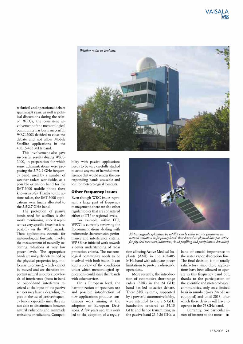
Weather radar in Toulouse.
➤
Meteorological exploration by satellite can be either passive (measures onnatural radiation in frequency bands that depend on physical laws) or activefor physical measures (altimeters, cloud profiling and precipitation detection).
orological community are ongo-ing at a European level:
- The compatibility betweenwind profiler radars (WPR) oper-ating in the 1270-1295 MHz bandand the future European Radio-navigation system, GALILEO.Initial technical studies performedby Vaisala pointed out potentialinterference to WPR that could re-sult in a substantial degradation ofthe availability of wind data. De-spite the outcome of WRC-03,and acknowledging the Europeanpriority given to GALILEO, themeteorological community is re-quested to study, within theECC/SE39 project team, the fea-sibility of possible mitigation tech-niques to apply to WPR thatcould improve the compatibilitybetween the two applications.
- The compatibility of“generic” Ultra-Wide Band(UWB) applications, i.e. newtechnologies that use severalGHz bandwidth and may covermultiple frequency ranges andpotentially impact a large num-ber of radio services in all fre-quency bands, currently be-tween 1 and 10 GHz. The gener-al concept of designated fre-quency bands in the Radio Reg-ulations is not relevant for regu-lating these types of applica-tions. The situation in Europe iscomplicated by the fact that theUnited States has already au-thorized these applications, withthe maximum power densitylimit (-41.3 dBm/MHz). Howev-er, all studies presented in Eu-rope, related in particular toEarth exploration (passive andactive) and all weather radarbands, show that this power lim-it is not sufficiently low to en-sure the protection of the corre-sponding services from the ag-gregate interference produced bythe thousands of such UWB de-vices that are expected to be im-plemented in telecommunica-tions, broadcasting and comput-er equipment. This issue is han-dled within a specific task groupin ECC (TG3) as well as in itscounterpart in ITU (TG 1/8) andthe situation is likely to transfer
onto the political playground, inview of the economical potentialof the UWB applications. Here,again, the participation of themeteorological community isnecessary to make sure our inter-ests are safeguarded.
Future trends and necessary actionsPeople around the world arehoping for communications fa-cilities that are easy to handle,without constraints and allowfor wireless connections athome, in the office or from anyremote area. To satisfy this de-mand, the inventiveness of newtechnology and skillfulness of ra-dio engineers have almost nolimits.
The new applications, suchas mobile phones, WIFI, UWBor satellite, demand more andmore bandwidth and improvedflexibility in the use of spectrum.They are also supported by pow-erful economical lobbies.
Even though we all take ad-vantage of these facilities, thetrend presents a growing threatto the frequency bands used formeteorological purposes andcould tremendously impact me-teorological forecasts and warn-ing capability with related finan-cial consequences.
The meteorological commu-nity is convinced that the protec-tion of the part of the spectrumused for meteorological opera-tions is essential. Thus it has mo-bilized to actively participate inthe different related forums. Col-laboration between meteorologi-cal services, researchers and in-dustry is essential and must con-tinue in order to safeguard the cur-rent and future use of frequencybands for meteorological pur-poses.
The international decision-making process is in general in-fluenced by national radiocom-munications authorities thathave to satisfy telecommunica-tions needs. This sets limitationson our involvement.
The meteorological commu-nity should be aware that action
22 167/2005
WRC-07 Agenda
W RC-03 agreed on the agenda for the next WRC, sched-uled for 2007. The agenda contains 20 items, including:
- The extension of the current 18.1-18.3 GHz geostationarymeteorological satellites' allocation and the protection of pas-sive bands 10.6-10.68 GHz and 36-37 GHz.
- The possible upgrading of the status of the radiolocationservice 9000-9200 MHz and 9300-9500 MHz, the latter being al-located to weather radars, and extending the existing alloca-tions to the Earth exploration-satellite service (active) in theband 9500-9800 MHz by up to 200 MHz.
- The compatibility between the fixed-satellite service andother services around 1.4 GHz, and in particular the protectionof the passive 1400-1427 MHz from unwanted emissions.
- The results of studies and proposals for regulatory mea-sures regarding the protection of the Earth exploration-satelliteservice (passive) from unwanted emissions.
These four items represent important issues for the meteo-rological community either to ensure the protection of existingbands or to get new allocations to prepare for future use.
In addition, several agenda items for WRC-07 do not direct-ly concern meteorological interests but, due to their wide scopein terms of frequency ranges, may have an impact on frequencybands used for meteorological purposes and will therefore alsoneed to be cautiously considered.
The preparation for WRC-07 has already started. It is first tak-ing place in the ITU but also at national and regional levels whereinitial positions are elaborated. For example, 46 European coun-tries have a common preparation within the Conference Prepara-tory Group (CPG) of the Electronic Communication Committee,which is assumed to prepare the European Common Proposals(ECP). Meteorological administrations are able to participate with-in their national delegation. EUMETNET, currently representing 19European meteorological administrations, is a recognized observ-er of the CPG process and fully entitled to contribute to the debateand voice the positions of the meteorological community. ●
through international bodieswould be significantly facilitatedby consistent action on a nation-al basis by meteorological ser-vices, researchers and manufac-turers. We need to voice the es-sential need for accurate meteo-
rological forecast and the neces-sity to maintain the availabilityof the frequency bands used formeteorological purposes. ●
Further information:[email protected]
Philippe Tristant is the FrequencyCoordinator of Meteo France(Toulouse). He is also managingthe EUMETNET program on the“protection of radio-frequencies”(EUMETFREQ) and is amember of the Study Group forRadio Frequency Coordination(SG-RFC) of the WMOCommission for Basic systems.
S ince 8 April 2000, manu-facturers placing telecom-munications terminals
and radio equipment on the Eu-ropean Union market have beenable to use the most advancedconformity assessment proce-dure in the world. With radioequipment, the procedure re-placed national approval sys-tems. With telecommunicationsterminal equipment (includingthe terminals of some Europeanharmonized radio networks, likeGSM), it replaced its predeces-sor, the TelecommunicationsTerminal Directive (98/13/EC),with more flexible procedures.All equipment placed on themarket after 7 April 2001 has tocomply with R&TTE Directive1999/5/EC.
The R&TTE Directive doesnot define the details of technicalrequirements. However, it doesoutline some subject areas for es-sential requirements, such as:
• Safety• Electromagnetic Compati-
bility (EMC)• Efficient use of the radio
frequency spectrum• Additional requirements
for some specified reasons, ap-plicable only by a specific Com-mission Decision
The interpretation in techni-cal terms is described in the Har-monized Standards. These aredrafted on the basis of mandatesfrom the European Commission(EC) given to the EuropeanTelecommunications StandardsInstitute (ETSI) and the Euro-pean Committee for Elec-trotechnical Standardization
(CENELEC). However, theHarmonized Standards are notthe only possible interpretationof the essential requirements.With the help of a third party,the so-called Notified Body, amanufacturer can also apply oth-er, equivalent specifications,standards and test methods. Therole of the Notified Body is toact as a consultant. The manu-facturer always carries full re-sponsibility for equipment andprocedures.
The manufacturer can inde-pendently carry out full con-formity assessments. The onlyexception is when the Harmo-nized Standards route is not tak-en, as described above. The man-ufacturers are allowed to performthe necessary tests in their ownlaboratory or in an outside labor-atory. The Directive does not de-mand the laboratories used to beaccredited, but since the manu-facturer always carries full re-sponsibility, the use of accredit-ed laboratories is often favored.
EU directives and national restrictions There is a dilemma in that whilethere should be EU wide recog-nition of conformity assessment,the use of radio frequencies isnot harmonized within the EU.Thus placing equipment on themarket and taking it into use aretwo different things. The require-ments for conformity assessmentare a set of parameters (con-tained in the Harmonized Stan-dards or other equivalent specifi-cations), which are the same forall EU states – and complyingwith these is a condition
167/2005 23
Pentti LindforsTechnical DirectorFinnish Communications Regulatory AuthorityRadio FrequenciesHelsinki, Finland
EU manufacturers need to ensure that allequipment placed on the market complieswith R&TTE Directive 1999/5/EC.
Radio and Telecommunications Terminal Equipment Directive
Ilkka IkonenManager, Spectrum MattersVaisalaHelsinki, Finland
R adiosondes, among all other radio equipment, need tomeet EU Directive 1999/5/EC on radio equipment and
telecommunications terminal equipment and the mutual recog-nition of their conformity. The Vaisala RS92 Radiosonde familycomplies with this requirement through an EU harmonized stan-dard.
The EU harmonized standard for radiosonde transmitters isa European Telecommunications Standards Institute (ETSI) stan-dard, EN 302 054. This harmonized standard, prepared by ETSIon the basis of a mandate from the European Commission, rep-resents a common interpretation of the essential requirementsby the standardization community. The EN 302 054 standardcovers radiosonde transmitters with digital transmission.
Because there are no EU harmonized standards for analogradiosonde transmitters, the placing on the EU market of anynew analog transmitter would require the involvement of a No-tified Body, whose task is to define the manufacturer test speci-fications, to fulfill the essential requirements of the R&TTE Di-rective. General technical development promotes digital trans-missions, which comply with the International Telecommunica-tion Union (ITU) recommendations to improve the radio fre-quency characteristics of radiosonde transmitters.
The development of the standard for the 1680 MHz ra-diosonde transmitter is currently in progress in ETSI, and is ex-pected to be harmonized in 2006. ●
➤
The Vaisala RS92 Family of Radiosondes Meet the Harmonized EU Standard
for placing equipment on themarket. When taking equipmentinto use, the manufacturer isobliged to inform the user of na-tional restrictions.
To enable the manufacturersto give such information, nationalfrequency authorities have the ob-ligation to publish information onnational frequency usage. On thebasis of this, the EC has drawn upa simple classification system forequipment. Radio equipment forwhich usage is harmonized in theEU belongs to Class 1. Others,not belonging to Class 1, belongto Class 2. For these, the final stepin placing equipment on the mar-ket is to notify the national fre-quency authorities of the coun-tries in question about this inten-tion. The notification contains in-formation that is necessary toevaluate whether the equipmentreally complies with national fre-quency restrictions.
Apart from stipulations forthe conformity assessment of thetechnical requirements, the Di-rective defines a marking system,where, in addition to the CEmark, the four digit number(s) ofthe notified body or bodiesshould be included. For all Class2 cases this should be followedby the alert symbol. Additional-ly, each product should carry ashort Declaration of Conformity(in English: Hereby, [Name ofmanufacturer], declares that this[type of equipment] is in com-pliance with the essential require-ments and other relevant provi-sions of Directive 1999/5/EC).This comes in all the official lan-guages of the EU states and in-cludes a contact address wherethe complete original documentis available, e.g. a web address.Restrictions on taking equip-ment into use must be explainedin the user manual and on thepackaging. ●
D ropwindsonde Observa-tions for Typhoon Sur-veillance near the Tai-
wan Region, i.e. DOTSTAR, isan international research pro-gram conducted by meteorolo-gists in Taiwan. It is carried outin cooperation with scientists atthe Hurricane Research Division(HRD) and the National Cen-ters for Environmental Predic-tion (NCEP) of the NationalOceanic and Atmospheric Ad-
ministration (NOAA). The program is based on
successful surveillance missionsconducted in the Atlantic withNOAA's Gulfstream-IV jet air-craft. Vaisala RD93 GPS drop-sondes are released from an As-tra jet aircraft flying above 42000ft (12.8 km) in and around trop-ical cyclones approaching Tai-wan. Information from the sur-veillance flights is transmitted innearly real-time to the Central
24 167/2005
Typhoon Surveillance inNorthwestern Pacific
Chun-Chieh Wu,Po-Hsiung LinDepartment of Atmospheric Sciences National Taiwan UniversityTaipei, Taiwan
Sim AbersonHurricane Research DivisionAOML/NOAAMiami, USA
An international research program investigating typhoons in theNorthwestern Pacific utilizes Vaisala RD93 dropsondes to improvedata provision and quality.
The Astra SPX jet releasing a dropsonde (circled) during a test flight in March, 2003.
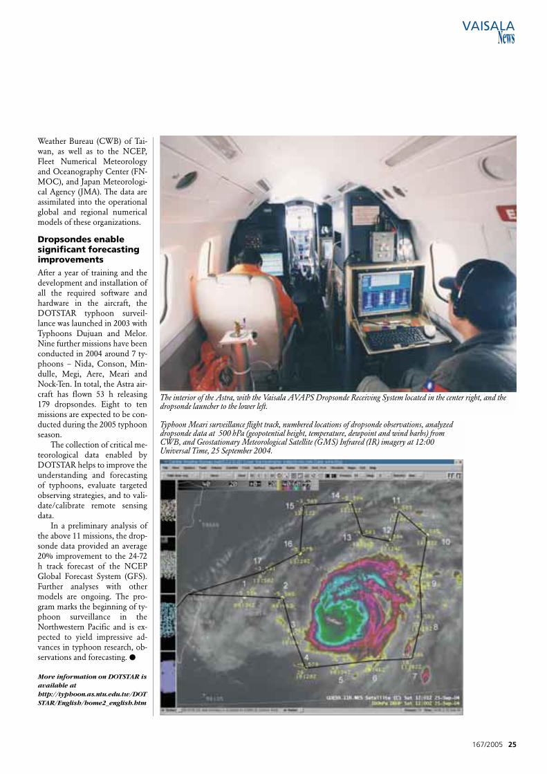
Weather Bureau (CWB) of Tai-wan, as well as to the NCEP,Fleet Numerical Meteorologyand Oceanography Center (FN-MOC), and Japan Meteorologi-cal Agency (JMA). The data areassimilated into the operationalglobal and regional numericalmodels of these organizations.
Dropsondes enable significant forecastingimprovements After a year of training and thedevelopment and installation ofall the required software andhardware in the aircraft, theDOTSTAR typhoon surveil-lance was launched in 2003 withTyphoons Dujuan and Melor.Nine further missions have beenconducted in 2004 around 7 ty-phoons – Nida, Conson, Min-dulle, Megi, Aere, Meari andNock-Ten. In total, the Astra air-craft has flown 53 h releasing179 dropsondes. Eight to tenmissions are expected to be con-ducted during the 2005 typhoonseason.
The collection of critical me-teorological data enabled byDOTSTAR helps to improve theunderstanding and forecastingof typhoons, evaluate targetedobserving strategies, and to vali-date/calibrate remote sensingdata.
In a preliminary analysis ofthe above 11 missions, the drop-sonde data provided an average20% improvement to the 24-72h track forecast of the NCEPGlobal Forecast System (GFS).Further analyses with othermodels are ongoing. The pro-gram marks the beginning of ty-phoon surveillance in theNorthwestern Pacific and is ex-pected to yield impressive ad-vances in typhoon research, ob-servations and forecasting. ●
More information on DOTSTAR isavailable athttp://typhoon.as.ntu.edu.tw/DOTSTAR/English/home2_english.htm
167/2005 25
Typhoon Meari surveillance flight track, numbered locations of dropsonde observations, analyzeddropsonde data at 500 hPa (geopotential height, temperature, dewpoint and wind barbs) fromCWB, and Geostationary Meteorological Satellite (GMS) Infrared (IR) imagery at 12:00Universal Time, 25 September 2004.
The interior of the Astra, with the Vaisala AVAPS Dropsonde Receiving System located in the center right, and thedropsonde launcher to the lower left.
T he unexpected eventhappened during the M 56 METEOR Expedi-
tion, which commenced on 20November 2002 in Cameroon atDouala and terminated atCapetown in South Africa on 28December 2002. The scientificobject of the Expedition, led byProf. Dr. Volkard Spiess of theDepartment of Geosciences atthe University of Bremen inGermany, was to investigatePockmarks in the Congo Basin.Pockmarks are depressions onthe prehistoric seabed of severalhundred meters in diameter andseveral dozens of meters deep.
The quantification of the oc-currence of gas hydrate in con-nection with an intensive up-ward surge of fluid material – inparticular, methane gas – was thepoint of emphasis of the M 56METEOR Expedition. Particu-larly unusual were the aerologi-cal upsurges which occurred on21 December 2002.
Wherever the wind blowsA Vaisala Radiosonde RS80-15Gwas launched at 09:00h UTC toreach an altitude of some 21,500meters, which could well be de-scribed as a successful ascent. At
around 12:10h, the radiosondelanded onto the ship's deck, to-gether with the remains of theballoon. It had commenced itsflight to the East and thenveered round to the West SouthWest, until it had finally turnedthrough 270° – after having putin an intermittent course to theNorth – and returned preciselyto its point of departure by de-scending onto the deck. Theship FS Meteor had not movedfrom its morning position dur-ing the whole of the ascent andhad remained precisely constantat 6.2°S, /10.4° E, as at the timeof the launch of the radiosonde.
Overall, the radiosonde – look-ing to the West – had been some7 kilometers distant.
The remains of the ra-diosonde stirred great interestamongst the crew. Everythingwas still there but in a consider-ably dilapidated state. It was ap-parent that the battery had beendamaged; this was confirmed bythe intensive odor of sulphuricacid, comparable to that of astink bomb. It was necessary towait a whole week for the ra-diosonde to “air” and the odorto dissipate before being able tosalvage it from the deck. ●
26 167/2005
An expedition team investigating Pockmarks in the CongoBasin witnessed an unusual turn of events when a VaisalaRadiosonde RS80-15G faithfully returned to its senders.
A Perfect Landing
Thorsten TruscheitDeutscher WetterdienstHamburg, Germany
German research vesselFS Meteor.
The remains of theVaisala RadiosondeRS80-15G after itsunexpected homecoming.
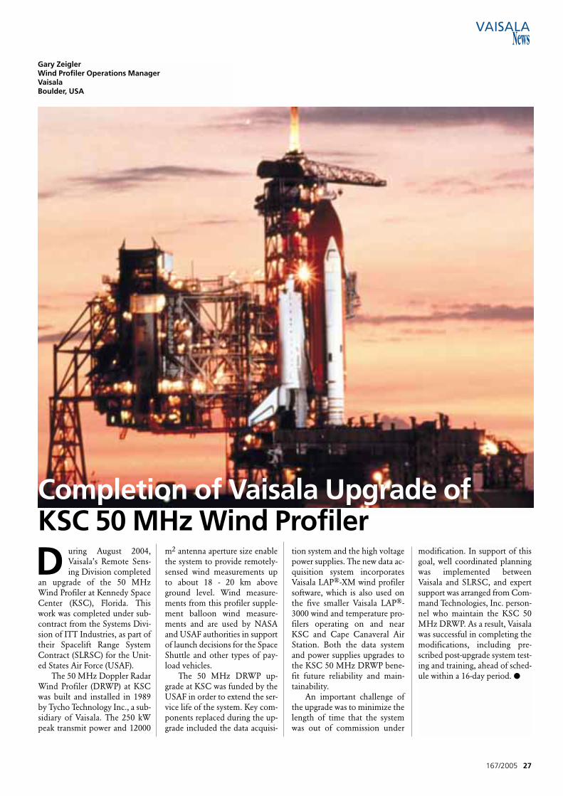
D uring August 2004,Vaisala’s Remote Sens-ing Division completed
an upgrade of the 50 MHzWind Profiler at Kennedy SpaceCenter (KSC), Florida. Thiswork was completed under sub-contract from the Systems Divi-sion of ITT Industries, as part oftheir Spacelift Range SystemContract (SLRSC) for the Unit-ed States Air Force (USAF).
The 50 MHz Doppler RadarWind Profiler (DRWP) at KSCwas built and installed in 1989by Tycho Technology Inc., a sub-sidiary of Vaisala. The 250 kWpeak transmit power and 12000
m2 antenna aperture size enablethe system to provide remotely-sensed wind measurements upto about 18 - 20 km aboveground level. Wind measure-ments from this profiler supple-ment balloon wind measure-ments and are used by NASAand USAF authorities in supportof launch decisions for the SpaceShuttle and other types of pay-load vehicles.
The 50 MHz DRWP up-grade at KSC was funded by theUSAF in order to extend the ser-vice life of the system. Key com-ponents replaced during the up-grade included the data acquisi-
tion system and the high voltagepower supplies. The new data ac-quisition system incorporatesVaisala LAP®-XM wind profilersoftware, which is also used onthe five smaller Vaisala LAP®-3000 wind and temperature pro-filers operating on and nearKSC and Cape Canaveral AirStation. Both the data systemand power supplies upgrades tothe KSC 50 MHz DRWP bene-fit future reliability and main-tainability.
An important challenge ofthe upgrade was to minimize thelength of time that the systemwas out of commission under
167/2005 27
Completion of Vaisala Upgrade of KSC 50 MHz Wind Profiler
Gary ZeiglerWind Profiler Operations ManagerVaisalaBoulder, USA
modification. In support of thisgoal, well coordinated planningwas implemented betweenVaisala and SLRSC, and expertsupport was arranged from Com-mand Technologies, Inc. person-nel who maintain the KSC 50MHz DRWP. As a result, Vaisalawas successful in completing themodifications, including pre-scribed post-upgrade system test-ing and training, ahead of sched-ule within a 16-day period. ●
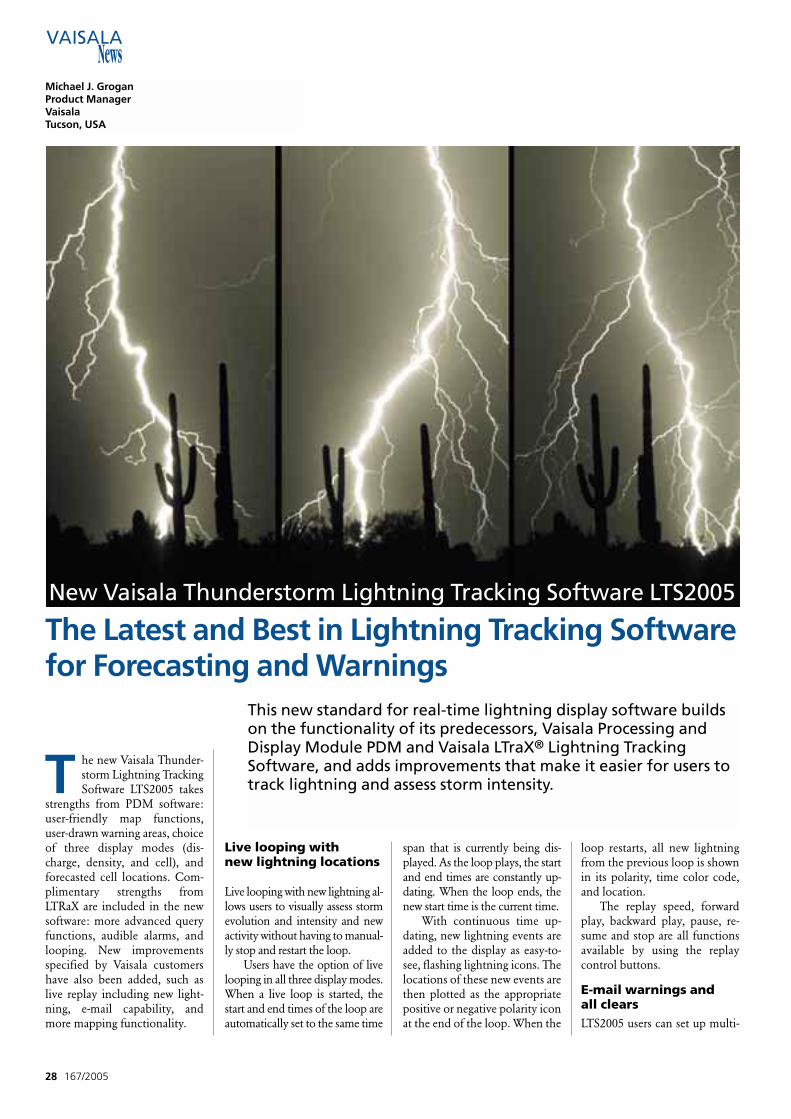
T he new Vaisala Thunder-storm Lightning TrackingSoftware LTS2005 takes
strengths from PDM software:user-friendly map functions,user-drawn warning areas, choiceof three display modes (dis-charge, density, and cell), andforecasted cell locations. Com-plimentary strengths fromLTRaX are included in the newsoftware: more advanced queryfunctions, audible alarms, andlooping. New improvementsspecified by Vaisala customershave also been added, such aslive replay including new light-ning, e-mail capability, andmore mapping functionality.
Live looping with new lightning locations
Live looping with new lightning al-lows users to visually assess stormevolution and intensity and newactivity without having to manual-ly stop and restart the loop.
Users have the option of livelooping in all three display modes.When a live loop is started, thestart and end times of the loop areautomatically set to the same time
span that is currently being dis-played. As the loop plays, the startand end times are constantly up-dating. When the loop ends, thenew start time is the current time.
With continuous time up-dating, new lightning events areadded to the display as easy-to-see, flashing lightning icons. Thelocations of these new events arethen plotted as the appropriatepositive or negative polarity iconat the end of the loop. When the
loop restarts, all new lightningfrom the previous loop is shownin its polarity, time color code,and location.
The replay speed, forwardplay, backward play, pause, re-sume and stop are all functionsavailable by using the replaycontrol buttons.
E-mail warnings and all clearsLTS2005 users can set up multi-
28 167/2005
Michael J. GroganProduct ManagerVaisala Tucson, USA
This new standard for real-time lightning display software buildson the functionality of its predecessors, Vaisala Processing andDisplay Module PDM and Vaisala LTraX® Lightning TrackingSoftware, and adds improvements that make it easier for users totrack lightning and assess storm intensity.
New Vaisala Thunderstorm Lightning Tracking Software LTS2005
The Latest and Best in Lightning Tracking Softwarefor Forecasting and Warnings
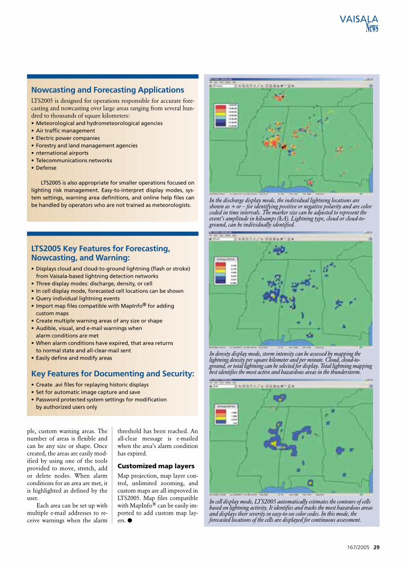
ple, custom warning areas. Thenumber of areas is flexible andcan be any size or shape. Oncecreated, the areas are easily mod-ified by using one of the toolsprovided to move, stretch, addor delete nodes. When alarmconditions for an area are met, itis highlighted as defined by theuser.
Each area can be set up withmultiple e-mail addresses to re-ceive warnings when the alarm
threshold has been reached. Anall-clear message is e-mailedwhen the area’s alarm conditionhas expired.
Customized map layersMap projection, map layer con-trol, unlimited zooming, andcustom maps are all improved inLTS2005. Map files compatiblewith MapInfo® can be easily im-ported to add custom map lay-ers. ●
167/2005 29
In cell display mode, LTS2005 automatically estimates the contours of cellsbased on lightning activity. It identifies and tracks the most hazardous areasand displays their severity in easy-to-see color codes. In this mode, theforecasted locations of the cells are displayed for continuous assessment.
In density display mode, storm intensity can be assessed by mapping thelightning density per square kilometer and per minute. Cloud, cloud-to-ground, or total lightning can be selected for display. Total lightning mappingbest identifies the most active and hazardous areas in the thunderstorm.
In the discharge display mode, the individual lightning locations areshown as + or – for identifying positive or negative polarity and are colorcoded in time intervals. The marker size can be adjusted to represent theevent’s amplitude in kiloamps (kA). Lightning type, cloud or cloud-to-ground, can be individually identified.
Nowcasting and Forecasting ApplicationsLTS2005 is designed for operations responsible for accurate fore-casting and nowcasting over large areas ranging from several hun-dred to thousands of square kilometers:• Meteorological and hydrometeorological agencies• Air traffic management• Electric power companies• Forestry and land management agencies• nternational airports• Telecommunications networks• Defense
LTS2005 is also appropriate for smaller operations focused onlighting risk management. Easy-to-interpret display modes, sys-tem settings, warning area definitions, and online help files canbe handled by operators who are not trained as meteorologists.
LTS2005 Key Features for Forecasting, Nowcasting, and Warning:• Displays cloud and cloud-to-ground lightning (flash or stroke)
from Vaisala-based lightning detection networks• Three display modes: discharge, density, or cell• In cell display mode, forecasted cell locations can be shown• Query individual lightning events• Import map files compatible with MapInfo® for adding
custom maps • Create multiple warning areas of any size or shape• Audible, visual, and e-mail warnings when
alarm conditions are met• When alarm conditions have expired, that area returns
to normal state and all-clear-mail sent• Easily define and modify areas
Key Features for Documenting and Security:• Create .avi files for replaying historic displays• Set for automatic image capture and save• Password protected system settings for modification
by authorized users only
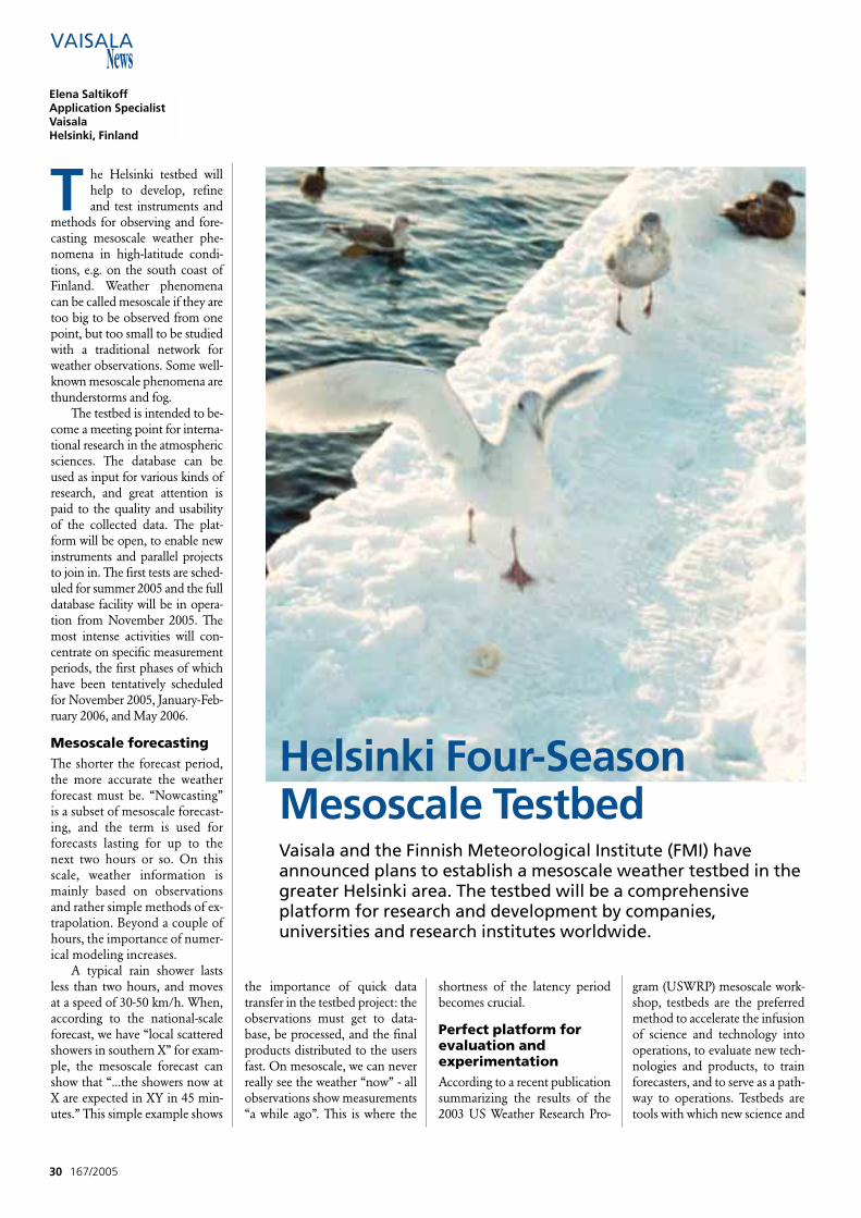
T he Helsinki testbed willhelp to develop, refineand test instruments and
methods for observing and fore-casting mesoscale weather phe-nomena in high-latitude condi-tions, e.g. on the south coast ofFinland. Weather phenomenacan be called mesoscale if they aretoo big to be observed from onepoint, but too small to be studiedwith a traditional network forweather observations. Some well-known mesoscale phenomena arethunderstorms and fog.
The testbed is intended to be-come a meeting point for interna-tional research in the atmosphericsciences. The database can beused as input for various kinds ofresearch, and great attention ispaid to the quality and usabilityof the collected data. The plat-form will be open, to enable newinstruments and parallel projectsto join in. The first tests are sched-uled for summer 2005 and the fulldatabase facility will be in opera-tion from November 2005. Themost intense activities will con-centrate on specific measurementperiods, the first phases of whichhave been tentatively scheduledfor November 2005, January-Feb-ruary 2006, and May 2006.
Mesoscale forecastingThe shorter the forecast period,the more accurate the weatherforecast must be. “Nowcasting”is a subset of mesoscale forecast-ing, and the term is used forforecasts lasting for up to thenext two hours or so. On thisscale, weather information ismainly based on observationsand rather simple methods of ex-trapolation. Beyond a couple ofhours, the importance of numer-ical modeling increases.
A typical rain shower lastsless than two hours, and movesat a speed of 30-50 km/h. When,according to the national-scaleforecast, we have “local scatteredshowers in southern X” for exam-ple, the mesoscale forecast canshow that “...the showers now atX are expected in XY in 45 min-utes.” This simple example shows
the importance of quick datatransfer in the testbed project: theobservations must get to data-base, be processed, and the finalproducts distributed to the usersfast. On mesoscale, we can neverreally see the weather “now” - allobservations show measurements“a while ago”. This is where the
shortness of the latency periodbecomes crucial.
Perfect platform forevaluation and experimentationAccording to a recent publicationsummarizing the results of the2003 US Weather Research Pro-
gram (USWRP) mesoscale work-shop, testbeds are the preferredmethod to accelerate the infusionof science and technology intooperations, to evaluate new tech-nologies and products, to trainforecasters, and to serve as a path-way to operations. Testbeds aretools with which new science and
30 167/2005
Helsinki Four-Season Mesoscale TestbedVaisala and the Finnish Meteorological Institute (FMI) haveannounced plans to establish a mesoscale weather testbed in thegreater Helsinki area. The testbed will be a comprehensiveplatform for research and development by companies,universities and research institutes worldwide.
Elena SaltikoffApplication SpecialistVaisala Helsinki, Finland
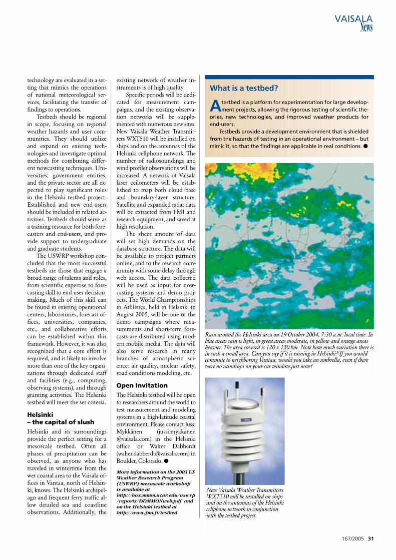
technology are evaluated in a set-ting that mimics the operationsof national meteorological ser-vices, facilitating the transfer offindings to operations.
Testbeds should be regionalin scope, focusing on regionalweather hazards and user com-munities. They should utilizeand expand on existing tech-nologies and investigate optimalmethods for combining differ-ent nowcasting techniques. Uni-versities, government entities,and the private sector are all ex-pected to play significant rolesin the Helsinki testbed project.Established and new end-usersshould be included in related ac-tivities. Testbeds should serve asa training resource for both fore-casters and end-users, and pro-vide support to undergraduateand graduate students.
The USWRP workshop con-cluded that the most successfultestbeds are those that engage abroad range of talents and roles,from scientific expertise to fore-casting skill to end-user decision-making. Much of this skill canbe found in existing operationalcenters, laboratories, forecast of-fices, universities, companies,etc., and collaborative effortscan be established within thisframework. However, it was alsorecognized that a core effort isrequired, and is likely to involvemore than one of the key organi-zations through dedicated staffand facilities (e.g., computing,observing systems), and throughgranting activities. The Helsinkitestbed will meet the set criteria.
Helsinki – the capital of slushHelsinki and its surroundingsprovide the perfect setting for amesoscale testbed. Often allphases of precipitation can beobserved, as anyone who hastraveled in wintertime from thewet coastal area to the Vaisala of-fices in Vantaa, north of Helsin-ki, knows. The Helsinki archipel-ago and frequent ferry traffic al-low detailed sea and coastlineobservations. Additionally, the
existing network of weather in-struments is of high quality.
Specific periods will be dedi-cated for measurement cam-paigns, and the existing observa-tion networks will be supple-mented with numerous new sites.New Vaisala Weather Transmit-ters WXT510 will be installed onships and on the antennas of theHelsinki cellphone network. Thenumber of radiosoundings andwind profiler observations will beincreased. A network of Vaisalalaser ceilometers will be estab-lished to map both cloud baseand boundary-layer structure.Satellite and expanded radar datawill be extracted from FMI andresearch equipment, and saved athigh resolution.
The sheer amount of datawill set high demands on thedatabase structure. The data willbe available to project partnersonline, and to the research com-munity with some delay throughweb access. The data collectedwill be used as input for now-casting systems and demo proj-ects. The World Championshipsin Athletics, held in Helsinki inAugust 2005, will be one of thedemo campaigns where mea-surements and short-term fore-casts are distributed using mod-ern mobile media. The data willalso serve research in manybranches of atmospheric sci-ence: air quality, nuclear safety,road conditions modeling, etc.
Open Invitation The Helsinki testbed will be opento researchers around the world totest measurement and modelingsystems in a high-latitude coastalenvironment. Please contact JussiMykkänen ([email protected]) in the Helsinki office or Walter Dabberdt ([email protected]) inBoulder, Colorado. ●
More information on the 2003 USWeather Research Program(USWRP) mesoscale workshopis available athttp://box.mmm.ucar.edu/uswrp/reports/DDMMONweb.pdf andon the Helsinki testbed athttp://www.fmi.fi/testbed
167/2005 31
Rain around the Helsinki area on 19 October 2004, 7:30 a.m. local time. Inblue areas rain is light, in green areas moderate, in yellow and orange areasheavier. The area covered is 120 x 120 km. Note how much variation there isin such a small area. Can you say if it is raining in Helsinki? If you wouldcommute to neighboring Vantaa, would you take an umbrella, even if therewere no raindrops on your car window just now?
New Vaisala Weather TransmittersWXT510 will be installed on shipsand on the antennas of the Helsinkicellphone network in conjunctionwith the testbed project.
What is a testbed?
Atestbed is a platform for experimentation for large develop-ment projects, allowing the rigorous testing of scientific the-
ories, new technologies, and improved weather products forend-users.
Testbeds provide a development environment that is shieldedfrom the hazards of testing in an operational environment – butmimic it, so that the findings are applicable in real conditions. ●
I n July 2003, the UnitedStates hosted the Earth Ob-servation Summit in Wash-
ington, DC. The summitbrought together 33 nations andthe European Commission, withthe aim to adopt a declaration ofa political commitment towardthe development of a compre-hensive, coordinated, and sus-tained Earth Observation Sys-tem that would collect and dis-seminate improved environmen-tal data, information, and mod-els to stakeholders and decisionmakers.
Nine months later, in Tokyo,Japan, a second Summit washeld. More than 50 nations for-mally adopted a ten-year imple-mentation plan for GEOSS, tohelp all nations produce andmanage environmental informa-tion in a way that benefits theenvironment and humanity.
GEOSS is a large coopera-tive effort to bring together ex-isting and new hardware andsoftware, making it all compati-ble in order to supply data andinformation at no cost. Themore-developed nations have a
unique role in developing andmaintaining the system, collect-ing data, enhancing data distri-bution, and providing models tohelp all of the world's nations.The third and final Summitmeeting is planned for February2005 in Brussels.
Environmental aspectsOn March 9-10, 2004, the U.S.Environmental Protection Agency(EPA) convened a panel of expertsto make recommendations per-taining to the possible role of airquality in conjunction with the
U.S. contributions to GEOSS. Inthis context, “air quality” encom-passes measurements, data assimi-lation, modeling and forecasting,including the relevant air chem-istry, meteorological and emis-sions aspects.
The panel recognized thatother governmental and non-governmental organizationswould also be contributing tothe design and implementationof GEOSS, and that many relat-ed observing initiatives may al-ready be in place. Thus the pan-el sought to consider unique
32 167/2005
Walter F. DabberdtDirector of Strategic ResearchVaisalaBoulder, USA
GEOSS – Opportunities for Air Quality More than 50 nations have formally adopted a
ten-year implementation plan for a Global EarthObservation System of Systems (GEOSS) to helpall nations produce and manage environmentalinformation in a way that benefits all.
contributions to GEOSS thatcould be made by the U.S. EPA.
Major recommendationswere made in numerous areas:
• Measurements and sampling
• Data assimilation• Integrated biogenic
assessments• Surface characterization
and parameterization• Strategies for improved
emissions estimates• Special urban challenges• International air quality
forecasting• Testbeds• Database management
and information systems• Education and outreach
SummarySeveral overarching themesemerged during the workshop,which have broad implicationsfor the traditional meteorologi-
cal community: First, air quality and air qual-
ity forecasting are receiving in-creased recognition and prioritythroughout the world. Opera-tional air quality forecasting isbeing implemented by an in-creasing number of countries.
Second, meteorology is thesingle most important determi-nant of hourly and daily varia-tions in air quality levels. Assuch, many operational meteo-rological resources – observa-tions and modeling – can anddo make important contribu-tions to predicting changes in airquality.
And third, air quality mea-surements such as ozone and car-bon dioxide are also importantfor meteorological and climateforecasting, as well as air qualityforecasting. In addition to all ofits many potential contributionsto the improved understanding
167/2005 33
T he panel’s recommenda-tions to EPA concerning
its future role in GEOSS aresummarized here accordingto various high-level themat-ic elements (not prioritized).Important details are provid-ed in the various sections ofthe full summary report, andinterested readers are en-couraged to consider the en-tire report when evaluatingthe scope and focus of the in-dividual recommendations.The full report is available atwww.vaisala.com in theVaisala News 167/2005 sec-tion.
• EPA should adopt airquality forecasting as a ma-jor focus of its contributionsto GEOSS.• Urban air quality forecast-ing should receive specialemphasis, especially urbanneeds pertaining to charac-terizing sub-grid-scaleprocesses and variability.• Development, improve-ment, and testing of dataassimilation schemes for airchemistry demand addition-al effort within GEOSS.• Improved, dynamic emis-sions inventories are veryimportant, and need to con-sider multiple aspects: ur-ban, rural, anthropogenic,and biogenic.• A focused effort is neededto design and establish mul-ti-sensor three-dimensional
measurement networks andobserving strategies for airchemistry, meteorology, andsurface characteristics (boot-strapping on existing mete-orological measurementnetworks).• Additional effort is re-quired to improve the use ofcurrent and future satellitedata for air quality forecast-ing, dynamic emissions in-ventories, and surface char-acterization.• Testbeds are a criticalcomponent in the develop-ment of a successful GEOSSprogram and its ability totransfer technology from re-search to operations; EPAhas much relevant experi-ence and should take a lead-ing international role.• EPA, in cooperation withNASA and NOAA, shouldparticipate in the design, im-plementation, operation,and support of a central re-al-time GEOSS databasemanagement system.• EPA (and other participat-ing GEOSS agencies) shouldplay a major role in prepar-ing future interdisciplinaryscientists for participation inlocal, regional, and globalobserving programs.• GEOSS will be extremelybeneficial to the global com-munity for its ability totransfer technology to de-veloping countries, and EPAshould play a key role. ●
Air Quality Panel Members and Affiliation• Gregory Carmichael - University of Iowa, Iowa City, IA• Mary Anne Carroll - University of Michigan, Ann Arbor, MI• Jason Ching - National Oceanic and Atmospheric
Administration, on assignment to EPA, Research Triangle Park, NC
• Walter Dabberdt - Vaisala, Inc., Boulder, CO (co-convener)• Jack Fishman - National Aeronautics and Space
Administration, Langley, VA• Alex Guenther - National Center for Atmospheric Research,
Boulder, CO• Jeremy Hales - ENVAIR, Pasco, WA• Robert Imhoff - Baron Advanced Meteorological Systems,
Asheville, NC• Sharon LeDuc - National Oceanic and Atmospheric
Administration, National Climate Data Center, Asheville, NC• John McHenry - Baron Advanced Meteorological Systems
(co-convener), North Carolina State University (Visiting Scholar), Raleigh, NC
• Richard McNider - University of Alabama, Huntsville, AL• Nelson Seaman - Pennsylvania State University, on assignment
to NOAA National Weather Service, Silver Spring, MD• James Szykman - Environmental Protection Agency, on
assignment to NASA Langley Research Center, Hampton, VA• Anne Thompson - National Aeronautics and Space
Administration, Goddard Space Flight Center, Greenbelt, MD
More information on EPA, theEarth Observation Summit andGEOSS is available athttp://www.epa.gov/geoss/in-dex.html
Panel's Recommendations
of the global environment,GEOSS can play a valuable rolein bringing closer together themeteorological and air qualitycommunities with their comple-mentary resources. ●
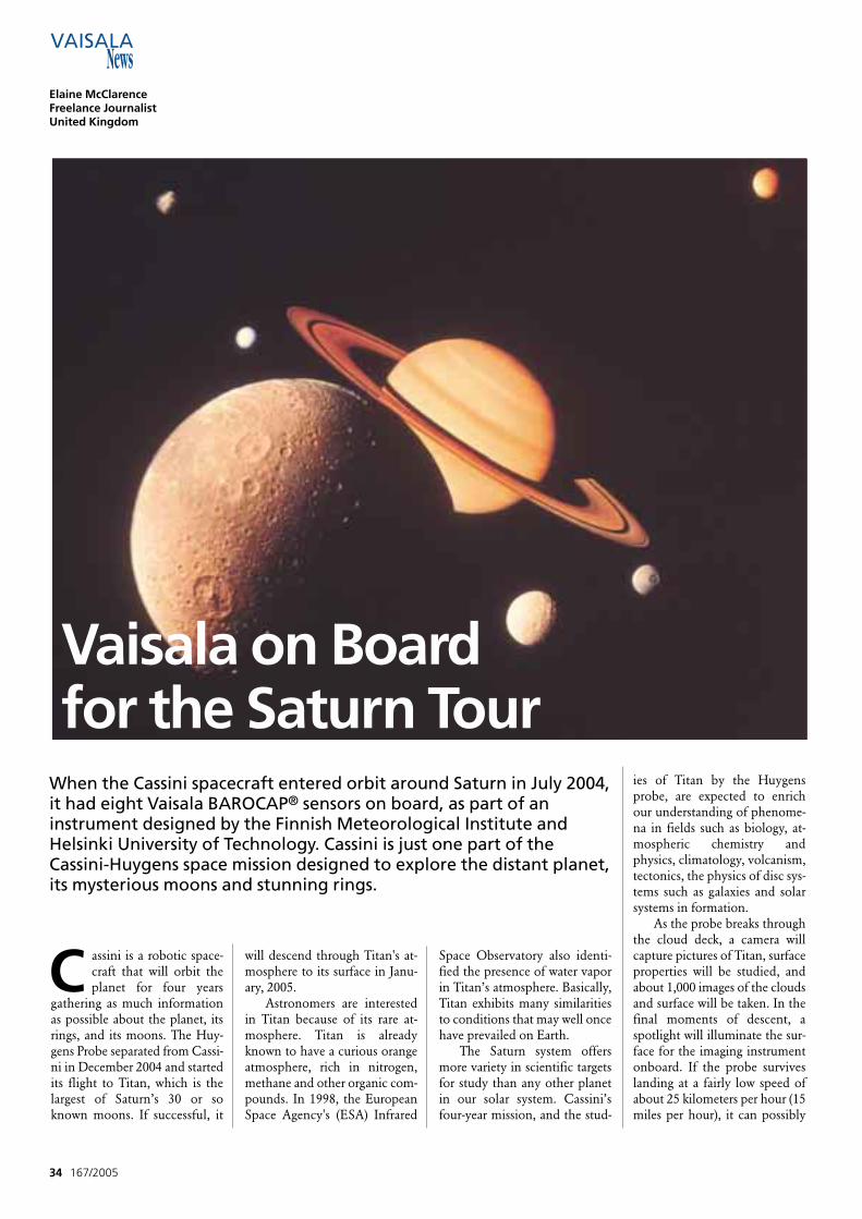
C assini is a robotic space-craft that will orbit theplanet for four years
gathering as much informationas possible about the planet, itsrings, and its moons. The Huy-gens Probe separated from Cassi-ni in December 2004 and startedits flight to Titan, which is thelargest of Saturn’s 30 or soknown moons. If successful, it
will descend through Titan's at-mosphere to its surface in Janu-ary, 2005.
Astronomers are interestedin Titan because of its rare at-mosphere. Titan is alreadyknown to have a curious orangeatmosphere, rich in nitrogen,methane and other organic com-pounds. In 1998, the EuropeanSpace Agency's (ESA) Infrared
Space Observatory also identi-fied the presence of water vaporin Titan’s atmosphere. Basically,Titan exhibits many similaritiesto conditions that may well oncehave prevailed on Earth.
The Saturn system offersmore variety in scientific targetsfor study than any other planetin our solar system. Cassini’sfour-year mission, and the stud-
ies of Titan by the Huygensprobe, are expected to enrichour understanding of phenome-na in fields such as biology, at-mospheric chemistry andphysics, climatology, volcanism,tectonics, the physics of disc sys-tems such as galaxies and solarsystems in formation.
As the probe breaks throughthe cloud deck, a camera willcapture pictures of Titan, surfaceproperties will be studied, andabout 1,000 images of the cloudsand surface will be taken. In thefinal moments of descent, aspotlight will illuminate the sur-face for the imaging instrumentonboard. If the probe surviveslanding at a fairly low speed ofabout 25 kilometers per hour (15miles per hour), it can possibly
34 167/2005
Elaine McClarenceFreelance JournalistUnited Kingdom
When the Cassini spacecraft entered orbit around Saturn in July 2004,it had eight Vaisala BAROCAP® sensors on board, as part of aninstrument designed by the Finnish Meteorological Institute andHelsinki University of Technology. Cassini is just one part of theCassini-Huygens space mission designed to explore the distant planet,its mysterious moons and stunning rings.
Vaisala on Board for the Saturn Tour
return data from Titan’s surface,where the atmospheric pressureis 1.6 times that on Earth.
The probe could touchdown on solid ground, ice oreven splash down in a lake ofethane or methane. Throughoutits mission, Huygens will radiodata collected to the Cassini or-biter to be stored and then re-layed to Earth. If it lands in liq-uid ethane, Huygens will not beable to return data for long be-cause the extremely low temper-ature of this liquid, about –180degrees Celsius (–290 degreesFahrenheit), would prevent thebatteries from operating and it isestimated that there would onlybe 30 minutes in which to sendback data before failure oc-curred.
The on-board Huygens At-mosphere Structure Instrument(HASI) comprises sensors formeasuring the physical and elec-trical properties of the atmos-phere and an on-board micro-phone that will send backsounds from Titan.
Sensor for pressure readingsVaisala’s contribution to the in-strumentation is a series ofVaisala BAROCAP® sensors.This is a capacitive absolute pres-sure device manufactured by sil-icon micro-machining. The sen-sor has excellent hysteresis andrepeatability characteristics andoutstanding temperature andlong-term stability. When thepressure changes, the silicon di-aphragm bends and changes theheight of the vacuum gap in thesensor. This alters the sensor’scapacitance, which is measuredand converted into a pressurereading. The sensor’s structuregives it a wide dynamic rangeand a built-in overpressureblocking mechanism. The designcombines two powerful tech-niques: the use of single crystalsilicon as sensor material and thecapacitive measurement princi-ple. Silicon offers good elastici-ty, low hysteresis, excellent re-peatability, small temperature
dependence and superior long-term stability.
International collaborationThe Cassini-Huygens mission isan international collaboration ofthree space agencies: NASA,ESA and the Italian SpaceAgency. The Cassini orbiter wasbuilt and is managed by NASA'sJet Propulsion Laboratory. TheHuygens Probe was built byESA. The Italian Space Agencyprovided Cassini's high-gain an-tenna. In addition, seventeencountries have made scientificcontributions to the mission atthe time of launch. More than250 scientists worldwide are in-volved in studying the data com-ing in from the Saturn system.
The total cost of the Cassini-Huygens mission is about $3.26billion, including $1.4 billionfor pre-launch development,$704 million for mission opera-tions, $54 million for trackingand $422 million for the launchvehicle. The U.S. contributed $2.6 billion, ESA $500 millionand the Italian Space Agency$160 million. The spacecraft andprobe carry a wide range of sci-entific equipment that will beused to explore the Saturn sys-tem over the next four years.
The Cassini-Huygens mis-sion started with a launch onOctober 15, 1997, on a Titan 4rocket from Cape Canaveral,Florida. Cassini has also flownpast other planets on its way toSaturn – once each by Earth andJupiter, twice by Venus. This wasnecessary in order to borrow suf-ficient gravitational energy tospeed the craft on its way. Dur-ing the Saturn Tour, Cassini willcomplete 74 orbits of the ringedplanet, 44 close flybys of Titan,and numerous flybys of Saturn'sother icy moons. Already scien-tists have been gathering newimages and information aboutone of the most intriguing plan-ets in the solar system.
The next crucial phase forthe mission begun on December25, 2004, when the Huygens
probe separated from the Cassi-ni orbiter and begun its 21-dayjourney to Titan. On January 14,2005, Huygens begins its de-scent through Titan's cloudy at-
mosphere, where, if successful, itlands on the surface about twoand half hours later. Then scien-tists will finally learn what Titanis really made of. ●
167/2005 35
The Saturn System
Titan
S aturn, the most distantplanet that could be seen
by ancient astronomers, hadappeared for centuries onlylike a bright star in the nightsky. The invention of the tele-scope at the beginning of the17th century finally confirmedthat this celestial body was ac-tually a planet.
Italian astronomer Galileowas the first to look at Saturnthrough a crude telescope in1609 and 1610 and mistakenlythought that the rings aroundthe planet were moons. It wasin 1655 that the Dutch scientistChristiaan Huygens saw thatthe two “moons” first identi-fied by Galileo were in fact athin flat ring surrounding theplanet. It later became clearthat this ring was really a sys-tem of rings. Then the Italianastronomer Jean-DominiqueCassini discovered in 1675 that
the “ring” consisted of an out-er ring and an inner ring, sepa-rated by a darker band, nowknown as the “Cassini Divi-sion”. Nearly two centuries lat-er, the Scottish physicist JamesClerk Maxwell proved that therings had to consist of manysmall particles, all orbiting Sat-urn like individual moons.
When the first space mis-sions flew past Saturn at the endof the 1970s, very little wasknown about this mysteriousand beautiful world. Groundobservations had shown Saturnitself to be a large ball of hydro-gen and helium, flattened atthe poles due to its rapid rota-tion. Occasionally, light and darkspots could be seen in the vaguebands of cloud running parallelto the equator. Virtually nothingwas known about the moons,except for their orbits, orbitalperiods and rough sizes. ●
H uygens discovered Titan in1655. Four more moons
were first observed by Cassiniand, thanks to better tele-scopes, nine more moons wereknown by the beginning of the20th century. On August 17th, themission revealed two moresmall moons, bringing the cur-rent total to 33. Dutch-born as-tronomer Gerard Kuiper discov-ered in 1944 that Titan has anatmosphere that containsmethane. This makes it unusual.A relatively thin atmosphere hasonly ever been found on twoother large moons, Jupiter’s Io
and Neptune’s Triton. Titan offers a tantalizing
mix of an Earth-like, nitrogen-based atmosphere and a sur-face that many scientists be-lieve probably features chilledlakes of ethane and a surfacecoated with sticky brown or-ganic condensate that hasrained down from the atmos-phere. Because Titan and Earthshare such similarities in at-mospheric composition, Titanis thought to hold clues tohow Earth evolved from itsprimitive beginnings into alife-bearing planet. ●
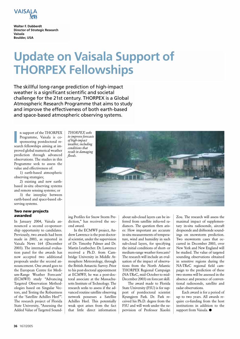
I n support of the THORPEXProgramme, Vaisala is co-sponsoring postdoctoral re-
search fellowships aiming at im-proved global numerical weatherprediction through advancedobservations. The studies in thisProgramme seek to assess thevalue and effectiveness of:
1) earth-based atmosphericobserving strategies;
2) existing and new earth-based in-situ observing systemsand remote sensing systems; or
3) the interplay betweenearth-based and space-based ob-serving systems.
Two new projectsawardedIn January 2004, Vaisala an-nounced a second co-sponsor-ship opportunity to candidates.Previously, two awards had beenmade in 2003, as reported inVaisala News 164 (December2003). The international evalua-tion panel for the awards hasnow accepted two additionalproposals under the second an-nouncement. One award goes tothe European Centre for Medi-um-Range Weather Forecasts’(ECMWF) study “AdvancingTargeted Observation Method-ologies based on Singular Vec-tors, and Testing the Robustnessof the ‘Satellite Achilles Heel’”.The research project of FloridaState University, “Assessing theAdded Value of Targeted Sound-
ing Profiles for Snow Storm Pre-diction,” has received the sec-ond award.
In the ECMWF project, An-drew Lawrence is the post-doctor-al scientist, under the supervisionof Dr. Timothy Palmer and Dr.Martin Leutbecher. Dr. Lawrencereceived a Ph.D. from Cam-bridge University in Middle At-mosphere Meteorology, throughthe British Antarctic Survey. Priorto his post-doctoral appointmentat ECMWF, he was a post-doc-toral associate at the Massachu-setts Institute of Technology. Theresearch seeks to assess if the ad-vanced routine satellite observingnetwork possesses a SatelliteAchilles Heel. This potentiallyweak spot arises from the factthat little direct information
about sub-cloud layers can be in-ferred from satellite infra-red ra-diances. The question then aris-es: How important are accuratein-situ measurements of tempera-ture, wind and humidity in suchsub-cloud layers, for specifyingthe initial conditions of short- ormedium-range weather forecasts?The research will include an eval-uation of the impact of observa-tions from the North AtlanticTHORPEX Regional Campaign(NA-TReC, mid-October to mid-December 2003) on forecast skill.
The award made to FloridaState University (FSU) is for sup-port of postdoctoral scientistKyungjeen Park. Dr. Park re-ceived his Ph.D. degree from theFSU and will work under the su-pervision of Professor Xiaolei
Zou. The research will assess themaximal impact of supplemen-tary in-situ radiosonde, aircraftdropsonde and driftsonde sound-ings on snowstorm prediction.Two snowstorm cases that oc-curred in December 2003, overNew York and New England willbe studied. The value of targetedsounding observations obtainedin sensitive regions during theNA-TReC regional field cam-paign to the prediction of thesetwo storms will be assessed in theabsence and presence of conven-tional radiosonde, satellite andradar observations.
Each award is for a period ofup to two years. All awards re-quire co-funding from the hostinstitutions in addition to thesupport from Vaisala. ●
36 167/2005
Update on Vaisala Support of THORPEX Fellowships
THORPEX seeksto improve forecastsof high-impactweather, includingconditions thatresult in damagingfloods.
Walter F. DabberdtDirector of Strategic ResearchVaisala Boulder, USA
The skillful long-range prediction of high-impactweather is a significant scientific and societalchallenge for the 21st century. THORPEX is a GlobalAtmospheric Research Programme that aims to studyand improve the effectiveness of both earth-basedand space-based atmospheric observing systems.
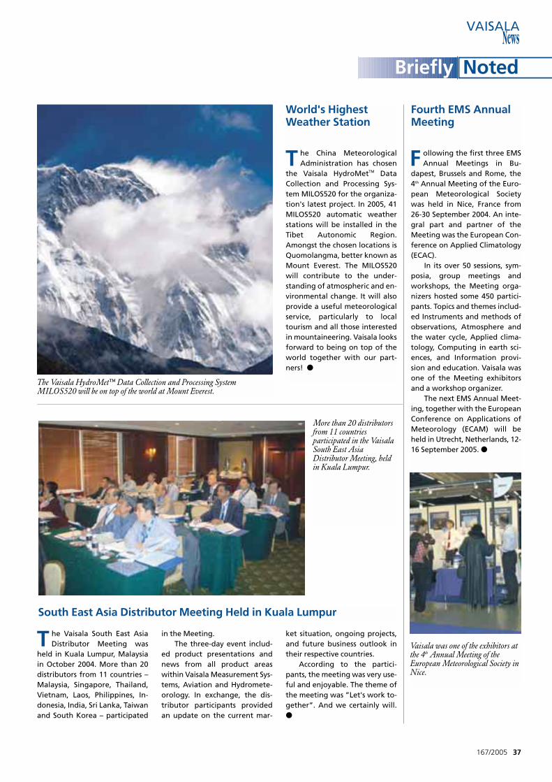
167/2005 37
World's HighestWeather Station
T he China MeteorologicalAdministration has chosen
the Vaisala HydroMetTM DataCollection and Processing Sys-tem MILOS520 for the organiza-tion's latest project. In 2005, 41MILOS520 automatic weatherstations will be installed in theTibet Autonomic Region.Amongst the chosen locations isQuomolangma, better known asMount Everest. The MILOS520will contribute to the under-standing of atmospheric and en-vironmental change. It will alsoprovide a useful meteorologicalservice, particularly to localtourism and all those interestedin mountaineering. Vaisala looksforward to being on top of theworld together with our part-ners! ●
T he Vaisala South East AsiaDistributor Meeting was
held in Kuala Lumpur, Malaysiain October 2004. More than 20distributors from 11 countries –Malaysia, Singapore, Thailand,Vietnam, Laos, Philippines, In-donesia, India, Sri Lanka, Taiwanand South Korea – participated
in the Meeting.The three-day event includ-
ed product presentations andnews from all product areaswithin Vaisala Measurement Sys-tems, Aviation and Hydromete-orology. In exchange, the dis-tributor participants providedan update on the current mar-
ket situation, ongoing projects,and future business outlook intheir respective countries.
According to the partici-pants, the meeting was very use-ful and enjoyable. The theme ofthe meeting was ”Let's work to-gether”. And we certainly will.●
South East Asia Distributor Meeting Held in Kuala Lumpur
More than 20 distributorsfrom 11 countriesparticipated in the VaisalaSouth East AsiaDistributor Meeting, heldin Kuala Lumpur.
The Vaisala HydroMet™ Data Collection and Processing SystemMILOS520 will be on top of the world at Mount Everest.
Briefly Noted
Fourth EMS AnnualMeeting
F ollowing the first three EMSAnnual Meetings in Bu-
dapest, Brussels and Rome, the4th Annual Meeting of the Euro-pean Meteorological Societywas held in Nice, France from26-30 September 2004. An inte-gral part and partner of theMeeting was the European Con-ference on Applied Climatology(ECAC).
In its over 50 sessions, sym-posia, group meetings andworkshops, the Meeting orga-nizers hosted some 450 partici-pants. Topics and themes includ-ed Instruments and methods ofobservations, Atmosphere andthe water cycle, Applied clima-tology, Computing in earth sci-ences, and Information provi-sion and education. Vaisala wasone of the Meeting exhibitorsand a workshop organizer.
The next EMS Annual Meet-ing, together with the EuropeanConference on Applications ofMeteorology (ECAM) will beheld in Utrecht, Netherlands, 12-16 September 2005. ●
Vaisala was one of the exhibitors atthe 4th Annual Meeting of theEuropean Meteorological Society inNice.
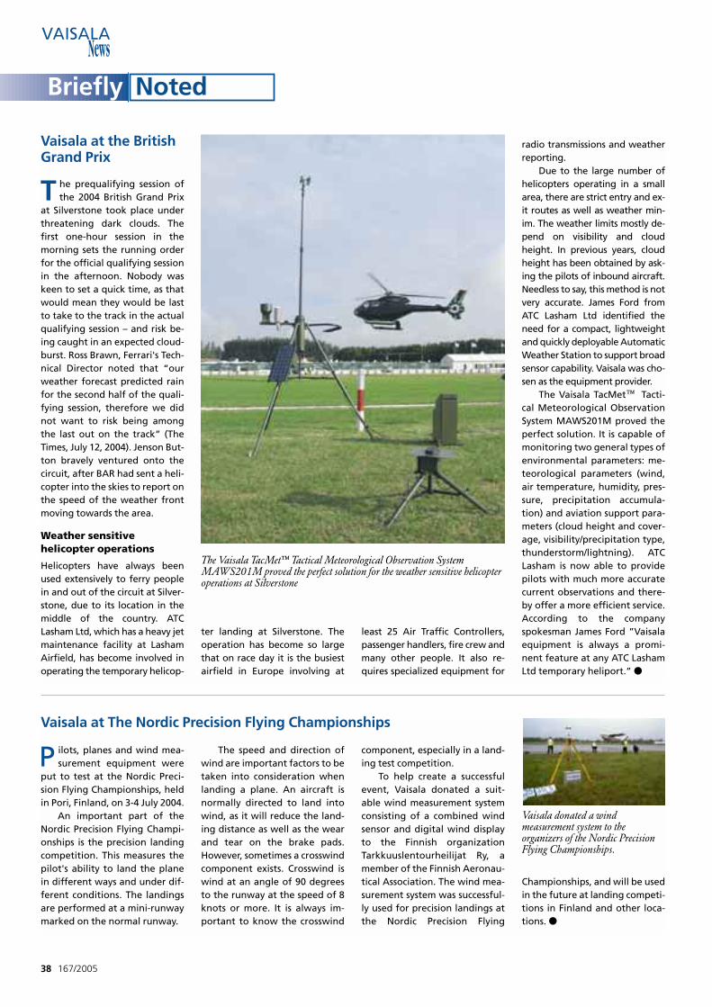
38 167/2005
Vaisala at the BritishGrand Prix
T he prequalifying session ofthe 2004 British Grand Prix
at Silverstone took place underthreatening dark clouds. Thefirst one-hour session in themorning sets the running orderfor the official qualifying sessionin the afternoon. Nobody waskeen to set a quick time, as thatwould mean they would be lastto take to the track in the actualqualifying session – and risk be-ing caught in an expected cloud-burst. Ross Brawn, Ferrari's Tech-nical Director noted that “ourweather forecast predicted rainfor the second half of the quali-fying session, therefore we didnot want to risk being amongthe last out on the track” (TheTimes, July 12, 2004). Jenson But-ton bravely ventured onto thecircuit, after BAR had sent a heli-copter into the skies to report onthe speed of the weather frontmoving towards the area.
Weather sensitive helicopter operations
Helicopters have always beenused extensively to ferry peoplein and out of the circuit at Silver-stone, due to its location in themiddle of the country. ATCLasham Ltd, which has a heavy jetmaintenance facility at LashamAirfield, has become involved inoperating the temporary helicop-
ter landing at Silverstone. Theoperation has become so largethat on race day it is the busiestairfield in Europe involving at
least 25 Air Traffic Controllers,passenger handlers, fire crew andmany other people. It also re-quires specialized equipment for
radio transmissions and weatherreporting.
Due to the large number ofhelicopters operating in a smallarea, there are strict entry and ex-it routes as well as weather min-im. The weather limits mostly de-pend on visibility and cloudheight. In previous years, cloudheight has been obtained by ask-ing the pilots of inbound aircraft.Needless to say, this method is notvery accurate. James Ford fromATC Lasham Ltd identified theneed for a compact, lightweightand quickly deployable AutomaticWeather Station to support broadsensor capability. Vaisala was cho-sen as the equipment provider.
The Vaisala TacMet™ Tacti-cal Meteorological ObservationSystem MAWS201M proved theperfect solution. It is capable ofmonitoring two general types ofenvironmental parameters: me-teorological parameters (wind,air temperature, humidity, pres-sure, precipitation accumula-tion) and aviation support para-meters (cloud height and cover-age, visibility/precipitation type,thunderstorm/lightning). ATCLasham is now able to providepilots with much more accuratecurrent observations and there-by offer a more efficient service.According to the companyspokesman James Ford ”Vaisalaequipment is always a promi-nent feature at any ATC LashamLtd temporary heliport.” ●
P ilots, planes and wind mea-surement equipment were
put to test at the Nordic Preci-sion Flying Championships, heldin Pori, Finland, on 3-4 July 2004.
An important part of theNordic Precision Flying Champi-onships is the precision landingcompetition. This measures thepilot's ability to land the planein different ways and under dif-ferent conditions. The landingsare performed at a mini-runwaymarked on the normal runway.
The speed and direction ofwind are important factors to betaken into consideration whenlanding a plane. An aircraft isnormally directed to land intowind, as it will reduce the land-ing distance as well as the wearand tear on the brake pads.However, sometimes a crosswindcomponent exists. Crosswind iswind at an angle of 90 degreesto the runway at the speed of 8knots or more. It is always im-portant to know the crosswind
component, especially in a land-ing test competition.
To help create a successfulevent, Vaisala donated a suit-able wind measurement systemconsisting of a combined windsensor and digital wind displayto the Finnish organizationTarkkuuslentourheilijat Ry, amember of the Finnish Aeronau-tical Association. The wind mea-surement system was successful-ly used for precision landings atthe Nordic Precision Flying
Championships, and will be usedin the future at landing competi-tions in Finland and other loca-tions. ●
Vaisala at The Nordic Precision Flying Championships
The Vaisala TacMet™ Tactical Meteorological Observation SystemMAWS201M proved the perfect solution for the weather sensitive helicopteroperations at Silverstone
Vaisala donated a windmeasurement system to theorganizers of the Nordic PrecisionFlying Championships.
Briefly Noted
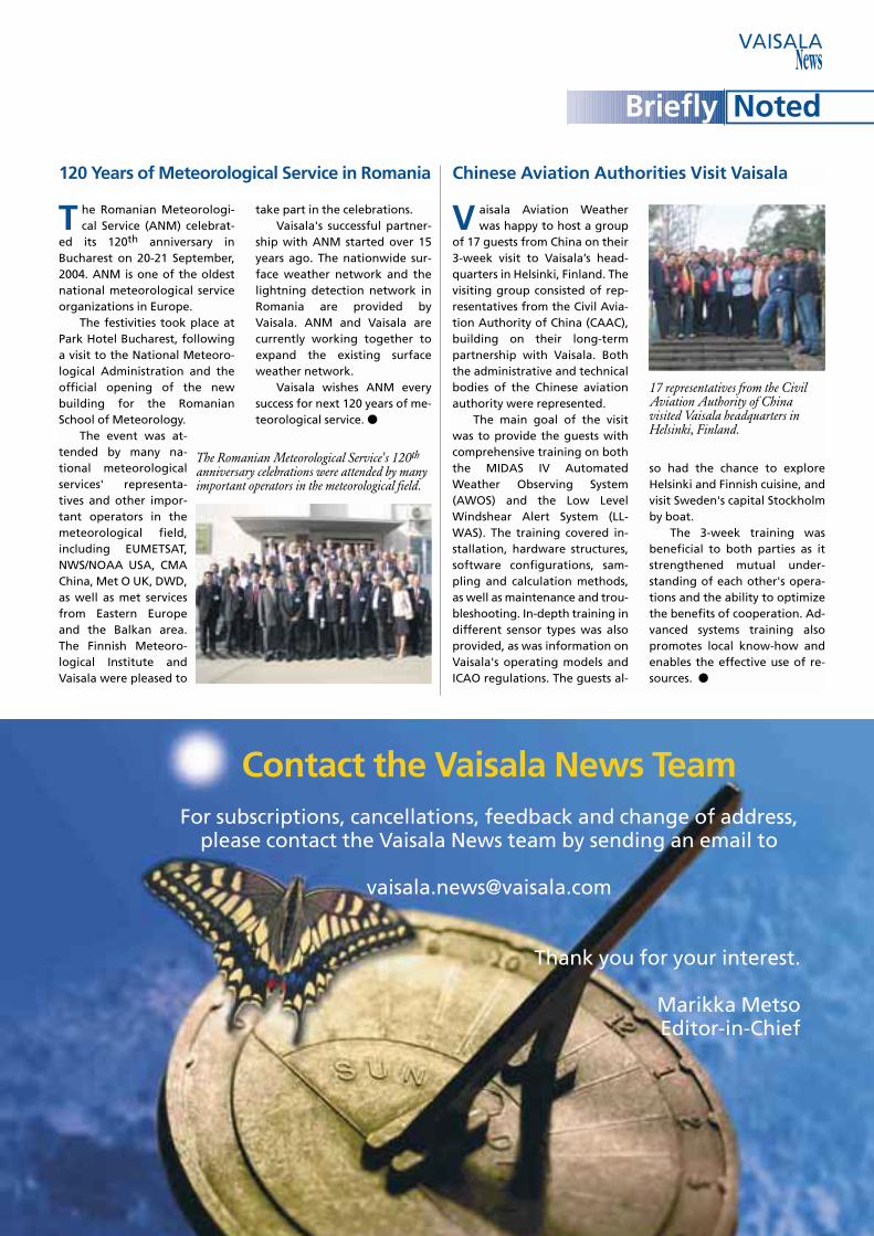
T he Romanian Meteorologi-cal Service (ANM) celebrat-
ed its 120th anniversary inBucharest on 20-21 September,2004. ANM is one of the oldestnational meteorological serviceorganizations in Europe.
The festivities took place atPark Hotel Bucharest, followinga visit to the National Meteoro-logical Administration and theofficial opening of the newbuilding for the RomanianSchool of Meteorology.
The event was at-tended by many na-tional meteorologicalservices' representa-tives and other impor-tant operators in themeteorological field,including EUMETSAT,NWS/NOAA USA, CMAChina, Met O UK, DWD,as well as met servicesfrom Eastern Europeand the Balkan area.The Finnish Meteoro-logical Institute andVaisala were pleased to
take part in the celebrations.Vaisala's successful partner-
ship with ANM started over 15years ago. The nationwide sur-face weather network and thelightning detection network inRomania are provided byVaisala. ANM and Vaisala arecurrently working together toexpand the existing surfaceweather network.
Vaisala wishes ANM everysuccess for next 120 years of me-teorological service. ●
V aisala Aviation Weatherwas happy to host a group
of 17 guests from China on their3-week visit to Vaisala’s head-quarters in Helsinki, Finland. Thevisiting group consisted of rep-resentatives from the Civil Avia-tion Authority of China (CAAC),building on their long-termpartnership with Vaisala. Boththe administrative and technicalbodies of the Chinese aviationauthority were represented.
The main goal of the visitwas to provide the guests withcomprehensive training on boththe MIDAS IV AutomatedWeather Observing System(AWOS) and the Low LevelWindshear Alert System (LL-WAS). The training covered in-stallation, hardware structures,software configurations, sam-pling and calculation methods,as well as maintenance and trou-bleshooting. In-depth training indifferent sensor types was alsoprovided, as was information onVaisala's operating models andICAO regulations. The guests al-
so had the chance to exploreHelsinki and Finnish cuisine, andvisit Sweden's capital Stockholmby boat.
The 3-week training wasbeneficial to both parties as itstrengthened mutual under-standing of each other's opera-tions and the ability to optimizethe benefits of cooperation. Ad-vanced systems training alsopromotes local know-how andenables the effective use of re-sources. ●
Contact the Vaisala News TeamFor subscriptions, cancellations, feedback and change of address,
please contact the Vaisala News team by sending an email to
Thank you for your interest.
Marikka MetsoEditor-in-Chief
120 Years of Meteorological Service in Romania
17 representatives from the CivilAviation Authority of Chinavisited Vaisala headquarters inHelsinki, Finland.
The Romanian Meteorological Service's 120th
anniversary celebrations were attended by manyimportant operators in the meteorological field.
Chinese Aviation Authorities Visit Vaisala
Briefly Noted
Europe
Vaisala Oyj P.O. Box 26, FI-00421 HelsinkiFINLAND Telephone: +358 9 894 91Telefax: +358 9 8949 2227
Vaisala Oyj Malmö OfficeDrottninggatan 1 DS - 212 11 MalmöSWEDENTelephone: +46 40 298 991, in Sweden: 0200 848 848Telefax.: +46 40 298 992, in Sweden: 0200 849 849
Vaisala GmbHHamburg OfficeSchnackenburgallee 41D-22525 HamburgGERMANYTelephone: +49 40 839 030Telefax: +49 40 839 03 110
Vaisala GmbHBonn OfficeAdenauerallee 46 aD-53113 BonnGERMANYTelephone: +49 228 912 5110Telefax: +49 228 912 5111
Vaisala GmbHStuttgart OfficePestalozzi Str. 8D-70563 Stuttgart GERMANYTelephone: +49 711 734 057Telefax: +49 711 735 6340
Vaisala LtdBirmingham OperationsVaisala House349 Bristol RoadBirmingham B5 7SWUNITED KINGDOMTelephone: +44 121 683 1200Telefax: +44 121 683 1299
Vaisala LtdNewmarket OfficeUnit 9, Swan LaneExningNewmarketSuffolk CB8 7FNUNITED KINGDOMTelephone: +44 1638 576 200Telefax: +44 1638 576 240
Vaisala SAParis Office2, rue Stéphenson (escalier 2bis)F-78181 Saint-Quentin-en-YvelinesCedexFRANCETelephone: +33 1 3057 2728Telefax: +33 1 3096 0858
Vaisala SAAix-en-Provence Office7, Europarc Ste-VictoireF-13590 Meyreuil FRANCETelephone: +33 4 4212 6464Telefax: +33 4 4212 6474
North America
Vaisala Inc. Boston Office10-D Gill StreetWoburn, MA 01801USATelephone: +1 781 933 4500Telefax: +1 781 933 8029
Vaisala Inc. Columbus Office7450 Industrial ParkwayPlain City, Ohio 43064-9005USA Telephone: +1 614 873 6880Telefax: +1 614 873 6890Effective January 17, 20051372 Oxley RoadColumbus, Ohio 43212
Vaisala Inc. Boulder Operations194 South Taylor AvenueLouisville, CO 80027USATelephone: +1 303 499 1701 Fax: +1 303 499 1767
Vaisala Inc.Sunnyvale Office260 Santa Ana Court Sunnyvale, CA 94085-4512USATelephone: +1 408 734 9640Telefax: +1 408 734 0655
Vaisala Inc.Tucson Operations2705 East Medina RoadTucson, Arizona 85706, USATelephone: +1 520 806 7300Telefax: +1 520 741 2848U.S. Toll Free 1 800 283 4557
Vaisala Inc.Houston Office1120 Nasa Road 1 Suite 220-EHouston, TX 77058Telephone: +1 281 335 9955Telefax: +1 281-335-9956
Vaisala Inc. Regional Office CanadaP.O. Box 2241, Station “B”LondonOntario N6A 4E3CANADATelephone: +1 519 679 9563Telefax: +1 519 679 9992
Asia and Pacific
Vaisala KKTokyo Office42 Kagurazaka 6-ChomeShinjuku-Ku Tokyo 162-0825JAPANTelephone: +81 3 3266 9611Telefax: +81 3 3266 9610
Vaisala KKOsaka OfficeThick Land Building 12032-3-5 Nanba Chuo-ku, Osaka 542-0076,JapanTelephone: +81 6 62123954Telefax: +81 6 62123955
Vaisala Pty LtdMelbourne Office3 Guest StreetHawthorn, VIC 3122AUSTRALIATelephone: +61 3 9818 4200Telefax: +61 3 9818 4522
Vaisala Beijing Representative OfficeCITIC Building19 Jianguomenwai DajieChaoyang DistrictBeijing 100004People’s Republic of ChinaTelephone: +86 10 8526 1199Telefax: +86 10 8526 1155
Vaisala Beijing Representative Office in Shanghaic/o KaukomarkkinatRoom 402A West Tower, Sun Plaza88 Xian Xia RoadShanghai, P.R. China 200336Telephone: +86 21 62700642/41Telefax:+86 21 62700640
Vaisala Regional Office MalaysiaLevel 36, Menara Citibank165 Jalan Ampang50450 Kuala LumpurMALAYSIATelephone: +60 3 2169 7776Telefax: +60 3 2169 7775
C21
0033
EN
200
5-01