Embed Size (px)
Citation preview


USING THE ROS SYSTEM
AS A MANAGEMENT TOOL
by
George H. Stankey Gregory A. Warren Warren R. Bacon
APRIL 1986

INTRODUCTION. .................................. 1
OVERVIEW OF ROS................................ 1
SETTING INDICATORS.............................. 2
SETTING GUIDELINES ............................. 5
EXPERIENCE GOALS ............................... 6
ROS SETTINGS
Primitive ................................ 7
Semi-Primitive Nonmotorized.................. 11
Semi-Primitive Motorized.................... 15
Roaded Natural ............................ 18
Roaded Modified ........................... 22
Rural ................................... 25
INCONSISTENCIES. ............................... 28
SUMMARY ...................................... 29

1 INTRODUCTION
The purpose of this handbook is to provide guidance for managing each ROS setting for a given set of conditions and experience opportunities. Maintaining or altering the conditions of the setting indicators to facilitate the possibly visitors gaining certain experiences is the key. The primary purpose of using the ROS system is to provide a diverse range of recreation settings so that people can realize a diverse range of recreation experience opportunities.
Based upon research on visitor preferences as well as professional judgments, seven indicators have been identified that represent aspects of recreation settings that facilitate certain experiences occurring and that managers can influence. Guidelines for these indicators and their underlying rationale are explained below.
The rationale for the guidelines is critical. Because it is not possible to develop specific guidelines for every possible contingency, managers often need to be able to formulate their own to deal with situations confronting them. Understanding the intent of the general ROS allocation, understanding what it is we are trying to achieve when we direct actions at an indicator should lead to the formulation of guidelines consistent with the overall goals of the ROS allocation.
AN OVERVIEW OF THE ROS PROCESS
It is helpful to review the underlying concepts of the ROS. The ROS is based on the idea that visitors participate in different recreation activities in different settings in order to realize certain experiences (see Figure 1). The key component of this framework is the recreation setting; it is what managers can influence. A recreation opportunity setting is defined as the combination of physical, biological, social, and managerial conditions that give value to a place. By combining variations in these conditions, it is possible to provide a diversity of recreational settings for visitors to enjoy.
The end product of this process is the experiences that visitors receive. There are many different types of experiences. Some relate to solitude, risk, and challenge and we typically associate these with opportunities at the primitive end of the spectrum. Others relate to meeting and enjoying others or family togetherness; generally we associate these with the developed end of the spectrum. The management of a setting can only influence the likelihood that a particular experience will be achieved. It is likely that visitors will find risk in settings where natural conditions prevail and there are few facilities. Conversely, meeting and enjoying others is likely to occur in places where management has facilitated the opportunity to be around others. Both these experiences, however, can occur in other settings.
2 For further discussion of the ROS as it relates to management, see Roger N. Clark
and George H. Stankey, The recreation opportunity spectrum: a framework for planning, management, and research. General Technical Report PNW-98. Portland, OR, U.S. Department of Agriculture, Pacific Northwest Forest and Range Experiment Station; 1979. 32 p.
SETTING INDICATORS
The seven indicators include access, remoteness, nonrecreation uses, on-site management, visitor management, social encounters, and visitor impacts. Their definition and underlying rationale are as follows:
1. Access - Includes the type of transportation used by the recreationists within the area and the level of access development, such as trails and roads.
Access influences both the levels and types of recreation use an area receives. Improved access can lead to increased use levels and resource impacts and an increased need for management action. Access affects the way in which some recreation experiences can be realized. For example, high quality access can reduce opportunities for solitude, risk, and challenge; on the other hand, it promotes convenience and facilitates experiences associated with meeting and enjoying others. Changing the nature of access to and within an area can greatly affect the kind of recreation place it is in terms of the type and level of use it receives, the nature and extent of resource impacts that occur, and the kind of management actions needed.
2. Remoteness - The distance of an area from the nearest road, access point, or center of human habitation or development.
Remoteness concerns the extent to which individuals perceive themselves away from the sights and sounds of human activity. All other things being equal, the greater the distance, the more likely the perception of remoteness will occur. Vegetative or topographic screening can also increase this sense of remoteness and the associated experiences of solitude and naturalness. For some kinds of recreational experiences, particularly those derived from the more developed recreation settings, remoteness is of little relevance.
3. Nonrecreation uses - Refers to the type and extent of nonrecreation uses present in the area, such as timber harvesting, grazing, and mining.
Nonrecreation uses conflict with opportunities at the primitive end of the spectrum and their associated experiences, such as solitude and the enjoyment of naturalness. In other recreation settings, nonrecreation uses do not necessarily detract from the visitor's enjoyment. For example, recreationists in roaded modified areas often find grazing and logging acceptable. But these users do express concern about large clearcuts, so the scale at which the activity is conducted, as well as the activity itself, influences the visitor’s experience. The lasting effects of an activity (mines, clearcuts) as well as short-term effects (logging trucks, noise) are also important.
The key to managing nonrecreation activities in each ROS setting is to use a compatible visual quality level and its corresponding guidelines. The visual quality level describes varying degrees of naturalness or levels of allowable alteration of the natural setting. The compatibility relationship of ROS classes and visual quality levels is best summarized in the following matrix (figure 2).

3
COMPATIBILITY MATRIX
Achieving the desired level of visual quality must be taken into account. Other resource objectives, desired future visual character, existing character of the natural landscape and variables such as observer position and speed, distance from the activity, scale, and season of visitor use. See USDA Landscape Management Handbook Series for further guidance.
4. On-site management - The on-site management indicator refers to modifications such as facilities, vegetation management, and site design.
The appropriateness of on-site management should be considered in light of four elements:
a. Extent of the modification. Is it limited to a few isolated locations or distributed throughout the area?
b. Apparentness of the modification. Does the use of native materials blend the modification into the natural setting or do artificial materials make the modification readily apparent?
c. Complexity of the modification. A bridge could be a simple log footpath or a complicated engineering effort.
d. Facilities. Facilities can be for the convenience or safety of visitors or for resource protection. In some areas, no facilities whatsoever are appropriate; in others, all possible conveniences would be appropriate.
In general, the appropriateness of on-site modifications increases as one moves from the primitive end of the spectrum to the urban.
5. Visitor management – Includes the management actions undertaken to maintain conditions and enhance visitor experiences within an ROS class.

4 Recreation is a voluntary, self-selected behavior. A major reason underlying
participation is to get away from the controls and constraints of the everyday world. Thus, there is a need for care and sensitivity in how visitor management is implemented. The presence of controls and the way in which they are implemented is as much a part of the recreation setting as the physical environment.
A continuum of management actions can be described, ranging from subtle techniques such as site design and providing visitors with information to strict rules and regulations on visitors. At the primitive end of the spectrum, actions should seek to influence behavior indirectly through steps such as the use of information and education programs that improve visitor behavior. In developed settings, controls are more directly imposed on visitors; site design to influence behavior may also be used. However, the "principle of minimum regulation" should apply across the spectrum; the rules and regulations that are implemented should only be those deemed necessary to protect the essential qualities of the BOS class.
In some opportunity settings, controls are expected and appropriate; for instance, people seek some developed settings for the security and safety they provide. Yet elsewhere, such on-site controls would detract from desired experiences such as independence and self-reliance.
The type and level of information provided visitors as well as where it is provided (on-site vs. off-site) facilitates some experiences, but hinders others. Where experiences such as self-discovery, challenge, and risk are important, information has the potential of adversely affecting the visitor. In other situations, information might be critical to achieving desired experiences. Generally, on-site information is appropriate at the developed end of the spectrum while off-site sources are better at the primitive end.
6. Social encounters - The number, type, and character of other recreationists met in the area, along travel ways, or camped within sight or sound.
Some recreation experiences require few if any contacts with people in other groups is important while in other situations such encounters are actively sought as part of the experience. Social encounters are a measure of the extent to which an area provides experiences such as solitude, defined as little or no contact with nongroup members as well as the opportunity for social interaction, defined as seeing and meeting others. Increasing numbers of visitors to an area changes the kind of recreational experience offered, attracting new users and causing others to leave. Party size limits are desirable to further reduce conflicts between large and small parties.
7. Visitor impacts - Includes those impacts caused by recreation use and affecting resources such as soil, vegetation, air, water, and wildlife.
Human use of resources inevitably results in impacts and recreation is no exception. Any use creates some impact; even the lightest recreation use can produce significant impacts. Thus, the relevant question confronting managers is not "how can impacts be prevented" but "what level of impact is consistent with the type of opportunity being supplied."
5 The effects of visitor impacts can influence the recreationist’s experience. At
the primitive end of the ROS, recreationists expect a natural appearing environment with impacts substantially unnoticeable. Towards the rural end of the spectrum, signs of human impact become more acceptable. Sub-elements of this indicator include air, water, vegetation, and fish and wildlife.
Air quality is important area wide in all ROS classes and it is also important at local sites. Local sites, such as camping areas where smoke from campfires can obscure views or create unnatural smells (e.g., burning plastic) should have specific air quality objectives.
Water quality is important in all classes.
Vegetation condition is a major indicator in creating the setting, with fewer impacts desirable at the primitive end of the spectrum. The guidelines are based on maximum impacts to be expected when "no trace*1 practices are being used by visitors. Vegetation impacts at the rural end of the spectrum are controlled by designating and hardening sites.
Impacts on wildlife habitat is a major concern. These impacts can stem from physical alteration of wildlife habitat or from habitat modification caused by recreationists that leads to species displacement. At the primitive end of the ROS, where naturalness is a key part of the setting, maintaining the natural behavior and existence of fish and wildlife populations is essential. The human-impacted sites and trail density guidelines, under each ROS class, were derived for maintaining various degrees of naturalness for black bear populations in a high Cascades environment. Indicator species should be developed for specific areas and used to monitor recreation-related impacts on fish and wildlife.
These seven indicators comprise the material from which a spectrum of recreation opportunities are developed. Identifying and defining these indicators is only a first step. What is needed next is to specify the condition of each indicator considered both acceptable and appropriate in each recreation opportunity setting. This involves establishment of guidelines for each indicator. By specifying the range of acceptable conditions for each indicator in each opportunity setting, we identify the specific character of that setting as well as needed management actions.
SETTING GUIDELINES
In setting guidelines for management actions, two general notions are important. First, the overall objective is to provide a range of conditions. Thus, the condition of each indicator should show a progression from one end of the spectrum to another. This implies that it is necessary to consider the entire spectrum when establishing guidelines because it is necessary to know how the status of a particular indicator in a given ROS class relates to the condition of that indicator in another class. It is also important to appreciate that a range of conditions can be described within any ROS class; there is not a single set of conditions that areas within a class must meet. In this way, additional diversity is assured.

6 Second, it is essential to link the guidelines to the recreation
experiences sought. It is the experiences that people receive from recreation that is the end product of management; therefore, we need to consider the probable effects specific actions will have on those experiences. The key words here are "appropriate" and "acceptable"; what conditions meet these criteria in each ROS class. Arriving at a decision as to what constitutes appropriate and acceptable requires judgments based upon research, management experience, and public input.
EXPERIENCE GOALS
For each ROS setting, a general goal as to the kinds of experiences typically associated with an area managed for this ROS class can be defined. For each ROS class description that follows an experience goal has been identified.
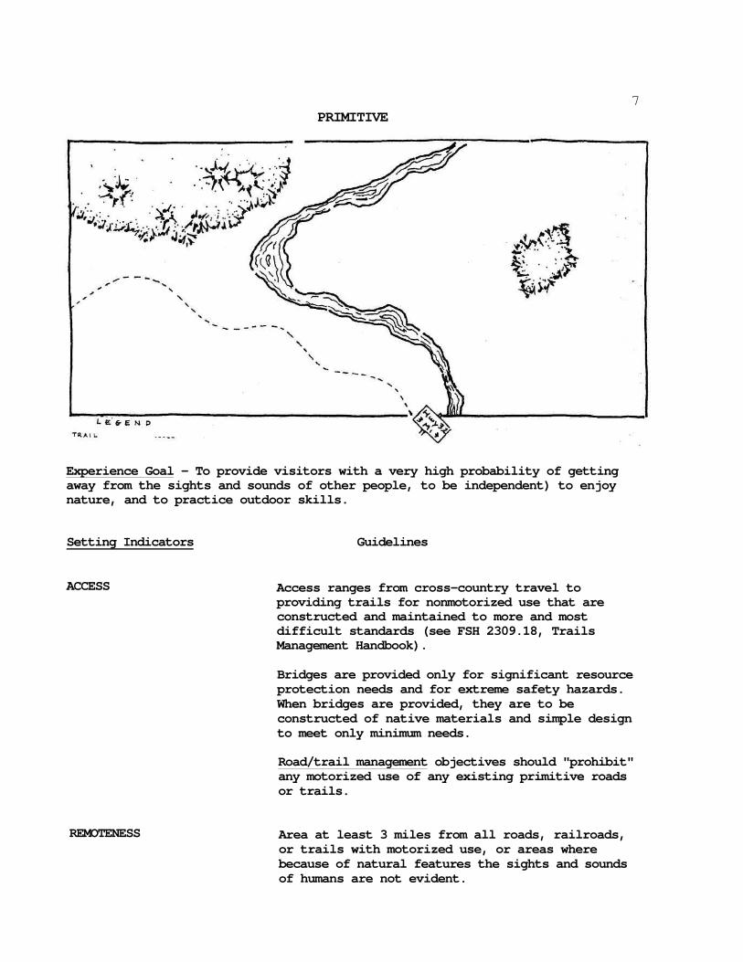
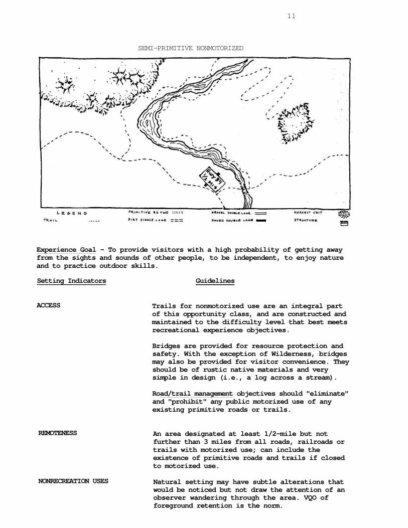
USE OF SKETCHES A sketch is shown for each ROS class depicting what an area might look like if managed for those conditions. The same area is shown for each class only modified to show the changing conditions. The sketches are limited to showing the indicator conditions of access, nonrecreation use, remoteness, and some on-site management.
7
PRIMITIVE
Experience Goal - To provide visitors with a very high probability of getting away from the sights and sounds of other people, to be independent) to enjoy nature, and to practice outdoor skills.
Setting Indicators Guidelines
ACCESS Access ranges from cross-country travel to providing trails for nonmotorized use that are constructed and maintained to more and most difficult standards (see FSH 2309.18, Trails Management Handbook).
Bridges are provided only for significant resource protection needs and for extreme safety hazards. When bridges are provided, they are to be constructed of native materials and simple design to meet only minimum needs.
Road/trail management objectives should "prohibit" any motorized use of any existing primitive roads or trails.
REMOTENESS Area at least 3 miles from all roads, railroads, or trails with motorized use, or areas where because of natural features the sights and sounds of humans are not evident.

PRIMITIVE (cont.)
Setting Indicators
NONRECREATION USES
8
Guidelines
Setting should essentially be an unmodified natural environment. No timber harvest or mineral extraction is allowed. Range conditions of “excellent” are appropriate. VQO of preservation is the norm. Existing primitive roads should be revegetated if not used as recreation trail. Structures should be extremely rare. Any remnants should be removed or allowed to deteriorate in place. Cultural or historic resources of state significance that are eligible for or are listed in the National Register may be stabilized and preserved.
ON-SITE MANAGEMENT Facilities are generally not provided except in isolated cases to protect fragile resources. Must be of simple design and natural materials when used. No site modification for facilities. Compatible site development is level 1. See FSM 2331.11c.
Camping areas to be located at sites within coniferous forest areas where possible. In all cases, sites should be located to take advantage of topographic and vegetative screening. Outside of coniferous areas where no vegetative or topographic screening is available, camps to be located where possible, outside foreground view (200») from lakes, trails, other camps and key interest features. Site design (trails and campsites) should encourage maximum dispersion of visitors, without creating additional new sites.
Human activities to remain subordinate in foreground distance zones (2001 - 300f). Human's activities should not be recognizable in middleground and background distance zones.
VISITOR MANAGEMENT Controls - Few if any management controls imposed on visitors on-site. Management personnel only occasionally present. Rules and regulations communicated to visitors off-site. Use limitations can be imposed, but these limitations occur before entry into the area and are used to help avoid the institution of an unnecessary number of on-site controls. No on-site physical controls such as barriers allowed.
9PRIMITIVE (cont.)
Setting Indicators
Guidelines
Information - No on-site interpretation. Signs should be for extreme safety situations only. No directional or destination point signs. Provide maps, guidebooks, and brochures appropriate for self-discovery at off-site visitor contact points.
SOCIAL ENCOUNTERS
VISITOR IMPACTS
Emphasis is on little or no interparty contact. There is a very high probability of less than 6 other groups encountered per day while traveling along trails and less than three parties camped within sight or sound at night. Attempt to minimize conflicts between hiking and horseback groups at entry points, along travel routes, and at campsites. Party size limits range between 6 and 12 depending on the actual number of encounters, with larger size parties only being allowed in lightly used areas. Livestock limits should be based on vegetation and soil impacts. Sounds associated with mechanized activity outside the area generally not apparent.
Air. - Air quality is maintained as per state objectives, and air quality is not degraded as a result of recreational use, such as from campfire smoke.
Soil - Displacement and erosion of soil resulting from visitor activity will be limited to a rate that closely approximates the natural process.
Soil compaction should not exceed limits which will prevent natural plant establishment and growth, except at some campsites (see vegetation), administrative facilities and in standard designated trail tread.
Water - Maintain the natural quality of streams and lakes. Activities should not degrade water quality.
Vegetation - At concentrated use sites, loss of ground cover should not exceed MOO square feet at any one site.
There should be no Joss of trees, and fewer than 4 trees with exposed roots per impacted site.
There should be no long-term modification of natural plant succession as a result of visitor activities on areas outside of campsites, trails, and administrative sites. Acceptable short-term modifications are those which will recover in one growing season.
PRIMITIVE (cont.)
Setting Indicators
VISITOR IMPACTS (cont.)
10 Guidelines
All dead, standing vegetation should be left in place. Visitor use should be managed to avoid hazards from snags.
Snags and down vegetation should be managed to approximate natural conditions. Dead and down vegetation may be removed in amounts that can be replaced annually through natural accumulation.
Vegetation impacts along trails should be confined to the planned location and to meet the objectives of the trail.
Range (recreational use): No more than 20 percent forage utilized. Overall range condition is excellent.
Fish and Wildlife - Visitor use should be managed to promote the naturalness of native fish populations.
Visitor use should not permanently displace wildlife populations, nor temporarily displace wildlife in critical areas and periods, such as fawning and winter range.
No more than 4 human-impacted sites per 640 acres. (1 square mile)
11
SEMI-PRIMITIVE NONMOTORIZED
Experience Goal - To provide visitors with a high probability of getting away from the sights and sounds of other people, to be independent, to enjoy nature and to practice outdoor skills.
Setting Indicators Guidelines
ACCESS Trails for nonmotorized use are an integral part of this opportunity class, and are constructed and maintained to the difficulty level that best meets recreational experience objectives.
Bridges are provided for resource protection and safety. With the exception of Wilderness, bridges may also be provided for visitor convenience. They should be of rustic native materials and very simple in design (i.e., a log across a stream).
Road/trail management objectives should "eliminate" and "prohibit" any public motorized use of any existing primitive roads or trails.
REMOTENESS
NONRECREATION USES
An area designated at least 1/2-mile but not further than 3 miles from all roads, railroads or trails with motorized use; can include the existence of primitive roads and trails if closed to motorized use.
Natural setting may have subtle alterations that would be noticed but not draw the attention of an observer wandering through the area. VQO of foreground retention is the norm.

SEMI-PRIMITIVE NONMOTORIZED S P N M
(cont.)
Setting Indicators
NOHRECREATION USES (cont.)
12
Guidelines
Vegetative management may range from no timber harvest to very limited regeneration cutting and sanitation salvage for the purpose of maintaining a healthy, attractive semiprimitive setting. Amount of regeneration cut per decade must not exceed 3-5 percent of the commercial Forest land. No new roads may be built. Motorized harvesting must be done in the low public use season and in not more than half of the decade.
Mineral extraction and other nonrecreation uses should meet the same guidelines as above.
Range condition of "very good" to "excellent" is appropriate. Range structure should meet VQO.
Structures should be rare and isolated.
ON-SITE MANAGEMENT Except for facilities necessary to protect fragile resources they should be limited to trail shelters, sanitary and safety needs. All should be of simple design in native rustic-like materials. Site modification for facilities should be very minimal to none. Site development level should be level 2 or less (see FSM 2331.11c).
Location - Camping areas should be located at sites within coniferous forest areas where possible. In all cases, sites should be located to take advantage of topographic and vegetative screening. Outside of coniferous forest areas where no vegetative or topographic screening is available camps are to be located outside of foreground view (200’) from lakes and trails and key interest features where possible. Site design (such as trails) should remain subordinate to the natural landscape.
Visual Resource - Human activities to remain subordinate in foreground distance zones (200' -300'). Human activities should not be recognizable in middleground and background distance zones.
Facilities should remain subordinate in foreground distance zones (200’ – 300’) from trails, lakes, and key interest features. Facilities, including trails, should be harmonious with natural landscape in middleground and background distance zones.

SEMI-PRIMITIVE MONMOTORIZED (cont.)
Setting Indicators
Guidelines
13 SPNM
VISITOR MANAGEMENT Controls - Emphasis is to minimize visitor management
controls imposed on on-site visitors. Management personnel may be present. Use limitations rarely employed. On-site physical controls permitted but must be subtle.
Information - Interpretation through self-discovery with no on-site facilities. Provide appropriate maps, brochures and guidebooks at off-site visitor contact points. Signs at trail junctions may show destination points and mileage. All should be of rustic materials.
SOCIAL ENCOUNTERS Emphasis is on limited interparty contact. There is a
very high probability of less than 15 other groups encountered per day while traveling along trails and less than six parties camped within sight or sound at night. Attempt to minimize conflicts between hiking and horseback groups at entry points, along travel routes, and at campsites. Party size limits range between 12 and 18 depending on the actual number of encounters, with larger size parties only being allowed in lightly used areas. Livestock limits should be based on vegetation and soil impacts. Sounds associated with mechanized activity outside the area generally not apparent.
VISITOR IMPACTS Air. - Air quality is maintained as per state
objectives, and air quality is not degraded as a result of recreational use, such as from campfire smoke.
Soils. - Displacement and erosion of soil resulting from visitor activity will be limited to a rate of natural processes.
Soil compaction should not exceed limits which will prevent natural plant establishment and growth, except at desired campsites (see vegetation), administrative facilities and on designated trail tread.
Water - Maintain the natural quality of streams and lakes. Activities should not degrade water quality except for temporary changes which are transitory in nature; i.e., the water quality returns to its previous level when the activity ceases.
SEMI-PRIMITIVE NONMOTORIZED (cont.) 14
S P N M Setting Indicators
VISITOR IMPACTS (cont.)
Guidelines
Vegetation - Maintain healthy, native vegetation around campsites. Loss of ground cover should not exceed 900 square feet at any site. There should be no trees lost as the result of recreational activity.
There should be no more than 10 trees per site that show sign8 of visitor use associated damage.
Dead standing (snags) and down vegetation should be managed to approximate natural conditions. Most dead standing vegetation should be left in place. Use should be managed to avoid the hazard. Dead, down vegetation may be removed in amounts that can be replaced annually through natural accumulation.
Vegetation impacts along trails should be confined to the planned to meet management objectives of the trails.
Range (recreational use): No more than 40 percent forage utilized. Overall range condition is very good or excellent.
Fish and Wildlife - Visitor use should be managed to prevent a significant decrease in native fish populations.
Recreational use should not display wildlife from critical areas during critical periods, such as fawning and winter range.
No more than 8 human-impacted sites per 640 acres.
Trail density should average less than mile per 640 acres. (1 square mile)

15
SEMI-PRIMITIVE MOTORIZED
Experience Goal - To provide visitors with a moderate probability of getting away from the sights and sounds of other people, to be independent, to enjoy nature and to practice outdoor skills. There is also opportunity to use motorized equipment while in the area.
Setting Indicators Guidelines
ACCESS Trails designed for motorized vehicles and four-
wheel driveways (primitive roads) are provided in this opportunity class.
Bridges are provided for resource protection, safety, and to enhance recreational experiences. They should be of native-like rustic materials and simple in design.
Road/trail management objectives should "encourage" high clearance 4-wheel drive vehicles but discourage 2-wheel drive and other low clearance vehicles.
REMOTENESS
NONRECREATION USES
An area designated within 1/2-mile of primitive roads or trails used by motor vehicles; but not closer than 1/2-mile from better primitive roads.
Natural setting may have moderately dominant alterations to the visitor wandering through. However, from trails and primitive roads they would remain visually subordinate. VQO of Partial Retention is the norm.

SEMI-PRIMITIVE MOTORIZED (cont.)
Setting Indicators
16
NONRECREATION USES (cont.) Vegetative management may range from no timber harvest to limited regeneration cutting and sanitation salvage for the purpose of maintaining a healthy, attractive semi-primitive setting. Harvest units must meet foreground Partial Retention. Amount of regeneration cut per decade must not exceed 5-7 percent of the commercial Forest land. Motorized harvesting and mineral exploration and extraction may be done over "Primitive11 road systems primarily in the low public use season. Other nonrecreation uses should follow these same guidelines.
Range condition of "very good" to "excellent" is appropriate. Range structures should meet VQO. Structures are rare and isolated.
ON-SITE MANAGEMENT Except for facilities necessary to protect fragile resources they should be limited to trail shelters, sanitary and safety need. All should be of simple design in native rustic-like materials. Site modification for facilities should be very minimal. Site development level should be level 2 or less (FSM 2331.11c).
Location - Camping areas should be located at sites within coniferous forest areas where possible. In all cases, sites should be located to take advantage of topographic and vegetative screening. Outside of coniferous forest areas where no vegetative or topographic screening is available camps are to be located outside of foreground view (200*) from lakes and trails and key interest features where possible. Site design (such as trails) should remain subordinate to the natural landscape.
Visual Resource - Human activities to remain subordinate in foreground distance zones (200* -300'). Human activities should not be recognizable in middleground and background distance zones.
Facilities should remain subordinate in foreground distance zones (200* - 300') from trails, lakes, and key interest features. Facilities, including trails, should be harmonious with natural landscape in middleground and background distance zones.

SEMI-PRIMITIVE MOTORIZED
(cont.)
Setting Indicators
VISITOR MANAGEMENT
17 5 PM
Guideline
Controls - Few if any management controls imposed on visitors on-site. Management personnel only occasionally present. Rules and regulations communicated to visitors off-site. Use limitations can be imposed, but these limitations occur before entry into the area and are used to help avoid the institution of an unnecessary number of on-site controls. No on-site physical controls such as barriers allowed.
Information - Interpretation primarily through self-discovery with very limited on-site facilities to none. Provide appropriate maps, brochures, and guidebooks at off-site visitor contact points. Trail signs may show destination and mileage. All should be of rustic materials.
SOCIAL ENCOUNTERS
VISITOR IMPACTS
Same as for semi-primitive nonmotorized except that efforts are directed at minimizing conflicts between mechanized and nonmechanized users. Sounds associated with mechanized use will occur.
Same as for semi-primitive nonmotorized.

18
ROADED NATURAL
Experience Goal - To provide visitors with an equal opportunity of meeting and enjoying other visitors and of being isolated from the sights and sounds of other people. Visitors have the opportunity to interact with the natural environment, but the risk and challenge associated with the previous setting is not present. Both motorized and nonmotorized forms of recreation take place.
Setting Indicators
ACCESS
Guidelines
Roads are an integral part of these classes and provide a range of opportunities for users of high clearance vehicles on dirt roads to passenger cars on pavement. Roads may be closed to recreational use to meet other resource management objectives. In addition to roads, a full range of trail types and difficulty levels can be present in order to meet recreation objectives.
Recreational experiences are enhanced by providing bridges where necessary to meet recreation objectives. Native materials should be used but with more refinement in design.
Road management should generally "accept" or "encourage" use by dispersed recreationists in highway vehicles. There should generally be some roads and spurs where their use is "discouraged" and 4-wheel drive is "encouraged" to provide travelway diversity.

ROADED NATURAL (cont.)
Setting Indicators
RENOTENESS
19 Guidelines
An area designated within 1/2-mile from better than primitive roads, and railroads.
NONRECREATION USES Natural setting may have alterations which range from being easily noticed to strongly dominant to observers within the area. However, from sensitive travel routes and use areas these alterations should remain unnoticed or visually subordinate.
Vegetative management should be done through timber harvest and/or fire by prescription to achieve visual and recreation objectives such as providing large tree and distinctive bark character in foregrounds, spring and fall color, dispersed site and trail head access, developed site needs, opening distant views. See USDA Handbook 559 for detail.
Range condition of “very good" is appropriate. Range structures should meet VQO.
Retention to Partial Retention in foregrounds and Retention to Modification in middlegrounds. Most nonrecreation uses are appropriate if they meet the adopted visual quality objective. (See USDA Handbook M62).
Structures are generally scattered, remaining visually subordinate or unnoticed to the sensitive travel route observer. Structures may include power lines, microwave installations, minor resorts and recreation areas, small local ski areas, etc.
OS-SITE MANAGEMENT In developed sites use moderate amount and complexity of facilities for comfort and convenience of the user. Use native materials but with more refinement in design. Site development level 3 is the norm. In dispersed sites level 2 or less is the norm. Facility guidelines are the same as SPM.
Camping areas should be located at sites within coniferous forest areas where possible. In all cases, sites should be located to take advantage of topographic and vegetative screening.

ROADED HATURAL (cont.)
Setting Indicators
VISITOR MANAGEMENT
20 RN
Guidelines
Control Developed Sites - Moderate number of rules and regulations may be in effect. Controls on users may be in the form of rules and regulations governing their use of the site as well as number of users allowed in the area. Management personnel may be on-site intermittently. Use of physical controls appropriate but use native rustic-like materials.
Control Dispersed Areas - Emphasis is to minimize visitor management controls imposed on on-site visitors. Exceptions to this would include rules and regulations related to protection of resource values, fire control, and traffic safety. Some on-site physical controls may be permitted.
Information - Interpretation through simple wayside exhibits in developed areas. Use native-like materials with some refinement in design. Some casual interpretation from Forest staff. Signing should be for comfort and convenience of the user. It should be simple in design and of native-like materials. In dispersed areas use SPM guidelines.
SOCIAL EUCOUNTERS Contacts among groups can reach high levels along travel routes and in developed sites. Intergroup and intragroup meetings are an important part of this experience and actions that facilitate this are appropriate. Opportunities for isolated camping should also be promoted.
VISITOR IMPACTS Air - Air quality is maintained as per State objectives and air quality is not degraded as a result of recreational use, such as from campfire smoke.
Water - Maintain the natural quality of streams and lakes. Activities should not degrade water quality except for temporary changes which are transitory in nature; i.e., the water quality returns to its previous level when the activity ceases.
Vegetation - Maintain healthy, native vegetation around campsites. There should be no trees lost as the result of recreational activity.

ROADED NATURAL (cont.)
Setting Indicators
VISITOR IMPACTS (cont.)
21 Guidelines
There should be no more than 10 trees per site that show signs of visitor use associated damage.
Vegetation impacts along trails should be confined to the planned location to meet management objectives of the trails.
Range (recreational use): No more than 20 percent forage utilized. Overall range condition is excellent.
Fish and Wildlife - Recreational use should not displace wildlife from critical areas during critical periods, such as fawning and winter range.
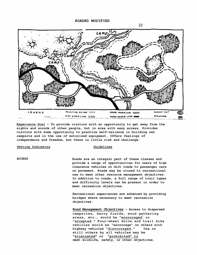
ROADED MODIFIED
22
Experience Goal - To provide visitors with an opportunity to get away from the sights and sounds of other people, but in area with easy access. Provides visitors with some opportunity to practice self-reliance in building own campsite and in the use of motorized equipment. Offers feelings of independence and freedom, but there is little risk and challenge.
Setting Indicators Guidelines
ACCESS Roads are an integral part of these classes and provide a range of opportunities for users of high clearance vehicles on dirt roads to passenger cars on pavement. Roads may be closed to recreational use to meet other resource management objectives. In addition to roads, a full range of trail types and difficulty levels can be present in order to meet recreation objectives.
Recreational experiences are enhanced by providing bridges where necessary to meet recreation objectives.
Road Management Objectives - Access to dispersed campsites, berry fields, wood gathering areas, etc., would be "encouraged” or "accepted." Four-wheel drive and trail bike vehicles would be "encourage" on others with highway vehicles "discouraged." Use on still others by all vehicles may be "eliminated” or "prohibited” to meet wildlife, safety, or other objectives.

ROADED MODIFIED (cont.)
Setting Indicators Guidelines
23 RM
REMOTENESS
NONRECREATION USES
ON-SITE MANAGEMENT
VISITOR MANAGEMENT
SOCIAL ENCOUNTERS
Remoteness is relevant to this opportunity to some degree but often is inherent in the setting because of the tremendous size of these areas, variability of activity occurring and pockets of undisturbed sites.
The natural setting is often heavily altered as this environment and access throughout are often the result of intensive commodity production. Timber harvest, for example, is constrained primarily by the NFMA regulation of shaping and blending harvest units with the terrain to the degree practicable. Harvest activities should protect user-established sites from alteration and provide access to them. It should be used to meet other recreation needs such as provide trailhead access, parking areas, and a diversity of travelway opportunities. Range condition of "good" or better is appropriate.
On-site facilities are not provided except for those needed for sanitary and safety reasons. Those provided should be of simple design and native rustic-like material. Site modification for facilities should be minimal. Site development level should be 2 or less.
Camping areas should be located at sites within coniferous forest areas where possible. In all cases, sites should be located to take advantage of topographic and vegetative screening.
Controls - Emphasis is to minimize visitor management controls imposed on on-site visitors. Management personnel may be present. Use limitations rarely employed. On-site physical controls permitted but must be subtle.
Information - Interpretation may vary from no on-site facilities to simple wayside exhibits of native rustic-like materials. Directional signs should be at major road junctions only. Other signs providing safety messages are appropriate.
Opportunities exist for visitors to be isolated from one another, particularly at campsites. Meeting others along travelways is common and frequent.
RMROADED MODIFIED (cont.)
Setting Indicators
VISITOR IMPACTS Guidelines
Water - Maintain the natural quality of streams and lakes. Activities should not degrade water quality except for temporary changes which are transitory in nature; i.e., the water quality returns to its previous level when the activity ceases.
Vegetation - Maintain healthy, native vegetation around campsite.
Vegetation impacts along trails should be confined to the planned location to meet management objectives of the trails.
Fish and Wildlife - Recreational use should not display wildlife from critical areas during critical periods, such as fawning and winter range.

25
RURAL
Experience Goal - To provide visitors with a good probability of meeting and enjoying others. Convenience in access to, and use of, sites is important. Challenge, risk, and testing of skills are relatively unimportant, except for some specific activities such as downhill skiing.
Setting Indicators Guidelines
ACCESS Roads are an integral part of this class and provide a range of opportunities for users of passenger cars on gravel and pavement surfaces. In addition to roads, a full range of trail types and difficulty levels can be present in order to meet recreation objectives.
Bridges are provided to meet recreation objectives. Design may be more refined and complex. Some synthetic materials may be appropriate but should be in harmony with natural surroundings.
Road Management objectives should encourage highway vehicles, RV's, buses, etc., with considerable comfort and convenience.
REMOTENESS Not a relevant indicator.

RURAL (cont.)
Setting Indicators
NONRECREATION USES
26
The natural setting may be culturally modified to the point that it is dominant to the sensitive travel route observer. It may include pastoral, agricultural, intensively managed wildland resource landscapes or utility corridors.
Structures are readily apparent and may range from scattered to small dominant clusters including power lines, summer home tracts, microwave installations, regional ski areas, major resorts and recreation areas.
Timber harvest is often done to meet Retention or Partial Retention of foregrounds and backdrops to important facilities, pastoral landscapes, etc. In less sensitive areas, Modification or Maximum Modification may be the adopted VQO.
ON-SITE MANAGEMENT
VISITOR MANAGEMENT
Highly complex and numerous facilities with some synthetic but harmonious materials. Design is more refined. Many convenience facilities such as flush toilets, lighting, piped-in water, etc. Site modification for facilities may be moderate to heavy.
Camping areas should be located at sites within coniferous forest areas where possible. In all cases, sites should be located to take advantage of topographic and vegetative screening.
Control - Relatively high number of rules and regulations may be in effect. Controls on users may be in the form of rules and regulations governing their use of the site as well as on the number of users allowed in the area. Management personnel commonly on site* Use of physical controls common, but generally using rustic materials. Some synthetic but harmonious materials may be appropriate.
Information - On-site information is important. Interpretation may be through more complex wayside exhibits including small lighted structures. Interpretive facilities such as kiosks and portals may be staffed part time.
Signing should be for comfort and convenience of the user. They may be more complex in design with some synthetic but harmonious materials.
RURAL (cont.)
Setting Indicators
SOCIAL ENCOUNTERS
27 Guidelines
Contacts among groups is frequent and high, both along travel ways and at campsites. Meeting and enjoying others is an important part of this experience and high levels of intergroup contact are appropriate.
VISITOR IMPACTS Air - Air is maintained as per State objectives.
Water - Maintain the natural quality of streams and lakes. Activities should not degrade water quality except for temporary changes which are transitory in nature; i.e., the water quality returns to its previous level when the activity ceases.
Vegetation - Maintain healthy, native vegetation around campsites. There should be no trees lost as the result of recreational activity.
Vegetation impacts along trails should be confined to the planned location to meet management objectives of the trails.
28
INCONSISTENCIES
An inconsistency is defined as a situation in which the condition of an indicator exceeds the range defined as acceptable by the management guidelines. For example, the condition of the indicators for an area may all be consistent with its management as a semi-primitive nonmotorized area with the exception of the presence of a mining operation in the middle of the area. Such a situation has the potential of leading to the eventual conversion of the character of the area to a more developed level.
In such a case, several questions need to be answered in order that the situation can be properly dealt with. First, how did the inconsistency occur? It could have resulted from an earlier management action. 0r, the impacts of the action on recreation might have been identified but judged to be unavoidable. Finally, the inconsistency could have occurred as the result of a purposeful course of action, where converting the ROS class was considered desirable.
Second, we need to ask what are the implications of the inconsistency? Here we need to trace out the likely consequences that will result from the presence of the inconsistency. Perhaps it will have little effect on the general character of the area. On the other hand, it could lead to profound changes on the area's character. It is important that these consequences be identified as carefully as possible. Many impacts may be slow to take form but by the time they become apparent, it may be too late to effectively control or prevent them from spreading. Such inadvertent changes can lead to great shifts in the character of area, departing substantially from that which is desired.
Finally, managers need to ask what should be done about the inconsistency. Three general kinds of actions are possible. First, perhaps nothing can or should be done. It may be concluded that the inconsistency will have little or no effect on the area's general character. Or, the agency may lack jurisdiction over the source of the inconsistency. A second response is to direct management action at the inconsistency to bring it back in line with the guidelines established for it, making it consistent with that ROS class. Finally, managers can respond to an inconsistency by altering the condition of the other indicators, thereby converting the original ROS class to a new one. This could occur where changing demand conditions warrant establishment of a new ROS class.
The main point to be understood with regard to inconsistencies is that they can be managed. The presence of one does not necessarily automatically lead to a change in ROS class. By analyzing its cause, implications, and possible solutions, an inconsistency can be handled in a logical and systematic fashion.

29
SUMMARY
The following sketches and photo series may help to summarize the Indicator conditions as they might change across the spectrum.