Embed Size (px)
Citation preview
E-927
Using Prescribed Fire in Oklahoma
Using Prescribed Fire in Oklahoma
Using Prescribed Fire in Oklahoma
Oklahoma Cooperative Extension ServiceDivision of Agricultural Sciences and Natural Resources
Oklahoma State Universityin cooperation with USDA Natural Resources Conservation Service,
the Oklahoma Department of Agriculture, Food, and Forestry, and the Oklahoma Department of Wildlife Conservation
Using Prescribed Fire in Oklahoma
Terrence G. BidwellProfessor and Extension SpecialistRangeland Ecology and Management
John R. WeirResearch Range SuperintendentRangeland Ecology and Management
J.D. CarlsonAgricultural/Fire MeteorologistBiosystems and Agricultural Engineering
Ronald E. MastersDirector of ResearchTall Timbers Research StationTallahassee, Florida
Samuel D. FuhlendorfAssociate ProfessorRangeland Ecology and Management
Jack WaymireBiologistOklahoma Department of Wildlife Conservation
Steve ConradyBiologistOklahoma Department of Wildlife Conservation
Revised February 7, 2006
Contents
Introduction __________________________________________________________________1Contemporary Use and Value of Prescribed Fire __________________________________1Fire Prescriptions _____________________________________________________________2Conducting the Burn __________________________________________________________2Firebreaks ____________________________________________________________________2Fire Crew _____________________________________________________________________4Cost of Burning _______________________________________________________________4Firing Techniques _____________________________________________________________4 Headfires ______________________________________________________________4 Backfires ______________________________________________________________5 Strip-headfires _________________________________________________________5 Flankfires _____________________________________________________________5 Area (spot) ignition ____________________________________________________5 Center and Ring ignition _______________________________________________6Weather Conditions ___________________________________________________________7Smoke Management ___________________________________________________________9 Category Day __________________________________________________________9 Screening Distance _____________________________________________________9 Trajectory of Smoke Plume _____________________________________________10 Identify Smoke Sensitive and other Affected Areas _______________________ 11 Evaluate the Results ___________________________________________________ 11Liability _____________________________________________________________________12Oklahoma’s Law on Prescribed Fire - Highlights _________________________________12How do I Burn to Comply with Current Oklahoma Law __________________________13Prescribed Fire Associations ___________________________________________________13Fire Effects __________________________________________________________________13Fighting Wildland Fires _______________________________________________________13Watch-OutSituations(SurvivalChecklistforFightingWildfires) __________________13Standard Fire Fighting Orders (Revised February 2003) ___________________________14Oklahoma Red Flag Fire Alert _________________________________________________14Oklahoma Fire Danger Model _________________________________________________15Other Web Pages Relevant to Fire Management _________________________________16Prescribed Burning Plan ______________________________________________________17Acknowledgements __________________________________________________________17Warning _____________________________________________________________________17PrescribedBurningNotificationPlan ___________________________________________18Prescribed Burning – Oklahoma Conservation Practice Job Sheet __________________19Note Pages __________________________________________________________________29


IntroductionIn pre-European settlement times, early explorers such as Washington Irving and Thomas
Nuttall found Native Americans using fire in the area now known as Oklahoma. Native Americans used fire to manage wildlife, a primary food source, and to maintain prairie openings in forested regions. Early settlers followed this example for a while, but gradually stopped burning. As land use changed, particularly to farming annual crops, the land was broken up into small ownerships thus eliminating most fires. In the mid-1900s, media attention focused on wildfires and Smokey the Bear. This information included misleading information about fire and its benefits to humans and the environment.
Fire is an ecosystem driver that facilitates ecosystem processes such as nutrient and water cycling. However, fire seldom affects ecosystems alone instead it works in concert with herbivory and climate, thus constituting an integral part of ecosystem restoration. Fire is mandatory for the health of prairies, shrublands, and forests throughout Oklahoma and most of the world. Fire is a necessary tool for managing wildlife, livestock, and timber; research has shown that although there are many land management tools, thereisnosubstituteforfire. It has taken almost 100 years for our contemporary culture to learn what Native American’s have known about fire for thousands of years.
Contemporary Use and Value of Prescribed FireAbout 2.5 million acres, or 6% of the total land area, of native prairie, shrubland, and forest
are burned in Oklahoma each year. Prescribed burning is increasing each year with the greatest gains in the southeastern part of the state. However, the number of acres burned is not keeping up with the need to control invading woody species and restore native habitats.
Before the mid-1980s relatively small amounts of land were intentionally burned except in the tallgrass prairie region of northeastern Oklahoma and the forests of southeastern Oklahoma. The increase in the use of prescribed fire can be attributed to public and landowner education from a number of sources. Internationally, scientists and land managers have acquired a better understanding of the historical role of fire in the development of ecosystems. Today, scientists and laymen recognize the role of fire in maintaining rangelands (i.e. prairies, shrublands, and savannahs) and forests. Most of Oklahoma’s native plant communities evolved with fire in conjunction with herbivory and climate as major influences on their development. As a result, most indigenous plants and animals are adapted to periodic fire. In fact, some plants require fire in order to complete their life cycle. A number of native animals and plants are dependent on periodic fire to create or maintain suitable habitat.
Unfortunately, most of Oklahoma’s native lands have been degraded as a result of the exclusion of fire. The most obvious example is the invasion of eastern redcedar and ashe juniper into prairies, shrublands, and forests across Oklahoma. Redcedar invasion is one readily visible ecological indicator of ecosystem dysfunction.
Prescribed fire is an inexpensive and natural process that can be used to restore ecosystems and landscapes to their historical biological diversity and productivity. Prescribed fire is essential in maintaining the habitat for some endangered or threatened species such as the lesser and greater prairie chicken, black-capped vireo, red-cockaded woodpecker, the eastern and western prairie fringed orchid, and many song birds. Prescribed fire can also be used as a tool to manipulate habitat for more common wildlife species such as bobwhite quail, white-tailed deer, and turkey.
Prescribed fire can be used to improve forage production, quality, composition, and palatability for livestock or wildlife. It can also be used to control non-native or undesirable plant species, plant diseases, and internal and external animal parasites such as ticks by modifying their habitat. Fire can be used in forest management to reduce logging debris and leaf litter, manage competing vegetation, manage regenerating stands, and prepare logged areas for planting or seeding. Prescribed fire can be used to enhance the appearance of both forests and rangelands. Fire creates open park-like conditions in forested areas, opens up savannah areas, and controls woody invasion on prairies. Fire can be an economically and ecologically sound alternative to herbicide use to reclaim native prairies, shrublands, savannahs, or forests and to reduce the probability of wildfires in the wildland-urban interface and intermix.
E-927 Using Prescribed Fire in Oklahoma 1 Notes:
Wildfires and a few poorly planned and executed intentional fires have received public attention in the media and have been blamed for destroying land. However, research and practical experience clearly demonstrate that fire does not destroy, but may cause a shift in plant species composition. The only real damage done by most of these wildfires is either to human built structures such as homes or to the standing or future timber values, when the trees are commercial species and are consumed or damaged in the wildfire. Depending on the land manager’s objectives, changes resulting from any fire may be either desirable or undesirable. For example, if a small area in a native grass is burned, wild or domestic grazing animals will concentrate their grazing on the burned area. This is called patch burning, patch grazing, or rotational grazing without fences, which does not reduce livestock production while it benefits many wildlife species. The growing season after the fire and grazing event may cause the area to be transformed from native tall grasses to native annual forbs that may be labeled as weeds by some. However, this is a short-term phenomenon and the burned/grazed area will revert back to preburned status under prescription grazing.
The key to the successful application of prescribed fire is to use it as part of an overall resource management plan that considers all of the operation’s resources and is directed toward specific management objectives. Only then can fire be used successfully.
Fire PrescriptionsDetailed fire prescriptions can be found in OSU Fact Sheet F-2878, Fire Prescriptions for
Vegetation Management. Unlike controlled burns or wildfire, prescribed fire has clear goals and objectives. However, the outcome to land resources from wildfire or prescribed fires is often similar. A prescribed fire is conducted with an appropriately trained crew and adequate equipment under a prescribed set of conditions for both safety and vegetation management objectives.
Conducting the BurnOnce it is determined that prescribed burning is appropriate, several critical steps must be
followed to plan and execute a safe and effective burn. The importance of planning cannot be overemphasized. Planning should begin ahead of time because the overriding consideration in planning is SAFETY. No one should attempt a prescribed burn without experience.
Planning includes developing a clear statement of objectives for the burn and how they will be accomplished. Considerations in planning include distance to roads, towns, neighbor’s houses, gas and oil production sites, and utilities. Other considerations include weather, vegetation type, desired vegetation response, topography, and pre- and post-management grazing strategies for domestic livestock and wildlife. The secret to prescribed burning is to let the weather, topography, and fuels work for you and not against you.
Effective application of prescribed fire requires an understanding of the technology plus experience. Prescribed burning requires the knowledge of how to manage people, weather, fire behavior, fuels, and plant and animal ecology. Good judgment and experience are required to appropriately integrate all of these aspects when making decisions before, during, and after the fire. Once safety and prescription guidelines are formalized, firebreak preparation can begin.
FirebreaksFirebreaks are used to contain the fire within the boundary of the burn unit and to assist
with reducing fuel along the boundary. Firebreaks can be used for access by equipment to the burn unit. Firebreaks must extend to bare ground or mineral soil, with no continuous fuel, so fire cannot creep across the line and outside the burn unit. Firebreaks can create erosion problems so care should be exercised on slopes.
It may also be necessary to mow or shred inside the burn unit along the downwind firebreaks to assist with the backfiring operation. Some fuels (examples: sand sagebrush, annual broomweed, and sand shinnery oak) are not totally consumed or burned in the backfiring operation or there is not enough continuous fine grass fuel for a backfire to carry, making backfiring unsafe because of unburned fuel that can carry a headfire into the backfire area and across the firebreak.
2 Oklahoma Cooperative Extension Service Notes:
One of the main problems along firebreaks occurs when dead trees and brush are present. If dozing is required, trees and brush piles should be pushed well inside of the burn unit (greater than 100 foot). It is best to scatter the trees instead of piling. If neither of these suggestions is possible then the brush should be piled next to the line and a dozed line made around them. This will allow the pile to be burned prior to burning the unit or to keep the pile from igniting during the burn. Burn brush piles in June when fuels are green. Burning during or after rain or snow with surrounding dead fuels often results in an escaped fire. Firebreaks may include any of the following: Mowedfirebreaks are best used in conjunction with a strip of bare ground. Do not leave
mowed grass in clumps or piles. Raking and/or baling is an option.Diskedfirebreaks are best made after mowing first, then disk twice, in opposite directions.
Make sure that residual grass does not form continuous fuel.Plowedfirebreaks are used with mowing if grass fuels are tall and/or heavy.Dozedfirebreaks should be scraped and not excavated. Do not leave piles of soil containing
fine fuels such as grass. Push soil piles outside of the burn area. Push brush inside the burn area and scatter. Do not make brush piles along a firebreak. Brush piles cause major problems during the fire and for several days after.
Two-track or pasture roads work well as firebreaks but it may be necessary to mow down the center and along the edge of the road to reduce tall fuels.
County roads work well as firebreaks but watch for traffic and tall fuels in the borrow ditches.Paved roads work very well but traffic must be managed. Also watch for burning embers
sliding across the road surface because of the wind.Naturalfirebreaks include rivers, creeks, ponds, lakes, canyons (may or may not work well
- watch out!), and cultivated fields.
Since most prescribed fires are conducted during the winter or spring, the firebreak should be prepared the preceding fall or at least six months ahead of the burning date. Disking, dozing, or blading are methods often used. The best method will be determined by the characteristics specific to the land area that is to be burned. Often a combination of methods is most appropriate because of variability in vegetation type, topography, and soil. Mowing as the only firebreak preparation should be discouraged because of safety concerns.
Often natural barriers such as streams or rock outcrops can be used as firebreaks. Linking man-made features such as ponds, roads, and plowed fields together with constructed firebreaks can save time and money. For disked or dozed firebreaks, caution should be used when disturbing highly erodible sites. For mowed firebreaks, heavy accumulations of downed fuel by mowing may need to be raked and removed. Fire spread along mowed firebreaks can be especially difficult to contain so mowed fire breaks should be used only by experienced crews in situations in which bare-soil fire breaks are not feasible. Brush piles or dead eastern redcedar trees, which can cause spot fires several hundred feet downwind from the firebreak, are very hazardous when close to a firebreak. Snags or hollow trees should be cut within 100 feet of firebreaks because they can cause a chimney effect when burning and spread embers many feet downwind. Better yet, protect hollow trees from fire by clearing a patch of bare ground around them. Hollow trees and snags are valuable habitat for many wildlife species. Brush piles should only be burned under special conditions (e.g. snow cover for several days, or in May and June with all green vegetation) and surrounded with very light fuel loads. However, we recommend that brush piles not be created at all and downed trees spread throughout the area to be burned.
Caution should be used when burning volatile fuels such as eastern redcedar or sagebrush. These species contain phenolics or other chemicals that flash when exposed to fire. Leaf litter should be raked or blown from firebreaks in forested areas. Pine needles are of special concern because fire can creep across firebreaks with only small amounts of pine leaf litter present. Caution should be used when burning stands of timber that have been recently logged or thinned. Logging or thinning debris increases fuel loads dramatically and can cause spot fire problems.
E-927 Using Prescribed Fire in Oklahoma 3 Notes:
The firebreak should be an appropriate type and width for the amount and type of fuel present as well as size of burn unit. To reduce flame length and fire intensity next to the firebreak use more than one type of firebreak (i.e. mowed and disked). The mowed area should be on the inside of the disked area. Firebreaks need to be wider on the downwind side of the area to be burned and should be burned-in or blackened inside the bladed line (bare ground). The minimum burn-in is usually 100 feet for grass fuels and 500 feet for windrowed brush or volatile fuels.
The burned-in firebreaks are prepared by using a less intense fire prescription (i.e. higher relative humidities, lower air temperatures, and lower wind speeds). For example, for a fire with a southwest wind, the burned-in firebreak would be on the north and east boundary of the area to be burned. If volatile fuels are a problem, firebreaks should be burned-in with a backfire and strip-headfire during the morning preceding the initiation of headfire. Otherwise, the burned-in firebreak is established as part of the firing procedure. Firebreaks in forested areas without prairie openings can be as little as eight feet wide if prescriptions for ground fires are used.
If the firebreak is planted with a cool season annual grass, then maintenance costs will be reduced, although there will be the initial cost of seeding and mowing until the stand is established. Avoid cool season perennials grass planting on firebreaks because they will contain dead material and support fire crossing the firebreak. Existing barriers such as roads sometimes can be used in the plan to reduce costs. A secondary, indirect cost may be needed to defer grazing or to implement a grazing system, such as intensive early stocking (IES), rotational grazing with fencing, or rotational grazing without fencing, known as patch burning, to allow for the build-up of an adequate fuel load to support a fire.
Fire CrewOnly one person who is highly experienced with firing techniques and fire behavior
serves as the fire boss. The fire boss is responsible for coordinating the fire crew, checking out all equipment, checking weather conditions, notifying the proper authorities, and directing implementation of the fire. If the landowner or the fire boss is not satisfied with the firebreak preparation, fire prescription, personnel, weather conditions, or other aspects of safety, then the fireboss should postpone the burn. If the fire has already been started, but is not going well, then the fire should be put out. Teamwork and communication between the fire boss, the fire crew, the landowner, and the relevant authorities are essential for successful prescribed burning.
A crew of people with experience in conducting a prescribed burn is absolutely necessary. Several neighbors will often work together so that all gain additional experience in prescribed burning and also pool their equipment resources. You can never get too much experience.
Cost of BurningThe costs of conducting a prescribed fire vary with the amount of preparation before the
fire, equipment and personnel used during and after the fire, and pre-burn and post-burn management. In general, costs vary from $0.50 to $10 per acre. Usually, the greatest direct cost of prescribed burning is preparing a firebreak around the perimeter of the area to be burned. Often firebreak preparation such as dozing is a one-time cost, and can be maintained indefinitely with mowing, disking, or herbicide. The cost of doing nothing or not burning is the most expensive because it will put you out of business, regardless of your objectives.
Firing TechniquesHeadfires, backfires, strip-headfires, area ignition, and center and ring ignition are useful
methods for setting fires under various conditions. Each fire type behaves differently and should be thoroughly understood before being used.
Headfires (Figure 1) move with the wind, are most intense, have the highest rates-of-spread (approximately 10 to 15 times faster than backfires), have long flame lengths, and have high maximum temperatures. Headfires are effective in killing trees and shrubs or burning downed
4 Oklahoma Cooperative Extension Service Notes:
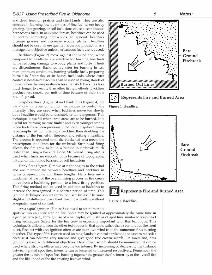
and dead trees on prairies and shrublands. They are also effective in burning low quantities of fine fuel where heavy grazing, spot grazing, or soil inclusions cause discontinuous herbaceous fuels. In oak/pine forests, headfires can be used to control competing hardwoods. In general, headfires increase grasses and decrease woody plants. Headfires should not be used where quality hardwood production is a management objective unless herbaceous fuels are reduced.
Backfires (Figure 2) move against the wind and, when compared to headfires, are effective for burning fine fuels while reducing damage to woody plants and forbs if fuels are discontinuous. Backfires are safer for burning in less than optimum conditions, burning volatile fuels, preparing burned-in firebreaks, or in heavy fuel loads where extra control is necessary. Backfires can be used in young stands of timber when the temperature is less than 45° F. Backfires take much longer to execute than other firing methods. Backfires produce less smoke per unit of time because of their slow rate-of-spread.
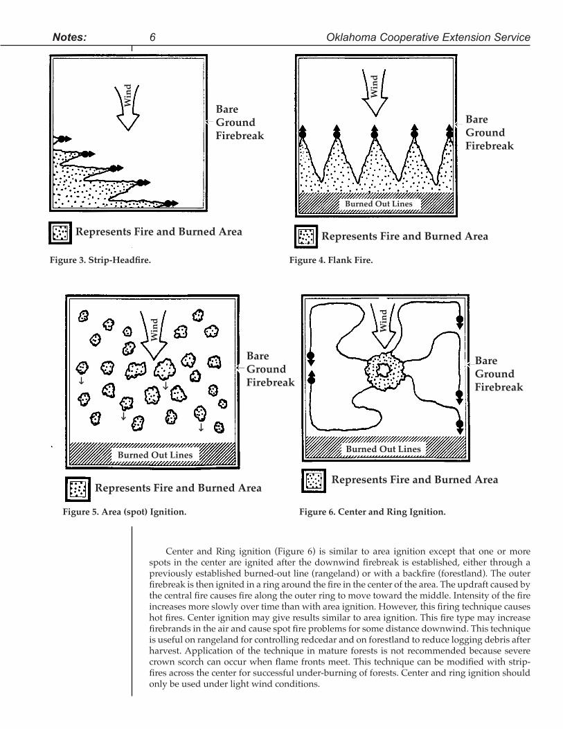
Strip-headfires (Figure 3) and flank fires (Figure 4) are variations in types of ignition techniques to control fire intensity. They are used when backfires move too slowly, but a headfire would be undesirable or too dangerous. This technique is useful when large areas are to be burned. It is useful for burning mature timber and even younger stands when fuels have been previously reduced. Strip-head firing is accomplished by initiating a backfire, then doubling the distance of the burned-in firebreak and setting a headfire. The process is repeated until the blackened area meets the prescription guidelines for the firebreak. Strip-head firing allows the fire crew to build a burned-in firebreak much faster than using a backfire alone. Strip-head firing also is used when fuels are discontinuous because of topography, natural or man-made barriers, or soil inclusions.
Flank fires (Figure 4) move at right angles to the wind and are intermediate between headfires and backfires in terms of spread rate and flame lengths. Flank fires are a fundamental part of the overall firing process as fire crews move from a backfiring position to a head firing position. This firing method can be used in addition to backfires to increase the area ignited in a shorter period of time. This ignition technique should rarely be used by itself because slight wind shifts can turn a flank fire into a headfire without adequate means of control.
Area (spot) ignition (Figure 5) is used to set numerous spots within an entire area on fire. Spots may be ignited at approximately the same time in a grid pattern (e.g., through use of a helicopter) or in strips of spot fires similar to strip-head firing techniques. Safety for the fire crew is especially important with this technique. This technique is different from the other techniques in that spots rather than a continuous fire front is set. Fires set with area ignition often create their own wind from the numerous fires burning together. This type of fire is often used on rangelands to control hardwoods or eastern redcedar because it can become very intense and give good tree crown scorch. On forestland, area ignition is used with different objectives. Here crown scorch should be minimized. It can be used where strip-headfires may become too intense. By increasing or decreasing the distance between ignited spot fires, intensity can be lessened or increased respectively. Remember, the greater the number of spot fires burning together the greater the fire intensity of the overall fire and the likelihood of the fire creating its own wind.
E-927 Using Prescribed Fire in Oklahoma 5 Notes:
Wind
Figure2.Backfire.
Bare GroundFirebreak
Represents Fire and Burned Area
Wind
Burned Out Lines
Figure1.Headfire.
Represents Fire and Burned Area
Bare GroundFirebreak
Notes:
Center and Ring ignition (Figure 6) is similar to area ignition except that one or more spots in the center are ignited after the downwind firebreak is established, either through a previously established burned-out line (rangeland) or with a backfire (forestland). The outer firebreak is then ignited in a ring around the fire in the center of the area. The updraft caused by the central fire causes fire along the outer ring to move toward the middle. Intensity of the fire increases more slowly over time than with area ignition. However, this firing technique causes hot fires. Center ignition may give results similar to area ignition. This fire type may increase firebrands in the air and cause spot fire problems for some distance downwind. This technique is useful on rangeland for controlling redcedar and on forestland to reduce logging debris after harvest. Application of the technique in mature forests is not recommended because severe crown scorch can occur when flame fronts meet. This technique can be modified with strip-fires across the center for successful under-burning of forests. Center and ring ignition should only be used under light wind conditions.
Win
d
Win
d
Burned Out Lines
Figure 5. Area (spot) Ignition.
Represents Fire and Burned Area
Win
d
Burned Out Lines
Figure 4. Flank Fire.
Bare GroundFirebreak
Represents Fire and Burned Area
6 Oklahoma Cooperative Extension Service
Win
d
Figure 6. Center and Ring Ignition.
Bare GroundFirebreak
Represents Fire and Burned Area
Burned Out Lines
Figure3.Strip-Headfire.
Bare GroundFirebreak
Represents Fire and Burned Area
Bare GroundFirebreak
Weather ConditionsOther than season of burn, weather variables are the main environmental factors considered
in developing a fire prescription. Fire behavior in rangeland and forestland is directly related to local weather conditions, and regional forecasts may not be accurate enough for decision-making concerning burning of local sites. Weather conditions must be monitored on site using a weather monitoring kit. Weather variables such as relative humidity, air temperature, and wind speed dictate how the fire will behave and how the plant community will respond to the fire. Wind speed and direction can change rapidly. Therefore, a prescribed fire should not be started within 12 hours of a weather front or when winds are variable in direction.
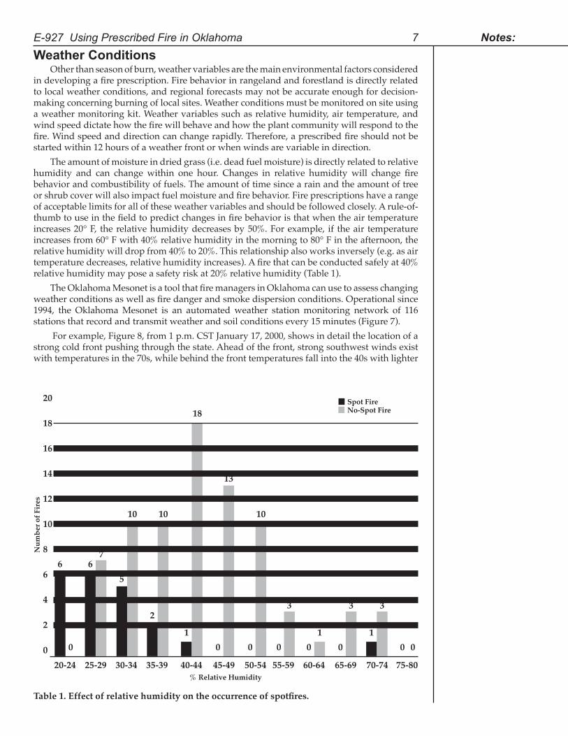
The amount of moisture in dried grass (i.e. dead fuel moisture) is directly related to relative humidity and can change within one hour. Changes in relative humidity will change fire behavior and combustibility of fuels. The amount of time since a rain and the amount of tree or shrub cover will also impact fuel moisture and fire behavior. Fire prescriptions have a range of acceptable limits for all of these weather variables and should be followed closely. A rule-of-thumb to use in the field to predict changes in fire behavior is that when the air temperature increases 20° F, the relative humidity decreases by 50%. For example, if the air temperature increases from 60° F with 40% relative humidity in the morning to 80° F in the afternoon, the relative humidity will drop from 40% to 20%. This relationship also works inversely (e.g. as air temperature decreases, relative humidity increases). A fire that can be conducted safely at 40% relative humidity may pose a safety risk at 20% relative humidity (Table 1).
The Oklahoma Mesonet is a tool that fire managers in Oklahoma can use to assess changing weather conditions as well as fire danger and smoke dispersion conditions. Operational since 1994, the Oklahoma Mesonet is an automated weather station monitoring network of 116 stations that record and transmit weather and soil conditions every 15 minutes (Figure 7).
For example, Figure 8, from 1 p.m. CST January 17, 2000, shows in detail the location of a strong cold front pushing through the state. Ahead of the front, strong southwest winds exist with temperatures in the 70s, while behind the front temperatures fall into the 40s with lighter
E-927 Using Prescribed Fire in Oklahoma 7 Notes:
Table1.Effectofrelativehumidityontheoccurrenceofspotfires.
20
18
16
14
12
10
8
6
4
2
0
Num
ber o
f Fir
es
20-24 25-29 30-34 35-39 40-44 45-49 50-54 55-59 60-64 65-69 70-74 75-80
6 6
0 0 0 0 0 0 0 0111
23 3 3
5
7
10 10 10
13
18Spot FireNo-Spot Fire
% Relative Humidity
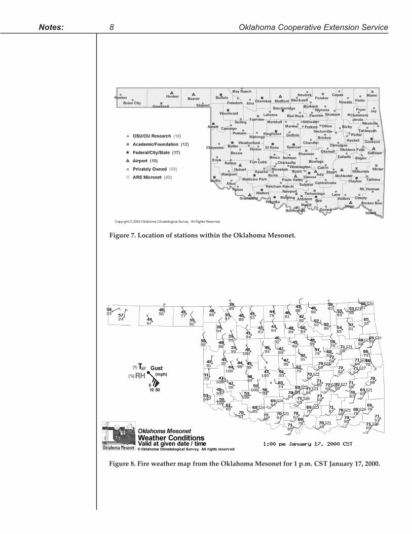
Figure 7. Location of stations within the Oklahoma Mesonet.
Figure 8. Fire weather map from the Oklahoma Mesonet for 1 p.m. CST January 17, 2000.
8 Oklahoma Cooperative Extension Service Notes:
northwest winds. Relative humidities increase behind the front as well. Because these maps are updated every 15 minutes, fire managers can see the location and speed of movement of various weather discontinuities, important in fire management. These weather maps, as well as many others, are available under “Current Weather” in the “Weather” section of the Oklahoma Agweather web site located at http://agweather.mesonet.org. Because of the spatial and temporal resolution of this weather station network, fire managers can see detailed weather conditions across the state in near-real-time.
Topography has a dramatic effect on wind speed, wind direction, and the spread rate of the fire, especially in mountainous regions or in canyons. The weather conditions depicted on Mesonet maps generally apply to flat terrain, so special precaution for erratic fire behavior and fire crew safety should be taken when burning in areas of non-uniform topography. A backup plan for fire escapes is essential in such areas.
Smoke Management Occasionally, weather conditions are within prescription guidelines to meet objectives,
but the smoke will not dissipate. Usually these conditions result from a thermal inversion in which warm air aloft traps air close to the earth’s surface. In this situation, smoke will stay close to the ground and reduce air quality and visibility. It is possible to “smoke-in” a town for several days. Fires that burn into the night may cause smoke problems. Smoke is usually more of a problem in the hilly and mountainous regions of eastern Oklahoma than in the rest of the state. If smoke crosses a road, a serious safety problem may exist for traffic. Be prepared with personnel to meet this challenge if it occurs.
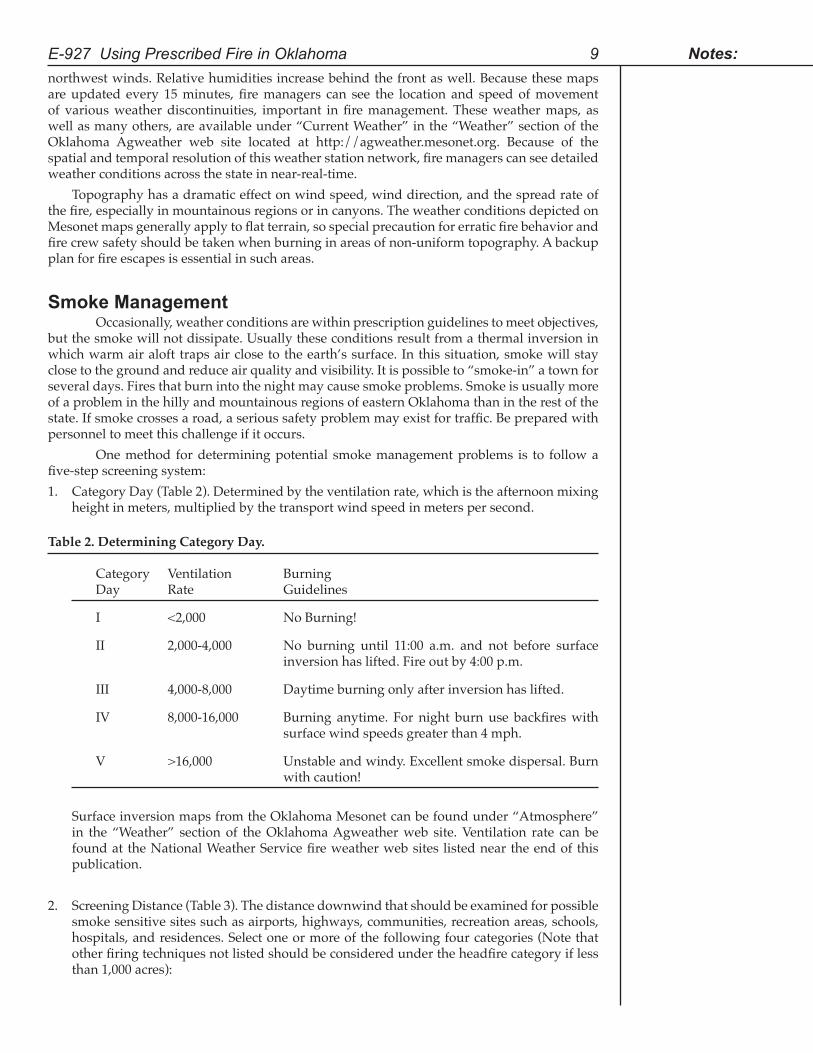
One method for determining potential smoke management problems is to follow a five-step screening system:1. Category Day (Table 2). Determined by the ventilation rate, which is the afternoon mixing
height in meters, multiplied by the transport wind speed in meters per second. Table 2. Determining Category Day.
Category Ventilation Burning Day Rate Guidelines
I <2,000 No Burning!
II 2,000-4,000 No burning until 11:00 a.m. and not before surface inversion has lifted. Fire out by 4:00 p.m.
III 4,000-8,000 Daytime burning only after inversion has lifted.
IV 8,000-16,000 Burning anytime. For night burn use backfires with surface wind speeds greater than 4 mph.
V >16,000 Unstable and windy. Excellent smoke dispersal. Burn with caution!
Surface inversion maps from the Oklahoma Mesonet can be found under “Atmosphere”
in the “Weather” section of the Oklahoma Agweather web site. Ventilation rate can be found at the National Weather Service fire weather web sites listed near the end of this publication.
2. Screening Distance (Table 3). The distance downwind that should be examined for possible smoke sensitive sites such as airports, highways, communities, recreation areas, schools, hospitals, and residences. Select one or more of the following four categories (Note that other firing techniques not listed should be considered under the headfire category if less than 1,000 acres):
E-927 Using Prescribed Fire in Oklahoma 9 Notes:
Notes:
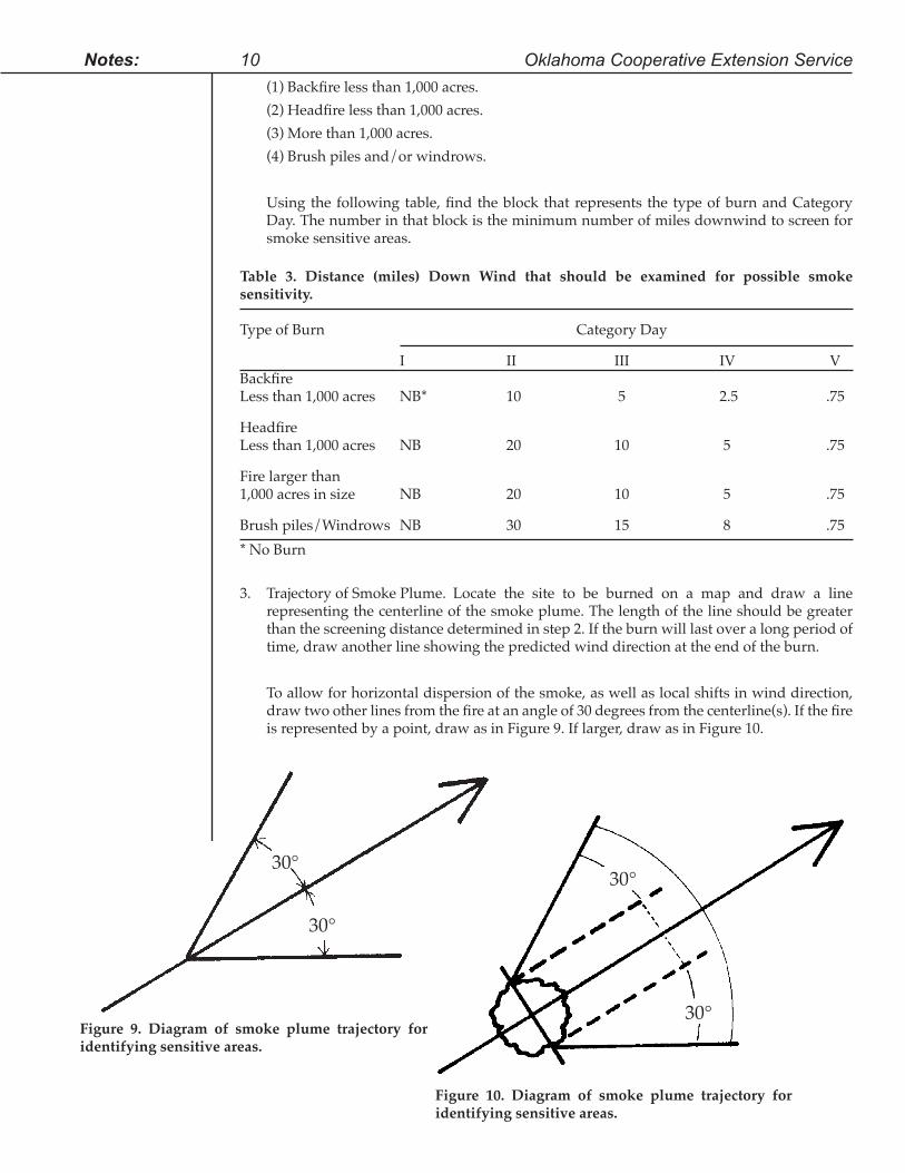
(1) Backfire less than 1,000 acres. (2) Headfire less than 1,000 acres. (3) More than 1,000 acres. (4) Brush piles and/or windrows.
Using the following table, find the block that represents the type of burn and Category Day. The number in that block is the minimum number of miles downwind to screen for smoke sensitive areas.
Table 3. Distance (miles) Down Wind that should be examined for possible smoke sensitivity.
Type of Burn Category Day
I II III IV V BackfireLess than 1,000 acres NB* 10 5 2.5 .75
HeadfireLess than 1,000 acres NB 20 10 5 .75
Fire larger than1,000 acres in size NB 20 10 5 .75
Brush piles/Windrows NB 30 15 8 .75* No Burn
3. Trajectory of Smoke Plume. Locate the site to be burned on a map and draw a line representing the centerline of the smoke plume. The length of the line should be greater than the screening distance determined in step 2. If the burn will last over a long period of time, draw another line showing the predicted wind direction at the end of the burn.
To allow for horizontal dispersion of the smoke, as well as local shifts in wind direction,
draw two other lines from the fire at an angle of 30 degrees from the centerline(s). If the fire is represented by a point, draw as in Figure 9. If larger, draw as in Figure 10.
10 Oklahoma Cooperative Extension Service
30°
30°
Figure 10. Diagram of smoke plume trajectory for identifying sensitive areas.
Figure 9. Diagram of smoke plume trajectory for identifying sensitive areas.
30°
30°
4. Identify Smoke Sensitive and other Affected Areas. Some areas may be adversely affected by smoke. Using the smoke plume trajectory map:
(a) Determine the smoke sensitive areas within the smoke trajectory. (b) Recognize the smoke sensitive areas that already have an air pollution problem. (c) Identify any potential area where emission of sulfur dioxide (SO2) merges with the
smoke plume. Likely sources of sulfur dioxide are smelters, electric power plants, and other factories where coal is burned (SO2 combined with particulates from fire may be a significant health hazard).
(d) Should other known sources of smoke overlap your trajectory toward a sensitive area, consider increasing the screening distance on the trajectory map to account for the effects of the combination.
5. Evaluate the Results. If you identify any areas in Step 4 that could be adversely impacted by smoke production from the prescribed fire, postpone the burn and wait for a higher Category Day, one that will reduce the smoke trajectory enough that those areas will not be impacted.
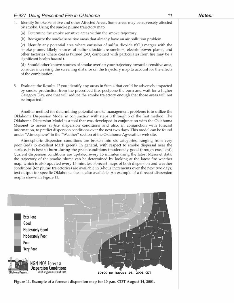
Another method for determining potential smoke management problems is to utilize the Oklahoma Dispersion Model in conjunction with steps 3 through 5 of the first method. The Oklahoma Dispersion Model is a tool that was developed in conjunction with the Oklahoma Mesonet to assess surface dispersion conditions and also, in conjunction with forecast information, to predict dispersion conditions over the next two days. This model can be found under “Atmosphere” in the “Weather” section of the Oklahoma Agweather web site.
Atmospheric dispersion conditions are broken into six categories, ranging from very poor (red) to excellent (dark green). In general, with respect to smoke dispersal near the surface, it is best to burn during the green conditions (moderately good through excellent). Current dispersion conditions are updated every 15 minutes using the latest Mesonet data; the trajectory of the smoke plume can be determined by looking at the latest fire weather map, which is also updated every 15 minutes. Forecast maps of both dispersion and weather conditions (for plume trajectories) are available in 3-hour increments over the next two days; text output for specific Oklahoma sites is also available. An example of a forecast dispersion map is shown in Figure 11.
E-927 Using Prescribed Fire in Oklahoma 11 Notes:
Figure 11. Example of a forecast dispersion map for 10 p.m. CDT August 14, 2001.
LiabilityLiability for any damages caused by the fire rests with the person who sets the fire or
who causes the fire to be set. Prudent action by the landowner and fire crew in carrying out a prescribed fire will demonstrate a “good neighbor policy” and will help to prevent frivolous claims and lawsuits. Prudent action is defined as using good judgment and executing a well-designed fire plan.
What is negligence? It is the failure to exercise the degree of care that the situation requires. It is a subjective measure that in some extreme cases is measured by a judge and jury. The burden of proof rests with the plaintiff. However, the person who sets the fire or causes it to be set can be held liable even if not negligent. Even though the Oklahoma Prescribed Burning Law does not address negligence, it is very important in determining damages during a jury trial.
Oklahoma is one of only four states that impose strict liability on prescribed burners. Under strict liability, defendants are liable for the damage caused by an escaped prescribed fire even is there is no evidence of negligence on their part and regardless of the precautions taken to contain the fire. An escaped fire is prima fascia evidence of negligence, so determining the value of the damages is the only question in the case of a damage claim or civil suit.
An important consequence of the lack of a reasonable negligence rule in Oklahoma’s prescribed burning statute is that the burner is assuming all the liability risk even when a neighbor could have reduced potential damage by managing fuels and other actions (such as using fire-resistant building materials on houses). Therefore, homeowners and other landowners living in the context of wildland fuels are free to practice negligence in the face of potential wildfire either from an escaped prescribed fire or a wildfire with no liability consequence. This is a classic example of contributory negligence on behalf of the homeowner.
However, negligence rules are changing across the country partly in response to the realization that fire in the urban-wildland interface or intermix requires prudence on the part of all property owners. Property owners should act responsibly and manage their fuels and select fire resistant building materials. An excellent program called Firewise (http://www.firewise.org) is being used nationwide to educate homeowners on fire protection.
The best defense against liability claims from an escaped fire is to exercise good judgment with all decisions and ensure that all prudent actions are taken. These actions include following all existing standards, rules, and regulations for prescribed burning. Claiming ignorance of prescribed burning methods or governmental regulations is not an acceptable defense. In most cases, ranch/farms insurance policies cover claims related to prescribed fire. However, after reviewing situations and legal cases that we are aware of for the past 20 years in Oklahoma, there are no examples of settlement of claims or successful lawsuits where a well designed prescribed fire plan was followed.
Oklahoma’s Law on Prescribed Fire - HighlightsIn Oklahoma the term “prescribed burning” has a legal definition and a burn that is not
conducted in accordance with this definition and the state statute (O.S. Title 2 - Section 16-28.2) that describes the prescribed burning process, is considered a “controlled” or even an “uncontrolled” burn. 1. It is lawful to burn. (Section 16-24.1A).2. It is considered a property right if conducted properly. (Section 16-28.2.F(1)).3. You are liable if the fire escapes. (Section(s) 16-24.1B, 16-28.D(a)).4. Civilly liable for the amount of actual damages only. (Section 16-28 and 16-28.2.G(2)).5. Criminal liability if found to have committed gross negligence, i.e. not fulfilling parts of
Section 16-28.2, to include not filling out the Prescribed Fire Notification Plan, notifying adjoining landowners, adequate fire breaks, etc. (Section16-28.G(2)).
12 Oklahoma Cooperative Extension Service Notes:
How do I Burn to Comply with Current Oklahoma Law?A complete discussion on the legal requirement to conduct a lawful prescribed burn may
be found at http://www.oda.state.ok.us/main/srvs/agform/burnlaw.pdf or by contacting the Oklahoma Department of Agriculture, Food, and Forestry at 405.522.6158.• Take reasonable precaution against the fire spreading to other lands: Provide adequate
firebreaks, manpower, and fire fighting equipment. Watch over the fire until extinguished. (Section(s) 16-28.A(1,2,&3)).
• Notify local Forestry Division representative at least four hours in advance in protection areas. (Section 16-28.A(1)).
• Within 60 days of conducting the fire, notify orally or in writing all adjoining landowners. Include proposed date, location, and contact number. (Section 16-28.2.B).
• Complete the prescribed burning notification plan (page 18) and submit to local fire department or Forestry Division representative. Keep a copy for your records. (Section 16-28.2.C).
• Within 48 hours of conducting the burn, notify local fire department and/or local Forestry Division representative. (Section 16-28.2.E(1&2)).
This section is not intended to be used as a substitute for the law. Read and know the law before conducting any prescribed fire.
Prescribed Fire AssociationsA Prescribed Fire Association (PFA) is made up of landowners and others interested in
conducting prescribed fires. The purpose of a PFA is to share knowledge, experience, and equipment among members to facilitate and increase the use of prescribed burning. There are several PFAs functioning very successfully in Oklahoma and others are forming. Cooperators include landowners, state and Federal agencies, and rural and municipal fire departments. See the OSU Fact Sheet F-2880 Prescribed Fire Associations.
Fire EffectsPrescribed fire or wildfires often have the same effects on soils, vegetation, livestock
grazing, and wildlife habitat. For a thorough discussion of the research related to fire effects, see OSU Fact Sheet F-2877, Fire Effects in Oklahoma.
Fighting Wildland FiresTraining courses and manuals are available on fighting wildfires. The following checklist
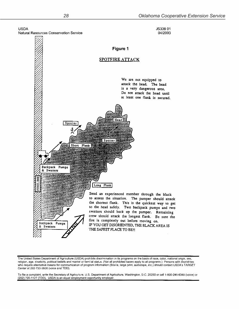
gives a brief overview of potentially dangerous situations. Each year in Oklahoma fire fighters and citizens alike are injured trying to fight wildfires. Too often landowners and others without proper training get excited and make poor decisions. This can result in people being trapped by the fire, vehicles wrecked, and other unnecessary accidents. If you do not have the training andarenotingoodphysicalcondition,stayawayfromthefire. Never try to fight a wildfire except from the blackened area (the area that has already burned). Never fight the fire from within an area of unburned fuel or ahead (downwind) of the fire.
Watch-Out Situations (Survival Checklist for Fighting Wildfires)1. Fire not scouted and sized up.2. In terrain not seen in daylight.3. Safety zones and escape routes not identified.4. Unfamiliar with weather and local factors influencing fire behavior.5. Uninformed on strategy, tactics, and hazards.
E-927 Using Prescribed Fire in Oklahoma 13 Notes:
6. Instructions and assignments not clear.7. No communication link with crew members/supervisor.8. Constructing a firebreak without a safe anchor point.9. Building a firebreak with fire below.10. Attempting frontal assault on fire.11. Unburned fuel between you and the fire.12. Cannot see main fire, not in contact with anyone who can.13. On a hillside where rolling material can ignite fuel below.14. Weather is getting hotter and drier.15. Wind increases and/or changes direction.16. Getting frequent spot fires across firebreak.17. Terrain and fuels make escape to safety zones difficult.18. Taking a nap near a firebreak.
Standard Fire Fighting Orders (Revised February 2003)1. Keep informed on fire weather conditions and forecasts.2. Know what your fire is doing at all times.3. Base all actions on current and expected behavior of the fire.4. Identify escape routes and safety zones, and make them known.5. Post lookouts when there is possible danger.6. Be alert. Keep calm. Think clearly. Act decisively.7. Maintain prompt communications with your forces, your boss, and adjoining forces.8. Give clear instructions and be sure they are understood.9. Maintain control of your forces at all times.10. Fight fire aggressively, having provided for safety first.
Oklahoma Red Flag Fire Alert During periods when weather and wildland fuel conditions combine to create
abnormal wildland fire hazards, the Oklahoma Forestry Service will issue a Red Flag Fire Alert (http://www.oda.state.ok.us/redflag/forred.html). This means that outdoor burning may be more risky than normal. When high winds (greater than 20 miles per hour), low relative humidity (less than 30%), and dry herbaceous or woody fuels (less than 6% for 1/2 inch diameter dead sticks) occur together, the number of wildfires, the intensity of wildfires, and the acres of land burned increases dramatically.
Almost all of the wildland fires experienced during these periods result from arsonists or people’s activities such as burning trash and brush piles, playing with matches and fireworks, or discarding cigarettes.
Fire danger is obvious in emergency situations, but there are other times when fire danger is not so easily recognized. An Oklahoma Red Flag Fire Alert means that the conditions that can support wildfires are worsening. The Red Flag Fire Alert will provide this warning, urging citizens to exercise extreme care. However, during a Red Flag Fire Alert, conditions exist that are within some fire prescriptions for certain management objectives and can be conducted safely. In summary, a Red Flag Fire Alert:1. Alerts all fire protection agencies to the increased risk, so that quick response to reported
wildfires may be made.2. Reminds people who use fire to take extra care to contain their fire and be sure it is out
before leaving it, or consider postponing burning until conditions are safer.3. Cautions the public to be extra careful with outdoor fires, smoking materials, and
matches.
14 Oklahoma Cooperative Extension Service Notes:
4. Cautions residents whose homes are in or next to wildland fuels to take measures to protect their dwellings if a fire should break out.
5. Alerts law enforcement personnel and community residents to report any activity that indicates an arsonist is setting fire.
6. Alerts landowners to keep a close watch on their land and carry out protection measures.
NOTE: The Red Flag Fire Alert is not a burning ban and is not intended for that purpose. It is intended to warn people of potential problems if fire should escape. The Red Flag Fire Alert is intended to be used only when current and forecast weather and fuel conditions exist to warrant the alert. These conditions must exist over an area larger than a single county and be forecast to be present for as least 24 hours on a continuous basis or in a repeating daily pattern. The Red Flag Fire Alert will be rescinded when burning conditions improve.
Oklahoma Fire Danger ModelAn excellent tool to assess the current state of fire danger across Oklahoma is the Oklahoma
Fire Danger Model, a joint project of the U.S. Forest Service and Oklahoma State University since 1994. This model, which has been on the Web since 1996, is an adaptation of the National Fire Danger Rating System (NFDRS) to Oklahoma, but to 1-km resolution and using hourly weather data from the Oklahoma Mesonet in conjunction with weekly satellite imagery. The model is available under either the “Rangeland” or “Forestry” sections of the Oklahoma Agweather web page.
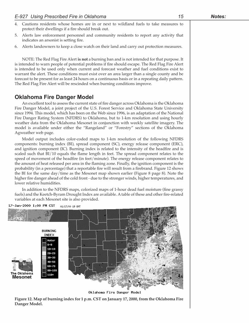
Model output includes color-coded maps to 1-km resolution of the following NFDRS components: burning index (BI), spread component (SC), energy release component (ERC), and ignition component (IC). Burning index is related to the intensity of the headfire and is scaled such that BI/10 equals the flame length in feet. The spread component relates to the speed of movement of the headfire (in feet/minute). The energy release component relates to the amount of heat released per area in the flaming zone. Finally, the ignition component is the probability (in a percentage) that a reportable fire will result from a firebrand. Figure 12 shows the BI for the same day/time as the Mesonet map shown earlier (Figure 8 page 8). Note the higher fire danger ahead of the cold front - due to the stronger winds, higher temperatures, and lower relative humidities.
In addition to the NFDRS maps, colorized maps of 1-hour dead fuel moisture (fine grassy fuels) and the Keetch-Byram Drought Index are available. A table of these and other fire-related variables at each Mesonet site is also provided.
E-927 Using Prescribed Fire in Oklahoma 15 Notes:
Figure 12. Map of burning index for 1 p.m. CST on January 17, 2000, from the Oklahoma Fire Danger Model.
These fire danger maps can be used in conjunction with the Mesonet fire weather maps to assess the general state of fire danger across the state. One note of caution - the model assumes generally flat terrain, so for fires within canyons or on fairly steep slopes, fire behavior can be markedly different. In addition, each square kilometer in the state is assigned a specific fuel type and if the fuel type in the fire of concern is different, then so will be the fire behavior. But for a general, real-time view of fire danger across the state, the Oklahoma Fire Danger Model represents a valuable tool for fire management.
Other Web Pages Relevant to Fire Management In addition to the products already mentioned (Mesonet fire weather and inversion maps,
Oklahoma Dispersion Model, Oklahoma Fire Danger Model), there are other fire-related products available on the Oklahoma Agweather web site (http://agweather.mesonet.org). These include maps of recent rainfall (last 1, 3, 6, 12, 24, 48, and 72 hours) and a variety of other weather information. In addition, zoomable radar maps from the National Weather Service (NWS) are available. Access to forecast information is also provided. In particular, graphical and text forecasts (NGM MOS forecasts) are available in 3-hour increments out to 60 hours in the future. These forecasts are useful for planning fire activities over the next two days. NWS forecasts from the Norman, Tulsa, Amarillo, and Shreveport offices are also available. In addition, access to longer-range NWS forecasts is available such as 7-day MRF MOS forecasts, 6-10 day, 8-14 day, and 30- and 90-day outlooks.
Specific fire weather forecasts for Oklahoma, which include ventilation rate - from which Category Day can be determined (Table 2 page 9), can be found at the following addresses:http://www.srh.noaa.gov/tulsa/fireweather.html (Tulsa NWS)http://www.srh.noaa.gov/oun/firewx (Norman NWS)http://www.srh.noaa.gov/ama/html/firewx.htm (Amarillo NWS)http://www.srh.noaa.gov/shv/firewx.htm (Shreveport NWS)
With respect to national-scale fire weather products, the following sites are of note:http://www.fs.fed.us/land/wfas (Wildland Fire Assessment System)http://fire.boi.noaa.gov (National Fire Weather Page)http://www.firedetect.noaa.gov/viewer.htm (real-time satellite fire detection)http://www.srh.noaa.gov/tulsa/model.html (national forecasts, including MOS forecasts for specific sites from various NWS models)
16 Oklahoma Cooperative Extension Service Notes:
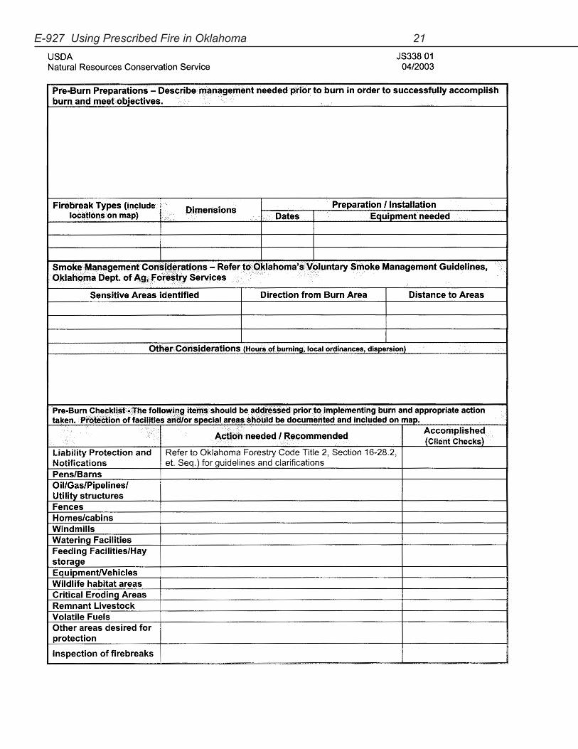
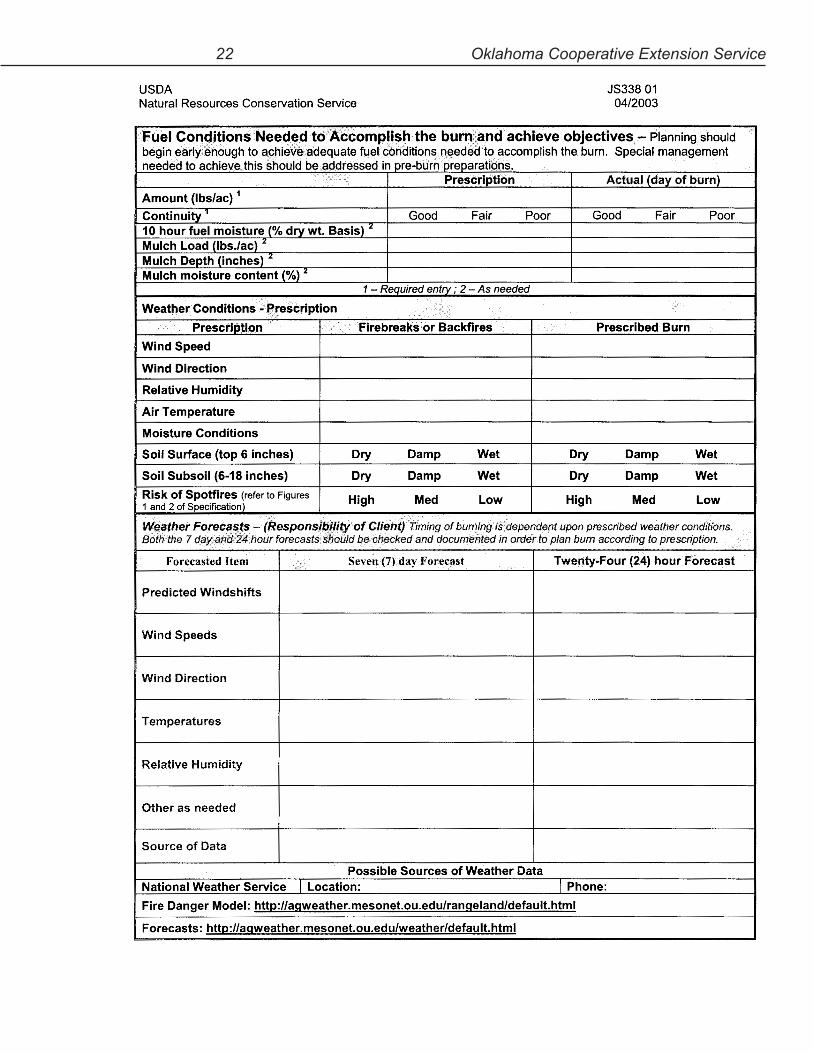
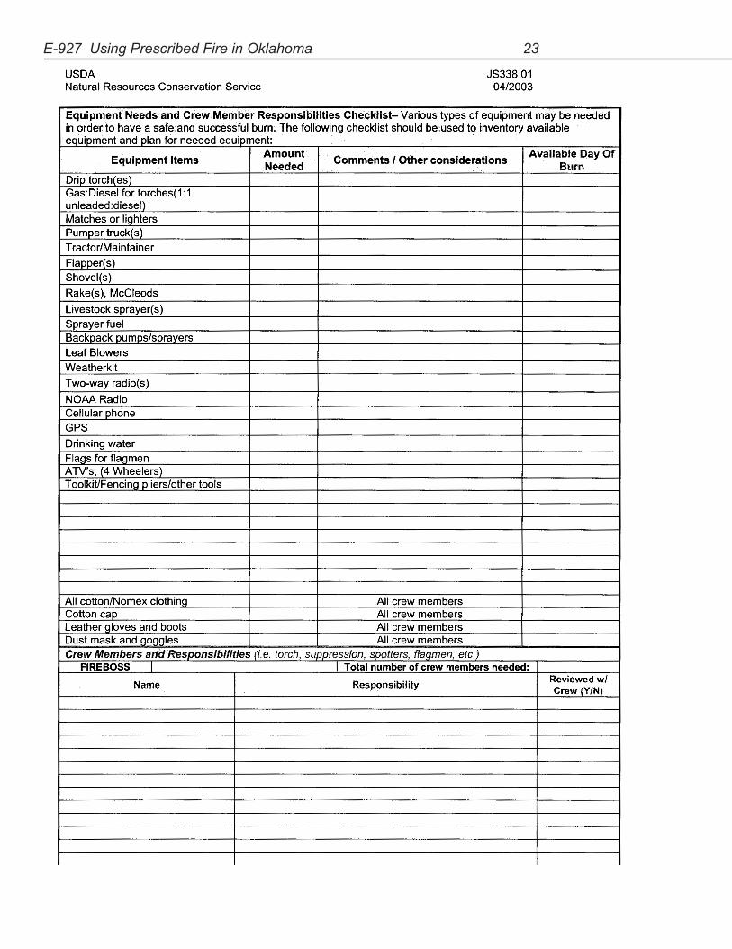
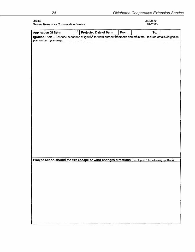
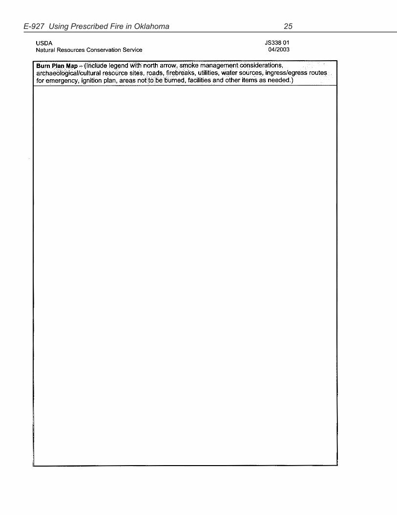
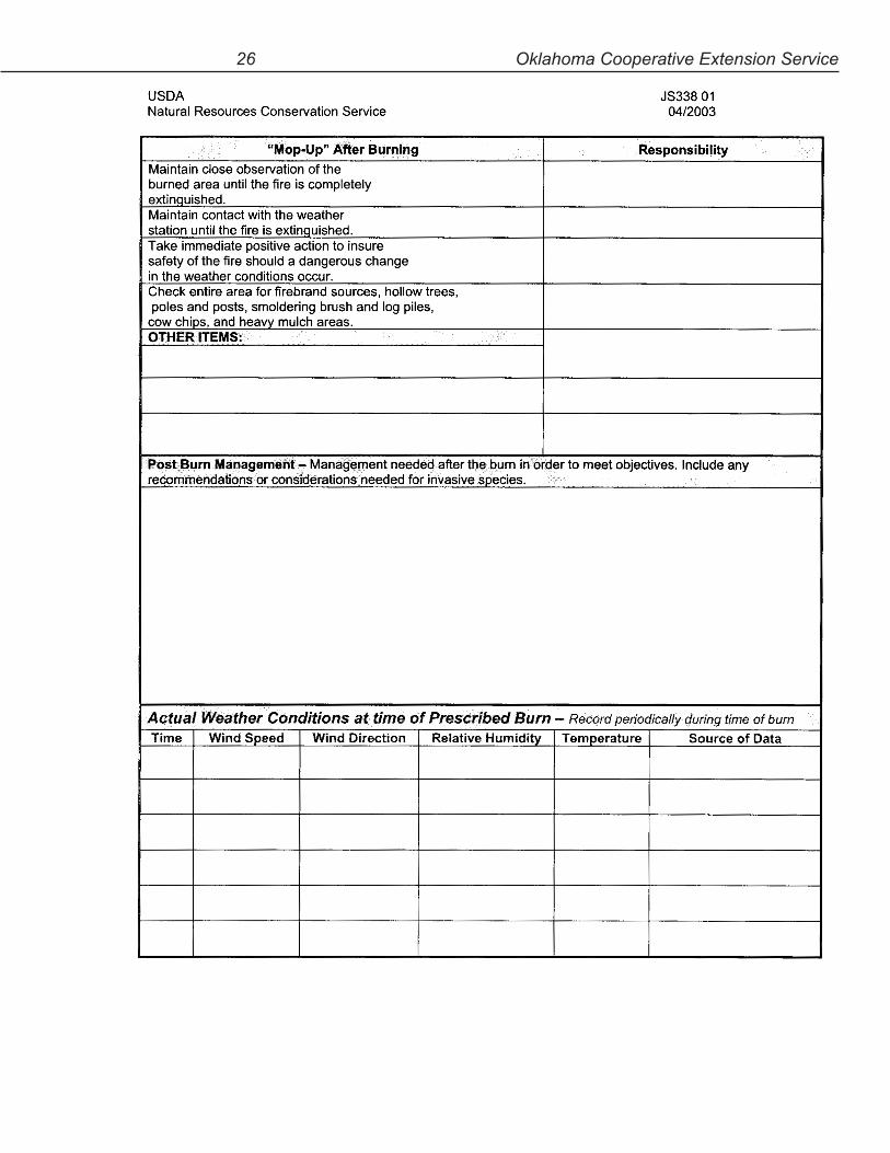
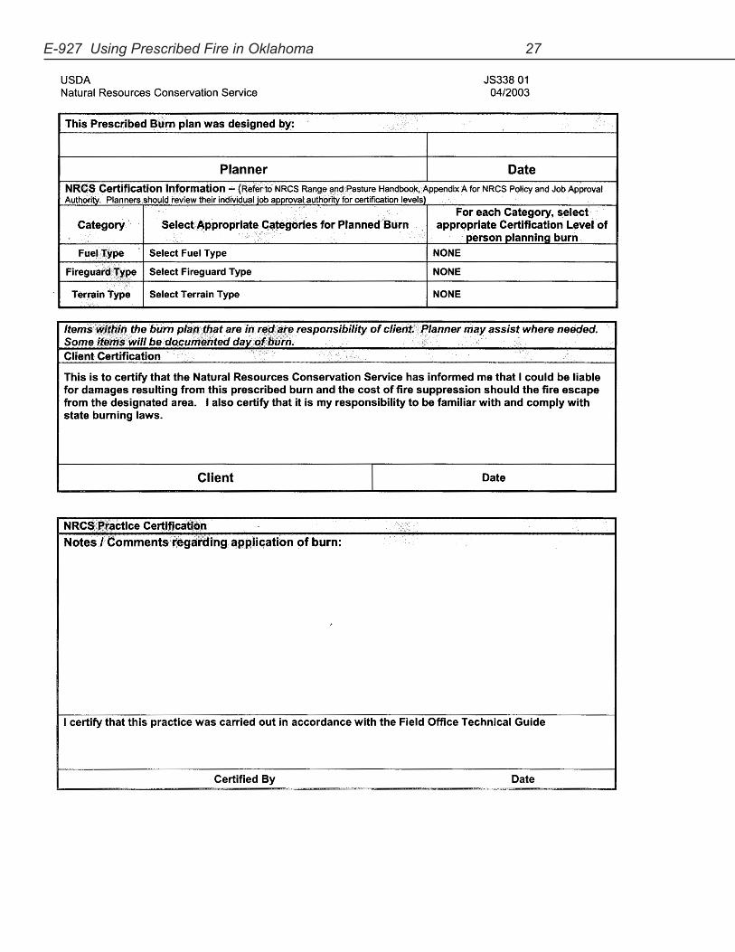
Prescribed Burning PlanObtain a copy of the Prescribed Burning Plan from the back of this circular, from your
county Natural Resources Conservation Service (NRCS) office, or access from the Web at http://www.ok.nrcs.usda.gov/ Do a search for standard in the search boxSelect Technical Resources Oklahoma NRCSSelect Oklahoma Job SheetsScroll down to Range Job SheetsSelect Prescribed Burning
AcknowledgementsPersonnel at the Oklahoma Department of Agriculture, Food, and Forestry-Forestry
Services; the USDA-Natural Resources Conservation Service; the Oklahoma Conservation Commission; the USDI-Fish and Wildlife Service, and the Oklahoma Department of Wildlife Conservation reviewed this circular.
WarningReading this or any other material in and of itself does not prepare you for burning.
You must also gain experience. There are many experienced private and governmental fire managers throughout the state. You can gain experience by burning with experienced crews and attending prescribed fire training workshops.
E-927 Using Prescribed Fire in Oklahoma 17 Notes:
18 Oklahoma Cooperative Extension Service
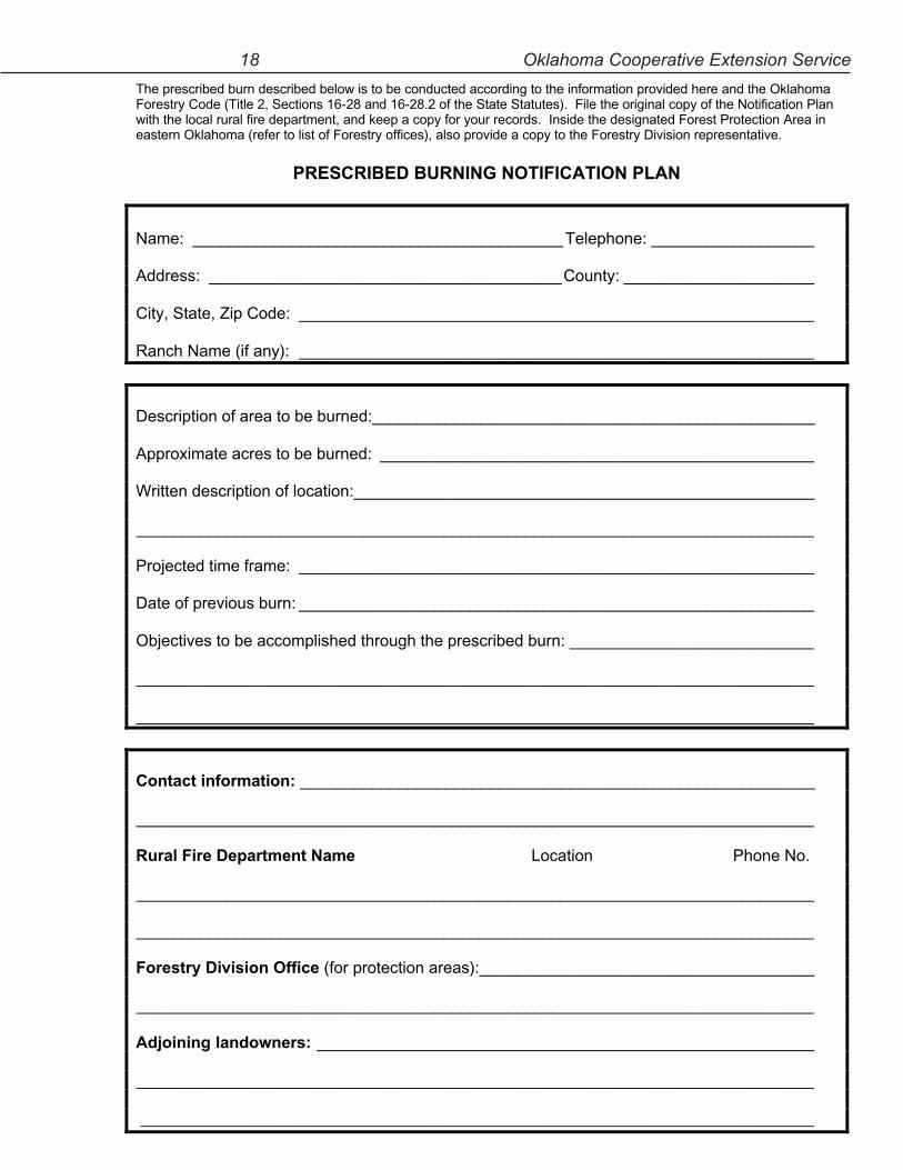
The prescribed burn described below is to be conducted according to the information provided here and the Oklahoma Forestry Code (Title 2, Sections 16-28 and 16-28.2 of the State Statutes). File the original copy of the Notification Plan with the local rural fire department, and keep a copy for your records. Inside the designated Forest Protection Area in eastern Oklahoma (refer to list of Forestry offices), also provide a copy to the Forestry Division representative.
PRESCRIBED BURNING NOTIFICATION PLAN
Name: _________________________________________Telephone: __________________
Address: _______________________________________County: _____________________
City, State, Zip Code: _________________________________________________________
Ranch Name (if any): _________________________________________________________
Description of area to be burned:_________________________________________________
Approximate acres to be burned: ________________________________________________
Written description of location:___________________________________________________
___________________________________________________________________________
Projected time frame: _________________________________________________________
Date of previous burn: _________________________________________________________
Objectives to be accomplished through the prescribed burn: ___________________________
___________________________________________________________________________
___________________________________________________________________________
Contact information: _________________________________________________________
___________________________________________________________________________
Rural Fire Department Name Location Phone No.
___________________________________________________________________________
___________________________________________________________________________
Forestry Division Office (for protection areas):_____________________________________
___________________________________________________________________________
Adjoining landowners: _______________________________________________________
___________________________________________________________________________
____________________________________________________________________________
E-927 Using Prescribed Fire in Oklahoma 19
20 Oklahoma Cooperative Extension Service
E-927 Using Prescribed Fire in Oklahoma 21
22 Oklahoma Cooperative Extension Service
E-927 Using Prescribed Fire in Oklahoma 23
24 Oklahoma Cooperative Extension Service
E-927 Using Prescribed Fire in Oklahoma 25
26 Oklahoma Cooperative Extension Service
E-927 Using Prescribed Fire in Oklahoma 27
28 Oklahoma Cooperative Extension Service

E-927 Using Prescribed Fire in Oklahoma 29
Notes:
30 Oklahoma Cooperative Extension Service
Notes:
Oklahoma State University, in compliance with Title VI and VII of the Civil Rights Act of 1964, Executive Order 11246 as amended, Title IX of the Education Amendments of 1972, Americans with Disabilities Act of 1990, and other federal laws and regulations, does not discriminate on the basis of race, color, national origin, gender, age, religion, disability, or status as a veteran in any of its policies, practices, or procedures. This includes but is not limited to admissions, employment, financial aid, and educational services.
Issued in furtherance of Cooperative Extension work, acts of May 8 and June 30, 1914, in cooperation with the U.S. Department of Agriculture, Robert E. Whitson, Director of Cooperative Extension Service, Oklahoma State University, Stillwater, Oklahoma. This publication is printed and issued by Oklahoma State University as authorized by the Vice President, Dean, and Director of the Division of Agricultural Sciences and Natural Resources and has been prepared and distributed at a cost of $1.34 per copy. 1103 JA
We are always striving to better serve our stakeholders’ needs. Please provide us feedback about this NREM document by completing a brief survey on the website: http://www.dasnr.okstate.edu/nremsurveys/ned. It should only require a couple of minutes of your time, and no identifying information will be asked of you. Your comments will be used to provide a higher quality of service in the future. Thank you.