Embed Size (px)
Citation preview

107
Using Local Early Action Planning (LEAP) to inform Climate Change Vulnerability Assessments – Guam 2019
Romina King, Marcel Higgs III, Kaylyn Bautista, and Edward Leon-Guerrero
University of Guam
Abstract Local Early Action Planning (LEAP) is a tool developed by the Nature Conservancy to engage communities in creating place-based climate histories meant to inform natural resource managers and decision makers about community concerns, perceptions, and collective knowledge. The tool was used at the All Planners Climate Change Workshop, held in Tumon, Guam on 08 April 2019 which resulted in a Guam Community Climate Story/perceived historical timeline. Findings indicate that participants mark their climate histories with strong typhoon events that have caused severe damage to Guam. Future adaptation planning should have a considerable emphasis on reducing risk of typhoon-related damage, facilitating post-typhoon recovery, and increasing general island resilience.
Introduction
Climate change may arguably be the greatest environmental challenge of this
generation. Small islands states are usually the most vulnerable to climate change; they currently and will continue to bear the brunt of the projected impacts (Mimura et al., 2007, IPCC 2014). Yet they are the least responsible for these impacts—small islands produce very low greenhouse gas emissions (Mimura et al., 2007, IPCC 2014). Key Terms and Concepts
Vulnerability refers to the degree to which people or anything they value are susceptible to, or are unable to cope with, the adverse impacts of climate change (IPCC, 2014a). There are three dimensions of vulnerability to climate change: exposure, sensitivity, and adaptive capacity (IPCC, 2014a). Exposure refers to the ‘presence of people, livelihoods, species or ecosystems, environmental functions, services, and resources, infrastructure, or economic, social or cultural assets in geographical locations that could be adversely affected’ (IPCC, 2014a). Sensitivity refers to ‘the degree to which a system or species is affected by climate variability or change’ (IPCC, 2014a). Adaptive capacity refers to ‘the ability of a system to adjust to climate change (including climate variability and extremes) to moderate potential damages, to take advantages of opportunities, or to cope with the consequences’ (IPCC, 2014a).
Impacts of climate change include but are not limited to: sea-level rise and subsequent increased inundation from storm-driven waves, surge, and tides; shoreline erosion; changes in rainfall patterns and subsequent impacts on surface and groundwater quality and availability; increased sea surface temperatures and

Using Local Early Action Planning (LEAP)
108
subsequent increased coral reef bleaching events (IPCC, 2014b). Societies will have to adapt accordingly. Adaptation may be defined as ‘an adjustment in ecological, social, or economic systems in response to actual or expected climatic stimuli and their effects or impacts’ (IPCC, 2014a). Pacific island communities’ cultures have evolved to deal with natural environmental impacts for thousands of years which have resulted in traditions and practices that collectively safeguard most of society (Mcleod et al., 2019). While the pace of environmental change is much faster than the past (IPCC, 2018), small islands will continue to adapt, as they have for centuries. As they do, they can augment traditional ecological knowledge, with the best available scientific knowledge to further inform their decision making.
Ideally, proposed climate adaptation policies are best, when rooted in science. Evidence-based decision making has been a tenet of the United Nations Sustainable Development Goals (SDGs), including SDG goal 13, ‘taking urgent action to combat climate change and its impacts’ (Lubchenco et al., 2015). However, while scientific knowledge is important, there are ‘multiple ways of knowing’, including indigenous ecological knowledge, that could further inform and co-produce science, a policy, or an intervention pertaining to climate change adaptation. Berkes (2009) recognized the value of indigenous knowledge and understood it as a ‘process’ (i.e., a way of observing and making sense of new information), as opposed to a body of information, which it may also be. Similarly, science is viewed as both a process and a body of knowledge, or scientia. Berkes (2009) also advocated for the partnership of traditional knowledge and science and illustrated this successful pairing in his examination of the conservation of the Puffinus griseus (i.e., a bird referred to as the titi, in Maori).
For successful climate adaptation science and policy, it is important to regularly and systematically include indigenous peoples’ traditional ecological knowledge, alongside scientific findings. Proposed adaptation interventions will be ineffective without any understanding of ‘place’, particularly the social systems and values of island societies (Barnett & Campbell, 2010). Hay (2013) reasoned that a fundamental step in building social and ecological resilience to threats of climate change is having an understanding of the impacts at the community level. That understanding should encompass local knowledge, practices, experiences, and observations, especially from but not limited to, elder community members. It should not be restricted to scientific literature that is usually difficult to access or not easily comprehended. While Guam is the most modernized and demographically heterogenous island of Micronesia, the indigenous population identifies as CHamoru. Adger et al. (2011) strongly advocated that community input needs to be factored into decision-making on climate change. For example, prehistoric CHamoru housing structures were elevated on latte stones (Thompson, 1940). Elevating current and future coastal houses and buildings would be an excellent proposed adaptation to consider for sea level rise. Community-Based Adaptation (CBA)
These inclusive concepts are embodied in community-based adaptation (CBA). CBA is a community-led process, based on the priorities, needs, knowledge, and
Pacific Asia Inquiry, Volume 11, Number 1, Fall 2020
109
technical capacity of a community (Reid et al., 2009). It aims to empower people by augmenting local, experiential, knowledge about environmental trends and changes, with the best available scientific information (e.g., climate models), so that they may plan for and cope with the impacts of climate change. Risk associated with climate change may be reduced with a well-informed community directly involved in the planning and implementation of adaptation (Forsyth, 2013). CBA has an emphasis on the social, political, and economic drivers of vulnerability (Forsyth, 2013).
CBA is used internationally and places the concerns, values, and knowledge of the community at the center of planning for impacts of climate change. For example, Cochran et al. (2014) proposed a five-prong approach in Alaska to better include local wisdom in adaptation planning: engage communities in actively forming solutions; promote an environment that values multiple ways of knowing; assist communities in adaptation interventions; form lasting partnerships that intersect indigenous and western perspectives; and encourage networking on multiple scales (i.e., local, federal, regional, and international) to better access resources and share solutions. Dujardin et al., (2018) showcased a CBA process in Bohol, Philippines that incorporates aspects of the approach outlined by Cochran et al. (2014), but with a focus on experiential knowledge. Like Alaska and the Philippines, Guam will also have to adapt to impacts of climate change, such as sea-level rise, changes in precipitation, and increases in air temperature (Grecni et al., 2020). Local Early Action Planning (LEAP)
In an effort to incorporate CBA in Guam, the Local Early Action Planning (LEAP) tool was utilized by the Nature Conservancy, with support by the Pacific Islands Climate Adaptation Science Center (PI-CASC), at the request of the Guam Coastal Management Program during the All Planners Climate Change Workshop, held in Tumon, Guam on 08 April 2019. TNC facilitators guided participants in generating a climate ‘story’ from a perceived historical climate timeline, that would inform the Vulnerability Assessment of Built Infrastructure near Coastal Bays using three Sea Level Rise Scenarios—Guam recently published by King et al. (2019) and initiate dialogues with local and federal planners. This was not the first time LEAP was utilized in Guam. In 2014, TNC facilitated an intimate, intensive one-week LEAP workshop focusing on the climate stories of two villages of Guam—Umatac and Tumon (Leberer & Gombos, 2015). The 2019 workshop included more participants from more organizations, but was a far shorter and less involved experience (Table 1 and Table 2).
LEAP is a tool initially developed by the Community Conservation Network (CCN) for the Pacific Islands Managed and Protected Area Community (PIMPAC) (Wongbusarakum et al., 2015). LEAP’s primary purpose is to assist island communities in effectively planning adaptative measures to climate change impacts with an emphasis on nature-based solutions, within the context of their traditions and values (Gombos & Wonbusarakam, 2019). It was designed for less modernized islands but it may be adapted for more developed places, such as Guam. Facilitators can use the LEAP tool to engage key stakeholders from various sectors within the same community

Using Local Early Action Planning (LEAP)
110
by convening them in a communal space; conducting a participatory exercise; and documenting and discussing the results. The ideal outcome is a shared “story” (Gombos & Wonbusarakam, 2019) written by the community, that serves to initiate meaningful dialogues about their understanding of how climate has changed, how they have responded to climate events in the past, what knowledge gaps they may have, and what resources are needed in order to respond to future events. The “story” may also reveal which social and ecological resources are of the highest value as well as which climate and non-climate threats are of the utmost concern. Wonbusarakam et al. (2015) have defined LEAP as a four-step process:
1. getting organized for awareness and planning, 2. understanding climate change and the community’s climate story, 3. field based threat and vulnerability assessment, and 4. finalizing the community’s Local Early Action Plan.
Only the first and second steps are relevant to this paper and the 2019 Guam LEAP workshop. Three and four are longer term goals.
Methodology
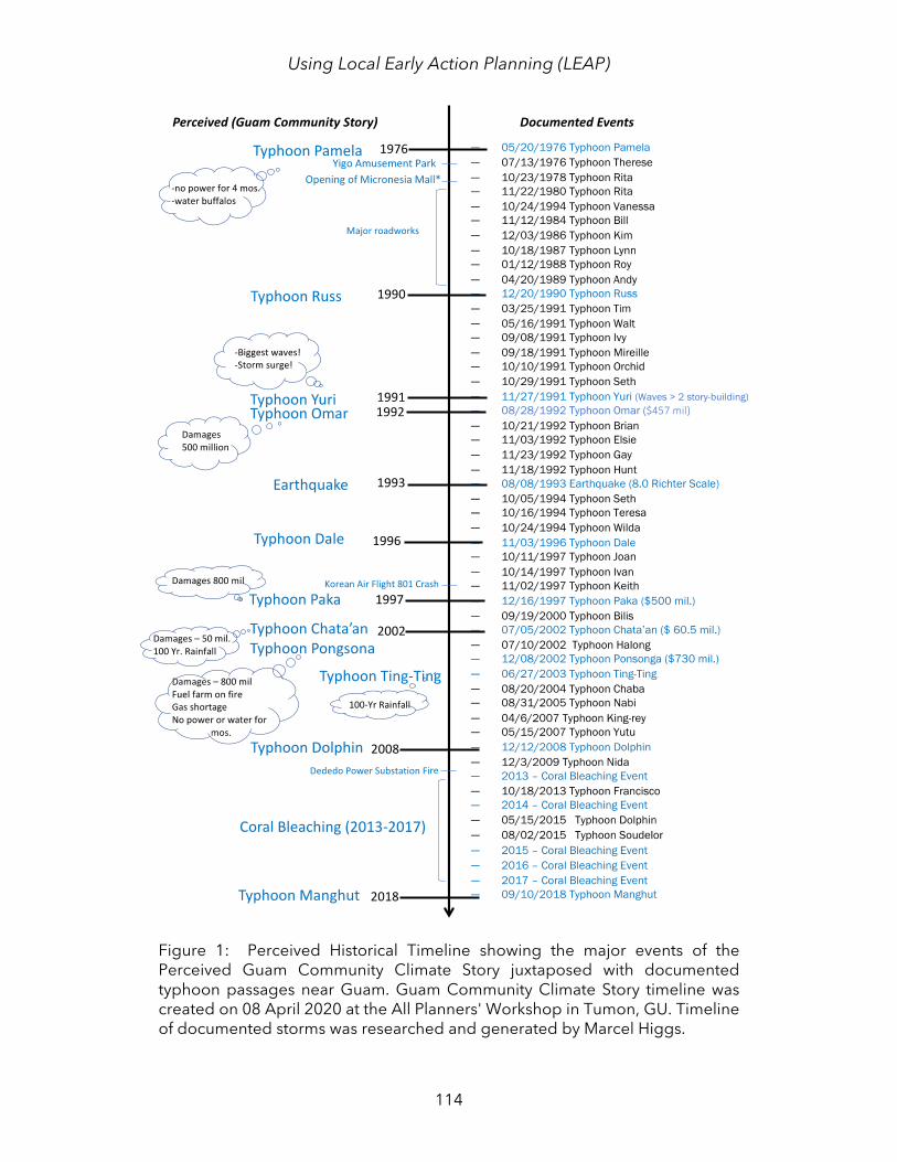
Approximately 90 community members from various organizations representing government, academia, local and federal natural resource agencies, private businesses, and tourism participated in the LEAP portion of the All-Planners Climate Change Workshop on 08 April 2020. Participants were grouped into four tables (three tables were Guam-based residents and the fourth table consisted of CNMI residents) and provided recording materials. The LEAP session occurred toward the end of the workshop and by then, approximately 45-50 attendees remained. After a brief general overview about the potential impacts of climate change on Guam and the Marianas Islands, groups were given instructions and time to create a climate story, in the form of a historical timeline for Guam and the CNMI. Participants worked from their collective memories and did not use modern technology to verify any dates. PI-CASC research assistants digitized the final timelines which consisted of sticky notes on large sheets of paper in a perceived chronology, from each group using Microsoft Excel and Word. The three Guam-focused timelines were consolidated into one Guam Community Climate Story/perceived historical timeline (Figure 1). For this paper, the CNMI timeline was omitted, because Guam is the focus. PI-CASC research assistants searched online databases, archival records, and peer-reviewed articles to cross-check the information in the final perceived historical timeline and added their search results as a timeline of documented natural disasters that affected Guam (Figure 1). The final perceived historical timeline includes the major events Guam’s climate story compared with documented events that occurred during that time frame (Figure 1).
Results and Discussion
The main results for Guam of the LEAP exercise are two timelines juxtaposed in Figure 1 augmented with a rudimentary analysis of general observations of

Pacific Asia Inquiry, Volume 11, Number 1, Fall 2020
111
participants’ interactions during the workshop. The Guam Community Climate Story indicates that residents delineate their collective climate history by major typhoons1, particularly the ones that resulted in significant damages to infrastructure, caused great personal discomfort and duress, and have high recovery costs (Figure 1). Twelve major typhoons from 1970 to 2019 and their respective details were noted in the Community Climate Story (Figure 1). Participants had a relatively high degree of accuracy in terms of the years the typhoons occurred, indicating how memorable those cyclones were (Figure 1). Participants did not mention 37 other typhoons that affected Guam during that same time frame (Figure 1). Clearly, these less powerful typhoons did not cause as much damage as the ones noted on the Community Climate Story and possibly were not worth remembering (Figure 1). A powerful typhoon can be a traumatic ordeal that can leave lasting psychological scars. For example, Super Typhoon Haiyan, one of the strongest tropical cyclones recorded in history and the most destructive storm to make landfall in the Philippines, caused short-term and long-term physical, psychological, and social problems for Filipino survivors (Hugelius et al., 2017). Chan et al., (2016) found that Filipino survivors of Super Typhoon Haiyan had higher symptoms of post-traumatic stress than those that did not experience the storm.
Surprisingly, the workshop participants did not mention other observed changes in vegetation, harvests, precipitation, and temperatures. Nor, did they remark on the El Niño Southern Oscillation (ENSO), the primary natural climate driver of rainfall, drought, and cyclonic activity for Guam. The omission of these phenomena may be explained by lack of awareness. Or perhaps the topic of typhoons overwhelmed the discussion, leaving little room to consider other thoughts. It is unknown why these topics were omitted; participants were not interviewed about their experience after the workshop. This is a stark difference from the issues brought forth from a LEAP workshop conducted in 2014 on Guam (Leberer & Gombos, 2015) (Table 1). Table 1 includes the prioritized climate impacts of 2014 and the major discussion topics of 2019. Table 2 provides a general comparison of the two workshops. While the 2014 LEAP Workshop had fewer participants, and tropical cyclones were a main discussion point, there was a far greater number of topics brought up (Table 1) and discussed in further detail.
Additionally, in 2014 and 2019 stakeholders did not mention the Northern Guam Lens Aquifer (NGLA), the island’s primary source of freshwater, or Fena Reservoir, as a topic of concern. Gingerich et al. (2019) found that Guam’s water resources in a future climate condition (2080–2099) are projected to diminish relative to today’s known climate. Projected future average temperature increases coupled with average rainfall decreases will lead to reduced streamflow in southern Guam and reduced groundwater recharge to the Northern Guam Lens Aquifer (NGLA) (Gingerich et al., 2019).
1 Typhoons are defined as tropical cyclones with maximum sustained winds reaching 74 mph or 119 km/h.
Using Local Early Action Planning (LEAP)
112
Observations In addition to the Guam Community Climate Story timeline (Figure 1), informal
observations were recorded during the LEAP session. Topics discussed within the groups included, typhoons, public infrastructure, private development, coral reef bleaching events, earthquakes, wildfires, plane crashes, and PCB contaminations (Table 1).
It appears that the focus of each group was driven by the experience and education of the participants within the group which may explain the disparity of topics in Table 1. For example, Group 1’s members were involved in planning, tourism, development, and private businesses and thus, their timeline included events that had a major impact on Guam’s economy, such as typhoons. Group 1 spent a considerable amount of time discussing infrastructure and private development and its associated economic benefits to Guam. They were very concerned in protecting these structures from typhoons, which in turn, protects the economy. Specific developments mentioned included the Guam Regional Medical City (GRMC)2, the Micronesia Mall, the Yigo Amusement Park, the new Dededo Farmers’ Market, and the Dededo power substation, which burned in 2013. This group was also anxious about the impending military build-up3 particularly, the inability of Guam’s infrastructure to handle a large population increase.
Group 2 addressed the largest number of topics, including typhoons (Table 1). They identified ten major typhoons that had affected Guam from 1976 to the present day (Figure 1). In addition to typhoons, Group 2 recorded recent coral bleaching events, wildfires, and the polychlorinated biphenyl PCB contamination at Cocos Island Guam.4 High levels of PCB consumption elevates the chances of cancer (Guam EPA, 2014). Their selection of events for inclusion into the Community Story indicate that ecosystem health and its linkage to human health were important.
Similar to Groups 1 and 3, Group 2 conversations around infrastructure revolved around typhoon damage, except for the brief mention of the major roadways constructed during the 1980s (Figure 1). Group 2 were the only group to reference the 8.0 earthquake which affected Guam in 1993 (Swan & Harris, 1993). They had perceived the earthquake to be an 8.2 magnitude, but the National Center for Earthquake Engineering Research recorded that it measured 8.0 on the Richter scale. Group 2 also included the 1997 Korean Air Flight 801 crash5, although it is unclear why due to its lack of relevance to Guam’s climate.
Group 3’s discussion topics were dominated by typhoons and the damage that they incur. Group 3 did not stray past this subject. They delved into greater detail
2 GRMC is the first private hospital in Guam. 3 US Marine troops are being relocated from Okinawa, Japan to Guam from 2009 to the present and Guam may experience an increase in population of approximately 10,000 people. 4 High levels of PCB were found in Cocos Island which is 1 mile south of Guam and is commonly used as a tourist attraction (Haddock et al., 2011). 5 The plane crashed in Nimitz Hill, Guam and only 26 of the 254 passengers had survived (ntsb.gov, 1999).

Pacific Asia Inquiry, Volume 11, Number 1, Fall 2020
113
about each of the storms and observed how the increase in FEMA involvement can be perceived as a decrease in self-reliance and greater dependence on US aid.
Using Local Early Action Planning (LEAP)
114
Figure 1: Perceived Historical Timeline showing the major events of the Perceived Guam Community Climate Story juxtaposed with documented typhoon passages near Guam. Guam Community Climate Story timeline was created on 08 April 2020 at the All Planners' Workshop in Tumon, GU. Timeline of documented storms was researched and generated by Marcel Higgs.
Pacific Asia Inquiry, Volume 11, Number 1, Fall 2020
115
Table 1: Discussions topics according to group at the 2014 Workshop compared to the 2019 LEAP Workshop. Topics from the 2019 workshop are from Lebrerer &
Gombos (2015).
Discussion Topic 2019 2014
Group 1 Group 2 Group 3 Umatac Tumon
Typhoons x x x x Public infrastructure x x x x Private development x Coral Bleaching Events x x x Earthquakes x Plane crashes x PCB Spills x Wildfires x x Population (Migration) x Cultural impacts x Shoreline Erosion x Flooding x x Less outdoor activites x More pests/dieseases x
Limitations
The LEAP tool is a response to traditional top-down approaches undertaken by
the natural resource management community toward planning, and it is a direct reflection of the shift toward community-based adaptation. Forsyth (2013) succinctly outlines the advantages and disadvantages of CBA. Advantages include the likelihood of a higher success rate of an adaptation intervention, if it was supported by the community, while disadvantages include the necessary investment in time for a community to undertake this process (Forsyth 2013). One mini-session of LEAP at one workshop is not enough time to generate long-term solutions. It is a gentle reminder to planners that this tool exists and was used in 2014 and can be used again, with modifications. To maximize the effectiveness of LEAP, one should invest approximately six months to one year of intense work with a community to draft a dynamic action plan (Wongbusarakum et al., 2015) with the expectation of revisiting the plan annually. It is also important to remember that LEAP is one tool in CBA, there are many others that also aim to incorporate traditional wisdom and community input in adaptation planning (Mcleod et al., 2015). With that in mind, results from this 2019 workshop should be regarded as quick snapshot in time because it was by no means as intensive as the 2014 Workshop. In comparing these results to the 2014 LEAP workshop, context must be considered, as provided by Table 2.

Using Local Early Action Planning (LEAP)
116
Table 2: Comparison of 2014 & 2019 LEAP Workshops held on Guam
Factors 2014 Workshop (10-14 March)
2019 Workshop (08 April)
Number of participants 33 45-50
Length of workshop 5 days 1 hour and 15 minutes
Focus Areas Tumon and Umatac
Guam (three groups) & the CNMI (one group)
Facilitators 2 2
Act
ivit
ies
Overview of the LEAP management tool
yes (more in-depth) yes (brief)
Community Vision Very in-depth No
Group Discussion yes (longer, more in-depth and around many topics)
yes (took up the bulk of the session and centered around
the historical timeline)
Seasonal Calendar yes no
Historical Timeline Activity yes yes
Potential Future Impacts from Climate Change
(Lecture) yes
no (but this was discussed by the keynote speaker of the All Planners workshop @
0930) Climate Indictors & Impacts Very in-depth General
Climate Narrative/Story yes (Umatac and Tumon) yes (report out from the
timeline exercise)
Community Profile yes no Prioritization of targets of
climate impacts yes no
Mapping Exercise yes (longer, more in-depth, handwritten)
no (but a satellite image of Guam with 10 ft SLR Scenario
was in the front and there was a dedicated session on
participatory geographic information science earlier in
the workshop)
Field-based threat and vulnerability assessment
yes no
Threat Action Model yes no
Next steps actions and responsibilities
yes yes
Pacific Asia Inquiry, Volume 11, Number 1, Fall 2020
117
Because no demographic data were formally collected, it is impossible to determine whether the participants were a true representative sample of the population. Ideally, follow-up workshops should be scheduled to further the dialogue, expand the topics, and include more stakeholders, particularly elder CHamoru, or manamko’, at the village-level in order to further the dialogue and ultimately create a dynamic action plan of adaptation.
Recommendations and Conclusion
In sum, results from the 2019 LEAP session indicate that Guam residents view their climate history by major weather events, particularly strong typhoons which have caused great devastation. The Community Climate Story/perceived climate historical timeline highlights 12 typhoons from 1970 to the present day, omitting 37 typhoons which had affected Guam during the same timeframe. Based on these modest results, future adaptation planning for Guam should adequately address typhoons and emphasize the protection of property, environment, and human health. It should be emphasized that these findings are a small component of a larger technical report, Vulnerability Assessment of Built Infrastructure near Coastal Bays using three Sea Level Rise Scenarios—Guam by King et al. (2019).
References Adger, W. N., Barnett, J., Chapin, F., & Ellemor, H. (2011). This Must Be the Place:
Underrepresentation of Identity and Meaning in Climate Change Decision-Making. Global Environmental Politics, 11(2), 1–25. https://doi.org/10.1162/GLEP_a_00051
Barnett, J., & Campbell, J. (2010). Climate Change and Small Island States: Power, Knowledge, and the South Pacific. Earthscan.
Berkes, F. (2009). Indigenous ways of knowing and the study of environmental change. Journal of the Royal Society of New Zealand, 39(4), 151–156.
Chan, C. S., Tang, K. N. S., Hall, B. J., Yip, S. Y. T., & Maggay, M. (2016). Psychological Sequelae of the 2013 Super Typhoon Haiyan Among Survivor-Responders. Psychiatry, 79(3), 282–296. https://doi.org/10.1080/00332747.2015.1129874
Cochran, P., Huntington, O. H., Pungowiyi, C., Tom, S., Chapin, F. S., Huntington, H. P., Maynard, N. G., & Trainor, S. F. (2014). Indigenous frameworks for observing and responding to climate change in Alaska. In J. K. Maldonado, B. Colombi, & R. Pandya (Eds.), Climate Change and Indigenous Peoples in the United States: Impacts, Experiences and Actions (pp. 49–59). Springer International Publishing. https://doi.org/10.1007/978-3-319-05266-3_5
Dujardin, S., Hermesse, J., & Dendoncker, N. (2018). Making space for experiential knowledge in climate change adaptation? Insights from municipal planning officers in Bohol, Philippines. Jàmbá: Journal of Disaster Risk Studies, 10(1), 1–10. https://doi.org/10.4102/jamba.v10i1.433
Using Local Early Action Planning (LEAP)
118
Forsyth, T. (2013). Community-based adaptation: A review of past and future challenges. Wiley Interdisciplinary Reviews: Climate Change, 4. https://doi.org/10.1002/wcc.231
Gingerich, S. B., Johnson, A. G., Rosa, S. N., Marineau, M. D., Wright, S. A., Hay, L. E., Widlansky, M. J., Jenson, J. W., Wong, C. I., Banner, J. L., Finucane, M. L., & Keener, V. (2019). Water resources on Guam—Potential impacts of and adaptive response to climate change (Scientific Investigations Report No. 2019–5095; p. 55). USGS. https://pubs.er.usgs.gov/publication/sir20195095
Gombos, M., & Wonbusarakam, S. (2019). Adapting To A Changing Climate: Guide To Local Early Action Planning (LEAP) And Management Planning. Micronesia Conservation Trust: Pohnpei,Federated States of Micronesia. https://www.weadapt.org/knowledge-base/climate-adaptation-training/adapting-to-a-changing-climate-guide-to-local-early-action-planning-leap-and-management-planning
Grecni, Z., Miles, W., King, R., Frazier, A., & Keener, V. (2020). 2020: Climate Change in Guam: Indicators and Considerations for Key Sectors (p. 58) [Pacific Islands Regional Climate Assessment]. East-West Center. https://www.eastwestcenter.org/PIRCA-Guam
Haddock, R. L., Badowski, G., & Bordallo, R. (2011). Cancer Mortality Following Polychlorinated Biphenyl (PCB) Contamination of a Guam Village. Hawaii Medical Journal. https://www.ncbi.nlm.nih.gov/pmc/articles/PMC3254225/
Hay, J. (2013). Small island developing states: Coastal systems, global change and sustainability. Sustainability Science. https://doi.org/10.1007/s11625-013-0214-8
Hugelius, K., Gifford, M., Örtenwall, P., & Adolfsson, A. (2017). Health among disaster survivors and health professionals after the Haiyan Typhoon: A self-selected Internet-based web survey. International Journal of Emergency Medicine, 10(1), 13. https://doi.org/10.1186/s12245-017-0139-6
IPCC. (2014a). Climate Change 2014: Impacts, Adaptation, and Vulnerability. Part A: Global and Sectoral Aspects (Ch 1-20). Contribution of Working Group II to the Fifth Assessment Report of the Intergovernmental Panel on Climate Change. Cambridge University Press. https://ipcc-wg2.gov/AR5/report/full-report/
IPCC. (2014b). Climate Change 2014: Impacts, Adaptation, and Vulnerability. Part B: Regional Aspects *Ch 21 -30). Contribution of Working Group II to the Fifth Assessment Report of the Intergovernmental Panel on Climate Change. Cambridge University Press. https://ipcc-wg2.gov/AR5/report/full-report/
IPCC. (2018). Global Warming of 1.5°C. An IPCC Special Report on the impacts of global warming of 1.5°C above pre-industrial levels and related global greenhouse gas emission pathways, in the context of strengthening the global response to the threat of climate change, sustainable development, and efforts to eradicate poverty (p. 630). Intergovernmental Panel on Climate Change. https://www.ipcc.ch/site/assets/uploads/sites/2/2019/06/SR15_Full_Report_High_Res.pdf

Pacific Asia Inquiry, Volume 11, Number 1, Fall 2020
119
King, R., Bautista, K., Higgs, M., & Leon Guerrero, E. (2019). Vulnerability Assessment of Built Infrastructure near Coastal Bays using three Sea Level Rise Scenarios—Guam (p. 72) [Technical Report]. University of Guam. https://bsp.guam.gov/guamccva/
Leberer, T., & Gombos, M. (2015). Adapting to a Changing Climate Workshop Report, Tumon, GU 10-14 March 2014 (p. 22). The Nature Conservancy.
Lubchenco, J., Barner, A. K., Cerny-Chipman, E. B., & Reimer, J. N. (2015). Sustainability rooted in science. Nature Geoscience, 8(10), 741–745. https://doi.org/10.1038/ngeo2552
Mcleod, E., Bruton-Adams, M., Förster, J., Franco, C., Gaines, G., Gorong, B., James, R., Posing-Kulwaum, G., Tara, M., & Terk, E. (2019). Lessons From the Pacific Islands – Adapting to Climate Change by Supporting Social and Ecological Resilience. Frontiers in Marine Science, 6. https://doi.org/10.3389/fmars.2019.00289
Mcleod, E., Margles weis, S. W., Wongbusarakum, S., Gombos, M., Dazé, A., Otzelberger, A., Hammill, A., Agostini, V., Cot, D. U., & Wiggins, M. (2015). Community-Based Climate Vulnerability and Adaptation Tools: A Review of Tools and Their Applications. Coastal Management, 43(4), 439–458. https://doi.org/10.1080/08920753.2015.1046809
Mimura, N., Nurse, L., McLean, R. F., Agard, J., Briguglio, L., Lefale, P., Payet, R., & Sem, G. (2007). Small islands. Climate Change 2007: Impacts, Adaptation and Vulnerability. Contribution of Working Group II to the Fourth Assessment Report of the Intergovernmental Panel on Climate Change, ML Parry, OF Canziani, JP Palutikof, PJ van Der Linden and CE Hanson (Eds). Cambridge University Press, Cambridge, UK, 687–716.
Reid, H., Alam, M., Berger, R., Cannon, T., Huq, S., & Milligan, A. (2009). Community-Based Adaptation to Climate Change. Participatory Learning and Action, 60, 11–33.
Swan, S. W., & Harris, S. K. (1993). The Island of Guam Earthquake of August 8, 1993. State University of New York at Buffalo. https://nehrpsearch.nist.gov/static/files/NSF/PB94141843.pdf
Thompson, L. (1940). THE FUNCTION OF LATTE IN THE MARIANAS. The Journal of the Polynesian Society, 49(3(195)), 447–465.
Wongbusarakum, S., Gombos, M., Parker, B.-A. A., Courtney, C. A., Atkinson, S., & Kostka, W. (2015). The Local Early Action Planning (LEAP) Tool: Enhancing Community-Based Planning for a Changing Climate. Coastal Management, 43(4), 383–393. https://doi.org/10.1080/08920753.2015.1046805