Embed Size (px)
Citation preview
A. Paget1, M. J. Brodzik2 ([email protected]), J. Gotberg1, M. A. Hardman2, D. G. Long1
1Microwave Earth Remote Sensing Laboratory, BYU, 2National Snow & Ice Data Center/CIRES, University of Colorado at Boulder
Using image reconstruction methods to enhance gridded resolutionfor a newly-calibrated passive microwave Earth System Data Record
ObjectiveWe are applying image reconstruction methods to produce a systematically reprocessed historical time series NASA MEaSUREs Earth System Data Record (ESDR), at higher spatial resolutions than have previously been available, for the 36-year satellite passive microwave record from SMMR, SSM/I-SSMIS and AMSR-E. We compare and contrast two candidate image reconstruction techniques: Backus-Gilbert interpolation (BGI) and a radiometer version of Scatterometer Image Reconstruction (SIR).
Image Reconstruction
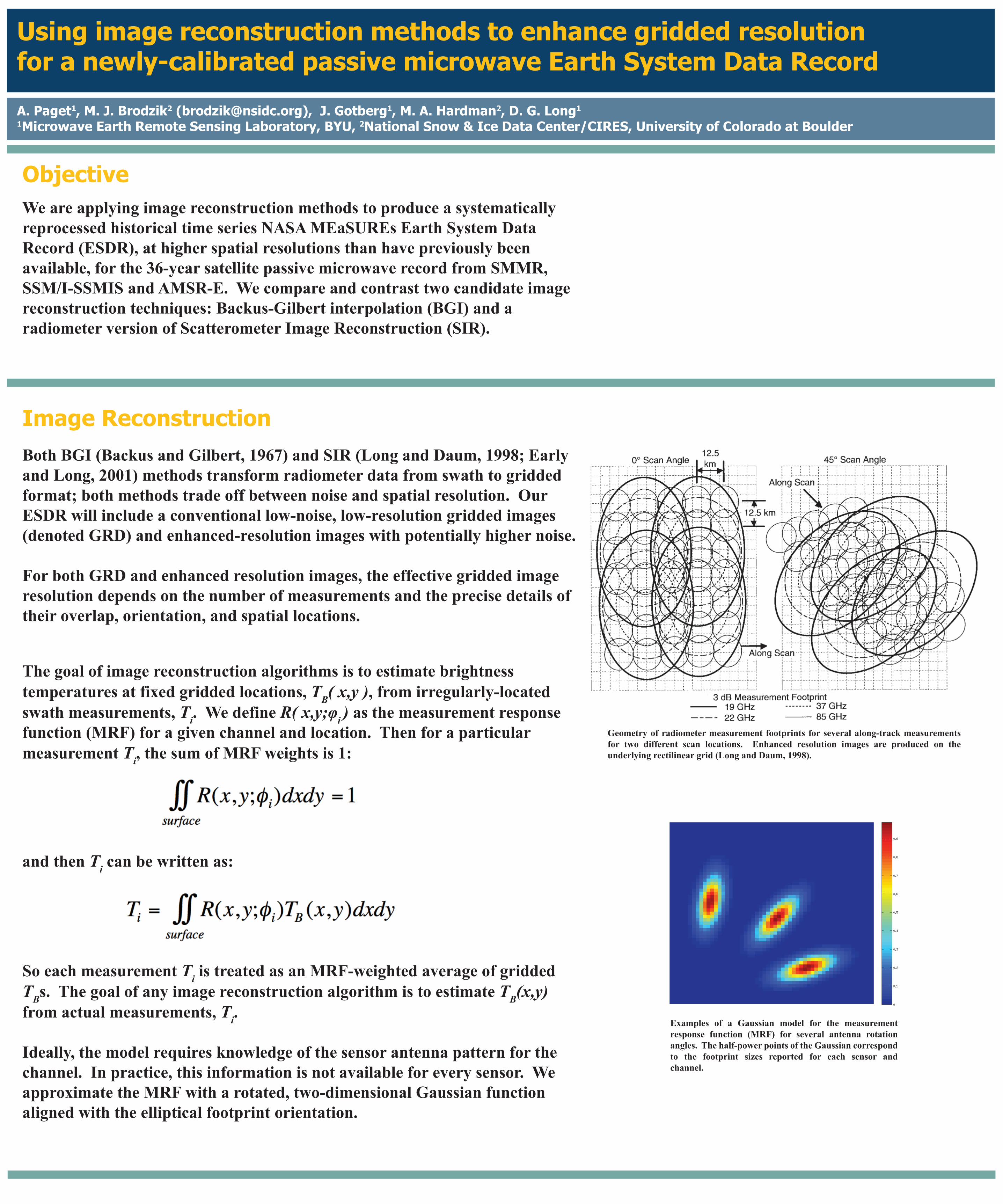
Geometry of radiometer measurement footprints for several along-track measurements for two different scan locations. Enhanced resolution images are produced on the underlying rectilinear grid (Long and Daum, 1998).
Both BGI (Backus and Gilbert, 1967) and SIR (Long and Daum, 1998; Early and Long, 2001) methods transform radiometer data from swath to gridded format; both methods trade off between noise and spatial resolution. Our ESDR will include a conventional low-noise, low-resolution gridded images (denoted GRD) and enhanced-resolution images with potentially higher noise.
For both GRD and enhanced resolution images, the effective gridded image resolution depends on the number of measurements and the precise details of their overlap, orientation, and spatial locations.
The goal of image reconstruction algorithms is to estimate brightness temperatures at fixed gridded locations, TB( x,y ), from irregularly-located swath measurements, Ti. We define R( x,y;φi ) as the measurement response function (MRF) for a given channel and location. Then for a particular measurement Ti, the sum of MRF weights is 1:
So each measurement Ti is treated as an MRF-weighted average of gridded TBs. The goal of any image reconstruction algorithm is to estimate TB(x,y) from actual measurements, Ti.
Ideally, the model requires knowledge of the sensor antenna pattern for the channel. In practice, this information is not available for every sensor. We approximate the MRF with a rotated, two-dimensional Gaussian function aligned with the elliptical footprint orientation.
Examples of a Gaussian model for the measurement response function (MRF) for several antenna rotation angles. The half-power points of the Gaussian correspond to the footprint sizes reported for each sensor and channel.
and then Ti can be written as:
http://nsidc.org/pmesdr
2014 AGU Fall Meeting: A51I-3158
Backus, G. E. and J. F. Gilbert. 1967. Numerical applications of a formalism for geophysical inverse problems. Geophys. J. R. Astron. Soc., 13:247–276.Brodzik, M. J., B. Billingsley, T. Haran, B. Raup, M. H. Savoie. 2012. EASE-Grid 2.0: Incremental but significant improvements for Earth-gridded data sets. ISPRS Interna-
tional Journal of Geo-Information, 1(1):32-45, doi:10.3390/ijgi1010032. http://www.mdpi.com/2220-9964/1/1/32/.Brodzik, M. J., B. Billingsley, T. Haran, B. Raup, M. H. Savoie. 2014. Correction: Brodzik, M. J. et al. EASE-Grid 2.0: Incremental but significant improvements
for Earth-gridded data sets. ISPRS International Journal of Geo-Information 2012, 1, 32-45. ISPRS International Journal of Geo-Information, 3(3):1154-1156, doi:10.3390/ijgi3031154. http://www.mdpi.com/2220-9964/3/3/1154/.
Early D. S. and D. G. Long. 2001. Image Reconstruction and Enhanced Resolution Imaging from Irregular Samples. IEEE TGARS, 39(2):291-302.Long, D. G. and D. L. Daum. 1998. Spatial resolution enhancement of SSM/I data. IEEE TGARS, 36(2):407-417.
Conclusions and Plans
This work has been funded by NASA MEaSUREs 2012. We use the Janus supercomputer, which is supported by the National Science Foundation (award number CNS-0821794) and the University of Colorado Boulder. The Janus supercomputer is a joint effort of the University of Colorado Boulder, the University of Colorado Denver and the National Center for Atmospheric Research.
Determining Reconstruction Tuning Parameters and Grid Pixel Sizes
References and Acknowledgements
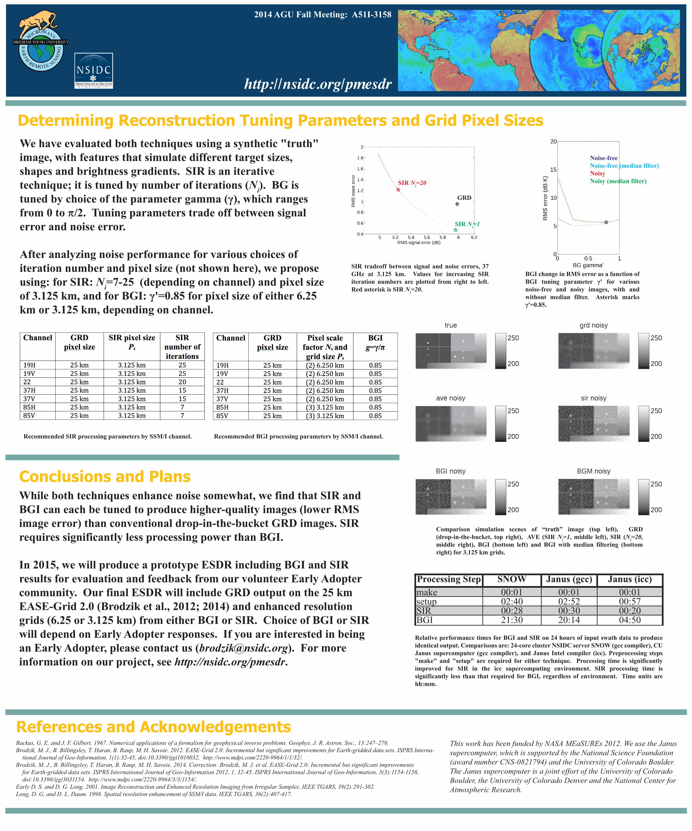
We have evaluated both techniques using a synthetic "truth" image, with features that simulate different target sizes, shapes and brightness gradients. SIR is an iterative technique; it is tuned by number of iterations (Ni). BG is tuned by choice of the parameter gamma (γ), which ranges from 0 to �/2. Tuning parameters trade off between signal error and noise error.
After analyzing noise performance for various choices of iteration number and pixel size (not shown here), we proposeusing: for SIR: Ni=7-25 (depending on channel) and pixel size of 3.125 km, and for BGI: γ'=0.85 for pixel size of either 6.25 km or 3.125 km, depending on channel.
SIR tradeoff between signal and noise errors, 37 GHz at 3.125 km. Values for increasing SIR iteration numbers are plotted from right to left. Red asterisk is SIR Ni=20.
BGI change in RMS error as a function of BGI tuning parameter γ' for various noise-free and noisy images, with and without median filter. Asterisk marks γ'=0.85.
Comparison simulation scenes of “truth” image (top left), GRD (drop-in-the-bucket, top right), AVE (SIR Ni=1, middle left), SIR (Ni=20, middle right), BGI (bottom left) and BGI with median filtering (bottom right) for 3.125 km grids.
Recommended SIR processing parameters by SSM/I channel. Recommended BGI processing parameters by SSM/I channel.
While both techniques enhance noise somewhat, we find that SIR and BGI can each be tuned to produce higher-quality images (lower RMS image error) than conventional drop-in-the-bucket GRD images. SIR requires significantly less processing power than BGI.
In 2015, we will produce a prototype ESDR including BGI and SIR results for evaluation and feedback from our volunteer Early Adopter community. Our final ESDR will include GRD output on the 25 km EASE-Grid 2.0 (Brodzik et al., 2012; 2014) and enhanced resolution grids (6.25 or 3.125 km) from either BGI or SIR. Choice of BGI or SIR will depend on Early Adopter responses. If you are interested in being an Early Adopter, please contact us ([email protected]). For more information on our project, see http://nsidc.org/pmesdr.
Relative performance times for BGI and SIR on 24 hours of input swath data to produce identical output. Comparisons are: 24-core cluster NSIDC server SNOW (gcc compiler), CU Janus supercomputer (gcc compiler), and Janus Intel compiler (icc). Preprocessing steps "make" and "setup" are required for either technique. Processing time is significantly improved for SIR in the icc supercomputing environment. SIR processing time is significantly less than that required for BGI, regardless of environment. Time units are hh:mm.
Processing Step SNOW Janus (gcc) Janus (icc)make 00:01 00:01 00:01setup 02:40 02:52 00:57SIR 00:28 00:30 00:20BGI 21:30 20:14 04:50
SIR Ni=20*
SIR Ni=1*
GRD*
*
Noise-freeNoise-free (median filter)NoisyNoisy (median filter)