Embed Size (px)
Citation preview
© 2013. American Geophysical Union. All Rights Reserved.
Eos, Vol. 94, No. 52, 24 December 2013
VOLUME 94 NUMBER 52
24 December 2013
PAGES 505–512EOS, TRANSACTIONS, AMERICAN GEOPHYSICAL UNION
Using GPS to Studythe Terrestrial Water Cycle
PAGES 505–506
Researchers are using GPS—usually thought
of as a way to measure position—to measure
water cycle properties, including surface soil
moisture, snow depth, and vegetation growth,
which are important for climate studies and
satellite validation. Water managers need these
data to predict, and possibly mitigate, hazards
such as floods and droughts. While there are
strong international efforts to use ground net-
works to measure and archive data for these
quantities, the GPS-based water cycle data
have the advantage that existing instrumenta-
tion can be used, significantly reducing the
cost of operating this new terrestrial water
cycle network.
The Plate Boundary Observatory water
project (PBO H2O) measures surface soil mois-
ture, snow depth, and vegetation growth using
a continental- scale GPS network [Larson
et al., 2008, 2009; Small et al., 2010]. These
water cycle products are derived from data
collected by the EarthScope Plate Boundary
Observatory (PBO), a GPS network installed
in the western United States to measure de-
formation of the North America– Pacific
plate boundary (http:// www . earthscope .org).
The GPS water cycle products produced by
PBO H2O represent an intermediate footprint,
approximately 1000 square meters, and are
currently computed and made available on a
daily basis. They complement other ground
sensors that sample smaller footprints and
larger- scale satellite measurements, which
have lower temporal resolution. Given this
sensing scale and temporal sampling, the GPS
data provide a unique opportunity to study
the water cycle and evaluate both models and
remote sensing estimates.
Measuring Water Cycle Properties
Most people are generally familiar with how
GPS receivers work in cars and cell phones:
We turn them on, and our location shows up
on a map. Less known to the public, GPS in-
struments also operate in “fixed installations”
around the world for either infrastructure
support (transportation, farming, surveying)
or geoscience experiments (fault motions,
polar sciences, atmospheric water vapor sens-
ing, precise orbit determination). These GPS
networks operate continuously and typically
provide their data to the public free of charge
with latencies of 1 second to 24 hours.
Of the GPS networks operating in the United
States, PBO is the largest, with more than
1100 sites. The original scientific goals of PBO
were to measure deformations caused by
faults, volcanoes, and earthquakes in the
western United States. The instruments were
distributed accordingly, with more than
500 located in California, about 150 in Alaska,
and the remainder in the Pacific Northwest
and Rocky Mountains. Of PBO sites, 90%
are surrounded by natural and agricultural
BY K. M. LARSON AND E. E. SMALL
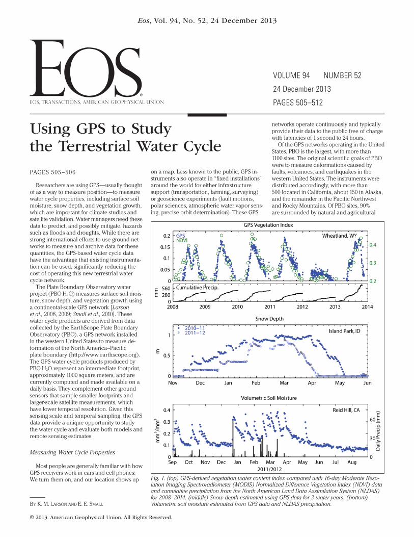
Fig. 1. (top) GPS-derived vegetation water content index compared with 16-day Moderate Reso-
lution Imaging Spectroradiometer ( MODIS) Normalized Difference Vegetation Index (NDVI) data
and cumulative precipitation from the North American Land Data Assimilation System (NLDAS)
for 2008–2014. (middle) Snow depth estimated using GPS data for 2 water years. (bottom)
Volumetric soil moisture estimated from GPS data and NLDAS precipitation.
Eos, Vol. 94, No. 52, 24 December 2013
© 2013. American Geophysical Union. All Rights Reserved.
landcover, which is important for terrestrial
hydrology studies. Thus, many of the sites can
be used to sense environmental changes to
the land surface around GPS antennas. GPS
instruments were installed beginning in 2004,
and the network was completed in 2008.
How does a GPS instrument tell scientists
anything about the terrestrial water cycle?
Ironically, this information comes from an
error source for GPS users. For GPS to accu-
rately measure position, the GPS signals must
travel directly from the satellite to the GPS
antenna. However, some of the GPS signal
also reflects off the land surface around the
antenna. These reflected signals (known as
multipath) travel a longer distance than the
direct signal and thus cause the estimated
position to be incorrect by a small amount.
The PBO H2O group uses the fact that the
direct and reflected signals interfere with
each other, turning the GPS unit into a de
facto interferometer.
The interference effect provides two pieces
of information: how wet the reflecting surface
is and the distance between the GPS antenna
and the reflecting surface. When it snows, the
reflecting surface gets closer to the antenna,
and the GPS interference pattern is sensing
snow depth. Dry soil reflects the GPS signal
differently than wet soil, thus linking the am-
plitude and phase of the interference pattern
in the GPS data to surface soil moisture. Water
in vegetation also influences the reflected GPS
signal. PBO H2O scientists have used electro-
dynamic forward models to develop retrieval
algorithms that make it possible to separate
the three different water cycle products: vege-
tation water content, snow depth, and surface
soil moisture.
Water Cycle Products
The PBO H2O project currently estimates
daily water cycle products for more than
400 sites. They are available on the PBO H2O
data portal at http:// xenon . colorado .edu/
portal. Typical GPS vegetation water content
products are shown in Figure 1 (top) for a
grasslands site in eastern Wyoming [Small
et al., 2010]. Because GPS is an L band system
(using wavelengths of ~20 centimeters), the
GPS vegetation index is dominated by changes
in the amount of water stored in vegetation.
At this site, vegetation water content generally
peaks in June. To place the GPS data in con-
text, a cumulative record of precipitation is
also shown. The data clearly show the GPS
record of vegetation water content responding
to extreme drought conditions in 2012 and
recovering in 2013.
Two representative snow depth time series
for the winters of 2010–2011 and 2011–2012 are
shown in Figure 1 (middle) [Larson et al.,
2009]. The snow depth and duration of snow
cover vary greatly between these years, with
2011 being a record snow year throughout the
western United States. (Snow water equivalent
data are also available.)
Finally, Figure 1 (bottom) shows surface
soil moisture estimated for a PBO site in North-
ern California [Larson et al., 2008]. Note the
response in soil moisture to rainfall events.
The GPS reflection technique is sensitive to
shallow soil moisture, from 0 to 5 centimeters,
which means it can be used to validate L band
soil moisture satellite missions.
Validation of the PBO H2O products is de-
scribed on the data portal. In addition to the
products described here, ancillary informa-
tion (photos, landcover classification, temper-
ature, precipitation, Google Earth™ links,
Normalized Difference Vegetation Index data)
about each GPS site is also available. An edu-
cation portal on GPS was also developed
(http:// xenon . colorado .edu/ spotlight).
Potential for Monitoring Hydrology Worldwide
GPS has revolutionized geodesy and geo-
science research by making it possible to
precisely measure the movements of the
Earth’s surface. The PBO H2O project has
demonstrated that GPS networks can
simultaneously— and with no additional
instrumentation— measure near- surface soil
moisture, snow, and vegetation water content.
Many countries operate GPS networks that
are very similar to PBO, and many of them
could be used to monitor terrestrial hydrolog-
ical signals.
Acknowledgments
We acknowledge our colleagues at the Uni-
versity of Colorado, the University Corpora-
tion for Atmospheric Research, the National
Center for Atmospheric Research, and the
National Oceanic and Atmospheric Adminis-
tration and funding from National Science
Foundation (NSF) EAR-1144221 and NASA
NNX12AK21G. PBO is operated by UNAVCO
for EarthScope and supported by NSF (EAR-
0350028 and EAR-0732947).
References
Larson, K. M., E. E. Small, E. D. Gutmann, A. L.
Bilich, J. J. Braun, and V. U. Zavorotny (2008),
Use of GPS receivers as a soil moisture network
for water cycle studies, Geophys. Res. Lett., 35,
L24405, doi:10.1029/ 2008GL036013.
Larson, K. M., E. D. Gutmann, V. U. Zavorotny,
J. J. Braun, M. W. Williams, and F. G. Nievinski
(2009), Can we measure snow depth with GPS
receivers?, Geophys. Res. Lett., 36, L17502,
doi:10.1029/ 2009GL039430.
Small, E. E., K. M. Larson, and J. J. Braun (2010),
Sensing vegetation growth with refl ected GPS sig-
nals, Geophys. Res. Lett., 37, L12401, doi:10.1029/
2010GL042951.
—KRISTINE M. LARSON, Department of Aerospace
Engineering Sciences, University of Colorado,
Boulder; email: kristinem . larson@ gmail .com; and
ERIC E. SMALL, Department of Geological Sciences,
University of Colorado, Boulder


![Global response of the terrestrial biosphere to CO and ...€¦ · sea ice and fresh water fluxes at surface. 2.2. Description of the Terrestrial Biosphere Model [8] The terrestrial](https://img.pdfslide.us/doc/110x75/5f51c25c26fb4b0d4a342f9d/global-response-of-the-terrestrial-biosphere-to-co-and-sea-ice-and-fresh-water.jpg)