Embed Size (px)
Citation preview
Using fMRI to Explore the Influence of Road Network
Patterns on Geospatial Cognition
Bing Liu a, b, Weihua Dong b, *, Lin Zhu b, Huiping Liu b , Liqiu Meng a
a Chair of Cartography, Technical University of Munich, 80333 Munich, Germany; Bing Liu, [email protected], Liuqiu Meng,
[email protected] b Beijing Key Laboratory for Remote Sensing of Environment and Digital Cities, Research Center of Geospatial Cognition and
Visual Analytics and Faculty of Geographical Science, Beijing Normal University, Beijing 100875, China; Weihua Dong,
[email protected], Lin Zhu, [email protected], Huiping Liu, [email protected]
* Corresponding author: [email protected]
Abstract: Road networks play an important role in our daily life. People strongly interact with roads in commuting and
tourism. The road network patterns influence human cognition, behaviour and the road safety. However, how the
influence takes places remains unclear. In this paper, we experiment with fMRI (functional Magnetic Resonance
Imaging) to explore the influence of regular and irregular road networks on spatial cognition. Nine subjects were asked
to accomplish orientation and shortest-route-selection tasks in both a regular and an irregular road network using street
view. SPM (Statistical Parametric Mapping) was used to analyse the brain activities in the process. The results of
orientation tasks show more activation in the middle frontal gyrus, relating to cognition, the superior frontal gyrus,
relating to voluntary movement and eye movement, and the medial frontal gyrus, relating to executive process in irregular
road network. The results indicate that the orientation task in an irregular road network is more demanding and requires
more information. For shortest route selection tasks in both road networks, no common active brain areas among different
subjects were found. This indicates that the associated cognition process is hardly influenced by road network patterns.
In summary, orientation tasks are harder for subjects in irregular road networks, while the cognition difficulty is almost
the same for shortest-route-selection tasks in regular and irregular road networks. Besides, subjects tend to use egocentric
frame of reference more and switch between ego- and allocentric frame of reference more frequently in irregular road
networks.
Keywords: Road network patterns, spatial cognition, fMRI, spatial orientation
1. Introduction
Roads are important in people’s daily life, whether
commuting or tourism, as they are essential to the
movement between any two places. Previous studies have
found that road network patterns can influence people’s
cognition (Byrne 1979, Green 1994), behaviour
(Fitzpatrick, Carlson et al. 2001, Hochmair and Karlsson
2004) and traffic safety (Haynes, Lake et al. 2008,
Hamdar, Qin et al. 2016). However, what results in such
differences are not clear. In this study, we aim to explore
how the road networks influence the cognition process in
wayfinding.
During the last decades, functional magnetic resonance
imaging (fMRI) has attracted researchers’ interests in
spatial cognition. The current widely used technology is
blood-oxygen-level dependent fMRI (BOLD fMRI),
which measures the blood oxygen level in brain. When a
certain brain area is in use, blood flow to this area would
increase, then the oxygen-rich blood overcome
consumption of oxygen and results in an increase of blood
oxygen level. This can further changes the magnetic field
and thus be detected by machine. Previous spatial studies
based on fMRI are mainly done by psychologists, who
usually cared more about orientation, picture recognition
and other cognition issues in small scale. However, these
small-scale abilities have no strong relationship with
environmental spatial ability (Hegarty, Richardson et al.
2002, Wakabayashi and Ishikawa 2011) and it is till
recently that researchers start applying fMRI on geospatial
ability and cognition study.
Although it was difficult to apply fMRI or other
technologies based on certain neurons on geospatial ability
study (Griffin and Robinson 2010), researchers realize the
importance of carrying on the investigations of fMRI for
geospatial ability study. Montello (2009) proposed in 2009
that fMRI is going to play an important role in geoscience
cognition study. Lobben, Olson et al. (2005) first reported
more activated voxels in sleuthing tasks than in map
rotation based on the fMRI results of one single subject.
They also found that for this subject, map rotation involved
right hemisphere more actively than left, while sleuthing
task initiated both hemispheres equally. Later, Lobben,
Lawrence et al. (2009) reviewed fMRI-based researches
related to cartography and concluded that fMRI is
promising in geography-specific studies and would help
improving the theories of map design and map use.
Proceedings of the International Cartographic Association, 2, 2019. 29th International Cartographic Conference (ICC 2019), 15–20 July 2019, Tokyo, Japan. This contribution underwent single-blind peer review based on submitted abstracts. https://doi.org/10.5194/ica-proc-2-75-2019 | © Authors 2019. CC BY 4.0 License.
2 of 6
Furthermore, some evidence show that cingulate gyrus,
parahippocampal gyrus, superial temporal gyrus and
middle temporal gyrus play important roles in navigation
related tasks (Lawrence 2011, Schinazi, Nardi et al. 2013,
Howard, Javadi et al. 2014, Spiers and Barry 2015, Boccia,
Guariglia et al. 2016). Therefore, we focus on the function
of frontal and temporal lobes in this study.
2. Method
2.1 Experiment design
In this study, we aim to explore the influence of regular
and irregular road networks on spatial cognition based on
fMRI experiment. Regular road networks are those with
orthogonal intersections and straight segments, and
irregular road networks are roads with non-orthogonal
intersections or curved segments. We instructed all
subjects to perform orientation (ORI) and shortest-route-
selection (SRS) tasks, which are very common in daily life
and can reflect people's sense of distance and direction, in
both networks.
The experiment was conducted in two days. On Day 1, the
subjects were asked to use street view maps to familiarize
themselves with a regular and an irregular road network.
On Day 2, they needed to complete a set of ORI and SRS
tasks based on the road networks they learned the day
before, while being scanned in a magnetic resonance
imaging machine.
2.2 Subjects
Nine right-handed students (5 males and 4 females; age =
26.8±3.6 years) from universities in Beijing participated in
the experiment. All subjects had normal or corrected-to-
normal vision, without having or having had neurological
or psychiatric disorders. The experiment data of 2 male
subjects were excluded in the analyses due to movement.
The study was approved by the Institutional Review Board
of Beijing Normal University, and all subjects signed the
written informed consent.
2.3 Apparatus
FMRI scanning was conducted at the BNU Imaging Center
for Brain Research, Beijing, China, on a Siemens 3T
scanner (MAGENTOM Trio, a Tim system) with a 12-
channel phased-array head coil. Whole brain structural T1-
weighted scan were acquired with a 3D magnetization-
prepared rapid acquisition gradient-echo pulse sequence
(MP-RAGE, TR = 2530 ms, TE = 3.45 ms, flip angle = 7°,
slice thickness = 1 mm, matrix size = 256×256, voxel size
= 1.0×1.0×1.0 mm, sagittal orientation).
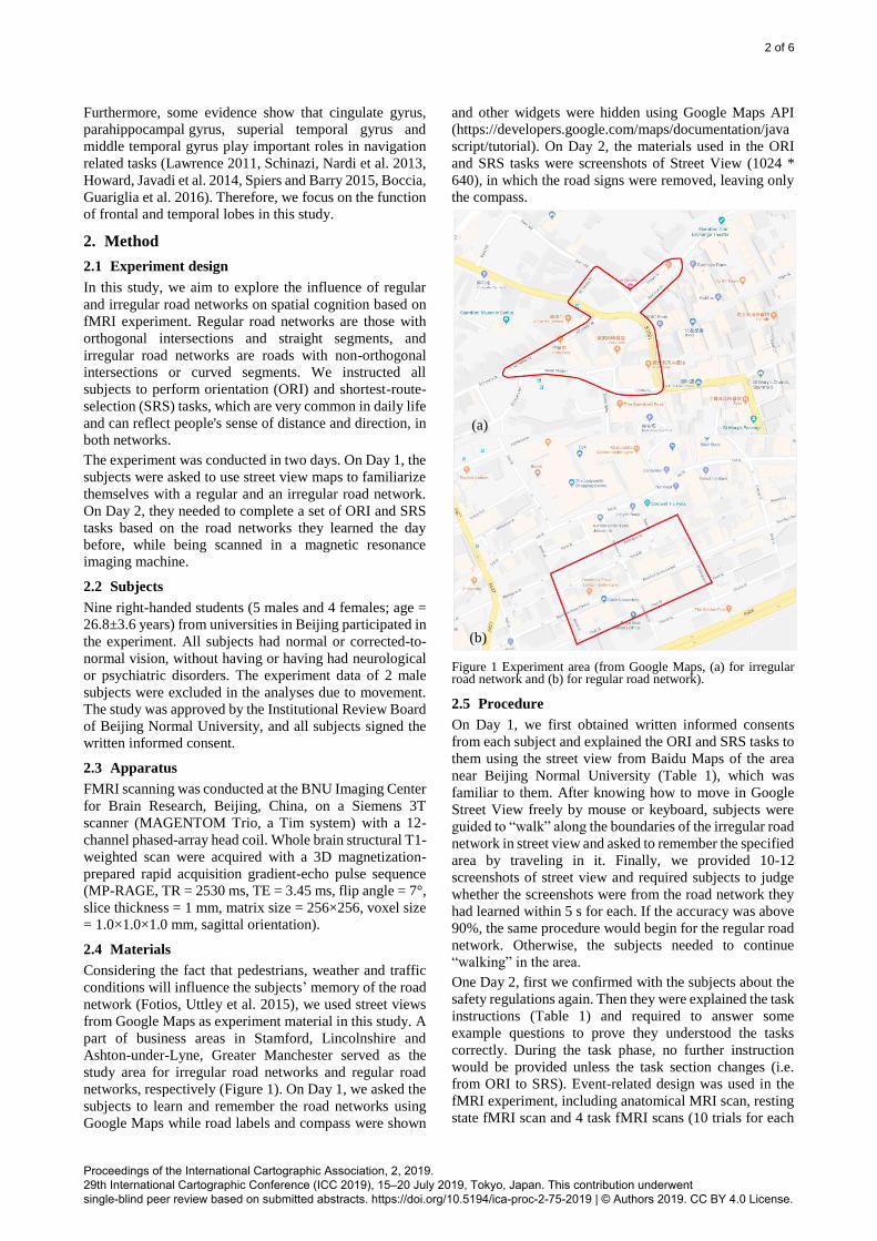
2.4 Materials
Considering the fact that pedestrians, weather and traffic
conditions will influence the subjects’ memory of the road
network (Fotios, Uttley et al. 2015), we used street views
from Google Maps as experiment material in this study. A
part of business areas in Stamford, Lincolnshire and
Ashton-under-Lyne, Greater Manchester served as the
study area for irregular road networks and regular road
networks, respectively (Figure 1). On Day 1, we asked the
subjects to learn and remember the road networks using
Google Maps while road labels and compass were shown
and other widgets were hidden using Google Maps API
(https://developers.google.com/maps/documentation/java
script/tutorial). On Day 2, the materials used in the ORI
and SRS tasks were screenshots of Street View (1024 *
640), in which the road signs were removed, leaving only
the compass.
Figure 1 Experiment area (from Google Maps, (a) for irregular road network and (b) for regular road network).
2.5 Procedure
On Day 1, we first obtained written informed consents
from each subject and explained the ORI and SRS tasks to
them using the street view from Baidu Maps of the area
near Beijing Normal University (Table 1), which was
familiar to them. After knowing how to move in Google
Street View freely by mouse or keyboard, subjects were
guided to “walk” along the boundaries of the irregular road
network in street view and asked to remember the specified
area by traveling in it. Finally, we provided 10-12
screenshots of street view and required subjects to judge
whether the screenshots were from the road network they
had learned within 5 s for each. If the accuracy was above
90%, the same procedure would begin for the regular road
network. Otherwise, the subjects needed to continue
“walking” in the area.
One Day 2, first we confirmed with the subjects about the
safety regulations again. Then they were explained the task
instructions (Table 1) and required to answer some
example questions to prove they understood the tasks
correctly. During the task phase, no further instruction
would be provided unless the task section changes (i.e.
from ORI to SRS). Event-related design was used in the
fMRI experiment, including anatomical MRI scan, resting
state fMRI scan and 4 task fMRI scans (10 trials for each
(a)
(b)
Proceedings of the International Cartographic Association, 2, 2019. 29th International Cartographic Conference (ICC 2019), 15–20 July 2019, Tokyo, Japan. This contribution underwent single-blind peer review based on submitted abstracts. https://doi.org/10.5194/ica-proc-2-75-2019 | © Authors 2019. CC BY 4.0 License.
3 of 6
task scan). The process of the scan was as follow: T1
anatomical scan with 10 min, resting state scan with
duration 200TR (400 s), task fMRI scan with duration
4*116 TR (4*232 s, TR = 2000 ms, TE = 30 ms, flip angle
= 90°, FOV = 220 mm, resolution = 64, matrix size =
384×384, voxel size = 3.125×3.125×3.5 mm, interleaved
odd sequence). The tasks were presented in the sequence
of Ir-ORI (Orientation tasks in irregular road network), R-
Ori, Ir-SRS (Shortest-Route-Selection tasks in regular
road network), and R-SRS. For each trial, first there would
be a black picture with a white “+” at the middle for 2 s,
then the picture of destination for 6 s, and the picture of
current position where participants should make a choice
within 15s. Response time was recorded.
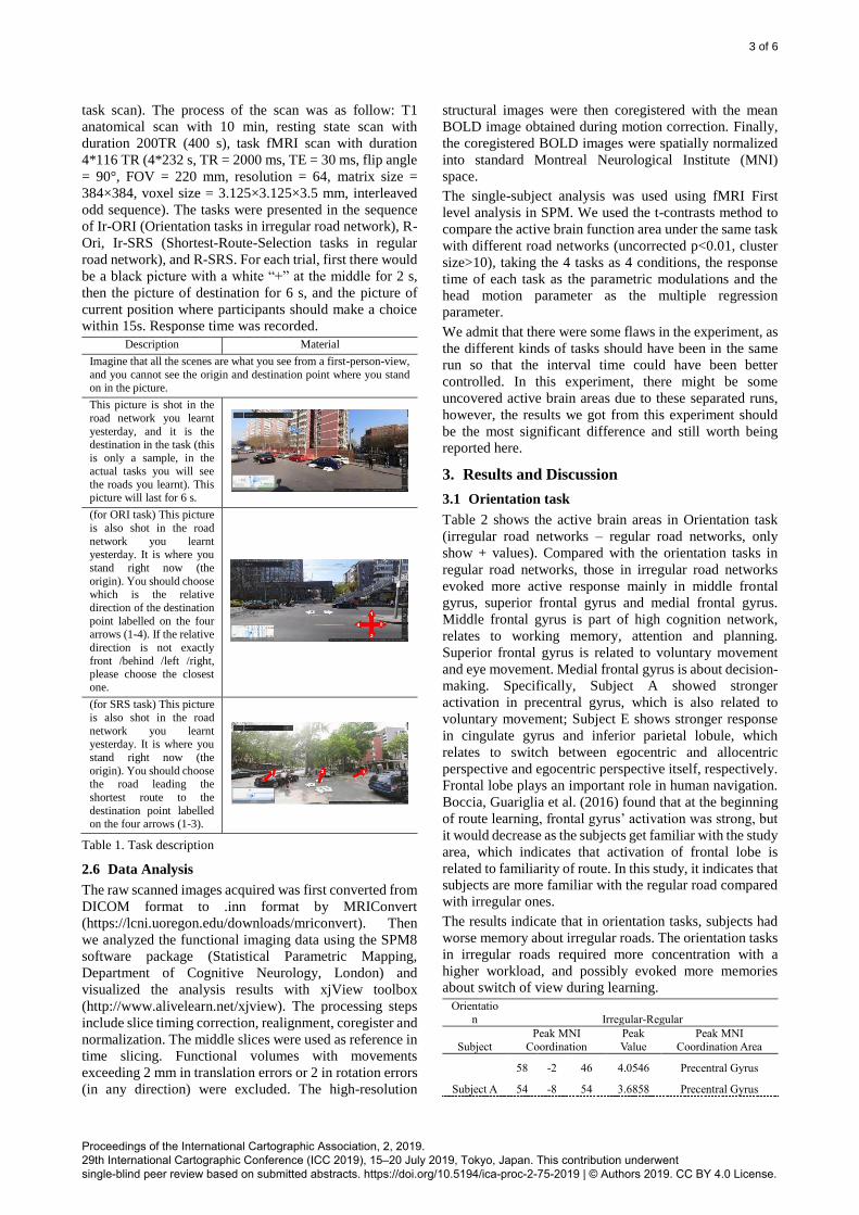
Description Material
Imagine that all the scenes are what you see from a first-person-view,
and you cannot see the origin and destination point where you stand on in the picture.
This picture is shot in the
road network you learnt
yesterday, and it is the destination in the task (this
is only a sample, in the actual tasks you will see
the roads you learnt). This picture will last for 6 s.
(for ORI task) This picture
is also shot in the road
network you learnt
yesterday. It is where you
stand right now (the
origin). You should choose which is the relative
direction of the destination
point labelled on the four arrows (1-4). If the relative
direction is not exactly
front /behind /left /right, please choose the closest one.
(for SRS task) This picture
is also shot in the road
network you learnt yesterday. It is where you
stand right now (the
origin). You should choose
the road leading the
shortest route to the
destination point labelled on the four arrows (1-3).
Table 1. Task description
2.6 Data Analysis
The raw scanned images acquired was first converted from
DICOM format to .inn format by MRIConvert
(https://lcni.uoregon.edu/downloads/mriconvert). Then
we analyzed the functional imaging data using the SPM8
software package (Statistical Parametric Mapping,
Department of Cognitive Neurology, London) and
visualized the analysis results with xjView toolbox
(http://www.alivelearn.net/xjview). The processing steps
include slice timing correction, realignment, coregister and
normalization. The middle slices were used as reference in
time slicing. Functional volumes with movements
exceeding 2 mm in translation errors or 2 in rotation errors
(in any direction) were excluded. The high-resolution
structural images were then coregistered with the mean
BOLD image obtained during motion correction. Finally,
the coregistered BOLD images were spatially normalized
into standard Montreal Neurological Institute (MNI)
space.
The single-subject analysis was used using fMRI First
level analysis in SPM. We used the t-contrasts method to
compare the active brain function area under the same task
with different road networks (uncorrected p<0.01, cluster
size>10), taking the 4 tasks as 4 conditions, the response
time of each task as the parametric modulations and the
head motion parameter as the multiple regression
parameter.
We admit that there were some flaws in the experiment, as
the different kinds of tasks should have been in the same
run so that the interval time could have been better
controlled. In this experiment, there might be some
uncovered active brain areas due to these separated runs,
however, the results we got from this experiment should
be the most significant difference and still worth being
reported here.
3. Results and Discussion
3.1 Orientation task
Table 2 shows the active brain areas in Orientation task
(irregular road networks – regular road networks, only
show + values). Compared with the orientation tasks in
regular road networks, those in irregular road networks
evoked more active response mainly in middle frontal
gyrus, superior frontal gyrus and medial frontal gyrus.
Middle frontal gyrus is part of high cognition network,
relates to working memory, attention and planning.
Superior frontal gyrus is related to voluntary movement
and eye movement. Medial frontal gyrus is about decision-
making. Specifically, Subject A showed stronger
activation in precentral gyrus, which is also related to
voluntary movement; Subject E shows stronger response
in cingulate gyrus and inferior parietal lobule, which
relates to switch between egocentric and allocentric
perspective and egocentric perspective itself, respectively.
Frontal lobe plays an important role in human navigation.
Boccia, Guariglia et al. (2016) found that at the beginning
of route learning, frontal gyrus’ activation was strong, but
it would decrease as the subjects get familiar with the study
area, which indicates that activation of frontal lobe is
related to familiarity of route. In this study, it indicates that
subjects are more familiar with the regular road compared
with irregular ones.
The results indicate that in orientation tasks, subjects had
worse memory about irregular roads. The orientation tasks
in irregular roads required more concentration with a
higher workload, and possibly evoked more memories
about switch of view during learning.
Orientatio
n Irregular-Regular
Subject
Peak MNI
Coordination
Peak
Value
Peak MNI
Coordination Area
Subject A
58 -2 46 4.0546 Precentral Gyrus
54 -8 54 3.6858 Precentral Gyrus
Proceedings of the International Cartographic Association, 2, 2019. 29th International Cartographic Conference (ICC 2019), 15–20 July 2019, Tokyo, Japan. This contribution underwent single-blind peer review based on submitted abstracts. https://doi.org/10.5194/ica-proc-2-75-2019 | © Authors 2019. CC BY 4.0 License.

4 of 6
Subject B
26 10 52 4.0066 Middle Frontal Gyrus
-22 10 56 4.1213
Superior Frontal Gyrus
-
20 18 60 3.9072 Middle Frontal Gyrus
Subject C
-10 34 -22 4.0659 Rectal Gyrus
-
36 64 6 4.0857 Middle Frontal Gyrus
Subject D 32 66 8 4.0194 Superior Frontal
Gyrus
Subject E
-6 48 -10 3.898 Medial Frontal Gyrus
4 56 4 4.234 Medial Frontal Gyrus
-10 46 8 4.7715 Medial Frontal Gyrus
-26 52 16 3.92 Middle Frontal Gyrus
26 58 26 3.8386 Middle Frontal Gyrus
-8 22 32 4.2863 Cingulate Gyrus
-56
-38 38 4.149
Inferior Parietal Lobule
6 24 60 4.7982
Superior Frontal
Gyrus
Table 2. Active brain areas in orientation tasks (irregular - regular)
Table 3 shows the active brain areas of regular road
networks – irregular road networks (only + values are
shown) and no unified active brain area was found. This
shows that the detected active brain area might not be
related to the task or indicates special strategies in
performing the tasks. For example, Subject C’s superior
temporal gyrus, which is related to process of verbal
information, showed stronger activation in regular roads.
This subject could have a special verbal memory about this
road network during Day 1’s learning, as the subjects were
not asked to maintain absolutely quiet in the learning.
Also, it could be the subject is imaging him/herself
walking in that area in an egocentric perspective and
updating his/her current location, according to Lawrence’s
finding based on visually impaired subjects.
Orientation Regular - Irregular
Subject
Peak MNI
Coordination
Peak
Value
Peak MNI
Coordination Area
Subject A
66 -
22 -6 4.441 Middle Temporal
Gyrus
18 40 22 3.7768 Medial Frontal Gyrus
Subject C
44 6 -
20 4.1786 Superior Temporal
Gyrus
48 0 -
10 3.656 Superior Temporal
Gyrus
Subject E
-24 58 -2 3.8924 Superior Frontal
Gyrus
46 34 26 3.9042 Middle Frontal Gyrus
36 -
58 32 3.7423 Sub-Gyral
46
-
50 48 4.014
Inferior Parietal
Lobule
-22 56 -
42 4.4466 *
38 48 -
36 3.8916
* Blank means undefined area, the followings are the same.
Table 3. Active brain areas in orientation tasks (regular - irregular)
3.2 Shortest-Route-Selection task
As Table 4, which shows the results in Shortest-Route-
Selection tasks of irregular road networks – regular road
networks (only show + values), shows that there are no
unified brain areas that are more active in tasks in irregular
road networks. This indicates that subjects had different
strategies. However, different brain areas can indicate
similar cognition process. Subject A showed more
activation in middle occipital gyrus and Subject G showed
more activation in superior frontal gyrus. While these two
brain areas locate in different lobes, they are both related
to visual information, i.e. visual cognition and eye
movement control, respectively. This indicates that visual
attention to be more complex in irregular road networks.
Also, according to Boccia’s summary (Boccia, Nemmi et
al. 2014), middle occipital gyrus is more active in learning
new roads. Therefore, Subject A might have a better
memory about regular roads. Also, Subject E showed
stronger activation in precentral gyrus, which is related to
mental orientation. Similar to Orientation tasks, there were
also subjects showing stronger activation in cingulate
gyrus (Subject G) and inferior parietal lobule (Subject F),
which indicates in irregular road networks, subjects tend
to apply an egocentric perspective of view and switch more
frequently between ego- and allocentric perspective.
Shortest-
Route-
Selection Irregular - Regular
Subject Peak MNI
Coordination Peak Value
Peak MNI
Coordination Area
Subject A
36 -82 0 4.0512 Middle Occipital
Gyrus
-4 -42 74 3.9033 Postcentral Gyrus
Subject E 64 -16 42 4.1133 Precentral Gyrus
Subject F
-54 -48 52 4.0815 Inferior Parietal
Lobule
-46 -66 50 4.2552
Subject G
62 -30 -10 4.1009 Middle Temporal
Gyrus
-22 60 18 3.9555 Superior Frontal
Gyrus
-2 -58 28 3.9911 Cingulate Gyrus
-10 50 46 4.5829 Superior Frontal
Gyrus
-42 52 -18 4.1411
-14 -68 64 -3.9744
Table 4. Active brain areas in shortest-route-selection tasks (irregular - regular)
Table 5 shows the brain areas that are more active in
regular road networks compared with irregular ones in
Shortest-Route-Selection task (only show + values).
Different subjects hardly have any unified or functionally
similar activated brain areas. Subject A and F showed
stronger activation in middle temporal gyrus, Subject E
and F showed stronger activation in precuneus, which are
related to distance estimation, and visual spatial picturing
Proceedings of the International Cartographic Association, 2, 2019. 29th International Cartographic Conference (ICC 2019), 15–20 July 2019, Tokyo, Japan. This contribution underwent single-blind peer review based on submitted abstracts. https://doi.org/10.5194/ica-proc-2-75-2019 | © Authors 2019. CC BY 4.0 License.
5 of 6
and plot memory, respectively. These subjects might have
a better memory and maintain better sense of direction in
regular road networks.
Shortest-
Route-Selectio
n Regular - Irregular
Subject Peak MNI
Coordination Peak Value
Peak MNI Coordination
Area
Subject A
-42 -62 16 3.8389 Middle Temporal
Gyrus
-56 -56 16 4.0899 Superior Temporal
Gyrus
-44 -48 36 4.3354 Supramarginal Gyrus
-46 18 42 4.0844 Middle Frontal Gyrus
-42 6 40 4.0307 Inferior Frontal Gyrus
-28 16 62 4.368 Middle Frontal Gyrus
Subject E -14 -68 64 3.9744 Precuneus
Subject F
-22 68 2 4.5276 Superior Frontal
Gyrus
-50 -72 12 4.9878 Middle Temporal
Gyrus
-32 -76 18 4.7807 Middle Temporal
Gyrus
-14 -88 26 3.7641 Cuneus
-38 -80 30 4.0994 Angular Gyrus
28 -60 34 4.3939 Sub-Gyral
8 -86 40 3.6981 Precuneus
-14 -82 44 3.7341 Precuneus
8 -80 50 4.6541 Precuneus
-6 -64 60 4.6156 Precuneus
2 -50 64 4.6526 Paracentral Lobule
14 -56 74 3.7577
-4 -74 58 4.2978
24 -60 68 4.6889
-22 -62 68 3.7798
6 -62 66 4.6621
Table 5. Active brain areas in shortest-route-selection tasks (regular - irregular)
4. Overall Discussion
In this empirical study, we applied fMRI-based experiment
to find out the influence of irregular and regular road
networks on geospatial cognition during orientation and
shortest-route-selection tasks. The results show that the
orientation task in irregular road networks requires more
attention and might be demanding because more
activations of the subjects were observed in middle frontal
gyrus, superior frontal gyrus and medial frontal gyrus. For
the shortest-route-selection task, some subjects showed
better sense of distance and pictorial spatial memory, but
there was no united active brain area. In both kinds of
tasks, there were some subjects showing stronger
activation in cingulate gyrus and inferior parietal lobule in
irregular road networks compared with in regular ones,
which means in irregular road networks subjects are more
likely to use egocentric framework and the switch more
frequently between ego- and allocentric perspective.
This study that may cover some difference and influence,
this research work can serve as a starting point to explore
more detailed influences caused by various road networks
in combination with other variates, such as relative density
and general orientation.
5. Acknowledgements
This research is supported by the National Natural Science
Foundation of China (NSFC, Grant No. 41871366), and
China Scholarship Council (Grant No. 201806040219).
6. References
Boccia, M., C. Guariglia, U. Sabatini and F. Nemmi
(2016). "Navigating toward a novel environment from a
route or survey perspective: neural correlates and context-
dependent connectivity." Brain Structure and Function
221(4): 2005-2021.
Boccia, M., F. Nemmi and C. Guariglia (2014).
"Neuropsychology of Environmental Navigation in
Humans: Review and Meta-Analysis of fMRI Studies in
Healthy Participants." Neuropsychology Review 24(2):
236-251.
Byrne, R. W. (1979). "Memory for Urban Geography."
Quarterly Journal of Experimental Psychology 31(1): 147-
154.
Fitzpatrick, K., P. Carlson, M. Brewer and M. Wooldridge
(2001). "Design factors that affect driver speed on
suburban streets." Transportation Research Record:
Journal of the Transportation Research Board(1751): 18-
25.
Fotios, S., J. Uttley, C. Cheal and N. Hara (2015). "Using
eye-tracking to identify pedestrians’ critical visual tasks,
Part 1. Dual task approach." 47(2): 133-148.
Green, P. (1994). "Driver workload as a function of road
geometry: A pilot experiment."
Griffin, A. and A. Robinson (2010). Comparing color and
leader line approaches for highlighting in geovisualization.
Proc. GIScience.
Hamdar, S. H., L. Qin and A. Talebpour (2016). "Weather
and road geometry impact on longitudinal driving
behavior: Exploratory analysis using an empirically
supported acceleration modeling framework."
Transportation Research Part C: Emerging Technologies
67: 193-213.
Haynes, R., I. R. Lake, S. Kingham, C. E. Sabel, J. Pearce
and R. Barnett (2008). "The influence of road curvature on
fatal crashes in New Zealand." Accident Analysis &
Prevention 40(3): 843-850.
Hegarty, M., A. E. Richardson, D. R. Montello, K.
Lovelace and I. Subbiah (2002). "Development of a self-
report measure of environmental spatial ability."
Intelligence 30(5): 425-447.
Hochmair, H. H. and V. Karlsson (2004). Investigation of
preference between the least-angle strategy and the initial
segment strategy for route selection in unknown
environments. International Conference on Spatial
Cognition, Springer.
Proceedings of the International Cartographic Association, 2, 2019. 29th International Cartographic Conference (ICC 2019), 15–20 July 2019, Tokyo, Japan. This contribution underwent single-blind peer review based on submitted abstracts. https://doi.org/10.5194/ica-proc-2-75-2019 | © Authors 2019. CC BY 4.0 License.
6 of 6
Howard, Lorelei R., Amir H. Javadi, Y. Yu, Ravi D. Mill,
Laura C. Morrison, R. Knight, Michelle M. Loftus, L.
Staskute and Hugo J. Spiers (2014). "The Hippocampus
and Entorhinal Cortex Encode the Path and Euclidean
Distances to Goals during Navigation." Current Biology
24(12): 1331-1340.
Lawrence, M. M. (2011). Behavioral and neurological
studies in tactile map reading and training by persons who
are blind or visually impaired, University of Oregon.
Lobben, A., M. Lawrence and J. M. Olson (2009). "fMRI
and human subjects research in cartography."
Cartographica: The International Journal for Geographic
Information and Geovisualization 44(3): 159-169.
Lobben, A. K., J. M. Olson and J. Huang (2005). Using
fMRI in cartographic research. Proceedings of the 22nd
International Cartographic Conference.
Montello, D. R. (2009). "Cognitive Research in
GIScience: Recent Achievements and Future Prospects."
Geography Compass 3(5): 1824-1840.
Schinazi, V. R., D. Nardi, N. S. Newcombe, T. F. Shipley
and R. A. Epstein (2013). "Hippocampal size predicts
rapid learning of a cognitive map in humans."
Hippocampus 23(6): 515-528.
Spiers, H. J. and C. Barry (2015). "Neural systems
supporting navigation." Current Opinion in Behavioral
Sciences 1: 47-55.
Wakabayashi, Y. and T. Ishikawa (2011). "Spatial
thinking in geographic information science: a review of
past studies and prospects for the future." Procedia-Social
and Behavioral Sciences 21: 304-313.
Proceedings of the International Cartographic Association, 2, 2019. 29th International Cartographic Conference (ICC 2019), 15–20 July 2019, Tokyo, Japan. This contribution underwent single-blind peer review based on submitted abstracts. https://doi.org/10.5194/ica-proc-2-75-2019 | © Authors 2019. CC BY 4.0 License.