Embed Size (px)
Citation preview

AEC SummitUsing ArcGIS to Collect and Improve the Spatial Accuracy of Parcel DataAmir Bar-MaorM.Sc., PLS, Real Estate Appraiser, Product Engineer

Reality Check
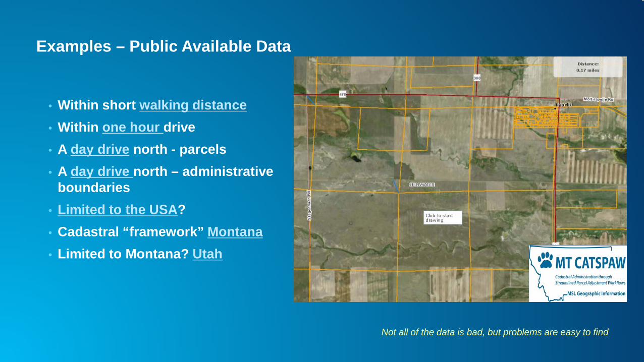
Examples – Public Available Data
• Within short walking distance• Within one hour drive• A day drive north - parcels• A day drive north – administrative
boundaries• Limited to the USA?• Cadastral “framework” Montana• Limited to Montana? Utah
Not all of the data is bad, but problems are easy to find

Observations
• Poor spatial accuracy is a global problem• Anyone can detect poor spatial accuracy• The term “accurate” is subjective and changes over time• Imagery is often more accurate• Control points would have been much better but are hard to come by• Vertical misalignment issues
Now we know
“There are known knowns; there are things we know we know. We also know there are known unknowns; that is to say we know there are some things we do not know
United States Secretary of Defense Donald Rumsfeld
Poor Spatial Accuracy – So What?!
• Cadastral data is foundational dataset:- Land Use- Administrative boundaries- Valuation- Permits- …
• Poor accuracy Mistrust each organization creates their own• Any decision making \ analysis wrong results• Public expectation• Location based services (real estate, land use)• Poor accuracy can kill - hunting permits • …

Las Vegas, Nevada – accuracy is not a roulette
21S 56E Section 1021S 60E Section 21

Las Vegas, Nevada – Accuracy as a Limited Resource

Conclusions
• Poor spatial accuracy has a real life impact, can be risky and cost $$$• High resolution imagery makes it easy to expose inaccuracies• GNSS position and imagery will only get better & cheaper• PLSS “Cadastral Framework” is a legal framework, not a spatial framework• Accuracy is a function of land value / risk management

How to Improve Spatial Accuracy

Imagine
• You manage a dataset of administrative boundaries• Boundaries are based on 2.4 million parcels• Data suffers from poor spatial accuracy• You work hard to align the datasets to each other• Just as you think you are done, the parcels move• Budget and resources are limited• Resurveying 2.4 M parcels is out of the question• Limited number of control points
WHAT WOULD YOU DO?
My Hero:Stewart KirkpatrickState GIS CoordinatorMontana State Library – Geographic Information

Continuum Of Spatial Accuracy
• Improving spatial accuracy is a never ending process• Steps:
- Be proactive: take ownership, migrate data- Gather as much control points from reliable sources- Prioritize by location- Supplement with “pseudo control points”- Adjust parcels- Adjust derived data (associated feature class)- Share results
Source: http://mslapps.mt.gov/Geographic_Information/Applications/cadnsdi/
Before
After

Before

After

LSA & Feature Adjustment

Continuum of Spatial Accuracy
Low Accuracy Inversed Data
Transform
Real and Psudocontrol points
Control Point Connection lines\ ties
Connectivity COGOed, weigted, tied, adjusted
LSA
It Looks BAD
It Looks GOOD
We know how GOOD it is

Conclusions
• Poor spatial accuracy is a common problem• There are dedicated tools to improve spatial accuracy• Improving spatial accuracy is a process / continuum• Sharing control points can help improve vertical alignment issues


![[Arcgis] Riset ArcGIS JS & Flex](https://img.pdfslide.us/doc/110x75/55cf96d7550346d0338e2017/arcgis-riset-arcgis-js-flex.jpg)