Embed Size (px)
Citation preview
?Ô
?Ý
KÍ
Aç
Aà
?̀
Aç
AÜ
KÍ
AÜ
AÜ
KÍ
?Ô ?Ý
ASTI
COTATI
NOVATO
SONOMA
GUALALA
JIMTOWN
KENWOOD
PETALUMA
TWO ROCK
CAZADERO CALISTOGA
ANNAPOLIS
FORT ROSSPLANTATION
GLEN ELLEN
SANTA ROSA
SEARS POINT
SEBASTOPOL
CLOVERDALE
VALLEY FORD
GEYSERVILLE
HEALDSBURG
RUTHERFORD
GUERNEVILLE
THE GEYSERS
BODEGA HEAD
TOMBS CREEK
CAMP MEEKERARCHED ROCK DUNCANS MILLS
POINT REYES NE
GUBE MOUNTAINMC QUIRE RIDGE
PETALUMA POINT
PETALUMA RIVER
STEWARTS POINT
CUTTINGS WHARF
SKAGGS SPRINGS MOUNT ST HELENA
WHISPERING PINESBIG FOOT MOUNTAIN
MARK WEST SPRINGS
Santa Rosa
Petaluma
Windsor
Rohnert Park
Healdsburg
Sonoma
Cotati
Cloverdale
Sebastopol
Riv er Rd
Geysers Rd
Adobe Rd
Stewarts Pt Skgs Sps Rd
Arnold Dr
Sto
ny P
oint
Rd
King Ridge Rd
D St
A s ti Rd
Bodeg
a Hwy
Dry Creek Rd
Fort Ross Rd
Bodega Ave
Westsi de Rd
Occidental Rd
Roblar Rd
Bohem
ian Hwy
Pet
alum
a H
ill R
d
W D
ry Creek Rd
Piner Rd
Bennett Valle y Rd
G raton
Rd
Valley Ford Rd
Lakeville Hwy
Spring Hi ll Rd
E asts
ide
Rd
Pepper Rd
Fulto
n R
d
Llano Rd
St Hele
na R
d
Hall Rd
8th
St E
Cazadero Hwy
Guerneville Rd
Old Redwood Hwy
Rama l Rd
San
ta R
osa
Ave
Heal d sburg Ave
Dutcher C
reek Rd
Ely Rd
Win
dsor
Rd
Geyserville Ave
Sonoma Mountain Rd
Porter Creek Rd
4th
St
Pres
sley
Rd
Faught Rd
Moscow Rd
Riebli Rd
Canyon Rd
Frei R
d W College Ave
Kruse Ranch Rd
Chilen
o Valley Rd
Alex
ander Valley Rd
5th
St E
Leveroni Rd
Tomales Rd
Fall
Creek Rd
River Rd
41F 42F
40F38F37F 39F36F
35F32F31F34F33F
30F
24F28F
25F 27F26F 29F23F
16F18F 20F 22F
17F 19F 21F
12F 14F11F
15F13F09F 10F
03F 04F02F
05F 06F
01F
07F 08F
41E 42E
37E36E40E38E 39E
31E30E34E 35E33E32E
23E27E26E25E
29E24E
28E
20E 22E18E
21E17E16E
19E
15E
09E
14E12E10E 11E
13E
06E
01E 02E04E
07E05E08E
03E
41D 42D41C 42C
41B 42B42A41A
40D36C 38C 39C 39D37C 37D 40C36D 38D
39B 40B38A36A 37A 39A 40A38B36B 37B
32D30C
34C 35D31C
35C31D 33D
30D34D32C 33C
34B30B 32B32A 35A
31B 33B33A30A
34A31A
35B
25C23C
26D24C
28C 28D27C 27D 29D25D24D 26C
23D29C
28B23A
26B26A 28A24A 25B23B 25A
29B27A 29A24B
27B
18C17D 18D16D
22C19D19C 20D20C 21C 21D
16C
22D17C
17B21A19A
16A18B
22A20B 21B19B16B 18A17A
20A 22B
14C12C15D
10D10C09C12D 14D13D
11C15C
09D13C11D
14B 15B
10A09A 10B12B12A11B11A
14A13A09B
13B 15A
03D05D
08C06D
01C02D
05C 07C
02C04D
08D06C
01D03C
07D04C
08B06B
01A03B02A 03A02B
05B 06A04A
07B07A
01B05A
08A04B
09AA
16AA
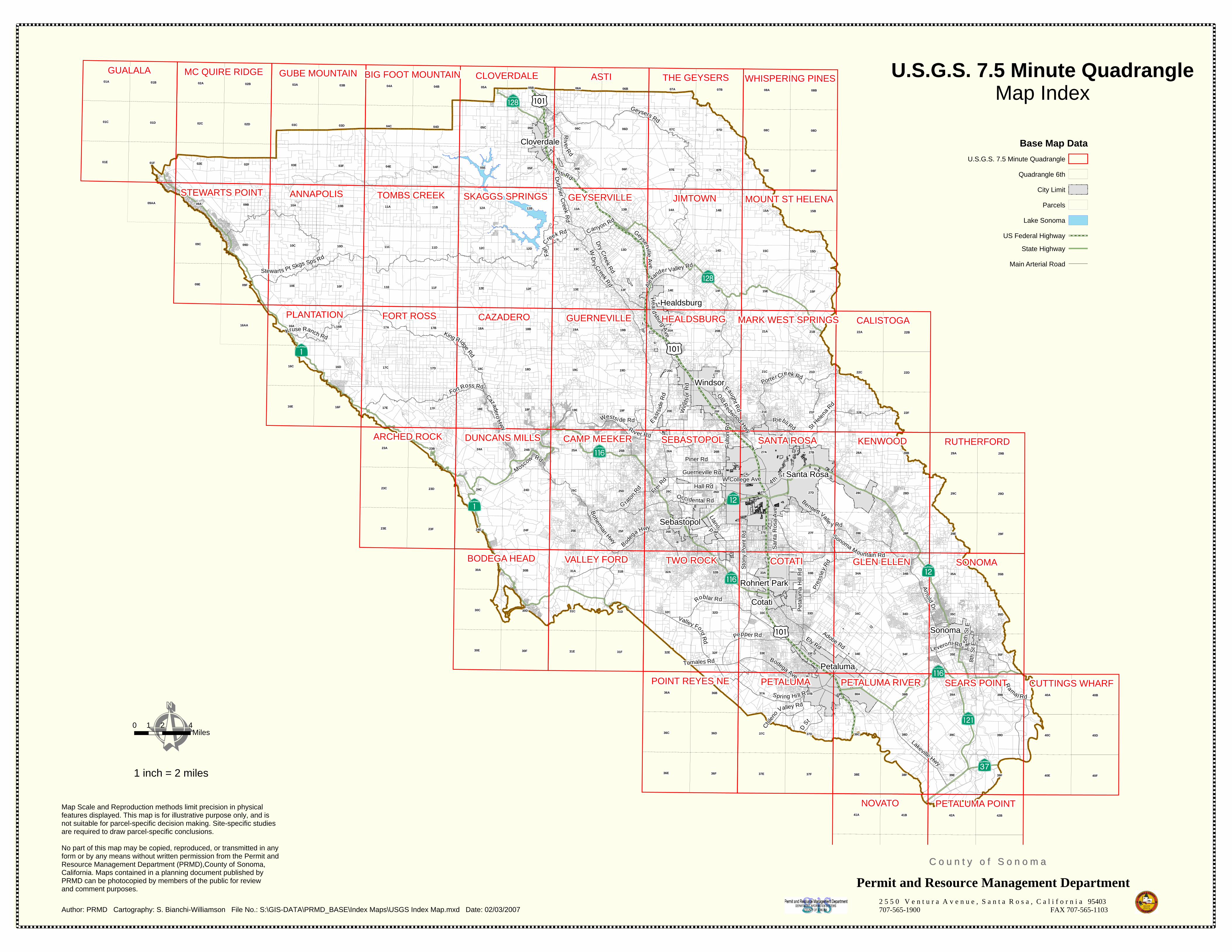
U.S.G.S. 7.5 Minute QuadrangleMap Index
Map Scale and Reproduction methods limit precision in physical features displayed. This map is for illustrative purpose only, and is not suitable for parcel-specific decision making. Site-specific studiesare required to draw parcel-specific conclusions.
No part of this map may be copied, reproduced, or transmitted in any form or by any means without written permission from the Permit and Resource Management Department (PRMD),County of Sonoma,California. Maps contained in a planning document published byPRMD can be photocopied by members of the public for reviewand comment purposes.
Author: PRMD Cartography: S. Bianchi-Williamson File No.: S:\GIS-DATA\PRMD_BASE\Index Maps\USGS Index Map.mxd Date: 02/03/2007
Permit and Resource Management Department2 5 5 0 V e n t u r a A v e n u e , S a n t a R o s a , C a l i f o r n i a 95403707-565-1900 FAX 707-565-1103
C o u n t y o f S o n o m aC o u n t y o f S o n o m a
Base Map DataU.S.G.S. 7.5 Minute Quadrangle
Quadrangle 6th
City Limit
Parcels
Lake Sonoma
US Federal Highway
State Highway
Main Arterial Road
0 2 41Miles
1 inch = 2 miles