Embed Size (px)
Citation preview
1514 April/May 2018 April/May 2018 unmanned systemsinside
unmanned systemsinside
USER SHOWCASE
Photos courtesy of Microdrones.
About the White Birch Paper MillOriginally built in 1927, the mill produces newsprint and commercial paper grades and has an annual capacity of more than 250,000 metric tons. White Birch, which was known as the Stadacona Mill until it was purchased in 2004, runs a paperboard machine that produces 45,000 metric tons per year of 100% recycled chip board and specialty paperboard products.
Benefits of Using the mdMapper1000DG • The advanced aerial photogrammetry package allows for a high
level of data accuracy
• It covers more ground in one flight
• There’s no need for ground control points
• Less people and equipment are necessary for each job
• Jobs take less time, as does post processing
• It can be used for a variety of missions including area mapping, surveying, construction, mining and LiDAR applications
Every three months, a team from Microdrones flies the
mdMapper1000DG over the wood chip piles stored
outside the White Birch Paper mill in Quebec City,
providing the mill with valuable information about their
inventory.
The mill transforms these wood chips into cardboard
paper, making it vital for company leaders to know exactly
how much volume they have in each pile, Microdrones
Canadian Sales Manager Sebastien Long said. Before
they started working with Microdrones about three years
ago, this was a dangerous, time-consuming task that was
performed using traditional surveying methods.
Now, a process that once took a few days to complete only
takes a few hours, and there’s no longer a need for workers
to walk around the heavy machinery in the area or to climb
on top of the wood chip piles—which is a lot like trying to
walk on mounds of sand—to collect the necessary data.
“This is safer, faster and we get a better data set,” Long
said. “The numbers we get are more accurate than what
they used to get from surveying. In the past, they’d take
images of the piles and convert that into 3-D. With the
drone, they can get better coverage of the surface than
someone walking the pile and taking a rating here and
there, every 6 or 12 feet. The drone covers 100 percent of
the pile and we’re able to give them accurate data of the
volume and their inventory.”
Why MicrodronesThe mill is located in the middle of a city and near an
international airport, so when the team decided to in-
vest in a drone for inventory management, they knew
the system they chose had to be safe and reliable—they
couldn’t risk it getting away from the pilot, or failing
during the middle of a f light.
“They wanted to make sure they were f lying with a
company that was serious on every level,” Long said.
“When a large company like White Birch is f lying some-
thing in the air, they have to make sure it’s reliable at
all costs. That’s one of the strengths of Microdrones. We
have a highly reliable platform.”
After reliability, accuracy was the next top consider-
ation, Long said. The system had to provide at least the
same level of accuracy as the manual surveys, a bench-
mark the Microdrones solution had no trouble reaching
and surpassing.
The Advantage of DG White Birch paper mill started with the original
mdMapper solution, but then moved on to the more
advanced mdMapper1000DG drone. This system
features direct georeferencing (DG), which means
there’s no need to lay down multiple ground control
points (GCPs) on what is very dangerous terrain,
Long said.
“If you use our entry level system or any other sensor
or drone on the market, you have to lay down ground
control points that help you get the level of accuracy you
need. The GCPs help ensure the measurements from the
pile are correct and that you can process the data as a
volume,” Long said. “When you use DG, you don’t have
to do that, which saves a lot of time. You also don’t have
to walk around the piles of wood chips to put the GCPs
in place, so it’s safer and the results are accurate. You’re
still using a base station, but it’s easy to set up. You can
also use a smart target. As long as the target is appear-
ing in the images, you’re good to go.”
Using DG also reduces overlap, Long said, leading to
faster post processing times after the 200 or so images
are taken.
Overcoming Weather Conditions The mill’s city location wasn’t the only challenge the
Microdrones team had to overcome when taking on this
project. They also had to contend with weather, Long said.
Quebec City is known for its harsh winters that come
with extremely cold temperatures and plenty of snow,
which can make flights a little difficult during that time
of year, Long said. The mill is also located near the St.
Lawrence River, which often brings heavy winds to the
area. Pilots have to consider these conditions when it’s
time to fly, but they know the robust Microdrones system
is built to handle adverse weather.
A Happy Customer Now that Microdrones handles wood chip pile surveys
for White Birch, there’s no need for the mill to send
workers out to do the job manually. So instead of sur-
veyors coming away with an incomplete picture of the
pile volumes, the Microdrones solution stiches the im-
ages together to create a 3-D map of the pile, and data
from that 3-D model is then brought into volume cal-
culation software to provide the exact volume of every
pile on the ground.
“They wanted a solution that was accurate, cheaper
and safer for operators on the ground and for the peo-
ple in the area,” Long said. “We’ve been able to offer
that, and have proven over the last three years that we
can provide more accurate data than they ever had in
the past.”
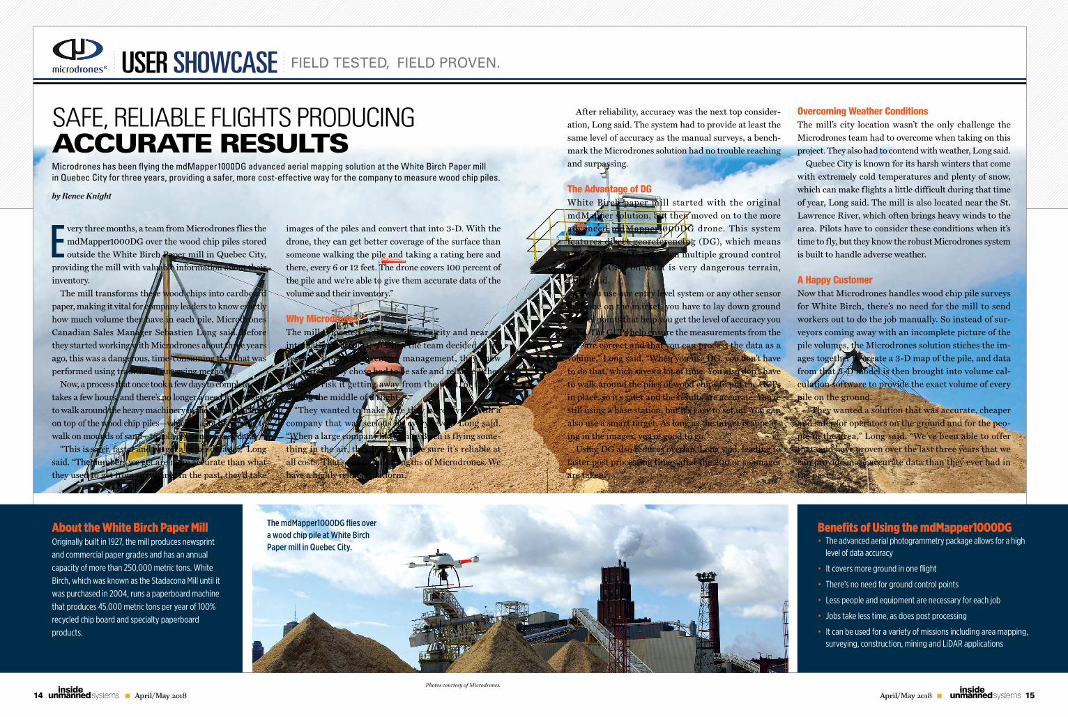
The mdMapper1000DG flies over a wood chip pile at White Birch Paper mill in Quebec City.
SAFE, RELIABLE FLIGHTS PRODUCING ACCURATE RESULTS Microdrones has been flying the mdMapper1000DG advanced aerial mapping solution at the White Birch Paper mill in Quebec City for three years, providing a safer, more cost-effective way for the company to measure wood chip piles.
by Renee Knight
FIELD TESTED, FIELD PROVEN.


![William Ramesey - Astrologia Munda [Revised English Edition by Birch Field]](https://img.pdfslide.us/doc/110x75/5527cafa497959ec0f8b4b14/william-ramesey-astrologia-munda-revised-english-edition-by-birch-field.jpg)