Embed Size (px)
Citation preview
LEMBAGA PENERBANGAN DAN ANTARIKSA NASIONALLEMBAGA PENERBANGAN DAN ANTARIKSA NASIONALINDONESIAN NATIONAL INSTITUTE OF AERONAUTICS AND SPACEINDONESIAN NATIONAL INSTITUTE OF AERONAUTICS AND SPACE
USAGE AND PLANS OF USAGE AND PLANS OF HOTSPOT INFORMATION HOTSPOT INFORMATION
IN INDONESIAIN INDONESIA
Orbita RoswintiartiOrbita RoswintiartiNatural Resources and Environmental Monitoring DivisionNatural Resources and Environmental Monitoring DivisionIndonesian National Institute of Aeronautics and Space (LAPAN)Indonesian National Institute of Aeronautics and Space (LAPAN)http://www.http://www.rsrs..lapanlapan.go.id/SIMBA.go.id/SIMBA
BackgroundBackground
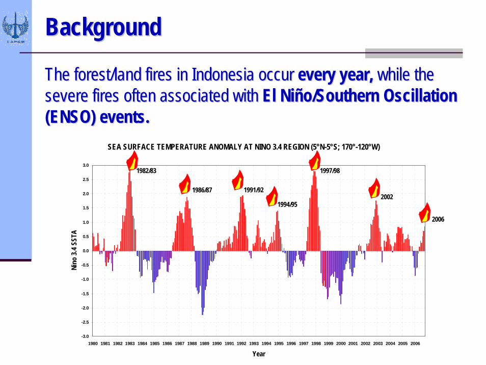
The forest/land fires in Indonesia occurThe forest/land fires in Indonesia occur every year, every year, while the while the severe fires often associated withsevere fires often associated with El NiEl Niñño/Southern Oscillation o/Southern Oscillation (ENSO) events.(ENSO) events.
SEA SURFACE TEMPERATURE ANOMALY AT NINO 3.4 REGION (5°N-5°S; 170°-120°W)
-3.0
-2.5
-2.0
-1.5
-1.0
-0.5
0.0
0.5
1.0
1.5
2.0
2.5
3.0
1980 1981 1982 1983 1984 1985 1986 1987 1988 1989 1990 1991 1992 1993 1994 1995 1996 1997 1998 1999 2000 2001 2002 2003 2004 2005 2006
Year
Nino
3.4
SSTA
1982/83
1986/87 1991/92
1994/95
1997/98
2002
2006
Usage of Hotspot Information Usage of Hotspot Information -- PastPast
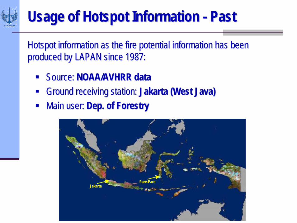
Hotspot information as the fire potential information has been Hotspot information as the fire potential information has been produced by LAPAN since 1987:produced by LAPAN since 1987:
Source: Source: NOAA/AVHRR dataNOAA/AVHRR dataGround receiving station: Ground receiving station: Jakarta (West Java)Jakarta (West Java)Main user: Main user: Dep. of ForestryDep. of Forestry
JakartaPare-Pare
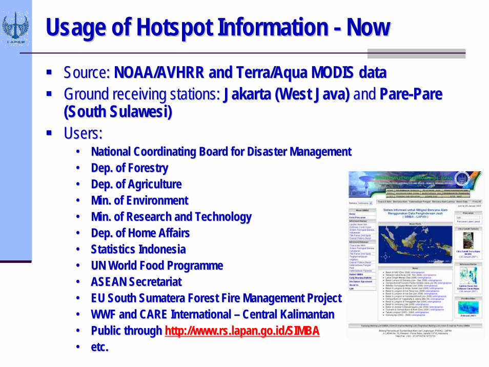
Usage of Hotspot Information Usage of Hotspot Information -- NowNowSource:Source: NOAA/AVHRR and Terra/Aqua MODIS dataNOAA/AVHRR and Terra/Aqua MODIS dataGround receiving stations:Ground receiving stations: Jakarta (West Java) Jakarta (West Java) andand ParePare--Pare Pare (South (South SulawesiSulawesi))Users:Users:
•• National Coordinating Board for Disaster ManagementNational Coordinating Board for Disaster Management•• Dep. of ForestryDep. of Forestry•• Dep. of AgricultureDep. of Agriculture•• Min. of EnvironmentMin. of Environment•• Min. of Research and TechnologyMin. of Research and Technology•• Dep. of Home AffairsDep. of Home Affairs•• Statistics IndonesiaStatistics Indonesia•• UN World Food UN World Food ProgrammeProgramme•• ASEAN SecretariatASEAN Secretariat•• EU South EU South SumateraSumatera Forest Fire Management ProjectForest Fire Management Project•• WWF and CARE International WWF and CARE International –– Central KalimantanCentral Kalimantan•• Public through Public through http://www.http://www.rsrs..lapanlapan.go.id/SIMBA.go.id/SIMBA•• etc.etc.
NOAA/AVHRR AlgorithmsNOAA/AVHRR Algorithms
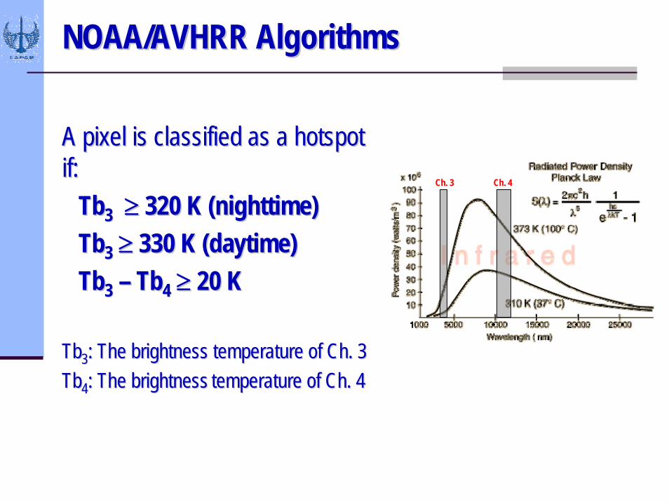
A pixel is classified as a hotspot A pixel is classified as a hotspot if:if:
TbTb33 ≥≥ 320 K (nighttime) 320 K (nighttime) TbTb33 ≥≥ 330 K (daytime)330 K (daytime)TbTb33 –– TbTb44 ≥≥ 20 K20 K
TbTb33: The brightness temperature of Ch. 3: The brightness temperature of Ch. 3TbTb44: The brightness: The brightness temperature of Ch. 4temperature of Ch. 4
Ch. 3 Ch. 4
Terra/Aqua MODIS AlgorithmsTerra/Aqua MODIS Algorithms
Fire (hotspot) and Vegetation Index algorithms are taken Fire (hotspot) and Vegetation Index algorithms are taken from the from the NASA Goddard Space Flight CenterNASA Goddard Space Flight Center..
A detailed description of the algorithm may be found in: A detailed description of the algorithm may be found in: GiglioGiglio, L., J. , L., J. DescloitresDescloitres, C. O. Justice, and Y. J. Kaufman, , C. O. Justice, and Y. J. Kaufman, 2003: 2003: An enhanced contextual fire detection algorithm for An enhanced contextual fire detection algorithm for MODIS. MODIS. Remote Sensing of EnvironmentRemote Sensing of Environment, 87, 273, 87, 273--282. 282.
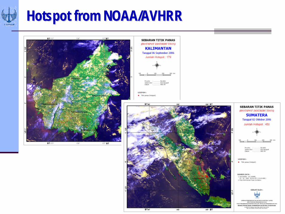
Hotspot from NOAA/AVHRRHotspot from NOAA/AVHRR
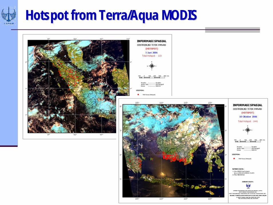
Hotspot from Terra/Aqua MODISHotspot from Terra/Aqua MODIS
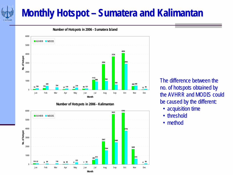
Monthly Hotspot Monthly Hotspot –– SumateraSumatera and Kalimantanand KalimantanNumber of Hotspots in 2006 - Sumatera Island
74 176 37 66 98
1113
2856
3726
4094
406
12156
428254 119 219 131
908 964
568
2905
44095
0
1000
2000
3000
4000
5000
6000
Jan Feb Mar Apr May Jun Jul Aug Sep Oct Nov Dec
Month
No. o
f hot
spot
AVHRR MODIS
Number of Hotspots in 2006 - Kalimantan
56225792
5000
6000
110 0 18 8 7
483
2567
1699
697 84 110 40222
50
613
1564
2460
3756
614
900
1000
2000
3000
4000
Jan Feb Mar Apr May Jun Jul Aug Sep Oct Nov Dec
Month
No. o
f hot
spot
AVHRR MODIS
The difference between the The difference between the no. of hotspots obtained by no. of hotspots obtained by the AVHRR and MODIS could the AVHRR and MODIS could be caused by the different:be caused by the different:
•• acquisition timeacquisition time•• thresholdthreshold•• methodmethod
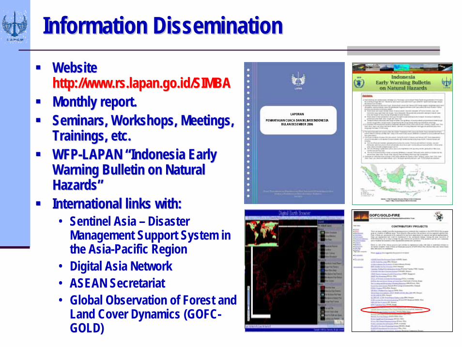
Information DisseminationInformation DisseminationWebsite Website http://www.http://www.rsrs..lapanlapan.go.id/SIMBA.go.id/SIMBAMonthly report.Monthly report.Seminars, Workshops, Meetings, Seminars, Workshops, Meetings, Trainings, etc.Trainings, etc.WFPWFP--LAPAN LAPAN ““Indonesia Early Indonesia Early Warning Bulletin on Natural Warning Bulletin on Natural HazardsHazards””International links with:International links with:• Sentinel Asia – Disaster
Management Support System in the Asia-Pacific Region
• Digital Asia Network• ASEAN Secretariat• Global Observation of Forest and
Land Cover Dynamics (GOFC-GOLD)
LAPORAN
PEMANTAUAN CUACA DAN IKLIM DI INDONESIABULAN DESEMBER 2006
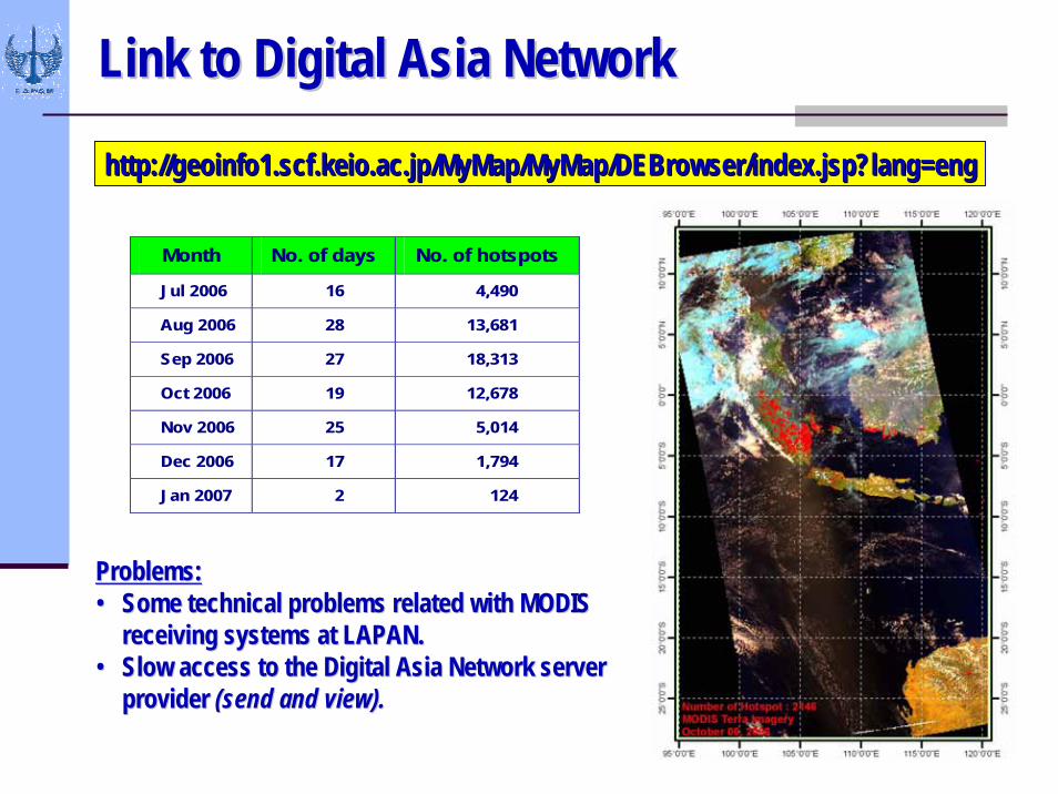
Link to Digital Asia NetworkLink to Digital Asia Network
Month No. of days No. of hotspots
Jul 2006 16 4,490
Aug 2006 28 13,681
Sep 2006 27 18,313
Oct 2006 19 12,678
Nov 2006 25 5,014
Dec 2006 17 1,794
Jan 2007 2 124
http://geoinfo1.scf.keio.ac.jp/MyMap/MyMap/DEBrowser/index.jsp?lhttp://geoinfo1.scf.keio.ac.jp/MyMap/MyMap/DEBrowser/index.jsp?lang=engang=eng
Problems:Problems:•• Some technical problems related with MODIS Some technical problems related with MODIS
receiving systems at LAPAN.receiving systems at LAPAN.•• Slow access to the Digital Asia Network server Slow access to the Digital Asia Network server
provider provider (send and view).(send and view).
Usage of Hotspot Information Usage of Hotspot Information -- PlansPlans
To upgrade the existing acquisition systems To upgrade the existing acquisition systems (receiving and processing systems)(receiving and processing systems)To process the hotspot information automaticallyTo process the hotspot information automaticallyTo validate the hotspot algorithms:To validate the hotspot algorithms:•• Sentinel Asia: Sentinel Asia:
Joint Project Team (JPT) activitiesJoint Project Team (JPT) activitiesResults from Results from ““Hotspot Validation Campaign in Central Hotspot Validation Campaign in Central Kalimantan (October 2006)Kalimantan (October 2006)””
To extend national, regional, and international To extend national, regional, and international collaborations collaborations (e. g. (e. g. GOFC/GOLD, GFMC, Department GOFC/GOLD, GFMC, Department of Land Information of Land Information -- Gov. of Western Australia, etc)Gov. of Western Australia, etc)
RecommendationRecommendation
To support the To support the wildlandwildland fire prevention at the national and fire prevention at the national and regional levels, the assistances from the regional and regional levels, the assistances from the regional and international institutions/organizations are needed, international institutions/organizations are needed, particularly in:particularly in:
The upgrade of the acquisition, monitoring, and The upgrade of the acquisition, monitoring, and information management systems.information management systems.The improvement of climate prediction that are likely to The improvement of climate prediction that are likely to results in fires.results in fires.The methods of the validation.The methods of the validation.The implementation of the Global The implementation of the Global WildlandWildland Fire Early Fire Early Warning System.Warning System.