Embed Size (px)
Citation preview
DEPARTMENT OF THE AIR FORCEAIR FORCE REAL PROPERTY AGENCY
281571
FINAL
DECISION DOCUMENT FOR
NO FURTHER ACTION AT
B-58 HUSTLER BURIAL SITE(AREA OF CONCERN 8)
Grissom Air Force Base, Indiana
NOVEMBER 2002
DEPARTMENT OF THE AIR FORCEAIR FORCE REAL PROPERTY AGENCY /i .,
08 Nov 02
MEMORANDUM FOR U.S. ENVIRONMENTAL PROTECTION AGENCY REGION VATTN: Tom Barounis77 West Jackson BoulevardChicago, IL 60604-3590
INDIANA DEPARTMENT OF ENVIRONMENTAL MANAGEMENTATTN: Stephanie Riddle100 North Senate AvenueIndianapolis, IN 46204
FROM: OL-L, AFRPA/DA1 Hoosier Blvd, Bldg 1Grissom ARE, IN 46971-5000
SUBJECT: Final Decision Document (DD) for B-58 Hustler Burial Site (AOC 8)
Attached is the Final B-58 Hustler Burial Site (AOC 8) DD for your review and ,comment. Please provide your comments on the subject document by 9 Dec 02. J^)o/> 'l / £$/*T- _
-A
If you have any questions, please call Kerry Settle at (765) 688-2248 Ext. #2.
MARLENE SENECASite Manager/BRAC EnvironmentalCoordinator
Attachment:1. Final B-58 Hustler Burial Site (AOC 8) DD
cc:AFBCA/DA

O
UNITED STATES ENVIRONMENTAL PROTECTION AGENCYREGIONS \J
^77 WEST JACKSON BOULEVARDCHICAGO, IL 60604-3590
REPLY TO THE ATTENTION OF
November 18, 2002 SRF-5J
Ms. Marlene SenecaBRAC Environmental CoordinatorDepartment of the Air ForceOL-L, AFBCA (Bldg. 1, Room.'108)Grissom ARE, IN 46971-5000
SUBJECT: Final Decision Document (DD) for No Further Action at the B-58 HustlerBurial Site, (Area of Concern (AOC) 8), November 2002, Grissom Air ForceBase, Indiana
Dear Ms. Seneca:
The U.S. Environmental Protection Agency (EPA) has completed received and reviewed theFinal Decision Document (DD) for the B-58 Hustler Burial Site, (Area of Concern (AOC)8), July 2002, Grissom Air Force Base, Indiana (DD). Our comments on the draft version ofthe DD, which were forwarded to the Air Force by letter dated October 2, 2002 have beenaddressed and requested changes made. EPA has no additional comments on the DD andrecommends that it be finalized
If you have any questions, or require additional information, please feel free to contact me byphone (312-353-5577) or e-mail ([email protected]).
Sincerely,
Tom BarounisRemedial Project Manager
cc: Stephanie Riddle, IDEMNara Mantravadi, AFBCAKerry Settle, AFBCA
Recycled/Recyclable . Printed with Vegetable Oil Based Inks on 100% Recycled Paper (50% Postconsumer)
DEPARTMENT OF THE AIR FORCEAIR FORCE REAL PROPERTY AGENCY
06 Dec 02
MEMORANDUM FOR U.S. ENVIRONMENTAL PROTECTION AGENCY REGION VATTN: Tom Barounis77 West Jackson BoulevardChicago, IL 60604-3590
INDIANA DEPARTMENT OF ENVIRONMENTAL MANAGEMENTATTN: Stephanie Riddle100 North Senate AvenueIndianapolis, IN 46204
FROM: OL-L, AFRPA/DA1 Hoosier Blvd, Bldg 1Grissom ARE, IN 46971-5000
SUBJECT: Final Decision Document (DD) for B-58 Hustler Burial Site (AOC 8)
Due to minor format and rhetorical corrections by AFRPA/HQ's, the page numbers of thesubject document have changed from the final version that you reviewed and commented on. Asa result, I have attached a copy of the DD to be used as change pages to replace the final youreviewed. Since our next BCT meeting is via conference call, once I receive Stephanie's signedconcurrence letter, I would like to circulate the signature page by fax to finalize the document.
If you have any questions, please call Kerry Settle at (765) 688-2248 Ext. #2.
MARLENE SENECASite Manager/BRAC EnvironmentalCoordinator
Attachment:1. Final B-58 Hustler Burial Site (AOC 8) DD
cc:AFRPA/DA
INDIANA DEPARTMENT OF ENVIRONMENTAL MANAGEMENTWe make Indiana a cleaner, healthier place to live
Frank O 'Ban/ionGovernor
Lori F. KaplanCommissioner DEC 182002
100 North Senate AvenueP.O. Box 6015Indianapolis, Indiana 46206-6015
(317)232-8603(800) 451-6027www.state.in.us/idem
December 12,2002
Ms. Marlene SenecaBRAC Environmental CoordinatorAFRPA/DA Grissom1 Hoosier Boulevard, Building 1Grissom ARE, IN 46971-5000
Dear Ms. Seneca:
Re: Final Decision Document (DD) to SupportNo Further Action at the B-58 HustlerBurial Site, Area of Concern (AOC) 8,Grissom Air Force Base (GAFB), Peru,
; Indiana
Staff of the Indiana Department of Environmental Management (IDEM) have reviewedthe above referenced document. Our comments have been adequately addressed. Please acceptthis as our concurrence on the DD. If you have any questions, please feel free to contact me at(317)234-0358.
Sincerely,
Stephanie Riddle, Senior Environmental ManagerFederal Programs SectionOffice of Land Quality
SR:trcc: Tom Barounis, USEPA
Rex Osbom, IDEM
Rectcleil Paper ® An Hquul Opportunity Employer Pirate Kei\clf
TABLE OF CONTENTS
PAGE
DECLARATION 7
Name of Base/Installation/Facility 7
Site Name and Location 7
Statement and Base of Purpose 7
Description of Selected Remedy 7
Declaration of Remedy 7
SIGNATURE PAGE 8
DECISION SUMMARY 9
SECTION 1.0 Purpose 9
SECTION 2.0 . Background Information 9
2.1 Base Location and Description 9
2.2 Base Geography 9
2.3 Physiography and Climatography 10
2.4 Base Geology 10
2.5 Base Hydrology 11
2.6 Base Surface Water Hydrology 11
2.7 Groundwater Supply Wells 11
2.8 Base History 11
2.9 Facility Ecological Assessment 12
2.9.1 Sensitive Habitats 12
Final NFRAP Decision Document, B-58 Hustler Burial Site (AOC 8),Grissom AFB, IN, November 2002
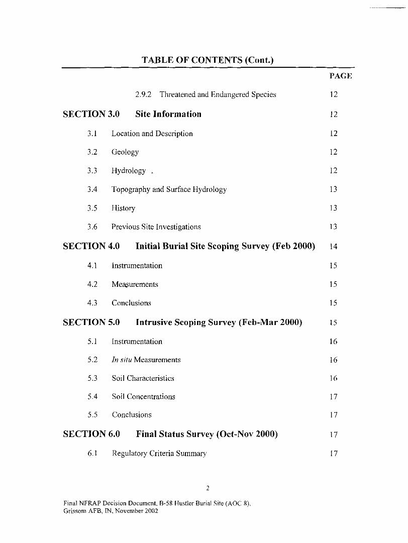
TABLE OF CONTENTS (Cont.)
PAGE
2.9.2 Threatened and Endangered Species 12
SECTION 3.0 Site Information 12
3.1 Location and Description 12
3.2 Geology 12
3.3 Hydrology , 12
3.4 Topography and Surface Hydrology 13
3.5 History 13
3.6 Previous Site Investigations 13
SECTION 4.0 Initial Burial Site Scoping Survey (Feb 2000) 14
4.1 Instrumentation 15
4.2 Measurements 15
4.3 Conclusions 15
SECTION 5.0 Intrusive Scoping Survey (Feb-Mar 2000) 15
5.1 Instrumentation 16
5.2 In situ Measurements 16
5.3 Soil Characteristics 16
5.4 Soil Concentrations 17
5.5 Conclusions 17
SECTION 6.0 Final Status Survey (Oct-Nov 2000) 17
6.1 Regulatory Criteria Summary 17
Final NFRAP Decision Document, B-58 Hustler Burial Site (AOC 8),Grissom AFB, IN, November 2002
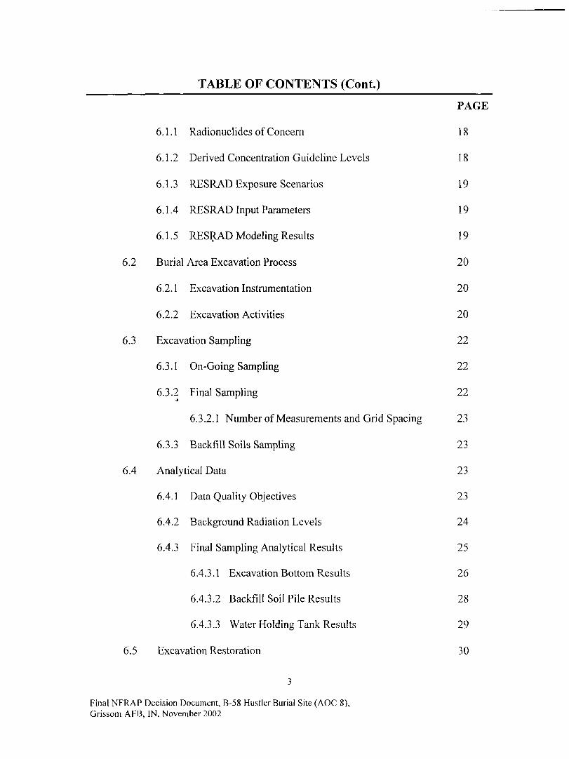
TABLE OF CONTENTS (Cont.)
PAGE
6.1.1 Radionuclides of Concern 18
6.1.2 Derived Concentration Guideline Levels 18
6.1.3 RESRAD Exposure Scenarios 19
6.1.4 RESRAD Input Parameters 19
6.1.5 RESRAD Modeling Results 19
6.2 Burial Area Excavation Process 20
6.2.1 Excavation Instrumentation 20
6.2.2 Excavation Activities 20
6.3 Excavation Sampling 22
6.3.1 On-Going Sampling 22
6.3.2 Final Sampling 22
6.3.2.1 Number of Measurements and Grid Spacing 23
6.3.3 Backfill Soils Sampling 23
6.4 Analytical Data 23
6.4.1 Data Quality Objectives 23
6.4.2 Background Radiation Levels 24
6.4.3 Final Sampling Analytical Results 25
6.4.3.1 Excavation Bottom Results 26
6.4.3.2 Backfill Soil Pile Results 28
6.4.3.3 Water Holding Tank Results 29
6.5 Excavation Restoration 30
Final NFRAP Decision Document, B-58 Hustler Burial Site (AOC 8),Grissom AFB, IN, November 2002
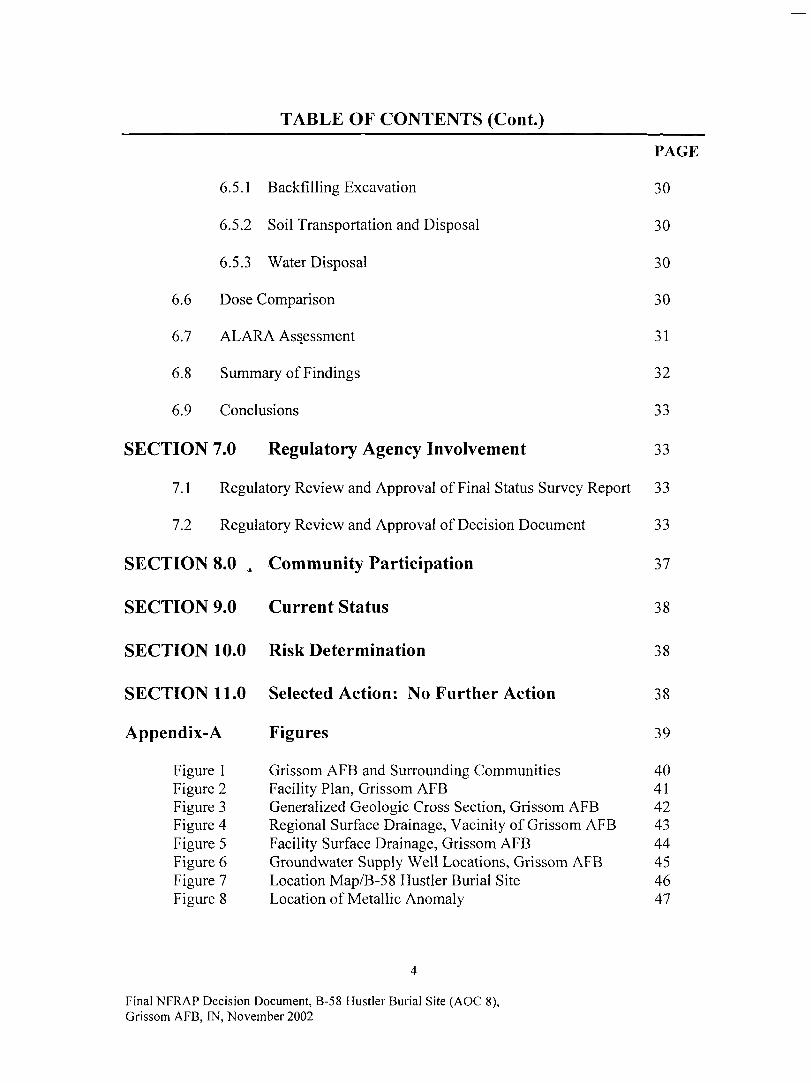
TABLE OF CONTENTS (Cont.)
6.6
6.7
6.5.1 Backfilling Excavation
6.5.2 Soil Transportation and Disposal
6.5.3 Water Disposal
Dose Comparison
ALARA Assessment
6.8 Summary of Findings
6.9 Conclusions
PAGE
30
30
30
30
31
32
33
SECTION 7.0 Regulatory Agency Involvement 33
7.1 Regulatory Review and Approval of Final Status Survey Report 33
7.2 Regulatory Review and Approval of Decision Document 33
SECTION 8.0 , Community Participation 37
SECTION 9.0 Current Status 38
SECTION 10.0 Risk Determination 38
SECTION 11.0 Selected Action: No Further Action 38
Appendix-A Figures 39
Figure 1 Grissom AFB and Surrounding Communities 40Figure 2 Facility Plan, Grissom AFB 41Figure 3 Generalized Geologic Cross Section, Grissom AFB 42Figure 4 Regional Surface Drainage, Vacinity of Grissom AFB 43Figure 5 Facility Surface Drainage, Grissom AFB 44Figure 6 Groundwater Supply Well Locations, Grissom AFB 45Figure 7 Location Map/B-58 Hustler Burial Site 46FigureS Location of Metallic Anomaly 47
Final NFRAP Decision Document, B-58 Hustler Burial Site (AOC 8),Grissom AFB, IN, November 2002
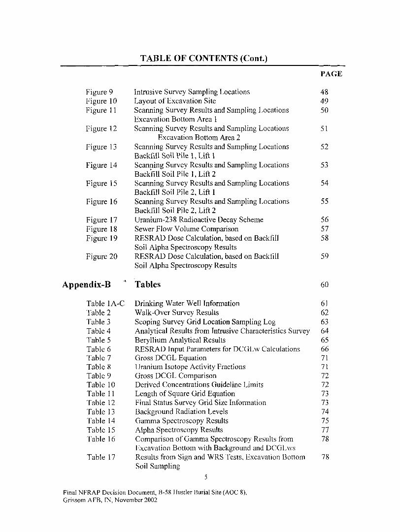
TABLE OF CONTENTS (Cont.)
Figure 9Figure 10Figure 1 1
Figure 12
Figure 13
Figure 14
Figure 15
Figure 16
Figure 17Figure 18Figure 19
Figure 20
Intrusive Survey Sampling LocationsLayout of Excavation SiteScanning Survey Results and Sampling LocationsExcavation Bottom Area 1Scanning Survey Results and Sampling Locations
Excavation Bottom Area 2Scanning Survey Results and Sampling LocationsBackfill Soil Pile 1, Lift 1Scanning Survey Results and Sampling LocationsBackfill Soil Pile 1, Lift 2Scanning Survey Results and Sampling LocationsBackfill Soil Pile 2, Lift 1Scanning Survey Results and Sampling LocationsBackfill Soil Pile 2, Lift 2Uranium-238 Radioactive Decay SchemeSewer Flow Volume ComparisonRESRAD Dose Calculation, based on BackfillSoil Alpha Spectroscopy ResultsRESRAD Dose Calculation, based on BackfillSoil Alpha Spectroscopy Results
PAGE
484950
51
52
53
54
55
565758
59
Appendix-B * Tables 60
Table 1A-C Drinking Water Well Information 61Table 2 Walk-Over Survey Results 62Table 3 Scoping Survey Grid Location Sampling Log 63Table 4 Analytical Results from Intrusive Characteristics Survey 64Table 5 Beryllium Analytical Results 65Table 6 RESRAD Input Parameters for DCGLw Calculations 66Table 7 Gross DCGL Equation 71Table 8 Uranium Isotope Activity Fractions 71Table 9 Gross DCGL Comparison 72Table 10 Derived Concentrations Guideline Limits 72Table 11 Length of Square Grid Equation 73Table 12 Final Status Survey Grid Size Information 73Table 13 Background Radiation Levels 74Table 14 Gamma Spectroscopy Results 75Table 15 Alpha Spectroscopy Results 77Table 16 Comparison of Gamma Spectroscopy Results from 78
Excavation Bottom with Background and DCGLwsTable 17 Results from Sign and WRS Tests, Excavation Bottom 78
Soil Sampling5
Final NFRAP Decision Document, B-58 Hustler Burial Site (AOC 8),Grissom AFB, IN, November 2002
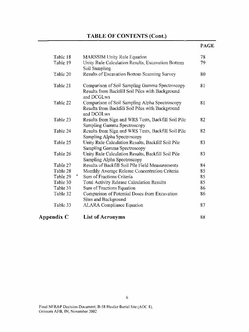
TABLE OF CONTENTS (Cont)
PAGE
MARSSIM Unity Rule Equation 78Unity Rule Calculation Results, Excavation Bottom 79Soil SamplingResults of Excavation Bottom Scanning Survey 80
Comparison of Soil Sampling Gamma Spectroscopy 81Results from Backfill Soil Piles with Backgroundand DCGLwsComparison of Soil Sampling Alpha Spectroscopy 81Results from Backfill Soil Piles with Backgroundand DCGLwsResults from Sign and WRS Tests, Backfill Soil Pile 82Sampling Gamma SpectroscopyResults from Sign and WRS Tests, Backfill Soil Pile 82Sampling Alpha SpectroscopyUnity Rule Calculation Results, Backfill Soil Pile 83Sampling Gamma SpectroscopyUnity Rule Calculation Results, Backfill Soil Pile 83Sampling Alpha SpectroscopyResults of Backfill Soil Pile Field Measurements 84Monthly Average Release Concentration Criteria 85Sum of Fractions Criteria 8 5Total Activity Release Calculation Results 85Sum of Fractions Equation 86Comparison of Potential Doses from Excavation 86Sites and BackgroundALARA Compliance Equation 87
List of Acronyms 88
Table 18Table 19
Table 20
Table 21
Table 22
Table 23
Table 24
Table 25
Table 26
Table 27Table 28Table 29Table 30Table 31Table 32
Table 33
Appendix C
Final NFRAP Decision Document, B-58 Hustler Burial Site (AOC 8),Grissom AFB, IN, November 2002

DECLARATION
Name of Base/Installation/Facility
Grissom Air Force Base (AFB), Peru, Indiana.
Site Name and Location
B-58 Hustler Burial Site/Area of Concern (AOC) 8, Grissom AFB, Peru, Indiana.
Statement of Basis and Purpose
This decision is based on the results of the Final Status Survey Report/B-58 HustlerBurial Site/AOC 8 (February 2002) conducted by Parsons Engineering Science, Inc.,Denver Colorado, under Project Number CTGC20006108, prepared for the Grissom AirForce Real Property Agency (AFRPA) and the Air Force Institute for Environment,Occupational Safety and Health Risk (AFIERA).
Description of Selected Remedy
Based on current site condition, it has been determined that no significant risk or threat topublic health or the environment exists. Therefore, no further action (NFA) under theComprehensive Environmental Response, Compensation, and Liability Act (CERCLA)and the Nuclear Regulatory Commission (NRC) guidance is required.
Declaration of the'Remedy
This decision document represents the selected action for this site developed inaccordance with CERCLA and the NRC guidance. It has been determined that the NFAis protective of human health and environment, attains federal and state requirements thatare applicable, or relevant and appropriate, and is cost effective. Based upon results ofthe intrusive survey activities conducted in Feb/Mar 2000 contaminant levels at the sitehave been determined to present no significant threat to human health or theenvironment; thus, no treatment is necessary and the site is suitable for unrestricted use.
7
Final NFRAP Decision Document, B-58 Hustler Burial Site (AOC 8),Grissom AFB, IN, November 2002
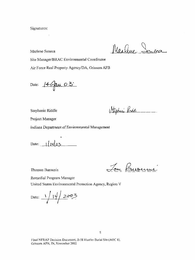
Signatures:
Marlene Seneca
Site Manager/BRAC Environmental Coordinator
Air Force Real Property Agency/DA, Grissom AFB
Date: 4 - > U Q
Stephanie Riddle
Project Manager
Indiana Department of Environmental Management
Date:
Thomas Barounis
Remedial Program Manager
United States Environmental Protection Agency, Region V
Date:V
Final NFRAP Decision Document, B-58 Hustler Burial Site (AOC 8),Grissom AFB, IN, November 2002

Decision Summary
1.0 Purpose
The purpose of this NFA Report is to summarize existing data and describe the AirForce's rationale for selecting a particular remedial action, in this case, the NFAalternative for the B-58 Hustler Burial Site (AOC 8). The objectives of this decisiondocument are:
• To describe the location, history, environmental setting and current status of the site;
• To summarize the results from previous investigations; and
• To assess the risk to human health and the environment.
2.0 Background Information
2.1 Base Location and Description
Grissom AFB is located approximately 15 miles north of Kokomo, Indiana on U.S. Route31 in Cass and Miami counties, approximately two miles west of the town of BunkerHill. See Appendix-A, Figure 1 for a map of Grissom AFB and the surroundingcommunities. The base, which was originally established in 1942, has undergone severaltransitions throughout its history. Grissom AFB was realigned to Grissom Air ReserveBase (ARB) on 30 September 1994. The Air Force Reserve 434th Air Refueling Wing isthe host within the new cantonment area. The excess Air Force property, known as BaseRealignment and Closure (BRAC) property, is being managed by the AFRPA pendingredevelopment. The primary mission of the AFRPA is to cleanup BRAC property fortransfer to the Grissom Redevelopment Authority for reuse. The former base wascomprised of 2,722 acres of land, which is surrounded by actively managed agriculturalland. Major population centers in the vicinity include the cities of Peru, Kokomo, andLogansport. In addition, several smaller towns and communities are scattered around theformer Grissom AFB as shown in Appendix-A, Figure 1. Grissom AFB Facility Plan isshown in Appendix-A, Figure 2.
2.2 Base Geography
The base lies within the Tipton Till Plain section of the Interior Plains division of theCentral Lowlands Province of the United States. The Tipton Till Plain section isgenerally characterized by nearly level plains with gently rolling hills and has a fewsmall, localized, closed depressions. The topography of the base exhibits characteristicstypical of the regional Tipton Till Plain. In general, the topography is a reflection of aglacially deposited till that has been affected to some extent by the shape of theunderlying bedrock surface and by post-glacial erosion. Across the base, land surfaceelevations vary from approximately 810 feet above the National Geodetic Vertical Datum(NGCD), reference to feet above mean sea level (ft MSL) near the southeast boundary to
Final NFRAP Decision Document, B-58 Hustler Burial Site (AOC 8),Grissom AFB, IN, November 2002

approximately 780 feet NGVD near the northern boundary. The south edge of the baseappears to be a topographic high, which slopes towards the north (on the base) and south(away from the base) (ESE, 1993a; United States Geological Survey [USGS], 1963).
2.3 Physiography and Climatography
The climate in north Central Indiana is temperate, with warm humid summers and coldwinters. The region is characterized by wide variations in temperature from season toseason, ranging from 20 degrees Fahrenheit (°F) in the winter to 80°F in the summer.The coolest month of the year is January, with a mean monthly temperature of 23°F andthe warmest month of the year is July with a mean monthly temperature of 74°F.Precipitation in Central Indiana averages 36.6 inches annually, and is evenly distributedthroughout the seasons. Snowfall in the region occurs mainly from December throughFebruary, and averages 32.2 inches per year.
2.4 Base Geology
Based on previous studies, the geology of the area consists of unconsolidated glacial andalluvial deposits overlying Silurian-age limestone and dolomitic limestone. SeeAppendix-A, Figure 3 for a generalized geologic cross-section. The unconsolidateddeposits observed during previous investigations at sites across the base consist of threeprimary stratigraphic units. The upper unit is approximately 25 feet thick and consists ofclay with silt, sand and gravel seams. The intermediate unit consists of silty clay withoccasional stringers of silt ranging in thickness from 22 to 31 feet. The lowerunconsolidated unit consists of interbedded sands and gravels with a thickness between13 to 17 feet. Two of the unconsolidated units have been identified as water-bearingunits, and are referred to as the "upper unconsolidated aquifer" (the upper clay unit withsilt, sand, and gravel seams) and the "lower unconsolidated aquifer" (the interbeddedsand and gravel unit which overlies the bedrock). Groundwater within the upper aquiferis associated with the sand and gravel seams and is considered "perched" water. As thewater is "perched," a determination of a regional groundwater flow direction is not valid,as flow will vary widely from location to location. Shallow groundwater flow isgenerally toward discharge areas such as utility corridors, creeks, and drainage ditches. Itcan also be affected by localized mounding near landfills or surface water bodies.Dolomitic limestone aquifer is an important aquifer in the region surrounding the base.Generally, groundwater flows in a north-northeasterly direction; however, flow changesdo occur due to heavy pumping of the bedrock aquifer. Groundwater within the loweraquifer exists under confined conditions, due to the confining pressure of the overlyingclay. Vertical gradients calculated from groundwater elevation data indicate that adownward vertical gradient exists between the upper and lower aquifers. Based on thelow permeability of the clay unit, which lies between the two units, poor hydraulicconnection between the unconsolidated aquifer units is expected. A till layer isreportedly present above the surface bedrock, isolating the lower, unconsolidated aquiferfrom the underlying bedrock. Therefore, communication with the underlying ListonCreek (bedrock) Aquifer is also expected to be limited. Historical groundwater elevationdata indicates that groundwater flow within the lower unconsolidated aquifer is generallytoward the north-northeast.
10
Final NFRAP Decision Document, B-58 Hustler Burial Site (AOC 8),Grissom AFB, IN, November 2002
2.5 Base Hydrology
Based on previous Installation Restoration Program investigations, shallow groundwaterhas been encountered at depths ranging from 6 to 10 feet below ground surface (bgs), andthe groundwater flow at the base is generally north to northeast, towards Pipe Creek.
2.6 Base Surface Water Hydrology
Grissom AFB is located in the Wabash River basin of north central Indiana in the PipeCreek drainage area. See Appendix-A, Figure 4 for a map of the regional surface waterdrainage, and Appendix-A, Figure 5 for a map of the facility surface water drainage onGrissom AFB. Surface water drainage on base is controlled by open drainage coursesand underground storm drains. Surface drainage not routed into the undergrounddrainage system flows off-site chiefly into the government ditch (to the northwest), LittleDeer Creek (to the west), and Pipe Creek (to the east and northeast). There are severalon-site ditches which drain specific areas of the base, the largest of which is McDowellDitch, but also include Bennett-Campbell and Cline Ditches, and an unnamed ditch to theeast of the base (ES, 1985).
2.7 Groundwater Supply Wells
The locations of the existing groundwater supply wells at Grissom AFB are presented inAppendix-A, Figure 6. Information on the depth, size, and use of the wells is presentedin Appendix-B, Tables 1A, IB, and 1C. Each of these wells reportedly produces fromthe Liston Creek Formation aquifer.
2.8 Base History
Grissom AFB was established in 1942 as "Bunker Hill Naval Air Station" (NAS), andremained an active naval training installation throughout World War II. Bunker HillNAS was deactivated in 1946, with the land and facilities leased to local business andagricultural interests. The site was reactivated as "Bunker Hill AFB", and assigned to theTactical Air Command. The Strategic Air Command assumed control of the base in 1957and became the home of the 4041st Air Base Group (ABG). In 1959, the 4041st ABG wasredesignated as the 305th Bombardment Wing. Bunker Hill AFB was renamed GrissomAFB in 1968 in honor of the late Lieutenant Colonel Virgil "Gus" Grissom, a native ofIndiana and one of America's original seven astronauts. In 1970, the 305th BombardmentWing was deactivated and the 305th Air Refueling Wing (ARW) was created to provideaerial refueling using KC-135 aircraft. The Base came under the control of Air MobilityCommand in 1992 with the dis-establishment of the Strategic Air Command.Approximately half of the former Grissom AFB realigned to Grissom Air Reserve Base(ARE) on 30 September 1994; the Air Force Reserve Command 434th ARW is the hostwithin the new cantonment area. The excess Air Force property is being managed by theAFRPA pending redevelopment.
Final NFRAP Decision Document, B-58 Hustler Burial Site (AOC 8),Grissom AFB, IN, November 2002
2.9 Facility Ecological Assessment
2.9.1 Sensitive Habitats
Sensitive habitats include wetlands, plant communities that are unusual or of limiteddistribution and important seasonal use areas for wildlife. There is no indication thatecological conditions at this site vary significantly. The only sensitive habitat within theconfines of Grissom AFB consists of a quarter acre wetland situated within the isolatedwoodland area on the southeastern side of the base. This area was part of a 200-acreparcel that transferred to the State of Indiana for the construction of a state prison. Thearea as such no longer exists. Although drainage ditches on the base meet all threewetland parameters, they have a statutory exemption from protection under the CleanWater Act to permit maintenance.
2.9.2 Threatened and Endangered Species
Consultation with the Indiana Department of Natural Resources and the U.S. Fish andWildlife Service indicated that 20 threatened, endangered, or candidate species of plantsor animals potentially occur in the region surrounding Grissom AFB. Of these, nofederally listed species are known or expected to occur on Grissom AFB itself. Of thestate-listed species that have been documented near the base, none were identified duringthe environmental baseline survey conducted on the base in 1993. However, the badger(State listed as threatened) may possibly utilize base land for temporary forage purposes.
3.0 Site Information
3.1 Location and Description
The B-58 Hustler Burial Site is located on BRAC property, outside the Grissom AREcantonment area (i.e. outside the fence-line), between two closed fire training areas (seeAppendix-A, Figure 7). The area is approximately 100 feet wide by 100 feet long, with aflat terrain. The vegetation at the site consists of sparse native grasses limited byremnants of asphalt from a former runway. There are no site restriction or securitymeasures surrounding the burial site.
3.2 Geology
The geology at the burial site is similar to the features of the rest of the former GrissomAFB and consists of unconsolidated glacial and alluvial deposits overlying ancientmarine deposits of the Silurian period. The glacial till typically consists of clays and siltyclays with discontinuous layers of stratified lenses of silt, sand, and gravel.
3.3 Hydrology
Elevation differential at the burial site is minimal and surface drainage is generally to thenorth to northeast. The nearest bedrock well is located approximately 1200 feet south ofthe site. In addition, the most notable sub-surface feature for the former base as a whole(including areas surrounding the site) is a shallow water table occurring at depths of
12
Final NFRAP Decision Document, B-58 Hustler Burial Site (AOC 8),Grissom AFB, IN, November 2002

6 to 15 feet across the former base. However, an underground storm drain line systemruns approximately 200 feet to the north of the site, which empties into McDowell Ditchand ultimately into Pipe Creek.
3.4 Topography and Surface Hydrology
Elevation difference at the burial site is minimal and surface water drainage is generallyto the northeast. The general area near the burial site is gradually sloped (approximately10%) to the north, toward the storm drain lines. Therefore, surface water would tend toflow in a northerly direction toward the underground storm drain system, which emptiesinto McDowell Ditch and ultimately into Pipe Creek.
3.5 History
On December 8, 1964, during a routine Operational Readiness Exercise, a B-58 Hustlerstrategic bomber skidded off a runway at Bunker Hill AFB, Indiana (later renamedGrissom AFB). The aircraft ran over several electrical fixtures and the landing gearsubsequently collapsed, rupturing a fuel tank. The resulting aircraft fire burned portionsof the five nuclear weapons on board to various extents, but did not cause detonation ofthe high explosives. Records indicate that site personnel had difficulty extinguishing thefire of one weapon. The fire was extinguished by placing the weapon in a pit(approximately 150 feet from the aircraft) and covering it with sand. After the fire wasextinguished, the weapon was removed and sent to an Atomic Energy Commission(AEC) facility. The recovered weapons and weapon debris were sent to AEC facilitieswhere analyses indicated that plutonium was not released to the environment during theaccident because all plutonium-bearing components were intact. Portions of the runwayand adjacent soils were subsequently excavated and buried nearby along with theremaining aircraft wreckage at the site referred to as AOC 8. With subsequent boundaryrestructuring, the burial site is currently located outside the Grissom ARB cantonmentarea (i.e. outside the fence-line) and is now considered BRAC property under the controloftheAFRPA.
3.6 Previous Site Investigations
Previous facility information used in the documenting the remedy includes:
Geological Survey Report, B-58 Hustler Burial Site, Grissom AFB, Indiana,
United States Environmental Protection Agency (Region 5), (U.S. EPA,
September 1998).
Radiological Characterization Survey Report, 1964 B-58 Accident Site, Area
of Concern 3, Grissom ARB, Indiana, Air Force Institute for Environment,
Safety, and Occupational Health Risk Analysis, (AFIERA, May 2000).
13
Final NFRAP Decision Document, B-58 Hustler Burial Site (AOC 8).Grissom AFB, IN, November 2002
Final Status Survey Work Plan, B-58 Burial Site, Area of Concern 8, Former
Grissom AFB, Indiana, Parsons Engineering Science, Inc., (Parsons, August
2000).
Final Status Survey Report B-58 Hustler Burial Site, Area of Concern 8,
Former Grissom AFB, Indiana, Parsons Engineering Science, Inc., (Parsons,
February 2002).
Since the accident in 1964, several sampling events have been conducted at the accidentsite. Some information regarding the burial site can be derived from the accident sitecharacterization studies, because this is the source of the radiological contamination. Aradiological survey preformed by the Civil Engineering Squadron in June 1991 did notlocate any areas of contamination at the accident site. In June 1996, the Air Force SafetyCenter concluded that sufficient information was not available to support a decision forunrestricted release of the site.
The United States Environmental Protection Agency (U.S. EPA) performed aradiological and geophysical survey of the suspected burial site (AOC 8) location inSeptember 1998. Gamma radiation levels were consistent with background, and a largeburied metallic anomaly was identified (see Appendix-A, Figure 8).
The Indiana State Department of Health (ISDH) performed gamma exposure ratemeasurements and collected soil samples from the accident site (AOC 3). The ISDHidentified an area with gamma radiation exposure rates eight to ten times backgroundrates. A soil sample collected at the accident site contained concentrations that wereseveral hundred times higher than background for uranium-238 (U-238). Uranium-235(U-235) and uranium-234 (U-234) concentrations were also elevated in proportionssimilar to that of depleted uranium (DU). It was concluded that the elevated levelsmaybe due to the presence of DU from the weapons. Plutonium concentrations wereconsistent with the typical background levels.
In October 1999, the AFIERA conducted a detailed characterization survey of theaccident site (AOC 3). The results of this survey are presented in the AFIERA documentRadiological Characterization Survey Report (AFIERA, 2000). No evidence of anyother radiological (e.g., plutonium) or chemical (e.g., beryllium) contamination wasfound at the accident site. The report concludes that the contamination at the accidentsite is due to DU.
4.0 Initial Burial Site Scoping Survey (February 2000)
Parsons and AFIERA conducted a preliminary radiological walk-over survey (part ofFinal Status Survey) in February 2000 to verify the results of the radiological walk-oversurvey performed by the U.S. EPA in September 1998 which found no radiological
14
Final NFRAP Decision Document, B-58 Hustler Burial Site (AOC 8),Grissom AFB, IN, November 2002

contamination above background at the burial site. The walkover survey was firstconducted over a background area and then over the burial site. The background locationwas located across an unmapped, gravel road approximately 300 ft southeast of the burialsite. The burial site and the background locations are shown in Appendix-A, Figure 7.
4.1 Instrumentation
A Ludlum ratemeter (Model 2221) with 2 inch by 2 inch sodium iodide (Nal) probe(Model 44-10) and a Bicron Analyst ratemeter with a FIDLER (field instrument for thedetection of low-energy radiation) probe were used in the walk-over survey. Bothinstruments can detect radioactive contamination to a depth of 1 ft below the groundsurface (bgs).
4.2 Measurements
Direct and scanning measurements were collected from both the background area and theburial site. Because the nature of the survey was to detect presence or absence ofradiation levels above background, the direct measurements were collected over theanomaly. Background measurements were collected at random locations. Directmeasurements were collected in the sealer mode with integrated counts over 1 minute.[Sealer mode refers to an instrument that is set to take a counted measurement ofradioactivity over a set period of time, typically one minute. The output is a discretenumber of hits or counts per minute (i.e., 2545 cpm). Using the sealer mode to take ameasurement increases the sensitivity of the instrument since the instrument is placedover one location for a set amount of time]. Scanning measurements were taken in therate meter mode at an approximate rate of 0.5 meters per second (m/s). [Rate meter moderefers to an instrument that has an output of a continuous counting rate displayed on agauge on the meter. The operator determines the amount of radioactivity present bywatching the fluctuations of the needle on the meter, and recording the range (i.e., 2000-3000 counts per minute (cpm)). The type of instrument is generally used during scanningsurveys].
4.3 Conclusions
The results of the radiological walk-over survey are summarized in Appendix-B, Table 2.From this table it can be seen that the radiological walk-over survey results at the burialsite were indistinguishable from the background area levels and, therefore, are consistentwith the results of the radiological survey performed by the U.S. EPA in September 1998.
5.0 Intrusive Scoping Survey (February-March 2000)
The primary purpose of the intrusive survey was to determine if the anomaly found inU.S. EPA's 1998 geophysical survey was a buried fuselage from the accident site and ifradioactive contamination was present deeper than 1 ft bgs (As discussed in Section 4.1,1 ft bgs is the maximum depth the instrumentation used in the walk-over survey candetect radiological contamination). The intrusive survey was performed in February and
15
Final NFRAP Decision Document, B-58 Hustler Burial Site (AOC 8),Grissom AFB, IN, November 2002
March 2000. The information collected during the intrusive survey was used to estimatethe volume of soil to be excavated for waste disposal. Sampling was performed based ona systematic grid that was overlaid on the geophysical anomaly detected by U.S. EPA, asshown in Appendix-A, Figure 8.
5.1 Instrumentation
Intrusive soil sampling was performed using the direct push Geoprobe® samplingtechnique. Soil samples were collected and sent to AFIERA laboratory forgammaspectroscopy analysis. In addition to samples being sent for laboratory analysis,in situ alpha radiation measurements were completed with a zinc sulfide (ZnS) alphaprobe (Ludlum Model 44-1) which was used with a rate meter (Ludlum Model 2350).For health and safety purposes, a Micro-R survey meter (Ludlum Model 19) and PancakeGeiger-Mueller (GM) probe (Ludlum Model 44-9) with a ratemeter (Ludlum model 12)were used for area, personnel, container, sample, and equipment surveys.
5.2 In Situ Measurements
In situ measurements were collected for all soil samples collected by the Geoprobe®using the Micro-R meter, the GM probe, and the alpha probe. The Micro-Rmeter andGM probe were used primarily for health and safety purposes. The alpha probe was usedto determine if elevated levels of alpha radiation were present and also provided anindication if DU was present in the soil. The combination of the beta-gamma GM probeand the alpha probe was used as field screening methods to determine presence orabsence of high levels, of alpha activity relative to background. This also assisted thesampling team in determining whether the extent of contamination was sufficientlydelineated.
5.3 Soil Characteristics
The sampling logs for the grid locations are presented in Appendix-B, Table 3. Fifteensamples were collected within the area of the anomaly. Three background samples werecollected west of the road. The nature of the native soil was clayey. Native clayey soilwas observed in all samples collected outside the immediate area of the anomaly exceptat locations 9 and 13 (see Appendix-A, Figure 9). Aircraft debris was encounteredbetween 3.5 to 4.5 ft bgs. Sample S-13 was a discretionary location because debris wasencountered at S-9. Debris was encountered at S-13 at 3 to 3.5 ft bgs.
Soil retrieved from locations corresponding to the anomaly (S-0, S-6 and S-7) weredistinctly different from the native clayey soil. Based on the on-site measurements nogross alpha or gamma measurements were detected above background soil levels. Atlocation S-6, debris that appeared to be aircraft parts were retrieved between 6.5 and 7 ftbgs. This confirmed that the buried anomaly was most likely a burnt fuselage andassociated aircraft wreckage.
16
Final NFRAP Decision Document, B-58 Hustler Burial Site (AOC 8).Grissom AFB, IN, November 2002
5.4 Soil Concentrations
Results of the gamma spectroscopy performed in the laboratory are presented inAppendix-B, Table 4. These results show non-detects for americium-241 (Am-241) andU-235 in most samples. U-235, when detected, is present at background levels.Thorium-234 (Th- 234) was detected at levels exceeding background at locationS-7 (14 pCi/g), indicating that U-238 was present above background levels. Th-234 is insecular equilibrium with U- 238 and is used as an indicator of U-238 levels. Results ofthe beryllium analysis are presented in Appendix-B, Table 5. Beryllium was not detectedin three of the four site samples. However, beryllium was detected at location S-7b at2.14 micrograms per gram (ug/G), which is not significantly greater than background.The ISDH preliminary remediation goal (PRG) for beryllium in subsurface soil is 16Hg/G. Based on historical record of the accident site, beryllium was not expected to be acontaminant of concern (COC). Based on this recent laboratory analysis and historicalrecords, beryllium is not considered to be a COC at the burial site.
5.5 Conclusions
Based on soil characteristics from the intrusive survey, it was concluded that a fuselagecorresponding to U. S. EPA's geophysical survey was buried between 3 and 8 ft bgs atthe suspected burial site (approximately 50 x 50 ft with a 10 x 10 ft spur to the south westcorner). The laboratory analysis showed that the extent of DU contamination was mostlikely confined to the area of the buried anomaly. As shown by the results in Appendix-B, Table 4, high levels of contamination were not found during the characterizationsurvey.
6.0 Final Status Survey (October-November 2000)
6.1 Regulatory Criteria Summary
The U.S. EPA criteria for unrestricted use requires that the total effective dose equivalent(TEDE) be as low as is reasonably achievable (ALARA), but no more than 15 milliremper year (mrem/yr) (0.15 millisieverts per year [mSv/yr]) above background (U.S. EPA,1997b). The radiological dose modeling software RESidual RADiation (RESRAD),developed at Argonne National Laboratory (USDOE, 1993), was used to establish soilactivity levels that would result in doses less than 15 mrem/yr for each radionuclide ofconcern (ROC). In addition, a gross soil activity concentration for all ROCs resulting ina dose of less than 15 mrem/yr was developed using Multi-Agency Radiation Survey andSite Investigation Manual (MARSSIM) guidance.
The RESRAD program was used to calculate the Derived Concentration GuidelineLevels (DCGLws) that result in a dose of 15 mrem/yr to a critical receptor. A compositeDCGL of 30 picocuries per gram of soil (pCi/g) was selected as a screening level basedon ALARA considerations. In the American National Standards Institute/Health PhysicsSociety (ANSI/HPS) N13.12-1999, Surface and Volume Radioactivity Standards for
17
Final NFRAP Decision Document, B-58 Hustler Burial Site (AOC 8).Grissom AFB, IN, November 2002

Clearance, this value correlates to an exposure limit of 1 mrem/yr to a potential receptorfor a group of radionuclides including all uranium isotopes and some beta-gammaemitters. While the ANSI standard is technically not applicable to soils that could bepotentially used for agricultural purposes, it was determined reasonable in this case to usethe standard as an applicable or relevant and appropriate requirement (ARAR) in theinterest of ALARA considerations. For this remediation, it was reasonable to remediateto activity concentrations much lower than the DCGLws because contaminants in the soilwere readily identified, removed, and disposed of in a cost-effective manner. Thescreening level of 30 pCi/g was selected to ensure that the soil sample results, whichprovide the objective evidence that the DCGLws are met, can easily demonstratecompliance with the appropriate DCGLws.
6.1.1 Radionuclides of Concern
The primary ROCs considered at the burial site were the uranium isotopes (U-234, U-235, and U-238) that are constituents of DU and enriched uranium (EU). Gross activitysoil limits were developed for these two materials in the FSS Work Plan (Parsons, August2000); isotopic DCGLws were also calculated as part of this report. Isotopic DCGLwswere also determined for two secondary ROCs - Th-232 and Am-241. Thorium-232 (Th-232) can be found in magnesium thorium alloy (MagThor), a material commonly used inthe construction of aircraft parts. This alloy is used due to its high melting point andstrength. MagThor is readily identifiable in the field using gamma spectroscopy becauseof its unique radiation spectra. Although several pieces of MagThor were recovered fromthe excavation, it was not considered a primary ROC because of its low likelihood ofresidual contamination. It was not readily dispersible from the B-58 incident due to itsform and high melting point. Contamination containing Th-232 was limited to largechunks or aircraft parts and, therefore, was easily removed. Am-241 is a daughterproduct of plutonium-241 (Pu-241), and is often used as an indicator for the presence ofweapons-grade plutonium. Because of the nature of the B-58 Hustler incident and theperceived concern of the regulatory agencies related to the presence of weapons-gradeplutonium in the burned weapons, a soil limit was calculated for Am-241.
6.1.2 Derived Concentration Guideline Levels
DCGLws are the concentrations of residual radioactivity distinguishable frombackground that, if distributed uniformly throughout a wide area, would result in a TEDEof a given value to a potential receptor. A dosage of 15 mrem/yr was used for the FSS(Parsons, February 2002). It was projected that a limit in excess of 15 mrem/yr wouldnot be consistent with ALARA goals for this site and the 15 mrem/yr limit is incompliance with both CERCLA and Nuclear Regulatory Commission (NRC) guidance.
Consistent with NRC requirements and MARSSIM, a post-cleanup ALARA evaluationwas performed to verify that remedial activities that resulted in concentrations below theDCGLws but still potentially above background were ALARA. Actions based on theALARA evaluation were implemented as part of the cleanup activity.
18
Final NFRAP Decision Document, B-58 Hustler Burial Site (AOC 8),Grissom AFB, IN, November 2002
6.1.3 RESRAD Exposure Scenarios
The modeling effort included five exposure scenarios: residential, residential farmer,prison resident, prison residential farmer, and excavation worker. These scenarios werechosen to provide an upper bound of any potential exposure that may be incurred toindividuals due to residual contamination. The primary basis for the prison scenarios isthe close proximity of the Indiana Department of Corrections Miami CorrectionalFacility. It is plausible that the site may someday be used for future prison expansion.
The residential scenario is the base case from which the other residential scenarios aredeveloped. For many sites, the upper boundary limit for individual exposure is typicallythe residential farmer scenario, due to the amount of time spent on-site, the physicalactivities required to develop the land for agricultural use, and the consumption of foodgrown onsite. The prison residential farmer performs the same agricultural activities andalso consumes food grown on-site. As a result, the residential and prison residentialfarmer scenarios differ only in the amount of time spent on-site which is much larger fora prisoner. The scenario of the non-farming prison resident is similar to that of the prisonresidential fanner, but without the consumption of on-site grown foods and the exposuresduring farming activities. The excavation worker scenario applies to that individual whois involved in intrusive activities such as excavation or construction. Specific differencesin model inputs between these scenarios are shown in Appendix-B, Table 6.
6.1.4 RESRAD Input Parameters
RESRAD requires over 100 input parameters for the model. The input parametersdescribe the receptor and source specifications within various categories including:exposure pathways, soil concentrations, calculation times, contaminated zone, cover andcontaminated zone hydrological data, saturated zone hydrological data, uncontaminatedunsaturated zone parameters, occupancy, ingestion pathway (dietary data), ingestionpathway (non-dietary data), radon data, and storage time before use. Site-specific datafor the burial site and the state of Indiana were used when available. When no site-specific data were available, conservative assumptions were used.
6.1.5 RESRAD Modeling Results
The calculated DCGLws are based on 15 mrem/yr and site-specific conditions. Forcomparison with gross activity measurements, gross activity DCGLws for DU and EU(enriched to 93.5 weight percent U-235) were calculated using the MARSSIM equationin Appendix-B, Table 7 and the activity fractions listed in Appendix-B, Table 8. Byusing the equation and the activity fractions, gross activity DCGLws were calculated forDU and EU for the five RESRAD modeled scenarios and are presented in Appendix-B,Table 9. It should be noted that for EU the gross DCGLw is dominated by the individualDCGL from U-234 due to it having the largest activity fraction. For DU, U-238 has thedominant individual DCGLw. The preliminary gross activity DCGLws that weredeveloped in the FSS Work Plan (Parsons, August 2000) were calculated in the samemanner and are also listed in Appendix-B, Table 9.
19
Final NFRAP Decision Document, B-58 Hustler Burial Site (AOC 8),Grissom AFB, IN, November 2002
In the interest of ALARA considerations, Parsons and AFIERA also adopted a soilactivity limit of 30 pCi/g for all radioactive contamination. For this remediation, it wasreasonable to remediate to activity concentrations much lower than the DCGLws becausecontaminants in soil were readily identified, removed, and disposed of in a cost-effectivemanner. The use of isotopic DCGLws rather than gross DCGLws decreases theuncertainty in the results that could be introduced based on the assumptions of isotopicfractions that would need to be made to show compliance with gross activity DCGLws.
The individual isotopic DCGLw results for all five scenarios are given in Appendix-B,Table 10. The results for the residential farmer, prison resident, and prison residentialfarmer scenarios were relatively low, indicative of the longer residence times required forthese scenarios to have any significant impact. The excavation worker scenario resultedin a high DCGLw, due prirnarily to the short residence time for the excavation worker.The RESRAD modeling results demonstrate that the prison residential farmer scenario isthe most conservative receptor scenario.
Derived concentration guideline limits for smaller, more elevated areas (hot spots),known as DCGLEMCs were also calculated. The DCGLw corresponds to the averageconcentration of the entire site or survey unit, while the DCGLeMC sets the upper limit fora single highly localized measurement (i.e., hot spot). The single radionuclideDCGLEMCs for the five scenarios are also listed in Appendix-B, Table 10.
6.2 Burial Area Excavation Process
6.2.1 Excavation Instrumentation•A
The primary instruments used in the soil surveys were a Bicron FIDLER probe and a 3-inch by 3-inch Nal detector. These instruments were used to determine if contaminationwas EU or DU through a field screening protocol. The primary instruments used forhealth and safety purposes were an alpha scintillation detector and two GM detectors,used for contamination control surveys; and a MicroR meter, used for radiation fieldmeasurements. Additionally, a Quantrad Scout Nal system and a Canberra IntrinsicGermanium system, both owned and operated by AFIERA, were used for wastecharacterization purposes.
6.2.2 Excavation Activities
The excavation began with the removal of a one-foot interval across the entire burial areain order to check for backfill and shallow buried objects. This initial lift scraped sod andunderlying asphalt remnants off of the area. The first pieces of airplane debris werefound at one location under this first one-foot lift. Given this discovery, the excavationplan changed from making continuous one-foot lifts across the entire burial site, asdescribed in the FSS Work Plan (Parsons, 2000), to digging outward from the center ofthe found debris. The excavation continued from the location of the first discoveredairplane debris and proceeded downward following the debris and contamination.
20
Final NFRAP Decision Document, B-58 Hustler Burial Site (AOC 8),Grissom AFB, IN, November 2002
Native soils were easily distinguishable from contaminated soils based on the fieldcorrelation of the survey results with the type of soil found; undisturbed, well packed clayor loose discolored soils. The edge of the excavation was determined by the change insoil type. Once a clean face was reached, an additional foot was excavated to ensure thatno airplane debris remained. The excavation then continued on the next face containingcontamination.
Any areas containing significant debris or contamination hot spots were scanned with theFIDLER and 3"x3" Nal probe to determine the extent of contamination. When theFIDLER displayed an elevated reading, a Nal 3"x3" detector was used to provisionallydetermine if EU or DU was present. The flag value for the FIDLER was approximately10,000 cpm, which is distinguishable from background (i.e., approximately 10 percent to15 percent above the upper bound of the 95 percent confidence level backgrounddistribution). This count rate also corresponds to the Minimum Detectable Count Ratethat was developed based on the MARSSIM guidance.
Once the soils were scanned, the area of contamination was removed and placed into thecontaminated soil or debris piles. At each excavation interval, areas that previouslycontained debris and/or hot spots were treated as contaminated, visually inspected, andscanned on a bucket-by-bucket basis.
From each bucket, all contaminated pieces of debris were retrieved from the excavatedsoil, scanned, and placed in the contaminated debris piles. If the entire bucket wasdetermined to be contaminated, the debris pieces were removed and the soil was placedin contaminated soil piles. If the soil was scanned and determined to be uncontaminatedafter debris was removed, the soil was placed in uncontaminated soil piles. This soil waseventually used as backfill for the completed excavation after a scanning survey wasconducted to check for contamination. The activity concentration in the soil was verifiedto be below the DCGLs using the Brooks AFB laboratory.
Uncontaminated debris, as determined by radiological surveys, was placed in a lined roll-off box for further characterization and disposal by Cabrera Services. Contaminateddebris was further scanned and tested using gamma spectrometry to determine the natureand extent of radiological contamination. All contaminated waste (both soil and debris)were characterized and disposed of by Cabrera Services.
In an attempt to minimize high-activity waste, the contaminated soil was scanned asecond time in order to locate any more hotspots. Contaminated debris and soil wereseparated from the lower-activity concentration soil and set aside for furthercharacterization. The remaining contaminated soil pile was placed in one roll-off boxand designated for off-site disposal upon further characterization.
During this excavation, the primary contaminated materials were chunks and not prone toairborne resuspension. However, loose soil was sprayed with water as necessary to
21
Final NFRAP Decision Document, B-58 Hustler Burial Site (AOC 8),Grissom AFB, IN, November 2002
reduce the amount of dust released into the atmosphere. Radioactively contaminated dustposed a potential health risk if inhaled (albeit a minimal health risk for this materialconcentration).
Dewatering activities were necessary at a depth of approximately 8-9 ft bgs. The waterwas pumped out of the pit at regular intervals and held in the water holding tank locatednext to the excavation pit. Groundwater (i.e., perched water) removal continued until theexcavation and final closure scanning and sampling were completed. Due to therelatively low solubility of uranium, groundwater was not expected to be contaminated.However, laboratory analyses were used to characterize the contamination of the watercollected in the pit before its final release. The water removed from the excavationappeared to be perched water collected in the cavities of the aircraft debris, rather thanwater from a perched aquifer. The water was released to the Peru Utilities WastewaterTreatment Plant, consistent with the requirements of 10 CFR 20.2003.
The final excavation had a T-shape with two rectangular sections measuringapproximately 53 ft by 25 ft and 57 ft by 27 ft, respectively. The final depth of theexcavation was approximately 9 feet. At this depth, no more debris was encountered andno soil appeared to be present except for undisturbed native clay. No elevatedmeasurements were found upon scanning.
6.3 Excavation Sampling
6.3.1 On-going Sampling•t
Soil samples were taken from the excavation whenever areas of elevated count rate werediscovered. If the source of the elevated count rate could be localized (e.g., the chunkidentified), it was placed in a sample bag for further analysis. The surrounding soil wasthen surveyed again to ensure that no contamination remained. These samples wereanalyzed for isotopic identification using the on-site gamma spectroscopy equipment.
6.3.2 Final Sampling
Once the excavation had reached its final depth, additional soil samples were taken fromthe excavation bottom for the MARS SIM final status survey and from theuncontaminated soil piles to clear these soils and allow them to be used as backfill.
At the point where the soil sample was taken, a one-minute total count was alsoperformed using the FIDLER. The static counts were collected with the probe in contactwith the ground surface at the point where the soil sample was to be taken. A one-minuteareal sealer count was performed for the whole grid square by walking over the squarearea for the count duration at a constant speed while holding the probe no more than onefoot above the ground. Each soil sample was labeled and appropriate chain-of-custodypaperwork was completed prior to sending the samples to the AFIERA AnalyticalChemistry Division laboratory for analysis. The analytical results, which confirms the
22
Final NFRAP Decision Document, B-58 Hustler Burial Site (AOC 8),Grissom AFB, IN, November 2002

presence of only uncontaminated soils and use of only uncontaminated backfill, providesthe basis for permitting unrestricted reuse of the site.
6.3.2.1 Number of Measurements and Grid Spacing
As specified in the MARSSIM, a two-sample Wilcoxon Rank Sum (WRS) test was usedto evaluate survey results when residual radioactivity contained radionuclides present inbackground or when survey measurements were not radionuclide-specific (i.e., grosssealer counts). The WRS test was used to determine if the residual radioactivity in asurvey unit was statistically different from activity detected in a background referencearea. The a priori, number of sample points necessary within a given survey unit andbackground reference area to perform the test, was calculated per Section 5.5.2.2 ofMARSSIM.
The bottom of the excavation was T-shaped and was split into two rectangular sections,Area 1 and Area 2, upon which the FSS Work Plan (Parsons, 2000) grids wereestablished (see Appendix-A, Figure 10). It was determined that a minimum of 24samples be collected from the excavation bottom to reach the desired confidence level.The grid spacing calculations were performed again in the field, when the actual size ofthe excavation had been determined. For the length of the side calculation (using theequation in Appendix-B, Table 11), it was assumed that 20 samples taken from eachexcavation area would ensure a high level of confidence for each area.
Based on these sampling requirements, a grid spacing of 8 ft was established foreach area (MARSSIM.guidance requires the user to round down the calculation). Oncethis grid was laid out on the excavation floor, Area 1 yielded 18 sample locations and theArea 2 yielded 21 sample locations (see Appendix-A, Figures 11 and 12).
6.3.3 Backfill Soils Sampling
The grid spacing for the backfill soil piles was completed in a similar manner usinga baseline requirement of 24 samples. This number of samples was not collected, butrather were only used to establish the grid spacing per the MARSSIM guidance (seeAppendix-A, Figures 13-16). Information summarizing the grid size calculations iscompiled in Appendix-B, Table 12. Once this was completed, the top half(approximately 1.5 feet) of the soil pile was removed and the process repeated. Once thefinal survey scan and sampling were performed, the soils below the DCGLws werebackfilled into the excavation.
6.4 Analytical Data
6.4.1 Data Quality Objectives
The Data Quality Objectives (DQOs) were developed using the guidance presented inAppendix D of MARSSIM. These DQOs were developed prior to the start of theexcavation and were promulgated by the project FSS Work Plan (Parsons, August 2000).
Final NFRAP Decision Document, B-58 Hustler Burial Site (AOC 8),Grissom AFB, IN, November 2002
The Final Status Survey (Parsons, February 2002) collected 59 samples to meet thefollowing DQOs:
• Investigate possible contamination at the burial site and determine the extent ofany contamination.
• Compare survey and background data to determine if the survey area data is similar tothe background area using the WRS test recommended in MARSSIM. The a- and P-levels for the WRS test at this site are both set at 0.05 for the analysis of the spectroscopyresults.
• Compare analytical results to DCGLws for those radionuclides that do not have anestablished background using the Sign test (also recommended in MARSSIM).
• Determine if the area satisfies the release criteria (i.e., the DCGLws) after the B-58wreckage and contaminated materials have been removed.
Samples were analyzed at the AFIERA laboratory at Brooks AFB, Texas.
Although MARSSIM guidance does not specifically apply to the investigation andrelease of sub-surface soils, the MARSSIM was used to help develop defensible andconservative remediation goals.
6.4.2 Background Radiation Levels•A
The radionuclides of interest are naturally-occurring in the environment or are present inthe environment due to the fallout from atmospheric weapons testing. The concentrationof these radionuclides in the natural environment varies significantly based on the sourceand types of soil. Background radioactivity material concentrations are a distribution ofvalues. When evaluating whether a sample is above background it is important to assessif it is consistent with the background distribution or higher than background. In the FFS(Parsons, February 2002) concentrations falling outside this background distribution arereferred to as "distinguishable from background."
Site soil background samples were collected and analyzed using gamma spectroscopyduring the initial site scoping survey (see Section 4) and in the AFIERA RadiologicalCharacterization Report of the B-58 Accident Site (AFIERA, May 2000). The averageand standard deviation of the sample results is given in Appendix-B, Table 13 (Table 5-1pg. 5-3).
Much of the background data available was comprised of non-detect values. It ispossible to estimate values for these results based on two separate statistical papers:Strom, 1986 and Finkelstein and Verma, 2001 (FSS, (Parsons, February 2002)). Themethods described in these papers require that the data be lognormally distributed, whichis typical for background radiation. The method outlined in Strom, 1986 begins bytesting the data for fitness within a lognormal distribution. The available background
24
Final NFRAP Decision Document, B-58 Hustler Burial Site (AOC 8),Grissom AFB, IN, November 2002

data fit such a distribution and, therefore, the two methodologies were applied. Theresults were compiled as shown in Appendix-B, Table 13. The U-234 values wereprojected based on the material type. For the natural uranium in background, the U-234and U-238 activities are in equilibrium and as such are equal. The decay series of U-238is presented in Appendix-A, Figure 17. For the sample results it was assumed that the U-234 values were representative of EU as a conservative measure. The U-234concentration in EU was calculated from the concentration of U-235 and the relativeactivity fraction.
The background count rate for the soils using the FIDLER was 6,194 cpm, with astandard deviation of 790 cpm. This background count rate was based on a total of 15random measurements of the ground surface outside the excavation.
V
6.4.3 Final Sampling Analytical Results
The final radionuclide results obtained from the laboratory were analyzed in order toensure that any residual radioactive material remaining at the site would meet theDCGLs. The final sampling results were compared to DCGLw values, the ALARAvalue, and the established soil background levels. Additionally, the results wereevaluated using statistical analyses (WRS and Sign tests). The sampling results were alsoevaluated with the unity rule per MARS SIM.
The WRS and Sign tests are selected in the MARSSIM procedures as the appropriatetests to determine whether or not the level of residual activity uniformly distributedthroughout the survey unit exceeds the DCGLw. Since these methods are based on ranks,the results are generally expressed in terms of the median. When the underlyingmeasurement distribution is symmetric, the mean is equal to the median. When theunderlying distribution is not symmetric, these tests are still true tests of the median butonly approximate tests of the mean. However, numerous studies show that this is areasonable approximation. The assumption of symmetry is less restrictive than that ofnormality because the normal distribution is itself symmetric. If, however, themeasurement distribution is skewed to the right, the average will generally be greaterthan the median. In severe cases, the average may exceed the DCGLw while the mediandoes not. For this reason, MARSSIM recommends comparing the arithmetic mean of thesurvey unit data to the DCGLw as a first step in the interpretation of the data.
The WRS test is a two-sample test that compares the distribution of a set ofmeasurements in a survey unit to that of a set of measurements in a reference area. Thetest was performed by first adding the value of the DCGLw to each measurement in thebackground area. The combined set of survey unit data and adjusted background areadata are listed, or ranked, in increasing numerical order. If the ranks of the adjustedbackground site measurements are significantly higher than the ranks of the survey unitmeasurements, the survey unit demonstrates compliance with the release criterion.
25
Final NFRAP Decision Document, B-58 Hustler Burial Site (AOC 8),Grissom AFB, IN, November 2002
The Sign test is a one-sample test that compares the distribution of a set of measurementsin a survey unit to a fixed value, namely the DCGLw. First, the value for eachmeasurement in the survey unit is subtracted from the DCGLw. The resultingdistribution is tested to determine if the center of the distribution is greater than zero. Ifthe adjusted distribution is significantly greater than zero, the survey unit demonstratescompliance with the release criterion by indicating that the sample results are less thanthe DCGLws.
Appendix-B, Table 14 summarizes the gamma spectroscopy results and Appendix-B,Table 15 summarizes the results from alpha spectroscopy. Detailed gamma spectroscopyanalysis was performed for all soil and water samples, while alpha spectroscopy wascompleted only for the backfill soils and soils for off-site shipment. The initial gammaspectroscopy results for the-excavation bottom soil and water samples did not justifyfurther analyses (e.g., alpha spectroscopy) for those samples. The results are organizedinto four subsets: excavation pit results, backfill soil pile results, soils for off-sitedisposal, and water tank results. The excavation pit results represent the samples thatwere gathered at the bottom of the excavation after the plane wreckage and contaminatedsoil had been removed. The backfill soil pile results describe those samples taken fromthe excavated soil that was used as backfill. The results for soils for off-site disposalrefer to the soils removed from the excavation that appeared to be contaminated withhydrocarbons. The water tank results represent the samples taken of the water that wasremoved from the excavation.
Because U-234 is not primarily a gamma-emitter, U-234 results were not reported withthe gamma spectroscopy results. Rather, concentrations of U-234 were estimated foreach sample based on the reported U-235 activities and the activity fraction for EU(fractions consistent with 93.5 weight percent U-235; listed in Appendix-B, Table 8.Using the enriched uranium activity fraction conservatively assumes that any uraniumencountered within the excavation is EU. An estimate of the U-234 activity was notrequired for the backfill soil alpha spectroscopy results as it was readily identified.
Analyses for both Am-241 and Th-232 were also performed. The laboratory analysisdemonstrated that Am-241 and Th-232 were below the established DCGLws and that Th-232 was indistinguishable from background. These results further demonstrate that noplutonium was released during the incident and that the presence of MagThorcomponents did not result in residual Th-232 contamination at the burial site.
6.4.3.1 Excavation Bottom Results
This section presents the soil sampling results for the bottom and side walls (sides ofexcavation steps) of the entire excavation. Activity concentrations of U-234, U-235, andU-236 were compared to both background levels and individual DCGLws. Additionally,the contaminant levels were compared to the ALARA remediation goal of 30 pCi/g.
26
Final NFRAP Decision Document, B-58 Hustler Burial Site (AOC 8),Grissom AFB, IN, November 2002
In accordance with MARSSIM guidance, basic statistical parameters (mean and standarddeviation) were developed for each radionuclide analyzed. A total of four tests orcomparisons were performed on the data to determine if radioactivity was present in thesoil above the DCGLw. These tests are:
1. Compare the Mean to the DCGLw2. WRS test3. Sign test4. Unity rule comparison summing all the ROCs
The DCGLws, calculated by RESRAD for the prison residential farmer scenario, wascompared to the analytical results. All individual concentration results were below theDCGLws. In addition, the sum of the individual mean soil concentrations was below theremediation goal of 30 pCi/g for all radionuclides (see Appendix-B, Table 16).
In addition, the Sign and WRS tests were applied to further document that any residualradioactivity left at the site meets the release criteria. Both the Sign test and WRS testuse a critical value to which the sampling results are compared. Based on the a andP parameters established with the FSS Work Plan (Parsons, August 2000) and guidancein MARSSIM, these critical values are determined. The results of these statistical testsare shown in Appendix-B, Table 17. These tests confirmed that the soils left at thebottom of the excavation meet the release criteria.
Finally, the unity rule was applied because of a mixture of radionuclides was present atthe site. Typically,.each radionuclide DCGLw corresponds to a specific release criterion(e.g., regulatory limit in term of dose or risk). However, in the presence of multipleradionuclides, the sum of the DCGLws for all radionuclides could exceed the applicablerelease criterion. The MARSSIM unity rule, represented in the equation in Appendix-BTable 18, is satisfied when radionuclide mixtures yield a combined fractionalconcentration limit that is less than or equal to one.
The result of applying the unity rule indicated that the mixture of radionuclides is wellbelow the overall annual dose guideline of 15 mrem/yr. Appendix-B, Table 19 shows theunity rule calculation results. The unity rule does not correct for backgroundconcentrations; however, the DCGL was increased by the background amount to adjustfor background. This has the effect of making the unity rule compensate for the fact thatbackground will be present in all the measurements.
In addition to the comparisons and analyses of the laboratory results, on-site fieldmeasurements were collected (see Appendix-B, Table 20). Appendix-A, Figures 10 and11 show the measurement locations and give the results of the one minute areal and oneminute static counts using the FIDLER. The excavation bottom shape (see Appendix-A,Figure 10) required that the FSS (Parsons, February 2002) grid be broken up into tworectangular pieces. As shown by Appendix-A, Figures 11 and 12; 32 of the 39 squaresscanned were below or within the background level of 6,194 ± 790 cpm. Statistical
27
Final NFRAP Decision Document, B-58 Hustler Burial Site (AOC 8),Grissom AFB, IN, November 2002
analysis of the scanning results (see Appendix-B, Table 20) indicates that both theaverage areal and average point sealer readings are similar to the average backgroundmeasurement.
6.4.3.2 Backfill Soil Pile Results
Laboratory analysis of the backfill soil pile samples was performed using both gammaspectroscopy and alpha spectroscopy. The statistical analysis of these results wascompleted consistent with the method presented in Section 6.4.3.1 (Excavation BottomResults). The comparison DCGLw values, average background values, and the results forthe two analytical methods are shown in Appendix-B, Tables 21 and 22. Note: gammaspectroscopy results for U-234 are based on the EU activity ratio of 0.97 to 0.0297 for U-234 to U-235. However, the U-234 concentrations reported with the alpha spectroscopyresults are actual measured concentrations. The differences between the two sets of U-234 concentrations are due to the assumptions made for the gamma spectroscopy results.
For both the gamma and alpha spectroscopy analyses, the U-234 and U-238 levels areabove the average background concentrations but well within the DCGLw values. Theaverage concentration of radionuclides within the soil is less than the 30 pCi/gremediation goal.
As with the excavation bottom results, the WRS and Sign tests were performed with thedata. The application of the Sign and WRS tests to the gamma and alpha backfill soil pilesampling results are shown in Appendix-B, Tables 23 and 24, respectively. In addition,the WRS test was performed for the total uranium concentrations (based on the alphaspectroscopy results) in the backfill soil samples and the background samples plus the 30pCi/g ALARA remediation goal. As shown in Appendix-B, Table 24, the concentrationsof total uranium in the backfill soil meet the 30 pCi/g criterion. Based on these results,the excavated soils were deemed suitable for use as backfill.
Application of the MARSSIM unity rule to the backfill soil pile data indicates that theresults do not exceed the annual dose guideline of 15 mrem/yr. This calculation wasperformed using the method of Section 6.4.3.1 (Excavation Bottom Results) with thebackground results added to the DCGLw values. The calculation results are shown inAppendix-B, Tables 25 and 26, respectively. Both the gamma and alpha spectroscopyresults satisfy the unity rule.
In addition to the laboratory results, on-site scanning data was gathered (see Appendix-B,Table 27). Appendix-A, Figures 13-16 show the approximate soil sampling locations andgive the results of the one-minute areal counts using the FIDLER. The background one-minute count rate for the soils using the FIDLER was 6,194 cpm with a standarddeviation of 790 cpm.
28
Final NFRAP Decision Document, B-58 Hustler Burial Site (AOC 8),Grissom AFB, IN, November 2002
6.4.3.3 Water Holding Tank Results
In order to release the water removed from the excavation and held within the waterholding tank, the gamma spectroscopy results were compared to applicable releasecriteria. The release criteria used for comparison are the federal sanitary sewer criteria(10 CFR 20.2003) for NRC licensees. While 10 CFR 20.2003 applies only to NRClicensees, it is acceptable to implement the rule as a ARAR as it is applicable to this typeof scenario (release to a sanitary sewer) and it is protective of human health and theenvironment. The release criteria for each ROC are contained in Appendix-B, Table 28.Requirements from 10 CFR 20.2003 state that: (1) the release must be less than themonthly average values, (2) for multiple radionuclides, the monthly release must meet asum of fractions test, shown in Appendix-B, Table 29; (3) the total release ofradioactivity must be less than 1 curie (Ci) per year, shown in Appendix-B, Table 30; and(4) the material must be readily soluble. Calculations were performed to assess that arelease to a sanitary sewer would meet these requirements. As with the soil samplesdescribed above, the U-234 activities are conservatively estimated based on the reportedU-235 activities and EU activity fractions. As shown in Appendix-B, Table 28, theestimated monthly release based on the water samples from the water holding tank andexcavation are well below the federal sewer release criteria.
Given there are multiple radionuclides present in the water samples, a sum of fractionscalculation must be completed for all of the radionuclides. The sum of fractions test wasperformed by summing the monthly release concentrations for each radionuclide and thendividing by the release criteria for that radionuclide. The equation listed in Appendix-B,Table 31 was used to complete this calculation. Appendix-A, Figure 18 displays how thesum of the fractions calculation varies as a function of sewer monthly average volume.Appendix-A, Figure 18 also shows that the additional minimum flow volume (i.e.,volume other than the tank liquid) required to meet the sum of fractions requirement is1000 gallons per month. However, since the actual flow volume is approximately 3,000gallons per month, this was the value used in assessing this release. Also higher flowvolumes would result in lower fractions. Appendix-B, Table 28 lists the monthly releasefraction information for each radionuclide based on the tank volume of 2,750 gallons andsewer monthly average flow of 3,000 gallons.
The next requirement is to assess the total amount of radioactivity to be released over anentire year. The total amount of activity to be released from the water holding tank canbe estimated by multiplying the water volume within the tank by the radionuclideconcentrations. The volume of the tank was conservatively estimated to be 2,750 gallons.Appendix-B, Table 30 shows that no more than 15 microcuries (Ci) would be released,which is well below the limit of 1 Ci per year. Given the radionuclide concentrationspresent in the water samples, it would take over 65,000.000 gallons to exceed the 1 Ci peryear release limit. It is assumed that the licensee will release no other sources ofradioactive material to this system.
The final requirement is that the material to be released is readily soluble. The materialanalyzed in the sample was soluble.
29
Final NFRAP Decision Document, B-58 Hustler Burial Site (AOC 8),Grissom AFB, IN, November 2002
6.5 Excavation Restoration
6.5.1 Backfilling Excavation
Once the sidewalls and floor of the excavation and the backfill soils were determined tobe uncontaminated, the excavation was backfilled with the clean soils. Additionaluncontaminated soil was brought in from off- site to complete the backfill and the sitewas restored to its original grade (all of the backfilling equipment was scanned with theFIDLER and GM probe prior to being filled uncontaminated, off-site soil and wasdetermined that none of the equipment had measurements of radioactivity aboveregulatory levels). Approximately 2 cubic ft of soil across the site was required. Theentire area was walked-over and scanned with the FIDLER to ensure that there were noareas with measurements of radioactivity above regulatory levels. Additionally, a finalscan of the areas where the clean excavated soils were stored was completed in the samemanner.
After completion of backfilling activities, the excavation and grading equipment werescanned for contamination with the FIDLER and GM probe. All contaminated soil wasremoved from the equipment and placed in the contaminated soil roll-off boxes. Thewater holding tank, which contained water that was removed during the excavation,remained at the site until water sampling results were determined by laboratory analysis.
6.5.2 Soil Transportation and Disposal
Contaminated soils,in the roll-off boxes were transported by a Department of Defenseapproved waste broker, Cabrera Services,Inc. Contaminated soils and materials weretransported either to WCS, in Texas, or to Envirocare, in Utah, for disposal. Wasteprofiles, manifests, and Certificates of Disposal are documented in a final report titled,Radiological Characterization Waste Brokering and Shipping, B-58 Aircraft Burial Site,(Cabrera, January 2002), and is available for review upon request in the GrissomAFRPA's Administrative Record.
6.5.3 Water Disposal
Water collected during dewatering activities in the excavation was stored in a waterholding tank located next to the excavation pit. Samples were taken from the waterholding tank for analysis of radionuclides by AFIERA. The water sample analysesshowed levels of radioactivity to be below sanitary sewer release criteria. As a result, thewater was released into the Peru Utilities Wastewater Treatment Plant for disposal.
6.6 Dose Comparison
This section compares the dose that could potentially be received by the scenarioreceptors to the background radiation exposure to which the general public is exposed.The background exposure which an average member of the U.S. population receives peryear is 360 mrem (BEIR V, 1990). This background exposure includes radiation from
30
Final NFRAP Decision Document, B-58 Hustler Burial Site (AOC 8),Grissom AFB, IN, November 2002
three specific sources: naturally occurring radiation, medical uses of radiation, andradiation from consumer products. For the closure of the contaminated area, theDCGLws that were developed were based on a dose limit of 15 mrem/yr (USEPA,1997b), or 4.2 percent of the typical background exposure. In addition, an ALARAremediation goal of 30 pCi/g, corresponding to a dose limit of 1 mrem/yr for totaluranium, was adopted. A 1 mrem/yr dose limit is equivalent to approximately 0.3percent of the typical background exposure.
Appendix-B, Table 32 shows the potential doses for the various soil sources. Theextrapolated potential doses were calculated by taking the ratio of the mean concentrationof each radionuclide (minus the background concentration) to its respective DCGLw andsumming. This ratio was 0.023 (or 2.3 percent) for the excavation bottom and 0.059 (or5.9 percent) for the backfill-soil piles based on the gamma spectroscopy results and 0.11(or 11 percent) for the backfill soil piles based on the alpha spectroscopy results. Theseratios, in relation to the 15 mrem/yr dose limit, equate to 0.35 mrem/yr for the excavationbottom and 0.89 mrem/yr for the backfill soil piles based on the gamma spectroscopyresults and 1.65 mrem/yr for the backfill soil piles based on the alpha spectroscopyresults. Additionally, the percentage of the 15 mrem/yr dose limit corresponding to thisvalue and the percentage of the typical background dose are given. Appendix-B, Table32 shows that the dose to the potential exposure receptors is below a few percent of thetypical background exposure that the average member of the U.S. population receives.With the DCGLw values developed using conservative assumptions, it is expected thatany potential exposures to residual radioactivity left at the burial site will be minimal andwill not significantly affect the health of a receptor.
•A
To further investigate the potential exposure to the limiting case receptor (prisonresidential farmer), the RESRAD model that was used to develop the DCGLws was usedto assess the potential exposure. This was completed by using the identical inputparameters with the backfill soil pile radionuclide mean concentrations. Two runs werecompleted, one using the gamma spectroscopy results and the other with the alphaspectroscopy results. The output of these runs is shown in Appendix-A, Figures 19 and20. As with the comparison depicted in Appendix-B, Table 32; Appendix-A, Figures 19and 20 indicate that the potential exposure to the receptor is a small fraction of theambient background radiation incurred annually and well below 15 mrem/yr. The peakdose represented in the figures indicates when radon-222 (Rn-222) has become asignificant dose contributor due to radium-226 (Ra-226) ingrowth.
6.7 ALARA Assessment
The final step in the FSS (Parsons, February 2002) was to show that any residualradioactivity left after the remedial action meets the ALARA requirements, as well as the15 mrem/yr dose goal, as outlined in the MARSSIM and in DG-4006 (NRC, 1998). Thesimplified method presented in DG-4006 is to estimate when further remedial action iscost effective. If the desired beneficial effects ("benefits") from the remedial action aregreater than the undesirable effects or "costs" of the action, the remedial action is costeffective and should be performed. Conversely, if the benefits are less than the costs, the
31
Final NFRAP Decision Document, B-58 Hustler Burial Site (AOC 8),Grissom AFB, IN, November 2002

levels of residual radioactivity are already ALARA without taking the remedial action.In order to compare the benefits and costs of a remedial action, it is necessary to use acomparable unit of measure. The unit of measure used here is the dollar; all benefits andcosts are given a monetary value. While materials potentially still remaining orrecovered from the burial site are not NRC-licensed, it is acceptable to perform anALARA assessment using NRC guidance because it is an industry-accepted practice andit is protective of human health.
As presented in DG-4006, the residual radioactivity level is ALARA when the impact ofthe concentration equals the cost associated with further remediation. DG-4006 uses anexpression that equates the ratio of the ALARA concentration (Cone) over the DCGLw tothe cost and benefit expressions (see Appendix-B, Table 33). This calculation is done foreach of the radionuclides that are within the soils being remediated, and summed for thefinal evaluation. The total cost to further remediate the site is assumed to be the same asthe current effort given that the burial site area would need to be excavated in a similarmanner. To complete the benefit term (right side of the equation minus the cost) is firstcalculated for each of the soil sources. These values are then summed, and divided intothe total cost for the remedial action to find the ALARA ratio. If this ratio is found to beless than one, further remediation may be warranted to satisfy ALARA. If the ratio isgreater than one, the remediation is considered to meet the principles of ALARA. Whenthis calculation is completed for the two source areas (excavation bottom and backfillsoils), the ratio is equal to 136, given the above parameters. As a result, the remediationmeets the principles of ALARA.
6.8 Summary qf Findings
The following findings were made during the excavation, final status survey, anddata analyses.
• The excavation procedure set forth in the Final Status Survey Work Plan (Parsons,August 2000) was successful in removing contaminated debris and soil at the B-58Hustler Burial Site.
• Contaminated soil and debris characterized on-site and contaminated wastes wereseparated from clean soil that was utilized as backfill at the completion of the excavation.
• The survey instruments were calibrated to detect the ROCs and daily checks indicatedacceptable instrument performance during the excavation and survey for field control ofexcavation activities.
• The DCGLw values established using RESRAD and presented in the FSS Work Plan(Parsons, August 2000) were adequate to ensure that the maximum exposure to on-sitereceptors would not exceed 15 mrem/yr.
• Comparisons of the mean results for all radionuclides for all soil were below DCGLwvalues.
32
Final NFRAP Decision Document, B-58 Hustler Burial Site (AOC 8),Grissom AFB, IN, November 2002
• The sums of the mean results for total uranium were below the remediation goal of 30pCi/g for uranium.
• Statistical analyses (WRS and Sign tests) of the soil and water results verify that thesoil and water on-site are below DCGLw values. In addition, the statistical analysesperformed on the alpha spectroscopy total uranium data demonstrate that the totaluranium results at the site are below the ALARA goal of 30 pCi/g.
• The final regraded excavation site was scanned and found to be indistinguishable frombackground using both the FIDLER and the 3" x 3" Nal detectors.
6.9 Conclusions
Based on the findings listed above, it can be concluded that the excavation successfullyremoved the radioactively contaminated B-58 aircraft debris and soil from the B-58Hustler Burial Site (AOC 8) near Grissom ARB, Indiana. Analysis of the soil samplestaken during and after the excavation show that any residual contamination at the site iswell below both the DCGLw values as determined by the MARSSIM protocol and thepreliminary ALARA goal of 30 pCi/g of total uranium. As such, the burial site is suitablefor unrestricted reuse.
7.0 Regulatory Agency Involvement
7.1 Regulatory Review and Approval of Final Status Survey Report•*
The B-58 Final Status Survey prepared by Parsons Engineering Science, Inc. in February2002 under Project Number CTGC-2000-6108, was submitted to Indiana StateDepartment of Health, IDEM, and U.S. EPA for review. Draft comments were receivedfrom IDEM and U.S. EPA in letters dated September 6, 2001 and October 12, 2000,respectively. IDEM and U.S. EPA had no comments and concurred with the findings ofthe report.
7.2 Regulatory Review and Approval of Decision Document
The draft decision document dated July 2002 was submitted to IDEM and U.S. EPA forreview and comment in a letter dated 12 July 2002. IDEM's and U.S. EPA's draftcomments were received by the Air Force in letters dated September 24, 2002 andOctober 2, 2002, respectively. Air Force responses to IDEM's and U.S. EPA's draftcomments were submitted to the agencies in a letter dated November 8, 2002. IDEM andU.S. EPA concurred with the no further remedial action planned remedy in letters datedTBD and TBD, respectively. IDEM's and U.S. EPA's draft comments and the AirForce's responses to those draft comments are listed below:
33
Final NFRAP Decision Document, B-58 Hustler Burial Site (AOC 8),Grissom AFB, IN, November 2002
IDEM Draft Comments/Air Force Responses
Specific Comments
Page 7, Declaration of the Remedy: Please remove "...the selected remedy of..." in thesecond sentence. No further action is not considered a remedy.
Air Force Response: "the selected remedy of has been removed from the subject text.
Page 9: It is not necessary to obtain Rex Bowser's signature for closure unless the AirForce is adamant about doing so.
Air Force Response: Comment noted.
Page 22, Section 6.2.2, Last Paragraph: Please remove "that" from the first sentence.
Air Force Response: "that" has been removed from the subject text.
Page 27, Section 6.4.3.K Last Paragraph: Please remove the extra line in the secondsentence.
Air Force Response: The extra line has been removed from subject text.
Page 31, Section 6.5.1. First Paragraph: Please clarify whether the third sentencediscusses "2 ft" of soil or "2 cubic ft" of soil.
Air Force Response: For clarification, the subject text has been changed to read "2cubic ft of soil.
Page 34, Section 6.8: Please add a line between the second and third bullets.
Air Force Response: A line has been added between the second and third bullets of thesubject text.
Page 34. Section 7.0. Second Sentence: An "and" is needed after "IDEM."
Air Force Response: "and" has been inserted after "IDEM" of the subject text.
U.S. EPA Draft Comments/Air Force Responses
General Comments
1. The Draft Decision Document (DD) for the B-58 Hustler Burial Site, (Area ofConcern (AOC) 8) is a well-written, well thought out explication of the work that wasdone at the B-58 Burial Site (Site). The analysis of the data generated as a result of thatwork establishes a sound basis for the conclusion stated at the end of the document, that
34
Final NFRAP Decision Document, B-58 Hustler Burial Site (AOC 8),Grissom AFB, IN, November 2002
the Site has satisfied all requirements for closure with unrestricted use and No FurtherAction (NFA). EPA concurs with the overall conclusions and recommendationspresented in the DD. However, there are several instances where explanation is unclear,incomplete or ambiguous. Please see the specific comments below.
Air Force Response: Comment noted.
2. EPA recommends that the DD include a list of acronyms.
Air Force Response: A list of acronyms has been added to the document and is locatedin Appendix C.
Specific Comments
1. Page 7, Declaration of the Remedy, last line: The DD states that "...no treatment isnecessary and the site is suitable for clean closure and unrestricted us." The use of theterm "clean closure" may be misleading, insofar as the term is commonly used todescribe complete remediation of contaminated sites pursuant to the requirements of theResource Conservation and Recovery Act (RCRA). EPA agrees that the site is suitablefor unrestricted use.
Air Force Response: The subject text has been changed to read: ".. .no treatment isnecessary and the site is suitable for unrestricted use.
2. Page 14, Section 3^5, History: The end of this section states that plutonium was notreleased to the environment. The next sentence discusses contaminated portions of therunway and adjacent soils that were excavated and buried. Since plutonium is identifiedas a contaminant that was not released, the contaminants referred to should also beidentified.
Air Force Response: For clarity the word "Contaminated" has been removed from thesubject text since there was no "known" release of any radiological or chemicalcontamination above regulatory levels at AOC 3 (Temporary Nuclear Weapon DisposalSite/Accident Site) at the time in which portions of the runway, adjacent soils, and theremaining aircraft wreckage were excavated, transported, and buried at AOC 8 (B-58Burial Site). The text now reads: "Portions of the runway and adjacent soils weresubsequently excavated and buried nearby along with the remaining aircraft wreckage atthe site referred to as AOC 8. "
3. Page 15, Section 3.6, Previous Site Investigations, last ^f, first line: Spell outAFIERA. This appears to be the first instance of the use of the term in the DD.
Air Force Response: The acronym AFIERA (Air Force Institute for Environment,Occupational Safety and Health Risk) is previously used and spelled-out on Page 7 underStatement of Basis and Purpose.
35
Final NFRAP Decision Document, B-58 Hustler Burial Site (AOC 8),Grissom AFB, IN, November 2002

4. Page 16, Section 4.0, Initial Scoping Survey (February 2000), fourth line: It isstated that the background location was across the street from the site. The backgroundsite should be identified more carefully. EPA does not recall a "street" in the area of theB-58 Burial Site.
Air Force Response: The text was ambiguous in stating that the background sitelocation was located across the street from the B-58 Burial Site. It actually is locatedacross an unmapped gravel road (not a street) approximately 300 ft southeast of the burialsite. For clarity, the subject text has been changed to read: "The background locationwas across an unmapped, gravel road approximately 300ft southeast of the burial site. "
5. Page 16, Section 4.2, Measurements, last two sentences: Please expand on thisexplanation by discussing the terms ''sealer mode" and "rate meter mode."
Air Force Response: The subject text has been revised to include the followingdefinitions of "sealer mode " and "rate meter mode ": "Sealer mode " refers to aninstrument .that is set to take a counted measurement of radioactivity over a set period oftime, typically one minute. The output is a discrete number of hits or counts per minute(i.e., 2545 counts per minute (cpm)). Using the sealer mode to take a measurementincreases the sensitivity of the instrument since the instrument is placed over one locationfor a set amount of time. "Rate meter mode " refers to an instrument that has an output ofa continuous counting rate displayed on a gauge on the meter. The operator determinesthe amount of radioactivity present by watching the fluctuations of the needle on themeter, and recording the range (i.e., 2000-3000 cpm). The type of instrument is generallyused during scanning surveys.
6. Page 16, Section 5.0, Intrusive Scoping Survey (February-March 2000): The firstsentence of this section does not follow from the conclusion of Section 4.3. If the sitesurvey results were indistinguishable from background for both of the surveyinstruments, then there would be no reason, based upon survey results, to perform anintrusive survey. As suggested in the next statement in Section 5.0, "Theprimarypurpose of the intrusive survey was to determine if the anomaly was a buried fuselagefrom the accident site, and if contamination was present"
Air Force Response: For clarity, first sentence in Section 4.3 and the first and secondsentences in Section 5.0 have been revised and read: Section 4.0, first sentence;"Parsons andAFIERA conducted a preliminary radiological walk-over survey (part ofFinal Status Survey) in February 2000 to verify the results of the radiological walk-oversurvey performed by U.S. EPA in September 1998 which found no radiologicalcontamination above background at the burial site. " Section 5.0 first and secondsentences; "The primary purpose of the intrusive survey was to determine if the anomalyfound in U.S. EPA 's 1998 geophysical survey was a buried fuselage from the accidentsite and if radioactive contamination was present deeper than I ft bgs (As discussed inSection 4.1, 1 ft bgs is the maximum depth the instrumentation used in the walk-oversurvey can detect radiological contamination). "
36
Final NFRAP Decision Document, B-58 Hustler Burial Site (AOC 8),Grissom AFB, IN, November 2002
7. Page 23, Section 6.2.2, Excavation Activities, last ^f, penultimate sentence: Thissentence would make sense if it state that "...770 more debris was encountered and the nosoil appeared to be present except for undisturbed native clay." As it is, it is unclear.
Air Force Response: For clarity, the subject text has been changed to read: "At thisdepth, no more debris was encountered and no soil appeared to be present except forundisturbed native clay. "
8. Page 31, Section 6.5.1, Backfilling Excavation, first ^j, penultimate sentence:EPA assumes that this sentence is intended to state that the entire area was walked-overand scanned with the FIDLER to ensure that there were no areas with measurementsabove the appropriate criteria.
Air Force Response: For clarity, the subject text has been changed to read: "The entirearea was walked-over and scanned with the FIDLER to ensure that there were no areaswith measurements of radioactivity above regulatory levels. "
9. Page 34, Section 6.9, Conclusions, first sentence: It is assumed that the intent ofthis sentence is to state something like the following: "...# can be concluded that theexcavation successfully removed efthe radioactively contaminated B-58 aircraft debrisand soil were successfully removed from the B-58 Hustler Burial Site (AOC 8) nearGrissom ARE, Indiana."
Air Force Response: For clarity, the subject text has been changed to read: "Based onthe objectives and findings listed above, it can be concluded that the excavationsuccessfully removed the radioactively contaminated B-58 aircraft debris and soil fromthe B-58 Hustler Burial Site (AOC 8) near Grissom ARE, Indiana. "
10. Page 34, Section 6.9, Conclusions, last line: See Specific Comment No. 1.
Air Force Response: The subject text has been changed to read: "As such, the burialsite is suitable for unrestricted reuse. "
11. Page 35, Section 9.0, Current Site Status, last line: See Specific Comment No. 1.
Air Force Response: The subject text has been changed to read: "... the B-58 HustlerBurial Site is suitable for unrestricted reuse. "
8.0 Community Participation
The community participation requirements for the former Grissom AFB, follow theguidance and procedures instituted by the Air Force. The community participationactivities for this decision document are described below:
37
Final NFRAP Decision Document, B-58 Hustler Burial Site (AOC 8),Grissom AFB, IN, November 2002
A Restoration Advisory Board (RAB) has been established for the former Grissom AFBwith regularly scheduled quarterly meetings, in which all pertinent restoration relatedactivities are communicated to the public. Notices of RAB meetings are published in thelocal community newspapers and a mailing list of over 125 citizens is being maintained.The quarterly meetings are attended and reported by local newspapers.
The public participation process to date for the B-58 Hustler Burial Site consists of thefollowing:
The public was briefed on the B-58 Hustler Burial Site at the February 2000, August2000, November 2000, February 2001, May 2001, September 2001, and February 2002Grissom AFB RAB meetings. The comments and responses from the public at themeetings were recorded and addressed as appropriate.
9.0 Current Site Status
Based on the findings listed above, which documents that no radioactive B-58 aircraftdebris or soil remain at the B-58 Hustler Burial Site (AOC 8) near Grissom ARE, IN thatexceed regulatory standards and regulations, the B-58 Hustler Burial Site is suitable forunrestricted reuse.
10.0 Risk Determination
The criteria for unrestricted use require that the TEDE be less than 15 mrem/year(USEPA, 1997b) and excavation actions are ALARA. In order to determine that the sitemeets these standards, DCGLw values were calculated using RESRAD. Soil samplescollected during and after the excavation process were below the DCGLw values.Therefore, there is no unacceptable risk to human health and the environment. The sitemeets all the above regulatory criteria for clean closure and unrestricted reuse.
11.0 Selected Action: No Further Action
Based upon the fact there is no unacceptable risk to human health and the environmentafter successful completion of excavation activities as documented in the Final StatusSurvey Report/B-58 Hustler Burial Site/AOC 8 (February 2002), the B-58 Hustler BurialSite (AOC 8) has satisfied all the requirements for closure with unrestricted reuse.Therefore the selected action for the B-58 Hustler Burial Site (AOC 8) is no furtheraction necessary.
38
Final NFRAP Decision Document, B-58 Hustler Burial Site (AOC 8),Grissom AFB, IN, November 2002

Appendix-A, Figures
39
Final NFRAP Decision Document, B-58 Hustler Burial Site (AOC 8),Grissom AFB, IN, November 2002
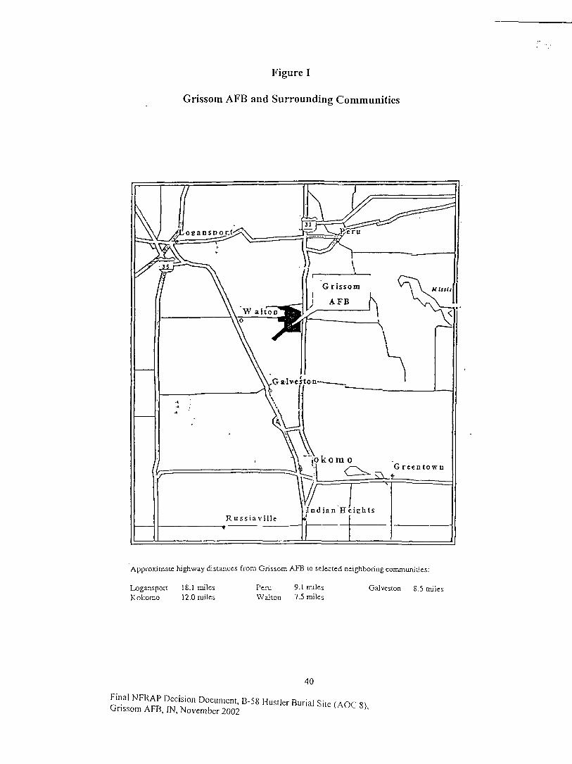
Figure 1
Grissom AFB and Surrounding Communities
Approximate highway distances from Grissom AFB lo selected neighboring communities:
GaJvcston 8.5 milesLogansport 18.1 milesKokomo 12.0 miles
Peru 9.1 milesWalton 7.5 miles
40
Final NFRAP Decision Document, B-58 Hustler Burial Site (AOC 8)Grissom AFB, IN, November 2002 ''
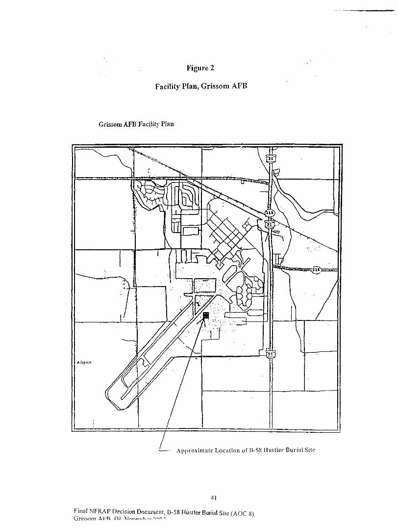
Figure 2
Facility Plan, Grissom AFB
Grissom AFB Facility Plan
Approximate Location of B-5S Hust ler Buria l Site
41
Final NFRAP Decision Document, B-58 Hustler Burial Site (AOC 8)Grissom APR I'M w™,»~v-~- ->AA^

Figure 3
Generalized Geologic Cross Section, Grissom AFB
Generalized Geologic Cross Section, Grissom AFB
Depth (Feet)
0
10
20
30
40
50
60
70
80
90
100
no
120
130
140
150
160
170
180
190
200
Wisconsin Age (Tizcwell Substagc)glacial deposits, clay and silty claytill units interbedded wttt poorly towell sorted sand aod gravel.
Basal sand and gravel overlyingfractured and weathered bedrock.
Silurian Age (Niagran Scries)Listen Creek Formation, gray thinlybedded, dolomitic, chcrty limestonecontaining intercalated beds ofchert.
Silurian Age (Niagran Series)Mississincwa Shale, bluish grayargillaceous, dolomitic, silty,massive limestone grading into graycalcareous shale.
42
Final NFRAP Decision Document, B-58 Hustler Burial Site (AOC 8).Grissom AFB. IN. Novemhe.r 700?
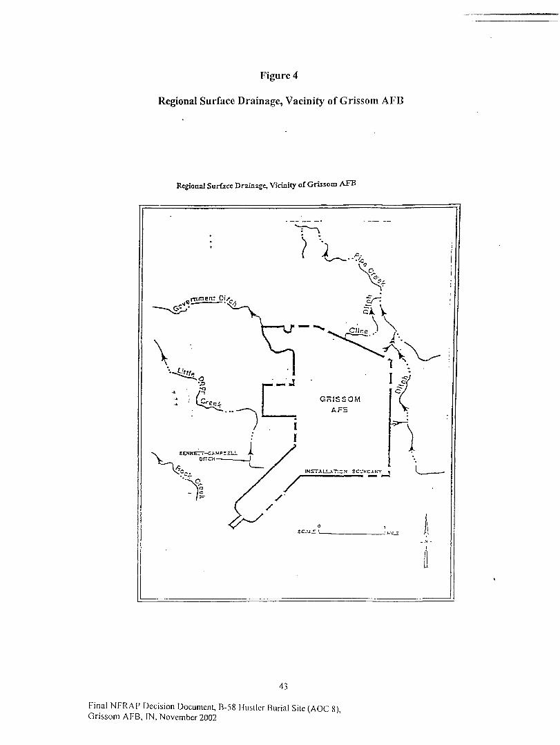
Figure 4
Regional Surface Drainage, Vacinify of Grissom AFB
Regional Surface Drainage, Vicinity of Grissom AFB
43
Final NFRAP Decision Document, B-58 Hustler Buria l Site (AOC 8),Grissom AFB, IN, November 2002

Figure 5
Facility Surface Drainage, Grissom AFB
Facility Surface Drainage, Grmom AFB
TU cc0101
crrcH
44
Final NFRAP Decision Document, B-58 Hustler Burial Site (AOC 8),Grissom AFB, IN, November 2002

Figure 6
Groundwater Supply Well Locations, Grissom AFB
Groundwater Supply Well Locations, Grissom AFB
JULXXLU. CimX
45
Final NFRAP Decision Document, B-58 Hustler Burial Site (AOC 8),Grissom AFB, IN, November 2002
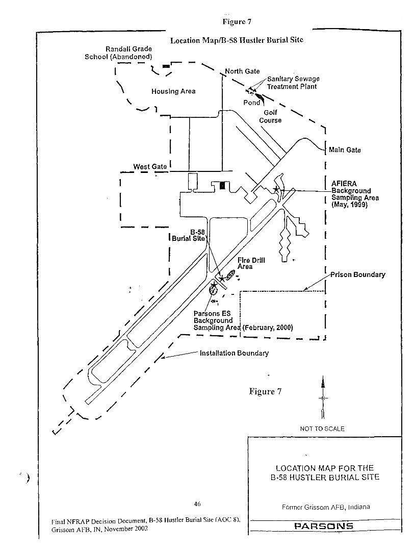
Randall GradeSchool (Abandoned)
Figure 7
Location Map/B-58 Hustler Burial Site
North GateSanitary SewageTreatment Plant
Housing Area
. B-58I Burial Site
Parsons ES |Background jSampling Area} (February, 2000)
Installation Boundary
Main Gate
AFIERABackground
i Sampling Area1 (May, 1999)
rlson Boundary
1 J
Figure 7
NOT TO SCALE
46
Final NFRAP Decision Document, B-58 Hustler Burial Site (AOC 8),Grissom AFB, IN, November 2002
LOCATION MAP FOR THEB-58 HUSTLER BURIAL SITE
Former Grissom AFB, Indiana
PARSONS

r Figure 8
Location of Metallic Anomaly
o0|
H—
\S
\\
\\
\
fcQJU.
r01
<ow
>-_Jt-fu.git°33
3^-* i—UJ5
roro
TD_c
COu.<E8w•cOL.0)
. oLL
5IM
O
incr<a
O)
47
Final NFRAP Decision Document, B-58 Hustler Burial Site (AOC 8),Grissom AFB, IN, November 2002

Figure 9
Intrusive Survey Sampling Locations
oo. (/)
>-zLU O
P3<->w oUJ -J
>CD(0 Z
I'IS
</5
«rulft^i! l
~°lml^ |
\ S
W 03
•2 «3 X>
CO £CO10 CQm ^m <>; c5 1C CO3 (0
CO 'CM 03 i_
S 1^ iCO LLC
E
inz
RS
O
i
«(A
0
oJC0
w£
LL
\
<0- \
£ =n o
II11O
\
\
Burie
d M
eta
l-^
Anom
aly
(Fro
m E
PA
nve
stig
atio
n) ^
48
Final NFRAP Decision Document, B-58 Hustler Burial Site (AOC 8).Grissom AFB, IN, November 2002

Figure 10
Layout of Excavation Site
TPH-CONTAMINATEO
SOIL PILES
(£
UNCONTAMINATEDSOIL PILES
SITE TRAILER
49
Final NFRAP Decision Document, B-58 Hustler Burial Site (AOC 8),Grissom AFB. IN. November 2002
LAYOUT OF EXCAVATION SITE
Final Status Survey, B-58 Burial SiteFormer Grissom AFB, Indiana
PARSONS
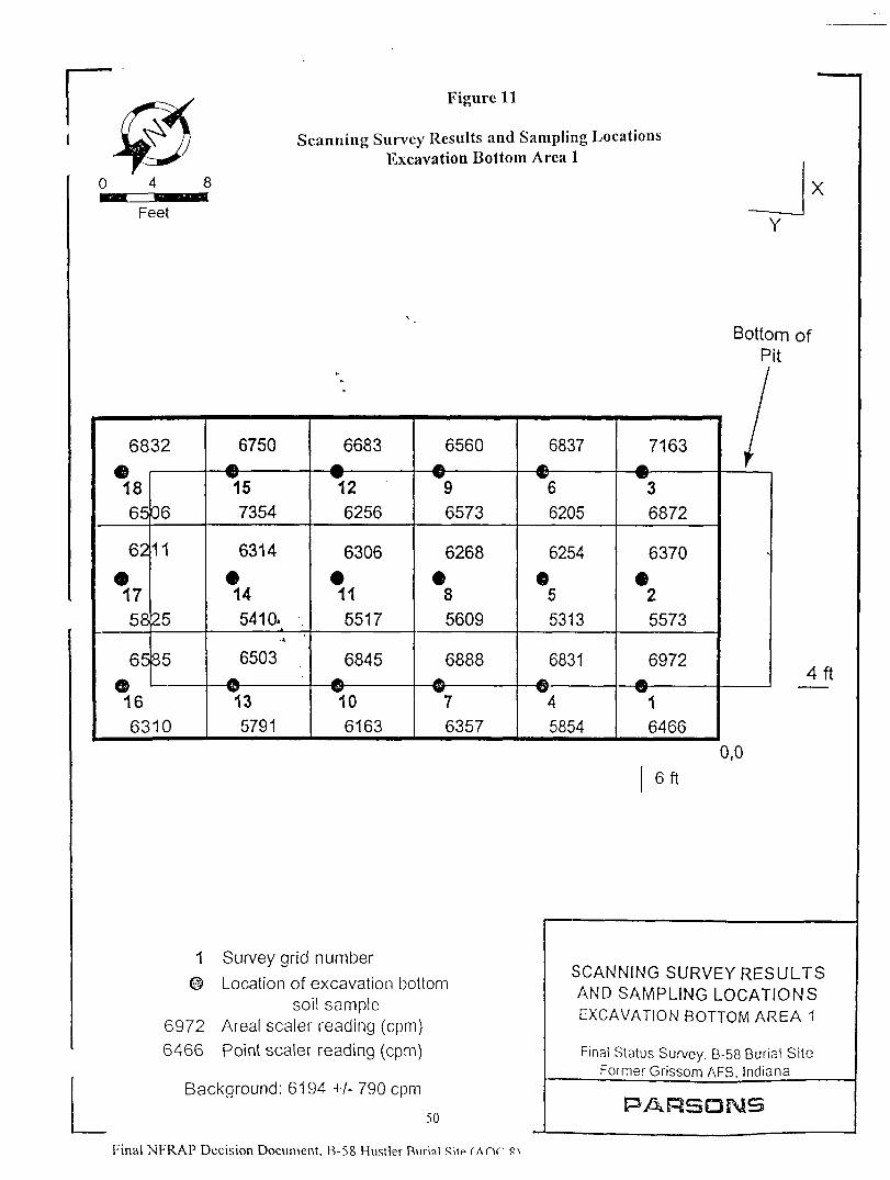
Figure 11
Scanning Survey Results and Sampling LocationsExcavation Bottom Area 1
Y
X
Bottom ofPit
68€>1865
62
•1758
65©16
32
06
11
25
35
6310
6750
157354
6314
•14541 a .
•A
6503ftV?135791
6683
126256
6306
•115517
6845
106163
6560AV96573
6268
•85609
6888
76357
6837gf.w66205
6254655313
6831
45854
7163
36872
6370
25573
6972
16466
/
4f t
0,0
6f t
1 Survey grid number
© Location of excavation bottomsoil sample
6972 Areal sealer reading (cpm)6466 Point sealer reading (cpm)
Background: 6194 +/- 790 cpm
50
Final NFRAP Decision Document. B-58 Hustler Burial Sitp I AOP
SCANNING SURVEY RESULTSAND SAMPLING LOCATIONSEXCAVATION BOTTOM AREA 1
Final Status Survey. B-58 Burial SiteFormer Grissom AFB, Indiana
PARSONS
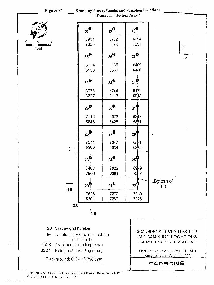
Figure 12 Scanning Survey Results and Sampling Locations
7526
8201
• A
•A
en
0,0
Excavation Bottom Area 2
38C
6973
35<
6661
32*
: 6662
29*
7168
261
726£
234
7479
2<f
£
8165
»
9490
3627
'1646
,7486
'6806
75268201
39®
67326372
36®
61655800
33®
62446113
30*
66226428
27«
70476634
24®
70226391
21©
73727280
40€
6972
37<
6464
34*
6160
31*
6258
28(
6568
25(
6972
22
*5491
j
0986
728
1871
i
8172
7957
*--.I
73157326
[4 ft
y grid number
on of excavation bottomsoil sample
sealer reading (cpm)
sealer reading (cpm)
id: 6194 +/-790cpm
5I
Y
X~~
T-
--Bottom ofPit
SCANNING SURVEY RESULTSAND SAMPLING LOCATIONSEXCAVATION BOTTOM AREA 2
Final Status Survey, B-58 Burial SiteFormer Grissom AFB, Indiana
PARSOPsfS
Final NFRAP Decision Document, B-58 Hustler Burial Site (AOC 8),Hriccnm A FR I'M X1r,i>orr,Kor OOAO

Figure 13 Scanning Survey Results and Sampling LocationsBackfill Soil Pile 1, Lift 1
0 5.5 11 4-f
Feet
37
6358
I 6581
35
•A
•A
6656ri6495
31
\ 6270\ 29
\
. --— -~5991
617325
624922
620719
628216
712913
« BF1-1
705410
68707
68474
e BF1-3
63241
43 6204 ""\
620526
606723
634020
O BF1-5
646417
405414
0BF1-4
686811
70338
66605
63502
641327
613524
631521
659918
9 BF1-2
654415
679612
66169
65096
63733
425933\
40 \5397 \
661439
642138
34 \6087 \
9121 \32
6117 /30 /
6567 28 ^^X
1 Survey grid number
6324 Areal sealer reading (cpm)
©BF1-1 Location of backfill soil sample
Background: 6194 +/- 790 cpm
52
SCANNING SURVEY RESULTSAND SAMPLING LOCATIONS
BACKFILL SOIL PILE 1, LIFT 1
Final Status Survey, B-58 Burial SiteFormer Grissom AFB, Indiana
PARSONS
Final MFR A P rVriqinn nnrimi^nt R-S8 HnqtW Rnrial 9itp ( AOP

Figure 14 Scanning Survey Results and Sampling Locations
Final NFRAP Decision Document.
Backimsou me i, L,IH z
6152
32
6257
31
6288
30 ,^
702129
6414
28
•A
•A ,
" 7202
27
6589
26
6181
25
6038
24
6089
23
6117
22
7975
21
0BF3-3
6809
20
6857
19
©BF3-4
6643
18
6001
17
5933
16
5898
15
6190
14
6250
13
6342
12
6697
11
7623
10
©BF3-1
6608
9
/ey grid number
al sealer reading (cpm)
ation of backfill soil sample
jnd:6194 +/- 790 cpm53
n Document B-"S8 Hnsllnr Rnrial ^i<p ( &r\r 01
5630
8
6051
7
6434
6
6694
5
6788
4
6696
3
6269
2
6333
1
-
SCANNING SURVEY RESULTSAND SAMPLING LOCATIONSBACKFILL SOIL PILE 1, LIFT 2
Final Status Survey, B-58 Burial SiteFormer Grissom AFB, Indiana
PARSONS
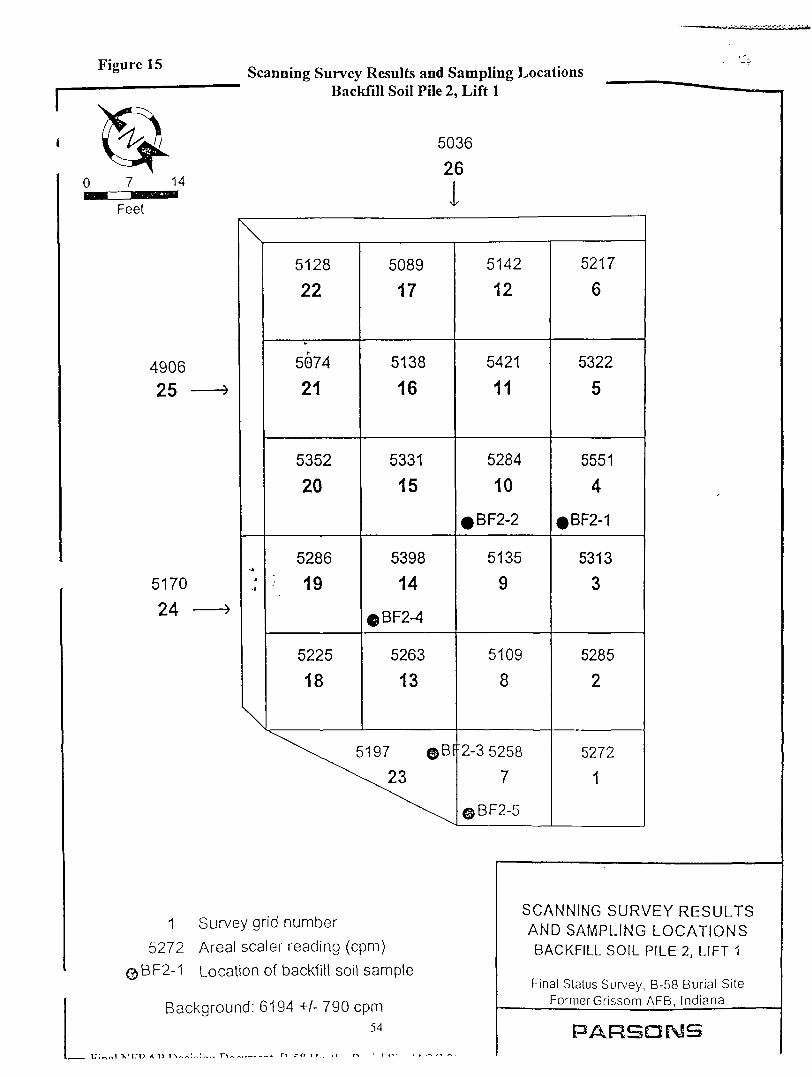
Figure 15 Scanning Survey Results and Sampling LocationsBackfill Soil Pile 2, Lift 1
5036
26
I
490625
5170
24
\
•A
-A
\
5128
22
5074
21
5352
20
5286
19
5225
18
5089
17
5138
16
5331
15
5398
14
$BF2-4
5263
13
^\^ 5197 ©BF
5142
12
5421
11
5284
10
5135
9
5109
8
'2-3 5258
7
©BF2-5
5217
6
5322
5
5551
4
• BF2-1
5313
3
5285
2
5272
1
1 Survey grid number5272 Areal sealer reading (cpm)
©BF2-1 Location of backfill soil sample
Background: 6194 +/- 790 cpm54
';«oi XICD A r> r~\~^:-:,>.~ r\ * r> ro I T . . ,r r-* • t *-•-. ,
SCANNING SURVEY RESULTSAND SAMPLING LOCATIONSBACKFILL SOIL PILE 2, LIFT 1
Final Status Survey, B-58 Burial SiteFormerGrissom AFB, Indiana
PARSONS
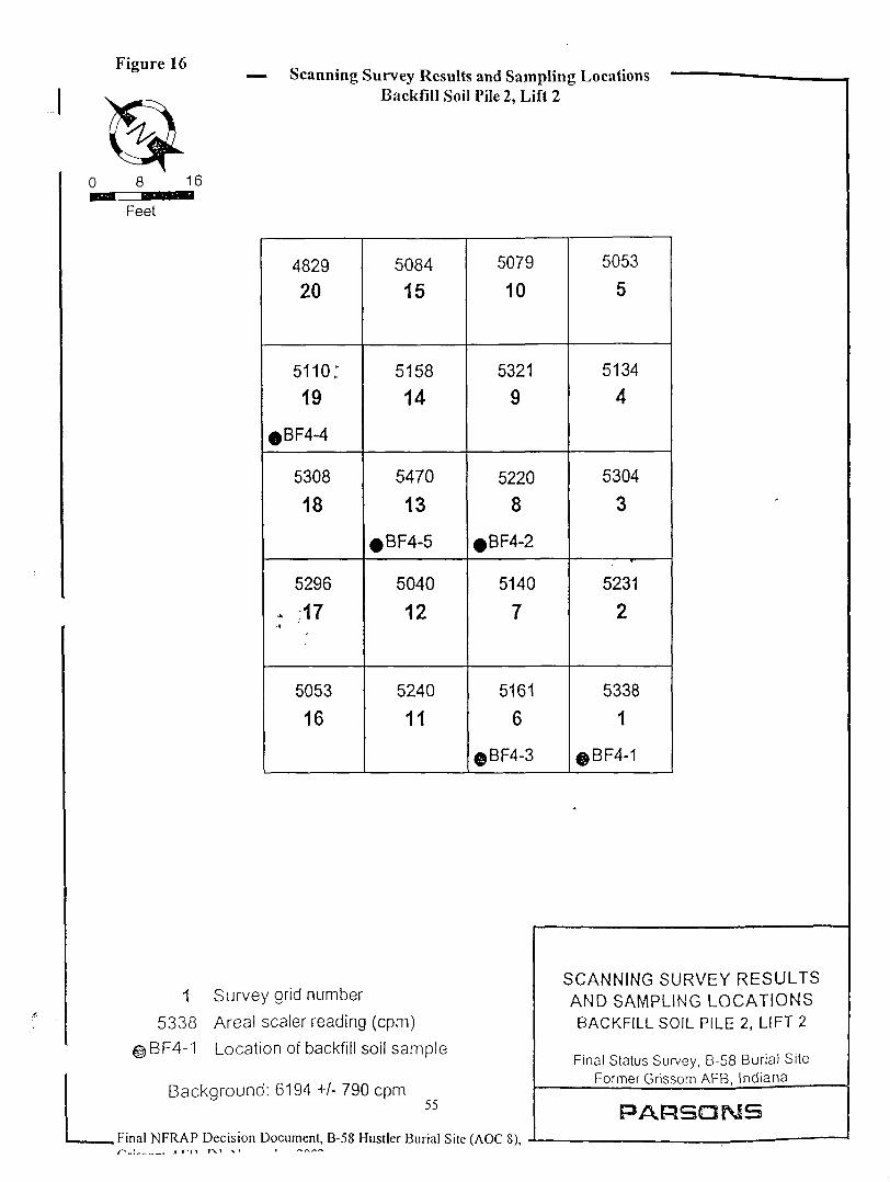
Scanning Survey Results and Sampling LocationsBackfill Soil Pile 2, Lift 2
4829
20
5110;19
0BF4-4
5308
18
5296
.*
5053
16
5084
15
5158
14
5470
13
5040
12
5240
11
5079
10
5321
9
5220
8
5140
7
5161
6
©BF4-3
5053
5
5134
4
5304
3
5231
2
5338
1
©BF4-1
1 Survey grid number
5338 Areal sealer reading (cpm)
@ BF4-1 Location of backfill soil sample
Background: 6194 +/- 790 cpm55
. Final NFRAP Decision Document, B-58 Hustler Burial Site (AOC 8),/^..:. A r^n T-K i >' ' ~/M*'-
SCANNING SURVEY RESULTSAND SAMPLING LOCATIONSBACKFILL SOIL PILE 2, LIFT 2
Final Status Survey, B-58 Burial SiteFormer Grissom AFB, Indiana _
PARSQMS
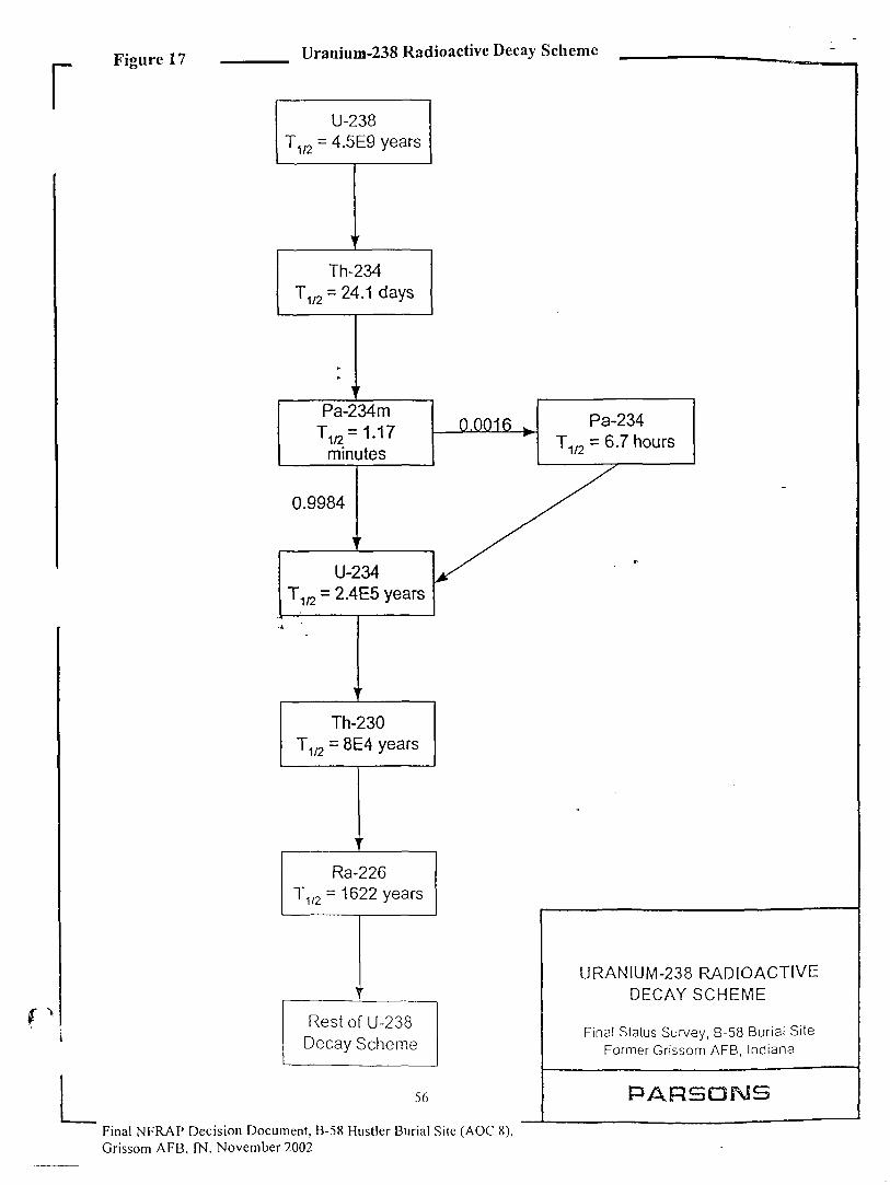
r Figure 17
L
Uranium-238 Radioactive Decay Scheme
U-238T1/? = 4.5E9 years
Th-234T1/? = 24.1 days
Pa-234m
T,a=1.17minutes
0.9984
U-234T1/2 = 2.4E5 years
Th-230T1/2 = 8E4 years
Ra-226T1/2 = 1622 years
Rest of U-238Decay Scheme
56
0.0016 Pa-234T1/2 = 6.7 hours
Final NFRAP Decision Document, B-58 Hustler Burial Site (AOC 8),Grissom AFB, IN, November 2002
URANIUM-238 RADIOACTIVEDECAY SCHEME
Final Status Survey, B-58 Burial SiteFormer Grissom AFB, Indiana
PARSONS
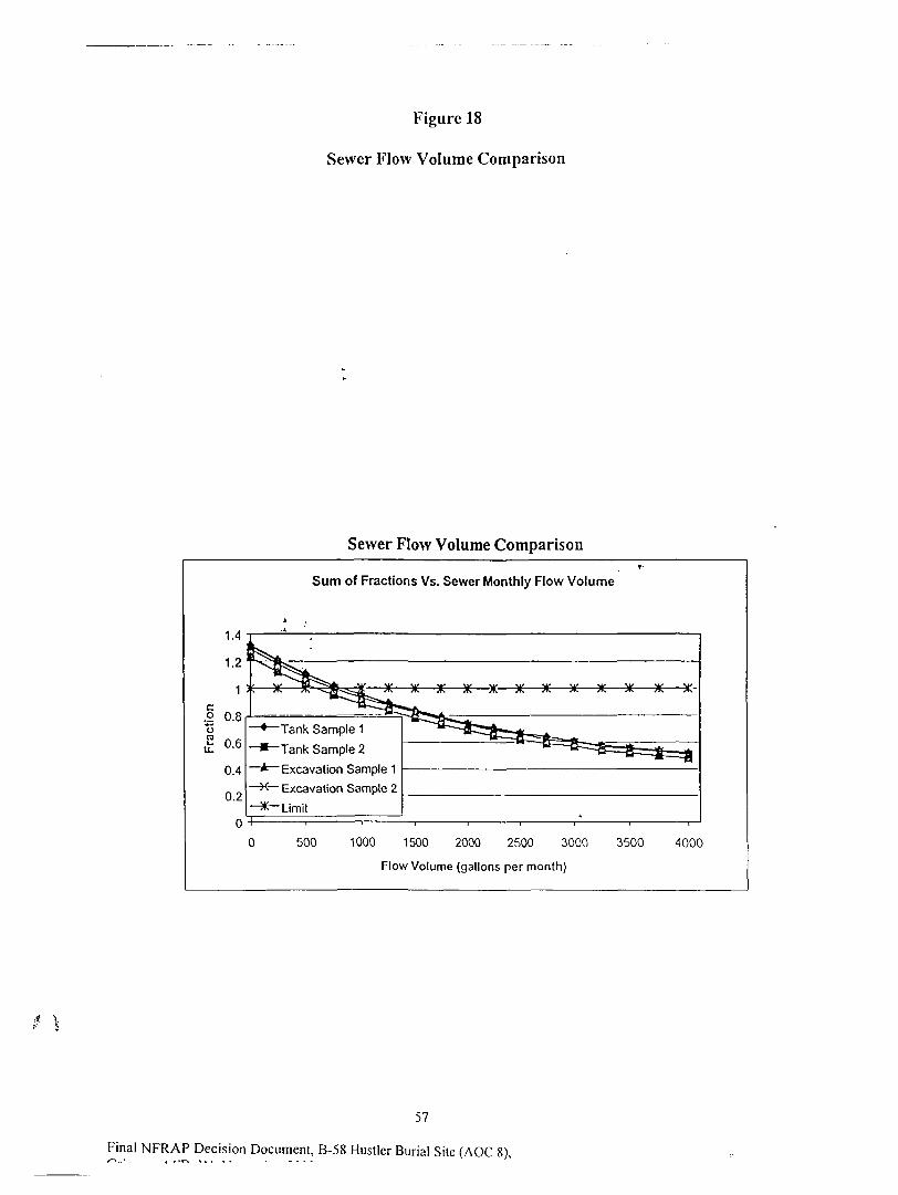
Figure 18
Sewer Flow Volume Comparison
Sewer Flow Volume Comparison
Sum of Fractions Vs. Sewer Monthly Flow Volume
Tank Sample 1
Tank Sample 2
Excavation Sample 1
X Excavation Sample 2
* Limit
500 1000 1500 2000 2500 3000
Flow Volume (gallons per month)
3500 4000
57
Final NFRAP Decision Document, B-58 Hustler Burial Site (AOC 8),
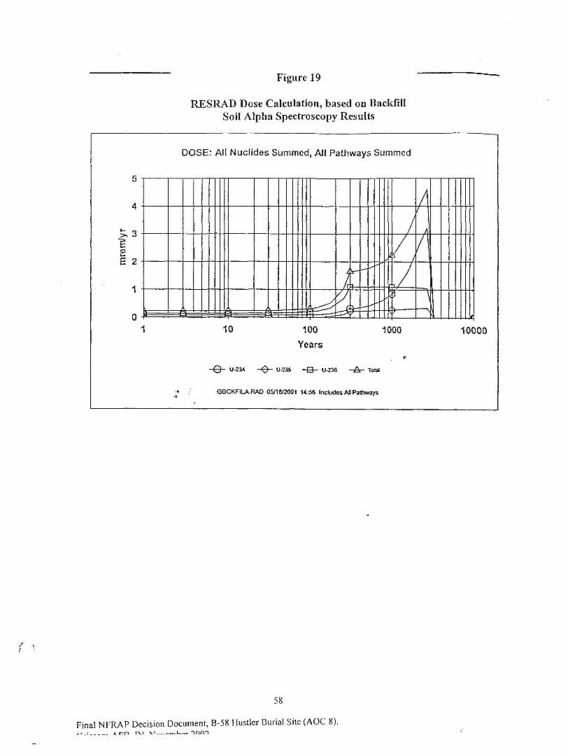
Figure 19
RESRAD Dose Calculation, based on BackfillSoil Alpha Spectroscopy Results
co
E 2
DOSE: All Nuclides Summed, All Pathways Summed
10 100
Years
1000 10000
-Q- U-234 -0- U-235 -Q- U-238 -A- Tout
GBCKFILA.RAO 05/18^001 14:56 Includes AH Pathways
58
Final NFRAP Decision Document, B-58 Hustler Burial Site (AOC 8),
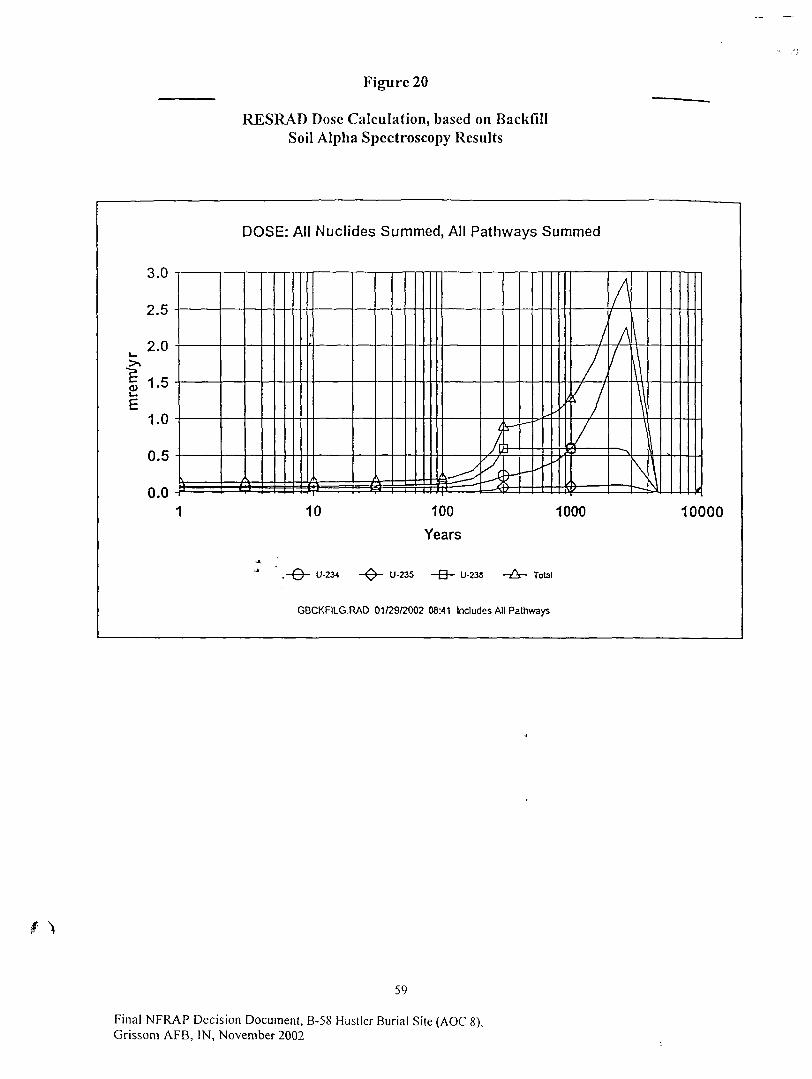
Figure 20
RESRAD Dose Calculation, based on BackfillSoil Alpha Spectroscopy Results
DOSE: All Nuclides Summed, All Pathways Summed
t0)
3.0
2.5
2.0
1.5
1.0
0.5
0.010 100
Years
1000 10000
.-©- U-2J4 -0- U-235 U-23S -A- Total
GBCKFILG.RAD 01/29/2002 08:41 Includes All Pathways
59
Final NFRAP Decision Document, B-58 Hustler Burial Site (AOC 8),Grissom AFB, IN, November 2002
Appendix-B, Tables
60
Final NFRAP Decision Document, B-58 Hustler Burial Site (AOC 8),Grissom AFB, IN, November 2002
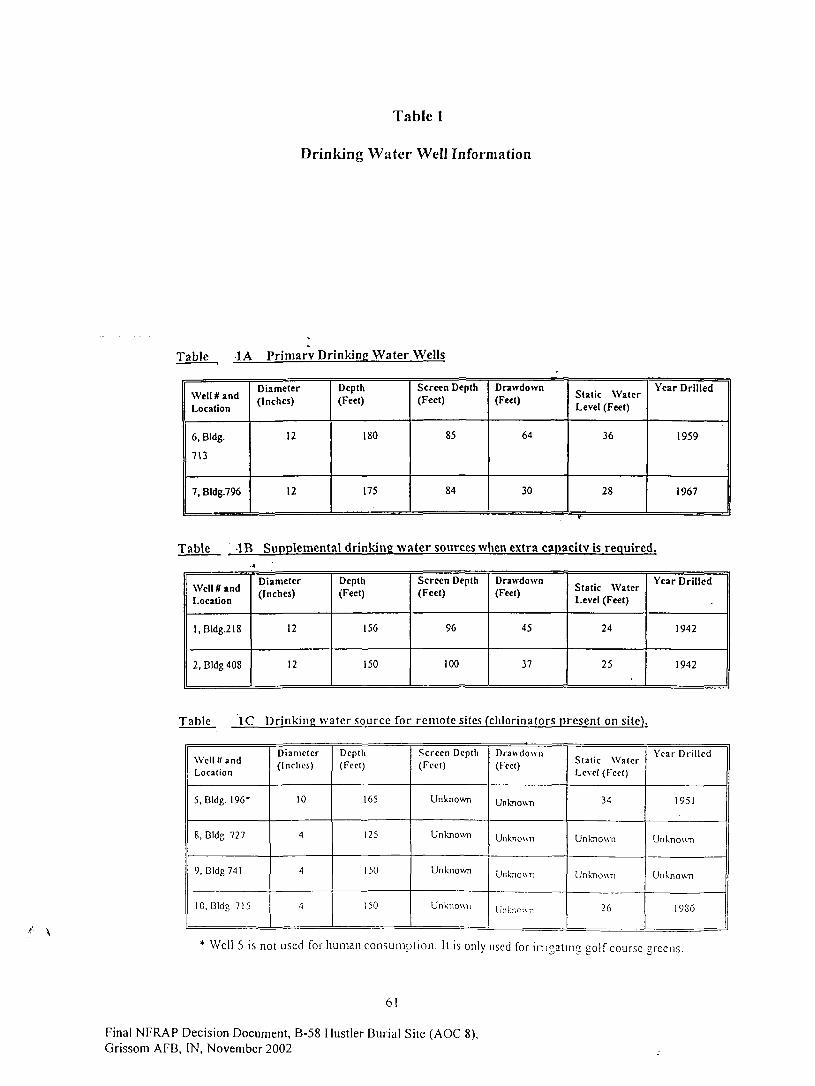
Table 1
Drinking Water Well Information
Table 1A Primary Drinking Water Wells
Well # andLocation
6, Bldg.
713
7, Bldg.796
Diameter(Inches)
12
12
Depth(Feet)
180
175
Screen Depth(Feet)
85
84
Drawdown(Feet)
64
30
Static WaterLevel (Feet)
36
28
Year Drilled
1959
1967
Table -IB Supplemental drinking water sources when extra capacity is required.
Well ff andLocation
l,Bldg.218
2, Bldg 408
Diameter(Inches)
12
12
Depth(Feet)
156
150
Screen Depth(Feet)
96
100
Drawdown(Feet)
45
37
Static WaterLevel (Feet)
24
25
Year Drilled
1942
1942
Table 1C Drinking water source for remote sites (chlorinators present on site).
Well SandLocation
5, Bldg. 196*
8, Bldg. 727
9, Bldg 741
10, Bldg. 715
Diameter
(Inches)
10
4
4
4
Depth(Feet)
165
125
150
150
Screen Deptli(Feet)
Unknown
Unknown
Unknown
Unknown
Drawdown(Feet)
Unknown
Unknown
Unknown
Untr.o-ATi
Stat ic WaterLevel (Feet)
34
Unknown
Unknown
26
Year Drilled
1951
Unknown
Unknown
19S6
Well 5 is not used for human consumpt ion . It is only used for i r r i "a tma coif course "reens.
61
Final NFRAP Decision Document, B-58 Hustler Burial Site (AOC 8),Grissom AFB, IN, November 2002
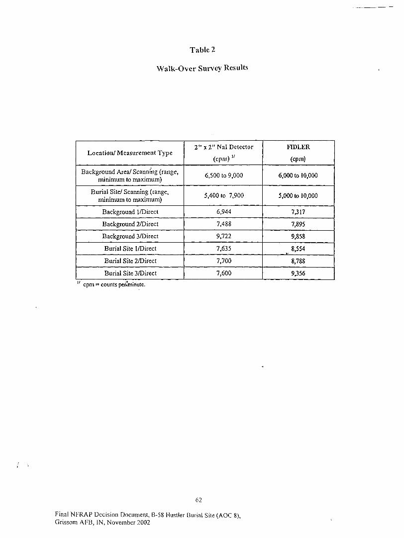
Table 2
Walk-Over Survey Results
Location/ Measurement Type
Background Area/ Scanning (range,minimum to maximum)
Burial Site/ Scanning (range,minimum to maximum)
Background I/Direct
Background 2/Direct
Background 3/Direct
Burial Site I/Direct
Burial Site 2/Direct
Burial Site 3/Direct
2"x2" Nal Detector
(cpm) "
6,500 to 9,000
5,400 to 7,900
6,944
7,488
9,722
7,635
7,700
7,600
FIDLER
(cpm)
6,000 to 10,000
5,000 to 10,000
7,317
7,895
9,858
8,554V-
8,788
9,356
cpm = counts petvminute.
62
Final NFRAP Decision Document, B-58 Hustler Burial Site(AOC 8),Grissom AFB, IN, November 2002

Table 3
Scoping Survey Grid Location Sampling Log
Location
B-l
B-2
B-3
S-0
S-l
S-2
S-3
S-4
S-5
S-6
S-6 DebrisS-7a
S-7b
S-8
S-9
S-10
S-11A
S-l IBS-I2
S-13
S - 1 4
S-15
Measurement
123
123123123123123123123I231
2
3
Not Measured123
Not Measured123I23123123
Not MeasuredNot Measured
123
Not Measured
Not Measured
43-1 Alpha, SealerMode (cpm) "
021
553
155535
8,.7"9263
645
321
383
3
3
5
4
32
352624
642253
155
CM Rate Meter(epm)
<100
<IOO
<100
<100
<100
<100
<100
<IOO
<100
<100
<100
<100
<100
<IOO
Model 19 RateMeter
(liR/hr)"
5
7
7
<10
<10
<10
<10
<IO
7
<10
7
10
<IO
7
Sample Interval and Description
Sample 5'-6'. Clay, brown to grey, soft.
Sample 2.5'-3'. Clay
3'-3.5' - soil looks bumt/ashy/black/gravelly, not clayey,"ushed to 4.5', encountered variable resistance. Noample recovered. Groundwater encountered at 4'
Clayey, natural soil at 3'-3.5'. 43-1 readings appear high,'crformcd source check (92) and recounted sample,nstrument check was OK: readings were 4,3^nd 1 .
Sample 4.5-5'. Clayey, encountered water at about 5'-5.5'.Soil appeared native.
Sample at 3'-3.5', soil appeared native.
Clayey sample taken at 3'-3.5', similar to background.
4.5'-5' sample collected. Na'.ivc clay throughout.
T-
Drilled to 7.5'. damage to barrel noted- probe lookedscarred from rubbing against metal (fuselage). Sampletaken at 3-3.5': black, ashy (same description as at center).When filling hole with bentonite, the hole took bcntoniteindefinitely. This confirmed that a cavity was hit.Debris at 6.5'-7.5'.
Sample 3'-3.5', black/burnt, resistance at 4.5'
Sample at 4' to 4. 5'Clayey sample taken at 3'-3.5'
Sample 1 .S'-2', much resistance at 2'. Pushed to 4';similar material: burnt black with some clay mixed in.
4.5' - 5 - - Clay, moist.
Native clay
Sample 0.5'-!'; ashy, black, grey, silly appearance
Hit asphalt at 0'-0.5'. Not enough sample to send to lab.Visual verification.Sample located 45° SW of S-9 by 15'. Pushed to 41,sampled 2.5'-3'. Burnt ashy soil, black with meial.Native clay above and below.
Resistance al 1'; auger refusal. Sampled 0.5 - 1', darksoil, appeared more like material surrounding airplane(fill/ash0) than np.iivc
Same as SI 4. Used trowel to dig to 1' and verify thatrcsislancc was natural mateml. No debris was visible.Looked like asphall at 1'.
(jR/hr = microRocntgcn per hour. 63
Final NFRAP Decision Document, B-58 Hustler Burial Site (AOC 8),Grissom AFB, IN, November 2002
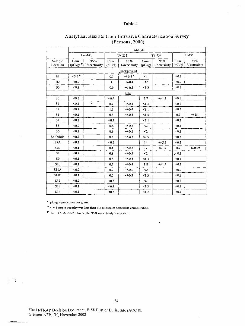
Table 4
Analytical Results from Intrusive Characterization Survey(Parsons, 2000)
SampleLocation
Analylc
Am-241
Cone.(pCi/g) "
95%Uncertainty
Th-232
Cone.(pCi/g)
95%Uncertainty
Tli-234
Cone.(PCi/g)
95%Uncertainty
U-235
Cone.(pCi/g)
95%Uncertainty
Background
Bl
B2
B3
<0. l y
<0.2
<0.1
0.5
1
0.6
+/-0.3 v
+/-0.4
+/-0.3
<1
<2
<1.3
<0.1
<0.2
<0.1
Site
SO
S!
S2
S3
S4
S5
S6
S6 Debris
S7A
S7B
S8
S9
SIO
S11A
SUB
S12
S13
SI4
<0.1
<0.1
<0.2
<O.I
<0.2
<0.2
<0.2
<0.2
<0.2
<0.1
<0.2
<0.1
<0.1
<Q.2 ;
<0.1
<0.2
<0.1
<0.l
»-
<0.4
0.7
1.3
0.5
<0.7
0.6
0.9
0.4
<0.6
0.4
0.8
0.8
0.7
0.7
0.5
<0.6
<0.4
<0.3
+/-0.3
+/-0.4
+/-0.3
+/-0.5
+/-0.5
+/-0.3
+/-0.2
+/-0.5
+/-0.3
+/-0.4
+/-0.6
+/-0.3
2.7
<1.3
<2.1
<1.4
<2.1
<2
<2
<2.5
14
12
<2
<1.3
1.8
<2
<1.3
<2
<1.3
<1.2
+/-1.2
+/-2.S
+/-1.7
+/-1.4
<0.1
<0.1
<0.2
0.2
<0.2
<0.1
<0.2
<0.2
<0.2
0.2
,.<0.2
<O.I
<0.1
<0.2
<0.1
<0.2
<0.1
<0.1
+/-0.1
+/-0.09
" pCi/g = picocurics per gram.v < = Sample quantity was less than the minimum detectable concentration.v +/- = For detected sample, the 95% uncertainty is reported.
64
Final NFRAP Decision Document, B-58 Hustler Burial Site (AOC 8),Grissom AFB, IN, November 2002

Table 5
Beryllium Analytical Results
Sample Location
B-l
B-3
B-2
S6 Debris
S7-A
" S6
S7-B
BerylliumConcentration (ug/g)1
0.670
0.570
0.550
<0.50
<0.50
<0.50
2.14
= microgram per gram of soil.
65
Final NFRAP Decision Document, B-58 Hustler Burial Site (AOC 8),Grissom AFB, IN, November 2002
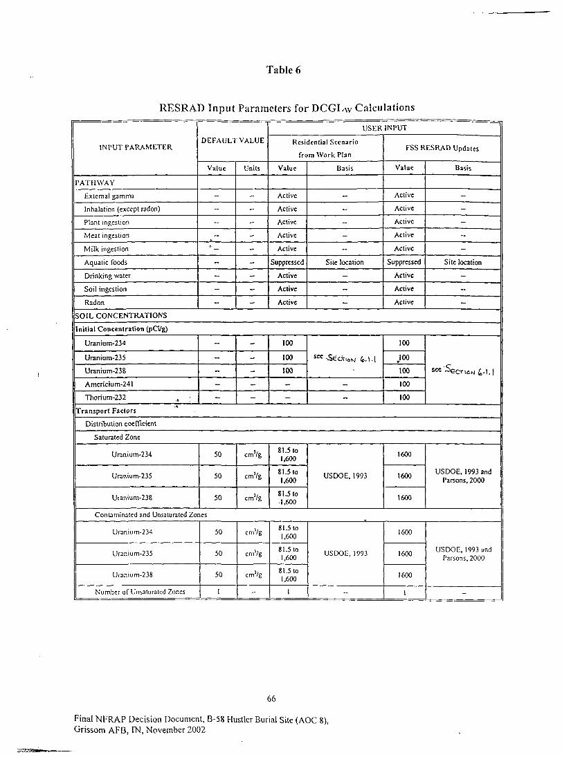
Table 6
RESRAD Input Parameters for DCGLW Calculations
INPUT PARAMETER
PATHWAY
External gamma
Inhalation (except radon)
Plant ingestion
Meat ingeslion
Milk ingestion
Aquatic foods
Drinking water
Soil ingestion
Radon
i
DEFAULT VALUE
Value
-
-
-
I-
-
-
-
-
Units
-
~
-
-
-
-
-
-
-
USER INPUT
Residential Scenario
from Work Plan
Value
Active
Active
Active
Active
Active
Suppressed
Active
Active
Active
Basis
-
-
-
-
-
Site location
-
-
-
FSS RESRAD Updates
Value
Active
Active
Active
Active
Active
Suppressed
Active
Active
Active
Basis
-
-
-
-
-
Site location
-
-
-
SOIL CONCENTRATIONS
Initial Concentration (pCi/g)
Uranium-234
Uranium-235
Uranium-238
Americium-241
Thorium-232 .,
-
-
-
-
-
-
-
-
-
-
100
100
100
-
-
SCC-S€CV16M lo.\\
-
-
100
100»•
100
100
100
see'Se^^^^.ij
Transport Factors
Distribution coefficient
Saturated Zone
Uranium-234
Uranium-235
Uranium-238
50
50
50
cm'/g
cmVg
cm'/g
8l.5lo1,600
81.5to1,600
81.5 to1,600
USDOE. 1993
1600
1600
1600
USDOE, 1993 andParsons, 2000
Contaminated and Unsaturatcd Zones
Uranium-234
Uranium-235
Uranium-238
Number of Unsaturated Zones
50
50
50
1
cmVg
cmVg
cmVg
-
81.5to1,600
81.5to1.600
81.5 to1.600
1
USDOE, 1993
-
1600
1600
1600
1
USDOE, 1993 andParsons, 2000
-
66
Final NFRAP Decision Document, B-58 Hustler Burial Site (AOC 8),Grissom AFB, IN, November 2002

Table 6 (Cont.)
RESRAD Input Parameters for DCGLw Calculations
INPUT PARAMETERDEFAULT VALUE
Value Units
USER INPUT
Residen t ia l Scenario
from Work Plan
Value Basis
Water Concentration
Time since material placement
Groundwater Concentration
Solubility Limit
Leach Rate
Use Plant Soil ratio
0
0
0
0
No
years
pCi/L
mol/L
year "'
-
--
-
-
-
-
--
No sources identifiedexcept those withinnatural background
FSS RESRAD Updates
Value Basis
0
0
0
0
No
Based on Guidance inUSDOE, 1993
No sources identifiedexcept those withinnatural background
CALCULATION TIMES
Basic Radiation Dose Limit
Calculation Times
30
1,3,10,30, 100,
300,1000
mrem/yr
years
15
-
USEPA, 1997b
-
15
1,3,10,30,100,300,
1000, 10000
USEPA, 1997b
-
CONTAMINATED ZONE
Thickness of contaminated zone 2 m 0 3, 0.6,12,1.8 Varies with run 3 Table 3.6 of Parsons,
2000
For DCGLw
Area of contaminated zone
^ngth parallel to aquifer flow
10000
100
m2
m1
232
15
2,500 sq. feet area
One side of sq. area
232
* 15
2 ,500 sq. feet area
One side of sq. area
For DCGLtMC
Area of contaminated zone ,-A
^ngth parallel to aquifer flow
-
~
-
-
6.3
2.5
2.5x2.5m sq. area (gridsize)
One side of sq. area
6.3
2.5
2.5x2.5m sq. area (gridsize)
One side of sq. area
COVER AND CONTAMINATED ZONE HYDROLOGICAL DATA
Cover depth
Density of cover material
Cover erosion rate
Density of contaminated zone
Contaminated zone erosion rate
Contaminated zone total porosity
Contaminated zone effectiveporosity
Contaminated zone hydraulicconductivity
Contaminated zone b parameter
H u m i d i t y in a i r
Evapot ranspi ra t ion coefficient
Wind speed
Precipi tat ion
Irrigation
0
1.5
0.00 1
1.5
0.001
0.4
0.2
10
5.3
8
0.5
2
1
0.2
m
g/cm'
m/yr
g/cmj
m/yr
-
-
m/yr
--
g/m'
--
n\/s
nVyr
m/yr
0.0, 0.3
1.2
-
1.2
-
0.42
0.06
32.1
10.4
NA
0999
1
0
Varies with run
USDOE, 1993; Table2.1
-
USDOE, 1993; Table2.1
-
USDOE, 1993; Table3.2
-
USDOE, 1993; Table5.2
USDOE, 1993; Table13.1
USDOE, 1993; Section12
40 inches/year
No irrigation on s i t e
0.3
1.2
0.001
1.2
0.001
0.42
0.06
32.1
10.4
NA "
0.999
2
1
0
Parsons, 2000
USDOE, 1993; Table2.1
-
USDOE, 1993; Table2.1
-
USDOE, 1993; Table3.2
-
USDOE, 1993; Table52
USDOE, 1993; Table13.1
-
USDOE, 1993; Section12
-
40 inches/year
No irrigation on site
67
Final NFRAP Decision Document, B-58 Hustler Burial Site (AOC 8).Grissom AFB, IN, November 2002

Table 6 (Cont.)
RESRAD Input Parameters for DCGLw Calculations
INPUT PARAMETER
Irrigation mode
Runoff Coefficient
Watershed area for nearby stream orpond
Accuracy for water/soil computation
DEFAULT VALUE
Value Uni ts
Overhead
0.2
l.OOE+06
0.001
m!
USER INPUT
Residential Scenario
from Work Plan
Value
NA
0.3
-
-
Basis
For overhead
USDOE, 1993; Table10.1
-
-
FSS RESRAD Updates
Value
NA
0.3
1.00E-KJ6
0.00 1
Basis
For overhead
USDOE, 1993; Table10.1
-
-
SATURATED ZONE HYDROLOGICAL DATA
Density of saturated zone
Saturated zone total porosity
Saturated zone effective porosity
Saturated zone hydraulicconductivity
Saturated zone hydraulic gradient
Saturated zone b parameter.
Water table drop rate
Well pump intake depth (belowwater table)
Model: nondispersion (ND) or massbalance (MB)
.4
Well pumping rule •«
1.5
0.4
0.2
100
0.02
5.3
0.001
10
ND
250
g/cm3
.
-
m/yr
-
-
m/yr
m
mVyr
1.2
0.42
0.06
32.1
0.007
10.4
-
4.4
-
-
USDOE, 1993; Table2.1
USDOE, 1993; Table3.2
USDOE, 1993; Table5.2
USDOE, 1993; Section15
USDOE, 1993; Table13.1
-
Well logs
-
Default, as no activewells in the area
1.2
0.42
0.06
32.1
0.007
10.4
0.001
•4-4
-
250
USDOE, 1993; Table2.1
USDOE, 1993; Table32
USDOE, 1993; Table52
USDOE, 1993; Section15
USDOE, 1993; Table13.1
-
Well logs
-
Default, as no activewe Ms in the area
UNCONTAMINATED UNSATURATED ZONE PARAMETERS
Number of unsalurated zones 1 - 1 - I -
Unsaturated zone 1
Thickness
Soil density
Total porosity
Effective porosity
Hydraulic conductivity
Soil-specific b parameter
4
1.5
0.4
0.2
10
5.3
m
g/cm'
--
--
m/yr
--
varies withrun
1.2
0.42
0.06
32.1
10.4
Varies with tun; =Depthto GW (5 to 10f t ) -
Thicfcness ofContaminated Zone
USDOE, 1993; Table2.1
USDOE, 1993, table3.2
USDOE, 1993; Table5.2
USDOE. 1993; Table13.1
0
1.2
0.42
0.06
32.1
104
Conservative valuebased on analysis in
Parsons, 2000
USDOE, 1993; Table2.1
USDOE, 1993; Table32
USDOE, 1993; Table52
USDOE, 1993; Table13.1
OCCUPANCY
Inhala t ion rate
Mass loading for inha la t ion
Exposure d u r a t i o n
Indoor dust f i l t r a t i o n factor
External gamma shielding factor
8400
0.0001
30
0.4
0.7
mVyr
E/m5
yr
11,000
0.001
30
-
USEPA, I997a
USDOE, 1993; Section35
USEPA. 1990
-
- -- -
68
Final NFRAP Decision Document, B-58 Hustler Burial Site (AOC 8),Grissom AFB, IN, November 2002

Table 6 (Cont.)
RESRAD Input Parameters for DCGLw Calculations
INPUT PARAMETER
Indoor time fraction
Ouldoor lime fraction
Shape of the contaminated zone
DEFAULT VALUE
Value
0.5
0.25
Units
-
-
Circular
USER I N P U T
Residential Scenario
from Work Plan
Value
0.65
0.08
Square
Basis
USEPA, I997a
USEPA, 1997a
Site conditions
FSS RESRAD Updates
Value
/
Square
Basis
Site conditions
INGESTION PATHWAY, DIETARY DATA
Fruit, vegetable, and grainconsumption
Leafy vegetable consumption
Mi lk consumption
Meat and poultry consumption
Soil ingestion
Groundwater ingestion
160
14
92
;6336.5
510
kg/yr
kg/yr
L/yr
kg/yr
6/y
L/yr
301
--
82
45
73
-
USEPA, 1997a
USDOE, 1993
USEPA, 1997a
USEPA, 1997a
USDOE, 1993
USDOE, 1993
301
-
82
45
43.8
-
USEPA, 1999 Tables 9-29 & 12-23
USDOE, 1993
USEPA. 1999
USEPA, 1999
USDOE, 1993
USDOE, 1993
Contaminated fractions
Livestock water
Irrigation water
Plant food
Meat
Milk
1
1
-1
-1
-I
m/yr
m/yr
1
I
0.5
0.5
0.5
Assumed all water fromonsite
USDOE, 1993
Assumed half of plantfood is from offsite
Assumed half of meat isfrom offsite
Assumed half of milk isfrom offsite
1
1
-1
-I»•
-1
Assumed all water fromonsite
USDOE, 1993
RES RAD to calculate
INGESTION PATHWAY, NPNDIETARY DATA
Livestock fodder intake for meat
Livestock fodder intake for milk
Livestock water intake for meat
Livestock water intake for milk
Livestock soil intake
Mass loading for foliar deposition
Depth of soil mixing layer
Depth of roots
68
55
50
160
0.5
0.0001
0.15
0.9
kg/d
kg/d
L/d
Ud
kg/d
E/m'
m
m
11.8
20.3
-
-
0.5
-
-
--
USEPA, 1998 Table B-3-10
USEPA, 1998 Table B-3-11
USDOE, 1993
USDOE, 1993
USEPA, 1998 Table B-3-10
USDOE, 19934
11.8
20.3
-
-
0.5
0.0001
0.15
0.9
USEPA, 1998 Table B-3-10
USEPA, 1998 Table B-3-11
USDOE, 1993
USDOE, 1993
USEPA, 1998 Table B-3-10
USDOE, 1993
Groundwaler fractional usage
Drinking water
Household water.
Livestock water
Irrigation water
1
1
1
1
-
-
-
-
--
-
--
--
Limiting caseassumption
-
-
-
-
Limiting caseassumption
RADON DATA
Cover total porosity
Cover volumetric water content
Cover radon dif fus ion coef f i c ien t
B u i l d i n g foundation thickness
Bu i ld ing foundation densi ty
0.4
0.05
2.0013-06
0.15
2.4
--
--
m'/s
m
g/cni'
Defaul t
Defaul t
Defau l t
Defaul t
D e f a u l t
Defau l t parameters usedin conjunction with silc
parameters andgu idance of USDOE,
1993
Default
Defau l t
Defaul t
Default
De fau l t
Defaul t parameters usedin conjunction with s i t e
parameters andguidance of USDOE,
1993
69
Final NFRAP Decision Document, B-58 Hustler Burial Site (AOC 8),Grissom AFB? IN, November 2002

Table 6 (Cont.)
RESRAD Input Parameters for DCGLw Calculations
INPUT PARAMETER
Building foundation total porosity
Building foundation volumetricwater content
Building foundation radon diffusioncoefficient
Contaminated radon diffusioncoefficient
Radon vertical dimension of mixing
Building air exchange rate
Building room height
Building indoor area factor
Foundation depth below groundsurface
Radon 222 emanation coefficient
Radon 220 emanation coefficient
DEFAULT VALUE
Value
0.1
0.03
3.00E-07
2.00E-06
2
tf.5
2.5
0
-1
0.25
0.15
Units
mVs
m'/s
m
hour"'
m
m
USER INPUT
Residential Scenario
from Work Plan
Value
Default
Default
Default
Default
Default
Default
Default
Default
Default
Default
Default
Basis
FSS RESRAD Updates
Value
Default
Default
Default
Default
Default
Default
Default
Default
Default
Default
Default
Basis
Only exception is theexcavation worker
scenario, which sets thebuilding foundation
thickness parameter tozero.
STORAGE TIME BEFORE USE DATA
Fruits, nonleafy vegetables, andgrain
Leafy vegetables
Milk
Meat
Fish
Crustacea and mollusks
Well water
Surface Water
Livestock fodder
14
1
1
20
7
7
I
1
45
days
days
days
days
days
days
days
days
days
-
-
-
-
NA
NA
-
-
-
USDOE, 1993
-
' -
-
-
NA
NA
-
-
-
USDOE, 1993
" NA - Not Applicable.
70
Final NFRAP Decision Document, B-58 Hustler Burial Site (AOC 8),Grissom AFB, IN, November 2002
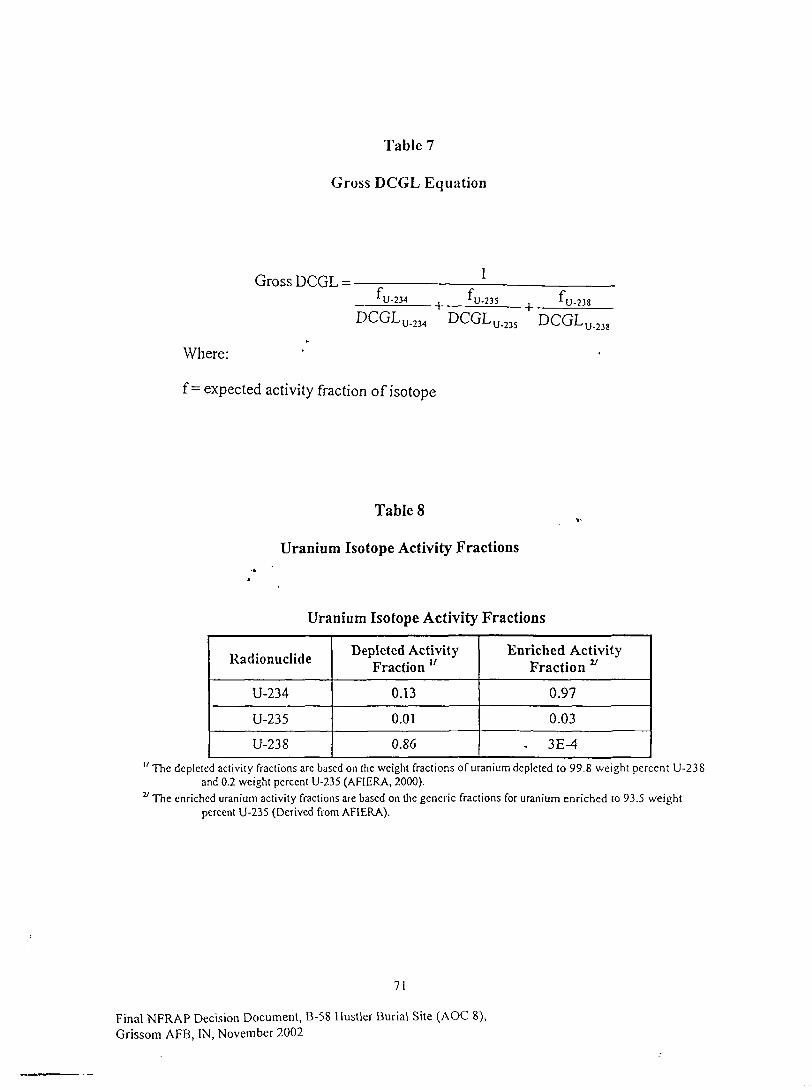
Table 7
Gross DCGL Equation
Gross DCGL = -!• I I TJX I IL U-234 |J.235
DCGLU-238
Where:
f = expected activity fraction of isotope
Table 8
Uranium Isotope Activity Fractions
Uranium Isotope Activity Fractions
Radionuclide
U-234
U-235
U-238
Depleted ActivityFraction "
0.13
0.01
0.86
Enriched ActivityFraction v
0.97
0.03
. 3E-4
" The depicted activity fractions arc based on the weight fractions of uranium depleted to 99.8 weight percent U-238and 0.2 weight percent U-235 (AFIERA, 2000).
v The enriched uranium activity fractions are based on the generic fractions for uranium enriched to 93.5 weightpercent U-235 (Derived from AFIERA).
71
Final NFRAP Decision Document, B-58 Hustler Burial Site (AOC 8),Grissom AFB, IN, November 2002
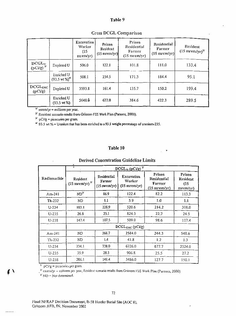
Table 9
Gross DCGL Comparison
DCGLW
(pCi/g) 3/
DCGLEMC
(pCi/g)
Depleted U
Enriched U(93.5wt%)4/
Depleted U
Enriched U(93.5 wt%)
ExcavationWorker
(15mrem/yr)
506.0
508.1
3593.8
5648.6
PrisonResident
(15 mrem/yr)
122.1
234.5
161.4
677.0
PrisonResidential
Farmer(15 mrem/yr)
101.8
171.3
135.7
384.6
ResidentialFarmer
(15 mrcm/yr)
111.0
184.4
150.2
422.3
Resident(15 mrem/yr)2'
133.4
95.1
199.4
289.5
" mrem/yr = millirem per year.v Resident scenario results from Grissom FSS Work Plan (Parsons, 2000).v pCi/g = picocuries per gram.41 93.5 wt % = Uranium that has been enriched to a 93.5 weight percentage of uranium-235.
Table 10
Derived Concentration Guideline Limits
Radionuclide
Am-24 1
Th-232
U-234
U-235
U-238
Am-24 1
Th-232
U-234
U-235
U-238
' . DCGLw (pCi/R) "
Resident(15 mrem/yr) y
ND3'
ND
103.1
26.8
147.4
ResidentialFarmer
(15 mrem/yr)
86.9
1.1
228.9
25.1
107.5
ExcavationWorker
(15 mrem/yr)
122.4
5.9
520.6
824.3
509.0
PrisonResidential
Farmer(15 mrem/yr)
82.2
1.0
214.2
22.7
98.6
PrisonResident
(15mrem/yr)
113.3
1.1
318.0
24.5
117.4
DCGLEMC (pCi/g)
ND
ND
734.1
35.9
206.1
266.7
1.4
738.0
28.3
141.4
2584.0
41.8
6726.0
906.8
3486.0
244.3
1.2
677.7
25.5
127.7
548.6
1.3
2524.0
27.2
150.1u pCi/g = picocuries per gram.y mrcnVyr = millircm per year; Resident scenario results from Grissom FSS Work Plan (Parsons, 2000)a ND = Not determined.
72
Final NFRAP Decision Document, B-58 Hustler Burial Site (AOC 8),Grissom AFB, IN, November 2002

Table 11
Length of Square Grid Equation
where:
L = length of side,
A = area of excavation,
n = number of samples'
Table 12
Final Status SurveyGrid Size Information
Area Name
Bottom Area 1
Bott'om Area 2
P i l e ] , Lift 1
Pile 1, Lift 2
Pile 2, Lift 1
Pile 2, Lift 2
Dimensions
53 ft x 25 ft
57 ft x 27 ft
75 ft x 45 ft
100 ft x 50 ft
80 ft x 65 ft
90 ft x 70 ft
Area(ft2)
1325
1539
3375
5000
5200
6300
Req'd Number ofSamples
18
21
24 V
2 4 "
2 4 "
24"
Length ofSide (ft)
8
8
11
14
14
16
Used in grid size calculation only.
73
Final NFRAP Decision Document, B-58 Hustler Burial Site (AOC 8),Grissom AFB, IN, November 2002
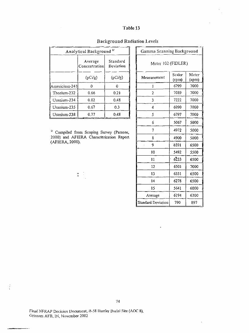
Table 13
Background Radiation Levels
Analytical Background "
Americium-24 1
Thorium-232
Uranium-234
Uranium-235
Uranium-238
AverageConcentration
(pCi/g)
0
0.66
0.82
0.67
0.77
StandardDeviation
(pCi/g)
0
0.21
0.48
0.3
0.48
17 Compiled from Scoping Survey (Parsons,2000) and AFIERA Characterization Report(AFIERA, 2000).
Gamma Scanning Background
Meter 102(FDDLER)
Measurement
1
2
3
4
5
6
7
8
9
10
11
12
13
14
15
Average
Standard Deviation
Sealer(cpm)
6799
7089
7222
6990
6797
5067
4972
4900
6591
5492
6233
6501
6331
6278
5641
6194
790
Meter(cpm)
7000
7000
7000
7000
7000
5000
5000
5000
6500
5500
6500
7000
6500
6500
6000
6300
897
74
Final NFRAP Decision Document, B-58 Hustler Burial Site (AOC 8),Grissom AFB, IN, November 2002
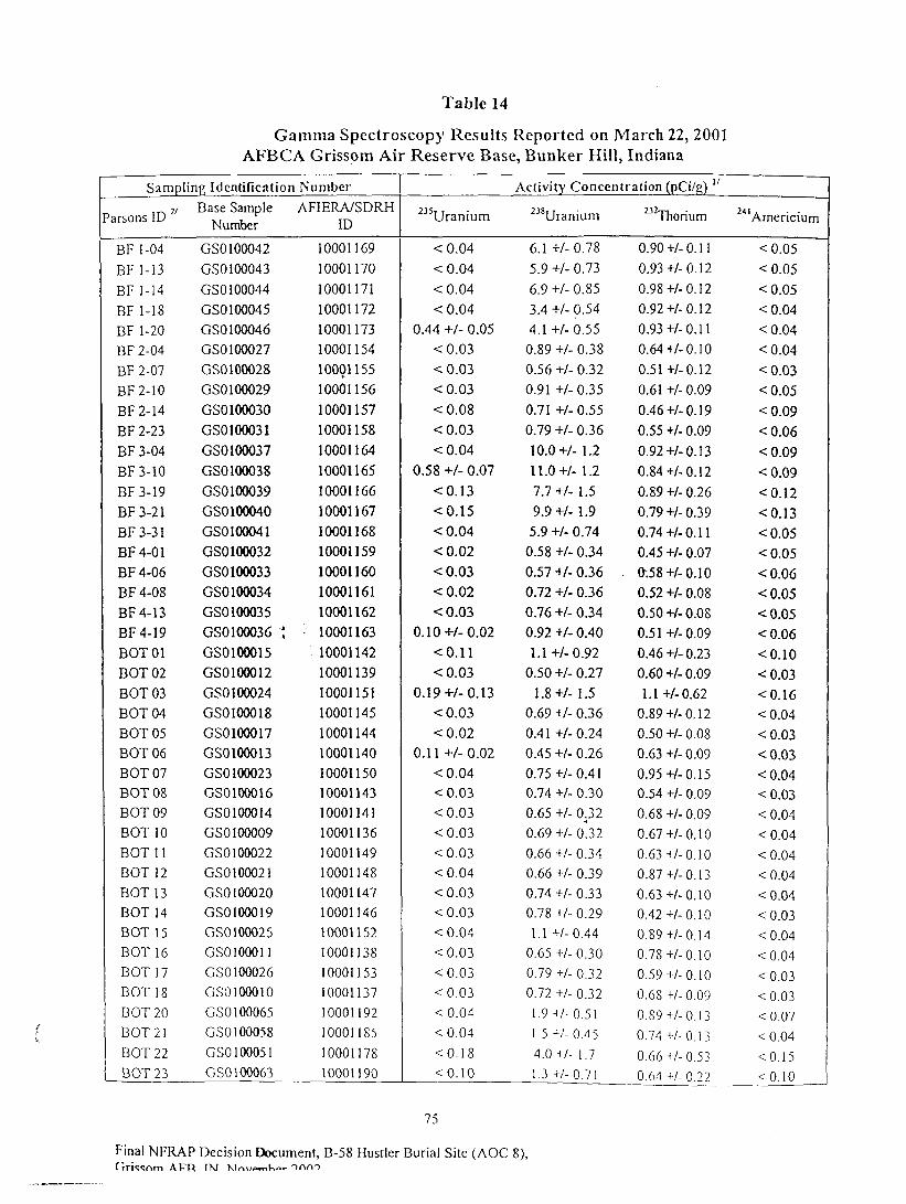
Table 14
Gamma Spectroscopy Results Reported on March 22, 2001AFBCA Grissom Air Reserve Base, Bunker Hill, Indiana
Sampling Identification
'arsons ID
BF 1-04
BF 1-13BF 1-14BF 1-18BF 1-20BF2-04
BF 2-07BF2-10
BF2-14
BF 2-23BF 3-04BF3-10
BF3-19
BF3-21
BF3-31
BF4-01
BF4-06
BF4-08
BF4-13
BF4-19
BOT01
EOT 02BOT03EOT 04EOT 05EOT 06EOT 07EOT 08EOT 09EOT 10BOTH
EOT 12EOT 13BOTHEOT 15EOT 16EOT 17EOT 18DOT 20DOT 21EOT 22DOT 23
Base SampleNumber
GS0100042
GS0100043
GSO 100044
GSO 100045
GS0100046GS0100027
GS0100028
GSO 100029
GSO 100030
GS0100031
GS0100037
GS0100038
GS0100039
GSO 100040GSO 100041
GS0100032
GS0100033
GSO 100034
GSO 100035
GSO 100036 :GS0100015
GS0100012
GS0100024
GS0100018
GS0100017
GS0100013
GSO 100023GS0100016GS0100014
GSO 100009GSO 100022
GSO 100021
GS0100020GS0100019
GSO 100025GSO 1000 11
GSO 100026GS0100010
GSO 100065
GSO 100058
GSO 100051
GS0100063
Number
AFIERA/SDRHID
10001169
10001170
10001171
10001172
1000117310001154
10001155
10001156
10001157
10001158
10001164
10001165
10001166
10001167
10001168
10001159
10001160
10001161
10001162: 10001163
10001142
10001139
1000115110001145
10001144
10001140
100011501000114310001141
10001136
1000114910001148
100011471000114610001152
10001138
1000115310001137
10001192
10001185
1000117810001190
Act ivi ty Concentration (pCi/g) "
2;!5Uranium
<0.04
<0.04
<0.04
<0.04
0.44 +/- 0.05<0.03
<0.03
<0.03
<0.08
<0.03
<0.04
0.58 +/- 0.07
<0.13<0.15<0.04
<0.02
<0.03
<0.02
<0.03
0.10+/-0.02
<0.11<0.03
0.19 +/- 0.13<0.03
<0.02
0.11 +/-0.02
<0.04<0.03
<0.03
<0.03
<0.03<0.04
<0.03<0.03<0.04
<0.03
<0.03<0.03<0.04
<0.04
<0.18<0.10
2J8Uranium
6.1 +/-0.78
5.9 +/- 0.73
6.9 +/- 0.853.4 +/- 0.544.1 +/-0.55
0.89 +/- 0.380.56 +/- 0.320.9 !+/- 0.350.7 !+/- 0.550.79 +/- 0.3610.0+/- 1.2
11.0+/- 1.2
7.7 +/- 1.59.9+/-1.9
5.9 +/- 0.740.58 +/- 0.340.57 +/- 0.360.72 +/- 0.360.76 +/- 0.340.92 +/- 0.40
I.1+/-0.920.50 +/- 0.27
1.8+/- 1.50.69 +/- 0.360.4 1 +/- 0.240.45 +/- 0.260.75 +/- 0.410.74 +/- 0.300.65 +/- 0.32
-4
0.69 +/- 0.320.66 +/- 0.340.66 +/- 0.390.74 +/- 0.330.78 +/- 0.291.1 +/-0.44
0.65 +/- 0.300.79 +/- 0.320.72 +/-0.32
1 .9+ / -0 .51
1.5 +/-0.45
4.0 +/- 1.71.3 +/-0.71
2J'-n Inonum
0.90 +/- 0.110.93+/-0.12
0.98+/-0.12
0.92+/-0.12
0.93 +/- 0.110.64+/-O.IO
0.51+/-0.12
0.61 +/- 0.09
0.46+/-0.190.55 +/- 0.09
0.92+/-0.13
0.84+/-0.12
0.89 +/- 0.260.79 +/- 0.390.74 +/- 0.110.45 +/- 0.07
. 0:58+7-0.100.52 +/- 0.08
0.50+/-O.OS
0.5 !+/- 0.090.46 +/- 0.230.60 +/- 0.091.1+/-0.62
0.89+/-0.12
0.50 +/- 0.080.63 +/- 0.09
0.95+/-0.150.54 +/- 0.09
0.68 +/- 0.090.67 +/- 0.100.63 +/- 0.100.87+/-0.13
0.63 +/- 0.100.42 +/- 0.100.89+/-0.14
0.78+/-0.10
0.59 +/- 0.100.68+/-0.09
O . S 9 + / - O . I 3
0.74 +/-0.13
0.66 +/- 0.530.64 +/- 0 22
Americium
<0.05
<0.05
<0.05
<0.04
<0.04
<0.04
<0.03
<0.05
<0.09
<0.06<0.09<0.09<0.12<0.13<0.05<0.05<0.06<0.05<0.05<0.06<0.10<0.03<0.16<0.04<0.03<0.03<0.04<0.03<0.04<0.04<0.04<0.04<0.04
<0.03<0.04
<0.04
<0.03<0.03<0.07
<0.04
<0.15<0.10
75
Final NFRAP Decision Document, B-58 Hustler Burial Site (AOC 8),Ori<;<:nm APR IN Nnvw^
Table 14 (Cont.)
Gamma Spectroscopy Results Reported on March 22, 2001AFBCA, Grissom Air Reserve Base, Bunker Hill, Indiana
Sampling Identification
Parsons ID
EOT 24EOT 25EOT 26EOT 27EOT 28EOT 29EOT 30EOT 31EOT 32
EOT 33EOT 34EOT 35EOT 3 6EOT 37EOT 38EOT 39EOT 40TSP 1TSP 2TSP 3
Base SampleNumber
GS0100048GS0100050GS0100057GS0100067GS0100056GS0100061GS01 00055GS0100052GSO 100066
GS0100049GS0100047GS0100059GS0100062GSO 100064GS0100054GSO 100053GS0100060.,4
GS0100095GS0100096GS0100097
Number
AFIERA/SDRHID
100011751000117710001184100011941000118310001188100011821000117910001193
1000117610001174100011861000118910001191100011811000118010001187101000031010000410100005
Activity Concentration in pCi/g "
B5Uranium
<0.03<0.17<0.03<0.09<0.16
0.17+/-0.09<0.18<0.03<0.02
<0.03<0.02<0.02<0.03<0.02<0.04<0.03<0.03
0.28 +/- 0.090.19+/-0.09
<0.14
^'Uranium
2.3 +/- 0.49<1.8
0.94 +/- 0.4 10.76 +/- 0.54
<1.70.84 +/- 0.702.9+/-1.7
0.90 +/- 0.310.59 +/- 0.32
0.77 +/- 0.311.0+/-0.29
0.48 +/- 0.330.47 +/- 0.320.5 !+/- 0.311.6+/-0.45
0.75 +/- 0.341.3+/-0.411.3+/-0.821.0+/-0.631.1+/-0.64
•"Thorium
0.65 +/- 0.09<0.60
0.79+/-0.130.50+/-0.180.69 +/- 0.430.66 +/- 0.230.46 +/- 0.400.50 +/- 0.080.48 +/- 0.08
0.4 !+/- 0.090.50 +/- 0.070.50 +/- 0.080.47 +/- 0.08
. 0:42 +/- 0.070.77+/-0.120.53+/-0.120.73 +/- 0.110.45 +/- 0.200.59 +/- 0.210.70 +/- 0.24
Americium
<0.04<0.15<0.04<0.09<0.13<0.10<0.15<0.03<0.05
<0.03<0.03<0.05<0.05<0.04<0.04<0.04<0.06<0.11<0.10<0.10
pCi/g = picocuries per gram.following abbreviations are used in the Parsons ID: BF- Backfill soil pile; EOT- Bottom of excavation; TSP -
Potentially TPH-contaiminated soil piles.
76
Final NFRAP Decision Document, B-58 Hustler Burial Site (AOC 8),Grissom AFB, IN, November 2002
Table 15
Alpha Spcctroscopy Results Reported on March 8, 2001AFBCA Grissom Air Reserve Base, Bunker Hill, Indiana
Sampling Identification
Parsons ID v
B-58Site
BF 1-04
BF1-13BF1-14
BF1-18
BF1-20
BF 2-04
BF 2-07
BF2-10
BF2-14
BF 2-23
BF3-04
BF3-10
BF3-19
BF3-21
BF3-31
BF4-01
BF 4-06
BF 4-08
BF4-13
BF4-19
Base SampleNumber
GS0100047
GS0100042
GS0100043
GSO 100044
GS0100045
GSO 100046
GSO 100027
GSO 100028
GS0100029
GS0100030
GS0100031
GS0100037
GS0100038
GS0100039
GS0100040
GS0100041
GS0100032
GS01QQ033
GS0100034
GS0100035
GS0100036
Number
AFIERA/SDRHID
10100060
10100055
10100056
10100057
10100058
; 10100059101000401010004110100042101000431010004410100050101000511010005210100053101000541010004510100046101000471010004810100049
Act ivi ty
"''Uranium
0.92+/-0.167.1 +/-0.768.0 +/- 0.8811.0+/- 1.02.8 +/- 0.348.2 +/- 0.85
0.82+7-0.140.59+/-0.130.76+/-0.140.56+7-0.117.5 +7- 0.894.4 +/- 0.4916.0+/- 1.84.6 +/- 0.577.0 +/- 0.695.7 +/- 0.725.0+7-0.570.75+/-0.150.70+7-0.142.2 +7- 0.26
0.60+/-0.12
Concentra t ion in
235Uranium
0.08 +/- 0.050.40 +/- 0.100.55 +/- 0.130.77+/-0.140.33 +/- 0.090.73+/-0.150.10+7-0.050.08 +/- 0.050.06 +/- 0.040.06 +/- 0.040. 52+7- 0.120.50 +/- 0.111.2+7- 0.22
0.33+7-0.100.53+/-0;120.56 +/- O.'l30.29 +/- 0.080.07 +7- 0.040.06 +/- 0.040.11 +7-0.050.07 +7- 0.04
PCi7g "
238i iUranium
1.1 +7-0.1915.0+7- 1.613.0+7- 1.417.0+7- 1.67.1 +7-0.7413.0+7- 1.3
0.82+7-0.140.61+7-0.130.79+7-0.140.83+7- 0.1 50.96+7-0.1718.0+7- 1.827.0 +/- 3.07.8 +7- 0.9011.0+7-1.012.0+7-1.41.2+7-0.18
0.91+7-0.170.88+7-0.160.91+7-0.140.58+7-0.11
1 pCi/g = picocunes per gram.27 The following abbreviations are used in the Parsons ID: BF-Backfil l soil pile; BOT- Bottom of excavation; TSP -
Potentially TPH-contaiminated soil piles.
77
Final NFRAP Decision Document, B-58 Hustler Burial Site (AOC 8),Grissom AFB, IN, November 2002
Table 16
Comparison Of Gamma Spectroscopy ResultsFrom Excavation Bottom
With Background And DCGLws
Soil Concentrations
Radionuclidc
U-234
U-235
U-238
Average BackgroundConcentration
(PCi/g) "
0.71
0.67
0.77h
DCGL\v(pCi/g)
214
222.7
98.6
Sum for comparison with 30 pCi/g level:
MeanSampleResults(PCi/g)
1.96*
0.06
1.08
3.1
Comparison to:
AverageBackground
Above
Below
Above
DCGLW
Below
Below
Below
Less than 30 pCi/g
" nCi/p = nicocuries oer cram.The U-234 results are conservatively based on the U-235 analytical results and the activity fractions of uranium
enriched to 93.5 weight percent U-235.
Table 17
Results From Sign And WRS Tests,Excavation Bottom Soil Sampling
Radionuclide
U-234
U-235
U-238
Sign Test
# Belowthe
DCGLW
39"
39
39
% Below
100
100
100
PassSign Test?
Yes
Yes
Yes
WRS Test
Sum ofBackground
Ranks
1705
1705
1705
MARSSIMCritical Value
1238
1238
1240
PassWRSTest?
Yes
Yes
Yes
" Critical value for Sign test is 14.
Table 18
MARSSIM Unity Rule Equation
r c c^t V-^7 ^n
DCGLW1 DCGLW2 DCGLWn
Where:
C = concentration, in pCi/g
DCGLw = guideline value for each individual radionuclide (1,2,..., n), in pCi/g
78
Final NFRAP Decision Document, B-58 Hustler Burial Site (AOC 8)Gnssom AFB, IN, November 2002

Table 19
Unity Rule Calculation Results,Excavation Bottom Soil Sampling
Radionuclide
U-234 r
U-235 'U-238
MeanConcentration
(pCi/R) "1.960.061.1
DCGLw(pCi/g)
21422.798.7
SumIs Sum of Ratios < 1?
Ratio
0.00910.00260.0110.023Yes
" pCi/g = picocuries per gram.
79
Final NFRAP Decision Document, B-58 Hustler Burial Site (AOC 8),Grissom AFB, IN, November 2002

Table 20
Results of Excavation Bottom Scanning Survey
Grid Location
1
2
3
4
5
6
7
8
9
10
11
12
13
14
15
16
17
18
20
21 :22
23
24
25
26
27
28
29
30
31
32
3334
35
36
37
38
39
40
Average
St. Dcv.
Areal Sealer Reading(cpm) " .6972
6370
7163
6831
6254
6837
, 6888
6268
6560
6845
6306
6683
6503
6314
6750
6585
6211
6832
7526
7372
7319
7468
7022
6979
7274
7047
6581
71166622
6218
6636
6244
6172
6694
6165
6409
6981
6732
6954
6736
385
Point Sealer Reading (cpm)
6466
5573
6872
5854
5313
6205
6357
5609
6573
6163
5517
6256
5791
5410
7354
6310
5825
6506
8201
7280
7326
7906
6391
7267
6986
6634
6872
6846
6428
5871
6227
6113
6018
6190
5800
6486
7365
6372
7291
Remarks
Area 1
»•
Area 2
Background
6457 6194
685 790
cpm = counts per m t n u l c .
80
Final NFRAP Decision Document, B-58 Hustler Burial Site (AOC 8),

Table 21
Comparison of Soil SamplingGamma Spectroscopy Results
From Backfill Soil PilesWith Background Ami DCGLws
Soil Concentrations
Radionuclide
U-234
U-235
U-238
Mean BackgroundConcentration
(pCi/g) "
0.71
0.6?
0.77
DCGLw(PCi/g)
214
nn
98.6
Sum for comparison with 30 pCi/g level:
Mean SampleResults(pCi/g)
3.17 "
0.10
3.9
7.17
Comparison to:
MeanBackground
Above
Below
Above
DCGLw
Below
Below
Below
Less than 30 pCi/g
" pCi/g = picocuries per gram.27 The U-234 results are conservatively based on the U-235 analytical results and the activity fractions of uranium
enriched to 93.5 weight percent U-235.
Table 22Comparison Of Soil SamplingAlpha Spectroscopy Results
From Backfill Soil PilesWith Background And DCGLws
Soil Concentrations
Radionuclide
U-234
U-235
U-238
Mean BackgroundConcentration
(pCi/g) "
0.71
0.67
0.77
DCGLW
(PCi/g)
214
22.7
98.6
Sum for comparison with 30 pCi/g level:
Mean SampleResults(PCi/g)
4.54
0.35
7.21
12.1
Comparison to:
MeanBackground
Above
Below
Above
DCGLW
Below
Below
Below
Less than 30 pCi/g
" pCi/g = picocuries per gram.
81
Final NFRAP Decision Document, B-58 Hustler Burial Site (AOC 8),Grissom AFB, IN, November 2002
Table 23
Results From Sign And WRS Tests,Backfill Soil Pile Sampling Gamma Spectroscopy
Radionuclide
U-234
U-235
U-238
Sign Test
U Belowthe
DCGLw
20"
20
20
% Below
100
100
:ioo
PassSign Test?
Yes
Yes
Yes
WRS Test
Sum ofBackground
Ranks
1116
1116
,1116
MARSSIMCritical Value
891
891
891
PassWRSTest?
Yes
Yes
Yes
' Critical value for Sign test is 14.
Table 24
Results From Sign And WRS Tests,Backfill Soil Pile Sampling Alpha Spectroscopy
Radionuclide
U-234
U-235
U-238
Total U *
Sign Test
# Belowthe
DCGLw•A
• A
21"
21
21
20
% Below
100
100
100
95
PassSign Test?
Yes
Yes
Yes
Yes
WRS Test
Sum ofBackground
Ranks
1147
1147
1147
966
MARSSIMCriticalValue
909
909
910
781
PassWRSTest?
Yes
Yes
Yes
Yes
"Critical value for Sign test is 14.The DCGLW for total uranium is 30 pCi/g.
82
Final NFRAP Decision Document, B-58 Hustler Burial Site (AOC 8),Grissom AFB, IN, November 2002
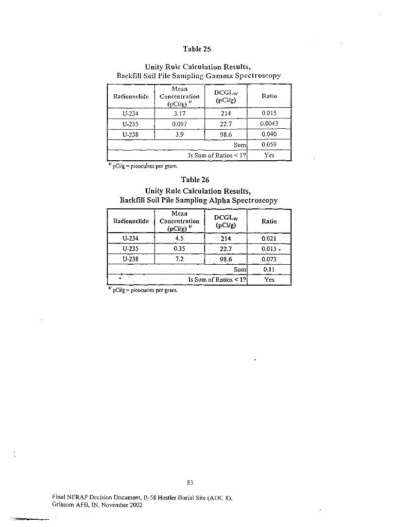
Table 25
Unity Rule Calculation Results,Backfill Soil Pile Sampling Gamma Spectroscopy
Radionuclide
U-234
U-235
U-238
MeanConcentration
(pCi/R) "3.17
0.097
3.9
DCGLW
(pCi/g)
214
22.7
98.6
Sum
Is Sum of Ratios < 1?
Ratio
0.015
0.0043
0.040
0.059
Yes
" pCi/g = picocuries per gram.
Table 26Unity Rule Calculation Results,
Backfill Soil Pile Sampling Alpha Spectroscopy
Radionuclide
U-234
U-235
U-238
MeanConcentration
(PCi/g) "4.5
0.35
7.2
DCGLW
(pCi/g)
214
22.7
98.6
Sum
Is Sum of Ratios < 1?
Ratio
0.021
0.0.15 '•
0.073
0.11
Yes
" pCi/g -picocuries per gram.
83
Final NFRAP Decision Document, B-58 Hustler Burial Site (AOC 8),Grissom AFB, IN, November 2002

Table 27
Results of Backfill Soil Pile Field Measurements
Pile l .Lifl 1
Grid Arcal SealerLocation Reading (cpm)
12345678910111213141516171819202122232425262728293031323334353637383940414243
6324635063736847666065096870703366167054686867%712970546544628264646599620763406315
62496067
6135617362056413 •*.65676270
611764956121
66566087
65816534
6358642166145397599159336204
AverageSt. Dcv.
6438344
Pile 1, Lift 2
Grid Areal SealerLocation Reading (cpm)
12345678910 -11 '12131415161718192021222324252627282930313233
63336269669667886694
' 6434605156306608762366976342625061905898593360016643685768097975
61176089
6038618165897202
64147021628862576152
5933
Average
St. Dev.6455
498
Pile 2, Lift 1
Grid Areal SealerLocation Reading (cpm)
1234567891011121314151617181920212223242526
527252855393555753225217525851095135528454215142526353985331513850895225528653525074
51285197517049065036
AverageSt. Dcv.
5230139
Pile 2, Lift 2
Grid Areal SealerLocation Reading (cpm)
1234
567891011121314151617181920
53385231530451345053516151405220532150795240504054705158508450535296530851104829
AverageSt. Dtv.
BackgroundAverage
St. Dev.
6194
790
-
5178143
84
Final NFRAP Decision Document, B-58 Hustler Burial Site (AOC 8),Grissom AFB, IN, November 2002

Table 28
Monthly Average Water ReleaseConcentration Criteria
Radionuclide
U-234
U-235
U-238
10 CFR 20AppBTable3
ReleaseCriteria
(pCi/L/month)
3.0E+03
3.0E+03
3.0E+03
Tank WaterSample 1
ReleaseConcentration "(pCi/L/month) y
3.1E+03
9.6E+01
7.5E+02
Tank WaterSample 2
ReleaseConcentration(pCi/L/month)
2.9E+03
9.0E+01
6.7E+02
ExcavationWater
Sample 1Release
Concentration(pCi/L/month)
3.1E+03
9.6E+01
7.2E+02
ExcavationWater
Sample 2Release
Concentration(pCi/L/month)
3.0E+03
9.3E+01
7.6E+02
" Assuming a frac tank volume of 2750 gallons.27 pCi/L/month = picocuries per liter of water released per month.
Table 29
Sum Of Fractions Criteria
Radionuclide
U-234
U-235
U-238
Sum
Tank WaterSample 1
ReleaseFraction "
0.5
0.015
0.12
0.63
Tank WaterSample 2
ReleaseFraction
0.47
0.014
0.11
0.59
Excavation WaterSample 1
ReleaseFraction
0.5
0.015
0.11
0.63
ExcavationWater
Sample 2Release
' Fraction
0.48
0.015
0.12
0.62
" Assuming a frac tank volume of 2750 gallons and a sewer flow of 3000 gallons per month.
Table 30
Total Activity ReleaseCalculation Results
Radionuclide
U-234
U-235
U-238
Sum
Total Activity (pCi) "
Tank WaterSample 1
3.3E+07
l.OE+06
7.8E+06
4.1E+07
Tank WaterSample 2
3.0E+07
9.3E+05
7.0E+06
3.8E+07
ExcavationWater
Sample 1
3.3E+07
l.OE+06
7.5E+06
4.1E+07
ExcavationWater
Sample 2
3.1E+07
9.6E+05
7.9E+06
4.0E+07
" pCi = picocuries; total activity release calculat ion performed assuming a frac tank volume of 2750gallons.
85
Final NFRAP Decision Document, B-58 Hustler Burial Site (AOC 8),APR I'M WnvpmKor
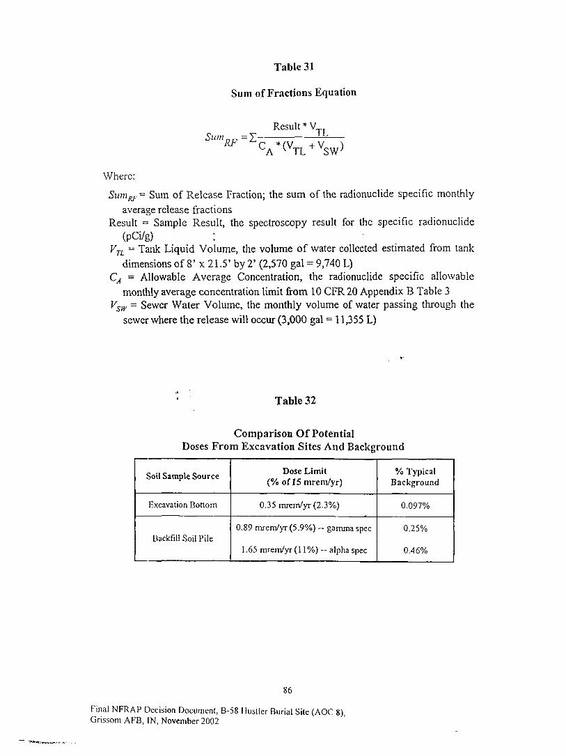
Table 31
Sum of Fractions Equation
Result * V.Sum =ZRF ^
TL;(VT VSW)
Where:
^ Sum of Release Fraction; the sum of the radionuclide specific monthly
average release fractionsResult = Sample Result, the spectroscopy result for the specific radionuclide
(pCi/g)VTL = Tank Liquid Volume, the volume of water collected estimated from tank
dimensions of 8' x 21 .5' by 2' (2,570 gal - 9,740 L)CA = Allowable Average Concentration, the radionuclide specific allowable
monthly average concentration limit from 10 CFR20 Appendix B Table 3Vsw = Sewer Water Volume, the monthly volume of water passing through the
sewer where the release will occur (3,000 gal = 1 1,355 L)
Table 32
Comparison Of PotentialDoses From Excavation Sites And Background
Soil Sample Source
Excavation Bottom
Backfill Soil Pile
Dose Limit(% oflS mrem/yr)
0.35 mrem/yr (2.3%)
0.89 mrem/yr (5.9%) — gamma spec
1.65 mrem/yr (1 1%) - alpha spec
% TypicalBackground
0.097%
0.25%
0.46%
86
Final NFRAP Decision Document, B-58 Hustler Burial Site (AOC 8)Grissom AFB, IN, November 2002
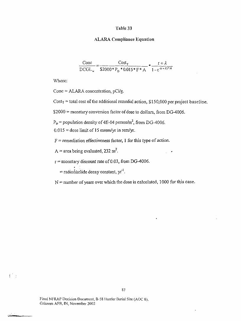
Table 33
ALARA Compliance Equation
Cone _ CostT
DCGLW ~$2000*PD*0.015*F*A
Where:
Cone = ALARA concentration, pCi/g.
Costy = total cost of the additional remedial action, $150,000 per project baseline.
$2000 = monetary conversion factor of dose to dollars, from DG-4006.
PD = population density of 4E-04 person/m2, from DG-4006.
0.015 = dose limit of 15 mrem/yr in rem/yr.
F = remediation effectiveness factor, 1 for this type of action.
A = area being evaluated, 232 m2. . ••
r = monetary discount rate of 0.03, from DG-4006.•A
= radionuclide decay constant, yr" .
N = number of years over which the dose is calculated, 1000 for this case.
87
Final NFRAP Decision Document, B-58 Hustler Burial Site (AOC 8),Grissom AFB, IN, November 2002

Appendix C, List of Acronyms
88
Final NFRAP Decision Document, B-58 Hustler Buria l Site (AOC 8),Grissom AFB, IN, November 2002
Acronyms and Abbreviations
ACRONYMS AND ABBREVIATIONS
uCi microcurieug/G micrograms per gramAEC Atomic Energy CommissionAFB Air Force Base
AFBCA Air Force Base Conversion AgencyAFIERA Air Force Institute for Environment, Safety, and
Occupational Health Risk AnalysisALARA as low as is reasonably achievableAm-241 americum-241
ANSI American National Standards InstituteARB Air Reserve Base
ARAR applicable or relevant and appropriate requirementBRAC Base Realignment and Closure (Act)
Ci curiecm centimeter
COC contaminant of concerncpm counts per minute
DCGL derived concentration guideline levelDCGLeMc DCGL elevated measurement comparison
DCGLw derived concentration guideline level, wide areaDOD Department of DefenseDQO data quality objective
.».. DU depleted uraniumEU enriched uranium
FIDLER field instrument for the detection of low energyradiation
FSS Final Status Surveyft bgs feet below ground surface
ft2 square feetGe germanium
GM Geiger-MuellerISDH Indiana State Department of Health
keV kiloelectron voltsm meters
m/s meters per secondnrVyr cubic meters per year
MagThor magnesium thorium alloyMARSSIM Multi-Agency Radiation Survey and Site Investigation
ManualMDC minimum detectable concentration
MDCR minimum detectable count ratemg/d milligrams per dayml/g milliliters per gram
mR/hr milliroentgen per hour
89
Final NFRAP Decision Document, B-58 Hustler Burial Site (AOC 8),
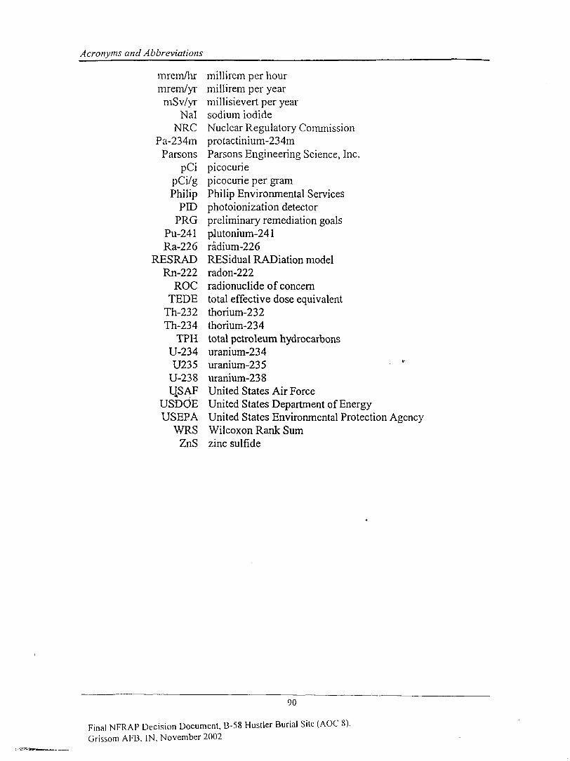
Acronyms and Abbreviations
mrem/hr millirem per hourmrem/yr millirem per year
mSv/yr millisievert per yearNal sodium iodide
NRC Nuclear Regulatory CommissionPa-234m protactinium-234m
Parsons Parsons Engineering Science, Inc.pCi picocurie
pCi/g picocurie per gramPhilip Philip Environmental Services
PDD photoionization detectorPRG preliminary remediation goals
Pu-241 piutonium-241Ra-226 radium-226
RESRAD RESidual RADiation modelRn-222 radon-222
ROC radionuclide of concernTEDE total effective dose equivalent
Th-232 thorium-232Th-234 thorium-234
TPH total petroleum hydrocarbonsU-234 uranium-234U235 uranium-235
U-238 uranium-238I4S AF United States Air Force
USDOE United States Department of EnergyUSEPA United States Environmental Protection Agency
WRS Wilcoxon Rank SumZnS zinc sulfide
90
Final NFRAP Decision Document, B-58 Hustler Burial Site (AOC 8),Grissom AFB. IN, November 2002
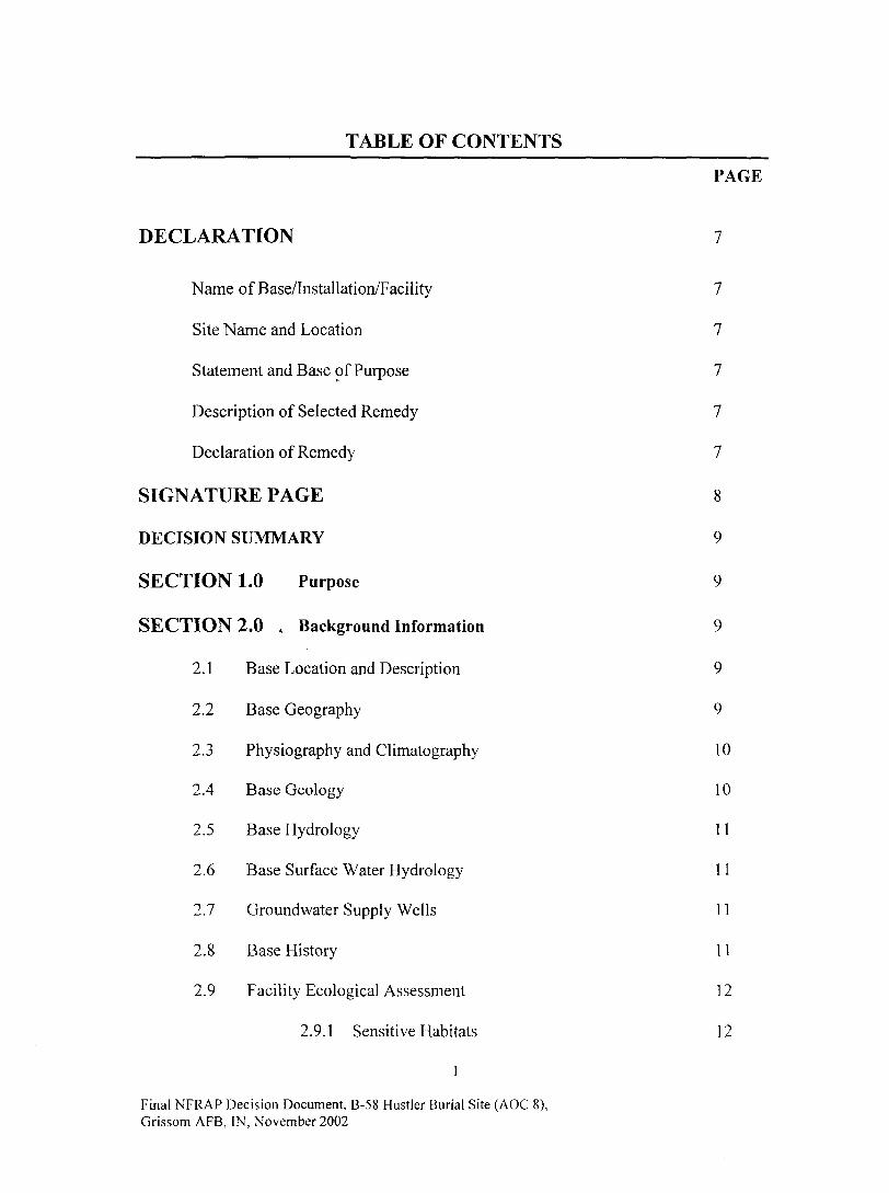
TABLE OF CONTENTS
PAGE
DECLARATION 7
Name of Base/Installation/Facility 7
Site Name and Location 7
Statement and Base of Purpose 7
Description of Selected Remedy 7
Declaration of Remedy 7
SIGNATURE PAGE 8
DECISION SUMMARY 9
SECTION 1.0 Purpose 9
SECTION 2.0 . Background Information 9
2.1 Base Location and Description 9
2.2 Base Geography 9
2.3 Physiography and Climatography 10
2.4 Base Geology 10
2.5 Base Hydrology 11
2.6 Base Surface Water Hydrology 11
2.7 Groundwater Supply Wells 11
2.8 Base History 11
2.9 Facility Ecological Assessment 12
2.9.1 Sensitive Habitats 12
1
Final NFRAP Decision Document, B-58 Hustler Burial Site (AOC 8),Grissom AFB, IN, November 2002

TABLE OF CONTENTS (Cont.)
PAGE
2.9.2 Threatened and Endangered Species 12
SECTION 3.0 Site Information 12
3.1 Location and Description 12
3.2 Geology 12
3.3 Hydrology , 12
3.4 Topography and Surface Hydrology 13
3.5 History 13
3.6 Previous Site Investigations 13
SECTION 4.0 Initial Burial Site Scoping Survey (Feb 2000) 14
4.1 Instrumentation 15
4.2 Measurements 15
4.3 Conclusions 15
SECTION 5.0 Intrusive Scoping Survey (Feb-Mar 2000) 15
5.1 Instrumentation 16
5.2 In situ Measurements 16
5.3 Soil Characteristics 16
5.4 Soil Concentrations 17
5.5 Conclusions 17
SECTION 6.0 Final Status Survey (Oct-Nov 2000) 17
6.1 Regulatory Criteria Summary 17
Final NFRAP Decision Document, B-58 Hustler Burial Site (AOC 8),Grissom AFB, IN, November 2002
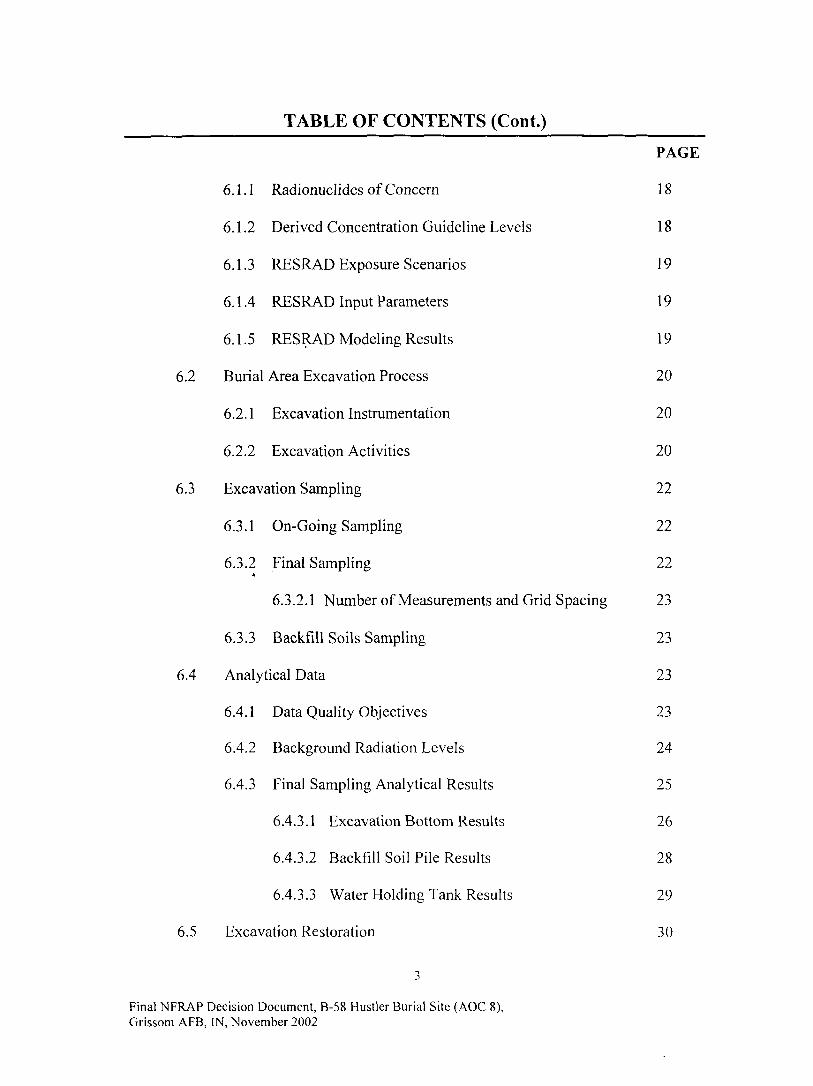
TABLE OF CONTENTS (Cont.)
PAGE
6.1.1 Radionuclides of Concern 18
6.1.2 Derived Concentration Guideline Levels 18
6.1.3 RESRAD Exposure Scenarios 19
6.1.4 RESRAD Input Parameters 19
6.1.5 RESRAD Modeling Results 19
6.2 Burial Area Excavation Process 20
6.2.1 Excavation Instrumentation 20
6.2.2 Excavation Activities 20
6.3 Excavation Sampling 22
6.3.1 On-Going Sampling 22
6.3.2 Final Sampling 22A
6.3.2.1 Number of Measurements and Grid Spacing 23
6.3.3 Backfill Soils Sampling 23
6.4 Analytical Data 23
6.4.1 Data Quality Objectives 23
6.4.2 Background Radiation Levels 24
6.4.3 Final Sampling Analytical Results 25
6.4.3.1 Excavation Bottom Results 26
6.4.3.2 Backfill Soil Pile Results 28
6.4.3.3 Water Holding Tank Results 29
6.5 Excavation Restoration 30
Final NFRAP Decision Document, B-58 Hustler Burial Site (AOC 8),Grissom AFB, IN, November 2002

TABLE OF CONTENTS (Cont.)
PAGE
6.5.1 Backfilling Excavation 30
6.5.2 Soil Transportation and Disposal 30
6.5.3 Water Disposal 30
6.6 Dose Comparison 30
6.7 ALARA Assessment 31
6.8 Summary of Findings 32
6.9 Conclusions 33
SECTION 7.0 Regulatory Agency Involvement 33
7.1 Regulatory Review and Approval of Final Status Survey Report 33
7.2 Regulatory Review and Approval of Decision Document 33
SECTION 8.0 . Community Participation 38
SECTION 9.0 Current Status 38
SECTION 10.0 Risk Determination 38
SECTION 11.0 Selected Action: No Further Action 38
Appendix-A Figures 39
Figure 1 Grissom AFB and Surrounding Communities 40Figure 2 Facility Plan, Grissom AFB 41Figure 3 Generalized Geologic Cross Section, Grissom AFB 42Figure 4 Regional Surface Drainage, Vacinity of Grissom AFB 43Figure 5 Facility Surface Drainage, Grissom AFB 44Figure 6 Groundwater Supply Well Locations, Grissom AFB 45Figure 7 Location Map/B-58 Hustler Burial Site 46FigureS Location of Metallic Anomaly 47
Final NFRAP Decision Document, B-58 Hustler Burial Site (AOC 8),Grissom AFB, IN, November 2002
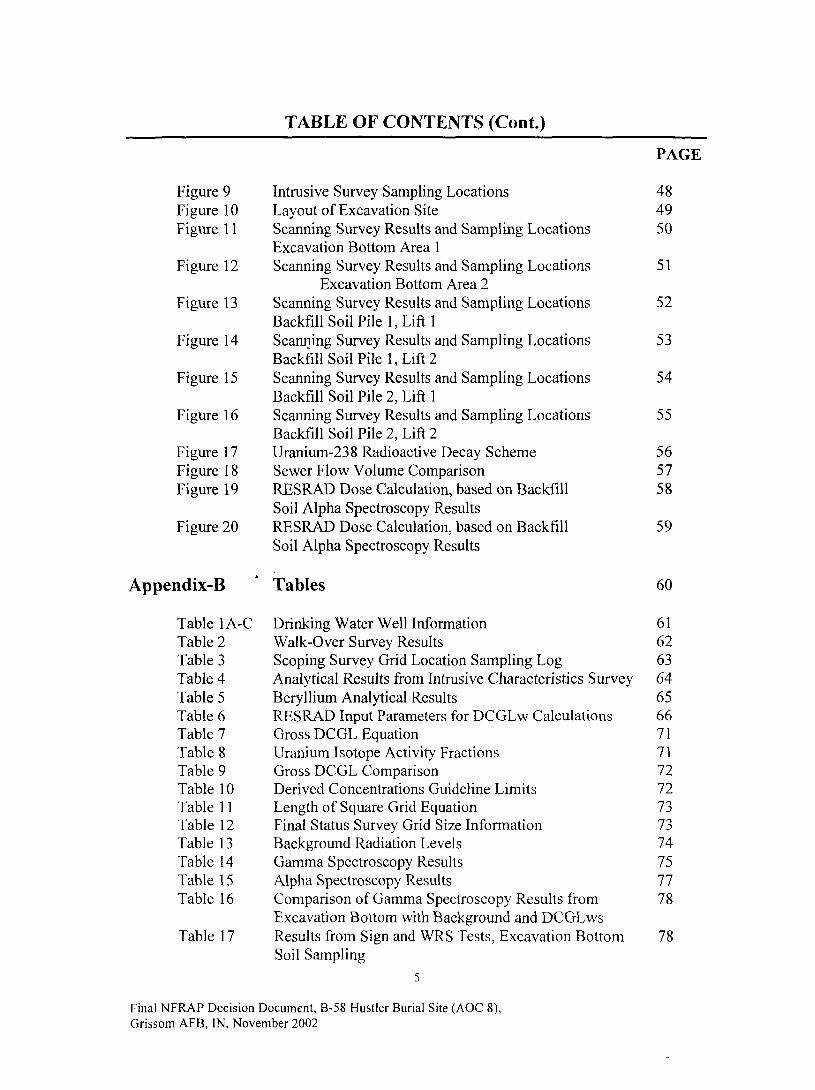
TABLE OF CONTENTS (Cont.)
Figure 9Figure 10Figure 1 1
Figure 12
Figure 13
Figure 14
Figure 15
Figure 16
Figure 17Figure 18Figure 19
Figure 20
Intrusive Survey Sampling LocationsLayout of Excavation SiteScanning Survey Results and Sampling LocationsExcavation Bottom Area 1Scanning Survey Results and Sampling Locations
Excavation Bottom Area 2Scanning Survey Results and Sampling LocationsBackfill Soil Pile 1, Lift 1Scanning Survey Results and Sampling LocationsBackfill Soil Pile 1, Lift 2Scanning Survey Results and Sampling LocationsBackfill Soil Pile 2, Lift 1Scanning Survey Results and Sampling LocationsBackfill Soil Pile 2, Lift 2Uranium-238 Radioactive Decay SchemeSewer Flow Volume ComparisonRESRAD Dose Calculation, based on BackfillSoil Alpha Spectroscopy ResultsRESRAD Dose Calculation, based on BackfillSoil Alpha Spectroscopy Results
PAGE
484950
51
52
53
54
55
565758
59
Appendix-B " Tables 60
Table 1A-C Drinking Water Well Information 61Table 2 Walk-Over Survey Results 62Table 3 Scoping Survey Grid Location Sampling Log 63Table 4 Analytical Results from Intrusive Characteristics Survey 64Table 5 Beryllium Analytical Results 65Table 6 RESRAD Input Parameters for DCGLw Calculations 66Table 7 Gross DCGL Equation 71TableS Uranium Isotope Activity Fractions 71Table 9 Gross DCGL Comparison 72Table 10 Derived Concentrations Guideline Limits 72Table 11 Length of Square Grid Equation 73Table 12 Final Status Survey Grid Size Information 73Table 13 Background Radiation Levels 74Table 14 Gamma Spectroscopy Results 75Table 15 Alpha Spectroscopy Results 77Table 16 Comparison of Gamma Spectroscopy Results from 78
Excavation Bottom with Background and DCGLwsTable 17 Results from Sign and WRS Tests, Excavation Bottom 78
Soil Sampling5
Final NFRAP Decision Document, B-58 Hustler Burial Site (AOC 8),Grissom AFB, IN, November 2002
TABLE OF CONTENTS (Cont.)
PAGE
MARSSIM Unity Rule Equation 78Unity Rule Calculation Results, Excavation Bottom 79Soil SamplingResults of Excavation Bottom Scanning Survey 80
Comparison of Soil Sampling Gamma Spectroscopy 81Results from Backfill Soil Piles with Backgroundand DCGLwsComparison of Soil Sampling Alpha Spectroscopy 81Results from Backfill Soil Piles with Backgroundand DCGLwsResults from Sign and WRS Tests, Backfill Soil Pile 82Sampling Gamma SpectroscopyResults from Sign and WRS Tests, Backfill Soil Pile 82Sampling Alpha SpectroscopyUnity Rule Calculation Results, Backfill Soil Pile 83Sampling Gamma SpectroscopyUnity Rule Calculation Results, Backfill Soil Pile 83Sampling Alpha SpectroscopyResults of Backfill Soil Pile Field Measurements 84Monthly Average Release Concentration Criteria 85Sum of Fractions Criteria 85Total Activity Release Calculation Results 85Sum of Fractions Equation 86Comparison of Potential Doses from Excavation 86Sites and BackgroundALARA Compliance Equation 87
List of Acronyms 88
Table 18Table 19
Table 20
Table 21
Table 22
Table 23
Table 24
Table 25
Table 26
Table 27Table 28Table 29Table 30Table 31Table 32
Table 33
Appendix C
Final NFRAP Decision Document, B-58 Hustler Burial Site (AOC 8),Grissom AFB, IN, November 2002
DECLARATION
Name of Base/Installation/Facility
Grissom Air Force Base (AFB), Peru, Indiana.
Site Name and Location
B-58 Hustler Burial Site/Area of Concern (AOC) 8, Grissom AFB, Peru, Indiana.
Statement of Basis and Purpose
This decision is based on the results of the Final Status Survey Report/B-58 HustlerBurial Site/AOC 8 (February 2002) conducted by Parsons Engineering Science, Inc.,Denver Colorado, under Project Number CTGC20006108, prepared for the Grissom AirForce Real Property Agency (AFRPA) and the Air Force Institute for Environment,Occupational Safety and Health Risk (AFIERA).
Description of Selected Remedy
Based on current site condition, it has been determined that no significant risk or threat topublic health or the environment exists. Therefore, no further action (NFA) under theComprehensive Environmental Response, Compensation, and Liability Act (CERCLA)and the Nuclear Regulatory Commission (NRC) guidance is required.
-*
Declaration of the Remedy
This decision document represents the selected action for this site developed inaccordance with CERCLA and the NRC guidance. It has been determined that the NFAis protective of human health and environment, attains federal and state requirements thatare applicable, or relevant and appropriate, and is cost effective. Contaminant levels atthe site have been determined to present no significant threat to human health or theenvironment; thus, no treatment is necessary and the site is suitable for unrestricted use.
Final NFRAP Decision Document, B-58 Hustler Burial Site (AOC 8),Grissom AFB, IN, November 2002
Signatures:
Marlene Seneca
Site Manager/BRAC Environmental Coordinator
Air Force Base Conversion Agency, Grissom AFB
Date:
Stephanie Riddle
Project Manager
Indiana Department of Environmental Management
• A
Date:
Thomas Barounis
Remedial Program Manager
United States Environmental Protection Agency, Region V
Date:
Final NFRAP Decision Document, B-58 Hustler Burial Site (AOC 8),Grissom AFB, IN, November 2002

Decision Summary
1.0 Purpose
The purpose of this NFA Report is to summarize existing data and describe the AirForce's rationale for selecting a particular remedial action, in this case, the NFAalternative for the B-58 Hustler Burial Site (AOC 8). The objectives of this decisiondocument are:
• To describe the location, history, environmental setting and current status of the site;
• To summarize the results from previous investigations; and
• To assess the risk to human health and the environment.
2.0 Background Information
2.1 Base Location and Description
Grissom AFB is located approximately 15 miles north of Kokomo, Indiana on U.S. Route31 in Cass and Miami counties, approximately two miles west of the town of BunkerHill. See Appendix-A, Figure 1 for a map of Grissom AFB and the surroundingcommunities. The base, which was originally established in 1942, has undergone severaltransitions throughout its history. Grissom AFB was realigned to Grissom Air ReserveBase (ARE) on 30 September 1994. The Air Force Reserve 434th Air Refueling Wing isthe host within the new cantonment area. The excess Air Force property, known as BaseRealignment and Closure (BRAC) property, is being managed by the AFBCA pendingredevelopment. The primary mission of the AFBCA is to cleanup BRAC property fortransfer to the Grissom Redevelopment Authority for reuse. The former base wascomprised of 2,722 acres of land, which is surrounded by actively managed agriculturalland. Major population centers in the vicinity include the cities of Peru, Kokomo, andLogansport. In addition, several smaller towns and communities are scattered around theformer Grissom AFB as shown in Appendix-A, Figure 1. Grissom AFB Facility Plan isshown in Appendix-A, Figure 2.
2.2 Base Geography
The base lies within the Tipton Till Plain section of the Interior Plains division of theCentral Lowlands Province of the United States. The Tipton Till Plain section isgenerally characterized by nearly level plains with gently rolling hills and has a fewsmall, localized, closed depressions. The topography of the base exhibits characteristicstypical of the regional Tipton Till Plain. In general, the topography is a reflection of aglacially deposited till that has been affected to some extent by the shape of theunderlying bedrock surface and by post-glacial erosion. Across the base, land surfaceelevations vary from approximately 810 feet above the National Geodetic Vertical Datum(NGCD), reference to feet above mean sea level (ft MSL) near the southeast boundary to
Final NFRAP Decision Document, B-58 Hustler Burial Site (AOC 8),Grissom AFB, IN, November 2002

approximately 780 feet NGVD near the northern boundary. The south edge of the baseappears to be a topographic high, which slopes towards the north (on the base) and south(away from the base) (ESE, 1993a; United States Geological Survey [USGS], 1963).
2.3 Physiography and Climatography
The climate in north Central Indiana is temperate, with warm humid summers and coldwinters. The region is characterized by wide variations in temperature from season toseason, ranging from 20 degrees Fahrenheit (°F) in the winter to 80°F in the summer.The coolest month of the year is January, with a mean monthly temperature of 23°F andthe warmest month of the year is July with a mean monthly temperature of 74°F.Precipitation in Central Indiana averages 36.6 inches annually, and is evenly distributedthroughout the seasons. Snowfall in the region occurs mainly from December throughFebruary, and averages 32.2 inches per year.
2.4 Base Geology
Based on previous studies, the geology of the area consists of unconsolidated glacial andalluvial deposits overlying Silurian-age limestone and dolomitic limestone. SeeAppendix-A, Figure 3 for a generalized geologic cross-section. The unconsolidateddeposits observed during previous investigations at sites across the base consist of threeprimary stratigraphic units. The upper unit is approximately 25 feet thick and consists ofclay with silt, sand and gravel seams. The intermediate unit consists of silty clay withoccasional stringers of silt ranging in thickness from 22 to 31 feet. The lowerunconsolidated unit consists of interbedded sands and gravels with a thickness between13 to 17. Two of the unconsolidated units have been identified as water-bearing units,and are referred to as the "upper unconsolidated aquifer" (the upper clay unit with silt,sand, and gravel seams) and the "lower unconsolidated aquifer" (the interbedded sandand gravel unit which overlies the bedrock). Groundwater within the upper aquifer isassociated with the sand and gravel seams and is considered "perched" water. As thewater is "perched," a determination of a regional groundwater flow direction is not valid,as flow will vary widely from location to location. Shallow groundwater flow isgenerally toward discharge areas such as utility corridors, creeks, and drainage ditches. Itcan also be affected by localized mounding near landfills or surface water bodies.Dolomitic limestone aquifer is an important aquifer in the region surrounding the base.Generally, groundwater flows in a north-northeasterly direction; however, flow changesdo occur due to heavy pumping of the bedrock aquifer. Groundwater within the loweraquifer exists under confined conditions, due to the confining pressure of the overlyingclay. Vertical gradients calculated from groundwater elevation data indicate that adownward vertical gradient exists between the upper and lower aquifers. Based on thelow permeability of the clay unit, which lies between the two units, poor hydraulicconnection between the unconsolidated aquifer units is expected. A till layer isreportedly present above the surface bedrock, isolating the lower, unconsolidated aquiferfrom the underlying bedrock. Therefore, communication with the underlying ListenCreek (bedrock) Aquifer is also expected to be limited. Historical groundwater elevationdata indicates that groundwater flow within the lower unconsolidated aquifer is generallytoward the north-northeast.
10
Final NFRAP Decision Document, B-58 Hustler Burial Site (AOC 8),Grissom AFB, IN, November 2002
2.5 Base Hydrology
Based on previous Installation Restoration Program investigations, shallow groundwaterhas been encountered at depths ranging from 6 to 10 feet below ground surface (bgs), andthe groundwater flow at the base is generally towards the north to northeast, towards PipeCreek.
2.6 Base Surface Water Hydrology
Grissom AFB is located in the Wabash River basin of north central Indiana in the PipeCreek drainage area. See Appendix-A, Figure 4 for a map of the regional surface waterdrainage, and Appendix-A, Figure 5 for a map of the facility surface water drainage onGrissom AFB. Surface water drainage on base is controlled by open drainage coursesand underground storm drains. Surface drainage not routed into the undergrounddrainage system flows off-site chiefly into the government Ditch (to the northwest), LittleDeer Creek (to the west), and Pipe Creek (to the east and northeast). There are severalon-site ditches which drain specific areas of the base, the largest of which is McDowellDitch, but also include Bennett-Campbell and Cline Ditches, and an unnamed ditch to theeast of the base (ES, 1985).
2.7 Groundwater Supply Wells
The location of the existing groundwater supply wells at Grissom AFB is presented inAppendix-A, Figure 6. Information on the depth, size, and use of the wells is presentedin Appendix-B, Tables 1A, IB, and 1C. Each of these wells reportedly produces fromthe Listen Creek Formation aquifer.
A
2.8 Base History
Grissom AFB was established in 1942 as "Bunker Hill Naval Air Station" (NAS), andremained an active naval training installation throughout World War II. Bunker HillNAS was deactivated in 1946, with the land and facilities leased to local business andagricultural interests. The site was reactivated as "Bunker Hill Air Force Base", andassigned to the Tactical Air Command. The Strategic Air Command assumed control ofthe Base in 1957 and became the home of the 4041st Air Base Group. In 1959, the 4041st
Air Base Group was redesignated as the 305th Bombardment Wing. Bunker Hill AFBwas renamed Grissom AFB in 1968 in honor of the late Lieutenant Colonel Virgil "Gus"Grissom, a native of Indiana and one of America's original seven astronauts. In 1970, the305th Bombardment Wing was deactivated and the 305th Air Refueling Wing was createdto provide aerial refueling using KC-135 aircraft. The Base came under the control ofAir Mobility Command in 1992 with the dis-establishment of the Strategic AirCommand. Approximately half of the former Grissom AFB realigned to Grissom AirReserve Base (ARB) on 30 September 1994; the Air Force Reserve Command 434th AirRefueling Wing is the host within the new cantonment area. The excess Air Forceproperty is being managed by the AFBCA pending redevelopment.
Final NFRAP Decision Document, B-58 Hustler Burial Site (AOC 8),Grissom AFB, IN, November 2002
2.9 Facility Ecological Assessment
2.9.1 Sensitive Habitats
Sensitive habitats include wetlands, plant communities that are unusual or of limiteddistribution and important seasonal use areas for wildlife. There is no indication thatecological conditions at this site vary significantly. The only sensitive habitat within theconfines of Grissom AFB consists of a quarter acre wetland situated within the isolatedwoodland area on the southeastern side of the base. This area was part of a 200-acreparcel that transferred to the State of Indiana for the construction of a state prison. Thearea as such no longer exists. Although drainage ditches on the base meet all threewetland parameters, they have a statutory exemption from protection under the CleanWater Act to permit maintenance.
2.9.2 Threatened and Endangered Species
Consultation with the Indiana Department of Natural Resources and the U.S. Fish andWildlife Service indicated that 20 threatened, endangered, or candidate species of plantsor animals potentially occur in the region surrounding Grissom AFB. Of these, nofederally listed species are known or expected to occur on Grissom AFB itself. Of thestate-listed species that have been documented near the base, none were identified duringthe environmental baseline survey conducted on the base in 1993. However, the badger(State listed as threatened) may possibly utilize base land for temporary forage purposes.
3.0 Site Information
3.1 Location arid Description
The B-58 Hustler Burial Site is located on BRAC property, outside the Grissom ARBcantonment area (i.e. outside the fence-line), between two closed fire training areas (seeAppendix-A, Figure 7). The area is approximately 100 feet wide by 100 feet long, with aflat terrain. The vegetation at the site consists of sparse native grasses limited byremnants of asphalt from a former runway. There are no site restriction or securitymeasures surrounding the burial site.
3.2 Geology
The geology at the burial site is similar to the features of the rest of the former GrissomAFB and consists of unconsolidated glacial and alluvial deposits overlying ancientmarine deposits of the Silurian period. The glacial till typically consists of clays and siltyclays with discontinuous layers of stratified lenses of silt, sand, and gravel.
3.3 Hydrology
Elevation differential at the burial site is minimal and surface drainage is generally to thenorth to northeast. The nearest bedrock well is located approximately 1200 feet south ofthe site. In addition, the most notable sub-surface feature for the former base as a whole(including areas surrounding the site) is a shallow water table occurring at depths of
12
Final NFRAP Decision Document, B-58 Hustler Burial Site (AOC 8),Grissom AFB, IN, November 2002
6 to 15 feet across the former base. However, an underground storm drain line systemruns approximately 200 feet to the north of the site, which empties into McDowell Ditchand ultimately into Pipe Creek.
3.4 Topography and Surface Hydrology
Elevation difference at the burial site is minimal and surface water drainage is generallyto the northeast. The general area near the burial site is gradually sloped (approximately10%) to the north, toward the storm drain lines. Therefore, surface water would tend toflow in a northerly direction toward the underground storm drain system, which emptiesinto McDowell Ditch and ultimately into Pipe Creek.
3.5 History
On December 8, 1964, during a routine Operational Readiness Exercise, a B-58 strategicbomber skidded off a runway at Bunker Hill AFB, Indiana (later renamed Grissom AFB).The aircraft ran over several electrical fixtures and the landing gear subsequentlycollapsed, rupturing a fuel tank. The resulting aircraft fire burned portions of the fivenuclear weapons on board to various extents, but did not cause detonation of the highexplosives. Records indicate that site personnel had difficulty extinguishing the fire ofone weapon. The fire was extinguished by placing the weapon in a pit (approximately150 feet from the aircraft) and covering it with sand. After the fire was extinguished, theweapon was removed and sent to an Atomic Energy Commission (AEC) facility. Therecovered weapons and weapon debris were sent to AEC facilities where analysesindicated that plutonium was not released to the environment during the accident becauseall plutonium-beariug components were intact. Portions of the runway and adjacent soilswere subsequently excavated and buried nearby along with the remaining aircraftwreckage at the site referred to as AOC 8. With subsequent boundary restructuring,burial site is currently located outside the Grissom ARB cantonment area (i.e. outside thefence-line) and is now considered BRAC property under the control of the AFRPA.
3.6 Previous Site Investigations
Previous facility information used in the documenting the remedy includes:
Geological Survey Report, B-58 Hustler Burial Site, Grissom AFB, Indiana,
United States Environmental Protection Agency (Region 5), (U.S. EPA,
September 1998).
Radiological Characterization Survey Report, 1964 B-58 Accident Site, Area
of Concern 3, Grissom ARB, Indiana, Air Force Institute for Environment,
Safety, and Occupational Health Risk Analysis, (AFIERA. May 2000).
13
Final NFRAP Decision Document, B-58 Hustler Burial Site (AOC 8),Grissom AFB, IN, November 2002

Final Status Survey Work Plan, B-58 Burial Site, Area of Concern 8, Former
Grissom AFB, Indiana, Parsons Engineering Science, Inc., (Parsons, August
2000).
Final Status Survey Report B-58 Hustler Burial Site, Area of Concern 8,
Former Grissom AFB, Indiana, Parsons Engineering Science, Inc., (Parsons,
February 2002).
Since the accident in 1964, several sampling events have been conducted at the accidentsite. Some information regarding the burial site can be derived from the accident sitecharacterization studies, because this is the source of the radiological contamination. Aradiological survey preformed by the Civil Engineering Squadron in June 1991 did notlocate any areas of contamination at the accident site. In June 1996, the Air Force SafetyCenter concluded that sufficient information was not available to support a decision forunrestricted release of the site.
The United States Environmental Protection Agency (U.S. EPA) performed aradiological and geophysical survey of the suspected burial site (AOC 8) location inSeptember 1998. Gamma radiation levels were consistent with background, and a largeburied metallic anomaly was identified (see Appendix-A, Figure 8).
The Indiana State Department of Health (ISDH) performed gamma exposure ratemeasurements and collected soil samples from the accident site (AOC 3). The ISDHidentified an area with gamma radiation exposure rates eight to ten times backgroundrates. A soil sample collected at the accident site contained concentrations that wereseveral hundred times higher than background for uranium-238 (U-238). Uranium-235(U-235) and uranium-234 (U-234) concentrations were also elevated in proportionssimilar to that of depleted uranium (DU). It was concluded that the elevated levelsmaybe due to the presence of DU from the weapons. Plutonium concentrations wereconsistent with the typical background levels.
In October 1999, the AFIERA conducted a detailed characterization survey of theaccident site (AOC 3). The results of this survey are presented in the AFIERA documentRadiological Characterization Survey Report (AFIERA, 2000). No evidence of anyother radiological (e.g., plutonium) or chemical (e.g., beryllium) contamination wasfound at the accident site. The report concludes that the contamination at the accidentsite is due to DU.
4.0 Initial Burial Site Scoping Survey (February 2000)
Parsons and AFIERA conducted a preliminary radiological walk-over survey (part ofFinal Status Survey) in February 2000 to verify the results of the radiological walk-oversurvey performed by the U.S. EPA in September 1998 which found no radiological
14
Final NFRAP Decision Document, B-58 Hustler Burial Site (AOC 8),Grissom AFB, IN, November 2002
contamination above background at the burial site. The walkover survey was firstconducted over a background area and then over the burial site. The background locationwas located across an unmapped, gravel road approximately 300 ft southeast of the burialsite. The burial site and the background locations are shown in Appendix-A, Figure 7.
4.1 Instrumentation
A Ludlum ratemeter (Model 2221) with 2 inch by 2 inch sodium iodide (Nal) probe(Model 44-10) and a Bicron Analyst ratemeter with a FIDLER (field instrument for thedetection of low-energy radiation) probe were used in the walk-over survey. Bothinstruments can detect radioactive contamination to a depth of 1 ft below the groundsurface (bgs).
*•
4.2 Measurements
Direct and scanning measurements were collected from both the background area and theburial site. Because the nature of the survey was to detect presence or absence ofradiation levels above background, the direct measurements were collected over theanomaly. Background measurements were collected at random locations. Directmeasurements were collected in the sealer mode with integrated counts over 1 minute.[Sealer mode refers to an instrument that is set to take a counted measurement ofradioactivity over a set period of time, typically one minute. The output is a discretenumber of hits or counts per minute (i.e., 2545 cpm). Using the sealer mode to take ameasurement increases the sensitivity of the instrument since the instrument is placedover one location fotr a set amount of time]. Scanning measurements were taken in therate meter mode at an approximate rate of 0.5 meters per second (m/s). [Rate meter moderefers to an instrument that has an output of a continuous counting rate displayed on agauge on the meter. The operator determines the amount of radioactivity present bywatching the fluctuations of the needle on the meter, and recording the range (i.e., 2000-3000 counts per minute (cpm)). The type of instrument is generally used during scanningsurveys].
4.3 Conclusions
The results of the radiological walk-over survey are summarized in Appendix-B, Table 2.From this table it can be seen that the radiological walk-over survey results at the burialsite were indistinguishable from the background area levels and, therefore, are consistentwith the results of the radiological survey performed by the U.S. EPA in September 1998.
5.0 Intrusive Scoping Survey (February-March 2000)
The primary purpose of the intrusive survey was to determine if the anomaly found inU.S. EPA's 1998 geophysical survey was a buried fuselage from the accident site and ifradioactive contamination was present deeper than 1 ft bgs (As discussed in Section 4.1.1 ft bgs is the maximum depth the instrumentation used in the walk-over survey candetect radiological contamination). The intrusive survey was performed in February and
15
Final NFRAP Decision Document, B-58 Hustler Burial Site (AOC 8),Grissom AFB, IN, November 2002
March 2000. The information collected during the intrusive survey was used to estimatethe volume of soil to be excavated for waste disposal. Sampling was performed based ona systematic grid that was overlaid on the geophysical anomaly detected by U.S. EPA, asshown in Appendix-A, Figure 8.
5.1 Instrumentation
Intrusive soil sampling was performed using the direct push Geoprobe® samplingtechnique. Soil samples were collected and sent to AFIERA laboratory forgammaspectroscopy analysis. In addition to samples being sent for laboratory analysis,in situ alpha radiation measurements were completed with a zinc sulfide (ZnS) alphaprobe (Ludlum Model 44-1) which was used with a rate meter (Ludlum Model 2350).For health and safety purposes, a Micro-R survey meter (Ludlum Model 19) and PancakeGeiger-Mueller (GM) probe (Ludlum Model 44-9) with a ratemeter (Ludlum model 12)were used for area, personnel, container, sample, and equipment surveys.
5.2 In Situ Measurements
In situ measurements were collected for all soil samples collected by the Geoprobe®using the Micro-R meter, the GM probe, and the alpha probe. The Micro-Rmeter andGM probe were used primarily for health and safety purposes. The alpha probe was usedto determine if elevated levels of alpha radiation were present and also provided anindication if DU was present in the soil. The combination of the beta-gamma GM probeand the alpha probe was used as field screening methods to determine presence orabsence of high levels of alpha activity relative to background. This also assisted thesampling team in determining whether the extent of contamination was sufficientlydelineated.
5.3 Soil Characteristics
The sampling logs for the grid locations are presented in Appendix-B, Table 3. Fifteensamples were collected within the area of the anomaly. Three background samples werecollected west of the road. The nature of the native soil was clayey. Native clayey soilwas observed in all samples collected outside the immediate area of the anomaly exceptat locations 9 and 13 (see Appendix-A, Figure 9). Aircraft debris was encounteredbetween 3.5 to 4.5 ft bgs. Sample S-13 was a discretionary location because debris wasencountered at S-9. Debris was encountered at S-13 at 3 to 3.5 ft bgs.
Soil retrieved from locations corresponding to the anomaly (S-0, S-6 and S-7) weredistinctly different from the native clayey soil. Based on the on-site measurements nogross alpha or gamma measurements were detected above background soil levels. Atlocation S-6, debris that appeared to be aircraft parts were retrieved between 6.5 and 7 ftbgs. This confirmed that the buried anomaly was most likely a burnt fuselage andassociated aircraft wreckage.
16
Final NFRAP Decision Document, B-58 Hustler Burial Site (AOC 8),Grissom AFB, IN, November 2002
5.4 Soil Concentrations
Results of the gamma spectroscopy performed in the laboratory are presented inAppendix-B, Table 4. These results show non-detects for americium-241 (Am-241) andU-235 in most samples. U-235, when detected, is present at background levels.Thorium-234 (Th- 234) was detected at levels exceeding background at locationS-7 (14 pCi/g), indicating that U-238 was present above background levels. Th-234 is insecular equilibrium with U- 238 and is used as an indicator of U-238 levels. Results ofthe beryllium analysis are presented in Appendix-B, Table 5. Beryllium was not detectedin three of the four site samples. However, beryllium was detected at location S-7b at2.14 micrograms per gram (|j.g/G), which is not significantly greater than background.The ISDH preliminary remediation goal (PRO) for beryllium in subsurface soil is 16(ig/G. Based on historical record of the accident site, beryllium was not expected to be acontaminant of concern (COC). Based on this recent laboratory analysis and historicalrecords, beryllium is not considered to be a COC at the burial site.
5.5 Conclusions
Based on soil characteristics from the intrusive survey it was concluded that a fuselagecorresponding to U. S. EPA's geophysical survey was buried between 3 and 8 ft bgs atthe suspected burial site (approximately 50 x 50 ft with a 10 x 10 ft spur to the south westcorner). The laboratory analysis showed that the extent of DU contamination was mostlikely confined to the area of the buried anomaly. As shown by the results in Appendix-B, Table 4, high levels of contamination were not found during the characterizationsurvey.
6.0 Final Status Survey (October-November 2000)
6.1 Regulatory Criteria Summary
The U.S. EPA criteria for unrestricted use requires that the total effective dose equivalent(TEDE) be as low as is reasonably achievable (ALARA), but no more than 15 milliremper year (mrem/yr) (0.15 millisieverts per year [mSv/yr]) above background (U.S. EPA,1997b). The radiological dose modeling software RESidual RADiation (RESRAD),developed at Argonne National Laboratory (USDOE, 1993), was used to establish soilactivity levels that would result in doses less than 15 mrem/yr for each radionuclide ofconcern (ROC). In addition, a gross soil activity concentration for all ROCs resulting ina dose of less than 15 mrem/yr was developed using Multi-Agency Radiation Survey andSite Investigation Manual (MARSSIM) guidance.
The RESRAD program was used to calculate the Derived Concentration GuidelineLevels (DCGLws) that result in a dose of 15 mrem/yr to a critical receptor. A compositeDCGL of 30 picocuries per gram of soil (pCi/g) was selected as a screening level basedon ALARA considerations. In the American National Standards Institute/Health PhysicsSociety (ANSI/HPS) N13.12-1999, Surface and Volume Radioactivity Standards for
17
Final NFRAP Decision Document, B-58 Hustler Burial Site (AOC 8),Grissom AFB, IN, November 2002
Clearance, this value correlates to an exposure limit of 1 mrem/yr to a potential receptorfor a group of radionuclides including all uranium isotopes and some beta-gammaemitters. While the ANSI standard is technically not applicable to soils that could bepotentially used for agricultural purposes, it was determined reasonable in this case to usethe standard as an applicable or relevant and appropriate requirement (ARAR) in theinterest of ALARA considerations. For this remediation, it was reasonable to remediateto activity concentrations much lower than the DCGLws because contaminants in the soilwere readily identified, removed, and disposed of in a cost-effective manner. Thescreening level of 30 pCi/g was selected to ensure that the soil sample results, whichprovide the objective evidence that the DCGLws are met, can easily demonstratecompliance with the appropriate DCGLws.
6.1.1 Radionuclides of Concern
The primary ROCs considered at the burial site were the uranium isotopes (U-234, U-235, and U-238) that are constituents of DU and enriched uranium (EU). Gross activitysoil limits were developed for these two materials in the FSS Work Plan (Parsons, August2000); isotopic DCGLws were also calculated as part of this report. Isotopic DCGLwswere also determined for two secondary ROCs - Th-232 and Am-241. Thorium-232 (Th-232) can be found in magnesium thorium alloy (MagThor), a material commonly used inthe construction of aircraft parts. This alloy is used due to its high melting point andstrength. MagThor is readily identifiable in the field using gamma spectroscopy becauseof its unique radiation spectra. Although several pieces of MagThor were recovered fromthe excavation, it was not considered a primary ROC because of its low likelihood ofresidual contamination. It was not readily dispersible from the B-58 incident due to itsform and high melting point. Contamination containing Th-232 was limited to largechunks or aircraft parts and, therefore, was easily removed. Am-241 is a daughterproduct of plutonium-241 (Pu-241), and is often used as an indicator for the presence ofweapons-grade plutonium. Because of the nature of the B-58 Hustler incident and theperceived concern of the regulatory agencies related to the presence of weapons-gradeplutonium in the burned weapons, a soil limit was calculated for Am-241.
6.1.2 Derived Concentration Guideline Levels
DCGLws are the concentrations of residual radioactivity distinguishable frombackground that, if distributed uniformly throughout a wide area, would result in a TEDEof a given value to a potential receptor. A dosage of 15 mrem/yr was used for the FSS(Parsons, February 2002). It was projected that a limit in excess of 15 mrem/yr wouldnot be consistent with ALARA goals for this site and the 15 mrem/yr limit is incompliance with both CERCLA and Nuclear Regulatory Commission (NRC) guidance.
Consistent with NRC requirements and MARSSIM, a post-cleanup ALARA evaluationwas performed to verify that remedial activities that resulted in concentrations below theDCGLws but still potentially above background were ALARA. Actions based on theALARA evaluation were implemented as part of the cleanup activity.
18
Final NFRAP Decision Document, B-58 Hustler Burial Site (AOC 8),Grissom AFB, IN, November 2002

6.1.3 RESRAD Exposure Scenarios
The modeling effort included five exposure scenarios: residential, residential farmer,prison resident, prison residential farmer, and excavation worker. These scenarios werechosen to provide an upper bound of any potential exposure that may be incurred toindividuals due to residual contamination. The primary basis for the prison scenarios isthe close proximity of the Indiana Department of Corrections Miami CorrectionalFacility. It is plausible that the site may someday be used for future prison expansion.
The residential scenario is the base case from which the other residential scenarios aredeveloped. For many sites, the upper bound for individual exposure is typically theresidential farmer scenario, due to the amount of time spent on-site, the physical activitiesrequired to develop the land for agricultural use, and the consumption of food grownonsite. The prison residential farmer performs the same agricultural activities and alsoconsumes food grown on-site. As a result, the residential and prison residential farmerscenarios differ only in the amount of time spent on-site which is much larger for aprisoner. The scenario of the non-farming prison resident is similar to that of the prisonresidential farmer, but without the consumption of on-site grown foods and the exposuresduring farming activities. The excavation worker scenario applies to that individual whois involved in intrusive activities such as excavation or construction. Specific differencesin model inputs between these scenarios are shown in Appendix-B, Table 6.
6.1.4 RESRAD Input Parameters
RESRAD requires over 100 input parameters for the model. The input parametersdescribe the receptor and source specifications within various categories including:exposure pathways, soil concentrations, calculation times, contaminated zone, cover andcontaminated zone hydrological data, saturated zone hydrological data, uncontaminatedunsaturated zone parameters, occupancy, ingestion pathway (dietary data), ingestionpathway (non-dietary data), radon data, and storage time before use. Site-specific datafor the burial site and the state of Indiana were used when available. When no site-specific data were available, conservative assumptions were used.
6.1.5 RESRAD Modeling Results
The calculated DCGLws are based on 15 mrem/yr and site-specific conditions. Forcomparison with gross activity measurements, gross activity DCGLws for DU and EU(enriched to 93.5 weight percent U-235) were calculated using MARSSIM equation inAppendix-B, Table 7 and the activity fractions listed in Appendix-B, Table 8. By usingthe equation and the activity fractions, gross activity DCGLws were calculated for DUand EU for the five RESRAD modeled scenarios and are presented in Appendix-B, Table9. It should be noted that for EU the gross DCGLw is dominated by the individual DCGLfrom U-234 due to it having the largest activity fraction. For DU, U-238 has thedominant individual DCGLw. The preliminary gross activity DCGLws that weredeveloped in the FSS Work Plan (Parsons, August 2000) were calculated in the samemanner and are also listed in Appendix-B, Table 9.
19
Final NFRAP Decision Document, B-58 Hustler Burial Site (AOC 8),Grissom AFB, IN, November 2002

In the interest of ALARA considerations, Parsons and AFIERA also adopted a soilactivity limit of 30 pCi/g for all radioactive contamination. For this remediation, it wasreasonable to remediate to activity concentrations much lower than the DCGLws becausecontaminants in soil were readily identified, removed, and disposed of in a cost-effectivemanner. The use of isotopic DCGLws rather than gross DCGLws decreases theuncertainty in the results that could be introduced based on the assumptions of isotopicfractions that would need to be made to show compliance with gross activity DCGLws.
The individual isotopic DCGLw results for all five scenarios are given in Appendix-B,Table 10. The results for the residential farmer, prison resident, and prison residentialfarmer scenarios were relatively low, indicative of the longer residence times required forthese scenarios to have any significant impact. The excavation worker scenario resultedin a high DCGLw, due primarily to the short residence time for the excavation worker.The RESRAD modeling results demonstrate that the prison residential farmer scenario isthe most conservative receptor scenario.
Derived concentration guideline limits for smaller, more elevated areas (hot spots),known as DCGLEMCs were also calculated. The DCGLw corresponds to the averageconcentration of the entire site or survey unit, while the DCGLEMC sets the upper limit fora single highly localized measurement (i.e., hot spot). The single radionuclideDCGLEMCs for the five scenarios are also listed in Appendix-B, Table 10.
6.2 Burial Area Excavation Process
6.2.1 Excavationjnstrumentation
The primary instruments used in the soil surveys were a Bicron FIDLER probe and a 3-inch by 3-inch Nal detector. These instruments were used to determine if contaminationwas EU or DU through a field screening protocol. The primary instruments used forhealth and safety purposes were an alpha scintillation detector and two GM detectors,used for contamination control surveys; and a MicroR meter, used for radiation fieldmeasurements. Additionally, a Quantrad Scout Nal system and a Canberra IntrinsicGermanium system, both owned and operated by AFIERA, were used for wastecharacterization purposes.
6.2.2 Excavation Activities
The excavation began with the removal of a one-foot interval across the entire burial areain order to check for backfill and shallow buried objects. This initial lift scraped sod andunderlying asphalt remnants off of the area. The first pieces of airplane debris werefound at one location under this first one-foot lift. Given this discovery, the excavationplan changed from making continuous one-foot lifts across the entire burial site, asdescribed in the FSS Work Plan (Parsons, 2000), to digging outward from the center ofthe found debris. The excavation continued from the location of the first discoveredairplane debris and proceeded downward following the debris and contamination.
20
Final NFRAP Decision Document, B-58 Hustler Burial Site (AOC 8),Grissom AFB, IN, November 2002
Native soils were easily distinguishable from contaminated soils based on the fieldcorrelation of the survey results with the type of soil found; undisturbed, well packed clayor loose discolored soils. The edge of the excavation was determined by the change insoil type. Once a clean face was reached, an additional foot was excavated to ensure thatno airplane debris remained. The excavation then continued on the next face containingcontamination.
Any areas containing significant debris or contamination hot spots were scanned with theFIDLER and 3"x3" Nal probe to determine the extent of contamination. When theFIDLER displayed an elevated reading, a Nal 3"x3" detector was used to provisionallydetermine if EU or DU was present. The flag value for the FIDLER was approximately10,000 cpm, which is distinguishable from background (i.e., approximately 10 percent to15 percent above the upper bound of the 95 percent confidence level backgrounddistribution). This count rate also corresponds to the Minimum Detectable Count Ratethat was developed based on the MARSSIM guidance.
Once the soils were scanned, the area of contamination was removed and placed into thecontaminated soil or debris piles. At each excavation interval, areas that previouslycontained debris and/or hot spots were treated as contaminated, visually inspected, andscanned on a bucket-by-bucket basis.
From each bucket, all contaminated pieces of debris were retrieved from the excavatedsoil, scanned, and placed in the contaminated debris piles. If the entire bucket wasdetermined to be contaminated, the debris pieces were removed and the soil was placedin contaminated soij piles. If the soil was scanned and determined to be uncontaminatedafter debris was removed, the soil was placed in uncontaminated soil piles. This soil waseventually used as backfill for the completed excavation after a scanning survey wasconducted to check for contamination. The activity concentration in the soil was verifiedto be below the DCGLs using the Brooks AFB laboratory.
Uncontaminated debris, as determined by radiological surveys, was placed in a lined roll-off box for further characterization and disposal by Cabrera Services. Contaminateddebris was further scanned and tested using gamma spectrometry to determine the natureand extent of radiological contamination. All contaminated waste (both soil and debris)were characterized and disposed of by Cabrera Services.
In an attempt to minimize high-activity waste, the contaminated soil was scanned asecond time in order to locate any more hotspots. Contaminated debris and soil wereseparated from the lower-activity concentration soil and set aside for furthercharacterization. The remaining contaminated soil pile was placed in one roll-off boxand designated for off-site disposal upon further characterization.
During this excavation, the primary contaminated materials were chunks and not prone toairborne resuspension. However, loose soil was sprayed with water as necessary to
21
Final NFRAP Decision Document, B-58 Hustler Burial Site (AOC 8),Grissom AFB, IN, November 2002
reduce the amount of dust released into the atmosphere. Radioactively contaminated dustposed a potential health risk if inhaled (albeit a minimal health risk for this materialconcentration).
Dewatering activities were necessary at a depth of approximately 8-9 ft bgs. The waterwas pumped out of the pit at regular intervals and held in the water holding tank locatednext to the excavation pit. Groundwater (i.e., perched water) removal continued until theexcavation and final closure scanning and sampling were completed. Due to therelatively low solubility of uranium, groundwater was not expected to be contaminated.However, laboratory analyses were used to characterize the contamination of the watercollected in the pit before its final release. The water removed from the excavationappeared to be perched water collected in the cavities of the aircraft debris, rather thanwater from a perched aquifer. The water was released to the Peru Utilities WastewaterTreatment Plant, consistent with the requirements of 10 CFR 20.2003.
The final excavation had a T-shape with two rectangular sections measuringapproximately 53 ft by 25 ft and 57 ft by 27 ft, respectively. The final depth of theexcavation was approximately 9 feet. At this depth, no more debris was encountered andno soil appeared to be present except for undisturbed native clay. No elevatedmeasurements were found upon scanning.
6.3 Excavation Sampling
6.3.1 On-going SamplingA
Soil samples were taken from the excavation whenever areas of elevated count rate werediscovered. If the source of the elevated count rate could be localized (e.g., the chunkidentified), it was placed in a sample bag for further analysis. The surrounding soil wasthen surveyed again to ensure that no contamination remained. These samples wereanalyzed for isotopic identification using the on-site gamma spectroscopy equipment.
6.3.2 Final Sampling
Once the excavation had reached its final depth, additional soil samples were taken fromthe excavation bottom for the MARSSIM final status survey and from theuncontaminated soil piles to clear these soils and allow them to be used as backfill.
At the point where the soil sample was taken, a one-minute total count was alsoperformed using the FIDLER. The static counts were collected with the probe in contactwith the ground surface at the point where the soil sample was to be taken. A one-minuteareal sealer count was performed for the whole grid square by walking over the squarearea for the count duration at a constant speed while holding the probe no more than onefoot above the ground. Each soil sample was labeled and appropriate chain-of-custodypaperwork was completed prior to sending the samples to the AFIERA AnalyticalChemistry Division laboratory for analysis. The analytical results, which confirms the
22
Final NFRAP Decision Document, B-58 Hustler Burial Site (AOC 8),Grissom AFB, IN, November 2002
presence of only uncontaminated soils and use of only uncontaminated backfill, providesthe basis for permitting unrestricted reuse of the site.
6.3.2.1 Number of Measurements and Grid Spacing
As specified in MARSSIM, a two-sample Wilcoxon Rank Sum (WRS) test was used toevaluate survey results when residual radioactivity contained radionuclides present inbackground or when survey measurements were not radionuclide-specific (i.e., grosssealer counts). The WRS test was used to determine if the residual radioactivity in asurvey unit was statistically different from activity detected in a background referencearea. The a priori, number of sample points necessary within a given survey unit andbackground reference area to perform the test, was calculated per Section 5.5.2.2 ofMARSSIM.
The bottom of the excavation was T-shaped and was split into two rectangular sections,Area 1 and Area 2, upon which the FSS Work Plan (Parsons, 2000) grids wereestablished (see Appendix-A, Figure 10). It was determined that a minimum of 24samples be collected from the excavation bottom to reach the desired confidence level.The grid spacing calculations were performed again in the field, when the actual size ofthe excavation had been determined. For the length of the side calculation (using theequation in Appendix-B, Table 11), it was assumed that 20 samples taken from eachexcavation area would ensure a high level of confidence for each area.
Based on these sampling requirements, a grid spacing of 8 ft was established foreach area (MARSSJM guidance requires the user to round down the calculation). Oncethis grid was laid out on the excavation floor, Area 1 yielded 18 sample locations and theArea 2 yielded 21 sample locations (see Appendix-A, Figures 11 and 12).
6.3.3 Backfill Soils Sampling
The grid spacing for the backfill soil piles was completed in a similar manner usinga baseline requirement of 24 samples. This number of samples was not collected, butrather were only used to establish the grid spacing per MARSSIM guidance (seeAppendix-A, Figures 13-16). Information summarizing the grid size calculations iscompiled in Appendix-B, Table 12. Once this was completed, the top half(approximately 1.5 feet) of the soil pile was removed and the process repeated. Once thefinal survey scan and sampling were performed, the soils below the DCGLws werebackfilled into the excavation.
6.4 Analytical Data
6.4.1 Data Quality Objectives
The Data Quality Objectives (DQOs) were developed using the guidance presented inAppendix D of MARSSIM. These DQOs were developed prior to the start of theexcavation and were promulgated by the project FSS Work Plan (Parsons, August 2000).
Final NFRAP Decision Document, B-58 Hustler Burial Site (AOC 8),Grissom AFB, IN, November 2002
The Final Status Survey (Parsons, February 2002) collected 59 samples to meet thefollowing DQOs:
• Investigate possible contamination at the burial site and determine the extent ofany contamination.
• Compare survey and background data to determine if the survey area data is similar tothe background area using the WRS test recommended in MARSSIM. The a- and P-levels for the WRS test at this site are both set at 0.05 for the analysis of the spectroscopyresults.
• Compare analytical results to DCGLws for those radionuclides that do not have anestablished background using the Sign test (also recommended in MARSSIM).
• Determine if the area satisfies the release criteria (i.e., the DCGLws) after the B-58wreckage and contaminated materials have been removed.
Samples were analyzed at the AFIERA laboratory at Brooks AFB, Texas.
Although MARSSIM guidance does not specifically apply to the investigation andrelease of sub-surface soils, MARSSIM was used to help develop defensible andconservative remediation goals.
6.4.2 Background Radiation Levels-A
The radionuclides of interest are naturally-occurring in the environment or are present inthe environment due to the fallout from atmospheric weapons testing. The concentrationof these radionuclides in the natural environment varies significantly based on the sourceand types of soil. Background radioactivity material concentrations are a distribution ofvalues. When evaluating whether a sample is above background it is important to assessif it is consistent with the background distribution or higher than background. In the FFS(Parsons, February 2002) concentrations falling outside this background distribution arereferred to as "distinguishable from background."
Site soil background samples were collected and analyzed using gamma spectroscopyduring the initial site scoping survey (see Section 4) and in the AFIERA RadiologicalCharacterization Report of the B-58 Accident Site (AFIERA, May 2000). The averageand standard deviation of the sample results is given in Appendix-B, Table 13 (Table 5-1pg. 5-3).
Much of the background data available was comprised of non-detect values. It ispossible to estimate values for these results based on two separate statistical papers:Strom, 1986 and Finkelstein and Verma, 2001 (FSS, (Parsons, February 2002)). Themethods described in these papers require that the data be lognormally distributed, whichis typical for background radiation. The method outlined in Strom, 1986 begins bytesting the data for fitness within a lognormal distribution. The available background
24
Final NFRAP Decision Document, B-58 Hustler Burial Site (AOC 8),Grissom AFB, IN, November 2002
data fit such a distribution and, therefore, the two methodologies were applied. Theresults were compiled as shown in Appendix-B, Table 13. The U-234 values wereprojected based on the material type. For the natural uranium in background, the U-234and U-238 activities are in equilibrium and as such are equal. The decay series of U-238is presented in Appendix-A, Figure 17. For the sample results it was assumed that the U-234 values were representative of EU as a conservative measure. The U-234concentration in EU was calculated from the concentration of U-235 and the relativeactivity fraction.
The background count rate for the soils using the FIDLER was 6,194 cpm, with astandard deviation of 790 cpm. This background count rate was based on a total of 15random measurements of the ground surface outside the excavation.
h
6.4.3 Final Sampling Analytical Results
The final radionuclide results obtained from the laboratory were analyzed in order toensure that any residual radioactive material remaining at the site would meet theDCGLs. The final sampling results were compared to DCGLw values, the ALARAvalue, and the established soil background levels. Additionally, the results wereevaluated using statistical analyses (WRS and Sign tests). The sampling results were alsoevaluated with the unity rule per MARSSIM.
The WRS and Sign tests are selected in the MARSSIM procedures as the appropriatetests to determine whether or not the level of residual activity uniformly distributedthroughout the survey unit exceeds the DCGLw. Since these methods are based on ranks,the results are generally expressed in terms of the median. When the underlyingmeasurement distribution is symmetric, the mean is equal to the median. When theunderlying distribution is not symmetric, these tests are still true tests of the median butonly approximate tests of the mean. However, numerous studies show that this is areasonable approximation. The assumption of symmetry is less restrictive than that ofnormality because the normal distribution is itself symmetric. If, however, themeasurement distribution is skewed to the right, the average will generally be greaterthan the median. In severe cases, the average may exceed the DCGLw while the mediandoes not. For this reason, MARSSIM recommends comparing the arithmetic mean of thesurvey unit data to the DCGLw as a first step in the interpretation of the data.
The WRS test is a two-sample test that compares the distribution of a set ofmeasurements in a survey unit to that of a set of measurements in a reference area. Thetest was performed by first adding the value of the DCGLw to each measurement in thebackground area. The combined set of survey unit data and adjusted background areadata are listed, or ranked, in increasing numerical order. If the ranks of the adjustedbackground site measurements are significantly higher than the ranks of the survey unitmeasurements, the survey unit demonstrates compliance with the release criterion.
25
Final NFRAP Decision Document, B-58 Hustler Burial Site (AOC 8),Grissom AFB, IN, November 2002
The Sign test is a one-sample test that compares the distribution of a set of measurementsin a survey unit to a fixed value, namely the DCGLw. First, the value for eachmeasurement in the survey unit is subtracted from the DCGLw. The resultingdistribution is tested to determine if the center of the distribution is greater than zero. Ifthe adjusted distribution is significantly greater than zero, the survey unit demonstratescompliance with the release criterion by indicating that the sample results are less thanthe DCGLws.
Appendix-B, Table 14 summarizes the gamma spectroscopy results and Appendix-B,Table 15 summarizes the results from alpha spectroscopy. Detailed gamma spectroscopyanalysis was performed for all soil and water samples, while alpha spectroscopy wascompleted only for the backfill soils and soils for off-site shipment. The initial gammaspectroscopy results for the excavation bottom soil and water samples did not justifyfurther analyses (e.g., alpha spectroscopy) for those samples. The results are organizedinto four subsets: excavation pit results, backfill soil pile results, soils for off-sitedisposal, and water tank results. The excavation pit results represent the samples thatwere gathered at the bottom of the excavation after the plane wreckage and contaminatedsoil had been removed. The backfill soil pile results describe those samples taken fromthe excavated soil that was used as backfill. The results for soils for off-site disposalrefer to the soils removed from the excavation that appeared to be contaminated withhydrocarbons. The water tank results represent the samples taken of the water that wasremoved from the excavation.
Because U-234 is not primarily a gamma-emitter, U-234 results were not reported withthe gamma spectroscopy results. Rather, concentrations of U-234 were estimated foreach sample based on the reported U-235 activities and the activity fraction for EU(fractions consistent with 93.5 weight percent U-235; listed in Appendix-B, Table 8.Using the enriched uranium activity fraction conservatively assumes that any uraniumencountered within the excavation is EU. An estimate of the U-234 activity was notrequired for the backfill soil alpha spectroscopy results as it was readily identified.
Analyses for both Am-241 and Th-232 were also performed. The laboratory analysisdemonstrated that Am-241 and Th-232 were below the established DCGLws and that Th-232 was indistinguishable from background. These results further demonstrate that noplutonium was released during the incident and that the presence of MagThorcomponents did not result in residual Th-232 contamination at the burial site.
6.4.3.1 Excavation Bottom Results
This section presents the soil sampling results for the bottom and side walls (sides ofexcavation steps) of the entire excavation. Activity concentrations of U-234, U-235, andU-236 were compared to both background levels and individual DCGLws. Additionally,the contaminant levels were compared to the ALARA remediation goal of 30 pCi/g.
26
Final NFRAP Decision Document, B-58 Hustler Burial Site (AOC 8),Grissom AFB, IN, November 2002

In accordance with MARS SIM guidance, basic statistical parameters (mean and standarddeviation) were developed for each radionuclide analyzed. A total of four tests orcomparisons were performed on the data to determine if radioactivity was present in thesoil above the DCGLw. These tests are:
1. Compare the Mean to the DCGLw2. WRS test3. Sign test4. Unity rule comparison summing all the ROCs
The DCGLws, calculated by RESRAD for the prison residential farmer scenario, wascompared to the analytical results. All individual concentration results were below theDCGLws. In addition, the sum of the individual mean soil concentrations was below theremediation goal of 30 pCi/g for all radionuclides (see Appendix-B, Table 16).
In addition, the Sign and WRS tests were applied to further document that any residualradioactivity left at the site meets the release criteria. Both the Sign test and WRS testuse a critical value to which the sampling results are compared. Based on the a andP parameters established with the FSS Work Plan (Parsons, August 2000) and guidancein MARSSIM, these critical values are determined. The results of these statistical testsare shown in Appendix-B, Table 17. These tests confirmed that the soils left at thebottom of the excavation meet the release criteria.
Finally, the unity rule was applied because of a mixture of radionuclides was present atthe site. Typically, .each radionuclide DCGLw corresponds to a specific release criterion(e.g., regulatory limit in term of dose or risk). However, in the presence of multipleradionuclides, the sum of the DCGLws for all radionuclides could exceed the applicablerelease criterion. The MARSSIM unity rule, represented in the equation in Appendix-BTable 18, is satisfied when radionuclide mixtures yield a combined fractionalconcentration limit that is less than or equal to one.
The result of applying the unity rule indicated that the mixture of radionuclides is wellbelow the overall annual dose guideline of 15 mrem/yr. Appendix-B, Table 19 shows theunity rule calculation results. The unity rule does not correct for backgroundconcentrations; however, the DCGL was increased by the background amount to adjustfor background. This has the effect of making the unity rule compensate for the fact thatbackground will be present in all the measurements.
In addition to the comparisons and analyses of the laboratory results, on-site fieldmeasurements were collected (see Appendix-B, Table 20). Appendix-A, Figures 10 and11 show the measurement locations and give the results of the one minute areal and oneminute static counts using the FIDLER. The excavation bottom shape (see Appendix-A,Figure 10) required that the FSS (Parsons, February 2002) grid be broken up into tworectangular pieces. As shown by Appendix-A, Figures 11 and 12; 32 of the 39 squaresscanned were below or within the background level of 6,194 ± 790 cpm. Statistical
27
Final NFRAP Decision Document, B-58 Hustler Buria l Site (AOC 8),Grissom AFB, IN, November 2002

analysis of the scanning results (see Appendix-B, Table 20) indicates that both theaverage areal and average point sealer readings are similar to the average backgroundmeasurement.
6.4.3.2 Backfill Soil Pile Results
Laboratory analysis of the backfill soil pile samples was performed using both gammaspectroscopy and alpha spectroscopy. The statistical analysis of these results wascompleted consistent with the method presented in Section 6.4.3.1 (Excavation BottomResults). The comparison DCGLw values, average background values, and the results forthe two analytical methods are shown in Appendix-B, Tables 21 and 22. Note: gammaspectroscopy results for U-234 are based on the EU activity ratio of 0.97 to 0.0297 for U-234 to U-235. However, the U-234 concentrations reported with the alpha spectroscopyresults are actual measured concentrations. The differences between the two sets of U-234 concentrations are due to the assumptions made for the gamma spectroscopy results.
For both the gamma and alpha spectroscopy analyses, the U-234 and U-238 levels areabove the average background concentrations but well within the DCGLw values. Theaverage concentration of radionuclides within the soil is less than the 30 pCi/gremediation goal.
As with the excavation bottom results, the WRS and Sign tests were performed with thedata. The application of the Sign and WRS tests to the gamma and alpha backfill soil pilesampling results are shown in Appendix-B, Tables 23 and 24, respectively. In addition,the WRS test was performed for the total uranium concentrations (based on the alphaspectroscopy results) in the backfill soil samples and the background samples plus the 30pCi/g ALARA remediation goal. As shown in Appendix-B, Table 24, the concentrationsof total uranium in the backfill soil meet the 30 pCi/g criterion. Based on these results,the excavated soils were deemed suitable for use as backfill.
Application of the MARSSIM unity rule to the backfill soil pile data indicates that theresults do not exceed the annual dose guideline of 15 mrem/yr. This calculation wasperformed using the method of Section 6.4.3.1 (Excavation Bottom Results) with thebackground results added to the DCGLw values. The calculation results are shown inAppendix-B, Tables 25 and 26, respectively. Both the gamma and alpha spectroscopyresults satisfy the unity rule.
In addition to the laboratory results, on-site scanning data was gathered (see Appendix-B,Table 27). Appendix-A, Figures 13-16 show the approximate soil sampling locations andgive the results of the one-minute areal counts using the FIDLER. The background one-minute count rate for the soils using the FIDLER was 6,194 cpm with a standarddeviation of 790 cpm.
28
Final NFRAP Decision Document, B-58 Hustler Burial Site (AOC 8),Grissom AFB, IN, November 2002
6.4.3.3 Water Holding Tank Results
In order to release the water removed from the excavation and held within the waterholding tank, the gamma spectroscopy results were compared to applicable releasecriteria. The release criteria used for comparison are the federal sanitary sewer criteria(10 CFR 20.2003) for NRC licensees. While 10 CFR 20.2003 applies only to NRClicensees, it is acceptable to implement the rule as a ARAR as it is applicable to this typeof scenario (release to a sanitary sewer) and it is protective of human health and theenvironment. The release criteria for each ROC are contained in Appendix-B, Table 28.Requirements from 10 CFR 20.2003 state that: (1) the release must be less than themonthly average values, (2) for multiple radionuclides, the monthly release must meet asum of fractions test, shown in Appendix-B, Table 29; (3) the total release ofradioactivity must be less than 1 curie (Ci) per year, shown in Appendix-B, Table 30; and(4) the material must be readily soluble. Calculations were performed to assess that arelease to a sanitary sewer would meet these requirements. As with the soil samplesdescribed above, the U-234 activities are conservatively estimated based on the reportedU-235 activities and EU activity fractions. As shown in Appendix-B, Table 28, theestimated monthly release based on the water samples from the water holding tank andexcavation are well below the federal sewer release criteria.
Given there are multiple radionuclides present in the water samples, a sum of fractionscalculation must be completed for all of the radionuclides. The sum of fractions test wasperformed by summing the monthly release concentrations for each radionuclide and thendividing by the release criteria for that radionuclide. The equation listed in Appendix-B,Table 31 was used tp complete this calculation. Appendix-A, Figure 18 displays how thesum of the fractions calculation varies as a function of sewer monthly average volume.Appendix-A, Figure 18 also shows that the additional minimum flow volume (i.e.,volume other than the tank liquid) required to meet the sum of fractions requirement is1000 gallons per month. However, since the actual flow volume is approximately 3,000gallons per month, this was the value used in assessing this release. Also higher flowvolumes would result in lower fractions. Appendix-B, Table 28 lists the monthly releasefraction information for each radionuclide based on the tank volume of 2,750 gallons andsewer monthly average flow of 3,000 gallons.
The next requirement is to assess the total amount of radioactivity to be released over anentire year. The total amount of activity to be released from the water holding tank canbe estimated by multiplying the water volume within the tank by the radionuclideconcentrations. The volume of the tank was conservatively estimated to be 2,750 gallons.Appendix-B, Table 30 shows that no more than 15 microcuries (Ci) would be released,which is well below the limit of 1 Ci per year. Given the radionuclide concentrationspresent in the water samples, it would take over 65,000,000 gallons to exceed the 1 Ci peryear release limit. It is assumed that the licensee will release no other sources ofradioactive material to this system.
The final requirement is that the material to be released is readily soluble. The materialanalyzed in the sample was soluble.
29
Final NFRAP Decision Document, B-58 Hustler Burial Site (AOC 8),Grissom AFB, IN, November 2002

6.5 Excavation Restoration
6.5.1 Backfilling Excavation
Once the sidewalls and floor of the excavation and the backfill soils were determined tobe uncontaminated, the excavation was backfilled with the clean soils. Additionaluncontaminated soil was brought in from off- site to complete the backfill and the sitewas restored to its original grade (all of the backfilling equipment was scanned with theFIDLER and GM probe prior to being filled uncontaminated, off-site soil and wasdetermined that none of the equipment had measurements of radioactivity aboveregulatory levels). Approximately 2 cubic ft of soil across the site was required. Theentire area was walked-over and scanned with the FIDLER to ensure that there were noareas with measurements of radioactivity above regulatory levels. Additionally, a finalscan of the areas where the clean excavated soils were stored was completed in the samemanner.
After completion of backfilling activities, the excavation and grading equipment werescanned for contamination with the FIDLER and GM probe. All contaminated soil wasremoved from the equipment and placed in the contaminated soil roll-off boxes. Thewater holding tank, which contained water that was removed during the excavation,remained at the site until water sampling results were determined by laboratory analysis.
6.5.2 Soil Transportation and Disposal
Contaminated soils in the roll-off boxes were transported by a Department of Defenseapproved waste broker,,Cabrera Servicesjnc. Contaminated soils and materials weretransported either to WCS, in Texas, or to Envirocare, in Utah, for disposal. Wasteprofiles, manifests, and Certificates of Disposal are documented in a final report titled,Radiological Characterization Waste Brokering and Shipping, B-58 Aircraft Burial Site,(Cabrera, January 2002), and is available for review upon request in the GrissomAFBCA's Administrative Record.
6.5.3 Water Disposal
Water collected during dewatering activities in the excavation was stored in a waterholding tank located next to the excavation pit. Samples were taken from the waterholding tank for analysis of radionuclides by AFIERA. The water sample analysesshowed levels of radioactivity to be below sanitary sewer release criteria. As a result, thewater was released into the Peru Utilities Wastewater Treatment Plant for disposal.
6.6 Dose Comparison
This section compares the dose that could potentially be received by the scenarioreceptors to the background radiation exposure to which the general public is exposed.The background exposure which an average member of the U.S. population receives peryear is 360 mrem (BEIR V, 1990). This background exposure includes radiation from
30
Final NFRAP Decision Document, B-58 Hustler Burial Site (AOC 8),Grissom AFB, IN, November 2002
three specific sources: naturally occurring radiation, medical uses of radiation, andradiation from consumer products. For the closure of the contaminated area, theDCGLws that were developed were based on a dose limit of 15 mrem/yr (USEPA,1997b), or 4.2 percent of the typical background exposure. In addition, an ALARAremediation goal of 30 pCi/g, corresponding to a dose limit of 1 mrem/yr for totaluranium, was adopted. A 1 mrem/yr dose limit is equivalent to approximately 0.3percent of the typical background exposure.
Appendix-B, Table 32 shows the potential doses for the various soil sources. Theextrapolated potential doses were calculated by taking the ratio of the mean concentrationof each radionuclide (minus the background concentration) to its respective DCGLw andsumming. This ratio was 0.023 (or 2.3 percent) for the excavation bottom and 0.059 (or5.9 percent) for the backfill soil piles based on the gamma spectroscopy results and 0.11(or 11 percent) for the backfill soil piles based on the alpha spectroscopy results. Theseratios, in relation to the 15 mrem/yr dose limit, equate to 0.35 mrem/yr for the excavationbottom and 0.89 mrem/yr for the backfill soil piles based on the gamma spectroscopyresults and 1.65 mrem/yr for the backfill soil piles based on the alpha spectroscopyresults. Additionally, the percentage of the 15 mrem/yr dose limit corresponding to thisvalue and the percentage of the typical background dose are given. Appendix-B, Table32 shows that the dose to the potential exposure receptors is below a few percent of thetypical background exposure that the average member of the U.S. population receives.With the DCGLw values developed using conservative assumptions, it is expected thatany potential exposures to residual radioactivity left at the burial site will be minimal andwill not significantly affect the health of a receptor.
.*
To further investigate the potential exposure to the limiting case receptor(prisonresidential farmer), the RESRAD model that was used to develop the DCGLwswas used to assess the potential exposure. This was completed by using the identicalinput parameters with the backfill soil pile radionuclide mean concentrations. Two runswere completed, one using the gamma spectroscopy results and the other with the alphaspectroscopy results. The output of these runs is shown in Appendix-A, Figures 19 and20. As with the comparison depicted in Appendix-B, Table 32; Appendix-A, Figures 19and 20 indicate that the potential exposure to the receptor is a small fraction of theambient background radiation incurred annually and well below 15 mrem/yr. The peakdose represented in the figures indicates when radon-222 (Rn-222) has become asignificant dose contributor due to radium-226 (Ra-226) ingrowth.
6.7 ALARA Assessment
The final step in the FSS (Parsons, February 2002) was to show that any residualradioactivity left after the remedial action meets the ALARA requirements, as well as the15 mrem/yr dose goal, as outlined in MARSSIM and in DG-4006 (NRC, 1998). Thesimplified method presented in DG-4006 is to estimate when further remedial action iscost effective. If the desired beneficial effects ("benefits") from the remedial action aregreater than the undesirable effects or "costs" of the action, the remedial action is costeffective and should be performed. Conversely, if the benefits are less than the costs, the
31
Final NFRAP Decision Document, B-58 Hustler Burial Site (AOC 8),Grissom AFB, IN, November 2002
levels of residual radioactivity are already ALARA without taking the remedial action.In order to compare the benefits and costs of a remedial action, it is necessary to use acomparable unit of measure. The unit of measure used here is the dollar; all benefits andcosts are given a monetary value. While materials potentially still remaining orrecovered from the burial site are not NRC-licensed, it is acceptable to perform anALARA assessment using NRC guidance because it is an industry-accepted practice andit is protective of human health.
As presented in DG-4006, the residual radioactivity level is ALARA when the impact ofthe concentration equals the cost associated with further remediation. DG-4006 uses anexpression that equates the ratio of the ALARA concentration (Cone) over the DCGLwtothe cost and benefit expressions. If this ratio (ALARA ratio) is greater than one then theremedial action meets the goals of ALARA and no further action is required.Conversely, if the ratio is less than one then further remediation should be implemented.This is shown in the equation listed in Appendix-B, Table 33.
This calculation is done for each of the radionuclides that are within the soils beingremediated, and summed for the final evaluation. The total cost to further remediate thesite is assumed to be the same as the current effort given that the burial site area wouldneed to be excavated in a similar manner. To complete the benefit term (right side of theequation minus the cost) is first calculated for each of the soil sources. These values arethen summed, and divided into the total cost for the remedial action to find the ALARAratio. If this ratio is found to be less than one, further remediation may be wan-anted tosatisfy ALARA. If the ratio is greater than one, the remediation is considered to meet theprinciples of ALARA. When this calculation is completed for the two source areas(excavation bottom and backfill soils), the ratio is equal to 136, given the aboveparameters. As a result, the remediation meets the principles of ALARA.
6.8 Summary of Findings
The following findings were made during the excavation, final status survey, anddata analyses.
• The excavation procedure set forth in the Final Status Survey Work Plan (Parsons,August 2000) was successful in removing contaminated debris and soil at the B-58Hustler Burial Site.
• Contaminated soil and debris characterized on-site and contaminated wastes wereseparated from clean soil that was utilized as backfill at the completion of the excavation.
• The survey instruments were calibrated to detect the ROCs and daily checks indicatedacceptable instrument performance during the excavation and survey for field control ofexcavation activities.
32
Final NFRAP Decision Document, B-58 Hustler Burial Site (AOC 8),Grissom AFB, IN, November 2002
• The DCGLw values established using RESRAD and presented in the FSS Work Plan(Parsons, August 2000) were adequate to ensure that the maximum exposure to on-sitereceptors would not exceed 15 mrem/yr.
• Comparisons of the mean results for all radionuclides for all soil were below DCGLwvalues.• The sums of the mean results for total uranium were below the remediation goal of 30pCi/g for uranium.
• Statistical analyses (WRS and Sign tests) of the soil and water results verify that thesoil and water on-site are below DCGLw values. In addition, the statistical analysesperformed on the alpha spectroscopy total uranium data demonstrate that the totaluranium results at the site afe below the ALARA goal of 30 pCi/g.
• The final regraded excavation site was scanned and found to be indistinguishable frombackground using both the FIDLER and the 3" x 3" Nal detectors.
6.9 Conclusions
Based on the findings listed above, it can be concluded that the excavation successfullyremoved the radioactively contaminated B-58 aircraft debris and soil from the B-58Hustler Burial Site (AOC 8) near Grissom ARB, Indiana. Analysis of the soil samplestaken during and after the excavation show that any residual contamination at the site iswell below both the DCGLw values as determined by MARSSIM protocol and thepreliminary ALARA goal of 30 pCi/g of total uranium. As such, the burial site is suitablefor unrestricted reuse.
7.0 Regulatory Agency Involvement
7.1 Regulatory Review and Approval of Final Status Survey Report
The B-58 Final Status Survey prepared by Parsons Engineering Science, Inc. in February2002 under Project Number CTGC-2000-6108, was submitted to Indiana StateDepartment of Health, IDEM, and U.S. EPA for review. Draft comments were receivedfrom IDEM and U.S. EPA in letters dated September 6, 2001 and October 12, 2000,respectively. IDEM and U.S. EPA had no comments and concurred with the findings ofthe report.
7.2 Regulatory Review and Approval of Decision Document
The draft decision document dated July 2002 was submitted to IDEM and U.S. EPA forreview and comment in a letter dated 12 July 2002. IDEM's and U.S. EPA's draftcomments were received by the Air Force in letters dated September 24, 2002 andOctober 2, 2002, respectively. Air Force responses to IDEM's and U.S. EPA's draftcomments were submitted to the agencies in a letter dated November 8, 2002. IDEM and
33
Final NFRAP Decision Document, B-58 Hustler Burial Site (AOC 8),Grissom AFB, IN, November 2002

U.S. EPA concurred with the no further remedial action planned remedy in letters datedTBD and TBD, respectively. IDEM's and U.S. EPA's draft comments and the AirForce's responses to those draft comments are listed below:
IDEM Draft Comments/Air Force Responses
Specific Comments
Page 7, Declaration of the Remedy: Please remove "...the selected remedy of..." in thesecond sentence. No further action is not considered a remedy.
Air Force Response: "the selected remedy of" has been removed from the subject text.t-
Page 9: It is not necessary to obtain Rex Bowser's signature for closure unless the AirForce is adamant about doing so.
Air Force Response: Comment noted.
Page 22, Section 6.2.2, Last Paragraph: Please remove "that" from the first sentence.
Air Force Response: "that" has been removed from the subject text.
Page 27, Section 6.4.3.1, Last Paragraph: Please remove the extra line in the secondsentence.
-A
Air Force Response: The extra line has been removed from subject text.
Page 31, Section 6.5.1, First Paragraph: Please clarify whether the third sentencediscusses "2 ft" of soil or "2 cubic ft" of soil.
Air Force Response: For clarification, the subject text has been changed to read "2cubic ft of soil.
Page 34. Section 6.8: Please add a line between the second and third bullets.
Air Force Response: A line has been added between the second and third bullets of thesubject text.
Page 34. Section 7.0. Second Sentence: An "and" is needed after "IDEM."
Air Force Response: "and" has been inserted after "IDEM" of the subject text.
34
Final NFRAP Decision Document, B-58 Hustler Burial Site (AOC 8),Grissom AFB, IN, November 2002

U.S. EPA Draft Comments/Air Force Responses
General Comments
1. The Draft Decision Document (DD) for the B-58 Hustler Burial Site, (Area ofConcern (AOC) 8) is a well-written, well thought out explication of the work that wasdone at the B-58 Burial Site (Site). The analysis of the data generated as a result of thatwork establishes a sound basis for the conclusion stated at the end of the document, thatthe Site has satisfied all requirements for closure with unrestricted use and No FurtherAction (NFA). EPA concurs with the overall conclusions and recommendationspresented in the DD. However, there are several instances where explanation is unclear,incomplete or ambiguous. Please see the specific comments below.
Air Force Response: Comment noted.
2. EPA recommends that the DD include a list of acronyms.
Air Force Response: A list of acronyms has been added to the document and is locatedin Appendix C.
Specific Comments
1. Page 7, Declaration of the Remedy, last line: The DD states that "...no treatment isnecessary and the site is suitable for clean closure and unrestricted us." The use of theterm "clean closure" may be misleading, insofar as the term is commonly used todescribe complete remediation of contaminated sites pursuant to the requirements of theResource Conservation and Recovery Act (RCRA). EPA agrees that the site is suitablefor unrestricted use.
Air Force Response: The subject text has been changed to read: ".. .no treatment isnecessary and the site is suitable for unrestricted use.
2. Page 14, Section 3.5, History: The end of this section states that plutonium was notreleased to the environment. The next sentence discusses contaminated portions of therunway and adjacent soils that were excavated and buried. Since plutonium is identifiedas a contaminant that was not released, the contaminants referred to should also beidentified.
Air Force Response: For clarity the word "Contaminated" has been removed from thesubject text since there was no "known" release of any radiological or chemicalcontamination above regulatory levels at AOC 3 (Temporary Nuclear Weapon DisposalSite/Accident Site) at the time in which portions of the runway, adjacent soils, and theremaining aircraft wreckage were excavated, transported, and buried at AOC 8 (B-58Burial Site). The text now reads: "Portions of the runway and adjacent soils weresubsequently excavated and buried nearby along with the remaining aircraft wreckage atthe site referred to as AOC 8. "
35
Final NFRAP Decision Document, B-58 Hustler Burial Site (AOC 8),Grissom AFB, IN, November 2002
3. Page 15, Section 3.6, Previous Site Investigations, last % first line: Spell outAFIERA. This appears to be the first instance of the use of the term in the DD.
Air Force Response: The acronym AFIERA (Air Force Institute for Environment,Occupational Safety and Health Risk) is previously used and spelled-out on Page 7 underStatement of Basis and Purpose.
4. Page 16, Section 4.0, Initial Scoping Survey (February 2000), fourth line: It isstated that the background location was across the street from the site. The backgroundsite should be identified more carefully. EPA does not recall a "street" in the area of theB-58 Burial Site.
Air Force Response: The text was ambiguous in stating that the background sitelocation was located across the street from the B-58 Burial Site. It actually is locatedacross an unmapped gravel road (not a street) approximately 300 ft southeast of the burialsite. For clarity, the subject text has been changed to read: "The background locationwas across an unmapped, gravel road approximately 300ft southeast of the burial site. "
5. Page 16, Section 4.2, Measurements, last two sentences: Please expand on thisexplanation by discussing the terms "sealer mode" and "rate meter mode."
Air Force Response: The subject text has been revised to include the followingdefinitions of "sealer mode " and "rate meter mode ": "Sealer mode " refers to aninstrument that is set to take a counted measurement of radioactivity over a set period oftime, typically one minute. The output is a discrete number of hits or counts per minute(i.e., 2545 counts per minute (cpm)). Using the sealer mode to take a measurementincreases the sensitivity of the instrument since the instrument is placed over one locationfor a set amount of time. "Rate meter mode " refers to an instrument that has an output ofa continuous counting rate displayed on a gauge on the meter. The operator determinesthe amount of radioactivity present by watching the fluctuations of the needle on themeter, and recording the range (i.e., 2000-3000 cpm). The type of instrument is generallyused during scanning surveys.
6. Page 16, Section 5.0, Intrusive Scoping Survey (February-March 2000): The firstsentence of this section does not follow from the conclusion of Section 4.3. If the sitesurvey results were indistinguishable from background for both of the surveyinstruments, then there would be no reason, based upon survey results, to perform anintrusive survey. As suggested in the next statement in Section 5.0, "Theprimarypurpose of the intrusive survey was to determine if the anomaly was a buried fuselagefrom the accident site, and if contamination was present."
Air Force Response: For clarity, first sentence in Section 4.3 and the first and secondsentences in Section 5.0 have been revised and read: Section 4.0, first sentence;"Parsons and AFIERA conducted a preliminary radiological -walk-over survey (part ofFinal Status Survey) in February 2000 to verify the results of the radiological walk-oversurvey performed by U.S. EPA in September 1998 which found no radiological
36
Final NFRAP Decision Document, B-58 Hustler Burial Site (AOC 8),Grissom AFB, IN, November 2002
contamination above background at the burial site. " Section 5.0 first and secondsentences; "The primary purpose of the intrusive survey was to determine if the anomalyfound in U.S. EPA's 1998 geophysical survey was a buried fuselage from the accidentsite and if radioactive contamination was present deeper than 1 ft bgs (As discussed inSection 4.1, I ft bgs is the maximum depth the instrumentation used in the walk-oversurvey can detect radiological contamination). "
7. Page 23, Section 6.2.2, Excavation Activities, last % penultimate sentence: Thissentence would make sense if it state that ''...no more debris was encountered and the nosoil appeared to be present except for undisturbed native clay.'" As it is, it is unclear.
Air Force Response: For clarity, the subject text has been changed to read: "At thisdepth, no more debris was encountered and no soil appeared to be present except forundisturbed native clay."
8. Page 31, Section 6.5.1, Backfilling Excavation, first f, penultimate sentence:EPA assumes that this sentence is intended to state that the entire area was walked-overand scanned with the FIDLER to ensure that there were no areas with measurementsabove the appropriate criteria.
Air Force Response: For clarity, the subject text has been changed to read: "The entirearea was walked-over and scanned with the FIDLER to ensure that there were no areaswith measurements of radioactivity above regulatory levels. "
9. Page 34, Section 6.9, Conclusions, first sentence: It is assumed that the intent ofthis sentence is to state something like the following: "...// can be concluded that theexcavation successfully removed efthe radioactively contaminated B-58 aircraft debrisand soil were successfully removed from the B-58 Hustler Burial Site (AOC 8) nearGrissom ARE, Indiana.'"
Air Force Response: For clarity, the subject text has been changed to read: "Based onthe objectives and findings listed above, it can be concluded that the excavationsuccessfully removed the radioactively contaminated B-58 aircraft debris and soil fromthe B-58 Hustler Burial Site (AOC 8) near Grissom ARB, Indiana. "
10. Page 34, Section 6.9, Conclusions, last line: See Specific Comment No. 1.
Air Force Response: The subject text has been changed to read: "As such, the burialsite is suitable for unrestricted reuse. "
11. Page 35, Section 9.0, Current Site Status, last line: See Specific Comment No. 1.
Air Force Response: The subject text has been changed to read: "...the B-58 HustlerBurial Site is suitable for unrestricted reuse. "
37
Final NFRAP Decision Document, B-58 Hustler Burial Site (AOC 8),Grissom AFB, IN, November 2002

8.0 Community Participation
The community participation requirements for the former Grissom AFB, follow theguidance and procedures instituted by the Air Force. The community participationactivities for this decision document are described below:
A Restoration Advisory Board (RAB) has been established for the former Grissom AFBwith regularly scheduled quarterly meetings, in which all pertinent restoration relatedactivities are communicated to the public. Notices of RAB meetings are published in thelocal community newspapers and a mailing list of over 125 citizens is being maintained.The quarterly meetings are attended and reported by local newspapers.
The public participation process to date for the B-58 Hustler Burial Site consists of thefollowing:
The public was briefed on the B-58 Hustler Burial Site at the February 2000, August2000, November 2000, February 2001, May 2001, September 2001, and February 2002Grissom AFB RAB meetings. The comments and responses from the public at themeetings were recorded.
9.0 Current Site Status
Based on the findings listed above (documents that no radioactive B-58 aircraft debris orsoil remain at the B-58 Hustler Burial Site (AOC 8) near Grissom ARB, IN which exceedregulatory standards and regulations), the B-58 Hustler Burial Site is suitable forunrestricted reuse.
10.0 Risk Determination
The criteria for unrestricted use require that the TEDE be less than 15 mrem/year(USEPA, 1997b) and excavation actions are ALARA. In order to determine that the sitemeets these standards, DCGLw values were calculated using RESRAD. Soil samplescollected during and after the excavation process were below the DCGLw values.Therefore, there is no unacceptable risk to human health and the environment. The sitemeets all the above regulatory criteria for clean closure and unrestricted reuse.
11.0 Selected Action: No Further Action
Based upon the fact there is no unacceptable risk to human health and the environmentafter successful completion of excavation activities as documented in the Final StatusSurvey Report/B-58 Hustler Burial Site/AOC S (February 2002), the B-58 Hustler BurialSite (AOC 8) has satisfied all the requirements for closure with unrestricted reuse.Therefore the selected action for the B-58 Hustler Burial Site (AOC 8) is no furtheraction necessary.
38
Final NFRAP Decision Document, B-58 Hustler Burial Site (AOC 8),Grissom AFB, IN, November 2002
Appendix-A, Figures
39
Final NFRAP Decision Document, B-58 Hustler Burial Site (AOC 8),Grissom AFB, IN, November 2002
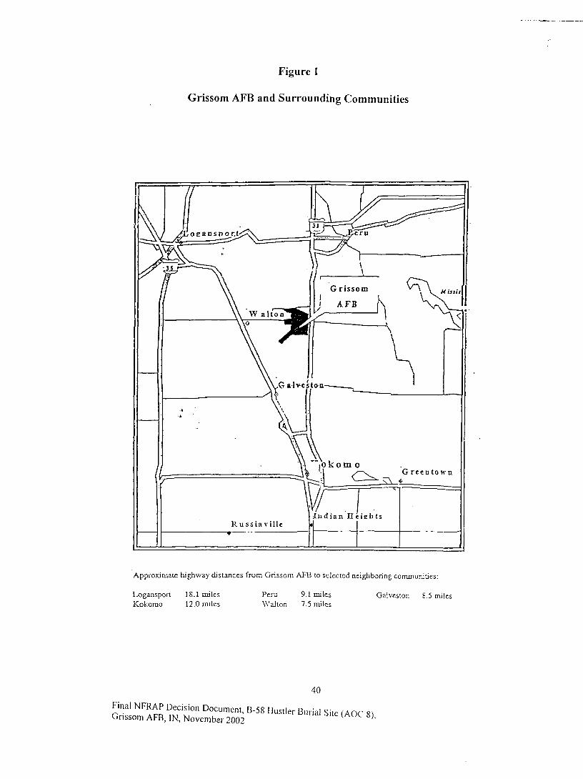
Figure 1
Grissom AFB and Surrounding Communities
Approximate highway distances from Grissom AFB to selected neighboring communities:
Galveston 8.5 milesLogansport 18.1 milesKokomo 12.0 miles
Peru 9.1 milesWalton 7.5 miles
40
Hustier
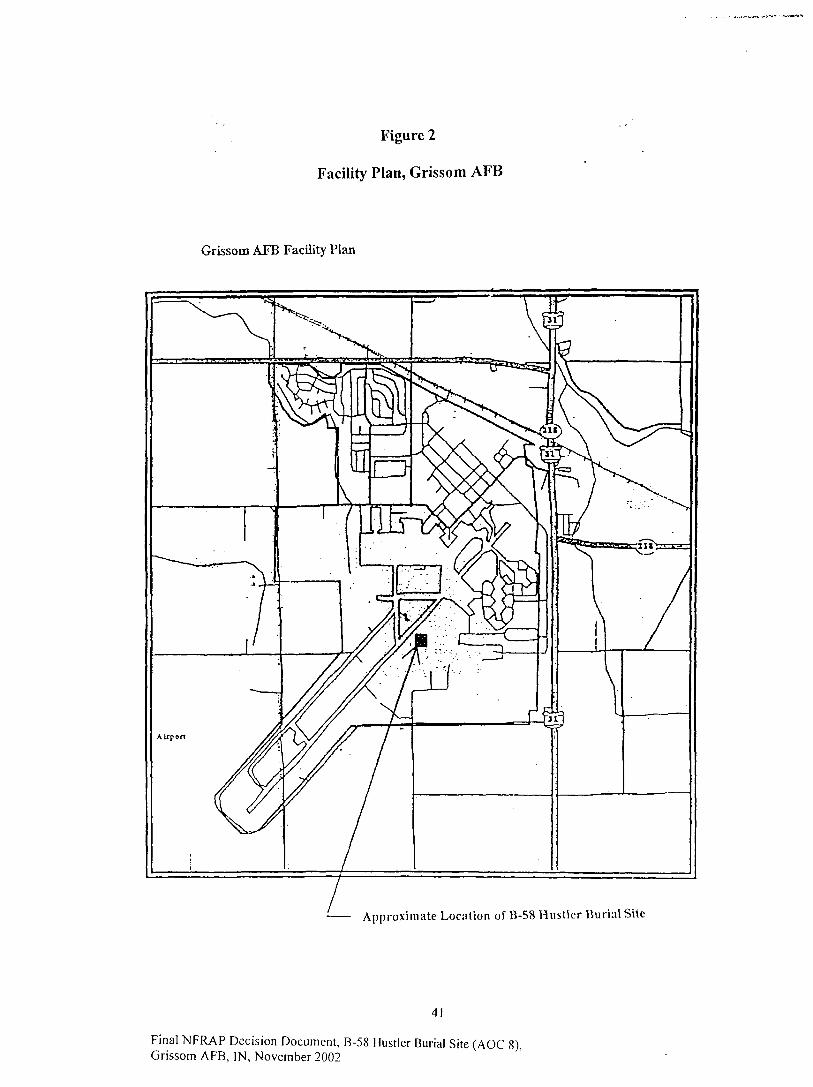
Figure 2
Facility Plan, Grissom AFB
Grissom AFB Facility Plan
Approximate Location of B-58 Hust ler Burial Site
4!
Final NFRAP Decision Document, B-58 Hustler Burial Site (AOC 8)Grissom AFB, IN, November 2002

Figure 3
Generalized Geologic Cross Section, Grissom AFB
Generalized Geologic Cross Section, Grissotn AFB
Wisconsin Age (Ttzcwell Substagc)glacial deposits, clay tnd silty claytill units interbedded with poorly towell sorted sand and gravel.
Basal sand and gravel overlyingfractured and weathered bedrock.
Silurian Age (Niagran Scries)Listen Creek Formation, gray thinlybedded, dolomitic, chcrty limestonecontaining intercalated beds ofchert.
Silurian Age (Niagran Scries)Mississincwa Shale, bluish grayargillaceous, dolomrtic, silty,massive limestone grading into graycalcareous shale.
42
Final NFRAP Decision Document, B-58 Hustler Burial Site (AOC 8),Grissom AFB, IN, November 2002
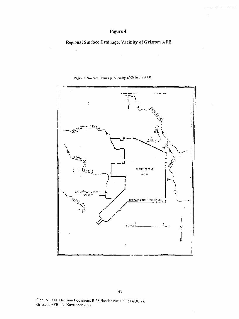
Figure 4
Regional Surface Drainage, Vacinity of Grissom AFB
Regional Surface Drainnge, Vicinity of Grissom AFB
43
Final NFRAP Decision Document, B-58 Hustler Burial Site (AOC 8),Grissom AFB, IN, November 2002
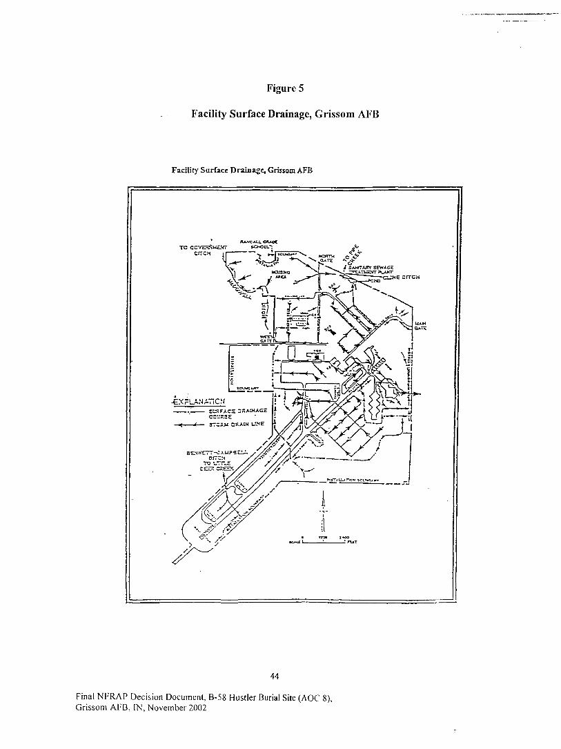
Figure 5
Facility Surface Drainage, Grissom AFB
Facility Surface Drainage, Grissom AFB
RXMTJLU. <7UdCTO GC
44
Final NFRAP Decision Document, B-58 Hustler Burial Site (AOC 8),Grissom AFB, IN, November 2002
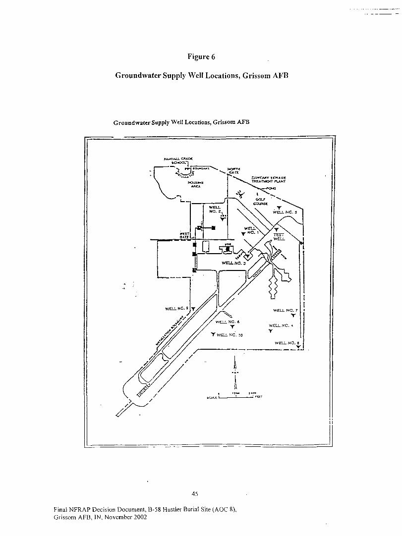
Figure 6
Groundwater Supply Well Locations, Grissom AFB
Groundwatcr Supply Well Locations, Grissom AFB
45
Final NFRAP Decision Document, B-58 Hustler Burial Site (AOC 8),Grissom AFB, IN, November 2002
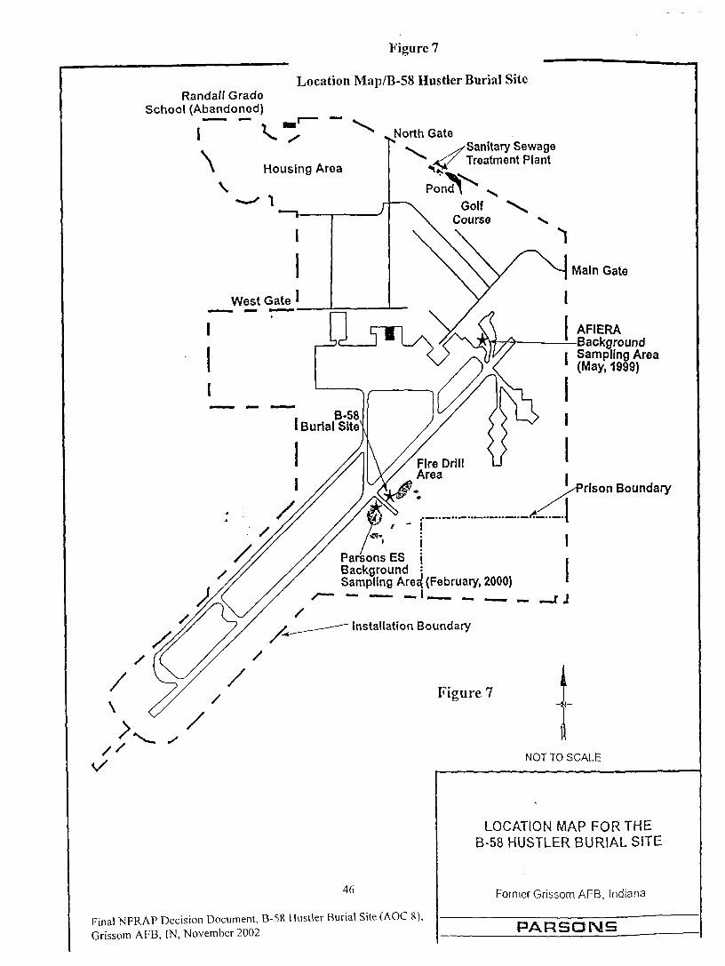
Randall GradeSchool (Abandoned)
Figure 7
Location Map/B-58 Hustler Burial Site
North Gate
\Sanitary SewageTreatment Plant
\Housing Area
, B-58I Burial Site
Parsons ES jBackground •Sampling Area; (February, 2000)
Installation Boundary
Main Gate
AFIERABackground
I Sampling Area1 (May, 1999)
rlson Boundary
r j
Figure 7
NOT TO SCALE
46
Final WRAP Decision Document, B-58 Hustler Burial Site (AOC 8),Grissom AFB, IN, November 2002
LOCATION MAP FOR THEB-58 HUSTLER BURIAL SITE
Former Grissom AFB, Indiana
PARSONS
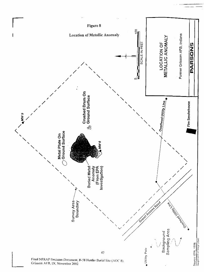
r Figure 8
Location of Metallic Anomaly
\
\\\
\\
fc1 1 1LLJ
LL
z01
<oU)
>-LJ
&SS§0<
6^S32in
2
TOCto
T5
COli.<
Eo(/).w*L-
Oo3
ou.
(n2Qinu
*
47
Final NFRAP Decision Document, B-58 Hustler Burial Site (AOC 8).Grissom AFB, IN, November 2002 r>
•
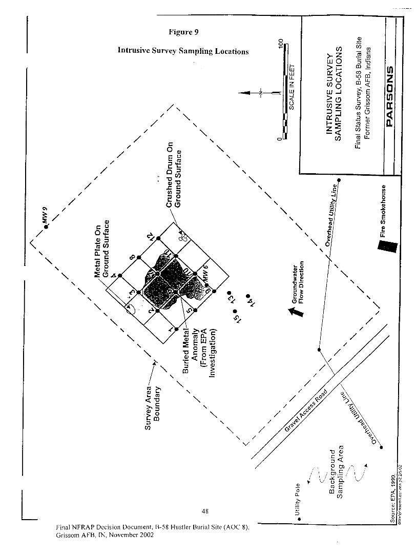
Figure 9
Intrusive Survey Sampling Locations
oo.
LUUL
2
01_l
OCO
CO
ULJ O
INT
RU
SIV
E S
UR
VA
MP
LIN
G L
OC
AT
I
CO
if-jj••£)
3s -D
V «
\ £^ £
0).t:COlo
00ooinCO
CD
3COto
CO"cocu.
COcCO
TD
orm
er G
risso
m A
FB
, In
u.
PA
RS
ON
S
v>o£0)
oE(0
£LL
Final NFRAP Decision Document, B-58 Hustler Burial Site (AOC 8),Grissom AFB, IN, November 2002

Figure 10
Layout of Excavation Site
TTPH-
CONTAM1NATED
SOIL PILES
UNCONTAMINATEDSOIL PILES
SITE TRAILER
49
Final NFRAP Decision Document, B-58 Hustler Buria l Site (AOC 8),Grissom AFB, IN, November 2002
LAYOUT OF EXCAVATION SITE
Final Status Survey, B-58 Burial SiteFormer Grissom AFB, Indiana
PARSQMS
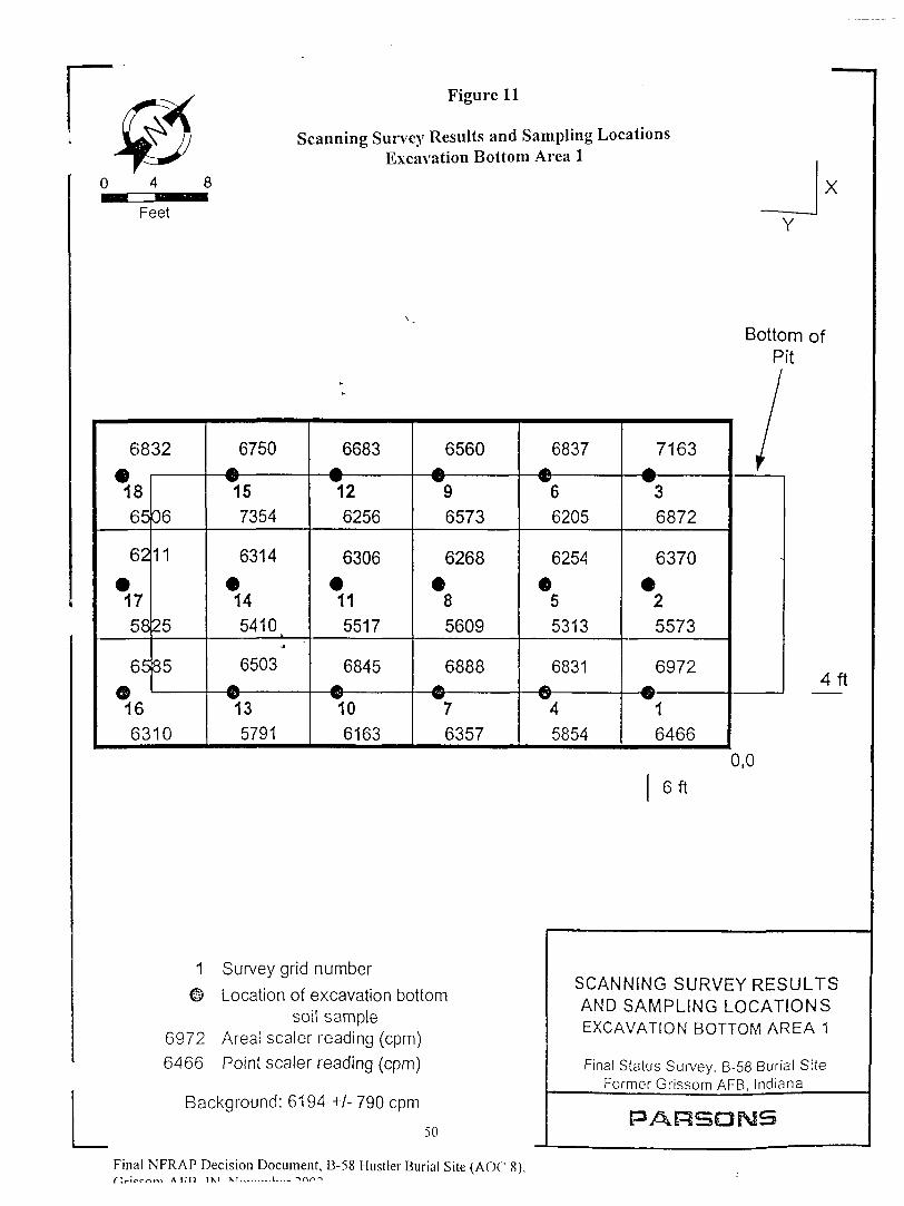
Figure 11
Scanning Survey Results and Sampling LocationsExcavation Bottom Area 1
X
Y
Bottom ofPit
68
1865
62
•1758
65©16
32
06
11
25
35
6310
6750ftV157354
6314
145410 .
•A
6503
135791
6683
126256
6306
115517
6845
106163
6560
96573
6268
•85609
6888
76357
6837«iV66205
6254
•55313
6831
45854
7163
36872
6370
25573
6972AW1
6466
/V
4f t
0,0
6 f t
1 Survey grid number
© Location of excavation bottomsoil sample
6972 Areal sealer reading (cpm)6466 Point sealer reading (cpm)
Background: 6194 +/- 790 cpm
50
Final NFRAP Decision Document, B-58 Hustler Burial Site (AOC 8),r^r-ico^™ ACT) 1X1 M,,.. —I -mn-i
SCANNING SURVEY RESULTSAND SAMPLING LOCATIONSEXCAVATION BOTTOM AREA 1
Final Status Survey. B-58 Burial SiteFormer Grissom AFB, Indiana
PARSONS
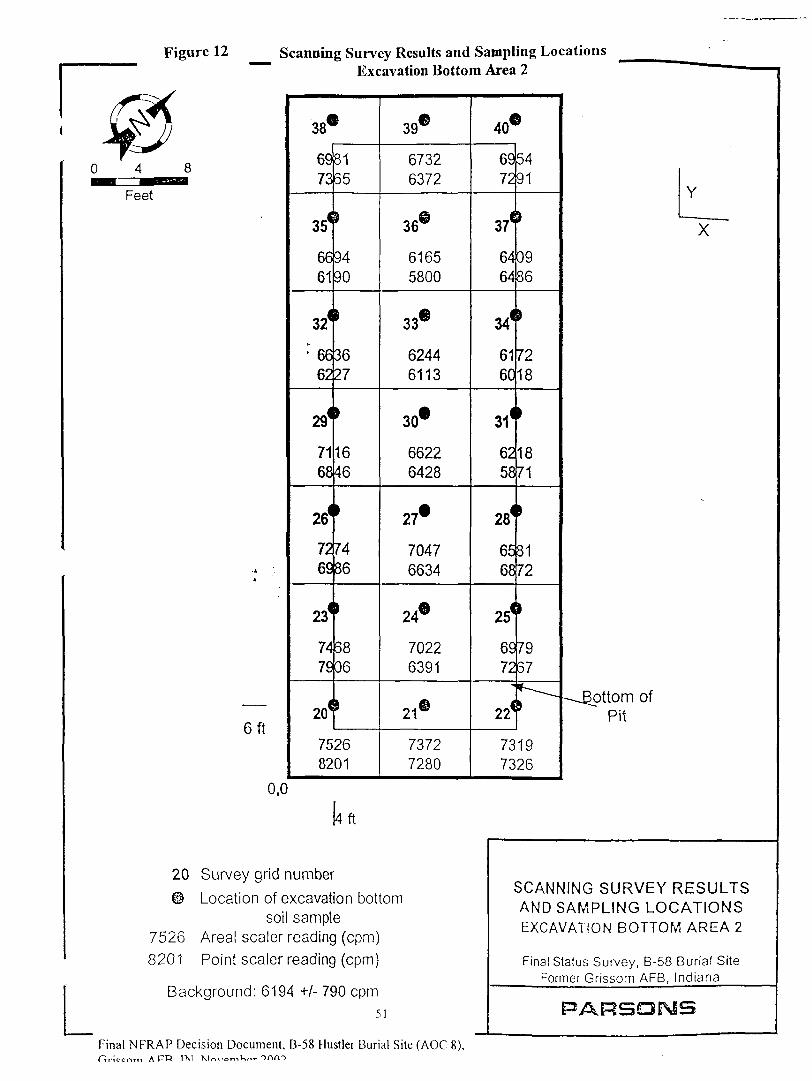
Figure 12 Scanning Survey Results and Sampling Locations
75268201
-AA
en
0,0
Excavation Bottom Area /
38C
6973
35<
6661
324
: 66
62
29*
7168
26*
7269
23*
7479
20*
75
t
8165
>
9490
1
3627
>1646
•7486
•5806
'26
8201
39®
67326372
36®
61655800
33®
62446113
30*
66226428
27*
70476634
24®
70226391
21®
73727280
40®
6972
37<
6464
34*
6160
31(
6258
28*
6568
25(
6972
22*
5491
0986
7218
}
1871
t
8172
7957
'73197326
[4 ft
y grid number
on of excavation bottomsoil sample
sealer reading (cpm)sealer reading (cpm)
id: 6194 +/-790cpm51
- ^^^^^^™
Y
X
-
-Bottom ofPit
SCANNING SURVEY RESULTSAND SAMPLING LOCATIONSEXCAVATION BOTTOM AREA 2
Final Status Survey, B-58 Burial SiteFormer Grissom AFB, Indiana
PARSOMS
Final NFRAP Decision Document, B-58 Hustler Burial Site (AOC 8),Oiccrtm APR 1X1 Mr..

Figure 13 Scanning Survey Results and Sampling LocationsBackfill Soil Pile 1, Lift 1
1 Survey grid number
6324 Areal sealer reading (cpm)
©BF1-1 Location of backfill soil sample
Background: 6194 +/- 790 cpm
52
Final NFRAP Decision Document, B-58 Hustler Burial Site (AOC 8),
SCANNING SURVEY RESULTSAND SAMPLING LOCATIONS
BACKFILL SOIL PILE 1, LIFT 1
Final Status Survey, B-58 Burial SiteFormer Grissom AFB, Indiana
PARSQIMS

Figure 14 Scanning Survey Results and Sampling LocationsBackfill Soil Pile 1, Lift 2
6152
32
6257
31
0BF3-5
6288
30
7021
29
6414
28
" 7202
27
6589
26
6181
25
6038
24
6089
23
6117
22
7975
21
6809
20
6857
19
®BF3-4
6643
18
6001
17
5933
16
5898
15
6190
14
6250
13
6342
12
6697
11
7623
10
©BF3-1
6608
9
5630
8
6051
7
6434
6
6694
5
6788
4
OBF3-2
6696
3
6269
2
63331
1 Survey grid number
6333 Areal sealer reading (cpm)
@ BF3-1 Location of backfill soil sample
Background: 6194 +/- 790 cpm53
Final NFRAP Decision Document, B-58 Hustler Burial Site (AOC 8),Hricc^rr, A Fn IM XI ,u_--vnni
SCANNING SURVEY RESULTSAND SAMPLING LOCATIONSBACKFILL SOIL PILE 1, LIFT 2
Final Status Survey, B-58 Burial SiteFormer Grissom AFB, Indiana
PARSOMS
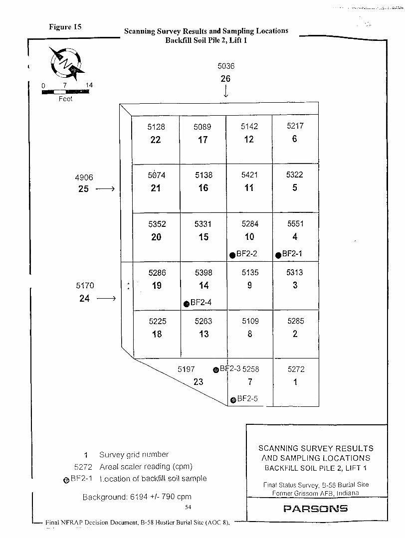
Figure 15
490625
Scanning Survey Results and Sampling LocationsBackfill Soil Pile 2, Lift 1
5036
26
5170
24
i\
-•
\
5128
22
5074
21
5352
20
5286
19
5225
18
5089
17
5138
16
5331
15
5398
14
5263
13
^\^^ 5197 ©B
^\^
5142
12
5421
11
5284
10
0BF2-2
5135
9
5109
8
:2-3 5258
7
©BF2-5
5217
6
5322
5
5551
4
0BF2-1
5313
3
5285
2
5272
1
1 Survey grid number
5272 Areal sealer reading (cpm)
©BF2-1 Location of backfill soil sample
Background: 6194 +/- 790 cpm54
Final NFRAP Decision Document. B-58 Hustler Burial Site (AOC 8),
SCANNING SURVEY RESULTSAND SAMPLING LOCATIONSBACKFILL SOIL PILE 2, LIFT 1
Final Status Survey, B-58 Burial SiteFormer Grissom AFB, Indiana
PARSONS
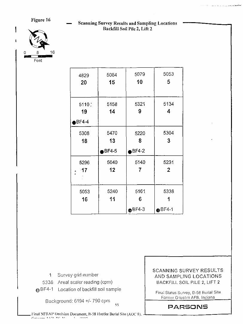
Figure 16Scanning Survey Results and Sampling Locations
Backfill Soil Pile 2, Lift 2
4829
20
5110;19
5308
18
5296
; 17
5053
16
5084
15
5158
14
5470
13
5040
12
5240
11
5079
10
5321
9
5220
8
5140
7
5161
6
©BF4-3
5053
5
5134
4
5304
3
5231
2
5338
1
©BF4-1
1 Survey grid number
5338 Areal sealer reading (cpm)
@BF4-1 Location of backfill soil sample
Background: 6194 +/- 790 cpm55
. Final NFRAP Decision Document, B-58 Hustler Burial Site (AOC 8),^ -;..,- ~«, Aim ix T - K T - . i -.rt,-!-.
SCANNING SURVEY RESULTSAND SAMPLING LOCATIONSBACKFILL SOIL PILE 2, LIFT 2
Final Status Survey, B-58 Burial SiteFormer Grissom AFB, Indiana
PARSOMS

r Figure 17
L
Uranium-238 Radioactive Decay Scheme
U-238T1/? = 4.5E9 years
Th-234T /2 = 24.1 days
Pa-234mT1fi=1.17
minutes
0.9984
0.0016 Pa-234T1/2 = 6.7 hours
U-234T1/2 = 2.4 E5 years
Th-230T1/2 = 8E4 years
Ra-226T1/2 = 1622 years
Rest of U-238Decay Scheme
56
Final NFRAP Decision Document, B-58 Hustler Burial Site (AOC 8),Grissom AFB. IN. November 2002
URANIUM-238 RADIOACTIVEDECAY SCHEME
Final Status Survey, B-58 Burial SiteFormer Grissom AFB, Indiana
PARSONS
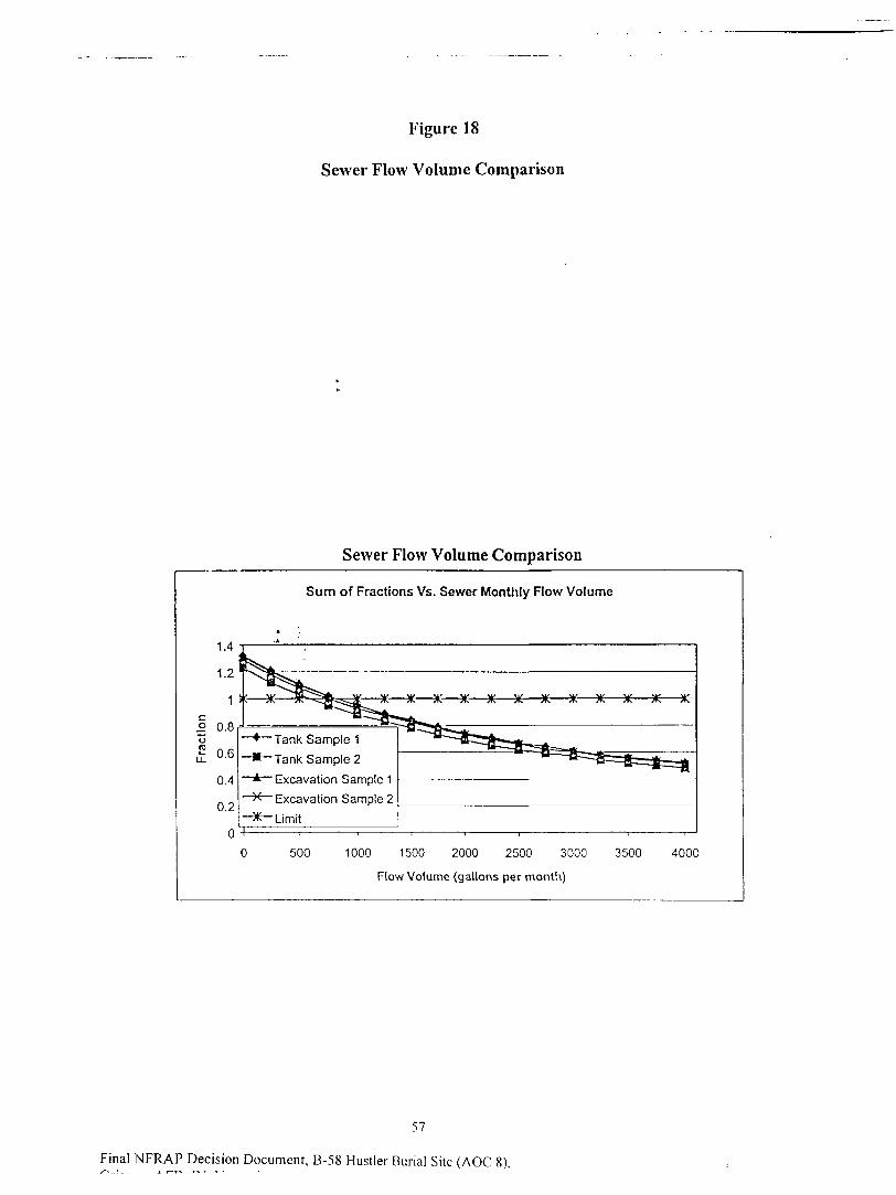
Figure 18
Sewer Flow Volume Comparison
Sewer Flow Volume Comparison
Sum of Fractions Vs. Sewer Monthly Flow Volume
Tank Sample 1
Tank Sample 2
Excavation Sample 1
Excavation Sample 2
* Limit
500 1000 1500 2000 2500 3000
Flow Volume (gallons per month)
3500 4000
57
Final NFRAP Decision Document, B-58 Hustler Burial Site (AOC 8),
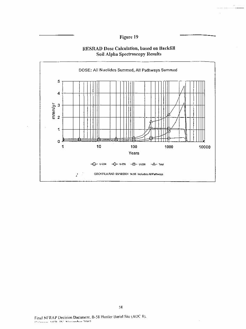
Figure 19
RESRAD Dose Calculation, based on BackfillSoil Alpha Spectroscopy Results
DOSE: All Nuclides Summed, All Pathways Summed
4 .
h- o .>> -5
£E o .f.
1'
0 -.1
=i\Y^
y J
^
f-
\-
J=
—',*• - -'
/
f 1„/T
/i/ i
/I
-10 100 1000
Years
-©- U-234 -^- U-235 -B- U-238 -A- Tolal
-• . GBCKFILA.RAD 05H8/2001 14:56 Includes An Pathways
10000
58
Final NFRAP Decision Document, B-58 Hustler Burial Site (AOC 8),

Figure 20
RESRAD Dose Calculation, based on BackfillSoil Alpha Spectroscopy Results
DOSE: All Nuclides Summed, All Pathways Summed
10000
.-©- U-234 U-235 -&- U-23fl -A- Total
GBCKFILG.RAD 01/29/2002 08:41 Includes All Pathways
59
Final NFRAP Decision Document, B-58 Hustler Burial Site (AOC 8).Grissom AFB, IN, November 2002

Appendix-B, Tables
60
Final NFRAP Decision Document, B-58 Hustler Burial Site (AOC 8),Grissom AFB, IN, November 2002
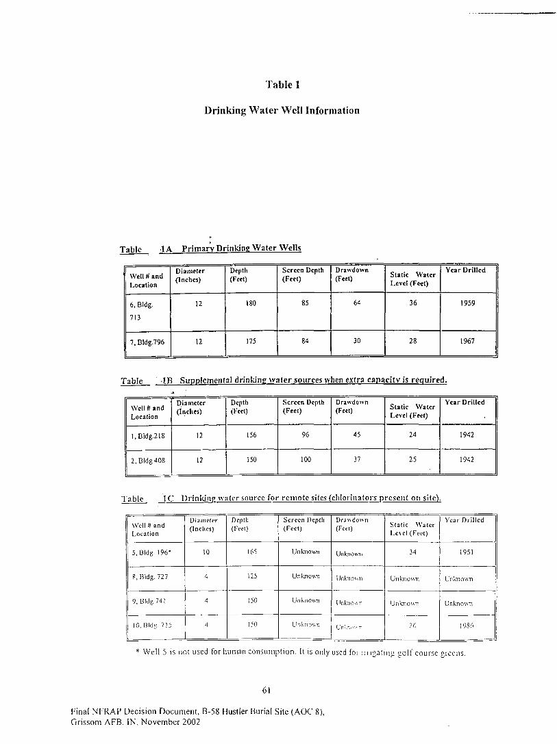
Table 1
Drinking Water Well Information
Table 1A Primary Drinking Water Wells
Well # andLocation
6, Bldg.
713
7, Bldg.796
Diameter(Inches)
12
12
Depth(Feet)
180
175
Screen Depth(Feet)
85
84
Drawdown(Feet)
64
30
Static WaterLevel (Fe«t)
36
28
Year Drilled
1959
1967
Table -IB Supplemental drinking water sources when extra capacity is required.
Well tt andLocation
l .BIdg.218
2, Bldg 408
Diameter(Inches)
12
12
Depth(Feet)
156
150
Screen Depth(Feet)
96
100
Drawdown(Feet)
45
37
Static WaterLevel (Feet)
24
25
Year Drilled
1942
1942
Table 1C Drinking water source for remote sites (chlorinators present on site).
Well H andLocation
5, Bldg. 196*
8, Bldg. 727
9, Bldg 741
10, Hide. 715
Diameter(Indies)
10
4
4
<]
Depth(Feet)
165
125
150
150
Screen Depth(Feet)
Unknown
Unknown
Unknown
Unknown
Drawdown(Feet)
Unknown
Unknown
Unknown
Un'.r,".v.-
Stat ic WaterLevel (Feet)
34
Unknown
Unknown
26
Year Drilled
1951
Unknown
Unknown
19S6
* Well 5 is not used for human consumption. It is only used for i m « a t i n < i coif course creens.
61
Final NFRAP Decision Document, B-58 Hustler Burial Site (AOC 8),
Grissom AFB, IN, November 2002

Table 2
Walk-Over Survey Results
Location/ Measurement Type
Background Area/ Scanning (range,minimum to maximum)
Burial Site/ Scanning (range,minimum to maximum)
Background I/Direct
Background 2/Direct
Background 3/Direct
Burial Site I/Direct
Burial Site 2/Direct
Burial Site 3/Direct
2" x 2" Nal Detector
(cpm) "
6,500 to 9,000
5,400 to 7,900
6,944
7,488
9,722
7,635
7,700
7,600
FIDLER
(cpm)
6,000 to 10,000
5,000 to 10,000
7317
7,895
9,858
8,554
8,788
9,356
cpm = counts pcr»minute.
62
Final NFRAP Decision Document, B-58 Hustler Bvirial Site (AOC 8),Grissom AFB, IN, November 2002
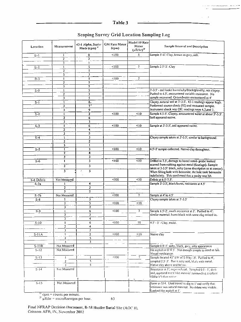
Table 3
Scoping Survey Grid Location Sampling Log
Location
B-l
B-2
B-3
S-0
S-l
S-2
S-3
S-4
S-5
S-6
S-6 DebrisS-7a
S-7bS-8
S-9
S-10
S-11A
S-l IBS-l 2
S-l 3
S-l 4
S-l 5
n
Measurement
1231231231231
231231231231231
2
3 ;;
Not Measured123
Not Measured
123123123123
Not Measured
Not Measured
123
Not Measured
1Not Measured
43-1 Alpha, SealerMode (cpm) "
021
553155535
8,7"9263645
321
3833
3
5
432
352624
642253
155
CM Rate Meter(cpm)
<100
<100
<100
<100
<100
<100
<100
<100
<100
<100
<100
<100
<100
<100
Model 1 9 RateMeter
(uR/hr)"
5
7
7
<10
<10
<10
<10
<10
7
<10
7
10
<10
7
Sample Interval and Description
Sample 5'-6'. Clay, brown to grey, soft.
Sample 2.5'-3'. Clay
3'-3.5' - soil looks bumt/ashy/black/gravelly, not clayey.Pushed to 4.5', encountered variable resistance. Nosample recovered. Groundwater encountered at 4'
Clayey, natural soil at 3'-3.5'. 43-1 readings appear high.Performed source check (92) and recounted sample.Instrument check was OK: readings were 4,3,and 1 .
Sample 4.5-5'. Clayey, encountered water at about 5'-5.5'.Soil appeared native.
Sample at 3'-3.5', soil appeared native.
Clayey sample taken at 3'-3.5', similar to background.
4.5'-5' sample collected. Native clay throughout.
Drilled to 7.5', damage to barrel noted- probe lookedscarred from rubbing against metal (fuselage). Sampletaken at 3-3.5': black, ashy (same description as at center).When filling hole with bentonite, the hole took benloniteindefinitely. This confirmed that a cavity was hit.Debris at 6.5'-7.5'.Sample 3'-3.5', black/burnt, resistance at 4.5'
Sample at 4' to 4.5'
Clayey sample taken at 3'-3.5'
Sample l.5'-2', much resistance at 2'. Pushed to 4';similar material: burnt black with some clay mixed in.
4.5' -5' -Clay, moist.
Native clay
Sample 0.5'-!'; ashy, black, grey, silty appearance
Hit asphalt at 0'-0.5'. Not enough sample to send to lab.Visual verification.
Sample located 45° S\V of S-9 by 15'. Pushed to 4',sampled 2.5'-3'. Burnt ashy soil, black with metal.Native clay above and below.
Resistance al 1'; auger refusal. Sampled 0.5 - 1', darksoil, appeared more like material surrounding airplane('fill/ash'') lhan native
SameasSM. Used trowel (o dig to I1 and verify thatresistance was natural material. No debris was visible.Looked like asphalt al 1'.
J |aR/hr = microRocntgcn per hour. 63
Final NFRAP Decision Document, B-58 Hustler Burial Site (AOC 8),Grissom AFB, IN, November 2002

Table 4
Analytical Results from Intrusive Characterization Survey(Parsons, 2000)
SampleLocation
Analytc
Am-24I
Cone.(pCi/g) "
95%Uncertainty
Th-232
Cone.(PCi/g)
95%Uncertainty
Th-234
Cone.(PCi/g)
95%Uncertainty
U-235
Cone.(PCi/g)
95%Uncertainly
Background
Bl
B2
B3
<0.1 v
<0.2
<0.1
0.5
1
0.6
+/-0.3 v
+/-0.4
+/-0.3
<1
<2
<1.3
<0.1
<0.2
<0.1
Site
SO
SI
S2
S3
S4
S5
S6
S6 Debris
S7A
S7B
S8
S9
S10
S11A
SUB
S12
S13
S14
<0.1
<0.1
<0.2
<O.I
<0.2
<0.2
<0.2
<0.2
<0.2
<0.1
<0.2
<0.1
<O.I
<0.2 ;
<O.I
<0.2
<0.1
<0.1
-
<0.4
0.7
1.3
0.5
<0.7
0.6
0.9
0.4
0.6
0.4
0.8
0.8
0.7
0.7
0.5
<0.6
<0.4
<0.3
+/-0.3
+/-0.4
+/-0.3
+/-0.5
+/-0.5
+/-0.3
+/-0.2
+/-0.5
+/-0.3
+/-0.4
+/-0.6
+/-0.3
2.7
<1.3
<2.1
<1.4
<2.1
<2
<2
<2.5
14
12
<2
<1.3
1. 8
<2
<1.3
<2
<1.3
<1.2
+/-I.2
+/-2.S
+/-1.7
+/-I.4
<O.I
<0.1
<0.2
0.2
<0.2
<0.1
<0.2
<0.2
<0.2
0.2
<0.2
<0.1
<0.1
<0.2
<0.1
<0.2
<0.l
<0.1
+/-0.1
+/-0.09
" pCi/g = picocuries per gram.
^ < — Sample quantity was less than the minimum delectable concentration.
" +/- = For detected sample, the 95% uncertainty is reported.
64
Final NFRAP Decision Document, B-58 Hustler Burial Site (AOC 8),Grissom AFB, IN, November 2002
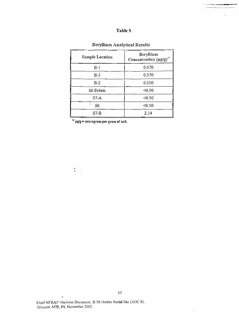
Table 5
Beryllium Analytical Results
Sample Location
B-l
B-3
B-2
S6 Debris
S7-A
' S6
S7-B
BerylliumConcentration (ug/g)"
0.670
0.570
0.550
<0.50
<0.50
<0.50
2.14
microgram per gram of soil.
65
Final NFRAP Decision Document, B-58 Hustler Burial Site (AOC 8),Grissom AFB, IN, November 2002

Table 6
RESRAD Input Parameters for DCGLw Calculations
INPUT PARAMETER
PATHWAY
External gamma
Inhalation (except radon)
Plant ingestion
Meat ingestion
Milk ingestion
Aquatic foods
Drinking water
Soil ingestion
Radon
DEFAULT VALUE
Value
--
-
-
r-
-
-
-
-
Units
-
--
-
-
-
-
-
-
-
USER INPUT
Residential Scenario
from Work Plan
Value
Active
Active
Active
Active
Active
Suppressed
Active
Active
Active
Basis
-
-
-
--
-
Site location
-
-
-
FSS RESRAD Updates
Value
Active
Active
Active
Active
Active
Suppressed
Active
Active
Active
Basis
-
-
-
-
-
Site location
-
-
-
SOIL CONCENTRATIONS
Initial Concentration (pCL/g)
Uranium-234
Uranium-235
Uranium-238
Americium-241
Thorium-232 A
--
-
-
-
-
-
-
-
-
-
100
100
100
-
-
sec -Secviiw 4.i.|
-
-
100
100
100
100
100
see -See-vie* 4.1.1
Transport Factors
Distribution coefficient
Saturated Zone
Uranium-234
Uranium-235
Uranium-238
50
50
50
cm'/g
cm'/g
cmVg
81.5to1,600
81.5 to1,600
81.5lo•1,600
US DOE, 1993
1600
1600
1600
USDOE, 1993 andParsons, 2000
Contaminated and Unsaturated Zones
Uranium-234
Uranium-235
Uranium-238
Number of Unsaturated Zones
50
50
50
1
cm'/g
cm'/g
cm'/g
-
81.5 to1,600
81.5 to1,600
81.5 to1,600
1
USDOE, 1993
-
1600
1600
1600
1
USDOE, 1993 andParsons, 2000
-
66
Final NFRAP Decision Document, B-58 Hustler Buria l Site (AOC 8),Grissom AFB, FN, November 2002
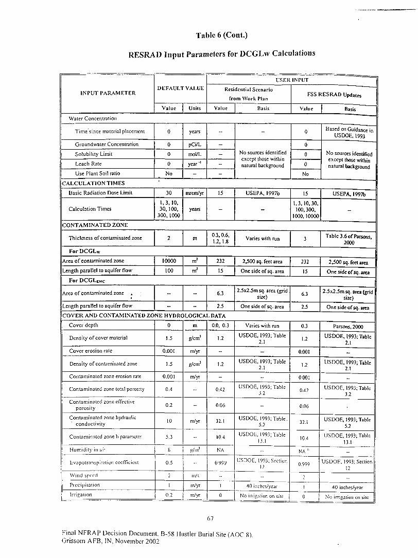
Table 6 (Cont.)
RESRAD Input Parameters for DCGLw Calculations
INPUT PARAMETERDEFAULT VALUE
Value Units
USER
Residential Scenario
from Work Plan
Value Basis
INPUT
FSS RESRAD Updates
Value
Water Concentration
Time since material placement
Groundwater Concentration
Solubility Limit
Leach Rate
Use Plant Soil ratio
CALCULATION TIMES
Basic Radiation Dose Limit
Calculation Times
CONTAMINATED ZONE
Thickness of contaminated zone
For DCGLw
Area of contaminated zone
Length parallel to aquifer flow
For DCGLtMc
Area of contaminated zone .A
Length parallel to aquifer flow
0
0
0
0
No*"
30
1.3,10,30,100,
300, 1000
2
10000
100
-
--
years
pCi/L
mol/L
year "'
-
mrem/yr
years
--
-
-
-
-
15
-
-
No sources identifiedexcept those withinnatural background
0
0
0
0
No
Basis
Based on Guidance inUSDOE, 1993
No sources identifiedexcept those withinnatural background
US EPA, 1997b
-
15
1,3.10,30,100,300,
1000,10000
USEPA, 1997b
-
m
m2
m2
-
-
0 3, 0.6,1.2,1.8
232
15
6.3
2.5
Varies with run 3 Table 3.6 of Parsons,2000
2,500 sq. feet area
One side of sq. area
232
15
2,500 sq. feet area
One side of sq. area
2.5x2.5m sq. area (gridsize)
One side of sq. area
6.3
2.5
2.5x2 .5m sq. area (gridsize)
One side of sq. area
COVER AND CONTAMINATED ZONE HYDROLOGICAL DATA
Cover depth
Density of cover material
Cover erosion rate
Density of contaminated zone
Contaminated zone erosion rate
Contaminated zone total porosity
Contaminated zone effectiveporosity
Contaminated zone hydraulicconductivity
Contaminated zone b parameter
H u m i d i t y in a i r
Evapotranspira l ion coefficient
Wind speed
Prec ip i ta t ion
Irrigation
0
1.5
0.001
1.5
0.001
0.4
0.2
10
5.3
8
0.5
2
1
0.2
m
g/cm'
m/yr
g/cm'
m/yr
-
-
m/yr
--
g/m'
-
ni/s
m/yr
m/yr
0.0, 0.3
1.2
-
1.2
-
0.42
0.06
32.1
10.4
NA
0.999
--
1
0
Varies with run
USDOE, 1993; Table2.1
-
USDOE, 1993; Table2.1
-
USDOE, 1993; Table3.2
--
USDOE, 1993; Table5.2
USDOE, 1993; Table13.1
-
USDOE, 1993; Section1 2
40 inches/year
No irrigation on silc
0.3
1.2
0.001
1.2
0.001
0.42
0.06
32.1
10.4
NA "
0.999
2
!
0
Parsons, 2000
USDOE, 1993; Table2.1
-
USDOE, 1993; Table2.1
-
USDOE, 1993; Table3.2
-
USDOE, 1993; TableS3.
USDOE, 1993; Table13.1_
USDOE, 1993; Section12
_
40 inches/year
No irrigation on site
67
Final NFRAP Decision Document, B-58 Hustler Burial Site (AOC 8).Grissom AFB, IN, November 2002

Table 6 (Cont.)
RESRAD Input Parameters for DCGLw Calculations
INPUT PARAMETER
Irrigation mode
Runoff Coefficient
Watershed area for nearby stream orpond
Accuracy for water/soil computation
DEFAULT VALUE
Value Uni ts
Overhead
0.2
l.OOE+06
0.001
m!
USER INPUT
Residential Scenario
from Work Plan
Value
NA
0.3
--
--
Basis
For overhead
USDOE, 1993; Table10.1
-
-
FSS RESRAD Updates
Value
NA
0.3
l.OOE+06
0.001
Basis
For overhead
USDOE, 1993; Table10.1
-
-
SATURATED ZONE HYDROLOGICAL DATA
Density of saturated zone
Saturated zone total porosity
Saturated zone effective porosity
Saturated zone hydraulicconductivity
Saturated zone hydraulic gradient
Saturated zone b parameter.
Water table drop rate
Well pump intake depth (belowwater table)
Model: nondispersion (ND) or massbalance (MB)
-A
Well pumping rale •»
1.5
0.4
0.2
100
0.02
5.3
0.001
10
ND
250
g/cm3
.
-
m/yr
-
-
m/yr
m
mVyr
1.2
0.42
0.06
32.1
0.007
10.4
-
4.4
-
-
USDOE, 1993; Table2.1
USDOE, 1993; Table3.2
USDOE, 1993; Table5.2
USDOE, 1993; Section15
USDOE, 1993; Table13.1
-
Well logs
-
Default, as no activewells in the area
1.2
0.42
0.06
32.1
0.007
10.4
0.001
4.4
-
250
USDOE, 1993; Table2.1
USDOE, 1993; Table32
USDOE, 1993; Table5.2
USDOE, 1993; Section15
USDOE, 1993; Table13.1
-
Well logs
-
Default, as no activewells in the area
UNCONTAMINATED UNSATURATED ZONE PARAMETERS
Number of unsaturated zones 1 - I - 1 -
linsaturated zone I
Thickness
Soil density
Total porosily
Effective porosity
Hydraulic conductivity
Soil-specific b parameter
4
1.5
0.4
0.2
10
5.3
m
g/cm'
--
--
m/yr
-
varies withrun
1.2
0.42
0.06
32.1
10.4
Varies with run; =Dcpthto GW (5 to 10f t ) -
Thickness ofContaminated Zone
USDOE, 1993; Table2.1
USDOE, 1993; Table3.2
USDOE, 1993; Table5.2
USDOE, 1993; Table13.1
0
1.2
0.42
0.06
32.1
10.4
Conservative valuebased on analysis in
Parsons, 2000
USDOE, 1993; Table2.1
USDOE, 1993; Table3.2
USDOE, 1993; Table5.2
USDOE, 1993; Table13.1
OCCUPANCY
Inhalat ion rale
Mass loading for inha la t ion
Exposure d u r a t i o n
Indoor dus t filtration factor
External gamma shielding factor
S400
0.0001
30
0.4
0.7
m'/yr
g/m j
y---
1 1,000
0.001
30
USEPA, 1997a
USDOE, 1993; Section35
USEPA, 1990
- -
-
68
Final NFRAP Decision Document, B-58 Hustler Burial Site (AOC 8),Grissom AFB, IN, November 2002
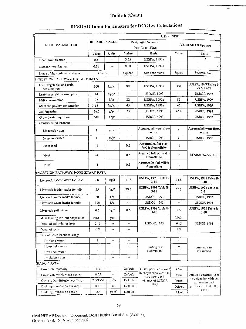
Table 6 (Cont.)
RESRAD Input Parameters for DCGLw Calculations
INPUT PARAMETER
Indoor time fraction
Outdoor time fraction
Shape of ihc contaminated zone
DEFAULT VALUE
Value
0.5
0.25
Units
-
-
Circular
USER
Residential Scenario
from Work Plan
Value
0.65
0.08
Square
Basis
USEPA, 1997a
US EPA, 1997a
Site conditions
INPUT
FSS RESRAD Updates
Value
/Square
INGESTION PATHWAY, DIETARY DATA
Fruit, vegetable, and grainconsumption
Leafy vegetable consumption
Milk consumption
Meat and poultry consumption
Soil ingestion
Groundwater ingestion
160
14
92
;6336.5
510
kg/yr
kg/yr
L/yr
kg/yr
E'yr
Uyr
301
--
82
45
73
-
USEPA, 1997a
USDOE, 1993
USEPA, 1997a
USEPA, 1997a
USDOE, 1993
USDOE, 1993
301
-
82
45
43.8
-
Basis
Site conditions
USEPA, 1999 Tables 9-29 & 12-23
USDOE, 1993
USEPA, 1999
USEPA, 1999
USDOE, 1993
USDOE, 1993
Contaminated fractions
Livestock water
Irrigation water
Plant food
Meat
Milk
1
1
-1
-I
-1
m/yr
m/yr
1
1
0.5
0.5
0.5
Assumed all water fromonsite
USDOE, 1993
Assumed half of plantfood is from offsite
Assumed half of meat isfrom offsite
Assumed half of milk isfrom offsite
1
I
-1
-1
-1
Assumed all water fromonsite
USDOE, 1993
RES RAD to calculate
INGESTION PATHWAY, N.pNDIETARY DATA
Livestock fodder intake for meat.
Livestock fodder intake for milk
Livestock water intake for meat
Livestock water intake for milk
Livestock soil intake
Mass loading for foliar deposition
Depth of soil mixing layer
Depth of roots
68
55
50
160
0.5
0.0001
0.15
0.9
kg/d
kg/d
Ud
L/d
kg/d
g/m!
m
m
11.8
20.3
-
-
0.5
-
--
--
USEPA, 1998 Table B-3-10
USEPA, 1998 Table B-3-11
USDOE, 1993
USDOE, 1993
USEPA, 1998 Table B-3-10
USDOE, 1993
11.8
20.3
-
-
0.5
0.0001
0.15
0.9
USEPA, 1998 Table B-3-10
USEPA, 1998 Table B-3-11
USDOE, 1993
USDOE, 1993
USEPA, 1998 Table B-3-10
USDOE, 1993
Groundwater fractional usage
Drinking water
Household water.
Livestock water
Irrigation water
1
1
1
1
-
-
-
-
--
-
--
--
Limiting caseassumption
-
-
-
-
Limiting caseassumption
RADON DATA
Cover total porosity
Cover volumetr ic water content
Cover radon d i f f u s i o n coefficient
B u i l d i n g foundation thickness
B u i l d i n g foundation density
0.4
0.05
2.00E-06
0.15
2.4
-
,nj/s
m
g/cm1
Defaul t
Defaul t
Dcfau l i
Default
Default
Defaul t parameters usedin conjunction with s i te
parameters andg u i d a n c e of USDOE.
1993
Dcfauk
Defaul t
De fau l t
Dcfauh
Defau l t
Defaul t parameters usedin conjunct ion with s i te
parameters andguidance of USDOE,
1993
69
Final NFRAP Decision Document, B-58 Hustler Burial Site (AOC 8),Grissom AFB. IN, November 2002
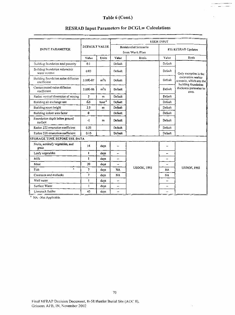
Table 6 (Cont.)
RESRAD Input Parameters for DCGLw Calculations
IN PUT PARAMETER
Building foundation total porosity
Building foundation volumetricwater content
Building foundation radon diffusioncoefficient
Contaminated radon diffusioncoefficient
Radon vertical dimension of mixing
Building air exchange rate
Building room height
EJuilding indoor area factor
Foundation depth below groundsurface
Radon 222 emanation coefficient
P^adon 220 emanation coefficient
DEFAULT VALUE
Value
O.I
0.03
3.00E-07
2.00E-06
2
<fc
2.5
0
-1
0.25
0.15
Units
m2/s
mVs
m
hour'1
m
m
USER INPUT
Residential Scenario
from Work Plan
Value
Default
Default
Default
Default
Default
Default
Default
Default
Default
Default
Default
Basis
FSS RESRAD Updates
Value
Default
Default
Default
Default
Default
Default
Default
Default
Default
Default
Default
Basis
Only exception is theexcavation worker
scenario, which sets thebuilding foundation
thickness parameter tozero.
STORAGE TIME BEFORE USE DATA
Fruits, nonleafy vegetables, andgrain
Leafy vegetables
Milk
Meat
Fish
Crustacea and mollusks
Well water
Surface Water
Livestock fodder
14
1
1
20
7
7
1
1
45
days
days
days
days
days
days
days
days
days
-
-
-
-
NA
NA
-
-
-
USDOE, 1993
-
-
-
-
NA
NA
-
-
--
USDOE, 1993
" NA - Not Applicable.
70
Final NFRAP Decision Document, B-58 Hustler Burial Site (AOC 8),Grissom AFB, IN, November 2002

Table 7
Gross DCGL Equation
Gross DCGL =
Where:
f = expected activity fraction of isotope
1f U-234
DCGLu.j,,_j * U-235
DCGL^j,, ^ U-238
DCGL,.^
Table 8
Uranium Isotope Activity Fractions
Uranium Isotope Activity Fractions
Radionuclidc
U-234
U-235
U-238
Depleted ActivityFraction "
0.13
0.01
0.86
Enriched ActivityFraction v
0.97
0.03
3E-4
"The depleted activity fractions arc based on the weight fractions of u r an ium depleted to 99.8 weight percent U-238and 0.2 weight percent U-235 (AFIERA, 2000).
y The enriched uranium activity fractions are based on the generic fractions for uranium enriched to 93.5 weightpercent U-235 (Derived from AFIERA).
71
Final NFRAP Decision Document, B-58 Hustler Burial Site (AOC 8),Grissom AFB, IN, November 2002

Table 9
Gross DCGL Comparison
DCGLW
(pci/g) 3/
DCGLEMC
(pCi/g)
Depleted U
Enriched U(93.5 wt %)4/
Depleted U
Enriched U(93.5wt%)
Excavation"Worker
(15mrem/yr)
506.0
508.1
3593.8
5648.6
PrisonResident
(15 mrem/yr)
122.1
234.5
161.4
677.0
PrisonResidential
Farmer(15 mrem/yr)
101.8
171.3
135.7
384.6
ResidentialFarmer
(15 mrem/yr)
111.0
184.4
150.2
422.3
Resident(15 mrem/yr)17
133.4
95.1
199.4
289.5
" mrem/yr = millirem per year.^ Resident scenario results from Grissom FSS Work Plan (Parsons, 2000).J/ pCi/g = picocuries per gram.41 93.5 wt % = Uranium that has been enriched to a 93.5 weight percentage of uranium-235.
Table 10
Derived Concentration Guideline Limits
Radionuclide
Am-241
Th-232
U-234
U-235
U-238
Am-241
Th-232
U-234
U-235
U-238
DCGLW (pCi/g) "
Resident(15 mrem/yr) y
ND3'
ND
103.1
26.8
147.4
ResidentialFarmer
(15 mrem/yr)
86.9
1.1
228.9
25.1
107.5
ExcavationWorker
(15 mrem/yr)
122.4
5.9
520.6
824.3
509.0
PrisonResidential
Farmer(15 mrem/yr)
82.2
1.0
214.2
22.7
98.6
PrisonResident
(15mrem/yr)
113.3
1.1
318.0
24.5
117.4
DCGLEMC (pCi/g)
ND
ND
734.1
35.9
206.1
266.7
1.4
738.0
28.3
141.4
2584.0
41.8
6726.0
906.8
3486.0
244.3
1.2
677.7
25.5
127.7
548.6
1.3
2524.0
27.2
150.1
" pCi/g = picocuries per gram.v mrcm/yr = mil l i rem per year; Resident scenario results from Grissom FSS Work Plan (Parsons, 2000)3/ ND = Not determined.
72
Final NFRAP Decision Document, B-58 Hustler Burial Site (AOC 8),Grissom AFB, IN. November 2002

Table 11
Length of Square Grid Equation
where:
L = length of side,
A = area of excavation,h
n = number of samples
Table 12
Final Status SurveyGrid Size Information
Area Name
Bottom Area 1
Bottom Area 2
Pile l . L i f t l
Pile 1, Lift 2
Pile 2, Lift 1
Pile 2, Lift 2
Dimensions
53 ft x 25 ft
57 ft x 27 ft
75 ft x 45 ft
100 ft x 50 ft
80 ft x 65 ft
90 ft x 70 ft
Area(ft2)
1325
1539
3375
5000
5200
6300
ReqM Number ofSamples
18
21
2 4 "
2 4 "
2 4 "
24"
Length ofSide (ft)
8
8
11
14
14
16
" Used in grid size calculation only.
73
Final NFRAP Decision Document, B-58 Hustler Burial Site (AOC 8),Grissom AFB, IN, November 2002

Table 13
Background Radiation Levels
Analytical Background "
A.mericium-241
Thorium-232
Uranium-234
Uranium-235
Uranium-238
AverageConcentration
(pCi/g)
0
0.66
0.82
0.67
0.77
StandardDeviation
(pCi/g)
0
0.21
0.48
0.3
0.48
" Compiled from Scoping Survey (Parsons,2000) and AFIERA Characterization Report(AFIERA, 2000).
Gamma Scanning Background
Meter 1 02 (FDDLER)
Measurement
1
2
3
4
5
6
7
8
9
10
11
12
13
14
15
Average
Standard Deviation
Sealer(cpm)
6799
7089
7222
6990
6797
5067
4972
4900
6591
5492
6233
6501
6331
6278
5641
6194
790
Meter(cpm)
7000
7000
7000
7000
7000
5000
5000
5000
6500
5500
6500
7000
6500
6500
6000
6300
897
74
Final NFRAP Decision Document, B-58 Hustler Burial Site (AOC 8),Grissom AFB, IN, November 2002
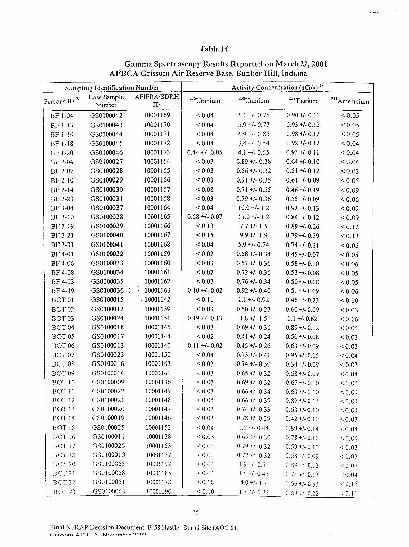
Table 14
Gamma Spectroscopy Results Reported on March 22, 2001AFBCA Grissom Air Reserve Base, Bunker Hill, Indiana
Sampling Identification
'arsons ID
BF 1-04BF 1-13BF 1-14
BF1-18BF 1-20BF 2-04BF 2-07BF2-10BF2-14BF 2-23BF 3-04BF3-10BF3-19BF3-21BF3-31BF4-01BF 4-06BF 4-08BF4-13BF4-19BOT01EOT 02EOT 03EOT 04EOT 05EOT 06EOT 07EOT 08EOT 09EOT 10EOT 11EOT 12EOT 13EOT 14EOT 15EOT 16EOT 17EOT 18BOT20EOT 21EOT 22DOT 23
Base SampleNumber
GSO 100042GS0100043GSO 100044GSO 100045GSO 100046GS0100027GSO 100028GS0100029GSO 100030GS0100031GS0100037GS0100038GSO 100039GSO 100040GS0100041GS0100032GSO 100033GSO 100034GS0100035GS0100036 •*GS0100015GS0100012GSO 100024GS0100018GS0100017GS0100013GS0100023GS0100016GS0100014GSO 100009GSO 100022GSO 100021GSO 100020GS0100019GS0100025GS0100011GSO 100026GS0100010GSO 100065GSO 100058GS0100051GSO 100063
NumberAFIERA/SDRH
ID
10001169100011701000117110001172100011731000115410001155100011561000115710001158100011641000116510001166100011671000116810001159100011601000116110001162
: 1000116310001142100011391000115110001145100011441000114010001150IOOOI1431000114110001136100011491000114810001147100011461000115210001138100011531000113710001192100011851000117810001190
Activity Concentration (pCi/g) "
235Uranium
<0.04<0.04<0.04<0.04
0.44 +/- 0.05<0.03<0.03<0.03<0.08<0.03<0.04
0.58 +/- 0.07<0.13<0.15<0.04<0.02<0.03<0.02<0.03
0.10+/-0.02<0.11<0.03
0.19 +/- 0.13<0.03<0.02
0.11+/-0.02<0.04<0.03<0.03<0.03<0.03<0.04<0.03<0.03<0.04<0.03<0.03<0.03<0.04<0.04<0.18<0.10
238Uranium
6.1 +/-0.785.9 +/- 0.736.9 +/- 0.853.4 +/- 0.544.1 +/-0.550.89 +/- 0.380.56 +/- 0.320.91 +/-0.350.7 !+/- 0.550.79 +/- 0.3610.0+/- 1.211.0 +/- 1.27.7+/-1.59.9 +/- 1.95.9 +/- 0.74
0.58 +/- 0.340.57 +/- 0.360.72 +/- 0.360.76 +/- 0.340.92 +/- 0.401.1+/-0.92
0.50 +/- 0.271.8+/-1.5
0.69 +/- 0.360.4 !+/- 0.240.45 +/- 0.260.75 +/- 0.410.74 +/- 0.300.65 +/- 0.320.69 +/- 0.320.66 +/- 0.340.66 +/- 0.390.74 +/- 0.330.78 +/- 0.29
1.1 +/-0.440.65 +/- 0.30
0.79+/-0.320.72 +/-0.321.9+/-0 .511.5 +/- 0.454.0+/- 1.71 .3+/ -0 .7!
^Thorium
0.90 +/- 0.110.93+/-0.120.98+/-0.120.92+/-0.120.93 +/- 0.110.64 +/- 0.10
0.51+/-0.120.61 +/- 0.09
0.46+/-0.190.55 +/- 0.090.92+/-0.130.84+/-0.120.89 +/- 0.260.79 +/- 0.390.74 +/- 0.110.45 +/- 0.070.58 +/- 0.100.52 +/- 0.080.50+/-O.OS0.5 !+/- 0.090.46 +/- 0.230.60 +/- 0.091.1+/-0.62
0.89+/-O.I20.50 +/- 0.08
0.63 +/- 0.090.95+/-0.150.54 +/- 0.09
0.68 +/- 0.090.67 +/- 0.100.63 +/- 0.100.87+/-0.130.63 +/- 0.100.42 +/- 0.100.89+/-0.140.78 +/- 0.100.59+/-0.100.6S+/-0.09O.S9+ / -0 .130.74 +/-0.13
0.66 +/- 0.530.64 +/-0"
24 1 AAmencium
<0.05<0.05<0.05<0.04<0.04<0.04<0.03<0.05<0.09<0.06<0.09<0.09<0.12<0.13<0.05<0.05<0.06<0.05<0.05<0.06<0.10<0.03<0.16<0.04<0.03<0.03<0.04<0.03<0.04<0.04<0.04<0.04<0.04<0.03<0.04<0.04<0.03<0.03<0.07<0.04<0.15<0 .10
75
Final NFRAP Decision Document, B-58 Hustler Buria l Site (AOC 8),Ori^nm APR IX] Xloi/omV^
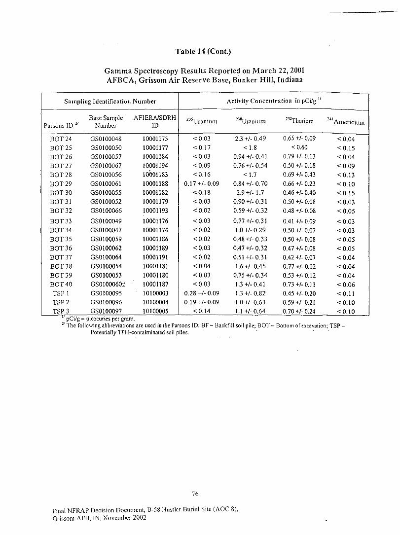
Table 14 (Cont.)
Gamma Spectroscopy Results Reported on March 22, 2001AFBCA, Grissom Air Reserve Base, Bunker Hill, Indiana
Sampling Identification
Parsons ID y
EOT 24BOT25EOT 26EOT 27EOT 28EOT 29EOT 30BOT31EOT 32
EOT 33EOT 34EOT 35EOT 36EOT 37EOT 38EOT 39EOT 40TSP 1TSP2TSP 3
Base SampleNumber
GS0100048GS0100050GS0100057GS0100067GS0100056GS0100061GS0100055GSO 100052GSO 100066
GSO 100049GS0100047GS0100059GS0100062GSO 100064GSO 100054GSO 100053GSO 100060.'GSO 100095GSO 100096GSO 100097
Number
AFIERA/SDRHID
100011751000117710001184100011941000118310001188100011821000117910001193
1000117610001174100011861000118910001191100011811000118010001187101000031010000410100005
Activity Concentration in pCi/g "
235Uranium
<0.03<0.17<0.03<0.09<0.16
0.17+/-0.09<0.18<0.03<0.02
<0.03<0.02<0.02<0.03<0.02<0.04<0.03<0.03
0.28 +/- 0.090.19+/-0.09
<0.14
""Uranium
2.3 +/- 0.49
<1.80.94 +/- 0.41
0.76 +/- 0.54
<1.70.84 +/- 0.702.9+M.7
0.90 +/- 0.310.59 +/- 0.32
0.77 +/- 0.311.0+/-0.29
0.48 +/- 0.330.47 +/- 0.32
0.5 !+/- 0.311.6+/-0.45
0.75 +/- 0.341.3+/-0.411.3+/-0.821.0+/-0.631.1 +/-0.64
232Thorium
0.65 +/- 0.09<0.60
0.79+/-0.130.50+/-0.180.69 +/- 0.430.66 +/- 0.230.46 +/- 0.400.50 +/- 0.080.48 +/- 0.08
0.41 +/-0.090.50 +/- 0.070.50 +/- 0.08
0.47 +/- 0.080.42 +/- 0.070.77 +/- 0.120.53+/-0.120.73 +/- 0.11
0.45 +/- 0.200.59 +/- 0.210.70 +/- 0.24
24 1 .Amencium
<0.04<0.15<0.04<0.09<0.13<0.10<0.15<0.03<0.05<0.03<0.03<0.05<0.05<0.04<0.04<0.04<0.06<0.11<0.10<0.10
pCi/g = picocuries per gram.following abbreviations are used in the Parsons ID: BF- Backfill soil pile; DOT- Bottom of excavation; TSP -
Potentially TPH-contaiminated soil piles.
76
Final NFRAP Decision Document, B-58 Hustler Burial Site (AOC 8),Grissom AFB, IN, November 2002
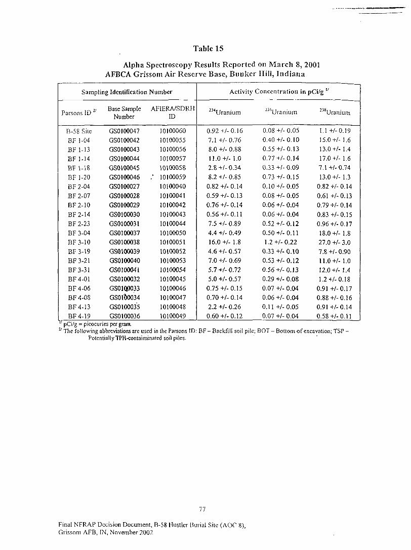
Table 15
Alpha Spectroscopy Results Reported on March 8, 2001AFBCA Grissom Air Reserve Base, Bunker Hill, Indiana
Sampling Identification
Parsons ID
B-58 SiteBF 1-04BF 1-13BF 1-14BF 1-18BF 1-20BF 2-04BF 2-07BF2-10BF2-14BF 2-23BF 3-04BF3-10BF 3-19BF3-21BF3-31BF4-01BF4-06BF 4-08BF4-13BF4-19
Base SampleNumber
GSO 100047GS0100042GSO 100043GSO 100044GS0100045GS0100046GS0100027GS0100028GS0100029GS0100030GS0100031GS0100037GS0100038GS0100039GSO 100040GSO 100041GS0100032GS01Q0033GSO 100034GS0100035GS0100036
Number
AF1ERA/SDRHID
1010006010100055101000561010005710100058
; 10100059101000401010004110100042
101000431010004410100050101000511010005210100053101000541010004510100046101000471010004810100049
Activity
""Uranium
0.92+/-0.167.1 +/-0.768.0 +/- 0.881 1 .0 +/- 1 .02.8 +/- 0.348.2 +/- 0.85
0.82 +/- 0.140.59+/-0.130.76+/-0.140.56 +/- 0.117.5 +/. 0.894.4 +/- 0.49
16.0+/- 1.84.6 +/- 0.577.0 +/- 0.695.7 +/- 0.725.0 +/- 0.57
0.75+/-0.150.70 +/- 0.142.2 +/- 0.260.60+/-0.12
Concentration in
235Uranium
0.08 +/- 0.050.40 +/- 0.100.55 +/- 0.130.77+/-0.140.2,3 +/- 0.09
0.73+/-0.150.10+/-0.05
0.08 +/- 0.050.06 +/- 0.040.06 +/- 0.040.52+/-0.120.50 +/- 0.111.2+/-0.22
0.33 +/- 0.100.53 +/- 0.120.56 +/- 0.130.29 +/- 0.080.07 +/- 0.040.06 +/- 0.040.11 +/-0.050.07 +/- 0.04
pCi/g "
238Uranium
1.1 +/-0.1915.0+/- 1.613.0+/- 1.417.0+/- 1.67.1+/-0.7413.0 +/- 1.3
0.82 +/- 0.140.61 +/- 0.130.79+/-0.14
0.83+/-0.150.96+/-0.1718.0+/- 1.827.0 +/- 3.07.8 +/- 0.9011.0+/- 1.012.0+/- 1.41.2 +/- 0.18
0.91 +/-0.170.88+/-0.160.91 +/-0.140.58 +/- 0.11
pCi/g = picocuries per gram.27 The following abbreviations are used in the Parsons ID:
PotentiallyTPH-contaiminated soil piles.BF - Backfi l l soil pile; EOT - Bottom of excavation; TSP -
77
Final NFRAP Decision Document, B-58 Hustler Burial Site (AOC 8),Grissom AFB, IN, November 2002
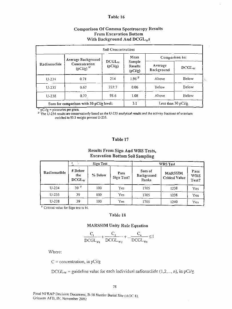
Table 16
Comparison Of Gamma Spectroscopy ResultsFrom Excavation Bottom
With Background And DCGLws
Soil Concentrations
Radionuclide
U-234
U-235
U-238
Average BackgroundConcentration
(PCi/g) "
0.71
0.67
0.77^
DCGLw(pCi/g)
214
222.7
98.6
Sum for comparison with 30 pCi/g level:
MeanSampleResults(PCi/g)
1.96*
0.06
1.08
3.1
Comparison to:
AverageBackground
Above
Below
Above
DCGLW
Below
Below
Below
Less than 30 pCi/g
" pCi/g = picocuries per gram.27 The U-234 results are conservatively based on the U-235 analytical results and the activity fractions of uranium
enriched to 93.5 weight percent U-235.
Table 17
Results From Sign And WRS Tests,Excavation Bottom Soil Sampling
Radionuclide
U-234
U-235
U-238
Sign Test
# Belowthe
DCGLW
39"
39
39
% Below
100
100
100
PassSign Test?
Yes
Yes
Yes
WRS Test
Sum ofBackground
Ranks
1705
1705
1705
MARSSIMCritical Value
1238
1238
1240
PassWRSTest?
Yes
Yes
Yes
Critical value for Sign test is 14.
Table 18
MARSSIM Unity Rule Equation
C.
DCGLW1 DCGLW2 DCGLWn
Where:
C = concentration, in pCi/g
DCGLw = guideline value for each individual radionuclide (1,2,..., n), in pCi/g
78
Final NFRAP Decision Document, B-58 Hustler Burial Site (AOC 8)Gnssom AFB, IN, November 2002
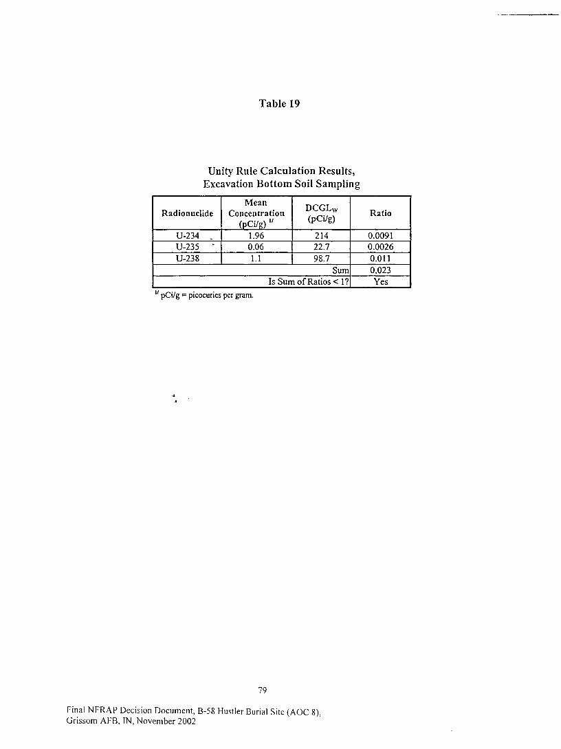
Table 19
Unity Rule Calculation Results,Excavation Bottom Soil Sampling
Radionuclide
U-234 „U-235 "U-238
MeanConcentration
(pCi/R) "1.960.061.1
DCGLW
(pCi/g)
21422.798.7
SumIs Sum of Ratios < 1?
Ratio
0.00910.00260.0110.023Yes
" pCi/g = picocuries per gram.
79
Final NFRAP Decision Document, B-58 Hustler Burial Site (AOC 8),Grissom AFB, IN, November 2002
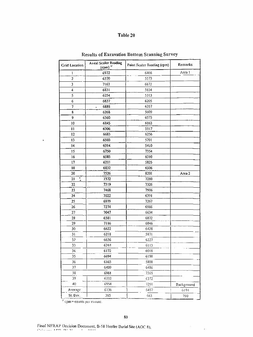
Table 20
Results of Excavation Bottom Scanning Survey
Grid Location
1
2
3
4
5
6
7
8
9
10
11
12
13
14
15
16
17
18
20
21 ',22
23
24
25
26
27
282930
3132
3334
35
36
37
38
39
40
Average
St. Dcv.
Areal Sealer Reading(cpm) "
6972
6370
7163
6831
6254
6837
6888
6268
6560
6845
6306
6683
6503
6314
6750
6585
6211
6832
7526
7372
7319
7468
7022
6979
7274
7047
658171166622
6218
6636
6244
6172
6694
6165
6409
6981
6732
6954
6736
385
Point Sealer Reading (cpm)
6466
5573
6872
5S54
5313
6205
6357
5609
6573
6163
5517
6256
5791
5410
7354
6310
5825
6506
8201
7280
7326
7906
6391
7267
6986
6634
687268466428
5871
6227
6113
6018
6190
5800
6486
73656372
7291
Remarks
Area 1
Area 2
Background
6457 6194
685 790
" cpm = counts per minute.
80
Final NFRAP Decision Document, B-58 Hustler Burial Site (AOC 8),
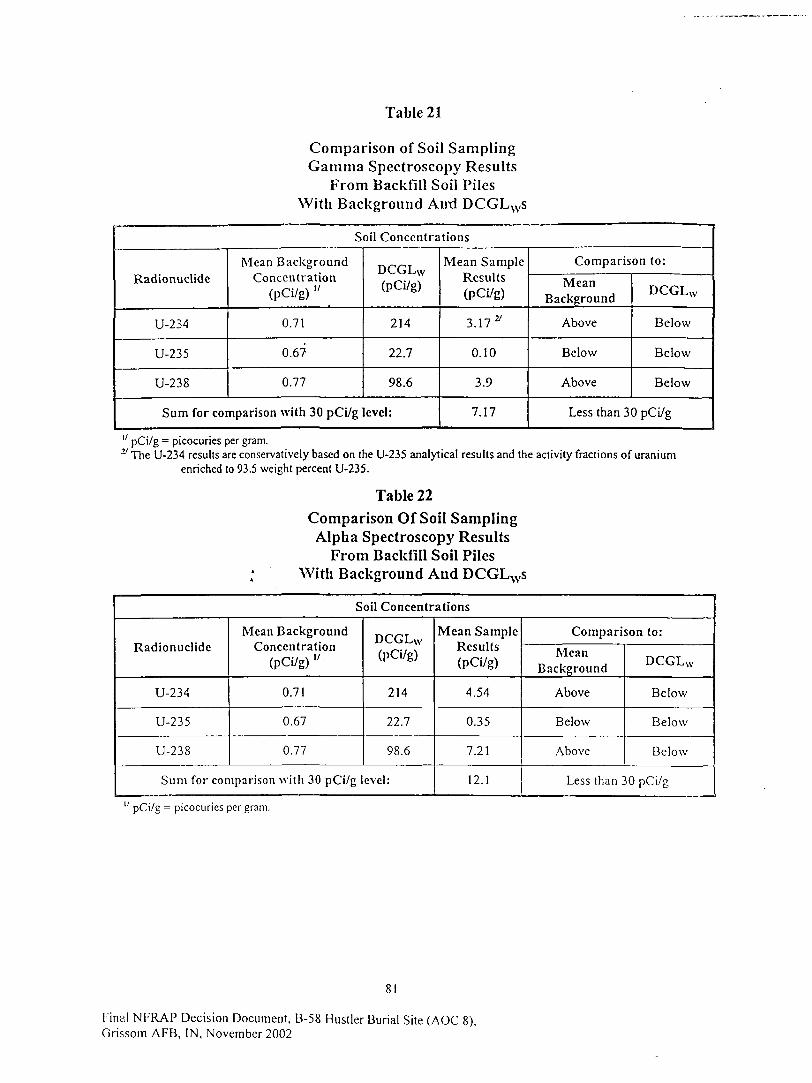
Table 21
Comparison of Soil SamplingGamma Spectroscopy Results
From Backfill Soil PilesWith Background Anxl DCGLws
Soil Concentrations
Radionuclide
U-234
U-235
U-238
Mean BackgroundConcentration
(pCi/g) "
0.71
0.6?
0.77
DCGLw(PCi/g)
214
Tin
98.6
Sum for comparison with 30 pCi/g level:
Mean SampleResults(PCi/g)
3.1727
0.10
3.9
7.17
Comparison to:
MeanBackground
Above
Below
Above
DCGLw
Below
Below
Below
Less than 30 pCi/g
" pCi/g = picocuries per gram.:y The U-234 results are conservatively based on the U-235 analytical results and the activity fractions of uranium
enriched to 93.5 weight percent U-235.
Table 22Comparison Of Soil SamplingAlpha Spectroscopy Results
From Backfill Soil PilesWith Background And DCGLNVs
Soil Concentrations
Radionuclide
U-234
U-235
U-238
Mean BackgroundConcentration
(pCi/g) "
0.71
0.67
0.77
DCGLw(PCi/g)
214
22.7
98.6
Sum for comparison with 30 pCi/g level:
Mean SampleResults(PCi/g)
4.54
0.35
7.21
12.1
Comparison to:
MeanBackground
Above
Below
Above
DCGLW
Below
Below
Below
Less than 30 pCi/g
" pCi/g = picocuries per gram.
81
Final NFRAP Decision Document, B-58 Hustler Burial Site (AOC 8),Grissom AFB, IN, November 2002
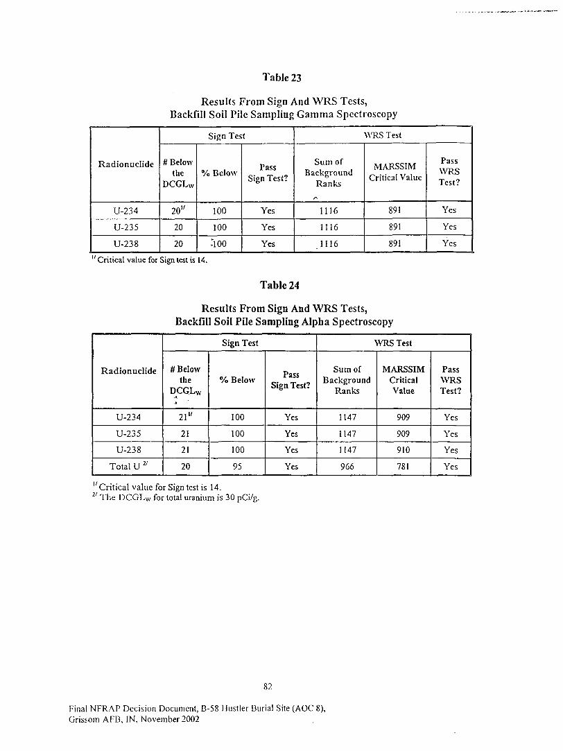
Table 23
Results From Sign And WRS Tests,Backfill Soil Pile Sampling Gamma Spectroscopy
Radionuclide
U-234
U-235
U-238
Sign Test
# Belowthe
DCGLw
20"
20
20
% Below
100
100
;ioo
PassSign Test?
Yes
Yes
Yes
WRS Test
Sum ofBackground
Ranks
1116
1116
.1116
MARSSIMCritical Value
891
891
891
PassWRSTest?
Yes
Yes
Yes
"Critical value for Sign test is 14.
Table 24
Results From Sign And WRS Tests,Backfill Soil Pile Sampling Alpha Spectroscopy
Radionuclide
U-234
U-235
U-238
Total U ^
Sign Test
# Belowthe
DCGLW
-A
21"
21
21
20
% Below
100
100
100
95
PassSign Test?
Yes
Yes
Yes
Yes
WRS Test
Sum ofBackground
Ranks
1147
1147
1147
966
MARSSIMCriticalValue
909
909
910
781
PassWRSTest?
Yes
Yes
Yes
Yes
"Critical value for Sign test is 14.27 The DCGLw for total uranium is 30 pCi/g.
82
Final NFRAP Decision Document, B-58 Hustler Burial Site (AOC 8),Grissom AFB, IN, November 2002
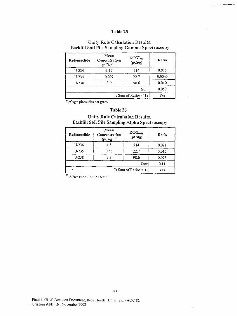
Table 25
Unity Rule Calculation Results,Backfill Soil Pile Sampling Gamma Spectroscopy
Radionuclide
U-234
U-235
U-238
MeanConcentration
(pCi/g) "3.17
0.097
3.9
DCGLw(pCi/g)
214
22.7
98.6
Sum
Is Sum of Ratios < 1?
Ratio
0.015
0.0043
0.040
0.059
Yes
" pCi/g = picocuries per gram.
Table 26
Unity Rule Calculation Results,Backfill Soil Pile Sampling Alpha Spectroscopy
Radionuclide
U-234
U-235
U-238
MeanConcentration
(pCI/g) "4.5
0.35
7.2
DCGLW
(PCi/g)
214
22.7
98.6
Sum
Is Sum of Ratios < 1?
Ratio
0.021
0.015
0.073
0.11
Yes
" pCi/g = picocuries per gram.
83
Final NFRAP Decision Document, B-58 Hustler Burial Site (AOC 8),Grissom AFB, IN, November 2002

Table 27
Results of Backfill Soil Pile Field Measurements
Pile l.Lift 1
Grid Area! SealerLocalion Reading (cpm)
12345678910111213141516171819202122232425262728293031323334353637383940414243
632463506373684766606509687070336616705468686796712970546544628264646599620763406315624960676135617362056413 •'.6567627061176495612166566087658165346358642166145397599159336204
AverageSt. Dcv.
6438344
Pile 1, Lift 2
Grid Arcal SealerLocation Reading (cpm)
12345678910"11 '12131415161718192021222324252627282930313233
63336269669667886694
' 6434605156306608762366976342625061905898593360016643685768097975611760896038618165897202641470216288625761525933
AverageSt. Dev.
6455498
Pile 2, Lift I
Grid Areal SealerLocation Reading (cpm)
1234567891011121314151617181920212223242526
52725285539355575322521752585109513552845421514252635398533151385089522552865352507451285197517049065036
AverageSt. Dev.
5230139
Pile 2, Lift 2
Grid Areal SealerLocalion Reading (cpm)
1234
56789101 1121314
151617IS1920
53385231530451345053516151405220532150795240504054705158508450535296530851104829
AverageSt. Dev.
BackgroundAverageSt. Dev.
6194
790
5178143
84
Final NFRAP Decision Document, B-58 Hustler Burial Site (AOC 8),Grissom AFB, IN, November 2002

Table 28
Monthly Average Water ReleaseConcentration Criteria
Radionuclidc
U-234
U-235
U-238
10CFR20App B Table 3
ReleaseCriteria
(pCi/L/month)
3.0E+03
3.0E+03
3.0E+03
Tank WaterSample 1
ReleaseConcentration "(pCi/L/month) v
3.1E+03
9.6E+01
7.5E+02
Tank WaterSample 2
ReleaseConcentration(pCi/L/month)
2.9E+03
9.0E+01
6.7E+02
ExcavationWater
Sample 1Release
Concentration(pCi/L/month)
3.1E+03
9.6E+01
7.2E+02
ExcavationWater
Sample 2Release
Concentration(pCi/L/ month)
3.0E+03
9.3E+01
7.6E+02
" Assuming a frac tank volume of 2750 gallons.v pCi/LVmonth = picocuries per liter of water released per month.
Table 29
Sum Of Fractions Criteria
Radionuclidc
U-234
U-235
U-238
Sum
Tank WaterSample 1
ReleaseFraction "
0.5
0.015
0.12
0.63
Tank WaterSample 2
ReleaseFraction
0.47
0.014
0.11
0.59
Excavation WaterSample 1
ReleaseFraction
0.5
0.015
0.11
0.63
ExcavationWater
Sample 2ReleaseFraction
0.48
0.015
0.12
0.62
Assuming a frac tank volume of 2750 gallons and a sewer flow of 3000 gallons per month.
Table 30
Total Activity ReleaseCalculation Results
Radionuclidc
U-234
U-235
U-238
Sum
Total Activity (pCi) "
Tank WaterSample 1
3.3E+07
l.OE+06
7.8E+06
4.1E-1-07
Tank WaterSample 2
3.0E+07
9.3E+05
7.0E+06
3.8E+07
ExcavationWater
Sample 1
3.3E+07
l.OE+06
7.5E+06
4.1E+07
ExcavationWater
Sample 2
3.1E+07
9.6E+05
7.9E+06
4.0E+07
" pCi = picocuries; lotal activity release calculation performed assuming a frac tank volume of 2750gallons.
85
Final NFRAP Decision Document, B-58 Hustler Burial Site (AOC 8),cnm APR IN Wnv^mKor

Table 31
Sum of Fractions Equation
Result * VSum
C^
+V )SW'
Where:
^ Sum of Release Fraction; the sum of the radionuclide specific monthly
average release fractionsResult = Sample Result, the spectroscopy result for the specific radionuclide
(pCi/g)VTL = Tank Liquid Volume, the volume of water collected estimated from tank
dimensions of 8' x 21.5' by 2' (2,570 gal - 9,740 L)CA - Allowable Average Concentration, the radionuclide specific allowable
monthly average concentration limit from 10 CFR 20 Appendix B Table 3Vsw = Sewer Water Volume, the monthly volume of water passing through the
sewer where the release will occur (3,000 gal = 1 1,355 L)
Table 32
Comparison Of PotentialDoses From Excavation Sites And Background
Soil Sample Source
Excavation Bottom
Backfill Soil Pile
Dose Limit(%of 15mrem/yr)
0.35 mrem/yr (2.3%)
0.89 mrem/yr (5.9%) -- gamma spec
1.65 mrem/yr ( 1 1 %) - alpha spec
% TypicalBackground
0.097%
0.25%
0.46%
86
Final NFRAP Decision Document, B-58 Hustler Burial Site (AOC 8),Grissom AFB, IN, November 2002

Table 33
ALARA Compliance Equation
Cone _ CostT
DCGLW $2000*PD*0.015*F*A l -e - ( r + A ) ' N
Where:
Cone = ALARA concentration, pCi/g.
Costy = total cost of the additional remedial action, $150,000 per project baseline.
$2000 = monetary conversion factor of dose to dollars, from DG-4006.
PD = population density of 4E-04 person/m2, from DG-4006.
0.015 = dose limit of 15 mrem/yr in rem/yr.
F = remediation effectiveness factor, 1 for this type of action.
A = area being evaluated, 232 m2.
r = monetary discount rate of 0.03, from DG-4006.4
= radionuclide decay constant, yr".
N = number of years over which the dose is calculated, 1000 for this case.
87
Final NFRAP Decision Document, B-58 Hustler Burial Site (AOC 8),Grissom AFB, IN, November 2002
Appendix C, List of Acronyms
Final NFRAP Decision Document, B-58 Hustler Bur ia l Site (AOC 8),Grissom AFB, IN, November 2002
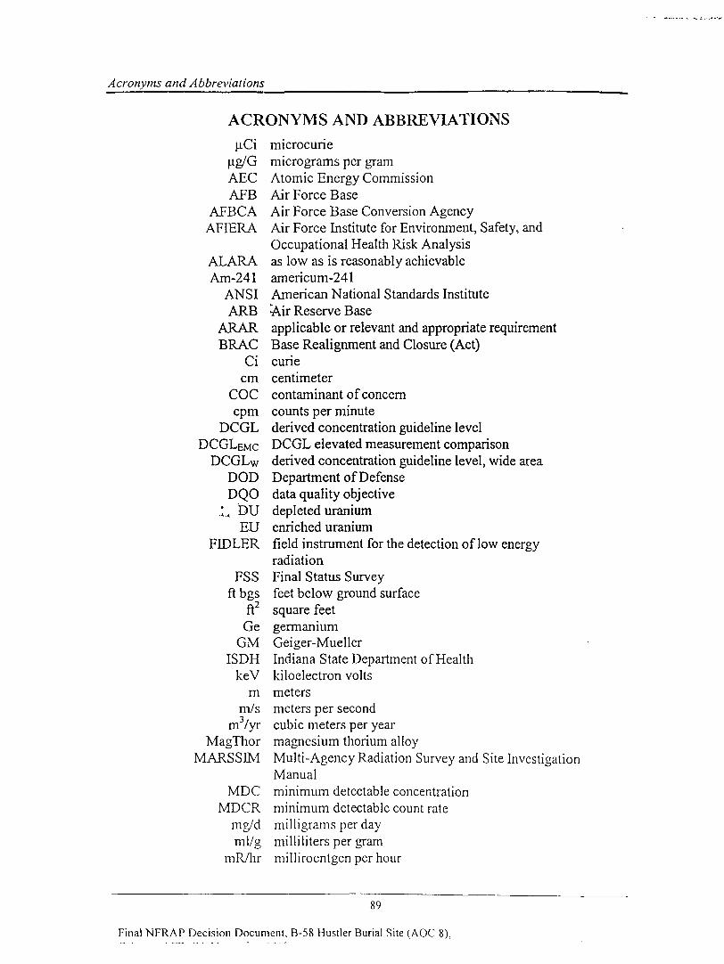
Acronyms and Abbreviations
ACRONYMS AND ABBREVIATIONS
uCi microcurieug/G micrograms per gramAEC Atomic Energy CommissionAFB Air Force Base
AFBCA Air Force Base Conversion AgencyAFIERA Air Force Institute for Environment, Safety, and
Occupational Health Risk AnalysisALARA as low as is reasonably achievableAm-241 americum-241
ANSI American National Standards InstituteARB -Air Reserve Base
ARAR applicable or relevant and appropriate requirementBRAG Base Realignment and Closure (Act)
Ci curiecm centimeter
COC contaminant of concerncpm counts per minute
DCGL derived concentration guideline levelDCGLeMC DCGL elevated measurement comparison
DCGLw derived concentration guideline level, wide areaDOD Department of DefenseDQO data quality objective
.'.„ DU depleted uraniumEU enriched uranium
FIDLER field instrument for the detection of low energyradiation
FSS Final Status Surveyft bgs feet below ground surface
ft2 square feetGe germanium
GM Geiger-MuellerISDH Indiana State Department of Health
keV kiloelectron voltsm meters
m/s meters per secondm3/yr cubic meters per year
MagThor magnesium thorium alloyMARSSEM Multi-Agency Radiation Survey and Site Investigation
ManualMDC minimum detectable concentration
MDCR minimum detectable count ratemg/d milligrams per dayml/g milliliters per gram
mR/hr milliroentgen per hour
89
Final NFRAP Decision Document, B-58 Hustler Burial Site (AOC 8),

Acronyms and Abbreviations
mrem/hr millirem per hourmrem/yr millirem per year
mSv/yr millisievert per yearNal sodium iodide
NRC Nuclear Regulatory CommissionPa-234m protactinium-234m
Parsons Parsons Engineering Science, Inc.pCi picocurie
pCi/g picocurie per gramPhilip Philip Environmental Services
PID photoionization detectorPRO preliminary remediation goals
Pu-241 pjutonium-241Ra-226 radium-226
RESRAD RESidual RADiation modelRn-222 radon-222
ROC radionuclide of concernTEDE total effective dose equivalent
Th-232 thorium-232Th-234 thorium-234
TPH total petroleum hydrocarbonsU-234 uranium-234U235 uranium-235
U-238 uranium-238UjSAF United States Air Force
USDOE United States Department of EnergyUSEPA United States Environmental Protection Agency
WRS Wilcoxon Rank SumZnS zinc sulfide
90
Final NFRAP Decision Document, B-58 Hustler Burial Site (AOC 8),Grissom AFB. IN, November 2002