Embed Size (px)
Citation preview

APPENDIX E
USACE Jurisdictional Determinations


DEPARTMENT OF THE ARMY CORPS OF ENGINEERS, OMAHA DISTRICT
NORTH DAKOTA REGULATORY OFFICE 1513 SOUTH 12TH STREET
BISMARCK ND 58504-6640 August 19, 2011
North Dakota Regulatory Office [NWO-2011-734-BIS]
Printed on Recycled Paper
Kadrmas, Lee and Jackson Attn: Ms. Becky Rude 128 Soo Line Drive P.O. Box 1157 Bismarck, North Dakota 58502-1157 Dear Ms. Rude: This is in reference to your July 8, 2011, request for a jurisdictional determination (JD) on behalf of the City of Minnewaukan, for the proposed townsite relocation. The project is located in Sections 3, 4, 9, 10, and 15, Township 153 North, Range 67 West and Sections 33 and 34, Township 154 North, Range 67 West, all in Benson County, North Dakota. We have reviewed the information furnished and have determined that the review area contains both, jurisdictional waters of the United States (WOUS) and nonjurisdictional waters. Jurisdictional waters are regulated by the Corps under the auspices of Section 404 of the Clean Water Act (33 USC 1344); therefore, the discharge of dredged or fill material into those waters, requires prior authorization from the Corps. The implementing regulation for this Act is found at 33 CFR Parts 320-332. We prepared a Preliminary JD (PJD) for all identified waters that may be jurisdictional WOUS. Such waters will be treated as jurisdictional WOUS for purposes of computation of impacts and compensatory mitigation requirements. If you concur with the findings of the enclosed preliminary JD, please sign it and return it to the letterhead address.
If you believe the preliminary JD is inaccurate, you may request this office complete an approved JD prior to your commencement of any work in a WOUS. An approved JD is an official determination regarding the presence or absence of WOUS. Completion of an approved JD may require coordination with the U.S. Environmental Protection Agency. In addition, we have determined that the remaining waters identified in your request, are isolated and nonjurisdictional. An Approved JD (enclosed) was prepared for all identified nonjurisdictional waters. The discharge of dredged or fill material into nonjurisdictional waters does not require Department of the Army (DA) authorization. Copies of supporting materials used in making these determinations are available upon request. Within 30 days from issuance, JDs are posted on our website at https://www.nwo.usace.army.mil/html/od-rnd/jur/jur.htm. Approved JDs are valid for a period of five (5) years. If you do not agree with our JD, you may request an administrative appeal under US Army Corps of Engineers regulations found at 33 CFR 331. A Notification of Administrative Appeal Options and Process and Request for Appeal (NAO-RFA) is enclosed. The NAO-RFA must be received in the Office specified on the second page within 60 days from the date of this letter. It is not necessary to submit the NAO-RFA if you do not object to the determination made in the JD. If you would like more information on the appeal process, please contact this Office. For your convenience, we have enclosed your wetland table with our jurisdictional findings added to the margins.
Should you have any questions regarding this determination, please do not hesitate to contact Matthew Mikulecky of my staff by letter or telephone (701)-255-0015 and reference Project Number NWO-2011-734-BIS.

The Omaha District, North Dakota Regulatory Office is committed to providing quality and timely
service to our customers. In an effort to improve customer service, please take a moment to complete our Customer Service Survey found on our website at http://per2.nwp.usace.army.mil/survey.html. If you do not have Internet access, you may call and request a paper copy of the survey that you can complete and return to us by mail or fax.
Sincerely, Daniel E. Cimarosti Regulatory Program Manager North Dakota Enclosures -Preliminary JD -Approved JD -NOA-RFA Form -Wetland Table

APPROVED JURISDICTIONAL DETERMINATION FORM U.S. Army Corps of Engineers
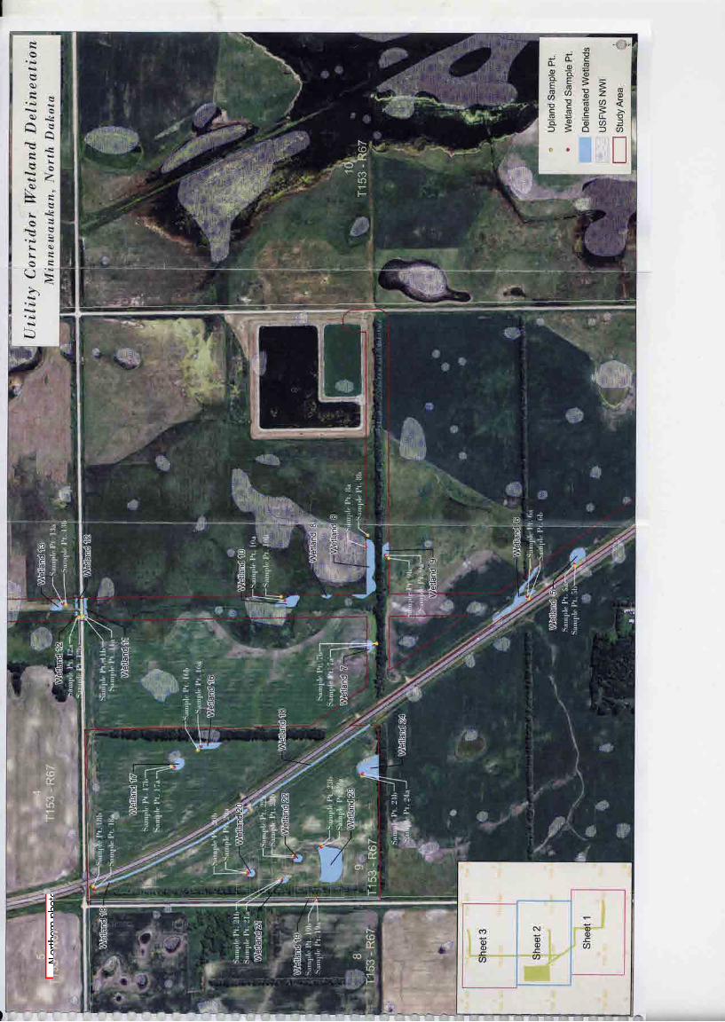
This form should be completed by following the instructions provided in Section IV of the JD Form Instructional Guidebook. SECTION I: BACKGROUND INFORMATION A. REPORT COMPLETION DATE FOR APPROVED JURISDICTIONAL DETERMINATION (JD): 19 August 2011 B. DISTRICT OFFICE, FILE NAME, AND NUMBER: Omaha District – NDDOT - NWO-2011-00734-BIS Form 2 WETLAND NO: ESTIMATED SIZE (acres): LOCATION 5A 0.32 See attached map 7A 0.14 See attached map 8A 0.88 See attached map 9A 0.15 See attached map 10A 0.12 See attached map 16A 0.24 See attached map 17A 0.19 See attached map 19A 0.50 See attached map 20A 0.09 See attached map 21A 0.09 See attached map 22A 0.10 See attached map 23A 1.32 See attached map 24A 0.60 See attached map C. PROJECT LOCATION AND BACKGROUND INFORMATION: Isolated pothole, depressional and ditch wetlands Central Legal Description: S9, T153N, R67W
State: North Dakota County/parish/borough: Benson City: Minnewaukan Center coordinates of site (lat/long in degree decimal format): Lat. 48.08735° N, Long. -99.28486° W. Universal Transverse Mercator: 14 Name of nearest waterbody: Devils Lake Name of nearest Traditional Navigable Water (TNW) into which the aquatic resource flows: None (hydrologically isolated) Name of watershed or Hydrologic Unit Code (HUC): Devils Lake (9020201)
Check if map/diagram of review area and/or potential jurisdictional areas is/are available upon request. Check if other sites (e.g., offsite mitigation sites, disposal sites, etc…) are associated with this action and are recorded on a
different JD form. D. REVIEW PERFORMED FOR SITE EVALUATION (CHECK ALL THAT APPLY):
Office (Desk) Determination. Date: 2 August 2011 Field Determination. Date(s): 22 July 2011
SECTION II: SUMMARY OF FINDINGS A. RHA SECTION 10 DETERMINATION OF JURISDICTION. There Are no “navigable waters of the U.S.” within Rivers and Harbors Act (RHA) jurisdiction (as defined by 33 CFR part 329) in the review area. [Required]
Waters subject to the ebb and flow of the tide. Waters are presently used, or have been used in the past, or may be susceptible for use to transport interstate or foreign commerce.
Explain: .
2
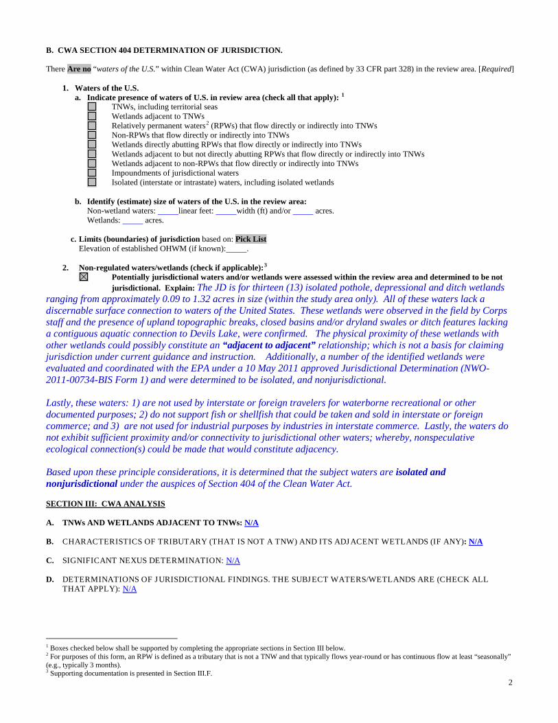
B. CWA SECTION 404 DETERMINATION OF JURISDICTION. There Are no “waters of the U.S.” within Clean Water Act (CWA) jurisdiction (as defined by 33 CFR part 328) in the review area. [Required] 1. Waters of the U.S. a. Indicate presence of waters of U.S. in review area (check all that apply): 1
TNWs, including territorial seas
Wetlands adjacent to TNWs Relatively permanent waters2
Non-RPWs that flow directly or indirectly into TNWs (RPWs) that flow directly or indirectly into TNWs
Wetlands directly abutting RPWs that flow directly or indirectly into TNWs Wetlands adjacent to but not directly abutting RPWs that flow directly or indirectly into TNWs Wetlands adjacent to non-RPWs that flow directly or indirectly into TNWs Impoundments of jurisdictional waters Isolated (interstate or intrastate) waters, including isolated wetlands b. Identify (estimate) size of waters of the U.S. in the review area: Non-wetland waters: linear feet: width (ft) and/or acres. Wetlands: acres. c. Limits (boundaries) of jurisdiction based on: Pick List Elevation of established OHWM (if known): . 2. Non-regulated waters/wetlands (check if applicable):3
Potentially jurisdictional waters and/or wetlands were assessed within the review area and determined to be not jurisdictional. Explain: The JD is for thirteen (13) isolated pothole, depressional and ditch wetlands ranging from approximately 0.09 to 1.32 acres in size (within the study area only). All of these waters lack a discernable surface connection to waters of the United States. These wetlands were observed in the field by Corps staff and the presence of upland topographic breaks, closed basins and/or dryland swales or ditch features lacking a contiguous aquatic connection to Devils Lake, were confirmed. The physical proximity of these wetlands with other wetlands could possibly constitute an “adjacent to adjacent” relationship; which is not a basis for claiming jurisdiction under current guidance and instruction. Additionally, a number of the identified wetlands were evaluated and coordinated with the EPA under a 10 May 2011 approved Jurisdictional Determination (NWO-2011-00734-BIS Form 1) and were determined to be isolated, and nonjurisdictional.
Lastly, these waters: 1) are not used by interstate or foreign travelers for waterborne recreational or other documented purposes; 2) do not support fish or shellfish that could be taken and sold in interstate or foreign commerce; and 3) are not used for industrial purposes by industries in interstate commerce. Lastly, the waters do not exhibit sufficient proximity and/or connectivity to jurisdictional other waters; whereby, nonspeculative ecological connection(s) could be made that would constitute adjacency. Based upon these principle considerations, it is determined that the subject waters are isolated and nonjurisdictional under the auspices of Section 404 of the Clean Water Act. SECTION III: CWA ANALYSIS A. TNWs AND WETLANDS ADJACENT TO TNWs: N/A B. CHARACTERISTICS OF TRIBUTARY (THAT IS NOT A TNW) AND ITS ADJACENT WETLANDS (IF ANY): N/A C. SIGNIFICANT NEXUS DETERMINATION: N/A D. DETERMINATIONS OF JURISDICTIONAL FINDINGS. THE SUBJECT WATERS/WETLANDS ARE (CHECK ALL
THAT APPLY): N/A
1 Boxes checked below shall be supported by completing the appropriate sections in Section III below. 2 For purposes of this form, an RPW is defined as a tributary that is not a TNW and that typically flows year-round or has continuous flow at least “seasonally” (e.g., typically 3 months). 3 Supporting documentation is presented in Section III.F.

3
E. ISOLATED [INTERSTATE OR INTRA-STATE] WATERS, INCLUDING ISOLATED WETLANDS, THE USE,
DEGRADATION OR DESTRUCTION OF WHICH COULD AFFECT INTERSTATE COMMERCE, INCLUDING ANY SUCH WATERS (CHECK ALL THAT APPLY): 4
N/A
F. NON-JURISDICTIONAL WATERS, INCLUDING WETLANDS (CHECK ALL THAT APPLY): If potential wetlands were assessed within the review area, these areas did not meet the criteria in the 1987 Corps of Engineers
Wetland Delineation Manual and/or appropriate Regional Supplements. Review area included isolated waters with no substantial nexus to interstate (or foreign) commerce.
Prior to the Jan 2001 Supreme Court decision in “SWANCC,” the review area would have been regulated based solely on the “Migratory Bird Rule” (MBR).
Waters do not meet the “Significant Nexus” standard, where such a finding is required for jurisdiction. Explain: . Other: (explain, if not covered above): . Provide acreage estimates for non-jurisdictional waters in the review area, where the sole potential basis of jurisdiction is the MBR
factors (i.e., presence of migratory birds, presence of endangered species, use of water for irrigated agriculture), using best professional judgment (check all that apply):
Non-wetland waters (i.e., rivers, streams): linear feet width (ft). Lakes/ponds: acres. Other non-wetland waters: acres. List type of aquatic resource: . Wetlands: APPROXIMATELY : 4.74 acres.
Provide acreage estimates for non-jurisdictional waters in the review area that do not meet the “Significant Nexus” standard, where such a finding is required for jurisdiction (check all that apply):
Non-wetland waters (i.e., rivers, streams): linear feet, width (ft). Lakes/ponds: acres. Other non-wetland waters: acres. List type of aquatic resource: . Wetlands: acres.
SECTION IV: DATA SOURCES. A. SUPPORTING DATA. Data reviewed for JD (check all that apply - checked items shall be included in case file and, where checked
and requested, appropriately reference sources below): Maps, plans, plots or plat submitted by or on behalf of the applicant/consultant:Consultant provided wetland delineation maps. Data sheets prepared/submitted by or on behalf of the applicant/consultant.
Office concurs with data sheets/delineation report. Office does not concur with data sheets/delineation report.
Data sheets prepared by the Corps: . Corps navigable waters’ study: . U.S. Geological Survey Hydrologic Atlas: .
USGS NHD data. USGS 8 and 12 digit HUC maps.
U.S. Geological Survey map(s). Cite scale & quad name: 1 : 24,000 – Minnewaukan West, NORTH DAKOTA. USDA Natural Resources Conservation Service Soil Survey. Citation:Hydric Soils Mapping. National wetlands inventory map(s). Cite name:USFWS NWI. State/Local wetland inventory map(s): . FEMA/FIRM maps: . 100-year Floodplain Elevation is: (National Geodectic Vertical Datum of 1929) Photographs: Aerial (Name & Date):Google Earth 2009; Wetland Delineation Map Aerials provided by consultant.
or Other (Name & Date):May 2011 & July 2011. Previous determination(s). File no. and date of response letter:NWO-2011-00734-BIS (Form 1). Applicable/supporting case law: . Applicable/supporting scientific literature: . Other information (please specify): .
B. ADDITIONAL COMMENTS TO SUPPORT JD: See attacbed delineation map.
4 Prior to asserting or declining CWA jurisdiction based solely on this category, Corps Districts will elevate the action to Corps and EPA HQ for review consistent with the process described in the Corps/EPA Memorandum Regarding CWA Act Jurisdiction Following Rapanos.


1
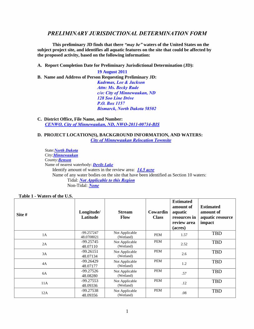
PRELIMINARY JURISDICTIONAL DETERMINATION FORM This preliminary JD finds that there “may be” waters of the United States on the subject project site, and identifies all aquatic features on the site that could be affected by the proposed activity, based on the following information:
A. Report Completion Date for Preliminary Jurisdictional Determination (JD): 19 August 2011 B. Name and Address of Person Requesting Preliminary JD: Kadrmas, Lee & Jackson Attn: Ms. Becky Rude c/o: City of Minnewaukan, ND 128 Soo Line Drive P.O. Box 1157 Bismarck, North Dakota 58502 C. District Office, File Name, and Number: CENWO, City of Minnewaukan, ND, NWO-2011-00734-BIS D. PROJECT LOCATION(S), BACKGROUND INFORMATION, AND WATERS:
City of Minnewaukan Relocation Townsite State:North Dakota City:Minnewaukan County:Benson Name of nearest waterbody: Devils Lake
Identify amount of waters in the review area: 14.5 acre Name of any water bodies on the site that have been identified as Section 10 waters: Tidal: Not Applicable to this Region Non-Tidal: None
Table 1 - Waters of the U.S.
Site #
Longitude/ Latitude
Stream Flow
Cowardin Class
Estimated amount of aquatic resources in review area (acres)
Estimated amount of aquatic resource impact
1A -99.257247 48.0708021
Not Applicable (Wetland) PEM 1.57 TBD
2A -99.25745 48.07110
Not Applicable (Wetland)
PEM 2.52 TBD
3A -99.26151 48.07134
Not Applicable (Wetland)
PEM 2.6 TBD
4A -99.26429 48.07177
Not Applicable (Wetland)
PEM 1.2 TBD
6A -99.27526 48.08280
Not Applicable (Wetland)
PEM .57 TBD
11A -99.27553 48.09336
Not Applicable (Wetland)
PEM .12 TBD
12A -99.27538 48.09356
Not Applicable (Wetland)
PEM .08 TBD
2
13A -99.27552 48.09410
Not Applicable (Wetland)
PEM .16 TBD
14A -99.27577 48.10244
Not Applicable (Wetland) PEMC 1.29 TBD
15A -99.26791 48.10812
Not Applicable (Wetland) PEMC 2.57 TBD
18A -99.28546 48.09316
I Not Applicable (Wetland) PEMC 1.3 TBD
E. REVIEW PERFORMED FOR SITE EVALUATION (CHECK ALL THAT APPLY):
Office (Desk) Determination. Date: 19 August 2011 Field Determination. Date(s):
F. SUPPORTING DATA: See below: Data reviewed for preliminary JD (check all that apply - checked items should be included in case file and, where checked and requested, appropriately reference sources below):
Maps, plans, plots or plat submitted by or on behalf of the applicant/consultant: Applicant provided maps & Delineation Map
Data sheets prepared/submitted by or on behalf of the applicant/consultant. Office concurs with data sheets/delineation report.
Office does not concur with data sheets/delineation report. Data sheets prepared by the Corps: .
Corps navigable waters’ study: . U.S. Geological Survey Hydrologic Atlas: .
USGS NHD data. USGS 8 and 12 digit HUC maps.
U.S. Geological Survey map(s). Cite quad name:Minnewaukan West. USDA Natural Resources Conservation Service Soil Survey. Citation: . National wetlands inventory map(s). Cite name: USFWS State/Local wetland inventory map(s):. FEMA/FIRM maps: .
100-year Floodplain Elevation is: (National Geodectic Vertical Datum of 1929) Photographs: Aerial (Name & Date): NAIP 2009 / Google Earth 2009.
or Other (Name & Date):Onsite (May 2011). Previous determination(s). File no. and date of response letter:NWO-2011-734-BIS
(April 2011). Other information (please specify):See attached maps.

3
IMPORTANT NOTE: The information recorded on this form has not necessarily been verified by the Corps and should not be relied upon for later jurisdictional determinations. _________________________ __________________________ Signature and date of Signature and date of Regulatory Project Manager person requesting preliminary JD (REQUIRED) (REQUIRED, unless obtaining the
signature is impracticable) G. EXPLANATION OF PRELIMINARY AND APPROVED JURISDICTIONAL DETERMINATIONS: 1. The Corps of Engineers believes that there may be jurisdictional waters of the United States on the subject site, and the permit applicant or other affected party who requested this preliminary JD is hereby advised of his or her option to request and obtain an approved jurisdictional determination (JD) for that site. Nevertheless, the permit applicant or other person who requested this preliminary JD has declined to exercise the option to obtain an approved JD in this instance and at this time. 2. In any circumstance where a permit applicant obtains an individual permit, or a Nationwide General Permit (NWP) or other general permit verification requiring “pre-construction notification” (PCN), or requests verification for a non-reporting NWP or other general permit, and the permit applicant has not requested an approved JD for the activity, the permit applicant is hereby made aware of the following: (1) the permit applicant has elected to seek a permit authorization based on a preliminary JD, which does not make an official determination of jurisdictional waters; (2) that the applicant has the option to request an approved JD before accepting the terms and conditions of the permit authorization, and that basing a permit authorization on an approved JD could possibly result in less compensatory mitigation being required or different special conditions; (3) that the applicant has the right to request an individual permit rather than accepting the terms and conditions of the NWP or other general permit authorization; (4) that the applicant can accept a permit authorization and thereby agree to comply with all the terms and conditions of that permit, including whatever mitigation requirements the Corps has determined to be necessary; (5) that undertaking any activity in reliance upon the subject permit authorization without requesting an approved JD constitutes the applicant’s acceptance of the use of the preliminary JD, but that either form of JD will be processed as soon as is practicable; (6) accepting a permit authorization (e.g., signing a proffered individual permit) or undertaking any activity in reliance on any form of Corps permit authorization based on a preliminary JD constitutes agreement that all wetlands and other water bodies on the site affected in any way by that activity are jurisdictional waters of the United States, and precludes any challenge to such jurisdiction in any administrative or judicial compliance or enforcement action, or in any administrative appeal or in any Federal court; and (7) whether the applicant elects to use either an approved JD or a preliminary JD, that JD will be processed as soon as is practicable. Further, an approved JD, a proffered individual permit (and all terms and conditions contained therein), or individual permit denial can be administratively appealed pursuant to 33 C.F.R. Part 331, and that in any administrative appeal, jurisdictional issues can be raised (see 33 C.F.R. 331.5(a)(2)). If, during that administrative appeal, it becomes necessary to make an official determination whether CWA jurisdiction exists over a site, or to provide an official delineation of jurisdictional waters on the site, the Corps will provide an approved JD to accomplish that result, as soon as is practicable.


APPENDIX F
USFWS Concurrence


APPENDIX G
SHPO Coordination


U.S. Department of Homeland Security Region VIII Denver Federal Center, Building 710 P.O. Box 25267 Denver, CO 80225-0267
R8-EHP
December 15, 2011 Mr. Merlan E. Paaverud, Jr State Historic Preservation Officer State Historical Society of North Dakota 612 East Boulevard Avenue Bismarck, North Dakota 58505 Attn: Susan Quinnell RE: Minnewaukan Acquisition/ Demolition/ Relocation, Benson County ND
FEMA 1829-DR-ND Project #46, #47, #48; ND SHPO Reference 11-1026, 11-0977 Dear Mr. Paaverud,
The City of Minnewaukan, Benson County, ND has applied for funding under the Federal Emergency Management Agency’s (FEMA) Hazard Mitigation Grant Program (HMGP). The HMGP program provides funds for the planning and the implementing mitigation projects prior to a disaster event. Funding these plans and projects reduces overall risks to the population and structures, while also reducing reliance on funding from future disaster declarations..
The City of Minnewaukan is an incorporated city located on the western shores of Devils Lake and is the county seat for Benson County, North Dakota. Over the last 18 years, the lake has tripled in size and has risen over 30 feet in elevation. Multiple structures are in danger of being inundated as the lake elevation continues to rise, which would leave large portions of the city virtually uninhabitable. Grant applications have also been submitted to several other federal, state and local agencies to fund development of infrastructure to and within a new town site needed to maintain Minnewaukan’s status as an incorporated city and county seat. An Environmental Assessment (EA) will be prepared for related actions that will be carried out concurrently as part of flood protection initiatives. The purpose of this letter is to initiate and complete Section 106 Consultation pursuant to the National Historic Preservation Act (NHPA) as implemented by 36 CFR Part 800. The goal of the proposed undertaking is to acquire property and remove flood-prone buildings from the existing downtown area by acquiring and either demolishing or relocating participating structures to the new town site. Three (3) FEMA HMGP projects contribute to this undertaking:
1. Acquire & Demolish 69 existing homes (Project #46) 2. Acquire & Relocate 19 existing homes to new town-site (Project #47) 3. Acquire & Relocate 3 existing (school-owned) homes to new town-site (Project #48)

Minnewaukan, ND Relocation December 15, 2011
Page 2
Related actions not funded by FEMA, but addressed in this consultation include:
4. Demolition of Minnewaukan School (US Dept. of Ed.) 5. Demolition of the existing water tower (USACE) 6. Relocation of six residential structures (BCHA/HUD)
The attached cultural resource assessment report (August 2011) was prepared by Kadramas, Lee & Jackson (KL&J) to research and document a Class III architectural survey as requested by your office on April 11, 2011(ND SHPO Ref. 11-1026). The attached survey (with addendum) was prepared by KL&J to assess and document specific properties (selected in coordination with ND SHPO). The survey identified 33 properties within the project area listed or eligible for listing on the National Register of Historic Places (NRHP). Of these, 11 are proposed for acquisition and demolition or relocation to the new town site and are discussed in more detail in the attached addendum to the survey. In addition, the addendum discusses the possible eligibility of downtown Minnewaukan as a historic district. Due to the nature of the proposed undertaking, it is anticipated that there is the potential for adverse impacts to historic properties. As part of the on-going coordination with ND SHPO, a number of mitigation measures were discussed. After evaluating the alternatives, FEMA believes the best (most widely accessible and cost-effective) approach is a web-based history that captures the tangible and intangible essence of the community by combining existing documentation (and newly produced documents) with a Social Media platform (such as YouTube) that allows individuals to contribute personal recollections of the city’s cultural heritage and the relocation process. The easily-updated website could include items such as:
• A photographic survey capturing the impact of the government, railroads, agriculture, etc. on the development and evolution of Minnewaukan and other similar communities in ND and the Great Plains
• An annotated mapping project that would show the development of the town and adjacent
area from initial settlement up to the take-over of the lake
• A summation on the Native American history of the land that the city now occupies and an analysis of tribal land acquisition and boundary changes over time
• A simple (PowerPoint) presentation on the overall relocation project that could also be presented by locals or put up on other local websites
The web-site could also be supplemented with interpretive signage at the old town to provide permanent historic information to the local population and visitors.

Minnewaukan, ND Relocation December 15, 2011
Page 3
Representatives of the North Dakota Department of Emergency Services and the City of Minnewaukan have reviewed and agreed to the proposed mitigation measures. It is important to note that the cost of implementing Sec. 106 mitigation measures is the responsibility of the sub-grantee, the City of Minnewaukan. As a condition of FEMA funding, the applicant and their contractors will be required to implement the agreed to mitigation measure(s). All areas of ground disturbance will be replaced with clean earthen, rock or concrete fill material. If previously unknown cultural resources are discovered during construction, work will be stopped and FEMA and SHPO notified as soon as possible. FEMA believes that the background research and survey represents a reasonable and good faith effort to carry out appropriate identification efforts as stated in §800.4(b)(1). While the proposed project has the potential for adverse impacts, FEMA believes that they will be mitigated with implementation of the measure(s) described above. Failure to complete the project could impact the health and safety of the public by exposure to an increased risk of flooding. Therefore, in accordance with Section 106 Review Procedures for Federal Undertakings, under the National Historic Preservation Act and its implementing regulation 36 CFR Part § 800.4(d)(1) FEMA has determined that there will be ‘no adverse effect to historic properties’ as a result of the proposed action. FEMA respectfully requests your concurrence with this determination, along with any additional recommendations related to the project. If you have any questions or comments, please do not hesitate to contact me by telephone at (303) 235-4926 or by email at [email protected].
Sincerely, Signed 12/15/2011
Richard Myers Deputy Regional Environmental Officer FEMA Region VIII
Attachments: Survey with addendum

North Dakota Heritage Center $ 612 East Boulevard Avenue, Bismarck, ND 58505-0830 $ Phone: 701-328-2666 $ Fax: 701-328-3710
Email: [email protected] $ Web site: http://history.nd.gov $ TTY: 1-800-366-6888
Jack Dalrymple Governor of North Dakota
North Dakota State Historical Board
Gereld Gerntholz
Valley City - President
Calvin Grinnell New Town - Vice
President
A. Ruric Todd III Jamestown - Secretary
Albert I. Berger Grand Forks
Richard Kloubec
Fargo
Diane K. Larson Bismarck
Chester E Nelson, Jr.
Bismarck Sara Otte Coleman
Director Tourism Division
Kelly Schmidt
State Treasurer
Alvin A. Jaeger Secretary of State
Mark Zimmerman
Director Parks and Recreation
Department
Francis Ziegler Director
Department of Transportation
Merlan E. Paaverud, Jr. Director
Accredited by the American Association of Museums since 1986
January 26, 2012
Mr. Richard Myers
Deputy Regional Environmental Officer
FEMA Region VIII
Denver Federal Center, Building 710
PO Box 25267
Denver, CO 80225-0267
ND SHPO Ref.:11-0310 “Minnewaukan Town Relocation: A Class III Cultural
Resource Inventory, Benson County, North Dakota” in portions of [T153N
R67W Sections 4, 9, 10, 15, 16 & 35] & [T154N R67W Sections 33 & 34],
Benson County, North Dakota
Dear Mr. Myers,
We reviewed ND SHPO Ref.:11-1026 “Minnewaukan Town Relocation: A Class
III Cultural Resource Inventory, Benson County, North Dakota” in portions of
[T153N R67W Sections 4, 9, 10, 15, 16 & 35] & [T154N R67W Sections 33 &
34], Benson County, North Dakota and find the report by Rigden A Glaab
acceptable. We concur with a “No Historic Properties Affected” determination,
provided the project is of the nature specified, and takes place at the location
specified and provided that any borrow material used comes from an approved
source. We further concur that 32BE197 and 32BE116 are not significant and are
therefore Not Eligible for the NRHP.
Thank you for the opportunity to review this project. Please include the ND
SHPO Reference number listed above in further correspondence for this specific
project. If you have any questions please contact Lisa Steckler, Preservation
Planner at (701) 328-3577 or [email protected]
Sincerely,
Merlan E. Paaverud, Jr.
State Historic Preservation Officer
(North Dakota) and
Director
State Historical Society of North Dakota

Minnewaukan, ND MOA Page 1 of 6 March 2012
MEMORANDUM OF AGREEMENT
Between the Federal Emergency Management Agency, The North Dakota State Historic Preservation Officer, The North Dakota Department of Emergency Services
And the City of Minnewaukan Submitted to the Advisory Council on Historic Preservation
Regarding Resolution of Adverse Effects to Historic Properties in the City of Minnewaukan resulting from their Acquisition and Demolition or Relocation
WHEREAS, the Federal Emergency Management Agency (FEMA) of the Department of Homeland Security proposes to administer Federal disaster assistance pursuant to the Robert T. Stafford Disaster Relief and Emergency Assistance Act, Public Law 93-288, as amended, to the City of Minnewaukan (Applicant) through the North Dakota Department of Emergency Services (DES), under the Hazard Mitigation Grant Program (HMGP), for the acquisition and demolition or relocation of flood-damaged structures in Minnewaukan, ND (Undertaking), as a result of Disaster No. 1829 – ND, and;
WHEREAS, FEMA and the North Dakota State Historic Preservation Officer (SHPO), pursuant to the regulations found in 36 CFR Part 800 implementing Section 106 of the National Historic Preservation Act (NHPA) 16 U.S.C. § 470f, have concurred that the Minnewaukan properties listed in Attachment A to this Agreement are eligible for listing in the National Register of Historic Places and have determined this Undertaking will adversely affect those properties; and
WHEREAS, FEMA has consulted with the DES and the Applicant regarding the effects of the Undertaking on the historic properties listed in Attachment A; and
WHEREAS, in accordance with 36 CFR § 800.6(a)(1), FEMA has notified the Advisory Council on Historic Preservation (ACHP) of its adverse effect determination with specified documentation and the ACHP has chosen not to participate on the consultation pursuant to 36 CFR Section 800.6(a)(1)(iii);
NOW, THEREFORE, FEMA, the SHPO, DES, and the Applicant agree that resolution of the Undertaking’s adverse effects will be achieved through implementation of the following stipulations.

Minnewaukan, ND MOA Page 2 of 6 March 2012
STIPULATIONS
To the extent of its authority and in coordination with the SHPO, DES, and the Applicant, FEMA will ensure that the following measures are implemented:
I. Relocation
The Applicant will place a public notice in the official newspaper of Benson County advertising the availability of the properties identified in Attachment A as Acquisition/Demolition (A/D) to the highest bidder. The public notice is to be run once per week for a 30-day period. The Applicant will provide FEMA copies of the appropriate Affidavits of Publication to document that this advertising requirement has been fulfilled. The cost of advertising these structures shall be an eligible HMGP project cost.
In the event that a historic property is purchased, the buyer shall be required to secure any required permits and fund moving the structure within 60 days after the close of the offering period. Actions integral to relocating a structure to a new site, such as utility connections, foundation preparations, or siting are the buyer’s responsibility and expense. The applicant will make every reasonable effort to secure these properties from physical alteration, illegal entry, and damage during the above process.
II. Demolition
If a purchase agreement with an interested party is not entered into within the agreed upon time period mentioned above, the structure will be scheduled for demolition, to occur after the salvage requirements described below have been met. To ensure the protection of any prehistoric or historic archaeological resources that might be located in the project area, FEMA will require that the demolition of the structures be performed in a manner that minimizes ground disturbance. FEMA will require that any fill used for grading or ground restoration will be obtained from a previously approved off-site source, and that no on-site grading of previously undisturbed soil shall take place.

Minnewaukan, ND MOA Page 3 of 6 March 2012
It is further understood that these measures shall be carried out in conformance with the Secretary of the Interior’s Standards for Rehabilitation and Guidelines for Archaeological Documentation (Federal Register, Vol. 48, No. 190.)
III. Salvage
If an historic property is scheduled for demolition, the Applicant shall notify the SHPO and other interested local historic organizations at least ten (10) calendar days prior to the proposed demolition. During this time, the SHPO or local organizations (or their designees) may inspect the acquired property, including interiors, if safe to enter, and may prepare a list of significant features they would like to salvage. The SHPO or other interested local historical organizations will be responsible for transportation off-site and the future management of the removed items.
IV. Web-site Creation
The Applicant shall create, or have created on its behalf, an easily updateable web-site within 12 months that will include at a minimum:
A. Captioned or annotated photographic images that explore and reveal the impact
that government, all common modes of transportation (waterways, railroads, roads and highways), agriculture, sports, tourism, and other leisure-time activities, etc., have had on the history and development of Minnewaukan, and comparing those impacts to those occurring in communities of similar size in North Dakota and elsewhere on the Great Plains;
B. Annotated maps showing the development of the community and surrounding area from initial settlement to present;
C. A summation of the Native American history of the land now occupied by the city, with particular reference to an analysis of the acquisition of tribal lands and the changes occurring thereby to the boundaries of the Spirit Lake Indian Reservation;
D. A simple, easily accessed and downloadable presentation (e.g., PowerPoint or
similar) on the overall City of Minnewaukan relocation project.
E. FEMA and the SHPO will be given an opportunity to review and approve the product at the completion of each of steps A through D above. Written approval to

Minnewaukan, ND MOA Page 4 of 6 March 2012
the Applicant from FEMA and the SHPO of the completed product (A. – D. above) before opening the web-site to public access and usage is required.
V. Duration
This agreement will be null and void if its terms are not carried out within one year from the date of its execution. Requests for reasonable extension will be considered. Prior to such time, FEMA may consult with the other signatories to reconsider the terms of the agreement and amend it in accordance with Stipulation VIII below.
VI. Post-Review Discoveries
If previously unidentified historic properties or archaeological resources are discovered, or unanticipated effects on historic properties are found, during ground-disturbing work related to the Undertaking, the Applicant will stop that portion of the project immediately, contact FEMA, the DES, and the SHPO, and satisfy the requirements of 36 CFR § 800.13.
VII. Dispute Resolution
A. If any objection or dispute should arise within the time frame provided by this
MOA to any plans, specifications, or actions provided for review pursuant to this MOA, FEMA will consult further with the objecting party to seek resolution.
B. If FEMA determines that the dispute cannot be resolved, FEMA shall forward all
documentation relevant to the dispute to the ACHP in accordance with 36 CFR § 800.2(b)(2), including FEMA’s proposed resolution of the dispute. Within thirty (30) calendar days after receipt of all pertinent documentation, the ACHP will either:
i. Advise FEMA that it concurs with FEMA’s resolution to the dispute. ii. Provide FEMA with recommendations, which FEMA will take consider in
reaching a final decision regarding the dispute; or

Minnewaukan, ND MOA Page 5 of 6 March 2012
iii. Notify FEMA that it will comment pursuant to 36 CFR § 800.7(c). Any comment provided will be taken into consideration by FEMA in accordance with 36 CFR § 800.7(c)(4) with reference to the subject of the dispute.
C. Any recommendation or comment provided by the ACHP will be understood to
pertain only to the subject of the dispute, and FEMA’s responsibility to fulfill all actions that are not subject of the dispute will remain unchanged.
D. If the ACHP does not provide comments regarding the dispute within 30 days after
receipt of adequate documentation, FEMA may render a decision regarding the dispute. In reaching its decision, FEMA will take into account all comments regarding the dispute from the parties to the MOA.
E. Failure to fulfill the terms of this MOA requires that FEMA again request the
ACHP’s comments in accordance with 36 CFR § 800.6(c)(8). If FEMA cannot fulfill the terms of this MOA, it shall not take or sanction any action or make any irreversible commitment that would result in an adverse effect with respect to eligible or listed historic properties covered by this MOA or that would foreclose the ACHP’s consideration of modifications or alternatives to the Undertaking that could avoid or mitigate the adverse effect until the comment process has been completed.
VIII. Amendments and Non-compliance
If any of the signatories to this MOA believe that the terms of the MOA cannot be adhered to, or that an amendment to the terms of this MOA must be made, that signatory shall immediately consult with the other signatories to develop amendments to this MOA. The process of amending this MOA shall be the same as that exercised in creating the original MOA. If an amendment cannot be agreed upon, the dispute resolution process set forth in Stipulation VII will be followed.
IX. Anticipatory Actions
A. FEMA shall not grant assistance to the Applicant should it, or those acting on its
behalf, engage in anticipatory actions with the intent to avoid the requirements of this MOA or Section 106 of NHPA that significantly adversely effects an historic

Minnewaukan, ND MOA Page 6 of 6 March 2012
property to which the assistance would relate or, having legal power to prevent it, allow such significant adverse effect to occur.
B. After consultation with the SHPO and ACHP, however, FEMA may determine that
circumstances justify granting such assistance despite the adverse effect created or permitted by the Applicant and shall complete consultation for the Undertaking.
X. Termination of Agreement
A. If any signatory or invited signatory to this MOA determines that its terms will not or cannot be carried out, that party shall immediately consult with the other parties to attempt to develop an amendment per Stipulation VII above.
B. If within thirty (30) days an amendment cannot be reached, any signatory may
terminate the MOA upon written notification to the other signatories. Once the MOA is terminated, and prior to work continuing on the Undertaking, FEMA must either (a) execute an MOA pursuant to 36 CFR § 800.6 or (b) request, take into account, and respond to the comments of the Council under 36 CFR § 800.7. FEMA shall notify the signatories as to the course of action it will pursue.
XI. Execution of the Memorandum of Agreement
Execution of this MOA by FEMA and implementation of its terms are evidence that FEMA has taken into account the effects of the Undertaking on historic properties, and that FEMA has satisfied its responsibilities under the NHPA and its implementing regulations.
This MOA may be executed in parts, with a separate page for each signatory, and FEMA will ensure that each party is provided with a copy of the fully executed MOA. This MOA will become effective on the date that the signed MOA is received by the ACHP.

MEMORANDUM OF AGREEMENT
Regarding Mitigation of Adverse Effect to Historic Properties in the City of Minnewaukan resulting from Acquisition and Demolition or Relocation
Attachment A – List of NRHP eligible properties within the APE.
*NIP = Not Included in Project; A/D = Acquistion/Demolition; A/R = Acqusition/Relocation
**Location information taken from North Dakota Cultural Resources Site Files
SITS # Status* Site Name Location**
32BE12 NIP Benson County Courthouse 311 B Ave. South
32BE32 NIP Grace Episcopal Church 210 C Ave. South 32BE33 NIP St. Peter Lutheran Church 121 C Ave. North
32BE35 A/D Cubbison House 240 Main Street 32BE152 NIP American Legion Main Street (Platted Block 55)
32BE165 A/D Prairie Style House 451 B. Ave South 32BE168 NIP Minnewaukan Motor Company Main Street (Platted Block 44) 32BE169 NIP Minnewaukan Post Office Main Street (Platted Block 44) 32BE170 NIP Benson County Farmers Press B Ave. North (Platted Block 43) 32BE171 NIP The Cottage B Avenue North (Platted Block 43)
32BE173 A/R Bungalow Style House 330 B Ave. South 32BE174 NIP City Hall and Fire Hall Main Street (Platted Block 55) 32BE175 NIP Bank NE corner, at Main St./East Ave.
32BE179 A/R Gable T Farm House 221 B Street West 32BE180 NIP White House 331 Main Street
32BE181 A/D Gabled Front House 310 Main Street 32BE182 NIP House 221 C Ave. South
32BE184 A/D Water Tower Main Street (Platted Block 5) 32BE185 A/D Minnewaukan School 200 D Ave. South 32BE186 NIP William Plummer Company Bld Main Street (Platted Block 44)
32BE187 A/D National Folk House 211 Main Street East 32BE188 A/R Craftsman House 211 C Avenue South 32BE189 A/D Mallard Inn 130 C Street East 32BE190 NIP Helberg Lodge Spirit Water Inn Main Street
32BE191 A/D Prairie Style Bungalow 441 B Ave. South 32BE192 NIP Hiassen Law Office Main Street 32BE209 NIP Pat Stensby 600 Block, West Avenue South 32BE210 NIP Lavern Butts 100 Block, 4th Street East 32BE211 NIP Grain Elevator West 2nd Street, at East & West Ave. South 32BE213 NIP School House South Hwy 19, at West Ave. & B Ave. South

!
!
!!
!
!
!
!!
!
!
!
!
!
!
!
!
!
!
!!
!
!
!
!
!
!
!
!
!
!
!
!
!
!
!
!
!
!
32BE32
32BE35
32BE12
32BE34
32BE33
32BE212
32BE211
32BE210
32BE192
32BE209
32BE152
32BE191
32BE190
32BE188
32BE189
32BE186
32BE185
32BE184
32BE183
32BE182
32BE181
32BE180
32BE17832BE177
32BE176
32BE17532BE174
32BE173
32BE172
32BE17132BE170
32BE168
32BE167
32BE166
32BE165
32BE187
/1:2,500
NAD 1983, 14NSec. 15 of T. 153 N., R. 67 W.
Data: SHSND2010 Aerial
A. Bleier, 2/22/2012! Architectural Site
0 400 800200Feet