Embed Size (px)
Citation preview
U.S. Towboat Robert Y. LoveAllision With Interstate 40 Highway BridgeNear Webbers Falls, OklahomaMay 26, 2002
Highway/MarineAccident ReportNTSB/HAR-04/05
PB2004-916205Notation 7654
National TransportationSafety BoardWashington, D.C.
National TransportationSafety BoardWashington, D.C.
National TransportationSafety BoardWashington, D.C. 20594
OFFICIAL BUSINESSPenalty for Private Use, $300
PRSRT STD
Postage & Fees Paid
NTSB
Permit No. G-200

Highway/Marine Accident Report
U.S. Towboat Robert Y. Love Allision With Interstate 40 Highway Bridge Near Webbers Falls, OklahomaMay 26, 2002
NTSB/HAR-04/05PB2004-916205 National Transportation Safety BoardNotation 7654 490 L’Enfant Plaza, S.W.Adopted August 31, 2004 Washington, D.C. 20594
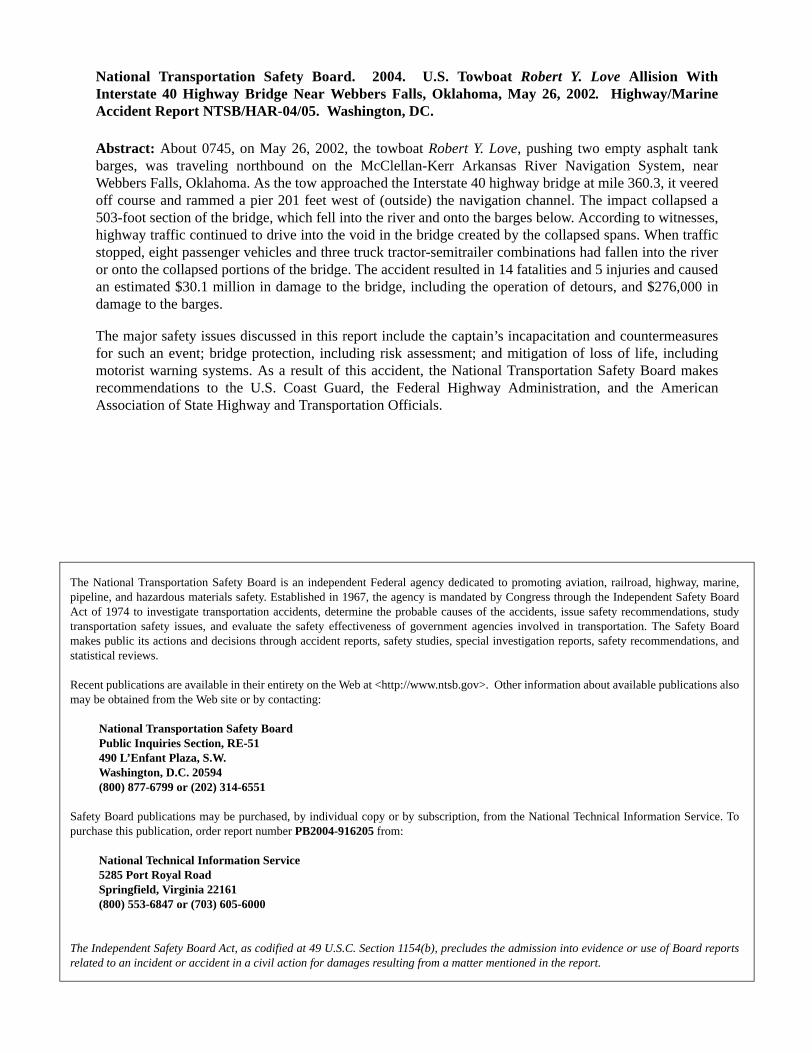
National Transportation Safety Board. 2004. U.S. Towboat Robert Y. Love Allision WithInterstate 40 Highway Bridge Near Webbers Falls, Oklahoma, May 26, 2002. Highway/MarineAccident Report NTSB/HAR-04/05. Washington, DC.
Abstract: About 0745, on May 26, 2002, the towboat Robert Y. Love, pushing two empty asphalt tankbarges, was traveling northbound on the McClellan-Kerr Arkansas River Navigation System, nearWebbers Falls, Oklahoma. As the tow approached the Interstate 40 highway bridge at mile 360.3, it veeredoff course and rammed a pier 201 feet west of (outside) the navigation channel. The impact collapsed a503-foot section of the bridge, which fell into the river and onto the barges below. According to witnesses,highway traffic continued to drive into the void in the bridge created by the collapsed spans. When trafficstopped, eight passenger vehicles and three truck tractor-semitrailer combinations had fallen into the riveror onto the collapsed portions of the bridge. The accident resulted in 14 fatalities and 5 injuries and causedan estimated $30.1 million in damage to the bridge, including the operation of detours, and $276,000 indamage to the barges.
The major safety issues discussed in this report include the captain’s incapacitation and countermeasuresfor such an event; bridge protection, including risk assessment; and mitigation of loss of life, includingmotorist warning systems. As a result of this accident, the National Transportation Safety Board makesrecommendations to the U.S. Coast Guard, the Federal Highway Administration, and the AmericanAssociation of State Highway and Transportation Officials.
The National Transportation Safety Board is an independent Federal agency dedicated to promoting aviation, railroad, highway, marine,pipeline, and hazardous materials safety. Established in 1967, the agency is mandated by Congress through the Independent Safety BoardAct of 1974 to investigate transportation accidents, determine the probable causes of the accidents, issue safety recommendations, studytransportation safety issues, and evaluate the safety effectiveness of government agencies involved in transportation. The Safety Boardmakes public its actions and decisions through accident reports, safety studies, special investigation reports, safety recommendations, andstatistical reviews.
Recent publications are available in their entirety on the Web at <http://www.ntsb.gov>. Other information about available publications alsomay be obtained from the Web site or by contacting:
National Transportation Safety BoardPublic Inquiries Section, RE-51490 L’Enfant Plaza, S.W.Washington, D.C. 20594(800) 877-6799 or (202) 314-6551
Safety Board publications may be purchased, by individual copy or by subscription, from the National Technical Information Service. Topurchase this publication, order report number PB2004-916205 from:
National Technical Information Service5285 Port Royal RoadSpringfield, Virginia 22161(800) 553-6847 or (703) 605-6000
The Independent Safety Board Act, as codified at 49 U.S.C. Section 1154(b), precludes the admission into evidence or use of Board reportsrelated to an incident or accident in a civil action for damages resulting from a matter mentioned in the report.
iii Highway Accident Report
Contents
Acronyms and Abbreviations . . . . . . . . . . . . . . . . . . . . . . . . . . . . . . . . . . . . . . . . . . . . . . . . . . . v
Executive Summary . . . . . . . . . . . . . . . . . . . . . . . . . . . . . . . . . . . . . . . . . . . . . . . . . . . . . . . . . . . vii
Factual Information. . . . . . . . . . . . . . . . . . . . . . . . . . . . . . . . . . . . . . . . . . . . . . . . . . . . . . . . . . . . . 1Accident Narrative . . . . . . . . . . . . . . . . . . . . . . . . . . . . . . . . . . . . . . . . . . . . . . . . . . . . . . . . . . . . . 1
Robert Y. Love . . . . . . . . . . . . . . . . . . . . . . . . . . . . . . . . . . . . . . . . . . . . . . . . . . . . . . . . . . . . . 1Highway Vehicles on Bridge . . . . . . . . . . . . . . . . . . . . . . . . . . . . . . . . . . . . . . . . . . . . . . . . 8Recreational Boats . . . . . . . . . . . . . . . . . . . . . . . . . . . . . . . . . . . . . . . . . . . . . . . . . . . . . . . . . 9
Emergency Response . . . . . . . . . . . . . . . . . . . . . . . . . . . . . . . . . . . . . . . . . . . . . . . . . . . . . . . . . 10Injuries . . . . . . . . . . . . . . . . . . . . . . . . . . . . . . . . . . . . . . . . . . . . . . . . . . . . . . . . . . . . . . . . . . . . . . 11Damage . . . . . . . . . . . . . . . . . . . . . . . . . . . . . . . . . . . . . . . . . . . . . . . . . . . . . . . . . . . . . . . . . . . . . 11Crew Information . . . . . . . . . . . . . . . . . . . . . . . . . . . . . . . . . . . . . . . . . . . . . . . . . . . . . . . . . . . . . 12
Captain . . . . . . . . . . . . . . . . . . . . . . . . . . . . . . . . . . . . . . . . . . . . . . . . . . . . . . . . . . . . . . . . . . 12Captain’s 72-Hour History . . . . . . . . . . . . . . . . . . . . . . . . . . . . . . . . . . . . . . . . . . . . . . . . . 13
Operations . . . . . . . . . . . . . . . . . . . . . . . . . . . . . . . . . . . . . . . . . . . . . . . . . . . . . . . . . . . . . . . . . . . 15Vessel Information . . . . . . . . . . . . . . . . . . . . . . . . . . . . . . . . . . . . . . . . . . . . . . . . . . . . . . . . . . . 15Waterway Information . . . . . . . . . . . . . . . . . . . . . . . . . . . . . . . . . . . . . . . . . . . . . . . . . . . . . . . . 16Highway Information . . . . . . . . . . . . . . . . . . . . . . . . . . . . . . . . . . . . . . . . . . . . . . . . . . . . . . . . . 19
Bridge Information . . . . . . . . . . . . . . . . . . . . . . . . . . . . . . . . . . . . . . . . . . . . . . . . . . . . . . . . 19Bridge Management Systems . . . . . . . . . . . . . . . . . . . . . . . . . . . . . . . . . . . . . . . . . . . . . . . 27Bridge Sufficiency Ratings . . . . . . . . . . . . . . . . . . . . . . . . . . . . . . . . . . . . . . . . . . . . . . . . . 27
Meteorological Information . . . . . . . . . . . . . . . . . . . . . . . . . . . . . . . . . . . . . . . . . . . . . . . . . . . . 29Medical and Pathological Information . . . . . . . . . . . . . . . . . . . . . . . . . . . . . . . . . . . . . . . . . . . 29
Postaccident Toxicology . . . . . . . . . . . . . . . . . . . . . . . . . . . . . . . . . . . . . . . . . . . . . . . . . . . 29Medical Information . . . . . . . . . . . . . . . . . . . . . . . . . . . . . . . . . . . . . . . . . . . . . . . . . . . . . . . 30
Survival Aspects . . . . . . . . . . . . . . . . . . . . . . . . . . . . . . . . . . . . . . . . . . . . . . . . . . . . . . . . . . . . . 32Tests and Research . . . . . . . . . . . . . . . . . . . . . . . . . . . . . . . . . . . . . . . . . . . . . . . . . . . . . . . . . . . 33
Vessel . . . . . . . . . . . . . . . . . . . . . . . . . . . . . . . . . . . . . . . . . . . . . . . . . . . . . . . . . . . . . . . . . . . 33Global Positioning System . . . . . . . . . . . . . . . . . . . . . . . . . . . . . . . . . . . . . . . . . . . . . . . . . 33Sight Distance . . . . . . . . . . . . . . . . . . . . . . . . . . . . . . . . . . . . . . . . . . . . . . . . . . . . . . . . . . . . 35Time Distance . . . . . . . . . . . . . . . . . . . . . . . . . . . . . . . . . . . . . . . . . . . . . . . . . . . . . . . . . . . . 35
Other Information . . . . . . . . . . . . . . . . . . . . . . . . . . . . . . . . . . . . . . . . . . . . . . . . . . . . . . . . . . . . 36Licensed Operators’ Hours of Service . . . . . . . . . . . . . . . . . . . . . . . . . . . . . . . . . . . . . . . 36Towboat Operator Incapacitation Accidents . . . . . . . . . . . . . . . . . . . . . . . . . . . . . . . . . . 36Alerter Systems . . . . . . . . . . . . . . . . . . . . . . . . . . . . . . . . . . . . . . . . . . . . . . . . . . . . . . . . . . . 36American Waterways Operators . . . . . . . . . . . . . . . . . . . . . . . . . . . . . . . . . . . . . . . . . . . . 37Coast Guard-AWO Safety Partnership . . . . . . . . . . . . . . . . . . . . . . . . . . . . . . . . . . . . . . . 37Motorist Warning Systems . . . . . . . . . . . . . . . . . . . . . . . . . . . . . . . . . . . . . . . . . . . . . . . . . 42Bridge Safety and Security . . . . . . . . . . . . . . . . . . . . . . . . . . . . . . . . . . . . . . . . . . . . . . . . . 45
Analysis . . . . . . . . . . . . . . . . . . . . . . . . . . . . . . . . . . . . . . . . . . . . . . . . . . . . . . . . . . . . . . . . . . . . . . . 47General . . . . . . . . . . . . . . . . . . . . . . . . . . . . . . . . . . . . . . . . . . . . . . . . . . . . . . . . . . . . . . . . . . . . . 47Exclusions . . . . . . . . . . . . . . . . . . . . . . . . . . . . . . . . . . . . . . . . . . . . . . . . . . . . . . . . . . . . . . . . . . . 47The Accident . . . . . . . . . . . . . . . . . . . . . . . . . . . . . . . . . . . . . . . . . . . . . . . . . . . . . . . . . . . . . . . . 49
Contents iv Highway Accident Report
Captain’s Incapacitation . . . . . . . . . . . . . . . . . . . . . . . . . . . . . . . . . . . . . . . . . . . . . . . . . . . 50The Allision . . . . . . . . . . . . . . . . . . . . . . . . . . . . . . . . . . . . . . . . . . . . . . . . . . . . . . . . . . . . . . 51
Allision Prevention . . . . . . . . . . . . . . . . . . . . . . . . . . . . . . . . . . . . . . . . . . . . . . . . . . . . . . . . . . . 53Wheelhouse Alerter Systems . . . . . . . . . . . . . . . . . . . . . . . . . . . . . . . . . . . . . . . . . . . . . . . 53Safe Transit Procedures . . . . . . . . . . . . . . . . . . . . . . . . . . . . . . . . . . . . . . . . . . . . . . . . . . . . 54
Bridge Protection . . . . . . . . . . . . . . . . . . . . . . . . . . . . . . . . . . . . . . . . . . . . . . . . . . . . . . . . . . . . . 55Motorist Warning Systems . . . . . . . . . . . . . . . . . . . . . . . . . . . . . . . . . . . . . . . . . . . . . . . . . . . . . 58
Conclusions . . . . . . . . . . . . . . . . . . . . . . . . . . . . . . . . . . . . . . . . . . . . . . . . . . . . . . . . . . . . . . . . . . . . 61Findings . . . . . . . . . . . . . . . . . . . . . . . . . . . . . . . . . . . . . . . . . . . . . . . . . . . . . . . . . . . . . . . . . . . . . 61Probable Cause . . . . . . . . . . . . . . . . . . . . . . . . . . . . . . . . . . . . . . . . . . . . . . . . . . . . . . . . . . . . . . . 62
Recommendations . . . . . . . . . . . . . . . . . . . . . . . . . . . . . . . . . . . . . . . . . . . . . . . . . . . . . . . . . . . . . 63New Recommendations . . . . . . . . . . . . . . . . . . . . . . . . . . . . . . . . . . . . . . . . . . . . . . . . . . . . . . . 63Previously Issued Recommendation Classified in This Report . . . . . . . . . . . . . . . . . . . . . . 63
AppendixesA: Investigation and Public Hearing . . . . . . . . . . . . . . . . . . . . . . . . . . . . . . . . . . . . . . . . . 65B: Vessel Impact Force Calculations . . . . . . . . . . . . . . . . . . . . . . . . . . . . . . . . . . . . . . . . . 66C: Previous Recommendations on Safe Transit Procedures,
Bridge Vulnerability and Protection, and Motorist Warning Systems . . . . . . . . . . . . . 68
v Highway Accident Report
Acronyms and Abbreviations
AASHTO American Association of State Highway and Transportation Officials
ADT average daily traffic countARTCO American River Transportation CompanyASTM American Association for Testing and MaterialsAWO American Waterways OperatorsBEC Blubaugh Engineering CompanyBMS bridge management systemCAMI Civil Aerospace Medical InstituteCEMS Crew Endurance Management SystemCFR Code of Federal RegulationsDOT U.S. Department of TransportationEMS emergency medical serviceEPS electrophysiological studyFDOT Florida Department of TransportationFHWA Federal Highway AdministrationGPS global positioning systemI-40 Interstate 40I-40 bridge Interstate 40 highway bridgeICD implantable cardioverter defibrillatorISTEA Intermodal Surface Transportation Efficiency Act of 1991Louisiana DOTD Louisiana Department of Transportation and
DevelopmentLMR Lower Mississippi RiverLRFD load and resistance factor designM-KARNS McClellan-Kerr Arkansas River Navigation SystemMMT Magnolia Marine Transport CompanyMUTCD Manual on Uniform Traffic Control DevicesNBI National Bridge InventoryODOT Oklahoma Department of TransportationPCP phencyclidinePI point of intersectionRCP Responsible Carrier Program
Acronyms and Abbreviations vi Highway Accident Report
SHM Structural Health MonitoringSTRAHNET Strategic Highway NetworkUMR Upper Mississippi RiverUSACE U.S. Army Corps of EngineersU.S.C. United States CodeVessel Collision GuideSpecifications Guide Specification and Commentary for Vessel
Collision Design of Highway BridgesWGS 84 World Geodetic System 1984
vii Highway Accident Report
Executive Summary
About 0745, on May 26, 2002, the towboat Robert Y. Love, pushing two emptyasphalt tank barges, was traveling northbound on the McClellan-Kerr Arkansas RiverNavigation System, near Webbers Falls, Oklahoma. As the tow approached the Interstate40 highway bridge at mile 360.3, it veered off course and rammed a pier 201 feet west of(outside) the navigation channel. The impact collapsed a 503-foot section of the bridge,which fell into the river and onto the barges below. According to witnesses, highwaytraffic continued to drive into the void in the bridge created by the collapsed spans. Whentraffic stopped, eight passenger vehicles and three truck tractor-semitrailer combinationshad fallen into the river or onto the collapsed portions of the bridge. The accident resultedin 14 fatalities and 5 injuries and caused an estimated $30.1 million in damage to thebridge, including the operation of detours, and $276,000 in damage to the barges.
The National Transportation Safety Board determines that the probable cause ofthe Robert Y. Love’s allision with the Interstate 40 highway bridge and its subsequentcollapse was the captain’s loss of consciousness, possibly as the result of an unforeseeableabnormal heart rhythm. Contributing to the loss of life was the inability of motorists todetect the collapsed bridge in time to stop their vehicles.
Major safety issues identified in this accident include:
• The captain’s incapacitation and countermeasures for such an event;
• Bridge protection, including risk assessment; and
• Mitigation of loss of life, including motorist warning systems.
As a result of this accident, the National Transportation Safety Board makesrecommendations to the U.S. Coast Guard, the Federal Highway Administration, and theAmerican Association of State Highway and Transportation Officials.

1 Highway Accident Report
Factual Information
Accident Narrative
About 0745,1 on May 26, 2002, the towboat Robert Y. Love, pushing two emptyasphalt tank barges, was traveling northbound on the McClellan-Kerr Arkansas RiverNavigation System (M-KARNS),2 near Webbers Falls, Oklahoma. As the tow approachedthe Interstate 40 highway bridge at mile 360.3, it veered off course and rammed a pier 201feet west of (outside) the navigation channel. The impact collapsed a 503-foot section of thebridge, which fell into the river and onto the barges below. According to witnesses, highwaytraffic continued to drive into the void in the bridge created by the collapsed spans. Whentraffic stopped, eight passenger vehicles and three truck tractor-semitrailer combinations hadfallen into the river or onto the collapsed portions of the bridge. The accident resulted in 14fatalities and 5 injuries and caused an estimated $30.1 million in damage to the bridge,including the operation of detours, and $276,000 in damage to the barges.
Robert Y. LoveAt 0340 on May 19, 2002, the towboat Robert Y. Love departed Decatur, Alabama,
mile 299, Tennessee River, en route to Catoosa, Oklahoma, pushing ahead two empty297-foot-long asphalt tank barges (MM-60 and MM-62), side by side (108 feet totalwidth), with a draft3 of 1 foot. (See figures 1 through 3.) On board were the licensedmaster (captain) and pilot4 and four unlicensed crewmembers—a chief engineer, twomates, and one deckhand. On May 21, a third empty barge, MM-54B, was added to thetow at mile 4, Tennessee River; on May 22, MM-54B was removed from the tow atRosedale Fleet, mile 585, LMR.5 (See figure 3, locations 2 and 3.) On May 23, the towentered M-KARNS at mile 599, LMR, heading northwest toward Catoosa on the VerdigrisRiver, mile 444.8, M-KARNS. (See figure 3, locations 4 and 5, and figure 4.)
1 All times in this report are central daylight time based on the 24-hour clock.2 On U.S. Army Corps of Engineers (USACE) river navigation charts, river miles along the
M-KARNS are measured from mile 0, where the M-KARNS enters the Lower Mississippi River (LMR),westward for 444.8 miles to the head of navigation on the Verdigris River at Catoosa, Oklahoma. TheM-KARNS flows southeastward from the Rocky Mountains in Colorado and enters the LMR at mile 599.(All miles are statute miles of 5,280 feet.) USACE controls the use and administration of the structures(bank protection, shore facility permits, regulation of water flow, and operation of the lock and dams).
3 Draft refers to the depth measured from the waterline to the lowest immersed part of hull or bottom of keel.4 In accordance with standard marine terminology for river towboats, the terms captain and pilot are used
to differentiate between the two licensed operators who navigate a vessel. The captain is the senior licensedoperator of uninspected towing vessels and is in charge of the vessel. The captain stands the 0600-1200 and the1800-2400 watches, and the pilot stands the alternate watches; the watch schedule may vary depending oncompany policy or boat operator’s preference. Each operator is required to have a U.S. Coast Guard (CoastGuard) license as master of uninspected towing vessels for the waters on which the vessel operates.
5 For navigation purposes, the Mississippi River is divided into the LMR and the Upper MississippiRiver (UMR). The LMR extends north from the Gulf of Mexico to the confluence of the Ohio River. TheUMR extends north from the Ohio River to the head of navigation at Minneapolis, Minnesota.
Factual Information 2 Highway Accident Report
Figure 1. Towboat Robert Y. Love. (Source: Magnolia Marine Transport Company)
Figure 2. Schematic of towboat Robert Y. Love and barge tow.
Factual Information 3 Highway Accident Report
On May 25, about 1840, while the tow was at lock 13 (near Van Buren, Arkansas),mile 292.8, M-KARNS, the alternate captain departed on vacation and was relieved by theregular captain. The regular captain took the navigation watch about 1910 and wasrelieved at the end of the watch by the pilot about 2245 on May 25. On May 26, about0530, the pilot was, in turn, relieved by the captain.
Figure 3. Map showing origin, selected locations, and destination of tow.
Factual Information 4 Highway Accident Report
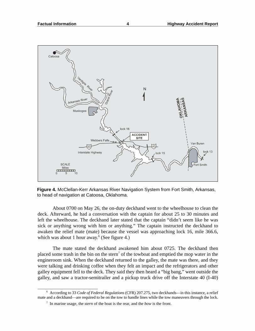
About 0700 on May 26, the on-duty deckhand went to the wheelhouse to clean thedeck. Afterward, he had a conversation with the captain for about 25 to 30 minutes andleft the wheelhouse. The deckhand later stated that the captain “didn’t seem like he wassick or anything wrong with him or anything.” The captain instructed the deckhand toawaken the relief mate (mate) because the vessel was approaching lock 16, mile 366.6,which was about 1 hour away.6 (See figure 4.)
The mate stated the deckhand awakened him about 0725. The deckhand thenplaced some trash in the bin on the stern7 of the towboat and emptied the mop water in theengineroom sink. When the deckhand returned to the galley, the mate was there, and theywere talking and drinking coffee when they felt an impact and the refrigerators and othergalley equipment fell to the deck. They said they then heard a “big bang,” went outside thegalley, and saw a tractor-semitrailer and a pickup truck drive off the Interstate 40 (I-40)
Figure 4. McClellan-Kerr Arkansas River Navigation System from Fort Smith, Arkansas, to head of navigation at Catoosa, Oklahoma.
6 According to 33 Code of Federal Regulations (CFR) 207.275, two deckhands—in this instance, a reliefmate and a deckhand—are required to be on the tow to handle lines while the tow maneuvers through the lock.
7 In marine usage, the stern of the boat is the rear, and the bow is the front.
Factual Information 5 Highway Accident Report
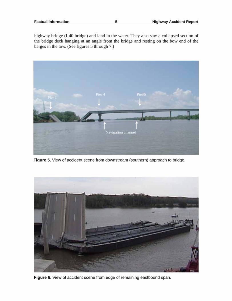
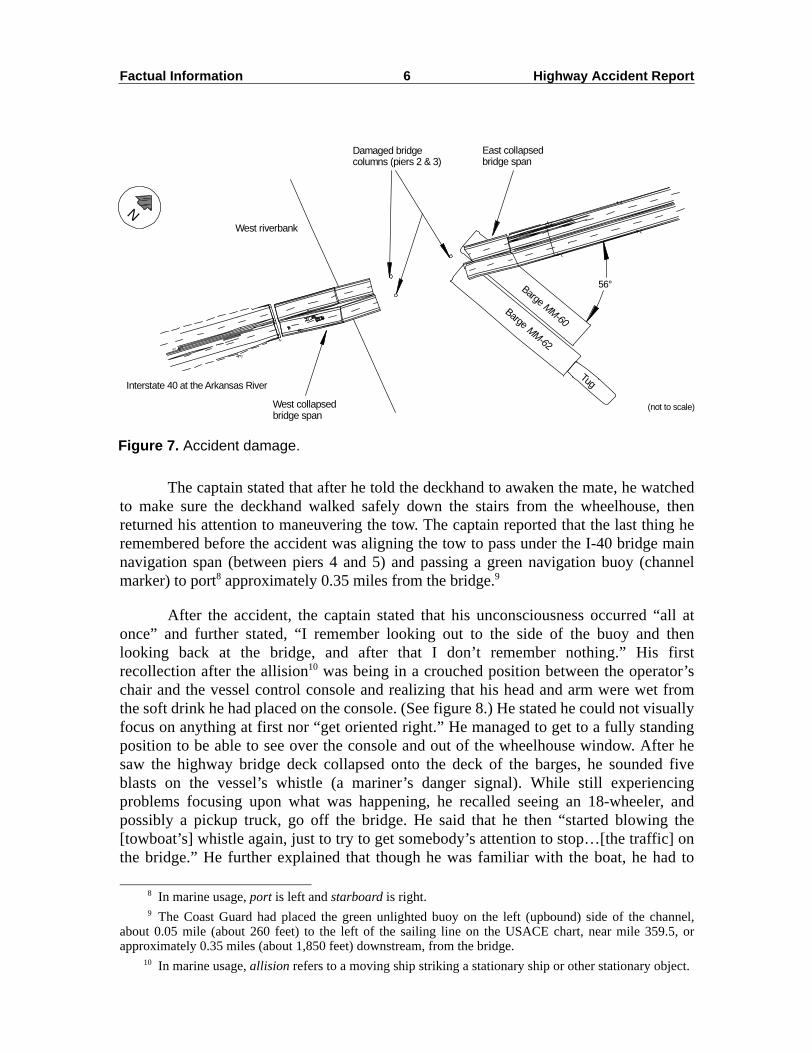
highway bridge (I-40 bridge) and land in the water. They also saw a collapsed section ofthe bridge deck hanging at an angle from the bridge and resting on the bow end of thebarges in the tow. (See figures 5 through 7.)
Figure 5. View of accident scene from downstream (southern) approach to bridge.
Figure 6. View of accident scene from edge of remaining eastbound span.
Pier 1Pier 4 Pier 5
Navigation channel
Factual Information 6 Highway Accident Report
The captain stated that after he told the deckhand to awaken the mate, he watchedto make sure the deckhand walked safely down the stairs from the wheelhouse, thenreturned his attention to maneuvering the tow. The captain reported that the last thing heremembered before the accident was aligning the tow to pass under the I-40 bridge mainnavigation span (between piers 4 and 5) and passing a green navigation buoy (channelmarker) to port8 approximately 0.35 miles from the bridge.9
After the accident, the captain stated that his unconsciousness occurred “all atonce” and further stated, “I remember looking out to the side of the buoy and thenlooking back at the bridge, and after that I don’t remember nothing.” His firstrecollection after the allision10 was being in a crouched position between the operator’schair and the vessel control console and realizing that his head and arm were wet fromthe soft drink he had placed on the console. (See figure 8.) He stated he could not visuallyfocus on anything at first nor “get oriented right.” He managed to get to a fully standingposition to be able to see over the console and out of the wheelhouse window. After hesaw the highway bridge deck collapsed onto the deck of the barges, he sounded fiveblasts on the vessel’s whistle (a mariner’s danger signal). While still experiencingproblems focusing upon what was happening, he recalled seeing an 18-wheeler, andpossibly a pickup truck, go off the bridge. He said that he then “started blowing the[towboat’s] whistle again, just to try to get somebody’s attention to stop…[the traffic] onthe bridge.” He further explained that though he was familiar with the boat, he had to
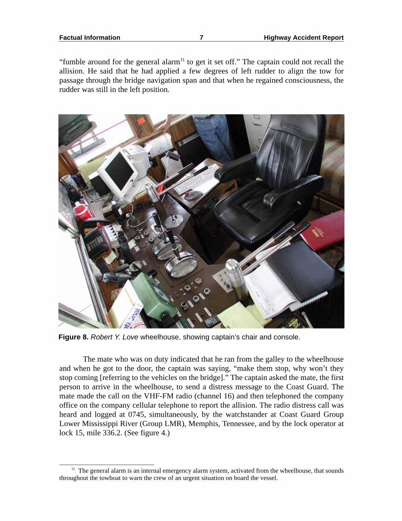
Figure 7. Accident damage.
8 In marine usage, port is left and starboard is right.9 The Coast Guard had placed the green unlighted buoy on the left (upbound) side of the channel,
about 0.05 mile (about 260 feet) to the left of the sailing line on the USACE chart, near mile 359.5, orapproximately 0.35 miles (about 1,850 feet) downstream, from the bridge.
10 In marine usage, allision refers to a moving ship striking a stationary ship or other stationary object.
Interstate 40 at the Arkansas River
(not to scale)
N
97 27
G
YY
R
L
L
L
L
M
Barge
Barge
Tug
West riverbank
East collapsedbridge span
West collapsedbridge span
Damaged bridgecolumns (piers 2 & 3)
MM-60MM-62
56°
Factual Information 7 Highway Accident Report
“fumble around for the general alarm11 to get it set off.” The captain could not recall theallision. He said that he had applied a few degrees of left rudder to align the tow forpassage through the bridge navigation span and that when he regained consciousness, therudder was still in the left position.
The mate who was on duty indicated that he ran from the galley to the wheelhouseand when he got to the door, the captain was saying, “make them stop, why won’t theystop coming [referring to the vehicles on the bridge].” The captain asked the mate, the firstperson to arrive in the wheelhouse, to send a distress message to the Coast Guard. Themate made the call on the VHF-FM radio (channel 16) and then telephoned the companyoffice on the company cellular telephone to report the allision. The radio distress call washeard and logged at 0745, simultaneously, by the watchstander at Coast Guard GroupLower Mississippi River (Group LMR), Memphis, Tennessee, and by the lock operator atlock 15, mile 336.2. (See figure 4.)
11 The general alarm is an internal emergency alarm system, activated from the wheelhouse, that soundsthroughout the towboat to warn the crew of an urgent situation on board the vessel.
Figure 8. Robert Y. Love wheelhouse, showing captain’s chair and console.
Factual Information 8 Highway Accident Report
The remainder of the crew heard the towboat’s whistle sound, followed by thesounding of the general alarm bell. While making routine engine room rounds, the chiefengineer heard the bell. He reported hearing the accident about 0750 and that the impactcaused him to fall to one knee. He immediately returned to the engineroom to check voidspaces for flooding and was in the engineroom for 10 to 15 minutes. The engineer statedthat he did not notice any engine speed changes before the accident and that had theengine speeds changed before the accident, he would have easily noticed the change.
The pilot and the other mate were off duty and asleep in their quarters during theallision. The pilot, who was in his bed when he felt a bump, heard the towboat’s whistlesounding and then heard the general alarm sound. He looked out of his window (his roomwas on the port side of the main deck, aft) and saw the bridge deck lying on the barges. Hesaid he immediately ran out of the deckhouse and went to the head of the tow to check thecondition of the barges. About 45 seconds to a minute and a half later, after checking thetow, the pilot arrived in the wheelhouse and found: “The captain was visibly shaken…Hewas standing, and he was in tears, shaken.” The pilot then relieved the captain from watchand the mate from handling communications. The mate and the pilot stated that the captaintold them that he had passed out, that he did not hear or see the impact, and that the lastthing that he remembered was seeing the deckhand walk out of the wheelhouse.
The pilot stated he heard people in the water yelling for help, so he directed themate and chief engineer to put the vessel’s motorboat into the water to determine whetherthey could render assistance. The mate and chief engineer searched for survivors for about30 minutes, saw a recreational boat rescue one person, and then returned to the towboatwithout rescuing anyone.
Highway Vehicles on BridgeEleven vehicles carrying 19 occupants either collapsed with or drove off the
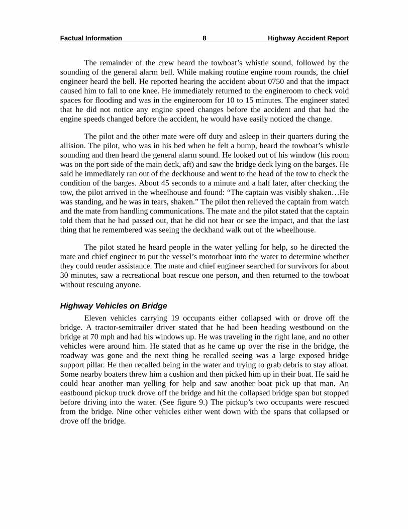
bridge. A tractor-semitrailer driver stated that he had been heading westbound on thebridge at 70 mph and had his windows up. He was traveling in the right lane, and no othervehicles were around him. He stated that as he came up over the rise in the bridge, theroadway was gone and the next thing he recalled seeing was a large exposed bridgesupport pillar. He then recalled being in the water and trying to grab debris to stay afloat.Some nearby boaters threw him a cushion and then picked him up in their boat. He said hecould hear another man yelling for help and saw another boat pick up that man. Aneastbound pickup truck drove off the bridge and hit the collapsed bridge span but stoppedbefore driving into the water. (See figure 9.) The pickup’s two occupants were rescuedfrom the bridge. Nine other vehicles either went down with the spans that collapsed ordrove off the bridge.
Factual Information 9 Highway Accident Report
Recreational BoatsAt the time of the accident, a fishing tournament was underway out of Webbers
Falls (2.6 river miles upstream of the I-40 bridge). One of the contestants observed theRobert Y. Love and tow headed to the west bank of the river, outside the main navigationspan. He indicated that after the tow struck the bridge supports, the span collapsedimmediately. Another pair of contestants, who were upriver of the bridge when they hearda loud boom, observed a section of the bridge span collapse and a number of vehicles enterthe water. The operator of this boat said that he saw at least one vehicle fall with the bridgeand he then accelerated his boat toward the bridge, and reached the area in about 20seconds. He also stated that he saw two more vehicles drive off the bridge and called 911,reaching the Muskogee Police Department. After the call, he saw five more vehicles driveoff the bridge. He indicated that most, if not all, of these vehicles came from thewestbound lanes. When the boat was about 30 to 40 yards upstream, he fired a flare from ahand-held flare pistol toward the bridge, in front of a tractor-trailer truck traveling fromthe east side of the bridge to the west side, to warn the driver of the danger. Thetruckdriver stopped, before reaching the edge of the collapsed span, partially jackknifingon the roadway. Vehicles behind this truck stopped before reaching the tractor-trailer
Figure 9. Eastbound pickup that drove off bridge onto collapsed span but stopped before driving into void.
Factual Information 10 Highway Accident Report
truck. The same recreational boat then rescued a person in the water near the bow of onebarge. The boat occupants saw two other recreational boats, also from the tournament;each of them rescued a person from the water. In all, three survivors were rescued from thewater. The recreational boats took the three survivors to a boat ramp at Webbers Falls,where they waited for emergency medical service (EMS) personnel to arrive on scene.
Emergency Response
At 0748, the Muskogee Police Department received the first of approximately 25calls regarding a bridge collapse at I-40 and the Arkansas River with several vehicles inthe water. Seven local police departments12 responded, as well as the OklahomaHighway Patrol and the Muskogee Police Department. Six ambulances responded; thefirst arrived on scene at 0756. In addition, 17 local fire departments,13 10 EMSdepartments,14 8 emergency management agencies,15 7 State agencies,16 and 7 Federalagencies,17 for a total of 58 local, State, and Federal agencies, responded to thisaccident.
After receiving the distress call from the Robert Y. Love, the watchstander atCoast Guard Group LMR sent an urgent marine information broadcast at 0746 overVHF-FM radio channel 16 advising mariners of the accident. He then used the Group’sbridge allision checklist and contacted the Arkansas State Police, who advised that theyhad called the Muskogee Police Department and had other units en route to the bridge at0747. The Coast Guard watchstander then notified the 8th Coast Guard District office,New Orleans, Louisiana, which is the next senior operational command over the CoastGuard Group LMR. He also notified the Coast Guard Marine Safety Office, Memphis,
12 Muskogee County Sheriff’s Department sheriff and deputies, Gans Police Department, Gore PoliceDepartment, Checotah Police Department, McIntosh County Sheriff’s Office, Tulsa Police Department, andFort Gibson Police Department.
13 Muskogee Fire Department, Ash Creek Fire Department, Fort Gibson Fire Department, WilburtonFire Department, Porum Fire Department, Warner Volunteer Fire Department, Norwood Fire Department,Sallisaw Fire Department, Spring Valley Fire Department, Keota Fire Department, Texanna FireDepartment, West End Fire Department, Checotah Fire and Emergency Management, Tulsa FireDepartment, Vian Fire Department, Onapa Fire Department, and the Oklahoma City Fire Department.
14 Muskogee County, Fort Gibson, Warner, Haskell, Cherokee County, Sequoyah County, NortheastOklahoma Underwater Recovery, Washington County Rescue, Vian First Responder, and McIntosh Officeof Emergency Services.
15 Muskogee City Emergency Operations Center, Muskogee County Emergency Management, GroveEmergency Management, Washington County Emergency Operations Center, Cherokee County EmergencyManagement, Haskell County Emergency Management, Pittsburg County Emergency Management, andSequoyah County Emergency Management.
16 Oklahoma Department of Public Safety Communications, Oklahoma Department of Transportation,Oklahoma Office of Emergency Management, Oklahoma National Guard, State Medical Examiners Office,Department of Environmental Quality, and Oklahoma State Bureau of Investigations.
17 USACE, the Federal Highway Administration, the U.S. Environmental Protection Agency, the U.S.Fish and Wildlife Service, the Coast Guard Gulf Strike Team, the U.S. National Guard, and the NationalWeather Service.
Factual Information 11 Highway Accident Report
Tennessee, which is responsible for marine safety activities on the Arkansas River. At0846, the Captain of the Port, Memphis,18 ordered the river closed to vessel traffic frommile 357 to 363, Arkansas River. At 1100, the Captain of the Port, Memphis, issued asafety marine information broadcast advising mariners that diving operations for vehiclesand occupants were being conducted at the I-40 bridge, mile 360.3, Arkansas River. Thebroadcast further directed search and rescue units to “transit the area at the slowest safespeed possible and transit with extreme caution.”
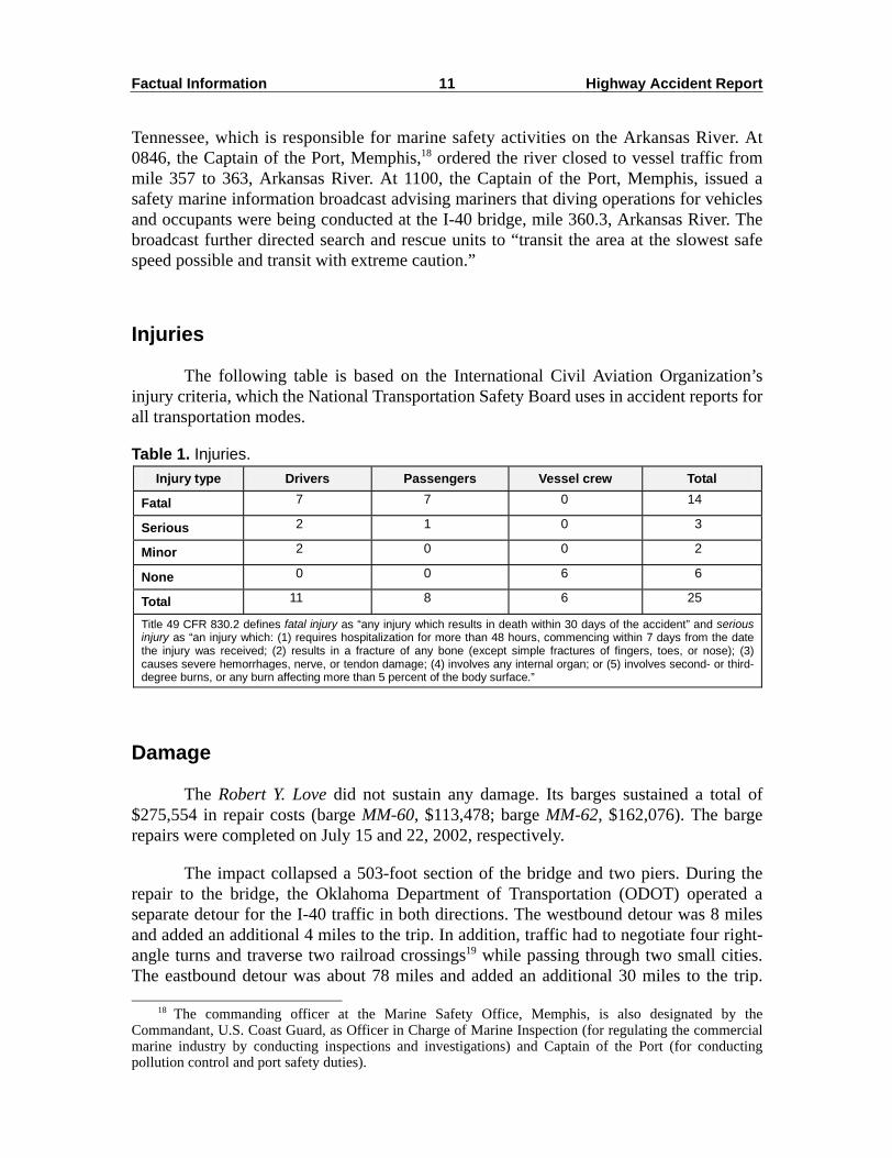
Injuries
The following table is based on the International Civil Aviation Organization’sinjury criteria, which the National Transportation Safety Board uses in accident reports forall transportation modes.
Table 1. Injuries.
Damage
The Robert Y. Love did not sustain any damage. Its barges sustained a total of$275,554 in repair costs (barge MM-60, $113,478; barge MM-62, $162,076). The bargerepairs were completed on July 15 and 22, 2002, respectively.
The impact collapsed a 503-foot section of the bridge and two piers. During therepair to the bridge, the Oklahoma Department of Transportation (ODOT) operated aseparate detour for the I-40 traffic in both directions. The westbound detour was 8 milesand added an additional 4 miles to the trip. In addition, traffic had to negotiate four right-angle turns and traverse two railroad crossings19 while passing through two small cities.The eastbound detour was about 78 miles and added an additional 30 miles to the trip.
18 The commanding officer at the Marine Safety Office, Memphis, is also designated by theCommandant, U.S. Coast Guard, as Officer in Charge of Marine Inspection (for regulating the commercialmarine industry by conducting inspections and investigations) and Captain of the Port (for conductingpollution control and port safety duties).
Injury type Drivers Passengers Vessel crew Total
Fatal 7 7 0 14
Serious 2 1 0 3
Minor 2 0 0 2
None 0 0 6 6
Total 11 8 6 25
Title 49 CFR 830.2 defines fatal injury as “any injury which results in death within 30 days of the accident” and serious injury as “an injury which: (1) requires hospitalization for more than 48 hours, commencing within 7 days from the date the injury was received; (2) results in a fracture of any bone (except simple fractures of fingers, toes, or nose); (3) causes severe hemorrhages, nerve, or tendon damage; (4) involves any internal organ; or (5) involves second- or third-degree burns, or any burn affecting more than 5 percent of the body surface.”
Factual Information 12 Highway Accident Report
According to ODOT, numerous bridges along the detour route had to be repaired andmonitored to accommodate the interstate commercial traffic volumes. The bridgereopened for traffic on July 29, 2002, 65 days after the accident. ODOT estimated that thetotal cost of the bridge repairs, including operating the detours, was $30.1 million.
Crew Information
The Robert Y. Love had a crew of six, including the captain and the pilot, who bothheld licenses in accordance with U.S. law. The remainder of the crew was not required tohold a Coast Guard license.
CaptainThe captain, age 60 at the time of the accident, began his marine career on the
Mississippi River in November 1957 and for about 40 years had been working in variouscapacities on board inland towing vessels operating on the Western Rivers20 of the UnitedStates. He started as a deckhand, serving in that capacity through the 1960s before beingassigned to the wheelhouse for training as a vessel operator. On May 21, 1973, he obtainedhis original Coast Guard license as operator of uninspected towing vessels.21 In 1991, hewent to work for Magnolia Marine Transport Company (MMT), the owner of the RobertY. Love, serving as a pilot, relief captain, and captain of its vessels. He had been thecaptain of the Robert Y. Love since February 22, 2001. At the time of this accident, he helda Coast Guard license as an operator of uninspected towing vessels upon the Great Lakesand Inland Waters with a radar observer (unlimited) endorsement. His current license hadbeen issued in December 1997 and was due to expire in December 2002. In December1997, he completed a radar observer (unlimited) training course to renew the radarendorsement on his license, as required by Coast Guard regulations.
19 About 18 to 20 trains per day traversed these rail crossings; the trains were more than 100 cars longand loaded with coal destined for an electrical generating facility.
20 The Western Rivers consist of the Mississippi River and all of its tributaries and connectingwaterways, the Gulf Intracoastal Waterways, and the other navigable river systems that empty into the Gulfof Mexico.
21 The Towing Vessel Licensing Act of July 7, 1972, requires that all commercial vessels 26 or morefeet long engaged, or intended to be engaged, in the service of towing be under the direction and control ofpersons licensed by the Coast Guard.
Factual Information 13 Highway Accident Report
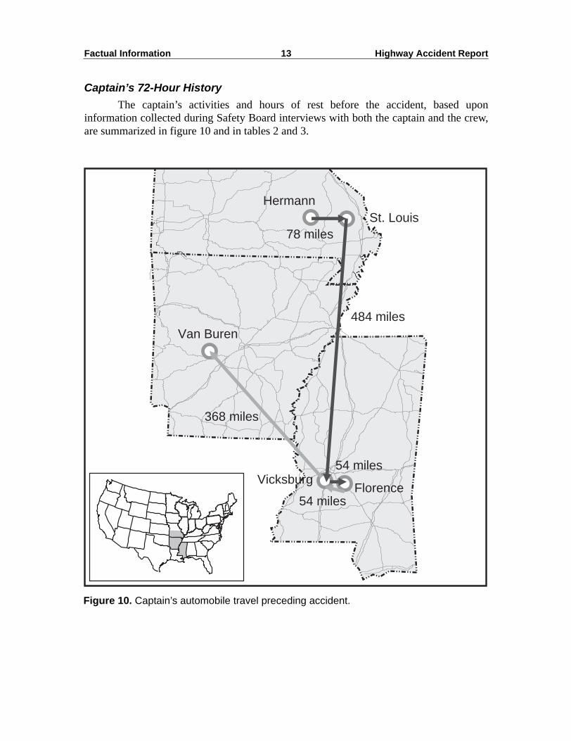
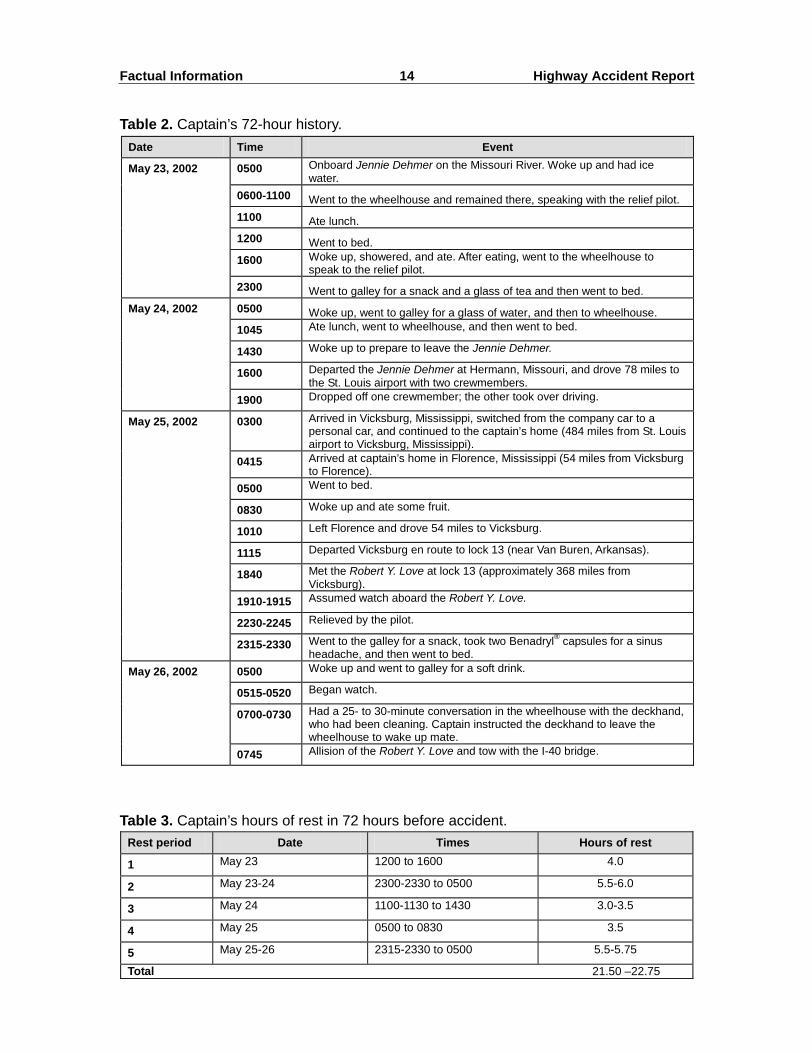
Captain’s 72-Hour HistoryThe captain’s activities and hours of rest before the accident, based upon
information collected during Safety Board interviews with both the captain and the crew,are summarized in figure 10 and in tables 2 and 3.
Figure 10. Captain’s automobile travel preceding accident.
St. LouisHermann
Van Buren
VicksburgFlorence
78 miles
484 miles
54 miles
54 miles
368 miles
Factual Information 14 Highway Accident Report
Table 2. Captain’s 72-hour history.
Table 3. Captain’s hours of rest in 72 hours before accident.
Date Time Event
0500 Onboard Jennie Dehmer on the Missouri River. Woke up and had ice water.
0600-1100 Went to the wheelhouse and remained there, speaking with the relief pilot. 1100 Ate lunch. 1200 Went to bed. 1600 Woke up, showered, and ate. After eating, went to the wheelhouse to
speak to the relief pilot.
May 23, 2002
2300 Went to galley for a snack and a glass of tea and then went to bed. 0500 Woke up, went to galley for a glass of water, and then to wheelhouse. 1045 Ate lunch, went to wheelhouse, and then went to bed.
1430 Woke up to prepare to leave the Jennie Dehmer.
1600 Departed the Jennie Dehmer at Hermann, Missouri, and drove 78 miles to the St. Louis airport with two crewmembers.
May 24, 2002
1900 Dropped off one crewmember; the other took over driving.
0300 Arrived in Vicksburg, Mississippi, switched from the company car to a personal car, and continued to the captain’s home (484 miles from St. Louis airport to Vicksburg, Mississippi).
0415 Arrived at captain’s home in Florence, Mississippi (54 miles from Vicksburg to Florence).
0500 Went to bed.
0830 Woke up and ate some fruit.
1010 Left Florence and drove 54 miles to Vicksburg.
1115 Departed Vicksburg en route to lock 13 (near Van Buren, Arkansas).
1840 Met the Robert Y. Love at lock 13 (approximately 368 miles from Vicksburg).
1910-1915 Assumed watch aboard the Robert Y. Love.
2230-2245 Relieved by the pilot.
May 25, 2002
2315-2330 Went to the galley for a snack, took two Benadryl® capsules for a sinus headache, and then went to bed.
0500 Woke up and went to galley for a soft drink.
0515-0520 Began watch.
0700-0730 Had a 25- to 30-minute conversation in the wheelhouse with the deckhand, who had been cleaning. Captain instructed the deckhand to leave the wheelhouse to wake up mate.
May 26, 2002
0745 Allision of the Robert Y. Love and tow with the I-40 bridge.
Rest period Date Times Hours of rest
1 May 23 1200 to 1600 4.0
2 May 23-24 2300-2330 to 0500 5.5-6.0
3 May 24 1100-1130 to 1430 3.0-3.5
4 May 25 0500 to 0830 3.5
5 May 25-26 2315-2330 to 0500 5.5-5.75
Total 21.50 –22.75
Factual Information 15 Highway Accident Report
The captain stated that his duty (work) rotation was 30 days on and 15 days off andthat he had stood the normal captain’s watches of 0600-1200 and 1800-2400 since comingto the towboat Robert Y. Love in 2001. He further stated that “after 44 years,” he wasaccustomed to the “6-on/6-off” duty schedule used on river towboats.
Operations
MMT owns and operates 16 towboats and about 60 barges and has been in theinland towing business for 32 years, according to the company’s Director of Operations. Itemploys about 220 people, of whom 185 are vessel employees; the other 35 serve inshoreside management and other positions. The company’s primary business istransporting products such as asphalt or black oil through the Mississippi River systemand intracoastal waterways of the Gulf of Mexico.
According to company officials, MMT vessels performed 711 round trips oninland waterways during the fiscal year ending June 30, 2004.
Vessel Information
The Robert Y. Love was a conventional twin-screw, diesel-driven, uninspected,22
inland river towboat. The vessel was constructed of steel, 104 feet long, and had a beam(width) of 30 feet. It had an operating draft of 7 feet 9 inches and had a displacement23 of444.5 long tons (a long ton equals 2,240 pounds). The vessel was built in 1955 by theNashville Bridge Company and the Alabama Dry Dock & Shipbuilding Company, Mobile,Alabama. Its first owner, the Canal Barge Company, named the vessel Caroline. In 1991, thevessel was sold to its present owner, MMT, Jackson, Mississippi, and renamed. In 1992, thevessel’s main engines were replaced, increasing the horsepower from 1800 to 2400 rpm.
The Robert Y. Love had a retractable or variable-height wheelhouse that could beraised or lowered using a hydraulic ram system. In waterways where wheelhouse height wasnot restricted by bridge vertical clearance or other structures, the wheelhouse could be raisedto the highest position for greater visibility. When necessary for the vessel to pass under abridge with limited vertical clearance or to avoid waiting for a bridge to open, the wheelhousecould be lowered to a point where the lowest eye height was about 16 feet and the top of thewheelhouse was 17.5 feet above the waterline. Maximum eye height with the wheelhouse inthe raised position was 29.5 feet; the overall maximum height with antennas extendedvertically was 43 feet. At the time of the accident, the wheelhouse was in the raised position.
22 An uninspected vessel is not subject to Coast Guard inspection under 46 United States Code(U.S.C.). The following categories of vessels are subject to inspection: freight vessels, nautical schoolvessels, ships, offshore supply vessels, passenger vessels, sailing school vessels, seagoing barges, seagoingmotor vessels, small passenger vessels, steam vessels, tank vessels, fish processing vessels, fish tendervessels, Great Lakes barges, and oil spill response vessels.
23 Volume or weight of the fluid displaced by a vessel.
Factual Information 16 Highway Accident Report
The wheelhouse was equipped with two VHF-FM radiotelephones, a single side-band radio, radar, a global positioning system unit, swing meter, depth sounder, steeringcontrols, and engine controls. The vessel also had a steering rudder aft and flankingrudders24 forward of each of the two propellers.
The Director of Marine Engineering for MMT reported that the Robert Y. Love hadbeen through its annual drydocking in March 2002. The company and crew conductedhull, steering machinery, engine, and electrical equipment inspections. They reported thatthe results were satisfactory.
The double-hull tank barges MM-60 and MM-62 built in Ashland City, Tennessee, in1999, were owned by the MMT and had identical dimensions: 297.5 feet long, beam of 54.0feet, and an empty draft of 1 foot. According to the barge’s “Strength and StabilityCalculations,”25 at a draft of 1 foot, MM-60 had a displacement of 402.6 long tons andMM-62 had a displacement of 427.4 long tons. Each barge had eight cargo tanks, four to portand four to starboard, separated by a centerline bulkhead. Each barge had a 6-million-BTUthermal fluid heater on deck, aft. The barge sterns were box-shaped and the bows were rakedto present a streamlined underwater shape to reduce water resistance. Each had a grosstonnage of 1,619 and a maximum loaded draft of 11.5 feet. Both vessels had last beeninspected and issued a 5-year certificate of inspection by the Coast Guard Marine SafetyOffice, St. Louis, Missouri, on August 23, 2001. The vessels were certified to carry up to25,800 barrels26 of Grade A through Grade E cargoes.27 The cargo thermal fluid heaters wereallowed to be operated only when the vessels were carrying Grade E cargoes, such as asphalt.
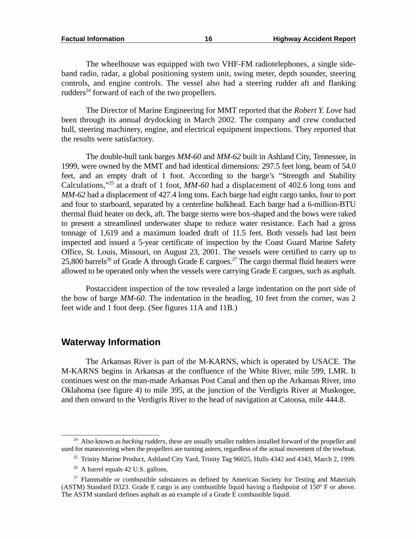
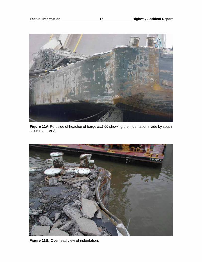
Postaccident inspection of the tow revealed a large indentation on the port side ofthe bow of barge MM-60. The indentation in the headlog, 10 feet from the corner, was 2feet wide and 1 foot deep. (See figures 11A and 11B.)
Waterway Information
The Arkansas River is part of the M-KARNS, which is operated by USACE. TheM-KARNS begins in Arkansas at the confluence of the White River, mile 599, LMR. Itcontinues west on the man-made Arkansas Post Canal and then up the Arkansas River, intoOklahoma (see figure 4) to mile 395, at the junction of the Verdigris River at Muskogee,and then onward to the Verdigris River to the head of navigation at Catoosa, mile 444.8.
24 Also known as backing rudders, these are usually smaller rudders installed forward of the propeller andused for maneuvering when the propellers are turning astern, regardless of the actual movement of the towboat.
25 Trinity Marine Product, Ashland City Yard, Trinity Tag 96025, Hulls 4342 and 4343, March 2, 1999.26 A barrel equals 42 U.S. gallons.27 Flammable or combustible substances as defined by American Society for Testing and Materials
(ASTM) Standard D323. Grade E cargo is any combustible liquid having a flashpoint of 150º F or above.The ASTM standard defines asphalt as an example of a Grade E combustible liquid.
Factual Information 17 Highway Accident Report
Figure 11. Port side of headlog of barge MM-60 showing the indentation made by south column of pier 3.
Figure 12. Overhead view of indentation.
Figure 11A.
Figure 11B.
Factual Information 18 Highway Accident Report
Construction of the M-KARNS began in May 1952; the system becameoperational in 1970. Each year, approximately 12 million tons of commodities aretransported on the waterway.28 Total domestic tonnage on all U.S. internal waterways isabout 620 million tons per year.29
The waterway has 17 locks and dams, 12 in Arkansas and 5 in Oklahoma, that stepthe water levels up a total of 420 feet in elevation. Thirty-eight bridges cross thewaterway. USACE maintains a minimum 9-foot channel depth on the system, and theCoast Guard marks the river with buoys and daymarks.30
From mile 357 of the M-KARNS, about 3 miles downriver from the I-40 bridge,the channel makes a gradual right turn of approximately 70 degrees over a distance ofabout 1 mile. The channel then straightens out for about a mile and then makes a slight leftturn of about 10 to 15 degrees, about 0.40 miles from the bridge.
The Robert S. Kerr Lock and Dam (lock 15), mile 336.2, is 24.1 miles below(downstream of) the I-40 bridge. The Webbers Falls Lock and Dam (lock 16), mile 366.6,is 6.3 miles upstream of the I-40 bridge. (See figure 4.) According to USACE officials,average barge traffic at each of the two locks in the vicinity of the accident site is aboutthree tows per day.
River currents in the M-KARNS are negligible most of the year because the waterlevels in the system are controlled by a series of dams, which regulate the release of waterinto the system. The area between two successive dams is known as a pool. The USACEDistrict Office at Tulsa, Oklahoma, determined that at the time of the accident the poolelevation was 459.37 feet (normal pool is 458 feet), and the current speed at the bridgewas about 2 mph.
According to USACE M-KARNS navigation charts, the I-40 bridge has a300-foot-wide main navigation span and a vertical clearance above normal pool of 62.4feet. The captain of the Robert Y. Love stated that he had been through the I-40 bridgehundreds of times and that it was an easy bridge to navigate. He explained that once linedup, a little right rudder would be required to steady the tow before placing the rudderamidships (zero rudder angle) and passing under the navigation span.
28 According to USACE, major commodities include iron and steel, chemical fertilizer and otherchemicals, petroleum products, sand/gravel and rock, coke and coal, soybeans, and wheat and other grains<http://www.swl.usace.army.mil/navigation/commod.html>.
29 USACE Waterborne Commerce Statistics Center <http://www.iwr.usace.army.mil/ndc/wcsc/wcsc00/fordom.pdf>.
30 According the Coast Guard’s U.S. Aids to Navigation System, a daymark is an identifying signon a beacon (fixed navigational aid) that makes the beacon more readily visible in daylight<http://www.uscgboating.org/safety/aton/system.htm>.
Factual Information 19 Highway Accident Report
Highway Information
I-40 and the I-40 bridge are owned and operated by ODOT. I-40 is an east-west,rural, principal arterial, controlled access, interstate highway. At the accident site, I-40 is atwo-way, four-lane, divided highway. The design speed and posted speed limit were 70mph, and the minimum-posted speed limit was 40 mph. The 2001 average daily trafficcount (ADT) for both directions was 19,200 vehicles. Commercial vehicles accounted for27 to 33 percent of the ADT during 1997 and 1999.
The concrete bridge deck had a 36-inch-high concrete barrier separating the east andwestbound lanes. The traffic lanes were 12 feet wide, with 3-foot-wide inside and outsideshoulders. At the immediate approach to the bridge, the highway was asphalt, with a33-inch-high concrete barrier separating the eastbound and westbound traffic lanes. Theapproach lanes were also 12 feet wide, with 4.5-foot-wide inside shoulders and 15-foot-wideoutside shoulders. The traffic lanes were divided by painted stripes approximately 11 feetlong and spaced every 20 feet. A 4-inch-wide retroreflective painted solid yellow edgelinedelineated the inside shoulder, and a 4-inch-wide retroreflective painted solid white edgelinedelineated the outside shoulder. The painted lines met the line width and space requirementsspecified in the Manual on Uniform Traffic Control Devices (MUTCD).31
The eastbound lanes were level approaching the 1,989-foot-long bridge andtransitioned into a 900-foot sag vertical curve32 with a 3-percent grade to the point ofintersection (PI) of a 1,444-foot vertical curve. (The PI of the curve was 632 feet from thewest end of the bridge and 1,356 feet from the east end of the bridge.) At the PI of thevertical curve, the grade became a 2.2-percent downgrade that transitioned into a 900-footsag vertical curve at the end of the bridge.
Bridge InformationThe I-40 bridge was built in 1967 and spanned the Arkansas River at M-KARNS
mile marker 360.3. Bridge plans indicate that the I-40 bridge project33 began 2 miles westof the Arkansas River and extended east in Muskogee and Sequoyah Counties, Oklahoma,over the Arkansas River.
The Secretary of the Army approved the State of Oklahoma’s bridge permit onOctober 22, 1963, for the location and plans of a bridge to be constructed across theArkansas River near Webbers Falls. According to the permit, the structure was to be 1,989feet long, with the main span providing a vertical clearance of 52 feet above flood stageand a horizontal clearance of 322 feet between the main piers. The remainder of the spansprovided a vertical clearance of approximately 50 feet and a horizontal clearance betweenthe piers of approximately 125 feet.
31 The Federal Highway Administration (FHWA) approved the MUTCD as the standard for all streetsand highways in accordance with 23 U.S.C., Sections 109 (b), 109 (d), 402 (a), and 23 CFR 1204.4.
32 A vertical curve provides a smooth transition from one roadway grade to another; this transition maybe a sag vertical curve (dip) or crest vertical curve (hill).
33 Federal-aid project number I-40-6 (99) 288.
Factual Information 20 Highway Accident Report
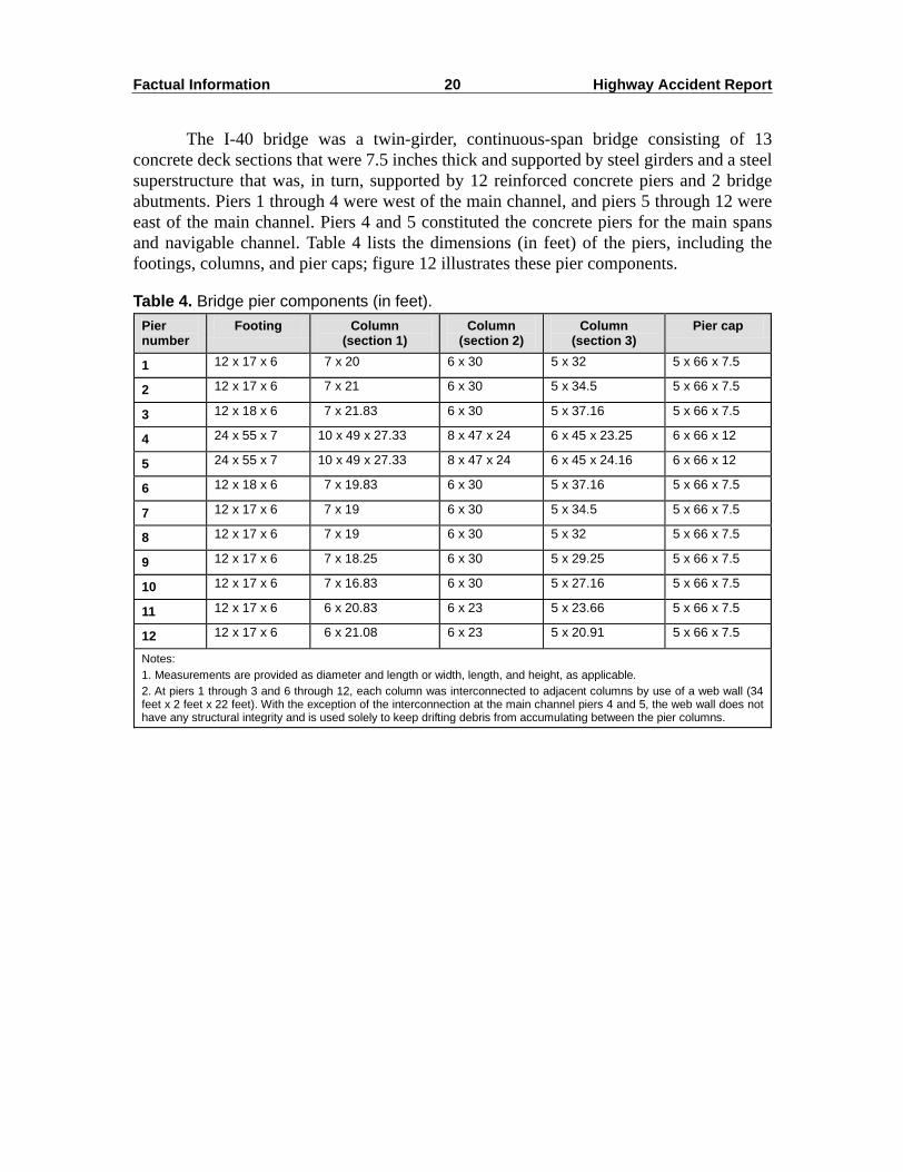
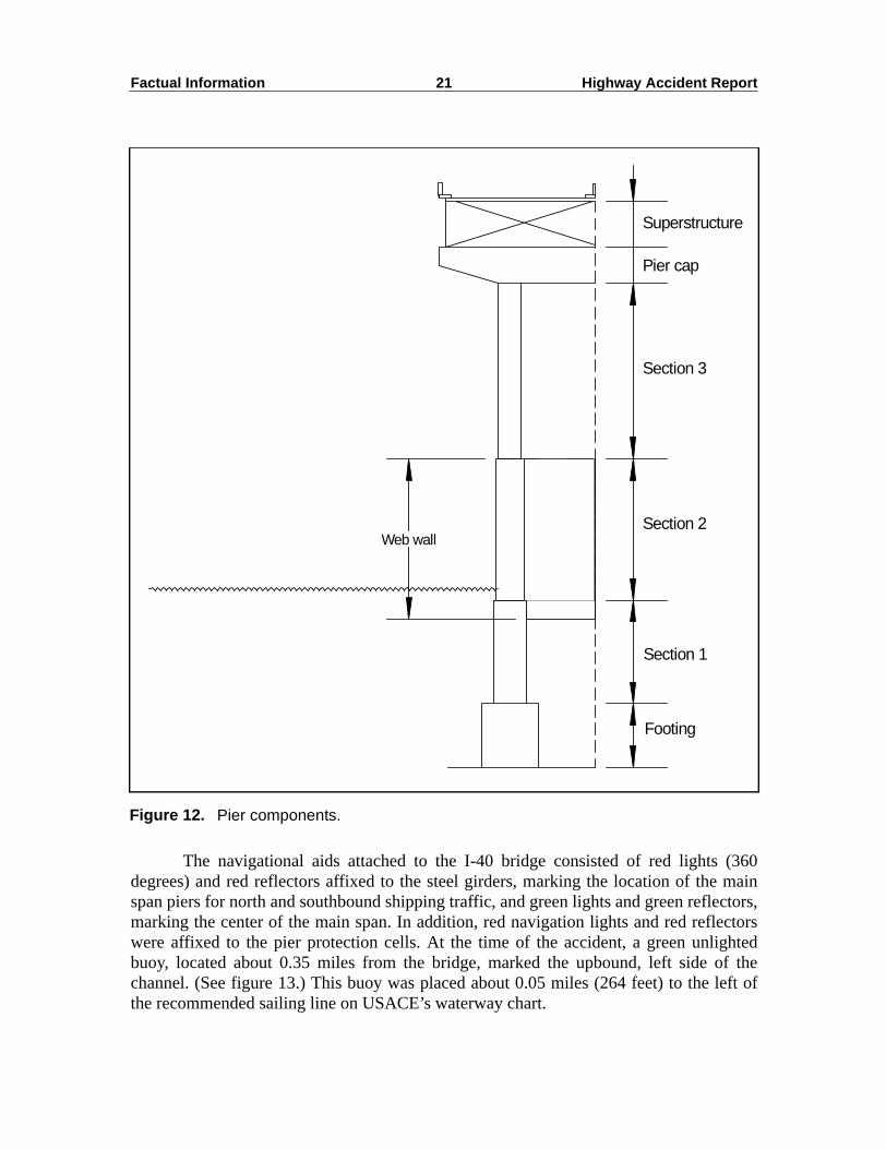
The I-40 bridge was a twin-girder, continuous-span bridge consisting of 13concrete deck sections that were 7.5 inches thick and supported by steel girders and a steelsuperstructure that was, in turn, supported by 12 reinforced concrete piers and 2 bridgeabutments. Piers 1 through 4 were west of the main channel, and piers 5 through 12 wereeast of the main channel. Piers 4 and 5 constituted the concrete piers for the main spansand navigable channel. Table 4 lists the dimensions (in feet) of the piers, including thefootings, columns, and pier caps; figure 12 illustrates these pier components.
Table 4. Bridge pier components (in feet).Pier number
Footing Column (section 1)
Column (section 2)
Column (section 3)
Pier cap
1 12 x 17 x 6 7 x 20 6 x 30 5 x 32 5 x 66 x 7.5
2 12 x 17 x 6 7 x 21 6 x 30 5 x 34.5 5 x 66 x 7.5
3 12 x 18 x 6 7 x 21.83 6 x 30 5 x 37.16 5 x 66 x 7.5
4 24 x 55 x 7 10 x 49 x 27.33 8 x 47 x 24 6 x 45 x 23.25 6 x 66 x 12
5 24 x 55 x 7 10 x 49 x 27.33 8 x 47 x 24 6 x 45 x 24.16 6 x 66 x 12
6 12 x 18 x 6 7 x 19.83 6 x 30 5 x 37.16 5 x 66 x 7.5
7 12 x 17 x 6 7 x 19 6 x 30 5 x 34.5 5 x 66 x 7.5
8 12 x 17 x 6 7 x 19 6 x 30 5 x 32 5 x 66 x 7.5
9 12 x 17 x 6 7 x 18.25 6 x 30 5 x 29.25 5 x 66 x 7.5
10 12 x 17 x 6 7 x 16.83 6 x 30 5 x 27.16 5 x 66 x 7.5
11 12 x 17 x 6 6 x 20.83 6 x 23 5 x 23.66 5 x 66 x 7.5
12 12 x 17 x 6 6 x 21.08 6 x 23 5 x 20.91 5 x 66 x 7.5
Notes: 1. Measurements are provided as diameter and length or width, length, and height, as applicable. 2. At piers 1 through 3 and 6 through 12, each column was interconnected to adjacent columns by use of a web wall (34 feet x 2 feet x 22 feet). With the exception of the interconnection at the main channel piers 4 and 5, the web wall does not have any structural integrity and is used solely to keep drifting debris from accumulating between the pier columns.
Factual Information 21 Highway Accident Report
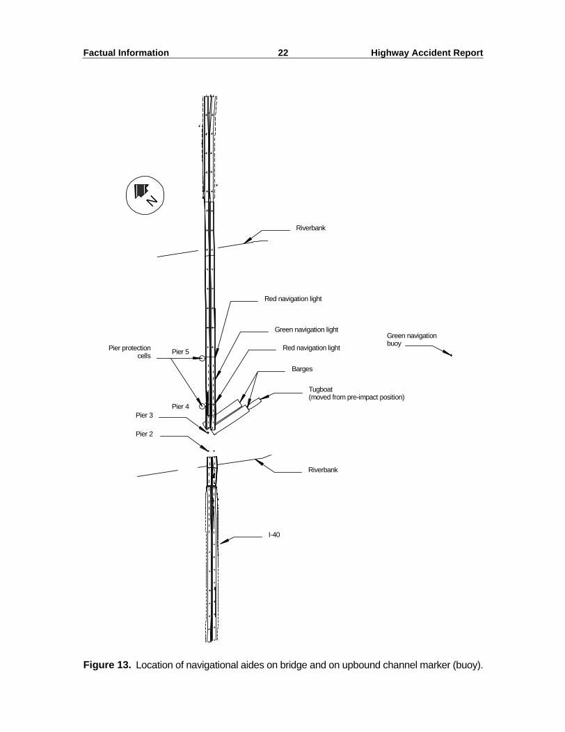
The navigational aids attached to the I-40 bridge consisted of red lights (360degrees) and red reflectors affixed to the steel girders, marking the location of the mainspan piers for north and southbound shipping traffic, and green lights and green reflectors,marking the center of the main span. In addition, red navigation lights and red reflectorswere affixed to the pier protection cells. At the time of the accident, a green unlightedbuoy, located about 0.35 miles from the bridge, marked the upbound, left side of thechannel. (See figure 13.) This buoy was placed about 0.05 miles (264 feet) to the left ofthe recommended sailing line on USACE’s waterway chart.
Figure 13. Pier components.
Footing
Section 1
Section 2
Section 3
Pier cap
Superstructure
Web wall
Figure 12.
Factual Information 22 Highway Accident Report
Figure 14. Location of navigational aides on bridge and on upbound channel marker (buoy).
9727
S
S
S
S
S
S
S
S
S
S
S
S
S
S
S
W
S
G
YY
R
2316
SS
SS
SS
SS
SS
SS
S78
48
LLL
L
L
SS
S
G
S
SG
SS
W
SS
S E SS
G
SS
SS
G
M
Barges
Tugboat(moved from pre-impact position)
Pier 3
Pier 2
Green navigationbuoy
Riverbank
Riverbank
Red navigation light
Green navigation light
Red navigation light
N
I-40
Pier protectioncells Pier 5
Pier 4
Figure 13.
Factual Information 23 Highway Accident Report
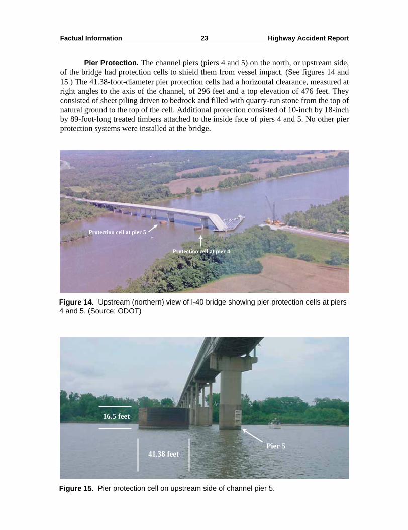
Pier Protection. The channel piers (piers 4 and 5) on the north, or upstream side,of the bridge had protection cells to shield them from vessel impact. (See figures 14 and15.) The 41.38-foot-diameter pier protection cells had a horizontal clearance, measured atright angles to the axis of the channel, of 296 feet and a top elevation of 476 feet. Theyconsisted of sheet piling driven to bedrock and filled with quarry-run stone from the top ofnatural ground to the top of the cell. Additional protection consisted of 10-inch by 18-inchby 89-foot-long treated timbers attached to the inside face of piers 4 and 5. No other pierprotection systems were installed at the bridge.
Figure 15. Upstream (northern) view of I-40 bridge showing pier protection cells at piers 4 and 5. (Source: ODOT)
Figure 16. Pier protection cell on upstream side of channel pier 5.
Protection cell at pier 4
Protection cell at pier 5
16.5 feet
41.38 feetPier 5
Figure 14.
Figure 15.
Factual Information 24 Highway Accident Report
According to ODOT, the pier protection system for the main channel was installedin 1984 following previously unreported bridge strikes that resulted in damage that wasdiscovered during bridge maintenance and substructure inspections. Bridge shift detectionsurvey data and maintenance reports indicated that superficial cracks had been observedand recorded on the north (upstream) side of pier 4 during maintenance procedures onSeptember 1, 1977. The report of a subsequent bridge inspection, performed by BlubaughEngineering Company (BEC) in June 1980 for ODOT, also noted this superficial damageto pier 4 and included comments that this pier had been hit from the north side and hadseveral cracks. BEC recommended that the cracks be filled with an epoxy grout to preventfurther deterioration of the pier. Bridge repairs, consisting of structurally rebondingcracks, delaminations, and hollow planes in the Portland cement concrete structures withan epoxy resin (epoxy injection), were completed during repair projects in June 1983 andNovember 1991 and included piers 2 and 4. ODOT submitted an application to the CoastGuard on November 9, 1982, requesting approval to install pier protection cells at thechannel piers of the I-40 bridge, Arkansas Waterway, mile 360.3; construction of the pierprotection cells was completed on October 9, 1984.
Before this accident, ODOT did not have a bridge-vessel impact risk assessmentprogram, nor was it required to. As of December 2002, the FHWA’s National BridgeInventory (NBI) recorded 32 bridges in Oklahoma that have navigation controls, meaningthat they require a bridge permit (91 percent were built between 1951 and 1990, and 63percent were built between 1960 and 1970). Since this accident, ODOT has hired aconsultant to evaluate bridges at 12 river crossings using the American Association ofState Highway and Transportation Officials (AASHTO) Guide Specification andCommentary for Vessel Collision Design of Highway Bridges34 (Vessel Collision GuideSpecifications).
Bridge Standards. In the 1960s, when the I-40 bridge was designed and built,lateral load requirements for bridge design followed the 1961 and 1965 editions of theAASHO35 Standard Specifications for Highway Bridges. These standards required thefollowing lateral loads to be used in the design of bridge piers: wind loads on thesubstructure and superstructure, wind loads on the live load (traffic), centrifugal forcesfrom the live load for curved structures, temperature forces, forces from stream current,floating ice and debris, earth pressure as applicable, longitudinal force from the live load,and seismic forces. According to ODOT, except for centrifugal forces and ice floes, theI-40 bridge was designed for the lateral loads specified in the 1961 and 1965 standards.Such loads can produce transverse or longitudinal forces on the piers or a combination oftransverse and longitudinal forces. At the time of the allision, lateral load requirementsfollowed the 2002 AASHTO Standard Specifications for Highway Bridges.36 None of thesestandards required that lateral loads caused by vessel impacts be considered.
34 American Association of State Highway and Transportation Officials, Guide Specification andCommentary for Vessel Collision Design of Highway Bridges (Washington, DC: AASHTO, 1991).
35 The American Association of State Highway Officials (AASHO) became AASHTO in the 1970s.36 American Association of State Highway and Transportation Officials, Standard Specifications for
Highway Bridges, 17th ed. (Washington, DC: AASHTO, 2002).
Factual Information 25 Highway Accident Report
When AASHTO published its Vessel Collision Guide Specifications in 1991, theFHWA recommended their use for bridge design. These specifications recommendprobability-based risk analysis and discuss several analytical methods for selecting adesign vessel, based upon vessels that typically navigate a waterway. To identify bridgesthat must continue to function after impact from a design vessel, the specificationsrecommend classification of bridges as either “critical” or “regular,” based onsocial/survival and security/defense criteria. Critical bridges include transportation routesto essential facilities such as hospitals, police and fire stations, communications centers,and bridges crucial for national defense that are part of the Strategic Highway Network(STRAHNET), including interstate and Federal-aid primary routes. The I-40 bridge wouldbe classified a critical bridge based upon its being part of STRAHNET.
In 1993, AASHTO adopted the load and resistance factor design (LRFD)37
specifications for new bridges; the LRFD specifications incorporated the 1991 VesselCollision Guide Specifications. According to the FHWA, the full compliance date for theLRFD is October 2007. (In other words, after October 2007, the LRFD specificationsbecome the official bridge specifications for federally funded bridge construction.) Thelateral load requirements in the LRFD include those listed above for the standardspecifications and include vehicle and railway collision forces, as well as vessel impactforces.
Experience Using 1991 AASHTO Vessel Collision Guide Specifications inFlorida and Louisiana. The NBI lists 551 Florida bridges with navigation controls (72percent of which were built between 1951 and 1990) and 261 Louisiana bridges withnavigation controls (75 percent of which were built between 1951 and 1990). A number ofvessel impacts with bridges have occurred in these States, including the ramming of theSunshine Skyway Bridge by the Liberian tanker Summit Venture in Tampa, Florida, in1980,38 the striking of the Lake Pontchartrain Causeway in New Orleans, Louisiana, bylarge tows in 1964,39 1974,40 and 1984,41 and the striking of the Judge William SeeberBridge in New Orleans by a tow and empty hopper barge in 1993.42 Both States currentlyuse the AASHTO Vessel Collision Guide Specifications and the 1994 LRFDspecifications.
37 American Association of State Highway and Transportation Officials, AASHTO LRFD BridgeDesign Specifications, 1st ed. (Washington, DC: AASHTO, 1994).
38 National Transportation Safety Board, Ramming of the Sunshine Skyway Bridge by the Liberian BulkCarrier Summit Venture, Tampa Bay, Florida, May 9, 1980, Marine Accident Report NTSB/MAR-81/03(Washington, DC: NTSB, 1981).
39 Tony M. Ducote and Zolan Prucz, “Vessel Collision Vulnerability of Bridges—Louisiana’s Role andPerspective,” Proceedings of the 1999 International Bridge Conference (Pittsburgh, PA: Engineers’ Societyof Western Pennsylvania, July 1999).
40 National Transportation Safety Board, safety recommendation letter to the Greater New OrleansExpressway Commission, January 8, 1975, regarding Safety Recommendations H-74-40 through –42,notation 1423.
41 Ducote and Prucz.42 National Transportation Safety Board, U. S. Towboat Chris Collision With the Judge William Seeber
Bridge New Orleans, Louisiana, May 28, 1993, Highway-Marine Accident Report NTSB/HAR-94/03(Washington, DC: NTSB, 1994).
Factual Information 26 Highway Accident Report
According to the Florida bridge engineer responsible for bridge-vessel impact riskanalysis, for the past 15 years, the Florida Department of Transportation (FDOT) hasdesigned all new bridges over navigable water using the AASHTO Vessel Design GuideSpecifications and customized risk analysis software.43 This software, based upon theAASHTO specification, measures the probability of vessel impact, using vessel datagathered by USACE for all waterways in Florida. The University of Florida’s BridgeSoftware Institute has also developed structural analysis software (FBPier) to determinethe plastic structural strength capability of bridge piers subject to vessel impacts. TheFlorida bridge engineer responsible for vessel impact risk analysis indicated that theaverage engineering costs to perform vessel impact risk analysis using the structuralanalysis software should be about the same as those for scour assessments, orapproximately $40,000.
In addition, during spring 2004, FDOT measured barge impact forces directly inconjunction with the replacement of the State Route 300-Saint George Island Causewaynear Apalachicola, Florida. After the new bridge was open to traffic, Florida test crashed ahopper barge into the older structure at various speeds to obtain direct measurements viainstrumentation of the lateral forces imparted to the bridge piers. The purpose of suchtesting, according to Florida bridge engineers, is to obtain “reliable and accurate bargeimpact-load data for use in bridge design, retrofit, and evaluation” and to ensure that “thelateral impact loads used for design are effective but do not result in unnecessarilyexpensive bridge designs.”44 FDOT has completed its physical testing and is analyzing theresults. According to the Florida bridge engineer responsible for vessel impact riskanalysis, lateral loads computed using the Vessel Collision Guide Specifications canincrease the cost of bridge substructures by a factor of 2 to 5.
Louisiana has also developed methods to determine the vulnerability of bridges tovessel impact. In 1984 and 1988, the Louisiana Department of Transportation andDevelopment (Louisiana DOTD) and the FHWA-sponsored research that led to thedevelopment of the Vessel Collision Guide Specifications.45 Later, after the 1993 JudgeWilliam Seeber Bridge accident in New Orleans,46 the Louisiana DOTD started a programto determine the vulnerability to vessel impact of Louisiana bridges over navigable water.The Louisiana DOTD selected 56 of the State’s almost 200 bridges over navigablewaterways and, working with contractors, examined these bridges to determine thevulnerability to vessel impact and collapse using the criteria in the 1991 Vessel CollisionGuide Specifications and the 1994 LRFD bridge specifications. The bridge evaluationfound that approximately 50 percent of the bridges examined had vulnerability “aboveestablished acceptable risk levels” for main piers, approach bents, and superstructurecomponents. Recommended remedies included both physical protection (pier
43 Vessel Impact Analysis, version 3.05, was developed by the University of Florida for FDOT and isaccessible from the FDOT software library <http://www.dot.state.fl.us/structures/proglib.htm>.
44 Gary Consolazio, Ronald A. Cook, Henry T. Bollman, and J. Darryll Dockstader, “Barge Impacts onBridges” TR News 221 (July-August 2002) 29.
45 Ducote and Prucz.46 NTSB/HAR-94/03.
Factual Information 27 Highway Accident Report
strengthening and pier protection) and preventive measures (installing aids to navigationand limiting the speed of large ships). For instance, the report recommended pierstrengthening for one of the channel piers, a two-column bent, of a bridge that crosses theMississippi River in New Orleans, at an estimated cost of $500,000.
Bridge Management SystemsBridge management systems (BMSs) are an outgrowth of the NBI and bridge
inspection procedures established after the 1967 Silver Bridge collapse47 and are one of sixState management systems once mandated48 by the Intermodal Surface TransportationEfficiency Act of 1991 (ISTEA). According to AASHTO, a BMS combines management,engineering, and economic inputs to help determine the best actions to take on all bridgesin a network over time. A BMS helps engineers and decision makers determine when andwhere to spend bridge funds so as to “enhance safety, preserve existing infrastructure, andserve commerce and the motoring public.”49
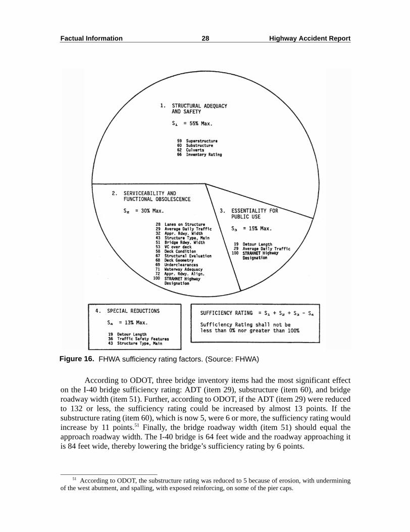
Bridge Sufficiency Ratings The FHWA calculates computer-generated bridge sufficiency ratings for all U.S.
bridges based on National Bridge Inventory and inspection data submitted by State andlocal agency bridge inspectors. The sufficiency rating is a numerical rating for a bridgebased on its structural adequacy and safety, its serviceability and functional obsolescence,and its essentiality for public use.50 (See figure 16.) Ratings range from 0 (worst) to 100(best) and are indicative of a bridge’s sufficiency to remain in service. The FHWA usessufficiency ratings in determining which bridges are eligible for Federal-aid funds.Deficient bridges with sufficiency ratings less than 50 are eligible for completereplacement, and deficient bridges with sufficiency ratings less than 80 are eligible forrehabilitation. The sufficiency rating does not include vulnerability to vessel impact.
The June 2001 sufficiency rating for the I-40 bridge was 67. According to theFHWA’s 2001 NBI data, the average age of the 1,177 interstate bridges in Oklahoma is 37years, and the average sufficiency rating is 76.2. Nationwide, the average age of the55,263 interstate bridges is 34 years, and the average sufficiency rating is 85.7.
47 National Transportation Safety Board, Collapse of the U.S. 35 Highway Bridge, Point Pleasant, WestVirginia, December 15, 1967, Highway Accident Report NTSB/HAR-71/01 (Washington, DC: NTSB,1971).
48 The use of a formal BMS is now optional, as outlined in 23 CFR Part 500 and as amended by theNational Highway System Act of 1995.
49 American Association of State Highway and Transportation Officials, Guidelines for BridgeManagement Systems (Washington, DC: AASHTO, 1993) 2.
50 U.S. Department of Transportation, Federal Highway Administration, Recording and Coding Guidefor the Structure Inventory and Appraisal of the Nation’s Bridges, FHWA-PD-96-001 (Washington, DC:FHWA, 1995) appendix B.
Factual Information 28 Highway Accident Report
According to ODOT, three bridge inventory items had the most significant effecton the I-40 bridge sufficiency rating: ADT (item 29), substructure (item 60), and bridgeroadway width (item 51). Further, according to ODOT, if the ADT (item 29) were reducedto 132 or less, the sufficiency rating could be increased by almost 13 points. If thesubstructure rating (item 60), which is now 5, were 6 or more, the sufficiency rating wouldincrease by 11 points.51 Finally, the bridge roadway width (item 51) should equal theapproach roadway width. The I-40 bridge is 64 feet wide and the roadway approaching itis 84 feet wide, thereby lowering the bridge’s sufficiency rating by 6 points.
Figure 17. FHWA sufficiency rating factors. (Source: FHWA)
51 According to ODOT, the substructure rating was reduced to 5 because of erosion, with underminingof the west abutment, and spalling, with exposed reinforcing, on some of the pier caps.
Figure 16.
Factual Information 29 Highway Accident Report
A bridge inventory item’s effect on the sufficiency rating is calculated as apercentage, and its value thus varies depending on the bridge’s overall sufficiency rating. Forexample, if a sufficiency rating is 67, a change in the length of the detour route may changethe sufficiency rating by 2.7 points. If a sufficiency rating is 98, the same change in thelength of the detour route would affect the sufficiency rating by 0.1 points. Table 5 shows thebridge inventory items that reduced the I-40 bridge’s sufficiency rating from 100 to 67.
Table 5. I-40 bridge sufficiency rating reductions.
Meteorological Information
Observations from the Oklahoma Climatological Survey’s Webbers Falls automaticenvironmental monitoring station 2.2 miles upriver from the accident site showed that at0745 the air temperature was 64º F, the relative humidity was 92 percent, and the winds werevariable at 3 to 5 mph. Sunrise was about 0610. In addition, at 0753, the National WeatherService station at Muskogee Davis Field, about 18 miles northwest of the accident site,reported overcast conditions with surface visibility of 10 miles. According to the captain ofthe Robert Y. Love, the skies were partly cloudy and visibility was clear.
Medical and Pathological Information
Postaccident ToxicologyAs required by both 46 CFR 16.24052 and company policy,53 toxicological testing
was conducted on the captain following the accident. At 1115, a blood sample was taken
52 Title 46 CFR 16.240 requires that the company perform toxicological testing on any crew involved ina “serious marine incident.” Title 49 CFR 40.85 specifies the five drugs for which the laboratory tests.
53 Vessel Operations Procedures Manual—Section 4, subsection “Policy,” heading “Drug and AlcoholPolicy.”
Bridge inventory
item number
Item description I-40 bridge Best results Reduction Cumulative sufficiency
rating
Item 19 Detour length 9 miles 5 miles or less 0.1 99.9
Item 29 ADT 21,610 132 or less 12.9 87.0
Item 51 Bridge roadway width
64 feet 84 feet (roadway width)
6.0 81.0
Item 58 Deck rating 5 7 or more 1.0 80.0
Item 59 Superstructure rating
6 7 or more 0.0 80.0
Item 60 Substructure rating 5 7 or more 11.0 69.0
Item 100 Defense highway designation
STRAHNET Not STRAHNET
2.0 67.0
Factual Information 30 Highway Accident Report
from the captain at the Muskogee Immediate Care Clinic and, at the request of SafetyBoard investigators on scene, a split sample of the blood specimen was sent to the CivilAerospace Medical Institute (CAMI), Oklahoma City, Oklahoma, for testing. The captaintested negative for the five illicit drugs: marijuana, cocaine, opiates, phencyclidines(PCPs), and amphetamines.54 Testing results were also negative for benzodiazepines,barbiturates, antidepressants, meprobamate, methaqualone, and nicotine.
At 1345, a urine sample was also collected at the Muskogee Immediate CareClinic. The samples were sent to the Clinical Reference Laboratory in Lenexa, Kansas, byFederal Express. Testing was negative for marijuana metabolites, cocaine metabolites,phencyclidine, opiates metabolites, and amphetamines. Further, alcohol was not detectedin either the captain’s blood or urine specimens.
The CAMI testing detected a low level of the antihistamine diphenhydramine55 inboth the captain’s blood (0.009 ug/ml) and urine (0.083 ug/ml). The captain stated that hehad occasional sinus problems and carried Benadryl® with him for use when needed; henoted he had taken two Benadryl® capsules to treat a sinus headache the night before theaccident. The captain stated that he did not drink alcohol and was not taking anyprescription medicines at the time of the accident. Inquiries made at pharmacies near thecaptain’s home revealed no prescriptions filled for him in the 90 days before the accident.
Postaccident drug tests were also conducted on the other crewmembers on duty atthe time of the allision. Urine samples were taken from the deckhand, the chief engineer,and the mate on May 28, 2002, at 0945, 0950, and 0955, respectively. The samples weretested for the five illicit drugs mentioned earlier in this section; test results were negative.No postaccident alcohol testing was conducted on the other crewmembers, nor was itrequired because they were not on duty during the accident.
Medical InformationThe Safety Board reviewed the captain’s preaccident medical records, including
Coast Guard medical records, employer medical records, personal medical records,hospital records, pharmacy records, and health insurance records. They revealed treatmentfor short-term illnesses and injuries, with complete resolution of symptoms.
In 1992, the captain underwent a nonfasting measurement of total cholesterol andtriglycerides in conjunction with a Coast Guard-required physical examination for licenserenewal. The values were elevated, but no additional evaluation of this report was noted. Thecaptain’s most recent Coast Guard-required physical examination for license renewal,performed November 3, 1997, indicated no medication use and no abnormal physicalfindings. The captain stated that he did not have a history of heart or vascular disease, heartsurgery, dizziness or fainting, or periods of unconsciousness. The examination form also
54 “Dangerous drugs” are further referenced in the Coast Guard regulations at 46 CFR 4.06-40, 46 CFR5.35, and 46 CFR 5.59, and are defined at 46 CFR 16.105. The regulations at 46 CFR 113 require testing formarijuana, cocaine, opiates, PCPs, and amphetamines.
55 An over-the-counter sedating antihistamine commonly used to treat allergic conditions, often knownby the trade name Benadryl®.
Factual Information 31 Highway Accident Report
indicated that the captain’s vision was corrected to a visual acuity of 20/20.56 His field ofvision was found to be 180° and his color vision was normal. When asked about his hearing,the captain stated that he had his hearing checked frequently and that he had lost 10 to 15percent of his hearing. The captain’s physical exam found his hearing to be normal.
Following this accident, the captain was admitted to a local regional medical centerfor examination, observation, and comprehensive medical testing. Heart function was notedto be normal on stress testing and echocardiography. A nuclear medicine imaging studyperformed in conjunction with the stress test was reported as negative for significantreduction in blood flow.57 All testing results were essentially normal, except for totalocclusion of the mid-left circumflex coronary artery discovered on cardiac catheterization.Later, the captain was admitted to a hospital nearer his home, where he underwent adiagnostic electrophysiology study (EPS),58 in which serious abnormal heart rhythms weregenerated, and also underwent subsequent implantation of an implantable cardioverterdefibrillator (ICD) because of, according to the captain’s cardiologist, his “inducibleventricular flutter59 with known coronary disease” and “recent syncope.’’60 The Safety Boardreviewed posthospitalization records prepared by the captain’s cardiologist, which showedthat the captain’s implantable cardioverter defibrillator had not delivered any defibrillationshocks in the 23 months following its implantation. In that time, the defibrillator hadrecorded two episodes (June 21, 2002, [5 beats] and October 13, 2003, [5 beats]) ofnonsustained ventricular tachycardia.61 In addition, the device recorded four episodes ofsustained tachycardia62 during a 25-minute period on February 23, 2004. The episodes lastedbetween 22 seconds and 1.6 minutes, and the most rapid average ventricular heart rate forthese four episodes was 182 beats per minute. Three of these episodes resulted in thepacemaker function of the device operating in an attempt to reduce the heart rate. Thecardiology records did not note any symptoms of dizziness or loss of consciousness.
The captain described his health as good; he reported that he had recently sufferedsome dizzy spells at home, which he attributed to overexertion from yard work. He alsohad sustained a dizzy spell and nausea while on board the towboat Jennie Dehmer on the
56 20/20 refers to Snellen acuity, a measure of the ability to identify an object (typically a letter) of acertain size at a specified distance. Visual acuity of 20/20 is considered “normal” vision.
57 Such imaging, performed in conjunction with stress testing, is highly predictive of both the absenceof significant coronary artery disease and a low risk of cardiac death; cardiac catheterization is usually notrequired. (See R.A. Nishimura, R.J. Gibbons, and A.J. Tajik, “Noninvasive Cardiac Imaging:Echocardiography and Nuclear Cardiology,” Harrison’s Principles of Internal Medicine, 15th ed., eds. E.Braunwald and others [New York: McGraw-Hill, 2001]).
58 A procedure in which electric stimuli are applied to the inside of the heart to try to cause abnormalheart rhythms.
59 A serious abnormal heart rhythm caused by the electric stimuli applied during the EPS study noted above.60 Syncope is a loss of consciousness resulting from an interruption of blood flow to the brain and refers
here to the captain’s episode of incapacitation that immediately preceded the accident. 61 A short series of rapid abnormal heartbeats that does not progress to a continuing abnormal heart rhythm.62 An elevated heart rate that persists beyond several seconds. The recorded information from the
device was insufficiently detailed to determine whether these episodes represented the serious abnormalrhythm of ventricular tachycardia or some other type of rhythm (including normal heart rate response tostress) that would result in an elevated heart rate.
Factual Information 32 Highway Accident Report
Wednesday (May 22, 2002) before this accident, while preparing lunch for the crew. Hesaid that after he lay down, his rest was interrupted twice by phone calls. He stated thatwhen called for watch about 1700, he felt “fine.”
Survival Aspects
Eleven vehicles carrying 19 occupants either collapsed with or drove off thebridge. Occupant protection use and injuries within each vehicle were as follows:
Vehicle 1—2002 Honda Odyssey EX. The driver’s air bag deployed. The35-year-old male driver sustained fatal blunt trauma injuries. During recovery operations,he was found without the seat belt buckled across his lap. The passenger compartment wasextensively crushed and destroyed.
Vehicle 2—2001 Dodge 3500 Pickup Quad Cab. Both front air bags deployed.Two female occupants, one 49 years old and the other 47 years old, drowned. Duringrecovery operations, they were both removed from the severely mangled passengercompartment; their seat belts were not fastened.
Vehicle 3—2001 Dodge Ram 2500 Laramie SLT. Both front air bags deployed.The belted 59-year-old male driver sustained minor injuries. The 58-year-old femalepassenger drowned. During recovery operations, she was removed from the passenger seatwith her seat belt fastened.
Vehicle 4—2001 Dodge Dakota Quad Cab SLT Pickup. Both air bags deployed.The belted 67-year-old male driver sustained serious injuries (compression fractures of theL2 and L3 vertebrae). The belted 68-year-old female passenger sustained serious injuries(a 10th left rib lateral fracture and an upper-right-arm hematoma).
Vehicle 5—1999 Ford Expedition XLT. Both air bags deployed. The 30-year-oldmale driver, who was found during recovery operations with seat belt unbuckled,drowned. The 29-year-old female passenger, who was removed during recoveryoperations from the passenger seat with her seat belt fastened, also drowned. A 3-year-oldfemale, reportedly traveling in a car seat, drowned; her body was found floating 50 feet offthe river bank, approximately 0.5 mile south of the recovery barge.
Vehicle 6—2001 Volvo Truck. The driver’s air bag deployed. The belted 39-year-oldmale driver drowned.
Vehicle 7—1999 Freightliner Truck Tractor-Semitrailer. The vehicle did nothave an air bag. The belted 37-year-old male driver sustained serious injuries (a fracturedright ninth rib, multiple abrasions, and facial lacerations and contusions).
Vehicle 8—2002 Chevrolet 1500 Ex-Cab. Vehicle damage preventedinvestigators from determining whether the air bag deployed. Both the belted 49-year-oldmale driver and the belted 49-year-old female passenger drowned.
Factual Information 33 Highway Accident Report
Vehicle 9—2001 Dodge Ram 2500. Both air bags deployed. The 58-year-oldmale driver, found with the unbuckled seat belt across his body, drowned. The unbelted57-year-old female passenger also drowned.
Vehicle 10—1997 Ford Crown Victoria. Both front air bags deployed. Both thebelted 51-year-old male driver and the belted 50-year-old female passenger drowned.
Vehicle 11—Mack Truck Tractor-Semitrailer ABF. The vehicle did not have anair bag. The belted 62-year-old male driver sustained minor injuries (a nose laceration,bilateral knee abrasions, forearm abrasions, and head and chest blunt trauma).
Tests and Research
VesselThe vessel’s chief engineer stated that he observed the steering system to be
operating normally before the accident. Following the accident, Safety Board investigatorsexamined the Robert Y. Love’s port and starboard steering systems. Investigators tested thesystem controls from both the wheelhouse control station and the local control station in thesteering gear room. The system operated within established parameters; the swing rate forthe rudders was approximately 9 seconds for each hydraulic unit operating independently,and the rudders operated over their full range, left and right, without difficulty.
The vessel’s chief engineer stated that he observed the propulsion system to beoperating normally before the accident. Following the accident, the main propulsion engineswere observed to be operating normally at idle conditions; the unstable barge-bridgeon-scene situation precluded more thorough examination of the engine control system.
No one noted oil leaking from any of the vessels in the tow. The Coast Guard GulfStrike Team was on scene until July 13, 2002, monitoring the situation in the event of apollution incident.
The Robert Y. Love was not fitted with a voyage data recorder, nor was it requiredto be.
Global Positioning SystemThe navigation global positioning system (GPS) unit (Furuno model GP 31),
located in the wheelhouse, was removed from the Robert Y. Love and shipped to the SafetyBoard’s Research and Engineering laboratory for extraction of saved track data. TheFuruno model GP 31 is a standard, bridge-mounted unit consisting of a display, soft keycontrols, and a 12-channel receiver. This GPS unit can store latitude and longitudeinformation for 950 predefined waypoints63 and also define and store information for up to
63 A waypoint is a particular location on a voyage. Waypoint memory is typically used to store locationsthat have particular significance, such as a landmark or a particular navigational point of reference.
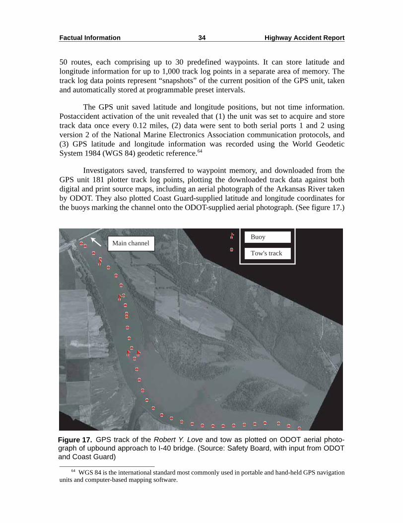
Factual Information 34 Highway Accident Report
50 routes, each comprising up to 30 predefined waypoints. It can store latitude andlongitude information for up to 1,000 track log points in a separate area of memory. Thetrack log data points represent “snapshots” of the current position of the GPS unit, takenand automatically stored at programmable preset intervals.
The GPS unit saved latitude and longitude positions, but not time information.Postaccident activation of the unit revealed that (1) the unit was set to acquire and storetrack data once every 0.12 miles, (2) data were sent to both serial ports 1 and 2 usingversion 2 of the National Marine Electronics Association communication protocols, and(3) GPS latitude and longitude information was recorded using the World GeodeticSystem 1984 (WGS 84) geodetic reference.64
Investigators saved, transferred to waypoint memory, and downloaded from theGPS unit 181 plotter track log points, plotting the downloaded track data against bothdigital and print source maps, including an aerial photograph of the Arkansas River takenby ODOT. They also plotted Coast Guard-supplied latitude and longitude coordinates forthe buoys marking the channel onto the ODOT-supplied aerial photograph. (See figure 17.)
64 WGS 84 is the international standard most commonly used in portable and hand-held GPS navigationunits and computer-based mapping software.
Figure 18. GPS track of the Robert Y. Love and tow as plotted on ODOT aerial photo-graph of upbound approach to I-40 bridge. (Source: Safety Board, with input from ODOTand Coast Guard)
Main channelBuoy
Tow's track
Figure 17.
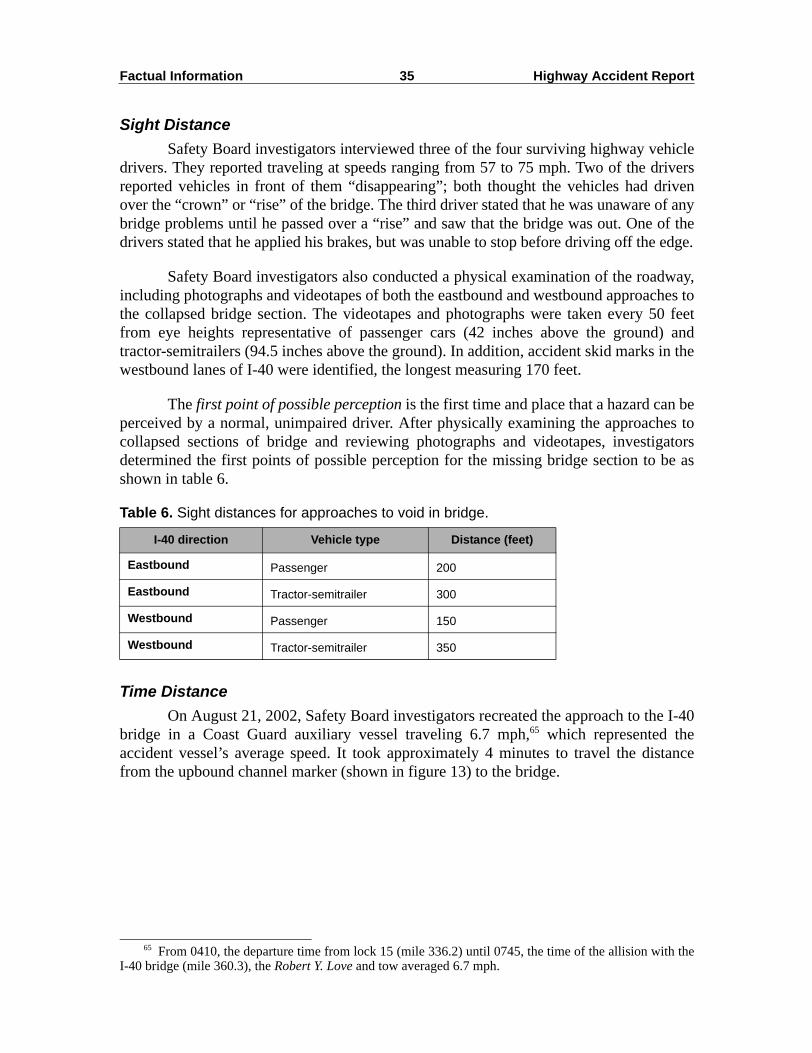
Factual Information 35 Highway Accident Report
Sight DistanceSafety Board investigators interviewed three of the four surviving highway vehicle
drivers. They reported traveling at speeds ranging from 57 to 75 mph. Two of the driversreported vehicles in front of them “disappearing”; both thought the vehicles had drivenover the “crown” or “rise” of the bridge. The third driver stated that he was unaware of anybridge problems until he passed over a “rise” and saw that the bridge was out. One of thedrivers stated that he applied his brakes, but was unable to stop before driving off the edge.
Safety Board investigators also conducted a physical examination of the roadway,including photographs and videotapes of both the eastbound and westbound approaches tothe collapsed bridge section. The videotapes and photographs were taken every 50 feetfrom eye heights representative of passenger cars (42 inches above the ground) andtractor-semitrailers (94.5 inches above the ground). In addition, accident skid marks in thewestbound lanes of I-40 were identified, the longest measuring 170 feet.
The first point of possible perception is the first time and place that a hazard can beperceived by a normal, unimpaired driver. After physically examining the approaches tocollapsed sections of bridge and reviewing photographs and videotapes, investigatorsdetermined the first points of possible perception for the missing bridge section to be asshown in table 6.
Table 6. Sight distances for approaches to void in bridge.
Time DistanceOn August 21, 2002, Safety Board investigators recreated the approach to the I-40
bridge in a Coast Guard auxiliary vessel traveling 6.7 mph,65 which represented theaccident vessel’s average speed. It took approximately 4 minutes to travel the distancefrom the upbound channel marker (shown in figure 13) to the bridge.
I-40 direction Vehicle type Distance (feet)
Eastbound Passenger 200
Eastbound Tractor-semitrailer 300
Westbound Passenger 150
Westbound Tractor-semitrailer 350
65 From 0410, the departure time from lock 15 (mile 336.2) until 0745, the time of the allision with theI-40 bridge (mile 360.3), the Robert Y. Love and tow averaged 6.7 mph.
Factual Information 36 Highway Accident Report
Other Information
Licensed Operators’ Hours of ServiceThe hours of service or hours “on watch” per day for the licensed towboat
wheelhouse watch personnel (the captain and the pilot) are specified at 46 U.S.C. 8104(h),which states that “an individual licensed to operate a towing vessel may not work for morethan 12 hours in a consecutive 24-hour period except in an emergency.” A licensedoperator on a towing vessel can work any combination of hours, as long as that person isnot on watch for more than 12 hours in any 24-hour period.
Not included in the 12-hour work period is standby time, for example, when the vesselis underway, but not moving or waiting to move through a lock or waiting for a tow to beformed. Also not included in the 12-hour work period is the operator’s commuting time to avessel. No regulation or requirement specifies the hours of rest a licensed, uninspected towingvessel operator must have before reporting on board to assume or relieve a watch.
According to MMT, the company complies with the hours-of-service law limitinglicensed wheelhouse personnel (captain and pilot) to 12 hours of work in a consecutive24-hour period. The company does not limit a captain’s or pilot’s prevoyage commutingdistance or time. Inland towing companies normally provide the crew with vehicles to usefor their commute, but they do not provide drivers.
Towboat Operator Incapacitation AccidentsThe Coast Guard’s Accident/Incident Database for 1999 to 2003 contained three
towboat accidents in which the towboat operator’s incapacitation was identified as thecausal factor.
• On February 11, 1999, the pilot of the towboat Gale C passed out and the towbecame entangled in trees along the bank of the LMR. The unconscious pilotwas taken to a hospital; he was later diagnosed with diabetes.
• On November 4, 1999, the pilot of the towboat Carol P suffered a stroke. Thetow struck a revetment (embankment) on the right bank of the LMR, damaging2 of 20 loaded barges.
• On March 31, 2003, the pilot of the towboat Don File fell from the helm chairand injured the back of his head. As he was lifting himself back into the chair,the chair’s arm broke, and he fell to the deck, rendering himself unconscious.The tow and eight barges allided with a small fleet of barges, loaded withstone, at mile 586.2 on the Ohio River.
Alerter SystemsAfter the I-40 bridge accident, segments of the marine inland towing industry
developed alerter systems for use on inland towing vessels. Two systems are beingevaluated by the industry. One of the systems continuously monitors steering rudder
Factual Information 37 Highway Accident Report
movements while the tow is underway. It is designed to sound an audible alarm in thewheelhouse if the steering levers are not moved within a given time period. (The systemsinstalled so far use a 2-minute period.) If the captain or pilot on duty does not answer thewheelhouse alarm within 30 seconds, secondary alarms are activated in the captain’s andpilot’s cabins and in a centrally located crew area. At least one company, American RiverTransportation Company (ARTCO), has installed this system on all 30 of its line-haultowboats and 30 tug or harbor boats. According to ARTCO, the crews like the system andthe wheelmen accept it. As of December 2003, MMT, the owner of the Robert Y. Love, hadinstalled the system on five of its towboats and was evaluating its performance forpossible installation on the remainder of its fleet. MMT told Safety Board investigators inJune 2004 that this system has been installed on its entire fleet of 16 towboats.
A second type of system currently available detects the physical movements of theoperator in the wheelhouse. If no movement is detected in the wheelhouse, the systemsounds an alarm to alert the crew. The detection system extends no closer than about 2 feetfrom the deck, so that a person who had collapsed but still was thrashing around on thedeck would not prevent the alarm from sounding. At least one major inland towingcompany, the Kirby Corporation, has installed this system on its towboats; a companyrepresentative stated that the system has performed satisfactorily.
American Waterways OperatorsThe American Waterways Operators (AWO) is a national association representing
the inland and coastal tugboat, towboat, and barge industry in the United States. Each year,more than 5,000 tugboats and towboats and more than 25,000 barges carry some 800million tons of cargo along the Nation’s inland and coastal waterways, or about 15 percentof all U.S. freight. The AWO represents about 75 percent of the industry nationwide,which accounts for about 85 percent of the ton-miles of towed traffic. Associationmembers include more than 375 companies and operate more than 25,324 vessels.
In 1994, the AWO instituted a safety management system for its members in thetugboat, towboat, and barge industry known as the Responsible Carrier Program (RCP).The RCP establishes voluntary company safety and environmental protection practicesthat exceed Government standards in areas that include comprehensive crew training,vessel maintenance procedures, and equipment requirements. Further, the RCP requiresthat a qualified outside auditor periodically assess the adequacy of the program and thecompany’s compliance. All AWO members must have an approved and active RCP. At thetime of the accident, MMT, the owner of the Robert Y. Love, had an approved and activeRCP and was a member of the AWO.
Coast Guard-AWO Safety PartnershipAllison Work Group. After this accident, the Coast Guard-AWO Safety
Partnership66 convened a working group to determine what could be done to correctproblems related to bridge allisions. As part of its research, the group reviewed the Coast
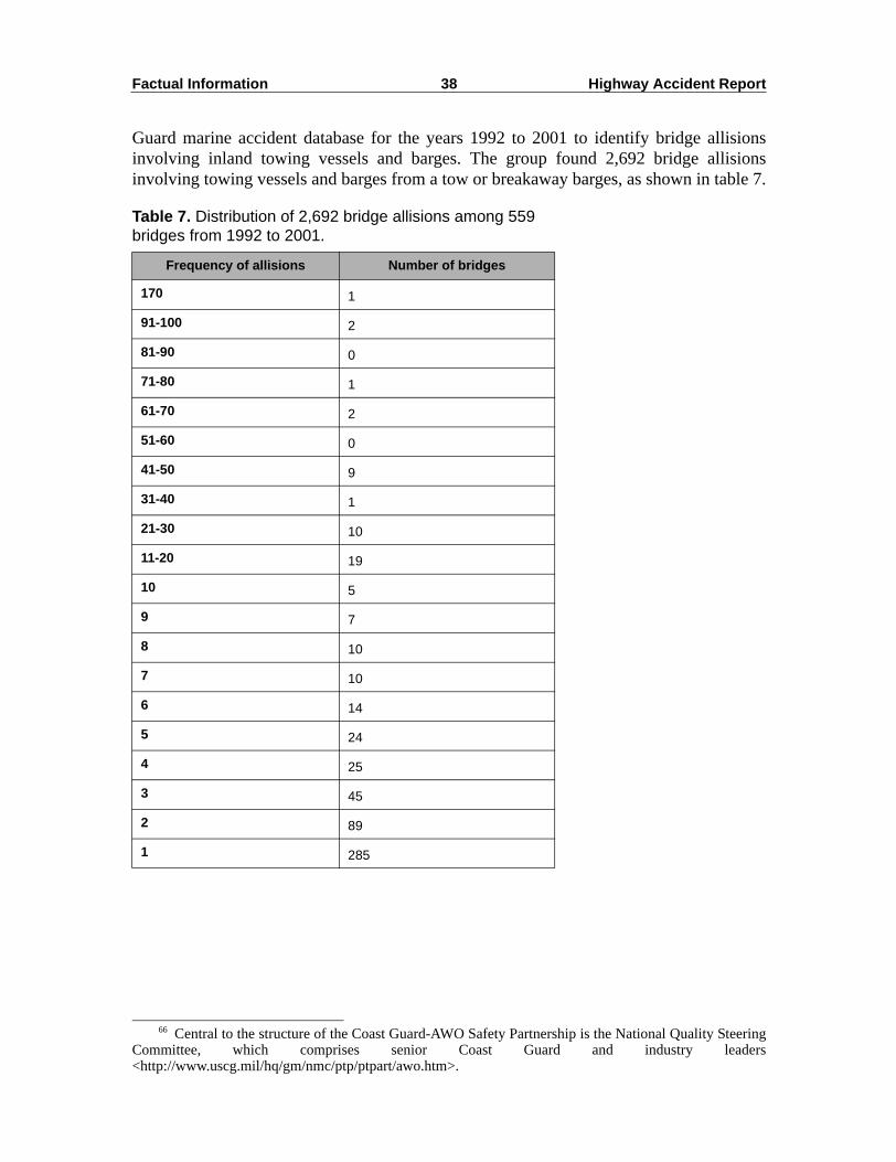
Factual Information 38 Highway Accident Report
Guard marine accident database for the years 1992 to 2001 to identify bridge allisionsinvolving inland towing vessels and barges. The group found 2,692 bridge allisionsinvolving towing vessels and barges from a tow or breakaway barges, as shown in table 7.
Table 7. Distribution of 2,692 bridge allisions among 559 bridges from 1992 to 2001.
66 Central to the structure of the Coast Guard-AWO Safety Partnership is the National Quality SteeringCommittee, which comprises senior Coast Guard and industry leaders<http://www.uscg.mil/hq/gm/nmc/ptp/ptpart/awo.htm>.
Frequency of allisions Number of bridges
170 1
91-100 2
81-90 0
71-80 1
61-70 2
51-60 0
41-50 9
31-40 1
21-30 10
11-20 19
10 5
9 7
8 10
7 10
6 14
5 24
4 25
3 45
2 89
1 285
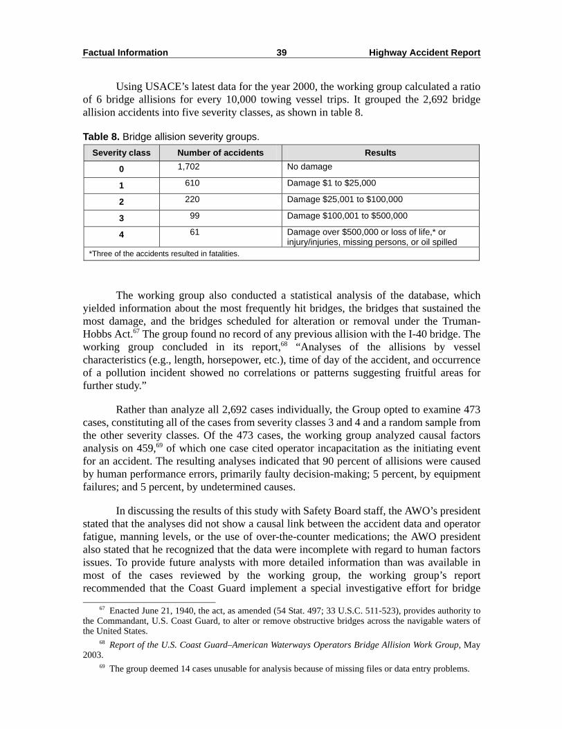
Factual Information 39 Highway Accident Report
Using USACE’s latest data for the year 2000, the working group calculated a ratioof 6 bridge allisions for every 10,000 towing vessel trips. It grouped the 2,692 bridgeallision accidents into five severity classes, as shown in table 8. Table 8. Bridge allision severity groups.
The working group also conducted a statistical analysis of the database, whichyielded information about the most frequently hit bridges, the bridges that sustained themost damage, and the bridges scheduled for alteration or removal under the Truman-Hobbs Act.67 The group found no record of any previous allision with the I-40 bridge. Theworking group concluded in its report,68 “Analyses of the allisions by vesselcharacteristics (e.g., length, horsepower, etc.), time of day of the accident, and occurrenceof a pollution incident showed no correlations or patterns suggesting fruitful areas forfurther study.”
Rather than analyze all 2,692 cases individually, the Group opted to examine 473cases, constituting all of the cases from severity classes 3 and 4 and a random sample fromthe other severity classes. Of the 473 cases, the working group analyzed causal factorsanalysis on 459,69 of which one case cited operator incapacitation as the initiating eventfor an accident. The resulting analyses indicated that 90 percent of allisions were causedby human performance errors, primarily faulty decision-making; 5 percent, by equipmentfailures; and 5 percent, by undetermined causes.
In discussing the results of this study with Safety Board staff, the AWO’s presidentstated that the analyses did not show a causal link between the accident data and operatorfatigue, manning levels, or the use of over-the-counter medications; the AWO presidentalso stated that he recognized that the data were incomplete with regard to human factorsissues. To provide future analysts with more detailed information than was available inmost of the cases reviewed by the working group, the working group’s reportrecommended that the Coast Guard implement a special investigative effort for bridge
67 Enacted June 21, 1940, the act, as amended (54 Stat. 497; 33 U.S.C. 511-523), provides authority tothe Commandant, U.S. Coast Guard, to alter or remove obstructive bridges across the navigable waters ofthe United States.
68 Report of the U.S. Coast Guard–American Waterways Operators Bridge Allision Work Group, May2003.
69 The group deemed 14 cases unusable for analysis because of missing files or data entry problems.
Severity class Number of accidents Results
0 1,702 No damage
1 610 Damage $1 to $25,000
2 220 Damage $25,001 to $100,000
3 99 Damage $100,001 to $500,000
4 61 Damage over $500,000 or loss of life,* or injury/injuries, missing persons, or oil spilled
*Three of the accidents resulted in fatalities.
Factual Information 40 Highway Accident Report
allision incidents in which the preliminary investigation showed human factors issues as apossible causal factor. The report further recommended that Coast Guard and AWOanalysts regularly evaluate the data from these completed investigations and report theirfindings to the National Quality Steering Committee of the Coast Guard-AWO SafetyPartnership. The working group also recommended that the Coast Guard and AWO workjointly to:
• Identify vulnerable bridges requiring measures to prevent and/or mitigateallisions, taking into consideration the costs and benefits of requiringadditional protection.
• Develop best practices for transiting bridges vulnerable to allision, and trainoperators in these practices.
• Require route familiarization, posting,70 or a check-ride before permitting anoperator to navigate alone under a vulnerable bridge.
• Improve Coast Guard-industry information sharing on near-misses.
• Require that the towing industry implement Crew Endurance ManagementSystems (CEMSs).71
• Accelerate the removal and alteration of “unreasonably obstructive” bridgesunder the authority of the Truman-Hobbs Act.72 The working group’s reportnoted, “More than 900 bridge allisions—34 percent of all allisions between1992-2001—occurred at bridges under order to be altered or on the Truman-Hobbs backlog priority list.”
The working group also recommended that the Coast Guard Research andDevelopment Center use this report as a basis for future studies on synergisticcombinations of actions resulting from the recommendations above.
70 Western River term for the process of familiarizing a licensed pilot with specific sections of a riverunder the supervision of an experienced, licensed pilot. Once a pilot is considered qualified to navigate asection of river, he or she is considered “posted.”
71 This process, derived from the CEMS originally developed for the Army Safety Center in the early1990s, allows companies to produce work and rest management plans that optimize alertness andperformance during duty hours and subsequently develop a crew endurance plan that meets their specificneeds. The CEMS coordinates a network of interrelated factors such as (1) company mission (for example,provide transport for oil companies); (2) equipment limitations (for example, type of vessel, and onboardcrew facilities); (3) environmental factors (for example, voyage duration, noise, and light levels); (4)crewmembers’ physiological and psychological limitations; and (5) crew rest and work hours policies.
72 This authority is delegated to the Commandant of the U.S. Coast Guard. The Commandant,represented by the Chief, Office of Bridge Administration (G-OPT), manages the alteration program forunreasonably obstructive bridges, including providing planning, programming, and budgeting; legalinterpretations; and technical engineering assistance. The laws relating to unreasonably obstructive bridgesacross the navigable waters of the United States are contained in the following statutes: (1) The Rivers andHarbors Appropriations Act of 1899, section 18 (30 Stat. 1153; 33 U.S.C. 502); (2) The Bridge Act of 1906,sections 4 and 5 (34 Stat. 85; 33 U.S.C. 494-495); and (3) The Act of June 21, 1940, as amended (Truman-Hobbs Act), (54 Stat. 497; 33 U.S.C. 511-523).
Factual Information 41 Highway Accident Report
Recent Developments. In November 2003, the AWO held a joint meeting of theAWO Interregion and Coastal Safety Committees in Baltimore, Maryland. At thismeeting, participants discussed safety issues that affect the marine towing industry, suchas the safety of bridge transits and towing vessel operator incapacitation.
Discussions during the joint meeting of these safety committees indicated thatinland marine training facilities in Houston, Texas, and Paducah, Kentucky, haveincorporated incapacitation scenarios in their towboat crewmember training simulations.In addition, the AWO safety committees have developed procedures for inclusion in RCPpractices concerning operator incapacitation and bridge transit procedures. Theseprocedures include provisions for on-duty personnel to check the wheelhouse hourly, orbefore navigating through bridges or through restricted or narrow channels, to ensure thatthe wheelman is alert and in control of the vessel; they also contain actions to be takenwhen a wheelman is found incapacitated. The AWO Board has not yet taken an officialposition on the wheelhouse monitoring and bridge transit procedures; its evaluation isongoing.
Crew endurance management, which provides the ability to maintain performancewithin safety limits while enduring job-related physical, psychological, and environmentalchallenges. CEMS demonstration projects are underway in at least eight companies and on40 towing vessels, and 150 CEMS “coaches” have been trained, according to the AWO. Inaddition, the Coast Guard has, for a number of years, been working with the towingindustry, through the AWO and its member companies, in demonstration project(s) usingCEMSs on towing vessels. This project aims to develop a system for managing the riskfactors that can lead to human error and performance degradation in maritime workenvironments. One goal of this project is to ensure sufficient hours of uninterrupted sleepfor watchstanders within the existing hours of duty.
The Coast Guard is now required to report to Congress on CEMS initiatives. OnAugust 9, 2004, the Coast Guard and Maritime Transportation Act of 2004 became PublicLaw 108-293, which amends section 409, “Hours of Service on Towing Vessels” asfollows:
(b) Demonstration Project. Prior to prescribing regulations under this section theSecretary shall conduct and report to the Congress on the results of ademonstration project involving the implementation of Crew EnduranceManagement Systems on towing vessels. The report shall include a description ofthe public and private sector resources needed to enable implementation of CrewEndurance Management Systems on all United States-flag towing vessels.
Factual Information 42 Highway Accident Report
Motorist Warning SystemsAbout 0210 on September 15, 2001, the towboat Brown Water V, pushing four
barges,73 struck the Queen Isabella Causeway, which connects South Padre Island to themainland in Cameron County, Texas.74 The allision caused two spans of the 2.37-mile-longcauseway to collapse. Ten passenger vehicles either fell with the collapsing sections ordrove off the end of the remaining roadway structure, resulting in eight fatalities. A thirdadjacent section of the bridge collapsed later that day. Bridge repair costs totaledapproximately $14.2 million, including $2.3 for demolition, $4.8 million forreconstruction, and $7.1 million for ferries to provide temporary transportation.
Weather conditions reported at 0210 by Brownsville International Airport, 18 milessouthwest of the accident site, were as follows: 7 miles of visibility, temperature 74° F,peak wind gusts out of the south-southeast (160°T) at 18.2 knots (21 mph), noprecipitation, and clear skies. According to the Coast Guard, the water current across theflats of the Laguna Madre Bay was approximately 4 to 5 mph, running from the southeasttoward the northwest, almost in line with the channel.
The collapsed causeway, with a 2001 ADT of 23,069, was the only vehicular linkfrom South Padre Island to the mainland. Opened to traffic in 1974, it was constructedsolely with State funds and spanned the Laguna Bay at the Gulf Intercoastal Waterway atmile marker 667.4 at Port Isabel, Texas. The main channel span, at piers 35 and 36, had ahorizontal clearance of 275 feet between the fender systems and a vertical clearance of 73feet. The channel piers had pier protection. The tow struck the unprotected pier 32, 175feet west of the channel. (See figures 18A and 18B.)
73 The barges had a draft of approximately 9 feet, the overall length of the tow was 851.1 feet, and thecombined weight of the vessels and their cargo was 9,030.9 tons. The Brown Water V was propelled by 600horsepower.
74 NTSB docket number HWY-01-I-H036.
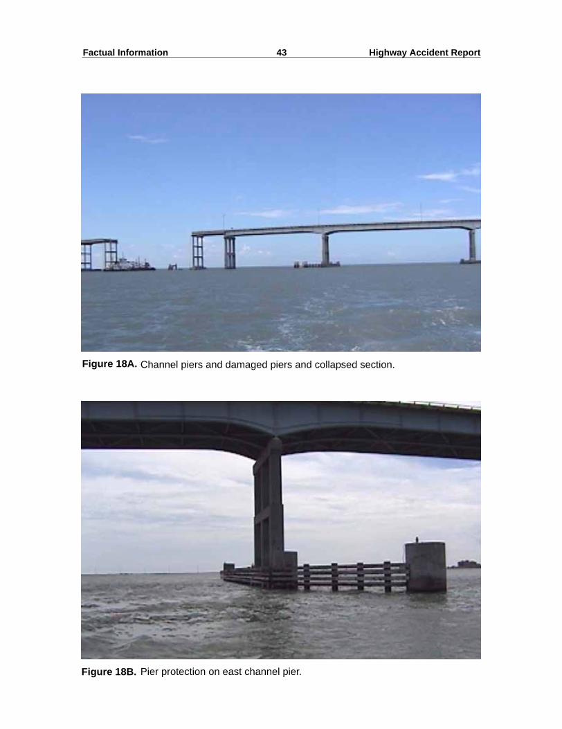
Factual Information 43 Highway Accident Report
Figure 19. Channel piers and damaged piers and collapsed section.
Figure 20. Pier protection on east channel pier.
Figure 18A.
Figure 18B.
Factual Information 44 Highway Accident Report
After the 2001 accident, the Texas Department of Transportation installed an earlywarning collapse detection system. The $850,000 system, which became operational inMarch 2004, consists of fiber-optic cable, “STOP WHEN FLASHING, DANGER”warning signs, red flashing signals placed every 500 feet along the bridge in bothdirections, and gates at both ends of the causeway. If the cable is severed, the signalslocated before the break are designed to flash red, and the signals beyond the break aredesigned not to flash, allowing traffic to clear the bridge. In addition, the system is toautomatically place calls to law enforcement agencies and the Coast Guard.
Lake Pontchartrain Causeway, New Orleans, Louisiana. The LakePontchartrain Causeway in New Orleans, Louisiana, has a motorist information/warningsystem, operated by the Greater New Orleans Expressway Commission, consisting of amarine radar system that scans the lake for targets, warning the bascule bridge operators ifa vessel is within 1 mile of the bridge (prohibited zone). According to the Commission,bridge operators can contact the vessel by marine radio and, if necessary, activate thehazard incident lighting system yellow flashers spaced every 4/10 mile for the length ofthe 24-mile bridge. Variable message signs are placed every 3 miles at the crossovers. Thesystem is used to warn motorists of accidents on the bridge as well as potential bridge spanfailures.
Police dispatch personnel, who also monitor marine frequencies and post warningmessages on the variable message signs, are notified of any incident. If a potential threatto the bridge structure exists, traffic is stopped at the toll plazas and the drawbridge(16-mile marker). Police units are dispatched to the projected impact area to close thelanes in both directions. The Coast Guard is notified for enforcement action in theprohibited zone.
Sunshine Skyway Bridge, Tampa Bay, Florida. The Sunshine Skyway Bridge inTampa Bay, Florida, has a motorist warning system that consists of digital message signsto warn motorists of high winds on the bridge. No other types of motorist advisorysystems currently operate on the bridge. According to FDOT, the Sunshine SkywayBridge has a continuity warning system that would advise FDOT and the highway patrolof a major discontinuity in the bridge. FDOT characterized this system as being less thantotally dependable.
Technical Guidance. On February 11, 1983, the FHWA issued TechnicalAdvisory T5140.19, “Pier Protection and Warning Systems for Bridges Subject to ShipCollisions.” Although this advisory and the Vessel Collision Guide Specifications describemotorist warning systems, neither document provides guidance on their use.
Related Bridge Sensor Research. Alabama A&M University, usingnanotechnology, has designed fiber-optic sensors for concrete overpasses and bridges thatcan alert engineers to stresses and damage caused by loads and weather. In addition, WestVirginia University has equipped the 1,000-foot Star City Bridge over the MonongahelaRiver near Morgantown, West Virginia, with finely tuned sensors to measure minuscule,visually undetectable changes in steel girders and support structures, in piers andabutments, and in concrete and reinforcing bars. In addition, New Mexico State University
Factual Information 45 Highway Accident Report
researchers have embedded optical sensors in an I-10 overpass in Las Cruces, NewMexico, and in an I-40 bridge over Rio Puerco west of Albuquerque, New Mexico, tomeasure stress and strain in the concrete beams.
According to the FHWA, recent research on short-term monitoring instrumentationhas been successful, and the agency is working to improve the ability of long-termmonitoring instrumentation to withstand weather conditions.75 The FHWA further notesthat, as part of the Structural Health Monitoring (SHM) approach to obtaining quantitativeinformation for efficient infrastructure assessment and management, research in recentyears has focused on moving from traditional bridge inspection methodologies relying onvisual inspection to the application of sensing technology. In March 2004, the FHWAestablished a “Virtual Team for Structural Health Monitoring,” consisting of FHWAbridge engineers and representatives from State highway agencies, academia, andindustry, to advance SHM.
Bridge Safety and SecurityAfter the September 11, 2001, terrorist attacks in the United States, the National
Cooperative Highway Research Program and the AASHTO Task Force on TransportationSecurity developed A Guide to Highway Vulnerability Assessment for Critical AssetIdentification and Protection.76 Some of the guide’s proposed countermeasures for bridgeprotection include built-in monitors on bridges, cameras for surveillance, motion sensorsor other active devices, column protection, advance warning systems, and barriers aroundbridge piers.
In September 2003, the FHWA/AASHTO Blue Ribbon Panel on Bridge andTunnel Security completed another study, Recommendations for Bridge and TunnelSecurity, requested by the AASHTO Task Force on Transportation Security. It discusseseight types of threats: low-tech and high-tech conventional explosives, for example, shapecharges; explosively formed penetrating devices, such as kinetic energy penetrators; low-tech, hand-held cutting devices; truck- or barge-size conventional explosives; chemical orbiological agents released in tunnels; incendiary conventional explosives; hazardousmaterials releases in tunnels; and intentional ramming by ship or barge.
75 March 17, 2004, telephone conversation with FHWA bridge engineers.76 A Guide to Highway Vulnerability Assessment for Critical Asset Identification and Protection,
National Cooperative Highway Research Program Project 20-07/Task 151B (Vienna, VA: ScienceApplications International Corporation, Transportation Policy and Analysis Center, May 2002).
Factual Information 46 Highway Accident Report
In a recent white paper, “Bridges for the 21st Century, Focus Area Bridge Safety,Reliability and Security,” the FHWA states:
It is common knowledge that our bridges are deteriorating at a faster rate than wecan fix them…there simply aren’t enough resources to continue conductingbusiness as usual…it is essential to develop innovative, revolutionary solutions torebuild our infrastructure. The goal…is to ensure safety of bridges and structuresagainst all manmade and natural hazards….A research program needs to beimplemented which develops breakthrough innovations, new structural systemsand rapid construction/reconstruction practices and systems that become thestandard, and produces long-lived facilities to counteract the effects ofearthquakes, scour, wind, overloads, collisions, and terrorist attacks.
The paper discusses natural threats to bridges, such as seismic events, hydraulicsand hydrology, and wind, and manmade threats to bridges, such as terrorist acts, bridgeoverloads, vessel impacts, and fire. The paper also notes: “The most vulnerable locationsfor major damage to a bridge over water are the piers. Our code does not considercarefully enough collisions with barges and other commercial or enemy craft.”
47 Highway Accident Report
Analysis
General
This analysis first identifies the factors and conditions that the Safety Board wasable to exclude as neither causing nor contributing to the accident. It then provides a briefoverview of the accident events, followed by a detailed discussion of these major safetyissues: the captain’s incapacitation and countermeasures for such an event; bridgeprotection, including risk assessment; and mitigation of loss of life, including motoristwarning systems.
Exclusions
The captain of the Robert Y. Love was tested for alcohol and illegal drugs about 3.5hours after the allision, and the results for both were negative. The captain had held anuninspected towing vessel operator’s license for almost 30 years, had extensive towingexperience on the inland waters of the United States, and was familiar with the accidentarea. The weather was mild, river conditions were calm, and skies were clear. The bargetow was small, the barges were empty, and no external forces or conditions, such as highwinds, rain, fog, or high current, were present that would have increased the captain’sworkload in controlling the movement of the tow. The river’s contour for lining up the towto pass through the navigation span of the bridge did not require excessive maneuvering;further, the relatively wide navigation span (296 feet), the barge tow’s width of 108 feet,and the 2-mph current conditions would have made for an uncomplicated passage throughthe navigation span.
The towboat had sufficient horsepower for control of the barge tow. Postaccidentinspection of the towboat revealed no mechanical anomalies that would have caused thetow to veer off course from the navigation channel. Fishing tournament witnessesimmediately rescued vehicle occupants in the water, and the first of 58 local, State, andFederal agencies responded in 8 minutes. The Safety Board therefore concludes that thecaptain was not impaired due to alcohol or illegal drugs. Further, neither the weather northe mechanical condition of the towboat nor the captain’s qualifications, experience,familiarity with the river, or workload contributed to the accident. Finally, the emergencyresponse was adequate and timely.
The Safety Board examined the captain’s 72-hour history to determine whetherfatigue was a factor in his incapacitation before the tow struck the bridge. In the 3 daysbefore the accident, the captain experienced significant disruption to his work-relatedsleep patterns. On May 24, 2002, he reduced his normal (6-hour) afternoon sleep by 3hours. The captain remained awake during the night of May 24 and into the morning ofMay 25, completely missing one sleep period. On the morning of May 25, the captain
Analysis 48 Highway Accident Report
went to bed at the time he would normally be waking up and slept for 4 hours. In addition,he shared driving an automobile with another person for approximately 10 hours whiletraveling to meet the Robert Y. Love, remaining awake through his entire afternoon sleepperiod. Assuming an average of 5.5 hours of sleep obtained during each off-watch period,the captain’s unusual sleep patterns in 72 hours before the accident resulted in a sleep debtof about 10 to 11.5 hours.
Research has shown that sleep loss compromises daytime functions; virtuallyeveryone experiences reduced performance efficiency when not sleeping adequately.77
Even modest sleep reduction, as little as 1 hour per night, can accumulate over time,progressively increasing daytime sleepiness.78 Also, small reductions in sleep, as little as 2hours, can result in measurable changes in vigilance.79 The Safety Board determined,based on the captain’s altered sleep pattern in the 72 hours before the accident, thatalthough the captain had complied with both company policy and Federal regulationsregarding hours of service, he was sleep-deficient at the time of the accident.
The captain had been working (on duty on board the vessel) for only about 6 of the24 hours immediately preceding the accident. He had stood watch the evening before andslept for at least 5 hours before going on watch the morning of the accident. However,although the captain had slept before the accident, the amount of sleep that he receivedwas insufficient to compensate for the deficit incurred while traveling, and he wastherefore sleep-deficient. When examining the circumstances of the captain’s loss ofconsciousness, investigators relied heavily on his statements, notably that his loss ofconsciousness occurred “all at once.” His last recollection before the allision waspreparing for passage under the bridge. He described being out of his chair, crouched onthe floor, and below the level of the vessel control console upon regaining consciousnessand further stated that he had trouble with his vision and could not “get oriented right.”The captain’s description of his loss of consciousness and recovery are atypical of afatigue or “falling asleep” incident. Additional factors, such as his recent conversationwith the deckhand and the time of day also argue against falling asleep. Therefore, theSafety Board concludes that the captain’s incapacitation was probably not a result of hisfalling asleep.
The captain said he had taken Benadryl® the evening before the accident, morethan 8 hours before the accident occurred. The very low levels of the medication detectedin the captain’s blood following the accident are consistent with his statements.Diphenhydramine (commonly known by the trade name Benadryl®) is an over-the-counter
77 Meir H. Kryger, Thomas Roth, and William C. Dement, eds., Principles and Practice of SleepMedicine, 2nd ed. (Philadelphia: W.B. Saunders Company, 1994).
78 W.C. Dement and C. Fisher, “Experimental Interference With the Sleep Cycle,” CanadianPsychiatric Association Journal Vol. 8 (1963): 400-405.
79 (a) R.T. Wilkinson, R.S. Edwards, and E. Haines, “Performance Following a Night of ReducedSleep,” Psychonomic Science Vol. 5 (1966): 471-472; (b) D.F. Dinges, F. Pack, K. Williams, K.A. Gillen,J.W Powell, G.E. Ott, C. Aptowicz, and A.I. Pack, “Cumulative Sleepiness, Mood, Disturbance, andPsychomotor Vigilance Performance Decrements During a Week of Sleep Restricted to 4-5 Hours perNight,” Sleep, 20(4) 1997: 267-277; and (c) T. Roehrs, E. Burduvali, A. Bonahoom, C. Drake, and T. Roth“Ethanol and Sleep Loss: A ‘Dose’ Comparison of Impairing Effects,” Sleep, 26(8) 2003: 981-985.
Analysis 49 Highway Accident Report
antihistamine with sedative effects, often used to treat allergy symptoms. In over-the-counter doses, the medication commonly results in drowsiness and has measurable effectson performance of complex cognitive and motor tasks. Reduced performance has beendemonstrated even in individuals who report feeling normal after taking the drug.80
Regular use results in some tolerance to the sedative effects of the medication, thoughcertain performance decrements persist. Studies have reported significant subjectivesedation 6 hours following a maximal over-the-counter dose of diphenhydramine81 andsignificant reduction in sleep latency (the time it takes to fall asleep in a quietenvironment) for at least 7 hours following a maximal over-the-counter dose ofdiphenhydramine.82 However, the concentration of diphenhydramine in the blood of thetowboat captain was much less than the average concentrations reported in the latter study,consistent with taking a less-than-maximal dose of the medication (depending on thespecific preparation, the amount of diphenhydramine contained in a single capsule ortablet could be 12.5 or 25 mg). At least one other study suggests that sedation would beunlikely at this blood concentration.83
The Safety Board concludes that although the captain’s performance may havebeen subtly impaired by the low level of diphenhydramine in his blood, and he may havebeen more prone to falling asleep as a result of taking the medication, neither factor waslikely to have accounted for his incapacitation.
The Accident
The Robert Y. Love was traveling on the M-KARNS waterway to Catoosa,Oklahoma, with two empty barges when the tow struck the I-40 bridge. The captain wasalone on watch in the wheelhouse, navigating the 1274.5-long ton tow at an average speedof 6.7 mph. The captain told investigators that the last thing he remembered was passingthe buoy to port and using “a few degrees” of left rudder to align his tow through the mainnavigation span of the bridge. At 6.7 mph, the Safety Board estimated the transit timefrom the buoy to the bridge to be about 4 minutes.
80 See, for example, John M. Weiler M.D. and others, “Effects of Fexofenadine, Diphenhydramine, andAlcohol on Driving Performance,” Annals of Internal Medicine (2000) 132: 354-363, in which the effect 2.5hours after a 50-mg dose of diphenhydramine is noted to be worse than the effect of an 0.10 blood alcohollevel.
81 J.R. Glass, B.A. Sproule, N. Herrmann, D. Streiner, and U.E. Busto. “Acute Pharmacological Effectsof Temazepam, Diphenhydramine, and Valerian in Healthy Elderly Subjects,” Journal of ClinicalPsychopharmacology (June 2003) 23(3): 260-268.
82 T. Roehrs, A. Zwyghuizen-Doorenbos, and T. Roth, “Sedative Effects And Plasma ConcentrationsFollowing Single Doses Of Triazolam, Diphenhydramine, Ethanol and Placebo,” Sleep 16(4) 2003:301-305.
83 S.G. Carruthers, D.W. Shoeman, C.E. Hignite, and D.L. Azarnoff, “Correlation Between PlasmaDiphenhydramine Level and Sedative and Antihistamine Effects,” Clinical Pharmacology and Therapeutics(April 1978) 23(4): 375-382.
Analysis 50 Highway Accident Report
Captain’s IncapacitationThe captain described an episode of sudden loss of consciousness lasting several
minutes, in which he fell, but not completely, because of the limited space between thevessel control console and the deck. He regained consciousness slowly, and remainedconfused for a short period of time after regaining consciousness. Such an incident isentirely consistent with an episode of syncope, in which blood flow to the brain isinterrupted for any of a variety of reasons. This interruption results in loss ofconsciousness and falling. Normally, after such a fall, an individual is in the horizontalposition, allowing blood to flow to the brain and recovery to occur quite rapidly. However,the captain was supported in a crouched position as a result of the limited space in whichto fall, and this position did not permit an immediate return of blood flow to his brain.Extensive postaccident testing did not reveal an obvious cause for the captain’s loss ofconsciousness, though the finding of coronary artery disease on cardiac catheterization(without any impairment of heart function) led physicians to recommend an EPS, in whichelectric stimuli are applied to the inside of the heart to try to cause abnormal heartrhythms. Serious abnormal rhythms were generated, and on the basis of the captain’s lossof consciousness that led to the accident, the presence of coronary artery disease, and anabnormal EPS, the captain’s cardiologist recommended that an ICD be placed in thecaptain. It is notable in this case, however, that invasive studies (cardiac catheterization,and EPS) were pursued despite a negative noninvasive evaluation. In particular, given thecaptain’s normal nuclear medicine stress test, it would not have been unusual to forgoinvasive cardiovascular testing in a typical clinical setting. Had the captain undergone thenoninvasive studies without a history of loss of consciousness, invasive testing almostcertainly would not have been pursued.
A prolonged serious abnormal heart rhythm can result in an episode of syncope.However, despite several short episodes of abnormal heart rhythms recorded by his ICDsince implantation, the captain has not had any further episodes of syncope nor requiredany shocks from the device. Syncope can have causes other than abnormal heart rhythms.Examples include vasovagal syncope (the common faint); postural hypotension (whenrising too quickly); carotid sinus hypersensitivity (in response to pressure on an area of theneck); heart attack, congestive heart failure and other heart problems; and certain types ofmigraines. However, no evidence conclusively indicates that any one of these mechanismsactually caused the captain’s episode, and, notably, in as many as 50 percent of cases, nospecific cause of syncope can be identified.84 Although the captain had a few shortepisodes of mild dizziness on occasion before the accident, he not unreasonably attributedthese episodes to overexertion, did not suffer any lasting ill effects, and did not report anyloss of consciousness, near-loss of consciousness, or any other symptoms that could beattributed to the typical causes of syncope. These episodes were apparently notnoteworthy enough for the captain to seek medical attention.
The Safety Board therefore concludes that the captain experienced a sudden loss ofconsciousness, possibly as the result of an abnormal heart rhythm. The Safety Board also
84 V.M. Voge, J.D. Hastings, and W.E. Drew, “Convulsive Syncope in the Aviation Environment,”Aviation, Space, and Environmental Medicine (December 1995) 66(12):1198-204.
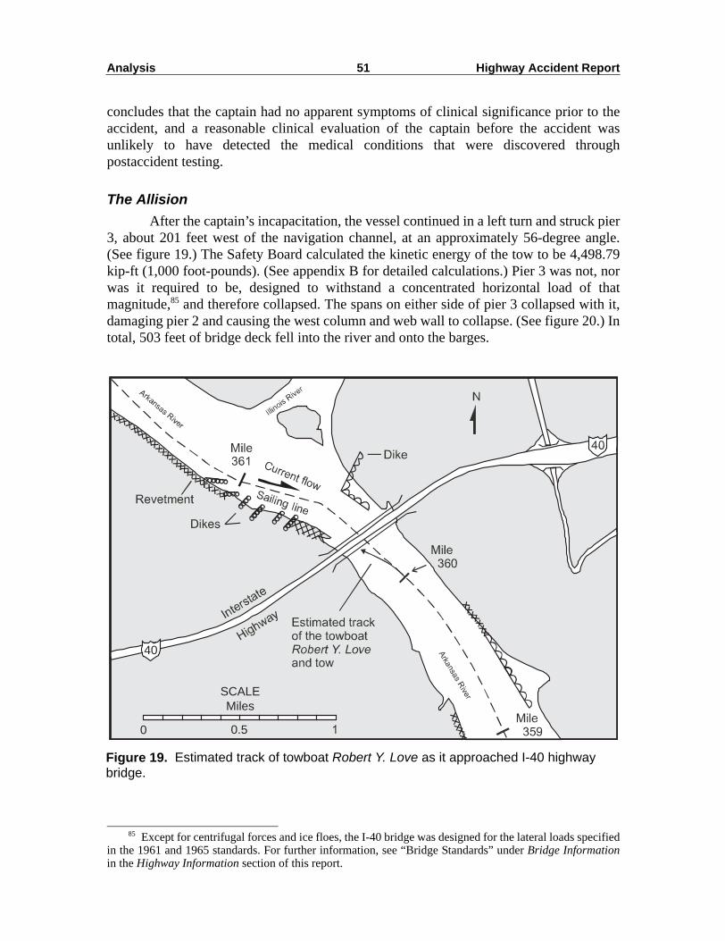
Analysis 51 Highway Accident Report
concludes that the captain had no apparent symptoms of clinical significance prior to theaccident, and a reasonable clinical evaluation of the captain before the accident wasunlikely to have detected the medical conditions that were discovered throughpostaccident testing.
The AllisionAfter the captain’s incapacitation, the vessel continued in a left turn and struck pier
3, about 201 feet west of the navigation channel, at an approximately 56-degree angle.(See figure 19.) The Safety Board calculated the kinetic energy of the tow to be 4,498.79kip-ft (1,000 foot-pounds). (See appendix B for detailed calculations.) Pier 3 was not, norwas it required to be, designed to withstand a concentrated horizontal load of thatmagnitude,85 and therefore collapsed. The spans on either side of pier 3 collapsed with it,damaging pier 2 and causing the west column and web wall to collapse. (See figure 20.) Intotal, 503 feet of bridge deck fell into the river and onto the barges.
85 Except for centrifugal forces and ice floes, the I-40 bridge was designed for the lateral loads specifiedin the 1961 and 1965 standards. For further information, see “Bridge Standards” under Bridge Informationin the Highway Information section of this report.
Figure 21. Estimated track of towboat Robert Y. Love as it approached I-40 highway bridge.
SCALEMiles
0.50
40
Figure 19.
Analysis 52 Highway Accident Report
Highway traffic continued to drive off the bridge into the void after the bridge deckcollapsed. A participant in the nearby fishing tournament observed a section of the bridgecollapse and several vehicles enter the water. He called 911 and fired a flare from a hand-held flare pistol toward the bridge in front of a tractor-semitrailer traveling westbound towarn the driver of the danger. The truckdriver stopped before reaching the edge, partiallyjackknifing his truck and blocking the bridge to following highway traffic. By the timeroadway traffic had stopped, eight passenger vehicles and three tractor-semitrailer truckcombinations had fallen into the river or onto collapsed portions of bridge span. TheSafety Board concludes that the quick-acting fisherman who fired the warning flare toalert motorists on the bridge probably prevented further loss of life.
Figure 22. Impact of barge MM-60 with south column of pier 3.
7.2 feet
22.8 feet
84.6 feet
MM-60
Figure 20.
Analysis 53 Highway Accident Report
Allision Prevention
Wheelhouse Alerter Systems In this accident, the captain of the Robert Y. Love was incapacitated as the result of
an unforeseen medical event. When he lost consciousness, he was alone in thewheelhouse, a not atypical condition aboard U.S. inland towing vessels. The deckhand onduty had just departed the wheelhouse and gone below deck to awaken the mate for dutyand to perform routine maintenance tasks. At the time of the accident, the mate had justbeen awakened, and the engineer was making his rounds of the engineroom. Thus,although three other crewmembers were awake and moving about the vessel in theminutes before the accident, none of them were in the wheelhouse when the captain lostconsciousness. The Safety Board estimates the captain became incapacitated about 4minutes before the impact with the bridge.86 Had a method been available to alertcrewmembers to the problem in the wheelhouse, they could have investigated andpossibly taken action that might have prevented the accident.
Since this accident, segments of the marine inland towing industry have beenevaluating wheelhouse alerter systems for use on inland towing vessels. These systems,which have already been installed on some towing vessels, are designed to sound an alarmshould the vessel operator either fail to move the rudder or fail to physically move for apredetermined period of time. The lack of such movements would indicate the strongpossibility that the operator is, for some reason, incapable of making them and wouldsummon assistance to the wheelhouse to investigate the cause.
If the Robert Y. Love had been equipped with such a system on the day of theaccident, other crewmembers on board the vessel may have been alerted to a problem inthe wheelhouse and may have been able to prevent this accident. Therefore, the SafetyBoard concludes that the presence of either another crewmember in the wheelhouse or awheelhouse alerter system might have resulted in timely action that could have preventedthis accident.
Although the number of reported incapacitation accidents is small, theconsequences can be catastrophic. The Safety Board considers alerter systems to be apromising safety improvement and concludes that wheelhouse alerter systems mayprovide an effective means of preventing operator incapacitation and operator fatigueaccidents in the future.
The Safety Board is aware of three companies that are, independently of oneanother, evaluating the effectiveness of these devices. Although the Board recognizesindustry’s initiative in developing and evaluating these devices, a coordinated effortinclusive of all aspects of the industry would provide the degree of uniformity needed toensure a comprehensive evaluation. The Coast Guard Research and Development Center
86 The captain told investigators that the last thing he remembered was being abreast of the buoy andlining up for the bridge. At 6.7 miles per hour, the Safety Board estimated the transit time from the buoy tothe bridge to be about 4 minutes.
Analysis 54 Highway Accident Report
has the technical staff and experience to evaluate these systems. In light of the CoastGuard’s responsibility for safety on the navigable waters of the United States, the ongoingsafety partnership between the Coast Guard and the towing industry, and the possiblesafety improvement that these alerter systems offer, the Safety Board believes that theCoast Guard Research and Development Center should evaluate the utility andeffectiveness of wheelhouse alerter systems on inland towing vessels for preventingaccidents. The Safety Board hopes that the Coast Guard will work with the towingindustry in implementing this recommendation.
Safe Transit ProceduresThe Safety Board has addressed the issue of safe transit procedures in several past
accident investigations. As a result of the 1983 City of Greenville and the 1984 Erin Marieaccidents,87 the Safety Board made recommendations to USACE regarding navigationalguides for mariners navigating the Western Rivers.88 As a result of the 1993 Chris allisionwith the Judge William Seeber Bridge in New Orleans, the Safety Board recommendedthat the Coast Guard, in cooperation with USACE, the Board of Commissioners, andbridge owners, review the conditions and practices in the Inner Harbor Navigation Canal,identify hazards to the safe transit of vessels through the canal and lock system, andimplement measures to reduce those hazards.89
Despite such initiatives, bridge allisions involving towing vessels continue tooccur, often with catastrophic consequences. In the past 10 years, 70 people90 have died insuch accidents, all third parties who happened to be crossing the bridge at the time of theaccident. The Coast Guard-AWO Work Group reported that 68 percent of bridge allisionswere caused by poor operator decision-making. Consequently, remedial action to preventor to reduce the frequency of bridge allisions involving towboats must focus not only onthe physical characteristics of waterways but also on measures to improve the ability oftowing vessel operators to make sound decisions.
Current initiatives to address such human performance issues include the CoastGuard-AWO Bridge Allision Work Group’s development of navigation “best practices”for transiting bridges vulnerable to allision and the promotion of CEMSs and the CEMS
87 National Transportation Safety Board, Ramming of the Poplar Street Bridge by the Towboat M/VCity of Greenville and its Four-Barge Tow, St. Louis, Missouri, April 2, 1983, Marine Accident ReportNTSB/MAR-83/10 (Washington, DC: NTSB, 1983) and Ramming of the Poplar Street Bridge by theTowboat M/V Erin Marie and its Twelve-Barge Tow, St. Louis, Missouri, April 26, 1984, Marine AccidentReport NTSB/MAR-85/02 (Washington, DC: NTSB, 1985).
88 Safety Recommendations M-83-96 and M-85-26. See appendix C for more information on these andrelated recommendations.
89 NTSB/HAR-94/03, Safety Recommendation M-94-10. See appendix C for more information on thisand related recommendations.
90 The Judge Seeber Bridge accident (NTSB/HAR-94/03) resulted in 1 fatality; the Big Bayou CanotBridge accident (National Transportation Safety Board, Derailment of AMTRAK Train No. 2 on the CSXTBig Bayou Canot Bridge Near Mobile, Alabama, September 22, 1993, Railroad-Marine Accident ReportNTSB/RAR-94/01 [Washington, DC: NTSB, 1994]) resulted in 47 fatalities; the Port Isabel-Padre IslandBridge accident (NTSB docket number HWY-01-I-H036) resulted in 8 fatalities; and the I-40 bridgeaccident resulted in 14 fatalities.
Analysis 55 Highway Accident Report
demonstration project. The Safety Board commends the AWO and Coast Guard for theirefforts to improve operator performance and concludes that the recommendations of theCoast Guard-AWO Bridge Allision Work Group to improve operator performance andlessons learned from the ongoing CEMS demonstration project, when implemented,should both enhance the safety of towing vessel operations and reduce bridge allisionaccidents.
Bridge Protection
In the 1960s, when the I-40 bridge was designed and built, pier protection was notrequired by State or Federal design standards or by USACE’s permit process. Followingcompletion of the M-KARNS in 1970, commercial vessel traffic began operating near thebridge. During subsequent bridge inspections in 1977 and 1980, ODOT found that thechannel piers had experienced superficial damage, indicating that the piers werevulnerable to vessel impact. Consequently, in 1982, the ODOT submitted an application tothe Coast Guard requesting permission to install pier protection cells91 on the north side ofthe channel piers to address these problems, though no requirement existed to do so. Atthat time, the bridge community still lacked standards or guidelines for bridge protection,though, by then, the Coast Guard had completed a study92 on bridge protection, and the1980 Sunshine Skyway Bridge accident93 in Florida had heightened awareness of thevulnerability of bridge piers to vessel impact.
Although ODOT installed pier protection cells inside the navigation channel, theI-40 bridge accident occurred outside the navigation channel. Such occurrencesdemonstrate that most bridges over navigable water can be struck either within or outsidethe regular navigation channel by barge tows and individual commercial vessels, thusincreasing the complexity of bridge protection. Another such accident involved the QueenIsabella Causeway,94 when the Brown Water V and tow struck an unprotected pier 175 feetwest of the navigation channel. Four additional accidents95 investigated by the SafetyBoard involved vessels that rammed approach piers outside the navigation channel, andanother involved an allision with a railroad bridge far from the navigation channel.96
However, protecting all substructure components of all bridges from vesselimpacts would be an enormous task. The vulnerability of a given bridge to vessel impactsdepends on the bridge design, location, current conditions, water depth at the bridgesupport(s), and the width and vertical clearance of the span(s). The I-40 bridge had 12
91 ODOT completed construction of the protection cells in 1984. 92 U.S. Coast Guard, The State of the Art of Bridge Protective Systems and Devices, USCG Contract
CG-71955-A (Washington, DC: USCG, November 1978).93 NTSB/MAR-81/03.94 NTSB docket number HWY-01-I-H036.95 USCG/NTSB/MAR-74/04, NTSB/MAR-78/01, NTSB/MAR-81/03, and NTSB/HAR-94/03.96 NTSB/RAR-94/01.
Analysis 56 Highway Accident Report
piers in the water, and the draft of the empty barges in this accident was 1 foot, makingmost of the piers accessible and therefore vulnerable to vessel impacts. According toODOT, in today’s dollars, providing protection cells costs about $300,000 per pier in laborand materials. ODOT also noted that installing protection cells at all piers of the I-40bridge would cost approximately $6.8 million. The I-40 bridge is just one of Oklahoma’s11 highway crossings on the M-KARNS; six of these 11 crossings have parallel bridges,for a total of 17 bridges with 74 piers in the water. To place a protection cell on both theupstream and downstream sides of the piers and one in between each parallel bridge on theM-KARNS alone would require 128 protection cells at a cost of $39.7 million.97
The M-KARNS is just one waterway in one State. Nationwide, Coast Guardrecords show more than 18,000 highway and railroad bridges spanning about 26,000 milesof commercially navigable waterways. The NBI lists 2,844 highway bridges requiring abridge permit. Many of these bridges have multiple piers that are vulnerable to vesselimpact. The Safety Board concludes that because of the cost, replacing or constructingpier protection for each existing bridge pier vulnerable to vessel impact nationwide maynot be reasonable.
Bridge engineers have a tool to effectively assess a given bridge’s risk (andacceptable risk) for vessel impact. The AASHTO Vessel Collision Guide Specificationsprovide guidelines for determining a bridge’s risk to impact by assessing vessel andvehicle traffic characteristics and the ability of the bridge to withstand the impact. Theseguidelines have been incorporated in the LRFD bridge standards, which, after 2007, willbecome the mandatory standards for all new Federal-aid bridge construction. Florida, withmany bridges over water, is already using the LRFD standards for new bridge design.
Louisiana, after the 1993 Judge William Seeber Bridge accident,98 embarked on aprogram using the AASHTO Vessel Collision Guide Specifications to evaluate existingbridges over navigable water. After the I-40 bridge accident, ODOT hired a consultant toevaluate bridges at 12 river crossings using the AASHTO Vessel Collision GuideSpecifications. Although these standards can and are being used to evaluate thevulnerability of existing bridges to vessel impacts and vehicle collisions, they are notmandatory. To adequately protect the motoring public, bridge owners should be requiredto evaluate an existing bridge’s vulnerability to vessel impact.
Demands on the limited funds in the bridge program are many. According to theNBI, the average age of the more than 590,000 bridges in the United States is 40 years.Approximately 28 percent of these structures are considered deficient, but funding is notavailable for replacement or rehabilitation.99 The FHWA sufficiency rating system is amethod of measuring one bridge’s needs against another when qualifying for limitedFederal-aid funds. Currently, the relative risk of a bridge to extreme events such as vessel
97 ODOT estimates include $38.4 million for materials and labor and an additional $1.3 million inmobilization costs.
98 NTSB/HAR-94/03.99 Raymond McCormick, “Lengthening the Span of Bridge Service Life,” TR News, No. 228
(Washington, DC: Transportation Research Board, September-October 2003).
Analysis 57 Highway Accident Report
or vehicle impacts; flooding, including scour and debris loading; seismic events; and,more recently, terrorist attacks, is not part of the sufficiency rating formula. Tools todesign new bridges and to evaluate existing bridges for protection against these events areavailable to bridge engineers through scour assessment methods, the debris loadingspecification,100 seismic risk methodology, and the Vessel Collision Guide Specifications.Once the relative risks of extreme events are established, this information can be includedin a bridge’s sufficiency rating and used to prioritize rehabilitation or replacement,balancing the many different needs of State bridge programs, while not ignoringconditions that can lead to catastrophic events.
The Safety Board therefore concludes that including the relative risk of extremeevents in bridge sufficiency ratings and in priority for rehabilitation and replacementwould help provide a more accurate assessment of a bridge’s risk to collapse and loss oflife. Therefore, the Safety Board believes that the FHWA should revise its sufficiencyrating system, which prioritizes bridges for rehabilitation and replacement, to include theprobability of extreme events, such as vessel impact.
The Safety Board has been working since the 1970s to address the vulnerability ofbridges to vessel impact. The Safety Board identified bridge vulnerability as a safety issuein its investigation of the 1972 SS African Neptune allision with the Sidney Lanier Bridgeat Brunswick, Georgia,101 and in its investigation of the 1977 towboat Carolyn and bargeallision with the Chesapeake Bay Bridge and Tunnel.102 The design of bridge protectiondevices was addressed in the investigations of the 1977 SS Floridian allision with theBenjamin Harris Bridge in Hopewell, Virginia,103 the 1980 Summit Venture allision withthe Sunshine Skyway Bridge in Tampa Bay, Florida,104 and the 1996 Julie N allision withthe Million Dollar Bridge in Portland, Maine.105 The Safety Board’s report on itsinvestigation of the Mauvilla allision with the Big Bayou Canot railroad bridge addressed
100 National Research Council, Transportation Research Board, National Cooperative HighwayResearch Program Report 445, Debris Forces on Highway Bridges (Washington, DC: National AcademyPress, 2000).
101 Safety Recommendation H-72-48 in National Transportation Safety Board, SS African Neptune:Collision With the Sidney Lanier Bridge at Brunswick, Georgia, on November 7, 1972, With Loss of Life,Marine Accident Report USCG/NTSB/MAR-74/04 (Washington, DC: NTSB, 1974). See appendix C formore information on this and related recommendations.
102 National Transportation Safety Board, Tug Carolyn and Barge Weeks No. 254, Chesapeake BayBridge and Tunnel, September 20-21, 1972, Marine Accident Report NTSB/MAR-74/02 (Washington, DC:NTSB, 1974).
103 Safety Recommendation H-78-02 in National Transportation Safety Board, Ramming of theBenjamin Harrison Bridge by the SS Floridian Near Hopewell, Virginia, February 24, 1977, MarineAccident Report NTSB/MAR-78/01 (Washington, DC: NTSB, 1978). See appendix C for more informationon this and related recommendations.
104 NTSB/MAR-81/03, Safety Recommendations M-81-15 and -20. See appendix C for moreinformation on these and related recommendations.
105 Safety Recommendation M-98-84 in National Transportation Safety Board, Postaccident Testing forAlcohol and Other Drugs in the Marine Industry and the Ramming of the Portland-South Portland (MillionDollar) Bridge at Portland, Maine, by the Liberian Tankship Julie N on September 27, 1996, SpecialInvestigation Report NTSB/SIR-98/02 (Washington, DC: NTSB 1998). See appendix C for moreinformation on this and related recommendations.
Analysis 58 Highway Accident Report
bridge risk assessment.106 The vulnerability of existing bridges to vessel impact wasdiscussed extensively in the Safety Board’s report of the 1993 towboat Chris allision withthe Judge William Seeber Bridge in New Orleans, Louisiana,107 which includedrecommendations to the FHWA and to AASHTO. Recommendation H-94-8 to FHWA wassuperseded in 1997 (see appendix C); the recommendation to AASHTO was as follows:
H-94-9
In cooperation with the Federal Highway Administration, broaden theapplication of risk-assessment and management programs to existing highwaybridges. Such programs should include, among other things, a formalassessment of the vulnerability of bridges to vessel collision and collapse.
On December 8, 1994, AASHTO responded, noting that this recommendation wasunder active consideration by the Standing Committee on Highways’ Subcommittee onBridges and Structures and would be discussed in depth at the May 1995 meeting of thesubcommittee. In its June 20, 1995, reply, the Safety Board acknowledged the above andclassified Safety Recommendation H-94-9 “Open—Acceptable Response.”
At a meeting with Safety Board staff on March 30, 2004, AASHTO indicated thatit is investigating additional countermeasures as part of its work on the security andvulnerability assessments of the transportation systems. The Water TransportationCommittee also discussed this issue with Safety Board staff at its July 2003 meeting andsaid it will work with the Standing Committee on Highways’ Subcommittee on Bridgesand Structures on risk assessment issues.
The Safety Board is disappointed that after 10 years AASHTO has not yet addressedthe vulnerability of existing bridges to vessel impact and collapse. In a July 20, 2004, letterto AASHTO, the Safety Board indicated Safety Recommendation H-94-9 remains classified“Open—Acceptable Response.” However, given that the intent of Safety RecommendationH-94-9 is covered by the recommendation issued in this report to revise the sufficiencyrating system, Safety Recommendation H-94-9 is reclassified “Closed—Superseded.”
Motorist Warning Systems
Bridge protection is a multitiered process. Available countermeasures range fromproviding physical protection against vessel impacts (pier strengthening and pierprotection) to instituting measures to prevent allisions from occurring (installing aids tonavigation and improving operator decision-making). However, when suchcountermeasures are unavailable, methods that mitigate the loss of life following a vesselimpact, such as motorist warning systems, become necessary.
106 NTSB/RAR-94/01, Safety Recommendations I-94-3 and -4. See appendix C for more information onthese and related recommendations.
107 Safety Recommendations H-94-8 and -9. See appendix C for more information on these and relatedrecommendations.
Analysis 59 Highway Accident Report
In this accident, 11 vehicles either fell with the collapsed sections of the bridge ordrove off the bridge and into the void. The surviving drivers indicated that they could notsee the void in the bridge in time to avoid driving into it. The Safety Board examined theavailable sight distance for both passenger cars and tractor-semitrailers on the east- andwestbound approaches to the void in the bridge. The sight distances ranged from 150 to350 feet; the minimum total stopping distance108 at 70 mph for passenger cars was 622 feetand for tractor-semitrailers was 726 feet. The minimum total stopping distance for atractor-semitrailer traveling at 57 mph (self-reported by one driver) was 514 feet. Thesetotal stopping distances are greater than the maximum estimated distance of 350 feet forthe first point of possible perception, indicating that some drivers involved in this accidentdid not have sufficient time to stop their vehicles after detecting the collapsed sections ofthe bridge. In light of the statements of surviving drivers, estimates of the point of firstpossible perception, and calculations of total stopping distance, the Safety Boardconcludes that the drivers in this accident did not have adequate time to detect, identify,and respond to the hazard posed by the collapsed sections of the bridge.
An effective motorist warning system, mounted on or near the bridge and capable ofalerting motorists to the bridge failure or directing vehicles to stop, might have preventedsome of the vehicles, the majority of which were traveling westbound, from driving off theI-40 bridge. The recreational boater who fired the flare pistol said that he saw at least onevehicle fall with the bridge and that his boat then accelerated toward the bridge andreached the area in about 20 seconds. He also stated that he saw two more vehicles driveoff the bridge and called 911; after the call, he saw five more vehicles drive off the bridgebefore shooting the flare. It is difficult to estimate exactly how much time elapsed betweenthe collapse and the time the truck stopped and blocked the westbound approach. Becausewestbound vehicles, traveling at 57 to 75 mph, could have traversed the 1,500 feet from theeast end of the bridge to the void in 13 to 18 seconds, it can be argued that had warning signsbeen activated within a few seconds, several of the westbound vehicles probably would havehad time to react to the warning signs and stop before driving off the bridge.
As stated earlier, it is difficult to estimate exactly how much time elapsed betweenthe collapse and the time the truckdriver saw the flare, stopped, and blocked thewestbound approach with his truck. Further, only by coincidence did the recreationalboater witness the accident and have the presence of mind to fire a warning flare. The firstemergency responder arrived within 8 minutes of notification of the accident, so, certainly,in the absence of a fishing tournament or other witnesses to the bridge collapse, aneffective warning system would have stopped additional vehicles from driving off thebridge. Therefore, the Safety Board concludes that an effective motorist warning systemon the I-40 bridge might have mitigated the loss of life in this accident.
The Texas Department of Transportation installed such a system after the 2001Queen Isabella Causeway Bridge accident,109 in which 10 vehicles either collapsed withthe bridge or drove off the void, resulting in 8 fatalities. This early warning collapse
108 Includes perception/reaction and braking distances.109 NTSB docket number HWY-01-I-H036.
Analysis 60 Highway Accident Report
detection system, which became operational in March 2004, consists of fiber-optic cable,which, if severed, activates flashing lights to warn motorists of danger ahead. As notedearlier, protecting all bridges against all events is not possible. However, in the case oflong bridges with many vulnerable piers, such as the Queen Isabella Causeway, or bridgeswith curvature that results in sight distance limitations, such as the I-40 bridge, it is criticalto protect the motoring public by installing automatic bridge failure detection and warningdevices.
The Safety Board has addressed the installation of bridge motorist warningsystems in previous accident investigations involving the Lake Pontchartrain Causeway,Sunshine Skyway Bridge, and Sidney Lanier Bridge.110 The Board is aware of at least onediscontinuity warning system that has been installed since these accidents, the one on theSunshine Skyway Bridge in Florida, which FDOT has characterized as being unreliable.The FHWA is working to improve the reliability of such systems, specifically the abilityof long-term monitoring instrumentation to withstand the conditions typically found onbridges, through its March 2004 Structural Health Monitoring initiative and throughcontinuing intelligent transportation systems programs. The development of reliable long-term sensing technology is critical in protecting the motoring public, and the Safety Boardencourages the FHWA to continue its efforts to provide reliable motorist warning systems.
Once a reliable long-term detection system has been developed, the FHWA shouldencourage the States to deploy this technology in comprehensive motorist warningsystems; such systems could also be used on bridges vulnerable to collapse from othercircumstances such as scour, seismic events, and terrorist attack. The Safety Boardtherefore believes that the FHWA should develop an effective motorist warning system tostop motor vehicle traffic in the event of a partial or total bridge collapse. In addition, theVessel Collision Guide Specifications describe motorist warning systems and referencethe 1983 FHWA technical advisory; however, neither the specifications nor the technicaladvisory provide guidance on the use of motorist warning systems. Therefore, the SafetyBoard believes that once an effective motorist warning system has been developed,AASHTO should provide guidance to the States on its use.
110 (a) National Transportation Safety Board, safety recommendation letter to the Greater NewOrleans Expressway Commission, January 8, 1975, notation 1423, Safety Recommendation H-74-42;(b) NTSB/MAR-81/03, Safety Recommendations M-81-18 and -19; and (c) USCG/NTSB/MAR-74/04,Safety Recommendation H-72-48. See appendix C for more information on these and relatedrecommendations.
61 Highway Accident Report
Conclusions
Findings
1. The captain was not impaired due to alcohol or illegal drugs. Further, neither theweather nor the mechanical condition of the towboat nor the captain’s qualifications,experience, familiarity with the river, or workload contributed to the accident. Finally,the emergency response was adequate and timely.
2. The captain’s incapacitation was probably not a result of his falling asleep.
3. Although the captain’s performance may have been subtly impaired by the low levelof diphenhydramine in his blood, and he may have been more prone to falling asleepas a result of taking the medication, neither factor was likely to have accounted for hisincapacitation.
4. The captain experienced a sudden loss of consciousness, possibly as the result of anabnormal heart rhythm.
5. The captain had no apparent symptoms of clinical significance prior to the accident,and a reasonable clinical evaluation of the captain before the accident was unlikely tohave detected the medical conditions that were discovered through postaccidenttesting.
6. The quick-acting fisherman who fired the warning flare to alert motorists on thebridge probably prevented further loss of life.
7. Wheelhouse alerter systems may provide an effective means of preventing operatorincapacitation and operator fatigue accidents in the future.
8. The recommendations of the U.S. Coast Guard-American Waterways OperatorsBridge Allision Work Group to improve operator performance and lessons learnedfrom the ongoing Crew Endurance Management System demonstration project, whenimplemented, should both enhance the safety of towing vessel operations and reducebridge allision accidents.
9. The presence of either another crewmember in the wheelhouse or a wheelhousealerter system might have resulted in timely action that could have prevented thisaccident.
10. Because of the cost, replacing or constructing pier protection for each existing bridgepier vulnerable to vessel impact nationwide may not be reasonable.
11. To adequately protect the motoring public, bridge owners should be required toevaluate an existing bridge’s vulnerability to vessel impact.
Conclusions 62 Highway Accident Report
12. Including the relative risk of extreme events in bridge sufficiency ratings and inpriority for rehabilitation and replacement would help provide a more accurateassessment of a bridge’s risk to collapse and loss of life.
13. The drivers in this accident did not have adequate time to detect, identify, and respondto the hazard posed by the collapsed sections of the bridge.
14. An effective motorist warning system on the Interstate 40 highway bridge might havemitigated the loss of life in this accident.
Probable Cause
The National Transportation Safety Board determines that the probable cause ofthe Robert Y. Love’s allision with the Interstate 40 highway bridge and its subsequentcollapse was the captain’s loss of consciousness, possibly as the result of an unforeseeableabnormal heart rhythm. Contributing to the loss of life was the inability of motorists todetect the collapsed bridge in time to stop their vehicles.
63 Highway Accident Report
Recommendations
New Recommendations
As a result of this accident, the Safety Board makes the following safetyrecommendations:
To the U.S. Coast Guard:
Direct the U.S. Coast Guard Research and Development Center to evaluate theutility and effectiveness of wheelhouse alerter systems on inland towing vesselsfor preventing accidents. (M-04-3)
To the Federal Highway Administration:
Revise your sufficiency rating system, which prioritizes bridges for rehabilitationand replacement, to include the probability of extreme events, such as vesselimpact. (H-04-29)
Develop an effective motorist warning system to stop motor vehicle traffic in theevent of a partial or total bridge collapse. (H-04-30)
To the American Association of State Highway and Transportation Officials:
Once an effective motorist warning system has been developed, provide guidanceto the States on its use. (H-04-31)
Previously Issued Recommendation Classified in This Report
Safety Recommendation H-94-9, previously issued to the American Association ofState Highway and Transportation Officials, is reclassified from “Open—AcceptableResponse” to “Closed—Superseded” by Safety Recommendation H-04-29.
H-94-9
In cooperation with the Federal Highway Administration, broaden the applicationof risk-assessment and management programs to existing highway bridges. Suchprograms should include, among other things, a formal assessment of thevulnerability of bridges to vessel collision and collapse.
Recommendations 64 Highway Accident Report
BY THE NATIONAL TRANSPORTATION SAFETY BOARD
ELLEN ENGLEMAN CONNERS CAROL J. CARMODYChairman Member
MARK V. ROSENKER RICHARD F. HEALINGVice Chairman Member
DEBORAH A. P. HERSMANMember
65 Highway Accident Report
Appendix A
Investigation and Public Hearing
The National Transportation Safety Board was notified of this accident from mediacoverage and the National Response Center on Sunday, May 26, 2002. An investigativeteam was dispatched that included members from the Washington, D.C.; Atlanta, Georgia;Arlington, Texas; and Denver, Colorado, offices.
Parties to the investigation included the Federal Highway Administration, the U.S.Coast Guard, the U.S. Department of Justice, the State of Oklahoma, and MagnoliaMarine Transport Company.
The Safety Board investigated the accident under the authority of the IndependentSafety Board Act of 1997, according to Safety Board rules. No public hearing was held.
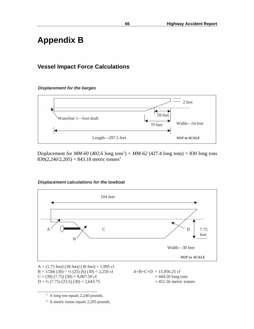
66 Highway Accident Report
Appendix B
Vessel Impact Force Calculations
Displacement for MM-60 (402.6 long tons1) + MM-62 (427.4 long tons) = 830 long tons830(2,240/2,205) = 843.18 metric tonnes2
1 A long ton equals 2,240 pounds.2 A metric tonne equals 2,205 pounds.
Displacement for the barges
Width—54 feet NOT to SCALE
2 feet
59 feetWaterline 1—foot draft
70 feet
Length—297.5 feet
Displacement calculations for the towboat
Width—30 feet NOT t o SCALE
7.75 feet
D
B
A C
104 feet
A = (1.75 feet) (38 feet) (30 feet) = 1,995 cf B = 1/2bh (30) = ½ (25) (6) (30) = 2,250 cf A+B+C+D = 15,956.25 cf C = (39) (7.75) (30) = 9,067.50 cf = 444.50 long tons D = ½ (7.75) (23.5) (30) = 2,643.75 = 451.56 metric tonnes
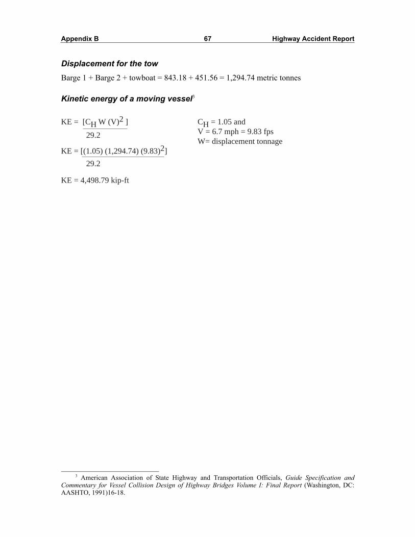
Appendix B 67 Highway Accident Report
Displacement for the towBarge 1 + Barge 2 + towboat = 843.18 + 451.56 = 1,294.74 metric tonnes
Kinetic energy of a moving vessel3
3 American Association of State Highway and Transportation Officials, Guide Specification andCommentary for Vessel Collision Design of Highway Bridges Volume I: Final Report (Washington, DC:AASHTO, 1991)16-18.
KE = [CH W (V)2 ] CH = 1.05 and V = 6.7 mph = 9.83 fps W= displacement tonnage
KE = [(1.05) (1,294.74) (9.83)2]
KE = 4,498.79 kip-ft
29.2
29.2
68 Highway Accident Report
Appendix C
Previous Recommendations on Safe Transit Procedures, Bridge Vulnerability and Protection, and Motorist Warning Systems
Sidney Lanier Bridge, Brunswick, Georgia—November 7, 1972The SS African Neptune rammed a span adjacent to the draw of the Sidney Lanier
Bridge in Brunswick, Georgia, and 450 feet of the bridge collapsed into the BrunswickRiver.1 Eight passenger cars and two tractor-semitrailers fell with the bridge, resulting in10 fatalities and 8 persons hospitalized.
As a result of its investigation of this accident, the Safety Board recommended thatthe Federal Highway Administration (FHWA), the American Association of StateHighway Officials,2 and the International Bridge, Tunnel and Turnpike Association:
H-72-48
Establish policies and standards to insure that traffic control devices (gate,signals, signs, and pavement markings) are installed on movable bridges atlocations which halt traffic on a section of the bridge that is not subject toimpact by large marine vessels. Such positioning of warning systems willprevent vehicles from being on those portions of such bridges which maycollapse when they are struck by a marine vessel.
On January 1, 1980, the Safety Board classified H-72-48 “Closed—No LongerApplicable.”
1 National Transportation Safety Board, SS African Neptune: Collision With the Sidney Lanier Bridgeat Brunswick, Georgia, on November 7, 1972, With Loss of Life, Marine Accident ReportUSCG/NTSB/MAR-74/04 (Washington, DC: NTSB, 1974).
2 The American Association of State Highway Officials (AASHO) became the American Associationof State Highway and Transportation Officials (AASHTO) in the 1970s.
Appendix C 69 Highway Accident Report
Lake Pontchartrain Causeway, New Orleans, Louisiana—August 1, 1974On August 1, 1974, the towboat, M/V Miss Andy, pushing four barges (two
abreast), struck the east span of the Lake Pontchartrain Causeway in New Orleans,Louisiana;3 252 feet of the bridge collapsed into the water. Two motor vehicles plungedinto the lake through the void created by the collapsed deck, resulting in three fatalities.As a result of its investigation of this accident, the Safety Board issued a safetyrecommendation letter on January 8, 1975, in which it asked the Greater New OrleansExpressway Commission to:
H-74-42
Install a warning system on those sections of the Lake Pontchartraincauseway that are vulnerable to impact by errant marine vessels. Thesystem should activate automatically to warn motorists of danger ahead,should the causeway span collapse.
On January 1, 1980, the Safety Board classified Safety Recommendation H-74-42“Closed—No Longer Applicable.”
Benjamin Harrison Bridge, Hopewell, Virginia—February, 24, 1977 The SS Marine Floridian, a bulk sulphur carrier, rammed the support pier between
the bridge’s northern approach causeway and its northern tower span and continued underthe span until the vessel’s starboard bridge wing struck the span.4 The bridge tender wasslightly injured while evacuating the bridge; no other injuries occurred. Total propertydamage was estimated to be $8.5 million.
As a result of its investigation of this accident, the Safety Board recommended thatthe FHWA:
H-78-2
Work with the U.S. Coast Guard to develop specifications for the design ofdolphins, fenders, and other energy absorption and/or vessel redirectiondevices for the protection of both bridge and vessel during an accidentalimpact. Issue these design specifications along with guidelines andrequirements for the placement of dolphins, fenders and energy absorptionand redirection devices.
3 National Transportation Safety Board, safety recommendation letter to the Greater New OrleansExpressway Commission, January 8, 1975, notation 1423.
4 National Transportation Safety Board, Ramming of the Benjamin Harrison Bridge by the SSFloridian Near Hopewell, Virginia, February 24, 1977, Marine Accident Report NTSB/MAR-78/01(Washington, DC: NTSB, 1978).
Appendix C 70 Highway Accident Report
The FHWA responded that the U.S. Coast Guard (Coast Guard) had sponsored astudy on state-of-the-art bridge protective systems and devices and that the FHWA hadsubmitted the specifications developed in this study to AASHTO for consideration asAASHTO specifications. On December 5, 1984, the Safety Board classified SafetyRecommendation H-78-2 “Closed—Acceptable Action.”
Sunshine Skyway Bridge, Tampa, Florida—May 9, 1980The Liberian bulk carrier Summit Venture rammed a support pier of the western
span of the Sunshine Skyway Bridge in Tampa Bay, Florida.5 The support pier wasdestroyed and about 1,297 feet of the bridge deck and superstructure fell from a height ofabout 150 feet into the bay. A Greyhound bus, a small pickup truck, and six automobilesfell into the bay, and 35 persons died. Repair costs were estimated at about $30 million forthe bridge and about $1 million for the Summit Venture.
As a result of the investigation of this accident, the Safety Board recommendedthat the Coast Guard:
M-81-15
In cooperation with the Federal Highway Administration, developstandards for the design, performance, and location of structural bridge pierprotection systems which consider that the impact from an off-coursevessel can occur significantly above as well as below the water surface.
M-81-16
In cooperation with the Federal Highway Administration, conduct a studyto determine which existing bridges over the navigable waterways of U.S.ports and harbors are not equipped with adequate structural pier protection.
M-81-17
Distribute a copy of the results of the U.S. Coast Guard’s studies regardingbridge and pier protection systems to each appropriate member of theAmerican Association of State Highway and Transportation Officials.
Safety Recommendation M-81-15. On April 13, 1987, the Coast Guardresponded that it, in cooperation with the FHWA, had developed a computer programaddressing this recommendation and made the program available to AASHTO. OnSeptember 4, 1987, the Safety Board classified Safety Recommendation M-81-15“Closed—Acceptable Action.”
Safety Recommendation M-81-16. On September 22, 1981, the Coast Guardresponded that it did not concur with this safety recommendation, noting, “We do not have
5 National Transportation Safety Board, Ramming of the Sunshine Skyway Bridge by the Liberian BulkCarrier Summit Venture, Tampa Bay, Florida, May 9, 1980, Marine Accident Report NTSB/MAR-81/03(Washington, DC: NTSB, 1981).

Appendix C 71 Highway Accident Report
the authority to determine the adequacy of any structural bridge protection system.” OnMay 4, 1982, the Safety Board responded that it could not accept the Coast Guard’s reasonfor not acting on this recommendation. The Board further asked for the Coast Guard’sinterpretation of Section 101 (7) of the 1972 Ports and Waterways Safety Act, asapplicable to the issue of bridge pier protection. The Board also stated, “We do not viewthe Coast Guard’s role as administrator of the Ports and Waterways Safety Act and theFederal bridge permit program as [limiting] highway bridge protection measures to thoseinvolving vessel operations.” On April 13, 1987, the Coast Guard responded:
The Coast Guard does not concur with this recommendation. As we stated in ourprevious response to this recommendation, we do not have the authority todetermine the adequacy of any structural bridge protection system. Therefore, nofurther action on this recommendation is anticipated.
Consequently, on February 17, 1987, the Safety Board classified SafetyRecommendation M-81-16 “Open—Unacceptable Action.” The Safety Board laterreclassified Safety Recommendation M-81-16 “Closed—Unacceptable Action” as a resultof its investigation of a 1987 allision involving the Sidney Lanier Bridge.6
Safety Recommendation M-81-17. On April 13, 1987, the Coast Guard indicatedthat criteria for the design of bridge piers to withstand vessel impacts had been sent toAASHTO. The Coast Guard also noted that the FHWA had prepared and distributed atechnical advisory on this subject. On September 4, 1987, the Safety Board classified SafetyRecommendation M-81-17 “Closed—Acceptable Action.”
Also as a result of its investigation of the accident involving the Sunshine SkywayBridge,7 the Safety Board recommended that the FHWA:
M-81-18
Develop standards for the design, performance, and installation of bridgespan failure detection and warning systems.
M-81-19
Establish criteria to evaluate the need for installing bridge span failuredetection and warning systems on existing and proposed bridges.
M-81-20
In cooperation with the U.S. Coast Guard, develop standards for thedesign, performance, and location of structural bridge pier protectionsystems which consider that the impact from an off-course vessel can occursignificantly above as well as below the water surface.
6 National Transportation Safety Board, Ramming of the Sidney Lanier Bridge by the Polish BulkCarrier Ziemia Bialostocka, Brunswick, Georgia, May 3, 1987, Marine Accident Report NTSB/MAR-88/03(Washington, DC: NTSB, 1988).
7 NTSB/MAR-81/03.
Appendix C 72 Highway Accident Report
M-81-21
In cooperation with the U.S. Coast Guard, conduct a study to determinewhich existing bridges over the navigable waterways of U.S. ports andharbors are not equipped with adequate structural pier protection.
M-81-22
Use the results of the study conducted under Safety RecommendationM-81-21 to advise appropriate bridge authorities of the benefits ofinstalling additional pier protection systems.
Safety Recommendation M-81-18. The FHWA’s responses on August 14, 1981,and February 25, 1983, indicated that the FHWA sent a memorandum to the field officesstating that the most practical existing span failure warning system is an electricalconductor system attached to the bridge that activates warning systems when itscontinuity is disrupted by span failure or collapse. In addition, the FHWA developed atechnical advisory, “Pier Protection and Warning Systems for Bridges Subject to ShipCollisions,” dated February 11, 1983, providing information on the advantages anddisadvantages of alternate types of warning systems, the design of bridge span detectionwarning systems, and the warrants for the need for such systems on Federal-aid highwayprojects. On May 4, 1983, the Safety Board classified Safety Recommendation M-81-18“Closed—Acceptable Action.”
Safety Recommendation M-81-19. The FHWA’s responses on August 14, 1981,and February 25, 1983, indicated that the FHWA had provided guidance for warrants foropen-span failure warning systems in a December 8, 1980, memorandum to FHWAregional administrators, “Motorist Warning Systems on Bridges Subject to ShipCollisions.” The memorandum stated that decisions to install such systems should bebased upon: (1) the type and frequency of shipping on the waterways; (2) the location andarrangement of the bridge piers in relation to the navigable channel and the resultingvulnerability of the piers to vessel impacts; (3) other factors (such as fog, channelgeometrics, wind, and river currents) that may create navigational problems in the vicinityof the bridge; and (4) the volume of highway traffic using the bridge. The FHWA furtherstated that these warrants were also included in the February 11, 1983, technical advisory,as noted in its response to Safety Recommendation M-81-18. On May 4, 1983, the SafetyBoard classified Safety Recommendation M-81-19 “Closed—Acceptable Action.”
Appendix C 73 Highway Accident Report
Safety Recommendation M-81-20. On March 5, 1984, the FHWA indicated thatbecause of the low probability of vessel-bridge impacts, the extraordinary costs requiredto design bridge piers to withstand the impact of large ships, and the limited fundsavailable to carry out the national bridge program, it and the Coast Guard had agreedrather than to design all water piers in navigable waters to withstand the full impact loadsof modern vessels, they would instead evaluate each bridge crossing on a case-by-casebasis to determine the degree of pier protection necessary. The FHWA noted that thefollowing guidance has been made available for this evaluation:
• Standards for pier protection systems that are being evaluated by an AASHTOtask force; and
• A report containing information on bridge pier design prepared by the MarineBoard of the National Research Council (Ship Collisions With Bridges) anddistributed to all FHWA field offices and State highway agencies through amemorandum on November 30, 1983. This memorandum requests that fieldoffices fully address the potential problems of vessel-bridge impacts inongoing Federal-aid projects through the Coast Guard/FHWA coordinationprocedures associated with Coast Guard bridge permits for navigable watercrossings. The FHWA further stated that the Marine Board report noted abovediscusses the fact that the impact of an off-course vessel can occur significantlyabove, as well as below, the water line.
On December 5, 1984, the Safety Board classified Safety RecommendationM-81-20 “Closed—Acceptable Action.”
Safety Recommendation M-81-21. On March 5, 1984, the FHWA respondedthat, as noted in its response to Safety Recommendation M-81-20, pier protectionevaluations must be made on a case-by-case basis. The FHWA also stated that it hadanticipated that the November 1983 study, Ship Collisions With Bridges, mentioned in itsresponse to Safety Recommendation M-81-20, would address this safety recommendationbut that this report did not specifically identify existing bridges in navigable waters withinadequate structural pier protection.
The FHWA further responded that it did not have the resources to conduct therequested study; it noted, however, that all highway bridges, including bridge piers andfendering systems, were being inspected on a regular basis by their respective State andlocal highway agencies. On October 30, 1984, the FHWA issued a memorandum to fieldoffices instructing them to ensure that State inspections of bridges over navigable waterscontinued to include an assessment and evaluation of bridge piers and fendering systemsfor structural integrity, as provided for in the Bridge Inspector’s Training Manual.
On April 19, 1985, the Safety Board requested additional information from theFHWA regarding: (1) inspection criteria to be used by State highway bridge inspectors, (2)qualifications of State inspectors, and (3) methods to be used by State inspectors toevaluate pier protection overall. On July 16, 1985, the FHWA replied:
Appendix C 74 Highway Accident Report
In response to Item 1, as noted in earlier responses, there is no universal standardwhich can be developed to determine whether a given pier protection system isneeded or whether an existing one is adequate. Such determination must be madeon a case-by-case basis considering the waterway usage. However, general criteriaand procedures can be developed and then modified for individual Staterequirements. These criteria should be developed where appropriate by theindividual in charge of the State’s bridge inspection program in conjunction withthose responsible for pier protection design.
The bridge inspector, through site inspections, can identify and provideinformation on the type, size, location and condition of pier protection systems.However, in many instances, he will not have sufficient data, training, orexperience to evaluate the adequacy of the system. A judgment as to adequacy ofa system should more appropriately be made by the State bridge engineer, throughan evaluation of the inspection data, in conjunction with other availableinformation.
A publication listing all bridges over the navigable waters of the United States isavailable to the States. This listing identifies those bridges where pier protectionsystems must at least be considered.
The State of Louisiana has developed a manual titled Criteria For: The Design ofBridge Piers with respect to Vessel Collision in Louisiana Waterways. Althoughspecifically prepared for Louisiana, the manual provides in-depth procedures foranalyzing and designing bridges to minimize vessel collisions. This manual hasbeen distributed to all States through the AASHTO Highway Subcommittee onBridges and Structures and was discussed at the national meetings held in 1985.The manual was referred back to the subcommittee for further review anddevelopment for consideration and later adoption as national standards.
In response to Item 2, the National Bridge Inspection Standards (NBIS) are veryspecific on bridge inspector qualifications. The requirements of a graduateengineer or a combination of experience and training assure that qualifiedinspectors will obtain accurate information on the type, size, location, andcondition of any existing pier protection system.
In response to Item 3, the information provided by the bridge inspector will beused with other available information on the stream characteristics, location ofchannel piers, type and volume of river traffic, etc., to analyze each site forrequired pier protection. Engineering judgment must be used in assessing the riskversus the consequences of bridge pier collisions along with the cost effectivenessin the development of possible pier protection systems.
In summary, the qualified bridge inspector will provide the needed site-specificinformation. This inspection data will be used with other available State criteria,or with criteria developed by others, to analyze and develop any needed pierprotection systems. Even though national standards have not yet been adopted,they are under development through the appropriate AASHTO committee. TheLouisiana criteria provided to each State could serve as an interim guide pendingfurther development of national criteria.
Appendix C 75 Highway Accident Report
On November 19, 1985, the Safety Board classified Safety RecommendationM-81-21 “Closed—Acceptable Alternate Action.”
Safety Recommendation M-81-22. On March 4, 1984, the FHWA responded thatit would continue to assess the integrity of pier protection systems through the nationalbridge inspection program. According to the FHWA, the results of each bridge inspectionwere provided to the appropriate bridge authorities for their review and subsequent actionto correct identified deficiencies, and the inspection and review of bridge piers and fendersystems through the national bridge inspection program would accomplish an ongoingreview of the structural integrity of existing pier protective systems. The FHWA alsostated that as additional technical information became available concerning the evaluationof pier protection systems on existing bridges, it would include it to the extent practicablein the ongoing national bridge inspection program.
The FHWA also noted that Federal-aid highway funds could be used to cover thecosts of warranted warning and pier protection systems for bridges on all public highways,if such costs were associated with bridge projects funded under the Highway BridgeReplacement and Rehabilitation Program. On April 19, 1985, the Safety Board classifiedSafety Recommendation M-81-22 “Closed—Acceptable Alternate Action.”
Poplar Street Bridge, St. Louis, Missouri—April 2, 1983The towboat City of Greenville, pushing four barges laden with crude oil, struck a
pier of the Poplar Street Bridge, which crosses the Upper Mississippi River between St.Louis, Missouri, and East St. Louis, Illinois.8 At least one barge was ruptured by theimpact, and crude oil was released and ignited almost immediately. Three barges brokeloose and floated downriver. One barge sank about a mile from the bridge, a second bargecollided with barges moored at a chemical barge loading facility, and the other bargecollided with a grain barge loading terminal. The facilities sustained severe damage. Theburning oil ignited several fires along about 2 miles of waterfront on the Illinois side of theriver and polluted approximately 10 miles of the river. One person was injured as a resultof this accident. The damage to the barge loading facilities, the grain barges, and theircargos; the damage and loss of cargo to the tow of the City of Greenville; and the cost ofthe oil cleanup operations were estimated to be about $9 million. As a result of itsinvestigation of this accident, the Safety Board recommended that the U.S. Army Corps ofEngineers (USACE):
M-83-96
Develop and publish a navigation guide or guides for mariners navigatingthe Western Rivers similar in format to the United States Coast Pilot.
8 National Transportation Safety Board, Ramming of the Poplar Street Bridge by the Towboat M/VCity of Greenville and its Four-Barge Tow, St. Louis, Missouri, April 2, 1983, Marine Accident ReportNTSB/MAR-83/10 (Washington, DC: NTSB, 1983).
Appendix C 76 Highway Accident Report
On June 29, 1984, USACE responded, “[T]he primary responsibility for safenavigation on the inland waterways lies with towboat pilots, who in addition to beingexperienced and well-trained need to have a through knowledge of the waterway beingtraveled.” While it agreed such a publication could be a useful tool, USACE stated that itdid not believe that publishing such a guide was appropriate, since publishing was not alogical extension of USACE’s duties. USACE indicated it would continue the practice ofadvising mariners, through local notices to navigation interests, of conditions on the riversthat could affect navigation, such as shoaling, river stages, and outdraft conditions atlocks. On June 26, 1985, the Safety Board classified Safety Recommendation M-83-96“Closed—Reconsidered.”
Poplar Street Bridge, St. Louis, Missouri—April 26, 1984The towboat Erin Marie, pushing 12 barges laden with grain downriver in high
water conditions, struck a pier of the Poplar Street Bridge, which crosses the UpperMississippi River between St. Louis, Missouri, and East St. Louis, Illinois.9 Several bargesbroke free and floated downriver, striking a fleet of 23 barges, breaking them free fromtheir moorings, and causing them to float free downriver. The barges in turn struck otherfleeted barges and shoreside facilities. More than 150 barges and vessels were broken freeof their moorings and cast adrift in the river. The total damages to barges, cargo, fleetingareas, and barge loading facilities was estimated at $3 million. No one was injured. As aresult of its investigation, the Safety Board recommended that USACE:
M-85-26
In the next edition of the Upper Mississippi River Navigation Charts,provide supplemental large scale charts for harbor areas, and areas difficultto navigate due to current conditions, sharp bends, or restricted navigationclearances; and areas having a higher-than-average accident rate or wherethere are recurrent major accidents. Incorporate on all charts the location offleeting areas and other important waterside features.
On December 30, 1992, USACE replied that it:
(1) prepares notices to navigation interests and regularly coordinates with theCoast Guard on unusual channel conditions, (2) identifies important watersidefeatures (including fleeting areas) on its navigation charts, [and that] (3) bargefleeting areas and harbor features are presented in map and tabular form, and (4)bridge configurations are shown in profile with dimensions and clearances.However, large-scale maps for harbor areas are not provided.
On March 4, 1993, the Safety Board acknowledged that USACE providesmariners with all of the requested information except for large-scale maps of harbor areasand classified Safety Recommendation M-85-26 “Closed—Acceptable Alternate Action.”
9 National Transportation Safety Board, Ramming of the Poplar Street Bridge by the Towboat M/VErin Marie and its Twelve-Barge Tow, St. Louis, Missouri, April 26, 1984, Marine Accident ReportNTSB/MAR-85/02 (Washington, DC: NTSB, 1985).
Appendix C 77 Highway Accident Report
Sidney Lanier Bridge in Brunswick, Georgia—May 3, 1987On May 3, 1987, the Polish Bulk carrier Ziemia Bialostocka rammed the Sidney
Lanier Bridge,10 resulting in about $1.4 million in damage to the bridge and causing a4-month bridge closure at an additional estimated cost of $7.9 million. As a result of itsinvestigation, the Safety Board recommended that the State of Georgia:
M-88-25
Modify the fenders on the Sidney Lanier Bridge to protect the bridge fromminor impact of large vessels.
M-88-26
Review the fenders on other Georgia bridges and modify the fenders toprotect bridges from minor impacts of large vessels.
Safety Recommendation M-88-25. On January 18, 1989, the State of Georgiaindicated that a study was underway to determine whether the Sidney Lanier Bridgeshould be replaced and noted that the damaged fendering system had been repaired.On March 23, 1989, the Safety Board classified Safety Recommendation M-88-25“Open—Acceptable Response.” On May 20, 1993, the State of Georgia indicated, basedupon its study and Coast Guard analysis, that Congress had designated the Sidney LanierBridge an “obstruction to navigation”11 and committed to a 50-percent share in thereplacement of the bridge. On July 20, 1993, the Safety Board noted that it was pleasedwork had begun on a replacement for the Sidney Lanier Bridge and that the new bridgedesign would incorporate “island” bridge protection. Accordingly, SafetyRecommendation M-88-25 was classified “Closed—Acceptable Action.”
Safety Recommendation M-88-26. On January 18, 1989, the State of Georgiaindicated that only two of its bridges (the Sidney Lanier Bridge in Brunswick and theTalmadge Bridge in Savannah) had a potential for impact by oceangoing vessels. TheState of Georgia further noted that the new Sidney Lanier Bridge would have “island”bridge protection and that none of the new Talmadge Bridge’s supporting substructureswould be in water deep enough to support oceangoing vessels. On March 21, 1989, theSafety Board classified Safety Recommendation M-88-26 “Closed—Acceptable Action.”
10 NTSB/MAR-88/03.11 A requirement for eligibility for funding under the The Act of June 21, 1940, as amended (Truman-
Hobbs Act), (54 Stat. 497; 33 U.S.C. 511-523).
Appendix C 78 Highway Accident Report
Judge William Seeber Bridge, New Orleans, Louisiana—May 28, 1993The towboat Chris, pushing the empty hopper barge DM 3021, collided with a
support pier of the eastern span of the Judge William Seeber Bridge over the IndustrialCanal in New Orleans.12 The impact severed bent 21, causing two approach spans and thetwo-column bent to collapse onto the barge and into the shallow waters of the canal. Twoautomobiles carrying three people fell with the four-lane bridge deck, resulting in onedeath and serious injuries to two persons. As a result of this accident, the canal was closedto navigation traffic for 2 days, and the bridge was closed to vehicular traffic for 2 months.The accident resulted in approximately $2 million in damage to the bridge and $7,000 indamage to barge DM 3021. As a result of its investigation of this accident, the SafetyBoard recommended that the FHWA:
H-94-8
In cooperation with the American Association of State HighwayTransportation Officials, broaden the application of risk-assessment andmanagement programs to existing highway bridges. Such programs shouldinclude, among other things, a formal assessment of the vulnerability ofbridges to vessel collision and collapse.
On March 27, 1997, the FHWA suggested that Safety Recommendation H-94-8 hadbeen superseded by Safety Recommendations I-94-3 and -4 (from the 1993 Bayou CanotRailroad Bridge accident). On October 7, 1997, the Safety Board agreed with the FHWA andclassified Safety Recommendation H-94-8 “Closed—No Longer Applicable/Superseded.”
Also as result of this investigation, the Safety Board recommended that AASHTO:
H-94-9
In cooperation with the Federal Highway Administration, broaden theapplication of risk-assessment and management programs to existinghighway bridges. Such programs should include, among other things, aformal assessment of the vulnerability of bridges to vessel collision andcollapse.
On December 8, 1994, AASHTO responded, noting that this recommendation wasunder active consideration by the Standing Committee on Highways’ Subcommittee onBridges and Structures and would be discussed in depth at the May 1995 meeting of thesubcommittee. In its June 20, 1995, reply, the Safety Board acknowledged the above replyand classified Safety Recommendation H-94-9 “Open—Acceptable Response.”
At a meeting with Safety Board staff on March 30, 2004, AASHTO indicated thatit is investigating additional countermeasures as part of its work on the security and
12 National Transportation Safety Board, U. S. Towboat Chris Collision With the Judge William SeeberBridge New Orleans, Louisiana, May 28, 1993, Highway-Marine Accident Report NTSB/HAR-94/03(Washington, DC: NTSB, 1994).
Appendix C 79 Highway Accident Report
vulnerability assessments of the transportation systems. The Water TransportationCommittee also discussed this issue with Safety Board staff at its July 2003 meeting andsaid it will work with the Standing Committee on Highways’ Subcommittee on Bridgesand Structures on risk-assessment issues.
In a July 20, 2004, letter to AASHTO, the Safety Board indicated SafetyRecommendation H-94-9 remains classified “Open—Acceptable Response.” However,given that the intent of Safety Recommendation H-94-9 is covered by therecommendation issued in this report to revise the sufficiency rating system, SafetyRecommendation H-94-9 is reclassified “Closed—Superseded.”
Also as a result of its investigation of the accident involving the Judge WilliamSeeber bridge, the Safety Board recommended that the Coast Guard:
M-94-10
Coordinate a cooperative effort with the United States Army Corps ofEngineers, the Board of Commissioners of the Port of New Orleans, andbridge owners to review conditions and practices in the Inner HarborNavigation Canal, identify hazards to the safe transit of vessels through thecanal and lock system, and implement measures to reduce those hazards.
In correspondence dated February 14, 1995, and September 23, 1996, the CoastGuard indicated that it had been working with USACE and the city of New Orleans. TheCoast Guard also stated that during the repair of the Judge William Seeber Bridge, pierprotection had been installed and that pier protection was planned for the Florida AvenueBridge.
On March 20, 1997, the Safety Board noted that it had learned USACE wasplanning a new lock in the industrial canal that should eliminate many of the problemsassociated with the existing lock. The Board further noted that it believed the constructionof a larger lock would attract larger tows and not necessarily reduce the hazards associatedwith the existing lock and asked the Coast Guard how it would address the last part ofSafety Recommendation M-94-10, requesting that it identify hazards to the safe transit ofvessels through the canal and lock system and implement measures to reduce those hazards.
On April 3, 2001, the Coast Guard responded that USACE had a lock replacementand Inner Navigation Canal Improvement project underway that would necessitatemodification of the Claiborne Avenue Bridge (Judge William Seeber Bridge) andreplacement of the Claude Avenue Bridge. The Coast Guard further stated that a Truman-Hobbs Act rehabilitation/alteration project was in progress on the Florida Avenue Bridge.The Coast Guard noted that these improvement projects were based on the results of anational bridge survey completed in 1996. The Coast Guard also stated that the bridgesover the waterway had sufficient clearances and pier protection to meet the reasonableneeds of land and water traffic without undue hazards and stated that it found nocompelling need to implement additional measures to ensure the safe transit of vesselsthrough the canal and lock system.
Appendix C 80 Highway Accident Report
In its reply, the Safety Board acknowledged that the Coast Guard had providedinformation regarding actions that it had taken to improve the safety of navigation in thecanal, had studied the hazard conditions in the canal, and had taken what it believed to beappropriate action to mitigate those hazards. Accordingly, on February 2, 2002, the SafetyBoard classified Safety Recommendation M-94-10 “Closed—Acceptable Action.”
Big Bayou Canot Railroad Bridge Near Mobile, Alabama—September 22, 1993About 2:45 a.m., the towboat Mauvilla, pushing six barges, struck and displaced
the Big Bayou Canot railroad bridge near Mobile, Alabama.13 Eight minutes later,AMTRAK train 2, the Sunset Limited, en route from Los Angeles, California, to Miami,Florida, with 220 persons on board, struck the displaced bridge and derailed. The threelocomotive units, the baggage and dormitory cars, and two of the six passenger cars fellinto the water. The fuel tanks on the locomotive units ruptured, and the locomotive unitsand the baggage and dormitory cars caught fire. Forty-two passengers and 5 crewmemberswere killed; 103 passengers were injured. The towboat’s four crewmembers were notinjured. As a result of its investigation of this accident, the Safety Board recommendedthat the U.S. Department of Transportation (DOT):
I-94-3
Convene an intermodal task force that includes the Coast Guard, theFederal Railroad Administration, the Federal Highway Administration, andthe U.S. Army Corps of Engineers to develop a standard methodology fordetermining the vulnerability of the Nation’s highway and railroad bridgesto collisions from marine vessels, to formulate a ranking system foridentifying bridges at greatest risk, and to provide guidance on theeffectiveness and appropriateness of protective measures.
I-94-4
Require that the Federal Railroad Administration and the Federal HighwayAdministration, for their respective modes, use the methodology developedby the intermodal task force to carry out a national risk-assessmentprogram for the Nation’s railroad and highway bridges.
On April 24, 1997, the DOT responded that an intermodal task force hadcompleted a screening of bridges across navigable waters that are particularly vulnerableto damage by commercial marine traffic. The DOT further stated that the task force used10 major risk factors in determining which bridges may need new or enhanced bridgefendering and lighting systems and that the task force, especially the Federal RailroadAdministration, relied upon the Coast Guard’s screening and evaluation to prioritizeimprovements for navigation at the bridge sites.
13 National Transportation Safety Board, Derailment of AMTRAK Train No. 2 on the CSXT Big BayouCanot Bridge Near Mobile, Alabama, September 22, 1993, Railroad-Marine Accident Report NTSB/RAR-94/01 (Washington, DC: NTSB, 1994).
Appendix C 81 Highway Accident Report
The Safety Board replied that although the methods used and the programestablished by the intermodal task force were less vigorous than the Safety Boardexpected, the program would reduce the risk of marine vessel impacts with bridges overnavigable waters. Consequently, on October 27, 1998, the Safety Board classified SafetyRecommendations I-94-3 and -4 “Closed—Acceptable Alternate Action.”
Million Dollar Bridge, Portland, Maine—September 27, 1996The 540-foot-long Liberian tankship Julie N, carrying a cargo of heating oil,
collided with the south bascule pier of the Portland-South Portland Million DollarBridge.14 Although no injuries occurred, the accident resulted in a 33-foot-long hole in thevessel’s hull beneath the waterline. About 4,000 barrels of oil spilled into the harbor. Thevessel sustained about $660,000 in damage, and the cost for cleanup of the oil wasapproximately $43 million. Repairs to the bridge were about $232,000. As a result of itsinvestigation of this accident, the Safety Board recommended that the FHWA:
M-98-83
Inform State highway departments of the circumstances of the accident andrecommend that the States evaluate the adequacy of fendering systems atbridge piers where the systems were not designed for the type and size ofvessel currently using the waterway and may not be adequate to protect thebridge and take corrective action as necessary.
On August 27, 1998, the FHWA responded that it would inform Statetransportation departments of the circumstances of the Million Dollar Bridge accident andreinforce its previous guidance to the States regarding this matter. On October 21, 1998,the Safety Board acknowledged that the FHWA had issued a memorandum to the FHWAfield offices recommending that the States evaluate the adequacy of fendering systems atbridge piers where the systems were not designed for the type and size of vessels currentlyusing the waterway and take corrective action, as necessary, in accordance with theiroverall, ongoing Bridge Management System Programs, and consequently classifiedSafety Recommendation M-98-03 “Closed—Acceptable Action.”
14 National Transportation Safety Board, Postaccident Testing for Alcohol and Other Drugs in theMarine Industry and the Ramming of the Portland-South Portland (Million Dollar) Bridge at Portland,Maine, by the Liberian Tankship Julie N on September 27, 1996, Special Investigation ReportNTSB/SIR-98/02 (Washington, DC: NTSB, 1998).
Appendix C 82 Highway Accident Report
Also as a result of its investigation, the Safety Board recommended that AASHTO:
M-98-84
Inform State highway departments of the circumstances of the accident andrecommend that the States evaluate the adequacy of fendering systems atbridge piers where the systems were not designed for the type and size ofvessel currently using the waterway and may not be adequate to protect thebridge and take corrective action as necessary.
On April 17, 2000, AASHTO responded that the FHWA memorandum had beendistributed to the AASHTO Standing Committee on Highways’ Subcommittee on Bridgesand Structures (consisting of State bridge engineers) and had been discussed at its May1999 meeting. On June 27, 2000, the Safety Board classified Safety RecommendationM-98-84 “Closed—Acceptable Action.”