Embed Size (px)
Citation preview
U.S. NAVAL BASE, PEARL HARBOR, CARRIER MOORINGS V1, V2, V3, V4 (Naval Base Pearl Harbor, Victor Wharfs V1 to V4) (Aviation Supply Wharfs) Near the southern tip of Pearl City Peninsula Pearl City vicinity Honolulu County Hawaii
PHOTOGRAPHS
WRITTEN HISTORICAL AND DESCRIPTIVE DATA
FIELD RECORDS
HISTORIC AMERICAN ENGINEERING RECORD PACIFIC WEST REGIONAL OFFICE
National Park Service U.S. Department of the Interior 1111 Jackson Street, Suite 700
Oakland, CA 94607
HAER Hl-95 HAER Hl-95
Location:
HISTORIC AMERICAN ENGINEERING RECORD
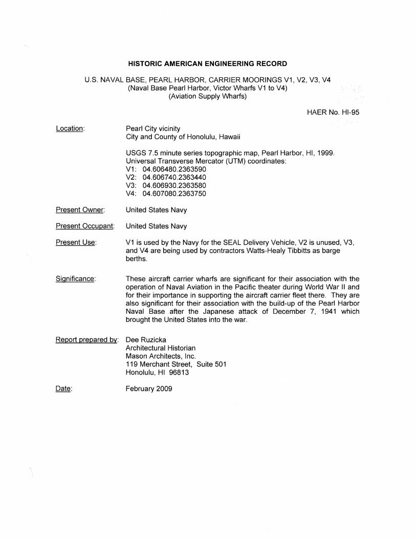
U.S. NAVAL BASE, PEARL HARBOR, CARRIER MOORINGS V1, V2, V3, V4 (Naval Base Pearl Harbor, Victor Wharfs V1 to V4)
(Aviation Supply Wharfs)
HAER No. Hl-95
Pearl City vicinity City and County of Honolulu, Hawaii
USGS 7.5 minute series topographic map, Pearl Harbor, HI, 1999. Universal Transverse Mercator (UTM) coordinates: V1: 04.606480.2363590 V2: 04.606740.2363440 V3: 04.606930.2363580 V4: 04.607080.2363750
Present Owner: United States Navy
Present Occupant: United States Navy
Present Use: V1 is used by the Navy for the SEAL Delivery Vehicle, V2 is unused, V3, and V4 are being used by contractors Watts-Healy Tibbitts as barge berths.
Significance: These aircraft carrier wharfs are significant for their association with the operation of Naval Aviation in the Pacific theater during World War II and for their importance in supporting the aircraft carrier fleet there. They are also significant for their association with the build-up of the Pearl Harbor Naval Base after the Japanese attack of December 7, 1941 which brought the United States into the war.
Report prepared by: Dee Ruzicka Architectural Historian Mason Architects, Inc. 119 Merchant Street, Suite 501 Honolulu, HI 96813
Date: February 2009
U.S. NAVAL BASE, PEARL HARBOR, CARRIER MOORINGS V1, V2, V3, V4 (Naval Base Pearl Harbor, Victor Wharfs V1 to V4)
(Aviation Supply Wharfs) HAER No. Hl-95 (Page 2)
PART I. DESCRIPTION
The carrier moorings, Victor Wharfs V1, V2, V3, and V4 are located near the southern tip of Pearl City Peninsula. V1 and V2 are oriented linearly on the west side of the peninsula, separated by about 624', with their long axes extending approximately northwest to southeast. V3 and V4, on the east side of the peninsula, are also oriented linearly and are separated by about 552', with their long axes extending approximately southwest to northeast. The two lines formed by the linear orientation of the two pairs of wharfs meet near the southern tip of the peninsula at an approximate right angle. At this point V2 and V3 are separated by about 340'.
All four of these wharfs are similar in design and construction, one difference between them being their length. Wharfs V1 and V2 are each 376'-0" long and wharfs V3 and V4 are each 448'-0" long. Other differences are; the width of the curb at the outboard edge of the wharfs, and the placement of batter piles along the wharfs' transverse bents.
Each of the wharfs is a cast reinforced concrete slab, its deck measuring 36'-0" wide from curb to curb and approximately 1' thick. The deck of each wharf at its outboard edge is about 8' above the mean low water level of the harbor. The wharfs typically have an 811 high concrete curb that is approximately 1' wide. At V1 and V2 the curb at the outboard edge of the wharf is approximately 3' wide to allow for the mounting of bitts, bollards, and cleats for mooring vessels. The typical curb at the outboard edge of V3 and V4 widens to 1 '-6" in numerous areas to allow for the mounting of bitts and cleats. The concrete slab of the wharfs slab is supported on driven concrete piles that are arranged in transverse bents spaced approximately 12' (on center) apart. Batter piles driven at a 4: 12 slope are placed midway between the bents at the outboard edges of wharfs V1 and V2. At wharfs V3 and V4 batter piles are located at both the inboard and outboard edges of the wharfs. Here a batter pile is paired with the inboard and outboard pile of each bent, with the batter piles on opposite sides of each bent at inboard and outboard edges.
The wharfs are oriented approximately parallel to their adjacent shoreline and are each connected to shore by three 38'-0" wide approach ramps of reinforced concrete. The design and construction of the ramps is very similar to the wharfs, with bents of driven concrete piles. The length of each approach ramp varies from about 60' (approximate typical length of most ramps) to about 94' (at the south approach to V3) due to the variable distance from the inboard edge of the wharfs to the shoreline. The deck of the wharfs and approach ramps is sloped downward approximately 1 /8" per foot from the outboard edge of the wharf to the inboard end of the approach ramps at the shoreline where it is approximately 7' above the mean low water level of the harbor. The inboard curbs of the wharfs have small suppers, typically about 3" x 9" and spaced every 6' to 9'.
The shoreline adjacent to the wharfs is hardened by a concrete sheet pile retaining wall. It is braced on the harbor side by concrete batter piles placed approximately every 1 O'. This wall is topped with a concrete beam and concrete curb about 1' wide and 8" high. The concrete beam topping the retaining wall widens to accommodate the top edge of the batter piles.
Each of the wharfs has areas of wooden fenders, primarily along its outboard edges. These fenders consist of driven timber piles, approximately 1 '-4" in diameter and spaced approximately every 5'. The distances between these piles are spanned by 811 wide timber wales. Behind the piles and wales is a continuous band of 1 '-0" x 1 '-0" timber that is held away from edge of the
U.S. NAVAL BASE, PEARL HARBOR, CARRIER MOORINGS V1, V2, V3, V4 (Naval Base Pearl Harbor, Victor Wharfs V1 to V4)
(Aviation Supply Wharfs) HAER No. Hl-95 (Page 3)
wharf by 4" wide timber chocks spaced approximately 6' apart. At many areas of the wharfs these fenders are missing or damaged.
At the outboard edge of each wharf are piping features consisting of approximate 3" diameter piping coming up from beneath the deck of the wharf and ending with a backflow preventer and gate valve. These piping features are typically protected from bumping by a framework of 2" diameter metal pipe bolted to the deck of the wharf. At V1, V2, and V4 this framework is boxlike in form with a rectangular portion of three lengthwise members joined at their ends by shorter transverse sections and supported at the center of each end by a single vertical member. At V3 this protective framework is semi-circular in form with two arched members bolted to the deck along the sides of the piping feature and joined near their tops by two transverse sections.
Five large onshore bollards that are associated with the wharfs are still extant. These bollards were installed at the time that the wharfs were constructed. The bollards are located near the shoreline between the four wharfs and past the outer ends of V1 and V4. The two bollards which are located between V1 and V2 and between V3 and V4 (one bollard between each pair of wharfs) are approximately midway between the wharfs and 120'-0" behind (inboard) of a line drawn along the outboard edges of the wharfs. A third bollard is located approximately midway between wharfs V2 and V3 and also 120'-0" behind a line drawn from the south (outboard) corners of each of the wharfs. Two additional bollards are located 150'-0" from the west end of V1 and the same distance from the north end of V4, each also 120'-0" back from the outboard edge of each wharf. Each steel bollard is about 3'-6" high and is mounted to a thick concrete slab that is approximately 15' in diameter. The slabs at the two bollards to the sides (north and south) of V4 are hexagonal, measuring about 15' across the flats. This slab is shown on original drawings as being 8'-0" thick and supported on twelve driven timber piles (141h ND November 2, 1942, drwg 221034). About 150' north of V4, the extant shore bollard has had a concrete ramp added to its southeast side. This ramp, about 15' wide, angles downward at an approximate 45 degree angle from the edge of the concrete slab of the bollard to the edge of the water about 7' below.
At the northwest end of V1 is an added finger pier about 120' long and about 7' wide. This pier has a floating deck (about 2' above the water) which is secured by six driven concrete piles. The finger pier is accessed by a ramp extending downward from the deck of V1.
At the southeast end of V1 is an added concrete wharf for the Seal Delivery Vehicle. This added wharf is at the same level, and contiguous with the deck of V1. It consists of a U-shaped concrete deck supported on concrete piles. It is oriented with the open end of the U pointing southwest (out into the harbor) and the base of the U at the shore. The outboard ends of the arms are in line with the outboard edge of V1. The deck of each arm of the U is 11 '-0" wide with 1 '-0" wide 1 '-0" high curbs. The length of each arm is about 60' and the distance between the arms is about 15'. Total length of the wharf is about 98' from its shoreward edge to the end of its arms. Onshore paving smoothly joins the deck of the wharf at its inboard edge.
The onshore areas of the wharfs contain various piping and valve pits. Eight pits are extant at wharf V4 and eight at V3. Three pits are extant at V2, and four pits are extant at wharf V1. The pits are all of similar construction, with varying footprint dimensions from 5'-5" x 5'-5" square to 16'-8" x 14'-0" rectangular. The pits all have a concrete perimeter wall (typically about 8" to 1'
U.S. NAVAL BASE, PEARL HARBOR, CARRIER MOORINGS V1, V2, V3, V4 (Naval Base Pearl Harbor, Victor Wharfs V1 to V4)
(Aviation Supply Wharfs) HAER No. Hl-95 (Page 4)
thick) which rises typically between about two to four feet above grade. Depths of the pits are also variable, typically from about 4' to about 1 O' below grade.
The pits contain sections of large diameter piping, typically about 8" to 12". The piping within the pits has a section removed with the free (flanged) ends of the piping sealed, indicating the probable removal of a valve and the discontinuation of the line. A number of the pits are marked "Out of Svc 12-14-05" on the inner surface of their perimeter wall.
One type of very shallow pit is found at the middle approach ramps of V3 and V4. This type of pit is only about 1' deep (below grade) and has a low perimeter wall about 2' high. Footprint dimensions of these pits are 14'-3" x 12'-1". There are four examples of this type of pit, one located at each corner of the shore (inboard) edge of the middle approach ramps at V3 and V4. These pits have five pipes (four are 8" diameter and one is 10" diameter) labeled; JP-8, JP-4, Ballast, and Multi-Product. The pipes within these pits have sections removed and the ends sealed. The pipes rise up from below grade on shore and continue out along the sides of the middle approach ramps in covered troughs to valve areas on each wharf at the outboard corners of the middle approach ramps. These valve areas on the wharfs have a footprint about 7' x 20' (oriented linearly along the length of the wharfs at the inboard edge) and are surrounded by a low concrete wall about 1 '-6" high. The pipes within them have sections removed and the ends sealed. Each pipe has a dispensing valve with a coupling oriented toward the outboard side of the wharf about 2'-6" above the deck.
Another type of pit which is found at all of the wharfs measures 12'-0" x 6'-0" in footprint dimensions. This type of pit has a depth of approximately 3' to 4' below grade and a perimeter wall 1'-0" thick and 3'-0" high. These pits contain a single pipe, approximately 1' in diameter, which rises up from below grade to the level of the top of the perimeter wall and then drops down below grade again. A center section of the exposed pipe, at the top where it is on level with the top of the perimeter wall, is removed and the flanged pipe ends are capped. Another distinctive feature of these pits is a framework of 4%'' diameter steel pipe about 3'-6" high that is set into the top of the perimeter wall. This framework has vertical members at each corner of the wall and a vertical member in the center of each of the long side walls. Horizontal members join the tops of the vertical pipes, forming a cage which appears designed to protect a valve (removed) at the top of the exposed pipe. There are two of this type of pit at V1, and one each at V2, V3, and V4. The pit at V2 is marked "To Tank and Hickam" on the outside of its perimeter wall.
At the shoreline between wharfs V3 and V4 are two notable features. The first is a pipe or conduit which extends out from the shoreline and disappears under the surface of the water a short distance (approximately 4') from shore. This is located about 185' north of the north end of V3. The shoreline here is formed by an abrupt drop of about 7' from grade to water level with rip rap piled against the edge of the drop to prevent erosion. Projecting out from below grade, about 2'-6" above the surface of the water is a metal pipe about 8" in diameter which is reduced to about 4" in diameter. This 4" pipe which extends downward into the water is formed of approximately 1'-6" long straight sections which are joined together by approximate 6" diameter couplings.
The second shoreline feature between wharfs V3 and V4 is the remains of a structure built of concrete, stone, and concrete hollow tile. This is located about 360' north of the north end of V3. It is a concrete-paved ramp with wide, low balustrades of concrete-surfaced uncoursed
U.S. NAVAL BASE, PEARL HARBOR, CARRIER MOORINGS V1, V2, V3, V4 (Naval Base Pearl Harbor, Victor Wharfs V1 to V4)
(Aviation Supply Wharfs) HAER No. Hl-95 (Page 5)
rubble along its sides. The ramp is built of concrete hollow tiles which were formed using a very dark aggregate, giving them a dark appearance. Each tile typically measures about 1 '-3" long, 1 '-0' deep and 8" high with three approximate 9" x 3" holes. The ramp itself is about 11' wide between the balustrades, which are each about 2'-0" wide and 1'-4" high. The ramp is approximately level, with the top concrete-paved surface about 6' above the water, and extending out towards the water in an approximate southeast orientation from about 2' below grade. The extant portion of the structure ends at the edge of the water, where it is broken off. Sections of concrete hollow tile and mortar are strewn about the broken end of the structure. These remains are in the approximate position and orientation as a feature shown projecting from shore on several historic maps and aerial photos (NAVFACPAC August 25, 1942 drwg BN22-326 and Furlong May 24, 1944). The shoreline property adjacent to this feature is show as owned by Harold G. Dillingham and Marion D. Erdman on a 1944 Navy boundary map (NAVFACPAC July 1, 1944 drwg OA-N1-1058).
PART II. HISTORICAL CONTEXT
For more information see: HAER No. Hl-53, Overview, Waterfront Facilities, U.S. Naval Base, Pearl Harbor. HAER No. Hl-55, Pier & Yacht Club Marine Railways, Fae. S649. U.S. Nav. Base Pearl Harbor. HABS No. Hl-393, Overview Pearl City Peninsula, U.S. Naval Base Pearl Harbor. HABS No. Hl-436, General Warehouse Pearl City Pen., Fae. 695, U.S Nav. Base Pearl Harbor. HABS No. Hl-358, Naval Housing Area, Pearl City, U.S. Naval Base Pearl Harbor.
Wharfs V1 and V2 were constructed as mooring facilities for aircraft carriers and were completed in May 1943 (CPNAB, A-841). They were constructed by Contractors Pacific Naval Air Base (CPNAB), a consortium of construction firms that built Navy facilities during WW II. They were built under CPNAB contract NOy-4173, as project number 537 A. Dredging the area in connection with the construction of these wharfs was also performed under the same contract, as project number 537. Approximately 11 % of this dredging was done under a second contract, NOy-8121. The dredging was not completed until November 1943 (ibid.). These projects were begun in August 1942.
Wharfs V3 and V4 were also constructed as mooring facilities for aircraft carriers. They were built by Hawaiian Dredging Company, LTD. Under contract NOy-8511 as project number 13 (14th ND April 1943, 4c). Also included in this project with the wharfs was 150,000 cubic yards of fill, the removal of an existing timber-constructed gasoline pier and associated piping, the installation of 20' floodlights, excavation and fill for 670' of submarine cable, and the installation of two shore bollards on pile foundations and concrete slabs. Construction of this project was begun on June 7, 1944 and completed on July 30, 1945 (14th ND n.d., 11-12). The gasoline pier that was removed near the site of V3 was built in late 1942 or 1943 as a "temporary joint Army & Navy (avgas) fuel pier" (14th ND drwg B-N22-326, August 8, 1942). This gasoline pier moved fuel from tankers to two above-ground, 150,000 barrel relay tanks that were re-located to Pearl City Peninsula from near the Submarine Base in early 1943 (141h ND 1945 Vol. Ill Fuel Annex NSD, Removal of Surface Tanks, np). These relay tanks were connected to the underground gasoline storage system (ibid.).
Extensive areas inboard of the wharfs were filled. The 1942 shoreline, before the start of construction, was in most areas only about 100' to 200' from Coral Avenue, a curving street which roughly followed the contour of the south end of the peninsula. One shoreline section
U.S. NAVAL BASE, PEARL HARBOR, CARRIER MOORINGS V1, V2, V3, V4 (Naval Base Pearl Harbor, Victor Wharfs V1 to V4)
(Aviation Supply Wharfs) HAER No. Hl-95 (Page 6)
that extended farther out in to the harbor (approximately 300') was located between V3 and V4 and was the site of the aviation gasoline pier which was dismantled (ca. 1944) at the time V3 and V4 were built.
Originally the wharfs were built with a timber fender system that used driven timber piles and four horizontal bands of 12" x 12" wood fenders secured outboard of the piles. The horizontal wood fenders and piles were supported at the edge of the wharfs by wood blocks, chocks, and wales. In 1956 this fender system was replaced at wharfs V1, V2, and V4 with a system using a single horizontal band of 12" x 12" wales set between the wood piles. During this replacement numerous damaged piles were removed and replaced with new 60' long treated wood piles.
Original construction plans show that a 20' deep steel sheet pile bulkhead was installed at the shoreward edges of the approach ramps of the wharfs. All of the wharfs were located outboard of the existing 1942 shoreline (NAVFACPAC drwg 221130 December 3, 1942 and OA-N01-844 April 6, 1944), typically by several hundred feet. This extensive filled area behind the wharfs would likely have required the steel sheet piling to stabilize it at the approach ramps. In 1950 a reinforced concrete sheet pile bulkhead was installed along approximately 400' of the inboard edge of V3. This bulkhead began at the north corner of the south approach ramp and after a short (approximately 50') section extending east, the bulkhead turned northeast to approximately parallel the wharf at the inboard edge of the remaining two approach ramps. The bulkhead was formed of concrete sheet piles which were buttressed by reinforced concrete batter piles driven at a 4: 12 slope outboard of the bulkhead about every 1 O' along its length (NAVFACPAC drwg 483070-081 June 13, 1950).
Shortly after this concrete sheet pile bulkhead was built at V3, similar bulkheads were installed at V1, V2, and V4, ca. 1951 (NAVFACPAC drwgs 504743 through 504750 April 30, 1951). The primary difference between these 1951 bulkheads and the earlier 1950 bulkhead is the use of composite batter piles at an approximate 50' section along V2 between the middle and south approach ramp (NAVFACPAC drwg 504747 April 1951). These composite piles were formed of a 16" square reinforced concrete pile joined to an approximate 15" diameter timber pile using a 4'-3" long section of 14" diameter%" thick pipe (NAVFACPAC drwg 504746 April 30, 1951). The typical spacing of the batter piles is shown on the V1, V2, and V4 drawings as 10'-6" at V1, 9'-6" at V2, and 11'-6" at V4 (NAVFACPAC drwg 504747 April 30, 1951).
Original drawings show that wharfs V1 V2 were supplied with fresh water via a 6" line which was reduced to 4" where it entered the wharf at the middle approach ramp (NAVFAVPAC drwg 221130, December 3, 1942). Wharfs V3 and V4 had 6" lines for fresh water, 10" lines for aviation gasoline (AVGAS) and 10" lines for motor gasoline (MOGAS) (NAVFACPAC drwg OANo1-361 June 2, 1944). Aviation gasoline was a higher octane fuel used in piston engine aircraft, motor gasoline was used as fuel for other piston engines.
By May 1945 another wharf had been constructed between V1 and V2. This was apparently wooden, it was called a "Timber Wharf'' (NAVFACPAC drwg 3280, May 15, 1945). This timber wharf was probably constructed at the same time as V3 and V4; it is not visible in a aerial photo taken May 24, 1944 (Furlong "Pearl Harbor 24 May 1944, in HAS box PPFUR-2-3). This wharf was about 400' long and 28' wide with a deck elevation the same as the other wharfs, 8'-0" above the water. It had two approximate 25' wide approach ramps, one at either end of the wharf, and its outboard edge was about 60' from the shoreline. By 1951 this wharf was referred to as S-727 (NAVFACPAC drwg OA-N1-2204, June 30, 1951) and by 1953 it was also
U.S. NAVAL BASE, PEARL HARBOR, CARRIER MOORINGS V1, V2, V3, V4 (Naval Base Pearl Harbor, Victor Wharfs V1 to V4)
(Aviation Supply Wharfs) HAER No. Hl-95 (Page 7)
designated as V1% (NAVFACPAC drwg 584655, June 30, 1953). Wharf V1% was demolished sometime between 1965 and 1977. In 1945 a small boat landing was located between V1 and V1 %. This was an approximate 80' long section of a 200' long pier that existed here when V1 was built. Most of this pier was removed when V1 and V2 were built, but the 80' section was retained and used as a small boat landing. When built, this 200' pier was constructed at the end of an approximate 150' long spit of land which extended out into the harbor. The Oahu Railway & Land Company (OR&L) railroad tracks terminated at this pier and the ferry landing to Ford Island was immediately to the north. When the wharfs V1 and V2 were built and the accompanying land acquired by the Navy for a Naval Avaiation Supply Depot, the train line was terminated and the land behind the wharfs was filled to about the end of the spit of land. By 1946 this small boat landing was called a "gasoline pier" (NAVFACPAC drwg OA-N1-1542, June 30, 1946). By 1953 this pier was referred to as S-726. It has since been demolished.
Also by May 1945 numerous buildings in the Naval Aviation Supply Depot compound behind wharfs V1 to V4 had been built. This included two transit sheds (one each between V1 and V2 [Fae 691] and between V3 and V4 [Fae 692]}, four storehouses (Fae 695, 696, 697, 698), a refrigerated storehouse (Fae 694), an administration building (Fae 693), fire station (Fae 700), and a mess hall (Fae 699) (NAVFACPAC drwg 3280, May 15, 1945).
Pearl City Peninsula
"A complete era passed away with World War II - a way of thinking, a basis of living, of handling wealth, and a paternalistic approach to the have-nots. Life was gracious, genteel, and mannerly. Now it's gone" (Hite 1995 in Ellis 1995, 54)
Prior the opening of the Oahu Railway & Land Company's railroad line to Manana in 1889, the Pearl City Peninsula reflected traditional land uses that extended from earlier times; subsistence farming, including rice and taro, pasture lands, and fishponds. The first map showing the entirety of Pearl Harbor, done by Charles Malden in 1825, shows little detail, but the south tip of the peninsula is noted as Coral Pt. and the Loko Weloka fishpond along the east side of the peninsula is shown (Fitzpatrick1987, 62). The Loko Weloka fishpond, which would be filled in by the Navy in 1943-44, extended south along the shoreline to between Franklin and Aloha Avenue, about 500' north of the northern end of V4. According to oral history, this fishpond was built about 1650 using stones that were transported from upland by a chain of people over a mile long who passed the stones hand-to-hand, "without once touching the ground in transit" (Cobb 1902, 427). In the 1920s and 30s mullet were raised in this fishpond (Hung 1971, 21). By the 1870s little more in the way of detail on the peninsula's uses was available from maps. Several photos from the collection of the Bishop Museum, Honolulu, Hawaii show historic views of the Loko Weloka fishpond. It was a dry-stacked stone wall with a level top surface, typically about 1 O' wide and about 3' to 4' above the water. A gate from the harbor to the interior of the pond was located just offshore at its northwest end, and a small gable roofed structure was located at its northeast corner. Two archaeological surveys photographed it, the J.F.G Stokes survey of 1911 and the McAllister survey of 1930. An earlier photo, taken ca. 1890 shows Benjamin F. Dillingham and family on the shoreline several hundred feet south of the fishpond, the low wall of which is visible in the distance. The Dillingham family maintained a home in this area. The shoreline here at that time is similar to what is presently found between V3 and V4, without the added rip rap. It appears in the photo as a steep drop about 8' to 1 O' from the grade of the peninsula to the graveled water's edge, which is strewn with some large boulders.
U.S. NAVAL BASE, PEARL HARBOR, CARRIER MOORINGS V1, V2, V3, V4 (Naval Base Pearl Harbor, Victor Wharfs V1 to V4)
(Aviation Supply Wharfs) HAER No. Hl-95 (Page 8)
An 1873 map shows Welaka fishpond with the same shape, but the presence of oyster beds is noted on the map close off the southern tip of the peninsula in waters between the shore and the 2% fathom depth contour (Sands 1873). The location of fisheries along the west side of the peninsula as well as expanded information on the land and coastline is available from a map dated 1887. This map notes the Fishery of Kaholona off the southwest side of the peninsula, near offshore from the approximate position of what would become the future mooring base for Pan American Airways seaplanes (Awana 1887). Just north of this location, the Fishery of Kahanaumaikai is noted just outside the wall of Loko O Paauau fishpond, and the Fishery of Kuhiawaho farther along the northwest shore near the present-day outlet of Waiawa Spring (ibid.).
The oyster beds noted on the 1873 map were likely indigenous pearl oysters that were located "at the head of the harbor" (Cobb 1902, 498). These pearl oysters were eaten and were also considered valuable for their shell. The commercial exploitation of the pearl oysters at Pearl Harbor was so complete that by 1850 the oyster beds were exhausted and the industry ended (ibid.). An early attempt at cultivating oysters for eating was begun in October 1893 by John F. Colburn, formerly Minister of the Interior for the Kingdom of Hawaii. Colburn transplanted thousands of oysters from California and the east coast of the American mainland to a pond on his property at "Manana Ewa" between 1893 and 1895 (Cobb 1902, 454). By 1895 some young oysters were noted at Colburn's pond, but by 1901, due to neglect, there were few oysters left (ibid.). Anecdotal accounts point to the existence of pearl oysters in the harbor, possibly in the East Loch, in the first half of the twentieth century (Schoenberg 2005, 16). The location of Colburn's oyster pond was on the western half of the peninsula, at the southern edge of the Loko Paauau fishpond (Nichols 1897).
There is some uncertainty on the correct ahupuaa 1 boundaries on the Pearl City Peninsula. An early map dated 1887 (Awana) shows the peninsula divided approximately lengthwise into the ahupuaa of Manana on the west and the ahupuaa of Waimano on the east. The ahupuaa boundary ran roughly along the present day route of Lehua Avenue to the southern tip of the peninsula near the south end of wharf V1. Ahupuaa boundaries were traditionally designated at their makai (seaward) ends by the erection of an upright stone which was also used as an altar during the Hawaiian observance of the makahiki. There is no evidence of any such stone remaining near wharf V1. A second, later, source shows the entire peninsula within the ahupuaa of Manana (Stirling and Summers 1978, map 56-57).
An important event in the history of the Pearl City Peninsula was the subdivision of lots at the south end of the peninsula (south of Palm Avenue) in 1890 by the Oahu Railway & Land Co. (OR&L) which had opened its rail line the previous year. Understanding that the first few years of operation would with a negative cash flow, OR&L general manager Benjamin Franklin Dillingham developed Pearl City and the lands at the tip of the peninsula as "the biggest venture to bring in cash to the strapped railway" during its early operation (Chiddix and Simpson 2004, 38). The land at the tip of the peninsula that would be subdivided was contained in several large parcels, the ownership or rights to which were apparently transferred to Dillingham/ OR&L after 1887. That year boundaries and ownership of two large plots, or iii were shown as; iii of Opukaula owned by Seth Porter Ford, and iii of Kaholona owned by P. Kanoa. Additionally, the Loko Welaka fishpond is shown under the ownership of F.T.P. Waterhouse (Awana 1887). In
1 An ahupuaa is a Hawaiian division of land which contained the necessary resources for a community to prosper and generally extended from the mountains to the sea.
U.S. NAVAL BASE, PEARL HARBOR, CARRIER MOORINGS V1, V2, V3, V4 (Naval Base Pearl Harbor, Victor Wharfs V1 to V4)
(Aviation Supply Wharfs) HAER No. Hl-95 (Page 9)
1866 Ford had also acquired the island, Mokuumeume, in Pearl Harbor through his marriage to Caroline Jackson who owned the island (Manning 1993, 6). By 1873 the island was already being referred to as Ford Island (Sands and Whiting 1873). Ford, a physician who arrived on Oahu in 1861 from Boston, maintained a house on the east shoreline of the peninsula, in the northern portion of the iii of Opukaula, near what would be the intersection of Palm and Kirkbridge Avenues, and about 3000' northwest of V4. Although there were two large parcels of land at the south end of the peninsula, a large section of land at the very tip of the peninsula is unmarked on the 1887 map (Awana 1887). This unmarked area roughly corresponds to the lands behind where V1 to V4 would be built. In 1887, the area that would be subdivided was primarily planted in rice with an area of trees along the east shoreline fronting Loko Weloka fishpond.
Pearl City is unique among the communities that began during the late 1800s in the area in that it did not form around a central sugar plantation, but was a planned community settled by independent farmers, businessmen, and vacation residents. It was "Hawaii's first planned city and suburban development in 1890" (Ellis 1995, 23).
By 1897 streets were in place in the area at the south end of the peninsula which would be subdivided, from Palm Avenue at the north to Coral Avenue at the south. On a map from that year, a hotel is indicated within the block bounded by Lehua, Lanakila, Kirkbridge, and Franklin Avenues and a train station is shown at the southwest corner of that block. Along the shoreline at the tip of the peninsula a "ruin" is indicated at the point closest to Ford Island and a rail road pier is indicated at the site of the future ferry landing (Nichols 1897). This ferry landing is approximately at the shoreline end of the ahupuaa boundary between Manana and Waimano ahupuaa at the south end of wharf V1 (NAVFACPAC drwg B-N22-326, 1942). The 1897 map also shows a club boat house a short distance north of the rail road pier. This could be the boat house that was built by OR&L for pleasure craft (Ellis 1995, 25). In the early 1890s boat races sponsored by the OR&L were held off the peninsula and the railroad operated excursions from Honolulu to watch them (Ellis 1995, 25). In 1897 the area north of Palm Avenue, to the Oahu Railway & Land Co train tracks, is shown under rice cultivation (Nichols 1897). Rice in this area was grown by J.B. Armstrong (Toguchi 1971, 2). In 1898 the McCandless brothers drilled an artesian well in Pearl City that was used for irrigating his rice crop (McCandless 1936, 76). The McCandless brothers also drilled wells at Pearl City for OR&L; two in 1905 and one in 1926 (ibid.). In 1907 they drilled one well there for J.F. Colburn for rice irrigation (McCandless 1936, 78).
The subdivided lots, both at the tip of the peninsula and farther upland around the intersection of Lehua Avenue and Government Road (the future Kamehameha Highway) were sold at auction (Chiddix and Simpson 2004, 42) beginning in November 1890 at $44 per lot (Hawaii DoE 1992, 70). By 1892 about 250 lots out of 800 had been sold (Chiddix And Simpson 2004, 42). In 1894 OR&L was offering "special terms" for buyers in addition to a ten cent fare for residents between Pearl City and Honolulu (Chiddix and Simpson 2004, 43). OR&L ran a rail spur south through the center of the peninsula to serve the community. A small trolley car which was called the "dummy" or the "Dinky" by local residents ran on this spur (Schoenberg 2005, 17, Tanouye 1991, 4 and Hawaii DoE 1992, 35). It was a bus that carryed about ten people which ran on tracks, moving passengers from the OR&L Pearl City station and the community at the south end of the peninsula. It was reversed at the north end of the line by a turntable situated at the Leong Store, near the OR&L main tracks which ran along the north edge of present day Lehua Elementary School (DoE 1992, 35). The train tracks down the peninsula were laid in
U.S. NAVAL BASE, PEARL HARBOR, CARRIER MOORINGS V1, V2, V3, V4 (Naval Base Pearl Harbor, Victor Wharfs V1 to V4)
(Aviation Supply Wharfs) HAER No. Hl-95 (Page 10)
1891, 1.1 miles long (Chiddix and Simpson 2004, 340). In 1902 or 1903 a steam dummy (OR&L No. 5) was acquired by the company to move passengers between the peninsula and the Pearl City Station. It was retired in 1923 (Chiddix and Simpson 2004, 288). After that date the service down the peninsula was accomplished by a railbus that was made from a converted 1921 Model T Ford (Bishop Museum Archives nd). This automotive-looking railbus had a small passenger compartment and four steel train wheels (Ellis 1995, 41).
The waterfront lots of the subdivision at Pearl City Peninsula were largely sold to wealth Caucasian families who eventually put up weekend homes (Hung 1971, np), choosing to maintain their regular residences in Honolulu. Much of the housing in this subdivided area was constructed ca. 1900-1920s due to the uneasy political environment of the 1890s as the Hawaiian Monarchy was overthrown and a republican government installed before annexation in 1898. There were a lot of less well off landowners who were able to purchase land on the peninsula. Although the area maintained a country feeling, those of more modest means tended to afford the purchase of lots on the interior of the peninsula, off the shoreline (Tanouye 1991, 4). Many of these owners constructed rental units on their property, and a class division existed where the affluent owned property on the shoreline and the landlords owned property in the interior of the peninsula (Tanouye 1991, 1). Those having homes in the interior would occasionally find employment as yardmen and caretakers for the "rich" owners, who often "lived downtown and [they] came out weekends, vacations" (ibid.). Some of the rental units were occupied by military families. These units were usually rented by enlisted personnel or noncommissioned officers who worked on Ford Island (Tanouye 1991, 1 ). They would commute to Ford Island via the ferry, which was a motorized launch that left from a landing near the tip of the peninsula (Tanouye 1991, 2). Rents were $25 per month (ca. 1930) for a furnished two bedroom one bath unit (ibid.). The Shimizu family operated four rental units at the northeast corner of Aloha and Lehua Avenues, and nearby the Asada, Matsumoto, and Sasaki families also operated rental units as their main source of income (Tanouye 1991, 3).
The ferry landing to Ford Island was at the terminus for the OR&L line on the peninsula (Ellis 1995, 41, and Tanouye 1991, 4). This was at the location of the south approach ramp of wharf V1 (NAVFACPAC drwg OA-N1-326, 1942). The rail road pier lay adjacent to the east, an approximate 200' long pier on a point of land which extended a total of about 350' into the harbor in the early 1940s (ibid.). Before \/1/W II the ferry that operated from this landing was large enough to transport automobiles to Ford Island (Tanouye 1991, 4). Next to this ferry landing was a pier where a launch picked up military personnel and took them to Ford Island (ibid.). After V1 and V2 were built, this ferry landing appears to have been moved to a small boat landing located about 500' north of V4. This site is shown as a "proposed ferry slip" on a 1942 plan (NAVFACPAC drwg B-N22-326, August 28, 1942). The site was built as a small boat landing, a wharf about 300' long, approximately parallel to the shoreline just south of wharf V5 with a deck 5'-0" above the water (NAVFACPAC drwg OA-N1-1542, June 30, 1946).
During the 1920s and 1930s the community at the south end of Pearl City Peninsula was thriving (McKinzie 1971 np). Along the eastern shoreline was an area of large "very lovely homes" with large open lanai and "well kept" yards (ibid.). In 1935 Pan American Airways (PAA) opened a mooring base for its seaplanes along the southwestern shore of the peninsula to service its San Francisco to Manila route. This was located west of Lehua Avenue on the spacious grounds of the Atkinson estate. One informant interviewed in 1971 for the Pearl City oral history project, Edith McKinzie, recollects the presence of a Pohaku O Kane near the area of the Pan American terminal, ca. 1936. Pohaku O Kane is a stone set upright by a family and
U.S. NAVAL BASE, PEARL HARBOR, CARRIER MOORINGS V1, V2, V3, V4 (Naval Base Pearl Harbor, Victor Wharfs V1 to V4)
(Aviation Supply Wharfs) HAER No. Hl-95 (Page 11)
used as an altar (Kamakau 1992, 201 ). It is possible that what McKinzie recollects is an ahupuaa boundary stone, which would have been located several hundred feet southeast of the Pan American complex, near the present-day location of V2. A compilation map drawn ca. 1959 with information compiled from maps dating from 1873 to 1915 shows landmarks on the peninsula that existed between those dates. This map has the notation "Pohaku O Kane" at the extreme south tip of the peninsula (Map of Pearl Harbor ca. 1959 and Sterling and Summers 1978, 56-57). McKinzie stated that the stone was "towards Waipio." Other possibilities for the stone McKinzie remembers could be the upright boulder located on the property of Navy Facility 637, the former residence of Dr. Uyehara, located north of the Pan American complex. Or it might have been a Pohaku O Kane located where McKinzie remembers it, on the Pan American complex grounds.
In the late 1930s and early 1940s, before the attack on Pearl Harbor, the Venetian Palms subdivision on the west side of the peninsula was developed by Honolulu realtor Frank L. James ("Realtor Urges Land Trades" Aug 28, 1946, 1). The subdivision was on the site of the Loko O Paauau fishpond, which had been filled in using dredging spoils. By the end of 1940 most of the 74 available lots had been sold (ibid.).
Numerous prominent local families maintained homes on the peninsula, including Waterhouse (this property, east of Kirkbridge between Palm and Ashley, would become the Naval Supply Depot Civilian Cantonment Annex during WW II}, Robinson, Fuller, Cooke, and Atkinson (Toguchi nd, 2). The Dillingham family owned a house south of Loko Weloka fishpond, at the site of V3 and V4 (Ellis 1995, 58). The Afong house along the west shoreline became the Pearl Harbor Yacht Club. The neighborhood streets inland from the shore line contained many groups of courtyard housing for rental. The Asada Store was located on Franklin Avenue at Lowela, and the Lehua Market was located at Ashley and Lehua, on the northwest corner. A third store, the Peninsula Store, was located at Franklin and Lehua Avenues and operated by Henry Chock Moy Mow who also owned the Mow Leong Store at the OR&L main line to the north (Hung 1971, 3, and Ellis 1995, 39). A fourth market, Palm Grove Market, location unknown, was operated on the peninsula (Ellis 1995, 39) and was sited near the Palm Lodge [Hotel] (Toguchi 1971, 2), possibly at Lehua Avenue between Franklin and Lanakila. The Palm Lodge was owned by the Perkins family (Ellis 1995, 52 and 55). It consisted of cottages along a u-shaped driveway with a main house that had a lanai overlooking Pearl Harbor and a dining room on the first floor (Ellis 1995, 56).
The Palm Lodge was destroyed by fire the night of the Japanese attack on Pearl Harbor, December 7, 1941. That evening the aircraft carrier USS Enterprise, about 100 miles west of Oahu, launched an aircraft mission to locate and attack the Japanese carriers responsible for the Pearl Harbor attack. Unable to locate any enemy ships, most of the aircraft returned to the Enterprise, while the six Grumman F4F Wildcat fighter aircraft that were escorting the mission were ordered to land at Ford Island. Coming over Barber's Point, with the island of Oahu blacked out, the fliers thought they were over Kauai and headed for the next island down the Hawaiian chain. Recognizing that as Molokai, they realized their mistake and calculating that they had enough fuel to go back to Oahu, turned around. Reaching Oahu near Koko Head at about 8: 15 pm the planes followed the coastline toward Pearl Harbor. Ford Island was lit, apparently expecting their arrival. All ships in the harbor and the Army antiaircraft units had earlier been advised that planes from the Enterprise were to arrive and should not be fired upon. The planes were circling the runway at an altitude of about 500 feet preparing to land when antiaircraft fire started. Almost immediately a chain reaction of a tremendous volume of gunfire
U.S. NAVAL BASE, PEARL HARBOR, CARRIER MOORINGS V1, V2, V3, V4 (Naval Base Pearl Harbor, Victor Wharfs V1 to V4)
(Aviation Supply Wharfs) HAER No. Hl-95 (Page 12)
began which the aircraft, caught at low altitude and speed with landing gear down, were virtually unable to evade. One plane, piloted by ENS Herbert Menges, crashed into the Palm Lodge, burning the building to the ground (Ellis 1995, 78). Menges was the first naval fighter pilot to die in the Pacific during WW II (Shepherd 2003 and Young 1941). Three other Wildcats were destroyed that night and two other pilots died as a result of their injuries. One pilot was shot down near Wheeler Field and one pilot was shot by a .30 cal bullet as he parachuted out of his destroyed plane over the drydock channel (Cressman and Wenger 1989, 55-58).
In 1926 a Girl Scout camp, Camp Haleopua, was opened along the east shore of the peninsula, north of Loko Weloka fishpond (NAVFACPAC drwg OA-N1-1129, and Ellis 1995, 69) and north of the Palm Lodge. The Girl Scout camp contained a large dwelling building that was near or on the location of Dr. Ford's house. During WW II this property was used for a U.S. Army Military Police camp (NAVFACPAC drwg OA-N1-1542, June 30, 1946 and drwg OA-N1-1129 July 1, 1944 and Ellis 1995, 79).
On the east side of Pearl City Peninsula, along the shoreline at the northern portion of Loko Weloka fishpond, were several large estates that were acquired by the Navy and turned to military use during the war. The Warden estate, just north of the north wall of Loko Weloka, had three dwellings and three warehouses in the early 1940s and was converted to a prisoner of war camp. The next estate to the south, the Waterhouse estate, was located at the north wall of the fishpond and had one large dwelling, two small dwellings, a garage, a swimming pool, and a green house. The Waterhouse estate in combination with the next property to the south, the Ross property, which had one large dwelling and one garage, were converted to the Naval Supply Depot (NSD) Civilian Cantonment Annex. The next estate to the south was the George Fuller estate. George Fuller was a vice president at the Bank of Hawaii and a former classmate of President Franklin D. Roosevelt (Ellis 1995, 28 and 34). On July 26, 27, and 28, 1934 President Roosevelt visited Oahu and was a guest at the Fuller estate, which was decorated with floral displays by women of the peninsula (Ellis 1995, 28). The Fuller estate contained one large dwelling, one small dwelling, a detached patio, several greenhouses and chicken houses, a garage, and swimming pool. It was later converted to a United Service Organizations (USO) recreation center. Proceeding southward, the next property was the Black parcel which had one large dwelling and a garage. It was used as a Naval Aviation Supply Depot (NASO) senior officer's quarters. By 1953 many of the smaller buildings in these areas had been demolished but the four large dwellings remained (NAVFAVPAC drwg 584655, June 30, 1953). By 1961 the Ross house was gone. In 1964 new housing was planned for the area, and by 1976 the remaining buildings here were replaced with new streets and housing (NAVFACPAC drwg 7004628, December 23, 1976). The housing that has been built on the peninsula since the war has greatly changed the character of the neighborhood. "[On the peninsula] the large homes were on the left side, on the Diamond Head side. On the ofther side was a very larfge open park with all the coconut trees, a place set aside for Pan American (Airlines, which) had their Clipper ships [seaplanes]. You could go into the area... It was lovely; just different than today ... with all kinds of fences all over... this is the difference between the old times" (Ellis 1995, 129).
In May 1939, in preparation for the impending war, the waters of Pearl Harbor were declared a defensive sea area. Foreign vessels were prohibited and no aliens were allowed to be on any vessel within the harbor. After the December 7, 1941 Japanese attack on Pearl Harbor, the United States evacuated Japanese families from the peninsula and began proceedings to
U.S. NAVAL BASE, PEARL HARBOR, CARRIER MOORINGS V1, V2, V3, V4 (Naval Base Pearl Harbor, Victor Wharfs V1 to V4)
(Aviation Supply Wharfs) HAER No. Hl-95 (Page 13)
acquire most of the peninsula. The PAA complex was turned over to the Navy, and many other properties were taken, pending the finalization of legalities covering the takings.
Early in the war the Navy began proceedings to acquire land on Pearl City Peninsula by condemnation under the First War Powers Act. Civil Action No. 505 was a part of this taking and included lands at the south and southwest tip of the peninsula. A portion of the No. 505 lands was the former PAA compound, and another portion included the land to the southeast of PAA, where V1, V2, and eventually V3 and V4 would be built. Although the Navy began utilizing the land in 1942, the date of record for taking No. 505 is March 21, 1946. Another taking, Civil No. 515, acquired the property just inland of Civil No. 505 at the tip of the peninsula. This accounted for land between Aloha and Coral Avenues, which would become the site of the NASO storehouses, cold storage, and administration (14th ND drawng OA-N1-1302, July 1, 1944). A third taking, Civil No. 693, acquired a small portion of land near where the Ford Island ferry berthed at the southwest end of the peninsula (ibid.).
During the war the Japanese residents of Pearl City Peninsula were confronted by the fears and animosity of the military, which now controlled the peninsula. Some residents were evacuated from their homes under verbal orders only, without any "official written document" and forced to subsist as best they could on vacant land (Ellis 1995, 81). Japanese employed at Pearl Harbor were taunted and threatened and not allowed outside their work area. This type of treatment was a compete change from their pre-war relations with the military and fostered fear and uncertainty in the community. Residents, understanding that the military exercised great power over their lives and fearing the worst, occasionally destroyed possessions that they thought would provoke an incident between them and their new landlords. "We got scared. We had a big framed emperor's picture; brought it to the back yard and we had to burn it. All the nice things gone" (Ellis 1995, 83).
After the Navy had acquired the land necessary for the Naval Aviation Supply Depot, some of the buildings on the property were moved to other locations on the peninsula, probably for use as housing. Eighteen buildings, from maps appearing to be single family homes, duplexes, and garages, were relocated on the block bounded by Beryl Street, Waipuilani and Waiauau Avenues, and the Kaipo Canal in courtyard groupings (NAVFACPAC drwg OA-N4-1180 to 1181, December 6, 1944). Seven buildings were relocated to the next block to the north NAVFACPAC drwg OA-N4-1182, December 6, 1944) and twelve buildings were relocated to the next block south (NAVFACPAC drwg OA-N4-4179, February 21, 1945). Walk and driveways, fresh water lines, cesspools, and sewage lines were also installed.
With wharfs V1 and V2 built and the land for V3 and V4 and the rest of the Naval Aviation Supply Depot secured by civil action, the Navy turned its attention to acquiring the rest of the peninsula. Beginning in 1944, Navy condemnation of these Pearl City Peninsula lands did not go smoothly. Some of the land owners were Navy enlisted personnel or civilian employees of the Navy. The Pearl City Peninsula was a natural location for these people to buy property and build homes, the ferry made commuting to work on Ford Island easy. These owners related that the Navy had them "over a barrel" when it came to negotiating a fair price for their property ("Owners Say Navy Tried Intimidation" August 26, 1946, 1) and resorted to coercive and intimidating tactics to obtain their property. Enlisted personnel were "attached to the same command as that which was after [the] property" (ibid.). The Navy "could have done most anything they wanted" (ibid.). For the civilian residents of the peninsula, "most of them work for the Navy at Pearl Harbor and are afraid to refuse to sign for fear of losing their jobs" (ibid.).
U.S. NAVAL BASE, PEARL HARBOR, CARRIER MOORINGS V1, V2, V3, V4 (Naval Base Pearl Harbor, Victor Wharfs V1 to V4)
(Aviation Supply Wharfs) HAER No. Hl-95 (Page 14)
Even those who had no connection to the Navy were offered what they considered to be unfair prices for their property, often less than half of what it was considered to be worth. One owner with a three-bedroom house and a cottage on two lots totaling 10,500 square feet was paid $2,100 for the property, although the Navy did move the buildings to a lot in Honouliuli (Family Loses $6,500 August 23, 1946, 1, and NAVFACPAC drwg OA-N1-11311944). Another source of animosity between the owners and the Navy was the pretext under which the Navy was operating. Claiming to need the land and homes "in the interests of national security," the Navy was acquiring the land on the interior of the peninsula for "a housing area for imported Navy employees" (Home Owners Battle September 21, 1947, 1). This "infuriated" the owners, "the fact that the homes they are condemning are to be used for navy dependents that are to be imported from the mainland" ("Owners Say Navy Tried Intimidation" August 26, 1946, 1).
The Navy began its moves to acquire the interior land of the peninsula in early 1942, when it asked for and received right of entry to landowners property ("Navy Condemns Family's Land Twice" August 27, 1946, 1). In May 1942 landowners were "notified that the navy department desired their property for security reasons. The notification pointed out that the land would be acquired either by negotiated sale and, if failed, by condemnation and court procedure" (Owner Say Navy Tried Intimidation" August 26, 1946, 1 ). By late 1942 condemnation proceedings for properties had begun ("Navy Condemns Family's Land Twice" August 27, 1946, 1). The land transfers were not completed until several years after the war.
Naval Aviation Supply Depot at Pearl City Peninsula
"It was unfortunate that a project which was recommended only a few months after the start of the war required more than three years to complete and did not begin to operate until the war was almost over. It did not represent the best in wartime achievement" (141h
ND Vol I 1945, 60).
The Naval Aviation Supply Depot (NASO) at Pearl City Peninsula had its beginnings in the months following the December 7, 1941 attack on Pearl Harbor which brought the United States into World War 11. At the time of the attack, the Supply Department at Naval Air Station (NAS) Pearl Harbor was "the major Naval Aviation Supply point in the entire Pacific (14th ND 1945 Vol I, 51). In January 1942 the commanding officer in charge of [Aircraft] Patrol Wing Two complained to the Commandant of the Naval District that the supply system was operating unsatisfactorily and in April recommended that an aviation supply depot be formed independent of the supply department of the Navy Yard. It was felt that a supply system dedicated to aviation materials would better serve the needs of Naval Aviation in the Pacific. This recommendation was endorsed by the Commandant and the Commander in Chief, Pacific Command (CinCPac) in May, and in September 1942 the first plans for the new aviation supply depot were formed. The depot was to include over one million square feet of storage space, a barracks area, and wharf facilities (14th ND 1945 Vol I, 54).
In mid-1941 the demands placed on the Navy supply system at Pearl Harbor had been greatly increased with the transformation of the Naval Base into a role supporting the entire Pacific fleet (14th ND 1945 Vol. 1, 1). In July 1941 there were numerous supply activities at Pearl Harbor, the Navy yard, fuel depot, Submarine Base supply department, and the supply department of the Naval Air Station, which provided the majority of aviation supplies. Additionally, other supply activities existed such as disbursing office, accounting office, and various disbursing,
U.S. NAVAL BASE, PEARL HARBOR, CARRIER MOORINGS V1, V2, V3, V4 (Naval Base Pearl Harbor, Victor Wharfs V1 to V4)
(Aviation Supply Wharfs) HAER No. Hl-95 (Page 15)
accounting, and commissary and supply offices at the receiving station, Bishop's Point, Naval Hospital, Kaneohe Air Station, and other installations. This far-flung supply system apparently proved cumbersome under the Peari Harbor expansion pressure, and the Naval Supply Depot was created in October 1941 with the mission of maintaining "supplies and stores for the support of the Fleet (14th ND 1945 Vol. 1, 8-9). It was from this central Naval Supply Depot, then under the direction of the District Supply Officer, that the duty of supplying aircraft materials was separated in 1942, to become the Naval Aviation Supply Depot (14th ND 1945 Vol. 1, 10).
During VWV II the District Supply Officer "occupied an inferior position in the Command structure" (14th ND 1945 Vol. 1, 26). The position of District Supply Officer was set up in the administrative structure such that the officer occupied three different positions in the 14th Naval District under two different commanders, the District Commandant and the Yard Commandant. As long as these two commandant positions were filled by one person, such as the case of Admiral Bloch before December 12, 1941, it was without major problems. After that date, when Admiral Furlong became Yard Commandant, the effectiveness of the District Supply Officer depended on good relationships between the two men (14th ND 1945 Vol. 1, 20). Although this was ostensibly the case during the war, it was this necessity of the District Supply Officer having to channel his work through two separate commanders which is blamed for the long delay in activating the Naval Aviation Supply Depot (14th ND 1945 Vol. 1, 27).
Initially, storage for the NASO was to be located on 1,000 acres in Waiawa Gulch, an undeveloped site about 3% miles from the carrier wharfs (V1 and V2) then planned for construction at the south end of Pearl City Peninsula. Although this Waiawa site would require extensive infrastructure and pre-construction preparation, it was seen as the most desirable location because it was considered isolated from any future attack on Pearl Harbor. Waiawa's isolated location was the only factor that recommended that site, but the fear of losing valuable aviation supplies in a second attack on NAS Pearl Harbor was consuming for the officers of the Navy, and the Waiawa location was approved (14th ND 1945 Vol I, 53-4).
In June 1943 carrier wharfs V1 and V2 were completed (CPNAB n.d., A-843). The area of the shore immediately behind them was listed as "Aviation Materials Storage Area" and a transit shed was proposed to be built there (CPNAB n.d., A-843). This transit shed was Facility 691, constructed in 1944. It was demolished ca. 1998. The carrier wharfs V1 and V2 are shown being used by light aircraft carriers USS Belleau Wood and USS Cabot in December 1943 in a historic photograph from the Admiral Furlong Collection at the Hawaii State Archives (Furlong December 12, 1943). Also in this photo the "Aviation Materials Storage Area" behind the carrier wharfs is cleared open space with clusters of supplies. The transit shed, Facility 691, is shown only with a footprint of its foundation in place. Although much of the remaining area of the NASO at the south end of the Pearl City Peninsula had been cleared, it was not yet under construction.
Construction of the main portion of the NASO at Waiawa Gulch proceeded in fits and starts through the early part of 1943, owing to the frequent transfers in and out of Pearl Harbor of SeaBee construction battalions doing the work. As the war front moved westward, the need to disperse the NASO by utilizing the Waiawa site became less important and other concerns, such as proximity to the wharfs, took on greater weight. By 1944 the continuation of United States' air power in the Pacific was vital to maintain the growing momentum of the war. Although warehouses at Waiawa were operational along with the previously established Naval Supply Depot (NSD) system for aviation materials at Pearl Harbor, it was necessary to operate
U.S. NAVAL BASE, PEARL HARBOR, CARRIER MOORINGS V1, V2, V3, V4 (Naval Base Pearl Harbor, Victor Wharfs V1 to V4)
(Aviation Supply Wharfs) HAER No. Hl-95 (Page 16)
twenty additional warehouses in Honolulu to provide the service needed by Naval aviation in the Pacific. This far-flung supply system strained the limits of logistics and pressure grew to consolidate and the need to "open a retail issue area in close proximity to docking facilities was recognized" (14th ND Vol 11945, 58).
Because of the delay in implementing dock-side storage facilities, most all of the land surrounding V1 and V2 had been assigned to other departments who were not inclined to relinquish them. "The Aviation Supply Depot had only enough space at the tip [of Pearl City Peninsula] for two transit sheds and four large docks" (ibid.). The NSD had claim to land here and offered the NASO property near the existing Victor wharfs. This offer was refused because it contained civilian homes which would result in a project delay of a year or more, presumably to wait for the residents to vacate. The Logistical Board of the 14th Naval District arbitrated the matter and awarded the south end of the peninsula to the NASO. The NSD was given space in the central portion of the peninsula. At this time additional property for NASO housing was allocated at Pearl City Junction, approximately midway between Waiawa Gulch and the Victor wharfs. The NASO property on the peninsula provided space for "two large transit sheds, four docks, an administration building, four retail warehouses, a refrigerated photographic building, a civilian cafeteria, a fire station and a boat house" (14th ND Vol V 1945, 3). The refrigerated building, which would become Facility 694, is listed as a refrigerated storehouse on a 1945 drawing with a small section labeled as a photo lab (14th ND drwg OA-N26-2186, June 30, 1945). This building was demolished after 1975. The housing area at Pearl City Junction accommodated "four 250-man barracks, a 78-man Bachelor Officer's Quarters, messing facilities for both officers and men, post office, ship's service, chapel, theatre, dispensary, offices for personnel, disbursing etc., large recreation fields, recreation garden and four large bulk storage warehouses" (14th ND Vol V 1945, 3). Excepting for the construction of V1 and V2, the adjacent transit shed, and some work at Waiawa, work on the NASO did not begin "in earnest" until early in 1944 (14th ND Vol V 1945, 9).
The NASO became fully operational in the spring of 1945 (14th ND Vol V 1945, 6). The retail storehouses were ready to accept aviation supplies in the early part of 1945 and finished from March to June. As of August 1945 the NASO had 1,817,747 square feet of storag~ space at the three locations, with 289,250 square feet of enclosed space at Pearl City Peninsula. Some additional warehouse space at Iroquois Point was occasionally allocated to the NASO (14th ND Vol V 1945, 4). A major problem was accomplishing a seamless transfer of aviation material from the storage facilities of NAS Pearl Harbor to the waiting storage facilities at NASO on Pearl City Peninsula in order to avoid interrupting service to the fleet. Transfer of the majority of the material began on February 20, 1945. To keep track of items in transit in anticipation of an emergency issue of aviation material, compartmented pallet boxes were used that were individually numbered, corresponding to a numbered invoice listing the items packed inside.
As a consequence of the increased importance of Naval Aviation, it may be said that the supplying of aircraft spares and supplies came of age during the war. Considering the relatively small stature it possessed at the outbreak of the war, aviation supply experienced perhaps the most sensational development and growth of any phase of supply. A rough indication of this growth may be seen from the fact that, whereas the money value of inventory at NAS Pearl at the beginning of the war was five million dollars, it totaled over one hundred twenty-four million dollars, of which Naval Aviation Supply Depot had eighty-five million, at the end of hostilities (141h ND 1945 Vol. I, 50).
U.S. NAVAL BASE, PEARL HARBOR, CARRIER MOORINGS V1, V2, V3, V4 (Naval Base Pearl Harbor, Victor Wharfs V1 to V4)
(Aviation Supply Wharfs) HAER No. Hl-95 (Page 17)
A spare parts distribution center was reported to have been built on the peninsula in 1944. "Pearl City Peninsula was also the site of the spare parts distribution center and other supply depot warehouses, known as the Manana Supply Center. The spare parts distribution center, built by the 117th Battalion, between March and September 1944, contained 18 warehouses which provided 626,000 square feet of covered storage space. Portions of other battalions assisted the 11th in developing 20 buildings for the supply depot" (Dept. of the Navy 1947, Vol. II 132). No further information on this distribution center could be located and its exact location could not be determined.
The NASO served three supply functions; 1) providing materials for Naval Air Stations in the Hawaiian area, 2) supplying fleet units based at or passing through Pearl Harbor, and 3) filling emergency requests from the forward area. For the second function; as the war progressed it became difficult to return fleet units to the NASO when aviation material was needed. This resulted in the commissioning of aviation supply ships, such as the USS Supply (IX-147) which first sailed from Pearl Harbor on March 25, 1944 for the Marshall Islands and Roi-Namur, returning to Pearl Harbor on July 7. These supply ships loaded at NASO and sailed with the fleet until their stores were exhausted, returning to NASO or another established base to resupply. For the third function; aviation supplies were stocked at forward areas as they were secured. These were normally supplied directly from the west coast, but in emergency situations NASO was tasked to supply their needs. "In a typical month about 55% of NASO issues were to activities in the Hawaiian area, 35% to ships and 10% to forward area supply points" (14th ND Vol V 1945, 6).
Aircraft Carrier Planning for the Pacific Theater During WW II
"And with the immense success of the American carrier building program, the Japanese now faced an entirely new situation with which they were not able to cope" (Hoyt 1989, 131 ).
The idea of using a contingent of aircraft carriers as a significant force during a war with Japan dates back to 1929 when war plan ORANGE was adopted (Friedman 1983, 13, 120). Carriers were not a major component of the Naval fleet before WW II, primarily because of naval treaty limitations on capital ships. The operational requirements for quickly deploying large numbers of both fleet carriers and carriers for the shipment of great numbers of replacement aircraft to the western Pacific were to be accomplished by the conversion of merchant ships. This conversion of existing ships would enable a rapid expansion of the carrier force during the time (approximately three years) after hostilities broke out that it would take to construct new Navy carriers (Friedman 1983, 119).
The production of escort carriers (CVE) by the United States was influenced by the Royal Navy's first conversion of a merchant hull to provide air cover for convoys in the Atlantic. While the Royal Navy viewed the small escort carrier as filling a role protecting the trade routes, the United States saw them being used as transports for moving aircraft across the Pacific, and ultimately supporting landing operations there (Friedman 1983, 160).
In June 1941 the first escort carrier, the USS Long Island (CVE-1), was completed from a converted standard maritime commission C3 cargo hull and initially designated as a seaplane tender (AVG). The conversion included adding a 365' deck for landing aircraft (lengthened in
U.S. NAVAL BASE, PEARL HARBOR, CARRIER MOORINGS V1, V2, V3, V4 (Naval Base Pearl Harbor, Victor Wharfs V1 to V4)
(Aviation Supply Wharfs) HAER No. Hl-95 (Page 18)
September 1941 to 442') and a forward catapult. The Long Island was transferred to the Pacific theater in May 1942.
A mass production of C3 cargo hulls followed in 1941 and 1942 that were finished with different configurations from the Long Island, a longer flight deck and an island superstructure. This was the Bogue class of US escort carriers. Most of these vessels were transferred to the Royal Navy, but eight of the carriers retained by the US Navy were deployed to the Pacific. Also during the first year of the war, another type of escort carrier, the Sangamon class, was built from converted Maritime Commission T3-S2-A 1 oiler hulls. Four Sangamon class carriers were deployed to the Pacific in late 1942 and early 1943.
The carrier war in the Pacific opened in 1942 with the Yorktown, Saratoga, Lexington, and Enterprise based at Pearl Harbor, the Hornet would enter the Pacific in March. Decisive carrier battles that year left this fleet decimated. The Saratoga was damaged by a torpedo in January and again in August and out of action for most of the year, the Lexington was sunk during the battle of the Coral Sea in May, and the Yorktown sunk at Midway in June. For the remainder of 1942 and most of 1943, carrier action fell off, mostly providing support for the Allied advance up the Solomon Island chain. The Wasp entered the Pacific in June and was sunk in September during the battle for Guadalcanal. While the Navy waited to replenish its supply of carriers in the Pacific with fresh escort, light, and fast fleet carriers, the Naval strategy underwent a profound evolution (Reynolds 1968, 51) from "hold what you've got and hit them when you can" (Wooldridge 1993, 1) to offensive drives across the central and south Pacific (Wooldridge 1993, 87). "The offensive initiatives of 1943 and later would not have been conceivable without a tremendous influx of new weapons for the war at sea" (Wooldridge 1993, 88).
After the Sangamon class carriers, the next phase of escort carrier construction was the Casablanca class of ships, built during 1943-44. These ships were designed as escort carriers from the beginning, not a converted or modified-converted design. Good benefits resulted from this dedicated design, such as twin screws for the propulsion system. The Casablanca class carriers were smaller and displaced less than the Sangamon escort carriers, while retaining about the same aircraft capacity. They also were designed with flat hangar decks, an improvement over the C3-converted escort carriers which used the cambered and sheered main decks of the original merchant ships for the hangar. The slope of these previous hangar decks made it more difficult to move the aircraft. Of the sixty-seven escort carriers deployed to the Pacific during the war, forty-seven were Casablanca class.
The earlier Sangamon class escort carriers (converted oiler hulls) were the starting point for the design of the last generation of escort carrier, the Commencement Bay class. These carriers were completed in late 1944 and early 1945, and seven of them were assigned to the Pacific Theater. These ships were designed as carriers from the beginning, and overcame many of the earlier shortcomings of the converted oilers. The Commencement Bay class carriers were the only CVE type that was judged worth continuing in service after the war, as they could launch modern anti-submarine warfare and ground attack aircraft. Two of these vessels were reactivated, although stripped of their armament and with civilian crews, as aircraft transports under the Military Sea Transport Service in the Vietnam War.
For the larger capacity aircraft carriers planned by the United States, a stopgap measure using light carriers was implemented to provide for the lengthy construction time anticipated for the fleet carriers. Because the first of the Essex class fleet carriers (CVA) was not expected to be
U.S. NAVAL BASE, PEARL HARBOR, CARRIER MOORINGS V1, V2, V3, V4 (Naval Base Pearl Harbor, Victor Wharfs V1 to V4)
(Aviation Supply Wharfs) HAER No. Hl-95 (Page 19)
completed until 1944, President Roosevelt proposed that a number of the Cleveland class light cruisers that were already on order in 1941 be converted to light carriers (CVL - Independence class). Initially, this idea was defeated on the grounds that under current production standards it would take almost as long (until 1944) to complete a light carrier from the cruiser hulls as it would to construct a fleet carrier. It was not until January 1942 that the high, prewar construction standards for these light carriers were lowered to allow for quicker construction. While the light carriers were being assembled on cruiser hulls, the construction pace of the first fleet carrier, the USS Essex (CVA 9), was greatly accelerated and it was finished. The Essex arrived in the Pacific in May 1943, before any of the light carriers. The next three fleet carriers, Yorktown II, Bunker Hill, and Lexington II arrived in the Pacific in July and August 1943. By that time three light carriers, Independence, Belleau Wood, and Princeton were also on station in the Pacific. The remaining six Independence class light carriers were deployed to the Pacific in 1943 and early 1944, and eleven more fleet carriers arrived there before the end of March 1945. Although the overall design and survivability of the light carriers converted from cruiser hulls was surpassed by the Essex class fleet carriers, the overriding concern in early 1942 was how fast the ships could be deployed. Each light carrier represented about half the air power of a fleet carrier. This extrapolates to the nine Independence class light carriers in the Pacific equaling "more than four fleet carriers in 1943, a considerable achievement" (Friedman 1983, 179).
By May 1944 the United States had inundated the Pacific theater with so many aircraft carriers that Japanese Naval Intelligence was not able to keep track of them. After the carriers of Task Force 58 supported an attack off New Guinea in April 1944, the fast, fleet carriers returned to Pearl Harbor to resupply for the invasion of the Marianas. Japanese intelligence observed that eight carriers stayed behind at New Guinea and incorrectly surmised that the main theater of battle would remain there, believing these carriers were fleet carriers. In reality they were US escort carriers, and the Japanese, unable to differentiate between the two carrier types prepared to meet the US fleet off New Guinea resulting in their being unprepared for the attack on Saipan in June (Hoyt 1989, 131).
The fast-carrier contingent of naval operations in the Pacific during the months of September and October 1943 (Tarawa, Makin, and Wake Islands) were conducted "in the nature of training and probing operations for the new Essex- and Independence-class carriers as they arrived in the Pacific" (USN CNO 1947, 30). During this time, the onboard complement of aircraft for Essex-class carriers was set at 36 fighters (VF), 36 dive bombers (VB), and 18 torpedo bombers (VT). The authorized aircraft complement for light carriers (Independence-class) was set at 24 VF and 9 VT in November of that year (Naval Historical Center 1997, 28). The first major fast-carrier operations in the Pacific were begun in November (Gilbert Islands) when a force of four Essex- and five Independence-class carriers had been added to the Pacific. In addition, this operation used eight escort carriers, plus the existing Enterprise and Saratoga (USN CNO 1947, 30). ).
By the early months of 1945, as the war in the Pacific moved closer to Japan, "the division of labor among aircraft carriers of the U.S. Navy was well established. In general, the small escort carriers - sometimes called jeep carriers - were assigned to bomb and strafe island beaches and enemy strong points as troops invaded and advanced. The fast carriers, though they also participated in this activity, operated on a much longer leash, free to attack behind the battle of the moment" (Reynolds 1982, 160). Aircraft from carriers played a "decisive" part in the war against the Japanese, "speeding the final defeat of the enemy" and "effective[ly] furnishing close
U.S. NAVAL BASE, PEARL HARBOR, CARRIER MOORINGS V1, V2, V3, V4 (Naval Base Pearl Harbor, Victor Wharfs V1 to V4)
(Aviation Supply Wharfs) HAER No. Hl-95 (Page 20)
support for ground troops and in spearheading amphibious attacks" (Klipper August 10, 1946, 4).
Aircraft Carriers at V1-V4 during WW II
"By the autumn of 1943 the United States was able to supply the Pacific theater with sufficient ships, planes, ground forces, and supporting equipment to undertake operations on a large scale" (USN CNO 1947, 29)
From historic photographs it can be seen that different types of ships, aircraft carriers and others, used Wharfs V1 and V2 during the war. On December 12, 1943 a light carrier was berthed at each wharf. At V1, the carrier USS Cabot (CVL-28) had arrived at Pearl Harbor on December 2 after transiting from the east coast. The Cabot left Pearl Harbor on January 15, 1944 joining Task Force 58 and participating in the attacks on Roi, Namur, and Truk in the Marshall Islands. At V2 on December 12, 1943 was the carrier USS Belleau Wood (CVL-24). She had arrived at Pearl Harbor on December 9 after Operation Galvanic in the Gilbert Islands. The Belleau Wood left on January 16, 1944 on Operation Flintlock in the Marshall Islands (Furlong, Dec. 12, 1943).
On March 11, 1944 the escort carrier USS Suwannee (CVE-27) was berthed at V1. This vessel had arrived at Pearl Harbor on March 2, staying for 2 weeks between its actions in the Marshall Islands and Palau (Furlong March 11, 1944). On May 24, 1944 Pearl Harbor was filled with ships preparing for the invasion of Saipan. That day there were 2 vessels moored side by side at V2. These were not carriers and appear to be some type of cargo vessels (Furlong May 24, 1944).
PART Ill. SOURCES OF INFORMATION
A. Architectural Drawings:
Historic drawings are available as electronic scans only, and can be viewed on the NAVFAC Pacific Plan File data base at Building 258, Makalapa, Pearl Harbor. Scans can be viewed and printed on 11" x 17" paper only.
B. Early Views:
Aerial photos are available at the National Archives and Records Administration, and the Admiral Furlong Collection at the Hawaii State Archives (HSA). The photos of the Admiral Furlong Collection were taken under the direction of Admiral William R. Furlong, Commandant of the Pearl Harbor Navy Yard. Photos in both archives were created by a U.S. federal agency (U.S. Navy) and are considered in the public domain.
Additional photos of the wharfs and the NASO are found in the U.S. Navy Seabee Museum Archives at Port Hueneme, CA in Box Tl 8/27 and in the Kidder-Smith Collection.
Typewritten transcripts of interviews conducted for the Pearl City oral history project are available at the Pearl City Library, Pearl City, Hawaii.
U.S. NAVAL BASE, PEARL HARBOR, CARRIER MOORINGS V1, V2, V3, V4 (Naval Base Pearl Harbor, Victor Wharfs V1 to V4)
(Aviation Supply Wharfs) HAER No. Hl-95 (Page 21)
A series of maps detailing the land acquisitions at the south end of Pearl City Peninsula by the Navy during WW II are available at NAVFAC Pacific Plan File data base; drawings numbered OA-N1-1122 through OA-N1-1137.
Views of the Loko Welaka fishpond are available at the Bishop Museum archives; Stokes survey (1911) in photo album BM alb Bk 18, part I, page 37-38, and McAllister survey (1930) BM alb Bk 49, part I, page 42. Additional photos of the fishpond can be found in and the peninsula can be found in photo folders Geography/Oahu/Pearl City Peninsula, and Geography/ Oahu/ Pearl City Peninsula/ Coconut Grove.
C. Bibliography:
Awana, T.Y. Map Showing Ahupuaas of Waiawa, Manana and a Part of Waimano, Ewa, Oahu. Hawaii Territory Survey. 1887. Traced from registered map 1258 by C.K. Tananka July 1951. Copy of this map received from J. Dodge NAVFACPAC in July 2003.
Bishop Museum Archives. Photograph 1971.41 "1921 Ford Model T railbus that served on Pearl City branch." No Date. In folder Transportation/Trains/OR&L/Engines, Motorcoaches, & Rail buses.
Chiddix, Jim, and MacKinnon Simpson. Next Stop Honolulu! Oahu Railway & Land Company 1889-1971. Honolulu: Sugar Cane Press. 2004.
Cobb, John N. "Commercial Fisheries of the Hawaiian Islands," U.S Fish Commission Report for 1901." Washington D.C.: Government Printing Office. 1902.
Contractor Pacific Naval Air Bases (CPNAB). Technical Report and Project History, Contracts NOy-3550 and NOy-4173. Ca. 1943. Microfilm of report at library of Naval Facilities Engineering Command, Pacific.
Cressman, Robert J. & J Michael Wenger. Steady Nerves and Stout Hearts: The Enterprise [CV6] Air Group and Pearl Harbor, 7 December 1941. Missoula, Montana: Pictorial Histories Publishing Co. 1989.
Department of the Navy, Bureau of Yards and Docks. Building the Navy's Bases in World War II: History of the Bureau of Yards and Docks and the Civil Engineer Corps, 1940-1946. Vol. I & II. Washington D.C.: U.S. Government Printing Office. 1947.
Ellis, Sheila Nonaka, ed. Where Pearls Flourished: Mo'olelo O Manana, The Story of Pearl City. Pearl City, HI: Pearl City High School Cultural Heritage Learning Center, 1995.
"Family Loses $6,500 on Navy Land Condemnation" Honolulu Advertiser, August 23, 1946.
Fitzpatrick, Gary L. The Early Mapping of Hawaii. London:KPI Ltd. 1987.
Fourteenth Naval District (141h ND). Cost Plus-a-Fixed Fee Contract NOy 8511. N.d. On microfilm at PACDIV Library, Bldg 258 Pearl Harbor.
U.S. NAVAL BASE, PEARL HARBOR, CARRIER MOORINGS V1, V2, V3, V4 (Naval Base Pearl Harbor, Victor Wharfs V1 to V4)
(Aviation Supply Wharfs) HAER No. Hl-95 (Page 22)
___ . Contract (Cost Plus A Fixed Fee) NOy 8511 Hawaiian Dredging Company, LTD. April 1943. On microfiche, call# VA 69.502, at PACDIV Library, Bldg 258 Pearl Harbor.
___ . World War II Administrative History of the Supply Activities of the Fourteenth Naval District. Document located at NARA, San Bruno, RG 181114th ND Staff Hdqts/District Supply Officer, Box (2)/Folder "Vol I Supply in the 14th Naval District." 1945.
___ . World War II Administrative History of the Supply Activities of the Fourteenth Naval District. Document located at NARA, San Bruno, RG 181114th ND Staff Hdqts/District Supply Officer, Box (3)/Folder "Vol V Aviation Supply in the 14th Naval District." 1945.
___ . Drawings available at NAVFAC Pacific Plan File data base. Various dates.
Friedman, Norman. U.S. Aircraft Carriers: An Illustrated Design History. Annapolis: Naval Institute Press. 1983.
Furlong, Admiral William R. Collection. Hawaii State Archives Photograph in Folder PPFUR-2-1. December 12, 1943.
___ . Photograph in Folder PPFUR-2-3 May 24, 1944.
___ . Hawaii State Archives Photograph in Folder PPFUR-2-2. March 11, 1944.
___ .Hawaii State Archives Photograph in Folder PPFUR-2-3. # ASBF 24320. May 24, 1944.
Hawaii Department of Education, Hawaii State Public Library System, Pearl City Public Library (Hawaii DoE). Pearl City: A Look at the Past, An Oral History Project by Pearl City Library. Wahiawa, HI: Wonder View Press, 1992 ..
Hawaii State Archives (HSA). Historic photographs in various folders. Various dates.
"Home Owners Battle With Navy Revived." Honolulu Advertiser September 21, 1947.
Hite, Robert A. Letter to Sandra Cruze, August 2, 1995. In Ellis, Sheila N. Where Pearls Flourished. 1995.
Hung, Amy and Kenneth. Transcription of interview for Pearl City Library Oral History Project "A Look at the Past." Available at Pearl City Library. 1971.
Kamakau, Samuel Manaiakalani. Ruling Chiefs of Hawaii, Revised Edition. Honolulu: Kamehameha Schools/ Bishop Estate. 1992.
Klipper, The. "Carrier Planes Played Decisive Part in Jap War." Kaneohe (Hawaii}, August 10, 1946.
MacDonald, Scott. Evolution of Aircraft Carriers. Washington DC: Office of the Chief of Naval Operations, 1964.
U.S. NAVAL BASE, PEARL HARBOR, CARRIER MOORINGS V1, V2, V3, V4 (Naval Base Pearl Harbor, Victor Wharfs V1 to V4)
(Aviation Supply Wharfs) HAER No. Hl-95 (Page 23)
"Map of Pearl Harbor Showing Location of Fishponds and Other Old Landmarks Compiled From Maps Dating From 1873 to 1915, Bishop Museum 1959 E.P.S." From map collection of Bishop Museum, Drawer 4; Pearl Harbor. 1959.
McCandless, James Sutton. A Brief History of the McCandless Brothers and Their Part in the Development of Artesian Well Water in the Hawaiian Islands 1880-1936. Honolulu: Np. 1936.
McKinzie, Edith Kapule. Transcription of interview for Pearl City Library Oral History Project "A Look at the Past." Available at Pearl City Library. 1971.
National Archives and Records Administration (NARA). Aerial Photograph Pearl City, Oahu, T.H. In RG-18-AA Box 53/ Album 53 Folder4 (18-AN-38279). January 3, 1938.
___ . Aerial photograph "Aerial of Pearl City Area." Navy Neg. # 411285 in PH # 117980. December 30, 1942.
___ . Map "Showing conditions on June 30, 1946." RG 71, file# 1447-3-7. 1946.
Naval Historical Center. "Naval Aviation Chronology in World War II. 1997. From website www.history.navy.mil/branches/avchr5.htm accessed on March 25, 1999.
NAVFAC Pacific (NAVFACPAC). Plan file database. Scans of historic drawings. Various dates.
"Navy Condemns Family's Land Twice In 4 Years." Honolulu Advertiser, August 27, 1946.
Nichols, Commander H.E. USN. Map Hawaiian Islands, South Coast of Oahu Pearl Lochs. Surveyed by officers of USS Bennington. 1897. Copy of this map received from J. Dodge NAVFACPAC in July 2004.
Port Hueneme. Photographs in the archives of the U.S. Navy Seabee Museum, Bldg 99, at Port Hueneme. Various dates.
"Realtor Urges Land Trades In Condemnation Cases Here." Honolulu Advertiser, August 28, 1946.
Reynolds, Clark G. The Fast Carriers: The Forging of an Air Navy. Annapolis: Naval Institute Press. 1962.
___ . The Carrier War. Alexandria VA: Time Life Books. 1982.
Sands, J.H. and W.H. Whiting, Lt. Comdrs. U.S. Navy. Map Pearl Lochs from a Hawaiian Government Survey in 1873. 1873. Copy of this map received from J. Dodge NAVFACPAC in July 2004.
Schoenberg, Eyvinn H. Fish Tales: Fresh and Salty. United States: Xlibris Corp. 2005.
U.S. NAVAL BASE, PEARL HARBOR, CARRIER MOORINGS V1, V2, V3, V4 (Naval Base Pearl Harbor, Victor Wharfs V1 to V4)
(Aviation Supply Wharfs) HAER No. Hl-95 (Page 24)
Shepherd, Joel. Website USS Enterprise CV-6 www.cv6.org 2003. Accessed on February 11, 2009.
Sterling, Elspeth P. and Catherine C. Summers, compilers. Sites of Oahu. Honolulu: Bishop Musuem Press. 1978.
Tanouye, Jeanette M. Transcription of interview for Pearl City Library Oral History Project "A Look at the Past." Available at Pearl City Library. 1991.
Toguchi, Kame. Transcription of interview for Pearl City Library Oral History Project "A Look at the Past." Available at Pearl City Library. 1971.
Unites States Navy Office of the Chief of Naval Operations (USN CNO) "U.S. Naval Aviation in the Pacific." Washington DC: United States Navy, 1947.
U.S. Navy, Fleet Air Photographic Laboratory, FPO San Francisco. Aerial Oblique View of Pearl City Peninsula NSC Warehouses, Neg No. VBP-VC-1-04297-10-75. October 10, 1975.
Valeri, Valerio. Kingship and Sacrifice: ritual and society in ancient Hawaii. Chicago: University of Chicago Press. 1985.
Wooldridge, E. T. Carrier War in the Pacific: An Oral History Collection. Washington D.C.: Smithsonian Institute Press. 1993.
Young, H.L. Enterprise Air Group, Report for Pearl Harbor Attack. December 15, 1941. Website Naval Historical Center www.history.navy.mil/docs/wwii/pearl/ph17 accessed on February 11, 2009.
PART IV. PROJECT INFORMATION
This documentation is being undertaken by direction of Commander, Navy Region Hawaii (CNRH), which is required under Section 110 of the National Historic Preservation Act of 1966, as amended, to initiate measures to make appropriate records of historic properties that would be substantially altered of demolished as a result of a Navy action. Mitigation for demolition of extensive alteration under Section 106 sometimes requires HABS or HAER reports according to National Park Service guidance. CNRH plans to conduct repairs to maintain the structural integrity and prevent further deterioration of Wharfs V1 thru V4. This report was researched and written by Dee Ruzicka of Mason Architects, Inc, Honolulu Hawaii. The land-based large-format archival photographs and water-based digital photographs for this report were taken by David Franzen of Franzen Photography.
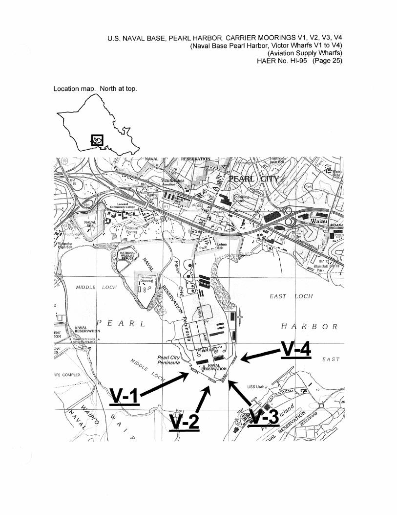
U.S. NAVAL BASE, PEARL HARBOR, CARRIER MOORINGS V1, V2, V3, V4 (Naval Base Pearl Harbor, Victor Wharfs V1 to V4)
(Aviation Supply Wharfs) HAER No. Hl-95 (Page 25)
Location map. North at top.
MEDDLE
EAST OCH
EARL RB OR
EAST
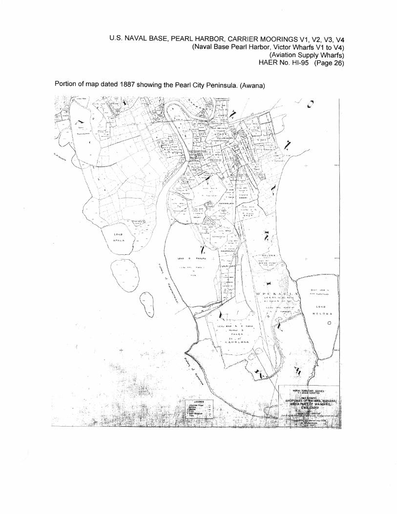
U.S. NAVAL BASE, PEARL HARBOR, CARRIER MOORINGS V1, V2, V3, V4 (Naval Base Pearl Harbor, Victor Wharfs V1 to V4)
(Aviation Supply Wharfs) HAER No. Hl-95 (Page 26)
Portion of map dated 1887 showing the Pearl City Peninsula. (Awana)
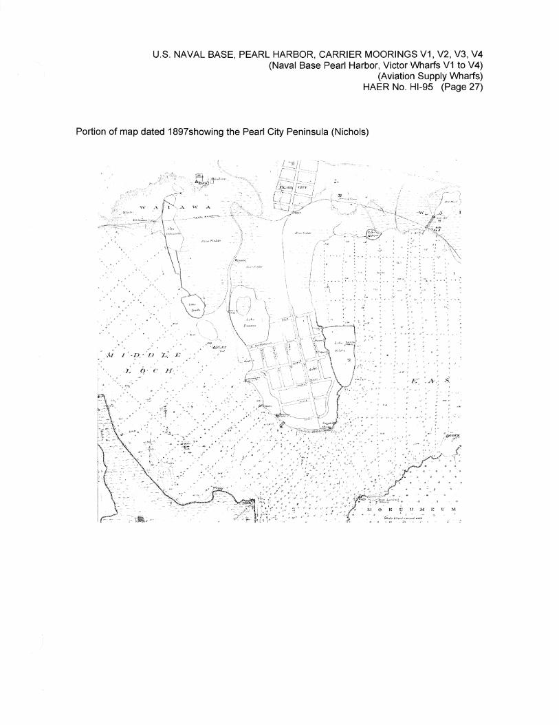
U.S. NAVAL BASE, PEARL HARBOR, CARRIER MOORINGS V1, V2, V3, V4 (Naval Base Pearl Harbor, Victor Wharfs V1 to V4)
(Aviation Supply Wharfs) HAER No. Hl-95 (Page 27)
Portion of map dated 1897showing the Pearl City Peninsula (Nichols)
' ~·
.. ' '
... '~ ..
:" :.:i; ;._D .·;, L", .£ •. •' ·' . - . ~ ' ,. .
. 1~ i! · · c . n,_: .
... ~ . .. . ,:· .. · ...
:. ·· .. -:J . ·-.. ·_' , .
. . .. ; •, • ' I • ' : • o. : • ' ,: ~ • • • ~ ~ : •
,, . ,,~ :
. : i •. ~ : -:·. • . ' • ' ' . : ~ . .: :l•-"'/ " .. .~ ; ~ : . '\ .•,.; I ,t"'
• •;' > I' ~d • 'f ~: \-•:, •; : •
,;' '""·
,l' :, ; ••
' ., . ,. ,,..,, .. ;{'
'. E'. :A•,: .$. ,,,·'
,, . , .
.. ~ •. : •' ; " . : .
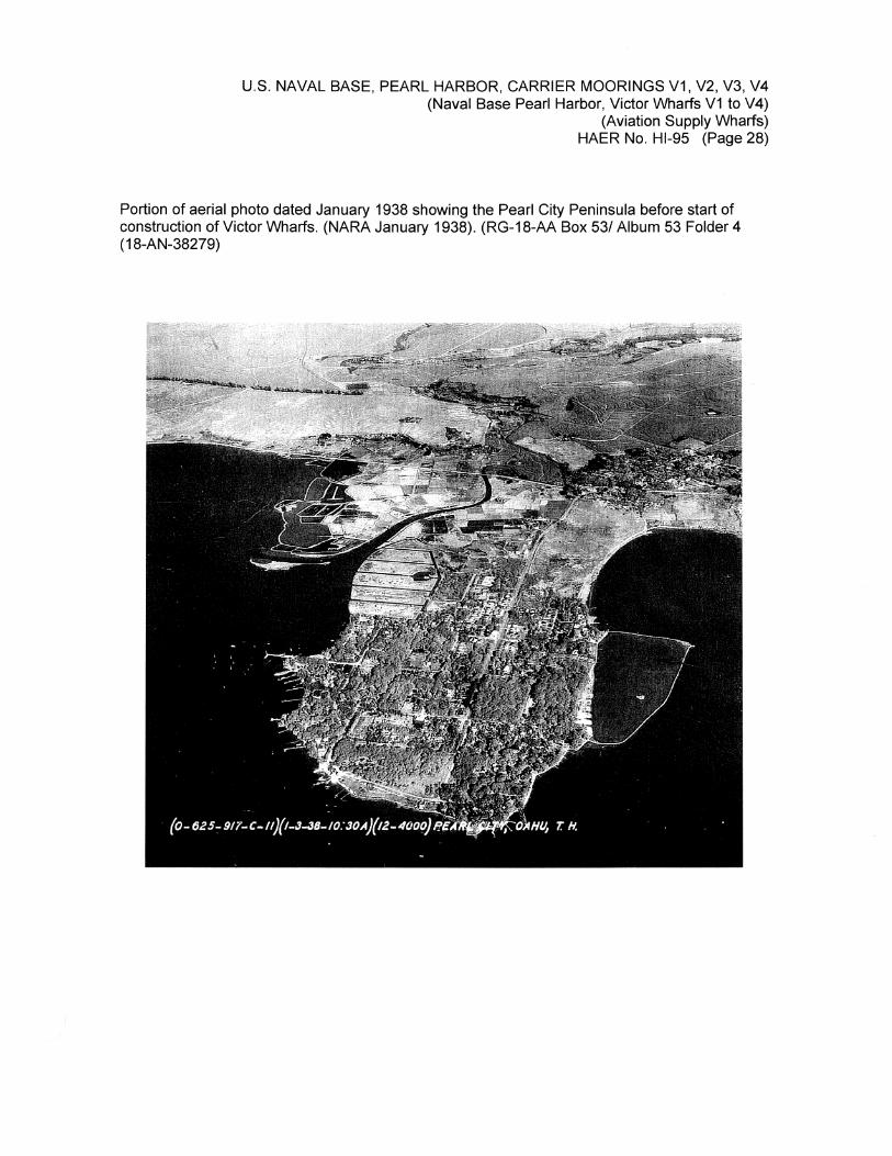
U.S. NAVAL BASE, PEARL HARBOR, CARRIER MOORINGS V1, V2, V3, V4 (Naval Base Pearl Harbor, Victor Wharfs V1 to V4)
(Aviation Supply Wharfs) HAER No. Hl-95 (Page 28)
Portion of aerial photo dated January 1938 showing the Pearl City Peninsula before start of construction of Victor Wharfs. (NARA January 1938). (RG-18-AA Box 53/ Album 53 Folder 4 (18-AN-38279)
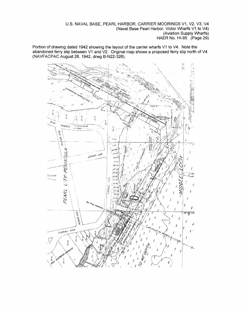
U.S. NAVAL BASE, PEARL HARBOR, CARRIER MOORINGS V1, V2, V3, V4 (Naval Base Pearl Harbor, Victor Wharfs V1 to V4)
(Aviation Supply Wharfs) HAER No. Hl-95 (Page 29)
Portion of drawing dated 1942 showing the layout of the carrier wharfs V1 to V4. Note the abandoned ferry slip between V1 and V2. Original map shows a proposed ferry slip north of V4. (NAVFACPAC August 28, 1942, drwg B-N22-326).
•' ' ,K·
·' . f
' ,'f $ !
t ; i ~ •
' ~ t ~ ' i,
' .IK",7-.u
f i
f 1-
,,.

U.S. NAVAL BASE, PEARL HARBOR, CARRIER MOORINGS V1, V2, V3, V4 · (Naval Base Pearl Harbor, Victor Wharfs V1 to V4)
(Aviation Supply Wharfs) HAER No. Hl-95 (Page 30)
Portion of a map showing the land parcels of the Peninsula shore line near Wharfs V1 & V2 before the Navy acquired the area. (NAVFACPAC OA-N1-599. December 26, 1942).
/ •t' I• 1 J.
I I
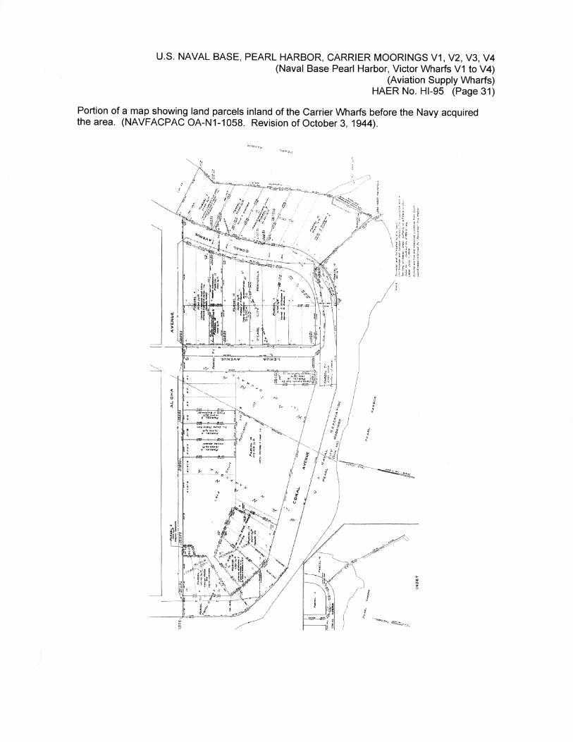
U.S. NAVAL BASE, PEARL HARBOR, CARRIER MOORINGS V1, V2, V3, V4 (Naval Base Pearl Harbor, Victor Wharfs V1 to V4)
(Aviation Supply Wharfs) HAER No. Hl-95 (Page 31)
Portion of a map showing land parcels inland of the Carrier Wharfs before the Navy acquired the area. (NAVFACPAC OA-N1-1058. Revision of October 3, 1944).
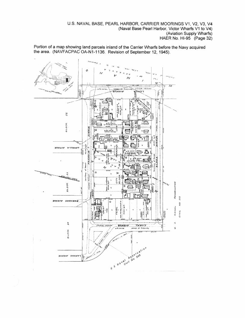
U.S. NAVAL BASE, PEARL HARBOR, CARRIER MOORINGS V1, V2, V3, V4 (Naval Base Pearl Harbor, Victor Wharfs V1 to V4)
(Aviation Supply Wharfs) HAER No. Hl-95 (Page 32)
Portion of a map showing land parcels inland of the Carrier Wharfs before the Navy acquired the area. (NAVFACPAC OA-N1-1136. Revision of September 12, 1945).
i .
-~~ .... " 0 ;:. ~ " ~ 'l
" "' 0( .; 0 ~
.J '( > g < '::,:
~
" :i
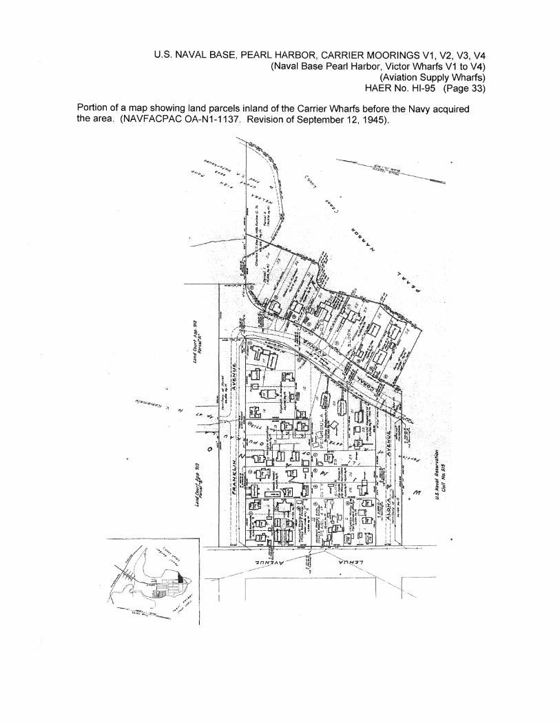
U.S. NAVAL BASE, PEARL HARBOR, CARRIER MOORINGS V1, V2, V3, V4 (Naval Base Pearl Harbor, Victor Wharfs V1 to V4)
(Aviation Supply Wharfs) HAER No. Hl-95 (Page 33)
Portion of a map showing land parcels inland of the Carrier Wharfs before the Navy acquired the area. (NAVFACPAC OA-N1-1137. Revision of September 12, 1945).
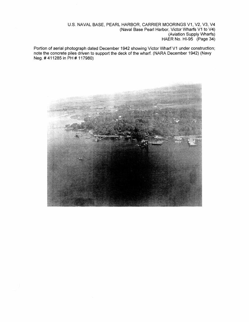
U.S. NAVAL BASE, PEARL HARBOR, CARRIER MOORINGS V1, V2, V3, V4 (Naval Base Pearl Harbor, Victor Wharfs V1 to V4)
(Aviation Supply Wharfs) HAER No. Hl-95 (Page 34)
Portion of aerial photograph dated December 1942 showing Victor Wharf V1 under construction; note the concrete piles driven to support the deck of the wharf. (NARA December 1942) (Navy Neg.# 411285 in PH# 117980)
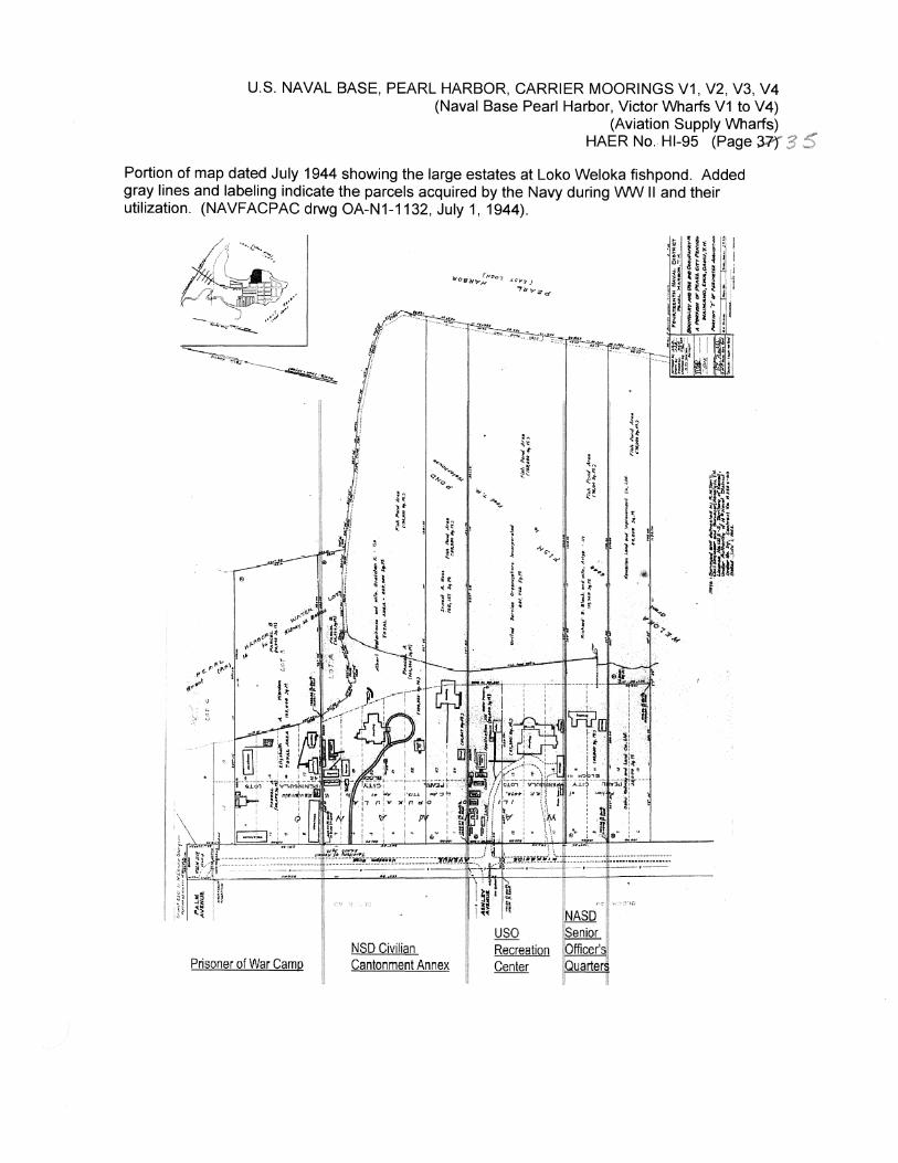
U.S. NAVAL BASE, PEARL HARBOR, CARRIER MOORINGS V1, V2, V3, V4 (Naval Base Pearl Harbor, Victor Wharfs V1 to V4)
(Aviation Supply Wharfs) HAER No. Hl-95 (Page 3=,f
Portion of map dated July 1944 showing the large estates at Loko Welaka fishpond. Added gray lines and labeling indicate the parcels acquired by the Navy during WW II and their utilization. (NAVFACPAC drwg OA-N1-1132, July 1, 1944).
11
Prisoner of War Camp
.... .,.,Se
9-40:·..f,,. I A
"' t ii tt t ~ ii "~
1 * le H ~ ~' I .~ .; . ·~ ' d ti
NSD Civilian Cantonment Annex
!lo''<
~' ~~ i: i!
""',...
l a;, e t 1 "'"', .., ! 1i ~ "I;;
h 3 ; E ~
1 1
Recreation Center
! '" 1• ,. ~, J--
. '
.A ... • ,. 1 t
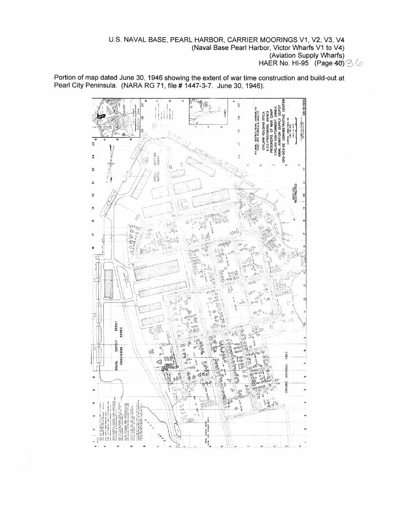
U.S. NAVAL BASE, PEARL HARBOR, CARRIER MOORINGS V1, V2, V3, V4 (Naval Base Pearl Harbor, Victor Wharfs V1 to V4)
(Aviation Supply Wharfs) HAER No. Hl-95 (Page 46'}'3
Portion of map dated June 30, 1946 showing the extent of war time construction and build-out at Pearl City Peninsula. (NARA RG 71, file# 1447-3-7. June 30, 1946).
0:: ~ ... "'
"' i~ xb~ i i H "' ~~~(.) ..
"' ••"• l Q
:e 0: j
" l:t:~~i=='. .J,l (!) iwa..~ :; .. ·t; ~~ I$ z 'if~ 1JI 2 ::::> t; ;:;J r .,
:;;i ~, ~ :s e; ~ I~; j~ -i; z :fl8~! ;H « ~~t: I ;;, ::J
Ill 2: tl)~~9 0
h .. ~ • ~
~ Uzb ~
"' 0 ;:.;
:;
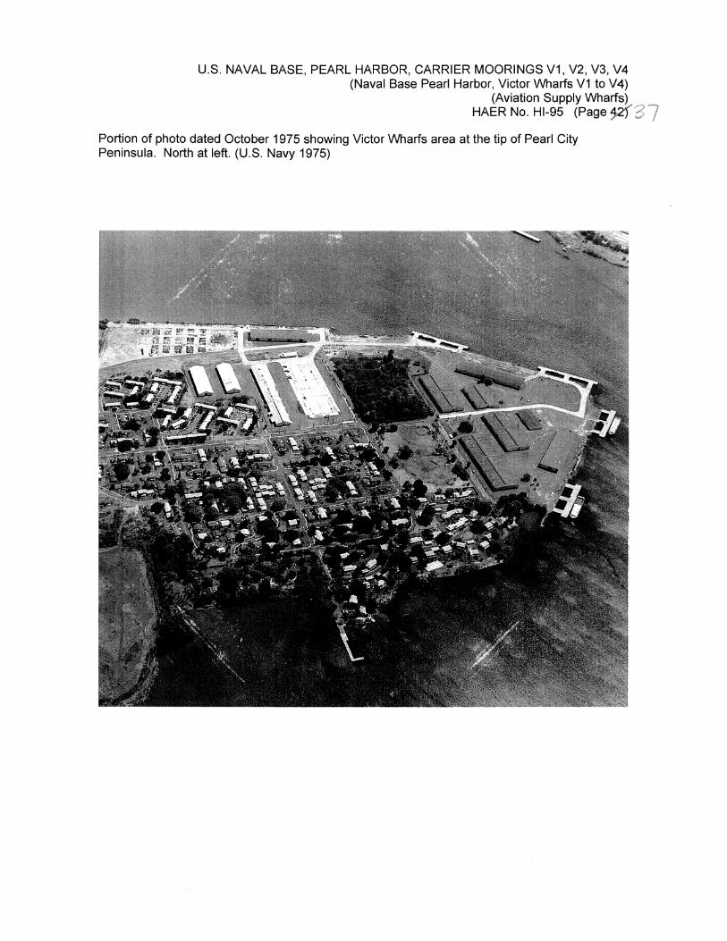
U.S. NAVAL BASE, PEARL HARBOR, CARRIER MOORINGS V1, V2, V3, V4 (Naval Base Pearl Harbor, Victor Wharfs V1 to V4)
(Aviation Supply Wharfs) HAER No. Hl-95 (Page 9{37
Portion of photo dated October 1975 showing Victor Wharfs area at the tip of Pearl City Peninsula. North at left. (U.S. Navy 1975)