Embed Size (px)
Citation preview
August 14, 2010 Landsat Project TRD
U.S. GEOLOGICAL SURVEY/EROS CENTER TECHNICAL REQUIREMENTS DOCUMENT
for TECHNICAL SUPPORT SERVICES CONTRACT SOLICITATION
TRD NUMBER
PERFORMANCE PERIOD
PROJECT NAME
Landsat
017
Contract Base Year: April 1, 2010 thru March 31, 2011

August 14, 2010 Landsat Project TRD
II. Technical Agreement Background:
The Landsat Project has established strategic goals to support a higher level goal defined by the Land Remote Sensing (LRS) Program at USGS Headquarters. One of LRS’s goals is to observe the Earth at all scales using remote sensing to understand the human and environmental dynamics of land change. The Landsat Project’s strategic goals that support this include:
1. provide daily management of all operations, maintenance, and engineering for the Landsat spacecraft and ground systems using sound project management, engineering, and operations best practices;
2. maintain a reliable and secure system infrastructure and avoid system obsolescence;
3. minimize data loss;
4. enhance the USGS’ position as a globally recognized leader in data capture and acquisition;
5. preserve the Landsat archive and employ consistent data management practices;
6. generate products that are useful and consistent to the Landsat user community and improve the availability and utility of Landsat data;
7. employ methods to improve information access and reporting for managing the Project;
8. position the USGS to operate and maintain future Landsat Missions;
9. develop and support agreements with cooperative agencies that further the Landsat Mission;
10. optimize global utilization of Landsat data by providing an efficient means for managing user acquisition requests;
11. review and enhance Landsat’s global acquisition plan;
12. advance sensor and image calibration across all Landsat data sets and provide calibration information to its user community;
13. guide and demonstrate technical excellence in Landsat sensor and image calibration;
14. support its customers, promote new data uses, and retain its customer base;
August 14, 2010 Landsat Project TRD
15. provide various methods of ordering and distributing Landsat data;
16. enhance communications with its user community;
17. establish and support agreements with foreign governments to acquire and provide data to the global Landsat user community;
18. optimize global utilization of Landsat data by providing an efficient means for managing International Cooperator (IC) acquisition requests;
19. promote and participate in data sharing across its International Cooperators (ICs) using standard data formats.
20. Make all Landsat products available for electronic download at no-charge to the customer (web enable Landsat data)
The USGS Landsat Project implements this strategy at the USGS Center for Earth Resources and Observation (EROS) located in Sioux Falls, SD through existing systems maintained and operated by a Technical Support Services Contract (TSSC) administered by a USGS Contracting Officer at USGS Headquarters in Reston, VA and monitored by a USGS Contracting Officer’s Technical Representative at EROS. Since the TSSC supports more than just the Landsat Project at USGS EROS, daily management of Landsat related activities is assigned to a team of USGS Government staff.
Scope:
The USGS Landsat Project is responsible for two active satellite missions and data from the previous missions. This responsibility includes daily management and long term sustainment of all operations, maintenance, and engineering for the Landsat 5 and Landsat 7 spacecraft systems, Flight Operations located in Maryland, and Landsat Ground Segment Operations, located at the USGS EROS in Sioux Falls, SD. The scope of the requirements in this document is limited to the Ground Segment portion, which includes a data capture and processing facility, systems for data archival, data discovery, data ordering, product generation, quality control, product distribution, and customer support. Beside the two active missions, the current Ground Segment systems also support data archives for MSS and TM data collected from the Landsat 1-5 missions.
The sponsor for this work is the Landsat Remote Sensing Program managed at USGS Headquarters in Reston, VA. Stakeholders also include NASA which is a partner in the overall management of the Landsat Program, other Federal Agencies which utilize Landsat data and International Cooperators that collect, archive, process and distribute Landsat data over their local coverage areas.
The Technical Support Services Contract (TSSC) will support the Landsat Ground Segment work and systems. These systems interface with separate, off-site systems supporting Flight Operations activities. A separate Flight Operations contract is responsible for the Flight Operations systems. The Government administers the Flight Operations contracts separately
August 14, 2010 Landsat Project TRD
from the TSSC. The interfaces between Flight and Ground systems are controlled via a Configuration Control Board chaired by the Government and administered by the TSSC.
The TSSC will provide the technical expertise to support the USGS in accomplishing its objectives for the ground portion of the Landsat Missions. Support for Landsat Project Ground Segment work comprises the following areas: daily operations, systems maintenance and system enhancement. Daily operations includes providing command and control uplink/downlinks, processing and archiving collected data, generating and distributing data products, performing calibration and validation of data products, and providing customer support for data product orders. Systems maintenance includes nominal hardware and software maintenance, which currently in some cases is sub-contracted, for antennas and ancillary equipment, data capture and ingest systems, data processing systems, data archival systems, data distribution systems, data calibration and validation systems, web sites, infrastructure systems, requirements control systems, configuration management systems, documentation control systems, inventory systems as well as interfaces to external systems. This maintenance is geared toward maintaining system operation at Government specified performance levels. System enhancement is modification to a system to meet Government specified changes to requirements the majority of which are already defined for the existing Landsat Missions.
The TSSC will provide the skills necessary to manage and perform all Landsat Ground Segment objectives. This includes but is not limited to project management, systems engineering, technical management, hardware specification and integration, data capture operations, data production operations, software engineering and development, software testing, risk management, configuration management, reporting and technical writing, remote sensing data calibration and validation, system administration, and security administration and testing.
The TSSC will be responsible for management of technical work as agreed to by the Government and TSSC in a yearly Technical Requirements Document and associated TSSC Work Plan. The project maintains all requirements in the DOORS package and reviews requirements and deliverables quarterly.
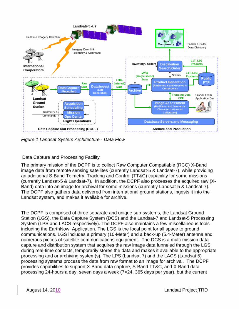
Landsat Ground Segment System Description Figure 1 shows the overall data flow of the Landsat ground system. The Landsat ground segment is composed of the Data Capture and Processing Facility (DCPF) and the Archive and Production (A&P) area. Although the Flight Operations activities are listed within the DCPF in this diagram, they are operated and controlled outside the scope of the TSSC and are located in Maryland.
August 14, 2010 Landsat Project TRD
Archive and ProductionData Capture and Processing (DCPF)
Distribution Search/Order
Data Ingest(L0R
Generation)Archive
Flight Operations
AcquisitionScheduling
Mission Ops Center
LandsatGroundStation
InternationalCooperators
Data Capture(Reception)
Realtime Imagery Downlink
Imagery DownlinkTelemetry & Command
Telemetry &Commands
UserCommunity
UserCommunity
Image Assessment(Radiometric & Geometric
Characterization and Calibration)
Product Generation(Radiometric and Geometric
Corrections)
Cal/Val TeamApplication Dev
Database Servers and Messaging
Landsats 5 & 7
Search & OrderData Discovery
Raw Data
PublicFTP
L0Ra(interval)
Data
L1T, L1GProductsInventory / Orders
L0Rp (single scene)
Data
Trending DataCPF
L1T, L1GProductsOrders
Figure 1 Landsat System Architecture - Data Flow
Data Capture and Processing Facility The primary mission of the DCPF is to collect Raw Computer Compatiable (RCC) X-Band image data from remote sensing satellites (currently Landsat-5 & Landsat-7), while providing an additional S-Band Telmetry, Tracking and Control (TT&C) capability for some missions (currently Landsat-5 & Landsat-7). In addition, the DCPF also processes the acquired raw (X-Band) data into an image for archival for some missions (currently Landsat-5 & Landsat-7). The DCPF also gathers data delivered from international ground stations, ingests it into the Landsat system, and makes it available for archive. The DCPF is comprised of three separate and unique sub-systems, the Landsat Ground Station (LGS), the Data Capture System (DCS) and the Landsat-7 and Landsat-5 Processing System (LPS and LACS respectively). The DCPF also maintains a few miscellaneous tools including the EarthNow! Application. The LGS is the focal point for all space to ground communications. LGS includes a primary (10-Meter) and a back-up (5.4-Meter) antenna and numerous pieces of satellite communications equipment. The DCS is a multi-mission data capture and distribution system that acquires the raw image data funneled through the LGS during real-time contacts, temporarily stores the data and makes it available to the appropriate processing and or archiving system(s). The LPS (Landsat 7) and the LACS (Landsat 5) processing systems process the data from raw format to an image for archival. The DCPF provides capabilities to support X-Band data capture, S-Band TT&C, and X-Band data processing 24-hours a day, seven days a week (7×24, 365 days per year), but the current
August 14, 2010 Landsat Project TRD
staffing is a 7-day by 19.5-hour/day schedule to support existing mission requirements (currently Landsat-5 & Landsat-7). The DCPF supports six passes of Landsat 7 and Landsat 5 daily. Landsat 7 passes consist of both X and S band. Landsat 5 includes three passes of X and S band and three passes of S band only. The DCPF captures an average of about 360GB of data per day. This includes data ingested from other ground stations. Archive and Production
The primary mission for the Archive and Production (A&P) area of the ground segment is to gather archive data delivered by the DCPF, archive it, process it to a standard product and make it available to the user community. The A&P systems also support the calibration and validation (cal/val) activities for the project. Figure 2 shows an overall architecture of the Landsat Web-enabled System. The A&P area consists of several subsystems outlined in this diagram: Image Assessment System (IAS), Level-1 Product Generation System (LPGS), National Landsat Archive Production System (NLAPS), Mission Management Office (MMO) Database System (MDS), USGS Inventory System (UIS), and the Landsat Archive Management System (LAM). While there are other systems used for archive, production and distribution of Landsat data, those systems are supported through the TSSC under the Long-Term Archive TRD. Those systems include Earth Explorer (EE), Glovis and Transaction Reporting and Management (TRAM) systems. The Landsat system interfaces with these systems.
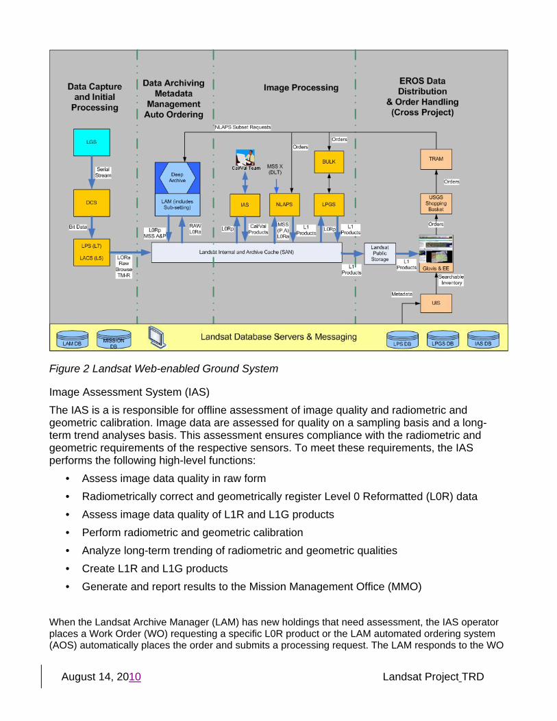
August 14, 2010 Landsat Project TRD
Figure 2 Landsat Web-enabled Ground System
Image Assessment System (IAS) The IAS is a is responsible for offline assessment of image quality and radiometric and geometric calibration. Image data are assessed for quality on a sampling basis and a long-term trend analyses basis. This assessment ensures compliance with the radiometric and geometric requirements of the respective sensors. To meet these requirements, the IAS performs the following high-level functions:
• Assess image data quality in raw form • Radiometrically correct and geometrically register Level 0 Reformatted (L0R) data • Assess image data quality of L1R and L1G products • Perform radiometric and geometric calibration • Analyze long-term trending of radiometric and geometric qualities • Create L1R and L1G products • Generate and report results to the Mission Management Office (MMO)
When the Landsat Archive Manager (LAM) has new holdings that need assessment, the IAS operator places a Work Order (WO) requesting a specific L0R product or the LAM automated ordering system (AOS) automatically places the order and submits a processing request. The LAM responds to the WO
August 14, 2010 Landsat Project TRD
by searching its archive and staging the appropriate L0R product. Upon notification of the staged L0Rp, the IAS ingests the data and schedules the product for assessment. The IAS assesses the image data in raw form and processes the data to L1R and/or L1G for assessment. Image data are assessed with respect to their radiometric and geometric qualities both on a sample basis and for long-term trend analyses. When image data anomalies arise, the IAS analyst may submit a verbal request to the appropriate front-end processing system for reprocessing the anomalous image data. The resulting output files are then transferred to the LAM for archival storage. After proper analysis of the products from L0R processing, the IAS generates reports concerning data appraisal. Additionally, the IAS produces a Calibration Parameter File (CPF) that houses the values that are used to process the L0R products. The IAS sends these CPFs and reports to the LAM, MOC, National Landsat Archive and Processing System (NLAPS), and the LPS. For Landsat 7 processing, the IAS also sends problem reports, scene requests, and quality assessment summary reports to the MOC and MMO. The IAS gets several data sets from external sources. The Universal Time (UT1) and pole wander predictions data are retrieved via File Transfer Protocol (FTP) from the United States Naval Observatory (USNO) FTP site and inserted into the CPF. The Definitive Ephemeris (DE) data is retrieved from the MDS. The IAS currently supports Landsat 7 ETM+ and Landsat 5 TM data. Work is currently in process to support Landsat MSS data products from Landsats 1 through 5. This development effort is scheduled to complete in June, 2010. The Landsat Data Continuity Mission (LDCM) project is also modifying the IAS to support LDCM data under the LDCM TRD. The operational IAS system runs on one Linux system with dual Intel processors. A redundant system is available if necessary and is used for development and integration purposes. The Landsat Storage Area Network (SAN)
Level 1 Product Generation System (LPGS) The Level 1 Product Generation System (LPGS) supports Level 1 (L1) processing requirements for the Landsat 5 (L5) and Landsat 7 (L7) missions. The primary mission of the L1 system is to provide customers with enhanced radiometrically, geometrically, precision, and terrain corrected L1 imagery. The LPGS outputs this imagery in standard imagery formats for worldwide applications. LPGS pulls Level Zero Reformatted Product (L0Rp) imagery from the Landsat Archive Manager (LAM), produces a standard Level 1 product, and places it on a public FTP server for distribution. The LPGS processes orders based on priority, then on a first-ordered, first-processed basis. The LPGS provides the capabilities to support product creation and distribution activities at EROS 7 days a week, 24 hours per day, 365 days per year. The LPGS creates the LPGS digital imagery product to provide a long-term imagery processing solution in support of customer imagery needs associated with the Landsat Project.
August 14, 2010 Landsat Project TRD
For on-demand L1 product requests, EROS Transaction Reporting and Management (TRAM) system supplies the LPGS with the customer requests in the form of an Object Description Language (ODL) file containing User Request Parameters (URP), also referred to as product generation requests. A product generation request identifies the data to be processed, the type of output product, and various options used to control L1 processing. The LPGS stores the ODL information in the LPGS database. Before the LPGS can begin L1 processing, it must ingest the L0Rp product needed for processing from the LAM. The LPGS transfers the L0Rp data from the location specified in the ODL information using File Transfer Protocol (FTP). The LPGS retrieves the L0Rp product and verifies that the product is correct and complete before commencing L1 processing. After LPGS ingests the L0Rp product, it creates an LPGS work order to initiate L1 processing. A work order is an internal mechanism used to control and monitor the L1 processing. As a part of work order processing, the LPGS executes a series of programs that performs the radiometric and geometric corrections, quality assessments, and product preparation. Each of the work order scripts has associated processing parameters. The customer-supplied options in the product generation request determine many of the parameter values. After producing the L1 product, the LPGS bulk subsystem packages the data and pushes it to the FTP server for distribution. A message is sent to TRAM to close the order. An email is then sent to the requester notifying them that their order is completed. Trending data are created in the LPGS database as a part of the work order processing. Because the Image Assessment System (IAS) processes fewer scenes than the LPGS, the IAS uses the LPGS trending data to augment the IAS trending data. The IAS pulls the trending data from the LPGS database daily. The LPGS on-demand orders are variable as the data is available non-discriminatory, at no cost to the user. The LPGS receives an average of about 1,150 scenes a day and has the capacity to process over 2,000 scenes a day. The LPGS queues are watched closely. If necessary, processing capacity can be increased or decreased by adding or removing processing nodes as necessary. The LPGS is operated on 9 Linux Intel based dual core processing systems. These systems share storage though the Landsat Storage Area Network (SAN). The LPGS shares most of its core processing code with the IAS. Processing functionality is developed on the IAS and migrated to the LPGS to enable it for production purposes. Among the many purposes of the IAS, Calibration / Validation analysts utilize the IAS confirm the products before the code is enabled in the LPGS production environment.
August 14, 2010 Landsat Project TRD
Currently the LPGS can process ETM+ and TM-R data. MSS and TM-A data is processed on NLAPS. The USGS is currently under development to integrate Landsat 1-5 MSS and Landsat 4 and 5 TM-A data into the LPGS. The MSS development is scheduled to complete in July, 2010. A schedule is not available for the TM-A data. Upon completion of the MSS and TM-A processing migration to LPGS, the NLAPS system will no longer be utilized by the Landsat project. The Landsat Data Continuity Mission (LDCM) project is also modifying the LPGS to produce LDCM data products under the LDCM TRD.
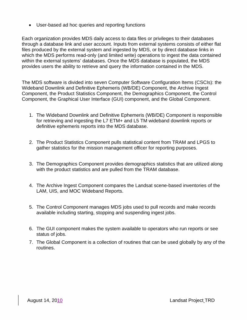
National Landsat Archive Production System (NLAPS) NLAPS is used for production of MSS and TM-A data. Development and sustaining engineering of the NLAPS system is not under scope of the TSSC. The Landsat project sustains the NLAPS system and has no plans for further development. The project plans to decommission the system for Landsat purposes once MSS and TM-A data production is migrated to the LPGS. MSS production is migration to LPGS is scheduled to complete in July, 2010. No schedule is available for the TM-A migration. The NLAPS on-demand orders are variable as the data is available non-discriminatory, at no cost to the user. NLAPS receives an average of about 140 MSS and TM-A scene requests a day. For these scenes, NLAPS attempts to auto correlate the data to create a precision model. If the precision model fails, the product falls back to a systematic product. Mission Management Office (MMO) Database System (MDS) The MDS was developed to provide periodic metrics and a mechanism for tracking the various stages and availability of Landsat data. While each Landsat subsystem and organization maintains its own internal record keeping, MDS provides a centralized database for storing all of the information for comparisons and trending purposes. Figure 3 provides a context overview of the MDS interfaces. The MDS interfaces with internal and external systems on a regular basis to obtain and ingest the data required to provide the following functions:
• Tracking and comparison functions to track Landsat inventories contained within the Landsat Archive Manager (LAM) and the USGS Inventory Server (UIS)
• Tracking and comparison capabilities to compare Wideband Downlink Reports generated by the Landsat Mission Operations Center (MOC) to various archive databases
• Graphical User Interface (GUI) based reports to track production statistics describing the Landsat customer base obtained from the Transaction Reporting and Management System (TRAM)
• Warehousing, long-term storage and distribution of Landsat Definitive Ephemeris (DE) • Ingesting and reporting of Landsat image impact reports • Tracking and reporting of NASA GN and SN performance
August 14, 2010 Landsat Project TRD
• User-based ad hoc queries and reporting functions
Each organization provides MDS daily access to data files or privileges to their databases through a database link and user account. Inputs from external systems consists of either flat files produced by the external system and ingested by MDS, or by direct database links in which the MDS performs read-only (and limited write) operations to ingest the data contained within the external systems’ databases. Once the MDS database is populated, the MDS provides users the ability to retrieve and query the information contained in the MDS. The MDS software is divided into seven Computer Software Configuration Items (CSCIs): the Wideband Downlink and Definitive Ephemeris (WB/DE) Component, the Archive Ingest Component, the Product Statistics Component, the Demographics Component, the Control Component, the Graphical User Interface (GUI) component, and the Global Component.
1. The Wideband Downlink and Definitive Ephemeris (WB/DE) Component is responsible for retrieving and ingesting the L7 ETM+ and L5 TM wideband downlink reports or definitive ephemeris reports into the MDS database.
2. The Product Statistics Component pulls statistical content from TRAM and LPGS to
gather statistics for the mission management officer for reporting purposes.
3. The Demographics Component provides demographics statistics that are utilized along with the product statistics and are pulled from the TRAM database.
4. The Archive Ingest Component compares the Landsat scene-based inventories of the
LAM, UIS, and MOC Wideband Reports.
5. The Control Component manages MDS jobs used to pull records and make records available including starting, stopping and suspending ingest jobs.
6. The GUI component makes the system available to operators who run reports or see
status of jobs. 7. The Global Component is a collection of routines that can be used globally by any of the
routines.
August 14, 2010 Landsat Project TRD
MDSL7 MOC ftp
server
L1 processing systems
LAM database
UIS databaseLandsat Web ftp server
L7 Processing System (LPS)L7 WB
reports
TRAM Order Data DB records
L5 MOC ftp server
L5 DE files &L5 WB reports
Landsat Archive Conversion System
(LACS)
L5 WBreports
DE DB records
L1 processing systems Order
dataDB Records
DB records
L7 DE files &L7 WB reports
DE files
Figure 3 MDS Context Diagram
The MDS is undergoing significant changes to support LDCM. This work is not within scope of the Landsat TRD and is included in the LDCM TRD.
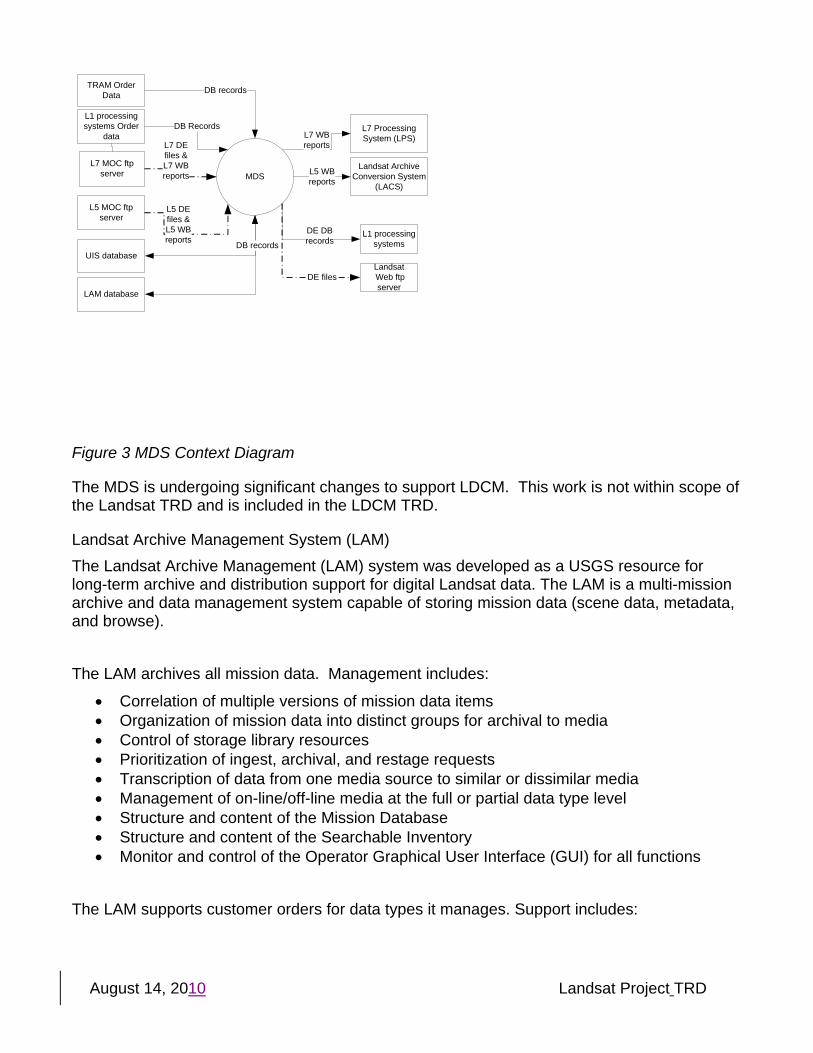
Landsat Archive Management System (LAM) The Landsat Archive Management (LAM) system was developed as a USGS resource for long-term archive and distribution support for digital Landsat data. The LAM is a multi-mission archive and data management system capable of storing mission data (scene data, metadata, and browse). The LAM archives all mission data. Management includes:
• Correlation of multiple versions of mission data items • Organization of mission data into distinct groups for archival to media • Control of storage library resources • Prioritization of ingest, archival, and restage requests • Transcription of data from one media source to similar or dissimilar media • Management of on-line/off-line media at the full or partial data type level • Structure and content of the Mission Database • Structure and content of the Searchable Inventory • Monitor and control of the Operator Graphical User Interface (GUI) for all functions
The LAM supports customer orders for data types it manages. Support includes:
August 14, 2010 Landsat Project TRD
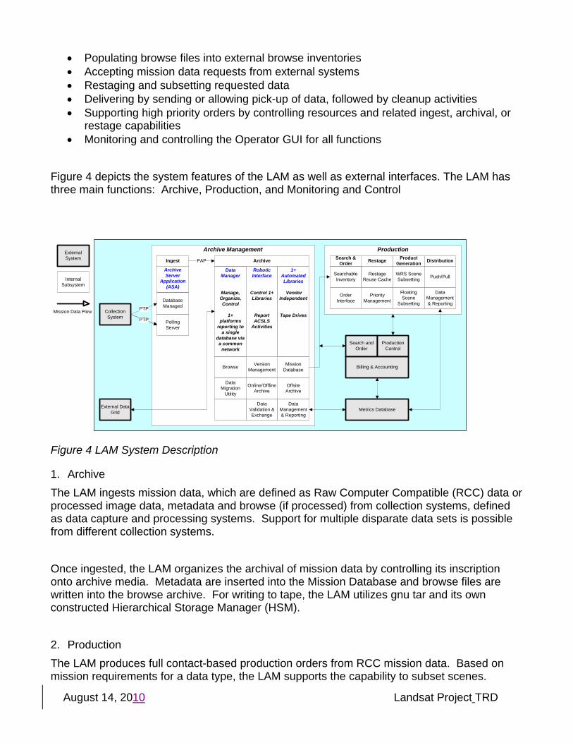
• Populating browse files into external browse inventories • Accepting mission data requests from external systems • Restaging and subsetting requested data • Delivering by sending or allowing pick-up of data, followed by cleanup activities • Supporting high priority orders by controlling resources and related ingest, archival, or
restage capabilities • Monitoring and controlling the Operator GUI for all functions
Figure 4 depicts the system features of the LAM as well as external interfaces. The LAM has three main functions: Archive, Production, and Monitoring and Control
Production
CollectionSystem
Metrics DatabaseExternal Data Grid
External System
Internal Subsystem
Restage Product Generation Distribution
WRS Scene Subsetting
Floating Scene
Subsetting
Push/PullSearchable Inventory
Archive Management
Archive Server
Application (ASA)
Ingest
Database Managed
PollingServer
PAP
Data Migration
Utility
Mission DatabaseBrowse
Offsite Archive
Online/OfflineArchive
Data Validation & Exchange
Data Manager
Manage, Organize, Control
1+ platforms
reporting to a single
database via a common
network
Archive
Robotic Interface
Control 1+ Libraries
Report ACSLS
Activities
1+ Automated Libraries
Vendor Independent
Tape Drives
VersionManagement
PTP
PTPPTP
DataManagement& Reporting
Search &Order
Restage Reuse Cache
Priority Management
Search and Order
Production Control
Billing & Accounting
OrderInterface
DataManagement& Reporting
Mission Data Flow
Figure 4 LAM System Description
1. Archive The LAM ingests mission data, which are defined as Raw Computer Compatible (RCC) data or processed image data, metadata and browse (if processed) from collection systems, defined as data capture and processing systems. Support for multiple disparate data sets is possible from different collection systems. Once ingested, the LAM organizes the archival of mission data by controlling its inscription onto archive media. Metadata are inserted into the Mission Database and browse files are written into the browse archive. For writing to tape, the LAM utilizes gnu tar and its own constructed Hierarchical Storage Manager (HSM). 2. Production The LAM produces full contact-based production orders from RCC mission data. Based on mission requirements for a data type, the LAM supports the capability to subset scenes.
August 14, 2010 Landsat Project TRD
Subsetting is the process of cropping upper and lower (longitudinal) portions of the larger image. The LAM follows instructions contained in the order request to produce the subsetted product. The LAM supports the capability to produce full interval-based processed mission data production orders as well as floating scene and single WRS scene mission data production orders. The archive provides the LAM with the ability to service retrieval requests for mission data, whether stored in the silo or in transition to the silo. Data can be copied from the reuse cache or restaged from the archive. For each data type managed by the LAM, a Searchable Inventory may be considered necessary. The LAM generates and maintains a Searchable Inventory used by search and order systems. The LAM supports automated ordering and a common order interface for selected users to search. The UIS contains a copy of the searchable inventory and is used for public search and discovery.
3. Monitoring and Control The LAM supports a metrics database system by allowing information in the Mission Database and Searchable Inventory to be queried. The LAM system also maintains a core set of both archiving and production reports locally to enable operations staff to monitor and control the system. Data management is supported through GUIs, which provide appropriate views into the database as well as SQL access. The LAM supports production order manipulation and priority assignment by mission data type and within the mission data type by request.
LAM Hardware, Media, and Volumes of Data LAM Hardware consists of:
Storagetek 9310 Tape Silo 20 9940B Tape Drives Two Dell 6650 Servers One Dell 6600 (development and test) Landsat Storage Area Network
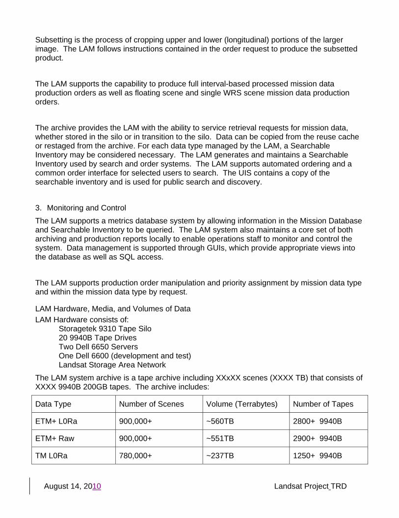
The LAM system archive is a tape archive including XXxXX scenes (XXXX TB) that consists of XXXX 9940B 200GB tapes. The archive includes:
Data Type Number of Scenes Volume (Terrabytes) Number of Tapes
ETM+ L0Ra 900,000+ ~560TB 2800+ 9940B
ETM+ Raw 900,000+ ~551TB 2900+ 9940B
TM L0Ra 780,000+ ~237TB 1250+ 9940B
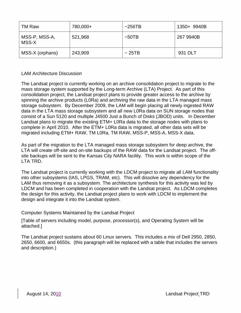
August 14, 2010 Landsat Project TRD
TM Raw 780,000+ ~256TB 1350+ 9940B
MSS-P, MSS-A, MSS-X
521,968 ~50TB 267 9940B
MSS-X (orphans) 243,909 ~ 25TB 931 DLT
LAM Architecture Discussion
The Landsat project is currently working on an archive consolidation project to migrate to the mass storage system supported by the Long-term Archive (LTA) Project. As part of this consolidation project, the Landsat project plans to provide greater access to the archive by spinning the archive products (L0Ra) and archiving the raw data in the LTA managed mass storage subsystem. By December 2009, the LAM will begin placing all newly ingested RAW data in the LTA mass storage subsystem and all new L0Ra data on SUN storage nodes that consist of a Sun 5120 and multiple J4500 Just a Bunch of Disks (JBOD) units. In December Landsat plans to migrate the existing ETM+ L0Ra data to the storage nodes with plans to complete in April 2010. After the ETM+ L0Ra data is migrated, all other data sets will be migrated including ETM+ RAW, TM L0Ra, TM RAW, MSS-P, MSS-A, MSS-X data. As part of the migration to the LTA managed mass storage subsystem for deep archive, the LTA will create off-site and on-site backups of the RAW data for the Landsat project. The off-site backups will be sent to the Kansas City NARA facility. This work is within scope of the LTA TRD. The Landsat project is currently working with the LDCM project to migrate all LAM functionality into other subsystems (IAS, LPGS, TRAM, etc). This will dissolve any dependency for the LAM thus removing it as a subsystem. The architecture synthesis for this activity was led by LDCM and has been completed in cooperation with the Landsat project. As LDCM completes the design for this activity, the Landsat project plans to work with LDCM to implement the design and integrate it into the Landsat system. Computer Systems Maintained by the Landsat Project [Table of servers including model, purpose, processor(s), and Operating System will be attached.] The Landsat project sustains about 60 Linux servers. This includes a mix of Dell 2950, 2850, 2650, 6600, and 6650s. (this paragraph will be replaced with a table that includes the servers and description.)
August 14, 2010 Landsat Project TRD
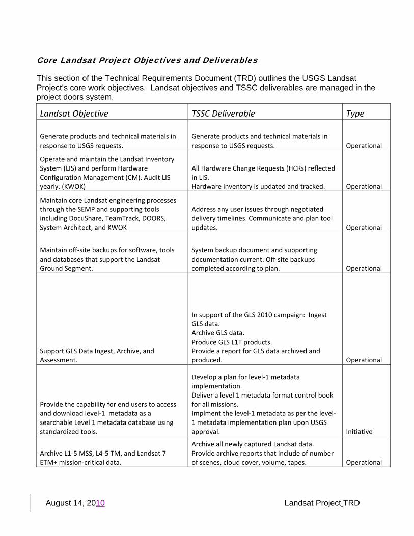
Core Landsat Project Objectives and Deliverables
This section of the Technical Requirements Document (TRD) outlines the USGS Landsat Project’s core work objectives. Landsat objectives and TSSC deliverables are managed in the project doors system.
Landsat Objective TSSC Deliverable Type
Generate products and technical materials in response to USGS requests.
Generate products and technical materials in response to USGS requests. Operational
Operate and maintain the Landsat Inventory System (LIS) and perform Hardware Configuration Management (CM). Audit LIS yearly. (KWOK)�
All Hardware Change Requests (HCRs) reflected in LIS. Hardware inventory is updated and tracked. Operational
Maintain core Landsat engineering processes through the SEMP and supporting tools including DocuShare, TeamTrack, DOORS, System Architect, and KWOK
Address any user issues through negotiated delivery timelines. Communicate and plan tool updates. Operational
Maintain off‐site backups for software, tools and databases that support the Landsat Ground Segment.
System backup document and supporting documentation current. Off‐site backups completed according to plan. Operational
Support GLS Data Ingest, Archive, and Assessment.
In support of the GLS 2010 campaign: Ingest GLS data. Archive GLS data. Produce GLS L1T products. Provide a report for GLS data archived and produced. Operational
Provide the capability for end users to access and download level‐1 metadata as a searchable Level 1 metadata database using standardized tools.
Develop a plan for level‐1 metadata implementation. Deliver a level 1 metadata format control book for all missions. Implment the level‐1 metadata as per the level‐1 metadata implementation plan upon USGS approval. Initiative
Archive L1‐5 MSS, L4‐5 TM, and Landsat 7 ETM+ mission‐critical data.
Archive all newly captured Landsat data. Provide archive reports that include of number of scenes, cloud cover, volume, tapes. Operational
August 14, 2010 Landsat Project TRD
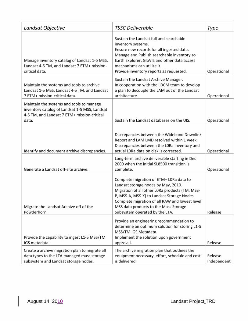
Landsat Objective TSSC Deliverable Type
Manage inventory catalog of Landsat 1‐5 MSS, Landsat 4‐5 TM, and Landsat 7 ETM+ mission‐critical data.
Sustain the Landsat full and searchable inventory systems. Ensure new records for all ingested data. Manage and Publish searchable inventory so Earth Explorer, GloVIS and other data access mechanisms can utilize it. Provide inventory reports as requested. Operational
Maintain the systems and tools to archive Landsat 1‐5 MSS, Landsat 4‐5 TM, and Landsat 7 ETM+ mission‐critical data.
Sustain the Landsat Archive Manager. In cooperation with the LDCM team to develop a plan to decouple the LAM out of the Landsat architecture. Operational
Maintain the systems and tools to manage inventory catalog of Landsat 1‐5 MSS, Landsat 4‐5 TM, and Landsat 7 ETM+ mission‐critical data. Sustain the Landsat databases on the UIS. Operational
Identify and document archive discrepancies.
Discrepancies between the Wideband Downlink Report and LAM LMD resolved within 1 week. Discrepancies between the L0Ra inventory and actual L0Ra data on disk is corrected. Operational
Generate a Landsat off‐site archive.
Long‐term archive deliverable starting in Dec 2009 when the initial SL8500 transition is complete. Operational
Migrate the Landsat Archive off of the Powderhorn.
Complete migration of ETM+ L0Ra data to Landsat storage nodes by May, 2010. Migration of all other L0Ra products (TM, MSS‐P, MSS‐A, MSS‐X) to Landsat Storage Nodes. Complete migration of all RAW and lowest level MSS data products to the Mass Storage Subsystem operated by the LTA. Release
Provide the capability to ingest L1‐5 MSS/TM IGS metadata.
Provide an engineering recommendation to determine an optimum solution for storing L1‐5 MSS/TM IGS Metadata. Implement the solution upon government approval. Release
Create a archive migration plan to migrate all data types to the LTA managed mass storage subsystem and Landsat storage nodes.
The archive migration plan that outlines the equipment necessary, effort, schedule and cost is delivered.
Release Independent
August 14, 2010 Landsat Project TRD
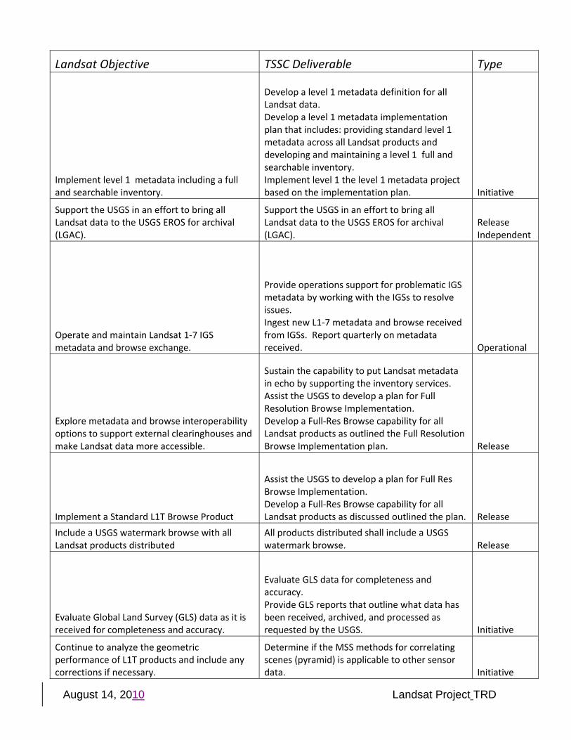
Landsat Objective TSSC Deliverable Type
Implement level 1 metadata including a full and searchable inventory.
Develop a level 1 metadata definition for all Landsat data. Develop a level 1 metadata implementation plan that includes: providing standard level 1 metadata across all Landsat products and developing and maintaining a level 1 full and searchable inventory. Implement level 1 the level 1 metadata project based on the implementation plan. Initiative
Support the USGS in an effort to bring all Landsat data to the USGS EROS for archival (LGAC).
Support the USGS in an effort to bring all Landsat data to the USGS EROS for archival (LGAC).
Release Independent
Operate and maintain Landsat 1‐7 IGS metadata and browse exchange.
Provide operations support for problematic IGS metadata by working with the IGSs to resolve issues. Ingest new L1‐7 metadata and browse received from IGSs. Report quarterly on metadata received. Operational
Explore metadata and browse interoperability options to support external clearinghouses and make Landsat data more accessible.
Sustain the capability to put Landsat metadata in echo by supporting the inventory services. Assist the USGS to develop a plan for Full Resolution Browse Implementation. Develop a Full‐Res Browse capability for all Landsat products as outlined the Full Resolution Browse Implementation plan. Release
Implement a Standard L1T Browse Product
Assist the USGS to develop a plan for Full Res Browse Implementation. Develop a Full‐Res Browse capability for all Landsat products as discussed outlined the plan. Release
Include a USGS watermark browse with all Landsat products distributed
All products distributed shall include a USGS watermark browse. Release
Evaluate Global Land Survey (GLS) data as it is received for completeness and accuracy.
Evaluate GLS data for completeness and accuracy. Provide GLS reports that outline what data has been received, archived, and processed as requested by the USGS. Initiative
Continue to analyze the geometric performance of L1T products and include any corrections if necessary.
Determine if the MSS methods for correlating scenes (pyramid) is applicable to other sensor data. Initiative
August 14, 2010 Landsat Project TRD
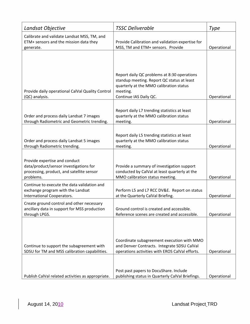
Landsat Objective TSSC Deliverable Type Calibrate and validate Landsat MSS, TM, and ETM+ sensors and the mission data they generate.
Provide Calibration and validation expertise for MSS, TM and ETM+ sensors. Provide Operational
Provide daily operational CalVal Quality Control (QC) analysis.
Report daily QC problems at 8:30 operations standup meeting. Report QC status at least quarterly at the MMO calibration status meeting. Continue IAS Daily QC. Operational
Order and process daily Landsat 7 images through Radiometric and Geometric trending.
Report daily L7 trending statistics at least quarterly at the MMO calibration status meeting. Operational
Order and process daily Landsat 5 images through Radiometric trending.
Report daily L5 trending statistics at least quarterly at the MMO calibration status meeting. Operational
Provide expertise and conduct data/product/sensor investigations for processing, product, and satellite sensor problems.
Provide a summary of investigation support conducted by CalVal at least quarterly at the MMO calibration status meeting. Operational
Continue to execute the data validation and exchange program with the Landsat International Cooperators.
Perform L5 and L7 RCC DV&E. Report on status at the Quarterly CalVal Briefing. Operational
Create ground control and other necessary ancillary data in support for MSS production through LPGS.
Ground control is created and accessible. Reference scenes are created and accessible. Operational
Continue to support the subagreement with SDSU for TM and MSS calibration capabilities.
Coordinate subagreement execution with MMO and Denver Contracts. Integrate SDSU CalVal operations activities with EROS CalVal efforts. Operational
Publish CalVal related activities as appropriate. Post past papers to DocuShare. Include publishing status in Quarterly CalVal Briefings. Operational
August 14, 2010 Landsat Project TRD
Landsat Objective TSSC Deliverable Type
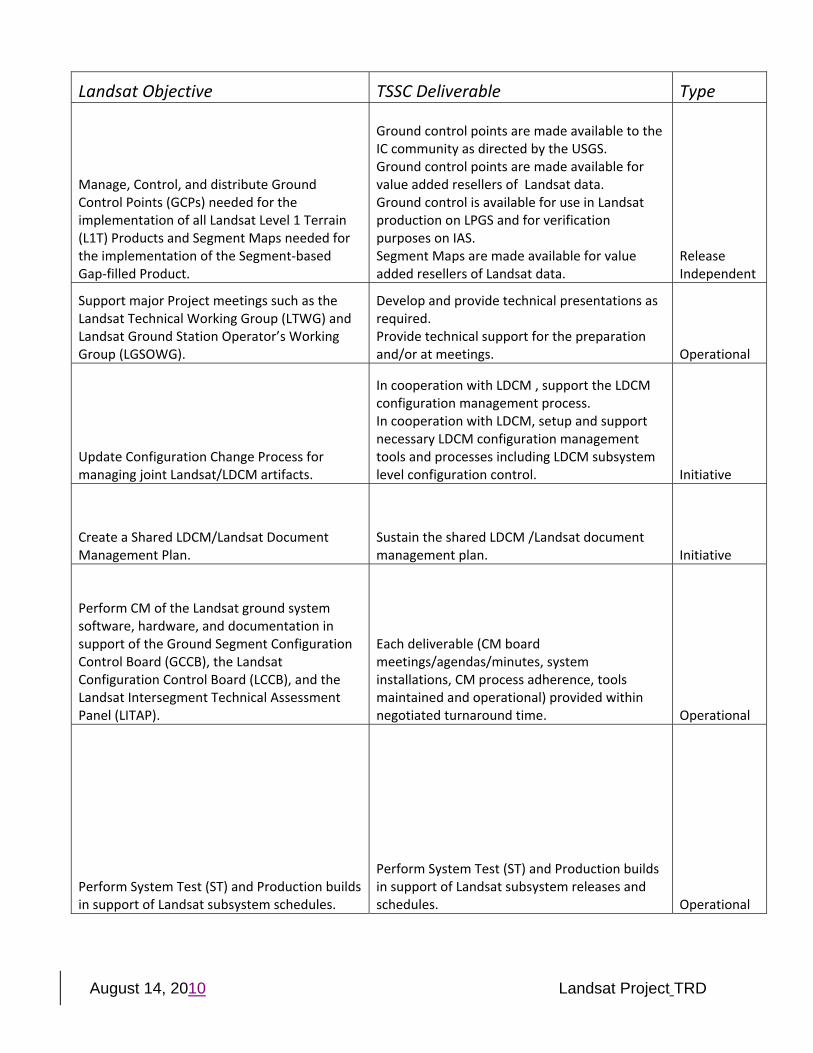
Manage, Control, and distribute Ground Control Points (GCPs) needed for the implementation of all Landsat Level 1 Terrain (L1T) Products and Segment Maps needed for the implementation of the Segment‐based Gap‐filled Product.
Ground control points are made available to the IC community as directed by the USGS. Ground control points are made available for value added resellers of Landsat data. Ground control is available for use in Landsat production on LPGS and for verification purposes on IAS. Segment Maps are made available for value added resellers of Landsat data.
Release Independent
Support major Project meetings such as the Landsat Technical Working Group (LTWG) and Landsat Ground Station Operator’s Working Group (LGSOWG).
Develop and provide technical presentations as required. Provide technical support for the preparation and/or at meetings. Operational
Update Configuration Change Process for managing joint Landsat/LDCM artifacts.
In cooperation with LDCM , support the LDCM configuration management process. In cooperation with LDCM, setup and support necessary LDCM configuration management tools and processes including LDCM subsystem level configuration control. Initiative
Create a Shared LDCM/Landsat Document Management Plan.
Sustain the shared LDCM /Landsat document management plan. Initiative
Perform CM of the Landsat ground system software, hardware, and documentation in support of the Ground Segment Configuration Control Board (GCCB), the Landsat Configuration Control Board (LCCB), and the Landsat Intersegment Technical Assessment Panel (LITAP).�
Each deliverable (CM board meetings/agendas/minutes, system installations, CM process adherence, tools maintained and operational) provided within negotiated turnaround time. Operational
Perform System Test (ST) and Production builds in support of Landsat subsystem schedules.
Perform System Test (ST) and Production builds in support of Landsat subsystem releases and schedules. Operational
August 14, 2010 Landsat Project TRD
Landsat Objective TSSC Deliverable Type
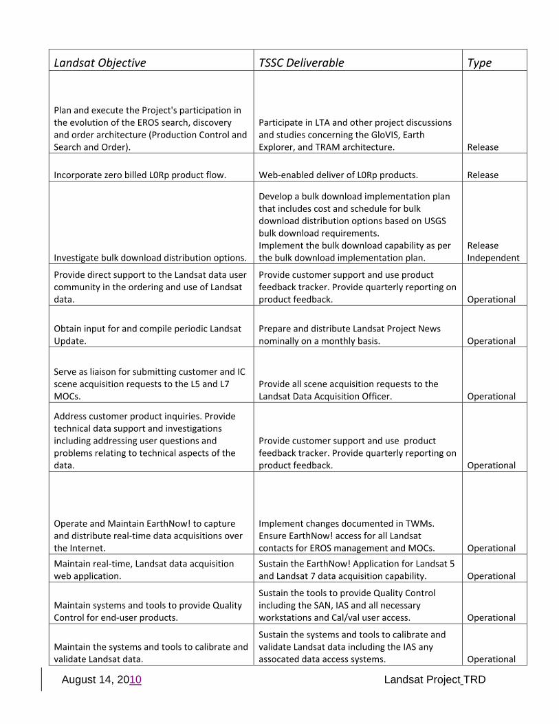
Plan and execute the Project's participation in the evolution of the EROS search, discovery and order architecture (Production Control and Search and Order).
Participate in LTA and other project discussions and studies concerning the GloVIS, Earth Explorer, and TRAM architecture. Release
Incorporate zero billed L0Rp product flow. Web‐enabled deliver of L0Rp products. Release
Investigate bulk download distribution options.
Develop a bulk download implementation plan that includes cost and schedule for bulk download distribution options based on USGS bulk download requirements. Implement the bulk download capability as per the bulk download implementation plan.
Release Independent
Provide direct support to the Landsat data user community in the ordering and use of Landsat data.
Provide customer support and use product feedback tracker. Provide quarterly reporting on product feedback. Operational
Obtain input for and compile periodic Landsat Update.
Prepare and distribute Landsat Project News nominally on a monthly basis. Operational
Serve as liaison for submitting customer and IC scene acquisition requests to the L5 and L7 MOCs.
Provide all scene acquisition requests to the Landsat Data Acquisition Officer. Operational
Address customer product inquiries. Provide technical data support and investigations including addressing user questions and problems relating to technical aspects of the data.
Provide customer support and use product feedback tracker. Provide quarterly reporting on product feedback. Operational
Operate and Maintain EarthNow! to capture and distribute real‐time data acquisitions over the Internet.
Implement changes documented in TWMs. Ensure EarthNow! access for all Landsat contacts for EROS management and MOCs. Operational
Maintain real‐time, Landsat data acquisition web application.
Sustain the EarthNow! Application for Landsat 5 and Landsat 7 data acquisition capability. Operational
Maintain systems and tools to provide Quality Control for end‐user products.
Sustain the tools to provide Quality Control including the SAN, IAS and all necessary workstations and Cal/val user access. Operational
Maintain the systems and tools to calibrate and validate Landsat data.
Sustain the systems and tools to calibrate and validate Landsat data including the IAS any assocated data access systems. Operational
August 14, 2010 Landsat Project TRD
Landsat Objective TSSC Deliverable Type
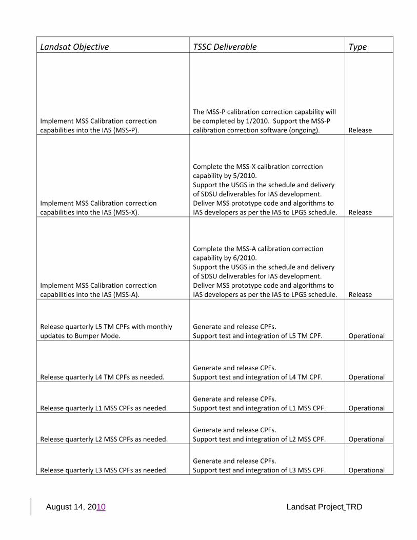
Implement MSS Calibration correction capabilities into the IAS (MSS‐P).
The MSS‐P calibration correction capability will be completed by 1/2010. Support the MSS‐P calibration correction software (ongoing). Release
Implement MSS Calibration correction capabilities into the IAS (MSS‐X).
Complete the MSS‐X calibration correction capability by 5/2010. Support the USGS in the schedule and delivery of SDSU deliverables for IAS development. Deliver MSS prototype code and algorithms to IAS developers as per the IAS to LPGS schedule. Release
Implement MSS Calibration correction capabilities into the IAS (MSS‐A).
Complete the MSS‐A calibration correction capability by 6/2010. Support the USGS in the schedule and delivery of SDSU deliverables for IAS development. Deliver MSS prototype code and algorithms to IAS developers as per the IAS to LPGS schedule. Release
Release quarterly L5 TM CPFs with monthly updates to Bumper Mode.
Generate and release CPFs. Support test and integration of L5 TM CPF. Operational
Release quarterly L4 TM CPFs as needed. Generate and release CPFs. Support test and integration of L4 TM CPF. Operational
Release quarterly L1 MSS CPFs as needed. Generate and release CPFs. Support test and integration of L1 MSS CPF. Operational
Release quarterly L2 MSS CPFs as needed. Generate and release CPFs. Support test and integration of L2 MSS CPF. Operational
Release quarterly L3 MSS CPFs as needed. Generate and release CPFs. Support test and integration of L3 MSS CPF. Operational
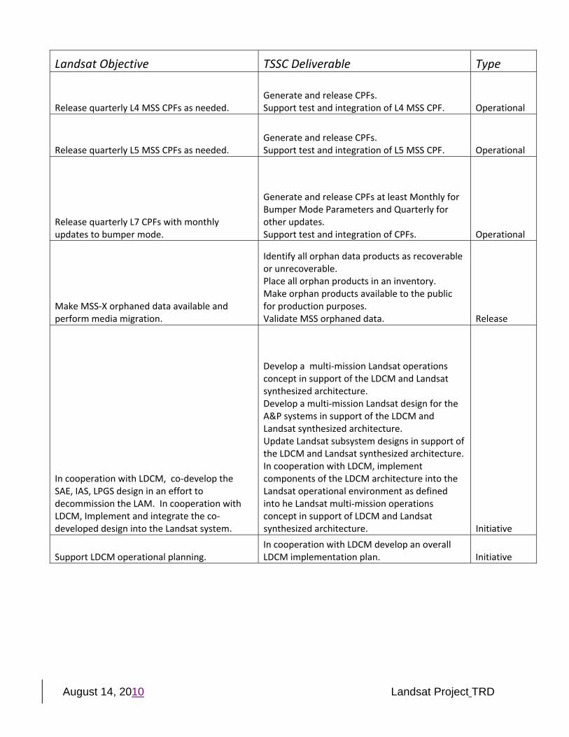
August 14, 2010 Landsat Project TRD
Landsat Objective TSSC Deliverable Type
Release quarterly L4 MSS CPFs as needed. Generate and release CPFs. Support test and integration of L4 MSS CPF. Operational
Release quarterly L5 MSS CPFs as needed. Generate and release CPFs. Support test and integration of L5 MSS CPF. Operational
Release quarterly L7 CPFs with monthly updates to bumper mode.
Generate and release CPFs at least Monthly for Bumper Mode Parameters and Quarterly for other updates. Support test and integration of CPFs. Operational
Make MSS‐X orphaned data available and perform media migration.
Identify all orphan data products as recoverable or unrecoverable. Place all orphan products in an inventory. Make orphan products available to the public for production purposes. Validate MSS orphaned data. Release
In cooperation with LDCM, co‐develop the SAE, IAS, LPGS design in an effort to decommission the LAM. In cooperation with LDCM, Implement and integrate the co‐developed design into the Landsat system.
Develop a multi‐mission Landsat operations concept in support of the LDCM and Landsat synthesized architecture. Develop a multi‐mission Landsat design for the A&P systems in support of the LDCM and Landsat synthesized architecture. Update Landsat subsystem designs in support of the LDCM and Landsat synthesized architecture.In cooperation with LDCM, implement components of the LDCM architecture into the Landsat operational environment as defined into he Landsat multi‐mission operations concept in support of LDCM and Landsat synthesized architecture. Initiative
Support LDCM operational planning. In cooperation with LDCM develop an overall LDCM implementation plan. Initiative
August 14, 2010 Landsat Project TRD
Landsat Objective TSSC Deliverable Type
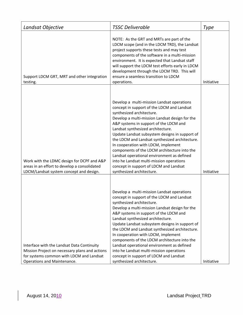
Support LDCM GRT, MRT and other integration testing.
NOTE: As the GRT and MRTs are part of the LDCM scope (and in the LDCM TRD), the Landsat project supports these tests and may test components of the software in a multi‐mission environment. It is expected that Landsat staff will support the LDCM test efforts early in LDCM development through the LDCM TRD. This will ensure a seamless transition to LDCM operations. Initiative
Work with the LDMC design for DCPF and A&P areas in an effort to develop a consolidated LDCM/Landsat system concept and design.
Develop a multi‐mission Landsat operations concept in support of the LDCM and Landsat synthesized architecture. Develop a multi‐mission Landsat design for the A&P systems in support of the LDCM and Landsat synthesized architecture. Update Landsat subsystem designs in support of the LDCM and Landsat synthesized architecture.In cooperation with LDCM, implement components of the LDCM architecture into the Landsat operational environment as defined into he Landsat multi‐mission operations concept in support of LDCM and Landsat synthesized architecture. Initiative
Interface with the Landsat Data Continuity Mission Project on necessary plans and actions for systems common with LDCM and Landsat Operations and Maintenance.
Develop a multi‐mission Landsat operations concept in support of the LDCM and Landsat synthesized architecture. Develop a multi‐mission Landsat design for the A&P systems in support of the LDCM and Landsat synthesized architecture. Update Landsat subsystem designs in support of the LDCM and Landsat synthesized architecture.In cooperation with LDCM, implement components of the LDCM architecture into the Landsat operational environment as defined into he Landsat multi‐mission operations concept in support of LDCM and Landsat synthesized architecture. Initiative
August 14, 2010 Landsat Project TRD
Landsat Objective TSSC Deliverable Type
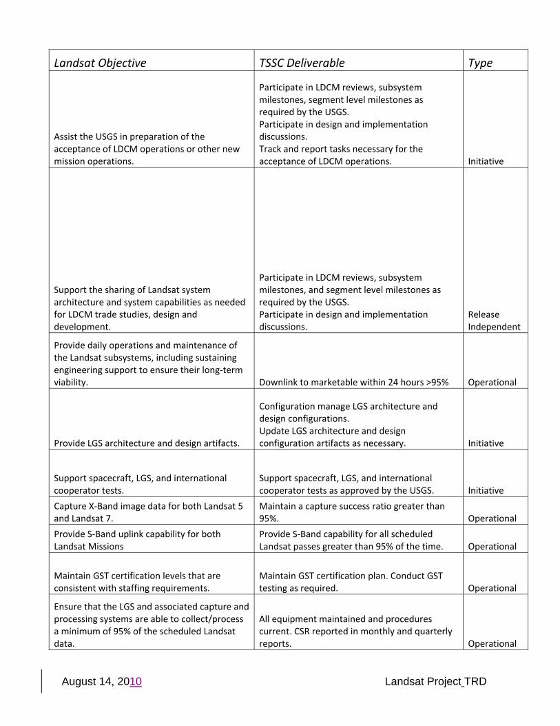
Assist the USGS in preparation of the acceptance of LDCM operations or other new mission operations.
Participate in LDCM reviews, subsystem milestones, segment level milestones as required by the USGS. Participate in design and implementation discussions. Track and report tasks necessary for the acceptance of LDCM operations. Initiative
Support the sharing of Landsat system architecture and system capabilities as needed for LDCM trade studies, design and development.
Participate in LDCM reviews, subsystem milestones, and segment level milestones as required by the USGS. Participate in design and implementation discussions.
Release Independent
Provide daily operations and maintenance of the Landsat subsystems, including sustaining engineering support to ensure their long‐term viability. Downlink to marketable within 24 hours >95% Operational
Provide LGS architecture and design artifacts.
Configuration manage LGS architecture and design configurations. Update LGS architecture and design configuration artifacts as necessary. Initiative
Support spacecraft, LGS, and international cooperator tests.
Support spacecraft, LGS, and international cooperator tests as approved by the USGS. Initiative
Capture X‐Band image data for both Landsat 5 and Landsat 7.
Maintain a capture success ratio greater than 95%. Operational
Provide S‐Band uplink capability for both Landsat Missions
Provide S‐Band capability for all scheduled Landsat passes greater than 95% of the time. Operational
Maintain GST certification levels that are consistent with staffing requirements.
Maintain GST certification plan. Conduct GST testing as required. Operational
Ensure that the LGS and associated capture and processing systems are able to collect/process a minimum of 95% of the scheduled Landsat data.
All equipment maintained and procedures current. CSR reported in monthly and quarterly reports. Operational
August 14, 2010 Landsat Project TRD
Landsat Objective TSSC Deliverable Type
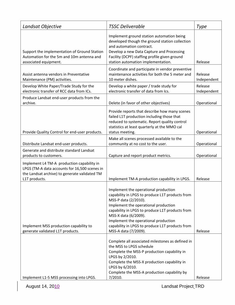
Support the implementation of Ground Station Automation for the 5m and 10m antenna and associated equipment.
Implement ground station automation being developed though the ground station collection and automation contract. Develop a new Data Capture and Processing Facility (DCPF) staffing profile given ground station automation implementation. Release
Assist antenna vendors in Preventative Maintenance (PM) activities.
Coordinate and participate in vendor preventive maintenance activities for both the 5 meter and 10 meter dishes.
Release Independent
Develop White Paper/Trade Study for the electronic transfer of RCC data from ICs.
Develop a white paper / trade study for electronic transfer of data from Ics.
Release Independent
Produce Landsat end‐user products from the archive. Delete (in favor of other objectives) Operational
Provide Quality Control for end‐user products.
Provide reports that describe how many scenes failed L1T production including those that reduced to systematic. Report quality control statistics at least quarterly at the MMO cal status meeting. Operational
Distribute Landsat end‐user products. Make all scenes processed available to the community at no cost to the user. Operational
Generate and distribute standard Landsat products to customers. Capture and report product metrics. Operational
Implement L4 TM‐A production capability in LPGS (TM‐A data accounts for 16,500 scenes in the Landsat archive) to generate validated TM L1T products. Implement TM‐A production capability in LPGS. Release
Implement MSS production capability to generate validated L1T products.
Implement the operational production capability in LPGS to produce L1T products from MSS‐P data (2/2010). Implement the operational production capability in LPGS to produce L1T products from MSS‐X data (6/2009). Implement the operational production capability in LPGS to produce L1T products from MSS‐A data (7/2009). Release
Implement L1‐5 MSS processing into LPGS.
Complete all associated milestones as defined in the MSS to LPGS schedule Complete the MSS‐P production capability in LPGS by 2/2010. Complete the MSS‐X production capability in LPGS by 6/2010. Complete the MSS‐A production capability by 7/2010. Release
August 14, 2010 Landsat Project TRD
Landsat Objective TSSC Deliverable Type
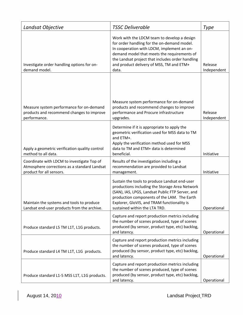
Investigate order handling options for on‐demand model.
Work with the LDCM team to develop a design for order handling for the on‐demand model. In cooperation with LDCM, implement an on‐demand model that meets the requirements of the Landsat project that includes order handling and product delivery of MSS, TM and ETM+ data.
Release Independent
Measure system performance for on‐demand products and recommend changes to improve performance.
Measure system performance for on‐demand products and recommend changes to improve performance and Procure infrastructure upgrades.
Release Independent
Apply a geometric verification quality control method to all data.
Determine if it is appropriate to apply the geometric verification used for MSS data to TM and ETM+. Apply the verification method used for MSS data to TM and ETM+ data is determined beneficial. Initiative
Coordinate with LDCM to investigate Top of Atmosphere corrections as a standard Landsat product for all sensors.
Results of the investigation including a recommendation are provided to Landsat management. Initiative
Maintain the systems and tools to produce Landsat end‐user products from the archive.
Sustain the tools to produce Landsat end‐user productions including the Storage Area Network (SAN), IAS, LPGS, Landsat Public FTP Server, and production components of the LAM. The Earth Explorer, GloVIS, and TRAM functionality is sustained within the LTA TRD. Operational
Produce standard L5 TM L1T, L1G products.
Capture and report production metrics including the number of scenes produced, type of scenes produced (by sensor, product type, etc) backlog, and latency. Operational
Produce standard L4 TM L1T, L1G products.
Capture and report production metrics including the number of scenes produced, type of scenes produced (by sensor, product type, etc) backlog, and latency. Operational
Produce standard L1‐5 MSS L1T, L1G products.
Capture and report production metrics including the number of scenes produced, type of scenes produced (by sensor, product type, etc) backlog, and latency. Operational
August 14, 2010 Landsat Project TRD
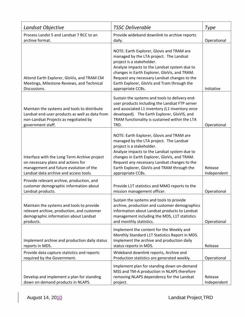
Landsat Objective TSSC Deliverable Type Process Landst 5 and Landsat 7 RCC to an archive format.
Provide wideband downlink to archive reports daily. Operational
Attend Earth Explorer, GloVis, and TRAM CM Meetings, Milestone Reviews, and Technical Discussions.
NOTE: Earth Explorer, Glovis and TRAM are managed by the LTA project. The Landsat project is a stakeholder. Analyze impacts to the Landsat system due to changes in Earth Explorer, GloVis, and TRAM. Request any necessary Landsat changes to the Earth Explorer, GloVis and Tram through the appropriate CCBs. Initiative
Maintain the systems and tools to distribute Landsat end‐user products as well as data from non‐Landsat Projects as negotiated by government staff.
Sustain the systems and tools to delivery end‐user products including the Landsat FTP server and associated L1 inventory (L1 inventory once developed). The Earth Explorer, GloVIS, and TRAM functionality is sustained within the LTA TRD. Operational
Interface with the Long Term Archive project on necessary plans and actions for management and future evolution of the Landsat data archive and access tools.
NOTE: Earth Explorer, Glovis and TRAM are managed by the LTA project. The Landsat project is a stakeholder. Analyze impacts to the Landsat system due to changes in Earth Explorer, GloVis, and TRAM. Request any necessary Landsat changes to the Earth Explorer, GloVis and TRAM through the appropriate CCBs.
Release Independent
Provide relevant archive, production, and customer demographic information about Landsat products.
Provide L1T statistics and MMO reports to the mission management officer. Operational
Maintain the systems and tools to provide relevant archive, production, and customer demographic information about Landsat products.
Sustain the systems and tools to provide archive, production and customer demographics information about Landsat products to Landsat management including the MDS, L1T statistics and monthly statistics. Operational
Implement archive and production daily status reports in MDS.
Implement the content for the Weekly and Monthly Standard L1T Statistics Report in MDS. Implement the archive and production daily status reports in MDS. Release
Provide data capture statistics and reports required by the Government.
Wideband downlink reports, Archive and Production statistics are generated weekly. Operational
Develop and implement a plan for standing down on‐demand products in NLAPS.
Implement plan for standing down on‐demand MSS and TM‐A production in NLAPS therefore removing NLAPS dependency for the Landsat project.
Release Independent
August 14, 2010 Landsat Project TRD
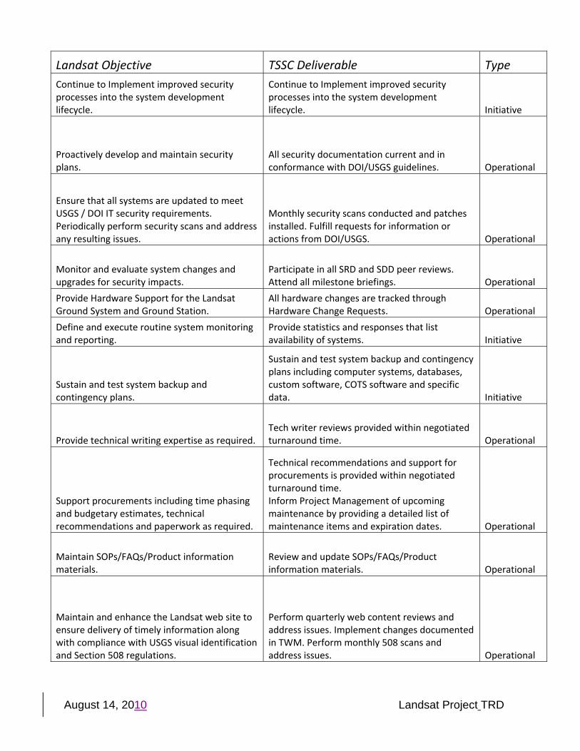
Landsat Objective TSSC Deliverable Type Continue to Implement improved security processes into the system development lifecycle.
Continue to Implement improved security processes into the system development lifecycle. Initiative
Proactively develop and maintain security plans.
All security documentation current and in conformance with DOI/USGS guidelines. Operational
Ensure that all systems are updated to meet USGS / DOI IT security requirements. Periodically perform security scans and address any resulting issues.
Monthly security scans conducted and patches installed. Fulfill requests for information or actions from DOI/USGS. Operational
Monitor and evaluate system changes and upgrades for security impacts.
Participate in all SRD and SDD peer reviews. Attend all milestone briefings. Operational
Provide Hardware Support for the Landsat Ground System and Ground Station.
All hardware changes are tracked through Hardware Change Requests. Operational
Define and execute routine system monitoring and reporting.
Provide statistics and responses that list availability of systems. Initiative
Sustain and test system backup and contingency plans.
Sustain and test system backup and contingency plans including computer systems, databases, custom software, COTS software and specific data. Initiative
Provide technical writing expertise as required. Tech writer reviews provided within negotiated turnaround time. Operational
Support procurements including time phasing and budgetary estimates, technical recommendations and paperwork as required.
Technical recommendations and support for procurements is provided within negotiated turnaround time. Inform Project Management of upcoming maintenance by providing a detailed list of maintenance items and expiration dates. Operational
Maintain SOPs/FAQs/Product information materials.
Review and update SOPs/FAQs/Product information materials. Operational
Maintain and enhance the Landsat web site to ensure delivery of timely information along with compliance with USGS visual identification and Section 508 regulations.
Perform quarterly web content reviews and address issues. Implement changes documented in TWM. Perform monthly 508 scans and address issues. Operational
August 14, 2010 Landsat Project TRD
Landsat Objective TSSC Deliverable Type
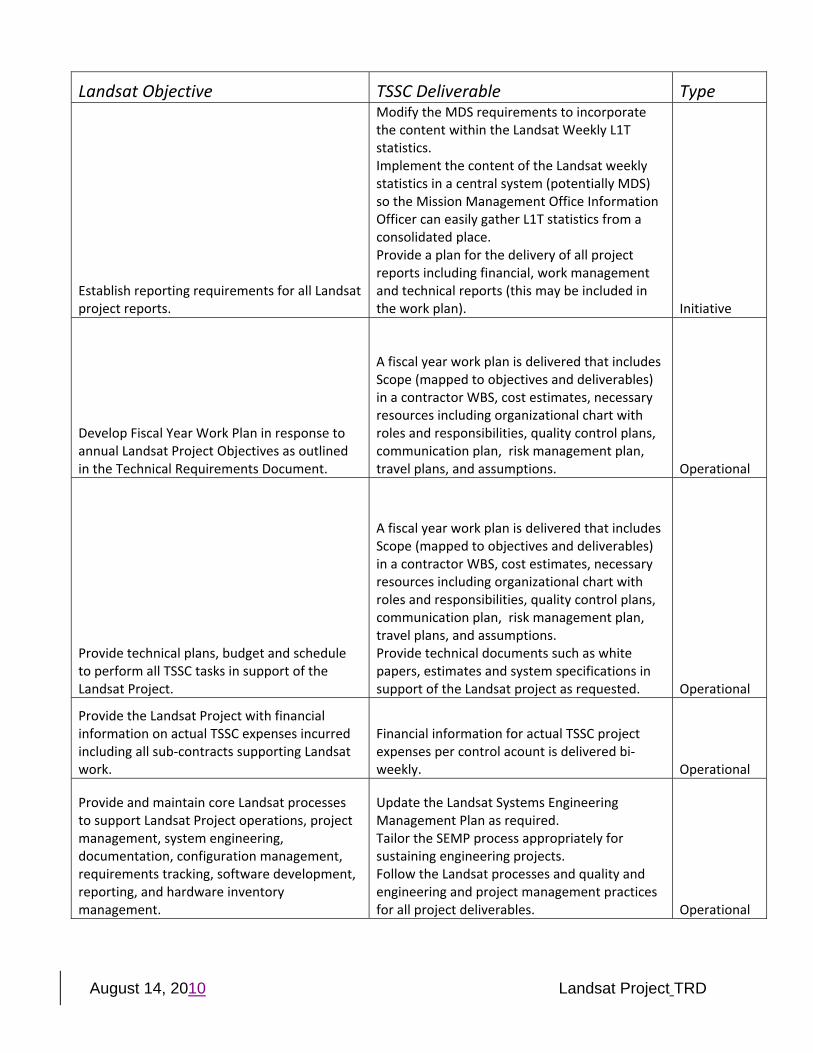
Establish reporting requirements for all Landsat project reports.
Modify the MDS requirements to incorporate the content within the Landsat Weekly L1T statistics. Implement the content of the Landsat weekly statistics in a central system (potentially MDS) so the Mission Management Office Information Officer can easily gather L1T statistics from a consolidated place. Provide a plan for the delivery of all project reports including financial, work management and technical reports (this may be included in the work plan). Initiative
Develop Fiscal Year Work Plan in response to annual Landsat Project Objectives as outlined in the Technical Requirements Document.
A fiscal year work plan is delivered that includes Scope (mapped to objectives and deliverables) in a contractor WBS, cost estimates, necessary resources including organizational chart with roles and responsibilities, quality control plans, communication plan, risk management plan, travel plans, and assumptions. Operational
Provide technical plans, budget and schedule to perform all TSSC tasks in support of the Landsat Project.
A fiscal year work plan is delivered that includes Scope (mapped to objectives and deliverables) in a contractor WBS, cost estimates, necessary resources including organizational chart with roles and responsibilities, quality control plans, communication plan, risk management plan, travel plans, and assumptions. Provide technical documents such as white papers, estimates and system specifications in support of the Landsat project as requested. Operational
Provide the Landsat Project with financial information on actual TSSC expenses incurred including all sub‐contracts supporting Landsat work.
Financial information for actual TSSC project expenses per control acount is delivered bi‐weekly. Operational
Provide and maintain core Landsat processes to support Landsat Project operations, project management, system engineering, documentation, configuration management, requirements tracking, software development, reporting, and hardware inventory management.
Update the Landsat Systems Engineering Management Plan as required. Tailor the SEMP process appropriately for sustaining engineering projects. Follow the Landsat processes and quality and engineering and project management practices for all project deliverables. Operational
August 14, 2010 Landsat Project TRD
Landsat Objective TSSC Deliverable Type
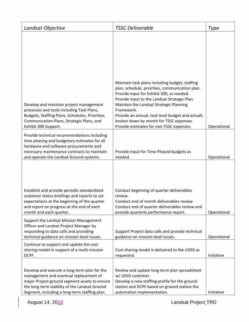
Develop and maintain project management processes and tools including Task Plans, Budgets, Staffing Plans, Schedules, Priorities, Communication Plans, Strategic Plans, and Exhibit 300 Support.
Maintain task plans including budget, staffing plan, schedule, priorities, communication plan. Provide input for Exhibit 300, as needed. Provide input to the Landsat Strategic Plan. Maintain the Landsat Strategic Planning Framework. Provide an annual, task level budget and actuals broken down by month for TSSC expenses. Provide estimates for non‐TSSC expenses. Operational
Provide technical recommendations including time phasing and budgetary estimates for all hardware and software procurements and necessary maintenance contracts to maintain and operate the Landsat Ground systems.
Provide Input for Time Phased budgets as needed. Operational
Establish and provide periodic standardized customer status briefings and reports to set expectations at the beginning of the quarter and report on progress at the end of each month and each quarter.
Conduct beginning of quarter deliverables review. Conduct end of month deliverables review. Conduct end of quarter deliverables review and provide quarterly performance report. Operational
Support the Landsat Mission Management Officer and Landsat Project Manager by responding to data calls and providing technical guidance on mission‐level issues.
Support Project data calls and provide technical guidance on mission‐level issues. Operational
Continue to support and update the cost sharing model in support of a multi‐mission DCPF.
Cost sharing model is delivered to the USGS as requested. Initiative
Develop and execute a long‐term plan for the management and eventual replacement of major Project ground segment assets to ensure the long‐term viability of the Landsat Ground Segment, including a long‐term staffing plan.
Review and update long term plan spreadsheet w/ USGS customer. Develop a new staffing profile for the ground station and DCPF based on ground station the automation implementation. Initiative
August 14, 2010 Landsat Project TRD
Landsat Objective TSSC Deliverable Type
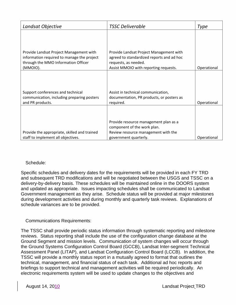
Provide Landsat Project Management with information required to manage the project through the MMO Information Officer (MMOIO).
Provide Landsat Project Management with agreed to standardized reports and ad hoc requests, as needed. Assist MMOIO with reporting requests. Operational
Support conferences and technical communication, including preparing posters and PR products.
Assist in technical communication, documentation, PR products, or posters as required. Operational
Provide the appropriate, skilled and trained staff to implement all objectives.
Provide resource management plan as a component of the work plan. Review resource management with the government quarterly. Operational
Schedule:
Specific schedules and delivery dates for the requirements will be provided in each FY TRD and subsequent TRD modifications and will be negotiated between the USGS and TSSC on a delivery-by-delivery basis. These schedules will be maintained online in the DOORS system and updated as appropriate. Issues impacting schedules shall be communicated to Landsat Government management as they arise. Schedule status will be provided at major milestones during development activities and during monthly and quarterly task reviews. Explanations of schedule variances are to be provided.
Communications Requirements:
The TSSC shall provide periodic status information through systematic reporting and milestone reviews. Status reporting shall include the use of the configuration change database at the Ground Segment and mission levels. Communication of system changes will occur through the Ground Systems Configuration Control Board (GCCB), Landsat Inter-segment Technical Assessment Panel (LITAP), and Landsat Configuration Control Board (LCCB). In addition, the TSSC will provide a monthly status report in a mutually agreed to format that outlines the technical, management, and financial status of each task. Additional ad hoc reports and briefings to support technical and management activities will be required periodically. An electronic requirements system will be used to update changes to the objectives and
August 14, 2010 Landsat Project TRD
deliverables, and major changes will be included in modifications to the TRD. The following table summarizes the communications mechanisms to be used:
Reporting Mechanism Format and Purpose Frequency
Configuration
Change Requests
Change Tracking Database—Provides detailed documentation of system changes and enhancements resulting from approved changes. Change requests contain sufficient information to describe the subject changes. Requirement and design information related to subject changes should be formally documented in a controlled manner.
As required
Email Email—Provides USGS management with periodic updates on the status of issues and resolutions.
User driven as required
Ad Hoc Briefings, Reports, and Data Calls
Microsoft Excel, PowerPoint, and Word—Generates periodic reports to support Landsat Project Management requests for information.
As required
Monthly Status Reports Microsoft Excel—Documents each task’s financial and programmatic status to:
• Review progress on objectives and deliverables for the previous month.
• Provide monthly spending plan review (actual to date plus planned).
Monthly for the first two months in a quarter
Quarterly Status Reports Microsoft Excel—Documents each task’s financial and programmatic status to:
• Review progress on objectives and deliverables for the previous quarter.
• Provide quarterly spending plan review (actual to date plus planned)
• Set next quarter’s plan through objectives and deliverables; document agreed to changes.
• Add new quarter to the plan (i.e., the quarter just completed plus one year).
Information from the Quarterly Report will be used by the USGS Government management to assist in USGS preparation of the quarterly TSSC evaluation for the Contracting Officer’s Representative (COR).
Quarterly (The final monthly report in a quarter will be used for the Quarterly Report and will contain a summary of all information provided in the two previous monthlies.)
Project Schedules Microsoft Project—Documents project activities with priorities and timeframes for development and implementation. Used primarily to document schedules for major items such as system releases.
As required to support each release / technical development
August 14, 2010 Landsat Project TRD
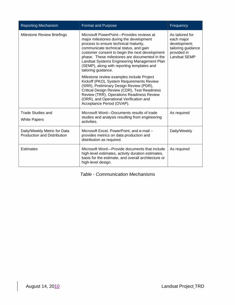
Reporting Mechanism Format and Purpose Frequency
Milestone Review Briefings Microsoft PowerPoint—Provides reviews at major milestones during the development process to ensure technical maturity, communicate technical status, and gain customer consent to begin the next development phase. These milestones are documented in the Landsat Systems Engineering Management Plan (SEMP), along with reporting templates and tailoring guidance.
Milestone review examples include Project Kickoff (PKO), System Requirements Review (SRR), Preliminary Design Review (PDR), Critical Design Review (CDR), Test Readiness Review (TRR), Operations Readiness Review (ORR), and Operational Verification and Acceptance Period (OVAP).
As tailored for each major development; tailoring guidance provided in Landsat SEMP
Trade Studies and
White Papers
Microsoft Word—Documents results of trade studies and analysis resulting from engineering activities.
As required
Daily/Weekly Metric for Data Production and Distribution
Microsoft Excel, PowerPoint, and e-mail – provides metrics on data production and distribution as required.
Daily/Weekly
Estimates Microsoft Word—Provide documents that include high-level estimates, activity duration estimates, basis for the estimate, and overall architecture or high-level design.
As required
Table - Communication Mechanisms