Embed Size (px)
Citation preview

U.S. Department of the InteriorU.S. Geological Survey
Sound Waves Volume FY 2011, Issue No. 128October/November 2010
Fieldwork
http://soundwaves.usgs.gov/
(Hydrates and Climate continued on page 2)
Degradation of Subsea Permafrost and Associated Gas Hydrates Offshore of Alaska in Response to Climate ChangeBy Carolyn Ruppel, Patrick Hart, and Charles Worley
Much of the shallow Arctic seafl oor just off Alaska’s North Slope was formerly subaerial tundra that was fl ooded during rapid sea-level rise beginning 15,000 years ago. In August 2010, U.S. Geological Sur-vey (USGS) scientists collected data from part of this area—Harrison Bay in the U.S. Beaufort Sea—to study the degradation of subsea permafrost and associated gas hydrate in response to climate change. The survey was the fi rst by the U.S. Depart-ment of the Interior since 1980 to target shallow-water areas of the U.S. Beaufort Sea and also the fi rst systematic USGS survey of Alaskan subsea permafrost.
Gas hydrate—an icelike combina-tion of water and certain gases, but most commonly methane—represents a highly concentrated form of gas and is stable only within a specifi c range of temperatures and pressures beneath the seafl oor and in and beneath permafrost. Globally, gas hydrate sequesters large volumes of methane and thus may have potential as a future energy resource. On the other hand, methane is 20 times more potent than CO2 as a green-house gas, and a large release of methane from dissociating gas hydrates could exac-erbate global warming.
On the central Alaskan North Slope and in the nearshore environment, gas hydrate could occur in some strata within a zone ranging from 400 to more than 1,000 me-ters in thickness, starting at depths as shal-low as 200 to 250 m.. An estimated 3x10¹³ m3 of methane (measured at standard pres-sure and temperature) may be sequestered within gas hydrates in sands in permafrost areas. The deep conventional gas reser-voirs that supply some of the source gas for gas hydrates currently sequestered in
Location map (inset) and Harrison Bay study area on the U.S. Beaufort Sea inner continental shelf. Orange lines denote legacy seismic surveys from the late 1970s; yellow lines indicate combined mini-sparker, Chirp, and sonar surveys conducted in August 2010. Many of the new survey lines coincide with legacy lines. Star marks location of sonobuoy deployment.
Relationships among an example Alaskan North Slope geothermal gradient (rate of change in tempera-ture with depth), the thickness of the permafrost zone, and potential gas-hydrate occurrences. Gas hy-drate is stable to the left and below the red curve for pure methane hy-drate, and to the left and below the purple curve for a mixture of meth-ane and CO2 that is similar to gas in the shallow part of an onshore well near Harrison Bay, according to data compiled by T. Lorenson. The situation illustrated here might pre-vail onshore and at offshore water depths of a few meters.

2October/November 2010 Sound Waves
Sound Waves
EditorHelen Gibbons
Menlo Park, CaliforniaTelephone: (650) 329-5042
E-mail: [email protected]: (650) 329-5190
Print Layout EditorsSusan Mayfi eld, Sara Boore
Menlo Park, CaliforniaTelephone: (650) 329-5066
E-mail: smayfi [email protected]; [email protected]: (650) 329-5051
Web Layout EditorJolene Shirley
St. Petersburg, FloridaTelephone: (727) 803-8747 Ext. 3038
E-mail: [email protected]: (727) 803-2032
SOUND WAVES (WITH ADDITIONAL LINKS) IS AVAILABLE ONLINE AT URLhttp://soundwaves.usgs.gov/
Fieldwork
Fieldwork, continued
Submission Guidelines
Deadline: The dead line for news items and pub li ca tion lists for the January/February issue of Sound Waves is Tuesday, November 30. Publications: When new publications or prod ucts are re leased, please no ti fy the ed i tor with a full reference and a bulleted sum ma ry or description.Images: Please sub mit all images at pub li ca- tion size (col umn, 2-column, or page width). Resolution of 200 to 300 dpi (dots per inch) is best. Ado be Illustrator© fi les or EPS fi les work well with vector fi les (such as graphs or di a grams). TIFF and JPEG fi les work well with ras ter fi les (pho to graphs or rasterized vec tor fi les).
Any use of trade, fi rm, or product names is for descriptive purposes only and does not imply endorsement by the U.S. Gov ern ment.
U.S. Geological Survey Earth Science Information Sources:
Need to fi nd natural-science data orinformation? Visit the USGS Frequently Asked Ques tions (FAQ’s) at URL http://www.usgs.gov/faq/
Can’t fi nd the answer to your question on the Web? Call 1-888-ASK-USGS
Want to e-mail your question to the USGS?Send it to this address: [email protected]
Contents
Fieldwork 1Research 6Outreach 11Meetings 14Awards 15Publications 16
(Hydrates and Climate continued from page 1)
(Hydrates and Climate continued on page 3)
sedimentary deposits on the Alaskan North Slope and in shallow offshore regions also contain signifi cant CO2. This CO2 could be reintroduced to the atmosphere through climate-induced gas-hydrate dissociation.
The August 2010 study focused on the Harrison Bay area of the U.S. Beaufort Sea inner shelf (the part of the continental shelf closest to shore) and was conducted from the research vessel (R/V) 1273 of the Bureau of Ocean Energy, Management, Regulation and Enforcement (formerly the Minerals Management Service). The scientists collected approximately 185 km of high-resolution geophysical imagery of the water column, the seafl oor, and the upper 100 m or more of the sediments beneath the seafl oor. This research is one component of a multiyear effort by the USGS Gas Hydrates Project to study the impact of late Pleistocene to contemporary climate change on circum-Arctic gas-hydrate deposits, both offshore and on-shore. (See related article in Sound Waves, October 2009, at http://soundwaves.usgs.gov/2009/10/.)
Arctic regions are undergoing rapid contemporary warming, but the overall warming trend in the Arctic began at the end of the Last Glacial Maximum (approx 19,000 years ago), and sea level began rising sharply about 15,000 years ago, with the onset of major melting in the southern Hemisphere. Much of the shallow Arctic shelf at water depths between approximately 10 and 100 m was formerly subaerial tundra that was fl ooded during rapid sea-level rise before 3,000 years ago. At water depths less
than 10 m, such as those in most of the Harrison Bay survey area, the inundation may be more recent. The thick permafrost underlying the fl ooded tundra experiences thawing because the temperature of the overlying water is higher than the average surface temperature when the tundra was subaerial. Such thawing processes have been recognized in other parts of the circum-Arctic but have never been studied on a regional basis in the U.S. Arctic Ocean. The thawing of subsea permafrost leads to enhanced methane emissions due to microbial degradation of newly released organic carbon that had previously been trapped in permafrost, and possibly due to methane hydrate degassing. (For more information, see recent studies by Natalia Shakhova and others in the Journal of Geophysical Research, http://dx.doi.org/10.1029/2009JC005602, and Science, http://dx.doi.org/10.1126/science.1182221.)
Before the August 2010 cruise, the USGS Gas Hydrates Project re-evaluated seismic-refraction data acquired on the shallow (less than 25-m water depth) Beaufort Sea shelf by Western Geophysi-cal in the late 1970s (see map, previous page). The “pre-stack” unprocessed fi eld data are available to the USGS through a licensing agreement; the “post-stack” processed data can be freely accessed through the National Archive of Marine Seismic Surveys (http://walrus.wr.usgs.gov/NAMSS/). Harrison Bay was chosen as the initial focus area for the re-analysis because an older study by the U.S. Army
(Left) R/V 1273, a 33-ft-long aluminum-hulled research vessel managed by the Bureau of Ocean En-ergy, Management, Regulation and Enforcement, departs West Dock, Prudhoe Bay. (Right) Patrick Hart (foreground) and Chuck Worley deploy the mini-sparker.

3 Sound Waves October/November 2010Fieldwork
Fieldwork, continued
(Hydrates and Climate continued from page 2)
Cold Regions Research and Engineering Laboratory (CRREL Report 82-24) had used the same data to map subsea perma-frost there. The new analysis challenges the older interpretation of permafrost distribution in western Harrison Bay and reveals deepening of the top of permafrost to more than 300 m beneath the seafl oor in the eastern part of Harrison Bay. Because permafrost onshore near Harrison Bay may reach thicknesses of 400 m, we infer that much of the permafrost now in the bay has probably thawed within less than 10 km offshore. The data pattern interpreted as permafrost on seismic-refraction records abruptly disappears within central Harrison Bay at a location mapped as the apparent seaward extent of the subsea permafrost. Numerical models predict gas-hydrate dis-sociation at this location.
The August 2010 cruise used low-energy sound sources (such as the Edgetech 424 Chirp and mini-sparker) and fi shfi nder sonar to (a) track the top of subsea perma-frost from the shallowest nearshore waters of Harrison Bay to several kilometers offshore, (b) map the distribution of gas in the shallow subseafl oor, and (c) im-age seafl oor features associated with ice scouring and possible methane emissions. The 200-kHz fi shfi nder mode was used to target possible methane plumes in the water column, and data obtained during a single sonobuoy deployment will provide constraints on sound velocities in subsea-fl oor layers, required for interpretation of the seismic data. The low-energy seismic sources chosen for the 2010 cruise were intended to provide data of overlapping vertical resolution and depth of penetra-tion, not to reproduce the results of the earlier Western Geophysical surveys. Important criteria in choosing instrumen-tation for the 2010 cruise were portability, compact size, low power demand, and manageable regulatory and permitting re-quirements, particularly with respect to the Marine Mammal Protection Act and the Endangered Species Act.
Shown on this page are sample data ob-tained in August 2010. Sound energy from the mini-sparker source penetrated more than 100 m below the seafl oor in some places, and the data reveal the presence of
three prominent seaward-dipping refl ectors in the example shown here (labeled “B”). The Chirp data vary in quality depending on the lithology and sea state; the section reproduced here (labeled “A”) shows thinly laminated sediments draping gas-charged sediments approximately 3 m below the seafl oor. This gas may originate through microbial degradation of organic matter in sediments that formerly hosted permafrost, with the possible addition of some methane that has migrated from deeper in the sedi-mentary section. Further processing will be required to generate images of the seafl oor from the fi shfi nder sonar; the map view la-beled “C” shows one example of a seafl oor feature of unknown origin.
To date, an estimated 5 percent of the Western Geophysical seismic data for the U.S. Beaufort Sea has been re-analyzed. Weather and time limitations permitted us to reoccupy only about 50 percent of the legacy seismic lines in Harrison Bay dur-ing the summer 2010 cruise. In October, National Research Council/Department of Energy Methane Hydrates postdoctoral fel-low Laura Brothers joined the USGS in Woods Hole, Massachusetts, to commence re-analysis of the most promising of the re-maining legacy refraction data. In summer 2011, reconnaissance surveys will likely target degradation of subsea permafrost and associated gas hydrate both westward and eastward (toward Prudhoe Bay) from Harrison Bay. During that research, we
will also be able to continuously measure methane concentrations in seawater to map methane hotspots. Eventually, the USGS Gas Hydrates project intends to extend cli-mate-hydrate studies farther offshore to the Beaufort Sea continental slope, where the upper edge of the deepwater gas-hydrate system could be dissociating and possibly exacerbating slope failures as Arctic Ocean temperatures and sea-ice conditions change in response to global warming.
Partial support for this research was provided by interagency agreements DE-FE0002911 and DE-AI26-05NT42496 between the USGS and the U.S. Depart-ment of Energy’s National Methane Hydrates R&D Program. We thank the Bureau of Ocean Energy, Management, Regulation and Enforcement and C. Coon for arranging our use of the R/V 1273; G. Lawley from Kinnetics Laboratories, Inc., for serving as captain for the cruise; and the National Marine Fisheries Service and the U.S. Fish and Wildlife Service for assistance with permitting and compli-ance. This research was made possible through the advice and support of the Na-tive Village of Nuiqsut, native observer E. Nugapigak, and several North Slope Bor-ough offi cials, particularly T. Hepa and W. Williams. T. Collett (USGS, Denver, Colorado) and B. Jones (USGS, Anchor-age, Alaska) were generous in sharing knowledge and advice that contributed to the project’s success.
Examples of new data collected in three different parts of Harrison Bay in August 2010. Two ex-amples on left are cross-sectional views of sub-seafl oor sediment layers in (A) Edgetech 424 (Chirp) data and (B) mini-sparker data. Map view and cross-section (C) of multifrequency sonar (fi shfi nder) data reveal a feature (circled in yellow) whose origin is unknown and will require further analysis.

4October/November 2010 Sound Waves
Fieldwork, continued
Fieldwork
(Calcifi cation Rates continued on page 5)
This is the second in a series of articles about CREST research in Dry Tortugas National Park. The fi rst article was pub-lished in the August/September issue of Sound Waves, at http://soundwaves.usgs.gov/2010/08/research.html
At several reef sites in South Florida, among the colorful corals and rich ma-rine life, lie concrete cinder blocks. Each of these blocks is fi rmly attached to the reef and holds a transplanted coral on top. The transplanted coral is fi xed onto a disc with a bolt that can easily slide into a hole at the top of the block and just as easily be removed to weigh the coral. This device, designed by U.S. Geological Survey (USGS) scientists with the Coral Reef Ecosystem Studies Project (CREST), is used to measure baseline calcifi ca-tion rates for one of the most abundant reef-building corals in South Florida, the massive starlet coral Siderastrea siderea. The goal of the study is to monitor coral growth as ocean conditions change.
With ever-increasing amounts of carbon dioxide (CO2) entering the atmosphere, oceans are absorbing more and more CO2. Part of this CO2 becomes carbonic acid when it dissolves in oceans, lowering pH levels. Recent research shows that many marine organisms may be at risk in condi-tions of declining pH.
This phenomenon of lowered pH in the oceans, known as “ocean acidifi cation,” is predicted to directly affect calcifying organisms such as corals, algae, and phy-toplankton, as well as the multitudes of marine life that depend on them for food and habitat. Experimental work has dem-onstrated decreases in calcifi cation rates of corals and other calcifying organisms related to changes in ocean chemistry. (For example, see “Coral Reef Builders Vulnerable to Ocean Acidifi cation,” Sound Waves, March 2008, http://soundwaves.usgs.gov/2008/03/research.html.) The changes are expected to occur during the present century. CREST scientists are studying and establishing baseline rates
Coral Calcifi cation Rates in South Florida During Times of Changing Ocean Conditions By Matthew Cimitile and Ilsa Kuffner
for coral and algal growth in Florida by conducting in-situ fi eld measurements of calcifi cation rates.
“We are making measurements to estab-lish these baseline rates for calcifi cation now because it has not yet been done in a systematic, direct manner,” said USGS marine scientist Ilsa Kuffner. “To do this, we have four calcifi cation-monitoring sites at reefs offshore from Miami, Key Largo, Marathon, and in the Dry Tortugas.”
The corals are periodically removed from the monitoring stations and weighed using the buoyant-weight technique. The method involves suspending the coral in a cooler of seawater while the coral hangs
from a balance overhead. The difference in buoyant weight between each weighing is used to calculate the mass of calcium carbonate gained per unit time.
While the corals wait in specially modifi ed buckets to be weighed, they are stained with a dye, alizarin red, that becomes incorporated into the outermost skeletal layer of the coral. The stain pro-vides a reference mark because corals, like trees, grow by accreting annual lay-ers. “Knowing the date of the staining and later measuring coral growth above the stain line give us the linear extension rate of newly calcifi ed material,” said Kuffner.
A curious reef squid hovers over a calci-fi cation-monitoring station at Fowey Rocks Light reef in Biscayne National Park.
CREST researchers (left to right) Adam Brame, Don Hickey, Kristen Hart, and Keith Ludwig assist with coral alizarin red staining off East Key, Dry Tortugas National Park.

5 Sound Waves October/November 2010Fieldwork
Fieldwork, continued
(Calcifi cation Rates continued from page 4)
(Coral Paparazzi continued on page 6)
The stain line also helps with another aspect of CREST research. The modern-day calcifi cation study contributes directly to a CREST study to reconstruct paleocli-mate by using coral cores collected from the Dry Tortugas. Historical coral-core re-cords are valuable tools for comparing cal-cifi cation rates of the past with those of the present or future. The stain line on each coral confi rms the time period when mate-rial above it was deposited. When coral skeletal composition and instrumental data are calibrated properly, cores can provide temperature and environmental records predating the instrumental records, reveal-ing coral responses to past ocean condi-tions. Density, thickness, and elemental composition of the growth bands are infl u-enced by such factors as temperature, rain-fall, nutrient variability, and water clarity.
Studying these skeletal characteristics as they have changed through time can help scientists predict how future coral growth will respond to decreasing ocean pH and warming temperatures.
“We are hypothesizing that corals on the Florida reef tract will slow their calcifi ca-tion rates noticeably between now and 20 or so years from now,” said Kuffner. “Depending on the trajectory that CO2 emissions end up taking, experimental re-search indicates we could see a 30-percent decline in calcifi cation by 2050 or 2100.”
This is year 2 of the CREST 5-year plan for studying processes that affect the status of shallow coral-reef resources in three Federally protected areas: the Florida Keys National Marine Sanctuary, Bis-cayne National Park in Florida, and Virgin Islands National Park on St. John. CREST
scientists hope to contribute scientifi c knowledge that can inform reef managers on best-management strategies for coral reefs and associated ecosystems.
Additional information about this topic is available in the following technical pa-pers:Kuffner, I.B., Andersson, A.J., Jokiel, P.L.,
Rodgers, K.S., and Mackenzie, F.T., 2008, Decreased abundance of crustose coralline algae due to ocean acidifi cation: Nature Geoscience, v. 1, p. 114-117 [http://dx.doi.org/10.1038/ngeo100].
Jokiel, P.L., Rodgers, K.S., Kuffner, I.B., Andersson, A.J., Cox, E.F., and Mackenzie, F.T., 2008, Ocean acidifi cation and calcifying reef organisms—a mesocosm investigation: Coral Reefs, v. 27, p. 473-483 [http://dx.doi.org/10.1007/s00338-008-0380-9].
Lights, camera, action! That’s surely what it felt like to be a diseased coral in the Florida Keys during the fi rst two weeks of August 2010. Using both an underwater, diver-operated spectrometer and an imag-ing spectrometer, U.S. Geological Survey (USGS) scientists collected data to deter-mine whether certain light wavelengths or spectral signatures can be used as diagnos-tic indicators of coral disease. The spec-trometer measures the distribution of light energy over a range of wavelengths—in this case, just visible light refl ected off the coral. The imaging spectrometer collects a series of images that correspond to specifi c wavelengths across the electromagnetic spectrum—spanning visible to near-infra-red light in this study—and combines them in an “image data cube,” which can be thought of as a deck of cards in which each card has a unique color.
Mitigation of impacts from coral diseases and syndromes requires better diagnostic techniques to detect the onset of disease; and, ideally, these techniques would be rapid and non-destructive. The ultimate goal is to develop an imaging system that could remotely sense disease-
Coral Paparazzi—Looking for a Quick Way to Spot Evidence of Coral DiseaseBy Christina A. Kellogg and David G. Zawada
Great star coral (Mon-tastraea cavernosa) affected by black-band disease. Coral tissue is light brown, black line is disease lesion, and white area is dead coral skeleton. Area circled in red is the part of the coral collected for imaging spectros-copy, histology, and microbiology sampling. Inset shows the detail of the disease interface captured by the imaging spectrometer.

6October/November 2010 Sound Waves Fieldwork, Research
Fieldwork, continued
(Whale Falls continued on page 7)
(Coral Paparazzi continued from page 5)
induced stress on the coral reef while be-ing towed behind a boat, allowing much greater coverage in a day than current diver surveys. To this end, Chris Kel-logg and Dave Zawada of the USGS St. Petersburg Coastal and Marine Science Center in St. Petersburg, Florida, collected diseased corals and small healthy corals (as controls) to scan with these various instruments. To ground-truth any optical signatures that might be discovered, they also sampled disease lesions for laboratory studies of cell and tissue anatomy (histolo-gy) and examination of microbes living on the coral. Analyses of this unique dataset will be carried out over the next year. This research was conducted under National
Small, healthy colony of great star coral (Montastraea caverno-sa). Inset shows detail of several polyps captured by the imaging spectrometer. Black squares on the ruler are 1 cm wide; black bars are 1 mm wide.
The imaging spectrometer captures a series of 640 images, each one corresponding to a different wavelength. The stacked images form an “image data cube,” much like a deck of cards in which each card has a unique color. As a result, every pixel in the image has its own spectrum. The example spectra on the right correspond to the points marked by colored dots in the image. In each spectrum, the horizontal axis is light wavelength, and the vertical axis is refl ectance. Note that the spectrum for a point in the diseased, “black band” region (red dot) differs from the spectrum for a point in healthy coral tissue (blue dot). Observing spectral changes while moving from healthy to diseased to dead areas of the coral is a key aspect of this study.
Marine Sanctuary Permit FKNMS-2010-084.
For additional informa-tion, visit the Coral Reef Ecology Study (CREST) Web site at http://coastal.er.usgs.gov/crest/research-themes/coral-disease.html (includes image galleries of bleached and diseased corals observed during this fi eldwork) and read USGS Fact Sheet 2009-3133, “Applying New Methods to Diagnose Coral Diseases” (http://pubs.usgs.gov/fs/2009/3113/).
Research
When a whale dies, it drifts to the sea-fl oor. Its carcass, known as a “whale fall,” provides massive amounts of nutrients to the normally food-deprived inhabitants of the deep sea, resulting in a wholly unique ecosystem. In addition to some of the more common scavengers, such as hagfi sh and crabs, microscopic organisms known as foraminifera (commonly abbreviated as “forams”) live at whale falls, providing valuable fossil records for the future.
One whale fall in particular, located in Monterey Bay on the central California
Whale FallsBy Jeremy GeistUSGS Volunteer for Science
-130˚ -120˚ -110˚ -100˚ -90˚ -80˚ -70˚ -60˚20˚
30˚
40˚
50˚
0 1000kmMonterey Bay,
California, USA
Vancouver Island,British Columbia,
Canada
36°40'
36°35'
36°50'
37°
100 150
50
50
100
1000
1000
2000
Monterey
500
1000
1000
500 1500
50
PacificOcean
Monterey
Bay
10 km0 5
N
150
SantaCruz
122°10' 122° 121°50' 121°45'122°20'
PUPPY
PEBBLES
FRANCISCO
GRADY
Soquel Canyon
Monterey Canyon
48°40'
48°41'
48°42'
126°50'126°51'126°52'126°53'
1300 1200
1400
1200
2 km0 1.5N
SHANNON
Five whale falls (one in British Columbia, Canada, and four in Monterey Bay, California) where USGS scientist Mary McGann has studied foraminiferal distributions.

7 Sound Waves October/November 2010
Research, continued
Research
(Whale Falls continued from page 6)
coast, has undergone a massive increase in the population of a certain species of foram, providing fascinating insights to these environments. To Mary McGann of the U.S. Geological Survey (USGS) and her colleagues at the Monterey Bay Aquarium Research Institute, this carcass is known as “Puppy.”
“Puppy wasn’t found on the seafl oor but was towed out to sea and dropped after it had washed up onto the beach,” said Mc-Gann. Unfortunately, the whale fall was accidentally placed in a strong current, leading to rapid scatter of the bones. Some interesting results could still be gained, however, from studying the earlier phases of carcass decomposition, most notably the dramatic increase in the abundance of a specifi c foram species.
Puppy is one of fi ve whale-fall sites off California and Canada where McGann has studied foraminiferal distributions. Forams are present in many marine en-vironments, in many different varieties. Their shells are commonly left behind as fossils, providing a biological record for scientists to use to determine what condi-tions were like in the ocean millions of years ago. In addition, foram assemblages can be used as indicators of environmental degradation and repair.
“In Santa Monica Bay near Los Ange-les, various sewage outfalls have been in use since the 1920s. In the 1960s, they added a very large one that polluted the area because they were dumping untreated sewage offshore. When the distribution of forams was studied, two species of one genus had been very negatively impacted. They both used to be in great abundance in Santa Monica Bay, but their numbers declined dramatically after the new outfall came on line. Both of these species have not returned to their former abundance, even though new remediation techniques have been employed that, supposedly, stopped the pollution. Instead, a third spe-cies is more abundant than it used to be before the 1960s,” said McGann.
Like human-caused pollution, whale falls introduce new components—such as unusually large amounts of nutrients—to the seafl oor environment. Scientists investigating whale falls are particularly
interested in how this new input affects seafl oor ecosystems. To study Puppy’s ef-fect on foraminifera, samples of the sedi-ment underneath the whale fall were taken with push cores, plastic tubes inserted into the sediment by a remotely operated vehi-cle (ROV) from the Monterey Bay Aquar-ium Research Institute. The sediment was then analyzed centimeter by centimeter for the presence of forams. This analysis
uncovered a spike in the abundance of one foram species, Epistominella pacifi ca, at the top of the core.
This population explosion contributes to a current theory concerning whale falls: that foraminifera, which reproduce both sexually and asexually, multiply in large numbers when there is a ready supply of nutrition. Unlike some other organisms,
Carcass of a gray whale, “Puppy,” sunk in 381 m of water in Monterey Bay. Puppy is in the fi rst stage of decomposition (the mobile-scavenger stage), with eel-shaped hagfi sh and small white amphipods feeding on the carcass. Photograph courtesy of Monterey Bay Aquarium Research Institute.
In a later photograph, little fl esh remains on Puppy’s bones, which have been jumbled by currents. Photograph courtesy of Monterey Bay Aquarium Research Institute.
Gray whale “Pebbles,” sunk to 632 m in Monterey Bay. Photograph courtesy of Monterey Bay Aquarium Research Institute.
Remotely operated vehicle (ROV) from the Monterey Bay Aquarium Research Institute inserts a push core into sediment near Pebbles. Photograph courtesy of Monterey Bay Aquarium Research Institute.
(Whale Falls continued on page 8)

8October/November 2010 Sound Waves
Research, continued
Research
(Whale Falls continued from page 7)
(Chesapeake Bay continued on page 9)
such as worms and clams, no forams are endemic to whale falls, and the foram species that drastically multiplies during decomposition depends on the water depth at which the whale lands.
Although Puppy is a particularly short-lived site to study forams, the evidence gathered there will contribute to further re-search into the prevalence of certain foram species over others and the factors that contribute to this phenomenon.
About the author: USGS volunteer Jeremy Geist is a freshman at Santa Clara University, with a double major in English and Theater.
Whale fall “Grady” (spe-cies unknown), recently found at 586-m depth in Monterey Bay. Photograph courtesy of Monterey Bay Aquarium Research Institute.
Skeleton of a fi n or blue whale, “Shannon,” observed off Vancouver Island, British Columbia, Canada, at 1,288-m depth. Photograph courtesy of Monterey Bay Aquarium Research Institute.
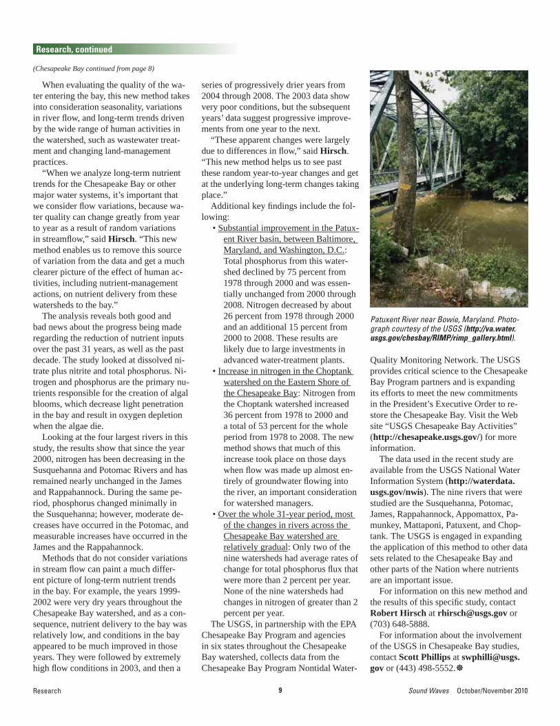
Reducing the delivery of nutrients to the Chesapeake Bay is one of the most impor-tant components of restoration efforts to achieve a healthy bay ecosystem. The U.S. Geological Survey (USGS) has developed a new method for tracking the progress toward reducing nitrogen and phosphorus delivery from the watershed to the bay.
“The public and public offi cials care deeply about progress toward clean water goals for the Chesapeake Bay and other impaired waters of the Nation,” said Rob-ert Hirsch, the USGS Research Hydrolo-gist who led the development of this new method. “We developed the new technique and applied it by using more than 13,000 measurements of nitrogen and phosphorus and 100,000 daily streamfl ow values for nine major rivers fl owing into the Chesa-peake Bay, in order to provide clearer answers about the changes taking place as part of these long-term restoration efforts.”
A description of the new technique and the results of its application to nine Chesapeake Bay tributaries were reported in the October issue of the Journal of the American Water Resources Association (v. 46, no. 5, p. 857-880, http://dx.doi.org/10.1111/j.1752-1688.2010.00482.x).
“The new USGS method will allow the Chesapeake Bay partners to better assess
A New Understanding of 31 Years of Chesapeake Bay Nutrient TrendsBy Robert Hirsch and Kara Capelli
progress toward reducing the delivery of nutrients and sediment to the bay,” said Rich Batiuk, Associate Director for Science, U.S. Environmental Protection Agency (EPA) Chesapeake Bay Program.
“This method, based on monitoring data, will improve accountability regarding the nutrient reductions needed to meet our res-toration goals for the bay.”
Chesapeake Bay watershed, outlined in white. Modifi ed from USGS poster “The Chesapeake Bay Watershed,” http://chesapeake.usgs.gov/poster.html.
Chesapeake Bay
Lake Erie
9 Sound Waves October/November 2010Research
Research, continued
(Chesapeake Bay continued from page 8)
When evaluating the quality of the wa-ter entering the bay, this new method takes into consideration seasonality, variations in river fl ow, and long-term trends driven by the wide range of human activities in the watershed, such as wastewater treat-ment and changing land-management practices.
“When we analyze long-term nutrient trends for the Chesapeake Bay or other major water systems, it’s important that we consider fl ow variations, because wa-ter quality can change greatly from year to year as a result of random variations in streamfl ow,” said Hirsch. “This new method enables us to remove this source of variation from the data and get a much clearer picture of the effect of human ac-tivities, including nutrient-management actions, on nutrient delivery from these watersheds to the bay.”
The analysis reveals both good and bad news about the progress being made regarding the reduction of nutrient inputs over the past 31 years, as well as the past decade. The study looked at dissolved ni-trate plus nitrite and total phosphorus. Ni-trogen and phosphorus are the primary nu-trients responsible for the creation of algal blooms, which decrease light penetration in the bay and result in oxygen depletion when the algae die.
Looking at the four largest rivers in this study, the results show that since the year 2000, nitrogen has been decreasing in the Susquehanna and Potomac Rivers and has remained nearly unchanged in the James and Rappahannock. During the same pe-riod, phosphorus changed minimally in the Susquehanna; however, moderate de-creases have occurred in the Potomac, and measurable increases have occurred in the James and the Rappahannock.
Methods that do not consider variations in stream fl ow can paint a much differ-ent picture of long-term nutrient trends in the bay. For example, the years 1999-2002 were very dry years throughout the Chesapeake Bay watershed, and as a con-sequence, nutrient delivery to the bay was relatively low, and conditions in the bay appeared to be much improved in those years. They were followed by extremely high fl ow conditions in 2003, and then a
series of progressively drier years from 2004 through 2008. The 2003 data show very poor conditions, but the subsequent years’ data suggest progressive improve-ments from one year to the next.
“These apparent changes were largely due to differences in fl ow,” said Hirsch. “This new method helps us to see past these random year-to-year changes and get at the underlying long-term changes taking place.”
Additional key fi ndings include the fol-lowing:
• Substantial improvement in the Patux-ent River basin, between Baltimore, Maryland, and Washington, D.C.: Total phosphorus from this water-shed declined by 75 percent from 1978 through 2000 and was essen-tially unchanged from 2000 through 2008. Nitrogen decreased by about 26 percent from 1978 through 2000 and an additional 15 percent from 2000 to 2008. These results are likely due to large investments in advanced water-treatment plants.
• Increase in nitrogen in the Choptank watershed on the Eastern Shore of the Chesapeake Bay: Nitrogen from the Choptank watershed increased 36 percent from 1978 to 2000 and a total of 53 percent for the whole period from 1978 to 2008. The new method shows that much of this increase took place on those days when fl ow was made up almost en-tirely of groundwater fl owing into the river, an important consideration for watershed managers.
• Over the whole 31-year period, most of the changes in rivers across the Chesapeake Bay watershed are relatively gradual: Only two of the nine watersheds had average rates of change for total phosphorus fl ux that were more than 2 percent per year. None of the nine watersheds had changes in nitrogen of greater than 2 percent per year.
The USGS, in partnership with the EPA Chesapeake Bay Program and agencies in six states throughout the Chesapeake Bay watershed, collects data from the Chesapeake Bay Program Nontidal Water-
Quality Monitoring Network. The USGS provides critical science to the Chesapeake Bay Program partners and is expanding its efforts to meet the new commitments in the President’s Executive Order to re-store the Chesapeake Bay. Visit the Web site “USGS Chesapeake Bay Activities” (http://chesapeake.usgs.gov/) for more information.
The data used in the recent study are available from the USGS National Water Information System (http://waterdata.usgs.gov/nwis). The nine rivers that were studied are the Susquehanna, Potomac, James, Rappahannock, Appomattox, Pa-munkey, Mattaponi, Patuxent, and Chop-tank. The USGS is engaged in expanding the application of this method to other data sets related to the Chesapeake Bay and other parts of the Nation where nutrients are an important issue.
For information on this new method and the results of this specifi c study, contact Robert Hirsch at [email protected] or (703) 648-5888.
For information about the involvement of the USGS in Chesapeake Bay studies, contact Scott Phillips at [email protected] or (443) 498-5552.
Patuxent River near Bowie, Maryland. Photo-graph courtesy of the USGS (http://va.water.usgs.gov/chesbay/RIMP/rimp_gallery.html).
10October/November 2010 Sound Waves Research
Research, continued
(Manatee Subspecies continued on page 11)
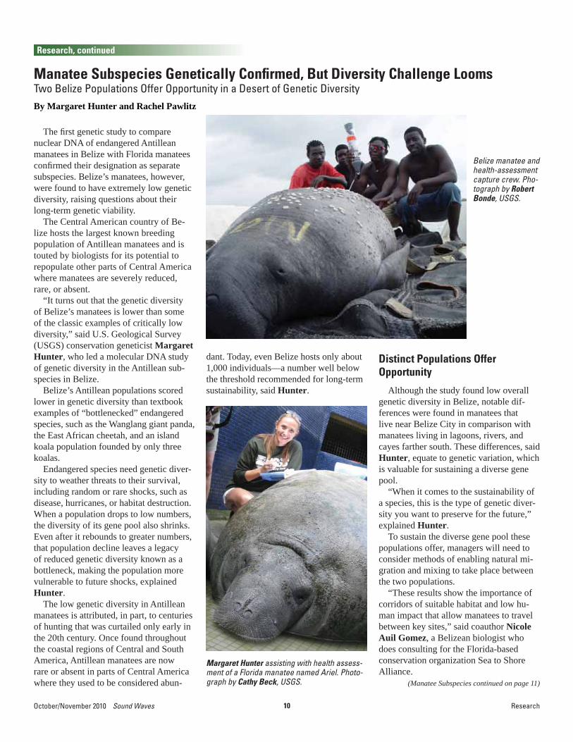
The fi rst genetic study to compare nuclear DNA of endangered Antillean manatees in Belize with Florida manatees confi rmed their designation as separate subspecies. Belize’s manatees, however, were found to have extremely low genetic diversity, raising questions about their long-term genetic viability.
The Central American country of Be-lize hosts the largest known breeding population of Antillean manatees and is touted by biologists for its potential to repopulate other parts of Central America where manatees are severely reduced, rare, or absent.
“It turns out that the genetic diversity of Belize’s manatees is lower than some of the classic examples of critically low diversity,” said U.S. Geological Survey (USGS) conservation geneticist Margaret Hunter, who led a molecular DNA study of genetic diversity in the Antillean sub-species in Belize.
Belize’s Antillean populations scored lower in genetic diversity than textbook examples of “bottlenecked” endangered species, such as the Wanglang giant panda, the East African cheetah, and an island koala population founded by only three koalas.
Endangered species need genetic diver-sity to weather threats to their survival, including random or rare shocks, such as disease, hurricanes, or habitat destruction. When a population drops to low numbers, the diversity of its gene pool also shrinks. Even after it rebounds to greater numbers, that population decline leaves a legacy of reduced genetic diversity known as a bottleneck, making the population more vulnerable to future shocks, explained Hunter.
The low genetic diversity in Antillean manatees is attributed, in part, to centuries of hunting that was curtailed only early in the 20th century. Once found throughout the coastal regions of Central and South America, Antillean manatees are now rare or absent in parts of Central America where they used to be considered abun-
Manatee Subspecies Genetically Confi rmed, But Diversity Challenge Looms Two Belize Populations Offer Opportunity in a Desert of Genetic DiversityBy Margaret Hunter and Rachel Pawlitz
dant. Today, even Belize hosts only about 1,000 individuals—a number well below the threshold recommended for long-term sustainability, said Hunter.
Distinct Populations Offer Opportunity
Although the study found low overall genetic diversity in Belize, notable dif-ferences were found in manatees that live near Belize City in comparison with manatees living in lagoons, rivers, and cayes farther south. These differences, said Hunter, equate to genetic variation, which is valuable for sustaining a diverse gene pool.
“When it comes to the sustainability of a species, this is the type of genetic diver-sity you want to preserve for the future,” explained Hunter.
To sustain the diverse gene pool these populations offer, managers will need to consider methods of enabling natural mi-gration and mixing to take place between the two populations.
“These results show the importance of corridors of suitable habitat and low hu-man impact that allow manatees to travel between key sites,” said coauthor Nicole Auil Gomez, a Belizean biologist who does consulting for the Florida-based conservation organization Sea to Shore Alliance.
Belize manatee and health-assessment capture crew. Pho-tograph by Robert Bonde, USGS.
Margaret Hunter assisting with health assess-ment of a Florida manatee named Ariel. Photo-graph by Cathy Beck, USGS.

11 Sound Waves October/November 2010Research, Outreach
Research, continued
(Manatee Subspecies continued from page 10)
(By and For Teachers continued on page 12)
“Leaving pockets of habitat is no longer enough,” she added.
Confi rmation of the SubspeciesThe genetic evidence that Florida mana-
tees (Trichechus manatus latirostris) are not regularly mixing with populations of Antillean manatees (Trichechus manatus manatus) in Belize means they don’t natu-rally affect each other’s population size or genetic diversity, Hunter said.
The question of whether these two seemingly distant populations were in-terbreeding had been raised in light of radiotracking evidence that manatees are capable of migrating long distances. Florida manatees have turned up in places as far away as Rhode Island, the Bahamas, and Cuba.
The only prior genetic data comparing the subspecies came from mitochondrial DNA, which is useful for understanding historical relationships on an evolutionary time scale (think millennia, not decades). By including nuclear DNA, this study provided a modern-day assessment of
Tuque, a rehabilitated Antillean manatee in Puerto Rico, trailing a radiotracking device (upper right) connected to a belt around his tail. Photograph by Antonio Mignucci-Giannoni, Inter American University of Puerto Rico; used with permission.
whether the two populations are migrating and interbreeding.
“We are continuing to piece together the genetic relationships of manatees through-out the Caribbean, and it’s giving us in-sights into how to maintain healthy and stable populations,” said USGS biologist and co-author Bob Bonde.
The study, “Low Genetic Variation and Evidence of Limited Dispersal in the Re-
gionally Important Belize Manatee,” was recently published in the journal Animal Conservation (published online July 23, 2010, http://dx.doi.org/10.1111/j.1469-1795.2010.00383.x).
For more information about USGS research on manatee genetics, visit the USGS Sirenia Project Web site at http://fl .biology.usgs.gov/Manatees/manatees.html.
During summer 2010, a graduate-level Physical and Earth Science Education class at the University of South Florida-St. Petersburg (USFSP) set out to produce several indepth science multimedia pre-sentations that could be shared with other class members and the teaching commu-nity at large. The project came out of a partnership between the U.S. Geological Survey (USGS) Science Communications Team at the St. Petersburg Coastal and Marine Science Center (St. Petersburg, Florida) and USFSP Science Education Professor Malcolm Butler. The partners sought to empower the education students to develop skills by using multimedia as they prepare science-topic resources for educators. The students of the class are local teachers working to boost their expertise in teaching math and science
Outreach
By and For Teachers: Earth-Science Multimedia Educational ProductsBy Matthew Cimitile
Use of imagery and multimedia appli-cations can enrich a teacher’s ability to illustrate com-plex and intangible scientifi c con-cepts, such as the size and makeup of the solar system. (Image of huge solar prominence taken September 14, 1999, by NASA’s SOHO Extreme ultraviolet Imaging Telescope [EIT], http://sohowww.nascom.nasa.gov/gallery/images/superprom.html.)

12October/November 2010 Sound Waves
Outreach, continued
Outreach
(By and For Teachers continued from page 11)
at the elementary-school level. The result was a collection of well-crafted, unique multimedia science-education products that teachers share with each other and use when teaching their own students.
“Presented to the teachers was the idea of a typical elementary-school scenario, in which one teacher catches a colleague in the hallway seeking advice on how to approach a particular sci-ence topic,” said Butler. “The colleague has only a few minutes to share some key ideas with the teacher. What should he or she say and share? These multimedia presentations are the outcomes of the teachers’ response to this scenario.”
Topics for these multimedia products ranged from astronomy (Sun as a Star) to marine sci-ence (Red Tide) and are tied to current events (Gulf Oil Spill). Teachers acquired new knowl-edge about a range of scientifi c concepts, located key resources to use when teaching students,
The presentations involved a combina-tion of showing the relevance of science in everyday life, illustrating hands-on approaches to teaching Earth science, and explaining more diffi cult, intangible scientifi c concepts, such as the solar sys-tem, through the use of multimedia. The success of the partnership venture was evident in watching teachers share their enthusiasm as they created their science presentations and as they collaborated in devising creative ways to communicate these concepts with their students.
“The teachers were very much engaged in the process of this project. Their inter-est was raised even further when the class attended a public forum on the recent oil spill in the Gulf of Mexico,” said Butler. “The teachers were amazed and quite moved by the public’s concern and par-ticipation in discussions regarding their community. They were even more moti-vated after attending this event, and their projects substantiated their commitment
to ensuring that other teachers are well informed.”
The introduction of multimedia into the classroom is a great way to boost scientifi c literacy and trains educators in gathering information through good, reliable sources from scientifi c institutions and organiza-tions. In general, these products are valu-able to teachers by:
• Being an information source,• Serving as a “how to” guide for teach-
ers,• Providing hands-on examples of
teaching complex scientifi c con-cepts,
• Covering current events to bring sci-entifi c fi ndings into everyday life,
• Expanding and enriching the educa-tor’s toolkit.
We hope to share these products to further extend the reach of science educa-tional resources for all teachers. Currently, these resources are posted online at http://cdnportfolio.net/usgs/.
This map, used in a teacher’s presentation on the Gulf oil spill, embodies information from the Naval Oceano-graphic Offi ce to show the location of the Loop Current (in orange) and its fl ow from the Gulf of Mexico through the Straits of Florida and into the Atlantic Ocean. Teachers learned where to locate credible resourc-es such as this to use in their classrooms.
and developed skills in multimedia ap-plications. These included shooting and editing video, PowerPoint animation, and use of graphics.
“Graphics and media are powerful edu-cational tools. At the USGS, we constantly hear that teachers want more high-quality, reliably researched, multimedia educa-tional products that put science and math topics into an exciting context. During this class, this is exactly what the teachers researched and created for themselves,” said Ann Tihansky, Information Special-ist with the USGS. “Lots of new relevant science isn’t in textbooks yet, but there are many good sources on the Web and many exciting ways to link science to society and current events. The partnership with USFSP is a great way to reach teachers and help them locate reliable scientifi c sources and develop multimedia resources. Connecting with teachers also helps the USGS share new scientifi c fi ndings with a wider audience.”

13 Sound Waves October/November 2010Outreach
Outreach, continued
USGS Woods Hole Center Contributes to Unique Summer Intern ProgramBy Ben Gutierrez
The Woods Hole Partnership Education Program (PEP) completed its second year on August 13 with a research presentation by each student and a concluding celebra-tion. This program is a multi-institution col-laboration that brings 16 summer interns to Woods Hole, Massachusetts, for a 4-week course and a 6-week independent-research internship. The program’s goal is to in-crease diversity within the Earth and ocean science workforce, which lags behind other disciplines. Open to students from all back-grounds, the program attracts college and university students from around the coun-try. PEP is supported by the six institutions that make up the Woods Hole Diversity Ini-tiative: the U.S. Geological Survey (USGS) Woods Hole Science Center, the Woods Hole Oceanographic Institution (WHOI), Sea Education Association (SEA), the Ma-rine Biological Laboratory, the National Oceanic and Atmospheric Administration (NOAA) National Marine Fisheries Ser-vice, and the Woods Hole Research Center. The program is also run in partnership with the University of Maryland Eastern Shore, which provides academic credit for PEP students. Members of the Woods Hole Di-versity Advisory committee designed the program over the past few years and are able to implement it with the help of volun-teers from each institution.
PEP begins with a course in Global Climate Change that is accredited through the University of Maryland Eastern Shore. The course consists of fi ve modules, each providing 3-day intensive studies of spe-cifi c topics in global climate change orga-nized according to the four oceanographic disciplines (physical, chemical, geological, and biological oceanography) and marine-ecosystem management. In addition, course instructors introduce students to common research methods, such as basic statistics and time-series methods. This year, the course was taught by a team of eight instructors, including John Bratton of the USGS Woods Hole Science Center. Other members of the USGS center also contributed: Matt Arsenault participated as an invited speaker. Ben Gutierrez
served as the course director and imple-mented public-speaking workshops and panel discussions for students. Claudia Flores led students in thought exercises, encouraging them to refl ect upon what they had learned over the summer and how this compares with what is reported in the media. Neil Ganju and Bill Waite served as panelists for discussions regard-ing careers in science and approaching graduate school. Kathy Scanlon advised one of the PEP students, Lane Boyer (University of Arkansas), during his re-search internship after the Global Climate Change course. Boyer’s research focused on assembling data for defi ning regions where cold-water corals could thrive in Glacier Bay, Alaska. Together with Ken Foote (WHOI), Marinna Martini (USGS) advised PEP students Chris Cep-ero (Bridgewater State University) and
PEP students after the closing ceremony and completion of their fi nal presentations, which were held in the USGS Woods Hole Science Center conference room. Left to right: Emily Motz (State University of New York [SUNY] Maritime College), Chris Cepero (Bridgewater State University), Melika Uter (University of Massachusetts [UMass] Boston), Anna-Mai Christmas (University of the Virgin Islands), Alex DeLeon (Morehouse College), Rachel Rochon (University of New Haven), Victoria Morgan (Cornell University), Brian Redding (Virginia Commonwealth University), Zachary Williams (South Carolina State University), Dolores Toledo (University of California, Berkeley), Lucy Flores (Nova Southeastern University), Diara Townes (Hampton University), Delawrence Sykes (Morehouse College), Laney Boyer (University of Arkansas), Angela Anorve (University of California, San Diego), and Nam Siu (University of Tampa). Photograph by Chris Polloni.
Dolores Toledo (University of California, Berkeley). Cepero and Toledo worked toward developing an effective calibration for the AQUAscat acoustic sensor.
For the PEP to succeed in diversifying the Earth and ocean sciences, PEP students must remain engaged in these sciences. Several students from PEP’s inaugural summer (2009) have done just that, return-ing to Woods Hole to take part in other student programs or to pursue other sum-mer research opportunities. PEP’s early success and a dramatic increase in the number of applicants are due largely to the dedicated effort of its many volunteers, particularly Ambrose Jearld, George Liles, and this year’s PEP coordinator, Joniqua Howard (all from NOAA Fisher-ies). The Woods Hole Diversity Advisory Committee remains committed to sustain-ing this productive program.

14October/November 2010 Sound Waves
Meetings
Meetings
If someone asked you to name a country with a lot of corals, you’d expect tropi-cal answers like “Australia” or “Belize” because of their well-known barrier reefs. Norway, crossed by the frigid Arctic Circle, would probably not even make the top 10 guesses. In fact, Norwegian waters are home to large numbers and varieties of cold-water corals. These corals, including both stony corals and seafan-like soft cor-als, do not host photosynthetic algae and so can survive in dark, deep waters. For that reason, they are also known as deep-sea corals. However, they may be found as shallow as 40 m in Norwegian fjords and as deep as thousands of meters on seamounts and on the continental shelf. As in the Gulf of Mexico, the areas of hard bottom where these corals are found are commonly areas of interest for oil and gas exploration and drilling.
The fi rst Norwegian-hosted workshop on cold-water corals was sponsored by the Norwegian Oil and Gas Association (OLF) and hosted by the International Research Institute of Stavanger (IRIS) on May 31-June 1, 2010. This workshop was designed to bring together researchers, government and nongovernmental organizations, and representatives from the oil and gas in-dustry who are actively involved in cold-water-coral research and management. (See workshop Web site at http://www.iris.no/coralworkshop2010.) Christina Kellogg of the U.S. Geological Survey
IRIS is in Mekjarvik, Norway, 13 km north of Stavanger. The view from the institute in-cludes a fjord and an oil rig in port for repairs. Photograph by Christina Kellogg, USGS.
International Workshop on Cold-Water Corals Held in NorwayBy Christina Kellogg
Cold-water-coral habitat featur-ing the stony coral, Lophelia per-tusa. This image is from the USGS DISCOVRE project in the Gulf of Mexico, but the same coral is even more common in Norwegian wa-ters. Photograph courtesy of USGS DISCOVRE (http://fl .biology.usgs.gov/DISCOVRE/).
(USGS) St. Petersburg Coastal and Marine Science Center in St. Petersburg, Florida, was the only invited speaker and attendee from the United States. Kellogg was in-vited to speak specifi cally because of her knowledge of coral-associated microbial communities and how they can be used as diagnostics of coral stress (see related article, “Coral Paparazzi,” this issue).
The workshop was organized and hosted by the International Research Institute of Stavanger (IRIS; http://www.iris.no/), some of whose researchers are studying the possible impacts of oil and gas activi-ties on deep-sea corals.
Christina Kellogg (center, coral shirt) participates in a lively discussion after one of the presentations at the cold-water-coral workshop. Photograph courtesy of IRIS.
Other scientifi c experts attended from Australia, Brazil, Canada, Germany, the Netherlands, Norway, Sweden, and the United Kingdom, with the goal of sharing results and expertise from national and international research projects. The work-shop focused on establishing the current state of knowledge about the sensitivity of cold-water corals to oil and gas activi-ties and on promoting discussions about management measures needed to protect cold-water-coral habitats.

15 Sound Waves October/November 2010
Meetings, continued
Awards
(NPS Awards continued on page 16)
Meetings, Awards
From June 6 to 11, 2010, 86 research-ers from academia, industry, and federal institutions worldwide met for the in-augural Gordon Research Conference on Natural Gas Hydrates, held at Colby College in Waterville, Maine. Gordon Research Conferences (http://www.grc.org/) is an 80-year-old nonprofi t organiza-tion that manages and supports nearly 200 intense, retreat-like scientifi c meetings each year. The inaugural Gordon Research Conference on Natural Gas Hydrates was initiated through a competitive proposal process led by conference chair Carolyn Ruppel of the U.S. Geological Survey (USGS) and vice-chair Peter Flemings of the University of Texas at Austin. For this fi rst biannual meeting, the Natural Gas Hydrates conference focused on the physical, chemical, and biological interac-tions among gas hydrate, sediment grains, free gas, pore fl uids, and microbes at vari-ous spatial scales. The Gordon Research Conference format schedules fi ve talks and one 2-hour poster session between 9 a.m. and 9:30 p.m., with the remaining time available for informal discussions in unstructured settings. The meeting was hailed by many attendees for conveying
USGS Gas Hydrates Scientists Lead and Participate in the Inaugural Gordon Research Conference on Natural Gas Hydrates By William Waite
state-of-the-art science while fostering a spirit of collegiality that led to many new research collaborations.
Seven current USGS gas hydrates scientists, two former USGS postdoc-toral researchers, and an incoming USGS Mendenhall postdoctoral researcher were vital participants in the conference. Ad-ditional attendees included postdoctoral researchers and senior professors from the United States, Japan, the United Kingdom, and Europe. An estimated 40 percent of the attendees were graduate students or recent Ph.D. recipients. A generous grant from the National Science Foundation’s Division of Ocean Sciences and contribu-tions from private-sector fi rms made it possible for many participants to receive substantial support for registration fees. If approved by the Gordon Research Confer-ences Board of Trustees, the 2012 meeting will focus on the theme “Energy and Cli-mate,” with Peter Flemings as chair and Michael Whiticar (University of Victoria) as vice-chair.
For additional information about the recent conference, visit http://www.grc.org/programs.aspx?year=2010&program=naturalgas.
William Winters (left; USGS) and Ann Cook (Lamont-Doherty Earth Observatory) discuss re-cent results at the Natural Gas Hydrates Gordon Research Conference held on the Colby College campus in Waterville, Maine. Photograph by Peter Flemings (University of Texas at Austin).
On September 8, 2010, U.S. Geologi-cal Survey (USGS) Scientist Emeritus S. Jeffress Williams was one of fi ve recipi-ents of the National Park Service (NPS) Director’s Awards for “Service in Natural Resources Stewardship and Science,” awarded by NPS Director Jon Jarvis at an awards ceremony during an all-hands meeting in Denver, Colorado. Williams’ award, which was one of two for scientifi c research, consisted of a framed certifi cate and a handsome limited-edition bronze bi-son sculpture by artist Chris Schiller.
“These men and women have dedi-cated themselves to the restoration and
USGS Scientist Emeritus Jeff Williams Receives NPS Director’s Career Achievement Award
maintenance of this Nation’s natural heritage,” said NPS Director Jarvis, “and while the awards recognize individual achievement, it is the teamwork, profes-sionalism, and shared sense of purpose with their colleagues that matter most to the recipients.”
In a statement released by NPS, Wil-liams was recognized for his career as a “Research Geologist, U.S. Geological Sur-vey (USGS), Woods Hole Science Center, MA, and Program Coordinator of USGS Coastal and Marine Geology Program: Williams has focused his research career
National Park Service Director Jon Jarvis (left) presents a Director’s Award for Service in Natural Resources Stewardship and Science to USGS Scientist Emeritus S. Jeffress Williams.

16October/November 2010 Sound Waves
Awards, continued
(NPS Awards continued from page 15)
(Recently Published continued on page 17)
Awards, Publications
on the geologic history and processes of coastal, estuarine, wetland, and inner con-tinental shelf regions and has developed a vulnerability index for U.S. coasts. He has assessed the vulnerability of coastal na-tional parks to sea-level rise. His work has led to a better understanding of potential future impacts of sea-level rise on coastal systems and has provided GIS [geographic information system] maps and information
needed to better manage coastal regions for the future.”
In addition to his work on assessing the potential effects of sea-level rise on NPS national seashores, Williams’ research along the Long Island coast and offshore shelf region has provided important in-formation on coastal processes to aid in managing barrier islands and wetlands. More recently, he served as an expert wit-
ness giving testimony on coastal geology and nearshore sediment processes for the U.S. Justice Department, which was defending the NPS in a legal action. The suit against NPS, if successful, could have had a major impact on the management of federally operated beaches and could have limited public access to them. Ultimately, the judge ruled in favor of the Department of Justice.
Alan Cooper, a scientist emeritus with the Coastal and Marine Geology Program of the U.S. Geological Survey (USGS), was awarded the Scientifi c Committee on Antarctic Research (SCAR) Medal for In-ternational Scientifi c Coordination, 2010. Cooper was recognized for his work over the past 25 years in initiating and oversee-ing the Antarctic Seismic Data Library System (SDLS) for Cooperative Research, and in helping with the coordination, compilation, and analysis of seismic data collected along the margins of Antarctica. The SDLS is the only geoscience agency directly linked to the Antarctic Treaty, via ATCM Recommendation XVI-12. Cooper
SCAR Medal for International Scientifi c Coordination Awarded to USGS Emeritus Scientist Alan Cooper
Alan Cooper, winner of the Scientifi c Committee on Antarctic Research (SCAR) Medal for Interna-tional Scientifi c Coordination, gives acceptance remarks at the SCAR Open Science Conference.
was further recognized for his work in editing and publishing the proceedings of SCAR’s 10th International Symposium on Antarctic Earth Sciences in 2007, with more than 100 peer-reviewed reports and 200 extended abstracts, all published on-line in advance of the conference and in book format less than a year later (http://pubs.usgs.gov/of/2007/1047/ and http://www.nap.edu/catalog.php?record_id=12168). Cooper received the award in Buenos Aires, Argentina, at the SCAR Open Science Conference in August 2010 (http://www.scar.org/awards/).
Congratulations, Alan!
Publications
Akin, S.K., and Grossman, E.E., 2010, Coast Salish and U.S. Geological Survey 2009 Tribal Journey water quality project: U.S. Geological Survey Open-File Report 2010-1143, 60 p. [http://pubs.usgs.gov/of/2010/1143/].
Andrews, B.D., Brothers, L.L., and Barnhardt, W.A., 2010, Automated feature extraction and spatial organization of seafl oor pockmarks, Belfast Bay, Maine, USA: Geomorphology, v. 124, no. 1-2, p. 55-64, doi:10.1016/j.geomorph.2010.08.009 [http://dx.doi.org/10.1016/j.geomorph.2010.08.009].
Bratton, J.F., 2010, The three scales of submarine groundwater fl ow and
Recently Published Articlesdischarge across passive continental margins: Journal of Geology, v. 118, no. 5, p. 565-575, doi:10.1086/655114 [http://dx.doi.org/10.1086/655114].
Chin, J.L., Woodrow, D.L., McGann, Mary, Wong, F.L., Fregoso, Theresa, and Jaffe, B.E., 2010, Estuarine sedimentation, sediment character, and foraminiferal distribution in central San Francisco Bay, Calif.: U.S. Geological Survey Open-File Report 2010-1130, 58 p. [http://pubs.usgs.gov/of/2010/1130/].
Doyle, T.W., Day, R.H., and Michot, T.C., 2010, Development of sea level rise scenarios for climate change assessments of the Mekong Delta, Vietnam: U.S. Geological Survey Open-File Report
2010–1165, 110 p. [http://pubs.usgs.gov/of/2010/1165/].
Draut, A.E., Sondossi, H.A., Dealy, T.P., Hazel, J.E., Jr., Fairley, H.C., and Brown, C.R., 2010, 2009 weather and aeolian sand-transport data from the Colorado River corridor, Grand Canyon, Arizona: U.S. Geological Survey Open-File Report 2010-1166, 98 p. [http://pubs.usgs.gov/of/2010/1166/].
Garrison, V., Lamothe, P., Morman, S., and Plumlee, G., 2010, Trace-metal concentrations in African dust; effects of long-distance transport and implications for Human Health: World Congress of Soil Science, 19th, Division Symposium

17 Sound Waves October/November 2010
(Recently Published continued from page 16)
Publications Submitted for Bureau Approval
Publications, continued
Publications
4.2, Soils and human health, Brisbane, Australia, August 1-6, 2010, Proceedings, p. 33-36 [http://www.iuss.org/19th%20WCSS/symposium/D4.2.html].
Haley, B., Ireland, D., and Childs, J.R., 2010, Environmental assessment for a marine geophysical survey of parts of the Arctic Ocean, August-September 2010: U.S. Geological Survey Open-File Report 2010-1117, version 2.0, 251 p. [http://pubs.usgs.gov/of/2010/1117/].
Hirsch, R.M., Moyer, D.L., and Archfi eld, S.A., 2010, Weighted regressions on time, discharge, and season (WRTDS), with an application to Chesapeake Bay river inputs: Journal of the American Water Resources Association, v. 46, no. 5, p. 857-880, doi:10.1111/j.1752-1688.2010.00482.x [http://dx.doi.org/10.1111/j.1752-1688.2010.00482.x].
Hunter, M.E., Auil-Gomez, N.E., Tucker, K.P., Bonde, R.K., Powell, J., and McGuire, P.M., 2010, Low genetic variation and evidence of limited dispersal in the regionally important Belize manatee: Animal Conservation, doi:10.1111/j.1469-1795.2010.00383.x [http://dx.doi.org/10.1111/j.1469-1795.2010.00383.x].
McKee, K.L., 2010, Coastal Louisiana; impacts of hurricanes on salt marsh and mangrove wetlands: U.S. Geological Survey video [http://gallery.usgs.gov/videos/258].
McKee, K.L., 2010, Effects of sea-level rise on coastal wetlands in the Mississippi River Delta: U.S. Geological Survey video [http://gallery.usgs.gov/videos/257].
Peters, Robert, and Jaffe, B.E., 2010, Database of recent tsunami deposits: U.S. Geological Survey Open-File Report 2010-1172, 12 p. [http://pubs.usgs.gov/of/2010/1172/].
Raabe, E.A., and Bialkowska-Jelinska, E., 2010, Thermal imaging of the Waccasassa Bay Preserve; image acquisition and processing: U.S. Geological Survey Open-
File Report 2010-1120, 61 p. [http://pubs.usgs.gov/of/2010/1120/].
Raabe, E., Bialkowska-Jelinska, E., Ebersol, K., and Stonehouse, D., 2010, Thermal infrared imagery reveals groundwater seeps and highlights the potential inland movement of seawater in Levy County, Florida [abs.]: American Institute of Professional Geologists (AIPG) Annual Meeting, 47th, Lake Buena Vista, Fla., September 11-15, 2010, p. 32-33.
Raabe, E., and Robbins, L., 2010, Response of Florida shelf ecosystems to climate change; from macro to micro scales: U.S. Geological Survey Fact Sheet 2010-3065, 2 p. [http://pubs.usgs.gov/fs/2010/3065/].
Raabe, E., Robbins, L., Yates, K., and Kuffner, I., Ocean acidifi cation: U.S. Geological Survey Web site, http://coastal.er.usgs.gov/ocean-acidifi cation/.
Robbins, L.L., Knorr, P.O., Liu, X., Byrne, R., and Raabe, E.A., 2010, USGS Field activity 08FSH01 on the West Florida shelf, Gulf of Mexico, in August 2008: U.S. Geological Survey Data Series 535, part A [http://pubs.usgs.gov/ds/535/a/].
Sliter, R.W., Ryan, H.F., and Triezenberg, P.J., 2010, High-resolution seismic-refl ection data offshore of Dana Point, southern California borderland: U.S. Geological Survey Open-File Report 2010-1111 [http://pubs.usgs.gov/of/2010/1111/].
Sliter, R.W., Triezenberg, P.J., Hart, P.E., Watt, J.T., Johnson, S.Y., and Scheirer, D.S., 2009, revised 2010, High-resolution seismic refl ection and marine magnetic data along the Hosgri Fault Zone, central California: U.S. Geological Survey Open-File Report 2009-1100, version 1.1 [http://pubs.usgs.gov/of/2009/1100/].
Takesue, R.K., 2010, Terrigenous sediment provenance from geochemical tracers, south Molokai reef fl at, Hawaii: U.S. Geological Survey Open-File Report 2010-1155, 17 p. [http://pubs.usgs.gov/of/2010/1155/].
Thatcher, C.A., Twilley, R., and Bridevaux, J., 2010, Forecast Mekong; navigating changing waters: U.S. Geological Survey video [http://gallery.usgs.gov/videos/267].
Thompson, E.M., Kayen, R.E., Carkin, Brad, and Tanaka, Hajime, 2010, Surface-wave site characterization at 52 strong-motion recording stations affected by the Parkfi eld, California, M6.0 earthquake of 28 September 2004: U.S. Geological Survey Open-File Report 2010-1168, 117 p. [http://pubs.usgs.gov/of/2010/1168/].
Trusel, L.D., Cochrane, G.R., Etherington, L.L., Powell, R.D., and Mayer, L.A., 2010, Marine benthic habitat mapping of Muir Inlet, Glacier Bay National Park and Preserve, Alaska, with an evaluation of the Coastal and Marine Ecological Classifi cation Standard III: U.S. Geological Survey Scientifi c Investigations Map 3122, 26 p., 4 sheets, various scales [http://pubs.usgs.gov/sim/3122/].
Valentine, P.C., Gallea, L.B., Blackwood, D.S., and Twomey, E.R., 2010, Seabed photographs, sediment texture analyses, and sun-illuminated sea fl oor topography in the Stellwagen Bank National Marine Sanctuary region off Boston, Massachusetts: U.S. Geological Survey Data Series 469 [http://pubs.usgs.gov/ds/469/].
Warner, J.C., Armstrong, B., He, R., and Zambon, J.B., 2010, Development of a Coupled Ocean-Atmosphere-Wave-Sediment Transport (COAWST) modeling system: Ocean Modelling, v. 35, no. 3, p. 230-244, doi:10.1016/j.ocemod.2010.07.010 [http://dx.doi.org/10.1016/j.ocemod.2010.07.010].
Watt, S.G., Jaffe, B.E., Morton, R.A., Richmond, B.M., and Gelfenbaum, G., 2010, Description of extreme-wave deposits on the northern coast of Bonaire, Netherlands Antilles: U.S. Geological Survey Open-File Report 2010-1180, 65 p. [http://pubs.usgs.gov/of/2010/1180/].
Anderson, T., Rosenberger, K., and Gartner, A.L., Reformatted data sets used by the Cooperative LACSD/USGS Palos Verdes Flow Study, 2000 to 2008: U.S. Geological Survey Data Series.
Apotsos, A., Jaffe, B., Gelfenbaum, G., Buck-ley, M., and Watt, S., The role of sediment supply in the formation of tsunami depos-its; a comparison of the 2004 and 2009 tsunamis [abs.]: American Geophysical
Union Fall Meeting, San Francisco, Calif., December 13-17, 2010.
Barnard, P.L., Hansen, J.E., and Hoover, D., The impact of the 2009-10 El Niño on West
(Publications Submitted continued on page 18)

18October/November 2010 Sound Waves
Coast beaches [abs.]: American Geophysical Union Fall Meeting, San Francisco, Calif., December 13-17, 2010.
Brothers, D., Kilb, D., Luttrell, K., Driscoll, N., and Kent, G., Potential triggers for large ruptures along the southern San Andreas Fault: Nature.
Buckley, M., Wei, Y., Jaffe, B.E., and Watt, S., Estimated velocities and inferred cause of overwash that emplaced inland fi elds of cobbles and boulders at Anegada, British Virgin Islands [abs.]: American Geophysical Union Fall Meeting, San Francisco, Calif., December 13-17, 2010.
Conrad, J.E., Paull, C.K., McGann, M., Ryan, H.F., Caress, D.W., Ussler, W., and Lundsten, Eve, Determination of slip rates for offshore faults; an example from the Palos Verdes fault zone, Southern California [abs.]: Ameri-can Geophysical Union Fall Meeting, San Francisco, Calif., December 13-17, 2010.
Côté, J.M., Hotchkiss, F.S., Martini, M., Den-ham, C.R., Ramsey, A.L., and Ruane, S., Acoustic Doppler Current Profi ler (ADCP) data processing system manual: U.S. Geo-logical Survey Open-File Report 00-458, version 4.
Cucciniello, C., Conrad, J.E., Grifa C., Mel-luso, L., Mercurio, M., Morra, V., Tucker, R.D., and Vincent, M., Petrology and geochemistry of Cretaceous mafi c and silicic dykes and spatially associated lavas in central-eastern coastal Madagascar: In-ternational Dyke Conference, 6th, Varanasi, India, February 4-7, 2010, Proceedings.
DeLong, K.L., Poore, R.Z., Flannery, J.A., Maupin, C.R., and Quinn, T.M., Do massive coral genera from the same reef record the same SST signal? A test from the Dry Tor-tugas, Florida Keys: Geophysical Research Letters.
Draut, A.E., Effects of river regulation on aeolian landscapes, Grand Canyon National Park, USA [abs.]: American Geophysical Union Fall Meeting, San Francisco, Calif., December 13-17, 2010.
Draut, A.E., and Gillette, E.R., Vegetation and substrate on aeolian landscapes in the Colo-rado River corridor, Cataract Canyon, Utah: U.S. Geological Survey Open-File Report.
Dreher, C.A., Flocks, J.G., Kulp, M.A., and Ferina, N.F., Archive of sediment data col-lected from offshore Chandeleur Islands and Breton Island in 2007 and 1987 (vibracore
surveys 07SCC04 and 87039): U.S. Geo-logical Survey Data Series (DVD).
Erikson, L.H., Richmond, B.M., Gibbs, A.E., and Jones, B., Evaluation of conditions leading to inundation of the airstrip in the remote village of Kaktovik, North Slope, Alaska [abs.]: American Geophysical Union Fall Meeting, San Francisco, Calif., Decem-ber 13-17, 2010.
Erikson, L.H., Storlazzi, C.S., and Jensen, R.E., Changes in wave climate and resulting increase in coastal hazards of the east-ern Chukchi Sea, Arctic, Alaska [abs.]: Solutions to Coastal Disasters Conference, Anchorage, AK, June 25-29, 2011.
Figurski, J.D., Malone, D., Lacy, J.R., and Denny, M., An inexpensive instrument for measuring wave exposure and water velocity: Limnology and Oceanography—Methods.
Ganguli, P.M., Conaway, C.H., Swarzenski, P.W., Kehrlein, N., and Flegal, A.R., Mer-cury speciation in coastal California barrier beach lagoons [abs.]: American Geophysical Union Fall Meeting, San Francisco, Calif., December 13-17, 2010.
Garcia, S., Rosenbauer, R.J., Palandri, J., and Maroto-Valer, M.M., Experimental and simulation studies of iron oxides for geo-chemical fi xation of CO2-SO2 gas mixtures [extended abs.]: International Conference on Greenhouse Gas Technologies, 10th, Amsterdam, The Netherlands, September 19-23, 2010.
Garcia, S., Rosenbauer, R.J., Palandri, J., and Maroto-Valera, M.M., Experimental and simulation studies of iron oxides for geo-chemical fi xation of CO2-SO2 gas mixtures: International Conference on Greenhouse Gas Technologies, 10th, Amsterdam, The Netherlands, September 19-23, 2010, Pro-ceedings.
Geist, E.L., and Parsons, T., Is the rate of global tsunami occurrence increasing? [abs.]: American Geophysical Union Fall Meeting, San Francisco, Calif., December 13-17, 2010.
Gelfenbaum, G., Stevens, A., Ruggiero, P., and Kaminsky, G., Southwest Washington littoral drift restoration; beach and nearshore morphological monitoring [abs.]: American Geophysical Union Fall Meeting, San Fran-cisco, Calif., December 13-17, 2010.
Gibbs, A.E., Erikson, L.H., Jones, B., and Richmond, B.M., Characterizing morpholo-
gy and erosional trends of permafrost bluffs, Barter Island, Alaska [abs.]: Solutions to Coastal Disasters Conference, Anchorage, AK, June 25-29, 2011.
Gibbs, A.E., Erikson, L.H., Richmond, B.M., and Harden, E.L., Regional shoreline change and coastal hazards in Arctic Alaska Native villages [abs.]: Solutions to Coastal Disasters Conference, Anchorage, AK, June 25-29, 2011.
Gray, M., and Kellogg, C., Comparison of three microbial community DNA preserva-tion models for the (almost) equipment-less microbiologist [abs.]: American Society for Microbiology, Florida Branch Annual Meet-ing, Islamorada, Fla., October 9-10, 2010.
Hansen, J.E., and Barnard, P.L., Sub-weekly to interannual variability of a high-energy shoreline [abs.]: American Geophysical Union Fall Meeting, San Francisco, Calif., December 13-17, 2010.
Hart, P.E., Lorenson, T.D., and Edwards, B.D., Beaufort Sea deep-water gas hydrate; piston core recovery from a seafl oor mound in a re-gion of widespread BSR occurrence [abs.]: International Conference on Gas Hydrates, 7th, Edinburgh, Scotland, July 17-21, 2011.
Hutchinson, D.R., and Barth, G.A., Continental margins and the Extended Continental Shelf Project: MARGINS/GeoPRISMS Newslet-ter [http://www.nsf-margins.org/Publica-tions/Newsletters/Newsletter.html].
Jaffe, B., Buckley, M., Richmond, B., Strotz, L., Etienne, S., Clark, K., and Gelfenbaum, G., Inverse modeling of normally-graded sandy tsunami deposits to estimate fl ow speed during the 29 September 2009 tsunami near Satitoa, east Upolu, Samoa [abs.]: American Geophysical Union Fall Meeting, San Francisco, Calif., December 13-17, 2010.
Lorenson, T.D., and Collett, T.S., Geochemi-cal evidence for gas hydrate occurrences in northern Alaska [abs.]: American Asso-ciation of Petroleum Geologists (AAPG) Annual Convention, Houston, Texas, April 10-13, 2011.
Lorenson, T.D., Hostettler, F.D., Rosenbauer, R.J., Peters, K.E., Wong, F.L., Kvenvolden, K.A., and Helix, M.E., Natural offshore oil seepage and related tarball accumulation on the California coastline, [abs.]: Geological Society of America (GSA) Annual Meet-
Publications, continued
(Publications Submitted continued from page 17)
(Publications Submitted continued on page 19)
Publications

19 Sound Waves October/November 2010
ing, Denver, Colo., October 31-November 3, 2010.
Maher, K., Bird, D.K., Brown, G.E., Jr., Garcia Del Real, P., Johnson, N., Kharaka, Y.K., and Rosenbauer, R.J., Discrepancies between laboratory and fi eld-based mineral-fl uid reaction rates; implications for CO2 seques-tration based on reactive transport studies of natural systems, [abs.]: Geological Society of America (GSA) Annual Meeting, Denver, Colo., October 31-November 3, 2010.
McGann, M., Microfaunal, temperature, productivity, and ventilation changes on the Farallon Escarpment of central California during the last 16,000 years [abs.]: Geologi-cal Society of America (GSA) Annual Meet-ing, Denver, Colo., October 31-November 3, 2010.
Muslic, A., Flannery, J.A., and Poore, R.Z., A 50-year record of extension rates in Mon-tastraea faveolata, Diploria strigosa, and Siderastrea siderea from the Dry Tortugas National Park, Florida [abs.]: Linking Sci-ence to Management, a Conference and Workshop on the Florida Keys Marine Ecosystem, Duck Key, Fla., October 19-22, 2010.
Noble, M.A. and Rosenberger, K., Temporal and spatial patterns in wind stress curl over the central Southern California Bight, [abs.]: Annual Eastern Pacifi c Ocean Conference (EPOC), 57th, Mt. Hood, Oreg., September 22-25, 2010.
Null, K.A., Paytan, A., Swarzenski, P.W., Dimova, N., Stacey, M., Esser, B., and Singleton, M., Submarine groundwater discharge and associated nutrient fl uxes into San Francisco Bay [abs.]: American Geo-physical Union Fall Meeting, San Francisco, Calif., December 13-17, 2010.
Paull, C.K., Caress, D.W., Ussler, William, Lundsten, E., McGann, M., Conrad, J.E., Edwards, B.D., and Covault, J., Anatomy of La Jolla Canyon, southern California [abs.]: American Geophysical Union Fall Meeting, San Francisco, Calif., December 13-17, 2010.
Peters, R., and Jaffe, B.E., Identifi cation of tsunami deposits in the geologic record; developing criteria using recent tsunami deposits: U.S. Geological Survey Open-File Report.
Richmond, B.M., Morton, R.A., Gelfenbaum, G., and Buckley, M.L., Sedimentary record of the February 27, 2010, Chile tsunami
[abs.]: American Geophysical Union Fall Meeting, San Francisco, Calif., December 13-17, 2010.
Robbins, L.L., Hansen, M., Kleypas, J.A., and Meylan, S.C., CO2calc application for PC and Mac desktop and iPhone: U.S. Geologi-cal Survey Open-File Report.
Robbins, L.L., Knorr, P.O., Liu, X., Byrne, R., and Raabe, E.A., USGS fi eld activity 09FSH01 on the West Florida shelf, Gulf of Mexico, February 2009: U.S. Geological Survey Data Series 535, part B.
Robbins, L.L., Knorr, P.O., Liu, X., Byrne, R., and Raabe, E.A., USGS fi eld activity 09FSH02 on the West Florida shelf, Gulf of Mexico, August 2009: U.S. Geological Survey Data Series 535, part C.
Rosenberger, K., Noble, M., Sherwood, C.R., Martini, M., and Montgomery, E., Palos Verdes shelf oceanographic study data re-port for observations December 2007-April 2008: U.S. Geological Survey Open-File Report.
Rubin, D.M., A unifying model of planform straightness of ripples and dunes in air and water [abs.]: American Geophysical Union Fall Meeting, San Francisco, Calif., Decem-ber 13-17, 2010.
Ruppel, C., Scientifi c ocean drilling and gas hydrates studies: Global Biogeochemical Cycles.
Ryan, H.F., Blakely, R.J., Kirby, S.H., Scholl, D.W., von Huene, R.E., and Wells, R.E., USGS multi-hazard demonstration project tsunami scenario; selecting a scientifi cally defensible Aleutian megathrust earthquake source [abs.]: American Geophysical Union Fall Meeting, San Francisco, Calif., Decem-ber 13-17, 2010.
Stellick, S.H., Gray, M.A., Galkeiwicz, J.P., and Kellogg, C.A., Using water quality test kits as enrichment cultures for sulfate-reducing bacteria in corals [abs.]: American Society for Microbiology, Florida Branch Annual Meeting, Islamorada, Fla., October 9-10, 2010.
Storlazzi, C.D., Elias, E., Field, M.E., and Presto, M.K., Numerical modeling of the impact of sea-level rise on fringing coral reef hydrodynamics and sediment transport [abs.] Coral Reefs (special issue on hydro-dynamics).
Storlazzi, C.D., Presto, M.K., Logan, J.B., and Field, M.E., Coastal circulation and
sediment dynamics in Maunalua Bay, Oahu, Hawaii; measurements of waves, currents, temperature, salinity, and turbidity; Novem-ber 2008-February 2009: U.S. Geological Survey Open-File Report.
Swarzenski, P.W., Dimova, N., and Izbicki, J.A., Exchange processes across sandy beach barriers; examples from Malibu and Younger lagoons, California [abs.]: Ameri-can Geophysical Union Fall Meeting, San Francisco, Calif., December 13-17, 2010.
Takesue, R.K., ed., Nearshore and ecological characteristics associated with urbanization in Liberty Bay, a small semi-urban embay-ment in Puget Sound, Washington: U.S. Geological Survey Scientifi c Investigations Report.
Thieler, E., and Ashton, A.D., “Cape capture”; geologic data and modeling results suggest the Holocene loss of a Carolina cape: Geol-ogy.
Voulgaris, G., Kumar, N., and Warner, J.C., A methodology for the prediction of rip currents using a 3-D numerical, coupled, wave-current model: International Rip Cur-rent Symposium, 1st, Miami, Fla., February 17-19, 2010, Proceedings.
Watt, S.G., Buckley, Mark, and Jaffe, B.E., Inland fi elds of dispersed cobbles and boul-ders as evidence for a tsunami on Anegada, British Virgin Islands: Natural Hazards.
Watt, S.G., Jaffe, B.E., Morton, R.A., Rich-mond, B.M., and Gelfenbaum, Guy, Description of extreme-wave deposits on the northern coast of Bonaire, Netherlands Antilles [abs.]: American Geophysical Union Fall Meeting, San Francisco, Calif., December 13-17, 2010.
Xu, J.P., Currents in submarine canyons—a summary of progress since Francis Shepard’s pioneering book 30 years ago: Geosphere.
Xu, J.P., Modes of sediment transport in Huen-eme Submarine Canyon, southern California [abs.]: American Geophysical Union (AGU) Chapman Conference on Source to Sink Systems Around the World and Through Time, Oxnard, Calif., January 24-27, 2011.
Yates, K.K., DuFore, C.M., and Robbins, L.L., The chemical and biological conse-quences of using carbon dioxide versus acid additions in ocean acidifi cation experi-ments: Limnology and Oceanography—Methods.
Publications, continued
(Publications Submitted continued from page 18)
Publications