Embed Size (px)
Citation preview
UB OEOCdOlCAL S U W Y
JAN 2 8 ?000 RESTQN,VA ,
U.S. Department of Interior U.S. Geological Survey
CONTENTS Page
ABSTRACT ........................................................................................................... 1 INTRODUCTION .................................................................................................. 2 GEOLOGIC SETTING AND PREVIOUS WORK ................................................. 2
......................................................................................... SURFICIAL DEPOSITS 7 ............................................................................................... PLUTONIC ROCKS 7
STRATIGRAPHY ................................................................................................... 9 Aaron Formation .......................................................................................... 9 Probable Unconformity at Base of Aaron Formation ..................................... 9 Hyco Formation ........................................................................................... 10
.................................. STRUCTURE ........................................................................ !. 11 Bedrock Structural Fabric .............................................................................. 1 1 Major Structures .......................................................................................... 1 1
METAMORPHISM ................................................................................................. 13 REFERENCES CITED ............................................................................................ 16
Map Explanation
DES CRlPTION OF MAP UNITS ........................................................................... 18 CORRELATION OF MAP UNITS .......................................................................... 23 EXPLANATION OF MAP SYMBOLS ................................................................. 24
Plates Plate 1 . Geologic Map Plate 2 . Cross-sections
Tables
Table 1 . Stratigraphic names used in the Carolina slate belt .................................... 5
Figures
................................................... Figure 1 . Geologic sketch map showing location 3 Figure 2 . Trace of axial surface of the Dryburg syncline ......... l ............................... 6 Figure 3 . Geologic sketch map showing location of metamorphic isograds
.................................................................................. and rock units ...... : 8 Figure 4 . Lower hemisphere equal-area stereographic projections . .
.... of poles to fohat~on ............................................................................ 12 ....................................................... Figure 5 . Schematic pressure-temperature grid 14
ABSTRACT
The Green Bay 7.5 minute quadrangle includes and area of about 150 square kilometers in south-central Virginia, about 6 km southeast of Farmville, Virginia. Previous geologic mapping suggested that this quadrangle lies across the northern termination of the Carolina slate belt in Virginia. '
A slightly westwardly overturned syncline, the Dryburg syncline, is mapped through the center of the Green Bay quadrangle. This syncline, mapped in detail since 1993 by personnel of the U S Geological Survey northward form the Roanoke and Qan River area, is a northern extension of the Virgilina synclinorium. It folds the Virgilina sequence of Carolina slate belt units, which here include higher metamorphic-grade equivalents of Aaron Formation slate and informal units of metamorphosed volcaniclastic rock of the underlying Hyco Formation. These units are traced progressively northward from the almandine zone, across a Barrovian series of staurolite and sillimanite metamorphic isograds into a higher metamorphic-grade terrain. This mapping shows that the Carolina slate belt units do not: 1) end against tFough-going faults in this area, or 2) rest on a higher metamorphic-grade "basement" to the north; as previously mapped (Laney, 19 17; Jonas, 1932; Horton and others, 199 1; Virginia Division of Mineral Resources, 1993). Instead, the same stratigraphic units increase in metamorphic grade northward extending into the central Piedmont of Virginia.
Metamorphic index minerals stabilities, and granite minimum melting temperatures, suggest that slate belt rocks in the Green Bay area were metamorphosed at depths of about 9 - 15 km, and temperatures of about 420 - 620 degrees centigrade. The area probably has been tilted southeastward about 30 degrees since a pre- or syn- Mississippian Redoak Granite period of metamorphism.
Late Alleghanian(?) arching and warping of foliation and bedding may be the result of transpressive deformation. The late Alleghanian(?) arches fold foliation and bedding on the west limb of the Dryburg syncline in the Keysville and Green Bay quadrangles.
INTRODUCTION I
The Green Bay 7.5-minute quadrangle (figure 1) includes an area of about 150 square kilometers in south-central Virginia. This mapping, as part of the larger Appomattox 30 x 60 minute quadrangle, was supported by the National Cooperative Geologic Mapping Program of the U. S. Geological Survey.
The study area, which is largely rural, lies on the southwest fringe of the Mid-Atlantic Urban Comdor and along the southern margin of the Chesapeake Bay watershed. It is traversed by State Highways 460 (east) and 360 (northeast). Farmville,, a major town, is about 6 km north- northwest of the northwest comer of the map area.
Sandy Creek and Sandy River near the north-central margin of the map area are ponded by a dam in the adjacent Rice quadrangle and form a large lake, Sandy Creek Reservoir ("water", Plate 1) with a project elevation of 339 feet.
Virginia State Highway 360 follows a major northeastward-trending drainage divide at an elevation of about 550 feet through the town of Green Bay and the southeastern part of the map area. Streams southeast of the divide flow to the Mehemn River and Albermarle Sound in North Carolina; streams to the northwest flow to the Appomattox River and Chesapeake Bay in Virginia. Interfluves on the upper part of the Piedmont surface are narrow and deeply dissected. They mostly range in elevation from about 550 to 480 feet. Leigh Mountain, the notable exception at an elevation of about 7 14 feet, lies along a band of high ground underlain by resistant kyanite-muscovite-quartz schist and gneiss. About 80 percent' of the area is forested and about 20 ,
-30 percent is farmed, with fields abundant especially over sandy soils characteristic of granites. The minor streams and numerous tributaries are incised about 40-100 feet, and about 60 percent of the area is in moderate slope.
Except in the Leigh Mountain area, the bedrock is very rarely exposed in outcrop on the upland surface. Most observations were in small saprolitized rock exposures in roadcuts or stream beds or gullies. Larger and more extensive exposures are in wave-cut benches along the shore of Sandy Creek Reservoir.
GEOLOGIC SETTING AND PREVIOUS WORK I ' The stratigraphy and structure of the map area comprise a northern, higher metamorphic- '!
grade extension of the northern part of the Carolina Slate belt (figure 1). The slate belt to the south is a region of greenschist-facies metavolcaniclastic, metavolcanic, and metasedimentary rock and intrusive rocks of Late Proterozoic and Paleozoic age that span the southern east-central 1 Piedmont through the Carolinas and into south-central Virginia. South of the map area the slate 1 belt is between higher-grade rocks of the Milton belt to the west, and to the east across the Nutbush Creek mylonite zone, the Raleigh belt (Horton and others, 1993). North and northeast of the map area the amphibolite facies prevails (Armstrong and Burton, 1997). Geologic understanding of the northwestern part of the slate belt and its boundaries stems fiom turn-of-the- century work by Laney (1917), who mapped the geology of the Virgilina copper district extending northward from the Virgilina, Virginia, area to near Keysville, Virginia. (figure l), on an older mile-to-the-inch planimetric base. He recognized, in a series of isoclinal folds that
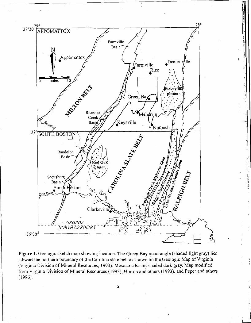
Figure 1. Geologic sketch map showing location. The Green Bay quadrangle (shaded light gray) lies athwart the northern boundary of the Carolina slate be1t.a~ shown on the Geologic Map of Virginia (Virginia Division of Mineral Resources, 1,993). Mesozoic basins shaded dark gray. Map modified from Virginia Division of Mineral Resources (1993), Horton and others (1993), andPeper and others (1996).
I
formed the "Virgilina synclinorium", a stratigraphic succession of units, from oldest to youngest: Hyco quartz porphyry, Aaron slate, and Virgilina greenstone. (table 1) which he mapped as far northward as the general latitude of Keysville, Virginia, and which he thought formed an overlying cover sequence on older, higher-grade, basement rocks to the north. The northward termination of Laney's mapping of the greenschist-facies slate belt units southeast of higher metamorphic grade gneisses and schists was identified by (Jonas, 1932) as a northwest boundary of the Carolina slate belt and of slate belt stratigraphic units, with higher metamorphic-grade rocks to the northeast. Tobish and Glover (1969) and Glover aAd Sinha (1973) identified the age of the slate belt units as Late Proterozoic. The major folds, and:some faults, they deemed the result of an approximately 600 Ma Virgilina deformation, that yas older than later Paleozoic (520-300 Ma) schistosity, cross-folding, and metamorphism. ~ g r r i s and Glover (1988) offered a stratigraphic nomenclature framework suggested as usefbl throughout the slate belt (table I), which is used here modified only by the addition of informal lithologic units and local members in the Hyco Formation.
Achtermann (1989) mapped the Mehenin area, including parts of the Green Bay, Hampden Sydney, Keysville, and Mehemn 7.5-minute quadrangles (figure 2). By southward projection, Achtermann suggested that a band of Aaron schist, flanked by h i t s of Hyco felsic gneiss, lay along the axis of a syncline that he projected through the Mehemn area. Laney's (1917) mapping of the Keysville area to the south of Achterman's (1989) mapping, however, cofisingly interposed a band of Virgilina greenstone between bands of Aaron and Hyco Formations there.
Newer regional-scale maps follow older pre-Achterman sources (Laney, 19 17; Jonas, 1932) in showing the Carolina slate belt stratigraphic units terminating to the northwest in this area, either by a curvilinear probable fault (Virginia Division of Mineral Resources, 1993; slate belt boundary shown on figure I), or as an unspecified terrane boundary (Horton and others, 1991).
Peper and Olinger (1998) showed that the structure of the "Virgilina synclin~riumyy north of the Dan River in the Buffalo Springs quadrangle in Virginia ( f i ~ r e 2), is that of a simple syncline, the Dryburg syncline, which is overturned slightly to the northwest. Since 1993, detailed quadrangle mapping by USGS geologists in support of mapping for the South Boston and Appomattox, Virginia 30-minute by one-degree sheets has traced the slate belt stratigraphic succession (figure 2), and the axis of the Dryburg syncline, from1 the Virginia-North Carolina border area northward through the Green Bay quadrangle in central Virginia.
Oflield (1994) and Offield and others (1991) argued for a Taconic age for folds and foliation in the central North Carolina slate belt based in part on a 450 Ma Argon-release age obtained on a biotite porphyroblast from central North Carolina.'Mineral ages, obtained from rocks collected along a slate-belt traverse near the Roanoke river in the Tungsten and Clarksville South quadrangles (Peper and others, 1996) and in the Nelson quadrangle (Peper and Olinger, 1998) are permissive of, but fail to identify, unique Taconic or Alcadian ages (Kunk and others, 1995). 39Ar age spectra of white mica, from strongly- foliatkd fissile felsic volcaniclastic rocks of the Hyco Formation suggest evidence of Alleghanian and older growth. Material from
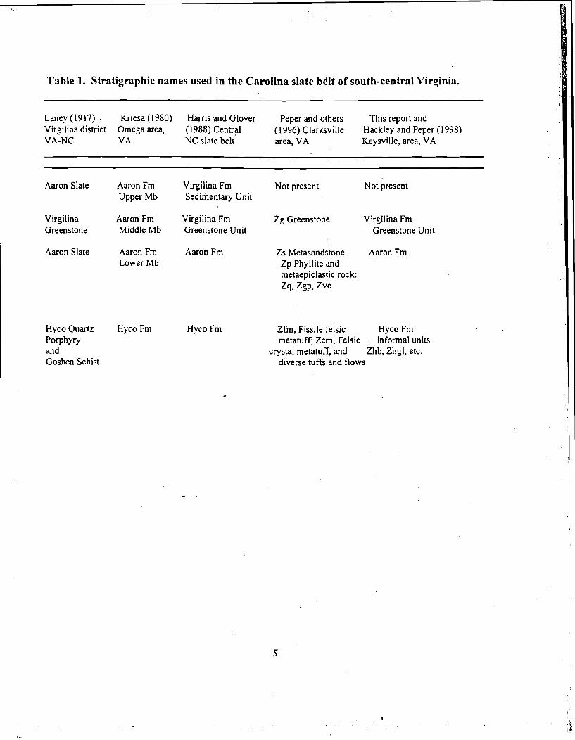
Table 1. Stratigraphic names used in the Carolina slate belt of south-central Virginia.
Laney (1 917) . Kriesa (1 980) Harris and Glover Peper and others This report and Virgilina district Omega area, (1988) Central (1 996) Clarkiyille Hackley and Peper (1 998) VA-NC VA NC slate belt area, VA Keysville, area, VA
Aaron Slate Aaron Fm Virgilina Fm Not present Not present Upper Mb S e d ~ e n t a r y Unit
Virgilina Aaron Fm Virgilina Fm Zg Greenstone Virgilina Fm Greenstone Middle Mb Greenstone Unit Greenstone Unit
Aaron Slate Aaron Fm Aaron Fm Zs etas sandstone Aaron Fm Lower Mb Zp Phyllite and
metaepiclastic rock: zq, zgp, 2%
Hyco Quartz Hyco Fm Hyco Fm Zfm, Fissile felsic Hyco Fm Porphyry metatuff; Zcm, Felsic informal units and crystal metatuff, and Zhb, Zhgl, etc. Goshen Schist diverse tuffs and flows
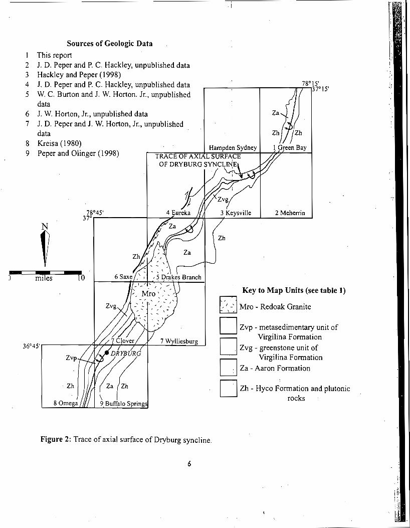
Sources of Geologic Data 1 This report 2 J. D. Peper and P. C. Hackley, unpublished data 3 Hackley and Peper ( 1 998) 4 J. D. Peper and P. C. Hackley, unpublished data 78" 15'
37" 15' 5 W. C. Burton and J. W. Horton. Jr., unpublished
data 6 J. W. Horton, Jr., unpublished data 7 J. D. Peper and J. W. Horton, Jr., unpublished
data 8 Kreisa (1980)
Han 9 Peper and Olinger (1998) T R A r F n F aurdr cri
Key to Map Units (see table 1)
Mro - Redoak Granite
Zvp - metasedimentary unit of Virgilina Formation
Zvg - greenstone unit of Virgilina Formation
Za - Aaron Formation
Zh - Hyco Formation and plutonic rocks
Figure 2: Trace of axial surface of Dryburg syncline.
6
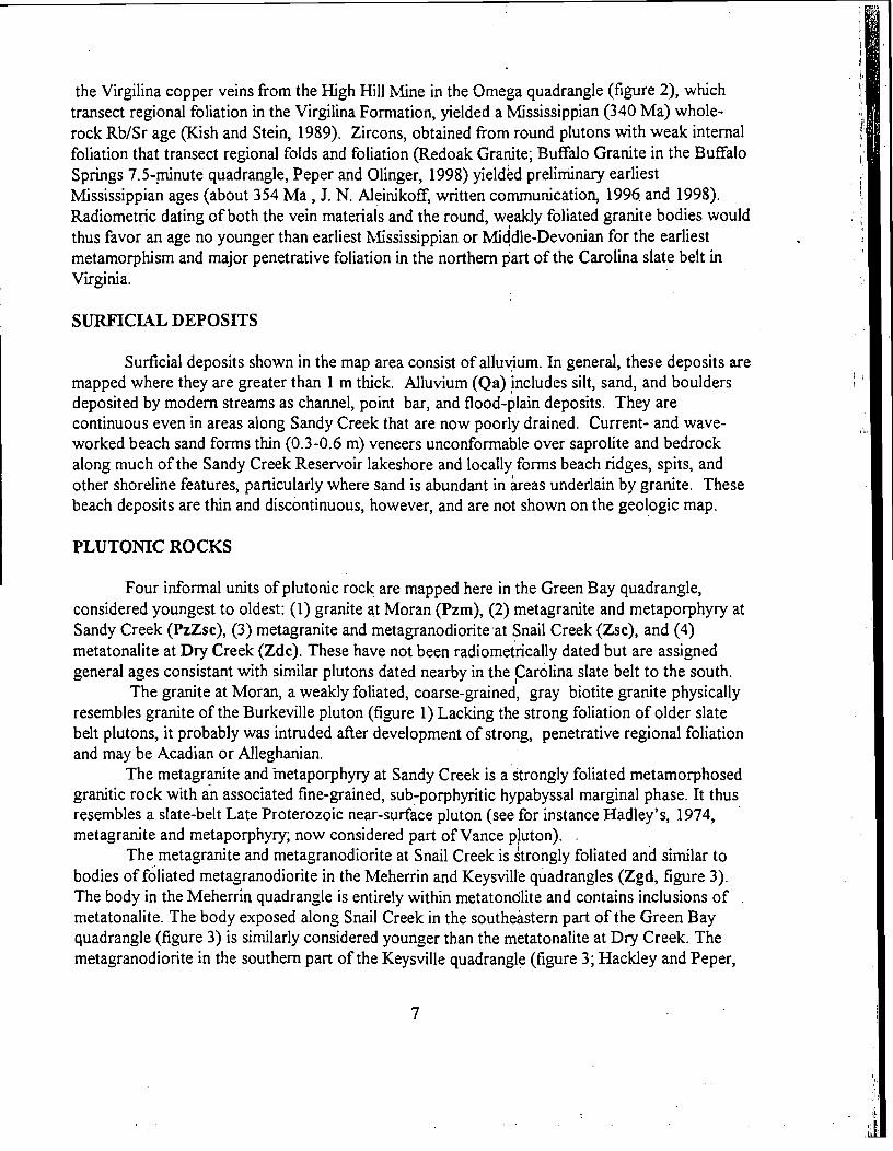
the Virgilina copper veins from the High Hill Mine in the Omega quadrangle (figure 2), which transect regional foliation in the Virgilina Formation, yielded a Mississippian (340 Ma) whole- rock RbISr age (Kish and Stein, 1989). Zircons, obtained from round plutons with weak internal foliation that transect regional folds and foliation (Redoak Granite; Buffalo Granite in the Buffalo Springs 7.5-pinute quadrangle, Peper and Olinger, 1998) yieldkd preliminary earliest Mississippian ages (about 354 Ma , 3. N. Aleinikoff, written communication, 1996 and 1998). Radiometric dating of both the vein materials and the round, weakly foliated granite bodies would thus favor an age no younger than earliest Mississippian or Middle-Devonian for the earliest metamorphism and major penetrative foliation in the northern part of the Carolina slate belt in Virginia.
I
SURFICIAL DEPOSITS
Surfrcial deposits shown in the map area consist of a1luv;ium. In general, these deposits are mapped where they are greater than 1 m thick. Alluvium (Qa) includes silt, sand, and boulders deposited by modern streams as channel, point bar, and flood-plain deposits. They are continuous even in areas along Sandy Creek that are now poorly drained. Current- and wave- worked beach sand forms thin (0.3-0.6 m) veneers unconformable over saprolite and bedrock along much of the Sandy Creek Reservoir lakeshore and locally forms beach ridges, spits, and other shoreline features, particularly where sand is abundant in areas underlain by granite. These beach deposits are thin and discontinuous, however, and are not shown on the geologic map.
PLUTOMC ROCKS
Four informal units of plutonic rock are mapped here in the Green Bay quadrangle, considered youngest to oldest: (1) granite at Moran (Pzm), (2) metagranite and metaporphyry at Sandy Creek (PzZsc), (3) metagranite and metagranodiorite*at Snail Creek (Zsc), and (4) metatonalite at Dry Creek (Zdc). These have not been radiometrically dated but are assigned general ages consistant with similar plutons dated nearby in the Carolina slate belt to the south.
The granite at Moran, a weakly foliated, coarse-grained, gray biotite granite physically resembles granite of the Burkeville pluton (figure 1) Lacking the strong foliation of older slate belt plutons, it probably was intruded after development of strong, penetrative regional foliation and may be Acadian or Alleghanian.
The metagranite and inetaporphyry at Sandy Creek is a strongly foliated metamorphosed granitic rock with an associated fine-grained, sub-porphyritic hypabyssal marginal phase. It thus resembles a slate-belt Late Proterozoic near-surface pluton (see for instance Hadley's, 1974, metagranite and metaporphyry; now considered part of Vance pluton). .
The metagranite and metagranodiorite at Snail Creek is strongly foliated and similar to bodies of foliated metagranodiorite in the Meherrin and Keysville quadrangles (Zgd, figure 3). The body in the Meherrin quadrangle is entirely within metatonolite and contains inclusions of metatonalite. The body exposed along Snail Creek in the southeastern part of the Green Bay quadrangle (figure 3) is similarly considered younger than the metatonalite at Dry Creek. The metagranodiorite in the southern part of the Keysville quadrangle (figure 3; Hackley and Peper,
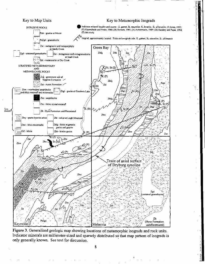
Key to Map Units Key to Metamorphic Isograds
RJTRUSlVE ROCKS Indicator mineral locality and source. G , garnet: St. suurolite: Y kyanite: Si. sillimanice; (0 Jonas. (E) Espenshade and Pot~cr, 1960; (B) BCMCR 1961 ; (A) Ach[mnann, 1989: (H) Hackley and Peper
- ganite , Moran (P) this study.
Isomad approximately located. Ticks on low-gndc side. G. garnet; St. staurolitc: Si. sillimanite
I
Figure 3. Generalized geologic map showing locations of metamorphic isograds and rock units. Lndicator minerals are millimeter-sized and sparsely distributed so that map pattern of isograds is only generally known. See text for discussion.
8
1998, unit PzZgd) is similar to foliated granodiorite in the Lunenburg, Virginia quadrangle, dated by zircons as Late Proterozoic (W.C. Burton, written communication, 1997).
The metatonalite at Dry Creek, crops out extensively in the bed of Dry Creek in the northeastern part of the Mehemn quadrangle (figure 3). The unit is mostly strongly foliated metatonalite. Lensoid, metamorphosed mafic enclaves, chiefly 0.5 - 1.2 meters-wide, make up about 5 - 10' percent of the unit. Foliated, thin, (5 - 10 centimeter-wide) dikes of leucocratic quartz diorite cut the metatonalite and mafic enclaves. The contact of the metatonalite with the Hyco volcaniclastic rocks is not exposed in the Green Bay quadrangle, but the metatonalite has a very fine grained, intensely foliated border against Hyco metavolcaniclastic rocks where exposed along Little Owl Creek in the Keysville quadrangle (Hackley and Peper, 1998, unit Zto) . The metatonalite is considered of Late Proterozoic intrusive age because of the intense foliation and metamorphism.
STRATIGRAPHY
Aaron Formation
The Aaron Formation (Za) in the Green Bay quadrangle, has been traced continuously north and south of the Red Oak pluton, and thus physically is tied to the Aaron Formation of the type locality along Aarons Creek in the Buffalo Springs quadrangle (Peperland Olinger, 1998). Northward fiom the southern margin of the Keysville quadrangle (Hackley and Peper, 1998), slate and phyllitic slate give way with increasing metamorphic grade to coarser-grained chloritic and white mica schists, and staurolite-garnet-muscovite schists. 'The schist reaches garnet grade in the northern part of the Keysville quadrangle, and staurolite and kyanite grades in the south- central part of the Green Bay quadrangle (figure 3). Metamorphosed mafic rocks (schistose greenstone, epidote amphibolite, amphibolite, hornblende schist), that are derived fiom both metabasalt and mafic metatuff, make ub less than 7 percent of the unit in the Green Bay quadrangle as thin (0.6 m ) lenses interlayered with schist and granofels. These are not thought to be down-folded remnants of the overlying greenstone unit of the Virgilina Formation (table I), a central unit of thick greenstone andfor amphibolite along the axis of the Dryburg syncline in the Keysville quadrangle because thin metabasalts are interbeded with slates of the Aaron Formation, and because the greenstone unit (figure 2) is central to the band of Aaron schist and terminates along the axis of the syncline in the central part of the Keysville quadrangle.
Probable Unconformity at Base of Aaron Formation
Regional evidence for an unconformity at the base of the Aaron Formation in central North Carolina is discussed by Hams and Glover, 1998. In the southern Virginia the mapped contact of basal Aaron Formation and the Hyco Formation progressively truncates units in the underlying Hyco Formation in the western and central parts of the slate belt (Peper and Olinger, 1998), and in the eastern part of the slate belt (Peper and Wygant, 1997; Peper and others, 1996). In the Green Bay quadrangle, the base of the Aaron ~ o d a t i o n truncates Progressively
northward the contact between the gneiss of Goodwin Lake and biotite gneiss, both of the Hyco Formation, on the east limb of the Dryburg syncline. On the west limb of the Dryburg syncline, the base of the Aaron Formation marks the expose'd top of the gneiss of Goodwin Lake of the Hyco Formation southward to the northern part of the Keysville ,quadrangle (unit Zhm of Hackley and Peper, 1998).
Hyco Formation
The Hyco Formation is mapped here in seven informal members: felsic wacke (Zhw), biotite gneiss (Zhb), muscovite-kyanite-quartz schist (Zhq), felsic rnigmatite gneiss and granite (Zhfg), muscovite schist (Zhs), schist at Leigh Mountain (Zhl), and gneiss of Goodwin Lake (Zhgl). The latter two units form distinctive rock types in the Green Bay quadrangle. The gneiss of Goodwin Lake is a distinctive rock unit. It consists of amphibolite, which is interpreted to be metamafic volcaniclastic and metavolcanic rock, interlayered in about equal proportions with felsic gneiss layers of metavolcaniclastic rock The unit is displayed in exposures along the State Forest Road (Virginia State Route 639) north of and around Goodwin and Prince Edward Lakes in the east-central part of the Green Bay quadrangle. The unit is mapped below Aaron Formation schist and phyllitic slate on both limbs of the Dryburg syncline, and is contiguous southwestward with a unit of similar distinctive lithology, unit Zhm ( Hackley and Peper, 1998; Achtermann, 1989) as far southwestward as the middle of the Keysville quadrangle. On the east limb of the Dryburg syncline this unit interfingers southwestward with Hyco felsic wacke, forming two lenses~near the top of the exposed Hyco Formation at the southern margin of the Green Bay quadrangle.
Hyco felsic biotite gniess is present beneath the gneiss of Goodwin Lake on both limbs of the Dryburg syncline, and locally beneath Aaron schist on the east limb of the syncline in the northern part of the Green Bay quadrangle. The Hyco felsic biotite gneiss interfingers westward and southwestward with Hyco felsic migmatite gneiss and granite, and with Hyco felsic wacke on the west limb of the Dryburg syncline. The Hyco felsic biotite gneiss is truncated southwestward on the east limb of the Dryburg syncline by the metatonalite at Djr Creek (figure 3), but can be projected to lie stratigraphically below gneiss of Goodwin Lake in the southeastern part of the Green Bay quadrangle, where it would be a northward partial stratigraphic equivalent of Hyco felsic wacke mapped in the Mehemn quadrangle (Achtermann, 1989; J.D. Peper and P.C. Hackley, unpublished mapping, Mehemn, Virginia quadrangle, 1997).
The schist at Leigh Mountain is distinctive kyanite quartzite and muscovite-kyanite-quartz schist, interlayered with biotite gneiss. The unit is well exposed in prominent outcrops on Leigh Mountain and the high ground to the southwest of Leigh Mountain, in the western part of the Green Bay quadrangle. The unit extends southwestward (figure 3) from Leigh Mountain through the western part of the Green Bay quadrangle and southeastern part of the Hampden Sydney quadrangle (muscovite schist, Achtermann, 1989; muscovite schist, Bennett, 1961; kyanite schist, Virginia Division of Mineral Resources, 1993) but must pinch out near the southern margin of the Hampden Sydney quadrangle (figure 3), as it is not present in exposures along strike to the southwest in the northernmost part of the Keysville quadrangle @Iackley and Peper, 1998). A large-scale map shows a layer of kyanite quartzite on Leigh Mountain, folded into a northeast-
plunging "Z" fold (Espenshade and Potter, 1960, figure 34). 1n the Green Bay quadrangle the unit occurs as a large lens within Hyco felsic migmatite gneiss and granite, but to the southwest it forms a lens within Hyco felsic wacke. The schist at Leigh ~o 'untain is in similar stratigraphic position to unit Zhq, which is low in the Hyco Formation on the east limb of the Dryburg syncline in the Green Bay quadrangle. The apparent width of outcrop and apparent thickness of the Hyco Formation on the west limb of the Dryburg syncline in the Green Bay quadrangle has been increased and thickened by foliation arching west of the trace bf the syncline (cross-section, plate 2).
The Hyco felsic migmatite gneiss and granite is a northward lateral stratigraphic equivalent of a thick unit of Hyco felsic wacke on the west limb of the Dryburg syncline, where, progressively northward, the felsic wacke has become coarser-grained by metamorphic recrystallization, losing the finely-laminated relict bedding retained at lower metamorphic grade. With northward increasing gneissocity and metamorphic segregation, the Hyco felsic migmatite and granite unit becomes more extensively injected with thin to thick sills and dikes of biotite granite or granite pegmatite, andfor displays in situ concordant layers of segregated granitoid melt.
I I STRUCTURE
Bedrock Structural Fabric
A schistosity, defined mostly by the alignment of whiteimica, chlorite, and biotite, and more rarely by amphibole sheaves, forms the dominant penetrative schistosity in the Green Bay quadrangle. The schistosity is parallel or sub-parallel to relict bedding in sparse exposures where both structures are visible. Primary sedimentary structures have been rendered generally unrecognizable by metamorphic recrystallization andlthe formation of the schistosity; however some compositional layering may be relict bedding. Massive metawacke and quartzite in the Hyco Formation, and metasandstone and quartzite in the Aaron Formation, lo;ally preserve thin laminations interpreted to be relict-bedding.
Major Structures
The axial trace of the Dryburg syncline has been traced north and northeastward (figures 2 and 3) through the Green Bay quadrangle. The major structure is that of a simple syncline, slightly overturned to the west as far northward as the southern part of the Keysville quadrangle. In the Green Bay quadrangle, however, the Hyco and Aaron Formations on the west limb of the structure have been warped and arched and folded in a series of micro-, meso-, and map scale post-foliation folds.
The mica foliation and relict bedding strike generally north-northeastwards and dip predominantly steeply east-southeastward (figure 4C and D)through the eastern part of the Green Bay quadrangle. In the western part of the Green Bay quadrangle, this mica foliation has been folded by later folding, local kinking and kink-band cleavage, and arching and warping into: 1) elongate, north-northeast trending foliation arches and recesses (figure 3, figure 4 B) in the'
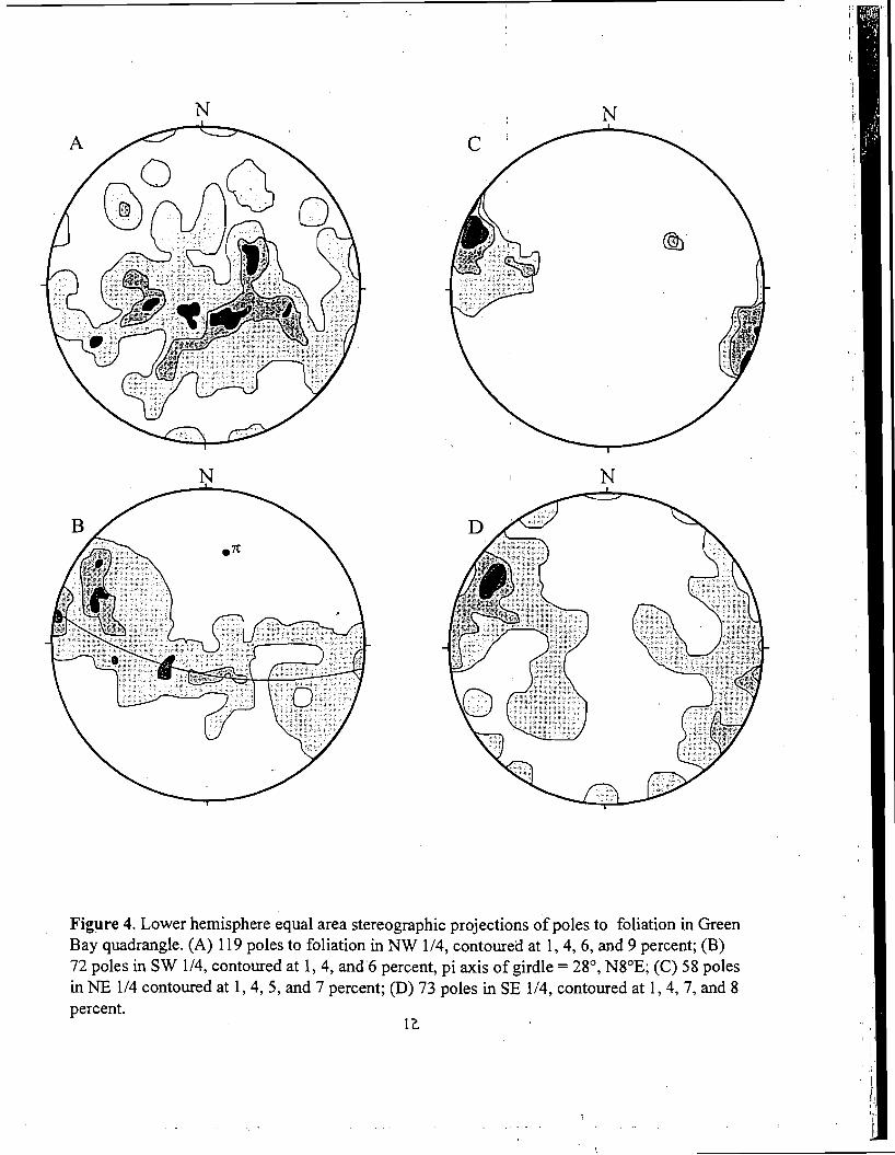
Figure 4. Lower hemisphere equal area stereographic projections of poles to foliation in Green Bay quadrangle. (A) 119 poles to foliation in NW 1/1, contoured at 1,4, 6 , and 9 percent; (B) 72 poles in SW 1/4, contoured at 1,4, and 6 percent, pi axis of girdle = 2S0, NSOE; (C) 58 poles in NE 1/4 contoured at 1,4, 5, and 7 percent; (D) 73 poles in SE 1/4, contoured at 1,4,7, and 8 percent.
12
southwestern part of the quadrangle, and 2) northeast-plunging, open asymmetric folds at minor, meso-, and map scales in the northwestern part of the quadrangle (figure 4A). Open asymmetric folds with northwest to nearly east-west striking and north-dipping limbs plunge to the northeast in the area of the foliation arch in the southwestern part of thelGreen Bay quadrangle. Near the southwest end of the arch, similar mesoscopic and map-scale asymmetric folds of foliation and bedding plunge to the south-southeast, and broadly fold the contact between the Hyco and Aaron Formations in the northern part of the Keysville quadrangle (figure 3). Folding of the Hyco-Aaron contact there includes a southeast- and south-plunging map-scale syncline and anticline, both slightly overturned to the west and southwest.
With reference to figure 2, the Hyco-Aaron contact on the west limb of the Dryburg syncline has been sheared along mylonite zones (an extension of the Clover shear zone) associated with late (Alleghanian?) shearing in the Saxe, Drakes Branch, and Eureka quadrangles, south of the middle of the Eureka quadrangle. he most northerly mylonite was observed in outcrop in the east-central part of the Eureka quadrangle in Spring Creek, under the bridge and northeast and southwest of Virginia State Route 653. In the east-central part of the Eureka quadrangle, the mylonite zone along the Hyco-Aaron contact splays off northward into the Hyco Formation west of the contact. North of this locality,' foliation and bedding on the west limb of the Dryburg syncline are warped into a series of broad kink folds and arches and recesses.
METAMORPHISM
The age of peak prograde metamorphism and development of northeast-trending regional foliation that has been later warped and folded has not been directly dated in the Green Bay area. The foliation may be Taconic(?) as discussed by Glover and others (1983), but the age of the regional foliation has been only broadly bracketed as older than the Redoak and Buffalo Granites (earliest Mississippian), and Virgilina Copper veins (Middle Devonian) in nearby areas of the slate belt to the south. Prograde overprinting by younger Alleghanian events in greenschist-facies rocks (white mica growth, Kunk and others, 1995), and folding, and late retrograde overprinting (green biotite replaces biotite, white-mica and chlorite replace garnet) in amphibolite facies rocks seems likely. I
Figure 3 depicts rock units and localities of key metarnorphic-grade indicator minerals (garnet, staurolite, kyanite, and sillimanite) in and near the Green Bay quadrangle. Garnet, in millimeter-sized dodecahedrons was noted in Aaron and Hyco Formations schist in the Keysville quadrangle and in the southern part of the Green Bay quadrangle (Achterman, 1989; Hackley and Peper, 1998; and this study). South of this area, garnet was not noted in Aaron schist. Accordingly, a tentative garnet isograd (figure 3) is drawn across the east limb of the Dryburg syncline in the south-central part of the Keysville quadrangle.
Staurolite, in millimeter-sized prisms in Hyco schist in map unit Zhw was noted in the north-central part of the Keysville quadrangle (Hackley and Peper, 1998). On the basis of this Keysville quadrangle staurolite locality, and on the bases of staurolite localities in Aaron schist and Hyco kyanite-muscovite quartzite (Zhq) in the southern part of the Green Bay quadrangle, a tentative staurolite isograd which trends about N.65 E. is drawn in figure3. This is essentially the staurolite isograd mapped across Aaron schist in the southern part of the Green Bay quadrangle
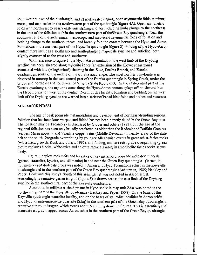
Figure 5. Schematic pressure-temperature grid. For interpretation of approximate metamorphic conditions in the Keysville-Green Bay area. Metamorphic facies and suggested geothermal gradients for plate interior and volcanic-plutonic complex from Emst (1976). Sta,urolite-producing reaction fiom Hoschek (1969). Stability field for alurninosilicates from Holdaway, (1971). Granite minimum melting curve from Tuttle and Bowen (1958). Approximate maximum PIT metamorphic conditions (vertically- ruled area) inferred fiom mineral assemblages and presence of granite melt. A shows suggested conditions for ~ a i o n chlorite + muscovite schist south of the gametisograd in the southem part of the Keysville quadrangle. A' shows suggested conditions for c/o felsic migmatite gneiss and granite (folded granite sill with foliated biotite-rich selvage) north of the sillimanite isograd in the northwestern part of the Green Bay quadrangle. See text for discussion.
by Achterma~ (1989). His isograd is herein realigned and extended on the basis of more recent observations.
Kyanite has not been observed in Aaron schist in the ~ r < e n Bay quadrangle, but has been observed, in millimeter-sized white blades in muscovite-bearing Hyco quartzite and gneiss northwest of the proposed staurolite isograd in figure 3. The areal pattern of occurrence of the kyanite is suggestive of a Barrovian-type metamorphism in which kyanite is coming in at about the same time as staurolite in rocks of suitable pelitic compositions.
Sillimanite, partially replacing kyanite, was noted in alurninous kyanite-muscovite schist near the north end of the band of Leigh Mountain schist of the H ~ C O Formation (figure 3) by
Espenshade and Potter (1960), and Achtermam (1989). In addition, sillimanite, in a band of . probable Aaron sillimanite-muscovite schist was noted by W.C. Burton (oral communication, 1997) in the western part of the Deatonville quadrangle (northeast of the Green Bay quadrangle of figure 3). On these bases, a tentative, northeast-trending sillimanite isograd is shown in the northwestern part of the Green Bay quadrangle.
Segregated and folded layers of granite, that have indistinct selvage borders enriched in biotite, and that can be best interpreted as in-situ layers of granit&ninimum melt, were noted in exposures of Hyco Formation gneiss (Zhfg) west of State Route 696, north of the tentative sillimanite isograd, in the area west of Aaron schist (Za) in the northwest-central part of the Green Bay quadrangle. Although many thin and thick sills of gra&te intrude the Hyco felsic migmatitic gneiss and granite unit (Zhfg) in exposures in the southwest-central part of the Green Bay quadrangle, these have sharp contacts with finer-grained Hyco gneiss, and seem to be distinct intrusives, rather than in-situ melted segregation.
Salient features of the metamorphism are discussed with the use of a schematic pressure- temperature grid (figure 5), considering the areal patterns of occurrence of metamorphic-grade indicator minerals and minimum granite melting in the Green Bay area. Facies boundaries on the grid are accurate to about plus or minus 50 centigrade degrees. The facies boundaries are complex hnctions of both bulk composition and chemical potentials of mobile components..
The stippled pattern marks a narrow band (A-A', figure 5), along a suggested geothermal gradient for the Green Bay area during regional metamorphism. This gradient is steeper (in pressure) than that suggested for a volcanic-plutonic complex, and somewhat less than that suggested for a plate interior. The band is drawn along a geothehal gradient fixed by two key observations: 1) kyanite, rather than sillimanite, comes in with the'formation of staurolite, and 2) in-situ granite-minimum melt first appears in the sillimanite field just north of the kyanite field. As noted by Achtermam (1989), chloritoid has not been observed in pelitic rocks in the Keysville- Green Bay area, so that a more likely possible staurolite-produc~ng reaction that may have occurred is: chlorite + muscovite = staurolite + biotite + quartz + vapor (Hoschek, 1969).
Kyanite comes in approximately with staurolite, so that nepr the middle of the stippled area (figure 5 ) , P-T conditions must have been to the left,of the kyanite-sillimanite boundary and to the right of staurolite-producing reaction line. In situ granite-melting first takes place in the sillimanite field near the kyanite field at the uppe;end of the stippled area (near A' in figure 5 ) , in a P-T space which must be to the right of the granite-minimum melting curve, and in the sillimanite field, not the kyanite field. The lower-most part of the stippled area (near A, figure 5) shows possible P-T conditions south of the garnet isograd in the south-central part of the
Keysville quadrangle. Assuming a pressureldepth ratio of about 0.3 k b h (Carmichael, Turner, and Verhoogen,
1974), one could surmise that the metamorphism in the ~ e ~ s v i l l e - Green Bay area took place at depths of about 9-15 km and temperatures of about 420-620 deg. C. Taking the horizontal map distance between the garnet isograd and the sillimanite isograd (about 13 km, figure 3), and estimating t'hat this distance corresponds to about 6 km along the geothermal gradient (figure 5), one could surmise that the crust has been tilted upward about 30 degrees. in a direction N.25W. since the thermal peak metamorphism.
REFERENCES CITED
Achtermann, R.D., 1989, Geology of the Meherrin, Virginia dea: tracing formations across the staurolite isograd from the Carolina slate belt into the qharlotte belt [unpublished M.S. Thesis: Blacksburg, Virginia Polytechnic Institute and State University, 34 p.
Bennett, P.J., 1961, The economic geology of some Virginia kyanite deposits [unpublished Ph.D. Thesis]:Tucson, University of Arizona, 13 1 p.
Burton, W.C., 1995, Preliminary geologic map of the Lunenberg and Fort Mitchell 7.5 minute quadrangles, Virginia: U.S. Geological Survey ~ ~ e n - ~ i l e Report 95 - 4, 14 p., map scale 1 :24,000.
Burton, W.C., and Armstrong, T.R., 1997, Structural and thermobaric history of the western margin of the Goochland terrane in Virginia [abs.]: Geological Society ck~rnerica Abstracts with Programs, v. 29, no. 3, p. 7 - 8.
Carmichael, I.S., Turner, F.J., and Verhoogen, John, 1974, ~ ~ d e o u s Petrology: New York, Mc- Graw-Hill Book Company, p. 98-99.
Ernst, W.G., 1976, Petrologic phase equilibria: San Francisco, 1W.H. Freeman and Company, p. 251, figure 6.46.
Espenshade, G.H., and Potter, D.B., 1960, Kyanite, sillimanite, and andalusite deposits of the southeastern states: U.S. Geological Survey Professional Paper 336, 121 p.
Glover, Lynn, 111, and Sinha, A.K., 1973, The Virgilina deformation, a Late Precambrian to Early Cambrian (?) Orogenic event in the central Piedmont of Virginia and North Carolina: American Journal of Science, v. 273-A (Cooper Volume), p. 234-25 1
Glover, Lynn 111, Speer, J. A., Russell, G.S., and Farrar, S. S., 1983, Ages of regional metamorphism and ductile deformation in the central and southern Appalachians: Lithos, V. 162, p. 223-245.
Hackley, P.C., and Peper, J.D., 1998, Reconnaissance bedrock geologic map of the Keysville 7.5 minute quadrangle, Prince Edward, Charlotte, and Lunenburg Counties, Virginia, U.S. Geological Survey Open-File Map 98-764, 14 p., scale 1:24,000.
Hadley, J.B., 1974, Geologic map of the Oxford quadrangle, Granville and Vance Counties, North Carolina: U.S. Geological Survey Miscellaneous Field Studies Map MF-608, scale 1:62,500.
Harris, C.W., and Glover, Lynn, 111, 1988, The regional extent of the ca..600 Ma. Virgilina deformation: implications for stratigraphic correlation in the Carolina terrane: Geological Society of America Bulletin, v. 100, no. 2, p. 200-217.
Holdaway, M.J., 1971, Stability of andalusite and the aluminum silicate phase diagram: American Journal of Science, v. 271, p. 91-13 1 I
Horton, J.w.,' ~ r . , Drake, A.A., Jr., Rankin, D.W., and ~ a l l m e ~ d r , R.D., 199 1, Preliminary tectonostratigraphic terrane map of the central and southern Appalacians: U.S. Geological Survey Miscellaneous Investigation Series Map 1-2 163, scale 1 :2,000,000.
Horton, J.W., Jr., Peper, J.D., Marr, J.D., Jr., Burton, W.C., and Sacks, P.E., 1993, Preliminary geologic map of the South Boston 30x60 minute quadrangle, Virginia and North Carolina: U.S. Geological Survey Open-File ~ e ~ 0 i - t 93-244, 20 p., scale 1:100,000.
Hoschek, G., 1969, The stability of staurolite and chloritoid and 'their significance in metamorphism of pelitic rocks: Contributions to Mineralogy and Petrology, v. 22, p. 208- 232.
Jonas, A.I., 1932, Kyanite in Virginia: Charlottesville, Virginia deological Survey Bulletin, no. 38, 52 p.
Laney, F.B., 1917, The geology and ore deposits of the Virgilina district of Virginia and North Carolina: Charlottesville, Virginia Geological Survey Bulletin no. 14, 176 p.
Kish, S.A., and Stein, H.J., 1989, Post-Acadian metasomatic origin for copper-bearing vein deposits of the Virgilina district, North Carolina and Virginia: Economic Geology, v. 84, no. 8, p. 1903-1920.
Kreisa, R.D., 1980, Geology of the Omega, South Boston, Cluster Springs, and Virgilina quadrangles, Virginia: Charlottesville, Virginia Division of Mineral Resources Publication 5,22 p., map scale 1:24,000.
Kunk, Michael J., Horton, J.W., Jr., and Peper, John D., 1995, Preliminary 40Arl39Ar mineral ages from the Raleigh metamorphic belt, Carolina slate belt, and Milton belt in the South Boston, VA-N.C. 30x60-minute quadrangle: Geological Society of America Abstracts with Programs, v. 27, no. 2, p. 67.
Offield, T.W., 1994, Lithotectonic map and field data--a reconnaissance geology of the Carolina slate belt and adjacent belts from southern Virginia to central South Carolina: U.S. Geological Survey Open File Report 94-429. [on 2 disks-13 sheets, 1:100,000, text, 50 p.].
Offield, T.W., Kunk, M.J., and Koeppen, R.P., 1991, Style and age of deformation in the Carolina slate belt of central North Carolina: Geological Society of America Abstracts with Programs, v. 22, no. 4, p. 54.
Peper, J.D., Clark, T.W. and Kanahele, K.A.,1996, Geologic map of the Clarksville South and Tungsten 7.5-minute quadrangles, Virginia and North' Carolina: U.S. Geological Survey Miscellaneous Investigations Map 1-247 1, scale 1 :24,000.
Peper, J.D., and Wygant, A.W., 1997, Reconnaissance geologic map of the Clarksville North and Boydton 7.5-minute quadrangles, Mecklenburg and Charlotte Counties, Virginia:
U.S. Geological Survey Open-File Report 97-524, 25 p., scale 1:48,000.
Peper, J.D., and Olinger, K.E., 1998, Reconnaissance geologic map of the Buffalo Springs and Nelson 7.5-minute quadrangles, Virginia and North Carolina: U.S. Geological Survey Open-File Report 98-775,28 p., scale 1:24,000.
Tobisch, O.T., and Glover, Lynn, III, 1969, Metamorphic changes across part of the Carolina slate belt-Charlotte belt boundary, North Carolina and Virginia: U.S. Geological Survey
I ~rofessional Paper 650-C, p. C 1-C7.
Tuttle, O.F., and Bowen, N.L., 1958, Origin of granite in the light of experimental studies in the system NaAlSi ,-KalSi ,-SiO ,-H,O :Geological Society of America Memoir no. 74, 153 p.
Virginia Division of Mineral Resources, 1993, Geologic Map of Virginia: Charlottesville, Virginia Division of Mineral Resources, scale 1 :500,000.
DESCRIPTION O F MAP UNITS
p o t e : Saprolite, which consists of layers of variably o+dized, decomposed, and dissaggregated rock, forms a blanket as much as 18 m thick that overlies undecomposed bedrock and underlies surficial deposits. Soil horizons are developed on the saprolite and on the surficial deposits. Pebble- to boulder-sized core stones of the bedrock, with spheroidal weathering and jointing in compositionally massive rocks and sheeted jointing in strongly foliated rocks, occur both within the saprolite and as lag blocks on the soil surface.
Where hyphenated mineral names are used as descriptive adjectives to form rock names, minerals are listed in increasing order of general abundance in the rock. Minerals in parentheses are sparse to moderately abundant, and may not be present in every rock sample; read parentheses as "with or without".]
SURFICIAL DEPOSITS
Qa Alluvium (Holocene)--Silt, sand, and minor gravel deposited along modem streams generally less than 5 m above channel of present-day stream. Material mixed with varied amounts of organic debris in poorly drained areas
IGNEOUS AND METAIGNEOUS ROCKS
Intrusive Rocks of Mesozoic Age
Jd Diabase dikes (Early Jurassic) - Medium-grained, homogeneous, dark-gray to black dike rock composed of sub-equal amounts of lath-shaped labradorite with intersertal calcic-clinopyroxene. Opaque Fe-Ti oxide and brown hornblende make up about 2-3 percent of the rock I
Intrusive Rocks of Probable Paleozoic Age
Pzm Granite at Moran (Middle? to Late? Paleozoic) - Coarse-grained, massive, to very- weakly foliated, light-gray weathering, white to light-tan, leucocratic biotite granite and granodiorite. Black biotite, in tiny flakes about 1 mm in diameter and distributed in 2-3 mm aggregates with feldspar, apatite, garnet, and ilmenite, and secondary epidote and white mica, makes up 3-5 percent of the rock. Exposed in rounded "pavement" outcrops; weathers to white fine-grained sandy soil. Extensive exposures are in railroad cut and creek south of village of Moran in the northeastern pad of the Green Bay quadrangle
Intrusive rocks of Late Proterozoic and Early Paleozoic Age I
PzZsc Metagranite and metaporphyry at Sandy Creek (Late Proterozoic and Early Paleozoic) - Homogeneous, tan- to dark-tan weathering, white to light-tan, very-strongly foliated, medium-grained biotite-muscovite metagranite and fine-grained metaporphyry. Tabular inclusions of amphibolite and thinly-layered biotite gneiss common in metagranite in exposures along west side of Sandy Creek; schlieren of migmatized muscovite schist common in metagranite exposures along east side of Sandy Creek. Black biotite, in tiny flakes, and aggregated with feldspar in 0.3-1 mm patches that are elongated along foliation, makes up about 5 percent of the fine-grained metaporphyry. Small, 3 mm by 3 mm, stubby euhedral crystals of pearly-white potassium-feldspar and rare aggregates of quartz, in a fine-grained matrix of quartz, plagioclase, and potassium feldspar, make up about 3-4 percent of the metaporphyry. Inferred to be a hydrated, hypabyssal granite body. Metagranite is cut by narrow, 4-6 cm, protoclastic shear zones filled by pods, lenses, stringers, and combed veins of foliated, pegmatitic, muscovite-quartz granophyre. Extensive exposures are along.the east side of Sandy Creek Reservoir in the northern part of the Green Bay quadrangle and the adjacent Rice quadrangle
Intrusive Rocks of Late Proterozoic Age
Zsc Metagranite and metagranodiorite at Snail Creek (Late Proterozoic) - Medium- grained, white- to light-gray weathering, foliated, pink to pinkish-gray, biotite-muscovite metagranite and metagranodiorite. Metagranodiorite composed of 1-2 mm euhedral to subhedral plagioclase phenocrysts set in a fine-grained granophyric groundmass of plagioclase, potassium feldspar, and quartz. Minor quartz phenocrysts. Green biotite makes up about 5 percent of rock. Fine-grained epidote and sericite indicate a greenschist facies metamorphic overprint. Metamorphic foliation defined by alignment of mica. Extensive exposures are in the bed of the mid-reach of Snail Creek and tributaries in the southeastern part of the Green Bay quadrangle. Metagranite and metagranodiorite similar to metagranodiorite (PzZgd) mapped 10 km to the southwest by Hackley and Peper (1998) along Juniper Creek in the southern part of the Keysville, Virginia quadrangle, and ,
by Burton (1 995) in the northern part of the Fort Mitchell, Virginia quadrangle
Zdc Metatonalite a t Dry Creek (Late Proterozoic) - Medium- to coarse-grained, dark-gray to light-gray weathering, homogeneous, foliated and metamorphosed hornblende-biotite tonalite. Metamorphosed and foliated, narrow 1-4 cm-wide felsic dikes of leucocratic, biotite quartz diorite; and wider, 0.5-1 m-wide mafic enclaves of hornblendite, hornblende gabbro, and melanocratic diorite are common. Metatonalite consists of saussuritized plagioclase, quartz, and green biotite, with secondary sericite/muscovite, epidote, and chlorite. Hornblende is locally pseudomorphed by aggfegates of biotite and chlorite. Hematite pseudomorphs after cubic pyrite found locally. Sprays of green and black hornblende overprint greenschist facies minerals in exqosures north of State Route 714. Composition ranges to diorite and granodiorite. Metamorphic foliation defined by alignment of biotite, and some amphibole, although many neo-amphibole sprays grow across foliation. Extensive exposures are in the bed of bry creek in the northeastern part of the Meherrin quadrangle. Body of metatonalite in the southeastern part of the Green Bay quadrangle is contiguous southwestward with an extensive body of metatonalite (Zto) mapped by Hackley and Peper (1998) through the Mehemn and Keysville, Virginia quadrangles and southwestward through the Fort Mitchell, Virginia quadrangle (Burton, 1995)
METAMORPHOSED VOLCANIC AND SEDIMENTARY ROCKS
Late Proterozoic metamorphosed sedimentary, volcaniclastic, and volcanic rocks
Za Aaron Formation (Late Proterozoic) - Metamorphosed pelite and lesser sandstone, minor metamorphosed mafic volcanic or volcaniclastic rock, and sparse layers of felsic metavolcaniclastic rock. Unit is mostly red-brown weathering, medium-gray to locally, splendant silvery white, fissile, thinly-layered, ilmenite-(chlorite)-(stauro1ite)-(garnet)- biotite-muscovite-quartz-plagioclase schist. Typically weathers to clay soil with muscovite flakes. Distinguished from splendant muscovite-quartz schists of unit Zhw (below) by the abundance of ilmenite, and finer grain size. Unit includes feldspathic, chlorite-epidote- garnet-biotite-quartz-plagioclase schist along upper reaches of Little Sandy and Weaver Creeks. Euhedral, 2 mm, dodecahedra1 garnets are prorhinent in outcrops of thin-layered biotite granofels having relict bedding southwest of Miller Lake. Millimeter-sized garnet and staurolite are not prominent, but occur locally, in unit in northern part of map area. Unit includes minor layers and lenses of dark green amphibolite and hornblende schist, having sprays of green and black amphibole in a plagioclase matrix overprinting an earlier chlorite-epidote-plagioclase greenschist facies mineralogy
Hyco Formation (Late Proterozoic) - Includes dominantly felsic and minor mafic metavolcaniclastic rocks, intercalated clastic metasedimentary rocks, and equivalent higher grade gneisses and schists. Mapped in seven informal units described below
Zhgl Gneiss of Goodwin Lake (Late Proterozoic) - Arnphibolite interlayered with locally more abundant felsic metatuff and metamorphosed felsic volcanic sandstones and felsic pelitic rocks. Dark gray, medium-grained, foliated, thin- to medium-layered, rarely massive, clinozoisite (epidote)-quartz-plagioclase-horriblende (actinolite) amphibolite interlayered with: 1) light-gray to white, laminated to thin-layered, medium-grained, muscovite-biotite-quartz-plagioclase gneiss with trace ;magnetite and fractured euhedral garnet, and with 2) much lesser feldspathic muscovite schist and quartzite, and: 3) rare muscovite schist. Except for gneissocity and higher metamorphic grade, unit is similar to, and roughly equivalent in stratigraphic position to, a u$it of mafic and felsic metavolcaniclastic rocks (Zhm) at and near the top of {he Hyco Formation mapped to the south by Hackley and Peper (1998) in the Keysville, Virginia quadrangle
Zhw Felsic wacke (Late Proterozoic) - Foliated to locally massive, but without prominent gneissocity and quartzofeldspathic segregation, fine- to medium-grained, brown- to tan-, to light- tan- weathering, thick-bedded to finely laminated, felsic metavolcanic sandstone and siltstone, felsic crystal metatuff, and metaporphyry,! having minor interlayers of white quartzite and local lenses of white micaceous, fissile, metatuff. Fine- to medium-grained, red weathering, thin-layered to massive, splendant silver muscovite schists, some with rare stretched and flattened quartz clasts are interbedded with the quartzofeldspathic rocks. Fine-grained schist and massive actinolite-bearing mafic metatuff occur as minor lenses. Soils typically are sandy and light in color; mica prominent in soils over schists
Zhb Biotite gneiss (Late Proterozoic) - Tan to dark-tan weathering, light-gray to white, medium-grained, foliated, laminated to thin-layered, locally massive, muscovite-biotite- quartz- (potassium- feldspar)-plagioclase gneiss containing trace magnetite in 0.5-1 mm octahedrons and rare trace garnet in lmrn dodecahedrons. Gneiss typically layered with quartz- and quartz-feldspar segregation laminae, and thin layers richer and poorer in biotite . Biotite content 1-15 percent, muscovite content 5-10 percent, quartz content 5-10 percent. Contains thick interlayers of white, laminated and fissile, feldspathic muscovite schist, sparse thin layers of plagioclase-amphibole amphibolite, and sparse thin layers of quartzite
Zhfg Felsic migmatite gneiss and granite (Late Proterozoic)- Gneiss and lesser schist, much lesser amphibolite, and quartzite similar to gneiss in u@t Zhb above, but having one or more thin to thick layers of concordant or semiconcordant, light-gray to white, foliated, medium-grained biotite-muscovite granite, and coarse-grained pegmatitic granite andlor sharply discordant thick, combed, veins of granite pegmatite in each exposure. Gneiss in areas along mid-reach and tributaries of Mountain Creek southeast and northeast of Leigh Mountain includes thick intervals of brown-weathering feldspathic muscovite schist. Exposures of gneiss north of 1atitude.of Leigh ~ o u n t a i n : t ~ ~ i c a l l ~ contain one or more
thick in-situ segregated lenses of biotite leucogranite migmatite, with 1-4 cm schistose selvages enriched in biotite
Zhl Schist at Leigh Mountain (Late Proterozoic) - Kyanite-muscovite- quartz schist and kyar$e quartzite interlayered with thin-layered, to rarely massive, quartzite, biotite quartzite, and biotite gneiss. Boulders of quartzite and kyanite-muscovite quartzite common as remnant corestones in soils. Rare magnetitel and sulfide-mineralized quartzite, and dark-red-weathering, thin-layered to fissile, white muscovite-quartz schist found in local thick lenses
Zhq Kyanite - muscovite quartzite (Late Proterozoic) - TI+ to very thick (3m) layers of . white to light gray, kyanite-muscovite quartzite interlayered with locally more abundant white, fissile, thinly layered, feldspathic magnetite-muscovite schist
Zhs Muscovite schist (Late Proterozoic) - Reddish-brown weathering, thinly layered, muscovite schist interlayered with lesser quartzose muscovite schist and amphibolite
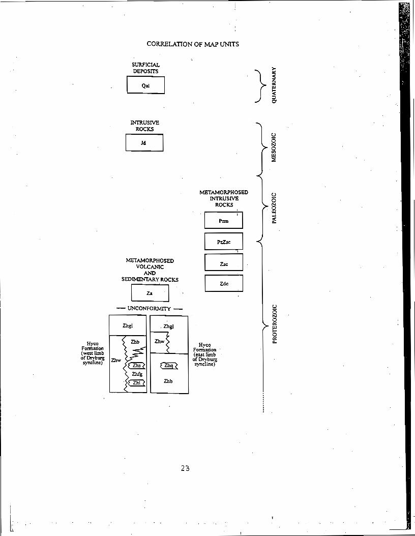
CORRELATION OF MAP U N I T S
Hyco Formation (west limb of T'J- sync me)
SURFICIAL DEPOSITS
m u s r V E ROCKS
METAMORPHOSED VOLCANIC
AND SEDtMENTARY ROCKS
METAMORPHOSED INTRUSIVE
ROCKS
Hyco Formation (cast l i b of D r v b q synche)
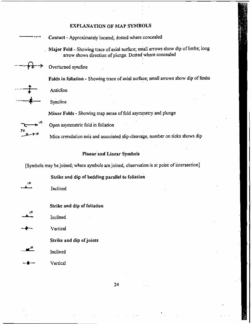
EXPLANATION OF MAP SYMBOLS
- ---- Contact - Approximately located; dotted whereconceded
. Major Fold - Showing trace of axial surface; siall arrows show dip of limbs; long arrow shows direction of plunge. Dotted'where , concealed
. . . .+> Ove~-turned syncline
Folds in foliation - Showing trace of axial surface; small arrows show dip of limbs
..... f- Anticline
Minor Folds - Showing map sense of fold asyqe t ry and plunge
X-b l o Open asymmetric fold in foliation ' '
70 Y lo Mica crenulation axis and associated slip-cleavage, number on ticks shows dip
Planar and Linear Symbols
[Symbols may be joined; where symbols are joined, observation is at point of intersection]
Strike and dip of bedding parallel to foliation 10
& Inclined
Strike and dip of foliation 10
A Inclined
-& Vertical
Strike and dip of joints
d Inclined
4- Vertical
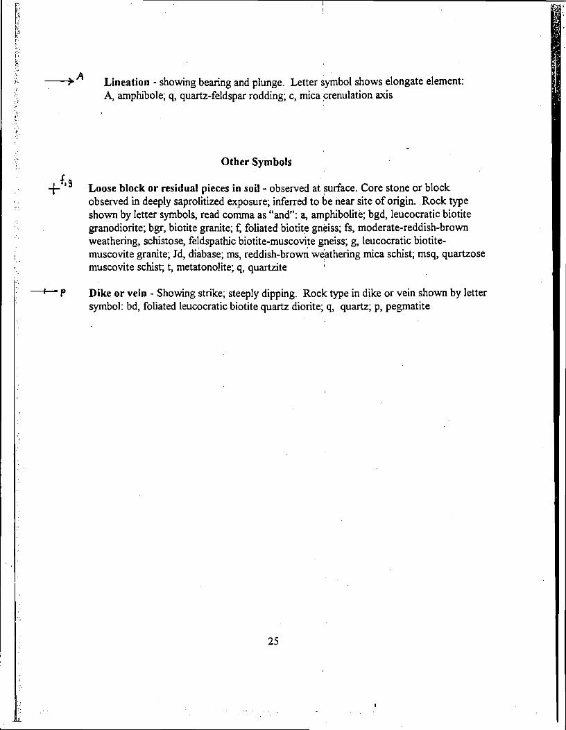
,A Lineation - showing bearing and plunge. Letter symbol shows elongate element: A, amphibole; q, quartz-feldspar rodding; c, rnica crenulation axis
Other Symbols
+{'' Loose block or residual pieces in soil - obsexved at surface. Core stone or block observed in deeply saprolitized exposure; inferred to be near site of origin. Rock type shown by letter symbols, read comma as "and": a, amphibolite; bgd, leucocratic biotite granodiorite; bgr, biotite granite; f, foliated biotite gneiss; fs, moderate-reddish-brown weathering, schistose, feldspathic biotite-muscovite gneiss; g, leucocratic biotite- muscovite granite; Jd, diabase; ms, reddish-brown weathering rnica schist; msq, quartzose muscovite schist; t, metatonolite; q, quartzite I
+ P Dike or vein - Showing strike; steeply dipping. Rock type in dike or vein shown by letter symbol: bd, foliated leucocratic biotite quartz diorite; q, quartz; p, pegmatite