Embed Size (px)
Citation preview
Summary
U.S. Fish & Wildlife Service
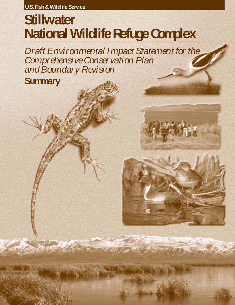
StillwaterNational Wildlife Refuge ComplexDraft Environmental Impact Statement for theComprehensive Conservation Planand Boundary Revision
SUMMARY OFDRAFT ENVIRONMENTAL IMPACT STATEMENT
for the
STILLWATER NATIONAL WILDLIFE REFUGE COMPLEX
COMPREHENSIVE CONSERVATION PLAN andBOUNDARY REVISION
March 2000
Prepared by:U.S. FISH AND WILDLIFE SERVICE
REGION 1PORTLAND, OREGON
Stillwater National Wildlife Refuge ComplexP.O. Box 1236
Fallon, Nevada 89407
CA/NV Refuge Planning Office2800 Cottage Way, Rm. W-1916Sacramento, California 95825
Summaryof the
Draft Environmental Impact Statement for theSTILLWATER NATIONAL WILDLIFE REFUGE COMPLEX
COMPREHENSIVE CONSERVATION PLAN andBOUNDARY REVISION
Churchill and Washoe Counties, Nevada
Type of Action: Administrative
Lead Agency: U.S. Department of the Interior, Fish and Wildlife Service
Responsible Officials: Anne Badgley, Regional Director, Region 1Michael Spear, California/Nevada Operations Manager
For Further Information: Kim Hanson, Refuge ManagerStillwater National Wildlife RefugeP.O. Box 1236Fallon, Nevada 89407(775) 423-5128
Abstract: The draft environmental impact statement (Draft EIS) summarize in this document describes and evaluates fouralternative comprehensive conservation plans and boundary scenarios for the Stillwater National Wildlife Refuge (NWR)Complex, which is comprised of Stillwater NWR, Fallon NWR, Stillwater Wildlife Management Area, and Anaho IslandNWR. The No Action Alternative (Alternative A) would retain the existing boundaries and entails baseline management asoutlined in the 1987 Management Plan for Stillwater WMA and modified by the U.S. Fish and Wildlife Service’s(Service’s) water-rights acquisition program. Alternative B would result in the lands within Stillwater WMA reverting backto U.S. Bureau of Reclamation or public land status, and would focus on providing fall and winter habitat for waterfowl andopportunities for waterfowl hunting on Stillwater NWR and breeding habitat for waterbirds on Fallon NWR. UnderAlternative C (Service’s Preferred Alternative), Stillwater NWR would be expanded to include most of Stillwater WMAand Fallon NWR and to include additional riparian and dune habitat. This alternative would emphasize the approximationof natural biological diversity, with adjustments to enhance breeding habitat for waterbirds and fall and winter habitat forwaterfowl, and would provide enhanced opportunities for wildlife observation and environmental education. Alternative D,in which Stillwater NWR would be expanded to include all of Stillwater WMA and Fallon NWR and to include additionalriparian and dune habitat, would focus on restoring natural hydrologic patterns and other ecological processes. Public usemanagement would focus on providing opportunities for wildlife observation and environmental education. In allalternatives, Anaho Island NWR would be managed much as it has in the past, with a continued emphasis on protecting thenesting colony of American white pelicans and other colony-nesting birds that use the island.
The issues addressed in the Draft EIS include the potential effects of the alternatives on populations of fish, wildlife, plants,and their habitat; priority public uses of the National Wildlife Refuge System; other public uses; cultural resources;Newlands Irrigation Project Operations; Naval Air Station-Fallon training; and the local economy. An insufficient volumeof water inflow, nonnative species (including livestock), and contaminants are the major factors limiting achievement ofrefuge purposes of Stillwater NWR and Fallon NWR. Compatibility of public uses is also a major issue addressed in theDraft EIS.
Commenting: Reviewers should provide the Service with their comments during the review period of the Draft EIS. Thiswill enable the Service to analyze and respond to the comments at one time and to use this input in the preparation of thefinal impact statement and the comprehensive conservation plan, thus avoiding undue delay in the decision-making process. Reviewers have an obligation to structure their input so that it is meaningful and alerts the agency to the reviewer’s positionand contentions. Environmental objections that could have been raised at the draft stage may be waived if not raised untilafter the completion of the final environmental impact statement. Comments on the Draft EIS should be specific and shouldaddress the adequacy of the EIS and the merits of the alternatives discussed (40 CFR 1503.3).
All comments received from the public will be placed in the Service’s record for this action. As part of the record,comments will be made available for inspection by the general public, and copies may also be provided to the public. Forpersons who do not wish to have their names and other identifying information made available, anonymous comments willbe accepted.
Comments on the Draft EIS should be mailed to Stillwater NWR no later than June 12, 2000
Stillwater NWR Complex CCP and Boundary Revision Summary DocumentDraft EIS 1
SUMMARY
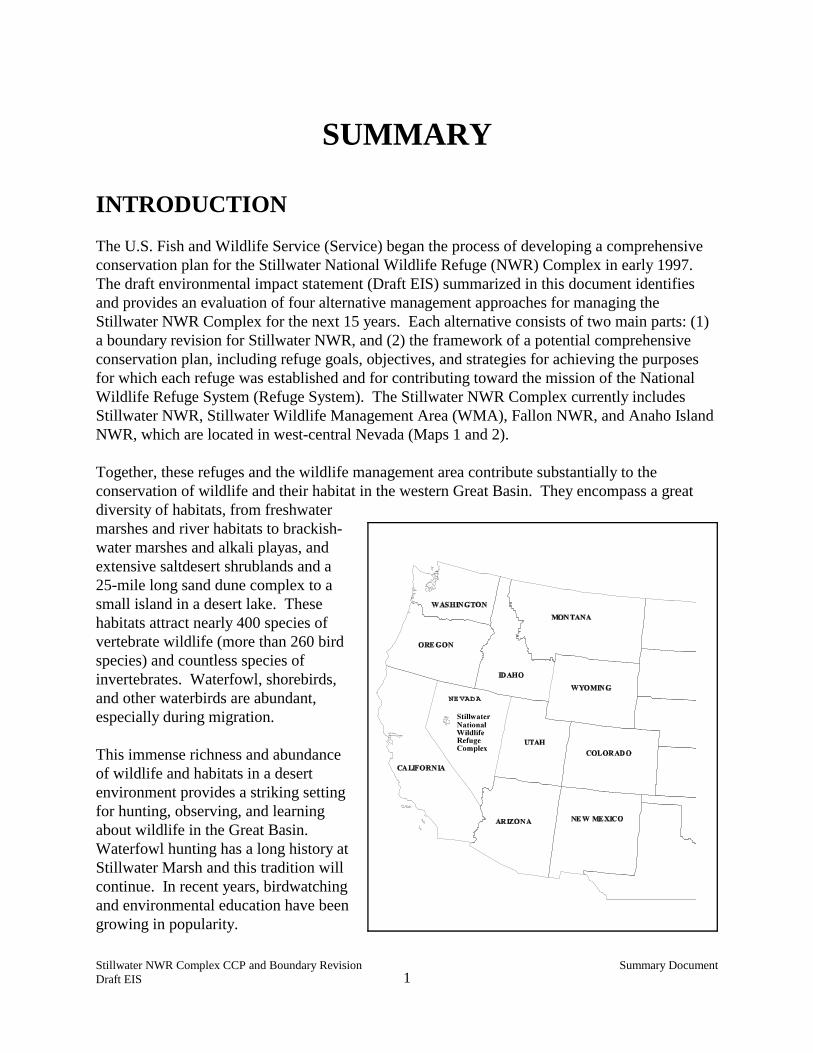
INTRODUCTIONThe U.S. Fish and Wildlife Service (Service) began the process of developing a comprehensiveconservation plan for the Stillwater National Wildlife Refuge (NWR) Complex in early 1997. The draft environmental impact statement (Draft EIS) summarized in this document identifiesand provides an evaluation of four alternative management approaches for managing theStillwater NWR Complex for the next 15 years. Each alternative consists of two main parts: (1)a boundary revision for Stillwater NWR, and (2) the framework of a potential comprehensiveconservation plan, including refuge goals, objectives, and strategies for achieving the purposesfor which each refuge was established and for contributing toward the mission of the NationalWildlife Refuge System (Refuge System). The Stillwater NWR Complex currently includesStillwater NWR, Stillwater Wildlife Management Area (WMA), Fallon NWR, and Anaho IslandNWR, which are located in west-central Nevada (Maps 1 and 2).
Together, these refuges and the wildlife management area contribute substantially to theconservation of wildlife and their habitat in the western Great Basin. They encompass a greatdiversity of habitats, from freshwatermarshes and river habitats to brackish-water marshes and alkali playas, andextensive saltdesert shrublands and a25-mile long sand dune complex to asmall island in a desert lake. Thesehabitats attract nearly 400 species ofvertebrate wildlife (more than 260 birdspecies) and countless species ofinvertebrates. Waterfowl, shorebirds,and other waterbirds are abundant,especially during migration.
This immense richness and abundanceof wildlife and habitats in a desertenvironment provides a striking settingfor hunting, observing, and learningabout wildlife in the Great Basin. Waterfowl hunting has a long history atStillwater Marsh and this tradition willcontinue. In recent years, birdwatchingand environmental education have beengrowing in popularity.
Stillwater NWR Complex CCP and Boundary Revision Summary DocumentDraft EIS 3
In addition to obtaining immense enjoyment from Stillwater NWR Complex’s wildlife andhabitats, individuals partaking in these activities have been very instrumental in ensuring thelong-term viability of the wetlands on Stillwater NWR, as well as other wetlands in the LahontanValley. If it were not for the efforts of several Nevada-based conservation groups, it is likely thatthe Service would not be acquiring much needed water rights for the refuge’s wetlands.
The human association with Stillwater Marsh goes back at least 12,000 years. The culture andtraditions of the Cattail-eater Northern Paiutes, or Toedokado, is embodied in the area’s culturalresources. Because Stillwater Marsh was such an ideal place for humans to live over themillennia, Stillwater NWR contains some of the richest cultural resources in the Great Basin.
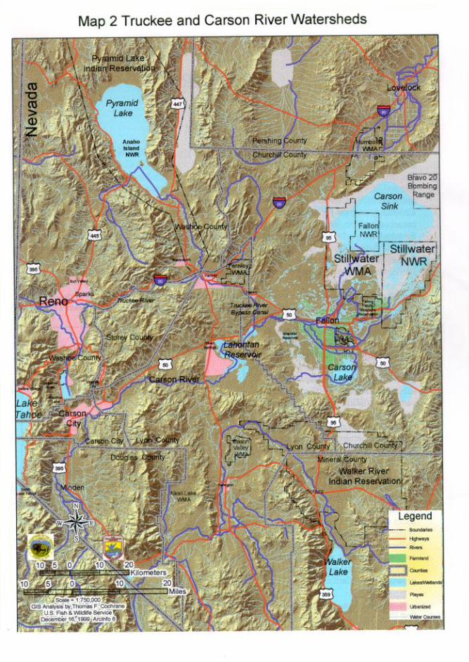
The contiguous Stillwater NWR, Stillwater WMA, and Fallon NWR are located about 6 milesnortheast of Fallon, Churchill County. Stillwater NWR is about 79,570 acres of Federal land,Stillwater WMA about 65,603 acres, and Fallon NWR about 17,848 acres, for a combined totalof 163,021 acres of Federal land. Non-Federal inholdings within the approved boundaries makeup about 59,708 acres.
Anaho Island NWR is in the Pyramid Lake Indian Reservation and is about 30 miles northeast ofReno, Washoe County. The Paiute name for Anaho Island is “Pai-sa-ka-tu-du” which meansroughly “... the dry island sitting out there all by itself..” The refuge encompasses the entireisland, which has fluctuated in size from 220 to 745 acres in recent history due to the fluctuatingwater levels of Pyramid Lake. In the summer of 1999, the size of the island was approximately490 acres.
Proposed Action
The proposed action is to (1) identify a boundary configuration of Stillwater NWR that wouldbest facilitate the achievement of the purposes for which the refuge was established, and (2)develop a comprehensive conservation plan for the Stillwater NWR Complex that best achievesthe purposes of the individual refuges that make up the complex, contributes to the mission of theRefuge System, is consistent with the principles of sound fish and wildlife management, andaddresses relevant mandates and the major issues identified during scoping. Any expansion ofthe approved boundary of Stillwater NWR would allow the Service to negotiate with willingparticipants within this boundary to acquire land. Lands acquired by the Service would bemanaged as part of the Refuge System.
The comprehensive conservation plan willemphasize two main factors. The top priority ofthe plan will be to provide goals, objectives, andstrategies aimed at conserving and protectingnative wildlife and their habitat. This prioritystems from the purposes of Stillwater NWR andthe fundamental mission of the Refuge System,which is the conservation of fish, wildlife, plants,and their habitats.
“To ensure that the Refuge System’s fish,wildlife, and plant resources endure, thelaw of the land now clearly states thattheir needs must come first.”
U.S. Fish and Wildlife Service (1999)
Stillwater NWR Complex CCP and Boundary Revision Summary DocumentDraft EIS 4
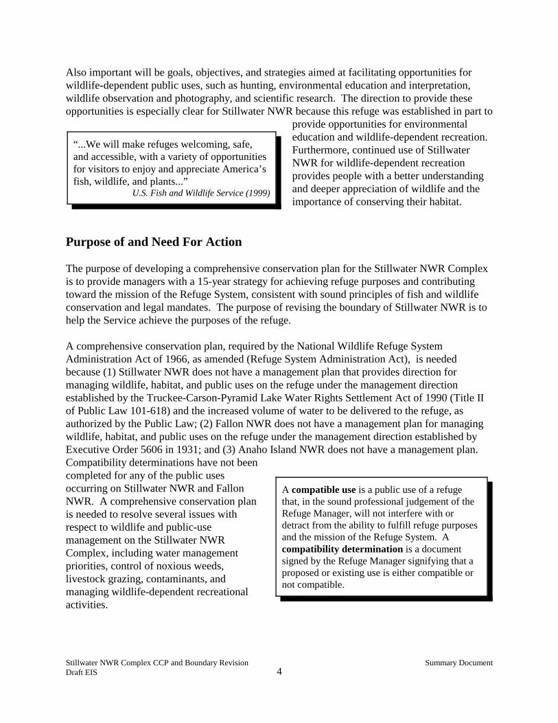
Also important will be goals, objectives, and strategies aimed at facilitating opportunities forwildlife-dependent public uses, such as hunting, environmental education and interpretation,wildlife observation and photography, and scientific research. The direction to provide theseopportunities is especially clear for Stillwater NWR because this refuge was established in part to
provide opportunities for environmentaleducation and wildlife-dependent recreation. Furthermore, continued use of StillwaterNWR for wildlife-dependent recreationprovides people with a better understandingand deeper appreciation of wildlife and theimportance of conserving their habitat.
Purpose of and Need For Action
The purpose of developing a comprehensive conservation plan for the Stillwater NWR Complexis to provide managers with a 15-year strategy for achieving refuge purposes and contributingtoward the mission of the Refuge System, consistent with sound principles of fish and wildlifeconservation and legal mandates. The purpose of revising the boundary of Stillwater NWR is tohelp the Service achieve the purposes of the refuge.
A comprehensive conservation plan, required by the National Wildlife Refuge SystemAdministration Act of 1966, as amended (Refuge System Administration Act), is neededbecause (1) Stillwater NWR does not have a management plan that provides direction formanaging wildlife, habitat, and public uses on the refuge under the management directionestablished by the Truckee-Carson-Pyramid Lake Water Rights Settlement Act of 1990 (Title IIof Public Law 101-618) and the increased volume of water to be delivered to the refuge, asauthorized by the Public Law; (2) Fallon NWR does not have a management plan for managingwildlife, habitat, and public uses on the refuge under the management direction established byExecutive Order 5606 in 1931; and (3) Anaho Island NWR does not have a management plan. Compatibility determinations have not beencompleted for any of the public usesoccurring on Stillwater NWR and FallonNWR. A comprehensive conservation planis needed to resolve several issues withrespect to wildlife and public-usemanagement on the Stillwater NWRComplex, including water managementpriorities, control of noxious weeds,livestock grazing, contaminants, andmanaging wildlife-dependent recreationalactivities.
A compatible use is a public use of a refugethat, in the sound professional judgement of theRefuge Manager, will not interfere with ordetract from the ability to fulfill refuge purposesand the mission of the Refuge System. Acompatibility determination is a documentsigned by the Refuge Manager signifying that aproposed or existing use is either compatible ornot compatible.
“...We will make refuges welcoming, safe,and accessible, with a variety of opportunitiesfor visitors to enjoy and appreciate America’sfish, wildlife, and plants...”
U.S. Fish and Wildlife Service (1999)
Stillwater NWR Complex CCP and Boundary Revision Summary DocumentDraft EIS 5
Decisions to be Made
The decisions to be made by the Pacific Region Director of the U.S. Fish and Wildlife Serviceare (1) the selection of an alternative to implement as the Stillwater NWR ComplexComprehensive Conservation Plan, and (2) the identification of the alternative boundary revisionthat would best contribute to achieving the purposes for which the refuge was established.
These decisions would be made in full recognition of the environmental effects of each of thealternatives considered. The decisions will be designated in a Record of Decision (ROD)document no sooner than 30 days after the final EIS is filed with the Environmental ProtectionAgency (EPA) and distributed to the public. The selected boundary-revision alternative will thenbe submitted to the U.S. Congress as the Service’s recommended boundary revision forStillwater NWR. Implementation of the comprehensive conservation plan will beginimmediately upon publishing a summary of the ROD in the Federal Register.
BACKGROUND INFORMATION
Establishment History and Purposes of the Stillwater NWR Complex
Anaho Island NWR was established in 1913 by Executive Order 1819 as a " . . . preserve andbreeding ground for native birds." Public Law 101-618 (§210(b)(2)) more narrowly defined thepurpose of Anaho Island NWR, stating that it was to be managed and administered " . . . for thebenefit and protection of colonial-nesting species and other migratory birds." The Public Lawalso recognized that Anaho Island is part of the Pyramid Lake Indian Reservation, but it is to bemanaged and administered by the Service as a component of the Refuge System. Amemorandum of understanding between the Service and the Pyramid Lake Paiute Tribe wassigned in March 1992 that outlined the terms of the Service’s management and administration ofthe island.
Fallon NWR is about 17,850 acres of Federal land and was established in 1931 by ExecutiveOrder 5606 “as a refuge and breeding ground for birds and other wild animals.” It has beenmanaged as part of the Stillwater WMA.
Stillwater WMA and Stillwater NWR were established through a 50-year agreement (1948Tripartite Agreement) signed in 1948 by the Truckee-Carson Irrigation District (TCID), NevadaState Board of Fish and Game Commissioners (Nevada Division of Wildlife), and the Service. Although the agreement expired in November 1998, the Service continues to cooperativelymanage the Stillwater WMA with the Bureau of Reclamation under most provisions of the 1948Tripartite Agreement (U.S. Bureau of Reclamation 2000). When Stillwater WMA wasestablished, it encompassed about 200,000 acres of land, of which about 140,000 acres werePublic Land that was originally withdrawn by the Bureau of Reclamation for Newlands IrrigationProject purposes. Stillwater WMA was established in 1948 for the purposes of conserving andmanaging wildlife and their habitat, and for public hunting. Under the Tripartite Agreement,
Stillwater NWR Complex CCP and Boundary Revision Summary DocumentDraft EIS 6
livestock grazing and muskrat production were to be managed commensurate with wildlifeconservation and management. Adjacent to the public hunting area located in Stillwater WMA,Stillwater NWR was established in 1949 as a wildlife sanctuary (closed to hunting). Itencompassed about 24,200 acres of Federal land, and comprised the southern end of the existingboundary of Stillwater NWR.
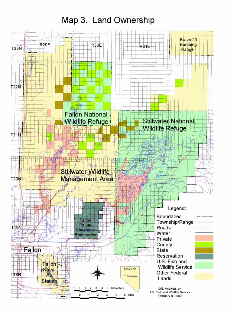
In 1990, the approved boundary of Stillwater NWR was expanded, under subsection 206(b)(1) ofthe Truckee-Carson-Pyramid Lake Water Rights Settlement Act (Title II of Public Law 101-618),to encompass Stillwater Marsh, most of which was previously in the Stillwater WMA. Map 3identifies the existing boundary of Stillwater NWR. In addition to the boundary expansion,Public Law 101-618 also outlined four purposes for which the Service must manage StillwaterNWR: (1) maintaining and restoring naturalbiological diversity within the refuge; (2) providingfor the conservation and management of fish andwildlife and their habitats within the refuge; (3) fulfilling international treaty obligations of theUnited States with respect to fish and wildlife; and(4) providing opportunities for scientific research,environmental education, and fish and wildlifeoriented recreation.
Enactment of Public Law 101-618 shifted the legal authority for managing the lands now withinStillwater NWR from the Tripartite Agreement to the Refuge Administration Act and the refugepurposes identified in Public Law 101-618. Four of the most marked changes in legal directivesare as follows. The Public Law enacted a shift in priorities whereby wildlife conservationbecame the single highest priority. It directed that all wildlife-dependent public uses be givenequal emphasis in planning and management, that these priority public uses be given higherconsideration than all other public uses, and that all uses must be shown to be compatible withrefuge purposes before they can be allowed to occur on the refuge. Livestock grazing andmuskrat trapping are only to be permitted to the extent they can help in achieving refugepurposes. The Public Law also mandated that the Service make recommendations to Congresson any boundary revisions that may be needed to help carry out refuge purposes and otherprovisions of the law.
Status of the Wetlands Water-Rights Acquisition Program
In partnership with the State of Nevada, The Nature Conservancy, and the Nevada WaterfowlAssociation, the Service has been acquiring water rights for the protection and enhancement ofLahontan Valley wetlands. The first water rights for the wetlands were purchased in 1989 by theNevada Waterfowl Association. To date, approximately 28,080 acre-feet of water rights in theCarson Division had been acquired, including 19,650 acre-feet by the Service for StillwaterRefuge, 8,150 acre-feet by the State of Nevada and Nevada Waterfowl Association for CarsonLake, and 280 acre-feet for the Bureau of Indian Affairs for the Fallon Paiute-Shoshone IndianReservation wetlands.
The natural biological diversity ofthe Stillwater area refers to thevariety within and among biologicalcommunities that evolved in the areaunder geological, evolutionary, andother ecological processes.
Stillwater NWR Complex CCP and Boundary Revision Summary DocumentDraft EIS 8
The ongoing water-rights acquisition program for Stillwater NWR and other designatedLahontan Valley wetland areas was authorized and directed by Public Law 101-618. Specifically, subsection 206(a) of Public Law 101-618 directs the Secretary of the Interior toacquire enough water and water rights, in conjunction with the State of Nevada and other parties,to sustain a long-term average of 25,000 acres of primary wetland-habitat in the Lahontan Valley. The Final Environmental Impact Statement for Water Rights Acquisition for Lahontan ValleyWetlands (WRAP EIS; U.S. Fish and Wildlife Service 1996a) describes a water-rightsacquisition program that was implemented by the Service in November 1996 when the record ofdecision was signed for the WRAP EIS decision (U.S. Fish and Wildlife Service 1996b) . TheWRAP EIS estimated that 125,000 acre-feet of water would be needed to sustain 25,000 acres ofwetland-habitat. Water sources include agricultural drainwater, spill-water, water rights from theCarson Division and from the Middle Carson River just above Lahontan Reservoir, leased waterfrom the Carson Division, and groundwater. Spill-water refers to water that is released or spilledfrom Lahontan Reservoir during high-water conditions to minimize flood potential.
Of the 25,000-acre target identified in Public Law 101-618, an average of 14,000 acres ofwetland-habitat would be sustained over the long term on Stillwater NWR, which is estimated totake about 70,000 acre-feet of the 125,000 acre-feet for the Lahontan Valley wetlands. Another10,200 acres would be sustained on Carson Lake Wildlife Management Area, and the remaining800 acres would be sustained on the Fallon Paiute-Shoshone Indian Reservation. In thecomprehensive conservation planning process for Stillwater NWR, the Service examined fouralternative strategies for managing the water being acquired for the refuge.
PLANNING ISSUES
Summary of Public Involvement
In March 1997, three public scoping meetings were conducted in Fallon, Fernley, and Reno,Nevada. The Service subsequently conducted six open-house workshops, three each in Fallonand Reno, in March, April and July. Prior to the open-house workshops, the Service sent lettersto all individuals, organizations, and agencies that were on the Lahontan Valley Wetlands WaterRights Acquisition EIS mailing list to ask if they would like to be placed on the comprehensiveconservation plan/boundary revision mailing list. The Service also sent letters to the landownerswithin the boundaries of Stillwater NWR and Stillwater WMA, and adjacent areas, summarizingthe boundary revision assessment, inviting them to the workshops, and encouraging input onissues and alternatives to consider.
The Service also met with a variety of other Federal agencies, the Nevada Division of Wildlife,Tribes, municipal governments, and several private groups on a number of occasions. A total offive planning updates were sent to people on the mailing list.
Stillwater NWR Complex CCP and Boundary Revision Summary DocumentDraft EIS 9
Summary of Major Issues
Six major issues were identified during the internal and public scoping process. Each of themajor issues described below identify potential effects that a revised boundary or comprehensiveconservation plan could have on a particular resource area. They were considered during thedevelopment of alternatives and evaluation of potential impacts.
• Potential Effects on Populations of Fish, Wildlife, and Plants. Wildlife management atStillwater NWR, Stillwater WMA, and Fallon NWR has traditionally focused on gamespecies, especially waterfowl. Thus, concern was raised that any changes to this traditionalfocus, such as any changes in water management strategies, controlling or not controllingcertain nest predators, and fisheries management, may affect waterfowl. In recent years,other migratory birds such as shorebirds and colonial-nesting species have been receivingmore management attention. Given the directive to manage Stillwater NWR to conserve thenatural biological diversity within the refuge, which includes all native species of fish,wildlife, and plants, there is interest in the effects that future management may have on theseother groups of organisms. Continued protection of colony-nesting birds at Anaho Island isthe main issue with respect to Anaho Island NWR.
Boundary revisions within the Stillwater NWR Complex can also affect populations ofanimals and plants, primarily through increased protection and restoration of sensitivehabitats such as riparian and dune habitats. Other potential effects of a boundary revisioninclude the enhanced protection afforded to reptile populations from commercial collection inChurchill County.
Another issue of concern, given the high importance of providing wildlife-dependentrecreational uses on Stillwater NWR, is the potential adverse impacts to wildlife resultingfrom people walking, driving, boating, hunting, and approaching wildlife in wildlife habitat.
• Potential Effects on Habitat and Ecosystem Functioning. Methods of managing waterand vegetation can have major effects on animal and plant populations, positive and negative. Therefore, the effects of the comprehensive conservation plan on habitat management,including the selection of management methods and intensity of use, is of concern to manypeople. Most public comments on habitat management addressed the management of waterand livestock, and their effects on habitat quality. Another important habitat issue on theStillwater NWR Complex is the effect that different management strategies have on thedistribution and abundance of several nonnative invasive plant species, such as saltcedar,perennial pepperweed, and cheatgrass. This issue applies to all units in the complex. Severalwater-born contaminants are also of concern. There is much interest in the effects thatmanaging newly acquired water rights will have on wetland-habitat on Stillwater NWR. Themajor habitat areas that could be affected by a boundary revision are the Carson Rivercorridor, the sand dune complex, a vast expanse of saltdesert shrub habitat, and thesouthwestern portion of the Carson Sink.
Stillwater NWR Complex CCP and Boundary Revision Summary DocumentDraft EIS 10
• Potential Effects on Recreational, Educational, and Interpretive Opportunities. Manypeople, including Service personnel, recognize the great potential that the Stillwater NWRComplex has for providing high-quality opportunities for wildlife-dependent recreationaluses. The Service has clear direction to facilitate compatible wildlife-dependent recreationaluses on Stillwater NWR. Two main issues surfaced during scoping: (1) members of thehunting public and others have asked that the waterfowl hunt program remain much as it istoday, including no change in the boundary of the hunt zone; and (2) people representing avariety of interests have asked that the Service provide better facilities and information forbirdwatchers, environmental educators, wildlife photographers, and other people interested inlearning about the refuge’s wildlife, habitats, and cultural resources. Although many issueswere brought to the attention of the Service, these appear to be the central issues. Interestwas also expressed in raising the limit on motorboats to 15 horespower during the huntingseason.
Other issues include the potential effects on opportunities for horseback riding, camping,access to desert areas, and hunting in upland habitats. For example, in contrast to somepeople envisioning additional opportunities created by expansion of Stillwater NWR’sboundary (e.g., for birdwatching along the Carson River), others expressed concern that itwould diminish opportunities by restricting road access and disallowing certain activities(e.g., coyote and jackrabbit hunting, and off-road vehicles).
• Potential Effects on Cultural Resources. Habitat management activities, facilitiesmaintenance, recreational use on the refuge, and a variety of environmental factors have thepotential to affect cultural resources on the refuge. Cultural resources on Stillwater NWRand WMA are essential elements of individual and group identity for members of the FallonPaiute-Shoshone Tribe. The cultural resources on Stillwater NWR and WMA are some ofthe most important cultural resources in Nevada, and the entire Stillwater Marsh has beenplaced on the National Register of Historic Places. Although cultural resources, especiallyarcheological sites, pervade Stillwater Marsh, they are fragile, easily disturbed and destroyed,and are nonrenewable. Cultural resources are small and subtle compared to the surroundinglandscape and contemporary features like roads, ditches, and visitor facilities.
The most critical issue with respect to the comprehensive conservation plan being preparedand potential boundary revision revolves around the basic question: How should culturalresources be protected and interpreted, given the need to manage wildlife habitat and publicuse of Stillwater NWR? Specific issues that need to be addressed include, (a) providingadequate protection of cultural resources from inadvertent disturbance by the public, whilestill allowing the public to enjoy a wildlife and cultural experience on the refuge; (b) reducingillegal artifact collecting and looting, while still allowing hunters and other recreationists toaccess the most archaeologically sensitive areas of the marsh; (c) implementing anenvironmental education program that incorporates accurate archaeological and culturalinformation including appropriate consultation with the Fallon Paiute Shoshone Tribe; and
Stillwater NWR Complex CCP and Boundary Revision Summary DocumentDraft EIS 11
(d) the effects of manipulating water levels, and the replacement and construction ofnecessary infrastructure on cultural resources, and the potential mitigation of these activities.
• Potential Effects on the Local Agriculture and Socio-Economy, and the NewlandsIrrigation Project. The Service was encouraged to look into ways to explore the use ofspill-water and to reassess the volume and water quality of drainwater and groundwaterreaching Stillwater NWR. Another suggestion was to reevaluate water-rights acquisitionsbased on recent adjustments to the 1988 Operating Criteria and Procedures (OCAP) for theNewlands Irrigation Project. Because the Service will have a considerable portion of waterrights in the Carson Division, changes in the seasonal water-delivery pattern has the potentialto affect Newlands Project operations and Truckee River resources. Any changes to livestockgrazing management on Stillwater NWR and Fallon NWR, in combination with any revisionsto the boundary of Stillwater NWR could potentially affect the local economy. The mostdirect economic effects of changes would be on livestock grazing permittees. Changes inrecreational opportunities could also affect the local economy.
• Potential Effects on Naval Air Station-Fallon Operations. The U.S. Navy expressedconcern that a boundary revision of Stillwater NWR could potentially affect their tacticaltraining at the Bravo-20 Bombing Range. A 3,000-foot ceiling currently exists overStillwater NWR, Fallon NWR, and Stillwater WMA, meaning that aircraft are not permittedto fly lower than 3,000 feet over this area. The 3,000-foot ceiling would not apply to anynorthward extension of Stillwater NWR.
Further Analysis of Issues
The National Environmental Policy Act (NEPA) requires that all major issues identified duringscoping be identified and described, but it does not specify which particular issues should beaddressed in any given situation. The Refuge System Administration Act, however, does specifytwo issues that are to be addressed in the comprehensive conservation planning process: (1)identification and description of significant problems that may adversely affect populations andhabitats of fish, wildlife, and plants within the planning unit, and the actions necessary to corrector mitigate such problems; and (2) identification, description, and facilitation of opportunities forwildlife-dependent recreation and a determination that allowed levels and distribution of theseuses will be compatible with refuge purposes. Of the issues identified during scoping, these twoissues provided the primary guidance in developing objectives and strategies to achieve refugegoals and purposes, and are therefore described in a little more detail on the following pages. The compatibility determination process was incorporated into the comprehensive conservationplanning effort and draft compatibility determinations are included in the Draft EIS.
Significant Problems Adversely Affecting Fish, Wildlife, and Plants
To ascertain significant problems within the Stillwater NWR Complex, existing conditionswere compared with desired, future conditions as reflected by refuge purposes and provisions
Stillwater NWR Complex CCP and Boundary Revision Summary DocumentDraft EIS 12
of the Refuge System Administration Act (such as the directive to ensure the maintenance ofbiological integrity and environmental health). For the purposes of the Draft EIS and thissummary, significant problems were defined as the underlying factors impeding theachievement of wildlife and habitat-related purposes of Stillwater NWR and Fallon NWR. The underlying factors hindering achievement of these purposes are:
• Reduced volume and altered timing of inflows, and flow restrictions in Stillwater Marsh,and along the lower Carson River and its delta, as compared to natural conditions;
• Prevalence and spread of nonnative plant and animal species in wetlands, riparian areas,and uplands;
• Altered chemistry of wetland inflows.
The first two are the major habitat issues that must be resolved or otherwise addressed inorder to meet statutory requirements. Because several contaminants have been found toexceed thresholds associated with adverse effects to wildlife, they are also of concern. Inaddition to management implications, they also have implications to the potential boundaryrevision.
Several other factors have the potential to limit the Service’s ability to achieve wildlife-related purposes. One of these is the effects of human activity on wildlife and their habitat. Other problems that will continue to have adverse effects on wildlife on the refuges are land-use practices and human activities that occur outside the refuges and throughout North,Central, and South America. Included are alterations to Carson River flow caused byagricultural, municipal, and industrial activities and Lahontan Reservoir, and habitatdestruction, pollution, and pesticide use throughout the Western Hemisphere. These off-refuge problems cannot be addressed through refuge management, but need to be recognizedwhen setting wildlife and habitat objectives. Even though they cannot be addressed on-refuge, the effects that these off-refuge problems have on refuge resources highlights the needfor the Service to continue its involvement in water allocation and management issues in theTruckee-Carson River basins, development and implementation of international birdconservation initiatives, and other large scale efforts.
Opportunities for Compatible Wildlife-Dependent Recreation
The Refuge System Administration Act requires the Service to (1) facilitate high-quality andsafe opportunities for wildlife-dependent recreation and (2) ensure that this is done in a waythat is compatible with refuge purposes and the Refuge System mission.
These two requirements may at first seem to oppose each other because one involvesfacilitation of uses and the other involves constraints on uses, one viewed as positive and theother viewed as negative. However, a closer examination reveals that they complement each
Stillwater NWR Complex CCP and Boundary Revision Summary DocumentDraft EIS 13
other. One of the dominant principles of refuge management is that, taken together, high-quality wildlife-dependent recreational experiences depend on a rich diversity and abundanceof wildlife and habitat. Without this resource, traditional uses of refuges could not besustained. Additionally, continued use of refuges for wildlife-dependent recreation providespeople with a better understanding and deeper appreciation of wildlife and the importance ofconserving their habitat, which ultimately contributes to the conservation mission of theRefuge System through increased public support.
The direction provided in the Refuge System Administration Act and the Stillwater NWRpurposes (Public Law 101-618) is very clear: opportunities for scientific research,environmental education, and other wildlife-dependent recreational uses are to be facilitatedon Stillwater NWR. “The term ‘facilitate’ was deliberately chosen [for the Refuge SystemImprovement Act] to represent a strong sense of encouragement, but not a requirement, thatways be sought to permit wildlife-dependent uses to occur if they are compatible” (HouseReport 105-106). The Refuge System Administration Act also specifically requires that thepriority general public uses of the Refuge System (hunting, fishing, wildlife observation andphotography, and environmental education and interpretation) receive enhancedconsideration over other general public uses in planning and management.
Conversely, high levels of human activity on refuges can diminish the benefits the refuge canpotentially provide to wildlife, and this is the reason why compatibility determinations aresuch an important part of refuge management. A quote from the first Refuge Manual (U.S.Fish and Wildlife Service 1943) shows that examining and attempting to resolve potentialconflicts between wildlife and public uses is not a new issue for national wildlife refuges:“Public use of refuge areas will in varying degrees result in disturbances to wildlifepopulations, but this adverse effect will be offset on many refuges by the public relationsvalue of limited public use.” To make sure that the fundamental mission of the RefugeSystem is not materially impaired, some constraints need to be imposed on uses.
With these factors in mind, the ultimate aim of this planning process for public usemanagement is to create a plan that truly facilitates and promotes an array of wildlife-dependent recreational opportunities, the combined effects of which the Service canconfidently demonstrate are compatible and consistent with refuge purposes. This has provento be a challenge given the limited amount of relevant site-specific biological data and thecontroversy that has resulted from exploring this issue. What is known from the availableinformation is that hunting is generally compatible with refuge purposes and that boating hasthe greatest potential to hinder achievement of refuge purposes. Boating is not a prioritypublic use of the Refuge System and tends to be more restrictive on refuges. An estimated 20percent of hunters used boats during the 1999-2000 hunting season. The main impactscaused by boating stem from their noise, speed, and easy access to all open habitats.
Stillwater NWR Complex CCP and Boundary Revision Summary DocumentDraft EIS 14
ALTERNATIVES BEING CONSIDEREDFour alternatives were developed by the Service for the boundary of Stillwater NWR and thecomprehensive conservation plan for the Stillwater NWR Complex. Thus, each alternativeconsists of: a potential boundary, refuge goals, objectives, and management strategies. Majorprogram areas are wildlife and habitat management, public-use management, and culturalresource management.
Factors Considered in Alternative Development
Alternative boundary revisions and management approaches were shaped by a number of factors,including:
• Legal requirements for refuge management; • Resource management principles and philosophies, including those identified during
scoping; • Existing plans and agreements;• Assessments of existing and natural ecological conditions;• Problems impairing the achievement of refuge purposes;• Other comments and recommendations from the public during scoping;• Future funding and staffing.
Differences between alternatives stem from differing management approaches identified duringthe scoping process, and thus the alternative selected for implementation will define the broadmanagement approach to be carried out for the life of the plan. Alternatives also differed in theway that public use would be managed on in the Stillwater NWR Complex.
A priority system for managing the Stillwater NWR Complex and other refuges (e.g., refugepurposes provide the primary direction for managing national wildlife refuges) is spelled out inlaws and executive orders. It is this priority system that guided alternative development for theDraft EIS. According to pertinent laws and policy, the focus of the comprehensive conservationplan, in order of priority, must be to:
1. Conserve fish, wildlife, plants, and their habitat in the manner specifically outlined in thepurposes of Stillwater NWR, Fallon NWR, and Anaho Island NWR, the Refuge SystemAdministration Act, international treaties, and other management authorities;
2. Provide opportunities for compatible wildlife-dependent recreational activities; and
3. Resolve other issues identified during scoping.
The Stillwater NWR boundary-revision effort focused on delineating alternative boundaries thatwould, in order of priority:
Stillwater NWR Complex CCP and Boundary Revision Summary DocumentDraft EIS 15
1. Contribute to achieving the purposes of Stillwater NWR and provisions of section 206(a)of Public Law 101-618, which addresses the maintenance of a long-term average of 25,000acres of primary wetland-habitat in designated Lahontan Valley wetland areas; and
2. Resolve other issues identified during scoping.
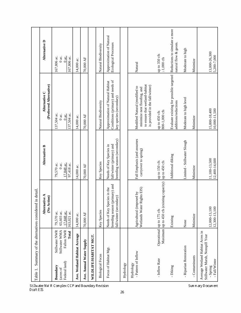
Alternatives Considered in Detail
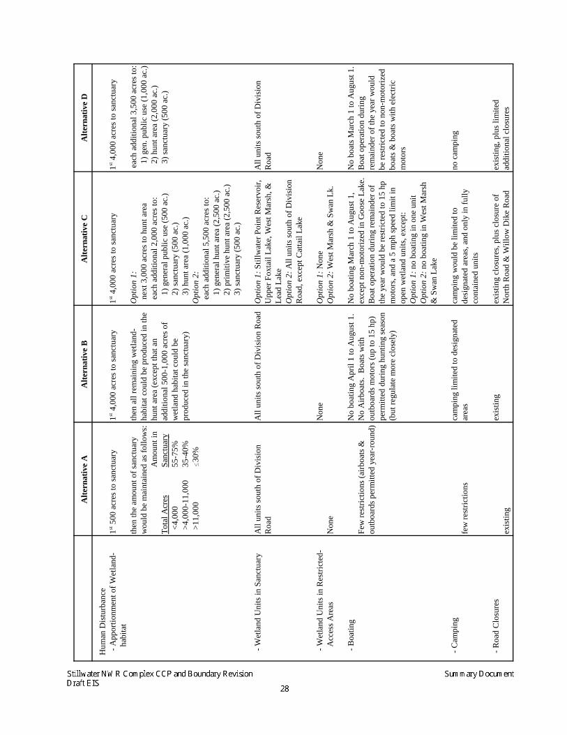
The four alternatives that are considered in detail in the Draft EIS are summarized on thefollowing pages and in Table 1 (which starts on page 26). All of the alternatives would haveseveral features in common, including:
• The status and management of private, county, and state inholdings that are within theapproved boundaries of Stillwater NWR and Stillwater WMA, or within the proposedexpansion of the approved boundary of Stillwater NWR, would not be affected by anyboundary changes.
• The water-rights acquisition program would continue until a long-term average of 14,000acres of wetland-habitat is being sustained on Stillwater NWR. It is anticipated that thiswill require an average of 70,000 acre-feet/year of wetland inflows from all sources ofwater, including acquired water-rights, drainwater, leased water, groundwater, spill-water.
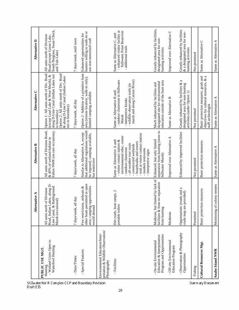
• Anaho Island NWR would be managed much as it has been in the past, with an emphasison protecting the nesting colony of American white pelicans and other colony-nesting birdsthat use the island and monitoring the annual production of colony-nesting bird productionand trends in their populations.
Alternative A (No Action Alternative)
Boundaries of Stillwater NWR, Stillwater WMA, and Fallon NWR would remain the same asthey are today. The Bureau of Reclamation has the primary withdrawal on lands withinStillwater WMA and Fallon NWR for Newlands Irrigation Project drainage purposes. TheService has extended provisions of the Tripartite Agreement, with respect to managing andadministering these lands, through a cooperative agreement with the Bureau of Reclamation(U.S. Bureau of Reclamation 2000). The combined acreage of Stillwater NWR, StillwaterWMA, and Fallon NWR is 222,729 acres, of which 163,021 is under Federal ownership.
This alternative represents baseline management as outlined in the 1987 Management Planfor Stillwater WMA and modified by the Service’s water-rights acquisition program. Stillwater NWR, Fallon NWR, and Stillwater WMA would continue to be managedaccording to the 1987 Management Plan for Stillwater WMA and provisions of the 1948Tripartite Agreement and, therefore, this alternative represents the No Action Alternative. Itprovides a baseline from which to evaluate changes proposed by any of the other alternatives. The focus of habitat management at Stillwater NWR, Stillwater WMA, and Fallon NWR
1 Bureau of Reclamation currently holds the primary withdrawal on Federal lands within Stillwater WMA and FallonNWR.
Stillwater NWR Complex CCP and Boundary Revision Summary DocumentDraft EIS 16
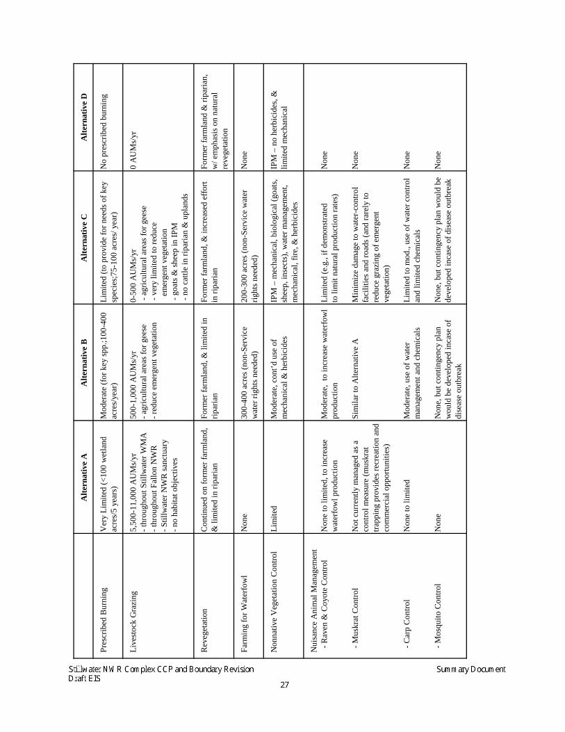
under Alternative A would be on providing nesting, migration, and wintering habitat forwaterfowl and other waterbirds. The water-delivery schedule would approximate agriculturaldelivery pattern as specified in the WRAP EIS. Revegetation of former farmland to nativevegetation would continue. Other management practices permitted under this alternative,such as prescribed burning, saltcedar control, and predator control would be implemented ona limited basis.
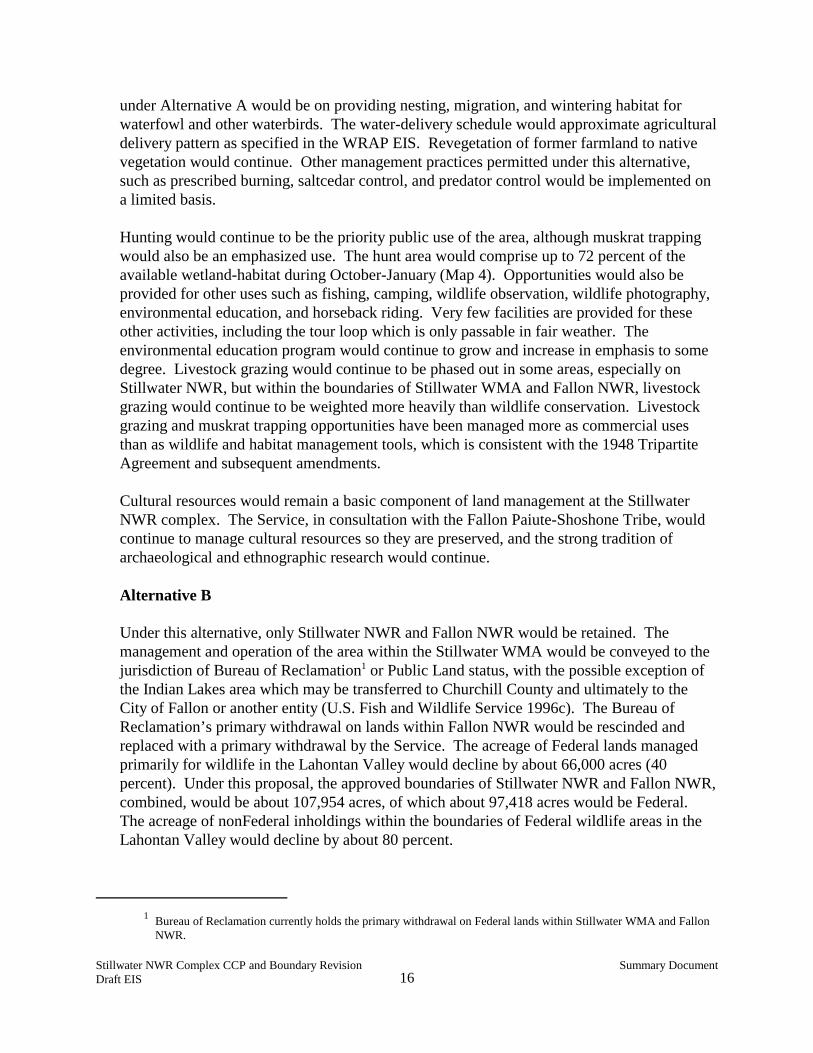
Hunting would continue to be the priority public use of the area, although muskrat trappingwould also be an emphasized use. The hunt area would comprise up to 72 percent of theavailable wetland-habitat during October-January (Map 4). Opportunities would also beprovided for other uses such as fishing, camping, wildlife observation, wildlife photography,environmental education, and horseback riding. Very few facilities are provided for theseother activities, including the tour loop which is only passable in fair weather. Theenvironmental education program would continue to grow and increase in emphasis to somedegree. Livestock grazing would continue to be phased out in some areas, especially onStillwater NWR, but within the boundaries of Stillwater WMA and Fallon NWR, livestockgrazing would continue to be weighted more heavily than wildlife conservation. Livestockgrazing and muskrat trapping opportunities have been managed more as commercial usesthan as wildlife and habitat management tools, which is consistent with the 1948 TripartiteAgreement and subsequent amendments.
Cultural resources would remain a basic component of land management at the StillwaterNWR complex. The Service, in consultation with the Fallon Paiute-Shoshone Tribe, wouldcontinue to manage cultural resources so they are preserved, and the strong tradition ofarchaeological and ethnographic research would continue.
Alternative B
Under this alternative, only Stillwater NWR and Fallon NWR would be retained. Themanagement and operation of the area within the Stillwater WMA would be conveyed to thejurisdiction of Bureau of Reclamation1 or Public Land status, with the possible exception ofthe Indian Lakes area which may be transferred to Churchill County and ultimately to theCity of Fallon or another entity (U.S. Fish and Wildlife Service 1996c). The Bureau ofReclamation’s primary withdrawal on lands within Fallon NWR would be rescinded andreplaced with a primary withdrawal by the Service. The acreage of Federal lands managedprimarily for wildlife in the Lahontan Valley would decline by about 66,000 acres (40percent). Under this proposal, the approved boundaries of Stillwater NWR and Fallon NWR,combined, would be about 107,954 acres, of which about 97,418 acres would be Federal. The acreage of nonFederal inholdings within the boundaries of Federal wildlife areas in theLahontan Valley would decline by about 80 percent.
Stillwater NWR Complex CCP and Boundary Revision Summary DocumentDraft EIS 18
This alternative focuses on providing fall and winter habitat for waterfowl and opportunitiesfor waterfowl hunting on Stillwater NWR and breeding habitat for waterbirds on FallonNWR. Much of the same management emphasis of Alternative A would be maintained inthis alternative, except that fall and winter habitat for waterfowl would be emphasized overbreeding habitat on Stillwater NWR. Water deliveries would be managed to create peakacreage in the fall and early winter to enhance waterfowl habitat and maximize the amount ofwetland-habitat during this season. On Fallon NWR, greater emphasis would be placed onproviding breeding habitat for waterfowl and other waterbirds during years when adequatewater is available, such as during precautionary releases or spills from Lahontan Reservoir. Control of saltcedar and noxious weeds would receive more attention, including on FallonNWR, as would prescribed burning. Livestock grazing would be used as a management tooland would be reduced considerably from the level of livestock grazing that has occurred inrecent years.
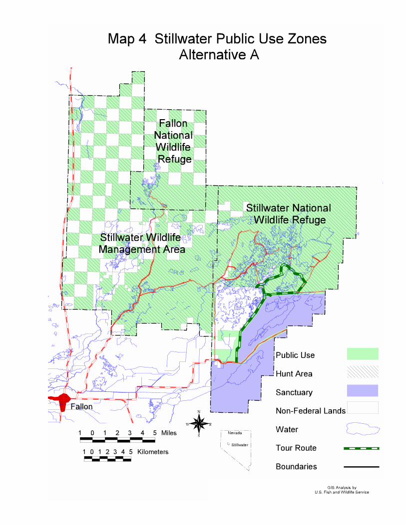
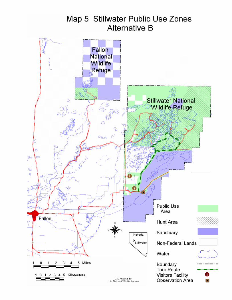
Hunting would continue to be the focal point of the public use program, exceptimprovements would be made in providing opportunities for other wildlife-dependentrecreational uses such as environmental education and wildlife observation. The hunt areawould remain where it is under existing conditions (Map 5), but additional boatingrestrictions would be imposed. An exception would be Fallon NWR, on which up to 40percent of the available fall wetland-habitat would be open to hunting. Due to the effects ofboating on wetland wildlife, several changes to boating regulations would be implemented. Under both options, a 15 horsepower limit would be enforced for motorboats (higher than theexisting 10 horsepower regulation) and airboats would not be permitted. These restrictionswould minimize adverse effects on wetland wildlife while still allowing motorboat access tothe marsh.
A visitor center, containing an environmental education center, would be constructed, theexisting tour loop would be improved, and observation points and towers would beconstructed. Opportunities for muskrat trapping would continue much as they were providedin the past, except that trapping would be used more as a management tool.
Fishing would not be permitted, primarily due to the high level of mercury contamination inthe Lahontan Valley, for which an advisory was issued by the State of Nevada noting thateating any fish caught in the Lahontan Valley is not safe. If the health advisory is lifted,fishing would be reevaluated.
Cultural resources would continue to be managed as under Alternative A.
Alternative C
This is the Service’s preferred alternative. Under this boundary-revision alternative, theapproved boundary of Stillwater NWR would be expanded to most of the lands that are nowinside Stillwater WMA and Fallon NWR. Major habitats added to Stillwater NWR would bethe lower Carson River and its delta marsh, the sand dunes along the southern edge of the
Stillwater NWR Complex CCP and Boundary Revision Summary DocumentDraft EIS 20
Carson Sink, and the stabilized dunes and salt desert shrub habitat between the Carson Riverand Stillwater Marsh. In addition to lands already in Stillwater WMA and Fallon NWR, theboundary would expand to include six sections of land along the lower Carson River and 26sections north of the existing Stillwater NWR. Although the size of Stillwater NWR wouldincrease, the acreage of Federal lands managed primarily for wildlife in the Lahontan Valleywould decline by about 25,517 acres. The most important lands with respect to refugepurposes and wetlands protection would be retained. Under this proposal, the approvedboundary of Stillwater NWR would be about 172,254 acres, of which about 137,504 acreswould be Federal. The acreage of nonFederal inholdings within the boundaries of Federalwildlife areas in the Lahontan Valley would decline by about 40 percent.
Under this alternative, the Service would manage the wetlands to approximate the area’snatural biological diversity, as outlined in refuge purposes, which would greatly benefitbreeding and migrating waterfowl, shorebirds, and other waterbirds as well as winteringwaterfowl. Habitat objectives would focus on providing a range of habitat conditions in themarshes, with an emphasis on breeding habitat, as well as restoring and protecting riparian,wet meadow, and sensitive upland areas such as the dunes. An emphasis of watermanagement would be placed on mimicking the natural seasonal pattern of inflow, modifiedsomewhat to minimize nest flooding and to provide fall and winter habitat for waterfowl andwaterfowl hunting. Second to water management, control of saltcedar and noxious weedswould be a focal point of management in meeting habitat objectives. Management wouldrecognize the important role that muskrats play in marsh ecology, but trapping would be usedto minimize damage to water-control facilities and roads. Livestock grazing would becurtailed substantially on refuge lands, and would only be used as a habitat management tool.
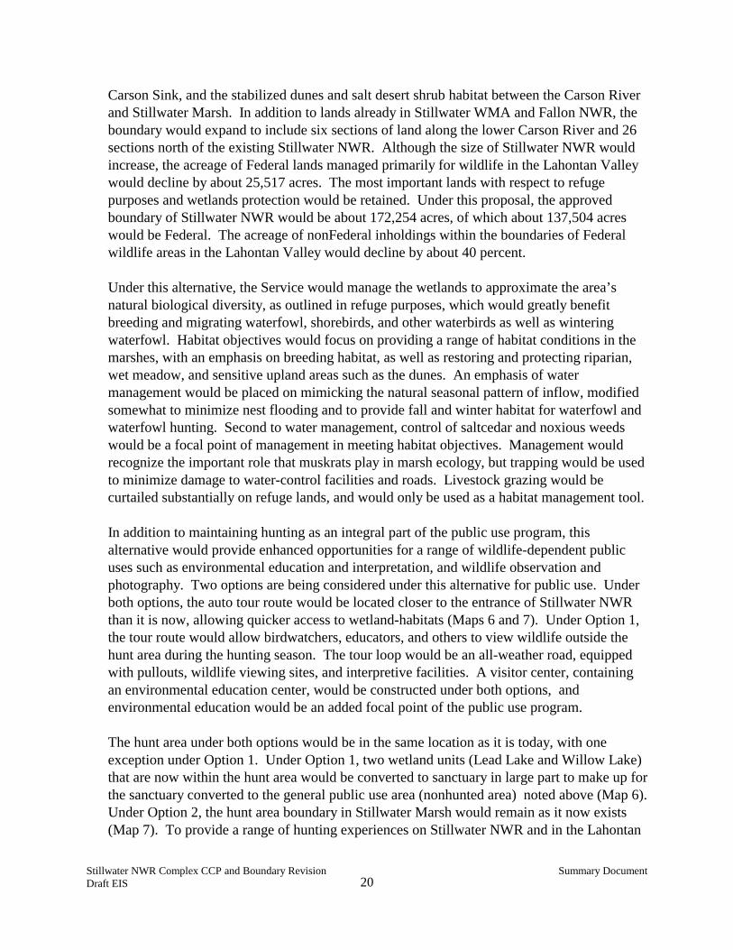
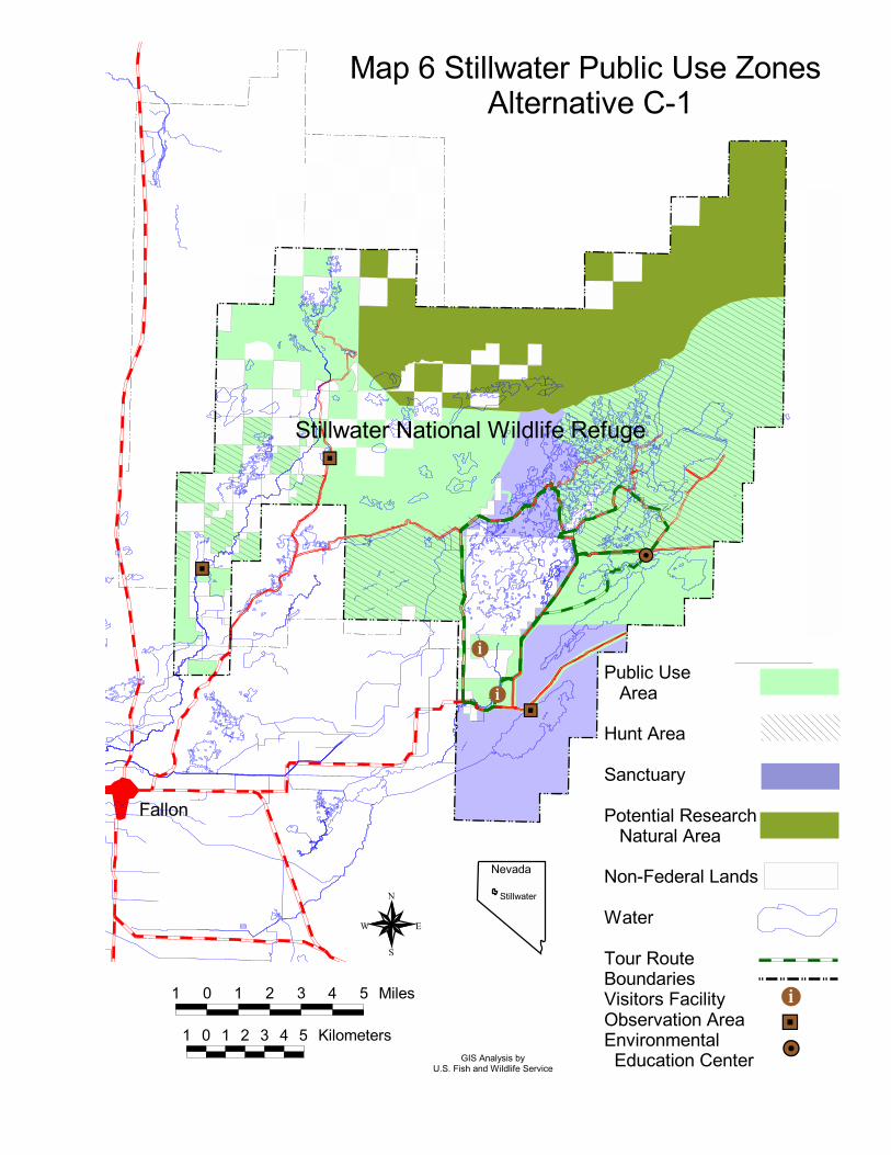
In addition to maintaining hunting as an integral part of the public use program, thisalternative would provide enhanced opportunities for a range of wildlife-dependent publicuses such as environmental education and interpretation, and wildlife observation andphotography. Two options are being considered under this alternative for public use. Underboth options, the auto tour route would be located closer to the entrance of Stillwater NWRthan it is now, allowing quicker access to wetland-habitats (Maps 6 and 7). Under Option 1,the tour route would allow birdwatchers, educators, and others to view wildlife outside thehunt area during the hunting season. The tour loop would be an all-weather road, equippedwith pullouts, wildlife viewing sites, and interpretive facilities. A visitor center, containingan environmental education center, would be constructed under both options, andenvironmental education would be an added focal point of the public use program.
The hunt area under both options would be in the same location as it is today, with oneexception under Option 1. Under Option 1, two wetland units (Lead Lake and Willow Lake)that are now within the hunt area would be converted to sanctuary in large part to make up forthe sanctuary converted to the general public use area (nonhunted area) noted above (Map 6). Under Option 2, the hunt area boundary in Stillwater Marsh would remain as it now exists(Map 7). To provide a range of hunting experiences on Stillwater NWR and in the Lahontan
#þ %[
%[
%[
#Y
#þPublic Use Area
Hunt Area
Sanctuary
Potential Research Natural Area
Non-Federal Lands
Water
Tour RouteBoundariesVisitors FacilityObservation AreaEnvironmental Education Center
Map 6 Stillwater Public Use Zones Alternative C-1
Fallon
Stillwater National Wildlife Refuge
1 0 1 2 3 4 5 Miles
1 0 1 2 3 4 5 Kilometers #Y%[#þ
N
EW
S
Nevada
Stillwater
GIS Analysis byU.S. Fish and Wildlife Service
#þ
#þ
%[
%[
%[
%[
#YPublic Use Area
Hunt Area
Walk-in Hunt Area
Sanctuary
Potential Research Natural Area
Non-Federal Lands
WaterSeasonal Tour RouteBoundariesVisitors FacilityObservation AreaEnvironmental Education Center
N
EW
S
Stillwater Summary Map 7 Public Use Zones Alternative C-2
Fallon
Stillwater National Wildlife Refuge
1 0 1 2 3 4 5 Miles
1 0 1 2 3 4 5 Kilometers%[#Y
#þ
GIS Analysis byU.S. Fish and Wildlife Service
Nevada
Stillwater
Stillwater NWR Complex CCP and Boundary Revision Summary DocumentDraft EIS 23
Valley and to ensure that hunting remains compatible with refuge purposes, several changesto boating regulations would be implemented. Under both options, a 15 horsepower limitwould be enforced for motorboats (higher than the existing regulations), airboats would notbe permitted, and a 5 mile-per-hour speed limit over the water would be imposed to minimizeadverse effects on wetland wildlife while still allowing access to the marsh using this form oftransport. Under Option 2, a walk-in-only area would be provided, consisting of two wetlandunits (West Marsh and Swan Lake). As under Alternative B, fishing would not be permitted.
Under Alternative C, the cultural resource program would become more proactive than underAlternatives A and B. The goal of the cultural resource management program would be tomanage cultural resources for the benefit of present and future generations, and anarchaeologist would be added to the staff to help support this program.
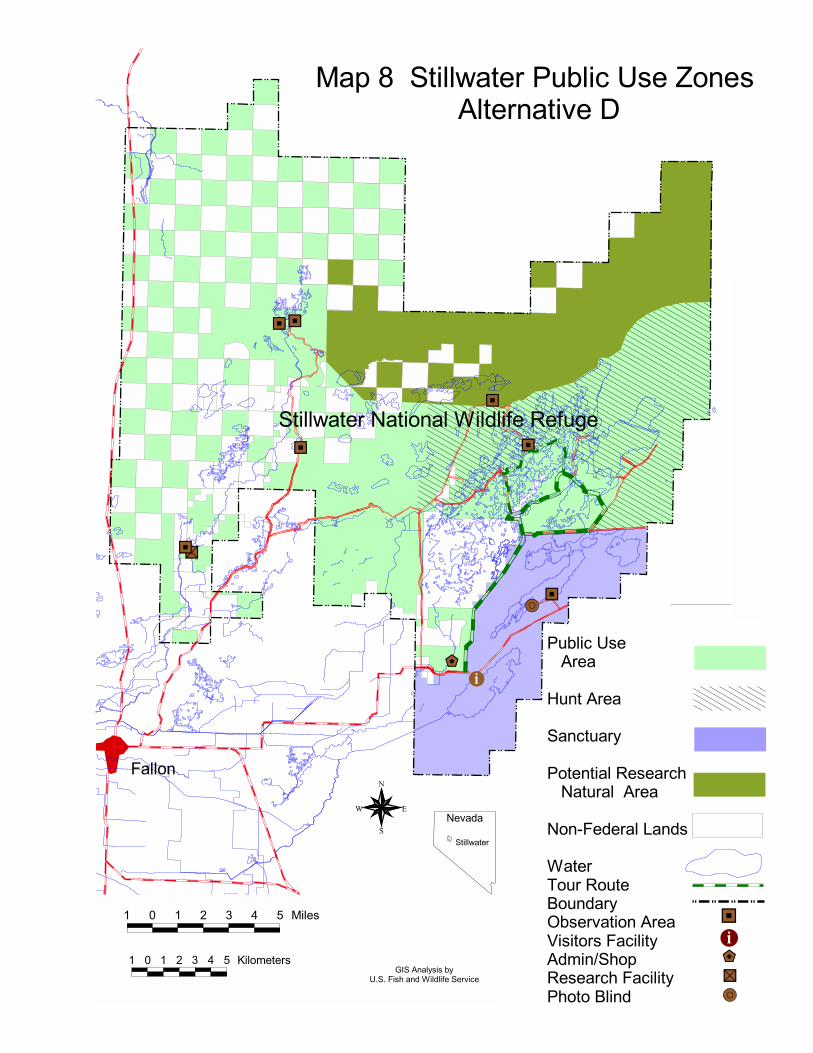
Alternative D
Under this alternative, the boundary of Stillwater NWR would be expanded to include all ofStillwater WMA and Fallon NWR, except the Indian Lakes area, as well as the six sections ofland along the lower Carson River and 26 sections north of the existing Stillwater NWRidentified under Alternative C. Major habitats added to Stillwater NWR would be the lowerCarson River and its delta marsh, the sand dunes along the southern edge of the Carson Sink,and the stabilized dunes and salt desert shrub habitat between Highway 95 and StillwaterMarsh, and the southwestern part of the Carson Sink, including the inlet of the HumboldtSlough. In addition to lands already in Stillwater WMA and Fallon NWR, the boundarywould expand to include six sections of land along the lower Carson River and 26 sectionsnorth of the existing Stillwater NWR. Under this proposal, the approved boundary ofStillwater NWR would be about 231,731 acres, of which about 167,806 acres are Federal,which would increase the amount of Federal lands managed primarily for wildlife in theLahontan Valley by about 3 percent. The acreage of nonFederal inholdings within theboundaries of Federal wildlife areas in the Lahontan Valley would increase by about 7percent.
Under this alternative, the Service would focus on approximating natural ecologicalprocesses as the primary means to restore the area’s natural biological diversity. The aim ofhabitat management would be to approximate a natural seasonal pattern of water inflow intothe refuge’s wetlands, assuming that habitat and wildlife would respond accordingly. Considerable emphasis would also be placed on restoring riparian habitats and protectingsensitive upland areas. Noxious weed control would be limited to nonintrusive methods andwould not include chemicals or nonnative biological controls. Management would recognizethe important role that muskrats play in marsh ecology, and trapping would be limited tominimize damage to water-control facilities and roads. Livestock grazing would not bepermitted on refuge lands.
Stillwater NWR Complex CCP and Boundary Revision Summary DocumentDraft EIS 24
As compared to the other alternatives, Alternative D would emphasize nonconsumptivepublic uses. Environmental education and wildlife observation would become the focal pointof public use management, as conditions would not be as favorable for waterfowl hunting asunder other alternatives (lesser amount of wetland-habitat acreage in the fall) except in spillyears. A visitor facility, containing an environmental education center, would be constructed,the existing tour loop would be improved, and observation points and trails would beconstructed. The tour loop would be an all-weather road, equipped with pullouts, wildlifeobservation points, and interpretive facilities.
During years when adequate water exists during October-January, opportunities for huntingwould be provided. In these years of high water, hunting would be provided in the northernwetland units of the refuge (Map 8). To minimize impacts from boating, restrictions wouldbe placed on boat use and some wetland units in the hunt area would be closed to boating. As under Alternative C, a 15 horsepower limit would be enforced for motorboats, airboatswould not be permitted, and a 5 mile-per-hour speed limit would be imposed to minimizeadverse effects on wetland wildlife while still allowing access to the marsh using this form oftransport. As under Alternatives B and C, fishing would not be permitted.
The cultural resource management program of this alternative would be similar to that ofAlternative C.
Summary of Alternatives Considered in Detail
Table 1 provides a summary of the alternatives considered in the Draft EIS.
#·
&\
%a
%[%[
%[
%[
%[
%[
%[
#þ
Public Use Area
Hunt Area
Sanctuary
Potential Research Natural Area
Non-Federal Lands
WaterTour RouteBoundaryObservation AreaVisitors FacilityAdmin/ShopResearch FacilityPhoto Blind
%[#þ
Map 8 Stillwater Public Use Zones Alternative D
N
EW
S
&\%a#·
Fallon
Stillwater National Wildlife Refuge
1 0 1 2 3 4 5 Miles
1 0 1 2 3 4 5 Kilometers
Nevada
Stillwater
GIS Analysis byU.S. Fish and Wildlife Service
Tabl
e 1.
Sum
mar
y of
the
alte
rnat
ives
con
side
red
in d
etai
l.
Alte
rnat
ive
A(N
o A
ctio
n)A
ltern
ativ
e B
Alte
rnat
ive
C(P
refe
rred
Alte
rnat
ive)
Alte
rnat
ive
D
Bou
ndar
ySt
illw
ater
NW
R
(acr
es o
fSt
illw
ater
WM
A
Fed
eral
land
)Fa
llon
NW
R
Tot
al
79,
570
ac.
65,
603
ac.
17,
848
ac.
163,
021
ac.
79,
570
ac.
0
ac.
17,
848
ac.
97,
418
ac.
137,
504
ac.
0
ac.
0
ac.
137,
504
ac.
167,
806
ac.
0
ac.
0
ac.
167,
806
ac.
Ave
. Wet
land
Hab
itat A
crea
ge14
,000
ac.
14,0
00 a
c.14
,000
ac.
14,0
00 a
c.
Ave
. Ann
ual W
ater
Sup
ply
70,0
00 A
F70
,000
AF
70,0
00 A
F70
,000
AF
WIL
DLI
FE/H
AB
ITA
T M
GT
.
B
iolo
gica
l Foc
usK
ey S
peci
esK
ey S
peci
esN
atur
al B
iodi
vers
ityN
atur
al B
iodi
vers
ity
Fo
cus o
f Hab
itat M
gt.
Nee
ds o
f Key
Spe
cies
in th
ebr
eedi
ng se
ason
(prim
ary)
and
fall/
win
ter (
seco
ndar
y)
Nee
ds o
f Key
Spe
cies
infa
ll/w
inte
r (pr
imar
y) a
ndbr
eedi
ng se
ason
(sec
onda
ry)
App
roxi
mat
ion
of N
atur
al H
abita
tC
ondi
tions
(prim
ary)
and
nee
ds o
fke
y sp
ecie
s (se
cond
ary)
App
roxi
mat
ion
of N
atur
alEc
olog
ical
Pro
cess
es
H
ydro
logy
H
ydro
logy
-
Patte
rn o
f Inf
low
-
Inflo
w R
ate
Ope
ratio
nal
Max
imum
-
Dik
ing
-
Rip
aria
n R
esto
ratio
n
-
Con
tam
inan
ts
Agr
icul
tura
l (im
pose
d by
Wet
land
s Wat
er R
ight
s EIS
)
up to
175
cfs
up to
450
cfs
(exi
stin
g ca
paci
ty)
Exis
ting
Non
e
Min
imiz
e
Fall
Emph
asis
(and
ass
umes
ca
rryo
ver t
o sp
ring)
up to
150
cfs
up to
450
cfs
Add
ition
al d
ikin
g
Lim
ited
- Stil
lwat
er S
loug
h
Min
imiz
e
Mod
ified
Nat
ural
(mod
ified
to
min
imiz
e ne
st fl
oodi
ng, a
nd
to e
nsur
e th
at w
etla
nd-h
abita
t
is p
rovi
ded
in th
e fa
ll/w
inte
r)
up to
450
cfs
800-
1,00
0 cf
s
Eval
uate
exi
stin
g fo
r pos
sibl
e ta
rget
edad
ditio
ns/re
duct
ions
Mod
erat
e to
hig
h le
vel
Min
imiz
e
Nat
ural
up to
350
cfs
�1,
000
cfs
Red
uctio
ns to
sim
ulat
e a
mor
ena
tura
l flo
w &
geo
m.
Mod
erat
e to
hig
h
Min
imiz
e
Ave
rage
Wet
land
Hab
itat A
cres
in S
tillw
ater
Mar
sh, N
onsp
ill Y
ear
-
Sprin
g
- Fa
ll/W
inte
r12
,000
-13,
100
12,3
00-1
3,10
011
,100
-13,
500
12,4
00-1
4,60
015
,800
-18,
400
10,0
00-1
1,50
013
,000
-26,
300
5,20
0-7,
000
Alte
rnat
ive
AA
ltern
ativ
e B
Alte
rnat
ive
CA
ltern
ativ
e D
Pre
scrib
ed B
urni
ngV
ery
Lim
ited
(<10
0 w
etla
ndac
res/
5 ye
ars)
Mod
erat
e (fo
r key
spp.
;100
-400
acre
s/ye
ar)
Lim
ited
(to p
rovi
de fo
r nee
ds o
f key
spec
ies;
75-1
00 a
cres
/ yea
r)
No
pres
crib
ed b
urni
ng
Liv
esto
ck G
razi
ng5,
500-
11,0
00 A
UM
s/yr
- thr
ough
out S
tillw
ater
WM
A- t
hrou
ghou
t Fal
lon
NW
R- S
tillw
ater
NW
R sa
nctu
ary
- no
habi
tat o
bjec
tives
500-
1,00
0 A
UM
s/yr
- agr
icul
tura
l are
as fo
r gee
se- r
educ
e em
erge
nt v
eget
atio
n
0-50
0 A
UM
s/yr
- ag
ricul
tura
l are
as fo
r gee
se -
very
lim
ited
to re
duce
em
erge
nt v
eget
atio
n -
goat
s & sh
eep
in IP
M
- no
cat
tle in
ripa
rian
& u
plan
ds
0 A
UM
s/yr
Rev
eget
atio
n
Con
tinue
d on
form
er fa
rmla
nd,
& li
mite
d in
ripa
rian
Form
er fa
rmla
nd, &
lim
ited
inrip
aria
nFo
rmer
farm
land
, & in
crea
sed
effo
rtin
ripa
rian
Form
er fa
rmla
nd &
ripa
rian,
w/ e
mph
asis
on
natu
ral
reve
geta
tion
Far
min
g fo
r Wat
erfo
wl
Non
e30
0-40
0 ac
res (
non-
Serv
ice
wat
er ri
ghts
nee
ded)
200-
300
acre
s (no
n-Se
rvic
e w
ater
right
s nee
ded)
Non
e
Non
nativ
e V
eget
atio
n C
ontro
lLi
mite
dM
oder
ate,
con
t’d u
se o
fm
echa
nica
l & h
erbi
cide
sIP
M –
mec
hani
cal,
biol
ogic
al (g
oats
,sh
eep,
inse
cts)
, wat
er m
anag
emen
t,m
echa
nica
l, fir
e, &
her
bici
des
IPM
– n
o he
rbic
ides
, &lim
ited
mec
hani
cal
Nui
sanc
e A
nim
al M
anag
emen
t
- R
aven
& C
oyot
e C
ontro
l
-
Mus
krat
Con
trol
-
Car
p C
ontro
l
-
Mos
quito
Con
trol
Non
e to
lim
ited,
to in
crea
sew
ater
fow
l pro
duct
ion
Not
cur
rent
ly m
anag
ed a
s aco
ntro
l mea
sure
(mus
krat
trapp
ing
prov
ides
recr
eatio
n an
dco
mm
erci
al o
ppor
tuni
ties)
Non
e to
lim
ited
Non
e
Mod
erat
e, t
o in
crea
se w
ater
fow
lpr
oduc
tion
Sim
ilar t
o A
ltern
ativ
e A
Mod
erat
e, u
se o
f wat
erm
anag
emen
t and
che
mic
als
Non
e, b
ut c
ontin
genc
y pl
anw
ould
be
deve
lope
d in
case
of
dise
ase
outb
reak
Lim
ited
(e.g
., if
dem
onst
rate
dto
lim
it na
tura
l pro
duct
ion
rate
s)
Min
imiz
e da
mag
e to
wat
er-c
ontro
lfa
cilit
ies a
nd ro
ads (
and
rare
ly to
redu
ce g
razi
ng o
f em
erge
ntve
geta
tion)
Lim
ited
to m
od.,
use
of w
ater
con
trol
and
limite
d ch
emic
als
Non
e, b
ut c
ontin
genc
y pl
an w
ould
be
deve
lope
d in
case
of d
isea
se o
utbr
eak
Non
e
Non
e
Non
e
Non
e
Alte
rnat
ive
AA
ltern
ativ
e B
Alte
rnat
ive
CA
ltern
ativ
e D
Hum
an D
istu
rban
ce
- A
ppor
tionm
ent o
f Wet
land
-
ha
bita
t
-
Wet
land
Uni
ts in
San
ctua
ry
-
Wet
land
Uni
ts in
Res
trict
ed-
Acc
ess A
reas
-
Boa
ting
- C
ampi
ng
- R
oad
Clo
sure
s
1st 5
00 a
cres
to sa
nctu
ary
then
the
amou
nt o
f san
ctua
ryw
ould
be
mai
ntai
ned
as fo
llow
s:A
mou
nt in
Tota
l Acr
esSa
nctu
ary
<4,
000
55-7
5% >
4,00
0-11
,000
35-4
0% >
11,0
00�
30%
All
units
sout
h of
Div
isio
nR
oad
Non
e
Few
rest
rictio
ns (a
irboa
ts &
outb
oard
s per
mitt
ed y
ear-
roun
d)
few
rest
rictio
ns
exis
ting
1st 4
,000
acr
es to
sanc
tuar
y
then
all
rem
aini
ng w
etla
nd-
habi
tat c
ould
be
prod
uced
in th
ehu
nt a
rea
(exc
ept t
hat a
nad
ditio
nal 5
00-1
,000
acr
es o
fw
etla
nd h
abita
t cou
ld b
epr
oduc
ed in
the
sanc
tuar
y)
All
units
sout
h of
Div
isio
n R
oad
Non
e
No
boat
ing
Apr
il 1
to A
ugus
t 1.
No
Airb
oats
. B
oats
with
outb
oard
s mot
ors (
up to
15
hp)
perm
itted
dur
ing
hunt
ing
seas
on(b
ut re
gula
te m
ore
clos
ely)
cam
ping
lim
ited
to d
esig
nate
dar
eas
exis
ting
1st 4
,000
acr
es to
sanc
tuar
y
Opt
ion
1:
nex
t 3,0
00 a
cres
to h
unt a
rea
eac
h ad
ditio
nal 2
,000
acr
es to
:
1) g
ener
al p
ublic
use
(500
ac.
)
2) s
anct
uary
(500
ac.
)
3) h
unt a
rea
(1,0
00 a
c.)
Opt
ion
2: e
ach
addi
tiona
l 5,5
00 a
cres
to:
1
) gen
eral
hun
t are
a (2
,500
ac.
)
2) p
rimiti
ve h
unt a
rea
(2,5
00 a
c.)
3
) san
ctua
ry (5
00 a
c.)
Opt
ion
1: S
tillw
ater
Poi
nt R
eser
voir,
Upp
er F
oxta
il La
ke, W
est M
arsh
, &Le
ad L
ake
Opt
ion
2: A
ll un
its so
uth
of D
ivis
ion
Roa
d, e
xcep
t Cat
tail
Lake
Opt
ion
1: N
one
Opt
ion
2: W
est M
arsh
& S
wan
Lk.
No
boat
ing
Mar
ch 1
to A
ugus
t 1,
exce
pt n
on-m
otor
ized
in G
oose
Lak
e.
Boa
t ope
ratio
n du
ring
rem
aind
er o
fth
e ye
ar w
ould
be
rest
ricte
d to
15
hpm
otor
s, an
d a
5 m
ph sp
eed
limit
inop
en w
etla
nd u
nits
, exc
ept:
Opt
ion
1: n
o bo
atin
g in
one
uni
tO
ptio
n 2:
no
boat
ing
in W
est M
arsh
& S
wan
Lak
e
cam
ping
wou
ld b
e lim
ited
tode
sign
ated
are
as, a
nd o
nly
in fu
llyco
ntai
ned
units
exis
ting
clos
ures
, plu
s clo
sure
of
Nor
th R
oad
& W
illow
Dik
e R
oad
1st 4
,000
acr
es to
sanc
tuar
y
eac
h ad
ditio
nal 3
,500
acr
es to
:
1) g
en. p
ublic
use
(1,0
00 a
c.)
2)
hun
t are
a (2
,000
ac.
)
3) sa
nctu
ary
(500
ac.
)
All
units
sout
h of
Div
isio
nR
oad
Non
e
No
boat
s Mar
ch 1
to A
ugus
t 1.
Boa
t ope
ratio
n du
ring
rem
aind
er o
f the
yea
r wou
ldbe
rest
ricte
d to
non
-mot
oriz
edbo
ats &
boa
ts w
ith e
lect
ricm
otor
s
no c
ampi
ng
exis
ting,
plu
s lim
ited
addi
tiona
l clo
sure
s
Alte
rnat
ive
AA
ltern
ativ
e B
Alte
rnat
ive
CA
ltern
ativ
e D
PUB
LIC
USE
MG
T.
Hun
ting
-
Wet
land
Uni
ts O
pen
to
W
ater
fow
l Hun
ting
-
Day
s/Ti
mes
-
Spec
ial F
eatu
res
All
units
nor
th o
f Div
isio
nR
oad,
Indi
an L
akes
, alo
ng D
-Li
ne C
anal
, & B
attle
grou
ndM
arsh
(occ
asio
nal)
7 da
ys/w
eek,
all
day
Few
rest
rictio
ns, a
irboa
ts &
othe
r boa
ts p
erm
itted
in o
pen
area
; cam
ping
opp
ortu
nitie
sw
ould
abo
und
All
units
nor
th o
f Div
isio
n R
oad,
& 4
0% o
f wet
land
-hab
itat i
nFa
llon
NW
R (o
n ra
re o
ccas
ions
).
7 da
ys/w
eek,
all
day
Sim
ilar t
o A
ltern
ativ
e A
, exc
ept
that
add
ition
al re
gula
tions
wou
ldbe
impo
sed;
cam
ping
ava
ilabl
e,bu
t res
trict
ive
Opt
ion
1: A
ll un
its n
orth
of D
iv. R
oad
(exc
ept L
ead
Lake
& W
est M
arsh
), &
alon
g D
-Lin
e C
anal
(Ind
ian
Lake
s not
in b
ound
ary)
Opt
ion
2: A
ll un
its n
orth
of D
iv. R
oad
& a
long
D-L
ine
Can
al (I
ndia
n La
kes
not i
n bo
unda
ry)
7 da
ys/w
eek,
all
day
Opt
ion
2: A
dditi
on o
f a p
rimiti
ve h
unt
area
(rem
ote
loca
tion,
wal
k-in
onl
y);
limite
d ca
mpi
ng a
vaila
ble
All
units
nor
th o
f Div
isio
nR
oad
(exc
ept G
oose
Lak
e,So
uth
Nut
gras
s, Sw
an C
heck
,an
d Tu
le L
ake)
7 da
ys/w
eek,
unt
il no
on
Enha
nced
opp
ortu
nitie
s for
hunt
ers w
illin
g to
wal
k-in
or
use
non-
mot
oriz
ed c
raft
Envi
ronm
enta
l Edu
catio
n/In
ter-
pret
atio
n &
Wild
life
Obs
erva
tion/
Phot
ogra
phy
-
Fac
ilitie
s
-
On-
site
Env
ironm
enta
l
Ed
ucat
ion
& In
terp
reta
tion
Prog
ram
and
Opp
ortu
nitie
s
-
Off-
site
Env
ironm
enta
l
Ed
ucat
ion
Prog
ram
-
Obs
erva
tion
& P
hoto
grap
hy
O
ppor
tuni
ties
Dirt
road
s, bo
at ra
mps
, 2po
rtabl
e to
ilets
Mod
erat
e, b
ut li
mite
d by
lack
of
faci
litie
s & fr
om n
o se
para
tion
from
hun
ting
Mod
erat
e
Opp
ortu
nist
ic (r
oads
and
acr
ude
map
are
pro
vide
d)
Sam
e as
Alte
rnat
ive
A a
nd:
- v
isito
r con
tact
stat
ion
&
env
ironm
enta
l edu
c. c
ente
r -
out
door
cla
ssro
om -
all-
wea
ther
tour
rout
e -
con
stru
cted
wet
land
s -
boa
rdw
alks
and
tow
ers
- tr
ail a
t vis
itor c
onta
ct st
atio
n -
mod
ern
rest
room
s -
inte
rpre
tive
sign
s
Enha
nced
, but
onl
y lim
ited
sepa
ratio
n fro
m h
untin
g (n
one
inSt
illw
ater
Mar
sh)
Impr
oved
ove
r Alte
rnat
ive
A
Enha
nced
by
impr
oved
faci
litie
s
Sam
e as
Alte
rnat
ive
B a
nd:
- o
utdo
or c
lass
room
in S
tillw
ater
M
arsh
- in
terp
retiv
e ki
osks
- w
ildlif
e ob
serv
atio
n tra
ils (i
n
mar
sh a
nd a
long
Car
son
Riv
er)
Muc
h en
hanc
ed b
y fa
cilit
ies a
ndde
sign
ated
site
for e
nviro
nmen
tal
educ
atio
n ou
tsid
e of
the
hunt
are
a
Sam
e as
Alte
rnat
ive
B
Gre
atly
enh
ance
d by
faci
litie
s & a
desi
gnat
ed a
rea
for n
on-h
untin
gac
tiviti
es (u
nder
Opt
ion
1)
Sam
e as
Alte
rnat
ive
C, a
nd:
- e
nhan
ced
visi
tor f
acili
ty a
t
Stil
lwat
er P
oint
Res
ervo
ir -
add
ition
al tr
ails
Gre
atly
enh
ance
d by
faci
litie
s,de
sign
ated
are
a fo
r non
-hu
ntin
g ac
tiviti
es
Impr
oved
ove
r Alte
rnat
ive
C
Gre
atly
enh
ance
d by
faci
litie
s&
a d
esig
nate
d ar
ea fo
r non
-hu
ntin
g ac
tiviti
es
Fis
hing
Perm
itted
Not
per
mitt
edN
ot p
erm
itted
Not
per
mitt
ed
Cul
tura
l Res
ourc
es M
gt.
Bas
ic p
rote
ctio
n m
easu
res
Bas
ic p
rote
ctio
n m
easu
res
Bas
ic p
rote
ctio
n m
easu
res,
goal
s and
obje
ctiv
es fo
r cul
tura
l res
ourc
es, &
ast
aff a
rche
olog
ist
Sam
e as
Alte
rnat
ive
C
Ana
ho Is
land
NW
RM
onito
ring
of c
olon
y ne
ster
sSa
me
as A
ltern
ativ
e A
Sam
e as
Alte
rnat
ive
ASa
me
as A
ltern
ativ
e A
Stillwater NWR Complex CCP and Boundary Revision Summary DocumentDraft EIS 30
POTENTIAL IMPACTS OF THE ALTERNATIVESBEING CONSIDEREDThis section, including Table 2, presents a summary of impacts that could potentially result fromimplementing the alternatives. Assessments were made of the potential effects of alternatives onexisting and baseline conditions. Existing conditions are those conditions that exist now and thatexisted in the recent past, or that could happen in the near future with the continuation of existingmanagement on the Stillwater NWR Complex and land-use practices outside the complex. Existing conditions assume that the 20,000 acre-feet of water rights acquired for Stillwater NWRhave been transferred to wetlands and that 17,000 acre-feet are available for wetland use on therefuge. However, at present, only about 7,900 acre-feet of water rights are permitted for deliveryto the wetlands. The other acquired water rights are either under protest, recently filed, orpending application. Therefore, the existing conditions identified in this Draft EIS are overstatedwith respect to actual existing conditions. Due to the high year-to-year variability and the earlystages of the water-rights acquisition program, the existing hydrologic conditions presented inthis Draft EIS are modeled conditions and are used to estimate changes in environmentalconditions due to changes in management that would occur under different alternatives.
Baseline conditions refer to those conditions that would result from continued management underAlternative A (No Action Alternative), including the completion of the ongoing water-rightsacquisition program, which may take another 15 years or more to complete. More specifically,baseline conditions assume that existing management of Stillwater NWR, Stillwater WMA, andFallon NWR continue as it has in the recent past and as generally outlined in the 1987Management Plan for Stillwater WMA, and that sufficient water is available to maintain a long-term average of 14,000 acres of wetland-habitat (i.e., completion of the water-rights acquisitionprogram), and that the efficiency targets identified in the Newlands Project OCAP (U.S. Bureauof Reclamation 1997) are being achieved.
Because baseline conditions will not be achieved for another 15 years or more, the changes fromexisting conditions to each alternative are presented. For each action alternative, this percentchange is compared with the percent change estimated to occur under the No Action Alternative(Alternative A). This is done to give readers an indication of the difference in change that wouldoccur under the No Action Alternative as compared to the action alternatives. The effects of theongoing water-rights acquisition program (the same program under all alternatives) have alreadybeen analyzed in the WRAP EIS (U.S. Fish and Wildlife Service 1996a).
Environmental consequences are direct and indirect adverse and beneficial effects that wouldresult from the action alternatives. Direct consequences are those that are caused by the action,and occur at the same time and place. Indirect consequences are also caused by the action, butoccur later in time or are further removed from the action. In addition to assessing the potentialimpacts on the environment, an assessment is also made of the effects of alternatives on theService’s capability to meet relevant legal mandates.
The assessment of environmental consequences includes the potential consequences ofalternatives on the Newlands Project operations and other environmental resources in the EIS
Stillwater NWR Complex CCP and Boundary Revision Summary DocumentDraft EIS 31
study area; physical components of the refuge complex environment (for example, waterresources); fish, wildlife, plants, and their habitats; public uses on the refuge complex; culturalresources and Indian trust assets; Naval Air Station-Fallon operations; and the local socio-economy. Also assessed is the Service’s ability to meet relevant legal and policy mandates undereach alternative and potential limitations of the alternatives on a refuge manager’s ability tomanage. The following resources were examined during scoping and the impact analysis processand found not to be affected by any of the alternatives: geology, climate and meteorology,groundwater, and secondary wetlands.
Physical Environment
Newlands Project Operations and Infrastructure
Because of the large amount of water rights that will eventually be acquired for StillwaterNWR wetlands, altering the seasonal delivery pattern of acquired water has the potential toaffect several components of Newlands Project Operations. For the parameters assessed in acomputer model (Below Lahontan Reservoir model, Bureau of Reclamation), all of thealternatives would have nearly the same effects as would Alternative A, the No ActionAlternative. An exception is the estimated change in hydroelectric power generation, forwhich Alternative C would have greater adverse impacts than would Alternatives B and D inthe long term.
For the actions being considered in the Draft EIS, headgate demand would remain unchangedbetween all of the alternatives. Under Alternatives A, B, and C, headgate delivery in theCarson Division of the Newlands Project would decline over the long term from existingconditions by an estimated 1.7 to 1.9 percent, with Alternative B being at the higher end ofthis estimate and Alternative C at the lower end. This compares with Alternative D, whichwould result in a decline of an estimated 1.4 percent over the long-term compared toestimated existing conditions. Project efficiency would increase under all alternativescompared to existing conditions (an estimated 64.8 percent). Under Alternatives A, B, andC, Project efficiency would improve to about 67.4 percent by the completion of the water-rights acquisition program. It would improve to an estimated 67.7 percent under AlternativeD.
As compared to estimated existing conditions, June 30 storage volumes in LahontanReservoir would remain nearly the same under Alternative C, increase slightly underAlternative A (1 percent) and slightly more under Alternative B (2.3 percent), but woulddecline under Alternative D (3.7 percent). November 30 storage volumes, as compared toestimated existing conditions, would increase slightly under Alternative B, somewhat moreunder Alternative A (4 percent) and C (6.9 percent), and especially under Alternative D (15.4percent).
Hydropower generation, according to the Below Lahontan Reservoir model, would alsodecline under all alternatives over the long-term. Under Alternatives A and B, hydroelectricpower generation would decline by nearly 9 percent and under Alternatives C and D, it would
Stillwater NWR Complex CCP and Boundary Revision Summary DocumentDraft EIS 32
decline by about 11 percent. Changes to revenues associated with hydroelectric powergeneration would be slightly higher than these percentage reductions, except underAlternative C in which there would be an estimated 22 percent reduction from existingconditions.
Lower Truckee River and Pyramid Lake
As with Newlands Project operations, modifications in the seasonal inflow pattern toStillwater NWR has the potential, in the long term, to alter lower Truckee River flows andPyramid Lake elevations, although effects would be slight under Alternatives B and C. Alternative B could result in slightly lesser flow volumes in the lower Truckee River andslightly lower water levels in Pyramid Lake, as compared to Alternative A. Conversely,Alternative C could result in slightly higher flow volumes in the lower Truckee River andslightly higher water levels in Pyramid Lake, as Alternative A. Effects of Alternative Dwould be similar to Alternative C, except effects would be slightly more beneficial to thelower Truckee River and Pyramid Lake.
Air Quality
Only minor, short-duration, and localized reductions in air quality would be anticipated underAlternatives B and C related to prescribed burning. Slight, immeasurable improvementscould result from Alternative D due to no prescribed burning.
Refuge Land Base
Each of the action alternatives (Alternatives B, C, and D), would result in considerablechanges to the land base of the Stillwater NWR Complex. Alternatives B and C would resultin a reduction in the acreage of Federal wildlife areas in the Lahontan Valley. Alternative Bwould result in about 65,000 acres being shifted from a Service and Bureau of Reclamation-administered wildlife management area to Bureau of Reclamation lands being administeredby their contractor. Under Alternative C, nearly 40,000 acres of Federal lands would shiftfrom Federal lands set aside for wildlife management to lands generally administered by theBureau of Reclamation. This would be counteracted by more than 15,000 acres of Bureau ofReclamation lands (currently outside the Stillwater NWR Complex boundary) beingincorporated into Stillwater NWR, for a net reduction of about 24,000 in Federally-ownedlands dedicated to wildlife management in the Lahontan Valley. Indian Lakes would not beincluded in Stillwater NWR Complex under any of the action alternatives. The size of AnahoIsland would not be measurably affected under any of the alternatives, except possiblyAlternative D which could result in the water level of Pyramid Lake rising by an estimated0.4 feet more than would occur under Alternative A. However, this would only result in lessthan an estimated ten fewer acres of land on Anaho Island.
Refuge Wetlands and Waters
None of the alternatives would affect the 14,000-acre wetland-habitat target for the StillwaterNWR Complex, although Alternatives B and D could affect the Service’s ability to achieve
Stillwater NWR Complex CCP and Boundary Revision Summary DocumentDraft EIS 33
this target. Alternative B would enhance efforts by reducing the annual wetland demand tosustain 14,000 acres of wetland-habitat, whereas Alternative D would make it more difficultto achieve the targeted acreage. Alternative D might ultimately require additional water to beacquired above the amount specified in the WRAP EIS. This summary and the Draft EIS forthe Stillwater NWR Complex comprehensive conservation plan and boundary revisionassumes that 70,000 acre-feet of water rights would be needed in average per year. Alternative C’s annual water demand for 14,000 acres of wetland-habitat would be similar tothat of Alternative A and would not require any additional water as compared to the amountspecified in the WRAP EIS. Water chemistry would not be affected markedly by thealternative selected. An estimated average of 12,500 acres of wetland habitat would besustained in Stillwater Marsh during nonspill years, and this would be supplemented by anestimated average of 16,500 acres of wetland habitat in the marsh during spill years. A spillyear refers to a year in which water is released or spilled from Lahontan Reservoir tominimize the potential of downstream flooding.
Because the water-rights acquisition program would be a component of all alternatives, theywould all result in increased acreages of wetland-habitat in all seasons of the year, exceptpossibly during the fall and winter for Alternative D (Figure 1). Differences from the effectsof the No Action Alternative would be as follows. Spring wetland-habitat would be highestunder Alternative D, with Alternative C also producing more wetland-habitat during thespring than would be produced under Alternatives A and B. During the fall and winter,Alternative B would produce the most wetland-habitat, followed by Alternative A, then C,with Alternative D producing the least amount of fall wetland-habitat.
Biological Communities
Because biological communities of wetland systems are integrally related to the seasonaldynamics of wetland inflow and other factors affecting wildlife habitat, each alternative wouldprovide for higher quality habitat for some communities and species at particular times of theyear, while habitat for other communities and species would be of lesser quality compared tobaseline conditions. After presenting each alternative’s effects on the Service’s ability toapproximate natural biological diversity, the effects of each alternative on each major componentof biological diversity are summarized.
Vegetation
As compared to existing conditions, all types of wetland vegetation would increase in amountand diversity through additional water-rights acquisitions under all of the alternativesconsidered in the Draft EIS. The effects that each alternative would have on marshvegetation would vary depending on a variety of factors, including differences in timing ofwater inflow, rate and timing of wetland subsidence, acreages and depths by season, andwater chemistry. Some alternatives would result in closer approximations than others to thenatural vegetative diversity.
The water inflow scenario and water management strategies of Alternative B would, ascompared to baseline conditions, provide deep and shallow emergent vegetation and moist
Jan Feb Mar Apr May Jun Jul Aug Sep Oct Nov Dec0
5000
10000
15000
20000
25000Alternative B
Jan Feb Mar Apr May Jun Jul Aug Sep Oct Nov Dec0
5000
10000
15000
20000
25000 Alternative DJan Feb Mar Apr May Jun Jul Aug Sep Oct Nov Dec0
5000
10000
15000
20000
25000
Alternative A(Baseline)
Jan Feb Mar Apr May Jun Jul Aug Sep Oct Nov Dec0
5000
10000
15000
20000
25000 Alternative C
Figure 1. Estimated average wetland-habitat acreages in Stillwater Marsh during nonspill years resulting from existing conditions (i.e.,assumes that all existing water rights are available for use in the wetlands) and alternative water-delivery schedules that assume completionof the ongoing water-rights acquisition program, Stillwater National Wildlife Refuge, Nevada. The verticaldashed line represents the onsetof the nesting season for waterbirds, and the vertical dashed and dotted line represents the fall migration and wintering season for waterfowland the onset of the waterfowl hunting season. Average annual acreage in the top graph is 6,600 acres and is 12,500 acres in all of the othergraphs.
Jan Feb Mar Apr May Jun Jul Aug Sep Oct Nov Dec0
5000
10000
15000
20000
25000Existing Conditions
Stillwater NWR Complex CCP and Boundary Revision Summary DocumentDraft EIS 35
soil vegetation that is flooded in the fall. As compared to baseline conditions, Alternative Cwould tend to produce more shallow emergent vegetation, wet meadow vegetation, springflooded moist soil vegetation, possibly more fall-flooded moist soil vegetation, and slightlylesser amounts of submergent aquatic vegetation. Alternative D would tend to produce moreshallow emergent vegetation, wet meadow vegetation, and spring-flooded moist soilvegetation than Alternative C, but would result in less submergent aquatic vegetation and nofall-flooded moist soil vegetation would be produced.
Riparian vegetation would be enhanced to the greatest extent under Alternative C through theexpansion of Stillwater NWR’s boundary to include the lower Carson River (an additionalthree miles of riverine habitat) and increased restoration emphasis, including an integratedprogram to reduce saltcedar and other invasive exotic vegetation and elimination of cattlegrazing along riparian corridors. Several plant communities now absent or in lowdistribution would be produced or their distribution increased. Restoration efforts underAlternative D would provide similar benefits to riparian vegetation, but would be slightlyimpaired by restrictions on biological and chemical controls. Riparian vegetation underAlternative B would continue in a degraded condition, as only four miles of the 27 miles nowwithin the Stillwater NWR Complex would be retained.
Upland vegetation would be enhanced to the largest degree under Alternative D because thisalternative would protect the largest amount of upland vegetation. Alternative C wouldprotect slightly less, but would still result in restoration of some upland plant communitiesthrough the elimination of livestock grazing in upland areas. Alternative B would protect theleast amount of upland vegetation.
The connection between the Humboldt River System and the Carson River system, a uniqueecological area, which occurs where the Humboldt Slough flows into the Carson Sink, wouldbe provided long-term protection under Alternative D, but would be foregone underAlternatives B and C.
Wildlife
Overall, as compared to baseline conditions, Alternative C would provide the most benefitsfor marsh and riparian wildlife during the breeding season and Alternative B would providethe most benefits for fall migrating and wintering birds using Stillwater Marsh. The amountand quality of wetland-habitat for an array of breeding waterbirds would be considerablyhigher under Alternative C as compared to existing and baseline conditions. Greaterprotection of the lower Carson River and more attention on restoring riparian habitat underAlternative C would benefit migratory birds, small mammals, and other wildlife associatedwith this habitat. Under Alternative B, the amount of breeding habitat would be slightlyhigher than it would be under baseline conditions, although the amount and diversity ofhabitats would not be as high as under Alternative C. Even though the acreage of springtimewetland-habitat would be significantly higher under Alternative D, the peak would occur wellafter most birds have started nesting, and the acreage would decline rapidly during thesummer months, thereby markedly reducing the quality of the habitat produced.
Stillwater NWR Complex CCP and Boundary Revision Summary DocumentDraft EIS 36
Alternative D would be the most favorable alternative for fall migrating shorebirds due to thevast expanse of wetland-habitat experiencing declining water levels throughout the shorebirdmigration period. Alternative C would be the next most favorable for similar reasons,followed by Alternative B and A, respectively. Alternatives A and B would be the leastdesirable for shorebirds because water levels during the migration period would not fluctuatesubstantially and, where water levels change, they would generally be rising (Alternative B).
Alternative B would be the most favorable to fall migrating and wintering waterfowl. Thehighest concentrations of waterfowl on Stillwater NWR occur during September throughNovember, and Alternative B would provide the highest amount of wetland-habitat duringthis period, of the alternatives being considered. Alternatives A and C would also improvehabitat conditions for fall and winter waterfowl markedly compared to existing conditions. Alternative A would eventually provide more wetland-habitat during the fall and winter, butmanagement under Alternative C would provide higher-quality habitats, which would tend toequalize the benefits to waterfowl during this period. Alternative D would have few benefitsto fall and winter waterfowl, as compared to existing conditions.
Alternative D would be the most favorable alternative for upland species, and the benefits ofAlternative C would be close to this level. Both alternatives would protect, within onecontiguous jurisdiction, a 25-mile-long sand dune system at the southern edge of the CarsonSink. This dune system provides habitat for several species of endemic dune beetles andother species associated with dune habitats. Under Alternatives A and B, the dune systemwould extend through different jurisdictions.
No adverse impacts to endangered or threatened species, as compared to baseline conditions,would be anticipated under any of the alternatives being considered. Bald eagles, Federallylisted as threatened, would benefit under all of the alternatives, except Alternative D. Ascompared to existing conditions, all of the alternatives would benefit cui-ui (an endangeredspecies) and Lahontan cutthroat trout (a threatened species), both inhabiting the TruckeeRiver and Pyramid Lake. Although differences in effects would be slight, cui-ui wouldbenefit most from the implementation of Alternative D, followed by Alternatives C, A, andB, respectively. Similarly, Lahontan cutthroat trout would benefit most from Alternatives Cand D, followed by Alternatives A and B, respectively.
Natural Biological Diversity
In general, Alternative C would most approximate the natural biological diversity of any ofthe alternatives. A majority of the water being delivered to Stillwater NWR wetlands in latewinter or early spring would emulate a spring pulse of water followed by summer drawdown. This would contribute toward habitat and associated biological communities that thishydrologic regime produced under natural conditions. Fall and winter habitat was also amajor component of the Lahontan Valley wetland system under natural conditions and wouldbe provided under Alternative C. Relatively low volume and flow rate of springtime flowswould continue to be a limiting factor under Alternative C.
Stillwater NWR Complex CCP and Boundary Revision Summary DocumentDraft EIS 37
Each of the other alternatives would highlight other aspects of the natural biological diversityand would diminish other aspects. For example, Alternative A would simulate year-roundwetland-habitat, which existed at times under natural conditions during periods when theCarson River flowed directly into Stillwater Marsh. However, the biological communitiesproduced by flushing flows that occurred during spring and by the seasonal fluctuations inwater levels characteristic of the Lahontan Valley wetlands in most years, would be poorlysimulated. Alternative B would enhance biological diversity during the fall and winter, butthis would be a tradeoff with early season flushing flows, breeding habitat, and otherconditions that would be produced through a spring pulse of water. Alternative D highlightthe habitat conditions making Great Basin wetlands ideal for shorebirds, that is, decliningwater levels during August and September. It would also to some extent enhance biologicaldiversity during the late spring and early summer, but because of lower-than-natural winterflows, wetland-habitat acreage would increase sharply during the nesting season, therebyflooding nests.
Recreation
Hunting
The size and location of the hunt area was a major concern to waterfowl hunters. Theamount of area open to hunting varies by alternative. The amount of wetland-habitat open tohunting under the different alternatives is a function of the boundary of the hunt area, theacreage of wetland-habitat on the entire refuge during the hunting season, and the allocationof wetted acres among the hunt area, wildlife sanctuary, and general public use area (foralternatives including this zone). Nonspill and spill years are treated separately because ofthe vastly different conditions they can produce. Compared to existing conditions, theamount of wetland-habitat available for hunting during nonspill years would increase underall alternatives, except Alternative D. In the long term (at the completion of the water-rightsacquisition program), Alternative B would result in the most wetland-habitat available duringthe hunting season—more than twice the amount anticipated with the existing water rights ina full-allocation nonspill year (up to an estimated 9,500 acres compared to 4,100 acres), andslightly higher than what is estimated under Alternative A at the completion of theacquisition program (an estimated 8,900 acres).
Of the two options being considered under Alternative C, Option 2 would provide thegreatest benefits to hunters in the long term, with an estimated increase in huntable fall andwinter wetland-habitat of about 50-80 percent over the amount of wetland-habitat availablefor hunting under existing conditions in a full-allocation, nonspill year (an estimated 6,000 to7,400 acres). Increases under Option 1 of Alternative C would be an estimated 10 to 20percent over existing conditions. In spill years (about one of four years), the amount ofwetland-habitat available for hunting would be similar for Alternatives A, B, and Option 2 ofAlternative C. Available hunting opportunities would decline from existing conditions underAlternative D. Additional boating restrictions under Alternatives C and D could enhance thehunting experience for some hunters while it would impair the opportunity for other hunters.
Stillwater NWR Complex CCP and Boundary Revision Summary DocumentDraft EIS 38
The year-to-year reliability of Stillwater NWR for providing suitable hunting conditions,compared to existing conditions and past conditions, would continue to increase under all ofthe alternatives, except Alternative D. In the past, the amount of wetland-habitat available forhunting varied tremendously from year to year, from less than 1,000 acres in some years toover 10,000 acres in other years. This resulted in the number of hunter visits fluctuatingwidely, from less than 800 in some years to over 10,000 in other years. Under Alternatives Aand B, it is estimated that the amount of wetland-habitat open to hunting would exceed 8,000acres in 8-9 out of 10 years, with the remaining 1-2 years having more than half this amount. Under Option 2 of Alternative C, it is estimated that wetland-habitat open to hunting wouldexceed 6,000 acres in 8-9 out of 10 years, with the remaining 1-2 years having at least half thisamount. In all of these alternatives, the amount of wetland-habitat open to hunting would beas high as 10,000 or more acres in 2-3 years out of 10, as has occurred in the past due to spills. Under Option 1 of Alternative C, the amount of wetland-habitat open to hunting would be atleast 4,500 acres in 8-9 out of 10 years, with acreages reaching 7,000 or more in spill years. Inmost years under Alternative D, it is estimated that there would be less than 1,500 acres inmost years, with up to 6,000 acres of open habitat in 2-3 years out of 10.
Environmental Education and Interpretation
Alternatives B, C, and D would enhance environmental education opportunities as comparedto baseline conditions (Alternative A). Option 1 of Alternative C and Alternative D wouldenhance the environmental education and interpretation program to the largest degree. Forexample, Option 1 of Alternative C would provide a higher quality, year-round tour loopcloser to the entrance of Stillwater NWR and would provide wetland-related environmentaleducation opportunities outside the hunt area. Option 2 of Alternative C would also providea high-quality tour loop close to the refuge entrance, but it would not be open during thehunting season, except on a limited basis, and it would not access as much wetland-habitat aswould the tour loop of Option 1. Alternative D would provide additional opportunities,especially during spring and early summer. However, wetlands along the tour loop would befurther from the refuge entrance, and less wetland-habitat would be available for viewingduring the late summer, fall, and winter.
Wildlife Observation and Photography
Alternatives B, C, and D would enhance wildlife observation and photography opportunitiesabove those provided under baseline conditions (Alternative A). Option 1 of Alternative Cand Alternative D would enhance wildlife observation opportunities to the largest degree. Option 1 of Alternative C would provide a higher quality tour loop closer to the entrance ofStillwater NWR and would provide wildlife observation opportunities outside the hunt area. Alternative D would provide additional opportunities, but wetlands along the tour loop wouldbe further from the refuge entrance. Option 2 of Alternative C would also provide a high-quality tour loop close to the refuge entrance, as would Option 1, but it would not be openduring the hunting season, and it would not access as much wetland-habitat as would the tourloop of Option 1. Alternatives C and D would provide the best viewing opportunities duringthe spring (breeding waterbirds) and late summer (shorebirds).
Stillwater NWR Complex CCP and Boundary Revision Summary DocumentDraft EIS 39
Construction of an all-weather tour route and viewing towers would enhance wildlife viewingopportunities under Alternative B, but other parts of the alternative would offset some ofthese additional opportunities. For example, viewing opportunities during the spring wouldbe reduced because portions of Stillwater Marsh would be closed to public access during thebreeding season and viewing opportunities during the fall and winter would continue to behampered due to hunting throughout the portion of the marsh open to public access.
Fishing
Fishing would not be permitted under any of the action alternatives. This would slightlyreduce fishing opportunities in the Lahontan Valley because little fishing presently occurs onStillwater NWR, Stillwater WMA, and Fallon NWR at present. Of major concern is thehealth advisory against eating fish in the Lahontan Valley, due to mercury contamination, andconflicts with wetland management and waterbird production.
Camping and Boating
Opportunities for camping in the Stillwater Marsh area would be highest under Alternative A,and would be reduced considerably under Alternatives B and C, and would be completelyeliminated under Alternative D. Under Alternative B, overnight stays would only bepermitted during the hunting season at designated sites and, under Alternative C, would bepermitted year-round in designated areas. Reductions in camping could result in increasedcamping in other nearby areas, possibly including the Indian Lakes area, private entities andadjacent Bureau of Land Management lands.
Alternative A would similarly provide the most boating opportunities during the huntingseason and throughout the year. Under Alternative B, boating opportunities would bereduced somewhat because airboats would not be permitted, motorboats would be limited to15 horsepower, and boating by the public would not be permitted from the end of the huntingseason through July 31. Alternative C could reduce boating opportunities further through theimplementation of a 5 mile-per-hour speed limit, and one to three units closed to motorizedboating. Boating opportunities would be significantly reduced under Alternative D becauseboating would be restricted to motorless craft and because of lower acreages of wetland-habitat during the hunting season.
Other Uses
Alternative A would provide the most opportunities for other uses such as horseback riding,picnicking, swimming, and trapping. These are non-priority public uses of the RefugeSystem. Under all action alternatives, activities occurring on the Indian Lakes area (wheremost of the “other uses” occur) would presumably continue as they have in the recent past. Actions being considered in the Draft EIS would not affect these activities, as the boundaryrevision alternatives would not include the Indian Lakes area. Because Alternative B wouldinclude the least amount of land in national wildlife refuge status, it would have the leastimpact to the other uses, whereas Alternatives C and D would have the most impact. In thelatter two alternatives, horseback riding, mountain bike riding, and street-legal vehicleswould be permitted, but would only be allowed on open roads.
Stillwater NWR Complex CCP and Boundary Revision Summary DocumentDraft EIS 40
Cultural Resources and Indian Trust Assets
Under Alternative A, the Service would continue to provide a required level of protection ofcultural resources for its cultural resource management program, except as funds becomeavailable for additional work. Alternative B would be similar except that the addition of a lawenforcement officer would enhance protection of these resources. Under Alternatives C and D,the Service would place additional emphasis on cultural resources and they would be moreeffectively protected. No adverse impacts to Indian trust assets would occur under any of thealternatives
Socio-Economics
With respect to anticipated changes in hunting, other recreation, livestock grazing, and muskrattrapping on Stillwater NWR, Stillwater WMA, and Fallon NWR, implementation of AlternativeC would result in a net benefit to the local economy of an estimated $88,000 to $200,000, whichis a 5-12 percent increase above the contribution estimated for Alternative A at the completion ofthe water-rights acquisition program. Although revenues from livestock grazing and muskrattrapping would be reduced on the Federal lands now encompassed within the Stillwater NWRComplex, revenues from general recreation would be anticipated to increase. Implementation ofAlternatives B and D would result in an anticipated reduction in contributions to the localeconomy, and estimated 1-2 percent reduction (Alternative B) and 2-10 percent reduction(Alternative D). Benefits associated with general recreation would be highest under AlternativeD, but these benefits would be more than offset by reductions in hunting, livestock grazing, andmuskrat trapping. Benefits under Alternative C would be offset and reductions underAlternatives B and D would be worsened by reductions in hydroelectric power generation at theNew Lahontan Power Plant.
Naval Air Station-Fallon Operations
Alternatives C and D would result in the northern boundary of Stillwater NWR moving six milescloser to the Bravo-20 Bombing Range. This bombing range is used by the Naval Air Station-Fallon for tactical combat training and the Navy had expressed concerns about the effects ofrevising Stillwater’s boundary on these operations. Because the boundary of the 3,000-footceiling that now exists over Stillwater NWR and Fallon NWR would not be moved with anynorthward expansion of Stillwater NWR, the boundary revision and ensuing management ofthese lands would not impair Naval Air Station-Fallon operations. An existing memorandum ofunderstanding would be modified to formalize this agreement between the Navy and the Service.
Ability of the Fish and Wildlife Service to Meet Legal Mandates
Alternative C would, compared to the other alternatives being considered, provide the bestframework for the Service to meet legal mandates. This would include the highest potential forapproximating natural biological diversity, fulfilling international treaty obligations with respectto wildlife, otherwise conserving wildlife, and providing opportunities for scientific research,environmental education, and other wildlife-dependent recreation. Alternative B would holdequally high potential for conserving wildlife, although toward different goals, except that a
Stillwater NWR Complex CCP and Boundary Revision Summary DocumentDraft EIS 41
considerable amount of important habitats would not be protected within the refuges. Alternatives A and D would hold the least potential for meeting legal mandates.
A concern was raised that placing limitations on certain management tools could hinder a refugemanager’s ability to achieve refuge goals and objectives. Alternatives A and B would providemanagers with the most flexibility and Alternative D would provide the least. Alternatives A andB would place few restrictions beyond those established through laws and Service policy. Although Alternative C would impose more restrictions on the use of some management tools,such as livestock grazing and prescribed burning, the constraints were designed as part of thestrategy to emphasize management practices that mimic ecological processes and the conditionsthey naturally produced. Regarding the examples given in the preceding sentence, grazing andbrowsing by large herbivores, other than mule deer (still present), and fire shaped the habitats ofthe Lahontan Valley only to a limited degree under natural conditions.
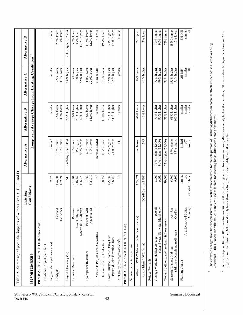
1Th
e es
timat
ed c
hang
es fr
om b
asel
ine
pres
ente
d in
this
mat
rix w
ere
calc
ulat
ed fo
r the
sole
pur
pose
of i
llust
ratin
g di
ffere
nces
in p
oten
tial e
ffect
s of e
ach
of th
e al
tern
ativ
es b
eing
cons
ider
ed..
The
num
bers
are
est
imat
es o
nly
and
are
used
as i
ndic
es fo
r ass
essi
ng b
road
diff
eren
ces a
mon
g al
tern
ativ
es.
2EC
= e
xist
ing
cond
ition
s; B
C =
bas
elin
e co
nditi
ons,
SH =
slig
htly
hig
her t
han
base
line
cond
ition
s, M
H =
mod
erat
ely
high
er th
an b
asel
ine,
CH
= c
onsi
dera
bly
high
er th
an b
asel
ine,
SL
=sli
ghtly
low
er th
an b
asel
ine,
ML
= m
oder
atel
y lo
wer
than
bas
elin
e, C
L =
cons
ider
ably
low
er th
an b
asel
ine.
Tabl
e 2.
Sum
mar
y of
pot
entia
l im
pact
s of A
ltern
ativ
es A
, B, C
, and
D.
Res
ourc
e/Is
sue
Exi
stin
gC
ondi
tions
Alte
rnat
ive
AA
ltern
ativ
e B
Alte
rnat
ive
CA
ltern
ativ
e D
Lon
g-te
rm A
vera
ge C
hang
e fr
om E
xist
ing
Con
ditio
ns1,
2
PHY
SIC
AL
ENV
IRO
NM
ENT
(EIS
Stu
dy A
rea)
N
ewla
nds P
roje
ct (a
cre-
feet
)
Ir
rigat
ed A
crea
ge B
ase
(acr
es)
59,0
75
sim
ilar1
sim
ilar
sim
ilar
sim
ilar
H
eadg
ate
Dem
and
D
eliv
erie
s 17
4,50
0 16
9,29
0 2.
5% lo
wer
1.8%
low
er2.
5% lo
wer
1.9%
low
er2.
5% lo
wer
1.7%
low
er2.
5% lo
wer
1.4%
low
er
P
roje
ct E
ffici
ency
(%)
64.8
2.
6% h
ighe
r (67
.4%
)2.
6% h
ighe
r2.
6% h
ighe
r2.
9% h
ighe
r (67
.7%
)
L
ahon
tan
Res
ervo
irR
elea
ses
June
30
Stor
age
N
ovem
ber 3
0 St
orag
e
261,
100
216,
160
108,
070
5.5%
low
er1%
hig
her
4.0%
hig
her
5.6%
low
er2.
3% h
ighe
r1.
0% h
ighe
r
5.4
low
er0.
1% h
ighe
r6.
9% h
ighe
r
5.6%
low
er3.
7% lo
wer
15.4
% h
ighe
r
H
ydro
pow
er R
esou
rces
Pow
er (G
Wh)
R
even
ue ($
) 21
,660
87
5,01
0 8.
6% lo
wer
8.9%
low
er8.
6% lo
wer
11.0
% lo
wer
11.0
% lo
wer
22.0
% lo
wer
11.5
% lo
wer
12.2
% lo
wer
New
land
s Pro
ject
Can
al C
apac
ities
EC2
incr
ease
nee
ded
sim
ilar
sim
ilar-M
HSH
-MH
Tru
ckee
Can
al a
t Der
by D
am88
,250
15
.7%
low
er15
.0%
low
er16
.3%
low
er19
.9%
low
er
L
ower
Tru
ckee
Riv
er a
t Der
by D
am
Pyr
amid
Lak
e El
evat
ion
(feet
)47
5,66
0 3,
836.
9 2.
8% h
ighe
r3.
1 ft.
hig
her
2.7%
hig
her
2.6
ft. h
ighe
r2.
9% h
ighe
r3.
2 ft.
hig
her
3.1%
hig
her
3.6
ft. h
ighe
r
A
ir Q
ualit
y (m
icro
gram
s/m
eter
3 )EC
11
1si
mila
rsi
mila
rsi
mila
r
PHY
SIC
AL
ENV
IRO
NM
ENT
(ON
REF
UG
E)
S
ervi
ce L
ands
Acr
eage
Bas
e
Stil
lwat
er N
WR
/WM
A a
nd F
allo
n N
WR
(acr
es)
163,
021
no c
hang
e40
% lo
wer
16%
low
er3%
hig
her
Ana
ho Is
land
NW
R (a
cres
)EC
(490
ac.
in 1
999)
24
5<1
% lo
wer
<1%
hig
her
2% lo
wer
R
efug
e W
etla
nds
A
vera
ge W
etla
nd-H
abita
t Acr
eage
ov
eral
l no
nspi
ll ye
ar, S
tillw
ater
Mar
sh o
nly
8,00
0 6,
600
75%
hig
her (
14,0
00)
90%
hig
her (
12,5
00)
75%
hig
her
90%
hig
her
75%
hig
her
90%
hig
her
75%
hig
her
90%
hig
her
W
etla
nd d
eliv
erie
s and
inci
dent
al in
flow
s (av
e.)
39
,900
75
% h
ighe
r (70
,000
)75
% h
ighe
r75
% h
ighe
r75
% h
ighe
r
S
easo
nal W
etla
nd-H
abita
tA
pr-J
un
(S
tillw
ater
Mar
sh, n
onsp
ill y
ear)
Oct
-Dec
6,
700
6,80
0 87
% h
ighe
r87
% h
ighe
r95
% h
ighe
r10
0% h
ighe
r15
3% h
ighe
r55
% h
ighe
r18
3% h
ighe
r15
% lo
wer
F
lush
ing
Act
ion
Tota
l Dis
solv
ed S
olid
s M
ercu
ry
limite
d EC
po
tent
ial p
robl
em
limite
dB
C1
sim
ilar
sim
ilar
sim
ilar
sim
ilar
SH-M
H1
sim
ilar
SH
SH-M
Hsi
mila
rSH
Stillwater NWR Complex CCP and Boundary Revision Summary DocumentDraft EIS 42
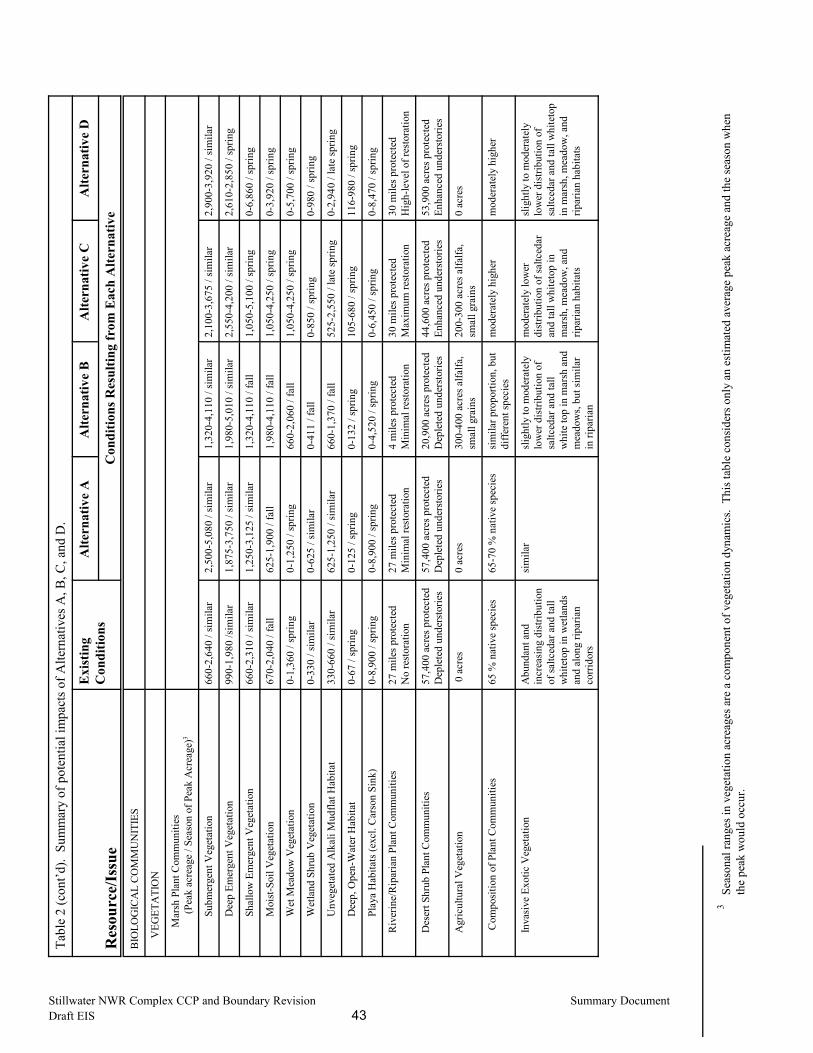
3Se
ason
al ra
nges
in v
eget
atio
n ac
reag
es a
re a
com
pone
nt o
f veg
etat
ion
dyna
mic
s. T
his t
able
con
side
rs o
nly
an e
stim
ated
ave
rage
pea
k ac
reag
e an
d th
e se
ason
whe
nth
e pe
ak w
ould
occ
ur.
Tabl
e 2
(con
t�d).
Sum
mar
y of
pot
entia
l im
pact
s of A
ltern
ativ
es A
, B, C
, and
D.
Res
ourc
e/Is
sue
Exi
stin
gC
ondi
tions
Alte
rnat
ive
AA
ltern
ativ
e B
Alte
rnat
ive
CA
ltern
ativ
e D
Con
ditio
ns R
esul
ting
from
Eac
h A
ltern
ativ
e
BIO
LOG
ICA
L C
OM
MU
NIT
IES
V
EGET
ATI
ON
Mar
sh P
lant
Com
mun
ities
(P
eak
acre
age
/ Sea
son
of P
eak
Acr
eage
)3
Subm
erge
nt V
eget
atio
n66
0-2,
640
/ sim
ilar
2,50
0-5,
080
/ sim
ilar
1,32
0-4,
110
/ sim
ilar
2,10
0-3,
675
/ sim
ilar
2,90
0-3,
920
/ sim
ilar
Dee
p Em
erge
nt V
eget
atio
n99
0-1,
980
/sim
ilar
1,87
5-3,
750
/ sim
ilar
1,98
0-5,
010
/ sim
ilar
2,55
0-4,
200
/ sim
ilar
2,61
0-2,
850
/ spr
ing
Shal
low
Em
erge
nt V
eget
atio
n66
0-2,
310
/ sim
ilar
1,25
0-3,
125
/ sim
ilar
1,32
0-4,
110
/ fal
l1,
050-
5,10
0 / s
prin
g0-
6,86
0 / s
prin
g
Moi
st-S
oil V
eget
atio
n67
0-2,
040
/ fal
l62
5-1,
900
/ fal
l1,
980-
4,11
0 / f
all
1,05
0-4,
250
/ spr
ing
0-3,
920
/ spr
ing
Wet
Mea
dow
Veg
etat
ion
0-1,
360
/ spr
ing
0-1,
250
/ spr
ing
660-
2,06
0 / f
all
1,05
0-4,
250
/ spr
ing
0-5,
700
/ spr
ing
Wet
land
Shr
ub V
eget
atio
n0-
330
/ sim
ilar
0-62
5 / s
imila
r0-
411
/ fal
l0-
850
/ spr
ing
0-98
0 / s
prin
g
Unv
eget
ated
Alk
ali M
udfla
t Hab
itat
330-
660
/ sim
ilar
625-
1,25
0 / s
imila
r66
0-1,
370
/ fal
l52
5-2,
550
/ lat
e sp
ring
0-2,
940
/ lat
e sp
ring
Dee
p, O
pen-
Wat
er H
abita
t0-
67 /
sprin
g0-
125
/ spr
ing
0-13
2 / s
prin
g10
5-68
0 / s
prin
g11
6-98
0 / s
prin
g
Play
a H
abita
ts (e
xcl.
Car
son
Sink
)0-
8,90
0 / s
prin
g0-
8,90
0 / s
prin
g0-
4,52
0 / s
prin
g0-
6,45
0 / s
prin
g0-
8,47
0 / s
prin
g
Riv
erin
e/R
ipar
ian
Plan
t Com
mun
ities
27 m
iles p
rote
cted
No
rest
orat
ion
27 m
iles p
rote
cted
Min
imal
rest
orat
ion
4 m
iles p
rote
cted
Min
imal
rest
orat
ion
30 m
iles p
rote
cted
Max
imum
rest
orat
ion
30 m
iles p
rote
cted
Hig
h-le
vel o
f res
tora
tion
Des
ert S
hrub
Pla
nt C
omm
uniti
es57
,400
acr
es p
rote
cted
Dep
lete
d un
ders
torie
s57
,400
acr
es p
rote
cted
Dep
lete
d un
ders
torie
s20
,900
acr
es p
rote
cted
Dep
lete
d un
ders
torie
s44
,600
acr
es p
rote
cted
Enha
nced
und
erst
orie
s53
,900
acr
es p
rote
cted
Enha
nced
und
erst
orie
s
Agr
icul
tura
l Veg
etat
ion
0 a
cres
0 ac
res
300-
400
acre
s alfa
lfa,
smal
l gra
ins
200-
300
acre
s alfa
lfa,
smal
l gra
ins
0 ac
res
Com
posi
tion
of P
lant
Com
mun
ities
65 %
nat
ive
spec
ies
65-7
0 %
nat
ive
spec
ies
sim
ilar p
ropo
rtion
, but
diffe
rent
spec
ies
mod
erat
ely
high
er
mod
erat
ely
high
er
Inva
sive
Exo
tic V
eget
atio
nA
bund
ant a
ndin
crea
sing
dis
tribu
tion
of sa
ltced
ar a
nd ta
llw
hite
top
in w
etla
nds
and
alon
g rip
aria
nco
rrido
rs
sim
ilar
slig
htly
to m
oder
atel
ylo
wer
dis
tribu
tion
ofsa
ltced
ar a
nd ta
llw
hite
top
in m
arsh
and
mea
dow
s, bu
t sim
ilar
in ri
paria
n
mod
erat
ely
low
erdi
strib
utio
n of
saltc
edar
and
tall
whi
teto
p in
mar
sh, m
eado
w, a
ndrip
aria
n ha
bita
ts
sligh
tly to
mod
erat
ely
low
er d
istri
butio
n of
saltc
edar
and
tall
whi
teto
pin
mar
sh, m
eado
w, a
ndrip
aria
n ha
bita
ts
Stillwater NWR Complex CCP and Boundary Revision Summary DocumentDraft EIS 43
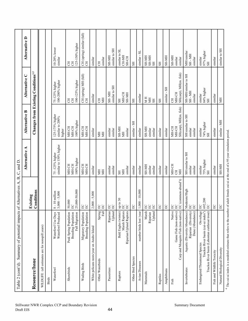
Tabl
e 2
(con
t�d).
Sum
mar
y of
pot
entia
l im
pact
s of A
ltern
ativ
es A
, B, C
, and
D.
Res
ourc
e/Is
sue
Exi
stin
gC
ondi
tions
Alte
rnat
ive
AA
ltern
ativ
e B
Alte
rnat
ive
CA
ltern
ativ
e D
Cha
nges
from
Exi
stin
g C
ondi
tions
1,2
WIL
DLI
FE (
all e
stim
ates
are
for n
onsp
ill y
ears
)
Bird
s
W
ater
fow
l W
ater
fow
l Use
Day
s
W
ater
fow
l Pro
duce
d
8 - 1
0 m
illio
n3,
000
- 5,0
0075
-125
% h
ighe
rsi
mila
r to
150%
hig
her
125-
175%
hig
her
sim
ilar t
o 20
0%hi
gher
75-1
25%
hig
her
100-
200%
hig
her
10-2
0% lo
wer
sim
ilar
S
hore
bird
sPe
ak S
prin
g Po
pula
tion
B
reed
ing
Popu
latio
n
Fall
Mig
ratio
n
50,0
00EC 25
,000
-50,
000
MH
-CH
MH
-CH
100%
hig
her
MH
-CH
MH
-CH
100%
hig
her
CH
CH
100-
125%
hig
her
CH
CH
125-
150%
hig
her
W
adin
g B
irds
M
igra
tory
Pop
ulat
ion
Bre
edin
g Po
pula
tion
EC EC
MH
-CH
MH
-CH
MH
-CH
MH
-CH
CH
(spr
ing)
MH
(fal
l)C
HC
H (s
prin
g) si
mila
r (fa
ll)C
H
W
hite
pel
ican
s nes
ts/y
ear o
n A
naho
Isla
nd
2,00
0 - 5
,000
sim
ilar
sim
ilar
sim
ilar
sim
ilar
O
ther
Wat
erbi
rds
Sprin
g Fa
ll EC EC
MH
MH
MH
MH
CH
MH
CH
sim
ilar
P
asse
rines
Rip
aria
n U
plan
d EC EC
sim
ilar
sim
ilar
sim
ilar
sim
ilar
SH- M
Hsi
mila
r to
SHSH
-MH
sim
ilar t
o SH
R
apto
rs
B
ald
Eagl
es (w
inte
r) M
arsh
Rap
tors
R
ipar
ian/
Upl
and
Rap
tors
up to
30
EC EC
SH MH
sim
ilar
SH-M
HM
Hsi
mila
r
SH MH
-CH
SH-M
H
sim
ilar t
o SL
CH
-MH
SH-C
H
O
ther
Bird
Spe
cies
ECsi
mila
rsi
mila
r - S
HSH
SH
A
vian
Dis
ease
snu
mbe
r bird
s los
t /ye
ar
1,00
0 - 1
0,00
0si
mila
rsi
mila
rsi
mila
rsi
mila
r - S
L
Mam
mal
sM
arsh
R
ipar
ian
U
plan
d
EC EC EC
SH-M
H
sim
ilar
sim
ilar
SH-M
Hsi
mila
rsi
mila
r
M H
MH
SH
SH-M
HSH
-MH
SH
Rep
tiles
ECsi
mila
rsi
mila
rSH
SH
Am
phib
ians
ECsi
mila
rsi
mila
rsi
mila
r - S
HSH
-MH
Fish
Nat
ive
Gam
e Fi
sh (n
on-n
ativ
e)
Car
p an
d M
osqu
ito F
ish
(non
-nat
ive)
EC EC EC (c
omm
on-a
bund
�t)
MH
-CH
C
HM
H
MH
-CH
MH
-CH
SH(c
arp)
, MH
(m. f
ish)
CH
MH
-CH
SH(c
arp)
, MH
(m. f
ish)
SH-M
Hsi
mila
r si
mila
r
Inve
rtebr
ates
Aqu
atic
(Div
ersi
ty/A
bund
ance
) R
ipar
ian
(Div
ersi
ty)
Dun
e (A
bund
ance
)
Mod
erat
e/H
igh
EC EC
SH/s
imila
r to
SHsi
mila
rsi
mila
r
SH/s
imila
r to
SHsi
mila
rsi
mila
r
SH-M
H/s
imila
r to
SHSH
- M
Hsi
mila
r
MH
/sim
ilar
SH -
MH
sim
ilar
Enda
nger
ed/T
hrea
tene
d Sp
ecie
sO
n-re
fuge
Tr
ucke
e R
iver
bas
in (c
ui-u
i ind
ex4 )
Truc
kee
Riv
er b
asin
(Lah
onta
n cu
tthro
at tr
out)
EC 692,
200
EC
sim
ilar
75%
hig
her
SH
sim
ilar
74%
hig
her
SH
sim
ilar
84%
hig
her
SH
sim
ilar
97%
hig
her
SH
Fish
and
Wild
life
Toxi
city
ECsi
mila
rsi
mila
rsi
mila
rsi
mila
r
Nat
ural
Bio
logi
cal D
iver
sity
ECSH
-MH
sim
ilar -
MH
MH
sim
ilar t
o SH
4 The
cui
-ui i
ndex
is a
mod
eled
est
imat
e th
at re
fers
to th
e nu
mbe
r of a
dult
fem
ale
cui-u
i at t
he e
nd o
f a 9
5-ye
ar si
mul
atio
n pe
riod.
Stillwater NWR Complex CCP and Boundary Revision Summary DocumentDraft EIS 44
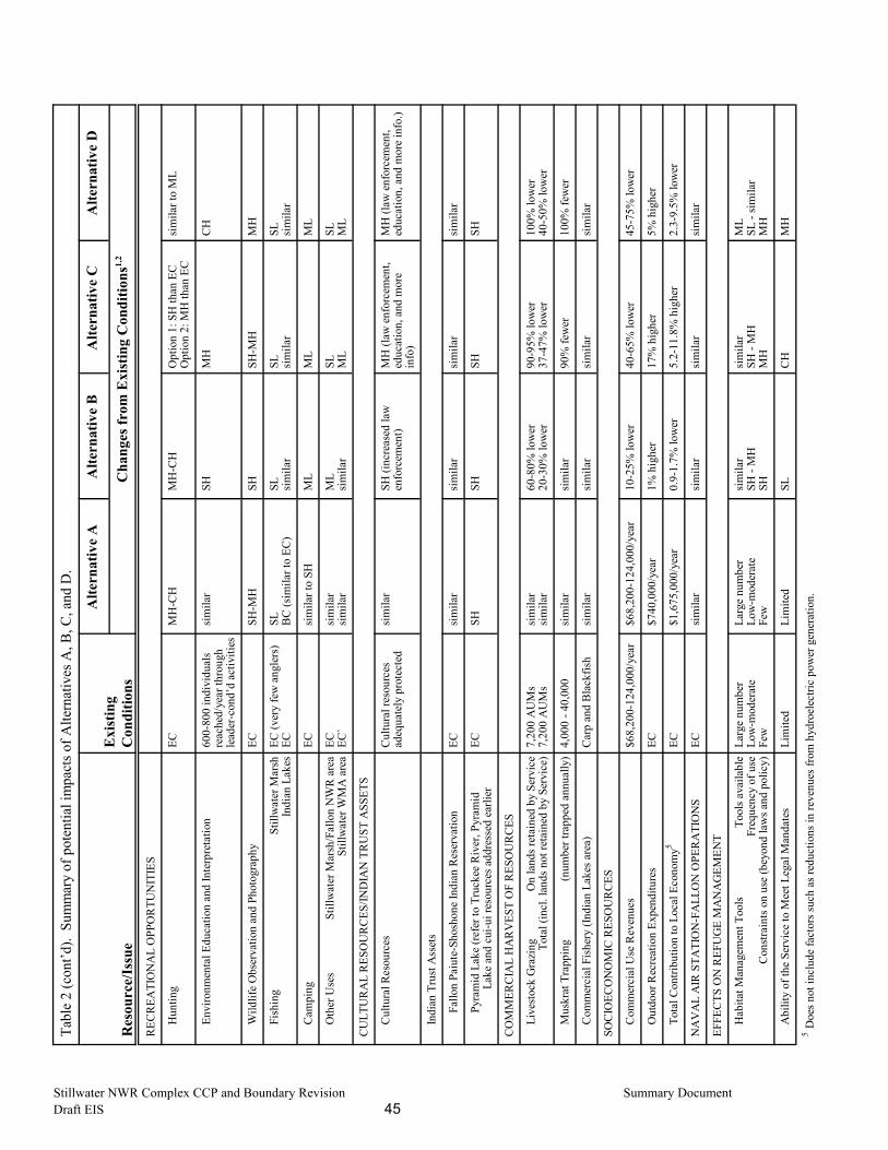
Tabl
e 2
(con
t�d).
Sum
mar
y of
pot
entia
l im
pact
s of A
ltern
ativ
es A
, B, C
, and
D.
Res
ourc
e/Is
sue
Exi
stin
gC
ondi
tions
Alte
rnat
ive
AA
ltern
ativ
e B
Alte
rnat
ive
CA
ltern
ativ
e D
Cha
nges
from
Exi
stin
g C
ondi
tions
1,2
REC
REA
TIO
NA
L O
PPO
RTU
NIT
IES
H
untin
gEC
MH
-CH
MH
-CH
Opt
ion
1: S
H th
an E
CO
ptio
n 2:
MH
than
EC
si
mila
r to
ML
E
nviro
nmen
tal E
duca
tion
and
Inte
rpre
tatio
n60
0-80
0 in
divi
dual
sre
ache
d/ye
ar th
roug
hle
ader
-con
d�d
activ
ities
sim
ilar
SHM
HC
H
W
ildlif
e O
bser
vatio
n an
d Ph
otog
raph
yEC
SH-M
HSH
SH-M
HM
H
F
ishi
ng S
tillw
ater
Mar
sh
Indi
an L
akes
EC
(ver
y fe
w a
ngle
rs)
ECSL B
C (s
imila
r to
EC)
SL sim
ilar
SL sim
ilar
SL sim
ilar
C
ampi
ngEC
sim
ilar t
o SH
ML
ML
ML
O
ther
Use
sSt
illw
ater
Mar
sh/F
allo
n N
WR
are
a St
illw
ater
WM
A a
rea
EC EC`
sim
ilar
sim
ilar
ML
sim
ilar
SL ML
SL ML
CU
LTU
RA
L R
ESO
UR
CES
/IND
IAN
TR
UST
ASS
ETS
C
ultu
ral R
esou
rces
Cul
tura
l res
ourc
esad
equa
tely
pro
tect
edsi
mila
rSH
(inc
reas
ed la
wen
forc
emen
t)M
H (l
aw e
nfor
cem
ent,
educ
atio
n, a
nd m
ore
info
)
MH
(law
enf
orce
men
t,ed
ucat
ion,
and
mor
e in
fo.)
In
dian
Tru
st A
sset
s
Fal
lon
Paiu
te-S
hosh
one
Indi
an R
eser
vatio
nEC
sim
ilar
sim
ilar
sim
ilar
sim
ilar
Pyr
amid
Lak
e (re
fer t
o Tr
ucke
e R
iver
, Pyr
amid
L
ake
and
cui-u
i res
ourc
es a
ddre
ssed
ear
lier
ECSH
SHSH
SH
CO
MM
ERC
IAL
HA
RV
EST
OF
RES
OU
RC
ES
L
ives
tock
Gra
zing
On
land
s ret
aine
d by
Ser
vice
T
otal
(inc
l. la
nds n
ot re
tain
ed b
y Se
rvic
e)
7,20
0 A
UM
s7,
200
AU
Ms
sim
ilar
sim
ilar
60-8
0% lo
wer
20-3
0% lo
wer
90-9
5% lo
wer
37-4
7% lo
wer
100%
low
er40
-50%
low
er
M
uskr
at T
rapp
ing
(n
umbe
r tra
pped
ann
ually
) 4,
000
- 40,
000
sim
ilar
sim
ilar
90%
few
er10
0% fe
wer
C
omm
erci
al F
ishe
ry (I
ndia
n La
kes a
rea)
Car
p an
d B
lack
fish
sim
ilar
sim
ilar
sim
ilar
sim
ilar
SOC
IOEC
ON
OM
IC R
ESO
UR
CES
C
omm
erci
al U
se R
even
ues
$68,
200-
124,
000/
year
$68,
200-
124,
000/
year
10-2
5% lo
wer
40-6
5% lo
wer
45-7
5% lo
wer
O
utdo
or R
ecre
atio
n Ex
pend
iture
s
EC$7
40,0
00/y
ear
1% h
ighe
r17
% h
ighe
r5%
hig
her
T
otal
Con
tribu
tion
to L
ocal
Eco
nom
y5EC
$1,6
75,0
00/y
ear
0.9-
1.7%
low
er5.
2-11
.8%
hig
her
2.3-
9.5%
low
er
NA
VA
L A
IR S
TATI
ON
-FA
LLO
N O
PER
ATI
ON
SEC
sim
ilar
sim
ilar
sim
ilar
sim
ilar
EFFE
CTS
ON
REF
UG
E M
AN
AG
EMEN
T
H
abita
t Man
agem
ent T
ools
T
ools
ava
ilabl
e Fr
eque
ncy
of u
se
Con
stra
ints
on
use
(bey
ond
law
s and
pol
icy)
Larg
e nu
mbe
rLo
w-m
oder
ate
Few
Larg
e nu
mbe
rLo
w-m
oder
ate
Few
sim
ilar
SH -
MH
SH
sim
ilar
SH -
MH
MH
ML
SL -
sim
ilar
MH
A
bilit
y of
the
Serv
ice
to M
eet L
egal
Man
date
sLi
mite
dLi
mite
dSL
CH
MH
5 Doe
s not
incl
ude
fact
ors s
uch
as re
duct
ions
in re
venu
es fr
om h
ydro
elec
tric
pow
er g
ener
atio
n.
Stillwater NWR Complex CCP and Boundary Revision Summary DocumentDraft EIS 45
Stillwater NWR Complex CCP and Boundary Revision Summary DocumentDraft EIS 46
REFERENCES CITED
U.S. Bureau of Reclamation. 1997. Adjustments to 1988 operating criteria and procedures(OCAP) for the Newlands Irrigation Project in Nevada. Federal Register, Vol. 61, No. 237,64815-64958.
U.S. Bureau of Reclamation. 2000. Memo re: Extension of the Tripartite Agreement, NewlandsProject, Nevada. Area Manager, Lahontan Basin Area Office, to: Project Leader, StillwaterNational Wildlife Refuge Complex, March 2000.
U.S. Fish and Wildlife Service. 1943. Wildlife Refuge Manual. U.S. Department of theInterior, Fish and Wildlife Service, Washington, D.C.
U.S. Fish and Wildlife Service. 1996a. Final Environmental Impact Statement: Water RightsAcquisition for Lahontan Valley Wetlands. Churchill County, NV. U.S. Department of theInterior, Fish and Wildlife Service, Region 1, Portland Oregon.
U.S. Fish and Wildlife Service. 1996b. Record of Decision for: Final Environmental ImpactStatement: Water Rights Acquisition for Lahontan Valley Wetlands. Churchill County, NV. U.S. Department of the Interior, Fish and Wildlife Service, Region 1, Portland Oregon.
U.S. Fish and Wildlife Service. 1996c. Final Environmental Assessment for Transfer of IndianLakes Area to Churchill County, Nevada. U.S. Department of the Interior, Fish and WildlifeService, Region 1, Portland Oregon. 35 pp.
U.S. Fish and Wildlife Service. 1999. Fulfilling the promise: The National Wildlife RefugeSystem: Visions for Wildlife, Habitat, People, and Leadership. U.S. Department of theInterior, Fish and Wildlife Service, Washington, D.C. 92 pp.
Contact: Kim Hanson, Project LeaderStillwater National Wildlife Refuge ComplexP.O. Box 1236Fallon, Nevada 89407(775) 423-5128
Don DeLong, Planning-team LeaderCA/NV Refuge Planning Office2800 Cottage Way, Rm. W-1916Sacramento, California 95825(916) 414-6502
U.S. Fish and Wildlife Service1(800) 344-WILD
March 2000