Embed Size (px)
Citation preview
US. Fish and Wildlife Service
FLOW RECOMMENDATIONS FOR THE DUCHESNE RIVER WITH
A SYNOPSIS OF INFORMATION REGARDING ENDANGERED FISHES
September 2003

FLOW RECOMMENDATIONS FOR THE DUCHESNE RIVER WITH
A SYNOPSIS OF INFORMATION REGARDING ENDANGERED FISHES
Draft Final Report Submitted to the Upper Colorado River Basin Endangered Fishes Recovery Implementation Program
Project No. 84-1
Tim Modde U.S. Fish and Wildlife Service
Colorado River Fish Project – Vernal
And
Chris Keleher Central Utah Water Conservancy District
Duchesne River Flow Recommendations, 2003
i
Table of Contents Acknowledgement and Disclaimer ........................................................................................ii
Table of contents ...............................................................................................................iii
List of tables ...........................................................................................................................iv
List of keywords ...............................................................................................................iv
Executive summary ................................................................................................................v
Introduction and Background ........................................................................................1
Fishes of the Duchesne River ........................................................................................4
Nonnative Fish Introductions ........................................................................................6
Colorado pikeminnow ...................................................................................... 7
Razorback sucker ..................................................................................................11
Flow Recommendations ..................................................................................................13
High Flow Recommendations ......................................................................................15
Base Flow Recommendations ......................................................................................18
Implementation of flow recommendations....................................................................21
Comparison of Flow Recommendations to Current Hydrology ..................................21
Logistical Considerations and Limitations ..............................................................23
Source of water ......................................................................................23
Shepherd and Protect Water ..........................................................................25
Supplementation ......................................................................................26
Uncertainties ..............................................................................................................27
Literature Cited ..............................................................................................................29
Appendix 1 ...............................................................................................................................44
Appendix 2 ...............................................................................................................................45

Duchesne River Flow Recommendations, 2003
ii
Acknowledgment and Disclaimer The Recovery Implementation Program for Endangered Fish Species in the Upper Colorado
River Basin funded this study. The Recovery Program is a joint effort of the U.S. Fish and
Wildlife Service, U.S. Bureau of Reclamation, National Park Service, Western Area Power
Administration, states of Colorado, Utah, and Wyoming, Upper Basin water users,
environmental organizations, and the Colorado River Energy Distributors Association. Mention
of trade names or commercial products does not constitute endorsement or recommendation for
use by the authors, the Fish and Wildlife Service, U.S. Department of Interior, or the Recovery
Program. This report represents a synthesis of information provided in separate reports
addressing fish use, river geomorphology and base flow habitat availability in the Duchesne
River prepared by Ron Brunson (UTDWR), Kevin Christopherson (UTDWR), Dave Gaeuman
(USU), Tim Modde (USFWS), John Schmidt (USU), Peter R. Wilcock (JHU) and Bruce Haines
(USFWS retired). Thanks to the Central Utah Water Conservancy District, particularly Gene
Shawcroft, for assistance during the development of the study design, and implementation of the
studies. The Ute Tribe provided access to Tribal lands, without which this study could not have
been completed. Logistic support from the Ute Tribe Fish and Game Department, particularly
Mike Montoya and his staff, was crucial in completing the studies in which this report is based.

Duchesne River Flow Recommendations, 2003
iii
List of Tables
Table 1. High flow recommendations for the Duchesne River.............................................. 34 Table 2. Base flow recommendations for the Duchesne River .......................................35
Table 3. Comparison of the frequency of high flows during the last 25 years with flow
recommendations. Numbers in red represent the frequency of flows not observed in the last 25
years .......................................................................................................................................37
Table 4. Comparison of the frequency of base flows during the last 25 years with flow
recommendations. Numbers in red represent the frequency of flows not observed in the last 25
years .......................................................................................................................................39
Table 5: Potential water sources to the Duchesne River...........................................................21
List of Keywords: Duchesne River, flow recommendations, endangered fishes, nonnative fishes, channel
morphology, sediment transport
Duchesne River Flow Recommendations, 2003
iv
Executive Summary
The Duchesne River is a highly modified river system that has been influenced by both
natural precipitation patterns and intense water development. Currently, most endangered fishes
reside in the Duchesne River only during non-winter months. Colorado pikeminnow adults were
found in the lower Duchesne River between the confluence and Myton, Utah, (approximately 35
river miles) during the spring and summer months, whereas razorback sucker adults were only
captured in the transition reach between the Green and Duchesne rivers in the spring. Few
immature Colorado pikeminnow or razorback sucker were collected in the Duchesne River.
Adult pikeminnow use of the Duchesne River appeared to be related to opportunistic foraging
activity. Several prey species spent their entire life history in the Duchesne River providing a
potential prey base for Colorado pikeminnow. The timing of most Colorado pikeminnow
entering the Duchesne River coincided with lower temperatures and higher velocities in the main
channel.
Flow recommendations for the Duchesne River represent an integration of physical
processes needed to maintain channel complexity and substrate quality (high flow needs), with
maintenance of adequate flows needed for endangered fish access, and productivity needed to
sustain the prey base supporting Colorado pikeminnow (base flow needs). High flow
recommendations for the Duchesne River were designed to maintain the geomorphic processes
that form and maintain the present level of channel complexity, dictate habitat availability for
endangered fishes, and provide discharge needed to rearrange substrate. These processes are
based on the flows needed to mobilize bed load, maintain channel movement, and transport fine
sediment as described by Gaeuman et al. (2003). Base flow recommendations for endangered
fishes in the Duchesne River address flows needed to access available habitat and specifically
address the needs of adult Colorado pikeminnow. Because razorback sucker were found in the
extreme lower reach of the river during spring flooding, flow needs are provided by the Green
River. Base flows recommended for the recovery of Colorado pikeminnow include magnitude,
duration and frequency needed to ensure spring and summer access to the river, and flows
needed to maintain biological productivity to support the resident prey base for pikeminnow

Duchesne River Flow Recommendations, 2003
v
during the spring and summer.
Flow Recommendations
In order to maintain the present channel forming processes, two compatible high flow
recommendations are presented. In the first alternative an instantaneous flow of 8,400 cfs needs
to recur in 8.2 – 10 % of years (approximately 10 year recurrence interval) and flows between
2,500 and 5,600 cfs need to occur at the specified durations during 7 of 10 years as outlined in
Table 1. The occurrence of 8,400 cfs in 8.2 - 10 % of years will promote channel migration,
maintain off-channel topographic complexity, maintain channel dimensions, and rejuvenate
riparian vegetation. Intense scouring of the channel bed will remove fine sediment from the
gravel framework, and fine sediment will be flushed from the full range of low velocity habitats
along the lower Duchesne River. These processes are necessary to maintain the current level of
channel integrity and habitat diversity now present in the Duchesne River. Flows between 3,000
and 5,000 cfs for the duration identified in Table 1 for the wet hydrological years (435,000 to
765,000 acre-ft) will result in widespread bed entrainment that maintains riffle and pool
topography, maintains channel dimensions, and contributes to channel migration. Regular flow
events exceeding the bankfull stage are necessary to prevent the establishment of riparian
vegetation within the bankfull channel. In addition, fine sediment will be flushed from gravel
substrates and from many low velocity habitats adjacent to the main channel. In average flow
years (224,000 to 435,000 acre-ft), flows of 2,500 cfs for 7 days will transport fine sediment
delivered to the lower Duchesne River that will balance the sediment budget and prevent fine
sediment accumulation in low velocity habitats.
An alternate approach to providing the flows necessary to maintain the geomorphologic
processes identified above is through a cfs-day approach. Using this approach an average annual
target of 7,000 cfs days is recommended. Under this approach the total volume of water each
year in excess of the 4,000 cfs particle entrainment treshold is averaged over an extended period
of record.. For example in a given year if the mean daily flow never exceeded 4,000 cfs there
would be 0 cfs-days for the year .If in a given year mean daily flows were at 7,000 cfs for 1 day
6,000 cfs for 3 days and 5,000 cfs for 6 days the cfs-days for that year would be 15,000. A long
Duchesne River Flow Recommendations, 2003
vi
term average of 7,000 cfs-days per year in excess of the particle entrainment threshold would
ensure that critical geomorphologic processes such as gravel entrainment and transport, bank
erosion and movement of fine sediments in the channel is accomplished in the Duchesne River
(Gaeuman 2003).
Base flow recommendations are founded on Colorado pikeminnow passage requirements
(March 1-June 30) and maintenance of a minimum level of instream productivity in order to
support a prey base for the Colorado pikeminnow for the remainder of the year (June 30-
February 28). The base flow recommendation calls for a minimum flow of 115 cfs between
March 1 and June 30 to ensure fish access and passage. During the remainder of the year the
base flow recommendation is for a minimum flow of 50 cfs to 115 cfs to ensure adequate prey
populations for the Colorado pikeminnow During wet years flows should not fall below 115 cfs.
During normal to dry years flows between June 30 and February 28 should not fall below 115 cfs
at a frequency greater than that observed in the last 25 year period of record (1977-2002) and
every effort should be made to maintain flows above 50 cfs at all times (Table 2).

Duchesne River Flow Recommendations, 2003
1
Introduction and Background
The Duchesne River has the largest drainage among tributaries in the alluvial Green
River. The headwaters of Duchesne River are in the southern slope of the Uinta Mountain
Range. Several tributaries, including the Strawberry, Lake Fork, and Uinta rivers drain the south
slope of the Uinta Mountain Range and enter the Duchesne River, which flows southeasterly to
its confluence with the Green River. Except for the lower 6 miles, the Duchesne River has a
gradient of approximately 0.002 and the streambed consists primarily of gravel and cobble
(Brink and Schmidt 1996). The lower six miles of river is a low gradient (0.0005) transition area
and the bottom substrate consists primarily of fine sediment. Brink and Schmidt (1996) provided
a historic description of the morphological changes in the Duchesne River during the last
century. Changes in both precipitation patterns and water depletions have resulted in narrowing
and widening episodes in some reaches and a loss of sinuosity in the lower 6 miles. In describing
the lower 15 miles of the Duchesne River, Gaeuman et al. (2003) stated that:
The 20th century geomorphic history of the lower Duchesne River includes complex adjustments
to changes in both sediment supplies and water discharge. The nature of the adjustments are varied both
spatially and temporally over a period of at least 65 years, and continues to influence river morphology to
the present day. This history can be condensed into a few periods of consistent trends and processes.
These are 1) channel narrowing, filling of side channels, and avulsions before 1950, 2) channel
metamorphosis involving extreme widening of short reach downstream of Pipeline (rmi) between 1948
and 1987, 3) bend extension with frequent chute cutoffs throughout the middle part of the study area, and
4) relative stability in the upstream part of the study area.
The average annual yield of Duchesne River, measured at the Randlett gage, is estimated
to be 768,000 acre feet (CH2MHill 1997). During the period of record from 1970 to 1990,
depletions from both private and federal sources have reduced the annual water yield by 54%
according to CH2MHill (1997), while information provided by the Utah Assistant State Engineer
to the U.S. Fish and Wildlife Service (USFWS 1998) stated that the average depletion from the
Duchesne River is 74%. This dramatic reduction in flows has contributed to morphological

Duchesne River Flow Recommendations, 2003
2
changes in the Duchesne River (Brink and Schmidt 1996, Gaeuman et al. 2003), which has no
doubt affected habitat use and availability for fish. Gaeuman et al. (2003) stated the Duchesne
River channel has responded physically to the occurrence of wet and dry cycles in the drainage
over the past 50 years, and that the implementation of any flow protection requires recognition of
this flow variability. They stated that the Duchesne River channel and floodplain is primarily
maintained during the wet periods, and the channel likely accumulates sediment during dry
periods. Increases in duration of dry periods limits the ability of wet-period floods to restore
channel dimensions and dynamic behavior, which determine habitat and productivity to fishes.
Diversions from the Duchesne River occurred early in the development of the Uintah
Basin. Following the establishment of the Ute Reservation in 1861, the Bureau of Reclamation
promoted irrigation and by 1899 at least 14 canals had been constructed (Berger et al. 2003). As
homesteading began in the early twentieth century and irrigation demands increased, several
irrigation companies secured water rights and began diverting water from the Duchesne River
drainage (Berger et al. 2003). The first transbasin water diversion, the Strawberry Valley
Project, was reportedly activated in 1899 with Strawberry River water transported to the Heber
Valley. In 1922, the Bureau of Reclamation constructed Strawberry Reservoir as a storage unit
for water diverted from the Duchesne River drainage. This project was absorbed into the Central
Utah Project, which was established as part of the Colorado River Storage Act in the 1950's. The
Central Utah Project has seven operational units, the largest of which is the Bonneville Unit.
The principal purpose of the Bonneville Unit was to transfer 136,000 acre-feet of water annually
from the Uintah Basin to the Bonneville Basin. The Bonneville Unit plan included the
construction of ten reservoirs, enlargement of existing reservoirs, nine pumping stations, more
than 140 miles of tunnels, canals, and aqueducts, as well as 200 miles of pipe drains. A smaller
transbasin diversion also delivers up to 31,700 acre-feet of water, at full demand, to the Provo
River. The operational plan for transbasin diversions is to divert spring high flows from the
Duchesne River basin to storage units that can deliver water to the Wasatch Front. A thorough
discussion of federal water development in the Duchesne River drainage is provided in the Fish
and Wildlife Service Biological Opinion, Duchesne River Basin (USFWS 1998) and the

Duchesne River Flow Recommendations, 2003
3
Duchesne/Strawberry Water Users Association Hydrologic Web Site System Description
(Berger et al. 2003).
Historically, the Duchesne River was important to Colorado pikeminnow and razorback
sucker (USFWS 1998). Despite being the largest Green River tributary in the Uintah Basin, the
importance of the Duchesne River to endangered fishes has been reduced by barriers to passage,
water depletions and interactions with nonnative fishes. Due to water related impacts, the value
of the Duchesne River to recovery of endangered fishes was ranked much lower than the White
River, which is similar morphologically, hydrologically and geographically (Tyus and Saunders
1996). These environmental changes have created severe pressures on native fish populations
forcing behavioral changes to respond to altered habitats that created additional predatory and
competitive burdens. Although the potential contribution of the Duchesne River has been
reduced, current use of the Duchesne River by endangered fishes (Cranney 1994, Modde and
Haines 2003) suggests that this tributary continues to be a resource to Colorado pikeminnow
Ptychocheilus lucius and razorback sucker Xyrauchen texanus and can contribute to recovery of
both species. In recognition of this resource the lower 2.5 miles of the Duchesne River was
designated as critical habitat for razorback sucker in 1994 (Fed. Reg./Vol. 59, No. 54/Monday,
March 21, 1994). In an effort to maintain the present value of the Duchesne River to recovery of
endangered fishes, the U.S. Fish and Wildlife Service provided preliminary flow
recommendations for the Duchesne River in 1998 (USFWS 1998). These preliminary flow
recommendations (Appendix 1), which were based on hydrological history, were to be revised
based on studies supported by the Recovery Implementation Program for the Endangered Fishes
of the Upper Colorado River (RIP). Between 1997 and 2000, the RIP conducted four
coordinated studies that defined use of larval, juvenile (Brunson and Christopherson 2003) and
adult (Modde and Haines 2003) fishes in the Duchesne River, identified high flows needed to
maintain existing habitat complexity (Gaeuman et al. 2003) and the base flows (Haines and
Modde 2003) that contribute to the recovery of endangered fishes. The purpose of this report is
to synthesize all available information and recommend flows needed to support endangered
fishes in the Duchesne River, and within the constraints of present and future hydrological

Duchesne River Flow Recommendations, 2003
4
limitations, assess the potential contribution of the Duchesne River to recovery of endangered
fishes. This report will summarize fish use patterns described in the previous studies, and using
information presented in the flow needs reports, recommend flows that are needed to maintain
the current use of endangered fish in the Duchesne River. Thus, the purpose of this report is to
provide recommendations that maintain the present level of habitat complexity and associated
geomorphological processes, and baseflows necessary to maintain the present use of the
Duchesne River by endangered fishes. Flow recommendations proposed were compared with
present water use patterns to determine the extent in which hydrological limitations affect
recovery potential within the Duchesne River. The deficit between the recommendation and
available water represents the target for future acquisition opportunities.
Fishes of the Lower Duchesne River
Adult fish surveys in the lower Duchesne River were conducted in the last decade by
Cranney (1994) and Modde and Haines (2003). Between 1997 and 1999, Modde and Haines
(2003) captured 7 native and 15 nonnative fishes in the Duchesne River, which was similar to the
7 native and 10 nonnative fishes collected by Cranney (1994). The only difference in the native
fish composition between these two studies was the former study captured speckled dace
Rhynicthys osculus, and the latter collected mottled sculpin Cottus bairdi. Some of the nonnative
species collected in the 1997-1999 study were probably present (i.e., fathead minnow
Pimephales promelas, red shiner, Notropis lutrensis and redside shiner Richardsonius balteatus)
but not collected in 1993, and bluegill Lepomis macrochirus, black crappie Pomoxis
nigromaculatus and grass carp Ctenopharyngodon idella may represent rare species that were
captured due to a greater effort in the later study. The most abundant fishes captured in both
studies were flannelmouth sucker Catostomus latipinnis and carp Cyprinus carpio. In 1993, carp
dominated fish numbers, and flannelmouth sucker was the second most abundant species in the
Duchesne River (Cranney 1994). Other native species including Colorado pikeminnow,
razorback sucker, bluehead sucker Catostomus discobolus, and roundtail chub Gila robusta were
poorly represented in the spring 1993 collection. In the 1997-1999 collections, flannelmouth
Duchesne River Flow Recommendations, 2003
5
sucker was the most abundant species and native fishes were numerically as abundant as
nonnative fishes (Modde and Haines 2003). Native fish more abundant in the later survey were
mountain whitefish and bluehead sucker. In both studies, the principal nonnative fishes, in
addition to carp, were white sucker Catostomus catostomus, channel catfish Ictalurus punctatus
and smallmouth bass Micropterus dolomieu. In an earlier survey that sampled three stations
below the Myton Townsite diversion by the U.S. Fish and Wildlife Service in 1975, a different
fish community was represented in which carp and smallmouth bass were less important
numerically, and channel catfish, flannlemouth sucker and bluehead sucker were more abundant
(Mullan, 1976). It is not clear whether the differences observed in twenty years was a change in
actual composition or is an artifact of the methods used (i.e., electrofishing vs piscicides),
although, it is probable that smallmouth bass have increased since their introduction in 1970.
Between 1997 and 1999 a survey of juvenile fish included four native and fourteen
nonnative fishes (Brunson and Christopherson 2003). Additional juvenile nonnative fishes, not
observed in the adult surveys, inlcuded largemouth bass Micropterus salmoides, brook
stickleback Culea inconstans, and sand shiner Notropis stramenius. The former two species
were rare, but sand shiners were fairly abundant (Brunson and Christopherson 2003). Brunson
and Christopherson (2003) reported that early life stages of most fishes found in the lower
Duchesne River were collected. Among native fishes, larvae of Colorado pikeminnow and
razorback sucker were not definitively documented (although two juvenile pikeminnow and a
possible razorback sucker larva were collected), and bluehead sucker larvae and juveniles were
rare. Few young-of-the-year channel catfish, a common nonnative adult fish collected in the
lower Duchesne River, were collected. Because early life stages of most suckers and cyprinids
(except listed species) were found in the river (Brunson and Christopherson 2003), and adults of
these fish were also found in electrofishing collections in December and March (Modde and
Haines 2003), it is reasonable to assume they are permanent residents of the lower Duchesne
River.

Duchesne River Flow Recommendations, 2003
6
Nonnative Fish Introductions
The species composition of fish in the Duchesne River reflects evolutionary ancestry and
the results of nonnative introductions. The more abundant large-bodied nonnative fishes,
common carp, white sucker, and channel catfish have been in the Green River system, and most
likely the Duchesne River, for nearly a century. The common carp were stocked throughout the
U.S. in the latter nineteenth century by the U.S. Fish Commission and were stocked in Utah in
1881 (Sigler and Miller 1963). White sucker were introduced into the Colorado River basin in
the 1860's and 1870's (Woodling 1985), and again in the first quarter of the twentieth century
(Holden and Stalnaker 1975). The first introductions of channel catfish in the Colorado River
took place in either1892-1893 or 1906 (Miller and Alcorn 1946) and became established
throughout the Colorado basin by the early 1900s (Holden and Stalnaker 1975). Sigler and Miller
(1963) reported green sunfish Lepomis cyanellus were stocked into Utah in 1881 and distributed
throughout the state shortly afterward. Largemouth bass and bluegill were stocked into Pelican
Lake in 1954 (Ed Johnson, UDWR, Personal Communication) and are the most likely source of
these species to the Green River in the Uintah Basin. More recently, northern pike Esox lucius,
smallmouth bass and black crappie have been introduced into the Uintah Basin. Northern pike
were stocked into Elkhead Reservoir in 1977 as a sport fish and later escaped into the Yampa
River and is currently reproducing successfully in the Yampa River basin (Colorado Division of
Wildlife 2001). Because few immature fish have been collected in the Utah reaches of the Green
River, it is probable that most northern pike collected in the Uintah Basin originated from the
Yampa River. Black crappie also originated from Colorado, a result of illegal introduction into
Kenney Reservoir in the 1980's (Martinez 1986, Trammell 1991). In 1970, the U.S. Fish and
Wildlife Service introduced smallmouth bass into the Uinta River, with the concurrence of the
state of Utah and the Ute Indian Tribe, to provide recreational fishing opportunity (Mullan 1973).
Since being introduced in both the Duchesne River and basin reservoirs, smallmouth bass have
established self-sustaining populations.
The most abundant small-bodied, nonnative fishes in the lower 34 miles of the Duchesne
River were red shiner and fathead minnow (Brunson and Christopherson 2003). Both the red

Duchesne River Flow Recommendations, 2003
7
shiner and fathead minnow were introduced into the Colorado River basin in the 1950's,
(Minckley 1973) and quickly established populations throughout the basin. The sand shiner, a
common fish in the lower Duchesne River, was first introduced into the Colorado River basin in
the 1930's (Minckley 1973) and first reported in the upper basin in 1971 (Holden and Stalnaker
1975). The brook stickleback was first reported in the Green River in the mid 1990's (Modde
and Haines 1996). Grass carp have not been reported in the literature to occupy the upper
Colorado River basin, but have been collected in the Duchesne River (FWS and UDWR
unpublished records) in the Colorado River (Doug Osmundson, Personal Communication) and in
the Green River in Utah (Tom Chart, Personal Communication).
Colorado pikeminnow
The Colorado pikeminnow is the largest North American cyprinid, reaching lengths as
much as five feet and living up to 45 years (Tyus 1991). The presence of Colorado pikeminnow
were reported by explorers in the Green River mainstem as early as the nineteenth century
(Vanicek 1967), and were utilized as food by early settlers in the Uintah Basin in early twentieth
century (Quartarone 1993). The Colorado pikeminnow is endemic to the Colorado River and
once occupied the mainstem river and major tributaries from Mexico to Wyoming (Tyus 1991).
Although once more abundant in the lower basin prior to major environmental alteration, the
Green River subbasin now supports the largest existing population of Colorado pikeminnow
(Tyus 1991). Within the Green River subbasin only two spawning sites have been documented
(Yampa River and Gray Canyon reaches) and fish migrate as far as 250 miles in one direction to
one of these sites on the descending limb of the hydrograph (Tyus and Karp 1989). Fidelity to
spawning sites have been reported in which fish in the middle Green River tend to use the
Yampa River spawning site and fish in the lower Green River (downstream of the White River
use the Gray Canyon site (Tyus 1990, Irving and Modde 2000). Following spawning, several
studies have documented adult pikeminnow returning to the approximate locations occupied
prior to spawning migrations (Tyus 1990, Irving and Modde 2000, Miller and Modde 2001).
Larval pikeminnow emerge from spawning gravels and drift from the high gradient spawning
Duchesne River Flow Recommendations, 2003
8
reaches downstream in excess of 50 to 150 miles to low gradient alluvial reaches of river where
they spend their first growing season in off-channel backwaters (Tyus and Haines 1991). Little
is known of the habitat needs of juvenile to subadult pikeminnow (70-200 mm) but they appear
to be more abundant in the lower reaches of the Green River occupying both backwater and
mainchannel habitats (McAda et al. 1998). As adults, pikeminnow occupy the mainstem river
and larger tributaries in the Green River subbasin. Pikeminnow are piscivorous as small as 50
mm, and the diet of fish over 200 mm consists solely of fish (Vanicek 1967).
Following implementation of the Endangered Species Act, surveys to monitor the species
began in 1986, but were largely confined to locations later designated as critical habitat (McAda
et al. 1998). Because only the lower 2.5 miles of Duchesne River is designated as critical habitat
for the ‘large river’ endangered fishes, little information exists on their presence or distribution
further upstream. Cranney (1994) conducted the first survey of endangered fishes in the lower
Duchesne River above the critical habitat designation. In a single pass, Cranney (1994) captured
seven Colorado pikeminnow, and four razorback sucker between Myton (rmi ~34) and the
confluence of the Green River. All endangered fish were captured below Randlett, with
Colorado pikeminnow captured as far upstream as river mile 13.7, and a razorback sucker was
captured at river mile 11.4. Cranney (1994) summarized observations in previous agency survey
data and anecdotal observations that reported pikeminnow in the Duchesne River as high as river
mile 50, as early as 1956 by UDWR survey crews. However, the Myton Townsite Diversion at
approximately river mile 35 represents an upstream barrier at almost all flows. The presence of
the diversion, which was completed before 1920, no doubt limited upstream movement during
most years. However, Colorado pikeminnow were observed in a 1956 stream survey as far
upstream as river mile 50 (Bridgeland) and at least two anglers reported catching pikeminnow (in
excess of 4 lbs.) above the Myton Townsite Diversion in the 1980's. Historical reports of
Colorado pikeminnow in the Duchesne River are similar to the White River where fish were first
reported by anglers in the 1940's (Seethaler 1978). The first scientific documentation of
pikeminnow in the White River was between 1968 and 1970 (Everhart and May 1973, in Lentsch
et al. 2000).
Duchesne River Flow Recommendations, 2003
9
Among the tributaries of the Green River, the Yampa and White rivers represent a
significant resource to Colorado pikeminnow. However, little was known of the pikeminnow
use in the Duchesne River above critical habitat (rmi 2.5). Recent telemetry data (Modde and
Haines 2003) provided strong evidence that, contrary to the other two large tributaries, most
pikeminnow only use the Duchesne River during the spring and summer months. Within the
Duchesne River, Colorado pikeminnow were found between the upstream barrier at the Myton
Townsite Diversion (rmi ~ 35) and confluence of the Green River, although most fish were
captured below the confluence of the Uinta River (rmi 15.4). The river reach most frequently
used by radio-implanted fish was between rmi 8.0 - 15.4, which was similar to the distribution of
pikeminnow captured by electrofishing. This reach has more channel complexity ( i.e., greater
sinuosity, greater range in substrate size, higher gradient, etc.) as described by Gaeuman et al.
(2003). Osmundson (2001) reported that Colorado pikeminnow in the upper Colorado River
prefer river reaches that contain diverse habitat types.
Colorado pikeminnow displayed a pattern of movement into and out of the Duchesne
River, entering the tributary in early spring and leaving between late spring and fall. In 1998,
some individuals left the tributary at a time consistent with the spawning migration and returned
to the Duchesne River later in the summer, whereas, others left the tributary at the same time in
1998 but did not return to the tributary. Fish exhibiting a home range would be expected to
return to the area occupied prior to its spawning migration as observed in the Yampa and White
Rivers (Tyus 1986, Irving and Modde 2000, Wick and Hawkins 1989). The fact that most
pikeminnow return to areas occupied prior to its spawning migration and remain through the
winter months distinguishes fish use of the Duchesne River from the more stable flow regimes in
the Yampa and White rivers, where fish return following spawning migration and overwinter.
Movement of Colorado pikeminnow out of the Duchesne River in late summer and prior to
winter (Modde and Haines 2003) occurred when flows were above average during both the peak
and base flow periods. Thus, although flow conditions did not appear to be limiting during the
first three years of the study, fish did not establish permanent residency in the Duchesne River.
The explanation for the lack of year around use of the Duchesne River by Colorado pikeminnow
Duchesne River Flow Recommendations, 2003
10
is not apparent. Failure to use the Duchesne River during the winter base flow period may be a
response to the periodic occurrence of extremely low base flows that have occurred in the last
sixty years. During the low flow year of 2000, no radio-implanted Colorado pikeminnow were
observed in the Duchesne River after May.
Colorado pikeminnow in the Green River use floodplain habitat in the Green River as
flood flows occur in the spring (Tyus 1986, Modde and Fuller 2002). Bioenergetically,
floodplain habitats offer warmer temperatures, greater prey availability, and lower maintenance
requirements (i.e., lower velocities) for large predators such as Colorado pikeminnow. The
appearance of Colorado pikeminnow in the Duchesne River coincided with increased flows in
the mainstem Green River. Thus, the utility of the Duchesne River to Colorado pikeminnow
may be as an energetically favorable environment available in the spring and summer during
years of higher than average flows, and at least through the peak flood flows during low flow
years. Diel patterns of movement observed in both the 24 hour monitoring and stationary
telemetry loggers suggested that fish move to different habitats that roughly coincide with the
diurnal/nocturnal periods which are probably linked to feeding behavior (Miller and Modde
1999). However, as flows decline, as in 2000 when peak flows did not exceed 200 cfs, fish used
the Duchesne River only a short period. Telemetry observations indicated that after pikeminnow
left the Duchesne River, most were located within 22 miles of the Duchesne River confluence.
The abundance of both native adult (Modde and Haines 2003) and juvenile (Brunson and
Christopherson 2003) fish indicates an abundant prey base available in the Duchesne River for
Colorado pikeminnow. Thus, use of the Duchesne River may represent opportunistic foraging
behavior by local pikeminnow. As such, the Duchesne River contributes to recovery of
Colorado pikeminnow in those years when an abundant prey base is available and flows allow
access.
Even though Colorado pikeminnow do not remain in the Duchesne River throughout the
entire year, many individuals spend several months in the tributary and depend on prey species
that are produced there. Because these fish have the option to reside in the Green River, it
appears they are opting to use the Duchesne River, most likely because of a bioenergetic

Duchesne River Flow Recommendations, 2003
11
advantage. Thus, although most Colorado pikeminnow are not present during the late fall and
winter months, the year-around production in the Duchesne River is needed to provide the prey
base for pikeminnow when they are present. Many of the resident suckers and cyprinids in the
Duchesne River probably represent prey for Colorado pikeminnow. In this regard, tributaries
represent important areas of prey production for Colorado pikeminnow (Stanford 1994).
Because nearly half of the pikeminnow captured were less than 500 mm, tributaries like the
Duchesne River may be particularly important to young adult Colorado pikeminnow attempting
to find areas to occupy outside established home ranges of larger pikeminnow.
Razorback sucker
Just as Colorado pikeminnow, razorback sucker were well distributed in the Green River
mainstem in the nineteenth century (Jordan 1891, in Minckley et al. 1991). Early records of
razorback sucker indicated they occurred in the Green River as far upstream as Green River,
Wyoming (Everman and Rutter 1895). Jordan and Evermann (1896) reported that razorback
sucker were “ very abundant where the water is not too cold”, suggesting that they were
widespread. Although the razorback sucker is well documented in the mainstem Green River,
little information exists on their presence in tributaries. Minckley et al. (1991) mentioned several
references to razorback sucker in tributaries, although most records of razorback sucker in the
upper Colorado River basin were in larger tributaries such as the San Juan and Yampa rivers. In
the Green River subbasin, Sigler and Miller (1963) mentioned that razorback sucker were
captured in the White River, near Ouray Utah but gave no specific information.
Because of their widespread historical distribution, it is likely that razorback sucker
occupied at least some portion of the Duchesne River prior to European settlement of the Uintah
Basin. BioWest reported the first record of razorback sucker in the Duchesne River in 1978, and
surveys by the USFWS captured 21 additional razorback suckers between 1980 and 1984
(Cranney 1994). In the last decade, razorback sucker have been captured on many occasions in
the lower Duchesne River (Modde and Wick 1997, unpublished FWS data). Because razorback
sucker were present in the Duchesne River in the first attempts to monitor their presence, and
have been captured readily in the past decade, it is likely they were present well before the first

Duchesne River Flow Recommendations, 2003
12
sampling efforts. However, no documentation exists as to their prior use of the Duchesne River.
Cranney (1994) noted that early UDWR summer and fall collections that reported Colorado
pikeminnow, did not record razorback sucker captures, which may suggest seasonal and possibly
localized historical use.
Razorback sucker are found primarily in mainstem river reaches and some larger
tributaries (Minckley et al. 1991). In the Green River, razorback sucker tend to congregate at
confluence of tributaries and floodplain outlets both before and just after spawning (Modde and
Irving 1998). Fish initiate migration to spawning areas as spring flood flows rise and spawn on
the ascending limb of the hydrograph (Tyus and Karp 1990, Modde and Irving 1998). Although
it is suspected that multiple spawning areas exist, razorback sucker have only been observed to
congregate at two locations, the Escalante spawning bar (rmi 311) and the lower Yampa River in
Echo Park (rmi 0.3)(McAda and Wydoski, 1970, Modde and Irving 1999). Razorback sucker do
not migrate as far to spawning areas as Colorado pikeminnow, nor do they exhibit fidelity to
spawning sites (Modde and Irving 1999). The majority of fish appear to use the Escalante
spawning site, with few fish collected recently at the Echo Park site (Modde and Irving 1999).
Following spawning, larvae emerge during peak flood flows and are believed to drift into
floodplain wetlands that provide nursery habitat (Muth et al. 2000, Modde et al. 2001). After
spending one to two growing seasons in the biologically rich floodplain wetlands, razorback
sucker return to the mainstem river (Modde et al. 1996, UDWR unpublished data).
Most razorback found in the Duchesne River have been captured in the lower 2.5 mi of
the river during the spring months (Archer et al. 1986); however, Cranney (1994) observed a
single individual at rmi 11.4 in 1993. Although several records of Colorado pikeminnow
captures exist in the Duchesne River, no records of razorback sucker captures exist before 1978
(Cranney 1994). Modde and Haines (2003) concluded that most razorback sucker use only the
lower reach of the Duchesne River, specifically the area influenced by water elevation of the
Green River. Razorback sucker have been observed in tributary mouths and floodplain outflows
in the spring, especially following spawning in late May and June (Tyus and Karp 1990, Modde
and Irving 1998, Modde 1996). Outside of the areas influenced by the Green River, razorback
Duchesne River Flow Recommendations, 2003
13
sucker do not appear to be common in tributaries of the Green River subbasin. Razorback sucker
have been reported in the Yampa River as far upstream as Lily Park, (Bestgen 1990), but few
have been captured in the White River (one by UDWR, unpublished data, and two by FWS,
unpublished data) despite extensive sampling during the last decade. Following collections of
larval razorback sucker near the mouth of the San Rafael River, Chart et al. (1999) concluded
that razorback sucker may be spawning either in the Green River near the San Rafael or in the
San Rafael itself. One possible larval razorback sucker (i.e., not conclusively identified) was
collected during this study in 1998, however extensive sampling in 1999 failed to capture any
larval razorback sucker (Brunson and Christopherson 2003). Razorback sucker were once
common in the Gunnison and San Juan tributaries of the upper Colorado River Basin and in
several larger tributaries in the lower Colorado River Basin (Minckley et al. 1991). It is likely
that if razorback sucker were more abundant in the Green River subbasin, fish would probably be
collected more frequently in smaller tributaries; however, it is unlikely that the Duchesne River
upstream of critical habitat would contribute significantly to the recovery of razorback sucker in
the Green River subbasin.
Flow Recommendations:
The goal of the following flow recommendations are to maintain the existing level of
habitat availability and endangered fish use as presently exists at this time in the Duchesne River.
These recommendations address the reach of the Duchesne River downstream from the
confluence of the Uintah. Recommendations for the Duchesne River represent the integration of
physical processes needed to maintain present channel complexity and substrate quality (high
flow needs), with maintenance of adequate flows needed for endangered fish access, and
productivity needed to sustain the prey base supporting Colorado pikeminnow (base flow needs).
High flow recommendations are physical requirements needed to maintain those processes that
form the present level of channel complexity and habitat diversity needed by fish in the
Duchesne River. These processes are based on the flows needed to mobilize bed load, maintain
channel movement, and transport fine sediment as described by Gaeuman et al. (2003). Thus,

Duchesne River Flow Recommendations, 2003
14
the high flow recommendations for the Duchesne River were designed to maintain the
geomorphic processes that form the present level of channel complexity that dictate habitat
availability for endangered fishes, and provide discharge needed to clean substrate which
determines biological productivity.
Given that the Duchesne River provides temporary residence and foraging opportunity to
Colorado pikeminnow, the base flows recommended for recovery of endangered fishes are based
on passage needs, and a general measure of biological productivity rather than an estimate of
useable area. Because adult habitat use is quite flexible, both within and among rivers, we felt a
productivity based approach was more useful in determining the contribution of the Duchesne
River to recovery of endangered fishes. The productivity component of the base flow
recommendation is based on the premise that primary and secondary production in shallow water
habitats, i.e., riffles, form the energetic base that supports the prey base for Colorado
pikeminnow in the Duchesne River. This approach assumes that 1) abundance of aquatic
invertebrates is proportional to wetted riffle area, 2) wetted perimeter can be used as an index to
riffle area, and 3) reductions in discharge below the wetted perimeter curve-break reduces
invertebrate abundance and therefore carrying capacity of fish (Lohr 1993). Several studies have
confirmed the relationship of primary and secondary productivity to riffle area (e.g., Buffagni
and Comin 2000, Brown and Brussock 1991, Lohr 1993), and the decline of invertebrates
abundance following dewatering of riffles (e.g., Ward and Stanford 1979, White et al. 1981).
Stanford (1994) noted that rivers of the Upper Colorado River Basin were capable of supporting
very productive benthic food webs on cobble substratum of riffles in steeper segments and stated
that food webs are more stable, complex, and productive in the upstream reaches of the potamon
associated with cobble substratum. The majority of the lower Duchesne River between Myton
and the confluence with the Green River represents a transition between rithron and potamon
reaches. Data from the Upper Colorado River indicated that primary and secondary production
was greatest in the upstream, higher gradient reaches with more riffles (Lamarra 1999) which
coincided with the highest density of fishes (Osmundson 1999). Osmundson (1999) stated that
riffles were ‘islands of productivity’ that were related to carrying capacity of fish. A relationship
Duchesne River Flow Recommendations, 2003
15
of riffles to fish abundance in smaller aquatic systems was also observed by Gelwick (1990).
Riffle habitats represent an important determinant for fish abundance and we used them as an
index for flow needs of endangered fishes in the Duchesne River.
Using riffles as an indirect index of biological production (Collings 1974, Nelson 1980),
we selected the wetted perimeter approach using a curve break approach similar to that described
by Gippel and Stewardson (1998) to define the base flow recommendation. The curve-break
methodology defines a flow, which represents an index discharge below which habitat conditions
decline rapidly, such that small additional reductions result in disproportionate impacts to stream
productivity. Thus, below the curve break a disproportionate loss in habitat occurs with further
reductions in discharge. Lohr (1993) stated that the “greatest rate of invertebrate habitat loss,
relative to stream discharge would occur when discharge falls below the wetted perimeter-
discharge inflection point”. In this respect, the curve break represents the most efficient flow
relative to flow reduction and biological production. However, the curve-break in itself is not a
minimum flow, but an index below which productivity in the stream decreases rapidly. Thus,
transgressions represent unfavorable conditions, which may not produce lasting negative impacts
at some minimal frequency. For the purposes of this report we define the number of acceptable
transgressions as those observed during the last 25 years (Randlett Gage, 1975-2000), which
represents approximately three generations of Colorado pikeminnow use in the Duchesne River.
High Flow Recommendations:
The objective of the High flow recommendations for the Duchesne River is to maintain
the current geomorphic processes that provide existing habitat for endangered fishes. Specific
geomorphic processes in the Duchesne River that need to be maintained include (Gaeuman et al.
2003):
1. gravel transport and bank erosion needed to maintain bend extension and cutoff, and
exchange of sediment between the channel, floodplain, and terraces to maintain channel
complexity and habitat diversity for the aquatic community,

Duchesne River Flow Recommendations, 2003
16
2. frequent entrainment of gravel to prevent accumulation of fines that reduce biological
production, and
3. movement of fine sediment through the lower river to prevent channel simplification.
Based on analysis of three reaches below the Randlette gage, gravel entrainment is
widespread at discharges of 4,000 cfs, although at various locations gravel mobility may begin as
low as 2,500 cfs or as high as 5,000 cfs. Similarly, local overtopping of high bars adjacent to
low-flow channels (i.e., bankfull flows) also occurs at flows of approximately 4,000 cfs.
Two different approaches are presented to maintain channel geometry and channel
forming processes. Both approaches result in similar flow recommendations that support the
current habitat in the Duchesne River. In the first approach data from the entire period of record
at the Randlett gage (1943-2000) was used to define hydrological categories associated with flow
recommendations. Four hydrological categories, based on flow frequency, are presented in
which three have specific flood flow requirements to maintain channel morphology and move
sediment (Table 1). An instantaneous peak flow (8,400 cfs) with a recurrence interval of 10
years and a high flow hydrograph including flows between 2,500 and 5,600 cfs at specified
durations for 70% of water years are identified. The purposes of the peak component of the high
flow recommendation are to promote channel migration, maintain off-channel topographic
complexity, maintain channel dimensions, and rejuvenate riparian vegetation. Peak flows
needed for these purposes were determined empirically from aerial photographs (Gaeuman
2003). The peak flow component of the high flow recommendation consists of an instantaneous
peak flow of 8,400 cfs with a recurrence interval of approximately 10 years. In addition the high
flow recommendation provides lesser flows for the scouring of the channel bed to remove fine
sediment from the gravel framework, and flushing of fine sediment from the full range of low
velocity habitats along the lower Duchesne River. Flows at various durations and magnitudes
between 3,000 and 5,000 cfs (as identified in Table 1) in the wet hydrological years (435,000 to
Duchesne River Flow Recommendations, 2003
17
765,000 acre-ft) will result in widespread bed entrainment that maintains riffle and pool
topography, maintains channel dimensions, and contributes to channel migration. Regular flow
events exceeding the bankfull stage are necessary to prevent the establishment of riparian
vegetation within the bankfull channel. In addition, fine sediment will be flushed from gravel
substrates and from many low velocity habitats adjacent to the main channel. In average flow
years (224,000 to 435,000 acre-ft), flows of 2,500 cfs for 7 days will transport fine sediment
delivered to the lower Duchesne River that will balance the sediment budget and prevent fine
sediment accumulation in low velocity habitats. .
An alternate approach to providing the flows necessary to maintain the geomorphologic
process identified above is through a cfs-day approach. Using this approach the total volume of
water in excess of 4,000 cfs each year is averaged over an extended period of record. In a given
year if mean daily flows never exceeded 4,000 cfs there would be 0 cfs-days for the year. If in a
given year mean daily flows were at 7,000 cfs for 1 day 6,000 cfs for 3 days and 5,000 cfs for 6
days the cfs-days for that year would be 15,000 cfs-days. A long-term average of 7,000 cfs-days
in excess of the 4,000 cfs particle entrainment threshold would ensure that the specific
geomorphic processes identified previously of gravel entrainment and transport, bank erosion
and movement of fine sediments in the channel is accomplished in the Duchesne River
(Gaeuman 2003).
In addition to magnitude and frequency of occurrence and the period of record over
which flows are assessed is an important component of the high flow recommendation.
Recurrence intervals for an instantaneous peak flow are intended to refer to the average number
of occurrences over a long period of time; for example in the approach using the 10 year
recurrence interval the instantaneous discharge of 8,400 cfs can be expected to occur 5 times in
50 years or 10 times in a 100 year period. Similarly, in the second approach the annual average
of 7,000 cfs days above gravel entrainment flows should also be determined over an extended
time period due to the variability in Duchesne River flows that result from climatic variation.
For example, one 30-year period (1953-1982) within the period of record averaged only 4,851
cfs days above 4,000 cfs, demonstrating that relatively few high water years have a significant
Duchesne River Flow Recommendations, 2003
18
effect on the long-term average. The high water year of 1983 significantly influenced the
average cfs days above 4,000 cfs (8,454 cfs days) for the period of record (1943-2003) at the
Randlett gage. In comparison, the period of record preceding 1983 (1943-1982) had an annual
average of 6,736 cfs days above 4,000 cfs and the dry period following 1983, (1984-2003) has
averaged only 6,007 cfs days above 4,000 cfs. Thus, the variability inherent in the Duchesne
River hydrology requires consideration of an extended period of time, i.e., 25-50 years, to allow
enough high water years to achieve the high flow recommendation.
In summary, the high flow recommendations in this synopsis are presented as two
alternatives; specific flow targets and an energy budget approach based on measurement of flow
in cfs days. Both approaches are compatible and result in flows that maintain geomorphologic
processes in the Duchesne River and the current level of habitat complexity. However, the use
of an energy budget approach based on measurement of flow in cfs-days provides more options
and flexibility for meeting the high flow recommendations. Both are also based on flow
measurement at Randlett or other comparable gages.
Base Flow Recommendations:
Base flow recommendations for endangered fishes in the Duchesne River address
recovery needs for Colorado pikeminnow. Because razorback sucker were found in the extreme
lower reach of the river during spring flooding, flow needs are provided by the Green River.
Base flows recommended for the recovery of Colorado pikeminnow include magnitude, duration
and frequency needed to ensure spring and summer access to the river, and flows recommended
to maintain biological productivity to support the resident prey base for pikeminnow during the
spring and summer. In recognition of natural variability, base flow recommendations are
presented for three symmetrical hydrological categories associated with the occurrence of high,
average and low flow years (Table 2).
Flow recommended for Colorado pikeminnow passage was estimated as the discharge
needed to provide a depth of 30 cm in the deepest area of the channel. Depth criteria used to
define passage was based on fish morphology, and was proposed for the Gunnison River by
Duchesne River Flow Recommendations, 2003
19
Burdick (1997) and applied to the Yampa River by Modde et al. (1999). Flows of 115 cfs in the
Duchesne River produced maximum (thalweg) depths greater than 30 cm in 22 of 27 riffle cross
sections. Two riffles had depths of 27 cm probably do not represent concerns regarding passage.
The remain three riffles had maximum depths ranging from 0.20 to 0.24 m and were located
between rkm 10.0 to 20.4. Of the five riffles that had maximum depths less than 30 cm, two had
depths greater than 27 cm and all had depths greater than 20 cm. Thus, a discharge of 115 cfs
produced maximum depth of at least 0.20 m for all riffles and should allow all but the largest fish
access into and out of the Duchesne River. Passage flows should be maintained between March
1 and June 30 annually (Table 2), which is the period when most pikeminnow occupied the
Duchesne River as determined by both telemetry and electrofishing surveys (Modde and Haines
2003). The Duchesne River represents a temporary residence for Colorado pikeminnow and if it
is to contribute to recovery, these fish need consistent access to the tributary on an annual basis
between March and June. During low flow years, such as 2000 flows were well over 115 cfs in
March and fish were observed in the Duchesne River in February, but as flows receded in April
through May, fish left the river. Thus, unless sufficient flows are available in the Duchesne
River, it will not support Colorado pikeminnow.
Fish surveys found all life stages of the most probable prey species for Colorado
pikeminnow (i.e., flannelmouth sucker, bluehead sucker, roundtail chub, speckled dace, and
possibly other nonnative cyprinids or catostomids) inhabiting the Duchesne River (Brunson and
Christopherson 2003, Modde and Haines 2003). Sizes and timing of captures indicated that prey
species for Colorado pikeminnow are permanent residents that spend their entire life cycle in the
tributary. Thus, in order to maintain a continual prey base available to pikeminnow, minimum
flow conditions are required to support prey species throughout the year. The wetted perimeter
methodology was used to estimate the flows needed to maintain biological productivity and a
curve break point was used to define the flow recommendation reference flow. The curve break
flow of 115 cfs was defined as the flow in which a major reduction occurred in riffle area, which
would result in a similar reduction in primary and secondary production. This flow magnitude is
comparable to minimum flow in other states. Tennant (1975) proposed that a minimum flow

Duchesne River Flow Recommendations, 2003
20
sustaining good survival habitat for most aquatic life forms is equal to 30% of the average annual
yield for streams and rivers in Montana. The same criterion in the Duchesne River represents
126 cfs (based on data cited by CH2MHill (1999). However, the minimum flow
recommendation for the Duchesne River is based on the assumption that an adequate prey base
has been maintained during the last three generations of Colorado pikeminnow (~ 25 years) to
support the existing number of Colorado pikeminnow occupying the Duchesne River. Given this
assumption, transgressions to the curve break flow may occur in the frequency observed during
the last 25 years and still maintain the existing number of Colorado pikeminnow. To ensure that
transgressions below 115 cfs do not occur at a frequency greater than the pattern observed the
last twenty-five years, no more than the observed frequency of incremental flows below 115 cfs
is recommended. Because it is likely that flows above the minimum recommendation will
enhance habitat available for Colorado pikeminnow, efforts should be made to reduce the
observed frequency of trangressions. During the last 25 years, flows below 50 cfs have occurred
regularly during 4 years (1989, 1990, 1994, 2002). During these four years, flows less than 50%
of the wetted perimeter were exceeded regularly. As a consequence, primary and secondary
production was below the magnitude Tennant (1976) described as “recommended to sustain
short term survival habitat for most aquatic life forms”. During those low flow years the
Duchesne River most likely did not support Colorado pikeminnow.
A minimum flow that inundates an average of 50% of the riffles is recommended to
maintain a baseline biological productivity to support the local fish community/pikeminnow prey
base in the lower Duchesne River. Based on wetted perimeter methodology, the Oregon
Department of Fish and Wildlife recommended a minimum of 50% of the wetted perimeter be
maintained to protect aquatic resources (IFC 2002). Tennant (1976) recommended minimum
stream flow be no less than 10% of the annual average flow (unregulated flows), which
represents approximately 50% of the wetted perimeter in Montana streams. Flows inundating
50% of the wetted perimeter in the lower Duchesne River (based on unregulated flows, i.e.,
CH2MHill [1999]) is approximately 50 cfs. Unless flows can be maintained above 50 cfs,
primary and secondary productivity in the Duchesne River will not likely maintain a continuous

Duchesne River Flow Recommendations, 2003
21
resident fish community. In years when 50 cfs is not provided, biological productivity will
decline dramatically and have to be replenished in future years. Thus, in years when the above
recommendations are not met, the Duchesne River will not contribute to the recovery of the
Colorado pikeminnow.
In summary base flow recommendations are based on Colorado pikeminnow passage
requirements (March 1-June 30) and maintenance of a minimum level of instream productivity in
order to support a prey base for the Colorado pikeminnow for the remainder of the year (June 30-
February 28). The base flow recommendation target a minimum flow of 115 cfs between March
1 and June 30 to ensure fish access and passage. During the remainder of the year the base flow
recommendation is for a minimum flow of 50 cfs to 115 cfs to ensure adequate prey populations
for the Colorado pikeminnow. During wet years flows should not fall below 115 cfs. During
normal to dry years flows between June 30 and February 28 should not fall below 115 cfs at a
frequency greater than that observed in the last 25 year period of record (1977-2002) and every
effort should be made to maintain flows above 50 cfs at all times (Table 2). Base flow
recommendations for this report were developed from information collected primarily
downstream of the Randlett gage on the Duchesne River and should be measured at the Randlett
or other comparable gage. Instream flows for the Duchesne River upstream of the Randlett gage
were not specifically quantified. However, due the documented occurrence of the Colorado
pikeminnow upstream in the Duchesne River and the importance of upstream areas to prey fish
production it is recommended that a significant portion of the water delivered to the target reach
(below Randlett) be delivered from the Duchesne river above the confluence with the Uinta
River in order to provide some level of minimum flows in the Duchesne River between Myton
and the Randlett gage for fish passage and biological productivity in that stream section.
Implementation of flow recommendations
Due to the variability in flows through any time period and the close coordination needed
between state and county water regulators, we recommend that the Fish and Wildlife Service
form a workgroup consisting of state and local stakeholders that will meet as needed during the
Duchesne River Flow Recommendations, 2003
22
year to discuss and make recommendations for implementation of flow recommendations.
Comparison of Flow Recommendations with Current Hydrology
High flow recommendations for endangered fishes in the Duchesne River are compatible
with flood flows that have occurred within the last 25 years (1975-2000) at the Randlett gage
(Table 3). There are discrepancies between the duration components for the high flow
recommendations and the last 25 years but they are fairly minor (one or two days of flows
between 4,400 and 2,500 cfs). However, it is worthy of note that the high flow year of 1983
contained a much higher number of cfs days above 4,000 cfs than any other year. Nonetheless,
the average number of cfs days above 4,000 cfs between 1943 and 1982 (prior to the highest flow
on record) was 6,736 cfs days. On the contrary, flows needed for passage and minimum base
flows have not occurred at the rate recommended (Table 4). The most difficult portion of the
flow recommendations to meet under the current hydrological regime are the passage
requirements of 115 cfs between March and June, and minimum base flow requirement of 50 cfs.
During the period between 1975 and 2000, passage requirements were met in all but one day, on
average, during the wet hydrological years (25% exceedance), but were not met 67 days on
average during the nine years observed in the dry hydrological period (75% exceedance) (Table
4). Colorado pikeminnow passage is limited when flows are less than 115 cfs. The curve break
flow recommendations above 50 cfs were met during the last 25 year period of record at the
Randlett gage (Table 4), however, the average minimum base flow (i.e., 50 cfs) was short by 8
and 39 days, respectively for average and low flow hydrological years (based on 8 and 9 years
each within the 25 period of record). Without maintenance of at least 50 cfs, productivity is
severely reduced to a level that will not sustain local populations until higher flows are resumed.
Using the time period between 1976 and 2001, the average volume of supplemented
water needed to meet flow recommendations for dry, average and high flow categories would be
7,137, 1,068 and 40 acre-feet, respectively.
Duchesne River Flow Recommendations, 2003
23
Logistical Considerations and Limitations
This section provides information on the logistical challenges of implementing a flow
recommendation for the lower Duchesne River. In general, the following needs would have to
be fulfilled in order to meet base flow recommendations. Specific, extraordinary measures or
management is not considered necessary to meet high flow recommendations:
1. a source of water would need to be identified and acquired;
2. water would need to be shepherded to and protected through the target reach which
would require a mechanism to measure water passing diversions above and in the
target reach; and,
3. reservoir storage would be necessary to implement certain aspects of the
recommendation.
Source of Water
The Management Committee of the Recovery Implementation Program for Endangered
Fish Species in the Upper Colorado River Basin funded a comprehensive review of the effects of
existing and proposed projects on the flow regime in the lower Duchesne River (Water
Availability Study; CH2MHill, 1997). Among the study objectives was to locate potential water
sources to meet flow deficiencies for endangered fishes.
The report discussed potential sources of water which include existing Bonneville Utah
Central Utah Project fishery flows, Daniels Creek diversion, land purchase and fallow,
conservation projects such as water delivery improvement projects (i.e. canal lining or piping),
on-farm conservation improvements (i.e. sprinkler systems), and purchase of water in existing
storage facilities. These potential sources are summarized in the following table:
Table 5: Potential water sources to the Duchesne River.
Source Amount Cost (1997)

Duchesne River Flow Recommendations, 2003
24
(acre-feet) ($/ acre-foot)
Bonneville Unit Fishery Flows 20,000-25,000 0
Daniels Creek Diversions 2,900 0
Land Purchase and Fallow ? Market Value
Conservation Projects Delivery ? $1,000-1,500
On-Farm Conservation Projects ? $1,000-1,500
Purchase of Existing Water Rights Storage ? Market Value
During a field tour of the lower Duchesne River on 5 May 2003 (see Appendix 2 for field
tour summary), the River Commissioner stated that the river was over appropriated (John
Swasey, personal communication). To provide for the equitable distribution of a limited water
supply, the acreage of crop production dictates the amount of water diverted. On an annual
basis, irrigators are required to submit crop reports identifying the area of land in production to
the River Commissioner. During dry years, water is delivered according to a “duty” or court
distribution order which targets the delivery of 4 acre-feet of water per acre of cropland over the
course of the irrigation season (April 1 – October 15). The distribution schedule is based on the
typical flow of the river in that early in the irrigation season flow deliveries are low (e.g. 1 cfs
per 160 acres of cropland), at peak run-off deliveries are highest (e.g., 1 cfs per 70 acres of
cropland), and delivery rates taper off through the irrigation season to their lowest by the end of
the irrigation season (e.g. 1 cfs per 250 acres of cropland).
As stated in the Water Availability Study (CH2MHill 1997), “. . . water in the Duchesne
River has been diverted and put to beneficial use under state law. The cycle of diversion, use,
and flows returning to the river occurs several times as the river flows down the system.” Many
of the diversions in the lower Duchesne River including the Duchesne Feeder Canal, the Myton
Townsite Diversion, the Ouray School Diversion, Leland Ditch and Jenkins Pump have the right
to dry dam the river during irrigation season. In addition, the Duchesne Feeder Canal has winter
storage rights in Midview Reservoir and can dry dam the river in the winter (this occurred in the
Duchesne River Flow Recommendations, 2003
25
winter of 2002/2003). During irrigation season, water downstream of Myton Townsite Diversion
is typically made up of return flows as the river is dry dammed at Myton Townsite Diversion
(Swasey, personal communication).
Shepherd and Protect Water
As stated in Section 73-3-3 (11) (a), under Utah Water Rights Law the Division of
Wildlife Resources (UDWR) or the Division of Parks and Recreation (UDPR) may file
applications for permanent or temporary changes for the purpose of providing water for instream
flows, within a designated section of a natural stream channel or altered natural stream channel,
necessary within the state of Utah for:
1. the propagation of fish;
2. public recreation; or,
3. the reasonable preservation or enhancement of the natural stream environment.
Protection through a natural river channel for water supplies owned by parties other than
those identified in Section 73-3-3 (11) (a) could prove challenging under Utah Water Rights
Law. The water must have a point of delivery and demonstrated beneficial use; however, having
a point of delivery and demonstrating beneficial use does not ensure that a water supply would
remain through a target reach of river. For instance, under current operations in the lower
Duchesne River, the river is dry dammed at Myton Townsite Diversion and water downstream is
typically made up of return flows. Each consecutive diversion downstream (i.e. Ouray School,
Leland Ditch, and Jenkins pump) has a legally protected water right and the capability to dry
dam the river; water rights at the lower diversions are simply made up of irrigation return flows.
Ensuring protection of flows through a target reach of river under Utah Water Rights Law may
require an agreement with UDWR or UDPR for water owned by other entities.
Another challenge for protecting water through the lower Duchesne River is the lack of a

Duchesne River Flow Recommendations, 2003
26
mechanism for measuring water in the river beyond diversion points. Many of the lower river
diversions do not have a permanent structure across the river channel but consist of temporary
dams of river substrate constructed by irrigators to direct water into an irrigation canal. The lack
of hard in-river structures at diversion points may be beneficial for river fishes as diversion dams
often inhibit fish passage; however, having no hard structure in the river will make it difficult to
measure water remaining in the river beyond diversions. Modifications at existing points of
diversion would be required to allow for accurate measurement of water.
Supplementation
The Recovery Implementation Program for Endangered Fish Species in the Upper
Colorado River Basin provided funding for a study to identify and evaluate opportunities to
coordinate reservoir operations in the Duchesne River Basin with the goal of delivering water to
the lower Duchesne River to improve habitat for Colorado pikeminnow and razorback sucker
(Coordinated Reservoir Study; Fiscal Year 1999 Work Plan). Information from this study may
be helpful for clarifying limitations and opportunities to store water in the existing system.
Although not complete at the time this report was written, preliminary results from the
Coordinated Reservoir Study indicate that nearly all of the excess water in the system is
available during run-off on an infrequent basis from Rock Creek and is uncontrollable (Jared
Hansen, personal communication). The Coordinated Reservoir Study did not include those
portions of the Duchesne River system below Starvation Reservoir (i.e. Moon Lake Reservoir on
the Lake Fork River, and the Uinta River).
Reservoir storage, or other water (i.e., water right purchase or out-of-drainage transfers),
would be necessary to supplement base flows that have not been available in the past 25 years
(see Tables 3 and 4). The base flow requirement (Table 4) for fish passage of 115 cfs was not
met on one occasion in wet years, 17 occasions in normal years, and 67 occasions in dry years
over the past 25 years. Productivity needs (Table 4) of 50 cfs had 8 discrepancies in normal

Duchesne River Flow Recommendations, 2003
27
water years and 39 discrepancies in dry water years over the past 25 years. To eliminate
discrepancies, present river flows would need to be supplemented.
Contrary to the base flow requirements, flows required for channel maintenance have, for
the most part, occurred in the past 25 years (Table 3), and would require minimal
supplementation on the descending limb of the hydrograph.
Uncertainties
Flow measurements were based on records from the USGS Randlett gage. Due to icing,
channel configuration at the gage and difficulty maintaining a rated section some of this data is
estimated. If it is determined with new gages that the Duchesne and Uinta Rivers above Randlett
that Randlett data has been consistently incorrect these recommendations will need to be
adjusted accordingly.
Referenced reports provide a relatively good understanding of endangered fish use in the
Duchesne River. Most adult Colorado pikeminnow use the Duchesne River in the spring and
summer months and razorback sucker use was confined temporally and spatially to the area
influenced by the Green River. Early life stages of either fish did not effectively use the
Duchesne River, however, if razorback sucker numbers increase, immature and subadult
razorback sucker may be found more frequently.
Several uncertainties exist regarding development of high flow recommendations
Gaeuman et al (2003). Of the 136 measurements of suspended sediment concentration used to
develop the rating relations, only two were taken at discharges greater than the 1.5-year flood
(1840 cfs). Therefore, “significant uncertainty exists regarding the accuracy of the ratings
relations for high discharges when a disproportionately large quantity of sediment is
transported”. Alternative methods of estimating the average suspended sediment flux in the
lower Duchesne River suggest that estimates derived from the rating relations may be low. The
estimated average annual suspended sediment load for the lower Duchesne River, as determined
from suspended sediment concentration measurements at the Randlett gage, is at least four-fold
less than other estimates (see Gaeuman et al. 2003). The only measurements of suspended

Duchesne River Flow Recommendations, 2003
28
sediment concentration at discharges greater than the 1.5-year flood discharge were made on
June 2, 1986 and June 22, 1983 when discharges were 9,000 cfs on the rising limb of the annual
hydrograph and 11,020 cfs on the falling limb, respectively. The concentrations measured on
these two dates were 1,150 mg/L in 1986 and 322 mg/L in 1983. Typical suspended sediment
concentrations at high discharges may be much larger than the values obtained by Gaeuman et al.
(2003). If so, these curves may significantly underestimate the quantity of sediment transported
by infrequent high discharge events or during particularly wet years. Gaeuman et al. (2003)
suggest that an extended sampling program to monitor suspended sediment concentrations in the
lower Duchesne River during peak flow events may be required to resolve this issue.
Gravel mobility analyses showed that gravel entrainment on the bed of the Duchesne
River becomes widespread through riffles and runs at discharges of about 4,000 cfs (Gaeuman et
al. 2003). Limited entrainment at some isolated locations may begin at discharges as low as
2,500 cfs, while entrainment at other locations may require more than 5,000 cfs. These estimates
are based on data collected from 15 riffle and run locations, and as stated by Gaeuman et al.
(2003), they are subject to the uncertainty inherent in modeling. Observations during the spring
2001 peak, which briefly reached 2,900 cfs, showed that 2,900 cfs is sufficient to initiate limited
particle movement in certain locations, but is insufficient to produce significant bed
mobilization.
Model calibration data for discharges necessary to access high bars and secondary
channels was collected at three locations: 24-hour Camp, Above Pipeline, and Wissiup Return
and at flow rates of 2,450 cfs, 770 cfs, 1,840 cfs, respectively. These represent the highest flow
rates for which the model was calibrated.
Relative to base flows, it is reasonable to assume that productivity in the Duchesne River
is an important element in determining the resource value of the Duchesne River to pikeminnow,
i.e., by supporting its prey base, but a specific correlation of the number of pikeminnow with
primary and secondary productivity was not determined. Rather, guidelines relative to instream
productivity determined from other studies were applied to riffle-area/discharge relationships in
the Duchesne River to determine base flow needs. Similarly, the minimum flow

Duchesne River Flow Recommendations, 2003
29
recommendation is based on minimum production estimates that were developed on riffle
area/discharge relationships from other streams and rivers and not specifically determined for the
Duchesne River. Therefore, our base flow recommendations represent flows which have been
determined to provide adequate production in other western streams and rivers, but, specific
production estimates and their relationship to Colorado pikeminnow have not been determined in
the Duchesne River. Passage requirements are based on flows defined in other studies, and if
correct, should represent accurate estimates of flows needed to access the Duchesne River.
We recommend ,however, that though the flow recommendations contained in this report
are based on the best information available at this time that fish population and habitat
parameters be periodically monitored in the Duchesne to ensure their adequacy.
Literature Cited
Archer, D.L., L. R. Kaeding, H.M. Tyus. 1986. Colorado River fishes monitoring project final
report. Final Report, Contract No. 2-07-40-L3083 to U.S. Bureau of Reclamation. U.S.
Fish and Wildlife Service, Lakewood, CO.
Berger, B., R. Hansen, and R. Jensenl. 2003. Duchesne/Strawberry Water Users Association
hydrologic web site system description. http://www.duchesneriver.org/sys_desc/t1.html
Brink, M.S., and J.C. Schmidt. 1996. The Duchesne River channel: a geomorphic history, 1875-
1995. Final Report to Utah Division of Wildlife Resources, Contract No. 93-1070. Utah
State University, Logan, UT.
Brown, A.V., and P.P. Brussock. 1991. Comparisons of benthic invertebrates between riffles
and pools. Hydrobiologia 220:99-108.
Brunson, R., and K. Christopherson. 2003. Early life-stage and fish community investigations
in the Lower Duchesne River, 1997-1999. Draft Final Report, Project No. 84-3,
Submitted to the Recovery Implementation Program for the Recovery of Endangered
Fishes in the Upper Colorado River Basin. U.S. Fish and Wildlife Service, Denver, CO.
Buffagni, A. and E. Comin. 2000. Secondary production of benthic communities at the habitat

Duchesne River Flow Recommendations, 2003
30
scale as a tool to assess ecological integrity in mountain streams. Hydrobiologia
422/423:183-195.
Burdick, R. 1997. Minimum flow recommendation for passage of Colorado squawfish and
razorback sucker in the 2.3 mile reach of the lower Gunnison River: Redlands diversion
dam to the Colorado River confluence. Final report submitted to the Recovery
Implementation Program for Endangered Fishes in the Upper Colorado River Basin, U.S.
Fish and Wildlife Service, Denver, Colorado.
Chart, T.E., D.P. Svendson, and L.Lentsch. 1999. Investigation of potential razorback sucker
(Xyrauchen texanus) and Colorado pikeminnow (Ptychocheilus lucius) spawning in the
lower Green River, 1994 and 1995. Final Report, Project No. 38, Submitted to the
Recovery Implementation Program for the Recovery of Endangered Fishes in the Upper
Colorado River Basin. U.S. Fish and Wildlife Service, Denver, CO.
CH2M Hill. 1997. Duchesne River hydrololgy and water availability study. Report submitted
to the Recovery Implementation Program Management Committee. U.S. Fish and
Wildlife Service, Denver, CO.
Collings. M.R. 1974. Generalization of spawning and rearing discharges for several Pacific
salmon species in Western Washington. U.S.G.S., Open File Report. Tacoma, WA.
Cranney, S.J. 1994. Lower Duchesne River fishery investigations - 1993. Draft Report. Utah
Division of Wildlife Resources, Vernal, UT.
Everhart, W.H. and B.E. May. 1973. Effects of chemical variation in aquatic environment:
Volume 1: biota and chemistry of Piceance Creek. EPA-R3-73-011a. U.S.
Environmental Protection Agency. 117 pp.
Evermann, B. W., and C. Rutter. 1895. The fishes of the Colorado Basin. Bulletin of the U.S.
Fish Commission for 1894, 14:473-486.
Gaeuman, D.A., P.R. Wilcock, and J.C. Schmidt. 2003. A recommendation for channel
maintenance flows for the lower Duchesne River between Randlett and Ouray, Utah,
based on geomorphic analyses. Draft Final Report, Project No. 84-4, Submitted to the
Recovery Implementation Program for the Recovery of Endangered Fishes in the Upper

Duchesne River Flow Recommendations, 2003
31
Colorado River Basin. U.S. Fish and Wildlife Service, Denver, CO.
Gelwick, F.P. 1990. Longitudinal and temporal comparisons of riffle and pool fish assemblages
in a northeastern Oklahoma Ozark stream. Copeia 1990: 1072-1082.
Gippel, C.J., and M.J. Stewardson. 1998. Use of wetted perimeter in defining minimum
environmental flows. Regulated Rivers: research and management 14:53-67.
Haines, G.B., and T. Modde, 2003. Base flow needs of endangered fish in the Duchesne River.
Final Report Project No. 84-5, submitted to the Recovery Implementation Program for
Endangered Fishes Species in the Upper Colorado River Basin, U.S. Fish and Wildlife
Service, Denver, CO.
Holden, P. B., and C. B. Stalnaker. 1975. Distribution and abundance of mainstream fishes of the
middle and upper Colorado River basins, 1967-1973. Transactions of the American
Fisheries Society 104(2):217-231.
Irving, D.B., and T. Modde. 2000. Home range fidelity and use of historical habitat by adult
Colorado squawfish (Ptychocheilus lucius) in the White River, Colorado and Utah.
Western North American Naturalist 60: 16-25.
Jordan, D.S. 1891. Report of explorations in Colorado and Utah during the summer of 1889,
with and account of the fishes found in each of the river basins examined. U.S. Fish
Commission, Bulletin 9:1-40.
Jordan, D.S., and B.W. Evermann. 1896. The fishes of North and Middle America. Bulletin of
the U.S. National Museum 47:1-1240.
Lamarra, V.A. 1999. Longitudinal variation in the trophic structure of the Upper Colorado
River. Final Report, Project No. 48-B, submitted to Recovery Implementation Program
for the Endangered Fish Species in the Upper Colorado River Basin, U.S. Fish and
Wildlife Service, Denver, CO.
Lentsch, L. D., Hoskins, B. G., and Lubomudrov, L. M. 2000. The White River and endangered
fish recovery: a hydological, physical, and biological synopsis. Final Report. Publication
No. 00-7. Utah Division of Wildlife Resources, Salt Lake City, UT.
Lohr, S.C. 1993. Wetted stream channel, fish-food organisms and trout relative to the wetted

Duchesne River Flow Recommendations, 2003
32
perimeter inflection point instream flow method. Unpublished Ph.D. dissertation,
Montana State University, Bozeman, Montana. Lohr 1993
McAda, C.W., W.R. Elmblad, K.S. Day, M.A. Trammel, and T.E. Chart. 1998. Interagency
Standardized Monitoring Program: summary of results, 1997. Summary Report
submitted to Recovery Implementation Program for the Endangered Fish Species in the
Upper Colorado River Basin, U.S. Fish and Wildlife Service, Denver, CO.
McAda, C.W. and R.S. Wydoski. 1980. The razorback sucker, Xyrauchen texanus, in the Upper
Colorado River Basin, 1974-76. U.S. Department of Interior, Fish and Wildlife Service,
Technical Paper 99.
Miller, W.J., and T. Modde. 1999. Chapter 4. Habitat use. Pages 61-90, in T. Modde, W. J.
Miller and R. Anderson (eds.), Determination of habitat availability, habitat use, and flow
needs of edangered fishes in the Yampa River between August and October. Project
CAP-9, Final Report, submitted to to Recovery Implementation Program for the
Endangered Fish Species in the Upper Colorado River Basin, U.S. Fish and Wildlife
Service, Denver, CO.
Miller, R. R., and J. R. Alcorn. 1946. The introduced fishes of Nevada, with a history of their
introduction. Transactions of the American Fisheries Society 73:173-193.
Minckley. W.L. 1973. Fishes of Arizona. Arizona Game and Fish Department, Phoenix.
Minckley, W.L., P.C. Marsh, J.E. Brooks, J.E. Johnson, and B.L. Jensen. 1991. Management
toward recovery of the razorback sucker. Chapter 17 in W.L. Minckley and J.E. Deacon
eds., Battle against extinction: Native fish management in the American west. University
of Arizona Press, Tucson, AZ.
Modde, T. 1996. Juvenile razorback sucker collected in a managed wetland in the middle Green
River. Great Basin Naturalist 56:375-376.
Modde, T., K.P. Burnham, and E.F.Wick. 1996. Population status of the razorback sucker in the
middle Green River. Conservation Biology 10:110-119.
Modde, T., R. Anderson, W. Miller, and D. Irving. 1999. Determination of habitat availability,
habitat use, and flow needs of endangered fishes in the Yampa River between August and

Duchesne River Flow Recommendations, 2003
33
October. Final report, Project #CAP-9. Recovery Implementation Program for
Endangered Fishes Species in the Upper Colorado River Basin, U.S. Fish and Wildlife
Service, Denver, Colorado.
Modde, T., and M.F. Fuller. 2002. Chapter 8: Native fishes. Pages 8.1 to 8.35, in The Levee
Removal Project: Assessment of floodplain habitat restoration in the middle Green River.
Final Report, submitted to to Recovery Implementation Program for the Endangered Fish
Species in the Upper Colorado River Basin, U.S. Fish and Wildlife Service, Denver, CO.
Modde, T., and G.B. Haines. 2003. Adult fish use in the Duchesne River below Myton, 1997-
2000. Final Report Project No. 84-3, submitted to the Recovery Implementation
Program for Endangered Fishes Species in the Upper Colorado River Basin, U.S. Fish
and Wildlife Service, Denver, CO.
Modde, T., and D.B. Irving. 1998. Use of multiple spawning sites and seasonal movements of
razorback sucker in the Green River, Utah. North American Journal of Fisheries
Management: 318-326.
Modde, T., R.T. Muth, and G.B. Haines. 2001. Floodplain wetland suitability, access and use
by juvenile razorback sucker in the middle Green River, Utah. Transactions of the
American Fisheries Society 130:1095-1105
Modde, T., and E.J. Wick. 1997. Investigations of razorback sucker distribution, movements
and habitats used during spring in the Green River, Utah. Final Report submitted to the
Recovery Implementation Program for the Recovery of Endangered Fishes in the Upper
Colorado River Basin. U.S. Fish and Wildlife Service, Denver, CO. 40 pp.
Mullan, J.W. 1973. Fishery Management Program: Uintah and Ouray Indian Reservation,
Uintah and Duchesne Counties, Utah. Annual Report, U.S. Fish and Wildlife Service,
Denver, CO.
Mullan, J.W. 1976. Fishery Management Program: Uintah and Ouray Indian Reservation,
Uintah and Duchesne Counties, Utah. Annual Report, U.S. Fish and Wildlife Service,
Denver, CO.
Muth, R.T. and seven other authors. 2000. Flow and temperature recommendations for

Duchesne River Flow Recommendations, 2003
34
endangered fishes inteh Green River downstream of Flaming Gorge Dam. Final Report
submitted to the Recovery Implementation Program for the Recovery of Endangered
Fishes in the Upper Colorado River Basin. U.S. Fish and Wildlife Service, Denver, CO.
Nelson, F.A. 1980. Evaluation of four instream flow methods applied to four trout rivers in
southwest Montana. Draft report to U.S. Fish and Wildlife Service. Montana
Department of Fish, Wildlife and Parks.
Osmundson, D.B. 1999. Longitudinal variation in fish community structure and water
temperature in the upper Colorado River. Final Report, Project No. 48-A, submitted to
Recovery Implementation Program for the Endangered Fish Species in the Upper
Colorado River Basin, U.S. Fish and Wildlife Service, Denver, CO.
Osmundson, D. 2001. Flow regimes for restoration and maintenance of sufficient habitat to
recover endangered razorback sucker and Colorado pikeminnow in the upper Colorado
River: Interim recommendations for the Palisade-to-Rifle reach. Final Report submitted
to the Recovery Implementation Program for the Recovery of Endangered Fishes in the
Upper Colorado River Basin. U.S. Fish and Wildlife Service, Denver, CO. .
Quartarone. F. 1993. Historical accounts of upper Colorado River Basin endangered fish. Final
Report submitted to the Recovery Implementation Program for Endangered Fish in the
Upper Colorado River Basin. U.S. Fish and Wildlife Service. Denver, CO.
Seethaler, K. 1978. Life history and ecology of the Colorado squawfish (Ptychocheilus lucuis)
in the upper Colorado River Basin. M.S. Thesis, Utah State University, Logan, Utah.
Sigler, W. F., and R. R. Miller. 1963. Fishes of Utah. Utah Department of Fish and Game, Salt
Lake City, UT.
Stanford, J.A. 1994. Instream flows to assist the recovery of endangered fishes of the Upper
Colorado River Basin. Biological Report 24, U.S. Department of Interior.
Tennant, D.L. 1976. Instream flow regimes for fish, wildlife, recreation and related
environmental resources. Pages 359-373 in J.F. Osborn and C.H. Allman, editors.
Instream flow needs. Bethesda, MD: Special publication of the American Fisheries
Society.
Duchesne River Flow Recommendations, 2003
35
Tyus, H.M. 1986. Life strategies in the evolution of the Colorado squawfish (Ptychocheilus
lucius). Great Basin Naturalist 46(4):656-661.
Tyus, H.M. 1990. Potamodromy and reproduction of Colorado squawfish in the Green River
Basin, Colorado and Utah. Transactions of the American Fisheries Society 119:1035-
1047.
Tyus, H.M. 1991. Ecology and management of Colorado squawfish. Pages 379-402, in W.L.
Minckley and J.E. Deacon eds., Battle against extinction: Native fish management in the
American west. Univ. of Arizona Press, Tucson, AZ.
Tyus, H.M. and G.B. Haines. 1991. Distribution, habitat use, and growth of Age-0 Colorado
squawfish in the Green River basin, Colorado and Utah. Transactions of the American
Fisheries Society 120:79-89
Tyus, H.M., and C.A. Karp. 1989. Habitat use and streamflow needs of rare and endangered
fishes, Yampa River, Colorado. Biological Report 89(4)
Tyus, H.M. and C.A. Karp. 1990. Spawning and movements of razorback sucker, Xyrauchen
texanus, in the Green River basin of Colorado and Utah. Southwestern Naturalist
35:427-433.
Tyus, H.M. and J.F. Saunders, III. 1996. Nonnative fishes in natural ecosystems and a strategic
plan for control of nonnatives in the Upper Colorado River Basin. Draft Report. Center
for Limnology, University of Colorado, Boulder, Colorado. For the Recovery
Implementation Program for Endangered fish Species in the Upper Colorado River Basin.
Cooperative Agreement No. 14-48-0006-95-923, U.S. Fish and Wildlife Service, Denver,
Colorado.
U.S. Fish and Wildlife Service. 1998. Final biological opinion, Duchesne River Basin. U.S.
Fish and Wildlife Service, Region 6, Denver, CO. July 29, 1998.
Vanicek, C.D. 1967. Ecological studies of native Green River fishes below Flaming Gorge Dam,
1964-1966. Ph.D. thesis, Utah State University, Logan.
Ward, J.V. and J.A. Stanford. 1979. Ecological factors controlling stream zoobenthos with
emphasis on thermal modification of regulated streams. Pages 35-56, in Ward, J.V. and

Duchesne River Flow Recommendations, 2003
36
J.A. Stanford, editors, The ecology of regulated streams. Plenum Press, NY.
White, R.G., J.G. Milligan, A.E. Bingham, R.A. Ruediger, T.S. Vogel, and D.H. Bennett. 1981.
Effects of Reduced Stream Discharge on Fish and Aquatic Macroinvertebrate
Populations. Idaho Water and Energy Resources Research Institute, University of Idaho,
Moscow, Idaho.
Wick, E.J. and J.A. Hawkins. 1989. Colorado squawfish winter habitat study, Yampa River,
Colorado, 1986-1988. Contribution 43 of the Larval Fish Laboratory, Colorado State
University, Fort Collins, Colorado. .
Woodling, J. 1985. Colorado's little fish: a guide to the minnows and other lesser known fishes in
the state of Colorado. Colorado Division of Wildlife, Denver, CO.
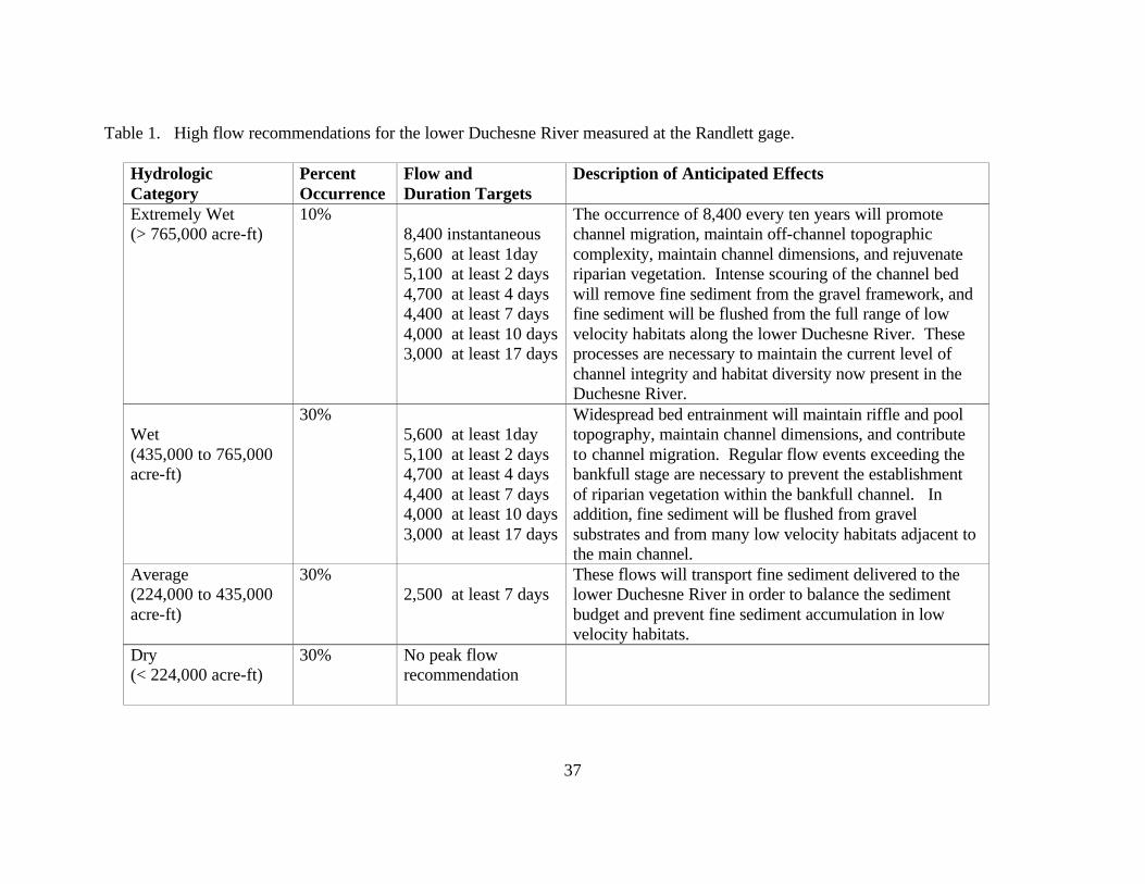
37
Table 1. High flow recommendations for the lower Duchesne River measured at the Randlett gage.
Hydrologic Category
Percent Occurrence
Flow and Duration Targets
Description of Anticipated Effects
Extremely Wet (> 765,000 acre-ft)
10% 8,400 instantaneous 5,600 at least 1day 5,100 at least 2 days 4,700 at least 4 days 4,400 at least 7 days 4,000 at least 10 days 3,000 at least 17 days
The occurrence of 8,400 every ten years will promote channel migration, maintain off-channel topographic complexity, maintain channel dimensions, and rejuvenate riparian vegetation. Intense scouring of the channel bed will remove fine sediment from the gravel framework, and fine sediment will be flushed from the full range of low velocity habitats along the lower Duchesne River. These processes are necessary to maintain the current level of channel integrity and habitat diversity now present in the Duchesne River.
Wet (435,000 to 765,000 acre-ft)
30% 5,600 at least 1day 5,100 at least 2 days 4,700 at least 4 days 4,400 at least 7 days 4,000 at least 10 days 3,000 at least 17 days
Widespread bed entrainment will maintain riffle and pool topography, maintain channel dimensions, and contribute to channel migration. Regular flow events exceeding the bankfull stage are necessary to prevent the establishment of riparian vegetation within the bankfull channel. In addition, fine sediment will be flushed from gravel substrates and from many low velocity habitats adjacent to the main channel.
Average (224,000 to 435,000 acre-ft)
30% 2,500 at least 7 days
These flows will transport fine sediment delivered to the lower Duchesne River in order to balance the sediment budget and prevent fine sediment accumulation in low velocity habitats.
Dry (< 224,000 acre-ft)
30% No peak flow recommendation

Duchesne River Flow Recommendations, 2003
38
Table 2. Base flow recommendations for the Duchesne River measured at the Randlett gage. Hydrologic Category Base flow Passage Recommendation Base flow Productivity Recommendation Wet - Less than 25% Exceedence (total annual runoff 565,000 acre-feet)
Passage Needs1 Target a minimum of 115 cfs between March 1 and June 30. 1Passage requirements are needed for fish to access the Duchesne River during the time period occupied by most Colorado pikeminnow observed in telemetry studies, i.e., March through June. Flows of 115 cfs provides a maximum depth of at least 30 cm through 22 of 27 riffles and of the remaining five riffles, two had maximum depths of greater than 27 cm and the remaining had depths of at least 20 cm.
Productivity Needs2 Target a minimum flow of 115 cfs. Transgressions that occur between June 30 through February 28 should not exceed:: Discharge Duration (days) No more than < 115 cfs 0 day < 100 cfs 0 day < 85 cfs 0 day < 60 cfs 0 day < 50 cfs3 0 day
2Cumulative wetted perimeter of the curve break for riffles represented 70% of the maximum riffle wetted perimeter. The frequency of flows below the curve break have occurred in high flow years (25%, 74-26%, and 75% exceedence) during the last 25 years and have maintained the current pattern of Colorado pikeminnow use of the Duchesne River 3Flows of 50 cfs maintain a minimum of 50% riffle inundation and should be maintained to provide minimum primary and secondary production.
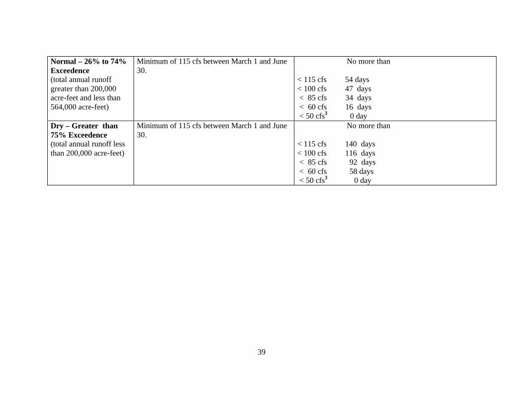
39
Normal – 26% to 74% Exceedence (total annual runoff greater than 200,000 acre-feet and less than 564,000 acre-feet)
Minimum of 115 cfs between March 1 and June 30.
No more than < 115 cfs 54 days < 100 cfs 47 days < 85 cfs 34 days < 60 cfs 16 days < 50 cfs3 0 day
Dry – Greater than 75% Exceedence (total annual runoff less than 200,000 acre-feet)
Minimum of 115 cfs between March 1 and June 30.
No more than < 115 cfs 140 days < 100 cfs 116 days < 85 cfs 92 days < 60 cfs 58 days < 50 cfs3 0 day

Duchesne River Flow Recommendations, 2003
40
Table 3. Comparison of the frequency of high flows during the last 25 years with flow recommendations measured at the Randlett gage. Numbers in red represent the frequency of flows not observed in the last 25 years. Hydrolgic Category Percent
Occurrence Flow Recommendation
Extremely Wet (> 765,000 acre-ft)
10% Channel Forming and Sediment 25 Year Discrepancy Transfer Requirements 8,400 instantaneous 0 5,600 at least 1day 0 5,100 at least 2 days 0 4,700 at least 4 days 0 4,400 at least 7 days 0 4,000 at least 10 days 0 3,000 at least 17 days 0
Wet (435,000 to 765,000 acre-ft)
30% Channel Forming and Sediment 25 Year Discrepancy Transfer Requirements 5,600 at least 1day 0 5,100 at least 2 days 0 4,700 at least 4 days 0 4,400 at least 7 days 1 4,000 at least 10 days 2 3,000 at least 17 days 1
Average (224,000 to 435,000
30% Channel Forming and Sediment 25 Year Discrepancy
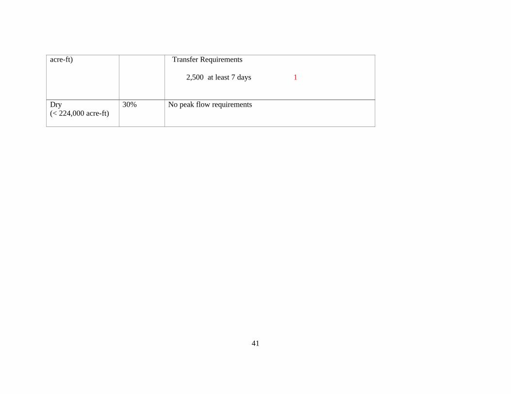
41
acre-ft)
Transfer Requirements 2,500 at least 7 days 1
Dry (< 224,000 acre-ft)
30% No peak flow requirements

Duchesne River Flow Recommendations, 2003
42
Table 4. Comparison of base flow frequencies during the last 25 years with flow recommendations (1975-2000) measured at the Randlett gage. Numbers in red represent the average number of days per year during the hydrological category that flows did not meet the recommendation during the last 25 years. Hydrologic Category
Base flow Requirements Productivity Needs
Wet - Less than 25% Exceedence (total annual runoff 565,000 acre-feet)
Passage Needs Minimum of 115 cfs between March 1 and June 30. 25 Yr. Discrepancy Wet Yrs = 1 d
Transgressions that occur between June 30 through February 28: Recommended Discharge Duration (days) 25 Yr. Discrepancy No more than < 115 cfs 0 day 0 < 100 cfs 0 day 0 < 85 cfs 0 day 0 < 60 cfs 0 day 0 < 50 cfs3 0 day 0
Normal – 26% to 74% Exceedence (total annual runoff greater than 200,000 acre-feet and less than 564,000 acre-feet)
25 Yr. Discrepancy Normal Yrs = 17 d
No more than 25 Yr. Discrepancy < 115 cfs 54 days 0 < 100 cfs 47 days 0 < 85 cfs 34 days 0 < 60 cfs 16 days 0 < 50 cfs3 0 day 8

43
Dry – Greater than 75% Exceedence (total annual runoff less than 200,000 acre-feet)
25 Yr. Discrepancy Dry Yrs = 67 d
No more than < 115 cfs 140 days 0 < 100 cfs 116 days 0 < 85 cfs 92 days 0 < 60 cfs 58 days 0 < 50 cfs3 0 day 39
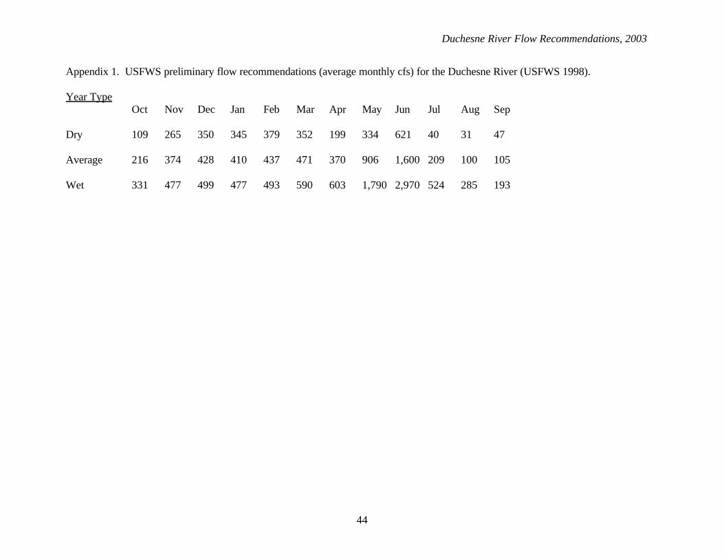
Duchesne River Flow Recommendations, 2003
44
Appendix 1. USFWS preliminary flow recommendations (average monthly cfs) for the Duchesne River (USFWS 1998). Year Type Oct Nov Dec Jan Feb Mar Apr May Jun Jul Aug Sep Dry 109 265 350 345 379 352 199 334 621 40 31 47 Average 216 374 428 410 437 471 370 906 1,600 209 100 105 Wet 331 477 499 477 493 590 603 1,790 2,970 524 285 193
45
Appendix 2. Spring 2003 Duchesne River Tour Report with Duchesne River

Duchesne River Flow Recommendations, 2003
Duchesne River Tour of Diversions below Starvation Reservoir
Date of Tour May 5, 2003 Attendance John Swasey, Duchesne River Commissioner Tim Modde, U.S. Fish and Wildlife Service Gene Shawcroft, Central Utah Water Conservancy District Chris Keleher, Central Utah Water Conservancy District Keith Hooper, Central Utah Water Conservancy District (did not attend field tour) Summary On 5 May 2003 those identified above met at the Central Utah Water Conservancy District Office in Duchesne. Prior to touring the diversion locations and structures in the lower Duchesne River, John Swasey provided an overview of water rights, duties, and distribution schedules associated with operating the Duchesne River below Starvation Reservoir. Gene Shawcroft also provided an overview of the importance of Starvation Reservoir for providing the storage that allows for exchanges necessary to operate the river and to make the Bonneville Unit of The Central Utah Project (CUP) function as it was intended. The following bulleted statements summarize key points brought up in the discussion:
• Water diverted below Myton Townsite Diversion is entirely made up of return flows during the irrigation season. This includes water diverted at Ouray School Diversion, Leland Ditch, and Jenkins Pump.
• Water is delivered based on crop reports that are submitted to the river commissioner on an annual basis. The acreage of crop production dictates the amount of water diverted.
• The Strawberry River above Starvation Reservoir and Currant Creek are not “regulated” because water comes back to the system as return flows.
• Water is delivered according to a “duty” or court distribution order which targets the delivery of 4 acre-feet of water per acre of cropland for the irrigation season (April 1 – October 15). The distribution schedule is based on the typical flow of the river in that early in the irrigation season flow deliveries are low (e.g. 1 cubic foot/second per 160 acres of cropland), at the typical time of peak run-off deliveries are highest (e.g. 1 cfs per 70 acres of cropland), and delivery rates taper off though the irrigation season to their lowest (e.g. 1 cfs per 250 acres of cropland). The delivery schedule for the Duchesne River for the irrigation season accounting for a distribution rate of 4.0 acre-feet of water per acre of cropland is attached (Attachment 1).
• A “duty” distribution schedule has been proposed in dry years since sometime in the 1930’s.
• Starvation Reservoir o Constructed as part of CUP

61
o A year-round water right allows CUP storage in Starvation Reservoir during the winter and when prior rights are being met
o Storage includes water from the Strawberry River directly, and from the Duchesne River delivered to the reservoir from Knights Diversion (limited to 300 cfs of Duchesne River flow)
o Storage capacity of Starvation Reservoir is 167,310 acre-feet, 21,400 acre-feet is the CUP yield for irrigation and 500 acre-feet is the CUP yield for Municipal and Industrial uses (M&I), the remainder is to satisfy exchanges for prior water rights
o Starvation Reservoir is a “3-year carry-over reservoir” in that it has storage capacity to meet needs for 3 years.
o Starvation Reservoir is a flood control feature and operates according to U.S. Army Corps of Engineers flood control guidelines. The safe channel capacity below Starvation Reservoir is 1100 cfs. Releases exceeding this amount result in flooding problems downstream.
o Storage in Starvation Reservoir provides for irrigation deliveries downstream that allows for exchange to Strawberry Reservoir through the Strawberry Aqueduct Collection System (SACS) which collects water from the upper reaches of the Duchesne River and Currant Creek. Water stored in Strawberry Reservoir is delivered to Utah Lake through the Diamond Fork System. Stored water in Utah Lake allows for exchange to Jordanelle Reservoir. Jordanelle Reservoir water is delivered to the Wasatch Front as M&I water. A schematic representation of the Bonneville Unit of CUP and features of the lower Duchesne River is attached (Attachment 2).
• The Midview Reservoir (storage capacity is 5000 acre-feet) in addition to Starvation Reservoir has winter storage rights and receives water from the Duchesne River through the Duchesne Feeder Canal. Although it doesn’t happen often, the Duchesne Feeder Canal can dry dam the river in winter (this occurred in the winter of 2002-2003)
Field Tour and Description of River Features The purpose of this field tour was to gain an understanding of the operation of the lower Duchesne River and the logistics of delivering flows through the lower river to provide for endangered fish needs. As a reference, graphs of USGS gage data on the day of the field trip are attached for: 1) the Uinta River at Randlett (10-15 cfs), 2) the Duchesne River above the Uinta River near Randlett (20-30 cfs) and 3) the Duchesne River near Randlett (25-30 cfs) are attached (Attachment 3a, 3b, and 3c).
Knight Diversion is located on the Duchesne River above the confluence with the Strawberry River and diverts up to 300 cfs for storage in Starvation Reservoir. This is a year-round storage right and diversion. Knight Diversion was not visited during this field tour.
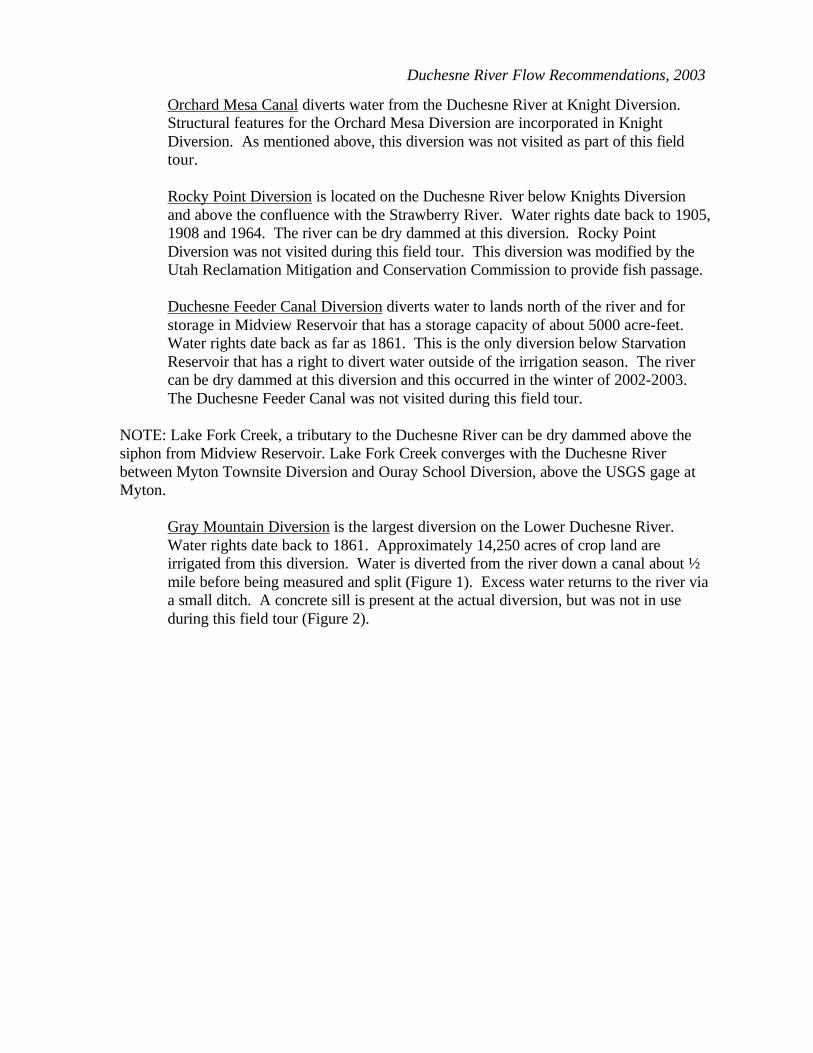
Duchesne River Flow Recommendations, 2003
Orchard Mesa Canal diverts water from the Duchesne River at Knight Diversion. Structural features for the Orchard Mesa Diversion are incorporated in Knight Diversion. As mentioned above, this diversion was not visited as part of this field tour. Rocky Point Diversion is located on the Duchesne River below Knights Diversion and above the confluence with the Strawberry River. Water rights date back to 1905, 1908 and 1964. The river can be dry dammed at this diversion. Rocky Point Diversion was not visited during this field tour. This diversion was modified by the Utah Reclamation Mitigation and Conservation Commission to provide fish passage. Duchesne Feeder Canal Diversion diverts water to lands north of the river and for storage in Midview Reservoir that has a storage capacity of about 5000 acre-feet. Water rights date back as far as 1861. This is the only diversion below Starvation Reservoir that has a right to divert water outside of the irrigation season. The river can be dry dammed at this diversion and this occurred in the winter of 2002-2003. The Duchesne Feeder Canal was not visited during this field tour.
NOTE: Lake Fork Creek, a tributary to the Duchesne River can be dry dammed above the siphon from Midview Reservoir. Lake Fork Creek converges with the Duchesne River between Myton Townsite Diversion and Ouray School Diversion, above the USGS gage at Myton.
Gray Mountain Diversion is the largest diversion on the Lower Duchesne River. Water rights date back to 1861. Approximately 14,250 acres of crop land are irrigated from this diversion. Water is diverted from the river down a canal about ½ mile before being measured and split (Figure 1). Excess water returns to the river via a small ditch. A concrete sill is present at the actual diversion, but was not in use during this field tour (Figure 2).
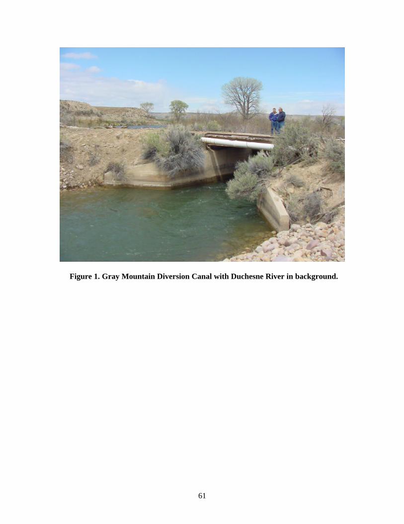
61
Figure 1. Gray Mountain Diversion Canal with Duchesne River in background.

Duchesne River Flow Recommendations, 2003
Figure 2. Duchesne River looking upstream at Gray Mountain Diversion.
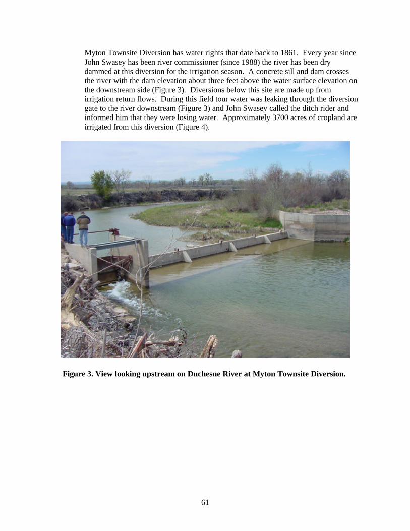
61
Myton Townsite Diversion has water rights that date back to 1861. Every year since John Swasey has been river commissioner (since 1988) the river has been dry dammed at this diversion for the irrigation season. A concrete sill and dam crosses the river with the dam elevation about three feet above the water surface elevation on the downstream side (Figure 3). Diversions below this site are made up from irrigation return flows. During this field tour water was leaking through the diversion gate to the river downstream (Figure 3) and John Swasey called the ditch rider and informed him that they were losing water. Approximately 3700 acres of cropland are irrigated from this diversion (Figure 4).
Figure 3. View looking upstream on Duchesne River at Myton Townsite Diversion.
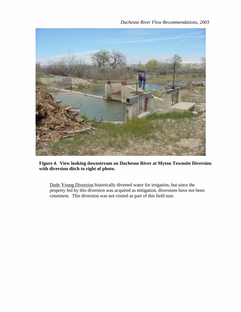
Duchesne River Flow Recommendations, 2003
Dude Young Diversion historically diverted water for irrigation, but since the property fed by this diversion was acquired as mitigation, diversions have not been consistent. This diversion was not visited as part of this field tour.
Figure 4. View looking downstream on Duchesne River at Myton Townsite Diversion with diversion ditch to right of photo.

61
Ouray School Diversion has water rights that date back to 1861. Water diverted here is usually made up of return flow from diversion off Lake Fork Creek. A gravel dam (pile of rocks) in the river directs water into an off-channel canal. Water flows down the canal about 600 yards and is measured and diverted to the irrigation canal (Figure 5). Extra water returns to the river via a small ditch. Approximately 2300 acres of cropland are irrigated from this diversion. This diversion can dry dam the river (Figure 6).
Figure 5. Irrigation Canal that receives water from Ouray School Diversion with measuring gate and overflow channel that goes back to the river.

Duchesne River Flow Recommendations, 2003
Figure 6. View looking downstream on Duchesne River at Ouray School Diversion with irrigation canal branching to the left on this photo, Duchesne River branching to the right.
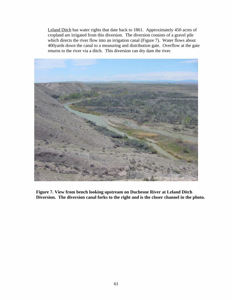
61
Leland Ditch has water rights that date back to 1861. Approximately 450 acres of cropland are irrigated from this diversion. The diversion consists of a gravel pile which directs the river flow into an irrigation canal (Figure 7). Water flows about 400yards down the canal to a measuring and distribution gate. Overflow at the gate returns to the river via a ditch. This diversion can dry dam the river.
Figure 7. View from bench looking upstream on Duchesne River at Leland Ditch Diversion. The diversion canal forks to the right and is the closer channel in the photo.
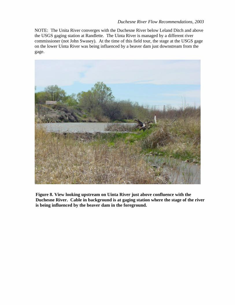
Duchesne River Flow Recommendations, 2003
NOTE: The Unita River converges with the Duchesne River below Leland Ditch and above the USGS gaging station at Randlette. The Uinta River is managed by a different river commissioner (not John Swasey). At the time of this field tour, the stage at the USGS gage on the lower Uinta River was being influenced by a beaver dam just downstream from the gage.
Figure 8. View looking upstream on Uinta River just above confluence with the Duchesne River. Cable in background is at gaging station where the stage of the river is being influenced by the beaver dam in the foreground.

61
NOTE: The field tour included a stop at the USGS gaging station at Randlett. There was a beaver dam upstream of the gage that was directing flow to the south side of the river (i.e. across from the gage house). Some of this flow remained on the south side of the river was not being measured by the USGS gage. This redirected flow joined the main channel just downstream from the USGS gage.
Figure 9. View looking downstream on Duchesne River towards USGS gaging station at Randlett showing braided channel.

Duchesne River Flow Recommendations, 2003
Figure 10. View of Duchesne River from USGS Randlett gage showing braided channel and stage differences across channel.

61
Jenkins Pump has water rights that date to 1962 and amount to about 7-8 cfs. About 600 acres of cropland are irrigated from this diversion. Water is diverted down a canal (Figure 11) into an off-channel pond (Figure 12) and then pumped uphill to another pond. From the second pond water is distributed into a sprinkler irrigation system.
Figure 11. View of Duchesne River at Jenkins Pump Diversion looking downstream. The diversion canal branches off to the left on this photo and the river continues downstream into the background.

Duchesne River Flow Recommendations, 2003
Figure 12. Off-channel pond fed by canal from Jenkins Pump Diversion. Ponded water is pumped uphill to another pond from where it is distributed via sprinkler irrigation.

61
Cover photo: Duchesne River Colorado River Fish Project U.S. Fish and Wildlife Service 1380 S. 2350 W. Vernal, UT 84078 435/789/0351 [email protected] September 2003