Embed Size (px)
Citation preview
US Department of the Interior
Bureau of Land Management
State of Colorado Grand Junction District
This document was re-typed with no graphics from the original report for easier reading and quicker download time.
Accident Report
Battlement Creek Fire
Fatalities & Injury
July 17, 1976
1
Contents
Page Foreword 3I. Events Prior to Accident 4
A. Location 4B. National Fire Situation 5C. Fire Environment 6
1. Weather 62. Topography 83. Vegetation and fuels 9
D. Origin and Initial Suppression Effort 11II. Fire Behavior and Burning Sequence on July 16-17, 1976 15
A. General Situation 15B. Prior Weather 16C. Fire Behavior Appraisal 22D. Fire Behavior July 16 22E. Burning Sequence July 17 23F. Chaparral Model Nomograph 25G. Fire Behavior Summary 26
III Suppression Effort and Accident Sequence 28A. Accident Sequence 28B. Post-Accident Rescue and Medical Action 37
IV. Investigation 40V. Organization and Management 42
A. Fire Overhead and Crew Assignments 427.16-7/17/76
B. Overhead Qualification and Experience 45C. Crew Qualification and Experience 49D. Logistical Support 52E. Fire Planning and Intelligence 52F. Aviation Management Activity 53
VI. Findings 57A. Mechanical Factors 57B. Physical Factors 57C. Human Factors 57
a. Crew 58b. Overhead 58
D. Management Factors 59VII. Appendix 61
2
Forward
This investigation report covers an accident which occurred July 17, 1976,
in the Grand Junction District of the Bureau of Land Management (BLM) in
Colorado. Three firefighters were killed and a fourth severely burned while
working on the Battlement Creek fire approximately 40 miles northeast of Grand
Junction, Colorado. All victims were members of a trained Forest Service (FS) fire
crew stationed at Mormon Lake on the Coconino National Forest near Flagstaff,
Arizona.
The victims were:
Anthony A. Czak, 25, Flagstaff, Arizona
Scott L. Nelson, 22, Bloomer, Wisconsin
Stephen H. Furey, 23, Salmon, Idaho.
The fourth victim, although severely burned, is expected to recover fully.
He is John C. Gibson, 27, of Wellsville, New York.
The accident occurred during a burnout operation along a ride above the
fire in a steep drainage. The crew did not recognize the danger they were in until
their planned primary escape route was cut off by a run of the fire from below
them. This report will discuss in depth the multiple factors which contributed to
this unfortunate accident.
Although unrelated to the Mormon Lake crew fatalities, another death
occurred on the Battlement Creek fire when a B-26 air tanker crashed and burned
on July 16, killing the pilot. This accident is reported in a separate report.
Western Colorado is experiencing an unusually severe fire season caused
partly by unusual fuel conditions and heavy lightning activity during dry weather.
A severe frost on June 14, 1976, killed a high percentage of the leaves on
Gambel’s oak, which is now a readily available and dry fine fuel. The District has
also experienced a greater number of fire starts, which has taxed their fire control
capability in the past few weeks.
Under a national plan to exchange and utilize manpower and equipment,
the Forest Service crew was working on this Bureau of Land Management fire.
There were also people from the Forest Service in supervisory positions.
The Director of the Bureau of Land Management and Chief of the Forest
Service appointed an interagency investigation team under the co-chairmanship of 3

Jack Wilson, BLM, Director of the Boise Interagency Fire Center (BIFC), and Max
Peterson, Deputy Chief for Programs and Legislation of the Forest Service (FS).
Other team members were: Clyde O’Dell, Boise (Idaho) BIFC Fire Weather
Meteorologist, National Weather Service; Ed Heilman, Director of Fire
Management, Northern Region, Forest Service; Robert Mutch, Research Forester
(Fire Behavior and Fuels), Northern Forest Fire Laboratory, Forest Service; James
Abbott, Fire Training and Safety Specialist, Washington Office, Forest Service;
and Harold Baer, Attorney, Solicitor’s Office, Department of Interior, Denver.
Instructions to the team through the co-chairmen were to determine the
conditions and circumstances that led to the fatalities and injury on the Battlement
Creek fire.
I. EVENTS PRIOR TO ACCIDENT
a. Location
The fire occurred approximately 40 miles northeast of Grand Junction, Colorado,
in the Battlement Creek drainage, Sections 11, 12, 13, 14 and 23, T7S, R95W. It
consumed 880 acres in 3 days: July 15, 16 and 17, 1976. At the time of the
accident, 13 crews totaling 270 men and approximately 20 overhead were assigned
to the fire. (See Section I-D for initial suppression effort by the Grand Valley
volunteer Fire Department on July 11.) The Grand Junction District of the Bureau
of Land Management was responsible for suppression of the fire. Fire suppression
support and capability is newly organized this year around the Grand Junction Fire
Center (BLM) located at Walker Field (the commercial airport) in Grand Junction.
This Center serves all BLM lands in western Colorado with a complement of
crews, helicopters and air tankers. The Fire Center, under Colorado State Office
supervision, has 1 full-time employee, 9 seasonal employees, 2 fire management
specialist assistants (detailed from BIFC), 30 trained firefighters from the San Luis
Valley, Colorado, crews, and one 12-man helitack crew (detailed from the Forest
Service).
b. National Fire Situation
On July 15, there were 198 fires reported on the Daily Fire Situation Report
from BIFC. The majority of the fires were in California, Nevada, and Utah. The
only fire requiring interregional support was the Ishawooa fire on the Shoshone 4
National Forest, which used air tanker No. 56 and 60 Missoula smokejumpers.
Utah BLM had a large fire southwest of Salt Lake City. During this day, the Grand
Junction District worked on three fires, including the Battlement Creek fire.
On July 16, the number of fires increased to 242, but more importantly
extensive dry lightning occurred in California, Nevada, and Utah. The Battlement
Creek fire and the Wickahoney fire in the Boise District of the BLM (1,590 acres)
required mobilization of considerable resources. Initial attack forces in most areas
of California and Utah were heavily taxed, but were successful in containing most
of the fires.
On July 17, as an aftermath of the lightning storms the prior afternoon, 458
fires were reported, and red flag warnings were forecast in central California. Of
the 458 fires, 384 of them were in California. The Battlement Creek fire was the
only one drawing on BIFC support, although several large restock orders were
processed through the fire warehouse from other areas.
This situation continued through Sunday, July 18, when 452 fires were
reported. Again, 352 of these were in California, with Sequoia and Yosemite
National Parks catching 120 of these fires. There were no major support actions
from BIFC or any other caches outside the fire areas.
In brief summary, the national picture shows a fairly busy initial attack
situation with few large fires materializing, and most of these not drawing on
outside resources to any extent. A large supply of crews, aircraft of all kinds
(except heavy helicopters), overhead, radio equipment, and fire supplies were
available.
C. Fire Environment
1. Weather
The most basic meteorological conclusion that can be drawn from available
meteorological data and extensive interviews with personnel assigned on the
Battlement Creek fire, Saturday, July 17, is that the accident was not directly
weather related; i.e., there were no thunderstorms in the immediate fire vicinity
between 1400 and 1500 m.d.t. that could have produced downdrafts to affect the
fire, no unusual or abnormal winds occurred attributable to accepted
meteorological causes such as fronts, low level jet stream, or locally induced dust
devils, etc. 5

At the time of the accident, the atmosphere was unstable, normal up-slope
winds were occurring, winds aloft were generally light SW and ranged from 5-15
m.p.h. from 6,600 feet to 31,000 feet m.s.l.
Observers on the fire at the time of the accident reported high winds at
ground level 25-35 M.P.H. and above. Earlier in the day, the weather was
described as fair; winds were light both on the ridge and on lower portions of the
fire. Some small whirl activity was reported about 1230-1300 m.d.t. which would
indicate unstable atmospheric conditions. Figure 2 illustrates the morning and
afternoon soundings for Grand Junction, Colorado, on Saturday, July 17, 1976.
They illustrate typical summertime conditions of afternoon low-level heating and
instability. Generally observers reported high winds at the time of, or just before,
the accident. These were very likely local fire-induced winds generated by very
intense burning and rapid rate of spread.
A rather severe frost on June 14 (23-27 degrees F. in the 6,200-9,000 foot
range) produced extensive damage to Gambel’s oak stands in the fire area. The
frost was an important indirect weather-related event which increased the dry fuel
available for combustion by killing leaves in the oak stands. Relatively warm, dry
weather following the frost provided conditions conducive to drying dead plant
tissue.
2. Topography
Origin of the fire was 40 airline miles NE of Grand Junction, Colorado, and
1 ½ miles south of the Colorado River in the Battlement Creek drainage.
Battlement Creek is approximately 8 miles long and flows in a northwesterly
direction to the Colorado River. The fire burned entirely on the east side of
Battlement Creek (fig. 3). The topography varies from relatively level land along
the drainage bottom to rugged mountain slopes. Elevations on the fire range from
6,200 feet near the origin to 8,400 feet near the site where the men died. The fire
burned primarily on north-facing aspects on Thursday, July 15, and Friday
morning, and on west-facing aspects on Friday afternoon and Saturday. The slopes
that burned on Saturday were fully exposed to prevailing southwesterly air flow;
and they received direct solar heating from 1100 on. Slopes that burned on
Saturday, July 17, ranged from 10 percent above the road to 75 percent in the chute
just below the ridgeline. The side drainage that burned out on Saturday was 6

characterized by two major draws, aligned in an east-west direction. The head of
the north draw was about 3500 feet northeast of the Battlement Creek road. This
draw terminated just below a saddle on the ridgeline where the Mormon Lake crew
was working on Saturday. The south draw climbs in an easterly direction for 3,200
feet from the road. Side slopes of these draws were measured at 50-60 percent.
Visibility to the west from the saddle above the north draw was restricted
due to the topography. The slope west of the ridgetop in the saddle was gradual for
about 140 feet and then broke off steeply (fig. 4).
3. Vegetation and Fuels
The vegetation of Battlement Creek reflects the arid climate. The dominant
vegetation in the fire area is Gambel’s oak--mountain mahogany. But vegetational
types in the drainage vary according to elevation and exposure. On north-facing
slops, the vegetation begins at the stream bottoms with a mixture of pinon-juniper
and sagebrush. As the elevation increases, the sagebrush decreases, and a mixed
mountain shrub type gradually replaces pinon-juniper. Grass and sagebrush types
are common on the ridges and drainage bottoms (cured cheatgrass was present in
openings at lower elevations). Aspen and spruce-fir may be found at lower
elevations along draws and moist areas. Some aspen occurred in the fire area at the
head of the south draw; and prostrate Douglas-fir was found along the high ridge
east of the south draw.
The mixed mountain shrub type was the primary plant community
contributing to fire spread on Saturday, July 17. The dominant species in this
community are Gambel’s oak, mountain mahogany, serviceberry, and snowberry.
The shrub community was dense and all but impenetrable in many places. The
shrubs contained a large amount of fine dead branches throughout the canopy (fig.
5). Gambel’s oak ranged as high as 10-12 feet or higher; it was 4-6 feet high along
the ridgeline above the chute (north draw). This ridgeline, the site of the accident,
also contained several small openings and game trails (fig 6). A very significant
weather event occurred 1 month prior to the fire which adversely affected the fuel
complex. An extensive frost on June 14 killed more than 50 percent of the leaves
on the Gambel’s oak (other shrub species did not appear to be materially affected).
Many of the dead leaves were sill retained on the plants at the time of the fire (fig.
7

7). Shedding oak leaves contributed to a 1-2 inch litter layer beneath the mixed
mountain shrub type. Pinon pine and juniper trees were scattered through the oak-
mahogany type, primarily along the ridge north of the north draw.
Fuel moisture samples were collected at 1830 on July 20 at 8,800 Feet on
the ridge above the fire area:
Sample Average moisture content (%)
Dead oak leaves (shrub canopy) 11.4Leaf litter on ground 13.7Dead oak branches (1/4 inch) 12.4Green oak leaves 166.5Living oak stems (1/4 inch) 193.8
The dead oak leaves in the shrub canopy and other fine fuels could have
been at 7-8 percent moisture content, or less, at the time of the fire run on
Saturday, July 17.
The June frost significantly increased the amount of available fuel in the
Battlement Creek area by contributing to the dieback of the oak leaves. One
individual remarked that fire behavior conditions seemed 2-3 weeks early for this
time of year.
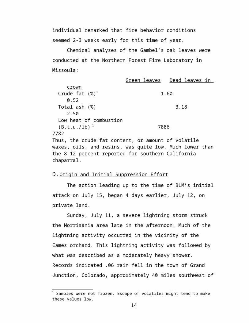
Chemical analyses of the Gambel’s oak leaves were conducted at the
Northern Forest Fire Laboratory in Missoula:
Green leaves Dead leaves in crown Crude fat (%)1 1.60 0.52 Total ash (%) 3.18 2.50 Low heat of combustion (B.t.u./lb) 1 7886 7782Thus, the crude fat content, or amount of volatile waxes, oils, and resins, was quite low. Much lower than the 8-12 percent reported for southern California chaparral.
D. Origin and Initial Suppression Effort
The action leading up to the time of BLM’s initial attack on July 15, began
4 days earlier, July 12, on private land.
Sunday, July 11, a severe lightning storm struck the Morrisania area late in
the afternoon. Much of the lightning activity occurred in the vicinity of the Eames
orchard. This lightning activity was followed by what was described as a 1 Samples were not frozen. Escape of volatiles might tend to make these values low.
8
moderately heavy shower. Records indicated .06 rain fell in the town of Grand
Junction, Colorado, approximately 40 miles southwest of the mesa lying in the
Colorado River Valley. No fire was reported at that time.
On July 12, at approximately 1330, a fire was reported in SE ¼, NW ¼
Section 11, T7S, R95W, at Eames orchard (fig. 8). This fire was controlled by
1700 at ½ acre by the Grand Valley Volunteer Fire Department. BLM air patrol
(783) confirmed the fire was no longer smoking at 1925.
At 2130, a lightning strike was observed by a local citizen in approximately
the same vicinity which resulted in an immediate fire start. The Grand Valley
Volunteer Fire Department responded to this fire and returned home at 0300, July
13.
During the daylight hours of Tuesday and Wednesday, July 13-14, a smoke
surveillance was maintained of the area by the captain of the Grand Valley Fire
Department from his place of employment and by other members of the
department at varying times.
On Thursday, July 15, at approximately 1400, smoke was again noted in
the area by the residents of the Eames Orchard, and a call was placed to the Grand
Valley Fire Department. Two men from the Grand Valley Department responded,
arriving at the fire approximately 1430. They found the fire was again in the same
location they had taken action on twice the previous Monday. The two men were
just starting suppression action when an increase in wind velocity was noted. The
fire jumped about 20-30 feet to the south and southeast into sage and cheatgrass
fuels and spread rapidly. The pumper was considered to be in danger and the men
moved the vehicle and radioed for assistance. The fire was gaining momentum and
velocity; the men decided to remain on the west side of the fire and wet down that
area with the water they had. The wind velocity kept increasing at this time.
At approximately 1430, the Grand valley Fire Chief went to the north of the
area on a higher mesa some 5 miles distant and had the area in observation. He
reported observing a pattern of fire about 50 yards wide moving rapidly southeast.
The Grand Valley Fire Captain reported observing a cloud of fire and
smoke erupt from the area at a time of 1500. His location was about 6 miles
northeast of the fire.
9
Additional manpower and equipment were dispatched to the scene by the
Grand Valley Fire Department (time undetermined).
At 1510, July 15, Wayne Fisher, BLM, radioed Grand Junction Fire
Dispatch a location on the fire from his visual observations from some distance
away.
Grand Junction District Fire Management Officer Roy Johnson initiated
BLM action at 1522 while on an aerial observation flight. The initial order was for
a retardant drop and two helitack crews. An additional retardant drop was ordered
almost immediately. At approximately 1600, the Fire Boss Jack Haslem, a local
district employee, was alerted and two 20-man crews were ordered.
At 1548, BLM air tanker No. 59 was dispatched with an ETA of 15
minutes and the county fire department had been advised to clear a drop zone.
The Grand Valley crew on the fire reported the first retardant drop at 1600.
They had pulled back to the Eames orchard prior to arrival of the air tanker.
Several local pumper, volunteer, BLM and Forest Service crews continued
to work along parts of the fire the night of July 15. Three air tankers, two 1,000
gallon B-26’s and a 2,000 gallon C-119 worked hot spots until dark. The pumper-
crews patrolled the west side from midnight to 0600 July 16 to prevent the fire
from crossing the road to the wet.
From the beginning of suppression effort on July 15, the attack strategy was
designed to prevent western and southern spread of the fire. The presence of
natural gas lines and wells to the west and Project Rulison to the south influenced
this decision. Later, on July 16, the fatal crash of an air tanker near the fire was
also an unusual event.
Project Rulison
This program was sponsored by Austrol Oil of Houston, Texas, and Los
Alamos Scientific Laboratories under the supervision of the Atomic Energy
Commission. It was conducted to stimulate the natural gas pockets and facilitate
gas collection by underground nuclear explosions.
Remaining at the project site are two above-ground metal holding tanks
which contain some explosive vapors. Also contained in the tanks is a small
amount of material which presents a low-level radiation problem. The well is
10
closed with plugs at the bottom and also the top of the shaft. The valves have been
closed and chain locked.
Plans are to close the site in the near future by removing the tanks and
cementing the shaft closed.
Aircraft Accident
On Friday, July 16, 1 day before the crew accident, a B-26 air tanker
crashed on a retardant dropping mission on the Battlement creek fire. The accident
occurred at 0856, approximately 1 mile south of the fire. The pilot was killed.
The crash diverted the line boss and the Sawtooth interregional crew for
much of the day in controlling a fire at the crash site and removing the pilot’s
remains.
Although this accident is not related directly to the crew fatalities and
injuries, it could be an indirect factor affecting overhead attitude and response.
Although the line boss and one crew were diverted to the crash site July 16,
there were, however, no direct actions taken on the Battlement Creek fire as a
result of this aircraft accident.
II. FIRE BEHAVIOR AND BURNING SEQUENCE ON JULY 16 AND 17, 1976
A. General Situation
The large scale synoptic weather pattern over western Colorado and the
Battlement Creek fire area on Saturday, July 17, was one of high pressure aloft and
a very flat surface pressure pattern associated with a poorly defined thermal low. A
large scale pattern of this type is conducive to generally light wind flow where
local effects dominate the weather picture.
A low pressure area aloft situated off the central California coast Saturday
morning, July 17, (fig. 9) had weakened and moved northeastward by Sunday
morning, July 18, (fig. 10) to the northern Nevada-California border. This
increased free air flow above 12,000 feet from a range of 2-15 m.p.h. at Grand
Junction Saturday at 0600 to 13-25 m.p.h. by 1800 (fig 11). Below 12,000 feet,
winds decreased from the 5-16 M.P.H. range to 1-8 M.P.H. during the same time
period. Grand Junction is about 40 air miles SW of the fire site, and winds aloft
above approximately 8,000-9,000 feet can be expected to be representative of the
fire area. This relatively weak upper air flow permitted local terrain effects to
dominate the wind field in the fire area. The fire burned over an elevation range of 11
6,200-8,400 feet m.s.l. on a steep west-facing slope. The accident occurred at
approximately 8,300 feet m.s.l. Terrain effects produced upslope afternoon winds
10-15 M.P.H., with higher gusts. These velocity values are based on measured
upper winds at Grand Junction and on untrained observer estimates. No on-site fire
weather measurements were made prior to the accident. Intense burning increased
these wind values for a short period of time and account for higher estimates by
observers. Surface winds recorded at Grand Junction and Rifle on July 16 and 17
are illustrated in the table below.
B. Prior Weather
The climate of the fire area is classified as arid. Mean annual and may-
September precipitation are illustrated below for several locations in northwestern
Colorado.
Aspen Craig Grand Junction
Rifle Gunnison Glenwood Springs
Mean annual (inches)
18.67 13.42 8.41 10.93 11.0 18.03
May-Sept.
7.09 6.04 4.32 4.58 5.36 6.99
The values for the fire area itself are estimated to be 16-20 inches mean
annual and 8-9 inches may through September based on NOAA isohyetal
precipitation analysis maps (1931-60).
Precipitation records for 1976 indicate Grand Junction was somewhat
below normal while Rifle was somewhat above. The fire area lies between these
two stations but much higher and closer to Rifle. Precipitation on the fire site was
most likely very near normal. Monthly distribution of precipitation for 1976 at
stations in the vicinity of the fire is illustrated below:
Grand Junction Rifle Grand ValleyPcpn Departure Pcpn Departure Pcpn
January .13 -.51 .52 -.40 .26February .81 +.20 1.81 +1.05 1.56March .75 +\-0 M M 1.53April .38 -.41 .89 -.04 -May 1.49 +.86 - - -June .14 -.41 - - -July-17th .14 -.18 - - -Season to Date
3.84 -.45 - - -
12

Mean maximum temperatures for warm months in northwester Colorado
are illustrated below:
Aspen 7913 ft
Craig 6280 ft
Grand Jct. 4843 ft
Rifle 5319 ft
Gunnison 7694 ft
Glenwood Springs 5823 ft
May 63.8 68.2 86.0 75.0 67.2 73.2June 73.7 77.7 98.0 84.5 77.5 83.3July 79.8 85.9 99.0 91.2 83.5 90.0August 77.8 83.4 98.0 88.5 80.5 87.0September 71.6 75.4 93.0 81.2 75.2 80.4
July is the month with the highest average maximum temperature. These
July normals can be seen to be similar to observed maximum temperatures before
and on the day of the fire accident ad illustrated below:
Grand Junction
Rifle Glenwood Springs
Gunnison
July 14 Max. 98 91 92 84Min. -- -- -- --
July 15 Max. 97 91 93 83Min. 60 49 51 42 (.01)
July 16 Max. 99 92 M 86Min. 65 48 M 44 (.04)
July 17 Max. 97 95 M --Min. 70 52 M 46
Note that Gunnison received light precipitation (.01 and .04 inch) on July
15 and 16.
Weather was described on the fire Saturday, July 17, as being fair and hot.
This is reasonable in view of the observed temperatures at Grand Junction and
Rifle reaching into the mid and upper 90’s.
The freeze of June 14 mentioned earlier was widespread over western
Colorado. The minimums observed were:
Degree F. ElevationGrand Junction 34 4843 ftRifle 32 5319 ftEagle 32 6600 ftGunnison 23 7694 ftMontrose 36 5794 ftSteamboat Springs 27 6695 ft
13
With the fire elevation well above most of these stations, it is reasonable
and conservative to estimate minimum temperatures in the 23-27 degree
Fahrenheit range. Palmer drought values for western Colorado are in the normal
range indicating little stress on vegetation. The occurrence of the freeze, therefore,
becomes more important from the point of view of altering normal vegetative
condition.
Since no direct on-site weather observations were available from the fire,
the next best choice was to go to nearby station. Rifle and Grand Junction weather
is illustrated below:
July 16, 1976
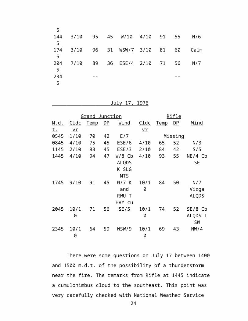
Grand Junction RifleM.d.t CldCovr Temp DP Wind Cldcvr Temp DP Wind0545 Clear 68 27 NE/12 Clear 51 38 NE/40845 1/10 78 37 ESE/11 3/10 66 46 Calm1145 2/10 93 43 SE/6 3/10 81 49 Calm1445 3/10 95 45 W/10 4/10 91 55 N/61745 3/10 96 31 WSW/7 3/10 81 60 Calm2045 7/10 89 36 ESE/4 2/10 71 56 N/72345 -- --
July 17, 1976
Grand Junction RifleM.d.t. Cldcvr Temp DP Wind Cldcvr Temp DP Wind0545 1/10 70 42 E/7 Missing0845 4/10 75 45 ESE/6 4/10 65 52 N/31145 2/10 88 45 ESE/3 2/10 84 42 S/51445 4/10 94 47 W/8 Cb
ALQDS K SLG MTS
4/10 93 55 NE/4 Cb SE
1745 9/10 91 45 W/7 K and
RWU T HVY cu
10/10 84 50 N/7 Virga ALQDS
2045 10/10 71 56 SE/5 10/10 74 52 SE/8 Cb ALQDS T
SW2345 10/10 64 59 WSW/9 10/10 69 43 NW/4
14

There were some questions on July 17 between 1400 and 1500 m.d.t. of the
possibility of a thunderstorm near the fire. The remarks from Rifle at 1445 indicate
a cumulonimbus cloud to the southeast. This point was very carefully checked with
National Weather Service radar observations at the same time. Echoes were
replotted and the closest echo to the fire as reported by the Rock Springs radar was
about 8 miles north-northeast of Rifle at 1435 MDT on July 17, 1976. Allowing for
extremes in errors in observation and plotting, it would be very difficult to place a
significant thunderstorm west of Rifle and near the fire at that time. Based on these
observations and most observers on the fire, a thunderstorm downdraft has been
ruled out as a possible contributing factor. Forecasts issued from Denver for
Saturday, July 17, are illustrated verbatim below. They called for showers and
thunderstorms in western Colorado which did, in fact, occur.
COLORADO ZONESC001C005C010ISSUED 4AM MDT SAT 7/17/76FAIR TO PARTLY COULDY WITH WIDELY SCATTERED AFTERNOON AND EVENING SHOWERS OR THUNDERSTORMS TODAY. MOSTLY CLOUDY AND LITTLE COOLER SUNDAY WITH SHOWERS OR THUNDERSTORMS SCATTERED. HIGH TODAY 85 TO 95. LOW TONIGHT 50 TO 65. HIGH SUNDAY 80 TO 90. WIND VARIABLE 5 TO 15 MPH EXCEPT GUSTY NEAR THUNDERSHWOERS. PROBABILITY OF PRECIP 20 PERCENT TODAY 30 PERCENT TONIGHT 40 PERCENT SUNDAY. $$
ZCZCDEN FP1 171010FPUS1KDEN171010ISSUED 4AM SATURDAY
COLORADO FAIR TO PARTLY CLOUDY AND CONTINUED WARM OVER STATE TODAY WITH WIDELY SCATTERED AFTERNOON AND EVENING THUNDERSTORMS..SOME HEAVY IN EAST PORTION TODAY. SHOWERS AND THUNDERSHOWERS INCREASING OVER MOUNTAINS AND WEST SUNDAY WITH WIDELY SCATTERED THUNDERSTORMS EAST. A LITTLE COOLER MOUNTAINS..WEST..AND NORTHEAST SUNDAY. HIGH TODAY UPPER 80S TO UPPER 90S EAST..85 TO 95 WEST WITH 75 TO 85 MOUNTAINS. LOW TONIGHT IN LOWER 60S EAST..60 TO 66 WEST WITH 40S AND UPPER 30S MOUNTAINS. HIGHS SUNDAY AROUND 90 EAST..80 TO 90 WEST WITH MOSTLY 70S MOUNTAINS
EAKIN..WSFO DENVER15
COLORADO FIRE WEATHER MORNING MAP DISCUSSIONNATIONAL WEATHER SERVICE DENVER CO845 AM MDT SAT JUL. 17 1976
HIGH PRESSURE RIDGE ALOFT STILL DOMINATES REGION…HOWEVER A CUT OFF LOW IS DRIFTING EASTWARD OFF THE CENTRAL CALIFORNIA COAST. ABUNDANT MOISTURE IS SPREAD THROUGHOUT THE WESTERN U.S. AND WILL SLOWLY BE MOVING INTO COLORADO OVER THE WEEKEND.
SHOWERS AND THUNDERSTORMS WIDELY SCATTERED IN WESTERN HALF OF STATE TODAY..MORE NUMEROUS SOUTHERN MOUNTAINS. ONLY ISLATED ACTIVITY LIKELY ALONG EAST SLOPES. TEMPERATURES A LITTLE COOLER WEST TODAY AND OTHERWISE LITTLE CHANGE. NO SIGNIFICATNT WINDS EXCEPT GUSTY NEAR THUNDERSTORMS.
OUTLOOK FOR SUNDAY…INCREASING SHOWER AND THUNDERSTORM ACTIVITY OVER MOUNTAINS AND WEST AND COOLER.
SMOKE DISPERSAL GOOD TO VERY GOOD.
LARISON….WSFO DENVER
ZCZC DEN FPI 171620 AMDFPUS1KEN171620 AMDISSUED 10 AM SATURDAY
COLORADO UPDATED FORECASTWIDELY SCATTERED SHOWERS AND THUNDERSTORMS MOUNTAINS AND WEST TODAY INCREASING SUNDAY. CLEAR TO PARTLY COULDY THROUGH SUNDAY EAST WITH ISOLATED AFTERNOON AND EVENING SHOWERS AND THUNERSTORMS. SLIGHT COOLING TREND WEST THROUGH SUNDAY. HIGH TODAY AND SUNDAY 80S AND LOW 90S WEST UPPER 80S AND 90S EAST WITH 60S AND 70S MOUNTAINS. LOW TONIGHT UPPER 50S AND 60S WITH 40S MOUNTAINS
A thunderstorm occurred at Rifle in the evening of July 17 (2040 m.d.t.)
and .04 inch of precipitation was recorded.
Ten-hour time lag fuel moisture was in the 3-5 percent range for several
stations in the week preceding the accident (fig. 12).
16

Showers at isolated points temporarily increased fuel moisture to as much
as 11 percent. Generally, however, fuels dried rapidly back to the 3-5 percent
range.
C. Fire Behavior Appraisal
A rather typical weather pattern, steep mountainous terrain, and frost-
induced dieback in Gambel’s oak established conditions for high rates of fire
spread in the Battlement Creek drainage during afternoon hours. For these reasons
there might be a tendency to equate the Battlement Creek fire with a southern
California brush fire, but such was not quite the case. Precipitation amounts were
near normal for this time of year, humidities were not unusually low, and wind
velocities generally fell far short of Santa Ana conditions. Green fuel moistures for
oak leaves and stems were 166 percent and 194 percent, respectively, well above
the 60 percent moisture contents recorded for drought-stressed chaparral in
California. Nevertheless, dead oak leaves on the ground and in the crowns,
abundant fine dead branches in the oak and mountain mahogany crowns, the dense
arrangement of 6- to 12-foot shrubs, and slopes ranging from 50-75 percent
provided all the potential necessary for a fast-spreading, high intensity fire.
D. Fire Behavior July 16
The major fire behavior on the day before the tragedy apparently resulted
from a hooking action down toward the road and a subsequent run uphill in oak
brush to the ridgeline. This side drainage lies just north of the drainage that burned
out on Saturday. The run on Friday burned out a major portion of the drainage
(from the road east to the ridgetop) in about 20 minutes. Fire whirls were
associated with this run which occurred between 1600 and 1700 (fig. 13).
Friday afternoon’s fire behavior was impressive. On Saturday it was
considered important to prevent the fire from crossing the road and catline and
getting into the large drainage to the southwest. Also a key part of the line to hold
on Saturday was the 1,800-foot stretch from the rocky bluff to the helispot.
On Friday a catline was constructed down the ridge of the next side
drainage (A-C, fig. 14). This line was burned out during Friday afternoon; the
burning out operation also proceeded along the road from the cattle guard (C, fig.
14) north to the bend in the road (D, fig. 14).
E. Burning Sequence July 1717
There were very few smokes visible in the area north of the catline on
Saturday morning—perhaps a few a long the road and on the ridge above the bend
in the road.
The plans for Saturday’s day shift were to mop-up along the catline (A-C)
and main road (C-D) and burn out the unburned fuel (A-D). The Mormon Lake
crew was to improve and burn out the line from the rocky bluff to the helispot (E-
G) and move into the black area when unburned fuels were fired out from below. It
is important to account for the burning out operations on Saturday because these
operations materially contributed to the fire behavior situation.
The Happy Jack crew started burning out from the rocky bluff at 0900.
They proceeded downhill along the edge of the previous day’s burnout north of the
catline (arriving at the previous day’s burnout north of the catline (arriving at the
road, Point C, at 1200). The same crew burned out above the bend in the road
between 1230 and 1315 (fig. 14). Meanwhile the Mormon Lake crew at the top of
the draw was improving the line between the rocky bluff (Point E) and the helispot
(Point G) and attempting to burn it out. Line improvement and burning out took
place between 1100 and 1400 along the ridgeline. The burning out on top did not
go well; the fuels did not sustain good fire spread.
Everyone in the Happy Jack burnout squad was back on the road at 1315.
Their burnout fires began burning well about 1300 (fig. 15) and moved up the
south draw first and then worked onto the ridge and into the north draw. A
photograph taken from a Cessna 210 at about 1420 shows the fire on the spur ridge
between the two draws and below the burned island (fig. 16) Thus, it took over an
hour for the fire to burn half way up the slope. The fire then must have burned into
the upper end of the steep north draw and burned rapidly to the helispot by 1430. A
photograph taken about 1430 from the rocky bluff by Mormon Lake crew member
John Meyers show the fire burning towards the helispot before burning under the
rocky bluff (fig. 17). The Bell 212 helicopter pilots observed a slightly delayed run
around the unburned island and up the south draw, hooking around the point of the
rocky bluff. The fire probably reached their position about 1435-1440 (fig. 19).
Thus, the fire traveled about 3,600 feet (scaled horizontal distance—from the base
of the north draw uphill and easterly to the ridgetop—C-D to F-G, fig. 14) in 1 ½
hours. 18

Although generally light, upslope winds were observed earlier in the day,
reports had winds increasing substantially between 1350 and 1445 (probably
gusting to 20-30 m.p.h.). The winds induced by the main fire whipped up the
burnout fires in the saddle between the rocky bluff and helispot, further threatening
the upslope escape route the four squad members followed. John Meyers reported
flame heights 25-30 feet above the shrubs when the fire came through the saddle.
Flames were at a low angle and elongated.
At 1445, the Bell 206-B helicopter pilot observed from a distance of about
20 miles a vertical convection column over the Battlement creek fire with a
“nuclear explosion” type cap on the top. He estimated the convection column
height at 16,000 feet m.s.l. (the same height as the tops of cumulus clouds in the
area). The convection column was visible from the airport at Grand Junction.
The fire burned across the saddle in a couple of places. But it was
essentially contained on the ridgetop by the handline, natural openings, and earlier
retardant drops.
F. Chaparral Model Nomograph
Site conditions on Saturday afternoon were run using the chaparral fuel
model2 of the National Fire-Danger Rating System with nomographs designed to
predict fire spread, intensity, and flame length. Two different wind speeds (15 and
25 m.p.h.) and three slope percents (40, 60 and 75) were used in calculations Dead
fuel moisture was set at 5.5 percent and live fuel moisture at 150 percent.
Nomograph results:
Condition 1 2 3
Wind speed (m.p.h.) 15 15 25Slope (percent) 40 60 75Effective wind (m.p.h.) 17 18 29Reaction intensity (B.t.u. /sec./ Ft.2 ) 12,000 12,000 12,000
Rate of spread (ch./hr.) 110 125 240Flame length (ft.) 20-30 20-30 30-40Fireline intensity (B.t.u./sec./ft.) 5,500 6,000 12,000Time to go ½ mile (min.) 24 21 11Time to go ¾ mile (min.) 36 32 16.5
2 Fire-Danger Rating System fuel model B was selected because it came closest to representing oak brush conditions on the Battlement Creek fire.
19
Conditions 1, 2, and 3 represent the lower slope, mid-slope, and the upper
portion of steep chute, respectively, Condition 3 also is characterized by a 25
M.P.H. wind speed to reflect probable peak gusts. Conditions 1, 2, and 3 show the
fire traveling ½ mile in 11-26 minutes. In reconstructing actual fire spread from
photographs and observations, it appears that the fire traveled the last 1,800 feet to
the ridgeline in about 15 minutes or well within the range of modeled conditions.
In terms of fireline intensity, 100 B.t.u./sec./ft. of fireline is about at the upper limit
for control by hand crews and 500-700 B.t.u./sec./ft. for direct control of a fire by
any forces. Fireline intensities for cases 1, 2, and 3 were 5,500, 6,000, and 12,000
B.t.u./sec./ft., respectively, or absolutely uncontrollable.
C. Fire Behavior Summary
Steep chutes, 10-20 M.P.H. upslope winds, and dense, flammable Gambel’s
oak all combined to place those in the saddle above in an extremely vulnerable
position. The topography below the saddle, as mentioned earlier, probably denied
the crew members good visibility of what was going on below them. Visibility also
was impaired by dense smoke from the main fire and the squad’s burnout fires.
A prophetic report prepared by the Colorado State Forest Service3
described a “fuel type X” that supports high-to-severe wildfire hazards. These
primarily oak brush fuels “are dense, high brush 1 ½ to 10 feet in height. Small
scattered patches of conifer or deciduous tress or scattered individual trees may
also exist but are of minor effect and occurrence. The fuels are continuous or
nearly so. Despite heavy shading, the ground is seldom damp. Flammability may
vary markedly in the year due to changes in fuel moisture and leaf fall. Fire seldom
kills these species. Many re-sprout after fires with more stems resulting in more
numerous, thin-stemmed fuels than before.”
Burning characteristics are described as becoming “extra hazardous during
special times of the year. The critical time of year varies with the species. For
example, oak brush is very difficult to burn when the leaves are green, but when
it’s leaves are brown and still hanging on the branches, it becomes one of
Colorado’s most flammable fuels for 2 to 3 weeks in autumn.” The key point here
3 Guidelines and Criteria for Wildfire hazard Areas, September 1974, Colorado State Forest Service, Fort Collins, Colorado.
20
is that these highly flammable autumn conditions in oak brush existed in the
Battlement creek drainage in mid-July due to the June 4 frost!
The report clearly described many of the events observed in the Battlement
Creek Fire:
“The “X” fuels support medium to high intensity fires, short-range spot fires are common, rate of spread is moderate to fast, flare-ups brief but common and hot, just-burned area is tenable by humans within about ¼ hour, the fire front is impassable. Brush fires seldom burn throughout the night and into the next day if suppression action is made.
These areas are of state interest due to the associated burning characteristics, the difficulty of fire suppression and the resultant dangers to life and property during special times. By their very nature “X” fuels often create a false sense of security due to their lush greenness and sometimes non-flammable periods. Many people find it impossible to believe the potential flammability until they witness burning in critical periods. Its (oak brush) rate of fire spread has been observed and timed to be an incredible 16 acres per minute, steady for 3 hours, in Colorado! Fast running mule deer have been found dead in oak brush burns—unable to outrun the fire’s spread. Brush fires are very sensitive to wind direction. Property and lives considered safe on a flank can be quickly threatened within minutes by a wind shift.”
Under the July conditions of frost-induced dieback in Gambel’s oak in
Battlement Creek, the oak brush stands must be considered as a most potent fuel
type.
III. SUPPRESSION EFFORT AND ACCIDENT SEQUENCE
A. Accident Sequence
In order to set the stage for full understanding of the events relating to the
three burn fatalities and one serious burn injury of the afternoon of Saturday, July
17, 1976, it would be helpful to include the highlights of the previous day, Friday,
July 16.
Strategy and Tactics—Day Shift, Friday, July 16 – The general plan for the
day shift was to hold the fire to the east of the Battlement Creek road, and to stop
the up canyon southerly spread from reaching gas wells, pipelines and the critical
Project Rulison site, with its potential for gas explosions, radioactivity exposure,
etc. To do this, the fire boss planned ground tankers and hand crews along the
Battlement Creek road and generally northerly along the west flank toward the
point of origin (figs. 3a, 3b). Air tankers were used to retard spread along this
21
flank. One of these air tankers, B-26 No. 56, flown by Don Goodman of Missoula,
Montana, crashed and burned about 0856 m.d.t. Friday, July 16, killing pilot
Goodman. Details of this accident are covered in a separate report. The line boss
and Sawtooth interregional crew were involved much of the day on this crash and
the resulting fire.
After early morning size-up by the fire boss and line boss, a bulldozer
ordered earlier was assigned to build fireline generally along a spur ridgetop
easterly from a cattle guard at point 7165 on the Battlement Creek road, near the
center of Sec. 23 (fig 3a). This line construction began about 0900 and was
completed about 1600. The fire at this time (1600) was exhibiting vigorous
behavior, including two impressive fire whirls, in the next draw about ½ mile
north, near the section of line 14/23.
The Coconino NF Mormon Lake and Happy Jack hotshot crews had arrived
on the fire about 0630 Friday, and by early afternoon were in place ready to begin
a major burnout of the newly constructed catline, starting at the base of rocky
bluffs to the east, and burning westerly downhill along the catline toward the
Battlement Creek road. Firing began at the top (Point A, fig. 20) about 1615, and
reached the road at the bottom (Point C, fig. 20) about 2030 as darkness
approached. This firing was generally successful—a strip of 60 feet or more along
the catline was burned, with a few locations exceeding 100 feet. No spotting
occurred outside the line. This fire continued to creep downhill most of Friday
night, burning mostly ground fuels. Some unburned patches of fuel remained
between the catline and the draw just to the north.
Strategy and Tactics, Night Shift, Friday, July 16
The night shift continued burning out from the bottom of this catline
northerly along the east side of the Battlement Creek road (C-D and beyond along
the road, fig. 20) and by Saturday morning had tied into the burn of Friday
afternoon near section line 14/23. This burnout by the night shift was spotty and
had considerable unburned fuel remaining Saturday morning.
Also during Friday night shift, other hand crews built handline
along a ridgetop from near point 8850 in Sec. 24 (Point E, fig. 20). The intent here
was to construct and burn out this ridgetop fireline Friday night. The line
22
construction was completed, but burning out was not attempted because the crew
had no fusees. Even if fusees had been available, night shift burning at this location
would have been difficult and less than fully effective.
The Mormon Lake and Happy Jack crews were bedded down about
0100 for the night in fire camp and got 5-6 hours rest under fire camp conditions.
Strategy and Tactics, Day Shift, Saturday, July 17
Following debriefing of night shift overhead and a morning look at the fire
by the fire boss and the line boss, the strategy for Saturday day shift was to hold
the south flank catline and west flank Battlement Creek road. The handline (about
40 chains long) built along the ridge in the Southeast corner during the night from
E to G (fig. 21) was to be widened and burned out, thus tying in the entire
perimeter. The crucial spot on the fire, in terms of potential fire behavior as shown
on Friday afternoon, was the ridgetop from E to G. The Mormon Lake crew was
assigned to this portion of the fire. This crew was specifically chosen for this tough
assignment by the fire boss, based on the crew’s demonstrated capability on the
Friday afternoon catline burning out assignment.
The Happy Jack crew was assigned to the burned out south catline and
Battlement creek road (A-D, fig. 21) with instructions to burn out inside Friday’s
black line and also begin mop-up along the outer edge of the burn.
Other crews were on other portions of the fireline, which by now were in
mop-up stage.
After a general briefing of overhead by the fire boss in fire camp, at about
0700, the Happy Jack and Mormon Lake crews moved out of fire camp for the day
shift. The Happy Jack crew hiked up the catline to the east and began firing about
0900 to expand Friday’s burnout. This burnout continued downhill toward the
Battlement Creek road, reaching the road about 1200 (A-B-C, fig. 21). While this
was going on, air tankers were laying a retardant line generally from the upper end
of the catline, along the base of the rock bluffs, and along the ridgetop handline
that would be burned out later in the day.
The Mormon Lake crew arrived at the base heliport along the Battlement
creek road about 0730 and waited until 1030 while the Bell 212 helicopter assigned
to the fire was occupied in making three trips to shuttle a crew from Grand
23
Junction to the fire base heliport. When this helicopter became available, about
1030, the line boss, sector boss, Mormon Lake crew boss and a few crewmen made
their fire reconnaissance flight over their assigned area (E-G, fig. 21). While
airborne, the line boss gave the sector boss and crew boss a thorough briefing as to
their landline improvement-burnout assignment, including their planned escape
route into the now cold burn of Friday afternoon. The helicopter ferry of the
remainder of the Mormon Lake crew was completed soon thereafter, and the entire
Mormon Lake crew was at the base of the rock bluff (Point E, fig. 21) about 1100.
Improvement of the handline began toward the helispots down the ridgeline (from
E toward F, fig. 21). One squad boss with 14 crewmen was assigned to this
activity.
The Mormon Lake crew boss had two radios for the day shift—a Coconino
NF set allowing him to talk to each of his two squad bosses, each of whom also
had only a Coconino radio; and a BLM fire net radio which allowed him to talk to
the sector boss, line boss, fire camp, etc. This radio setup allowed the crew boss to
communicate both up and down organizationally, but did require two separate
radios to do so. Best evidence indicates that all radios functioned normally
throughout the day.
The sector boss started the crew boss and one crewman burning out narrow
fingers of fuel running up into the rock bluff. Another crewman was stationed on
top of the rock bluffs to watch for spots. As this was going on, the bulk of the crew
was improving the handline down the ridgetop.
At this same time, the Happy Jack crew reached the bottom of the catline
(Point C, fig. 21). While one squad ate lunch, the other squad continued burning
out in the bottom of the draw (C-d, fig. 21), reaching 500 feet or more inside the
fire edge. The Friday evening burnout of the lower catline and road had generally
resulted in a ground fire, with scorching, but not consumption of the brush canopy.
This draw burned readily, and when firing was completed about 1315, the fire
burned uphill toward the Mormon Lake crew. The Happy Jack crew went on to
another part of the fire. Apparently, neither crew knew of the specific location or
assignment of the other.
When the Mormon Lake line improvement squad had worked about half
way down the ridge to the upper helispot (about midway between E and F, Fig. 24
21), the sector boss moved the Mormon Lake burnout squad to the base of the rock
bluff to burn out a 60- to 80-foot-wide strip on the west or fire side of the improved
line. The burnout squad consisted of the crew boss, one squad boss, and three
crewmen. The time was now about 1330.
This burnout progressed slowly, with difficult ignition of the sparse fuels.
The crew boss sent one crewman out to the fireline. This crewman later joined the
other crewman on top of the rock bluff, leaving the crew boss, squad boss, and two
crewmen as the burnout squad. The burnout reached a dense stand of Gambel’s
oak brush about one/third of the way from the rock bluff to the upper helispot. The
time was now about 1400. This dense brush burned vigorously, and coupled with
the noticeable increase in smoke from the draw below the burnout operation,
inspired the sector boss (who was located on a rocky point uphill from Point E, fig.
21) to instruct the crew boss to speed up the line improvement squad on toward the
safety zone (Point G, fig. 21). He also instructed the crew boss to narrow down and
speed up his burnout on down the ridgeline to join the remainder of the crew in the
safety zone when his burnout was done.
The sector boss also ordered an air tanker load of retardant to reinforce the
fireline. This air tanker was launched at 1410 from Grand Junction airport, with a
lead plane for supervision. The lead plane ordered a second air tanker en route.
The sector boss advised the crew boss of the impeding arrival of the air
tanker and directed the crew boss to move the line improvement squad downhill to
the safety zone to avoid possible impact hazard from retardant to be dropped by the
air tanker.
Using a crew radio, the crew boss instructed the line improvement squad
boss to move on down the ridge to the safety zone and warned him of the
impending arrival of air tankers. This squad movement occurred without incident,
but the last man had to hurry to avoid the smoke and flames approaching the ridge-
top just south of the lower helispot (Point G, fig. 21). The squad boss reported to
the crew boss when 14 members of the line improvement squad reached the safety
zone. The crew boss relayed this message to the sector boss. The sector boss
assumed this meant the entire crew was in the safety zone, not just the line
improvement squad. Moments before this message from the crew boss, the sector
boss had observed four men moving out of the smoke near where the burnout 25
squad had been and join the line improvement squad. The sector boss assumed
these four men were the burnout squad.
Actually, crew boss Czak, with his three-man burnout squad (squad boss
Gibson, crewmen Furey and Nelson), was still uphill on the ridgetop, separated by
100-200 yards from the line improvement squad in the safety zone. The time was
now about 1425-1430. The burnout squad tried to reach the safety zone occupied
by the line improvement squad but was unable to do due to the fire front hitting the
ridgetop, just south of the lower helispot (Point g, fig. 21 –see also figure 17 for
photograph of fire at this time). The crew boss then radioed his line improvement
squad boss in the safety zone that he and the burnout squad were “trapped” and
unable to join them in the safety zone. This radio conversation was calm, without
any sign of panic, and the line improvement squad boss interpreted this only as
meaning the burnout squad was temporarily cut off from the safety zone.
The crew boss also radioed the sector boss that he was unable to get into
the planned safety zone and told the sector boss that he was proceeding back up the
ridgetop fireline toward the rock bluff. The sector boss was dismayed to learn that
the burnout squad was not already safely with the line improvement squad, as he
had thought earlier. The sector boss told the crew boss that because of heavy
smoke obscuring the sector boss’s visibility, he could not advise him on an escape
route. The crew boss and his three-man burnout squad then started rapidly back
uphill southerly along the ridgetop toward the rock bluffs (approximately from F
toward E, fig. 21). The time was now 1430-1435. The sector boss tried
unsuccessfully several times during the next 20 to 30 minutes to contact the crew
boss by radio.
Fire-induced winds had now increased, and as the first air tanker from
Grand Junction arrived about this time, it was unable to drop along the ridgeline
(where the burnout squad was), as requested by the sector boss. Heavy smoke and
strong, erratic winds prevented the drop where requested. A few minutes later, the
air tanker made a drop diagonally across the ridgeline approximately at the base of
the rock bluffs. This had no effect on the burnout squad.
About 1440, the burnout squad was unable to proceed any further uphill
along the ridgeline toward the rock bluffs. Their movement was stopped (at Point
26

E, fig. 21) by heavy smoke and flames, perhaps from their wind-fanned burnout
hitting against the fireline along which the crew had been moving.
Upon orders from the crew boss, they removed their canvas cruiser vests,
moistened the vests and their shirts and trousers with water from their canteens,
and laid face down in the mineral soil of the fireline. They covered their heads and
faces with the moistened canvas vests. All had aluminum cap-style hardhats,
Nomex fire-resistant shirts and non-fire-resistant work trousers. All four men were
close enough to touch each other. The flames and smoke roared overhead. The
time was about 1440-1445.
B. Post-Accident Rescue and Medical Action
While the fire was overrunning the four burnout squad members shortly
before 1448 m.d.t. July 15, 1976, crewmen Nelson stood up from his prone
position on the fireline (their attempted refuge point, shouted, “I’m on fire,” and
ran downhill into the fire area below the burnout squad position. His body was
later found with his burned watch nearby stopped at 1448. He was badly burned.
Shortly after Nelson left the burnout squad position, crew boss Czak stood
up, shouted unintelligibly, and ran generally down the ridgeline. His body was later
found approximately 1,100 feet away from the burnout squad refuge position. He
was burned, but much less so than Nelson.
Crewman Furey and squad boss Gibson remained, apparently in a prone
position in the burnout squad location. Both were burned as the fire swept over
them. Furey’s work trousers and fire-resistant shirt were burned entirely off his
back except for small fragments. He was in considerable pain. Gibson advised
Furey to remain on the ground, to try to rest, that help was on the way. Gibson
heard a helicopter overhead at this time.
Sector boss Coleman arrived at the Furey-Gibson location about 1510.
Coleman radioed word of the accident to the fire boss and quickly checked the
immediate area for other burnout squad members. He found no one else in the
immediate area. Using a Coconino crew radio he found at the scene, Coleman then
summoned Kimball, squad boss of the line-building portion of the Mormon Lake
crew, from their refuge in the burned area below the helispot. Coleman instructed
Kimball to bring his squad from their refuge in the burned area and to come up the
27

ridgeline to the Furey-Gibson location to help locate the missing men (Czak and
Nelson).
About this time, Furey stopped breathing, so Coleman began mount-to-
mouth resuscitation. While this resuscitation effort was going on, Safety Officer
Bellar and Maps and Records Officer Woody were en route by helicopter to the
helispot just downhill from Coleman’s location. They had first aid equipment with
them. Coleman continued resuscitation efforts on Furey for about 15 minutes until
Bellar and Woody arrived. Bellar, a trained emergency medical technician,
checked Furey’s life signs, which indicated no sign of life. Coleman was unable to
detect any signs of life all the time he was administering resuscitation to Furey.
The group decided that any further efforts at resuscitation on Furey were useless,
and turned their efforts to aid Gibson, who was seated nearby. Gibson was in
considerable pain.
Gibson was half-carried, half-walked, downhill to the helispot and boarded
the waiting helicopter. Mormon Lake crewman Armstrong also boarded the
helicopter to assist Gibson. The helicopter was airborne at 1553 and landed at St.
Mary’s Hospital, Grand Junction, at 1610. Gibson was admitted to the emergency
room and received treatment from Dr. G. R. Kempers. Upon the recommendation
of the staff at St. Mary’s Hospital, Gibson was transferred to the Burn/Trauma Unit
at Bernalillo County Medical Center, Albuquerque, New Mexico, the next day,
Sunday, July 18. He is presently (August 4) recovering at that hospital. His
medical prognosis appears favorable.
While Gibson’s evacuation was going on, the Mormon Lake crew and
others were searching for the other two missing burn-out crew members. Nelson’s
body was located, and shortly thereafter, Czak’s body (fig. 22a, 22b). The fire
boss had earlier requested both a doctor and emergency medical technician. Dr. J.
L. Sisk of Rifle and EMT Steve Miller of St. Mary’s Hospital, Grand Junction,
arrived separately by helicopter about 1700. Czak, Furey, and Nelson were
pronounced dead on the scene. Garfield County Coroner O. L. Sowder of Rifle
arrived later by helicopter and aided in the helicopter transport of the bodies to the
Sowder Funeral Home in Rifle.
Because of the lack of facilities at Rifle, no autopsies were performed. The
bodies were shipped by air to mortuaries in the victims’ home towns. (Czak to 28

Flagstaff, Arizona; Furey to Salmon, Idaho; Nelson to Bloomer, Wisconsin.) A
member of the Mormon Lake crew accompanied the bodies as escorts to their
home towns.
The Garfield County (Colorado) Coroner’s Office reports show
asphyxiation as cause of death for Czak, Furey, and Nelson.
All the burn victims wore fire-resistant shirts (GSA Stock No. 8415-11-
233-5819), which were apparently in good condition prior to the fire. All wore
work trousers which were not fire-resistant. In addition, all wore Filson canvas
cruiser vests over their fire-resistant shirts. These vests were removed, moistened
by water from canteens and draped over the men’s heads for facial and respiratory
protection. All wore aluminum cap-style hard hats during this time. All laid face
down in the mineral soil of the fireline which had a shallow (13-18 inches)
depression at this point (fig. 23). None had fire shelters.
Fabric samples of work trousers and fire-resistant shirts from the dead
firefighters have been submitted to FS Missoula (Montana) Equipment
Development center for further technical analysis.
IV. INVESTIGATION
Grand Junction BLM District Manager Tom Owen was notified of the
accident at approximately 1520, Saturday, July 17. Colorado BLM Safety Officer
Dick Huff and Grand Junction staffman Gus Juarez were immediately involved
with investigative action and follow-up medical matters and care of the bodies.
The following sequence of events covers the time period from the accident
to the initial investigation:
July 17
1600 – (Approx.) Safety Officer Bellar marked location of victims and collected
personal effects.
1615 – Huff and Juarez talked to Mormon Lake crew member Armstrong at St.
Mary’sHospital in Grand Junction. Armstrong had accompanied injured squad
boss Gibson. Completed CA-16 at that time.
1730 – Huff and Juarez met remainder of Mormon Lake crew at airport, began
taking statements.
2130 -- Huff and Juarez took statements from remainder of crew at airport.
29

2230 – District personnel Owen, Juarez, Johnson and Byron Kropf of the BLM
Colorado State Office met with fire overhead Haslem, Coleman, Smith,
Bartlett, Kellogg, Putnam and Woody to review accident and fire plans.
2300 – District Manager Owen ordered a departmental project overhead team to
relieve present team.
2330 – Huff and Juarez interviewed survivor at St. Mary’s Hospital. Gibson was
sedated in pain. A nurse was present during the 20-minute interview.
0100 – Fire overhead team returned to fire camp.
July 18
Huff collected statements from coroner and doctor. Also coordinated reports and
records requirements with R-3 fiscal management and the crew’s home unit, the
Coconino National Forest.
1630 – Four members of investigation team BIFC arrived at Grand Junction. The
three remaining team members arrived that night and the next morning.
1800 – New overhead team relieved team on fire.
1930 – Team members Wilson, Heilman, Mutch, and O’Dell interviewed Mormon
Lake squad boss Kimball.
July 19-24
Team members continued field investigation.
July 24-August 3
Individual team members continued work on assigned portions of report.
August 4-6
Team met in Denver, Colorado, to complete draft of report.
30
V. ORGANIZATION AND MANAGEMENT - Battlement Greek fire
A. Fire Overhead and Crew Assignments 7/16-7/17/76
7/16 DAY SHIFT
Fire Boss Haslem 7/15*
31

Time Officer Dillon
0900 *
Service ChiefEngle
0900 *
Line BossSmith
P.M. 7/15*
Plans Chief Bartlett, 0715*
-Safety Officer Bellar 0715*
- Maps & Records Woody 0715*
32

Sector I
PutnamP.M. 7/15*
Grand Jct. Eff Crew
Sector IISexton
P.M. 7/15* Happy Jack Crew Mormon Lake Crew
*Arrival at Grand Junction and assumption of responsibility
33

7/16 NIGHT SHIFT
Fire Boss Haslem
7/15*
Time Officer Service Chief Line Boss Plans ChiefDillon Engle Vincent Bartlett
Safety officer Bellar
Maps & Records Woody
Sector I Sector II Sector IIIGreen Sexton MitchellCarson Hotshot SRV Crews Blue Jay SRVSanta Fe #2, 30, 39,70Panam SRV
FIRE ORGANIZATION 7/17/76 Day Shift
Fire Boss Haslem
Scout Kellogg
Time Officer Service Chief Line boss Plans Chief Dillon Engle Smith Bartlett
Sector III Sector II Sector I Safety Officer Sexton Coleman Putnam Bellar
Happy Jack Mormon Lake Sawtooth Maps & Records Crew * Crew I.R. WoodySan Luis CrewGrand Jct. EFF crew
* moved to Sector I approximately 1330 after burnout completed.
See figures 24 and 25 following.
B. Overhead Qualification and Experience
District manager Tom Owen with the advice of Roy Johnson, Fire Control
Officer, initially assigned District employee Joseph Haslem as fire boss. They also
requested two crews and two sector bosses at that time. Subsequent orders for specific
overhead were determined by fire boss Haslem and transmitted to BIFC by Grand
Junction Dispatch Center. BIFC coordinators followed the normal procedure of
requesting overhead by position from units adjacent to the fire. In this case, requests were
filled by fire control personnel stationed at BIFC and Wyoming BLM at Lander and
Rawlins. In addition, several local Grand Junction District Personnel were assigned,
including Bureau of Land Management and Forest Service detailers previously assigned
at the Grand Junction Fire Center. A summary of orders placed with BIFC for this fire on
July 15 and 16 follows.
Overhead orders received at BIFC 7/15 and 16, 1976 from Grand Junction, Battlement Creek fire.
7/15 2340 –BIFC #760970 1 Safety Officer, Wyoming BLM, J. Bellar
2 Sector Bosses, Wyoming BLM, G. Green and M. Woody
BIFC, T. Sexton, B. Mitchell4 Heliport Mgr’s,, R-4, R. Patterson, D. Hamrick, Geo. Starr; BIFC, R. Everson1 Timekeeper, BIFC, Cindy Dillon1 Line Boss, BIFC, R. Vincent1 Service Chief, BIFC, D. Engle1 Plans Chief, Wyoming BLM, B. Bartlett
7/15 2355 –BIFC #760974 3 Ramp Personnel
2 Helicopter Managers Class 1, R-47/16 0800 – BIFC #760974 1 Logistics Team, BIFC, B. Carr and J.
Reginato1 Supply Officer, BIFC, M. Mitchell1 Timekeeper, BIFC, L. Johnson1 Tool Mgr., BIFC, R. Weeks
7/16 2005 --BIFC #760996 1 Ass’t. Supply Officer, BIFC, Campbell
1 Ass’t. Camp Officer, BIFC, D. Call1 Air Service Mgr., Helicopter (trainee), BIFC, B. Carlton

For several years, the BLM and the Forest Service have used similar but
somewhat different qualification criteria for certifying individuals for specific fire
suppression positions. The differences have been in the amount and currency of
experience and the type of formal training required. In 1974, the agencies jointly
developed a common qualification system which combined the strong aspects of both
systems. The new system is currently in the process of being adopted and is used by all
Forest Service units. The BLM has begun to implement the system through designation
of two states and the Boise Interagency Fire Center as test units.
Consequently, personnel on the Battlement Creek fire were rated on two systems;
the old BLM system and the new Interagency Fire Qualification System. Requirements in
the new system are considerably more demanding in terms of training and experience,
and in addition, require a high level of physical fitness based on aerobic (oxygen)
capacity.
The following table contains the fire assignment and the qualification rating
according to the system by which the individuals were rated for key overhead assignment
to the Battlement fire on July 16 and 17.
An individual summary of key overhead showing work experience and training
relevant to the position in which they were assigned on the Battlement Creek fire follows:
Name Regular Duty Station
Arrival on Fire
Battlement Fire Assignment 7/15-7/18
Fire Qualification Card Rating
Joseph Haslem Grand Junction BLM Colorado
7/15 Fire Boss Fire Boss I
Walt Smith Aerial Fire Depot, FS Missoula, Montana
7/16 Line Boss (day) Division Boss
William Bartlett
Rawlins District, BLM Wyoming
7/16 Plans Chief Plans Chief II
Dave Engle BIFC-BLM 7/16 Service Chief Service Chief IIMonford Woody
Rawlins District, BLM Wyoming
7/16 Maps and Records
Plans Chief II
Jon Bellar Rawlins District, BLM Wyoming
7/16 Safety Officer Safety Officer
Jim Sexton BIFC – BLM 7/16 Sector Boss Sector BossLeonard Coleman
Grand Junction BLM Colorado
7/16 Sector Boss Sector Boss
Ted Putnam Aerial Fire Depot, FS Missoula, Montana
7/16 Sector Boss Crew Boss
Dan Kellogg Grand Junction BLM Colorado
7/16 Scout
Rick Vincent BIFC – BLM 7/16 Line Boss (night)
Line Boss II
Cindy Dillon BIFC –BLM 7/16 Finance Chief Time officer
Time Officer
Steve Cornell BIFC-BLM 7/16 Crew Liaison Officer
Crew Boss
Bill Mitchell BIFC-BLM 7/16 Sector Boss Division BossGale Green Rawlins district,
BLM Wyoming 7/16 Sector Boss Sector Boss
(All except Smith and Putnam rated on BLM system)
Jack Haslem, Fire Boss I (rated by BLM system)Experience: Fire Boss 1 - 3 fires since 1974Recent Training: Fire Command 1975Fire Generalship 1976
Walt Smith, Division Boss (rated by Interagency Fire Qualifications System) Experience: Division Boss - 1 fireSector Boss - 3 firesWork History: Smokejumper and crewman many fires Recent Training: Sector BossIntermediate Fire Behavior
William Bartlett, Plans Chief II, rated by BLM System Experience: Worked in plans function in 1971. Work History: Varied experience as crew boss on small fires in past three years. Recent training: Plans and Service functional trainer in 1974.
Dave Engle, Service Chief II (rated by BLM System (only person in Service Section on July 17) Experience: Served as service chief on one fire in 1975. Also limited experience in other service functions, especially heliport and air service areas. Work History: Numerous crewman and crewboss fires. Recent Training: Fire organization and Management Training in 1975.
Cindy Dillon, Time Officer (rated by BLM System (only person in finance section))Experience: Timekeeper on 7 fires.Work History: Limited additional fire experienceRecent Training: Finance Training 1976.
Leonard Coleman, Sector Boss (rated by BLM system) Experience: Two fires in sector boss position. Work History: Numerous small fires as crewman and crew boss. Recent Training: BLM Fire Academy.
Ted Putnam, Crew Boss (rated by Interagency Fire Qualification System) Experience: First fire in Sector Boss capacity. Numerous fires as crewman and smokejumper. Recent Training: Sector Boss Training 1975.
Don Kellogg: Served as scout or observer for fire boss.-Not rated by qualification system.Experience: None on fire team. Training: None.
C. Crew Qualification and Experience
Crews assigned to the Battlement Creek fire were organized Forest Service
interregional or hotshot crews, Snake River Valley organized Mexican-American crews,
and a newly formed emergency crew from Grand Junction. With the exception of the
Grand Junction crew, all crews were well-trained and experienced. Most had been assigned
to several fires in similar conditions this year. This was the seventeenth fire of the first
season of the newly formed Mormon Lake crew, of which five had been large brush or
timber fires.
The Mormon Lake crew boss, squad bosses and crewmen all had completed
training requirements for their positions and had been actively involved in refresher
training sessions.
A summary of the experience and training of this crew follows:
EMPLOYMENT HISTORY – MORMON LAKE HOTSHOT CREW
CZAK – Crew Boss (Czak) 5/73-8/73 Hotshot crew, Flagstaff RD, Coconino NF 5/74-8/74 Hotshot Crew, Blue Ridge RD, Coconino NF Squad Boss 4/75-11/75 Hotshot Crew, Blue Ridge RD, Coconino NF Squad Boss-Crew Boss 3/76-7/76 Hotshot Crew, Mormon Lake RD, Coconino NFCrew Boss Training S-100, 110, 130, 230, 230, 270
Total Time 17 Months
FUREY – Crewman (deceased) 6/73-8/73 Salmon National Forest Pumper Crewman 6/74-8/74 Salmon National Forest Pumper Crewman 5/75-8/75 Salmon National Forest Helitack Crewman 4/76-7/76 Mormon Lake RD, Coconino NF Hotshot Crewman Training S-100, 110, 130, 190
Total Time 10 Months

NELSON -- Crewman (deceased) 5/76-7/76 Hotshot Crew, Mormon Lake RD, Coconino Crewman Training S-100, 110, 130, 190
Total Time 2 Months
GIBSON – Squad Boss (hospitalized) 5/75-12/75 Hotshot Crew, Blue Ridge RD, Coconino 4/76-7/76 Hotshot Crew, Mormon Lake RD, Coconino Training S-100, 110, 130, 190
Total Time 10 Months
KIMBALL – Squad Boss 9/70-12/70 San Bernardino NF Various Dist. Supp. Crews 6/71-12/71 San Bernardino NF Various Dist. Supp. Crews 3/72-8/72 San Bernardino NF Various Dist. Supp. Crews 5/75-10/75 Hotshot crew, Blue Ridge RD, Coconino NF 4/76-7/76 Hotshot Crew, Mormon Lake RD, Coconino NF Training S-100, 110, 130, 190
Total Time 22 Months
WOFFORD - Crewman
4/72-10/72 Hamilton RD, Bitterroot NF, Montana Project & Fire4/73-10/73 Darby RD,, Bitterroot NF, Montana Suppression crew5/75-11/75 Hotshot Crew, Blue Ridge RD, Coconino4/76-7/76 Hotshot Crew, Mormon lake RD, CoconinoTraining S-100, 110, 130, 190
Total Time 21 Months
Kwiatkowski Crewman First Season Maximum 3 monthsSimpson `` `` ``Booth `` `` ``Strayhand `` `` ``Sutton `` `` ``Davis `` `` ``Ely `` `` ``Sullivan `` `` ``Meyers `` `` ``
Training S-100, 110, 190
D. Logistical Support
Logistical support for the Battlement Creek Fire was provided by the Grand
Junction fire center at Walker Field. They in turn would draw on BIFC for
requests beyond local capability. In addition, on July 16 a special logistical
support office was established in Grand Junction to handle direct orders from the
fire.
There were no manpower or material shortages during the time of the fire.
All confirmed requests were filled. A problem did occur in ordering procedures
and follow-up in fire camp. While this did affect some material orders, it did not
appear to be a major problem.
E. Fire Planning and Intelligence
There was no functioning system of planning and intelligence gathering on this
fire. One individual served as an observer or scout for the fire boss. The plans
section operated with a plans chief and one individual initially assigned as maps
and records officer, but due to other demands by the fire boss, served in this role
part-time.

The procedure for transmitting information consisted of fire boss briefings
to line personnel before going on shift. This was always verbal with no written
instructions or maps provided. Personnel briefed varied, but always included the
line boss, and usually the sector bosses. Written plans were prepared after the
briefing as a record.
There was no system of information exchange between line personnel
working different shifts. Transfer of information was accomplished verbally by
the fire boss.
Helicopters were used by the line boss, sector boss, and crew boss for
aerial reconnaissance prior to going on shift. Such a flight was taken by Smith,
Coleman, and Czak on July 17. There were no helicopter reconnaissance flights
made later during the day, until the rescue activities commenced.
F. Aviation Management Activity
There were no aircraft shortages during the fire. On the afternoon of July 15,
aerial tanker (T59), a B-26 was available at Walker Field at Grand Junction. This
aircraft, and a Bell 206-B Jet Ranger helicopter, No. 654W, were the initial attack
complement for the Grand Junction District. Because of the serious nature of this
fire season, a Bell 212 helicopter was also at Walker Field. There were other
retardant aircraft and light helicopters within a 2-hour radius.
At approximately 1615 on July 15, the Bell 212 helicopter was grounded
for failure of a vital instrument, and replaced by a Bell 205 helicopter from Boise
at 2200. An additional C-119 air tanker from Winslow, Arizona (Tanker 138)
arrived at approximately 1914. Air tanker No. 56, a B-26, from Denver, also
arrived July 15.
There were several other smaller ongoing fires beside the Battlement
Creek fire No. 1173 where aircraft were being used.
By 1000 on July 16, the Bell 212 helicopter was back on the line.
According to the Grand Junction Fire Center, the following aircraft were available
and being used on the Battlement Creek fire:
Helicopter 212 81FCHelicopter 205 440ASHelicopter 206B 654W*Baron Lead Plane 98WTanker, B-26 T-59*Tanker, B-26 T-56 (Crashed 7/16)Tanker, C-119 T-138Light Twins ?*Primary initial attack ships used on the battlement Creek fire.
On July 16, most of these aircraft used either their allowed flight times or
duty hours, resulting in a shortage of pilot hours prior to 0800 on July 17.
There was some confusion between the Battlement Creek fire boss and the
local organization as to availability of the Bell 206B helicopter for the fire. The
Grand Junction Fire Center view was that the ship was assigned to Fire No. 1173
and available for call. The fire boss view was that this was the District initial
attack ship, and was to be used sparingly.
On the day of the incident—July 17—major aircraft use on the Battlement
Creek fire was as follows:
Helicopter 212 Helicopter 205 Jet Ranger 206B0858 to 1UO
Ferrying San Luis Crews (27 men) - G. Jet to Fire Helispot #1.
1300 to 1320
Grand Junction - Grand Valley. Loaded LA* tank and dropped water on spots on NW corner of fire.
14-30 to 1515
Was over Fire #1173 until ordered to Camp Helispot to pick up Safety Officer and Emergency Supplies and go to Heli. #2 on top.
1515 to 1918
Working on rescue and fire operation.
0800 to 0830
Took air accident in-vestigating team to air tanker crash site.
08.45
Refueled at river.
0915 to 09A5
Flew overhead crew over fire for recon-naissance.
1000 to 1100
Hauled Mormon Lake Crew to' Helispot #2 and ferried Blue Jay Crew to base heliport.
1200 to 1230
Returned to G. Jet. For. Initial attack.
2415
Dispatched to Fire #1173 - no sign of emergency mission)
1515 to 1922
Rescue, evacuation on Fire #1173.
1015 to 1138
Attached to Fire No. 1172.
1153 to 144.5
Picked up litters and flew to Heli. #2 on Battlement Cr. Fire.
1602 to 1921
Evacuation and fire #1173 operation.
* Special helicopter tank developed by Los Angeles County for dropping liquids.
Aircraft communication over the fire was on FAA frequency 122.9 MHZ.
There was no overall air management officer, but lead plane 98W directed air
tanker operations. Coordination was accomplished through constant monitoring of
122.9 MHZ and USFS air net in the lead plane, air tankers, and large helicopters.
The line boss also carried the air net. Aircraft were ordered through the Grand
Junction Dispatch Office, although it has not been possible to establish firmly
who determined priorities.
Responsibility for fire heliport management was assigned to Mike
Campbell at 0600 on July 17. He immediately moved the base heliport to a new
location 2 miles north of the fire camp.
Aircraft facility management at Grand Junction functioned satisfactorily
under crowded conditions. The area was quite congested, especially when large
transport aircraft arrived. The ramp operation was tightly controlled, and security
was present. The retardant plant was operated by Jim McKay of USFS.
In brief recapitulation, there was minimal overall aircraft coordination or
management during this minimal overall aircraft coordination or management
during this multiple fire complex. Even though ample aircraft were readily
available, they were not used for reconnaissance or intelligence gathering on this
fire the day of the accident, except for one flight approximately 4 hours before the
accident. There was no tight and understood aircraft use scheduling. Aircraft
communications, though successful, were minimal, and priority setting for aircraft
use was not definite.
VI. FINDINGS
A. Mechanical Factors
There were no mechanical failures that contributed to the accident.
On-fire radio communication equipment was adequate.
Adequate air support and line workers were available.
The Mormon Lake Crew was wearing the latest Nomex fire resistant shirts.
Fire Shelters were not used. They were not requested or supplied to the fire.
Fire shelters might have prevented the fatalities at the refuge site. Additional data to confirm this has been requested from Missoula Equipment Development Center.
Policy on issuing and carrying shelters has not been established for the BLM in Colorado.
B. Physical Factors
Fire behavior was not usual and was reasonably predictable.
Fire was dominating the local winds at time of accident, not vice versa.
Fuel Condition was usual for this area because of a late spring freeze.
The Mormon Lake burnout squad and line building squad could not see fire buildup below them in the draw.
The fire buildup was observed by many people on the fire including the fire boss, line boss, adjacent sector boss, scout and aircraft crews. Its potential rate of spread was underestimated by them.
Topography did not prevent crew movement.
A steep draw on a southwest exposure and readily available fuels provided the conditions for rapid upslope fire movement.
C. Human Factors
Crew

The Mormon Lake crew was in good condition, well-disciplined, and morale was high. They were observed to be a highly productive crew the day before.
Crew was specifically selected by fire boss for this assignment because of apparent expertise and previous day’s performance.
Crew boss and squad bosses were serving in those positions for the first year, but had worked together on 17 fires this year.
The crew boss, with the sector boss and line boss, had taken an aerial reconnaissance flight prior to beginning burnout
During burnout, crew boss and squad boss were serving as working members of the four-man burnout squad. No lookout was posted by the squad.
The line-building portion of the crew was ordered to evacuate by the crew boss. He asked for and received confirmation that they had reached the preplanned safety area.
Burnout squad did try to go to the same preplanned safety area but the fire had crossed their planned route.
Burnout squad then attempted to reach their preselected safety area, but were blocked by the fire
Better alternate escape routes over the ridge away from the fire were available.
Burnout squad remained together, communicated their situation to the sector boss, and took survival precautions at direction of crew boss with evidence of panic.
The four-man burnout squad remained together when overrun by the fire.
Sometime during or immediately after the fire passed over them, two men of the burnout squad left their refuge site and ultimately perished.
The remaining two men of the burnout squad stayed in place. The survivor stated that he remained prone while the fire passed over. OverheadNew interagency fire suppression qualification standards have been established recently.

The new standards have been adopted nationally by the Forest Service and are being pilot tested by the BLM in Montana and New Mexico.
Standards applicable to this fire were the existing USDI standards, dated April 23, 1973.
Some members of the fire management team did not meet existing USDI standards.
Had the new interagency standards been applicable some members would not have been qualified for the jobs to which they were assigned.
The following positions were not filled on this fire: Tractor boss, fire behavior officer, equipment officer, communication officer, air attack boss, and others.
Sector boss and line boss relied heavily on Mormon Lake and Happy Jack crew boss judgment to complete the crews’ assignments.
The fire boss issued a strong and direct order to get out of the area just prior to the fire’s uphill run to an individual in an adjacent area. This order was interpreted by the adjacent sector boss who was observing the situation as being directed to the Mormon Lake crew’s sector boss. Because of this he did not issue a warning to evacuate that he was about to give to the Mormon Lake crew’s sector boss.
The crew boss was given specific instructions by the sector boss to move the line-building squad to the safety area.
The sector boss observed what he thought was the burnout squad moving out to the heliport, adjacent to the safety area. He issued no specific instructions to move the burnout squad to safety.
D. Management Factors Fire team had not worked together previously and were not a pre-organized project fire team.
The interagency nature of the fire management team was not a problem.
The plans and service organization was assembled at fire camp approximately 24 hours prior to the accident.
There was an absence of key support positions in the plans and service function which resulted in members of team doing other duties which detracted from their primary assignment.
A central point of ordering and follow-up at the fire was not established.
Work assignments and instructions were verbally communicated to crew boss by fire boss, line boss, and sector boss.
Maps and written instructions were not used in briefings or distributed.
Mormon Lake crew did not get to line until approximately 1030 due to planned helicopter not arriving when anticipated.
Weather intelligence was not formally and regularly gathered on the fire. Spot forecasts were not made until Sunday.
Previous day’s fire behavior should have alerted the fire organization as to the probable fire behavior and served as a background and clue to alternate escape routes, suppression action, etc.
There was no aerial reconnaissance by the fire team between 1100 and 1500, July 17, 1976.
There was no intelligence requested nor given from aircraft over the fire, although aircraft were present most of the time.
The July 17, burnout operations of Happy Jack and Mormon Lake crews were not tightly coordinated and controlled in the plans for the day or during execution by the line boss and fire boss.
Burnout at bottom of draw moved slowly at first but accelerated up the steep slopes and cut off the Mormon lake squad and then overran them.
Various overhead were aware of the position of the burnout squad’s activity, but the individual crews were not aware of each others position or activity.
No formal lookout with communications was posted for the burnout squad.
Rescue effort was prompt and professional and effective.
This accident was not caused by any single factor, rather by several contributing factors. There is no evidence of individual misconduct.

APPENDIX
COPY
Memorandum
To: BLM D-BIFCJuly 28, 1976
From: Director
Subject: Investigation and Report of Battlement creek Fire Fatalities and Injuries
You are hereby designated as the Bureau’s representative and co-chairman of a fact-finding team charged with determining the conditions and circumstances that led to the recent fatalities and injuries on the Battlement Creek Fire near Grand Valley, Colorado. Concurrently with your assignment, Mr. R. Max Peterson, U.S. Forest Service, is being designated as the other co-chairman.
Once the fact-finding team has completed its study and appraisal, both co-chairmen are to forward duplicate detailed reports of findings and recommendations to their respective headquarters offices (Director, BLM, and Chief, U.S. Forest Service) by August 10, 1975. Since release of these reports will be made solely and jointly by the headquarters offices, no other releases of your report are authorized at this time.
/s/ George L. Turcott
GEORGE L. TURCOTTAssociate Director
Cc: Director, Fire Management, USFSState Director, Colorado

UNITED STATES DEPARTMENT OF AGRICULTUREFOREST SERVICE
WO COPY
___________________________________________________________
REPLY TO: 6730 Accident Investigation July 30, 1976
SUBJECT: Investigation and Report of Battlement Creek FireFatalities and Injuries
TO: R. Max PetersonDeputy Chief
You are hereby designated as the Agency’s representative and co-chairman of a fact finding team charged with determining the conditions and circumstances that led to the recent fatalities and injuries on the Battlement Creek Fire near Grand Valley, Colorado. Concurrently with your assignment, Mr. Jack Wilson, Bureau of Land Management, is being designated as the other co-chairman.
Once the fact finding team has completed its study and appraisal, both co-chairmen are to forward duplicate detailed reports of findings and recommendations to their respective headquarters offices (Chief, Forest Service, and Director, BLM) by August 10, 1976. Since release of these reports will be made solely and jointly by the headquarters offices, no other releases of your report are authorized at this time.
/s/ John R. McGuire
JOHN R. McGUIREChief
cc:Director, Fire ManagementDirector, BLM
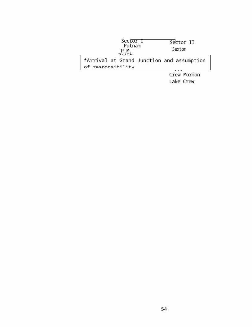
Halsem – F.B.
Bartlett – D.C. Maps and Records:
Engle, Dave – S.C.
BATTLEMENT CREEK FIRE
Fire #1173
Friday – July 16, 1976
Evening Shift:
Line Boss --- Rick Vincent
Division A.
Sector #1 2 Sector Bosses
Sector Boss Green
Carson Hotshots (Road)Santa Fe HotshotsPan Ams
Sector Boss Sexton
S R V #70 (Catline)S R V # 2S R V #39S R V #30 (Bob Clark)
These crews will leave fire camp at 1900 hrs. and will be bussed to the bottom of Div. I.
Tools will consist of ½ shovels and ½ Pulaskis. In addition each crew will be equipped
with 1 chain saw and 1 radio per crew.
Division B.
Sector #1
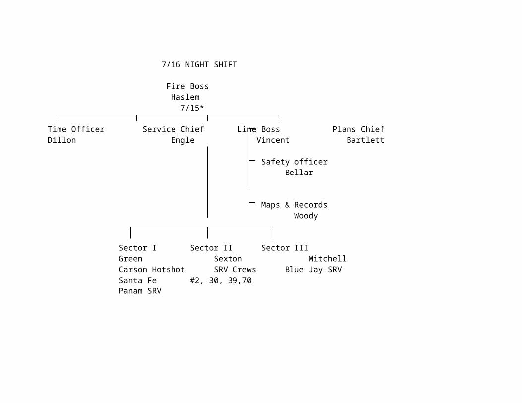
This crew will leave camp at 1900 and be transported to the T. V. antenna site
area where they will walk into the area immediately east of the ridgetop. The crew will be
equipped with 1 chain saw and one radio.
All overhead will have a radio. Crew members will be reminded of safety
precautions related to working in steep terrain at night, keep men spaced out, watch for
rolling rocks, etc.
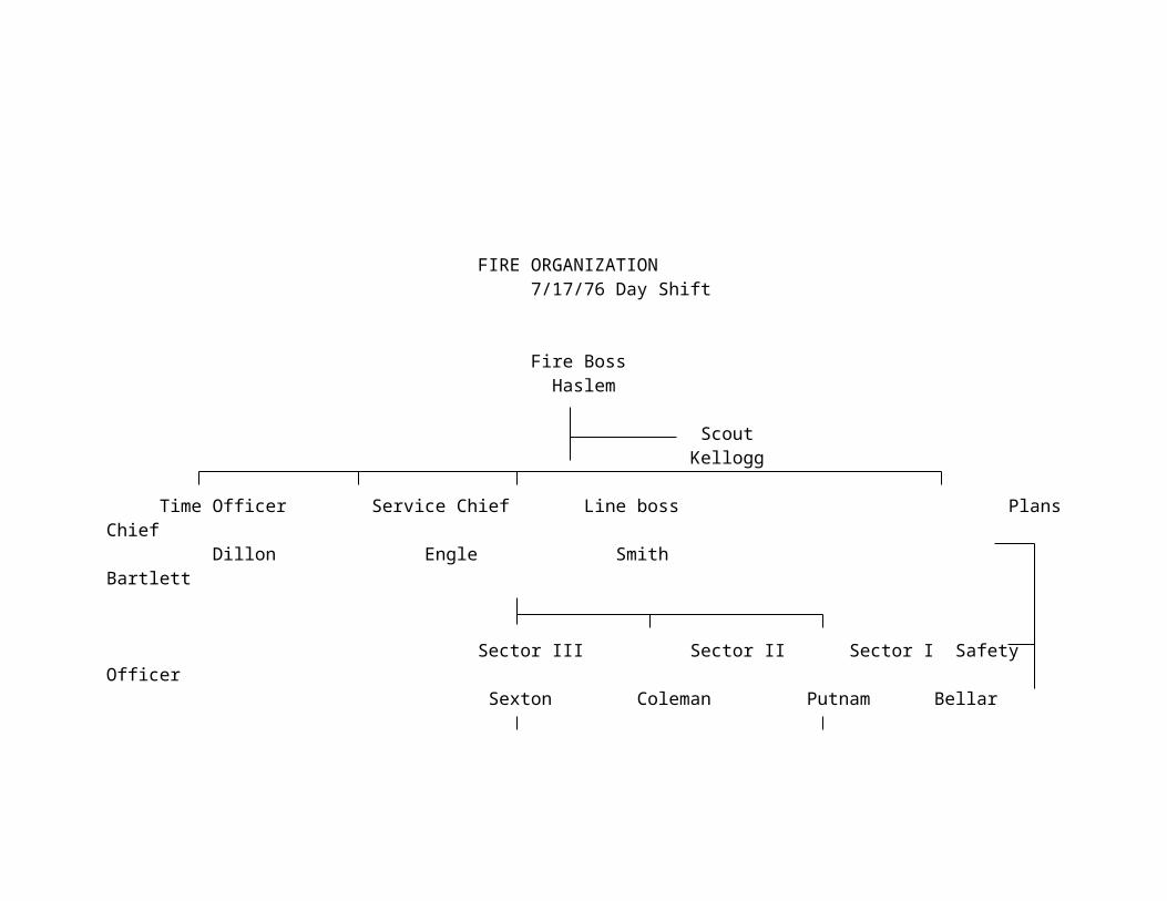
BATTLEMENT CREEK FIRE
FIRE #1173
SATURDAY, JULY 17, 1976
Dayshift: Fire Boss……………………….Jack HaslemLine Boss………………………Walt SmithPlans Chief……………………..Bill BartlettService Chief……………………Dave EngleSafety Officer…………………..Jon Bellar
Sector #1
Sector Boss………………………PutnamSawtooth IR Crew:
Crew will construct hand line from road and tie in black on northwest corner. Bulldozers will be used where possible.
Sector #2
Sector Boss……………………….SextonHappy Jack Hotshots and Grand Junction E.F.F.
These crews will mop up along Catline and road. Unburned areas will be burned out upon command.
Sector #3
Sector Boss…………………….ColemanMormon Lake Crew
This crew will be helicoptered to the top and will burn out along line in order to strengthen line. Crew will move into black area when unburned draw is fired from below.
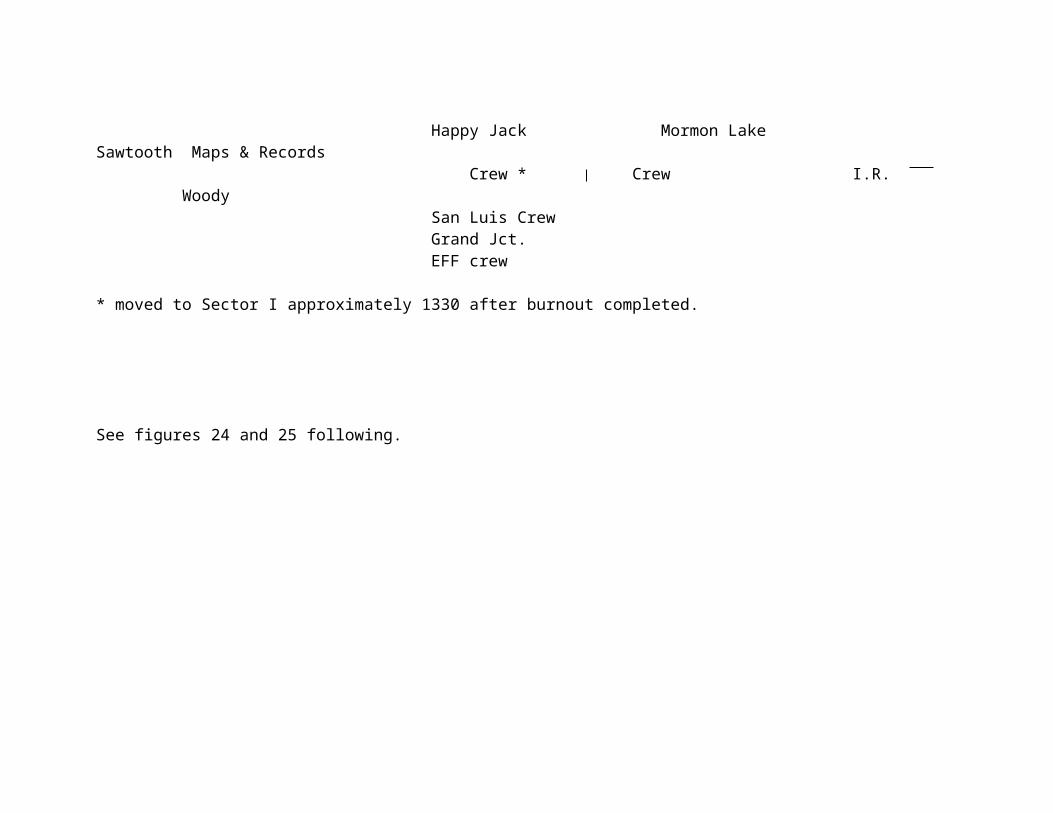
INDIVIDUAL FIRE REPORT
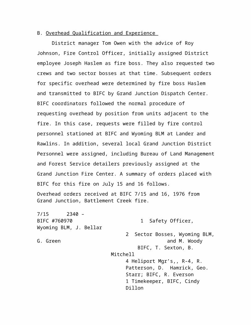
BRIEF OF EVENTS AND PRESS RELEASE PREPARED BY
INVESTIGATION TEAM
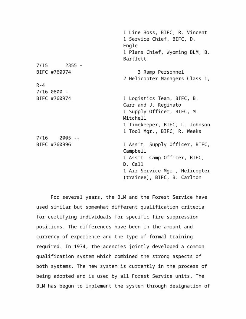
PRESS RELEASEBUREAU OF LAND MANAGEMENT
Grand Junction, July 21, 1976
The following brief is the first reconstruction of the sequence of events leading to
the death of 3 crew men and 1 injury at the 880-acre Battlement Creek fire. This fire on
National Resource land under Bureau of Land Management (BLM) jurisdiction was 5
miles west of Grand Valley, Colorado. All 4 men were members of the Mormon lake
Hotshots Crew assigned to the Coconino National Forest, Flagstaff, Arizona.
A 7-man team under the co-chairmanship of jack Wilson, Chief, Boise
Interagency Fire Center, (BLM), and Max Peterson, Deputy Chief, Forest Service, (FS),
has been interviewing personnel who were in the area prior, during, or following the
catastrophe and have also made an on-site review of the burned area and accident site.
The team is continuing to reconstruct events during the time of the tragedy and
this is their most accurate assessment of the facts at this time.
BRIEF
On Saturday, July 17, at about 2:45 PM, a 4-man burnout crew from the Mormon
Lake Hotshot Crew, Coconino National Forest, (NF), whose planned route of escape was
suddenly cut off by flames were overrun by the fire burning rapidly up a steep draw.
Three men died at the scene, and one was evacuated by helicopter and is in fair condition
in the Albuquerque Burn center. The dead men were identified as:
Anthony “Tony” Czak, 25, 643 Campus Heights, Flagstaff, Arizona
Scott L. Nelson, 22, 1505 5th Avenue, Bloomer, Wisconsin
Stephen H. Furey, 23, P.O. Box 1127, Salmon, Idaho.

The accident occurred on the Battlement Creek Fire which started from an
undetermined cause 45 miles east of Grand Junction near Grand Valley, Colorado. The
fire started on private lands and burned on to national Resource Lands managed by the
Bureau of Land Management, (BLM). Immediately following the accident, an
Interagency Investigation team was convened and has been on the scene reconstructing
the events which follow:
The Battlement Creek Fire was one of several fires in the area, and was first
attacked with aerial retardant from planes based at Grand Junction. This was
supplemented by Garfield County, BLM, and Forest Service crews and equipment. When
these initial efforts failed to contain the fire, a fire team was assembled made up of BLM
and USFS personnel. The team was headed by Jack Haslem, Grand Junction, Colorado,
an experienced BLM Fire Boss. Additional crews and equipment were obtained, totaling
approximately 300 men, aerial tankers, dozers, helicopters, and other equipment. One of
the crews was the specially trained 20-man Mormon Lake Hotshots Crew from the
Coconino NF at Flagstaff, Arizona.
The crew worked on the fire on Friday, July 16, burning out the critical southeast
corner of the fire.
On Saturday, July 17, the crew was transported by helicopter to a rocky ridge to
burn out a hand line that had been constructed the night before. The Crew Boss, Tony
Czak, flew the area by helicopter with the Sector Boss prior to commencing work at
approximately 11 a.m. The Crew Boss assigned fourteen members of the crew under the
supervision of Squad Boss Don Kimball to widen the hand line. He assigned John
Gibson, the other Squad Boss and two crewmen to burn along the hand line to provide a

barrier to the main fire. Two members of the crew were stationed above the burnout crew
on the rocky ridge.
The Crew Boss ordered Kimball and his portion of the crew out of the area and
into a previously burned area while he and the burnout crew remained to complete the
remaining distance of about 200 yards. They intended to follow Kimball and the balance
of the crew as the burnout was to be completed in a few minutes.
A fast-moving finger of the fire moved up a steep slope, out of their view, and cut
off their planned route of escape. Czak notified both his Sector Boss and Squad Boss that
he was cut off and unable to follow the balance of his crew. The four men retreated up
the ridge along the burned out line looking for a safe place. When it became apparent to
them that the fire would overrun them, using survival techniques, they removed their
cruiser vests, wet themselves down with water from their canteens, and laid face down on
the ground in a depression along the fire line.
The heat and smoke was intense as the fire passed over them, and some of their
clothing ignited. Crew Boss Czak and crewmen Nelson and Furey perished. John Gibson
survived. Sector Boss Coleman, Glenwood Springs, Colorado, arrived approximately ten
minutes after the fire passed and found both Gibson and Furey alive. Steve Furey died at
the scene in spite of first aid, including mouth-to-mouth resuscitation by Coleman.
Immediately upon arrival at the scene, Coleman advised Fire Boss Haslem that
there were injured men and help was needed.
A helicopter with an experienced medical technician and first aid equipment
arrived at the scene within 10 minutes.
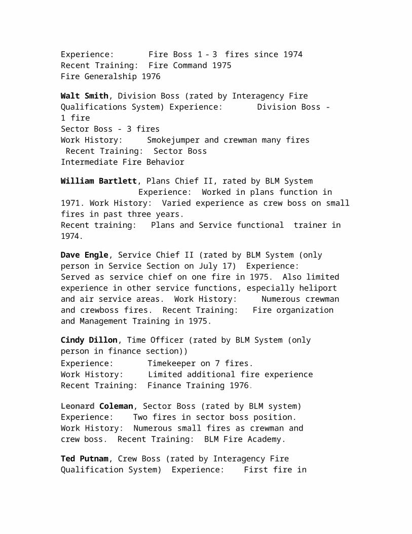
John Gibson was promptly removed to St. Mary’s Hospital in Grand Junction, and
later, after initial treatment was flown to the burn unit in Albuquerque.
The investigation will proceed in two directions:
1. To validate what happened;
2. To determine what factors caused the accident and what steps the
agencies might take to prevent a recurrence in the future. It will
require several more days to complete the fact-finding phase and
write a report.
FOR THE PRESS:
Terms
Fire Boss – Overall direction of the fire fighting activities
Line Boss – Person responsible for all fire line construction
Sector Boss – responsible to a line Boss for a portion of the line. Supervises crew bosses.
Crew Boss – Person in charge of a crew on the fire. (Usually 20 men). Reports to Sector
Boss
Squad Boss – Person in charge of portion of the crew. Reports to Crew Boss.
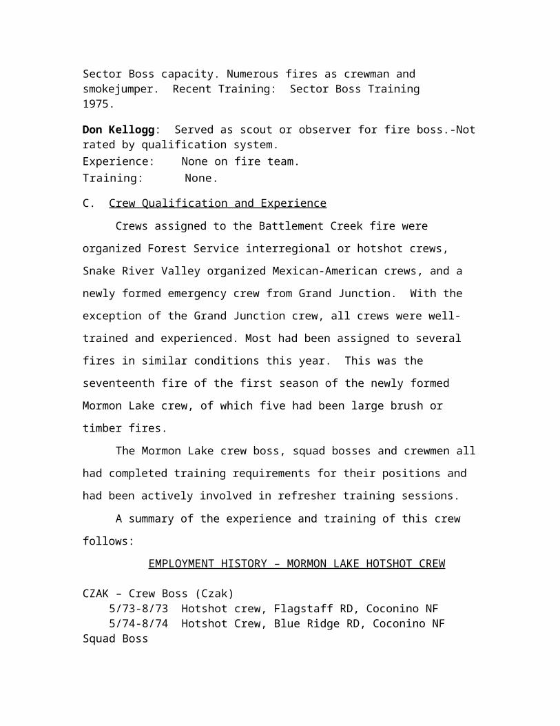
FOLLOWUP ACTION RELATING TO UNUSUAL FUEL CONDITIONS
UNITED STATES DEPARTMENT OF AGRICULTUREFOREST SERVICE
WO ______________________________________________________________
REPLY TO: 5100 Fire Management Aug 16 1976
SUBJECT: Extreme Fire Behavior Conditions
TO: Regional Foresters, region 2, 3 and 4
The enclosed report and memorandum clearly explain an unusual fire behavior situation. The importance of this information became evident during investigation of the fatalities on the Battlement Creek Fire near Grand Junction, Colorado.
Please assure that line officers are aware of this potential problem. The information should also be shared with State Foresters in the affected areas. All fire teams assigned to fires must be cognizant of this unusual situation and not count on normal fire intensities and rates of spread.
While this matter relates particularly to frost dieback in Gambel’s Oak, you should be alert for different conditions caused by other unusual events. Only through careful, thorough attention to the local situation can future problems be averted.
JOHN R. McGUIREChief
Enclosure
Cc: Regional Foresters, R-1 thru 10
August 6, 1976
EXTREME FIRE BEHAVIOR CONDITIONS NOW EXIST INFROST-DAMAGED BRUSH FUELS
The purpose of this report is:
1. To alert wildland fire management agencies in Colorado and adjacent states regarding the current potential for extreme rates of fire spread in brush stands that suffered leaf mortality, due to a frost, on June 14, 1976, in Colorado.
2. To request that land managers thoroughly brief fire crews and overhead teams regarding any local fuel conditions that might accelerate rates of spread or increase fire intensities (should consider possible drought, insect, and disease effects in addition to frost-induced dieback).
3. To provide background information on the nature of fire behavior conditions in frost-damaged oak stands.
On July 15, Jack Wilson, BLM Director at BIFC, made a helicopter reconnaissance flight to evaluate frost-killed fuels on the west slope of Colorado in the Grand Junction are (see attached July 16 memorandum to the State Director, BLM, Colorado). On June 14, the temperature at Grand Junction was 32 degrees F., 28 degrees F. at Rifle and probably in the 24 degree range above 7,000 feet elevation. This frost caused widespread mortality to the leaves of Gambel’s oak. Other species affected were snowberry, mountain mahogany, aspen, and Douglas-for. As of late July, 50 percent or more of the Gambel’s oak leaves in affected stands were dead and retained in the shrub crowns. Shed oak leaves contributed to a 1-2 inches littler layer on the ground.
The day of Wilson’s flight, July 15, the stage was already being set to demonstrate a significant fire behavior episode in frost-damaged Gambel’s oak. The Battlement Creek Fire, 40 miles northeast of Grand Junction, Colorado, made major runs on the afternoons of July 15, 16 and 17. ON the afternoon of July 17, three members of an Interregional firefighting crew were overrun and killed by a fire that burned rapidly in frost-damaged Gambel’s oak on a steep, west facing aspect. Slope percentages in the draw immediately below the crew ranged from 50 to 75 percent.
The single most significant weather event that affected the Battlement Creek Fire was extensive frost that occurred one month prior to the fire!
Fuel moisture sample on the Battlement Creek Fire were collected at 1830 on July 20 at 8800 feet on the ridge above the fire area:
Sample Average Moisture Content (%)
Dead oak leaves (shrub canopy) 11.4Leaf litter on ground 13.7Dead oak branches (< ¼ inch) 12.4Green oak leaves 166.5Living oak stems (< ¼ inch) 193.8
The dead oak leaves in the shrub canopy could have been at 7-8 percent moisture content or less at the time of the fire run on Saturday, July 17.
The June frost significantly increased the amount of available fuel in the Battlement Creek area by contributing to the dieback of the oak leaves. One individual remarked that fire behavior conditions seemed 2-3 weeks early for this time of year.
Chemical analyses of the Gambel’s oak leaves were conducted at the Northern Forest Fire Laboratory in Missoula:
Green Leaves Dead Leaves in CrownCrude fat (%)4 1.60 .52Total Ash 3.18 2.50Low heat of combustion (Btu/lb) 4
7886 7782
The crude fat content, or amount of volatile waxes, oils, and resins, was quite low in Gambel’s oak. Much lower than the 8-12 percent reported for southern California chaparral. Therefore, the significant fire behavior fact was the great increase in amount of available fuel in the Gambel’s oak crowns due to frost damage. Fuel chemistry did not play the important role on the west slope of Colorado that it does in California.
Chaparral Model Nomograph Results
Site conditions on the Battlement Creek Fire on Saturday afternoon were run using the chaparral fuel model5 of the National Fire-Danger Rating System with nomographs designed to predict fire spread, intensity, and flame length. Two different wind speeds (15 and 25 m.p.h.) and 2 slope percents (40 and 75) were used in calculations. Dead fuel moisture was set at 5.5 percent and live fuel moisture at 150 percent.
4 Samples were not frozen. Escape of volatiles might tend to make these values low. 5 Fire-Danger Rating System fuel model B was selected because it came closest to representing oak brush conditions on the Battlement Creek fire.

Nomograph results:
Condition 1 2 3
Wind speed (m.p.h.) 15 15 25Slope (percent) 40 60 75Effective wind (m.p.h.) 17 18 29Reaction intensity (B.t.u. /sec./ Ft.2 ) 12,000 12,000 12,000Rate of spread (ch./hr.) 110 125 240Flame length (ft.) 20-30 20-30 30-40Fireline intensity (B.t.u./sec./ft.) 5,500 6,000 12,000Time to go ½ mile (min.) 24 21 11Time to go ¾ mile (min.) 36 32 16.5
Conditions 1, 2, and 3 represent the lower slope, mid-slope, and the upper portion of steep chute, respectively, Condition 3 also is characterized by a 25 M.P.H. wind speed to reflect probable peak gusts. Conditions 1, 2, and 3 show the fire traveling ½ mile in 11-26 minutes. In reconstructing actual fire spread from photographs and observations, it appears that the fire traveled the last 1,800 feet to the ridgeline in about 15 minutes or well within the range of modeled conditions. In terms of fireline intensity, 100 B.t.u./sec./ft. of fireline is about at the upper limit for control by hand crews and 500-700 B.t.u./sec./ft. for direct control of a fire by any forces. Fireline intensities for cases 1, 2, and 3 were 5,500, 6,000, and 12,000 B.t.u./sec./ft., respectively, or absolutely uncontrollable.
Fire Behavior Summary
A rather typical weather patter, steep mountain terrain, and frost-induced dieback in Gambel’s oak established conditions for high rates of fire spread in the Battlement Creek drainage during afternoon hours. For these reasons there might be a tendency to equate the battlement Creek Fire with a southern California brush fire, but such was not quite the case. Precipitation amounts were near normal for this time of year, humidities were not usually low, and wind velocities generally fell far short of Santa Ana conditions. Green fuel moistures for oak leaves and stems were 166 percent and 194 percent, respectively, well above the 60 percent moisture contents recorded for drought-stressed chaparral in California. Nevertheless, dead oak leaves on the ground and in the crowns, abundant fine dead branches in the oak and mountain mahogany crowns, the dense arrangement of 6-12 foot shrubs, and slopes ranging from 50 to 75 percent provided all the potential necessary for a fast spreading, high intensity fire.
A prophetic report prepared by the Colorado State Forest Service6 described a “fuel type X” that supports high-to-severe wildfire hazards. (This report should be required reading for all fire management agencies in Colorado.) These primarily oak brush fuels “are dense, high brush 1 ½ to 10 feet in height. Small scattered patches of conifer or
6 Guidelines and Criteria for Wildfire hazard Areas, September 1974, Colorado State Forest Service, Fort Collins, Colorado.
deciduous tress or scattered individual trees may also exist but are of minor effect and occurrence. The fuels are continuous or nearly so. Despite heavy shading, the ground is seldom damp. Flammability may vary markedly in the year due to changes in fuel moisture and leaf fall. Fire seldom kills these species. Many re-sprout after fires with more stems resulting in more numerous, thin-stemmed fuels than before.”
Burning characteristics are described as becoming “extra hazardous during special times of the year. The critical time of year varies with the species. For example, oak brush is very difficult to burn when the leaves are green, but when its leaves are brown and still hanging on the branches, it becomes one of Colorado’s most flammable fuels for 2 to 3 weeks in autumn.” The key point here is that these highly flammable autumn conditions in oak brush existed in the Battlement creek drainage in mid-July due to the June 4 frost!The report clearly described many of the events observed in the Battlement Creek Fire:
“The “X” fuels support medium to high intensity fires, short-range spot fires are common, rate of spread is moderate to fast, flare-ups brief but common and hot, just-burned area is tenable by humans within about ¼ hour, the fire front is impassable. Brush fires seldom burn throughout the night and into the next day if suppression action is made.
These areas are of state interest due to the associated burning characteristics, the difficulty of fire suppression and the resultant dangers to life and property during special times. By their very nature “X” fuels often create a false sense of security due to their lush greenness and sometimes non-flammable periods. Many people find it impossible to believe the potential flammability until they witness burning in critical periods. Its (oak brush) rate of fire spread has been observed and timed to be an incredible 16 acres per minute, steady for 3 hours, in Colorado! Fast running mule deer have been found dead in oak brush burns—unable to outrun the fire’s spread. Brush fires are very sensitive to wind direction. Property and lives considered safe on a flank can be quickly threatened within minutes by a wind shift.”
So Colorado oak brush need not be compared to California chaparral fuel types. Under the July conditions of frost-induced dieback in Gambel’s oak in Battlement Creek, the oak stands on its own as a most potent fuel type!
Robert W. MutchResearch Forester
Intermountain Forest and Range Experiment Station

United States Department of the Interior
BUREAU OF LAND MANAGEMENTBoise Interagency Fire Center3905 Vista AvenueBoise, Idaho 83705
July 16, 1976Memorandum
To: State Director, Colorado
From: BLM Director-BIFC
Subject: Evaluation of Fuels on the West Slope of Colorado
Subject to your request, I flew to your West Slope Fire Center at Grand Junction on July 14. There I met Byron Kropf and Doug Gregory of the Colorado State Office and Roy Johnson of the Grand Junction District. On July 15, Byron and I flew extensive areas by helicopter after having determined these were probably the more critical areas based on a fixed wing flight on July 14.
The imminent problem is caused by the fact that on June 14, 1976, a very hard killing frost occurred across most of the West Slope of Colorado. A temperature of 32 degrees was recorded at Grand Junction, and Rifle recorded 28 degrees. In the area above 7,000 feet, this temperature probably got down in the 24 degree range. The frost caught particularly the oak brush at a very vulnerable early leaf and bud stage. Above the 10,000 foot elevation, it appears the aspen was also heavily damaged. Above 8,500 feet, there is evidence of damage to the snowberry and mahogany.
The following details are essentially the observations that were made on the July 15 helicopter flight.
The helicopter flight took us southwest of Grand Junction to an area of a prior fire, “Granite Creek.” We landed at the 8,000 foot level and examined the oak brush and snowberry stands. It appeared that 25 to 30 percent of the oak brush had been severely affected. On an individual plant basis, most of the secondary and tertiary branches were dead. The leaves were desiccated, and 90 percent had fallen to the ground. There was perhaps a two-inch ground cover in the thicker areas where the leaves had shed. Perhaps ten percent of the snowberry had been nipped and their leaves were like parchment. We dug into the oak root system and even the smaller feeder roots appeared to be alive. The 7,500 foot elevation seemed to be a critical level. The damaged areas exhibited no particular pattern in this area but did seem to follow typical drainage flow channels. Pinon juniper exhibited a fairly solid canopy and was fairly dry for this time of year.
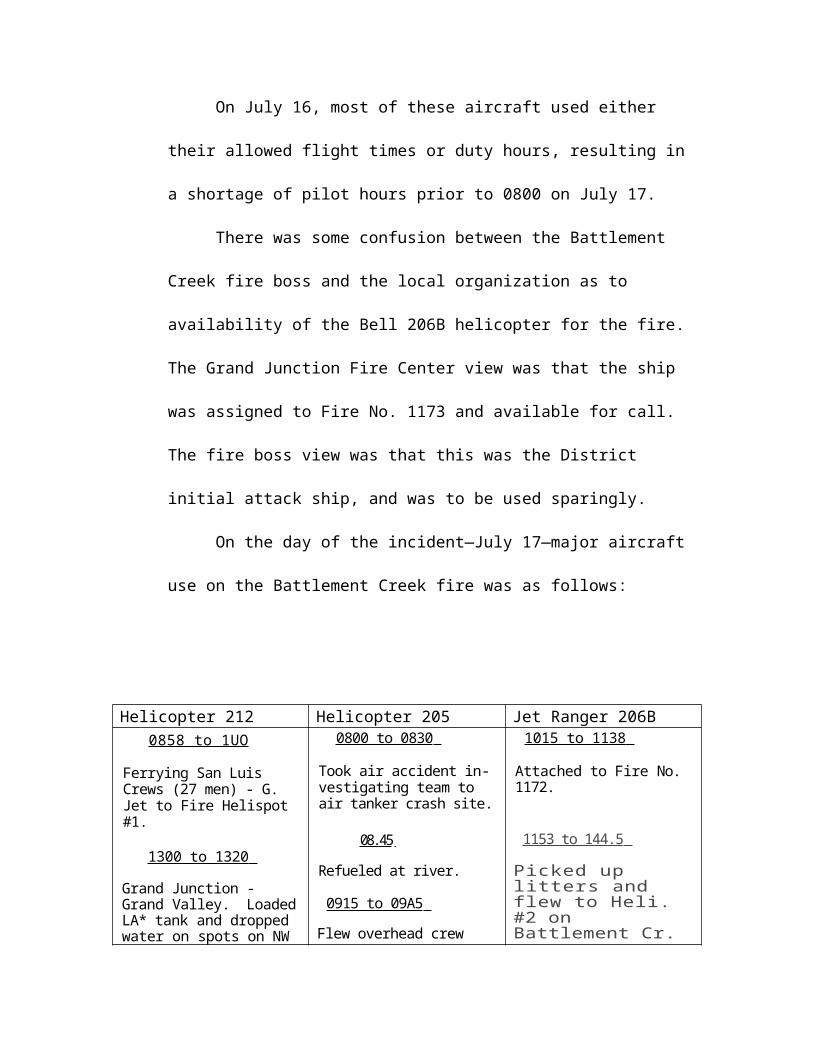
We then proceeded east of Gateway to the south of Montrose into the Powderhorn area. Here the frost damage was much more severe. Up to 80 percent of the area appeared affected. In this area generally, the oak leaves had not fallen from the trees. Time precluded spending much tine in this area and we did not land, but I expect the individual plant situation would be similar to the Granite creek fire area except that there may be some mortality in the primary stalks.
We then flew northward to an area perhaps 35 miles north of the Gunnison Gorge and proceeded westward into Grand Junction, flying south over Rifle and over the Bookcliffs area. The area around Rifle appears to be damaged at about the 50 percent level. I would like to have gotten into the Douglas Pass area since there appeared to be considerable damage in that area.
There is a large area between 7,500 feet and 9,500 feet north of the Gunnison Gorge that is affected but of probably more concern to the Bureau of Land Management is the apparent damage to the lodgepole pine in draws feeing into the Gunnison Canyon Reservoir. Damage appears extensive on both sides of the reservoir and is either a very serious beetle infestation or a frost desiccation. While I expect this might be the “gray forest” stage in lodgepole pine, it needs to be field examined to determine if, in fact, these trees are dying ad if so, then the field problem is greatly magnified.
Upon returning to Grand Junction, I made some cursory analysis of the long range situation. Most of the West Slope had a very mild winter. Two large April storms brought substantial moisture to the area and the Palmer Drought Index indicates very near to the normal range. Since May the area has had very limited moisture but this is not too abnormal. However, computer runs of the AFFIRMS program are showing some interesting comparisons. Comparative runs of the ignition index (which is a pretty good one for light fuels) shows readings that are consistently worse than those that have been recorded in the past. The same kind of comparisons for energy release indexes were indicating about the same thing.
From a fire standpoint, the West Slope Fire Center has been responding to about three times the normal number of fires, and in the 6,000 plus elevations, they have had difficulty with spotting in fairly sparse pinon juniper stands. At this time they have not yet had a fire in the oak brush areas.
The State Office has caused a fair buildup in the initial attack capability with the view of getting the fires early. The basic strategy of the initial attack complement has been very effective so far. To date the initial attack crews have done an excellent job in coping with the overload fire situation.
Summary and Conclusions:
1. The West Slope of Colorado was subjected to an abnormal hard frost on June 14, 1976. It caught particularly the oak brush at a very vulnerable stage and has affected snowberry and mountain mahogany in the higher elevations.
2. Nature has provided an exceptionally rigorous pruning job to most of the affected plans. My cursory estimate on an individual plant basis is that, where affected, about 40 percent of the plant is damaged. In some areas the leaves have fallen to the ground; in other areas, this has not occurred. As long as the fuel is in the air, it is more dangerous from the ladder effect, but when it falls to the ground there is a dangerous ground cover.
3. Much of the heavier fuels on BLM lands, pinon juniper in particular, are already dry. It is running about a month ahead of normal. The “pinon smell,” which is an indicator of flashiness, has already been noted and, in fact, has been causing spot fires that normally should not occur in fairly sparse stands.
4. The West Slope of the Colorado is facing a very dangerous fire situation because of the extra volume of fuel and the drying conditions and the possibility for ladder effect, particularly in the oak brush areas. My sampling was of necessity very spotty and cursory and I could not assess potential wildlife or grazing implications but there is a very dangerous fire situation developing because of the added fuel load.
5. Of vital interest and concern to BLM but not a direct responsibility is the vast area of bug killed spruce and lodgepole now compounded by damage too the aspen and mountain brush encompassed a large area bounded roughly by a triangle involving Meeker, Kremmling and Delta and including the Gunnison River drainage. This would involve parts of the Routt, White River, and Uncompagre National Forests.
6. From a suppression standpoint, there is in place a reasonably strong initial attack force at Grand Junction. It is essentially, however, a “loaner” organization made up of USFS smoke jumpers, BIFC personnel and aircraft, and Alamosa crew. There should be a regular complement to staff and manage this complex operation, particularly the air operation. A critical point to remember is that the worst of the fire season is yet to come. There is going to be a normal and continuing operation for the next few years and this force, in my view, is perhaps conservative. They may be faced with added fuel loading for several years which might need augmented support.
7. For this particular season, I would recommend that any fire that exceeds 50 acres in oak brush fuels is a potential project fire and assistance should be requested for any fires that exceed this limitation when containment has not been achieved by initial attack.
Cc: Mr. Max PetersonUSFS-USDAPrograms and LegislationWashington, D.D.
WO 440