Embed Size (px)
Citation preview

U.S. DEPARTMENT OF THE INTERIOR
U.S. GEOLOGICAL SURVEY
AN INDEX OF CONTINUOUS-TONE PHOTOGRAPHIC PRINTS
OF THE
DIGITAL SHADED-RELIEF MAP OF THE UNITED STATES
-WHOLE OR IN SIX SECTIONS
by
Richard J. Pike, Gail P. Thelin, and Chip P. Stevens
Open-File Report 92-256
This report is preliminary and has not been reviewed for conformity with U.S. Geological Survey editorial standards.
Any use of trade, firm, or product names is for descriptive purposes only and does not imply endorsement by the U. S. Government.
Menlo Park
California 94025
An Index of Continuous-Tone Photographic Printsof the
Digital Shaded-Relief Map of the United States Whole or in Six Sections
by
Richard J. Pike, Gail P. Thelin, and Chip P. Stevens
Introduction
Landforms as small as one mile across are shown in their true location, detail, complexity, and regional context by a new shaded-relief image of the 48 United States in vertical perspective. The image, compiled by computer manipulation of 12 million terrain heights arranged in a square-grid format, is the largest single-sheet graphic of the Nation's topography since the near-vertical panorama drawn by cartographer Erwin Raisz over 50 years ago. The map exemplifies how image processing and computer graphics have mechanized the art of landform portrayal by essentially combining two traditional artistic techniques-pictorial relief and hill shading-and executing them in digital form.
The new physiographic map was first shown at 1:2,500,000 scale at the Centennial meeting of the Geological Society of America in Denver, Colorado (Pike and Thelin, 1988). The image has since been reproduced at much-reduced sizes (Pike and Thelin, 1989a and b, 1991; Pike, 1992). It was recently issued by the Geological Survey as a high-quality paper map at 1:3,500,000 scale with an explanatory pamphlet that gives full details on the computer technique, digital data set, and applications (Thelin and Pike, 1991).
Photographic Prints
In response to requests for greater flexibility in presentation, we are making the digital U.S. map available as continuous-tone glossy black-and-white photo- enlargements. This new version is for users who require photographic quality reproduction of (1) one image of the entire conterminous U.S. at a size smaller than that of the Thelin and Pike (1991) map, (2) the same area divided into regional sections-which may be used to assemble a large mosaic of the conterminous U.S. or some portion of it, or (3) only one part of the Country. The prints are made from negatives created as row-by-row scans (from the original shaded-relief output tape) on a film recorder-scanner. The map projection is Albers Equal Area. The version offered here differs slightly from Thelin and Pike (1991) in that it has a digital, rather than an analog, coastline and no lakes.
Many requests have been received for enlargements of specific parts of the Country. The six sectional maps offered here should fill most needs for such limited-area views. Areal coverage of the U.S. by the six regional images, also
shown in the accompanying index map (fig. 1), is not equal. The sections overlap generously, but maintain a continuous rectangular margin surrounding the entire U.S. This both allows maximum coverage of the Country by each print and assists their mosaicking by the user into one large map. (See Obtaining Prints, below, for cautions on mosaicking enlargements.)
Obtaining Prints
Glossy prints made from the seven different negatives are available on standard photographic-weight paper.
One image (fig. 1), made from a 25-micron-resolution negative, includes the entire conterminous United States. The image of the U.S. measures about 8.5 cm X 14 cm on the negative. To order, specify:
Whole U.S.
Six images made from 50-micron-resolution negatives cover the conterminous United States in regional sections (figs. 2-7). Each image measures up to about 12 cm X 12 cm on the negative, depending on the shape of the U.S. in that section. Sections are available individually or in any combination. To order, specify:
Northwest North Central Northeast Southwest South Central Southeast
Enlargements made from one or more of these seven negatives are available in different sizes on standard-weight photographic paper. For best results, magnification should be no more than 10X for the Whole-US image and no more than 6X for each of the six sections. Because image tone, contrast, and even size can differ slightly from print to print, due to normal variation in darkroom processing, a perfect match~and thus a seamless whole-U .S. mosaic from the six sections in one continuous tone-cannot be guaranteed. For details and terms, inquire at:
Photographic Library Mail Stop 914 U.S. Geological Survey Box 25046 Federal Center Denver, CO 80225-0046 [303] 236-1010

Please note that print cost increases with size of the image requested, and that prices are subject to change without notice. Small prints are mailed flat; larger sizes are mailed rolled in a protective tube. When ordering, please specify (1) which of the seven images are wanted and (2) for each image what print size or magnification is wanted. Orders for prints smaller than 50 cm X 60 cm (20 in. X 24 in.) can be handled more rapidly than orders for larger sizes.
References
Pike, R.J., 1991, Surface features of central North America: A synoptic view from computer graphics: GSA Today, v. 1, no. 11, p. 241, 251-253.
Pike, R.J., and Thelin, G.P., 1988, New shaded relief map of the United States from digital elevations, with summary statistics on landform geometry for the physiographic provinces: Geological Society of America Abstracts with Programs, v. 20, no. 7, p. A284.
Pike, R.J., and Thelin, G.P., 1989a, Shaded relief map of U.S. topography from digital elevations: Eos, Transactions American Geophysical Union, v. 70, no. 38, p. 841 (cover), 843, and 853.
Pike, R.J., and Thelin, G.P., 1989b, Cartographic analysis of U.S. topographyfrom digital data: American Society of Photogrammetry and Remote Sensing and American Congress on Surveying and Mapping, Auto-Carto 9 Convention, Baltimore, Maryland, Proceedings, p. 631-640.
Pike, R.J., and Thelin, G.P., 1992, Building a better map: Earth, v. 1, no. 1, p. 44- 51.
Thelin, G.P., and Pike, R.J., 1991, Landforms of the conterminous United States- A digital shaded-relief portrayal: U.S. Geological Survey Miscellaneous Investigations Map, 1-2206, scale 1:3,500,000.
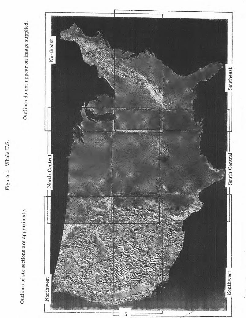
Fig
ure
1.
Who
le U
.S.
Out
lines
of
six
sect
ions
are
app
roxi
mat
e.O
utli
nes
do n
ot a
ppea
r on
im
age
supp
lied.
8
Sout
h C
entr
al

Figure 2. Northwest
6

Fig
ures
. N
orth
Cen
tral

Figure 4. Northeast
8
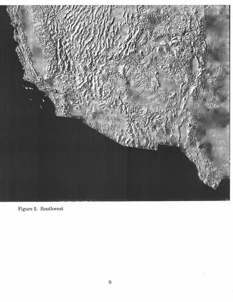
Figure 5. Southwest
9
Fig
ure
6.
Sou
th C
entr
al]

Figure 7. Southeast