Embed Size (px)
Citation preview
U.S. Department of the Interior U.S. Geological Survey
Ground-Water Flow Study in the Vicinity of the Savannah River Site, South Carolina and Georgia
uG
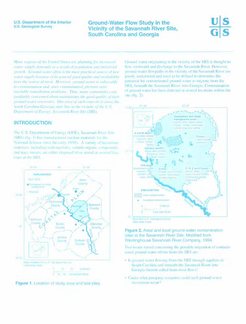
Many regions of the United States are planning for increased water-supply demands as a result of population and industrial growth. Ground water often is the most practical source of new water supply because of its general good quality and availability near the source of need. However, ground water is vulnerable to contamination and. once contaminated, presents near insoluble remediation problems. Thus, many communities are justifiably concerned about maintaining the good quality of their ground-water resen-oirs. One area of such concern is along the 'south Carolina-Georgia state line in the vicinity of the L.S. Department of Energy, Savannah River Site (SRS).
INTRODUCTION
The U.S. Department of Energy (DOE), Savannah River Site (SRS) (fig. I) has manufactured nuclear materials for the National defense since the early 1950's A variety of hazardous materials, including radionuclides. volatile organic compounds, and trace metals, are either disposed of or stored at several loca- lions at the SRS.
81^30'
J3 30'
XV.x -,
, / ^<</-, ,' Aiken ^->__
J^V' County ' X,
' Aiken / - .*
St /Richmond "' County
8<ise modified from U.S Gei logic.il Survey .Mate base maps
30 MILES
H 10 20 30 KILOMETERS
Figure 1. Location of ytudy area and test sites.
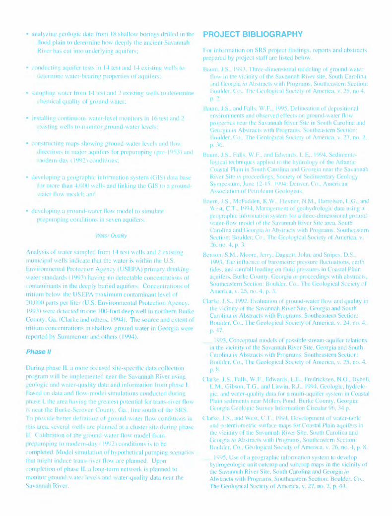
Ground water originating in the vicinity of the SRS is thought to flou westward and discharge to the Savannah River. However, ground-water Howpaths in the vicinity of the Savannah River are poorly understood and need to be defined to determine the potential for contaminated ground water to migrate from the SRS, beneath the Savannah River, into Georgia. Contamination of ground water has been detected at several locations within the site (fig. 2).
2581 '451 81 35'
33'
Separations and waste- management areas tritium, other radionuclides metals nitrate, chlorinated volatile organics sulfate
AandMareas^/^cl-'orinated volatile
nrganics. radio uclider. metals ^J
nitrateSanitary landfill- chlorinated vr 1 j* ; if / organic^, radio- ",nuclides. metals
R area adionuclides :admium \
.1
QTNXa ^
chlorinated volatile organics. radio nuclides, pesti
cides nitratT
D area metals radio .-j'.iid sulfate chlorinated volatile orgnnics
C, K, L and P areas \tritium, other radionuclides metals chlorinated volatile organics /"""
t*- \ eals ,
r ' r*
EXPLANATION '"^
3 Area contamination
Localized contamination
0 5 MILES, -i, - ,
0 5 KILOMETERS
S
-=/>'
Base from U.S. Geological Survey State base maps
Figure 2. Areal and local ground-water contamination sites at the Savannah River Site. Modified from Westinghouse Savannah River Company, 1994.
Two issues raised concerning the possible migration of contami nated ground water offsite from the SRS are:
Is ground water Mowing from the SRS through aquifers in South Carolina and beneath the Savannah River into Georgia (herein called trans-river flow)?
I rnder what pumping scenarios could such ground-water movement occur9
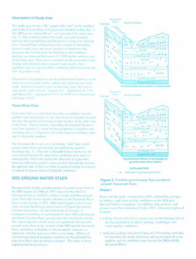
Description of Study Area
The study area covers 4.592 square miles (mr) in the northern part of the Coastal Plain of Georgia and South Carolina (fig. 1). The SRS covers about 300 mi 2 , or 7 percent of the study area i fig. 2). The northern limit of the study area and boundar} between the Coastal Plain and Piedmont is marked by the Fall Line. Coastal Plain sedimentary rocks consist of alternating layers of sand, clay, and lesser amounts of limestone that progressively thicken from the Fall Line to the southeast, leaching an estimated thickness of 2,700 ft in the southern part of the study area. These rot ks comprise highly permeable water- hearing units through which ground water readily flow^ I aquifers), and >ility confining units that restrict the flow ot ground wtuci.
Georgia
Savannah River South Carolina
V predominant land ust ton, and soybeans are rr.u.r .i 1 the study area. The largest
"a. -population 44.m 1990 (U.S. Depar...._.
Silvaculturt ar >tudy area writ crops Kaolin . cities in the sti jnd Aiken. S.C r _ ot" Census, 199H
Trans-River Flow
IVans-river flow is a term that describes a condition whereby ground water originating on one side of a river migrates beneath the river floodplain to discharge points located on the other side of the river. Natural factors controlling the potential for trans- river flow include (1) waterbearing properties of aquifers and confining units; (2) thickness and areal extent of confining units, and (3) hydraulic gradient.
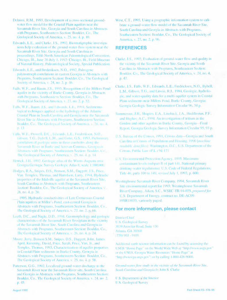
The Savannah River acts as a hydrologic "sink" into which ground water from surrounding and underlying aquifers discharge (fig. 3). This sink is thought to have formed as the river eroded through the uppermost confining units and was subsequently filled with permeable alluvium. It is possible, however, that some ground water can flow beneath the river to the opposite side of the river from its point of origin in response so natural or human-induced hydraulic gradients.
SRS GROUND-WATER STUDY
Because of the highly complex nature of ground-water flow in the SRS region, the DOE in 1991 requested that the U.S. Geological Survey (USGS) conduct a study to define ground- water flow and stream-aquifer relations in the Savannah River basin in the vicinity ot SRS Other participants in the 6-year study include the Georgia Department of Natural Resources, Clemson University, and the University of Georgia. A committee consisting of representatives from SRS and Georgia and South Carolina State agencies provides technical oversite. The major objective of the study is to quantitatively describe ground-water flow in the vicinity of the SRS and the Savannah Kiver, including evaluation of stream-aquifer relations, to jetermine whether trans-river flow is occurring. Effects of elected hypothetical pumping scenarios on the potential for trans-river flow also are being evaluated. The study is bcinj: implemented in two phu>ev
Ground-water flow system (unstressed)
Savannah
Georgia SOUth
Pumping well Aquifer I
Hypothetical effects of pumpage on ground-water flow system
EXPLANATION
> Direction of ground-water flow
Figure 3. Possible ground-water flow conditions beneath Savannah River.
Phase I
Phase I of the study, completed in 1994, defined the geologic, hydrologic. and water-quality conditions in the SRS area through field investigations, test drilling, data analysis, and ground-water flow modeling (Clarke 1992). Elements of phase I included
drilling 18 test wells at five cluster sites on the Georgia side of the Savannah River to define geology, hydrologic, and water-quality conditions;
analyzing geologic data from 5 test and 110 existing well sites to determine the depth, thickness, and areal extent of seven aquifers and six confining units beneath the SRS and the Savannah River;
analyzing geologic data from 18 shallow borings drilled in the Hood plain to determine how deeply the ancient Savannah River has cut into underlying aquifers;
conducting aquifer tests in 14 test and 14 existing wells to determine water-bearing properties of aquifers;
sampling water from 14 test and 2 existing wells to deteimine chemical quality of ground water;
installing continuous water-level monitors in 16 test and 2 existing wells to monitor ground-water levels:
constructing maps showing ground-water levels and fli directions in major aquifers for prepumping (pre-19 modern-day 11992) conditions;
developing a geographic information system (GIS) data base lor more than 4.000 wells and linking the GIS to a ground- water flow model; and
developing a ground-water flow model to simulate prepumping conditions in seven aquifers.
Water Quality
\nalysis of water sampled from 14 test wells and 2 existing municipal wells indicate that the water is within the U.S. Environmental Protection Agency (USEPA) primary drinking- water standards (1993) having no detectable concentrations of contaminants in the deeply buried aquifers. Concentrations of tritium below the USEPA maximum contaminant level of 20,000 parts per liter (U.S. Environmental Protection Agency, 1993) were detected in one 100-foot deep well in northern Burke County, Ga. (Clarke and others. 1994). The source and extent of tritium concentrations in shallow ground water in Georgia were reported by Summerour and others (1994).
Phase II
During phase II. a more focused site-specific data collection program will be implemented near the Savannah River using geologic and water-quality data and information from phase I. F»ased on data and flow-model simulations conducted during pnase I. the area having the greatest potential for trans-river flow is near the Burke-Screven County, Ga., line south of the SRS. To provide better definition of ground-water flow conditions in this area, several wells are planned at a cluster site during phase II. Calibration of the ground-water flow model from prepumping to modern-day (1992) conditions is to be completed. Model simulation of hypothetical pumping scenarios that mijjht induce trans-river flow are planned. Upon completion of phase II, a long-term network is planned to monitor ground-v.ater levels nnd water-quality data near the Savannah River.
PROJECT BIBLIOGRAPHY
Foi information on SRS project findings, reports and abstracts prepared by project staff are listed below.
Baum. J.S.. 1993. Three-dimensional modeling of ground-water flow in the vicinity of the Savannah River site, South Carolina jnd Georgia in Abstracts with Programs, Southeastern Section: Boulder, Co., The Geological Society of America, v. 25, no 4, p. 2
Ituum. J.S., and Falls. W.F., 1995, Delineation of depositional environments and observed effects on ground-water flow properties near the Savannah River Site in South Carolina and Georgia //; Abstracts with Programs. Southeastern Section: houlder, Co., The Geological Society of America, v. 27, no. 2, p. 36.
Baum. J.S.. Falls. W.F.. and Edwards. L.E.. 1994. Sedimento- lo°ical techniques applied to the hydrology of the Atlantic Coastal Plain in South Carolina and Georgia near the Savannah River Site /// proceedings, Society of Sedimentary Geology Symposium, June 12-15. 1994: Denver, Co., American Association of Petroleum Geologists.
Baum, J.S., McFadden, K.W., Flexner, N.M., Harrelson, L.G., and West, C.T., 1994, Management of geohydrologic data using a geographic information system for a three-dimensional ground- water-flow model of the Savannah River Site area. South Carolina and Georgia in Abstracts with Programs, Southeastern Section: Boulder, Co.. The Geological Society of America, v. 26, no. 4, p. 3.
Benson, S.M., Moore, Jerry, Daggett, John, and Snipes, D.S.. 1993, The influence of barometric pressure fluctuations, earth tides, and rainfall loading on fluid pressures in Coastal Plain aquifers, Burke County, Georgia /// proceedings wtih abstracts, Southeastern Section: Boulder. Co., The Geological Society of America, v. 25, no. 4, p. 3.
Clarke. J.S.. 1992. Evaluation of ground-water flow and quality in the vicinity of the Savannah River Site, Georgia and South Carolina in Abstracts with Programs, Southeastern Section: Boulder, Co., The Geological Society of America, v. 24, no. 4, p. 47.
_ 1993, Conceptual models of possible stream-aquifer relations in the vicinity of the Savannah River Site, Georgia and South Carolina in Abstracts with Programs, Southeastern Section: Boulder, Co., The Geological Society of America, v. 25, no. 4, p. 8.
Clarke. J.S., Falls, W.F., Edwards, L.E., Fredricksen, N.O., Bybell, L.M.. Gibson. T.G.. and Litwin. R.J.. 1994, Geologic, hydrolo- gic, and water-quality data for a multi-aquifer system in Coastal Plain sediments near Millers Pond, Burke County, Georgia: Georgia Geologic Survey Information Circular 96, 34 p.
Clarke, J.S., and West, C.T., 1994, Development of water-table and potentiometric-surface maps for Coastal Plain aquifers in the vicinity of the Savannah River Site, South Carolina and Georgia in Abstracts with Programs, Southeastern Section: Boulder. Co.. Geological Society of America, v. 26, no. 4, p. 8.
1995, Use of a geographic information system to develop hydrogeologic unit outcrop and subcrop maps in the vicinity of the Savannah River Site, South Carolina and Georgia in Abstracts with Programs, Southeastern Section: Boulder, Co., The Geological Society of America, v. 27, no. 2, p. 44.
Delaimi, R.M., 1993, Development of a cross-sectional ground- water flow model for the Coastal Plain aquifers near the Savannah River Site, Georgia and South Carolina /// Abstracts with Programs, Southeastern Section: Boulder, Co.. The Geological Society of America, v. 25, no. 4. p. 10.
Edwards, L.E., and Clarke, J.S., 1992, Biostratigraphic investiga tions help evaluation of the ground-water-flow system near the Savannah River Site, Georgia and South Carolina in proceedings. Fifth North American Paleontological Convention, Chicago, III., June 28-July 1, 1992: Chicago. Ill, Field Museum of Natural History, Paleontological Society, Special Publication.
Edwards, L.E., and Frederiksen, N.O., 1992, Paleogenepalynomorph correlations in eastern Georgia in Abstracts with Programs, Southeastern Section: Boulder, Co., The Geological Society of America, v. 24, no. 2, p. 46.
Falls, W.F., and Baum, J.S., 1995, Recognition of the Millers Pond .Kjuifer in the vicinity of Burke County, Georgia in Abstracts with Programs, Southeastern Section: Boulder, Co., The Geological Society of America. \. 27. no. 2. p. 52.
Tails, W.F., Baum, J.S., and Edwards L.E.. 1994, Sedimento- logical techniques applied 10 the hydrology of the Atlantic Coastal Plain in South Carolina and Georgia near the Savannah River Site in Abstracts with Programs, Southeastern Section: Boulder, Co., The Geological Society of America. \ 26. no. 4. P 13
1 alls. W.F., Prowell, D.C., EC wards, L.E.. Frederiksen, N.O., " :1~ - T.G., Bybell. E.M., and Gohn, G.S., 1993. Preliminarj
on of geologic uniK in three coreholes along the ih Rivei in Burke and Screven Countie*. Gee
._.. _jts with Programs. Southeastern Section: Bou!__.. _. . The Geological Society of America. \. 25, no. 4, p. 14.
Hetnck. J.H.. 1992. Geologic atlas of the Wrens-Augusta area. Georgia Geologic Survey Geologic Atlas 8, scale 1:100.000.
Hodges, R.A., Snipes, D.S., Benson, S.M., Daggett- J.S., Price. Van. Temples. Thomas, and Harrelson, Earry, 1994, Hydraulic properties of the Midville aquifer at the Savannah River Site, South Carolina in Abstracts with Programs, Southeastern Section: Boulder, Co., The Geological Society of America, v 26, no. 4, p. 20.
__ 1995, Hydraulic conductivities of Eate Cretaceous Coastal I'lain aquifers at Miller's Pond, east-central Georgia in Abstracts with Programs, Southeastern Section: Boulder, Co., The Geological Society of America, v. 27. no. 2, p. 66.
Leeth. D.C., and Nagle, D.D.. 1994. Geomorphology and geologic characteristics of the Savannah River floodplain in the vicinity of the Savannah River Site, South Carolina and Georgia in Abstracts with Programs, Southeastern Section: Boulder, Co., The Geological Society of America, v. 26, no. 4, p. 24.
Moore, Jerry, Benson S.M.. Snipes. D.S., Daggett, John. James. April, Kroening, David, Price, Sarah, Price, Van, Jr., and Temples, Thomas, 1993, Characterization of aquifer properties in Coastal Plain sediments in Burke County, Georgia in Abstracts with Programs, Southeastern Section: Boulder, Co., The Geological Society of America, v. 25, no. 4, p. 58.
Patterson, G.G., 1992, Eocali/ed ground-water discharge to the Savannah River near the Savannah River site. South Carolina and Georgia in Abstracts with Programs, Southeastern Section: Boulder, Co., The Geological Society of America, v. 24. no 2. p. 45.
West, C.T., 1995, Using a geographic information system to cali brate a ground-water flow model of the Savannah River Site, South Carolina and Georgia /// Abstracts with Programs, Southeastern Section: Boulder, Co., The Geological Society of America, v. 27, no. 2. p. 96.
REFERENCES
Clarke, J.S.. 1992, Evaluation of ground-water flow and quality in the vicinity of the Savannah River Site. Georgia and South Carolina in Abstracts with Programs, Southeastern Section: Boulder, Co., The Geological Society of America, v. 24, no. 4, p. 47.
Clarke, J.S., Falls, W.F., Edwards, E.E., Fredricksen, N.O., Bybell, L.M.. Gibson. T.G.. and Eitwin. R.J.. 1994, Geologic, hydrolo- gic, and water-quality data for a multi-aquifer system in Coastal Plain sediments near Millers Pond. Burke County, Georgia: Georgia Geologic Survey Information Circular 96. 34 p.
Summerour, J.H., Shapiro, E.A., Eineback, J.A., Huddlestun, P.P.. and Hughes A.C., 1994, An investigation of tritium in the Gordon and other aquifers in Burke County, Georgia Final Report. Georgia Geologic Survey Information Circular 95, 93 p.
U.S. Bureau of the Census, 1991, Census data Georgia and South Carolina /'// Census of Population and Housing. 1990 [machine readable data files \: Washington, D.C., U.S. Department of the Census. Public Eaw (P.E.) 94-171
U S. Environmental Protection Agency. 1993. Maximum contaminant levels (subpart B of part 141, National primary drinking-water regulations): U.S. Code of Federal Regulations, Title 40, parts 100 to 149, revised My 1, 1993, p. 600.
Westinghouse Savannah River Company, 1994. Savannah River Site environmental report for 1993: Westinghouse Savannah River Company, Aiken, S.C., WSRC-TR-94-075, prepared for U.S. Department of Energy, contract no. DE-AC09- 89SR18035. variously paged.
For more information, please contact
District ChiefU.S. Geological Survey3039 Armviler Road, Suite 130Atlanta. GA 30360i770)903-9100
Additional earth science information can be found by accessing the USGS "Home Page" on the World Wide Web at "http://www.usgs.gov" or the USGS, Georgia Water Resources "Home Page" at "http://wwwga.usgs.gov": or by calling 1-800-426-9000.
Ground-water flow study in the vicinity of the Savannah River Site, Soitih Carolina and Georgia b\ John S. Clarke
t'.S. Department of the Interior U.S. Geological Survev
August 1995 Fact Sheet FS-178-95